Embed Size (px)
Citation preview
rchaeology
Yolume 2 Number 3 Decemh er 1999
t'n.opeanIr
A.nJ;;i;;jGeneral EditorJohn Chapman UniaersiĘ of Durham, UK
Editorial BoardTeresa Chapa BrunetFelipe Criado Boado UniuersiĘ of Santiago de Compostela, SpainKostas Kotsakis UnizlersiĘ of Thessaloniki, Creece
Viktor Trifunov lnstitute for Histary of Mateńal Culture, St Petersburg, Rt*siaNatalie Venclovi Institute of Archaealogy, Prague, Czech RepublicPaul Wagner Landschaftsoerband Rheinląnd Amt fiir BoderLdatltrnalfllege, Cernntly
Reviews EditorPeter Biehi UnioersiĘ of Caltfornia, Berkeley, USA
Assistant Reviews EditorAlexander Gramsch, Germany Free Uniłersi$ af Błlitl
AIMS AND SCOPEThe publication orgarr of ttre Europearr Associaiion oi.Ąrchaeolog:sts,'tb,e European Joułnal ofArchaeology (published trom 1993 to 1997 as tlle lrnłmłi cf Eurtrpenł ,},ltkrcolog_V" vols 1 5)
seeks to promote open debate amóngst arńaeoiogisis connTnli=led io a ne1r idea of Europe inwhich there is more commrrnication acloss rra-uonal fo,oąfuers alr,l more ,T^Łiene§i ln inierpreiation.The joumal accepts not on]v nerr- empirical daia ałd nert lnterpretaiiorus ot iłe past but alsoencourages debate about the role arcFlaeologv plals ił sclcreir. horł jt slrou]d be organżed ina changing Europe, and the eihics oi arńaeologicai pracŁice. _Ąil periocis are covered; papers,relrerv arlicles, intenierr.s and shori'dehate'pieces are ali słught.
European Journal af Archłeologv {trSSN 1461 9a71} is pu-Ł,lished lłr+e i,r.es a rear in April, Augustand December b1, Sage Publicafions iaon,lol- Tilotsanri OŁks. LĄ aąC \err= Delfu) in associationwith the Ewopean Associaiion of _ĄrchaeologisiS"Institutiona] rate (1999): {110lU§§l7ó; Regiitrar ininidua_l raie {1999l: {.]j,L'SS56, Flrrdrer subscription details and advertising deiai]s are al=a.Labie iTotr-u iŁe }iarkerurg Depa.fuleni. Sage PublicahonsLtd, 6 Bon}ril1 Stree! London EClĄ,!PU, t'K [eł:ra.!: :-uł-.sdlp6on€sagepub.co.,l;k]; ałd in NorthAmerica {rom Sage Publrcaiions Lió PO Box 5uJ96. Thousan,j OŁks. L{ 91359, L§A.Individua1 subscription ś furcluded as part oł ti-le ałunual merąŁrersn p iees oi ńe Eu;opearr ,Ąssociation of Archaeologisis. For iur'ńer deiai]s oi rneurbership cćiegorles anri beąefiis, inctuding reducedrates for students and Eastem Europeał coulfies, piease contaci t&e -LŁĄ Secreianat, clo \foLAS,Wa]ker House, 87 Queen Yicioria StreeĘ Lorióon EC4\- łĄB, LK !erna!l: [email protected]]. TheSecretariat also deals rłi'ń back numbers oi '&e y'nlrcn,ł ai Eu:rr.ł:,esłl ,ł,c}ujEl!§g!,Coplright C; 1999 Editorial Bcard of ihe Europełrl Jcr,ln,łł! a.i,Ąrchtłełlopt arrd Sage Pubiicaiions, Apartfrom fair deaLing for the purposes of research or piiraie sirrdr,, or cEifidsj!1 ol ler.rerv, and ody aspermitted under the CopylrghŁ Desigrrs and Paienis.Ąc.l- 1988, tiris pu-Łriicalion mav only- be repro-duced, stored or lranslnitted in ar5. form or bv artv glearrs,. rli'lh iŁe prior peimrission in rtł:tlng of thePublishers.see the inside back cover for infom.ation for coniributors.Tlpeset in Palatino by BC Typesetting Keynsham, BnstoI" LK.Printed in Great Britain by The Alden Press, Oldord, on acid iree paper.Cover: Detail of a ground penetrating radar profile from ń suroey in Carlisle, Ctmlfuią, calried otLt by theClark Laboratory ąt the Museum of London Archaeology Sensice,Corler designed by Tracy Wellman, MoLAS.
§ rorup Acp sETTLEMENT IN THE>J Lpcł Vru.,lpy MIcRoREGloN oF
NoRTH_EAsr Ponno
Jerzy SiemaszkoMuzeuru )krggowe w Suwałkacb, Suwalki, Poland
Abstract: Over a period of1_ yeats, and as part ofthe Polish Archaeologica1 Record research project,the author directed a field survey of the whole of the Lega river basin QrTE Poland) - an area of over850 km2. As a result of the survey of this hitherto poorly investigated area, aimost 1100 archaeo-logica1 sites were discovered,748 ol which contained lithic materials. The most interesting siteswere initially studied by detailed mapping of surface-find distribution and later by excavation.A complete study of the whole drainage basin was very important for settlement research.The 1arge number of the surface Lithic assemblages enables reliable statistical analyses and accuratecartographic studies supported by palaeo,environmenta1 Ieconstluctions. Lithic assemblages wereanaĘed from the point of production techniques and typology, dispelling some doubts aboutchronologica1 cultura1 affiLiations of flint inventories from north-east Poland and neighbouringcountries, but also raising new questions. It was possibie to observe clear and changing settlementpreferences in the 1ate Palaeolithic and Mesolithic in the zone of late Glacia1 iakes and their adjacentóutwash territories to the south. six concentrations of sites were discovered, associated withcommunication routes and zones of economic activity.
Keywords: late Paieolithic and MesoLithic, methodology, north-east Poland, settlement
ItlTRopucttotl
A prehistorian would not include Poland amongst those well-known parts ofEurope. Linguistic and political barriers hindered international contacts and litera-
ture exchange was limited. Nonetheless, Polish archaeology has many achieve-ments, including the Polish Archaeological Record research project, the innovativeprogramme of nation-wide fieldwalking (known as 'PAI{), the results of which con-siitute the basis of the current research programme into Stone Age settlements inthe most northern part of Poland. The author would like to present to the readerthe experience gained during the study as we1l as the methods involved, some
Eurapean ]ournal of Archaeology Yol. 2Q): 293-312Copl,right @ 1999 Sage Publications Qondon, Thousand Oaks, CA and New Delhi) and
the European Association of Archaeologists L1"461-9571(199912)2:3;293-3lż;007590]
2S4 EunopBnlv Jounlal" or A,acnaaoloav 2(3)_
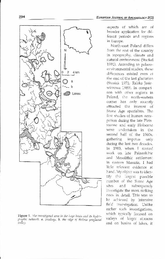
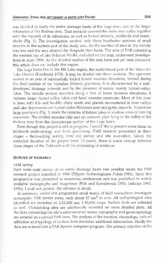
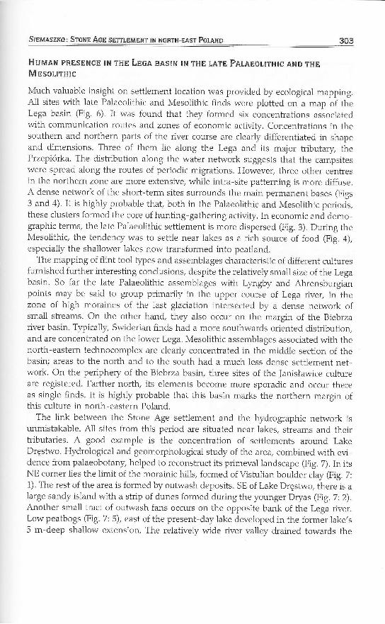
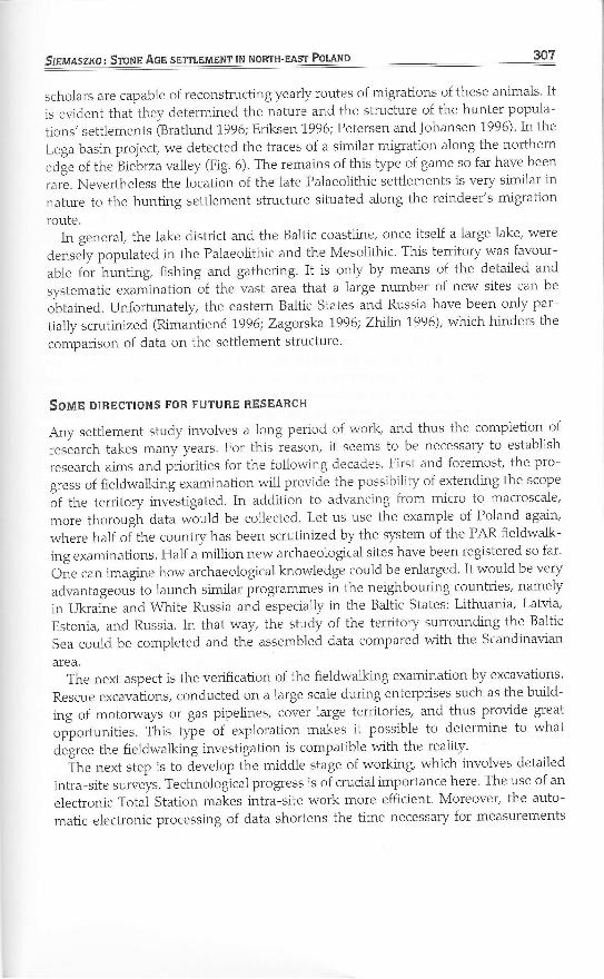
Figure 1. The inuestigated area in the Lega basin and its hydro-graphic netuork: a. peatbogs, b. the edge of Biebrza pro§lacialr.:alley.
aspects of which are o{broader application for dif-feren t periods and regionsin Europe.
North-east Poland differsfrom the rest of the countryin topography, climate andnatural environment (Starkel199I). According to palaeo-environmental studies, thesedifferences existed even atthe end of the lasI glaciation(Stasiak 1971; Ralska-Jasie-wiczowa 1989). In compari-son with other regions inPoland, the north,easterncorner has only recentlyattracted the interest ofStone Age specialists. Thefirst studies of human occu-pation during the 1ate Pleis-tocene and early Holocenewere undertaken in thesecond half of the 1960s,gathering impetus onlyduring the 1ast two decades.In 1,983, when I startedwork on 1ate Palaeolithicand Mesolithic settlementin eastern Masuria, I hadIittle lelevant evidence athand. My object was to iden-tity the largest possiblenumber of the Stone Agesites and subsequentlyinvestigate the most strikingones in detail. This was tobe achieved by intensivefield investigation. Unlikeearlier such investigations,which typically focused onvalleys of larger stTeamsand on basins of lakes, it
N
9?4,Oa--_- b
@t
Slsuaszxo: SroNp Aon sETTIĘMENT lN NoRTH-EAsT Polłt{p 2'95
was decided to study the entire drainage basin of the Lega river, one of the largertributaries of the Biebrza river. That research covered the main river valley togetherwiih the majoriĘ of its tributaries, as well as former streams, peatlands and water-sheds (Fig, 1). The investigation omitted only those headwater sections of smal1
streams in the eastern part of the study area, for the number of sites in the vicinitywas 1ow and ihe area abutted the Rospuda river basin. The area of PAR containingthe western bay of 1ake Selment Wielki, excluded on the map, underrłrent investiga-tions in Apri1 1998. As the detailed studies of the area have not yet been prepared/
this article does not include this region.The Lega basin lies in the Ełk Lake region, the easternmost part of the Masurian
Lake District (Kondracki 1978). It may be divided into three sections. The upstreamsection is an area of substantially folded fronta1 moraine elevations, formed duringthe final stadials of the Vistulian (Wtirm) glaciation. It is characterizedby a well-developed drainage network and by the presence of scarce, mainly tunnel-valley,lakes. The middle section stretches along a line of 1ower moraine elevations; itfeatures larger tunnel-valley 1akes and basa1 moraine reservoirs. Most of this zoneis 1ined with tills and boulder clays; sands and gravels encountered in river valleysand 1ake depressions are buried under Holocene peat and gytija deposits. Numerous1arge peatlands (Fig. 1) mark the remains of former lakes or sha1low arms of existingreselvoirs. The eroded moraine hills and an outwash plain Ęing in the valley of theBiebrza river form the downstream section of the Lega basin.
Even though this project is still in progtess/ I would 1ike to present some ideas onfieldwork methodology and finds processing. Field research proceeded in threestages - fieldwalking survey/ intra-site survey and site excavation. Given theextended duration of the project (over 10 years), there is some overlap betweenthese stages of the fieldwork and the processing of evidence.
OUrLINS OF RESEARCH
Field suraeySuch wide-scale survey of an entire drainage basin was possible under the PARresearch project 1aunched in 1980 (Zdjęcie Archeologiczne Polski 1981). Since thisprogramme was presented at numerous conferences and was published in widelyavailable monographs and magazines (Fish and Kowalewski 1990; Jaskanis 1992,
1,996),I shall not present the scheme in detai1.
In summary under this programme sma1l teams of field researchers investigaterectangular PAR survey areas, each about 37 kmz in area. A11 archaeological sites
identified are recorded on 1:25,000 and 1:10,000 maps. Surface finds are collectedas well. Outstanding sites are additionally recorded on more detailed plots. A11
the data concerning the site's administrative status, topography and geomorphologyare entered on a special PAR form, The analysis of the function, chronology, culturalaffiliation and typology of surface finds furnishes additional information. Finally thedata are entered into a PAR System computer program. The primary objective of the
296 Eunopelv Jounnal or AncnaEoloev 2(3)
l |a
,,lil1,1,1{ ,
a)
ot
a)
ó\ą)
*o
§N§..
|Dd
N
l+
)W,------,-".)/rj
nu,G7,il
ł"-_- -
,r'--- /i//,,ał-lilffi,
i(rII
.uffip/____l \\t\-tt\.-t-t:---_--"'
,-_--_ _ \. "t.
\i-------t
-\ \\\\\\\r
l\\\t127.0 l
N§--,:,,,,-.} ,)-,tzo.so_ _ _n--,"/
§
łI
126.25
\ 125,75_'\
:_l|,. ---\_______
i lt' f'----l! / ,--------*-'i| ,'--,/.i I /"7-"-ir-| { ---,
'i\\ <
\\,\".\\r'. \'. \
i,N\\r\
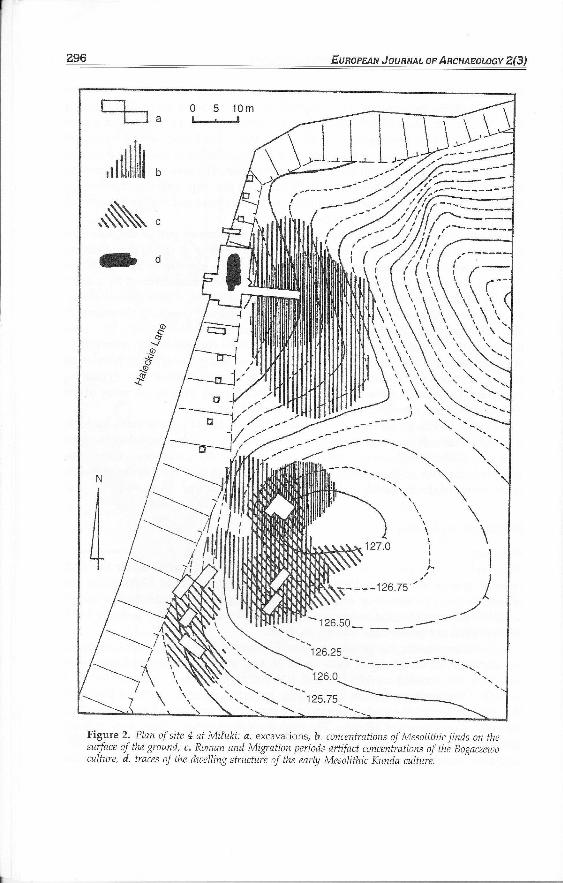
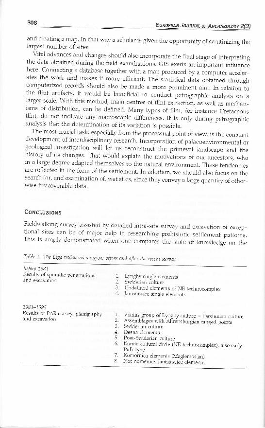
Figure 2. Plan of site 4 ą! Miłuki: a. excavations, b. mncentrations of Mesolithic finds on thesurface of the ground, c. Roman and Migration periods artifuct concenirations of thb Bogaczewoculture, d. traces of the dwelling structure of the earĘ Mesolithic Kunda cultur-e.
Snllaszxoz STONE AGE sETTIEMENT lN NoRTH_EAsT Ponnp ż97
PAR project is a comprehensive registration of the Polish archaeological heritage.The data produced by the project form an invaluable input for the ArchaeologicalHeritage Preservation Serwice (Jaskanis 1996). According to the author, they arealso useful for research into Stone Age settlement. There is no question that ihedata on finds collected from the ground surface have their limitations (Rogge andFul}.er 1,977; Lewarch and O'Brien 1981); nonetheless, the data set provided byfield survey is sufficiently large and robust for statistical analysis. The resultsobtained and combined with cartographic survey may be used for identiĄring settle-ment concentrations and possible migration routes, as well as the modelling of theuses of distinct topographic microregions by hunter,fisher-gatherer populationsduring the late Palaeolithic and Mesoiithic.
In the Lega river drainage basiry a total of over 850 km2 was investigated by fietd-walking, which led to the identification of almost 1100 archaeological sites, datingfrom the late Palaeolithic up to the modern period.
lntra-site suraeysThis stage of fieldwork covered the detailed mapping of surface finds distribution.Ten of the most significant sites in the Lega basin discovered earlier during PARfieldwalking were studied at the intra-site level. The site measurements were carriedout by the grid and point method, knonrr since the 1950s (Kenyon 1952; Zurowski1955). The author and his colleagues have recently modified the method, yieidingvaluable new data for intra-site investigation @itner-Wróblewska et aI. 1996).These methods were also used in planning and carryring out excavation work.
The adopted approach is we11 exemplified by ihe case of the multi-period site 4of Miłuki (Suwałki Province) (Fig. 2). This site, Ęing in the basin of the neighbouringEłk river but only 7 km from the Lega, is Ępical of this area. It was investigated twiceby means of intra-site survey - in 1988 and 1989. In 1988, angular intersection wasused. In fieldwork 1asting 8 hours, 139 points were measured and 263 artifactslocated. In 1989, the polar method was use{ based on the points established bythe first survey. The work lasted 6 hours, with 137 points registered yielding 333finds. The finds distribution was subsequently mapped and superimposed on a con-tour site plan. The data from the analysis of artifact chronology, cultural affillationand period were then added on to the finds distribution. \A/hile originally the distri-bution of all finds (Stone Age to post-Medieval) recovered at Miłuki was mapped,partitive analysis was subsequently used to generate a site plan which wouldshow only concentrations of artifacts dated to the Stone and Bronze Age, Romanand Migration periods. Those periods were of particular interest to the researchteam.
The Miłuki site 4 was subsequently excavated (1989-1995), with trench locationguided by the results of the intra-site survey. The principal objects of explorationwere the Stone Age and Roman-period archaeological features. In genera| excava-tion confirmed the findings of the intra-site survey. Trenches located on the beachslope close to the largest concentration of the Stone Age artifacts proved to be of the
z98 Eunopnau Jouayu, or AncruaBoloev 2(3)
most interest. They revealed the well-preserved multi,period remains suggested bythe survey. Finds included finely preserved organic materials and a uniform flintinventory of the Kunda culture discovered inside the remains of a dwelling-structure(Fig. 2d) dated to the end of the Preboreal period. V\4rile the value of the intra-site survey has been confirmed on many other sites, it obviously cannot replaceexcavations.
site excaaątionEight sites in the Lega basin were excavated during the project, furnishing a remark-able body of evidence (Siemaszko 1991). Since the fundamenta1 ob;'ective of the pro-ject was to identify the cultural situation and provide information about long-termchanges in settlement in a poorly examined area, the excavation sites were chosento reflect both ecological and chronological diversity. Two of them were largemulti,period sites (Puchówka 9 and 10). Since they were located at particularlyfavourable places, a succession of short-term camps were occupied over a periodof thousands of years - often overlapping one another. In modern times, theyhave been destroyed to a 1arge degree by ploughing, which made the chrono-1ogical cultura1 interpretation of such mixed inventories extremely difficult. For thatreason/ subsequent excavations focused on smaller sites featuring the remains ofmoderately extensive settlements (Skomętno 11, Dręstwo 9 and 35, Stacze 6), as
wel1 as of a flint workshop (Lenar§ 5) and a sma1l Stone Age cemetery @ręstwo10). The results have proved extremely interesting and the finds are currentlyunder thorough examination as a part of the author's doctoral thesis.
Processing of eaidenceOut of 1086 archaeological sites identified by fieldwalking ln the Lega bastn, 748contained lithic finds. Based on the §pology and technological features of flintinventories, it was possible to distingrrish 840 episodes of occupation: campsites,settlements or traces of human occupation. The 1atter category includes very smallassemblages or isolated finds, presumably traces of brief stops, and accounts forover 80 per cent of all the identified settlement sites. Further investigation isneeded to determine whether the settlement sites in this group are mainly intactsites containing artifacts stil1 buried urrder humus or sites damaged by post-medievalcuitivation. At ihe beginning of the sixteenth century the territory in question wasintensively cultivate{ excavation carried out on the sandy sites fully confirmeddestruction ofpotential occupation features byploughing and erosion. Other factors,such as ground surface visibility, may also have affected the number of findsrecovered during fieldwalking, The importance of this factor has been tested statis-tically: in only 32 pet cent of cases, the scantiness of artifacts found during investi-gations has resulted from poor surface visibility, The remaining sites appear to belargeiy undisturbed, producing either a small number of buried finds or traces of abrief human presence. From the point of view of the settlement study, this is a
very important conclusion. Almost 70 per cent of the single finds and the small
Slpuaszxo: SrollB Acn sETTIEMENT IN NoRTH_EAsT PoLłtlp z99
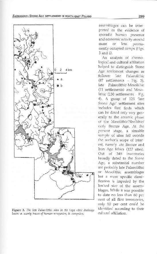
Figure 3, The late Palaeolithic sites in the Lega riaer drainagebasin: a. scanty trąces of human occupation, b. campsites.
assemblages Can be inter-preted as the evidence ofSporadic human preSenceand economic activiĘ aroundmore or less perma-nently occupied camps (Figs.3 and 4).
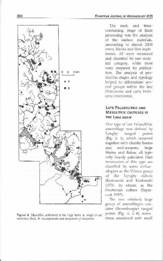
An analysis of chrono-logrcal and cultural affiliationhelped to distinguish StoneAge settlement changes asfollows: late Palaeolithic(87 settlements - Fig, 3),late Palaeolithic-Mesolithic(11 settlements) and Meso,lithic (130 settlements - Fig.4). A group of 125 'lateStone Age' settlement sitesincludes flint finds whichcan be dated only very gen-erally to the ceramic phaseof the MesolithiciNeolithic/early Bronze Age. At thepresent stage, a sizeablesample of sites fell outsidethe author's scope of inter,est, namely late Bronze andIron Age lithics (127 sites).Out of 348 inventoriesbroadly dated to the StoneAge, a substantial numberare probably late Palaeolithicof Mesolithic assemblagesbut a more specific classi-fication is impeded by ihelimited size of the assem-blages. While it was possibleto date no less than 60 percent of all flint inventories,only 10 per cent could beidentified according to theircultural affiliation.
0 2 4km
300 Eunopnau JounNAL oF ARcHAEoloev 2(3)
The next, and time-consuming, stage of findsprocessing was the analysisof the surface materials,amounting to almost 2000cores, blanks and flint imple-ments, A11 were measuredand classified by raw mate-rial category, while mostwere prepaled for publica-tion. The anaĘis of pro-duction stages and §pologyhelped to differentiate sev-eral groups within the latePleistocene and eaĄ Ho1o-cene inventories.
Larp PłnpotITHIc ANDMpsollrnlc cUtTUREs lNTHE LECA BASIN
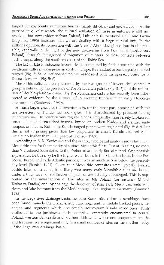
One §pe of 1ate Palaeolithicassemblage was defined byLyngby tanged points(Fig. 5: 1), which occurredtogether with chunky burinsand end-scrapers, Iargeblades and flakes, all typi-cally heavily patinated. Flintinventories of this Ępe areclassified by some archae-o1ogists as the Vilnius groupof the Ly.gby culture(Kozłowski and Kozłowski1,979), by others, as thePerstunian culture (Srirm-czak 1987).
The next relatively 1arge
group of assemblages con-tains Ahrensburgian tangedpoints (Fig. 5: 2-4), some-times associated with small
o 2 4km
Figure 4. Mesolithic settlement in the Lega basin: a. single or notnumerous finds, b. encampments and complexes of campsites.
Srcu,a,szxo: Sronn Ace sETTLEMENT IN NoRTH-EAsT Potłtlo
ianged Lpgby points, numerous burins (mainly dihedral) and end-scrapers. At thepresent stage of research, the cultural affiliation of these inventories is still unresolved, but new evidence from Poland, Lithuania (Rimantienó 1996) and Latvia(Zagorska 1996) indicates that we are dealing with a large cultural unit. In theauthor's opinion, its connection with the 'classic'Ahrensburgian culture is also pos-sible, especially in the light of the new discoveries from Pomerania (north,westPoland), through the agency of migration of hunters, or close contacts betweensuch groups, along the southern coast of the Baltic Sea,
The list of 1ate Pleistocene inventories is completed by finds associated with theSwiderian culture, widespread in central Europe. Its standard assemblages containedtanged (Fig. 5: 5) or leaf-shaped points, associated with the sporadic presence ofDesna elements (Fig. 5: 6).
Mesolithic cultures are represented by the two groups of inventories. A smallergroup is defined by the presence of Post-Swiderian points (Fig. 5: 7) and the utiliza-tion of double-platform cores. The Post-Swiderian culture has recently been inter,preted as evidence for the surwival of Palaeolithic hunters in an early Holoceneenvironment (Kozłowski 1989).
A much larger group of the inventories is, for the most part, associated with thenorth-eastern, or Kunda, technocomplex. It is characterized by pressure-flakingtechniques used to produce very regu,lar blades, frequently transversely broken forunretouched and retouched inserts, burins on broken blades and slender end-scrapers on blades. Not many Kunda tanged points were registered (Fig. 5: 8-9) butthis is not surprising given their low proportion in classic Kunda assemblages -usually no higher than 1-15 percent (Koltsov 1989).
According to S. K. Kozłowski and the author, §pological analysis indicates a laterMesolithic date for the majority of surface Mesolithic flints. Out of 130 sites, no morethan 7 produced tools dated to the Preboreai and early Boreal period. One possibleexplanation for this may be the higher water ievels in the Masurian lakes. In the Preboreal, Boreal and early Atlantic periods, it was as much as 5 m below the present-day level (Stasiak 1971), Given that Mesolithic campsites were typically locatedbeside lakes or streams, it is Iikely that many early Mesolithic sites are buriedunder a thick layer of solifluxion or peat, or are actually submerged. This is sup-ported by the investigation of five sites in NE Poland (for instance Miłuki,TŁokowo, Dudka) and, by analogy, the discovery of stray early Mesolithic finds fromrivers and lake bottoms from the Mecklenburg Lake Region in Germany (Gramsch1983).
In the Lega river drainage basin, no pure Komornica culture assemblages havebeen found, namely the characteristic Stawinoga and lanceolate backed pieces, tri-angles, and segments which occasionally accompany Kunda inventories. Flintsattributed to the Janisławice technocomplex commonly encountered in centralPoland, western Belorussia and southern Lithuanią with cores, scrapers/ microlithsand trapezes, were registered only in a small number of sites on the southern edgeof the Lega river drainage basin.
301
Eunopaaru Jouanal, or Anałaaoroev 2(3)3oz,
N,r\E\rlL. l
b}Ęc
h
o
/--],/ę\
ffi&il *8
U-,",#Bt§l LF,\
ćĘHF§\
w
nJllIll(lti
rlF\
=ll(?łFlż-vę§
W
Figure 1 langed points as an example of cultural differentiahon of the inaestigated area duńngthe late Palaeolithic and Mesolithic: 1. Lyngby tanged point, Rajgród 25; 24. Ahrensburgiańpoints (2, Sedranki 14; 3. Golubki 3, 4. Puchówka 9-:L0); 5. Swiderian tanged point, Tajenko1;6.,Desna point, Nowe Raczki 3;7, post-Suiderian leaf-shaped point, Słożne 6;8. EarlyKunda tanged point of the Pulli type, Stacze 6; 9. Kunda leaf-shaped point, Puchóuka g-10.
r1
I7
Slrmnszxo: Srorvp ^Acp sETTIEMENT |N NoRTH-EAsT Potłnp 303
Huułlv pREsENcE lN TtiE LBoł słsIr,J lN THE IATE PALAEotITHlc AND THEMssoLlrHtc
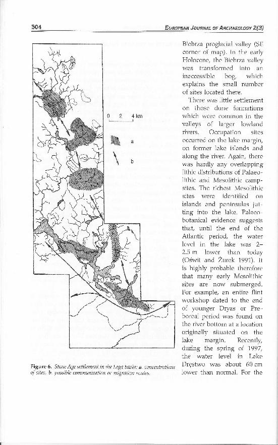
Much valuable insight on settlement location was provided by ecological mapping.A11 sites with 1ate Palaeolithic and Mesolithic finds were plotted on a map of theLega basin (Fig. 6). It was found that they formed six concentrations associatedwith communication routes and zones of economic activiĘ. Concentrations in thesouthern and northern parts of the river course are cleaĄ differentiated in shapeand dimensions. Three of them lie along the Lega and its major tributary thePruepiórka. The distribution along the water network suggests that the campsiteswere spread along the routes of periodic migrations. Howeve1 three other centresin the northern zone are more extensive, while intra,site patterning is more diffuse.A dense network of the short-term sites surrounds the main permanent bases (Figs3 and 4). It is highly probable that, both in the Palaeolithic and Mesolithic periods,these clusters formed the core of hunting-gathering actMĘ. In economic and demo-graphic terms, the late Palaeolithic settlement is more dispersed (Fig. 3). During theMesolithic, the tendenry was to settle near lakes as a rich source of food (Fig. 4),especially the shallower 1akes now transformed into peatland.
The mapping of flint too1 §pes and assemblages characteristic of different culturesfurnished further interesting conclusions, despite the relatively small size of the Legabasin. So far the 1ate Palaeolithic assemblages with Lyngby and Ahrensburgianpoints may be said to group primarily in the upper course of Lega river, in thezone of high moraines of the 1ast glaciation intersected by a dense network ofsmal1 streams. On the other hand" they also occur on the margin of the Blebrzariver basin. Typically, Swiderian finds had a mofe southwards oriented distribution,and are concentrated on the lower Lega. Mesolithic assemblages associated with thenorth-eastern technocomplex are clearly concentrated in the middle sectlon of thebasin; areas to the north and to the south had a much less dense settlement net,work. On the periphery of the Biebrza basin, three sites of the Janisławice cultureare registered. Farther north, its elements become more sporadic and occur thereas single finds, It is highly probable that this basin marks the northern margin ofthis culture in north-eastern Poland.
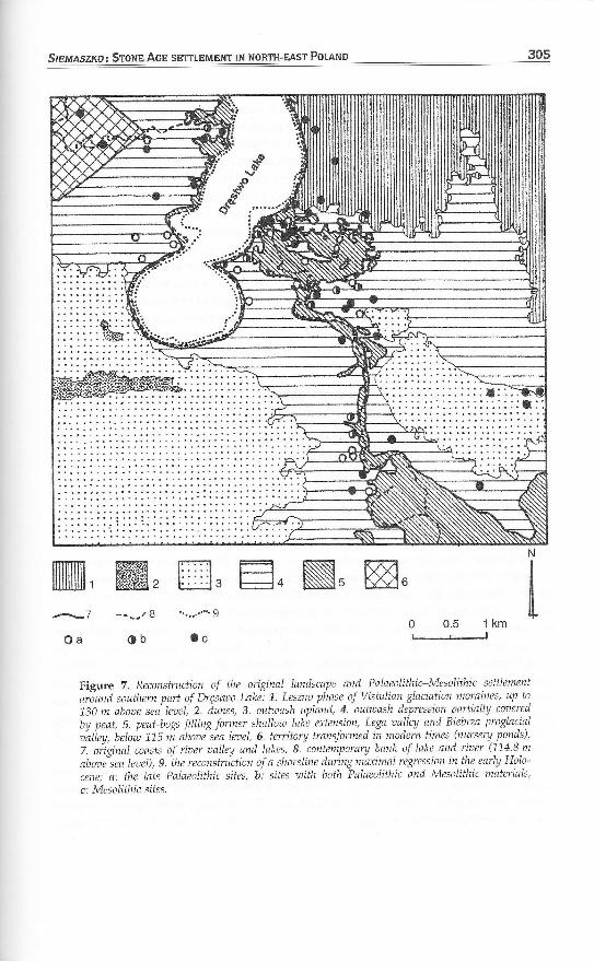
The 1ink between the Stone Age settlement and the hydrographic network isunmistakable. A11 sites from this period are situated near lakes, streams and theirtributaries, A good example is the concentration of settlements around LakeDręstwo. Hydrologrcal and geomorphological study of the area, combined with evi-dence from palaeobotany, helped to reconstruct its primeval landscape (Fig. 7). In itsNE corner lies the lim jt of the morainic hills, formed of Vistulian boulder clay (Fig.7:1). The rest of the area is formed by outwash deposits. SE of Lake Dręstwo, there is alarge sandy island with a strip of dunes formed during the younger Dryas (Fig. 7: 2).Another smail tract of outwash fans occurs on the opposite bank of the Lega river.Low peatbogs (Fig. 7: 5), east of the present-day lake developed in the former lake's5 m-deep shallow extension. The relatively wide river valley drained towards the
304 EunopBau JouRNAL oF ARcHAaoroey 2(3I
Biebrza proglacial valley (SEcorner of map). In the earlyF{olocene, the Biebrza valleywas transformed intcl aninaccessible bog, whichexplains the smal1 numberof sites located there.
There was 1ittle settlementon those dune formationswhich were common in thevalleys of larger lowlandrivers. Occupation sitesoccurred on the lake margin,on former 1ake islands andalong the river. Again, therewas hardly any overlappinglithic distributions of Palaeo-lithic and l\4esolithic camp-sites. The richest Mesolithicsites were identified onislands and peninsulas jut-ting into the lake. Palaeo-botanical evidence suggeststhat, unti1 the end of theAtlantic period, the water1evel in the 1ake was 2-2.5 m 1ower than today(Cświt and Zurek 1991). his highly probable thereforethat many early Mesolithicsites are now submerged.For example, an entire flintworkshop dated to the endof younger Dryas or Pre-boreal period was found onthe river bottom at a 1ocationoriginally situated on thelake margin. Recently,during the spring of 1997,the water level in LakeDręstwo was about 60 cmlower than normal. For the
0 2 4km
\\
Figure 6. Stone Age settlement in the Lega basin: ą. concentrationsof sites, b, possible communication or migration routes.
StBl,MszI<o: SroruB Aon sETTLEMENT IN NoRTH-EAST Polłt,lp
mm, m, m. E. N, m.
Figure 7. Reconstruction of the ońgnal landscape and Palaeolithic-Mesolithic settle-ment
aróund southem part of Dręstwo Lake: 1. Leszno phase of Vistulian,glaciation mom,ines, up to
130 m abooe sea' lez:eli 2. dunes, 3, ouhaash upland, 4. oufaash depression parfialĘ coaered
by peat, 5, peat-bogs filling fotmer shallow ląke extension, I-ega aalley and Biebrza proglacial
łaliey, belń ll5 ń ibooe"sba leael, 6. tetitory transfotmed in modem times (nursery ponds),
z. oiginal coasts of rirser aalley and lakes, 8. ,contemporary bank of lake. and ńaer (1,14.8 m
abore"sea leael), 9. the reconsttuction of a shoreline duńng ma-timal regression in the early Holo-
cene; a: the late Palaeolithic sites, b: sites with both Palaeolithic and Mesolithic materials,
c: Mesolithic sites.
*-_7 .--_.ł$
Oa Ob
.. .,.. o
Jc0 0,5 1km
author and his colleague, J. Brzozowski, it was an excellent opportunity to investi-g,ate the exposed part of the ]ake beds. As a result of the slrvey, two new sitesdated to the Stone Age were discovered and the submerged continuation was recog,nized of another one, previously noted on the bank of ńe lake, near the outflow ofthe river. This evidence strongly supports the submerged settlement hypothesis.
The late Pa]aeolithic sites are more frequent along the Lega valley and around thesouthern bay of the lake, definitely higher than Mesolithic ones. Moraine and out-wash heights were carefully avoided, Within the Biebrza valley, there is also a lack ofPalaeolithic settlement (Fig. 3). It suggests that, at the end of the Pleistocene/ com-munication by land was preferred. It explains also the 1ow quantiĘ of sites dated tothis period on the middle course of the Lega river. They u." *o.ó numerous alongthe valleYs of smalier tributaries in the eastern part of thó basin, forming the shortesiway to the north. It appears that penetration of the edge of the moraine upland andthe outwash plain on the peĘhery of the Biebrzu .iń basin was equalĘ intensivein both periods. This is because the area formed an attractive communication routeand lay in the zone of migration of larger mammals such as reindeer and elk.
TXB LBCł RESEARCH PROJECT IN COMPARISON TO THE SETTIEMENT STUD'ESIN THE Eunopełn LoWIAND
As I stressed in the introduction of this article, this pro;'ect of the studies on thePalaeolithic and Mesolithic settlements in the Lega river diainage basin has a micro_regional scope and a loca1 character. I concenirated my efńrt on detailing thisresearcĘ which appeared to be beneficial in determining to what extent the field-walking examination allows us to draw any conclusions. Ńevertheless, it is temptingto confront the results and the aims of the research with the achievements in theother parts of the European 1owland.
_ The Meuse Valley Project (łVansleeben and Verhar t 1990) has a very similar poliry.It is significant that the Meuse team and our own/ although workingindepenłentl/,employ the same methods and reached the same conclusions. Tńat is a positiveaspect, which grves the opporLuniĘ to evaluate the choice of the methods engagedin the studies. The Dutch schoiars incorporated the quantitative method incartography. Their project, however, considered subsequent periods, such as theMesolithic and the Neolithic, highlighting the period of neollthization. Neolithiza,tion is of major importance in the Lega drainage basin, but in a very dif{erentsense. In contrast to the Dutch case, the transformation of the economy tookPlace much later. The populations inhabiting this area continued in hunting, fishing,and gathering, esPecially since the natura] environment was more conducive to thisform of economy than to agriculture.
A comparison of the landscape, environment, and the form of the settlementin the late pleistocene and the late Holocene shows how much poland resemblesscandinavia and the northern part of Germany. The strategy of settlement locationfrom the ]ate Palaeolithic onwards was based on hunting r"ńd"".. The Scandinavian
SrEMAszl{o, SToNE AcE sEmL
scholars are capable of reconstruciing yearly routes of migrations of these animals. It
is evident that they determined the nature and the structure of the hunter popula-
tions' settlements (Bratlun d1996; Eriksen 1996; Petersen and Johansen 1996). In the
Lega basin project, we detected the traces of a similar migration along the northern
edle of the bletrza valley (Fig. 6). The remains of this Ępe of game so far have been
rari. Nevertheless the 1ocation of the 1ate Palaeolithic settiements is very similar in
nature to the hunting settlement structure situated along the reindeer's migration
route.In general, the 1ake district and the Baltic coastline/ once itself a large lake, were
denseĘ populated in the Palaeolithic and the Mesolithic, This territory was favour-
able fór-hunting, fishing and gathering. It is only by means of the detailed and
systematic examination of the vast area that a large number of new sites can be
oitained. Unfortunately, the eastern Baltic States and Russia have been only Par,tially scrutinized (Rimanti enó 1,996; Zagorska 1,996; Zhllin 1996), which hinders the
comparison of data on the settlement structure.
SOUn OIRBCTIONS FOR FUTURE RESEARCH
Any settlement study involves a long period of worŁ and thus the completion of
research takes many years. For this reason, it seems to be necessary to establish
research aims and priorities for the following decades. First and foremost, the Pro-gtess of fieldwalking examination wil1 provide the possibiiity of extending the scope
Óf the territory investigated. in addition to advancing from micro to macroscale,
more thorough data would be collected. Let us use the example of Poland again,
where half of the country has been scrutinized by the system of the PAR fieldwalk-
ing examinations, Half a mlllion new archaeo1ogcal sites have been registered so far.
oie cun imagine how archaeological knowledge could be eniarged. It would be very
advantageoui to launch similar proglammes in the neighbouring countries, namely
in Ukraine and \Vhite Russia and especially in the Baltic States: Lithuanią LaMąEstonia, and Russia. In that way, the study of the territory Surrounding the Baltic
Sea could be completed and the assembled data compared With the Scandinavian
area.The next aspect is the verification of the fieldwalking examination by excavations.
Rescue excavations, conducted on a large scale during enterprises such as the build-
ing of motorways or gas pipelines, cover 1arge territories, and thus provide great
op"portunities. This Ępe of exploration makes it possible to determine to what
degree the fieldwalking investigation is compatible with the realiĘ.
ihe next step is to develop the middle stage of working, which involves detailed
intra-site surveys. Technological progress is of crucial importance here. The use of an
electronic Total station makes intra-site work more efficient. Moreover, the auto-
matic electronic processing of data shortens the time necessary for meąsurements
and creating a map. In that way a scholar is given the opportunity of scrutinizing thelargest number of sites.
vital advances and changes should also incorporate the final stage of interpretingthe data obtained during the field examinations, GIS exerts an imiortant influencehere. connecting a database together with a map produced by a computer acceler-ates the work and makes it more efficient. Thó statistical data obtained throughcomputerized records should also be made a more prominent aim. In relation tothe flint artifacts, it would be beneficial to conduci petrographic analysis on alarger scale. with this method, main centres of flint extiactiń, as weli as mechan_isms of distribution, can be defined. Many §pes of flint, for instance cretaceousflint, do not indicate any macroscopic diiferences. It is only during petrographicanalysis that the determination of its variation is possible.
The most crucial tasĘ especially from the processual point of view, is the constantdeveloPment of interdisciplinary research. Incorporation of palaeoenvironmental or8eologrcal investigation will let us reconstruci the primwal landscape and thehistory of its changes. That would explain the motivations of our ancestors, whoin a large degree adapted themselves to the naturai environment. These tendenciesare reflected in the form of the settlement. In additiory we should also focus on thesearch foł and examination of, wet sites, since they convey a large quantity of other,wise irrecoverabie data.
Cor.lcLusIo1,1s
Fieldwalking survey assisted by detailed intra-site survey and excavation of excep-tional sites can be of major heip in researching prehiitoric settlement patterns.This is amply demonstrated when one compares the state of knowledgó on the
Table 1. The Lega oalley microregion: before and after the recent surley
19B3,1995Results of PAR surwey, planigraphyand excavat]on
Before 1983Results of sporadic penekationsand excavation
1 Lyrgby single elements2. Swiderian culture3. Undefined elements of NE technocomplex4. Janisławice single elements
1. Vilnius group of Lyngby culture = Persfunian culture2 Assemblages wjth Ahrensburgian tanged poinls3. Swiderian culture4. Desna elements5. Post-Swiderian culture6. Kunda culfural circle §E technocomplex), also eaĄ
Pulli type7. Komornicaelements (Magiemosian)8. Not numerous Janisławicó elements
§lxu,ąszxo: SroNn Ace sETTLEMENT lN NoRTH-EAsT PoLłtlo
_ate Palaeolithic and Mesolithic archaeological cultures in north-east Poland prior to
:nd following the investigation of the Lega basin outlined in the present paper
Table 1). I believe that these methods of investigation are also suitable for settle-
:nent research of later prehistory in different countries,
AcrHowl,ppGEMENTs
Ii is difficult to mention all the people taking part in the investigation works. I am
greatly indebted to all of them, particularly to lerzy Btzozowski and KrzysztofTerepko, without whose assistance I should not have been able to carry out such
large-scale field investigations, and to Professor Stefan Karo1 KozŁowski, project
consultant. I should also like cordially to thank the Editorial Board of the |oumalcf European Archaeology, who found my paPer (given in Riga in 1996) of general
interest.
RPPPRPtJCSS
Brnqen-Wnonrpwsxł, ANNĄ ]nnzv Bnzozowsxl and Jnnzv SIEt"łłszro, 1996. Nowemozliwości rłykorzystania metody planigraficznej w badaniach archeo,1ogicznych. Archeologia P olski 41, (1-2) :7 18.
Bnanu,ln, Boot, 1996, Archaeozoological comments on final Palaeolithic frontiers insouth Scandinaia. Acta Archaeologica Lundensia, Series in Bo (ż4):23-33.
EnrrsnN, BBnrr VłlpmN, 1996. Regiona1 variation in late Pleistocene subsistencestrategies. Southern Scandinavian reindeer hunters in a European context.Acta Archaeologica Lundensia, Series in Bo (24):7-21.
FIsĘ SuzaNNE K. and SrpprłBN A, Kowłrgwsrc (eds), !990. The Archaeology of Regions:
a Case for Full-coaerage Sut,uey. Washington, DC/London: Smithsonian Institu,tion Press.
GnauscH, BnnNnar<o, 1983. Bemerkungen Zur Palókologie und zur Besidlungwdhrend des ;'l.ingeren Boreals und des ólteren Atlantikums im nórdlichenMitteleuropa. In Janusz K. Kozłowski and Stefan K. Kozłowski (eds), Les
changemenis, leurs mćcanismes, leurs causes dans la culture du 7e au 6e millĆnaireaa, 1-ę. en Europe. Archaeologia Interregionalis 263*270, Warszawa: Wydaw-nictwa Uniwers}tetu Warszawskiego.
JA5KANI5, DerrrrrĄ 1992. Polish Nationa] Record of Archaeological Sites - genera1 out,line. In Carsten U. Larsen (ed.), Slfes and Monuments, National ArchaeologicalRecords:81-87. Copenhagen: Nationa1 Museum of Denmark,
JesxaNIs, Dax-urł (ed.), 1,996. Archeologicme Zdjęcie Polski - metoda i doŚu:iadczenia.
Próba oceny, (Polish Archaeologcal Record - Method and Experiences. An Attempted
Assessmeni). Biblioteka Muzealnictwa i Ochrony Zabytków Series B vo1. 95.
Warszawa: Ośrodek Dokumentacji ZabYków -
KEtlyoN, KATHLEEN M., 1,952. Beginning in Archaeology. London: Phoenix Flouse.Kolrsov, L. V, (ed.), 1989. Mezolit SSSR. Moskva: Izdatelstvo Nauka.KoNonacru, lnazu, 1,978. Geografa fizyczna Polski. \Ęatszawa: Państwowe Wydaw,
nictwo Naukowe.
309
31O er*r*- lrrrr*rr*Kozł,ows<l, Jal"usz K. and SrsrAN K. Kozł.ows<r, 1,979. Llpper Palaeolithic and Meso-
lithic in Europe. Taxonomy ąnd Palaeohisto,ry. Polska Atademia Nauk - oddziŃw krakowie. prace komisji Archeologicznej 1B. wrocław/warszawalkrakówlGdańsk: Ossolineum.
Kozrowslc, SrpraN K. (ed.), 1989, Mesolithic in Poląnd. A New Approach. Warszawa:_ Wydav,nictwaUniwersytetuWarszawskiego.Luwancry D. E. and M. J. o'nrunN, 1981. The ex|anding role of surface assemblages in^ , archaeologrcal research. Adrlances ił,t Archabologicń Mrtho,l and, Theory 4:29i_g42,ośrwr, JaN and Sł.łwolłtR Zuo.''r, 7997. Genezi t rozwój w holocenió torfowiska
Y9?"u^Wieś (rejon .st1lorlrsk_a_archeologicznego). In Elżbieta KempisĘ and
Zofia Sulgostowska (eds) Osadni_cfu,uo patńtityńe,' mezoliĘczne i paraieolityczne_ w rejonte Woznej Wsi, w!. łomżyńskie: 105-11-0. Warszawai Semper.PnrensrN, PETER VANG and Lrxr. JorraxsrN, 1996. Tracking 1ate glacia1 reindeer
hunters in eastern Denmark. Acta Archaeologica Luidenslc," Series in Bo(ż4):75-BB.
Rłrsxł-}łsmwrczowl/ Mecoł-nN4 1989. History of Po]and's vegetation cover andclimate in the early.Ho]ocene (up to 7000 BC). In Stefan i. Kozłowski (ed.),Mesolithic in Poland. Ą New Approach: 227-241. Warszawa: WydarłłrictwaUniwersletu Warszawskiego.
RrMaNrrsN-E, RIMrnt, 1,996. Akmens amżius Lietuaoje. Vilnius: Żlburio leidykla.Roccs, A. E. and S. L, Furną 1977. Probabllisticiurvey sampling: makińg parameter
estimates. In M. B. Schiffer and G. J. Gumerman (ed), ćonńroationAichaeology:Guide to Cultural Resource Management Studies: 227-238. New York.
Sinueszro, lynzu, 1991. Archeologiczne badania wykopaliskowe w woj. suwalskim wlatach 1981-1989. Rocznik Suwalsko Mazurćki
-t'5z-.B9. Suwui,ki, Suwałskie
Towarzystwo Kultury.Sreł5Er, Leszur (ed.),
.1,991. Geografia Polski. środowisko przyrodnicze. Warszawa:Wydawnictwo Naukowe PlĄN.
Stłsux, Jłowrca, 1971. Holncen Polski północno-wschodniej. Disseńationes Llnhsersi-tatis Varsoaiensis 47. Vllarszawa.
Szyvczax, Kanor-, 1987. Perstunian culture - the eastern equivalent of the Lyngbyculture in the Neman basin. In Jan M. Burdukiewicz u.,d Mi.h^ł Kobusiewicz(eds), Late Glacial in Central Europe. Culfure and Enaironment. WrocławlWarszawa/KrakódGdańsk/Łódź: Ossolineum.
WaNsrEnnEN, Mnco and Lno B. M. VErułłq 1990. Meuse Valley Project: the transi-tion from the Mesolithic to the Neolithic in the Dutch Meusó Vafey. In Pierre M.Vermeersch and Philip Van Peer (eds), Contributions to the Mesolithic in Europe:389-402. Leuven: Leuven Universitv Press.
Złconsxa, Itc4 1,996. The 1ate Pa]aeoliihic finds in the Daugava RiverValley. AcfaArchaeologica Lundensia, Series in 8o (24):263-272.
ZDlĘcIE Ancneotoctczlu-s Pors<r, 1981. Biblioteka Muzealnictwa i ochrony Zabytków,Series B 66.Warszawa: Ośrodek Dokumentacji Zabytków.
ZHILnN, MIKT]A]L G., 1996_. The westernpart of Russia in the late Palaeolithic - earlyMesolithic. Acta Archaeologica Lundbnsia, Series in Bo (24):273-284.
Zunowsxi, TłoEusz, 1955'. Pomiar ur.h"o1ogi."rlycn .turlo*irk r,uri.ń"}.n. światowit21:350-378.
Srcuaszxo: SronB Aop sETTLEMENT IN NoRTH-EAsT Pounp 311
BlocnłpgIcłt NoTE
Ierzy siemaszko is a senior curator and head of the Archaeologica1 section at theSulvałki Province Museum. From 1995 to 1998 he has been leader of the inter-lational Miłuki project, an interdisciplinary social and environmental study of
the early Mesolithic campsite of the Kunda culture (which has now been preparedlor publication). His main research interests are the Palaeolithic and Mesolithic,especially of north-eastern Europe, also methodology. He is author and co-authoroi many articles on the Stone Age in Poland and methodological aspects of thenvestigation.
Ąddress: Muzeum Okręgowe w Suwałkach, ul. Kościuszki 81, PL 16-400 Suwałki,Poland [email: [email protected] or [email protected]]
Aestnłcrsńtude d'une occupation de l'Age de la Pierre dans le bassin de la Lega (Pologne du nold-est)en tant qu'exemple de l'ćtude de sites archóologiques i l'óchelle microrógionale
|erzlł Siemaszko
Pendant quatorze ans et sous 1'ógide du Projet de Recherches Archóologiques Polonais, l'auteur a
dirige l'exploration de la totalitó du bassin de 1a rividre Lega (Pologne du nord-est), une rógionde quelques 850 km2. Cette rógion jusqu'ici peu connue a revelć prds de 1100 sites archóologiquesdoni ząg ont 1iwó du materiel lithique. Les sites 1es plus intóressants ont tout d'abord ÓiĆ ÓtudiÓs aumoyen de plans dótaillós de 1a distribution du materiel de surface et ensuite par des fouilles. L'Ćtudede ia totaliió du bassin hydrographique a ótó trós importante pour les recherches sur 1a distributiondes sites. Le grand nombre de sites 1ithiques de surface a permis des analyses statistiques dignes deconfiance aińsi qu'une ótude cartographique prócise qui confirme les róconstructions du palóo-environnement. Les assemblages lithiques ont ótó ótudiós du point de łue §pologque ainsi que
de 1a technique de production utilisóe, permettant ainsi de clarifier 1eur relation chronologique et
culturelle aui inventaires de silex de la Pologne du nord est ainsi qu') ceux des pays limitrophes,mais qui dóbouche sur de nouvelles questions. On a pu observer des changements dans 1a
iocalisition prófórentielle des sites du Epipalóolithique superieur et de Mósolithique dans 1a zonedes iacs de la dernióre glaciation et des bassins adjacents au sud. Un tota1 de 6 concentrations de
sites avec routes de communication et zones d'activitós óconomique ont Ótó dócouvertes.
Die Untersuchung der steinzeitlichen Besiedlung im Lega Becken (Nordostpolen) als einBeispiel fur kleinriiumige Siedlungsuntersuchung
Jerzy Siemaszko
Uber einen Zeitraum von vierzehn Jahren und als Tei1 des polnischen ArchAologie-AufnahmeForschungsprojekts, 1eitete Verfasser eine Feldbegehung des gesamten Lega Flussbeckens (Nordost-polen) _ ein Ćebiet von riber 850 km2. Fast 1100 archdologische Fundstellen, von denen 748
iithisches Material erbrachten wurden als Ergebnis der Begehung dieses bisher schlecht unter-suchten Gebietes entdeckt. Die interessantesten Fundstellen wurden anfAnglich durch genaueAufnahme der Fundverteilung an der Oberfliiche und spżiter durch Ausgrabung untersucht.
Eine vollstżindige Untersuchung der gesamien Entwasserungsbeckens war auSserst wichtig fur ,Jie
Siedlungsuntersuihung. Die grosse Anzahl der lithischen Oberflżichenfundkomplexe ermóglicht

31' er^"r^- l"r**",ver]Żissiiche statistische Analysen und genaue kartographische Sfudien untersttitzt durch palżiobota-nische Umweltrekonstruktionen, Die liihischen Funókómplexe wurden vom produktionstechnischenund §Pologischen Gesichtspunkt aus analysiert, wobei einige Zweifel an cńronologisch-kulturellenverwandtschaften von Flintiriventalen aui dem nordostlicien polen und benacńbarten Liinclernbeseitigt werden kónnten, sich aber auch neue Fragen ergaben. Es wurde -ogli"h klare Vorliebenim Siedlungsverhalten aber.auch Anderungen desielben"wżihrend des spatefi palao- und Meso-lithikums im,Gebiet, der speitglazialen Seeń und ńren angrenzenden a,isg"waschenen Gebietenlm Suden zu beobachten. Sechs Konzentrationen von Fund-platzen die mit kommunikationswegenund Gebieten wirtschaftlicher Aktińtzit verbunden waren, ńrden entdeckt.