Embed Size (px)
Citation preview

Draft Report on Environmental Impact Assessment
& Environment Management Plan
Building Stone & M-Sand Quarry 12-00 Acres (4.856 Ha.) of Patta Land
Sy. No. 8/3, 8/6, 4/1, 4/2, 4/11, 4/3, Vajrabanadi Village Yelburga Taluk, Koppal District
Karnataka, INDIA (Monitoring Period Jan. 2022-Mar. 2022)
Proponent Sri Sairama Stone Crushers
Consultant: Mr. Ashwath Narayan M S Envipro Solutions Pvt. Ltd.
Second Floor, Sy. No. 63/4, Site No. 5 P & T Layout Road, Ashwath Nagar Sri Gandhada Kavalu, Sunkadakatte Off Magadi Road, Bengaluru–560 091
March 2022

Sri Sairama
Stone Crushers
Draft EIA/ EMP Report for the Proposed Building Stone and M-Sand Quarry in an Extent of 12-00 Acres (4.856 Ha.) of Patta
Land in Sy. No. 8/3, 8/6, 4/1, 4/2, 4/11, 4/3 of Vajrabanadi village Yelburga Taluk, Koppal District, Karnataka
i | P a g e

Sri Sairama
Stone Crushers
Draft EIA/ EMP Report for the Proposed Building Stone and M-Sand Quarry in an Extent of 12-00 Acres (4.856 Ha.) of Patta
Land in Sy. No. 8/3, 8/6, 4/1, 4/2, 4/11, 4/3 of Vajrabanadi village Yelburga Taluk, Koppal District, Karnataka
ii | P a g e
C O N T E N T S
Sl. No. Particulars Page No.
Executive Summary 01-07 Compliance of ToR 08-19
1 Chapter 1: Introduction
1.1 Purpose of the report 20
1.2 Identification of the Project & Project Proponent 20-21
1.2.1 The Project 20
1.2.2 Project Proponent 21
1.3 Brief description of the nature, size, location of the project and its importance to the region
21
1.4 Scope of Study 21-22 2 Chapter 2: Project Description
2.1 Type of Project 23
2.2 Need of Project 23
2.3 Location 23-25
2.4 Size and Magnitude of Operation 25-30
2.4.1 Magnitude of Operations 26
2.4.2 Mining Related Activities 27
2.4.3 Extent of Mechanization 27-28
2.4.4 Drilling and Blasting 28-30
2.5 Proposed Schedule for approval and Implementation 30-31
2.6 Technology and Process Description 31
2.7 Project description 31-34
2.7.1 Location 31
2.7.2 Connectivity 31
2.7.3 Topography 31
2.7.4 General Geology 31-33
2.7.5 Local/ Mine Geology 34
2.7.6 Estimated Capital Cost of the Project 34
2.8 Description of Mitigation incorporated in Project to Meet Environmental Standards and Operating Conditions for EIA
34-35
2.9 Assessment of New and Untested Technology for Technology Failure
35
2.10 Environmental Setting 35-38
2.10.1 Basic Information 35-37
2.10.2 Details of other quarries present within the same cluster of 500 meter radius
38
2.11 Environmental Policy at Sri Sairama Stone Crushers 38-41
2.12 Safeguards in Opencast Mine Working at Sri Sairama Stone Crushers’s Quarry
41-42

Sri Sairama
Stone Crushers
Draft EIA/ EMP Report for the Proposed Building Stone and M-Sand Quarry in an Extent of 12-00 Acres (4.856 Ha.) of Patta
Land in Sy. No. 8/3, 8/6, 4/1, 4/2, 4/11, 4/3 of Vajrabanadi village Yelburga Taluk, Koppal District, Karnataka
iii | P a g e
Sl. No. Particulars Page No.
3 Chapter 3: Description of Environment
3.1 General 43
3.2 Terrestrial/ Land Environment 43-45
3.2.1 Landuse 43-44
3.2.2 Soil Quality 44-45
3.3 Air Environment 45-46
3.3.1 Air Pollutants 45-46
3.3.2 Monitoring Stations for Ambient Air Quality 46
3.4 Water Environment 47-51
3.4.1 Water Budget 47
3.4.2 Ground Water Potential 47
3.4.3 Ground Water Scenario 47-50
3.4.4 Water Quality 51
3.5 Noise Environment 52
3.6 Flora and Fauna 53-55
3.6.1 General 53
3.6.2 Predominant Crops 53
3.6.3 Flora of the Area 53-54
3.6.4 Common Fauna found in the Area 55
3.7 Socio-Economic Environment 55-60
3.7.1 Introduction 55-56
3.7.2 Methodology used for the Field survey 57
3.7.3 Methodology applied for selection of sample & data collection
57
3.7.4 Field Survey and Observations 57
3.7.5 Data Collection and Quality Assurance 57
3.7.6 Distribution of Population 57-58
3.7.7 Social Structure 58
3.7.8 Literacy Levels 58-59
3.7.9 Occupational Structure 59
3.7.10 Salient observation of survey/study area 60
3.8 Waste Generation 61
3.8.1 Solid Waste 61
3.8.2 Soil 61 4 Chapter 4: Anticipated Environmental Impacts and
Mitigation Measures
4.1 Land Environment 62-63
4.1.1 Anticipated Impacts 62-63
4.1.2 Mitigation Measures 63

Sri Sairama
Stone Crushers
Draft EIA/ EMP Report for the Proposed Building Stone and M-Sand Quarry in an Extent of 12-00 Acres (4.856 Ha.) of Patta
Land in Sy. No. 8/3, 8/6, 4/1, 4/2, 4/11, 4/3 of Vajrabanadi village Yelburga Taluk, Koppal District, Karnataka
iv | P a g e
Sl. No. Particulars Page No.
4.2 Air Environment 63-64
4.2.1 Anticipated Impact 63
4.2.1.1 Emission Inventory 63
4.2.1.2 Prediction of Fugitive Emission in the project 63
4.2.2 Mitigation Measures 64
4.3 Water Environment (Surface & Ground Water) 64-66
4.3.1 Impact on hydrology, alteration in natural drainage etc. 64
4.3.2 Anticipated Impacts 64
4.3.3 Mitigation Measures 64-65
4.3.4 Rain Water Harvesting Plan for Water Conservation 65-66
4.3.4.1 Rain Water Harvesting 65-66
4.4 Noise Environment 66
4.4.1 Anticipated Impacts 66
4.4.2 Mitigation Measures 66
4.5 Biological Environment 66
4.5.1 Anticipated Impacts 66
4.5.2 Mitigation Measures 66
4.6 Socio Economic Environment 67
4.6.1 Anticipated Impacts 67
4.6.2 Mitigation Measures 67
4.7 Mine Wastes 67
4.7.1 Anticipated Impacts 67
4.7.2 Mitigation Measures 67
4.8 Occupational Health Hazards 67-70
4.8.1 Physical Hazards 67-68
4.8.2 Biological Hazards 68
4.8.3 Ergonomic Hazards 68
4.8.4 Psychological Hazards 68
4.8.5 Mitigation Measures 68-70
4.9 Traffic Density 70-71
4.9.1 Anticipated Impacts 70
4.9.2 Mitigation Measures 71
4.10 Soil 71
4.10.1 Anticipated Impacts 71
4.10.2 Mitigation Measures 71 5 Chapter 5: Analysis of Alternatives (Technology & Site)
5.1-5.2 Site 72
5.3 Alternative Method of Mining 72
6 Chapter 6: Environment Monitoring Programme
6.1 Environmental Monitoring Programme 73
6.2 Monitoring Programme 73-74
6.3 Plantation Programme 74

Sri Sairama
Stone Crushers
Draft EIA/ EMP Report for the Proposed Building Stone and M-Sand Quarry in an Extent of 12-00 Acres (4.856 Ha.) of Patta
Land in Sy. No. 8/3, 8/6, 4/1, 4/2, 4/11, 4/3 of Vajrabanadi village Yelburga Taluk, Koppal District, Karnataka
v | P a g e
Sl. No. Particulars Page No.
7 Chapter 7: Additional Studies
7.1 Public Consultation 75
7.2 Risk Assessment and Disaster Management Plan 75-79
7.2.1 Hazard Identification and their analysis 76-78
7.2.1.1 Blasting 77
7.2.1.2 Overburden 77
7.2.1.3 Heavy Machinery 77
7.2.1.4 Storage of explosive 77
7.2.1.5 Fuel Storage 77
7.2.1.6 Water Logging 78
7.2.2 Safety Measures 78-79
7.2.2.1 Safety Measures at the Proposed Open Cast Mining Project 78
7.2.2.2 Measures suggested to avoid accidents due to blasting 78
7.2.2.3 Measures to prevent failure of overburden dump 79
7.2.2.4 Measures to prevent accidents due to trucks & dumpers 79
7.3 Emergency Response System 79
7.4 Natural Resource Conservation 79
7.5 R&R, Corporate Social Responsibility Action Plan 79
7.6 Corporate Social Responsibility 80
7.7 Corporate Environment Responsibility 80 8 Chapter 8: Project Benefits
8.1 Project Benefits 81 9 Chapter 9: Environmental Cost Benefit Analysis
9.1 Environmental Cost Benefit Analysis 82 10 Chapter 10: Environment Management Plan (EMP)
10.1 Administrative And Technical Management 83
10.2 Dust Control Plan 83-84
10.3 Village Biodiversity Conservation Plan 84-85
10.4 Cost for Implementation of EMP 85
10.5 Cluster Environment Management Plan 86
11 Chapter 11: Summary and Conclusion
11.1 Overall Justification for the Project 87
11.2 Proponent and Need of Project 87-88
11.3 Lease Details 88-89
11.4 Proposed Mining 89-90
11.5 EIA Monitoring 90-91
11.6 Impacts 91-92
11.7 Monitoring Schedule 93
11.8 Plantation 93
11.9 Occupational Health & safety Measures 93
11.10 Corporate Social Responsibility 93-94
11.11 Economics of the Project 94
12 Chapter 12: Disclosure of Consultants 95
Sri Sairama
Stone Crushers
Draft EIA/ EMP Report for the Proposed Building Stone and M-Sand Quarry in an Extent of 12-00 Acres (4.856 Ha.) of Patta
Land in Sy. No. 8/3, 8/6, 4/1, 4/2, 4/11, 4/3 of Vajrabanadi village Yelburga Taluk, Koppal District, Karnataka
vi | P a g e
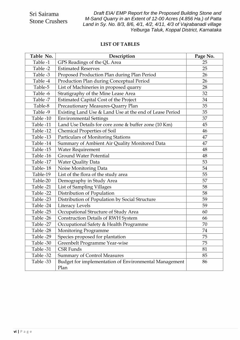
LIST OF TABLES
Table No. Description Page No.
Table -1 GPS Readings of the QL Area 25
Table -2 Estimated Reserves 25
Table -3 Proposed Production Plan during Plan Period 26
Table -4 Production Plan during Conceptual Period 26
Table-5 List of Machineries in proposed quarry 28
Table -6 Stratigraphy of the Mine Lease Area 32
Table -7 Estimated Capital Cost of the Project 34
Table-8 Precautionary Measures-Quarry Plan 35
Table -9 Existing Land Use & Land Use at the end of Lease Period 35
Table -10 Environmental Settings 37
Table -11 Land Use Details for core zone & buffer zone (10 Km) 45
Table -12 Chemical Properties of Soil 46
Table -13 Particulars of Monitoring Stations 47
Table -14 Summary of Ambient Air Quality Monitored Data 47
Table -15 Water Requirement 48
Table -16 Ground Water Potential 48
Table -17 Water Quality Data 53
Table- 18 Noise Monitoring Data 54
Table-19 List of the flora of the study area 55
Table-20 Demography in Study Area 57
Table -21 List of Sampling Villages 58
Table -22 Distribution of Population 58
Table -23 Distribution of Population by Social Structure 59
Table -24 Literacy Levels 59
Table -25 Occupational Structure of Study Area 60
Table -26 Construction Details of RWH System 66
Table -27 Occupational Safety & Health Programme 70
Table -28 Monitoring Programme 74
Table -29 Species proposed for plantation 75
Table -30 Greenbelt Programme Year-wise 75
Table -31 CSR Funds 81
Table -32 Summary of Control Measures 85
Table -33 Budget for implementation of Environmental Management Plan
86

Sri Sairama
Stone Crushers
Draft EIA/ EMP Report for the Proposed Building Stone and M-Sand Quarry in an Extent of 12-00 Acres (4.856 Ha.) of Patta
Land in Sy. No. 8/3, 8/6, 4/1, 4/2, 4/11, 4/3 of Vajrabanadi village Yelburga Taluk, Koppal District, Karnataka
vii | P a g e
ANNEXURES
No. Description Page No.
1 Terms of Reference (ToR) issued by SEIAA, Karnataka 98-105
2 Notification 106-107
3 Extract of Topo-sheet 108
4 Environmental Policy 109
5 Organization Chart 110
6 Geological Map of Koppal District 111
7 Soil Map of Koppal District 112
8 Geomorphological Map of Koppal District 113
9 Land-Use Land-Cover Map of 10 km Buffer Zone 114
10 Satellite Imagery of 10 km Radius 115
11 Ambient Air Quality Monitored Data 116-117
12 Surface Geological Plan and Sections 118-120
13 Production Development Plan and Sections 121-122
15 Progressive Mine Closure Plan 123
16 Environmental Plan 124
17 Cluster Letter 125-126
18 Micro-Meteorological Data during the Study Period 127-189
ENGLISH EXECUTIVE
SUMMARY
FOR BUILDING STONE
QUARRY SEIAA NO. 635 MIN 2021
DT. 19.01.2022

Sri Sairama
Stone Crushers
Draft EIA/ EMP Report for the Proposed Building Stone and M-Sand Quarry in an Extent of 12-00 Acres (4.856 Ha.) of Patta
Land in Sy. No. 8/3, 8/6, 4/1, 4/2, 4/11, 4/3 of Vajrabanadi village Yelburga Taluk, Koppal District, Karnataka
1 | P a g e
EXECUTIVE SUMMARY
o Dept. of Mines & Geology, Government of Karnataka has issued the Notification Letter for extraction of Boulders for production of Aggregates and M-Sand, in an extent of 12-00 Acres (4.856 Hectares) of Patta Land, to Sri Sairama Stone Crushers, vide their letter No. SG/KPL/DMG/GL/NTN-13/2020-21/1401 dated 13th July 2021, under in pursuance of rule 8(A) of the Karnataka Minor Mineral Concession Rules, 1994 (Amendment-2016).
o Sri Sairama Stone Crushers, is a Partnership Firm, owned by Sri Vankineni
Vamsidhar, a resident of Sy. No.54, Venaktagiri Village, Gangavathi Taluk, Koppal District.
o The proposed Building Stone Quarry Area is under Vajrabanadi Village limits, in Yelburga Taluk & District, Karnataka, and the Proponent (Sri Sairama Stone Crushers) is in possession of the proposed land.
o The proposed Building Stone & M-Sand Quarry Lease area, is located between
Latitude of 15o 40’ 36.47” N To 15o 40’ 48.65” N and Longitude of 76o 06’ 23.27” E to 76o 06’ 34.91” E.
o The Proponent (Sri Sairama Stone Crushers), has obtained the No Objection Certificate (NOC) dated 16-04-2021 from Revenue Department, Govt. of Karnataka and NOC dated 18-11-2020 from Forest Department, Govt. of Karnataka.
o There is no agriculture on the proposed mining land.
o The Proponent had applied for Environmental Clearance to State Environment
Impact Assessment Authority (SEIAA), Karnataka and they have issued the Terms of Reference (ToR), for carrying-out Environment Impact Assessment (EIA) studies and preparation of an EIA/ EMP (Environmental Management Plan), for the proposed Building Stone (M-Sand) Quarrying, vide Lr No. SEIAA 635 MIN 2021, dated 19.01.2022.
o Present summary is of the EIA report as per TOR and has been prepared as per
generic structure given in Appendix III of EIA notification 2006 by MOEF & CC.
o It is proposed to mine Building Stone, at a uniform saleable production of 5,01,910 Tons per Annum and a uniform ROM (incl. waste) of 5,12,153 Tons per annum, by semi-mechanized open cast mining method. There will be a waste generation of about 10,243 Tons per annum (average).
o The method of mining is by semi-mechanized open cast mining method, with
controlled sequential blasting. o Building Stone Mining is important for the Construction Industry, in domestic
market, for use as aggregates and also for M-Sand production.

Sri Sairama
Stone Crushers
Draft EIA/ EMP Report for the Proposed Building Stone and M-Sand Quarry in an Extent of 12-00 Acres (4.856 Ha.) of Patta
Land in Sy. No. 8/3, 8/6, 4/1, 4/2, 4/11, 4/3 of Vajrabanadi village Yelburga Taluk, Koppal District, Karnataka
2 | P a g e
o This is a new project & RQP has prepared the Quarry Plan for mining of Building
Stone, by maintaining proper safety standards. o Life of the mine is 7 years, considering an estimated mineable reserve of
35,62,940 Tons (incl. waste). The anticipated saleable quality building stone will be of 98% of the total mined quantity, with 2% in the form of waste generation.
o The Estimated Geological and Mineable Reserves, are as under:
Description Geological Reserves Tons
Mineable Reserves Tons
Proved 38,14,723 30,49,761
Probable 6,27,150 5,13,179 TOTAL 44,41,873 35,62,940
o Local Geology: Geology of the area in the field visit to examine and map the
quarry site revealed that the rock is coarse grained, porphyritic granular in texture. The individual mineral grains are hyphidiomorphic to idiomorphic. Hornblende and Biotite are the mafics. In the hand specimen mafics or dark coloured minerals are seen as disseminated specks or as tiny patches in a mosaic of light or pale coloured quartzo-felspathic mass. The rock breaks with uneven surface having glassy or vitreous luster and contain tiny pits when chistled and dressed. Pathologically the nomenclature of the rock is hornblende Biotite gnesiss granodiorite. The notified area consists of Building stone quality rock, which can be used for construction of buildings and roads and other domestic industries. Specific gravity is around 2.63.
o Topography of the site: The topography of the area consists of stony ridges and slopes/gradient in all directions. The average elevation of the subject area is 679 m above the MSL. Topography and the drainage of the area is both structurally and lithological controlled. The subject area falls within the region confined to a part of Vajrabanadi Village. The highest elevation is 682 m and lowest elevation is 676 m above the MSL.
o There are no sensitive receptors or ecosystems or water bodies in the core zone. o Nearest Village Vajrabanadi, is at 1.0 km from the proposed quarry area
o There are no eco sensitive areas within 10 km of the lease. There are no major
industries within this area, except some stone crushers and M-Sand units.
Proposed Mining o Building stone Quarrying of applied area for the proposed plan period is by
Semi-Mechanized method of opencast quarrying. o Considering the technical parameters like surface topography, quality variations,
geo-technical aspects, required rate of production & available resources etc., it is proposed to work this deposit by adopting 3 m bench height and with an

Sri Sairama
Stone Crushers
Draft EIA/ EMP Report for the Proposed Building Stone and M-Sand Quarry in an Extent of 12-00 Acres (4.856 Ha.) of Patta
Land in Sy. No. 8/3, 8/6, 4/1, 4/2, 4/11, 4/3 of Vajrabanadi village Yelburga Taluk, Koppal District, Karnataka
3 | P a g e
ultimate pit slope of 850 by medium scale quarrying activity with small dia jack Hammer drilling & controlled Blasting and use of Hydraulic Rock Breaker.
o The benches height and the width will be maintained as specified by DGMS. The width of the working benches shall not be less than the height.
o In view of the Quarrying plan for production of Building Stone, it is planned to operate the quarry by deploying machineries for development & productions, using drilling equipment, hydraulic rock breakers, excavator/loaders and tippers/tractors.
o Small diameter jack hammer and blasting will be proposed to be carried out by engaging licensed & certified blaster on contractual basis and by obtaining permission from competent authority
o Proper blasting would be undertaken ensuring lower ground vibrations by Controlled Blasting Methodology.
o The noise levels will be ensured to below 90 dB. Blast holes of 32 mm diameter with 5’ depth will be charged with a maximum of 187.5 gms of explosives.
o Excessive charges will be avoided. Instead of inclined drilling, vertical holes will be drilled
o Loading of building stone blocks will be done mechanically to Tippers of 10 tons capacity and transported from the quarry to the Crushing & Screening Plant, located within 2 km from Quarry site.
o Mineral rejection/waste will also be handled mechanically. In the quarry, roads will be maintained at 1 : 16 gradient.
o Sufficient number of bunds, parapet walls will be made all along the quarry haulage roads wherever necessary in order to maintain safe working conditions by using waste generated during the course of quarry operations
o Considering an average annual production of 5,12,153 Tons per Annum of ROM (Incl. Waste) and 300 working days in a year, the average daily production will be about 1,707 Tons per day.
o About 51,215 tons of intercalated waste is required to be handled during the plan period, which will be utilized for strengthening the approach road.
Proposed Production Plan: o The details of year wise excavation during the plan period, are as under:
Year Total ROM Production Saleable Mineral @ 98% (Tons)
Waste @ 2% (Tons) CuM Tons
1st Year 1,94,735 5,12,153 5,01,910 10,243
2nd Year 1,94,735 5,12,153 5,01,910 10,243
3rd Year 1,94,735 5,12,153 5,01,910 10,243
4th Year 1,94,735 5,12,153 5,01,910 10,243
5th Year 1,94,735 5,12,153 5,01,910 10,243
Total 9,73,675 25,60,765 25,09,550 51,215
Average 1,69,456 5,01,910 5,12,153 8,913

Sri Sairama
Stone Crushers
Draft EIA/ EMP Report for the Proposed Building Stone and M-Sand Quarry in an Extent of 12-00 Acres (4.856 Ha.) of Patta
Land in Sy. No. 8/3, 8/6, 4/1, 4/2, 4/11, 4/3 of Vajrabanadi village Yelburga Taluk, Koppal District, Karnataka
4 | P a g e
Base line environmental quality: Air:
There are no industrial gaseous -emission sources. Predominant wind directions in the order are from E (18.56%), ESE (15.18%), ENE (11.85%) and SE (9.35%). Average wind speed is 2.76m /sec.
Atmospheric stability class at Koppal Area is “moderately unstable to slightly unstable” during the day. Area has rural setting.
Concentrations of criteria pollutants were found to be well below National air
quality criteria viz. PM10, PM2.5, SO2 and NOx which are respectively 100, 60, 80
and 80 µg/m3. Predominant emissions during open cast mining operations would be generation
of particulate matter during drilling, blasting, loading/unloading and transportation activities.
Noise: Ld, Ln & Ldn values were typical of rural background.
Lease (Core) dB(A)
Buffer (Min.) dB(A)
Buffer (Max.) dB(A)
Ld 38 40 52
Ln 36 36 48
Ldn 37 39 50
Sources of noise would be during drilling, blasting and moving quarry equipment.
Water: There are no surface sources viz. rivers/ lake in the lease area. The average annual rainfall in Koppal District is about 572mm per year. As per the Ground Water Brochure (December 2008) prepared for Koppal District, by Central Ground Water Board, GoI, the average ground water levels in Kustagi Region is about 10-20m BGL (Pre-Monsoon) and there is not much change in the Post-Monsoon season as well. Based on the interaction with locals, the average ground water level is 35-40m BGL during pre-monsoon and it raises to 30-35m BGL in the post-monsoon season. The ground water quality in and around the proposed lease area is slightly alkaline, with the pH levels ranging from 7.38 to 8.09. The total hardness is ranging from 188 to 344 mg/liter as CaCO3, whereas the Total Dissolved Solids content is varying between 234 to 475 mg/liter. The fluoride levels are ranging from 0.391 to 1.098 mg/liter and the nitrate levels are varying between 2.51 to 8.49 mg/liter. The sulphate levels are ranging from 22.1 to 31.3 mg/liter and the chloride levels are varying between 52.98 to 160.95 mg/liter. In general, the ground water quality in the study area, confirms to the permissible limits of IS:10500-2012 (Drinking Water Specification.
Surface runoffs during monsoon from lease will enter the quarry pits. Of this, some water will evaporate and some can slowly percolate down.
Solid waste: During the Quarry Plan period, the mineral rejects are estimated to be 51,215 Tons. These mineral rejects, predominantly being weathered rock, can be used with M-Sand and also for the maintenance of the approach road.

Sri Sairama
Stone Crushers
Draft EIA/ EMP Report for the Proposed Building Stone and M-Sand Quarry in an Extent of 12-00 Acres (4.856 Ha.) of Patta
Land in Sy. No. 8/3, 8/6, 4/1, 4/2, 4/11, 4/3 of Vajrabanadi village Yelburga Taluk, Koppal District, Karnataka
5 | P a g e
Impacts:
Land: There is not much top soil in the proposed lease area, also there is no agriculture. There are no existing quarry pits within the proposed lease area. A single pit will be made during the operational phase of the quarry. Hence there would not be any major adverse impact on topography/drainage or on land use or agriculture. Appearance will continue to be as it is. Backfilling or reclamation of the mined out area is not proposed. Thus, mined out pit will be a “rainwater” storage structure. It is likely that recharge of ground water aquifer takes place. Also reservoir water can be used for miscellaneous purposes like plantation, fish culture etc.
During the plan period, about 51,215 Tons of mineral rejects (waste) is expected to be generated, which predominantly being weathered rock, will be used along with M-Sand and also for maintenance (strengthening) of the approach road. This waste is not expected to cause any adverse impact on the surrounding environment.
The Landuse details, in lease area, are as under:
Sl. No.
Item Existing Landuse
(Acres-Guntas)
Landuse at the end of plan period (Acres-Guntas)
1. Mining area - 9-06
2. Overburden / dump -- 0-10
3. Mineral Storage -- 0-10
4. Infrastructure, office -- 0-02
5. Roads - 0-02
6. Safety/Green Belt 2-10 2-10
7. Unused / virgin area 9-30 --
Total 12-00 12-00
Air: Ground level concentrations as per the models for dispersion of air pollutants for lease area source show that there would not be any major adverse impact on ambient air quality. Water: There would not be any impact on aquatic environment including hydrology, drainage or quality because a) there is no drain in the lease, b) ground water table will not be intercepted, c) dewatering of pits will not be required and d) granite pit water is suitable for irrigation. Regular monitoring for fluoride content is required.
Noise: Sources during mine operation would be drilling and blasting. Drillers would be exposed to about 75-80 dB(A). In this case, controlled sequential blasting will be carried-out to reduce noise and vibration. Pit-walls would absorb the vibrations due to drilling and blasting. Hence, there would not be any adverse impact. There are no structures over the lease area, as well as within 1 km radius of the quarry lease area.

Sri Sairama
Stone Crushers
Draft EIA/ EMP Report for the Proposed Building Stone and M-Sand Quarry in an Extent of 12-00 Acres (4.856 Ha.) of Patta
Land in Sy. No. 8/3, 8/6, 4/1, 4/2, 4/11, 4/3 of Vajrabanadi village Yelburga Taluk, Koppal District, Karnataka
6 | P a g e
Biological: There is no sensitive fauna and flora or endangered species within 10 km radius of the lease. Lease is a part of Non-Forest area. Also, this area is not known for any special kind of biodiversity. Project proponent will carry out plantation in scientific way. He will choose locally suitable species in consultation with local forest department.
Socioeconomic & health: There will not be any displacement on account of this project because land has already been notified in favour of the Project Proponent. It is proposed to a) prefer employment to deserving local persons in mining related trades like loading/unloading of Building Stone & M-Sand, waste handling, drilling etc., b) train residents of nearby villages for harvesting rain water, and sanitation practices etc., c) employment of local people for works related to development & maintenance of greenbelt and afforestation.
Monitoring schedule:
Env. segment Parameter Frequency
Water quality IS 10500 Quarterly
G.W. table Fluctuation in monsoon & post monsoon period
May & October
AAQ Particulate matter PM10 & PM2.5
during drilling, blasting – Half Yearly
Noise Equi. noise levels during drilling, blasting – Half Yearly
Health Pulmonary function, eye sight, audiometry, B.P., etc.
Annual record
Plantation Survival annual survival rate
Data analysis Efficiency of mitigation measures Half-Yearly
Plantation: The proposed quarry area and its buffer zone, has a rocky outcrop and hence it is not possible to take-up any plantation in the 7.5 m wide safety zone. However, it is proposed to take-up plantation, on either side of the approach road and also in the adjoining government land. It is proposed to plant about 600 locally suitable species, as part of green belt development. One cubic meter pits will be made on either side of the approach road and in the vacant Patta Land. These pits will be filled with top soil from lease area. Refuse or garbage will be added as per availability. Growth in the first year will be observed. Species will be chosen depending on availability and suitability to local soil conditions.
Occupational Health & Safety Measures:
The employees working in the quarrying activity will be provided with suitable personnel protective equipment (PPE) like safety shoes, dust masks, helmets, etc. Also, they will be subjected to annual health check-up, particularly for hearing related illness and respiratory disorders. Protective shelters for workers with treated R.O. Water, First Aid facilities, Dining facility etc. will be provided.

Sri Sairama
Stone Crushers
Draft EIA/ EMP Report for the Proposed Building Stone and M-Sand Quarry in an Extent of 12-00 Acres (4.856 Ha.) of Patta
Land in Sy. No. 8/3, 8/6, 4/1, 4/2, 4/11, 4/3 of Vajrabanadi village Yelburga Taluk, Koppal District, Karnataka
7 | P a g e
Corporate Social Responsibility:
A few are mentioned below: (1) Supply of drinking water unit to nearby Vajrabandi village (2) Project Proponent will organize annual health camp, in the nearby villages.
CSR – funds
Activity Anticipated funds
Supply of Drinking Water unit to Vajrabandi Village
Rs. 3,50,000 (One time investment)
Annual Health camps in the nearby villages
Rs. 1,00,000/- per camp per annum
N.B. Costs are indicative Economics of project: Granitic Gneiss deposits in Vajrabanadi Area and its surroundings are suitable for building stone and M-Sand production. It has high demand in the construction industry from the nearby Bangalore city. The proposed land has a rocky patch and is non-productive and unsuitable for agriculture. Therefore mining will be in the interest of State revenue and of the people around. Direct and indirect employment to locals is assured.
Lease is a rocky land in Non-Forest Area. It has no major trees, except some thorny bushes. The rain water collected in the quarry pits will be used for purposes like dust suppression, tree watering etc. Therefore there would not any damage to environmental quality.
Initiation of mining by Sri Sairama Stone Crushers, will improve revenue to the state without deterioration in environmental quality. On the contrary population in nearby villages will become aware of importance of potable water quality and sanitation.
Openings for indirect employment to locals in plantation, loading/ unloading operations etc. are possible. Additional water supply source in form of pit-water, recharge of aquifer is likely.

KANNADA EXECUTIVE
SUMMARY
FOR BUILDING STONE
QUARRY SEIAA NO. 635 MIN 2021
DT. 19.01.2022

Executive Summary: Building Stone & M-Sand Quarry of M/s Sri Sairama
Stone Crushers, of 12-00 Acres located in Sy. Nos. 8/3, 8/6, 4/1, 4/2, 4/11, 4/3
of Vajrabandi village Yelburga Taluk, Koppal District in Karnataka State
Page 1 of 9
JPÀìPÀÆånªï ¸ÀªÀÄäj PÀ£ÁðlPÀ ¸ÀPÁðgÀzÀ UÀt ªÀÄvÀÄÛ ¨sÀÆ «eÁÕ£À E¯ÁSÉAiÀÄÄ ªÉÄ. ²æà ¸Á¬ÄgÁªÀÄ ¸ÉÆÖãï PÀæµÀgïì CªÀjUÉ ¥ÀvÀæ ¸ÀASÉå : No. SG/KPL/DMG/GL/NTN-13/2020-21/1401. ¢£ÁAPÀ 13 dįÉÊ 2021 gÀAzÀÄ eÁj ªÀiÁr 12 JPÀgÉ (4.855 ºÉPÉÖÃgï) ¥ÀmÁÖ ¨sÀÆ«ÄAiÀÄ°è PÀ®Äè ªÀÄvÀÄÛ JA-¸ÁåAqï GvÁàzÀ£ÉUÁV PÀ®Äè UÀtÂUÁjPÉ £ÀqɸÀ®Ä PÀ£ÁðlPÀ ªÉÄÊ£Àgï «Ä£ÀgÀ¯ï PÀ£ÀìµÀ£ï gÀƯïì 1994gÀ (wzÀÄÝ¥Àr – 2016)gÀ ¥ÀæPÁgÀ C£ÀĪÀÄw ¤ÃrzÉ. ªÉÄ. ²æà ¸Á¬ÄgÁªÀÄ ¸ÉÆÖãï PÀæµÀgïì ¸ÀA¸ÉÜAiÀÄÄ PÉÆ¥Àà¼À f¯ÉèAiÀÄ UÀAUÁªÀw vÁ®ÆQ£À ªÉAPÀlVj UÁæªÀÄzÀ ¸ÀªÉÃð £ÀA. 54gÀ°è ªÁ¹¸ÀÄwÛgÀĪÀ ²æà ªÀAQ£Éä ªÀA²ÃzsÀgï CªÀgÀ £ÉÃvÀÈvÀézÀ°è EgÀĪÀ ¥Á®ÄzÁjPÉAiÀÄ ¸ÀA¸ÉÜ DVzÉ. ªÉÄ. ²æà ¸Á¬ÄgÁªÀÄ ¸ÉÆÖãï PÀæµÀgïì ¸ÀA¸ÉÜAiÀÄÄ PÀ£ÁðlPÀzÀ PÉÆ¥Àà¼À f¯ÉèAiÀÄ AiÀÄ®§ÄUÁð vÁ®ÆQ£À
ವಜ್ರಬಂಡಿ UÁæªÀÄzÀ ªÁå¦ÛAiÀÄ°è PÀlÖqÀzÀ PÀ®Äè UÀtÂUÁjPÉ £ÀqɸÀ®Ä ¸ÀPÁðgÀPÉÌ ¥Àæ¸ÁÛªÀ£É ¸À°è¹zÉ. ¥Àæ¸ÁÛ«vÀ PÀlÖqÀ PÀ®Äè ªÀÄvÀÄÛ JA-¸ÁåAqï UÀt UÀÄwÛUÉ ¥ÀæzÉñÀªÀÅ CPÁëA±À 15o 40’ 36.47” J£ï ¬ÄAzÀ 15o 40’ 48.65” J£ï ªÀÄvÀÄÛ gÉÃSÁA±À 76o 06’ 23.27” E ¬ÄAzÀ 76o 06’ 34.91” E DVzÉ. ¥Àæ¸ÁÛ«vÀ (²æà ¸Á¬ÄgÁªÀÄ ¸ÉÆÖãï PÀæµÀgïì) PÀA¥À¤AiÀÄÄ GzÉÝòvÀ ¸ÀܼÀzÀ°è PÀ®Äè UÀtÂUÁjPÉ £ÀqɸÀ®Ä PÀ£ÁðlPÀ ¸ÀPÁðgÀzÀ PÀAzÁAiÀÄ E¯ÁSÉ ¢£ÁAPÀ 16.04.2021 ªÀÄvÀÄÛ PÀ£ÁðlPÀ ¸ÀPÁðgÀzÀ CgÀtå E¯ÁSÉ ¢£ÁAPÀ 18.11.2020 gÀAzÀÄ ¤gÁ¥ÉÃPÀëuÁ ¥ÀvÉæªÀ£ÀÄß ¥ÀqÉ¢zÉ. ¥Àæ¸ÁÛ«vÀ (GzÉÝòvÀ) UÀt ¥ÀæzÉñÀzÀ°è PÀȶ ZÀlĪÀnPÉUÀ¼ÀÄ £ÀqÉAiÀÄÄwÛ®è. ¥Àæw¥ÁzÀPÀgÀÄ PÀ£ÁðlPÀzÀ gÁdå ¥Àj¸ÀgÀ ¥ÀjuÁªÀÄ ªÀiË®åªÀiÁ¥À£À ¥Áæ¢üPÁgÀPÉÌ (SEIAA) PÉÌ Cfð ¸À°è¹ ¥Àj¸ÀgÀ C£ÀĪÀÄwUÁV PÉÆÃjzÀÝgÀÄ. ¥Àj¸ÀgÀ ¥Àæ¨sÁªÀzÀ ªÀiË®åªÀiÁ¥À£À (EIA) CzsÀåAiÀÄ£À £ÀqɸÀ®Ä EIA/ EMP PÀlÖqÀ PÀ®Äè UÀtÂUÁjPÉ ªÀÄvÀÄÛ JA-¸ÁåAqï UÀtÂUÁjPÉUÁV ¥ÀvÀæ ¸ÀASÉå : SEIAA 635 MIN 2021, dated 19.01.2022 gÀ ¥ÀæPÁgÀ (ToR) UÀ¼À C£ÀéAiÀÄ AiÉÆÃd£ÉAiÀÄ£ÀÄß ¹zÀÞ¥Àr¸À¯ÁUÀÄvÀÛzÉ. ¥Àæ¸ÀÄÛvÀ ¸ÁgÁA±ÀªÀ£ÀÄß MOEF & CC £À EIA C¢ü¸ÀÆZÀ£É 2006 gÀ C£ÀħAzsÀ 3gÀAvÉ EIA ªÀÄvÀÄÛ ToR ¥ÀæPÁgÀªÉà ¹zÀÞ¥Àr¸À¯ÁVzÉ. ¥Àæ¸ÁÛ«vÀ PÀlÖqÀ PÀ®Äè UÀtÂUÁjPÉAiÀÄ°è vÉgÉzÀ ªÀÄvÀÄÛ ¸É«Ä ªÉÄPÁå¤PÀ¯ï ªÀåªÀ¸ÉÜAiÀÄ°è UÀtÂUÁjPÉ £ÀqɸÀ¯ÁUÀÄwÛzÀÄÝ, ªÁ¶ðPÀ GvÁàzÀ£ÉAiÀÄÄ vÁådå ¸ÉÃj MlÄÖ 5,12,153 l£ï. EzÀgÀ°è 5,01,910 l£ï GvÁàzÀ£É §¼ÀPÉUÉ ªÀÄvÀÄÛ 10,243 l£ï vÁådåªÁVgÀÄvÀÛzÉ. F UÀt ¥ÀæzÉñÀzÀ°è ¤§ðA¢üvÀ ¸ÉÆàÃlPÀUÀ¼À£ÀÄß §¼ÀPÉ ªÀiÁr CgÉ vÁAwæPÀ ªÀÄvÀÄÛ vÉgÉzÀ ªÀåªÀ¸ÉÜUÀ¼À°è UÀtÂUÁjPÉAiÀÄ£ÀÄß £ÀqɸÀ¯ÁUÀÄvÀÛzÉ.
Executive Summary: Building Stone & M-Sand Quarry of M/s Sri Sairama
Stone Crushers, of 12-00 Acres located in Sy. Nos. 8/3, 8/6, 4/1, 4/2, 4/11, 4/3
of Vajrabandi village Yelburga Taluk, Koppal District in Karnataka State
Page 2 of 9
¸ÀܽÃAiÀĪÁV £ÀqÉAiÀÄÄwÛgÀĪÀ ¤ªÀiÁðt PÁªÀÄUÁjUÀ½UÉ PÀ®ÄèUÀ¼ÀÄ ªÀÄvÀÄÛ JA-¸ÁåAqï CUÀvÀå«zÉ. PÀ®Äè UÀtÂUÁjPɬÄAzÀ ¸ÀܽÃAiÀĪÁVgÀĪÀ PÀ®ÄèUÀ¼À£ÀÄß ªÀÄvÀÄÛ JA-¸ÁåAqï C£ÀÄß ¥ÀÆgÉʸÀ®Ä C£ÀÄPÀÆ®ªÁ°zÉ. F ¥Àæ¸ÁÛªÀ£ÉAiÀÄÄ ºÉƸÀ AiÉÆÃd£É. PÉÃAzÀæ ¸ÀPÁðgÀzÀ UÀt ªÀÄvÀÄÛ ¸ÀÄgÀPÀëvÁ ¤zÉÃð±À£Á®AiÀĪÀÅ eÁj ªÀiÁrgÀĪÀ J¯Áè jÃwAiÀÄ ¸ÀÄgÀPÀëvÁ PÀæªÀÄUÀ¼À£ÀÄß C£ÀĸÀj¹AiÉÄà UÀtÂUÁjPÉAiÀÄ AiÉÆÃd£ÉAiÀÄ£ÀÄß ¹zÀÞ¥Àr¸À¯ÁVzÉ. F UÀt ¥ÀæzÉñÀzÀ°è 35,62,940 l£ï (vÁådå ¸ÉÃj) ¥ÀæªÀiÁtzÀ PÀ°è£À ¸ÀAUÀæºÀªÀ£ÀÄß UÀÄgÀÄw¸À¯ÁVzÉ. MlÄÖ GvÁàzÀ£ÉAiÀÄ ±ÉÃ. 98 gÀµÀÖ£ÀÄß ªÀiÁgÁl ªÀiÁqÀ®Ä ¸ÁzsÀå«zÀÄÝ, ±ÉÃ. 2 gÀµÀÄÖ vÁådåªÁVgÀÄvÀÛzÉ. F UÀtÂAiÀÄ fëvÁªÀ¢üAiÀÄÄ 7 ªÀµÀð DVgÀÄvÀÛzÉ. ¥Àæ¸ÁÛ«vÀ UÀt ¥ÀæzÉñÀzÀ°è ¨sÀÆ ªÉÊeÁФPÀ ªÀÄvÀÄÛ UÀtÂUÁjPÉAiÀÄ «ÄøÀ®Ä PɼÀV£ÀAwzÉ ;
Description Geological Reserves Tons
Mineable Reserves Tons
Proved 38,14,723 30,49,761
Probable 6,27,150 5,13,179 TOTAL 44,41,873 35,62,940
: ¸ÀܽÃAiÀÄ ¨sÀÆ «eÁÕ£À: ¥Àæ¸ÁÛ«vÀ UÀt ¥ÀæzÉñÀzÀ°è EgÀĪÀ ¤PÉëÃ¥ÀªÀ£ÀÄß ºÁ£ïð¨ÉèAqï §AiÉÆÃmÉæöÊmï UÉß¹¸ï UÁæ£ÉÆÃrAiÉÆgÉÊmï JAzÀÄ ºÉ¸Àj¸À¯ÁVzÀÄÝ, MgÀmÁzÀ §AqÉUÀ®ÄèUÀ¼ÀÄ ªÀÄvÀÄÛ ºÀgÀ½£À gÀÆ¥ÀzÀ°è PÀ°è£À ¤PÉëÃ¥ÀUÀ¼À£ÀÄß PÁt§ºÀÄzÁVzÉ. F ¤PÉëÃ¥ÀªÀ£ÀÄß PÀlÖqÀzÀ PÀ°èUÁV ªÀÄvÀÄÛ JA-¸ÁåAqï GvÁàzÀ£ÉUÁV, gÀ¸ÉÛUÀ¼À ¤ªÀiÁðtPÁÌV, ¸ÀܽÃAiÀÄ PÉÊUÁjPÉUÀ½UÁV §¼ÀPÉ ªÀiÁqÀ§ºÀÄzÁVzÉ. ¥Àæ¸ÁÛ«vÀ PÀ®Äè UÀtÂUÀ ¥ÀæzÉñÀzÀ°èAiÀÄ UÀÄgÀÄvÁéPÀµÀðuÉ ±ÀQÛAiÀÄÄ 2.63 ¥ÀæªÀiÁtzÀ°è EgÀÄvÀÛzÉ. UÀtÂUÁjPÉ ¸ÀܼÀzÀ «£Áå¸À : ¥Àæ¸ÁÛ«vÀ UÀt ¥ÀæzÉñÀªÀÅ J¯Áè ¢PÀÄÌUÀ¼À®Æè PÀ°è£À gÉÃSÉUÀ¼ÀÄ ªÀÄvÀÄÛ E½eÁgÀ£ÀÄß M¼ÀUÉÆArzÉ. ¸ÀªÀÄÄzÀæªÀÄlÖQAvÀ 679 «ÄÃlgï JvÀÛzÀ°èzÉ. ¸ÀªÀÄÄzÀæªÀÄlÖQÌAvÀ CvÀÄå£ÀßvÀ JvÀÛgÀªÀÅ 682 «ÄÃlgï ªÀÄvÀÄÛ PÀrªÉÄ JvÀÛgÀªÀÅ 676 «ÄÃlgï DVzÉ. ªÀdæ§Ar UÁæªÀÄzÀ ºÉÆgÀ ªÀ®AiÀÄzÀ°èzÀÄÝ, F UÁæªÀĪÀÅ PÉêÀ® 1 Q¯ÉÆà «ÄÃlgï CAvÀgÀzÀ°èzÉ. UÀtÂUÁjPÉAiÀÄ PÉÆÃgï ªÀ®AiÀÄzÀ°è AiÀiÁªÀÅzÉà ¸ÀÆPÀëöäªÁzÀ ¥Àj¸ÀgÀ UÁæºÀPÀUÀ¼ÀÄ CxÀªÁ ¥Àj¸ÀgÀ ªÀåªÀ¸ÉÜUÀ¼ÀÄ CxÀªÁ d®ªÀÄÆ®UÀ¼ÀÄ E®è.

Executive Summary: Building Stone & M-Sand Quarry of M/s Sri Sairama
Stone Crushers, of 12-00 Acres located in Sy. Nos. 8/3, 8/6, 4/1, 4/2, 4/11, 4/3
of Vajrabandi village Yelburga Taluk, Koppal District in Karnataka State
Page 3 of 9
¥Àæ¸ÁÛ«vÀ PÀ®Äè UÀtÂUÁjPÉ ¥ÀæzÉñÀ¢AzÀ 10 Q¯ÉÆëÄÃlgï ªÁå¦ÛAiÀÄ°è AiÀiÁªÀÅzÉà ¸ÀÆPÀëöäªÁzÀ ¥Àj¸ÀgÀ UÁæºÀPÀUÀ¼ÀÄ E®è. ¸À«ÄÃ¥ÀzÀ°è AiÀiÁªÀÅzÉà §ÈºÀvï PÉÊUÁjPÁ WÀlPÀUÀ¼ÀÄ E®è. PÉ® PÀ®Äè UÀtÂUÁjPÉ ªÀÄvÀÄÛ JA-¸ÁåAqï GvÁàzÀ£Á WÀlPÀUÀ¼ÀÄ EªÉ. ¥Àæ¸ÁÛ«vÀ UÀt ¥ÀæzÉñÀzÀ°è PÀȶ ZÀlĪÀnPÉUÀ¼ÀÄ £ÀqÉAiÀÄĪÀÅ¢®è.
: ¥Àæ¸ÁÛ«vÀ UÀtÂUÁjPÉ AiÉÆÃd£É : ¥Àæ¸ÁÛ«vÀ ¥ÀæzÉñÀzÀ°è vÉgÉzÀ (N¥sÀ¥À£ïPÁ¸ïÖ) ªÀÄvÀÄÛ ¸É«Ä ªÉÄPÀ£ÉʸïØ ªÀåªÀ¸ÉÜAiÀÄ°è PÀlÖqÀ PÀ®Äè UÀtÂUÁjPÉ £ÀqɸÀ¯ÁUÀÄvÀÛzÉ. UÀtÂUÁjPÉAiÀÄ «£Áå¸À, UÀtªÀÄlÖzÀ°èAiÀÄ ªÀåvÁå¸À, vÁAwæPÀ ªÀåªÀ¸ÉÜAiÀÄ£ÀÄß M¼ÀUÉÆAqÀÄ 3 «ÄÃlgï JvÀÛgÀPÉÌ ¥ÀÆgÀPÀ E½eÁj£À ¨ÉAZïUÀ¼À£ÀÄß ¤ªÀiÁðt ªÀiÁr ªÀÄzsÀåªÀÄ ¥ÀæªÀiÁtzÀ UÀtÂUÁjPÉUÉ ¥ÀÆgÀPÀªÁzÀ ¸ÀtÚ ªÁå¸ÀzÀ eÁåPï ræ®ègïUÀ¼À ªÀÄÆ®PÀ ¤§ðA¢üvÀ ¸ÉÆàÃlPÀUÀ¼À£ÀÄß §¼ÀPÉ ªÀiÁr ºÁåªÀÄgï ræ®ègïUÀ¼À£ÀÄß §¼ÀPÉ ªÀiÁr PÀ®ÄèUÀ¼À£ÀÄß ¸ÉÆàÃn¸À¯ÁUÀÄvÀÛzÉ. UÀt ¸ÀÄgÀPÁë ¤zÉÃð±À£Á®AiÀĪÀÅ eÁj ªÀiÁrgÀĪÀ ¸ÀÄgÀPÁë PÀæªÀÄUÀ¼À ¥ÀæPÁgÀªÉà ¨ÉAZÀÄUÀ¼À JvÀÛgÀ, CUÀ® ªÀÄvÀÄÛ E½eÁgÀ£ÀÄß ¤ªÀð»¸À¯ÁUÀÄvÀÛzÉ. JPÀìªÉÃlgÀÄUÀ¼ÀÄ/¯ÉÆÃqÀgÀÄUÀ¼ÀÄ ªÀÄvÀÄÛ n¥ÀàgïUÀ¼ÀÄ-mÁæöåPÀÖgïUÀ¼À£ÀÄß, AiÀÄAvÀæUÀ¼À£ÀÄß §¼ÀPÉ ªÀiÁr UÀt ¥ÀæzÉñÀzÀ°è UÀtÂUÁjPÉ £ÀqɸÀ¯ÁUÀÄvÀÛzÉ. UÀt ¸ÀÄgÀPÀëvÁ ¤zÉÃð±À£Á®AiÀÄ¢AzÀ ¥ÀgÀªÁ¤UÉ ¥ÀqÉzÀ, CºÀð ªÀåQÛUÀ¼À ¸ÀªÀÄÄäRzÀ°èAiÉÄà UÀtÂUÁjPÉ ZÀlªÀnPÉUÀ¼À£ÀÄß £ÀqɸÀ¯ÁUÀÄvÀÛzÉ. ªÀÄvÀÄÛ ¸ÉÆàÃlPÀUÀ¼À£ÀÄß £ÀqɸÀ¯ÁUÀÄvÀÛzÉ. ¤§ðA¢üvÀ ¸ÉÆàÃlPÀUÀ¼À£ÀÄß §¼ÀPÉ ªÀiÁqÀĪÀ ªÀÄÆ®PÀ ¸ÉÆàÃn¸À¯ÁUÀÄvÀÛzÉ. ¥Àæ¸ÁÛ¦vÀ UÀt ¥ÀæzÉñÀzÀ°è ±À§ÝzÀ ªÀÄlÖªÀÅ 90 qɹ§¯ï ¥ÀæªÀiÁtQÌAvÀ PÀrªÉÄ EgÀÄvÀÛzÉ. 32 «Ä«Äà ªÁå¸ÀzÀ 5 EAZÀÄ D¼ÀzÀ gÀAzsÀæUÀ¼À£ÀÄß PÉÆgÉzÀÄ 187.5 UÁæA ¥ÀæªÀiÁtzÀ ¸ÉÆàÃlPÀUÀ¼À£ÀÄß s̈Àwð ªÀiÁr ªÉÊeÁÕ¤PÀªÁV ¸ÉÆàÃlPÀUÀ¼À£ÀÄß £ÀqɸÀ¯ÁUÀÄvÀÛzÉ. UÀt GvÀà£ÀߪÀ£ÀÄß 10 l£ï ¸ÁªÀÄxÀåðzÀ n¥Ààgï / ¯ÉÆÃqÀgïUÀ¼À°è AiÀÄAvÀæUÀ¼À ªÀÄÆ®PÀ vÀÄA© 2 Q¯ÉÆà «ÄÃlgï zÀÆgÀzÀ°è EgÀĪÀ PÀæ¶AUï ªÀÄvÀÄÛ ¹ÌçäAUï£À ¸ÀܼÀPÉÌ ¸ÁUÁtÂPÉ ¸ÀÄgÀPÀëvÁ ªÀÄÄAeÁUÀævÁ PÀæªÀÄUÀ¼À£ÀÄß PÉÊUÉƼÀÄîªÀ ªÀÄÆ®PÀ ¸ÁUÁtÂPÉ ªÀiÁqÀ¯ÁUÀÄvÀÛzÉ. UÀt vÁådåªÀ£ÀÄß ¸ÀªÀÄxÀðªÁV ¤ªÀðºÀuÉ ªÀiÁqÀ¯ÁUÀÄvÀÛzÉ. C®èzÉÃ, 1:6 C£ÀÄ¥ÁvÀzÀ°è UÀt ¥ÀæzÉñÀzÀ°èAiÀÄ DAvÀjPÀ gÀ¸ÉÛ ¤ªÀiÁðtPÉÌ §¼ÀPÉ ªÀiÁqÀ¯ÁUÀÄvÀÛzÉ. UÀt ZÀlĪÀnPÉUÀ¼ÀÄ £ÀqÉAiÀÄĪÀ ¸ÀܼÀzÀ°è ¸ÀÄgÀPÀëvÉUÉ C£ÀÄUÀÄtªÁV vÁådåªÀ£ÀÄß §¼ÀPÉ ªÀÄrPÉÆAqÀ vÀqÉUÉÆÃqÉUÀ¼ÀÄ, E½eÁgÀÄUÀ¼ÀÄ, gÀ¸ÉÛUÀ¼À£ÀÄß ¤ªÀð»¸À¯ÁUÀÄvÀÛzÉ.

Executive Summary: Building Stone & M-Sand Quarry of M/s Sri Sairama
Stone Crushers, of 12-00 Acres located in Sy. Nos. 8/3, 8/6, 4/1, 4/2, 4/11, 4/3
of Vajrabandi village Yelburga Taluk, Koppal District in Karnataka State
Page 4 of 9
¥Àæ¸ÁÛ«vÀ UÀt ¥ÀæzÉñÀzÀ°è ªÀµÀðzÀ°è 300 ¢£ÀUÀ¼À PÁAiÀÄ𠤪À𻹠¥Àæw ¢£ÀPÉÌ 1,707 l£ï ¥ÀæªÀiÁtzÀ GvÀà£ÀßzÀ UÀÄjºÉÆAzÀ¯ÁVzÉ. ªÁ¶ðPÀ vÁådå ¸ÉÃj MlÄÖ 5,12,153 l£ï ¥ÀæªÀiÁtzÀ GvÁàzÀ£ÉAiÀÄ UÀÄj EzÉ. MlÄÖ GvÁàzÀ£ÉAiÀÄ°è ¹UÀĪÀ 51,215 l£ï ¥ÀæªÀiÁtzÀ vÁådåªÀ£ÀÄß ¸ÀA¥ÀPÀð gÀ¸ÉÛUÀ¼À ¸ÁªÀÄxÀåð ºÉZÀѼÀ ªÀÄvÀÄÛ ¤ªÀðºÀuÉUÁV §¼ÀPÉ ªÀiÁqÀ¯ÁUÀÄvÀÛzÉ.
: ªÁ¶ðPÀªÁgÀÄ GvÁàzÀ£ÉAiÀÄ AiÉÆÃd£É : o The details of year wise excavation during the plan period, are as under:
Year Total ROM Production Saleable Mineral @ 98% (Tons)
Waste @ 2% (Tons) CuM Tons
1st Year 1,94,735 5,12,153 5,01,910 10,243
2nd Year 1,94,735 5,12,153 5,01,910 10,243
3rd Year 1,94,735 5,12,153 5,01,910 10,243
4th Year 1,94,735 5,12,153 5,01,910 10,243
5th Year 1,94,735 5,12,153 5,01,910 10,243
Total 9,73,675 25,60,765 25,09,550 51,215
Average 1,69,456 5,01,910 5,12,153 8,913
: UÀtÂUÁjPÉ ¥ÀæzÉñÀzÀ ¥Àj¸ÀgÀ UÀÄtªÀÄlÖ : 1. UÁ½ : ¥Àæ¸ÁÛ«vÀ PÀ®Äè UÀtÂUÁjPɬÄAzÀ AiÀiÁªÀÅzÉà C¤® ºÉÆgÀ§gÀĪÀÅ¢®è. ¥Àj¸ÀgÀ CzsÀåAiÀÄ£ÀzÀ CªÀ¢üAiÀÄ°è ¥ÀæzsÁ£ÀªÁzÀ UÁ½ ©Ã¸ÀĪÀ ¢PÀÄÌUÀ¼ÀÄ ENE (11.85%) ªÀÄvÀÄÛ SE (9.35%), E (18.56%), ESE (15.18%)
DVgÀÄvÀÛzÉ. ¸ÀgÁ¸Àj UÁ½AiÀÄ ªÉÃUÀªÀÅ 2.76 «ÄÃlgï/¥Àæw ¸ÉPÉArUÉ. PÉÆ¥Àà¼À f¯ÉèAiÀÄ°è ªÁvÁªÀgÀtzÀ ¹ÜgÀvÉAiÀÄÄ ºÀUÀ°£À°è ªÀÄzsÀåªÀÄ C¹ÛgÀvɬÄAzÀ ¸Àé®à C¹ÛgÀªÁVgÀÄvÀÛzÉ. F ¥ÀæzÉñÀªÀÅ UÁæ«ÄÃt ªÀÄvÀÄÛ £ÀUÀgÀ ¥ÀæzÉñÀzÀ «Ä±Àæ ¥Àj¸ÀgÀªÀ£ÀÄß ºÉÆA¢zÉ. UÀtÂUÁjPÉ ¥ÀæzÉñÀzÀ°èAiÀÄ ªÀiÁ°£ÀåªÀÅ gÁ¶ÖçÃAiÀÄ ªÁAiÀÄÄ UÀÄtªÀÄlÖzÀ ªÀiÁ£ÀzÀAqÀUÀ½VAvÀ®Æ wÃgÀ PÀrªÉÄ ¥ÀæªÀiÁtzÀ°è EzÉ. PM10, PM2.5, SO2 ªÀÄvÀÄÛ NOx C£ÀÄPÀæªÀĪÁV 100, 60, 80 ªÀÄvÀÄÛ 80
µg/m3 DVzÉ. UÀtÂUÁjPÉ ¸ÀAzÀ¨sÀðzÀ°è vÀAw UÀgÀUÀ¸À¢AzÀ ¨ÁèPïUÀ¼À£ÀÄß PÀvÀÛj¸ÀĪÀÅzÀÄ ªÀÄvÀÄÛ ¨ÁèPïUÀ¼À£ÀÄß ¯ÉÆÃrAUï/C£ï¯ÉÆÃrAUï ªÀiÁqÀĪÁV£À ¸ÁjUÉ ZÀlĪÀnPÉUÀ½AzÀ C®à ¥ÀæªÀiÁtzÀ°è zsÀƽ£À PÀtUÀ¼ÀÄ UÁ½AiÀÄ°è ¸ÉÃgÀÄvÀÛªÉ.

Executive Summary: Building Stone & M-Sand Quarry of M/s Sri Sairama
Stone Crushers, of 12-00 Acres located in Sy. Nos. 8/3, 8/6, 4/1, 4/2, 4/11, 4/3
of Vajrabandi village Yelburga Taluk, Koppal District in Karnataka State
Page 5 of 9
2. ±À§Þ : Ld, Ln & Ldn values were typical of rural background.
Lease (Core) dB(A)
Buffer (Min.) dB(A)
Buffer (Max.) dB(A)
Ld 38 40 52
Ln 36 36 48
Ldn 37 39 50
UÀtÂUÁjPÉAiÀÄ°è ræ°èAUï ªÀÄvÀÄÛ vÀAwAiÀÄ UÀgÀUÀ¸ÀzÀ §¼ÀPɬÄAzÀ GAmÁUÀĪÀ ±À§zÀݪÀ£ÀÄß DzsÀj¹ PÉÆõÀ×PÀªÀ£ÀÄß ¹zÀÞ¥Àr¸À¯ÁVzÉ.
3. ¤Ãj£À UÀÄtªÀÄlÖ : ¥Àæ¸ÁÛ«vÀ UÀtÂUÁjPÉ ¥ÀæzÉñÀzÀ ªÉÄïÉäöÊ£À°è ¤Ãj£À ªÀÄÆ®UÀ½®è. PÉÆ¥Àà¼À f¯ÉèAiÀÄ°è ªÁ¶ðPÀ ¸ÀgÁ¸Àj 572 «Ä.«Äà ¥ÀæªÀiÁtzÀ°è ªÀÄ¼É ¸ÀÄjAiÀÄ°zÉ. ¨sÁgÀvÀ ¸ÀPÁðgÀzÀ CAvÀdð®ªÀÄAqÀ½ r¸ÉA§gï 2008 gÀ°è £ÀqɹgÀĪÀ CzsÀåAiÀÄ£ÀzÀ ¥ÀæPÁgÀ PÉÆ¥Àà¼À f¯ÉèAiÀÄ PÀĵÀÖV vÁ®ÆQ£À°è ªÀÄÄAUÁgÀÄ ¥ÀƪÀð ªÀÄvÀÄÛ ªÀÄÄAUÁj£À £ÀAvÀgÀzÀ°è CAvÀdð®ªÀÄlÖªÀÅ CAzÁdÄ 10-20«Äà ©fJ¯ï DVgÀÄvÀÛzÉ. ¸ÀܽÃAiÀÄgÀ ¥ÀæPÁgÀ, ªÀÄÄAUÁgÀÄ ¥ÀƪÀðzÀ°è CAvÀdð®ªÀÄlÖªÀÅ ¸ÀĪÀiÁgÀÄ 35-40«Äà ©fJ¯ï ªÀÄvÀÄÛ ªÀÄÄAUÁj£À £ÀAvÀgÀ 30-35«Äà ©fJ¯ï DVgÀÄvÀÛzÉ. ¥Àæ¸ÁÛ«vÀ UÀt UÀÄwÛUÉ ¥ÀæzÉñÀzÀ°è ®¨sÀå«gÀĪÀ CAvÀdð®zÀ UÀÄtªÀÄlÖªÀÅ PÀÄrAiÀÄĪÀ ¤Ãj£À §¼ÀPÉUÉ C£ÀĪÀÄw¸ÀĪÀ «ÄwAiÀÄ°èzÉ. ªÀļÉUÁ®zÀ°è UÀtÂUÁjPÉ ¥ÀæzÉñÀzÀ ¸ÀÄvÀÛ®Æ ºÀjAiÀÄĪÀ ¤ÃgÀ£ÀÄß CAvÀdð® ºÉaѸÀ®Ä ¸ÀAUÀæºÀ ªÀiÁqÀ§ºÀÄzÀÄ. C®èzÉà ¤ÃgÀÄ D«AiÀiÁUÀÄvÀÛzÉ.
UÀtÂAiÀÄ WÀ£À vÁådå ¤ªÀðºÀuÉ : PÀ®Äè UÀtÂUÁjPɬÄAzÁV ªÁ¶ðPÀ 51,215 l£ï ¥ÀæªÀiÁtzÀ WÀ£À vÁådå GvÀà£ÀߪÀ£ÀÄß CAzÁf¸À¯ÁVzÉ. F vÁådåªÀ£ÀÄß L©JA ¤AiÀĪÀÄUÀ¼À ¥ÀæPÁgÀ ¸ÀAUÀæºÀ ªÀiÁr JA-¸ÁåAqï GvÁàzÀ£É, ¸ÀA¥ÀPÀð gÀ¸ÉÛUÀ¼À ¤ªÀðºÀuÉUÉ §¼ÀPÉ ªÀiÁqÀ®UÀÄvÀÛzÉ.

Executive Summary: Building Stone & M-Sand Quarry of M/s Sri Sairama
Stone Crushers, of 12-00 Acres located in Sy. Nos. 8/3, 8/6, 4/1, 4/2, 4/11, 4/3
of Vajrabandi village Yelburga Taluk, Koppal District in Karnataka State
Page 6 of 9
: UÀtÂUÁjPÉAiÀÄ ¥ÀjuÁªÀÄUÀ¼ÀÄ : ¨sÀÆ«Ä: ¥Àæ¸ÁÛ«vÀ PÀ®Äè UÀt UÀÄwÛUÉ ¥ÀæzÉñÀzÀ°è ºÉaÑ£À ªÀÄtÄÚ E®è. PÀȶ ZÀlĪÀnPÉUÀ¼ÀÄ £ÀqÉAiÀÄÄwÛ®è. PÁéj ºÉÆAqÀ CxÀªÁ qÀA¥ïUÀ¼ÀÄ E®è. UÀtÂUÁjPÉAiÀÄ ¸ÀAzÀ¨sÀðzÀ°è MAzÀÄ PÀAzÀPÀªÀ£ÀÄß gÀZÀ£É ªÀiÁqÀ¯ÁUÀÄvÀÛzÉ. ¨sÀÆ«ÄUÉ zsÀPÉÌAiÀiÁUÀĪÀ/ºÁ¤AiÀiÁUÀĪÀ ZÀlĪÀnPÉUÀ¼À£ÀÄß £ÀqɸÀĪÀÅ¢®è. UÀt ¥ÀæzÉñÀzÀ°èAiÀÄ ªÉÄïÉäöÊ ¥ÀæzÉñÀªÀ£ÀÄß ¥Àæ¸ÀÄÛvÀ EgÀĪÀ jÃwAiÀÄ°è ¤ªÀð»¸À¯ÁUÀÄvÀÛzÉ. UÀt ¥ÀæzÉñÀzÀ°èAiÀÄ »A¨sÁUÀªÀ£ÀÄß ªÀÄÄZÀÄÑ«PÉ CxÀªÁ ¸ÀÄzsÁgÀuÉ ªÀiÁqÀĪÀ ¥Àæ¸ÁÛªÀ£É E®è. ªÀÄ¼É ¤ÃgÀ£ÀÄß UÀtÂAiÀÄ ºÉÆgÀ ¥ÀæzÉñÀzÀ°è ¸ÀAUÀæºÀ ªÀiÁr, ¤ªÀðºÀuÉ ªÀiÁr CAdvÀð®ªÀÄlÖ ¸ÀÄzsÁgÀuÉUÉ ªÀÄvÀÄÛ ¸À¹UÀ¼À£ÀÄß ¤ªÀð»¸À®Ä §¼ÀPÉ ªÀiÁqÀ¯ÁUÀÄvÀÛzÉ. UÀtÂUÁjPÉ ¸ÀÜVvÀUÉÆAqÀ°è GzÉÝòvÀ ¥ÀæzÉñÀzÀ°è «ÄãÀÄUÁjPÉ £ÀqɸÀ§ºÀÄzÁVzÉ. UÀtÂUÁjPÉAiÀÄ UÀÄwÛUÉ CªÀ¢üAiÀÄ°è CAzÁdÄ ªÁ¶ðPÀ 51,215 l£ï ¥ÀæªÀiÁt vÁådå GvÁàzÀ£ÉAiÀÄ ¤jÃPÉë¬ÄzÉ. F vÁådåªÀ£ÀÄß JA-¸ÁåAqï GvÁàzÀ£É, gÀ¸ÉÛUÀ¼À ¤ªÀðºÀuÉ ¸ÉÃj ««zsÀ ZÀlĪÀnPÉUÀ½UÉ §¼ÀPÉ ªÀiÁrPÉƼÀî®Ä GzÉÝò¸À¯ÁVzÉ. UÀtÂUÁjPÉAiÀÄ F vÁådåªÀÅ ¥Àj¸ÀgÀzÀ ªÉÄÃ¯É AiÀiÁªÀÅzÉà jÃwAiÀÄ°è zÀĵÀàjuÁªÀÄ ©ÃgÀĪÀÅ¢®è. UÀt UÀÄwÛUÉ ¥ÀæzÉñÀzÀ°èAiÀÄ ¨sÀÆ §¼ÀPÉAiÀÄ ¸ÀªÀÄUÀæ «ªÀgÀUÀ¼ÀÄ: The Land use details, in lease area, are as under:
Sl. No.
Item Existing Landuse (Acres-Guntas)
Landuse at the end of plan period (Acres-Guntas)
1. Mining area - 9-06
2. Overburden / dump -- 0-10
3. Mineral Storage -- 0-10
4. Infrastructure, office -- 0-02
5. Roads - 0-02
6. Safety/Green Belt 2-10 2-10
7. Unused / virgin area 9-30 -- Total 12-00 12-00
UÁ½: UÀt UÀÄwÛUÉ ¥ÀæzÉñÀzÀ°è UÀtÂUÁjPÉ ZÀlĪÀnPÉUÀ½AzÀ ¥Àj¸ÀgÀ ªÀÄvÀÄÛ ¸ÀÄvÀÛ°£À ªÁAiÀÄÄ ¥Àj¸ÀgÀzÀ ªÉÄ¯É zÀĵÀàjuÁªÀÄ GAmÁUÀĪÀÅ¢®è. ræ°èAUï, ªÁºÀ£ÀUÀ¼À ¸ÀAZÁgÀzÀ°è UÀÄwÛUÉ ¥ÀæzÉñÀzÀ°è C®à ¥ÀæªÀiÁtzÀ zsÀƼÀÄ PÁt¸À°zÀÄÝ PÁ®PÁ®PÉÌ ¥Àj¸ÀgÀ ¤ªÀðºÀuÉAiÀÄ PÀæªÀÄUÀ¼À£ÀÄß PÉÊUÉƼÀî¯ÁUÀÄvÀÛzÉ. (UÀªÀĤ¹).

Executive Summary: Building Stone & M-Sand Quarry of M/s Sri Sairama
Stone Crushers, of 12-00 Acres located in Sy. Nos. 8/3, 8/6, 4/1, 4/2, 4/11, 4/3
of Vajrabandi village Yelburga Taluk, Koppal District in Karnataka State
Page 7 of 9
¤ÃgÀÄ: UÀtÂUÁjPÉ ¥ÀæzÉñÀzÀ°è M¼ÀZÀgÀAr E®èzÀ PÁgÀt d®ZÀgÀUÀ¼À ªÉÄÃ¯É AiÀiÁªÀÅzÉà zÀĵÀàjuÁªÀÄ GAmÁUÀĪÀÅ¢®è. UÀt ¥ÀæzÉñÀzÀ°è CAvÀdð®ªÀ£ÀÄß ¤§A¢ü¸ÀĪÀ ZÀlĪÀnPÉUÀ¼ÀÄ £ÀqÉAiÀÄĪÀÅ¢®è. UÀtÂUÁjPÉUÁV §¼ÀPÉ ªÀiÁqÀĪÀ ¤ÃgÀÄ PÀȶUÉ AiÉÆÃUÀåªÁVzÀÄÝ, ¥sÉÆèÃgÉÊqï CA±ÀªÀ£ÀÄß ¤gÀAvÀgÀªÁV ¤ªÀð»¸À¯ÁUÀÄvÀÛzÉ.
±À§Þ : UÀtÂUÁjPÉAiÀÄ ¸ÀAzÀ¨sÀðzÀ°è ræ°èAUï ªÀÄvÀÄÛ PÀnAUï ¸ÀAzÀ¨sÀðzÀ°è 75-80 qɹªÀ§¯ï (J) ¥ÀæªÀiÁtzÀ°è ±À§Þ PÉý§gÀÄwÛgÀÄvÀÛzÉ. ræ°èAUï ¸ÀAzÀ¨sÀðzÀ°è ºÀ®ªÉqÉ PÉ®ªÉǪÉÄä UÀt ¥ÀæzÉñÀzÀ UÉÆÃqÉUÀ¼À°è PÀA¥À£ÀUÀ¼ÀÄ GAmÁUÀ§ºÀÄzÀÄ. DzÀgÉ F PÀA¥À£ÀUÀ¼ÀÄ AiÀiÁªÀÅzÉà zÀĵÀàjuÁªÀÄ ©ÃgÀĪÀÅ¢®è.
eÉÊ«PÀ ¥Àj¸ÀgÀ : ¥Àæ¸ÁÛ«vÀ UÀtÂUÁjPÉ ¥ÀæzÉñÀzÀ 10 Q«Äà ¸ÀÄvÀÛ°£À ¥ÀæzÉñÀzÀ°è AiÀiÁªÀÅzÉà ¸ÀÆPÀëöä ¥ÁætÂ, ¸À¸Àå CxÀªÁ C½«£À CAa£À°ègÀĪÀ ¥Àæ¨ÉÃzsÀUÀ¼À ªÁ¸À«®è. UÀtÂUÁjPÉ ¥ÀæzÉñÀªÀÅ «ÄøÀ®Ä CgÀuÉåÃvÀgÀ ¥ÀæzÉñÀªÁVzÉ. AiÉÆÃd£ÉAiÀÄ ¥Àæw¥ÁzÀPÀgÀÄ CgÀtå E¯ÁSÉAiÀÄ £ÉgÀ«£À°è ªÉÊeÁÕ¤PÀªÁV ¸ÀܽÃAiÀĪÁV ¨É¼ÉAiÀÄĪÀ ¸À¹UÀ¼À£ÀÄß £ÉlÄÖ ¨É¼É¸À®Ä ªÁ¶ðPÀ AiÉÆÃd£ÉAiÀÄ£ÀÄß ¹zÀÞ¥Àr¹zÁÝgÉ. ¸ÁªÀiÁfPÀ, DyðPÀ ªÀÄvÀÄÛ DgÉÆÃUÀå:
GzÉÝòvÀ ¥ÀæzÉñÀªÀÅ AiÉÆÃd£ÉAiÀÄ ¥Àæw¥ÁzÀPÀgÁzÀ ªÉÄ. ²æà ¸Á¬ÄgÁªÀÄ ¸ÉÆÖãï PÀæµÀgïì CªÀjUÉ C¢ü¸ÀÆa¸À®ànÖzÉ. F AiÉÆÃd£É ¥ÁægÀA¨sÀ DUÀĪÀÅzÀjAzÀ J). UÀt ZÀlĪÀnPÉUÀ¼ÀÄ ªÀÄvÀÄÛ UÀtÂUÁjPÉUÉ ¥ÀÆgÀPÀªÁzÀ ¯ÉÆÃrAUï / C£ï¯ÉÆÃrªÀÄUï, JA-¸ÁåAqï GvÁàzÀ£É, vÁådå ¤ªÀðºÀuÉ, ræ°èAUï ¸ÉÃj ««zsÀ « s̈ÁUÀUÀ¼À°è ¸ÀܽÃAiÀÄ ªÀÄvÀÄÛ CºÀðjUÉ GzÉÆåÃUÀªÀPÁ±ÀUÀ¼ÀÄ ¹UÀ°ªÉ. ©). ªÀÄ¼É ¤ÃgÀÄ ¸ÀAUÀæºÀuÉ ªÀÄvÀÄÛ ¤ªÀðºÀuÉ, £ÉʪÀÄð®å ªÀÄvÀÄÛ DgÉÆÃUÀå ¸ÀÄzsÁgÀuÉ ¸ÉÃj E¤ßvÀgÉ ZÀlĪÀnPÉUÀ¼À ¤ªÀðºÀuÉUÉ ¸ÀܽÃAiÀÄjUÉ CUÀvÀå vÀgÀ¨ÉÃw. ¹). UÀtÂUÁjPÉ ZÀlĪÀnPÉUÀ¼À°è ¸ÀܽÃAiÀÄ CºÀðjUÉ CªÀPÁ±À. C®èzÉÃ, C£ÉÃPÀjUÉ ¥ÀÆtðPÁ°PÉ / CgÉPÁ°PÀ GzÉÆåÃUÀUÀ¼À CªÀPÁ±À. ºÀ¹gÀÄ ªÀ®AiÀÄ ¤ªÀiÁðt ªÀÄvÀÄÛ ¤ªÀðºÀuÉUÉ ¥ÀÆgÀPÀªÁVgÀÄvÀÛzÉ.
Monitoring schedule:
Env. segment Parameter Frequency
Water quality IS 10500 Quarterly
G.W. table Fluctuation in monsoon & post monsoon period
May & October
AAQ Particulate matter PM10 & PM2.5
during drilling, blasting – Half Yearly
Noise Equi. noise levels during drilling, blasting – Half Yearly

Executive Summary: Building Stone & M-Sand Quarry of M/s Sri Sairama
Stone Crushers, of 12-00 Acres located in Sy. Nos. 8/3, 8/6, 4/1, 4/2, 4/11, 4/3
of Vajrabandi village Yelburga Taluk, Koppal District in Karnataka State
Page 8 of 9
Health Pulmonary function, eye sight, audiometry, B.P., etc.
Annual record
Plantation Survival annual survival rate
Data analysis Efficiency of mitigation measures Half-Yearly
: ¸À¹ £ÉqÀÄ«PÉ: (£ÉqÀÄvÉÆÃ¥ÀÄ)
¥Àæ¸ÁÛ«vÀ PÀ®Äè PÁéj ¥ÀæzÉñÀzÀ §¥sÀgï ªÀ®AiÀÄzÀ 7.5 «ÄÃlgï CUÀ®zÀ°è AiÀiÁªÀÅzÉà jÃwAiÀÄ ¸À¹UÀ¼À£ÀÄß £ÀqÉ®Ä / ¤ªÀð»¸À®Ä §gÀĪÀÅ¢®è. UÀtÂUÁjPÉ £ÀqɸÀĪÀ ¸ÀA¥ÀPÀð gÀ¸ÉÛAiÀÄ EPÉÌ®UÀ¼À°è ªÀÄvÀÄÛ ¸À«ÄÃ¥ÀzÀ ¸ÀPÁðj ¨sÀÆ«ÄAiÀÄ°è CgÀtå E¯ÁSÉ ²¥sÁgÀ¸ÀÄì ªÀiÁrgÀĪÀ ªÉÊeÁÕ¤PÀ ªÀiÁ£ÀzÀAqÀUÀ¼À ¥ÀæPÁgÀ PÀAzÀPÀUÀ¼À£ÀÄß ¤«Äð¹ ¸ÀܽÃAiÀÄ 600 eÁwAiÀÄ ¸À¹UÀ¼À£ÀÄß £ÉlÄÖ ¨É¼É¹ ºÀ¹gÀÄ ªÀ®AiÀĪÀ£ÀÄß ¤ªÀiÁðt ªÀiÁr ¤ªÀð»¸À¯ÁUÀÄvÀÛzÉ. ¸À¹UÀ¼À£ÀÄß £ÉqÀĪÀ PÀAzÀPÀUÀ½UÉ UÀÄwÛUÉ ¥ÀæzÉñÀzÀ ªÉÄïÉäöÊ ªÀÄtÚ£ÀÄß s̈Àwð ªÀiÁqÀ¯ÁUÀÄvÀÛzÉ. CUÀvÀåPÉÌ vÀPÀÌ ¥ÀæªÀiÁtzÀ°è vÁådå ªÀÄvÀÄÛ PÀ¸ÀªÀ£ÀÄß ¨sÀwð ªÀiÁqÀ¯ÁUÀÄvÀÛzÉ. ¤Ãj£À ®¨sÀåvÉ ªÀÄvÀÄÛ ªÀÄtÂÚ£À ¸ÁgÁA±ÀªÀ£ÀÄß CªÀ®A©ü¹ ¸ÀܽÃAiÀÄ eÁwAiÀÄ ¸À¹UÀ¼À£ÀÄß DAiÉÄÌ ªÀiÁrPÉƼÀî¯ÁUÀÄvÀÛzÉ.
: GzÉÆåÃUÀ, DgÉÆÃUÀå ªÀÄvÀÄÛ ¸ÀÄgÀPÀëvÁ PÀæªÀÄUÀ¼ÀÄ : UÀtÂUÁjPÉAiÀÄ°è vÉÆqÀVPÉÆAqÀ PÁ«ÄðPÀjUÉ ªÉÊAiÀÄQÛPÀ ¸ÀÄgÀPÀÛvÁ Qmï (PPE) UÀ¼À£ÀÄß ¥ÀÆgÉÊPÉ ªÀiÁr PÀqÁÙAiÀĪÁV ¸ÀÄgÀPÀëvÁ G¥ÀPÀgÀtUÀ¼À£ÀÄß §¼À¸ÀĪÀAvÉ CUÀvÀå PÀæªÀÄUÀ¼À£ÀÄß PÉÊUÉƼÀî¯ÁUÀÄvÀÛzÉ. ¥ÀÆgÀPÀ ¸ÀÄgÀPÀëvÁ ¸ÁªÀÄVæUÀ¼ÁzÀ §ÆlÄ, ªÀÄÄRªÁqÀUÀ¼ÀÄ, ºÉ¯ÉämïUÀ¼ÀÄ ¸ÉÃjzÀAvÉ J¯Áè ¸ÀÄgÀPÀëvÁ G¥ÀPÀgÀtUÀ¼À£ÀÄß vÀ¥ÀàzÉà ¥ÀÆgÉʸÀ¯ÁUÀÄvÀÛzÉ. ±ÀæªÀt ªÀÄvÀÄÛ ±Áé¸ÀPÉÆñÀzÀ DgÉÆÃUÀå ¤ªÀðºÀuÉUÁV ªÀµÀðPÉÆ̪ÉÄä vÀdÕ ªÉÊzÀåjAzÀ ªÉÊzÀåQÃAiÀÄ vÀ¥Á¸ÀuÉ £Àqɹ, ¥ÀæªÀiÁt¥ÀvÀæªÀ£ÀÄß ¥ÀqÉAiÀįÁUÀÄvÀÛzÉ. PÁ«ÄðPÀgÀÄ PÉ®¸À ªÀiÁqÀĪÀ ¸ÀܼÀzÀ°è «±ÁæAw PÉÆÃuÉ, ±ÀÄzÀÞªÁzÀ PÀÄrAiÀÄĪÀ ¤Ãj£À ¥ÀÆgÉÊPÉ, ¥ÀæxÀªÀÄ aQvÉì ¸Ë®¨sÀå, Hl – G¥ÀºÁgÀzÀ ¸Ë®¨sÀåUÀ¼À£ÀÄß PÀ°à¸À¯ÁUÀÄvÀÛzÉ.
PÁ¥ÉÆðgÉÃmï ªÀ®AiÀÄzÀ ¸ÁªÀiÁfPÀ dªÁ¨ÁÝj (¹J¸ïDgï)
1. ªÀdæ§Ar UÁæªÀÄPÉÌ gÀÆ¥Á¬Ä 3.50 ®PÀë ªÉZÀÑzÀ°è ±ÀÄzÀÞ PÀÄrAiÀÄĪÀ ¤Ãj£À WÀlPÀªÀ£ÀÄß MzÀV¸ÀĪÀÅzÀÄ.
2. PÁ®PÁ®PÉÌ CPÀëgÀ, DgÉÆÃUÀå ªÀÄvÀÄÛ £ÉʪÀÄð®å eÁUÀÈw ²©gÀUÀ¼À£ÀÄß £ÀqɸÀ¯ÁUÀĪÀÅzÀÄ.

Executive Summary: Building Stone & M-Sand Quarry of M/s Sri Sairama
Stone Crushers, of 12-00 Acres located in Sy. Nos. 8/3, 8/6, 4/1, 4/2, 4/11, 4/3
of Vajrabandi village Yelburga Taluk, Koppal District in Karnataka State
Page 9 of 9
3. ¸À«ÄÃ¥ÀzÀ ºÀ½îUÀ¼À°è ªÁ¶ðPÀ DgÉÆÃUÀå ²©gÀUÀ¼À£ÀÄß DAiÉÆÃf¹ d£ÀgÀ GavÀ DgÉÆÃUÀå vÀ¥Á¸ÀuÉ £ÀqɸÀĪÀÅzÀÄ.
: ¹J¸ïDgï ¤¢ü:
CSR – funds
Activity Anticipated funds
Supply of Drinking Water unit to Vajrabandi Village
Rs. 3,50,000 (One time investment)
Annual Health camps in the nearby villages
Rs. 1,00,000/- per camp per annum
N.B. Costs are indicative
: AiÉÆÃd£É¬ÄAzÀ GAmÁUÀĪÀ DyðPÀ ¯Á¨sÀUÀ¼ÀÄ : ªÉÄ. ¸Á¬ÄgÁªÀÄ ¸ÉÆÖãï PÀæµÀgïì PÀA¥À¤AiÀÄÄ GzÉÝòvÀ ¸ÀܼÀzÀ°è UÀtÂUÁjPÉ £ÀqɸÀĪÀÅzÀjAzÀ ªÀdæ§Ar UÁæªÀÄ ¸ÉÃj ¸ÀÄvÀÛ°£À UÁæªÀÄUÀ¼À°è £ÉÃgÀ ªÀÄvÀÄÛ DzsÁjvÀ GzÉÆåÃUÀUÀ¼ÀÄ ¸À馅 DUÀ°ªÉ. ªÀdæ§Ar ¥ÀæzÉñÀ°è ¹UÀĪÀ PÀ®Äè ªÀÄvÀÄÛ JA-¸ÁåAqï¤AzÀ ¨ÉAUÀ¼ÀÆj£À°è £ÀqÉAiÀÄÄwÛgÀĪÀ ¤ªÀiÁðt PÁªÀÄUÁjUÉ CUÀvÀå«gÀĪÀ PÀZÁÑ ªÀ¸ÀÄÛ«£À ¥ÀÆgÉÊPÉ DUÀ°zÉ. ¥Àæ¸ÁÛ«vÀ ¥ÀæzÉñÀªÀÅ CgÀuÉåÃvÀgÀ ¨sÀÆ«Ä. E°è zÉÆqÀØzÁzÀ ªÀÄgÀ, ¥ÉÆzÉUÀ¼ÀÄ E®è. ¸ÀAUÀæºÀªÁUÀĪÀ ªÀÄ¼É ¤ÃgÀ£ÀÄß zsÀƼÀÄ ¤AiÀÄAvÀætPÉÌ ªÀÄvÀÄÛ ºÀ¹gÀÄ ªÀ®AiÀÄ ¤ªÀiÁðtPÉÌ §¼ÀPÉ ªÀiÁrPÉƼÀî¯ÁUÀÄvÀÛzÉ. PÁgÀt E°è UÀtÂUÁjPÉ £ÀqɸÀĪÀÅzÀjAzÀ ¥Àj¸ÀgÀzÀ ªÉÄÃ¯É AiÀiÁªÀÅzÉà zÀĵÀàjuÁªÀÄ GAmÁUÀĪÀÅ¢®è. ¸ÀܽÃAiÀÄ d£ÀgÀ°è ¤ÃgÀÄ ¤ªÀðºÀuÉ, ªÀÄ¼É ¤ÃgÀÄ ¸ÀAUÀæºÀ, ¥Àj¸ÀgÀ ¸ÀAgÀPÀëuÉ, DgÉÆÃUÀå, CPÀëgÀ E¤ßvÀgÉUÀ¼À eÁUÀÈw ªÀÄÆr ¸ÁªÀiÁfPÀ ªÀÄvÀÄÛ zÉÊ£ÀA¢£À §zÀÄQ£À ªÀÄlÖ ¸ÀÄzsÁgÀuÉ DUÀ°zÉ. ¸ÀÄvÀÛ°£À UÁæªÀÄUÀ¼À°è DyðPÀ ZÀlĪÀnPÉUÀ¼ÀÄ ºÉZÁÑV d£ÀgÀ vÀ¯Á DzÁAiÀÄ ; DgÉÆÃUÀå : ²PÀët : £ÉʪÀÄð®åPÉÌ ¸ÀºÀdªÁVAiÉÄà ¥Áæ±À¸ÀÛöå ¹UÀ°zÉ. MmÁÖgÉ F AiÉÆÃd£É eÁj¬ÄAzÁV ªÀdæ§Ar ªÀÄvÀÄÛ ¸ÀÄvÀÛ°£À UÁæªÀÄUÀ¼À d£ÀgÀ fêÀ£ÀªÀÄlÖ ¸ÀÄzsÁgÀuÉUÉÆAqÀÄ DyðPÀ ¹ÜwAiÀÄÆ UÀt¤ÃAiÀĪÁV C©üªÀÈ¢Þ ºÉÆAzÀ°zÉ.

Sri Sairama
Stone Crushers
Draft EIA/ EMP Report for the Proposed Building Stone and M-Sand Quarry in an Extent of 12-00 Acres (4.856 Ha.) of Patta
Land in Sy. No. 8/3, 8/6, 4/1, 4/2, 4/11, 4/3 of Vajrabanadi village Yelburga Taluk, Koppal District, Karnataka
Page | 8
Compliance To Terms of Reference (ToR) issued by SEIAA, A.P. vide Annexure-1
Sl. No.
Terms of Reference Compliance
A Standard Terms of Reference
1) Year-wise production details since 1994 should be given, clearly stating the highest production achieved in any one year prior to 1994. It may also be categorically informed whether there had been any increase in production after the EIA Notification, 1994 came into force w.r.t. the highest production achieved prior to 1994.
Not applicable, in the present case as the project is coming for its EC for the first time. Also, the In-Principle Grant of Lease was issued by Dept. of Mines & Geology, on 13-07-2021.
2) A copy of the document in support of the fact that the Proponent is the rightful lessee of the mine should be given.
The Notification Letter issued by the Dept. of Mines & Geology, Govt. of Karnataka is enclosed as Annexure-2, Page No. 105-107
3) All documents including approved mine plan, EIA and public hearing should be compatible with one another in terms of the mine lease area, production levels, waste generation and its management and mining technology and should be in the name of the lessee.
As per approved Quarry Plan, it is proposed to mine at an average rate of about 5,01,910 Tons/ Annum and at a maximum rate of 5,12,153 Tons/ Annum of ROM of Building Stone and M-Sand. As per the Approved Quarry Plan, the saleable production of Building Stone and M-Sand is about 98% of the mined-out quantity, resulting in 2% as waste. All the documents are compatible with one another, with reference to lease area, production levels, waste generation etc. and all documents are in the name of the lessee only.
4) All corner coordinates of the mine lease area, superimposed on a High Resolution Imagery/topography sheet, geomorphology and geology of the area should be provided. Such an Imagery of the proposed area should clearly show the land use and other ecological features of the study area (core and buffer zone).
We have enclosed the Topo-sheet extract (10 km radius), Landuse/Land Cover Map, Satellite imagery etc. showing the core zone and buffer zone of 10km radial distance around the proposed lease. Refer Annexure 9 and 10 (Page No. 114-115) for Toposheet; Annexure-3 (Page 108) for Landuse/Landcover Map of 10 km radius; Page 35 for Landuse Table of quarry area and Annexure 10 (Page 115) for satellite imagery (10 km radius).
5) Information should be provided on Survey of India Topo-sheet in 1:50,000 scale indicating geological map of the area, geomorphology of landforms of the area, existing minerals and mining history of the area, important water bodies, streams and rivers and soil characteristics.
Toposheet showing the project area, and 10 km buffer zone around it, in 1:50000 scale, has been enclosed, as Annexure-3 (Page No. 108). Also, the geological map of Koppal District is enclosed as Annexure-6 (Page No. 111); the soil map of Koppal District is enclosed as Annexure-7 (Page No. 112) and geomorphology map of Koppal District is enclosed as Annexure-8 (Page No. 113).

Sri Sairama
Stone Crushers
Draft EIA/ EMP Report for the Proposed Building Stone and M-Sand Quarry in an Extent of 12-00 Acres (4.856 Ha.) of Patta
Land in Sy. No. 8/3, 8/6, 4/1, 4/2, 4/11, 4/3 of Vajrabanadi village Yelburga Taluk, Koppal District, Karnataka
Page | 9
Sl. No.
Terms of Reference Compliance
6) Details about the land proposed for mining activities should be given with information as to whether mining conforms to the landuse policy of the state, land diversion for mining should have approval from landuse board or the concerned authorities.
The proposed quarry area, is part of Non- Forest Patta Land and the proponent has obtained the In-Principle Grant of Quarry Lease (in the form of Notification), for carrying-out the mining activities, vide letter No. SG/KPL/DMG/GL/NTN-13/2020-21/1401 dated 13th July 2021, for a period of 20 years.
7) Does the company have a well laid down Environment Policy approved by its Board of Directors? If so, it may be spelt out in the EIA report with description of the prescribed operating process/ procedures to bring into focus any infringement/ deviation/violation of the environmental or forest norms/ conditions? The hierarchical system or administrative order of the Company to deal with the environmental issues and for ensuring compliance with the EC conditions may also be given. The system of reporting of non-compliances / violations of environmental norms to the Board of Directors of the Company and/or shareholders or stakeholders at large may also be detailed in the EIA report.
Yes, the Environmental Policy (approved by the Proponent) is enclosed, as Annexure-4 (Page No. 109) of this Report. Refer Para 2.11, Page 38-41.
8) Issues relating to Mine Safety, including subsidence study in case of underground mining and slope study in case of open cast mining, blasting study etc. should be detailed. The proposed safeguard measures in each case should also be provided.
In the proposed Building Stone & M-Sand Quarry, there will be controlled sequential blasting. The parameters related to blasting have been given in Para No. 2.4.4, Page Nos. 28 to 30 of the report. Being an open cast mine, it is proposed to follow a pit slope of 60o by way of benches of 3m height and > 3m width, to maintain the mine safety. For details refer para No. 7.2.2 (Page 78 to 79)
9) The study area will comprise of 10 km zone around the mine lease from lease periphery and the data contained in the EIA such as waste generation etc. should be for the life of the mine / lease period.
Study is carried out for 10 Km area around mine lease for carrying out EIA. As per Approved Quarry Plan, there will not be any kind of waste generation.

Sri Sairama
Stone Crushers
Draft EIA/ EMP Report for the Proposed Building Stone and M-Sand Quarry in an Extent of 12-00 Acres (4.856 Ha.) of Patta
Land in Sy. No. 8/3, 8/6, 4/1, 4/2, 4/11, 4/3 of Vajrabanadi village Yelburga Taluk, Koppal District, Karnataka
Page | 10
Sl. No.
Terms of Reference Compliance
10) Land use of the study area delineating forest area, agricultural land, grazing land, wildlife sanctuary, national park, migratory routes of fauna, water bodies, human settlements and other ecological use features should be indicated. Land use plan of the mine lease area should be prepared to encompass preoperational, operational and post operational phases and submitted. Impact, if any, of change of land use should be given.
Refer Chapter 3, Para 3.2.1 Page 44-45, Table No. 11 (Page 45)
11) Details of the land for any Over Burden Dumps outside the mine lease, such as extent of land area, distance from mine lease, its land use, R and R issues, if any, should be given.
No Over Burden Dumps are proposed outside the lease area. Also, the proposed lease area, being non-forest patta land, without any habitation, no R & R issues are involved.
12) A Certificate from the Competent Authority in the State Forest Department should be provided, confirming the involvement of forest land, if any, in the project area. In the event of any contrary claim by the Project Proponent regarding the status of forests, the site may be inspected by the State Forest Department along with the Regional Office of the Ministry to ascertain the status of forests, based on which, the Certificate in this regard as mentioned above be issued. In all such cases, it would be desirable for representative of the State Forest Department to assist the Expert Appraisal Committees.
The proposed land being non-forest government revenue land, this condition is not applicable.
13) Status of forestry clearance for the broken up area and virgin forest land involved in the Project including deposition of net present value (NPV) and compensatory afforestation (CA) should be indicated. A copy of the forestry clearance should also be furnished.
The proposed land being non-forest government revenue land, this condition is not applicable.

Sri Sairama
Stone Crushers
Draft EIA/ EMP Report for the Proposed Building Stone and M-Sand Quarry in an Extent of 12-00 Acres (4.856 Ha.) of Patta
Land in Sy. No. 8/3, 8/6, 4/1, 4/2, 4/11, 4/3 of Vajrabanadi village Yelburga Taluk, Koppal District, Karnataka
Page | 11
Sl. No.
Terms of Reference Compliance
14) Implementation status of recognition of forest rights under the Scheduled Tribes and other Traditional Forest Dwellers (Recognition of Forest Rights) Act, 2006 should be indicated.
The proposed land being non-forest government revenue land, this condition is not applicable. Also, there are no dwellers in the proposed quarry area.
15) The vegetation in the RF / PF areas in the study area, with necessary details, should be given.
The details of vegetation in the Study Area, are given Para No. 3.6, Page No. 54-57 and also Table No. 19 (Page No. 54)
16) A study shall be got done to ascertain the impact of the Mining Project on wildlife of the study area and details furnished. Impact of the project on the wildlife in the surrounding and any other protected area and accordingly detailed mitigative measures required, should be worked out with cost implications and submitted.
No wild life in the surrounding and other protected area is involved. Refer Para No. 3.6, Page No. 54-57 and also Table No. 19 (Page No. 54) flora and fauna observed / recorded during field survey.
17) Location of National Parks, Sanctuaries, Biosphere Reserves, Wildlife Corridors, Tiger/Elephant Reserves/(existing as well as proposed), if any, within 10 km of the mine lease should be clearly indicated, supported by a location map duly authenticated by Chief Wildlife Warden. Necessary clearance, as may be applicable to such projects due to proximity of the ecologically sensitive areas as mentioned above, should be obtained from the State Wildlife Department/Chief Wildlife Warden under the Wildlife (Protection) Act, 1972 and copy furnished.
No National Parks, Sanctuaries, Biosphere Reserves, Wildlife Corridors, Tiger/ Elephant Reserves are existing as well as proposed within 10 Km of mine lease area.
No clearance is required.

Sri Sairama
Stone Crushers
Draft EIA/ EMP Report for the Proposed Building Stone and M-Sand Quarry in an Extent of 12-00 Acres (4.856 Ha.) of Patta
Land in Sy. No. 8/3, 8/6, 4/1, 4/2, 4/11, 4/3 of Vajrabanadi village Yelburga Taluk, Koppal District, Karnataka
Page | 12
Sl. No.
Terms of Reference Compliance
18) A detailed biological study of the study area [core zone and buffer zone (10 km radius of the periphery of the mine lease)] shall be carried out. Details of flora and fauna, duly authenticated, separately for core and buffer zone should be furnished based on such primary field survey, clearly indicating the Schedule of the fauna present. In case of any schedule-I fauna found in the study area, the necessary plan for their conservation should be prepared in consultation with State Forest and Wildlife Department and details furnished. Necessary allocation of funds for implementing the same should be made as part of the project cost. The Conservation Plan for Schedule-I species shall be approved by the Chief Wildlife Warden of the State Government.
Refer Para No. 3.6, Page No. 54-57 and also Table No. 19 (Page No. 54) observed / recorded during field survey.
19) Proximity to Areas declared as ‘Critically Polluted’ or the Project areas likely to come under the ‘Aravali Range’, (attracting court restrictions for mining operations), should also be indicated and where so required, clearance certifications from the prescribed Authorities, such as the SPCB or State Mining Dept. Should be secured and furnished to the effect that the proposed mining activities could be considered.
Proposed lease does not fall under Critically Polluted area or under “Aravali range”.
20) Similarly, for coastal Projects, A CRZ map duly authenticated by one of the authorized agencies demarcating LTL. HTL, CRZ area, location of the mine lease w.r.t CRZ, coastal features such as mangroves, if any, should be furnished. (Note: The Mining Projects falling under CRZ would also need to obtain approval of the concerned Coastal Zone Management Authority).
Not applicable since proposed lease does not fall under CRZ area.

Sri Sairama
Stone Crushers
Draft EIA/ EMP Report for the Proposed Building Stone and M-Sand Quarry in an Extent of 12-00 Acres (4.856 Ha.) of Patta
Land in Sy. No. 8/3, 8/6, 4/1, 4/2, 4/11, 4/3 of Vajrabanadi village Yelburga Taluk, Koppal District, Karnataka
Page | 13
Sl. No.
Terms of Reference Compliance
21) R and R Plan/compensation details for the Project Affected People (PAP) should be furnished. While preparing the R and R Plan, the relevant State/National Rehabilitation and Resettlement Policy should be kept in view. In respect of SCs /STs and other weaker sections of the society in the study area, a need based sample survey, family-wise, should be undertaken to assess their requirements, and action programmes prepared and submitted accordingly, integrating the sectoral programmes of line departments of the State Government. It may be clearly brought out whether the village located in the mine lease area will be shifted or not. The issues relating to shifting of Village including their RandR and socio-economic aspects should be discussed in the report.
Not applicable since land is already notified in favour of the Project Proponent. R & R not applicable.
22) One season (non-monsoon) [i.e. March-May (Summer Season); October-December (post monsoon season); December-February (winter season)] primary baseline
data on ambient air quality as per CPCB Notification of 2009, water quality, noise level, soil, flora and fauna shall be collected and the AAQ and other data so compiled presented date-wise in the EIA and EMP Report. Site-specific meteorological data should also be collected. The location of the monitoring stations should be such as to represent whole of the study area and justified keeping in view the pre-dominant downwind direction and location of sensitive receptors. There should be at least one monitoring station within 500 m of the mine lease in the pre-dominant downwind direction. The Mineralogical composition of PM 10, particularly for free silica, should be given.
Refer Chapter 3, Table 12: Chemical Properties of Soil (Page 46).
Annexure-17: Site Specific Meteorological Data
(Page Nos. 127 to 189)
Table 13: Particulars of Monitoring Stations
(Page 47)
Annexure-11: Ambient Air Quality Data (Page
Nos. 116 to 117)
Table 14: Summary of AAQ Monitored Data
(Page 47).
Table 17: Ground Water Quality Analysis (Page
53).
Table 18: Noise Monitored Data (Page 54).

Sri Sairama
Stone Crushers
Draft EIA/ EMP Report for the Proposed Building Stone and M-Sand Quarry in an Extent of 12-00 Acres (4.856 Ha.) of Patta
Land in Sy. No. 8/3, 8/6, 4/1, 4/2, 4/11, 4/3 of Vajrabanadi village Yelburga Taluk, Koppal District, Karnataka
Page | 14
Sl. No.
Terms of Reference Compliance
23) Air quality modeling should be carried out for prediction of impact of the project on the air quality of the area. It should also take into account the impact of movement of vehicles for transportation of mineral. The details of the model used and input parameters used for modeling should be provided. The air quality contours may be shown on a location map clearly indicating the location of the site, location of sensitive receptors, if any, and the habitation. The wind roses showing pre-dominant wind direction may also be indicated on the map.
The proposal involves controlled sequential blasting, with delayed electric detonators. It will be carried-out in open area, during a specific time of the day. The details of blasting parameters and the safety measures to be adopted in blasting are given in Page No. 28 to 30 in Para No. 2.4.4. Also, the proposed mining area being only 12-00 Acres (4.856 Ha.), i.e. < 25 Ha., modelling is not mandatory.
24) The water requirement for the Project, its availability and source should be furnished. A detailed water balance should also be provided. Fresh water requirement for the Project should be indicated.
Refer Para 3.4.1 (Page 47), Table 15, Water Requirement, Page 48. Drinking water will be delivered by tankers from nearby village.
25) Necessary clearance from the competent authority for drawl of requisite quantity of water for the Project should be provided.
Water will be sourced by tankers from the nearby village.
26) Description of water conservation measures proposed to be adopted in the Project should be given. Details of rainwater harvesting proposed in the Project, if any, should be provided.
Refer Para 4.3.4, Page 65-66
27) Impact of the project on the water quality, both surface and ground water should be assessed and necessary safeguard measures, if any required, should be provided.
Refer Para 4.3.2, Page 64 for anticipated impacts and Para 4.3.3, Page 64-65 for mitigation measures

Sri Sairama
Stone Crushers
Draft EIA/ EMP Report for the Proposed Building Stone and M-Sand Quarry in an Extent of 12-00 Acres (4.856 Ha.) of Patta
Land in Sy. No. 8/3, 8/6, 4/1, 4/2, 4/11, 4/3 of Vajrabanadi village Yelburga Taluk, Koppal District, Karnataka
Page | 15
Sl. No.
Terms of Reference Compliance
28) Based on actual monitored data, it may clearly be shown whether working will intersect groundwater. Necessary data and documentation in this regard may be provided. In case the working will intersect groundwater table, a detailed Hydro Geological Study should be undertaken and Report furnished. Necessary permission from Central Ground Water Authority for working below ground water and for pumping of ground water should also be obtained and copy furnished.
The working depth of the proposed quarry, will not intersect with the ground water, due to the fact that the hillock is at a height of above 50m, from the surrounding ground level and the average ground water level is 25-30m BGL. Hence the permission from Central Ground Water Authority, is not required for this proposal.
29) Details of any stream, seasonal or otherwise, passing through the lease area and modification/ diversion proposed, if any, and the impact of the same on the hydrology should be brought out.
There is no any stream (seasonal or perennial) flowing from the proposed Quarry Lease Area.
30) Information on site elevation, working depth, groundwater table etc. Should be provided both in AMSL and BGL. A schematic diagram may also be provided for the same.
agreed
31) A time bound progressive greenbelt development plan shall be prepared in a tabular form (indicating linear and quantitative coverage, plant species and time frame) and submitted keeping in mind, the same will have to be executed upfront on commencement of the project. Phase-wise plan of plantation and compensatory afforestation should be charted clearly indicating the area to be covered under plantation and the species to be planted. The details of plantation already done should be given. The plant species selected for greenbelt should have greater ecological value and should be of good utility value to the local population with emphasis on local and native species and the species which are tolerant to pollution.
Refer Para 6.3 Page 75, Table 29 & 30, Page No. 75

Sri Sairama
Stone Crushers
Draft EIA/ EMP Report for the Proposed Building Stone and M-Sand Quarry in an Extent of 12-00 Acres (4.856 Ha.) of Patta
Land in Sy. No. 8/3, 8/6, 4/1, 4/2, 4/11, 4/3 of Vajrabanadi village Yelburga Taluk, Koppal District, Karnataka
Page | 16
Sl. No.
Terms of Reference Compliance
32) Impact on local transport infrastructure due to the Project should be indicated. Projected increase in truck traffic as a result of the Project in the present road network (including those outside the Project area) should be worked out, indicating whether it is capable of handling the incremental load. Arrangement for improving the infrastructure, if contemplated (including action to be taken by other agencies such as State Government) should be covered. Project proponent shall conduct Transportation Study as per Indian Road Congress
Based on estimated maximum annual saleable production of 512153 Tons per annum of Building Stone and M-Sand, and considering 300 working days per annum, the average quantity to be transported is about 1,707 Tons per day. Each truck carries about 15 Tons per trip and accordingly, the average no. of trips per day will be about 114 and considering 10 hours operating schedule per day, there will be an addition of 10 trucks per hour, to the existing traffic.
33) Details of the onsite shelter and facilities to be provided to the mine workers should be included in the EIA report.
The facilities to be provided in the mines are detailed in Mines Rules 1955 (Draft amendments in 2019). Accordingly rest shelters, drinking water, sanitary facilities, canteen etc. will be provided.
34) Conceptual post mining land use and Reclamation and Restoration of mined out areas (with plans and with adequate number of sections) should be given in the EIA report.
Refer Table 11, Page 45 for Conceptual Land Use. The Progressive Mine closure plan is included as Annexure-14 (Page No. 123). Plan for reclamation and restoration of mined out area, will be submitted at the time of quarry closure.
35) Occupational Health impacts of the Project should be anticipated and the proposed preventive measures spelt out in detail. Details of pre-placement medical examination and periodical medical examination schedules should be incorporated in the EMP. The project specific occupational health mitigation measures with required facilities proposed in the mining area may be detailed.
Refer Para 4.8 page 68-71, For Risk Assessment and Disaster Management Plan, refer Para No. 7.2, Page No. 75-79
36) Public health implications of the Project and related activities for the population in the impact zone should be systematically evaluated and the proposed remedial measures should be detailed along with budgetary allocations.
The nearest habitation is Vajrabanadi village, at a distance of 1.00 km from the proposed lease area. Hence there will not be any public health implications due to the project. However, we are proposing an annual health camp as part of CSR for employees as well as general public (Para 7.6; Page 80)

Sri Sairama
Stone Crushers
Draft EIA/ EMP Report for the Proposed Building Stone and M-Sand Quarry in an Extent of 12-00 Acres (4.856 Ha.) of Patta
Land in Sy. No. 8/3, 8/6, 4/1, 4/2, 4/11, 4/3 of Vajrabanadi village Yelburga Taluk, Koppal District, Karnataka
Page | 17
Sl. No.
Terms of Reference Compliance
37) Measures of socio economic significance and influence to the local community proposed to be provided by the Project Proponent should be indicated. As far as possible, quantitative dimensions may be given with time frames for implementation.
Refer Para 7.6, Page 80 a capital budget of Rs. 3.50 lacs with recurring budget of Rs. 1.00 Lacs is earmarked to address activities of socioeconomic concerns.
Refer Para 7.7, Page 80 a capital budget of 2 % of Project cost i.e. Rs. 1.60 Lakhs, is earmarked for taking-up works under CER (Corporate Environmental Responsibility)
38) Detailed environmental management plan to mitigate the environmental impacts which, should inter-alia include the impacts of change of land use, loss of agricultural and grazing land, if any, occupational health impacts besides other impacts specific to the proposed Project.
Refer Chapter 10, page 83-86
39) Public hearing points raised and commitment of the project proponent on the same along with time bound action plan to implement the same should be provided and also incorporated in the final EIA/EMP Report of the Project.
This document is prepared for public hearing only and will be updated, based on public hearing feedback.
40) Details of litigation pending against the project, if any, with direction / order passed by any Court of Law against the project should be given.
No litigation or Court Case is pending against Project, in any Court of Law
41) The cost of the project (capital cost and recurring cost) as well as the cost towards implementation of EMP should clearly be spelt out.
Refer Chapter 10, Para 10.4, Table 33, Page 86.
42) A Disaster Management Plan shall be prepared and included in the EIA/ EMP Report
Refer Para 7.2, Page No. 75 to 79
43) Benefits of the Project, if the project is implemented should be spelt out. The benefits of the project shall clearly indicate environmental, social, economic, employment potential etc.
Refer Chapter 8 (Page No. 81) and Chapter 9 (Page No. 82)
Sl. No.
Terms of Reference Compliance
44) Besides the above, the below mentioned general points are also to be followed
a) Executive Summary of the EIA/EMP Report
Refer Page No. 01 to 07

Sri Sairama
Stone Crushers
Draft EIA/ EMP Report for the Proposed Building Stone and M-Sand Quarry in an Extent of 12-00 Acres (4.856 Ha.) of Patta
Land in Sy. No. 8/3, 8/6, 4/1, 4/2, 4/11, 4/3 of Vajrabanadi village Yelburga Taluk, Koppal District, Karnataka
Page | 18
b) All documents to be properly referenced with index and continuous page numbering
Noted and taken due care in indexing and page numbering of all the documents.
c) Where data are presented in the Report especially in Tables, the period in which the data were collected and the sources should be indicated.
Noted and taken care.
d) Project Proponent shall enclose all the analysis/testing reports of water, air, soil, noise etc. using the MoEF&CC/ NABL accredited laboratories. All the original analysis/testing reports should be available during appraisal of the Project.
All analysis reports, are available, for appraisal purpose.
e) Where the documents provided are in a language other than English, an English translation should be provided.
All documents are in English language only.
f) The Questionnaire for environmental appraisal of mining projects as devised earlier by the Ministry shall also be filled and submitted.
Noted.
g) While preparing the EIA report, the instructions for the Proponents and instructions for the Consultants issued by MoEF&CC vide O.M. No. J-11013/ 41/2006-IA. II (I) dated 4th August, 2009, which are available on the website of this Ministry, should be followed.
Noted and followed.
h) Changes, if any made in the basic scope and project parameters (as submitted in Form-I and the PFR for securing the TOR) should be brought to the attention of MoEF&CC with reasons for such changes and permission should be sought, as the TOR may also have to be altered. Post Public Hearing changes in structure and content of the draft EIA/EMP (other than modifications arising out of the P.H. process) will entail conducting the PH again with the revised documentation.
As such there are no changes in the project parameters.
Sl. No.
Terms of Reference Compliance
i) As per the circular no. J-11011/618/2010-IA.II(I) dated 30.5.2012, certified report of the status of compliance of the conditions stipulated in the environment clearance for the existing operations of the project, should be obtained from the Regional Office of Ministry of Environment, Forest
This is a new proposal. Hence Certified Compliance Report from Regional Office of MoEFCC, is not applicable.

Sri Sairama
Stone Crushers
Draft EIA/ EMP Report for the Proposed Building Stone and M-Sand Quarry in an Extent of 12-00 Acres (4.856 Ha.) of Patta
Land in Sy. No. 8/3, 8/6, 4/1, 4/2, 4/11, 4/3 of Vajrabanadi village Yelburga Taluk, Koppal District, Karnataka
Page | 19
and Climate Change, as may be applicable.
j) The EIA report should also include (i) surface plan of the area indicating contours of main topographic features, drainage and mining area, (ii) geological maps and sections and (iii) sections of the mine pit and external dumps, if any, clearly showing the land features of the adjoining area.
Refer Annexure 12; Page No. 118 to 120 (Surface Geological Plan and Cross-Sections of Proposed Area) and Annexure-13 Page No. 121 to 122 (Production & Development Plan and Cross-Sections of Proposed Area for the Plan Period). For Progressive mine closure plan refer Annexure 14 (Page no. 123)
B Additional Terms of Reference
1 Cumulative effect on environment considering the surrounding mining leases to be studies
Noted and included as part of the air dispersion modelling.
2 Approach road strengthening works should be detailed as part of EMP
Noted and being considered as part of EMP budget
3 Nalas/ water bodies as per the village survey map should be detailed
Noted and taken care
4 Waste Storage Details Waste will be used for approach road maintenance. However, as a contingency arrangement, an area of 0-10 Acres is earmarked for waste dump
5 Tree species to be planted both within and outside the lease area should be detailed
Included as part of Table No. 29, page 75 of the EIA report
6 CER in specific terms should be detailed Included as Para 7.7, Page 80 of the EIA report
7 Specific protection measures should be detailed, since the project site is located at a distance of 23m from forest land
Noted and taken care, as part of EMP budget, Para 10.4, page 85, wherein provision for fie watchers is made.
Additional TOR
1 Cumulative Pollution load taking inti account of cluster should be submitted
Agreed
2 Waste handling details should be submitted
Agreed
3 Strengthening of the approach road and road connecting the cluster as per IRC(Indian Road Congress) Standard Norms
Agreed
4 Study on Impact of additional traffic load from the proposed project on the nearest national highway with suitable mitigation measures proposed
Agreed

Sri Sairama
Stone Crushers
Draft EIA/ EMP Report for the Proposed Building Stone and M-Sand Quarry in an Extent of 12-00 Acres (4.856 Ha.) of Patta
Land in Sy. No. 8/3, 8/6, 4/1, 4/2, 4/11, 4/3 of Vajrabanadi village Yelburga Taluk, Koppal District, Karnataka
Page | 20
CHAPTER 1: INTRODUCTION
1.1 Purpose of the Report: Project proponent Sri Sairama Stone Crushers, a Partnership firm owned by Sri Vankineni Vamsidhar resident of Sy. No. 54, Venaktagiri Village, Gangavathi Taluk, Koppal District, had proposed for extraction of Granitic Gneissic Rock for production of Building Stone and M-Sand, in an extent of 12-00 Acres (4.856 Ha.) of Non-Forest Patta Land, located in Sy. No. 8/3, 8/6, 4/1, 4/2, 4/11, 4/3 of Vajrabanadi village Yelburga Taluk, Koppal District in Karnataka State. The Proponent has obtained the Notification Letter, from the Department of Mines & Geology, Karnataka, vide letter No. SG/KPL/DMG/GL/NTN-13/2020-21/1401 dated 13th July 2021, under Rule 8(A) of Karnataka Minor Mineral Concession Rules, 1994 (Amendment-2016). Copy of the Notification issued by the Dept. of Mines & Geology, Govt. of Karnataka is enclosed as Annexure-2. Now, the Proponent had applied for Environmental Clearance (EC) from State level Environment Impact Assessment Authority (SEIAA), Karnataka. In line with the provisions of Environment Impact Assessment (EIA) Notification 2006 (incl. its amendments from time to time), the SEIAA, Karnataka had issued the Standard Terms of Reference (ToR) along with additional Terms of Reference, for carrying-out EIA Studies and preparation of an EIA/EMP Report, for onward submission to the State level Expert Appraisal Committee (SEAC), for appraisal for issue of Environmental Clearance. Copies of the ToR issued by SEIAA, Karnataka, is enclosed as Annexure 1. The proposed Quarry area has already been notified in favour of the proponent i.e. Sri Sairama Stone Crushers (vide Annexure-2).
To carry-out the EIA Studies and to prepare the EIA/ EMP (Environment Management Plan) Reports, Sri Sairama Stone Crushers, has engaged a consultant viz. Sri. M. S. Ashwath Narayan of M/s Envipro Solutions Pvt. Ltd., Bangalore, Karnataka. Environmental monitoring was conducted as per MOEF & CC norms for summer season for the period Jan. 2022 to Mar. 2022. This EIA report contains information as per TOR and has been prepared as per generic structure given in Appendix III of EIA notification 2006 by MOEF & CC, Govt. of India.
1.2 Identification of the project & project proponent: 1.2.1 Project: This proposal is for mining of grey granitic gneissic boulders, using blasting techniques, for production of Building Stone and M-Sand. The proposed average saleable production of Building Stone and M-Sand is about 5,12,153 Tons per Annum. The proposed mine will be a semi-mechanized open cast mining, from a lease of 12-00 Acres (4.856 Ha.), notified in favour of Sri Sairama Stone Crushers for a period of Twenty (20) years. The proposed Building Stone & M-Sand Quarry area is part of Non-Forest Patta Land, located in Sy. No. 8/3, 8/6, 4/1, 4/2, 4/11, 4/3 of Vajrabanadi village Yelburga Taluk, Koppal District, Karnataka. The nearest village to the proposed area is Vajrabanadi, at a distance of 1.0 km. There is no agriculture on the proposed land.
1.2.2 Project Proponent: The partnership firm of Sri Sairama Stone Crushers, is a resident of Sy. No. 54, Venaktagiri

Sri Sairama
Stone Crushers
Draft EIA/ EMP Report for the Proposed Building Stone and M-Sand Quarry in an Extent of 12-00 Acres (4.856 Ha.) of Patta
Land in Sy. No. 8/3, 8/6, 4/1, 4/2, 4/11, 4/3 of Vajrabanadi village Yelburga Taluk, Koppal District, Karnataka
Page | 21
Village, Gangavathi Taluk, Koppal District. The contact details of the proponent, are as under: Name: Sri Sairama Stone Crushers
Address: Sri Sairama Stone Crushers Sy. No. 54, Venaktagiri Village,
Gangavathi Taluk, Koppal District
The Organization Chart of Sri Sairama Stone Crushers’s Quarry at Vajrabanadi, is given in Annexure-5, Page No. 123.
Sri Sairama Stone Crushers has engaged Shri Veerendra, as their RQP, for preparation of the quarry plan for mining of Building Stone & M-Sand Quarry, from the 12-00 Acres (4.856 Ha.) of lease area.
1.3 Brief description of the nature, size, location of the project and its importance to
region: It is proposed to mine Building Stone and M-Sand, at an average rate of 5,01,910 Tons per Annum and a maximum rate of 5,12,153 Tons per Annum of ROM, from an extent of 12-00 Acres (4.856 Ha.) of Non-Forest Patta Land located in Sy. No. 8/3, 8/6, 4/1, 4/2, 4/11, 4/3 of Vajrabanadi village Yelburga Taluk, Koppal District, Karnataka, by opencast semi-mechanized mining method (using controlled sequential blasting) as per approved Quarry Plan. The recovery (saleable) of Building Stone and M-Sand has been considered as 98% of the mined-out mineral and there will be 2% waste generation. Based on an average annual quantity (ROM) of 5,01,910 Tons per Annum and considering the total mineable reserves of 35,62,940 Tons of building stone and M-sand, the anticipated life of the quarry will be about 7 years. However, the Govt. of Karnataka, has accorded in-principle approval for a period of 20 years. There are no eco-sensitive areas, national parks, wildlife sanctuaries, bio-spheres, etc. within 10 km of the lease area. There are no major industries within this area.
This proposal of mining has been proposed due to the fact that there is enough demand for Building Stone and M-Sand in the surrounding areas, from the construction industry.
1.4 Scope of the study: Based on the application submitted by the proponent, the SEAC, Karnataka, has recommended for issue of Standard Terms of Reference (ToR), along with few additional ToR, to carry-out the Environmental Impact Assessment (EIA) studies and prepare the EIA/ EMP (Environmental Management Plan). Accordingly, SEIAA had issued the ToR, vide their letter No. SEIAA 635 MIN 2021, dated 19.01.2022. The ToR issued by SEIAA, is the scope of EIA studies for region within 10 km radius from the proposed lease area. Copy of the ToR issued by SEIAA, Karnataka, is enclosed at Annexure 1. Baseline data pertaining to ambient air quality, information on hydrogeology and water quality, land use etc. was collected as per MOEF&CC criteria. Probable impacting activities during

Sri Sairama
Stone Crushers
Draft EIA/ EMP Report for the Proposed Building Stone and M-Sand Quarry in an Extent of 12-00 Acres (4.856 Ha.) of Patta
Land in Sy. No. 8/3, 8/6, 4/1, 4/2, 4/11, 4/3 of Vajrabanadi village Yelburga Taluk, Koppal District, Karnataka
Page | 22
proposed mining activity were identified. Particulate matter emissions were predicted by emission factor approach for drilling, blasting, transportation activities etc. Impacts on water quality and quantity impacts were considered. Impact on land use, socio economic status during project activities have been considered.

Sri Sairama Stone
Crushers
Draft EIA/ EMP Report for the Proposed Building Stone and
M-Sand Quarry in an Extent of 12-00 Acres (4.856 Ha.) of
Patta Land in Sy. No. 8/3, 8/6, 4/1, 4/2, 4/11, 4/3 of
Vajrabanadi village Yelburga Taluk, Koppal District,
Karnataka
23 | P a g e
CHAPTER 2 PROJECT DESCRIPTION
2.1 Type of project In the proposed Building Stone & M-Sand Quarry, mining will be carried-out by semi-mechanized methods to produce about 5,01,910 Tons per Annum (average) and 5,12,153 Tons per Annum (maximum) of saleable Building Stone and M-Sand, from a lease area of 12-00 Acres (4.856 Ha.) of Non-Forest Patta Land is proposed. Sri Sairama Stone Crushers, has obtained the in-principle grant in the form of Notification Letter from the Department of Mines & Geology, Govt. of Karnataka. The proposed lease area is part of Sy. No. 8/3, 8/6, 4/1, 4/2, 4/11, 4/3 of Vajrabanadi village Yelburga Taluk, Koppal District, in the state of Karnataka. The Lease Period authorized by Govt. of Karnataka is 20 years and considering the average annual production of 5,01,910 Tons per annum of ROM, the anticipated life of the mine will be about 7 years. Sri Sairama Stone Crushers has proposed to start mining over the proposed area, starting from the year 2022-23 onwards, after securing all applicable statutory clearances.
2.2 Need of the project: Building Stone, either in the form of boulders or aggregates or M-Sand, has its importance all over the world, in the construction industry. Sri Sairama Stone Crushers has opted for Building Stone & M-Sand Quarrying in the proposed area, due to its proximity to nearby towns and cities like Yelburga, Koppal, Bangalore, etc.
2.3 Location: The proposed Building Stone & M-Sand Quarry of Sri Sairama Stone Crushers, is located in Vajrabanadi Village, of Yelburga Taluk in Koppal District. The proposed Quarry Lease area, falls within a Latitude of 15o 40’ 36.47” N To 15o 40’ 48.65” N and Longitude of 76o 06’ 23.27” E to 76o 06’ 34.91” E. The proposed Quarry Lease area falls on the Survey of India Topo Sheet No. 57 A/2. The land notified for quarrying is 1.0 KM away from the human settlements, i.e. Vajrabanadi village and 0.3 KM away from Vajrabanadi – Konasagar Village Road and to its further SW with Yelburga Town: 12.1 KM. Koppal is the nearest railway station within a proximity of 36.1 KM. Bangalore International Airport, is the nearest airport, at about 323 km form the proposed lease area. The quarry is reachable with almost all type of vehicles.
The administrative map, showing the location of the proposed Building Stone & M-Sand Quarry, is shown below:

Sri Sairama Stone
Crushers
Draft EIA/ EMP Report for the Proposed Building Stone and
M-Sand Quarry in an Extent of 12-00 Acres (4.856 Ha.) of
Patta Land in Sy. No. 8/3, 8/6, 4/1, 4/2, 4/11, 4/3 of
Vajrabanadi village Yelburga Taluk, Koppal District,
Karnataka
24 | P a g e
Location Map of Sri Sairama Stone Crushers’s Building Stone & M-Sand Quarry (12-00 Acres: 4.856 Ha.) Figure-1.
LOCATION OF LEASE ON ADMINISTRATIVE MAP
Project Site

Sri Sairama
Stone Crushers
Draft EIA/ EMP Report for the Proposed Building Stone and M-Sand Quarry in an Extent of 12-00 Acres (4.856 Ha.) of Patta
Land in Sy. No. 8/3, 8/6, 4/1, 4/2, 4/11, 4/3 of Vajrabanadi village Yelburga Taluk, Koppal District, Karnataka
Page | 25
The GPS coordinates of the lease boundary are given below in Table 1.
Table 1: GPS Readings of the QL Area
P. No. Latitude Longitude
A N 15º 40’ 36.47” E 76º 06’ 25.11”
B N 15º 40’ 36.97” E 76º 06’ 30.16”
C N 15º 40’ 43.07” E 76º 06’ 29.70”
D N 15º 40’ 45.84” E 76º 06’ 35.34”
E N 15º 40’ 48.65” E 76º 06’ 34.91”
F N 15º 40’ 48.36” E 76º 06’ 34.12”
G N 15º 40’ 47.98” E 76º 06’ 34.03”
H N 15º 40’ 36.92” E 76º 06’ 30.85”
I N 15º 40’ 42.85” E 76º 06’ 23.27”
Datum-WGS 84
2.4 Size /magnitude of operations:
Lease is 12-00 Acres (4.856 Ha.)
Table 2: Estimated Reserves
Category Wise Geological Reserves Calculation of
SAIRAMA STONE CRUSHERS 12.00 ACRES
Section Sectional area
(Sq.m.)
Sectional Influence
(m)
Volume (Cu.m.)
ROM @2.63t/cmt
Saleable Building
stone (98%)
Inter calculated Waste(2%)
Proved reserves
1-1' 5005 100 500500 1316315 1289989 26326
2-2' 5465 100 546500 1437295 1408549 28746
3-3' 4247 95 403465 1061113 1039891 21222
3814723 3738428 76294
Probable reserves
1-1' 813 100 81300 213819 209543 4276
2-2' 899 100 89900 236437 231708 4729
3-3' 708 95 67260 176894 173356 3538
627150 614607 12543
TOTAL 4441873 4353035 88837
Category Wise Mineable Reserves Calculation of
SAIRAMA STONE CRUSHERS 12.00 ACRES
Section Sectional area
(Sq.m.)
Sectional Influence
(m)
Volume (Cu.m.)
ROM @2.63t/cmt
Saleable Building
stone (98%)
Inter calculated Waste(2%)
Proved reserves
1-1' 4436 92.5 410330 1079168 1057585 21583
2-2' 4902 92.5 453435 1192534 1168683 23851

Sri Sairama
Stone Crushers
Draft EIA/ EMP Report for the Proposed Building Stone and M-Sand Quarry in an Extent of 12-00 Acres (4.856 Ha.) of Patta
Land in Sy. No. 8/3, 8/6, 4/1, 4/2, 4/11, 4/3 of Vajrabanadi village Yelburga Taluk, Koppal District, Karnataka
Page | 26
3-3' 3698 80 295840 778059 762498 15561
3049761 2988766 60995
Probable reserves
1-1' 738 92.5 68265 179537 175946 3591
2-2' 824 92.5 76220 200459 196449 4009
3-3' 633 80 50640 133183 130520 2664
513179 502915 10264
TOTAL 3562940 3491681 71259
There are no sensitive receptors or ecosystems or water bodies like sanctuaries, biospheres etc. in core and buffer zones. Nearest village Vajrabanadi is at 1.0 km. There is no agriculture on the proposed lease area. Mining will be in an environment-friendly manner with a) water sprinkling for dust control, b) transportation of waste in covered vehicles and c) plantation on both sides of the approach road.
2.4.1 Magnitude of operations: Open cast Semi-mechanized method of mining, with controlled blasting Maximum saleable annual production: 5,12,153 Tons per Annum of Building Stone
and M-Sand Average saleable annual production: 5,01,910 Tons per Annum of Building Stone
and M-Sand Total Excavation during the Plan Period: 25,60,765 Tons ROM of Building Stone and
M-Sand Total Excavation during the Lease Period: 35,62,940 Tons ROM of Building Stone
and M-Sand Resulting Top Soil: Nil Total Mineral Rejects/ Waste: 10,243 Tons/ Annum (Avg.) Saleable Building Stone & M-Sand in Five Years (plan period) @ 98%: 25,09,550 Tons Saleable Building Stone & M-Sand, in Lease Period @ 98%: 34,91,681 Tons.
Table 3: Proposed Production Plan during Plan Period
Year Total ROM Production Saleable Mineral @ 98% (Tons)
Waste @ 2% (Tons) CuM Tons
1st Year 1,94,735 5,12,153 5,01,910 10,243
2nd Year 1,94,735 5,12,153 5,01,910 10,243
3rd Year 1,94,735 5,12,153 5,01,910 10,243
4th Year 1,94,735 5,12,153 5,01,910 10,243
5th Year 1,94,735 5,12,153 5,01,910 10,243
Total 9,73,675 25,60,765 25,09,550 51,215
Average 1,69,456 5,01,910 5,12,153 8,913
Table 4: Proposed Production Plan during Conceptual Period

Sri Sairama
Stone Crushers
Draft EIA/ EMP Report for the Proposed Building Stone and M-Sand Quarry in an Extent of 12-00 Acres (4.856 Ha.) of Patta
Land in Sy. No. 8/3, 8/6, 4/1, 4/2, 4/11, 4/3 of Vajrabanadi village Yelburga Taluk, Koppal District, Karnataka
Page | 27
Period Total ROM Production Saleable Mineral @ 98% (Tons)
Waste @ 2% (Tons) CuM Tons
Plan period 9,73,675 25,60,765 25,09,550 51,215
1st Scheme 3,81,055 10,02,175 9,82,131 20,044
TOTAL 13,54,730 35,62,940 34,91,681 71,259
2.4.2 Mining related activities: Building stone Quarrying of applied area for the proposed plan period is by Semi-
Mechanized method of opencast quarrying. Considering the technical parameters like surface topography, quality variations,
geo-technical aspects, required rate of production & available resources etc., it is proposed to work this deposit by adopting 3 m bench height and with an ultimate pit slope of 850 by medium scale quarrying activity with small dia jack Hammer drilling & controlled Blasting and use of Hydraulic Rock Breaker.
The benches height and the width will be maintained as specified by DGMS. The width of the working benches shall not be less than the height.
In view of the Quarrying plan for production of Building Stone, it is planned to operate the quarry by deploying machineries for development & productions, using drilling equipment, hydraulic rock breakers, excavator/loaders and tippers/ tractors.
Small diameter jack hammer and blasting will be proposed to be carried out by engaging licensed & certified blaster on contractual basis and by obtaining permission from competent authority
Proper blasting would be undertaken ensuring lower ground vibrations by Controlled Blasting Methodology.
The noise levels will be ensured to below 90 dB. Blast holes of 32 mm diameter with 5’ depth will be charged with a maximum of 187.5 gms of explosives.
Excessive charges will be avoided. Instead of inclined drilling, vertical holes will be drilled
Loading of building stone blocks will be done mechanically to Tippers of 10 tons capacity and transported from the quarry to the Crushing & Screening Plant, located within 2 km from Quarry site.
Mineral rejection/waste will also be handled mechanically. In the quarry, roads will be maintained at 1 : 16 gradient.
Sufficient number of bunds, parapet walls will be made all along the quarry haulage roads wherever necessary in order to maintain safe working conditions by using waste generated during the course of quarry operations
Considering an average annual production of 5,12,153 Tons per Annum of ROM (Incl. Waste) and 300 working days in a year, the average daily production will be about 1,707 Tons per day.
About 51,215 tons of intercalated waste is required to be handled during the plan period, which will be utilized for strengthening the approach road

Sri Sairama
Stone Crushers
Draft EIA/ EMP Report for the Proposed Building Stone and M-Sand Quarry in an Extent of 12-00 Acres (4.856 Ha.) of Patta
Land in Sy. No. 8/3, 8/6, 4/1, 4/2, 4/11, 4/3 of Vajrabanadi village Yelburga Taluk, Koppal District, Karnataka
Page | 28
2.4.3 Extent of Mechanization: As proposed above, the extent of mechanization involves deployment of machinery in the quarry. It is envisaged to deploy Excavator(s), Jack Hammer drilling machinery with wet drilling, powered by Compressors, Hydraulic Rock Breaker to avoid the requirement of blasting explosives, Loader Backhoe as support equipment, along with 10 tons capacity Tippers to transport building stone blocks from the pit to the Crushing and Screening plant, which will be established outside the subject area.
List of Machineries are as under.
Table 5: List of Machineries in Proposed Quarry
Sl. No. Machinery Nos
1 Compressors 1
2 Excavator 2
3 Breaker 1
4 Weigh Bridge 1
5 Wagon Drilling Equipment 2
6 Service Vehicle 1
7 Water Tank (Tractor) 1
8 Tippers 8
2.4.4 Drilling & Blasting:
To get required fragmentation from ROM, drilling and blasting play an important role in mining activity. Broad blasting parameters like charge per hole, blasting, charge per delay, maximum number of holes blasted in a round, manner and sequence of firing, etc is as follows. Proper blasting would be undertaken ensuring lower ground vibrations by Controlled Blasting Methodology. The noise levels will be ensured to below 90 dB. Blast holes of 32 mm diameter with 5’ depth will be charged with a maximum of 187.5 gms of explosives. Excessive charges will be avoided. Instead of inclined
drilling, vertical holes will be drilled.
Free will would be developed with proper benching in the stone quarry which is as follows:
Initiation - Straight line on the area No. of rows - 5 (Maximum) No. of holes - 30 Width of blast area - 4-5m In-Hole initiation - Electric Short Delay Detonators Charge per hole - 187.5 gms Max. Holes/Delay - 5 (Maximum) Blasts will be conducted with Free Faces

Sri Sairama
Stone Crushers
Draft EIA/ EMP Report for the Proposed Building Stone and M-Sand Quarry in an Extent of 12-00 Acres (4.856 Ha.) of Patta
Land in Sy. No. 8/3, 8/6, 4/1, 4/2, 4/11, 4/3 of Vajrabanadi village Yelburga Taluk, Koppal District, Karnataka
Page | 29
Diagram of the Free Face is given below: Pattern of Holes: Rectangular as per the layout shown in the figure below:
0-------0-------0-------0-------0 I Row 0-------0-------0-------0-------0 II Row
0-------0-------0-------0-------0 III Row
Blasting work will be given to an outsourcing agency, which has the explosive license.
It is proposed to use slurry with Ammonium Nitrate (ANFO), electrical detonators and fuses will be used for blasting. No secondary blasting is required because no oversize boulders will be generated from primary blasting. Controlled blasting will be carried out by:
1. Adopting sequential blasting by using delay detonators. 2. Restricting number of holes at a time blasting to only 10. 3. Detonating –Cord and Raydets/Nonel detonators will be used to prevent
ground vibrations. 4. Sand bags/ mud bags will be covered over the holes to prevent vertical
through of flying fragments. 5. Tyre mats or steel mat will be used over the blasting area to prevent flying
rocks. Precautionary Measures to be adopted at the time of Blasting Period: The employer shall permit only authorized and qualified persons to handle and
use explosives. All persons within the premises of danger zone (300meters) shall be cleared
before blasting. Siren shall be horned before the blasting. Effective communication system shall
be established between all entries and the blasting personnel. All entries to the mine shall be guarded by security to prevent inadvertent entry
of persons in to the restricted area of blasting. Smoking, firearms, matches, open flame lamps, and other fires, flame or heat
producing devices and sparks shall be prohibited in or near explosive magazines or while explosives are being handled, transported or used.
No person shall be allowed to handle or use explosives while under the influence of intoxicating liquors, narcotics, or other dangerous drugs.
All explosives shall be accounted for at all times. Explosives not being used shall be returned to the magazine, unavailable to persons not authorized to handle them. The employer shall maintain an inventory and use record of all explosives. Appropriate authorities shall be notified of any loss, theft, or unauthorized entry into a magazine.
No explosives or blasting agents shall be abandoned.

Sri Sairama
Stone Crushers
Draft EIA/ EMP Report for the Proposed Building Stone and M-Sand Quarry in an Extent of 12-00 Acres (4.856 Ha.) of Patta
Land in Sy. No. 8/3, 8/6, 4/1, 4/2, 4/11, 4/3 of Vajrabanadi village Yelburga Taluk, Koppal District, Karnataka
Page | 30
No fire shall be fought where the fire is in imminent danger of contact with explosives. All employees shall be removed to a safe area and the fire area guarded against intruders.
Original containers, or Class II magazines, shall be used for taking detonators and other explosives from storage magazines to the blasting area.
When blasting is done in congested areas or in proximity to a structure, railway, or highway, or any other installation that may be damaged, the blaster shall take special precautions in the loading, delaying, initiation, and confinement of each blast with mats or other methods so as to control the throw of fragments, and thus prevent bodily injury to employees.
Employees authorized to prepare explosive charges or conduct blasting operations shall use every reasonable precaution including, but not limited to, visual and audible warning signals, flags, or barricades, to ensure employee safety.
Insofar as possible, blasting operations above ground shall be conducted between sunrise and sunset.
Due precautions shall be taken to prevent accidental discharge of electric blasting caps from current induced by radar, radio transmitters, lightning, adjacent power lines, dust storms, or other sources of extraneous electricity. These precautions shall include:
Detonators shall be short-circuited in holes which have been primed and shunted until wired into the blasting circuit.
The suspension of all blasting operations and removal of persons from the blasting area during the approach and progress of an electric storm;
The prominent display of adequate signs, warning against the use of mobile radio transmitters, on all roads within feet of blasting operations. Whenever adherence to the 1,000-foot distance would create an operational handicap, a competent person shall be consulted to evaluate the particular situation, and alternative provisions may be made which are adequately designed to prevent any premature firing of electric blasting caps. A description of any such alternatives shall be reduced to writing and shall be certified as meeting the purposes of this subdivision by the competent person consulted. The description shall be maintained at the construction site during the duration of the work, and shall be available for inspection by representatives of the Secretary of Labor.
Specimens of signs which would meet the requirements of paragraph (k)(3) of this section are the following:
2.5 Proposed schedule for approval and implementation:

Sri Sairama
Stone Crushers
Draft EIA/ EMP Report for the Proposed Building Stone and M-Sand Quarry in an Extent of 12-00 Acres (4.856 Ha.) of Patta
Land in Sy. No. 8/3, 8/6, 4/1, 4/2, 4/11, 4/3 of Vajrabanadi village Yelburga Taluk, Koppal District, Karnataka
Page | 31
Sri Sairama Stone Crushers has followed the standard schedule for approval of this mining project and is as given below:
a) Submission of Quarry Plan to Dept. of Mines & Geology, Govt. of Karnataka and obtaining the approval from the Dept.
b) Apply for TOR to SEIAA, Karnataka c) Presentation with SEAC, Karnataka for obtaining ToR d) Monitoring of base line environmental quality e) Preparation of Draft EIA and EMP Report f) Submission of draft EIA report to KSPCB for Public Consultation g) Public Consultation will be done as per the guideline h) Receipt of Public Consultation minutes from the authority (KSPCB) i) Submission of final EIA report to SEAC for E.C appraisal.
2.6 Technology and process description: The proposed mining will be Open-Cast Semi-Mechanized method, which includes drilling and blasting. Detailed mining process, has been explained in Para No. 2.4.2 above.
2.7 Project description: Lease details:
2.7.1 Location: This 12-00 Acres (4.856 Ha.) of Building Stone & M-Sand Quarry of Sri Sairama Stone Crushers, is located in Sy. No. 8/3, 8/6, 4/1, 4/2, 4/11, 4/3 of Vajrabanadi village Yelburga Taluk, Koppal District, Karnataka. The lease area is spread between Latitude of 15o 40’ 36.47” N To 15o 40’ 48.65” N and Longitude of 76o 06’ 23.27” E to 76o 06’ 34.91” E.
2.7.2 Connectivity: The land notified for quarrying is 1.0 KM away from the human settlements, i.e. Vajrabanadi village and and 0.3 KM away from Vajrabanadi – Konasagar Village Road and to its further SW with Yelburga Town: 12.1 KM. Koppal is the nearest railway station within a proximity of 36.1 KM. Bangalore International Airport, is the nearest airport, at about 323 km form the proposed lease area. The quarry is reachable with almost all type of vehicles.
2.7.3 Topography: The area granted for quarrying is located in non-forest patta land. The area is located on Toposheet No. 57 A/2. The topography of the area consists of stony ridges and slopes/gradient in all directions. The average elevation of the subject area is 679 m above the MSL. Topography and the drainage of the area is both structurally and lithological controlled. The subject area falls within the region confined to a part of Vajrabanadi Village. The highest elevation is 682 m and lowest elevation is 676 m above the MSL.
2.7.4 General Geology:

Sri Sairama
Stone Crushers
Draft EIA/ EMP Report for the Proposed Building Stone and M-Sand Quarry in an Extent of 12-00 Acres (4.856 Ha.) of Patta
Land in Sy. No. 8/3, 8/6, 4/1, 4/2, 4/11, 4/3 of Vajrabanadi village Yelburga Taluk, Koppal District, Karnataka
Page | 32
Dharwar Craton encompasses major parts of Karnataka and Andhra Pradesh States. Dharwar Craton is a typical Archaean-Proterozoic granite-greenstone terrain. An array of granitic lithounits such as tonalite, granodiorite, adamellite and granite constitute this Archaean- Proterozoic granitic terrain. They are frequently deformed into complex gneisses. The granitic rocks of varying composition and their gneisses are together known as Peninsular Gneissic Complex (PGC). The area represents the Archean Closepet Granite. Intrusion of granites called as Closepet granite is a significant event in the evolution of the Dharwar craton. The Archean Closepet Granite is a ploy phase body intruding the PGC and the associated supracrustal rocks. The granite outcrop runs for nearly 500 km and cut across the regional metamorphic structures such as granulite facies in the south and green-schist facies in the north. In the transitional zones of amphibolite-granulite facies granites were formed in mixing up with charnokites and migmatites. Anatexis of peninsular gneiss led to the formation of granites: Table-6: Stratigraphy of the Mine Lease Area
The vast stretch of southern and central Karnataka occupied by gneissic rocks were earlier referred as a single litho assemblage called Peninsular Gneissic Complex (PGC); this is divisible into two distinct suites (Ramakrishnan, Geo Karnataka, MGD Centenary vol. 1994). The eastern suits called Bangalore Supersite (PG-II) are considered younger to its western conterpart enveloping the western Archaean nucleus of Dharwar Craton (Radhakrishna, 1997). Both the Bangalore Supersuit with the adjoining Closepet Granitoid is termed as Dharwar batholith by Hegde, Vasudev and Chadwick, Geological studies- special report, DMG, 1999). The rock types recorded in this region are grey biotite gneiss leucogranite hornblende biotite granite and migmatite with soda rich feldspars as the main mineral constituent. MINE DRAINAGE:
Lithoassemblage Group Age
Granites and Granodiorites Closepet Granite 2550 Million years
Granitoids and Gneisses Pensisular Gneiss II 2600-2500 Million years
Greenstones - predominantly metavolcanics.
Eastern Greenstone Belts 2700 Million years
Meta volcano sedimentary sequences
Dharwar Supergroup 2800-2700 Million years
Banded biotite gneiss, tonalitetrondhjemite gneisses migmatites and older Granitoids
Peninsular Gneiss – I of
PGC
3000-2900 Million years

Sri Sairama
Stone Crushers
Draft EIA/ EMP Report for the Proposed Building Stone and M-Sand Quarry in an Extent of 12-00 Acres (4.856 Ha.) of Patta
Land in Sy. No. 8/3, 8/6, 4/1, 4/2, 4/11, 4/3 of Vajrabanadi village Yelburga Taluk, Koppal District, Karnataka
Page | 33
Likely depth of water table based on observation from the nearby wells and other water bodies is expected to be minimum 100 m to 150 m below the general ground level. Working expected to be at 650 MSL which is much above the water table and no water is expected. LITHOLOGY: The granitic gneisses are mainly of migmatitic type, highly banded varying in composition from granite to diorite. Granites are mainly coarse grained in nature. The area occupied by gneisses forms more or less gently undulating plains and hillocks ranging from 20 to 80 m above ground level. The strike of foliation in gneisses trends from NNW–SSE to ENE-WSW dipping easterly at steep angles. Sheet joints are found to be parallel to the land surface. These hard rocks have undergone alteration and decomposition in the plains and in valleys resulting in weathered mantle ranging in thickness from 20 to 30 metres generally and occasionally extending down to a maximum depth of 50 m. Gneisses and granites are traversed by pegmatites and dolerite dykes. Closepet granites commonly give rise to barren hillocks with flat valleys. The boundary between peninsular gneiss and closepet granite is irregular and transitional. Closepet granites show comparatively more joints than the peninsular gneisses. The dykes are trending E-W to WNW-ESE with the width ranging between 5 to 20 meters and extend over a length of few tens of metres to several kilometres. Laterites of Paleocene age are seen at places as capping on the gneisses. Beneath the Laterites, gneisses are deeply weathered giving rise to various shades of Clays and weathered rocks, which is termed as ‘Saprolite’. Alluvial patches are generally seen along the stream courses and nallahs. It comprises of medium to coarse-grained sand with some gravel and pebbles associated with silt and clay at many places. The aerial extent of these alluvial deposits in general is controlled by the topography of the basement crystallines. This Alluvium is of limited aerial extent in nature. Gneiss is a common and widely distributed type of rock formed by high-grade regional metamorphic processes from pre-existing formations that were originally either igneous or sedimentary rocks. Gneissic rocks are usually medium to coarse foliated and largely recrystallized but do not carry large quantities of micas, chlorite or other platy minerals. Gneisses that are metamorphosed igneous rocks or their equivalent are termed granite gneisses, diorite gneisses, etc. However, depending on their composition, they may also be called garnet gneiss, biotite gneiss, albite gneiss, etc. The most common minerals in gneiss are quartz, potassium feldspar, and sodium feldspar. Smaller amount of muscovite, biotite and hornblende are common. Gneiss can also form from gabbro or shale. Common field characters of the gneiss as observed megascopically in hand specimen are given below. Color: Grey or dark bluish, but with dark streaks and layers.

Sri Sairama
Stone Crushers
Draft EIA/ EMP Report for the Proposed Building Stone and M-Sand Quarry in an Extent of 12-00 Acres (4.856 Ha.) of Patta
Land in Sy. No. 8/3, 8/6, 4/1, 4/2, 4/11, 4/3 of Vajrabanadi village Yelburga Taluk, Koppal District, Karnataka
Page | 34
Texture: Medium-to coarse grained, characterized by discontinuous, altering light and dark layers, the former usually having a coarsely granular texture while the latter, which often contains mica, may be foliated. Structure: In addition to the gneissose texture described above, gneisses tend to be banded on a large scale with layers and streaks if darker and lighter colored gneiss. Granite and quartz veins and pegmatites are common may be folded. MINERALOGY: Feldspar is abundant and together with quartz, forms the granular, lighter colored layers. Muscovite, biotite and hornblende are commonly present, while any of the minerals characteristic of higher grades of regional metamorphism may occur. Field Relations: They are either sharp or diffused contacts depending upon the, then existing physical and chemical parameters 2.7.5 Local/ Mine Geology: The area exposed is generally of Granite gneisses trending in N-S direction and dipping due N650 to 750 towards east as a narrow belt. It has essentially medium grained texture, light grey color, petrologically termed monzonites and monzo-granites and is traversed by fine grained grey to pink color pegmatites and aplites. The granite gneisses are seen all along the quarry lease applied area. The quarry exposes the sheet rocks acting as a ridge at 20 m above the ground level. This area of grey color granite gneisses is moderately disturbed and exhibits well-developed joints. Granitic-gneisses outcrops are prominently exposed in the Quarry applied area. 2.7.6 Estimated Capital Cost of the Project: Considering the present domestic market conditions of the products, the cost of the project estimated to be around Rs. 80 Lakhs, with the concept of outsourcing some of the machineries. The item-wise break-up for the Capital Cost is as under:
Table 7: Summary of Capital Cost of the Quarry
# Description Amount (INR in Lakhs)
A Plant & Machinery 57.00
B Environmental Management Works 17.60
C Statutory Payments (like Env. Protection Fee, Advance Royalty etc.)
3.40
D Miscellaneous Expenses 2.00
Total Capital Cost for Quarry Works 80.00
2.8 Description of mitigation incorporated in the project to meet environmental standards and operating conditions for EIA
Open cast mining will be strictly as per approved Quarry Plan. The table below

Sri Sairama
Stone Crushers
Draft EIA/ EMP Report for the Proposed Building Stone and M-Sand Quarry in an Extent of 12-00 Acres (4.856 Ha.) of Patta
Land in Sy. No. 8/3, 8/6, 4/1, 4/2, 4/11, 4/3 of Vajrabanadi village Yelburga Taluk, Koppal District, Karnataka
Page | 35
includes precautionary measures given in the Quarry Plan.
Table 8: Precautionary Measures-Quarry Plan
Activity Mitigation Measures
Hole drilling Wet drilling; Ø-54mm, Depth: 3.0 m in granitic gneiss, at 0.6m spacing
Blasting A max. of 10 holes will be blasted, simultaneously, to reduce the vibration impact, that too with delayed detonators
Waste generation Top soil
As per approved plan, there is 2% waste generation. 98% of the mined-out product is saleable. There is Top Soil generation, at scattered places, which will be used for approach road formation
Transportation Will be in tipper trucks (8 no.) over WBM road of 0.5 km length to reach the Crusher, thereafter a distance of 0.5 km to reach the black top road
Plantation 600 saplings (total) on either side of the approach road and in the vacant area of the government land surrounding the quarry site.
Dewatering of pits
Ground water table will not be intercepted thus dewatering of pits will not be required.
Table 9: Existing Land Use & Land Use at the end of Quarry Plan period.
Sl. No.
Item Existing Landuse
(Acres-Guntas)
Landuse at the end of plan period (Acres-Guntas)
1. Mining area - 9-06
2. Overburden / dump -- 0-10
3. Mineral Storage -- 0-10
4. Infrastructure, office -- 0-02
5. Roads - 0-02
6. Safety/Green Belt 2-10 2-10
7. Unused / virgin area 9-30 --
Total 12-00 12-00
2.9 Assessment of new & untested technology for technological failure Open-Cast Semi-Mechanized method of mining is not a new technology. It is being practiced regularly. Drilling, blasting etc. will be as per approved Quarry Plan.
2.10 Environmental Settings
2.10.1 Basic Information:- Name of the Mining Lease site : Sri Sairama Stone Crushers’s Quarry 12-00 Acres (4.856 Ha.) Quarry
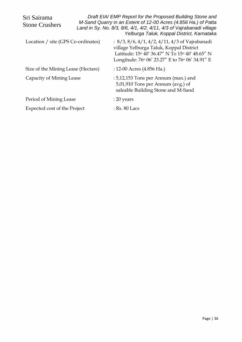
Sri Sairama
Stone Crushers
Draft EIA/ EMP Report for the Proposed Building Stone and M-Sand Quarry in an Extent of 12-00 Acres (4.856 Ha.) of Patta
Land in Sy. No. 8/3, 8/6, 4/1, 4/2, 4/11, 4/3 of Vajrabanadi village Yelburga Taluk, Koppal District, Karnataka
Page | 36
Location / site (GPS Co-ordinates) : 8/3, 8/6, 4/1, 4/2, 4/11, 4/3 of Vajrabanadi village Yelburga Taluk, Koppal District
Latitude: 15o 40’ 36.47” N To 15o 40’ 48.65” N Longitude: 76o 06’ 23.27” E to 76o 06’ 34.91” E
Size of the Mining Lease (Hectare) : 12-00 Acres (4.856 Ha.)
Capacity of Mining Lease : 5,12,153 Tons per Annum (max.) and 5,01,910 Tons per Annum (avg.) of saleable Building Stone and M-Sand
Period of Mining Lease : 20 years
Expected cost of the Project : Rs. 80 Lacs

Sri Sairama
Stone Crushers
Draft EIA/ EMP Report for the Proposed Building Stone and M-Sand Quarry in an Extent of 12-00 Acres (4.856 Ha.) of Patta
Land in Sy. No. 8/3, 8/6, 4/1, 4/2, 4/11, 4/3 of Vajrabanadi village Yelburga Taluk, Koppal District, Karnataka
Page | 37
Contact Information : Sri Sairama Stone Crushers Sy. No.54, Venaktagiri Village,
Gangavathi Taluk, Koppal District.
Table 10: Environmental Settings
Sl. No.
Areas Distance in kilometer / Details
1 Distance of project site from nearest rail or road bridge over the concerned River
Not applicable, since the proposal is not for River Sand Mining.
2 Distance from infrastructural facilities
Railway Station Koppal: 36.5 km
National Highway NH-50: 11.2 km
State Highway
Vajrabanadi – Konasagar Road: 0.3 km
Any Other Road
SH-36 (Koppal to Kushtagi Road): 5.1 km
Electric transmission line pole or tower 0.5 km, near the crusher site
Canal or check dam or reservoirs or lake or ponds (Canal)
Dammur Kere: 4.1 km SW
3 Areas protected under international conventions, national or local legislation for their ecological, landscape, cultural or other related value
None within 5 km
4 Areas which are important or sensitive for ecological reasons - Wetlands, watercourses or other water bodies, coastal zone, biospheres, mountains, forests
Dammur Kere: 4.1 km SW
5 Areas used by protected, important or sensitive species of flora or fauna for breeding, nesting, foraging, resting, over wintering, migration
None within 5 km radius
6 Inland, coastal, marine waters Dammur Kere: 4.1 km SW
7 State, National boundaries None within 5 km
8 Routes or facilities used by the public for access to recreation or other tourist, pilgrim areas
SH-36 (Koppal to Kushtagi Road): 5.1 km
9 Defense installations None within 10 km radial distance

Sri Sairama
Stone Crushers
Draft EIA/ EMP Report for the Proposed Building Stone and M-Sand Quarry in an Extent of 12-00 Acres (4.856 Ha.) of Patta
Land in Sy. No. 8/3, 8/6, 4/1, 4/2, 4/11, 4/3 of Vajrabanadi village Yelburga Taluk, Koppal District, Karnataka
Page | 38
Sl. No.
Areas Distance in kilometer / Details
10 Densely populated or built-up area, distance from nearest human habitation
Koppal: 36.5 km Vajrabanadi Village: 1.0 km
11 Areas occupied by sensitive man-made land uses(hospitals, schools, places of worship, community facilities)
Yelburga-12.1
12 Areas susceptible to natural hazard which could cause the project to present environmental problems (earthquakes, subsidence, landslides, erosion, flooding or extreme or adverse climatic conditions)
Not within 10 km Study area
13 Is proposed mining site located over or near fissure / fracture for ground water recharge
No
14 Whether the proposal involves approval or clearance under the following Regulations or Acts, namely:-
No. The proposal doesn’t involve any kind of clearance under Forest (Conservation) Act, 1980; Wildlife (Protection) Act, 1972
and CRZ Notification 2011/2019
(a) The Forest (Conservation) Act, 1980;
(b) The Wildlife (Protection) Act, 1972;
(c) The Coastal Regulation Zone Notification, 2011.
If yes, details of the same and their status to be given.
15 Forest land involved (hectares) NIL
16 Whether there is any litigation pending against the project and/or land in which the project is propose to be set up?
No
(a) Name of the Court
(b) Case No.
(c) Orders or directions of the Court, if any, and its relevance with the proposed project

Sri Sairama
Stone Crushers
Draft EIA/ EMP Report for the Proposed Building Stone and M-Sand Quarry in an Extent of 12-00 Acres (4.856 Ha.) of Patta
Land in Sy. No. 8/3, 8/6, 4/1, 4/2, 4/11, 4/3 of Vajrabanadi village Yelburga Taluk, Koppal District, Karnataka
Page | 39
2.10.2 Details of other quarries present within the same cluster of 500m radius:
The proposed Building Stone & M-Sand Quarry of Sri Sairama Stone Crushers, with an extent of 12-00 Acres (4.856 Ha.), is located in Sy. No. 8/3, 8/6, 4/1, 4/2, 4/11, 4/3 of Vajrabanadi village Yelburga Taluk, Koppal District, Karnataka.
As per the Clause No. (b) (i) of the Gazette Notification No. S.O. 2269 (E), dated 01st July 2016, issued by the Ministry of Environment, Forests & Climate Change, Government of India (Amendment of the EIA Notification 2006), “A cluster shall be formed when the distance between the peripheries of one lease is less than 500 meters from the periphery of other lease in a homogeneous mineral area which shall be applicable to the mine leases or quarry licenses granted on and after 9th September, 2013”.
Further, as per Clause No. (5) of the said Notification, “The leases not operative for three years or more and leases which have got environmental clearance as on 15th January 2016, shall not be counted for calculating the area of cluster, but shall be included in the Environmental Management Plan and the Regional Environmental Management Plan”.
Accordingly, the proponent has obtained the Cluster Certificate from the Senior Geologist, Dept. of Mines & Geology, Koppal, vide Letter No. DMG/SGK/QLA/2021-22/2323 dated 16th Sep. 2021, which states that, there are Four (4) existing quarry leases, within 500m from the lease boundary of the above proposed quarry and all these existing four (4) leases with a combined extent of 28 Acres 38 Guntas ((17.71 Ha.)
2.11 Environmental Policy at Sri Sairama Stone Crushers’s Quarry A] Objectives:
Conduct mining and associated operations in an environmentally responsible manner to comply applicable laws and other requirements related to environmental aspects and design projects with due consideration of sustainable development.
Prevent pollution of surrounding habitation by continuous monitoring and adopt suitable measures for environmental protection.
Ensure compliance of Environmental Clearance conditions and other statutory conditions issued by regulatory agencies.
Implement Environmental Management Plan in the mine effectively to mitigate pollutions of air, water, noise and land caused by mining operations.
B] Strive to conserve Bio-diversity: Strive for continual improvement in our environmental performances by setting
targets, measuring progress and taking corrective actions. Great awareness about environment among the employees and local community
through proactive communication and training. C] Strategies to implement Environmental Policy:
1] Mine planning on sustainable development: Mining activity will be designed on principal of sustainable development with due

Sri Sairama
Stone Crushers
Draft EIA/ EMP Report for the Proposed Building Stone and M-Sand Quarry in an Extent of 12-00 Acres (4.856 Ha.) of Patta
Land in Sy. No. 8/3, 8/6, 4/1, 4/2, 4/11, 4/3 of Vajrabanadi village Yelburga Taluk, Koppal District, Karnataka
Page | 40
consideration to environment, safety at the planning stage itself. Efforts will be given to use latest equipments and technologies which will be
environmental friendly.
2] Environmental Impact Assessment and Management Plan: Mining will be carried out to comply the environmental standards of quality of
various pollutants within limit under NAAQM, acts and National Environmental Policy.
Detailed Environmental Management Plan has been prepared and operations will be carried out as per clearances of SEIAA, KSPCB and environment department of Karnataka State Government.
Detailed mine closure plans is/shall be prepared as per IBM/ Dept. of Mines & Geology guidelines.
3] Compliance to statutory requirements
Timely submission of returns/ compliance will be ensured with respect to implementation of CFO, EMP and EC.
4] Measure to mitigate Pollution a] Air Pollution: Generation of dust will be marginal, in Building Stone & M-Sand Quarrying.
However, the dust that gets generated will be controlled at source to possible extent with necessary measures during drilling, blasting, loading, unloading, transfer points etc. Dust generation will be minimized along transportation as per mitigation measures in EMP. Green belt will be developed around dust source and along the haulage road.
b] Mine Closure Plan: Mine closure plan is/will be prepared as progressive and at final stage. Appropriate
funds were deposited every year for its utilization for PMCP and FMCP. c] Monitoring:
All receptors in and around mine will be monitored regularly to assess efficiency of pollution control measures.
Effect of mining on hydrology of the area will be monitored through measurement of water level and its quality of nearby wells/bores. Conservation of water through rain water harvesting shall be taken up.
Environmental cell will regularly interact with local area people related to environment to have corrective actions.
Environmental monitoring and audit will be carried out regularly. Annual budget will be prepared based on action plan including monitoring and
implementation. Budget utilization will also be recorded.
d] Preservation of Bio-diversity:

Sri Sairama
Stone Crushers
Draft EIA/ EMP Report for the Proposed Building Stone and M-Sand Quarry in an Extent of 12-00 Acres (4.856 Ha.) of Patta
Land in Sy. No. 8/3, 8/6, 4/1, 4/2, 4/11, 4/3 of Vajrabanadi village Yelburga Taluk, Koppal District, Karnataka
Page | 41
Selection of species for plantation shall be done in consultation with local community to include the local species and their preferences if any. Technical help of experts like local forest departments will also be sought.
e] Awareness Program: Regular training programs will be organized for executives and workers to aware
the environmental policies and implementation, execution of EMP etc. D] Implementation of Policy: a] Manpower:
An environmental cell shall be setup, comprising
(i) Partner (ii) Mines Manager (iii) Blaster (iv) Admin Officer (v) Representative of Workers
Mines Manager will be in charge of “Environment Cell” at Sri Sairama Stone Crushers’s Building Stone & M-Sand Quarry (12-00 Acres: 4.856 Ha.) and will be responsible for compliance of the conditions stipulated in environmental clearance by State Environment Impact Assessment Authority, Karnataka.
Environment management plan has been prepared to ensure mining with least likely alterations in environmental quality. Needs as per review of impacting activities at Sri Sairama Stone Crushers’s quarry are i) dust control from fugitive sources, ii) controlled sequential blasting (with delayed detonators) & noise control, iii) storage of material and iv) sustained health care of miners. Terms of reference for environmental cell during regular mine operations: Construction of macadamized /asphalted roads, Transportation of mined material in covered trucks, Provision of speed breakers over haulage roads. Water sprinkling and plantation along the roads, Plantation along the safety zone, Stabilization of dumps by plantation. Study efficiencies of control measures. Regular monitoring of ambient air quality, noise levels within 5 km radius as per
MoEF norms & conditions in the environmental clearance letter. An NABL - accredited agency will be engaged for monitoring. They will use
appliances like standard make high volume samplers, noise meter and collect micrometeorology data.
b] Roles and Responsibilities:
This environmental cell will be responsible to implement policy, obtaining EC, undertaking mitigation measures, preparation of action plan every year and

Sri Sairama
Stone Crushers
Draft EIA/ EMP Report for the Proposed Building Stone and M-Sand Quarry in an Extent of 12-00 Acres (4.856 Ha.) of Patta
Land in Sy. No. 8/3, 8/6, 4/1, 4/2, 4/11, 4/3 of Vajrabanadi village Yelburga Taluk, Koppal District, Karnataka
Page | 42
statutory compliances to regulatory agencies. This cell will be responsible for monitoring of work, budget allocation, its
expenses, audits and will monitor cost effectiveness of environmental control measures undertaken and help to frame future budget allocations.
Any noncompliance will be dealt as per procedure defined in OM J11013/41/2006 IA.II(I) dated 12.12.2012 and amendments thereof or notifications or time to time guidelines and court orders.
C] Review of Policy:
In view of fast changing social, environmental, economic scenario, this policy will be reviewed and revised every 5 years to incorporate statutory legal and other changes to acts, policies, standards prevailing at that time.
Copy of Environmental Policy of Sri Sairama Stone Crushers’s Quarry, duly signed by her (partnership), is enclosed as Annexure-4. 2.12 Safeguards in Opencast Mine working at Sri Sairama Stone Crushers’s Quarry: Basis & provisions of safeguards Metalliferous Mines Regulations, 1961
A] Opencast Workings
Height of benches will not be more than digging height of machine used for digging, excavation, removal.
Width of bench shall not be less than height of bench. Formation of bench will be from top to downwards
B] Roads for trucks/dumpers All roads and machinery like trucks, dumpers will be maintained in good
condition probably under AMC with OEM. If possible one way traffic / flagging for traffic management will be implemented. Benches will be designed in such a way that at corner/bends vehicle drives shall
at least have visibility 3 times of breaking distance. Speed limit restriction will be 20km/hr within mines.
Haulage road shall be designed in such a way that it shall not have gradient more than 1 in 10.
C] Supervision Well qualified mining engineer will only supervise the operations. All drilling and cutting operations will be carried under supervision of qualified
Mining Engineer only as per standard drilling and cutting pattern.

Sri Sairama
Stone Crushers
Draft EIA/ EMP Report for the Proposed Building Stone and M-Sand Quarry in an Extent of 12-00 Acres (4.856 Ha.) of Patta
Land in Sy. No. 8/3, 8/6, 4/1, 4/2, 4/11, 4/3 of Vajrabanadi village Yelburga Taluk, Koppal District, Karnataka
Page | 43
D] Maintenance of machineries and vehicles Every HEMM will be maintained in good condition probably under supervision
of OEM. All the machineries and vehicles will be equipped with alarming systems, horns,
front and rear lights, efficient brakes, reverse alarms and trained operators. Code of instruction furnished by OEM regarding machinery operations,
maintenance, schedules etc. shall be strictly followed and recorded. Any machine found to be unfit for operation shall be boldly tagged as “OUT OF
SERVICE” to avoid any mishap. Powers will be disconnected when repairs made to any electrical machinery. Brakes for machinery/vehicles /dumpers shall be tested on regular interval as
per schedule of OEM. Records shall be maintained. No person will be allowed to work under chassis when body will be on raised
position. Chokes will be used during parking of machineries. All the machineries will be daily monitored, checks for preventive maintenance
before their deployment to field by authorized persons. Record will be maintained on daily basis.
No person/ helper will be deployed without permission of Mines Manager to any machinery/dumper.
No vehicle without instruction of management will be allowed to Mines as a safety matter.
E] Duties of Machinery Operator: Operator will check his machinery on daily basis before operating it. All operators will be regularly monitored by authority for their fitness and skills. To prevent unauthorized driving ignition keys/cabin keys will be deposited to
store keeper. Store keeper will issue these key only on permission of Mines Manager to Operator or to Maintenance Supervisor.
Code of Traffic Rules will be framed by Mines Manager for movement of HEMM, Dumpers, Trucks will be prominently displayed and complied with.
Spoil bank will be designed and maintained scientifically away from railway track, public roads building or other permanent structures.
F] Precautions while drilling Position of every hole will be drilled strictly as marked by competent authority of
Mines. These will be clearly visible. No person will be permitted within radius of 20m or 60m from same bench while
dislodging the blocks from primary rock.
G] Miscellaneous Precautions Contractors’ persons will be guided and monitored as a safety point of view. No
trailer will be allowed in the mine. Management will frame Safe Operating Procedures (SOP) for each operation and
copy will be handed over to concerned personnel for implementation. All precautions and directives given by DGMS will be strictly followed.

Sri Sairama
Stone Crushers
Draft EIA/ EMP Report for the Proposed Building Stone and M-Sand Quarry in an Extent of 12-00 Acres (4.856 Ha.) of Patta
Land in Sy. No. 8/3, 8/6, 4/1, 4/2, 4/11, 4/3 of Vajrabanadi village Yelburga Taluk, Koppal District, Karnataka
Page | 44
CHAPTER 3 DESCRIPTION OF ENVIRONMENT
3.1 General: This chapter includes baseline environmental quality data in and around the
proposed Building Stone & M-Sand Quarry of Sri Sairama Stone Crushers, which is the proposed open cast mining by semi- mechanized method over 12-00 Acres (4.856 Ha.) of Non-Forest Patta Land, in Sy. No. 8/3, 8/6, 4/1, 4/2, 4/11, 4/3 of Vajrabanadi village Yelburga Taluk, Koppal District, Karnataka. The Baseline information was generated and also collected from secondary sources.
Present terrestrial/land use and status of aquatic/water, air quality, noise levels, biological, socio economic aspects of environment was studied. Mining operations are concerned with status of land, water, air, noise & vibration, biological, socio economic aspects directly or indirectly related.
a) Study area: Core zone is the proposed lease area itself. Buffer zone for this project is 10 km radius from the proposed area, as per Standard ToR, published by MoEFCC. Core and buffer zones for this project are marked on Survey of India Topo sheet Nos. 57 A/2, along with 5 km and 10 km from lease area (Annexure-3).
b) Monitoring period: Base line monitoring was conducted, as per Office Memo no J- 110134/2006-IA-II (Part), dated 29th August 2017. Monitoring period is from Jan. 2022 to Mar. 2022.
C) Components of environment which were examined and monitored included. o Land-use pattern, topography, geology/soil
o Air – Micrometeorology, concentrations of criteria pollutants within core zone as per wind direction, inventory of sources etc.
o Water-Inventory of surface, ground water sources, ground water potential, hydrogeological features e.g. ground water fluctuation, yield
o Noise: inventory of sources, receptors etc.
o Biological- flora, fauna, national park, wild life sanctuaries etc. and
o Socio economic- Demographic details, quality of life, land losers, R & R issues etc.
3.2 Terrestrial/land environment:
3.2.1 Land use Present status of Land-Use Land-Cover within in 10 km radius of the proposed area is shown in Annexure-9. Detailed classification of land use is given in Table 11.
The landuse classification, in the core zone, as well as the 10km radius (buffer zone) of the proposed Building Stone & M-Sand Quarry, are as under:

Sri Sairama
Stone Crushers
Draft EIA/ EMP Report for the Proposed Building Stone and M-Sand Quarry in an Extent of 12-00 Acres (4.856 Ha.) of Patta
Land in Sy. No. 8/3, 8/6, 4/1, 4/2, 4/11, 4/3 of Vajrabanadi village Yelburga Taluk, Koppal District, Karnataka
Page | 45
Table 11: Landuse Details
2.12.1.1 Core Zone (Quarry Area):
Sl. No.
Item Existing Landuse
(Acres-Guntas)
Landuse at the end of plan period (Acres-Guntas)
1. Mining area - 9-06
2. Overburden / dump -- 0-10
3. Mineral Storage -- 0-10
4. Infrastructure, office -- 0-02
5. Roads - 0-02
6. Safety/Green Belt 2-10 2-10
7. Unused / virgin area 9-30 -- Total 12-00 12-00
2.12.1.2 Buffer Zone (10 km radius)
# Category Area (Ha.) Percentage (%)
1 Agricultural Land 39,480.49 94.43 %
2 Built-up Area 606.15 1.46 %
3 Forest Area & Plantation 374.49 0.90 %
4 Waste Lands-Scrub Lands 1,102.24 2.64 %
5 Water Bodies 245.17 0.59 %
TOTAL 41,808.54 100.00
Highest and lowest contours are 682 to 676 m MSL respectively. The project area is sloping down from north-east to south-west. There is not much topsoil, in the proposed area. If any quantity is generated, it will be used for plantation on both sides of the approach road. As per the approved Quarry Plan, there will be waste generation, to the tune of 2% of the mined-out material (ROM). This waste, predominantly being weathered rock, will be used for formation and maintenance of approach road from the quarry location, to the nearby govt. black top road. The proposed lease area is under low hazard seismic zone. There is no record of earthquake.
3.2.2 Soil quality: There are no major rivers in the area and even in the district. Most of the streams are ephemeral in nature carrying large quantities of water immediately after precipitation. The drainage is generally sub-articulate to sub-parallel following straight courses. According to the assessment made on the basis of the visit and some secondary data the area is covered by Red loamy soils, red sandy soils. Majority of the soils around the proposed site are shallow to medium deep in character. These are subjected to certain farming practices. Which offers moderate production status, as the area receives moderate and scanty rainfall.
As the soils are exposed to dryness and the problem of erosion is very serious due to slopy and undulating topography. The steep slopes and marginal lands bordering

Sri Sairama
Stone Crushers
Draft EIA/ EMP Report for the Proposed Building Stone and M-Sand Quarry in an Extent of 12-00 Acres (4.856 Ha.) of Patta
Land in Sy. No. 8/3, 8/6, 4/1, 4/2, 4/11, 4/3 of Vajrabanadi village Yelburga Taluk, Koppal District, Karnataka
Page | 46
hillocks face acute erosion in times of heavy rains. The cropping environment includes the rainfed situation.
As far as the proposed building stone & M-Sand quarry area is concerned, there is no agriculture over the lease. Physical - chemical properties of soils, in the nearby areas are given in Table 12:
Table 12: Chemical properties of Soil
# Parameters Unit S1 S2 S3 S4 S5 S6 S7 S8
1 pH @ 250C - 7.57 7.61 7.49 7.59 7.68 7.79 7.66 7.90
2 Elect. Conductivity s/cm 283 289 282 292 302 299 302 295
3 Sodium mg/Kg 128 138 142 148 158 164 172 179
4 Potassium mg/Kg 112 119 121 119 117 118 117 118
5 Total Soluble Solids % 1.0 8.5 8.9 9.8 8.8 9.8 8.1 9.1
6 Organic Matter % 0.8 1.5 1.9 1.9 1.5 2.4 1.2 1.9
7 Water Content % 6.8 3.9 4.2 4.9 3.4 3.9 3.2 3.9
8 Nitrate Nitrogen* mg/Kg 230 359 379 391 382 388 375 369
9 Phosphorus mg/Kg 28 8.8 8.2 8.9 8.9 8.9 7.2 7.9
3.3 Air Environment: Micrometeorology: Koppal is the nearest Automatic Weather Station from the proposed Building Stone & M-Sand Quarry Area. Site specific micro-meteorological data was collected for 3 months (Jan. 2022-Mar. 2022), for various parameters like temperature, rainfall, wind speed, wind direction, humidity etc. The collected data, is presented in Annexure-17.
Data Analysis Meteorological data collected during the study reveals the following status. Wind Direction: Predominant wind directions, during the study period, in the order are from ENE (19.70%), followed by NE (14.58%), E (12.82%) and ESE (10.05%). Wind Speed: Wind velocity readings were ranging from 0.06 m/Sec to 6.69 m/ sec, with an average wind speed of 2.48 m/ sec, during the study period. Temperature: Temperature values were ranging from 13.24°C to 29.77°C, with an average temperature of 21.52°C, during the study period. Relative Humidity: The mean relative humidity value was found to be 84.21%. Cloud cover: Sky was cloudy during major part (60.37%) of the study period. Rainfall: A considerable rainfall of 507.43 mm was recorded during the study period.
3.3.1 Air pollutants: Source inventory: There are no major industries within core and buffer zones and there are no stationary sources like stacks/chimneys. There is no agriculture in the core area. Nearest habitation is Vajrabanadi village and there are no fugitive sources of emissions.
3.3.2 Monitoring stations for ambient air quality (AAQ): AAQ monitoring sites were decided on basis of predominant wind directions and wind direction during monitoring period. The monitoring stations are shown below:

Sri Sairama
Stone Crushers
Draft EIA/ EMP Report for the Proposed Building Stone and M-Sand Quarry in an Extent of 12-00 Acres (4.856 Ha.) of Patta
Land in Sy. No. 8/3, 8/6, 4/1, 4/2, 4/11, 4/3 of Vajrabanadi village Yelburga Taluk, Koppal District, Karnataka
Page | 47
Table 13: Particulars of Monitoring Stations
Station Code
Station Name Distance KM
Direction
S1 Mine Lease Area Core Zone
S2 Vajrabanadi 1.00 S
S3 Kalakbandi 3.8 NE
S4 Dammur 4.1 SW
S5 Konsagar 2.4 NW
S6 Ningalbandi 3.8 E
Air quality was monitored as per MOEF & CC norms. There are no sources of sulphur & nitrogen oxides, hydrocarbons or heavy metals etc. Building Stone & M-Sand deposits do not contain trace/ heavy metals. Therefore, air quality criteria pollutants for this project are PM10, PM2.5, Sulphur dioxide and nitrous oxides in air were measured. Calibrated
Respirable Dust Samplers and Fine Particulate Samplers were used. 24 hours samples were collected twice a week for, 12 weeks (3 months) at each station. Samples were collected and sent to a NABL recognized laboratory for analysis. Air quality monitoring data is given in Annexure-11.
Data Analysis (Jan. 2022 to Mar. 2022) Area has rural setting. Predominant emissions during open cast mining project would be generate
particulate matter likely during drilling, blasting, loading/unloading and transportation activities.
Based on the ambient air quality status is given in Annexure-11, the following conclusions could be arrived at:
Table 14: Summary of Ambient Air Quality Monitored Data
Parameter Min. value observed (μg/m3)
Max. value observed (μg/m3)
Average Value Observed (μg/m3)
Limit as per NAAQS 2009
(μg/m3)
Core Zone
Buffer Zone
Core Zone
Buffer Zone
Core Zone
Buffer Zone
PM 2.5 28.80 30.90 36.20 52.00 31.60 38.70 60
PM 10 47.90 46.80 60.60 67.30 51.20 60.30 100
SO2 9.40 9.50 11.50 13.00 10.90 11.30 80
NOx 9.40 8.40 10.50 11.40 9.90 9.80 80 3.4 Water Environment:
3.4.1 Water Budget Water requirement for project, sources and ground water potential: Building Stone and M-Sand Boulders mining will need water for drinking for the mine workers, dust control and plantation. Mining operations also need water for wet drilling etc.
There will not be any residential colony. Drinking water requirement for 20 workers

Sri Sairama
Stone Crushers
Draft EIA/ EMP Report for the Proposed Building Stone and M-Sand Quarry in an Extent of 12-00 Acres (4.856 Ha.) of Patta
Land in Sy. No. 8/3, 8/6, 4/1, 4/2, 4/11, 4/3 of Vajrabanadi village Yelburga Taluk, Koppal District, Karnataka
Page | 48
would be 600 LPD (Liters per Day) @ 30 LPCD (Liters per Capita per Day). Water requirement for dust control would be 5 KLD (incl. wet drilling) and about 5 KLD will be required for plantation. Drinking water will be supplied from the nearby village after disinfection. Tankers will be used.
Table 15: Water Requirement
Use Source Quantity KLD Wastewater KLD
Disposal
Dust control Mine pit/ Crusher Site 5 Nil --
Plantation Mine pit/ Crusher Site 5 Nil --
Domestic Mine pit/ Crusher Site 0.60 0.50 Septic Tank
Total -- 10.60 0.50
There are no surface sources viz. rivers/ lake within the proposed quarry lease area. There are no surface sources viz. rivers/ lake in the lease area. 3.4.2 Ground Water Potential:
Ground water resource in the Koppal region of which proposed quarry area is Karnataka, as per hydrogeology report –CGWB is given below:
Table 16: Ground Water Potential
Net G.W. availability 28426 HAM
Net Annual Draft 40060 HAM
Balance Resource 1699 HAM
Stage of G. W. Development (28426/40060)x 100= 70.96% (Source: Ground Water Brochure, Koppal District, KARNATAKA, published by Central Ground
Water Board, Govt. of India, South Western Region, Bangalore, August 2012) 3.4.3 Ground Water Scenario : At the end of conceptual period there will be a single pit of 72500 sq. m. with the conceptual depth of 52m from the highest peak in the quarry. At the end of conceptual period ultimate bottom level will be 650 m above MSL.

Sri Sairama
Stone Crushers
Draft EIA/ EMP Report for the Proposed Building Stone and M-Sand Quarry in an Extent of 12-00 Acres (4.856 Ha.) of Patta
Land in Sy. No. 8/3, 8/6, 4/1, 4/2, 4/11, 4/3 of Vajrabanadi village Yelburga Taluk, Koppal District, Karnataka
Page | 49
The district is part of Krishna basin, the main streams draining the area are Maskinala, Ilkal-nadi and Hirenala. These are Ephemaral in nature, these come under Tungabhadra sub-basin. The drainage exhibit dentritic to subdentric with drainage density varies from 1.4 to7.0kms/sq.km.
Koppal district experiences a semi-arid type climate characterized by hot summer and low rainfall. It is cool and pleasant during major part of the year except during the summer months of March to middle of June. The coldest period is December to January minimum temperatures reaches up to 16°C and maximum reaches 45°C during hot summer district characterized by dryness for the major part of the year because of less rainfall there is pleasant monsoon season. The annual normal rain fall is 571.92 mm and normally rain commences from June and continuous up to November. Heavy rainfall during the months of September and October about 65% of which is south west monsoon with normal average rain days of 40 in a year. In general rainfall decreases from west to east the district falls northern median region of state.
The district is mainly underlain by gneisses, granites and schists. The hard rocks as they do not have any primary porosity however, weathering, fracturing, joints and tectonic features likes folds and faults have secondary porosity and permeability. Which has improved water yielding, capacity of the wells. The main source of recharge is precipitation. Weathered thickness is reported minimum of 1m and maximum of 20 m BGL nearer to nalas. In general ground water available in the weathered zone under phreatic condition and under confined to semi-confined conditions in the jointed and fractured formation. Ground water developed through dug wells, dug cum bore wells and bore wells. Dug wells are common, used for irrigation as well as for domestic purposes. Its depth ranges from minimum of 1.7m m BGL to maximum of 15.7m m BGL. Pink granite is more susceptible for weathering than grey granite. So, pink granite is good aquifer than gray granite. In granite gneisses the yield of the wells reported are in the range of 4-100m3/day in dug wells, and in dug cum bore wells it ranges between 28.8-42.3m3 withstanding pumping of 4-5hr/day and the specific capacity ranges between 35.0-240.5m3/day/m. The wells taping schistose formation is poor yielding compared to granite and gneiss formations. The alluvium found along a major nala course as thin lenses with thickness of 6-8m m BGL. The diameter of wells is 3.5 to 5.00 m, the specific capacity reported was between 230.4 to 533.0 m3/day/m. the bore wells drilled by formers as well as govt agencies for domestic and irrigation purposes with depth range of 40-70m and reported yield of bore wells less than 1 lps to 7.6lps. The promising zone is 30-60 m BGL. The central ground water board in the district has 33 net work stations, which are being monitored four times in a year i.e. January, May (pre monsoon) August and November (post monsoon). A hydrogeological map is presented below.

Sri Sairama
Stone Crushers
Draft EIA/ EMP Report for the Proposed Building Stone and M-Sand Quarry in an Extent of 12-00 Acres (4.856 Ha.) of Patta
Land in Sy. No. 8/3, 8/6, 4/1, 4/2, 4/11, 4/3 of Vajrabanadi village Yelburga Taluk, Koppal District, Karnataka
Page | 50

Sri Sairama
Stone Crushers
Draft EIA/ EMP Report for the Proposed Building Stone and M-Sand Quarry in an Extent of 12-00 Acres (4.856 Ha.) of Patta
Land in Sy. No. 8/3, 8/6, 4/1, 4/2, 4/11, 4/3 of Vajrabanadi village Yelburga Taluk, Koppal District, Karnataka
Page | 51
Pre-Monsoon Ground Water Levels in Koppal District Pre-monsoon depth to water level during 2006, recorded in the range of minimum of 4.5mts and maximum of 16.50mts. In the district major parts of Koppal, Yelburga, Kushtagi taluks are having depth to water levels in the range of 10-20m. In major parts of Gangavathi taluk depth to water levels recorded in the range of 5-10 m range and a small patch is having 2-5m range.

Sri Sairama
Stone Crushers
Draft EIA/ EMP Report for the Proposed Building Stone and M-Sand Quarry in an Extent of 12-00 Acres (4.856 Ha.) of Patta
Land in Sy. No. 8/3, 8/6, 4/1, 4/2, 4/11, 4/3 of Vajrabanadi village Yelburga Taluk, Koppal District, Karnataka
Page | 52
Post-Monsoon Ground Water Levels in Koppal District Post monsoon depth to water level during 2006 range from 1.15m to 16.24m. Study of distribution of percentage of observation of wells during November 2006 show 30.77% having depth to water levels in the range of 5.0-10.0 m bgl, 38.46% wells have recorded water levels in the range of 10.0-20.0 m BGL. A small patch in Gangavathi taluk is having water levels of less than 2m BGL and a small patch of more than 20m BGL is observed around in Kushtagi and Yelburga taluks

Sri Sairama
Stone Crushers
Draft EIA/ EMP Report for the Proposed Building Stone and M-Sand Quarry in an Extent of 12-00 Acres (4.856 Ha.) of Patta
Land in Sy. No. 8/3, 8/6, 4/1, 4/2, 4/11, 4/3 of Vajrabanadi village Yelburga Taluk, Koppal District, Karnataka
Page | 53
From the above, it is concluded that ground water level in the proposed quarry region, is varying in between 30m to 40m BGL, during pre-monsoon season and becomes 25m to 30m BGL, during post-monsoon season. (Source: Ground Water Brochure, Koppal District, KARNATAKA, published by Central Ground Water Board, Govt. of India, South Western Region, Bangalore, August 2012)
Hence it is also concluded that mining operation will not intersect ground water table of the area.
3.4.4 Water Quality: Ground Water Samples were collected from the nearby villages and from a farm land near the proposed quarry site. The collected samples were analyzed in a NABL accredited laboratory. Analysis of water samples are given in Table 17.
Table 17: Ground water quality
Parameter Unit IS:10500-2012(RA 2018) Sampling Stations
Allowable Permissible S1 S2 S3 S4 S5 S6 S7 S8
Color Hazen 5 15 05 05 05 05 05 05 05 05
pH ----- 6.5 to 8.5
No Relaxation
7.25 7.60 7.35 7.82 8.02 7.93 7.55 7.62
Turbidity NTU 1 5 0.32 0.72 0.46 0.65 0.28 0.70 0.54 0.86
Alkalinity as CaCO3
mg/L 200 600 162 190 184 178 120 134 146 162
Total Dissolved
Solids
mg/L 500 2000 650 820 742 790 546 810 682 950
Total Hardness as CaCO3
mg/L 200 600 180 232 240 204 296 194 300 250
Calcium
as Ca+2 mg/L 75 200 36.87 47.29 48.89 41.68 60.12 40.08 60.92 51.30
Magnesium as Mg
mg/L 30 100 21.38 27.70 28.67 24.3 35.47 22.84 35.96 29.65
Sulphate mg/L 200 400 32.1 40.5 35.2 32.4 28.8 24.1 25.8 30.2
Chloride as Cl
mg/L 250 1000 52.98 59.98 136.9 106.9 96.97 122.9 120.9 160.9
Nitrate as NO3-N
mg/L 45 No
Relaxation 4.10 3.60 5.04 3.25 4.31 4.68 3.15 3.36
Total Iron mg/L 0.3 No
Relaxation 0.040 0.032 0.025 0.032 0.028 0.032 0.043 0.035
Fluoride mg/L 1.0 1.5 0.680 0.825 0.782 0.730 0.635 0.544 0.629 0.846
a) Observations on water quality:
The ground water quality in and around the proposed lease area is slightly alkaline, with the pH levels ranging from 7.20 to 7.60. The total hardness is ranging from 336 to 548 mg/liter as CaCO3, whereas the Total Dissolved Solids content is varying between 470 to 751 mg/liter. The fluoride levels are ranging from 0.25 to 0.52 mg/liter and the nitrate levels are varying between 0.20 to 1.984 mg/liter. The sulphate levels are

Sri Sairama
Stone Crushers
Draft EIA/ EMP Report for the Proposed Building Stone and M-Sand Quarry in an Extent of 12-00 Acres (4.856 Ha.) of Patta
Land in Sy. No. 8/3, 8/6, 4/1, 4/2, 4/11, 4/3 of Vajrabanadi village Yelburga Taluk, Koppal District, Karnataka
Page | 54
ranging from 37.0 to 277.0 mg/liter and the chloride levels are varying between 60 to 172 mg/liter. In general, the ground water quality in the study area, confirms to the permissible limits of IS:10500-2012, within the study area.
b) Wastewater: Dewatering of pits during mining will not be required. Sanitary wastewater will be generated. Toilet facility will be provided with septic tank and soak pit
3.5 Noise environment: There are no industrial noise sources. There is no habitation over the lease. Ambient noise levels were measured at the ambient air monitoring stations. Day and night equivalent noise levels were measured using a standard noise meter. Observed values are given in Table 18.
Sources of noise would be during drilling, blasting and transportation of mined-out material from the lease area to the Stone Crusher, proposed at a distance of 0.3 km
Table 18: Noise levels Leq in dB(A)
Time S1 S2 S3 S4 S5 S6 S7 S8 S9
0600 41.4 37.5 36.9 42.5 36.3 42.1 39.6 42.3 43.1
0700 42.5 34.6 40.6 41.4 37.9 43 40.6 42.5 44.2
0800 37.5 35 42.6 40.3 39.3 41.1 41.3 45.3 39.6
0900 37.8 36.9 41.6 43.4 37.4 42 42.4 43.2 41.2
1000 36.5 37.2 36.7 39.5 39.4 41 43.2 44.3 42.9
1100 35.6 38.5 37.4 38.5 39 43 45.4 45.6 43.7
1200 41.5 38.2 46.4 39.5 40.1 40.8 44.3 43.7 45.8
1300 42.4 39.5 43.6 38.5 40.3 42.8 45.3 43.9 44.5
1400 34.6 41 47.5 37.5 41.3 39.2 43.2 45 43.5
1500 35.2 39.6 42.2 38.6 44.5 40.8 42.3 44.6 41.2
1600 35.9 40.2 43.7 37.5 44.2 42.3 45.3 44.4 42.5
1700 36.5 40.6 46.3 36.7 45.6 43.5 42.3 43 43.3
1800 39.7 41.8 47.4 45.3 46.5 43.6 39.8 48.5 45.3
1900 38.5 42.1 46.5 43.2 45.6 43.7 43.4 40.2 44.4
2000 39.8 45.6 46.7 42.5 47.7 44.6 45.3 43.5 44.9
2100 40.3 43.2 46.4 46.4 47.6 44.7 45.2 45.3 44.6
2200 40.2 45.3 40 46.5 48.6 45.5 45.8 44.3 44.3
2300 41.2 46.5 42.5 44.3 45.5 46.8 43.5 44.6 46.4
2400 41.5 47.7 43.6 43.4 46.6 37.6 44.5 44.6 45.6
0100 42.2 45.3 44.5 45.4 43.4 38.7 45.1 44.7 45.6
0200 39.4 47.4 43.6 44.5 42.4 39.5 45.2 39.6 37.3
0300 40.3 36.2 35.6 40.2 37 43.7 45.7 38.6 39.5
0400 37.2 43.6 37.6 39.5 38.5 45.3 45.8 39.6 39.1
0500 36.5 37.4 36.6 40.2 38.2 43.2 39.5 40.1 41.2
Min. 34.6 34.6 35.6 36.7 36.3 39.5 37.6 38.6 37.3
Max. 42.5 47.7 47.5 46.5 48.6 46.8 45.8 48.5 46.4
Ld 39.8 45.6 46.7 42.5 47.7 44.6 45.3 43.5 44.9

Sri Sairama
Stone Crushers
Draft EIA/ EMP Report for the Proposed Building Stone and M-Sand Quarry in an Extent of 12-00 Acres (4.856 Ha.) of Patta
Land in Sy. No. 8/3, 8/6, 4/1, 4/2, 4/11, 4/3 of Vajrabanadi village Yelburga Taluk, Koppal District, Karnataka
Page | 55
Ln 36.5 38.2 37.8 39.7 38.6 37.5 38.8 39.4 38.7
Ldn 56.11 57.91 57.57 59.30 58.38 57.19 58.48 58.94 58.37
3.6 Flora and Fauna 3.6.1 General: The study area is marked with low isolated hill ranges or hillocks which have bare or very sparse vegetative cover. The area has small terrains of protected forests and scrubland. The overall vegetation of this area is scattered scrubland interspersed with grasslands. sampling locations exhibit same vegetation pattern. The riverine vegetation can be easily distinguished from that of dry scrublands. 3.6.2 Predominant crops Agriculture in Koppal district is dependent upon rainfall, irrigation tanks, wells, streams etc. The major agricultural crops grown are Jawar, Bajra, Wheat, Maize, Paddy, Horsegram, Greengram, Cowpeas and the commercial crops are Groundnut, Till, Cotton, Niger seeds, Castor, Sunflower, Sugarcane etc. 3.6.3 Flora of the area: Koppal District has a very scanty rainfall and the rivers and streams are dry for a large part of the year. Hence, the area is, for the most part, devoid of any major vegetation, and scarcity conditions are very common. There are far more lands under dry cultivation in this district than under wet. If any flora with large trees is to be found in the district, it is only in the regions of Gangavathi Taluk. In other regions, the soil presentation is of a shallow blackish vegetable mould. The soils here give rise to trees and bushes but they do not attain size. The hills in the north of the district are barren and only stunted bushy growth is seen of Kushtagi, Koppal and Yelburga Taluks. In some parts of the district, there is a wild tamarind growth in plenty. In the plains, mango groves are common. Some of the common species found in the buffer zone are surveyed with field visits and listed below.
Table 19: List of the Flora of the Study Area
Sl. No. Botanical Name Family
1. Acacia chundra Mimosaceae
2. Acacia fernesiana Mimosaceae
3. Acacia ferruginea Mimosaceae
4. Acasia leucophloea Mimosaceae
5. Pongamia pinnata Fabaceae
6. Acacia nilotica Mimosaceae
7. Aegle marmelos Rutaceae
8. Ailanthus excelsa Simaroubaceae
9. Albizzia lebbek Mimosaceae
10. Albizzia procera Mimosaceae

Sri Sairama
Stone Crushers
Draft EIA/ EMP Report for the Proposed Building Stone and M-Sand Quarry in an Extent of 12-00 Acres (4.856 Ha.) of Patta
Land in Sy. No. 8/3, 8/6, 4/1, 4/2, 4/11, 4/3 of Vajrabanadi village Yelburga Taluk, Koppal District, Karnataka
Page | 56
11. Anogeissus pendula Combretaceae
12. Cordia dichotoma Boraginaceae
13. Azadirachta indica Meliaceae
14. Balanites aegyptiaca Balantaceae
15. Bauhinia purpurea Caesalpinaceae
16. Bauhinia racemosa Caesalpinaceae
17. Bauhinia variegate Caesalpinaceae
18. Euphorbia pulcherrima Euphorbiaceae
19. Butea monosperma Fabaceae
20. Carica papaya Caricaceae
21. Areca catechu Arecaceae
22. Cassia fistula Caesalpinaceae
23. Cassia siamea Caesalpinaceae
24. Casurina equisetifolia Casurinanaceae
25. Ceiba pentandra Bombaceae
26. Cocos nucifera Arecaceae
27. Borassus flabellifer Arecaceae
28. Dalbergia latifolia Fabaceae
29. Delonix regia Caesalpinaceae
30. Dolichandrone sp Bignoniaceae
31. Erythrina indica Fabaceae
32. Eucalyptus sp Myrtaceae
33. Euphorbia tirucalli Euphorbiaceae
34. Ficus bengalensis Moraceae
35. Ficus benjamina Moraceae
36. Ficus racemosa Moraceae
37. Ficus religiosa Moraceae
38. Holoptelia integrifolia Ulmaceae
39. Jacarada mimosaefolia Bignoniaceae
40. Kigelia pinnata Bignoniaceae
41. Thevatia neriifolia Apocynaceae
42. Leucaena leucocephalia Mimosaceae
43. Mangifera indica Anacardiaceae
44. Melia azadirachta Meliacaeae
45. Millingtonia hortensis Bignoniaceae
46. Moringa oleifera Moringaceae
47. Peltophorum pterocarpum Caesalpinaceae
48. Pithecolobium dulce Mimosaceae
49. Syzigium cumini Myrtaceae
50. Pithecolumbium saman Mimosaceae
51. Plumeria alba Apocynaceae
52. Polyalthea longifolia Annonaceae
53. Prosopis spicigera Mimosaceae
54. Santalum album Santalaceae
55. Tectona grandis Verbenaceae

Sri Sairama
Stone Crushers
Draft EIA/ EMP Report for the Proposed Building Stone and M-Sand Quarry in an Extent of 12-00 Acres (4.856 Ha.) of Patta
Land in Sy. No. 8/3, 8/6, 4/1, 4/2, 4/11, 4/3 of Vajrabanadi village Yelburga Taluk, Koppal District, Karnataka
Page | 57
56. Terminalia catappa Combretaceae
57. Wrighitia tinctoria Apocynaceae
58. Euphorbia geniculata Euphorbiaceae
3.6.3 Common Fauna found in the area: No wildlife sanctuaries are situated within the study area. It was observed that wild life in the region is very scanty. No endangered species have been reported in the study area. The study area does not show much diversity in both terrestrial fauna and avifauna. This is partly due to scarcity of water and disappearance of forests. The mammalians mainly constitute domesticated animals and rodents. 3.7 Socio-Economic Environment
3.7.1 Introduction: The study of socio-economic component of environment incorporates various facets, viz. demographic structure, availability of basic amenities such as housing, education, health and medical services, occupation, water supply, sanitation, communication and power supply, prevailing diseases in the region as well as features such as places of tourist attraction and monuments of archaeological importance. The study of these parameters helps in identifying predicting and evaluating the likely impacts due to project activity in the surrounding region.
In the 10 km radius study area, there are one districts viz. Koppal. As per 2011 census, the study area consists of 20,112 persons inhabited in 12 villages. The statistics regarding the list of villages, number of households and human population is given in Table 20.
TABLE 20: DEMOGRAPHY IN STUDY AREA
Village Name No. of House Holds
Total Population
Vajrabanadi 367 2,125
Ningalbandi 365 2,160
Konsagar 361 2,058
Dammur 331 1,948
Jerkundi 103 684
Bandihal 335 1,867
Bandi 469 2,420
Basapur 213 1,039
Marnal 175 1,101
Helgudda 238 1,795
Madlur 164 450
Taralkatti 451 2,465
Total 3,572 20,112
3.7.2 Methodology used for the Field survey In order to access and evaluate likely impacts arising out of any development projects

Sri Sairama
Stone Crushers
Draft EIA/ EMP Report for the Proposed Building Stone and M-Sand Quarry in an Extent of 12-00 Acres (4.856 Ha.) of Patta
Land in Sy. No. 8/3, 8/6, 4/1, 4/2, 4/11, 4/3 of Vajrabanadi village Yelburga Taluk, Koppal District, Karnataka
Page | 58
on socio economic environment, it is necessary to gauge the apprehensions of the people in the study areas.
3.7.3 Methodology applied for selection of sample & data collection The methodology which is applied for primary source of data collection i.e. gathering data through field survey for socio-economic environment is depicted below:
A Sampling Method A judgmental and purposive sampling method was used for choosing respondents of various sections of the society i.e. Village Assistant, adult males and females, teachers, medical practitioners, businessmen, agriculture laborers, unemployed group etc. Judgmental and purposive sampling method includes the right cases from the total population that helps to fulfill the purpose of research needs.
B Data Collection Method For the process of data collection through primary source farming methods are used.
3.7.4 Field Survey and Observations Field survey and observations is made at each sampling village and the socio- economic status of that region is studied. Visits are made at hospitals, primary health centers and sub-centers to know the health status of the region. Various Governmental organizations such as Statistical Department, Census Department etc. were visited to collect the requisite details of that region.
Table 21: List of Sampling Villages
# Village Name
01 Vajrabanadi
02 Kalkbandi
03 Dammur
04 Konsagar
05 Ningalbandi
3.7.5 Data Collection and Quality Assurance The latest available data have been complied to generate the existing socio- economic scenario of the study area. Information on socio-economic profile was collected from the Primary Census Abstract CD 2011, including the population details of the region and Village Directory CD 2011, having the details of basic amenities available in the region.
3.7.6 Distribution of Population: The distribution of population in the study area is shown in Table: 22
TABLE 22: DISTRIBUTION OF POPULATION
Particulars Total
Total Population 20,221
Male Population (% with total population)
10,404 (51.53%)
Female Population (% with total population)
9,817 (48.47%)
No. of Households 3,572

Sri Sairama
Stone Crushers
Draft EIA/ EMP Report for the Proposed Building Stone and M-Sand Quarry in an Extent of 12-00 Acres (4.856 Ha.) of Patta
Land in Sy. No. 8/3, 8/6, 4/1, 4/2, 4/11, 4/3 of Vajrabanadi village Yelburga Taluk, Koppal District, Karnataka
Page | 59
Average Household Size 4.44
Sex ratio (Female/1000 male) 943
Source: Census of India 2011
The configuration of male and females indicates that the males constitute to about 51.53% and females to about 48.47% of the study area of Yelburga Taluk population, Koppal District. The sex ratio i.e. the number of females per 1000 males indirectly reveals certain sociological aspects in relation with female births, infant mortality among female children and single person family structure, a resultant of migration of industrial workers. The study area at an average has 970 females per 1000 males.
3.7.7 Social Structure Majority of the people in the study area belong to Hindu religion. The study area also contains Scheduled Castes (SC) and Scheduled Tribes (ST). The distribution of population of socially weaker sections in the study area is shown in Table: 23
TABLE: 23 Distribution of Population by Social Structure
Category Population
Total Population 20,112
Scheduled Castes 3,376 (16.79%)
Scheduled Tribes 1,429 (7.11%)
Total SC and ST 4,806 (23.90%)
In the study area 16.79% of the population belongs to Scheduled Castes (SC) while 7.11% to Scheduled Tribes (ST), thus indicating that about 23.90% of the population is formed by SC and ST population. Scheduled Caste and Scheduled Tribe sections are predominant in this area. 3.7.8 Literacy Levels The distribution of literates and literacy rates in the study area are given in Table: 24 below:
TABLE 24: Literacy Level
Particulars Population
Total Population 20,112
Male population 10,404
Male literates 9,812
Female population 9,817
Female literates 7,625
Total literates 17,437
3.7.9 Occupational Structure The occupational structure of the study area is studied with reference to main workers, marginal workers and non-workers. The main workers include 9 categories of workers defined by the Census Department consisting of cultivators, agricultural laborers, those engaged in live-stock, forestry, fishing etc. mining and quarrying; manufacturing,

Sri Sairama
Stone Crushers
Draft EIA/ EMP Report for the Proposed Building Stone and M-Sand Quarry in an Extent of 12-00 Acres (4.856 Ha.) of Patta
Land in Sy. No. 8/3, 8/6, 4/1, 4/2, 4/11, 4/3 of Vajrabanadi village Yelburga Taluk, Koppal District, Karnataka
Page | 60
processing and repairs in household industry; and other than household industry, construction, trade & commerce, transport & communication and other services. Due to boom in mining in recent years majority of farmers as well as agriculture laborers are engaged in the mining activity. This information is not forthcoming from the Published Census Data. The marginal workers are those engaged in some work for a period of less than six months during the reference year prior to the census survey. The non-workers include those engaged in unpaid household duties, students, retired persons, dependents, beggars, vagrants etc. institutional inmates or all other non-workers who do not fall under the above categories. The occupational structure of the study area is shown in Table: 25.
TABLE 25: Occupational Structure of Study Area
Occupation Total
Nos. % to
population
Total Workers 8278 41.16 %
Casual Labor 770 3.83 %
Agricultural laborers 830 4.08 %
Household laborers 420 2.02 %
Other workers 5,125 25.36 %
Total main workers 2,288 11.34 %
Marginal workers 1,198 5.92 %
Non-workers 1,180 5.84 %
Total population 20,112 100.00 %
Altogether the main workers work out to be 11.34% of the area population. The marginal workers and non-workers constitute to 5.92% and 5.84% of the population respectively. The distribution of workers by occupation indicates that the workers in the other workers category are 25.36%, followed by Agricultural Labours (4.08%), casual labor (3.83%) and household labourers (2.02%) respectively.
3.7.10 Salient Observation of the Survey/ Study Area House pattern: It is notable that nearly 85% of the houses were semi pakka with
good construction and others were pakka at survey area. Employment: Main occupation of the people in the study area was labour work
and Business, and some of agriculture. The labours were getting daily wage in the range of Rs. 250-300, depending on type of work involved.
Fuel: Most of the villagers use fire woods and LPG for cooking purpose Main Crops: There are three main cropping seasons in the surrounding area of
the site, namely Kharief from June to December, Late Kharief from September to March and Rabi from December to April. The Kharief is the main farming season, sometimes supported with late Kharief, as the major area falls on rainfed situation only. The crops includes, Ragi, Sajja and Jower as common food crops.

Sri Sairama
Stone Crushers
Draft EIA/ EMP Report for the Proposed Building Stone and M-Sand Quarry in an Extent of 12-00 Acres (4.856 Ha.) of Patta
Land in Sy. No. 8/3, 8/6, 4/1, 4/2, 4/11, 4/3 of Vajrabanadi village Yelburga Taluk, Koppal District, Karnataka
Page | 61
Among the few perennials Mangoes are very popular. Flowering crops like chrysanthemum are of the attraction to farms. Chillies and few vegetables such as Tomatoes, Cabbage and Brinjal are also crops of the interest. Water from dug well and bore well and cannel was used for irrigation
Migration: During survey it was found that local population were migrating for employment purpose. As well as others state peoples were came in that area for the labour work also.
Sanitation: Toilet facility is one of the most basic facilities required in a house. The findings of the survey show that more than 85% of the households were having toilet facilities in their houses. There was open drainage system were seen at the surveyed villages. The overall condition of cleanliness was satisfactory.
Drinking Water Facilities: Ground water is the major source of drinking water in the villages wherein hand pumps, tap water and dug wells are installed.
Education Facilities: Most of the villages had education facilities in the form of Anganwadi and Primary Schools. Higher education facilities were available in the range of 4-6 km. Colleges and other diploma courses were available at district headquarters.
Transportation Facility: For transportation purpose Auto, Public and Private Bus services were available. Transportation facilities were frequently available in the study area and connecting major cities. Private vehicles like Bicycles & Motor Cycles were mostly used by villagers for transportation purpose
Road Connectivity: Most of the roads were pucca and connecting to villages. Blacktop and cement roads were commonly seen inside the villages
Communication Facilities: For communication purpose mainly mobile phones, newspaper & post offices were seen in the villages.
Medical Facilities: There were few health care facilities available in the study area. In some of the villages, Primary Health Sub-Centers were available. Hospitals and other better medical facilities were available in the range of 05-10 km at town/city place
Electricity: All villages were availing electricity facility for all uses Market Facility: Study area was predominantly rural and semi urban type. In
villages, small shops were available for daily needs. Weekly market facility was available in some villages. Wholesale markets were available at town place.

Sri Sairama
Stone Crushers
Draft EIA/ EMP Report for the Proposed Building Stone and M-Sand Quarry in an Extent of 12-00 Acres (4.856 Ha.) of Patta
Land in Sy. No. 8/3, 8/6, 4/1, 4/2, 4/11, 4/3 of Vajrabanadi village Yelburga Taluk, Koppal District, Karnataka
Page | 62
3.8 Waste generation: 3.8.1 Solid Waste:
Mining plan has been prepared for period a five years and the period of lease is about 20 years. As per the approved mining plan, the estimated quantity of waste generation will be about 51,215 Tons for the plan period. This waste, being predominantly weathered rock, will be used for maintenance and strengthening of the approach road (between the quarry and crusher).
3.8.2 Leachates: Granite rejects are not hazardous and do not contain any toxic elements. Leachates will be innocuous because all soluble material has been washed out.
3.8.3 Soil: There is no topsoil likely to be generated. It is proposed to handle about 51,215 tons of waste for the plan period, which will be utilized for strengthening the approach roads and village roads. Excess quantity of waste will be dumped within the lease as shown in the plan.

Sri Sairama
Stone Crushers
Draft EIA/ EMP Report for the Proposed Building Stone and M-Sand Quarry in an Extent of 12-00 Acres (4.856 Ha.) of Patta
Land in Sy. No. 8/3, 8/6, 4/1, 4/2, 4/11, 4/3 of Vajrabanadi village Yelburga Taluk, Koppal District, Karnataka
Page | 63
CHAPTER 4 ANTICIPATED IMPACTS AND MITIGATION MEASURES
4.1 Land Environment:
4.1.1 Anticipated Impact On topography: Lease area is 12-00 Acres (4.856 Ha.), and is a part of flat terrain. The proposed quarry land is a grazing land, but not an agriculture land. It is part of Non-Forest Patta Land, for which, the project authorities have obtained the in-principle grant (in the form of Letter of Intent) from the Dept. of Mines & Geology, Karnataka. The proposed quarry area, is newly allotted to the proponent. The present appearance of the proposed quarry area, is shown below:
It is seen that there is not much top soil and subsoil present within the proposed area. There is no agriculture within the proposed lease area and its immediate surroundings. The QL area is part of a hillock that has an elevation of about 30-40m from the surrounding ground level. Elevation range within the bounds of QL area is between 676 to 682 m above MSL. The entire hillock is part of Sy. No. 8/3, 8/6, 4/1, 4/2, 4/11, 4/3, devoid of any major vegetation. Plants of typical dry lands in Koppal District covers the foot of the lease area besides thorny shrubs. Since the proposed QL area, is at considerable height from the surrounding ground level, there would not be any adverse impact on a) topography/drainage or land use, b) agriculture etc. This being an open cast mining proposal subsidence in the nearby area is not expected. Also, being a hard granitic mass, slope failures are also not anticipated. The external appearance will continue to be as it is.
4.1.2 Mitigation Measures: Geological records on granite deposits state that considerable quantity of grey granitic gneiss, with fractured zones, would be present in the QL area. Extraction of this granitic gneiss boulders, will be done, as per the approved Quarry Plan, which states that all recorded granite deposits as ‘proved mineable reserves’ would be mined within the lease period/ conceptual period of mine. Further, the anticipated quantity of saleable Building Stone & M-Sand is about 98% of the total quantity excavated, resulting in 2% as waste. The top soil generated, if any, will be used for formation and maintenance of the approach road, during the project execution phase.
4.2 Air Environment:
Flow chart for Building Stone & M-Sand production proposed at Vajrabanadi Sy. No.

Sri Sairama
Stone Crushers
Draft EIA/ EMP Report for the Proposed Building Stone and M-Sand Quarry in an Extent of 12-00 Acres (4.856 Ha.) of Patta
Land in Sy. No. 8/3, 8/6, 4/1, 4/2, 4/11, 4/3 of Vajrabanadi village Yelburga Taluk, Koppal District, Karnataka
Page | 64
8/3, 8/6, 4/1, 4/2, 4/11, 4/3, Quarry, is shown below:
4.2.1 Anticipated Impact(s). 4.2.1.1 Emission Inventory: At present there is no activity over the proposed lease area. There are no sources of gaseous pollutants. Processing of Building Stone & M-Sand, within the lease area is not proposed. There will not be any crushing & grinding etc. within the quarry area. Hence Sulphur dioxide, nitrous oxides will not be contributed during the quarrying operations.
4.2.1.2Prediction of Fugitive Emissions in the Project: In the proposed Building Stone & M-Sand Quarry, it is envisaged to adopt wet drilling followed by controlled blasting for separation of boulders from the primary rock. Hence, there will be some nominal fugitive particulate matter emissions. Air modelling was carried-out and the net increase in the Ground Level Concentrations, found to be negligible.
To control the fugitive emissions, the following mitigative measures will be followed:
QUARRY DRILLING
&
BLASTING
SPLITTING
TRANSPORT LOADING

Sri Sairama
Stone Crushers
Draft EIA/ EMP Report for the Proposed Building Stone and M-Sand Quarry in an Extent of 12-00 Acres (4.856 Ha.) of Patta
Land in Sy. No. 8/3, 8/6, 4/1, 4/2, 4/11, 4/3 of Vajrabanadi village Yelburga Taluk, Koppal District, Karnataka
Page | 65
4.2.2 Mitigation Measures:
During Mining Bore hole Drills of 54mm diameter will be used. Wet drilling is proposed. Personal protection equipment will be issued to drillers. Road in lease will be macadamized. Rain water that gets accumulated in the quarry pit will be used for wet drilling,
blasting and for dust suppression of the approach roads. Tipper trucks will be covered.
Greenbelt There are no major trees existing within the lease area, except some bushes and
thorny plants. The entire lease area, being a sheet rock, it is not possible for plantation, even in
the 7.5m wide buffer zone/ safety zone of the QL area. It is proposed to take-up plantation, on both sides of approach road, and also in
the vacant government land, with trees of wide canopy like gulmohor, neem etc. There is some top soil, scattered at places, within the lease area and will be
utilized for plantation purpose, on both sides of the approach road, to support trees.
4.3 Water Environment (surface & ground water)
4.3.1. Impact on hydrology, alteration in natural drainage etc. There are no surface sources viz. rivers/ lake within the proposed quarry lease area. There is one water tank, viz. Dammur Kere, located at about 4.1 km towards SW side of the proposed lease area. The applied lease area is sloping down from East to West and the above tank is at a far-off distance. Also, the proposed quarrying activity, will be limited to a maximum depth of 30m from top, which will still be above 10m from the surrounding ground level. Hence there will not be any kind of disturbance to ground water.
Dewatering of working pits may be required, during monsoon season. However, ground water regime will be undisturbed.
Hydrology: Average rainfall: 572 mm/year
4.3.2 Anticipated Impact: There are no surface sources and ground water regime will not be altered during mining. There would not be any impact if stored rainwater in the quarry pits is used for dust control.
There is likelihood of washing-away of loose solid particles from the quarry lease area. It will slide down the hilly slope. However, the flow of this water, will not be towards the nearby water body. Hence, there will not be any significant impact, on the surrounding water bodies.
4.3.3 Mitigation Measures: I. With respect to the washing of loose particles from the lease area, it is proposed
to construct garland drain, gully plugs, using the boulders from the quarry, along the boundary of the quarry, to prevent soil erosion and consequent washing of loose particles.

Sri Sairama
Stone Crushers
Draft EIA/ EMP Report for the Proposed Building Stone and M-Sand Quarry in an Extent of 12-00 Acres (4.856 Ha.) of Patta
Land in Sy. No. 8/3, 8/6, 4/1, 4/2, 4/11, 4/3 of Vajrabanadi village Yelburga Taluk, Koppal District, Karnataka
Page | 66
II. It is proposed to provide silt traps, in the garland drain, to arrest the escape of silt, into the nearby streams (if any).
III. Entry to un-authorized persons will be prohibited. IV. Ground water in granite deposit areas, will be free from fluoride. V. A Caution Board would be put at mine that mine pit water is unfit for drinking.
All well/hand pump water will be tested for fluoride and other parameters and suitability or otherwise will be displayed.
VI. In absence of alternate sources in nearby village, a water treatment plant will be installed at a hand pump for supply of drinking water. Treatment plant based on electrochemical method of treatment will be suitable.
VII. Unused/abandoned pits will be converted in to rain water harvesting structures so that ground water recharge is assured.
VIII. Mine water, if required for community drinking water supply, will be treated by a water treatment plant with following flow sheet.
- Pump
- Rapid sand filter
- Clear water tank storage after disinfection&
- Supply
4.3.4 Rainwater Harvesting and Plan for Water Conservation: Ground water recharge in not expected, as there is no scope for rain water collection.
Rain water collected on the quarry surface will flow down the hillock and will enter into the nearby streams. Hence, no accumulation of storm water is anticipated in the proposed quarry. However, as a responsible corporate citizen, we will do rain water harvesting pits in the nearby government land. 4.3.4.1 RAINWATER HARVESTING In the nearby villages open drains will be made to collect the storm waters for rain water harvesting. The designs and construction details that will be carried out, as follows:
Rain Water Harvesting Structure (RWHS) for Ground water Recharge:
Size: 1.0m x 1.0m x 1.5m
Table 26: Construction Details of Rain Water harvesting system
Sr. No Volume, Cu.m Description
1 1.50 Excavation in Hard Gravelly and all available soils
2 0.75 65 mm metal
3 0.375 20 mm metal
4 0.175 Coarse sand
5 0.24 CRS masonry in 1:6 prop.

Sri Sairama
Stone Crushers
Draft EIA/ EMP Report for the Proposed Building Stone and M-Sand Quarry in an Extent of 12-00 Acres (4.856 Ha.) of Patta
Land in Sy. No. 8/3, 8/6, 4/1, 4/2, 4/11, 4/3 of Vajrabanadi village Yelburga Taluk, Koppal District, Karnataka
Page | 67
4.4 Noise Environment: 4.4.1 Anticipated Impact: There are no industrial noise sources in the lease. There are no sensitive receptors like hospitals, schools, old age homes etc., within 1 km radial distance. Only source during mine operation would be drilling, blasting and movement of quarrying machinery. Drillers would be exposed to about 75-80 dB(A).
4.4.2 Mitigation Measures: In case of Building Stone & M-Sand quarrying, there will be involvement of
blasting, for extraction of boulders. Due to this, moderate noise pollution is anticipated, intermittently. The vibrations during drilling will be absorbed by the mother rock. Hence, there would not be any major adverse impact.
Drillers would be given personal protection equipment. There are no structures over the lease
4.5 Biological Environment: 4.5.1 Anticipated Impact:
There is no sensitive fauna and flora or endangered species in 10 km radius of the lease. Lease is not a part of any forest area. This area is not known for any kind of biodiversity.
4.5.2 Mitigation Measures: Project proponent will carry out plantation in scientific way. It will choose local species in consultation with local forest department. Secondly State Fisheries department will be requested to carry out fish culture in abandoned mine pits.

Sri Sairama
Stone Crushers
Draft EIA/ EMP Report for the Proposed Building Stone and M-Sand Quarry in an Extent of 12-00 Acres (4.856 Ha.) of Patta
Land in Sy. No. 8/3, 8/6, 4/1, 4/2, 4/11, 4/3 of Vajrabanadi village Yelburga Taluk, Koppal District, Karnataka
Page | 68
4.6 Socioeconomic &Health: 4.6.1 Anticipated Impacts:
There will not be any displacement on account of this project because land has already been granted (in-principle) in favour of Sri Sairama Stone Crusherss. Land is non –agriculture and is not being put to any use.
4.6.2 Mitigation Measures:
It is proposed to a) prefer employment to deserving local persons in mining related trades like loading/unloading of boulders/ waste, drilling etc. b) train residents of nearby villages, for harvesting rain water, and sanitation practices etc., c) training in fish culture also is one activity which will be useful to local population.
4.7 Mine wastes: 4.7.1 Anticipated Impacts:
The expected waste generation will be about 51,215 Tons, during the plan period. This being predominantly weathered rock, it is expected not to cause any adverse impact on prevailing mine lease environment. Leachates from dumps will not contain any toxic material.
4.7.2 Mitigation Measures:
During proposed mining, major quantity of the waste generated will be used for maintenance and strengthening of the approach road. Excess waste, if any, will be stored in an area of 0-10 Acres, earmarked within the lease area.
Physical stability of dump will be ensured since it will be designed as per I.B.M. norms. A garland drain will be provided to collect runoff from the dumps.
Reclamation/Closure Plan: Lease area is 12-00 Acres (4.856 Ha.) and 9 Acres 06 Guntas will be opened during the lease period, during execution of this project.
All mineable reserves are expected to be exhausted at the end of conceptual period, as the mining will reach the ultimate pit level.
Reclamation or closure of mine will be planned only, at the time of the final closure of the quarry. There would not be any municipal waste since any residential colony is not proposed over the lease.
4.8 Occupational Health Hazards
4.8.1 Physical Hazards 1. Traumatic injury remains a significant problem and ranges from the trivial to
the fatal. Common causes of fatal injury include rock fall, mobile equipment accidents, falls from height, entrapment and electrocution.
2. Noise is almost ubiquitous in mining. It is generated by drilling, blasting, materials handling, and ore transportation. Controlling noise has proven difficult in mining and noise-induced hearing loss remains common.

Sri Sairama
Stone Crushers
Draft EIA/ EMP Report for the Proposed Building Stone and M-Sand Quarry in an Extent of 12-00 Acres (4.856 Ha.) of Patta
Land in Sy. No. 8/3, 8/6, 4/1, 4/2, 4/11, 4/3 of Vajrabanadi village Yelburga Taluk, Koppal District, Karnataka
Page | 69
3. Whole body vibration is commonly experienced whilst operating mobile equipment, such as load –haul –dump units, trucks, scrapers and diggers. This can cause or exacerbate pre-existing spinal disorders. Poorly maintained roads and vehicles contribute to the problem. Hand –arm vibration syndrome is also encountered with the use of vibrating tools such as air leg rock drills.
4.8.2 Biological Hazards The risk of tropical diseases such as malaria and dengue fever is substantial at some remote mining locations. Leptospirosis and ankylostomiasis were common in mines, but eradication of rats and improved sanitation has controlled these hazards effectively.
4.8.3 Ergonomic Hazards Although mining has become increasingly mechanized, there is still a substantial amount of manual handling. Cumulative trauma disorders continue to constitute the largest category of occupational disease in mining and often result in prolonged disability. Broken ground is often encountered and can cause ankle and knee injuries.
4.8.4 Psychological Hazards Drug and alcohol abuse has been a difficult issue to deal with in mining. Debate continues about how to measure psychophysical impairment. Nevertheless, mining operations commonly require the measurement of urinary drug metabolites and breath or blood alcohol on pre-employment and following accidents. Remote locations are common in mining with mine employees separated from their families and communities during work periods.
Expatriate placements are also common in mining and the associated psychosocial hazards have been reviewed recently. Unfortunately, fatal and severe traumatic injuries continue to occur in mining and often have a profound impact on morale. Post-traumatic stress disorders sometimes develop in witnesses, colleagues and managers. Registered managers often feel personally responsible for such injuries, even in the absence of negligence, and face the ordeal of government inquiries and legal proceedings. 4.8.5 Mitigation Measures: Mining activities are associated with dust emissions and can be hazardous to workers particularly during drilling, blasting and loading. Associated health hazards will be respiratory/ pulmonary and some injury to eye may be likely. Therefore health status before commencement of mining (pre-employment medical check-up), record of each worker will be maintained. A competent doctor shall be engaged for bi-annual health evaluation during pre-mining and mining period. Data will be accrued and achieved as per the format mentioned below.

Sri Sairama
Stone Crushers
Draft EIA/ EMP Report for the Proposed Building Stone and M-Sand Quarry in an Extent of 12-00 Acres (4.856 Ha.) of Patta
Land in Sy. No. 8/3, 8/6, 4/1, 4/2, 4/11, 4/3 of Vajrabanadi village Yelburga Taluk, Koppal District, Karnataka
Page | 70
Name:
Present occupation: farmer, miner, any other specified.
Post applied for: miner, driller, operator, sorter/hand picking, loaders etc. Past history; pneumonia, T.B, HIV, asthma, cough, alcohol, tobacco, etc. Blood pressure, pulse: Eye sight:
Hearing test:
Chest X–ray:
Others (If any):
Table 27: Occupational Safety and Health Program
Program Definition Study Elements
Surveillance Assessment for the condition of occupational Hygiene and Factors in the organization with interpretation of health data.
Availability and use of PPE
Appropriate workers exposure to the work zone
Injury and illness
Improvement of data collection and surveillance system
Health Effect Study
Determination of the health outcomes of plant related activities through study of individual workers.
Epidomology
Toxicology
Physical exposure (Heat, Noise, Vibration, Radiation, Others.)
Exposure Assessment Study
Measurement of the extent of exposure to Workers
Assessment tools
Assessment strategies
Intervention Study
Study comprises of all approaches to identify and control accidental risks
Control system (Engineering, Administrative and PPE)
Emergency preparedness and response (Communication, Escape ways, Others)
Work Organization (Innovative work schedule, Plant characteristics, etc.)
Policy and regulation
Community participation
Diffusion and dissemination (Effectiveness training and information)
Maintenance of Log book of Training program

Sri Sairama
Stone Crushers
Draft EIA/ EMP Report for the Proposed Building Stone and M-Sand Quarry in an Extent of 12-00 Acres (4.856 Ha.) of Patta
Land in Sy. No. 8/3, 8/6, 4/1, 4/2, 4/11, 4/3 of Vajrabanadi village Yelburga Taluk, Koppal District, Karnataka
Page | 71
data related to OH and S
workers health and available infrastructure
Computer program
Reports and papers
Workshop and seminars
4.9 Traffic Density: Maximum saleable production is 5,12,153 Tons per Annum of Building Stone and M-Sand. Considering an operating calendar of 300 days per year, the maximum saleable production will be about 1,707 Tons per day. Considering an average carrying capacity of truck as 15 Tons, the number of truck trips will be about 113 trips per day. Further, considering an operating hours of 10 hours per day, about 10-11 trips will be added to the existing traffic of 15 Heavy vehicles per hour, on the nearby Vajrabanadi to State Highway Connecting Road.
4.9.1 Anticipated Impact: The impact on traffic due to the proposed quarry has been divided into three stretches viz. a) between the quarry & crusher unit; b) between the Crusher Unit to the Vajrabanadi to State Highway Connecting Road and the Vajrabanadi to State Highway Connecting Road itself.
a) Impact on the approach road between Quarry & Crusher Unit: This road, is the new road to be developed, within the Patta Land, connecting the proposed quarry area to the crusher site and this will be exclusively used by the proposed quarry. Hence it may not cause any significant impact on this approach road.
b) Impact on the Road between Crusher Unit to Vajrabanadi to State Highway Connecting Road: The proposed crusher unit, will process the boulders from the proponent’s quarry and also purchased from other sources nearby. The installed capacity of the Crusher unit will be about 300 TPH and considering an operating schedule of 10 hours per day, the anticipated output will be about 1707 Tons/Day. Considering an average truck capacity of 15 Tons/ Trip, the expected no. of trips will be about 113 trips per day and with an operating schedule of 10 hours per day, the anticipated increase in volume will be about 20 Trips per hour. The PCU factor for a 15 Ton tipper/trailer is about 4.5 (as per IRC), which will eventually result in a traffic volume of 90 PCU/ Hour.
c) Impact on Traffic on Vajrabanadi to State Highway Connecting Road: It is proposed that, 90% of the material will be sent towards State Highway side and 10% towards Vajrabanadi side. Hence it may not have a significant impact on the existing traffic.
Considering the road condition in Stretch a) and b) above, it may get damaged due to plying of 15 tonner tipper over a span of 0.50 km and 0.50 km respectively on a WBM road. Here it is important to mention that Vajrabanadi to State Highway Connecting Road is capable to accommodate the incremental traffic density of 200 tippers a day, i.e. about b trips/ day towards State Highway side and about 20 trips per day towards Vajrabanadi side.
4.9.2 Mitigation Measures Traffic will be regulated using flagging. The trucks carrying the materials will be

Sri Sairama
Stone Crushers
Draft EIA/ EMP Report for the Proposed Building Stone and M-Sand Quarry in an Extent of 12-00 Acres (4.856 Ha.) of Patta
Land in Sy. No. 8/3, 8/6, 4/1, 4/2, 4/11, 4/3 of Vajrabanadi village Yelburga Taluk, Koppal District, Karnataka
Page | 72
covered with tarpaulins, to avoid any spillage along the haulage road. All tippers/ trucks will be periodically checked to confirm exhaust norms. Traffic signages will be provided. A flagger will manage traffic at convergence point of the approach road and national highway to avoid possible mishap. 4.10 Soil 4.10.1 Anticipated Impact As such there may not be any top soil/ OB is expected to be generated during the lease period. If any top soil is encountered, it will be used for plantation on both sides of the approach road of 1.0km length, from Crusher/M-Sand Plant site to State Highway.
They have not caused any adverse impact on prevailing mine lease environment. Leachates from dumps will not contain any toxic material.
During proposed mining 51,215 Tons of mineral rejects/ waste material will be generated for the plan period. This, mainly being a weathered tock, will be used for strengthening of the approach road and other nearby village roads. Excess quantity, if any, will be stored over 0-10 Acres of land within the lease area and will be used for backfilling of the quarry pit. The dump height and other measures will be as per IBM norms.
4.10.2 Mitigation Measures A garland drain will be provided to collect runoff from the dumps. Also a storm water drain of 1m x 1m will be provided along the lease area so that runoff during rainy season cannot flow in to nearby area. This water will be collected in the quarry pit and utilized during mining operations.
There will be no potential of eroding in to and degrading any surface water. Sum up: Mining activity will lead to creation of benches, on an extent of 9-06 Acres, with
maximum cutting of 30 m, at the end of plan period. Environmental impacts can be managed by implementation of management
plan. Mining activity will create direct and indirect employment. Though interception of ground water is not involved. Mining activity will lead to create green belt. Up to some extent socioeconomic needs of village will be addressed through
project activities.

Sri Sairama
Stone Crushers
Draft EIA/ EMP Report for the Proposed Building Stone and M-Sand Quarry in an Extent of 12-00 Acres (4.856 Ha.) of Patta
Land in Sy. No. 8/3, 8/6, 4/1, 4/2, 4/11, 4/3 of Vajrabanadi village Yelburga Taluk, Koppal District, Karnataka
Page | 73
CHAPTER 5 ANALYSIS OF ALTERNATIVES
5.1 Present proposal is for Building Stone and M-Sand Quarrying from 12-00 Acres (4.856 Ha.) of non-forest patta land. The proponents, Sri Sairama Stone Crusherss, have got the in-principle grant, in the form of Notification Letter, from the State Government. Sri Sairama Stone Crushers’s officials are professional mining personnel. As per regulations they had engaged an RQP (Recognized Qualified Person) to prepare a Quarry Plan for approval by Dept. of Mines & Geology. No choice for alternative for site is available due to identification and allotment of mineral lease to project proponent by the State Government.
5.2 Both Sri Sairama Stone Crushers’s officials and the RQP have inspected the site and studied the occurrence of Building Stone and M-Sand Boulders deposits at the site and other geological features in order that the same could be mined safely, economically and in an environment friendly manner. Mapping of Building Stone and M-Sand Boulder deposits was completed. Then section wise details of reserves were worked.
There is no mining being carried-over over the lease at present, except some test pits.
It was decided that it would be appropriate to opt for “Open Cast Semi-Mechanized Method” which would enable economical mining, at a maximum saleable production of 5,12,153 Tons per Annum of Building Stone and M-Sand.
5.3 Other alternatives for method of opencast mining like manual mining would be unscientific and economically not viable. Use of surface-miner equipment is not possible for Building Stone and M-Sand Boulders mining.

Sri Sairama
Stone Crushers
Draft EIA/ EMP Report for the Proposed Building Stone and M-Sand Quarry in an Extent of 12-00 Acres (4.856 Ha.) of Patta
Land in Sy. No. 8/3, 8/6, 4/1, 4/2, 4/11, 4/3 of Vajrabanadi village Yelburga Taluk, Koppal District, Karnataka
Page | 74
CHAPTER 6 Environmental Monitoring Programme
6.1 Environmental Monitoring Programme: Water Quality Monitoring: It has been decided that proposed lease being a granitic gneiss deposit area water quality in pits, nearby wells and hand pumps may need not be regularly monitored. However, as a precautionary measure, water quality from the nearby sources will be verified and mitigation measures (if any required) will be implemented accordingly. Water quality measurement will be quarterly. Particulate Matter: PM emissions from fugitive sources will be quantified by measurement of ambient air quality during drilling and blasting by a competent agency. Dust control by water sprinkling will be ensured. AAQ monitoring in lease will be monitored on a quarterly basis, during active mining. Noise: A standard noise meter will be issued to mine manager who will measure noise levels and maintain a record. Occupational Health: Health record of miners will be entrusted to a registered medical doctor. He will maintain record as per industrial/occupational hygiene requirements. 6.2 Monitoring Programme:
Table 28: Monitoring Programme
Env. Segment Parameter Frequency
Water quality IS 10500 quarterly
G.W. table Fluctuation in monsoon & post monsoon period
May & October
AAQ Particulate matter PM10 & PM2.5
during mining-Quarterly
Noise Equivalent noise levels during drilling and blasting: Quarterly
Health Pulmonary function, eye sight, audiometry, B.P.,etc.
Annual record
Plantation annual survival rate
Data analyses Efficiency of mitigation measures Half Yearly
Monitoring and analysis will be carried out as per monitoring and testing methods prescribed by MoEFCC & CPCB.

Sri Sairama
Stone Crushers
Draft EIA/ EMP Report for the Proposed Building Stone and M-Sand Quarry in an Extent of 12-00 Acres (4.856 Ha.) of Patta
Land in Sy. No. 8/3, 8/6, 4/1, 4/2, 4/11, 4/3 of Vajrabanadi village Yelburga Taluk, Koppal District, Karnataka
Page | 75
Year No. of trees
Location Peripheral lease in Acres
Along haul road Area in ha.
A budget of 1.00 Lac is earmarked for the activity.
6.3 Plantation Programme:
About 600 saplings will be planted on either side haulage road and also in the vacant government land. One cubic metre pits will be made and will be filled with local soils from lease. Refuse or garbage will be added as per availability. Growth in the first year will be observed. Species will be chosen from the following and depending on availability.
Table 29: Species proposed for plantation
Common name Botanical name
Sunari Cassia fistula
Kanchan Bahunia variegata & accuminate
Pink cassia Cassia nodasa & Cassia javanica
Baheda Terminalia bellirica
Neem Azadirachta indicia
Pangamia Pongamia pinnata
Table 30: Green Belt program Year wise
Year No of trees Location Total Area in ha
1st 600 trees Avenue plantation, on either side of the
approach road, between the Quarry- Crusher Site and Crusher to the nearby State Highway
connecting Road and in the vacant government land adjoining the quarry area
0.400
TOTAL 600 trees 0.400 ha
A total budget of Rs. 5,00,000 is earmarked for implementation of plantation programme (excluding their annual maintenance).

Sri Sairama
Stone Crushers
Draft EIA/ EMP Report for the Proposed Building Stone and M-Sand Quarry in an Extent of 12-00 Acres (4.856 Ha.) of Patta
Land in Sy. No. 8/3, 8/6, 4/1, 4/2, 4/11, 4/3 of Vajrabanadi village Yelburga Taluk, Koppal District, Karnataka
Page | 76
CHAPTER 7: ADDITIONAL STUDIES
7.1 Public Consultation: This is a draft EIA report prepared with respect to TOR issued following the SEAC meeting. This report will be circulated prior to public hearing under the auspices of KSPCB. Issues raised during public hearing will be addressed in the final EIA/EMP Report. 7.2 Risk Assessment and Disaster Management Plan: Any mines have dangers or risk like fires, inundation, failure of machinery, which need to be investigated, addressed and mitigated. Disaster management is formulated with an aim of taking precautionary steps to avert disaster and also to take such action after the disaster which limits the damage to the minimum. Preliminary Risk assessment is based on the philosophy that “Prevention is better than cure”. Mining operations may be carried to the utmost safety but there is always some element of danger or risk in it. No major disaster is envisaged. Only minor accidents may take place. No perennial source of surface water is present in the ML area. Blasting in ore body will be proposed. The mining operations will be carried out under supervision of statutory personnel’s as per provisions of MCR 1960, MCDR 1988, Mines Rules 1955, Mines Act 1952 & strictly following safety aspects as per MMR 1961 monitored by Directorate General of Mines Safety (DGMS). The lease area does not come under active seismic zone. Land slide, subsidence is not expected in view of opencast mining. No river is near the applied area and hence flood is not expected. Since opencast mining will be proposed, problems related with underground mines are not applicable. In case of eventuality, first aid will be given by the competent authority initially to the injured person. The competent person/ Mines manager or Mining Engineer will give notice of accident as per Rule-23 of Mines Act-1952. The persons/competent authorities named above will be responsible for co-ordinations between management district authorities / DGMS etc. Regarding general safety as per Rule-181 of MMR 1961, “No person shall negligently or willfully do anything likely to endanger life or limb in the mine, or negligible or will fully omit to do anything necessary for the safety of the mine or of the persons employed there in”. The workers will be provided with protective foot wear and safety helmets.
The complete mining operation will be carried out under the management control and direction of a qualified Mine Manager holding a Second Class Manager’s Certificate of competency to manage a metalliferous mine granted by the DGMS. The DGMS have been regularly issuing standing orders, model standing orders and circulars to be followed by the mine management in case of disaster, if any. Moreover, mining staff will be sent to refresher courses from time to time to keep them alert. However, following natural/industrial hazards may occur during normal operation.
Accident due to explosives; Accident due to heavy mining equipment; and Sabotage in case of magazine.

Sri Sairama
Stone Crushers
Draft EIA/ EMP Report for the Proposed Building Stone and M-Sand Quarry in an Extent of 12-00 Acres (4.856 Ha.) of Patta
Land in Sy. No. 8/3, 8/6, 4/1, 4/2, 4/11, 4/3 of Vajrabanadi village Yelburga Taluk, Koppal District, Karnataka
Page | 77
In order to take care of above hazard/disaster, the following control measures will be adopted;
All safety precautions and provisions of Mine Act, 1952, Metalliferous Mines Regulation, 1961 and Mines Rules, 1955 will be strictly followed during all mining operations;
Entry of unauthorized persons will be prohibited; Firefighting and first aid provisions in the mines office complex and mining area Provisions of all the safety appliances such as safety boot, helmets, goggles etc.
will be made available to the employees and regular check for their use; Training and refresher courses for all the employees working in hazardous
premises; Under Mines vocational training rules all employees of mines shall have to undergo the training at a regular interval;
Working of mine, as per approved mine plan and regularly updating the mine plans;
Cleaning of mine faces will be regularly done; Handling of explosives, charging and blasting will be carried out by competent
persons only; Provisions of magazine at a safe place with fencing and necessary security
arrangement; Regular maintenance and testing of all mining equipment as per manufacturer’s
guidelines; Suppression of dust on the haulage roads; Adequate safety equipment will be provided at explosive magazine; and Increasing the awareness of safety and disaster through competitions, posters
and other similar drivers.
For any type of above disaster, a rescue team will be formed by training the mining staff with specialized training. 7.2.1 Hazard Identification and Their Analysis The identification of hazards has been done considering these operations. The hazards have been covered under three broad activities that are part of the proposed surface mining operations: winning the mineral, transporting the mineral, and processing the mineral. Mining is a hazardous operation and consists of considerable environmental, health and safety risk to miners. Unsafe conditions in mines lead to a number of accidents and cause loss and injury to human lives, damage to property, interruption in production etc. The following section presents the different hazards in surface mines, their precautions and statistics of accidents in mines.

Sri Sairama
Stone Crushers
Draft EIA/ EMP Report for the Proposed Building Stone and M-Sand Quarry in an Extent of 12-00 Acres (4.856 Ha.) of Patta
Land in Sy. No. 8/3, 8/6, 4/1, 4/2, 4/11, 4/3 of Vajrabanadi village Yelburga Taluk, Koppal District, Karnataka
Page | 78
7.2.1.1 Blasting Most of the accidents from blasting occur due to the projectiles, as they may sometime go even beyond the danger zone, mainly due to overcharging of the shot-holes as a result of certain special features of the local ground. Flying rocks are encountered during initial and final blasting operations. Vibrations also lead to damage of properties in nearby areas. Dust and noise are also problems commonly encountered blasting operations.
7.2.1.2 Overburden The overburden dumps may cause landslides. High overburden dumps created at the quarry edge may cause sliding of the overburden dump or may cause failure of the pit slope due to excessive loading, thereby causing loss of life and property. Siltation of surface water may also cause run-off from overburden dumps.
7.2.1.3 Heavy Machinery Most of the accidents during transport of dumpers proclaim and dozers and other heavy vehicles are often attributable to mechanical failure and human errors.
7.2.1.4 Storage of Explosive The applicant will take license from controller of explosive, to store explosive in magazine. The storage of explosives will be done in accordance with the Indian Explosive Act, 1984 and the Rules made there under. The explosives will be supplied by the explosive van of 10 ton capacity approved by Chief Controller of Explosive, Nagpur. The main hazard associated with the storage, transport and handling of explosives is fire and explosion.
7.2.1.5 Fuel Storage Most of the HEMM will operate on diesel. However, no major storage is envisaged at the mine Lase area. A diesel tanker will be provided for the crawler mounted machines operating in the mine.
Open Cast Mining
Drilling & Blasting
Transportation Of Ore to Crushing
Loading Waste Rock Removal
& Dumping
Exploitation Of Ore
Ecological Risk (Land,
Air & Water)
Dust Noise

Sri Sairama
Stone Crushers
Draft EIA/ EMP Report for the Proposed Building Stone and M-Sand Quarry in an Extent of 12-00 Acres (4.856 Ha.) of Patta
Land in Sy. No. 8/3, 8/6, 4/1, 4/2, 4/11, 4/3 of Vajrabanadi village Yelburga Taluk, Koppal District, Karnataka
Page | 79
7.2.1.6 Water Logging Water logging in the mine site have been avoided by adopting following measures;
7.2.1.6.1 Correct marking of position of water bodies with their highest flood level and keeping the mine protected by suitable bunds
7.2.1.6.2 Water from the surface water bodies shall not enter in the mines; 7.2.1.6.3 Draining of mine water by suitable capacity pumps;
7.2.2 Safety Measures 7.2.2.1 Safety Measures at the Proposed Open Cast mining Project The opencast mine has been planned for working with shovel dumper system
which requires proper benching not only for slope stability but also for movement of dumpers and other heavy machinery. The inclination of the quarry
sides at the final stage i.e. at the dip most point will not exceed 45o to the horizontal. (This angle is measured between the line joining the toe of the bottom most bench to the crest of the top most bench and the horizontal line).
The quarries will be protected by garland drains around the periphery for storm water drainage;
A minimum safe distance of 200 m will be kept between the surface edge of the quarry and the nearest public building, roads etc. When the surface edge of the quarry approaches within a limit of 200 m from any road, public building special permission from DGMS will be taken to conduct controlled blasting to prevent damage/injury to public life and property;
All mining operations both within the quarry and outside will be conducted as per the conditions laid down by DGMS and under strict supervision of competent persons appointed under Metalifierous Mine Regulation Act, 1961.
7.2.2.2 Measures Suggested to Avoid Accidents due to Blasting The blasting operation shall be supervised by a competent person appointed for
the purpose;
The blasting operation shall be strictly conducted as per the guideline given in metalliferous mine regulation, 1961;
Demarcation of danger zone area falling within a radius of 300 m from the blast site;
All employee and equipment shall be cleared from the blast area and removed to a safe location prior to any scheduled blasting;
To prevent unauthorized entry, guards shall be posted at all access points leading to the blast area; and
Audible signals such as sirens, whistles, etc. shall be used to warn employees, visitors and neighbors about the scheduled blasting event.
Only controlled blasting will be done to minimize damage to nearest structure

Sri Sairama
Stone Crushers
Draft EIA/ EMP Report for the Proposed Building Stone and M-Sand Quarry in an Extent of 12-00 Acres (4.856 Ha.) of Patta
Land in Sy. No. 8/3, 8/6, 4/1, 4/2, 4/11, 4/3 of Vajrabanadi village Yelburga Taluk, Koppal District, Karnataka
Page | 80
7.2.2.3 Measures to Prevent Failure of Overburden Dump In flat area where the dumping operations have come to an end, the slope angle
should be flattened by about 15o lower than the angle of repose which varies
from the site to site but not less than 25o.
Planting vegetation as early as possible over the overburden dump slopes;
Provide drainage channels along the overburden dump toe for additional protection, in such a way that a distance of 15 m should be maintained left between the overburden dump and the bench; and
If a mine is abandoned, the bench and overburden dump should be separated from each other by digging a trench of 6 to 10 m width.
7.2.2.4 Measures to Prevent Accidents due to Trucks and Dumpers All transportation within the main working area should be carried out under the
direct supervision and control of the management;
The vehicles must be maintained in good repairs and checked thoroughly at least once a week by a competent person authorized for this purpose by the management;
Broad signs should be provided at each and every turning point specially for the guidance of the drivers at night;
To avoid dangers while reversing the trackless vehicles, especially at the embankment and tripping points, all areas for reversing of lorries should, as for as possible, be made man free, and there should be a light and sound device to indicate reversing of trucks; and
A statuary provision of the fence, constant education, training etc. will go a long way in reducing the incidence of such accidents.
7.3 Emergency response system A cell will be formed at Sri Sairama Stone Crushers’s quarry for disaster management. Mine manager will be the Secretary. He will formulate a policy for the purpose of a) emergency steps at site during lightening conditions, b) deal with accidents, c) labour unrest etc.
7.4 Natural resource conservation: It has been decided to postpone mine closure plan in order to be able to conserve the granite reserves underneath the proposed depth in the present Quarry Plan.
7.5 R & R, Corporate Social Responsibility action plan: Lease area is in possession of Sri Sairama Stone Crushers. Therefore R & R plan per se is not required.

Sri Sairama
Stone Crushers
Draft EIA/ EMP Report for the Proposed Building Stone and M-Sand Quarry in an Extent of 12-00 Acres (4.856 Ha.) of Patta
Land in Sy. No. 8/3, 8/6, 4/1, 4/2, 4/11, 4/3 of Vajrabanadi village Yelburga Taluk, Koppal District, Karnataka
Page | 81
7.6 Corporate Social Responsibility: Sri Sairama Stone Crushers, being a responsible citizen, will abide by all requirements of social responsibility. A few are mentioned below:
A few are mentioned below: (i) Supply of drinking water unit to nearby Vajrabandi village
(ii) Project Proponent will organize annual health camp, in the nearby villages.
Table 31: CSR – funds
Activity Anticipated funds
Supply of Drinking Water unit to Vajrabandi Village
Rs. 3,50,000 (One time investment)
Annual Health camps in the nearby villages
Rs. 1,00,000/- per camp per annum
7.7 Corporate Environmental Responsibility: As per the provisions of MOEFCC office memorandum F-22-65/2017IA.III dated 1.05.2018, Sri Sairama Stone Crushers, has earmarked an investment of Rs. 1,60,000/- towards CER and this budget is earmarked for taking-up additional plantation on both sides of the approach road and near the public buildings at the nearby Vajrabanadi village, by project proponent.

Sri Sairama
Stone Crushers
Draft EIA/ EMP Report for the Proposed Building Stone and M-Sand Quarry in an Extent of 12-00 Acres (4.856 Ha.) of Patta
Land in Sy. No. 8/3, 8/6, 4/1, 4/2, 4/11, 4/3 of Vajrabanadi village Yelburga Taluk, Koppal District, Karnataka
Page | 82
CHAPTER 8 PROJECT BENEFITS
8.1 Project Benefits Building Stone and M-Sand Boulders deposits at Vajrabanadi area are of good quality. It has been being extracted by many lease holders, for quite some time. However, there is a very good market potential for Building Stone and M-Sand Boulders from nearby Koppal Town and Bangalore City from the construction industry. The proposed quarry area, is non- productive and unsuitable for agriculture.
Therefore mining will be in the interest of State revenue and of the people around. Direct and indirect employment to locals is assured.
● Improvement in Physical Infrastructure:
1. Implementation of time bound corporate social responsibility will lead to installation of drinking water plant in the nearby villages.
2. A provision for implementation of fish culture activity (optional) will lead to improve the skills of local needy people.
● Employment: Direct employment to 20 persons are expected. Out of which 15-18 persons will be of semiskilled and unskilled category and will be sourced from nearby villages. Indirect employment to 20 people is expected.
● Land Use There will be a small change in Land Use of the area due to the proposed mining activity. But Project activity will lead local socioeconomic benefit which will attract change in land use by developing small shops in the area, may be chance of developing better household infrastructures etc.

Sri Sairama
Stone Crushers
Draft EIA/ EMP Report for the Proposed Building Stone and M-Sand Quarry in an Extent of 12-00 Acres (4.856 Ha.) of Patta
Land in Sy. No. 8/3, 8/6, 4/1, 4/2, 4/11, 4/3 of Vajrabanadi village Yelburga Taluk, Koppal District, Karnataka
Page | 83
CHAPTER 9 ENVIRONMENTAL COST BENEFIT ANALYSIS
9.1 Environmental Cost Benefit Lease is a non-forest land. It has no major tree cover. There is sheet rock. Therefore there would not any damage to environmental quality.
Initiation of mining by Sri Sairama Stone Crushers will improve revenue to the state without deterioration in environmental quality. On the contrary, population in nearby villages will become aware of importance of potable water quality and sanitation.
Openings for indirect employment to locals in plantation, fish culture (optional) are possible. Additional water supply source in form of pit-water, recharge of aquifer is likely.
Project will create green inventory of 600 trees.
Apart from it project authority will implement village biodiversity conservation plan to conserve village flora, faunas etc.
Detailed budget is earmarked for the activities in Chapter 10. Recharge practices will lead to charge the aquifer.

Sri Sairama
Stone Crushers
Draft EIA/ EMP Report for the Proposed Building Stone and M-Sand Quarry in an Extent of 12-00 Acres (4.856 Ha.) of Patta
Land in Sy. No. 8/3, 8/6, 4/1, 4/2, 4/11, 4/3 of Vajrabanadi village Yelburga Taluk, Koppal District, Karnataka
Page | 84
CHAPTER 10 ENVIRONMENT MANAGEMENT PLAN
10.1 Administrative/ Technical Management Mines Manager of Sri Sairama Stone Crushers’s Quarry, will be the technical head for mining operations, who will be qualified mining engineer having awareness of prevailing environmental laws besides mining rules according to which open cast mining, management of wastes, water will have to be carried out.
Mine manager will adhere to the monitoring schedule included in Chapter 6. He will organize regular monitoring of ambient air and water quality and ensure enforcement of mitigation methods for control of particulate matter, as per DGMS norms.
Mine manager will keep a record of ground water quality in the nearby villages. Awareness camps on water quality and sanitation will be organized by mine manager.
A competent agency will be retained for environmental monitoring and for reports thereof which will be forwarded to KSPCB/MoEFCC/SEIAA as per EC conditions.
10.2 Dust Control Plan Dust is the major pollutant generated from the mining operations. In case of Building Stone and M-Sand Boulders mining, major dust would be generated during drilling, blasting and transportation of the material. However, the environmental control measures, proposed to control the fugitive emissions released during the production are given below:
Mines
Dust masks will be provided to the workers especially working in the drilling operations.
Excavation operations are proposed to be suspended during periods of very strong winds
Emission from exhaust of compressors will be checked periodically to ascertain the engine efficiency
Periodical monitoring through Respirable dust samplers shall be done to take corrective action.
Plantation of wide leaf trees and tall grass along approach roads and on safety barrier zones will be done to suppress the spread of airborne dust.
Afforestation over the inactive waste dump surfaces and over the backfilled areas shall be done
Periodic health checkup for the workers as per OHS plan.
Haulage
All haulage roads will be maintained regularly.
Macadamizing of main approach roads will be carried out to reduce dust generation
Water will be sprayed regularly on the roads by using water tankers. Carrying out experiments on dust suppressants and wetting agents and implementing the same if feasible.

Sri Sairama
Stone Crushers
Draft EIA/ EMP Report for the Proposed Building Stone and M-Sand Quarry in an Extent of 12-00 Acres (4.856 Ha.) of Patta
Land in Sy. No. 8/3, 8/6, 4/1, 4/2, 4/11, 4/3 of Vajrabanadi village Yelburga Taluk, Koppal District, Karnataka
Page | 85
Regular and periodic maintenance of deployed machineries, to reduce smoke emission.
Development of green barriers along the main approach roads.
Avoiding over filling of tippers and consequent overturning on the roads
Air quality will be regularly monitored both in the core zone and the buffer zone. A summary of control measures is given below.
Table 32: Summary of Control Measures
# Dust Source Control measure
1 Haulage Road Compaction, gradation and drainage on both sides and development of greenbelts
Proper maintenance. Regular water spraying. The main approach roads to the mine and waste
dumps will be macadamized.
2 Truck Movement No overloading of trucks. Enforcing speed limit. Regular monitoring of the exhaust Covering of the trucks with tarpaulin
3 Waste dumps Peripheral dumping and compaction. Water spraying on dump roads.
4 Mine pit Regular water spraying in working areas. Proper maintenance of HEMM Proper height exhaust chimney to air compressor Simultaneous backfilling of completely worked out
portions and plantation over the backfilled surface. Provision of dust masks.
10.3 Village Biodiversity Conservation Plan: A detailed survey is carried out for flora and fauna at proposed quarry area and its surroundings. Detailed Inventory of flora and fauna, is given in Chapter No. 3 above (Para No. 3.6)
Village Biodiversity Conservation Plan: A program will be run by project proponent as part of Environmental Responsibility based on villagers’ participation to conserve existing biodiversity of the village area.
Methodology: A Panchayat level discussion will be called every year and village volunteers will be chosen. A list of species for plants, animals, birds, fishes according to their current status and importance will be prepared. This list will be totally based on villagers’ observations. Some scientific inputs required will be shared from experts if required and species population will be conserved, farmed as per action plan suggested below.
Action Plan: List of Species for conservation for a year will be tabulated as below:

Sri Sairama
Stone Crushers
Draft EIA/ EMP Report for the Proposed Building Stone and M-Sand Quarry in an Extent of 12-00 Acres (4.856 Ha.) of Patta
Land in Sy. No. 8/3, 8/6, 4/1, 4/2, 4/11, 4/3 of Vajrabanadi village Yelburga Taluk, Koppal District, Karnataka
Page | 86
Name of
Species
Scientific Name
Villagers Observation
Expert Opinion (if required)
Whether Endangered or
not
Analysis will be done as below:
Name of Species Root Cause species in danger
Suggested Response Action Plan
Action plan for Floral Species: 1] Awareness in local people for species to be conserved through meetings, volunteers, posters. 2] Target for plantation including identification of sites like road boundaries, waste lands, burial/crematorial area, gram panchayat, school peripheries etc. 3] Daily watering facility to planted saplings. 4] It will be ensured that no sapling will be planted below age of 2 years.
Action Plan for Fauna Species: 1] Awareness in local people for species to be conserved through meetings, volunteers, posters. 2] Awareness regarding importance of fauna in villagers. Advocacy to have good policy to save faunas. 3] Fauna habitat conservations. 4] Expert advice for conservation.
All these efforts will develop a culture to conserve village biodiversity apart from water, soil conservation.
10.4 Cost for Implementation of Environmental Management Plan
Table 33: Budget for implementation of Environmental Management Plan
Activity Capital investment, Rs. in lakhs
Recurring Budget , Rs. per Annum
Garland Drain, gully plugs, silt trap etc. for prevention of loose particles
escape from the lease area
0.50 10,000
Fencing and garland drain 5.20 -
Dust Suppression using water tanker
4.00 1,20,000
Environmental Monitoring - 1,00,000
Plantation Works 5.00 1,00,000
Health & Safety 1.00 80,000
Fire Prevention - 30,000
CSR 3.50 1,00,000
CER 1.60 --
Total Rs. 20.80 Lakhs Rs. 5,40,000

Sri Sairama
Stone Crushers
Draft EIA/ EMP Report for the Proposed Building Stone and M-Sand Quarry in an Extent of 12-00 Acres (4.856 Ha.) of Patta
Land in Sy. No. 8/3, 8/6, 4/1, 4/2, 4/11, 4/3 of Vajrabanadi village Yelburga Taluk, Koppal District, Karnataka
Page | 87
10.5 Cluster Environment Management Plan: The proposed Building Stone & M-Sand Quarry of Sri Sairama Stone Crushers, with an extent of 12-00 Acres (4.856 Ha.), is located in Sy. No. 8/3, 8/6, 4/1, 4/2, 4/11, 4/3 of Vajrabanadi village Yelburga Taluk, Koppal District, Karnataka.
As per the Clause No. (b) (i) of the Gazette Notification No. S.O. 2269 (E), dated 01st July 2016, issued by the Ministry of Environment, Forests & Climate Change, Government of India (Amendment of the EIA Notification 2006), “A cluster shall be formed when the distance between the peripheries of one lease is less than 500 meters from the periphery of other lease in a homogeneous mineral area which shall be applicable to the mine leases or quarry licenses granted on and after 9th September, 2013”.
Further, as per Clause No. (5) of the said Notification, “The leases not operative for three years or more and leases which have got environmental clearance as on 15th January 2016, shall not be counted for calculating the area of cluster, but shall be included in the Environmental Management Plan and the Regional Environmental Management Plan”.
Accordingly, the proponent has obtained the Cluster Certificate from the Senior Geologist, Dept. of Mines & Geology, Koppal, vide Letter No. DMG/SGK/QLA/2021-22/2323 dated 16th Sep. 2021, which states that, there are Four (4) existing quarry leases, within 500m from the lease boundary of the above proposed quarry and all these existing four (4) leases with a combined extent of 28 Acres 38 Guntas ((17.71 Ha.) are granted prior to 09th Sept. 2013 and are exempted from cluster effect, as per Gazette Notification No. S.O. 2269 (E), dated 01st July 2016, issued by MoEFCC. Hence, the above proposed lease, shall be considered as an individual lease, and cluster environmental management plan is not applicable.

Sri Sairama
Stone Crushers
Draft EIA/ EMP Report for the Proposed Building Stone and M-Sand Quarry in an Extent of 12-00 Acres (4.856 Ha.) of Patta
Land in Sy. No. 8/3, 8/6, 4/1, 4/2, 4/11, 4/3 of Vajrabanadi village Yelburga Taluk, Koppal District, Karnataka
Page | 88
CHAPTER 11 SUMMARY & CONCLUSION
11.1 Overall Justifications for the Project Area around the proposed Building Stone & M-Sand Quarry is known for granitic gneiss deposits which are not being used. Sri Sairama Stone Crushers has decided to mine the available Building Stone Boulders for production of aggregates and M-Sand, to cater to the demands of construction industry from nearby Bangalore City, Koppal Towns.
RQP has prepared a Quarry Plan to suit the type of deposits which are in the proposed area and can be mined by Open Cast Semi-Mechanized mining method without altering any tenet of environment. Lease is part of Non-Forest Patta Land and is not an agricultural land or residential area. It has been leased-out by Sri Sairama Stone Crushers
Mining rate will be 1,538 Tons per day (ROM, max.) with drilling and blasting.
11.2 Proponent and the need of the project Dept. of Mines & Geology, Government of Karnataka has issued the Notification
Letter for extraction of Boulders for production of Aggregates and M-Sand, in an extent of 12-00 Acres (4.856 Hectares) of Non-Forest Patta Land, to Sri Sairama Stone Crushers, vide their letter No. SG/KPL/DMG/GL/NTN-13/2020-21/1401 dated 13th July 2021, under Rule 8(A) of Karnataka Minor Mineral Concession Rules, 1994 (Amendment-2016).
Sri Sairama Stone Crushers, is a Partnership Firm, owned by Sri Vankineni Vamsidhar, a resident of Sy. No.54, Venaktagiri Village, Gangavathi Taluk, Koppal District.
The proposed Building Stone Quarry Area is under Vajrabanadi Village limits, in
Yelburga Taluk & District, Karnataka, and the Proponent (Sri Sairama Stone Crushers) is in possession of the proposed land.
The proposed Building Stone Quarry Lease area, falls within a Latitude and
longitude of 15o 40’ 36.47” N To 15o 40’ 48.65” N and Longitude of 76o 06’ 23.27” E to 76o 06’ 34.91” E respectively.
The Proponent (Sri Sairama Stone Crushers), has obtained the No Objection
Certificate (NOC) dated 16-04-2021 from Revenue Department, Govt. of Karnataka and NOC dated 18-11-2020 from Forest Department, Govt. of Karnataka.
There is no agriculture on the proposed mining land.
The Proponent had applied for Environmental Clearance to State Environment
Impact Assessment Authority (SEIAA), Karnataka and they have issued the Terms of Reference (ToR), for carrying-out Environment Impact Assessment (EIA) studies and preparation of an EIA/ EMP (Environmental Management

Sri Sairama
Stone Crushers
Draft EIA/ EMP Report for the Proposed Building Stone and M-Sand Quarry in an Extent of 12-00 Acres (4.856 Ha.) of Patta
Land in Sy. No. 8/3, 8/6, 4/1, 4/2, 4/11, 4/3 of Vajrabanadi village Yelburga Taluk, Koppal District, Karnataka
Page | 89
Plan), for the proposed Building Stone (M-Sand) Quarrying, vide Lr No. SEIAA 635 MIN 2021, dated 19.01.2022.
The baseline data collection (environmental monitoring) was conducted as per
MOEF & CC norms for post monsoon season (Jan 2022 to Mar 2022).
Present summary is of the EIA report as per TOR and has been prepared as per generic structure given in Appendix III of EIA notification 2006 by MOEF & CC.
It is proposed to mine Building Stone, at an average production of 5,01,910 Tons per Annum and a maximum of 5,12,153 Tons per annum of ROM (incl. waste), by semi-mechanized open cast mining method. There will be a waste generation of about 10,243 Tons per annum (average).
Building Stone Mining is important for the Construction Industry, in domestic
market, for use as aggregates and also for M-Sand production.
This is a new project & RQP has prepared the mining plan for mining of Building Stone, by maintaining proper safety standards.
Life of the mine is 7 years, considering an estimated mineable reserve of
35,62,940 Tons (incl. waste). The anticipated saleable quality building stone will be of 98% of the total mined quantity, with 2% in the form of waste generation.
11.3 Lease Details: The Estimated Geological and Mineable Reserves, are as under:
Description Geological Reserves Tons
Mineable Reserves Tons
Proved 38,14,723 30,49,761
Probable 6,27,150 5,13,179
TOTAL 44,41,873 35,62,940
Local Geology: Geology of the area in the field visit to examine and map the quarry site revealed that the rock is coarse grained, porphyritic granular in texture. The individual mineral grains are hyphidiomorphic to idiomorphic. Hornblende and Biotite are the mafics. In the hand specimen mafics or dark coloured minerals are seen as disseminated specks or as tiny patches in a mosaic of light or pale coloured quartzo-felspathic mass. The rock breaks with uneven surface having glassy or vitreous luster and contain tiny pits when chistled and dressed. Pathologically the nomenclature of the rock is hornblende Biotite gnesiss granodiorite. The notified area consists of Building stone quality rock, which can be used for construction of buildings and roads and other domestic industries. Specific gravity is around 2.63.
Topography of the site: The topography of the area consists of stony ridges and slopes/gradient in all directions. The average elevation of the subject area is 679 m above the MSL. Topography and the drainage of the area is both structurally and lithological controlled. The subject area falls within the region confined to a part of Vajrabanadi Village. The highest elevation is 682 m and lowest elevation is 676 m

Sri Sairama
Stone Crushers
Draft EIA/ EMP Report for the Proposed Building Stone and M-Sand Quarry in an Extent of 12-00 Acres (4.856 Ha.) of Patta
Land in Sy. No. 8/3, 8/6, 4/1, 4/2, 4/11, 4/3 of Vajrabanadi village Yelburga Taluk, Koppal District, Karnataka
Page | 90
above the MSL.
There are no sensitive receptors or ecosystems or water bodies in the core zone.
Nearest Village Vajrabanadi, is at 1.0 km
There are no eco sensitive areas within 10 km of the lease. There are no major
industries within this area.
11.4 Proposed Mining Building stone Quarrying of applied area for the proposed plan period is by Semi-
Mechanized method of opencast quarrying. Considering the technical parameters like surface topography, quality variations,
geo-technical aspects, required rate of production & available resources etc., it is proposed to work this deposit by adopting 3 m bench height and with an ultimate pit slope of 850 by medium scale quarrying activity with small dia jack Hammer drilling & controlled Blasting and use of Hydraulic Rock Breaker.
The benches height and the width will be maintained as specified by DGMS. The width of the working benches shall not be less than the height.
In view of the Quarrying plan for production of Building Stone, it is planned to operate the quarry by deploying machineries for development & productions, using drilling equipment, hydraulic rock breakers, excavator/loaders and tippers/tractors.
Small diameter jack hammer and blasting will be proposed to be carried out by engaging licensed & certified blaster on contractual basis and by obtaining permission from competent authority
Proper blasting would be undertaken ensuring lower ground vibrations by Controlled Blasting Methodology.
The noise levels will be ensured to below 90 dB. Blast holes of 32 mm diameter with 5’ depth will be charged with a maximum of 187.5 gms of explosives.
Excessive charges will be avoided. Instead of inclined drilling, vertical holes will be drilled
Loading of building stone blocks will be done mechanically to Tippers of 10 tons capacity and transported from the quarry to the Crushing & Screening Plant, located within 2 km from Quarry site.
Mineral rejection/waste will also be handled mechanically. In the quarry, roads will be maintained at 1 : 16 gradient.
Sufficient number of bunds, parapet walls will be made all along the quarry haulage roads wherever necessary in order to maintain safe working conditions by using waste generated during the course of quarry operations
Considering an average annual production of 5,01,910 Tons per Annum of ROM (Incl. Waste) and 300 working days in a year, the average daily production will be about 1,486 Tons per day.
About 51,215 tons of intercalated waste is required to be handled during the plan period, which will be utilized for strengthening the approach road.
The details of year wise excavation during the plan period, are as under:

Sri Sairama
Stone Crushers
Draft EIA/ EMP Report for the Proposed Building Stone and M-Sand Quarry in an Extent of 12-00 Acres (4.856 Ha.) of Patta
Land in Sy. No. 8/3, 8/6, 4/1, 4/2, 4/11, 4/3 of Vajrabanadi village Yelburga Taluk, Koppal District, Karnataka
Page | 91
Year Total ROM Production Saleable Mineral @ 98% (Tons)
Waste @ 2% (Tons) CuM Tons
1st Year 1,94,735 5,12,153 5,01,910 10,243
2nd Year 1,94,735 5,12,153 5,01,910 10,243
3rd Year 1,94,735 5,12,153 5,01,910 10,243
4th Year 1,94,735 5,12,153 5,01,910 10,243
5th Year 1,94,735 5,12,153 5,01,910 10,243
Total 9,73,675 25,60,765 25,09,550 51,215
Average 1,69,456 5,01,910 5,12,153 8,913
11.5 EIA Monitoring: Monitoring was conducted as per standard terms of reference for the mining
industry and those mentioned in the TOR issued by SEIAA, Karnataka. Area within 10 km radius from the lease was examined. Baseline ambient air quality, information on hydrogeology and water quality, land use etc. was collected as per MOEF&CC criteria.
Probable impacting activities during proposed mining activity were identified.
Impacts on water quality quantity impacts were considered. Impact on land use, socio economic status during project activities have been considered.
Base line environmental quality: Air: There are no industrial gaseous -emission sources. Predominant wind directions
in the order are from ENE (19.70%), NE (14.58%), E (12.82%) and ESE (10.05%). Average wind speed is 2.48m /sec.
Atmospheric stability class at Koppal Area is “moderately unstable to slightly unstable” during the day. Area has rural setting.
Concentrations of criteria pollutants were found to be well below National air quality criteria viz. PM10, PM2.5, SO2 and NOx which are respectively 100, 60, 80 and 80 µg/m3.
Predominant emissions during open cast mining operations would be generation of particulate matter during drilling, blasting, loading/unloading and transportation activities.
Noise: Ld, Ln &Ldn values were typical of rural background.
Lease (Core) dB(A)
Buffer (Min.) dB(A)
Buffer (Max.) dB(A)
Ld 38 40 52
Ln 36 36 48
Ldn 37 39 50
Sources of noise would be during drilling, blasting and moving quarry equipment.
Water: There are no surface sources viz. rivers/ lake in the lease area. The

Sri Sairama
Stone Crushers
Draft EIA/ EMP Report for the Proposed Building Stone and M-Sand Quarry in an Extent of 12-00 Acres (4.856 Ha.) of Patta
Land in Sy. No. 8/3, 8/6, 4/1, 4/2, 4/11, 4/3 of Vajrabanadi village Yelburga Taluk, Koppal District, Karnataka
Page | 92
average annual rainfall in Koppal District is about 756mm per year. As per the Ground Water Brochure (August 2012) prepared for Koppal District, by Central Ground Water Board, GoI, the average ground water levels in Vajrabanadi Region is about 30-40m BGL (Pre-Monsoon) and 25-30m BGL (Post-Monsoon).
The ground water quality in and around the proposed lease area is slightly alkaline, with the pH levels ranging from 7.38 to 8.09. The total hardness is ranging from 188 to 344 mg/liter as CaCO3, whereas the Total Dissolved Solids content is varying between 234 to 475 mg/liter. The fluoride levels are ranging from 0.391 to 1.098 mg/liter and the nitrate levels are varying between 2.51 to 8.49 mg/liter. The sulphate levels are ranging from 22.1 to 31.3 mg/liter and the chloride levels are varying between 52.98 to 160.95 mg/liter. In general, the ground water quality in the study area, confirms to the permissible limits of IS:10500-2012 (Drinking Water Specification).
Surface runoffs during monsoon from lease will enter the quarry pits. Of this, some water will evaporate and some can slowly percolate down.
Solid waste: During the mining plan period, the mineral rejects are estimated to be 51,215 Tons.
These mineral rejects, predominantly being weathered rock, can be used with M-Sand and also for the maintenance of the approach road.
11.6 Impacts: Land: There is not much top soil in the proposed lease area, also there is no agriculture. There are no existing quarry pits within the proposed lease area. A single pit will be made during the operational phase of the quarry. Hence there would not be any major adverse impact on topography/drainage or on land use or agriculture. Appearance will continue to be as it is. Backfilling or reclamation of the mined out area is not proposed. Thus, mined out pit will be a “rainwater” storage structure. It is likely that recharge of ground water aquifer takes place. Also reservoir water can be used for miscellaneous purposes like plantation, fish culture etc. During the plan period, about 51,215 Tons of mineral rejects (waste) is expected to be generated, which predominantly being weathered rock, will be used along with M-Sand and also for maintenance (strengthening) of the approach road. This waste is not expected to cause any adverse impact on the surrounding environment.

Sri Sairama
Stone Crushers
Draft EIA/ EMP Report for the Proposed Building Stone and M-Sand Quarry in an Extent of 12-00 Acres (4.856 Ha.) of Patta
Land in Sy. No. 8/3, 8/6, 4/1, 4/2, 4/11, 4/3 of Vajrabanadi village Yelburga Taluk, Koppal District, Karnataka
Page | 93
The Landuse details, in lease area, are as under:
Sl. No.
Item Existing Landuse
(Acres-Guntas)
Landuse at the end of plan period (Acres-Guntas)
1. Mining area - 9-06
2. Overburden / dump -- 0-10
3. Mineral Storage -- 0-10
4. Infrastructure, office -- 0-02
5. Roads - 0-02
6. Safety/Green Belt 2-10 2-10
7. Unused / virgin area 9-30 --
Total 12-00 12-00
Air: Ground level concentrations as per the model for dispersion of air pollutants for lease area source show that there would not be any adverse impact on ambient air quality.
Water: There would not be any impact on aquatic environment including hydrology, drainage or quality because a) there is no drain in the lease, b) ground water table will not be intercepted, c) dewatering of pits will not be required and d) granite pit water is suitable for irrigation. Regular monitoring for fluoride content is required.
Noise: Sources during mine operation would be drilling and controlled blasting. Drillers would be exposed to about 75-80 dB(A). In this case, controlled sequential blasting will be carried-out to reduce noise and vibration. Pit-walls would absorb the vibrations due to drilling and blasting. Hence, there would not be any adverse impact. There are no structures over the lease area, as well as within 1 km radius of the quarry lease area.
Biological: There is no sensitive fauna and flora or endangered species within 10 km radius of the lease. Lease is part of non-forest area. Also, this area is not known for any special kind of biodiversity. Project proponent will carry out plantation in scientific way. He will choose locally suitable species in consultation with local forest department.
Socioeconomic & health: There will not be any displacement on account of this project because land has already been notified in favour of the Project Proponent. It is proposed to a) prefer employment to deserving local persons in mining related trades like loading/unloading of building stone & M-Sand, waste handling, drilling etc., b) train residents of nearby villages for harvesting rain water, and sanitation practices etc., c) employment of local people for works related to development & maintenance of greenbelt and afforestation.

Sri Sairama
Stone Crushers
Draft EIA/ EMP Report for the Proposed Building Stone and M-Sand Quarry in an Extent of 12-00 Acres (4.856 Ha.) of Patta
Land in Sy. No. 8/3, 8/6, 4/1, 4/2, 4/11, 4/3 of Vajrabanadi village Yelburga Taluk, Koppal District, Karnataka
Page | 94
11.7 Monitoring Schedule:
Env. segment Parameter Frequency
Water quality IS 10500 Quarterly
G.W. table Fluctuation in monsoon & post monsoon period
May & October
AAQ Particulate matter PM10 & PM2.5
during drilling, blasting – Quarterly
Noise Equi. noise levels during drilling, blasting- Quarterly
Health Pulmonary function, eye sight, audiometry, B.P., etc.
Annual record
Plantation Survival annual survival rate
Data analysis Efficiency of mitigation measures
Half-Yearly
11.8 Plantation: The proposed quarry area and its buffer zone, has a rocky outcrop and hence it is not possible to take-up any plantation in the 7.5 m wide safety zone. However, it is proposed to take-up plantation, on either side of the approach road and also in the adjoining government land. It is proposed to plant about 600 locally suitable species, as part of green belt development. One cubic meter pits will be made on either side of the approach road and in the vacant Patta Land. These pits will be filled with top soil from lease area. Refuse or garbage will be added as per availability. Growth in the first year will be observed. Species will be chosen depending on availability and suitability to local soil conditions.
11.9 Occupational Health & Safety Measures: The employees working in the quarrying activity will be provided with suitable personnel protective equipment (PPE) like safety shoes, dust masks, helmets, etc. Also, they will be subjected to annual health check-up, particularly for hearing related illness and respiratory disorders. Protective shelters for workers with treated R.O. Water, First Aid facilities, Dining facility etc. will be provided.
11.10 Corporate Social Responsibility:
A few are mentioned below: (1) Supply of drinking water unit to nearby Vajrabandi village (2) Project Proponent will organize annual health camp, in the nearby villages.

Sri Sairama
Stone Crushers
Draft EIA/ EMP Report for the Proposed Building Stone and M-Sand Quarry in an Extent of 12-00 Acres (4.856 Ha.) of Patta
Land in Sy. No. 8/3, 8/6, 4/1, 4/2, 4/11, 4/3 of Vajrabanadi village Yelburga Taluk, Koppal District, Karnataka
Page | 95
CSR – funds
Activity Anticipated funds
Supply of Drinking Water unit to Vajrabandi Village
Rs. 3,50,000 (One time investment)
Annual Health camps in the nearby villages
Rs. 1,00,000/- per camp per annum
11.11 Economics of project:
Granitic Gneiss deposits in Vajrabanadi Area and its surroundings are suitable for building stone and M-Sand production. It has high demand in the construction industry from the nearby Bangalore city. The proposed land has a rocky patch and is non-productive and unsuitable for agriculture. Therefore mining will be in the interest of State revenue and of the people around. Direct and indirect employment to locals is assured.
Lease is a rocky land in Non-Forest Area. It has no major trees, except some thorny bushes. The rain water collected in the quarry pits will be used for purposes like dust suppression, tree watering etc. Therefore there would not any damage to environmental quality.
Initiation of mining by Sri Sairama Stone Crushers, will improve revenue to the state without deterioration in environmental quality. On the contrary population in nearby villages will become aware of importance of potable water quality and sanitation.
Openings for indirect employment to locals in plantation, loading/ unloading operations etc. are possible. Additional water supply source in form of pit-water, recharge of aquifer is likely.

Sri Sairama
Stone Crushers
Draft EIA/ EMP Report for the Proposed Building Stone and M-Sand Quarry in an Extent of 12-00 Acres (4.856 Ha.) of Patta
Land in Sy. No. 8/3, 8/6, 4/1, 4/2, 4/11, 4/3 of Vajrabanadi village Yelburga Taluk, Koppal District, Karnataka
Page | 96
CHAPTER 12 DISCLOSURE OF CONSULTANTS
Name of consultant
Sri. M S Aswatha Narayana M/s Envipro Solutions Pvt. Ltd. Bangalore, Karnataka Phone : 9480180099 E mail : [email protected]
Details Recognition & Accreditation
Stay Order from Hon’ble High Court of Karnataka Bangalore, Karnataka
Mr. Aswatha Narayana M S, is graduated in Civil Engineering (B. Tech) from K S R M
College of Engg., Kadapa, Andhra Pradesh in 1988, under Sri Venkateswara University, Tirupati. He has alsoCompleted Post Graduation in Environmental Engg. (M.E.) from University Visweswaraya College of Engg., Bangalore University, Bangalore in 1992; Post Graduate Diploma in Management from IGNOU and Diploma in Industrial Safety from Annamalai University, Tamil Nadu. He has also attended various Proficience courses conducted by the Centre for Continuing Education, Indian Institute of Science, Bangalore and has also completed the NEBOSH National General Certificate Examination from NEBOSH (National Examination Board in Occupational Safety and Health), U.K. and ISO 14001 Lead Auditor Training course from BVQI (Bureau Veritas Quality International) etc.
Mr. Ashwath Narayan is having an experience of 27+ years in India and Oman in
various fields of Industrial Safety & Environmental Engineering, such as Carrying-out EIA studies and obtaining Environmental Clearances, Solid Waste Management, Preparation of project reports, Conducting EHS (Environment, Health & Safety) audits & training, Liasoning & Coordination with Pollution Control Boards & other statutory authorities, Project Co-ordination & Management, Pollution Monitoring, evaluation of water/ waste water treatment plants, etc. He is also a member of various professional associations/ institutions in the field of Environmental Engineering.
He had established M/s Envipro Solutions Pvt. Ltd., an Environmental Engineering
Consultancy Company, in Oct./ Nov. 2007, at Bangalore, with the aim of providing consultancy services to various Industrial, Construction and Mining Sector projects. To supplement the services of the consultancy, he had started an Environmental Laboratory in January 2010, viz. M/s Envipro Laboratories, at Bangalore

Sri Sairama
Stone Crushers
Draft EIA/ EMP Report for the Proposed Building Stone and M-Sand Quarry in an Extent of 12-00 Acres (4.856 Ha.) of Patta
Land in Sy. No. 8/3, 8/6, 4/1, 4/2, 4/11, 4/3 of Vajrabanadi village Yelburga Taluk, Koppal District, Karnataka
Page | 97
A N N E X U R E S

Sri Sairama
Stone Crushers
Draft EIA/ EMP Report for the Proposed Building Stone and M-Sand Quarry in an Extent of 12-00 Acres (4.856 Ha.) of Patta
Land in Sy. No. 8/3, 8/6, 4/1, 4/2, 4/11, 4/3 of Vajrabanadi village Yelburga Taluk, Koppal District, Karnataka
Page | 98
Annexure-1 (Terms of Reference)

Sri Sairama
Stone Crushers
Draft EIA/ EMP Report for the Proposed Building Stone and M-Sand Quarry in an Extent of 12-00 Acres (4.856 Ha.) of Patta
Land in Sy. No. 8/3, 8/6, 4/1, 4/2, 4/11, 4/3 of Vajrabanadi village Yelburga Taluk, Koppal District, Karnataka
Page | 99

Sri Sairama
Stone Crushers
Draft EIA/ EMP Report for the Proposed Building Stone and M-Sand Quarry in an Extent of 12-00 Acres (4.856 Ha.) of Patta
Land in Sy. No. 8/3, 8/6, 4/1, 4/2, 4/11, 4/3 of Vajrabanadi village Yelburga Taluk, Koppal District, Karnataka
Page | 100

Sri Sairama
Stone Crushers
Draft EIA/ EMP Report for the Proposed Building Stone and M-Sand Quarry in an Extent of 12-00 Acres (4.856 Ha.) of Patta
Land in Sy. No. 8/3, 8/6, 4/1, 4/2, 4/11, 4/3 of Vajrabanadi village Yelburga Taluk, Koppal District, Karnataka
Page | 101

Sri Sairama
Stone Crushers
Draft EIA/ EMP Report for the Proposed Building Stone and M-Sand Quarry in an Extent of 12-00 Acres (4.856 Ha.) of Patta
Land in Sy. No. 8/3, 8/6, 4/1, 4/2, 4/11, 4/3 of Vajrabanadi village Yelburga Taluk, Koppal District, Karnataka
Page | 102

Sri Sairama
Stone Crushers
Draft EIA/ EMP Report for the Proposed Building Stone and M-Sand Quarry in an Extent of 12-00 Acres (4.856 Ha.) of Patta
Land in Sy. No. 8/3, 8/6, 4/1, 4/2, 4/11, 4/3 of Vajrabanadi village Yelburga Taluk, Koppal District, Karnataka
Page | 103

Sri Sairama
Stone Crushers
Draft EIA/ EMP Report for the Proposed Building Stone and M-Sand Quarry in an Extent of 12-00 Acres (4.856 Ha.) of Patta
Land in Sy. No. 8/3, 8/6, 4/1, 4/2, 4/11, 4/3 of Vajrabanadi village Yelburga Taluk, Koppal District, Karnataka
Page | 104
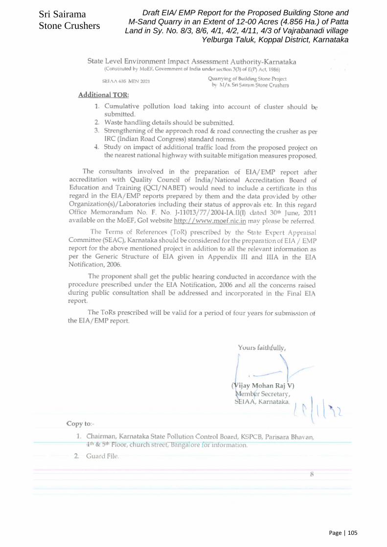
Sri Sairama
Stone Crushers
Draft EIA/ EMP Report for the Proposed Building Stone and M-Sand Quarry in an Extent of 12-00 Acres (4.856 Ha.) of Patta
Land in Sy. No. 8/3, 8/6, 4/1, 4/2, 4/11, 4/3 of Vajrabanadi village Yelburga Taluk, Koppal District, Karnataka
Page | 105

Sri Sairama
Stone Crushers
Draft EIA/ EMP Report for the Proposed Building Stone and M-Sand Quarry in an Extent of 12-00 Acres (4.856 Ha.) of Patta
Land in Sy. No. 8/3, 8/6, 4/1, 4/2, 4/11, 4/3 of Vajrabanadi village Yelburga Taluk, Koppal District, Karnataka
Page | 106
Notification Letter issued by DMG, Karnataka (Annexure- 2)

Sri Sairama
Stone Crushers
Draft EIA/ EMP Report for the Proposed Building Stone and M-Sand Quarry in an Extent of 12-00 Acres (4.856 Ha.) of Patta
Land in Sy. No. 8/3, 8/6, 4/1, 4/2, 4/11, 4/3 of Vajrabanadi village Yelburga Taluk, Koppal District, Karnataka
Page | 107

Sri Sairama
Stone Crushers
Draft EIA/ EMP Report for the Proposed Building Stone and M-Sand Quarry in an Extent of 12-00 Acres (4.856 Ha.) of Patta
Land in Sy. No. 8/3, 8/6, 4/1, 4/2, 4/11, 4/3 of Vajrabanadi village Yelburga Taluk, Koppal District, Karnataka
Page | 108
Extract of Topo-Sheet (Annexure-3)

Sri Sairama
Stone Crushers
Draft EIA/ EMP Report for the Proposed Building Stone and M-Sand Quarry in an Extent of 12-00 Acres (4.856 Ha.) of Patta
Land in Sy. No. 8/3, 8/6, 4/1, 4/2, 4/11, 4/3 of Vajrabanadi village Yelburga Taluk, Koppal District, Karnataka
Page | 109
Environmental Policy (Annexure-4)

Sri Sairama
Stone Crushers
Draft EIA/ EMP Report for the Proposed Building Stone and M-Sand Quarry in an Extent of 12-00 Acres (4.856 Ha.) of Patta
Land in Sy. No. 8/3, 8/6, 4/1, 4/2, 4/11, 4/3 of Vajrabanadi village Yelburga Taluk, Koppal District, Karnataka
Page | 110
Organization Chart (Annexure-5)
The Organization Chart of Sri Sairama Stone Crushers’s Quarry will be as under:
Drillers (2 Nos.)
Operators (3 Nos.)
Sri Sairama Stone Crushers (Proponent/ Lease Holder)
Supervisor (1 No.)
Skilled (05 Nos.)
Mines Manager (1 No.)
Unskilled (08 Nos.)

Sri Sairama
Stone Crushers
Draft EIA/ EMP Report for the Proposed Building Stone and M-Sand Quarry in an Extent of 12-00 Acres (4.856 Ha.) of Patta
Land in Sy. No. 8/3, 8/6, 4/1, 4/2, 4/11, 4/3 of Vajrabanadi village Yelburga Taluk, Koppal District, Karnataka
Page | 111
Geological Map of Koppal District (Annexure- 6)

Sri Sairama
Stone Crushers
Draft EIA/ EMP Report for the Proposed Building Stone and M-Sand Quarry in an Extent of 12-00 Acres (4.856 Ha.) of Patta
Land in Sy. No. 8/3, 8/6, 4/1, 4/2, 4/11, 4/3 of Vajrabanadi village Yelburga Taluk, Koppal District, Karnataka
Page | 112
Soil Map of Koppal District (Annexure- 7)

Sri Sairama
Stone Crushers
Draft EIA/ EMP Report for the Proposed Building Stone and M-Sand Quarry in an Extent of 12-00 Acres (4.856 Ha.) of Patta
Land in Sy. No. 8/3, 8/6, 4/1, 4/2, 4/11, 4/3 of Vajrabanadi village Yelburga Taluk, Koppal District, Karnataka
Page | 113
Geomorphological Map of Koppal District (Annexure-8)

Sri Sairama
Stone Crushers
Draft EIA/ EMP Report for the Proposed Building Stone and M-Sand Quarry in an Extent of 12-00 Acres (4.856 Ha.) of Patta
Land in Sy. No. 8/3, 8/6, 4/1, 4/2, 4/11, 4/3 of Vajrabanadi village Yelburga Taluk, Koppal District, Karnataka
Page | 114
Land-Use Land-Cover Map of 10 KM Radius of Proposed Quarry Area (Annexure-9)

Sri Sairama
Stone Crushers
Draft EIA/ EMP Report for the Proposed Building Stone and M-Sand Quarry in an Extent of 12-00 Acres (4.856 Ha.) of Patta
Land in Sy. No. 8/3, 8/6, 4/1, 4/2, 4/11, 4/3 of Vajrabanadi village Yelburga Taluk, Koppal District, Karnataka
Page | 115
Satellite Imagery of 10 KM Radius of Proposed Quarry Site (Annexure-10)

Sri Sairama
Stone Crushers
Draft EIA/ EMP Report for the Proposed Building Stone and M-Sand Quarry in an Extent of 12-00 Acres (4.856 Ha.) of Patta
Land in Sy. No. 8/3, 8/6, 4/1, 4/2, 4/11, 4/3 of Vajrabanadi village Yelburga Taluk, Koppal District, Karnataka
Page | 116
Ambient Air Quality Monitored Data (Annexure-11)
DATE
STATIONS
Project Site (S1) Vajrabanadi (S2) Doddarayappanahalli (S3) Nandi (S4) Muddenahalli (S5) Kalavara (S6) Nallakadirenahalli (S7) Jakkalamadugu (S8)
PM 2.5 PM 10 SO2 Nox PM 2.5 PM 10 SO2 Nox PM 2.5 PM 10 SO2 Nox PM 2.5 PM 10 SO2 Nox PM 2.5 PM 10 SO2 Nox PM 2.5 PM 10 SO2 Nox PM 2.5 PM 10 SO2 Nox PM 2.5 PM 10 SO2 Nox
04-10-2021 29.8 49.1 10.9 9.9 32.1 47.8 11.5 10.3 51.3 65.2 10.9 9.1 − − − − − − − − − − − − − − − − − − − −
05-10-2021 30.5 49.6 11.5 9.8 31.9 47.2 11.2 10.5 45.9 64.5 10.6 8.9 − − − − − − − − − − − − − − − − − − − −
06-10-2021 − − − − − − − − − − − − 34.5 59.5 9.9 10.8 34.5 61.8 10.3 10.3 36.4 61.8 11 8.8 − − − − − − − −
07-10-2021 − − − − − − − − − − − − 34.7 60.3 10.3 11.3 38.6 63.4 10.2 9.8 36.8 61.9 12 9.1 − − − − − − − −
08-10-2021 − − − − − − − − − − − − − − − − − − − − − − − − 43.3 67.1 12.2 9.4 37.7 58.2 11.5 10.5
09-10-2021 − − − − − − − − − − − − − − − − − − − − − − − − 45.5 66.8 13.2 9.5 38.2 56.7 13.4 11.4
11-10-2021 30.2 48.6 11.4 9.4 30.9 47.2 10.2 9.5 47.9 65.4 10.8 8.7 − − − − − − − − − − − − − − − − − − − −
12-10-2021 31.1 49.1 10.9 9.9 32.1 47.8 11.8 10.3 51.3 64.2 10.9 8.9 − − − − − − − − − − − − − − − − − − − −
13-10-2021 − − − − − − − − − − − − 33.2 61.2 9.9 9.7 34.6 61.3 10.8 10.6 35.4 61.8 12 9.2 − − − − − − − −
14-10-2021 − − − − − − − − − − − − 36.8 60.2 10.6 10.5 38.4 62.8 10.2 9.9 36.8 63.2 12 8.4 − − − − − − − −
15-10-2021 − − − − − − − − − − − − − − − − − − − − − − − − 43.6 66.3 12.5 9.3 38.2 57.9 11.6 10.5
16-10-2021 − − − − − − − − − − − − − − − − − − − − − − − − 45.1 67.3 12.9 9.1 38.4 55.8 12.6 11.3
18-10-2021 34.5 59.2 9.9 9.8 35.1 60.3 10.8 10.2 35.4 62.1 11.2 9.3 − − − − − − − − − − − − − − − − − − − −
19-10-2021 36.2 60.6 10.6 10.5 38.4 62.8 10.2 9.9 36.8 62.9 11.9 8.8 − − − − − − − − − − − − − − − − − − − −
20-10-2021 − − − − − − − − − − − − 34.5 59.5 9.8 10.8 34.6 61.8 10.3 10.3 36.4 61.8 11 8.8 − − − − − − − −
21-10-2021 − − − − − − − − − − − − 35.1 61.1 10.9 11.2 38.6 63.4 10.9 10.1 39.5 61.9 12 9.1 − − − − − − − −
22-10-2021 − − − − − − − − − − − − − − − − − − − − − − − − 43.2 66.6 12.2 9.2 36.7 56.2 11.6 10.5
23-10-2021 − − − − − − − − − − − − − − − − − − − − − − − − 45.1 65.2 12.5 9.1 38.4 55.6 12.1 10.9
25-10-2021 31.1 47.9 10.8 9.7 32.2 46.8 9.7 9.5 50.2 64.5 10.6 9.1 − − − − − − − − − − − − − − − − − − − −
26-10-2021 29.5 50.2 11.1 9.9 33.3 47.3 11.9 10.2 52.0 64.7 11.7 8.7 − − − − − − − − − − − − − − − − − − − −
27-10-2021 − − − − − − − − − − − − 35.1 61.1 10.9 11.2 38.6 62.8 10.2 9.9 36.8 62.9 12 8.8 − − − − − − − −
28-10-2021 − − − − − − − − − − − − 36.2 60.6 10.6 10.5 38.4 61.3 10.8 10.2 35.4 61.1 12 8.5 − − − − − − − −
29-10-2021 − − − − − − − − − − − − − − − − − − − − − − − − 44.2 66.4 12.2 9.2 37.7 56.2 11.9 10.5
30-10-2021 − − − − − − − − − − − − − − − − − − − − − − − − 43.1 67.1 12.5 9.1 38.4 55.8 12.5 10.9
01-11-2021 31.5 50.5 10.9 10.1 32.4 47.3 11.5 10.5 45.9 64.2 10.6 8.9 − − − − − − − − − − − − − − − − − − − −
02-11-2021 28.8 49.1 10.9 9.9 32.1 47.8 11.5 10.4 47.3 65.2 10.5 9.2 − − − − − − − − − − − − − − − − − − − −
03-11-2021 − − − − − − − − − − − − 35.9 59.2 9.9 9.8 35.1 61.3 10.8 10.2 35.4 62.1 11 9 − − − − − − − −
04-11-2021 − − − − − − − − − − − − 36.2 61.6 10.6 10.5 38.4 63.1 10 9.9 36.8 62.5 11 8.8 − − − − − − − −
05-11-2021 − − − − − − − − − − − − − − − − − − − − − − − − 45.1 65.2 12.5 9.1 38.5 56.9 12.4 10.5
06-11-2021 − − − − − − − − − − − − − − − − − − − − − − − − 43.6 66.3 12.5 9.3 38.2 57.9 12.6 11.3
08-11-2021 30.2 48.6 11.4 9.4 30.9 47.2 10.2 9.5 47.9 65.7 10.8 8.7 − − − − − − − − − − − − − − − − − − − −
09-11-2021 31.1 49.1 10.9 9.9 32.1 47.8 11.8 10.3 51.3 64.2 10.9 8.9 − − − − − − − − − − − − − − − − − − − −
10-11-2021 − − − − − − − − − − − − 34.5 60.5 9.9 10.8 33.6 61.8 10.3 10.3 36.4 61.8 11 8.7 − − − − − − − −
11-11-2021 − − − − − − − − − − − − 35.1 61.1 10.5 11.2 36.6 62.4 10.5 10.1 39.5 63.2 12 9.1 − − − − − − − −
12-11-2021 − − − − − − − − − − − − − − − − − − − − − − − − 41.9 64.5 11.9 9.5 37.5 56.3 11.5 10.9
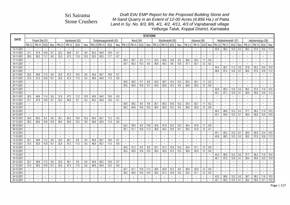
Sri Sairama
Stone Crushers
Draft EIA/ EMP Report for the Proposed Building Stone and M-Sand Quarry in an Extent of 12-00 Acres (4.856 Ha.) of Patta
Land in Sy. No. 8/3, 8/6, 4/1, 4/2, 4/11, 4/3 of Vajrabanadi village Yelburga Taluk, Koppal District, Karnataka
Page | 117
DATE
STATIONS
Project Site (S1) Vajrabanadi (S2) Doddarayappanahalli (S3) Nandi (S4) Muddenahalli (S5) Kalavara (S6) Nallakadirenahalli (S7) Jakkalamadugu (S8)
PM 2.5 PM 10 SO2 Nox PM 2.5 PM 10 SO2 Nox PM 2.5 PM 10 SO2 Nox PM 2.5 PM 10 SO2 Nox PM 2.5 PM 10 SO2 Nox PM 2.5 PM 10 SO2 Nox PM 2.5 PM 10 SO2 Nox PM 2.5 PM 10 SO2 Nox
13-11-2021 − − − − − − − − − − − − − − − − − − − − − − − − 43.6 66.3 12.5 9.3 38.2 57.9 12.6 11.3
15-11-2021 31.1 47.9 10.8 9.7 32.2 46.8 9.7 9.5 50.2 64.8 10.6 9.1 − − − − − − − − − − − − − − − − − − − −
16-11-2021 29.5 50.2 11.1 9.9 33.3 47.3 11.9 10.2 52.0 65.3 11.7 8.7 − − − − − − − − − − − − − − − − − − − −
17-11-2021 − − − − − − − − − − − − 36.4 59.7 9.5 11.1 34.5 60.6 10.6 9.9 36.6 62.2 11 8.8 − − − − − − − −
18-11-2021 − − − − − − − − − − − − 34.7 60.3 10.3 9.9 36.8 64.3 9.8 10.5 37.1 62.1 12 9.2 − − − − − − − −
19-11-2021 − − − − − − − − − − − − − − − − − − − − − − − − 44.4 66.7 11.2 9.5 37.8 55.2 10.9 10.9
20-11-2021 − − − − − − − − − − − − − − − − − − − − − − − − 46.6 67.2 12.8 9.7 38.5 57.9 12.8 11.2
22-11-2021 32.2 49.8 11.5 9.8 33.5 47.2 10.2 9.5 45.6 65.7 10.6 8.7 − − − − − − − − − − − − − − − − − − − −
23-11-2021 31.5 51.5 10.9 10.1 32.4 47.3 11.5 9.3 48.9 64.9 11.5 8.9 − − − − − − − − − − − − − − − − − − − −
24-11-2021 − − − − − − − − − − − − 34.5 59.2 9.7 9.8 34.5 59.7 10.5 10.2 36.4 62.1 11 9.2 − − − − − − − −
25-11-2021 − − − − − − − − − − − − 35.2 60.6 10.6 10.7 40.9 62.8 10.2 9.9 36.8 63.2 12 8.8 − − − − − − − −
26-11-2021 − − − − − − − − − − − − − − − − − − − − − − − − 43.6 66.3 12.5 9.3 38.2 57.9 11.6 10.5
27-11-2021 − − − − − − − − − − − − − − − − − − − − − − − − 45.1 67.1 12.9 9.1 38.4 55.8 12.6 11.3
29-11-2021 30.5 49.6 11.4 9.8 31.9 47.2 11.2 10.5 45.9 64.5 10.6 8.9 − − − − − − − − − − − − − − − − − − − −
30-11-2021 31.1 47.9 10.8 9.7 32.2 46.8 9.7 9.5 50.2 64.8 10.6 9.1 − − − − − − − − − − − − − − − − − − − −
01-12-2021 − − − − − − − − − − − − 34.5 59.2 9.9 9.8 35.1 60.3 10.8 10.2 35.4 62.1 11 9.2 − − − − − − − −
02-12-2021 − − − − − − − − − − − − 36.2 60.6 10.6 10.5 38.4 62.8 10.2 9.9 36.8 62.9 12 8.8 − − − − − − − −
03-12-2021 − − − − − − − − − − − − − − − − − − − − − − − − 44.2 66.6 12.2 9.2 37.7 56.2 11.9 10.5
04-12-2021 − − − − − − − − − − − − − − − − − − − − − − − − 43.1 64.9 12.5 9.1 38.4 55.8 12.5 10.9
06-12-2021 34.5 59.2 9.4 9.8 35.1 60.3 10.8 10.2 35.4 62.1 11.2 9.2 − − − − − − − − − − − − − − − − − − − −
07-12-2021 36.2 60.6 10.6 10.5 38.4 62.8 10.2 9.9 36.8 62.9 11.9 8.8 − − − − − − − − − − − − − − − − − − − −
08-12-2021 − − − − − − − − − − − − 34.3 59.5 9.9 10.8 34.6 61.8 10.3 10.3 36.4 61.8 11 8.8 − − − − − − − −
09-12-2021 − − − − − − − − − − − − 35.1 61.1 10.9 11.2 38.6 63.4 10.9 10.1 39.5 61.9 12 9.1 − − − − − − − −
10-12-2021 − − − − − − − − − − − − − − − − − − − − − − − − 45.1 65.2 12.5 9.1 38.5 56.9 12.4 10.5
11-12-2021 − − − − − − − − − − − − − − − − − − − − − − − − 43.6 66.3 12.5 9.3 38.2 57.9 12.6 11.3
13-12-2021 32.1 49.8 11.2 9.8 33.5 48.1 9.9 9.5 45.6 66.1 10.6 8.7 − − − − − − − − − − − − − − − − − − − −
14-12-2021 31.5 50.5 10.9 10.1 32.4 47.3 11.5 9.3 48.9 65.7 11.5 8.9 − − − − − − − − − − − − − − − − − − − −
15-12-2021 − − − − − − − − − − − − 34.5 61.2 9.9 9.8 35.1 61.3 10.8 10.2 35.4 61.1 12 8.8 − − − − − − − −
16-12-2021 − − − − − − − − − − − − 35.2 60.6 10.6 10.5 38.4 62.8 10.2 10.2 36.8 62.9 12 8.8 − − − − − − − −
17-12-2021 − − − − − − − − − − − − − − − − − − − − − − − − 44.2 66.5 12.2 9.2 37.7 56.2 11.6 10.5
18-12-2021 − − − − − − − − − − − − − − − − − − − − − − − − 45.1 67.2 12.9 9.1 38.4 55.8 12.5 10.9
20-12-2021 32.1 49.8 11.2 9.8 33.5 48.1 9.9 9.5 45.6 66.2 10.6 8.7 − − − − − − − − − − − − − − − − − − − −
21-12-2021 31.5 50.5 10.9 10.1 32.4 47.3 11.5 9.2 48.9 64.9 12.3 8.9 − − − − − − − − − − − − − − − − − − − −
22-12-2021 − − − − − − − − − − − − 35.1 61.1 10.9 11.2 38.6 62.8 10.2 9.9 36.8 62.9 12 8.8 − − − − − − − −
23-12-2021 − − − − − − − − − − − − 36.2 60.6 10.6 10.5 38.4 61.3 10.8 10.2 35.4 61.1 12 8.5 − − − − − − − −
24-12-2021 − − − − − − − − − − − − − − − − − − − − − − − − 43.2 66.6 12.2 9.2 36.7 56.2 11.6 10.5
25-12-2021 − − − − − − − − − − − − − − − − − − − − − − − − 45.1 65.2 12.5 9.1 38.4 55.6 12.1 10.9

Sri Sairama
Stone Crushers
Draft EIA/ EMP Report for the Proposed Building Stone and M-Sand Quarry in an Extent of 12-00 Acres (4.856 Ha.) of Patta
Land in Sy. No. 8/3, 8/6, 4/1, 4/2, 4/11, 4/3 of Vajrabanadi village Yelburga Taluk, Koppal District, Karnataka
Page | 118
Surface Geological Plan & Sections (Annexure-12)

Sri Sairama
Stone Crushers
Draft EIA/ EMP Report for the Proposed Building Stone and M-Sand Quarry in an Extent of 12-00 Acres (4.856 Ha.) of Patta
Land in Sy. No. 8/3, 8/6, 4/1, 4/2, 4/11, 4/3 of Vajrabanadi village Yelburga Taluk, Koppal District, Karnataka
Page | 119

Sri Sairama
Stone Crushers
Draft EIA/ EMP Report for the Proposed Building Stone and M-Sand Quarry in an Extent of 12-00 Acres (4.856 Ha.) of Patta
Land in Sy. No. 8/3, 8/6, 4/1, 4/2, 4/11, 4/3 of Vajrabanadi village Yelburga Taluk, Koppal District, Karnataka
Page | 120

Sri Sairama
Stone Crushers
Draft EIA/ EMP Report for the Proposed Building Stone and M-Sand Quarry in an Extent of 12-00 Acres (4.856 Ha.) of Patta
Land in Sy. No. 8/3, 8/6, 4/1, 4/2, 4/11, 4/3 of Vajrabanadi village Yelburga Taluk, Koppal District, Karnataka
Page | 121
Production & Development Plan and Sections (Annexure-13)

Sri Sairama
Stone Crushers
Draft EIA/ EMP Report for the Proposed Building Stone and M-Sand Quarry in an Extent of 12-00 Acres (4.856 Ha.) of Patta
Land in Sy. No. 8/3, 8/6, 4/1, 4/2, 4/11, 4/3 of Vajrabanadi village Yelburga Taluk, Koppal District, Karnataka
Page | 122

Sri Sairama
Stone Crushers
Draft EIA/ EMP Report for the Proposed Building Stone and M-Sand Quarry in an Extent of 12-00 Acres (4.856 Ha.) of Patta
Land in Sy. No. 8/3, 8/6, 4/1, 4/2, 4/11, 4/3 of Vajrabanadi village Yelburga Taluk, Koppal District, Karnataka
Page | 123
Progressive Mine Closure Plan (Annexure-14)

Sri Sairama
Stone Crushers
Draft EIA/ EMP Report for the Proposed Building Stone and M-Sand Quarry in an Extent of 12-00 Acres (4.856 Ha.) of Patta
Land in Sy. No. 8/3, 8/6, 4/1, 4/2, 4/11, 4/3 of Vajrabanadi village Yelburga Taluk, Koppal District, Karnataka
Page | 124
Environmental Plan (Annexure-15)

Sri Sairama
Stone Crushers
Draft EIA/ EMP Report for the Proposed Building Stone and M-Sand Quarry in an Extent of 12-00 Acres (4.856 Ha.) of Patta
Land in Sy. No. 8/3, 8/6, 4/1, 4/2, 4/11, 4/3 of Vajrabanadi village Yelburga Taluk, Koppal District, Karnataka
Page | 125
Cluster Letter (Annexure-16)

Sri Sairama
Stone Crushers
Draft EIA/ EMP Report for the Proposed Building Stone and M-Sand Quarry in an Extent of 12-00 Acres (4.856 Ha.) of Patta
Land in Sy. No. 8/3, 8/6, 4/1, 4/2, 4/11, 4/3 of Vajrabanadi village Yelburga Taluk, Koppal District, Karnataka
Page | 126

Sri Sairama
Stone Crushers
Draft EIA/ EMP Report for the Proposed Building Stone and M-Sand Quarry in an Extent of 12-00 Acres (4.856 Ha.) of Patta
Land in Sy. No. 8/3, 8/6, 4/1, 4/2, 4/11, 4/3 of Vajrabanadi village Yelburga Taluk, Koppal District, Karnataka
Page | 127
Site Specific Micro-Meteorological Data (Annexure-17)
Monitoring Period
Jan. 2022 to Mar. 2022

Sri Sairama
Stone Crushers
Draft EIA/ EMP Report for the Proposed Building Stone and M-Sand Quarry in an Extent of 12-00 Acres (4.856 Ha.) of Patta
Land in Sy. No. 8/3, 8/6, 4/1, 4/2, 4/11, 4/3 of Vajrabanadi village Yelburga Taluk, Koppal District, Karnataka
Page | 128
Date & Time Latitude Longitude Avg. Temp (oC)
Min. Temp (oC)
Max. Temp (oC)
Pressure Humidity (%)
Wind Speed Wind Direction Rainfall (in mm)
Weather Category
Weather Description HPa mm Hg m/Sec KMPH Deg. Direction
2022-01-01 00:00:00 +0000 UTC 15.678205 76.107525 19.11 19.11 19.11 1018 763.50 94 3.39 12.20 103 ESE Clouds overcast clouds
2022-01-01 01:00:00 +0000 UTC 15.678205 76.107525 19.39 19.39 19.39 1018 763.50 94 3.84 13.82 102 ESE Clouds overcast clouds
2022-01-01 02:00:00 +0000 UTC 15.678205 76.107525 20.27 20.27 20.27 1019 764.25 92 4.65 16.74 102 ESE Clouds overcast clouds
2022-01-01 03:00:00 +0000 UTC 15.678205 76.107525 20.59 20.59 20.59 1020 765.00 88 5.06 18.22 100 E Clouds broken clouds
2022-01-01 04:00:00 +0000 UTC 15.678205 76.107525 20.83 20.83 20.83 1020 765.00 84 5.23 18.83 97 E Clouds broken clouds
2022-01-01 05:00:00 +0000 UTC 15.678205 76.107525 23.44 23.44 23.44 1020 765.00 71 5.23 18.83 96 E Clouds broken clouds
2022-01-01 06:00:00 +0000 UTC 15.678205 76.107525 24.71 24.71 24.71 1019 764.25 66 5 18.00 97 E Clouds broken clouds
2022-01-01 07:00:00 +0000 UTC 15.678205 76.107525 24.71 24.71 24.71 1018 763.50 65 4.81 17.32 100 E Clouds broken clouds
2022-01-01 08:00:00 +0000 UTC 15.678205 76.107525 26.91 26.91 26.91 1017 762.75 57 4.37 15.73 103 ESE Clouds broken clouds
2022-01-01 09:00:00 +0000 UTC 15.678205 76.107525 27.13 27.13 27.13 1016 762.00 55 3.97 14.29 107 ESE Clouds overcast clouds
2022-01-01 10:00:00 +0000 UTC 15.678205 76.107525 26.56 26.56 26.56 1015 761.25 57 3.39 12.20 111 ESE Clouds broken clouds
2022-01-01 11:00:00 +0000 UTC 15.678205 76.107525 26.79 26.79 26.79 1015 761.25 56 3.13 11.27 108 ESE Clouds scattered clouds
2022-01-01 12:00:00 +0000 UTC 15.678205 76.107525 26.74 26.74 26.74 1015 761.25 56 2.51 9.04 106 ESE Clouds scattered clouds
2022-01-01 13:00:00 +0000 UTC 15.678205 76.107525 26.34 26.34 26.34 1016 762.00 57 2.16 7.78 108 ESE Clouds few clouds
2022-01-01 14:00:00 +0000 UTC 15.678205 76.107525 25.17 25.17 25.17 1017 762.75 62 2.33 8.39 108 ESE Clear sky is clear
2022-01-01 15:00:00 +0000 UTC 15.678205 76.107525 23.8 23.8 23.8 1018 763.50 66 2.44 8.78 105 ESE Clear sky is clear
2022-01-01 16:00:00 +0000 UTC 15.678205 76.107525 22.9 22.9 22.9 1018 763.50 70 2.28 8.21 105 ESE Clear sky is clear
2022-01-01 17:00:00 +0000 UTC 15.678205 76.107525 21.41 21.41 21.41 1018 763.50 76 2.17 7.81 109 ESE Clear sky is clear
2022-01-01 18:00:00 +0000 UTC 15.678205 76.107525 20.69 20.69 20.69 1018 763.50 80 2.1 7.56 114 ESE Clear sky is clear
2022-01-01 19:00:00 +0000 UTC 15.678205 76.107525 20.9 20.9 20.9 1018 763.50 80 2.45 8.82 119 ESE Clear sky is clear
2022-01-01 20:00:00 +0000 UTC 15.678205 76.107525 19.72 19.72 19.72 1017 762.75 85 2.68 9.65 121 ESE Clear sky is clear
2022-01-01 21:00:00 +0000 UTC 15.678205 76.107525 19.74 19.74 19.74 1017 762.75 86 2.53 9.11 121 ESE Clear sky is clear
2022-01-01 22:00:00 +0000 UTC 15.678205 76.107525 18.92 18.92 18.92 1016 762.00 90 2.72 9.79 123 ESE Clear sky is clear
2022-01-01 23:00:00 +0000 UTC 15.678205 76.107525 18.66 18.66 18.66 1017 762.75 92 2.37 8.53 119 ESE Clear sky is clear
2022-01-02 00:00:00 +0000 UTC 15.678205 76.107525 18.8 18.8 18.8 1017 762.75 92 2.32 8.35 112 ESE Clear sky is clear
2022-01-02 01:00:00 +0000 UTC 15.678205 76.107525 18.81 18.81 18.81 1018 763.50 92 2.34 8.42 106 ESE Clouds few clouds
2022-01-02 02:00:00 +0000 UTC 15.678205 76.107525 19.74 19.74 19.74 1018 763.50 91 3 10.80 102 ESE Clear sky is clear
2022-01-02 03:00:00 +0000 UTC 15.678205 76.107525 20.16 20.16 20.16 1019 764.25 87 3.76 13.54 109 ESE Clear sky is clear
2022-01-02 04:00:00 +0000 UTC 15.678205 76.107525 20.83 20.83 20.83 1019 764.25 83 4.23 15.23 111 ESE Clouds few clouds
2022-01-02 05:00:00 +0000 UTC 15.678205 76.107525 24.34 24.34 24.34 1019 764.25 67 4.36 15.70 108 ESE Clear sky is clear
2022-01-02 06:00:00 +0000 UTC 15.678205 76.107525 26.12 26.12 26.12 1018 763.50 58 4.49 16.16 104 ESE Clear sky is clear
2022-01-02 07:00:00 +0000 UTC 15.678205 76.107525 26.55 26.55 26.55 1016 762.00 55 4.45 16.02 98 E Clear sky is clear
2022-01-02 08:00:00 +0000 UTC 15.678205 76.107525 28.37 28.37 28.37 1015 761.25 49 4.14 14.90 94 E Clouds scattered clouds
2022-01-02 09:00:00 +0000 UTC 15.678205 76.107525 28.97 28.97 28.97 1013 759.75 46 3.67 13.21 95 E Clouds scattered clouds
2022-01-02 10:00:00 +0000 UTC 15.678205 76.107525 27.33 27.33 27.33 1013 759.75 50 3.21 11.56 89 E Clouds broken clouds

Sri Sairama
Stone Crushers
Draft EIA/ EMP Report for the Proposed Building Stone and M-Sand Quarry in an Extent of 12-00 Acres (4.856 Ha.) of Patta
Land in Sy. No. 8/3, 8/6, 4/1, 4/2, 4/11, 4/3 of Vajrabanadi village Yelburga Taluk, Koppal District, Karnataka
Page | 129
Date & Time Latitude Longitude Avg.
Temp (oC) Min.
Temp (oC) Max.
Temp (oC) Pressure Humidity
(%) Wind Speed Wind Direction Rainfall
(in mm) Weather Category
Weather Description HPa mm Hg m/Sec KMPH Deg. Direction
2022-01-02 11:00:00 +0000 UTC 15.678205 76.107525 27.6 27.6 27.6 1014 760.50 48 3.18 11.45 82 E Clouds scattered clouds
2022-01-02 12:00:00 +0000 UTC 15.678205 76.107525 27.45 27.45 27.45 1013 759.75 48 2.83 10.19 71 ENE Clouds scattered clouds
2022-01-02 13:00:00 +0000 UTC 15.678205 76.107525 26.93 26.93 26.93 1014 760.50 49 2.35 8.46 62 ENE Clouds scattered clouds
2022-01-02 14:00:00 +0000 UTC 15.678205 76.107525 24.59 24.59 24.59 1015 761.25 57 2.8 10.08 67 ENE Clouds scattered clouds
2022-01-02 15:00:00 +0000 UTC 15.678205 76.107525 23.48 23.48 23.48 1016 762.00 59 2.97 10.69 77 ENE Clouds scattered clouds
2022-01-02 16:00:00 +0000 UTC 15.678205 76.107525 23 23 23 1016 762.00 61 2.88 10.37 83 E Clouds few clouds
2022-01-02 17:00:00 +0000 UTC 15.678205 76.107525 21.26 21.26 21.26 1016 762.00 67 2.56 9.22 82 E Clear sky is clear
2022-01-02 18:00:00 +0000 UTC 15.678205 76.107525 21.02 21.02 21.02 1016 762.00 67 2.38 8.57 80 E Clear sky is clear
2022-01-02 19:00:00 +0000 UTC 15.678205 76.107525 21.1 21.1 21.1 1016 762.00 67 2.55 9.18 80 E Clear sky is clear
2022-01-02 20:00:00 +0000 UTC 15.678205 76.107525 19.77 19.77 19.77 1016 762.00 72 2.94 10.58 85 E Clear sky is clear
2022-01-02 21:00:00 +0000 UTC 15.678205 76.107525 19.59 19.59 19.59 1015 761.25 77 3.11 11.20 92 E Clear sky is clear
2022-01-02 22:00:00 +0000 UTC 15.678205 76.107525 18.08 18.08 18.08 1015 761.25 82 3.08 11.09 100 E Clear sky is clear
2022-01-02 23:00:00 +0000 UTC 15.678205 76.107525 17.89 17.89 17.89 1015 761.25 88 2.92 10.51 106 ESE Clear sky is clear
2022-01-03 00:00:00 +0000 UTC 15.678205 76.107525 18.2 18.2 18.2 1016 762.00 91 2.72 9.79 108 ESE Clouds few clouds
2022-01-03 01:00:00 +0000 UTC 15.678205 76.107525 18.34 18.34 18.34 1016 762.00 93 2.63 9.47 109 ESE Clouds scattered clouds
2022-01-03 02:00:00 +0000 UTC 15.678205 76.107525 19.31 19.31 19.31 1018 763.50 92 3.15 11.34 111 ESE Clouds broken clouds
2022-01-03 03:00:00 +0000 UTC 15.678205 76.107525 19.8 19.8 19.8 1018 763.50 89 3.91 14.08 115 ESE Clouds scattered clouds
2022-01-03 04:00:00 +0000 UTC 15.678205 76.107525 20.63 20.63 20.63 1019 764.25 84 3.48 12.53 111 ESE Clouds few clouds
2022-01-03 05:00:00 +0000 UTC 15.678205 76.107525 24.14 24.14 24.14 1018 763.50 68 3.42 12.31 106 ESE Clear sky is clear
2022-01-03 06:00:00 +0000 UTC 15.678205 76.107525 25.92 25.92 25.92 1017 762.75 58 3.58 12.89 96 E Clear sky is clear
2022-01-03 07:00:00 +0000 UTC 15.678205 76.107525 26.44 26.44 26.44 1016 762.00 55 3.56 12.82 87 E Clear sky is clear
2022-01-03 08:00:00 +0000 UTC 15.678205 76.107525 27.99 27.99 27.99 1015 761.25 46 3.45 12.42 86 E Clear sky is clear
2022-01-03 09:00:00 +0000 UTC 15.678205 76.107525 28.3 28.3 28.3 1013 759.75 44 3.26 11.74 88 E Clear sky is clear
2022-01-03 10:00:00 +0000 UTC 15.678205 76.107525 26.9 26.9 26.9 1013 759.75 48 3.06 11.02 90 E Clear sky is clear
2022-01-03 11:00:00 +0000 UTC 15.678205 76.107525 26.97 26.97 26.97 1013 759.75 47 2.99 10.76 91 E Clear sky is clear
2022-01-03 12:00:00 +0000 UTC 15.678205 76.107525 27.03 27.03 27.03 1014 760.50 45 2.33 8.39 88 E Clear sky is clear
2022-01-03 13:00:00 +0000 UTC 15.678205 76.107525 25.94 25.94 25.94 1014 760.50 49 2.08 7.49 81 E Clouds scattered clouds
2022-01-03 14:00:00 +0000 UTC 15.678205 76.107525 23.86 23.86 23.86 1015 761.25 57 1.93 6.95 71 ENE Clouds broken clouds
2022-01-03 15:00:00 +0000 UTC 15.678205 76.107525 22.36 22.36 22.36 1016 762.00 61 1.95 7.02 59 ENE Clouds few clouds
2022-01-03 16:00:00 +0000 UTC 15.678205 76.107525 22.35 22.35 22.35 1016 762.00 61 2.21 7.96 54 NE Clear sky is clear
2022-01-03 17:00:00 +0000 UTC 15.678205 76.107525 20.73 20.73 20.73 1016 762.00 66 2.32 8.35 54 NE Clouds few clouds
2022-01-03 18:00:00 +0000 UTC 15.678205 76.107525 20.48 20.48 20.48 1016 762.00 65 2.3 8.28 52 NE Clear sky is clear
2022-01-03 19:00:00 +0000 UTC 15.678205 76.107525 20.4 20.4 20.4 1016 762.00 65 2.27 8.17 51 NE Clouds scattered clouds
2022-01-03 20:00:00 +0000 UTC 15.678205 76.107525 19.39 19.39 19.39 1016 762.00 69 2.38 8.57 51 NE Clouds broken clouds
2022-01-03 21:00:00 +0000 UTC 15.678205 76.107525 19.47 19.47 19.47 1016 762.00 68 2.6 9.36 54 NE Clouds broken clouds

Sri Sairama
Stone Crushers
Draft EIA/ EMP Report for the Proposed Building Stone and M-Sand Quarry in an Extent of 12-00 Acres (4.856 Ha.) of Patta
Land in Sy. No. 8/3, 8/6, 4/1, 4/2, 4/11, 4/3 of Vajrabanadi village Yelburga Taluk, Koppal District, Karnataka
Page | 130
Date & Time Latitude Longitude Avg. Temp (oC)
Min. Temp (oC)
Max. Temp (oC)
Pressure Humidity (%)
Wind Speed Wind Direction Rainfall (in mm)
Weather Category
Weather Description HPa mm Hg m/Sec KMPH Deg. Direction
2022-01-03 22:00:00 +0000 UTC 15.678205 76.107525 18.04 18.04 18.04 1016 762.00 71 2.63 9.47 62 ENE Clouds few clouds
2022-01-03 23:00:00 +0000 UTC 15.678205 76.107525 17.84 17.84 17.84 1016 762.00 73 2.45 8.82 74 ENE Clear sky is clear
2022-01-04 00:00:00 +0000 UTC 15.678205 76.107525 18.76 18.76 18.76 1016 762.00 78 2.36 8.50 90 E Clear sky is clear
2022-01-04 01:00:00 +0000 UTC 15.678205 76.107525 18.65 18.65 18.65 1017 762.75 83 2.39 8.60 104 ESE Clear sky is clear
2022-01-04 02:00:00 +0000 UTC 15.678205 76.107525 19.25 19.25 19.25 1018 763.50 87 2.96 10.66 112 ESE Clear sky is clear
2022-01-04 03:00:00 +0000 UTC 15.678205 76.107525 19.44 19.44 19.44 1019 764.25 88 3.46 12.46 120 ESE Clouds scattered clouds
2022-01-04 04:00:00 +0000 UTC 15.678205 76.107525 19.89 19.89 19.89 1019 764.25 83 3.5 12.60 117 ESE Clear sky is clear
2022-01-04 05:00:00 +0000 UTC 15.678205 76.107525 22.44 22.44 22.44 1018 763.50 69 3.7 13.32 109 ESE Clear sky is clear
2022-01-04 06:00:00 +0000 UTC 15.678205 76.107525 25.82 25.82 25.82 1017 762.75 55 3.75 13.50 96 E Clear sky is clear
2022-01-04 07:00:00 +0000 UTC 15.678205 76.107525 26.27 26.27 26.27 1016 762.00 51 3.69 13.28 85 E Clear sky is clear
2022-01-04 08:00:00 +0000 UTC 15.678205 76.107525 28.13 28.13 28.13 1015 761.25 42 3.69 13.28 79 E Clear sky is clear
2022-01-04 09:00:00 +0000 UTC 15.678205 76.107525 28.5 28.5 28.5 1013 759.75 40 3.62 13.03 77 ENE Clear sky is clear
2022-01-04 10:00:00 +0000 UTC 15.678205 76.107525 26.95 26.95 26.95 1013 759.75 46 3.44 12.38 75 ENE Clear sky is clear
2022-01-04 11:00:00 +0000 UTC 15.678205 76.107525 26.92 26.92 26.92 1013 759.75 44 3.48 12.53 76 ENE Clear sky is clear
2022-01-04 12:00:00 +0000 UTC 15.678205 76.107525 26.74 26.74 26.74 1013 759.75 43 2.72 9.79 78 ENE Clear sky is clear
2022-01-04 13:00:00 +0000 UTC 15.678205 76.107525 26.07 26.07 26.07 1014 760.50 44 2.12 7.63 80 E Clear sky is clear
2022-01-04 14:00:00 +0000 UTC 15.678205 76.107525 23.57 23.57 23.57 1014 760.50 52 2.29 8.24 82 E Clear sky is clear
2022-01-04 15:00:00 +0000 UTC 15.678205 76.107525 21.95 21.95 21.95 1015 761.25 55 2.28 8.21 85 E Clear sky is clear
2022-01-04 16:00:00 +0000 UTC 15.678205 76.107525 21.62 21.62 21.62 1016 762.00 57 2.18 7.85 89 E Clear sky is clear
2022-01-04 17:00:00 +0000 UTC 15.678205 76.107525 19.17 19.17 19.17 1016 762.00 64 2.16 7.78 99 E Clear sky is clear
2022-01-04 18:00:00 +0000 UTC 15.678205 76.107525 18.87 18.87 18.87 1016 762.00 65 2.11 7.60 112 ESE Clear sky is clear
2022-01-04 19:00:00 +0000 UTC 15.678205 76.107525 19.02 19.02 19.02 1016 762.00 65 2.12 7.63 126 SE Clear sky is clear
2022-01-04 20:00:00 +0000 UTC 15.678205 76.107525 18.04 18.04 18.04 1016 762.00 71 2.03 7.31 129 SE Clear sky is clear
2022-01-04 21:00:00 +0000 UTC 15.678205 76.107525 18 18 18 1016 762.00 73 2.06 7.42 125 SE Clear sky is clear
2022-01-04 22:00:00 +0000 UTC 15.678205 76.107525 17.06 17.06 17.06 1016 762.00 78 2.04 7.34 125 SE Clear sky is clear
2022-01-04 23:00:00 +0000 UTC 15.678205 76.107525 16.94 16.94 16.94 1016 762.00 80 2.02 7.27 124 SE Clear sky is clear
2022-01-05 00:00:00 +0000 UTC 15.678205 76.107525 17.57 17.57 17.57 1016 762.00 85 1.98 7.13 123 ESE Clear sky is clear
2022-01-05 01:00:00 +0000 UTC 15.678205 76.107525 17.32 17.32 17.32 1017 762.75 87 1.98 7.13 122 ESE Clear sky is clear
2022-01-05 02:00:00 +0000 UTC 15.678205 76.107525 18.35 18.35 18.35 1018 763.50 85 2.17 7.81 116 ESE Clear sky is clear
2022-01-05 03:00:00 +0000 UTC 15.678205 76.107525 18.65 18.65 18.65 1018 763.50 83 2.41 8.68 121 ESE Clear sky is clear
2022-01-05 04:00:00 +0000 UTC 15.678205 76.107525 18.63 18.63 18.63 1019 764.25 82 2.83 10.19 122 ESE Clear sky is clear
2022-01-05 05:00:00 +0000 UTC 15.678205 76.107525 21.72 21.72 21.72 1018 763.50 67 3.14 11.30 114 ESE Clear sky is clear
2022-01-05 06:00:00 +0000 UTC 15.678205 76.107525 25.1 25.1 25.1 1017 762.75 55 3.11 11.20 101 E Clear sky is clear
2022-01-05 07:00:00 +0000 UTC 15.678205 76.107525 25.48 25.48 25.48 1016 762.00 51 2.91 10.48 94 E Clear sky is clear
2022-01-05 08:00:00 +0000 UTC 15.678205 76.107525 27.48 27.48 27.48 1014 760.50 42 2.68 9.65 95 E Clear sky is clear

Sri Sairama
Stone Crushers
Draft EIA/ EMP Report for the Proposed Building Stone and M-Sand Quarry in an Extent of 12-00 Acres (4.856 Ha.) of Patta
Land in Sy. No. 8/3, 8/6, 4/1, 4/2, 4/11, 4/3 of Vajrabanadi village Yelburga Taluk, Koppal District, Karnataka
Page | 131
Date & Time Latitude Longitude Avg. Temp (oC)
Min. Temp (oC)
Max. Temp (oC)
Pressure Humidity (%)
Wind Speed Wind Direction Rainfall (in mm)
Weather Category
Weather Description HPa mm Hg m/Sec KMPH Deg. Direction
2022-01-05 09:00:00 +0000 UTC 15.678205 76.107525 27.97 27.97 27.97 1013 759.75 39 2.45 8.82 102 ESE Clear sky is clear
2022-01-05 10:00:00 +0000 UTC 15.678205 76.107525 26.93 26.93 26.93 1013 759.75 40 2.28 8.21 112 ESE Clear sky is clear
2022-01-05 11:00:00 +0000 UTC 15.678205 76.107525 26.95 26.95 26.95 1013 759.75 38 2.25 8.10 118 ESE Clear sky is clear
2022-01-05 12:00:00 +0000 UTC 15.678205 76.107525 26.73 26.73 26.73 1013 759.75 36 1.8 6.48 120 ESE Clear sky is clear
2022-01-05 13:00:00 +0000 UTC 15.678205 76.107525 25.15 25.15 25.15 1014 760.50 40 2.64 9.50 112 ESE Clear sky is clear
2022-01-05 14:00:00 +0000 UTC 15.678205 76.107525 22.75 22.75 22.75 1014 760.50 48 2.53 9.11 100 E Clear sky is clear
2022-01-05 15:00:00 +0000 UTC 15.678205 76.107525 21.44 21.44 21.44 1015 761.25 50 2.36 8.50 99 E Clear sky is clear
2022-01-05 16:00:00 +0000 UTC 15.678205 76.107525 21.84 21.84 21.84 1016 762.00 48 2.15 7.74 103 ESE Clear sky is clear
2022-01-05 17:00:00 +0000 UTC 15.678205 76.107525 19.91 19.91 19.91 1016 762.00 55 2.36 8.50 111 ESE Clear sky is clear
2022-01-05 18:00:00 +0000 UTC 15.678205 76.107525 18.88 18.88 18.88 1015 761.25 59 2.4 8.64 115 ESE Clear sky is clear
2022-01-05 19:00:00 +0000 UTC 15.678205 76.107525 18.21 18.21 18.21 1015 761.25 62 2.41 8.68 121 ESE Clear sky is clear
2022-01-05 20:00:00 +0000 UTC 15.678205 76.107525 16.94 16.94 16.94 1015 761.25 67 2.3 8.28 123 ESE Clear sky is clear
2022-01-05 21:00:00 +0000 UTC 15.678205 76.107525 16.91 16.91 16.91 1014 760.50 67 2.2 7.92 122 ESE Clear sky is clear
2022-01-05 22:00:00 +0000 UTC 15.678205 76.107525 15.77 15.77 15.77 1014 760.50 73 2.09 7.52 124 SE Clear sky is clear
2022-01-05 23:00:00 +0000 UTC 15.678205 76.107525 16.12 16.12 16.12 1015 761.25 73 2.16 7.78 120 ESE Clear sky is clear
2022-01-06 00:00:00 +0000 UTC 15.678205 76.107525 17.8 17.8 17.8 1016 762.00 77 2.19 7.88 116 ESE Clear sky is clear
2022-01-06 01:00:00 +0000 UTC 15.678205 76.107525 17.65 17.65 17.65 1016 762.00 81 2.2 7.92 112 ESE Clear sky is clear
2022-01-06 02:00:00 +0000 UTC 15.678205 76.107525 18.48 18.48 18.48 1017 762.75 82 2.47 8.89 112 ESE Clear sky is clear
2022-01-06 03:00:00 +0000 UTC 15.678205 76.107525 18.81 18.81 18.81 1017 762.75 84 2.78 10.01 118 ESE Clear sky is clear
2022-01-06 04:00:00 +0000 UTC 15.678205 76.107525 19.27 19.27 19.27 1017 762.75 81 3.29 11.84 123 ESE Clear sky is clear
2022-01-06 05:00:00 +0000 UTC 15.678205 76.107525 21.82 21.82 21.82 1017 762.75 66 3.7 13.32 123 ESE Clear sky is clear
2022-01-06 06:00:00 +0000 UTC 15.678205 76.107525 25.81 25.81 25.81 1016 762.00 53 3.24 11.66 120 ESE Clear sky is clear
2022-01-06 07:00:00 +0000 UTC 15.678205 76.107525 26.21 26.21 26.21 1014 760.50 49 2.58 9.29 118 ESE Clear sky is clear
2022-01-06 08:00:00 +0000 UTC 15.678205 76.107525 28.18 28.18 28.18 1012 759.00 40 2.06 7.42 122 ESE Clear sky is clear
2022-01-06 09:00:00 +0000 UTC 15.678205 76.107525 28.85 28.85 28.85 1011 758.25 37 1.65 5.94 128 SE Clear sky is clear
2022-01-06 10:00:00 +0000 UTC 15.678205 76.107525 27.86 27.86 27.86 1011 758.25 41 1.15 4.14 134 SE Clear sky is clear
2022-01-06 11:00:00 +0000 UTC 15.678205 76.107525 27.97 27.97 27.97 1011 758.25 40 0.88 3.17 134 SE Clear sky is clear
2022-01-06 12:00:00 +0000 UTC 15.678205 76.107525 27.88 27.88 27.88 1011 758.25 42 0.97 3.49 110 ESE Clear sky is clear
2022-01-06 13:00:00 +0000 UTC 15.678205 76.107525 26.67 26.67 26.67 1012 759.00 44 1.82 6.55 83 E Clear sky is clear
2022-01-06 14:00:00 +0000 UTC 15.678205 76.107525 23.66 23.66 23.66 1013 759.75 54 2.3 8.28 77 ENE Clear sky is clear
2022-01-06 15:00:00 +0000 UTC 15.678205 76.107525 22.66 22.66 22.66 1013 759.75 55 2.24 8.06 76 ENE Clear sky is clear
2022-01-06 16:00:00 +0000 UTC 15.678205 76.107525 22.59 22.59 22.59 1014 760.50 55 2.12 7.63 74 ENE Clear sky is clear
2022-01-06 17:00:00 +0000 UTC 15.678205 76.107525 20.63 20.63 20.63 1014 760.50 63 2.11 7.60 77 ENE Clear sky is clear
2022-01-06 18:00:00 +0000 UTC 15.678205 76.107525 20.2 20.2 20.2 1014 760.50 66 2.2 7.92 81 E Clear sky is clear

Sri Sairama
Stone Crushers
Draft EIA/ EMP Report for the Proposed Building Stone and M-Sand Quarry in an Extent of 12-00 Acres (4.856 Ha.) of Patta
Land in Sy. No. 8/3, 8/6, 4/1, 4/2, 4/11, 4/3 of Vajrabanadi village Yelburga Taluk, Koppal District, Karnataka
Page | 132
Date & Time Latitude Longitude Avg. Temp (oC)
Min. Temp (oC)
Max. Temp (oC)
Pressure Humidity (%)
Wind Speed Wind Direction Rainfall (in mm)
Weather Category
Weather Description HPa mm Hg m/Sec KMPH Deg. Direction
2022-01-06 19:00:00 +0000 UTC 15.678205 76.107525 19.75 19.75 19.75 1014 760.50 68 2.28 8.21 85 E Clear sky is clear
2022-01-06 20:00:00 +0000 UTC 15.678205 76.107525 18.09 18.09 18.09 1014 760.50 75 2.29 8.24 92 E Clear sky is clear
2022-01-06 21:00:00 +0000 UTC 15.678205 76.107525 18.29 18.29 18.29 1013 759.75 74 2.3 8.28 101 E Clear sky is clear
2022-01-06 22:00:00 +0000 UTC 15.678205 76.107525 17.89 17.89 17.89 1013 759.75 76 2.51 9.04 114 ESE Clouds few clouds
2022-01-06 23:00:00 +0000 UTC 15.678205 76.107525 17.95 17.95 17.95 1013 759.75 78 2.76 9.94 119 ESE Clouds few clouds
2022-01-07 00:00:00 +0000 UTC 15.678205 76.107525 18.51 18.51 18.51 1014 760.50 78 2.82 10.15 122 ESE Clouds few clouds
2022-01-07 01:00:00 +0000 UTC 15.678205 76.107525 18.39 18.39 18.39 1015 761.25 81 2.89 10.40 123 ESE Clouds few clouds
2022-01-07 02:00:00 +0000 UTC 15.678205 76.107525 19.49 19.49 19.49 1016 762.00 82 3.29 11.84 121 ESE Clouds few clouds
2022-01-07 03:00:00 +0000 UTC 15.678205 76.107525 19.55 19.55 19.55 1016 762.00 84 3.98 14.33 126 SE Clouds scattered clouds
2022-01-07 04:00:00 +0000 UTC 15.678205 76.107525 20.13 20.13 20.13 1016 762.00 85 4.6 16.56 134 SE Clouds scattered clouds
2022-01-07 05:00:00 +0000 UTC 15.678205 76.107525 25.07 25.07 25.07 1016 762.00 67 4.7 16.92 139 SE Clear sky is clear
2022-01-07 06:00:00 +0000 UTC 15.678205 76.107525 26.61 26.61 26.61 1015 761.25 60 4.5 16.20 146 SE Clouds few clouds
2022-01-07 07:00:00 +0000 UTC 15.678205 76.107525 27.12 27.12 27.12 1014 760.50 57 4.1 14.76 157 SSE Clouds broken clouds
2022-01-07 08:00:00 +0000 UTC 15.678205 76.107525 28.93 28.93 28.93 1013 759.75 47 3.83 13.79 163 SSE Clouds broken clouds
2022-01-07 09:00:00 +0000 UTC 15.678205 76.107525 29.1 29.1 29.1 1012 759.00 45 3.52 12.67 168 SSE Clouds scattered clouds
2022-01-07 10:00:00 +0000 UTC 15.678205 76.107525 28.31 28.31 28.31 1011 758.25 48 3.01 10.84 175 S Clouds broken clouds
2022-01-07 11:00:00 +0000 UTC 15.678205 76.107525 28.21 28.21 28.21 1011 758.25 47 2.57 9.25 175 S Clouds broken clouds
2022-01-07 12:00:00 +0000 UTC 15.678205 76.107525 28.21 28.21 28.21 1011 758.25 46 1.68 6.05 161 SSE Clouds broken clouds
2022-01-07 13:00:00 +0000 UTC 15.678205 76.107525 27.67 27.67 27.67 1012 759.00 48 1.63 5.87 135 SE Clouds scattered clouds
2022-01-07 14:00:00 +0000 UTC 15.678205 76.107525 25.63 25.63 25.63 1013 759.75 56 1.78 6.41 120 ESE Clouds scattered clouds
2022-01-07 15:00:00 +0000 UTC 15.678205 76.107525 24.04 24.04 24.04 1014 760.50 60 1.95 7.02 119 ESE Clouds broken clouds
2022-01-07 16:00:00 +0000 UTC 15.678205 76.107525 24.46 24.46 24.46 1014 760.50 59 1.52 5.47 136 SE Clouds scattered clouds
2022-01-07 17:00:00 +0000 UTC 15.678205 76.107525 22.59 22.59 22.59 1015 761.25 68 1.11 4.00 173 S Clouds scattered clouds
2022-01-07 18:00:00 +0000 UTC 15.678205 76.107525 21.57 21.57 21.57 1015 761.25 72 1.07 3.85 197 SSW Clouds broken clouds
2022-01-07 19:00:00 +0000 UTC 15.678205 76.107525 21.82 21.82 21.82 1015 761.25 71 1.44 5.18 198 SSW Clouds scattered clouds
2022-01-07 20:00:00 +0000 UTC 15.678205 76.107525 20.23 20.23 20.23 1015 761.25 76 1.31 4.72 194 SSW Clouds broken clouds
2022-01-07 21:00:00 +0000 UTC 15.678205 76.107525 20.65 20.65 20.65 1014 760.50 75 1.17 4.21 185 S Clouds broken clouds
2022-01-07 22:00:00 +0000 UTC 15.678205 76.107525 19.42 19.42 19.42 1014 760.50 77 1.42 5.11 184 S Clouds overcast clouds
2022-01-07 23:00:00 +0000 UTC 15.678205 76.107525 19.94 19.94 19.94 1014 760.50 74 1.28 4.61 165 SSE Clouds broken clouds
2022-01-08 00:00:00 +0000 UTC 15.678205 76.107525 20.45 20.45 20.45 1014 760.50 74 1.25 4.50 150 SSE Clouds broken clouds
2022-01-08 01:00:00 +0000 UTC 15.678205 76.107525 20.24 20.24 20.24 1015 761.25 76 1.4 5.04 146 SE Clouds broken clouds
2022-01-08 02:00:00 +0000 UTC 15.678205 76.107525 21.17 21.17 21.17 1016 762.00 75 1.92 6.91 144 SE Clouds broken clouds
2022-01-08 03:00:00 +0000 UTC 15.678205 76.107525 21.19 21.19 21.19 1017 762.75 77 2.06 7.42 143 SE Clouds broken clouds
2022-01-08 04:00:00 +0000 UTC 15.678205 76.107525 21.75 21.75 21.75 1017 762.75 75 2.18 7.85 154 SSE Clouds few clouds
2022-01-08 05:00:00 +0000 UTC 15.678205 76.107525 25.15 25.15 25.15 1017 762.75 61 1.63 5.87 174 S Clouds few clouds

Sri Sairama
Stone Crushers
Draft EIA/ EMP Report for the Proposed Building Stone and M-Sand Quarry in an Extent of 12-00 Acres (4.856 Ha.) of Patta
Land in Sy. No. 8/3, 8/6, 4/1, 4/2, 4/11, 4/3 of Vajrabanadi village Yelburga Taluk, Koppal District, Karnataka
Page | 133
Date & Time Latitude Longitude Avg.
Temp (oC) Min.
Temp (oC) Max.
Temp (oC) Pressure Humidity
(%) Wind Speed Wind Direction Rainfall
(in mm) Weather Category
Weather Description HPa mm Hg m/Sec KMPH Deg. Direction
2022-01-08 06:00:00 +0000 UTC 15.678205 76.107525 26.56 26.56 26.56 1016 762.00 52 1.3 4.68 190 S Clear sky is clear
2022-01-08 07:00:00 +0000 UTC 15.678205 76.107525 27.3 27.3 27.3 1015 761.25 49 2.12 7.63 201 SSW Clouds broken clouds
2022-01-08 08:00:00 +0000 UTC 15.678205 76.107525 28.6 28.6 28.6 1013 759.75 43 2.55 9.18 204 SSW Clouds broken clouds
2022-01-08 09:00:00 +0000 UTC 15.678205 76.107525 29.86 29.86 29.86 1012 759.00 39 2.68 9.65 204 SSW Clouds broken clouds
2022-01-08 10:00:00 +0000 UTC 15.678205 76.107525 28.9 28.9 28.9 1012 759.00 42 3.1 11.16 218 SW Clouds overcast clouds
2022-01-08 11:00:00 +0000 UTC 15.678205 76.107525 29.01 29.01 29.01 1012 759.00 40 2.98 10.73 219 SW Clouds overcast clouds
2022-01-08 12:00:00 +0000 UTC 15.678205 76.107525 28.99 28.99 28.99 1012 759.00 41 2.23 8.03 219 SW Clouds overcast clouds
2022-01-08 13:00:00 +0000 UTC 15.678205 76.107525 27.55 27.55 27.55 1013 759.75 45 1.72 6.19 212 SSW Clouds broken clouds
2022-01-08 14:00:00 +0000 UTC 15.678205 76.107525 25.14 25.14 25.14 1013 759.75 56 1.8 6.48 212 SSW Clouds scattered clouds
2022-01-08 15:00:00 +0000 UTC 15.678205 76.107525 23.72 23.72 23.72 1014 760.50 58 1.85 6.66 214 SW Clouds scattered clouds
2022-01-08 16:00:00 +0000 UTC 15.678205 76.107525 23 23 23 1014 760.50 60 1.76 6.34 230 SW Clouds few clouds
2022-01-08 17:00:00 +0000 UTC 15.678205 76.107525 21.39 21.39 21.39 1014 760.50 67 1.77 6.37 244 WSW Clear sky is clear
2022-01-08 18:00:00 +0000 UTC 15.678205 76.107525 21.88 21.88 21.88 1014 760.50 64 1.77 6.37 253 WSW Clear sky is clear
2022-01-08 19:00:00 +0000 UTC 15.678205 76.107525 22.19 22.19 22.19 1014 760.50 63 1.66 5.98 255 WSW Clouds few clouds
2022-01-08 20:00:00 +0000 UTC 15.678205 76.107525 20.71 20.71 20.71 1014 760.50 67 1.59 5.72 260 W Clouds few clouds
2022-01-08 21:00:00 +0000 UTC 15.678205 76.107525 19.93 19.93 19.93 1014 760.50 73 0.47 1.69 279 W Clouds scattered clouds
2022-01-08 22:00:00 +0000 UTC 15.678205 76.107525 17.83 17.83 17.83 1014 760.50 81 0.85 3.06 316 NW Clouds few clouds
2022-01-08 23:00:00 +0000 UTC 15.678205 76.107525 17.92 17.92 17.92 1013 759.75 81 0.65 2.34 359 N Clouds scattered clouds
2022-01-09 00:00:00 +0000 UTC 15.678205 76.107525 19.51 19.51 19.51 1014 760.50 78 0.78 2.81 37 NE Clouds few clouds
2022-01-09 01:00:00 +0000 UTC 15.678205 76.107525 19.84 19.84 19.84 1014 760.50 76 0.96 3.46 65 ENE Clouds scattered clouds
2022-01-09 02:00:00 +0000 UTC 15.678205 76.107525 19.92 19.92 19.92 1015 761.25 80 0.77 2.77 94 E Clouds few clouds
2022-01-09 03:00:00 +0000 UTC 15.678205 76.107525 20.66 20.66 20.66 1015 761.25 75 1.17 4.21 133 SE Clear sky is clear
2022-01-09 04:00:00 +0000 UTC 15.678205 76.107525 21.39 21.39 21.39 1015 761.25 74 1.88 6.77 153 SSE Clear sky is clear
2022-01-09 05:00:00 +0000 UTC 15.678205 76.107525 24.14 24.14 24.14 1015 761.25 66 2.06 7.42 173 S Clear sky is clear
2022-01-09 06:00:00 +0000 UTC 15.678205 76.107525 27.62 27.62 27.62 1014 760.50 54 2.15 7.74 191 S Clear sky is clear
2022-01-09 07:00:00 +0000 UTC 15.678205 76.107525 28.32 28.32 28.32 1013 759.75 50 2.79 10.04 203 SSW Clouds few clouds
2022-01-09 08:00:00 +0000 UTC 15.678205 76.107525 29.89 29.89 29.89 1012 759.00 43 3.03 10.91 208 SSW Clouds few clouds
2022-01-09 09:00:00 +0000 UTC 15.678205 76.107525 30.17 30.17 30.17 1011 758.25 41 3.23 11.63 213 SSW Clouds few clouds
2022-01-09 10:00:00 +0000 UTC 15.678205 76.107525 29.19 29.19 29.19 1010 757.50 43 3.38 12.17 221 SW Clouds few clouds
2022-01-09 11:00:00 +0000 UTC 15.678205 76.107525 28.92 28.92 28.92 1010 757.50 42 3.29 11.84 226 SW Clouds few clouds
2022-01-09 12:00:00 +0000 UTC 15.678205 76.107525 28.63 28.63 28.63 1011 758.25 41 2.22 7.99 229 SW Clouds few clouds
2022-01-09 13:00:00 +0000 UTC 15.678205 76.107525 27.02 27.02 27.02 1011 758.25 45 2.22 7.99 225 SW Clear sky is clear
2022-01-09 14:00:00 +0000 UTC 15.678205 76.107525 24.53 24.53 24.53 1012 759.00 52 1.76 6.34 225 SW Clear sky is clear
2022-01-09 15:00:00 +0000 UTC 15.678205 76.107525 23.32 23.32 23.32 1012 759.00 54 1.9 6.84 237 WSW Clear sky is clear
2022-01-09 16:00:00 +0000 UTC 15.678205 76.107525 22.63 22.63 22.63 1013 759.75 55 2.05 7.38 258 WSW Clear sky is clear

Sri Sairama
Stone Crushers
Draft EIA/ EMP Report for the Proposed Building Stone and M-Sand Quarry in an Extent of 12-00 Acres (4.856 Ha.) of Patta
Land in Sy. No. 8/3, 8/6, 4/1, 4/2, 4/11, 4/3 of Vajrabanadi village Yelburga Taluk, Koppal District, Karnataka
Page | 134
Date & Time Latitude Longitude Avg. Temp (oC)
Min. Temp (oC)
Max. Temp (oC)
Pressure Humidity (%)
Wind Speed Wind Direction Rainfall (in mm)
Weather Category
Weather Description HPa mm Hg m/Sec KMPH Deg. Direction
2022-01-09 17:00:00 +0000 UTC 15.678205 76.107525 21.67 21.67 21.67 1013 759.75 57 2.38 8.57 270 W Clear sky is clear
2022-01-09 18:00:00 +0000 UTC 15.678205 76.107525 21.21 21.21 21.21 1013 759.75 60 2.76 9.94 277 W Clear sky is clear
2022-01-09 19:00:00 +0000 UTC 15.678205 76.107525 20.82 20.82 20.82 1014 760.50 65 2.86 10.30 285 WNW Clear sky is clear
2022-01-09 20:00:00 +0000 UTC 15.678205 76.107525 19.05 19.05 19.05 1014 760.50 73 2.7 9.72 293 WNW Clouds few clouds
2022-01-09 21:00:00 +0000 UTC 15.678205 76.107525 18.68 18.68 18.68 1014 760.50 78 2.34 8.42 304 NW Clouds few clouds
2022-01-09 22:00:00 +0000 UTC 15.678205 76.107525 18.31 18.31 18.31 1014 760.50 81 1.87 6.73 311 NW Clouds broken clouds
2022-01-09 23:00:00 +0000 UTC 15.678205 76.107525 18.2 18.2 18.2 1013 759.75 84 1.9 6.84 322 NW Clouds overcast clouds
2022-01-10 00:00:00 +0000 UTC 15.678205 76.107525 19.61 19.61 19.61 1014 760.50 82 1.66 5.98 331 NNW Clouds overcast clouds
2022-01-10 01:00:00 +0000 UTC 15.678205 76.107525 19.43 19.43 19.43 1014 760.50 85 1.38 4.97 334 NNW Clouds overcast clouds
2022-01-10 02:00:00 +0000 UTC 15.678205 76.107525 19.79 19.79 19.79 1015 761.25 85 1.4 5.04 325 NW Clouds overcast clouds
2022-01-10 03:00:00 +0000 UTC 15.678205 76.107525 20.33 20.33 20.33 1016 762.00 83 1.04 3.74 334 NNW Clouds overcast clouds
2022-01-10 04:00:00 +0000 UTC 15.678205 76.107525 20.79 20.79 20.79 1016 762.00 81 0.96 3.46 2 N Clouds broken clouds
2022-01-10 05:00:00 +0000 UTC 15.678205 76.107525 23.12 23.12 23.12 1016 762.00 68 0.51 1.84 35 NE Clouds broken clouds
2022-01-10 06:00:00 +0000 UTC 15.678205 76.107525 26.46 26.46 26.46 1015 761.25 54 0.48 1.73 180 S Clouds scattered clouds
2022-01-10 07:00:00 +0000 UTC 15.678205 76.107525 27.18 27.18 27.18 1013 759.75 51 1.75 6.30 199 SSW Clouds scattered clouds
2022-01-10 08:00:00 +0000 UTC 15.678205 76.107525 29.27 29.27 29.27 1012 759.00 43 3.15 11.34 204 SSW Clouds scattered clouds
2022-01-10 09:00:00 +0000 UTC 15.678205 76.107525 29.21 29.21 29.21 1011 758.25 42 3.57 12.85 204 SSW Clouds scattered clouds
2022-01-10 10:00:00 +0000 UTC 15.678205 76.107525 28.54 28.54 28.54 1010 757.50 43 3.75 13.50 213 SSW Clouds scattered clouds
2022-01-10 11:00:00 +0000 UTC 15.678205 76.107525 28.33 28.33 28.33 1010 757.50 43 3.66 13.18 215 SW Clouds broken clouds
2022-01-10 12:00:00 +0000 UTC 15.678205 76.107525 28.27 28.27 28.27 1011 758.25 42 2.71 9.76 216 SW Clouds broken clouds
2022-01-10 13:00:00 +0000 UTC 15.678205 76.107525 26.97 26.97 26.97 1012 759.00 47 1.65 5.94 212 SSW Clouds scattered clouds
2022-01-10 14:00:00 +0000 UTC 15.678205 76.107525 24.26 24.26 24.26 1013 759.75 55 1.95 7.02 200 SSW Clouds few clouds
2022-01-10 15:00:00 +0000 UTC 15.678205 76.107525 23.87 23.87 23.87 1013 759.75 55 1.78 6.41 190 S Clouds few clouds
2022-01-10 16:00:00 +0000 UTC 15.678205 76.107525 24.14 24.14 24.14 1014 760.50 54 1.82 6.55 211 SSW Clear sky is clear
2022-01-10 17:00:00 +0000 UTC 15.678205 76.107525 22.89 22.89 22.89 1014 760.50 60 2.09 7.52 247 WSW Clear sky is clear
2022-01-10 18:00:00 +0000 UTC 15.678205 76.107525 22.03 22.03 22.03 1013 759.75 63 1.9 6.84 263 W Clear sky is clear
2022-01-10 19:00:00 +0000 UTC 15.678205 76.107525 22.23 22.23 22.23 1014 760.50 61 2.63 9.47 275 W Clear sky is clear
2022-01-10 20:00:00 +0000 UTC 15.678205 76.107525 21.66 21.66 21.66 1013 759.75 64 2.75 9.90 281 W Clear sky is clear
2022-01-10 21:00:00 +0000 UTC 15.678205 76.107525 19.99 19.99 19.99 1013 759.75 73 1.24 4.46 282 WNW Clouds few clouds
2022-01-10 22:00:00 +0000 UTC 15.678205 76.107525 19.62 19.62 19.62 1013 759.75 71 1.69 6.08 287 WNW Clouds few clouds
2022-01-10 23:00:00 +0000 UTC 15.678205 76.107525 18.93 18.93 18.93 1013 759.75 75 1.11 4.00 302 WNW Clouds few clouds
2022-01-11 00:00:00 +0000 UTC 15.678205 76.107525 19.03 19.03 19.03 1014 760.50 75 1.47 5.29 308 NW Clouds few clouds
2022-01-11 01:00:00 +0000 UTC 15.678205 76.107525 18.58 18.58 18.58 1014 760.50 77 1.72 6.19 311 NW Clouds few clouds
2022-01-11 02:00:00 +0000 UTC 15.678205 76.107525 19.85 19.85 19.85 1015 761.25 73 2.21 7.96 316 NW Clouds few clouds
2022-01-11 03:00:00 +0000 UTC 15.678205 76.107525 20.49 20.49 20.49 1016 762.00 72 1.71 6.16 321 NW Clear sky is clear

Sri Sairama
Stone Crushers
Draft EIA/ EMP Report for the Proposed Building Stone and M-Sand Quarry in an Extent of 12-00 Acres (4.856 Ha.) of Patta
Land in Sy. No. 8/3, 8/6, 4/1, 4/2, 4/11, 4/3 of Vajrabanadi village Yelburga Taluk, Koppal District, Karnataka
Page | 135
Date & Time Latitude Longitude Avg. Temp (oC)
Min. Temp (oC)
Max. Temp (oC)
Pressure Humidity (%)
Wind Speed Wind Direction Rainfall (in mm)
Weather Category
Weather Description HPa mm Hg m/Sec KMPH Deg. Direction
2022-01-11 04:00:00 +0000 UTC 15.678205 76.107525 21.37 21.37 21.37 1016 762.00 70 1.44 5.18 318 NW Clear sky is clear
2022-01-11 05:00:00 +0000 UTC 15.678205 76.107525 25.71 25.71 25.71 1015 761.25 57 1.05 3.78 297 WNW Clear sky is clear
2022-01-11 06:00:00 +0000 UTC 15.678205 76.107525 27.02 27.02 27.02 1015 761.25 52 1.21 4.36 238 WSW Clear sky is clear
2022-01-11 07:00:00 +0000 UTC 15.678205 76.107525 27.67 27.67 27.67 1013 759.75 50 2.18 7.85 216 SW Clouds few clouds
2022-01-11 08:00:00 +0000 UTC 15.678205 76.107525 29.66 29.66 29.66 1012 759.00 43 3.25 11.70 215 SW Clouds broken clouds
2022-01-11 09:00:00 +0000 UTC 15.678205 76.107525 30.02 30.02 30.02 1011 758.25 41 3.79 13.64 220 SW Clouds scattered clouds
2022-01-11 10:00:00 +0000 UTC 15.678205 76.107525 28.53 28.53 28.53 1010 757.50 46 4.36 15.70 228 SW Clouds few clouds
2022-01-11 11:00:00 +0000 UTC 15.678205 76.107525 28.45 28.45 28.45 1010 757.50 45 4.42 15.91 233 SW Clouds few clouds
2022-01-11 12:00:00 +0000 UTC 15.678205 76.107525 28.24 28.24 28.24 1011 758.25 42 3.6 12.96 237 WSW Clear sky is clear
2022-01-11 13:00:00 +0000 UTC 15.678205 76.107525 27.07 27.07 27.07 1011 758.25 45 2.22 7.99 240 WSW Clear sky is clear
2022-01-11 14:00:00 +0000 UTC 15.678205 76.107525 25.08 25.08 25.08 1012 759.00 51 2.28 8.21 252 WSW Clear sky is clear
2022-01-11 15:00:00 +0000 UTC 15.678205 76.107525 23.88 23.88 23.88 1013 759.75 52 2.85 10.26 269 W Clear sky is clear
2022-01-11 16:00:00 +0000 UTC 15.678205 76.107525 23.88 23.88 23.88 1014 760.50 52 3.33 11.99 279 W Clear sky is clear
2022-01-11 17:00:00 +0000 UTC 15.678205 76.107525 21.49 21.49 21.49 1014 760.50 62 3.31 11.92 285 WNW Clear sky is clear
2022-01-11 18:00:00 +0000 UTC 15.678205 76.107525 20.43 20.43 20.43 1013 759.75 66 3.12 11.23 289 WNW Clear sky is clear
2022-01-11 19:00:00 +0000 UTC 15.678205 76.107525 20.21 20.21 20.21 1013 759.75 66 2.97 10.69 291 WNW Clear sky is clear
2022-01-11 20:00:00 +0000 UTC 15.678205 76.107525 18.68 18.68 18.68 1013 759.75 69 2.67 9.61 291 WNW Clouds scattered clouds
2022-01-11 21:00:00 +0000 UTC 15.678205 76.107525 18.63 18.63 18.63 1012 759.00 68 2.5 9.00 292 WNW Clouds scattered clouds
2022-01-11 22:00:00 +0000 UTC 15.678205 76.107525 17.34 17.34 17.34 1012 759.00 77 2.41 8.68 290 WNW Clouds broken clouds
2022-01-11 23:00:00 +0000 UTC 15.678205 76.107525 16.7 16.7 16.7 1012 759.00 79 1.98 7.13 288 WNW Clouds broken clouds
2022-01-12 00:00:00 +0000 UTC 15.678205 76.107525 16.97 16.97 16.97 1013 759.75 80 1.54 5.54 289 WNW Clouds scattered clouds
2022-01-12 01:00:00 +0000 UTC 15.678205 76.107525 16.89 16.89 16.89 1014 760.50 82 1.11 4.00 311 NW Clouds broken clouds
2022-01-12 02:00:00 +0000 UTC 15.678205 76.107525 17.63 17.63 17.63 1015 761.25 76 0.72 2.59 323 NW Clouds broken clouds
2022-01-12 03:00:00 +0000 UTC 15.678205 76.107525 18.25 18.25 18.25 1016 762.00 74 0.56 2.02 293 WNW Clouds broken clouds
2022-01-12 04:00:00 +0000 UTC 15.678205 76.107525 19.97 19.97 19.97 1016 762.00 68 0.7 2.52 252 WSW Clouds broken clouds
2022-01-12 05:00:00 +0000 UTC 15.678205 76.107525 23.74 23.74 23.74 1015 761.25 53 1.31 4.72 229 SW Clouds overcast clouds
2022-01-12 06:00:00 +0000 UTC 15.678205 76.107525 25.71 25.71 25.71 1015 761.25 49 2.05 7.38 222 SW Clouds broken clouds
2022-01-12 07:00:00 +0000 UTC 15.678205 76.107525 26.63 26.63 26.63 1013 759.75 48 2.81 10.12 220 SW Clear sky is clear
2022-01-12 08:00:00 +0000 UTC 15.678205 76.107525 28.81 28.81 28.81 1012 759.00 42 3.48 12.53 217 SW Clear sky is clear
2022-01-12 09:00:00 +0000 UTC 15.678205 76.107525 29.4 29.4 29.4 1010 757.50 39 3.97 14.29 216 SW Clouds few clouds
2022-01-12 10:00:00 +0000 UTC 15.678205 76.107525 28.08 28.08 28.08 1010 757.50 44 4.23 15.23 221 SW Clouds few clouds
2022-01-12 11:00:00 +0000 UTC 15.678205 76.107525 27.68 27.68 27.68 1010 757.50 46 4.09 14.72 223 SW Clear sky is clear
2022-01-12 12:00:00 +0000 UTC 15.678205 76.107525 27.77 27.77 27.77 1010 757.50 43 3.29 11.84 225 SW Clear sky is clear
2022-01-12 13:00:00 +0000 UTC 15.678205 76.107525 26.83 26.83 26.83 1011 758.25 47 2.16 7.78 232 SW Clear sky is clear
2022-01-12 14:00:00 +0000 UTC 15.678205 76.107525 24.43 24.43 24.43 1012 759.00 54 2.61 9.40 245 WSW Clear sky is clear

Sri Sairama
Stone Crushers
Draft EIA/ EMP Report for the Proposed Building Stone and M-Sand Quarry in an Extent of 12-00 Acres (4.856 Ha.) of Patta
Land in Sy. No. 8/3, 8/6, 4/1, 4/2, 4/11, 4/3 of Vajrabanadi village Yelburga Taluk, Koppal District, Karnataka
Page | 136
Date & Time Latitude Longitude Avg. Temp (oC)
Min. Temp (oC)
Max. Temp (oC)
Pressure Humidity (%)
Wind Speed Wind Direction Rainfall (in mm)
Weather Category
Weather Description HPa mm Hg m/Sec KMPH Deg. Direction
2022-01-12 15:00:00 +0000 UTC 15.678205 76.107525 23.11 23.11 23.11 1013 759.75 56 3.28 11.81 253 WSW Clear sky is clear
2022-01-12 16:00:00 +0000 UTC 15.678205 76.107525 23.34 23.34 23.34 1014 760.50 53 3.62 13.03 258 WSW Clear sky is clear
2022-01-12 17:00:00 +0000 UTC 15.678205 76.107525 21.17 21.17 21.17 1014 760.50 60 3.5 12.60 260 W Clear sky is clear
2022-01-12 18:00:00 +0000 UTC 15.678205 76.107525 20.15 20.15 20.15 1014 760.50 62 3.12 11.23 258 WSW Clear sky is clear
2022-01-12 19:00:00 +0000 UTC 15.678205 76.107525 19.77 19.77 19.77 1014 760.50 63 2.87 10.33 254 WSW Clear sky is clear
2022-01-12 20:00:00 +0000 UTC 15.678205 76.107525 18.09 18.09 18.09 1013 759.75 69 2.61 9.40 253 WSW Clear sky is clear
2022-01-12 21:00:00 +0000 UTC 15.678205 76.107525 17.73 17.73 17.73 1013 759.75 71 2.59 9.32 259 W Clouds few clouds
2022-01-12 22:00:00 +0000 UTC 15.678205 76.107525 16.45 16.45 16.45 1012 759.00 80 2.48 8.93 271 W Clear sky is clear
2022-01-12 23:00:00 +0000 UTC 15.678205 76.107525 16.09 16.09 16.09 1012 759.00 83 2.22 7.99 271 W Clear sky is clear
2022-01-13 00:00:00 +0000 UTC 15.678205 76.107525 15.77 15.77 15.77 1013 759.75 88 1.83 6.59 270 W Clear sky is clear
2022-01-13 01:00:00 +0000 UTC 15.678205 76.107525 15.01 15.01 15.01 1014 760.50 92 1.52 5.47 255 WSW Clear sky is clear
2022-01-13 02:00:00 +0000 UTC 15.678205 76.107525 16.21 16.21 16.21 1014 760.50 88 1.83 6.59 236 SW Clouds few clouds
2022-01-13 03:00:00 +0000 UTC 15.678205 76.107525 17.1 17.1 17.1 1015 761.25 84 1.79 6.44 228 SW Clear sky is clear
2022-01-13 04:00:00 +0000 UTC 15.678205 76.107525 18.51 18.51 18.51 1016 762.00 73 2.68 9.65 230 SW Clear sky is clear
2022-01-13 05:00:00 +0000 UTC 15.678205 76.107525 23.26 23.26 23.26 1015 761.25 53 3.57 12.85 231 SW Clear sky is clear
2022-01-13 06:00:00 +0000 UTC 15.678205 76.107525 25.12 25.12 25.12 1014 760.50 48 4.2 15.12 230 SW Clear sky is clear
2022-01-13 07:00:00 +0000 UTC 15.678205 76.107525 26.04 26.04 26.04 1013 759.75 45 4.62 16.63 228 SW Clear sky is clear
2022-01-13 08:00:00 +0000 UTC 15.678205 76.107525 27.91 27.91 27.91 1011 758.25 39 5.01 18.04 228 SW Clear sky is clear
2022-01-13 09:00:00 +0000 UTC 15.678205 76.107525 28.27 28.27 28.27 1010 757.50 37 5.29 19.04 232 SW Clear sky is clear
2022-01-13 10:00:00 +0000 UTC 15.678205 76.107525 26.73 26.73 26.73 1009 756.75 43 5.65 20.34 239 WSW Clouds few clouds
2022-01-13 11:00:00 +0000 UTC 15.678205 76.107525 26.59 26.59 26.59 1010 757.50 44 5.27 18.97 242 WSW Clouds few clouds
2022-01-13 12:00:00 +0000 UTC 15.678205 76.107525 26.56 26.56 26.56 1010 757.50 43 4.31 15.52 243 WSW Clouds few clouds
2022-01-13 13:00:00 +0000 UTC 15.678205 76.107525 25.94 25.94 25.94 1011 758.25 44 2.66 9.58 245 WSW Clouds few clouds
2022-01-13 14:00:00 +0000 UTC 15.678205 76.107525 23.54 23.54 23.54 1012 759.00 53 2.61 9.40 251 WSW Clear sky is clear
2022-01-13 15:00:00 +0000 UTC 15.678205 76.107525 21.83 21.83 21.83 1013 759.75 58 2.6 9.36 254 WSW Clear sky is clear
2022-01-13 16:00:00 +0000 UTC 15.678205 76.107525 21.68 21.68 21.68 1013 759.75 58 2.48 8.93 254 WSW Clear sky is clear
2022-01-13 17:00:00 +0000 UTC 15.678205 76.107525 20.24 20.24 20.24 1013 759.75 62 2.25 8.10 253 WSW Clear sky is clear
2022-01-13 18:00:00 +0000 UTC 15.678205 76.107525 19.11 19.11 19.11 1013 759.75 66 2.16 7.78 255 WSW Clear sky is clear
2022-01-13 19:00:00 +0000 UTC 15.678205 76.107525 18.8 18.8 18.8 1013 759.75 67 2.2 7.92 262 W Clear sky is clear
2022-01-13 20:00:00 +0000 UTC 15.678205 76.107525 17.05 17.05 17.05 1012 759.00 71 2.36 8.50 270 W Clear sky is clear
2022-01-13 21:00:00 +0000 UTC 15.678205 76.107525 16.57 16.57 16.57 1012 759.00 74 2.51 9.04 274 W Clear sky is clear
2022-01-13 22:00:00 +0000 UTC 15.678205 76.107525 15.64 15.64 15.64 1012 759.00 80 2.6 9.36 278 W Clear sky is clear
2022-01-13 23:00:00 +0000 UTC 15.678205 76.107525 15.43 15.43 15.43 1012 759.00 82 2.55 9.18 280 W Clear sky is clear
2022-01-14 00:00:00 +0000 UTC 15.678205 76.107525 16.46 16.46 16.46 1012 759.00 85 2.22 7.99 280 W Clear sky is clear
2022-01-14 01:00:00 +0000 UTC 15.678205 76.107525 16.3 16.3 16.3 1013 759.75 87 2.06 7.42 284 WNW Clouds scattered clouds

Sri Sairama
Stone Crushers
Draft EIA/ EMP Report for the Proposed Building Stone and M-Sand Quarry in an Extent of 12-00 Acres (4.856 Ha.) of Patta
Land in Sy. No. 8/3, 8/6, 4/1, 4/2, 4/11, 4/3 of Vajrabanadi village Yelburga Taluk, Koppal District, Karnataka
Page | 137
Date & Time Latitude Longitude Avg. Temp (oC)
Min. Temp (oC)
Max. Temp (oC)
Pressure Humidity (%)
Wind Speed Wind Direction Rainfall (in mm)
Weather Category
Weather Description HPa mm Hg m/Sec KMPH Deg. Direction
2022-01-14 02:00:00 +0000 UTC 15.678205 76.107525 16.88 16.88 16.88 1014 760.50 87 1.95 7.02 283 WNW Clouds broken clouds
2022-01-14 03:00:00 +0000 UTC 15.678205 76.107525 17.74 17.74 17.74 1016 762.00 83 1.14 4.10 263 W Clouds broken clouds
2022-01-14 04:00:00 +0000 UTC 15.678205 76.107525 18.53 18.53 18.53 1016 762.00 77 1.61 5.80 229 SW Clouds broken clouds
2022-01-14 05:00:00 +0000 UTC 15.678205 76.107525 21.84 21.84 21.84 1016 762.00 62 2.8 10.08 223 SW Clouds few clouds
2022-01-14 06:00:00 +0000 UTC 15.678205 76.107525 25.8 25.8 25.8 1015 761.25 49 3.85 13.86 222 SW Clear sky is clear
2022-01-14 07:00:00 +0000 UTC 15.678205 76.107525 26.24 26.24 26.24 1013 759.75 48 4.62 16.63 220 SW Clear sky is clear
2022-01-14 08:00:00 +0000 UTC 15.678205 76.107525 27.83 27.83 27.83 1012 759.00 41 5.24 18.86 221 SW Clouds few clouds
2022-01-14 09:00:00 +0000 UTC 15.678205 76.107525 27.72 27.72 27.72 1011 758.25 41 5.52 19.87 224 SW Clouds few clouds
2022-01-14 10:00:00 +0000 UTC 15.678205 76.107525 26.94 26.94 26.94 1010 757.50 44 5 18.00 234 SW Clouds scattered clouds
2022-01-14 11:00:00 +0000 UTC 15.678205 76.107525 27.05 27.05 27.05 1010 757.50 43 4.54 16.34 239 WSW Clear sky is clear
2022-01-14 12:00:00 +0000 UTC 15.678205 76.107525 27 27 27 1010 757.50 42 3.59 12.92 249 WSW Clouds few clouds
2022-01-14 13:00:00 +0000 UTC 15.678205 76.107525 26.3 26.3 26.3 1011 758.25 43 2 7.20 263 W Clear sky is clear
2022-01-14 14:00:00 +0000 UTC 15.678205 76.107525 23.66 23.66 23.66 1011 758.25 51 2.18 7.85 279 W Clear sky is clear
2022-01-14 15:00:00 +0000 UTC 15.678205 76.107525 22.56 22.56 22.56 1012 759.00 52 2.49 8.96 287 WNW Clear sky is clear
2022-01-14 16:00:00 +0000 UTC 15.678205 76.107525 22.7 22.7 22.7 1013 759.75 51 2.73 9.83 288 WNW Clear sky is clear
2022-01-14 17:00:00 +0000 UTC 15.678205 76.107525 20.48 20.48 20.48 1013 759.75 60 2.78 10.01 282 WNW Clear sky is clear
2022-01-14 18:00:00 +0000 UTC 15.678205 76.107525 19.61 19.61 19.61 1013 759.75 64 2.7 9.72 279 W Clear sky is clear
2022-01-14 19:00:00 +0000 UTC 15.678205 76.107525 19.23 19.23 19.23 1013 759.75 66 2.52 9.07 280 W Clear sky is clear
2022-01-14 20:00:00 +0000 UTC 15.678205 76.107525 17.38 17.38 17.38 1013 759.75 72 2.3 8.28 281 W Clear sky is clear
2022-01-14 21:00:00 +0000 UTC 15.678205 76.107525 17.04 17.04 17.04 1013 759.75 74 2.16 7.78 283 WNW Clouds few clouds
2022-01-14 22:00:00 +0000 UTC 15.678205 76.107525 15.97 15.97 15.97 1013 759.75 75 2.36 8.50 295 WNW Clear sky is clear
2022-01-14 23:00:00 +0000 UTC 15.678205 76.107525 15.98 15.98 15.98 1012 759.00 76 2.32 8.35 303 WNW Clouds few clouds
2022-01-15 00:00:00 +0000 UTC 15.678205 76.107525 16.19 16.19 16.19 1013 759.75 76 2.3 8.28 311 NW Clouds few clouds
2022-01-15 01:00:00 +0000 UTC 15.678205 76.107525 16.11 16.11 16.11 1013 759.75 77 2.2 7.92 319 NW Clouds few clouds
2022-01-15 02:00:00 +0000 UTC 15.678205 76.107525 17.24 17.24 17.24 1014 760.50 75 2.57 9.25 332 NNW Clear sky is clear
2022-01-15 03:00:00 +0000 UTC 15.678205 76.107525 18.54 18.54 18.54 1015 761.25 70 2.2 7.92 354 N Clear sky is clear
2022-01-15 04:00:00 +0000 UTC 15.678205 76.107525 19.72 19.72 19.72 1016 762.00 68 2.48 8.93 26 NNE Clear sky is clear
2022-01-15 05:00:00 +0000 UTC 15.678205 76.107525 24.55 24.55 24.55 1016 762.00 51 2.33 8.39 55 NE Clear sky is clear
2022-01-15 06:00:00 +0000 UTC 15.678205 76.107525 26 26 26 1015 761.25 46 1.71 6.16 84 E Clear sky is clear
2022-01-15 07:00:00 +0000 UTC 15.678205 76.107525 26.57 26.57 26.57 1014 760.50 46 1.21 4.36 123 ESE Clear sky is clear
2022-01-15 08:00:00 +0000 UTC 15.678205 76.107525 28.35 28.35 28.35 1013 759.75 39 1.43 5.15 161 SSE Clear sky is clear
2022-01-15 09:00:00 +0000 UTC 15.678205 76.107525 28.66 28.66 28.66 1012 759.00 37 1.96 7.06 182 S Clear sky is clear
2022-01-15 10:00:00 +0000 UTC 15.678205 76.107525 28.33 28.33 28.33 1011 758.25 41 2.22 7.99 202 SSW Clouds few clouds
2022-01-15 11:00:00 +0000 UTC 15.678205 76.107525 28.41 28.41 28.41 1011 758.25 40 2.29 8.24 202 SSW Clouds few clouds
2022-01-15 12:00:00 +0000 UTC 15.678205 76.107525 28.2 28.2 28.2 1011 758.25 39 1.76 6.34 194 SSW Clear sky is clear

Sri Sairama
Stone Crushers
Draft EIA/ EMP Report for the Proposed Building Stone and M-Sand Quarry in an Extent of 12-00 Acres (4.856 Ha.) of Patta
Land in Sy. No. 8/3, 8/6, 4/1, 4/2, 4/11, 4/3 of Vajrabanadi village Yelburga Taluk, Koppal District, Karnataka
Page | 138
Date & Time Latitude Longitude Avg. Temp (oC)
Min. Temp (oC)
Max. Temp (oC)
Pressure Humidity (%)
Wind Speed Wind Direction Rainfall (in mm)
Weather Category
Weather Description HPa mm Hg m/Sec KMPH Deg. Direction
2022-01-15 13:00:00 +0000 UTC 15.678205 76.107525 26.89 26.89 26.89 1012 759.00 43 2.18 7.85 172 S Clear sky is clear
2022-01-15 14:00:00 +0000 UTC 15.678205 76.107525 24.96 24.96 24.96 1013 759.75 49 2.26 8.14 165 SSE Clear sky is clear
2022-01-15 15:00:00 +0000 UTC 15.678205 76.107525 23.77 23.77 23.77 1013 759.75 49 2 7.20 163 SSE Clear sky is clear
2022-01-15 16:00:00 +0000 UTC 15.678205 76.107525 24.65 24.65 24.65 1014 760.50 43 1.37 4.93 158 SSE Clear sky is clear
2022-01-15 17:00:00 +0000 UTC 15.678205 76.107525 23.21 23.21 23.21 1014 760.50 50 0.93 3.35 124 SE Clouds scattered clouds
2022-01-15 18:00:00 +0000 UTC 15.678205 76.107525 21.4 21.4 21.4 1013 759.75 54 1.58 5.69 64 ENE Clouds broken clouds
2022-01-15 19:00:00 +0000 UTC 15.678205 76.107525 21.27 21.27 21.27 1014 760.50 55 2.28 8.21 51 NE Clouds broken clouds
2022-01-15 20:00:00 +0000 UTC 15.678205 76.107525 19.85 19.85 19.85 1014 760.50 64 2.45 8.82 67 ENE Clouds broken clouds
2022-01-15 21:00:00 +0000 UTC 15.678205 76.107525 19.76 19.76 19.76 1013 759.75 71 2.51 9.04 85 E Clouds broken clouds
2022-01-15 22:00:00 +0000 UTC 15.678205 76.107525 18.86 18.86 18.86 1013 759.75 72 2.67 9.61 99 E Clouds overcast clouds
2022-01-15 23:00:00 +0000 UTC 15.678205 76.107525 18.79 18.79 18.79 1014 760.50 80 2.74 9.86 109 ESE Clouds overcast clouds
2022-01-16 00:00:00 +0000 UTC 15.678205 76.107525 18.94 18.94 18.94 1014 760.50 87 3.31 11.92 116 ESE Clouds broken clouds
2022-01-16 01:00:00 +0000 UTC 15.678205 76.107525 20.03 20.03 20.03 1015 761.25 87 3.84 13.82 117 ESE Clouds overcast clouds
2022-01-16 02:00:00 +0000 UTC 15.678205 76.107525 20.8 20.8 20.8 1016 762.00 86 3.84 13.82 117 ESE Clouds broken clouds
2022-01-16 03:00:00 +0000 UTC 15.678205 76.107525 20.16 20.16 20.16 1017 762.75 86 4.02 14.47 118 ESE Clouds broken clouds
2022-01-16 04:00:00 +0000 UTC 15.678205 76.107525 19.8 19.8 19.8 1018 763.50 87 4.18 15.05 115 ESE 0.1 Rain light rain
2022-01-16 05:00:00 +0000 UTC 15.678205 76.107525 22.87 22.87 22.87 1017 762.75 78 4.56 16.42 114 ESE 0.16 Rain light rain
2022-01-16 06:00:00 +0000 UTC 15.678205 76.107525 24.21 24.21 24.21 1017 762.75 71 4.77 17.17 117 ESE Clouds scattered clouds
2022-01-16 07:00:00 +0000 UTC 15.678205 76.107525 24.96 24.96 24.96 1016 762.00 67 4.53 16.31 116 ESE Clouds broken clouds
2022-01-16 08:00:00 +0000 UTC 15.678205 76.107525 27.07 27.07 27.07 1014 760.50 57 4.22 15.19 115 ESE Clouds overcast clouds
2022-01-16 09:00:00 +0000 UTC 15.678205 76.107525 27.42 27.42 27.42 1013 759.75 54 3.96 14.26 111 ESE Clouds overcast clouds
2022-01-16 10:00:00 +0000 UTC 15.678205 76.107525 27.42 27.42 27.42 1013 759.75 52 3.35 12.06 104 ESE Clouds overcast clouds
2022-01-16 11:00:00 +0000 UTC 15.678205 76.107525 27.2 27.2 27.2 1013 759.75 51 3.36 12.10 97 E Clouds overcast clouds
2022-01-16 12:00:00 +0000 UTC 15.678205 76.107525 27.46 27.46 27.46 1013 759.75 50 2.99 10.76 92 E Clouds overcast clouds
2022-01-16 13:00:00 +0000 UTC 15.678205 76.107525 27.41 27.41 27.41 1014 760.50 50 2.15 7.74 84 E Clouds overcast clouds
2022-01-16 14:00:00 +0000 UTC 15.678205 76.107525 25.42 25.42 25.42 1014 760.50 57 2.25 8.10 75 ENE Clouds overcast clouds
2022-01-16 15:00:00 +0000 UTC 15.678205 76.107525 24.14 24.14 24.14 1015 761.25 59 2.32 8.35 69 ENE Clouds overcast clouds
2022-01-16 16:00:00 +0000 UTC 15.678205 76.107525 23.68 23.68 23.68 1015 761.25 59 2.72 9.79 61 ENE Clouds overcast clouds
2022-01-16 17:00:00 +0000 UTC 15.678205 76.107525 22.27 22.27 22.27 1016 762.00 63 3.35 12.06 62 ENE Clouds overcast clouds
2022-01-16 18:00:00 +0000 UTC 15.678205 76.107525 22.17 22.17 22.17 1016 762.00 64 3.84 13.82 71 ENE Clouds overcast clouds
2022-01-16 19:00:00 +0000 UTC 15.678205 76.107525 21.79 21.79 21.79 1016 762.00 68 3.84 13.82 83 E Clouds overcast clouds
2022-01-16 20:00:00 +0000 UTC 15.678205 76.107525 20.76 20.76 20.76 1016 762.00 75 3.75 13.50 93 E Clouds overcast clouds
2022-01-16 21:00:00 +0000 UTC 15.678205 76.107525 20.26 20.26 20.26 1016 762.00 82 3.71 13.36 99 E Clouds broken clouds
2022-01-16 22:00:00 +0000 UTC 15.678205 76.107525 19.73 19.73 19.73 1016 762.00 84 3.54 12.74 100 E Clouds scattered clouds
2022-01-16 23:00:00 +0000 UTC 15.678205 76.107525 19.78 19.78 19.78 1016 762.00 87 3.43 12.35 100 E Clouds broken clouds

Sri Sairama
Stone Crushers
Draft EIA/ EMP Report for the Proposed Building Stone and M-Sand Quarry in an Extent of 12-00 Acres (4.856 Ha.) of Patta
Land in Sy. No. 8/3, 8/6, 4/1, 4/2, 4/11, 4/3 of Vajrabanadi village Yelburga Taluk, Koppal District, Karnataka
Page | 139
Date & Time Latitude Longitude Avg. Temp (oC)
Min. Temp (oC)
Max. Temp (oC)
Pressure Humidity (%)
Wind Speed Wind Direction Rainfall (in mm)
Weather Category
Weather Description HPa mm Hg m/Sec KMPH Deg. Direction
2022-01-17 00:00:00 +0000 UTC 15.678205 76.107525 20.43 20.43 20.43 1016 762.00 88 3.45 12.42 103 ESE Clouds broken clouds
2022-01-17 01:00:00 +0000 UTC 15.678205 76.107525 20.44 20.44 20.44 1017 762.75 88 3.64 13.10 106 ESE Clouds overcast clouds
2022-01-17 02:00:00 +0000 UTC 15.678205 76.107525 20.72 20.72 20.72 1018 763.50 87 3.72 13.39 108 ESE Clouds overcast clouds
2022-01-17 03:00:00 +0000 UTC 15.678205 76.107525 20.33 20.33 20.33 1019 764.25 88 4.22 15.19 110 ESE Clouds broken clouds
2022-01-17 04:00:00 +0000 UTC 15.678205 76.107525 21 21 21 1020 765.00 85 4.93 17.75 112 ESE Clouds broken clouds
2022-01-17 05:00:00 +0000 UTC 15.678205 76.107525 22.86 22.86 22.86 1020 765.00 76 4.8 17.28 112 ESE Clouds broken clouds
2022-01-17 06:00:00 +0000 UTC 15.678205 76.107525 25.67 25.67 25.67 1019 764.25 64 4.23 15.23 110 ESE Clouds scattered clouds
2022-01-17 07:00:00 +0000 UTC 15.678205 76.107525 26.09 26.09 26.09 1017 762.75 61 3.62 13.03 109 ESE Clouds scattered clouds
2022-01-17 08:00:00 +0000 UTC 15.678205 76.107525 27.41 27.41 27.41 1016 762.00 54 3.01 10.84 105 ESE Clouds scattered clouds
2022-01-17 09:00:00 +0000 UTC 15.678205 76.107525 27.52 27.52 27.52 1015 761.25 53 2.58 9.29 97 E Clouds scattered clouds
2022-01-17 10:00:00 +0000 UTC 15.678205 76.107525 27.46 27.46 27.46 1015 761.25 48 2.49 8.96 87 E Clouds scattered clouds
2022-01-17 11:00:00 +0000 UTC 15.678205 76.107525 27.7 27.7 27.7 1014 760.50 46 2.72 9.79 79 E Clouds scattered clouds
2022-01-17 12:00:00 +0000 UTC 15.678205 76.107525 27.62 27.62 27.62 1014 760.50 45 2.85 10.26 76 ENE Clouds scattered clouds
2022-01-17 13:00:00 +0000 UTC 15.678205 76.107525 26.79 26.79 26.79 1015 761.25 47 2.21 7.96 76 ENE Clouds few clouds
2022-01-17 14:00:00 +0000 UTC 15.678205 76.107525 25.04 25.04 25.04 1016 762.00 54 2.41 8.68 76 ENE Clouds scattered clouds
2022-01-17 15:00:00 +0000 UTC 15.678205 76.107525 23.15 23.15 23.15 1017 762.75 60 2.44 8.78 75 ENE Clouds few clouds
2022-01-17 16:00:00 +0000 UTC 15.678205 76.107525 23.12 23.12 23.12 1018 763.50 60 2.66 9.58 71 ENE Clouds few clouds
2022-01-17 17:00:00 +0000 UTC 15.678205 76.107525 21.13 21.13 21.13 1018 763.50 67 2.5 9.00 71 ENE Clouds scattered clouds
2022-01-17 18:00:00 +0000 UTC 15.678205 76.107525 20.73 20.73 20.73 1018 763.50 69 2.38 8.57 74 ENE Clouds broken clouds
2022-01-17 19:00:00 +0000 UTC 15.678205 76.107525 20.42 20.42 20.42 1018 763.50 74 2.36 8.50 84 E Clouds overcast clouds
2022-01-17 20:00:00 +0000 UTC 15.678205 76.107525 19.36 19.36 19.36 1017 762.75 80 2.28 8.21 95 E Clouds broken clouds
2022-01-17 21:00:00 +0000 UTC 15.678205 76.107525 18.96 18.96 18.96 1017 762.75 85 2.11 7.60 104 ESE Clouds scattered clouds
2022-01-17 22:00:00 +0000 UTC 15.678205 76.107525 18.59 18.59 18.59 1017 762.75 85 2.01 7.24 103 ESE Clear sky is clear
2022-01-17 23:00:00 +0000 UTC 15.678205 76.107525 18.34 18.34 18.34 1017 762.75 89 1.94 6.98 104 ESE Clear sky is clear
2022-01-18 00:00:00 +0000 UTC 15.678205 76.107525 19.41 19.41 19.41 1018 763.50 89 1.97 7.09 109 ESE Clear sky is clear
2022-01-18 01:00:00 +0000 UTC 15.678205 76.107525 19.44 19.44 19.44 1018 763.50 89 2 7.20 110 ESE Clear sky is clear
2022-01-18 02:00:00 +0000 UTC 15.678205 76.107525 19.81 19.81 19.81 1019 764.25 89 2.61 9.40 111 ESE Clear sky is clear
2022-01-18 03:00:00 +0000 UTC 15.678205 76.107525 20.09 20.09 20.09 1019 764.25 85 3.14 11.30 118 ESE Clear sky is clear
2022-01-18 04:00:00 +0000 UTC 15.678205 76.107525 20.63 20.63 20.63 1019 764.25 81 3.25 11.70 116 ESE Clear sky is clear
2022-01-18 05:00:00 +0000 UTC 15.678205 76.107525 23.06 23.06 23.06 1018 763.50 71 3.52 12.67 106 ESE Clear sky is clear
2022-01-18 06:00:00 +0000 UTC 15.678205 76.107525 26.29 26.29 26.29 1017 762.75 56 3.48 12.53 91 E Clouds few clouds
2022-01-18 07:00:00 +0000 UTC 15.678205 76.107525 26.53 26.53 26.53 1016 762.00 54 3.18 11.45 83 E Clouds scattered clouds
2022-01-18 08:00:00 +0000 UTC 15.678205 76.107525 28.32 28.32 28.32 1015 761.25 45 2.64 9.50 79 E Clouds few clouds
2022-01-18 09:00:00 +0000 UTC 15.678205 76.107525 28.49 28.49 28.49 1013 759.75 44 2.31 8.32 76 ENE Clouds few clouds
2022-01-18 10:00:00 +0000 UTC 15.678205 76.107525 27.8 27.8 27.8 1013 759.75 43 2.1 7.56 65 ENE Clouds few clouds

Sri Sairama
Stone Crushers
Draft EIA/ EMP Report for the Proposed Building Stone and M-Sand Quarry in an Extent of 12-00 Acres (4.856 Ha.) of Patta
Land in Sy. No. 8/3, 8/6, 4/1, 4/2, 4/11, 4/3 of Vajrabanadi village Yelburga Taluk, Koppal District, Karnataka
Page | 140
Date & Time Latitude Longitude Avg. Temp (oC)
Min. Temp (oC)
Max. Temp (oC)
Pressure Humidity (%)
Wind Speed Wind Direction Rainfall (in mm)
Weather Category
Weather Description HPa mm Hg m/Sec KMPH Deg. Direction
2022-01-18 11:00:00 +0000 UTC 15.678205 76.107525 27.78 27.78 27.78 1013 759.75 44 2.2 7.92 58 ENE Clouds scattered clouds
2022-01-18 12:00:00 +0000 UTC 15.678205 76.107525 27.84 27.84 27.84 1013 759.75 43 2.25 8.10 53 NE Clouds few clouds
2022-01-18 13:00:00 +0000 UTC 15.678205 76.107525 26.69 26.69 26.69 1013 759.75 47 1.89 6.80 47 NE Clouds few clouds
2022-01-18 14:00:00 +0000 UTC 15.678205 76.107525 24.07 24.07 24.07 1014 760.50 56 1.97 7.09 40 NE Clouds scattered clouds
2022-01-18 15:00:00 +0000 UTC 15.678205 76.107525 22.53 22.53 22.53 1015 761.25 59 2.13 7.67 43 NE Clouds broken clouds
2022-01-18 16:00:00 +0000 UTC 15.678205 76.107525 22.56 22.56 22.56 1015 761.25 60 2.3 8.28 48 NE Clouds broken clouds
2022-01-18 17:00:00 +0000 UTC 15.678205 76.107525 20.95 20.95 20.95 1016 762.00 64 2.49 8.96 51 NE Clouds overcast clouds
2022-01-18 18:00:00 +0000 UTC 15.678205 76.107525 20.56 20.56 20.56 1016 762.00 64 2.55 9.18 52 NE Clouds broken clouds
2022-01-18 19:00:00 +0000 UTC 15.678205 76.107525 20.5 20.5 20.5 1015 761.25 65 2.35 8.46 57 ENE Clouds broken clouds
2022-01-18 20:00:00 +0000 UTC 15.678205 76.107525 18.51 18.51 18.51 1015 761.25 72 2.1 7.56 60 ENE Clouds broken clouds
2022-01-18 21:00:00 +0000 UTC 15.678205 76.107525 18.24 18.24 18.24 1014 760.50 74 2.02 7.27 59 ENE Clouds broken clouds
2022-01-18 22:00:00 +0000 UTC 15.678205 76.107525 16.45 16.45 16.45 1014 760.50 80 1.99 7.16 64 ENE Clear sky is clear
2022-01-18 23:00:00 +0000 UTC 15.678205 76.107525 16.2 16.2 16.2 1015 761.25 81 2.39 8.60 66 ENE Clear sky is clear
2022-01-19 00:00:00 +0000 UTC 15.678205 76.107525 17.82 17.82 17.82 1015 761.25 79 2.43 8.75 77 ENE Clear sky is clear
2022-01-19 01:00:00 +0000 UTC 15.678205 76.107525 17.98 17.98 17.98 1015 761.25 79 2.47 8.89 89 E Clear sky is clear
2022-01-19 02:00:00 +0000 UTC 15.678205 76.107525 19.57 19.57 19.57 1016 762.00 74 1.63 5.87 97 E Clear sky is clear
2022-01-19 03:00:00 +0000 UTC 15.678205 76.107525 20.15 20.15 20.15 1016 762.00 72 1.84 6.62 100 E Clear sky is clear
2022-01-19 04:00:00 +0000 UTC 15.678205 76.107525 20.27 20.27 20.27 1017 762.75 72 2.31 8.32 107 ESE Clear sky is clear
2022-01-19 05:00:00 +0000 UTC 15.678205 76.107525 23.52 23.52 23.52 1017 762.75 56 2.19 7.88 99 E Clear sky is clear
2022-01-19 06:00:00 +0000 UTC 15.678205 76.107525 27.11 27.11 27.11 1016 762.00 45 2.07 7.45 70 ENE Clear sky is clear
2022-01-19 07:00:00 +0000 UTC 15.678205 76.107525 27.47 27.47 27.47 1015 761.25 44 2.5 9.00 47 NE Clear sky is clear
2022-01-19 08:00:00 +0000 UTC 15.678205 76.107525 28.58 28.58 28.58 1014 760.50 37 2.87 10.33 39 NE Clear sky is clear
2022-01-19 09:00:00 +0000 UTC 15.678205 76.107525 29.07 29.07 29.07 1012 759.00 37 3.02 10.87 34 NE Clear sky is clear
2022-01-19 10:00:00 +0000 UTC 15.678205 76.107525 28.28 28.28 28.28 1012 759.00 38 2.96 10.66 29 NNE Clear sky is clear
2022-01-19 11:00:00 +0000 UTC 15.678205 76.107525 28.24 28.24 28.24 1012 759.00 38 2.88 10.37 24 NNE Clear sky is clear
2022-01-19 12:00:00 +0000 UTC 15.678205 76.107525 28.33 28.33 28.33 1012 759.00 36 2.43 8.75 21 NNE Clear sky is clear
2022-01-19 13:00:00 +0000 UTC 15.678205 76.107525 27.36 27.36 27.36 1012 759.00 41 2.42 8.71 19 NNE Clear sky is clear
2022-01-19 14:00:00 +0000 UTC 15.678205 76.107525 23.48 23.48 23.48 1013 759.75 52 2.3 8.28 23 NNE Clear sky is clear
2022-01-19 15:00:00 +0000 UTC 15.678205 76.107525 22.31 22.31 22.31 1013 759.75 54 2.31 8.32 31 NNE Clear sky is clear
2022-01-19 16:00:00 +0000 UTC 15.678205 76.107525 21.37 21.37 21.37 1014 760.50 56 2.32 8.35 50 NE Clear sky is clear
2022-01-19 17:00:00 +0000 UTC 15.678205 76.107525 19.01 19.01 19.01 1013 759.75 65 2.33 8.39 75 ENE Clear sky is clear
2022-01-19 18:00:00 +0000 UTC 15.678205 76.107525 18.93 18.93 18.93 1014 760.50 66 2.43 8.75 94 E Clear sky is clear
2022-01-19 19:00:00 +0000 UTC 15.678205 76.107525 19.36 19.36 19.36 1013 759.75 64 2.17 7.81 98 E Clear sky is clear
2022-01-19 20:00:00 +0000 UTC 15.678205 76.107525 18.3 18.3 18.3 1013 759.75 66 1.4 5.04 75 ENE Clear sky is clear
2022-01-19 21:00:00 +0000 UTC 15.678205 76.107525 18.62 18.62 18.62 1012 759.00 64 0.74 2.66 32 NNE Clear sky is clear

Sri Sairama
Stone Crushers
Draft EIA/ EMP Report for the Proposed Building Stone and M-Sand Quarry in an Extent of 12-00 Acres (4.856 Ha.) of Patta
Land in Sy. No. 8/3, 8/6, 4/1, 4/2, 4/11, 4/3 of Vajrabanadi village Yelburga Taluk, Koppal District, Karnataka
Page | 141
Date & Time Latitude Longitude Avg. Temp (oC)
Min. Temp (oC)
Max. Temp (oC)
Pressure Humidity (%)
Wind Speed Wind Direction Rainfall (in mm)
Weather Category
Weather Description HPa mm Hg m/Sec KMPH Deg. Direction
2022-01-19 22:00:00 +0000 UTC 15.678205 76.107525 18.29 18.29 18.29 1012 759.00 64 0.41 1.48 67 ENE Clear sky is clear
2022-01-19 23:00:00 +0000 UTC 15.678205 76.107525 18.3 18.3 18.3 1012 759.00 63 0.53 1.91 254 WSW Clear sky is clear
2022-01-20 00:00:00 +0000 UTC 15.678205 76.107525 19.66 19.66 19.66 1012 759.00 65 0.77 2.77 284 WNW Clear sky is clear
2022-01-20 01:00:00 +0000 UTC 15.678205 76.107525 17.96 17.96 17.96 1012 759.00 72 1.42 5.11 294 WNW Clear sky is clear
2022-01-20 02:00:00 +0000 UTC 15.678205 76.107525 18.98 18.98 18.98 1013 759.75 69 1.17 4.21 293 WNW Clear sky is clear
2022-01-20 03:00:00 +0000 UTC 15.678205 76.107525 19.61 19.61 19.61 1014 760.50 68 1.36 4.90 281 W Clear sky is clear
2022-01-20 04:00:00 +0000 UTC 15.678205 76.107525 20.78 20.78 20.78 1015 761.25 61 1.02 3.67 250 WSW Clear sky is clear
2022-01-20 05:00:00 +0000 UTC 15.678205 76.107525 24.94 24.94 24.94 1015 761.25 46 0.96 3.46 228 SW Clear sky is clear
2022-01-20 06:00:00 +0000 UTC 15.678205 76.107525 27.88 27.88 27.88 1014 760.50 40 0.71 2.56 266 W Clear sky is clear
2022-01-20 07:00:00 +0000 UTC 15.678205 76.107525 28.19 28.19 28.19 1013 759.75 38 1.15 4.14 320 NW Clear sky is clear
2022-01-20 08:00:00 +0000 UTC 15.678205 76.107525 30.26 30.26 30.26 1011 758.25 32 1.74 6.26 337 NNW Clear sky is clear
2022-01-20 09:00:00 +0000 UTC 15.678205 76.107525 31.02 31.02 31.02 1010 757.50 31 2.26 8.14 348 NNW Clear sky is clear
2022-01-20 10:00:00 +0000 UTC 15.678205 76.107525 30.09 30.09 30.09 1009 756.75 34 2.56 9.22 358 N Clear sky is clear
2022-01-20 11:00:00 +0000 UTC 15.678205 76.107525 30.06 30.06 30.06 1009 756.75 33 2.4 8.64 4 N Clear sky is clear
2022-01-20 12:00:00 +0000 UTC 15.678205 76.107525 30 30 30 1009 756.75 32 1.76 6.34 11 N Clear sky is clear
2022-01-20 13:00:00 +0000 UTC 15.678205 76.107525 28.63 28.63 28.63 1010 757.50 38 1.94 6.98 24 NNE Clear sky is clear
2022-01-20 14:00:00 +0000 UTC 15.678205 76.107525 25.73 25.73 25.73 1010 757.50 48 1.87 6.73 33 NNE Clear sky is clear
2022-01-20 15:00:00 +0000 UTC 15.678205 76.107525 23.41 23.41 23.41 1011 758.25 52 1.52 5.47 24 NNE Clear sky is clear
2022-01-20 16:00:00 +0000 UTC 15.678205 76.107525 23.7 23.7 23.7 1012 759.00 51 1.2 4.32 15 NNE Clear sky is clear
2022-01-20 17:00:00 +0000 UTC 15.678205 76.107525 21.89 21.89 21.89 1012 759.00 57 1.09 3.92 41 NE Clear sky is clear
2022-01-20 18:00:00 +0000 UTC 15.678205 76.107525 21.29 21.29 21.29 1012 759.00 58 1.32 4.75 80 E Clear sky is clear
2022-01-20 19:00:00 +0000 UTC 15.678205 76.107525 21.84 21.84 21.84 1011 758.25 57 1.27 4.57 162 SSE Clear sky is clear
2022-01-20 20:00:00 +0000 UTC 15.678205 76.107525 21.98 21.98 21.98 1011 758.25 55 1.93 6.95 232 SW Clear sky is clear
2022-01-20 21:00:00 +0000 UTC 15.678205 76.107525 19.82 19.82 19.82 1011 758.25 61 2.46 8.86 266 W Clear sky is clear
2022-01-20 22:00:00 +0000 UTC 15.678205 76.107525 17.72 17.72 17.72 1011 758.25 69 2.54 9.14 279 W Clear sky is clear
2022-01-20 23:00:00 +0000 UTC 15.678205 76.107525 17.52 17.52 17.52 1011 758.25 71 2.33 8.39 288 WNW Clear sky is clear
2022-01-21 00:00:00 +0000 UTC 15.678205 76.107525 18.1 18.1 18.1 1011 758.25 70 2.23 8.03 296 WNW Clear sky is clear
2022-01-21 01:00:00 +0000 UTC 15.678205 76.107525 18.28 18.28 18.28 1012 759.00 71 2.06 7.42 300 WNW Clear sky is clear
2022-01-21 02:00:00 +0000 UTC 15.678205 76.107525 19.16 19.16 19.16 1013 759.75 68 2.29 8.24 303 WNW Clear sky is clear
2022-01-21 03:00:00 +0000 UTC 15.678205 76.107525 19.87 19.87 19.87 1014 760.50 67 1.95 7.02 308 NW Clear sky is clear
2022-01-21 04:00:00 +0000 UTC 15.678205 76.107525 21.86 21.86 21.86 1015 761.25 58 1.73 6.23 313 NW Clear sky is clear
2022-01-21 05:00:00 +0000 UTC 15.678205 76.107525 27.64 27.64 27.64 1014 760.50 43 1.7 6.12 320 NW Clear sky is clear
2022-01-21 06:00:00 +0000 UTC 15.678205 76.107525 28.79 28.79 28.79 1014 760.50 38 1.92 6.91 310 NW Clear sky is clear
2022-01-21 07:00:00 +0000 UTC 15.678205 76.107525 29.17 29.17 29.17 1012 759.00 38 2.5 9.00 292 WNW Clear sky is clear
2022-01-21 08:00:00 +0000 UTC 15.678205 76.107525 31.58 31.58 31.58 1011 758.25 32 3.03 10.91 295 WNW Clear sky is clear

Sri Sairama
Stone Crushers
Draft EIA/ EMP Report for the Proposed Building Stone and M-Sand Quarry in an Extent of 12-00 Acres (4.856 Ha.) of Patta
Land in Sy. No. 8/3, 8/6, 4/1, 4/2, 4/11, 4/3 of Vajrabanadi village Yelburga Taluk, Koppal District, Karnataka
Page | 142
Date & Time Latitude Longitude Avg. Temp (oC)
Min. Temp (oC)
Max. Temp (oC)
Pressure Humidity (%)
Wind Speed Wind Direction Rainfall (in mm)
Weather Category
Weather Description HPa mm Hg m/Sec KMPH Deg. Direction
2022-01-21 09:00:00 +0000 UTC 15.678205 76.107525 32.33 32.33 32.33 1010 757.50 28 3.4 12.24 305 NW Clear sky is clear
2022-01-21 10:00:00 +0000 UTC 15.678205 76.107525 31.64 31.64 31.64 1009 756.75 29 3.62 13.03 318 NW Clear sky is clear
2022-01-21 11:00:00 +0000 UTC 15.678205 76.107525 31.68 31.68 31.68 1009 756.75 27 3.52 12.67 322 NW Clear sky is clear
2022-01-21 12:00:00 +0000 UTC 15.678205 76.107525 31.63 31.63 31.63 1009 756.75 26 2.21 7.96 325 NW Clear sky is clear
2022-01-21 13:00:00 +0000 UTC 15.678205 76.107525 29 29 29 1010 757.50 32 2.66 9.58 330 NNW Clear sky is clear
2022-01-21 14:00:00 +0000 UTC 15.678205 76.107525 24.66 24.66 24.66 1010 757.50 45 2.55 9.18 336 NNW Clear sky is clear
2022-01-21 15:00:00 +0000 UTC 15.678205 76.107525 23.41 23.41 23.41 1011 758.25 45 2.39 8.60 328 NNW Clear sky is clear
2022-01-21 16:00:00 +0000 UTC 15.678205 76.107525 23.55 23.55 23.55 1012 759.00 44 2.22 7.99 303 WNW Clear sky is clear
2022-01-21 17:00:00 +0000 UTC 15.678205 76.107525 21.08 21.08 21.08 1012 759.00 50 2.43 8.75 274 W Clear sky is clear
2022-01-21 18:00:00 +0000 UTC 15.678205 76.107525 20.79 20.79 20.79 1012 759.00 50 2.99 10.76 270 W Clear sky is clear
2022-01-21 19:00:00 +0000 UTC 15.678205 76.107525 20.56 20.56 20.56 1012 759.00 52 2.96 10.66 278 W Clear sky is clear
2022-01-21 20:00:00 +0000 UTC 15.678205 76.107525 18.65 18.65 18.65 1012 759.00 61 2.72 9.79 289 WNW Clear sky is clear
2022-01-21 21:00:00 +0000 UTC 15.678205 76.107525 18.68 18.68 18.68 1011 758.25 62 2.5 9.00 293 WNW Clouds few clouds
2022-01-21 22:00:00 +0000 UTC 15.678205 76.107525 17.2 17.2 17.2 1011 758.25 70 2.26 8.14 283 WNW Clouds scattered clouds
2022-01-21 23:00:00 +0000 UTC 15.678205 76.107525 17.01 17.01 17.01 1011 758.25 74 2.18 7.85 272 W Clouds broken clouds
2022-01-22 00:00:00 +0000 UTC 15.678205 76.107525 18.21 18.21 18.21 1011 758.25 76 2.28 8.21 262 W Clouds broken clouds
2022-01-22 01:00:00 +0000 UTC 15.678205 76.107525 18.05 18.05 18.05 1012 759.00 81 2.53 9.11 256 WSW Clouds broken clouds
2022-01-22 02:00:00 +0000 UTC 15.678205 76.107525 18.59 18.59 18.59 1013 759.75 85 3.33 11.99 250 WSW Clouds broken clouds
2022-01-22 03:00:00 +0000 UTC 15.678205 76.107525 19.09 19.09 19.09 1013 759.75 85 3.63 13.07 248 WSW Clouds broken clouds
2022-01-22 04:00:00 +0000 UTC 15.678205 76.107525 19.46 19.46 19.46 1014 760.50 80 3.86 13.90 252 WSW Clear sky is clear
2022-01-22 05:00:00 +0000 UTC 15.678205 76.107525 23.24 23.24 23.24 1014 760.50 62 3.86 13.90 261 W Clear sky is clear
2022-01-22 06:00:00 +0000 UTC 15.678205 76.107525 26.97 26.97 26.97 1012 759.00 47 3.81 13.72 270 W Clear sky is clear
2022-01-22 07:00:00 +0000 UTC 15.678205 76.107525 27.67 27.67 27.67 1011 758.25 43 3.65 13.14 270 W Clear sky is clear
2022-01-22 08:00:00 +0000 UTC 15.678205 76.107525 30.34 30.34 30.34 1010 757.50 32 3.62 13.03 265 W Clear sky is clear
2022-01-22 09:00:00 +0000 UTC 15.678205 76.107525 30.98 30.98 30.98 1008 756.00 31 3.86 13.90 263 W Clear sky is clear
2022-01-22 10:00:00 +0000 UTC 15.678205 76.107525 30.07 30.07 30.07 1008 756.00 35 3.94 14.18 268 W Clear sky is clear
2022-01-22 11:00:00 +0000 UTC 15.678205 76.107525 30.06 30.06 30.06 1007 755.25 34 4.05 14.58 268 W Clear sky is clear
2022-01-22 12:00:00 +0000 UTC 15.678205 76.107525 30.24 30.24 30.24 1007 755.25 33 3.24 11.66 264 W Clear sky is clear
2022-01-22 13:00:00 +0000 UTC 15.678205 76.107525 29.39 29.39 29.39 1009 756.75 36 2.57 9.25 255 WSW Clear sky is clear
2022-01-22 14:00:00 +0000 UTC 15.678205 76.107525 26.61 26.61 26.61 1009 756.75 45 3.16 11.38 254 WSW Clear sky is clear
2022-01-22 15:00:00 +0000 UTC 15.678205 76.107525 24.95 24.95 24.95 1010 757.50 51 3.93 14.15 255 WSW Clear sky is clear
2022-01-22 16:00:00 +0000 UTC 15.678205 76.107525 24.53 24.53 24.53 1011 758.25 57 4.24 15.26 255 WSW Clear sky is clear
2022-01-22 17:00:00 +0000 UTC 15.678205 76.107525 22.04 22.04 22.04 1011 758.25 70 4.05 14.58 255 WSW Clear sky is clear
2022-01-22 18:00:00 +0000 UTC 15.678205 76.107525 21.1 21.1 21.1 1011 758.25 77 3.82 13.75 257 WSW Clear sky is clear
2022-01-22 19:00:00 +0000 UTC 15.678205 76.107525 20.37 20.37 20.37 1011 758.25 82 3.73 13.43 261 W Clear sky is clear

Sri Sairama
Stone Crushers
Draft EIA/ EMP Report for the Proposed Building Stone and M-Sand Quarry in an Extent of 12-00 Acres (4.856 Ha.) of Patta
Land in Sy. No. 8/3, 8/6, 4/1, 4/2, 4/11, 4/3 of Vajrabanadi village Yelburga Taluk, Koppal District, Karnataka
Page | 143
Date & Time Latitude Longitude Avg. Temp (oC)
Min. Temp (oC)
Max. Temp (oC)
Pressure Humidity (%)
Wind Speed Wind Direction Rainfall (in mm)
Weather Category
Weather Description HPa mm Hg m/Sec KMPH Deg. Direction
2022-01-22 20:00:00 +0000 UTC 15.678205 76.107525 18.16 18.16 18.16 1011 758.25 91 3.7 13.32 267 W Clear sky is clear
2022-01-22 21:00:00 +0000 UTC 15.678205 76.107525 17.92 17.92 17.92 1010 757.50 94 3.66 13.18 273 W Clear sky is clear
2022-01-22 22:00:00 +0000 UTC 15.678205 76.107525 17.11 17.11 17.11 1011 758.25 96 3.79 13.64 279 W Clouds broken clouds
2022-01-22 23:00:00 +0000 UTC 15.678205 76.107525 17.44 17.44 17.44 1011 758.25 95 3.77 13.57 283 WNW Clouds broken clouds
2022-01-23 00:00:00 +0000 UTC 15.678205 76.107525 18.01 18.01 18.01 1011 758.25 93 3.74 13.46 282 WNW Clouds broken clouds
2022-01-23 01:00:00 +0000 UTC 15.678205 76.107525 17.94 17.94 17.94 1012 759.00 93 3.39 12.20 278 W Clouds overcast clouds
2022-01-23 02:00:00 +0000 UTC 15.678205 76.107525 18.67 18.67 18.67 1013 759.75 90 3 10.80 264 W Clouds scattered clouds
2022-01-23 03:00:00 +0000 UTC 15.678205 76.107525 18.81 18.81 18.81 1013 759.75 84 3.29 11.84 259 W Clear sky is clear
2022-01-23 04:00:00 +0000 UTC 15.678205 76.107525 19.7 19.7 19.7 1014 760.50 76 3.35 12.06 255 WSW Clear sky is clear
2022-01-23 05:00:00 +0000 UTC 15.678205 76.107525 24.72 24.72 24.72 1014 760.50 55 3.57 12.85 259 W Clear sky is clear
2022-01-23 06:00:00 +0000 UTC 15.678205 76.107525 26.71 26.71 26.71 1012 759.00 45 3.91 14.08 262 W Clear sky is clear
2022-01-23 07:00:00 +0000 UTC 15.678205 76.107525 27.46 27.46 27.46 1011 758.25 45 4.42 15.91 262 W Clear sky is clear
2022-01-23 08:00:00 +0000 UTC 15.678205 76.107525 29.61 29.61 29.61 1010 757.50 37 4.92 17.71 260 W Clear sky is clear
2022-01-23 09:00:00 +0000 UTC 15.678205 76.107525 30 30 30 1008 756.00 37 5.47 19.69 257 WSW Clouds few clouds
2022-01-23 10:00:00 +0000 UTC 15.678205 76.107525 29.03 29.03 29.03 1008 756.00 41 6.25 22.50 263 W Clouds scattered clouds
2022-01-23 11:00:00 +0000 UTC 15.678205 76.107525 29 29 29 1008 756.00 40 6.29 22.64 262 W Clouds scattered clouds
2022-01-23 12:00:00 +0000 UTC 15.678205 76.107525 29.02 29.02 29.02 1009 756.75 38 5.49 19.76 260 W Clouds few clouds
2022-01-23 13:00:00 +0000 UTC 15.678205 76.107525 29.11 29.11 29.11 1010 757.50 38 4.06 14.62 258 WSW Clear sky is clear
2022-01-23 14:00:00 +0000 UTC 15.678205 76.107525 26.47 26.47 26.47 1011 758.25 48 4.1 14.76 260 W Clear sky is clear
2022-01-23 15:00:00 +0000 UTC 15.678205 76.107525 24.21 24.21 24.21 1012 759.00 59 4.18 15.05 262 W Clear sky is clear
2022-01-23 16:00:00 +0000 UTC 15.678205 76.107525 22.99 22.99 22.99 1012 759.00 69 4.05 14.58 265 W Clear sky is clear
2022-01-23 17:00:00 +0000 UTC 15.678205 76.107525 20.76 20.76 20.76 1012 759.00 82 3.78 13.61 268 W Clear sky is clear
2022-01-23 18:00:00 +0000 UTC 15.678205 76.107525 20.49 20.49 20.49 1012 759.00 84 3.53 12.71 274 W Clear sky is clear
2022-01-23 19:00:00 +0000 UTC 15.678205 76.107525 20.14 20.14 20.14 1012 759.00 87 3.17 11.41 281 W Clear sky is clear
2022-01-23 20:00:00 +0000 UTC 15.678205 76.107525 18.1 18.1 18.1 1011 758.25 91 2.85 10.26 287 WNW Clear sky is clear
2022-01-23 21:00:00 +0000 UTC 15.678205 76.107525 17.86 17.86 17.86 1011 758.25 92 2.67 9.61 293 WNW Clear sky is clear
2022-01-23 22:00:00 +0000 UTC 15.678205 76.107525 17.23 17.23 17.23 1011 758.25 90 2.26 8.14 296 WNW Clear sky is clear
2022-01-23 23:00:00 +0000 UTC 15.678205 76.107525 17.04 17.04 17.04 1011 758.25 91 2.17 7.81 303 WNW Clear sky is clear
2022-01-24 00:00:00 +0000 UTC 15.678205 76.107525 17.61 17.61 17.61 1011 758.25 90 2.24 8.06 312 NW Clouds few clouds
2022-01-24 01:00:00 +0000 UTC 15.678205 76.107525 17.38 17.38 17.38 1012 759.00 90 2.16 7.78 318 NW Clouds few clouds
2022-01-24 02:00:00 +0000 UTC 15.678205 76.107525 18.38 18.38 18.38 1013 759.75 84 2.39 8.60 324 NW Clouds few clouds
2022-01-24 03:00:00 +0000 UTC 15.678205 76.107525 18.41 18.41 18.41 1014 760.50 78 1.9 6.84 327 NNW Clouds few clouds
2022-01-24 04:00:00 +0000 UTC 15.678205 76.107525 19.03 19.03 19.03 1014 760.50 72 1.57 5.65 287 WNW Clouds few clouds
2022-01-24 05:00:00 +0000 UTC 15.678205 76.107525 21.86 21.86 21.86 1014 760.50 54 1.83 6.59 252 WSW Clear sky is clear
2022-01-24 06:00:00 +0000 UTC 15.678205 76.107525 23.82 23.82 23.82 1013 759.75 45 2.06 7.42 246 WSW Clear sky is clear

Sri Sairama
Stone Crushers
Draft EIA/ EMP Report for the Proposed Building Stone and M-Sand Quarry in an Extent of 12-00 Acres (4.856 Ha.) of Patta
Land in Sy. No. 8/3, 8/6, 4/1, 4/2, 4/11, 4/3 of Vajrabanadi village Yelburga Taluk, Koppal District, Karnataka
Page | 144
Date & Time Latitude Longitude Avg. Temp (oC)
Min. Temp (oC)
Max. Temp (oC)
Pressure Humidity (%)
Wind Speed Wind Direction Rainfall (in mm)
Weather Category
Weather Description HPa mm Hg m/Sec KMPH Deg. Direction
2022-01-24 07:00:00 +0000 UTC 15.678205 76.107525 24.5 24.5 24.5 1012 759.00 43 2.37 8.53 242 WSW Clear sky is clear
2022-01-24 08:00:00 +0000 UTC 15.678205 76.107525 26.87 26.87 26.87 1010 757.50 36 2.65 9.54 238 WSW Clouds few clouds
2022-01-24 09:00:00 +0000 UTC 15.678205 76.107525 27.53 27.53 27.53 1009 756.75 34 2.91 10.48 238 WSW Clear sky is clear
2022-01-24 10:00:00 +0000 UTC 15.678205 76.107525 26.39 26.39 26.39 1009 756.75 37 3.23 11.63 243 WSW Clear sky is clear
2022-01-24 11:00:00 +0000 UTC 15.678205 76.107525 26.25 26.25 26.25 1008 756.00 37 3.12 11.23 248 WSW Clear sky is clear
2022-01-24 12:00:00 +0000 UTC 15.678205 76.107525 26.07 26.07 26.07 1009 756.75 38 2.66 9.58 255 WSW Clear sky is clear
2022-01-24 13:00:00 +0000 UTC 15.678205 76.107525 24.36 24.36 24.36 1010 757.50 43 2.36 8.50 278 W Clear sky is clear
2022-01-24 14:00:00 +0000 UTC 15.678205 76.107525 22.15 22.15 22.15 1010 757.50 52 2.11 7.60 306 NW Clear sky is clear
2022-01-24 15:00:00 +0000 UTC 15.678205 76.107525 20.72 20.72 20.72 1011 758.25 53 1.76 6.34 326 NW Clear sky is clear
2022-01-24 16:00:00 +0000 UTC 15.678205 76.107525 20.41 20.41 20.41 1012 759.00 54 1.75 6.30 333 NNW Clear sky is clear
2022-01-24 17:00:00 +0000 UTC 15.678205 76.107525 18.61 18.61 18.61 1012 759.00 60 1.99 7.16 330 NNW Clear sky is clear
2022-01-24 18:00:00 +0000 UTC 15.678205 76.107525 18.68 18.68 18.68 1012 759.00 61 2.14 7.70 318 NW Clear sky is clear
2022-01-24 19:00:00 +0000 UTC 15.678205 76.107525 18.71 18.71 18.71 1011 758.25 62 2.1 7.56 294 WNW Clear sky is clear
2022-01-24 20:00:00 +0000 UTC 15.678205 76.107525 16.71 16.71 16.71 1011 758.25 70 1.94 6.98 276 W Clear sky is clear
2022-01-24 21:00:00 +0000 UTC 15.678205 76.107525 16.51 16.51 16.51 1011 758.25 74 2.14 7.70 267 W Clear sky is clear
2022-01-24 22:00:00 +0000 UTC 15.678205 76.107525 14.58 14.58 14.58 1011 758.25 78 1.9 6.84 267 W Clear sky is clear
2022-01-24 23:00:00 +0000 UTC 15.678205 76.107525 14.27 14.27 14.27 1011 758.25 83 1.63 5.87 273 W Clear sky is clear
2022-01-25 00:00:00 +0000 UTC 15.678205 76.107525 15.74 15.74 15.74 1011 758.25 85 1.48 5.33 283 WNW Clear sky is clear
2022-01-25 01:00:00 +0000 UTC 15.678205 76.107525 15.55 15.55 15.55 1012 759.00 88 1.36 4.90 291 WNW Clear sky is clear
2022-01-25 02:00:00 +0000 UTC 15.678205 76.107525 16.77 16.77 16.77 1013 759.75 84 1.68 6.05 300 WNW Clear sky is clear
2022-01-25 03:00:00 +0000 UTC 15.678205 76.107525 17.11 17.11 17.11 1014 760.50 82 0.77 2.77 312 NW Clear sky is clear
2022-01-25 04:00:00 +0000 UTC 15.678205 76.107525 17.85 17.85 17.85 1014 760.50 70 0.53 1.91 45 NE Clear sky is clear
2022-01-25 05:00:00 +0000 UTC 15.678205 76.107525 21.26 21.26 21.26 1014 760.50 56 1.41 5.08 94 E Clear sky is clear
2022-01-25 06:00:00 +0000 UTC 15.678205 76.107525 24.58 24.58 24.58 1013 759.75 45 1.77 6.37 108 ESE Clear sky is clear
2022-01-25 07:00:00 +0000 UTC 15.678205 76.107525 25.01 25.01 25.01 1012 759.00 45 1.89 6.80 129 SE Clear sky is clear
2022-01-25 08:00:00 +0000 UTC 15.678205 76.107525 27.37 27.37 27.37 1010 757.50 39 2.17 7.81 149 SSE Clear sky is clear
2022-01-25 09:00:00 +0000 UTC 15.678205 76.107525 28.06 28.06 28.06 1009 756.75 36 2.22 7.99 163 SSE Clear sky is clear
2022-01-25 10:00:00 +0000 UTC 15.678205 76.107525 27.28 27.28 27.28 1008 756.00 39 1.89 6.80 178 S Clear sky is clear
2022-01-25 11:00:00 +0000 UTC 15.678205 76.107525 27.28 27.28 27.28 1008 756.00 39 1.68 6.05 188 S Clear sky is clear
2022-01-25 12:00:00 +0000 UTC 15.678205 76.107525 27.31 27.31 27.31 1009 756.75 38 1.21 4.36 192 SSW Clear sky is clear
2022-01-25 13:00:00 +0000 UTC 15.678205 76.107525 28.1 28.1 28.1 1009 756.75 35 0.98 3.53 184 S Clear sky is clear
2022-01-25 14:00:00 +0000 UTC 15.678205 76.107525 24.26 24.26 24.26 1010 757.50 46 0.71 2.56 193 SSW Clear sky is clear
2022-01-25 15:00:00 +0000 UTC 15.678205 76.107525 23.05 23.05 23.05 1011 758.25 48 0.69 2.48 191 S Clear sky is clear
2022-01-25 16:00:00 +0000 UTC 15.678205 76.107525 21.99 21.99 21.99 1011 758.25 50 0.39 1.40 79 E Clear sky is clear
2022-01-25 17:00:00 +0000 UTC 15.678205 76.107525 19.45 19.45 19.45 1011 758.25 60 0.95 3.42 45 NE Clear sky is clear

Sri Sairama
Stone Crushers
Draft EIA/ EMP Report for the Proposed Building Stone and M-Sand Quarry in an Extent of 12-00 Acres (4.856 Ha.) of Patta
Land in Sy. No. 8/3, 8/6, 4/1, 4/2, 4/11, 4/3 of Vajrabanadi village Yelburga Taluk, Koppal District, Karnataka
Page | 145
Date & Time Latitude Longitude Avg. Temp (oC)
Min. Temp (oC)
Max. Temp (oC)
Pressure Humidity (%)
Wind Speed Wind Direction Rainfall (in mm)
Weather Category
Weather Description HPa mm Hg m/Sec KMPH Deg. Direction
2022-01-25 18:00:00 +0000 UTC 15.678205 76.107525 19.68 19.68 19.68 1011 758.25 58 1.69 6.08 24 NNE Clear sky is clear
2022-01-25 19:00:00 +0000 UTC 15.678205 76.107525 19.6 19.6 19.6 1011 758.25 56 1.58 5.69 6 N Clear sky is clear
2022-01-25 20:00:00 +0000 UTC 15.678205 76.107525 18.48 18.48 18.48 1011 758.25 59 1.37 4.93 343 NNW Clear sky is clear
2022-01-25 21:00:00 +0000 UTC 15.678205 76.107525 18 18 18 1010 757.50 61 1.59 5.72 317 NW Clear sky is clear
2022-01-25 22:00:00 +0000 UTC 15.678205 76.107525 15.72 15.72 15.72 1011 758.25 72 1.4 5.04 301 WNW Clear sky is clear
2022-01-25 23:00:00 +0000 UTC 15.678205 76.107525 15.41 15.41 15.41 1011 758.25 74 1.27 4.57 284 WNW Clear sky is clear
2022-01-26 00:00:00 +0000 UTC 15.678205 76.107525 16.5 16.5 16.5 1011 758.25 73 1.21 4.36 288 WNW Clear sky is clear
2022-01-26 01:00:00 +0000 UTC 15.678205 76.107525 16.01 16.01 16.01 1012 759.00 76 0.96 3.46 313 NW Clear sky is clear
2022-01-26 02:00:00 +0000 UTC 15.678205 76.107525 17.16 17.16 17.16 1013 759.75 71 1.19 4.28 329 NNW Clear sky is clear
2022-01-26 03:00:00 +0000 UTC 15.678205 76.107525 18.6 18.6 18.6 1014 760.50 67 1.02 3.67 5 N Clear sky is clear
2022-01-26 04:00:00 +0000 UTC 15.678205 76.107525 19.39 19.39 19.39 1014 760.50 67 1.64 5.90 74 ENE Clear sky is clear
2022-01-26 05:00:00 +0000 UTC 15.678205 76.107525 21.78 21.78 21.78 1014 760.50 64 2.52 9.07 91 E Clear sky is clear
2022-01-26 06:00:00 +0000 UTC 15.678205 76.107525 25.38 25.38 25.38 1013 759.75 53 2.87 10.33 93 E Clear sky is clear
2022-01-26 07:00:00 +0000 UTC 15.678205 76.107525 25.89 25.89 25.89 1012 759.00 49 2.55 9.18 102 ESE Clouds few clouds
2022-01-26 08:00:00 +0000 UTC 15.678205 76.107525 28.15 28.15 28.15 1011 758.25 42 2.16 7.78 115 ESE Clouds broken clouds
2022-01-26 09:00:00 +0000 UTC 15.678205 76.107525 28.61 28.61 28.61 1009 756.75 40 1.98 7.13 121 ESE Clouds scattered clouds
2022-01-26 10:00:00 +0000 UTC 15.678205 76.107525 27.81 27.81 27.81 1009 756.75 44 1.64 5.90 124 SE Clouds broken clouds
2022-01-26 11:00:00 +0000 UTC 15.678205 76.107525 27.91 27.91 27.91 1009 756.75 43 1.63 5.87 117 ESE Clouds broken clouds
2022-01-26 12:00:00 +0000 UTC 15.678205 76.107525 27.85 27.85 27.85 1009 756.75 42 1.45 5.22 102 ESE Clouds broken clouds
2022-01-26 13:00:00 +0000 UTC 15.678205 76.107525 26.11 26.11 26.11 1010 757.50 49 1.88 6.77 89 E Clouds scattered clouds
2022-01-26 14:00:00 +0000 UTC 15.678205 76.107525 24.79 24.79 24.79 1011 758.25 53 1.93 6.95 83 E Clouds scattered clouds
2022-01-26 15:00:00 +0000 UTC 15.678205 76.107525 23.74 23.74 23.74 1012 759.00 54 2 7.20 72 ENE Clouds broken clouds
2022-01-26 16:00:00 +0000 UTC 15.678205 76.107525 23.69 23.69 23.69 1012 759.00 55 2.12 7.63 60 ENE Clouds scattered clouds
2022-01-26 17:00:00 +0000 UTC 15.678205 76.107525 22.76 22.76 22.76 1012 759.00 58 2.04 7.34 54 NE Clouds scattered clouds
2022-01-26 18:00:00 +0000 UTC 15.678205 76.107525 23.02 23.02 23.02 1012 759.00 56 2.6 9.36 53 NE Clouds scattered clouds
2022-01-26 19:00:00 +0000 UTC 15.678205 76.107525 23.28 23.28 23.28 1012 759.00 55 2.87 10.33 55 NE Clouds scattered clouds
2022-01-26 20:00:00 +0000 UTC 15.678205 76.107525 21.84 21.84 21.84 1011 758.25 58 3.04 10.94 63 ENE Clouds few clouds
2022-01-26 21:00:00 +0000 UTC 15.678205 76.107525 21.67 21.67 21.67 1011 758.25 59 1.63 5.87 87 E Clouds few clouds
2022-01-26 22:00:00 +0000 UTC 15.678205 76.107525 20.2 20.2 20.2 1011 758.25 64 1.46 5.26 128 SE Clouds scattered clouds
2022-01-26 23:00:00 +0000 UTC 15.678205 76.107525 19.7 19.7 19.7 1012 759.00 68 1.37 4.93 125 SE Clouds broken clouds
2022-01-27 00:00:00 +0000 UTC 15.678205 76.107525 20.37 20.37 20.37 1012 759.00 70 1.23 4.43 79 E Clouds broken clouds
2022-01-27 01:00:00 +0000 UTC 15.678205 76.107525 19.63 19.63 19.63 1013 759.75 79 1.63 5.87 56 NE 0.11 Rain light rain
2022-01-27 02:00:00 +0000 UTC 15.678205 76.107525 20.09 20.09 20.09 1014 760.50 79 2.3 8.28 55 NE 0.11 Rain light rain
2022-01-27 03:00:00 +0000 UTC 15.678205 76.107525 19.82 19.82 19.82 1014 760.50 83 2.69 9.68 63 ENE Clouds broken clouds
2022-01-27 04:00:00 +0000 UTC 15.678205 76.107525 19.86 19.86 19.86 1015 761.25 85 3.49 12.56 80 E Clouds broken clouds

Sri Sairama
Stone Crushers
Draft EIA/ EMP Report for the Proposed Building Stone and M-Sand Quarry in an Extent of 12-00 Acres (4.856 Ha.) of Patta
Land in Sy. No. 8/3, 8/6, 4/1, 4/2, 4/11, 4/3 of Vajrabanadi village Yelburga Taluk, Koppal District, Karnataka
Page | 146
Date & Time Latitude Longitude Avg.
Temp (oC) Min.
Temp (oC) Max.
Temp (oC) Pressure Humidity
(%) Wind Speed Wind Direction Rainfall
(in mm) Weather Category
Weather Description HPa mm Hg m/Sec KMPH Deg. Direction
2022-01-27 05:00:00 +0000 UTC 15.678205 76.107525 21.99 21.99 21.99 1015 761.25 76 4.13 14.87 83 E 0.18 Rain light rain
2022-01-27 06:00:00 +0000 UTC 15.678205 76.107525 25.21 25.21 25.21 1014 760.50 63 4.33 15.59 82 E Clouds scattered clouds
2022-01-27 07:00:00 +0000 UTC 15.678205 76.107525 25.59 25.59 25.59 1013 759.75 61 4.16 14.98 79 E Clouds scattered clouds
2022-01-27 08:00:00 +0000 UTC 15.678205 76.107525 26.91 26.91 26.91 1012 759.00 55 3.91 14.08 78 ENE Clouds broken clouds
2022-01-27 09:00:00 +0000 UTC 15.678205 76.107525 26.36 26.36 26.36 1010 757.50 56 3.74 13.46 76 ENE Clouds broken clouds
2022-01-27 10:00:00 +0000 UTC 15.678205 76.107525 26.16 26.16 26.16 1010 757.50 57 3.76 13.54 72 ENE Clouds broken clouds
2022-01-27 11:00:00 +0000 UTC 15.678205 76.107525 26.46 26.46 26.46 1010 757.50 55 3.86 13.90 71 ENE Clouds scattered clouds
2022-01-27 12:00:00 +0000 UTC 15.678205 76.107525 26.83 26.83 26.83 1010 757.50 53 3.69 13.28 69 ENE Clouds few clouds
2022-01-27 13:00:00 +0000 UTC 15.678205 76.107525 27.03 27.03 27.03 1011 758.25 52 2.52 9.07 63 ENE Clouds few clouds
2022-01-27 14:00:00 +0000 UTC 15.678205 76.107525 25.02 25.02 25.02 1012 759.00 58 2.83 10.19 56 NE Clear sky is clear
2022-01-27 15:00:00 +0000 UTC 15.678205 76.107525 23.61 23.61 23.61 1013 759.75 59 3.29 11.84 56 NE Clear sky is clear
2022-01-27 16:00:00 +0000 UTC 15.678205 76.107525 24.05 24.05 24.05 1013 759.75 57 3.5 12.60 60 ENE Clear sky is clear
2022-01-27 17:00:00 +0000 UTC 15.678205 76.107525 22.39 22.39 22.39 1014 760.50 61 3.55 12.78 66 ENE Clear sky is clear
2022-01-27 18:00:00 +0000 UTC 15.678205 76.107525 22.06 22.06 22.06 1014 760.50 61 3.44 12.38 69 ENE Clear sky is clear
2022-01-27 19:00:00 +0000 UTC 15.678205 76.107525 21.76 21.76 21.76 1013 759.75 62 3.42 12.31 71 ENE Clear sky is clear
2022-01-27 20:00:00 +0000 UTC 15.678205 76.107525 20.24 20.24 20.24 1013 759.75 65 3.53 12.71 74 ENE Clear sky is clear
2022-01-27 21:00:00 +0000 UTC 15.678205 76.107525 19.99 19.99 19.99 1013 759.75 66 3.42 12.31 74 ENE Clear sky is clear
2022-01-27 22:00:00 +0000 UTC 15.678205 76.107525 18.65 18.65 18.65 1013 759.75 71 3.17 11.41 72 ENE Clear sky is clear
2022-01-27 23:00:00 +0000 UTC 15.678205 76.107525 18.46 18.46 18.46 1013 759.75 72 3.13 11.27 69 ENE Clear sky is clear
2022-01-28 00:00:00 +0000 UTC 15.678205 76.107525 19.49 19.49 19.49 1014 760.50 70 3.33 11.99 68 ENE Clouds few clouds
2022-01-28 01:00:00 +0000 UTC 15.678205 76.107525 19.28 19.28 19.28 1014 760.50 69 3.47 12.49 67 ENE Clouds few clouds
2022-01-28 02:00:00 +0000 UTC 15.678205 76.107525 19.98 19.98 19.98 1015 761.25 68 3.83 13.79 66 ENE Clouds few clouds
2022-01-28 03:00:00 +0000 UTC 15.678205 76.107525 20.29 20.29 20.29 1016 762.00 69 4.37 15.73 73 ENE Clouds few clouds
2022-01-28 04:00:00 +0000 UTC 15.678205 76.107525 20.77 20.77 20.77 1017 762.75 74 5.28 19.01 84 E Clouds few clouds
2022-01-28 05:00:00 +0000 UTC 15.678205 76.107525 22.57 22.57 22.57 1017 762.75 67 5.91 21.28 92 E Clouds few clouds
2022-01-28 06:00:00 +0000 UTC 15.678205 76.107525 24.8 24.8 24.8 1016 762.00 56 5.53 19.91 95 E Clouds few clouds
2022-01-28 07:00:00 +0000 UTC 15.678205 76.107525 25.43 25.43 25.43 1015 761.25 53 4.86 17.50 97 E Clouds scattered clouds
2022-01-28 08:00:00 +0000 UTC 15.678205 76.107525 27.45 27.45 27.45 1013 759.75 46 4.47 16.09 99 E Clouds scattered clouds
2022-01-28 09:00:00 +0000 UTC 15.678205 76.107525 27.87 27.87 27.87 1012 759.00 44 4.17 15.01 100 E Clouds scattered clouds
2022-01-28 10:00:00 +0000 UTC 15.678205 76.107525 27.09 27.09 27.09 1012 759.00 47 4.03 14.51 97 E Clouds scattered clouds
2022-01-28 11:00:00 +0000 UTC 15.678205 76.107525 27.16 27.16 27.16 1011 758.25 46 4.04 14.54 96 E Clouds scattered clouds
2022-01-28 12:00:00 +0000 UTC 15.678205 76.107525 27.12 27.12 27.12 1012 759.00 45 3.68 13.25 94 E Clear sky is clear
2022-01-28 13:00:00 +0000 UTC 15.678205 76.107525 26.41 26.41 26.41 1012 759.00 46 2.18 7.85 83 E Clear sky is clear
2022-01-28 14:00:00 +0000 UTC 15.678205 76.107525 24.35 24.35 24.35 1013 759.75 51 2.37 8.53 67 ENE Clear sky is clear
2022-01-28 15:00:00 +0000 UTC 15.678205 76.107525 22.44 22.44 22.44 1014 760.50 51 2.72 9.79 61 ENE Clear sky is clear

Sri Sairama
Stone Crushers
Draft EIA/ EMP Report for the Proposed Building Stone and M-Sand Quarry in an Extent of 12-00 Acres (4.856 Ha.) of Patta
Land in Sy. No. 8/3, 8/6, 4/1, 4/2, 4/11, 4/3 of Vajrabanadi village Yelburga Taluk, Koppal District, Karnataka
Page | 147
Date & Time Latitude Longitude Avg. Temp (oC)
Min. Temp (oC)
Max. Temp (oC)
Pressure Humidity (%)
Wind Speed Wind Direction Rainfall (in mm)
Weather Category
Weather Description HPa mm Hg m/Sec KMPH Deg. Direction
2022-01-28 16:00:00 +0000 UTC 15.678205 76.107525 22.68 22.68 22.68 1015 761.25 50 3.1 11.16 55 NE Clear sky is clear
2022-01-28 17:00:00 +0000 UTC 15.678205 76.107525 21.11 21.11 21.11 1015 761.25 53 3.31 11.92 55 NE Clear sky is clear
2022-01-28 18:00:00 +0000 UTC 15.678205 76.107525 21.19 21.19 21.19 1015 761.25 52 3.36 12.10 60 ENE Clear sky is clear
2022-01-28 19:00:00 +0000 UTC 15.678205 76.107525 20.97 20.97 20.97 1015 761.25 53 3.21 11.56 67 ENE Clear sky is clear
2022-01-28 20:00:00 +0000 UTC 15.678205 76.107525 19.45 19.45 19.45 1015 761.25 57 3.06 11.02 73 ENE Clear sky is clear
2022-01-28 21:00:00 +0000 UTC 15.678205 76.107525 18.9 18.9 18.9 1014 760.50 59 2.8 10.08 76 ENE Clouds scattered clouds
2022-01-28 22:00:00 +0000 UTC 15.678205 76.107525 17.71 17.71 17.71 1015 761.25 61 2.66 9.58 77 ENE Clouds broken clouds
2022-01-28 23:00:00 +0000 UTC 15.678205 76.107525 17.59 17.59 17.59 1015 761.25 62 2.53 9.11 71 ENE Clouds broken clouds
2022-01-29 00:00:00 +0000 UTC 15.678205 76.107525 18.06 18.06 18.06 1015 761.25 65 2.65 9.54 65 ENE Clouds scattered clouds
2022-01-29 01:00:00 +0000 UTC 15.678205 76.107525 17.97 17.97 17.97 1015 761.25 67 2.88 10.37 65 ENE Clear sky is clear
2022-01-29 02:00:00 +0000 UTC 15.678205 76.107525 18.43 18.43 18.43 1016 762.00 66 3.39 12.20 67 ENE Clear sky is clear
2022-01-29 03:00:00 +0000 UTC 15.678205 76.107525 18.58 18.58 18.58 1018 763.50 64 3.84 13.82 75 ENE Clear sky is clear
2022-01-29 04:00:00 +0000 UTC 15.678205 76.107525 18.78 18.78 18.78 1018 763.50 64 4.53 16.31 84 E Clear sky is clear
2022-01-29 05:00:00 +0000 UTC 15.678205 76.107525 20.97 20.97 20.97 1018 763.50 56 4.75 17.10 86 E Clear sky is clear
2022-01-29 06:00:00 +0000 UTC 15.678205 76.107525 25.49 25.49 25.49 1017 762.75 42 4.64 16.70 81 E Clear sky is clear
2022-01-29 07:00:00 +0000 UTC 15.678205 76.107525 25.95 25.95 25.95 1016 762.00 41 4.34 15.62 79 E Clear sky is clear
2022-01-29 08:00:00 +0000 UTC 15.678205 76.107525 28.15 28.15 28.15 1014 760.50 37 4.01 14.44 81 E Clear sky is clear
2022-01-29 09:00:00 +0000 UTC 15.678205 76.107525 28.8 28.8 28.8 1013 759.75 35 3.68 13.25 84 E Clear sky is clear
2022-01-29 10:00:00 +0000 UTC 15.678205 76.107525 28.02 28.02 28.02 1012 759.00 38 3.3 11.88 93 E Clear sky is clear
2022-01-29 11:00:00 +0000 UTC 15.678205 76.107525 28.21 28.21 28.21 1013 759.75 38 3.16 11.38 100 E Clear sky is clear
2022-01-29 12:00:00 +0000 UTC 15.678205 76.107525 28.35 28.35 28.35 1012 759.00 36 2.71 9.76 100 E Clear sky is clear
2022-01-29 13:00:00 +0000 UTC 15.678205 76.107525 27.6 27.6 27.6 1013 759.75 37 2.17 7.81 83 E Clear sky is clear
2022-01-29 14:00:00 +0000 UTC 15.678205 76.107525 25.33 25.33 25.33 1014 760.50 43 2.09 7.52 63 ENE Clear sky is clear
2022-01-29 15:00:00 +0000 UTC 15.678205 76.107525 23.11 23.11 23.11 1015 761.25 46 2.22 7.99 56 NE Clear sky is clear
2022-01-29 16:00:00 +0000 UTC 15.678205 76.107525 23.07 23.07 23.07 1015 761.25 44 2.43 8.75 52 NE Clear sky is clear
2022-01-29 17:00:00 +0000 UTC 15.678205 76.107525 21.16 21.16 21.16 1016 762.00 47 2.78 10.01 49 NE Clear sky is clear
2022-01-29 18:00:00 +0000 UTC 15.678205 76.107525 21.29 21.29 21.29 1015 761.25 45 3.09 11.12 47 NE Clear sky is clear
2022-01-29 19:00:00 +0000 UTC 15.678205 76.107525 21.35 21.35 21.35 1015 761.25 44 3.02 10.87 51 NE Clear sky is clear
2022-01-29 20:00:00 +0000 UTC 15.678205 76.107525 19.79 19.79 19.79 1015 761.25 47 2.57 9.25 59 ENE Clear sky is clear
2022-01-29 21:00:00 +0000 UTC 15.678205 76.107525 19.18 19.18 19.18 1014 760.50 49 2.14 7.70 74 ENE Clear sky is clear
2022-01-29 22:00:00 +0000 UTC 15.678205 76.107525 16.93 16.93 16.93 1014 760.50 60 2.13 7.67 86 E Clear sky is clear
2022-01-29 23:00:00 +0000 UTC 15.678205 76.107525 16.53 16.53 16.53 1014 760.50 62 2.23 8.03 91 E Clear sky is clear
2022-01-30 00:00:00 +0000 UTC 15.678205 76.107525 17.46 17.46 17.46 1014 760.50 66 2.14 7.70 90 E Clear sky is clear
2022-01-30 01:00:00 +0000 UTC 15.678205 76.107525 17.24 17.24 17.24 1015 761.25 68 2.05 7.38 95 E Clear sky is clear
2022-01-30 02:00:00 +0000 UTC 15.678205 76.107525 19.19 19.19 19.19 1016 762.00 67 1.72 6.19 106 ESE Clear sky is clear

Sri Sairama
Stone Crushers
Draft EIA/ EMP Report for the Proposed Building Stone and M-Sand Quarry in an Extent of 12-00 Acres (4.856 Ha.) of Patta
Land in Sy. No. 8/3, 8/6, 4/1, 4/2, 4/11, 4/3 of Vajrabanadi village Yelburga Taluk, Koppal District, Karnataka
Page | 148
Date & Time Latitude Longitude Avg. Temp (oC)
Min. Temp (oC)
Max. Temp (oC)
Pressure Humidity (%)
Wind Speed Wind Direction Rainfall (in mm)
Weather Category
Weather Description HPa mm Hg m/Sec KMPH Deg. Direction
2022-01-30 03:00:00 +0000 UTC 15.678205 76.107525 19.84 19.84 19.84 1017 762.75 73 1.83 6.59 124 SE Clear sky is clear
2022-01-30 04:00:00 +0000 UTC 15.678205 76.107525 20.2 20.2 20.2 1017 762.75 73 2.45 8.82 133 SE Clear sky is clear
2022-01-30 05:00:00 +0000 UTC 15.678205 76.107525 24.71 24.71 24.71 1017 762.75 55 2.73 9.83 126 SE Clear sky is clear
2022-01-30 06:00:00 +0000 UTC 15.678205 76.107525 28.21 28.21 28.21 1015 761.25 44 2.12 7.63 119 ESE Clear sky is clear
2022-01-30 07:00:00 +0000 UTC 15.678205 76.107525 28.38 28.38 28.38 1014 760.50 45 1.41 5.08 116 ESE Clear sky is clear
2022-01-30 08:00:00 +0000 UTC 15.678205 76.107525 30.22 30.22 30.22 1013 759.75 43 0.89 3.20 110 ESE Clear sky is clear
2022-01-30 09:00:00 +0000 UTC 15.678205 76.107525 30.67 30.67 30.67 1011 758.25 41 0.69 2.48 81 E Clear sky is clear
2022-01-30 10:00:00 +0000 UTC 15.678205 76.107525 29.97 29.97 29.97 1010 757.50 41 0.58 2.09 60 ENE Clear sky is clear
2022-01-30 11:00:00 +0000 UTC 15.678205 76.107525 30.01 30.01 30.01 1010 757.50 40 0.78 2.81 43 NE Clear sky is clear
2022-01-30 12:00:00 +0000 UTC 15.678205 76.107525 30.08 30.08 30.08 1010 757.50 39 0.92 3.31 43 NE Clear sky is clear
2022-01-30 13:00:00 +0000 UTC 15.678205 76.107525 28.99 28.99 28.99 1011 758.25 43 1.63 5.87 47 NE Clear sky is clear
2022-01-30 14:00:00 +0000 UTC 15.678205 76.107525 25.97 25.97 25.97 1011 758.25 52 2.13 7.67 41 NE Clear sky is clear
2022-01-30 15:00:00 +0000 UTC 15.678205 76.107525 24.38 24.38 24.38 1012 759.00 55 2.29 8.24 40 NE Clear sky is clear
2022-01-30 16:00:00 +0000 UTC 15.678205 76.107525 24.23 24.23 24.23 1013 759.75 55 2.4 8.64 39 NE Clear sky is clear
2022-01-30 17:00:00 +0000 UTC 15.678205 76.107525 21.57 21.57 21.57 1013 759.75 63 2.35 8.46 42 NE Clear sky is clear
2022-01-30 18:00:00 +0000 UTC 15.678205 76.107525 21.7 21.7 21.7 1013 759.75 63 2.06 7.42 47 NE Clear sky is clear
2022-01-30 19:00:00 +0000 UTC 15.678205 76.107525 21.8 21.8 21.8 1013 759.75 62 1.97 7.09 54 NE Clear sky is clear
2022-01-30 20:00:00 +0000 UTC 15.678205 76.107525 20.38 20.38 20.38 1013 759.75 65 2.06 7.42 60 ENE Clear sky is clear
2022-01-30 21:00:00 +0000 UTC 15.678205 76.107525 19.66 19.66 19.66 1012 759.00 66 2.14 7.70 64 ENE Clear sky is clear
2022-01-30 22:00:00 +0000 UTC 15.678205 76.107525 17.89 17.89 17.89 1012 759.00 70 2.15 7.74 69 ENE Clear sky is clear
2022-01-30 23:00:00 +0000 UTC 15.678205 76.107525 17.81 17.81 17.81 1011 758.25 70 2.09 7.52 70 ENE Clear sky is clear
2022-01-31 00:00:00 +0000 UTC 15.678205 76.107525 19.46 19.46 19.46 1011 758.25 67 2.04 7.34 65 ENE Clear sky is clear
2022-01-31 01:00:00 +0000 UTC 15.678205 76.107525 19.69 19.69 19.69 1012 759.00 66 2.06 7.42 66 ENE Clear sky is clear
2022-01-31 02:00:00 +0000 UTC 15.678205 76.107525 21.08 21.08 21.08 1013 759.75 61 2.16 7.78 70 ENE Clear sky is clear
2022-01-31 03:00:00 +0000 UTC 15.678205 76.107525 21.49 21.49 21.49 1014 760.50 61 2.35 8.46 81 E Clear sky is clear
2022-01-31 04:00:00 +0000 UTC 15.678205 76.107525 21.89 21.89 21.89 1015 761.25 61 2.65 9.54 93 E Clear sky is clear
2022-01-31 05:00:00 +0000 UTC 15.678205 76.107525 26.26 26.26 26.26 1015 761.25 48 2.59 9.32 95 E Clear sky is clear
2022-01-31 06:00:00 +0000 UTC 15.678205 76.107525 29.35 29.35 29.35 1014 760.50 40 1.65 5.94 84 E Clear sky is clear
2022-01-31 07:00:00 +0000 UTC 15.678205 76.107525 29.62 29.62 29.62 1013 759.75 40 1.18 4.25 70 ENE Clear sky is clear
2022-01-31 08:00:00 +0000 UTC 15.678205 76.107525 30.84 30.84 30.84 1011 758.25 35 1.02 3.67 53 NE Clear sky is clear
2022-01-31 09:00:00 +0000 UTC 15.678205 76.107525 31.63 31.63 31.63 1010 757.50 34 0.96 3.46 40 NE Clear sky is clear
2022-01-31 10:00:00 +0000 UTC 15.678205 76.107525 30.76 30.76 30.76 1010 757.50 36 0.56 2.02 2 N Clear sky is clear
2022-01-31 11:00:00 +0000 UTC 15.678205 76.107525 30.79 30.79 30.79 1009 756.75 36 0.71 2.56 358 N Clear sky is clear
2022-01-31 12:00:00 +0000 UTC 15.678205 76.107525 30.87 30.87 30.87 1010 757.50 34 1.07 3.85 8 N Clear sky is clear
2022-01-31 13:00:00 +0000 UTC 15.678205 76.107525 29.13 29.13 29.13 1010 757.50 40 2.13 7.67 23 NNE Clear sky is clear

Sri Sairama
Stone Crushers
Draft EIA/ EMP Report for the Proposed Building Stone and M-Sand Quarry in an Extent of 12-00 Acres (4.856 Ha.) of Patta
Land in Sy. No. 8/3, 8/6, 4/1, 4/2, 4/11, 4/3 of Vajrabanadi village Yelburga Taluk, Koppal District, Karnataka
Page | 149
Date & Time Latitude Longitude Avg. Temp (oC)
Min. Temp (oC)
Max. Temp (oC)
Pressure Humidity (%)
Wind Speed Wind Direction Rainfall (in mm)
Weather Category
Weather Description HPa mm Hg m/Sec KMPH Deg. Direction
2022-01-31 14:00:00 +0000 UTC 15.678205 76.107525 26.41 26.41 26.41 1011 758.25 47 2.35 8.46 30 NNE Clear sky is clear
2022-01-31 15:00:00 +0000 UTC 15.678205 76.107525 24.63 24.63 24.63 1012 759.00 49 2.37 8.53 34 NE Clear sky is clear
2022-01-31 16:00:00 +0000 UTC 15.678205 76.107525 24.52 24.52 24.52 1012 759.00 50 2.48 8.93 42 NE Clear sky is clear
2022-01-31 17:00:00 +0000 UTC 15.678205 76.107525 22.16 22.16 22.16 1013 759.75 54 2.51 9.04 53 NE Clear sky is clear
2022-01-31 18:00:00 +0000 UTC 15.678205 76.107525 21.82 21.82 21.82 1012 759.00 54 2.25 8.10 64 ENE Clear sky is clear
2022-01-31 19:00:00 +0000 UTC 15.678205 76.107525 21.31 21.31 21.31 1012 759.00 54 2.41 8.68 73 ENE Clear sky is clear
2022-01-31 20:00:00 +0000 UTC 15.678205 76.107525 19.77 19.77 19.77 1012 759.00 58 2.41 8.68 79 E Clear sky is clear
2022-01-31 21:00:00 +0000 UTC 15.678205 76.107525 19.9 19.9 19.9 1011 758.25 56 2.22 7.99 79 E Clear sky is clear
2022-01-31 22:00:00 +0000 UTC 15.678205 76.107525 17.81 17.81 17.81 1011 758.25 62 2.66 9.58 83 E Clear sky is clear
2022-01-31 23:00:00 +0000 UTC 15.678205 76.107525 19.39 19.39 19.39 1011 758.25 56 2.1 7.56 77 ENE Clear sky is clear
2022-02-01 00:00:00 +0000 UTC 15.678205 76.107525 19.43 19.43 19.43 1011 758.25 60 0.7 2.52 48 NE Clear sky is clear
2022-02-01 01:00:00 +0000 UTC 15.678205 76.107525 19.29 19.29 19.29 1012 759.00 61 0.52 1.87 357 N Clear sky is clear
2022-02-01 02:00:00 +0000 UTC 15.678205 76.107525 19.7 19.7 19.7 1013 759.75 67 0.65 2.34 322 NW Clear sky is clear
2022-02-01 03:00:00 +0000 UTC 15.678205 76.107525 20.71 20.71 20.71 1014 760.50 62 0.45 1.62 333 NNW Clear sky is clear
2022-02-01 04:00:00 +0000 UTC 15.678205 76.107525 20.83 20.83 20.83 1014 760.50 61 0.53 1.91 105 ESE Clear sky is clear
2022-02-01 05:00:00 +0000 UTC 15.678205 76.107525 25.67 25.67 25.67 1014 760.50 53 1.33 4.79 113 ESE Clear sky is clear
2022-02-01 06:00:00 +0000 UTC 15.678205 76.107525 28.35 28.35 28.35 1013 759.75 43 1.62 5.83 102 ESE Clear sky is clear
2022-02-01 07:00:00 +0000 UTC 15.678205 76.107525 28.67 28.67 28.67 1012 759.00 39 1.63 5.87 82 E Clear sky is clear
2022-02-01 08:00:00 +0000 UTC 15.678205 76.107525 30.4 30.4 30.4 1010 757.50 33 1.57 5.65 72 ENE Clear sky is clear
2022-02-01 09:00:00 +0000 UTC 15.678205 76.107525 31.29 31.29 31.29 1009 756.75 31 1.55 5.58 65 ENE Clear sky is clear
2022-02-01 10:00:00 +0000 UTC 15.678205 76.107525 30.62 30.62 30.62 1009 756.75 32 1.1 3.96 57 ENE Clear sky is clear
2022-02-01 11:00:00 +0000 UTC 15.678205 76.107525 30.83 30.83 30.83 1009 756.75 30 1 3.60 56 NE Clear sky is clear
2022-02-01 12:00:00 +0000 UTC 15.678205 76.107525 30.85 30.85 30.85 1009 756.75 29 1 3.60 57 ENE Clear sky is clear
2022-02-01 13:00:00 +0000 UTC 15.678205 76.107525 29.63 29.63 29.63 1009 756.75 34 1.63 5.87 56 NE Clear sky is clear
2022-02-01 14:00:00 +0000 UTC 15.678205 76.107525 26.21 26.21 26.21 1010 757.50 46 2.28 8.21 42 NE Clear sky is clear
2022-02-01 15:00:00 +0000 UTC 15.678205 76.107525 23.83 23.83 23.83 1011 758.25 51 2.4 8.64 33 NNE Clear sky is clear
2022-02-01 16:00:00 +0000 UTC 15.678205 76.107525 23.74 23.74 23.74 1011 758.25 51 2.25 8.10 29 NNE Clear sky is clear
2022-02-01 17:00:00 +0000 UTC 15.678205 76.107525 21.63 21.63 21.63 1012 759.00 55 2.33 8.39 31 NNE Clear sky is clear
2022-02-01 18:00:00 +0000 UTC 15.678205 76.107525 21.65 21.65 21.65 1012 759.00 54 2.35 8.46 39 NE Clear sky is clear
2022-02-01 19:00:00 +0000 UTC 15.678205 76.107525 21.68 21.68 21.68 1012 759.00 53 2.43 8.75 53 NE Clear sky is clear
2022-02-01 20:00:00 +0000 UTC 15.678205 76.107525 19.99 19.99 19.99 1011 758.25 60 2.26 8.14 64 ENE Clear sky is clear
2022-02-01 21:00:00 +0000 UTC 15.678205 76.107525 19.88 19.88 19.88 1011 758.25 62 2.19 7.88 68 ENE Clear sky is clear
2022-02-01 22:00:00 +0000 UTC 15.678205 76.107525 18.98 18.98 18.98 1011 758.25 61 2.19 7.88 78 ENE Clear sky is clear
2022-02-01 23:00:00 +0000 UTC 15.678205 76.107525 19.03 19.03 19.03 1011 758.25 61 2.45 8.82 77 ENE Clear sky is clear
2022-02-02 00:00:00 +0000 UTC 15.678205 76.107525 18.79 18.79 18.79 1011 758.25 63 2.42 8.71 92 E Clear sky is clear

Sri Sairama
Stone Crushers
Draft EIA/ EMP Report for the Proposed Building Stone and M-Sand Quarry in an Extent of 12-00 Acres (4.856 Ha.) of Patta
Land in Sy. No. 8/3, 8/6, 4/1, 4/2, 4/11, 4/3 of Vajrabanadi village Yelburga Taluk, Koppal District, Karnataka
Page | 150
Date & Time Latitude Longitude Avg. Temp (oC)
Min. Temp (oC)
Max. Temp (oC)
Pressure Humidity (%)
Wind Speed Wind Direction Rainfall (in mm)
Weather Category
Weather Description HPa mm Hg m/Sec KMPH Deg. Direction
2022-02-02 01:00:00 +0000 UTC 15.678205 76.107525 19.12 19.12 19.12 1012 759.00 63 2.16 7.78 116 ESE Clear sky is clear
2022-02-02 02:00:00 +0000 UTC 15.678205 76.107525 21.18 21.18 21.18 1013 759.75 60 1.85 6.66 159 SSE Clear sky is clear
2022-02-02 03:00:00 +0000 UTC 15.678205 76.107525 21.55 21.55 21.55 1013 759.75 62 1.45 5.22 173 S Clear sky is clear
2022-02-02 04:00:00 +0000 UTC 15.678205 76.107525 21.97 21.97 21.97 1014 760.50 62 2.03 7.31 168 SSE Clear sky is clear
2022-02-02 05:00:00 +0000 UTC 15.678205 76.107525 29.04 29.04 29.04 1014 760.50 43 2.4 8.64 165 SSE Clear sky is clear
2022-02-02 06:00:00 +0000 UTC 15.678205 76.107525 29.96 29.96 29.96 1013 759.75 38 1.94 6.98 160 SSE Clear sky is clear
2022-02-02 07:00:00 +0000 UTC 15.678205 76.107525 30.19 30.19 30.19 1012 759.00 36 1.12 4.03 149 SSE Clear sky is clear
2022-02-02 08:00:00 +0000 UTC 15.678205 76.107525 31.84 31.84 31.84 1011 758.25 33 0.95 3.42 141 SE Clear sky is clear
2022-02-02 09:00:00 +0000 UTC 15.678205 76.107525 32.51 32.51 32.51 1010 757.50 30 0.78 2.81 137 SE Clear sky is clear
2022-02-02 10:00:00 +0000 UTC 15.678205 76.107525 31.56 31.56 31.56 1010 757.50 35 0.85 3.06 168 SSE Clear sky is clear
2022-02-02 11:00:00 +0000 UTC 15.678205 76.107525 31.49 31.49 31.49 1010 757.50 34 0.75 2.70 171 S Clear sky is clear
2022-02-02 12:00:00 +0000 UTC 15.678205 76.107525 31.53 31.53 31.53 1010 757.50 35 0.71 2.56 166 SSE Clear sky is clear
2022-02-02 13:00:00 +0000 UTC 15.678205 76.107525 31.25 31.25 31.25 1010 757.50 34 1.42 5.11 155 SSE Clear sky is clear
2022-02-02 14:00:00 +0000 UTC 15.678205 76.107525 28.41 28.41 28.41 1011 758.25 40 1.99 7.16 171 S Clear sky is clear
2022-02-02 15:00:00 +0000 UTC 15.678205 76.107525 27.15 27.15 27.15 1012 759.00 42 1.85 6.66 176 S Clear sky is clear
2022-02-02 16:00:00 +0000 UTC 15.678205 76.107525 27.25 27.25 27.25 1012 759.00 42 1.08 3.89 160 SSE Clear sky is clear
2022-02-02 17:00:00 +0000 UTC 15.678205 76.107525 24.78 24.78 24.78 1012 759.00 51 0.73 2.63 167 SSE Clear sky is clear
2022-02-02 18:00:00 +0000 UTC 15.678205 76.107525 23.68 23.68 23.68 1012 759.00 53 1.02 3.67 256 WSW Clear sky is clear
2022-02-02 19:00:00 +0000 UTC 15.678205 76.107525 23.2 23.2 23.2 1012 759.00 55 1.91 6.88 279 W Clear sky is clear
2022-02-02 20:00:00 +0000 UTC 15.678205 76.107525 20.88 20.88 20.88 1012 759.00 64 2.6 9.36 284 WNW Clear sky is clear
2022-02-02 21:00:00 +0000 UTC 15.678205 76.107525 21.27 21.27 21.27 1011 758.25 64 2.58 9.29 288 WNW Clear sky is clear
2022-02-02 22:00:00 +0000 UTC 15.678205 76.107525 18.45 18.45 18.45 1011 758.25 78 2.07 7.45 290 WNW Clear sky is clear
2022-02-02 23:00:00 +0000 UTC 15.678205 76.107525 18.01 18.01 18.01 1012 759.00 82 1.82 6.55 295 WNW Clear sky is clear
2022-02-03 00:00:00 +0000 UTC 15.678205 76.107525 19.22 19.22 19.22 1012 759.00 80 1.75 6.30 295 WNW Clear sky is clear
2022-02-03 01:00:00 +0000 UTC 15.678205 76.107525 19.28 19.28 19.28 1012 759.00 80 1.44 5.18 277 W Clear sky is clear
2022-02-03 02:00:00 +0000 UTC 15.678205 76.107525 19.95 19.95 19.95 1013 759.75 80 1.09 3.92 230 SW Clear sky is clear
2022-02-03 03:00:00 +0000 UTC 15.678205 76.107525 20.28 20.28 20.28 1014 760.50 77 1.28 4.61 225 SW Clear sky is clear
2022-02-03 04:00:00 +0000 UTC 15.678205 76.107525 20.66 20.66 20.66 1014 760.50 73 1.35 4.86 233 SW Clear sky is clear
2022-02-03 05:00:00 +0000 UTC 15.678205 76.107525 25.17 25.17 25.17 1014 760.50 53 1.31 4.72 242 WSW Clear sky is clear
2022-02-03 06:00:00 +0000 UTC 15.678205 76.107525 28.49 28.49 28.49 1013 759.75 42 1.43 5.15 242 WSW Clear sky is clear
2022-02-03 07:00:00 +0000 UTC 15.678205 76.107525 28.99 28.99 28.99 1012 759.00 41 1.95 7.02 235 SW Clear sky is clear
2022-02-03 08:00:00 +0000 UTC 15.678205 76.107525 31.35 31.35 31.35 1011 758.25 36 2.77 9.97 231 SW Clear sky is clear
2022-02-03 09:00:00 +0000 UTC 15.678205 76.107525 31.99 31.99 31.99 1009 756.75 34 3.37 12.13 234 SW Clear sky is clear
2022-02-03 10:00:00 +0000 UTC 15.678205 76.107525 30.14 30.14 30.14 1009 756.75 39 4.01 14.44 238 WSW Clear sky is clear
2022-02-03 11:00:00 +0000 UTC 15.678205 76.107525 30.29 30.29 30.29 1008 756.00 38 4.3 15.48 243 WSW Clear sky is clear

Sri Sairama
Stone Crushers
Draft EIA/ EMP Report for the Proposed Building Stone and M-Sand Quarry in an Extent of 12-00 Acres (4.856 Ha.) of Patta
Land in Sy. No. 8/3, 8/6, 4/1, 4/2, 4/11, 4/3 of Vajrabanadi village Yelburga Taluk, Koppal District, Karnataka
Page | 151
Date & Time Latitude Longitude Avg. Temp (oC)
Min. Temp (oC)
Max. Temp (oC)
Pressure Humidity (%)
Wind Speed Wind Direction Rainfall (in mm)
Weather Category
Weather Description HPa mm Hg m/Sec KMPH Deg. Direction
2022-02-03 12:00:00 +0000 UTC 15.678205 76.107525 30.5 30.5 30.5 1009 756.75 37 3.99 14.36 244 WSW Clear sky is clear
2022-02-03 13:00:00 +0000 UTC 15.678205 76.107525 29.87 29.87 29.87 1009 756.75 38 2.97 10.69 238 WSW Clear sky is clear
2022-02-03 14:00:00 +0000 UTC 15.678205 76.107525 27.84 27.84 27.84 1010 757.50 43 3.99 14.36 244 WSW Clear sky is clear
2022-02-03 15:00:00 +0000 UTC 15.678205 76.107525 26.25 26.25 26.25 1011 758.25 45 5.15 18.54 252 WSW Clear sky is clear
2022-02-03 16:00:00 +0000 UTC 15.678205 76.107525 25.7 25.7 25.7 1012 759.00 49 5.12 18.43 256 WSW Clear sky is clear
2022-02-03 17:00:00 +0000 UTC 15.678205 76.107525 22.84 22.84 22.84 1012 759.00 58 4.64 16.70 258 WSW Clear sky is clear
2022-02-03 18:00:00 +0000 UTC 15.678205 76.107525 21.58 21.58 21.58 1012 759.00 65 4.26 15.34 262 W Clear sky is clear
2022-02-03 19:00:00 +0000 UTC 15.678205 76.107525 21.24 21.24 21.24 1012 759.00 68 4.02 14.47 270 W Clear sky is clear
2022-02-03 20:00:00 +0000 UTC 15.678205 76.107525 19.36 19.36 19.36 1011 758.25 76 3.84 13.82 273 W Clear sky is clear
2022-02-03 21:00:00 +0000 UTC 15.678205 76.107525 19.42 19.42 19.42 1011 758.25 78 3.76 13.54 273 W Clear sky is clear
2022-02-03 22:00:00 +0000 UTC 15.678205 76.107525 17.14 17.14 17.14 1011 758.25 86 3.59 12.92 265 W Clear sky is clear
2022-02-03 23:00:00 +0000 UTC 15.678205 76.107525 17.23 17.23 17.23 1011 758.25 88 3.4 12.24 262 W Clear sky is clear
2022-02-04 00:00:00 +0000 UTC 15.678205 76.107525 18.52 18.52 18.52 1011 758.25 86 3.19 11.48 257 WSW Clear sky is clear
2022-02-04 01:00:00 +0000 UTC 15.678205 76.107525 18.52 18.52 18.52 1012 759.00 87 3.1 11.16 249 WSW Clear sky is clear
2022-02-04 02:00:00 +0000 UTC 15.678205 76.107525 18.88 18.88 18.88 1013 759.75 85 3.47 12.49 249 WSW Clouds few clouds
2022-02-04 03:00:00 +0000 UTC 15.678205 76.107525 19.03 19.03 19.03 1013 759.75 83 3.64 13.10 259 W Clear sky is clear
2022-02-04 04:00:00 +0000 UTC 15.678205 76.107525 19.48 19.48 19.48 1014 760.50 75 3.73 13.43 270 W Clear sky is clear
2022-02-04 05:00:00 +0000 UTC 15.678205 76.107525 22.29 22.29 22.29 1014 760.50 55 3.76 13.54 281 W Clear sky is clear
2022-02-04 06:00:00 +0000 UTC 15.678205 76.107525 25.8 25.8 25.8 1013 759.75 45 3.59 12.92 292 WNW Clear sky is clear
2022-02-04 07:00:00 +0000 UTC 15.678205 76.107525 26.24 26.24 26.24 1012 759.00 42 3.31 11.92 303 WNW Clear sky is clear
2022-02-04 08:00:00 +0000 UTC 15.678205 76.107525 28.75 28.75 28.75 1011 758.25 31 3.06 11.02 310 NW Clear sky is clear
2022-02-04 09:00:00 +0000 UTC 15.678205 76.107525 29.32 29.32 29.32 1009 756.75 30 2.92 10.51 316 NW Clear sky is clear
2022-02-04 10:00:00 +0000 UTC 15.678205 76.107525 28.94 28.94 28.94 1008 756.00 32 2.56 9.22 319 NW Clear sky is clear
2022-02-04 11:00:00 +0000 UTC 15.678205 76.107525 28.95 28.95 28.95 1008 756.00 32 2.33 8.39 324 NW Clear sky is clear
2022-02-04 12:00:00 +0000 UTC 15.678205 76.107525 28.98 28.98 28.98 1009 756.75 31 1.76 6.34 334 NNW Clear sky is clear
2022-02-04 13:00:00 +0000 UTC 15.678205 76.107525 27.64 27.64 27.64 1009 756.75 36 2.1 7.56 358 N Clear sky is clear
2022-02-04 14:00:00 +0000 UTC 15.678205 76.107525 24.45 24.45 24.45 1010 757.50 44 2.36 8.50 12 NNE Clear sky is clear
2022-02-04 15:00:00 +0000 UTC 15.678205 76.107525 22.41 22.41 22.41 1011 758.25 46 2.42 8.71 21 NNE Clear sky is clear
2022-02-04 16:00:00 +0000 UTC 15.678205 76.107525 22.39 22.39 22.39 1011 758.25 45 2.36 8.50 32 NNE Clear sky is clear
2022-02-04 17:00:00 +0000 UTC 15.678205 76.107525 20.42 20.42 20.42 1011 758.25 48 2.1 7.56 38 NE Clear sky is clear
2022-02-04 18:00:00 +0000 UTC 15.678205 76.107525 20.93 20.93 20.93 1011 758.25 51 1.61 5.80 60 ENE Clear sky is clear
2022-02-04 19:00:00 +0000 UTC 15.678205 76.107525 20.85 20.85 20.85 1011 758.25 51 0.38 1.37 105 ESE Clear sky is clear
2022-02-04 20:00:00 +0000 UTC 15.678205 76.107525 19.1 19.1 19.1 1011 758.25 55 0.28 1.01 257 WSW Clear sky is clear
2022-02-04 21:00:00 +0000 UTC 15.678205 76.107525 18.21 18.21 18.21 1010 757.50 60 0.97 3.49 278 W Clear sky is clear
2022-02-04 22:00:00 +0000 UTC 15.678205 76.107525 16.07 16.07 16.07 1010 757.50 67 1.51 5.44 280 W Clouds few clouds

Sri Sairama
Stone Crushers
Draft EIA/ EMP Report for the Proposed Building Stone and M-Sand Quarry in an Extent of 12-00 Acres (4.856 Ha.) of Patta
Land in Sy. No. 8/3, 8/6, 4/1, 4/2, 4/11, 4/3 of Vajrabanadi village Yelburga Taluk, Koppal District, Karnataka
Page | 152
Date & Time Latitude Longitude Avg. Temp (oC)
Min. Temp (oC)
Max. Temp (oC)
Pressure Humidity (%)
Wind Speed Wind Direction Rainfall (in mm)
Weather Category
Weather Description HPa mm Hg m/Sec KMPH Deg. Direction
2022-02-04 23:00:00 +0000 UTC 15.678205 76.107525 15.09 15.09 15.09 1010 757.50 73 1.5 5.40 295 WNW Clear sky is clear
2022-02-05 00:00:00 +0000 UTC 15.678205 76.107525 16.41 16.41 16.41 1011 758.25 75 1.47 5.29 307 NW Clear sky is clear
2022-02-05 01:00:00 +0000 UTC 15.678205 76.107525 16.08 16.08 16.08 1011 758.25 79 1.59 5.72 315 NW Clear sky is clear
2022-02-05 02:00:00 +0000 UTC 15.678205 76.107525 17.63 17.63 17.63 1012 759.00 73 0.86 3.10 310 NW Clear sky is clear
2022-02-05 03:00:00 +0000 UTC 15.678205 76.107525 18.91 18.91 18.91 1013 759.75 68 0.32 1.15 283 WNW Clear sky is clear
2022-02-05 04:00:00 +0000 UTC 15.678205 76.107525 19.5 19.5 19.5 1014 760.50 60 0.51 1.84 132 SE Clear sky is clear
2022-02-05 05:00:00 +0000 UTC 15.678205 76.107525 24.6 24.6 24.6 1014 760.50 46 1.83 6.59 126 SE Clear sky is clear
2022-02-05 06:00:00 +0000 UTC 15.678205 76.107525 27.27 27.27 27.27 1013 759.75 39 2.67 9.61 124 SE Clear sky is clear
2022-02-05 07:00:00 +0000 UTC 15.678205 76.107525 27.72 27.72 27.72 1012 759.00 38 2.7 9.72 135 SE Clear sky is clear
2022-02-05 08:00:00 +0000 UTC 15.678205 76.107525 29.95 29.95 29.95 1011 758.25 31 2.55 9.18 146 SE Clear sky is clear
2022-02-05 09:00:00 +0000 UTC 15.678205 76.107525 30.53 30.53 30.53 1010 757.50 30 2.27 8.17 155 SSE Clear sky is clear
2022-02-05 10:00:00 +0000 UTC 15.678205 76.107525 30.45 30.45 30.45 1009 756.75 32 1.84 6.62 168 SSE Clear sky is clear
2022-02-05 11:00:00 +0000 UTC 15.678205 76.107525 30.5 30.5 30.5 1009 756.75 30 1.5 5.40 172 S Clear sky is clear
2022-02-05 12:00:00 +0000 UTC 15.678205 76.107525 30.49 30.49 30.49 1009 756.75 30 1.16 4.18 165 SSE Clear sky is clear
2022-02-05 13:00:00 +0000 UTC 15.678205 76.107525 31.08 31.08 31.08 1010 757.50 26 1.33 4.79 119 ESE Clouds few clouds
2022-02-05 14:00:00 +0000 UTC 15.678205 76.107525 26.43 26.43 26.43 1010 757.50 40 1.5 5.40 81 E Clear sky is clear
2022-02-05 15:00:00 +0000 UTC 15.678205 76.107525 23.51 23.51 23.51 1011 758.25 45 2.15 7.74 65 ENE Clear sky is clear
2022-02-05 16:00:00 +0000 UTC 15.678205 76.107525 23.12 23.12 23.12 1012 759.00 44 2.59 9.32 63 ENE Clear sky is clear
2022-02-05 17:00:00 +0000 UTC 15.678205 76.107525 21.63 21.63 21.63 1012 759.00 47 2.35 8.46 65 ENE Clear sky is clear
2022-02-05 18:00:00 +0000 UTC 15.678205 76.107525 22.09 22.09 22.09 1012 759.00 44 2.64 9.50 69 ENE Clear sky is clear
2022-02-05 19:00:00 +0000 UTC 15.678205 76.107525 21.26 21.26 21.26 1012 759.00 45 2.81 10.12 73 ENE Clear sky is clear
2022-02-05 20:00:00 +0000 UTC 15.678205 76.107525 19.74 19.74 19.74 1012 759.00 49 2.77 9.97 76 ENE Clear sky is clear
2022-02-05 21:00:00 +0000 UTC 15.678205 76.107525 19.69 19.69 19.69 1012 759.00 48 2.77 9.97 78 ENE Clear sky is clear
2022-02-05 22:00:00 +0000 UTC 15.678205 76.107525 18.38 18.38 18.38 1012 759.00 52 2.91 10.48 90 E Clear sky is clear
2022-02-05 23:00:00 +0000 UTC 15.678205 76.107525 18.45 18.45 18.45 1012 759.00 52 2.84 10.22 99 E Clear sky is clear
2022-02-06 00:00:00 +0000 UTC 15.678205 76.107525 18.96 18.96 18.96 1013 759.75 52 2.6 9.36 105 ESE Clear sky is clear
2022-02-06 01:00:00 +0000 UTC 15.678205 76.107525 18.68 18.68 18.68 1014 760.50 59 2.43 8.75 109 ESE Clear sky is clear
2022-02-06 02:00:00 +0000 UTC 15.678205 76.107525 19.69 19.69 19.69 1015 761.25 64 2.98 10.73 111 ESE Clear sky is clear
2022-02-06 03:00:00 +0000 UTC 15.678205 76.107525 19.93 19.93 19.93 1016 762.00 77 3.69 13.28 118 ESE Clear sky is clear
2022-02-06 04:00:00 +0000 UTC 15.678205 76.107525 20.11 20.11 20.11 1016 762.00 78 4.54 16.34 123 ESE Clear sky is clear
2022-02-06 05:00:00 +0000 UTC 15.678205 76.107525 24.59 24.59 24.59 1016 762.00 68 4.76 17.14 123 ESE Clear sky is clear
2022-02-06 06:00:00 +0000 UTC 15.678205 76.107525 27.66 27.66 27.66 1015 761.25 55 4.5 16.20 121 ESE Clear sky is clear
2022-02-06 07:00:00 +0000 UTC 15.678205 76.107525 28.12 28.12 28.12 1014 760.50 49 3.83 13.79 120 ESE Clear sky is clear
2022-02-06 08:00:00 +0000 UTC 15.678205 76.107525 30.22 30.22 30.22 1013 759.75 42 3.21 11.56 122 ESE Clear sky is clear
2022-02-06 09:00:00 +0000 UTC 15.678205 76.107525 30.75 30.75 30.75 1012 759.00 40 2.75 9.90 127 SE Clear sky is clear

Sri Sairama
Stone Crushers
Draft EIA/ EMP Report for the Proposed Building Stone and M-Sand Quarry in an Extent of 12-00 Acres (4.856 Ha.) of Patta
Land in Sy. No. 8/3, 8/6, 4/1, 4/2, 4/11, 4/3 of Vajrabanadi village Yelburga Taluk, Koppal District, Karnataka
Page | 153
Date & Time Latitude Longitude Avg.
Temp (oC) Min.
Temp (oC) Max.
Temp (oC) Pressure Humidity
(%) Wind Speed Wind Direction Rainfall
(in mm) Weather Category
Weather Description HPa mm Hg m/Sec KMPH Deg. Direction
2022-02-06 10:00:00 +0000 UTC 15.678205 76.107525 29.94 29.94 29.94 1012 759.00 41 2.09 7.52 139 SE Clouds few clouds
2022-02-06 11:00:00 +0000 UTC 15.678205 76.107525 29.85 29.85 29.85 1011 758.25 41 1.61 5.80 134 SE Clouds few clouds
2022-02-06 12:00:00 +0000 UTC 15.678205 76.107525 30.06 30.06 30.06 1012 759.00 39 1.43 5.15 122 ESE Clouds few clouds
2022-02-06 13:00:00 +0000 UTC 15.678205 76.107525 29.09 29.09 29.09 1012 759.00 41 1.92 6.91 100 E Clouds few clouds
2022-02-06 14:00:00 +0000 UTC 15.678205 76.107525 26.95 26.95 26.95 1013 759.75 45 2.14 7.70 84 E Clouds few clouds
2022-02-06 15:00:00 +0000 UTC 15.678205 76.107525 25.81 25.81 25.81 1014 760.50 48 2.72 9.79 80 E Clouds few clouds
2022-02-06 16:00:00 +0000 UTC 15.678205 76.107525 25.91 25.91 25.91 1014 760.50 45 2.41 8.68 81 E Clouds scattered clouds
2022-02-06 17:00:00 +0000 UTC 15.678205 76.107525 24.49 24.49 24.49 1015 761.25 53 0.97 3.49 119 ESE Clouds scattered clouds
2022-02-06 18:00:00 +0000 UTC 15.678205 76.107525 23.71 23.71 23.71 1015 761.25 56 1.27 4.57 237 WSW Clouds broken clouds
2022-02-06 19:00:00 +0000 UTC 15.678205 76.107525 23.2 23.2 23.2 1015 761.25 60 2.2 7.92 249 WSW Clouds broken clouds
2022-02-06 20:00:00 +0000 UTC 15.678205 76.107525 21.13 21.13 21.13 1015 761.25 72 2.21 7.96 259 W Clouds scattered clouds
2022-02-06 21:00:00 +0000 UTC 15.678205 76.107525 21.2 21.2 21.2 1015 761.25 76 1.93 6.95 265 W Clouds few clouds
2022-02-06 22:00:00 +0000 UTC 15.678205 76.107525 19.92 19.92 19.92 1014 760.50 83 1.97 7.09 269 W Clear sky is clear
2022-02-06 23:00:00 +0000 UTC 15.678205 76.107525 19.48 19.48 19.48 1015 761.25 87 1.64 5.90 276 W Clear sky is clear
2022-02-07 00:00:00 +0000 UTC 15.678205 76.107525 19.38 19.38 19.38 1014 760.50 89 1.46 5.26 291 WNW Clear sky is clear
2022-02-07 01:00:00 +0000 UTC 15.678205 76.107525 18.87 18.87 18.87 1015 761.25 90 1.43 5.15 308 NW Clear sky is clear
2022-02-07 02:00:00 +0000 UTC 15.678205 76.107525 20.06 20.06 20.06 1016 762.00 88 1.61 5.80 334 NNW Clear sky is clear
2022-02-07 03:00:00 +0000 UTC 15.678205 76.107525 20.7 20.7 20.7 1016 762.00 85 1.35 4.86 353 N Clear sky is clear
2022-02-07 04:00:00 +0000 UTC 15.678205 76.107525 21.42 21.42 21.42 1017 762.75 82 1.19 4.28 38 NE Clear sky is clear
2022-02-07 05:00:00 +0000 UTC 15.678205 76.107525 26.19 26.19 26.19 1017 762.75 60 1.27 4.57 102 ESE Clear sky is clear
2022-02-07 06:00:00 +0000 UTC 15.678205 76.107525 27.64 27.64 27.64 1016 762.00 54 1.76 6.34 133 SE Clear sky is clear
2022-02-07 07:00:00 +0000 UTC 15.678205 76.107525 28.49 28.49 28.49 1015 761.25 50 1.75 6.30 138 SE Clouds few clouds
2022-02-07 08:00:00 +0000 UTC 15.678205 76.107525 30.31 30.31 30.31 1013 759.75 43 1.4 5.04 136 SE Clouds few clouds
2022-02-07 09:00:00 +0000 UTC 15.678205 76.107525 30.85 30.85 30.85 1012 759.00 42 1.08 3.89 130 SE Clouds few clouds
2022-02-07 10:00:00 +0000 UTC 15.678205 76.107525 30.15 30.15 30.15 1011 758.25 44 1.07 3.85 130 SE Clear sky is clear
2022-02-07 11:00:00 +0000 UTC 15.678205 76.107525 30.39 30.39 30.39 1011 758.25 43 1.03 3.71 128 SE Clear sky is clear
2022-02-07 12:00:00 +0000 UTC 15.678205 76.107525 30.35 30.35 30.35 1011 758.25 43 1.17 4.21 125 SE Clear sky is clear
2022-02-07 13:00:00 +0000 UTC 15.678205 76.107525 29.7 29.7 29.7 1012 759.00 46 1.94 6.98 126 SE Clear sky is clear
2022-02-07 14:00:00 +0000 UTC 15.678205 76.107525 27.95 27.95 27.95 1013 759.75 48 2.24 8.06 127 SE Clouds scattered clouds
2022-02-07 15:00:00 +0000 UTC 15.678205 76.107525 25.48 25.48 25.48 1013 759.75 54 1.81 6.52 133 SE Clouds broken clouds
2022-02-07 16:00:00 +0000 UTC 15.678205 76.107525 25.72 25.72 25.72 1014 760.50 53 1.85 6.66 131 SE Clouds broken clouds
2022-02-07 17:00:00 +0000 UTC 15.678205 76.107525 24.3 24.3 24.3 1014 760.50 59 1.8 6.48 125 SE Clouds broken clouds
2022-02-07 18:00:00 +0000 UTC 15.678205 76.107525 24.87 24.87 24.87 1014 760.50 56 1.79 6.44 119 ESE Clouds broken clouds
2022-02-07 19:00:00 +0000 UTC 15.678205 76.107525 25.13 25.13 25.13 1013 759.75 55 1.75 6.30 125 SE Clouds scattered clouds
2022-02-07 20:00:00 +0000 UTC 15.678205 76.107525 23.67 23.67 23.67 1013 759.75 59 1.36 4.90 157 SSE Clouds scattered clouds

Sri Sairama
Stone Crushers
Draft EIA/ EMP Report for the Proposed Building Stone and M-Sand Quarry in an Extent of 12-00 Acres (4.856 Ha.) of Patta
Land in Sy. No. 8/3, 8/6, 4/1, 4/2, 4/11, 4/3 of Vajrabanadi village Yelburga Taluk, Koppal District, Karnataka
Page | 154
Date & Time Latitude Longitude Avg. Temp (oC)
Min. Temp (oC)
Max. Temp (oC)
Pressure Humidity (%)
Wind Speed Wind Direction Rainfall (in mm)
Weather Category
Weather Description HPa mm Hg m/Sec KMPH Deg. Direction
2022-02-07 21:00:00 +0000 UTC 15.678205 76.107525 23.43 23.43 23.43 1013 759.75 60 0.95 3.42 213 SSW Clouds scattered clouds
2022-02-07 22:00:00 +0000 UTC 15.678205 76.107525 20.97 20.97 20.97 1012 759.00 69 1.59 5.72 242 WSW Clouds scattered clouds
2022-02-07 23:00:00 +0000 UTC 15.678205 76.107525 20.87 20.87 20.87 1012 759.00 71 1.43 5.15 262 W Clouds scattered clouds
2022-02-08 00:00:00 +0000 UTC 15.678205 76.107525 21.61 21.61 21.61 1012 759.00 72 1.41 5.08 269 W Clouds scattered clouds
2022-02-08 01:00:00 +0000 UTC 15.678205 76.107525 21.36 21.36 21.36 1013 759.75 73 1.17 4.21 259 W Clouds scattered clouds
2022-02-08 02:00:00 +0000 UTC 15.678205 76.107525 22.13 22.13 22.13 1014 760.50 73 0.81 2.92 248 WSW Clouds scattered clouds
2022-02-08 03:00:00 +0000 UTC 15.678205 76.107525 22.01 22.01 22.01 1015 761.25 77 0.71 2.56 233 SW Clouds scattered clouds
2022-02-08 04:00:00 +0000 UTC 15.678205 76.107525 22.41 22.41 22.41 1016 762.00 73 0.88 3.17 203 SSW Clouds few clouds
2022-02-08 05:00:00 +0000 UTC 15.678205 76.107525 28.11 28.11 28.11 1015 761.25 53 1.55 5.58 189 S Clouds few clouds
2022-02-08 06:00:00 +0000 UTC 15.678205 76.107525 28.94 28.94 28.94 1015 761.25 46 1.89 6.80 193 SSW Clear sky is clear
2022-02-08 07:00:00 +0000 UTC 15.678205 76.107525 29.02 29.02 29.02 1013 759.75 45 1.59 5.72 195 SSW Clouds few clouds
2022-02-08 08:00:00 +0000 UTC 15.678205 76.107525 30.85 30.85 30.85 1012 759.00 39 1.49 5.36 191 S Clouds few clouds
2022-02-08 09:00:00 +0000 UTC 15.678205 76.107525 31.3 31.3 31.3 1010 757.50 37 1.49 5.36 194 SSW Clear sky is clear
2022-02-08 10:00:00 +0000 UTC 15.678205 76.107525 29.85 29.85 29.85 1010 757.50 42 1.62 5.83 196 SSW Clear sky is clear
2022-02-08 11:00:00 +0000 UTC 15.678205 76.107525 29.89 29.89 29.89 1009 756.75 41 1.43 5.15 202 SSW Clear sky is clear
2022-02-08 12:00:00 +0000 UTC 15.678205 76.107525 30.14 30.14 30.14 1010 757.50 39 1.1 3.96 204 SSW Clear sky is clear
2022-02-08 13:00:00 +0000 UTC 15.678205 76.107525 30.26 30.26 30.26 1010 757.50 39 1.56 5.62 174 S Clouds few clouds
2022-02-08 14:00:00 +0000 UTC 15.678205 76.107525 27.51 27.51 27.51 1011 758.25 48 2.28 8.21 162 SSE Clouds scattered clouds
2022-02-08 15:00:00 +0000 UTC 15.678205 76.107525 25.81 25.81 25.81 1012 759.00 50 1.87 6.73 158 SSE Clouds scattered clouds
2022-02-08 16:00:00 +0000 UTC 15.678205 76.107525 25.75 25.75 25.75 1013 759.75 50 2.02 7.27 156 SSE Clouds scattered clouds
2022-02-08 17:00:00 +0000 UTC 15.678205 76.107525 23.88 23.88 23.88 1013 759.75 57 2.09 7.52 166 SSE Clouds scattered clouds
2022-02-08 18:00:00 +0000 UTC 15.678205 76.107525 23.79 23.79 23.79 1013 759.75 57 1.53 5.51 204 SSW Clouds scattered clouds
2022-02-08 19:00:00 +0000 UTC 15.678205 76.107525 24.31 24.31 24.31 1012 759.00 55 1.18 4.25 240 WSW Clouds scattered clouds
2022-02-08 20:00:00 +0000 UTC 15.678205 76.107525 21.78 21.78 21.78 1012 759.00 65 1.19 4.28 271 W Clouds scattered clouds
2022-02-08 21:00:00 +0000 UTC 15.678205 76.107525 21.52 21.52 21.52 1012 759.00 67 1.55 5.58 308 NW Clouds few clouds
2022-02-08 22:00:00 +0000 UTC 15.678205 76.107525 19.88 19.88 19.88 1012 759.00 73 1.76 6.34 330 NNW Clouds scattered clouds
2022-02-08 23:00:00 +0000 UTC 15.678205 76.107525 19.78 19.78 19.78 1012 759.00 74 1.49 5.36 7 N Clouds broken clouds
2022-02-09 00:00:00 +0000 UTC 15.678205 76.107525 19.79 19.79 19.79 1012 759.00 76 1.45 5.22 44 NE Clouds broken clouds
2022-02-09 01:00:00 +0000 UTC 15.678205 76.107525 19.6 19.6 19.6 1013 759.75 78 1.68 6.05 71 ENE Clear sky is clear
2022-02-09 02:00:00 +0000 UTC 15.678205 76.107525 20.86 20.86 20.86 1014 760.50 76 1.69 6.08 102 ESE Clear sky is clear
2022-02-09 03:00:00 +0000 UTC 15.678205 76.107525 21.73 21.73 21.73 1015 761.25 73 2.14 7.70 130 SE Clouds few clouds
2022-02-09 04:00:00 +0000 UTC 15.678205 76.107525 21.77 21.77 21.77 1015 761.25 73 3.05 10.98 148 SSE Clouds broken clouds
2022-02-09 05:00:00 +0000 UTC 15.678205 76.107525 26.09 26.09 26.09 1015 761.25 57 3.35 12.06 152 SSE Clouds overcast clouds
2022-02-09 06:00:00 +0000 UTC 15.678205 76.107525 27.54 27.54 27.54 1014 760.50 52 3.12 11.23 150 SSE Clouds overcast clouds
2022-02-09 07:00:00 +0000 UTC 15.678205 76.107525 28.09 28.09 28.09 1013 759.75 48 2.81 10.12 146 SE Clouds overcast clouds

Sri Sairama
Stone Crushers
Draft EIA/ EMP Report for the Proposed Building Stone and M-Sand Quarry in an Extent of 12-00 Acres (4.856 Ha.) of Patta
Land in Sy. No. 8/3, 8/6, 4/1, 4/2, 4/11, 4/3 of Vajrabanadi village Yelburga Taluk, Koppal District, Karnataka
Page | 155
Date & Time Latitude Longitude Avg. Temp (oC)
Min. Temp (oC)
Max. Temp (oC)
Pressure Humidity (%)
Wind Speed Wind Direction Rainfall (in mm)
Weather Category
Weather Description HPa mm Hg m/Sec KMPH Deg. Direction
2022-02-09 08:00:00 +0000 UTC 15.678205 76.107525 29.87 29.87 29.87 1012 759.00 42 2.58 9.29 145 SE Clouds overcast clouds
2022-02-09 09:00:00 +0000 UTC 15.678205 76.107525 30.52 30.52 30.52 1011 758.25 40 2.46 8.86 144 SE Clouds overcast clouds
2022-02-09 10:00:00 +0000 UTC 15.678205 76.107525 29.94 29.94 29.94 1010 757.50 41 1.87 6.73 154 SSE Clouds overcast clouds
2022-02-09 11:00:00 +0000 UTC 15.678205 76.107525 29.87 29.87 29.87 1010 757.50 41 1.75 6.30 148 SSE Clouds broken clouds
2022-02-09 12:00:00 +0000 UTC 15.678205 76.107525 29.88 29.88 29.88 1010 757.50 41 1.68 6.05 132 SE Clouds overcast clouds
2022-02-09 13:00:00 +0000 UTC 15.678205 76.107525 28.67 28.67 28.67 1010 757.50 44 2.16 7.78 117 ESE Clouds overcast clouds
2022-02-09 14:00:00 +0000 UTC 15.678205 76.107525 26.85 26.85 26.85 1011 758.25 48 2.01 7.24 105 ESE Clouds overcast clouds
2022-02-09 15:00:00 +0000 UTC 15.678205 76.107525 25.19 25.19 25.19 1012 759.00 51 2.07 7.45 98 E Clouds broken clouds
2022-02-09 16:00:00 +0000 UTC 15.678205 76.107525 24.94 24.94 24.94 1012 759.00 52 2.02 7.27 92 E Clouds scattered clouds
2022-02-09 17:00:00 +0000 UTC 15.678205 76.107525 23.52 23.52 23.52 1013 759.75 58 2.16 7.78 93 E Clouds scattered clouds
2022-02-09 18:00:00 +0000 UTC 15.678205 76.107525 23.3 23.3 23.3 1013 759.75 59 2.44 8.78 97 E Clouds scattered clouds
2022-02-09 19:00:00 +0000 UTC 15.678205 76.107525 23.55 23.55 23.55 1012 759.00 60 2.92 10.51 104 ESE Clouds scattered clouds
2022-02-09 20:00:00 +0000 UTC 15.678205 76.107525 21.76 21.76 21.76 1012 759.00 65 3.47 12.49 113 ESE Clouds few clouds
2022-02-09 21:00:00 +0000 UTC 15.678205 76.107525 21.22 21.22 21.22 1012 759.00 68 3.74 13.46 120 ESE Clouds few clouds
2022-02-09 22:00:00 +0000 UTC 15.678205 76.107525 20.38 20.38 20.38 1012 759.00 72 3.48 12.53 128 SE Clouds scattered clouds
2022-02-09 23:00:00 +0000 UTC 15.678205 76.107525 20.19 20.19 20.19 1012 759.00 74 2.86 10.30 136 SE Clouds scattered clouds
2022-02-10 00:00:00 +0000 UTC 15.678205 76.107525 20.69 20.69 20.69 1012 759.00 79 2.06 7.42 147 SSE Clouds scattered clouds
2022-02-10 01:00:00 +0000 UTC 15.678205 76.107525 20.46 20.46 20.46 1013 759.75 81 1.62 5.83 163 SSE Clouds scattered clouds
2022-02-10 02:00:00 +0000 UTC 15.678205 76.107525 21.3 21.3 21.3 1014 760.50 78 1.8 6.48 172 S Clouds few clouds
2022-02-10 03:00:00 +0000 UTC 15.678205 76.107525 20.88 20.88 20.88 1015 761.25 79 2.12 7.63 160 SSE Clouds scattered clouds
2022-02-10 04:00:00 +0000 UTC 15.678205 76.107525 21.12 21.12 21.12 1015 761.25 76 2.6 9.36 149 SSE Clouds few clouds
2022-02-10 05:00:00 +0000 UTC 15.678205 76.107525 23.59 23.59 23.59 1015 761.25 62 2.98 10.73 138 SE Clouds few clouds
2022-02-10 06:00:00 +0000 UTC 15.678205 76.107525 27.8 27.8 27.8 1015 761.25 48 3 10.80 127 SE Clear sky is clear
2022-02-10 07:00:00 +0000 UTC 15.678205 76.107525 28.22 28.22 28.22 1013 759.75 44 2.57 9.25 113 ESE Clouds few clouds
2022-02-10 08:00:00 +0000 UTC 15.678205 76.107525 30.3 30.3 30.3 1012 759.00 37 2.42 8.71 98 E Clouds few clouds
2022-02-10 09:00:00 +0000 UTC 15.678205 76.107525 30.68 30.68 30.68 1011 758.25 36 2.49 8.96 92 E Clear sky is clear
2022-02-10 10:00:00 +0000 UTC 15.678205 76.107525 29.66 29.66 29.66 1010 757.50 39 2.36 8.50 86 E Clear sky is clear
2022-02-10 11:00:00 +0000 UTC 15.678205 76.107525 29.79 29.79 29.79 1010 757.50 38 2.68 9.65 82 E Clear sky is clear
2022-02-10 12:00:00 +0000 UTC 15.678205 76.107525 29.84 29.84 29.84 1010 757.50 37 2.78 10.01 80 E Clear sky is clear
2022-02-10 13:00:00 +0000 UTC 15.678205 76.107525 28.88 28.88 28.88 1011 758.25 40 1.86 6.70 76 ENE Clouds scattered clouds
2022-02-10 14:00:00 +0000 UTC 15.678205 76.107525 27.15 27.15 27.15 1012 759.00 45 2.05 7.38 69 ENE Clear sky is clear
2022-02-10 15:00:00 +0000 UTC 15.678205 76.107525 25.08 25.08 25.08 1012 759.00 49 2.25 8.10 66 ENE Clear sky is clear
2022-02-10 16:00:00 +0000 UTC 15.678205 76.107525 25.16 25.16 25.16 1013 759.75 50 2.62 9.43 66 ENE Clouds few clouds
2022-02-10 17:00:00 +0000 UTC 15.678205 76.107525 23.23 23.23 23.23 1014 760.50 57 3.06 11.02 67 ENE Clouds few clouds
2022-02-10 18:00:00 +0000 UTC 15.678205 76.107525 23.23 23.23 23.23 1014 760.50 57 3.37 12.13 68 ENE Clouds few clouds

Sri Sairama
Stone Crushers
Draft EIA/ EMP Report for the Proposed Building Stone and M-Sand Quarry in an Extent of 12-00 Acres (4.856 Ha.) of Patta
Land in Sy. No. 8/3, 8/6, 4/1, 4/2, 4/11, 4/3 of Vajrabanadi village Yelburga Taluk, Koppal District, Karnataka
Page | 156
Date & Time Latitude Longitude Avg.
Temp (oC) Min.
Temp (oC) Max.
Temp (oC) Pressure Humidity
(%) Wind Speed Wind Direction Rainfall
(in mm) Weather Category
Weather Description HPa mm Hg m/Sec KMPH Deg. Direction
2022-02-10 19:00:00 +0000 UTC 15.678205 76.107525 23.42 23.42 23.42 1013 759.75 56 3.45 12.42 69 ENE Clouds few clouds
2022-02-10 20:00:00 +0000 UTC 15.678205 76.107525 21.93 21.93 21.93 1013 759.75 60 3.28 11.81 72 ENE Clouds few clouds
2022-02-10 21:00:00 +0000 UTC 15.678205 76.107525 21.57 21.57 21.57 1012 759.00 61 3.01 10.84 83 E Clear sky is clear
2022-02-10 22:00:00 +0000 UTC 15.678205 76.107525 20.41 20.41 20.41 1012 759.00 65 3.45 12.42 96 E Clear sky is clear
2022-02-10 23:00:00 +0000 UTC 15.678205 76.107525 19.99 19.99 19.99 1012 759.00 67 3.24 11.66 107 ESE Clear sky is clear
2022-02-11 00:00:00 +0000 UTC 15.678205 76.107525 20.94 20.94 20.94 1012 759.00 69 2.94 10.58 108 ESE Clear sky is clear
2022-02-11 01:00:00 +0000 UTC 15.678205 76.107525 20.78 20.78 20.78 1013 759.75 70 2.68 9.65 104 ESE Clear sky is clear
2022-02-11 02:00:00 +0000 UTC 15.678205 76.107525 21.22 21.22 21.22 1014 760.50 69 3.18 11.45 100 E Clear sky is clear
2022-02-11 03:00:00 +0000 UTC 15.678205 76.107525 21.59 21.59 21.59 1015 761.25 67 3.51 12.64 105 ESE Clear sky is clear
2022-02-11 04:00:00 +0000 UTC 15.678205 76.107525 21.97 21.97 21.97 1015 761.25 65 4.4 15.84 108 ESE Clear sky is clear
2022-02-11 05:00:00 +0000 UTC 15.678205 76.107525 24.8 24.8 24.8 1015 761.25 51 5.2 18.72 105 ESE Clear sky is clear
2022-02-11 06:00:00 +0000 UTC 15.678205 76.107525 28.44 28.44 28.44 1015 761.25 39 5.58 20.09 94 E Clouds few clouds
2022-02-11 07:00:00 +0000 UTC 15.678205 76.107525 28.65 28.65 28.65 1013 759.75 38 5.18 18.65 88 E Clouds few clouds
2022-02-11 08:00:00 +0000 UTC 15.678205 76.107525 30.04 30.04 30.04 1012 759.00 33 4.68 16.85 87 E Clouds scattered clouds
2022-02-11 09:00:00 +0000 UTC 15.678205 76.107525 30.26 30.26 30.26 1011 758.25 32 4.18 15.05 87 E Clouds few clouds
2022-02-11 10:00:00 +0000 UTC 15.678205 76.107525 29.29 29.29 29.29 1010 757.50 37 4.13 14.87 83 E Clear sky is clear
2022-02-11 11:00:00 +0000 UTC 15.678205 76.107525 29.27 29.27 29.27 1010 757.50 37 3.75 13.50 84 E Clear sky is clear
2022-02-11 12:00:00 +0000 UTC 15.678205 76.107525 29.42 29.42 29.42 1010 757.50 36 3.38 12.17 83 E Clear sky is clear
2022-02-11 13:00:00 +0000 UTC 15.678205 76.107525 28.34 28.34 28.34 1011 758.25 38 2.03 7.31 78 ENE Clear sky is clear
2022-02-11 14:00:00 +0000 UTC 15.678205 76.107525 26.01 26.01 26.01 1012 759.00 46 2.34 8.42 70 ENE Clear sky is clear
2022-02-11 15:00:00 +0000 UTC 15.678205 76.107525 24.21 24.21 24.21 1013 759.75 45 2.6 9.36 64 ENE Clear sky is clear
2022-02-11 16:00:00 +0000 UTC 15.678205 76.107525 24.28 24.28 24.28 1013 759.75 46 2.93 10.55 60 ENE Clear sky is clear
2022-02-11 17:00:00 +0000 UTC 15.678205 76.107525 22.5 22.5 22.5 1014 760.50 52 3.13 11.27 58 ENE Clear sky is clear
2022-02-11 18:00:00 +0000 UTC 15.678205 76.107525 22.44 22.44 22.44 1014 760.50 54 3.15 11.34 62 ENE Clear sky is clear
2022-02-11 19:00:00 +0000 UTC 15.678205 76.107525 22.47 22.47 22.47 1013 759.75 55 3.11 11.20 73 ENE Clear sky is clear
2022-02-11 20:00:00 +0000 UTC 15.678205 76.107525 21.13 21.13 21.13 1013 759.75 57 3.15 11.34 82 E Clear sky is clear
2022-02-11 21:00:00 +0000 UTC 15.678205 76.107525 20.83 20.83 20.83 1013 759.75 60 2.8 10.08 85 E Clear sky is clear
2022-02-11 22:00:00 +0000 UTC 15.678205 76.107525 18.81 18.81 18.81 1012 759.00 67 2.54 9.14 91 E Clear sky is clear
2022-02-11 23:00:00 +0000 UTC 15.678205 76.107525 18.83 18.83 18.83 1013 759.75 70 2.33 8.39 89 E Clear sky is clear
2022-02-12 00:00:00 +0000 UTC 15.678205 76.107525 20.54 20.54 20.54 1013 759.75 72 2.3 8.28 89 E Clear sky is clear
2022-02-12 01:00:00 +0000 UTC 15.678205 76.107525 20.47 20.47 20.47 1014 760.50 74 2.44 8.78 87 E Clear sky is clear
2022-02-12 02:00:00 +0000 UTC 15.678205 76.107525 21.24 21.24 21.24 1015 761.25 73 3.09 11.12 88 E Clear sky is clear
2022-02-12 03:00:00 +0000 UTC 15.678205 76.107525 21.19 21.19 21.19 1016 762.00 74 3.55 12.78 93 E Clear sky is clear
2022-02-12 04:00:00 +0000 UTC 15.678205 76.107525 21.25 21.25 21.25 1016 762.00 70 4.21 15.16 98 E Clear sky is clear
2022-02-12 05:00:00 +0000 UTC 15.678205 76.107525 23.72 23.72 23.72 1016 762.00 60 4.72 16.99 97 E Clear sky is clear

Sri Sairama
Stone Crushers
Draft EIA/ EMP Report for the Proposed Building Stone and M-Sand Quarry in an Extent of 12-00 Acres (4.856 Ha.) of Patta
Land in Sy. No. 8/3, 8/6, 4/1, 4/2, 4/11, 4/3 of Vajrabanadi village Yelburga Taluk, Koppal District, Karnataka
Page | 157
Date & Time Latitude Longitude Avg. Temp (oC)
Min. Temp (oC)
Max. Temp (oC)
Pressure Humidity (%)
Wind Speed Wind Direction Rainfall (in mm)
Weather Category
Weather Description HPa mm Hg m/Sec KMPH Deg. Direction
2022-02-12 06:00:00 +0000 UTC 15.678205 76.107525 26.93 26.93 26.93 1015 761.25 50 4.8 17.28 94 E Clear sky is clear
2022-02-12 07:00:00 +0000 UTC 15.678205 76.107525 27.31 27.31 27.31 1013 759.75 47 4.12 14.83 93 E Clear sky is clear
2022-02-12 08:00:00 +0000 UTC 15.678205 76.107525 28.97 28.97 28.97 1012 759.00 41 3.5 12.60 94 E Clear sky is clear
2022-02-12 09:00:00 +0000 UTC 15.678205 76.107525 29.61 29.61 29.61 1011 758.25 39 3 10.80 95 E Clear sky is clear
2022-02-12 10:00:00 +0000 UTC 15.678205 76.107525 28.84 28.84 28.84 1010 757.50 41 2.54 9.14 98 E Clear sky is clear
2022-02-12 11:00:00 +0000 UTC 15.678205 76.107525 28.92 28.92 28.92 1010 757.50 40 2.35 8.46 97 E Clear sky is clear
2022-02-12 12:00:00 +0000 UTC 15.678205 76.107525 29.09 29.09 29.09 1010 757.50 38 2.16 7.78 91 E Clear sky is clear
2022-02-12 13:00:00 +0000 UTC 15.678205 76.107525 28.28 28.28 28.28 1010 757.50 41 2.27 8.17 74 ENE Clear sky is clear
2022-02-12 14:00:00 +0000 UTC 15.678205 76.107525 26.3 26.3 26.3 1011 758.25 47 1.98 7.13 63 ENE Clear sky is clear
2022-02-12 15:00:00 +0000 UTC 15.678205 76.107525 24.77 24.77 24.77 1012 759.00 50 2.06 7.42 60 ENE Clear sky is clear
2022-02-12 16:00:00 +0000 UTC 15.678205 76.107525 24.78 24.78 24.78 1013 759.75 50 2.26 8.14 58 ENE Clear sky is clear
2022-02-12 17:00:00 +0000 UTC 15.678205 76.107525 22.55 22.55 22.55 1013 759.75 57 2.48 8.93 57 ENE Clear sky is clear
2022-02-12 18:00:00 +0000 UTC 15.678205 76.107525 22.27 22.27 22.27 1013 759.75 57 2.64 9.50 56 NE Clear sky is clear
2022-02-12 19:00:00 +0000 UTC 15.678205 76.107525 22.41 22.41 22.41 1012 759.00 55 2.58 9.29 54 NE Clear sky is clear
2022-02-12 20:00:00 +0000 UTC 15.678205 76.107525 21.19 21.19 21.19 1012 759.00 55 2.51 9.04 54 NE Clear sky is clear
2022-02-12 21:00:00 +0000 UTC 15.678205 76.107525 21.12 21.12 21.12 1011 758.25 54 2.39 8.60 59 ENE Clear sky is clear
2022-02-12 22:00:00 +0000 UTC 15.678205 76.107525 19.24 19.24 19.24 1011 758.25 59 2.5 9.00 74 ENE Clear sky is clear
2022-02-12 23:00:00 +0000 UTC 15.678205 76.107525 19.22 19.22 19.22 1011 758.25 59 2.53 9.11 78 ENE Clear sky is clear
2022-02-13 00:00:00 +0000 UTC 15.678205 76.107525 20.58 20.58 20.58 1011 758.25 63 2.29 8.24 78 ENE Clear sky is clear
2022-02-13 01:00:00 +0000 UTC 15.678205 76.107525 20.59 20.59 20.59 1013 759.75 65 2.05 7.38 81 E Clear sky is clear
2022-02-13 02:00:00 +0000 UTC 15.678205 76.107525 21.11 21.11 21.11 1013 759.75 67 2.68 9.65 91 E Clear sky is clear
2022-02-13 03:00:00 +0000 UTC 15.678205 76.107525 21.15 21.15 21.15 1014 760.50 71 2.8 10.08 108 ESE Clear sky is clear
2022-02-13 04:00:00 +0000 UTC 15.678205 76.107525 21.1 21.1 21.1 1015 761.25 73 3.57 12.85 116 ESE Clear sky is clear
2022-02-13 05:00:00 +0000 UTC 15.678205 76.107525 23.69 23.69 23.69 1014 760.50 62 4.12 14.83 112 ESE Clear sky is clear
2022-02-13 06:00:00 +0000 UTC 15.678205 76.107525 27.48 27.48 27.48 1013 759.75 49 3.77 13.57 107 ESE Clouds few clouds
2022-02-13 07:00:00 +0000 UTC 15.678205 76.107525 27.77 27.77 27.77 1012 759.00 46 2.96 10.66 105 ESE Clear sky is clear
2022-02-13 08:00:00 +0000 UTC 15.678205 76.107525 29.37 29.37 29.37 1010 757.50 42 2.43 8.75 101 E Clear sky is clear
2022-02-13 09:00:00 +0000 UTC 15.678205 76.107525 29.78 29.78 29.78 1009 756.75 40 2.03 7.31 95 E Clear sky is clear
2022-02-13 10:00:00 +0000 UTC 15.678205 76.107525 29.14 29.14 29.14 1008 756.00 40 1.75 6.30 83 E Clear sky is clear
2022-02-13 11:00:00 +0000 UTC 15.678205 76.107525 29.25 29.25 29.25 1008 756.00 39 1.84 6.62 81 E Clear sky is clear
2022-02-13 12:00:00 +0000 UTC 15.678205 76.107525 29.38 29.38 29.38 1008 756.00 37 1.98 7.13 82 E Clear sky is clear
2022-02-13 13:00:00 +0000 UTC 15.678205 76.107525 28.79 28.79 28.79 1009 756.75 41 2.1 7.56 83 E Clear sky is clear
2022-02-13 14:00:00 +0000 UTC 15.678205 76.107525 26.8 26.8 26.8 1010 757.50 45 2.14 7.70 82 E Clear sky is clear
2022-02-13 15:00:00 +0000 UTC 15.678205 76.107525 24.73 24.73 24.73 1011 758.25 50 2.34 8.42 83 E Clear sky is clear
2022-02-13 16:00:00 +0000 UTC 15.678205 76.107525 24.95 24.95 24.95 1012 759.00 49 2.53 9.11 85 E Clear sky is clear

Sri Sairama
Stone Crushers
Draft EIA/ EMP Report for the Proposed Building Stone and M-Sand Quarry in an Extent of 12-00 Acres (4.856 Ha.) of Patta
Land in Sy. No. 8/3, 8/6, 4/1, 4/2, 4/11, 4/3 of Vajrabanadi village Yelburga Taluk, Koppal District, Karnataka
Page | 158
Date & Time Latitude Longitude Avg. Temp (oC)
Min. Temp (oC)
Max. Temp (oC)
Pressure Humidity (%)
Wind Speed Wind Direction Rainfall (in mm)
Weather Category
Weather Description HPa mm Hg m/Sec KMPH Deg. Direction
2022-02-13 17:00:00 +0000 UTC 15.678205 76.107525 23.07 23.07 23.07 1012 759.00 53 2.61 9.40 83 E Clear sky is clear
2022-02-13 18:00:00 +0000 UTC 15.678205 76.107525 22.59 22.59 22.59 1012 759.00 52 2.51 9.04 78 ENE Clear sky is clear
2022-02-13 19:00:00 +0000 UTC 15.678205 76.107525 22.56 22.56 22.56 1011 758.25 50 2.43 8.75 74 ENE Clouds few clouds
2022-02-13 20:00:00 +0000 UTC 15.678205 76.107525 21.08 21.08 21.08 1011 758.25 53 2.54 9.14 73 ENE Clear sky is clear
2022-02-13 21:00:00 +0000 UTC 15.678205 76.107525 20.91 20.91 20.91 1011 758.25 53 2.71 9.76 76 ENE Clear sky is clear
2022-02-13 22:00:00 +0000 UTC 15.678205 76.107525 18.76 18.76 18.76 1010 757.50 58 2.91 10.48 82 E Clear sky is clear
2022-02-13 23:00:00 +0000 UTC 15.678205 76.107525 18.64 18.64 18.64 1010 757.50 60 2.95 10.62 91 E Clear sky is clear
2022-02-14 00:00:00 +0000 UTC 15.678205 76.107525 18.61 18.61 18.61 1011 758.25 66 2.93 10.55 102 ESE Clear sky is clear
2022-02-14 01:00:00 +0000 UTC 15.678205 76.107525 18.44 18.44 18.44 1011 758.25 71 2.71 9.76 113 ESE Clear sky is clear
2022-02-14 02:00:00 +0000 UTC 15.678205 76.107525 20.08 20.08 20.08 1013 759.75 72 3.11 11.20 119 ESE Clear sky is clear
2022-02-14 03:00:00 +0000 UTC 15.678205 76.107525 20.81 20.81 20.81 1013 759.75 73 3.15 11.34 127 SE Clear sky is clear
2022-02-14 04:00:00 +0000 UTC 15.678205 76.107525 21.68 21.68 21.68 1014 760.50 72 3.52 12.67 132 SE Clear sky is clear
2022-02-14 05:00:00 +0000 UTC 15.678205 76.107525 26.26 26.26 26.26 1014 760.50 53 3.93 14.15 133 SE Clear sky is clear
2022-02-14 06:00:00 +0000 UTC 15.678205 76.107525 28.78 28.78 28.78 1013 759.75 44 3.66 13.18 130 SE Clear sky is clear
2022-02-14 07:00:00 +0000 UTC 15.678205 76.107525 28.99 28.99 28.99 1012 759.00 42 2.68 9.65 121 ESE Clear sky is clear
2022-02-14 08:00:00 +0000 UTC 15.678205 76.107525 30.49 30.49 30.49 1010 757.50 36 1.87 6.73 105 ESE Clear sky is clear
2022-02-14 09:00:00 +0000 UTC 15.678205 76.107525 31.13 31.13 31.13 1009 756.75 33 1.57 5.65 90 E Clear sky is clear
2022-02-14 10:00:00 +0000 UTC 15.678205 76.107525 29.99 29.99 29.99 1008 756.00 36 1.28 4.61 89 E Clear sky is clear
2022-02-14 11:00:00 +0000 UTC 15.678205 76.107525 29.92 29.92 29.92 1008 756.00 35 1.44 5.18 84 E Clear sky is clear
2022-02-14 12:00:00 +0000 UTC 15.678205 76.107525 30.1 30.1 30.1 1008 756.00 34 1.69 6.08 81 E Clear sky is clear
2022-02-14 13:00:00 +0000 UTC 15.678205 76.107525 29.41 29.41 29.41 1009 756.75 35 2.04 7.34 87 E Clouds few clouds
2022-02-14 14:00:00 +0000 UTC 15.678205 76.107525 27.12 27.12 27.12 1009 756.75 42 2.21 7.96 90 E Clouds scattered clouds
2022-02-14 15:00:00 +0000 UTC 15.678205 76.107525 25.69 25.69 25.69 1010 757.50 46 2.51 9.04 95 E Clouds scattered clouds
2022-02-14 16:00:00 +0000 UTC 15.678205 76.107525 25.05 25.05 25.05 1011 758.25 48 2.74 9.86 98 E Clouds scattered clouds
2022-02-14 17:00:00 +0000 UTC 15.678205 76.107525 23.31 23.31 23.31 1012 759.00 55 3.03 10.91 103 ESE Clouds scattered clouds
2022-02-14 18:00:00 +0000 UTC 15.678205 76.107525 23.19 23.19 23.19 1012 759.00 54 3.19 11.48 105 ESE Clouds scattered clouds
2022-02-14 19:00:00 +0000 UTC 15.678205 76.107525 22.86 22.86 22.86 1011 758.25 54 3.28 11.81 107 ESE Clouds scattered clouds
2022-02-14 20:00:00 +0000 UTC 15.678205 76.107525 21.37 21.37 21.37 1011 758.25 58 3.06 11.02 111 ESE Clouds scattered clouds
2022-02-14 21:00:00 +0000 UTC 15.678205 76.107525 21.15 21.15 21.15 1010 757.50 59 2.4 8.64 124 SE Clouds scattered clouds
2022-02-14 22:00:00 +0000 UTC 15.678205 76.107525 20.15 20.15 20.15 1010 757.50 62 1.62 5.83 152 SSE Clouds broken clouds
2022-02-14 23:00:00 +0000 UTC 15.678205 76.107525 19.59 19.59 19.59 1010 757.50 64 1.38 4.97 187 S Clouds broken clouds
2022-02-15 00:00:00 +0000 UTC 15.678205 76.107525 20.8 20.8 20.8 1011 758.25 63 1.44 5.18 188 S Clouds overcast clouds
2022-02-15 01:00:00 +0000 UTC 15.678205 76.107525 20.9 20.9 20.9 1012 759.00 62 1.47 5.29 163 SSE Clouds broken clouds
2022-02-15 02:00:00 +0000 UTC 15.678205 76.107525 21.21 21.21 21.21 1013 759.75 63 1.95 7.02 142 SE Clouds broken clouds
2022-02-15 03:00:00 +0000 UTC 15.678205 76.107525 21.02 21.02 21.02 1014 760.50 67 2.27 8.17 144 SE Clouds broken clouds

Sri Sairama
Stone Crushers
Draft EIA/ EMP Report for the Proposed Building Stone and M-Sand Quarry in an Extent of 12-00 Acres (4.856 Ha.) of Patta
Land in Sy. No. 8/3, 8/6, 4/1, 4/2, 4/11, 4/3 of Vajrabanadi village Yelburga Taluk, Koppal District, Karnataka
Page | 159
Date & Time Latitude Longitude Avg. Temp (oC)
Min. Temp (oC)
Max. Temp (oC)
Pressure Humidity (%)
Wind Speed Wind Direction Rainfall (in mm)
Weather Category
Weather Description HPa mm Hg m/Sec KMPH Deg. Direction
2022-02-15 04:00:00 +0000 UTC 15.678205 76.107525 20.56 20.56 20.56 1014 760.50 74 2.66 9.58 142 SE Clouds scattered clouds
2022-02-15 05:00:00 +0000 UTC 15.678205 76.107525 22.8 22.8 22.8 1014 760.50 64 2.95 10.62 138 SE Clouds scattered clouds
2022-02-15 06:00:00 +0000 UTC 15.678205 76.107525 27.22 27.22 27.22 1013 759.75 53 3.02 10.87 138 SE Clouds few clouds
2022-02-15 07:00:00 +0000 UTC 15.678205 76.107525 27.85 27.85 27.85 1012 759.00 46 2.65 9.54 136 SE Clouds scattered clouds
2022-02-15 08:00:00 +0000 UTC 15.678205 76.107525 30.09 30.09 30.09 1010 757.50 36 1.58 5.69 142 SE Clouds broken clouds
2022-02-15 09:00:00 +0000 UTC 15.678205 76.107525 30.8 30.8 30.8 1009 756.75 32 0.82 2.95 182 S Clouds broken clouds
2022-02-15 10:00:00 +0000 UTC 15.678205 76.107525 29.73 29.73 29.73 1008 756.00 37 0.67 2.41 194 SSW Clouds broken clouds
2022-02-15 11:00:00 +0000 UTC 15.678205 76.107525 29.67 29.67 29.67 1008 756.00 37 0.48 1.73 199 SSW Clouds broken clouds
2022-02-15 12:00:00 +0000 UTC 15.678205 76.107525 30.05 30.05 30.05 1008 756.00 35 0.33 1.19 133 SE Clouds broken clouds
2022-02-15 13:00:00 +0000 UTC 15.678205 76.107525 29.49 29.49 29.49 1008 756.00 38 1.53 5.51 97 E Clouds broken clouds
2022-02-15 14:00:00 +0000 UTC 15.678205 76.107525 27.2 27.2 27.2 1009 756.75 45 2.04 7.34 93 E Clouds scattered clouds
2022-02-15 15:00:00 +0000 UTC 15.678205 76.107525 25.62 25.62 25.62 1010 757.50 45 2.06 7.42 100 E Clouds few clouds
2022-02-15 16:00:00 +0000 UTC 15.678205 76.107525 25.44 25.44 25.44 1010 757.50 46 2.41 8.68 103 ESE Clouds few clouds
2022-02-15 17:00:00 +0000 UTC 15.678205 76.107525 24.02 24.02 24.02 1011 758.25 53 2.78 10.01 105 ESE Clouds scattered clouds
2022-02-15 18:00:00 +0000 UTC 15.678205 76.107525 24.4 24.4 24.4 1011 758.25 54 2.63 9.47 109 ESE Clouds broken clouds
2022-02-15 19:00:00 +0000 UTC 15.678205 76.107525 23.28 23.28 23.28 1011 758.25 58 2.18 7.85 128 SE Clouds scattered clouds
2022-02-15 20:00:00 +0000 UTC 15.678205 76.107525 20.83 20.83 20.83 1010 757.50 66 1.11 4.00 184 S Clouds few clouds
2022-02-15 21:00:00 +0000 UTC 15.678205 76.107525 20.68 20.68 20.68 1010 757.50 66 1.43 5.15 212 SSW Clouds few clouds
2022-02-15 22:00:00 +0000 UTC 15.678205 76.107525 18.12 18.12 18.12 1009 756.75 71 1.76 6.34 218 SW Clear sky is clear
2022-02-15 23:00:00 +0000 UTC 15.678205 76.107525 18 18 18 1009 756.75 73 1.8 6.48 191 S Clear sky is clear
2022-02-16 00:00:00 +0000 UTC 15.678205 76.107525 19 19 19 1010 757.50 70 1.7 6.12 175 S Clear sky is clear
2022-02-16 01:00:00 +0000 UTC 15.678205 76.107525 19.35 19.35 19.35 1010 757.50 68 1.85 6.66 166 SSE Clear sky is clear
2022-02-16 02:00:00 +0000 UTC 15.678205 76.107525 21.35 21.35 21.35 1011 758.25 62 2.43 8.75 158 SSE Clear sky is clear
2022-02-16 03:00:00 +0000 UTC 15.678205 76.107525 22.09 22.09 22.09 1012 759.00 63 2.4 8.64 160 SSE Clear sky is clear
2022-02-16 04:00:00 +0000 UTC 15.678205 76.107525 22.38 22.38 22.38 1012 759.00 67 3.12 11.23 170 S Clear sky is clear
2022-02-16 05:00:00 +0000 UTC 15.678205 76.107525 27.19 27.19 27.19 1012 759.00 49 3.13 11.27 172 S Clouds few clouds
2022-02-16 06:00:00 +0000 UTC 15.678205 76.107525 28.2 28.2 28.2 1011 758.25 46 2.57 9.25 170 S Clear sky is clear
2022-02-16 07:00:00 +0000 UTC 15.678205 76.107525 28.77 28.77 28.77 1010 757.50 43 1.68 6.05 184 S Clouds few clouds
2022-02-16 08:00:00 +0000 UTC 15.678205 76.107525 30.23 30.23 30.23 1008 756.00 37 1.28 4.61 225 SW Clouds scattered clouds
2022-02-16 09:00:00 +0000 UTC 15.678205 76.107525 30.35 30.35 30.35 1006 754.50 36 1.57 5.65 252 WSW Clouds overcast clouds
2022-02-16 10:00:00 +0000 UTC 15.678205 76.107525 29.24 29.24 29.24 1006 754.50 39 1.55 5.58 237 WSW Clouds overcast clouds
2022-02-16 11:00:00 +0000 UTC 15.678205 76.107525 29.19 29.19 29.19 1005 753.75 39 1.59 5.72 228 SW Clouds overcast clouds
2022-02-16 12:00:00 +0000 UTC 15.678205 76.107525 29.47 29.47 29.47 1006 754.50 36 1.46 5.26 212 SSW Clouds overcast clouds
2022-02-16 13:00:00 +0000 UTC 15.678205 76.107525 29.52 29.52 29.52 1006 754.50 37 1.38 4.97 183 S Clouds broken clouds
2022-02-16 14:00:00 +0000 UTC 15.678205 76.107525 27.03 27.03 27.03 1007 755.25 46 1.78 6.41 161 SSE Clouds scattered clouds

Sri Sairama
Stone Crushers
Draft EIA/ EMP Report for the Proposed Building Stone and M-Sand Quarry in an Extent of 12-00 Acres (4.856 Ha.) of Patta
Land in Sy. No. 8/3, 8/6, 4/1, 4/2, 4/11, 4/3 of Vajrabanadi village Yelburga Taluk, Koppal District, Karnataka
Page | 160
Date & Time Latitude Longitude Avg. Temp (oC)
Min. Temp (oC)
Max. Temp (oC)
Pressure Humidity (%)
Wind Speed Wind Direction Rainfall (in mm)
Weather Category
Weather Description HPa mm Hg m/Sec KMPH Deg. Direction
2022-02-16 15:00:00 +0000 UTC 15.678205 76.107525 25.2 25.2 25.2 1008 756.00 52 1.88 6.77 159 SSE Clouds broken clouds
2022-02-16 16:00:00 +0000 UTC 15.678205 76.107525 24.71 24.71 24.71 1008 756.00 55 2.15 7.74 156 SSE Clouds broken clouds
2022-02-16 17:00:00 +0000 UTC 15.678205 76.107525 23.34 23.34 23.34 1009 756.75 58 2.33 8.39 153 SSE Clouds broken clouds
2022-02-16 18:00:00 +0000 UTC 15.678205 76.107525 24.12 24.12 24.12 1008 756.00 55 1.96 7.06 164 SSE Clouds broken clouds
2022-02-16 19:00:00 +0000 UTC 15.678205 76.107525 24.31 24.31 24.31 1008 756.00 54 1.22 4.39 217 SW Clouds broken clouds
2022-02-16 20:00:00 +0000 UTC 15.678205 76.107525 22.86 22.86 22.86 1008 756.00 58 1.86 6.70 250 WSW Clouds broken clouds
2022-02-16 21:00:00 +0000 UTC 15.678205 76.107525 22.54 22.54 22.54 1008 756.00 59 2.31 8.32 284 WNW Clouds scattered clouds
2022-02-16 22:00:00 +0000 UTC 15.678205 76.107525 19.97 19.97 19.97 1008 756.00 62 2.01 7.24 324 NW Clouds broken clouds
2022-02-16 23:00:00 +0000 UTC 15.678205 76.107525 19.98 19.98 19.98 1007 755.25 62 2.09 7.52 355 N Clouds broken clouds
2022-02-17 00:00:00 +0000 UTC 15.678205 76.107525 21.07 21.07 21.07 1008 756.00 59 2.13 7.67 4 N Clouds broken clouds
2022-02-17 01:00:00 +0000 UTC 15.678205 76.107525 20.67 20.67 20.67 1008 756.00 60 2.01 7.24 9 N Clouds scattered clouds
2022-02-17 02:00:00 +0000 UTC 15.678205 76.107525 21.36 21.36 21.36 1009 756.75 58 2.57 9.25 18 NNE Clouds scattered clouds
2022-02-17 03:00:00 +0000 UTC 15.678205 76.107525 21.86 21.86 21.86 1010 757.50 60 2.32 8.35 37 NE Clouds broken clouds
2022-02-17 04:00:00 +0000 UTC 15.678205 76.107525 22.83 22.83 22.83 1011 758.25 56 2.49 8.96 66 ENE Clouds scattered clouds
2022-02-17 05:00:00 +0000 UTC 15.678205 76.107525 25.31 25.31 25.31 1011 758.25 47 2.28 8.21 106 ESE Clouds scattered clouds
2022-02-17 06:00:00 +0000 UTC 15.678205 76.107525 28.76 28.76 28.76 1010 757.50 42 2.53 9.11 136 SE Clouds scattered clouds
2022-02-17 07:00:00 +0000 UTC 15.678205 76.107525 28.93 28.93 28.93 1009 756.75 42 2.82 10.15 150 SSE Clouds broken clouds
2022-02-17 08:00:00 +0000 UTC 15.678205 76.107525 30.25 30.25 30.25 1008 756.00 37 2.6 9.36 161 SSE Clouds overcast clouds
2022-02-17 09:00:00 +0000 UTC 15.678205 76.107525 30.07 30.07 30.07 1007 755.25 37 2.06 7.42 164 SSE Clouds overcast clouds
2022-02-17 10:00:00 +0000 UTC 15.678205 76.107525 29.99 29.99 29.99 1005 753.75 39 1.32 4.75 172 S Clouds broken clouds
2022-02-17 11:00:00 +0000 UTC 15.678205 76.107525 29.92 29.92 29.92 1005 753.75 38 0.99 3.56 165 SSE Clouds broken clouds
2022-02-17 12:00:00 +0000 UTC 15.678205 76.107525 30.18 30.18 30.18 1005 753.75 37 0.85 3.06 119 ESE Clouds broken clouds
2022-02-17 13:00:00 +0000 UTC 15.678205 76.107525 29.66 29.66 29.66 1006 754.50 39 1.66 5.98 85 E Clouds scattered clouds
2022-02-17 14:00:00 +0000 UTC 15.678205 76.107525 26.93 26.93 26.93 1006 754.50 47 1.95 7.02 82 E Clouds few clouds
2022-02-17 15:00:00 +0000 UTC 15.678205 76.107525 25.43 25.43 25.43 1007 755.25 50 2.39 8.60 89 E Clouds few clouds
2022-02-17 16:00:00 +0000 UTC 15.678205 76.107525 25.45 25.45 25.45 1008 756.00 48 2.7 9.72 97 E Clouds scattered clouds
2022-02-17 17:00:00 +0000 UTC 15.678205 76.107525 23.15 23.15 23.15 1008 756.00 52 2.7 9.72 102 ESE Clouds scattered clouds
2022-02-17 18:00:00 +0000 UTC 15.678205 76.107525 22.79 22.79 22.79 1008 756.00 50 2.93 10.55 106 ESE Clouds few clouds
2022-02-17 19:00:00 +0000 UTC 15.678205 76.107525 22.89 22.89 22.89 1009 756.75 48 3.92 14.11 111 ESE Clouds few clouds
2022-02-17 20:00:00 +0000 UTC 15.678205 76.107525 21.73 21.73 21.73 1008 756.00 55 4.11 14.80 115 ESE Clouds few clouds
2022-02-17 21:00:00 +0000 UTC 15.678205 76.107525 21.49 21.49 21.49 1008 756.00 61 3.76 13.54 119 ESE Clouds few clouds
2022-02-17 22:00:00 +0000 UTC 15.678205 76.107525 20.04 20.04 20.04 1009 756.75 72 3.38 12.17 126 SE Clouds few clouds
2022-02-17 23:00:00 +0000 UTC 15.678205 76.107525 20.43 20.43 20.43 1009 756.75 72 3.18 11.45 133 SE Clouds few clouds
2022-02-18 00:00:00 +0000 UTC 15.678205 76.107525 21.39 21.39 21.39 1010 757.50 75 2.67 9.61 137 SE Clouds few clouds
2022-02-18 01:00:00 +0000 UTC 15.678205 76.107525 20.92 20.92 20.92 1010 757.50 76 2.15 7.74 136 SE Clouds scattered clouds

Sri Sairama
Stone Crushers
Draft EIA/ EMP Report for the Proposed Building Stone and M-Sand Quarry in an Extent of 12-00 Acres (4.856 Ha.) of Patta
Land in Sy. No. 8/3, 8/6, 4/1, 4/2, 4/11, 4/3 of Vajrabanadi village Yelburga Taluk, Koppal District, Karnataka
Page | 161
Date & Time Latitude Longitude Avg. Temp (oC)
Min. Temp (oC)
Max. Temp (oC)
Pressure Humidity (%)
Wind Speed Wind Direction Rainfall (in mm)
Weather Category
Weather Description HPa mm Hg m/Sec KMPH Deg. Direction
2022-02-18 02:00:00 +0000 UTC 15.678205 76.107525 21.55 21.55 21.55 1011 758.25 74 2.52 9.07 132 SE Clouds scattered clouds
2022-02-18 03:00:00 +0000 UTC 15.678205 76.107525 22.02 22.02 22.02 1012 759.00 69 2.76 9.94 134 SE Clouds broken clouds
2022-02-18 04:00:00 +0000 UTC 15.678205 76.107525 22.2 22.2 22.2 1012 759.00 61 3.53 12.71 135 SE Clouds broken clouds
2022-02-18 05:00:00 +0000 UTC 15.678205 76.107525 25.16 25.16 25.16 1012 759.00 47 4.27 15.37 132 SE Clouds scattered clouds
2022-02-18 06:00:00 +0000 UTC 15.678205 76.107525 28.53 28.53 28.53 1012 759.00 38 4.73 17.03 130 SE Clouds scattered clouds
2022-02-18 07:00:00 +0000 UTC 15.678205 76.107525 28.46 28.46 28.46 1011 758.25 38 4.69 16.88 131 SE Clouds scattered clouds
2022-02-18 08:00:00 +0000 UTC 15.678205 76.107525 30.33 30.33 30.33 1009 756.75 34 4.39 15.80 130 SE Clouds scattered clouds
2022-02-18 09:00:00 +0000 UTC 15.678205 76.107525 30.68 30.68 30.68 1009 756.75 33 3.61 13.00 134 SE Clouds broken clouds
2022-02-18 10:00:00 +0000 UTC 15.678205 76.107525 30.24 30.24 30.24 1008 756.00 33 3.13 11.27 125 SE Clouds scattered clouds
2022-02-18 11:00:00 +0000 UTC 15.678205 76.107525 30.1 30.1 30.1 1007 755.25 33 2.65 9.54 121 ESE Clouds scattered clouds
2022-02-18 12:00:00 +0000 UTC 15.678205 76.107525 30.11 30.11 30.11 1008 756.00 33 2.55 9.18 108 ESE Clouds scattered clouds
2022-02-18 13:00:00 +0000 UTC 15.678205 76.107525 30.2 30.2 30.2 1008 756.00 32 2.28 8.21 94 E Clouds few clouds
2022-02-18 14:00:00 +0000 UTC 15.678205 76.107525 28.11 28.11 28.11 1009 756.75 39 2.93 10.55 90 E Clouds few clouds
2022-02-18 15:00:00 +0000 UTC 15.678205 76.107525 26.28 26.28 26.28 1010 757.50 44 3.43 12.35 90 E Clear sky is clear
2022-02-18 16:00:00 +0000 UTC 15.678205 76.107525 25.88 25.88 25.88 1011 758.25 44 3.86 13.90 88 E Clear sky is clear
2022-02-18 17:00:00 +0000 UTC 15.678205 76.107525 23.79 23.79 23.79 1012 759.00 50 4.08 14.69 88 E Clouds few clouds
2022-02-18 18:00:00 +0000 UTC 15.678205 76.107525 23.48 23.48 23.48 1011 758.25 50 4.24 15.26 93 E Clouds scattered clouds
2022-02-18 19:00:00 +0000 UTC 15.678205 76.107525 23.65 23.65 23.65 1011 758.25 50 4.77 17.17 104 ESE Clouds scattered clouds
2022-02-18 20:00:00 +0000 UTC 15.678205 76.107525 22.23 22.23 22.23 1011 758.25 56 4.57 16.45 111 ESE Clear sky is clear
2022-02-18 21:00:00 +0000 UTC 15.678205 76.107525 21.64 21.64 21.64 1011 758.25 62 4.04 14.54 117 ESE Clear sky is clear
2022-02-18 22:00:00 +0000 UTC 15.678205 76.107525 19.27 19.27 19.27 1011 758.25 71 3.6 12.96 117 ESE Clear sky is clear
2022-02-18 23:00:00 +0000 UTC 15.678205 76.107525 19.33 19.33 19.33 1011 758.25 73 3.32 11.95 122 ESE Clear sky is clear
2022-02-19 00:00:00 +0000 UTC 15.678205 76.107525 20.3 20.3 20.3 1012 759.00 76 3.11 11.20 126 SE Clear sky is clear
2022-02-19 01:00:00 +0000 UTC 15.678205 76.107525 20.18 20.18 20.18 1012 759.00 78 2.96 10.66 132 SE Clear sky is clear
2022-02-19 02:00:00 +0000 UTC 15.678205 76.107525 20.95 20.95 20.95 1014 760.50 78 3.48 12.53 138 SE Clear sky is clear
2022-02-19 03:00:00 +0000 UTC 15.678205 76.107525 21.25 21.25 21.25 1014 760.50 75 3.74 13.46 141 SE Clear sky is clear
2022-02-19 04:00:00 +0000 UTC 15.678205 76.107525 22.28 22.28 22.28 1015 761.25 62 4.13 14.87 140 SE Clear sky is clear
2022-02-19 05:00:00 +0000 UTC 15.678205 76.107525 27.85 27.85 27.85 1015 761.25 44 4.43 15.95 132 SE Clear sky is clear
2022-02-19 06:00:00 +0000 UTC 15.678205 76.107525 29.29 29.29 29.29 1014 760.50 39 4.79 17.24 122 ESE Clear sky is clear
2022-02-19 07:00:00 +0000 UTC 15.678205 76.107525 29.67 29.67 29.67 1013 759.75 37 4.46 16.06 113 ESE Clear sky is clear
2022-02-19 08:00:00 +0000 UTC 15.678205 76.107525 31.62 31.62 31.62 1012 759.00 31 3.89 14.00 104 ESE Clear sky is clear
2022-02-19 09:00:00 +0000 UTC 15.678205 76.107525 31.95 31.95 31.95 1011 758.25 31 3.29 11.84 95 E Clear sky is clear
2022-02-19 10:00:00 +0000 UTC 15.678205 76.107525 30.76 30.76 30.76 1010 757.50 33 2.47 8.89 90 E Clear sky is clear
2022-02-19 11:00:00 +0000 UTC 15.678205 76.107525 30.8 30.8 30.8 1010 757.50 33 2.29 8.24 89 E Clear sky is clear
2022-02-19 12:00:00 +0000 UTC 15.678205 76.107525 30.81 30.81 30.81 1010 757.50 31 2.22 7.99 90 E Clear sky is clear

Sri Sairama
Stone Crushers
Draft EIA/ EMP Report for the Proposed Building Stone and M-Sand Quarry in an Extent of 12-00 Acres (4.856 Ha.) of Patta
Land in Sy. No. 8/3, 8/6, 4/1, 4/2, 4/11, 4/3 of Vajrabanadi village Yelburga Taluk, Koppal District, Karnataka
Page | 162
Date & Time Latitude Longitude Avg. Temp (oC)
Min. Temp (oC)
Max. Temp (oC)
Pressure Humidity (%)
Wind Speed Wind Direction Rainfall (in mm)
Weather Category
Weather Description HPa mm Hg m/Sec KMPH Deg. Direction
2022-02-19 13:00:00 +0000 UTC 15.678205 76.107525 29.65 29.65 29.65 1011 758.25 34 2.37 8.53 99 E Clear sky is clear
2022-02-19 14:00:00 +0000 UTC 15.678205 76.107525 26.99 26.99 26.99 1011 758.25 41 2.13 7.67 102 ESE Clear sky is clear
2022-02-19 15:00:00 +0000 UTC 15.678205 76.107525 25.71 25.71 25.71 1012 759.00 45 2.3 8.28 102 ESE Clear sky is clear
2022-02-19 16:00:00 +0000 UTC 15.678205 76.107525 25.37 25.37 25.37 1013 759.75 46 2.39 8.60 105 ESE Clear sky is clear
2022-02-19 17:00:00 +0000 UTC 15.678205 76.107525 23.73 23.73 23.73 1013 759.75 50 2.4 8.64 114 ESE Clear sky is clear
2022-02-19 18:00:00 +0000 UTC 15.678205 76.107525 23.37 23.37 23.37 1013 759.75 51 2.35 8.46 125 SE Clear sky is clear
2022-02-19 19:00:00 +0000 UTC 15.678205 76.107525 22.39 22.39 22.39 1012 759.00 52 2.41 8.68 136 SE Clouds few clouds
2022-02-19 20:00:00 +0000 UTC 15.678205 76.107525 21.05 21.05 21.05 1012 759.00 57 2.32 8.35 138 SE Clouds broken clouds
2022-02-19 21:00:00 +0000 UTC 15.678205 76.107525 21.27 21.27 21.27 1011 758.25 57 2.61 9.40 134 SE Clouds broken clouds
2022-02-19 22:00:00 +0000 UTC 15.678205 76.107525 19.78 19.78 19.78 1011 758.25 58 2.75 9.90 140 SE Clouds broken clouds
2022-02-19 23:00:00 +0000 UTC 15.678205 76.107525 19.16 19.16 19.16 1011 758.25 62 2.23 8.03 167 SSE Clouds broken clouds
2022-02-20 00:00:00 +0000 UTC 15.678205 76.107525 20.14 20.14 20.14 1011 758.25 66 1.81 6.52 245 WSW Clouds broken clouds
2022-02-20 01:00:00 +0000 UTC 15.678205 76.107525 20.46 20.46 20.46 1012 759.00 64 2.03 7.31 275 W Clouds overcast clouds
2022-02-20 02:00:00 +0000 UTC 15.678205 76.107525 21.44 21.44 21.44 1013 759.75 60 2.49 8.96 267 W Clouds overcast clouds
2022-02-20 03:00:00 +0000 UTC 15.678205 76.107525 22.25 22.25 22.25 1014 760.50 57 2.19 7.88 253 WSW Clouds scattered clouds
2022-02-20 04:00:00 +0000 UTC 15.678205 76.107525 22.41 22.41 22.41 1014 760.50 54 2.71 9.76 239 WSW Clear sky is clear
2022-02-20 05:00:00 +0000 UTC 15.678205 76.107525 26.76 26.76 26.76 1014 760.50 47 2.81 10.12 231 SW Clear sky is clear
2022-02-20 06:00:00 +0000 UTC 15.678205 76.107525 29.91 29.91 29.91 1014 760.50 37 2.69 9.68 232 SW Clear sky is clear
2022-02-20 07:00:00 +0000 UTC 15.678205 76.107525 30.39 30.39 30.39 1012 759.00 36 2.48 8.93 243 WSW Clear sky is clear
2022-02-20 08:00:00 +0000 UTC 15.678205 76.107525 32.24 32.24 32.24 1011 758.25 33 2.33 8.39 253 WSW Clear sky is clear
2022-02-20 09:00:00 +0000 UTC 15.678205 76.107525 32.82 32.82 32.82 1009 756.75 31 2.33 8.39 258 WSW Clear sky is clear
2022-02-20 10:00:00 +0000 UTC 15.678205 76.107525 32.09 32.09 32.09 1008 756.00 32 2.64 9.50 254 WSW Clear sky is clear
2022-02-20 11:00:00 +0000 UTC 15.678205 76.107525 32.06 32.06 32.06 1008 756.00 32 2.82 10.15 256 WSW Clear sky is clear
2022-02-20 12:00:00 +0000 UTC 15.678205 76.107525 32.08 32.08 32.08 1008 756.00 31 2.44 8.78 257 WSW Clear sky is clear
2022-02-20 13:00:00 +0000 UTC 15.678205 76.107525 30.97 30.97 30.97 1009 756.75 35 2.51 9.04 239 WSW Clear sky is clear
2022-02-20 14:00:00 +0000 UTC 15.678205 76.107525 28.05 28.05 28.05 1009 756.75 43 2.42 8.71 229 SW Clear sky is clear
2022-02-20 15:00:00 +0000 UTC 15.678205 76.107525 26.06 26.06 26.06 1010 757.50 47 2.33 8.39 214 SW Clear sky is clear
2022-02-20 16:00:00 +0000 UTC 15.678205 76.107525 25.83 25.83 25.83 1011 758.25 47 2.21 7.96 225 SW Clear sky is clear
2022-02-20 17:00:00 +0000 UTC 15.678205 76.107525 23.77 23.77 23.77 1011 758.25 52 3.5 12.60 241 WSW Clear sky is clear
2022-02-20 18:00:00 +0000 UTC 15.678205 76.107525 23.81 23.81 23.81 1011 758.25 52 4.18 15.05 258 WSW Clear sky is clear
2022-02-20 19:00:00 +0000 UTC 15.678205 76.107525 24.12 24.12 24.12 1011 758.25 53 4.1 14.76 276 W Clear sky is clear
2022-02-20 20:00:00 +0000 UTC 15.678205 76.107525 22.53 22.53 22.53 1011 758.25 56 3.83 13.79 291 WNW Clear sky is clear
2022-02-20 21:00:00 +0000 UTC 15.678205 76.107525 22.45 22.45 22.45 1010 757.50 54 3.59 12.92 299 WNW Clear sky is clear
2022-02-20 22:00:00 +0000 UTC 15.678205 76.107525 20.67 20.67 20.67 1010 757.50 58 3.26 11.74 306 NW Clear sky is clear
2022-02-20 23:00:00 +0000 UTC 15.678205 76.107525 20.8 20.8 20.8 1009 756.75 55 3.18 11.45 315 NW Clouds few clouds

Sri Sairama
Stone Crushers
Draft EIA/ EMP Report for the Proposed Building Stone and M-Sand Quarry in an Extent of 12-00 Acres (4.856 Ha.) of Patta
Land in Sy. No. 8/3, 8/6, 4/1, 4/2, 4/11, 4/3 of Vajrabanadi village Yelburga Taluk, Koppal District, Karnataka
Page | 163
Date & Time Latitude Longitude Avg.
Temp (oC) Min.
Temp (oC) Max.
Temp (oC) Pressure Humidity
(%) Wind Speed Wind Direction Rainfall
(in mm) Weather Category
Weather Description HPa mm Hg m/Sec KMPH Deg. Direction
2022-02-21 00:00:00 +0000 UTC 15.678205 76.107525 21.43 21.43 21.43 1010 757.50 52 3.19 11.48 323 NW Clear sky is clear
2022-02-21 01:00:00 +0000 UTC 15.678205 76.107525 21.35 21.35 21.35 1011 758.25 50 3.19 11.48 327 NNW Clear sky is clear
2022-02-21 02:00:00 +0000 UTC 15.678205 76.107525 22.79 22.79 22.79 1012 759.00 43 3.52 12.67 330 NNW Clear sky is clear
2022-02-21 03:00:00 +0000 UTC 15.678205 76.107525 23.42 23.42 23.42 1012 759.00 45 3.53 12.71 334 NNW Clear sky is clear
2022-02-21 04:00:00 +0000 UTC 15.678205 76.107525 24.32 24.32 24.32 1013 759.75 45 3.87 13.93 343 NNW Clear sky is clear
2022-02-21 05:00:00 +0000 UTC 15.678205 76.107525 29.87 29.87 29.87 1013 759.75 32 4.07 14.65 352 N Clear sky is clear
2022-02-21 06:00:00 +0000 UTC 15.678205 76.107525 30.81 30.81 30.81 1012 759.00 31 3.51 12.64 354 N Clear sky is clear
2022-02-21 07:00:00 +0000 UTC 15.678205 76.107525 30.74 30.74 30.74 1011 758.25 32 2.52 9.07 350 N Clear sky is clear
2022-02-21 08:00:00 +0000 UTC 15.678205 76.107525 32.81 32.81 32.81 1009 756.75 29 1.9 6.84 345 NNW Clear sky is clear
2022-02-21 09:00:00 +0000 UTC 15.678205 76.107525 33.51 33.51 33.51 1008 756.00 27 1.7 6.12 340 NNW Clear sky is clear
2022-02-21 10:00:00 +0000 UTC 15.678205 76.107525 32.79 32.79 32.79 1007 755.25 29 1.35 4.86 346 NNW Clear sky is clear
2022-02-21 11:00:00 +0000 UTC 15.678205 76.107525 32.8 32.8 32.8 1007 755.25 29 1.26 4.54 353 N Clear sky is clear
2022-02-21 12:00:00 +0000 UTC 15.678205 76.107525 32.76 32.76 32.76 1007 755.25 28 1.08 3.89 15 NNE Clear sky is clear
2022-02-21 13:00:00 +0000 UTC 15.678205 76.107525 31.35 31.35 31.35 1008 756.00 32 1.49 5.36 54 NE Clear sky is clear
2022-02-21 14:00:00 +0000 UTC 15.678205 76.107525 27.66 27.66 27.66 1009 756.75 39 1.68 6.05 63 ENE Clear sky is clear
2022-02-21 15:00:00 +0000 UTC 15.678205 76.107525 26.9 26.9 26.9 1010 757.50 39 1.73 6.23 69 ENE Clear sky is clear
2022-02-21 16:00:00 +0000 UTC 15.678205 76.107525 25.96 25.96 25.96 1011 758.25 41 2.17 7.81 73 ENE Clear sky is clear
2022-02-21 17:00:00 +0000 UTC 15.678205 76.107525 24.22 24.22 24.22 1011 758.25 47 1.94 6.98 78 ENE Clouds scattered clouds
2022-02-21 18:00:00 +0000 UTC 15.678205 76.107525 24.73 24.73 24.73 1011 758.25 45 1.38 4.97 95 E Clouds scattered clouds
2022-02-21 19:00:00 +0000 UTC 15.678205 76.107525 23.13 23.13 23.13 1011 758.25 50 0.28 1.01 166 SSE Clear sky is clear
2022-02-21 20:00:00 +0000 UTC 15.678205 76.107525 21.14 21.14 21.14 1010 757.50 54 1.37 4.93 272 W Clear sky is clear
2022-02-21 21:00:00 +0000 UTC 15.678205 76.107525 21.69 21.69 21.69 1010 757.50 53 2.03 7.31 282 WNW Clear sky is clear
2022-02-21 22:00:00 +0000 UTC 15.678205 76.107525 19.06 19.06 19.06 1010 757.50 62 2.2 7.92 290 WNW Clear sky is clear
2022-02-21 23:00:00 +0000 UTC 15.678205 76.107525 19.09 19.09 19.09 1010 757.50 63 2.09 7.52 299 WNW Clear sky is clear
2022-02-22 00:00:00 +0000 UTC 15.678205 76.107525 20.06 20.06 20.06 1010 757.50 65 1.92 6.91 306 NW Clear sky is clear
2022-02-22 01:00:00 +0000 UTC 15.678205 76.107525 19.74 19.74 19.74 1011 758.25 67 1.73 6.23 317 NW Clear sky is clear
2022-02-22 02:00:00 +0000 UTC 15.678205 76.107525 21.21 21.21 21.21 1012 759.00 61 2.2 7.92 339 NNW Clear sky is clear
2022-02-22 03:00:00 +0000 UTC 15.678205 76.107525 22.13 22.13 22.13 1013 759.75 60 1.53 5.51 20 NNE Clear sky is clear
2022-02-22 04:00:00 +0000 UTC 15.678205 76.107525 23.55 23.55 23.55 1014 760.50 54 2.07 7.45 59 ENE Clear sky is clear
2022-02-22 05:00:00 +0000 UTC 15.678205 76.107525 29.55 29.55 29.55 1014 760.50 40 2.51 9.04 86 E Clear sky is clear
2022-02-22 06:00:00 +0000 UTC 15.678205 76.107525 30.79 30.79 30.79 1013 759.75 35 2.68 9.65 104 ESE Clear sky is clear
2022-02-22 07:00:00 +0000 UTC 15.678205 76.107525 31.05 31.05 31.05 1012 759.00 35 2.49 8.96 104 ESE Clear sky is clear
2022-02-22 08:00:00 +0000 UTC 15.678205 76.107525 32.76 32.76 32.76 1011 758.25 30 2.4 8.64 94 E Clear sky is clear
2022-02-22 09:00:00 +0000 UTC 15.678205 76.107525 33.45 33.45 33.45 1010 757.50 28 2.57 9.25 85 E Clear sky is clear
2022-02-22 10:00:00 +0000 UTC 15.678205 76.107525 32.58 32.58 32.58 1009 756.75 30 2.7 9.72 82 E Clear sky is clear

Sri Sairama
Stone Crushers
Draft EIA/ EMP Report for the Proposed Building Stone and M-Sand Quarry in an Extent of 12-00 Acres (4.856 Ha.) of Patta
Land in Sy. No. 8/3, 8/6, 4/1, 4/2, 4/11, 4/3 of Vajrabanadi village Yelburga Taluk, Koppal District, Karnataka
Page | 164
Date & Time Latitude Longitude Avg. Temp (oC)
Min. Temp (oC)
Max. Temp (oC)
Pressure Humidity (%)
Wind Speed Wind Direction Rainfall (in mm)
Weather Category
Weather Description HPa mm Hg m/Sec KMPH Deg. Direction
2022-02-22 11:00:00 +0000 UTC 15.678205 76.107525 32.54 32.54 32.54 1009 756.75 29 2.96 10.66 82 E Clear sky is clear
2022-02-22 12:00:00 +0000 UTC 15.678205 76.107525 32.55 32.55 32.55 1009 756.75 28 2.97 10.69 84 E Clear sky is clear
2022-02-22 13:00:00 +0000 UTC 15.678205 76.107525 31.4 31.4 31.4 1010 757.50 31 2.04 7.34 89 E Clear sky is clear
2022-02-22 14:00:00 +0000 UTC 15.678205 76.107525 28.46 28.46 28.46 1011 758.25 40 2.22 7.99 84 E Clear sky is clear
2022-02-22 15:00:00 +0000 UTC 15.678205 76.107525 26.81 26.81 26.81 1012 759.00 44 2.27 8.17 77 ENE Clear sky is clear
2022-02-22 16:00:00 +0000 UTC 15.678205 76.107525 26.8 26.8 26.8 1012 759.00 44 2.23 8.03 65 ENE Clear sky is clear
2022-02-22 17:00:00 +0000 UTC 15.678205 76.107525 24.75 24.75 24.75 1013 759.75 50 2.29 8.24 57 ENE Clear sky is clear
2022-02-22 18:00:00 +0000 UTC 15.678205 76.107525 24.87 24.87 24.87 1013 759.75 50 2.27 8.17 52 NE Clear sky is clear
2022-02-22 19:00:00 +0000 UTC 15.678205 76.107525 25.11 25.11 25.11 1013 759.75 49 2.43 8.75 62 ENE Clear sky is clear
2022-02-22 20:00:00 +0000 UTC 15.678205 76.107525 23.63 23.63 23.63 1013 759.75 54 3.03 10.91 79 E Clear sky is clear
2022-02-22 21:00:00 +0000 UTC 15.678205 76.107525 23.75 23.75 23.75 1013 759.75 54 3.19 11.48 92 E Clear sky is clear
2022-02-22 22:00:00 +0000 UTC 15.678205 76.107525 22.06 22.06 22.06 1013 759.75 60 3.22 11.59 101 E Clear sky is clear
2022-02-22 23:00:00 +0000 UTC 15.678205 76.107525 21.86 21.86 21.86 1013 759.75 62 2.8 10.08 102 ESE Clear sky is clear
2022-02-23 00:00:00 +0000 UTC 15.678205 76.107525 22.17 22.17 22.17 1013 759.75 64 2.67 9.61 101 E Clear sky is clear
2022-02-23 01:00:00 +0000 UTC 15.678205 76.107525 21.91 21.91 21.91 1014 760.50 66 2.68 9.65 104 ESE Clear sky is clear
2022-02-23 02:00:00 +0000 UTC 15.678205 76.107525 22.76 22.76 22.76 1015 761.25 68 3.45 12.42 112 ESE Clear sky is clear
2022-02-23 03:00:00 +0000 UTC 15.678205 76.107525 23.3 23.3 23.3 1016 762.00 69 3.86 13.90 126 SE Clear sky is clear
2022-02-23 04:00:00 +0000 UTC 15.678205 76.107525 24.01 24.01 24.01 1016 762.00 69 4.56 16.42 137 SE Clear sky is clear
2022-02-23 05:00:00 +0000 UTC 15.678205 76.107525 28.76 28.76 28.76 1017 762.75 50 4.86 17.50 138 SE Clear sky is clear
2022-02-23 06:00:00 +0000 UTC 15.678205 76.107525 30.02 30.02 30.02 1016 762.00 43 4.6 16.56 132 SE Clear sky is clear
2022-02-23 07:00:00 +0000 UTC 15.678205 76.107525 30.56 30.56 30.56 1015 761.25 42 4.11 14.80 122 ESE Clear sky is clear
2022-02-23 08:00:00 +0000 UTC 15.678205 76.107525 32.44 32.44 32.44 1013 759.75 36 3.72 13.39 113 ESE Clear sky is clear
2022-02-23 09:00:00 +0000 UTC 15.678205 76.107525 32.95 32.95 32.95 1013 759.75 34 3.57 12.85 106 ESE Clear sky is clear
2022-02-23 10:00:00 +0000 UTC 15.678205 76.107525 32.01 32.01 32.01 1012 759.00 35 3.69 13.28 105 ESE Clear sky is clear
2022-02-23 11:00:00 +0000 UTC 15.678205 76.107525 32.03 32.03 32.03 1012 759.00 34 3.75 13.50 103 ESE Clear sky is clear
2022-02-23 12:00:00 +0000 UTC 15.678205 76.107525 32.08 32.08 32.08 1012 759.00 32 3.63 13.07 100 E Clear sky is clear
2022-02-23 13:00:00 +0000 UTC 15.678205 76.107525 31.56 31.56 31.56 1012 759.00 34 2.4 8.64 98 E Clear sky is clear
2022-02-23 14:00:00 +0000 UTC 15.678205 76.107525 28.51 28.51 28.51 1013 759.75 41 2.78 10.01 95 E Clear sky is clear
2022-02-23 15:00:00 +0000 UTC 15.678205 76.107525 27.42 27.42 27.42 1014 760.50 45 3.12 11.23 93 E Clear sky is clear
2022-02-23 16:00:00 +0000 UTC 15.678205 76.107525 26.64 26.64 26.64 1015 761.25 47 3.18 11.45 92 E Clear sky is clear
2022-02-23 17:00:00 +0000 UTC 15.678205 76.107525 24.66 24.66 24.66 1015 761.25 54 3.01 10.84 92 E Clear sky is clear
2022-02-23 18:00:00 +0000 UTC 15.678205 76.107525 23.86 23.86 23.86 1015 761.25 55 2.9 10.44 94 E Clear sky is clear
2022-02-23 19:00:00 +0000 UTC 15.678205 76.107525 23.91 23.91 23.91 1015 761.25 53 2.95 10.62 101 E Clear sky is clear
2022-02-23 20:00:00 +0000 UTC 15.678205 76.107525 21.99 21.99 21.99 1015 761.25 58 3.02 10.87 108 ESE Clear sky is clear
2022-02-23 21:00:00 +0000 UTC 15.678205 76.107525 21.66 21.66 21.66 1015 761.25 60 2.89 10.40 114 ESE Clear sky is clear

Sri Sairama
Stone Crushers
Draft EIA/ EMP Report for the Proposed Building Stone and M-Sand Quarry in an Extent of 12-00 Acres (4.856 Ha.) of Patta
Land in Sy. No. 8/3, 8/6, 4/1, 4/2, 4/11, 4/3 of Vajrabanadi village Yelburga Taluk, Koppal District, Karnataka
Page | 165
Date & Time Latitude Longitude Avg.
Temp (oC) Min.
Temp (oC) Max.
Temp (oC) Pressure Humidity
(%) Wind Speed Wind Direction Rainfall
(in mm) Weather Category
Weather Description HPa mm Hg m/Sec KMPH Deg. Direction
2022-02-23 22:00:00 +0000 UTC 15.678205 76.107525 19.74 19.74 19.74 1015 761.25 63 2.84 10.22 121 ESE Clear sky is clear
2022-02-23 23:00:00 +0000 UTC 15.678205 76.107525 19.5 19.5 19.5 1015 761.25 66 2.77 9.97 128 SE Clear sky is clear
2022-02-24 00:00:00 +0000 UTC 15.678205 76.107525 20.61 20.61 20.61 1015 761.25 68 2.82 10.15 132 SE Clear sky is clear
2022-02-24 01:00:00 +0000 UTC 15.678205 76.107525 20.73 20.73 20.73 1016 762.00 70 2.85 10.26 135 SE Clear sky is clear
2022-02-24 02:00:00 +0000 UTC 15.678205 76.107525 22.32 22.32 22.32 1017 762.75 67 3.58 12.89 138 SE Clear sky is clear
2022-02-24 03:00:00 +0000 UTC 15.678205 76.107525 22.66 22.66 22.66 1018 763.50 68 3.9 14.04 142 SE Clear sky is clear
2022-02-24 04:00:00 +0000 UTC 15.678205 76.107525 23.42 23.42 23.42 1018 763.50 65 4.15 14.94 142 SE Clear sky is clear
2022-02-24 05:00:00 +0000 UTC 15.678205 76.107525 25.9 25.9 25.9 1018 763.50 52 4.14 14.90 136 SE Clear sky is clear
2022-02-24 06:00:00 +0000 UTC 15.678205 76.107525 29.47 29.47 29.47 1017 762.75 39 3.9 14.04 124 SE Clear sky is clear
2022-02-24 07:00:00 +0000 UTC 15.678205 76.107525 29.94 29.94 29.94 1016 762.00 37 3.57 12.85 111 ESE Clouds few clouds
2022-02-24 08:00:00 +0000 UTC 15.678205 76.107525 31.28 31.28 31.28 1015 761.25 31 3.46 12.46 99 E Clouds broken clouds
2022-02-24 09:00:00 +0000 UTC 15.678205 76.107525 31.78 31.78 31.78 1013 759.75 29 3.42 12.31 92 E Clouds broken clouds
2022-02-24 10:00:00 +0000 UTC 15.678205 76.107525 32.11 32.11 32.11 1012 759.00 26 3.57 12.85 92 E Clouds broken clouds
2022-02-24 11:00:00 +0000 UTC 15.678205 76.107525 32.04 32.04 32.04 1012 759.00 25 3.62 13.03 93 E Clouds scattered clouds
2022-02-24 12:00:00 +0000 UTC 15.678205 76.107525 31.32 31.32 31.32 1012 759.00 25 3.45 12.42 96 E Clouds broken clouds
2022-02-24 13:00:00 +0000 UTC 15.678205 76.107525 30.36 30.36 30.36 1013 759.75 27 2.16 7.78 100 E Clouds overcast clouds
2022-02-24 14:00:00 +0000 UTC 15.678205 76.107525 27.32 27.32 27.32 1014 760.50 33 2.33 8.39 97 E Clouds overcast clouds
2022-02-24 15:00:00 +0000 UTC 15.678205 76.107525 25.5 25.5 25.5 1015 761.25 36 2.49 8.96 96 E Clouds broken clouds
2022-02-24 16:00:00 +0000 UTC 15.678205 76.107525 25.13 25.13 25.13 1015 761.25 36 2.54 9.14 94 E Clouds broken clouds
2022-02-24 17:00:00 +0000 UTC 15.678205 76.107525 22.54 22.54 22.54 1016 762.00 43 2.5 9.00 95 E Clouds broken clouds
2022-02-24 18:00:00 +0000 UTC 15.678205 76.107525 22.09 22.09 22.09 1015 761.25 44 2.46 8.86 98 E Clouds few clouds
2022-02-24 19:00:00 +0000 UTC 15.678205 76.107525 21.76 21.76 21.76 1015 761.25 45 2.48 8.93 104 ESE Clouds scattered clouds
2022-02-24 20:00:00 +0000 UTC 15.678205 76.107525 20.14 20.14 20.14 1015 761.25 48 2.49 8.96 108 ESE Clouds scattered clouds
2022-02-24 21:00:00 +0000 UTC 15.678205 76.107525 19.7 19.7 19.7 1015 761.25 51 2.58 9.29 113 ESE Clouds broken clouds
2022-02-24 22:00:00 +0000 UTC 15.678205 76.107525 18.61 18.61 18.61 1015 761.25 55 2.66 9.58 124 SE Clouds broken clouds
2022-02-24 23:00:00 +0000 UTC 15.678205 76.107525 18.64 18.64 18.64 1015 761.25 58 2.63 9.47 129 SE Clouds broken clouds
2022-02-25 00:00:00 +0000 UTC 15.678205 76.107525 19.38 19.38 19.38 1015 761.25 62 2.72 9.79 136 SE Clouds broken clouds
2022-02-25 01:00:00 +0000 UTC 15.678205 76.107525 19.42 19.42 19.42 1015 761.25 66 2.77 9.97 143 SE Clouds broken clouds
2022-02-25 02:00:00 +0000 UTC 15.678205 76.107525 21.22 21.22 21.22 1016 762.00 64 3.41 12.28 148 SSE Clouds broken clouds
2022-02-25 03:00:00 +0000 UTC 15.678205 76.107525 23.57 23.57 23.57 1017 762.75 57 3.5 12.60 150 SSE Clear sky is clear
2022-02-25 04:00:00 +0000 UTC 15.678205 76.107525 25.66 25.66 25.66 1017 762.75 47 3.69 13.28 147 SSE Clear sky is clear
2022-02-25 05:00:00 +0000 UTC 15.678205 76.107525 30.21 30.21 30.21 1017 762.75 35 3.83 13.79 135 SE Clouds few clouds
2022-02-25 06:00:00 +0000 UTC 15.678205 76.107525 30.74 30.74 30.74 1016 762.00 30 3.93 14.15 117 ESE Clouds scattered clouds
2022-02-25 07:00:00 +0000 UTC 15.678205 76.107525 31.27 31.27 31.27 1015 761.25 27 3.98 14.33 102 ESE Clouds broken clouds
2022-02-25 08:00:00 +0000 UTC 15.678205 76.107525 33.24 33.24 33.24 1013 759.75 20 3.98 14.33 92 E Clouds broken clouds

Sri Sairama
Stone Crushers
Draft EIA/ EMP Report for the Proposed Building Stone and M-Sand Quarry in an Extent of 12-00 Acres (4.856 Ha.) of Patta
Land in Sy. No. 8/3, 8/6, 4/1, 4/2, 4/11, 4/3 of Vajrabanadi village Yelburga Taluk, Koppal District, Karnataka
Page | 166
Date & Time Latitude Longitude Avg.
Temp (oC) Min.
Temp (oC) Max.
Temp (oC) Pressure Humidity
(%) Wind Speed Wind Direction Rainfall
(in mm) Weather Category
Weather Description HPa mm Hg m/Sec KMPH Deg. Direction
2022-02-25 09:00:00 +0000 UTC 15.678205 76.107525 33.6 33.6 33.6 1012 759.00 18 3.98 14.33 87 E Clouds broken clouds
2022-02-25 10:00:00 +0000 UTC 15.678205 76.107525 32.38 32.38 32.38 1011 758.25 20 3.63 13.07 84 E Clouds broken clouds
2022-02-25 11:00:00 +0000 UTC 15.678205 76.107525 32.38 32.38 32.38 1011 758.25 19 3.54 12.74 83 E Clouds broken clouds
2022-02-25 12:00:00 +0000 UTC 15.678205 76.107525 32.27 32.27 32.27 1011 758.25 17 3.28 11.81 85 E Clouds scattered clouds
2022-02-25 13:00:00 +0000 UTC 15.678205 76.107525 31.19 31.19 31.19 1011 758.25 18 2.31 8.32 89 E Clear sky is clear
2022-02-25 14:00:00 +0000 UTC 15.678205 76.107525 27.19 27.19 27.19 1012 759.00 25 2.49 8.96 87 E Clear sky is clear
2022-02-25 15:00:00 +0000 UTC 15.678205 76.107525 24.68 24.68 24.68 1013 759.75 29 2.65 9.54 84 E Clear sky is clear
2022-02-25 16:00:00 +0000 UTC 15.678205 76.107525 24.52 24.52 24.52 1013 759.75 29 2.67 9.61 78 ENE Clear sky is clear
2022-02-25 17:00:00 +0000 UTC 15.678205 76.107525 22.27 22.27 22.27 1014 760.50 38 2.56 9.22 73 ENE Clear sky is clear
2022-02-25 18:00:00 +0000 UTC 15.678205 76.107525 22.04 22.04 22.04 1014 760.50 39 2.49 8.96 73 ENE Clear sky is clear
2022-02-25 19:00:00 +0000 UTC 15.678205 76.107525 22.25 22.25 22.25 1013 759.75 39 2.83 10.19 90 E Clear sky is clear
2022-02-25 20:00:00 +0000 UTC 15.678205 76.107525 20.77 20.77 20.77 1014 760.50 44 3.05 10.98 104 ESE Clouds scattered clouds
2022-02-25 21:00:00 +0000 UTC 15.678205 76.107525 20.63 20.63 20.63 1014 760.50 44 2.79 10.04 114 ESE Clouds scattered clouds
2022-02-25 22:00:00 +0000 UTC 15.678205 76.107525 18.6 18.6 18.6 1013 759.75 54 2.57 9.25 117 ESE Clouds scattered clouds
2022-02-25 23:00:00 +0000 UTC 15.678205 76.107525 18.53 18.53 18.53 1013 759.75 61 2.66 9.58 116 ESE Clear sky is clear
2022-02-26 00:00:00 +0000 UTC 15.678205 76.107525 20.32 20.32 20.32 1014 760.50 64 2.74 9.86 114 ESE Clear sky is clear
2022-02-26 01:00:00 +0000 UTC 15.678205 76.107525 20.34 20.34 20.34 1014 760.50 69 2.76 9.94 111 ESE Clear sky is clear
2022-02-26 02:00:00 +0000 UTC 15.678205 76.107525 22.23 22.23 22.23 1016 762.00 67 2.55 9.18 118 ESE Clear sky is clear
2022-02-26 03:00:00 +0000 UTC 15.678205 76.107525 22.55 22.55 22.55 1017 762.75 64 3.06 11.02 127 SE Clear sky is clear
2022-02-26 04:00:00 +0000 UTC 15.678205 76.107525 22.81 22.81 22.81 1017 762.75 59 3.8 13.68 127 SE Clear sky is clear
2022-02-26 05:00:00 +0000 UTC 15.678205 76.107525 26.15 26.15 26.15 1017 762.75 42 4.3 15.48 121 ESE Clear sky is clear
2022-02-26 06:00:00 +0000 UTC 15.678205 76.107525 29.63 29.63 29.63 1017 762.75 31 4.66 16.78 114 ESE Clear sky is clear
2022-02-26 07:00:00 +0000 UTC 15.678205 76.107525 30.18 30.18 30.18 1015 761.25 29 4.84 17.42 105 ESE Clear sky is clear
2022-02-26 08:00:00 +0000 UTC 15.678205 76.107525 31.84 31.84 31.84 1014 760.50 22 4.83 17.39 99 E Clear sky is clear
2022-02-26 09:00:00 +0000 UTC 15.678205 76.107525 32.19 32.19 32.19 1013 759.75 20 4.76 17.14 97 E Clear sky is clear
2022-02-26 10:00:00 +0000 UTC 15.678205 76.107525 31.52 31.52 31.52 1012 759.00 21 4.5 16.20 96 E Clear sky is clear
2022-02-26 11:00:00 +0000 UTC 15.678205 76.107525 31.45 31.45 31.45 1012 759.00 20 4.29 15.44 95 E Clear sky is clear
2022-02-26 12:00:00 +0000 UTC 15.678205 76.107525 31.5 31.5 31.5 1012 759.00 19 3.62 13.03 93 E Clear sky is clear
2022-02-26 13:00:00 +0000 UTC 15.678205 76.107525 30.35 30.35 30.35 1012 759.00 20 2.27 8.17 89 E Clear sky is clear
2022-02-26 14:00:00 +0000 UTC 15.678205 76.107525 26.58 26.58 26.58 1013 759.75 27 2.39 8.60 86 E Clear sky is clear
2022-02-26 15:00:00 +0000 UTC 15.678205 76.107525 24.37 24.37 24.37 1014 760.50 32 2.63 9.47 89 E Clear sky is clear
2022-02-26 16:00:00 +0000 UTC 15.678205 76.107525 24.22 24.22 24.22 1015 761.25 32 2.75 9.90 91 E Clear sky is clear
2022-02-26 17:00:00 +0000 UTC 15.678205 76.107525 22.17 22.17 22.17 1015 761.25 40 2.76 9.94 98 E Clear sky is clear
2022-02-26 18:00:00 +0000 UTC 15.678205 76.107525 22.01 22.01 22.01 1015 761.25 40 2.76 9.94 106 ESE Clear sky is clear
2022-02-26 19:00:00 +0000 UTC 15.678205 76.107525 22.45 22.45 22.45 1015 761.25 41 2.95 10.62 110 ESE Clear sky is clear

Sri Sairama
Stone Crushers
Draft EIA/ EMP Report for the Proposed Building Stone and M-Sand Quarry in an Extent of 12-00 Acres (4.856 Ha.) of Patta
Land in Sy. No. 8/3, 8/6, 4/1, 4/2, 4/11, 4/3 of Vajrabanadi village Yelburga Taluk, Koppal District, Karnataka
Page | 167
Date & Time Latitude Longitude Avg.
Temp (oC) Min.
Temp (oC) Max.
Temp (oC) Pressure Humidity
(%) Wind Speed Wind Direction Rainfall
(in mm) Weather Category
Weather Description HPa mm Hg m/Sec KMPH Deg. Direction
2022-02-26 20:00:00 +0000 UTC 15.678205 76.107525 20.92 20.92 20.92 1015 761.25 48 3.18 11.45 111 ESE Clear sky is clear
2022-02-26 21:00:00 +0000 UTC 15.678205 76.107525 20.58 20.58 20.58 1014 760.50 54 3.12 11.23 113 ESE Clear sky is clear
2022-02-26 22:00:00 +0000 UTC 15.678205 76.107525 18.94 18.94 18.94 1015 761.25 66 2.93 10.55 116 ESE Clouds scattered clouds
2022-02-26 23:00:00 +0000 UTC 15.678205 76.107525 18.91 18.91 18.91 1014 760.50 71 2.84 10.22 121 ESE Clear sky is clear
2022-02-27 00:00:00 +0000 UTC 15.678205 76.107525 20.58 20.58 20.58 1015 761.25 76 2.78 10.01 126 SE Clear sky is clear
2022-02-27 01:00:00 +0000 UTC 15.678205 76.107525 20.61 20.61 20.61 1016 762.00 79 2.65 9.54 130 SE Clear sky is clear
2022-02-27 02:00:00 +0000 UTC 15.678205 76.107525 21.98 21.98 21.98 1017 762.75 77 3.42 12.31 133 SE Clear sky is clear
2022-02-27 03:00:00 +0000 UTC 15.678205 76.107525 22.26 22.26 22.26 1017 762.75 75 3.62 13.03 135 SE Clear sky is clear
2022-02-27 04:00:00 +0000 UTC 15.678205 76.107525 22.6 22.6 22.6 1017 762.75 70 4.08 14.69 133 SE Clear sky is clear
2022-02-27 05:00:00 +0000 UTC 15.678205 76.107525 25.13 25.13 25.13 1017 762.75 54 4.18 15.05 126 SE Clear sky is clear
2022-02-27 06:00:00 +0000 UTC 15.678205 76.107525 29.25 29.25 29.25 1016 762.00 40 3.83 13.79 118 ESE Clear sky is clear
2022-02-27 07:00:00 +0000 UTC 15.678205 76.107525 29.72 29.72 29.72 1015 761.25 35 3.64 13.10 107 ESE Clear sky is clear
2022-02-27 08:00:00 +0000 UTC 15.678205 76.107525 31.75 31.75 31.75 1014 760.50 28 3.62 13.03 94 E Clear sky is clear
2022-02-27 09:00:00 +0000 UTC 15.678205 76.107525 32.17 32.17 32.17 1013 759.75 25 3.62 13.03 85 E Clear sky is clear
2022-02-27 10:00:00 +0000 UTC 15.678205 76.107525 31.68 31.68 31.68 1012 759.00 24 3.38 12.17 86 E Clear sky is clear
2022-02-27 11:00:00 +0000 UTC 15.678205 76.107525 31.71 31.71 31.71 1012 759.00 23 3.2 11.52 85 E Clear sky is clear
2022-02-27 12:00:00 +0000 UTC 15.678205 76.107525 31.63 31.63 31.63 1012 759.00 22 2.95 10.62 85 E Clear sky is clear
2022-02-27 13:00:00 +0000 UTC 15.678205 76.107525 30.61 30.61 30.61 1012 759.00 23 2.27 8.17 88 E Clear sky is clear
2022-02-27 14:00:00 +0000 UTC 15.678205 76.107525 27.28 27.28 27.28 1013 759.75 29 2.25 8.10 85 E Clear sky is clear
2022-02-27 15:00:00 +0000 UTC 15.678205 76.107525 25.03 25.03 25.03 1014 760.50 34 2.36 8.50 85 E Clear sky is clear
2022-02-27 16:00:00 +0000 UTC 15.678205 76.107525 24.86 24.86 24.86 1014 760.50 35 2.42 8.71 83 E Clear sky is clear
2022-02-27 17:00:00 +0000 UTC 15.678205 76.107525 22.23 22.23 22.23 1015 761.25 44 2.44 8.78 82 E Clear sky is clear
2022-02-27 18:00:00 +0000 UTC 15.678205 76.107525 22.15 22.15 22.15 1015 761.25 44 2.37 8.53 78 ENE Clear sky is clear
2022-02-27 19:00:00 +0000 UTC 15.678205 76.107525 22.08 22.08 22.08 1014 760.50 44 2.35 8.46 77 ENE Clear sky is clear
2022-02-27 20:00:00 +0000 UTC 15.678205 76.107525 20.6 20.6 20.6 1014 760.50 49 2.45 8.82 84 E Clear sky is clear
2022-02-27 21:00:00 +0000 UTC 15.678205 76.107525 20.82 20.82 20.82 1014 760.50 49 2.71 9.76 96 E Clear sky is clear
2022-02-27 22:00:00 +0000 UTC 15.678205 76.107525 18.82 18.82 18.82 1014 760.50 56 2.86 10.30 112 ESE Clear sky is clear
2022-02-27 23:00:00 +0000 UTC 15.678205 76.107525 18.64 18.64 18.64 1014 760.50 61 2.7 9.72 126 SE Clear sky is clear
2022-02-28 00:00:00 +0000 UTC 15.678205 76.107525 20.48 20.48 20.48 1014 760.50 67 2.57 9.25 134 SE Clear sky is clear
2022-02-28 01:00:00 +0000 UTC 15.678205 76.107525 20.5 20.5 20.5 1015 761.25 71 2.48 8.93 140 SE Clear sky is clear
2022-02-28 02:00:00 +0000 UTC 15.678205 76.107525 21.89 21.89 21.89 1016 762.00 69 3.01 10.84 141 SE Clear sky is clear
2022-02-28 03:00:00 +0000 UTC 15.678205 76.107525 22.44 22.44 22.44 1017 762.75 67 3.01 10.84 145 SE Clear sky is clear
2022-02-28 04:00:00 +0000 UTC 15.678205 76.107525 22.89 22.89 22.89 1017 762.75 62 3.24 11.66 143 SE Clear sky is clear
2022-02-28 05:00:00 +0000 UTC 15.678205 76.107525 26.13 26.13 26.13 1016 762.00 48 3.34 12.02 137 SE Clear sky is clear
2022-02-28 06:00:00 +0000 UTC 15.678205 76.107525 30.2 30.2 30.2 1016 762.00 35 3.16 11.38 119 ESE Clear sky is clear

Sri Sairama
Stone Crushers
Draft EIA/ EMP Report for the Proposed Building Stone and M-Sand Quarry in an Extent of 12-00 Acres (4.856 Ha.) of Patta
Land in Sy. No. 8/3, 8/6, 4/1, 4/2, 4/11, 4/3 of Vajrabanadi village Yelburga Taluk, Koppal District, Karnataka
Page | 168
Date & Time Latitude Longitude Avg.
Temp (oC) Min.
Temp (oC) Max.
Temp (oC) Pressure Humidity
(%) Wind Speed Wind Direction Rainfall
(in mm) Weather Category
Weather Description HPa mm Hg m/Sec KMPH Deg. Direction
2022-02-28 07:00:00 +0000 UTC 15.678205 76.107525 30.66 30.66 30.66 1014 760.50 33 3.26 11.74 101 E Clear sky is clear
2022-02-28 08:00:00 +0000 UTC 15.678205 76.107525 32.45 32.45 32.45 1013 759.75 27 3.55 12.78 87 E Clear sky is clear
2022-02-28 09:00:00 +0000 UTC 15.678205 76.107525 32.93 32.93 32.93 1012 759.00 25 3.62 13.03 78 ENE Clear sky is clear
2022-02-28 10:00:00 +0000 UTC 15.678205 76.107525 32.13 32.13 32.13 1011 758.25 27 3.29 11.84 73 ENE Clear sky is clear
2022-02-28 11:00:00 +0000 UTC 15.678205 76.107525 32.09 32.09 32.09 1011 758.25 26 3.12 11.23 71 ENE Clear sky is clear
2022-02-28 12:00:00 +0000 UTC 15.678205 76.107525 32.02 32.02 32.02 1011 758.25 24 2.86 10.30 73 ENE Clear sky is clear
2022-02-28 13:00:00 +0000 UTC 15.678205 76.107525 30.94 30.94 30.94 1011 758.25 26 2.28 8.21 79 E Clear sky is clear
2022-02-28 14:00:00 +0000 UTC 15.678205 76.107525 26.77 26.77 26.77 1012 759.00 34 2.33 8.39 82 E Clear sky is clear
2022-02-28 15:00:00 +0000 UTC 15.678205 76.107525 25.86 25.86 25.86 1013 759.75 35 2.66 9.58 80 E Clear sky is clear
2022-02-28 16:00:00 +0000 UTC 15.678205 76.107525 25.94 25.94 25.94 1014 760.50 33 2.89 10.40 77 ENE Clear sky is clear
2022-02-28 17:00:00 +0000 UTC 15.678205 76.107525 23.99 23.99 23.99 1014 760.50 38 2.96 10.66 78 ENE Clear sky is clear
2022-02-28 18:00:00 +0000 UTC 15.678205 76.107525 23.2 23.2 23.2 1014 760.50 38 2.74 9.86 81 E Clear sky is clear
2022-02-28 19:00:00 +0000 UTC 15.678205 76.107525 22.34 22.34 22.34 1014 760.50 37 2.59 9.32 86 E Clear sky is clear
2022-02-28 20:00:00 +0000 UTC 15.678205 76.107525 21.36 21.36 21.36 1014 760.50 39 2.68 9.65 92 E Clear sky is clear
2022-02-28 21:00:00 +0000 UTC 15.678205 76.107525 21.58 21.58 21.58 1013 759.75 40 3.46 12.46 101 E Clear sky is clear
2022-02-28 22:00:00 +0000 UTC 15.678205 76.107525 19.93 19.93 19.93 1013 759.75 47 3.86 13.90 112 ESE Clear sky is clear
2022-02-28 23:00:00 +0000 UTC 15.678205 76.107525 19.71 19.71 19.71 1014 760.50 58 3.54 12.74 121 ESE Clear sky is clear
2022-03-01 00:00:00 +0000 UTC 15.678205 76.107525 21.36 21.36 21.36 1014 760.50 65 3.13 11.27 126 SE Clear sky is clear
2022-03-01 01:00:00 +0000 UTC 15.678205 76.107525 21.68 21.68 21.68 1015 761.25 69 2.68 9.65 128 SE Clouds scattered clouds
2022-03-01 02:00:00 +0000 UTC 15.678205 76.107525 22.86 22.86 22.86 1015 761.25 68 2.99 10.76 130 SE Clouds scattered clouds
2022-03-01 03:00:00 +0000 UTC 15.678205 76.107525 22.99 22.99 22.99 1016 762.00 66 2.79 10.04 136 SE Clouds scattered clouds
2022-03-01 04:00:00 +0000 UTC 15.678205 76.107525 23.28 23.28 23.28 1016 762.00 59 3.29 11.84 138 SE Clear sky is clear
2022-03-01 05:00:00 +0000 UTC 15.678205 76.107525 27.25 27.25 27.25 1016 762.00 48 3.69 13.28 135 SE Clear sky is clear
2022-03-01 06:00:00 +0000 UTC 15.678205 76.107525 31.11 31.11 31.11 1015 761.25 35 3.4 12.24 126 SE Clear sky is clear
2022-03-01 07:00:00 +0000 UTC 15.678205 76.107525 31.37 31.37 31.37 1014 760.50 33 3.01 10.84 107 ESE Clear sky is clear
2022-03-01 08:00:00 +0000 UTC 15.678205 76.107525 32.83 32.83 32.83 1013 759.75 29 3.39 12.20 83 E Clear sky is clear
2022-03-01 09:00:00 +0000 UTC 15.678205 76.107525 33.39 33.39 33.39 1012 759.00 26 3.62 13.03 74 ENE Clear sky is clear
2022-03-01 10:00:00 +0000 UTC 15.678205 76.107525 32.76 32.76 32.76 1011 758.25 26 3.39 12.20 74 ENE Clear sky is clear
2022-03-01 11:00:00 +0000 UTC 15.678205 76.107525 32.45 32.45 32.45 1011 758.25 26 3.41 12.28 76 ENE Clear sky is clear
2022-03-01 12:00:00 +0000 UTC 15.678205 76.107525 32.39 32.39 32.39 1011 758.25 26 3.23 11.63 77 ENE Clear sky is clear
2022-03-01 13:00:00 +0000 UTC 15.678205 76.107525 31.46 31.46 31.46 1011 758.25 26 2.16 7.78 79 E Clear sky is clear
2022-03-01 14:00:00 +0000 UTC 15.678205 76.107525 27.9 27.9 27.9 1012 759.00 31 2.53 9.11 78 ENE Clear sky is clear
2022-03-01 15:00:00 +0000 UTC 15.678205 76.107525 26.82 26.82 26.82 1013 759.75 30 3.1 11.16 77 ENE Clear sky is clear
2022-03-01 16:00:00 +0000 UTC 15.678205 76.107525 26.39 26.39 26.39 1014 760.50 31 3.54 12.74 74 ENE Clear sky is clear
2022-03-01 17:00:00 +0000 UTC 15.678205 76.107525 24.37 24.37 24.37 1014 760.50 36 3.64 13.10 71 ENE Clear sky is clear

Sri Sairama
Stone Crushers
Draft EIA/ EMP Report for the Proposed Building Stone and M-Sand Quarry in an Extent of 12-00 Acres (4.856 Ha.) of Patta
Land in Sy. No. 8/3, 8/6, 4/1, 4/2, 4/11, 4/3 of Vajrabanadi village Yelburga Taluk, Koppal District, Karnataka
Page | 169
Date & Time Latitude Longitude Avg.
Temp (oC) Min.
Temp (oC) Max.
Temp (oC) Pressure Humidity
(%) Wind Speed Wind Direction Rainfall
(in mm) Weather Category
Weather Description HPa mm Hg m/Sec KMPH Deg. Direction
2022-03-01 18:00:00 +0000 UTC 15.678205 76.107525 24.21 24.21 24.21 1014 760.50 37 3.22 11.59 73 ENE Clear sky is clear
2022-03-01 19:00:00 +0000 UTC 15.678205 76.107525 24.19 24.19 24.19 1014 760.50 37 3.16 11.38 89 E Clear sky is clear
2022-03-01 20:00:00 +0000 UTC 15.678205 76.107525 22.9 22.9 22.9 1014 760.50 43 3.96 14.26 105 ESE Clouds scattered clouds
2022-03-01 21:00:00 +0000 UTC 15.678205 76.107525 22.77 22.77 22.77 1013 759.75 46 3.6 12.96 112 ESE Clouds broken clouds
2022-03-01 22:00:00 +0000 UTC 15.678205 76.107525 19.87 19.87 19.87 1013 759.75 55 3.07 11.05 121 ESE Clouds overcast clouds
2022-03-01 23:00:00 +0000 UTC 15.678205 76.107525 19.39 19.39 19.39 1013 759.75 57 2.82 10.15 124 SE Clouds overcast clouds
2022-03-02 00:00:00 +0000 UTC 15.678205 76.107525 21.08 21.08 21.08 1013 759.75 62 2.53 9.11 126 SE Clouds overcast clouds
2022-03-02 01:00:00 +0000 UTC 15.678205 76.107525 21.06 21.06 21.06 1014 760.50 64 2.41 8.68 133 SE Clouds overcast clouds
2022-03-02 02:00:00 +0000 UTC 15.678205 76.107525 23.03 23.03 23.03 1015 761.25 60 2.84 10.22 144 SE Clouds overcast clouds
2022-03-02 03:00:00 +0000 UTC 15.678205 76.107525 23.44 23.44 23.44 1016 762.00 55 2.83 10.19 150 SSE Clouds overcast clouds
2022-03-02 04:00:00 +0000 UTC 15.678205 76.107525 23.55 23.55 23.55 1016 762.00 50 3.47 12.49 143 SE Clouds broken clouds
2022-03-02 05:00:00 +0000 UTC 15.678205 76.107525 27.35 27.35 27.35 1016 762.00 38 3.94 14.18 132 SE Clouds few clouds
2022-03-02 06:00:00 +0000 UTC 15.678205 76.107525 30.89 30.89 30.89 1015 761.25 29 4.33 15.59 118 ESE Clouds scattered clouds
2022-03-02 07:00:00 +0000 UTC 15.678205 76.107525 31.25 31.25 31.25 1014 760.50 27 4.98 17.93 105 ESE Clouds scattered clouds
2022-03-02 08:00:00 +0000 UTC 15.678205 76.107525 32.64 32.64 32.64 1013 759.75 24 5.27 18.97 100 E Clear sky is clear
2022-03-02 09:00:00 +0000 UTC 15.678205 76.107525 33.02 33.02 33.02 1012 759.00 22 5.15 18.54 97 E Clear sky is clear
2022-03-02 10:00:00 +0000 UTC 15.678205 76.107525 31.9 31.9 31.9 1011 758.25 21 4.35 15.66 96 E Clear sky is clear
2022-03-02 11:00:00 +0000 UTC 15.678205 76.107525 32.01 32.01 32.01 1010 757.50 20 3.98 14.33 94 E Clear sky is clear
2022-03-02 12:00:00 +0000 UTC 15.678205 76.107525 32.19 32.19 32.19 1010 757.50 19 3.47 12.49 94 E Clear sky is clear
2022-03-02 13:00:00 +0000 UTC 15.678205 76.107525 30.85 30.85 30.85 1011 758.25 23 2.37 8.53 90 E Clouds scattered clouds
2022-03-02 14:00:00 +0000 UTC 15.678205 76.107525 27.86 27.86 27.86 1011 758.25 28 2.4 8.64 78 ENE Clouds overcast clouds
2022-03-02 15:00:00 +0000 UTC 15.678205 76.107525 25.93 25.93 25.93 1012 759.00 32 2.33 8.39 68 ENE Clouds overcast clouds
2022-03-02 16:00:00 +0000 UTC 15.678205 76.107525 25.68 25.68 25.68 1013 759.75 32 2.47 8.89 65 ENE Clouds overcast clouds
2022-03-02 17:00:00 +0000 UTC 15.678205 76.107525 23.54 23.54 23.54 1014 760.50 37 2.63 9.47 70 ENE Clouds overcast clouds
2022-03-02 18:00:00 +0000 UTC 15.678205 76.107525 22.9 22.9 22.9 1014 760.50 37 2.74 9.86 81 E Clear sky is clear
2022-03-02 19:00:00 +0000 UTC 15.678205 76.107525 22.91 22.91 22.91 1013 759.75 38 2.66 9.58 89 E Clear sky is clear
2022-03-02 20:00:00 +0000 UTC 15.678205 76.107525 21.54 21.54 21.54 1013 759.75 42 2.57 9.25 97 E Clear sky is clear
2022-03-02 21:00:00 +0000 UTC 15.678205 76.107525 21.48 21.48 21.48 1013 759.75 45 2.66 9.58 107 ESE Clear sky is clear
2022-03-02 22:00:00 +0000 UTC 15.678205 76.107525 19.12 19.12 19.12 1013 759.75 47 2.66 9.58 113 ESE Clear sky is clear
2022-03-02 23:00:00 +0000 UTC 15.678205 76.107525 19.12 19.12 19.12 1013 759.75 51 2.74 9.86 119 ESE Clear sky is clear
2022-03-03 00:00:00 +0000 UTC 15.678205 76.107525 19.61 19.61 19.61 1013 759.75 56 2.69 9.68 127 SE Clear sky is clear
2022-03-03 01:00:00 +0000 UTC 15.678205 76.107525 19.98 19.98 19.98 1014 760.50 58 2.6 9.36 135 SE Clear sky is clear
2022-03-03 02:00:00 +0000 UTC 15.678205 76.107525 22.57 22.57 22.57 1015 761.25 53 3.04 10.94 140 SE Clouds few clouds
2022-03-03 03:00:00 +0000 UTC 15.678205 76.107525 23.01 23.01 23.01 1016 762.00 48 3.24 11.66 138 SE Clouds broken clouds
2022-03-03 04:00:00 +0000 UTC 15.678205 76.107525 23.61 23.61 23.61 1016 762.00 42 4.16 14.98 134 SE Clouds broken clouds

Sri Sairama
Stone Crushers
Draft EIA/ EMP Report for the Proposed Building Stone and M-Sand Quarry in an Extent of 12-00 Acres (4.856 Ha.) of Patta
Land in Sy. No. 8/3, 8/6, 4/1, 4/2, 4/11, 4/3 of Vajrabanadi village Yelburga Taluk, Koppal District, Karnataka
Page | 170
Date & Time Latitude Longitude Avg.
Temp (oC) Min.
Temp (oC) Max.
Temp (oC) Pressure Humidity
(%) Wind Speed Wind Direction Rainfall
(in mm) Weather Category
Weather Description HPa mm Hg m/Sec KMPH Deg. Direction
2022-03-03 05:00:00 +0000 UTC 15.678205 76.107525 29.87 29.87 29.87 1015 761.25 29 5.21 18.76 123 ESE Clouds scattered clouds
2022-03-03 06:00:00 +0000 UTC 15.678205 76.107525 31.43 31.43 31.43 1015 761.25 25 6.09 21.92 109 ESE Clouds scattered clouds
2022-03-03 07:00:00 +0000 UTC 15.678205 76.107525 31.53 31.53 31.53 1013 759.75 26 6.3 22.68 98 E Clouds few clouds
2022-03-03 08:00:00 +0000 UTC 15.678205 76.107525 33.08 33.08 33.08 1012 759.00 22 5.94 21.38 95 E Clear sky is clear
2022-03-03 09:00:00 +0000 UTC 15.678205 76.107525 33.37 33.37 33.37 1011 758.25 21 5.49 19.76 96 E Clouds few clouds
2022-03-03 10:00:00 +0000 UTC 15.678205 76.107525 31.66 31.66 31.66 1011 758.25 25 5.09 18.32 96 E Clear sky is clear
2022-03-03 11:00:00 +0000 UTC 15.678205 76.107525 31.64 31.64 31.64 1010 757.50 24 4.87 17.53 97 E Clouds scattered clouds
2022-03-03 12:00:00 +0000 UTC 15.678205 76.107525 31.61 31.61 31.61 1010 757.50 22 4.3 15.48 100 E Clouds broken clouds
2022-03-03 13:00:00 +0000 UTC 15.678205 76.107525 30.78 30.78 30.78 1011 758.25 22 2.53 9.11 106 ESE Clouds overcast clouds
2022-03-03 14:00:00 +0000 UTC 15.678205 76.107525 28.15 28.15 28.15 1012 759.00 26 2.67 9.61 108 ESE Clouds overcast clouds
2022-03-03 15:00:00 +0000 UTC 15.678205 76.107525 26.58 26.58 26.58 1013 759.75 28 2.66 9.58 107 ESE Clouds overcast clouds
2022-03-03 16:00:00 +0000 UTC 15.678205 76.107525 26.35 26.35 26.35 1014 760.50 28 2.54 9.14 105 ESE Clouds few clouds
2022-03-03 17:00:00 +0000 UTC 15.678205 76.107525 23.62 23.62 23.62 1015 761.25 36 2.52 9.07 104 ESE Clear sky is clear
2022-03-03 18:00:00 +0000 UTC 15.678205 76.107525 23.46 23.46 23.46 1015 761.25 37 2.74 9.86 110 ESE Clear sky is clear
2022-03-03 19:00:00 +0000 UTC 15.678205 76.107525 23.76 23.76 23.76 1015 761.25 40 3.09 11.12 120 ESE Clear sky is clear
2022-03-03 20:00:00 +0000 UTC 15.678205 76.107525 23.03 23.03 23.03 1014 760.50 46 3.11 11.20 128 SE Clear sky is clear
2022-03-03 21:00:00 +0000 UTC 15.678205 76.107525 22.7 22.7 22.7 1014 760.50 49 2.85 10.26 134 SE Clear sky is clear
2022-03-03 22:00:00 +0000 UTC 15.678205 76.107525 19.92 19.92 19.92 1013 759.75 58 2.69 9.68 140 SE Clear sky is clear
2022-03-03 23:00:00 +0000 UTC 15.678205 76.107525 19.6 19.6 19.6 1013 759.75 59 2.52 9.07 144 SE Clear sky is clear
2022-03-04 00:00:00 +0000 UTC 15.678205 76.107525 21.28 21.28 21.28 1013 759.75 60 2.45 8.82 139 SE Clear sky is clear
2022-03-04 01:00:00 +0000 UTC 15.678205 76.107525 21.35 21.35 21.35 1013 759.75 59 2.58 9.29 127 SE Clear sky is clear
2022-03-04 02:00:00 +0000 UTC 15.678205 76.107525 23.28 23.28 23.28 1014 760.50 53 2.36 8.50 112 ESE Clear sky is clear
2022-03-04 03:00:00 +0000 UTC 15.678205 76.107525 23.62 23.62 23.62 1015 761.25 50 2.49 8.96 108 ESE Clouds few clouds
2022-03-04 04:00:00 +0000 UTC 15.678205 76.107525 24.36 24.36 24.36 1015 761.25 47 3.47 12.49 106 ESE Clouds scattered clouds
2022-03-04 05:00:00 +0000 UTC 15.678205 76.107525 28.19 28.19 28.19 1016 762.00 38 4.55 16.38 101 E Clouds broken clouds
2022-03-04 06:00:00 +0000 UTC 15.678205 76.107525 31.19 31.19 31.19 1015 761.25 27 4.95 17.82 97 E Clouds overcast clouds
2022-03-04 07:00:00 +0000 UTC 15.678205 76.107525 31.25 31.25 31.25 1014 760.50 25 4.94 17.78 91 E Clouds overcast clouds
2022-03-04 08:00:00 +0000 UTC 15.678205 76.107525 32.61 32.61 32.61 1013 759.75 22 4.81 17.32 84 E Clouds overcast clouds
2022-03-04 09:00:00 +0000 UTC 15.678205 76.107525 32.87 32.87 32.87 1012 759.00 21 4.68 16.85 80 E Clouds overcast clouds
2022-03-04 10:00:00 +0000 UTC 15.678205 76.107525 31.98 31.98 31.98 1011 758.25 25 3.99 14.36 79 E Clouds overcast clouds
2022-03-04 11:00:00 +0000 UTC 15.678205 76.107525 32.05 32.05 32.05 1010 757.50 23 3.71 13.36 75 ENE Clouds overcast clouds
2022-03-04 12:00:00 +0000 UTC 15.678205 76.107525 32.17 32.17 32.17 1010 757.50 21 3.32 11.95 71 ENE Clouds broken clouds
2022-03-04 13:00:00 +0000 UTC 15.678205 76.107525 30.59 30.59 30.59 1011 758.25 22 2.14 7.70 61 ENE Clouds broken clouds
2022-03-04 14:00:00 +0000 UTC 15.678205 76.107525 26.6 26.6 26.6 1012 759.00 29 2.57 9.25 56 NE Clouds broken clouds
2022-03-04 15:00:00 +0000 UTC 15.678205 76.107525 25.59 25.59 25.59 1012 759.00 29 2.98 10.73 53 NE Clouds broken clouds

Sri Sairama
Stone Crushers
Draft EIA/ EMP Report for the Proposed Building Stone and M-Sand Quarry in an Extent of 12-00 Acres (4.856 Ha.) of Patta
Land in Sy. No. 8/3, 8/6, 4/1, 4/2, 4/11, 4/3 of Vajrabanadi village Yelburga Taluk, Koppal District, Karnataka
Page | 171
Date & Time Latitude Longitude Avg.
Temp (oC) Min.
Temp (oC) Max.
Temp (oC) Pressure Humidity
(%) Wind Speed Wind Direction Rainfall
(in mm) Weather Category
Weather Description HPa mm Hg m/Sec KMPH Deg. Direction
2022-03-04 16:00:00 +0000 UTC 15.678205 76.107525 25.55 25.55 25.55 1013 759.75 28 3.33 11.99 52 NE Clouds broken clouds
2022-03-04 17:00:00 +0000 UTC 15.678205 76.107525 23.58 23.58 23.58 1013 759.75 35 3.17 11.41 53 NE Clouds overcast clouds
2022-03-04 18:00:00 +0000 UTC 15.678205 76.107525 23.71 23.71 23.71 1013 759.75 34 2.89 10.40 65 ENE Clouds overcast clouds
2022-03-04 19:00:00 +0000 UTC 15.678205 76.107525 23.62 23.62 23.62 1013 759.75 35 3.16 11.38 97 E Clouds overcast clouds
2022-03-04 20:00:00 +0000 UTC 15.678205 76.107525 22.76 22.76 22.76 1013 759.75 38 3.68 13.25 121 ESE Clouds overcast clouds
2022-03-04 21:00:00 +0000 UTC 15.678205 76.107525 22.68 22.68 22.68 1012 759.00 45 3.43 12.35 135 SE Clouds overcast clouds
2022-03-04 22:00:00 +0000 UTC 15.678205 76.107525 20.84 20.84 20.84 1013 759.75 53 3.18 11.45 140 SE Clouds broken clouds
2022-03-04 23:00:00 +0000 UTC 15.678205 76.107525 20.83 20.83 20.83 1012 759.00 55 2.83 10.19 137 SE Clouds broken clouds
2022-03-05 00:00:00 +0000 UTC 15.678205 76.107525 21.94 21.94 21.94 1013 759.75 58 2.53 9.11 133 SE Clouds few clouds
2022-03-05 01:00:00 +0000 UTC 15.678205 76.107525 21.77 21.77 21.77 1013 759.75 59 2.45 8.82 132 SE Clear sky is clear
2022-03-05 02:00:00 +0000 UTC 15.678205 76.107525 22.97 22.97 22.97 1014 760.50 55 2.77 9.97 134 SE Clear sky is clear
2022-03-05 03:00:00 +0000 UTC 15.678205 76.107525 23.43 23.43 23.43 1015 761.25 50 2.57 9.25 137 SE Clouds scattered clouds
2022-03-05 04:00:00 +0000 UTC 15.678205 76.107525 23.92 23.92 23.92 1015 761.25 48 2.87 10.33 131 SE Clouds broken clouds
2022-03-05 05:00:00 +0000 UTC 15.678205 76.107525 27.6 27.6 27.6 1015 761.25 40 3.33 11.99 118 ESE Clouds broken clouds
2022-03-05 06:00:00 +0000 UTC 15.678205 76.107525 30.81 30.81 30.81 1014 760.50 30 3.98 14.33 103 ESE Clouds scattered clouds
2022-03-05 07:00:00 +0000 UTC 15.678205 76.107525 30.95 30.95 30.95 1013 759.75 31 4.39 15.80 91 E Clouds few clouds
2022-03-05 08:00:00 +0000 UTC 15.678205 76.107525 32.59 32.59 32.59 1012 759.00 28 4.49 16.16 79 E Clear sky is clear
2022-03-05 09:00:00 +0000 UTC 15.678205 76.107525 32.94 32.94 32.94 1011 758.25 27 4.5 16.20 74 ENE Clear sky is clear
2022-03-05 10:00:00 +0000 UTC 15.678205 76.107525 31.49 31.49 31.49 1010 757.50 31 4.42 15.91 72 ENE Clear sky is clear
2022-03-05 11:00:00 +0000 UTC 15.678205 76.107525 31.57 31.57 31.57 1010 757.50 30 4.27 15.37 70 ENE Clear sky is clear
2022-03-05 12:00:00 +0000 UTC 15.678205 76.107525 31.63 31.63 31.63 1010 757.50 29 3.87 13.93 69 ENE Clear sky is clear
2022-03-05 13:00:00 +0000 UTC 15.678205 76.107525 30.82 30.82 30.82 1010 757.50 29 2.33 8.39 69 ENE Clear sky is clear
2022-03-05 14:00:00 +0000 UTC 15.678205 76.107525 28.89 28.89 28.89 1011 758.25 34 2.83 10.19 67 ENE Clear sky is clear
2022-03-05 15:00:00 +0000 UTC 15.678205 76.107525 27.04 27.04 27.04 1012 759.00 36 3.47 12.49 70 ENE Clear sky is clear
2022-03-05 16:00:00 +0000 UTC 15.678205 76.107525 27.51 27.51 27.51 1012 759.00 34 3.63 13.07 73 ENE Clear sky is clear
2022-03-05 17:00:00 +0000 UTC 15.678205 76.107525 24.93 24.93 24.93 1012 759.00 41 3.3 11.88 77 ENE Clear sky is clear
2022-03-05 18:00:00 +0000 UTC 15.678205 76.107525 24.31 24.31 24.31 1012 759.00 42 3.01 10.84 81 E Clear sky is clear
2022-03-05 19:00:00 +0000 UTC 15.678205 76.107525 24.25 24.25 24.25 1011 758.25 43 2.83 10.19 85 E Clear sky is clear
2022-03-05 20:00:00 +0000 UTC 15.678205 76.107525 22.29 22.29 22.29 1011 758.25 49 2.86 10.30 102 ESE Clouds scattered clouds
2022-03-05 21:00:00 +0000 UTC 15.678205 76.107525 22.85 22.85 22.85 1011 758.25 48 4.06 14.62 117 ESE Clouds overcast clouds
2022-03-05 22:00:00 +0000 UTC 15.678205 76.107525 21.53 21.53 21.53 1010 757.50 53 4.14 14.90 127 SE Clouds broken clouds
2022-03-05 23:00:00 +0000 UTC 15.678205 76.107525 20.69 20.69 20.69 1011 758.25 60 3.66 13.18 128 SE Clouds broken clouds
2022-03-06 00:00:00 +0000 UTC 15.678205 76.107525 21.93 21.93 21.93 1011 758.25 66 3.63 13.07 122 ESE Clouds broken clouds
2022-03-06 01:00:00 +0000 UTC 15.678205 76.107525 22.34 22.34 22.34 1012 759.00 67 3.7 13.32 121 ESE Clouds broken clouds
2022-03-06 02:00:00 +0000 UTC 15.678205 76.107525 22.93 22.93 22.93 1013 759.75 67 4.12 14.83 125 SE Clouds broken clouds

Sri Sairama
Stone Crushers
Draft EIA/ EMP Report for the Proposed Building Stone and M-Sand Quarry in an Extent of 12-00 Acres (4.856 Ha.) of Patta
Land in Sy. No. 8/3, 8/6, 4/1, 4/2, 4/11, 4/3 of Vajrabanadi village Yelburga Taluk, Koppal District, Karnataka
Page | 172
Date & Time Latitude Longitude Avg.
Temp (oC) Min.
Temp (oC) Max.
Temp (oC) Pressure Humidity
(%) Wind Speed Wind Direction Rainfall
(in mm) Weather Category
Weather Description HPa mm Hg m/Sec KMPH Deg. Direction
2022-03-06 03:00:00 +0000 UTC 15.678205 76.107525 23.12 23.12 23.12 1014 760.50 65 4.26 15.34 130 SE Clouds broken clouds
2022-03-06 04:00:00 +0000 UTC 15.678205 76.107525 23.68 23.68 23.68 1014 760.50 60 4.65 16.74 126 SE Clouds overcast clouds
2022-03-06 05:00:00 +0000 UTC 15.678205 76.107525 27.47 27.47 27.47 1014 760.50 46 5.1 18.36 115 ESE Clouds broken clouds
2022-03-06 06:00:00 +0000 UTC 15.678205 76.107525 30.38 30.38 30.38 1013 759.75 38 5.56 20.02 103 ESE Clouds broken clouds
2022-03-06 07:00:00 +0000 UTC 15.678205 76.107525 30.97 30.97 30.97 1012 759.00 34 5.68 20.45 94 E Clouds broken clouds
2022-03-06 08:00:00 +0000 UTC 15.678205 76.107525 32.38 32.38 32.38 1011 758.25 29 5.26 18.94 91 E Clouds broken clouds
2022-03-06 09:00:00 +0000 UTC 15.678205 76.107525 32.73 32.73 32.73 1010 757.50 28 4.7 16.92 91 E Clouds broken clouds
2022-03-06 10:00:00 +0000 UTC 15.678205 76.107525 31.52 31.52 31.52 1009 756.75 32 4.43 15.95 93 E Clouds scattered clouds
2022-03-06 11:00:00 +0000 UTC 15.678205 76.107525 31.57 31.57 31.57 1009 756.75 31 3.98 14.33 91 E Clouds broken clouds
2022-03-06 12:00:00 +0000 UTC 15.678205 76.107525 31.75 31.75 31.75 1010 757.50 30 3.28 11.81 92 E Clouds broken clouds
2022-03-06 13:00:00 +0000 UTC 15.678205 76.107525 30.96 30.96 30.96 1010 757.50 32 2.48 8.93 90 E Clouds broken clouds
2022-03-06 14:00:00 +0000 UTC 15.678205 76.107525 27.42 27.42 27.42 1011 758.25 41 2.56 9.22 85 E Clouds broken clouds
2022-03-06 15:00:00 +0000 UTC 15.678205 76.107525 26.78 26.78 26.78 1012 759.00 40 2.8 10.08 82 E Clouds broken clouds
2022-03-06 16:00:00 +0000 UTC 15.678205 76.107525 27.01 27.01 27.01 1012 759.00 40 3.19 11.48 90 E Clouds few clouds
2022-03-06 17:00:00 +0000 UTC 15.678205 76.107525 25.74 25.74 25.74 1013 759.75 42 4.18 15.05 108 ESE Clear sky is clear
2022-03-06 18:00:00 +0000 UTC 15.678205 76.107525 25.31 25.31 25.31 1013 759.75 43 4.79 17.24 118 ESE Clear sky is clear
2022-03-06 19:00:00 +0000 UTC 15.678205 76.107525 25.24 25.24 25.24 1012 759.00 48 4.47 16.09 120 ESE Clear sky is clear
2022-03-06 20:00:00 +0000 UTC 15.678205 76.107525 23.55 23.55 23.55 1012 759.00 57 4.11 14.80 120 ESE Clear sky is clear
2022-03-06 21:00:00 +0000 UTC 15.678205 76.107525 23.25 23.25 23.25 1012 759.00 54 3.71 13.36 122 ESE Clear sky is clear
2022-03-06 22:00:00 +0000 UTC 15.678205 76.107525 20.93 20.93 20.93 1012 759.00 55 3.42 12.31 124 SE Clouds few clouds
2022-03-06 23:00:00 +0000 UTC 15.678205 76.107525 20.69 20.69 20.69 1012 759.00 55 3.12 11.23 120 ESE Clouds few clouds
2022-03-07 00:00:00 +0000 UTC 15.678205 76.107525 22.23 22.23 22.23 1012 759.00 57 2.78 10.01 115 ESE Clouds scattered clouds
2022-03-07 01:00:00 +0000 UTC 15.678205 76.107525 22.14 22.14 22.14 1013 759.75 60 2.6 9.36 108 ESE Clouds scattered clouds
2022-03-07 02:00:00 +0000 UTC 15.678205 76.107525 23.34 23.34 23.34 1014 760.50 62 3.3 11.88 103 ESE Clouds few clouds
2022-03-07 03:00:00 +0000 UTC 15.678205 76.107525 23.58 23.58 23.58 1015 761.25 63 3.84 13.82 108 ESE Clouds scattered clouds
2022-03-07 04:00:00 +0000 UTC 15.678205 76.107525 23.7 23.7 23.7 1015 761.25 63 4.98 17.93 113 ESE Clear sky is clear
2022-03-07 05:00:00 +0000 UTC 15.678205 76.107525 26.5 26.5 26.5 1014 760.50 52 5.66 20.38 112 ESE Clear sky is clear
2022-03-07 06:00:00 +0000 UTC 15.678205 76.107525 29.67 29.67 29.67 1014 760.50 40 5.89 21.20 109 ESE Clear sky is clear
2022-03-07 07:00:00 +0000 UTC 15.678205 76.107525 30.18 30.18 30.18 1012 759.00 39 5.71 20.56 102 ESE Clear sky is clear
2022-03-07 08:00:00 +0000 UTC 15.678205 76.107525 31.98 31.98 31.98 1011 758.25 35 5.34 19.22 96 E Clear sky is clear
2022-03-07 09:00:00 +0000 UTC 15.678205 76.107525 32.59 32.59 32.59 1010 757.50 32 5.07 18.25 95 E Clouds few clouds
2022-03-07 10:00:00 +0000 UTC 15.678205 76.107525 32.01 32.01 32.01 1009 756.75 32 4.97 17.89 95 E Clear sky is clear
2022-03-07 11:00:00 +0000 UTC 15.678205 76.107525 32.22 32.22 32.22 1009 756.75 30 4.8 17.28 96 E Clear sky is clear
2022-03-07 12:00:00 +0000 UTC 15.678205 76.107525 32.21 32.21 32.21 1009 756.75 29 4.47 16.09 96 E Clear sky is clear
2022-03-07 13:00:00 +0000 UTC 15.678205 76.107525 31.84 31.84 31.84 1010 757.50 29 2.8 10.08 99 E Clouds few clouds

Sri Sairama
Stone Crushers
Draft EIA/ EMP Report for the Proposed Building Stone and M-Sand Quarry in an Extent of 12-00 Acres (4.856 Ha.) of Patta
Land in Sy. No. 8/3, 8/6, 4/1, 4/2, 4/11, 4/3 of Vajrabanadi village Yelburga Taluk, Koppal District, Karnataka
Page | 173
Date & Time Latitude Longitude Avg.
Temp (oC) Min.
Temp (oC) Max.
Temp (oC) Pressure Humidity
(%) Wind Speed Wind Direction Rainfall
(in mm) Weather Category
Weather Description HPa mm Hg m/Sec KMPH Deg. Direction
2022-03-07 14:00:00 +0000 UTC 15.678205 76.107525 29.23 29.23 29.23 1011 758.25 35 2.62 9.43 102 ESE Clouds few clouds
2022-03-07 15:00:00 +0000 UTC 15.678205 76.107525 28.2 28.2 28.2 1012 759.00 35 2.54 9.14 105 ESE Clouds few clouds
2022-03-07 16:00:00 +0000 UTC 15.678205 76.107525 28.04 28.04 28.04 1012 759.00 35 2.65 9.54 104 ESE Clouds few clouds
2022-03-07 17:00:00 +0000 UTC 15.678205 76.107525 26.47 26.47 26.47 1013 759.75 41 3.31 11.92 110 ESE Clouds scattered clouds
2022-03-07 18:00:00 +0000 UTC 15.678205 76.107525 26.26 26.26 26.26 1013 759.75 46 3.9 14.04 118 ESE Clouds scattered clouds
2022-03-07 19:00:00 +0000 UTC 15.678205 76.107525 26.25 26.25 26.25 1013 759.75 51 3.78 13.61 123 ESE Clouds scattered clouds
2022-03-07 20:00:00 +0000 UTC 15.678205 76.107525 24.28 24.28 24.28 1012 759.00 60 3.64 13.10 123 ESE Clouds scattered clouds
2022-03-07 21:00:00 +0000 UTC 15.678205 76.107525 23.77 23.77 23.77 1012 759.00 63 3.29 11.84 122 ESE Clouds few clouds
2022-03-07 22:00:00 +0000 UTC 15.678205 76.107525 22.37 22.37 22.37 1012 759.00 67 3.09 11.12 126 SE Clouds scattered clouds
2022-03-07 23:00:00 +0000 UTC 15.678205 76.107525 21.8 21.8 21.8 1012 759.00 69 2.73 9.83 132 SE Clouds few clouds
2022-03-08 00:00:00 +0000 UTC 15.678205 76.107525 23.67 23.67 23.67 1012 759.00 66 2.38 8.57 137 SE Clouds few clouds
2022-03-08 01:00:00 +0000 UTC 15.678205 76.107525 23.57 23.57 23.57 1013 759.75 66 2.28 8.21 144 SE Clouds few clouds
2022-03-08 02:00:00 +0000 UTC 15.678205 76.107525 24.27 24.27 24.27 1014 760.50 65 2.78 10.01 149 SSE Clouds few clouds
2022-03-08 03:00:00 +0000 UTC 15.678205 76.107525 24.5 24.5 24.5 1015 761.25 66 3.32 11.95 150 SSE Clouds scattered clouds
2022-03-08 04:00:00 +0000 UTC 15.678205 76.107525 24.49 24.49 24.49 1015 761.25 66 3.74 13.46 144 SE Clouds few clouds
2022-03-08 05:00:00 +0000 UTC 15.678205 76.107525 26.98 26.98 26.98 1014 760.50 56 4.02 14.47 136 SE Clear sky is clear
2022-03-08 06:00:00 +0000 UTC 15.678205 76.107525 30.6 30.6 30.6 1014 760.50 43 4.01 14.44 126 SE Clouds few clouds
2022-03-08 07:00:00 +0000 UTC 15.678205 76.107525 31.07 31.07 31.07 1012 759.00 41 3.91 14.08 114 ESE Clear sky is clear
2022-03-08 08:00:00 +0000 UTC 15.678205 76.107525 32.86 32.86 32.86 1011 758.25 36 3.72 13.39 106 ESE Clear sky is clear
2022-03-08 09:00:00 +0000 UTC 15.678205 76.107525 33.5 33.5 33.5 1010 757.50 34 3.49 12.56 102 ESE Clear sky is clear
2022-03-08 10:00:00 +0000 UTC 15.678205 76.107525 32.59 32.59 32.59 1009 756.75 38 3.08 11.09 97 E Clouds scattered clouds
2022-03-08 11:00:00 +0000 UTC 15.678205 76.107525 32.71 32.71 32.71 1008 756.00 37 2.86 10.30 90 E Clouds few clouds
2022-03-08 12:00:00 +0000 UTC 15.678205 76.107525 32.71 32.71 32.71 1009 756.75 35 2.81 10.12 82 E Clouds scattered clouds
2022-03-08 13:00:00 +0000 UTC 15.678205 76.107525 32.03 32.03 32.03 1009 756.75 35 1.71 6.16 72 ENE Clouds few clouds
2022-03-08 14:00:00 +0000 UTC 15.678205 76.107525 29.31 29.31 29.31 1010 757.50 41 2.01 7.24 58 ENE Clear sky is clear
2022-03-08 15:00:00 +0000 UTC 15.678205 76.107525 28.28 28.28 28.28 1011 758.25 41 2.53 9.11 54 NE Clouds few clouds
2022-03-08 16:00:00 +0000 UTC 15.678205 76.107525 28.55 28.55 28.55 1011 758.25 38 3.05 10.98 51 NE Clouds few clouds
2022-03-08 17:00:00 +0000 UTC 15.678205 76.107525 27.05 27.05 27.05 1012 759.00 42 3.14 11.30 55 NE Clear sky is clear
2022-03-08 18:00:00 +0000 UTC 15.678205 76.107525 26.16 26.16 26.16 1011 758.25 43 2.89 10.40 60 ENE Clear sky is clear
2022-03-08 19:00:00 +0000 UTC 15.678205 76.107525 26.07 26.07 26.07 1011 758.25 42 2.75 9.90 76 ENE Clouds few clouds
2022-03-08 20:00:00 +0000 UTC 15.678205 76.107525 24.38 24.38 24.38 1011 758.25 47 3.39 12.20 96 E Clouds few clouds
2022-03-08 21:00:00 +0000 UTC 15.678205 76.107525 24.61 24.61 24.61 1010 757.50 46 3.57 12.85 109 ESE Clouds few clouds
2022-03-08 22:00:00 +0000 UTC 15.678205 76.107525 23.21 23.21 23.21 1011 758.25 53 3.22 11.59 126 SE Clear sky is clear
2022-03-08 23:00:00 +0000 UTC 15.678205 76.107525 22.67 22.67 22.67 1011 758.25 56 2.69 9.68 138 SE Clouds few clouds
2022-03-09 00:00:00 +0000 UTC 15.678205 76.107525 23.55 23.55 23.55 1012 759.00 56 2.3 8.28 144 SE Clouds few clouds

Sri Sairama
Stone Crushers
Draft EIA/ EMP Report for the Proposed Building Stone and M-Sand Quarry in an Extent of 12-00 Acres (4.856 Ha.) of Patta
Land in Sy. No. 8/3, 8/6, 4/1, 4/2, 4/11, 4/3 of Vajrabanadi village Yelburga Taluk, Koppal District, Karnataka
Page | 174
Date & Time Latitude Longitude Avg.
Temp (oC) Min.
Temp (oC) Max.
Temp (oC) Pressure Humidity
(%) Wind Speed Wind Direction Rainfall
(in mm) Weather Category
Weather Description HPa mm Hg m/Sec KMPH Deg. Direction
2022-03-09 01:00:00 +0000 UTC 15.678205 76.107525 24.04 24.04 24.04 1013 759.75 56 2.14 7.70 145 SE Clouds scattered clouds
2022-03-09 02:00:00 +0000 UTC 15.678205 76.107525 24.8 24.8 24.8 1013 759.75 57 2.77 9.97 150 SSE Clouds scattered clouds
2022-03-09 03:00:00 +0000 UTC 15.678205 76.107525 24.66 24.66 24.66 1014 760.50 60 3.08 11.09 160 SSE Clouds scattered clouds
2022-03-09 04:00:00 +0000 UTC 15.678205 76.107525 24.52 24.52 24.52 1014 760.50 58 3.72 13.39 164 SSE Clouds scattered clouds
2022-03-09 05:00:00 +0000 UTC 15.678205 76.107525 27.54 27.54 27.54 1014 760.50 46 3.77 13.57 157 SSE Clouds few clouds
2022-03-09 06:00:00 +0000 UTC 15.678205 76.107525 31.42 31.42 31.42 1013 759.75 37 3.55 12.78 142 SE Clear sky is clear
2022-03-09 07:00:00 +0000 UTC 15.678205 76.107525 32.33 32.33 32.33 1012 759.00 35 3.18 11.45 118 ESE Clear sky is clear
2022-03-09 08:00:00 +0000 UTC 15.678205 76.107525 33.73 33.73 33.73 1010 757.50 29 2.86 10.30 95 E Clear sky is clear
2022-03-09 09:00:00 +0000 UTC 15.678205 76.107525 34.55 34.55 34.55 1009 756.75 26 2.85 10.26 83 E Clear sky is clear
2022-03-09 10:00:00 +0000 UTC 15.678205 76.107525 34 34 34 1008 756.00 26 2.75 9.90 81 E Clear sky is clear
2022-03-09 11:00:00 +0000 UTC 15.678205 76.107525 33.87 33.87 33.87 1008 756.00 26 2.74 9.86 81 E Clear sky is clear
2022-03-09 12:00:00 +0000 UTC 15.678205 76.107525 33.75 33.75 33.75 1008 756.00 25 2.77 9.97 82 E Clouds few clouds
2022-03-09 13:00:00 +0000 UTC 15.678205 76.107525 32.61 32.61 32.61 1008 756.00 29 2.06 7.42 77 ENE Clouds few clouds
2022-03-09 14:00:00 +0000 UTC 15.678205 76.107525 29.4 29.4 29.4 1009 756.75 37 2.29 8.24 67 ENE Clouds few clouds
2022-03-09 15:00:00 +0000 UTC 15.678205 76.107525 28.39 28.39 28.39 1010 757.50 36 2.38 8.57 61 ENE Clouds few clouds
2022-03-09 16:00:00 +0000 UTC 15.678205 76.107525 28.44 28.44 28.44 1011 758.25 34 2.64 9.50 56 NE Clouds scattered clouds
2022-03-09 17:00:00 +0000 UTC 15.678205 76.107525 26.14 26.14 26.14 1011 758.25 38 2.93 10.55 60 ENE Clouds scattered clouds
2022-03-09 18:00:00 +0000 UTC 15.678205 76.107525 26.07 26.07 26.07 1011 758.25 39 3.13 11.27 66 ENE Clouds scattered clouds
2022-03-09 19:00:00 +0000 UTC 15.678205 76.107525 25.54 25.54 25.54 1011 758.25 41 3.32 11.95 82 E Clouds scattered clouds
2022-03-09 20:00:00 +0000 UTC 15.678205 76.107525 23.96 23.96 23.96 1010 757.50 44 4.06 14.62 105 ESE Clouds scattered clouds
2022-03-09 21:00:00 +0000 UTC 15.678205 76.107525 24.19 24.19 24.19 1010 757.50 47 3.63 13.07 118 ESE Clouds few clouds
2022-03-09 22:00:00 +0000 UTC 15.678205 76.107525 22.06 22.06 22.06 1010 757.50 53 1.91 6.88 126 SE Clouds few clouds
2022-03-09 23:00:00 +0000 UTC 15.678205 76.107525 20.99 20.99 20.99 1011 758.25 58 1.83 6.59 124 SE Clear sky is clear
2022-03-10 00:00:00 +0000 UTC 15.678205 76.107525 23.22 23.22 23.22 1011 758.25 59 1.35 4.86 87 E Clear sky is clear
2022-03-10 01:00:00 +0000 UTC 15.678205 76.107525 23.83 23.83 23.83 1012 759.00 58 0.63 2.27 62 ENE Clear sky is clear
2022-03-10 02:00:00 +0000 UTC 15.678205 76.107525 24.15 24.15 24.15 1013 759.75 59 0.47 1.69 63 ENE Clear sky is clear
2022-03-10 03:00:00 +0000 UTC 15.678205 76.107525 24.34 24.34 24.34 1013 759.75 59 0.76 2.74 153 SSE Clear sky is clear
2022-03-10 04:00:00 +0000 UTC 15.678205 76.107525 24.75 24.75 24.75 1014 760.50 53 1.86 6.70 149 SSE Clear sky is clear
2022-03-10 05:00:00 +0000 UTC 15.678205 76.107525 28.35 28.35 28.35 1013 759.75 43 2.64 9.50 136 SE Clear sky is clear
2022-03-10 06:00:00 +0000 UTC 15.678205 76.107525 31.55 31.55 31.55 1013 759.75 34 3.08 11.09 122 ESE Clear sky is clear
2022-03-10 07:00:00 +0000 UTC 15.678205 76.107525 32.04 32.04 32.04 1012 759.00 35 3.41 12.28 111 ESE Clear sky is clear
2022-03-10 08:00:00 +0000 UTC 15.678205 76.107525 33.45 33.45 33.45 1010 757.50 32 3.2 11.52 103 ESE Clouds scattered clouds
2022-03-10 09:00:00 +0000 UTC 15.678205 76.107525 33.79 33.79 33.79 1009 756.75 29 2.81 10.12 97 E Clouds scattered clouds
2022-03-10 10:00:00 +0000 UTC 15.678205 76.107525 32.49 32.49 32.49 1009 756.75 32 2.73 9.83 97 E Clouds scattered clouds
2022-03-10 11:00:00 +0000 UTC 15.678205 76.107525 32.51 32.51 32.51 1008 756.00 32 2.77 9.97 95 E Clouds scattered clouds

Sri Sairama
Stone Crushers
Draft EIA/ EMP Report for the Proposed Building Stone and M-Sand Quarry in an Extent of 12-00 Acres (4.856 Ha.) of Patta
Land in Sy. No. 8/3, 8/6, 4/1, 4/2, 4/11, 4/3 of Vajrabanadi village Yelburga Taluk, Koppal District, Karnataka
Page | 175
Date & Time Latitude Longitude Avg.
Temp (oC) Min.
Temp (oC) Max.
Temp (oC) Pressure Humidity
(%) Wind Speed Wind Direction Rainfall
(in mm) Weather Category
Weather Description HPa mm Hg m/Sec KMPH Deg. Direction
2022-03-10 12:00:00 +0000 UTC 15.678205 76.107525 32.35 32.35 32.35 1008 756.00 32 2.69 9.68 93 E Clouds scattered clouds
2022-03-10 13:00:00 +0000 UTC 15.678205 76.107525 32.01 32.01 32.01 1009 756.75 33 1.97 7.09 87 E Clouds scattered clouds
2022-03-10 14:00:00 +0000 UTC 15.678205 76.107525 28.99 28.99 28.99 1009 756.75 39 1.98 7.13 69 ENE Clouds scattered clouds
2022-03-10 15:00:00 +0000 UTC 15.678205 76.107525 28.26 28.26 28.26 1010 757.50 38 2.31 8.32 54 NE Clouds few clouds
2022-03-10 16:00:00 +0000 UTC 15.678205 76.107525 28.35 28.35 28.35 1011 758.25 38 3.38 12.17 54 NE Clouds few clouds
2022-03-10 17:00:00 +0000 UTC 15.678205 76.107525 27.02 27.02 27.02 1011 758.25 44 3.91 14.08 59 ENE Clouds few clouds
2022-03-10 18:00:00 +0000 UTC 15.678205 76.107525 26.09 26.09 26.09 1011 758.25 45 3.52 12.67 62 ENE Clouds few clouds
2022-03-10 19:00:00 +0000 UTC 15.678205 76.107525 26.06 26.06 26.06 1011 758.25 46 2.89 10.40 74 ENE Clouds few clouds
2022-03-10 20:00:00 +0000 UTC 15.678205 76.107525 24.31 24.31 24.31 1011 758.25 52 2.72 9.79 92 E Clouds few clouds
2022-03-10 21:00:00 +0000 UTC 15.678205 76.107525 24.08 24.08 24.08 1011 758.25 53 2.51 9.04 106 ESE Clouds few clouds
2022-03-10 22:00:00 +0000 UTC 15.678205 76.107525 22.07 22.07 22.07 1010 757.50 53 2.5 9.00 130 SE Clouds few clouds
2022-03-10 23:00:00 +0000 UTC 15.678205 76.107525 21.72 21.72 21.72 1011 758.25 55 2.45 8.82 139 SE Clear sky is clear
2022-03-11 00:00:00 +0000 UTC 15.678205 76.107525 22.43 22.43 22.43 1011 758.25 57 2.12 7.63 141 SE Clear sky is clear
2022-03-11 01:00:00 +0000 UTC 15.678205 76.107525 22.18 22.18 22.18 1012 759.00 59 2.07 7.45 148 SSE Clear sky is clear
2022-03-11 02:00:00 +0000 UTC 15.678205 76.107525 23.86 23.86 23.86 1013 759.75 56 1.93 6.95 157 SSE Clear sky is clear
2022-03-11 03:00:00 +0000 UTC 15.678205 76.107525 24.61 24.61 24.61 1013 759.75 54 1.61 5.80 167 SSE Clear sky is clear
2022-03-11 04:00:00 +0000 UTC 15.678205 76.107525 25.44 25.44 25.44 1014 760.50 49 2.33 8.39 167 SSE Clear sky is clear
2022-03-11 05:00:00 +0000 UTC 15.678205 76.107525 29.82 29.82 29.82 1013 759.75 39 2.64 9.50 146 SE Clear sky is clear
2022-03-11 06:00:00 +0000 UTC 15.678205 76.107525 31.16 31.16 31.16 1013 759.75 33 2.87 10.33 124 SE Clear sky is clear
2022-03-11 07:00:00 +0000 UTC 15.678205 76.107525 32.15 32.15 32.15 1011 758.25 33 3.18 11.45 108 ESE Clear sky is clear
2022-03-11 08:00:00 +0000 UTC 15.678205 76.107525 33.33 33.33 33.33 1010 757.50 30 3.19 11.48 97 E Clear sky is clear
2022-03-11 09:00:00 +0000 UTC 15.678205 76.107525 33.57 33.57 33.57 1008 756.00 29 3.14 11.30 89 E Clouds scattered clouds
2022-03-11 10:00:00 +0000 UTC 15.678205 76.107525 32.8 32.8 32.8 1008 756.00 31 3.24 11.66 85 E Clouds scattered clouds
2022-03-11 11:00:00 +0000 UTC 15.678205 76.107525 32.83 32.83 32.83 1007 755.25 31 3.28 11.81 81 E Clouds broken clouds
2022-03-11 12:00:00 +0000 UTC 15.678205 76.107525 32.7 32.7 32.7 1007 755.25 31 3.15 11.34 78 ENE Clouds broken clouds
2022-03-11 13:00:00 +0000 UTC 15.678205 76.107525 33.03 33.03 33.03 1008 756.00 29 2.19 7.88 67 ENE Clouds broken clouds
2022-03-11 14:00:00 +0000 UTC 15.678205 76.107525 30.16 30.16 30.16 1009 756.75 34 2.86 10.30 55 NE Clouds scattered clouds
2022-03-11 15:00:00 +0000 UTC 15.678205 76.107525 28.7 28.7 28.7 1010 757.50 37 3.42 12.31 48 NE Clouds few clouds
2022-03-11 16:00:00 +0000 UTC 15.678205 76.107525 28.33 28.33 28.33 1010 757.50 39 3.67 13.21 48 NE Clouds few clouds
2022-03-11 17:00:00 +0000 UTC 15.678205 76.107525 26.58 26.58 26.58 1011 758.25 46 3.18 11.45 52 NE Clear sky is clear
2022-03-11 18:00:00 +0000 UTC 15.678205 76.107525 25.66 25.66 25.66 1011 758.25 48 2.82 10.15 65 ENE Clear sky is clear
2022-03-11 19:00:00 +0000 UTC 15.678205 76.107525 25.56 25.56 25.56 1011 758.25 49 3.21 11.56 81 E Clouds scattered clouds
2022-03-11 20:00:00 +0000 UTC 15.678205 76.107525 24.3 24.3 24.3 1010 757.50 52 3.57 12.85 84 E Clouds scattered clouds
2022-03-11 21:00:00 +0000 UTC 15.678205 76.107525 24.4 24.4 24.4 1010 757.50 52 3.01 10.84 81 E Clouds scattered clouds
2022-03-11 22:00:00 +0000 UTC 15.678205 76.107525 23.18 23.18 23.18 1010 757.50 55 2.54 9.14 77 ENE Clouds few clouds

Sri Sairama
Stone Crushers
Draft EIA/ EMP Report for the Proposed Building Stone and M-Sand Quarry in an Extent of 12-00 Acres (4.856 Ha.) of Patta
Land in Sy. No. 8/3, 8/6, 4/1, 4/2, 4/11, 4/3 of Vajrabanadi village Yelburga Taluk, Koppal District, Karnataka
Page | 176
Date & Time Latitude Longitude Avg.
Temp (oC) Min.
Temp (oC) Max.
Temp (oC) Pressure Humidity
(%) Wind Speed Wind Direction Rainfall
(in mm) Weather Category
Weather Description HPa mm Hg m/Sec KMPH Deg. Direction
2022-03-11 23:00:00 +0000 UTC 15.678205 76.107525 22.76 22.76 22.76 1010 757.50 57 1.87 6.73 77 ENE Clouds few clouds
2022-03-12 00:00:00 +0000 UTC 15.678205 76.107525 23.25 23.25 23.25 1011 758.25 61 1.68 6.05 78 ENE Clouds scattered clouds
2022-03-12 01:00:00 +0000 UTC 15.678205 76.107525 23.33 23.33 23.33 1012 759.00 61 1.38 4.97 64 ENE Clouds few clouds
2022-03-12 02:00:00 +0000 UTC 15.678205 76.107525 24.24 24.24 24.24 1013 759.75 60 1.59 5.72 46 NE Clear sky is clear
2022-03-12 03:00:00 +0000 UTC 15.678205 76.107525 24.35 24.35 24.35 1013 759.75 57 1.39 5.00 74 ENE Clear sky is clear
2022-03-12 04:00:00 +0000 UTC 15.678205 76.107525 24.41 24.41 24.41 1014 760.50 56 1.55 5.58 98 E Clear sky is clear
2022-03-12 05:00:00 +0000 UTC 15.678205 76.107525 27.06 27.06 27.06 1014 760.50 46 2.05 7.38 108 ESE Clear sky is clear
2022-03-12 06:00:00 +0000 UTC 15.678205 76.107525 30.07 30.07 30.07 1013 759.75 38 2.67 9.61 102 ESE Clouds few clouds
2022-03-12 07:00:00 +0000 UTC 15.678205 76.107525 30.33 30.33 30.33 1011 758.25 38 3.04 10.94 89 E Clouds few clouds
2022-03-12 08:00:00 +0000 UTC 15.678205 76.107525 31.6 31.6 31.6 1010 757.50 35 2.98 10.73 83 E Clouds scattered clouds
2022-03-12 09:00:00 +0000 UTC 15.678205 76.107525 32.27 32.27 32.27 1009 756.75 32 2.8 10.08 75 ENE Clouds scattered clouds
2022-03-12 10:00:00 +0000 UTC 15.678205 76.107525 32.19 32.19 32.19 1009 756.75 33 2.87 10.33 72 ENE Clouds scattered clouds
2022-03-12 11:00:00 +0000 UTC 15.678205 76.107525 32.04 32.04 32.04 1008 756.00 32 3.04 10.94 68 ENE Clouds few clouds
2022-03-12 12:00:00 +0000 UTC 15.678205 76.107525 32.29 32.29 32.29 1008 756.00 31 2.74 9.86 67 ENE Clear sky is clear
2022-03-12 13:00:00 +0000 UTC 15.678205 76.107525 32.22 32.22 32.22 1009 756.75 31 2.01 7.24 54 NE Clear sky is clear
2022-03-12 14:00:00 +0000 UTC 15.678205 76.107525 29.6 29.6 29.6 1009 756.75 37 2.08 7.49 41 NE Clear sky is clear
2022-03-12 15:00:00 +0000 UTC 15.678205 76.107525 28.17 28.17 28.17 1010 757.50 39 2.89 10.40 41 NE Clear sky is clear
2022-03-12 16:00:00 +0000 UTC 15.678205 76.107525 28.01 28.01 28.01 1011 758.25 40 3.47 12.49 43 NE Clear sky is clear
2022-03-12 17:00:00 +0000 UTC 15.678205 76.107525 26.29 26.29 26.29 1011 758.25 46 3.3 11.88 44 NE Clear sky is clear
2022-03-12 18:00:00 +0000 UTC 15.678205 76.107525 25.65 25.65 25.65 1011 758.25 48 2.9 10.44 46 NE Clear sky is clear
2022-03-12 19:00:00 +0000 UTC 15.678205 76.107525 25.28 25.28 25.28 1011 758.25 49 2.5 9.00 58 ENE Clear sky is clear
2022-03-12 20:00:00 +0000 UTC 15.678205 76.107525 23.39 23.39 23.39 1010 757.50 56 2.46 8.86 76 ENE Clear sky is clear
2022-03-12 21:00:00 +0000 UTC 15.678205 76.107525 23.07 23.07 23.07 1010 757.50 58 2.44 8.78 90 E Clouds few clouds
2022-03-12 22:00:00 +0000 UTC 15.678205 76.107525 21.36 21.36 21.36 1010 757.50 62 2.22 7.99 90 E Clouds few clouds
2022-03-12 23:00:00 +0000 UTC 15.678205 76.107525 21.46 21.46 21.46 1010 757.50 63 2.13 7.67 85 E Clouds few clouds
2022-03-13 00:00:00 +0000 UTC 15.678205 76.107525 22.61 22.61 22.61 1010 757.50 64 2.04 7.34 85 E Clear sky is clear
2022-03-13 01:00:00 +0000 UTC 15.678205 76.107525 22.57 22.57 22.57 1011 758.25 65 2.13 7.67 91 E Clear sky is clear
2022-03-13 02:00:00 +0000 UTC 15.678205 76.107525 24.21 24.21 24.21 1012 759.00 60 2.44 8.78 106 ESE Clear sky is clear
2022-03-13 03:00:00 +0000 UTC 15.678205 76.107525 24.49 24.49 24.49 1013 759.75 57 2.32 8.35 123 ESE Clear sky is clear
2022-03-13 04:00:00 +0000 UTC 15.678205 76.107525 24.72 24.72 24.72 1013 759.75 53 3.17 11.41 125 SE Clear sky is clear
2022-03-13 05:00:00 +0000 UTC 15.678205 76.107525 28.91 28.91 28.91 1013 759.75 43 3.71 13.36 113 ESE Clear sky is clear
2022-03-13 06:00:00 +0000 UTC 15.678205 76.107525 32.12 32.12 32.12 1013 759.75 33 4.12 14.83 95 E Clear sky is clear
2022-03-13 07:00:00 +0000 UTC 15.678205 76.107525 32.53 32.53 32.53 1011 758.25 33 4.29 15.44 83 E Clear sky is clear
2022-03-13 08:00:00 +0000 UTC 15.678205 76.107525 33.74 33.74 33.74 1010 757.50 30 4.28 15.41 78 ENE Clouds few clouds
2022-03-13 09:00:00 +0000 UTC 15.678205 76.107525 33.98 33.98 33.98 1009 756.75 29 4.2 15.12 78 ENE Clouds few clouds

Sri Sairama
Stone Crushers
Draft EIA/ EMP Report for the Proposed Building Stone and M-Sand Quarry in an Extent of 12-00 Acres (4.856 Ha.) of Patta
Land in Sy. No. 8/3, 8/6, 4/1, 4/2, 4/11, 4/3 of Vajrabanadi village Yelburga Taluk, Koppal District, Karnataka
Page | 177
Date & Time Latitude Longitude Avg.
Temp (oC) Min.
Temp (oC) Max.
Temp (oC) Pressure Humidity
(%) Wind Speed Wind Direction Rainfall
(in mm) Weather Category
Weather Description HPa mm Hg m/Sec KMPH Deg. Direction
2022-03-13 10:00:00 +0000 UTC 15.678205 76.107525 33.29 33.29 33.29 1008 756.00 31 3.92 14.11 77 ENE Clouds scattered clouds
2022-03-13 11:00:00 +0000 UTC 15.678205 76.107525 33.41 33.41 33.41 1008 756.00 31 3.76 13.54 79 E Clouds few clouds
2022-03-13 12:00:00 +0000 UTC 15.678205 76.107525 33.29 33.29 33.29 1008 756.00 30 3.58 12.89 82 E Clouds few clouds
2022-03-13 13:00:00 +0000 UTC 15.678205 76.107525 33.24 33.24 33.24 1009 756.75 30 2.43 8.75 82 E Clear sky is clear
2022-03-13 14:00:00 +0000 UTC 15.678205 76.107525 29.21 29.21 29.21 1010 757.50 37 2.79 10.04 78 ENE Clear sky is clear
2022-03-13 15:00:00 +0000 UTC 15.678205 76.107525 28.62 28.62 28.62 1011 758.25 38 3.47 12.49 76 ENE Clear sky is clear
2022-03-13 16:00:00 +0000 UTC 15.678205 76.107525 28.91 28.91 28.91 1011 758.25 38 3.87 13.93 78 ENE Clear sky is clear
2022-03-13 17:00:00 +0000 UTC 15.678205 76.107525 26.93 26.93 26.93 1012 759.00 45 3.49 12.56 81 E Clear sky is clear
2022-03-13 18:00:00 +0000 UTC 15.678205 76.107525 25.53 25.53 25.53 1011 758.25 48 2.75 9.90 82 E Clear sky is clear
2022-03-13 19:00:00 +0000 UTC 15.678205 76.107525 25.12 25.12 25.12 1011 758.25 49 2.25 8.10 80 E Clear sky is clear
2022-03-13 20:00:00 +0000 UTC 15.678205 76.107525 23.42 23.42 23.42 1010 757.50 54 2.14 7.70 87 E Clear sky is clear
2022-03-13 21:00:00 +0000 UTC 15.678205 76.107525 23.26 23.26 23.26 1010 757.50 56 2.14 7.70 108 ESE Clear sky is clear
2022-03-13 22:00:00 +0000 UTC 15.678205 76.107525 22.19 22.19 22.19 1010 757.50 57 2.72 9.79 120 ESE Clear sky is clear
2022-03-13 23:00:00 +0000 UTC 15.678205 76.107525 22.04 22.04 22.04 1011 758.25 58 2.53 9.11 127 SE Clear sky is clear
2022-03-14 00:00:00 +0000 UTC 15.678205 76.107525 21.82 21.82 21.82 1011 758.25 60 2.31 8.32 133 SE Clear sky is clear
2022-03-14 01:00:00 +0000 UTC 15.678205 76.107525 21.41 21.41 21.41 1012 759.00 62 2.17 7.81 136 SE Clear sky is clear
2022-03-14 02:00:00 +0000 UTC 15.678205 76.107525 24.02 24.02 24.02 1014 760.50 55 2.07 7.45 135 SE Clear sky is clear
2022-03-14 03:00:00 +0000 UTC 15.678205 76.107525 24.71 24.71 24.71 1014 760.50 52 1.88 6.77 141 SE Clear sky is clear
2022-03-14 04:00:00 +0000 UTC 15.678205 76.107525 25.66 25.66 25.66 1015 761.25 50 2.44 8.78 136 SE Clear sky is clear
2022-03-14 05:00:00 +0000 UTC 15.678205 76.107525 31.58 31.58 31.58 1014 760.50 39 3.07 11.05 123 ESE Clear sky is clear
2022-03-14 06:00:00 +0000 UTC 15.678205 76.107525 32.43 32.43 32.43 1013 759.75 34 3.56 12.82 104 ESE Clear sky is clear
2022-03-14 07:00:00 +0000 UTC 15.678205 76.107525 32.68 32.68 32.68 1012 759.00 33 3.65 13.14 86 E Clear sky is clear
2022-03-14 08:00:00 +0000 UTC 15.678205 76.107525 34.24 34.24 34.24 1010 757.50 30 3.52 12.67 71 ENE Clear sky is clear
2022-03-14 09:00:00 +0000 UTC 15.678205 76.107525 34.42 34.42 34.42 1009 756.75 28 3.38 12.17 60 ENE Clear sky is clear
2022-03-14 10:00:00 +0000 UTC 15.678205 76.107525 33.8 33.8 33.8 1008 756.00 31 3.6 12.96 57 ENE Clear sky is clear
2022-03-14 11:00:00 +0000 UTC 15.678205 76.107525 33.75 33.75 33.75 1008 756.00 30 3.64 13.10 54 NE Clear sky is clear
2022-03-14 12:00:00 +0000 UTC 15.678205 76.107525 33.76 33.76 33.76 1008 756.00 29 3.45 12.42 53 NE Clear sky is clear
2022-03-14 13:00:00 +0000 UTC 15.678205 76.107525 33.26 33.26 33.26 1009 756.75 29 2.2 7.92 60 ENE Clear sky is clear
2022-03-14 14:00:00 +0000 UTC 15.678205 76.107525 29.28 29.28 29.28 1010 757.50 36 2.64 9.50 65 ENE Clear sky is clear
2022-03-14 15:00:00 +0000 UTC 15.678205 76.107525 27.91 27.91 27.91 1011 758.25 37 3 10.80 73 ENE Clear sky is clear
2022-03-14 16:00:00 +0000 UTC 15.678205 76.107525 27.98 27.98 27.98 1011 758.25 36 3.16 11.38 81 E Clear sky is clear
2022-03-14 17:00:00 +0000 UTC 15.678205 76.107525 25.71 25.71 25.71 1012 759.00 42 2.89 10.40 89 E Clear sky is clear
2022-03-14 18:00:00 +0000 UTC 15.678205 76.107525 24.82 24.82 24.82 1011 758.25 43 2.66 9.58 94 E Clear sky is clear
2022-03-14 19:00:00 +0000 UTC 15.678205 76.107525 24.06 24.06 24.06 1011 758.25 46 2.64 9.50 98 E Clouds few clouds
2022-03-14 20:00:00 +0000 UTC 15.678205 76.107525 21.94 21.94 21.94 1010 757.50 50 2.8 10.08 94 E Clouds scattered clouds

Sri Sairama
Stone Crushers
Draft EIA/ EMP Report for the Proposed Building Stone and M-Sand Quarry in an Extent of 12-00 Acres (4.856 Ha.) of Patta
Land in Sy. No. 8/3, 8/6, 4/1, 4/2, 4/11, 4/3 of Vajrabanadi village Yelburga Taluk, Koppal District, Karnataka
Page | 178
Date & Time Latitude Longitude Avg.
Temp (oC) Min.
Temp (oC) Max.
Temp (oC) Pressure Humidity
(%) Wind Speed Wind Direction Rainfall
(in mm) Weather Category
Weather Description HPa mm Hg m/Sec KMPH Deg. Direction
2022-03-14 21:00:00 +0000 UTC 15.678205 76.107525 22.06 22.06 22.06 1009 756.75 51 2.48 8.93 90 E Clouds scattered clouds
2022-03-14 22:00:00 +0000 UTC 15.678205 76.107525 22.24 22.24 22.24 1009 756.75 47 2.6 9.36 77 ENE Clouds few clouds
2022-03-14 23:00:00 +0000 UTC 15.678205 76.107525 20.8 20.8 20.8 1009 756.75 49 2.93 10.55 66 ENE Clouds few clouds
2022-03-15 00:00:00 +0000 UTC 15.678205 76.107525 23.12 23.12 23.12 1009 756.75 45 2.7 9.72 74 ENE Clear sky is clear
2022-03-15 01:00:00 +0000 UTC 15.678205 76.107525 24.26 24.26 24.26 1010 757.50 42 2.8 10.08 73 ENE Clear sky is clear
2022-03-15 02:00:00 +0000 UTC 15.678205 76.107525 24.77 24.77 24.77 1012 759.00 44 2.5 9.00 56 NE Clear sky is clear
2022-03-15 03:00:00 +0000 UTC 15.678205 76.107525 24.21 24.21 24.21 1013 759.75 50 1.46 5.26 31 NNE Clear sky is clear
2022-03-15 04:00:00 +0000 UTC 15.678205 76.107525 25.29 25.29 25.29 1013 759.75 50 0.93 3.35 37 NE Clear sky is clear
2022-03-15 05:00:00 +0000 UTC 15.678205 76.107525 29.76 29.76 29.76 1012 759.00 40 1.2 4.32 88 E Clear sky is clear
2022-03-15 06:00:00 +0000 UTC 15.678205 76.107525 32.79 32.79 32.79 1011 758.25 29 1.84 6.62 83 E Clear sky is clear
2022-03-15 07:00:00 +0000 UTC 15.678205 76.107525 33.4 33.4 33.4 1010 757.50 26 2.9 10.44 54 NE Clear sky is clear
2022-03-15 08:00:00 +0000 UTC 15.678205 76.107525 35.01 35.01 35.01 1009 756.75 22 3.4 12.24 43 NE Clear sky is clear
2022-03-15 09:00:00 +0000 UTC 15.678205 76.107525 35.54 35.54 35.54 1007 755.25 20 3.57 12.85 40 NE Clear sky is clear
2022-03-15 10:00:00 +0000 UTC 15.678205 76.107525 34.29 34.29 34.29 1007 755.25 23 3.96 14.26 42 NE Clear sky is clear
2022-03-15 11:00:00 +0000 UTC 15.678205 76.107525 34.3 34.3 34.3 1007 755.25 22 3.78 13.61 47 NE Clear sky is clear
2022-03-15 12:00:00 +0000 UTC 15.678205 76.107525 34.39 34.39 34.39 1007 755.25 21 3.3 11.88 53 NE Clear sky is clear
2022-03-15 13:00:00 +0000 UTC 15.678205 76.107525 33.15 33.15 33.15 1008 756.00 23 2.26 8.14 69 ENE Clear sky is clear
2022-03-15 14:00:00 +0000 UTC 15.678205 76.107525 28.99 28.99 28.99 1008 756.00 28 2.52 9.07 74 ENE Clear sky is clear
2022-03-15 15:00:00 +0000 UTC 15.678205 76.107525 28.9 28.9 28.9 1009 756.75 28 3 10.80 82 E Clear sky is clear
2022-03-15 16:00:00 +0000 UTC 15.678205 76.107525 28.92 28.92 28.92 1010 757.50 27 3.05 10.98 93 E Clear sky is clear
2022-03-15 17:00:00 +0000 UTC 15.678205 76.107525 24.83 24.83 24.83 1010 757.50 37 2.54 9.14 106 ESE Clear sky is clear
2022-03-15 18:00:00 +0000 UTC 15.678205 76.107525 23.56 23.56 23.56 1010 757.50 42 2.59 9.32 113 ESE Clear sky is clear
2022-03-15 19:00:00 +0000 UTC 15.678205 76.107525 24.36 24.36 24.36 1009 756.75 40 2.89 10.40 114 ESE Clear sky is clear
2022-03-15 20:00:00 +0000 UTC 15.678205 76.107525 24.57 24.57 24.57 1009 756.75 41 2.4 8.64 133 SE Clear sky is clear
2022-03-15 21:00:00 +0000 UTC 15.678205 76.107525 23.32 23.32 23.32 1008 756.00 41 1.14 4.10 224 SW Clear sky is clear
2022-03-15 22:00:00 +0000 UTC 15.678205 76.107525 22.92 22.92 22.92 1008 756.00 40 2.31 8.32 249 WSW Clear sky is clear
2022-03-15 23:00:00 +0000 UTC 15.678205 76.107525 21.38 21.38 21.38 1008 756.00 52 2.9 10.44 269 W Clear sky is clear
2022-03-16 00:00:00 +0000 UTC 15.678205 76.107525 21.15 21.15 21.15 1009 756.75 61 2.44 8.78 279 W Clear sky is clear
2022-03-16 01:00:00 +0000 UTC 15.678205 76.107525 20.51 20.51 20.51 1009 756.75 70 2.01 7.24 280 W Clear sky is clear
2022-03-16 02:00:00 +0000 UTC 15.678205 76.107525 22.24 22.24 22.24 1010 757.50 70 2.63 9.47 267 W Clear sky is clear
2022-03-16 03:00:00 +0000 UTC 15.678205 76.107525 23.1 23.1 23.1 1011 758.25 71 2.39 8.60 257 WSW Clear sky is clear
2022-03-16 04:00:00 +0000 UTC 15.678205 76.107525 25.56 25.56 25.56 1011 758.25 58 2.14 7.70 260 W Clear sky is clear
2022-03-16 05:00:00 +0000 UTC 15.678205 76.107525 32.37 32.37 32.37 1011 758.25 35 1.63 5.87 264 W Clear sky is clear
2022-03-16 06:00:00 +0000 UTC 15.678205 76.107525 33.41 33.41 33.41 1010 757.50 31 0.62 2.23 315 NW Clear sky is clear
2022-03-16 07:00:00 +0000 UTC 15.678205 76.107525 33.9 33.9 33.9 1009 756.75 29 2.02 7.27 34 NE Clear sky is clear

Sri Sairama
Stone Crushers
Draft EIA/ EMP Report for the Proposed Building Stone and M-Sand Quarry in an Extent of 12-00 Acres (4.856 Ha.) of Patta
Land in Sy. No. 8/3, 8/6, 4/1, 4/2, 4/11, 4/3 of Vajrabanadi village Yelburga Taluk, Koppal District, Karnataka
Page | 179
Date & Time Latitude Longitude Avg.
Temp (oC) Min.
Temp (oC) Max.
Temp (oC) Pressure Humidity
(%) Wind Speed Wind Direction Rainfall
(in mm) Weather Category
Weather Description HPa mm Hg m/Sec KMPH Deg. Direction
2022-03-16 08:00:00 +0000 UTC 15.678205 76.107525 35.86 35.86 35.86 1007 755.25 23 3.55 12.78 42 NE Clear sky is clear
2022-03-16 09:00:00 +0000 UTC 15.678205 76.107525 36.44 36.44 36.44 1006 754.50 21 4.03 14.51 46 NE Clear sky is clear
2022-03-16 10:00:00 +0000 UTC 15.678205 76.107525 35.26 35.26 35.26 1005 753.75 22 3.63 13.07 54 NE Clear sky is clear
2022-03-16 11:00:00 +0000 UTC 15.678205 76.107525 35.2 35.2 35.2 1005 753.75 22 3.48 12.53 57 ENE Clear sky is clear
2022-03-16 12:00:00 +0000 UTC 15.678205 76.107525 35.2 35.2 35.2 1005 753.75 20 3.13 11.27 68 ENE Clear sky is clear
2022-03-16 13:00:00 +0000 UTC 15.678205 76.107525 34.59 34.59 34.59 1006 754.50 21 2.3 8.28 89 E Clear sky is clear
2022-03-16 14:00:00 +0000 UTC 15.678205 76.107525 30.02 30.02 30.02 1007 755.25 26 3.04 10.94 95 E Clear sky is clear
2022-03-16 15:00:00 +0000 UTC 15.678205 76.107525 29.71 29.71 29.71 1008 756.00 27 3.34 12.02 99 E Clear sky is clear
2022-03-16 16:00:00 +0000 UTC 15.678205 76.107525 29.7 29.7 29.7 1009 756.75 32 3.11 11.20 102 ESE Clear sky is clear
2022-03-16 17:00:00 +0000 UTC 15.678205 76.107525 26.73 26.73 26.73 1009 756.75 36 2.69 9.68 100 E Clear sky is clear
2022-03-16 18:00:00 +0000 UTC 15.678205 76.107525 26.18 26.18 26.18 1009 756.75 37 2.71 9.76 94 E Clear sky is clear
2022-03-16 19:00:00 +0000 UTC 15.678205 76.107525 27.13 27.13 27.13 1008 756.00 33 2.87 10.33 86 E Clear sky is clear
2022-03-16 20:00:00 +0000 UTC 15.678205 76.107525 26.04 26.04 26.04 1007 755.25 34 2.33 8.39 65 ENE Clouds few clouds
2022-03-16 21:00:00 +0000 UTC 15.678205 76.107525 25.41 25.41 25.41 1007 755.25 39 0.74 2.66 339 NNW Clouds broken clouds
2022-03-16 22:00:00 +0000 UTC 15.678205 76.107525 22.13 22.13 22.13 1007 755.25 46 1.47 5.29 305 NW Clouds overcast clouds
2022-03-16 23:00:00 +0000 UTC 15.678205 76.107525 22.04 22.04 22.04 1007 755.25 53 1.91 6.88 286 WNW Clouds overcast clouds
2022-03-17 00:00:00 +0000 UTC 15.678205 76.107525 21.42 21.42 21.42 1007 755.25 67 1.68 6.05 263 W Clouds overcast clouds
2022-03-17 01:00:00 +0000 UTC 15.678205 76.107525 20.64 20.64 20.64 1008 756.00 78 1.75 6.30 239 WSW Clouds overcast clouds
2022-03-17 02:00:00 +0000 UTC 15.678205 76.107525 23.24 23.24 23.24 1009 756.75 75 2.65 9.54 222 SW Clouds overcast clouds
2022-03-17 03:00:00 +0000 UTC 15.678205 76.107525 23.72 23.72 23.72 1010 757.50 71 2.54 9.14 218 SW Clouds overcast clouds
2022-03-17 04:00:00 +0000 UTC 15.678205 76.107525 25.83 25.83 25.83 1011 758.25 57 2.88 10.37 215 SW Clouds overcast clouds
2022-03-17 05:00:00 +0000 UTC 15.678205 76.107525 32.42 32.42 32.42 1010 757.50 40 3.11 11.20 202 SSW Clouds overcast clouds
2022-03-17 06:00:00 +0000 UTC 15.678205 76.107525 34.18 34.18 34.18 1009 756.75 31 2.33 8.39 181 S Clouds overcast clouds
2022-03-17 07:00:00 +0000 UTC 15.678205 76.107525 34.73 34.73 34.73 1008 756.00 28 1.59 5.72 107 ESE Clouds broken clouds
2022-03-17 08:00:00 +0000 UTC 15.678205 76.107525 36.51 36.51 36.51 1007 755.25 22 3.25 11.70 61 ENE Clouds broken clouds
2022-03-17 09:00:00 +0000 UTC 15.678205 76.107525 37.27 37.27 37.27 1006 754.50 19 3.74 13.46 53 NE Clouds scattered clouds
2022-03-17 10:00:00 +0000 UTC 15.678205 76.107525 36.24 36.24 36.24 1005 753.75 21 4 14.40 54 NE Clouds scattered clouds
2022-03-17 11:00:00 +0000 UTC 15.678205 76.107525 36.22 36.22 36.22 1004 753.00 21 3.88 13.97 51 NE Clouds scattered clouds
2022-03-17 12:00:00 +0000 UTC 15.678205 76.107525 35.97 35.97 35.97 1005 753.75 19 3.28 11.81 55 NE Clouds few clouds
2022-03-17 13:00:00 +0000 UTC 15.678205 76.107525 33.68 33.68 33.68 1006 754.50 24 2.33 8.39 67 ENE Clear sky is clear
2022-03-17 14:00:00 +0000 UTC 15.678205 76.107525 29.57 29.57 29.57 1007 755.25 34 2.32 8.35 77 ENE Clouds few clouds
2022-03-17 15:00:00 +0000 UTC 15.678205 76.107525 29.34 29.34 29.34 1008 756.00 32 2.61 9.40 87 E Clear sky is clear
2022-03-17 16:00:00 +0000 UTC 15.678205 76.107525 28.98 28.98 28.98 1008 756.00 31 2.83 10.19 94 E Clear sky is clear
2022-03-17 17:00:00 +0000 UTC 15.678205 76.107525 27.44 27.44 27.44 1008 756.00 32 3.1 11.16 99 E Clear sky is clear
2022-03-17 18:00:00 +0000 UTC 15.678205 76.107525 27.67 27.67 27.67 1008 756.00 33 2.68 9.65 112 ESE Clear sky is clear

Sri Sairama
Stone Crushers
Draft EIA/ EMP Report for the Proposed Building Stone and M-Sand Quarry in an Extent of 12-00 Acres (4.856 Ha.) of Patta
Land in Sy. No. 8/3, 8/6, 4/1, 4/2, 4/11, 4/3 of Vajrabanadi village Yelburga Taluk, Koppal District, Karnataka
Page | 180
Date & Time Latitude Longitude Avg.
Temp (oC) Min.
Temp (oC) Max.
Temp (oC) Pressure Humidity
(%) Wind Speed Wind Direction Rainfall
(in mm) Weather Category
Weather Description HPa mm Hg m/Sec KMPH Deg. Direction
2022-03-17 19:00:00 +0000 UTC 15.678205 76.107525 27.71 27.71 27.71 1007 755.25 35 2.26 8.14 160 SSE Clear sky is clear
2022-03-17 20:00:00 +0000 UTC 15.678205 76.107525 25.45 25.45 25.45 1007 755.25 41 2.4 8.64 233 SW Clear sky is clear
2022-03-17 21:00:00 +0000 UTC 15.678205 76.107525 23.84 23.84 23.84 1008 756.00 60 3.93 14.15 264 W Clear sky is clear
2022-03-17 22:00:00 +0000 UTC 15.678205 76.107525 21.52 21.52 21.52 1008 756.00 85 3.88 13.97 274 W Clouds scattered clouds
2022-03-17 23:00:00 +0000 UTC 15.678205 76.107525 21.65 21.65 21.65 1008 756.00 93 3.06 11.02 273 W Clouds scattered clouds
2022-03-18 00:00:00 +0000 UTC 15.678205 76.107525 23.47 23.47 23.47 1008 756.00 92 2.14 7.70 258 WSW Clear sky is clear
2022-03-18 01:00:00 +0000 UTC 15.678205 76.107525 22.89 22.89 22.89 1009 756.75 95 1.83 6.59 238 WSW Clear sky is clear
2022-03-18 02:00:00 +0000 UTC 15.678205 76.107525 23.95 23.95 23.95 1010 757.50 91 2.63 9.47 230 SW Clear sky is clear
2022-03-18 03:00:00 +0000 UTC 15.678205 76.107525 24.47 24.47 24.47 1010 757.50 83 2.85 10.26 231 SW Clear sky is clear
2022-03-18 04:00:00 +0000 UTC 15.678205 76.107525 25.25 25.25 25.25 1010 757.50 70 2.78 10.01 236 SW Clear sky is clear
2022-03-18 05:00:00 +0000 UTC 15.678205 76.107525 28.9 28.9 28.9 1010 757.50 55 2.51 9.04 240 WSW Clear sky is clear
2022-03-18 06:00:00 +0000 UTC 15.678205 76.107525 33.21 33.21 33.21 1009 756.75 42 2.11 7.60 233 SW Clouds scattered clouds
2022-03-18 07:00:00 +0000 UTC 15.678205 76.107525 33.28 33.28 33.28 1007 755.25 38 1.23 4.43 216 SW Clouds scattered clouds
2022-03-18 08:00:00 +0000 UTC 15.678205 76.107525 35.66 35.66 35.66 1006 754.50 28 0.44 1.58 102 ESE Clouds scattered clouds
2022-03-18 09:00:00 +0000 UTC 15.678205 76.107525 36.2 36.2 36.2 1005 753.75 25 1.17 4.21 62 ENE Clouds scattered clouds
2022-03-18 10:00:00 +0000 UTC 15.678205 76.107525 34.85 34.85 34.85 1004 753.00 28 1.11 4.00 79 E Clouds scattered clouds
2022-03-18 11:00:00 +0000 UTC 15.678205 76.107525 34.54 34.54 34.54 1003 752.25 31 1.3 4.68 74 ENE Clouds broken clouds
2022-03-18 12:00:00 +0000 UTC 15.678205 76.107525 34.38 34.38 34.38 1004 753.00 31 1.06 3.82 87 E Clouds scattered clouds
2022-03-18 13:00:00 +0000 UTC 15.678205 76.107525 32.96 32.96 32.96 1005 753.75 35 0.96 3.46 125 SE Clouds broken clouds
2022-03-18 14:00:00 +0000 UTC 15.678205 76.107525 29.96 29.96 29.96 1005 753.75 38 1.52 5.47 129 SE Clouds broken clouds
2022-03-18 15:00:00 +0000 UTC 15.678205 76.107525 29.42 29.42 29.42 1006 754.50 36 1.95 7.02 172 S Clouds broken clouds
2022-03-18 16:00:00 +0000 UTC 15.678205 76.107525 29.19 29.19 29.19 1007 755.25 33 3.01 10.84 212 SSW Clouds scattered clouds
2022-03-18 17:00:00 +0000 UTC 15.678205 76.107525 27.17 27.17 27.17 1008 756.00 39 4.37 15.73 245 WSW Clouds scattered clouds
2022-03-18 18:00:00 +0000 UTC 15.678205 76.107525 26.35 26.35 26.35 1009 756.75 64 4.98 17.93 264 W Clouds few clouds
2022-03-18 19:00:00 +0000 UTC 15.678205 76.107525 25.56 25.56 25.56 1008 756.00 81 4.59 16.52 270 W Clouds scattered clouds
2022-03-18 20:00:00 +0000 UTC 15.678205 76.107525 24.03 24.03 24.03 1008 756.00 88 4.13 14.87 266 W Clouds scattered clouds
2022-03-18 21:00:00 +0000 UTC 15.678205 76.107525 23.97 23.97 23.97 1007 755.25 88 4.16 14.98 266 W Clouds few clouds
2022-03-18 22:00:00 +0000 UTC 15.678205 76.107525 23.47 23.47 23.47 1007 755.25 89 3.43 12.35 267 W Clouds scattered clouds
2022-03-18 23:00:00 +0000 UTC 15.678205 76.107525 23.75 23.75 23.75 1007 755.25 87 3.46 12.46 254 WSW Clouds broken clouds
2022-03-19 00:00:00 +0000 UTC 15.678205 76.107525 24.79 24.79 24.79 1007 755.25 84 3.73 13.43 240 WSW Clouds scattered clouds
2022-03-19 01:00:00 +0000 UTC 15.678205 76.107525 24.34 24.34 24.34 1008 756.00 85 3.52 12.67 226 SW Clouds few clouds
2022-03-19 02:00:00 +0000 UTC 15.678205 76.107525 24.73 24.73 24.73 1009 756.75 83 3.61 13.00 220 SW Clouds few clouds
2022-03-19 03:00:00 +0000 UTC 15.678205 76.107525 25.17 25.17 25.17 1010 757.50 79 3.79 13.64 231 SW Clouds scattered clouds
2022-03-19 04:00:00 +0000 UTC 15.678205 76.107525 25.38 25.38 25.38 1010 757.50 77 3.56 12.82 245 WSW Clouds scattered clouds
2022-03-19 05:00:00 +0000 UTC 15.678205 76.107525 28.2 28.2 28.2 1010 757.50 64 3.68 13.25 253 WSW Clouds few clouds

Sri Sairama
Stone Crushers
Draft EIA/ EMP Report for the Proposed Building Stone and M-Sand Quarry in an Extent of 12-00 Acres (4.856 Ha.) of Patta
Land in Sy. No. 8/3, 8/6, 4/1, 4/2, 4/11, 4/3 of Vajrabanadi village Yelburga Taluk, Koppal District, Karnataka
Page | 181
Date & Time Latitude Longitude Avg.
Temp (oC) Min.
Temp (oC) Max.
Temp (oC) Pressure Humidity
(%) Wind Speed Wind Direction Rainfall
(in mm) Weather Category
Weather Description HPa mm Hg m/Sec KMPH Deg. Direction
2022-03-19 06:00:00 +0000 UTC 15.678205 76.107525 31.51 31.51 31.51 1009 756.75 55 3.97 14.29 257 WSW Clouds few clouds
2022-03-19 07:00:00 +0000 UTC 15.678205 76.107525 31.71 31.71 31.71 1008 756.00 53 4.18 15.05 258 WSW Clear sky is clear
2022-03-19 08:00:00 +0000 UTC 15.678205 76.107525 34.1 34.1 34.1 1007 755.25 43 4.17 15.01 255 WSW Clouds few clouds
2022-03-19 09:00:00 +0000 UTC 15.678205 76.107525 34.67 34.67 34.67 1006 754.50 41 3.99 14.36 254 WSW Clouds few clouds
2022-03-19 10:00:00 +0000 UTC 15.678205 76.107525 33.78 33.78 33.78 1004 753.00 43 3.33 11.99 242 WSW Clouds scattered clouds
2022-03-19 11:00:00 +0000 UTC 15.678205 76.107525 32.97 32.97 32.97 1004 753.00 41 3.83 13.79 252 WSW Clouds scattered clouds
2022-03-19 12:00:00 +0000 UTC 15.678205 76.107525 31.74 31.74 31.74 1004 753.00 42 4.18 15.05 257 WSW Clouds broken clouds
2022-03-19 13:00:00 +0000 UTC 15.678205 76.107525 31.24 31.24 31.24 1006 754.50 44 3.71 13.36 264 W Clouds broken clouds
2022-03-19 14:00:00 +0000 UTC 15.678205 76.107525 27.26 27.26 27.26 1007 755.25 52 2.97 10.69 263 W Clouds scattered clouds
2022-03-19 15:00:00 +0000 UTC 15.678205 76.107525 26.49 26.49 26.49 1007 755.25 57 3.08 11.09 238 WSW Clouds scattered clouds
2022-03-19 16:00:00 +0000 UTC 15.678205 76.107525 26.51 26.51 26.51 1008 756.00 61 4.25 15.30 224 SW Clouds scattered clouds
2022-03-19 17:00:00 +0000 UTC 15.678205 76.107525 25.35 25.35 25.35 1008 756.00 68 5.19 18.68 229 SW Clouds scattered clouds
2022-03-19 18:00:00 +0000 UTC 15.678205 76.107525 24.72 24.72 24.72 1009 756.75 72 4.98 17.93 246 WSW Clouds broken clouds
2022-03-19 19:00:00 +0000 UTC 15.678205 76.107525 24.53 24.53 24.53 1009 756.75 73 4.71 16.96 260 W Clouds broken clouds
2022-03-19 20:00:00 +0000 UTC 15.678205 76.107525 23.81 23.81 23.81 1009 756.75 77 4.55 16.38 267 W Clouds broken clouds
2022-03-19 21:00:00 +0000 UTC 15.678205 76.107525 23.67 23.67 23.67 1009 756.75 76 4.38 15.77 274 W Clouds broken clouds
2022-03-19 22:00:00 +0000 UTC 15.678205 76.107525 21.94 21.94 21.94 1009 756.75 83 3.92 14.11 272 W Clouds overcast clouds
2022-03-19 23:00:00 +0000 UTC 15.678205 76.107525 21.64 21.64 21.64 1008 756.00 85 3.92 14.11 254 WSW 0.14 Rain light rain
2022-03-20 00:00:00 +0000 UTC 15.678205 76.107525 22.7 22.7 22.7 1008 756.00 85 3.94 14.18 234 SW Clouds overcast clouds
2022-03-20 01:00:00 +0000 UTC 15.678205 76.107525 22.97 22.97 22.97 1009 756.75 86 3.82 13.75 224 SW Clouds overcast clouds
2022-03-20 02:00:00 +0000 UTC 15.678205 76.107525 23.48 23.48 23.48 1010 757.50 86 3.74 13.46 225 SW Clouds overcast clouds
2022-03-20 03:00:00 +0000 UTC 15.678205 76.107525 23.45 23.45 23.45 1010 757.50 86 3.93 14.15 232 SW Clouds overcast clouds
2022-03-20 04:00:00 +0000 UTC 15.678205 76.107525 23.73 23.73 23.73 1010 757.50 83 4.24 15.26 239 WSW Clouds scattered clouds
2022-03-20 05:00:00 +0000 UTC 15.678205 76.107525 25.36 25.36 25.36 1010 757.50 73 4.46 16.06 244 WSW Clouds scattered clouds
2022-03-20 06:00:00 +0000 UTC 15.678205 76.107525 29.07 29.07 29.07 1009 756.75 58 4.12 14.83 249 WSW Clouds broken clouds
2022-03-20 07:00:00 +0000 UTC 15.678205 76.107525 29.91 29.91 29.91 1008 756.00 54 3.65 13.14 248 WSW Clouds broken clouds
2022-03-20 08:00:00 +0000 UTC 15.678205 76.107525 32.66 32.66 32.66 1007 755.25 45 3.64 13.10 246 WSW Clouds broken clouds
2022-03-20 09:00:00 +0000 UTC 15.678205 76.107525 33.06 33.06 33.06 1006 754.50 43 3.69 13.28 246 WSW Clouds broken clouds
2022-03-20 10:00:00 +0000 UTC 15.678205 76.107525 32.55 32.55 32.55 1005 753.75 47 3.3 11.88 240 WSW Clouds scattered clouds
2022-03-20 11:00:00 +0000 UTC 15.678205 76.107525 33.41 33.41 33.41 1005 753.75 43 3.07 11.05 238 WSW Clear sky is clear
2022-03-20 12:00:00 +0000 UTC 15.678205 76.107525 33.57 33.57 33.57 1005 753.75 41 2.64 9.50 237 WSW Clouds scattered clouds
2022-03-20 13:00:00 +0000 UTC 15.678205 76.107525 31.79 31.79 31.79 1005 753.75 46 2.46 8.86 234 SW 0.27 Rain light rain
2022-03-20 14:00:00 +0000 UTC 15.678205 76.107525 28.09 28.09 28.09 1007 755.25 61 4.41 15.88 241 WSW Clouds few clouds
2022-03-20 15:00:00 +0000 UTC 15.678205 76.107525 27.23 27.23 27.23 1008 756.00 65 4.87 17.53 247 WSW Clouds few clouds
2022-03-20 16:00:00 +0000 UTC 15.678205 76.107525 27.11 27.11 27.11 1009 756.75 67 4.8 17.28 247 WSW Clouds scattered clouds

Sri Sairama
Stone Crushers
Draft EIA/ EMP Report for the Proposed Building Stone and M-Sand Quarry in an Extent of 12-00 Acres (4.856 Ha.) of Patta
Land in Sy. No. 8/3, 8/6, 4/1, 4/2, 4/11, 4/3 of Vajrabanadi village Yelburga Taluk, Koppal District, Karnataka
Page | 182
Date & Time Latitude Longitude Avg.
Temp (oC) Min.
Temp (oC) Max.
Temp (oC) Pressure Humidity
(%) Wind Speed Wind Direction Rainfall
(in mm) Weather Category
Weather Description HPa mm Hg m/Sec KMPH Deg. Direction
2022-03-20 17:00:00 +0000 UTC 15.678205 76.107525 25.82 25.82 25.82 1010 757.50 74 4.4 15.84 245 WSW Clouds scattered clouds
2022-03-20 18:00:00 +0000 UTC 15.678205 76.107525 25.68 25.68 25.68 1009 756.75 75 4.21 15.16 247 WSW Clouds broken clouds
2022-03-20 19:00:00 +0000 UTC 15.678205 76.107525 25.63 25.63 25.63 1010 757.50 75 4.19 15.08 250 WSW Clouds broken clouds
2022-03-20 20:00:00 +0000 UTC 15.678205 76.107525 24.66 24.66 24.66 1009 756.75 79 4.14 14.90 255 WSW Clouds broken clouds
2022-03-20 21:00:00 +0000 UTC 15.678205 76.107525 24.65 24.65 24.65 1008 756.00 79 3.83 13.79 262 W Clouds broken clouds
2022-03-20 22:00:00 +0000 UTC 15.678205 76.107525 23.56 23.56 23.56 1008 756.00 84 4 14.40 263 W Clouds overcast clouds
2022-03-20 23:00:00 +0000 UTC 15.678205 76.107525 23.38 23.38 23.38 1008 756.00 85 3.44 12.38 266 W Clouds overcast clouds
2022-03-21 00:00:00 +0000 UTC 15.678205 76.107525 24.22 24.22 24.22 1008 756.00 84 3.26 11.74 266 W Clouds overcast clouds
2022-03-21 01:00:00 +0000 UTC 15.678205 76.107525 24.18 24.18 24.18 1009 756.75 85 3.22 11.59 262 W Clouds overcast clouds
2022-03-21 02:00:00 +0000 UTC 15.678205 76.107525 24.46 24.46 24.46 1010 757.50 85 3.7 13.32 262 W Clouds broken clouds
2022-03-21 03:00:00 +0000 UTC 15.678205 76.107525 24.59 24.59 24.59 1011 758.25 84 3.54 12.74 262 W Clouds few clouds
2022-03-21 04:00:00 +0000 UTC 15.678205 76.107525 25.18 25.18 25.18 1011 758.25 79 3.27 11.77 268 W Clear sky is clear
2022-03-21 05:00:00 +0000 UTC 15.678205 76.107525 27.08 27.08 27.08 1011 758.25 68 3.04 10.94 278 W Clear sky is clear
2022-03-21 06:00:00 +0000 UTC 15.678205 76.107525 30.94 30.94 30.94 1010 757.50 53 2.7 9.72 285 WNW Clear sky is clear
2022-03-21 07:00:00 +0000 UTC 15.678205 76.107525 31.73 31.73 31.73 1008 756.00 49 2.16 7.78 296 WNW Clouds few clouds
2022-03-21 08:00:00 +0000 UTC 15.678205 76.107525 34.23 34.23 34.23 1007 755.25 39 1.67 6.01 314 NW Clouds few clouds
2022-03-21 09:00:00 +0000 UTC 15.678205 76.107525 35.11 35.11 35.11 1006 754.50 36 1.38 4.97 347 NNW Clouds scattered clouds
2022-03-21 10:00:00 +0000 UTC 15.678205 76.107525 34.71 34.71 34.71 1005 753.75 37 1.91 6.88 23 NNE Clouds scattered clouds
2022-03-21 11:00:00 +0000 UTC 15.678205 76.107525 34.29 34.29 34.29 1004 753.00 35 2.35 8.46 29 NNE Clouds scattered clouds
2022-03-21 12:00:00 +0000 UTC 15.678205 76.107525 34.43 34.43 34.43 1004 753.00 35 1.81 6.52 36 NE Clouds scattered clouds
2022-03-21 13:00:00 +0000 UTC 15.678205 76.107525 34.75 34.75 34.75 1005 753.75 36 1.26 4.54 52 NE Clouds broken clouds
2022-03-21 14:00:00 +0000 UTC 15.678205 76.107525 32.46 32.46 32.46 1006 754.50 40 0.61 2.20 106 ESE Clouds scattered clouds
2022-03-21 15:00:00 +0000 UTC 15.678205 76.107525 30.38 30.38 30.38 1007 755.25 44 0.89 3.20 98 E Clouds scattered clouds
2022-03-21 16:00:00 +0000 UTC 15.678205 76.107525 30.1 30.1 30.1 1008 756.00 44 0.81 2.92 148 SSE Clouds scattered clouds
2022-03-21 17:00:00 +0000 UTC 15.678205 76.107525 27.58 27.58 27.58 1008 756.00 54 2.17 7.81 224 SW Clouds few clouds
2022-03-21 18:00:00 +0000 UTC 15.678205 76.107525 26.63 26.63 26.63 1009 756.75 64 3.77 13.57 245 WSW Clouds few clouds
2022-03-21 19:00:00 +0000 UTC 15.678205 76.107525 26.08 26.08 26.08 1009 756.75 74 3.99 14.36 249 WSW Clouds few clouds
2022-03-21 20:00:00 +0000 UTC 15.678205 76.107525 24.65 24.65 24.65 1009 756.75 83 3.9 14.04 247 WSW Clouds few clouds
2022-03-21 21:00:00 +0000 UTC 15.678205 76.107525 24.36 24.36 24.36 1009 756.75 85 3.83 13.79 246 WSW Clouds few clouds
2022-03-21 22:00:00 +0000 UTC 15.678205 76.107525 23.01 23.01 23.01 1008 756.00 88 3.72 13.39 235 SW Clouds broken clouds
2022-03-21 23:00:00 +0000 UTC 15.678205 76.107525 22.73 22.73 22.73 1009 756.75 88 3.76 13.54 235 SW Clouds scattered clouds
2022-03-22 00:00:00 +0000 UTC 15.678205 76.107525 23.52 23.52 23.52 1009 756.75 87 3.65 13.14 237 WSW Clouds scattered clouds
2022-03-22 01:00:00 +0000 UTC 15.678205 76.107525 23.59 23.59 23.59 1010 757.50 86 3.11 11.20 240 WSW Clouds scattered clouds
2022-03-22 02:00:00 +0000 UTC 15.678205 76.107525 23.99 23.99 23.99 1011 758.25 84 3.31 11.92 244 WSW Clouds scattered clouds
2022-03-22 03:00:00 +0000 UTC 15.678205 76.107525 24.26 24.26 24.26 1011 758.25 81 3.25 11.70 245 WSW Clouds scattered clouds

Sri Sairama
Stone Crushers
Draft EIA/ EMP Report for the Proposed Building Stone and M-Sand Quarry in an Extent of 12-00 Acres (4.856 Ha.) of Patta
Land in Sy. No. 8/3, 8/6, 4/1, 4/2, 4/11, 4/3 of Vajrabanadi village Yelburga Taluk, Koppal District, Karnataka
Page | 183
Date & Time Latitude Longitude Avg.
Temp (oC) Min.
Temp (oC) Max.
Temp (oC) Pressure Humidity
(%) Wind Speed Wind Direction Rainfall
(in mm) Weather Category
Weather Description HPa mm Hg m/Sec KMPH Deg. Direction
2022-03-22 04:00:00 +0000 UTC 15.678205 76.107525 24.61 24.61 24.61 1012 759.00 77 3.17 11.41 245 WSW Clouds broken clouds
2022-03-22 05:00:00 +0000 UTC 15.678205 76.107525 26.92 26.92 26.92 1011 758.25 66 2.88 10.37 248 WSW Clouds broken clouds
2022-03-22 06:00:00 +0000 UTC 15.678205 76.107525 30.29 30.29 30.29 1010 757.50 55 2.41 8.68 246 WSW Clouds scattered clouds
2022-03-22 07:00:00 +0000 UTC 15.678205 76.107525 31.17 31.17 31.17 1009 756.75 52 1.81 6.52 237 WSW Clouds few clouds
2022-03-22 08:00:00 +0000 UTC 15.678205 76.107525 33.99 33.99 33.99 1008 756.00 44 0.86 3.10 212 SSW Clouds few clouds
2022-03-22 09:00:00 +0000 UTC 15.678205 76.107525 34.35 34.35 34.35 1007 755.25 42 0.89 3.20 130 SE Clouds scattered clouds
2022-03-22 10:00:00 +0000 UTC 15.678205 76.107525 33.37 33.37 33.37 1006 754.50 42 1.18 4.25 98 E Clouds scattered clouds
2022-03-22 11:00:00 +0000 UTC 15.678205 76.107525 32.82 32.82 32.82 1005 753.75 43 1.8 6.48 80 E Clouds scattered clouds
2022-03-22 12:00:00 +0000 UTC 15.678205 76.107525 33.16 33.16 33.16 1006 754.50 40 2.18 7.85 77 ENE Clouds scattered clouds
2022-03-22 13:00:00 +0000 UTC 15.678205 76.107525 32.6 32.6 32.6 1006 754.50 42 2.08 7.49 92 E Clouds scattered clouds
2022-03-22 14:00:00 +0000 UTC 15.678205 76.107525 30.93 30.93 30.93 1007 755.25 44 1.95 7.02 99 E Clouds scattered clouds
2022-03-22 15:00:00 +0000 UTC 15.678205 76.107525 29.93 29.93 29.93 1008 756.00 45 2.14 7.70 92 E Clouds scattered clouds
2022-03-22 16:00:00 +0000 UTC 15.678205 76.107525 28.76 28.76 28.76 1008 756.00 49 2.04 7.34 84 E Clouds scattered clouds
2022-03-22 17:00:00 +0000 UTC 15.678205 76.107525 28.79 28.79 28.79 1009 756.75 48 2.31 8.32 86 E Clouds scattered clouds
2022-03-22 18:00:00 +0000 UTC 15.678205 76.107525 28.27 28.27 28.27 1008 756.00 53 2.48 8.93 89 E Clouds scattered clouds
2022-03-22 19:00:00 +0000 UTC 15.678205 76.107525 27.79 27.79 27.79 1008 756.00 57 1.77 6.37 101 E Clouds scattered clouds
2022-03-22 20:00:00 +0000 UTC 15.678205 76.107525 26.19 26.19 26.19 1008 756.00 62 1.4 5.04 133 SE Clouds scattered clouds
2022-03-22 21:00:00 +0000 UTC 15.678205 76.107525 25.32 25.32 25.32 1007 755.25 65 1.16 4.18 180 S Clouds scattered clouds
2022-03-22 22:00:00 +0000 UTC 15.678205 76.107525 23.38 23.38 23.38 1007 755.25 64 1.53 5.51 218 SW Clouds scattered clouds
2022-03-22 23:00:00 +0000 UTC 15.678205 76.107525 23.53 23.53 23.53 1007 755.25 68 2.06 7.42 245 WSW Clouds few clouds
2022-03-23 00:00:00 +0000 UTC 15.678205 76.107525 23.92 23.92 23.92 1008 756.00 75 2.17 7.81 261 W Clouds scattered clouds
2022-03-23 01:00:00 +0000 UTC 15.678205 76.107525 23.95 23.95 23.95 1009 756.75 81 2.42 8.71 268 W Clouds scattered clouds
2022-03-23 02:00:00 +0000 UTC 15.678205 76.107525 24.51 24.51 24.51 1010 757.50 83 2.56 9.22 269 W Clouds scattered clouds
2022-03-23 03:00:00 +0000 UTC 15.678205 76.107525 25.2 25.2 25.2 1011 758.25 82 2.05 7.38 265 W Clouds scattered clouds
2022-03-23 04:00:00 +0000 UTC 15.678205 76.107525 25.65 25.65 25.65 1011 758.25 74 1.35 4.86 250 WSW Clouds broken clouds
2022-03-23 05:00:00 +0000 UTC 15.678205 76.107525 28.07 28.07 28.07 1010 757.50 60 0.85 3.06 198 SSW Clouds scattered clouds
2022-03-23 06:00:00 +0000 UTC 15.678205 76.107525 31.86 31.86 31.86 1010 757.50 52 1.2 4.32 152 SSE Clouds broken clouds
2022-03-23 07:00:00 +0000 UTC 15.678205 76.107525 32.4 32.4 32.4 1009 756.75 49 1.92 6.91 131 SE Clouds scattered clouds
2022-03-23 08:00:00 +0000 UTC 15.678205 76.107525 34.89 34.89 34.89 1007 755.25 39 2.54 9.14 118 ESE Clouds scattered clouds
2022-03-23 09:00:00 +0000 UTC 15.678205 76.107525 35.41 35.41 35.41 1006 754.50 36 3.04 10.94 110 ESE Clouds scattered clouds
2022-03-23 10:00:00 +0000 UTC 15.678205 76.107525 33.47 33.47 33.47 1004 753.00 40 3.34 12.02 105 ESE Clouds scattered clouds
2022-03-23 11:00:00 +0000 UTC 15.678205 76.107525 33.45 33.45 33.45 1004 753.00 40 3.28 11.81 104 ESE Clouds scattered clouds
2022-03-23 12:00:00 +0000 UTC 15.678205 76.107525 33.15 33.15 33.15 1005 753.75 40 3.35 12.06 93 E Clouds broken clouds
2022-03-23 13:00:00 +0000 UTC 15.678205 76.107525 32.82 32.82 32.82 1006 754.50 42 2.6 9.36 87 E Clouds scattered clouds
2022-03-23 14:00:00 +0000 UTC 15.678205 76.107525 30.54 30.54 30.54 1006 754.50 48 2.09 7.52 78 ENE 0.18 Rain light rain

Sri Sairama
Stone Crushers
Draft EIA/ EMP Report for the Proposed Building Stone and M-Sand Quarry in an Extent of 12-00 Acres (4.856 Ha.) of Patta
Land in Sy. No. 8/3, 8/6, 4/1, 4/2, 4/11, 4/3 of Vajrabanadi village Yelburga Taluk, Koppal District, Karnataka
Page | 184
Date & Time Latitude Longitude Avg.
Temp (oC) Min.
Temp (oC) Max.
Temp (oC) Pressure Humidity
(%) Wind Speed Wind Direction Rainfall
(in mm) Weather Category
Weather Description HPa mm Hg m/Sec KMPH Deg. Direction
2022-03-23 15:00:00 +0000 UTC 15.678205 76.107525 29.78 29.78 29.78 1007 755.25 47 1.84 6.62 61 ENE Clouds scattered clouds
2022-03-23 16:00:00 +0000 UTC 15.678205 76.107525 29.26 29.26 29.26 1008 756.00 47 1.64 5.90 32 NNE Clouds scattered clouds
2022-03-23 17:00:00 +0000 UTC 15.678205 76.107525 28.43 28.43 28.43 1008 756.00 51 1.36 4.90 352 N Clouds scattered clouds
2022-03-23 18:00:00 +0000 UTC 15.678205 76.107525 27.81 27.81 27.81 1008 756.00 53 1.52 5.47 303 WNW Clouds scattered clouds
2022-03-23 19:00:00 +0000 UTC 15.678205 76.107525 28.23 28.23 28.23 1008 756.00 53 1.29 4.64 266 W Clouds broken clouds
2022-03-23 20:00:00 +0000 UTC 15.678205 76.107525 25.95 25.95 25.95 1008 756.00 64 1.56 5.62 232 SW Clouds broken clouds
2022-03-23 21:00:00 +0000 UTC 15.678205 76.107525 25.58 25.58 25.58 1008 756.00 70 1.9 6.84 238 WSW Clouds scattered clouds
2022-03-23 22:00:00 +0000 UTC 15.678205 76.107525 24.26 24.26 24.26 1007 755.25 77 2.21 7.96 241 WSW Clouds scattered clouds
2022-03-23 23:00:00 +0000 UTC 15.678205 76.107525 24.09 24.09 24.09 1008 756.00 82 2.69 9.68 245 WSW Clouds scattered clouds
2022-03-24 00:00:00 +0000 UTC 15.678205 76.107525 24.78 24.78 24.78 1008 756.00 83 3.04 10.94 249 WSW Clouds few clouds
2022-03-24 01:00:00 +0000 UTC 15.678205 76.107525 24.72 24.72 24.72 1009 756.75 84 2.95 10.62 253 WSW Clouds scattered clouds
2022-03-24 02:00:00 +0000 UTC 15.678205 76.107525 25.19 25.19 25.19 1010 757.50 83 3.42 12.31 262 W Clouds few clouds
2022-03-24 03:00:00 +0000 UTC 15.678205 76.107525 25.26 25.26 25.26 1010 757.50 80 3.31 11.92 274 W Clouds few clouds
2022-03-24 04:00:00 +0000 UTC 15.678205 76.107525 25.96 25.96 25.96 1011 758.25 76 3.07 11.05 283 WNW Clouds scattered clouds
2022-03-24 05:00:00 +0000 UTC 15.678205 76.107525 27.62 27.62 27.62 1010 757.50 63 2.47 8.89 282 WNW Clouds scattered clouds
2022-03-24 06:00:00 +0000 UTC 15.678205 76.107525 31.83 31.83 31.83 1010 757.50 53 1.68 6.05 258 WSW Clouds scattered clouds
2022-03-24 07:00:00 +0000 UTC 15.678205 76.107525 32.66 32.66 32.66 1008 756.00 50 1.37 4.93 208 SSW Clouds few clouds
2022-03-24 08:00:00 +0000 UTC 15.678205 76.107525 34.56 34.56 34.56 1007 755.25 43 1.56 5.62 165 SSE Clouds scattered clouds
2022-03-24 09:00:00 +0000 UTC 15.678205 76.107525 34.78 34.78 34.78 1006 754.50 39 2.19 7.88 132 SE Clouds few clouds
2022-03-24 10:00:00 +0000 UTC 15.678205 76.107525 33.67 33.67 33.67 1005 753.75 40 2.62 9.43 120 ESE Clouds scattered clouds
2022-03-24 11:00:00 +0000 UTC 15.678205 76.107525 34.3 34.3 34.3 1004 753.00 37 2.7 9.72 119 ESE Clouds scattered clouds
2022-03-24 12:00:00 +0000 UTC 15.678205 76.107525 34.71 34.71 34.71 1004 753.00 33 2.71 9.76 111 ESE Clouds scattered clouds
2022-03-24 13:00:00 +0000 UTC 15.678205 76.107525 33.89 33.89 33.89 1005 753.75 37 1.84 6.62 123 ESE Clouds scattered clouds
2022-03-24 14:00:00 +0000 UTC 15.678205 76.107525 30.75 30.75 30.75 1006 754.50 43 2.01 7.24 156 SSE Clouds broken clouds
2022-03-24 15:00:00 +0000 UTC 15.678205 76.107525 29.85 29.85 29.85 1008 756.00 46 2.58 9.29 225 SW Clouds broken clouds
2022-03-24 16:00:00 +0000 UTC 15.678205 76.107525 28.3 28.3 28.3 1010 757.50 60 4.19 15.08 248 WSW Clouds broken clouds
2022-03-24 17:00:00 +0000 UTC 15.678205 76.107525 25.96 25.96 25.96 1010 757.50 77 4.6 16.56 262 W Clouds broken clouds
2022-03-24 18:00:00 +0000 UTC 15.678205 76.107525 26.51 26.51 26.51 1010 757.50 79 4.35 15.66 278 W Clouds broken clouds
2022-03-24 19:00:00 +0000 UTC 15.678205 76.107525 26.7 26.7 26.7 1009 756.75 78 4.29 15.44 288 WNW Clouds scattered clouds
2022-03-24 20:00:00 +0000 UTC 15.678205 76.107525 25.43 25.43 25.43 1008 756.00 79 3.74 13.46 291 WNW Clouds scattered clouds
2022-03-24 21:00:00 +0000 UTC 15.678205 76.107525 25.29 25.29 25.29 1008 756.00 80 3.04 10.94 289 WNW Clouds scattered clouds
2022-03-24 22:00:00 +0000 UTC 15.678205 76.107525 24.4 24.4 24.4 1008 756.00 85 2.26 8.14 281 W Clouds scattered clouds
2022-03-24 23:00:00 +0000 UTC 15.678205 76.107525 23.98 23.98 23.98 1008 756.00 88 1.78 6.41 252 WSW Clouds broken clouds
2022-03-25 00:00:00 +0000 UTC 15.678205 76.107525 24.17 24.17 24.17 1008 756.00 72 2.46 8.86 245 WSW Clear sky is clear
2022-03-25 01:00:00 +0000 UTC 15.678205 76.107525 24.17 24.17 24.17 1008 756.00 72 2.46 8.86 245 WSW Clear sky is clear

Sri Sairama
Stone Crushers
Draft EIA/ EMP Report for the Proposed Building Stone and M-Sand Quarry in an Extent of 12-00 Acres (4.856 Ha.) of Patta
Land in Sy. No. 8/3, 8/6, 4/1, 4/2, 4/11, 4/3 of Vajrabanadi village Yelburga Taluk, Koppal District, Karnataka
Page | 185
Date & Time Latitude Longitude Avg.
Temp (oC) Min.
Temp (oC) Max.
Temp (oC) Pressure Humidity
(%) Wind Speed Wind Direction Rainfall
(in mm) Weather Category
Weather Description HPa mm Hg m/Sec KMPH Deg. Direction
2022-03-25 02:00:00 +0000 UTC 15.678205 76.107525 27.17 27.17 27.17 1011 758.25 58 1.56 5.62 279 W Clouds scattered clouds
2022-03-25 03:00:00 +0000 UTC 15.678205 76.107525 27.17 27.17 27.17 1011 758.25 58 1.56 5.62 279 W Clouds scattered clouds
2022-03-25 04:00:00 +0000 UTC 15.678205 76.107525 27.17 27.17 27.17 1011 758.25 58 1.56 5.62 279 W Clouds scattered clouds
2022-03-25 05:00:00 +0000 UTC 15.678205 76.107525 33.27 33.27 33.27 1010 757.50 34 0.91 3.28 74 ENE Clear sky is clear
2022-03-25 06:00:00 +0000 UTC 15.678205 76.107525 33.27 33.27 33.27 1010 757.50 34 0.91 3.28 74 ENE Clear sky is clear
2022-03-25 07:00:00 +0000 UTC 15.678205 76.107525 33.27 33.27 33.27 1010 757.50 34 0.91 3.28 74 ENE Clear sky is clear
2022-03-25 08:00:00 +0000 UTC 15.678205 76.107525 36.33 36.33 36.33 1006 754.50 22 3.32 11.95 41 NE Clouds broken clouds
2022-03-25 09:00:00 +0000 UTC 15.678205 76.107525 36.33 36.33 36.33 1006 754.50 22 3.32 11.95 41 NE Clouds broken clouds
2022-03-25 10:00:00 +0000 UTC 15.678205 76.107525 36.33 36.33 36.33 1006 754.50 22 3.32 11.95 41 NE Clouds broken clouds
2022-03-25 11:00:00 +0000 UTC 15.678205 76.107525 34.87 34.87 34.87 1006 754.50 21 3.35 12.06 117 ESE Clear sky is clear
2022-03-25 12:00:00 +0000 UTC 15.678205 76.107525 34.87 34.87 34.87 1006 754.50 21 3.35 12.06 117 ESE Clear sky is clear
2022-03-25 13:00:00 +0000 UTC 15.678205 76.107525 34.87 34.87 34.87 1006 754.50 21 3.35 12.06 117 ESE Clear sky is clear
2022-03-25 14:00:00 +0000 UTC 15.678205 76.107525 32.38 32.38 32.38 1009 756.75 26 1.98 7.13 237 WSW Clouds overcast clouds
2022-03-25 15:00:00 +0000 UTC 15.678205 76.107525 32.38 32.38 32.38 1009 756.75 26 1.98 7.13 237 WSW Clouds overcast clouds
2022-03-25 16:00:00 +0000 UTC 15.678205 76.107525 32.38 32.38 32.38 1009 756.75 26 1.98 7.13 237 WSW Clouds overcast clouds
2022-03-25 17:00:00 +0000 UTC 15.678205 76.107525 27.54 27.54 27.54 1011 758.25 61 4.36 15.70 250 WSW Clear sky is clear
2022-03-25 18:00:00 +0000 UTC 15.678205 76.107525 27.54 27.54 27.54 1011 758.25 61 4.36 15.70 250 WSW Clear sky is clear
2022-03-25 19:00:00 +0000 UTC 15.678205 76.107525 27.54 27.54 27.54 1011 758.25 61 4.36 15.70 250 WSW Clear sky is clear
2022-03-25 20:00:00 +0000 UTC 15.678205 76.107525 25.85 25.85 25.85 1009 756.75 68 3.65 13.14 236 SW Clouds few clouds
2022-03-25 21:00:00 +0000 UTC 15.678205 76.107525 25.85 25.85 25.85 1009 756.75 68 3.65 13.14 236 SW Clouds few clouds
2022-03-25 22:00:00 +0000 UTC 15.678205 76.107525 25.85 25.85 25.85 1009 756.75 68 3.65 13.14 236 SW Clouds few clouds
2022-03-25 23:00:00 +0000 UTC 15.678205 76.107525 24.04 24.04 24.04 1010 757.50 75 2.94 10.58 248 WSW Clear sky is clear
2022-03-26 00:00:00 +0000 UTC 15.678205 76.107525 24.04 24.04 24.04 1010 757.50 75 2.94 10.58 248 WSW Clear sky is clear
2022-03-26 01:00:00 +0000 UTC 15.678205 76.107525 24.04 24.04 24.04 1010 757.50 75 2.94 10.58 248 WSW Clear sky is clear
2022-03-26 02:00:00 +0000 UTC 15.678205 76.107525 27.02 27.02 27.02 1013 759.75 62 2.39 8.60 290 WNW Clouds scattered clouds
2022-03-26 03:00:00 +0000 UTC 15.678205 76.107525 27.02 27.02 27.02 1013 759.75 62 2.39 8.60 290 WNW Clouds scattered clouds
2022-03-26 04:00:00 +0000 UTC 15.678205 76.107525 27.02 27.02 27.02 1013 759.75 62 2.39 8.60 290 WNW Clouds scattered clouds
2022-03-26 05:00:00 +0000 UTC 15.678205 76.107525 33.09 33.09 33.09 1012 759.00 37 1.45 5.22 18 NNE Clear sky is clear
2022-03-26 06:00:00 +0000 UTC 15.678205 76.107525 33.09 33.09 33.09 1012 759.00 37 1.45 5.22 18 NNE Clear sky is clear
2022-03-26 07:00:00 +0000 UTC 15.678205 76.107525 33.09 33.09 33.09 1012 759.00 37 1.45 5.22 18 NNE Clear sky is clear
2022-03-26 08:00:00 +0000 UTC 15.678205 76.107525 36.23 36.23 36.23 1008 756.00 22 4.04 14.54 48 NE Clouds broken clouds
2022-03-26 09:00:00 +0000 UTC 15.678205 76.107525 36.23 36.23 36.23 1008 756.00 22 4.04 14.54 48 NE Clouds broken clouds
2022-03-26 10:00:00 +0000 UTC 15.678205 76.107525 36.23 36.23 36.23 1008 756.00 22 4.04 14.54 48 NE Clouds broken clouds
2022-03-26 11:00:00 +0000 UTC 15.678205 76.107525 35.65 35.65 35.65 1007 755.25 20 3.52 12.67 48 NE Clear sky is clear
2022-03-26 12:00:00 +0000 UTC 15.678205 76.107525 35.65 35.65 35.65 1007 755.25 20 3.52 12.67 48 NE Clear sky is clear

Sri Sairama
Stone Crushers
Draft EIA/ EMP Report for the Proposed Building Stone and M-Sand Quarry in an Extent of 12-00 Acres (4.856 Ha.) of Patta
Land in Sy. No. 8/3, 8/6, 4/1, 4/2, 4/11, 4/3 of Vajrabanadi village Yelburga Taluk, Koppal District, Karnataka
Page | 186
Date & Time Latitude Longitude Avg.
Temp (oC) Min.
Temp (oC) Max.
Temp (oC) Pressure Humidity
(%) Wind Speed Wind Direction Rainfall
(in mm) Weather Category
Weather Description HPa mm Hg m/Sec KMPH Deg. Direction
2022-03-26 13:00:00 +0000 UTC 15.678205 76.107525 35.65 35.65 35.65 1007 755.25 20 3.52 12.67 48 NE Clear sky is clear
2022-03-26 14:00:00 +0000 UTC 15.678205 76.107525 32.61 32.61 32.61 1010 757.50 25 2.74 9.86 110 ESE Clouds broken clouds
2022-03-26 15:00:00 +0000 UTC 15.678205 76.107525 32.61 32.61 32.61 1010 757.50 25 2.74 9.86 110 ESE Clouds broken clouds
2022-03-26 16:00:00 +0000 UTC 15.678205 76.107525 32.61 32.61 32.61 1010 757.50 25 2.74 9.86 110 ESE Clouds broken clouds
2022-03-26 17:00:00 +0000 UTC 15.678205 76.107525 27.85 27.85 27.85 1012 759.00 57 4.3 15.48 265 W Clear sky is clear
2022-03-26 18:00:00 +0000 UTC 15.678205 76.107525 27.85 27.85 27.85 1012 759.00 57 4.3 15.48 265 W Clear sky is clear
2022-03-26 19:00:00 +0000 UTC 15.678205 76.107525 27.85 27.85 27.85 1012 759.00 57 4.3 15.48 265 W Clear sky is clear
2022-03-26 20:00:00 +0000 UTC 15.678205 76.107525 25.55 25.55 25.55 1010 757.50 72 4.16 14.98 234 SW Clouds few clouds
2022-03-26 21:00:00 +0000 UTC 15.678205 76.107525 25.55 25.55 25.55 1010 757.50 72 4.16 14.98 234 SW Clouds few clouds
2022-03-26 22:00:00 +0000 UTC 15.678205 76.107525 25.55 25.55 25.55 1010 757.50 72 4.16 14.98 234 SW Clouds few clouds
2022-03-26 23:00:00 +0000 UTC 15.678205 76.107525 24.53 24.53 24.53 1011 758.25 74 2.04 7.34 242 WSW Clear sky is clear
2022-03-27 00:00:00 +0000 UTC 15.678205 76.107525 24.53 24.53 24.53 1011 758.25 74 2.04 7.34 242 WSW Clear sky is clear
2022-03-27 01:00:00 +0000 UTC 15.678205 76.107525 24.53 24.53 24.53 1011 758.25 74 2.04 7.34 242 WSW Clear sky is clear
2022-03-27 02:00:00 +0000 UTC 15.678205 76.107525 27.06 27.06 27.06 1014 760.50 64 2.36 8.50 285 WNW Clear sky is clear
2022-03-27 03:00:00 +0000 UTC 15.678205 76.107525 27.06 27.06 27.06 1014 760.50 64 2.36 8.50 285 WNW Clear sky is clear
2022-03-27 04:00:00 +0000 UTC 15.678205 76.107525 27.06 27.06 27.06 1014 760.50 64 2.36 8.50 285 WNW Clear sky is clear
2022-03-27 05:00:00 +0000 UTC 15.678205 76.107525 33.68 33.68 33.68 1012 759.00 35 2.01 7.24 21 NNE Clear sky is clear
2022-03-27 06:00:00 +0000 UTC 15.678205 76.107525 33.68 33.68 33.68 1012 759.00 35 2.01 7.24 21 NNE Clear sky is clear
2022-03-27 07:00:00 +0000 UTC 15.678205 76.107525 33.68 33.68 33.68 1012 759.00 35 2.01 7.24 21 NNE Clear sky is clear
2022-03-27 08:00:00 +0000 UTC 15.678205 76.107525 36.97 36.97 36.97 1008 756.00 21 4.42 15.91 29 NNE Clouds few clouds
2022-03-27 09:00:00 +0000 UTC 15.678205 76.107525 36.97 36.97 36.97 1008 756.00 21 4.42 15.91 29 NNE Clouds few clouds
2022-03-27 10:00:00 +0000 UTC 15.678205 76.107525 36.97 36.97 36.97 1008 756.00 21 4.42 15.91 29 NNE Clouds few clouds
2022-03-27 11:00:00 +0000 UTC 15.678205 76.107525 34.97 34.97 34.97 1008 756.00 25 7 25.20 81 E Clear sky is clear
2022-03-27 12:00:00 +0000 UTC 15.678205 76.107525 34.97 34.97 34.97 1008 756.00 25 7 25.20 81 E Clear sky is clear
2022-03-27 13:00:00 +0000 UTC 15.678205 76.107525 34.97 34.97 34.97 1008 756.00 25 7 25.20 81 E Clear sky is clear
2022-03-27 14:00:00 +0000 UTC 15.678205 76.107525 32.58 32.58 32.58 1010 757.50 24 1.91 6.88 93 E Clouds scattered clouds
2022-03-27 15:00:00 +0000 UTC 15.678205 76.107525 32.58 32.58 32.58 1010 757.50 24 1.91 6.88 93 E Clouds scattered clouds
2022-03-27 16:00:00 +0000 UTC 15.678205 76.107525 32.58 32.58 32.58 1010 757.50 24 1.91 6.88 93 E Clouds scattered clouds
2022-03-27 17:00:00 +0000 UTC 15.678205 76.107525 29 29 29 1011 758.25 49 4.55 16.38 251 WSW Clear sky is clear
2022-03-27 18:00:00 +0000 UTC 15.678205 76.107525 29 29 29 1011 758.25 49 4.55 16.38 251 WSW Clear sky is clear
2022-03-27 19:00:00 +0000 UTC 15.678205 76.107525 29 29 29 1011 758.25 49 4.55 16.38 251 WSW Clear sky is clear
2022-03-27 20:00:00 +0000 UTC 15.678205 76.107525 26.23 26.23 26.23 1009 756.75 67 3.87 13.93 229 SW Clouds scattered clouds
2022-03-27 21:00:00 +0000 UTC 15.678205 76.107525 26.23 26.23 26.23 1009 756.75 67 3.87 13.93 229 SW Clouds scattered clouds
2022-03-27 22:00:00 +0000 UTC 15.678205 76.107525 26.23 26.23 26.23 1009 756.75 67 3.87 13.93 229 SW Clouds scattered clouds
2022-03-27 23:00:00 +0000 UTC 15.678205 76.107525 24.93 24.93 24.93 1011 758.25 71 2.06 7.42 243 WSW Clear sky is clear

Sri Sairama
Stone Crushers
Draft EIA/ EMP Report for the Proposed Building Stone and M-Sand Quarry in an Extent of 12-00 Acres (4.856 Ha.) of Patta
Land in Sy. No. 8/3, 8/6, 4/1, 4/2, 4/11, 4/3 of Vajrabanadi village Yelburga Taluk, Koppal District, Karnataka
Page | 187
Date & Time Latitude Longitude Avg.
Temp (oC) Min.
Temp (oC) Max.
Temp (oC) Pressure Humidity
(%) Wind Speed Wind Direction Rainfall
(in mm) Weather Category
Weather Description HPa mm Hg m/Sec KMPH Deg. Direction
2022-03-28 00:00:00 +0000 UTC 15.678205 76.107525 24.93 24.93 24.93 1011 758.25 71 2.06 7.42 243 WSW Clear sky is clear
2022-03-28 01:00:00 +0000 UTC 15.678205 76.107525 24.93 24.93 24.93 1011 758.25 71 2.06 7.42 243 WSW Clear sky is clear
2022-03-28 02:00:00 +0000 UTC 15.678205 76.107525 28.12 28.12 28.12 1012 759.00 56 1.67 6.01 239 WSW Clear sky is clear
2022-03-28 03:00:00 +0000 UTC 15.678205 76.107525 28.12 28.12 28.12 1012 759.00 56 1.67 6.01 239 WSW Clear sky is clear
2022-03-28 04:00:00 +0000 UTC 15.678205 76.107525 28.12 28.12 28.12 1012 759.00 56 1.67 6.01 239 WSW Clear sky is clear
2022-03-28 05:00:00 +0000 UTC 15.678205 76.107525 34.36 34.36 34.36 1011 758.25 30 1.38 4.97 67 ENE Clear sky is clear
2022-03-28 06:00:00 +0000 UTC 15.678205 76.107525 34.36 34.36 34.36 1011 758.25 30 1.38 4.97 67 ENE Clear sky is clear
2022-03-28 07:00:00 +0000 UTC 15.678205 76.107525 34.36 34.36 34.36 1011 758.25 30 1.38 4.97 67 ENE Clear sky is clear
2022-03-28 08:00:00 +0000 UTC 15.678205 76.107525 37.06 37.06 37.06 1007 755.25 20 4.72 16.99 36 NE Clouds few clouds
2022-03-28 09:00:00 +0000 UTC 15.678205 76.107525 37.06 37.06 37.06 1007 755.25 20 4.72 16.99 36 NE Clouds few clouds
2022-03-28 10:00:00 +0000 UTC 15.678205 76.107525 37.06 37.06 37.06 1007 755.25 20 4.72 16.99 36 NE Clouds few clouds
2022-03-28 11:00:00 +0000 UTC 15.678205 76.107525 35.75 35.75 35.75 1007 755.25 22 5.2 18.72 107 ESE Clear sky is clear
2022-03-28 12:00:00 +0000 UTC 15.678205 76.107525 35.75 35.75 35.75 1007 755.25 22 5.2 18.72 107 ESE Clear sky is clear
2022-03-28 13:00:00 +0000 UTC 15.678205 76.107525 35.75 35.75 35.75 1007 755.25 22 5.2 18.72 107 ESE Clear sky is clear
2022-03-28 14:00:00 +0000 UTC 15.678205 76.107525 33.84 33.84 33.84 1009 756.75 25 0.59 2.12 340 NNW Clouds broken clouds
2022-03-28 15:00:00 +0000 UTC 15.678205 76.107525 33.84 33.84 33.84 1009 756.75 25 0.59 2.12 340 NNW Clouds broken clouds
2022-03-28 16:00:00 +0000 UTC 15.678205 76.107525 33.84 33.84 33.84 1009 756.75 25 0.59 2.12 340 NNW Clouds broken clouds
2022-03-28 17:00:00 +0000 UTC 15.678205 76.107525 30.32 30.32 30.32 1010 757.50 48 3.44 12.38 272 W Clear sky is clear
2022-03-28 18:00:00 +0000 UTC 15.678205 76.107525 30.32 30.32 30.32 1010 757.50 48 3.44 12.38 272 W Clear sky is clear
2022-03-28 19:00:00 +0000 UTC 15.678205 76.107525 30.32 30.32 30.32 1010 757.50 48 3.44 12.38 272 W Clear sky is clear
2022-03-28 20:00:00 +0000 UTC 15.678205 76.107525 27.16 27.16 27.16 1008 756.00 61 4.22 15.19 261 W Clouds scattered clouds
2022-03-28 21:00:00 +0000 UTC 15.678205 76.107525 27.16 27.16 27.16 1008 756.00 61 4.22 15.19 261 W Clouds scattered clouds
2022-03-28 22:00:00 +0000 UTC 15.678205 76.107525 27.16 27.16 27.16 1008 756.00 61 4.22 15.19 261 W Clouds scattered clouds
2022-03-28 23:00:00 +0000 UTC 15.678205 76.107525 25.07 25.07 25.07 1010 757.50 75 4.17 15.01 201 SSW Clear sky is clear
2022-03-29 00:00:00 +0000 UTC 15.678205 76.107525 25.07 25.07 25.07 1010 757.50 75 4.17 15.01 201 SSW Clear sky is clear
2022-03-29 01:00:00 +0000 UTC 15.678205 76.107525 25.07 25.07 25.07 1010 757.50 75 4.17 15.01 201 SSW Clear sky is clear
2022-03-29 02:00:00 +0000 UTC 15.678205 76.107525 27.9 27.9 27.9 1012 759.00 61 4.05 14.58 265 W Clear sky is clear
2022-03-29 03:00:00 +0000 UTC 15.678205 76.107525 27.9 27.9 27.9 1012 759.00 61 4.05 14.58 265 W Clear sky is clear
2022-03-29 04:00:00 +0000 UTC 15.678205 76.107525 27.9 27.9 27.9 1012 759.00 61 4.05 14.58 265 W Clear sky is clear
2022-03-29 05:00:00 +0000 UTC 15.678205 76.107525 34.4 34.4 34.4 1010 757.50 32 1.5 5.40 309 NW Clear sky is clear
2022-03-29 06:00:00 +0000 UTC 15.678205 76.107525 34.4 34.4 34.4 1010 757.50 32 1.5 5.40 309 NW Clear sky is clear
2022-03-29 07:00:00 +0000 UTC 15.678205 76.107525 34.4 34.4 34.4 1010 757.50 32 1.5 5.40 309 NW Clear sky is clear
2022-03-29 08:00:00 +0000 UTC 15.678205 76.107525 37.68 37.68 37.68 1006 754.50 18 3.49 12.56 62 ENE Clear sky is clear
2022-03-29 09:00:00 +0000 UTC 15.678205 76.107525 37.68 37.68 37.68 1006 754.50 18 3.49 12.56 62 ENE Clear sky is clear
2022-03-29 10:00:00 +0000 UTC 15.678205 76.107525 37.68 37.68 37.68 1006 754.50 18 3.49 12.56 62 ENE Clear sky is clear

Sri Sairama
Stone Crushers
Draft EIA/ EMP Report for the Proposed Building Stone and M-Sand Quarry in an Extent of 12-00 Acres (4.856 Ha.) of Patta
Land in Sy. No. 8/3, 8/6, 4/1, 4/2, 4/11, 4/3 of Vajrabanadi village Yelburga Taluk, Koppal District, Karnataka
Page | 188
Date & Time Latitude Longitude Avg.
Temp (oC) Min.
Temp (oC) Max.
Temp (oC) Pressure Humidity
(%) Wind Speed Wind Direction Rainfall
(in mm) Weather Category
Weather Description HPa mm Hg m/Sec KMPH Deg. Direction
2022-03-29 11:00:00 +0000 UTC 15.678205 76.107525 37.18 37.18 37.18 1005 753.75 16 1.87 6.73 38 NE Clear sky is clear
2022-03-29 12:00:00 +0000 UTC 15.678205 76.107525 37.18 37.18 37.18 1005 753.75 16 1.87 6.73 38 NE Clear sky is clear
2022-03-29 13:00:00 +0000 UTC 15.678205 76.107525 37.18 37.18 37.18 1005 753.75 16 1.87 6.73 38 NE Clear sky is clear
2022-03-29 14:00:00 +0000 UTC 15.678205 76.107525 33.89 33.89 33.89 1008 756.00 17 2.99 10.76 22 NNE Clouds scattered clouds
2022-03-29 15:00:00 +0000 UTC 15.678205 76.107525 33.89 33.89 33.89 1008 756.00 17 2.99 10.76 22 NNE Clouds scattered clouds
2022-03-29 16:00:00 +0000 UTC 15.678205 76.107525 33.89 33.89 33.89 1008 756.00 17 2.99 10.76 22 NNE Clouds scattered clouds
2022-03-29 17:00:00 +0000 UTC 15.678205 76.107525 28.05 28.05 28.05 1009 756.75 63 5.59 20.12 255 WSW Clear sky is clear
2022-03-29 18:00:00 +0000 UTC 15.678205 76.107525 28.05 28.05 28.05 1009 756.75 63 5.59 20.12 255 WSW Clear sky is clear
2022-03-29 19:00:00 +0000 UTC 15.678205 76.107525 28.05 28.05 28.05 1009 756.75 63 5.59 20.12 255 WSW Clear sky is clear
2022-03-29 20:00:00 +0000 UTC 15.678205 76.107525 25.47 25.47 25.47 1008 756.00 75 5.31 19.12 258 WSW Clouds few clouds
2022-03-29 21:00:00 +0000 UTC 15.678205 76.107525 25.47 25.47 25.47 1008 756.00 75 5.31 19.12 258 WSW Clouds few clouds
2022-03-29 22:00:00 +0000 UTC 15.678205 76.107525 25.47 25.47 25.47 1008 756.00 75 5.31 19.12 258 WSW Clouds few clouds
2022-03-29 23:00:00 +0000 UTC 15.678205 76.107525 23.93 23.93 23.93 1009 756.75 84 4.32 15.55 235 SW Clear sky is clear
2022-03-30 00:00:00 +0000 UTC 15.678205 76.107525 23.93 23.93 23.93 1009 756.75 84 4.32 15.55 235 SW Clear sky is clear
2022-03-30 01:00:00 +0000 UTC 15.678205 76.107525 23.93 23.93 23.93 1009 756.75 84 4.32 15.55 235 SW Clear sky is clear
2022-03-30 02:00:00 +0000 UTC 15.678205 76.107525 27.01 27.01 27.01 1011 758.25 66 4.16 14.98 249 WSW Clear sky is clear
2022-03-30 03:00:00 +0000 UTC 15.678205 76.107525 27.01 27.01 27.01 1011 758.25 66 4.16 14.98 249 WSW Clear sky is clear
2022-03-30 04:00:00 +0000 UTC 15.678205 76.107525 27.01 27.01 27.01 1011 758.25 66 4.16 14.98 249 WSW Clear sky is clear
2022-03-30 05:00:00 +0000 UTC 15.678205 76.107525 33.79 33.79 33.79 1010 757.50 31 2.4 8.64 303 WNW Clear sky is clear
2022-03-30 06:00:00 +0000 UTC 15.678205 76.107525 33.79 33.79 33.79 1010 757.50 31 2.4 8.64 303 WNW Clear sky is clear
2022-03-30 07:00:00 +0000 UTC 15.678205 76.107525 33.79 33.79 33.79 1010 757.50 31 2.4 8.64 303 WNW Clear sky is clear
2022-03-30 08:00:00 +0000 UTC 15.678205 76.107525 37.29 37.29 37.29 1006 754.50 14 3.82 13.75 60 ENE Clouds few clouds
2022-03-30 09:00:00 +0000 UTC 15.678205 76.107525 37.29 37.29 37.29 1006 754.50 14 3.82 13.75 60 ENE Clouds few clouds
2022-03-30 10:00:00 +0000 UTC 15.678205 76.107525 37.29 37.29 37.29 1006 754.50 14 3.82 13.75 60 ENE Clouds few clouds
2022-03-30 11:00:00 +0000 UTC 15.678205 76.107525 36.88 36.88 36.88 1006 754.50 12 2.25 8.10 93 E Clear sky is clear
2022-03-30 12:00:00 +0000 UTC 15.678205 76.107525 36.88 36.88 36.88 1006 754.50 12 2.25 8.10 93 E Clear sky is clear
2022-03-30 13:00:00 +0000 UTC 15.678205 76.107525 36.88 36.88 36.88 1006 754.50 12 2.25 8.10 93 E Clear sky is clear
2022-03-30 14:00:00 +0000 UTC 15.678205 76.107525 31.75 31.75 31.75 1008 756.00 18 0.52 1.87 27 NNE Clear sky is clear
2022-03-30 15:00:00 +0000 UTC 15.678205 76.107525 31.75 31.75 31.75 1008 756.00 18 0.52 1.87 27 NNE Clear sky is clear
2022-03-30 16:00:00 +0000 UTC 15.678205 76.107525 31.75 31.75 31.75 1008 756.00 18 0.52 1.87 27 NNE Clear sky is clear
2022-03-30 17:00:00 +0000 UTC 15.678205 76.107525 27.05 27.05 27.05 1010 757.50 59 5.5 19.80 240 WSW Clear sky is clear
2022-03-30 18:00:00 +0000 UTC 15.678205 76.107525 27.05 27.05 27.05 1010 757.50 59 5.5 19.80 240 WSW Clear sky is clear
2022-03-30 19:00:00 +0000 UTC 15.678205 76.107525 27.05 27.05 27.05 1010 757.50 59 5.5 19.80 240 WSW Clear sky is clear
2022-03-30 20:00:00 +0000 UTC 15.678205 76.107525 24.84 24.84 24.84 1009 756.75 77 5.5 19.80 253 WSW Clear sky is clear
2022-03-30 21:00:00 +0000 UTC 15.678205 76.107525 24.84 24.84 24.84 1009 756.75 77 5.5 19.80 253 WSW Clear sky is clear

Sri Sairama
Stone Crushers
Draft EIA/ EMP Report for the Proposed Building Stone and M-Sand Quarry in an Extent of 12-00 Acres (4.856 Ha.) of Patta
Land in Sy. No. 8/3, 8/6, 4/1, 4/2, 4/11, 4/3 of Vajrabanadi village Yelburga Taluk, Koppal District, Karnataka
Page | 189
Date & Time Latitude Longitude Avg.
Temp (oC) Min.
Temp (oC) Max.
Temp (oC) Pressure Humidity
(%) Wind Speed Wind Direction Rainfall
(in mm) Weather Category
Weather Description HPa mm Hg m/Sec KMPH Deg. Direction
2022-03-30 22:00:00 +0000 UTC 15.678205 76.107525 24.84 24.84 24.84 1009 756.75 77 5.5 19.80 253 WSW Clear sky is clear
2022-03-30 23:00:00 +0000 UTC 15.678205 76.107525 23.52 23.52 23.52 1010 757.50 85 3.32 11.95 235 SW Clear sky is clear
2022-03-31 00:00:00 +0000 UTC 15.678205 76.107525 23.52 23.52 23.52 1010 757.50 85 3.32 11.95 235 SW Clear sky is clear
2022-03-31 01:00:00 +0000 UTC 15.678205 76.107525 23.52 23.52 23.52 1010 757.50 85 3.32 11.95 235 SW Clear sky is clear
2022-03-31 02:00:00 +0000 UTC 15.678205 76.107525 26.75 26.75 26.75 1012 759.00 65 4.39 15.80 242 WSW Clouds few clouds
2022-03-31 03:00:00 +0000 UTC 15.678205 76.107525 26.75 26.75 26.75 1012 759.00 65 4.39 15.80 242 WSW Clouds few clouds
2022-03-31 04:00:00 +0000 UTC 15.678205 76.107525 26.75 26.75 26.75 1012 759.00 65 4.39 15.80 242 WSW Clouds few clouds
2022-03-31 05:00:00 +0000 UTC 15.678205 76.107525 35.11 35.11 35.11 1010 757.50 18 3.99 14.36 329 NNW Clear sky is clear
2022-03-31 06:00:00 +0000 UTC 15.678205 76.107525 35.11 35.11 35.11 1010 757.50 18 3.99 14.36 329 NNW Clear sky is clear
2022-03-31 07:00:00 +0000 UTC 15.678205 76.107525 35.11 35.11 35.11 1010 757.50 18 3.99 14.36 329 NNW Clear sky is clear
2022-03-31 08:00:00 +0000 UTC 15.678205 76.107525 37.41 37.41 37.41 1007 755.25 11 2.29 8.24 19 NNE Clear sky is clear
2022-03-31 09:00:00 +0000 UTC 15.678205 76.107525 37.41 37.41 37.41 1007 755.25 11 2.29 8.24 19 NNE Clear sky is clear
2022-03-31 10:00:00 +0000 UTC 15.678205 76.107525 37.41 37.41 37.41 1007 755.25 11 2.29 8.24 19 NNE Clear sky is clear
2022-03-31 11:00:00 +0000 UTC 15.678205 76.107525 36.91 36.91 36.91 1006 754.50 11 2.9 10.44 112 ESE Clear sky is clear
2022-03-31 12:00:00 +0000 UTC 15.678205 76.107525 36.91 36.91 36.91 1006 754.50 11 2.9 10.44 112 ESE Clear sky is clear
2022-03-31 13:00:00 +0000 UTC 15.678205 76.107525 36.91 36.91 36.91 1006 754.50 11 2.9 10.44 112 ESE Clear sky is clear
2022-03-31 14:00:00 +0000 UTC 15.678205 76.107525 32.19 32.19 32.19 1008 756.00 16 1.53 5.51 172 S Clouds few clouds
2022-03-31 15:00:00 +0000 UTC 15.678205 76.107525 32.19 32.19 32.19 1008 756.00 16 1.53 5.51 172 S Clouds few clouds
2022-03-31 16:00:00 +0000 UTC 15.678205 76.107525 32.19 32.19 32.19 1008 756.00 16 1.53 5.51 172 S Clouds few clouds
2022-03-31 17:00:00 +0000 UTC 15.678205 76.107525 27.01 27.01 27.01 1010 757.50 61 5.92 21.31 255 WSW Clear sky is clear
2022-03-31 18:00:00 +0000 UTC 15.678205 76.107525 27.01 27.01 27.01 1010 757.50 61 5.92 21.31 255 WSW Clear sky is clear
2022-03-31 19:00:00 +0000 UTC 15.678205 76.107525 27.01 27.01 27.01 1010 757.50 61 5.92 21.31 255 WSW Clear sky is clear
2022-03-31 20:00:00 +0000 UTC 15.678205 76.107525 24.57 24.57 24.57 1009 756.75 75 5.02 18.07 249 WSW Clouds scattered clouds
2022-03-31 21:00:00 +0000 UTC 15.678205 76.107525 24.57 24.57 24.57 1009 756.75 75 5.02 18.07 249 WSW Clouds scattered clouds
2022-03-31 22:00:00 +0000 UTC 15.678205 76.107525 24.57 24.57 24.57 1009 756.75 75 5.02 18.07 249 WSW Clouds scattered clouds
2022-03-31 23:00:00 +0000 UTC 15.678205 76.107525 23.79 23.79 23.79 1010 757.50 78 1.74 6.26 229 SW Clear sky is clear
2022-04-01 00:00:00 +0000 UTC 15.678205 76.107525 23.79 23.79 23.79 1010 757.50 78 1.74 6.26 229 SW Clear sky is clear


