Embed Size (px)
Citation preview

Securing Warning Message Dissemination in
VANETs using Cooperative Neighbor Position
VerificationManuel Fogue∗, Francisco J. Martinez∗, Piedad Garrido∗, Marco Fiore†,
Carla-Fabiana Chiasserini‡, Claudio Casetti‡, Juan-Carlos Cano§, Carlos T. Calafate§, Pietro Manzoni§
Abstract—Efficient schemes for warning message dissemi-nation in vehicular ad hoc networks (VANETs) use contextinformation collected by vehicles about their neighbor nodesto guide the dissemination process. Based on this information,vehicles autonomously decide whether or not they are the mostappropriate forwarding nodes. These schemes maximize theirperformance when all the vehicles advertise correct informationabout their positions, but position errors may drastically reducethe performance of the dissemination process. We present aproactive Cooperative Neighbor Position and Verification (CNPV)protocol that detects nodes advertising false locations and selectsoptimal forwarders so as to mitigate the impact of adversarialusers. We combine our mechanism with two warning dissem-ination schemes for VANETs, and demonstrate how the lattercan benefit from the use of our security scheme, in presence ofmalicious nodes trying to exploit known system vulnerabilities.
Index Terms—Neighbor Position Verification, Vehicular AdHoc Networks, Warning Message Dissemination, Security.
I. INTRODUCTION
Vehicular ad hoc networks (VANETs) are wireless networks
that do not require any fixed infrastructure and are consid-
ered essential for cooperative applications among cars on the
road [1], [2]. VANETs are usually classified as a subset of
Mobile ad hoc networks (MANETs), but they present some
distinctive characteristics such as (a) road-constrained high-
speed mobility leading to rapidly variable network topologies,
(b) challenging RF signal propagation conditions, (c) no
significant power constraints, and (d) very large network scales
involving up to hundreds of vehicles.
VANETs have many possible applications, ranging from
road safety through cooperative awareness to real-time dis-
tributed traffic management. In this work we focus on traffic
safety and efficient warning message dissemination, where the
most critical goal is to reduce the latency while ensuring the
accuracy of the information when a dangerous situation occurs.
There, vehicles detecting abnormal situations (accident, slip-
pery road, etc.) are deemed to notify the anomaly to nearby
vehicles that could face the same problem later on. This is
Copyright (c) 2013 IEEE. Personal use of this material is permitted.However, permission to use this material for any other purposes must beobtained from the IEEE by sending a request to [email protected].
∗University of Zaragoza, Spain. E-mail: {mfogue, f.martinez,piedad}@unizar.es
†CNR-IEIIT, Italy and INRIA, France. E-mail: [email protected]‡Politecnico di Torino, Italy. E-mail: {chiasserini, casetti}@polito.it§Universitat Politecnica de Valencia, Spain. E-mail: {jucano, calafate,
pmanzoni}@disca.upv.es
achieved through multi-hop forwarding, where location infor-
mation is the key to decide whether to rebroadcast an incoming
warning message or not. Therefore, context information on car
positioning is paramount to the correct operation of the sys-
tem. However, most warning message dissemination schemes
assume that all the information shared between vehicles is
accurate, thus location errors due to positioning malfunction
or attacks can seriously affect performance [3].
In this paper, we propose a Cooperative Neighbor Position
and Verification (CNPV) protocol based on a proactive ap-
proach. Our scheme allows securing warning dissemination
protocols in adversarial environments where advertised posi-
tions are not always accurate. We evaluate the effectiveness of
CNPV on the performance of two of the most efficient – yet
insecure – dissemination algorithms developed for VANETs.
Our mechanism is fully distributed and, combined with dis-
semination algorithms that require position information from
communication neighbors, it allows detecting malicious ve-
hicles announcing false positions, which should not be con-
sidered for the forwarding of critical information. As a result,
CNPV improves the performance of the dissemination process
in adversarial environments of up to 50% in terms of warning
notification time and percentage of uninformed nodes.
The rest of the paper is organized as follows. Section II
reviews the related work on neighbor positions localization and
verification, and using context information to improve warning
message dissemination in VANETs. Section III presents our
proactive neighbor position verification algorithm. Section IV
details the simulation environment used for the performance
evaluation, whose results are presented and discussed in Sec-
tion V. Finally, Section VI concludes the paper.
II. RELATED WORK
Here, we first review existing proposals for the localization
and position verification of communication neighbors. We then
show how current schemes for warning message dissemination
use context information to improve performance.
A. Neighbor Localization and Verification
As detailed in [4], determining neighbor location in a wire-
less network is performed using positioning and verification
of the position. The positioning process allows computing the
position of a neighbor after collecting the information sent by
1
other nodes. The verification of the position determines if the
computed location matches the true position of the node.
Regarding positioning, self-localization can be performed
through Global Navigation Satellite Systems (GNSS) [5]. Own
position information can then be announced to nearby vehicles
using vehicle-to-vehicle Dedicated Short-Range Communica-
tion (DSRC). In addition, different existing methods can be
combined to find out the neighbors within communication
range. A distance bounding technique is described in [6],
which leverages the fact that each node has a limited wireless
communication range. In our case study, we will rely on
Time of Flight (ToF) measurements of the difference between
message transmission and reception times [7].
Once a node knows the positions of its neighbors, it
must ensure that the advertised positions correspond to the
true geographic coordinates, i.e., it must perform a location
verification. In the existing literature, we can find several
mechanisms for infrastructured or hybrid networks: these
provide solutions to secure localization using fixed or mobile
nodes connected securely to the certification authority [8], or
through multilateration methods based on ranging and Time
Difference of Arrival (TDoA) [9]. The multilateration is based
on the difference of the reception time of a message among
a plurality of nodes. Indeed, if a source sends a message, the
neighbors will receive it at different times depending on their
distance from the transmitter. By sharing information, we can
deduce the location of the transmitter. Multilateration systems
are widespread nowadays, and they are used by GPS and even
airports in order to check the positions of the planes [10].
As far as ad hoc-oriented location verfication protocols are
concerned, secure position verification systems for VANETs
is presented in [11], [7], [12]. In particular, [11] presents a
complete taxonomy of position verification techniques and
compares them via simulation under a simple, non-colluder
attacker model. The work in [7] applies a simple multi-
lateration involving two nodes only, thus it is not resistant
to colluding and Sybil attacks. Our proposal instead can
counter such attacks since it exploits the cooperation of all
available neighbors through the cross-simmetry test and a
more robust multilateration. In [12], the authors proposed
a distributed neighbor position verification mechanism for
wireless networks. This protocol is designed to be reactive,
i.e., a node called verifier must start the process at a given
time to discover and verify the position of its communication
neighbors. However, a high number of messages are required
by this reactive protocol, thereby imposing a high channel
overhead. In addition, there can be an important delay between
the beginning of the process and the verification of neighbor
positions. If all the nodes forwarding warning messages start
this process upon reception of a warning message, the accumu-
lated delay may be very significant, and the efficiency of the
dissemination process would decrease. Hence, using reactive
approaches is not appropriate for networks where nodes need
to be constantly aware of the position of their neighbors.
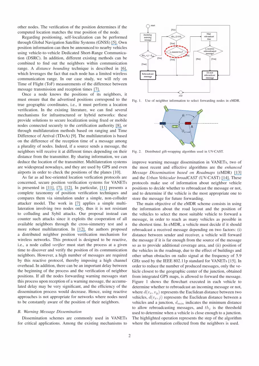
B. Warning Message Dissemination
Dissemination schemes are commonly used in VANETs
for critical applications. Among the existing mechanisms to
Fig. 1. Use of neighbor information to select forwarding nodes in eMDR.
Fig. 2. Distributed gift-wrapping algorithm used in UV-CAST.
improve warning message dissemination in VANETs, two of
the most recent and effective algorithms are the enhanced
Message Dissemination based on Roadmaps (eMDR) [13]
and the Urban Vehicular broadCAST (UV-CAST) [14]. These
protocols make use of information about neighbor vehicle
positions to decide whether to rebroadcast the message or not,
and to determine if the vehicle is the most appropriate one to
store the message for future forwarding.
The main objective of the eMDR scheme consists in using
the information about the road layout and the position of
the vehicles to select the most suitable vehicle to forward a
message, in order to reach as many vehicles as possible in
the shortest time. In eMDR, a vehicle must decide if it should
rebroadcast a received message depending on two factors: (i)
distance between sender and receiver, a vehicle will forward
the message if it is far enough from the source of the message
so as to provide additional coverage area, and (ii) position of
the vehicles in the roadmap, due to the effect of buildings and
other urban obstacles on radio signal at the frequency of 5.9
GHz used by the IEEE 802.11p standard for VANETs [15]. In
order to reduce the number of produced messages, only the ve-
hicle closest to the geographic center of the junction, obtained
from integrated GPS maps, is allowed to forward the message.
Figure 1 shows the flowchart executed in each vehicle to
determine whether to rebroadcast an incoming message or not,
where d(vx, vy) represents the Euclidean distance between two
vehicles, d(vx, j) represents the Euclidean distance between a
vehicles and a junction, dmin indicates the minimum distance
to allow rebroadcasting messages, and thj is the threshold
used to determine when a vehicle is close enough to a junction.
The highlighted operation represents the step of the algorithm
where the information collected from the neighbors is used.
2

The UV-CAST algorithm selects different mechanisms for
message dissemination in VANETs differentiating between
well-connected and disconnected network regimes, depending
in the density of vehicles in the vicinity. Each vehicle uses
only local information to decide the network regime it belongs
to. Vehicles in well-connected regime rebroadcast incoming
messages after a wait time if no redundant messages are
received. Vehicles in disconnected regime must decide if
they are suitable for the Store-Carry-Forward (SCF) task,
forwarding the message whenever they meet new neighbors.
The SCF task is assigned to vehicles that have small expected
time before they see new neighbors, obtained as the boundary
vehicles of the neighbors in communication range, i.e., located
on the vertices of the boundary polygon. The boundary poly-
gon can be defined as the convex hull including the points
representing the positions of the vehicles in communication
range from the sender; hence, the boundary vehicles will be
those located in the vertices of this convex hull, represented
as shadowed polygons in Figure 2. The angles between the
receiver vehicles, the source of the message, and each of the
neighbors is computed, and the highest and lowest values are
used to determine if the vehicle is boundary by means of
the gift-wrapping algorithm. As shown in Figure 2, after the
vehicle A receives a message from the sender S, it obtains the
highest and lowest angle values with respect to its neighbors
(θ+ and θ , respectively). If |θ+|+ |θ | > π, the vehicle is not
selected for the SCF task.
Both eMDR and UV-CAST are designed to blindly trust
the information provided by other vehicles. Vehicles may
announce incorrect positions due to several factors: uninten-
tional inaccuracies, e.g., GPS errors in poorly covered areas;
however, malicious vehicles can also advertise an incorrect
position to decrease the performance of a system, or to gain
advantage among peers, for example by attracting traffic to
a specific area. Hence, the information provided by other
vehicles should be verified before being trusted and used as
an input to dissemination algorithms. To this end, we design
CNPV, a protocol that proactively determines which neighbors
are advertising false information about their positions.
III. THE CNPV PROTOCOL
We first introduce our reference communication environ-
ment, and then detail the CNPV protocol we propose.
A. System Model
We consider a vehicular ad hoc network where the com-
munication neighbors of a vehicle are all the nodes that it
can reach directly when transmitting. All vehicles are syn-
chronized to a common time reference, and we assume that
each node is able to determine its own geographical position
with a maximum error ǫp. Both criteria regarding timing and
geographical position can be fulfilled by equipping vehicles
with GPS receivers, a plausible assumption given the rapid
diffusion of this technology in the automotive industry.
In addition, vehicles are capable of performing Time of
Flight (ToF)-based Radio Frequency (RF) ranging with a
maximum error equal to ǫr. To retrieve the exact transmis-
sion and reception time instants, avoiding the unpredictable
latencies introduced by interrupts triggered at the driver level
of RF interfaces, a solution such as that implemented in [16]
should be adopted. This implies a timing precision of about
23 ns, i.e., an average error of 6.8 meters, determined by the
44 MHz clock of standard 802.11a/b/g cards. Furthermore,
the GPS receiver should be integrated in the 802.11 cards;
software defined radio solutions integrating GPS in 802.11
are proposed, among others, in [17], [18].
Each vehicle X has a unique identifier, as well as a long-
term private key kX and a long-term public key KX , to encrypt
and decrypt data [19]. The node identity can be a permanent
identifier or a temporary pseudonym, so as to ensure user
privacy [20]. Additionally, vehicles have a set of one-time
use keys available {k′X ,K ′
X}, and they can produce digital
signatures (SigX) with their private key. We assume that the
correspondence between X and KX can be validated by any
node, as in state-of-the-art secure communication architectures
exploiting the presence of a public key infrastructure (i.e.,
certification authority) [21].
Vehicles are correct if they comply with the verification
protocol, or adversarial if they deviate from it. Adversaries
can be considered either internal or external to the network,
depending on whether they have a set of recognized crypto-
graphic keys or not. External adversaries have fewer oppor-
tunities to thwart the system; in fact, they can only serve as
relay nodes since messages with unrecognized signatures will
be immediately rejected by the rest of nodes. Hence, we only
consider the more challenging case of internal adversaries.
B. CNPV Protocol Objectives
The CNPV protocol is proactive, as each node participating
in the system periodically sends its location and the infor-
mation necessary for the protocol operation, similar to other
existing routing protocols [22], [23]. Hence, our approach is
proactive in the sense that node messages are not the result of
explicit queries.
The proposed protocol is designed to attain two main
objectives in a mobile environment: (i) acquiring the positions
of the neighbors, and (ii) verifying the correctness of these
positions. The system is designed so as to allow each node to
decide whether the positions advertised by its neighbors are
accurate or not. Thus, a node assigns one of three possible
states to each of its neighboring nodes:
• Verified: the advertised position corresponds to the true
geographic position of the neighbor;
• Faulty: the advertised position does not correspond to the
true position of the neighbor, tagged as an attacker;
• Unverifiable: the information collected so far is not
enough to determine the correctness of the advertised
position.
The CNPV protocol is based on a cooperative approach
that takes advantage of the broadcast nature of the wireless
medium, and allows each node to verify the positions of its
communication neighbors through the messages it receives.
We remark that the position validation is run by each node
3

Fig. 3. Timings of the proactive neighbor position verification algorithm.
independently, and that CNPV does not require any exchange
of the resulting neighbor states among nodes. Thus, the
protocol does not require nodes to have a global knowledge of
the network, nor to find a global consensus on the verification
of claimed positions.
C. CNPV Protocol Message Exchange
The proactive verification process uses a message exchange
mechanism that takes place in two rounds with the same
duration Tround:
• Round 1: In the first round, each node X participating
in the protocol chooses a random time tX (not exceeding
the round interval). At tX , the node sends an anonymous
HELLO message, using a freshly-generated MAC address
and including (i) the node public one-time use key K ′
X
and (ii) a pair of values for each neighbor from which
X has received an HELLO in this round. Specifically,
the pair of values referring to neighbor Y contains Y ’s
public one-time use key K ′
Y and the time instant at which
X received Y ’s HELLO (denoted by tY X ). The HELLO
message is received by all the neighbors of X , possibly
at a different time instant for each node.
• Round 2: Ater a constant guard time denoted by Tguard,
nodes execute the second round of the protocol. Each
node X sends a new message, named DISCLOSURE, at
time t′X . DISCLOSURE messages are sent following the
same order at which the HELLOs were transmitted by the
nodes, i.e., for each node X , t′X = tX+Tround+Tguard.
The DISCLOSURE message sent by node X contains:
(i) the identity of the sender, IDX ;
(ii) its announced position, px;
(iii) the time at which it sent the HELLO message, tX ;
(iv) a pair of values (K ′
Y , tXY ) for each neighbor Y
whose HELLO was received by X after tX ;
(v) the information needed to make the correspondence
with the HELLO message that X sent anonymously
during the first round. Such information consists
of the public one-time use key X transmitted in
the first round, K ′
X , and of this same value en-
crypted with X’s private one-time use key k′X (i.e.,
Ek′
X(K ′
X)). Note that K ′
X allows X’s neighbors to
decrypt Ek′
X(K ′
X), while the latter lets X prove to
its neighbors that it is the sender of both the HELLO
and the DISCLOSURE messages it transmitted;
(vi) X’s long-term public key KX ;
(vii) the digital signature of the DISCLOSURE message
generated using X’s long-term private key, SigX .
Algorithm 1: Message exchange routine (NX denotes the
set of neighbors of node X)
1 node X do2 if round == 1 then
3 X : tX = random ∈ [now, now + tround]4 when tx do
5 forall node Y ∈ NX do
6 X : cy ={(
K ′
Y, tY X
)}
7 X → ∗ :⟨
HELLO,K ′
X, {cy}y
⟩
8 else if round == 2 then
9 X : t′X = tX + Tround + Tguard
10 when t′x do11 X → ∗ :
〈DISCLOSURE, IDX , pX , tX ,K ′
X, Ek′
X
(K ′
X),
{cy}y , KX , SigX〉
The protocol and the message exchange routine are pre-
sented in Figure 3 and Algorithm 1. Note that, in Algorithm
1, NX denotes the set of neighbors of node X . Furthermore,
we remark that during Round 1, a node X keeps recording
the pair of values cY for all neighbors from which it receives
a HELLO message, even after having sent its own HELLO.
After the message exchange routine is complete, each node
can create the correspondences between the messages sent
in the first round and the neighbors that have revealed their
identity (or pseudoidentity) in Round 2. Moreover, each node
retrieves from the DISCLOSURE messages the transmission
times (tX ) of the HELLOs for each of its neighbors. Such
information, together with the locally stored reception times of
the HELLOs, allows each node to use ToF-based RF ranging to
calculate the distance that separates them from their neighbors.
Packets received during the second round without a reference
from the first round cannot be verified, hence they are ignored
until a complete packet interchange is performed.
For example, let us consider the case of a node Y receiving
a message from X . Y retrieves tX , the transmission time of
HELLO sent by X , from X’s DISCLOSURE message. Y has
locally stored tXY , i.e., the time at which it received the same
message. Using this information Y can determine the distance
that separates it from X .
Finally, we remark that the HELLO message in Round 1
needs to be anonymous, so as to make the protocol robust
to attacks. Indeed, if an adversary knew the postion of the
nodes taking part in Round 1, it could use this information
to adjust the timing data it includes in its own HELLO in
Round 1. In order to make the HELLO in Round 1 anonymous,
such message (i) is transmitted employing a fresh, software-
generated MAC address, and (ii) contains a public key K ′
X
taken from X’s pool of anonymous one-time use keys that do
not allow neighbors to map the key onto a specific node. Since
a source address has to be included in the MAC-layer header
of the message, a fresh, software-generated MAC address
is needed; note that this is considered a part of emerging
4

cooperative systems [20]. Including a one-time key in the
HELLO also ensures that the message is fresh (i.e., the key
acts as a nonce).
D. CNPV Protocol Verification Algorithm
Once the message exchange is finished, it is time for the
participating nodes to verify the positions advertised by their
neighbors. To this end, three tests are subsequently carried
out by each of the nodes, allowing them to determine if
the positions advertised are accurate or not. A more detailed
description of such tests, as well as a mathematical analysis
laying the foundations of the secure positioning scheme of
CNPV, are available in [12].
Three tests are performed for position verification: the
Direct Symmetry test, the Cross-Symmetry test, and the Mul-
tilateration test. After running the three tests for each com-
munication neighbor, each vehicle is able to determine if the
interchanged information is trustworthy, hence the neighbor
may be considered as a potential forwarding node; or it
may be considered malicious, in which case, the neighbor
is considered as faulty and not suitable to rebroadcast the
message. Next, we present the three different tests.
1) Direct Symmetry (DS Test): During this test, the verifier
node compares its own information to the information col-
lected from each of its neighbors. This test does not use the
cooperative approach of the protocol. During this test, two sub-
tests are performed: (i) a coherence test, where the distance
calculated using the time of flight of radio signal must be
coherent with the position announced by the neighbor, and
(ii) a signal range test, where the calculated distance must be
less than the maximum range of the Radio Frequency (RF)
communication system.
2) Cross-Symmetry (CS Test): Unlike the DS test, the
Cross-Symmetry test exploits the collaborative behavior of
our approach by performing cross checks. The purpose is to
verify the collected information from the neighbors which are
mutually interconnected. The CS test ignores the nodes already
considered incorrect by the DS test, and compares pairs of
nodes such that the two nodes and the verifier node are within
communication range. When nodes meet these conditions, they
are tested using the same criteria as in the DS test. The
algorithm works by counting the number of links considered
correct and the number of links considered incorrect. The ratio
of invalid links with respect to the total number of links for
a given node allows determining if its advertised position is
trustworthy. With a ratio limit set to 50%, the majority value is
considered. A smaller ratio limit will provide greater security,
but it limits the number of links correctly verified.
3) Multilateration (ML Test): The last of the three proposed
tests is applied to previously verified nodes. We want to detect
suspicious situations where nodes have deliberately neglected
to announce the links they have with other nodes by counting
the number of neighbors who reported a link not announced
by the suspicious node. If there are at least two, then we
can compute – for each pair of nodes including a verifier S
and a neighbor Y – a curve in which node X is present. If
we can calculate two or more curves, node X is located at
(a) (b)
Fig. 4. Road network scenarios used in SUMO: (a) section of the city ofLos Angeles, CA, USA, and (b) section of the city of Madrid, Spain.
the intersection of these curves, that, due to their geometrical
construction, are hyperbolas. GPS and ToF-based RF ranging
error may lead to curves that do not perfectly intersect in one
point. Thus, the centroid of such (closely located) intersections
is determined and then compared to the distance advertised
by the suspicious node. If the error threshold is exceeded,
the node is considered invalid. In our simulations, the error
threshold is set to 10 meters.
IV. SIMULATION ENVIRONMENT
We evaluate the impact of the CNPV protocol on eMDR
and UV-CAST, two state-of-the-art warning message dissem-
ination algorithms.
Since deploying and testing VANETs is unpractical due
to high economic costs and system complexity, we resort to
simulation as a viable alternative to actual implementation.
We selected two different road layouts to test our proposal.
Figure 4(a) shows the area between Martin Luther King Blvd.
and West Slauson Av. in the city of Los Angeles (CA, USA),
which has a very regular street layout similar to synthetic
Manhattan-grid layouts. The street map around Paseo de la
Castellana in the city of Madrid (Spain), shown in Figure 4(b),
is an example of European city with a more irregular layout.
The scenarios were obtained from OpenStreetMap [24], each
one representing a 4-km2 square area.
Vehicular mobility is generated with the CityMob for
Roadmaps (C4R) tool1, which can import maps from Open-
StreetMap and is based on SUMO [25], a realistic open-
source traffic simulation package. The microscopic mobility
is modeled through the Krauss mobility model with some
modifications to allow multi-lane behavior [26]. From a
macroscopic viewpoint, our mobility simulations account for
areas with different vehicle densities, ranging from 12.5 to 100
vehicles/km2. Since in a realistic urban environment the traffic
is not uniformly distributed, being driven by points of interest
that attract vehicles, we adopt the Downtown Model [27]
to determine such points of attraction in the roadmaps and
to derive the macroscopic traffic flows. The effect of traffic
flow changes on the performance is negligible, since the
dissemination time obtained in our simulations is too short to
appreciate noticeable changes due to these changes that could
modify the dynamic behavior of the simulation.
1C4R is freely available at http://www.grc.upv.es/software/
5

TABLE IPARAMETER VALUES USED FOR THE SIMULATIONS
Parameter Value
number of vehicles 100, 200, 300, 400simulated area 2000m × 2000mmobility generator C4Rmobility models Krauss [26] and
Downtown model [30]maximum speed of vehicles 23 m/s ≈ 83 km/hmaximum acceleration of vehicles 1.4 m/s2
maximum deceleration of vehicles 2.0 m/s2
driver reaction time (τ ) 1 snumber of warning mode vehicles 3warning message size 512Bwarning packet rate 1 per secondwarning message priority AC3HELLO message size 40B(CNPV )+
512B(key + sign.)HELLO packet rate 1 per secondHELLO message priority AC1MAC/PHY 802.11pmaximum transmission range 400mCNPV ǫr 10mCNPV ǫp 10mCNPV Tround 0.75 secondsCNPV Tguard 0.25 seconds
Simulations were carried out using the ns-2 simulator [28],
modified to include the IEEE 802.11p [15] standard so as to
closely follow the upcoming WAVE standard. In terms of the
physical layer, the data rate used for packet broadcasting is
of 6 Mbit/s, as this is the maximum rate for broadcasting in
802.11p. At the MAC layer, channel access priorities were
implemented: four different Access Categories (ACs) provide
different priority to application messages, where AC0 has the
lowest and AC3 the highest priority. The simulator was also
modified to make use of our Real Attenuation and Visibility
(RAV) propagation model [29], which increases the level of
realism of the VANET simulations by accounting for real
urban roadmaps and obstacles that have a strong influence
over the wireless signal propagation. The RAV model is based
on real-world measurements and accounts for attenuation and
fading due to radio obstacles.
In each scenario, three warning-mode vehicles generate
warning messages at a rate of 1 message/second, while the
rest of normal-mode vehicles act as relaying nodes for these
messages. The vehicles in the simulation also broadcast one-
hop HELLO messages at a rate of 1 message/second in order
to implement the neighbor position verification algorithm. In
a urban environment where the maximum speed should not
exceed 50 km/2, the maximum distance traveled by vehicles
is about 14 meters, and thus it is a reasonable assumption
to generate verification messages at this rate to avoid satura-
tion of the wireless channel. However, the scheme could be
easily adapted to comply with standards like the ETSI TS
102 637-2 [31], in which the beacons are sent dynamically
with frequencies between 1 Hz and 10 Hz in dependence of
the mobility of the sender vehicle. In this case, the CNPV
information could be broadcast once per second, while the rest
of the beacons would contain only the information required in
each situation, making the verification mechanism compatible
with these standards.
As for the time required by the operations of signing and
verification that are part of the secure protocol, we took
them into account. We set the time required for signing a
DISCLOSURE message to 3 ms and that required for signature
verification to 12 µs, assuming that an Intel Core i7-2670QM
2.2Ghz processor is used [32]. Note that only one signature
per cycle time has to be generated by each node, and that
every cycle time one signature verification per neighbor has
to be carried out.
We evaluate the following performance metrics of interest:
the warning notification time, i.e., the time required by normal
vehicles to receive a warning message sent by a warning-
mode vehicle, and the percentage of blind vehicles, i.e., the
percentage of normal-mode vehicles that do not receive a
warning message. We are also interested in assessing the
overhead that CNPV induces in the network, and the effect
of different levels of ranging errors on the performance of
the mechanism. All results represent the average of multiple
executions with different random seeds, and fall within a 95%
confidence interval. Table I summarizes the parameter values
used in our simulations.
A. Adversary model
Simulations account for different percentages of adversarial
vehicles, namely 3%, 6%, and 9% of the total number of
vehicles. This relatively high values are selected since we
are interested in worst case scenarios where the number of
adversaries could threaten the performance of the Warning
Message Dissemination system. The nodes only have knowl-
edge about their communication neighbors, they do not have
global knowledge of the network, and a high percentage of
adversaries is necessary to cover all the attacked area.
Attackers aim at reducing the performance of the warning
message dissemination process, by attracting the road safety
data traffic but not forwarding the warning messages received.
To that end, they announce false positions so as to exploit
the vulnerabilities of the eMDR and UV-CAST algorithms, as
detailed next.
In the case of the eMDR algorithm, vehicles closer to
roadmap junctions have an advantage over their neighbors
since they have the highest chances of reaching new areas
of the topology. Hence, a simple attack that would reduce
the performance of warning message dissemination using
this algorithm consists in announcing bogus positions very
close to the junction coordinates. Detecting a neighbor in a
more appropriate location, all other vehicles will refrain from
forwarding the message. Some time later, another node might
forward the message even though it is in a less favorable posi-
tion, since the integrity of the system has been compromised.
Regarding the UV-CAST protocol, the Store-Carry-Forward
task is performed by boundary vehicles, and a vehicle which
is not located in the vertices of the boundary polygon will
not be assigned this task. Hence, vehicles advertising false
positions relatively far from their actual position will obtain
advantage over their neighbors, since they will be located with
higher probability in the boundary area. Fewer neighbors will
be assigned the data carrying task, reducing the chances that
the warning message reaches new areas of the urban scenario.
6

0
20
40
60
80
100
0 10 20 30 40 50 60
% o
f veh
icle
s re
ceiv
ing
the
war
ning
mes
sage
s
Warning notification time (s)
eMDR (Secure)eMDR (Insecure)
UV-CAST (Secure)UV-CAST (Insecure)
(a)
0
20
40
60
80
100
0 10 20 30 40 50 60
% o
f veh
icle
s re
ceiv
ing
the
war
ning
mes
sage
s
Warning notification time (s)
eMDR (Secure)eMDR (Insecure)
UV-CAST (Secure)UV-CAST (Insecure)
(b)
Fig. 5. Warning notification time in Madrid with 200 vehicles varying the percentage of adversaries: (a) 3%, and (b) 9%.
0
20
40
60
80
100
0 10 20 30 40 50 60
% o
f veh
icle
s re
ceiv
ing
the
war
ning
mes
sage
s
Warning notification time (s)
eMDR (Secure)eMDR (Insecure)
UV-CAST (Secure)UV-CAST (Insecure)
(a)
0
20
40
60
80
100
0 10 20 30 40 50 60%
of v
ehic
les
rece
ivin
g th
e w
arni
ng m
essa
ges
Warning notification time (s)
eMDR (Secure)eMDR (Insecure)
UV-CAST (Secure)UV-CAST (Insecure)
(b)
Fig. 6. Warning notification time in Madrid with 400 vehicles varying the percentage of adversaries: (a) 3%, and (b) 9%.
V. SIMULATION RESULTS
In this section, the performance of the CNPV protocol
is evaluated. We rely on simulation since an accurate rep-
resentation of both (i) vehicular mobility, and (ii) CNPV
protocol operation, are required. Unfortunately, those two
aspects are nearly impossible to abstract into an analytical
model without oversimplifying the system – which would
yield results of little significance, as shown, e.g., in [33].
For instance, previous works presenting analytical models
of nodes mobility and vehicle-to-vehicle connectivity [34],
or message dissemination [35] have limited their scope to
extremely simplified scenarios (a highway road section, or a
regular grid) and to dynamics over very short time intervals,
besides making unrealistic assumptions on car movement (e.g.,
each road lane corresponds to a fixed speed and lane changes
occur with known probabilities). However, the performance of
the message dissemination scheme and the secure positioning
techniques of CNPV are strongly dependent on the underlying
node mobility, which should thus be represented in a very
realistic way, too complex to be mathematically tractable via,
e.g., Markovian analysis.
We first study the effect of adversarial nodes on the per-
formance of the dissemination process, when eMDR and
UV-CAST are used in their legacy version as well as in
combination with the CNPV protocol we propose. Then, we
assess the overhead induced by the use of the CNPV protocol,
and the effect of different levels of ranging error on the
performance of the sysyem. Finally, we study the influence
of high vehicle densities in urban scenarios.
A. Securing Warning Message Dissemination
Figures 5 and 6 show the percentage of vehicles reached
by the warning message over time in the Madrid map, under
different vehicle densities and percentages of adversaries. As
we can observe, the legacy UV-CAST scheme is noticeably
affected even when a low percentage of attackers are present in
the environment: when CNPV is used, the number of informed
vehicles grows by 15-20% for most warning notification times.
The differences observed when CNPV is used or not tend
to grow with increasing vehicle densities, which implies that
attackers can more easily slow down the overall process in
presence of a dense vehicular network. Regarding the two
mechanisms used by the UV-CAST algorithm, the Store-
Carry-Forward (SCF) task is mainly inhibited when adver-
saries announce false positions. Results show that this is a
very important mechanism to reach new areas of the roadmap,
and hence the UV-CAST algorithm is greatly affected by the
presence of adversaries.
The eMDR algorithm is more resistant, in general, to
adversaries trying to thwart it. As shown in Figure 5, when
the vehicle density remains low, there are not enough vehicles
to cover most of the junctions of the topology, and hence the
warning message reception probability is only reduced by 10%
at each time instant. However, the effect of the adversary nodes
is more evident when the vehicle density increases, since the
area occupied by vehicles is larger. This effect is more evident
in Figure 6(b), where we can see an important performance
decrease when the security mechanism is not enabled.
To better understand the impact of vehicle density, Figure 7
7

0
20
40
60
80
100
0 10 20 30 40 50 60
% o
f veh
icle
s re
ceiv
ing
the
war
ning
mes
sage
s
Warning notification time (s)
eMDR (Secure)eMDR (Insecure)
UV-CAST (Secure)UV-CAST (Insecure)
(a)
0
20
40
60
80
100
0 10 20 30 40 50 60
% o
f veh
icle
s re
ceiv
ing
the
war
ning
mes
sage
s
Warning notification time (s)
eMDR (Secure)eMDR (Insecure)
UV-CAST (Secure)UV-CAST (Insecure)
(b)
0
20
40
60
80
100
0 10 20 30 40 50 60
% o
f veh
icle
s re
ceiv
ing
the
war
ning
mes
sage
s
Warning notification time (s)
eMDR (Secure)eMDR (Insecure)
UV-CAST (Secure)UV-CAST (Insecure)
(c)
Fig. 7. Warning notification time in Los Angeles with 6% of adversaries and a varying number of vehicles: (a) 100, (b) 200, and (c) 400.
shows the evolution of the warning dissemination process in
Los Angeles when the percentage of adversaries is fixed at 6%.
Again, we observe a similar tendency for both dissemination
schemes with respect to the Madrid scenario. The UV-CAST
algorithm is very sensitive to adversaries in the environment,
and there is a uniform performance reduction in all the
tested scenarios, independently of the chosen vehicle density.
However, the eMDR scheme is able to support up to 200
vehicles (50 vehicles/km2) without a significant performance
loss. Whenever the vehicle density exceeds this threshold,
the number of adversary vehicles is enough to degrade the
dissemination process, making the selection of the optimal
forwarding vehicles unfeasible. We must remember that this
selection uses the information of the road topology to choose
those vehicles with a better line-of-sight with respect to the
streets (i.e., the closest to the center of the junctions), and
adversary vehicles sending this information will affect all the
vehicles in the proximity of the junction. As the number of
adversaries rises, the number of occupied junctions increases,
and the selection of forwarding vehicles is not optimal.
We already proved how the UV-CAST algorithm is greatly
affected by the presence of even a low percentage of adversary
nodes. It would be more interesting to study how the eMDR
algorithm is affected in a wider variety of scenario. Table II
contains the average simulation results for the eMDR scheme
in all the configurations tested in the Madrid scenario, for the
metrics of blind vehicles not receiving warning messages after
120 seconds, and the time required to inform at least 50%
and 75% of the vehicles in the scenario, also called Warning
Notification Time (WNT). It is noticeable that, when the
security scheme for neighbor position verification is enabled,
we achieve better results in all the tested scenarios and for
all the metrics selected: the gain in the values of some of the
metrics is higher than 60%. In general, we observe how, by
increasing the percentage of adversary vehicles per warning
vehicle (column ”% Adv.”), the scheme reduces considerably
its performance, especially for high vehicle densities. Fur-
thermore, under high vehicle density, the scheme reduces the
percentage of blind vehicles (by up to 50%) as well as the time
needed to inform 75% of the vehicles. The latter improves
from 10.4% when simulating 100 vehicles, to 61.1% for 400
vehicles in the best case. This confirms the tendency observed
for the eMDR algorithm in the rest of tested scenarios.
B. CNPV Protocol Overhead
We define the overhead as the average ratio of wireless traf-
fic received by a vehicle due to the CNPV protocol, in terms
of HELLO and DISCLOSURE messages. More formally, the
overhead is computed as:
Overhead =1
N
N∑
i=1
BytesReceivedCNPV (i)
BytesReceivedtotal(i)(1)
Where BytesReceivedCNPV (i) are the bytes of
traffic induced by CNPV and received by vehicle i,
BytesReceivedtotal(i) are the total bytes received by vehicle
i, and N is the total number of vehicles in the system. As
shown in Figure 8, the packet overhead is less than 8%
of the total traffic in all the tested scenarios when 3% of
adversaries are considered, and less than 10% when the
simulation accounts for 9% of adversaries. There is a slight
increase in the overhead produced by the security mechanism
as the percentage of adversarial nodes grows, since there are
fewer vehicles forwarding warning messages and the amount
of relative traffic due to HELLO messages is higher.
We can observe how the percentage becomes higher when
the UV-CAST algorithm is used: 5-10% of traffic for UV-
CAST compared to 1-4% for eMDR; notice that this difference
is mainly due to the lower number of messages produced by
UV-CAST compared to the eMDR scheme. In addition, in
regular maps like Los Angeles, the ratio between HELLO
messages and warning messages increases as the vehicle
density grows, due to the superlinear increase in the number of
one-hop neighbors with respect to the total number of vehicles.
Conversely, the overhead does not have a monotonic trend in
irregular maps like in Madrid, where connectivity is sparser.
In general, the additional traffic generated by the security
scheme is low compared to the warning message dissemination
scheme that it gives support to. The small one-hop HELLO
messages used by the CNPV mechanism occupy less band-
width than the large warning message that are not limited to
one-hop interactions.
To better understand the efficiency of the dissemination
algorithms studied, Figure 9 shows the average percentage
of duplicate warning messages received by each vehicle in
Madrid, compared to the total number of warning messages
received. As we can see, the amount of duplicate messages
is higher when using the eMDR algorithm, where 60-80%
8

TABLE IIAVERAGE SIMULATION RESULTS IN THE MADRID SCENARIO USING THE EMDR ALGORITHM.
Veh. Density % Adv. Security % Blind veh. WNT (50%) WNT (75%)
100 vehicles
(25 veh./km2)
3%OFF 21.7% 29.10 s 96.11 sON 21.0% (-3.2%) 26.63 s (-8.5%) 86.09 s (-10.4%)
6%OFF 28.3% 33.33 s –
ON 23.6% (-16.6%) 31.34 s (-6.0%) 89.63 s
9%OFF 32.0% 41.09 s –
ON 28.0% (-12.5%) 35.10 s (-14.6%) –
200 vehicles
(50 veh./km2)
3%OFF 3.4% 4.44 s 15.42 sON 2.8% (-17.6%) 4.12 s (-7.2%) 12.85 s (-16.7%)
6%OFF 4.9% 6.42 s 20.55 sON 3.9% (-20.4%) 4.41 s (-31.3%) 14.45 s (-29.7%)
9%OFF 8.5% 9.42 s 34.44 sON 5.0% (-41.2%) 6.11 s (-35.1%) 18.44 s (-46.5%)
300 vehicles
(75 veh./km2)
3%OFF 1.3% 1.04 s 8.15 sON 1.2% (-7.7%) 0.84 s (-19.2%) 6.84 s (-16.1%)
6%OFF 1.7% 2.13 s 12.83 sON 1.5% (-11.7%) 1.67 s (-21.6%) 8.67 s (-32.4%)
9%OFF 2.3% 4.13 s 21.15 sON 1.7% (-26.1%) 2.66 s (-35.6%) 9.15 s (-56.7%)
400 vehicles
(100 veh./km2)
3%OFF 2.1% 3.73 s 11.89 sON 1.0% (-52.3%) 3.19 s (-14.5%) 9.73 s (-18.2%)
6%OFF 3.5% 6.86 s 15.74 sON 2.2% (-37.1%) 4.73 s (-31.0%) 10.91 s (-30.7%)
9%OFF 8.2% 13.70 s 48.19 sON 5.1% (-37.8%) 8.19 s (-40.2%) 18.72 s (-61.1%)
0
2
4
6
8
10
12
50 100 150 200 250 300 350 400 450
% o
f add
ition
al tr
affic
rec
eive
d du
e to
sec
urity
mec
hani
sm
Number of vehicles simulated
Madrid (eMDR)Madrid (UV-CAST)
Los Angeles (eMDR)Los Angeles (UV-CAST)
(a)
0
2
4
6
8
10
12
50 100 150 200 250 300 350 400 450
% o
f add
ition
al tr
affic
rec
eive
d du
e to
sec
urity
mec
hani
sm
Number of vehicles simulated
Madrid (eMDR)Madrid (UV-CAST)
Los Angeles (eMDR)Los Angeles (UV-CAST)
(b)
0
2
4
6
8
10
12
50 100 150 200 250 300 350 400 450
% o
f add
ition
al tr
affic
rec
eive
d du
e to
sec
urity
mec
hani
sm
Number of vehicles simulated
Madrid (eMDR)Madrid (UV-CAST)
Los Angeles (eMDR)Los Angeles (UV-CAST)
(c)
Fig. 8. Average overhead due to the security mechanism with (a) 3%, (b) 6%, and (c) 9% of adversaries.
messages received are duplicated. However, even if this may
be considered inefficient compared to the UV-CAST scheme,
which achieves 40-50% of duplicates, the results show how
eMDR is able to inform more vehicles in less time, making
it especially suitable to deliver critical information. UV-CAST
could be useful to disseminate non-critical information with
decent performance and little resource usage. Finally, if we
disable the verification mechanism, the percentage of duplicate
messages also decreases. Malicious nodes are able to reduce
the overall warning message traffic, thus reducing the amount
of informed vehicles and increasing the time required to notify
the affected vehicles.
C. Influence of ToF Ranging Errors on CNPV Performance
The localization obtained by means of Time of Flight-
based Radio Frequency ranging technique is not completely
accurate. Depending on the frequency selected, the specific
interfaces, and the environment we may find different levels of
ranging errors that could affect the performance of the security
mechanism developed.
Lanzisera et al. [36] performed different experiments using
several frequency ranges around the 2.4 GHz band, including
methods for reducing error from clock offset and multipath
propagation implemented on prototype hardware. In this sce-
nario, the maximum localization error found was 24 meters
using the frequency of 2405 MHz, whereas for the rest of
frequencies the maximum error was under 20 meters, with
an average error of 3 meters. The error registered showed a
Gaussian distribution, meaning that the probability of error
over 10 meters is less than 10%.
Sikora and Groza [37] tested this ranging technique in
street scenarios with and without obstacles, such as vehicles,
trees, and other urban structures, using commercial equipment
working in the 2.4 GHz band. The error registered were about
4-10 meters without obstacles, and 5-15 meters in the presence
of obstacles, with typical standard deviations below 0.4 meters.
Using the data from existing works as a reference, we
studied the effect of ranging errors on the performance of
CNPV mechanism used jointly with the tested warning mes-
sage dissemination algorithms. We simulated different levels
of maximum error: from 10 meters, as used in the previous
simulations presented, to 40 meters, representing conditions
with extreme error values if we compare with the empirical
results using this ranging technology. These values correspond
to the variable ǫr in the CNPV algorithm, representing the
9

0
20
40
60
80
100
50 100 150 200 250 300 350 400 450% o
f dup
licat
e w
arni
ng m
essa
ges
rece
ived
per
veh
icle
Number of vehicles simulated
eMDR (Secure)eMDR (Insecure)
UV-CAST (Secure)UV-CAST (Insecure)
(a)
0
20
40
60
80
100
50 100 150 200 250 300 350 400 450% o
f dup
licat
e w
arni
ng m
essa
ges
rece
ived
per
veh
icle
Number of vehicles simulated
eMDR (Secure)eMDR (Insecure)
UV-CAST (Secure)UV-CAST (Insecure)
(b)
0
20
40
60
80
100
50 100 150 200 250 300 350 400 450% o
f dup
licat
e w
arni
ng m
essa
ges
rece
ived
per
veh
icle
Number of vehicles simulated
eMDR (Secure)eMDR (Insecure)
UV-CAST (Secure)UV-CAST (Insecure)
(c)
Fig. 9. Average percentage of duplicate warning messages received in the Madrid scenario with (a) 3%, (b) 6%, and (c) 9% of adversaries.
0
20
40
60
80
100
0 10 20 30 40 50 60
% o
f veh
icle
s re
ceiv
ing
the
war
ning
mes
sage
s
Warning notification time (s)
eMDR (εr = 10 m)eMDR (εr = 20 m)eMDR (εr = 30 m)eMDR (εr = 40 m)
UV-CAST (εr = 10 m)UV-CAST (εr = 20 m)UV-CAST (εr = 30 m)UV-CAST (εr = 40 m)
(a)
0
20
40
60
80
100
0 10 20 30 40 50 60
% o
f veh
icle
s re
ceiv
ing
the
war
ning
mes
sage
s
Warning notification time (s)
eMDR (εr = 10 m)eMDR (εr = 20 m)eMDR (εr = 30 m)eMDR (εr = 40 m)
UV-CAST (εr = 10 m)UV-CAST (εr = 20 m)UV-CAST (εr = 30 m)UV-CAST (εr = 40 m)
(b)
0
20
40
60
80
100
0 10 20 30 40 50 60
% o
f veh
icle
s re
ceiv
ing
the
war
ning
mes
sage
s
Warning notification time (s)
eMDR (εr = 10 m)eMDR (εr = 20 m)eMDR (εr = 30 m)eMDR (εr = 40 m)
UV-CAST (εr = 10 m)UV-CAST (εr = 20 m)UV-CAST (εr = 30 m)UV-CAST (εr = 40 m)
(c)
Fig. 10. Warning notification time under different maximum ranging error in Madrid, with 200 vehicles with (a) 3%, (b) 6%, and (c) 9% of adversaries.
0
20
40
60
80
100
0 10 20 30 40 50 60
% o
f veh
icle
s re
ceiv
ing
the
war
ning
mes
sage
s
Warning notification time (s)
eMDR (εr = 10 m)eMDR (εr = 20 m)eMDR (εr = 30 m)eMDR (εr = 40 m)
UV-CAST (εr = 10 m)UV-CAST (εr = 20 m)UV-CAST (εr = 30 m)UV-CAST (εr = 40 m)
(a)
0
20
40
60
80
100
0 10 20 30 40 50 60
% o
f veh
icle
s re
ceiv
ing
the
war
ning
mes
sage
s
Warning notification time (s)
eMDR (εr = 10 m)eMDR (εr = 20 m)eMDR (εr = 30 m)eMDR (εr = 40 m)
UV-CAST (εr = 10 m)UV-CAST (εr = 20 m)UV-CAST (εr = 30 m)UV-CAST (εr = 40 m)
(b)
0
20
40
60
80
100
0 10 20 30 40 50 60
% o
f veh
icle
s re
ceiv
ing
the
war
ning
mes
sage
s
Warning notification time (s)
eMDR (εr = 10 m)eMDR (εr = 20 m)eMDR (εr = 30 m)eMDR (εr = 40 m)
UV-CAST (εr = 10 m)UV-CAST (εr = 20 m)UV-CAST (εr = 30 m)UV-CAST (εr = 40 m)
(c)
Fig. 11. Warning notification time under different maximum ranging error in Madrid, with 400 vehicles under (a) 3%, (b) 6%, and (c) 9% of adversaries.
precision of the ranging mechanism.
Figures 10 and 11 show the results obtained using the
scenario of Madrid simulating 200 and 400 vehicles, i.e.,
50 and 100 vehicles/km2. As shown, the performance of the
warning dissemination process in an adversarial environment
is noticeable influenced by the presence of ranging errors, but
it is only really remarkable when the error levels are very high
(over 30 meters) and when the percentage of attackers exceeds
6%. The tendency in all the situations tested is the same, the
warning notification time and the percentage of uninformed
nodes increase as the error level grows, but there are no major
differences when the maximum error is 30 or 40 meters.
If we compare the dissemination algorithms, eMDR and
UV-CAST, it is also noteworthy that the eMDR scheme
outperforms UV-CAST in all the scenarios, even when the
ranging error levels are the highest. However, the influence of
ranging errors on the performance of UV-CAST are almost
independent on the percentage of adversarial nodes, whereas
eMDR becomes less efficient as the number of attackers
increases. This is especially visible in Figure 11(c), where the
performance of eMDR reduces up to 20% comparing between
10 and 50 meters of maximum ranging error.
D. Performance under High Vehicle Density
In realistic urban environments, the vehicle density could
increase far over the threshold of 100 vehicles/km2, producing
scenarios prone to cause broadcast storms due to the number of
vehicles directly connected. The higher probability of packet
collisions in the shared channel under these conditions may re-
duce the effectiveness of the position verification mechanism.
Hence, we will study the effects of dense environments on the
designed system.
We performed new simulations accounting for higher ve-
hicle densities. Specifically, we tested with 400 vehicles/km2
and 800 vehicles/km2, representing traffic jam conditions in
10

Fig. 12. Road network scenario: Madrid, 1 km2 area.
dense cities. Due to the limitations of the ns-2 simulator,
we obtained a smaller area of the Madrid map covering 1
km2 were the new simulations could be performed without
excessively increasing simulation time. We decided to test
new values for the percentage of adversary nodes to observe
their effect when combined with higher vehicular densities. In
particular, we obtained the results simulating when 1%, 3%,
and 9% of adversaries. Figures 13 and 14 show the simulation
results in this scenario.
As shown, the performance reduction when the verifica-
tion mechanism is disabled is not as noticeable as it was
under lower densities. The main reason of this effect is that
the parts of the algorithm that are inhibited by the actions
of the malicious nodes, i.e., rebroadcast in junctions using
eMDR and Store-Carry-Forward using UV-CAST, are mainly
useful for densities under 100 vehicles/km2 since they are
designed for low-congested urban environments. As vehicle
density increases, the importance of theses mechanisms in the
notification of additional vehicles is less important, and the
other parts of the algorithm become more useful, reducing the
negative effect of the adversaries.
Regarding the trend observed in these new results, it remains
the same when compared to those obtained under low-medium
density. The eMDR algorithm achieves better results than
UV-CAST in all the simulations, and it only experiences
performance drops under the highest percentages of adver-
saries. The performance reduction is hardly noticeable for 1%
of adversary nodes, increasing as the number of adversaries
increases. The performance of the UV-CAST algorithm is
reduced by about 5-10% even when the number of adversaries
is low, proving that the efficiency of the verification system is
maintained even in congested environments.
VI. CONCLUSIONS
In this paper, we presented a proactive, cooperative mech-
anism for neighbor position verification based on the infor-
mation interchanged among one-hop neighbors. Our CNPV
protocol is easily adaptable to different warning message
dissemination schemes that make use of the neighbor infor-
mation to decide the most appropriate forwarding scheme in
VANETs. CNPV allows verifying the position of the neighbors
before deciding the next forwarding vehicle, favouring the
dissemination process and a limiting the number of vehicles
that do not receive the warning messages.
We evaluated the performance of the CNPV protocol by
coupling it with two dissemination algorithms, eMDR and
UV-CAST, showing how (i) the presence of adversary nodes
affects the warning message dissemination performance in
urban scenarios, and (ii) CNPV can help to reduce the impact
of adversarial users in the vehicular network. When applied
in conjunction to the eMDR algorithm, we see how this
dissemination scheme supports a high percentage of attackers
if the vehicle density is low; however, increasing the number
of vehicles in the area allows adversary nodes to occupy
the best positions of the road topology, noticeably reducing
the performance of the dissemination process. When applying
our approach to the UV-CAST scheme, we observe that it
is especially sensitive to vehicles announcing false positions,
since the store-carry-and-forward approach adopted to reach
new areas in disconnected regimes is only performed by
boundary vehicles. A vehicle sending false information can
easily become the boundary vehicle, avoiding vehicles with
a more favorable position to assume this role. Overall, our
results show how CNPV improves the performance of the
dissemination process in adversarial environments by up to
50% in terms of warning notification time and percentage of
uninformed nodes.
ACKNOWLEDGMENTS
This work was partially supported by the Ministerio de
Ciencia e Innovacion, Spain, under Grant TIN2011-27543-
C03-01, by the Fundacion Universitaria Antonio Gargallo and
the Obra Social de Ibercaja, under Grant 2013/B010, as well
as the Government of Aragon under Grant “subvenciones des-
tinadas a la formacion y contratacion de personal investigador”
and the European Social Fund (T91 Research Group).
REFERENCES
[1] J. A. Dias, J. J. Rodrigues, and L. Zhou, “Cooperation advanceson vehicular communications: A survey,” Vehicular Communications,vol. 1, no. 1, pp. 22–32, 2014.
[2] ——, “Performance Evaluation of Cooperative Strategies for VehicularDelay-Tolerant Networks,” The European Transactions on Emerging
Telecommunications Technlogies (ETT), 2013.[3] E. Schoch, F. Kargl, and T. Leinmuller, “Vulnerabilities of geocast
message distribution,” in IEEE Workshop on Automotive Networkingand Applications (AutoNet), 2007.
[4] Y. Zeng, J. Cao, J. Hong, and L. Xie, “Secure localization and locationverification in wireless sensor networks,” in IEEE 6th InternationalConference on Mobile Adhoc and Sensor Systems (MASS ’09), Oct.2009, pp. 864–869.
[5] P. Papadimitratos and A. Jovanovic, “GNSS-based Positioning: Attacksand Countermeasures,” in IEEE Milcom, San Diego, CA, USA, Nov.2008.
[6] N. Sastry, U. Shankar, and D. Wagner, “Secure verification of locationclaims,” in Proc. of the ACM Workshop on Wireless Security 2003
(WiSe’03), San Diego, CA, USA, Sep. 2003, pp. 1–10.[7] J.-H. Song, V. Wong, and V. Leung, “Secure location verification
for vehicular ad-hoc networks,” in IEEE Global Telecommunications
Conference (IEEE GLOBECOM), New Orleans, LO, USA, Dec. 2008,pp. 1–5.
[8] S. Capkun, K. Rasmussen, M. Cagalj, and M. Srivastava, “Securelocation verification with hidden and mobile base stations,” IEEE
Transactions on Mobile Computing, vol. 7, no. 4, pp. 470–483, Apr.2008.
[9] S. Capkun and J.-P. Hubaux, “Securing position and distance verificationin wireless networks,” Swiss Federal Institute of Technology Lausanne,Lausanne, Switzerland, Technical Report EPFL/IC/200443, Tech. Rep.,May 2004.
11

0
20
40
60
80
100
0 5 10 15 20 25 30
% o
f veh
icle
s re
ceiv
ing
the
war
ning
mes
sage
s
Warning notification time (s)
eMDR (Secure)eMDR (Insecure)
UV-CAST (Secure)UV-CAST (Insecure)
(a)
0
20
40
60
80
100
0 5 10 15 20 25 30
% o
f veh
icle
s re
ceiv
ing
the
war
ning
mes
sage
s
Warning notification time (s)
eMDR (Secure)eMDR (Insecure)
UV-CAST (Secure)UV-CAST (Insecure)
(b)
0
20
40
60
80
100
0 5 10 15 20 25 30
% o
f veh
icle
s re
ceiv
ing
the
war
ning
mes
sage
s
Warning notification time (s)
eMDR (Secure)eMDR (Insecure)
UV-CAST (Secure)UV-CAST (Insecure)
(c)
Fig. 13. Warning notification time in Madrid simulating 400 vehicles/km2 varying the percentage of adversaries: (a) 1%, (b) 3%, and (c) 9%.
0
20
40
60
80
100
0 5 10 15 20 25 30
% o
f veh
icle
s re
ceiv
ing
the
war
ning
mes
sage
s
Warning notification time (s)
eMDR (Secure)eMDR (Insecure)
UV-CAST (Secure)UV-CAST (Insecure)
(a)
0
20
40
60
80
100
0 5 10 15 20 25 30
% o
f veh
icle
s re
ceiv
ing
the
war
ning
mes
sage
s
Warning notification time (s)
eMDR (Secure)eMDR (Insecure)
UV-CAST (Secure)UV-CAST (Insecure)
(b)
0
20
40
60
80
100
0 5 10 15 20 25 30
% o
f veh
icle
s re
ceiv
ing
the
war
ning
mes
sage
s
Warning notification time (s)
eMDR (Secure)eMDR (Insecure)
UV-CAST (Secure)UV-CAST (Insecure)
(c)
Fig. 14. Warning notification time in Madrid simulating 800 vehicles/km2 varying the percentage of adversaries: (a) 1%, (b) 3%, and (c) 9%.
[10] Creativerge ERA Corporation, “Multilateration Executive ReferenceGuide,” 2013. [Online]. Available: http://multilateration.com/
[11] T. Leinmuller, E. Schoch, F. Kargl, and C. Maihofer, “Decentralizedposition verification in geographic ad hoc routing,” Security and Com-munication Networks, 2008.
[12] M. Fiore, C. Casetti, C. Chiasserini, and P. Papadimitratos, “Discoveryand verification of neighbor positions in mobile ad hoc networks,” IEEE
Transactions on Mobile Computing, vol. 12, no. 2, pp. 289–303, Feb.2013.
[13] M. Fogue, P. Garrido, F. J. Martinez, J.-C. Cano, C. T. Calafate, andP. Manzoni, “Evaluating the impact of a novel message disseminationscheme for vehicular networks using real maps,” Transportation Re-search Part C: Emerging Technologies, vol. 25, pp. 61–80, Dec. 2012.
[14] W. Viriyasitavat, O. Tonguz, and F. Bai, “UV-CAST: an urban vehicularbroadcast protocol,” IEEE Communications Magazine, vol. 49, no. 11,pp. 116–124, Nov. 2011.
[15] IEEE 802.11 Working Group, “IEEE Standard for Information Technol-ogy – Telecommunications and information exchange between systems– Local and metropolitan area networks –Specific requirements –Part 11: Wireless LAN Medium Access Control (MAC) and PhysicalLayer (PHY) specifications Amendment 6: Wireless Access in VehicularEnvironments,” July 2010.
[16] M. Ciurana, F. Barcelo-Arroyo, and F. Izquierdo, “A ranging systemwith IEEE 802.11 data frames,” in IEEE Radio and Wireless Symposium,January 2007.
[17] F. Carpenter, S. Srikanteswara, and A. Brown, “Software defined radiotest bed for integrated communications and navigation applications,” inSoftware Defined Radio Technical Conference, November 2004.
[18] E. D. Re, L. S. Ronga, L. Vettori, L. L. Presti, E. Falletti, and M. Pini,“Software defined radio terminal for assisted localization in emergencysituations,” in CTIF Wireless Vitae, May 2009.
[19] “IEEE 1363a 2004, IEEE Standard Specifications for Public-key Cryp-tography – Amendment 1: Additional Techniques,” 2004.
[20] “Preciosa: Privacy enabled capability in co-operative systems and safetyapplications.” [Online]. Available: http://www.preciosa-project.org
[21] P. Papadimitratos, L. Buttyan, T. Holczer, E. Schoch, J. Freudiger,M. Raya, Z. Ma, F. Kargl, A. Kung, and J. P. Hubaux, “Secure vehicularcommunication systems: Design and architecture,” IEEE Communica-
tions Magazine, vol. 46, no. 11, pp. 100–109, 2008.
[22] P. Fazio, F. De Rango, C. Sottile, and A. F. Santamaria, “Routing
Optimization in Vehicular Networks: A New Approach Based on Multi-objective Metrics and Minimum Spanning Tree,” International Journalof Distributed Sensor Networks, vol. 2013, 2013.
[23] P. Fazio, F. De Rango, and C. Sottile, “An On Demand InterferenceAware Routing Protocol for VANETS,” Journal of Networks, vol. 7,no. 11, pp. 1728–1738, Nov 2012.
[24] “OpenStreetMap, collaborative project to create a free editable map ofthe world,” 2013. [Online]. Available: http://www.openstreetmap.org
[25] D. Krajzewicz, J. Erdmann, M. Behrisch, and L. Bieker, “Recent devel-opment and applications of SUMO - Simulation of Urban MObility,”International Journal On Advances in Systems and Measurements,vol. 5, no. 3&4, pp. 128–138, December 2012.
[26] D. Krajzewicz, G. Hertkorn, C. Rossel, and P. Wagner, “SUMO (Sim-ulation of Urban MObility) - An open-source traffic simulation,” inProceedings of the 4th Middle East Symposium on Simulation andModelling (MESM2002), Sharjah, United Arab Emirates, Sept. 2002,pp. 183–187.
[27] M. Fogue, P. Garrido, F. J. Martinez, J.-C. Cano, C. T. Calafate, andP. Manzoni, “A realistic simulation framework for vehicular networks,”in 5th International ICST Conference on Simulation Tools and Tech-
niques (SIMUTools), March 2012, pp. 37–46.
[28] K. Fall and K. Varadhan, “ns notes and documents,” The VINTProject. UC Berkeley, LBL, USC/ISI, and Xerox PARC, February 2000.[Online]. Available: http://www.isi.edu/nsnam/ns/ns-documentation.html
[29] F. J. Martinez, M. Fogue, C. Toh, J.-C. Cano, C. T. Calafate, andP. Manzoni, “Computer simulations of VANETs using realistic citytopologies,” Wireless Personal Communications, vol. 69, no. 2, pp. 639–663, 2013.
[30] F. J. Martinez, J.-C. Cano, C. T. Calafate, and P. Manzoni, “A Per-formance Evaluation of Warning Message Dissemination in 802.11pbased VANETs,” in IEEE Local Computer Networks Conference (LCN),
Zurich, Switzerland, Oct. 2009, pp. 221–224.
[31] European Telecommunications Standards Institute, “ETSI TS102 637-2: “Intelligent Transport Systems (ITS); VehicularCommunications; Basic Set of Applications; Part 2: Specificationof Cooperative Awareness Basic Service”,” 2011. [Online].Available: http://www.etsi.org/deliver/etsi ts/102600 102699/10263702/01.02.01 60/ts 10263702v010201p.pdf
[32] C. K. Wong and S. Lam, “Digital signatures for flows and multicasts,”
12

IEEE/ACM Transactions on Networking, vol. 7, no. 4, pp. 502–513,1999.
[33] A. Kesting, M. Treiber, and D. Helbing, “Connectivity statistics ofstore-and-forward intervehicle communication,” IEEE Transactions onIntelligent Transportation Systems, vol. 11, no. 1, pp. 172–181, March2010.
[34] W. Viriyasitavat, O. Tonguz, and F. Bai, “Network connectivity of vanetsin urban areas,” in SECON ’09. 6th Annual IEEE Communications
Society Conference on Sensor, Mesh and Ad Hoc Communications and
Networks, 2009, June 2009, pp. 1–9.[35] E. Baccelli, P. Jacquet, B. Mans, and G. Rodolakis, “Information
propagation speed in bidirectional vehicular delay tolerant networks,”in 2011 Proceedings IEEE INFOCOM, April 2011, pp. 436–440.
[36] S. Lanzisera, D. Lin, and K. Pister, “RF Time of Flight Ranging forWireless Sensor Network Localization,” in 2006 International Workshopon Intelligent Solutions in Embedded Systems, 2006, pp. 1–12.
[37] A. Sikora and V. Groza, “Fields Tests for Ranging and Localizationwith Time-of-Flight-Measurements Using Chirp Spread Spectrum RF-devices,” in IEEE Instrumentation and Measurement Technology Con-
ference Proceedings, 2007 (IMTC 2007), 2007, pp. 1–6.
Manuel Fogue is an assistant professor in the De-partment of Computers and Systems Engineering atthe University of Zaragoza in Spain. He earned B.Sc.and M.Sc. Computer Science degrees from both theUniversity of Zaragoza in 2007 and the UniversityJaume I of Castellon in 2009, respectively. In bothcases, he graduated with honors. He received hisPh.D. degree in Computer Engineering from theUniversity of Zaragoza in 2012. His research in-terests include VANET simulation, intelligent trans-portation systems, traffic safety, vehicle-to-vehicle
(V2V) and vehicle-to-infrastructure (V2I) communications.
Francisco J. Martinez is an associate professor inthe Department of Computers and Systems Engi-neering at the University of Zaragoza in Spain. Hegraduated in Computer Science and Documentationat the Technical University of Valencia in 1996 and1999, respectively. He received his Ph.D. degree inComputer Engineering from the Technical Univer-sity of Valencia in 2010, and received an Extraordi-nary Doctorate Award. His current research interestsinclude VANET simulation, intelligent transportationsystems, traffic safety, vehicle-to-vehicle (V2V) and
vehicle-to-infrastructure (V2I) communications. He is member of the IEEE.
Piedad Garrido is an assistant professor in theDepartment of Computers and Systems Engineeringat the University of Zaragoza in Spain. She grad-uated in Computer Science and Documentation atthe Technical University of Valencia in 1997 and1999, respectively. She received her Ph.D. degreein Documentation from the University Carlos IIIof Madrid in 2008. Her current research interestsinclude intelligent transportation systems, virtualagents, ontologies, traffic safety, vehicle-to-vehicle(V2V) and vehicle-to-infrastructure (V2I) commu-
nications. She is member of the IEEE.
Marco Fiore (S’05, M’09) is a researcher at CNR-IEIIT, Italy, and an associate researcher at Inriawithin the UrbaNet team, France. He received hisPhD degree from Politecnico di Torino, in 2008, andwas a visiting researcher at Rice University, TX,USA, and at Universitat Politecnica de Catalunya,Spain. From 2009 to 2013, he held a tenured Asso-ciate Professor position at INSA Lyon, France. Hismain research interests are in the fields of mobiledata analysis and vehicular networking.
Carla-Fabiana Chiasserini (M’98, SM’09) re-ceived her Ph.D. in 2000 from Politecnico di Torino,where she is currently an Associate Professor. Herresearch interests include architectures, protocols,and performance analysis of wireless networks. Dr.Chiasserini has published over 240 papers at majorvenues, and serves as Associated Editor of severaljournals.
Claudio Casetti (M’05) graduated from Politecnicodi Torino in 1992 and received his PhD in ElectronicEngineering from the same institution in 1997. He isan Assistant Professor at Politecnico di Torino. Hehas coauthored more than 130 papers in the fieldsof networking and holds three patents. His interestsfocus on ad hoc wireless networks and vehicularnetworks.
Juan-Carlos Cano is a full professor in the Depart-ment of Computer Engineering at the PolytechnicUniversity of Valencia (UPV) in Spain. He earnedan MSc and a Ph.D. in Computer Science from theUPV in 1994 and 2002 respectively. From 1995-1997 he worked as a programming analyst at IBM’smanufacturing division in Valencia. His current re-search interests include Vehicular Networks, MobileAd Hoc Networks, and Pervasive Computing.
Carlos T. Calafate is an associate professor inthe Department of Computer Engineering at theTechnical University of Valencia (UPV) in Spain. Hegraduated with honors in Electrical and ComputerEngineering at the University of Oporto (Portugal)in 2001. He received his Ph.D. degree in ComputerEngineering from the Technical University of Va-lencia in 2006, where he has worked as an assistantprofessor since 2005. He is a member of the Com-puter Networks research group (GRC). His researchinterests include mobile and pervasive computing,
security and QoS on wireless networks, as well as video coding and streaming.
Pietro Manzoni received the MS degree in computerscience from the “Universita degli Studi” of Milan,Italy, in 1989, and the PhD degree in computer sci-ence from the Politecnico di Milano, Italy, in 1995.He is currently a full professor of computer scienceat the “Universitat Politecnica de Valencia”, Spain.His research activity is related to mobile wirelessdata systems design, modelling, and implementation,particularly oriented to Intelligent Transport Sys-tems. He is a member of the IEEE.
13


