Embed Size (px)
Citation preview
Roundhay Ward Neighbourhood Design Statement
2
A group of determined residents in Roundhay Ward decided in April 2005 that the essential character of the area was being undermined by a series of planning applications to knock down large houses and build apartments. These apartments were often built without any sense of the character of the area. Another cause for concern was the designation of large domestic gardens as brown field sites suitable for building. The welcome recent reversal of this national policy clearly demonstrates how fickle such policy can be. It came only just in time as so much land had been lost already to infill and intensification which led to overdevelopment.
Residents also began to recognise that opposing single planning applications, whilst successful in some cases, did not address long term concerns. They understand that what was required was a more strategic approach in determining what needed to be built and where in the Ward. It was further decided that the whole of the Ward should be covered by the NDS as each part of the area has distinctive characteristics worth preserving. Both the City Council, via its North East (Inner) Area Committee, and officers from the Planning Department were very supportive of this approach. Thankfully, they shared our vision that a completed ward-wide design statement could act as a template for all the other wards in the city and thus encourage greater community involvement in the planning process.
It was clear to all Forum members that producing a ward-wide NDS was not an easy option, but local residents fired our determination to make a difference as far as planning matters are concerned in the Ward. It must be stressed that the Forum is not, and never has been, a NIMBY organization. We know that change is inevitable, and in many cases desirable, but it needs to be managed so that we gain developments of quality and we do not lose buildings and features of value.
Michael S Fox DL Chairman - Roundhay Planning Forum October 2010
Leeds City Council fully supports this Neighbourhood Design Statement and congratulates Roundhay Planning Forum in delivering the first ward-wide Neighbourhood Design Statement in the City. Considerable effort and thought has gone into its preparation. The NDS represents the values residents
ascribe to living in the Roundhay Ward. It represents the community’s aspirations to retain and develop these intrinsic qualities and characteristics which are reflected in the built and environmental qualities of Roundhay. These have evolved as part of the historic development in Roundhay which has resulted in a unique and distinctive residential area in the Leeds District.
Following consultation, this document will be adopted by the City Council as a Supplementary Planning Document and as such will be a material consideration in the determining of planning applications in the Roundhay ward. It will form part of the statutory development plan for Leeds, the Local Development Framework.
Encouragement will be given to the community to keep the document alive through further studies, research and guidelines to maintain and improve the area qualities. This should include monitoring the effectiveness of the policies and aspirations in the NDS. It is hoped that by such an approach the document can be reviewed on a regular basis to keep it up to date and pertinent to the present moment.
Throughout the NDS there are notes describing the main issues and development concerns raised during the consultation process with residents. As a guide to understanding just what effect these may have in the future of the area, the following definitions will be used within the document:
Guidelines are informed directly by LCC policy and provide a local context to existing planning policies. The guidelines will be used by the City Council in determining planning applications in the area.
Aspirations (recommendations for action and management) are requests and suggestions that are in line with residents' and the wider community's wishes. They cannot be given the status of guidance, but should be taken into account, where appropriate, by developers. Aspirations will also assist in justifying any future bids for funding.
FOREWORD
INTRODUCTION
3
The appearance and the ambience of Roundhay Ward comes from its progressive development from a predominantly rural into an urban area over the late nineteenth and most of the twentieth century. Its particular character is well summed up by the architect Derek Linstrum who wrote in West Yorkshire - Architects and Architecture, "Roundhay demonstrates the influence time and posterity play in shaping a suburb until, in its maturity it becomes 'a cherished local scene' with its own distinctive character; the affection in which such communities of houses and gardens are held can be measured in the countless instances of residents who have formed themselves into groups to defend what they regard as their rights and their heritage." (see page 70) For the location of the wards and its streets see the map on page 5 and the aerial photograph on page 6 where the underlying topography of the moors and valleys of North Leeds, once visible as farmland are now much obscured by buildings and trees. The designation of the gardens of houses as brown-field sites in the first decade of the twenty first century (repealed in 2010) i.e. making them equivalent to derelict mineral extraction sites or industrial wasteland, made them susceptible, if large enough, to subdivision and development, and the demands of central government that building on such land should be dense to the extent of being out of scale with surrounding properties, risked the destruction of the very quality of Roundhay that made residents want to live there. Through permitted development rights, the built environment is being degraded by the use of the cheapest inappropriate materials for roofing, cladding, windows and doors on housing and the conversion of front gardens to hard paving and their boundaries from soft green to hard brash walls and over-decorative, and often gaudy, iron work. Residents were concerned by the
poor quality of design of new housing, the development of apartment blocks in place of family houses and of unsightly extensions. Neighbourhood Design Statements give them an opportunity to voice the i r p re fe rences fo r the environment in which they wish to live. Roundhay Planning Forum's objective was to prepare an NDS for Roundhay Ward in consultation with its residents.
What is a Neighbourhood Design Statement (NDS)?
An NDS is an appraisal of the existing character of an area that makes it unique:
• It makes suggestions for improving and enhancing that character.
• It represents the views of the local community.
• I t w i l l h e l p t o g u i d e development, large and small, so that existing character can be protected.
• It will inform developers and planners of the importance local people attach to their area.
• It should ensure that any change contributes to the sustainability of the area, its heritage, its quality of design, its landscape, its accessibility, its facilities and its cohesion.
• Following consultation it will be adopted officially and used by the City Counci l as a Supp lementary P lann ing Document.
An NDS does not preclude modern design, see, for example, the recent addition of an Education Centre to Roundhay Park's Mansion. The contents of this NDS
First we describe the process of development of this NDS. As it must reflect the opinions and expectations of the residents of Roundhay Ward, the development of an NDS depends on a close interaction with residents through, for example, a ward-wide questionnaire, neighbourhood
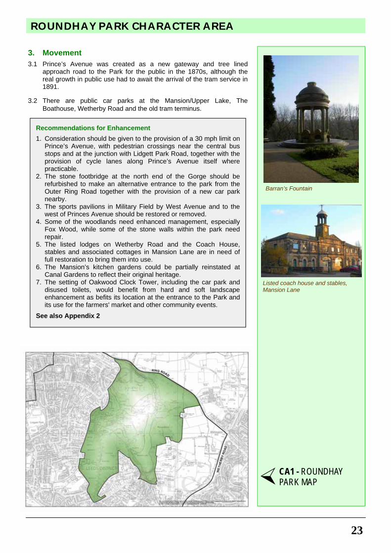
workshops and public events such as a launch meeting, and exhibitions of workshops and results of work in progress. The history of the area follows as it enables us to understand what led to the present character of the built and natural environments. There are four underlying themes to our NDS - land use, built form, landscape and movement. Their main characteristics are described and illustrated by four maps. Next the two conservation areas in the ward are described. For an area as large as Roundhay Ward, it is clear that the character of the area is not homogeneous. For this reason we have divided it into character areas. Character areas are distinct parts of Roundhay Ward having their own:
• Individuality • Separately definable character • Specif ic possibi l i t ies for
improvement Character combines:
• Location • Geography • History in common • Houses and gardens • Landscapes and open spaces • Footpaths and roads • A community with social
cohesion We have designated ten character areas ranging in size from the largest, 'Park Villas and Lidgett Park', to the smallest residential area, 'Wetherby Road and Park Avenue', the 'enclave' of Park Avenue and West Avenue. There are two further character areas for the shopping centres of Oakwood and Street Lane. See maps on pages 6 and 21. The results of our consultations with residents (summarised in an appendix) have enabled us to write appraisals of these twelve character areas. The appraisals
describe the buildings, structures and heritage, the open spaces and landscape, and the access and movement. They identify the listed and notable buildings and conclude w i th recommendat ions fo r enhancement of each area, the policy context of which is set out in an appendix. The context of the Design Statement in relation to the Leeds Unitary Development Plan (UDP, 2006) is established next with recommendations for future policies and proposals related to buildings and structures, green spaces, trees and shopping centres. The listed and notable buildings are collected together for the whole ward as are the open spaces and landscape features including playing fields and sports grounds. The open spaces and landscape are subdivided into protected, unprotected and recently lost green spaces. This context is also supported by a UDP map, a map of tree preservation orders and a map summarising our a n a l y s i s o f p l a c e a n d enhancements with illustrative photographs. We have set out 'guidance for design' to residents, planners and property developers and builders to complement, enhance and improve the future development of buildings and the green space around them. W e h a v e a l s o s e t o u t 'recommendations for future action and management' directed to the attention of council officers, residents, and businesses in the Ward for carrying forward the Neighbourhood Design Statement i n t o t h e f u t u r e . T h e s e recommendations, the guidance and post-adoption monitoring are backed by relevant national and local policies which are appended in detail (Appendices 1, 2 and 4). Finally our Design Statement includes a ‘design in context’ chapter with case studies highlighting positive and negative design in the NDS area to help inform future design and choice of building materials.
4
INTRODUCTION
1. Foreword 2 2. Introduction 3 & 4 3. Street Map of Roundhay Ward 5 4. Aerial Photograph of Roundhay Ward 6
5. The Process 7 & 8 6. History of the Neighbourhood 8 - 10 Historical Maps 11 - 12 7. Themes 13 - 19 Theme 1: Land Use - Map 16 Theme 2: Built Form - Map 17 Theme 3: Landscape - Map 18 Theme 4: Movement - Map 19 8. Conservation Areas 20 - 21 9. Map of Character Areas 21
10. Character Area Appraisals 22 - 47 CA1 Roundhay Park 22 & 23 CA2 East of the Park 24 & 24 CA3 Oakwood East 26 & 27 CA4 Wetherby Road and Park Avenue 28 & 29 CA5 Gipton Wood 30 & 31 CA6 Oakwood West 32 & 33 CA7 Gledhow 34 & 35 CA8 Brackenwood 36 & 37 CA9 Roundhay: Park Villas and Lidgett Park 38 - 41 CA10 Roundhay: North of Street Lane 42 & 43 CA11 Oakwood Town Centre 44 & 45 CA12 Street Lane Shopping Centre 46 & 47
11. Planning Context - Current and Future Policies and Recommendations
48
12. Unitary Development Plan Map 49 13. Green Spaces 50 - 52 14. Tree Preservation Orders Map 53 15. Analysis of Place and Enhancements
Map 54 & 55
54 Photographic Examples 55
16. Guidance for Design 56 17. Recommendations for Action and Management 57 - 59 18. Design in Context - Case Studies 60 & 61 19. Appendix 1: Relevant Planning and Related Policies 62 - 65 20. Appendix 2: Policy Context for Recommendations for
Enhancement of Specific Character Areas 66 & 67
21. Appendix 3: Consultation with Residents 68
22. Appendix 4: Post-adoption Monitoring 69
Acknowledgements / Bibliography 70
CONTENTS
5
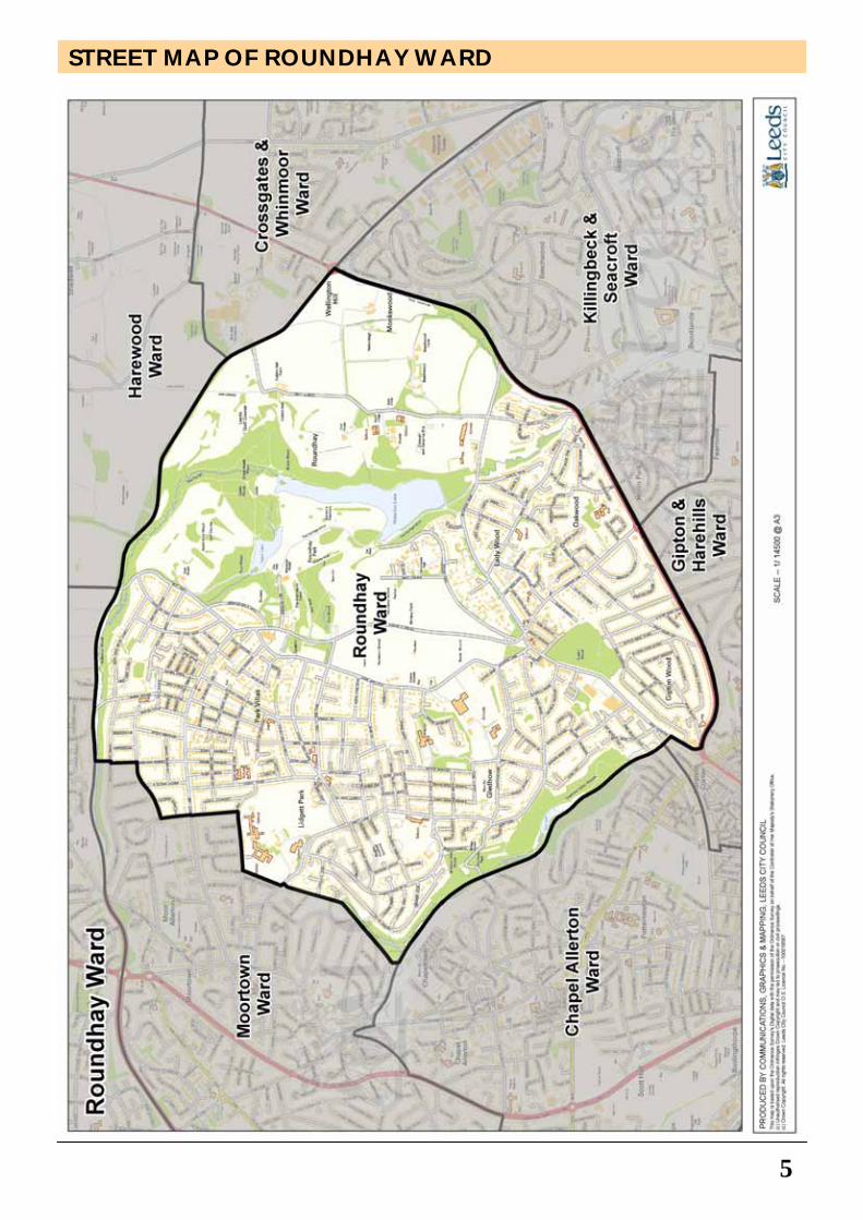
STREET MAP OF ROUNDHAY WARD
6
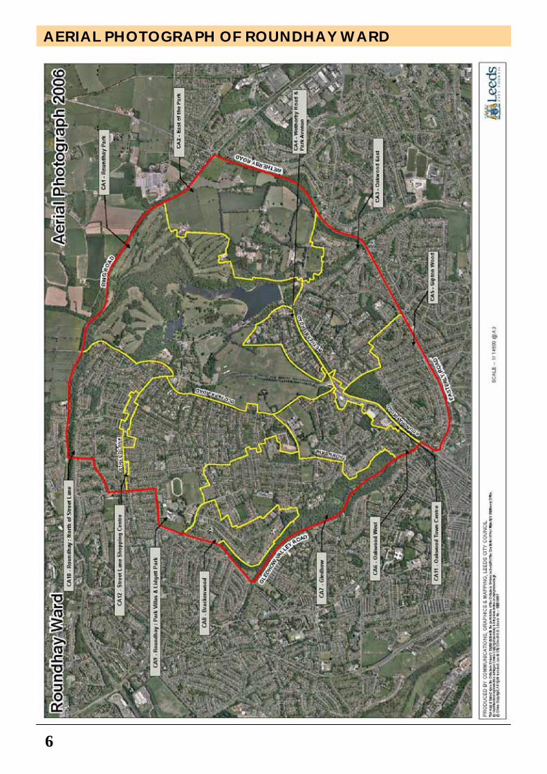
AERIAL PHOTOGRAPH OF ROUNDHAY WARD
THE PROCESS
7
1. Origin
Our project to realise and produce a N e i g h b o u r h o o d D e s i g n Statement (NDS) covering the whole of Roundhay Ward began in June 2005. Following adoption of the Far Headingley NDS by LCC in 2005, Roundhay Planning Forum (a local voluntary group of residents, founded in April 2004) decided that Roundhay Ward would benefit from a strategy for the conservation and improvement of the natural and built environments of the Ward if it had an NDS adopted by Leeds City Council as a Supplementary Planning Document (SPD). Roundhay Planning Forum observed that the LCC Inner North East Area Committee's (INEAC) Action Plan included several objectives relevant to NDSs, namely: On improving the environment
• Improve the environmental appearance of inner North East Leeds
• Encourage envi ronmenta l awareness initiatives and community involvement
On regeneration
• Support Town and District Centre physical improvement projects
Consequently we applied to the INEAC for funding for the NDS from its Well-being Fund and were given two awards in 2007 and 2008, totalling £14,220, to enable us to complete the project. The Management Committee of Roundhay Planning Forum, through its constitution (February 2007), comprises a chairman, secretary, treasurer and four members. Members include the chair of the Friends of Gledhow Valley Conservation Area Group, a representative of the Friends of Gipton Wood, a professional r es iden t p l anne r and an arch i tec tura l s tudent . The committee's activities have been
augmented by a Planning Consultant, Tony Ray, MRTPI, who has extensive experience of NDSs, by a representative from the Transport Group of Roundhay Environmental Action Project (REAP), and by the Ward Councillors. The Committee meets monthly.
2. Survey, evidence and data gathering
A Public Meeting and official formal launch of project to residents on 26 September 2007 was attended by at least 174 people, 151 of whom completed a simple questionnaire on the night. The concept of an NDS and its character areas was explained and illustrated by examples of design statements and by maps illustrating the main themes of the NDS. These are land use, built form, landscape and movement. The meeting endorsed the project in principle.
A Neighbourhood Questionnaire was sent for distribution to all residents (11,000 copies) in mid-September 2007. It was completed by 800 residents and analysed by December 2007. It asked residents about themselves, and their perceptions of Roundhay as a place to live through aspects of its transport, community safety, open spaces and landscape and of its facilities, services and housing.
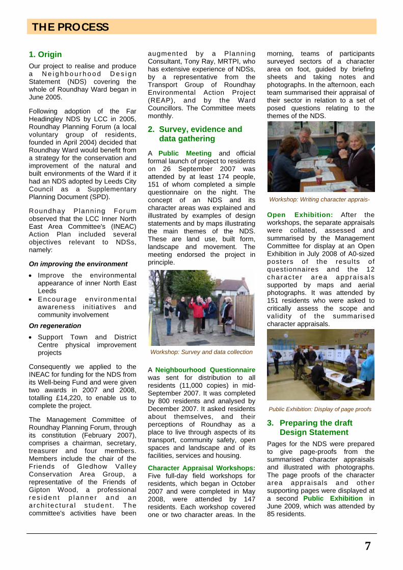
Character Appraisal Workshops: Five full-day field workshops for residents, which began in October 2007 and were completed in May 2008, were attended by 147 residents. Each workshop covered one or two character areas. In the
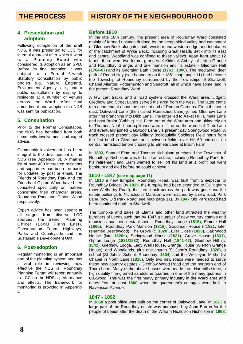
morning, teams of participants surveyed sectors of a character area on foot, guided by briefing sheets and taking notes and photographs. In the afternoon, each team summarised their appraisal of their sector in relation to a set of posed questions relating to the themes of the NDS.
Open Exhibition: After the workshops, the separate appraisals were collated, assessed and summarised by the Management Committee for display at an Open Exhibition in July 2008 of A0-sized posters of the results of questionnaires and the 12 charac ter a rea appra isa ls supported by maps and aerial photographs. It was attended by 151 residents who were asked to critically assess the scope and validity of the summarised character appraisals.
3. Preparing the draft Design Statement
Pages for the NDS were prepared to give page-proofs from the summarised character appraisals and illustrated with photographs. The page proofs of the character area appraisals and other supporting pages were displayed at a second Public Exhibition in June 2009, which was attended by 85 residents.
Workshop: Survey and data collection
Workshop: Writing character apprais-
Public Exhibition: Display of page proofs
8
4. Presentation and adoption
Following completion of the draft NDS, it was presented to LCC for internal approval after which it went to a Planning Board who considered its adoption as an SPD. Before its final adoption it was subject to a Formal 6-week Statutory Consultation by public bodies e.g. Natural England, Environment Agency, etc., and a public consultation by display to residents at a number of venues across the Ward. After final amendment and adoption the NDS was sent for publication. 5. Consultation
Prior to the Formal Consultation, the NDS has benefited from both community involvement and expert advice. Community involvement has been integral to the development of the NDS (see Appendix 3). A mailing list of over 400 interested residents and supporters has been the basis for updates by post or email. The Friends of Roundhay Park and the Friends of Gipton Wood have been consulted specifically on matters concerning their character areas, Roundhay Park and Gipton Wood respectively. Expert advice has been sought at all stages from diverse LCC sources: the Senior Planning Officer (Local Plans East), Conservation Team, Highways, Parks and Countryside and the Sustainable Development Unit. 6. Post-adoption
Regular monitoring is an important part of the planning system and has a vital role in reviewing how effective the NDS is. Roundhay Planning Forum will report annually to LCC on the NDS’s performance and effects. The framework for monitoring is provided in Appendix 4.
Before 1810 In the late 18th century, the present area of Roundhay Ward consisted mainly of farmed uplands drained by the steep-sided valley and catchment of Gledhow Beck along its south-western and western edge and tributaries of the catchment of Wyke Beck, including Great Heads Beck into its east and centre. Woodland was confined to these valleys. Apart from about 12 farms, there were two former granges of Kirkstall Abbey - Allerton Grange and Roundhay Grange, and one mansion and its estate - Gledhow Hall (1764-67) and its Georgian Bath House (1761; 1800). The mediaeval deer park of Round Hay (see boundary on the 1851 map, page 11) had become the Township of Roundhay surrounded by the Townships of Shadwell, Chapel Allerton, Potternewton and Seacroft, all of which have some land in the present Roundhay Ward. A few cart tracks and a road system crossed the Ward area. Lidgett, Gledhow and Street Lanes served the area from the west. The latter came to a dead end at about the present end of Roman Gardens. From the south east, Oakwood Lane (then called Horseshoe Lane) joined Gledhow Lane after first branching into Dibb Lane. The latter led to Asket Hill, Elmete Lane and past Braim (Cobble) Hall Farm out of the Ward area and ultimately on to Thorner. North Lane split westward off the northern end of Dibb Lane and eventually joined Oakwood Lane via present day Springwood Road. A track crossed present day Military (colloquially Soldiers) Field north from the first bend in Gledhow Lane, between fields, over Hill 60 and on to a central farmstead before crossing to Elmete Lane at Braim Farm. In 1803, Samuel Elam and Thomas Nicholson purchased the Township of Roundhay. Nicholson was to build an estate, including Roundhay Park, for his retirement and Elam wanted to sell off his land at a profit but went bankrupt and died before he could achieve it. 1810 - 1847 (see map page 11) In 1810 a new turnpike, Roundhay Road, was built from Sheepscar to Roundhay Bridge. By 1825, the turnpike had been extended to Collingham (now Wetherby Road), the farm track across the park was gone and the estate buildings to Nicholson's Mansion were reached by a new road, Park Lane (now Old Park Road, see map page 11). By 1847 Old Park Road had been continued north to Shadwell. The turnpike and sales of Elam's and other land attracted the wealthy burghers of Leeds such that by 1847 a number of new country estates and mansions had been established - Roundhay Lodge (1815), Elmete Hall (1865), Roundhay Park Mansion (1816), Goodman House (<1821, later renamed Beechwood), The Grove (c. 1820), Eller Close (1820), Oak Wood House (late 1820s), Springwood House (1827), Grove House (1831), Gipton Lodge (1831/1832), Roundhay Hall (1841-42), Gledhow Hill (c. 1842), Gledhow Lodge, Lady Well House, Grange House (Allerton Grange House), and Woodlands, plus one church (St John's Roundhay, 1826), a school (St John's School, Roundhay, 1834) and the Wesleyan Methodist Chapel in North Lane (1815). Only two new roads were needed to serve these new country estates - Gledhow Wood Road and the northern end of Thorn Lane. Many of the above houses were made from Harehills stone, a high quality fine-grained sandstone quarried in one of the many quarries in Oakwood. This was the first heavy primary industry in the Ward area and dates from at least 1800 when the quarrymen's cottages were built in Ravenscar Avenue. 1847 - 1892 In 1868 a post office was built on the corner of Oakwood Lane. In 1871 a large part of the Roundhay estate was purchased by John Barran for the people of Leeds after the death of the William Nicholson Nicholson in 1868.
HISTORY OF THE NEIGHBOURHOOD THE PROCESS
HISTORY OF THE NEIGHBOURHOOD
9
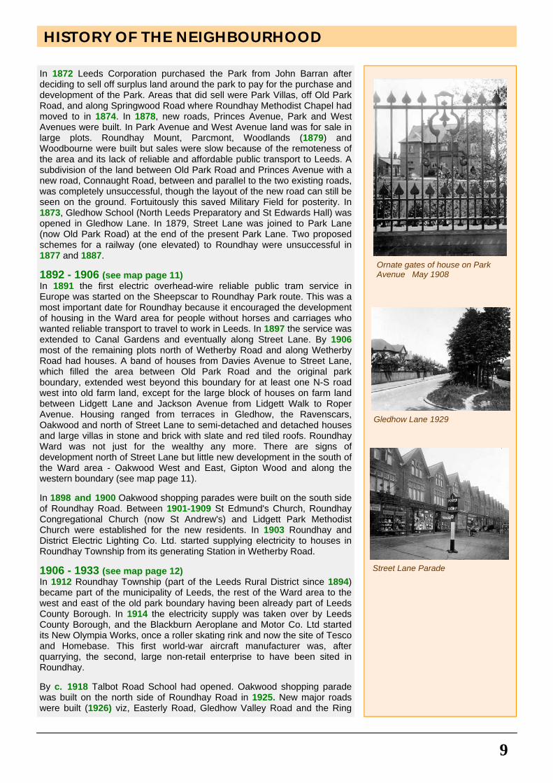
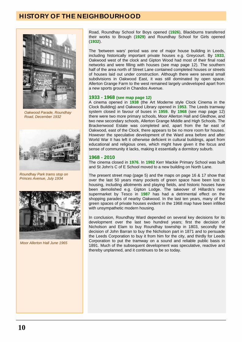
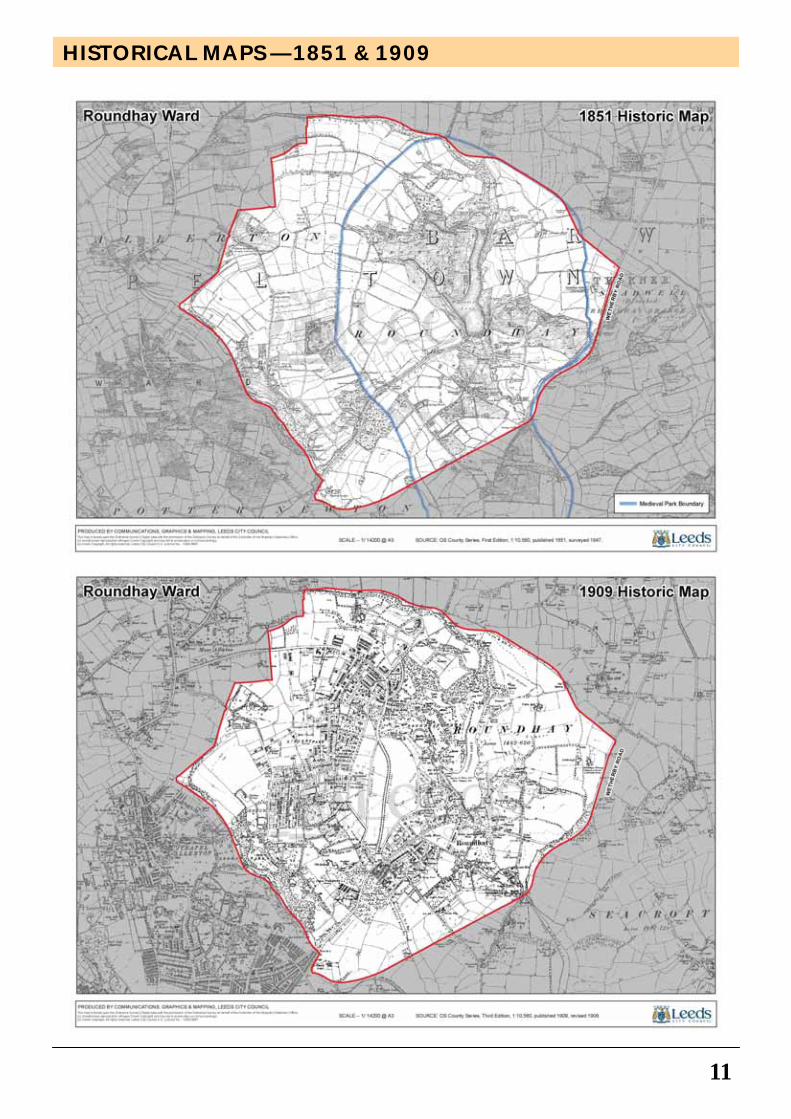
In 1872 Leeds Corporation purchased the Park from John Barran after deciding to sell off surplus land around the park to pay for the purchase and development of the Park. Areas that did sell were Park Villas, off Old Park Road, and along Springwood Road where Roundhay Methodist Chapel had moved to in 1874. In 1878, new roads, Princes Avenue, Park and West Avenues were built. In Park Avenue and West Avenue land was for sale in large plots. Roundhay Mount, Parcmont, Woodlands (1879) and Woodbourne were built but sales were slow because of the remoteness of the area and its lack of reliable and affordable public transport to Leeds. A subdivision of the land between Old Park Road and Princes Avenue with a new road, Connaught Road, between and parallel to the two existing roads, was completely unsuccessful, though the layout of the new road can still be seen on the ground. Fortuitously this saved Military Field for posterity. In 1873, Gledhow School (North Leeds Preparatory and St Edwards Hall) was opened in Gledhow Lane. In 1879, Street Lane was joined to Park Lane (now Old Park Road) at the end of the present Park Lane. Two proposed schemes for a railway (one elevated) to Roundhay were unsuccessful in 1877 and 1887. 1892 - 1906 (see map page 11) In 1891 the first electric overhead-wire reliable public tram service in Europe was started on the Sheepscar to Roundhay Park route. This was a most important date for Roundhay because it encouraged the development of housing in the Ward area for people without horses and carriages who wanted reliable transport to travel to work in Leeds. In 1897 the service was extended to Canal Gardens and eventually along Street Lane. By 1906 most of the remaining plots north of Wetherby Road and along Wetherby Road had houses. A band of houses from Davies Avenue to Street Lane, which filled the area between Old Park Road and the original park boundary, extended west beyond this boundary for at least one N-S road west into old farm land, except for the large block of houses on farm land between Lidgett Lane and Jackson Avenue from Lidgett Walk to Roper Avenue. Housing ranged from terraces in Gledhow, the Ravenscars, Oakwood and north of Street Lane to semi-detached and detached houses and large villas in stone and brick with slate and red tiled roofs. Roundhay Ward was not just for the wealthy any more. There are signs of development north of Street Lane but little new development in the south of the Ward area - Oakwood West and East, Gipton Wood and along the western boundary (see map page 11). In 1898 and 1900 Oakwood shopping parades were built on the south side of Roundhay Road. Between 1901-1909 St Edmund's Church, Roundhay Congregational Church (now St Andrew's) and Lidgett Park Methodist Church were established for the new residents. In 1903 Roundhay and District Electric Lighting Co. Ltd. started supplying electricity to houses in Roundhay Township from its generating Station in Wetherby Road. 1906 - 1933 (see map page 12) In 1912 Roundhay Township (part of the Leeds Rural District since 1894) became part of the municipality of Leeds, the rest of the Ward area to the west and east of the old park boundary having been already part of Leeds County Borough. In 1914 the electricity supply was taken over by Leeds County Borough, and the Blackburn Aeroplane and Motor Co. Ltd started its New Olympia Works, once a roller skating rink and now the site of Tesco and Homebase. This first world-war aircraft manufacturer was, after quarrying, the second, large non-retail enterprise to have been sited in Roundhay. By c. 1918 Talbot Road School had opened. Oakwood shopping parade was built on the north side of Roundhay Road in 1925. New major roads were built (1926) viz, Easterly Road, Gledhow Valley Road and the Ring
Ornate gates of house on Park Avenue May 1908
Gledhow Lane 1929
Street Lane Parade
10
Road, Roundhay School for Boys opened (1926), Blackburns transferred their works to Brough (1929) and Roundhay School for Girls opened (1932). The 'between wars' period was one of major house building in Leeds, including historically important private houses e.g. Greycourt. By 1933, Oakwood west of the clock and Gipton Wood had most of their final road networks and were filling with houses (see map page 12). The southern half of the area north of Street Lane contained completed houses or streets of houses laid out under construction. Although there were several small subdivisions in Oakwood East, it was still dominated by open space. Allerton Grange Farm to the west remained largely undeveloped apart from a new sports ground in Chandos Avenue. 1933 - 1968 (see map page 12) A cinema opened in 1938 (the Art Moderne style Clock Cinema in the Clock Building) and Oakwood Library opened in 1953. The Leeds tramway system closed in favour of buses in 1959. By 1968 (see map page 12) there were two more primary schools, Moor Allerton Hall and Gledhow, and two new secondary schools, Allerton Grange Middle and High Schools. The Brackenwood Estate was completed and, apart from the far east of Oakwood, east of the Clock, there appears to be no more room for houses. However the speculative development of the Ward area before and after World War II has left it otherwise deficient in cultural buildings, apart from educational and religious ones, which might have given it the focus and sense of community it lacks, making it essentially a dormitory suburb. 1968 - 2010 The cinema closed in 1976. In 1992 Kerr Mackie Primary School was built and St John's C of E School moved to a new building on North Lane. The present street map (page 5) and the maps on page 16 & 17 show that over the last 50 years many pockets of green space have been lost to housing, including allotments and playing fields, and historic houses have been demolished e.g. Gipton Lodge. The takeover of Hillards's new supermarket by Tesco in 1987 has had a detrimental effect on the shopping parades of nearby Oakwood. In the last ten years, many of the green spaces of private houses evident in the 1968 map have been infilled with unsympathetic modern housing. In conclusion, Roundhay Ward depended on several key decisions for its development over the last two hundred years; first the decision of Nicholson and Elam to buy Roundhay township in 1803, secondly the decision of John Barran to buy the Nicholson part in 1871 and to persuade the Leeds Corporation to buy it from him for the city, and thirdly for Leeds Corporation to put the tramway on a sound and reliable public basis in 1891. Much of the subsequent development was speculative, reactive and thereby unplanned, and it continues to be so today.
HISTORY OF THE NEIGHBOURHOOD
Roundhay Park trams stop on Princes Avenue, July 1934
Moor Allerton Hall June 1965
Oakwood Parade, Roundhay Road, December 1932
HISTORICAL MAPS — 1851 & 1909
11
12
HISTORICAL MAPS — 1933 & 1968
THEMES
13
A townscape analysis has been undertaken of Roundhay Neighbourhood Design Statement area, Roundhay Ward, modelled on Leeds City Council's 'Neighbourhoods for Living (Residential Design Guide)' Supplementary Planning Document. In line with that document, four themes of built form, landscape, movement and land use comprise the basis on which the following townscape analysis has been undertaken. The results are illustrated by maps of the Ward on the following four pages (16-19). 1. Land Use
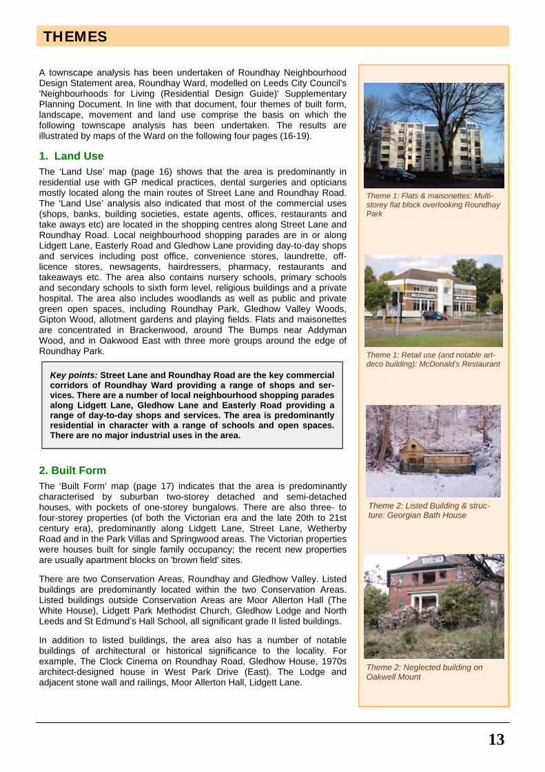
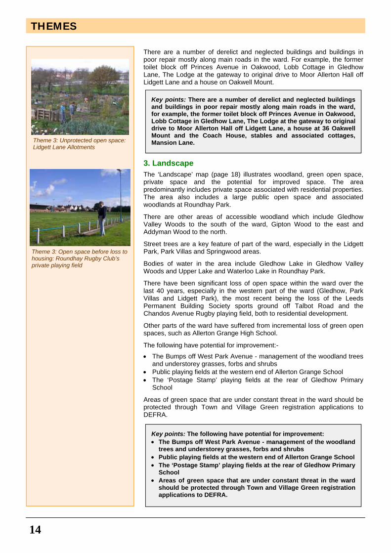
The ‘Land Use’ map (page 16) shows that the area is predominantly in residential use with GP medical practices, dental surgeries and opticians mostly located along the main routes of Street Lane and Roundhay Road. The ‘Land Use’ analysis also indicated that most of the commercial uses (shops, banks, building societies, estate agents, offices, restaurants and take aways etc) are located in the shopping centres along Street Lane and Roundhay Road. Local neighbourhood shopping parades are in or along Lidgett Lane, Easterly Road and Gledhow Lane providing day-to-day shops and services including post office, convenience stores, laundrette, off-licence stores, newsagents, hairdressers, pharmacy, restaurants and takeaways etc. The area also contains nursery schools, primary schools and secondary schools to sixth form level, religious buildings and a private hospital. The area also includes woodlands as well as public and private green open spaces, including Roundhay Park, Gledhow Valley Woods, Gipton Wood, allotment gardens and playing fields. Flats and maisonettes are concentrated in Brackenwood, around The Bumps near Addyman Wood, and in Oakwood East with three more groups around the edge of Roundhay Park.
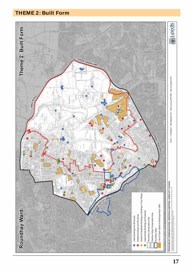
2. Built Form
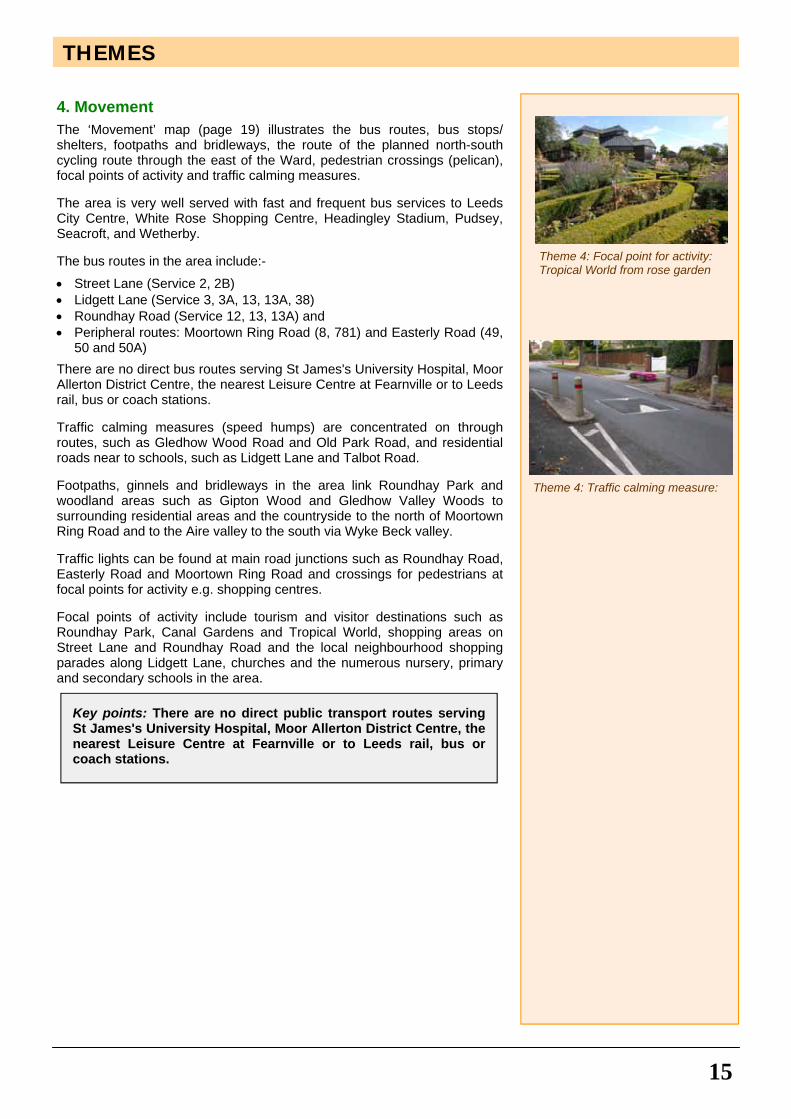
The ‘Built Form’ map (page 17) indicates that the area is predominantly characterised by suburban two-storey detached and semi-detached houses, with pockets of one-storey bungalows. There are also three- to four-storey properties (of both the Victorian era and the late 20th to 21st century era), predominantly along Lidgett Lane, Street Lane, Wetherby Road and in the Park Villas and Springwood areas. The Victorian properties were houses built for single family occupancy; the recent new properties are usually apartment blocks on 'brown field' sites. There are two Conservation Areas, Roundhay and Gledhow Valley. Listed buildings are predominantly located within the two Conservation Areas. Listed buildings outside Conservation Areas are Moor Allerton Hall (The White House), Lidgett Park Methodist Church, Gledhow Lodge and North Leeds and St Edmund’s Hall School, all significant grade II listed buildings. In addition to listed buildings, the area also has a number of notable buildings of architectural or historical significance to the locality. For example, The Clock Cinema on Roundhay Road, Gledhow House, 1970s architect-designed house in West Park Drive (East). The Lodge and adjacent stone wall and railings, Moor Allerton Hall, Lidgett Lane.
Key points: Street Lane and Roundhay Road are the key commercial corridors of Roundhay Ward providing a range of shops and ser-vices. There are a number of local neighbourhood shopping parades along Lidgett Lane, Gledhow Lane and Easterly Road providing a range of day-to-day shops and services. The area is predominantly residential in character with a range of schools and open spaces. There are no major industrial uses in the area.
Theme 1: Flats & maisonettes: Multi-storey flat block overlooking Roundhay Park
Theme 1: Retail use (and notable art-deco building): McDonald’s Restaurant
Theme 2: Listed Building & struc-ture: Georgian Bath House
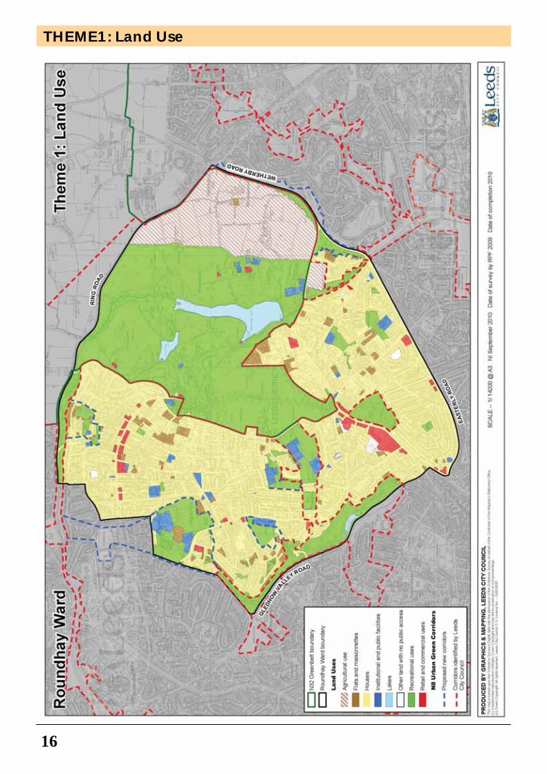
Theme 2: Neglected building on Oakwell Mount
14
There are a number of derelict and neglected buildings and buildings in poor repair mostly along main roads in the ward. For example, the former toilet block off Princes Avenue in Oakwood, Lobb Cottage in Gledhow Lane, The Lodge at the gateway to original drive to Moor Allerton Hall off Lidgett Lane and a house on Oakwell Mount.
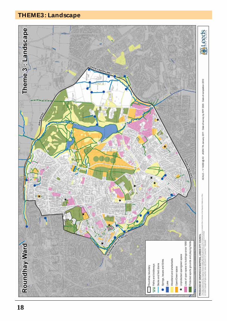
3. Landscape
The ‘Landscape’ map (page 18) illustrates woodland, green open space, private space and the potential for improved space. The area predominantly includes private space associated with residential properties. The area also includes a large public open space and associated woodlands at Roundhay Park.
There are other areas of accessible woodland which include Gledhow Valley Woods to the south of the ward, Gipton Wood to the east and Addyman Wood to the north.
Street trees are a key feature of part of the ward, especially in the Lidgett Park, Park Villas and Springwood areas.
Bodies of water in the area include Gledhow Lake in Gledhow Valley Woods and Upper Lake and Waterloo Lake in Roundhay Park.
There have been significant loss of open space within the ward over the last 40 years, especially in the western part of the ward (Gledhow, Park Villas and Lidgett Park), the most recent being the loss of the Leeds Permanent Building Society sports ground off Talbot Road and the Chandos Avenue Rugby playing field, both to residential development.
Other parts of the ward have suffered from incremental loss of green open spaces, such as Allerton Grange High School.
The following have potential for improvement:-
• The Bumps off West Park Avenue - management of the woodland trees and understorey grasses, forbs and shrubs
• Public playing fields at the western end of Allerton Grange School • The ‘Postage Stamp’ playing fields at the rear of Gledhow Primary
School
Areas of green space that are under constant threat in the ward should be protected through Town and Village Green registration applications to DEFRA.
Key points: There are a number of derelict and neglected buildings and buildings in poor repair mostly along main roads in the ward, for example, the former toilet block off Princes Avenue in Oakwood, Lobb Cottage in Gledhow Lane, The Lodge at the gateway to original drive to Moor Allerton Hall off Lidgett Lane, a house at 36 Oakwell Mount and the Coach House, stables and associated cottages, Mansion Lane.
Key points: The following have potential for improvement: • The Bumps off West Park Avenue - management of the woodland
trees and understorey grasses, forbs and shrubs • Public playing fields at the western end of Allerton Grange School • The ‘Postage Stamp’ playing fields at the rear of Gledhow Primary
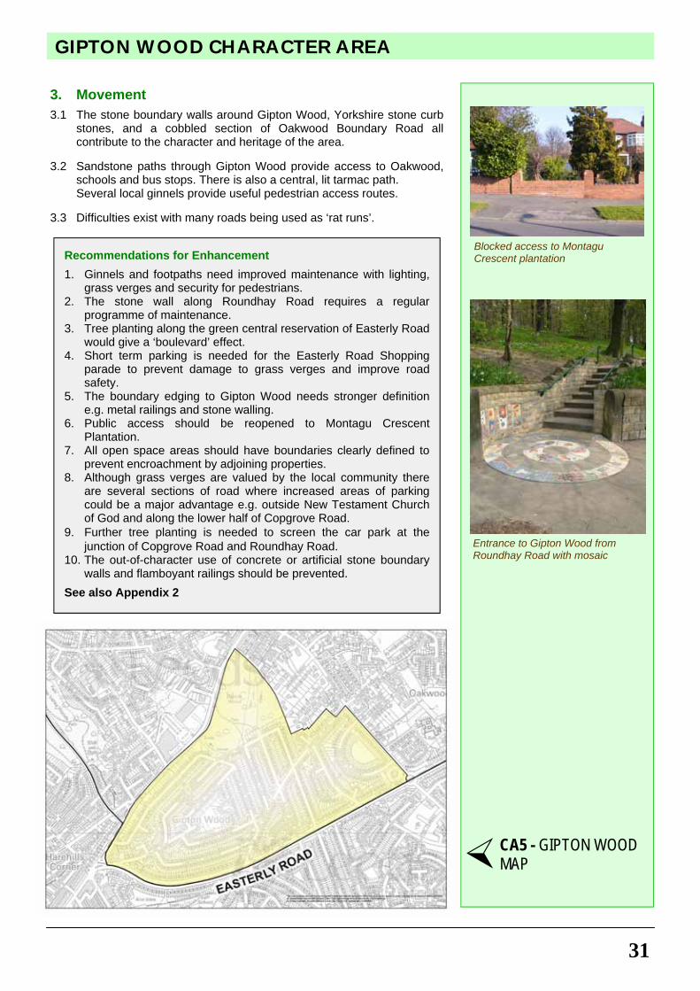
School • Areas of green space that are under constant threat in the ward
should be protected through Town and Village Green registration applications to DEFRA.
Theme 3: Open space before loss to housing: Roundhay Rugby Club’s private playing field
Theme 3: Unprotected open space: Lidgett Lane Allotments
THEMES
THEMES
15
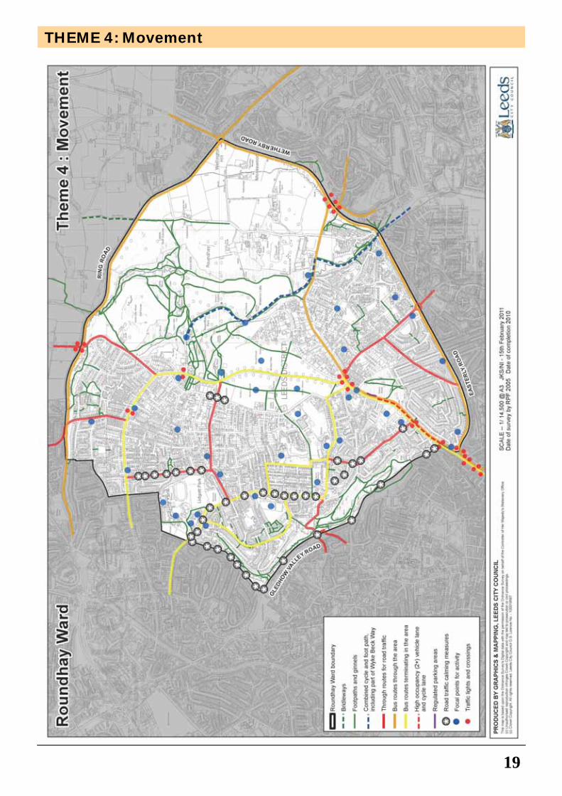
4. Movement
The ‘Movement’ map (page 19) illustrates the bus routes, bus stops/shelters, footpaths and bridleways, the route of the planned north-south cycling route through the east of the Ward, pedestrian crossings (pelican), focal points of activity and traffic calming measures. The area is very well served with fast and frequent bus services to Leeds City Centre, White Rose Shopping Centre, Headingley Stadium, Pudsey, Seacroft, and Wetherby. The bus routes in the area include:-
• Street Lane (Service 2, 2B) • Lidgett Lane (Service 3, 3A, 13, 13A, 38) • Roundhay Road (Service 12, 13, 13A) and • Peripheral routes: Moortown Ring Road (8, 781) and Easterly Road (49,
50 and 50A)
There are no direct bus routes serving St James's University Hospital, Moor Allerton District Centre, the nearest Leisure Centre at Fearnville or to Leeds rail, bus or coach stations. Traffic calming measures (speed humps) are concentrated on through routes, such as Gledhow Wood Road and Old Park Road, and residential roads near to schools, such as Lidgett Lane and Talbot Road. Footpaths, ginnels and bridleways in the area link Roundhay Park and woodland areas such as Gipton Wood and Gledhow Valley Woods to surrounding residential areas and the countryside to the north of Moortown Ring Road and to the Aire valley to the south via Wyke Beck valley. Traffic lights can be found at main road junctions such as Roundhay Road, Easterly Road and Moortown Ring Road and crossings for pedestrians at focal points for activity e.g. shopping centres. Focal points of activity include tourism and visitor destinations such as Roundhay Park, Canal Gardens and Tropical World, shopping areas on Street Lane and Roundhay Road and the local neighbourhood shopping parades along Lidgett Lane, churches and the numerous nursery, primary and secondary schools in the area.
Key points: There are no direct public transport routes serving St James's University Hospital, Moor Allerton District Centre, the nearest Leisure Centre at Fearnville or to Leeds rail, bus or coach stations.
Theme 4: Focal point for activity: Tropical World from rose garden
Theme 4: Traffic calming measure:
16
THEME1: Land Use
17
THEME 2: Built Form
18
THEME3: Landscape
19
THEME 4: Movement
CONSERVATION AREAS
20
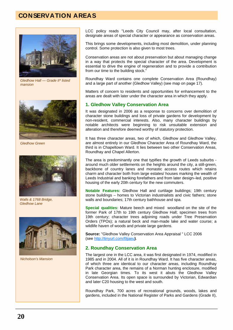
LCC policy reads "Leeds City Council may, after local consultation, designate areas of special character or appearance as conservation areas. This brings some developments, including most demolition, under planning control. Some protection is also given to most trees. Conservation areas are not about preservation but about managing change in a way that protects the special character of the area. Development is essential to drive the engine of regeneration and to provide a contribution from our time to the building stock." Roundhay Ward contains one complete Conservation Area (Roundhay) and a large part of another (Gledhow Valley) (see map on page 17). Matters of concern to residents and opportunities for enhancement to the areas are dealt with later under the character area in which they apply. 1. Gledhow Valley Conservation Area
It was designated in 2006 as a response to concerns over demolition of character stone buildings and loss of private gardens for development by non-resident, commercial interests. Also, many character buildings by notable architects were beginning to risk unsuitable extension and alteration and therefore deemed worthy of statutory protection. It has three character areas, two of which, Gledhow and Gledhow Valley, are almost entirely in our Gledhow Character Area of Roundhay Ward, the third is in Chapeltown Ward. It lies between two other Conservation Areas, Roundhay and Chapel Allerton. The area is predominantly one that typifies the growth of Leeds suburbs - around much older settlements on the heights around the city, a still-green, backbone of country lanes and monastic access routes which retains charm and character both from large estates/ houses marking the wealth of Leeds Industrial and banking forefathers and from later design–led, positive housing of the early 20th century for the new commuters. Notable Features: Gledhow Hall and curtilage buildings; 19th century stone buildings – homes to Victorian industrialists and civic fathers; stone walls and boundaries; 17th century bathhouse and spa. Special qualities: Mature beech and mixed woodland on the site of the former Park of 17th to 19th century Gledhow Hall; specimen trees from 19th century; character trees adjoining roads under Tree Preservation Orders (TPOs); a natural beck and man-made lake and water course; a wildlife haven of woods and private large gardens. Source: "Gledhow Valley Conservation Area Appraisal " LCC 2006 (see http://tinyurl.com/l9jaeu). 2. Roundhay Conservation Area
The largest one in the LCC area, it was first designated in 1974, modified in 1985 and in 2004. All of it is in Roundhay Ward. It has five character areas, of which three are identical to our character areas, including Roundhay Park character area, the remains of a Norman hunting enclosure, modified in late Georgian times. To its west it abuts the Gledhow Valley Conservation Area. Its open space is surrounded by Victorian, Edwardian and later C20 housing to the west and south. Roundhay Park, 700 acres of recreational grounds, woods, lakes and gardens, included in the National Register of Parks and Gardens (Grade II),
Nicholson’s Mansion
Gledhow Green
Gledhow Hall — Grade II* listed mansion
Walls & 1768 Bridge, Gledhow Lane
21
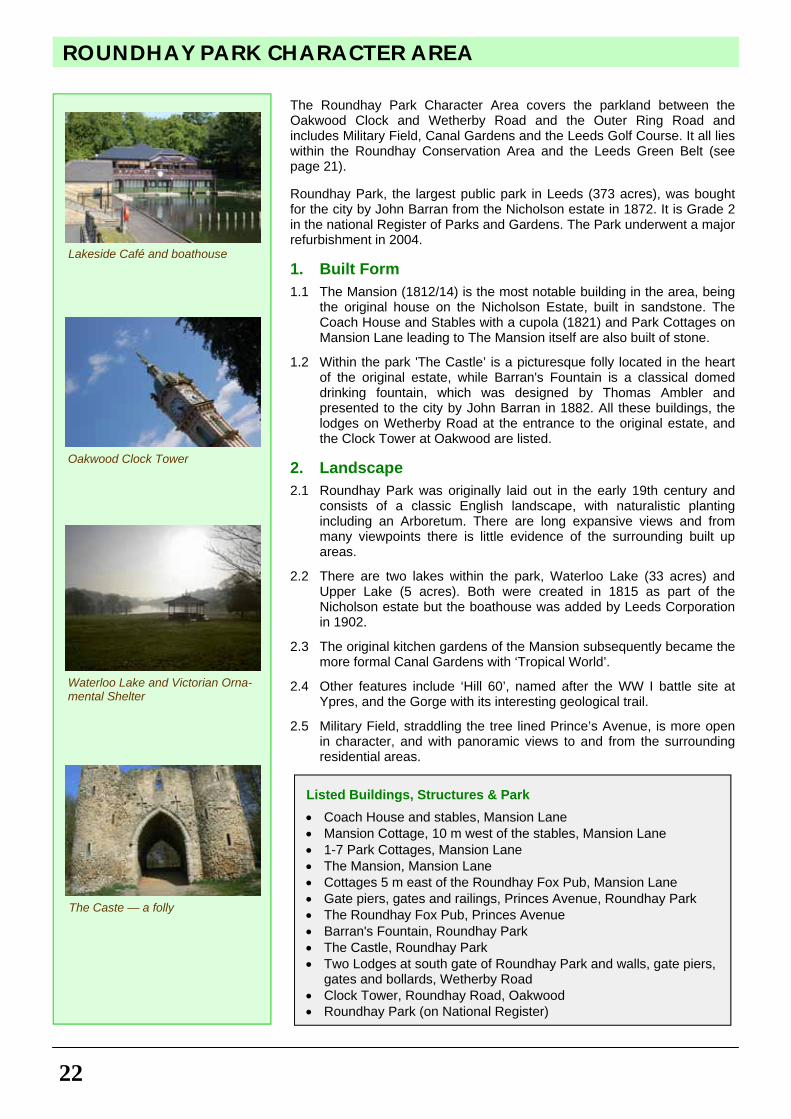
serves the entire city and offers a huge selection of sports and recreational facilities for all ages. It has benefited greatly from major Heritage funding and regularly attains Green Flag awards. In Oakwood, Gipton Wood has remnants of enclosed settlements thought to date from 1000 BC to 400 AD and these are registered as ancient monuments by English Heritage. Friends of Gipton Wood assist in maintaining the mature trees of an impressive oak wood. The whole Conservation Area has important historical associations with leading Leeds families. Notable features: Oakwood Town Centre; Tropical World; many excellent listed C19 and earlier buildings especially in the green belt area of the park and to its east; Special qualities: Woods; open farmland and park with extensive views; a registered geological trail; a monthly Farmers' Market; specialist gardens. Source: "Roundhay Conservation Area Appraisal " LCC 2004 (see http://tinyurl.com/33lkreu).
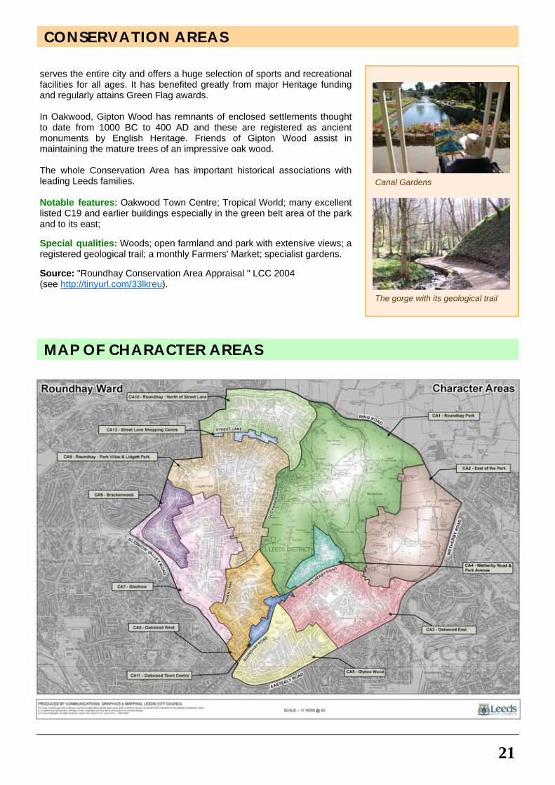
Canal Gardens
The gorge with its geological trail
CONSERVATION AREAS
MAP OF CHARACTER AREAS
Listed Buildings, Structures & Park
• Coach House and stables, Mansion Lane • Mansion Cottage, 10 m west of the stables, Mansion Lane • 1-7 Park Cottages, Mansion Lane • The Mansion, Mansion Lane • Cottages 5 m east of the Roundhay Fox Pub, Mansion Lane • Gate piers, gates and railings, Princes Avenue, Roundhay Park • The Roundhay Fox Pub, Princes Avenue • Barran's Fountain, Roundhay Park • The Castle, Roundhay Park • Two Lodges at south gate of Roundhay Park and walls, gate piers,
gates and bollards, Wetherby Road • Clock Tower, Roundhay Road, Oakwood • Roundhay Park (on National Register)
ROUNDHAY PARK CHARACTER AREA
22
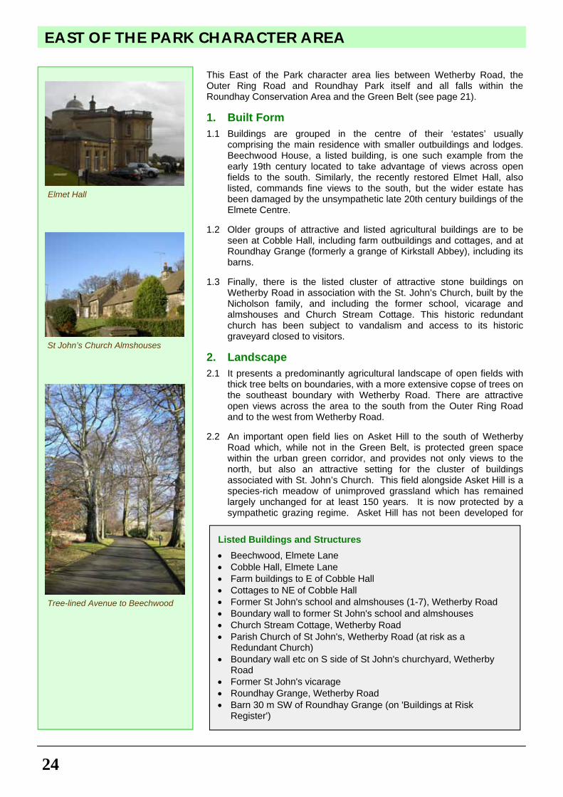
The Roundhay Park Character Area covers the parkland between the Oakwood Clock and Wetherby Road and the Outer Ring Road and includes Military Field, Canal Gardens and the Leeds Golf Course. It all lies within the Roundhay Conservation Area and the Leeds Green Belt (see page 21). Roundhay Park, the largest public park in Leeds (373 acres), was bought for the city by John Barran from the Nicholson estate in 1872. It is Grade 2 in the national Register of Parks and Gardens. The Park underwent a major refurbishment in 2004. 1. Built Form
1.1 The Mansion (1812/14) is the most notable building in the area, being the original house on the Nicholson Estate, built in sandstone. The Coach House and Stables with a cupola (1821) and Park Cottages on Mansion Lane leading to The Mansion itself are also built of stone.
1.2 Within the park 'The Castle’ is a picturesque folly located in the heart of the original estate, while Barran's Fountain is a classical domed drinking fountain, which was designed by Thomas Ambler and presented to the city by John Barran in 1882. All these buildings, the lodges on Wetherby Road at the entrance to the original estate, and the Clock Tower at Oakwood are listed.
2. Landscape
2.1 Roundhay Park was originally laid out in the early 19th century and consists of a classic English landscape, with naturalistic planting including an Arboretum. There are long expansive views and from many viewpoints there is little evidence of the surrounding built up areas.
2.2 There are two lakes within the park, Waterloo Lake (33 acres) and Upper Lake (5 acres). Both were created in 1815 as part of the Nicholson estate but the boathouse was added by Leeds Corporation in 1902.
2.3 The original kitchen gardens of the Mansion subsequently became the more formal Canal Gardens with ‘Tropical World’.
2.4 Other features include ‘Hill 60’, named after the WW I battle site at Ypres, and the Gorge with its interesting geological trail.
2.5 Military Field, straddling the tree lined Prince’s Avenue, is more open in character, and with panoramic views to and from the surrounding residential areas.
Lakeside Café and boathouse
The Caste — a folly
Waterloo Lake and Victorian Orna-mental Shelter
Oakwood Clock Tower
23
ROUNDHAY PARK CHARACTER AREA
3. Movement
3.1 Prince’s Avenue was created as a new gateway and tree lined approach road to the Park for the public in the 1870s, although the real growth in public use had to await the arrival of the tram service in 1891.
3.2 There are public car parks at the Mansion/Upper Lake, The
Boathouse, Wetherby Road and the old tram terminus.
Recommendations for Enhancement
1. Consideration should be given to the provision of a 30 mph limit on Prince’s Avenue, with pedestrian crossings near the central bus stops and at the junction with Lidgett Park Road, together with the provision of cycle lanes along Prince’s Avenue itself where practicable.
2. The stone footbridge at the north end of the Gorge should be refurbished to make an alternative entrance to the park from the Outer Ring Road together with the provision of a new car park nearby.
3. The sports pavilions in Military Field by West Avenue and to the west of Princes Avenue should be restored or removed.
4. Some of the woodlands need enhanced management, especially Fox Wood, while some of the stone walls within the park need repair.
5. The listed lodges on Wetherby Road and the Coach House, stables and associated cottages in Mansion Lane are in need of full restoration to bring them into use.
6. The Mansion’s kitchen gardens could be partially reinstated at Canal Gardens to reflect their original heritage.
7. The setting of Oakwood Clock Tower, including the car park and disused toilets, would benefit from hard and soft landscape enhancement as befits its location at the entrance to the Park and its use for the farmers' market and other community events.
See also Appendix 2
Barran’s Fountain
CA1 - ROUNDHAY PARK MAP
Listed coach house and stables, Mansion Lane
EAST OF THE PARK CHARACTER AREA
24
This East of the Park character area lies between Wetherby Road, the Outer Ring Road and Roundhay Park itself and all falls within the Roundhay Conservation Area and the Green Belt (see page 21). 1. Built Form
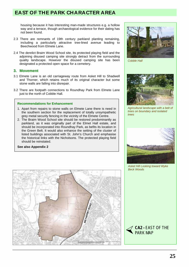
1.1 Buildings are grouped in the centre of their ‘estates’ usually comprising the main residence with smaller outbuildings and lodges. Beechwood House, a listed building, is one such example from the early 19th century located to take advantage of views across open fields to the south. Similarly, the recently restored Elmet Hall, also listed, commands fine views to the south, but the wider estate has been damaged by the unsympathetic late 20th century buildings of the Elmete Centre.
1.2 Older groups of attractive and listed agricultural buildings are to be
seen at Cobble Hall, including farm outbuildings and cottages, and at Roundhay Grange (formerly a grange of Kirkstall Abbey), including its barns.
1.3 Finally, there is the listed cluster of attractive stone buildings on
Wetherby Road in association with the St. John’s Church, built by the Nicholson family, and including the former school, vicarage and almshouses and Church Stream Cottage. This historic redundant church has been subject to vandalism and access to its historic graveyard closed to visitors.
2. Landscape
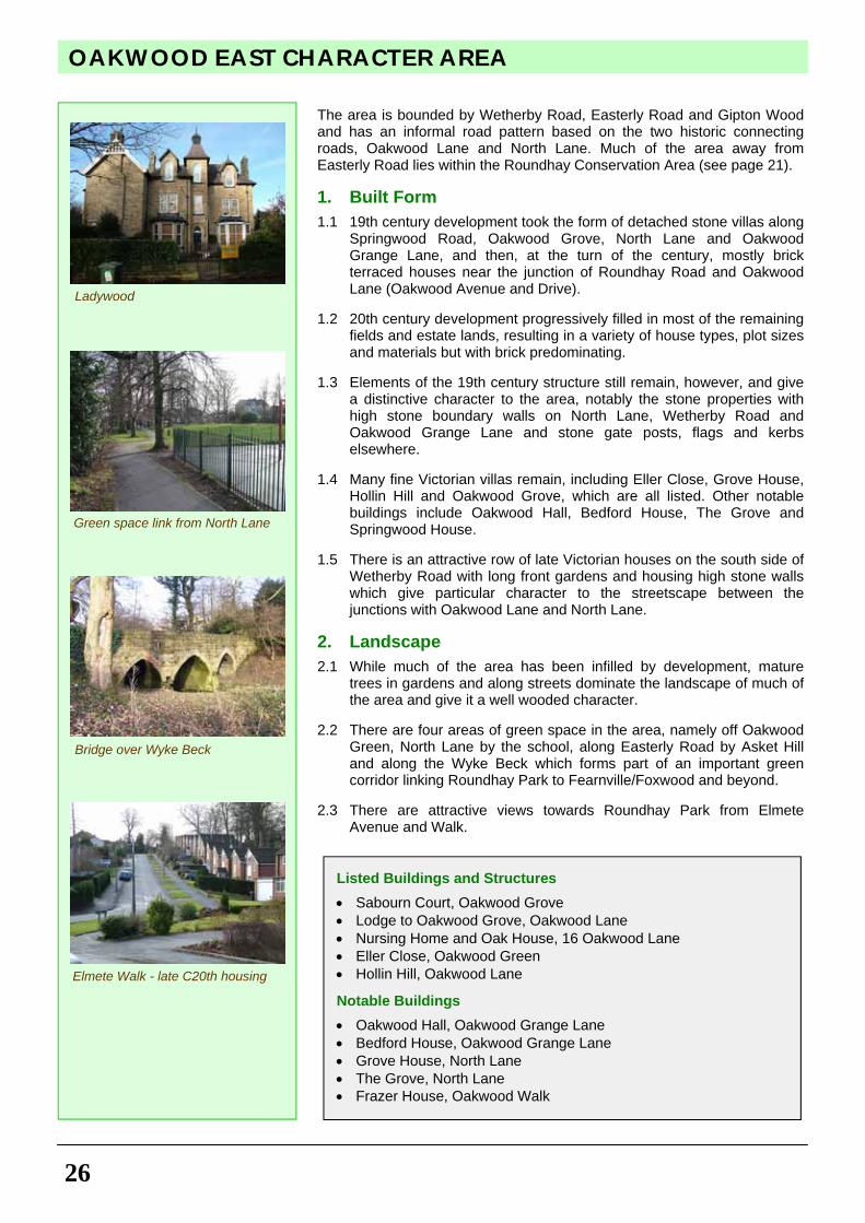
2.1 It presents a predominantly agricultural landscape of open fields with thick tree belts on boundaries, with a more extensive copse of trees on the southeast boundary with Wetherby Road. There are attractive open views across the area to the south from the Outer Ring Road and to the west from Wetherby Road.
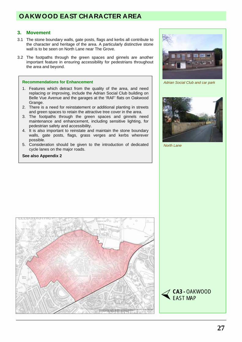
2.2 An important open field lies on Asket Hill to the south of Wetherby
Road which, while not in the Green Belt, is protected green space within the urban green corridor, and provides not only views to the north, but also an attractive setting for the cluster of buildings associated with St. John’s Church. This field alongside Asket Hill is a species-rich meadow of unimproved grassland which has remained largely unchanged for at least 150 years. It is now protected by a sympathetic grazing regime. Asket Hill has not been developed for
Listed Buildings and Structures
• Beechwood, Elmete Lane • Cobble Hall, Elmete Lane • Farm buildings to E of Cobble Hall • Cottages to NE of Cobble Hall • Former St John's school and almshouses (1-7), Wetherby Road • Boundary wall to former St John's school and almshouses • Church Stream Cottage, Wetherby Road • Parish Church of St John's, Wetherby Road (at risk as a
Redundant Church) • Boundary wall etc on S side of St John's churchyard, Wetherby
Road • Former St John's vicarage • Roundhay Grange, Wetherby Road • Barn 30 m SW of Roundhay Grange (on 'Buildings at Risk
Register')
Elmet Hall
St John’s Church Almshouses
Tree-lined Avenue to Beechwood
25
EAST OF THE PARK CHARACTER AREA
housing because it has interesting man-made structures e.g. a hollow way and a terrace, though archaeological evidence for their dating has not been found.
2.3 There are remnants of 19th century parkland planting remaining,
including a particularly attractive tree-lined avenue leading to Beechwood from Elmete Lane.
2.4 The derelict Braim Wood School site, its protected playing field and the
adjoining disused camping site strongly detract from the surrounding quality landscape. However the disused camping site has been designated a protected open space for a cemetery.
3. Movement
3.1 Elmete Lane is an old carriageway route from Asket Hill to Shadwell and Thorner, which retains much of its original character but some stone walls are falling into disrepair.
3.2 There are footpath connections to Roundhay Park from Elmete Lane
just to the north of Cobble Hall.
Recommendations for Enhancement
1. Apart from repairs to stone walls on Elmete Lane there is need in the southern section for the replacement of totally unsympathetic grey metal security fencing in the vicinity of the Elmete Centre.
2. The Braim Wood School site should be restored predominantly as parkland, as it was originally part of the Elmet Hall estate, and should be incorporated into Roundhay Park, as befits its location in the Green Belt. It would also enhance the setting of the cluster of listed buildings associated with St. John’s Church and emphasise the historical links with the Nicholsons. The protected playing field should be reinstated.
See also Appendix 2
Agricultural landscape with a belt of trees on boundary and isolated trees
Cobble Hall
CA2 - EAST OF THE PARK MAP
Asket Hill Looking toward Wyke Beck Woods
OAKWOOD EAST CHARACTER AREA
26
The area is bounded by Wetherby Road, Easterly Road and Gipton Wood and has an informal road pattern based on the two historic connecting roads, Oakwood Lane and North Lane. Much of the area away from Easterly Road lies within the Roundhay Conservation Area (see page 21). 1. Built Form
1.1 19th century development took the form of detached stone villas along Springwood Road, Oakwood Grove, North Lane and Oakwood Grange Lane, and then, at the turn of the century, mostly brick terraced houses near the junction of Roundhay Road and Oakwood Lane (Oakwood Avenue and Drive).
1.2 20th century development progressively filled in most of the remaining
fields and estate lands, resulting in a variety of house types, plot sizes and materials but with brick predominating.
1.3 Elements of the 19th century structure still remain, however, and give
a distinctive character to the area, notably the stone properties with high stone boundary walls on North Lane, Wetherby Road and Oakwood Grange Lane and stone gate posts, flags and kerbs elsewhere.
1.4 Many fine Victorian villas remain, including Eller Close, Grove House,
Hollin Hill and Oakwood Grove, which are all listed. Other notable buildings include Oakwood Hall, Bedford House, The Grove and Springwood House.
1.5 There is an attractive row of late Victorian houses on the south side of
Wetherby Road with long front gardens and housing high stone walls which give particular character to the streetscape between the junctions with Oakwood Lane and North Lane.
2. Landscape
2.1 While much of the area has been infilled by development, mature trees in gardens and along streets dominate the landscape of much of the area and give it a well wooded character.
2.2 There are four areas of green space in the area, namely off Oakwood
Green, North Lane by the school, along Easterly Road by Asket Hill and along the Wyke Beck which forms part of an important green corridor linking Roundhay Park to Fearnville/Foxwood and beyond.
2.3 There are attractive views towards Roundhay Park from Elmete
Avenue and Walk.
Listed Buildings and Structures
• Sabourn Court, Oakwood Grove • Lodge to Oakwood Grove, Oakwood Lane • Nursing Home and Oak House, 16 Oakwood Lane • Eller Close, Oakwood Green • Hollin Hill, Oakwood Lane
Notable Buildings
• Oakwood Hall, Oakwood Grange Lane • Bedford House, Oakwood Grange Lane • Grove House, North Lane • The Grove, North Lane • Frazer House, Oakwood Walk
Ladywood
Elmete Walk - late C20th housing
Bridge over Wyke Beck
Green space link from North Lane
27
OAKWOOD EAST CHARACTER AREA
3. Movement
3.1 The stone boundary walls, gate posts, flags and kerbs all contribute to the character and heritage of the area. A particularly distinctive stone wall is to be seen on North Lane near The Grove.
3.2 The footpaths through the green spaces and ginnels are another
important feature in ensuring accessibility for pedestrians throughout the area and beyond.
Recommendations for Enhancement
1. Features which detract from the quality of the area, and need replacing or improving, include the Adrian Social Club building on Belle Vue Avenue and the garages at the ‘RAF’ flats on Oakwood Grange.
2. There is a need for reinstatement or additional planting in streets and green spaces to retain the attractive tree cover in the area.
3. The footpaths through the green spaces and ginnels need maintenance and enhancement, including sensitive lighting, for pedestrian safety and accessibility.
4. It is also important to reinstate and maintain the stone boundary walls, gate posts, flags, grass verges and kerbs wherever possible.
5. Consideration should be given to the introduction of dedicated cycle lanes on the major roads.
See also Appendix 2
North Lane
Adrian Social Club and car park
CA3 - OAKWOOD EAST MAP
WETHERBY ROAD & PARK AVENUE CHARACTER AREA
28
This small character area is bounded by Wetherby Road, Park Avenue / West Avenue and Roundhay Park. It is wholly within the Roundhay Conservation Area (see page 21). 1. Built Form
1.1 In 1873, after its purchase of Nicholson's park and estate, Leeds Corporation ran a competition to design a master plan for its development. George Corson won it. His plan for this area was originally laid out for substantial villas set well back from street frontages in large plots, following one of Corson's principles, which envisaged that villas on the fringes of the park would not be visible from within the park itself. Smaller scale coach houses, stables and servants accommodation were also provided, usually to the rear of the main residences.
1.2 Development started close to the park in the later 19th century with
Woodlands Hall and Parc Mont, followed in Edwardian times with development along Wetherby Road.
1.3 There is considerable variety in styles and materials from classical to
‘arts and crafts’ with turrets, deep eaves, corner bays, render, stone, brick and half timber.
1.4 Surprisingly, there are no listed buildings in the area, but in addition to
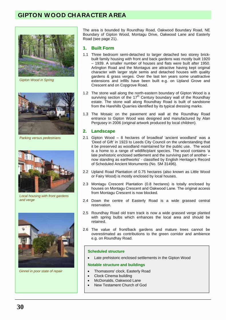
Woodlands Hall and Parc Mont mentioned above, other notable buildings are No 8 Park Avenue and No 17 Wetherby Road.
1.5 Much late 20th century infill has failed to follow the original pattern
with smaller plots, clustered development and blocks of flats with many of the latter contravening the original ‘Corson principles’.
1.6 The Wetherby Road frontage, however, retains most of the original
character. 2. Landscape 2.1 Mature trees dominate the area, many set in the large front gardens,
most notably on the Wetherby Road frontage and also on the edge of Roundhay Park. It is essential that they be retained.
2.2 There are attractive views from Park Avenue/West Avenue across
Military Field. 3. Movement 3.1 The Wetherby Road frontage, with its high stone walls is particularly
attractive (as originally portrayed by Atkinson Grimshaw). 3.2 Park Avenue remains the main vehicular access to the boathouse car
park in Roundhay Park, the jewel in Leeds' crown, yet the approach is marred by a long standing derelict large house and grounds with an unsightly green fence.
Notable Buildings
• Woodlands, West Avenue • Parc Mont, Park Avenue • 3 Park Avenue • 17 Wetherby Road
Woodlands, West Avenue
Wetherby Road stone wall in Con-servation Area but in disrepair
View across Military Field
Woodlands Lodge, West Avenue
29
WETHERBY ROAD & PARK AVENUE CHARACTER AREA
Recommendations for Enhancement
1. Future alterations, extensions and infill need to show greater respect for the scale and character of the streetscape and the views from Roundhay Park.
2. Boundary treatments are particularly important, to be retained and reinstated wherever possible e.g. the original walls including coping stones on the Wetherby Road frontages.
3. Consideration should be given to a 30 mph speed limit on Wetherby Road from St. John’s Church to the Oakwood Centre.
4. Number 1 Park Avenue should be redeveloped for housing, retaining existing buildings and in accordance with Corson's principles.
See also Appendix 2
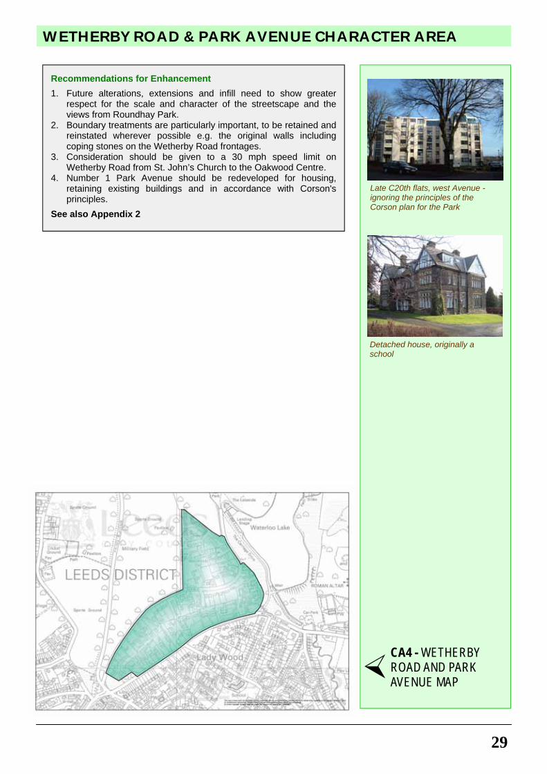
Late C20th flats, west Avenue - ignoring the principles of the Corson plan for the Park
Detached house, originally a school
CA4 - WETHERBY ROAD AND PARK AVENUE MAP
GIPTON WOOD CHARACTER AREA
30
The area is bounded by Roundhay Road, Oakwood Boundary Road, NE Boundary of Gipton Wood, Montagu Drive, Oakwood Lane and Easterly Road (see page 21). 1. Built Form
1.1 Three bedroom semi-detached to larger detached two storey brick-built family housing with front and back gardens was mostly built 1920 – 1939. A smaller number of houses and flats were built after 1950. Arlington Road and the Montagus are attractive having kept original character with larger style semis and detached houses with quality gardens & grass verges. Over the last ten years some unattractive extensions and infills have been built e.g. on Upland Grove and Crescent and on Copgrove Road.
1.2 The stone wall along the north-eastern boundary of Gipton Wood is a
surviving section of the 17th Century boundary wall of the Roundhay estate. The stone wall along Roundhay Road is built of sandstone from the Harehills Quarries identified by its typical dressing marks.
1.3 The Mosaic on the pavement and wall at the Roundhay Road
entrance to Gipton Wood was designed and manufactured by Alan Pergusey in 2006 (original artwork produced by local children).
2. Landscape
2.1 Gipton Wood – 8 hectares of broadleaf ‘ancient woodland’ was a ‘Deed of Gift’ in 1923 to Leeds City Council on the understanding that it be preserved as woodland maintained for the public use. The wood is a home to a range of wildlife/plant species. The wood contains ‘a late prehistoric enclosed settlement and the surviving part of another – now standing as earthworks' - classified by English Heritage’s Record of Scheduled Ancient Monuments (No. SM 31496).
2.2 Upland Road Plantation of 0.75 hectares (also known as Little Wood
or Fairy Wood) is mostly enclosed by local houses. 2.3 Montagu Crescent Plantation (0.8 hectares) is totally enclosed by
houses on Montagu Crescent and Oakwood Lane. The original access from Montagu Crescent is now blocked.
2.4 Down the centre of Easterly Road is a wide grassed central
reservation. 2.5 Roundhay Road old tram track is now a wide grassed verge planted
with spring bulbs which enhances the local area and should be retained.
2.6 The value of front/back gardens and mature trees cannot be
overestimated as contributions to the green corridor and ambience e.g. on Roundhay Road.
Scheduled structure
• Late prehistoric enclosed settlements in the Gipton Wood
Notable structure and buildings
• Thomasons' clock, Easterly Road • Clock Cinema building • McDonalds, Oakwood Lane • New Testament Church of God
Gipton Wood in Spring
Ginnel in poor state of repair
Local housing with front gardens and verge
Parking versus pedestrians
31
GIPTON WOOD CHARACTER AREA
3. Movement
3.1 The stone boundary walls around Gipton Wood, Yorkshire stone curb stones, and a cobbled section of Oakwood Boundary Road all contribute to the character and heritage of the area.
3.2 Sandstone paths through Gipton Wood provide access to Oakwood,
schools and bus stops. There is also a central, lit tarmac path. Several local ginnels provide useful pedestrian access routes. 3.3 Difficulties exist with many roads being used as ‘rat runs’.
Recommendations for Enhancement
1. Ginnels and footpaths need improved maintenance with lighting, grass verges and security for pedestrians.
2. The stone wall along Roundhay Road requires a regular programme of maintenance.
3. Tree planting along the green central reservation of Easterly Road would give a ‘boulevard’ effect.
4. Short term parking is needed for the Easterly Road Shopping parade to prevent damage to grass verges and improve road safety.
5. The boundary edging to Gipton Wood needs stronger definition e.g. metal railings and stone walling.
6. Public access should be reopened to Montagu Crescent Plantation.
7. All open space areas should have boundaries clearly defined to prevent encroachment by adjoining properties.
8. Although grass verges are valued by the local community there are several sections of road where increased areas of parking could be a major advantage e.g. outside New Testament Church of God and along the lower half of Copgrove Road.
9. Further tree planting is needed to screen the car park at the junction of Copgrove Road and Roundhay Road.
10. The out-of-character use of concrete or artificial stone boundary walls and flamboyant railings should be prevented.
See also Appendix 2
Blocked access to Montagu Crescent plantation
CA5 - GIPTON WOOD MAP
Entrance to Gipton Wood from Roundhay Road with mosaic
OAKWOOD WEST CHARACTER AREA
32
1. Built Form
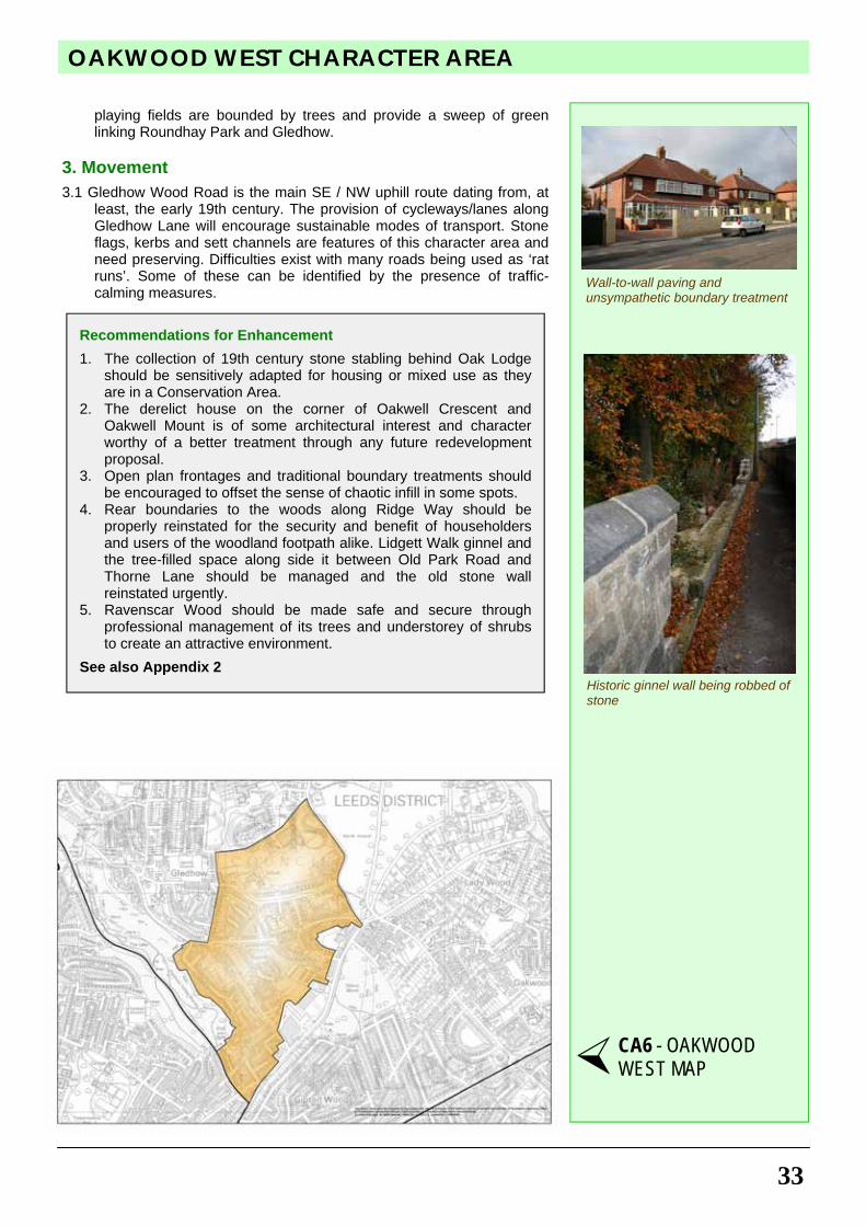
1.1 The area between Gledhow Lane and Gledhow Wood Road is now mostly characterised by attractive 1930s semi-detached housing of a uniform style, with some Tudor detailing and stone bases to some frontages (see page 21).
1.2 There are 19th century buildings of stone construction remaining at
the top of the hill on Gledhow Wood Road including Gledhow Lodge. A most interesting range of buildings with stone facades and a mock mediaeval wooden gated entrance now form two dwellings. They were once home to estate workers. One includes an unusual listed gothic coach house in the grounds. At the brow of the hill there is also a collection of stone stabling and the gothic Oak Lodge which once belonged to an earlier estate on the environs of Ridge Way.
1.3 Behind and beside the 'Roundhay' public house and up to Oakwell
Crescent, there are examples of Victorian back-to-back housing and terraces, the Ravenscars, the oldest built of stone for quarry workers. There is a major listed Georgian residence, Woodlands, at the corner of Gledhow Lane and Old Park Road. The original mansion in Roundhay School grounds survives with some fine old trees. Ryder Gardens and houses along the north side of Gledhow Lane date from 1915, whilst the attractive housing south of the old stone wall is from the 1920s and 1930s. Opposite Kerr Mackie Primary School there is a group of quality early 20th century stone houses. At the corner of Thorn Lane and Gledhow Lane stands Lobb Cottage, with extremely fine stone tooling and detailing.
2. Landscape
2.1 There are mature trees bordering much of the Well Houses and upper part of Gledhow Wood Road, causing some damage to pavements, but affording much character. Spaces close to the former quarry sites have mostly remained open and natural e.g. behind Dean Court, but where quarries have been built on, there has been subsidence e.g. corner of Fitzroy Drive and Thorn Lane, necessitating demolition and rebuilding. Properties on Ridgeway benefit from long rear gardens backing onto woodland, as do some in the Well Houses; this makes for a sense of green oases in this suburban area. To the rear of Oakwell Crescent and the Ravenscars there are spaces, with many trees that would benefit from Preservation Orders. 'Ravenscar Wood', another former quarry with five owners, suffers from fly tipping and anti-social behaviour. The dual carriageway of Gledhow Lane harbours many fine mature trees on its central verge and the school
Listed Buildings
• Queensmead, 9 Gledhow Lane • Woodlands, 11 Gledhow Lane • North Leeds and St Edmund’s Hall School (Gledhow School),
Gledhow Lane • Gledhow Lodge, 51-53 Gledhow Wood Road
Notable Buildings and Structures
• Façade Roundhay Technology College, Old Park Road • The Mansion, Roundhay Technology College • Brocklesby Estate, Gledhow Wood Road and Ridge Way • Oak Lodge, Ridge Way • Lobb Cottage, Gledhow Lane • 36 Oakwell Mount
Parking on verges and too high fence
Listed Buildings - Gledhow Wood Road
Fitzroy Drive - attractive, cohesive design
Lobb Cottage - derelict with incon-gruous fencing in Conservation Area
33
OAKWOOD WEST CHARACTER AREA
playing fields are bounded by trees and provide a sweep of green linking Roundhay Park and Gledhow.
3. Movement
3.1 Gledhow Wood Road is the main SE / NW uphill route dating from, at least, the early 19th century. The provision of cycleways/lanes along Gledhow Lane will encourage sustainable modes of transport. Stone flags, kerbs and sett channels are features of this character area and need preserving. Difficulties exist with many roads being used as ‘rat runs’. Some of these can be identified by the presence of traffic-calming measures.
Recommendations for Enhancement
1. The collection of 19th century stone stabling behind Oak Lodge should be sensitively adapted for housing or mixed use as they are in a Conservation Area.
2. The derelict house on the corner of Oakwell Crescent and Oakwell Mount is of some architectural interest and character worthy of a better treatment through any future redevelopment proposal.
3. Open plan frontages and traditional boundary treatments should be encouraged to offset the sense of chaotic infill in some spots.
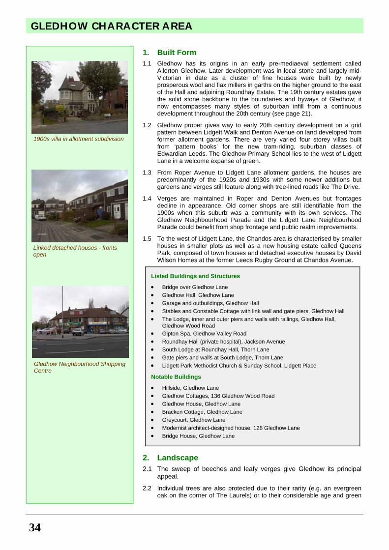
4. Rear boundaries to the woods along Ridge Way should be properly reinstated for the security and benefit of householders and users of the woodland footpath alike. Lidgett Walk ginnel and the tree-filled space along side it between Old Park Road and Thorne Lane should be managed and the old stone wall reinstated urgently.
5. Ravenscar Wood should be made safe and secure through professional management of its trees and understorey of shrubs to create an attractive environment.
See also Appendix 2
Wall-to-wall paving and unsympathetic boundary treatment
CA6 - OAKWOOD WEST MAP
Historic ginnel wall being robbed of stone
GLEDHOW CHARACTER AREA
34
1. Built Form
1.1 Gledhow has its origins in an early pre-mediaeval settlement called Allerton Gledhow. Later development was in local stone and largely mid-Victorian in date as a cluster of fine houses were built by newly prosperous wool and flax millers in garths on the higher ground to the east of the Hall and adjoining Roundhay Estate. The 19th century estates gave the solid stone backbone to the boundaries and byways of Gledhow; it now encompasses many styles of suburban infill from a continuous development throughout the 20th century (see page 21).
1.2 Gledhow proper gives way to early 20th century development on a grid pattern between Lidgett Walk and Denton Avenue on land developed from former allotment gardens. There are very varied four storey villas built from ‘pattern books’ for the new tram-riding, suburban classes of Edwardian Leeds. The Gledhow Primary School lies to the west of Lidgett Lane in a welcome expanse of green.
1.3 From Roper Avenue to Lidgett Lane allotment gardens, the houses are predominantly of the 1920s and 1930s with some newer additions but gardens and verges still feature along with tree-lined roads like The Drive.
1.4 Verges are maintained in Roper and Denton Avenues but frontages decline in appearance. Old corner shops are still identifiable from the 1900s when this suburb was a community with its own services. The Gledhow Neighbourhood Parade and the Lidgett Lane Neighbourhood Parade could benefit from shop frontage and public realm improvements.
1.5 To the west of Lidgett Lane, the Chandos area is characterised by smaller houses in smaller plots as well as a new housing estate called Queens Park, composed of town houses and detached executive houses by David Wilson Homes at the former Leeds Rugby Ground at Chandos Avenue.
2. Landscape
2.1 The sweep of beeches and leafy verges give Gledhow its principal appeal.
2.2 Individual trees are also protected due to their rarity (e.g. an evergreen oak on the corner of The Laurels) or to their considerable age and green
Listed Buildings and Structures
• Bridge over Gledhow Lane • Gledhow Hall, Gledhow Lane • Garage and outbuildings, Gledhow Hall • Stables and Constable Cottage with link wall and gate piers, Gledhow Hall • The Lodge, inner and outer piers and walls with railings, Gledhow Hall,
Gledhow Wood Road • Gipton Spa, Gledhow Valley Road • Roundhay Hall (private hospital), Jackson Avenue • South Lodge at Roundhay Hall, Thorn Lane • Gate piers and walls at South Lodge, Thorn Lane • Lidgett Park Methodist Church & Sunday School, Lidgett Place Notable Buildings
• Hillside, Gledhow Lane • Gledhow Cottages, 136 Gledhow Wood Road • Gledhow House, Gledhow Lane • Bracken Cottage, Gledhow Lane • Greycourt, Gledhow Lane • Modernist architect-designed house, 126 Gledhow Lane • Bridge House, Gledhow Lane
Gledhow Neighbourhood Shopping Centre
Linked detached houses - fronts open
1900s villa in allotment subdivision
35
GLEDHOW CHARACTER AREA
amenity. From the wooded former parkland of Gledhow Valley to the Lidgett Lane allotments in the north, there are significant green spaces which are important to the character and amenity of the area. These comprise the grounds of the private hospital on Jackson Avenue, the Sports and Social Club field on Lidgett Lane, the large private gardens at the top of ‘Little Switzerland’ (Bracken House, Bridge House, Gledhow House and Greycourt) (all of these are also in one of the conservation areas), the playing field and 'The Postage Stamp' of Gledhow Primary School and the small playground on the corner of Chandos Gardens.
3. Movement
3.1 Gledhow Lane is the main east/west artery whilst Lidgett Lane and Gledhow Wood Road run roughly north to south. The main flow is North-South as stated above and housing areas form distinct groups according to the phases of development. Footpaths have appeared along the back of Gledhow School across the pocket of green space known locally as ‘The Postage Stamp’. Informal paths have also grown up across the remaining grounds of the private hospital. Cycle lanes along Lidgett Lane and Gledhow Lane will encourage the use of sustainable modes of transport in the area.
Recommendations for Enhancement
1. Access into the woods from Gledhow Wood Road needs to be formalised. 2. Historic features of Gledhow need to be recognised and used to create a
sense of community identity. 3. Access to 'The ‘Postage Stamp‘ needs clearer definition and maintenance -
perhaps the creation of a 'friends' group to ensure its survival. 4. The Gledhow neighbourhood shopping parade would benefit from some
community space, such as a café, and more diverse retail use would be sensible. Defined parking and forecourt treatment with planting could improve safety and appearance.
5. Lidgett Lane neighbourhood shopping parade would benefit from shop front improvements, paving and other works to attract shoppers.
6. The former petrol station site on Lidgett Lane needs a sensible long term plan for the future – it is currently a car wash venture.
7. Parking regulations need to be strictly enforced in the vicinity of Gledhow Primary school and measures should be taken to encourage safe cycling on the arterial roads.
8. Lower speed limits could be investigated for roads through the area and indeed for residential streets.
See also Appendix 2
CA7 - GLEDHOW MAP
Traffic congestion and anti social parking outside a primary school
Gledhow Fields Community Playground - a much valued green space
Historic road sign on historic high stone wall
BRACKENWOOD CHARACTER AREA
36
The Brackenwood Character Area is bounded by Lidgett Lane to the north, Borough Avenue to the east, Gledhow Valley Woods to the south and Allerton Grange Avenue to the west (see page 21). The character area is predominantly post World War II housing estate made up of high rise blocks of flats, medium rise blocks of maisonettes and short terraced town houses and small semi-detached houses in the 'garden city' suburban style. Brackenwood was formerly a Leeds City Council owned estate, but now has a mixture of tenures from owner occupation, private rented accommodation through to social housing. The Brackenwood and Allerton Grange area is of historic significance as it was the site of Allerton Grange Farm (on what is now Larkhill Green) which was a monastic farm of Kirkstall Abbey. Allerton Grange Farm was located near to the site of two converging becks which flow into Gledhow Valley Woods. 1. Built Form
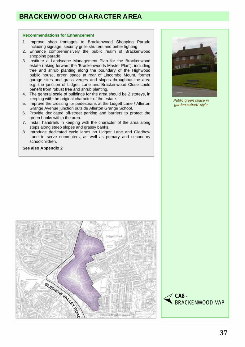
1.1 This residential area dates from the 1950s and the predominant materials are brick with concrete tiled gable and hipped roof. It is a mixture of maisonettes, flats and two storey semis in the ‘garden suburb’ style. The Brackenwood Parade on Lidgett Lane, opposite Allerton Grange School is a successful and vibrant local neighbourhood shopping parade, with a newsagent, wines and spirits off-licence, fish and chips take- away outlet, a charity shop and a delicatessen. The parade of shops is let down by poor shop frontages and public realm. The Highwood public house is in a prominent location off Brackenwood Drive and has some architectural merit. The site is in need of landscape treatment to soften up boundaries and make the site more attractive.
2. Landscape
2.1 The area is characterised by wide green spaces between buildings and open vistas and open spaces between angled blocks or short terraced houses. The main green space in the area is Bracken Hills Wood, which connects with the Gledhow Valley open space that borders Brackenwood to both the south and west. The green space to the rear of Lincombe Mount is in need of environmental enhancement. Other smaller green spaces in the area need robust planting schemes, notably the long derelict former garage sites. The junction of Lidgett Lane and Brackenwood Close, for example, could benefit from robust tree and shrub planting. The grass verges/slopes would benefit from further tree planting.
3. Movement
3.1 Pedestrian crossing on Lidgett Lane opposite the Allerton Grange School site and Moor Allerton Hall Primary School is currently difficult, especially at the start and end of the school day. The area could benefit from improvements to pedestrian crossing facilities on Lidgett Lane. Steep steps along the slopes and grassy banks throughout the area could benefit from handrails to make access safer for pedestrians. Car parking within the area is predominantly on-street, which can lead to vehicles driving along or parking on grass verges in congested areas.
Green spaces and open vistas between buildings
Loss of green space to parking
Brackenwood Shopping Parade
Two storey maisonettes
37
BRACKENWOOD CHARACTER AREA
Recommendations for Enhancement
1. Improve shop frontages to Brackenwood Shopping Parade including signage, security grille shutters and better lighting.
2. Enhance comprehensively the public realm of Brackenwood shopping parade
3. Institute a Landscape Management Plan for the Brackenwood estate (taking forward the 'Brackenwoods Master Plan'), including tree and shrub planting along the boundary of the Highwood public house, green space at rear of Lincombe Mount, former garage sites and grass verges and slopes throughout the area e.g. the junction of Lidgett Lane and Brackenwood Close could benefit from robust tree and shrub planting.
4. The general scale of buildings for the area should be 2 storeys, in keeping with the original character of the estate.
5. Improve the crossing for pedestrians at the Lidgett Lane / Allerton Grange Avenue junction outside Allerton Grange School.
6. Provide dedicated off-street parking and barriers to protect the green banks within the area.
7. Install handrails in keeping with the character of the area along steps along steep slopes and grassy banks.
8. Introduce dedicated cycle lanes on Lidgett Lane and Gledhow Lane to serve commuters, as well as primary and secondary schoolchildren.
See also Appendix 2
Public green space in ‘garden suburb’ style
CA8 - BRACKENWOOD MAP
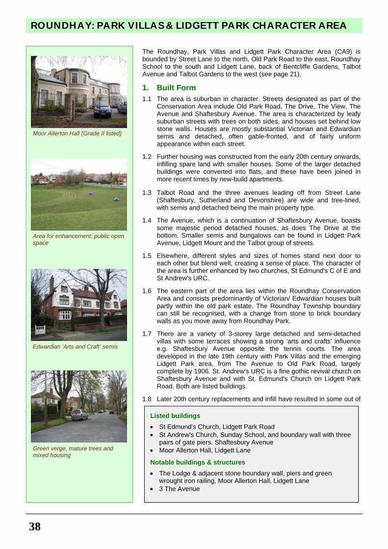
ROUNDHAY: PARK VILLAS & LIDGETT PARK CHARACTER AREA
38
The Roundhay, Park Villas and Lidgett Park Character Area (CA9) is bounded by Street Lane to the north, Old Park Road to the east, Roundhay School to the south and Lidgett Lane, back of Bentcliffe Gardens, Talbot Avenue and Talbot Gardens to the west (see page 21).
1. Built Form
1.1 The area is suburban in character. Streets designated as part of the Conservation Area include Old Park Road, The Drive, The View, The Avenue and Shaftesbury Avenue. The area is characterized by leafy suburban streets with trees on both sides, and houses set behind low stone walls. Houses are mostly substantial Victorian and Edwardian semis and detached, often gable-fronted, and of fairly uniform appearance within each street.
1.2 Further housing was constructed from the early 20th century onwards,
infilling spare land with smaller houses. Some of the larger detached buildings were converted into flats, and these have been joined in more recent times by new-build apartments.
1.3 Talbot Road and the three avenues leading off from Street Lane
(Shaftesbury, Sutherland and Devonshire) are wide and tree-lined, with semis and detached being the main property type.
1.4 The Avenue, which is a continuation of Shaftesbury Avenue, boasts
some majestic period detached houses, as does The Drive at the bottom. Smaller semis and bungalows can be found in Lidgett Park Avenue, Lidgett Mount and the Talbot group of streets.
1.5 Elsewhere, different styles and sizes of homes stand next door to
each other but blend well, creating a sense of place. The character of the area is further enhanced by two churches, St Edmund's C of E and St Andrew's URC.
1.6 The eastern part of the area lies within the Roundhay Conservation
Area and consists predominantly of Victorian/ Edwardian houses built partly within the old park estate. The Roundhay Township boundary can still be recognised, with a change from stone to brick boundary walls as you move away from Roundhay Park.
1.7 There are a variety of 3-storey large detached and semi-detached
villas with some terraces showing a strong ‘arts and crafts’ influence e.g. Shaftesbury Avenue opposite the tennis courts. The area developed in the late 19th century with Park Villas and the emerging Lidgett Park area, from The Avenue to Old Park Road, largely complete by 1906. St. Andrew's URC is a fine gothic revival church on Shaftesbury Avenue and with St. Edmund's Church on Lidgett Park Road. Both are listed buildings.
1.8 Later 20th century replacements and infill have resulted in some out of
Listed buildings
• St Edmund's Church, Lidgett Park Road • St Andrew's Church, Sunday School, and boundary wall with three
pairs of gate piers. Shaftesbury Avenue • Moor Allerton Hall, Lidgett Lane
Notable buildings & structures
• The Lodge & adjacent stone boundary wall, piers and green wrought iron railing, Moor Allerton Hall, Lidgett Lane
• 3 The Avenue
Moor Allerton Hall (Grade II listed)
Edwardian ‘Arts and Craft’ semis
Area for enhancement: public open space
Green verge, mature trees and mixed housing
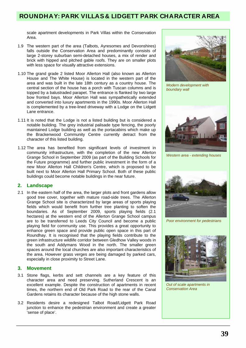
39
ROUNDHAY: PARK VILLAS & LIDGETT PARK CHARACTER AREA
scale apartment developments in Park Villas within the Conservation Area.
1.9 The western part of the area (Talbots, Ayresomes and Devonshires)
falls outside the Conservation Area and predominantly consists of large 2-storey suburban semi-detached houses, a mix of render and brick with hipped and pitched gable roofs. They are on smaller plots with less space for visually attractive extensions.
1.10 The grand grade 2 listed Moor Allerton Hall (also known as Allerton
House and The White House) is located in the western part of the area and was built in the late 18th century as a country house. The central section of the house has a porch with Tuscan columns and is topped by a balustraded parapet. The entrance is flanked by two large bow fronted bays. Moor Allerton Hall was sympathetically extended and converted into luxury apartments in the 1990s. Moor Allerton Hall is complemented by a tree-lined driveway with a Lodge on the Lidgett Lane entrance.
1.11 It is noted that the Lodge is not a listed building but is considered a
notable building. The grey industrial palisade type fencing, the poorly maintained Lodge building as well as the portacabins which make up the Brackenwood Community Centre currently detract from the character of this listed building.
1.12 The area has benefited from significant levels of investment in
community infrastructure, with the completion of the new Allerton Grange School in September 2009 (as part of the Building Schools for the Future programme) and further public investment in the form of a new Moor Allerton Hall Children's Centre, which is proposed to be built next to Moor Allerton Hall Primary School. Both of these public buildings could become notable buildings in the near future.
2. Landscape
2.1 In the eastern half of the area, the larger plots and front gardens allow good tree cover, together with mature road-side trees. The Allerton Grange School site is characterized by large areas of sports playing fields which would benefit from further tree planting to soften the boundaries. As of September 2009, sports playing fields (2.1 hectares) at the western end of the Allerton Grange School campus are to be transferred to Leeds City Council and become a public playing field for community use. This provides a great opportunity to enhance green space and provide public open space in this part of Roundhay. It is recognised that the playing fields contribute to the green infrastructure wildlife corridor between Gledhow Valley woods in the south and Addymans Wood in the north. The smaller green spaces around the local churches are also important characteristics of the area. However grass verges are being damaged by parked cars, especially in close proximity to Street Lane.
3. Movement
3.1 Stone flags, kerbs and sett channels are a key feature of this character area and need preserving. Sutherland Crescent is an excellent example. Despite the construction of apartments in recent times, the northern end of Old Park Road to the rear of the Canal Gardens retains its character because of the high stone walls.
3.2 Residents desire a redesigned Talbot Road/Lidgett Park Road
junction to enhance the pedestrian environment and create a greater ‘sense of place’.
Modern development with boundary wall
Western area - extending houses
Poor environment for pedestrians
Out of scale apartments in Conservation Area
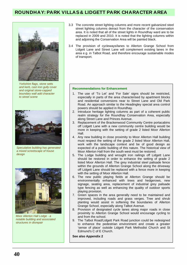
ROUNDHAY: PARK VILLAS & LIDGETT PARK CHARACTER AREA
40
3.3 The concrete street lighting columns and more recent galvanized steel street lighting columns detract from the character of the conservation area. It is noted that all of the street lights in Roundhay ward are to be replaced in 2009 and 2010. It is noted that the lighting columns within and adjoining the Conservation Area will be painted black.
3.4 The provision of cycleways/lanes to Allerton Grange School from
Lidgett Lane and Street Lane will complement existing lanes in the area e.g. in Talbot Road, and therefore encourage sustainable modes of transport.
Yorkshire flags, stone setts and kerb, cast iron gully cover and original stone-capped boundary wall add character to street scene
Recommendations for Enhancement
1. The use of ‘To Let’ and ‘For Sale’ signs should be restricted, especially in parts of the area characterised by apartment blocks and residential conversions near to Street Lane and Old Park Road. An approach similar to the Headingley special area control powers should be applied in Roundhay.
2. Introduce heritage lighting columns as part of a coherent public realm strategy for the Roundhay Conservation Area, especially along Street Lane and Princes Avenue.
3. Replacement of the Brackenwood Community Centre portacabins off Lidgett Lane with a new community centre building would be more in keeping with the setting of grade 2 listed Moor Allerton Hall.
4. Any new building in close proximity to Moor Allerton Hall building must respect the setting of the grade 2 listed Moor Allerton Hall, work with the landscape context and be of good design as expected of a public building of this nature. The historical view of Moor Allerton Hall from the south west must be restored.
5. The Lodge building and wrought iron railings off Lidgett Lane should be restored in order to enhance the setting of grade 2 listed Moor Allerton Hall. The grey industrial steel palisade fence within the grounds of Allerton Grange School along the driveway off Lidgett Lane should be replaced with a fence more in keeping with the setting of Moor Allerton Hall.
6. The new public playing fields at Allerton Grange should be environmentally enhanced with trees and hedgerows, new signage, seating area, replacement of industrial grey palisade type fencing as well as enhancing the quality of outdoor sports playing provision.
7. Green spaces in the area generally need to be maintained and improved, including roads and grass verges. Tree and shrub planting would assist in softening the boundaries of Allerton Grange School, especially along Talbot Avenue.
8. Provision of designated cycle lanes along major roads in close proximity to Allerton Grange School would encourage cycling to and from the school.
9. The Talbot Road/Lidgett Park Road junction could be redesigned to enhance the pedestrian environment and create a greater ‘sense of place’ outside Lidgett Park Methodist Church and St Edmund's C of E Church.
See also Appendix 2
Speculative building has generated a mixed screetscape of house design
Moor Allerton Hall Lodge - a notable building and associated structures in disrepair
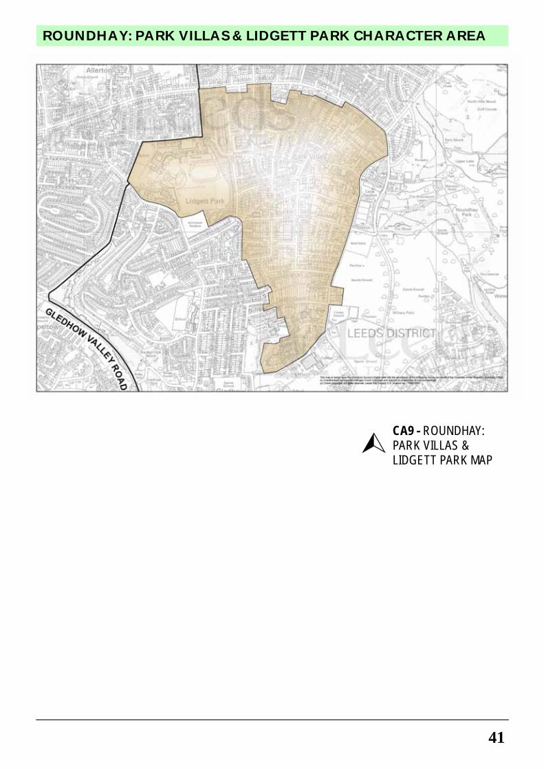
41
ROUNDHAY: PARK VILLAS & LIDGETT PARK CHARACTER AREA
CA9 - ROUNDHAY: PARK VILLAS & LIDGETT PARK MAP
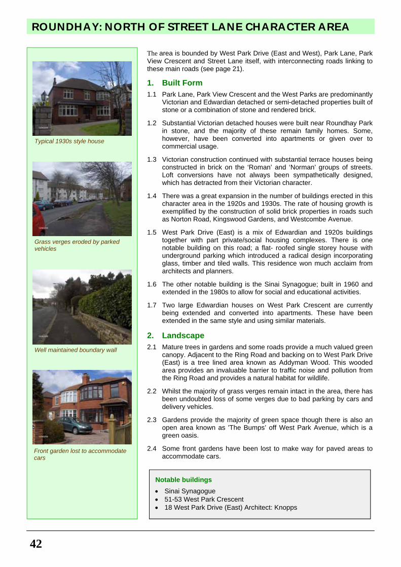
ROUNDHAY: NORTH OF STREET LANE CHARACTER AREA
42
The area is bounded by West Park Drive (East and West), Park Lane, Park View Crescent and Street Lane itself, with interconnecting roads linking to these main roads (see page 21).
1. Built Form
1.1 Park Lane, Park View Crescent and the West Parks are predominantly Victorian and Edwardian detached or semi-detached properties built of stone or a combination of stone and rendered brick.
1.2 Substantial Victorian detached houses were built near Roundhay Park
in stone, and the majority of these remain family homes. Some, however, have been converted into apartments or given over to commercial usage.
1.3 Victorian construction continued with substantial terrace houses being
constructed in brick on the ‘Roman’ and ‘Norman’ groups of streets. Loft conversions have not always been sympathetically designed, which has detracted from their Victorian character.
1.4 There was a great expansion in the number of buildings erected in this
character area in the 1920s and 1930s. The rate of housing growth is exemplified by the construction of solid brick properties in roads such as Norton Road, Kingswood Gardens, and Westcombe Avenue.
1.5 West Park Drive (East) is a mix of Edwardian and 1920s buildings
together with part private/social housing complexes. There is one notable building on this road; a flat- roofed single storey house with underground parking which introduced a radical design incorporating glass, timber and tiled walls. This residence won much acclaim from architects and planners.
1.6 The other notable building is the Sinai Synagogue; built in 1960 and
extended in the 1980s to allow for social and educational activities. 1.7 Two large Edwardian houses on West Park Crescent are currently
being extended and converted into apartments. These have been extended in the same style and using similar materials.
2. Landscape
2.1 Mature trees in gardens and some roads provide a much valued green canopy. Adjacent to the Ring Road and backing on to West Park Drive (East) is a tree lined area known as Addyman Wood. This wooded area provides an invaluable barrier to traffic noise and pollution from the Ring Road and provides a natural habitat for wildlife.
2.2 Whilst the majority of grass verges remain intact in the area, there has
been undoubted loss of some verges due to bad parking by cars and delivery vehicles.
2.3 Gardens provide the majority of green space though there is also an
open area known as 'The Bumps’ off West Park Avenue, which is a green oasis.
2.4 Some front gardens have been lost to make way for paved areas to
accommodate cars.
Notable buildings
• Sinai Synagogue • 51-53 West Park Crescent • 18 West Park Drive (East) Architect: Knopps
Typical 1930s style house
Grass verges eroded by parked vehicles
Well maintained boundary wall
Front garden lost to accommodate cars
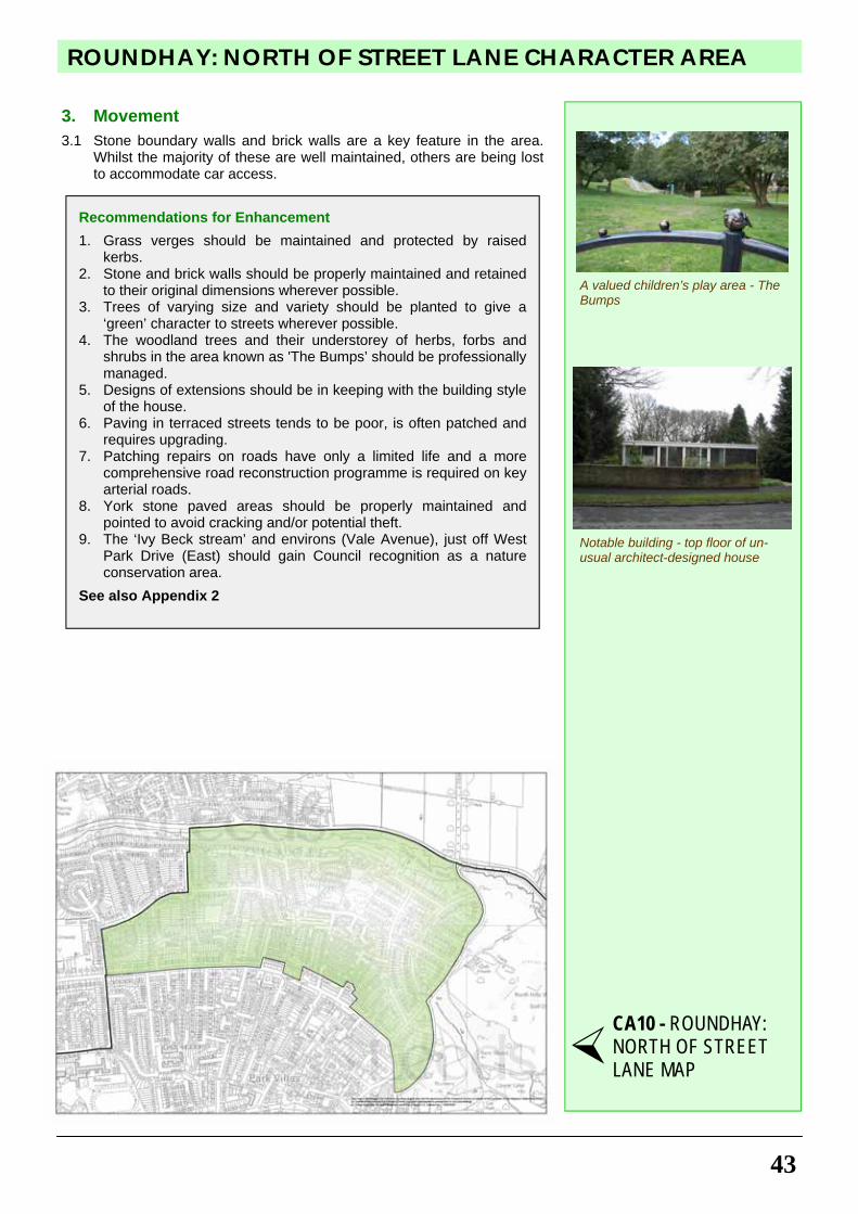
43
ROUNDHAY: NORTH OF STREET LANE CHARACTER AREA
3. Movement
3.1 Stone boundary walls and brick walls are a key feature in the area. Whilst the majority of these are well maintained, others are being lost to accommodate car access.
Recommendations for Enhancement
1. Grass verges should be maintained and protected by raised kerbs.
2. Stone and brick walls should be properly maintained and retained to their original dimensions wherever possible.
3. Trees of varying size and variety should be planted to give a ‘green’ character to streets wherever possible.
4. The woodland trees and their understorey of herbs, forbs and shrubs in the area known as 'The Bumps’ should be professionally managed.
5. Designs of extensions should be in keeping with the building style of the house.
6. Paving in terraced streets tends to be poor, is often patched and requires upgrading.
7. Patching repairs on roads have only a limited life and a more comprehensive road reconstruction programme is required on key arterial roads.
8. York stone paved areas should be properly maintained and pointed to avoid cracking and/or potential theft.
9. The ‘Ivy Beck stream’ and environs (Vale Avenue), just off West Park Drive (East) should gain Council recognition as a nature conservation area.
See also Appendix 2
A valued children’s play area - The Bumps
CA10 - ROUNDHAY: NORTH OF STREET LANE MAP
Notable building - top floor of un-usual architect-designed house
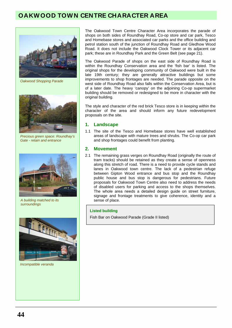
OAKWOOD TOWN CENTRE CHARACTER AREA
44
The Oakwood Town Centre Character Area incorporates the parade of shops on both sides of Roundhay Road, Co-op store and car park, Tesco and Homebase stores and associated car parks and the office building and petrol station south of the junction of Roundhay Road and Gledhow Wood Road. It does not include the Oakwood Clock Tower or its adjacent car park; these are in Roundhay Park and the Green Belt (see page 21). The Oakwood Parade of shops on the east side of Roundhay Road is within the Roundhay Conservation area and the ‘fish bar’ is listed. The original shops for the developing community of Oakwood were built in the late 19th century; they are generally attractive buildings but some improvements to shop frontages are needed. The parade opposite on the west side of Roundhay Road also falls within the Conservation Area, but is of a later date. The heavy ‘canopy’ on the adjoining Co-op supermarket building should be removed or redesigned to be more in character with the original building. The style and character of the red brick Tesco store is in keeping within the character of the area and should inform any future redevelopment proposals on the site.
1. Landscape
1.1 The site of the Tesco and Homebase stores have well established areas of landscape with mature trees and shrubs. The Co-op car park and shop frontages could benefit from planting.
2. Movement
2.1 The remaining grass verges on Roundhay Road (originally the route of tram tracks) should be retained as they create a sense of openness along this stretch of road. There is a need to provide cycle stands and lanes in Oakwood town centre. The lack of a pedestrian refuge between Gipton Wood entrance and bus stop and the Roundhay public house and bus stop is dangerous for pedestrians. Future proposals for Oakwood Town Centre also need to address the needs of disabled users for parking and access to the shops themselves. The whole area needs a detailed design guide on street furniture, signage and frontage treatments to give coherence, identity and a sense of place.
Listed building
Fish Bar on Oakwood Parade (Grade II listed)
Precious green space: Roundhay’s Gate - retain and entrance
Oakwood Shopping Parade
A building matched to its surroundings
Incompatible veranda
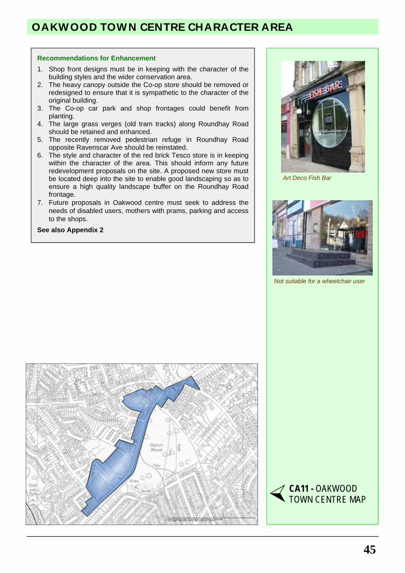
45
OAKWOOD TOWN CENTRE CHARACTER AREA
Recommendations for Enhancement
1. Shop front designs must be in keeping with the character of the building styles and the wider conservation area.
2. The heavy canopy outside the Co-op store should be removed or redesigned to ensure that it is sympathetic to the character of the original building.
3. The Co-op car park and shop frontages could benefit from planting.
4. The large grass verges (old tram tracks) along Roundhay Road should be retained and enhanced.
5. The recently removed pedestrian refuge in Roundhay Road opposite Ravenscar Ave should be reinstated.
6. The style and character of the red brick Tesco store is in keeping within the character of the area. This should inform any future redevelopment proposals on the site. A proposed new store must be located deep into the site to enable good landscaping so as to ensure a high quality landscape buffer on the Roundhay Road frontage.
7. Future proposals in Oakwood centre must seek to address the needs of disabled users, mothers with prams, parking and access to the shops.
See also Appendix 2
Not suitable for a wheelchair user
Art Deco Fish Bar
CA11 - OAKWOOD TOWN CENTRE MAP
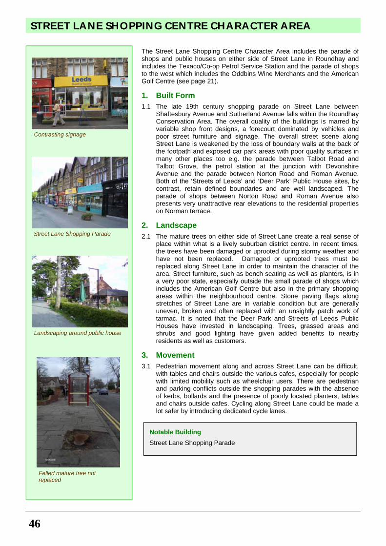
STREET LANE SHOPPING CENTRE CHARACTER AREA
46
The Street Lane Shopping Centre Character Area includes the parade of shops and public houses on either side of Street Lane in Roundhay and includes the Texaco/Co-op Petrol Service Station and the parade of shops to the west which includes the Oddbins Wine Merchants and the American Golf Centre (see page 21). 1. Built Form
1.1 The late 19th century shopping parade on Street Lane between Shaftesbury Avenue and Sutherland Avenue falls within the Roundhay Conservation Area. The overall quality of the buildings is marred by variable shop front designs, a forecourt dominated by vehicles and poor street furniture and signage. The overall street scene along Street Lane is weakened by the loss of boundary walls at the back of the footpath and exposed car park areas with poor quality surfaces in many other places too e.g. the parade between Talbot Road and Talbot Grove, the petrol station at the junction with Devonshire Avenue and the parade between Norton Road and Roman Avenue. Both of the ‘Streets of Leeds’ and ‘Deer Park’ Public House sites, by contrast, retain defined boundaries and are well landscaped. The parade of shops between Norton Road and Roman Avenue also presents very unattractive rear elevations to the residential properties on Norman terrace.
2. Landscape
2.1 The mature trees on either side of Street Lane create a real sense of place within what is a lively suburban district centre. In recent times, the trees have been damaged or uprooted during stormy weather and have not been replaced. Damaged or uprooted trees must be replaced along Street Lane in order to maintain the character of the area. Street furniture, such as bench seating as well as planters, is in a very poor state, especially outside the small parade of shops which includes the American Golf Centre but also in the primary shopping areas within the neighbourhood centre. Stone paving flags along stretches of Street Lane are in variable condition but are generally uneven, broken and often replaced with an unsightly patch work of tarmac. It is noted that the Deer Park and Streets of Leeds Public Houses have invested in landscaping. Trees, grassed areas and shrubs and good lighting have given added benefits to nearby residents as well as customers.
3. Movement
3.1 Pedestrian movement along and across Street Lane can be difficult, with tables and chairs outside the various cafes, especially for people with limited mobility such as wheelchair users. There are pedestrian and parking conflicts outside the shopping parades with the absence of kerbs, bollards and the presence of poorly located planters, tables and chairs outside cafes. Cycling along Street Lane could be made a lot safer by introducing dedicated cycle lanes.
Notable Building
Street Lane Shopping Parade
Contrasting signage
Street Lane Shopping Parade
Landscaping around public house
Felled mature tree not replaced
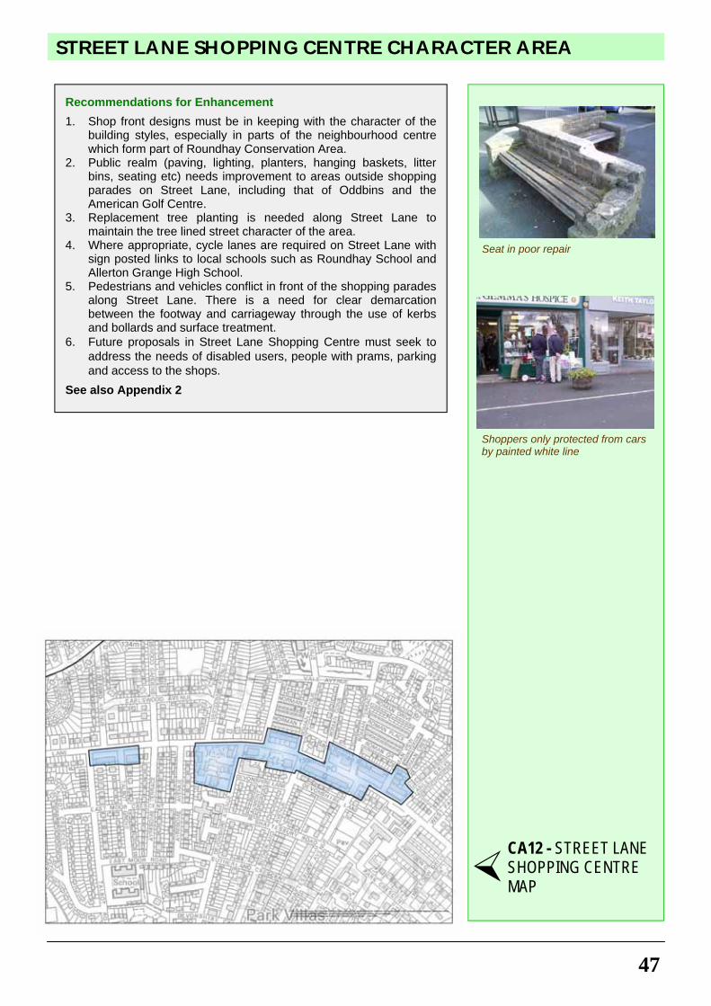
47
STREET LANE SHOPPING CENTRE CHARACTER AREA
Recommendations for Enhancement
1. Shop front designs must be in keeping with the character of the building styles, especially in parts of the neighbourhood centre which form part of Roundhay Conservation Area.
2. Public realm (paving, lighting, planters, hanging baskets, litter bins, seating etc) needs improvement to areas outside shopping parades on Street Lane, including that of Oddbins and the American Golf Centre.
3. Replacement tree planting is needed along Street Lane to maintain the tree lined street character of the area.
4. Where appropriate, cycle lanes are required on Street Lane with sign posted links to local schools such as Roundhay School and Allerton Grange High School.
5. Pedestrians and vehicles conflict in front of the shopping parades along Street Lane. There is a need for clear demarcation between the footway and carriageway through the use of kerbs and bollards and surface treatment.
6. Future proposals in Street Lane Shopping Centre must seek to address the needs of disabled users, people with prams, parking and access to the shops.
See also Appendix 2
Seat in poor repair
CA12 - STREET LANE SHOPPING CENTRE MAP
Shoppers only protected from cars by painted white line
PLANNING CONTEXT - CURRENT & FUTURE PLANS AND RECOMMENDATIONS
48
Roundhay Ward lies on the north-eastern edge of the main urban area of Leeds and is bounded by the Outer Ring Road to the north, Wetherby Road/Easterly Road to the east and south and Gledhow valley to the south-west. The north-east boundary is less well defined cutting through the built up area from the Moortown Ring Road, along Allerton Grange Fields to Gledhow Valley (see maps pages 5 and 6). Current Local Policies and Proposals
Within the Leeds Unitary Development Plan Review (UDP), the Outer Ring Road and Easterly/Wetherby Road are both part of the Leeds Strategic Highway Network (T18) and the former is the subject of a future major highway scheme (T20). (For details of the relevant bracketed planning policies, see Appendix 1.) The Green Belt (N32) which surrounds the main urban area of Leeds crosses the Ring Road and extends into the neighbourhood to include the whole of Roundhay Park as far as the Oakwood Clock and all the open area to the east to Wetherby Road. The Ward includes parts of the urban green corridor (N8), protected Green Spaces (N1), Allotments (N1A), Playing Fields (N6), Local Nature Areas (N50) and Conservation Areas (N19). Smaller areas of protected green spaces and playing fields are to found within the built-up areas, most significantly Gipton Wood which includes a Class 1 Ancient Monument Site. The area close to Easterly Road is classed as a priority area for improving green space provision (N3). Extensions to the urban green corridor flank the Ring Road (Addyman Wood) and follow the Gledhow Beck and Wyke Beck valleys. The latter is the subject of an ‘area based initiative’ (R2), which includes a new cycle route to Roundhay Park (T7). The area contains one designated Town Centre at Oakwood (S2) and another shopping centre with frontage policies on Street Lane (S4) and a number of Neighbourhood Shopping Parades (S8). Further planning advice is available from http://www.leeds.gov.uk/planning. Recommendations for Local Future Policies and Proposals
The section represents the residents’ recommendations for future policies and proposals following extensive community consultation and which have all been the subject of consultation with Leeds City Council. This section does not have the same status as the ‘Guidance for Design’ chapter. The following recommendations should be taken into account as material consideration in the preparation of local development plans and policies:
Recommendation 1: To ensure that notable buildings and structures which contribute to the distinct identity of Roundhay Ward are protected and enhanced. Notable buildings and structures identified on 'Built Form' map on page 17 should be protected as Statutory Listed Buildings or Locally Listed Buildings in addition to those already protected under Policy N14 of the UDP and draft Core Strategy Policy SC8. Recommendation 2: To ensure that unprotected green spaces, that are integral to the fabric of the urban area, are retained to safeguard the special character of Roundhay Ward. Unprotected green spaces listed on page 50 and identified on the 'Landscape' map on page 18 should be protected from development in addition to those already protected under Policies N1, N1A, N6, N50 of the UDP and draft Core Strategy Policy G1 and G5. Recommendation 3: To safeguard and maximise accessibility, improve the linkage of existing green spaces and provide for informal recreation, amenity and nature conservation by green corridors. Proposed urban green corridors should help connect existing green spaces and also improve accessibility between Roundhay Ward and the countryside. The extent of the proposed urban green corridors identified on the 'Land Use' Map on page 16 should be protected from development in addition to those already protected under Policy N8 of the UDP and draft Core Strategy Policy G1 and G5. Recommendation 4: To ensure that the trees which contribute to the special character of Roundhay Ward are protected from development. Potential areas for new Tree Preservation Orders (TPOs) should be identified by Roundhay Planning Forum and Leeds City Council, so that visually significant trees can be protected from indiscriminate felling and development as are those already protected under Town & Country Planning (Trees) Regulation 1999 and draft Core Strategy Policy G5A (see 'TPOs' map on page 53). Recommendation 5: To ensure that Neighbourhood Shopping Parades within walking distance of residential areas are maintained and enhanced (as it is recognised that they play a vital role in serving the day to day retail needs of people resident and working in Roundhay Ward) The Roundhay Planning Forum has conducted a comprehensive townscape appraisal of Roundhay Ward (in accordance with ‘Neighbourhoods for Living’ SPG, LCC, 2003) to help understand the local character and opportunities for environmental enhancement (see the ‘Analysis of Place and Enhancements’ map on page 54 and supplementary photos on page 55). Neighbourhood Shopping Parades identified on the 'Land Use' map on page 16 should be recognised, and their vitality and viability should be enhanced further in accordance with Policy S8 of the UDP and draft Core Strategy Policy SC2. Recommendation 6: To assist in managing change in a positive way and enhancing the built and natural environments for the benefit of all its users. The ‘Analysis of Place and Enhancement’ Map on page 54 should be used to inform development schemes, planning application decisions, local development plans, policies and proposals in accordance with Policy N12 of the UDP Neighbourhood for Living SPG and draft Core Strategy Policy SC8.
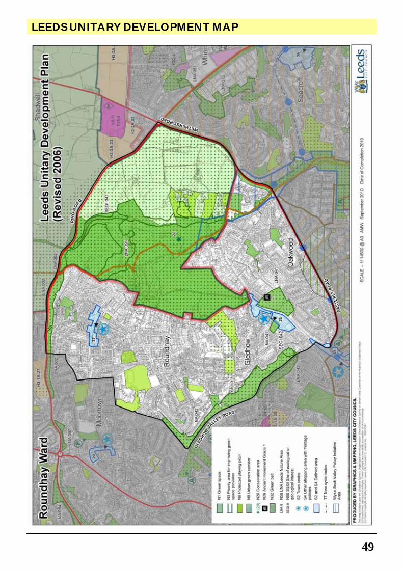
49
LEEDS UNITARY DEVELOPMENT MAP
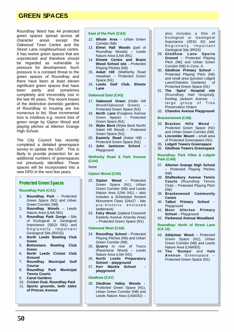
50
GREEN SPACES
Roundhay Ward has 44 protected green spaces spread across all character areas except the Oakwood Town Centre and the Street Lane neighbourhood centre. It has twelve green spaces that are unprotected and therefore should be regarded as vulnerable to pressure for development. Such pressure is a constant threat to the green spaces of Roundhay and there have been at least eleven significant green spaces that have been partly and sometimes completely and irreversibly lost in the last 40 years. The recent losses of the distinctive domestic gardens of Roundhay to housing are too numerous to list. Slow incremental loss is insidious e.g. recent loss of green verge by Gipton Wood and playing pitches at Allerton Grange High School. The City Council has recently completed a detailed greenspace survey to update the UDP. This is likely to provide protection for an additional numbers of greenspaces not previously identified. These spaces will be incorporated into a new DPD in the next few years.
Protected Green Spaces Roundhay Park (CA1)
1. Roundhay Park – Protected Green Space (N1) and Urban Green Corridor (N8)
2. Roundhay Woods – Leeds Nature Area (LNA 091)
3. Roundhay Park Gorge – Site of Ecological or Geological Importance (SEGI 041) and R e g i o n a l l y I m p o r t a n t Geological Site (RIGS))
4. North Leeds Bowling Club Green
5. Bohemians Bowling Club Green
6. North Leeds Cricket Club Ground
7. Roundhay Municipal Golf Course
8. Roundhay Park Municipal Tennis Courts
9. Canal Gardens 10. Cricket Oval, Roundhay Park 11. Sports grounds, both sides
of Princes Avenue
East of the Park (CA2)
12. Whole Area – Urban Green Corridor (N8)
13. Elmet Hall Woods (part of Roundhay Woods) – Leeds Nature Area (LNA 091)
14. Elmete Centre and Braim Wood School site – Protected Playing Pitches (N6)
15. Asket Hill (Wetherby Road meadow) – Protected Green Space (N1)
16. Leeds Golf Club, Elmete Lane
Oakwood East (CA3)
17. Oakwood Green (Hollin Hill Wood/Oakwood Green) – Protected Green Space (N1)
18. North Lane (Foxglove Avenue Green Space) – Protected Green Space (N1)
19. Wyke Beck (Wyke Beck North/Asket Hill Wood) – Protected Green Space (N1)
20. Easterly Road (Asket Hill) – Protected Green Space (N1)
21. John Jamieson School – Playground
Wetherby Road & Park Avenue (CA4)
None Gipton Wood (CA5) 22. Gipton Wood – Protected
Green Space (N1), Urban Green Corridor (N8) and Leeds Nature Area (LNA 041) – also includes a Scheduled Ancient Monument Class 1(No27 - late p r e - h i s t o r i c e n c l o s e d settlement).
23. Fairy Wood, (Upland Crescent/Easterly Avenue Amenity Area) – Protected Green Space (N1)
Oakwood West (CA6)
24. Roundhay School – Protected Playing Pitches (N6) and Urban Green Corridor (N8)
25. Quarry to rear of Tesco (Ravenscar Wood) – Leeds Nature Area (LNA 041)
26. North Leeds Preparatory School – playground
27. Kerr Mackie School – playground
Gledhow (CA7)
28. Gledhow Valley Woods – Protected Green Space (N1), Urban Green Corridor (N8) and Leeds Nature Area (LNA042) –
also includes a Site of Ecological or Geological Importance (SEGI 42) and R e g i o n a l l y I m p o r t a n t Geological Site (RIGS)
29. Gledhow Lane Sports Ground – Protected Playing Pitch (N6) and Urban Green Corridor (N8) in Cons. A.
30. Gledhow Primary School – Protected Playing Pitch (N6) and small area (junction Lidgett Lane/Chandos Gardens) of Protected Green Space (N1)
31. The ‘Spire’ Hospital site (Roundhay Hall Hospital), fronting Jackson Avenue – l a r g e g r o u p o f T r e e Preservation Orders
32. Chandos Avenue Playground Brackenwood (CA8)
33. Bracken Hills Wood – Protected Green Space (N1) and Urban Green Corridor (N8)
34. Lincombe Mount – small area of Protected Greenspace (N1)
35. Lidgett Towers Greenspace 36. Gledhow Towers Greenspace Roundhay: Park Villas & Lidgett Park (CA9)
37. Allerton Grange High School – Protected Playing Pitches (N6)
38. Shaftesbury Avenue Tennis Courts (Roundhay Tennis Club) – Protected Playing Pitch (N6)
39. Brackenwood Community Centre
40. Talbot Primary School – Playground
41. Moor Allerton Primary School – Playground
42. Parkwood Avenue Woodland Roundhay: North of Street Lane (CA 10)
43. Addyman Wood – Protected Green Space (N1), Urban Green Corridor (N8) and Leeds Nature Area (LNA002)
44. The ‘Bumps’ and Vale Avenue G reenspace – Protected Green Space (N1)
51
GREEN SPACES
Unprotected Green Spaces Roundhay Park (CA1)
None East of the Park (CA2)
None Oakwood East (CA3)
1. Belle Vue Avenue Allotments Wetherby Road & Park Avenue (CA4)
None Gipton Wood (CA5)
2. M o n t a g u e C r e s c e n t Plantation – Access blocked
Oakwood West (CA6)
3. Gledhow Lane – Divided Carriageway Plantation
4. Small copse – between Oak we l l D r i ve & Back Ravenscar Avenue (remnant of Barkers Wood)
5. 'Ravenscar' Wood – between Ravenscar View & Dean Court (remnant of Gipton Wood)
Gledhow (CA7)
6. Jackson Avenue Allotments – lost to woodland
7. Jackson Avenue woodland 8. ‘The Postage Stamp’ – green
space behind Gledhow Primary School
9. Lidgett Lane Allotments (North Park Avenue Allotments)
Brackenwood (CA8)
10. Green space – between houses
Roundhay: Park Villas & Lidgett Park (CA9)
11. Green space – between Talbot Fold, Talbot Court and East Moor Crescent
Lost Green Spaces Oakwood East (CA3)
1. Grove House – curtilage area lost to housing
Gipton Wood ( (CA5)
2. Roundhay Road Green Reservation - part lost to parking and road widening
Gledhow (CA7)
3. Chandos Avenue Rugby Playing Field - lost to housing
4. Gledhow Hall Walled Garden – lost to housing
5. Gledhow Hall Gardens – mostly lost to housing
6. Gledhow House Horse Paddock – lost to housing (The Laurels)
7. Oakley House Walled Garden – lost to flats (137 Gledhow Lane)
Roundhay: Park Villas & Lidgett Park(CA9)
8. Leeds Permanent Building Society Playing Field – lost to housing
9. Lidgett Park Road Allotments – lost to housing
10. Moor Allerton Hall allotments – lost to housing.
11. Devonshire Hall playing fields – lost to buildings
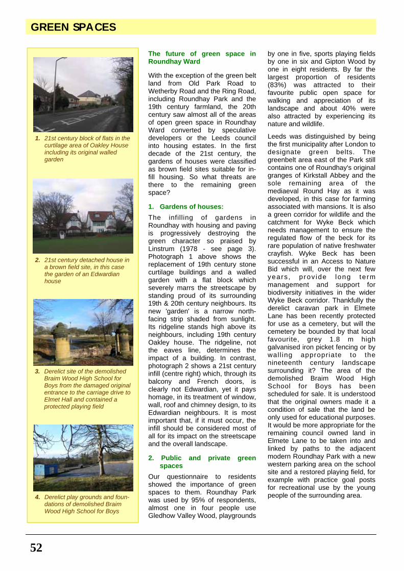
GREEN SPACES
52
The future of green space in Roundhay Ward With the exception of the green belt land from Old Park Road to Wetherby Road and the Ring Road, including Roundhay Park and the 19th century farmland, the 20th century saw almost all of the areas of open green space in Roundhay Ward converted by speculative developers or the Leeds council into housing estates. In the first decade of the 21st century, the gardens of houses were classified as brown field sites suitable for in-fill housing. So what threats are there to the remaining green space? 1. Gardens of houses:
The infilling of gardens in Roundhay with housing and paving is progressively destroying the green character so praised by Linstrum (1978 - see page 3). Photograph 1 above shows the replacement of 19th century stone curtilage buildings and a walled garden with a flat block which severely marrs the streetscape by standing proud of its surrounding 19th & 20th century neighbours. Its new 'garden' is a narrow north-facing strip shaded from sunlight. Its ridgeline stands high above its neighbours, including 19th century Oakley house. The ridgeline, not the eaves line, determines the impact of a building. In contrast, photograph 2 shows a 21st century infill (centre right) which, through its balcony and French doors, is clearly not Edwardian, yet it pays homage, in its treatment of window, wall, roof and chimney design, to its Edwardian neighbours. It is most important that, if it must occur, the infill should be considered most of all for its impact on the streetscape and the overall landscape. 2. Public and private green
spaces
Our questionnaire to residents showed the importance of green spaces to them. Roundhay Park was used by 95% of respondents, almost one in four people use Gledhow Valley Wood, playgrounds
by one in five, sports playing fields by one in six and Gipton Wood by one in eight residents. By far the largest proportion of residents (83%) was attracted to their favourite public open space for walking and appreciation of its landscape and about 40% were also attracted by experiencing its nature and wildlife.
Leeds was distinguished by being the first municipality after London to designate green belts. The greenbelt area east of the Park still contains one of Roundhay's original granges of Kirkstall Abbey and the sole remaining area of the mediaeval Round Hay as it was developed, in this case for farming associated with mansions. It is also a green corridor for wildlife and the catchment for Wyke Beck which needs management to ensure the regulated flow of the beck for its rare population of native freshwater crayfish. Wyke Beck has been successful in an Access to Nature Bid which will, over the next few years , p rov ide long te rm management and support for biodiversity initiatives in the wider Wyke Beck corridor. Thankfully the derelict caravan park in Elmete Lane has been recently protected for use as a cemetery, but will the cemetery be bounded by that local favourite, grey 1.8 m high galvanised iron picket fencing or by wal l ing appropriate to the nineteenth century landscape surrounding it? The area of the demolished Braim Wood High School for Boys has been scheduled for sale. It is understood that the original owners made it a condition of sale that the land be only used for educational purposes. It would be more appropriate for the remaining council owned land in Elmete Lane to be taken into and linked by paths to the adjacent modern Roundhay Park with a new western parking area on the school site and a restored playing field, for example with practice goal posts for recreational use by the young people of the surrounding area.
4. Derelict play grounds and foun-dations of demolished Braim Wood High School for Boys
3. Derelict site of the demolished Braim Wood High School for Boys from the damaged original entrance to the carriage drive to Elmet Hall and contained a protected playing field
2. 21st century detached house in a brown field site, in this case the garden of an Edwardian house
1. 21st century block of flats in the curtilage area of Oakley House including its original walled garden
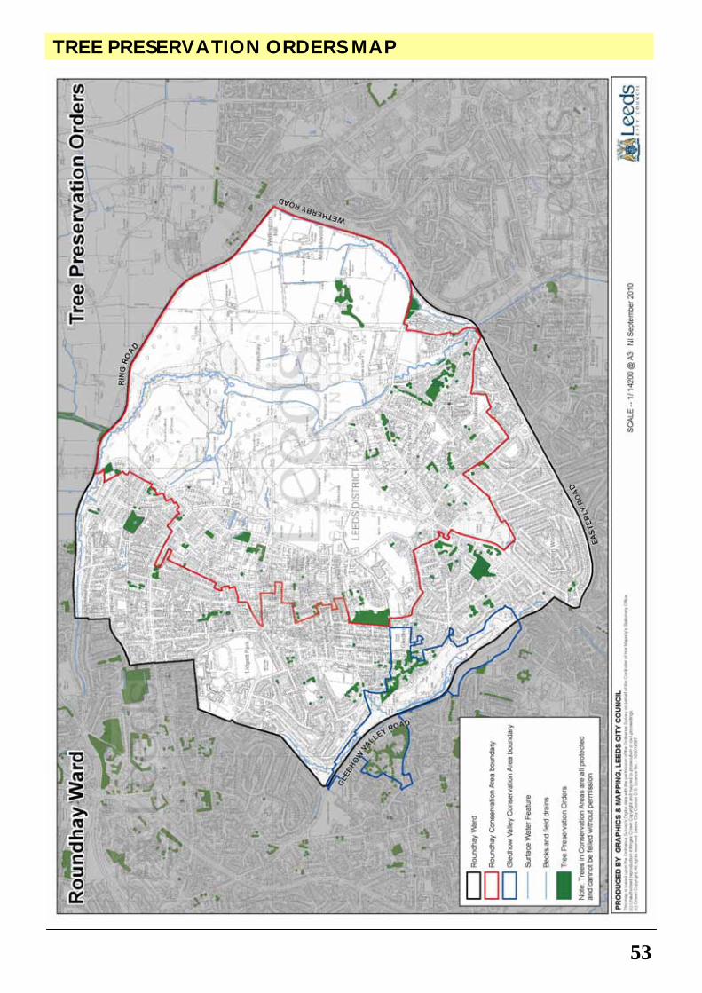
TREE PRESERVATION ORDERS MAP
53
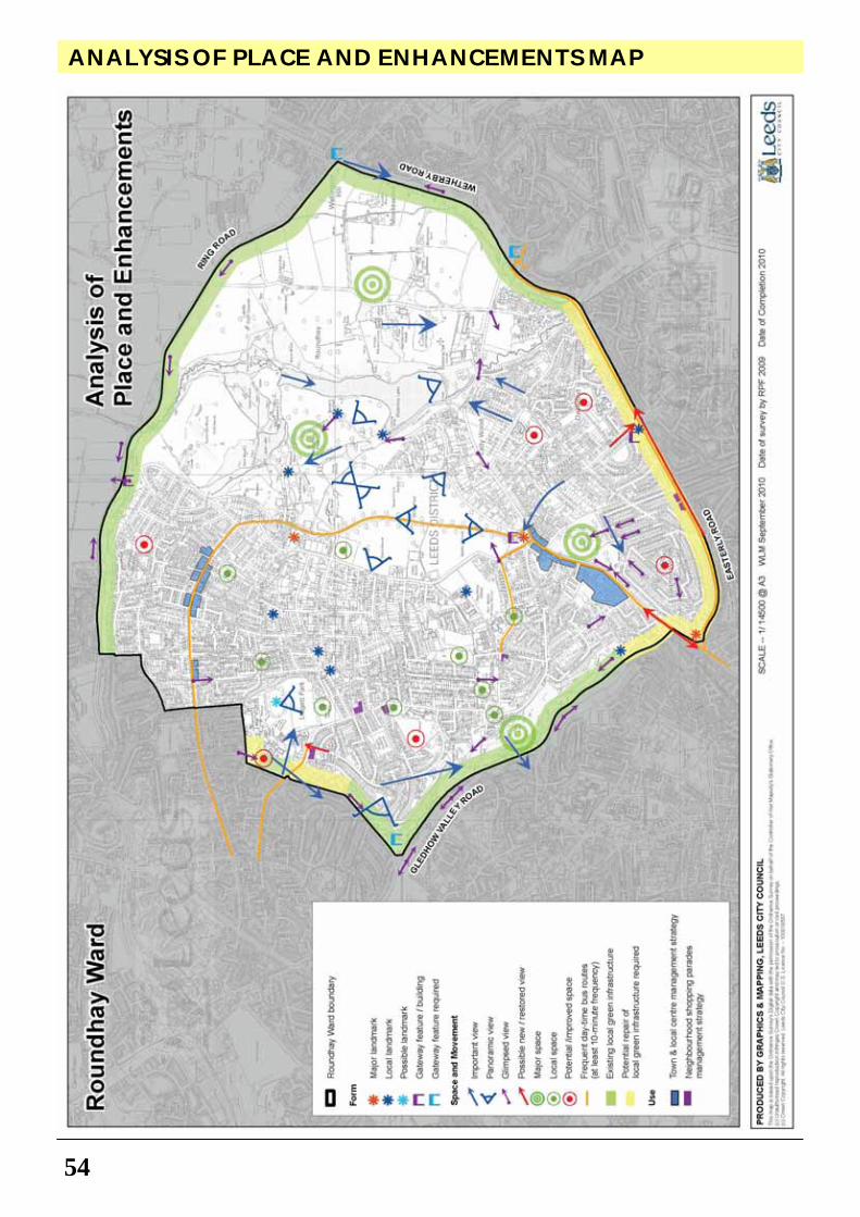
54
ANALYSIS OF PLACE AND ENHANCEMENTS MAP
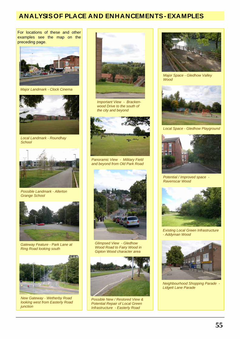
For locations of these and other examples see the map on the preceding page.
55
ANALYSIS OF PLACE AND ENHANCEMENTS - EXAMPLES
Local Space - Gledhow Playground
Potential / Improved space - Ravenscar Wood
Local Landmark - Roundhay School
Existing Local Green Infrastructure - Addyman Wood
Possible Landmark - Allerton Grange School
Gateway Feature - Park Lane at Ring Road looking south
Neighbourhood Shopping Parade - Lidgett Lane Parade
Possible New / Restored View & Potential Repair of Local Green Infrastructure - Easterly Road
New Gateway - Wetherby Road looking west from Easterly Road junction
Major Space - Gledhow Valley Wood
Important View - Bracken-wood Drive to the south of the city and beyond
Panoramic View - Military Field and beyond from Old Park Road
Major Landmark - Clock Cinema
Glimpsed View - Gledhow Wood Road to Fairy Wood in Gipton Wood character area
56
GUIDANCE FOR DESIGN
The Roundhay Ward Neighbourhood Design Statement is intended to give developers, planners, property owners and householders a description of those aspects of the area which are considered to be of importance in defining its character. Before undertaking the design of any development, including alterations to existing buildings and spaces (including front boundary walls), an examination should be made of the quality and character of the surroundings, and the question should be asked:
“How can this development be designed to complement, enhance or improve that
character?”
The following provides guidance for design of developments within the Roundhay NDS. It implements Strategic Aim SA1 of the UDP, and supplements the UDP and emerging policies listed in Appendix 1. It should be read alongside the design principles established within ‘Neighbourhoods for Living – A residential design guide for Leeds’ which was adopted by Leeds City Council as Supplementary Planning Guidance in December 2003. This chapter should also be read alongside ‘Character Area Appraisals’ (pages 22-47), ‘Recommendation for Action and Management’ and Appendix 2 (page 57, 66), and the maps on pages 16, 17, 18, 19, 49, 53, and 54.This 'Guidance for Design' of developments will be used by Leeds City Council in the determination of planning applications and the production of local development plans. New Developments must respect the special character and context of Roundhay Ward
New development within Roundhay Ward must be mindful of the local character of the surrounding area, whilst at the same time being distinctly of the 21st century and addressing contemporary issues
such as sustainability and building for life requirements. Development in Neighbourhood Design Statement areas should:
• Relate well to the topography and landscape of the place and the lie of the land
• Be integrated into the pattern of existing developments, streets and footpaths through and around it
• Address important short and long views and vistas i.e. key aspects
• Respect the scale, proportions and aspects of neighbouring buildings
• Use materials which match in colour, texture and quality those used in existing buildings, particularly in the case of terraces and any alterations and extensions
• Create new views and features which add to the variety and interest of their setting, particularly on corner sites and at road junctions
• Retain garden plots, front gardens and boundary walls to preserve the coherence of streetscapes where possible
• Any dormers or roof extensions should match the original roof in pitch and materials. Any dormers should be subordinate to the main roof i.e. set back from the eaves, side/party walls and preferably set below the ridgeline.
• Extensions, including garages, should not dominate the original building and side extensions should be set back from the original frontage.
Protect and enhance surviving historic architectural forms in Roundhay Ward
There are 53 Listed Buildings and two Conservation Areas within Roundhay Ward. There are also many notable buildings, features and spaces that are not within a
conservation area, nor listed, but equally add character and a sense of distinctiveness to Roundhay Ward. Replacement of windows, doors, traditional wall and roofing materials with inappropriate materials and designs is a negative feature that affects individual buildings and the wider streetscape. Original details such as architraves, glazing bars and finials should be retained. The cumulative effect of small changes is particularly noticeable in the large Victorian terraces, villas and the cottage terraces where the original uniformity has been weakened.
Road signs and street furniture
Despite the busy nature of Roundhay Road, Street Lane, Lidgett Lane, Gledhow Valley Road, Easterly Road and A6120 Leeds Outer Ring Road, Roundhay does not suffer greatly from an excess of road signs. There are, however, opportunities for enhancement with the replacement of broken and vandalised signs. It is good practice to carry out regular sign audits and remove redundant road signs. When new signs are installed, their siting should be considered in the context of the wider streetscape.
Guidance 2: Surviving historic buildings, structures and features should be retained where possible, and where necessary, sympathetically repaired and restored; in accordance with national and local planning policies, SPGs/SPDs and the Conservation Area Assessments and Management Plans.
Guidance 3: The siting and design of road signs and street furniture in Roundhay Ward should have regard to Traffic Signs Regulation and General Directions (DfT, 2002) and Streets for All (English Heritage, 2005) guidance.
Guidance 1: New development must respond sensitively and creatively to the particular character of the neighbourhood (see above) in which they are located in Roundhay Ward; in accordance with national and local planning policies and SPGs/SPDs and the criteria outlined above.
57
RECOMMENDATIONS FOR ACTION AND MANAGEMENT
Paving and surfacing
The retention of existing York flagstones, cobble setts and kerb setts is important in maintaining the special character of Roundhay Ward, especially in historic parts of the ward and along main roads such as Street Lane. Opportunities should be taken to enhance areas of stone paving which are in poor repair and investigate the reinstatement of flagstones adjacent to historic buildings and features in prominent locations.
This chapter presents the residents’ 'Recommendations for Action and Management' following extensive community consultation and which have all been the subject of consultation with Leeds City Council. At the time of writing, the Council has made no specific c o m m i t m e n t s t o t h e i r i m p l e m e n t a t i o n . T h e recommendations presented in this chapter, in line with good practice, have been cross referenced to relevant national and local planning policies and SPGs/SPDs but do not have the same status as the 'Guidance for Design' chapter. However, this chapter should be taken into account as material consideration in the determination of planning applications and preparation of development plans. Implementation of the following recommendations will require pa r tne rsh ips be tween the community and various Council services (such as Highways, Parks & Countryside, and so on). Recommendations for Action and Management will also assist in justifying any future bids for funding. Green space Management Strategy for Roundhay Ward
On the positive side, Roundhay Park has been greatly improved recently, in terms of restoration of historic structures and landscapes, creation of mobility friendly walkways and new attractions, but on the negative side the residential areas have seen the loss of protected green spaces and the lack of positive management of many of the remaining smaller green spaces. It is essential that the benefits of the investment of Heritage Lottery funding in Roundhay Park are maintained over the long term and that a pro-active management strategy is developed for the other green spaces within the wider neighbourhood including the
designation of further protected green spaces and pocket parks.
Tree Management Programme for Roundhay Ward
Tree protection and planting is an increasingly important element of the Council’s approach to climate change adaptation. There are already a number of individual Tree Preservation Orders (TPOs) and Group TPOs in Roundhay Ward (see page 53). Existing mature trees that contribute significantly to the visual scene within the Roundhay Neighbourhood Design Statement area must be protected before they disappear. There is a need for a strategy for replacement of trees that have died or have been damaged in order to ensure presence of trees in Roundhay Ward remains sustainable. There is a need for a comprehensive survey of trees in the ward and a programme of tree planting, so that replacement trees are beginning to make their mark when older trees start dying off. To ensure that this element of Roundhay Ward's special character is protected and enhanced, a Tree Management Programme should be considered in order to manage existing trees, investigate which trees should be TPO protected, and consider areas for replacement and new tree planting and landscaping in streets, on highway grass verges and on incidental public and private spaces in prominent locations.
Guidance 4: Retain and enhance historic paving flagstones, cobble setts and kerb setts within the conservation area; in accordiance with the conservation area management plans and with national and local planning policies, SPGs/SPDs and Highway Maintenance Policy Statement & Plan (LCC, 2005).
Recommendation 1: To prepare and monitor a long term green space management strategy including Roundhay Park, all existing and proposed protected green spaces and other elements of the green infrastructure of Roundhay Ward; in accordance with National Planning Policies, Green Space Strategies - A Good Practice Guide (CABE, 2006), A Guide to producing Parks & Green Space Management Plans (CABE, 2004),
GUIDANCE FOR DESIGN
58
RECOMMENDATIONS FOR ACTION AND MANAGEMENT
Shopping Centre Management Strategy for Oakwood Town Centre, Street Lane Local Centre, and Neighbourhood Shopping Parades (Lidgett Lane Parade, Brackenwood Parade, Gledhow Parade, and Easterly Road Parade)
The vitality and viability of the Oakwood Town Centre and Street Lane Local Centre is a key element of what makes them such great places. Local traders and high street retailers represented in Roundhay Ward in partnership with Leeds City Council should form a Shopping Centre Management Association with the following key aims:
• To ensure all public and private spaces within the town centre, the local centre and neighbourhood shopping parades of Roundhay Ward are welcoming, free from litter, vandalism and graffiti and maintained to a high standard.
• To provide a safe environment and create a sense of well-being for the local residents and visitors to the town, local and neighbourhood shopping places through initiatives including improvements to the public realm (street furniture, such as bollards, bins and seating, and paving) and shop fronts.
• To enhance the experience for visitors by making the shopping centres and parades of Roundhay Ward easy to access and attractive through a number of initiatives such as Roundhay in Bloom, Festive Lights, Oakwood Farmers' Market and special events.
• To manage and publicise the promotional opportunities within the
town, local and neighbourhood shopping places of Roundhay Ward.
• To promote temporary uses or attractive screening of empty shops, which can have a detrimental effect both on the local environment and on adjoining businesses.
Street Lighting
The majority of concrete and old steel street lighting columns in Roundhay Ward were replaced during 2010 and 2011 with galvanised street lighting columns (painted black within the Conservation Areas) with Philips CosmoPolis white lamps on residential streets and High Pressure Sodium lamps on main roads thereby improving the night time lighting levels in the Ward and creating a safer environment. Prior to the installation of the new street lighting elected members were consulted and some locations identified for the installation of heritage style lighting and/ or floral hanging baskets. These locations included replacement lighting columns outside conservation areas along the main routes such as Street Lane, Roundhay Road and Princes Avenue. Along Neighbourhood Shopping Parades It is possible to paint the lighting columns black and it may be possible to include either floral
hanging baskets or wrap round baskets and festive motif lighting fixtures as appropriate and as possible.
Historic Street Signs in Roundhay Ward
Historic iron street name plate signs should be conserved and restored rather than removed and replaced with modern street signs. Examples of historic iron street name plates can be found in the Park Villas and Lidgett Park areas. Disrepair should not be used as an excuse for removal, but as an opportunity for enhancement, especially as they complement the character of surrounding buildings, walling, streets and spaces.
‘At risk’ and Redundant Historic Buildings and Structures
Buildings such as St. John’s Church, the Coach House, stables and associated cottages in Mansion Lane, Roundhay Grange and Gledhow Hall and its associated structures and walls are in need of restoration and/or reuse.
Recommendation 3: To establish a Shopping Centre Management Association for Roundhay Ward shopping centres and parades made up of local independent traders, high street retailers and Leeds City Council to take forward initiatives including public realm improvements programmes and Roundhay in Bloom and Festive Lights; in accordance with UDP Policy S8 (2006), PPS4 Planning for Sustainable Economic Growth (DCLG, 2009), Planning for Town Centres (DCLG, 2009), Looking After Our Town Centres (DCLG, 2009), How to Management Town Centres (DCLG, 2007), Managing Town Centre Partnership - A Guide for Practitioners (DCLG, 2008)
Recommendation 4: To develop an extended plan for the painting of street lighting columns black and adding 2 x 20kg floral hanging baskets or 1 x wrap round basket and festive motif lighting fixtures as appropriate along Roundhay Road and Street Lane and along Neighbourhood Shopping Parades; in accordance with North East Inner Area Management Plans and in consultation with the PFI lighting contractor and LCC's Street Lighting Section.
Recommendation 5: To protect and restore historic iron street name plate signs; in accordance with Highway Maintenance Policy Statement & Plan (LCC, 2005)
Recommendation 2: To formulate a Tree Management Programme to protect and enhance the green landscape of Roundhay Ward; in accordance with Section 142 of the Highways Act (1980), Protected Trees - A Guide to Tree Preservation Procedures (DCLG, 2004), Tree Preservation Orders: A Guide to the Law and Good Practice - Addendum May 2009
59
RECOMMENDATIONS FOR ACTION AND MANAGEMENT
Register of Locally Listed Buildings and Structures in Roundhay Ward
Leeds City Council does not currently have a register of 'Locally Listed Buildings and Structures'. The Roundhay Planning Forum would encourage Leeds City Council to adopt a 'Register of Locally Listed Buildings and Structures' in light of guidance issued in PPS5. 'Notable Buildings and Structures' which have been highlighted within the NDS, are of architectural and/or of historical and/or of townscape significance. Such 'Notable Buildings and Structures' should be included in any future Leeds City Council register of locally listed buildings and structures of character and importance. This register does not give the buildings and structures any legal protection but is a public record of their special status, which will need to be considered when planning decision are made about them.
Enhancement of Green Open Spaces and Outdoor Sports Playing Fields in Roundhay Ward
Green open spaces and outdoor sports playing fields in Roundhay Ward should be protected and enhanced for the needs of present and future generations. Existing
open spaces and playing fields in Roundhay Ward should be enhanced to meet the demands of local sports clubs as well as to serve the needs of local communities. The green open spaces of Roundhay Ward also act as essential green infrastructure by providing vital storage areas for flood waters as well as providing important habitats for wildlife.
Implementation of Recommendations
The above recommendations will be taken forward in partnership with Leeds City Council, public, private and voluntary sectors. The recommendations address the priorities in the Vision for Leeds II Community Strategy, the Leeds Strategic Plan and the Area Committee Priorities and Themes which include culture, enterprise and economy, transport, environment, health and well being, thriving places, harmonious communities. Funding will be sought from key public and private
Recommendations 8-10: 8. To protect and enhance existing
green open spaces and outdoor sports playing fields of Roundhay Ward for existing and future generations to enjoy.
9. To monitor the local green space audit with a view to protecting and creating local ‘pocket parks’ within easy walking distance of all homes.
10. To protect areas of green space that are under constant threat in the ward through Town and Village Green registration applications to DEFRA.
In accordance with PPS17 Planning for Open Space, Sports and Recreation (DCLG, 2002), Assessing Needs and Opportunities - A Companion Guide to PPG17 (DCLG, 2001), Section 77 of the Schools Standards and Framework Act 1998, Education (School Premises) Regulations 1999, Playing Fields Guidance, (DCSF, 2007), Circular 02/09: The Town and Country Planning (Consultation) (England) Direction 2009, Planning Bulletin 8 Playing Fields for Sport (Sport England, 2000), Commons Act 2006
Recommendation 7: To ensure that all 'Notable Buildings and Structures' highlighted in the NDS are also recorded on any future Leeds City Council 'Register of Locally Listed Buildings and Structures' of character and importance and considered as part of planning applications and decisions; in accordance with PPS5 Planning for the Historic Environment (DCLG, 2010) advice on Local Listing.
Recommendation 6: To review all redundant and ‘at risk’ historic buildings and structures with a view to drawing up a programme for their restoration and/or reuse; in accordance with PPS5 Planning for the Historic Environment (DCLG, 2010).
sector partners, the Area Committee or equivalent and other Leeds City Council services as well as contributions from developers through planning conditions/obligations/agreements/levies attached to planning permissions in order to implement the above recommendations for the benefit of present and future residents and businesses of Roundhay Ward.
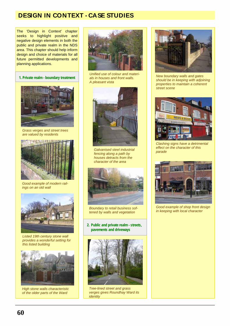
60
DESIGN IN CONTEXT - CASE STUDIES
The ‘Design in Context’ chapter seeks to highlight positive and negative design elements in both the public and private realm in the NDS area. This chapter should help inform design and choice of materials for all future permitted developments and planning applications.
Grass verges and street trees are valued by residents
Unified use of colour and materi-als in houses and front walls. A pleasant vista
Galvanised steel industrial fencing along a path by houses detracts from the character of the area
Boundary to retail business sof-tened by walls and vegetation
Tree-lined street and grass verges gives Roundhay Ward its identity
Good example of shop front design in keeping with local character
Clashing signs have a detrimental effect on the character of this parade
New boundary walls and gates should be in keeping with adjoining properties to maintain a coherent street scene
Listed 19th century stone wall provides a wonderful setting for this listed building
High stone walls characteristic of the older parts of the Ward
Good example of modern rail-ings on an old wall
2. Public and private realm - streets, pavements and driveways
1. Private realm - boundary treatment
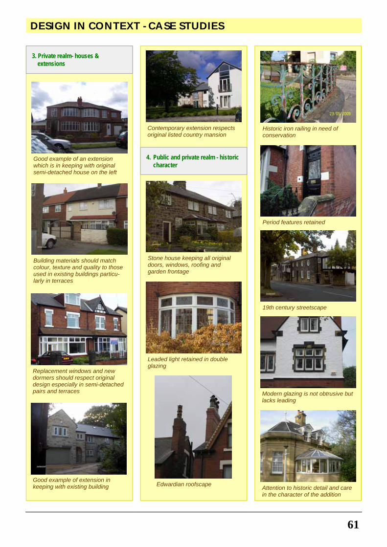
61
DESIGN IN CONTEXT - CASE STUDIES
19th century streetscape
Modern glazing is not obtrusive but lacks leading
Attention to historic detail and care in the character of the addition
Edwardian roofscape
Leaded light retained in double glazing
Stone house keeping all original doors, windows, roofing and garden frontage
Contemporary extension respects original listed country mansion
Good example of an extension which is in keeping with original semi-detached house on the left
Building materials should match colour, texture and quality to those used in existing buildings particu-larly in terraces
Replacement windows and new dormers should respect original design especially in semi-detached pairs and terraces
Good example of extension in keeping with existing building
Historic iron railing in need of conservation
Period features retained
3. Private realm- houses & extensions
4. Public and private realm - historic character
62
APPENDIX 1 - RELEVANT PLANNING AND RELATED POLICIES
local communities’ and set out design policies for the local area aimed at ‘creating places, streets, and spaces which … have their own distinctive identity and maintain and improve local character’ (paragraph 14).
The government is seeking ‘to create sustainable, inclusive, mixed communities in all areas’ (paragraph 9). Proposed developments should ‘contribute to the creation of mixed communities having regard to the proportions of households that require market or affordable housing and the existing m i x o f h o u s i n g i n t h e locality’ (paragraph 24).
In respect of development on garden land, there is no presumption that land that is previously developed is necessarily suitable for housing development nor that the whole of the curtilage should be developed (paragraph 41). Planning Policy Statement 4 - Planning for Sustainable Economic Growth (DCLG, 2009)
Promotes the vitality and viability of town and other centres as important places for local communities.
It also 'provides greater scope for the protection of local shops and retail diversity' and 'more emphasis on c o n s u m e r c h o i c e a n d competition'. Planning Policy Statement 5 - Planning for Historic Environments (DCLG, 2010)
Sets out the governments policies on the conservation of the historic environment and highlights the contribution of local listing to the development of the evidence base used to support local plan making.
"Local Planning Authorities should take into account the desirability of new development making a positive contribution to the character and local distinctiveness of the historic environment (paragraph HE7.5)."
Encourages the use of local lists which will strengthen the role of local heritage assets as a material consideration in deciding the outcome of planning decisions. It
The Roundhay NDS supplements the following national and local planning and related policies.
NATIONAL POLICIES
Planning Policy Statement 1 – Delivering Sustainable Development (DCLG, 2005)
Sets out the Government 's overarching planning policies on the delivery of sustainable development through the planning system.
‘Design which is inappropriate in its context, or which fails to take opportunities for improving the character and quality of an area and the way it functions, should not be accepted’ (paragraph 34).
‘Seek to promote or reinforce local distinctiveness particularly where th is is suppor ted by c lear development plan policies or s u p p l e m e n t a r y p l a n n i n g documents on design’ (paragraph 38). Planning Policy Guidance 2 - Green Belt (DCLG, 1995)
Outlines the history and extent of Green Belts and explains their purposes.
Describes how Green Belts are d e s i g n a t e d a n d t h e i r l a n d safeguarded.
Outlines Green Belt land-use objectives and sets out the presumption against inappropriate development.
Describes visual amenity factors and summarises policies regarding new building and re-use of old buildings. Planning Policy Statement 3 – Housing (DCLG, 2010)
Underpins the delivery of the Government’s strategic housing policy objectives and its goal to ensure that everyone has the opportunity to live in a decent home, which they can afford, in a community where they want to live. The policy was revised in June 2010 to give local authorities the power to prevent overdeve lopment o f neighbourhoods and 'garden grabbing'.
‘Local Planning Authorities should develop a shared vision with their
gives local authorities and their communities the confidence they need to introduce a local list in their area or make changes to an existing list, through the preparation of 'selection criteria'. Planning Policy Guidance 17 - Planning for Open Space, Sport and Recreation (DCLG, 2001)
Describes the role of the planning system in assessing opportunities and needs for sport and recreation provision and safeguarding open space which has recreational value.
Observes that it is part of the function of the planning system to ensure that, th rough the p repara t ion o f development plans, adequate land and water resources are allocated for organised sport and informal recreation.
Says that local planning authorities should take account of the community’s need for recreational space, having regard to current levels of provision and deficiencies and resisting pressures for development of open space which conflict with the wider public interest.
Discusses the role of all levels of plan, planning agreements, and the use of local authority land and compulsory purchase powers. Assessing Needs and Opportunities – A Companion Guide to PPG 17 (DCLG, 2001)
Reflects the Government's policy objectives for open space, sport and recreation. Manual for Streets (DCLG and DfT, 2007)
Local identity and distinctiveness are important design considerations and can be strengthened by using grain, patterns and form sympathetic to the predominant vernacular styles and by using local materials (paragraph 5.11).
Street furniture and l ight ing equipment should also be integrated into the overall appearance of a street (paragraph 10.1).
Planting should be integrated into street designs wherever possible, particularly street trees (paragraph
63
APPENDIX 1 - RELEVANT PLANNING AND RELATED POLICIES
about how to improve outcomes on shared priorities. The contents of the Strategic Plan are aligned with the Vision for Leeds (2004 to 2020) and can be seen as the delivery plan for the Vision for Leeds.
At the heart of the Leeds Strategic Plan is the ambition to transform the quality of life in Leeds to see:
• People happy, healthy, safe, successful and free from the effects of poverty;
• Young people equipped to contribute to their own and the city’s future well being and prosperity;
• Local people engaged in d e c i s i o n s a b o u t t h e i r neighbourhood and community and helping to shape local services;
• Neighbourhoods tha t a re inclusive, varied and vibrant offering housing options and quality facilities and free from harassment and crime;
• An environment that is clean, green, attractive and above all, sustainable;
• A city-region that is prosperous, innovat ive and dist inct ive, e n a b l i n g i n d i v i d u a l s a n d businesses to achieve their economic potential.
Leeds Unitary Development Plan (UDP) Review (Leeds City Council, 2006)
Strategic Aim
SA1 – to secure the highest possible quality of the environment throughout the District, by protecting existing good environment, conserving and enhancing where there is scope for improvement, including initiating the renewal and restoration of areas of poor environment. Buildings
N13 – The design of all new buildings should be of high quality and have regard to the character and appearance of the i r surroundings. Good contemporary design which is sympathetic or complementary to its setting will be welcomed.
N14 – There will be a presumption in favour of the preservation of Listed
11.3). Streets for All: Yorkshire & Humber (English Heritage, 2005)
The underlying principles are to reduce clutter, co-ordinate design and to reinforce local character whilst maintaining safety for all. Planning for Town Centres (Guidance on Design & Implementation) (ODPM, 2005)
Deals specifically with design issues relating to planning for town centres and some of the main tools available to secure the implementation of town centre planning policies and proposals.
LOCAL POLICIES
The Community Strategy for Leeds - Vision for Leeds 2004 to 2020 (Leeds City Council, 2004)
The Vision for Leeds has the following main aims:
• ‘Going up a league as a city’ making Leeds an internationally competitive city and the best place in the country to live, work and learn, with a high quality of life for everyone.
• ‘Narrowing the gap’ between the most disadvantaged people and communities and the rest of the city.
• ‘Developing Leeds’ role as the regional capital’, contributing to the national economy as a competit ive European city, supporting and supported by a reg ion tha t i s becoming increasingly prosperous.
The Leeds Strategic Plan 2008 to 2011 (Leeds City Council, 2008)
Sets out the strategic outcomes and priorities for improvement, which have been agreed fol lowing ex tens i ve consu l ta t ion w i th councillors, stakeholder groups and the public across the city. The Leeds Strategic Plan is also the Local Area Agreement for Leeds, a formal agreement with central government
Buildings.
N16 – Extensions to Listed Buildings will be accepted only where they relate sensitively to the original buildings. In all aspects of their design, location, mass, and materials, they should be subservient to the original building.
N19 – All new buildings and extensions within or adjacent to Conservation Areas should preserve or enhance the character or appearance of the area by ensuring that:
• The siting and scale of the building is in harmony with the adjoining buildings and the area as a whole.
• Detailed design of the buildings, including the roofscape is such that the proportions of the parts relate to each other and to adjoining buildings.
• T h e ma t e r i a l s us e d a re appropriate to the area and sympathetic to adjoining buildings (where a local materials policy exists this should be complied with).
• Careful attention is given to the design and quality of boundary and landscape treatment.
N20 – Demolition or removal of other features which contribute to the character of the Conservation Area such as trees, boundary walls or railings will be resisted.
N25 – Boundaries of sites should be designed in a positive manner, using walls, hedges, or railings appropriate to the character of the area. All paving materials should accord with the character of adjacent buildings and surrounding areas.
BD2 – The design and siting of new buildings should complement and, where possible, enhance existing vistas, skylines and landmarks.
BD5 – All new buildings should be designed with consideration given to both their own amenity and that of their surroundings. This should include useable space, privacy and satisfactory penetration of daylight and sunlight.
BD6 – All alterations and extensions should respect the scale, form, detailing and materials of the original building.
64
APPENDIX 1 - RELEVANT PLANNING AND RELATED POLICIES
N24 – Where development proposals abut Green Corridors or other open land their assimilation into the landscape must be achieved.
N29 – Sites and monuments of archaeological importance will be preserved
N33 – Except in very special circumstances approval will only be given in the Leeds Green Belt for limited extension, alteration or replacement of existing dwellings.
N50 – Development will not be permitted which would seriously harm, either directly or indirectly, a Local Nature Area (LNA) or a Site of Ecological or Geological Interest (SEGI).
LD1v – Protect existing vegetation, including shrubs, hedges and trees. Sufficient space is to be allowed around buildings to enable existing trees to be retained.
R2 – Area based initiatives will be undertaken … in the following areas for action … Wyke Beck Valley. Traffic Management
T2 – New Development should normally be adequately served and provision made for highway network, public transport, cycling and walking
T4 – Pedestrianisation and traffic calming schemes in the town centres identified in policy S2.
T6 – Satisfactory access and provision for disabled people and other people with mobility problems will be required.
T7 – Development of new and improved cycle routes ... will be promoted.
T18 – Priority will be given to the defined Strategic Highway Network in the allocation of resources for investment in roads.
T20 (4) – Major Highway Schemes – includes A6120 Ring Road Strategy for the future development and management of the route.
T23 – Traffic management and traffic calming measures will be encouraged particularly alongside main radial roads and within residential areas.
T27 – In town centres identified in policy S2, the provision of off street
BC7 – Development wi th in Conservation Areas will normally be required to be traditional local materials. Shopping Centres
S2 – The vitality and viability of Town Centres will be maintained and enhanced.
S3 – Enhancement and maintenance of Town Centres … including environmental improvements.
S4 – In order to maintain and enhance the vitality and viability of ident i f ied shopping cent res , shopping frontage policies SF7and 8 will apply.
S8 – Vitality and viability of smaller neighbourhood shopping centres, local shopping parades and corner shops will be maintained.
BD7 – All new shop fronts should relate architecturally to the buildings in which they are inserted. Solid shutters permi t ted on ly in exceptional circumstances.
BD12 – Advertisement hoardings may be acceptable where they screen unsightly areas but elsewhere they will generally be discouraged. Greenspace and Trees
N1 – Development of land identified as Protected Greenspace will not be permitted for purposes other than outdoor recreation.
N1A – Development of land currently used as Allotment Gardens will not be permitted for purposes other than outdoor recreation.
N3 – Priority will be given to improving Greenspace Provision within the identified priority residential areas.
N6 – Development of Playing Pitches will not be permitted (subject to various caveats).
N8 – The strategic network of Urban Green Corridors links the main urban area with the countryside.
N23 – Incidental open space around new build development should be designed to provide a visually attractive setting for the development itself and, where appropriate, contribute to informal public recreation and nature conservation.
car parking will be encouraged.
West Yorkshire Local Transport Plan 2006-11
Under the Quality of Life heading, the LTP recognises that ‘the quality of p u b l i c s p a c e ( i n c l u d i n g streetscape) is, and will continue to be, an important design consideration in all transport projects’.
Effective asset management will improve the appearance of transport infrastructure (roads, bus shelters, streetl ights etc) and thereby contribute to the quality of public space. Leeds Core Strategy: Preferred Approach (Leeds City Council, 2009)
The emerging Core Strategy sets out the vision for the future of Leeds over the next two decades and provides broad policies to shape development. All other documents prepared as part o f t h e L o c a l D e v e l o p m e n t Framework, including this NDS, have to fit with the Core Strategy and c o n t a i n G u i d a n c e a n d Recommendations which support its strategic vision. The NDS has therefore been informed by the emerging Core Strategy at every stage. This following is emerging draft policy, and the wording and policy may change before the Core Strategy is adopted:
Policy G1: Strategic Green Infrastructure The Strategic Green Infrastructure for the Leeds District is defined on the Key Diagram. Within these areas the Council will safeguard and, in partnership with others, seek ways to enhance key corridors for wildlife and amenity [including Gledhow Valley and Wyke Beck Valley].
Policy G5: Woodland - The Council will, on its own initiative and through the development process, work towards increasing appropriate species of woodland cover in the District (from 6.45% to 7.5%) by 2026. This will include planting in both urban and rural areas and partnership with the Forestry Commission, Natural England and landowners, to help deliver this.
65
APPENDIX 1 - RELEVANT PLANNING AND RELATED POLICIES
• Design streets as spaces for people and design buildings to front onto streets
• Connect open space networks and reinforce existing features and trees
• Co-ordinate street furniture – seating, lighting, signage, bollards etc.
Leeds Street Design Guide (Leeds City Council SPD, 2009)
Conservation Areas (paragraph 4.6)
Traditional paving materials, where they still exist, contribute to the character of a Conservation Area. The re fo re , i n ca r r y ing ou t maintenance, or the provision of new streets, within these areas, it is necessary that traditional materials are used. These materials are likely to be made of stone, although alternative new materials such as tegula blocks, conservation kerbs and tarmac dressed with suitable local aggregate may also be acceptable.
Street furniture (paragraph 4.4.2)
Street furniture should also be of appropriate materials in keeping with the surrounding area.
REGULATIONS AND ORDERS
Planning (Listed Buildings and Conservation Areas) Act 1990
Under the Act, a Conservation Area and numerous Listed Buildings have been designated wi th in the Neighbourhood. Town & Country Planning (Use Classes) Order 1987, Amendment Orders 2005, 2006 & 2010.
Defines classes of usage of land or property; change from one use to another usually requires planning permission. Changes of use within Town and Local Centres within the Neighbourhood are restricted. The Amendment of 2010 introduces a new Use Class C4 for HMOs. Town & Country Planning (General Permitted Development) Order 1995, Amendment Orders 2008 & 2010
Identifies development which is normally permitted; but it also
Policy G5A: Tree Preservation Orders - Tree Preservation Orders, Planning Conditions and Legal Agreements, will be used, as appropriate, to ensure that existing trees are protected and the future management of woodland is supported, where appropriate, by the creation of Management Companies or the ownership transferred to the City Council (or a registered organisation), with an adequate commuted sum.
Policy G7: Access to ‘Natural’ / ‘Semi-Natural’ Spaces - The City Council will take Natural England’s ANGSt standards into account, in reviewing and developing standards for Greenspace, natural areas and woodland/Green Infrastructure targets, following conclusion of the PPG 17 Audit, the Council’s objective will be to maximise people’s access to natural and semi natural spaces in planning the future regeneration and growth of the District.
Policy SC2 : Hierarchy of Centres - In order to promote their vitality and viability, the following hierarchy of centres is to be maintained: 1 The City Centre, 2 Town Centres [including Oakwood], 3 Local Centres [ i n c l u d i n g S t r e e t L a n e ] , 4 Neighbourhood Shopping Parades (including Lidgett Lane Parade, Brackenwood Parade, Gledhow Parade, Easterly Road Parade).
Policy SC8: Design, Conservation and Landscape - All development will be expected to create excellent design that protects and enhances those elements which contribute to the distinct identity of the City and places within the District, including … the residential Victorian, Edwardian and inter-war Suburbs … and the unique historical development of their townscape and landscape. Neighbourhoods for Living (Leeds City Council SPG, 2003)
Design Principles:
• Identify local character and enhance positive aspects
• Respond to the context in terms of scale, massing and height.
• Connect new development into existing streets and footpaths and the historical network of spaces
provides for Article 4 Directions, withdrawing permitted development rights in designated areas. The Amendment 2008 is concerned notably with development within the curtilage of a dwelling house. Town & Country Planning (Trees) Regulations 1999, Amendment Regulations 2008
Under the regulat ions, Tree Preservation Orders protect a n u m b e r o f t r e e s i n t h e Ne ighbourhood, ou ts ide the Conservation Area. Town & Country Planning (Control of Advertisements) (England) Regulations 2007
Under Regulation 7, a Direction has withdrawn deemed consent for residential letting boards in a des ignated area wi th in the Neighbourhood. DfT Circular 01/2006 on Setting Local Speed Limits (DfT, 2006)
Provides guidance to authorities on the setting of local speed limits where local needs and considerations deem it desirable for drivers to adopt a speed which is different from the national speed limit. DfT Circular 02/2003 The Traffic Signs Regulations and General Directions (TSRGD, 2002)
prescribe the designs and conditions of use for traffic signs to be lawfully placed on or near roads in England, Scotland and Wales. Highways Act 1980 Section 140
The Highways Authority may grant a license to a member of the public allowing them to plant and maintain vegetation near the highway.
66
APPENDIX 2 POLICY CONTEXT FOR RECOMMENDATION FOR ENHANCEMENT OF SPECIFIC CHARACTER AREAS
BC7. 2. In accordance with PPG2 (2001)
and Leeds UDP (2006) Policies N19, N20 and N33.
CA3 Oakwood East Character Area (for actual recommendations see page 27)
1. In accordance with Leeds UDP (2006) Policy N13 and Neighbourhoods for Living SPG (2003) Principle 45.
2. In accordance with Manual for Streets (DCLG and DoT, 2007), West Yorkshire LTP 2006-11 and Neighbourhoods for Living SPG (2003) Principles 34, 52 and 66.
3. In accordance with West Yorkshire LTP 2006-11 and Neighbourhoods for Living SPG (2003) Principles 13, 42 and 65.
4. In accordance with Leeds UDP (2006) Policy N25, West Yorkshire LTP 2006-11 and Neighbourhoods for Living SPG (2003) Principle 37.
5. In accordance with Leeds UDP (2006) Policy T7, Manual for Streets (DCLG and DoT, 2007) and Neighbourhoods for Living SPG (2003) Principle 13.
CA4 Wetherby Road and Park Avenue Character Area (for actual recommendations see page 29)
1. In accordance with Leeds UDP (2006) Policies N13, N25, BD2, BD5 and BD6 and Neighbourhoods for Living SPG (2003) Principle 84.
2. In accordance with Leeds UDP (2006) Policy N25.
3. In accordance with DfT Circular 01/2006 on Setting Local Speed Limits, West Yorkshire LTP 2006-11 and Neighbourhoods for Living SPG (2003) Principle 34.
CA5 Gipton Wood Character Area (for actual recommendations see page 31)
1. In accordance with West Yorkshire LTP 2006-11 and Neighbourhoods for Living SPG (2003) Principles 13, 42 and 65.
2. In accordance with Leeds UDP (2006) Policy N25 and Neighbourhoods for Living SPG (2003) Principles 37 and 104.
3. In accordance with Manual for
The residents’ 'Recommendations for Enhancement' in the Character Area chapters followed extensive community consultation and have all been the subject of consultation with Leeds City Council. At the time of writing, the Council had made no specific commitments to their implementation. Here the recommendations, in line with good practice, have been cross referenced to relevant national and local planning policies and Supplementary Planning Guidances (SPGs) / Supplementary Planning Documents (SPDs), but they do not have the same status as the 'Guidance for Design' chapter. However, this chapter should be taken into account as material consideration in the determination of planning applications and the preparation of development plans. Implementation of the recommendations will require partnerships between the community and various Council service areas (such as Highways, Parks & Countryside, and so on). Recommendations for enhancement will also assist in justifying any future bids for funding. CA1 Roundhay Park Character Area (for actual recommendations see page 23)
1. In accordance with DfT Circular 01/2006 on Setting Local Speed Limits, West Yorkshire LTP 2006-11 and Neighbourhoods for Living SPG (2003) Principle 34.
2. In accordance with Neighbourhoods for Living SPG (2003) Principles 73 and 93.
3. In accordance with Leeds UDP (2006) Policies N19 and BC7.
4. In accordance with Leeds UDP (2006) Policies N20 and LD1v.
5. In accordance with Leeds UDP (2006) Policies N14 and N19.
6. In accordance with Leeds UDP (2006) Policy N19.
7. In accordance with Leeds UDP (2006) Policies N16, N19, N20 and BC7 and Neighbourhoods for Living SPG (2003) Principle 57.
CA2 East of the Park Character Area (for actual recommendations see page 25)
1. In accordance with Leeds UDP (2006) Policies N25, N20 and
Streets (DCLG and DoT, 2007), West Yorkshire LTP 2006-11 and Neighbourhoods for Living SPG (2003) Principles 34, 52 and 66.
4. In accordance with Neighbourhoods for Living SPG (2003) Principles 73, 74 and 76.
5. In accordance with Leeds UDP (2006) Policy N25, West Yorkshire LTP 2006-11 and Neighbourhoods for Living SPG (2003) Principle 37.
6. In accordance with Neighbourhoods for Living SPG (2003) Principles 57 and 61.
7. In accordance with Neighbourhoods for Living SPG (2003) Principles 49, 50 and 65.
8. In accordance with Neighbourhoods for Living SPG (2003) Principles 73, 74 and 76.
9. In accordance with Neighbourhoods for Living SPG (2003) Principle 77.
10. In accordance with the Leeds UDP (2006) Policy N25.
CA6 Oakwood West Character Area (for actual recommendations see page 33)
1. In accordance with Leeds UDP (2006) Policies N19, N20 and BC7.
2. In accordance with Leeds UDP (2006) Policies N13, N25, BD2, BD5, and BD6.
3. In accordance with Leeds UDP (2006) Policy N25.
4. In accordance with Leeds UDP (2006) Policy N25 and Neighbourhoods for Living SPG (2003) Principles 49, 50 and 65.
5. In accordance with Neighbourhoods for Living SPG (2003) Principles 57 and 61.
CA7 Gledhow Character Area (for actual recommendations see page 35)
1. In accordance with Neighbourhoods for Living SPG (2003) Principle 57.
2. In accordance with Leeds UDP (2006) Policies N25, N13, BD2, BD5 and BD6.
3. In accordance with Neighbourhoods for Living SPG (2003) Principle 57.
4. In accordance with PPS4 and Neighbourhoods for Living SPG (2003) Principles 73, 74 and 76.
67
APPENDIX 2 POLICY CONTEXT FOR RECOMMENDATION FOR ENHANCEMENT OF SPECIFIC CHARACTER AREAS
(2006) Policies N13, BD2, BD5 and BD6 and Neighbourhoods for Living SPG (2003) Principle 60.
4. In accordance with PPS5 (2010) and Leeds UDP (2006) Policies N13, N14 and BD2.
5. In accordance with Neighbourhoods for Living SPG (2003) Principles 57, 65 and 71, PPG17 (2002), Assessing Needs and Opportunities – A Companion Guide to PPG 17 (2001) and Leeds UDP (2006) Policy N6.
6. In accordance with Manual for Streets (DCLG and DoT, 2007) paragraph 11.3, West Yorkshire LTP 2006-11 and Neighbourhoods for Living SPF (2003).
7. In accordance with Leeds UDP (2006) Policy T7 and Neighbourhoods for Living SPG (2003) Principle 13.
8. In accordance with West Yorkshire LTP 2006-11 and Neighbourhoods for Living SPG (2003) Principles 32 and 92.
CA10 Roundhay: North of Street Lane Character Area (for actual recommendations see page 43)
1. In accordance with Neighbourhoods for Living SPG (2003) Principles 73, 74 and 76.
2. In accordance with Leeds UDP (2006) Policy N25 and Neighbourhoods for Living SPG (2003) Principles 37 and 104.
3. In accordance with Manual for Streets (DCLG and DoT, 2007), West Yorkshire LTP 2006-11 and Neighbourhoods for Living SPG (2003) Principles 34, 52 and 66.
4. In accordance with Neighbourhoods for Living SPG (2003) Principles 57 and 61.
5. In accordance with Leeds UDP (2006) Policy BD6.
6. In accordance with Neighbourhoods for Living SPG (2003) Principle 104.
7. In accordance with Neighbourhoods for Living SPG (2003) Principle 104.
8. In accordance with Manual for Streets (DCLG and DoT, 2007) and Neighbourhoods for Living SPG (2003) Principles 37 and 104.
9. In accordance with
5. In accordance with PPS4, Leeds UDP (2006) Policy BD7 and Neighbourhoods for Living SPG (2003) Principles 73, 74 and 76.
6. In accordance with Leeds UDP (2006) Policies N13, N25, BD2 and BD5.
7. In accordance with West Yorkshire LTP 2006-11 and Leeds UDP (2006) Policy T2.
8. In accordance with DfT Circular 01/2006 on Setting Local Speed Limits, West Yorkshire LTP 2006-11 and Neighbourhoods for Living SPG (2003) Principle 34.
CA8 Brackenwood Character Area (for actual recommendations see page 37)
1. In accordance with PPS4, Leeds UDP (2006) Policy BD7.
2. In accordance with PPS4 and ODPM (2005) Planning for Town Centres (Guidance on Design & Implementation).
3. In accordance with Manual for Streets (DCLG and DoT, 2007) and Neighbourhoods for Living SPG (2003) Principles 26, 55, 57 and 58.
4. In accordance with Leeds UDP (2006) Policies N13 and BD6.
5. In accordance with Leeds UDP (2006) Policy T23, Manual for Streets (DCLG and DoT, 2007) and West Yorkshire LTP 2006-11.
6. In accordance with Neighbourhoods for Living SPG (2003) Principles 73, 74 and 76.
7. In accordance with Neighbourhoods for Living SPG (2003) Principle 104.
8. In accordance with Leeds UDP (2006) Policies T7 and T23, Manual for Streets (DCLG and DoT, 2007) and West Yorkshire LTP 2006-11.
CA9 Roundhay: Park Villas and Lidgett Park Character Area (for actual recommendations see page 39)
1. Through an Article 4 Direction. 2. In accordance with Manual for
Streets (DCLG and DoT, 2007) paragraph 10.1, Leeds Streets Design Guide (SPD) paragraph 4.6, and Neighbourhoods for Living SPG (2003) Principle 42.
3. In accordance with Leeds UDP
Neighbourhoods of Living SPG (2003) Principles 69, 70 and 71.
CA11 Oakwood Town Centre Character Area (for actual recommendations see page 45)
1. In accordance with PPS4 (2010), Leeds UDP (2006) Policies S2, S3 and BD7.
2. In accordance with Leeds UDP (2006) Policy BD7.
3. In accordance with Leeds UDP (2006) Policies S2 and S3 and Neighbourhoods for Living SPG (2003) Principle 79.
4. In accordance with Manual for Streets (DCLG and DoT, 2007) and West Yorkshire LTP 2006-11.
5. In accordance with Manual for Streets (DCLG and DoT, 2007) paragraph 11.3 and West Yorkshire LTP 2006-11.
6. In accordance with PPS4 (2010), Leeds UDP (2006) Policies S2, S3 and T6, Neighbourhoods for Living (2003) Principle 29 and Leeds Street Design Guide SPD (2009).
CA12 Street Lane Shopping Centre Character Area (for actual recommendations see page 47)
1. In accordance with PPS4 (2010) and Leeds UDP (2006) Policies S2, S3 and BD7.
2. In accordance with PPS4 (2010), Leeds UDP (2006) Policies S2, S3 and T6, Neighbourhoods for Living SPG (2003) Principle 29 and Leeds Street Design Guide SPD (2009).
3. In accordance with Neighbourhoods for Living SPG (2003) Principle 55 and Leeds Street Design Guide SPD (2009).
4. In accordance with Leeds UDP (2006) Policy T7 and T23, Manual for Streets (DCLG and DoT, 2007) and West Yorkshire LTP 2006-11.
5. In accordance with PPS4 and Neighbourhoods for Living SPG (2003) Principles 73, 74 and 76.
6. In accordance with PPS4 (2010), Leeds UDP (2006) Policies S2, S3 and T6, Neighbourhoods for Living SPG (2003) Principle 29 and Leeds Street Design Guide SPD (2009).
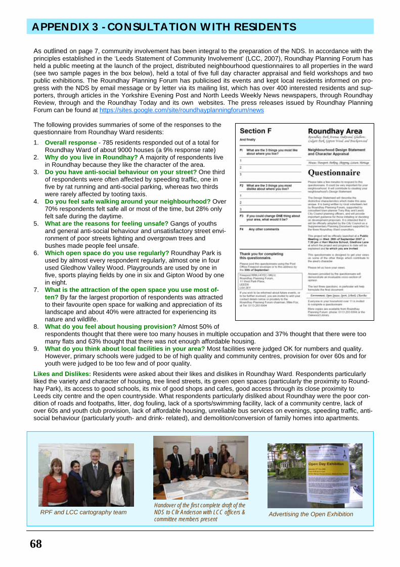
68
APPENDIX 3 - CONSULTATION WITH RESIDENTS
As outlined on page 7, community involvement has been integral to the preparation of the NDS. In accordance with the principles established in the ‘Leeds Statement of Community Involvement’ (LCC, 2007), Roundhay Planning Forum has held a public meeting at the launch of the project, distributed neighbourhood questionnaires to all properties in the ward (see two sample pages in the box below), held a total of five full day character appraisal and field workshops and two public exhibitions. The Roundhay Planning Forum has publicised its events and kept local residents informed on pro-gress with the NDS by email message or by letter via its mailing list, which has over 400 interested residents and sup-porters, through articles in the Yorkshire Evening Post and North Leeds Weekly News newspapers, through Roundhay Review, through and the Roundhay Today and its own websites. The press releases issued by Roundhay Planning Forum can be found at https://sites.google.com/site/roundhayplanningforum/news The following provides summaries of some of the responses to the questionnaire from Roundhay Ward residents:
1. Overall response - 785 residents responded out of a total for Roundhay Ward of about 9000 houses (a 9% response rate)
2. Why do you live in Roundhay? A majority of respondents live in Roundhay because they like the character of the area.
3. Do you have anti-social behaviour on your street? One third of respondents were often affected by speeding traffic, one in five by rat running and anti-social parking, whereas two thirds were rarely affected by tooting taxis.
4. Do you feel safe walking around your neighbourhood? Over 70% respondents felt safe all or most of the time, but 28% only felt safe during the daytime.
5. What are the reasons for feeling unsafe? Gangs of youths and general anti-social behaviour and unsatisfactory street envi-ronment of poor streets lighting and overgrown trees and bushes made people feel unsafe.
6. Which open space do you use regularly? Roundhay Park is used by almost every respondent regularly, almost one in four used Gledhow Valley Wood. Playgrounds are used by one in five, sports playing fields by one in six and Gipton Wood by one in eight.
7. What is the attraction of the open space you use most of-ten? By far the largest proportion of respondents was attracted to their favourite open space for walking and appreciation of its landscape and about 40% were attracted for experiencing its nature and wildlife.
8. What do you feel about housing provision? Almost 50% of respondents thought that there were too many houses in multiple occupation and 37% thought that there were too many flats and 63% thought that there was not enough affordable housing.
9. What do you think about local facilities in your area? Most facilities were judged OK for numbers and quality. However, primary schools were judged to be of high quality and community centres, provision for over 60s and for youth were judged to be too few and of poor quality.
Likes and Dislikes: Residents were asked about their likes and dislikes in Roundhay Ward. Respondents particularly liked the variety and character of housing, tree lined streets, its green open spaces (particularly the proximity to Round-hay Park), its access to good schools, its mix of good shops and cafes, good access through its close proximity to Leeds city centre and the open countryside. What respondents particularly disliked about Roundhay were the poor con-dition of roads and footpaths, litter, dog fouling, lack of a sports/swimming facility, lack of a community centre, lack of over 60s and youth club provision, lack of affordable housing, unreliable bus services on evenings, speeding traffic, anti-social behaviour (particularly youth- and drink- related), and demolition/conversion of family homes into apartments.
Advertising the Open Exhibition Handover of the first complete draft of the NDS to Cllr Anderson with LCC officers & committee members present
RPF and LCC cartography team
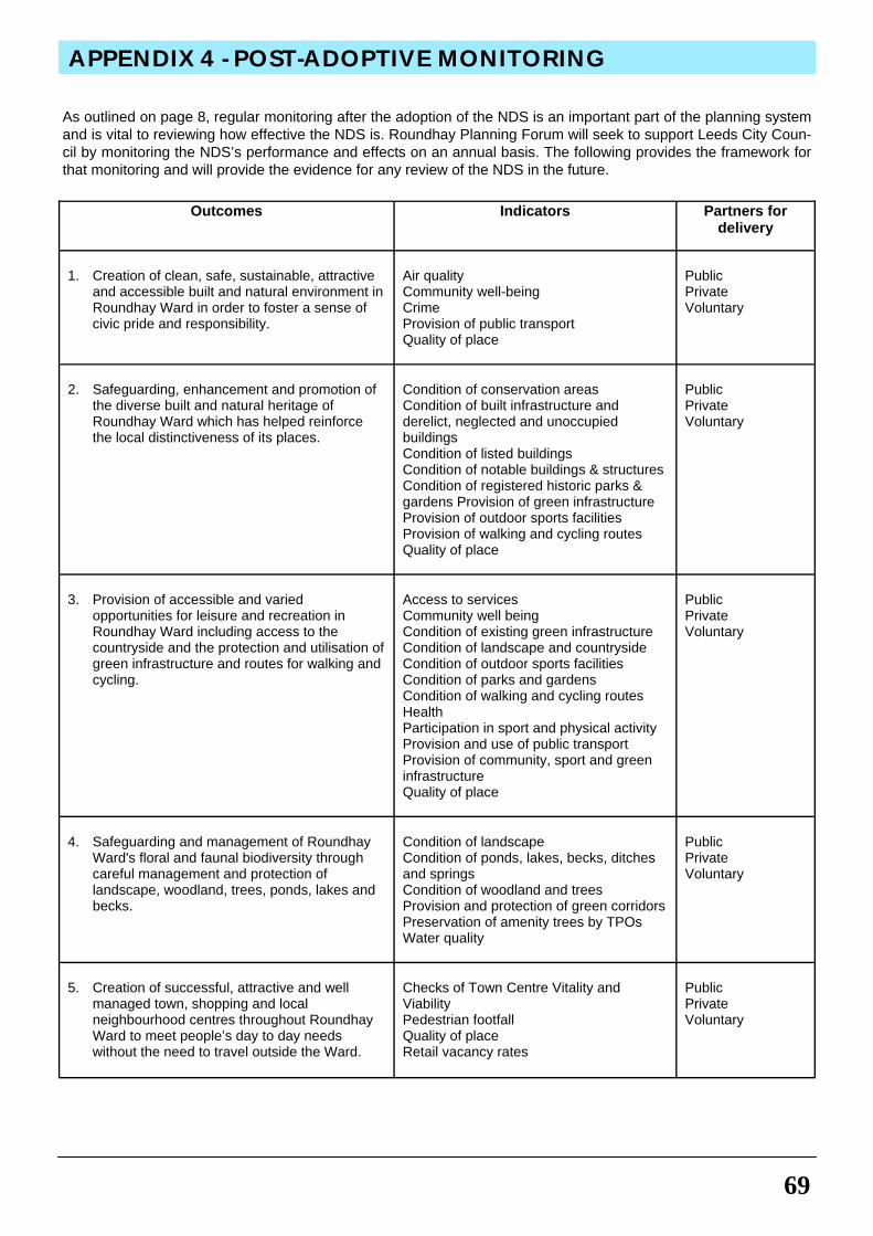
69
APPENDIX 4 - POST-ADOPTIVE MONITORING
As outlined on page 8, regular monitoring after the adoption of the NDS is an important part of the planning system and is vital to reviewing how effective the NDS is. Roundhay Planning Forum will seek to support Leeds City Coun-cil by monitoring the NDS’s performance and effects on an annual basis. The following provides the framework for that monitoring and will provide the evidence for any review of the NDS in the future.
Outcomes Indicators Partners for delivery
1. Creation of clean, safe, sustainable, attractive
and accessible built and natural environment in Roundhay Ward in order to foster a sense of civic pride and responsibility.
Air quality Community well-being Crime Provision of public transport Quality of place
Public Private Voluntary
2. Safeguarding, enhancement and promotion of
the diverse built and natural heritage of Roundhay Ward which has helped reinforce the local distinctiveness of its places.
Condition of conservation areas Condition of built infrastructure and derelict, neglected and unoccupied buildings Condition of listed buildings Condition of notable buildings & structures Condition of registered historic parks & gardens Provision of green infrastructure Provision of outdoor sports facilities Provision of walking and cycling routes Quality of place
Public Private Voluntary
3. Provision of accessible and varied
opportunities for leisure and recreation in Roundhay Ward including access to the countryside and the protection and utilisation of green infrastructure and routes for walking and cycling.
Access to services Community well being Condition of existing green infrastructure Condition of landscape and countryside Condition of outdoor sports facilities Condition of parks and gardens Condition of walking and cycling routes Health Participation in sport and physical activity Provision and use of public transport Provision of community, sport and green infrastructure Quality of place
Public Private Voluntary
4. Safeguarding and management of Roundhay
Ward's floral and faunal biodiversity through careful management and protection of landscape, woodland, trees, ponds, lakes and becks.
Condition of landscape Condition of ponds, lakes, becks, ditches and springs Condition of woodland and trees Provision and protection of green corridors Preservation of amenity trees by TPOs Water quality
Public Private Voluntary
5. Creation of successful, attractive and well
managed town, shopping and local neighbourhood centres throughout Roundhay Ward to meet people’s day to day needs without the need to travel outside the Ward.
Checks of Town Centre Vitality and Viability Pedestrian footfall Quality of place Retail vacancy rates
Public Private Voluntary
70
ACKNOWLEDGEMENTS
• Richard Shaw – lSenior Planning Officer – Leeds City Council
• Jenny Fisher - Principal Design Officer - Leeds City Council
• David Incoll - Photography and Archives
• Neville Hurworth - Local History • Martin Plimley – Access and
Mobility issues • Peter and Hillary Dyson –
History of Oakwood • N. Inayat, W. Murgatroyd, J.
Sohanpall, A. Wood, Cartographers, Leeds City Council
• Darren Maddison - Desk Top Publishing work, Leeds City Council
• Steve Burt – History of Roundhay Park
• Bill Urry - REAP Transport Group
Roundhay Planning Forum consists of:
• Mike Fox - Chairman • Lynton Incoll - Secretary • Betty Bertrand - Treasurer 2005
-2010 • Roger Williams - Treasurer 2010 • Bhupinder Dev • Christine Mather • Christine Osborne • Danielle Shaw The Forum thanks the following individuals and organisations in particular for their many and varied contributions:
• Tony Ray – Planning Consultant • North East (Inner) Area
Management Committee
• Peter Kelley and Friends of Gipton Wood (FoGW)
• Robert Reid and Friends of Roundhay Park (FoRP)
• Gledhow Valley Conservation Area Group (GVCAG)
• Roundhay Conservation Society (RCS)
• Roundhay Environmental Action Project (REAP)
• Roundhay Ward Councillors - V Kendall, M Lobley and P Wadsworth
• Fabian Hamilton MP • Roundhay residents who
attended workshops and drop in exhibitions
• Chairman - The Adel Association
• Chairman - Far Headingley Village Society
• Open Door, Brackenwood
1. S. Burt (2000) An Illustrated History of Roundhay Park. 48p. Steven Burt, Leeds 2. S. Burt and K. Grady (2002) The Illustrated History of Leeds. 2nd ed. 284p. Breedon Books, Derby. 3. N.R. Hurworth (2005) Thomas and Elizabeth Nicholson, the Quaker Founders of Roundhay Park. 29p. Neville
Hurworth, Leeds 4. Leeds Tithe Map Project: website http://tithemaps.leeds.gov.uk/ 5. Leodis: A Photographic Archive of Leeds: website http://www.leodis.net/ 6. D. Linstrum (1978) West Yorkshire: Architects and Architecture. 399p. Lund Humphries. 7. Listed Buildings of Leeds Metropolitan County. Gazetteer. Leeds Central Library. (Full descriptions) 8. Listed Buildings of Leeds Metropolitan County. WWW (World Wide Web) list only - no detail except name, ad-
dress and unique number. http://tinyurl.com/3xbp3cx 9. Oak Leaves Parts 2 to 9 (2001-2009) Oakwood and District Historical Society 10. B. Thompson (1971) Portrait of Leeds. 191p. Robert Hale, London 11. S. Wrathmell with J. Minns and contributions from J. Douglas … et al. (2005) Leeds. Pevsner Architectural
Guides. 326p. Yale, New Haven. 12. For data on schools and churches of Roundhay see web pages and telephone directories.
Statement of Purpose
The Ordnance Survey mapping included within this document is provided by Leeds Council under licence from the Ordnance Survey in order to fulfil its public function to make available Council held public domain information. Per-sons viewing this mapping should contact Ordnance Survey copyright for advice where they wish to licence Ord-nance Survey mapping/map data for their own use. The OS web site can be found at Ordnance Survey (link opens in new window). Statement of Copyright
OS data © Crown Copyright. All rights reserved. Leeds City Council LA 100019567. 2010
STATEMENT OF PURPOSE AND COPYRIGHT
BIBLIOGRAPHY

CONTACT DETAILS
Write to: LDF Team
Forward Planning & Implementation City Development Leeds City Council 2 Rossington Street
Leeds LS2 8HD
Tel: 0113 2478075
Email: