Embed Size (px)
Citation preview
Environment and Planning D: Society and Space 2013, volume 31, pages 000 – 000
doi:10.1068/d18112
Remapping the border: geospatial technologies and border activism
James WalshSocial Science and Policy Forum, University of Philadelphia, PA 191104, USA; e-mail: [email protected] 28 September 2012, in revised form 18 March 2013; published online 14 November 2013
Abstract. This paper analyzes the politics of mapping along the US–Mexico border to explore how humanitarian activists wield geospatial technologies in challenging border securitization. In addition to ‘bounding’ societies within delimited territorial zones, mapping technologies have recently been elevated to encompass observing, locating, and tracking mobile bodies—outcomes that, in the context of immigration control, have heightened the risk of clandestine border crossings and produced a sharp rise in migrant fatalities. As geospatial tools have been integrated into official gatekeeping strategies, activists have deployed them to protect migrants, promote mobility rights, and disrupt borders and the spatial, legal, and technical orders underpinning their materialization and enforcement. This case study considers the political implications of these interventions, and highlights how technologies traditionally aligned with state security and surveillance have been reappropriated in the service of transnational solidarity, recognition, and hospitality.
Keywords: immigration, borders, geosurveillance, cartography, social movements, United States
IntroductionIn designating the spatial coordinates of territorial sovereignty and political community, national borders are fundamentally products of cartographic knowledge. Their enforcement’s significance in the “production of space” (Harvey, 1989) is by now well documented. Reflecting the ‘spatial turn’ in the social sciences (Warf and Anias, 2009), numerous works have analyzed mapping’s role in bounding and producing national societies (Harley, 1988; Wood et al, 2010), as well as the persistence of boundary maintenance amidst intensified globalization. At present, emergent technologies have rendered borders visible or ‘legible’ (Scott, 1998) in new ways. Highlighting geospatial information technologies for tracking, sorting, and regulating movement, scholarship has documented escalations in gatekeeping and surveillance, and their role in spatializing the neoliberal state (Amoore et al, 2008).
While the nexus between cartography, surveillance, and border control has been widely considered, other trends remain unexplored. One issue deserving greater attention is the use of geospatial technologies by border activists. Drawing on literatures concerning ‘counter-mapping’ (Peluso, 1995), and the ambiguity and democratization of surveillance (Monahan, 2010), this paper studies how social movements have redeployed forms of spatial tracking and observation to assist migrants crossing through the dangerous terrain of the US–Mexico border. Taking Humane Borders and the Electronic Disturbance Theatre (EDT) as cases for analysis, it studies two of the more creative and interesting interventions: the placement of water and first aid in the desert, and creation of the Transborder Immigrant Tool (TBIT). Formed in response to the spike in migrant deaths following intensified enforcement, Humane Borders is committed to maintaining water and first aid stations throughout the
2 J Walsh
Sonora desert, and has utilized Geographic Information Systems (GIS) and other locational technologies to augment these practices. The TBIT is a device constructed by the EDT, an artist/activist collective at the University of California San Diego, to protect and empower undocumented migrants by directing them towards safety through the creation of customized maps of the desert environment.
Assessing both interventions uncovers how, beyond curbing fatalities and providing aid, techniques of mapping and spatial surveillance have been employed to challenge, destabilize, and subvert dominant spatial imaginaries. In place of the traditional territorial grid that divides, excludes, and selectively mobilizes bodies according to the conflictive exigencies of accumulation, sovereignty, and security (Sparke, 2006), both organizations promote radically democratic frameworks of mobility and association. In this alternative moral cartography the imperatives of restriction, gatekeeping, and control give way to those of care, hospitality, and forms of personhood that evade state-imposed legal categories and identities.
The remainder of this paper is divided as follows. First, I review the literature on cartography, surveillance, and borders. Extant work largely emphasizes mapping’s importance in the nation-state’s formation and consolidation, whether through attempts to systematically manage space, information, and populations, or through cultural constructions of national sentiments and identities. Additionally, I stress the significance of recent geospatial technologies. Second, an assessment of surveillance and policing strategies along the US–Mexico border is provided. Here I highlight their egregious human toll, and emphasize the role of geography and geospatial surveillance in deterring and disciplining unauthorized migrants. Third, departing from conceptualizations of mapping as a power-laden, despotic enterprise, I expand on existing studies of countermapping, and present an analytic framework for assessing the empowering and counterhegemonic possibilities of cartographic and mapping technologies. Before offering a brief summary and conclusion, in the final section I interrogate the technical and symbolic interventions of Humane Borders and the EDT. In addition to documenting their practical consequences, I interpret them as forms of transnational practice invested in fostering critical engagements with settled configurations of space, law, and technology. Here I also address the potential limitations of each intervention, and discuss their ethical implications and relations with undocumented migrants.
The power of maps: cartography, surveillance, and the quest for spatial orderThe world’s division into territorialized national societies is a recent, historically contingent outcome. The hegemony of these arrangements reflects the ascendance of a particular relationship to space, a relationship typified in and enacted through the modern map. Under the Westphalian order of territorial sovereignty and national citizenship, mapping, geographic knowledge, and the spatial ordering of human activities emerged as critical instruments and instantiations of political power.
For received scholarship, since its foundation in the 15th century, cartography has constituted a “science of princes” (Harley, 1988, page 281), fundamental to state administration and centralization. In addition to demarcating their territorial perimeters and sovereign domain, modern states have frequently employed mapping as a totalizing form of collective surveillance. In allowing space to be controlled and rationally planned in an abstract elevated fashion, maps have enabled the “mastery of territory” (Hannah, 2000), and figured prominently in facilitating, inter alia, accumulation and resource extraction, empire-building, militarization, and demographic maintenance (Edney, 1997). Like censuses, passports, and other instruments of measurement, supervision, and documentation, maps permit states to thoroughly ‘penetrate’ and ‘embrace’ societies (Torpey, 2000). However, mapping represents a superordinate tool of the “calculating surveillant state” (Crampton, 2011, page 73): cartographic rationality has provided the requisite knowledge, instruments,
Geospatial technologies and border activism 3
and observational fields to render other programmatic schemes from cadastral surveys to urban planning thinkable and practicable (Scott, 1998).
Moreover, by naturalizing spatial arrangements and nationalizing social relations, mapping has facilitated the nation-state’s accumulation of symbolic power (Bourdieu, 1991). Despite claims of mathematical certainty and scientific accuracy, mapping is inherently meaningful, and inseparable from sociopolitical power. As observed by Scott (1998, page 82), states “do not merely describe, observe and map; they strive to shape a people and a landscape that will fit their techniques of observation.” In reinforcing the apportionment of people and things to distinct places, territories, and legal zones, maps are ‘banal’ (Billig, 1995) artifacts of nationalism that “figure … [and] preform the shape of statehood” (Wood et al, 2010, page 31). Further, maps visualize several important dimensions of nationalist ideologies, whether sharp delineations between the nation and its exterior, or the partitioning of populations into territorialized, internally unified, and mutually exclusive collectivities. As visual ‘logos’ of nationhood (Anderson, 1991), they have frequently been mobilized as evidence of the eternal existence of their respective nations (Batuman, 2010), and have assisted in making national societies appear as facts of nature or substantial, enduring things such as rivers, oceans, and mountain ranges. Finally, while part of the ensemble of symbols, rituals, myths, and memories that facilitate national solidarity, mapping is central in acts of “forgetting” (Renan, 1996) that underpin modern nationalism. The rationalized grid of official maps conceals and omits subaltern understandings of the boundaries and nature of spatial relations, property regimes, the environment, and human communities (Hall, 1993).
Accordingly, cartographic techniques and technologies have figured prominently in “imagining” (Anderson, 1991) the integral, categorical identity of nations. However, the divisions, categories, and measurements embodied in maps, are not superimposed externally but reproduced and maintained through social interaction, official authority, and order enforcement (Blandy and Sibley, 2010). While numerous locales are implicated in the politico-legal production of space and scale, the significance of territorial borders can hardly be overestimated. Given that states are “constituted of spatialized social practices” (Painter, 1995, page 34), mapping and border regulation share equivalent, interlocking functions. Both reinforce the state’s conceptual boundaries as a unified homogenous actor, and reiterate critical dimensions of modern politics such as territoriality, nationality, and sovereignty. Finally, by producing distinctions between inside/outside, us/them, and self/other, both mapping and border enforcement create a world where political boundaries mark the official limits of human collectivities.
The preceding indicates that by ‘bounding’ social relations, enforcing sedentarization, and distinguishing between members and strangers, the policing of borders has helped solidify the spatial correlation between citizen, territory, homeland, and state conveyed through official maps. In transgressing this order, unauthorized mobility represents a challenge to the nation-state and an overarching source of disorder. Undocumented crossings of its perimeters unsettle the state’s control over the “placement of people” (Trouillot, 2001), a practice that presumes it natural that some people belong here and others there, and that uncontrolled migration is inherently threatening. Presently, the physical and institutional reality of borders has grown rather than diminished. While economic transnationalization has established a global labor market in which nomadic professionals and ‘flexible citizens’ (Ong, 1999) provide critical sources of skills and innovation, for unwanted migrants and asylum seekers from the global South, intensified immobilization, closure, and surveillance have ensured border crossings often entail unspeakable trauma and suffering. Accordingly, border control is less about prohibiting mobility than categorizing, filtering, and separating
4 J Walsh
‘safe’ from ‘risky’ travellers (Shamir, 2005). Despite their selective permeability, borders remain decisive in the spatialization of states and social order.
Before proceeding it should be mentioned that mapping’s history has been defined by continual improvements in capacities of spatial surveillance and representation. Recent advances in digital and electronic technology have facilitated the latest revolution and enabled maps to become infinitely more pervasive and fine-grained in their manipulation and visualization of spatial data (Klinkenberg, 2007). For several scholars, new technologies, whether Global Positioning Systems (GPS), GIS, remote sensing and satellite imagery, or location-based systems, have: enhanced the gaze of powerholders; enabled states and other powerful institutions to extend their activities across new territories; and allowed mapmaking to be integrated into a massive apparatus of surveillance and social control (Amoore et al, 2008). By extending capacities to monitor and discipline populations as well as track and profile individuals, geosurveillance technologies have produced new modalities of seeing and acting. With their capacity to monitor data in real time, and store them indefinitely, they have transformed the map’s cross-sectional view into a multidimensional, interactive, and diachronic system of spatial information (Crampton, 2011; Lyon, 2007). For Hall (1993, page 8) incipient technologies involve “nothing less than the reinvention of ... geography”. Below I expand upon the implications of recent innovations in efforts to identify, track, and intercept ‘illegal’ migrants along the US–Mexico border.
Border surveillance and migrant deathsDespite the United States’ self-definition as a ‘nation of immigrants’, by the 1990s a popular turn against immigration was readily perceptible. Economic stagnation, pervasive feelings of social insecurity, and heightened racism and xenophobia made migrants—especially those deemed ‘illegal’—into scapegoats for several societal ills (Chavez, 2008). To mollify public intransigence, political officials recalibrated border policing and surveillance. In 1993 Sandia National Labs, a military research facility commissioned to assess enforcement efforts, recommended a new anticipatory strategy of ‘prevention through deterrence’. Formally developed with the launch of Operation Blockade and Gatekeeper in 1993 and 1994, these efforts hinged on the surveillance and mobilization of geographic space, whether the deployment of advanced technologies or perceived deterrent power of the Southwestern landscape. State officials invested several billion dollars in new surveillance equipment, including night-vision goggles, seismic sensors, low-light CCTVs, and hi-tech aircraft for nocturnal detection, to monitor highly trafficked urban corridors (Inda, 2006). According to official reports, enhanced “technological resources” would catapult “the Border Patrol into the 21st century” (Sandia National Laboratories, 1993), and allow it to “effectively apprehend and ... track ... illegal entrants” (Ackleson, 2005, page 172). Second, the physical environment was mobilized as a tool of enforcement. Believing crackdowns in populated areas would reroute arrivals into “hostile terrain, less suited for crossing and more suited for enforcement” (USBP, 1994, page 7), and that natural barriers, whether rivers, mountains, or vast tracts of the Sonora Desert, would amplify the difficulty of crossing and deter future transgressions, former US Immigration and Naturalization Service director Doris Meissner claimed if urban areas could be effectively controlled “geography would do the rest” (Doty, 2011, page 608).(1)
Ultimately, the government’s calculus proved incorrect, and illicit entries showed no sign of abatement. Border policies would, however, succeed in displacing migrants into the harsh terrain of Southern Arizona, outcomes that produced a noticeable spike in deaths from (1) These arrangements have functioned to deflect official responsibility and absolve the government of moral culpability for growing fatalities. Instead migrant deaths are treated as “unintended consequences” derived from environmental causes, rather than official gatekeeping strategies (Doty, 2011).
Geospatial technologies and border activism 5
dehydration and exposure. Since 1994 over 5000 migrants have died in transit, a conservative estimate given that the vast desert landscape likely holds hundreds, if not thousands, more (Doty, 2011).
When combined with greater executive discretion, expanded deportations, and restrictions on social provision, border enforcement represents an important dimension in the “severity revolution” in US immigration control (Simon, 2001). Migrants able to evade the gaze of gatekeepers will join the ranks of a uniquely pliant workforce that is legally and socially nonexistent and continuously vulnerable to arrest and expulsion (Harrison and Lloyd, 2011). If they perish they provide testaments to the ugly paradox of border control and security: the insecurity of the other is justified as necessary to support, protect, and foster the life of the citizen–body. Given these outcomes, ‘prevention through deterrence’ has constituted the desert as an exceptional “zone of indistinction” in which undocumented entrants are rendered exposed and expendable “bare life” (Agamben, 1998). Consequently, America’s southern border represents a “topography of cruelty” (Balibar, 2001) in which migrants’ lives are treated as collateral damage in aggressive securitization strategies. In language that is characteristic of this atmosphere of violence, fear, and exclusion, activists, scholars, and government officials alike have labeled the borderlands “occupied territory” (No More Deaths, 2008), “the corridor of death” (Customs and Border Protection Today, 2003), and a space of “abjection” (Inda, 2006).
Under the new politics of insecurity generated following 11 September 2001, border enforcement has been fused with the War on Terror outcomes producing a significant reterritorialization of sociopolitical life. In its efforts to secure the homeland, the government has sought to develop “next-generation detection technolog[ies]” as ‘force multipliers’ for tracking unauthorized movements (Koslowski, 2011, page 9). Alongside biometric databases and automated passenger screening devices employed to identify risky travellers at designated entryways (Sparke, 2006), with the passage of the Secure Fence Act and Secure Border Initiative in 2006 the government began constructing a ‘virtual fence’ along the country’s territorial perimeters. Central in these efforts was the deployment and integration of geospatial and locational technologies, whether remote sensors, satellite imagery, GPS devices, unmanned aerial drones, or advanced radar systems, to establish a ‘geography of locatability’ (Amoore, 2009, page 51), an invisible, ubiquitous system of surveillance and tracking. GIS has also been employed to guide the Border Patrol’s tactical interventions. Spatial analysis of apprehensions data has been utilized to identify popular crossing routes, develop “a more complex picture of smuggling and other activities along the border” (ESRI, 2001), and allocate agents accordingly. Additionally, GIS has been employed in conjunction with Intelligent Computer-Aided Dispatch systems, which monitor data from remote sensors and transmit real-time intelligence to agents in the field (Veal, 2003). Here the integration of sensor and topographic data has been approached as a form of ‘geo-profiling’ (Crampton, 2011), which estimates the probable coordinates of future movements, and increases the likelihood of interception.
Geosurveillance has reconstituted territorial borders as dynamic ecosystems of spatial data and technical landscapes of control. Border policing has been transformed from a direct ocular enterprise ruled by copresent ‘linewatching’, to one governed by indirect and electronically mediated forms of ‘dataveillance’. Ultimately, the border’s technologization has failed to curb clandestine crossings and continues to push migrants further away from populated areas, ensuring that crossings occur through increasingly treacherous terrain for longer periods of time. These outcomes have further amplified the risk of death in transit, which more than doubled between 2004 and 2009 (Cook, 2011). Below I elaborate the significance of new innovations by outlining their connection to a broader double movement
6 J Walsh
in which technological developments have been horizontally dispersed, and appropriated by counterhegemonic movements.
Countermapping and the democratization of cartographyMapping’s importance in enforcing borders, governing mobilities, and spatializing states has been thoroughly scrutinized. What has not been adequately addressed are countervailing trends concerning the ambiguity of geospatial technologies and their appropriation to destabilize territorial borders and the divisions, enmity, and inequalities their enforcement produces.
Taken as elite-based forms of sociopolitical engineering, cartography and map-making were initially approached as “language[s] of power ... controlled by dominant groups” (Harley, 1988, pages 301–303). Employing this dystopian perspective, scholars frequently approach new geospatial technologies as objects to be feared, and several have linked them to the imperatives of the present ‘safety and security state’ (Lyon, 2007), whether hierarchical surveillance, the erosion of privacy, risk management, enhanced social control, or warfare and espionage (Crampton, 2011; Gray, 2003; Pickles, 1991). Although they have yet to completely jettison such outlooks, scholars have retreated from totalizing accounts of disempowerment, and noted that geospatial technologies are flexible and contain multiple, heterogeneous possibilities. Specifically, it is held that technological changes have democratized capacities of spatial observation, visualization, and analysis. Unlike old cartographic technologies which were “totally controlled by … map-making powers” (Hodgson and Schroeder, 2002, page 81), with the mass production and dissemination of cartographic tools (such as GPS devices, GIS, and Google Earth) that are more accurate, less expensive, and widely accessible, anyone with the necessary purchasing power and technological literacy can monitor and track spatial processes and phenomena. Consequently, the hierarchical relationship between producers and consumers of maps has been gradually leveled, and people can exert sovereignty over the mapping process, and re-present the world in popular and alternative ways.
Scholars have documented how civil-society actors, social movements, and other interested parties have cultivated practices of ‘counter-mapping’ to empower marginalized populations and emancipate cartography from the clutches of state experts and technicians (Kwan and Schwanen, 2009; Peluso, 1995; Sparke, 1998; Wood et al, 2010). Extant work has predominantly applied the term to the efforts of indigenous populations to protect their sovereignty and environmental resources by contesting dominant representations of their native lands (Peluso, 1995; Wainwright and Bryan, 2009). Here spatial information technology has figured prominently in challenging inequitable access to and control over resources, while empowering indigenous populations to defend their customary land rights against corporate and state encroachments.
While the concept has done much to challenge entrenched understandings, much work remains to be done. First, countermapping’s relationship to border enforcement remains opaque. Given the significance of border enforcement as a critical axis of global inequality and lynchpin of established spatial imaginaries, this neglect is surprising. Additionally, while scholarship has documented how geosurveillance can reveal, pinpoint, and address inequality, little attention has been devoted to its use in challenging boundaries, territoriality, and the allocation of people to sharply delimited spatial zones. For existing conceptualizations countermapping remains a ‘territorialized strategy’ (Peluso, 1995, page 384) in which customary claims to lands and resources are translated into the spatial repertoires of the state. Under such strategies the demarcation and control of boundaries, albeit of a subterranean, nonofficial variety, is embraced as a source of protection, sovereignty, and security. Consequently, countermapping’s ultimate goal is to identify patterns of inequality within existing spatial schemas, arrangements that have led many to question its overreliance on
Geospatial technologies and border activism 7
spatial fixity and bounded notions of community (Hodgson and Schroeder, 2002). The remaining sections address practices of countermapping employed along the US–Mexico border. Like struggles documented in the existing literature, they are aimed at empowering disadvantaged groups and challenging official representations. However, they differ drastically as their actions are explicitly directed towards thinking and acting beyond territorial borders.
Mapping for justice: geospatial technologies and border activistsHumanitarian interventions in the Southwest emerged against the backdrop of intensified border enforcement. Viewing government policy as immoral, disproportionate, and complicit in the deaths of unauthorized entrants, several organizations devised interventions to ameliorate migrant suffering, and contest border enforcement’s human consequences. Below I assess the activities of Humane Borders and EDT. While several civil society groups are invested in publicizing the abuse of migrants and refugees (Bloemraad et al, 2011), the following interventions are distinct in the degree to which they directly intervene in the processes of border crossing, as well as their use of geospatial tools to achieve these ends. In discussing them I focus on their technical and symbolic dimensions.
Technical interventionsThe first example is Humane Borders, a faith-based organization in Tucson Arizona. It was founded in 2000 when several religious congregations and human rights groups led by the Reverend Robin Hoover gathered to devise a compassionate response to border-crossing deaths and injuries. Their initial decision was to leave water and first-aid kits along popular migrant pathways. Over time these efforts were augmented by the use of spatial information technologies. Forms of geosurveillance are now central to three of the group’s practices: the installation and maintenance of water tanks; the creation of warning posters; and the distribution of GPS devices that transmit distress signals to emergency responders.
After securing rights of entry and permits from local, state, and federal authorities, in early 2001 Humane Borders constructed its first water station, and, with the help of over 15 000 volunteers, currently maintains over 100 stations throughout Northern Mexico and the Southwestern US. Each consists of one to three sixty-gallon tanks and a blue flag mounted on a thirty-foot steel pole. Many are stocked with clothing, food, and first-aid kits (Humane Borders, 2005). To maintain its ability to place water on public land the organization has pledged to provide only immediate aid, and contact the Border Patrol when injured migrants require medical evacuation. Moreover, while several political figures have labeled the organization as aiding and abetting unauthorized entry, Humane Borders’ relationship with the Border Patrol is less adversarial. Through a series of consultations the latter has promised not to patrol near water stations so long as Humane Borders operates within the confines of the law (Menjivar, 2007, page 114).
As more stations were constructed, Humane Borders began producing annual maps depicting all migrant deaths with a known location. Created by aggregating and combining data from the Border Patrol, Mexican Consulate, and Pima County Medical Examiner, the maps are used to visualize the consequences of border enforcement, identify dangerous areas, and allocate water accordingly.(2) Once a cluster of deaths is identified, water stations are constructed a few miles south to preempt future fatalities. The plotting of positional data was initially achieved using consumer-grade GPS navigation software and Adobe Photoshop, techniques that, while improving the group’s operational capacity, were extremely
(2) The Border Patrol’s sharing of migrant death data largely reflects its desire to free up agents for enforcement rather than search and rescue missions (Cunningham, 2002). While such collaboration could certainly open avenues for co-optation, and function to strengthen the state’s moral authority, the Border Patrol has done little to publicize such engagements.
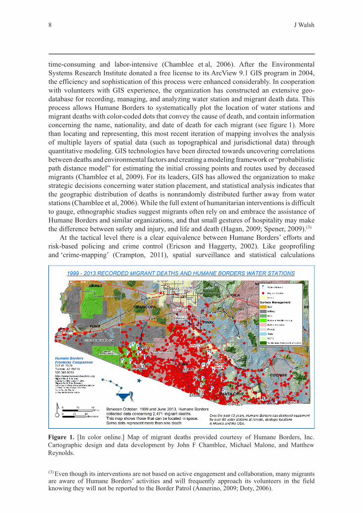
8 J Walsh
time-consuming and labor-intensive (Chamblee et al, 2006). After the Environmental Systems Research Institute donated a free license to its ArcView 9.1 GIS program in 2004, the efficiency and sophistication of this process were enhanced considerably. In cooperation with volunteers with GIS experience, the organization has constructed an extensive geo-database for recording, managing, and analyzing water station and migrant death data. This process allows Humane Borders to systematically plot the location of water stations and migrant deaths with color-coded dots that convey the cause of death, and contain information concerning the name, nationality, and date of death for each migrant (see figure 1). More than locating and representing, this most recent iteration of mapping involves the analysis of multiple layers of spatial data (such as topographical and jurisdictional data) through quantitative modeling. GIS technologies have been directed towards uncovering correlations between deaths and environmental factors and creating a modeling framework or “probabilistic path distance model” for estimating the initial crossing points and routes used by deceased migrants (Chamblee et al, 2009). For its leaders, GIS has allowed the organization to make strategic decisions concerning water station placement, and statistical analysis indicates that the geographic distribution of deaths is nonrandomly distributed further away from water stations (Chamblee et al, 2006). While the full extent of humanitarian interventions is difficult to gauge, ethnographic studies suggest migrants often rely on and embrace the assistance of Humane Borders and similar organizations, and that small gestures of hospitality may make the difference between safety and injury, and life and death (Hagan, 2009; Spener, 2009).(3)
At the tactical level there is a clear equivalence between Humane Borders’ efforts and risk-based policing and crime control (Ericson and Haggerty, 2002). Like geoprofiling and ‘crime-mapping’ (Crampton, 2011), spatial surveillance and statistical calculations
(3) Even though its interventions are not based on active engagement and collaboration, many migrants are aware of Humane Borders’ activities and will frequently approach its volunteers in the field knowing they will not be reported to the Border Patrol (Annerino, 2009; Doty, 2006).
Figure 1. [In color online.] Map of migrant deaths provided courtesy of Humane Borders, Inc. Cartographic design and data development by John F Chamblee, Michael Malone, and Matthew Reynolds.
Geospatial technologies and border activism 9
are utilized to identify threats, gauge the probability of future movements and events, and minimize risks to public safety. However, for Humane Borders, the tracking, collation, and analysis of geographic data are directed to promoting forms of human security that evade and call into question entrenched distinctions of crime and illegality. Consequently, rather than denying access, restricting movement, and disciplining migrants, advanced technological systems are directed to offering assistance, protection, and care.
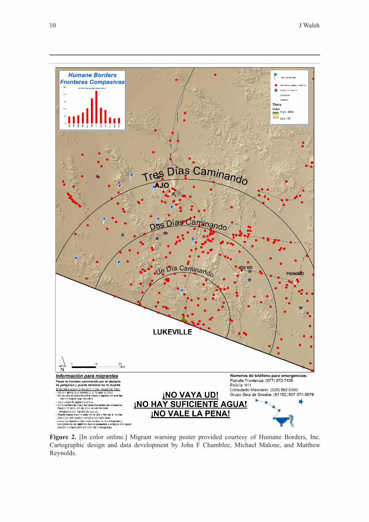
GIS has also been employed to construct topographic maps that inform migrants of the dangers of crossing. Cooperating with NGOs in Mexico and Central America, Humane Borders has distributed over 70 000 maps to major sending communities (Humane Borders, 2008). The maps, which represent 50 × 60-mile sectors of the border, provide the location of water stations, cell-phone coverage, emergency telephone numbers, and other potentially life-saving information. Framed as educational tools that, in contrast to smugglers or the Border Patrol, give truthful assessments of risk, they indicate: where migrants have perished; the distance one can expect to cover on foot in one to three days; and the months in which migrants have died (see figure 2). Accordingly, the maps are an “interim moral response” (Hoover, 2004, page 2) that provide migrants with the necessary knowledge to survive:
“The most basic level of ethics is informed consent. By equipping migrants with real information: where migrants die, where roads are, where water stations are and are not ... which months are the ... deadliest, the hope is migrants will choose not to come in the deadliest months and ... take safer routes” (Humane Borders, 2006).
Given official silence on migrant fatalities, the maps also visualize and represent the tragic consequences of border security, and provide a ‘virtual monument’ to the deceased (Chamblee et al, 2006, page 10).
Most recently, through an initiative known as Rescatame, the group’s leadership has begun providing cell-phone-sized GPS devices to church-run migrant shelters in Altar Sonora, which distribute them to local guides for undocumented entrants. The devices, McMurdo Fast Find Personal Location Beacons, weigh five ounces and have batteries that last five years. In an emergency they can be activated to send distress signals to the National Oceanic and Atmospheric Administration who will locate and transmit its geographic coordinates to local search and rescue personnel (Hoover, 2012).
The second intervention is offered by the TBIT and is an effort to “reappropriate widely available technologies ... as ... humanitarian aid” (Cardenas et al, 2009, page 2). The device represents the latest project of the artist/activist Ricardo Dominguez and the EDT, whose previous actions included a virtual sit-in coordinated with the Zapatistas, and a ‘swarm the Minutemen’ campaign in which the nativist group’s website was flooded by activist software. The TBIT is intended to reduce fatalities by directing migrants to water caches, natural springs, safety beacons, highways, cities, and other potentially life-saving locations. As a form of ‘tactical media’ and ‘border disturbance’, it repurposes inexpensive cell phones ranging from $15 to $30 as “emergency life-saving tool[s]” (UCSD Guardian, 2009). Exemplary of new forms of locative media and spatial surveillance, the device integrates geospatial systems and GPS technologies through customized navigational software known as the ‘virtual hiker algorithm’ (Dominguez and Stalbaum, 2007). These features are enabled by a Java-based application programmed and coded by Brett Stalbaum (a member of the EDT and lecturer in the Visual Arts Deparment at the University of California San Diego), which allows the phone to receive positional data without cell-phone service or transmitting a signal that could be triangulated and tracked by government authorities. Embracing principles of universal design, the software is available for download online, and the EDT hopes others will reprogram it for other geographic settings: “we imagine the [TBIT’s] code and gesture as open to use on multiple borders” (Bird, 2011).
10 J Walsh
Figure 2. [In color online.] Migrant warning poster provided courtesy of Humane Borders, Inc. Cartographic design and data development by John F Chamblee, Michael Malone, and Matthew Reynolds.
Geospatial technologies and border activism 11
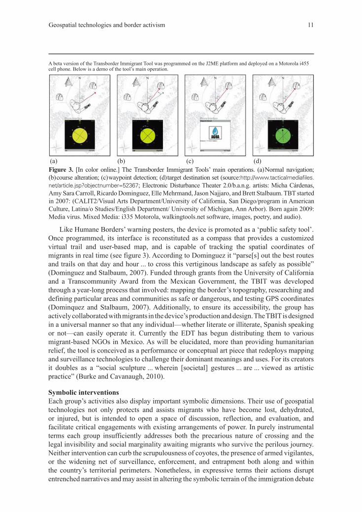
Like Humane Borders’ warning posters, the device is promoted as a ‘public safety tool’. Once programmed, its interface is reconstituted as a compass that provides a customized virtual trail and user-based map, and is capable of tracking the spatial coordinates of migrants in real time (see figure 3). According to Dominguez it “parse[s] out the best routes and trails on that day and hour ... to cross this vertiginous landscape as safely as possible” (Dominguez and Stalbaum, 2007). Funded through grants from the University of California and a Transcommunity Award from the Mexican Government, the TBIT was developed through a year-long process that involved: mapping the border’s topography, researching and defining particular areas and communities as safe or dangerous, and testing GPS coordinates (Dominquez and Stalbaum, 2007). Additionally, to ensure its accessibility, the group has actively collaborated with migrants in the device’s production and design. The TBIT is designed in a universal manner so that any individual—whether literate or illiterate, Spanish speaking or not—can easily operate it. Currently the EDT has begun distributing them to various migrant-based NGOs in Mexico. As will be elucidated, more than providing humanitarian relief, the tool is conceived as a performance or conceptual art piece that redeploys mapping and surveillance technologies to challenge their dominant meanings and uses. For its creators it doubles as a “social sculpture ... wherein [societal] gestures ... are ... viewed as artistic practice” (Burke and Cavanaugh, 2010).
Symbolic interventionsEach group’s activities also display important symbolic dimensions. Their use of geospatial technologies not only protects and assists migrants who have become lost, dehydrated, or injured, but is intended to open a space of discussion, reflection, and evaluation, and facilitate critical engagements with existing arrangements of power. In purely instrumental terms each group insufficiently addresses both the precarious nature of crossing and the legal invisibility and social marginality awaiting migrants who survive the perilous journey. Neither intervention can curb the scrupulousness of coyotes, the presence of armed vigilantes, or the widening net of surveillance, enforcement, and entrapment both along and within the country’s territorial perimeters. Nonetheless, in expressive terms their actions disrupt entrenched narratives and may assist in altering the symbolic terrain of the immigration debate
Figure 3. [In color online.] The Transborder Immigrant Tools’ main operations. (a) Normal navigation; (b) course alteration; (c) waypoint detection; (d) target destination set (source:http://www.tacticalmediafiles.net/article.jsp?objectnumber=52367; Electronic Disturbance Theater 2.0/b.a.n.g. artists: Micha Cárdenas, Amy Sara Carroll, Ricardo Dominguez, Elle Mehrmand, Jason Najjaro, and Brett Stalbaum. TBT started in 2007: (CALIT2/Visual Arts Department/University of California, San Diego/program in American Culture, Latina/o Studies/English Department/ University of Michigan, Ann Arbor). Born again 2009: Media virus. Mixed Media: i335 Motorola, walkingtools.net software, images, poetry, and audio).
A beta version of the Transborder Immigrant Tool was programmed on the J2ME platform and deployed on a Motorola i455 cell phone. Below is a demo of the tool’s main operation.
(a) (b) (c) (d)
12 J Walsh
and constructing repertoires of collective recognition and obligation that advocate for rights of movement and membership. While they may appear as minor gestures, their significance should not be underestimated. The framing of political issues is critical in constituting public concerns (Melucci, 1989) and, in the case of the undocumented, assists in directly contesting their criminalization and subordination (Coutin, 2005). Most importantly, each organization’s interventions challenge the state’s power to classify certain lives as illegal and expendable, and the configurations of space, law, and technology that reinforce such designations. As Bourdieu (1991) has observed, the power over classificatory schemes is a central dimension of authority that prefigures perceptions and understandings of the social world. The fields of space, law, and technology play critical and interlocking roles in producing social categories of migrant illegality: spatial ordering involves the establishment of classifications and divisions; law codifies such distinctions; and technology facilitates their enforcement and reiteration. Accordingly, in contrast to territorial nationalism, both organizations have linked mapping to a subversive brand of cosmopolitan hospitality.
In relationship to space both groups appropriate techniques of spatial surveillance and representation to protect migrants, challenge official spatializations, and visualize the world in new ways. Through their interventions each attempts to cultivate an alternative moral geography and “politics of connectivity” (Amin, 2004, page 43) in which recognition and responsibility extend beyond the proximate or local.
For the EDT its objectives are “redirect[ing] technologies used by nation-states to manage territorial borders” towards “creating gestures [of transnational solidarity] that question the very nature of the border” (Ramney, 2007) and promoting a “universal cosmology of navigation” where the traversal of borders is a source of neither danger, nor psychic trauma (Cardenas, 2011). More than highlighting the brutality of enforcement, Humane Borders critiques the entire enterprise of immigration control, and promotes “fundamental right[s]” of migration (Humane Borders, 2003). As its name implies the organization’s ultimate concern is humanizing the border environment and transforming its securitized status into a space of contact, recognition, and collaboration. As its leadership has argued: “Borders ... should not kill people, freeze them ... dehydrate them, confine them, or drive them into medical distress” (Humane Borders, 2005, page 3). Drawing on Judeo-Christian beliefs, the organization contends that, in dividing the world’s population, territorial borders violate principles of shared humanity and global community where there is room for everyone, as God’s children (Humane Borders, 2005).
These statements underscore both groups’ advocacy of democratic mobility, and their interventions are, in however small a fashion, actively promoting it. Given that ethnographic studies suggest border-crossing deaths are overwhelmingly caused by spatial dislocation and disorientation (Annerino, 2009; Magana, 2008), the provision of maps and virtual compasses provides promises of a less treacherous topography that, although not purged of the structures, relations, and practices that produce experiences of abjection and distinctions of illegality, is momentarily transformed from one of cruelty to one of civility (Balibar, 2001). Ultimately, by preventing migrants from being conquered by death as they enter an unknown, unmarked, and unwelcoming territory, both interventions secure the restoration and reassertion of life and personhood. While the interventions are provisional and unlikely to halt the broader border crisis, the significance of their outcomes should not be overlooked. According to Doty (2011, page 610): “The survival of those migrants who successfully negotiate the dangerous crossings ... attests to the potential for a [subversive] refusal to be captured in the sovereign state of exception which has relegated them to bare life.”
Both groups also promulgate new spatial imaginaries and ethical frameworks. Here the goal is to redefine borders as spaces of inclusion, trust, and bridges—rather than barriers—between self and other. Their practices are not intended to do away with nation-states, but
Geospatial technologies and border activism 13
rather challenge and decenter their status as moral referents, and markers of identity and alterity. According to Dominguez, the TBIT “is not about doing away … with borders, but ... generating new forms of communication and understanding” (Dunbar, 2009). Embracing notions of mutual dependence, solidarity, and interconnection, Humane Borders claims: “beyond kinship, beyond neighborliness, we must treat each other much better than we do now because the others in our lives are human” (Hoover, 2008). Accordingly, the group can be viewed as cultivating a form of critical transnationalism that seeks to construct alternative political spaces based on the deterritorialized “principles of justice, accommodation, dignity, and ... love” (Hoover, 2008). It is, however, important to note that for Humane Borders legal constraints limit the articulation of a fully cosmopolitan hospitality. While the anonymous act of leaving water, food, and clothing in the desert represents hospitality in an unlimited form, when activists meet the other in the field assistance is often conditional. As previously noted, when encountering migrants requiring immediate medical attention, volunteers are forbidden to transport them, and will contact the Border Patrol. While ultimately saving lives, such an approach also facilitates migrants’ expulsion.
Despite these limitations, and the fact that neither intervention directly alters existing laws and policies or addresses the broader structural asymmetries that uproot and propel migrants from the Global South, by caring for and welcoming the other, both groups articulate an ethics of responsibility that assumes a relationship of moral proximity transcending geographic distance, hierarchies, and divisions. In these respects both groups offer powerful—albeit fleeting and momentary—gestures of subversive hospitality that challenge systems of “normative nationalism” in which the nation-state is constituted as the “total universe of ... moral concern” (Bosniak, 2008, page 6).
Both interventions are also invested in demystifying the arbitrary and violent nature of legal categories and identities. Each organization challenges the state’s criminalization of irregular migrants and of the provision of humanitarian aid. Consequently their activities are oriented to destabilizing regimes of “legal truth”, or the state’s monopoly on producing authoritative accounts of reality (Coutin, 1995; cf Gupta, 1995). In doing so the organizations seek to transform the terms of the immigration debate and improve the social, juridical, and symbolic standing of those whose existence is deemed illegal and unauthorized.
Their humanitarianism is intended to expose the brutality of enforcement, shame society, and deconstruct the legal and institutional scripts that animate policy making. The deceptively simple act of mapping the desert to leave water for migrants is much more than a substitute for the state’s humanitarian obligations and responsibilities. More than pinpointing the location of deaths, Humane Borders is surveying and attempting to unsettle relations of power, dependence, and complicity. Their mapping efforts are meant to stimulate public dialogue and provoke contemplation of the discursive and legal categorization of certain bodies as ‘illegal’, and thus undesirable and dispensable. According to the organization, government policy amounts to a morally bankrupt approach that, in the name of order and security, knowingly and deliberately “herds migrants down death trails” (Hoover, 2004, page 3). Accordingly, such actions command “us to reinterpret [the] foundations of our laws” and “constitute moments of deconstruction happening” (Doty, 2006, page 71). For the EDT “immigrant bodies moving north are criminalized …[and] hunted” and “the numbers ... dying attempting to cross ... are horrifying” (Cardenas et al, 2009, pages 1–2). Reflecting these claims, the group’s actions are intended to unveil “the logics with which borders are dealt with” (page 2) and are characterized as “disturbances of law... [that] create new spaces and moral possibilities” (Nadir, 2012). Here the goal is to transform the “dialogue about migration ... to focus on the humanitarian crisis occurring in this region” (Cardenas et al, 2009, page 2). Consequently, both organizations challenge law’s status as something that
14 J Walsh
is fixed, unambiguous, and innately sacrosanct and that transcends politics and social relations. Specifically, they highlight how the law obscures the contingency of the categories, distinctions, and identities it produces and enforces. In criminalizing migrants whose, as the EDT notes, “only crime is hope” (page 4), the law constitutes a form of symbolic violence that preserves a world in which accidents of longitude and latitude—the arbitrariness of being born here and not there—provide powerful determinants of life chances and social destiny.
In stressing the necessity of their work and inalienable rights of rescue, both organizations proclaim fidelity and adherence to a higher law. Unlike other humanitarian groups along the border, neither has been charged with violations of federal immigration law. Nonetheless, each has been officially investigated and threatened with prosecution for ‘aiding and abetting’ illegal activities.(4) In response, they have utilized threats of criminal charges to publicize the plight of migrants, highlight the state’s indifference to human suffering and its role in promoting it, and advance competing assessments of justice, law, and security. In appealing to a higher legal and moral order, Humane Borders implies they are merely embracing a “social theology”, and following ‘God’s law’ to care for “the other within our midst” (Humane Borders, 2005, page 8; cf Cook, 2011)—commitments which trump national legal codes. Asking “since when is it illegal to save peoples’ lives” (Steele, 2011), the EDT advocates forms of “electronic civil disobedience” and “transborder justice”, which “break one law for a higher law” (Bird, 2011; cf Cardenas et al, 2009). Additionally, in mobilizing international legal codes concerning human and migrants’ rights to underscore the necessity and permissibility of their actions (Cook, 2011), both organizations are embracing and articulating models of global citizenship that stress transnational rights and obligations, and the fundamental dignity of all peoples regardless of nationality or legal status.
Finally, both organizations pursue alternative, democratic, and affirmative engagements with geospatial technologies. Their interventions not only contest the logics and consequences of immigration control, but question the place and uncritical uses of technology in our daily lives. In its dominant manifestations cartography remains an abstract enterprise that fosters notions of “socially empty space” and, in turn, “lessens the burden of conscience about people in the landscape” (Harley, 1988, page 303). While the government’s use of geospatial technologies reveals, tracks, and represents migrants as abstract objects in space and quantifiable data points, it does so in ways that mask, conceal, and obscure the faces and dignity of the suffering. If, as Lyon (2007, page 183) has claimed, this sense of distance and detachment fosters “possibilities for exploitation, abandonment, and even violence”, these arrangements only further reinforce migrants’ expendable status. While both organizations also rely on statistical calculations and the processing of spatial information, their efforts differ significantly as each utilizes geospatial technologies in the service of resocializing space and reembodying persons. Moreover, given that border policing and surveillance often occur in technical and administrative spaces shielded from public scrutiny, in promoting transparent actions and open-source technologies both groups embrace democratic accountability in place of official secrecy and insulated expertise.
By approaching technology as an ally, both groups are exploring how spatial tracking and geosurveillance can be ethically designed and employed to promote democratic practices and address injustice. Through their actions they seek to alter the position of the undocumented within sociotechnical systems, as well as level hierarchies, equalize power relations, and
(4) For Humane Borders several federal agencies have threatened to revoke its ability to maintain water stations, and former Department of Homeland Security secretary Michael Chertoff claims the department strongly opposed the group’s actions on the grounds they gave migrants a false sense of hope, and interfered with government enforcement. For the EDT its members were subject to a formal FBI investigation in 2011 on the grounds that the TBIT could assist human smugglers and organized criminal networks (Nadir, 2012).
Geospatial technologies and border activism 15
actualize social justice. Consequently, both groups are promoting forms of ‘technological citizenship’ directed to designing new systems and infrastructures in responsible and appropriate ways (Lyon, 2007). According to the EDT, as a “multi-valent code-switch, a queer technology” (Blas, 2012), the TBIT is a form of productive disruption and collective empowerment that disturbs rituals of border crossing and security by placing surveillance technologies directly in the hands of migrants. By enabling people to “make their own maps” and control the data they produce, the EDT challenges inequalities concerning technological access and promotes the TBIT as a “social technology” intended to empower migrants and transcend the command and control dimensions of spatial surveillance (Nadir, 2012). According to its inventors the device is part of a broader “science” or “engineering of the oppressed” that attempts to “reconfigure knowledge production ... in the service of oppressed communities and ... social movements” (Cardenas et al, 2009, page 3). Further, they claim the project should be viewed as an ongoing effort, a “space of rehearsal, allowing for the exploration of models of public intervention as well as technological models for locative media” (page 3). While the issue of technology remains peripheral to its official agenda, Humane Borders has critiqued the government’s use of technology as costly, misguided, and disproportionate. Additionally, the group’s engagements with geospatial technology function to document and represent migrant deaths, transforming hidden subjugated knowledge into information that commands attention and intervention. Moreover, its leadership has argued that its use of GIS not only highlights the lethal effects of contemporary enforcement, but underscores how grassroots spatial surveillance can be directed to “taking death out of the migration equation” (Humane Borders, 2005, page 1). In contrast to simplistic understandings of technologies as inherently negative determinants of social relations, both interventions indicate they are malleable, contingent, and “underdetermined” objects that can be reprogrammed and redirected to alternative uses and agendas (Monahan, 2010).
One important distinction concerning the groups’ engagements with technology concerns the democratic and participatory aspects of their interventions. For Humane Borders, migrants are largely objects of protection rather than active participants or collaborators. While the organization is committed to designing ethical technological systems, techniques of mapping and the subsidiary processes of data gathering, spatial analysis, and tactical interventions remain inaccessible to the undocumented. In contrast, by directly engaging migrants in the design and development of the TBIT, the EDT actively enlists those it assists and promotes democratic participation in place of traditional hierarchies of technical expertise. Consequently, the EDT’s interventions go further in suspending and destabilizing “configurations of experts and users, subjects and objects” (Monahan, 2010, page 106).
ConclusionHistorically, the cartographer has played a pivotal role in the production of borders and territoriality, and existed as a technician or handmaiden of the state. In tracing the form of the nation and drawing lines of sovereign authority, official mapping is inextricably fused with political surveillance and instrumentation, as well as the production of political subjectivities. Recent technological developments have further intensified mapping’s significance in the spatialization of states. For borders and movements across them, geospatial technologies have been integrated into preemptive techniques of risk management in which the surveillance and modeling of locational data have been directed to identifying, tracking, and preventing unauthorized mobilities. While the links between mapping and the accumulation and exercise of political power are undeniable, recent works have highlighted alternative and popular practices of countermapping to challenge totalizing accounts and explore the flexible and empowering potential of emergent cartographic technologies. Nonetheless, “there is still a long way to go before the ... democratizing role of geospatial technologies is
16 J Walsh
functionally established” (Klinkenberg, 2007, page 357). Focusing on struggles concerning land use and indigenous rights, studies of countermapping have documented its importance in articulating grievances, challenging official representations, and pursuing social justice. Despite their valuable insights, existing work has been concerned with contesting the spatial distribution of resources, and, as a result, efforts to disrupt and subvert borders themselves remain unanalyzed.
To complement existing work and push the concept of countermapping into new territory, this paper has emphasized the distributed and heterodox nature of mapping and spatial surveillance. Focusing on gatekeeping and immigration control in the context of the US–Mexico border, I have documented the activities of two social movement organizations, and shown how they have reclaimed and redirected cartographic technologies to ameliorate migrant suffering, promote mobility rights, challenge the disciplinary orientation of existing sociotechnical systems, and subvert the spatial order of the state. While geospatial surveillance may be more limiting than liberating, both groups have mobilized new technologies as strategic resources for social struggle. Irrespective of their long-term success or failure, these practices raise several critical theoretical issues that deepen understandings of borders, surveillance, and countermapping.
Interrogating both organizations reveals that mapping has come to constitute a significant tool of protest and contention. Whereas the state uses geospatial tools to enforce divisions and construct “fearful others” whose movements are to be monitored and controlled (Klinkenberg, 2007), Humane Borders and the EDT have promoted constructive engagements with these tools through the distribution of water, warning posters, emergency GPS devices, and GPS-enabled cell phones. At the most basic level each group’s humanitarianism functions to protect and assist migrants who are legally invisible, socially unprotected, and deliberately exposed to undue risk and danger. Additionally, by facilitating safe passage and empowering migrants, each organization is actively promoting a democratized vision of mobility in which, at the very least, borders are no longer spaces of anguish and injury.
More than just welcoming and caring for the other, both interventions promote forms of critical transnationalism and radically cosmopolitan models of political practice. Here mapping provides a platform or stage for critiquing government policy, demystifying state power, and disrupting dominant spatial, legal, and technical orders. Ultimately, both groups are utilizing the very sort of cartographic and locational tools used for hunting and intercepting ‘illegal’ bodies to alter the map, redefine its terms, and rehumanize its abstract, bounded, and often threatening spaces. Such activities expose the inconsistencies and aporias of the state’s political programs and self-imaginings. Additionally, they enable the possibilities of new transnational imaginaries and models of human association. By dramatizing and rendering the plight of migrants visible, both groups pose a series of important questions: What sort of society builds walls and watchtowers along its perimeters? What kind of community deems the existence of large portions of its members ‘illegal’ and unauthorized? What sort of society consciously endangers others in the name of its own security? In provoking contemplations of the nature of justice, security, citizenship, and borders within an increasingly globalized world, both organizations’ actions have implications far beyond the isolated landscape of the Sonora desert.ReferencesAckleson J, 2005, “Constructing security on the US–Mexico border” Political Geography
24 165–184Agamben G, 1998 Homo Sacer (Stanford University Press, Stanford, CA)Amin A, 2004, “Regions unbound: towards a new politics of place” Geografiska Annaler B 86 33–44Amoore L, 2009, “Algorithmic war: everyday geographies in the War on Terror” Antipode 41 49–69
Geospatial technologies and border activism 17
Amoore L, Marmura S, Salter M, 2008, “Smart borders and mobilities” Surveillance and Society
5 96–101Anderson B, 1991 Imagined Communities (Verso, London)Annerino, J, 2009 Dead in Their Tracks (University of Arizona Press, Tuscon, AZ)Balibar E, 2001, “Outlines of a topography of cruelty” Constellations 8 15–29Batuman B, 2010, “The shape of the nation: visual production of nationalism through maps in
Turkey” Political Geography 29 220–234Billig M, 1995 Banal Nationalism (Sage, London)Bird L, 2011, “Global positioning: an interview with Ricardo Dominguez”,
http://www.furtherfield.org/features/Blandy S, Sibley D, 2010, “Law, boundaries and the production of space” Social and Legal Studies
19 275–284Blas Z, 2012, “Electronic civil disobedience”, http://www.reclamationsjournal.org/blog/Bloemraad I, Voss K, Lee T, 2011, “The protests of 2006: what were they, how do we understand
them, where do we go? ”, in Rallying for Immigrant Rights Eds K Voss, I Bloemraad (University of California Press, Berkeley, CA) pp 3–43
Bosniak L, 2008 The Citizen and the Alien (Princeton University Press, Princeton, NJ)Bourdieu P, 1991 Language and Symbolic Power (Harvard University Press, Cambridge, MA)Burke M, Cavanaugh M, 2010, “UCSD artists develop tool to guide illegal border crossers to water”,
http://www.kpbs.orgCardenas M, 2011, “net.walkingtools.Transformer.shift()”,
http://crg.berkeley.edu/ content/catalyst-mcardenasCardenas M, Carroll A, Dominguez R, Stalbaum B, 2009, “The transborder immigrant tool”,
http://www.uni-siegen.de/locatingmedia/workshops/mobilehci/ cardenas_the_transborder_immigrant_tool.pdf
Chamblee J, Christopherson G, Townley M, DeBorde D, Hoover R, 2006, “Mapping migrant deaths in southern Arizona”, http://proceedings.esri.com/library/userconf/ proc06/papers/papers/pap_1464.pdf
Chamblee J, Christopherson G, Anderson B, Reineke R, 2009, “The international openGIS initiative for missing and deceased migrants”, www.casa.arizona.edu/ Foundation_Report_2009_02_28
Chavez L, 2008 The Latino Threat (Stanford University Press, Stanford, CA)Cook M, 2011, “ ‘Humanitarian aid is never a crime’: humanitarianism and illegality in migrant
advocacy” Law and Society Review 45 561–591Coutin S, 2005, “Contesting criminality: illegal immigration and the spatialization of legality”
Theoretical Criminology 9 5–33Coutin S, 1995, “Smugglers or Samaritans in Tucson, Arizona: producing and contesting legal truth”
American Ethnologist 22 549–571Crampton J, 2011 Mapping: A Critical Introduction to Cartography and GIS (Wiley-Blackwell,
Oxford)Cunningham H, 2002, “Transnational social movements and sovereignties in transition”
Anthropologica 44 185–196Customs and Border Protection Today, 2003, “Operation Safeguard”,
http://www.cbp.gov/xp/CustomsToday/2003/august/opdesertsafeguard.xmlDominguez R, Stalbaum B, 2007, “Transborder immigrant tool”, http://post.thing.net/node/1642Doty R, 2006, “Fronteras compasivas and the ethics of unconditional hospitality” Millennium
35 53–74Doty R, 2011, “Bare life: border-crossing deaths and the spaces of moral alibi” Environment and
Planning D: Society and Space 29 599–612Dunbar A, 2009, “Crossing the border illegally? There’s an app for that”,
http://motherboard.vice.com/read/the-transborder-immigrant-tool-helps-mexicans-cross-over-safelyEdney M, 1997 Mapping an Empire (University of Chicago Press, Chicago, IL)Ericson R, Haggerty K, 2002, “The policing of risk”, in Embracing Risk Eds T Baker, J Simon
(University of Chicago Press, Chicago, IL) pp 238–272ESRI, 2001, “US Border Patrol Maximizes Enforcement with GIS”, Electronic Systems Research
Institute, http://www.esri.com/news/arcnews/fall01articles/ usborderpatrol.html
18 J Walsh
Gray M, 2003, “Urban surveillance and Panopticism” Surveillance and Society 1 314–330Gupta A, 1995, “Blurred boundaries: the discourse of corruption, the culture of politics, and the
imagined state” American Ethnologist 22 375–402Hagan J, 2009 Migration Miracle (Harvard University Press, Cambridge, MA)Hall S, 1993 Mapping the Next Millennium (Vintage, New York)Hannah M, 2000 Governmentality and the Mastery of Territory in Nineteenth-century America
(Cambridge University Press, Cambridge)Harley B, 1988, “Maps, knowledge, and power”, in The Iconography of Landscape Eds D Cosgrove,
P Daniels (Cambridge University Press, Cambridge) pp 277–312Harrison J, Lloyd S, 2011, “Illegality at work: deportability and the productive new era of
immigration enforcement” Antipode 43 1–24Harvey D, 1989 The Condition of Postmodernity (Blackwell, London)Hodgson D, Schroeder R, 2002, “Dilemmas of counter-mapping community resources in Tanzania”
Development and Change 33 79–100Hoover R, 2004, “Oded’s indictment”, paper presented at the International Conference on Migration
and Theology, September 2004, Notre Dame University, South Bend, INHoover R, 2008, “Remarks at World Council of Churches”,
http://www.humaneborders.org/news/news_opinion.htmlHoover R, 2012, “Proyecto Rescatame”, http://robinhoover.com/Home.htmlHumane Borders, 2003, “Public policy strategies for 2003”,
http://www.humaneborders.org/new/news_positionpaper.htmlHumane Borders, 2005, “The Story of Humane Borders”,
http://www.humaneborders.org/news/news_storymarch05.htmlHumane Borders, 2006, “Press Release: January 12th”,
http://www.humaneborders.org/news/PressReleaseJan.192006.htmlHumane Borders, 2008, “Humane Borders Water Station Maps and Warning Posters”,
http://www.humaneborders.org/news/news4.htmlInda J, 2006 Targeting Immigrants (Blackwell, Oxford)Klinkenberg B, 2007, “Geospatial technologies and the geographies of hope and fear” Annals of the
Association of American Geographers 97 349–360Koslowski R, 2011 The Evolution of Border Controls as a Mechanism to Prevent Illegal Immigration
(Migration Policy Institute, Washington, DC)Kwan M P, Schwanen T, 2009, “Quantitative revolution 2: the critical (re)turn” The Professional
Geographer 61 283–291Lyon D, 2007 Surveillance Studies (Polity, Cambridge)Magana R, 2008 Bodies on the Line PhD dissertation, Department of Anthropology, University
of ChicagoMelucci A, 1989, “Symbolic challenge of contemporary movements” Social Research 52 789–816Menjivar C, 2007, “Serving Christ in the borderlands”, in Religion and Social Justice for Immigrants
Ed. P Hondagneu-Sotelo (Rutgers University Press, New Brunswick, NJ) pp 104–121Monahan T, 2010, “Surveillance as governance: social inequality and the pursuit of democratic
surveillance”, in Surveillance and Democracy Eds K Haggerty, M Samatas (Routledge, London) pp 91–110
Nadir L, 2012, “Poetry, immigration, and the FBI, http://hyperallergic.com/54678/ poetry-immigration-and-the-fbi-the-transborder-immigrant-tool/
No More Deaths, 2008, “No More Deaths reader”, http://www.nomoredeaths.org/DocumentsOng A, 1999 Flexible Citizenship (Duke University Press, Durham, NC)Painter J, 1995 Politics, Geography and ‘Political Geography’ (Arnold, New York)Peluso N, 1995, “Whose woods are these? Counter-mapping forest territories in Kalimatan,
Indonesia” Antipode 27 383–406Pickles J, 1991, “Geography, GIS, and the surveillant society” Papers and Proceedings of the
Applied Geography Conference 14 80–91Ramney C, 2007, “Artivists and mobile phones”, http://mobileactive.org/artivists-and-mobile-pho

Geospatial technologies and border activism 19
Renan E, 1996[1882], “What is a nation?”, in Becoming National Eds G Eley, R Suny (Oxford University Press, Oxford)
Sandia National Laboratories, 1993 Systematic Analysis of the Southwest Border (Sandia National Laboratories, Albuquerque, NM)
Scott J, 1998 Seeing Like a State (Yale University Press, New Haven, CT)Shamir R, 2005, “Without borders?” Sociological Theory 23 197–217Simon J, 2001, “Sanctioning government: explaining America’s severity revolution” University of
Miami Law Review 56 218–219Sparke M, 1998, “A map that roared and an original atlas: Canada, cartography, and the narration of
nation” Annals of the Association of American Geographers 88 463–495Sparke M, 2006, “A neoliberal nexus: economy, security and the biopolitics of citizenship on the
border” Political Geography 25 151–180Spener D, 2009 Clandestine Crossings (Cornell University Press, Ithaca, NY)Steele S, 2011, “Crossing the desert: the art and tech of the transborder immigrant tool”,
http://news.infoshop.orgTorpey J, 2000 The Invention of the Passport (Cambridge University Press, Cambridge)Trouillot M, 2001, “The anthropology of the state in the age of globalization” Current Anthropology
42 125–138UCSD Guardian, 2009, “Low-tech app aids in crossing Mexican border”,
http://www.uscdguardian.org/news/low-tech-app-aids-in-crossing-mexican-borderVeal W, 2003 “Protecting the borders: GIS technology and command/control optimization” Police
Chief 70 41–48Wainwright J, Bryan J, 2009, “Cartography, territory, property” Cultural Geographies 16 153–178Warf B, Arias S, 2009 The Spatial Turn (Routledge, London)Wood D, Fels J, Krygier J, 2010 Rethinking the Power of Maps (Guilford, London)


