Embed Size (px)
Citation preview
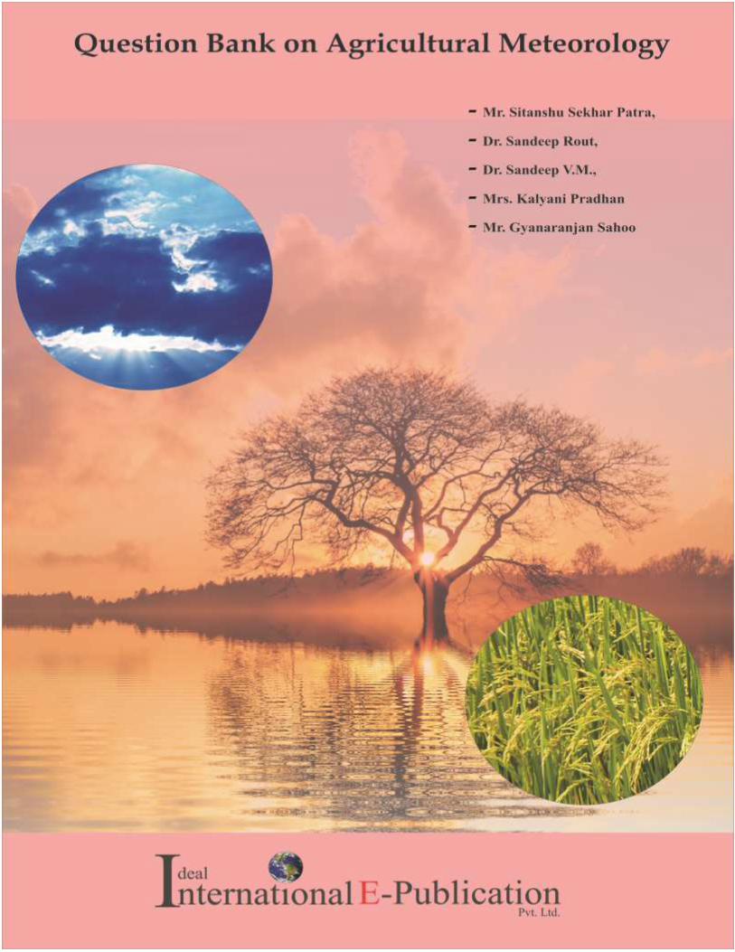
Question Bank on Agricultural Meteorology
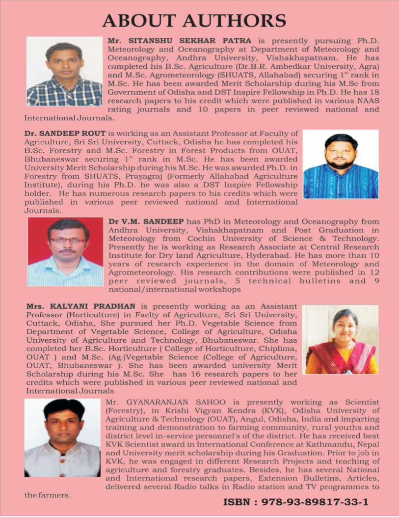
Mr. Sitanshu Sekhar Patra
Ph.D. Scholar and DST Inspire JRF
Department of Meteorology and Oceanography
Andhra University, Visakhapatnam, Andhra Pradesh
Pin-530003, India
Dr. Sandeep Rout
Assistant Professor (Forestry)
Faculty of Agriculture, Sri Sri University,
Cuttack, Pin -754006, Odisha, India
Dr. Sandeep V.M.
Research Associate
AICRPAM, ICAR- CRIDA,
Santosh Nagar, Saidabad PO
Hyderabad - 500059, India
Mrs. Kalyani Pradhan
Assistant Professor (Horticulture)
Faculty of Agriculture, Sri Sri University,
Cuttack, Pin -754006, Odisha, India
Mr. Gyanaranjan Sahoo
Scientist (Forestry)
Krishi Vigyan Kendra, OUAT, Angul, Pin-759132
Odisha, India
2020
Ideal International E – PublicationPvt. Ltd. www.isca.co.in
427, Palhar Nagar, RAPTC, VIP-Road, Indore-452005 (MP) INDIA
Phone: +91-731-2616100, Mobile: +91-80570-83382
E-mail: [email protected], Website:www.isca.co.in
Title: Question Bank on Agricultural Meteorology Author(s): Mr. Sitanshu Sekhar Patra, Dr. Sandeep Rout, Dr.
Sandeep V.M. , Mrs. Kalyani Pradhan, Mr. Gyanaranjan Sahoo
Edition: First Volume: I
© Copyright Reserved
2020
All rights reserved. No part of this publication may be reproduced, stored, in a
retrieval system or transmitted, in any form or by any means, electronic,
mechanical, photocopying, reordering or otherwise, without the prior permission
of the publisher.
ISBN: 978-93-89817-33-1
3
3 | P a g e
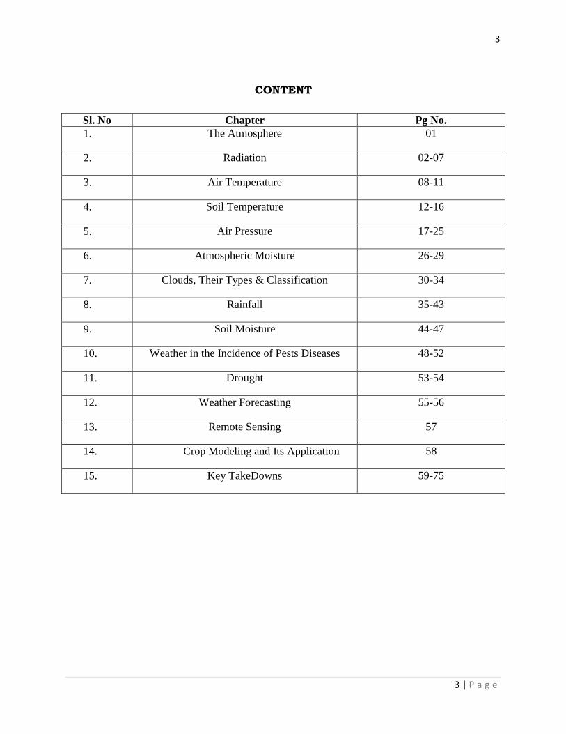
CONTENT
Sl. No Chapter Pg No.
1. The Atmosphere 01
2. Radiation 02-07
3. Air Temperature 08-11
4. Soil Temperature 12-16
5. Air Pressure 17-25
6. Atmospheric Moisture 26-29
7. Clouds, Their Types & Classification 30-34
8. Rainfall 35-43
9. Soil Moisture 44-47
10. Weather in the Incidence of Pests Diseases 48-52
11. Drought 53-54
12. Weather Forecasting 55-56
13. Remote Sensing 57
14. Crop Modeling and Its Application 58
15. Key TakeDowns 59-75
1
Ideal International E- Publication
www.isca.co.in
Chapter 1. THE ATMOSPHERE
1. Which chemical forms during lightning in the atmosphere?
Ans:-NH4
2. Nitrogen forms about……………% of the total volume of dry air.
Ans:-78.08
3. Oxygen forms about………% of the total volume of dry air.
Ans:-20.94
4. The top most layer of atmosphere is……………..
Ans:-Thermosphere
5. …………%of the total gaseous mass of atmosphere present in the troposphere.
Ans:-75%
6. Decrease in temperature with height in the troposphere is known as………..
Ans:-Lapse rate
7. The mean rate of decrease of temperature with height is…………..
Ans:-6.50C/km
8. Altitude of the troposphere above the equator is………km & over pole is………km.
Ans:-16,8
9. Higher temperature occurs in the stratosphere because of absorption of……by ozone.
Ans:-Ultraviolet radiations
10. Above stratopause average temperature decreases to minimum of about………0Caround
80km.
Ans:-90
11. Atmospheric densities are low in………..
Ans:-Thermosphere
12. Layer above 80km commonly known as…….
Ans:-Ionosphere
2
Ideal International E- Publication
www.isca.co.in
Chapter 2. RADIATION
1. Radiation is a form of energy that is emitted by all objects having a temperature
above………
Ans:-Absolute Zero
2. Energy receipt & disposal form earth must be in the form of…………
Ans:-Radiation
3. X & γ rays having wavelength …..nm.
Ans:-0-300
4. UV rays having wavelength of……….nm.
Ans:-300-400
5. ………% of energy received by earth from PAR.
Ans:-39
6. The shortest distance between two consecutive points and the same phase on a wave
pattern is known as………..
Ans:-Wavelength
7. Number of vibrations per second is known as………..
Ans:-Frequency
8. The value of speed of light (c) is…………
Ans:-3x10⁸ m/s
9. The ratio of speed light (c) to frequency (ν) is known as………
Ans:-Wavelength(λ)
10. The time period of one vibration is equal to……….
Ans:-1/Frequency
11. The wave number is equal to……….
Ans:- 1/λ (λ=Wavelength)
12. The energy received on a unit surface in a unit time is known as………….
Ans:-Radiant flux density
13. The SI unit of radiant flux density is……….
Ans:-W/m2 or J/m
2/s
14. The CGS unit of radiant flux density is…………
3
Ideal International E- Publication
www.isca.co.in
Ans:-Cal/cm2/min
15. 1 cal /cm2/min =………W/m
2.
Ans:-697.93
16. ……….. is a physical ideal, perfect radiator and perfect absorber.
Ans:-Blackbody
17. The ratio of emittance of a given surface at a specified wavelength & temperature to the
emittance of an ideal blackbody at the same wavelength & temperature is known
as………….
Ans:-Emissivity (ε)
18. The emissivity of a blackbody is……………
Ans:-Unity or 1
19. The ratio of the amount of radiant energy absorbed to the total energy incident on it is
known as……….
Ans:-Absorptivity (α)
20. Absorptivity of a blackbody is………….
Ans:-Unity or1
21. Earth behaves in total as a ……….. body.
Ans:- Grey
22. The ratio of the radiant energy reflected from the surface to the total radiation incident
upon the surface is known as …………..
Ans:-Reflectivity(r)
23. The ratio of transmitted radiation to the total radiation incident upon the surface is known
as……………
Ans:-Transmissivity (t)
24. The sum of absorptivity, reflectivity and transmissivity of a surface at a specific
wavelength is equal to or less than………………
Ans:-Unity or 1
25. Which law states that a good absorber of radiation is also a good emitter under similar
conditions?
Ans:-Kirchhoff’s law
26. Value of Planck's constant is……………
4
Ideal International E- Publication
www.isca.co.in
Ans:-6.626 x10⁻³⁴
Js
27. The………………. the frequency the greater is the energy content of the quantum.
Ans:-Greater
28. The greater the frequency then …………the wave length.
Ans :-Shorter
29. Stefan-Boltzman constant is equal to……………….
Ans:-5.67 x 10⁻⁸
J/m2/s/
0k
4
30. The value of Wein’s constant has value of ………….. µm0k.
Ans:-2897
31. By Wien’s law tmax of the sun is………….
Ans:-0.483µm
32. The solar radiations are known as……………
Ans:-Short wave radiations
33. The range of shortwave radiations (solar radiations) is………to…….µ.
Ans:-0.15 to 4.0
34. The peak of solar radiation is at………….
Ans:-0.483µ
35. The flux density C or intensity of the solar beam at the top of the atmosphere and at the
earth’s mean distance from the sun is known as……………
Ans:-Solar Constant
36. The value of solar constant estimates approximately as……………
Ans:-1.94 cal/cm2/min
37. Incoming solar radiation is known as……………
Ans:-Insolation
38. Direct radiations are those, which cast…………
Ans:-Shadow
39. Solar radiation directly received on a unit horizontal surface is called as……………
Ans:-Direct radiation
40. Before sunrise and after sunset all radiations received on a horizontal surface
are………radiation.
Ans:-Diffuse or sky
5
Ideal International E- Publication
www.isca.co.in
41. The peak of earth radiation or long wave radiation is at…………µ.
Ans:-9.66
42. The long wave radiation radiated both from earth surface & atmosphere is also known
as………..radiation.
Ans: Terrestrial
43. The ozone and………of the atmosphere absorb most of U.V radiation.
Ans:-Oxygen
44. Ozone is a perfect absorber of U.V radiation up to……….µm.
Ans:-0.3
45. The ratio of reflected shortwave radiation to the incident shortwave radiation on a surface
is known as………….
Ans:-Albedo
46. Albedo of crop surface is ranging between…………
Ans:-23-30%
47. The total of all incoming and outgoing radiation over earth's surface is………….
Ans:-Zero
48. …………% of radiation is absorbed directly by ozone & water vapors.
Ans:-18
49. …………. % of radiation are absorbed by clouds.
Ans:-3
50. …………. % of radiation is absorbed by earth’s surface.
Ans:-48
51. About………% of energy is reflected back by the cloud.
Ans:-21
52. About……% of energy is reflected back by air, dust & water vapor.
Ans:-6
53. About ……% of energy is reflected back by earth’s surface.
Ans:-4
54. A maximum of infrared (long wave) radiation is emitted by the heated ground surface
at………time.
Ans:-12:00h (Mid-day)
6
Ideal International E- Publication
www.isca.co.in
55. The flux/flow of heat into or out of the soil through a process of conduction is known
as…………
Ans:-Soil heat flux (S)
56. Soil acts as a…………for energy during the day and as……….at night.
Ans:-Sink, Source
57. The flux of the sensible heat between the surface and air near the surface is known
as……………
Ans:-Sensible heat flux(H)
58. During sensible heat flux the flow of heat is done through the process of…………
Ans:-Convection
59. Sensible heat flux is………during day time.
Ans:-Positive
60. Sensible heat flux is……………when heat is released.
Ans:-Positive
61. Sensible heat flux determines the…………
Ans:-Air temperature
62. The amount of heat required in the process of evaporation and the amount of heat
released in the process of condensation is nothing but……….
Ans:-Latent heat
63. The latent heat flux over wheat crop, at the flowering stage at midday is……%.
Ans:-101
64. The energy over 100% is due to……………
Ans:-Heat advection
65. Direct components of solar radiation at normal incidence are measured by……….
Ans:-Pyrheliometer
66. …………..measures the global solar radiation reaching the earth’s surface (W/m2).
Ans:-Pyranometer
67. The diffuse radiation (W/m2) is measured by………….
Ans:- Shading ring pyranometer
68. ………. measures the long wave radiation either is upward or downward direction
(W/m2).
7
Ideal International E- Publication
www.isca.co.in
Ans:-Pyradiometer
69. The balance between upward and downward total radiant energy (W/m2) is measured
by……………
Ans:-Net radiometer
70. Sunshine recorder measures…………and……………
Ans:-Bright sunshine hour, cloudiness
71. Albedometer measures…………
Ans:-Total albedo
72. Number of photons received on a unit area per second (E/m2/s) is recorded by……….
Ans:-Quantum sensor
73. Illuminance (brightness) of light is measured with………or……………
Ans:-Lux Meter or Photometric sensors
74. The unit of Lux Meter is…………or…………..
Ans:-Foot candle(fc) or Lux(l)
75. 1K Lux=………fc.
Ans:-92.9
76. 92.9fc=……W/m2.
Ans:-4.0
77. Sensors used in quantum sensors and photometric sensors are made of………
Ans:-Photodiode
8
Ideal International E- Publication
www.isca.co.in
Chapter 3. AIR TEMPERATURE
1. Temperature is a measurement of ………… of the molecules in the body.
Ans:-Speed (Kinetic energy)
2. The difference ………….. of two bodies indicated the direction of flow heat energy.
Ans:-Temperature
3. …………… is a measure of degree of hotness of a body whether solid, liquid or gas.
Ans:-Temperature
4. S.I Unit of temperature is…………
Ans:-0C
5. Thermodynamic scale uses…….as the unit.
Ans:-0K
6. 00C=…………
0K.
Ans:-273
7. K=C+………
Ans:-273
8. (F-32)/180=C/…..
Ans:-100
9. Taverage=……………
Ans-(Tmax+Tmin)/2
10. Preferably over…………or more years records are used to establish monthly and annual
temperature normal.
Ans:-30
11. The temperature decreases with the ………of latitudes.
Ans:-Increase
12. Water bodies are greater moderators of temperature because of high……of water.
Ans:-Specific heat
13. The maximum temperature recorded at………pm in a day.
Ans:-2-3
14. The half of the difference between the maximum and minimum temperature is called the
……….of air temperature.
Ans:-Amplitude of daily oscillations
9
Ideal International E- Publication
www.isca.co.in
15. The difference between the maximum and minimum temperature is referred to as……….
Ans:-Daily range
16. The change of temperature with distance is known as …………
Ans:-Temperature gradient
17. The average global surface temperature is about………0C.
Ans:-13
18. …………exhibits the horizontal distribution of temperature across the latitude.
Ans:-Isotherms
19. The line on the map that joins the places of equal temperature is known as…………
Ans:-Isotherms
20. When the isotherms are far apart, the temperature gradient is…….. and vice versa.
Ans:-Weak
21. The change of temperature over a unit distance along the vertical is known as……or……….
Ans:- Vertical temperature gradient or lapse rate
22. A positive lapse rate means a……..of temperature with height.
Ans:-Decrease
23. Negative lapse rate is called as………….
Ans:-Inversion
24. The temperature lapse is irregular being the strongest in the ……….km layer.
Ans:-5-9
25. Lapse rate is measured in……………
Ans:-0C/km
26. The average lapse rate up to tropopause is……….
Ans:-6.50C/km
27. As the air ascends upward it encounters………….and get expanded due to which cooling is
produced.
Ans:-Low pressure
28. Any change in volume, pressure and temperature of air when it moves upward or downward
which takes place without any addition or removal of heat from the system is known
as………….
Ans:-Adiabatic change
10
Ideal International E- Publication
www.isca.co.in
29. The air in stable equilibrium tends to resist………. movements.
Ans:-Vertical
30. If the vertical temperature gradient is less than…………. degree per 100m then the
atmosphere is in stable equilibrium.
Ans:-1
31. Radiation fogs, dew and frost usually occurs in…………condition.
Ans:-Stable
32. ………..is that state of air when air can be pushed up easily.
Ans: Instability
33. If the vertical temperature gradient is greater than…………. degree per 100m then the
atmosphere is in unstable equilibrium.
Ans:-1
34. Violent weather conditions usually occur during…………. condition.
Ans:-Unstable
35. Stevenson’s screen is always installed facing…………. direction.
Ans-North
36. The shelter of Stevenson’s screen is located at a height of………m from ground.
Ans:-1.2
37. The shelter of Stevenson’s screen is always painted ………..
Ans:-White
38. Dry bulb and wet bulb thermometers are…………thermometers.
Ans:-Mercury
39. Minimum thermometer is an ……………thermometer.
Ans:-Alcohol
40. Assmann psychrometer is also known as……………
Ans:-Aspiration thermometer
41. Assmann psychrometer was devised by Assmann in the year ……..
Ans:- 1887
42. ……………. keeps the wet bulb thermometer wet.
Ans:-Muslin cloth
43. Assmann psychrometer is used for the measurement of………… and ……………...
11
Ideal International E- Publication
www.isca.co.in
Ans:-Vertical profile of temperature, humidity of the atmosphere
44. …………used for making a continuous record of the temperature changes in the
atmosphere.
Ans:-Thermograph
45. Thermograph consists of a …………to record the temperature changes in the atmosphere.
Ans:-Bimetallic strip
46. The bimetallic strip is generally……………in shape.
Ans:-Helical
47. ……………..is used to measure minimum temperature at the height of vegetation.
Ans:-Grass minimum thermometer
48. The minimum thermometer placed horizontally at…………cm height from ground.
Ans:-5 to 6
49. The minimum air temperature occurs at about……………
Ans:-Sunrise
50. The fall in temperature for every 100m rise in the free atmosphere is nearly……… 0C.
Ans:-0.5 to 0.6
12
Ideal International E- Publication
www.isca.co.in
Chapter 4. SOIL TEMPERATURE
1. Germination is a slow process in……….soil.
Ans:-Cold
2. The incoming short-wave radiation and outgoing long wave radiation are highest in the
…………latitudes.
Ans:-Lower
3. Albedo is lowest in the……………regions and highest in the……….latitudes.
Ans:-Tropical, Lower
4. The cultivated soil has…………temperature amplitude as compared with the
uncultivated soil.
Ans:-Greater
5. Sandy soil warms up rapidly than clay due to………….
Ans:-Lower heat capacity
6. …………..reduces the heat capacity and thermal conductivity of soil but increases the
water holding capacity.
Ans:-Organic matter
7. Albedo for fresh snow is…………%
Ans:-75-95
8. Albedo of water is………… %
Ans:-3-10
9. Albedo of sand is………. %
Ans:-35
10. Albedo of forest is………%
Ans:-5-20
11. Albedo of bare field is………%
Ans:-12-25
12. The amount of heat absorbed or released in raising or lowering the temperature of a unit
mass of the material by 10C is known as…………
Ans:-Specific heat(Cs)
13. The product of mass density (ρ) and specific heat (Cs) is called as…………….
Ans:-Heat Capacity(C)
13
Ideal International E- Publication
www.isca.co.in
14. Through solid media and still fluids, heat is transferred primarily through……………
Ans:-Conduction
15. In soil, thermal conductivity (K) can vary considerably with…………and……….
Ans:-Moisture content, Soil type
16. The ratio of thermal conductivity to the thermal capacity is known as………….
Ans:-Thermal diffusivity (k)
17. The c.g.s unit of thermal diffusivity is ………………
Ans:- cm2/sec
18. The reciprocal of thermal diffusivity, 1/k (sec/cm2) will control the time necessary for
soil elements to …………….. by conduction.
Ans:-Heat up
19. The larger the value of 1/k the………it will take to heat up.
Ans:-Longer
20. The larger the value of thermal ………….. will lead to rapid change in temperature.
Ans:- diffusivity
21. Thermal conductivity of water is……….than air.
Ans:-More
22. In dry soil the value of thermal diffusivity is …………….. cm2/sec.
Ans:- 5×10⁻³
23. Thermal conductivity of water is…………..
Ans:-1.4 × 10⁻³
cal/cm/sec/0C
24. Thermal conductivity of air is……………..
Ans:-0.062 × 10⁻³
cal/cm/sec/0C
25. The replacement of air between soil particles by water increases the…………….of the
medium as a whole.
Ans:-Thermal Conductivity
26. ……….. is the quantity of heat flowing in a unit time through a 1 cm2 cross section of the
soil in response to a temperature gradient of 10C/cm of depth.
Ans:-Thermal conductivity
27. The thermal conductivity of soil is observed to………….. with reduction in particle size.
Ans:-Decrease
14
Ideal International E- Publication
www.isca.co.in
28. The thermal conductivity of quartz is …………………
Ans:-20×10-3
cal/cm/sec/0C
29. The thermal conductivities of quartz, water and air are in the ratio of…………..
Ans:-333:23:1
30. A dry and loose soil will be a…………conductor of heat compared to when it is wet and
compact.
Ans:-Poor
31. There is a ………… in thermal conductivity with fineness of the texture of soil.
Ans:- decrease (sand>loam>clay>peat)
32. The change in 0C that occurs in one second when the temperature gradient changes
10C/cm is known as…………..
Ans:-Thermal diffusivity
33. Thermal conductivity of water is about …………. times that of air.
Ans:- 23
34. In dry soil the increase in thermal conductivity with compaction is associated with
decrease in ………..
Ans:- porosity
35. The ratio between thermal conductivity and heat capacity is known as ………..
Ans:- thermal diffusivity
36. Specific heat of air is……………..
Ans:- 0.24 cal/g/0C
37. Specific heat of water is…………….
Ans:-1 cal/g/0C
38. Tillage causes……………. distribution of energy at the soil surface.
Ans:-Unequal
39. Ridging decreases …………..
Ans:- Albedo
40. The black plastic mulches ……… the outgoing radiation, while paper and straw mulches
………it.
Ans:-Reduces, increases
41. Outgoing radiation ……….. sharply under highly reflective aluminium.
15
Ideal International E- Publication
www.isca.co.in
Ans:- increases
42. In warm weather, where temperature is not limiting but water is limiting ……... the
surface may conserve water and enhance germination.
Ans:-Whitening
43. The surface soil temperature ranges under polythene from ……. to ……. 0C.
Ans:-1.5 to 430C (Optimum at 27.5
0C)
44. The surface soil temperature range under bare soil ranges from …… to …… 0C.
Ans:-13.7 to 350C (Optimum at 21.3
0C)
45. Soil temperature fluctuations are …………. under straw and ………..under clear
polythene.
Ans:-Minimum , maximum
46. ………………is often practiced either to reduce the intensity of the direct radiation or to
conserve the soil crop canopy heat in the case of crops like tomato, brinjal and some
ornamental plants.
Ans:-Artificial shading
47. Tillage …………the soil porosity and ……….the thermal conductivity and heat capacity.
Ans:-Increase, Decrease
48. ……….. irrigation reduces soil temperature in both bare and cropped fields.
Ans:- sprinkler
49. Soil compaction increases the heat capacity and thermal conductivity due to an increase
in………..
Ans:-Bulk density
50. …………reduces the damage effects of frost.
Ans:-Soil Compaction
51. The WMO recommends as standard depths for soil temperature measurements are …… ,
…… , ….. and …… cm.
Ans:-10,20,50,100
52. For micro climatological and physiological studies, the soil temperature is measured at a
depth of ……… cm.
Ans:-2.5

16
Ideal International E- Publication
www.isca.co.in
53. The flux of heat into and out of soil can be measured directly by means of…………….
Ans:-Thermal flux plates
17
Ideal International E- Publication
www.isca.co.in
Chapter 5. AIR PRESSURE
1. When air pressure …………, more molecules are present in a given volume.
Ans:-Increases
2. P(pressure) =…………….
Ans-Force per unit area
3. 1mb=…………part of 1 bar.
Ans:-1000th
4. The unit of force is…………… or………….. or…………
Ans:-dynes/cm2, millibars, hecto pascals
5. 1 Pa=…………N/m2.
Ans:-1
6. A change in pressure (dP) is given by the change in head of fluid, dh with density ρ
and acceleration due to gravity g, dP= …………
Ans:-ρgdh
7. 1 Pa= …… dynes/cm2.
Ans:-10
8. 1 mb = …… Pa.
Ans:-102
9. 1mb=…… hPa= ……… dynes/cm2= ……… mmHg.
Ans:-1, 103, 0.750
10. 1mm Hg= ……… Pa.
Ans:-133.3
11. 1 atm= …… hPa
Ans:-1013.25
12. 1013.25mb= ……… mmHg.
Ans:-760
13. The standard atmospheric pressure at mean sea level and latitude of 450, at a
temperature of 00C is ……… mmHg.
Ans:-760
14. With increase in height, the air density…………
Ans:-Decrease
18
Ideal International E- Publication
www.isca.co.in
15. Along the equator lies a belt of low pressure known as the ……… or………
Ans:-Equatorial low, doldrum
16. 600
to 700 north and south latitude are the………belts.
Ans:-Sub polar low pressure
17. 250
to 350 north and south latitudes are the……………
Ans:-Subtropical highs
18. Atmosphere is a ………… medium.
Ans:-Dynamic
19. The peak pressure occurs at …… AM and ……… PM.
Ans:-10:00,10:00
20. The low pressure occurs at………AM & ……….PM.
Ans:-4:00, 4:00
21. This low and high pressure is caused by the………. tide.
Ans:-Solar or Thermal
22. The imaginary lines that connect places having the same atmospheric pressure is
known as…………
Ans:-Isobars
23. Equatorial low is also known as…………..
Ans:-ITCZ
24. ITCZ Stands for……………
Ans:-Inter Tropical Convergence Zone
25. Closely spaced isobars indicate a ………… change of pressure in the direction at the
right angle to the isobars.
Ans:-Rapid or steep
26. When isobars are widely spaced, a…….change in pressure or a ……..pressure
gradient is indicated.
Ans:-Slow, weak
27. ……… never crosses each other.
Ans:-Isobars
28. The winds are the result of ……… pressure gradients.
Ans:-Horizontal
19
Ideal International E- Publication
www.isca.co.in
29. The science of pressure measurement is known as……….
Ans:-Barometry
30. ………… type barometer has a fixed cistern.
Ans:-Kew pattern
31. The pressure sensitive element in an aneroid barometer is a cylindrical vacuum
chamber made up of………..
Ans:-Beryllium-copper
32. For continuous record of atmospheric pressure ……… is used.
Ans:-Barograph
33. The pressure sensitive element in a barograph is a …………
Ans:-Syphon bellow
34. Air in horizontal motion is known as …………
Ans:-Wind
35. Vertically moving air columns are called as………
Ans:-Currents
36. Average horizontal wind speeds are much……….than average vertical movements.
Ans:-Greater
37. Wind is a ………….. quantity.
Ans:-Vector
38. The primary cause of air movement is the development of a horizontal pressure
gradient developed due to the…………
Ans:-Temperature gradient
39. For horizontal variations in pressure, a force is created acting from high to low
pressure is known as…………….
Ans:-Pressure gradient force(P)
40. Closer is the isobar spacing, the more intense are the……………..
Ans:-Pressure gradient
41. Intense pressure gradient is related to greater……………
Ans:-Wind speed
42. ………… causes a change in the direction of the flow.
Ans:-Rotation
20
Ideal International E- Publication
www.isca.co.in
43. The force created by rotation of earth is known as………….
Ans:-Coriolis force
44. On a rotating planet, the speed of the wind is governed by …………… force.
Ans:- Pressure gradient
45. Coriolis force is also known as ………… force.
Ans:-Deflective
46. The effect of Coriolis force is maximum at………..
Ans:-Poles
47. Coriolis force becomes ………. at the equator.
Ans:- Zero
48. The Coriolis force always acts at right angles to the direction of the ……… to
the……..in the northern hemisphere.
Ans:-Air motion, right
49. When the pressure gradient force and Coriolis force acting in diametrically opposite
directions comes into equilibrium and there is a balanced flow with two equal forces
the wind in this idealized case is called as………….
Ans:-Geostrophic wind
50. Velocity is inversely proportional to………….
Ans:-Latitude
51. ……………force acts outwards from the center on any curved motion.
Ans:-Centrifugal
52. The wind that results from a balance of the three forces (Pressure gradient force,
Coriolis force, centrifugal force) is known as the …………… wind.
Ans:-Gradient
53. The direction of gradient wind is parallel to the …………
Ans:- Isobars
54. ………… force acts directly against the airflow, leading to a reduction in wind speed.
Ans:-Frictional
55. The decrease of frictional force with height also leads to clock wise change in wind
direction with height, which is sometimes called as……………..
Ans:-Ekman spiral
21
Ideal International E- Publication
www.isca.co.in
56. Frictional force becomes insignificant at the area of ……………
Ans:- Geostrophic wind
57. The surface wind represents a balance between the pressure gradient force and
friction is ………. to the air motion.
Ans:-Parallel
58. The surface wind represents a balance between the pressure gradient force & the
Coriolis is …………… to the air motion.
Ans:-Perpendicular
59. …………..is associated with convergence and ascending air.
Ans:-Low pressure
60. ………..is associated with descend and surface divergence.
Ans:-High pressure
61. The ………… belt is a region of calms and is also called ITCZ.
Ans:-Doldrum
62. The average location of the doldrums is roughly between ………. 0N and …………
0S.
Ans:-50N and 5
0S
63. The direction of the gradient wind is parallel to the …………..
Ans:-Isobars
64. The wind blows from subtropical high pressure belts toward the equator is known as
…………… winds.
Ans:-Trade
65. The trade winds belt is seen roughly from ……… 0 to …………
0latitude.
Ans:-50, 30
0
66. The surface flow of trade wind is ……….. ward.
Ans:- Equator
67. All the tropical deserts of the world are located between………. and ……….pressure
belts.
Ans:-Subtropical high, Equatorial low
68. The trade winds in the northern hemisphere is known as…………winds.
Ans:-North-east trade
22
Ideal International E- Publication
www.isca.co.in
69. The trade winds in the southern hemisphere is known as……….winds.
Ans:-South-east trade
70. In case of anti-trade winds, the winds flow in the upper atmosphere towards………
Ans:-Pole
71. Anti-trade winds are known as………..
Ans:-Prevailing westerlies
72. ………….. are more variable and intense compared to the trade winds.
Ans:- Prevailing westerlies
73. The atmospheric disturbance in which the air pressure decreases at a particular
location and there is a wind movement towards the center is known as………
Ans:-Cyclone
74. While moving towards higher latitudes, the westerlies become ……….
Ans:- Cooler
75. During a cyclone, the atmospheric pressure is always lowest in the ………… of the
region.
Ans:-Center
76. In the upper atmosphere, the reverse air movement takes place. This circulation is
known as ……… cell.
Ans:-Ferrell
77. In the northern hemisphere during cyclones wind flows in a ……… motion.
Ans:-Anticlockwise
78. Cyclones are also known as ……… or…………
Ans:-Lows, Depressions
79. Cyclones originate and intensify over………..oceans.
Ans:-Tropical
80. Mid latitude lows are known technically as ………….. cyclones.
Ans:- extratropical
81. 1 knot= ………… km/h= ……… m/s.
Ans:-1.85,0.515
82. During low, the wind speed is ……… knots.
Ans:-<17
23
Ideal International E- Publication
www.isca.co.in
83. During depression, the wind speed is ……… knots.
Ans:-17-27
84. During deep depression, the wind speed is ……… knots.
Ans:-28-34
85. During cyclonic storms, the wind speed is ……… knots.
Ans:-35-47
86. During severe cyclonic storms, the wind speed is ………. knots.
Ans:-48-63
87. During hurricanes or typhoons, the wind speed is………knots.
Ans:-64 or higher
88. The center of the cyclone is known as………….of the cyclone.
Ans:-Eye
89. The modern Beaufort system (Beaufort scale) employs a series of numbers from … to
……
Ans:-0,17
90. The anticyclones are associated with………weather.
Ans:-Fine
91. During anticyclone in the northern hemisphere the wind blows in ……… motion.
Ans:-Clockwise
92. Anticyclone travels at a rate appreciably…………. than the typical cyclone.
Ans:-Slower
93. The science of measuring and reading the direction and speed of wind is called……..
Ans:-Anemometry
94. Instruments for surface wind speed measurements are known as………., while those
that make a record are……….
Ans:-Anemometers, Anemograph
95. Devices which measure and record wind direction alone are known as………….
Ans:-Wind vanes
96. Wind is a ………. quantity.
Ans:- Vector
24
Ideal International E- Publication
www.isca.co.in
97. For agrometeorological purposes the observations for wind speed are made at a height
of …… m.
Ans:-3
98. The direction from which the wind comes is known as…………..direction.
Ans:-Windward
99. The direction to which wind blows is known as …………direction.
Ans:-Leeward
100. Generally wind is named by………….direction.
Ans:-Windward
101. Wind direction is expressed in degrees measured clockwise from……………
Ans:-Geographical north
102. Wind direction normally expressed in codes from ……… to ………
Ans:-00, 16
103. Code 00 represents ………
Ans:-Calm
104. Code 04 represents ………
Ans:-Easterly
105. Code 08 represents………..
Ans:-Southerly
106. Code 12 represents ………
Ans:-Westerly
107. Code 16 represents ………
Ans:-Northerly
108. 8 points compass starting from north in a clockwise direction representing
direction from …… 0 to ………
0.
Ans:-340,20
109. Wind vane will have a low moment of …………
Ans:-Inertia
110. The wind speed is measured in ……… or in ………….
Ans:-km/h, m/s

25
Ideal International E- Publication
www.isca.co.in
111. To determine the wind speed at the time of observation take two successive
readings of the anemometer at an interval of …… minutes.
Ans:-3
112. For continuous records, the instruments used are called …………..
Ans:- Anemographs
26
Ideal International E- Publication
www.isca.co.in
Chapter 6. ATMOSPHERIC MOISTURE
1. The moisture content of the atmosphere is about ………… % of all freshwater.
Ans:-0.035
2. The evaporation of 1 kg of water at 200C requires about ……… MJ, which is known as
the ……. of vaporization.
Ans:-2.45, Latent heat
3. Evaporation is a heat …………process.
Ans:-Taking
4. When water condenses in the atmosphere the amount of latent is given is …… MJ, at the
same temperature during evaporation (200C).
Ans:-2.45
5. Condensation is a heat ……… process.
Ans:-Releasing
6. When 1 kg of water freezes, about ……… MJ is released which is referred to as latent
heat of………….
Ans:-0.34, fusion
7. During the ……… process, there is a direct transition of water from the solid to vapour
phase and vice versa without passing through an intermediate liquid phase.
Ans:-Sublimation
8. Sublimation involves the consumption or release of about …… MJ/kg.
Ans:-2.834
9. The distribution of water vapour in the atmosphere is directly related to the distribution of
…………
Ans:-Temperature
10. Water vapour is transferred to the bulk air primarily by ………… or………..
Ans:-Convection, Turbulent transport
11. Atmospheric water vapour………in a non-uniform way from the equator to the poles in
both hemispheres.
Ans:-Decreases
12. Marine air is commonly about ……… % of saturation while continental air, as over
desert may be only ……… % saturated.
27
Ideal International E- Publication
www.isca.co.in
Ans:-80, 20
13. Bulk of the atmosphere’s moisture content contained below …… km.
Ans:-6
14. Increase in water vapour in air =increase in ……………
Ans:-Vapour pressure
15. Saturated vapour pressure is directly proportional to the…………
Ans:-Temperature
16. Below 00C the saturation vapour pressure(SVP) above an ice surface is ………… than
that above a super cooled water surface at the same temperature.
Ans:-Lower
17. Saturated air is moist air whose vapour pressure is equal to the……………….
Ans:-Saturation vapour pressure(SVP)
18. When vapour pressure is ……… than the SVP, air is unsaturated.
Ans:-Less
19. The ratio of the mass of water vapour to the total volume of moist air in which it is
contained is known as……………
Ans:-Absolute humidity
20. SI unit of absolute humidity is……………
Ans:-Kg/m3
21. Molecular weight of water is………….
Ans:-18.016 g/mol
22. The value of the universal constant is……………
Ans:-8.314 KJ/kg/mol/0K
23. The ratio mass of water vapour in a sample of moist air to the total mass of the sample is
known as……………
Ans:-Specific humidity(q)
24. The specific humidity can be expressed in units of…………
Ans:-Kg/Kg
25. The ratio of the mass of water vapour contained in a sample of moist air to the mass of
dry air in the sample is known as………..
Ans:-Mass mixing ratio(W)
28
Ideal International E- Publication
www.isca.co.in
26. The mass mixing ratio is usually expressed in terms of ……………
Ans:-Kg of water vapour/Kg of dry air
27. The ratio of the amount of water vapour in the air to the amount of vapour the air can
hold at that temperature or the capacity is known as ………………
Ans:-Relative humidity(RH)
28. The relative humidity is always expressed in…………..
Ans:-Percentage
29. …………… is the frequently used parameter for the description of humidity conditions.
Ans:-Relative humidity
30. Relative humidity is inversely proportional to………
Ans:-Temperature
31. The temperature at which saturation occurs if air is cooled at constant pressure without
addition or removal of vapour is known as………….
Ans:-Dew point temperature
32. For dew point temperature, the relative humidity is always……………
Ans:-100 percent
33. The difference between the saturation vapour pressure and actual vapour pressure is
known as ………
Ans:-Vapour pressure deficit
34. The drying power of the air is measured by…………
Ans:-Vapour pressure deficit
35. The measurement of humidity in the air is known as………….
Ans:-Hygrometry
36. The instruments used for measurement of humidity are known as…………..
Ans:-Hygrometers
37. Psychrometer consists of 2 thermometers known as …………… &………….
Ans:-Dry bulb thermometer, wet bulb thermometer
38. The difference in ……………. between the wet and dry bulb thermometers is a measure
of relative humidity.
Ans:-Temperature
39. The difference between wet bulb and dry bulb readings is known as…………….

29
Ideal International E- Publication
www.isca.co.in
Ans:-Wet bulb depression
40. For field micrometeorology……………. psychrometer is adapted.
Ans:-Thermocouple
41. To avoid fanning, an instrument called ……………. Psychrometer is used.
Ans:- Sling
42. ……………can be used for the measurement of rapid fluctuation in both temperature and
humidity.
Ans:-Fine-wire thermocouples
43. The sensor of fine wire thermocouple consists of 0.025mm …………….
Ans:-Chromel-constantan thermocouple
44. ………….can be used in correlation studies of heat & vapour transport.
Ans:-Fine-wire thermocouples
45. ………… is widely used for routine measurements and makes a continuous record of
humidity.
Ans:-Hair Hygrometer
46. The sensitive elements of the hair hygrometer are a bundle of ordinary ………….
Ans:-Blond Human Hair
30
Ideal International E- Publication
www.isca.co.in
Chapter 7. CLOUDS, THEIR TYPES & CLASSIFICATION
1. At ……… wavelength the cloudy atmosphere forms an opaque medium.
Ans:-Visible (0.4 to 0.7 µm)
2. Assembly of tiny water and or ice particles in the atmosphere above the earth’s
surface is known as …………
Ans:-Cloud
3. As the air parcel rises, the air pressure upon it……….
Ans:-Decreases
4. The volume and pressure of a gas are inversely proportional as defined
by………..law.
Ans:-Boyle’s
5. …………. law defines that temperature and volume of a gas are directly proportional
to each other.
Ans:-Charle’s
6. As long as the air in a parcel remains unsaturated, temperature will fall at a linear rate
of 0.980C/100m ascent. It is known as……….
Ans:-Dry adiabatic lapse rate (DALR)
7. During condensation heat energy is released in the form of……..
Ans:-Latent heat
8. The lapse rate of temperature within saturated air is known as………..
Ans:-Saturated adiabatic lapse rate (SALR)
9. SALR is always……..than DALR.
Ans:-Less
10. The height at which dew point is reached marks the………….of the cloud base.
Ans:-Lifting condensation Level (LCL)
11. Clouds are formed when moist air cools below a………..
Ans:-Dew point
12. Condensation will not take places if air were completely free of …………..
Ans:-Suspended particles
13. These particles are called as…………….
Ans:-Cloud condensation Nuclei (CCN)
31
Ideal International E- Publication
www.isca.co.in
14. The CCN often made up to………..
Ans:-Common salt of oceanic origin
15. The CCN are …… micrometer to a few micrometers in diameter.
Ans:- 0.1
16. In the presence of the right number of CCN, condensation starts even when RH is as
low as ……
Ans:-75%
17. …………. lifting occurs when an air stream is forced to rise due to an obstacle such
as mountain range or even a city or a large vegetation stand.
Ans:-Orographic
18. ………… uplift occurs when warm air is forced to glide over colder air in frontal
zones.
Ans:-Frontal
19. ……… occurs when air is warmed up by contact with a heated part of the earth’s
surface.
Ans:-Convection
20. ………….. processes are opposite of cloud formation processes.
Ans:- Cloud dissipation
21. The first systematic attempt to classify clouds was made by ………… in the year
…………..
Ans:-Luke Howard, 1803
22. In the year …………the World Meteorological Organization prepared International
Cloud Atlas(ICA).
Ans:-1956
23. ICA describes …….. main cloud types.
Ans:- 10
24. Mean height of high clouds are ……… km.
Ans:-5-13
25. Cirrus is a ……… cloud.
Ans:-High
26. Cirus, cirro cumulus and cirro-stratus are ………… clouds.
32
Ideal International E- Publication
www.isca.co.in
Ans:-High
27. The mean height of medium clouds are ……… km.
Ans:-2-7
28. …………… and ………… are medium clouds.
Ans:-Alto cumulus (Ac), Altostratus (As)
29. The mean height of low clouds are ……… km.
Ans:-<2(below 2)
30. Nimbostratus(Ns), Strato cumulus(Sc), Stratus(St), Cumulus (Cu) and Cumulo-
nimbus(Cb) are ………… clouds.
Ans:-Low
31. ……………are thin feather-like clouds with a fibrous structure and give a silky
appearance.
Ans:-Cirrus clouds
32. ………… clouds are observed detached in the form of filaments, patches or narrow
bands.
Ans:-Cirrus
33. …………clouds show brilliant colours at sunset and sunrise.
Ans:-Cirrus(Ci)
34. Cirrus clouds do not give……………..
Ans:-Precipitation
35. The sun or moon shining through cirrus clouds produces a ……….
Ans:- Halo
36. ……………… clouds appear as a thin whitish layer of very small cloud elements
usually without shadows.
Ans:-Cirro Cumulus(Cc)
37. Cirro-cumulus clouds are mostly arranged in groups, lines or ripples called ….…….
Ans:-Mackerel sky
38. ………. clouds are whitish, transparent covering almost the whole sky and giving it a
milky appearance.
Ans:-Cirro-Stratus(Cs)
39. ……………… clouds produce a halo around the sun and moon.
33
Ideal International E- Publication
www.isca.co.in
Ans:-Cirro-Stratus(Cs)
40. ………. clouds have flattened globular masses of clouds arranged in lines or waves.
Ans:-Alto-Cumulus(Ac)
41. …………… clouds are sometimes referred to as “sheep” clouds or “wool pack”
clouds.
Ans:-Alto-Cumulus(Ac)
42. ……………. clouds are composed of a uniform sheet of cloud of gray or bluish color.
Ans:-Altostratus (As)
43. …………. clouds are like thick Cs.
Ans: -Alto stratus(As)
44. Through Altostratus(As) the sun or moon shines only as a bright spot is known as
…………. phenomena.
Ans:-Corona
45. ………… clouds give a dull overcast sky.
Ans: - Stratus(St)
46. ………….. form a low uniform layer of cloud resembling fog but not resting on the
ground.
Ans:- Stratus(St)
47. ………… clouds continuously produce precipitation.
Ans:-Nimbostratus(Ns)
48. ………….. clouds are dense, shapeless low clouds and horizontally homogeneous.
Ans:-Nimbostratus(Ns)
49. The rain falls from the Nimbo-stratus but does not reach the earth’s surface is known
as …………
Ans:-Virga
50. ………… clouds' upper part is bulging and often resembles a cauliflower.
Ans:-Cumulus (Cu)
51. The flat bases of cumulus clouds indicate the…………..
Ans:-Dew point level
52. Cumulus is generally found in the ………… over land areas.
Ans:-Day time
34
Ideal International E- Publication
www.isca.co.in
53. Most of the cumulus clouds are ………… weather type.
Ans:-Fair
54. …………clouds are heavy, dense masses of clouds with a great vertical development
whose peaks rise like mountains or towers.
Ans:-Cumulo-nimbus(Cb)
55. ……………type of cloud is associated with heavy rainfall, thunder, lightning and
hail.
Ans:-Cumulo-nimbus
56. ……………cloud has an anvil head and flat base.
Ans:-Cumulo-nimbus
57. ……………cloud produces gusty weather.
Ans:-Cumulonimbus
58. The cirro-stratus clouds when able to obscure the outline of the sun they are
called…………..
Ans:-Altostratus
59. Proportion of cloud cover (%) for clear sky is………….
Ans:-0-5%
60. Cloud cover percentage for scattered cloud cover sky is………%.
Ans:-5-55
61. Cloud cover percentage for broken cloud cover sky is…………%.
Ans:-55-95
62. Cloud cover percentage for overcast sky is……….%.
Ans:-95-100
63. ……………sensor of geostationary satellites supply day and night pictures of cloud
cover.
Ans:-Infrared scanning
35
Ideal International E- Publication
www.isca.co.in
Chapter 8. RAINFALL
1. Rainfall is the most predominant form of precipitation in which water droplets of size
greater than …… mm fall on the earth’s surface.
Ans:-0.5
2. The unit of measurement of rainfall is …………
Ans:-mm
3. On an average oceanic air contains ……… million condensation nuclei per litre.
Ans:-1
4. The land air holds ……… million condensation nuclei per litre.
Ans:-5-6
5. Relative humidity air > Relative humidity of ………… >Relative humidity of
………..
Ans:-Ice, water surface
6. The major source for freezing nuclei are…………….
Ans:-very fine soil particles
7. Different hexagonal forms of crystal developing at different………..ranges.
Ans:-Temperature
8. Ice crystals generally have ……… shape.
Ans:-Dendritic(Branched)
9. Bergeron-Findeisen theory is not completely satisfactory for …………clouds.
Ans:-Warm
10. ………… encourages collisions in the early stages in cumulus form clouds.
Ans:-Turbulence
11. Mixed snow and rain is called as……………
Ans:-Sleet
12. Sleet is especially likely when air temperature at the surface is about …… 0C.
Ans:-1.5(34-350F)
13. Snow rarely occurs when air temperature exceeds …… 0C.
Ans:-4(390F)
14. Opaque ice is known as ………
Ans:-Rime
36
Ideal International E- Publication
www.isca.co.in
15. Soft hail pellets are generally of ………… shape.
Ans:- spherical
16. Soft opaque ice pellets are quite common in winter and spring from ………. Clouds.
Ans:- Cumulonimbus
17. Clear ice is also called……..
Ans:-Glaze
18. Rainfall intensity=…………….
Ans:-Amount of rainfall (cm)/Duration of rainfall (hr)
19. According to the primary mode of upliftment of the air there are ……… main types
of precipitation.
Ans:-3
20. On occasions, hailstorms may reach giant size, weighing upto …… kg each.
Ans:- 0.76
21. ………… type of precipitation is associated with towering cumulus and
cumulonimbus clouds.
Ans:-Convective
22. There are …………… subtypes of convective precipitation.
Ans:- 3
23. Cyclonic type precipitation moves usually…………. in the westerly wind belt.
Ans:-Eastward
24. …………… depressions give moderate and generally continuous precipitation over
very extensive areas.
Ans:- extratropical
25. In mid latitudes orographic effects tend to increase the frequency and intensity of
……….. precipitation.
Ans:- Winter
26. ………type of precipitation depends upon the size of the barrier.
Ans:-Orographic
27. When a parcel of air is either warmer than the air surrounding it or is actively
undercut by colder encroaching air give rise to…………
Ans:-Thunderstorm
37
Ideal International E- Publication
www.isca.co.in
28. As condensation begins to form clouds droplets, ………… is released.
Ans:- Latent heat
29. The temperature of air and earth surface decreases to such an extent that water
condenses over the surface, it is called as……….
Ans:-Dew
30. …………… is the water that is condensed onto the ground, rocks, grass and so on.
Ans:- Dew
31. Dew occurs in ………hours.
Ans:-Early morning
32. Dew generally forms at night due to …………….
Ans:- Radiational cooling
33. Dew forms in ………..nights.
Ans:-Clear, still, cool
34. Dew is especially effective when the ground layer of air has a high………..
Ans:-Relative humidity
35. …………is the only form of moisture available to plants and animals in extreme
deserts.
Ans:-Dew
36. …………… is the temperature at which saturation of the air occurs.
Ans:-Dew point
37. At dew point temperature, SVP=………
Ans:-AVP
38. If the parcel of air is hypothetically held at a constant pressure and vapour content,
the temperature at which it must be cooled to reach saturation is called its……….
Ans:-Dew point
39. The temperature of air decreased to such an extent that water droplets remain
suspended in air but do not deposit over the surface and are called as……….
Ans:-Fog
40. Fog occurs in …………. hours.
Ans:- Early morning
41. Fog is a …………. cloud that lies on, or very close to the surface of the earth.
38
Ideal International E- Publication
www.isca.co.in
Ans:-Stratus
42. Horizontal visibility in fog is reduced to ……… km.
Ans:-<1
43. Fog is an aggregate of very small water droplets in a size range of ……µm.
Ans:-10-50
44. These water droplets are typically in concentrations of ……….. per cc.
Ans:- 10-100
45. Expansion cooling due to ascent of air mass may lead to formation of……………..
Ans:-Fog
46. ………. produces a thin, grayish veil over a land shape, reducing visibility to a lesser
extent than fog.
Ans:-Mist
47. Mist particles range in size from …… to……. µm.
Ans:-50-500
48. ………… is intermediate between damp haze and fog.
Ans:- Mist
49. The temperature of the air and earth surface decreases to such an extent that water
condenses and freezes over the surface of deposition is called as……….
Ans:-Frost
50. ………… is a solid phase of water.
Ans:- Frost
51. For white or hoar frost to occur the surfaces on which the frost form must be
………… 0C or below.
Ans:-0
52. The hoar implies ……… tone.
Ans:- Gray or grayish
53. The loss of heat to or below the freezing level by the atmosphere and surface objects
in dry air and without reaching saturation creates ………. frost.
Ans:-Black
54. Hail is a type of precipitation often composed of alternating clear and opaque ice,
having a diameter upto …… µm.
39
Ideal International E- Publication
www.isca.co.in
Ans:-50 or more
55. There are ……… forms of hail.
Ans:- 3
56. ……… hail composed of loosely compacted ice crystals and is roughly spherical
tending to fracture upon striking the ground.
Ans:- Graupel or soft
57. Ice crystals from graupel hail have a diameter less than ……… mm.
Ans:-5
58. ……… hail is semi-transparent.
Ans:-Small
59. Hail stone from ………… hail when strikes' hard surface remain intact.
Ans:-Small
60. ……… hail is composed of hail stones greater than 5mm.
Ans:-True or severe
61. ……….. is the form of precipitation in which small balls of ice with diameter 5.5 µm
or sometimes more falls.
Ans:- Hail
62. …………is the form of precipitation in which drops are of diameter 0.5µm and very
close to each other.
Ans:-Drizzle
63. ……… is the form of precipitation in which drops are of diameter 0.5 µm or more.
Ans:-Rain
64. ………… is the form of precipitation in which loose aggregate of branched ice
crystal fall.
Ans:-Snow
65. A day is called a rainy day when rainfall recorded is more than or equal to …… mm.
Ans:-2.5
66. The rainfall is measured by an instrument known as ……………
Ans:-Rain Gauge
67. There are ……….. types of rain gauges.
Ans:- 2
40
Ideal International E- Publication
www.isca.co.in
68. Collector of ordinary rain gauge having area of ………… sq cm.
Ans:-100-200
69. ……… gives continuous records of the rainfall.
Ans:- Self-recording rain gauge
70. Both the collector and the base of ordinary rain gauge are made up of……………….
Ans:-Fiber glass reinforced polyester (FRP)
71. Generally, in an ordinary rain gauge at a time we can measure………mm of rainfall.
Ans:-20
72. The Indian summer monsoon is also known as ……….. monsoon.
Ans:-South-West
73. The south-west monsoon contributes about ………… % to the annual rain water
potential.
Ans:-80
74. The annual average precipitation of India is …………… mm.
Ans:-1083(World bank data, 2014)
75. The terms monsoon appears to have originated from the Arabic word……which
means season.
Ans:-Mausim
76. Differential heating of land and ocean leads to……………….
Ans:-Monsoon circulation
77. ………… formulated four simultaneous criteria to indicate exact positions of the
monsoon areas.
Ans:- Ramage(1971)
78. The normal dates of onset of monsoon over the Indian subcontinent have been
determined from the average ………data.
Ans:-Pentad
79. The onset of summer monsoon takes place over the mainland of India by………….
Ans:-1st June
80. ……..is known as the gateway of Indian monsoon.
Ans:-Kerala
41
Ideal International E- Publication
www.isca.co.in
81. Over north India, monsoon generally advances from ……… to ……… direction
along with monsoon easterlies.
Ans:-East, West
82. Monsoon easterlies are also known as …………
Ans:-Bay current
83. The summer monsoon is withdrawn from the whole country except the south
peninsula by……
Ans:- 15 October
84. During south west (summer) monsoon ………… receive highest rainfall.
Ans:- Coastal Karnataka(250-350 cm)
85. The onset of northeast monsoon normally takes place over the south peninsula at
about…………
Ans:-15 October
86. The highest seasonal rainfall during north east monsoon received by………. state.
Ans:-Tamilnadu
87. ………… mm of rainfall received by Tamilnadu during north east monsoon.
Ans;-600-800
88. ……….. affects India weather during December to march.
Ans:-Western disturbances
89. ………..is defined as a low or a trough of low pressure at the surface.
Ans:-Western disturbances
90. Time scale for short range weather prediction is ……. days.
Ans:-1-3
91. Time scale for medium range weather forecasting is ……… days.
Ans:-4-10
92. Time scale for long range weather forecasting is………… days and up to a season.
Ans:-Beyond 10
93. …………… method is based on mathematical equations simulating the physics of the
global atmosphere.
Ans:-Dynamical
94. ………..method is based on empirical and statistical formulation.

42
Ideal International E- Publication
www.isca.co.in
Ans:-Statistical
95. Most of the LRF techniques evolved are …………….
Ans:- Statistical
96. Monsoon is a …………. system.
Ans:- Complex
97. DSTM Stands for………….
Ans:-Dynamic Stochastic Transfer Model
98. The first operational LRF was issued by IMD in……….
Ans:-June, 1886
99. Landmark contributions in the field of LRF were made by…………….
Ans:-Sir Gilbert Walker(Director General, IMD [1904-1924])
100. PPRM stands for………………
Ans:-Parametric and power regression model
101. PPRM, a new LRF model was developed in the year………….
Ans:-1988
102. PPRM was developed by IMD scientists led by………..
Ans:-Dr.V.R. Gowarikar
103. PPRM uses ……… regional and global land-ocean-atmosphere parameters.
Ans:-16
104. PPRM parameters are physically related to the …………….
Ans:- Indian Monsoon rainfall
105. Based upon an observed variability in space and time, for the country as a whole
season rainfall within …… % of the long period average is defined as normal.
Ans:-10
106. For individual meteorological subdivisions rainfall within ……… % of the long
period average is defined as normal.
Ans:-19
107. ……… model utilizes the signals from 16 antecedent global and regional land-
ocean-atmospheric parameters.
Ans:-Parametric
43
Ideal International E- Publication
www.isca.co.in
108. ………… model is based on the physical relationship of monsoon rainfall with 16
different individual parameters.
Ans:-Power regression
109. ………… model is based on statistical correlation between monsoon rainfall and
certain global and regional meteorological parameters.
Ans:-Multiple regression
110. Multiple regression models utilizes …… predictors.
Ans:- 7
111. …….. model considers the atmosphere as a dynamic system.
Ans:-DSTM
112. ………… utilizes regional parameters as inputs and yields monsoon rainfall over
the country as a whole as an output.
Ans:-DSTM
113. ……..model has been developed based on dynamic stochastic transfer and power
regression technique.
Ans:-Power transfer
114. Power transfer models use………. regional and global parameters as inputs.
Ans:-12
115. …….. model has been developed based on the Empirical Orthogonal Function
(EOF) analysis technique and makes use of 8 regional and global parameters.
Ans:-Principal component regression
116. Hybrid artificial neural network models are different from principal component
regression models by using …………….
Ans:-Artificial neural network techniques
117. The performance of ……… and ………… model proves to be most accurate.
Ans:-Parametric, power regression
118. The ………… forecasting of monsoon is most essential in planning the crop and
agriculture in developing countries.
Ans:-Long range
44
Ideal International E- Publication
www.isca.co.in
Chapter 9. SOIL MOISTURE
1. ISSS stands for …………..
Ans:-International Soil Science Society
2. Particle diameter of gravel is ………… mm.
Ans:->2
3. Particle diameter of coarse sand is …… mm.
Ans:-0.2 to 0.2
4. Particle diameter of fine sand is…..mm.
Ans:-0.02 to 0.2
5. Particle diameter of silt is ……… mm.
Ans:-0.002 to 0.02 mm
6. Particle diameter of clay is ……… mm.
Ans:-<0.002
7. The relative proportion of sand, silt and clay determines the ……………
Ans:-Soil texture
8. The term ………… is an expression of the predominant size or size range of the particles.
Ans:- Soil texture
9. The arrangement of individual soil particles with respect to each other into a pattern is
called………..
Ans:-Soil structure
10. The ratio of mass of dried particles to the total volume of soil is known as…………..
Ans:-Dry bulk density
11. The ratio of mass of moist soil per unit volume is called as……….
Ans:-Wet bulk density
12. The ratio of the volume of pores(voids) to the total soil volume is known as……...
Ans:-Porosity(n)
13. The ratio of the volume of pores to the volume of solids is terms as ……………
Ans:-Void ratio(e)
14. Void ratio is also known as……………….
Ans:-Relative porosity
15. The term ………… refers to the relative water content in the soil.
45
Ideal International E- Publication
www.isca.co.in
Ans:-Soil wetness
16. The ratio of mass of water to the soil is known as………….
Ans:-Mass wetness(w)
17. Mass wetness is often referred to as the ………………
Ans:-Gravimetric water content
18. Mass wetness is also commonly called as…………..
Ans:-Soil moisture content
19. Mass wetness is expressed in ……………….
Ans:-Percentage
20. The ratio of volume of water to the total soil volume is called as…………..
Ans:-Volume wetness(θ)
21. Volume wetness is also called as ………………… of the soil.
Ans:-Volumetric water content
22. ……………refers to the volume of water present in the total pore volume.
Ans:-Degree of saturation
23. Water is held in the soil by ……….. and ………. forces.
Ans:- Adhesive, Cohesive
24. Water held tightly to the surface of soil particles by adsorption force is known as
…………
Ans:-Hygroscopic water
25. Hygroscopic water is also known as…………
Ans:-Water of adhesion
26. Water held by force of surface tension and continuous films around soil particles and in
the capillary spaces is known as………………
Ans:-Capillary water
27. Capillary water is also known as water of…………….
Ans:-Cohesion
28. ………….water moves freely in response to gravity and drains out of the soil.
Ans:-Gravitational
29. ………… water is not available to plants.
Ans:-Hygroscopic
46
Ideal International E- Publication
www.isca.co.in
30. The gravitational water is held in the soil at tension of…………atm or less.
Ans:-1/3 (One third)
31. Capillary water is held in the soil at tension between ……… and ………atm.
Ans:-1/3,31
32. Between ……….and ………… atm, the movement of capillary water is very sluggish.
Ans:-15,31
33. Water at the tension beyond ………… atm is not available to the plants.
Ans:-15
34. One atmosphere= …………… cm of water column=………..cm of mercury column.
Ans:-1036,76.39
35. Kinetic energy for movement of water in the soil is………..
Ans:-Negligible
36. Kinetic energy is proportional to the……………..
Ans:-Square of velocity(v2)
37. Differences in a ………… of water between one point and another give rise to the
tendency of water to flow within the soil.
Ans:-Potential energy
38. Soil water moves from the zone of……….. potential energy to the zone of ………
potential energy.
Ans:-Higher, lower
39. Soli water moves constantly in the direction of………..potential energy.
Ans:-Decreasing
40. For saturated soils, the ………… pressure is greater than the atmospheric pressure.
Ans:-Hydrostatic
41. Soil water potential is…………for saturated soil.
Ans:-Positive
42. For unsaturated soils the water is constrained by……… and ………..force.
Ans:-Capillary, adsorptive
43. Energy potential for unsaturated soil is ………….
Ans:-Negative

47
Ideal International E- Publication
www.isca.co.in
44. In a saturated soil, the hydrostatic pressure and suction or tension are…………
Ans:-Zero
48
Ideal International E- Publication
www.isca.co.in
CHAPTER 10. WEATHER IN THE INCIDENCE OF PESTS DISEASES
1. A high humid temperature encourages development of ……………fungi, which check insect
population.
Ans: Entomophagous
2. High infestations of stem borer noted in paddy planted from……… to…..............
Ans: October, January
3. The stem borer infestation is negatively correlated with…………… and ............ and ………….
Ans: Rainfall, Minimum temperature, Humidity
4. The moths of stem borer are active between the temperature range of …………to……….0C.
Ans: 19, 33
5. The maximum number of eggs by stem borer are laid at…………0C & ……% RH.
Ans: 29-30, 90
6. Infestation by rice gall midge requires temperature ranges between………… to………0C.
Ans:-19.8oC, 35.2
oC
7. …………% of RH is favorable for rice gall midge infestation.
Ans: 89, 94
8. ………to………mm of mean rainfall is favorable for rice gall midge infestation.
Ans: 4.5-62.5
9. High humidity, less SSH high temperature is…………for rice gall midge infestation.
Ans: Favorable
10. Temperature range of……… to………0C is conductive for brown plant hopper attack.
Ans: 21-23
11. ………….mm rainfall per week for at least 2 weeks is conductive for brown plant hopper
attack.
Ans: 30
12. Temperature range of…………to………0C is favorable for rice swarming caterpillar attack.
Ans: 22, 32
13. Relative humidity between …………to……….% is favorable for rice swarming caterpillars
infestation.
Ans: 65, 70
49
Ideal International E- Publication
www.isca.co.in
14. The dry warm weather during the hatching & molting phase favors the multiplication
of…………pest.
Ans: Rice grasshopper
15. Jowar shoot fly requires…………0C &…………%RH for egg laying & larval activity.
Ans: 30-40, 40-75
16. High relative humidity of……………% is not favorable for infestations of Jowar shoot fly.
Ans: 86-90
17. …………% of RH is required for lower mute infestation
Ans: 51
18. During…………stage the infestation by cotton spotted bollworm occurs at a rapid rate.
Ans: Boll formation
19. ……………. % of RH, BSS of…………hr & weekly rainfall of…………mm is favorable for
cotton spotted bollworm infestation
Ans: 95-100, 5-7, 17-210
20. For more larval activities of cotton bollworm the Tmin is………0C &………Tmax is……….
0C.
Ans: 19-20, 30-32
21. Tmax of…………0C & Tmin of…………
0C is favorable for sugarcane shoot borer.
Ans: 37.8-41.4, 24.4-31.1
22. Temperature …………0C and annual rainfall of ………mm is favorable for development of
Colorado potato beetles.
Ans: 16-27, 600-1500
23. …………0C of temperature is lethal for larvae of Colorado potato beetles.
Ans: 38
24. Egg laying by Colorado potato beetle is maximum at………0C & mortality Occurs at……
0C.
Ans: 25, 30
25. Beetles go for hibernation when temperature falls below…………….0C and can tolerate lowest
temperature up to………..0C.
Ans: 12, -4
26. ETL stands for…………………
Ans: Economic Threshold Level
27. Rice blast disease is a…………….. disease.
50
Ideal International E- Publication
www.isca.co.in
Ans: Fungal
28. Temperature of around………. 0C during night and day for about………...hr is found to be
suitable for infection of rice by rice blast disease (Pyricularia oryzae)
Ans: 20, 14
29. The fungus (Pyricularia oryzae) in the rice leaves grows most rapidly at ………0C.
Ans: 24-28
30. ……….inhibits the development of the blast fungus and the spores do not germinate
in……….
Ans: Sunshine, direct sunlight
31. A combination of……….weather, dull……….days and temperature of……….0C are suitable
for development of bacterial blight of rice.
Ans: Rainy, windy, 22-26
32. Crops supplied with high doses of…………shows more disease incidence by bacterial
blight.
Ans: Nitrogen
33. The optimum temperature for the germination condition of the brown spot is between
……………0C & fictions occurs when humidity is……% or more.
Ans: 25-30, 90
34. Brown spot of rice is a………….disease.
Ans: Fungal
35. Spread of fungus of brown spot disease inside the host is reported to be greater is………….
Ans: Darkness
36. Most susceptible stage of the crop for brown spot disease is ………stage.
Ans: Flowering
37. ………..days appear to be favorable for the brown spot disease.
Ans: Cloudy
38. Warm conditions with temperature more than …….0C and light rain favors incidence of
brown rust disease in wheat.
Ans: 20
39. Fungus of loose smut germinates at………….0C.
Ans: 18-20
51
Ideal International E- Publication
www.isca.co.in
40. Heavy incidence of loose smut noticed at temperature of……….0C.
Ans: 20
41. Karnal bunt of wheat is an……….borne disease.
Ans: Air
42. Karnal bunt of wheat becomes epiphytotic when there is ……… rain and the soil
temperature is around………0C.
Ans: Heavy, 15-20
43. The optimum temperature for both production and germination of conidia of downy mildew
disease (Sclerophthora) is about……….0C.
Ans: 25
44. Tikka Disease of groundnut requires relative humidity of about……….% and temperature
around…....0C during the growing period of groundnut.
Ans: 90, 20
45. Average maximum temperature of……0C and average minimum temperature of ..…..
0C and
Monthly rainfall of………mm are found to be favorable for outbreak of tikka disease.
Ans: 33, 20, 88
46. For outbreak of late blight of potato, a minimum of…………hrs of dew in the night is
suitable.
Ans: 4
47. Minimum temperature during night required for the outbreak of potato blight is
below………0C.
Ans: 10
48. The optimum temperature for spore germination of sugarcane spots is about…….0C.
Ans: 25-30
49. The spores are killed instantaneously at………0C, but they survive for more than……..days.
Ans: 62, 3
50. For spore germination……….% humidity is essential.
Ans: 100
51. Apple scab is caused by………
Ans: Fungus.
52
Ideal International E- Publication
www.isca.co.in
52. The optimum temperature for germination of spores of Downy mildew of grapevine
is……….0C with the minimum of ………
0C.
Ans: 10-16, 5
53. Alternaria blight of cucurbits is severe during……….season.
Ans: Kharif
54. Alternaria blight of cucurbits inhibits by……….temperature.
Ans: Low
55. The spore germination of Alternaria blight of cucurbits requires RH above…….% and are
optimum between…….. and …….0C.
Ans: 85, 25 & 28
56. A minimum period of nearly ………hour of very high RH is required for successful
infection by Alternaria blight.
Ans: 48
53
Ideal International E- Publication
www.isca.co.in
CHAPTER 11. DROUGHT
1. ………… is universally acknowledged as a phenomenon associated with scarcity of water.
Ans: Drought
2. ………….drought occurs when there is a prolonged absence or marked deficiency or poor
distribution of precipitation over an area.
Ans: Meteorological
3. Meteorological drought over an area according to IMD is defined as a situation where seasonal
rainfall over an area is less than……..% of its long term average value.
Ans: 75
4. Moderate drought occurs when rainfall deficit is between……….to ……….%.
Ans: 26, 50
5. Severe drought occurs when rainfall deficit exceeds……..% of the normal.
Ans: 50
6. There are………drought years since 1875.
Ans: 25
7. ……..drought occurs when the surface & ground water resources are too insufficient to meet the
demand.
Ans: Hydrological
8. …………drought occurs when available soil moisture is insufficient for healthy crop growth and
causes extreme stress & witting.
Ans: Agricultural
9. …………drought occurs in association with the delay in commencement of sowing rains.
Ans: Early season
10. ………drought occurs in association with the breaks of the south west monsoon.
Ans: Mid season
11. ……drought occurs when the rainfall in the region may be adequate for one crop but may not be
for others.
Ans: Apparent
12. Low humidity & hot dry desiccating winds causes…………..
Ans: Atmospheric Drought
54
Ideal International E- Publication
www.isca.co.in
13. Kilting causes due to………drought.
Ans: Atmospheric
14. Persistent drought for years leads to………..
Ans: Aridity
15. ……….is a permanent climate situation of a region.
Ans: Aridity
16. ……….is a temporary phenomenon and often occurs when rainfall of a region is below normal.
Ans: Drought
17. Increasing atmospheric turbidity and house warming are the causes of ……..drought.
Ans. Sahelian
55
Ideal International E- Publication
www.isca.co.in
CHAPTER 12. WEATHER FORECASTING
1. Weather forecasting for agriculture is divided into ………..groups.
Ans: Four
2. ………. ranges from a few hours to one day.
Ans: Now casting
3. Short range forecasts range from……hours to less than…….Days.
Ans: 24, 3
4. Short range forecasting in a forecast & warning of weather elements hazardous to
agriculture are valid for……….hours to two days.
Ans: 36
5. The short range forecast is issued …….a day based on synoptic conditions.
Ans: twice
6. Medium range forecasting is valid for………. to……….days.
Ans: 3, 10
7. NCMRWF stands for……………..
Ans: National centre for medium range weather forecasting
8. NCMRWF established during………. in New Delhi.
Ans: 1988
9. Long range forecasting is the forecast for more than……….. days.
Ans: 10
10. ……released in air for measurement of wind direction & speed at different heights in the
atmosphere using a theodolite.
Ans: Pilot balloons
11. ………is an optical telescope.
Ans: Theodolite
12. ………is a combination of barograph, thermograph & hygrograph.
Ans: Meteorograph
13. ……………Provides data immediately which are useful for weather forecasting.
Ans: Radiosonde
14. Radar stands for……………….
Ans: Radio detection and ranging
15. ………..is an Indian satellite which gives information on cloud spread, amount &
information on temperature of the earth’s surface and cloud tops.
Ans:-INSAT-IA
16. AMFU stands for…………..
Ans: Agro meteorological field units
17. ARIMA models based on…………..global land ocean atmosphere variable.
Ans: 16
18. ARIMA stands for………………………….
56
Ideal International E- Publication
www.isca.co.in
Ans: Auto Regressive Integrated Moving Average
19. IMD issuing FWBs since…………………..
Ans: 1945
20. FWB stands for …………
Ans: Farmers weather Bulletins
21. FWB contains forecast of expected weather for the next………hrs
Ans: 36
22. AAS Stands for…………..
Ans: Agro meteorological Advisory services
23. AAS is in operation since………….
Ans: 1977
24. AAS based on …………range weather forecasting.
Ans: Medium
25. NCMRWF has proposed to establish…………AMFUs.
Ans:-127
26. The ……………prepares AAS bulletins.
Ans:-AMFU
27. The NCMRWF provides information on MRF every……… and ………
Ans: Tuesday, Friday
28. AASU stands for…………..
Ans: Agro met Advisory units
29. SMCS Stands for……….
Ans: State meteorological centres
30. …………..refers to an abnormal increase of sea surface temperature over central and
eastern parts of the equatorial pacific ocean of the coast of Peru.
Ans: El-Nino
31. ….. was globally the warmest year.
Ans: 1997
57
Ideal International E- Publication
www.isca.co.in
CHAPTER 13. REMOTE SENSING
1. Remote sensing deals with the use of………..
Ans: Electromagnetic Radiation
2. According to planck's law the radiation emitted by Earth is………0K.
Ans: 300
3. According to planck's law the radiation emitted by the sun is……….0K.
Ans: 6000
4. Rockets can be used to carry remote sensing payloads to great height up to……km.
Ans: 1000
5. Geostationary orbit is…………km above the earth.
Ans: 36,000
6. Near earth orbit is also known as……..orbit.
Ans: Polar
7. When chlorophyll absorption decreases the red reflectance……….
Ans: Increases
8. As moisture content in the soil increases the reflectance in the optional IR region……….
Ans: Decreases
9. In a thermal IR image moist soils look ………compared to the dry soils.
Ans: Darker
10. Water absorbs most of the radiations in the………. and ……….regions.
Ans: NIR, MIR
11. …………in water generally leads to an increase in the reflectance.
Ans: Turbidity
12. The reflectance peak shifts towards………..wavelength.
Ans: Longer
13. Snow has very high reflectance up to………cm.
Ans: 0.8
14. In case of clouds there is …………scattering which makes them appear uniform bright
throughout the range of 0.3 to 3 cm.
Ans: Non selective
58
Ideal International E- Publication
www.isca.co.in
CHAPTER 14. CROP MODELLING AND IT’S APPLICATION
1. …………is an equation or set of equations which represent the behavior of a system.
Ans: Model
2. …….models express the relationship between yield or yield component & weather
parameters.
Ans: Statistical empirical models
3. …………model explains the mechanism of influencing dependent variables i.e.,
photosynthesis, LAI etc.
Ans: Mechanistic
4. ………..models estimate/predict the exact value of the yield or dependent variable.
Ans: Deterministic
5. …….….models are developed by mathematical techniques and wave well defined
coefficients.
Ans: Deterministic
6. ……… models use the value of the weather parameter at some or the other
probability level.
Ans: Stochastic
7. …………models do not account for time factors.
Ans: Static
8. ……….. models are defined at a given time.
Ans: Dynamic
9. CERES Stands for…………
Ans: Crop Environment Resource Synthesis model
10. CERES was developed by………in 1994.
Ans: Ritchie et. al
59
Ideal International E- Publication
www.isca.co.in
CHAPTER 15. KEY TAKEDOWNS
A. CLIMATE NORMALS FOR CROP PLANTS
RICE (Oryza sativa)
High temperature, high RH, ample water
⮚ Mean temperature=220C in the entire growing period.
⮚ If night temperature falls below 150C, yield reduces (during entire vegetative plants).
⮚ The period during which low temperature is most critical is about 10 to 14 days before
heading.
⮚ For getting higher grain yield a solar radiation of 300 cal/m2 per day is required.
⮚ For low land rice=200 mm rainfall/month
⮚ For upland rice=100 mm rainfall/month
⮚ At a waxy ripening stage no standing water in the field is required.
WHEAT (Triticum spp.)
⮚ It withstands extreme cold conditions.
⮚ Optimum temperature is 15-200C
⮚ High temperature during growth and tillering adversely affects the crop.
⮚ Bright sunny days with dryness and colder nights during ripening periods give better
sized quality grains.
⮚ Optimum rainfall requirement during the growing season -50-87.5cm.
⮚ Total water requirement-35-55cm
⮚ Daily consumptive use-0.17-0.87cm
MAIZE (Zea mays)
Warm and Humid region crop.
⮚ Mean temperature is 240C and night temperature above 15
0C.
⮚ No maize cultivation is possible in areas where the mean summer temperature is below
190C & night temperature falls below 21
0C during summer months.
60
Ideal International E- Publication
www.isca.co.in
⮚ High night temperature results in less yield.
⮚ If the temperature is around 350C during flowering period, the yield will be poor.
⮚ 50-25 cm of rainfall during life span.
COTTON (Gossypium Spp.)
Subtropical climate (Heat loving)
⮚ Cool night & low day time temperature encourage vegetative growth.
⮚ Mean temperature is 160C (Above 39
0C is detrimental)
⮚ Low night temperature during ball development period results in shorter fiber and bad
boll opening.
⮚ T range=25.300C
⮚ Rainfall =50-65 cm
⮚ Peak daily water use rate=0.35 inch
SUGARCANE (Sacharum spp.)
Tropical crops (Warm humid climate)
⮚ For good sprouting, Mean daily temperature is 220C (30
0C is best)
⮚ Soil temperature of 27-280C is optimum for the plant growth.
⮚ Maximum temperature above 370C inhibits growth.
⮚ RH above 70%, moist humid climate & 20-320C of temperature, short day, long night
and water supply highly conductive for good vegetative growth.
⮚ If sunshine is cut down to half then crop yield is also cut down to half.
⮚ Very low temperature reduces the quality of juice.
⮚ 125-165 cm rainfall in a year.
POTATO (Solanum tuberosum)
Temperate Climate
⮚ Optimum temperature at planting time is 18-200C.
⮚ Too high temperature damages the tubers and low temperature damages the sprouting.
⮚ Decrease in tuber formation at 250C and complete inhibition at 29
0C.
61
Ideal International E- Publication
www.isca.co.in
⮚ Plants get damaged by mild frost.
⮚ 40-60cm rainfall is required
⮚ The crop is moderately sensitive to salinity.
TOBACCO (Nicotiana spp.)
Tropical plant
⮚ Temperature range =10-320C.
⮚ Temperature>350C results in leaf burning.
⮚ Optimum Temperature=24-270C.
⮚ Low temperature is essential for germination.
⮚ Warm moist weather for growth and cool dry weather for ripening.
⮚ High humidity during leaf curing is necessary.
⮚ 80-100cm rainfall is required.
GRAM (Cicer arietinum)
Cool & humid climate
⮚ Crop can germinate from temperature 10 to 450C.
⮚ Optimum Temperature =15-200C.
⮚ Root zone soil temperature=15-250C.
⮚ Nodulation is adversely affected when the root temperature exceeds 300C.
⮚ Excessive rains after sowing and at flowering are harmful.
⮚ Excessive humidity also has a negative influence on new settings.
⮚ Highest food formation records at RH from 20-40%.
SOYABEAN (Glycine max)
Warm, humid climate semi tropic
⮚ Optimum temperature for its seed germination is 300C.
⮚ High temperature during flowering and ripening increases fat but reduces proteins.
⮚ Soil temperature affects the nodulation and nitrogen fixation.
⮚ Growth is limited by temperature in excess of 330C.
62
Ideal International E- Publication
www.isca.co.in
⮚ 45-75 cm rain is required per season.
⮚ Moisture stress during pod filling period leads to 20-50% reduction in grain yield.
GROUND NUT (Arachis hypogaea)
Warm and moderately moist climate
⮚ Warm climate (24-340C) plenty of sunshine is highly favorable for crops.
⮚ Temperatures above 440 C and below 4
0C are not desirable.
⮚ Optimum seed germination temperature is 14-160C.
⮚ The maximum number of pods have been harvested at mean soil temperature of 230C.
⮚ The number of pod decreases when soil temperature increases
⮚ 50-70 cm rainfall
⮚ Rain at maturity reduces yield.
MUSTARD (Brasica juncea)
Subtropical, temperate climate
⮚ 10-15cm rainfall during crop growth is best.
⮚ Cool temperature with good moisture during the crop growing period and dry harvest
period is ideal for crop.
SUNFLOWER (Helianthus annuus)
cool, temperate region
⮚ High daily temperature decreases the number and weight of seed per plant, seed yield and
oil content.
⮚ Optimum temperature =18-250C.
⮚ High RH marked positive influence on growth of the crop.
⮚ 300-550 mm of water requirement
⮚ Tolerant to frost and salt.
B. WEATHER IN THE INCIDENCE OF PESTS AND DISEASES
63
Ideal International E- Publication
www.isca.co.in
SOME PESTS:-
RICE STEM BORER
⮚ High infestation in rice:-October to January
⮚ Low infestation in rice:-June to October
⮚ Infestation is negatively correlated with rainfall, minimum temperature, humidity and
positively with maximum temperature.
⮚ Moths are active between the temperature range of 19-330 C.
⮚ Maximum number of eggs laid at 29-300 C and 90% RH.
RICE GALL MIDGE
Favorable conditions for infestation
⮚ Tmin=19.80 C
⮚ Tmax=35.20 C
⮚ RH=89.94%
⮚ Mean rainfall =4.5 to 62.5mm per 5 days.
⮚ High humidity, less SSH and high temperature are conductive.
BROWN PLANT HOPPER
Tmin=21-230 C,30mm heavy precipitation per week for 2 weeks during September is
conducive for attack.
RICE SWARMING CATERPILLAR
⮚ 2-3 weeks of dry spells.
⮚ Trange=22-320C, RH=65-70% & SSH of 7-9 hrs is favorable.
RICE GRASSHOPPER
Dry and warm weather during hatching is favorable.
JOWAR SHOOT FLY
64
Ideal International E- Publication
www.isca.co.in
Tmax of 30-400 C & RH 40-70% is conducive for egg laying and larval acting. Whereas, a
very high RH of 86-90% is not favorable for infestation.
JOWAR MITE
Tmax=34.5-38.80C, Tmin=24.4-25.5
0 C, RH=51%
COTTON SPOTTED BOLLWORM
⮚ July/August- Infestation occurs at rapid rate(Boll formation)
⮚ RH=95-100%, BSS of 5-7 hrs, Rainfall of 17-210 mm is favorable infestation.
⮚ During Oct/Nov the larval activity is more when Tmin ranging between 19-200C & Tmax is
30-320C.
SUGARCANE SHOOT BORER
⮚ Tmax=37.8-41.40C, Tmin=24.4-31.1
0C
⮚ RH-I=23-73% and RH-II=16.61%
COLORADO POTATO BEETLE
⮚ Trange=16-270C, Rainfall=600-500 mm (Annual)
⮚ Egg laying maximum at 250C and mortality at 30
0C.
⮚ Incubation period is 5 days at 300C and 19 days at 12
0C.
⮚ 380C is lethal for larvae.
⮚ <120C=Hibernation Tolerate up to 4
0C.
DISEASES
RICE BLAST DISEASE (Pyricularia oryzae)
⮚ Fungal Disease.
⮚ 200C (Night), day temperature of 30
0C with a day light for 14hrs have been found
favorable.
⮚ The fungus invades the rice leaves most rapidly at 24-280C.
⮚ RH of 92% and above and free water is required for conidial germination and infection
65
Ideal International E- Publication
www.isca.co.in
⮚ Sunlight inhibits the development of blast fungus.
⮚ Cloudy overcast weather encourages blast spread.
⮚ Peak conc. of spore dispersal occurs around 4am favored by night temperature of 25-
270C and humidity of 86-98%.
BACTERIAL BLIGHT OF RICE
⮚ Rainy weather, dull windy days, T of 22-260C are favorable.
⮚ Plants in shade, closely planted, supplied with high doses of nitrogen shows more disease
incidence.
BROWN SPOT OF RICE
⮚ Optimum temperature germination of Conidia is 25-300C.
⮚ Infection occurs when humidity is 90% or more.
⮚ Spread of fungus inside the host is greater in darkness.
⮚ Most susceptible stage is the flowering stage.
⮚ South west and northeast monsoon, cloudy day is favorable for disease.
BROWN RUST OF WHEAT
Temperatures more than 200C and light rain favors disease incidence.
LOOSE SMUT OF WHEAT
⮚ Fungus germinates at 18-200C.
⮚ Moderate attack at 190C and heavy at 20
0C.
KARNAL BUNT OF WHEAT
Air borne disease
⮚ Heavy rain, soil temperature around 15-200C, 2 to 3 weeks prior to flowering is
favorable.
⮚ Low temperature favors spore germination.
DOWNY MILDEW OF MAIZE
⮚ Optimum temperature =250C for production and germination of conidia.
66
Ideal International E- Publication
www.isca.co.in
⮚ Conidia are not produced below 130C and above 31
0C, germination occurs at 10
0C to
340C.
⮚ Fresh water is required for germination.
TIKKA DISEASE
⮚ If there is enough precipitation with RH of 90%, temperature around 200C for 6-7 days
during growing period of groundnut, the onset of disease can be predicted.
⮚ Tmax of 330C, Tmin of 20
0C and monthly rainfall of 88 mm is found to be favorable for the
outbreak.
LATE BLIGHT OF POTATO
⮚ 4 hrs of dew during night.
⮚ Minimum temperature of night below 100C.
⮚ Rainfall of at least 0.1 mm in 24 hrs followed by dew at night.
SUGARCANE SMUT
⮚ Spore germination =25-300C (Optimum)
⮚ Maximum 36-400C, Minimum-5-9
0C
⮚ Spores are killed at 620C, but in ice they survive for more than 3 days.
⮚ For spore germination, 100% humidity is essential.
APPLE SCAB
⮚ It is caused by fungus
⮚ Leaf wetness period (in hrs) multiplied by mean temperature (in 0C) should exceed 14
0
when infection is probable(This is applicable for T below 250C and leaf wetness hours
are 9 or more).
DOWNY MILDEW OF GRAPE VINES
Optimum Temperature for germination of sporangia is 10-160C, Tmin is 5
0C.
ALTERNARIA BLIGHT IN CUCURBITS
⮚ Severe during kharif.
67
Ideal International E- Publication
www.isca.co.in
⮚ Spore germination requires RH above 85% and is optimum between 250C & 28
0C.
⮚ A minimum period of 48 hrs of very high RH is required for successful infection.
C. CLIMATIC CLASSIFICATION
KOPPEN’S CLASSIFICATION
Koppen classified the climate into 5major classes (A, B, C, D, and E). 4 of these major
classes (A, C, D, and E) are based on temperature characteristics however B class has been
classified based on precipitation and temperature characteristics. Temperature characteristics
of 5 major classes are as follows-
CLASSES TYPES
A. Tropical Rainy Climate
Average Temperature of the coldest month is more than >180C.
B. Dry climate
Here, Evaporation > Precipitation, low temperature limit.
C. Humid mesothermal climate
Average temperature of the coldest one is between 180C to -3
0C and average temperature
of the warmest month is more than 100C.
D. Humid microthermal climate
Average temperature of the coldest month is <-30C and temperature of warmest month is
>100C.
E. Polar climate
Warmest month temperature is <100C.
Except E Class each of the above primary classes are further subdivided into 2 or more
secondary categories.
KOPPEN’S CLIMATIC CLASSIFICATION OF INDIA
Analyzed according to the Koppen’s system the climate of India resolves into six major
climatic subtypes, their influence give rise to desert in the west, alpine tundra and glaciers
in the north, humid, tropical regions supporting rain forests in the southwest and Indian
68
Ideal International E- Publication
www.isca.co.in
ocean island territories that flank the Indian subcontinent. Regions are different but have
clustered microclimates. The nation is largely subject to four seasons: winter (January
and February), summer (March to May), a monsoon (rainy) season (June to September)
and a post monsoon period (October to December).
India’s geography and geology are climatically pivotal. The Thar Desert in the North
West and the Himalayas in the north work to affect a culturally and economically break
all monsoonal regime. As earth’s highest and most massive mountain range the
Himalayan system bars the influx of katabatic winds from the icy Tibetan plateau and
northerly central India. Most of north India is thus kept warm or is only mildly chilly or
cold during winter the same thermal dam keeps most regions in India hot in summer.
THORNTHWAITE’S METHOD
A.1931 Scheme
He introduced climatic classification based on climatic efficiency. He used two climatic indices-
1. Temperature efficiency (TE)
2. Precipitation efficiency (PE)
The TE is calculated as, TE=1/4∑
Where,Ti= Mean temperature in 0F in ith month.
i=1 to 12 is because of 12 months.
PE= ∑
10/9
Where, Pi= Mean precipitation in ith Month.
TE SYMBOL DESCRIPTION PE SYMBOL DESCRIPTION
>127 A Tropical >127 A Per humid
64-127 B Mesothermal 64.127 B Humid
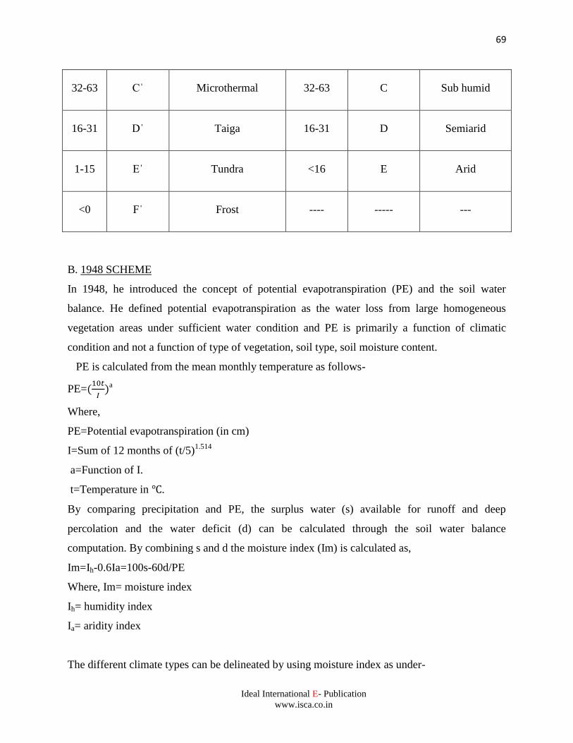
69
Ideal International E- Publication
www.isca.co.in
32-63 C Microthermal 32-63 C Sub humid
16-31 D Taiga 16-31 D Semiarid
1-15 E Tundra <16 E Arid
<0 F Frost ---- ----- ---
B. 1948 SCHEME
In 1948, he introduced the concept of potential evapotranspiration (PE) and the soil water
balance. He defined potential evapotranspiration as the water loss from large homogeneous
vegetation areas under sufficient water condition and PE is primarily a function of climatic
condition and not a function of type of vegetation, soil type, soil moisture content.
PE is calculated from the mean monthly temperature as follows-
PE=
a
Where,
PE=Potential evapotranspiration (in cm)
I=Sum of 12 months of (t/5)1.514
a=Function of I.
t=Temperature in .
By comparing precipitation and PE, the surplus water (s) available for runoff and deep
percolation and the water deficit (d) can be calculated through the soil water balance
computation. By combining s and d the moisture index (Im) is calculated as,
Im=Ih-0.6Ia=100s-60d/PE
Where, Im= moisture index
Ih= humidity index
Ia= aridity index
The different climate types can be delineated by using moisture index as under-
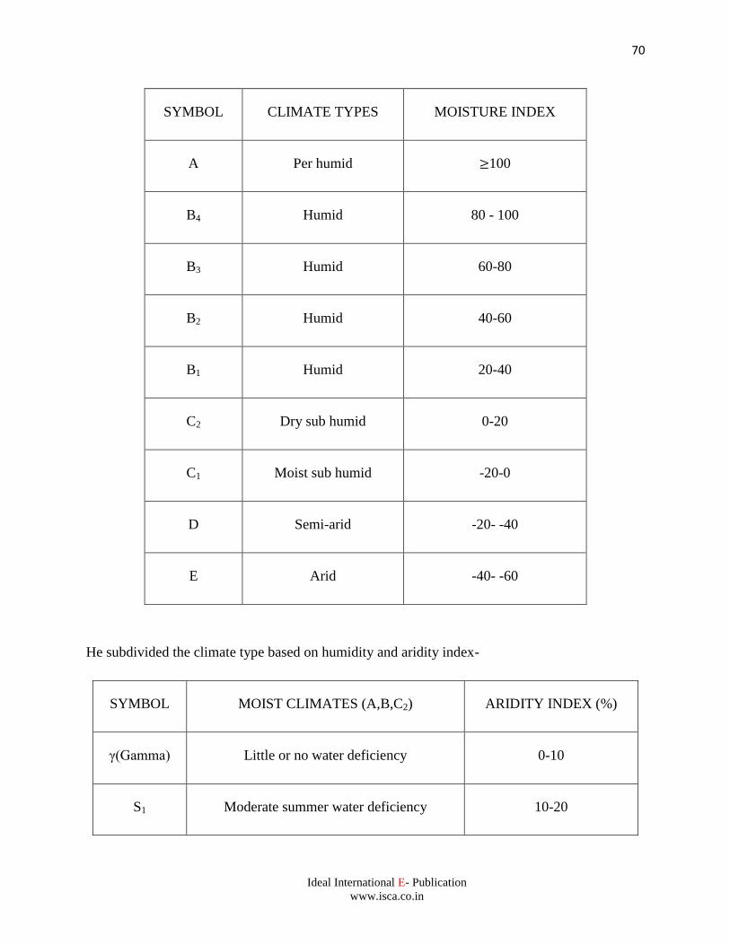
70
Ideal International E- Publication
www.isca.co.in
SYMBOL CLIMATE TYPES MOISTURE INDEX
A Per humid 100
B4 Humid 80 - 100
B3 Humid 60-80
B2 Humid 40-60
B1 Humid 20-40
C2 Dry sub humid 0-20
C1 Moist sub humid -20-0
D Semi-arid -20- -40
E Arid -40- -60
He subdivided the climate type based on humidity and aridity index-
SYMBOL MOIST CLIMATES (A,B,C2) ARIDITY INDEX (%)
γ(Gamma) Little or no water deficiency 0-10
S1 Moderate summer water deficiency 10-20
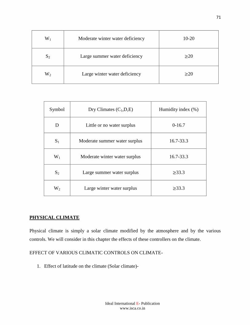
71
Ideal International E- Publication
www.isca.co.in
W1 Moderate winter water deficiency 10-20
S2 Large summer water deficiency 20
W2 Large winter water deficiency 20
Symbol Dry Climates (C1,D,E) Humidity index (%)
D Little or no water surplus 0-16.7
S1 Moderate summer water surplus 16.7-33.3
W1 Moderate winter water surplus 16.7-33.3
S2 Large summer water surplus 33.3
W2 Large winter water surplus 33.3
PHYSICAL CLIMATE
Physical climate is simply a solar climate modified by the atmosphere and by the various
controls. We will consider in this chapter the effects of these controllers on the climate.
EFFECT OF VARIOUS CLIMATIC CONTROLS ON CLIMATE-
1. Effect of latitude on the climate (Solar climate)-
72
Ideal International E- Publication
www.isca.co.in
The sun or we may say latitude is the principal control of climate. The climate of any place
by solar radiation is called the solar climate. Solar radiation is named as insolation. The heat
energy received from the sun at any place depends on the following factors-
a. Distance from the sun since insolation varies inversely as square of distance.
b. Inclination of the rays to the solar elevation, since the rays when falling obliquely upon a
surface are spread out over a larger area than when falling normally.
c. Duration –i.e., length of the day.
d. Transmission and absorption by the atmosphere.
e. Output of solar radiation.
2. Mountain and Plateau Climates (Effect of altitude on climate)-
Altitude also influences the climate at a given place as the various controls vary with altitude.
Thus, climate at mountain and plateau are different. The climates on mountains are
characterized by decrease in temperature, pressure and absolute humidity. They are also
characterized by an increase in insolation and in relative humidity. The mountains are cool in
summer because increase in loss of heat by radiation (40%) is more than increase in gain of
heat by insolation (20%).Precipitation increases with increase in altitude. Winds of local
nature such as mountain and valley breeze exist.
3. Marine Climate (effect of water on climate)-
Marine climate exists wherever water is the dominant control. They are therefore found over the
open ocean on small islands and along coasts. Marine climates are characterized by moderate
temperatures with small diurnal and annual ranges by high humidity both absolute and relative
and by much cloudiness and rainfall.
4. Continental Climate (effect of land on climate)-
Continental climate is exactly opposite to the marine climate. The land body has lower specific
heat as compared to the specific heat of water on sea. The temperature ranges, both annual and
73
Ideal International E- Publication
www.isca.co.in
diurnal are large. The limited amount of water for evaporation is responsible for low relative
humidity. The higher temperature of summer and the greater water vapor content (i.e., absolute
humidity) of the air during that season favor more convection than in winter but the average
percentage of cloudiness may vary little with the season since relative humidity is greater in
winter.
5. Desert Climate-
Desert climate is also referred to as extreme continental climate because of the similarity in the
high ranges of temperatures, humidity, cloudiness and rainfall. Two physical characteristics of
the deserts are-
a. A low relative humidity that results in a small amount of clouds but unless there is sufficient
cooling of the air no precipitation takes place.
b. A great diurnal range of temperature.
6. Monsoon Climate-
In winter, continents favor high pressure and outflowing wind and in summer they favor low
pressure and inflowing wind. Oceans favors the opposite conditions, high pressure and out
flowing wind in summer and low pressure and inflowing wind in winter. Thus, in winter the
wind flows from continents to oceans and in summer wind flows in the opposite direction
that is from ocean to continents and these winds are called monsoon winds and climate is
called as monsoon climate. A monsoon climate is characterized by:
1. In summer, high humidity (Both relative and absolute) and intense rainfall.
2. In winter, low humidity, little or no precipitation and clear skies.
Such climates exist in India, southern and eastern Asia, east central Africa and northern
Australia.
AGROCLIMATIC REGIONS OF INDIA
According to the Planning Commission (1989), there are 15 Agroclimatic zones in India.
1. Western Himalayan Regions: [J&K, HP, UP hills (silty loam soil)]
74
Ideal International E- Publication
www.isca.co.in
2. High Rainfall Regions: (7 Sisters state, Darjeeling hills, Jalpaiguri)
Run off problem
3. Lower genetic plains: (Regions in WB)
⮚ Ground water utilization is more than 35%.
⮚ This zone accounts for 12% of the country's rice production.
4. Mid Gangetic Plains: (12 districts of UP East, 27 districts of Bihar)
⮚ 16 million hectares of area.
⮚ Rainfall is high, 61% of the area is under rainfed cultivation.
⮚ Cropping intensity is 142%.
5. Upper Gangetic Plains: (32 Districts)
⮚ Irrigation intensity is 131%.
⮚ Cropping intensity is 144%.
⮚ Production of wheat and rice is high.
6. Trans Gangetic Plains:(Punjab, Haryana, Delhi, Chandigarh and Sriganganagar in
Rajasthan)
Highest net sown area, highest irrigated area, highest cropping intensity, highest ground
water utilization.
7. Eastern Plateau and Hills:(Odisha Hills, North Odisha, Madhya PradeshEastern Hillsand
Plateau, Chhattisgarh, South and West Bengal Hills)
⮚ Kharif (82% of area under rice)
⮚ Rabi (52% of area under oil seeds)
8. Central Plateau and Hills: (46 Districts of Madhya Pradesh, U.P and Rajasthan)
25% of the area is under rainfed.
9. Western Plateau and Hills: (Parts of Maharashtra, Madhya Pradesh and Rajasthan)
⮚ Average annual rainfall is 904 mm.
⮚ Irrigated area is 12.4%.
⮚ Sorghum and cotton are major crops.
⮚ 50% of the country's sorghum production.
⮚ Best quality of orange, grape, banana.
10. Southern Plateau and Hills: (35 Districts of Andhra Pradesh, Karnataka and Tamil Nadu)
⮚ Semi-arid zone.
75
Ideal International E- Publication
www.isca.co.in
⮚ 81% of the area is under rainfed farming.
⮚ 11% cropping intensity.
11. East Coast Plains and Hills: (Coast of Odisha, North coastal regions of Andhra Pradesh
and South coastal Tamil Nadu)
⮚ 20.3% of India’s rice production and 17% of groundnut.
⮚ Alkaline & saline soils.
12. West Coast Plains and Hills: (West Coast of Tamil Nadu, Kerala, Karnataka,
Maharashtra and Goa)
13. Gujarat Plains and Hills(19 districts of Gujarat)
⮚ 22.5% area is irrigated.
⮚ 78% of rainfed farming.
14. Western Dry Region(9 districts of Rajasthan)
⮚ Desert
⮚ Average rainfall 400 mm.
⮚ 1.2% forest area &4.3% pasture.
⮚ Cropping intensity is 105%.
15. ISLAND REGION (Andaman and Nicobar, Lakshadweep)
⮚ Half Cropped area under coconut
⮚ 3000 mm rainfall
D. RADIATIONS LAWS
PLANCK'S LAW
Electromagnetic radiation consists of the flow of quanta or particles. The energy content (E) of
each quantum is proportional to the frequency and it is given by the following equation.
E=hν
Where, h=Planck's constant
=6.625 x 10⁻²⁷
erg sec-1
The equation indicates that the greater the frequency the greater is the energy of the quantum.
KIRCHOFF’S LAW
76
Ideal International E- Publication
www.isca.co.in
Any grey object (other than a perfect black body) that receives radiation disposes of a part of it in
reflection and transmission. The values of absorptivity, reflectivity and transmissivity are less
than or equal to unity.
This law states that the absorptivity ‘a’ of an object for radiation of a specific wavelength
is equal to its emissivity ‘e’ for the same wavelength.
a (λ)=e (λ)
STEFAN –BOLTZMAN LAW
This law states that the intensity of radiation emitted by a radiating body is proportional to the
fourth power of the absolute temperature of that body.
Flux= σT4
Here σ is Stefan Boltzmann’s constant (5.67 x 10⁻⁵
erg.cm-2
sec-1
k-4
) and T is the absolute
temperature of the body.
WEIN’S LAW
The wavelength of maximum intensity of emission from a black body is inversely proportional to
the absolute temperature (T) of the body. Thus,
Wave length (λ) of maximum intensity (µm)=2897/T
LAMBERT’S LAW
This law states that the permeability of the atmosphere to solar radiation. The intensity of solar
radiation on a vertical irradiation at the earth’s surface is given by the equation.Im=I0qm.
77
Ideal International E- Publication
www.isca.co.in
REFERENCES
Brunt, D. (1952).Physical and Dynamical Meteorology, Cambridge University Press.pp 1-428.
Byers, H. R. (1974).General Meteorology, McGraw-Hill, New York.pp 1-461.
Lal, D. S. (2014).Climatology, Sharda PustakBhawan, Allahabad.pp 1-448. Mavi, H. S.
(2010).Introduction to Agrometeorology, Oxford & IBH Publishing Co. pp 1-286.
Mote, B. M and Sahu, D. D. (2014).Principles of Agricultural Meteorology, Scientific
Publishers, India.pp 1-197.
Murthy, V. R. K. (1996). Basic Principles of Agricultural Meteorology, Shri Venkateswar
Publishers, Hyderabad.pp 1-261.
Purohit, S. S. and Ranjan, R. (2003).Ecology, Environment and Pollution, Agrobios, Jodhpur,
India.pp 223-308.
Siddhartha, K. (2013). Atmosphere, Weather & Climate, Kisalaya Publications Pvt. Limited,
New Delhi, India. pp 1-547.
Varshneya, M.C. and Pillai, P. Balakrishna. (2018). Textbook of Agricultural Meteorology,
Indian Council of Agricultural Research, New Delhi, India. pp 1-221.