Embed Size (px)
Citation preview
AMEC Earth & Environmental a Division of AMEC Americas Limited 2227 Douglas Road, Burnaby, BC Canada V5C 5A9 Tel +1 (604) 294-3811 Fax +1 (604) 294-4664 www.amec.com
Preliminary Geotechnical HDD Feasibility Assessment
Hook Creek (Crossing #390)
Proposed Enbridge Northern Gateway Project
Rev R KP602.5
Submitted to:
Northern Gateway Pipelines Inc.
Calgary, Alberta
Submitted by:
AMEC Earth & Environmental, a division of AMEC Americas Limited
Burnaby, BC
May 25, 2010
AMEC File: EG0926008.3000
Document Control No. 1151-WC-20100714

Northern Gateway Pipelines Inc. Preliminary Geotechnical HDD Feasibility Assessment Hook Creek (Crossing #390) July 14, 2010
AMEC File: EG0926008.3000 Page i
TABLE OF CONTENTS
Page
1.0 PROJECT DESCRIPTION ............................................................................................. 1-1
2.0 SCOPE ........................................................................................................................... 2-1
3.0 GEOTECHNICAL & HYDROTECHNICAL SITE CONDITIONS ...................................... 3-1 3.1 Sources of Information ........................................................................................... 3-1 3.2 Topography ............................................................................................................ 3-1 3.3 Geology ................................................................................................................. 3-2 3.4 Slope Stability ........................................................................................................ 3-2 3.5 Stream Characteristics ........................................................................................... 3-2
4.0 PRELIMINARY ASSESSMENT ...................................................................................... 4-1 4.1 Horizontal Directional Drill (HDD) Crossing ............................................................ 4-1 4.2 Contingency Crossing Method ............................................................................... 4-2
5.0 FUTURE GEOTECHNICAL WORK TO SUPPORT DETAILED DESIGN ....................... 5-1
6.0 CLOSURE ...................................................................................................................... 6-1
REFERENCES ........................................................................................................................ 6-2
LIST OF FIGURES
Figure 1 Mean Monthly Flows of Hook Creek at Crossing ....................................................... 3-4
LIST OF PHOTOS
Photos 1 to 6
LIST OF DRAWINGS Drawing 08-3000-0602-1 Location Plan Drawing 08-3000-0602-2 Terrain Typing Drawing 08-3000-0602-3 Detailed Site Plan

IMPORTANT NOTICE
This report was prepared exclusively for Northern Gateway Pipelines Inc. by AMEC Earth & Environmental Limited, a wholly owned subsidiary of AMEC. The quality of information, conclusions and estimates contained herein is consistent with the level of effort involved in AMEC services and based on: i) information available at the time of preparation, ii) data supplied by outside sources, and iii) the assumptions, conditions and qualifications set forth in this report. This report is intended to be used by Northern Gateway Pipelines Inc. only, subject to the terms and conditions of its contract with AMEC. Any other use of, or reliance on, this report by any third party is at that party’s sole risk.

Northern Gateway Pipelines Inc. Preliminary Geotechnical HDD Feasibility Assessment Hook Creek (Crossing #390) July 14, 2010
AMEC File: EG0926008.3000 Page 1-1
1.0 PROJECT DESCRIPTION
Northern Gateway Pipelines Inc. (Northern Gateway), a subsidiary of Enbridge Pipelines Inc., initiated the regulatory phase of the Enbridge Northern Gateway Project (the Project) to obtain regulatory approvals to construct and operate the Project. The Project is being developed to provide pipelines and associated facilities for the transportation of approximately 83,400 m3/d (525,000 bbl/d) of oil from Bruderheim, Alberta to Kitimat, British Columbia and the transportation of approximately 30,700 m3/d (193,000 bbl/d) of condensate from Kitimat to Bruderheim. The Project includes the following major components:
• an oil pipeline, 914 mm OD (NPS 36), approximately 1172 km long extending from the outlet of the Bruderheim station to the Kitimat Terminal
• a condensate pipeline, 508 mm OD (NPS 20), approximately 1172 km long, located in the same right-of-way as the oil pipeline, extending from the Kitimat Terminal to the Bruderheim Station
• the Bruderheim Station, consisting of the oil initiating pump station and the condensate receiving facilities
• eight intermediate pump stations located at intervals along the pipelines • two tunnels, approximately 6.5 km and 6.6 km long, to route the oil and condensate
pipelines between the Clore River and Hoult Creek valleys • the Kitimat Terminal which will comprise the following:
o a tank terminal including oil tanks, condensate tanks and associated infrastructure
o a marine terminal including two tanker berths and one utility berth o an initiating condensate pump station
oil receiving facilities
Northern Gateway Pipelines Inc. Preliminary Geotechnical HDD Feasibility Assessment Hook Creek (Crossing #390) July 14, 2010
AMEC File: EG0926008.3000 Page 2-1
2.0 SCOPE
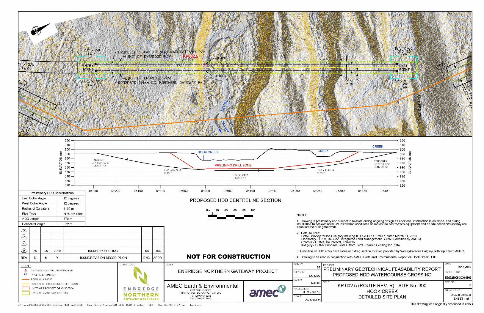
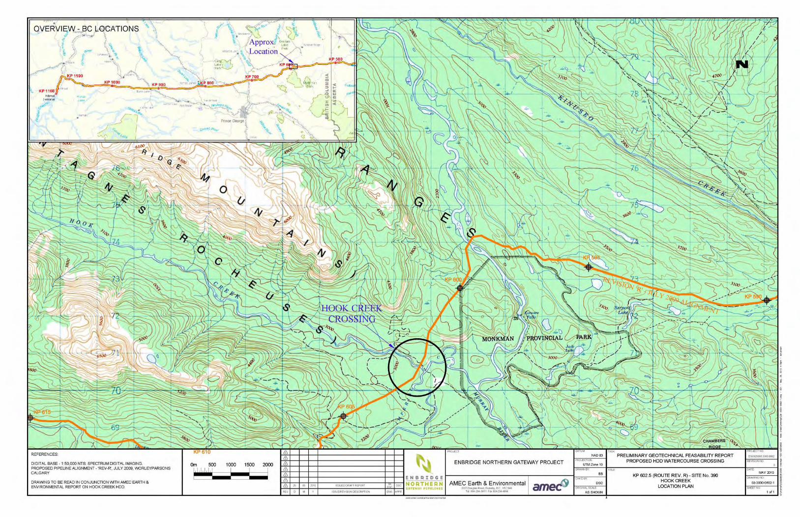
This report provides a preliminary geotechnical and hydrotechnical feasibility assessment of a proposed horizontal directional drill (HDD) crossing for the Enbridge Northern Gateway Project at Hook Creek (Crossing #390), KP 602.5 of the Rev R Alignment, as shown on Drawing 08-3000-0602-1.

Northern Gateway Pipelines Inc. Preliminary Geotechnical HDD Feasibility Assessment Hook Creek (Crossing #390) July 14, 2010
AMEC File: EG0926008.3000 Page 3-1
3.0 GEOTECHNICAL & HYDROTECHNICAL SITE CONDITIONS
3.1 Sources of Information
The following sources of information on site conditions were available at the time of report preparation:
1. Aerial photography (15BCB 96074 No. 98 to 100).
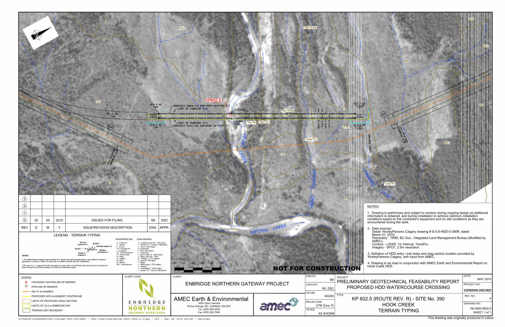
2. Project terrain type mapping (Drawing 08-3000-0602-2)
3. Topographic (bare earth hillshade) model generated from LiDAR survey (Drawing 08-3000-0602-3).
4. Airborne geotechnical reconnaissance has been carried out at several locations along the valley, including the presently considered crossing. The reconnaissance trips have been carried out at various times in 2005, 2006, and 2008, with the most recent work carried out near the proposed crossing site in November 2008.
5. Surficial geology (Maxwell 1976) and bedrock geology mapping (GSC 1979).
6. Hook Creek is not gauged; therefore, regional projections have been used to provide monthly mean flow information.
3.2 Topography
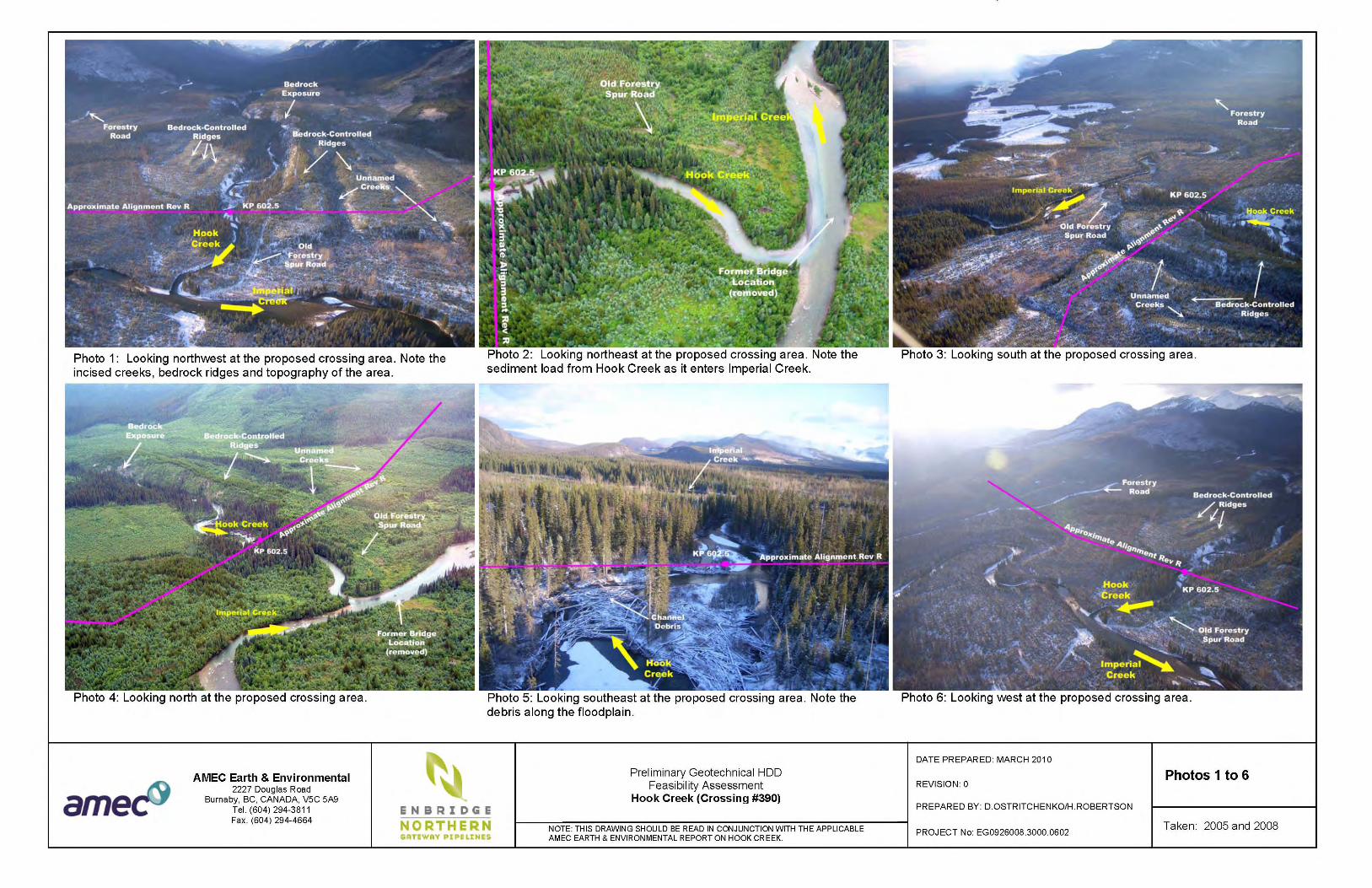
Hook Creek originates at Hook Lake, approximately 14 km northwest of the crossing location on the eastern flanks of the Rocky Mountains just west of Monkman Provincial Park. The crossing is located approximately 250 m upstream of the confluence of Hook Creek and Imperial Creek and approximately 1.6 km west the confluence of Imperial Creek with the Murray River. At the proposed crossing, Hook Creek flows southeast in an irregular meandering channel that is typically narrow, steep-sided and incised approximately 15 to 30 m into the bottom of a larger U-shaped glacial valley. In the vicinity of the proposed crossing, the Hook Creek floodplain ranges from about 75 to 150 m in width. The approach slopes range from very steep (45° due to undercutting by the stream) to gentle with heights of about 15 to 20 m. The slopes are less steep near the confluence with Imperial Creek. The terrain is ridged, with bedrock controlled troughs and ridges oriented roughly parallel to Hook Creek. A trough about 250 m northeast of the Hook Creek channel contains an unnamed stream that is much smaller than Hook Creek. Photos 1 through 6 show general conditions in the area.
Northern Gateway Pipelines Inc. Preliminary Geotechnical HDD Feasibility Assessment Hook Creek (Crossing #390) July 14, 2010
AMEC File: EG0926008.3000 Page 3-2
3.3 Geology
Surficial geology mapping indicates that the dominant surficial materials in the area include colluvial veneers, glacial till of variable depth, bedrock and glaciofluvial slopes on the Hook Creek valley slopes. Alluvial glaciofluvial and till deposits of variable depth overlying rock occur in Hook Creek valley and the neighbouring trough. Fluvial or glaciofluvial terraces occur at lower elevations along Imperial Creek (Maxwell 1976, Project mapping and local observation). Aerial reconnaissance and airphoto interpretation suggest that the Rev R alignment is located on glacial till overlying shallow bedrock on the east side of the crossing and fluvial terraces on the west side. On the west side of the crossing, approximately 15 to 20 m of sand and gravel deposits were exposed in the eroded terrace banks; these thick deposits likely represent glaciofluvial materials. Exposed bedrock and till were observed in the eastern valley slope at the sharp valley bend located about 150 m upstream of the Rev R alignment. Hook Creek and Imperial Creek are located in the vicinity of the relatively high, steep slopes of the Rocky Mountains, and this high energy environment may have introduced very coarse-grained materials (cobbles and boulders) into both valleys. It is possible that the unconsolidated glaciofluvial and fluvial materials underlying the proposed crossing include interbedded deposits with cobbles and boulders originating from both Imperial and Hook Creek valleys. Bedrock mapping in the area (GSC 1979) identifies bedrock east of Hook Creek as Banff Formation (brown calcareous siltstone, limestone and shale) and bedrock to the west as the Besa River Formation (black shale). The contact between these units occurs along a thrust fault and associated drag fold aligned approximately parallel to Hook Creek, located about 500 m east of the confluence of Hook Creek and Imperial Creek. Potential ARD considerations have been identified in the Besa River Formation to the west and are discussed under separate cover. Bedrock in the area appears from helicopter reconnaissance to be folded and the ridges in the area are likely controlled by the folded bedrock structure. 3.4 Slope Stability
No major stability considerations have been identified at the crossing location; however, the creek has been undercutting the toes of some of the steep slopes near the proposed HDD crossing, resulting in minor surficial slides and bank erosion of the valley walls. This erosion would not affect the proposed HDD crossing.
3.5 Stream Characteristics
At its headwaters near the source of the creek at Hook Lake, the gradient of Hook Creek varies between 3 and 4% for the first 3 km. Further downstream, the channel gradient flattens to less than 0.5% with a wetted width of approximately 50 m at the proposed crossing location.
Northern Gateway Pipelines Inc. Preliminary Geotechnical HDD Feasibility Assessment Hook Creek (Crossing #390) July 14, 2010
AMEC File: EG0926008.3000 Page 3-3
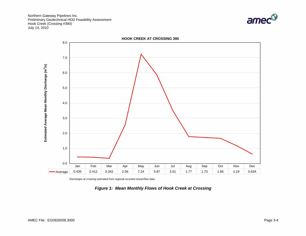
The creek has an irregular meander pattern within a valley that is controlled by the structure of the underlying bedrock. Several bars and islands are located upstream and downstream of the crossing. The crossing is located close to the junction between a braided section of channel upstream and an alluvial fan downstream. Farther upstream, the creek is extensively eroding in a canyon contributing surficial materials that are augmenting the braiding process. Debris jamming in the area is anticipated, as large amounts of debris eroded upstream are being deposited and/or transported past the crossing location. Preliminary estimates suggest scour of 2.5 m relative to the present channel bottom; however, debris jamming could increase scour depths and lateral erosion substantially. The creek is tending to erode laterally to the west near the proposed crossing, and further erosion is likely to occur. Erosion to the east is also occurring along parts of the channel and could occur at the proposed crossing in the future. West of the proposed alignment, future lateral migration by Imperial Creek may erode into the lower reaches of Hook Creek; hence the crossing should be located at least 150 m upstream of their confluence. Lateral erosion and scour potential need to be further assessed on the ground. Flow projections from regional data indicate that mean monthly discharge (flow) is:
• less than 1 m³/s from December to March; • 2.5 m³/s in April; • between 5 and 7 m³/s from May to June; • 3.5 m³/s in July; and, • 1 to 2 m³/s from August to November.
Note that subsurface flows are likely substantial. Figure 1 below, shows the mean monthly flows.
Northern Gateway Pipelines Inc. Preliminary Geotechnical HDD Feasibility Assessment Hook Creek (Crossing #390) July 14, 2010
AMEC File: EG0926008.3000 Page 3-4
Figure 1: Mean Monthly Flows of Hook Creek at Crossing
HOOK CREEK AT CROSSING 390
0.0
1.0
2.0
3.0
4.0
5.0
6.0
7.0
8.0Es
timat
ed A
vera
ge M
ean
Mon
thly
Dis
char
ge (m
3 /s)
Average 0.435 0.412 0.342 2.56 7.24 5.87 3.51 1.77 1.73 1.66 1.19 0.634
Jan Feb Mar Apr May Jun Jul Aug Sep Oct Nov Dec
Discharges at crossing estimated from regional recorded streamflow data.
Northern Gateway Pipelines Inc. Preliminary Geotechnical HDD Feasibility Assessment Hook Creek (Crossing #390) July 14, 2010
AMEC File: EG0926008.3000 Page 4-1
4.0 PRELIMINARY ASSESSMENT
The geotechnical and hydrotechnical assessments of an HDD crossing and a potential contingency crossing method are summarized below.
4.1 Horizontal Directional Drill (HDD) Crossing
The preliminary HDD crossing is shown on Drawing 08-3000-0602-3. The crossing location is northwest (upstream) of Rev R to allow for possible lateral erosion of Imperial Creek toward Hook Creek southwest of the crossing. Further hydrotechnical review of the potential extent of lateral erosion is anticipated during future studies. An HDD crossing at the proposed location is considered appropriate for the purposes of project planning based on the preliminary information outlined above and the preliminary no-drill zone shown on Drawing 08-3000-0602-3. The preliminary no-drill zone was established using the following criteria:
1. Maintaining the static mud pressure in the directional drill hole to a level less than or equal to the vertical overburden total stress under the valley bottom of Hook Creek and a tributary of Imperial Creek northeast of Hook Creek. This methodology has been found to greatly reduce the potential for hydro-fracing and if hydro-fracing occurs, leakage will stop when mud circulation stops, allowing mitigative solutions to be applied.
2. No allowances for slope stability in the no-drill zone are required at the Hook Creek crossing.
3. It was assumed that coarse grained soils or bedrock faulting are not present in locations that would provide a direct seepage path to the river.
Further field studies should be carried out to investigate geotechnical conditions with respect to:
1. Hydrotechncial and geotechnical reviews of the potential for lateral erosion relative to the potential movement of Imperial Creek and possibly Hook Creek. The review will provide input to adjusting the crossing location if required.
2. Depth, lithology and lateral distribution of deposits and the topography of the bedrock surface underlying the valley within the approximate lateral limits of the HDD path.
3. Nature of the bedrock and the topography of the buried bedrock surface if drilling through the bedrock will be required (including competency, joint and fault patterns, lithology, whether ARD potential may be present). A thrust fault is indicated near the crossing to the west on some geologic maps.
Northern Gateway Pipelines Inc. Preliminary Geotechnical HDD Feasibility Assessment Hook Creek (Crossing #390) July 14, 2010
AMEC File: EG0926008.3000 Page 4-2
4.2 Contingency Crossing Method
Isolated crossing methods are feasible from the geotechnical and hydrotechnical points-of-view. Based on estimated average flow rates, isolation using dam and pump or fluming methods appears to be feasible from August through April. The location of the crossing relative to possible lateral erosion by Imperial Creek, topography along Hook Creek and excavation considerations on the approach slope slopes and adjacent upland will require consideration. Scour depths and the depth and elevation of excavation during construction will also be important considerations as will be the possible presence of bedrock Isolated crossing methods are generally considered feasible from a hydrotechnical point-of-view.
Northern Gateway Pipelines Inc. Preliminary Geotechnical HDD Feasibility Assessment Hook Creek (Crossing #390) July 14, 2010
AMEC File: EG0926008.3000 Page 5-1
5.0 FUTURE GEOTECHNICAL WORK TO SUPPORT DETAILED DESIGN
1. Carry out detailed geotechnical and hydrotechnical ground reconnaissances in the proposed crossing area.
2. Obtain survey data across the channel as required for scour modelling and to indicate the channel bottom accurately on cross sections.
3. Finalize crossing alignment to be determined in conjunction with input from the Project Team.
4. Complete a combined drilling investigation and geophysical survey to determine subsurface geological conditions at the crossing.
5. Carry out a hydrotechnical review of lateral erosion potential on both Imperial and Hook Creeks.
6. Conduct a hydrotechnical scour assessment if required by crossing method considerations and stream flow measurement.
7. Provide a combined hydrotechnical and geotechnical report on crossing feasibility based on the foregoing investigation.
Northern Gateway Pipelines Inc. Preliminary Geotechnical HDD Feasibility Assessment Hook Creek (Crossing #390) July 14, 2010
AMEC File: EG0926008.3000 Page 6-1
6.0 CLOSURE
Recommendations presented herein are based on a geotechnical and hydrotechnical evaluation of the information discussed above. This report is preliminary and recommendations contained herein should be updated and revised as additional information becomes available from further investigations.
This report has been prepared for the exclusive use of Northern Gateway Pipelines Inc. for specific application to the area described within this report. Any use which a third party makes of this report, or any reliance on or decisions made based on it, are the responsibility of such third parties. AMEC accepts no responsibility for damages, if any, suffered by any third party as a result of decisions made or actions based on this report. It has been prepared in accordance with generally accepted geotechnical engineering practices. No other warranty, expressed or implied, is made.
Respectfully submitted, AMEC Earth & Environmental, a division of AMEC Americas Limited
Reviewed by:
Per
D.S. (Drum) Cavers, M.Eng., P.Eng., P.Geo. Principal Engineer
Pete Barlow, M.Sc., P.Eng. Principal Geotechnical Engineer
Northern Gateway Pipelines Inc. Preliminary Geotechnical HDD Feasibility Assessment Hook Creek (Crossing #390) July 14, 2010
AMEC File: EG0926008.3000 Page 6-2
REFERENCES
GSC Open File 630, 1979. Geology compiled by Stott, D.F. 1975, and Taylor, G.C. 1979. Bedrock Geology Monkman Pass (93I) Map Area British Columbia; Geological Survey of Canada. 1:125,000. Maxwell, R. 1976. Surficial Geology of Kinuseo Falls Map Area (NTS 93I/14). Department of Lands and Forests. 1:50,000.


�
�����
����������
�
�����
����������
�����
����
���
��
�����
��
�
����
���
����
������
�������
���
������
���
��
�������
��
���
��
���
���
����������������������
� �� ����
������������������������ ������������������ �� �!������������������
����
����������������
�� �� ���������������!���������
��"#���#�
�����������
������ !�� ��
���$ � ��
���%��� ���
����
��&� ��
�����!�
���'�%#(�)��������"#��*�+��������#��,�����������
�������������
�����-./0�1���23.��4��/-5�
�036�7.-83�9�8-6��.393�-55:�;.�7<=�7�3��=�5�<.#
�>('��;3���.�6=��/�.3�=�����.9�&� �&��� �"%��%�,
��5#�)%(�*�('>+�%>��-?�)%(�*�('%+@�>(
�����A��"������ �������������" �
�
�
���# ���#
������
�#�� .-83�9�36�;.�5343�-.:�-�7�6<BC�=/�/��.�2363���7<.3�9���9�3�9�7�639��-6�-773/3��-53�D�.4-/3���36��B/-3��7&�-�7�7<.3�9�3�6/-55-/3���/��-=03�2���;/34<4�3�6/-55-/3��=��73/3��6�B-6�7����/0��=��/.-=/�.$6��E<3;4��/�-�7����63/��=��73/3��6�-6�/0�:�-.���=�<�/�.�7�7<.3�9�/0��8�.F#
%#�� -/-�6�<.=�6������ �/-35+�!�.5�:�-.6��6��-59-.:�7.-83�9�G� +(#�+� +�+�,��&�7-/�7������-.=0���&�%���#������5-�34�/.:�+�����&� ����2#&���/�9.-/�7�-�7��-�-9�4��/� <.�-<�)��73D3�7�B:��������*#��������/�<.�+�3 �&��4���/�.2-5&���..-�.�#������4-9�.:�+�����&�%#(4�.�6�5</3��#
�#� �D3�3/3����D�� ���/.:�A��?3/�637�6�-�7�7.-9�6�=/3���5�=-/3���;.�237�7�B:!�.5�:�-.6��6��-59-.:&�83/0�3�;</�D.�4����#
>#� .-83�9�/��B��.�-7�3��=��C<�=/3���83/0������-./0�-�7���23.��4��/-5���;�./������F��.��F�� #
���� �
���������������������������
����������������
��"����������
������� �� ������������������
���������������� � ����������
���������%(#��4��� �� ����A!
������������ ��� ��
������ ������ ������
�!�������
�
��+����+�'�%+%���������D��
%���
�
%
%( �( �� ������� ����������
���
>��4 %� ��'� ���

�