Embed Size (px)
Citation preview

Fleet Management Limited
Passage Plan
Section 11Departure Port Information
Section 2Charts
Section 12 : Sea Passage Information
Section 8ISPS
Section 5Weather Conditions
Section 13 CArrival Port – Passage from EOSP to Anchorage / Drifting in open
safe waters
Section 4Tides and Currents
Section 7Bridge Team Management
Section 6Reporting details
Section 9Environmental
Section 1General Information
Section 3Publications
Section 10Contingencies
Section 14 AUKC Instructions
Instructions for Use
Section 15 : Master's review
Section 14 BUKC Calculation
(Point of least depth at Departure)
Section 14 DSquat Calculation
PRINT ALL
Section 13 AArrival Port Information
Section 13 BArrival Port – Passage from Pilot
Station to Anchorage
Section 14 CUKC Calculation
(Point of least depth at Arrival)
Section 16Minor Last Minute Changes
Section 17Post Voyage De-brief of
Passage Plan

NAV-001 Rev 0 Nov 2011

Fleet Management Limited
Instructions for use
Sr. No. Guidelines
1
2
3
4
5
6
7
8
9
10
11
As per the requirements of STCW, "Passage Planning" is mandatory and all vessels in our fleet shall comply fully with the requirements in order that safety of navigation is enhanced and the rules are complied with.
The Master shall ensure that a plan for the intended voyage is prepared before sailing. The passage plan must be prepared berth to berth for each intended passage including shifting berths within a port using the company's format - NAV 1.When shifting between berths in a port or between terminals or ports in a river or waterway, only relevant sections of the Passage Plan need to be filled.The voyage should be executed in accordance with the Passage Plan. In the event of any changes to the planned route during the voyage the Passage Plan should be revised and the changes must be made known to all the Watch Officers.Section 16 of the passage plan is to be used to document last minute changes or changes made after the pilot boards.
The passage plan must be made prior commencement of the Voyage. Please use a fresh spread sheet for every passage plan. Please save the Master file and rename the file for use. The Passage Plan file is protected so that the formulae may not be inadvertently disturbed while filling in the Passage Plan.
The Home page must be used to directly navigate to any sheet of the passage plan. For ease of reference the passage plan is made out in a list of 17 sections. Each section has a button to navigate back to the Home page .
Section 1 : This section contains General information which must be filled in prior preparing the plan. Please fill in this section completely prior to filling up the remaining passage plan. Where applicable select the data from the drop down list. The information fed in to this section is directly linked to the other sections.
Section 2: This section contains information to be laid out on Navigation charts. As soon as the chart number is entered the other columns which must be filled in become visible. Please collect relevant information for every cell after referring to the respective chart. For entering information in this sheet, Select the relevant data for every cell from the drop down list and do not leave any cell blank. The data from the columns marked " Following to be marked on the Chart" must be plotted/marked on individual charts.
Section 3: This section must contain information of publications in use for the present voyage . Please use the drop down menu for selecting applicable Voyage publications only. Please fill in the required data in the Blue shaded cells for the latest edition, the edition on board and corrected up to NTM No. Where the drop down Menu does not contain the required publication , please enter the same manually in the blank space provided.
Section 4 : Tides for departure, arrival port and during passage need to be filled in the relevant sections. Significant currents and tidal streams to be encountered enroute must also be filled into the relevant section.
Section 5: Weather conditions, briefly describe weather expected enroute and special climatic conditions/phenomenon which may be experienced.Section 6 : Please fill in the relevant reporting details and attach a VTS reporting diagram (If applicable) from the ALRS for ready reference.Section 7 : Please fill in the BTM chart for the present voyage with special reference to doubling up of watches as required.
Section 8: Please fill in the ISPS information for the relevant passage. Where applicable select the data from the drop down list. This section should be completed and signed by the Ship security officer.
Section 9: Please fill in the relevant environmental protection information pertaining to the voyage. Where applicable select the data from the drop down list.

12
13
14
15
16
17
18
19
NAV-001 Rev 0 Nov 2011
Section 10: Please be guided by the emergency procedure manual for handling emergencies and fill in section 4 to detail the Ports of refuge during the voyage. Please list general precautions for the voyage in section 5 For example: Keep clear of Fishing nets which will be encountered whilst in Taiwan straits. Keep a good look out for small wooden fishing boats not readily visible on the radar.
Section 11,12,13 :Please fill in name of the waypoint and the co-ordinates (LAT/LONG) in the blue color cells. As soon as the waypoint number is fed in , the UKC information becomes visible. The program calculates the Distance to go and the True course. Please also fill in the intended transit speed and the charted depth at every waypoint . The program will provide UKC at every waypoint.
Section 14 A, B, C: The UKC calculation must be carried out as per attachments. Fill in the required data in the Blue color cells. Section 14 B/ C UKC calculations are specifically provided to calculate under keel clearance with variable drafts, vessels condition and after factoring in local tides.
Once completed, please take print outs of all the sections using the "PRINT ALL " button available on the Home page. Additional relevant data may be attached to the passage plan as required.
Section 15: A print out of this section must be obtained and then the Master must review the entire passage plan. All the data filled in various sections must be reviewed by the Master and YES/NO/NOT APPLICABLE must be written down in the space provided. All officers comprising the bridge team must sign the plan to confirm understanding and compliance and clarify doubts if any.
Section 16: Any last minute deviation made by the Master before pilot boarding, particularly with regards to pilotage and near shore waters should be discussed with all navigating officers and hand written in this section whenever applicable.
Section 17: Whenever possible after the completion of a passage, the master should take the opportunity to discuss the planning and execution of the passage with his team members. Possible weakness should be openly admitted and discussed so that they may be corrected or allowed for in future passages. Such a de brief need not take long, and can take place during the passage whilst the memory is still fresh in people's minds. Where corrections are made to a planned passage they can be saved for future use.
Vessels calling US Waters are required to send passage plan duly signed by the Master and other Navigating officers to Office prior entering US waters on email ID [email protected].
Vessels departing from US ports or shifting port/ berth/ anchorage within US waters are required to send passage plan duly signed by the Master and other Navigating officers to Office prior vessel's departure on email ID [email protected]

Fleet Management Limited
Passage Plan
Section 1: General information
Vessel's Name TANKER Departure Port Information
Voyage Number 1 Name of the Port QUINGDAO,CHINA
Vessel's Condition Loaded ETD 5/30/2014 / 1400Hrs.
Target Speed 14 Time Zone 8
Target RPM 102 Estimated ROB's on Departure
Total Steaming Time 3D 12H 12M HFO250
Total distance to go 1305 MDO/MGO 150
34.7 FW200
Max Summer Draft 11 MECYL1500
Departure Draft (mtrs) Arrival Port Information
Fore 8.50 Name of the Port YOKOHAMA,JAPAN
Aft 8.50 ETA 6/3/2014 / 1212Hrs.
Max Air Draft 43.30Time Zone
9Density 1.025
Arrival Draft (mtrs) Estimated ROB's on Arrival
Fore 8.50 HFO 250
Aft 8.50 MDO/MGO 100
Max Air Draft 43.30 FW 195
Density 1.025 MECYL 1480
Consumptions / Day in MT
HFO 20 Block Coefficient 0.71
MDO/MGO 4 Clock to be advanced/Retarded during voyage
L.O.- ME CYL Ltrs/day 2 Clocks TO BE ADVANCED BY
Fresh Water Data Duration 1 HR
12 If the vessel is Crossing International Date line
15 Date of Crossing NA
1Not Applicable
Max height above Keel (in Meters)
FW Consumption/ day in MTFW Production / day in MT
Net Gain / Loss / day in MT
Day Advance/ Retard

Fleet Management Limited
Section 2: Nautical charts - AppraisalM.V./M.T.: TANKER Voyage No: 1
Chart No. T & P Corrections
FOLLOWING TO BE MARKED ON THE CHART
B.A 876 NIL Yes Yes Yes Yes Yes Yes Yes Yes Unlashed Visual Radar
B.A1253 NIL Yes Yes Yes No Yes Yes Yes Yes Unlashed Visual Radar/GPS
B.A 3480 NIL N/A Yes Yes No N/A No N/A N/A Lashed GPS Radar/GPS
B.A 3237 NIL N/A Yes Yes No N/A No N/A N/A Lashed 15 mins GPS Radar/GPS
B.A 1648 196T/14 N/A Yes Yes No N/A No N/A N/A Lashed 30 mins GPS Radar/GPS
B.A 996 196T/14 N/A Yes Yes No N/A No N/A N/A Lashed 60 mins GPS Radar/GPS
JP80 NIL N/A Yes Yes No N/A No N/A N/A Lashed 60 mins GPS Radar/GPS
JP1062 N/A Yes Yes No N/A Yes Yes N/A Unlashed 30 mins Visual Radar/GPS
JP 66 Yes Yes Yes Yes Yes Yes Yes Yes Unlashed Visual Radar/GPS
M/E ready for
Manouvering
Position Plotting Interval
METHOD OF POSITION FIXING
Parallel Indexing
Wheel Over Position
Abort Positions
Contingency Anchorage
No-Go Areas
Echo Sounder Usage
Possibility of Banking
Effect
Anchors Lashed / Unlashed
Primary method
Secondary method
5 mins or less
5 mins or less
10 mins or less
5324T/13,195T/14,1108T/14
45T/09,593T/09,2811T/09,3620T/09,3982T/09
5 mins or less
Select from list
Select from list
Select from list
Select from list
Select from list
Select from list
Select from list
Select from list
Select from list
Select from list
Select from list
Select from list
Select from list
Select from list
Select from list
Select from list
Select from list
Select from list
Select from list
Select from list
Select from list
Select from list
Select from list
Select from list
Select from list
Select from list
Select from list
Select from list
Select from list
Select from list
Select from list
Select from list
Select from list
Select from list
Select from list
Select from list
Select from list
Select from list
Select from list
Select from list
Select from list
Select from list
Select from list
Select from list
Select from list
Select from list
Select from list
Select from list
Select from list
Select from list
Select from list
Select from list
Select from list
Select from list
Select from list
Select from list
Select from list
Select from list
Select from list
Select from list
Select from list
Select from list
Select from list
Select from list
Select from list
Select from list
Select from list
Select from list
Select from list
Select from list
Select from list
Select from list
Select from list
Select from list
Select from list
Select from list
Select from list
Select from list
Select from list
Select from list
Select from list
Select from list
Select from list
Select from list
Select from list
Select from list
Select from list
Select from list
Select from list
Select from list
Select from list
Select from list
Select from list
Select from list
Select from list
Select from list

Chart No. T & P Corrections
FOLLOWING TO BE MARKED ON THE CHARTM/E ready for
Manouvering
Position Plotting Interval
METHOD OF POSITION FIXING
Parallel Indexing
Wheel Over Position
Abort Positions
Contingency Anchorage
No-Go Areas
Echo Sounder Usage
Possibility of Banking
Effect
Anchors Lashed / Unlashed
Primary method
Secondary method
Please provide chart numbers of Charts other than WGS 84 Datum:
Please provide chart numbers of Charts other than WGS 84 Datum:
Select from list
Select from list
Select from list
Select from list
Select from list
Select from list
Select from list
Select from list
Select from list
Select from list
Select from list
Select from list
Select from list
Select from list
Select from list
Select from list
Select from list
Select from list
Select from list
Select from list
Select from list
Select from list
Select from list
Select from list
Select from list
Select from list
Select from list
Select from list
Select from list
Select from list
Select from list
Select from list
Select from list
Select from list
Select from list
Select from list
Select from list
Select from list
Select from list
Select from list
Select from list
Select from list
Select from list
Select from list
Select from list
Select from list
Select from list
Select from list
Select from list
Select from list
Select from list
Select from list
Select from list
Select from list
Select from list
Select from list
Select from list
Select from list
Select from list
Select from list
Select from list
Select from list
Select from list
Select from list
Select from list
Select from list
Select from list
Select from list
Select from list
Select from list
Select from list
Select from list
Select from list
Select from list
Select from list
Select from list
Select from list
Select from list
Select from list
Select from list
Select from list
Select from list
Select from list
Select from list
Select from list
Select from list
Select from list
Select from list
Select from list
Select from list
Select from list
Select from list
Select from list
Select from list
Select from list
Select from list
Select from list
Select from list
Select from list
Select from list
Select from list
Select from list
Select from list
Select from list
Select from list
Select from list
Select from list
Select from list
Select from list
Select from list
Select from list
Select from list
Select from list
Select from list
Select from list
Select from list
Select from list
Select from list
Select from list
Select from list
Select from list
Select from list
Select from list
Select from list
Select from list
Select from list
Select from list
Select from list
Select from list
Select from list
Select from list
Select from list
Select from list
Select from list
Select from list
Select from list
Select from list
Select from list
Select from list
Select from list
Select from list
Select from list
Select from list
Select from list
Select from list
Select from list
Select from list
Select from list
Select from list
Select from list
Select from list
Select from list
Select from list
Select from list
Select from list
Select from list
Select from list
Select from list
Select from list
Select from list
Select from list
Select from list
Select from list
Select from list
Select from list
Select from list
Select from list
Select from list
Select from list
Select from list
Select from list
Select from list
Select from list
Select from list
Select from list
Select from list
Select from list
Select from list
Select from list
Select from list
Select from list
Select from list
Select from list
Select from list
Select from list
Select from list
Select from list
Select from list
Select from list
Select from list
Select from list
Select from list
Select from list
Select from list
Select from list
Select from list
Select from list
Select from list
Select from list
Select from list
Select from list
Select from list
Select from list
Select from list
Select from list
Select from list
Select from list
Select from list
Select from list
Select from list
Select from list
Select from list
Select from list
Select from list
Select from list
Select from list
* TMSA 5.4.1 : If electronic charts are in use , the electronic charts should be kept fully corrected. Officers using electronic charts must be appropriately trained
NAV-001 Rev 0 / Nov 2011

Chart No. T & P Corrections
FOLLOWING TO BE MARKED ON THE CHARTM/E ready for
Manouvering
Position Plotting Interval
METHOD OF POSITION FIXING
Parallel Indexing
Wheel Over Position
Abort Positions
Contingency Anchorage
No-Go Areas
Echo Sounder Usage
Possibility of Banking
Effect
Anchors Lashed / Unlashed
Primary method
Secondary method
- Plotting sheets are not to be used for navigation under any circumstance.
* TMSA 5.4.1 : If electronic charts are in use , the electronic charts should be kept fully corrected. Officers using electronic charts must be appropriately trained

Fleet Management Limited
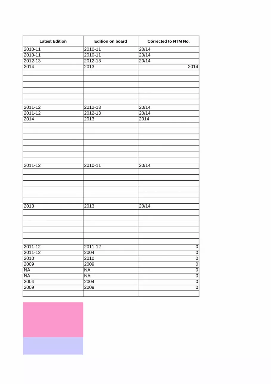
Section 3: PublicationsM.V / M.T. TANKER Voyage No: 1
Voyage Charts corrected upto: 20/14 NTM Number
Applicable Admiralty List of Radio Signals Applicable List of Sailing Directions
List of Radio Signals Sailing Directions
2010-11 2010-11 20/14 NP32 China Sea Pilot Vol 3 2011-12 2012-13 20/14
2010-11 2010-11 20/14 NP42B Japan Pilot Vol 3 2011-12 2012-13 20/14
2012-13 2012-13 20/14 NP42A Japan Pilot Vol 2 2014 2013 2014
2014 2013 2014
Applicable Admiralty List of Lights and fog signals Applicable Admiralty Tide tables
List of Lights Tide tables
2011-12 2010-11 20/14 2013 2013 20/14
DetailsPublication Remarks
45 yes NP 131 Chart Catalogue 2011-12 2011-12
Vessel's present Navarea 12 yes 2011-12 2004
Navareas to be transited 12 yes NP 100 Mariners hand book 2010 2010
Navtex /local area warnings? 68 yes Guide to port entry 2009 2009
Navtex Areas selected I yes Admiralty Co-Tidal Atlas NA NA
YOKOHAMA yes Tidal Stream Atlas NA NA
Ocean routeing services NA Load line Chart 2004 2004
Radio Weather Broadcasts?
2009 2009
Inmarsat Broadcasts (EGC warnings)45 yes
Special area warnings 121 yes Arrival port Dep. Port
Region A Region B
Latest Edition
Edition on board
Corrected to NTM No.
Latest Edition
Edition on board
Corrected to NTM No.
NP286(6) Volume 6 - Part 6, North East Asia
NP282 Volume 2, Radio Aids to Navigation, Satellite Navigation
Systems, Legal Time, Radio Time Signals and Electronic Position Fixing
Systems
NP283(2) Volume 3 - Part 2, Maritime Safety Information Services (Oceania and the Americas and the Far East)
NP284 Volume 4, Meteorological Observation Stations
Latest Edition
Edition on board
Corrected to NTM No.
Latest Edition
Edition on board
Corrected to NTM No.
NP85 Volume M: Western side of North Pacific Ocean; excluding western parts of Philippines, East China and Yellow
Seas
NP204 Volume 4, Pacific Ocean (including Tidal
Stream Tables)
Details of latest Radio/ Electronic Broadcasts (Add any other information in the blank spaces provided)
Applicable Miscellaneous publications (Add any other publication in use in the blank spaces provided)
Latest warning available
Applied on charts
Latest Edition
Edition on board
Navareas/ Hydrolants/ Hydropac warnings
NP 136 Ocean Passages of the world
Weather Facsimile broadcasts (List the Chart station)
Routeing charts & Guidance for Laden tanker routes off Dutch coast and South Africa
NP 735 IALA Buoyage System
NAV-001 Rev 0 Nov 2011

Fleet Management Limited
Section 4: Tides and current
M.V./M.T.: TANKER Voyage No: 1
Departure Port
1) Departure Date 30-May-14
2) Departure Time 14:00:00 PM Lt
3) Tides TIME HEIGHT
i. High water 23:35 1.5
ii. Low water 9:00 0.3
4) Tidal Streami. Rate
ii. Direction
Arrival Port
1) Arrival Date 03-Jun-14
2) Arrival Time 1221Hrs.Lt
3) Tides TIME HEIGHT
i. High water 0:16 1.6
ii. Low water 7:12 0.7
4) Tidal Streami. Rate -2.3
ii. Direction Southerly
During The Passage(Straits, channels, Ocean Currents etc)
1) Position 35-10.4N / 139-46.8E
2) Arrival Date 03-Jun-14
3) Arrival Time 1212Hrs. Lt
4) Tides TIME HEIGHT
i. High water 0:16 1.6
ii. Low water 7:12 0.7
5) Tidal Streami. Rate -2.3
ii. Direction Southerly
6) Currentsi Name
ii. Rate 1.5 Kts
iii Direction NE
NAV-001 Rev 0 Nov 2011
Koroshio Current

Fleet Management Limited
Section 5: Weather conditionsM.V./M.T.: TANKER Voyage No: 1
Navtex Station Weather Fax StationI tokyo (JMH)
13622.5, 7795, 3988.5
1) Are Weather Routing Services being provided ?
Which organization is providing these services ? NA
Is the routine weather routing format/report available? NA
2) What are the expected weather conditions on during the passage ?
GOOD
3) What is the max height of swell expected at Departure/ Arrival port & during Sea passage ?
0.5
4) What is the max wind speed expected at Departure/ Arrival port & during Sea passage ?
10.-35
5) What is the max / minimum temperature likely to encounter during voyage ?
27-31
6)
NA
7) Is the vessel expected to encounter ice during passage, if yes please advise precautions taken ?
NO
8)
NO
9) What is the GM of the vessel on Departure, Arrival & expected minimum GM during Sea passage ?
Departure 1 Arrival 1 Passage 1
NAV-001 Rev 0 / Nov 2011
Is the vessel expected to experience areas with restricted visibility during the passage, if yes, please list the way point no's where restricted visibility may be encountered.
Is the vessel expected to encounter any Tropical Cyclones / Typhoons / Tropical Depression / Hurricanes during voyage ?

Fleet Management Limited
Section 6: Reporting DetailsM.V./M.T.: TANKER Voyage No: 1
A) ENOA / D1. ENOA/D to send (For US Calling vessels only) No
If Yes , Expected Date of submission ENOA/D to NVMC/ SANS Date N.A
2. Expected Date of submission ENOA/D to OFFICE REVIEW Date N.AReminder:1) Vessel to send ENOA for office review prior sending same to NVMC and ENOA has to be forwarded to NVMC
2) Vessels calling US Waters are required to send completed passage plan copies duly signed by the Master and other
4) Vessels departing US ports are required to send completed passage plan copies duly signed by the Master and other
5)Vessel to send ENOD for office review prior sending same to NVMC and ENOD has to be forwarded to NVMC atleast 6
Remarks (If any)
B) PILOTS1. How many days pre arrival notice to be given to Pilot station at arrival port.Days Hrs 72 Hrs.
2. Means of Communication with pilot station (Email, VHF etc)
VHF Channels 11,12,14,18,20,22 , 16 Email address [email protected]
Any other means
Remarks (If any)
send Email 24 Hrs. Before arrival P/s Uraga Informing arrival of vessel.
C) VTS (Vessel traffic system)/ Ship's position reports during the voyage :VTS Sector Reporting Position VTS Callsign VHF Channel Remarks
Quingdao Port ControlReport Vsl. All Lines Cast Off 16 Report Proceeding to Yokohama, Japan 16 report E.T.A
yokohama portcontrolwhen abeam uraga suido traffic 16 report E.T.Ayokohama portcontrol when abeam naka-no-se traffic 16 advised final E.T.A.
Yes
Remarks (If any)
NOTICE OF READINESS
D) CHARTERERS/ Agents1. Is any notice required to be given to Charterers/agents prior departure / Yes
Arrival and by what means
2. Means of Communication with Charterers/agents Email address [email protected] Email addressEmail address Email address
Any other means
3. Interval of notices to Charterers/agents, Please state days/ hrs Days 1 Hrs 6
Remarks (If any)
NAV-001 Rev 0 / Nov 2011
at least 96 hrs prior entering US Waters (Voyage type = Foreign to US).
Navigating Officers to Office on email ID [email protected] prior entering US Waters.3) Vessels calling US to US port (different COTP zone) are required to send 'E-NOA with voyage type US to US'.
Navigating Officers to Office on email ID [email protected] prior vessel's departure.
hours prior departing the berth (Voyage type = US to Foreign).
Is Vessel participating in any SRS Ship reporting system (eg AMVER/ AUSREP/ JASREP etc)

NAV-001 Rev 0 Nov 11
Fleet Management Limited
Section 7: BRIDGE MANAGEMENT TEAMM.V./M.T.: TANKER Voyage No: 1
Note: Cadets and any other ratings without appropriate certification should not be part of the bridge team.
1. AT SEA
RESPONSIBILITY
OOW 2/o C/o 3/O
Lookout AB1 AB2 AB3
2. AT SEA, IN RESTRICTED VISIBILITY
RESPONSIBILITY
OOW 2/o C/o 3/O
Lookout AB1 AB2 AB3Crew members on Call:
Helmsman (If required) OS1 BOSUN OS2NOTE:1. Master should be notified if visibility deteriorates below 5 nautical miles or greater distance at Master's discretion.
3. Helmsman should be posted in addition to lookout if considered necessary.
3. ARRIVAL/ DEPARTURE PORTS, and/ or IN CONGESTED WATERS
RESPONSIBILITY
Master should be present on bridge during the time of arrival/ departure port.OOW 2/o C/o 3/O
Helmsman AB1 AB2 AB3Crew members on Call:
Lookout (If required) OS1 BOSUN OS2
Note: Additional lookout should be posted on bridge if considered necessary.
4. PILOTAGE WATERS
RESPONSIBILITY
Master should be present on bridge during the pilotage.
OOW 2/o C/o 3/O
Helmsman AB1 AB2 AB3Crew members on Call:
Lookout (If required) OS1 BOSUN OS2Note:
- Entering or leaving port in very poor visibility, - Navigating with low UKC,
0000 - 0400 & 1200 - 1600
0400-0800 & 1600- 2000
0800 – 1200 & 2000 - 2400
0000 - 0400 & 1200 - 1600
0400-0800 & 1600- 2000
0800 – 1200 & 2000 - 2400
2. In case of prolonged restricted visibility, Master and Chief Officer should man the bridge in rotation ensuring atleast one of them is present on bridge till visibility improves.
0000 - 0400 & 1200 - 1600
0400-0800 & 1600- 2000
0800 – 1200 & 2000 - 2400
0000 - 0400 & 1200 - 1600
0400-0800 & 1600- 2000
0800 – 1200 & 2000 - 2400
1. Under prolonged pilotage or similar circumstances, or if he is tired, the Master may at his discretion, be relieved by the Chief Officer.2. The Bridge Team may be strengthened by adding an officer or ratings as a 'Risk Mitigating Measure' whenever the Master feels that it is necessary. Some examples of such situations are:

NAV-001 Rev 0 Nov 11
- In the event of an unsatisfactory Master-Pilot exchange and if a replacement Pilot cannot be arranged.

Fleet Management Limited
Section 8: ISPS requirements
M.V./M.T.: TANKER Voyage No: 1
ARRIVAL PORT/ COUNTRY YOKOHAMA, JAPAN
BERTH NAME /NUMBER: Exxon Mobil
SECURITY LEVEL IN PORT 1
SECURITY LEVEL OF THE VESSEL 1
ANY ADDITIONAL MEASURES TO BE TAKEN DUE TO SECURITY ALERTS :
NIL
AT SEA
1. is the vessel expected to pass through Piracy prone area ? No
2. Is the SSAS in good working order ? Yes
Date of last testing of SSAS: 29/May/14
3. Are all security equipment in good working order ? Yes
(AIS / Torches / Night vision binoculars /Additional lights/ Radar etc)
4. Have Anti Piracy watches been planned and relevant duties Not applicable explained to staff on board ?
5. Give brief description of areas which require high vigilance :
NA
NAV-001 Rev 0 / Nov 2011

Fleet Management Limited
Section 9: Environmental requirements
M.V/M.T TANKER Voyage No: 1
(Reminder: Master to get latest local regulations from agents well in advance in order to comply fully with all local regulations well in time)
1) Is the vessel expected to transit Particular sensitive Sea Areas (PSSA) Not Applicable
Area Not applicable
a. Point at which master is to be called marked on chart
b.
c.
d.
2) Is the vessel expected to enter Marpol Annex 1 special areas enroute ? Not Applicable
Sr. No. MARPOL ANNEX 1 AREAS DATE /TIME OF ENTRY
1 Not applicable
2
3
4
5
6
3) Is the vessel expected to enter Marpol Annex 5 special areas enroute ? Not Applicable
Sr. No. MARPOL ANNEX V AREAS DATE/ TIME OF ENTRY
1 Not applicable
2
3
4
5
6
4) Is the vessel expected to enter SECA area, if yes please advise if Not Applicablevessel complies with SECA plan (QMS 90A).
Sr. No. SECA AREAS DATE / TIME OF ENTRY
1 Not applicable
2
3
4
All overboard v/v to be sealed and locked so as to prevent any grey water overboard ?Have all concerned personnel been informed that "No deballasting operations to be carried out"Have all concerned personnel been informed that No deck washing or Hatch cover testing to be carried out while at anchorage / berth?

Fleet Management Limited
Section 9: Environmental requirements
M.V/M.T TANKER Voyage No: 1
5) Not Applicable
6) Does the vessel have sufficient MGO to comply with the EU Directive? Yes
7) Yes
8) Is Ballast water exchange required to be carried out ? Yes
9) Has the vessel been supplied with refractometer and same working in order? Yes
10) Not Applicable
Date of Last entry:
11) Yes
12)Not Applicable
Area Not applicable
Chief Officer Chief Engineer
NAV-001 Rev 0 / Nov 2011
Does the vessel have sufficient LSFO for its entire duration of stay in the SECA areas?
If calling California, Does the vessel have sufficient MGO to comply with the local regulations?(When the vessel arrives within 24 nautical miles of California coast, the vessel will be required to use in their Main Engine/ Auxiliary engines/ boilers, Marine gas oil(MGO) with a 1.5% sulphur cap and Marine diesel oil (MDO) with a 0.5% sulphur cap.)
On Bulk carriers and General cargo vessels, has the disposal of Cargo residues been recorded in Garbage Record Book.
Is the vessel calling any port with special sewage or grey water regulations in force ?
If trading on US East Coast (Southeastern Atlantic and mid-Atlantic US waters), are speed restrictions to protect endangered right whales maintained and marked on respective Charts?(The 10-knot speed restriction will extend out to 20 nautical miles around major mid-Atlantic ports each year in the following approximate locations at the following times.)

Fleet Management Limited
Section 10: Contingencies
M.V./M.T.: TANKER Voyage No: 1
1. Tug Failure
Master shall inform forward & aft station in order to deal with any emergencies
Vessel should rig fenders to minimize the contact damage.
2. Please refer to Emergency Procedure Manual Section 4 for following Emergencies :
Fire / Main Engine Failure / Casuality / Terrorism / Gyro Failure / Steering gear failure / Oil / Cargo
Spill ETC
3. Incapacity of Pilot
Master shall take over the Con of the vessel
Master shall notify Pilot Station and Tugs if applicable
Master should proceed to safe contingency anchorage
Master should notify all vessel in the vicinity
Crew should be standby forward station along with C/O for possible anchoring
4. Port Of Refuge
List out possible 'Port of Refuge'.
1 Cheju do
2 Tanega shima
3
4
5
5 General Precautions for the Voyage :
NAV-001 Rev 0 / Nov 2011
Port of refuge should be a port where necessary assistance can be provided to the vessel immediately for example assistance for Machinery repairs, Medical Assistance, and possibility of discharging cargo for further transshipment)
Exercise caution while crossing high speed craft vessel.keep clear of all pleasure crafts.charted depth in feets and fishing vessel

Note: Increase in draft forward or aft due to squat effect could be more than mean draft increase. Squat is likely to result in an increase in forward draft if the block coefficient is > 0.7 and increase in aft draft if the block coefficient is < 0.7.
Fleet Management Limited
Section 11: Departure port - Passage from Berth to Pilot Station
M.V./ TANKER Voyage No. 1
UKC CALCULATION AT EVERY WAY POINT (mtr)
WP Name/ ReferenceLatitude Longitude
T/CO DIST DTG UKC SquatDeg Min 'N/S Deg Min 'E/W
1 QUINGDAO berth 36* 02.900' N 120* 14.600' E 0.0 4.9 14.64 8.50 8.50 8.50 1.90 2 0.06 21.3
2 A/C 36* 01.700' N 120* 17.050' E 121.1 2.3 2.5 29.49 8.50 8.50 8.50 1.90 8 0.91 37
3 pilot station 36* 01.120' N 120* 20.100' E 103.2 2.5 0.0 36.34 8.50 8.50 8.50 1.90 2 0.06 43
Fwd Draft
Aft Draft
Deepest Draft
Expected Height of
Tide
Intended transit
Speed (kts)
Min. Charted Depth

Note: Increase in draft forward or aft due to squat effect could be more than mean draft increase. Squat is likely to result in an increase in forward draft if the block coefficient is > 0.7 and increase in aft draft if the block coefficient is < 0.7.

Note: Increase in draft forward or aft due to squat effect could be more than mean draft increase. Squat is likely to result in an increase in forward draft if the block coefficient is > 0.7 and increase in aft draft if the block coefficient is < 0.7.

Note: Increase in draft forward or aft due to squat effect could be more than mean draft increase. Squat is likely to result in an increase in forward draft if the block coefficient is > 0.7 and increase in aft draft if the block coefficient is < 0.7.

Note: Increase in draft forward or aft due to squat effect could be more than mean draft increase. Squat is likely to result in an increase in forward draft if the block coefficient is > 0.7 and increase in aft draft if the block coefficient is < 0.7.

Note: Increase in draft forward or aft due to squat effect could be more than mean draft increase. Squat is likely to result in an increase in forward draft if the block coefficient is > 0.7 and increase in aft draft if the block coefficient is < 0.7.
Note: Increase in draft forward or aft due to squat effect could be more than mean draft increase. Squat is likely to result in an increase in forward draft if the block coefficient is > 0.7 and increase in aft draft if the block coefficient is < 0.7.

Note: Increase in draft forward or aft due to squat effect could be more than mean draft increase. Squat is likely to result in an increase in forward draft if the block coefficient is > 0.7 and increase in aft draft if the block coefficient is < 0.7.
4.9 NAV-001 Rev 0 / Nov 2011

Note: Increase in draft forward or aft due to squat effect could be more than mean draft increase. Squat is likely to result in an increase in forward draft if the block coefficient is > 0.7 and increase in aft draft if the block coefficient is < 0.7.
Fleet Management Limited
Section 12: Sea Passage - Passage from Pilot station to Pilot station
M.V./M.T.: TANKER Voyage No. 1
*** - A longer route should always be accpeted in preference to shorter more hazardous route. UKC CALCULATION AT EVERY WAY POINT (mtr)
WP Name/ ReferenceLatitude Longitude
T/CO DIST DTG UKC SquatDeg Min 'N/S Deg Min 'E/W
1 PILOTSTN. 36* 01.2' N 120* 20.4' E 0.0 1,305.1 2.0 34.44 8.50 8.50 8.50 2 0.06 43
2 Chaolian Dao 36* 56.2' N 120* 46.2' E 020.7 58.8 1,246.3 5.3 19.59 8.50 8.50 8.50 8 0.91 29
3 Chaolian Dao 35* 44.0' N 120* 54.0' E 175.0 72.5 1,173.8 10.0 16.71 8.50 8.50 8.50 14 2.79 28
4 BRB Buoy 31* 00.0' N 129* 12.0' E 124.2 505.1 668.7 28.0 37.71 8.50 8.50 8.50 14 2.79 49
5 Racon D 30* 55.0' N 131* 00.0' E 093.1 93.2 575.5 42.0 92.10 8.50 8.50 8.50 14 1.40 102
6 Uji Gunto 33* 00.0' N 136* 02.0' E 064.1 286.2 289.3 16.0 581.10 8.50 8.50 8.50 14 1.40 591
7 Kishika Saki 34* 30.0' N 139* 00.0' E 058.8 173.8 115.5 6.0 98.10 8.50 8.50 8.50 14 1.40 108
8 Shiono misaki 34* 39.0' N 139* 31.0' E 070.7 27.2 88.3 29.0 2661.10 8.50 8.50 8.50 14 1.40 2671
9 Iro saki point 34* 30.0' N 139* 00.0' E 250.7 27.2 61.2 10.0 285.10 8.50 8.50 8.50 14 1.40 295
10 O shima island 34* 39.0' N 139* 31.0' E 070.7 27.2 34.0 4.0 217.04 8.50 8.50 8.50 8 0.46 226
11 PILOTSTN. 35* 10.4' N 139* 46.8' E 022.5 34.0 0.0 0.0 60.47 8.50 8.50 8.50 2 0.03 69
Min Distance from Nearest Land/ Hazard (NM)
FWD Draft
Aft Draft
Deepest Draft
Intended transit Speed
Min. Charted Depth

Note: Increase in draft forward or aft due to squat effect could be more than mean draft increase. Squat is likely to result in an increase in forward draft if the block coefficient is > 0.7 and increase in aft draft if the block coefficient is < 0.7.
*** - A longer route should always be accpeted in preference to shorter more hazardous route. UKC CALCULATION AT EVERY WAY POINT (mtr)
WP Name/ ReferenceLatitude Longitude
T/CO DIST DTG UKC SquatDeg Min 'N/S Deg Min 'E/W
Min Distance from Nearest Land/ Hazard (NM)
FWD Draft
Aft Draft
Deepest Draft
Intended transit Speed
Min. Charted Depth
1,305.1
NAV-001 Rev 0 / Nov 2011

Note: Increase in draft forward or aft due to squat effect could be more than mean draft increase. Squat is likely to result in an increase in forward draft if the block coefficient is > 0.7 and increase in aft draft if the block coefficient is < 0.7.
Fleet Management Limited
Section 13A: Arrival Port - Passage from Pilot Station to Berth
M.V./ TANKER Voyage No. 1
UKC CALCULATION AT EVERY WAY POINT (mtr)
WP Name/ ReferenceLatitude Longitude
T/CO DIST DTG UKC SquatDeg Min 'N/S Deg Min 'E/W
1 PILOTSTN. 35* 10.400' N 139* 46.800' E 0.0 91.4 62.17 8.5 8.5 8.5 1.70 2 0.03 69
2 No.4 Bouy 35* 15.400' N 139* 46.850' E 000.5 5.0 86.4 62.08 8.5 8.5 8.5 1.70 4 0.12 69
3 No.6 Buoy 35* 19.750' N 139* 43.900' E 330.9 5.0 81.4 32.68 8.5 8.5 8.5 1.70 6 0.52 40
4 No.1 Bouy 35* 22.800' N 139* 42.800' E 343.5 3.2 78.2 24.68 8.5 8.5 8.5 1.70 6 0.52 32
5 No.2 Bouy 35* 24.250' N 139* 43.600' E 024.3 1.6 76.6 14.68 8.5 8.5 8.5 1.70 6 0.52 22
6 Racon B 35* 25.700' N 139* 45.000' E 038.3 1.8 74.8 11.68 8.5 8.5 8.5 1.70 6 0.52 19
7 No. 3 Bouy 35* 25.300' N 139* 45.000' E 180.0 0.4 74.4 21.68 8.5 8.5 8.5 1.70 6 0.52 29
8 Daikoku 35* 27.400' N 139* 42.600' E 316.9 2.9 71.5 8.68 8.5 8.5 8.5 1.70 6 0.52 16
9 Tsurumi Tsubasa 35* 28.500' N 139* 41.850' E 330.8 1.3 70.2 5.97 8.5 8.5 8.5 1.70 4 0.23 13
10 Tsurumi signal station 35* 28.750' N 139* 85.000' E 089.6 35.3 34.9 5.14 8.5 8.5 8.5 1.70 2 0.06 12
11 Exxon Mobil 35* 29.240' N 139* 42.300' E 270.8 34.9 0.0 5.14 8.5 8.5 8.5 1.70 2 0.06 12
FWD Draft
Aft Draft
Deepest Draft
Expected Height of
Tide
Intended transit Speed
Min. Charted Depth

Note: Increase in draft forward or aft due to squat effect could be more than mean draft increase. Squat is likely to result in an increase in forward draft if the block coefficient is > 0.7 and increase in aft draft if the block coefficient is < 0.7.

Note: Increase in draft forward or aft due to squat effect could be more than mean draft increase. Squat is likely to result in an increase in forward draft if the block coefficient is > 0.7 and increase in aft draft if the block coefficient is < 0.7.

Note: Increase in draft forward or aft due to squat effect could be more than mean draft increase. Squat is likely to result in an increase in forward draft if the block coefficient is > 0.7 and increase in aft draft if the block coefficient is < 0.7.

Note: Increase in draft forward or aft due to squat effect could be more than mean draft increase. Squat is likely to result in an increase in forward draft if the block coefficient is > 0.7 and increase in aft draft if the block coefficient is < 0.7.

Note: Increase in draft forward or aft due to squat effect could be more than mean draft increase. Squat is likely to result in an increase in forward draft if the block coefficient is > 0.7 and increase in aft draft if the block coefficient is < 0.7.

Note: Increase in draft forward or aft due to squat effect could be more than mean draft increase. Squat is likely to result in an increase in forward draft if the block coefficient is > 0.7 and increase in aft draft if the block coefficient is < 0.7.

Note: Increase in draft forward or aft due to squat effect could be more than mean draft increase. Squat is likely to result in an increase in forward draft if the block coefficient is > 0.7 and increase in aft draft if the block coefficient is < 0.7.
91.4
NAV-001 Rev 0 / Nov 2011

Note: Increase in draft forward or aft due to squat effect could be more than mean draft increase. Squat is likely to result in an increase in forward draft if the block coefficient is > 0.7 and increase in aft draft if the block coefficient is < 0.7.
Fleet Management Limited
Section 13B: Arrival Port - Passage from Pilot Station to AnchorageM.V./ TANKER Voyage No. 1
UKC CALCULATION AT EVERY WAY POINT (mtr)
WP Name/ ReferenceLatitude Longitude
T/CO DIST DTG UKC SquatDeg Min 'N/S Deg Min 'E/W
1 P/STN. 35* 10.400' N 139* 46.800' E 0.0 73.5 62.17 8.50 8.50 8.50 1.70 2 0.03 69
2 No.4 Bouy 35* 15.400' N 139* 46.850' E 000.5 5.0 68.5 55.08 8.50 8.50 8.50 1.70 4 0.12 62
3 No.6 Buoy 35* 19.750' N 139* 43.900' E 330.9 5.0 63.5 36.68 8.50 8.50 8.50 1.70 6 0.52 44
4 No.1 Bouy 35* 22.800' N 139* 42.800' E 343.5 3.2 60.3 28.68 8.50 8.50 8.50 1.70 6 0.52 36
5 No.2 Bouy 35* 24.250' N 139* 45.000' E 051.2 2.3 58.0 17.68 8.50 8.50 8.50 1.70 6 0.52 25
6 Racon B 35* 25.000' N 139* 25.300' E 272.7 16.1 41.9 23.68 8.50 8.50 8.50 1.70 6 0.52 31
7 No. 3 Bouy 35* 45.000' N 139* 27.000' E 004.0 20.0 21.8 21.97 8.50 8.50 8.50 1.70 4 0.23 29
8 "YK3"ANCHORAGE 35* 27.520' N 139* 43.000' E 143.2 21.8 0.0 10.14 8.50 8.50 8.50 1.70 2 0.06 17
FWD Draft
Aft Draft
Deepest Draft
Expected Height of
Tide
Intended transit Speed
Min. Charted Depth

Note: Increase in draft forward or aft due to squat effect could be more than mean draft increase. Squat is likely to result in an increase in forward draft if the block coefficient is > 0.7 and increase in aft draft if the block coefficient is < 0.7.

Note: Increase in draft forward or aft due to squat effect could be more than mean draft increase. Squat is likely to result in an increase in forward draft if the block coefficient is > 0.7 and increase in aft draft if the block coefficient is < 0.7.

Note: Increase in draft forward or aft due to squat effect could be more than mean draft increase. Squat is likely to result in an increase in forward draft if the block coefficient is > 0.7 and increase in aft draft if the block coefficient is < 0.7.

Note: Increase in draft forward or aft due to squat effect could be more than mean draft increase. Squat is likely to result in an increase in forward draft if the block coefficient is > 0.7 and increase in aft draft if the block coefficient is < 0.7.

Note: Increase in draft forward or aft due to squat effect could be more than mean draft increase. Squat is likely to result in an increase in forward draft if the block coefficient is > 0.7 and increase in aft draft if the block coefficient is < 0.7.
73.5
NAV-001 Rev 0 / Nov 2011

Note: Increase in draft forward or aft due to squat effect could be more than mean draft increase. Squat is likely to result in an increase in forward draft if the block coefficient is > 0.7 and increase in aft draft if the block coefficient is < 0.7.
Fleet Management Limited
Section 13C: Arrival Port - Passage from EOSP to Anchorage/ Drifting in Open Safe WatersM.V./ TANKER Voyage No. 1
UKC CALCULATION AT EVERY WAY POINT (mtr)
WP Name/ ReferenceLatitude Longitude
T/CO DIST DTG UKC SquatDeg Min 'N/S Deg Min 'E/W
1 P/STN. 35* 10.400' N 139* 46.800' E 0.0 1.4 61.97 8.50 8.50 8.50 1.50 2 0.03 69
2 Drifting Area 35* 09.100' N 139* 47.500' E 156.1 1.4 0.0 75.88 8.50 8.50 8.50 1.50 4 0.12 83
FWD Draft
Aft Draft
Deepest Draft
Expected Height of
Tide
Intended transit Speed
Min. Charted Depth
Note: Increase in draft forward or aft due to squat effect could be more than mean draft increase. Squat is likely to result in an increase in forward draft if the block coefficient is > 0.7 and increase in aft draft if the block coefficient is < 0.7.

Note: Increase in draft forward or aft due to squat effect could be more than mean draft increase. Squat is likely to result in an increase in forward draft if the block coefficient is > 0.7 and increase in aft draft if the block coefficient is < 0.7.
1.4
NAV-001 Rev 0 / Nov 2011

Fleet Management Limited
Section 14 A. Instructions for filling UKC Calculation Form
M.V/M.T TANKER Voyage No: 1
1 The vessels name must be filled in the GENERAL INFORMATION page.2 Go to the UKC Calculation sheet and fill in ONLY the blue shaded cells. Fill in
data in ALL the blue cells
3 For Hog, put negative value
4 Fill in the correct block coefficent for the corrected mean draft.
5 The intended transit speed should normally be the maximum maneuvering speed
6 When entering controlling depth data , put negative sign in case the height of tide
sea and swell is negative.7 Remember to correctly choose "Yes" or "No" for whether vessel is in confined
waters.
NAV-001 Rev 0 / Nov 2011

Fleet Management Limited
Section 14 B. UKC CALCULATION (Departure Port)VESSEL TANKER DATE 30-May-14
PORT/ AREA QUINGDAO LOCAL TIME 14:00:00 PM
CONTROLLING DEPTH CALCULATION
DRAFTS
8.50 CHARTED DEPTH 21.30
8.50 EFFECT OF TIDE ( + / - ) 1.00
a) MIDSHIPS (P) 8.50 EFFECT OF SEA ( - ) 1.00
b) MIDSHIPS (S) 8.50 EFFECT OF SWELL ( - ) 1.00
Density used for computing above drafts 1.025ACTUAL CONTROLLING DEPTH (ii) 24.30
c) HOG / SAG ALLOWANCE 0.00
d) 0.00 14.89
CORRECTED MEAN DRAFT(a+b)/2+c+d 8.5 Feet and Inches 48 Ft 10.3 Inches
MAXIMUM DRAFT 8.50
Block Coefficient for Corrected Mean draft 0.71
INCREASE DUE TO SQUAT ( + ) 0.91 IS VESSEL IN CONFINED WATERS? YES
DEEPEST NAVIGATIONAL DRAFT (i) 9.41
INTENDED TRANSIT SPEED (KTS) 8.00
( ALL DRAFTS AND DEPTHS ARE IN METERS )
NAV-001 Rev 0 / Nov 2011
DEEPEST NAVIGATIONAL DRAFT CALCULATION
FORWARD
AFT
INCREASE IN DRAFT DUE TO LIST ( + )
UNDER-KEEL CLEARANCE [ (ii) - (i) ] (Meters)

Fleet Management Limited
Section 14 C. UKC CALCULATION (Arrival Port)VESSEL TANKER DATE 6.03.2014
PORT/ AREA YOKOHAMA, JAPAN LOCAL TIME 12:12
CONTROLLING DEPTH CALCULATION
DRAFTS
8.50 CHARTED DEPTH 11.00
8.50 EFFECT OF TIDE ( + / - ) 1.70
a) MIDSHIPS (P) 8.50 EFFECT OF SEA ( - ) 0.50
b) MIDSHIPS (S) 8.50 EFFECT OF SWELL ( - ) 0.50
Density used for computing above drafts 1.025ACTUAL CONTROLLING DEPTH (ii) 13.70
c) HOG / SAG ALLOWANCE 1.00
d) 1.00 2.29
CORRECTED MEAN DRAFT(a+b)/2+c+d 10.5 Feet and Inches 7 Ft 6.2 Inches
MAXIMUM DRAFT 10.50
Block Coefficient for Corrected Mean draft 0.71
INCREASE DUE TO SQUAT ( + ) 0.91 IS VESSEL IN CONFINED WATERS? YES
DEEPEST NAVIGATIONAL DRAFT (i) 11.41
INTENDED TRANSIT SPEED (KTS) 8.00
( ALL DRAFTS AND DEPTHS ARE IN METERS )
NAV-001 Rev 0 Nov 2011
DEEPEST NAVIGATIONAL DRAFT CALCULATION
FORWARD
AFT
INCREASE IN DRAFT DUE TO LIST ( + )
UNDER-KEEL CLEARANCE [ (ii) - (i) ] (Meters)

Fleet Management Limited
SQUAT CALCULATIONVESSEL TANKER
BLOCK COEFFICIENT 0.710
OPEN WATERS CONFINED WATERSSPEED SQUAT SPEED SQUAT
knots meters knots meters
3 0.06 3 0.13
4 0.11 4 0.23
5 0.18 5 0.36
6 0.26 6 0.51
7 0.35 7 0.70
8 0.45 8 0.91
9 0.58 9 1.15
10 0.71 10 1.42
11 0.86 11 1.72
12 1.02 12 2.04
13 1.20 13 2.40
14 1.39 14 2.78
15 1.60 15 3.20
16 1.82 16 3.64
17 2.05 17 4.10
18 2.30 18 4.60
19 2.56 19 5.13
20 2.84 20 5.68
21 3.13 21 6.26
22 3.44 22 6.87
23 3.76 23 7.51
24 4.09 24 8.18
25 4.44 25 8.88
NAV-001 Rev 0 / Nov 2011
Note: Increase in draft forward or aft due to squat effect could be more than mean draft increase. Squat is likely to result in an increase in forward draft if the block coefficient is > 0.7 and increase in aft draft if the block coefficient is < 0.7

NAV-001 Rev 0 Nov 2011
Fleet Management Limited
Section 15: Master's review of passage planM.V/M.T TANKER Voyage No: 1
Dep Port: QUINGDAO,CHINA Arr. Port: YOKOHAMA,JAPAN
Section - 1 General information YES NO N/AHas all relevant information filled up in the Set up Page ?
Section - 2 Nautical ChartsAre all charts on board for the passage and are the largest scale charts in use ?
Has all relevant information including below been filled in for each chart being used? Areas where speed reduction is required.
Areas where two steering motors are required to be switched ON
Areas where echo sounder should be activated
Crossing and high density traffic areas
Call Points' for Master
Notices to Engine Room
Manning of Engine Room (UMS Vessels)
Has a proper 'Abort Point' been marked ? Indicate position:
Has the 'Shallow Water Effect' and 'Banking Effect' been considered ?Voyage Charts corrected to NTM no.Has the designated Pilot Boarding Ground been assessed and found suitable forthe manoeuvering characteristics of the vessel ?
If NO, has an alternate location been identified? Indicate posn:
Section - 3 PublicationsHave all required Publications been identified and relevant information filled in section 3 ? Voyage Publications corrected to NTM no.Has relevant information been extracted from required publications ?
Section - 4 Tides & currentHas all relevant information regarding tides & current filled in section 4 ?
Section - 5 Weather conditionsHas the advice from Weather routeing agencies been applied ?
Section - 6 Reporting detailsHas all relevant reporting requirements as listed in section 6 kept ready for use.? Vessels calling/ Departing US ports, duly signed copies of completed passage
Section - 7 Bridge team managementHas watch schedule/ manning requirements as per Bridge Team Management discussed with all Navigating officers and Understood ?
Section - 8 ISPS requirementsHas the ISPS Section fully filled in and required precautions taken ?
Section - 9 Environment requirementsHave all relevant answers been filled up regarding environmental aspect during the voyage ?
will be send to office on email ID [email protected] ?

NAV-001 Rev 0 Nov 2011
Section - 10 Contingencies YES NO N/AHave all contingencies measures been discussed with the bridge team ?
Section - 11 Departure port- WaypointsHas the Departure port way point list filled in ?What is the Minimum expected UKC Are any navigation risk assessments required to be carried out during this leg ?(Note: Refer to BPM Section 3.2.3.1 for further details).
Section - 12 Sea passage- WaypointsHas the Sea passage way point list filled in ?
Has a longer route been taken in preference to shorter more hazardous route ?
Section - 13 Arrival port- WaypointsHas the arrival port way point list filled in ?What is the Minimum expected UKC Are any navigation risk assessments required to be carried out during this leg ?(Note: Refer to BPM Section 3.2.3.1 for further details).
Section - 14 UKC calculationIs UKC calculated as per bridge procedure manual Annex 7 ?
Signature
Date Time
We undersigned hereby confirm understanding & compliance with above passage plan Name Rank Date/Time Signature
Chief officer
Second officer
Third officer
Master's Name

Fleet Management Limited
NAV-001 Rev 0 Nov 2011
Passage PlanSection 1: General Information
Vessel's Name: TANKER Voyage Number: 1
Vessel's Condition: Loaded Target Speed: 14 Target RPM 102
Total Steaming Time: 3D 12H 12M Total Distance to Go 1305 Nm
Max. Height above Keel: 34.7 mtr Max. Summer Draft: 11 mtr Block Coefficient: 0.71
Departure Port Information Arrival Port InformationPort: QUINGDAO,CHINA Port: YOKOHAMA,JAPANETD: 5/30/2014 / 1400Hrs. ETA: 6/3/2014 / 1212Hrs.
Time Zone 8 Time Zone 9Draft: Fwd: 8.50 mtr Aft: 8.50 mtr Draft: Fwd: 8.50 mtr Aft: 8.50 mtrDensity: 1.025 Max. Air Draft: 43.3 mtr Density: 1.025 Max. Air Draft: 43.3 mtr
HFO: 250 MT MDO: 150 MT HFO: 250 MT MDO: 100 MTFW 200 MT MECYL 1500 Ltr FW 195 MT MECYL 1480 Ltr
Consumptions/ Day in MT : HFO: 20 MT MDO: 4 MT MECYL: 2 Ltr
Fresh Water Data (Daily): Generation: 12 MT Consumption: 15 MT Net Gain/ Loss: 1 MT
Clocks: TO BE ADVANCED BY 1 HR Date of crossing IDL: Not Applicable
Section 3: Publications:Confirm that Publications for the voyage are of the Latest edition & corrected to the Latest NTM onboard the vessel.
IRLA Buoyage System: Departure Port: Region B Arrival Port: Region A
Publications
Misc - NP 131 Chart Catalogue 0 0 0Misc - NP 136 Ocean Passages of the world 0 0 0Misc - NP 100 Mariners Hand Book 0 0 0Misc - Guide to Port Entry 0 0 0Misc - Admiralty Co-Tidal Atlas 0 0 0Misc - Tidal Stream Atlas 0 0 0Misc - Load Line Chart 0 0 0Misc - Routeing Charts & Guidance for laden tanker routes off Dutch coast and South Africa 0 0 0
Estimated ROB
Estimated ROB
Latest Edition
Edition onboard
Corrected to NTM No.

Fleet Management Limited
NAV-001 Rev 0 Nov 2011

Fleet Management Limited
NAV-001 Rev 0 Nov 2011
Details Last warnings available Applied on chartsNavareas/ Hydrolants/ Hyrdopac warnings 45 yesVessel's present Navarea 12 yesNavareas to be transited 12 yesNavtex/ local area warnings ? 68 yesNavtex areas selected ? I yesWeather Facsimile broadcasts (List the Chart Station) YOKOHAMA yesOcean Routing Services NARadio Weather Broadcasts ?Inmarsat Broadcasts (EGC Warnings) 45 yesSpecial Area Warnings: 121 yes
Section 4: Tides
Items Departure Port During the Passage Arrival PortPort/ Position QUINGDAO,CHINA 35-10.4N / 139-46.8E YOKOHAMA,JAPAN
Date 41789 41793 41793Time 14:00:00 PM Lt 1212Hrs. Lt 1221Hrs.Lt
Tides:Time 23:35 0:16 0:16
Height 1.5 1.6 1.6Time 9:00 7:12 7:12
Height 0.3 0.7 0.7
Tidal Stream:Rate -2.3 -2.3
Direction Southerly Southerly
Currents:Name Koroshio CurrentRate 1.5 Kts
Direction NE
Section 5: Weather Conditions
Navtex Station Weather Fax Station Stability Information (GM)I tokyo (JMH) Departure : 1
13622.5, 7795, 3988.5 Passage : 1Arrival : 1
1. Are weather routing services being provided ?Which organisation is providing these services ? NAIs the routine weather routing format/ report available ? NA
2. What are the expected weather conditions on during the passage ?
GOOD
3. What is the max height of swell expected at Departure/ Arrival port & during sea passage ?0.5
4. What is the max wind speed expected at Departure/ Arrival port & during sea passage ?10.-35
5. What is the max/ minimum temperature likely to encounter during voyage ?27-31
6. Is the vessel expected to experience areas with restricted visibility during the passage, if yes, please list thewaypoint numbers where restricted visibility may be encountered ?
NA
High WaterLow
Water

Fleet Management Limited
NAV-001 Rev 0 Nov 2011
7. Is the vessel expected to encounter ice during passage, if yes, please advise precautions taken ?
NO
8. Is the vessel expected to encounter any Tropical Cyclones/ Typhoons/ Tropical Depression/ Hurricanesduring the voyage ?
NO
Section 6: Reporting Details
A. ENOA/ D:1. ENOA/ D to send (For US Calling vessels only) No
If yes, Expected date of submission ENOA/ D to NVMC/ SANS N.A
2. Expected date of submission ENOA/ D to OFFICE REVIEW N.AReminder:1) Vessel to send ENOA for office review prior sending same to NVMC and ENOA has to be forwarded to NVMC at least
2) Vessels calling US Waters are required to send completed passage plan copies duly signed by the Master and other
4) Vessels departing US ports are required to send completed passage plan copies duly signed by the Master and other
5)Vessel to send ENOD for office review prior sending same to NVMC and ENOD has to be forwarded to NVMC atleast 6
B. PILOTS:1. How many days pre arrival notice to be given to Pilot station at arrival port ? Days 72 Hrs. Hrs
2. Means of communication with pilot station (Email, VHF etc) = VHF Channel: 11,12,14,18,20,22 , 16 Email: [email protected] Any other means :
send Email 24 Hrs. Before arrival P/s Uraga Informing arrival of vessel.
C. VTS (Vessel Traffic System)/ Ship's position reports during the voyage:
VTS Sector Reporting Position VTS Callsign VHF Channel RemarksQuingdao Port ControlReport Vsl. All Lines Cast Off 16 Report
Proceeding to Yokohama, Japan 16 report E.T.Ayokohama portcontrolwhen abeam uraga suido traffic 16 report E.T.Ayokohama portcontrolwhen abeam naka-no-se traffic 16 advised final E.T.A.
= Yes
NOTICE OF READINESS
D. Charterers/ Agents1. Is any notice required to be given to Charterers/ agents prior departure/ Arrival and by what menas ?
Yes
2.Means of communication with Charterers/ agentsEmail Address: [email protected]
Any other means:
3. Intervals of notices to Charterers/ agents, please state days/ hrs 1 Days 6 Hrs
96 hrs prior entering US Waters (Voyage type = Foreign to US).
Navigating Officers to Office on email ID [email protected] prior entering US Waters.3) Vessels calling US to US port (different COTP zone) are required to send 'E-NOA with voyage type US to US'.
Navigating Officers to Office on email ID [email protected] prior vessel's departure.
hours prior departing the berth (Voyage type = US to Foreign).
Is vessel participating in any 'Ship Reporting System' (eg AMVER/ AUSREP/ JASREP etc)

Fleet Management Limited
NAV-001 Rev 0 Nov 2011
Remarks:
Section 7: Bridge Management TeamNote: Cadets and any other ratings without appropriate certification should not be part of the bridge team.
1. AT SEAResponsibility 0000-0400 & 1200-1600 0400-0800 & 1600-2000 0800-1200 & 2000-2400
OOW 2/o C/o 3/OLookout AB1 AB2 AB3
Responsibility 0000-0400 & 1200-1600 0400-0800 & 1600-2000 0800-1200 & 2000-2400OOW 2/o C/o 3/O
Lookout AB1 AB2 AB3Crew members on Call:
OS1 BOSUN OS2Note:1. Master should be notified if visibility deteriorates below 5 nautical miles or greater distance at his discretion.
3. Helmsman should be posted in addition to lookout if considered necessary.
Responsibility 0000-0400 & 1200-1600 0400-0800 & 1600-2000 0800-1200 & 2000-2400Master should be present on bridge during the time of arrival/ departure port.
OOW 2/o C/o 3/OHelmsman AB1 AB2 AB3
Crew members on Call:OS1 BOSUN OS2
Note: Additional lookout should be posted on bridge if considered necessary.
Responsibility 0000-0400 & 1200-1600 0400-0800 & 1600-2000 0800-1200 & 2000-2400Master should be present on bridge during the pilotage.
OOW 2/o C/o 3/OHelmsman AB1 AB2 AB3
Crew members on Call:OS1 BOSUN OS2
Note:
1. Under prolonged pilotage or similar circumstances, or if he is tired, the Master may at his discretion, be relieved by the Chief Officer.
- Entering or leaving port in very poor visibility, - Navigating with low UKC, - In the event of an unsatisfactory Master-Pilot exchange & if a replacement Pilot cannot be arranged.
Section 8: ISPS RequirementsArrival Port/ Country: YOKOHAMA, JAPANBerth Name/ Number: Exxon MobilSecurity Level in Port: 1Security Level of the vessel: 1Any additional measures to be taken due to security alerts :
NIL
AT SEA1. Is the vessel expected to pass through piracy prone area ? No2. Is the SSAS in good working order ? Yes
Date of last testing of SSAS: 29/May/143. Are all security equipment in good working order ? Yes
(AIS/ Torches/ Night vision binoculars/ Additional lights/ Radar etc)4. Have Anti Piracy watches been planned and relevant duties explained to the staff ? Not applicable5. Give brief description of areas which require high vigilance:
2. AT SEA, IN RESTRICTED
VISIBILITY
Helmsman (If required)
2. In case of prolonged restricted visibility, Master and Chief Officer should man the bridge in rotation ensuring atleast one of them is present on bridge till visibility improves.
3. Arrival/ Departure and/or
in Congested Waters
Lookout (If required)
4. PILOTAGE WATERS
Lookout (If required)
2. The Bridge Team may be strengthened by adding an officer or ratings as a 'Risk Mitigating Measure' whenever the Master feels that it is necessary. Some examples of such situations are:

Fleet Management Limited
NAV-001 Rev 0 Nov 2011
NA
Ship Security Officer

Fleet Management Limited
NAV-001 Rev 0 Nov 2011
Section 9: Environmental Requirements(Reminder: Master to get latest local regulations from agents well in advance in order to comply fully with all local regulations well in time.)
1. Is the vessel expected to transit 'Particular Sensitive Sea Areas (PSSA) Not ApplicableArea: Not applicable
a. Point at which Master is to be called marked on chart ?
b. All overboard v/v to be sealed and locked so as to prevent any grey water overboard ?
c. Have all concerned personnel been informed that 'No de-ballasting operations' to be carried out ?
d. Have all concerned personnel been informed that 'No deck washing' or 'Hatch cover testing' be carried out while at anchorage/ berth ?
2. Is the vessel expected to enter Marpol Annex I special areas enroute ? Not Applicable
3. Is the vessel expected to enter Marpol Annex 5 special areas enroute ? Not Applicable
4. Is the vessel expected to enter SECA area, if yes, please advise if vessel complies Not Applicablewith SECA plan contained in QMS 90A ?
No. MARPOL Annex/ Areas Date/ Time of Entry
5. Does the vessel have sufficient LSFO for its entire duration of stay in the SECA Areas ? Not Applicable
6. Does the vessel have sufficient MGO to comply with the EU Directive ? Yes
7. If calling California, Does the vessel have sufficient MGO to comply with the local regs ? Yes
8. Is Ballast water exchange required to be carried out ? Yes
9. Has the vessel been supplied with refractometer and same working in order ? Yes
10. On Bulk Carriers and General Cargo vessels, has the disposal of Cargo Residues beenrecorded in Garbage Record Book ? Not Applicable Date of Last Entry:
11. Is the vessel calling any port with special sewage or grey water regulations in force ? Yes
12. If trading on US East Coast (Southeastern Atlantic and mid-Atlantic US waters), are Not Applicablespeed restrictions to protect endangered right whales maintained and marked on respective charts ?
Area: Not applicable
Chief Officer Chief Engineer
(When the vessel arrives within 24 NM of California coast, the vessel will be required to use in their Main Engine/ Auxilliary engines/ boilers, Marine Gas Oil (MGO) with a 1.5% sulphur cap and Marine Diesel Oil (MDO) with 0.5% sulphur cap).
(The 10 kts speed restriction will extend out to 20 NM around major mid-Atlantic ports each year in the following approximate locations at the following times.

Fleet Management Limited
NAV-001 Rev 0 Nov 2011
Section 10: Contingencies
1. Tug Failure:Master shall inform forward and aft station in order to deal with any emergencies.Vessel should rig fenders to minimize the contact damage.
2. Please refer to 'Emergency Procedure Manual' Section 4 for following emergencies :Fire/ Main Engine Failure/ Casualty/ Terrorism/ Gyro Failure/ Steering gear failure/ Oil/ Cargo Spill etc.
3. Incapacity of Pilot :Master shall take over the Con of the vessel.Master shall notify Pilot Station and Tugs if applicable.Master should proceed to safe contingency anchorage.Master should notify all vessel in the vicinity.Crew should be stand-by forward station along with Ch/ Off for possible anchoring.
4. Port of Refuge :List out possible Port of Refuge.
### Cheju do ### Tanega shima### ######
5. General Precautions for the Voyage :
Section 14 A: SQUAT CALCULATION
Block Coefficient: 0.71
Open Waters Open Waters Confined Waters Confined WatersSpeed Squat Speed Squat Speed Squat Speed Squat3 Kts 0.06 Mtrs 14 Kts 1.39 Mtrs 3 Kts 0.13 Mtrs 14 Kts 2.78 Mtrs4 Kts 0.11 Mtrs 15 Kts 1.60 Mtrs 4 Kts 0.23 Mtrs 15 Kts 3.20 Mtrs5 Kts 0.18 Mtrs 16 Kts 1.82 Mtrs 5 Kts 0.36 Mtrs 16 Kts 3.64 Mtrs6 Kts 0.26 Mtrs 17 Kts 2.05 Mtrs 6 Kts 0.51 Mtrs 17 Kts 4.10 Mtrs7 Kts 0.35 Mtrs 18 Kts 2.30 Mtrs 7 Kts 0.70 Mtrs 18 Kts 4.60 Mtrs8 Kts 0.45 Mtrs 19 Kts 2.56 Mtrs 8 Kts 0.91 Mtrs 19 Kts 5.13 Mtrs9 Kts 0.58 Mtrs 20 Kts 2.84 Mtrs 9 Kts 1.15 Mtrs 20 Kts 5.68 Mtrs
10 Kts 0.71 Mtrs 21 Kts 3.13 Mtrs 10 Kts 1.42 Mtrs 21 Kts 6.26 Mtrs11 Kts 0.86 Mtrs 22 Kts 3.44 Mtrs 11 Kts 1.72 Mtrs 22 Kts 6.87 Mtrs12 Kts 1.02 Mtrs 23 Kts 3.76 Mtrs 12 Kts 2.04 Mtrs 23 Kts 7.51 Mtrs13 Kts 1.20 Mtrs 24 Kts 4.09 Mtrs 13 Kts 2.40 Mtrs 24 Kts 8.18 Mtrs
25 Kts 4.44 Mtrs 25 Kts 8.88 Mtrs
Note: Port of refuge should be a port where necessary assistance can be provided to the vessel immediately for example assistance for Machinery repairs, Medical Assistance, and possiblility of discharging cargo for further trans-shipment.
Exercise caution while crossing high speed craft vessel.keep clear of all pleasure crafts.charted depth in feets and fishing vessel
Note: Increase in draft forward or aft due to squat could be more than mean draft increase. Squat is likely to result in an increase in forward draft if the block coefficient is > 0.7 and increase in aft draft if the block coefficient is < 0.7.

Fleet Management Limited
NAV-001 Rev 0 Nov 2011
Port: QUINGDAO Date: 30-May-14 Local Time: 14:00:00 PM
Deepest Navigational Draft Calculation Controlling Depth Calculation
Drafts
Forward 8.50 Intended Transit Speed (KTS) 8.00Aft 8.50 Is vessel in confined waters ? YESa) Midships (P) 8.50 Charted Depth 21.30b) Midships (S) 8.50 Effect of Tide (+/ -) 1.00
Density used for computing above drafts 1.025 Effect of Sea (-) 1.00c) HOG/ SAG Allowance 0.00 Effect of Swell (-) 1.00d) Increase in draft due to List (+) 0.00 Actual Controlling Depth (ii) 24.30Corrected Mean Draft [(a+b)/2+c+d] 8.5Maximum Draft 8.50
Under-keel Clearance [ (ii) - (i) ] meters 14.89Block Coefficient for Corrected Mean Draft 0.71Increase due to Squat (+) 0.91Deepest Navigational Draft (i) 9.41 UKC (In Feet) 48 Feet 10.3 Inches
Port: YOKOHAMA, JAPAN Date: 6.03.2014 Local Time: 12:12
Deepest Navigational Draft Calculation Controlling Depth Calculation
Drafts
Forward 8.50 Intended Transit Speed (KTS) 8.00Aft 8.50 Is vessel in confined waters ? YESa) Midships (P) 8.50 Charted Depth 11.00b) Midships (S) 8.50 Effect of Tide (+/ -) 1.70
Density used for computing above drafts 1.025 Effect of Sea (-) 0.50c) HOG/ SAG Allowance 1.00 Effect of Swell (-) 0.50d) Increase in draft due to List (+) 1.00 Actual Controlling Depth (ii) 13.70Corrected Mean Draft [(a+b)/2+c+d] 10.5Maximum Draft 10.50
Under-keel Clearance [ (ii) - (i) ] meters 2.29Block Coefficient for Corrected Mean Draft 0.71Increase due to Squat (+) 0.91Deepest Navigational Draft (i) 11.41 UKC (In Feet) 7 Feet 6.2 Inches
Prepared By: Name/ Rank / Sign:
Section 14 B: UNDER-KEEL CLEARANCE CALCULATION (For the point of least depth at Departure)
Section 14 C: UNDER-KEEL CLEARANCE CALCULATION (For the point of least depth at Arrival)

Fleet Management Limited
NAV-001 Rev 0 Nov 2011
Section 16: Minor Last Minute Changes to Passage Plan:
Prepared by: ( Master )
Above changes have been discussed and understood by:
1. Name: _____________________________ ; Rank: _________________ ; Signature: _____________________
2. Name: _____________________________ ; Rank: _________________ ; Signature: _____________________
3. Name: _____________________________ ; Rank: _________________ ; Signature: _____________________
4. Name: _____________________________ ; Rank: _________________ ; Signature: _____________________
Note: Any last minute minor deviations made by the Master before pilot boarding to the intended passage plan, particularly with regards to pilotage and near shore waters should be discussed with duty officer and such details are to be recorded in this section.

List of Radio Signals
ALRS NP286(6) Volume 6 - Part 6, North East AsiaALRS NP282 Volume 2, Radio Aids to Navigation, Satellite Navigation Systems, ALRS NP283(2) Volume 3 - Part 2, Maritime Safety Information Services (OceanALRS NP284 Volume 4, Meteorological Observation Stations
ASD NP32 China Sea Pilot Vol 3 ASD NP42B Japan Pilot Vol 3 ASD NP42A Japan Pilot Vol 2
ALL NP85 Volume M: Western side of North Pacific Ocean; excluding western p
ATT NP204 Volume 4, Pacific Ocean (including Tidal Stream Tables)
Misc NP 131 Chart CatalogueMisc NP 136 Ocean Passages of the worldMisc NP 100 Mariners Hand BookMisc Guide to Port EntryMisc Admiralty Co-Tidal AtlasMisc Tidal Stream AtlasMisc Load Line ChartMisc Routeing Charts & Guidance for laden tanker routes off Dutch coast and So
List of Radio Signals

Latest Edition Edition on board Corrected to NTM No.
2010-11 2010-11 20/142010-11 2010-11 20/142012-13 2012-13 20/142014 2013 2014
2011-12 2012-13 20/142011-12 2012-13 20/142014 2013 2014
2011-12 2010-11 20/14
2013 2013 20/14
2011-12 2011-12 02011-12 2004 02010 2010 02009 2009 0NA NA 0NA NA 02004 2004 02009 2009 0


1 Misc1 Misc1 Misc1 Misc1 Misc1 Misc1 Misc1 Misc
List of Radio Signals


List of Radio Signals Latest Edition
NP 131 Chart CatalogueNP 136 Ocean Passages of the worldNP 100 Mariners Hand BookGuide to Port EntryAdmiralty Co-Tidal AtlasTidal Stream AtlasLoad Line ChartRouteing Charts & Guidance for laden tanker routes off Dutch coast and South Africa
Misc - NP 131 Chart Catalogue 0Misc - NP 136 Ocean Passages of the world 0Misc - NP 100 Mariners Hand Book 0Misc - Guide to Port Entry 0Misc - Admiralty Co-Tidal Atlas 0Misc - Tidal Stream Atlas 0Misc - Load Line Chart 0Misc - Routeing Charts & Guidance for laden tanker routes off Dutch coast 0


Edition on board Corrected to NTM No.
0 00 00 00 00 00 00 00 0


Rev 1 / Mar 2010

NAV-001 Rev 0 Nov 2011
Fleet Management Limited
Section 2: Nautical charts - AppraisalM.V./M.T.: TANKER Voyage No: 1
Voyage Charts corrected upto: 20/14 NTM Number
Chart No. T & P Corrections
FOLLOWING TO BE MARKED ON THE CHART
B.A 876 NIL Yes Yes Yes Yes Yes Yes Yes Yes Unlashed Visual Radar
B.A1253 NIL Yes Yes Yes No Yes Yes Yes Yes Unlashed Visual Radar/GPS
B.A 3480 NIL N/A Yes Yes No N/A No N/A N/A Lashed GPS Radar/GPS
B.A 3237 NIL N/A Yes Yes No N/A No N/A N/A Lashed 15 mins GPS Radar/GPS
B.A 1648 196T/14 N/A Yes Yes No N/A No N/A N/A Lashed 30 mins GPS Radar/GPS
B.A 996 196T/14 N/A Yes Yes No N/A No N/A N/A Lashed 60 mins GPS Radar/GPS
JP80 NIL N/A Yes Yes No N/A No N/A N/A Lashed 60 mins GPS Radar/GPS
JP1062 N/A Yes Yes No N/A Yes Yes N/A Unlashed 30 mins Visual Radar/GPS
JP 66 Yes Yes Yes Yes Yes Yes Yes Yes Unlashed Visual Radar/GPS
Please provide chart numbers of Charts other than WGS 84 Datum:
Please provide chart numbers of Charts other than WGS 84 Datum:
* TMSA 5.4.1 : If electronic charts are in use , the electronic charts should be kept fully corrected. Officers using electronic charts must be appropriately trained. - Plotting sheets are not to be used for navigation under any circumstances.
M/E ready for
Manouvering
Position Plotting Interval
METHOD OF POSITION FIXING
Parallel Indexing
Wheel Over Position
Abort Positions
Contingency Anchorage
No-Go Areas
Echo Sounder Usage
Possibility of Banking
Effect
Anchors Lashed / Unlashed
Primary method
Secondary method
5 mins or less
5 mins or less
10 mins or less
5324T/13,195T/14,1108T/1445T/09,593T/
09,2811T/09,3620T/09,3982T/09
5 mins or less

Note: Increase in draft forward or aft due to squat effect could be more than mean draft increase. Squat is likely to result in an increase in forward draft if the block coefficient is > 0.7 and increase in aft draft if the block coefficient is < 0.7.
Fleet Management Limited
Section 11: Departure port - Passage from Berth to Pilot StationM.V./ TANKER Voyage No. 1
UKC CALCULATION AT EVERY WAY POINT (mtrs)
WP Name/ ReferenceLatitude Longitude
T/CO DIST DTG UKC SquatDeg Min N/S Deg Min E/W
1 QUINGDAO berth 36* 2.900 N 120* 14.600 E 0.00 4.87 14.64 8.50 8.50 8.50 1.90 2 0.06 21.3
FWD Draft
Aft Draft
Deepest Draft
Expected Height of
Tide
Intended transit
Speed(kts)
Min. Charted Depth

Note: Increase in draft forward or aft due to squat effect could be more than mean draft increase. Squat is likely to result in an increase in forward draft if the block coefficient is > 0.7 and increase in aft draft if the block coefficient is < 0.7.
Fleet Management Limited
Section 12: Sea Passage - Passage from Pilot station to Pilot station
M.V./M.T.: TANKER Voyage No. 1
*** - A longer route should always be accpeted in preference to shorter more hazardous route. UKC CALCULATION AT EVERY WAY POINT (mtrs)
WP Name/ ReferenceLatitude Longitude
T/CO DIST DTG UKC SquatDeg Min N/S Deg Min E/W
1 PILOTSTN. 36* 01.2' N 120* 20.4' E 0.0 1,305.1 2.0 34.44 8.50 8.50 8.50 2 0.06 43
Min Distance from Nearest Land/ Hazard (NM)
FWD Draft
Aft Draft
Deepest Draft
Intended transit Speed
Min. Charted Depth

Note: Increase in draft forward or aft due to squat effect could be more than mean draft increase. Squat is likely to result in an increase in forward draft if the block coefficient is > 0.7 and increase in aft draft if the block coefficient is < 0.7.
Fleet Management Limited
Section 13A: Arrival Port - Passage from Pilot Station to Berth
M.V./ TANKER Voyage No. 1
UKC CALCULATION AT EVERY WAY POINT (mtrs)
WP Name/ ReferenceLatitude Longitude
T/CO DIST DTG UKC SquatDeg Min N/S Deg Min E/W
1 PILOTSTN. 35* 10.400 N 139* 46.800 E 0.00 91.36 62.17 8.50 8.50 8.50 1.70 2 0.03 69
FWD Draft
Aft Draft
Deepest Draft
Expected Height of
Tide
Intended transit Speed
Min. Charted Depth

Note: Increase in draft forward or aft due to squat effect could be more than mean draft increase. Squat is likely to result in an increase in forward draft if the block coefficient is > 0.7 and increase in aft draft if the block coefficient is < 0.7.
Fleet Management Limited
Section 13B: Arrival Port - Passage from Pilot Station to Anchorage
M.V./ TANKER Voyage No. 1
UKC CALCULATION AT EVERY WAY POINT (mtrs)
WP Name/ ReferenceLatitude Longitude
T/CO DIST DTG UKC SquatDeg Min N/S Deg Min E/W
1 P/STN. 35* 10.400 N 139* 46.800 E 0.00 73.49 62.17 8.50 8.50 8.50 1.70 2 0.03 69
FWD Draft
Aft Draft
Deepest Draft
Expected Height of
Tide
Intended transit Speed
Min. Charted Depth

Note: Increase in draft forward or aft due to squat effect could be more than mean draft increase. Squat is likely to result in an increase in forward draft if the block coefficient is > 0.7 and increase in aft draft if the block coefficient is < 0.7.
Fleet Management Limited
Section 13C: Arrival Port - Passage from EOSP to Anchorage/ Drifting in Open Safe WatersM.V./ TANKER Voyage No. 1
UKC CALCULATION AT EVERY WAY POINT (mtr)
WP Name/ ReferenceLatitude Longitude
T/CO DIST DTG UKC SquatDeg Min N/S Deg Min E/W
1 P/STN. 35* 10.400 N 139* 46.800 E 0.00 1.42 61.97 8.50 8.50 8.50 1.50 2 0.03 69
FWD Draft
Aft Draft
Deepest Draft
Expected Height of
Tide
Intended transit Speed
Min. Charted Depth

Fleet Management Limited
Section 17: Post Voyage De-Brief of Passage PlanM.V/M.T TANKER Voyage No: 1
YES NO N/A1. Were charts and publications suitable for the voyage ?Remarks (if any):
2. Was the bridge team composition adequate or were any changes required ?Remarks (if any):
3. Were any amendments required to the departure port information (Section 11) ?Remarks (if any):
4. Were any amendments required to the arrival port information (Section 13A) ?Remarks (if any):
5. a) Was the UKC experienced during the passage as calculated in the passage plan ?
b) Was there a significant difference between the UKC at the berth(s) and the expected UKC as per
Remarks (if any):
6. Was the position fixing interval stated in the passage plan adequate/ difficult to comply with ?Remarks (if any):
7. List 'Note worthy efforts' (for example by members of the bridge team, during the various stages of the plan etc.
8. List the scope for improvement in future passage plans:
Master SignCh/ Off Sign
2/ Off Sign3/ Off Sign
Addnl Off SignDate Time
Whenever possible after the completion of a passage, the master should take the opportunity to discuss the planning and execution of the passage with his team members. Possible weaknesses should be openly admitted and discussed so that they may be corrected or allowed for in future passages.
Such a de brief need not take long, and can take place during the passage whilst the memory is still fresh in people's minds. Where corrections are made to a planned passage they can be saved for future use.
calculation ? UKC at berth(s): ______________ UKC as per calculation: __________________

NAV-001 Rev 0 Nov 2011

NAV-001 Rev 0 Nov 2011
Fleet Management Limited
Section 16: Minor Last Minute Changes to Passage Plan:
Prepared by: ( Master )
Above changes have been discussed and understood by:
1. Name: _____________________________ ; Rank: _________________ ; Signature: _____________________
2. Name: _____________________________ ; Rank: _________________ ; Signature: _____________________
3. Name: _____________________________ ; Rank: _________________ ; Signature: _____________________
4. Name: _____________________________ ; Rank: _________________ ; Signature: _____________________
Note: Any last minute minor deviations made by the Master before pilot boarding to the intended passage plan, particularly with regards to pilotage and near shore waters should be discussed with duty officer and such details are to be recorded in this section.


