Embed Size (px)
Citation preview
World Maritime University World Maritime University
The Maritime Commons: Digital Repository of the World Maritime The Maritime Commons: Digital Repository of the World Maritime
University University
World Maritime University Dissertations Dissertations
12-1-1985
Passage planning and weather routing Passage planning and weather routing
Yi-Shun Chen World Maritime University
Follow this and additional works at: https://commons.wmu.se/all_dissertations
Recommended Citation Recommended Citation Chen, Yi-Shun, "Passage planning and weather routing" (1985). World Maritime University Dissertations. 1300. https://commons.wmu.se/all_dissertations/1300
This Dissertation is brought to you courtesy of Maritime Commons. Open Access items may be downloaded for non-commercial, fair use academic purposes. No items may be hosted on another server or web site without express written permission from the World Maritime University. For more information, please contact [email protected].
WORLD MARITIME UNIVERSITY MALMD - SWEDEN
PASSAGE PLANNING AND WEATHER ROUTING
' BYCHEN YI-SHUN
China
A paper submitted to the Faculty of the WORLD MARITIME UNIVERSITY in partial satisfaction of the requirements of the MARITIME EDUCATION (NAUTICAL) COURSE.
The contents of this paper reflect my own personnel views and are not necessarily endorsed by the UNIVERSITY.
Signature:01 July 1985
Paper directed and assessed by GUENTHER ZADEProfessor WORLD MARITIME UNIVERSITY
Paper co-assessed by:M. JURDZINSKI ProrectorMerchant Marine Academy Gdynia, PolandVisiting Professor WORLD MARITIME UNIVERSITY
PASSAGE PLANNING & UEAIHER ROUTING
y PI U PIED(N) -
CHEN YISHUN
1985.5.. 15. PlALPld SWEDEN
CQNTEIMTS
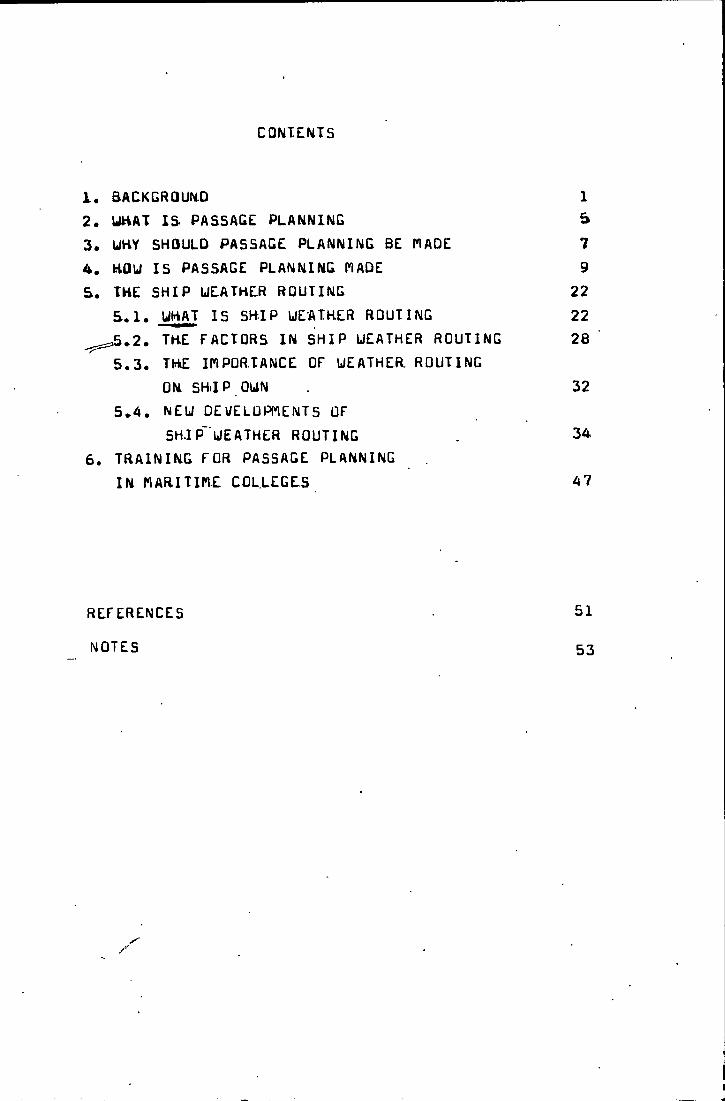
1. BACKGRQUN.0 12. UHAT IS PASSAGE PLANNING S3. UHY SHOULD PASSAGE PLANNING BE riADE 74. HQUI IS PASSAGE PLANNING l*IADE 95. THE SHIP ULATHER ROUTING 22
S.l. WHAT IS SHIP WEATHER ROUTING 22^^^.2. the factors in SHIP WEATHER ROUTING 28
5.3. the INPOR.TANCE OF WEATHER, ROUTINGON SHIP OWN 32
5.4. NEW DEUELOPMENTS OFSHIP' WEATHER ROUTING 34
6. TRAINING FOR PASSAGE PLANNINGIN PlARITimE COL.LEGE.S 47
REFERENCES 51NOTES 53
1
i, bACKtrtaUNDAlthousn ship opasatiPh in marina naviyatian ia ona of
tna oldest arts of ciaiUtation.since I96Qs.a large numPar of maritime casualties nave ta.en place . particularly stran- dings. some of these have resulted in loss of many lives, vast pollution of the marine env'ironment and enormous loss
of property.for example,in 19S3 the Chinese first ocean-going general cargo ship "V«U gtoun<ia‘‘.‘••’ah immediately .sank duringthe voyage from UINCDAU to nUJl. In 19o7. the UCCC -lOrtHEY
' CAllYUN" CtlBEHlA) stranding caused very severe vast pollution in English Channei.uhich shocked the whole uorld. Mouever .afteruards such maritime casualties took place
continuously* such as:in 1971 "CEHNU” CNUrtuiAY) stranding 10^974 "I'ltTULA” CHQLLAND) stranding in 1975 'OAKUB” (DENnAHK) stranding in ■i'978 "AmiCU CADIZ” UldCKlA) stranding nit is remarkaole to focus on the fact that the LiverpoolUnderuriters Association over the year 1963 reported on
casualties over bOD gross tons : Collisions btrandingsPercentage of number of ships “l/
.or fhP vear 1977 the reports, were ;Collisions Strandingsozi-y 76/bPercentage of number of ships
,t indicates that the percentage of the strandings has increased and have become a more severe problems over the years. A great attention uas paied by the International narltime Organization U.h.U.jto the strandings.
in ho-vember 1913 l.h.G. adopted Hesolution on Passage Planning and from this desolution Ihe l.n.O. published
2
in 1978 its well knoun "LiUlDt FU THt PLANNINLi AND CUNDUCT or PASSAGCii''. "This oryanization thereby aimed at'setting out a code of practice for two essentially intgr-related aspep-t's;
1, Ihe organization required for the planning of passages,and
2. the subsequent requirement to ensure that such passages are accomplished in compliance with the plan,"2/
The indications given in the LUlUt! present a completeset of jnaasures and procedures to proniute a practice of navigation which would enhance the safety of the ship and the protection of marine environment, would minimize the risk in ship operation and by Lliis simultaneously improve the economic profit of the ship."Some of the recommendations and statements made in the
GUIDE” ara;1, The principles outlined in this GUIDE are not new;
they have long ueen practised in many ships2, There are four distinct stages in the planning and
achievement of a safe passage:Appraisal, Planning, Execution and I'lonitoring
3, The information necessary to make an appraisal of the intended passage will include details ofship's manoeuvring data
4, In planning the passage decide upon the key elements of the navigational plan. These should include Put not be limited to:
points where accuracy of position fixing is critical
- :i -
and the primary and secondary methods hy which sucti posi- tion^'-must be obtained Tor maximum reiiability
5, Ewery fix should if possible be based on at leastthree EQP’s
(
6, Un every occasion when the ship’s position is fixed and marked on the chart in use, the EP ^t a convenient interval of time in advance should be pro.iected and plotted
7, ‘The navigating officer has the task of preparing the. detailed passage plan to the masters reguirements prior todeparture
8, that all officers of the watch should be fully acquainted in advance with the details of the passage plan *‘3/
Also mentioned in ''KLCuni’lENUAT1 UN UN 8ASIC PKINCIPLES AND OPEHATIUNAL LiUIUANUE HELATING TU NAVIGAIIUNAL uIATCHKEEPING”
The master of every ship is bound to ensure that the uatchkeeping arrangements are adequate for maintaining a safe navigational watch. Under his general direction the officers of the watch are responsible for navigating the ship safely during their periods of duty when they will be particularly concerned to avoid collision and stranding.The stipulations concerning passage planning made oy the
I.n.O*are detailed enough and good enough,out since 1973there have bean many examples that clearly show tba shortcomings in the execution of the fundamental principles of passage planning.
The maritime community was faced with the fact that it should revise its traditional attitude towards the ship-
4
Ping industry, uacausa the raasan, laaninq to tha stranding uhich uera identified after the caaualty indicated that there pare fundaaental »isconcapticns aUuut a.adarn shipping in tha thinking, attitude and uahauipur of nauigatara.ahipounera. nationpi depart,nenta of »ariti»,a affairs and Poarda of ihqu-
irybailing a ship uas to be enrinhad ny hat tar planning of
navigation and closer monitoring of the passage.
It is necessary for the navigator at the traditional methods of navigation, nic navigation aids has been introduced necessary to master the principles of
to select the optimum route.
times to resort to though many electro-
bo it is absolutely Passage Planning and
5
2. UHATIS PASSAGE PLANNINGSea navigation is definad as the process oT conducting
vessels betueen selected points in accordance with certainlimitations and criteria.This process uill be concerned with
«
voyage and passage planning.Sensible people have practised passage planning since
the earliest periods of navigations, the passage planning should lead to a safe and economic voyage.
Passage planning uas born from the recognition of the fact that many disasters-uith ships uere caused by the conjunction of a certain number of ill-fated circumstances t wrong decisions i unexpected happenings,bad procedures t P>^o- fessional inabilities and technical failures. Composition., of a good passage plan requires a good knowledge of the ^complete spectrum of navigation and shiphandling. The de- tailed plan should embrace The whole passage from berth to berth and include all waters where a pilot will be on board.
The passage planning embraces a broad scope of theoretical and practical problems. Preparation of a gjaod. pass"aga plan requires long sea experience and deep knowledge on different nautical and seamanship subjects on- the part of navigators•so the passage planning is a significant subject, . ^
y ■ wThe passage planning is a process witjn a great varietyof problems yuhile the problems then/selves differ greatlywith the type of ship,the route,the season,the type ofcargo,etc.
yOn deep-sea ships,it is customary for the master to
/
6
delegate the initial rasponsi'bility for preparing the plan for a passage to the navigating officer,usually the secondmate.So he has to undertake the task to prepare the detailr----------ed passage plan to the master*s requirements prior to de- parture.
i\ll in all, Passage Planning is to make a detailed navigational plan before departure to ensure a *^afe and
^'^economl'c,,vd.y-agje.Jfrom departure port to destination port. Passage Planning requires a ^gopd knouJed.ge._anjcL.JL*.PB*‘isncB in navigation and seamanship.
0' V
7
3. WHY SHOULD PASSAGE PLANNING BE P1ADEobjectiv/e of passage planning in marine navigation
is the safe passing of a craft from point of depa_rti^jBL_t-o point of arrival according to prescribed criteria and given
v5. limitations.The main safety criteria for all crafts are grounding and collision avoidance,
he aim of P-lanningi:^s> the prevention of disastersand the modernization'of ships operation including the minimizing of the risk to navigation. The scale-enlargement of vessels and the greatly varying properties of modern ships create n_eu problems. Hence the problems encounteredin passage planning partly stem from the develppment of ships.
----------- ^ ‘ .
For passage planning purposes, the position fixing systems parameters in all voyage phases should be discussed:
Accuracy J
2. AvailabilityCinterval)3. rime needed to obtain a fix4, Coverage "
„V5, Reliability o. Ambiguity
/wJ
’ " f
• 7, Environmental disturbances and operational. ./ constraints r'
8. Presentation of information9, Suitability for giwen phase of voyage
The plan uill have to have details of tides,tidal streams,j/HF Frequencies,reporting po in ts , tr af f ic monitoring station,
navjvigational uarninqs,weather reports,times of sunrise/
sunset,etc.These should be part of the routine put many times they are not done^ houe\/er a passaye plan uill serve as a reminder.
The phenomenon of a rise in the number of strandings was mentioned in the introduction to the 1I*IU CUIOE:"The/e is a disturbing number of casual ties,particularly strandings,continuing to occur in restricted waters and port approaches.""With regard to strandings the causes are follows:
1. No or inadequate planning of the navigation2. not checking the ship’s position ^3. not bringing back the ship on the intended track4. only one navigation system in use without backing
up by a secondary system5. too much confidence in visual navigational aids6. no independent checking of important decisions on
navigation to prevent the one man’s error7. ineffective use.of navigational instruments available6. errors in identification of conspicuous points9. delayed processing of lyitfls and navigational warnings10. duty officers who have not prepared themselves in
advance for the navigation during their watch11. lack of a clear bridge organization12. lack of or incomplete exchange of information between
pilot and bridge team "4/All in all,in any case of stranding,the reason is the
lack or incompleteness of a passage plan,so a efficient passage plan is a must in navigation.
- 9 -
4. HOU IS PASSAGE. PLAANING TIADEPassage Planning farmerly uas the typical ship master's
job,nou houewer it tends to ue a team uork, i.e. the pas^ sage planning can be done by an officer in co-operation with the rest of the officers and supervised by the ship master*
A team> effort is very important and effectiwe,because transfer of experience is a matter of concern in passage planning* The advantages of a team work are as follows.
" - transfer of experience- preventing one man's errors- reducing the probability of hiatus in planning 115^
Passage planning gives detailed attention to the portdeparture/arrival requirements of the voyage as well as specific constraints enroute, such as around head lands, through straits and the like. The passage plan must take everything into account for promotion of safety in navigation and improvement of the economic profit of the ship*
In some ships problems are related to Linder Keel Clearance, manoeuvring characteristics, pathuidth, margins of safety and navigational accuracy, and in other ships , problems relate to fuel consumption, ship s behaviour in respect to the cargo and sticking to the timetable.
In all cases safety and economics govern passage planning. Sometimes,contradictions may happen uetween safety and eco- nomic. If .0, safety should be takah into account first, then economics, i.e. “SAftTV IB flRBT” and "ECONOnlCS IS SECOND". Safety is maximum’ economics and safety improves
10
tha aconotnical rasult in the long-run. Safety is for economiccs,II * ■" There are four distinct- stages in the planning and achiew- ing of a safa passage:Appraisal,Planning,tlxecu'tion and fioni- toring,The first and second stage may ba defined as the statical stage. Third and fourth defining the dynamical stage of a voyage. These stages /must of necesity/ follow each other in the order set out above.An appraisal of information availaule jnust ba-jivad-e~~iyB~f-orB a
detailed^,43lan can be drawn up. "6/ Appraisal is the process of gathering together all data and information relevant to the contemplated passage. The collection,selecLion and weighing of data is the most time-consuming activity in passage plan production, bearing in mind the condition of the systems, crew,ship,cargo and environment and any other circumstances, a judgement of the margins of safety which must be allowed in tha various parts of intended passage can be made.
All information may be devidad into variables and fixed data which define the state of the systems:crew, ship, cargo and environment.
CrtEU: number, experience, qualifications and the psychological, condition. Particularly every ocean-going ship should be pr.operly manned with a fully qualifieil and. experienced crew. Particularly in constrained waters and ia areas difficult for navigation the manpower requirements should be well planned.I^SHIP. diaansions, machinery, manoeuvring parameters, stability, seakeeping, speedkeeping and navigation aids and eQuipment, communication equipment ,etc." (he approach to passage planning of a uLLC will mainly concentrate on navi-
11
gatic^al accuracy and manoeuvring characteristics, because the bottle neck is caused by the small margins- of safety in restricted waters and port entrances.The heavy lift carrier or a HoHo-wassel,the main concern might be the stability and the sea-keeping qualities of the ship.
CARGO: kind, nature, distribution and place of loading------- ---- -- ----------- ---------------- ^ ‘ ‘and destinations,etc. Particularly, dangerous cargo should .be pei'Sb extra attention.CNUlHONflCNT:
1. seasons, weather, sea, currents, fog, ice, storms, etc.2. navigational and position fixing systems.
Position fixing plays the main role in safety of navigation. tstablish the points where accuracy of position fixing is critical and the primary and secondary position fixing methods by which such fixed may be obtained for increasing reliability.
3. navigational information should be accurate and on-time. The season and weather in connection with the navigation
al information are playing the fundamental role in passage planning and executing the voyage. Faking into account those elements the navigator will select the proper route and time of passage when planning the voyage.
The first three elements produce a ship system, fhe ship system is a technelogicaUman-machinelsystem incorporating .operations, guidance, safety and support systems integrated to achieve cost-effective economical results.
fhe environmental system incorporates all other sophisticated factors surrounding the ship.
12
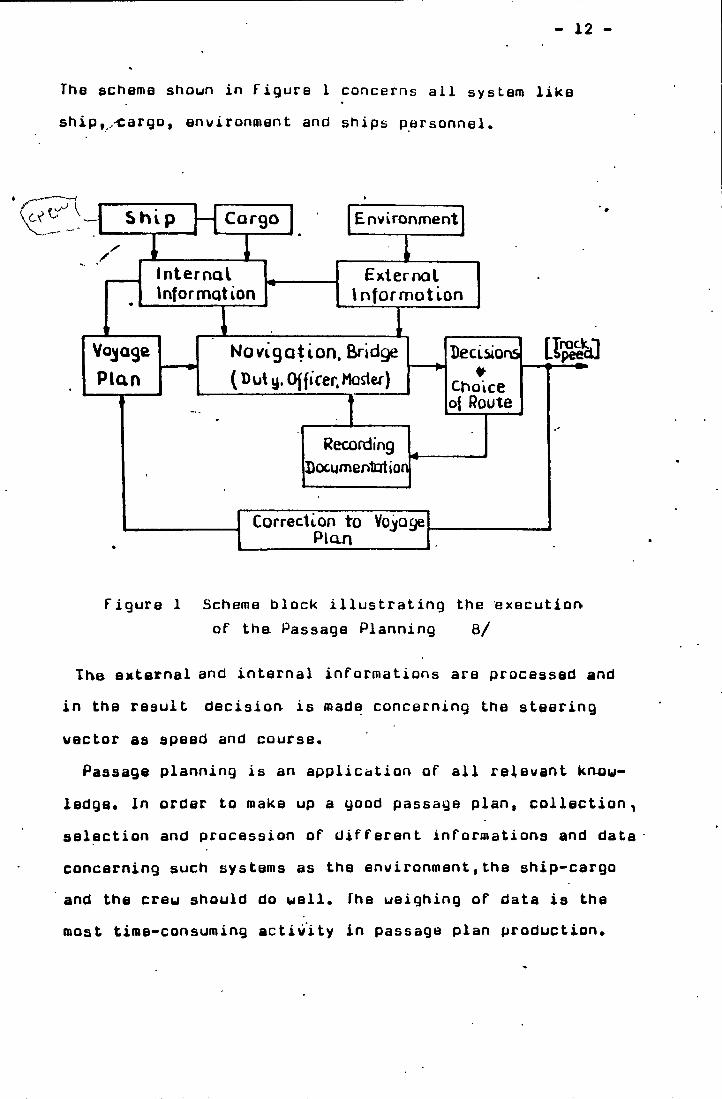
The scheme shoun in Figure 1 concerns ail system like ship-cargo, environment and ships personnel.
Figure 1 Scheme block illustrating the execution of tha Passage Planning 8/
The external and internal informations are processed and in the result decision is made concerning the steering vector as speed and course.
Passage planning is an application of all relevant knou- ledge* In order to make up a good passage plan, collection^ selection and procession of different informations and data concerning such systems as the environment,the ship-cargo and the creu should do uell. The ueighing of data is the roost time-consuming activity in passage plan production.
13 -i
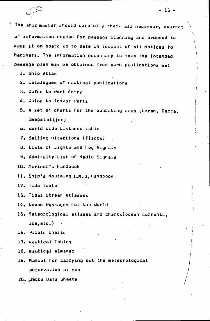
The ship masLar should carefully check all necessary sourcof information needed for passage planning and ordered to keep it on board up to date in respect of all Notices to Mariners* The information necessary to make the intended
t
passage plan may be obtained from such publications aaS1. Ship Atlas2. Catalogues of nautical publications3. Guide to Port Entry A» Guide to Tanker Ports5, A set of charts for the operating area (Loran, Oeccai
bmegaLattice)6. world Wide Distance fable ?• Sailing directions (Pilots)ti. Lists of Lights and Fog Signals
Admiralty List of Hadio Signals 10* Mariner’s Handbook11. Ship’s Houteing 1 Handbook .12. Tide Table13. Tidal Stream Atlasses14. Ucean Passages for the World15. Meteorological atlases and chartsCocean currents,
ice,etc.)16. Pilots Charts17. Nautical Tables18. Nautical Almanac19. Manual for carrying out the meteorological
observation at sea20. ^cca Data Sheets
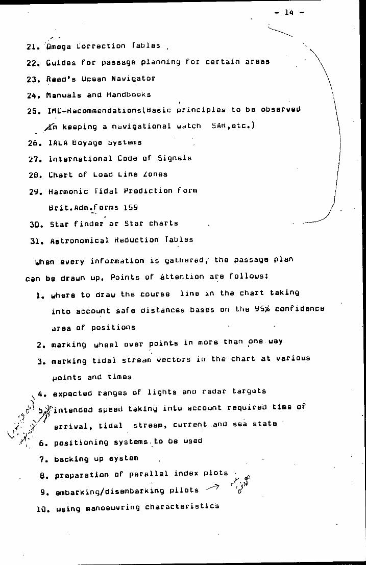
21. Omega Lorrection fables .22. Guides for passage planning for certain areas23. Reed's Ocean Navigator 24* Manuals and Handbooks
I
25. lMU-rtacommendationsl.dastc principles to be observed yin keeping a navigational uatch bAH,etc.)
26. lALA Ooyage bystems27. International Code of Signals 2B, Chart of Load Line Zones29. Harmonic Tidal Prediction form
Brit.Adm.rorms 15930. Star finder or Star charts31. Astronomical Reduction TablesUhen every information is gathered,' the passage plan
can be draun up. Points of attention are follous.1. where to draw the course line in the chart taking
into account safe distances bases on the 95^ confidence area of positions
2. marking wheel over points in more than one way3. marking tidal stream vectors in the chart at various
points and timesexpected ranges of lights ano radar targets
b^intended speed taking into account required time ofarrival, tidal stream, current and sea state
6. positioning systems to be used7. backing up system6. preparation of parallel index plots 9. embarking/disembarking pilots V
. using manoeuvring characteristics10
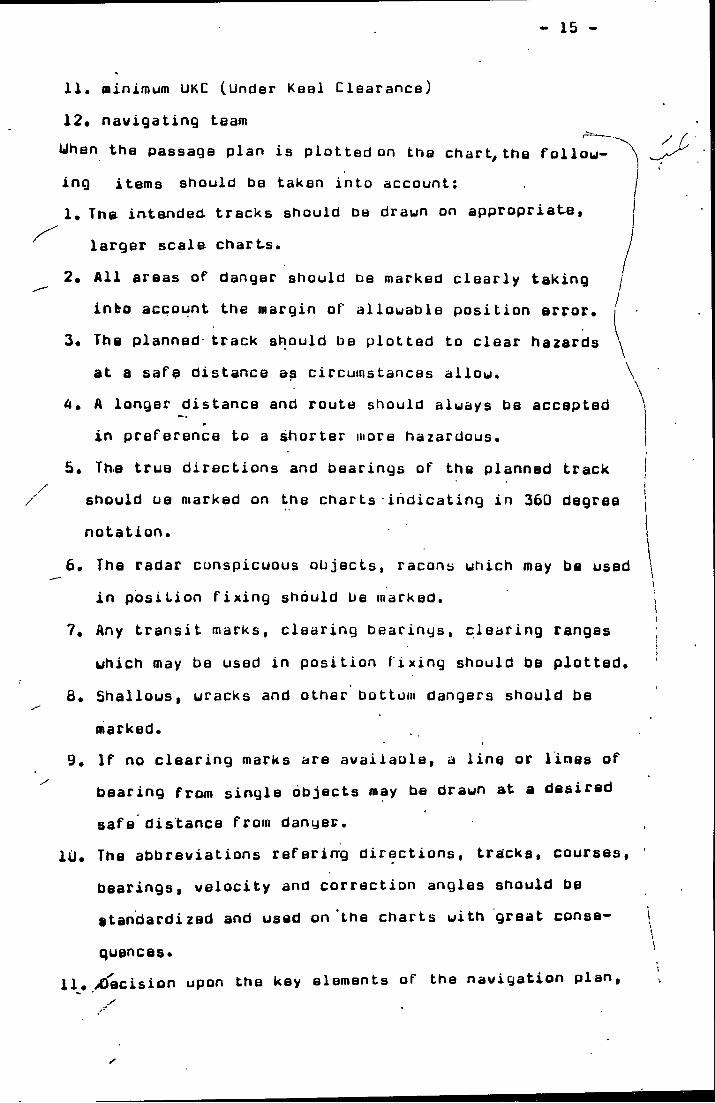
15
/
11. minimum UKC (Under Keel Clearance)12* navigating teamUhan the passage plan is plotted on the charts the following items should be taken into account:1. The irvtended. tracks should be drawn on appropriabe.
larger scale charts.2* All areas of danger should be marked clearly taking
into account the margin of allowable position error.
3* The planned track should be plotted to clear hazards at a safe distance a$ circumstances allow.
A. A longer distance and route should always be accepted in preference to a shorter more hazardous.
5. The true directions and bearings of the planned trackshould ue marked on the charts indicating in 360 degree j notation. 1
6. The radar conspicuous objects, racons which may be used \Iin position fixing should be marked. i
7. Any transit marks, clearing bearings, clearing ranges which may be used in position fixing should be plotted.
8. Shallows, wracks and other bottom dangers should be marked.
9. If no clearing marks are availaole, a line or lines of bearing from single objects may he drawn at a desired safe distance from danger.
1U« The abbreviations refering directions, tracks, courses, bearings, velocity and correction angles should be standardized and used on the charts with great conse- I\quences* '
11« /Ctecision upon the key elements of the navigation plan.
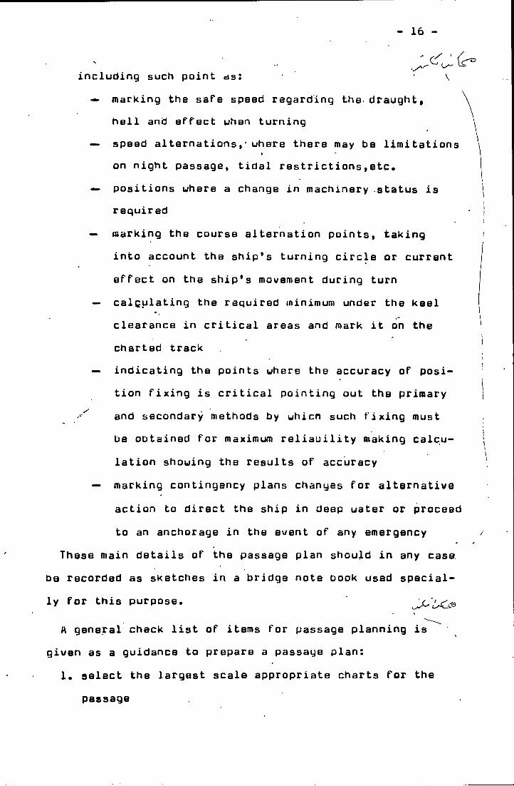
16
Daly
including such paint as: V<•> marking the safe speed regarding the draught,
hell and ePfect whan turning —> spaed altarnationsuhere there may be limitations
I *
on night passage, tidal restrictions,etc.O' positions uhere a change in machinery status is
requiredmarking the course alternation points, taking into account the ship’s turning circle or current effect on the ship’s mov/ement during turn
— calculating the required minimum under the keel clearance in critical areas and mark it on the charted track
— indicating the points uhere the accuracy of posi*- tion fixing is critical pointing out the primary and secondary methods by uhicn such fixing must be obtained for maximum reliability making calculation shouing the results of accuracy
— marking contingency plans changes for alternative action to direct the ship in deep uater or proceed to an anchorage in the event of any emergency
These main details of the passage plan should in any case recorded as sketches in a bridge note book used special- for this purpose.
A general check list of items for passage planning is given as a guidance to prepare a passage plan:
1. select the largest scale appropriate charts for thepassage
17
2. check that all charts to be used have been corrected up to date from the latest information available
3. check that all radio navigational wamiags affecting the area have been received
4. check that sailing directions and relevant lists of lights have been corrected up to date
5. estimate the draught of the ship during the various stages of the passage
6. study sailing directions and Ucean Passages for the World for advice and recommendations on route to be taken
7. consult current atlas to obtain direction and rate of set
8. consult tide tables and tidal atlas to obtain times, hights and direction and rate of set
9. study climatological information for weather characteristics of the area
10. study charted navigational aids and coastline charac teristics for landfall position monitoring purposes
11. check the requirements of traffic separation androuteing schemes - ■
12. consider volume and flow of traffic likely to be encountered-
13. assess the coverage of radio,aids to navigation in the area and the degree of accuracy of each
14. study the manoeuvring characteristics of the ship to decide upon safe speed and, where appropriate,allowance for turning circle,at course alteration j
points.
N
-IB
IS. If a pilot is to be embarked,- make a careful study of the area at the pilot boarding point for preplanning intended manoeuvres.
16. Where it is appropriate, study all available port j
information data. ;•. I
17. Check any additional items which may be required byj the type of ship, the particular locality, or the | passage to be undertaken.The stages in the Passage Planning •— Appraisal,
(»
Planning, Execution and Monitoring are shown in Figure 2.Having finalized the passage plan , the ETA can be made
to critical points in the route and the tactics to be used in the execution of the plan should be decided.
When executing the navigation plan, the factor to be taken into account will include the following:
1. ETA at critical points for tide heights and flow.2. The reliability and condition of the ship’s systems
including navigation equipment, communication procedure^ etc.
3. Environmental system hydrometeorological conditions, particularly in hazardous areas known to be affected by high seas, gales, strong currents, frequent periods
- ibf low visibility and ice.4. Position fixing accuracy when passing danger points ■
taking into account the day-time versus.5. Traffic conditions especially in narrow waters and at
c V ^ . ,1navigational focal points. ’ ^
6. The ship master should consider whether any particular circumstances introduces an unacceptable hazard to the
^ o
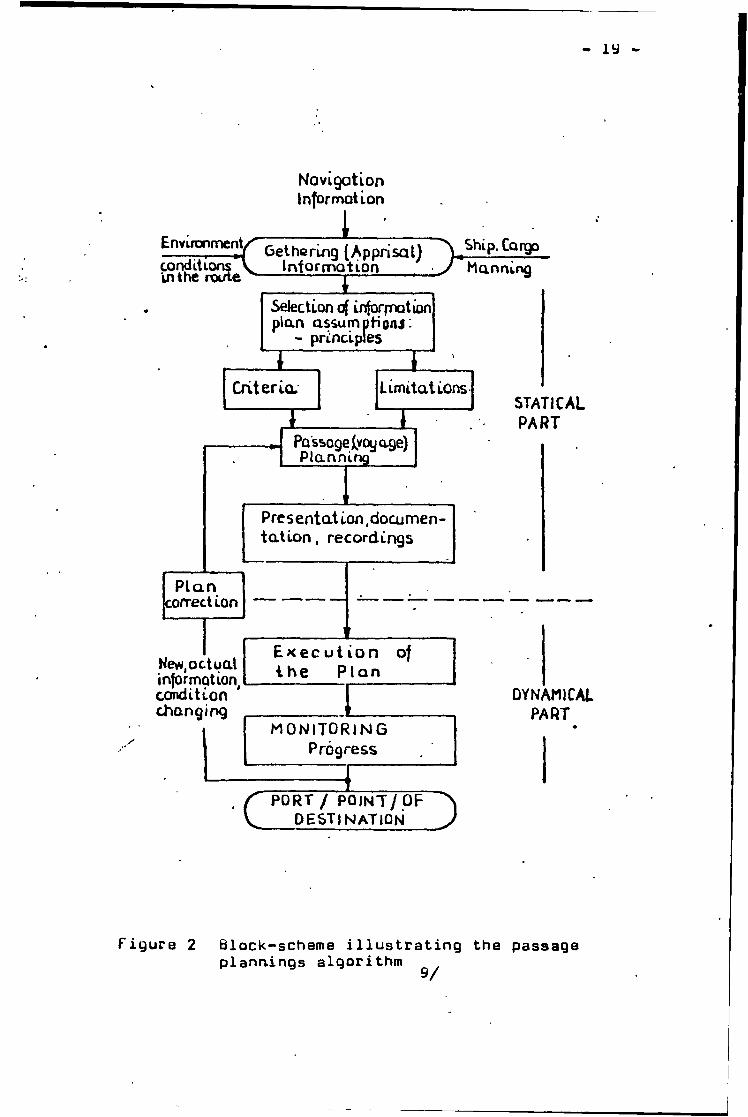
NovigationInformation
Figure 2 Block-scheme illustrating the passage plannings algorithm 9/
20
safe conduct of the passaQe and also consider at which specific points in the route it is need to utilize additional engine-room or deck personnel.
7. Establish bridge or engine-room procedure for abowe mentioned situations taking into account preparation for saa or arrival to pilot station and harbour,
ti. It is recommended to ship masters and watch keeping personnel to observe the IflU "HlCOMMUimDATIUN. QI^ BASIC
' -■^PRINCIPLES AND OPERATIUNAL GUIDANCE RELATING TO NAVIGATIONAL UATCHKEEPING"
1
The passage planning and continuous monitoring of position during the voyage are highly important in the interest of safe navigation, Monitoring must be carried out to ensure that a passage plan is followed. The continuous monitoring of a ship's progress along the preplanned I track is very essential for the safe conduct of the passage.
Uhan" monitoring the passage as regards to position fixing should bear in mind the following points:
1. Visual bearings are usually the most accurate means of position fixing.
,'V2. Every fix should,if possible be based on at least three position lines.
3. Transit marks, clearing bearings and clearing ranges (radar) can be of great assistance.
4. Uhen checking, use systems which are based on different data.
5. Positions obtained by navigational aids should be checked where practicable by visual means.
6. The value of the echo sounder as a navigational aid.
- 21 -
7. tiuoys should not be used for fixing, but may ba used for guidance when shore marks are difficult to distinguish visually; in these circumstances their positions should first be checked by other means.
8. The functioning and correct reading of the instruments used should oe checked
9. An informed decision in advance as to the frequency with which the position is to be fixed should ba made for each section of the passage. "10/
Human error is in many cases evitable provided' that navigators have a responsible attitude and conscientious
Itstyle of work at all times. Failure to sight a particular light at the stipulated time will prompt action to check the ship’s position. Frequent cross-checking of one navigational system against another will verify the ship’s positi^on as well as conform the systems themselves. “11/
Ducinq the carrying out of the passage plan,in the event of any unexpected emergency conditions, it is necessary to alter the planning. In that time, the attitude of alertness, firmness, scrupulousness and accuracy should particularly be taken. Qtheruise serious consequences would be happened.
Passage Planning is done in all cases, but not always in very detail to familiar routes.
22
5. THt SHIP UEATHER ROUTING5.1* Uhat is ship weather routeingThe oldest reports on weather routing came from India and.
Africa about the practice by Arab Dhows trading between India and the east coast of the African continent in that they utilized the NC monsoon on west-bound passages and the Slii monsoon on east-bound passages.
In 1787, B.Franklyn published a chart of the north Atlantic showing the currents and the ships used this chart improv/ed theip’^^performance significantly.
In the 1950s, the routing of ship by shore establishments began in the USA . Then the practice was adopted by various European government meteorological services.
In the 1980s, China Shangdong Navigation Institute and Qingdao Ocean Shipping Company have been studying the weather routing irv the north Pacific. So far an initial success has been obtained in this experimental works.In the near future, the Chinese own ship weather routing service will be built in Qingdao,China.
y'Ship weather routing is a procedure whereby an optimum route is developed based pn, the for-ecasts of weather andseas and the ship's characteristics for a particular tran-
’ /sit<Uithin specified limits of weather and sea conditions,the term optimum is used to mean maximum safety and crew comfort, minimum fuel consumption, minimum time underway,or any desired combination of these factors.
Weather routing is not a new part of navigation or seamanship knowledge. It has been conducted by ship master from on board information and weather report, dy applying
the available surface and upper air forecasts to transoceanic shipping, it uas possible to effectively avoid much of the heavy weather.
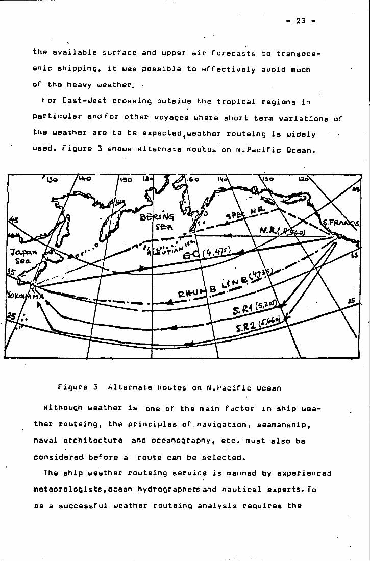
For East-Uest crossing outside the tropical regions in particular and for other voyages where short term variations of the weather are to be expectad^weather routaing is widely used. Figure 3 shows Miternate houtes on i\i,Pacific Ocean.
- 23 -
Figure 3 Alternate Houtes on N.Pacific tlceanAlthough weather is one of the main factor in ship wea
ther routeing, the principles of.navigation , seamanship, naval architecture and oceanography, etc. must also be considered before a route can be selected.
The ship weather routeing service is manned by experienced meteorologists,ocean hydrographersand nautical experts. To be a successful weather routeing analysis requires the
integration of three disciplines: meteorology, oceanography, and nautical science.
The criteria of optimizing the route during a voyage can be as follous:
1* Least timeThe main objective is to reduce time on passage regardless of other considerations.
This refers to ships uhich do not suffer cargo damage as tankers and bulk carriers. These ships are less
/’Susceptible to hull damage than other ships.2. Least time \jith least damage to h^ll and cargo
.trome ships have very low center of gravity and are prone to heavy rolling. Ihe small ships carrying valuable cargoes in all seasons of the year in the N.Atlantic or N.Pacific routes should be routed on this criteria.
3. Least damage to cargoThis is requested in cases when ships are carrying a particularly sensitive cargo such as uncrated cars, livestock or deck cargo,etc.
4. Constant sp^eedIn cases when the charters stipulate to maintain constant speed over a certain period of time. Also some passenger ship or container ship uhich should keep the schedule and bound for the destination port in time.
5. fuel savingIncreased oil costs carry weight in the ships operation
25
Bxpences, has been
All in1.2.3.
4.
7.
. Tha ^rnost significant adv/antags of ship routeing in fuel saving.all, the advantages of ship ueather routeing are: Enhancing safety Time saving Fuel savingriinimising storm damage to the stiip and cargo Comfortable to creu and passenger ^Attaining of punctuality,maintaining of scheduleMeeting special .requirements of the individual voyages'
However,many of these objectives tend to conflict with each other. Minimized sailing time must be weighed against increased fuel costs and risk of heavy ueather damage.There is no guarantee tnat a “least time" route will be a “least cost" route when all factors are considered.
The passage planning in the ocean areas based on the weather routeing is to avoid the areas of highest waves as far as possible. A poorer speedkeeping environment may be acceptable if it allows for a more direct route or more favorable ocean currents. Thus the essence of the ship routing problem is to assess the relative effects of a wide variety of conditions in establishing suitable tradeoffs among appropriate cost criteria.
Theyishould lead to the choise of a reasonably good routeThe final route selection may represent a voyage which hasbeen optimized with respect to passage time, ship safety,fuel consumption , passenger comfort,etc. or some combination of these goals.
26
The greatest potential advantage for this ship weather routeing exists when:
1. The passage is relatively long, generally about 1500 miles or more;
2* The waters are navigationally unrestricted so that there is a choice of routes (alternatively, navigational restrictions are limiting but at the same time offer possible protection from adverse weather);
3« Weather is a factor in determining the route to be followed.
« Repbmmendatlons in ship weather routeing usually are:1. Uivarsion
A diversion is aa underway adjustment in track and is intended to avoid or limit the effect of adverse weather conditions. In most cases, the distance to the destination is increased, but this is partially overcome by being able to maintain near normal speed of advance.
2. Adjustment of speed of advanceIt is a recommendation for slowing or increasing the ship's speed as much as practicable in an attempt to avoid an adverse weather situation by adjusting the
V time of the encounter. This is also an effective means of maintaining maximum ship operating efficiency and not diverting from tha present ship's track, by adjusting the speed of advance, a major weather system can sometimes be avoided with no increase in distance.
3. Adjustment of departure timeIt is a recommendation for delay in departure, or early departure if feasible, and is intended to avoid or
27 -
significantly reduce the adverse ueather and seas forecast on the first portion of the route if sailing on the original estimated departure time. The initial route is not r§i\/'i8ed, only the timing of the ship’s transit through an area with currently unfavoraole ueather conditions. Adjusting the departure time is an effective method of avoiding a potentially hazardous situation uhere thare is no optimum route for sailing at the originally scheduled time, II 12/According to ueather routeing, diversions or reduction of
the ship’s speed are made to avoid adverse ueather conditions and shorten the track or the transit time, significant savings can be the result.
Ship ueather routeing is useless uithout an efficient communication link betueen the ship master at sea and the transmitting stations to obtain all the informations needed, Delays in the transmission and the limited information of advisories put further uncertainty into tbe situation, so the ship ueather routeing is successful or not, the key question is the accuracy of the forecast and the on-time of communications.
2a -
Tha factors in ship ueathar routeingIt sust combine enuironmental factors with a number of
economic considerations to determine the effectiweness of a particular weather routeing decision. The weighing factors used in optimalisation differ from ship to ship also dope** nding on the type of cargo . For example, a talker with heated cargo might wish to awoid cold uaterCdepending on the cost; for the heating^^M dry cargo ship may need weather to be able to ouerhaul the cargo gear.
The knowledge of expected weather conditions and the Shipps seakeeping and the spaedxeepini^ response character** istic^ have an important role in the total operational planning and decision making procedure.
The requirement at sea is for an accurate extended peri** od forecast, that is for a five or six day forecast of a comparable accuracy to the present twenty-four hour forecast. This wiii enable the ship weather routeing to be used to greater advantage. Since storm avoidance has been one of the principal criteria in ship weather routeing, marine weather forecasting efforts have concentrated on storm identification. In ocean navigation, the selection of the track.''to be followed in seasonal weather is based mainly on optimalization of the tracks found in "ocean Passages of the Worlo" by taxing into consideration ship's characteristics and comparing this with the "least track" based on climatological data valid for the duration of the passage." Various external weather factors influence the choiceof route. Attention must be paid mainly on the long term
29
weather forecasts hav/ing in mind hydra-meteorological factors like storm, ocean .currents,fog,ice,etc."13/ chosen track is adjusted according to ship's behaviour and the prospects of the voyage based on fasciiniXe charts
I
and weather reports,"14/The key to weather forecasting for ship routeing is the
ability to recognize key upper air patterns in order to forecas*t storm track movement. The basic forecasting procedure consists of a three day forecast with extensions to five days based upon persistence and extra polation.The forecast is made to utilize all the data sources previously listed.
As new information becomes available, the forecast is updated and disseminated to the respective ships enroute sBctidh. Unce the surface features are forecasted , the route analyst then checks the existing sea conditions and than makes a similar forecast movement with the associated surface feature.
Based on input data for enuironmental conditions and ship's behavior, route selection and sur.veillanca tachni- ques seek to achieve the optimum balance between time and distance and acceptable environmental and seakeeping conditions.
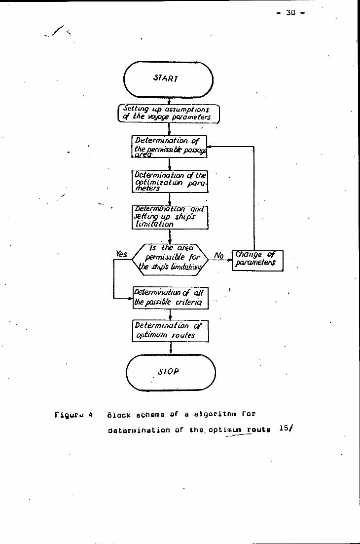
Figure 4 shows the scheme block of a algorithmfor determination of the optimum route
- 3Q -
SlOP
figuru 4 Block scheme of a algorithm for determination of the.optimum route 1^/
31 -
"At the present time, considerations for surface current in route selection are based upon data by the bcripps Institute and as depicted by the Pilot Charts. Tuo major currents which are in close proximity to.major shipping lanes, the Kuroshio Current off Japan and the Culf Stream off the Li.S* east coast, are closely monitored by the latest sate- llite'^technology. Concise,updated information is utilized to provide maximum considerations in the route selections in -thesa areas. In the case of deepening systems,where the wind field expands and wind velocities increase, generating are expanded outwards correspondingly. Beyond the3—S day extended forecast, the route analyst utilizes Oceanroutes* climatological methods to extend the forecast to cover the remainder of the voyage. "16/
If the effects of wind and seas conditions can be optimized and sufficient data about speed-loss, rolling, slamming, acceleration,etc. are available, optimum routeing should be obtained. Passage Planning and Ship Weather Houteing provide more detailed decisions on the time sequence of distances,courses and speeds which are perceived to best meet scheduling and/or economic requirements of those specific voyage.
32
5.3<* The importance of ueather routeing on ship ounIn all cases of the passage planning based on the weather
routeing and execution of the passage, the ship roaster isresponsible. The ship roaster of any routed ship is free to
(
accept or reject the adx/ise giwen by any weather routeing service. The routeing service supplied to the ship master is a recomroendatioa only and the decision whether.or aot to follow the route is entirely up to the ship master’s decision. This recommendation given by ueather routeing service should be considered as an "aid to navigation" only. Even when performing voyages under a time charter party, the ship master has freedom regarding the choice of the route.
The general pattern recognized by shore from limited ueather informations and data may be correct, but errors in essential detail may occur, because the oceans.are such vast expanses and sometimes the change of weather conditions is too fast to measure. However,the ship master is on the very spot in command of the ship,he can get exact,in-tima weather data by his own measurement. So apparent discrepancies between shore side prediction and onboard observations can be ch^ecked.
I believe that the ship master can do some very effective ueather routeing by himself, if he is provided with great accuracy ueather data.For example,in 1981 I was on a ship bound for Qingdao,China
from Vancouver,Canada.The nautical officers of the ship had applied ueather routing service.During the voyage there were . two typhoons.The first had just gone,the second was coming^
- 33 -
The position of our ship was just betueen the two typhoons The routeing service gave our ship u recommendation of diversion to SQ^NjlbO^y • dut according to the practicalconditionsy our ship determined to increase the ship ape—
»
ed as much as possible for rushing out of the gap between the two typhoons. At last we were successful. So, if the duration of the adverse weather conditions is limited, it may be better to ride out* the weathers and seas conditions, which would make the diversion not necessary.
The ship weather routing from shore and on the own ship should be combined with each other. The ship master should never blindly obey the recommendations from the weather routing service on shore.The practice is only a standard for tasting truth.
34
5.4, f\l4u developments of ship weather routingMeteorology is a relatively young science as compared to
mathematics, chemistry and physics,etc. I'lany of the weather phenomena today, still can not be fully explained or veri-
t
fied due to the fact that to re-create a certain phenomena is merely a hit or miss method due to the many parameters required to interreact within a specified amount of time.
Unfortunately, the actual techniques of route selection have not entirely kept pace with advances in other areas of weather routing , Houte selection is at present largely based on weather charts giving both present condi- tions and medium to long range forecasts; however,it remains an essentially manual process and is still based primarily on storm avoidance. Its goal is usually minimization of transit-time.
There is ample room for improvement in the theory and practice of ship weather routeing, and there is a significant potential market for such improved services. Much work has already been devoted to developing a highly rationalized approach to ship routeing and its computer implementations. There is still much room for improvement in the efficiency of weather routeing, mainly in connection with forecasting accuracy, particularly of storm tracks and the wave heights.
The success of the exercise in the ship weather routeing demands an effort on the part of ship mariners, whether routed from ashore or on board. In the last two decades, there have been.significant advances in the availability of detailed weather information and in
35 -
prediction of seakeeping and speedkeeping responses. Hou- ever, significant efforts should be carried out toward the understanding of the marine enwironment and its effect on ship operation, because of the importance of safety of
t
ocean transportation and the many difficulties associated with its economics and profitable conduct." To implement the ship weather routeing proc-edure, large computer and data processing facilities, complete with a tele-communication system, seem imperatiwe."17/ "The recent emergence of highly accurate methods for sea state forecasting and prediction of ship seakeeping characteristics, coupisd with the ability to save time, fuel and associated costs through their use, has 'heightened the potential ualue of new computer based approaches to trie ship routeing problem, "18/"The present study has continued the development of the
dynamic programming approach to ship routeing with the purp'osB of moving it closer to practical application. “19/A concerted effort has been applied to bring new capabilities in weather forecasting, vessel simulation, communications and data processing to bear on the problem of ship weather routeingTrurther experiences in running the enlarged model in simulated sea conditions will help to determine the exact form and level of detail of the inputs that are required by the routeing algorithm.
Sensitivity studies should be carried out for different types of cost functions together with the ship motion constraints in order to modal different types of commercial operations realistically.'^"20/ Today,ship weather routing
36
uses modern weather forecasting techniques and computer procedures to provide optimum routes. Uhen technological advances introduced high-speed computers into the collection and transmision of meteorological data and into the pre-
I
diction of the development and movement of weather systems* the ship weather routeing became more successful."To obtain the comprehensive* quantitative wave data that are required for a more sophisticated treatment of weather routeing* it is necessary to employ large scale numerical modelling techniques. These must be able to simulate wave growth and decay due to changing wind patterns* as well as propagation of energy from one location to another* over a large area in real time and for several days into the' future. ”21/”Several routeing simulation exercises were carried out. These exercises allowed assessment of the costs and benefits of using various levels of environmental data in route selection, and they provided comparisons between the costs of optimal routes * routes recommended by commercial routeing services* and routes actually chosen by ship roasters. ” 22/" In some areas* research efforts can be combined to utilize these valuable resources more effactively.For example* the Heavy L/eather Damage Avoidance System can be used for the local optimization problem which the ship master could solve using his seagoing experiences and the sensor readings* while the weather routeing program searches for a global optimum. ”23/” The development of satellites has greatly assisted the
- 3.7
forecaster in locating weather phenomena especially inareas of sparse weather reports. Each year more forecast-
• ' •>
ing aids are being prouided, such as improved satellite cowerage and methods of analysis, automated electronic
I
data buoys, high speed computers to handle the voluminous amounts of data, and faster, more economical moiies of data transmission.“24/ ''iMost ocean passages are of longer duration than 72 hours. Th.e data through the Satellite ^Data Distribution System (SDDS) required for implementation of the optimal ship routeing algorithm are presently available, at least for northern hemisphere , for up to 72 hour forecasts.
The data sources presently exist to provide sufficiently detailed wind and wave information to implement the optimal ship weather routeing algorithm, using forecasta out to 3 days, climatology beyond-7 to 10 days, and a mixture of the two during the interim transition period. ”25/ “Initially, in order to save cost, it is recommended to utilize the existing time-sharing computer network and radio transmissions. Later when the maritime communication sataliite.riARISAT, becomes fully operational, much of the delay and inconvenience due to severe weather or ionospheric disturbances can be avoided through the direct ship/ shore communication capability provided by the satellite.“26/
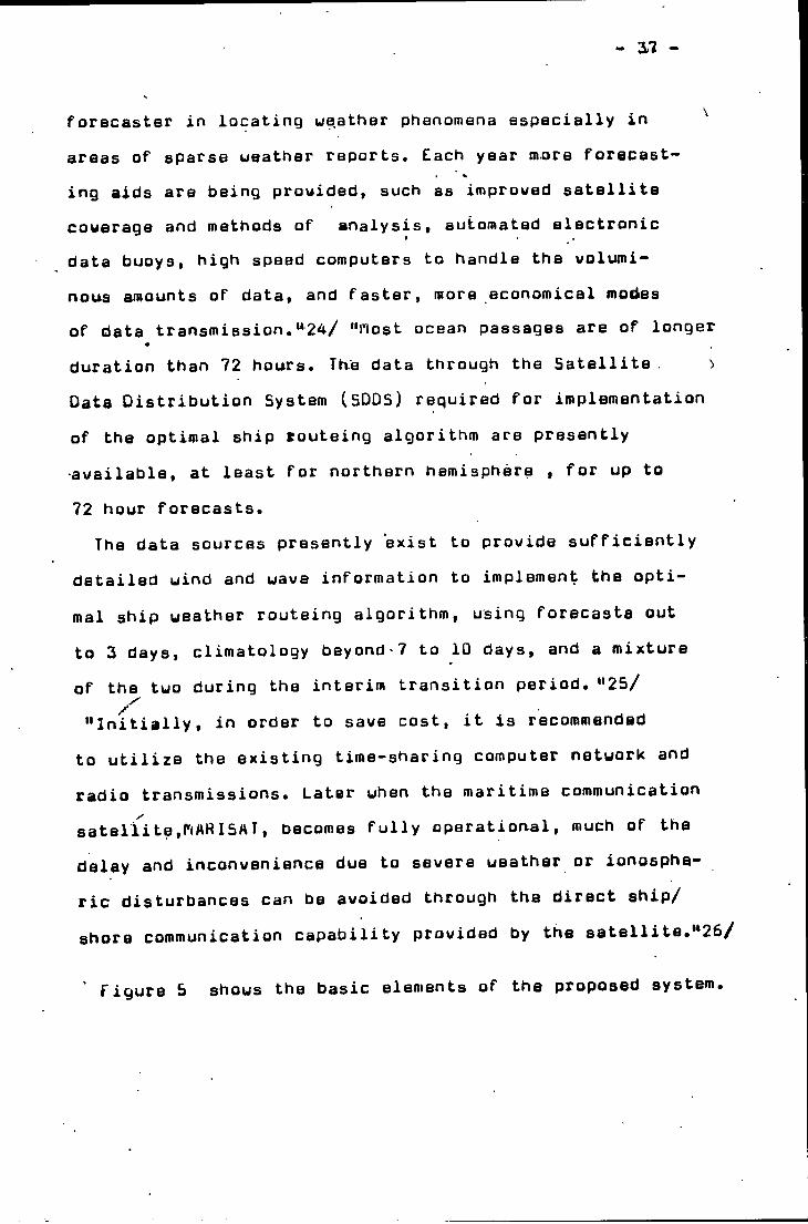
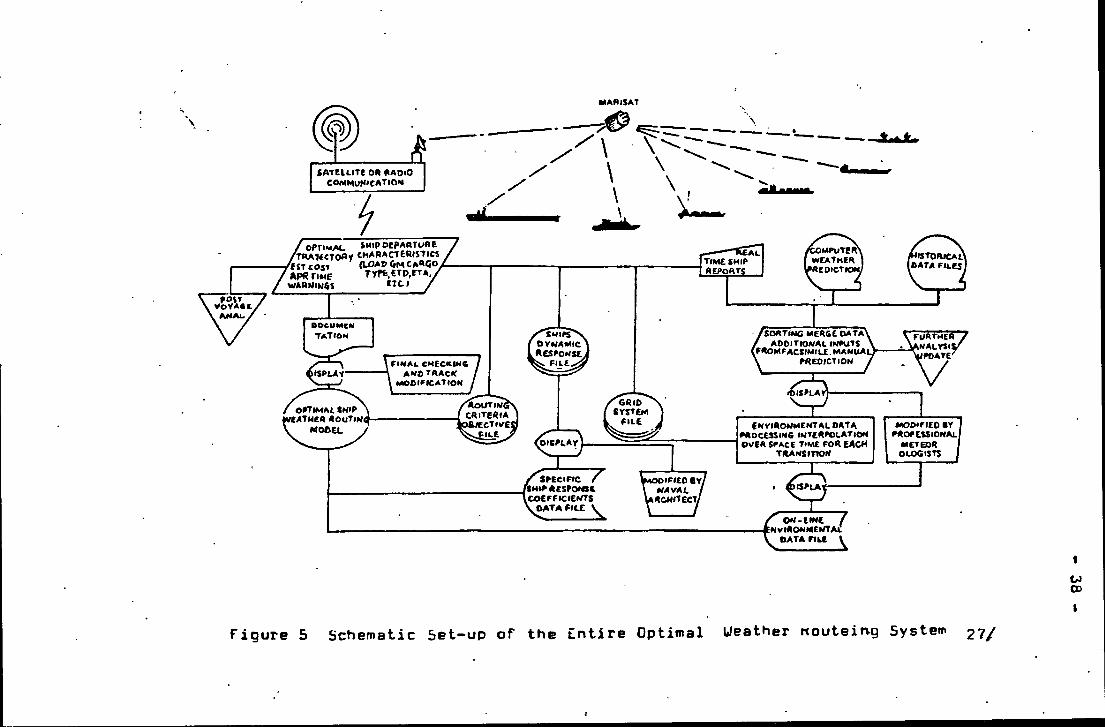
figure 5 shows the basic elements of the proposed system.
CJCD
Schematic Set-up of the Entire OptimalFigure 5 Ueather woutein-g System 27/
39
" The ship weather routeing "algorithm" has been implemented as a system of four routines which carry out different tasks in finding the dynamic programming optimization of a particular voyage. This division of labour is outlined as
t
FUNCTIONEstablishes Latitudes and Longitudes within the system of grid points and provides for editing of geographic locations.Defines the time variable for all grid points and performs spatial and temporal interpolations of environmental data to derive weather conditions at all grid points.Computes optimal value function for the grid point system by performing speed- keeping and seakeeping analyses and calculating associated costs.Traces out an'optimal routs starting at any grid point.
Two of the programs -- GRIDS and ENUIR -- prepare thegrid system and environmental data which are input to theUUF program which calculates the optimal value function»”28/
/doth programs require the documentation of the ship's dynamic response in* waves and wave spectra input} the l*larine Sdfety Data Center may provide the weather damage statistics which will become a valuable data source in formulating the cost functions.*' This function is then interpreted by the ROUTING program to give the final routeing recommendation. The advantage
following:PROGRAMGRIDS
ENUia
OUF
ROUTING
- 40
of this division of labour is that data files produced by the GRIDS and ENUIR programs may be used in solving several, if not many, routeing problems. Once the geographical coordinates of the dynamic programming grid system have been defined for a particular route, they will serve as the basis of grid systems for all future voyages between the same points. If any ships with similar speed ranges are on the same route and in similar positions, then the environmental information generated by the CNUIR program may be applied to all of them.'>29/
Other improvements on modeling the uncertainty of weather changes are also possible. A conditional probability distribution may be attached to each state so that updating the weather forecast may be performed by using a formal analysis. The technique should use the power-speed relationship derived on the basis of analytical methods.nUn many sophisticated and new ships, it is increasingly
popular to install multi-purpose minicomputers. The computer can carry out many different tasks, such as satellite navigation, collision avoidance, cargo loading, engine monitoring and regulation,etc. The size of programs varies from problem to problem and storage cores can be added by simply inserting an additional panel. Therefore, an existing computing facility can be easily adapted to carry out a weather routeing procedure. After all of the feasible states of the voyage have been evaluated by the main computation facility, the state information is transmitted directly to onboard data storage units via communication satellite,if capacity permits."30/
41
"By using a simple subroutine, the trade-off and optimal track selection could be performed onboard under the ship master’s superuisian. The on-line trade-off on thie onboard minicomputer would reduce the work load oh the-main comput-
Iing facility. At the same time, it also prowides a tool for the ship master to carry out various possible routes before making the final decision.
For environmental data processing and forecasting, the existing services are not sufficient for the proposed automated ship weather routeing system."31/ "Looking toward future de\>elopment, an automated data gathering/processing system using sophisticated satellite technology is currently under study."32/"Technological advancements in the areas of satellite and
automated communications, and onboard ship response systems will increase the amount and type of information to and from the ship with fewer delays."33/
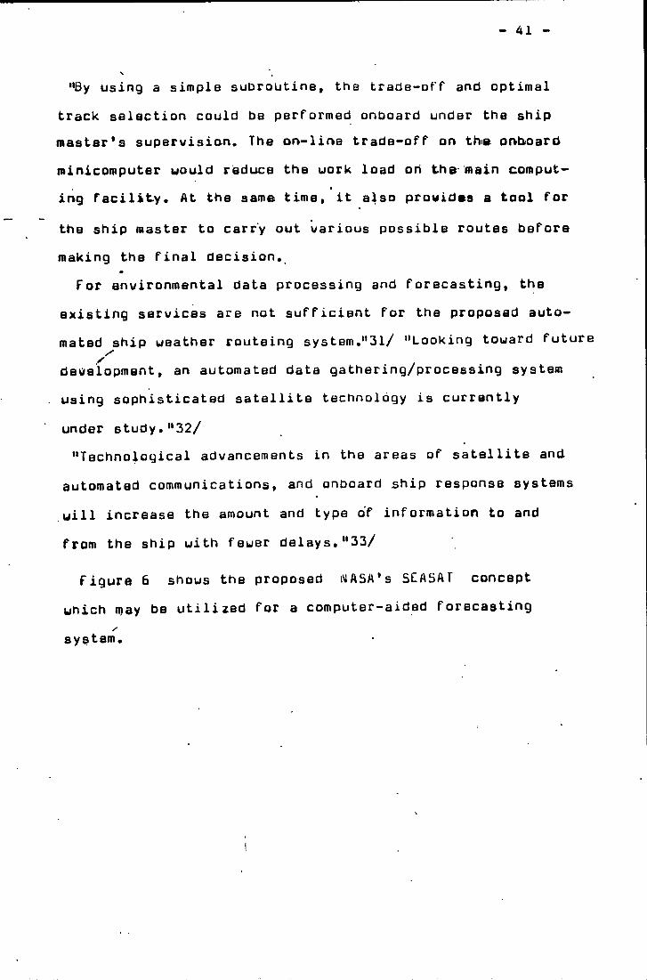
Figure 6 shows the proposed WASA’s 5LASAT concept which may be utilized for a computer-aided forecasting system.
42
/
SEASAr MISSION DESCRIPTION MEASURE GLOBAL OCEAN TOPOGRAPHYGlobal average wind speed and dirlction LOCAL IMAGESIICE.CURRENT.OILSPILL.ETC I WAVE LENGTH SPECTRA 9S\ GLOBAL COVERAGE IN 36 HOURS I YEAR DESIGN LIFE.3 YEAR EXPENDABLES 1985 OPERATIONAL
. rDATA COMPUTER AIDEDdissemination WEATHER FORECASTieC
• SYSTEM
V
Figure 6 Environmental Data Gathering end ProcessingSystem through Proposed NASA’s SEASAT Concept 34/
The sensors onboard SEA5AT will continuously scan the Earth's ocean surface to record data on uav/e heights, winds^ ocean surface temperture and ice formation. The gathered data will then be relayed to another satellite in higher orbit
t
which transmits to ground stations. The disseminated data can be used for many scientific studies. After geophysical processing, the result can be directly fed into a computer-aided weather forecasting system for ship weather rou- teing.
Generally speaking, there are four major areas that require further research and development efforts.
'(Area 1 Environmental data processing and analysis An automated data processing network should be established to receive environmental data directly. Subroutines for sorting, updating and checking have to be developed in order to handle the vast amount of data to be received.
Area 2 Analysis of ship dynamic response characteristics
The major obstacle in estimating a realistic speed function for a specific power output , however, is the uncertainty of a ship's propulsive coefficients' due to the interaction between hull, steering and propulsion systems - while in waves.
Area 3 Operating criteria and cost function- analysis This area itself requires a substantial research effort both in shipping management and related engineering fields.XArea 4 flodeling of uncertainties in weather prediction
and ship's dynamic response“35/
- 44
AlthouQh an attampt uas made in the present formulation to account for the stochastic disturbances of enwironment on the ship»s dynamic response, further refinements should be incorporated in order to model the uncertainty
I
in weather and the effect of such on a ship*s performance.
Based on satellite data, numerical models and other sources, forecasts of atmospheric pressures and marine wind fields are developed and estimates are made of wave activity. As more observational data becomes available , the numerical prediction models can be improved,thus enabling the forecaster to improve his forecasting ability,
*'It is to be hoped that methods of numerical analysis, an increase in effective observations and remote sensing techniques by weather satellites together with a wider use of computers for processing and storing data will alleviate the exposure to danger which the seaman and his ship continue to experience.
Automated solutions to the weather routeing problem are under active development at this time, borne organizations are using computers as book keeping tools in the route following portion of the total operation. Computer programmes have been written and tested which will compute a least time track given the necessary sea wave fields far enough ahead.IThe use of modern technology has the natural limitation imposed by human understanding. The future of weather routeing lies in a greater knowledge of the processes involved, of the dynamics of meteorology. ”36/
45
Ad \/an com ants in mathematical meteorology coupled with the continued application of computers uill extend the time range and skill of the dynamic and statistical, fore** casts. A neu approach to ship ueather routeing has recently culminated in the development of an algorit.hffi uhi.ch combines presently availabld technologies in the areas of ueather and uav/e forecasting as well as vessel seakeeping and speedkeeping, in conjunction with a comprehensive ship operating cost model. The resulting model uill identify the optimum ship routeing consistent with prevailing ueather and operational constraints, as well as related economic factors, uhen solved by a dynamic programming technique.•'Thexinitial success of the project in developing an ®^^icient and uorking algorithm for sHip ueather route— ing renders a promising future for actual testing and evaluation under real operational conditions at sea.At the present stage of development, the basic algorithm and attached models are still not refined in many respects. Much research and development uill be required before it becomes operational. The proposed model actually provides a general framework into which more sophisticated techniques and refinements can be incorporated as they become available in the future. '*37/
Now, it is possible to forecast with a fair degree of reliability expected ueather and sea state conditions several days into the future, in the heavily traveled areas of the world, and further enhancements-in forecast models are already in progress.
46
"a small computer or calculator could be used in the locus determination on board. The machine could have proQra— mmed packages of ship data; a commnncement co-ordinate fed in together with uave information and a proposed set of
I
locus co-ordinates would be available as output.The operator would transfer the locus to a chart, facilitating a choice of route.*'36/ Uith these technical advances,the reli- ability of ship weather routeing will be promoted greatly. Hesearch products from the heavy weather damage avoidancesystem, wave height measurement instrumentation, marine Xsafety data center, etc. will be invaluable to the future development of the ship routeing project. "39/
Finally, it should be realized that more benefits may result if the entire research effort were closely coordinated with the other ongoing research projects.
Hopefully, the combined efforts will yield more fruitful results.
47
6. TRAiMiNG fUR PASSAGE PLANMNG IN l»lAHlTinE COLLEGES
“ Irvwestigations iato shipping casualties have shown that a considerable percentage of their causes have ta be attri- butab to human failure and in particular to failure resulting from lack of qualifiration,"40/ These cases should be of great concern to responsibility of maritime education. Because'transferring the necessary knowledge for completing a voyage to tomorrow's mariners is the task of a marine college.
many disasters originate from poor passage planning.How to deal with the education and training of passage planning is a problem which is worth to study conscientiously. Recognition of the valuable standards of the principles of passage planning is one thing after which the question remains how and to what extent education and training of this code of practice is carried out.First of allf in maritime college , nautical teachers
should aim at changing the behaviour of students in such a way that they have the correct attitude towards their profession and to turn them into serious navigators.
Passage planning embraces all facets of navigation. As soon as specialisation develops, the disciplines tend to diverge and interrelationship of the various specialisations grows less distinct, bubdivision of a subject is useful from the teaching point of view. However, the navigator has quickly and efficiently to integrate this detailed knowledge into a whole again. So to the students, the study of passage planning is an application of all relevant
. 48
knouledgs available and all skills during previous training, The application of knouledge presupposes the existence of it and so passage planning can only be properly taught to students in the last stage of their training.
Before starting to teach, the teacher should make the students realizs that passage^ planning is a necessity, ti/hen teaching and training, the teacher should confront the student with as many contributing factors as possible and so they are having more problems than usual and because they lack experience.•' Ifperson has done sometning in detail, he is able to do the same correctly and fast after gaining experience, because he is aware of the problems that may arise and has learned to avoid them." 41/ So, many human failures could be avoided by detailed passage planning.
The experiences and teaching methods from our Senior F ARdEIDER and 3 MULDERS are worth to learn. They introduced that “Ue open with the analysis of a couple of maritime disasters which show a variety of factors causing or contributing to the accident." These analyses woke much interest and reaction from the side of the students. Then, each student chooses a ship,a route and month for which he is going to make a passage plan. At tne same time, lectures concentrate on the collection of relevant concerning the ship and the environment from ship's data bank and environment data bank for the particular voyage.
A lot of information, which has to be gathered in the school situation will be very available on board in the future practical situation, and passage planning can be
49
done more efficient and will cost lass time, because a lot of contributing factors are known far ahead and in practice incorporated in the planning. Indeed the passage planning is a time consuming operation. In some cases, planning took longer than the actual trip would last.
In general , the students do not have a casual attitude towards passage planning. The opposite is true as they are very intently engaged with the subject and their own passage plan.
There is a virtual, desirable way of checking and assessing a passage plan. That is to utilize a navigation simulator. All necessary tasks can be carried out on a simulating bridge. For example, Decca ship simulator offers a unique possibility to demonstrate the necessity of passage planning to all concerned.
For the training of the principle of the passage planning, the simulator is badly needed, Students need to see the results of putting into effect what they have planned,and this may only be achieved by monitoring passages in real time on the simulator.
The close and continuous monitoring of a ship’s progress, along the pre-planned track can be done on the simulator.
"The experience of adding simulator execution and monitoring to chartroom appraisal and planning, has demonstrated clearly the greater realism and improved understanding that students experience in this total approach to passage planning. ” ^2/
Simulators have the advantage of representing different
50
ports and different env/ironmentai and ship conditions, plus the fact that more training can be accomplished in a much shorter time than at sea. Mlso malfunctioning of navigational equipments and navigational systems, propulsion and
• *
steering system and the effect of adverse ueather conditions should be part of the simulator functions. Another important factor is the capability to simulate general emergen- cy conditions without incurring the risk or cost that would be involved in similar at-sea training.
To enable students to function as realistically as pos- sibl(^>^in the simulator ample "hands . on" time must be given to build up familiarity with the equipment,before running passage planning exercises. It is essential for the lecturer in the simulator to create untoward situations which demand deviations from the original plan.
The simulator is proving to be an inwaluable tool for certain tasks, although it is felt that the at-sea experience is and will always be a necessary major part of the training program. A simulator would tremendously improve our training methods in passage planning.
51
REFEREMCES1. riuldeEs,3.
"Introduction” at WORKSHOP OW PASSAGE PLANNING 27,28 ANO 29 APRIL 1983 AT AMSTERDAM
2. Arbeider,F. and Mulders,3."Passage Planning, Are theory and practice satisfactory?"THIRD INTER.NATIONAL CONFERENCE ON MARITIME EDUCATION AND TRAINING17-19 September 1984 MALMO SWEDEN
3. Arbeider,F,"What should be taught on Passage Planning"WORKSHOP ON. PASSAGE PLANNING27,28 ANO 29 APRIL 1983 AT AMSTERDAM
4. 3urdzinski,M,"PASSAGE PLANNING IN SEA NAUIGATION"Lecture at THE WORLD MARITIME UNIVERSITY August 1984 at MALMO
5. "OPTIMIZATION OF SHIP ROUTING"NATIONAL MARITIME RESEARCH CENTER KINGS .POINT,NEW YORK 1984
6. George,L.P. , Kenneth,3,B. and Walter,M.M,"A NEW APPROACH TO VESSEL WEATHER ROUTING ANO PERFORMANCE ANALYSIS"
NEW YORK , NEW YORK 24 MARCH 1982
52
7. Bouditch,N.''AMERICAN PRACTICAL NAUIGATOR"DEFENSE MAPPING AGENCY HYDROGRAHniL CENTER 1977
6. OraaismayY."uihat should be taught on Passage Planning"WORKSHOP ON PASSAGE PLANNING27,28 AND 29 APRIL 1983 AT AMSTERDAM
9. Kennerly,A."Methods,possibilities and use of simulators in teaching Passage Planning"
WORKSHOP ON PASSAGE PLANNING27,28 AND 29 APRIL 1983 AT AMSTERDAM
10. 3ongeneel,D,"What is to be done on Passage Planning in practice"WORKSHOP ON PASSAGE PLANNING27,28 AND 29 APRIL 1983 AT AMSTERDAM
11, Motte,R,"Weather Routeing of Ships"Maritime Press1972
53
NDTEIS1/ Mulders,3,
”Introduction” at UORKSHOP ON PASSAGE PLANNING27,28 AND 29 APRIL 1983 AT AMSTERDAM P. 5
2/ Ibid. P. 4 3/ Ibid. P. 6 4/ Draaisma,Y.
"Uhat should be taught on Passage Planning” UORKSHQP ON PASSAGE PLANNING27,28 AND 29 APRIL 1983 AT AMSTERDAM P. 2
5/ Arbeider,F. and Mulders,3."Passage Planning, Are theory and practice satisfactory?"
THIRD INTERNATIONAL CONFERENCE ON MARITIME EDUCATION AND TRAINING 17-19 September 1984 MALMO SWEDEN P. 24
6/ 3urdzinski,M."PASSAGE PLANNING IN SEA NAVIGATION"Lecture at THE WORLD MARITIME UNIVERSITY August 1984 at MALMO P. 6
7/ Arbeider,F•"What should be taught on Passage Planning"WORKSHOP ON PASSAGE PLANNING27,28 AND 29 APRIL 1983 AT AMSTERDAMP. 4
54
8/ Durdzinski. Op.Cit,P. 70 Fig.4.1.
9/ Ourdzinski. Op.Cit.P. 8 Fig.1.1.
10/ Ourdzinski. Op.Cit.P. 16 P. 17 P. 18
11/ BrunicardjD.N."Passage Planning Today"SCAUAYS The Journal of The Nautical Institute August 1984
12/ BouditchjN,"AnCRICAN PRACTICAL NAVIGATOR"DEFENSE MAPPING AGENCY HYDROGRAPHIC CENTER1977P. 664
13/ Jurdzinski,M. Op.Cit.P. 58
14/ Arbeider,F, Op.Cit.P. 17
15/ Jurdzinski,M, Op.Cit.P. 151
16/ Ibid. P. 15617/ "OPTIMIZATION OF SHIP ROUTING"
NATIONAL MARITIME RESEARCH CENTERKINGS POINT,NEU YORK1984P. 57
55
18/ George,L.P. , Kenneth,J.B, and Walter,!^.PI."A NEW APPROACH TO VESSEL UEATHER RQUTIMG AND PERFORPIANCE ANALYSIS”
NEy YORK , NEW YORK 24 Plarch 1982 P. 4
19/ Ibid. P. 520/ '‘OPTIMIZATION OF SHIP ROUTING"
NATIONAL MARITIME RESEARCH CENTER KINGS POINT,NEW YORK 1984 P. 64
21/ George,L.P. , Kenneth,J.B, and Walter,M.M. Op.Cit.P. 8
22/ Ibid.P. 5
23/ "OPTIMIZATION OF SHIP ROUTING" Op.Cit.P. 65
24/ Ourdzinski,M, Op.Cit.P. 155
25/ George,L.P, , Kenneth,L.8. and Walter,M.M. Op.Cit. P. 8
26/ "OPTIMIZATION OF SHIP ROUTING" Op.Cit.P. 57
27/ Ibid. P, 58 Figure 5.1-128/ George,L.P. , Kenneth,J.B. and Walter,M.M. Op.Cit.
P. 729/ Ibid. P. 7
30/ "OPTIMIZATION OF SHIP ROUTING" Op.Cit. P. 57
31/ Ibid, P. 57 32/ Ibid. P. 60 33/ BouditchjN, Op.Cit,
P. 66734/ "OPTIMIZATION OF SHIP ROUTING" Op.Cit.
P, 61 Figure 5,2-2 35/ Ibid. P. 63 36/ Motts,R,
"Ueather Routeing of Ships"Maritime Press 1972P. 113 P. 114
37/ "OPTIMIZATION OF SHIP ROUTING" Op.Cit. P. 63
38/ Motte,R, Op.Cit,P. 114
39/ "OPTIMIZATION OF SHIP ROUTING" Op.Cit. P. 65
40/ Zade,G."THE UORLD MARITIME UNIUERSITY"COURSE ON MARITIME EDUCATION General introduction 1983 AT MALMd P. 40
41/ Arbeider,F. Op.Cit,P. 6

57
42/ KennerlyjA."Methods,possibilities and use of simulators in teaching Passage Planning"
WORKSHOP ON PASSAGE PLANNING27,28 AND 29 APRIL 1983 AT AMSTERDAMP. 7


