Embed Size (px)
Citation preview

BICYCLE MASTER PLAN
APPENDICES
MASTER PLANBICYCLEHE

5
CONTENTSAPPENDICES
Appendix A: Detailed Monitoring Report
Appendix B: Bicycle Facility Design Toolkit
Appendix C: Issue Papers
Appendix D: Level of Traffic Stress Methodology
Appendix E: BikewayPrioritization Methodology
Appendix F: Short-Term Bicycle Parking Supply Analysis
Appendix G: Bicycle Parking Recommendations at Transit Stations
Appendix H: Silver Spring to Glenmont Bikeway
Appendix I: Breezeway Network
Appendix J: Neighborhood Connectors
Appendix K: Bicycle Parking Guidelines
MONTGOMERY COUNTY BICYCLE MASTER PLAN | WORKING DRAFT | DECEMBER 2017


APPENDIX ADETAILED MONITORING REPORT
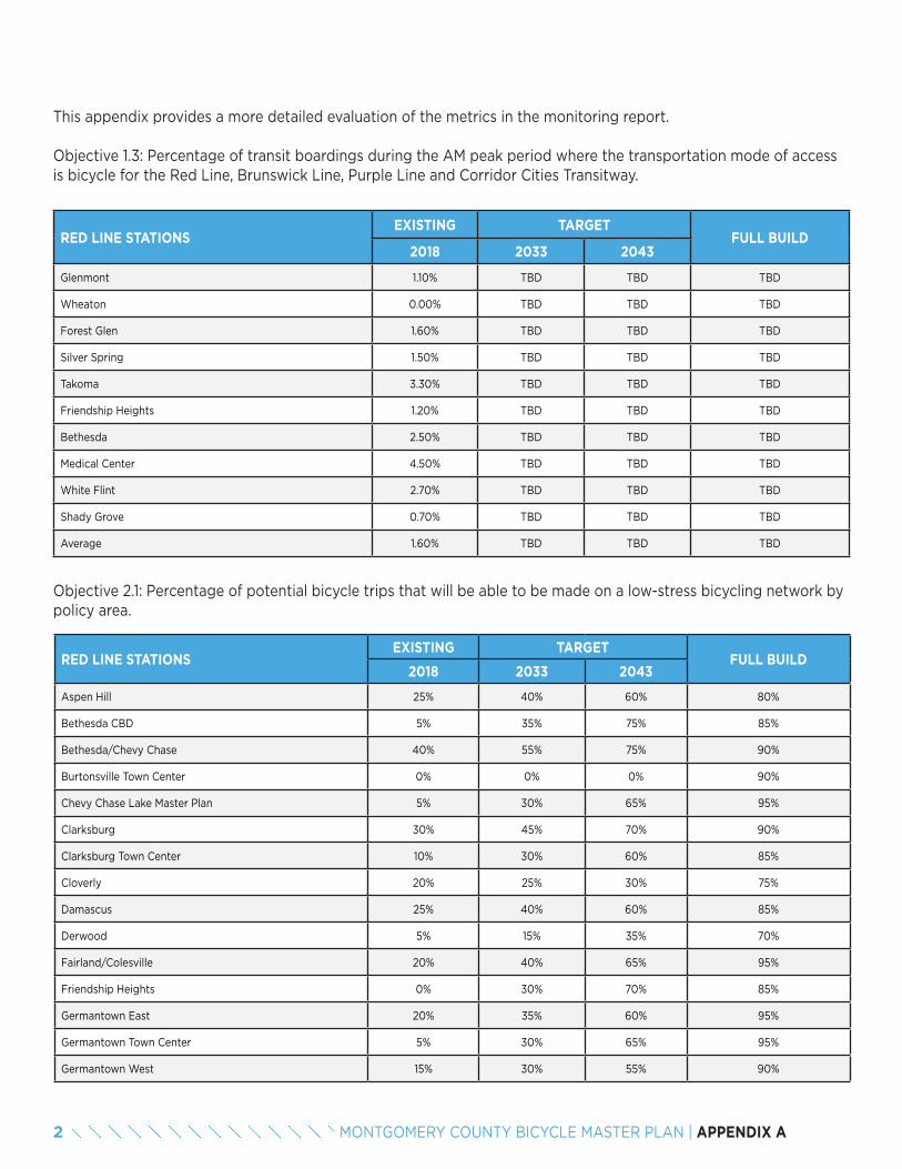
This appendix provides a more detailed evaluation of the metrics in the monitoring report.
Objective 1.3: Percentage of transit boardings during the AM peak period where the transportation mode of access is bicycle for the Red Line, Brunswick Line, Purple Line and Corridor Cities Transitway.
RED LINE STATIONSEXISTING TARGET
FULL BUILD2018 2033 2043
Glenmont 1.10% TBD TBD TBD
Wheaton 0.00% TBD TBD TBD
Forest Glen 1.60% TBD TBD TBD
Silver Spring 1.50% TBD TBD TBD
Takoma 3.30% TBD TBD TBD
Friendship Heights 1.20% TBD TBD TBD
Bethesda 2.50% TBD TBD TBD
Medical Center 4.50% TBD TBD TBD
White Flint 2.70% TBD TBD TBD
Shady Grove 0.70% TBD TBD TBD
Average 1.60% TBD TBD TBD
Objective 2.1: Percentage of potential bicycle trips that will be able to be made on a low-stress bicycling network by policy area.
RED LINE STATIONSEXISTING TARGET
FULL BUILD2018 2033 2043
Aspen Hill 25% 40% 60% 80%
Bethesda CBD 5% 35% 75% 85%
Bethesda/Chevy Chase 40% 55% 75% 90%
Burtonsville Town Center 0% 0% 0% 90%
Chevy Chase Lake Master Plan 5% 30% 65% 95%
Clarksburg 30% 45% 70% 90%
Clarksburg Town Center 10% 30% 60% 85%
Cloverly 20% 25% 30% 75%
Damascus 25% 40% 60% 85%
Derwood 5% 15% 35% 70%
Fairland/Colesville 20% 40% 65% 95%
Friendship Heights 0% 30% 70% 85%
Germantown East 20% 35% 60% 95%
Germantown Town Center 5% 30% 65% 95%
Germantown West 15% 30% 55% 90%
2 MONTGOMERY COUNTY BICYCLE MASTER PLAN | APPENDIX A
RED LINE STATIONSEXISTING TARGET
FULL BUILD2018 2033 2043
Glenmont 5% 35% 75% 95%
Grosvenor 5% 40% 90% 95%
Kensington/Wheaton 25% 45% 75% 95%
Long Branch Sector Plan 30% 50% 75% 80%
Montgomery Village/Airpark 10% 20% 40% 75%
North Bethesda 5% 35% 75% 85%
North Potomac 20% 35% 55% 80%
Olney 30% 40% 50% 90%
Potomac 15% 35% 60% 85%
R&D Village 5% 30% 70% 85%
Rural East 5% 10% 20% 65%
Rural West 40% 40% 40% 65%
Shady Grove Metro Station 0% 15% 40% 80%
Silver Spring CBD 0% 30% 75% 75%
Silver Spring/Takoma Park 30% 50% 80% 90%
Takoma/Langley 55% 70% 90% 95%
Twinbrook 0% 10% 30% 35%
Wheaton CBD 5% 25% 50% 90%
White Flint 0% 35% 85% 90%
White Oak 15% 40% 75% 90%
AVERAGE 15% 35% 65% 85%
3MONTGOMERY COUNTY BICYCLE MASTER PLAN | APPENDIX A
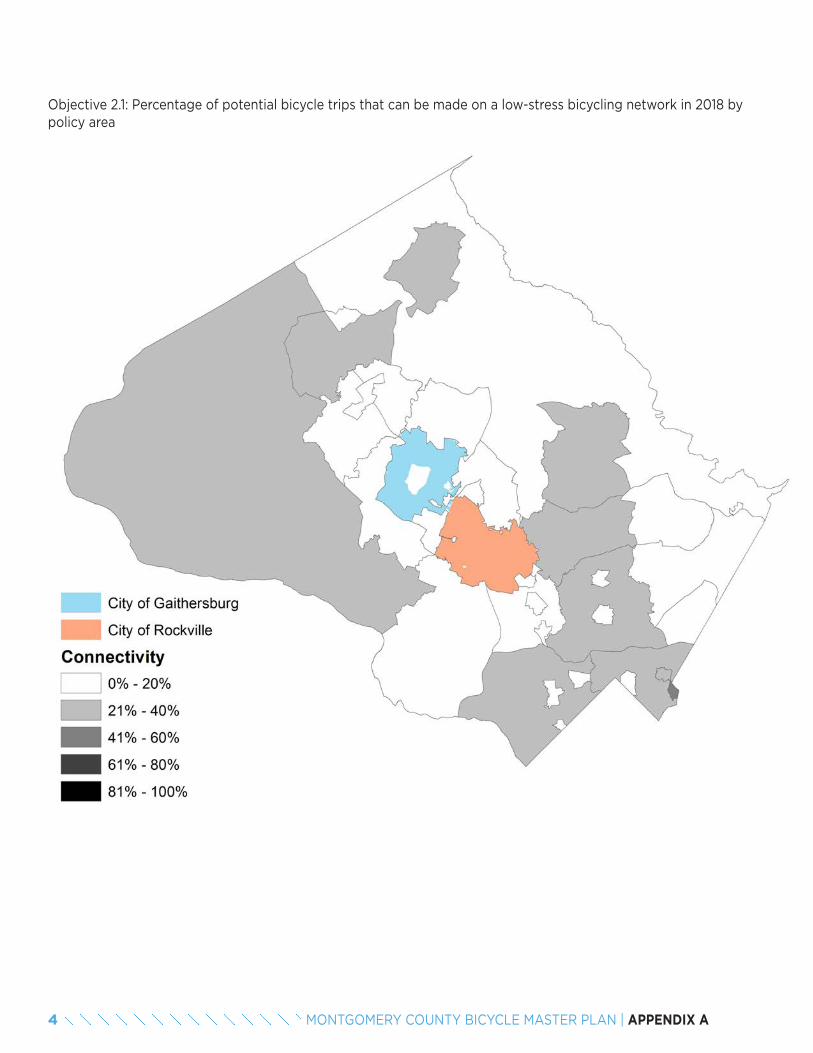
Objective 2.1: Percentage of potential bicycle trips that can be made on a low-stress bicycling network in 2018 by policy area
4 MONTGOMERY COUNTY BICYCLE MASTER PLAN | APPENDIX A
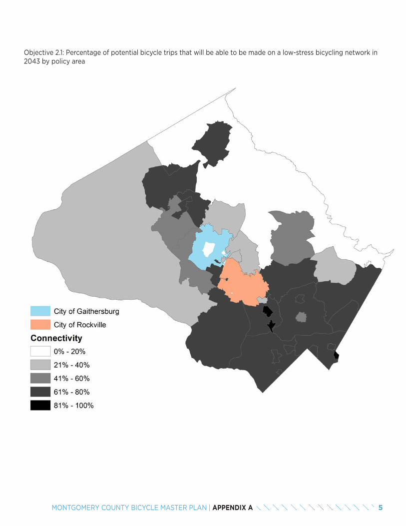
Objective 2.1: Percentage of potential bicycle trips that will be able to be made on a low-stress bicycling network in 2043 by policy area
5MONTGOMERY COUNTY BICYCLE MASTER PLAN | APPENDIX A
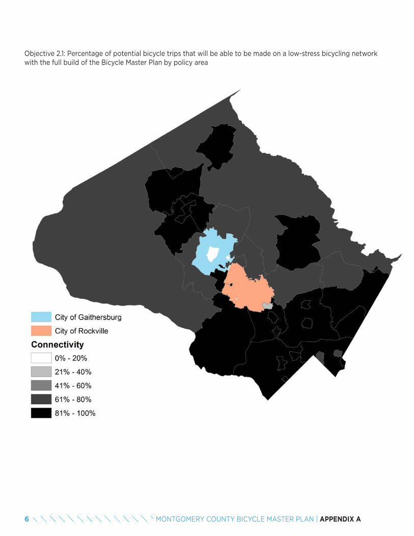
Objective 2.1: Percentage of potential bicycle trips that will be able to be made on a low-stress bicycling network with the full build of the Bicycle Master Plan by policy area
6 MONTGOMERY COUNTY BICYCLE MASTER PLAN | APPENDIX A
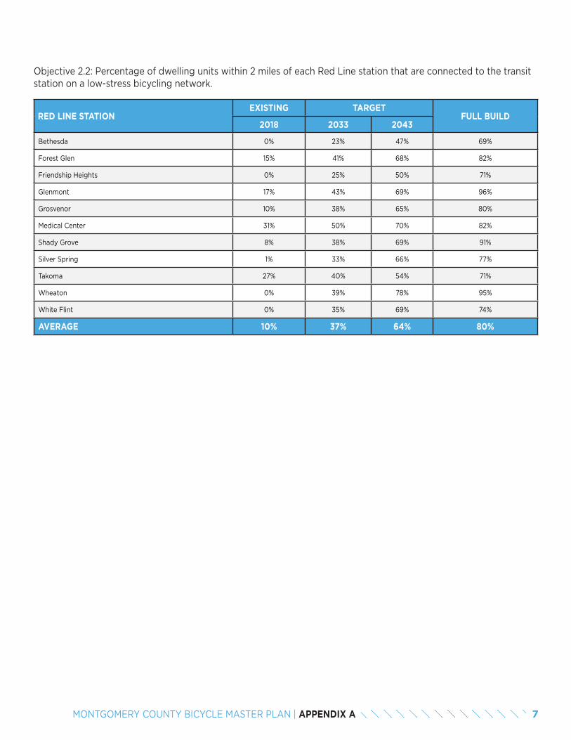
Objective 2.2: Percentage of dwelling units within 2 miles of each Red Line station that are connected to the transit station on a low-stress bicycling network.
RED LINE STATIONEXISTING TARGET
FULL BUILD2018 2033 2043
Bethesda 0% 23% 47% 69%
Forest Glen 15% 41% 68% 82%
Friendship Heights 0% 25% 50% 71%
Glenmont 17% 43% 69% 96%
Grosvenor 10% 38% 65% 80%
Medical Center 31% 50% 70% 82%
Shady Grove 8% 38% 69% 91%
Silver Spring 1% 33% 66% 77%
Takoma 27% 40% 54% 71%
Wheaton 0% 39% 78% 95%
White Flint 0% 35% 69% 74%
AVERAGE 10% 37% 64% 80%
7MONTGOMERY COUNTY BICYCLE MASTER PLAN | APPENDIX A
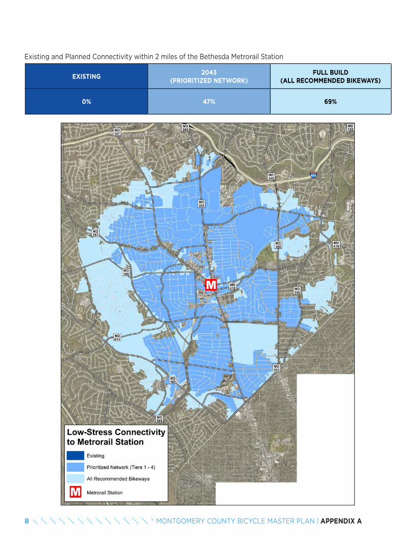
Existing and Planned Connectivity within 2 miles of the Bethesda Metrorail Station
EXISTING2043
(PRIORITIZED NETWORK)FULL BUILD
(ALL RECOMMENDED BIKEWAYS)
0% 47% 69%
8 MONTGOMERY COUNTY BICYCLE MASTER PLAN | APPENDIX A
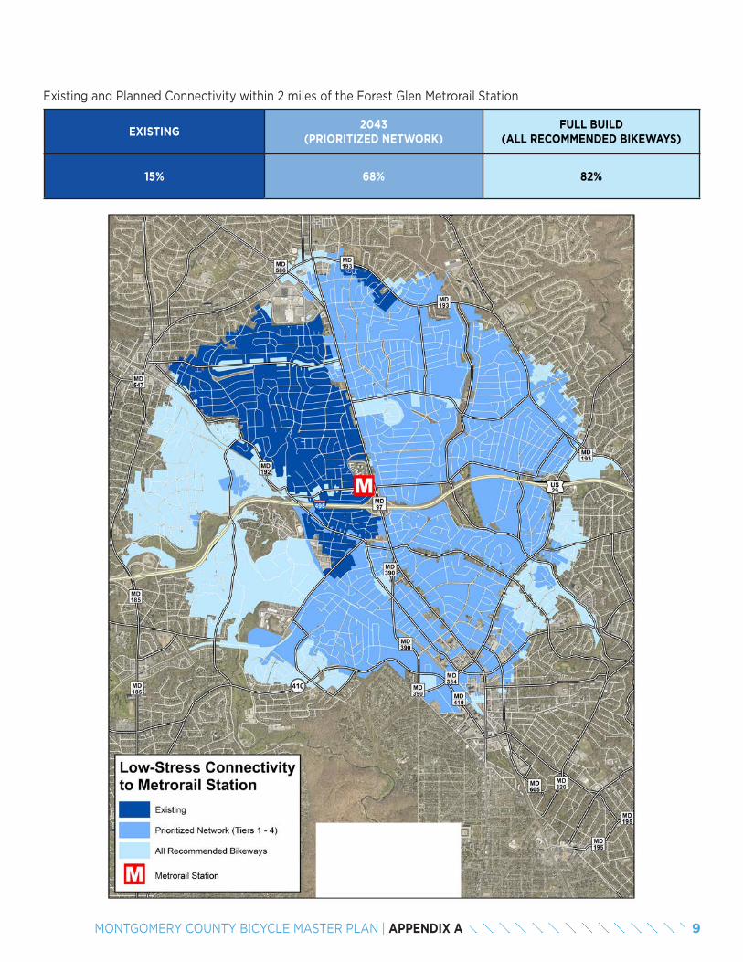
Existing and Planned Connectivity within 2 miles of the Forest Glen Metrorail Station
EXISTING2043
(PRIORITIZED NETWORK)FULL BUILD
(ALL RECOMMENDED BIKEWAYS)
15% 68% 82%
9MONTGOMERY COUNTY BICYCLE MASTER PLAN | APPENDIX A
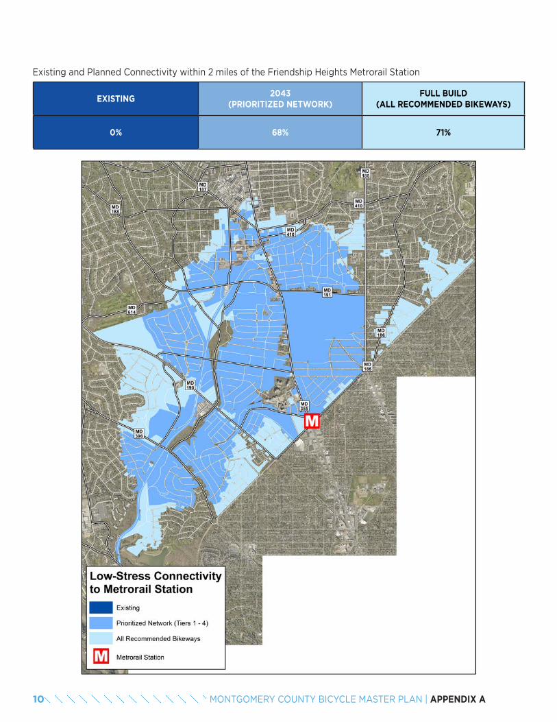
Existing and Planned Connectivity within 2 miles of the Friendship Heights Metrorail Station
EXISTING2043
(PRIORITIZED NETWORK)FULL BUILD
(ALL RECOMMENDED BIKEWAYS)
0% 68% 71%
10 MONTGOMERY COUNTY BICYCLE MASTER PLAN | APPENDIX A
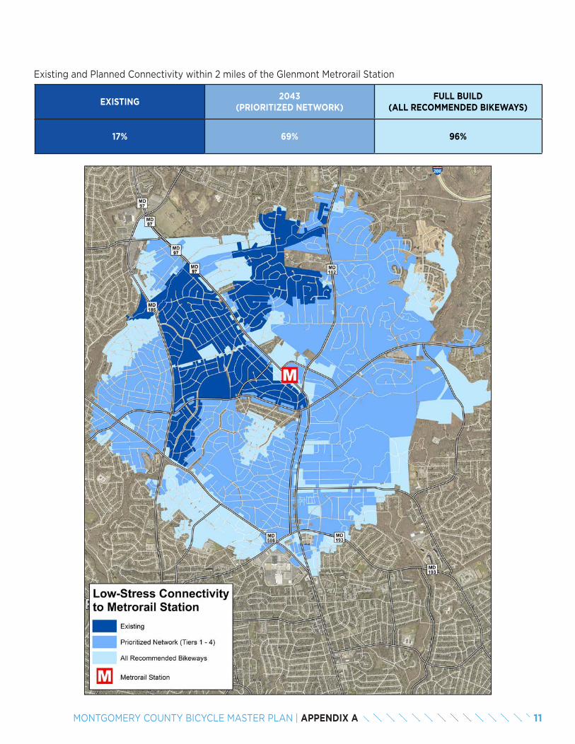
Existing and Planned Connectivity within 2 miles of the Glenmont Metrorail Station
EXISTING2043
(PRIORITIZED NETWORK)FULL BUILD
(ALL RECOMMENDED BIKEWAYS)
17% 69% 96%
11MONTGOMERY COUNTY BICYCLE MASTER PLAN | APPENDIX A
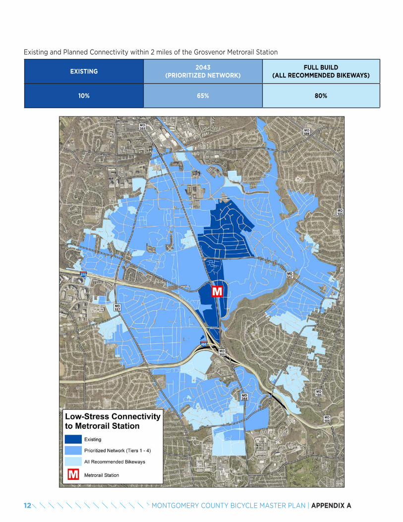
Existing and Planned Connectivity within 2 miles of the Grosvenor Metrorail Station
EXISTING2043
(PRIORITIZED NETWORK)FULL BUILD
(ALL RECOMMENDED BIKEWAYS)
10% 65% 80%
12 MONTGOMERY COUNTY BICYCLE MASTER PLAN | APPENDIX A
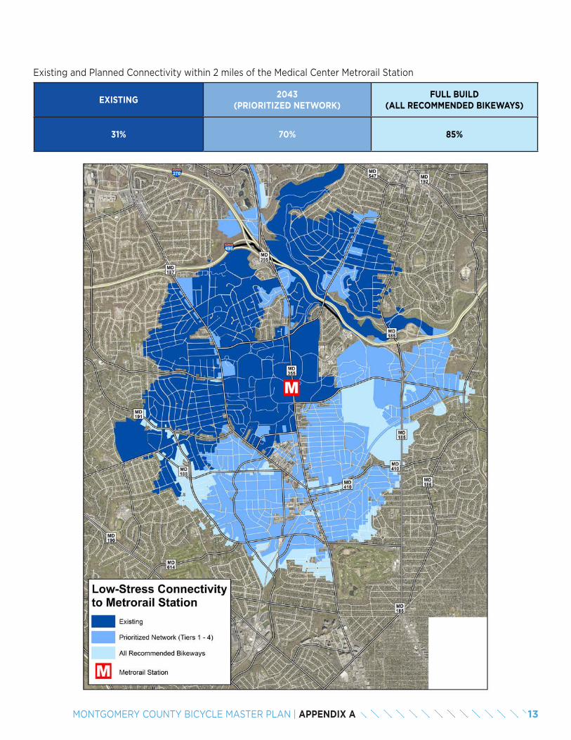
Existing and Planned Connectivity within 2 miles of the Medical Center Metrorail Station
EXISTING2043
(PRIORITIZED NETWORK)FULL BUILD
(ALL RECOMMENDED BIKEWAYS)
31% 70% 85%
13MONTGOMERY COUNTY BICYCLE MASTER PLAN | APPENDIX A
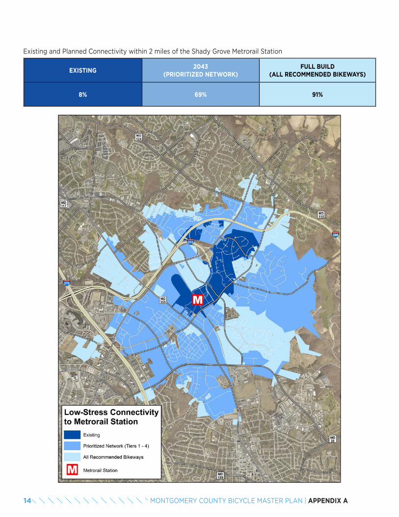
Existing and Planned Connectivity within 2 miles of the Shady Grove Metrorail Station
EXISTING2043
(PRIORITIZED NETWORK)FULL BUILD
(ALL RECOMMENDED BIKEWAYS)
8% 69% 91%
14 MONTGOMERY COUNTY BICYCLE MASTER PLAN | APPENDIX A
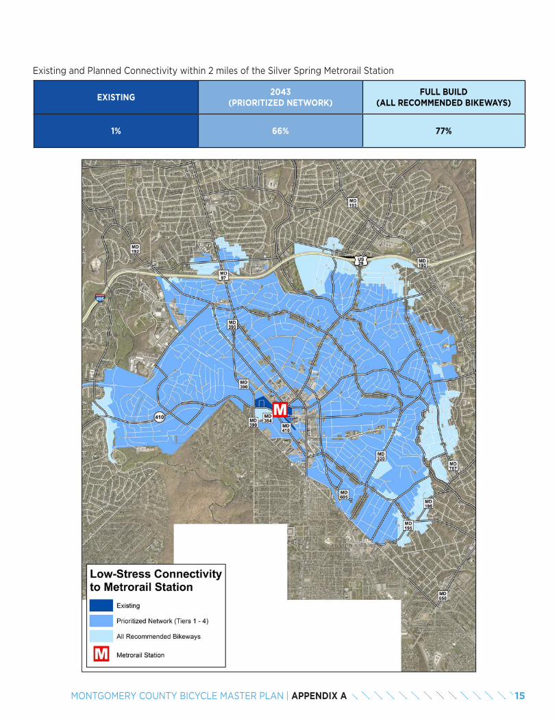
Existing and Planned Connectivity within 2 miles of the Silver Spring Metrorail Station
EXISTING2043
(PRIORITIZED NETWORK)FULL BUILD
(ALL RECOMMENDED BIKEWAYS)
1% 66% 77%
15MONTGOMERY COUNTY BICYCLE MASTER PLAN | APPENDIX A
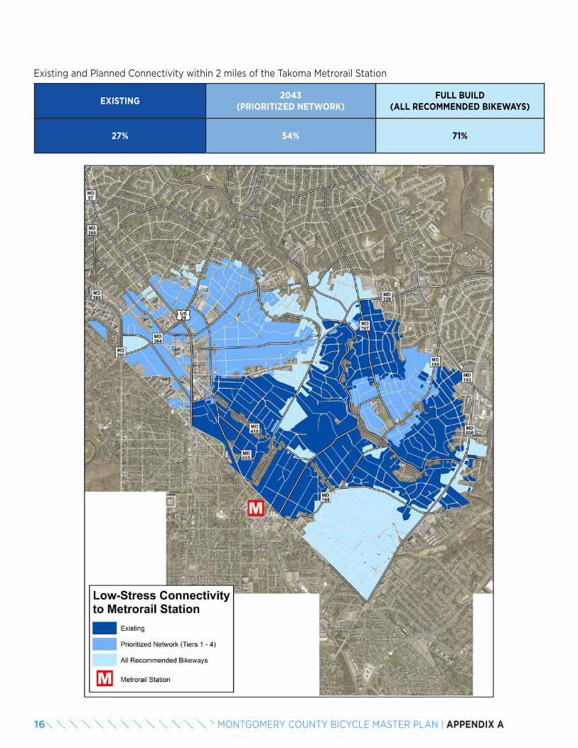
Existing and Planned Connectivity within 2 miles of the Takoma Metrorail Station
EXISTING2043
(PRIORITIZED NETWORK)FULL BUILD
(ALL RECOMMENDED BIKEWAYS)
27% 54% 71%
16 MONTGOMERY COUNTY BICYCLE MASTER PLAN | APPENDIX A
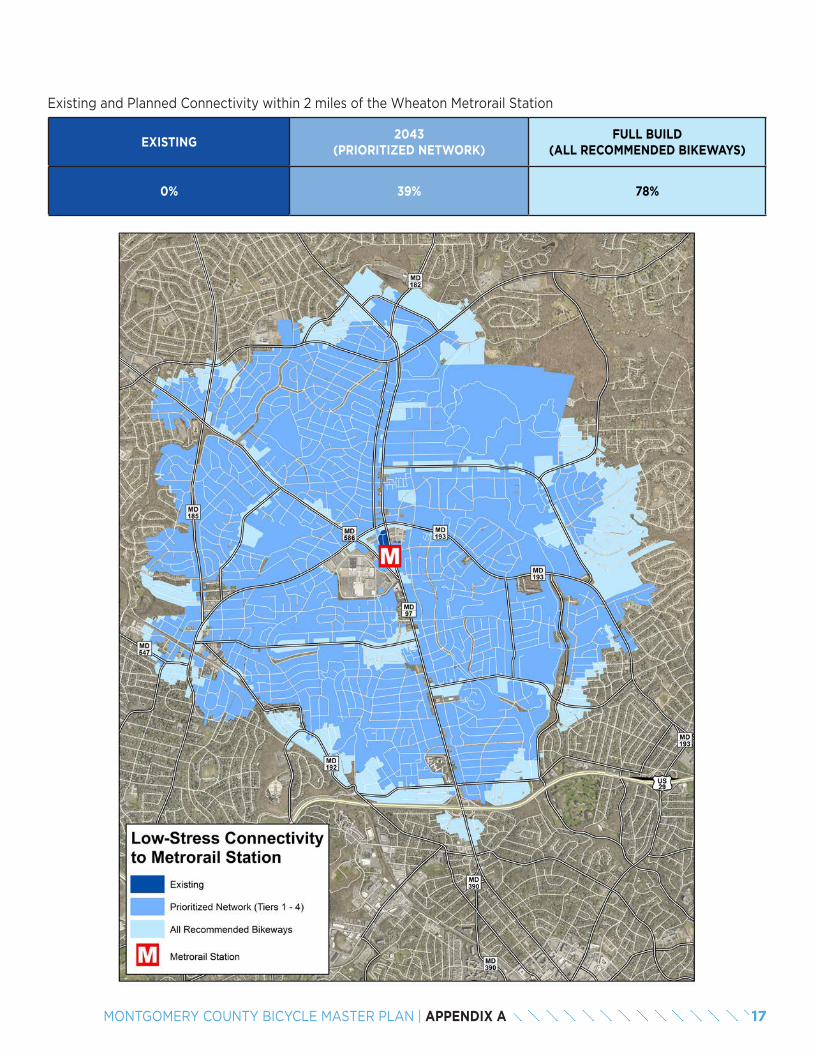
Existing and Planned Connectivity within 2 miles of the Wheaton Metrorail Station
EXISTING2043
(PRIORITIZED NETWORK)FULL BUILD
(ALL RECOMMENDED BIKEWAYS)
0% 39% 78%
17MONTGOMERY COUNTY BICYCLE MASTER PLAN | APPENDIX A
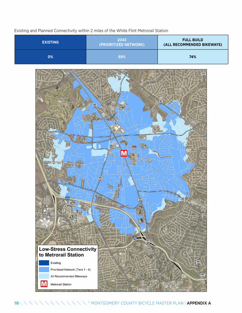
Existing and Planned Connectivity within 2 miles of the White Flint Metrorail Station
EXISTING2043
(PRIORITIZED NETWORK)FULL BUILD
(ALL RECOMMENDED BIKEWAYS)
0% 69% 74%
18 MONTGOMERY COUNTY BICYCLE MASTER PLAN | APPENDIX A

Objective 2.2: Percentage of dwelling units within 2 miles of each Brunswick Line station that are connected to the transit station on a low-stress bicycling network.
BRUNSWICK LINE STATIONEXISTING TARGET
FULL BUILD2018 2033 2043
Barnesville 0% 0% 0% 0%
Boyds 2% 2% 2% 64%
Dickerson 5% 5% 5% 5%
Garrett Park 46% 67% 88% 91%
Germantown 17% 31% 45% 83%
Kensington 0% 39% 78% 87%
Silver Spring 0% 35% 70% 75%
Washington Grove 6% 16% 25% 29%
AVERAGE 12% 37% 62% 74%
Objective 2.2: Percentage of dwelling units within 2 miles of each Purple Line station that are connected to the tran-sit station on a low-stress bicycling network.
PURPLE LINE STATIONEXISTING TARGET
FULL BUILD2018 2028 2038
Bethesda 5% 31% 56% 69%
Connecticut Avenue 6% 33% 61% 76%
Dale Drive 0% 37% 74% 76%
Long Branch 0% 37% 75% 80%
Lyttonsville 17% 43% 68% 77%
Manchester Place 15% 45% 76% 79%
Piney Branch Road 0% 36% 72% 79%
Silver Spring Library 0% 38% 75% 79%
Silver Spring Transit Center 1% 38% 75% 77%
Takoma / Langley 0% 39% 78% 86%
Woodside 0% 35% 70% 74%
AVERAGE 4% 37% 71% 77%
19MONTGOMERY COUNTY BICYCLE MASTER PLAN | APPENDIX A
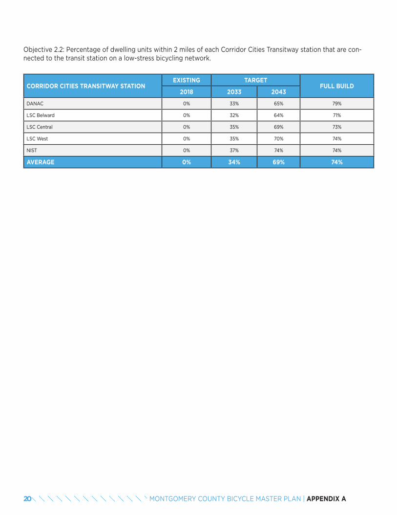
Objective 2.2: Percentage of dwelling units within 2 miles of each Corridor Cities Transitway station that are con-nected to the transit station on a low-stress bicycling network.
CORRIDOR CITIES TRANSITWAY STATIONEXISTING TARGET
FULL BUILD2018 2033 2043
DANAC 0% 33% 65% 79%
LSC Belward 0% 32% 64% 71%
LSC Central 0% 35% 69% 73%
LSC West 0% 35% 70% 74%
NIST 0% 37% 74% 74%
AVERAGE 0% 34% 69% 74%
20 MONTGOMERY COUNTY BICYCLE MASTER PLAN | APPENDIX A
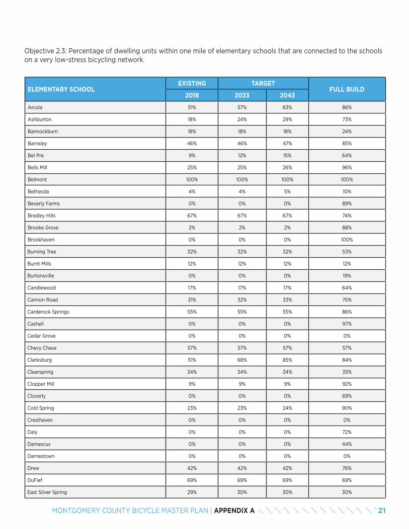
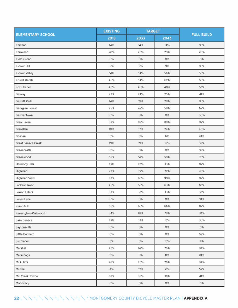
Objective 2.3: Percentage of dwelling units within one mile of elementary schools that are connected to the schools on a very low-stress bicycling network.
ELEMENTARY SCHOOLEXISTING TARGET
FULL BUILD2018 2033 2043
Arcola 51% 57% 63% 86%
Ashburton 18% 24% 29% 73%
Bannockburn 18% 18% 18% 24%
Barnsley 46% 46% 47% 85%
Bel Pre 9% 12% 15% 64%
Bells Mill 25% 25% 26% 96%
Belmont 100% 100% 100% 100%
Bethesda 4% 4% 5% 10%
Beverly Farms 0% 0% 0% 89%
Bradley Hills 67% 67% 67% 74%
Brooke Grove 2% 2% 2% 88%
Brookhaven 0% 0% 0% 100%
Burning Tree 32% 32% 32% 53%
Burnt Mills 12% 12% 12% 12%
Burtonsville 0% 0% 0% 19%
Candlewood 17% 17% 17% 64%
Cannon Road 31% 32% 33% 75%
Carderock Springs 55% 55% 55% 86%
Cashell 0% 0% 0% 97%
Cedar Grove 0% 0% 0% 0%
Chevy Chase 57% 57% 57% 57%
Clarksburg 51% 68% 85% 84%
Clearspring 34% 34% 34% 35%
Clopper Mill 9% 9% 9% 92%
Cloverly 0% 0% 0% 69%
Cold Spring 23% 23% 24% 90%
Cresthaven 0% 0% 0% 0%
Daly 0% 0% 0% 72%
Damascus 0% 0% 0% 44%
Darnestown 0% 0% 0% 0%
Drew 42% 42% 42% 76%
DuFief 69% 69% 69% 69%
East Silver Spring 29% 30% 30% 30%
21MONTGOMERY COUNTY BICYCLE MASTER PLAN | APPENDIX A
ELEMENTARY SCHOOLEXISTING TARGET
FULL BUILD2018 2033 2043
Fairland 14% 14% 14% 88%
Farmland 20% 20% 20% 20%
Fields Road 0% 0% 0% 0%
Flower Hill 9% 9% 9% 85%
Flower Valley 51% 54% 56% 56%
Forest Knolls 46% 54% 62% 66%
Fox Chapel 40% 40% 40% 53%
Galway 23% 24% 25% 41%
Garrett Park 14% 21% 28% 85%
Georgian Forest 25% 42% 58% 67%
Germantown 0% 0% 0% 60%
Glen Haven 89% 89% 89% 92%
Glenallan 10% 17% 24% 40%
Goshen 6% 6% 6% 61%
Great Seneca Creek 19% 19% 19% 39%
Greencastle 0% 0% 0% 89%
Greenwood 55% 57% 59% 76%
Harmony Hills 13% 23% 33% 87%
Highland 72% 72% 72% 70%
Highland View 83% 86% 90% 92%
Jackson Road 46% 55% 63% 63%
JoAnn Leleck 33% 33% 33% 33%
Jones Lane 0% 0% 0% 91%
Kemp Mill 66% 66% 66% 87%
Kensington–Parkwood 84% 81% 78% 84%
Lake Seneca 13% 13% 13% 80%
Laytonsville 0% 0% 0% 0%
Little Bennett 0% 0% 0% 69%
Luxmanor 5% 8% 10% 11%
Marshall 48% 62% 76% 84%
Matsunaga 11% 11% 11% 81%
McAuliffe 26% 26% 26% 94%
McNair 4% 12% 21% 52%
Mill Creek Towne 38% 38% 38% 41%
Monocacy 0% 0% 0% 0%
22 MONTGOMERY COUNTY BICYCLE MASTER PLAN | APPENDIX A
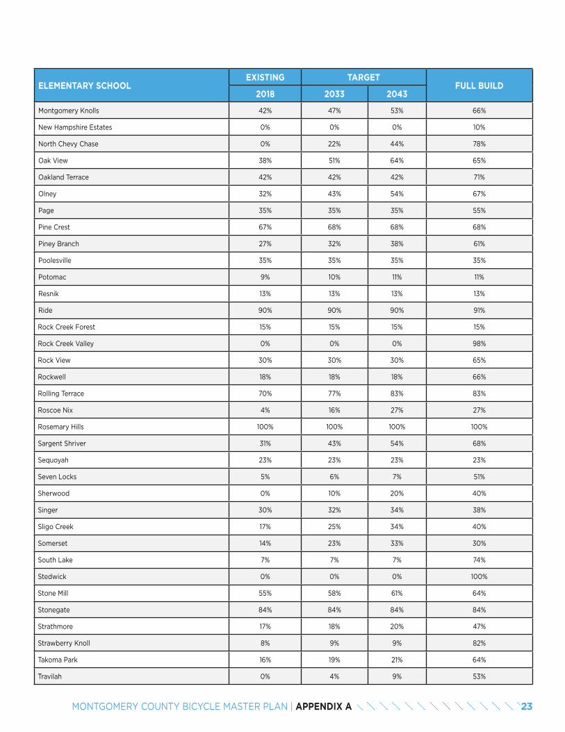
ELEMENTARY SCHOOLEXISTING TARGET
FULL BUILD2018 2033 2043
Montgomery Knolls 42% 47% 53% 66%
New Hampshire Estates 0% 0% 0% 10%
North Chevy Chase 0% 22% 44% 78%
Oak View 38% 51% 64% 65%
Oakland Terrace 42% 42% 42% 71%
Olney 32% 43% 54% 67%
Page 35% 35% 35% 55%
Pine Crest 67% 68% 68% 68%
Piney Branch 27% 32% 38% 61%
Poolesville 35% 35% 35% 35%
Potomac 9% 10% 11% 11%
Resnik 13% 13% 13% 13%
Ride 90% 90% 90% 91%
Rock Creek Forest 15% 15% 15% 15%
Rock Creek Valley 0% 0% 0% 98%
Rock View 30% 30% 30% 65%
Rockwell 18% 18% 18% 66%
Rolling Terrace 70% 77% 83% 83%
Roscoe Nix 4% 16% 27% 27%
Rosemary Hills 100% 100% 100% 100%
Sargent Shriver 31% 43% 54% 68%
Sequoyah 23% 23% 23% 23%
Seven Locks 5% 6% 7% 51%
Sherwood 0% 10% 20% 40%
Singer 30% 32% 34% 38%
Sligo Creek 17% 25% 34% 40%
Somerset 14% 23% 33% 30%
South Lake 7% 7% 7% 74%
Stedwick 0% 0% 0% 100%
Stone Mill 55% 58% 61% 64%
Stonegate 84% 84% 84% 84%
Strathmore 17% 18% 20% 47%
Strawberry Knoll 8% 9% 9% 82%
Takoma Park 16% 19% 21% 64%
Travilah 0% 4% 9% 53%
23MONTGOMERY COUNTY BICYCLE MASTER PLAN | APPENDIX A
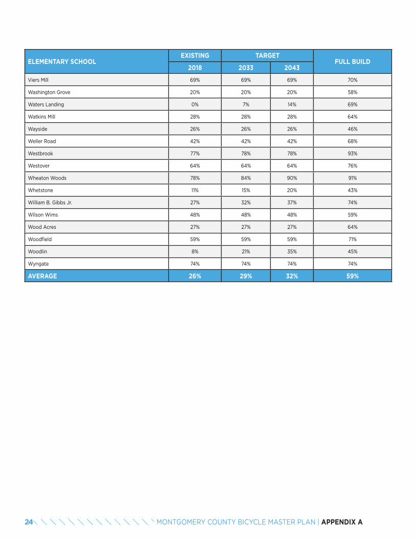
ELEMENTARY SCHOOLEXISTING TARGET
FULL BUILD2018 2033 2043
Viers Mill 69% 69% 69% 70%
Washington Grove 20% 20% 20% 58%
Waters Landing 0% 7% 14% 69%
Watkins Mill 28% 28% 28% 64%
Wayside 26% 26% 26% 46%
Weller Road 42% 42% 42% 68%
Westbrook 77% 78% 78% 93%
Westover 64% 64% 64% 76%
Wheaton Woods 78% 84% 90% 91%
Whetstone 11% 15% 20% 43%
William B. Gibbs Jr. 27% 32% 37% 74%
Wilson Wims 48% 48% 48% 59%
Wood Acres 27% 27% 27% 64%
Woodfield 59% 59% 59% 71%
Woodlin 8% 21% 35% 45%
Wyngate 74% 74% 74% 74%
AVERAGE 26% 29% 32% 59%
24 MONTGOMERY COUNTY BICYCLE MASTER PLAN | APPENDIX A
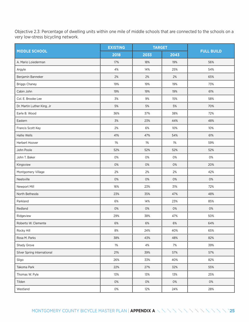
Objective 2.3: Percentage of dwelling units within one mile of middle schools that are connected to the schools on a very low-stress bicycling network.
MIDDLE SCHOOLEXISTING TARGET
FULL BUILD2018 2033 2043
A. Mario Loiederman 17% 18% 19% 56%
Argyle 4% 14% 25% 54%
Benjamin Banneker 2% 2% 2% 65%
Briggs Chaney 19% 19% 19% 73%
Cabin John 19% 19% 19% 61%
Col. E. Brooke Lee 3% 9% 15% 58%
Dr. Martin Luther King, Jr 5% 5% 5% 70%
Earle B. Wood 36% 37% 38% 72%
Eastern 3% 23% 44% 48%
Francis Scott Key 2% 6% 10% 10%
Hallie Wells 41% 47% 54% 61%
Herbert Hoover 1% 1% 1% 59%
John Poole 52% 52% 52% 52%
John T. Baker 0% 0% 0% 0%
Kingsview 0% 0% 0% 20%
Montgomery Village 2% 2% 2% 42%
Neelsville 0% 0% 0% 0%
Newport Mill 16% 23% 31% 72%
North Bethesda 23% 35% 47% 48%
Parkland 6% 14% 23% 85%
Redland 0% 0% 0% 0%
Ridgeview 29% 38% 47% 50%
Roberto W. Clemente 6% 6% 6% 64%
Rocky Hill 8% 24% 40% 65%
Rosa M. Parks 38% 43% 48% 82%
Shady Grove 1% 4% 7% 39%
Silver Spring International 21% 39% 57% 57%
Sligo 26% 33% 40% 82%
Takoma Park 22% 27% 32% 55%
Thomas W. Pyle 13% 13% 13% 25%
Tilden 0% 0% 0% 0%
Westland 0% 12% 24% 28%
25MONTGOMERY COUNTY BICYCLE MASTER PLAN | APPENDIX A

MIDDLE SCHOOLEXISTING TARGET
FULL BUILD2018 2033 2043
White Oak 28% 39% 49% 49%
William H. Farquhar 4% 5% 7% 14%
AVERAGE 11% 17% 22% 48%
26 MONTGOMERY COUNTY BICYCLE MASTER PLAN | APPENDIX A
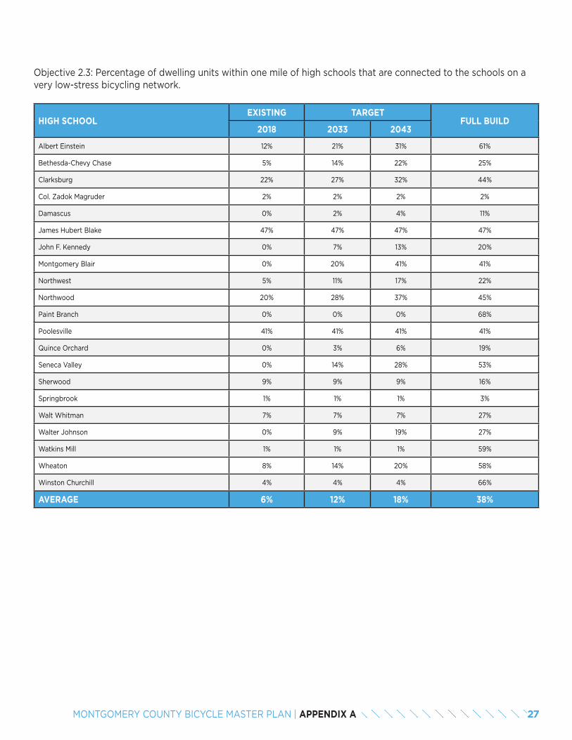
Objective 2.3: Percentage of dwelling units within one mile of high schools that are connected to the schools on a very low-stress bicycling network.
HIGH SCHOOLEXISTING TARGET
FULL BUILD2018 2033 2043
Albert Einstein 12% 21% 31% 61%
Bethesda-Chevy Chase 5% 14% 22% 25%
Clarksburg 22% 27% 32% 44%
Col. Zadok Magruder 2% 2% 2% 2%
Damascus 0% 2% 4% 11%
James Hubert Blake 47% 47% 47% 47%
John F. Kennedy 0% 7% 13% 20%
Montgomery Blair 0% 20% 41% 41%
Northwest 5% 11% 17% 22%
Northwood 20% 28% 37% 45%
Paint Branch 0% 0% 0% 68%
Poolesville 41% 41% 41% 41%
Quince Orchard 0% 3% 6% 19%
Seneca Valley 0% 14% 28% 53%
Sherwood 9% 9% 9% 16%
Springbrook 1% 1% 1% 3%
Walt Whitman 7% 7% 7% 27%
Walter Johnson 0% 9% 19% 27%
Watkins Mill 1% 1% 1% 59%
Wheaton 8% 14% 20% 58%
Winston Churchill 4% 4% 4% 66%
AVERAGE 6% 12% 18% 38%
27MONTGOMERY COUNTY BICYCLE MASTER PLAN | APPENDIX A
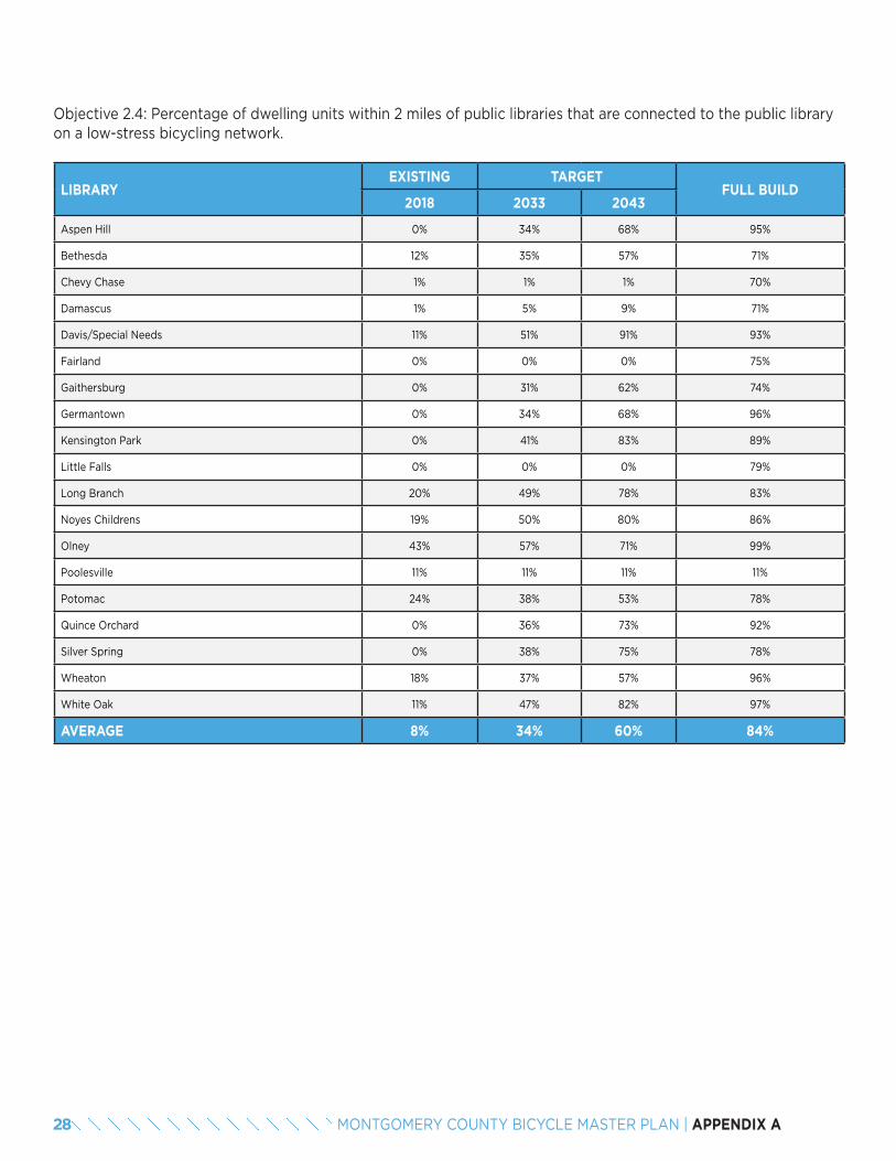
Objective 2.4: Percentage of dwelling units within 2 miles of public libraries that are connected to the public library on a low-stress bicycling network.
LIBRARYEXISTING TARGET
FULL BUILD2018 2033 2043
Aspen Hill 0% 34% 68% 95%
Bethesda 12% 35% 57% 71%
Chevy Chase 1% 1% 1% 70%
Damascus 1% 5% 9% 71%
Davis/Special Needs 11% 51% 91% 93%
Fairland 0% 0% 0% 75%
Gaithersburg 0% 31% 62% 74%
Germantown 0% 34% 68% 96%
Kensington Park 0% 41% 83% 89%
Little Falls 0% 0% 0% 79%
Long Branch 20% 49% 78% 83%
Noyes Childrens 19% 50% 80% 86%
Olney 43% 57% 71% 99%
Poolesville 11% 11% 11% 11%
Potomac 24% 38% 53% 78%
Quince Orchard 0% 36% 73% 92%
Silver Spring 0% 38% 75% 78%
Wheaton 18% 37% 57% 96%
White Oak 11% 47% 82% 97%
AVERAGE 8% 34% 60% 84%
28 MONTGOMERY COUNTY BICYCLE MASTER PLAN | APPENDIX A
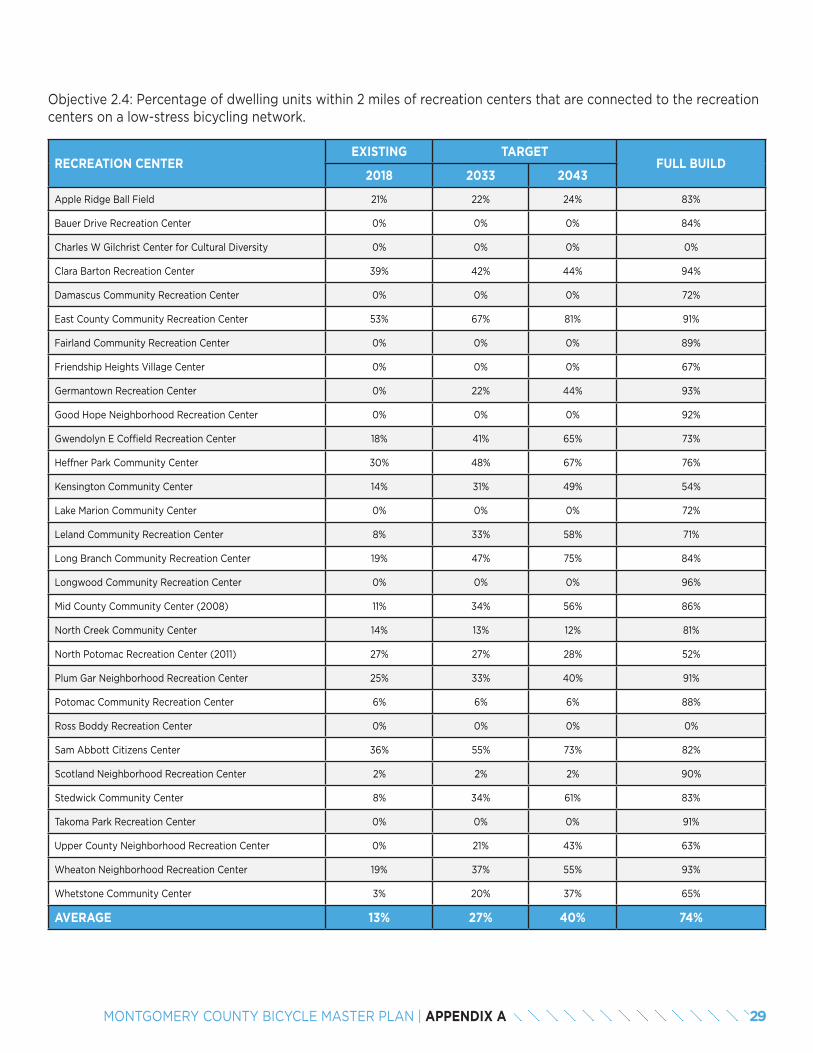
Objective 2.4: Percentage of dwelling units within 2 miles of recreation centers that are connected to the recreation centers on a low-stress bicycling network.
RECREATION CENTEREXISTING TARGET
FULL BUILD2018 2033 2043
Apple Ridge Ball Field 21% 22% 24% 83%
Bauer Drive Recreation Center 0% 0% 0% 84%
Charles W Gilchrist Center for Cultural Diversity 0% 0% 0% 0%
Clara Barton Recreation Center 39% 42% 44% 94%
Damascus Community Recreation Center 0% 0% 0% 72%
East County Community Recreation Center 53% 67% 81% 91%
Fairland Community Recreation Center 0% 0% 0% 89%
Friendship Heights Village Center 0% 0% 0% 67%
Germantown Recreation Center 0% 22% 44% 93%
Good Hope Neighborhood Recreation Center 0% 0% 0% 92%
Gwendolyn E Coffield Recreation Center 18% 41% 65% 73%
Heffner Park Community Center 30% 48% 67% 76%
Kensington Community Center 14% 31% 49% 54%
Lake Marion Community Center 0% 0% 0% 72%
Leland Community Recreation Center 8% 33% 58% 71%
Long Branch Community Recreation Center 19% 47% 75% 84%
Longwood Community Recreation Center 0% 0% 0% 96%
Mid County Community Center (2008) 11% 34% 56% 86%
North Creek Community Center 14% 13% 12% 81%
North Potomac Recreation Center (2011) 27% 27% 28% 52%
Plum Gar Neighborhood Recreation Center 25% 33% 40% 91%
Potomac Community Recreation Center 6% 6% 6% 88%
Ross Boddy Recreation Center 0% 0% 0% 0%
Sam Abbott Citizens Center 36% 55% 73% 82%
Scotland Neighborhood Recreation Center 2% 2% 2% 90%
Stedwick Community Center 8% 34% 61% 83%
Takoma Park Recreation Center 0% 0% 0% 91%
Upper County Neighborhood Recreation Center 0% 21% 43% 63%
Wheaton Neighborhood Recreation Center 19% 37% 55% 93%
Whetstone Community Center 3% 20% 37% 65%
AVERAGE 13% 27% 40% 74%
29MONTGOMERY COUNTY BICYCLE MASTER PLAN | APPENDIX A
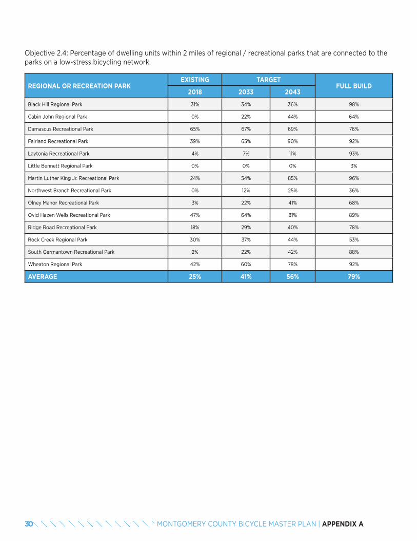
Objective 2.4: Percentage of dwelling units within 2 miles of regional / recreational parks that are connected to the parks on a low-stress bicycling network.
REGIONAL OR RECREATION PARKEXISTING TARGET
FULL BUILD2018 2033 2043
Black Hill Regional Park 31% 34% 36% 98%
Cabin John Regional Park 0% 22% 44% 64%
Damascus Recreational Park 65% 67% 69% 76%
Fairland Recreational Park 39% 65% 90% 92%
Laytonia Recreational Park 4% 7% 11% 93%
Little Bennett Regional Park 0% 0% 0% 3%
Martin Luther King Jr. Recreational Park 24% 54% 85% 96%
Northwest Branch Recreational Park 0% 12% 25% 36%
Olney Manor Recreational Park 3% 22% 41% 68%
Ovid Hazen Wells Recreational Park 47% 64% 81% 89%
Ridge Road Recreational Park 18% 29% 40% 78%
Rock Creek Regional Park 30% 37% 44% 53%
South Germantown Recreational Park 2% 22% 42% 88%
Wheaton Regional Park 42% 60% 78% 92%
AVERAGE 25% 41% 56% 79%
30 MONTGOMERY COUNTY BICYCLE MASTER PLAN | APPENDIX A
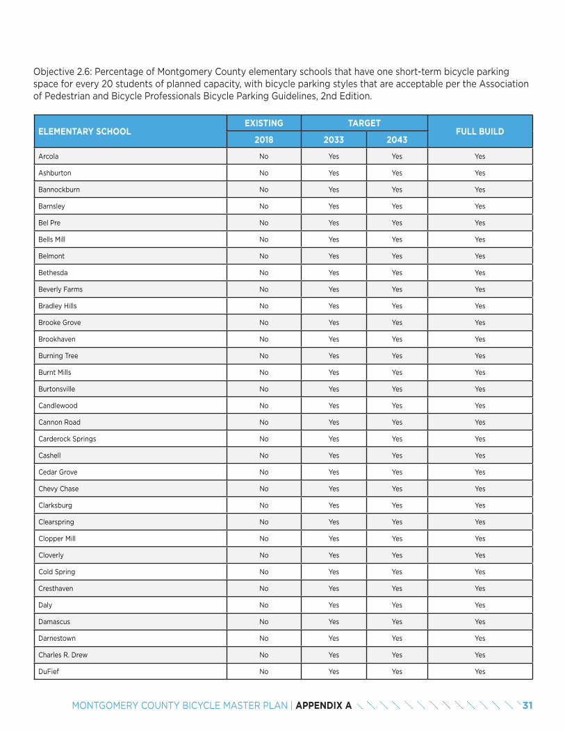
Objective 2.6: Percentage of Montgomery County elementary schools that have one short-term bicycle parking space for every 20 students of planned capacity, with bicycle parking styles that are acceptable per the Association of Pedestrian and Bicycle Professionals Bicycle Parking Guidelines, 2nd Edition.
ELEMENTARY SCHOOLEXISTING TARGET
FULL BUILD2018 2033 2043
Arcola No Yes Yes Yes
Ashburton No Yes Yes Yes
Bannockburn No Yes Yes Yes
Barnsley No Yes Yes Yes
Bel Pre No Yes Yes Yes
Bells Mill No Yes Yes Yes
Belmont No Yes Yes Yes
Bethesda No Yes Yes Yes
Beverly Farms No Yes Yes Yes
Bradley Hills No Yes Yes Yes
Brooke Grove No Yes Yes Yes
Brookhaven No Yes Yes Yes
Burning Tree No Yes Yes Yes
Burnt Mills No Yes Yes Yes
Burtonsville No Yes Yes Yes
Candlewood No Yes Yes Yes
Cannon Road No Yes Yes Yes
Carderock Springs No Yes Yes Yes
Cashell No Yes Yes Yes
Cedar Grove No Yes Yes Yes
Chevy Chase No Yes Yes Yes
Clarksburg No Yes Yes Yes
Clearspring No Yes Yes Yes
Clopper Mill No Yes Yes Yes
Cloverly No Yes Yes Yes
Cold Spring No Yes Yes Yes
Cresthaven No Yes Yes Yes
Daly No Yes Yes Yes
Damascus No Yes Yes Yes
Darnestown No Yes Yes Yes
Charles R. Drew No Yes Yes Yes
DuFief No Yes Yes Yes
31MONTGOMERY COUNTY BICYCLE MASTER PLAN | APPENDIX A
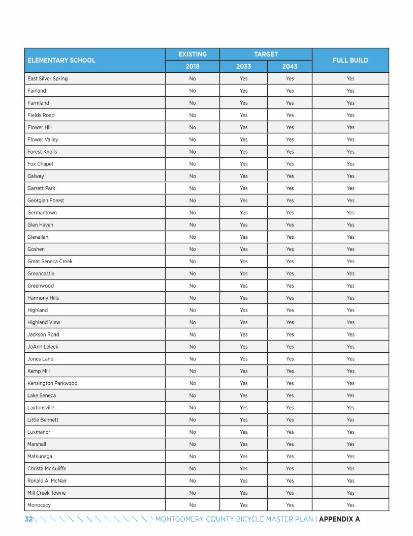
ELEMENTARY SCHOOLEXISTING TARGET
FULL BUILD2018 2033 2043
East Silver Spring No Yes Yes Yes
Fairland No Yes Yes Yes
Farmland No Yes Yes Yes
Fields Road No Yes Yes Yes
Flower Hill No Yes Yes Yes
Flower Valley No Yes Yes Yes
Forest Knolls No Yes Yes Yes
Fox Chapel No Yes Yes Yes
Galway No Yes Yes Yes
Garrett Park No Yes Yes Yes
Georgian Forest No Yes Yes Yes
Germantown No Yes Yes Yes
Glen Haven No Yes Yes Yes
Glenallan No Yes Yes Yes
Goshen No Yes Yes Yes
Great Seneca Creek No Yes Yes Yes
Greencastle No Yes Yes Yes
Greenwood No Yes Yes Yes
Harmony Hills No Yes Yes Yes
Highland No Yes Yes Yes
Highland View No Yes Yes Yes
Jackson Road No Yes Yes Yes
JoAnn Leleck No Yes Yes Yes
Jones Lane No Yes Yes Yes
Kemp Mill No Yes Yes Yes
Kensington Parkwood No Yes Yes Yes
Lake Seneca No Yes Yes Yes
Laytonsville No Yes Yes Yes
Little Bennett No Yes Yes Yes
Luxmanor No Yes Yes Yes
Marshall No Yes Yes Yes
Matsunaga No Yes Yes Yes
Christa McAuliffe No Yes Yes Yes
Ronald A. McNair No Yes Yes Yes
Mill Creek Towne No Yes Yes Yes
Monocacy No Yes Yes Yes
32 MONTGOMERY COUNTY BICYCLE MASTER PLAN | APPENDIX A
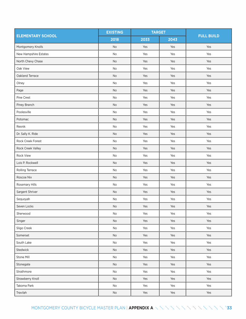
ELEMENTARY SCHOOLEXISTING TARGET
FULL BUILD2018 2033 2043
Montgomery Knolls No Yes Yes Yes
New Hampshire Estates No Yes Yes Yes
North Chevy Chase No Yes Yes Yes
Oak View No Yes Yes Yes
Oakland Terrace No Yes Yes Yes
Olney No Yes Yes Yes
Page No Yes Yes Yes
Pine Crest No Yes Yes Yes
Piney Branch No Yes Yes Yes
Poolesville No Yes Yes Yes
Potomac No Yes Yes Yes
Resnik No Yes Yes Yes
Dr. Sally K. Ride No Yes Yes Yes
Rock Creek Forest No Yes Yes Yes
Rock Creek Valley No Yes Yes Yes
Rock View No Yes Yes Yes
Lois P. Rockwell No Yes Yes Yes
Rolling Terrace No Yes Yes Yes
Roscoe Nix No Yes Yes Yes
Rosemary Hills No Yes Yes Yes
Sargent Shriver No Yes Yes Yes
Sequoyah No Yes Yes Yes
Seven Locks No Yes Yes Yes
Sherwood No Yes Yes Yes
Singer No Yes Yes Yes
Sligo Creek No Yes Yes Yes
Somerset No Yes Yes Yes
South Lake No Yes Yes Yes
Stedwick No Yes Yes Yes
Stone Mill No Yes Yes Yes
Stonegate No Yes Yes Yes
Strathmore No Yes Yes Yes
Strawberry Knoll No Yes Yes Yes
Takoma Park No Yes Yes Yes
Travilah No Yes Yes Yes
33MONTGOMERY COUNTY BICYCLE MASTER PLAN | APPENDIX A
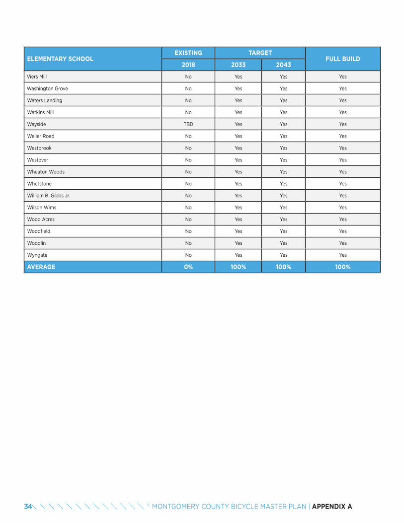
ELEMENTARY SCHOOLEXISTING TARGET
FULL BUILD2018 2033 2043
Viers Mill No Yes Yes Yes
Washington Grove No Yes Yes Yes
Waters Landing No Yes Yes Yes
Watkins Mill No Yes Yes Yes
Wayside TBD Yes Yes Yes
Weller Road No Yes Yes Yes
Westbrook No Yes Yes Yes
Westover No Yes Yes Yes
Wheaton Woods No Yes Yes Yes
Whetstone No Yes Yes Yes
William B. Gibbs Jr. No Yes Yes Yes
Wilson Wims No Yes Yes Yes
Wood Acres No Yes Yes Yes
Woodfield No Yes Yes Yes
Woodlin No Yes Yes Yes
Wyngate No Yes Yes Yes
AVERAGE 0% 100% 100% 100%
34 MONTGOMERY COUNTY BICYCLE MASTER PLAN | APPENDIX A
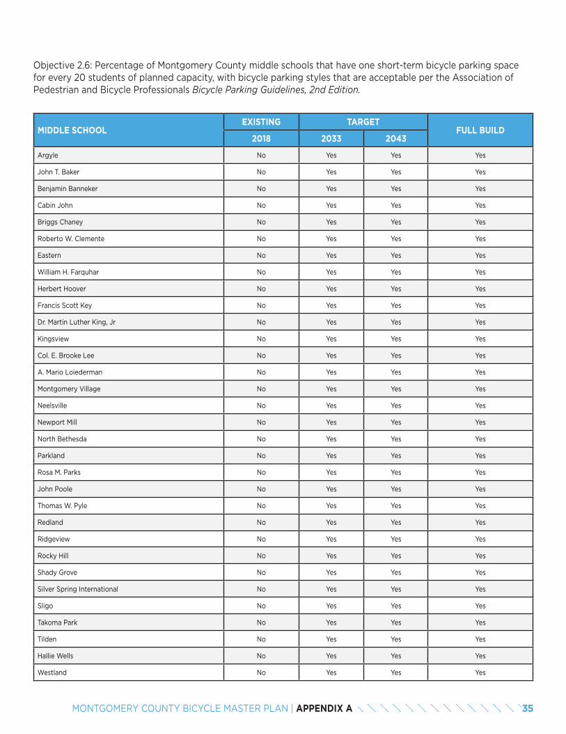
Objective 2.6: Percentage of Montgomery County middle schools that have one short-term bicycle parking space for every 20 students of planned capacity, with bicycle parking styles that are acceptable per the Association of Pedestrian and Bicycle Professionals Bicycle Parking Guidelines, 2nd Edition.
MIDDLE SCHOOLEXISTING TARGET
FULL BUILD2018 2033 2043
Argyle No Yes Yes Yes
John T. Baker No Yes Yes Yes
Benjamin Banneker No Yes Yes Yes
Cabin John No Yes Yes Yes
Briggs Chaney No Yes Yes Yes
Roberto W. Clemente No Yes Yes Yes
Eastern No Yes Yes Yes
William H. Farquhar No Yes Yes Yes
Herbert Hoover No Yes Yes Yes
Francis Scott Key No Yes Yes Yes
Dr. Martin Luther King, Jr No Yes Yes Yes
Kingsview No Yes Yes Yes
Col. E. Brooke Lee No Yes Yes Yes
A. Mario Loiederman No Yes Yes Yes
Montgomery Village No Yes Yes Yes
Neelsville No Yes Yes Yes
Newport Mill No Yes Yes Yes
North Bethesda No Yes Yes Yes
Parkland No Yes Yes Yes
Rosa M. Parks No Yes Yes Yes
John Poole No Yes Yes Yes
Thomas W. Pyle No Yes Yes Yes
Redland No Yes Yes Yes
Ridgeview No Yes Yes Yes
Rocky Hill No Yes Yes Yes
Shady Grove No Yes Yes Yes
Silver Spring International No Yes Yes Yes
Sligo No Yes Yes Yes
Takoma Park No Yes Yes Yes
Tilden No Yes Yes Yes
Hallie Wells No Yes Yes Yes
Westland No Yes Yes Yes
35MONTGOMERY COUNTY BICYCLE MASTER PLAN | APPENDIX A

MIDDLE SCHOOLEXISTING TARGET
FULL BUILD2018 2033 2043
White Oak No Yes Yes Yes
Earle B. Wood No Yes Yes Yes
AVERAGE 0% 100% 100% 100%
36 MONTGOMERY COUNTY BICYCLE MASTER PLAN | APPENDIX A
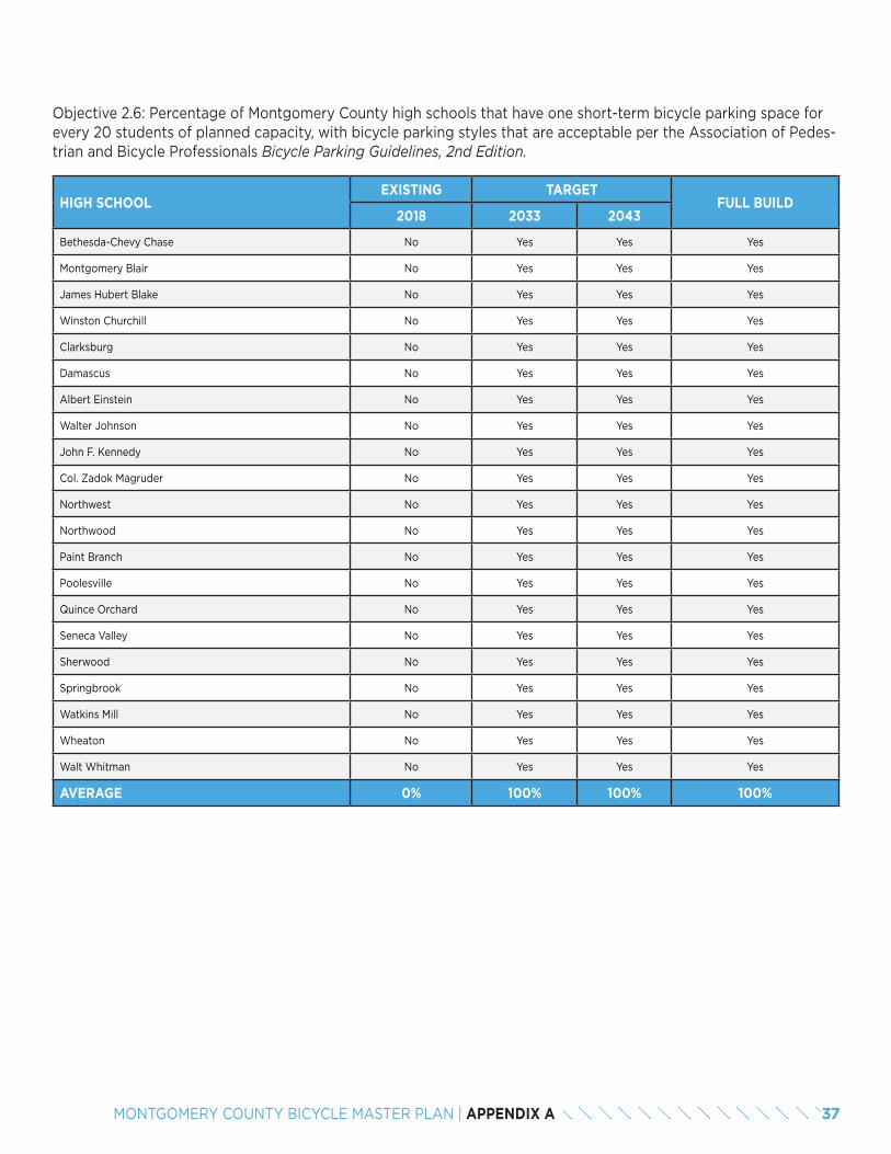
Objective 2.6: Percentage of Montgomery County high schools that have one short-term bicycle parking space for every 20 students of planned capacity, with bicycle parking styles that are acceptable per the Association of Pedes-trian and Bicycle Professionals Bicycle Parking Guidelines, 2nd Edition.
HIGH SCHOOLEXISTING TARGET
FULL BUILD2018 2033 2043
Bethesda-Chevy Chase No Yes Yes Yes
Montgomery Blair No Yes Yes Yes
James Hubert Blake No Yes Yes Yes
Winston Churchill No Yes Yes Yes
Clarksburg No Yes Yes Yes
Damascus No Yes Yes Yes
Albert Einstein No Yes Yes Yes
Walter Johnson No Yes Yes Yes
John F. Kennedy No Yes Yes Yes
Col. Zadok Magruder No Yes Yes Yes
Northwest No Yes Yes Yes
Northwood No Yes Yes Yes
Paint Branch No Yes Yes Yes
Poolesville No Yes Yes Yes
Quince Orchard No Yes Yes Yes
Seneca Valley No Yes Yes Yes
Sherwood No Yes Yes Yes
Springbrook No Yes Yes Yes
Watkins Mill No Yes Yes Yes
Wheaton No Yes Yes Yes
Walt Whitman No Yes Yes Yes
AVERAGE 0% 100% 100% 100%
37MONTGOMERY COUNTY BICYCLE MASTER PLAN | APPENDIX A
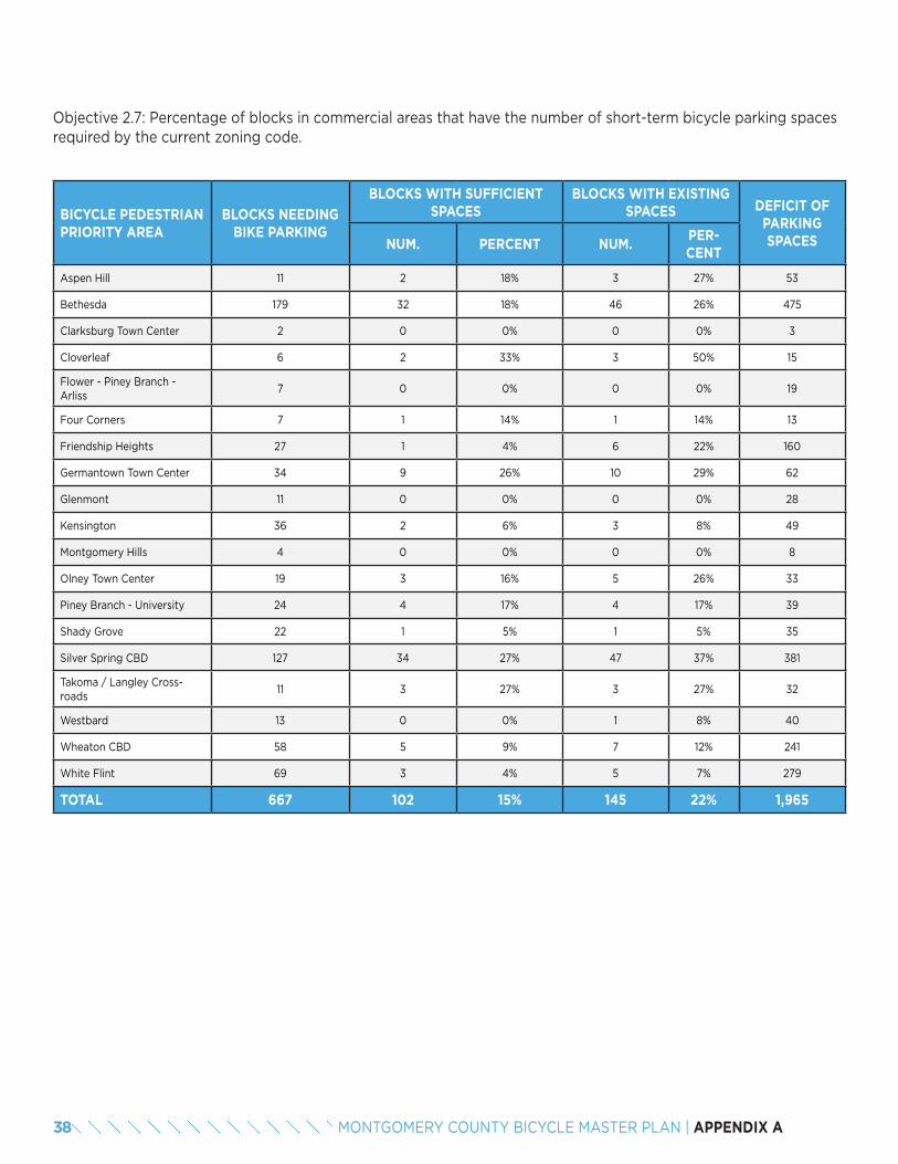
Objective 2.7: Percentage of blocks in commercial areas that have the number of short-term bicycle parking spaces required by the current zoning code.
BICYCLE PEDESTRIAN PRIORITY AREA
BLOCKS NEEDING BIKE PARKING
BLOCKS WITH SUFFICIENT SPACES
BLOCKS WITH EXISTING SPACES DEFICIT OF
PARKING SPACESNUM. PERCENT NUM.
PER-CENT
Aspen Hill 11 2 18% 3 27% 53
Bethesda 179 32 18% 46 26% 475
Clarksburg Town Center 2 0 0% 0 0% 3
Cloverleaf 6 2 33% 3 50% 15
Flower - Piney Branch - Arliss
7 0 0% 0 0% 19
Four Corners 7 1 14% 1 14% 13
Friendship Heights 27 1 4% 6 22% 160
Germantown Town Center 34 9 26% 10 29% 62
Glenmont 11 0 0% 0 0% 28
Kensington 36 2 6% 3 8% 49
Montgomery Hills 4 0 0% 0 0% 8
Olney Town Center 19 3 16% 5 26% 33
Piney Branch - University 24 4 17% 4 17% 39
Shady Grove 22 1 5% 1 5% 35
Silver Spring CBD 127 34 27% 47 37% 381
Takoma / Langley Cross-roads
11 3 27% 3 27% 32
Westbard 13 0 0% 1 8% 40
Wheaton CBD 58 5 9% 7 12% 241
White Flint 69 3 4% 5 7% 279
TOTAL 667 102 15% 145 22% 1,965
38 MONTGOMERY COUNTY BICYCLE MASTER PLAN | APPENDIX A
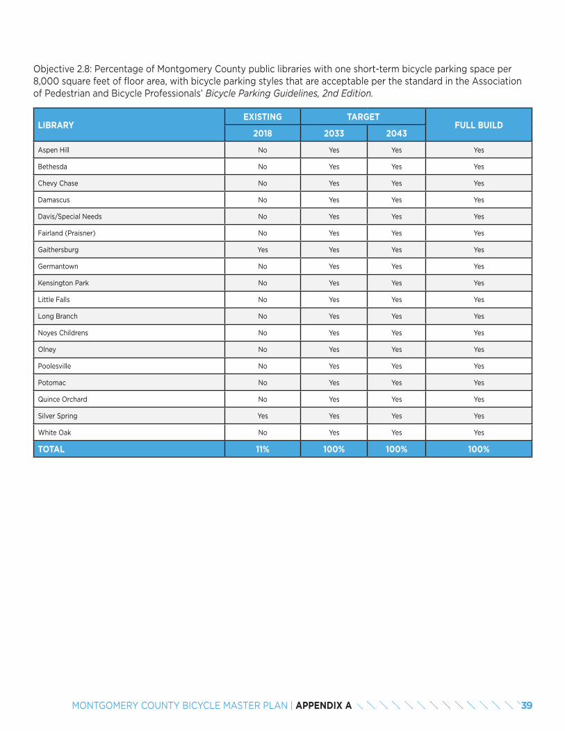
Objective 2.8: Percentage of Montgomery County public libraries with one short-term bicycle parking space per 8,000 square feet of floor area, with bicycle parking styles that are acceptable per the standard in the Association of Pedestrian and Bicycle Professionals’ Bicycle Parking Guidelines, 2nd Edition.
LIBRARYEXISTING TARGET
FULL BUILD2018 2033 2043
Aspen Hill No Yes Yes Yes
Bethesda No Yes Yes Yes
Chevy Chase No Yes Yes Yes
Damascus No Yes Yes Yes
Davis/Special Needs No Yes Yes Yes
Fairland (Praisner) No Yes Yes Yes
Gaithersburg Yes Yes Yes Yes
Germantown No Yes Yes Yes
Kensington Park No Yes Yes Yes
Little Falls No Yes Yes Yes
Long Branch No Yes Yes Yes
Noyes Childrens No Yes Yes Yes
Olney No Yes Yes Yes
Poolesville No Yes Yes Yes
Potomac No Yes Yes Yes
Quince Orchard No Yes Yes Yes
Silver Spring Yes Yes Yes Yes
White Oak No Yes Yes Yes
TOTAL 11% 100% 100% 100%
39MONTGOMERY COUNTY BICYCLE MASTER PLAN | APPENDIX A
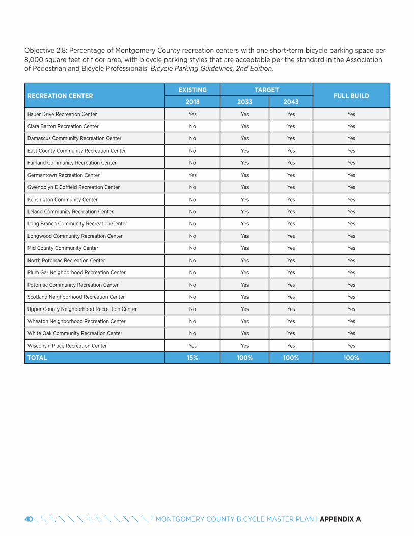
Objective 2.8: Percentage of Montgomery County recreation centers with one short-term bicycle parking space per 8,000 square feet of floor area, with bicycle parking styles that are acceptable per the standard in the Association of Pedestrian and Bicycle Professionals’ Bicycle Parking Guidelines, 2nd Edition.
RECREATION CENTEREXISTING TARGET
FULL BUILD2018 2033 2043
Bauer Drive Recreation Center Yes Yes Yes Yes
Clara Barton Recreation Center No Yes Yes Yes
Damascus Community Recreation Center No Yes Yes Yes
East County Community Recreation Center No Yes Yes Yes
Fairland Community Recreation Center No Yes Yes Yes
Germantown Recreation Center Yes Yes Yes Yes
Gwendolyn E Coffield Recreation Center No Yes Yes Yes
Kensington Community Center No Yes Yes Yes
Leland Community Recreation Center No Yes Yes Yes
Long Branch Community Recreation Center No Yes Yes Yes
Longwood Community Recreation Center No Yes Yes Yes
Mid County Community Center No Yes Yes Yes
North Potomac Recreation Center No Yes Yes Yes
Plum Gar Neighborhood Recreation Center No Yes Yes Yes
Potomac Community Recreation Center No Yes Yes Yes
Scotland Neighborhood Recreation Center No Yes Yes Yes
Upper County Neighborhood Recreation Center No Yes Yes Yes
Wheaton Neighborhood Recreation Center No Yes Yes Yes
White Oak Community Recreation Center No Yes Yes Yes
Wisconsin Place Recreation Center Yes Yes Yes Yes
TOTAL 15% 100% 100% 100%
40 MONTGOMERY COUNTY BICYCLE MASTER PLAN | APPENDIX A
Objective 3.1: Percentage of potential bicycle trips that can be made on a low-stress bicycling network in US cen-sus tracts where the median income is below 60 percent of the county average median income, compared to other areas in the County.
POLICY AREA LOW INCOMEEXISTING TARGET
FULL BUILD2018 2043
24031700101 5% 5% 45%
24031700103 10% 20% 50%
24031700104 5% 5% 75%
24031700105 10% 15% 35%
24031700204 5% 5% 5%
24031700205 40% 75% 90%
24031700206 30% 40% 85%
24031700207 30% 70% 90%
24031700208 0% 50% 85%
24031700304 15% 60% 95%
24031700306 5% 55% 85%
24031700308 15% 45% 95%
24031700309 5% 65% 95%
24031700310 10% 75% 95%
24031700311 25% 70% 90%
24031700312 15% 50% 85%
24031700400 5% 5% 15%
24031700500 80% 80% 80%
24031700604 20% 35% 70%
24031700606 5% 5% 35%
24031700607 20% 65% 85%
24031700608 15% 30% 60%
24031700610 10% 70% 80%
24031700611 20% 45% 95%
24031700613 10% 45% 90%
24031700614 15% 55% 85%
24031700615 15% 15% 95%
24031700616 25% 55% 90%
24031700704 10% 50% 60%
24031700706 10% 75% 85%
24031700710 10% 25% 75%
24031700711 10% 40% 80%
41MONTGOMERY COUNTY BICYCLE MASTER PLAN | APPENDIX A
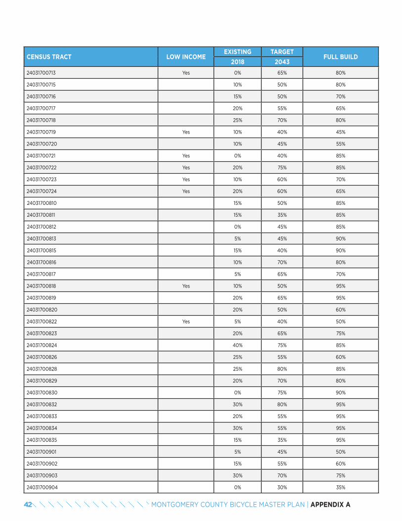
CENSUS TRACT LOW INCOMEEXISTING TARGET
FULL BUILD2018 2043
24031700713 Yes 0% 65% 80%
24031700715 10% 50% 80%
24031700716 15% 50% 70%
24031700717 20% 55% 65%
24031700718 25% 70% 80%
24031700719 Yes 10% 40% 45%
24031700720 10% 45% 55%
24031700721 Yes 0% 40% 85%
24031700722 Yes 20% 75% 85%
24031700723 Yes 10% 60% 70%
24031700724 Yes 20% 60% 65%
24031700810 15% 50% 85%
24031700811 15% 35% 85%
24031700812 0% 45% 85%
24031700813 5% 45% 90%
24031700815 15% 40% 90%
24031700816 10% 70% 80%
24031700817 5% 65% 70%
24031700818 Yes 10% 50% 95%
24031700819 20% 65% 95%
24031700820 20% 50% 60%
24031700822 Yes 5% 40% 50%
24031700823 20% 65% 75%
24031700824 40% 75% 85%
24031700826 25% 55% 60%
24031700828 25% 80% 85%
24031700829 20% 70% 80%
24031700830 0% 75% 90%
24031700832 30% 80% 95%
24031700833 20% 55% 95%
24031700834 30% 55% 95%
24031700835 15% 35% 95%
24031700901 5% 45% 50%
24031700902 15% 55% 60%
24031700903 30% 70% 75%
24031700904 0% 30% 35%
42 MONTGOMERY COUNTY BICYCLE MASTER PLAN | APPENDIX A
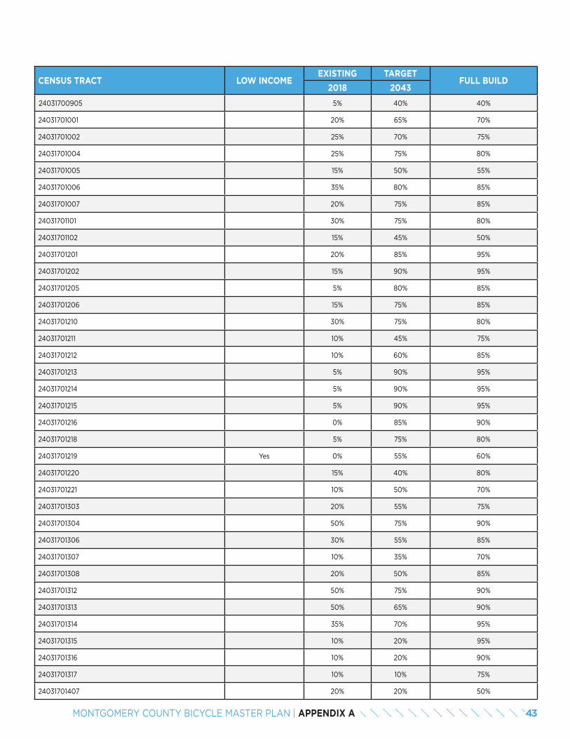
CENSUS TRACT LOW INCOMEEXISTING TARGET
FULL BUILD2018 2043
24031700905 5% 40% 40%
24031701001 20% 65% 70%
24031701002 25% 70% 75%
24031701004 25% 75% 80%
24031701005 15% 50% 55%
24031701006 35% 80% 85%
24031701007 20% 75% 85%
24031701101 30% 75% 80%
24031701102 15% 45% 50%
24031701201 20% 85% 95%
24031701202 15% 90% 95%
24031701205 5% 80% 85%
24031701206 15% 75% 85%
24031701210 30% 75% 80%
24031701211 10% 45% 75%
24031701212 10% 60% 85%
24031701213 5% 90% 95%
24031701214 5% 90% 95%
24031701215 5% 90% 95%
24031701216 0% 85% 90%
24031701218 5% 75% 80%
24031701219 Yes 0% 55% 60%
24031701220 15% 40% 80%
24031701221 10% 50% 70%
24031701303 20% 55% 75%
24031701304 50% 75% 90%
24031701306 30% 55% 85%
24031701307 10% 35% 70%
24031701308 20% 50% 85%
24031701312 50% 75% 90%
24031701313 50% 65% 90%
24031701314 35% 70% 95%
24031701315 10% 20% 95%
24031701316 10% 20% 90%
24031701317 10% 10% 75%
24031701407 20% 20% 50%
43MONTGOMERY COUNTY BICYCLE MASTER PLAN | APPENDIX A
CENSUS TRACT LOW INCOMEEXISTING TARGET
FULL BUILD2018 2043
24031701408 15% 15% 90%
24031701409 10% 30% 95%
24031701410 25% 45% 95%
24031701414 5% 30% 95%
24031701415 15% 55% 95%
24031701417 25% 75% 90%
24031701418 30% 85% 95%
24031701420 20% 85% 95%
24031701421 15% 85% 95%
24031701422 Yes 20% 85% 95%
24031701423 45% 90% 95%
24031701503 20% 80% 95%
24031701505 5% 75% 95%
24031701506 10% 50% 90%
24031701507 10% 70% 85%
24031701508 Yes 15% 85% 95%
24031701509 Yes 15% 65% 85%
24031701601 Yes 20% 20% 55%
24031701602 Yes 20% 20% 50%
24031701701 40% 65% 90%
24031701702 60% 90% 95%
24031701703 55% 85% 95%
24031701704 50% 75% 95%
24031701800 35% 80% 90%
24031701900 55% 90% 95%
24031702000 Yes 15% 70% 70%
24031702101 Yes 10% 90% 90%
24031702102 15% 90% 95%
24031702200 45% 85% 95%
24031702301 Yes 50% 90% 95%
24031702302 50% 90% 95%
24031702401 25% 85% 90%
24031702402 20% 85% 90%
24031702500 Yes 0% 75% 75%
24031702601 0% 75% 75%
44 MONTGOMERY COUNTY BICYCLE MASTER PLAN | APPENDIX A
CENSUS TRACT LOW INCOMEEXISTING TARGET
FULL BUILD2018 2043
24031701602 Yes 20% 20% 50%
24031701701 40% 65% 90%
24031701702 60% 90% 95%
24031701703 55% 85% 95%
24031701704 50% 75% 95%
24031701800 35% 80% 90%
24031701900 55% 90% 95%
24031702000 Yes 15% 70% 70%
24031702101 Yes 10% 90% 90%
24031702102 15% 90% 95%
24031702200 45% 85% 95%
24031702301 Yes 50% 90% 95%
24031702302 50% 90% 95%
24031702401 25% 85% 90%
24031702402 20% 85% 90%
24031702500 Yes 0% 75% 75%
24031702601 0% 75% 75%
24031702602 25% 95% 95%
24031702700 30% 85% 95%
24031702800 5% 70% 80%
24031702900 20% 85% 90%
24031703000 40% 80% 95%
24031703100 40% 80% 95%
24031703201 35% 80% 90%
24031703202 25% 55% 80%
24031703206 10% 70% 95%
24031703207 Yes 20% 85% 95%
24031703208 40% 65% 95%
24031703209 30% 70% 95%
24031703210 35% 80% 100%
24031703212 10% 80% 95%
24031703213 Yes 25% 50% 95%
24031703214 40% 70% 95%
24031703215 40% 80% 95%
24031703216 Yes 10% 20% 25%
45MONTGOMERY COUNTY BICYCLE MASTER PLAN | APPENDIX A
CENSUS TRACT LOW INCOMEEXISTING TARGET
FULL BUILD2018 2043
24031703218 Yes 5% 5% 55%
24031703219 Yes 5% 5% 30%
24031703220 25% 55% 80%
24031703221 15% 40% 85%
24031703301 35% 90% 95%
24031703302 25% 85% 95%
24031703401 15% 80% 95%
24031703402 30% 90% 95%
24031703403 25% 85% 95%
24031703404 Yes 30% 90% 95%
24031703501 30% 90% 95%
24031703502 30% 90% 95%
24031703601 20% 75% 95%
24031703602 30% 90% 95%
24031703701 25% 85% 95%
24031703702 15% 70% 95%
24031703800 5% 40% 85%
24031703901 25% 65% 95%
24031703902 25% 65% 90%
24031704000 10% 35% 95%
24031704100 35% 85% 95%
24031704200 20% 85% 90%
24031704300 25% 80% 85%
24031704401 15% 90% 95%
24031704403 30% 65% 65%
24031704404 45% 85% 90%
24031704501 10% 90% 95%
24031704502 50% 85% 95%
24031704503 55% 95% 95%
24031704600 55% 90% 95%
24031704700 20% 80% 85%
24031704803 5% 75% 80%
24031704804 5% 70% 80%
24031704805 10% 70% 80%
24031704806 5% 85% 90%
46 MONTGOMERY COUNTY BICYCLE MASTER PLAN | APPENDIX A
CENSUS TRACT LOW INCOMEEXISTING TARGET
FULL BUILD2018 2043
24031705000 60% 90% 95%
24031705100 10% 65% 90%
24031705200 40% 75% 90%
24031705300 30% 75% 85%
24031705400 20% 85% 90%
24031705501 5% 55% 65%
24031705502 20% 75% 90%
24031705601 35% 70% 90%
24031705602 0% 75% 85%
24031705701 20% 50% 85%
24031705702 40% 75% 85%
24031705800 45% 70% 90%
24031705901 30% 55% 90%
24031705902 20% 30% 90%
24031705903 20% 35% 90%
24031706005 10% 15% 80%
24031706007 25% 55% 80%
24031706008 40% 55% 90%
24031706009 25% 35% 95%
24031706010 15% 45% 95%
24031706011 15% 45% 90%
24031706012 0% 75% 85%
24031706013 5% 30% 90%
TOTAL 15% 65% 80%
47MONTGOMERY COUNTY BICYCLE MASTER PLAN | APPENDIX A
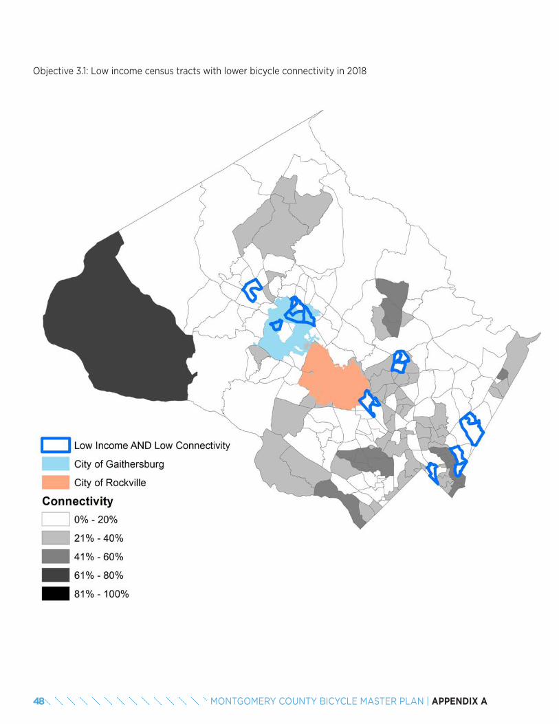
Objective 3.1: Low income census tracts with lower bicycle connectivity in 2018
48 MONTGOMERY COUNTY BICYCLE MASTER PLAN | APPENDIX A
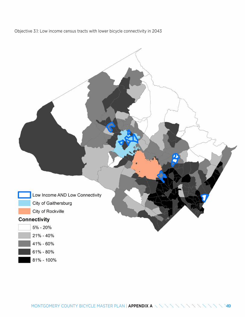
Objective 3.1: Low income census tracts with lower bicycle connectivity in 2043
49MONTGOMERY COUNTY BICYCLE MASTER PLAN | APPENDIX A
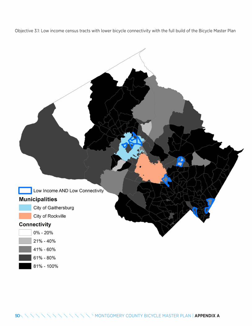
Objective 3.1: Low income census tracts with lower bicycle connectivity with the full build of the Bicycle Master Plan
50 MONTGOMERY COUNTY BICYCLE MASTER PLAN | APPENDIX A


APPENDIX BBICYCLE FACILITY DESIGN TOOLKIT

3
RE
FE
RE
NC
ES
MO
NTG
OM
ER
Y C
OU
NT
Y P
LA
NN
ING
DE
PAR
TM
EN
T B
ICY
CLE
FA
CIL
ITY
DE
SIG
N T
OO
LKIT
•
J
ULY
20
17
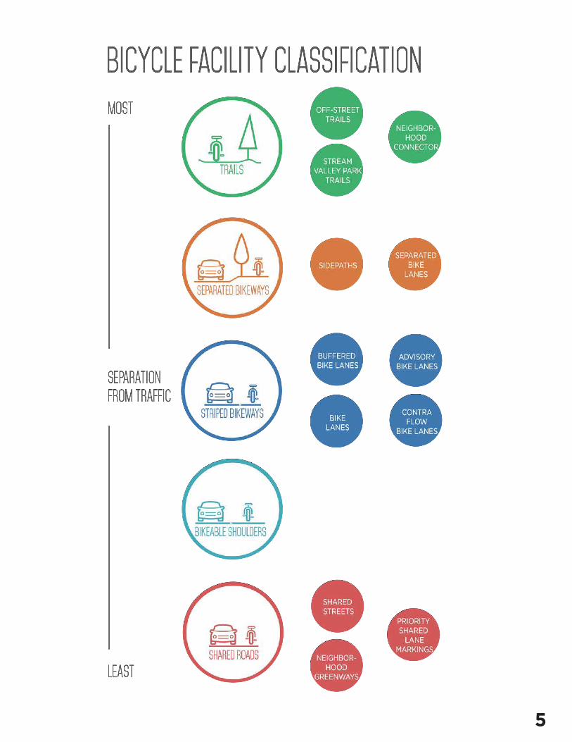
The Montgomery County Planning Department’s Bicycle Facility Design Toolkit provides an overview of the types of bicycle facilities recommended in the Bicycle Master Plan. It is divided into four parts:
• Bikeway Facility Types
• Additional Guidance on Separated Bike Lanes
• Additional Guidance on Neighborhood Greenways
• Intersections Treatments
The toolkit profiles best practices for bicycle facility design and application as described in the National Association of Cities and Transportation Officials (NACTO) Urban Bikeway Design Guide, 2nd Edition, the Federal Highway (FHWA) Separated Bike Lane Planning and Design Guide, the Massachusetts Department of Transportation (MassDOT) Separated Bike Lane Planning and Design Guide, and the American Associ-ation of State Highway Transportation Officials (AASHTO) Guide for the Development of Bicycle Facilities, 4th Edition.
The toolkit’s purpose is to provide guidance to designers and planners and is not intended to take the place of design standards prepared by the Montgomery County Department of Transportation or the Mary-land State Highway Administration.
Key principles assumed in the toolkit are that:
• The bicycling network should accommodate people of all ages and bicycling abilities.
• Bicycle travel on all streets should be safe, continuous, direct and convenient.
1
2
3
4
INTRO
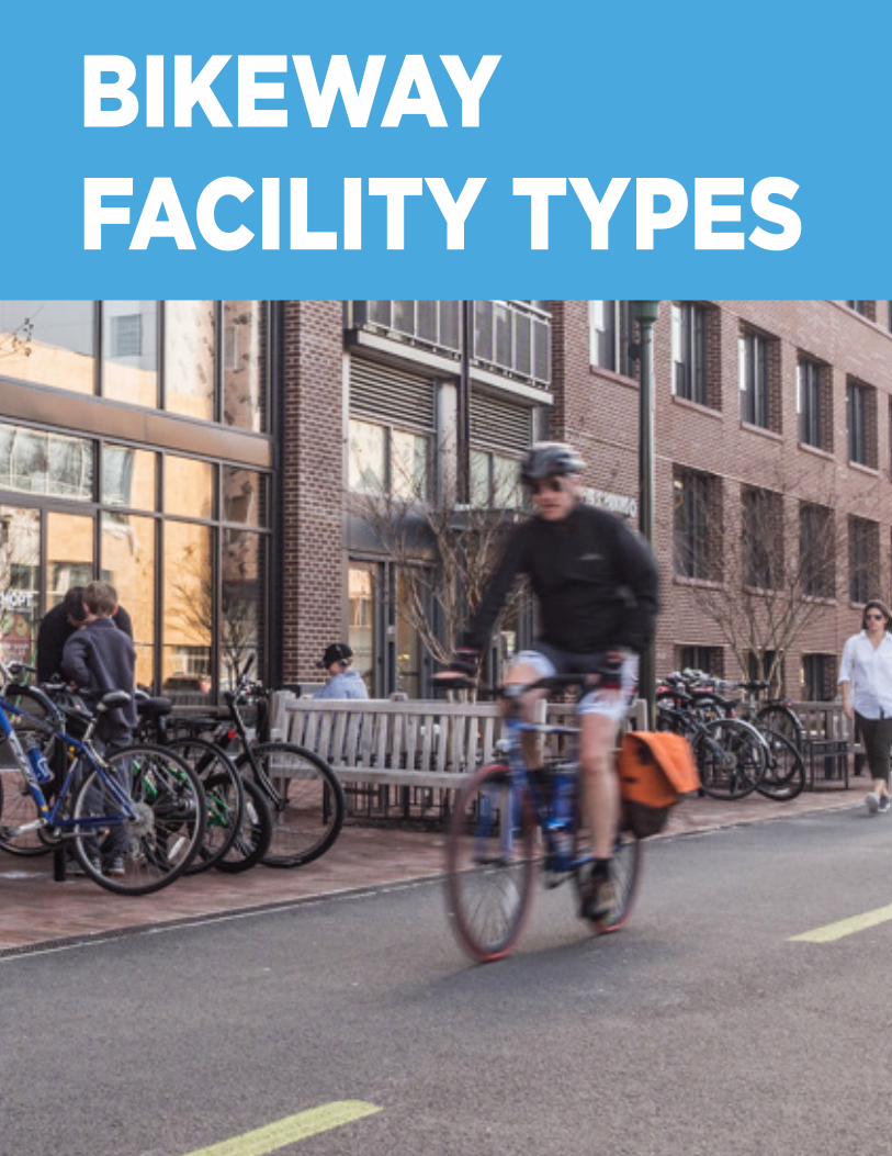
BIKEWAY FACILITY TYPES
5
6
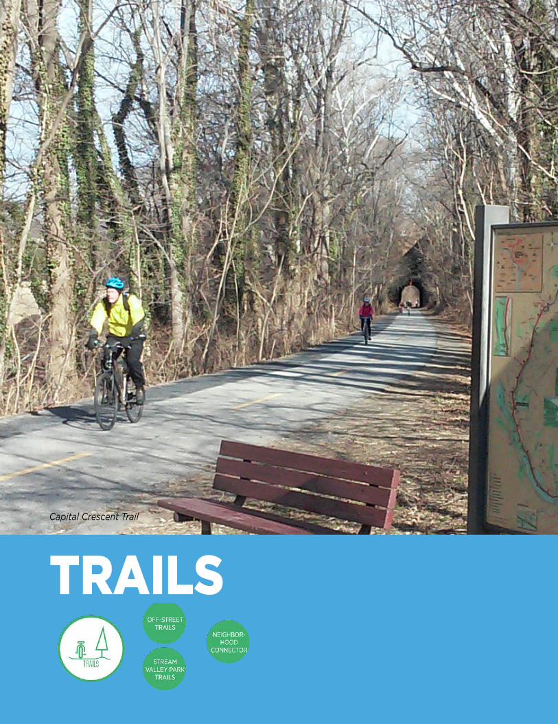
Capital Crescent Trail
TRAILS
7
RE
FE
RE
NC
ES
MO
NTG
OM
ER
Y C
OU
NT
Y P
LA
NN
ING
DE
PAR
TM
EN
T B
ICY
CLE
FA
CIL
ITY
DE
SIG
N T
OO
LKIT
•
J
ULY
20
17
AASHTO. Guide for the Development of Bicycle Facilities. 2012.
United States Access Board. Accessibility Guidelines for Pedestrian Facilities in the Public Right-of-Way; Shared Use Paths. Washington,
DC, February, 2013. https://www.access-board.gov/guidelines-and-standards/streets-sidewalks/shared-use-paths/supplemental-notice
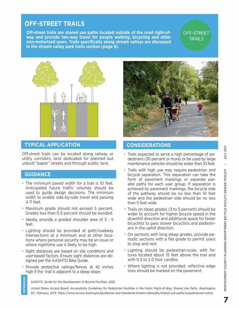
Off-street trails are shared use paths located outside of the road right-of-way and provide two-way travel for people walking, bicycling and other non-motorized users. Trails specifically along stream valleys are discussed in the stream valley park trails section (page 8).
OFF-STREET TRAILS
Off-street trails can be located along railway or utility corridors, land dedicated for planned but unbuilt “paper” streets and through public land.
• Trails expected to serve a high percentage of pe-destrians (30 percent or more) or be used by large maintenance vehicles should be wider than 10 feet.
• Trails with high use may require pedestrian and bicycle separation. This separation can take the form of pavement markings or separate par-allel paths for each user group. If separation is achieved by pavement markings, the bicycle side of the pathway should be no less than 10 feet wide and the pedestrian side should be no less than 5 feet wide.
• Trails on steep grades (3 to 5 percent) should be wider to account for higher bicycle speed in the downhill direction and additional space for faster bicyclists to pass slower bicyclists and pedestri-ans in the uphill direction.
• On sections with long steep grades, provide pe-riodic sections with a flat grade to permit users to stop and rest.
• Lighting should be pedestrian-scale, with fix-tures located about 15 feet above the trail and with 0.5 to 2.0 foot candles.
• Where lighting is not provided, reflective edge lines should be marked on the pavement.
TYPICAL APPLICATION CONSIDERATIONS
GUIDANCE
• The minimum paved width for a trail is 10 feet. Anticipated future traffic volumes should be used to guide design decisions. The minimum width to enable side-by-side travel and passing is 11 feet.
• Maximum grade should not exceed 5 percent. Grades less than 0.5 percent should be avoided.
• Ideally, provide a graded shoulder area of 3 - 5 feet.
• Lighting should be provided at path/roadway intersections at a minimum and at other loca-tions where personal security may be an issue or where nighttime use is likely to be high.
• Sight distances are based on site conditions and user-based factors. Ensure sight distances are de-signed per the AASHTO Bike Guide.
• Provide protective railings/fences at 42 inches high if the trail is adjacent to a steep slope.
8
RE
FE
RE
NC
ES
MO
NTG
OM
ER
Y C
OU
NT
Y P
LA
NN
ING
DE
PAR
TM
EN
T B
ICY
CLE
FA
CIL
ITY
DE
SIG
N T
OO
LKIT
•
J
ULY
20
17
AASHTO. Guide for the Development of Bicycle Facilities. 2012.
Amended Countywide Park Trails Plan. 2016
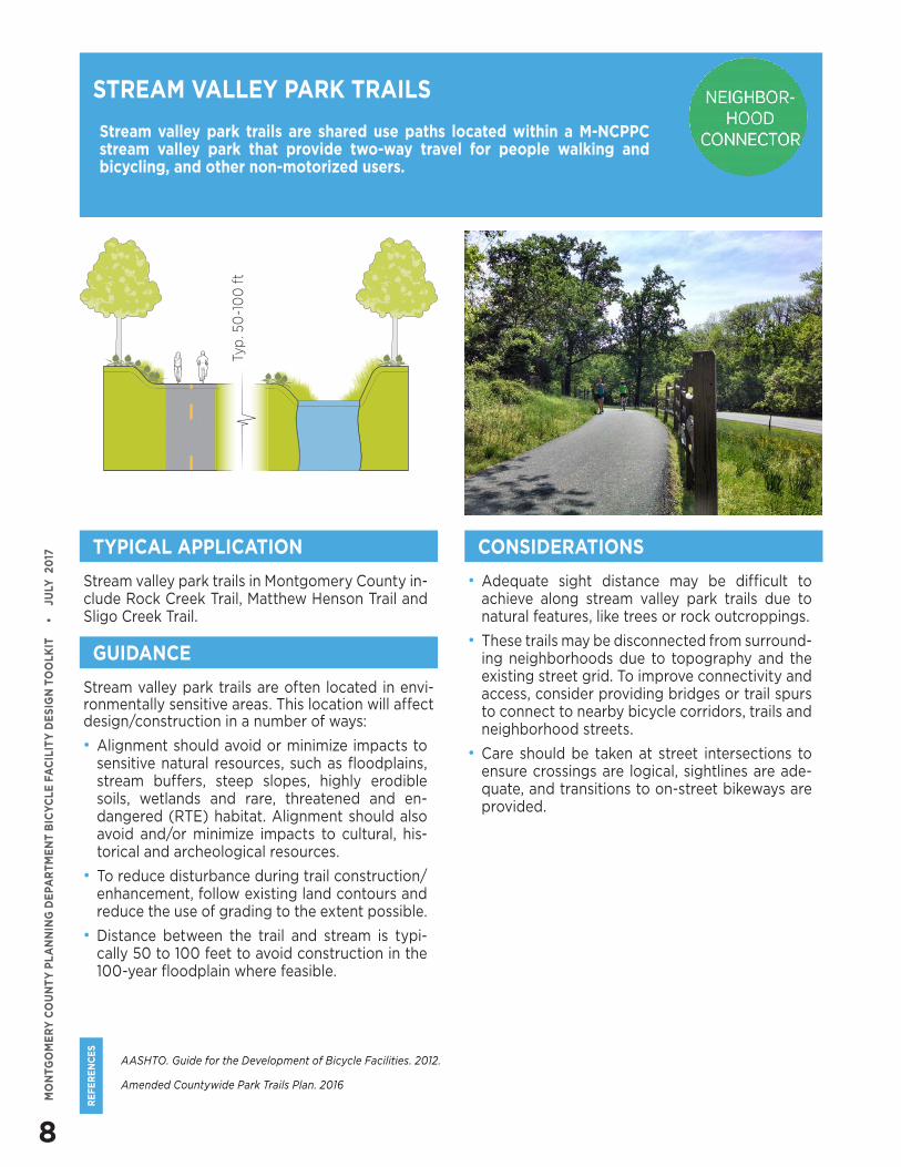
Stream valley park trails are shared use paths located within a M-NCPPC stream valley park that provide two-way travel for people walking and bicycling, and other non-motorized users.
Stream valley park trails in Montgomery County in-clude Rock Creek Trail, Matthew Henson Trail and Sligo Creek Trail.
• Adequate sight distance may be difficult to achieve along stream valley park trails due to natural features, like trees or rock outcroppings.
• These trails may be disconnected from surround-ing neighborhoods due to topography and the existing street grid. To improve connectivity and access, consider providing bridges or trail spurs to connect to nearby bicycle corridors, trails and neighborhood streets.
• Care should be taken at street intersections to ensure crossings are logical, sightlines are ade-quate, and transitions to on-street bikeways are provided.
STREAM VALLEY PARK TRAILS
TYPICAL APPLICATION CONSIDERATIONS
GUIDANCE
Stream valley park trails are often located in envi-ronmentally sensitive areas. This location will affect design/construction in a number of ways:
• Alignment should avoid or minimize impacts to sensitive natural resources, such as floodplains, stream buffers, steep slopes, highly erodible soils, wetlands and rare, threatened and en-dangered (RTE) habitat. Alignment should also avoid and/or minimize impacts to cultural, his-torical and archeological resources.
• To reduce disturbance during trail construction/enhancement, follow existing land contours and reduce the use of grading to the extent possible.
• Distance between the trail and stream is typi-cally 50 to 100 feet to avoid construction in the 100-year floodplain where feasible.
Typ
. 50
-10
0 f
t
9
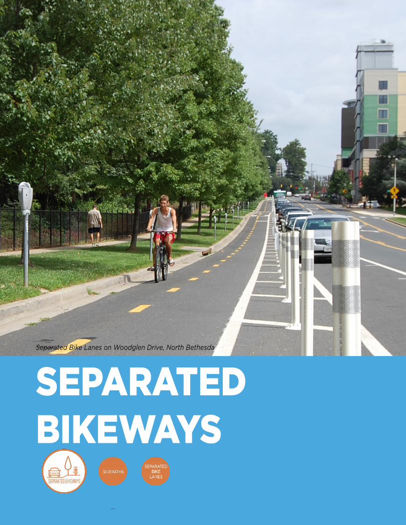
Separated Bike Lanes on Woodglen Drive, North Bethesda
SEPARATED BIKEWAYS
10
RE
FE
RE
NC
ES
MO
NTG
OM
ER
Y C
OU
NT
Y P
LA
NN
ING
DE
PAR
TM
EN
T B
ICY
CLE
FA
CIL
ITY
DE
SIG
N T
OO
LKIT
•
J
ULY
20
17
MassDOT. Separated Bike Lane Planning and Design Guide. 2015.
AASHTO. Guide for the Development of Bicycle Facilities. 2012.
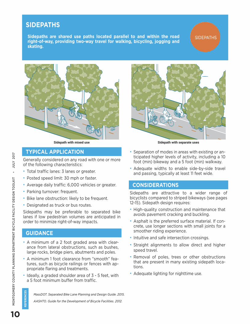
Sidepaths are shared use paths located parallel to and within the road right-of-way, providing two-way travel for walking, bicycling, jogging and skating.
SIDEPATHS
Generally considered on any road with one or more of the following characteristics:
• Total traffic lanes: 3 lanes or greater.
• Posted speed limit: 30 mph or faster.
• Average daily traffic: 6,000 vehicles or greater.
• Parking turnover: frequent.
• Bike lane obstruction: likely to be frequent.
• Designated as truck or bus routes.
Sidepaths may be preferable to separated bike lanes if low pedestrian volumes are anticipated in order to minimize right-of-way impacts.
Sidepaths are attractive to a wider range of bicyclists compared to striped bikeways (see pages 12-15). Sidepath design requires:
• High-quality construction and maintenance that avoids pavement cracking and buckling.
• Asphalt is the preferred surface material. If con-crete, use longer sections with small joints for a smoother riding experience.
• Intuitive and safe intersection crossings.
• Straight alignments to allow direct and higher speed travel.
• Removal of poles, trees or other obstructions that are present in many existing sidepath loca-tions.
• Adequate lighting for nighttime use.
TYPICAL APPLICATION
CONSIDERATIONS
GUIDANCE
• A minimum of a 2 foot graded area with clear-ance from lateral obstructions, such as bushes, large rocks, bridge piers, abutments and poles.
• A minimum 1 foot clearance from “smooth” fea-tures, such as bicycle railings or fences with ap-propriate flaring and treatments.
• Ideally, a graded shoulder area of 3 - 5 feet, with a 5 foot minimum buffer from traffic.
Sidepath with mixed use Sidepath with separate uses
• Separation of modes in areas with existing or an-ticipated higher levels of activity, including a 10 foot (min) bikeway and a 5 foot (min) walkway.
• Adequate widths to enable side-by-side travel and passing, typically at least 11 feet wide.
11
RE
FE
RE
NC
ES
MO
NTG
OM
ER
Y C
OU
NT
Y P
LA
NN
ING
DE
PAR
TM
EN
T B
ICY
CLE
FA
CIL
ITY
DE
SIG
N T
OO
LKIT
•
J
ULY
20
17
MassDOT. Separated Bike Lane Planning and Design Guide. 2015.
NACTO. Urban Bikeway Design Guide. 2nd Edition.
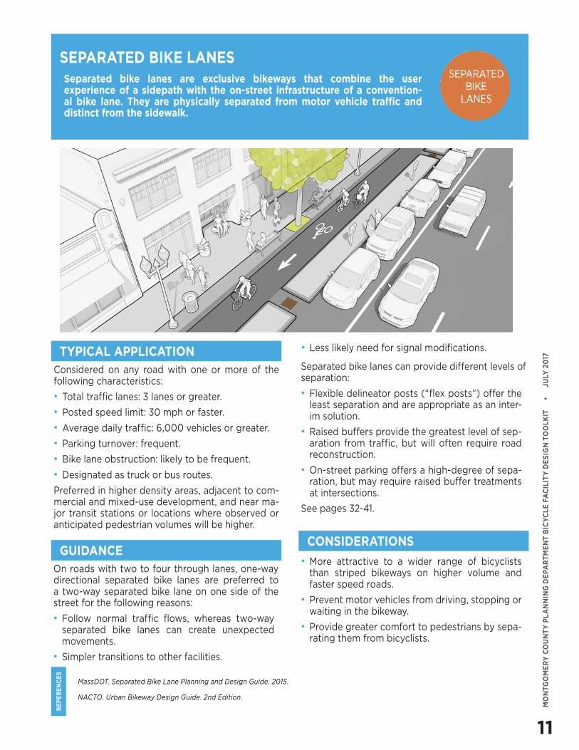
Separated bike lanes are exclusive bikeways that combine the user experience of a sidepath with the on-street infrastructure of a convention-al bike lane. They are physically separated from motor vehicle traffic and distinct from the sidewalk.
Considered on any road with one or more of the following characteristics:
• Total traffic lanes: 3 lanes or greater.
• Posted speed limit: 30 mph or faster.
• Average daily traffic: 6,000 vehicles or greater.
• Parking turnover: frequent.
• Bike lane obstruction: likely to be frequent.
• Designated as truck or bus routes.
Preferred in higher density areas, adjacent to com-mercial and mixed-use development, and near ma-jor transit stations or locations where observed or anticipated pedestrian volumes will be higher.
• More attractive to a wider range of bicyclists than striped bikeways on higher volume and faster speed roads.
• Prevent motor vehicles from driving, stopping or waiting in the bikeway.
• Provide greater comfort to pedestrians by sepa-rating them from bicyclists.
SEPARATED BIKE LANES
TYPICAL APPLICATION
CONSIDERATIONS
Separated bike lanes can provide different levels of separation:
• Flexible delineator posts (“flex posts”) offer the least separation and are appropriate as an inter-im solution.
• Raised buffers provide the greatest level of sep-aration from traffic, but will often require road reconstruction.
• On-street parking offers a high-degree of sepa-ration, but may require raised buffer treatments at intersections.
See pages 32-41.
GUIDANCEOn roads with two to four through lanes, one-way directional separated bike lanes are preferred to a two-way separated bike lane on one side of the street for the following reasons:
• Follow normal traffic flows, whereas two-way separated bike lanes can create unexpected movements.
• Simpler transitions to other facilities.
• Less likely need for signal modifications.
12
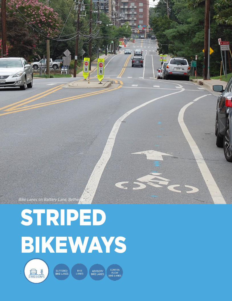
Bike Lanes on Battery Lane, Bethesda
STRIPED BIKEWAYS
13
RE
FE
RE
NC
ES
MO
NTG
OM
ER
Y C
OU
NT
Y P
LA
NN
ING
DE
PAR
TM
EN
T B
ICY
CLE
FA
CIL
ITY
DE
SIG
N T
OO
LKIT
•
J
ULY
20
17
AASHTO. Guide for the Development of Bicycle Facilities. 2012.
NACTO. Urban Bikeway Design Guide. 2nd Edition.
Portland State University, Center for Transportation Studies. Evaluation of Innovative Bicycle Facilities: SW Broadway Cycle Track & SW Stark/Oak Street Buffered Bike Lanes FINAL REPORT. 2011.
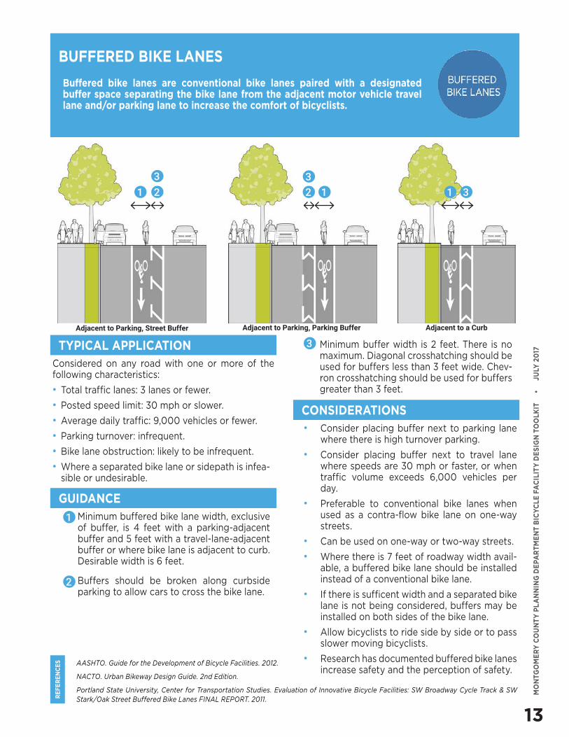
Buffered bike lanes are conventional bike lanes paired with a designated buffer space separating the bike lane from the adjacent motor vehicle travel lane and/or parking lane to increase the comfort of bicyclists.
BUFFERED BIKE LANES
Considered on any road with one or more of the following characteristics:
• Total traffic lanes: 3 lanes or fewer.
• Posted speed limit: 30 mph or slower.
• Average daily traffic: 9,000 vehicles or fewer.
• Parking turnover: infrequent.
• Bike lane obstruction: likely to be infrequent.
• Where a separated bike lane or sidepath is infea-sible or undesirable.
• Consider placing buffer next to parking lane where there is high turnover parking.
• Consider placing buffer next to travel lane where speeds are 30 mph or faster, or when traffic volume exceeds 6,000 vehicles per day.
• Preferable to conventional bike lanes when used as a contra-flow bike lane on one-way streets.
• Can be used on one-way or two-way streets.
• Where there is 7 feet of roadway width avail-able, a buffered bike lane should be installed instead of a conventional bike lane.
• If there is sufficent width and a separated bike lane is not being considered, buffers may be installed on both sides of the bike lane.
• Allow bicyclists to ride side by side or to pass slower moving bicyclists.
• Research has documented buffered bike lanes increase safety and the perception of safety.
TYPICAL APPLICATION
CONSIDERATIONS
GUIDANCE• Minimum buffered bike lane width, exclusive
of buffer, is 4 feet with a parking-adjacent buffer and 5 feet with a travel-lane-adjacent buffer or where bike lane is adjacent to curb. Desirable width is 6 feet.
• Buffers should be broken along curbside parking to allow cars to cross the bike lane.
1 2 1 3
Adjacent to Parking, Street Buffer Adjacent to a Curb
1
2
12
Adjacent to Parking, Parking Buffer
33
• Minimum buffer width is 2 feet. There is no maximum. Diagonal crosshatching should be used for buffers less than 3 feet wide. Chev-ron crosshatching should be used for buffers greater than 3 feet.
3
14
RE
FE
RE
NC
ES
MO
NTG
OM
ER
Y C
OU
NT
Y P
LA
NN
ING
DE
PAR
TM
EN
T B
ICY
CLE
FA
CIL
ITY
DE
SIG
N T
OO
LKIT
•
J
ULY
20
17
AASHTO. Guide for the Development of Bicycle Facilities. 2012.
NACTO. Urban Bikeway Design Guide. 2nd Edition.
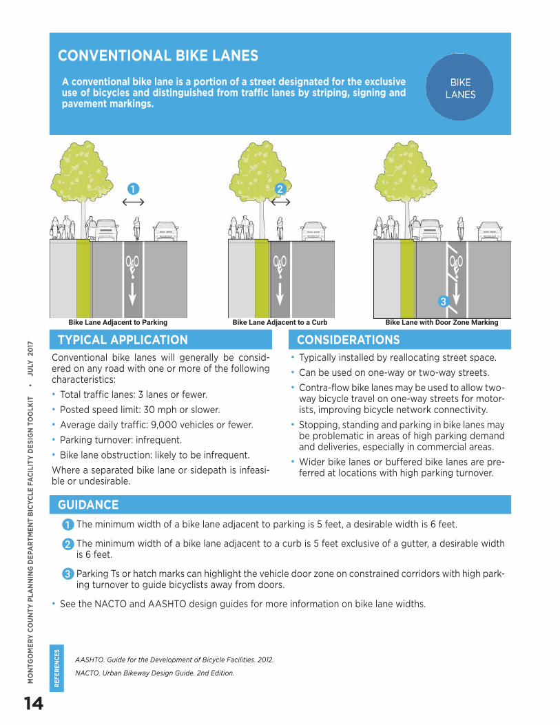
A conventional bike lane is a portion of a street designated for the exclusive use of bicycles and distinguished from traffic lanes by striping, signing and pavement markings.
Conventional bike lanes will generally be consid-ered on any road with one or more of the following characteristics:
• Total traffic lanes: 3 lanes or fewer.
• Posted speed limit: 30 mph or slower.
• Average daily traffic: 9,000 vehicles or fewer.
• Parking turnover: infrequent.
• Bike lane obstruction: likely to be infrequent.
Where a separated bike lane or sidepath is infeasi-ble or undesirable.
• Typically installed by reallocating street space.
• Can be used on one-way or two-way streets.
• Contra-flow bike lanes may be used to allow two-way bicycle travel on one-way streets for motor-ists, improving bicycle network connectivity.
• Stopping, standing and parking in bike lanes may be problematic in areas of high parking demand and deliveries, especially in commercial areas.
• Wider bike lanes or buffered bike lanes are pre-ferred at locations with high parking turnover.
CONVENTIONAL BIKE LANES
TYPICAL APPLICATION CONSIDERATIONS
GUIDANCE
• The minimum width of a bike lane adjacent to parking is 5 feet, a desirable width is 6 feet.
• The minimum width of a bike lane adjacent to a curb is 5 feet exclusive of a gutter, a desirable width is 6 feet.
• Parking Ts or hatch marks can highlight the vehicle door zone on constrained corridors with high park-ing turnover to guide bicyclists away from doors.
• See the NACTO and AASHTO design guides for more information on bike lane widths.
1
2
Bike Lane Adjacent to Parking Bike Lane Adjacent to a Curb Bike Lane with Door Zone Marking
3
1 2
3
15
RE
FE
RE
NC
ES
MO
NTG
OM
ER
Y C
OU
NT
Y P
LA
NN
ING
DE
PAR
TM
EN
T B
ICY
CLE
FA
CIL
ITY
DE
SIG
N T
OO
LKIT
•
J
ULY
20
17
AASHTO. Guide for the Development of Bicycle Facilities. 2012.
FHWA. Bicycle Facilities and the Manual on Uniform Traffic Control Devices – Dashed Bicycle Lanes. 2015.
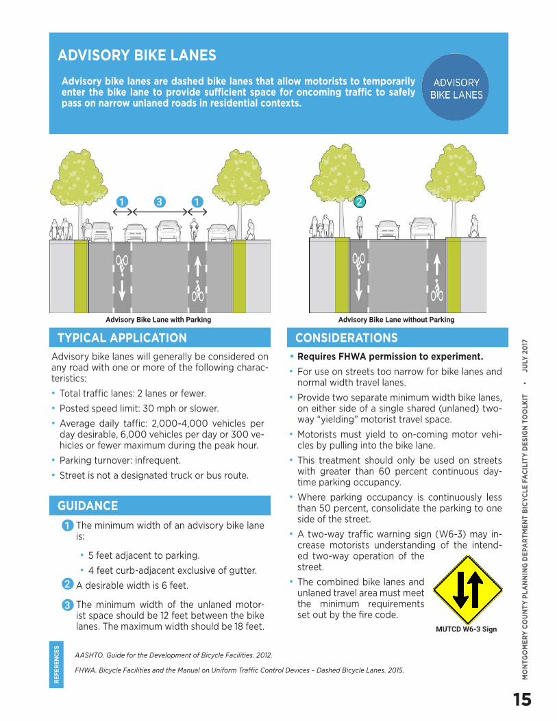
Advisory bike lanes are dashed bike lanes that allow motorists to temporarily enter the bike lane to provide sufficient space for oncoming traffic to safely pass on narrow unlaned roads in residential contexts.
ADVISORY BIKE LANES
Advisory bike lanes will generally be considered on any road with one or more of the following charac-teristics:
• Total traffic lanes: 2 lanes or fewer.
• Posted speed limit: 30 mph or slower.
• Average daily taffic: 2,000-4,000 vehicles per day desirable, 6,000 vehicles per day or 300 ve-hicles or fewer maximum during the peak hour.
• Parking turnover: infrequent.
• Street is not a designated truck or bus route.
• Requires FHWA permission to experiment.
• For use on streets too narrow for bike lanes and normal width travel lanes.
• Provide two separate minimum width bike lanes, on either side of a single shared (unlaned) two-way “yielding” motorist travel space.
• Motorists must yield to on-coming motor vehi-cles by pulling into the bike lane.
• This treatment should only be used on streets with greater than 60 percent continuous day-time parking occupancy.
• Where parking occupancy is continuously less than 50 percent, consolidate the parking to one side of the street.
• A two-way traffic warning sign (W6-3) may in-crease motorists understanding of the intend-ed two-way operation of the street.
• The combined bike lanes and unlaned travel area must meet the minimum requirements set out by the fire code.
TYPICAL APPLICATION CONSIDERATIONS
GUIDANCE
• The minimum width of an advisory bike lane is:
• 5 feet adjacent to parking.
• 4 feet curb-adjacent exclusive of gutter.
• A desirable width is 6 feet.
• The minimum width of the unlaned motor-ist space should be 12 feet between the bike lanes. The maximum width should be 18 feet.
1 3 1
1
2
MUTCD W6-3 Sign
Advisory Bike Lane without ParkingAdvisory Bike Lane with Parking
3
2
16
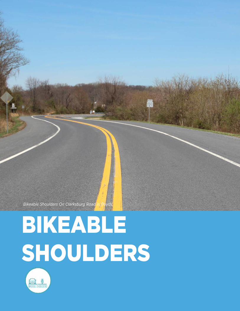
Bikeable Shoulders On Clarksburg Road in Boyds.
BIKEABLE SHOULDERS
17
RE
FE
RE
NC
ES
MO
NTG
OM
ER
Y C
OU
NT
Y P
LA
NN
ING
DE
PAR
TM
EN
T B
ICY
CLE
FA
CIL
ITY
DE
SIG
N T
OO
LKIT
•
J
ULY
20
17
AASHTO. Guide for the Development of Bicycle Facilities. 2012.
FHWA. Achieving Multimodal Networks: Applying Design Flexibility and Reducing Conflicts. 2016.
Bikeable shoulders are portions of the roadway that accommodate stopped or parked vehicles, emergency use, bicycles, motor scooters and pedestrians where sidewalks do not exist.
BIKEABLE SHOULDERS
Rural areas of Montgomery County where dedicat-ed bikeways either will not fit on the street or would not be appropriate given the surrounding context.
• For roads that are unable to provide consistent and standard size bikeable shoulders in both di-rections, prioritize:
• The uphill direction on hilly roads to reduce conflicts between slow-moving bicyclsts and fast-moving motor vehicles.
• The inside of a horizontal curve and/or the downgrade of a vertical curve where sight distance is restricted.
• Paved shoulders should be considered on road-ways popular with recreational bicyclists that have significant motor vehicle traffic during peri-ods when recreational bicycling is known to oc-cur.
• Bicyclists will not use a shoulder if it is covered in gravel, glass and other road debris, so regular street sweeping is important.
• In rural areas, paved shoulders can also provide space for pedestrians on roadways without side-walks. In situations where a shoulder is intended for pedestrian use, it must meet Americans wit Disabilities Act requirements to the maximum extent possible.
TYPICAL APPLICATION CONSIDERATIONS
GUIDANCE
• Shoulder width should be at least 4 feet if the roadway is curbless and there are no vertical ob-structions. If curbs or vertical obstructions are present, shoulder width should be 5 feet mini-mum exclusive of the gutter if present.
• Shoulders should be wider on roads with high levels of bicycle traffic to accommodate bicyclist passing and facilitate side-by-side bicycling.
• When posted speed limits or 85th percentile speeds exceed 50 mph and/or if heavy vehicles frequently use the road, shoulders should exceed minimum widths to enhance bicyclist comfort.
• The width of a shoulder with rumble strips should be measured from the rightmost side of the rum-ble strip. Periodic gaps should be provided to allow bicyclists to move across the strip pattern.
• Edge line rumble strips can provide additional bicyclist space on paved shoulders.
18
SHARED ROADS
19
RE
FE
RE
NC
ES
MO
NTG
OM
ER
Y C
OU
NT
Y P
LA
NN
ING
DE
PAR
TM
EN
T B
ICY
CLE
FA
CIL
ITY
DE
SIG
N T
OO
LKIT
•
J
ULY
20
17
FHWA. Achieving Multimodal Networks: Applying Design Flexibility and Reducing Conflicts. 2016.
Boston. Complete Streets Design Guidelines. 2013.
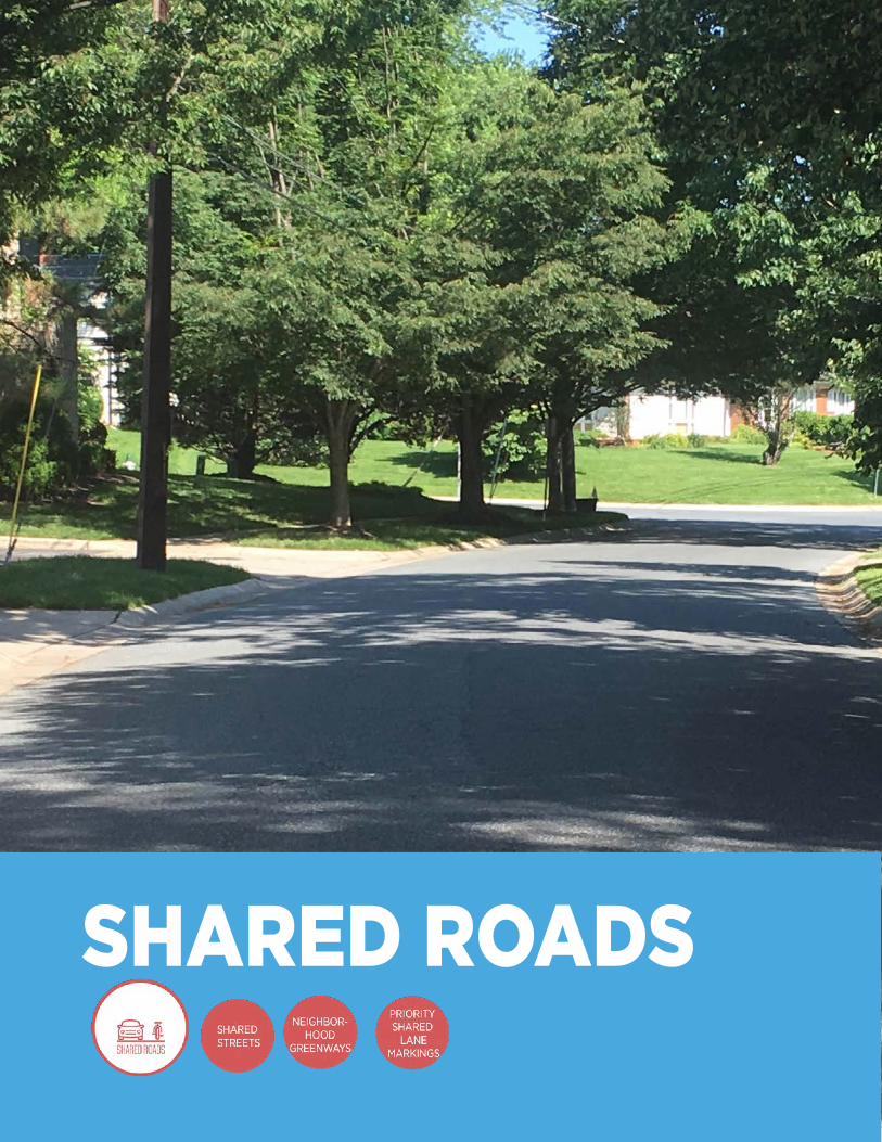
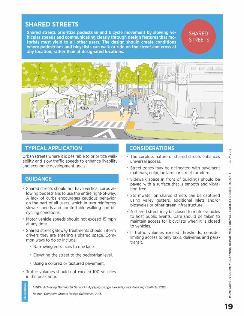
Shared streets prioritize pedestrian and bicycle movement by slowing ve-hicular speeds and communicating clearly through design features that mo-torists must yield to all other users. The design should create conditions where pedestrians and bicyclists can walk or ride on the street and cross at any location, rather than at designated locations.
Urban streets where it is desirable to prioritize walk-ability and slow traffic speeds to enhance livability and economic development goals.
• The curbless nature of shared streets enhances universal access.
• Street zones may be delineated with pavement materials, color, bollards or street furniture.
• Sidewalk space in front of buildings should be paved with a surface that is smooth and vibra-tion-free.
• Stormwater on shared streets can be captured using valley gutters, additional inlets and/or bioswales or other green infrastructure.
• A shared street may be closed to motor vehicles to host public events. Care should be taken to maintain access for bicyclists when it is closed to vehicles.
• If traffic volumes exceed thresholds, consider limiting access to only taxis, deliveries and para-transit.
SHARED STREETS
TYPICAL APPLICATION CONSIDERATIONS
GUIDANCE
• Shared streets should not have vertical curbs al-lowing pedestrians to use the entire right-of-way. A lack of curbs encourages cautious behavior on the part of all users, which in turn reinforces slower speeds and comfortable walking and bi-cycling conditions.
• Motor vehicle speeds should not exceed 15 mph at any time.
• Shared street gateway treatments should inform drivers they are entering a shared space. Com-mon ways to do so include:
• Narrowing entrances to one lane.
• Elevating the street to the pedestrian level.
• Using a colored or textured pavement.
• Traffic volumes should not exceed 100 vehicles in the peak hour.
20
RE
FE
RE
NC
ES
MO
NTG
OM
ER
Y C
OU
NT
Y P
LA
NN
ING
DE
PAR
TM
EN
T B
ICY
CLE
FA
CIL
ITY
DE
SIG
N T
OO
LKIT
•
J
ULY
20
17
IPBI, Alta Planning + Design, Portland State University. Bicycle Boulevard Planning and Design Guidebook. 2009.
NACTO. Urban Bikeway Design Guide. 2nd Edition.
Portland Bureau of Transportation. Neighborhood Greenway Assessment Report. 2015.
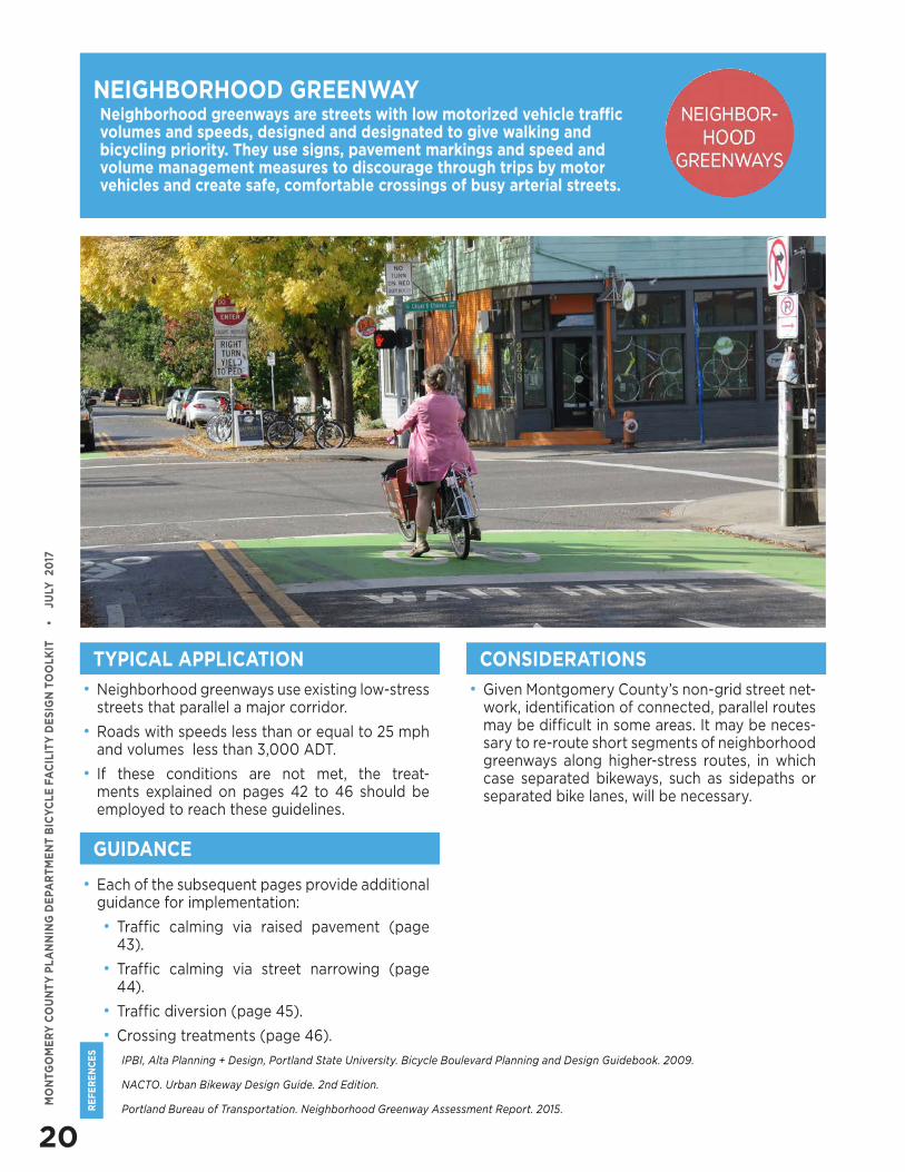
Neighborhood greenways are streets with low motorized vehicle traffic volumes and speeds, designed and designated to give walking and bicycling priority. They use signs, pavement markings and speed and volume management measures to discourage through trips by motor vehicles and create safe, comfortable crossings of busy arterial streets.
• Neighborhood greenways use existing low-stress streets that parallel a major corridor.
• Roads with speeds less than or equal to 25 mph and volumes less than 3,000 ADT.
• If these conditions are not met, the treat-ments explained on pages 42 to 46 should be employed to reach these guidelines.
NEIGHBORHOOD GREENWAY
TYPICAL APPLICATION
• Given Montgomery County’s non-grid street net-work, identification of connected, parallel routes may be difficult in some areas. It may be neces-sary to re-route short segments of neighborhood greenways along higher-stress routes, in which case separated bikeways, such as sidepaths or separated bike lanes, will be necessary.
CONSIDERATIONS
GUIDANCE
• Each of the subsequent pages provide additional guidance for implementation:
• Traffic calming via raised pavement (page 43).
• Traffic calming via street narrowing (page 44).
• Traffic diversion (page 45).
• Crossing treatments (page 46).
21
RE
FE
RE
NC
ES
MO
NTG
OM
ER
Y C
OU
NT
Y P
LA
NN
ING
DE
PAR
TM
EN
T B
ICY
CLE
FA
CIL
ITY
DE
SIG
N T
OO
LKIT
•
J
ULY
20
17
AASHTO. Guide for the Development of Bicycle Facilities. 2017.
Montgomery County Bicycle Planning Guidance. 2014
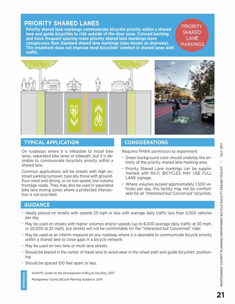
Priority shared lane markings communicate bicyclist priority within a shared lane and guide bicyclists to ride outside of the door zone. Colored backing and more frequent spacing make priority shared lane markings more conspicuous than standard shared lane markings (also known as sharrows). This treatment does not improve most bicyclists’ comfort in shared lanes with traffic.
On roadways where it is infeasible to install bike lanes, separated bike lanes or sidepath, but it is de-sirable to communicate bicyclists priority within a shared lane.
Common applications will be streets with high on-street parking turnover, typically those with ground-floor retail and dining, or on low-speed, low-volume frontage roads. They may also be used in separated bike lane mixing zones where a protected intersec-tion is not provided.
Requires FHWA permission to experiment.
• Green background color should underlay the en-tirety of the priority shared lane marking area.
• Priority Shared Lane markings can be supple-mented with R4-11, BICYCLES MAY USE FULL LANE signage.
• Where volumes exceed approximately 1,500 ve-hicles per day, this facility may not be comfort-able for all “Interested but Concerned” bicyclists.
PRIORITY SHARED LANES
TYPICAL APPLICATION CONSIDERATIONS
GUIDANCE
• Ideally placed on streets with speeds 25 mph or less with average daily traffic less than 3,000 vehicles per day.
• May be used on streets with higher volumes and/or speeds (up to 6,000 average daily traffic at 30 mph, or 20,000 at 25 mph), but streets will not be comfortable for the “Interested but Concerned” rider.
• May be used as an interim measure on any roadway where it is desirable to communicate bicycle priority within a shared lane to close gaps in a bicycle network.
• May be used on two-lane or multi-lane streets.
• Should be placed in the center of travel lane to avoid wear in the wheel path and guide bicyclists’ position-ing.
• Should be spaced 100 feet apart or less.
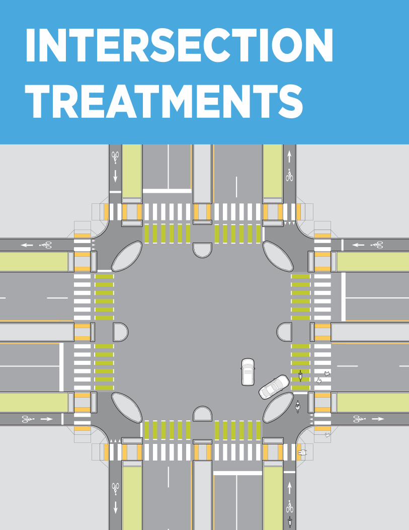
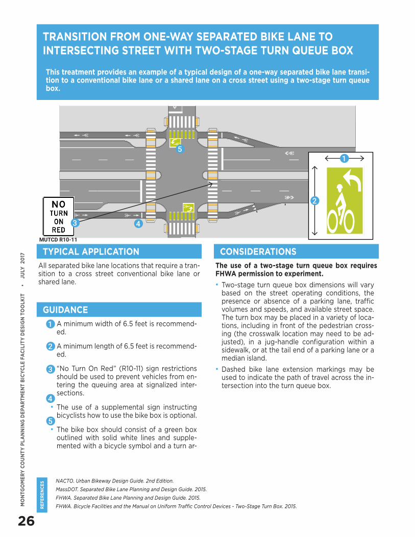
INTERSECTION TREATMENTS
23
RE
FE
RE
NC
ES
MO
NTG
OM
ER
Y C
OU
NT
Y P
LA
NN
ING
DE
PAR
TM
EN
T B
ICY
CLE
FA
CIL
ITY
DE
SIG
N T
OO
LKIT
•
J
ULY
20
17
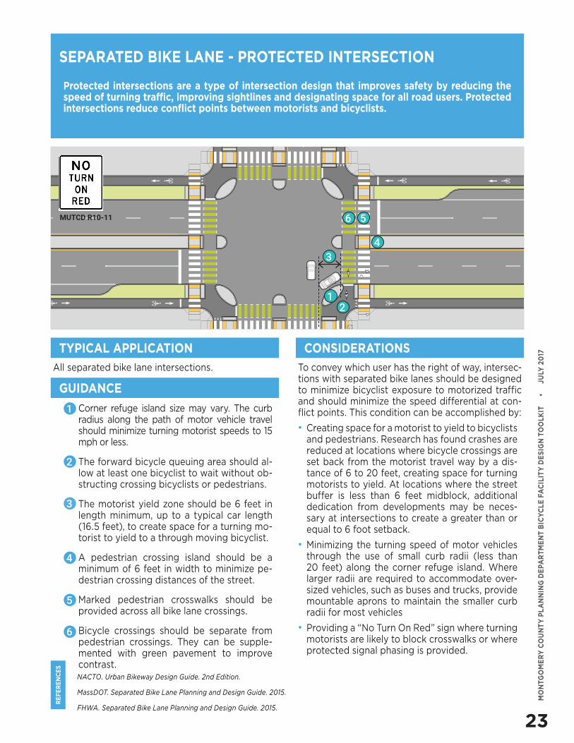
• Corner refuge island size may vary. The curb radius along the path of motor vehicle travel should minimize turning motorist speeds to 15 mph or less.
• The forward bicycle queuing area should al-low at least one bicyclist to wait without ob-structing crossing bicyclists or pedestrians.
• The motorist yield zone should be 6 feet in length minimum, up to a typical car length (16.5 feet), to create space for a turning mo-torist to yield to a through moving bicyclist.
• A pedestrian crossing island should be a minimum of 6 feet in width to minimize pe-destrian crossing distances of the street.
• Marked pedestrian crosswalks should be provided across all bike lane crossings.
• Bicycle crossings should be separate from pedestrian crossings. They can be supple-mented with green pavement to improve contrast.NACTO. Urban Bikeway Design Guide. 2nd Edition.
MassDOT. Separated Bike Lane Planning and Design Guide. 2015.
FHWA. Separated Bike Lane Planning and Design Guide. 2015.
Protected intersections are a type of intersection design that improves safety by reducing the speed of turning traffic, improving sightlines and designating space for all road users. Protected intersections reduce conflict points between motorists and bicyclists.
All separated bike lane intersections. To convey which user has the right of way, intersec-tions with separated bike lanes should be designed to minimize bicyclist exposure to motorized traffic and should minimize the speed differential at con-flict points. This condition can be accomplished by:
• Creating space for a motorist to yield to bicyclists and pedestrians. Research has found crashes are reduced at locations where bicycle crossings are set back from the motorist travel way by a dis-tance of 6 to 20 feet, creating space for turning motorists to yield. At locations where the street buffer is less than 6 feet midblock, additional dedication from developments may be neces-sary at intersections to create a greater than or equal to 6 foot setback.
• Minimizing the turning speed of motor vehicles through the use of small curb radii (less than 20 feet) along the corner refuge island. Where larger radii are required to accommodate over-sized vehicles, such as buses and trucks, provide mountable aprons to maintain the smaller curb radii for most vehicles
• Providing a “No Turn On Red” sign where turning motorists are likely to block crosswalks or where protected signal phasing is provided.
TYPICAL APPLICATION CONSIDERATIONS
GUIDANCE
1
2
3
4
5
SEPARATED BIKE LANE - PROTECTED INTERSECTION
12
4
56
3
MUTCD R10-11
6
INTERSECTION TREATMENTS
24
RE
FE
RE
NC
ES
MO
NTG
OM
ER
Y C
OU
NT
Y P
LA
NN
ING
DE
PAR
TM
EN
T B
ICY
CLE
FA
CIL
ITY
DE
SIG
N T
OO
LKIT
•
J
ULY
20
17
NACTO. Urban Bikeway Design Guide. 2nd Edition.
MassDOT. Separated Bike Lane Planning and Design Guide. 2015.
FHWA. Separated Bike Lane Planning and Design Guide. 2015.
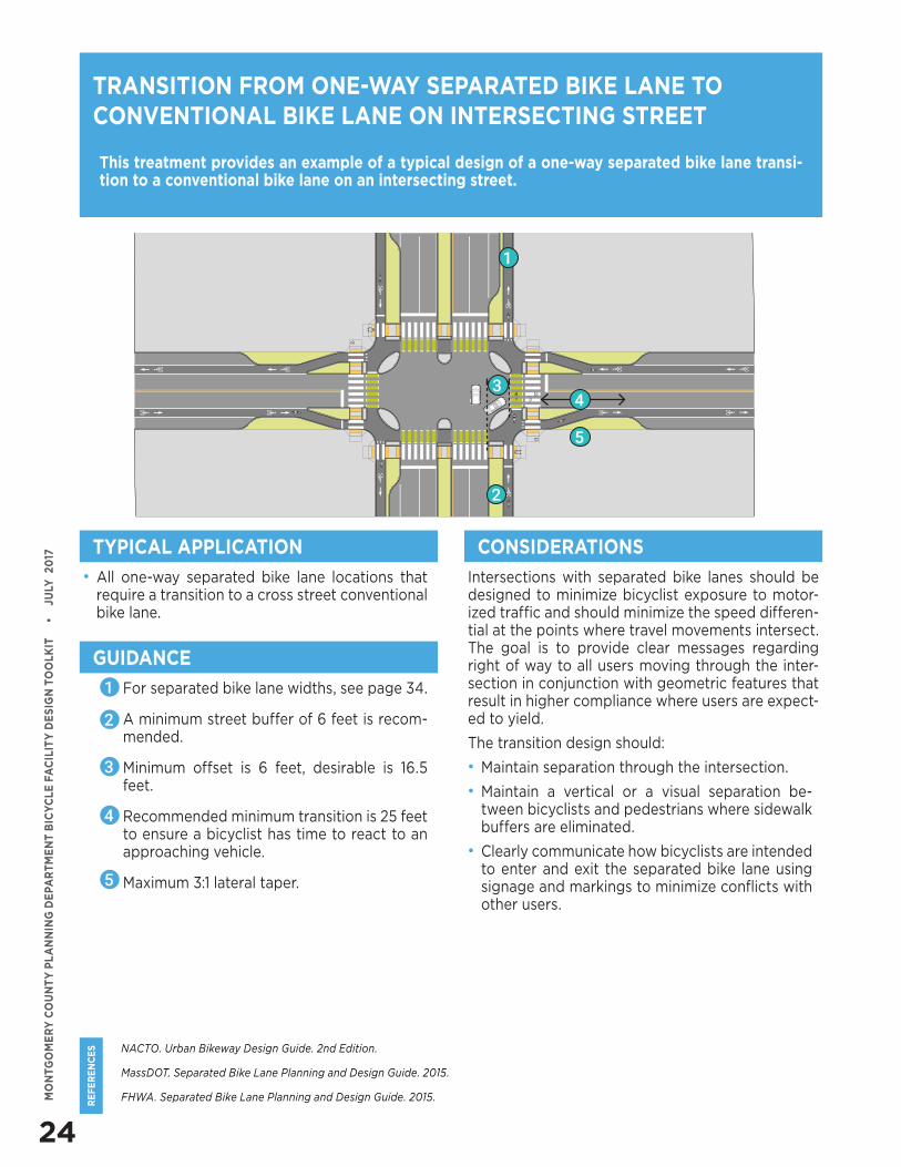
This treatment provides an example of a typical design of a one-way separated bike lane transi-tion to a conventional bike lane on an intersecting street.
• All one-way separated bike lane locations that require a transition to a cross street conventional bike lane.
Intersections with separated bike lanes should be designed to minimize bicyclist exposure to motor-ized traffic and should minimize the speed differen-tial at the points where travel movements intersect. The goal is to provide clear messages regarding right of way to all users moving through the inter-section in conjunction with geometric features that result in higher compliance where users are expect-ed to yield.
The transition design should:
• Maintain separation through the intersection.
• Maintain a vertical or a visual separation be-tween bicyclists and pedestrians where sidewalk buffers are eliminated.
• Clearly communicate how bicyclists are intended to enter and exit the separated bike lane using signage and markings to minimize conflicts with other users.
TRANSITION FROM ONE-WAY SEPARATED BIKE LANE TO CONVENTIONAL BIKE LANE ON INTERSECTING STREET
TYPICAL APPLICATION CONSIDERATIONS
GUIDANCE
• For separated bike lane widths, see page 34.
• A minimum street buffer of 6 feet is recom-mended.
• Minimum offset is 6 feet, desirable is 16.5 feet.
• Recommended minimum transition is 25 feet to ensure a bicyclist has time to react to an approaching vehicle.
• Maximum 3:1 lateral taper.
5
43
1
2
5
4
3
2
1
25
RE
FE
RE
NC
ES
MO
NTG
OM
ER
Y C
OU
NT
Y P
LA
NN
ING
DE
PAR
TM
EN
T B
ICY
CLE
FA
CIL
ITY
DE
SIG
N T
OO
LKIT
•
J
ULY
20
17
NACTO. Urban Bikeway Design Guide. 2nd Edition.
MassDOT. Separated Bike Lane Planning and Design Guide. 2015.
FHWA. Separated Bike Lane Planning and Design Guide. 2015.
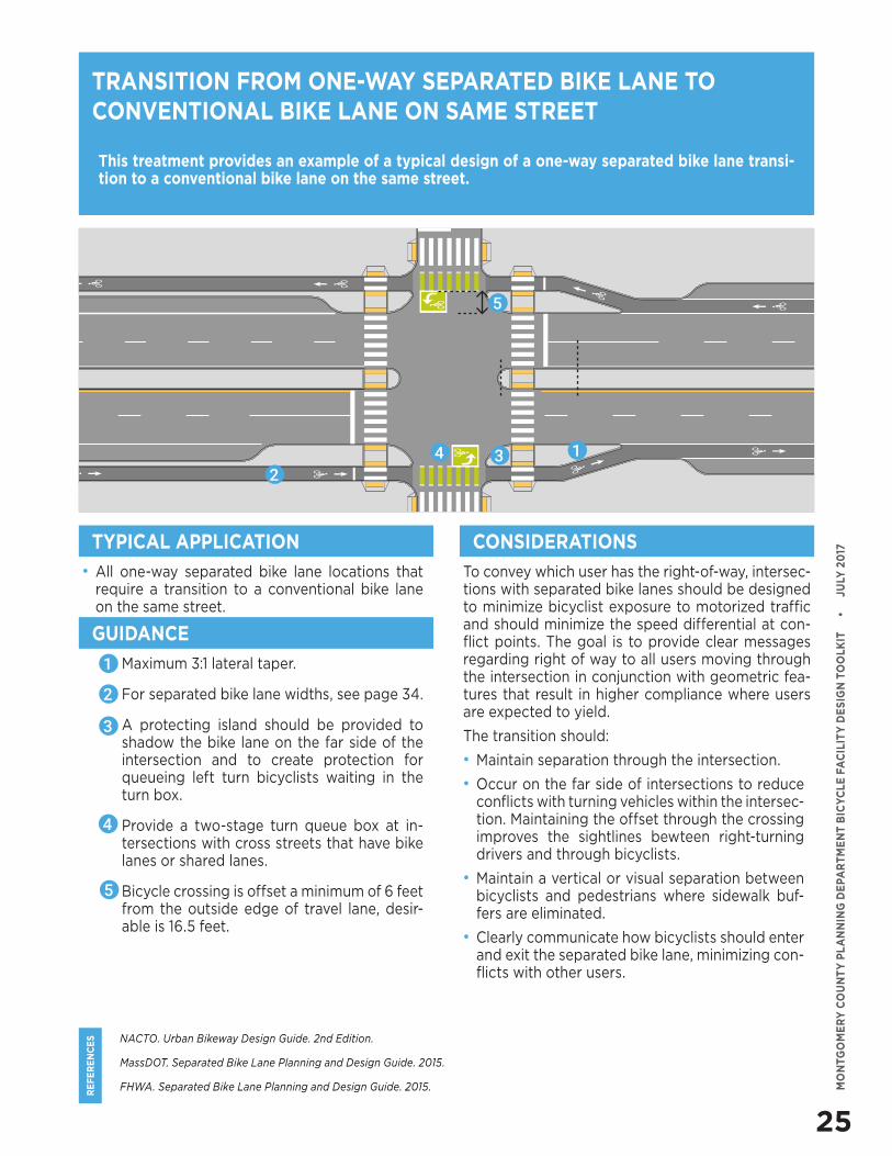
This treatment provides an example of a typical design of a one-way separated bike lane transi-tion to a conventional bike lane on the same street.
• All one-way separated bike lane locations that require a transition to a conventional bike lane on the same street.
To convey which user has the right-of-way, intersec-tions with separated bike lanes should be designed to minimize bicyclist exposure to motorized traffic and should minimize the speed differential at con-flict points. The goal is to provide clear messages regarding right of way to all users moving through the intersection in conjunction with geometric fea-tures that result in higher compliance where users are expected to yield.
The transition should:
• Maintain separation through the intersection.
• Occur on the far side of intersections to reduce conflicts with turning vehicles within the intersec-tion. Maintaining the offset through the crossing improves the sightlines bewteen right-turning drivers and through bicyclists.
• Maintain a vertical or visual separation between bicyclists and pedestrians where sidewalk buf-fers are eliminated.
• Clearly communicate how bicyclists should enter and exit the separated bike lane, minimizing con-flicts with other users.
TRANSITION FROM ONE-WAY SEPARATED BIKE LANE TO CONVENTIONAL BIKE LANE ON SAME STREET
TYPICAL APPLICATION CONSIDERATIONS
GUIDANCE
• Maximum 3:1 lateral taper.
• For separated bike lane widths, see page 34.
• A protecting island should be provided to shadow the bike lane on the far side of the intersection and to create protection for queueing left turn bicyclists waiting in the turn box.
• Provide a two-stage turn queue box at in-tersections with cross streets that have bike lanes or shared lanes.
• Bicycle crossing is offset a minimum of 6 feet from the outside edge of travel lane, desir-able is 16.5 feet.
1
2
3
4
5
234 1
5
26
RE
FE
RE
NC
ES
MO
NTG
OM
ER
Y C
OU
NT
Y P
LA
NN
ING
DE
PAR
TM
EN
T B
ICY
CLE
FA
CIL
ITY
DE
SIG
N T
OO
LKIT
•
J
ULY
20
17
NACTO. Urban Bikeway Design Guide. 2nd Edition.
MassDOT. Separated Bike Lane Planning and Design Guide. 2015.
FHWA. Separated Bike Lane Planning and Design Guide. 2015.
FHWA. Bicycle Facilities and the Manual on Uniform Traffic Control Devices - Two-Stage Turn Box. 2015.
This treatment provides an example of a typical design of a one-way separated bike lane transi-tion to a conventional bike lane or a shared lane on a cross street using a two-stage turn queue box.
TRANSITION FROM ONE-WAY SEPARATED BIKE LANE TO INTERSECTING STREET WITH TWO-STAGE TURN QUEUE BOX
All separated bike lane locations that require a tran-sition to a cross street conventional bike lane or shared lane.
The use of a two-stage turn queue box requires FHWA permission to experiment.
• Two-stage turn queue box dimensions will vary based on the street operating conditions, the presence or absence of a parking lane, traffic volumes and speeds, and available street space. The turn box may be placed in a variety of loca-tions, including in front of the pedestrian cross-ing (the crosswalk location may need to be ad-justed), in a jug-handle configuration within a sidewalk, or at the tail end of a parking lane or a median island.
• Dashed bike lane extension markings may be used to indicate the path of travel across the in-tersection into the turn queue box.
TYPICAL APPLICATION CONSIDERATIONS
GUIDANCE
• A minimum width of 6.5 feet is recommend-ed.
• A minimum length of 6.5 feet is recommend-ed.
• “No Turn On Red” (R10-11) sign restrictions should be used to prevent vehicles from en-tering the queuing area at signalized inter-sections.
• The use of a supplemental sign instructing bicyclists how to use the bike box is optional.
• The bike box should consist of a green box outlined with solid white lines and supple-mented with a bicycle symbol and a turn ar-
1
2
3
4
5
1
2
3
5
4
MUTCD R10-11
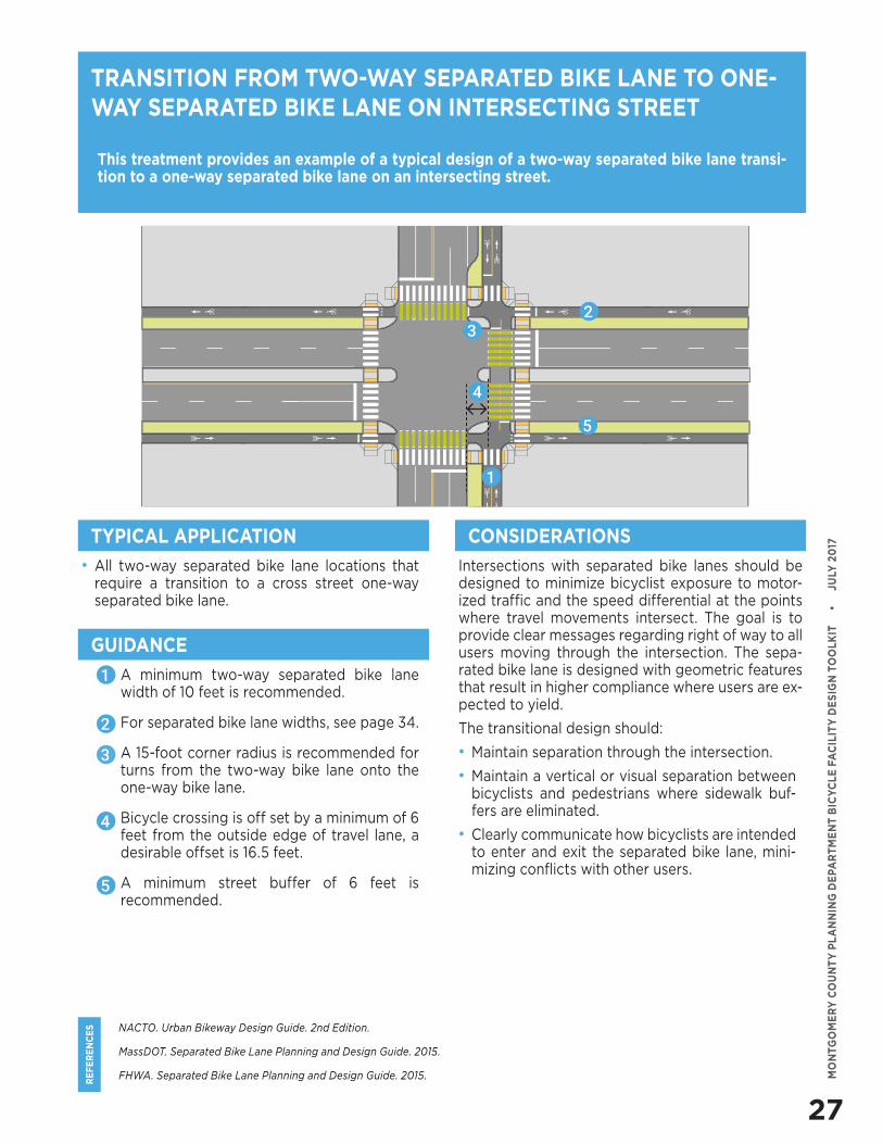
27
RE
FE
RE
NC
ES
MO
NTG
OM
ER
Y C
OU
NT
Y P
LA
NN
ING
DE
PAR
TM
EN
T B
ICY
CLE
FA
CIL
ITY
DE
SIG
N T
OO
LKIT
•
J
ULY
20
17
NACTO. Urban Bikeway Design Guide. 2nd Edition.
MassDOT. Separated Bike Lane Planning and Design Guide. 2015.
FHWA. Separated Bike Lane Planning and Design Guide. 2015.
This treatment provides an example of a typical design of a two-way separated bike lane transi-tion to a one-way separated bike lane on an intersecting street.
TRANSITION FROM TWO-WAY SEPARATED BIKE LANE TO ONE-WAY SEPARATED BIKE LANE ON INTERSECTING STREET
• All two-way separated bike lane locations that require a transition to a cross street one-way separated bike lane.
Intersections with separated bike lanes should be designed to minimize bicyclist exposure to motor-ized traffic and the speed differential at the points where travel movements intersect. The goal is to provide clear messages regarding right of way to all users moving through the intersection. The sepa-rated bike lane is designed with geometric features that result in higher compliance where users are ex-pected to yield.
The transitional design should:
• Maintain separation through the intersection.
• Maintain a vertical or visual separation between bicyclists and pedestrians where sidewalk buf-fers are eliminated.
• Clearly communicate how bicyclists are intended to enter and exit the separated bike lane, mini-mizing conflicts with other users.
TYPICAL APPLICATION CONSIDERATIONS
GUIDANCE
• A minimum two-way separated bike lane width of 10 feet is recommended.
• For separated bike lane widths, see page 34.
• A 15-foot corner radius is recommended for turns from the two-way bike lane onto the one-way bike lane.
• Bicycle crossing is off set by a minimum of 6 feet from the outside edge of travel lane, a desirable offset is 16.5 feet.
• A minimum street buffer of 6 feet is recommended.
1
2
3
4
5
1
23
5
4
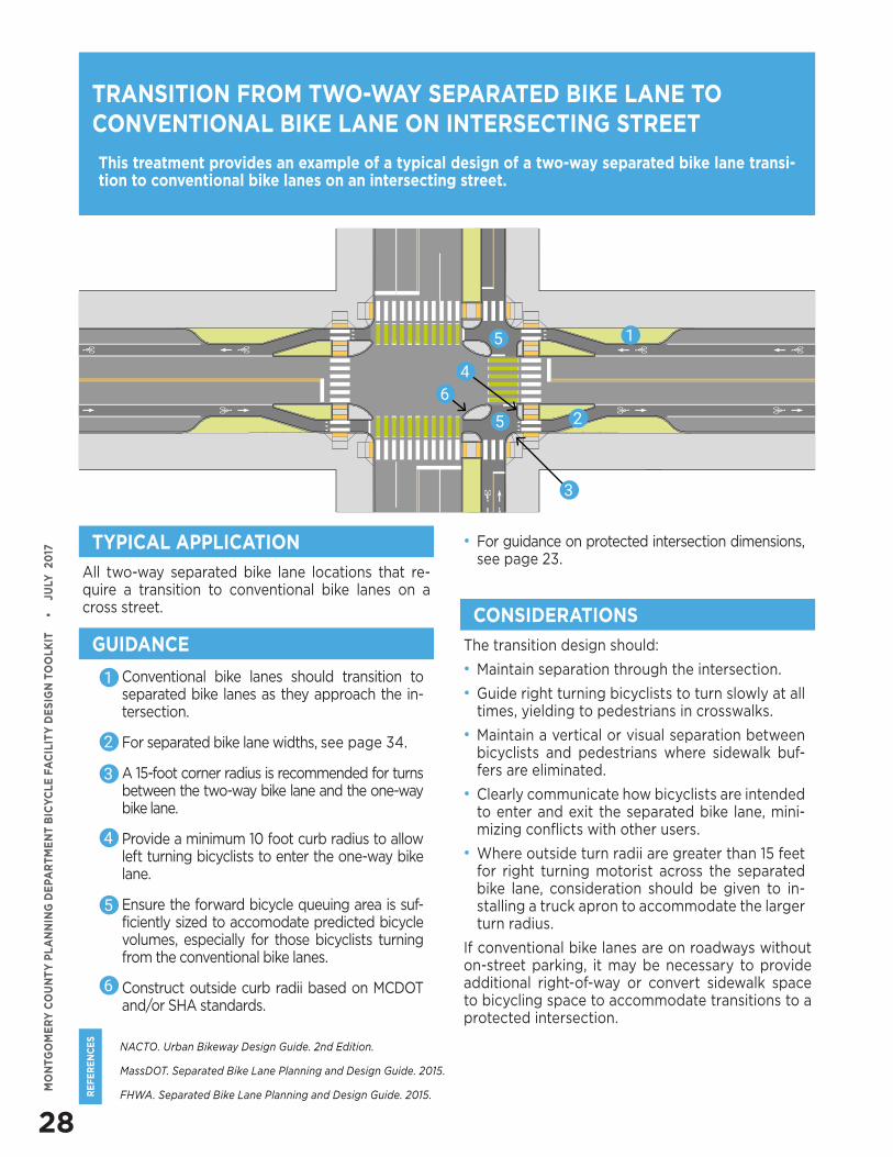
28
RE
FE
RE
NC
ES
MO
NTG
OM
ER
Y C
OU
NT
Y P
LA
NN
ING
DE
PAR
TM
EN
T B
ICY
CLE
FA
CIL
ITY
DE
SIG
N T
OO
LKIT
•
J
ULY
20
17
NACTO. Urban Bikeway Design Guide. 2nd Edition.
MassDOT. Separated Bike Lane Planning and Design Guide. 2015.
FHWA. Separated Bike Lane Planning and Design Guide. 2015.
This treatment provides an example of a typical design of a two-way separated bike lane transi-tion to conventional bike lanes on an intersecting street.
TRANSITION FROM TWO-WAY SEPARATED BIKE LANE TO CONVENTIONAL BIKE LANE ON INTERSECTING STREET
All two-way separated bike lane locations that re-quire a transition to conventional bike lanes on a cross street.
The transition design should:
• Maintain separation through the intersection.
• Guide right turning bicyclists to turn slowly at all times, yielding to pedestrians in crosswalks.
• Maintain a vertical or visual separation between bicyclists and pedestrians where sidewalk buf-fers are eliminated.
• Clearly communicate how bicyclists are intended to enter and exit the separated bike lane, mini-mizing conflicts with other users.
• Where outside turn radii are greater than 15 feet for right turning motorist across the separated bike lane, consideration should be given to in-stalling a truck apron to accommodate the larger turn radius.
If conventional bike lanes are on roadways without on-street parking, it may be necessary to provide additional right-of-way or convert sidewalk space to bicycling space to accommodate transitions to a protected intersection.
TYPICAL APPLICATION
CONSIDERATIONS
GUIDANCE
• Conventional bike lanes should transition to separated bike lanes as they approach the in-tersection.
• For separated bike lane widths, see page 34.
• A 15-foot corner radius is recommended for turns between the two-way bike lane and the one-way bike lane.
• Provide a minimum 10 foot curb radius to allow left turning bicyclists to enter the one-way bike lane.
• Ensure the forward bicycle queuing area is suf-ficiently sized to accomodate predicted bicycle volumes, especially for those bicyclists turning from the conventional bike lanes.
• Construct outside curb radii based on MCDOT and/or SHA standards.
1
1
2
2
3
3
4
4
5
5
5
6
6
• For guidance on protected intersection dimensions, see page 23.
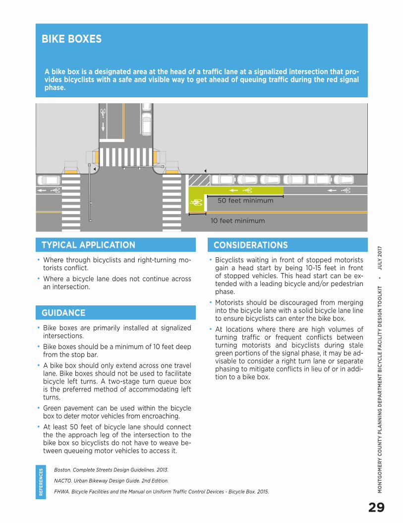
29
RE
FE
RE
NC
ES
MO
NTG
OM
ER
Y C
OU
NT
Y P
LA
NN
ING
DE
PAR
TM
EN
T B
ICY
CLE
FA
CIL
ITY
DE
SIG
N T
OO
LKIT
•
J
ULY
20
17
• Where through bicyclists and right-turning mo-torists conflict.
• Where a bicycle lane does not continue across an intersection.
Boston. Complete Streets Design Guidelines. 2013.
NACTO. Urban Bikeway Design Guide. 2nd Edition.
FHWA. Bicycle Facilities and the Manual on Uniform Traffic Control Devices - Bicycle Box. 2015.
A bike box is a designated area at the head of a traffic lane at a signalized intersection that pro-vides bicyclists with a safe and visible way to get ahead of queuing traffic during the red signal phase.
• Bicyclists waiting in front of stopped motorists gain a head start by being 10-15 feet in front of stopped vehicles. This head start can be ex-tended with a leading bicycle and/or pedestrian phase.
• Motorists should be discouraged from merging into the bicycle lane with a solid bicycle lane line to ensure bicyclists can enter the bike box.
• At locations where there are high volumes of turning traffic or frequent conflicts between turning motorists and bicyclists during stale green portions of the signal phase, it may be ad-visable to consider a right turn lane or separate phasing to mitigate conflicts in lieu of or in addi-tion to a bike box.
BIKE BOXES
CONSIDERATIONS
GUIDANCE
• Bike boxes are primarily installed at signalized intersections.
• Bike boxes should be a minimum of 10 feet deep from the stop bar.
• A bike box should only extend across one travel lane. Bike boxes should not be used to facilitate bicycle left turns. A two-stage turn queue box is the preferred method of accommodating left turns.
• Green pavement can be used within the bicycle box to deter motor vehicles from encroaching.
• At least 50 feet of bicycle lane should connect the the approach leg of the intersection to the bike box so bicyclists do not have to weave be-tween queueing motor vehicles to access it.
TYPICAL APPLICATION
10 feet minimum
50 feet minimum
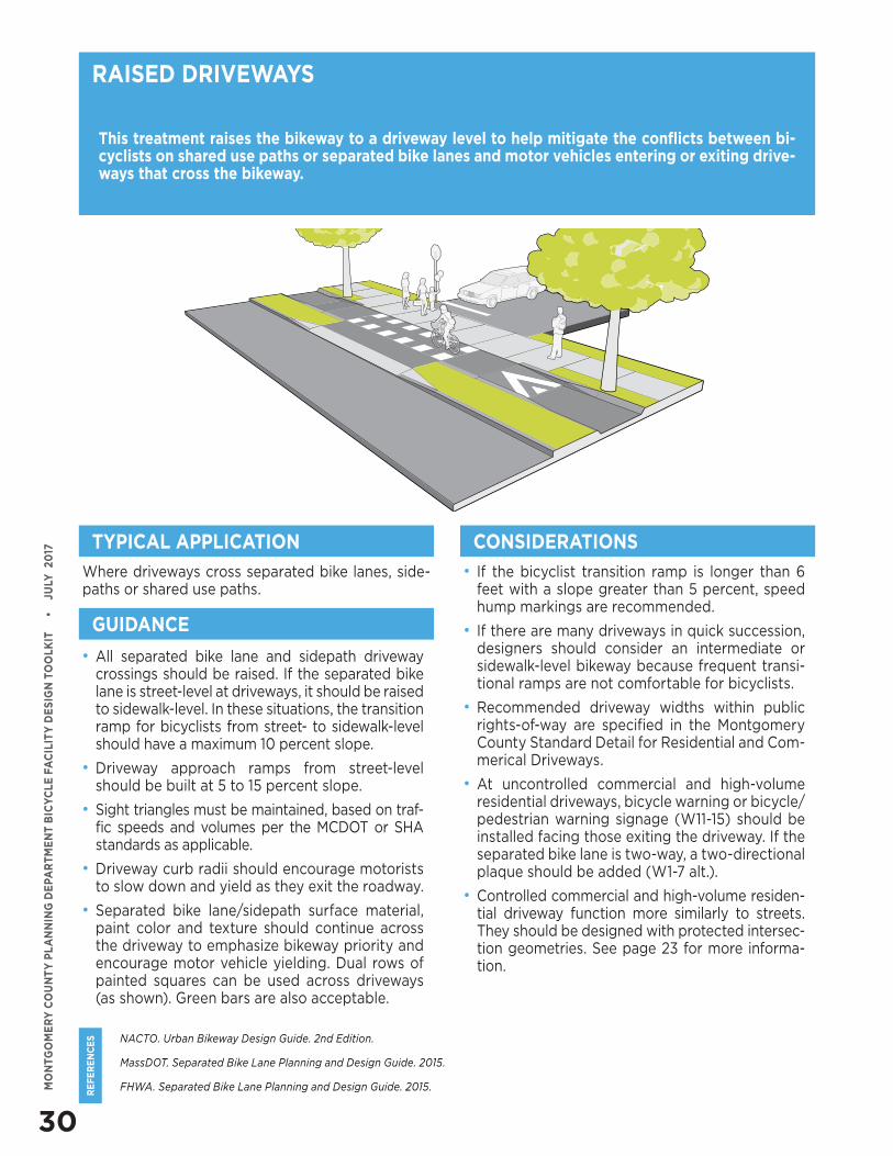
30
RE
FE
RE
NC
ES
MO
NTG
OM
ER
Y C
OU
NT
Y P
LA
NN
ING
DE
PAR
TM
EN
T B
ICY
CLE
FA
CIL
ITY
DE
SIG
N T
OO
LKIT
•
J
ULY
20
17
NACTO. Urban Bikeway Design Guide. 2nd Edition.
MassDOT. Separated Bike Lane Planning and Design Guide. 2015.
FHWA. Separated Bike Lane Planning and Design Guide. 2015.
This treatment raises the bikeway to a driveway level to help mitigate the conflicts between bi-cyclists on shared use paths or separated bike lanes and motor vehicles entering or exiting drive-ways that cross the bikeway.
Where driveways cross separated bike lanes, side-paths or shared use paths.
• If the bicyclist transition ramp is longer than 6 feet with a slope greater than 5 percent, speed hump markings are recommended.
• If there are many driveways in quick succession, designers should consider an intermediate or sidewalk-level bikeway because frequent transi-tional ramps are not comfortable for bicyclists.
• Recommended driveway widths within public rights-of-way are specified in the Montgomery County Standard Detail for Residential and Com-merical Driveways.
• At uncontrolled commercial and high-volume residential driveways, bicycle warning or bicycle/pedestrian warning signage (W11-15) should be installed facing those exiting the driveway. If the separated bike lane is two-way, a two-directional plaque should be added (W1-7 alt.).
• Controlled commercial and high-volume residen-tial driveway function more similarly to streets. They should be designed with protected intersec-tion geometries. See page 23 for more informa-tion.
RAISED DRIVEWAYS
TYPICAL APPLICATION CONSIDERATIONS
GUIDANCE
• All separated bike lane and sidepath driveway crossings should be raised. If the separated bike lane is street-level at driveways, it should be raised to sidewalk-level. In these situations, the transition ramp for bicyclists from street- to sidewalk-level should have a maximum 10 percent slope.
• Driveway approach ramps from street-level should be built at 5 to 15 percent slope.
• Sight triangles must be maintained, based on traf-fic speeds and volumes per the MCDOT or SHA standards as applicable.
• Driveway curb radii should encourage motorists to slow down and yield as they exit the roadway.
• Separated bike lane/sidepath surface material, paint color and texture should continue across the driveway to emphasize bikeway priority and encourage motor vehicle yielding. Dual rows of painted squares can be used across driveways (as shown). Green bars are also acceptable.
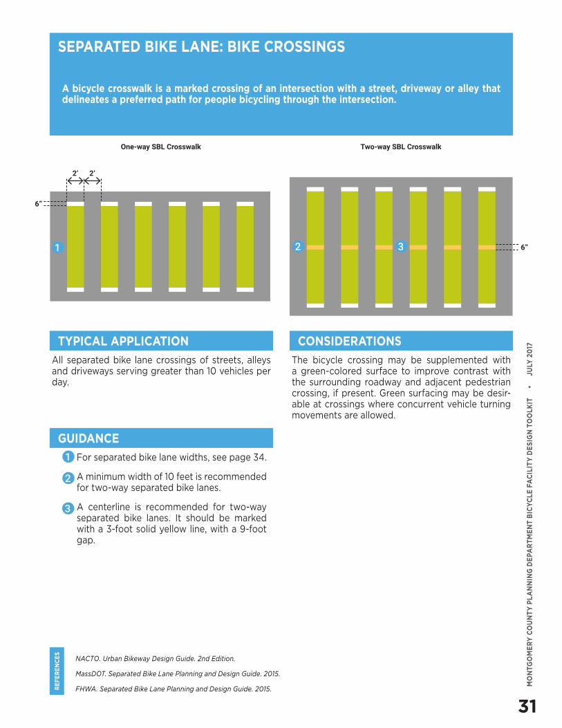
31
RE
FE
RE
NC
ES
MO
NTG
OM
ER
Y C
OU
NT
Y P
LA
NN
ING
DE
PAR
TM
EN
T B
ICY
CLE
FA
CIL
ITY
DE
SIG
N T
OO
LKIT
•
J
ULY
20
17
NACTO. Urban Bikeway Design Guide. 2nd Edition.
MassDOT. Separated Bike Lane Planning and Design Guide. 2015.
FHWA. Separated Bike Lane Planning and Design Guide. 2015.
A bicycle crosswalk is a marked crossing of an intersection with a street, driveway or alley that delineates a preferred path for people bicycling through the intersection.
All separated bike lane crossings of streets, alleys and driveways serving greater than 10 vehicles per day.
The bicycle crossing may be supplemented with a green-colored surface to improve contrast with the surrounding roadway and adjacent pedestrian crossing, if present. Green surfacing may be desir-able at crossings where concurrent vehicle turning movements are allowed.
SEPARATED BIKE LANE: BIKE CROSSINGS
TYPICAL APPLICATION CONSIDERATIONS
GUIDANCE
• For separated bike lane widths, see page 34.
• A minimum width of 10 feet is recommended for two-way separated bike lanes.
• A centerline is recommended for two-way separated bike lanes. It should be marked with a 3-foot solid yellow line, with a 9-foot gap.
1
2
3
1 2 3
One-way SBL Crosswalk
2’
6”
6”
2’
Two-way SBL Crosswalk
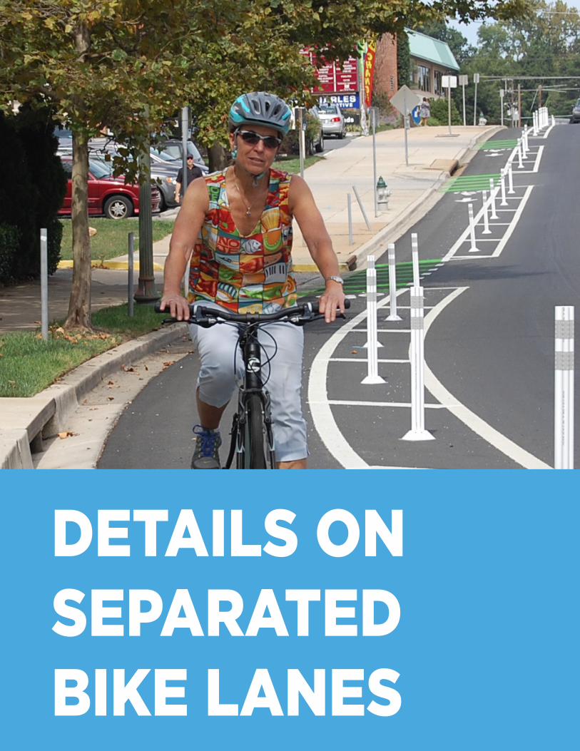
DETAILS ON SEPARATED BIKE LANES
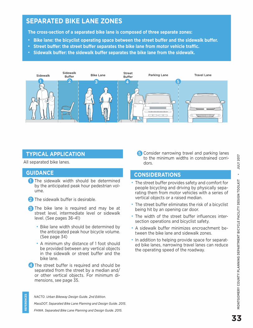
33
RE
FE
RE
NC
ES
MO
NTG
OM
ER
Y C
OU
NT
Y P
LA
NN
ING
DE
PAR
TM
EN
T B
ICY
CLE
FA
CIL
ITY
DE
SIG
N T
OO
LKIT
•
J
ULY
20
17
NACTO. Urban Bikeway Design Guide. 2nd Edition.
MassDOT. Separated Bike Lane Planning and Design Guide. 2015.
FHWA. Separated Bike Lane Planning and Design Guide. 2015.
The cross-section of a separated bike lane is composed of three separate zones:
• Bike lane: the bicyclist operating space between the street buffer and the sidewalk buffer.• Street buffer: the street buffer separates the bike lane from motor vehicle traffic.• Sidewalk buffer: the sidewalk buffer separates the bike lane from the sidewalk.
SEPARATED BIKE LANE ZONES
All separated bike lanes.
• The street buffer provides safety and comfort for people bicycling and driving by physically sepa-rating them from motor vehicles with a series of vertical objects or a raised median.
• The street buffer eliminates the risk of a bicyclist being hit by an opening car door.
• The width of the street buffer influences inter-section operations and bicyclist safety.
• A sidewalk buffer minimizes encroachment be-tween the bike lane and sidewalk zones.
• In addition to helping provide space for separat-ed bike lanes, narrowing travel lanes can reduce the operating speed of the roadway.
TYPICAL APPLICATION
CONSIDERATIONSGUIDANCE• The sidewalk width should be determined
by the anticipated peak hour pedestrian vol-ume.
• The sidewalk buffer is desirable.
• The bike lane is required and may be at street level, intermediate level or sidewalk level. (See pages 36-41)
• Bike lane width should be determined by the anticipated peak hour bicycle volume. (See page 34)
• A minimum shy distance of 1 foot should be provided between any vertical objects in the sidewalk or street buffer and the bike lane.
• The street buffer is required and should be separated from the street by a median and/or other vertical objects. For minimum di-mensions, see page 35.
SidewalkSidewalk
Buffer Bike LaneStreet Buffer
Travel LaneParking Lane
51 2 43
1
2
3
4
• Consider narrowing travel and parking lanes to the minimum widths in constrained corri-dors.
5
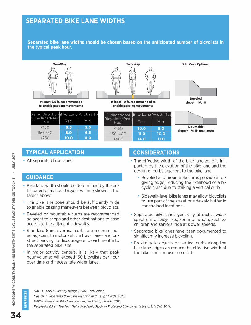
34
RE
FE
RE
NC
ES
MO
NTG
OM
ER
Y C
OU
NT
Y P
LA
NN
ING
DE
PAR
TM
EN
T B
ICY
CLE
FA
CIL
ITY
DE
SIG
N T
OO
LKIT
•
J
ULY
20
17
NACTO. Urban Bikeway Design Guide. 2nd Edition.
MassDOT. Separated Bike Lane Planning and Design Guide. 2015.
FHWA. Separated Bike Lane Planning and Design Guide. 2015.
People for Bikes. The First Major Academic Study of Protected Bike Lanes in the U.S. is Out. 2014.
Separated bike lane widths should be chosen based on the anticipated number of bicyclists in the typical peak hour.
• All separated bike lanes. • The effective width of the bike lane zone is im-pacted by the elevation of the bike lane and the design of curbs adjacent to the bike lane.
• Beveled and mountable curbs provide a for-giving edge, reducing the likelihood of a bi-cycle crash due to striking a vertical curb.
• Sidewalk-level bike lanes may allow bicyclists to use part of the street or sidewalk buffer in constrained locations.
• Separated bike lanes generally attract a wider spectrum of bicyclists, some of whom, such as children and seniors, ride at slower speeds.
• Separated bike lanes have been documented to significantly increase bicycling.
• Proximity to objects or vertical curbs along the bike lane edge can reduce the effective width of the bike lane and user comfort.
SEPARATED BIKE LANE WIDTHS
TYPICAL APPLICATION CONSIDERATIONS
GUIDANCE
• Bike lane width should be determined by the an-ticipated peak hour bicycle volume shown in the tables above.
• The bike lane zone should be sufficiently wide to enable passing maneuvers between bicyclists.
• Beveled or mountable curbs are recommended adjacent to shops and other destinations to ease access to the adjacent sidewalks.
• Standard 6-inch vertical curbs are recommend-ed adjacent to motor vehicle travel lanes and on-street parking to discourage encroachment into the separated bike lane.
• In major activity centers, it is likely that peak hour volumes will exceed 150 bicyclists per hour over time and necessitate wider lanes.
Beveledslope = 1V:1H
Mountableslope = 1V:4H maximum
Same Direction Bicyclists/Peak
Hour
Bike Lane Width (ft.)
Rec. Min.
<150 6.5 5.0
150-750 8.0 6.5
>750 10.0 8.0
Bidirectional Bicyclists/Peak
Hour
Bike Lane Width (ft.)
Rec. Min.
<150 10.0 8.0
150-400 11.0 10.0
>400 14.0 11.0
at least 6.5 ft. recommended to enable passing movements
at least 10 ft. recommended to enable passing movements
One-Way Two-Way SBL Curb Options
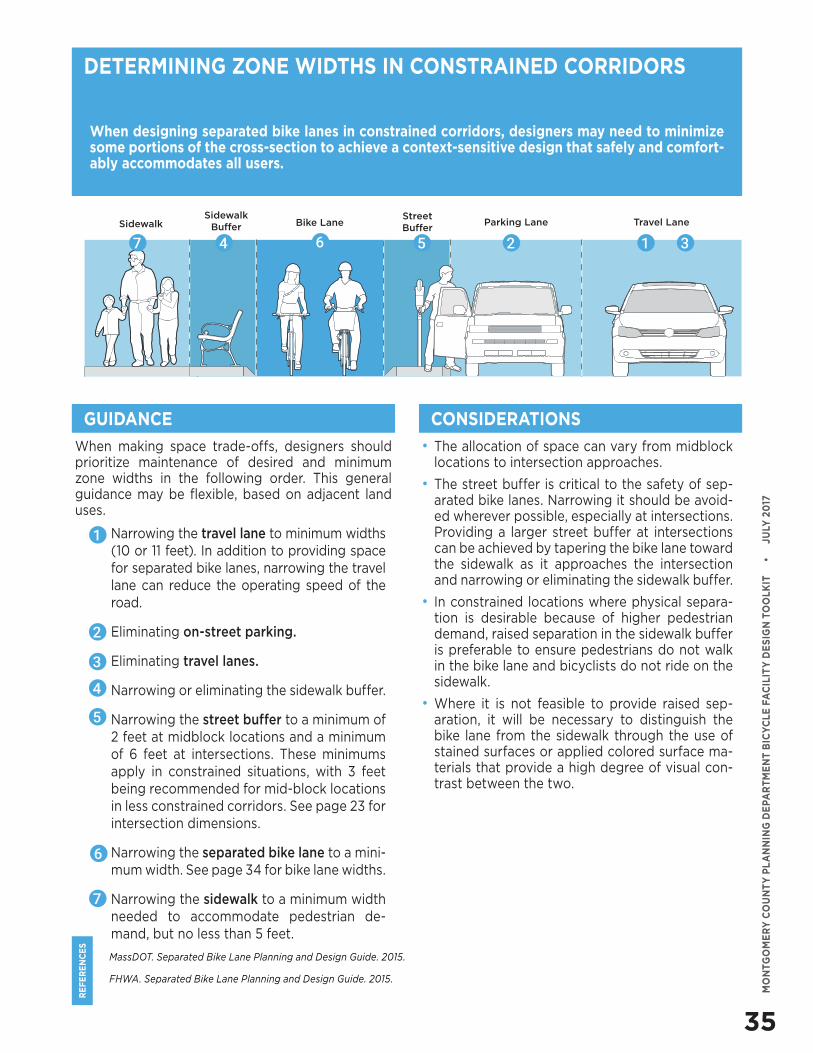
35
RE
FE
RE
NC
ES
MO
NTG
OM
ER
Y C
OU
NT
Y P
LA
NN
ING
DE
PAR
TM
EN
T B
ICY
CLE
FA
CIL
ITY
DE
SIG
N T
OO
LKIT
•
J
ULY
20
17
When making space trade-offs, designers should prioritize maintenance of desired and minimum zone widths in the following order. This general guidance may be flexible, based on adjacent land uses.
• Narrowing the travel lane to minimum widths (10 or 11 feet). In addition to providing space for separated bike lanes, narrowing the travel lane can reduce the operating speed of the road.
• Eliminating on-street parking.
• Eliminating travel lanes.
• Narrowing or eliminating the sidewalk buffer.
• Narrowing the street buffer to a minimum of 2 feet at midblock locations and a minimum of 6 feet at intersections. These minimums apply in constrained situations, with 3 feet being recommended for mid-block locations in less constrained corridors. See page 23 for intersection dimensions.
• Narrowing the separated bike lane to a mini-mum width. See page 34 for bike lane widths.
• Narrowing the sidewalk to a minimum width needed to accommodate pedestrian de-mand, but no less than 5 feet.
MassDOT. Separated Bike Lane Planning and Design Guide. 2015.
FHWA. Separated Bike Lane Planning and Design Guide. 2015.
When designing separated bike lanes in constrained corridors, designers may need to minimize some portions of the cross-section to achieve a context-sensitive design that safely and comfort-ably accommodates all users.
• The allocation of space can vary from midblock locations to intersection approaches.
• The street buffer is critical to the safety of sep-arated bike lanes. Narrowing it should be avoid-ed wherever possible, especially at intersections. Providing a larger street buffer at intersections can be achieved by tapering the bike lane toward the sidewalk as it approaches the intersection and narrowing or eliminating the sidewalk buffer.
• In constrained locations where physical separa-tion is desirable because of higher pedestrian demand, raised separation in the sidewalk buffer is preferable to ensure pedestrians do not walk in the bike lane and bicyclists do not ride on the sidewalk.
• Where it is not feasible to provide raised sep-aration, it will be necessary to distinguish the bike lane from the sidewalk through the use of stained surfaces or applied colored surface ma-terials that provide a high degree of visual con-trast between the two.
DETERMINING ZONE WIDTHS IN CONSTRAINED CORRIDORS
CONSIDERATIONSGUIDANCE
1
2
3
4
5
SidewalkSidewalk
Buffer Bike LaneStreet Buffer
Travel LaneParking Lane
6
7
126 357 4
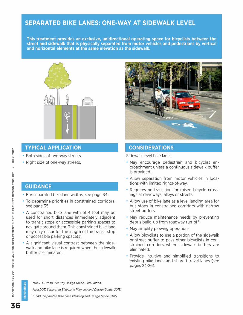
36
RE
FE
RE
NC
ES
MO
NTG
OM
ER
Y C
OU
NT
Y P
LA
NN
ING
DE
PAR
TM
EN
T B
ICY
CLE
FA
CIL
ITY
DE
SIG
N T
OO
LKIT
•
J
ULY
20
17
NACTO. Urban Bikeway Design Guide. 2nd Edition.
MassDOT. Separated Bike Lane Planning and Design Guide. 2015.
FHWA. Separated Bike Lane Planning and Design Guide. 2015.
This treatment provides an exclusive, unidirectional operating space for bicyclists between the street and sidewalk that is physically separated from motor vehicles and pedestrians by vertical and horizontal elements at the same elevation as the sidewalk.
• Both sides of two-way streets.
• Right side of one-way streets.
Sidewalk level bike lanes:
• May encourage pedestrian and bicyclist en-croachment unless a continuous sidewalk buffer is provided.
• Allow separation from motor vehicles in loca-tions with limited rights-of-way.
• Requires no transition for raised bicycle cross-ings at driveways, alleys or streets.
• Allow use of bike lane as a level landing area for bus stops in constrained corridors with narrow street buffers.
• May reduce maintenance needs by preventing debris build-up from roadway run-off.
• May simplify plowing operations.
• Allow bicyclists to use a portion of the sidewalk or street buffer to pass other bicyclists in con-strained corridors where sidewalk buffers are eliminated.
• Provide intuitive and simplified transitions to existing bike lanes and shared travel lanes (see pages 24-26).
SEPARATED BIKE LANES: ONE-WAY AT SIDEWALK LEVEL
TYPICAL APPLICATION CONSIDERATIONS
GUIDANCE
• For separated bike lane widths, see page 34.
• To determine priorities in constrained corridors, see page 35.
• A constrained bike lane with of 4 feet may be used for short distances immediately adjacent to transit stops or accessible parking spaces to navigate around them. This constrained bike lane may only occur for the length of the transit stop or accessible parking space(s).
• A significant visual contrast between the side-walk and bike lane is required when the sidewalk buffer is eliminated.
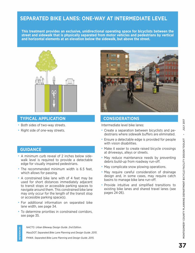
37
RE
FE
RE
NC
ES
MO
NTG
OM
ER
Y C
OU
NT
Y P
LA
NN
ING
DE
PAR
TM
EN
T B
ICY
CLE
FA
CIL
ITY
DE
SIG
N T
OO
LKIT
•
J
ULY
20
17
NACTO. Urban Bikeway Design Guide. 2nd Edition.
MassDOT. Separated Bike Lane Planning and Design Guide. 2015.
FHWA. Separated Bike Lane Planning and Design Guide. 2015.
This treatment provides an exclusive, unidirectional operating space for bicyclists between the street and sidewalk that is physically separated from motor vehicles and pedestrians by vertical and horizontal elements at an elevation below the sidewalk, but above the street.
• Both sides of two-way streets.
• Right side of one-way streets.
Intermediate level bike lanes:
• Create a separation between bicyclists and pe-destrians where sidewalk buffers are eliminated.
• Ensure a detectable edge is provided for people with vision disabilities.
• Make it easier to create raised bicycle crossings at driveways, alleys or streets.
• May reduce maintenance needs by preventing debris build-up from roadway run-off.
• May complicate snow plowing operations.
• May require careful consideration of drainage design and, in some cases, may require catch basins to manage bike lane run-off.
• Provide intuitive and simplified transitions to existing bike lanes and shared travel lanes (see pages 24-26).
SEPARATED BIKE LANES: ONE-WAY AT INTERMEDIATE LEVEL
TYPICAL APPLICATION CONSIDERATIONS
GUIDANCE
• A minimum curb reveal of 2 inches below side-walk level is required to provide a detectable edge for visually impaired pedestrians.
• The recommended minimum width is 6.5 feet, which allows for passing.
• A constrained bike lane with of 4 feet may be used for short distances immediately adjacent to transit stops or accessible parking spaces to navigate around them. This constrained bike lane may only occur for the length of the transit stop or accessible parking space(s).
• For additional information on separated bike lane width, see page 34.
• To determine priorities in constrained corridors, see page 35.
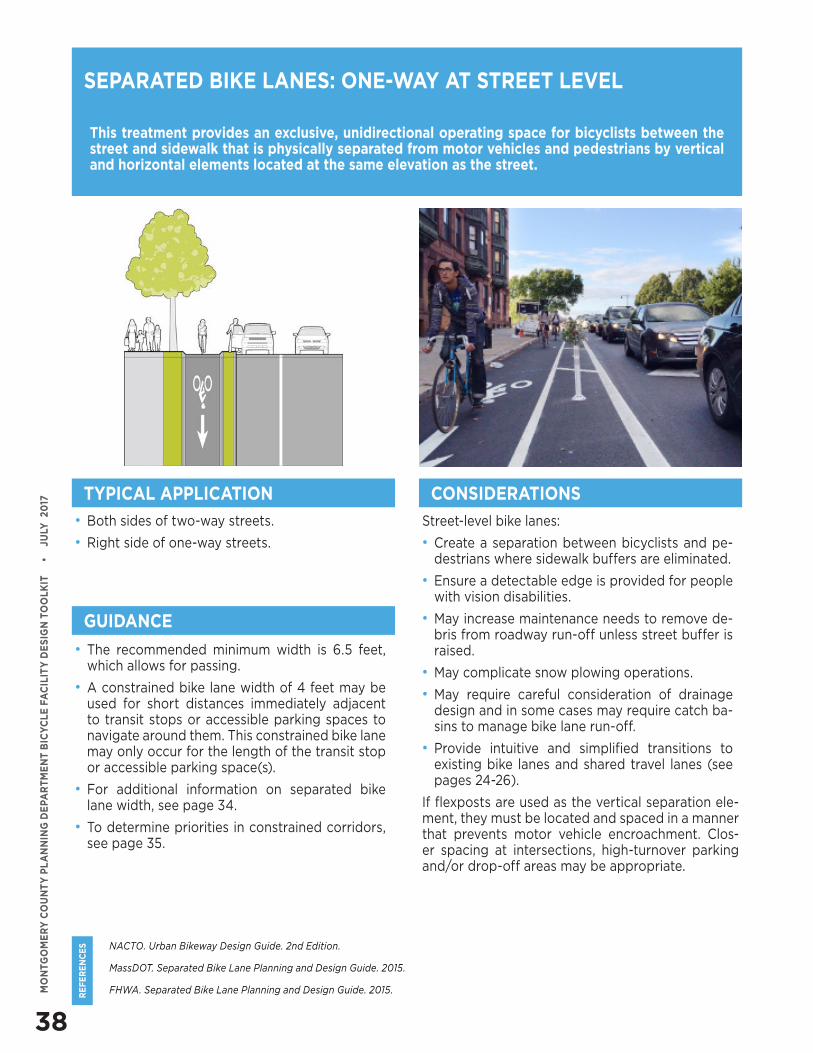
38
RE
FE
RE
NC
ES
MO
NTG
OM
ER
Y C
OU
NT
Y P
LA
NN
ING
DE
PAR
TM
EN
T B
ICY
CLE
FA
CIL
ITY
DE
SIG
N T
OO
LKIT
•
J
ULY
20
17
NACTO. Urban Bikeway Design Guide. 2nd Edition.
MassDOT. Separated Bike Lane Planning and Design Guide. 2015.
FHWA. Separated Bike Lane Planning and Design Guide. 2015.
This treatment provides an exclusive, unidirectional operating space for bicyclists between the street and sidewalk that is physically separated from motor vehicles and pedestrians by vertical and horizontal elements located at the same elevation as the street.
• Both sides of two-way streets.
• Right side of one-way streets.
Street-level bike lanes:
• Create a separation between bicyclists and pe-destrians where sidewalk buffers are eliminated.
• Ensure a detectable edge is provided for people with vision disabilities.
• May increase maintenance needs to remove de-bris from roadway run-off unless street buffer is raised.
• May complicate snow plowing operations.
• May require careful consideration of drainage design and in some cases may require catch ba-sins to manage bike lane run-off.
• Provide intuitive and simplified transitions to existing bike lanes and shared travel lanes (see pages 24-26).
If flexposts are used as the vertical separation ele-ment, they must be located and spaced in a manner that prevents motor vehicle encroachment. Clos-er spacing at intersections, high-turnover parking and/or drop-off areas may be appropriate.
SEPARATED BIKE LANES: ONE-WAY AT STREET LEVEL
TYPICAL APPLICATION
GUIDANCE
• The recommended minimum width is 6.5 feet, which allows for passing.
• A constrained bike lane width of 4 feet may be used for short distances immediately adjacent to transit stops or accessible parking spaces to navigate around them. This constrained bike lane may only occur for the length of the transit stop or accessible parking space(s).
• For additional information on separated bike lane width, see page 34.
• To determine priorities in constrained corridors, see page 35.
CONSIDERATIONS
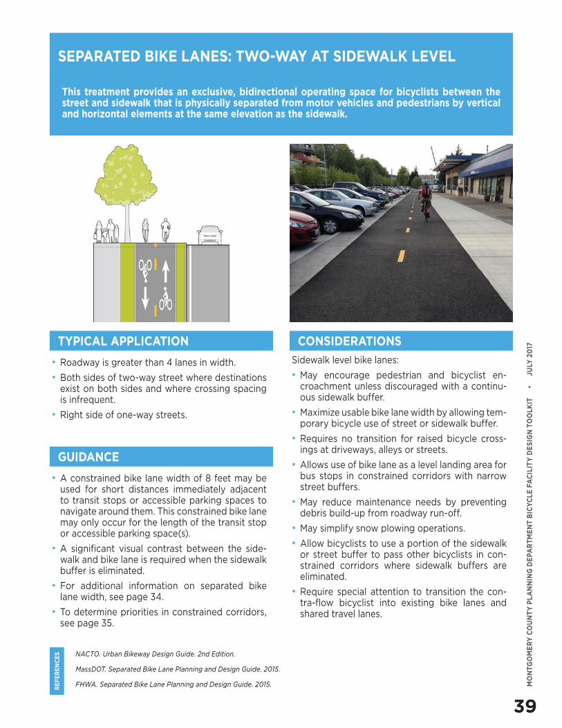
39
RE
FE
RE
NC
ES
MO
NTG
OM
ER
Y C
OU
NT
Y P
LA
NN
ING
DE
PAR
TM
EN
T B
ICY
CLE
FA
CIL
ITY
DE
SIG
N T
OO
LKIT
•
J
ULY
20
17
NACTO. Urban Bikeway Design Guide. 2nd Edition.
MassDOT. Separated Bike Lane Planning and Design Guide. 2015.
FHWA. Separated Bike Lane Planning and Design Guide. 2015.
This treatment provides an exclusive, bidirectional operating space for bicyclists between the street and sidewalk that is physically separated from motor vehicles and pedestrians by vertical and horizontal elements at the same elevation as the sidewalk.
SEPARATED BIKE LANES: TWO-WAY AT SIDEWALK LEVEL
• Roadway is greater than 4 lanes in width.
• Both sides of two-way street where destinations exist on both sides and where crossing spacing is infrequent.
• Right side of one-way streets.
Sidewalk level bike lanes:
• May encourage pedestrian and bicyclist en-croachment unless discouraged with a continu-ous sidewalk buffer.
• Maximize usable bike lane width by allowing tem-porary bicycle use of street or sidewalk buffer.
• Requires no transition for raised bicycle cross-ings at driveways, alleys or streets.
• Allows use of bike lane as a level landing area for bus stops in constrained corridors with narrow street buffers.
• May reduce maintenance needs by preventing debris build-up from roadway run-off.
• May simplify snow plowing operations.
• Allow bicyclists to use a portion of the sidewalk or street buffer to pass other bicyclists in con-strained corridors where sidewalk buffers are eliminated.
• Require special attention to transition the con-tra-flow bicyclist into existing bike lanes and shared travel lanes.
TYPICAL APPLICATION CONSIDERATIONS
GUIDANCE
• A constrained bike lane width of 8 feet may be used for short distances immediately adjacent to transit stops or accessible parking spaces to navigate around them. This constrained bike lane may only occur for the length of the transit stop or accessible parking space(s).
• A significant visual contrast between the side-walk and bike lane is required when the sidewalk buffer is eliminated.
• For additional information on separated bike lane width, see page 34.
• To determine priorities in constrained corridors, see page 35.
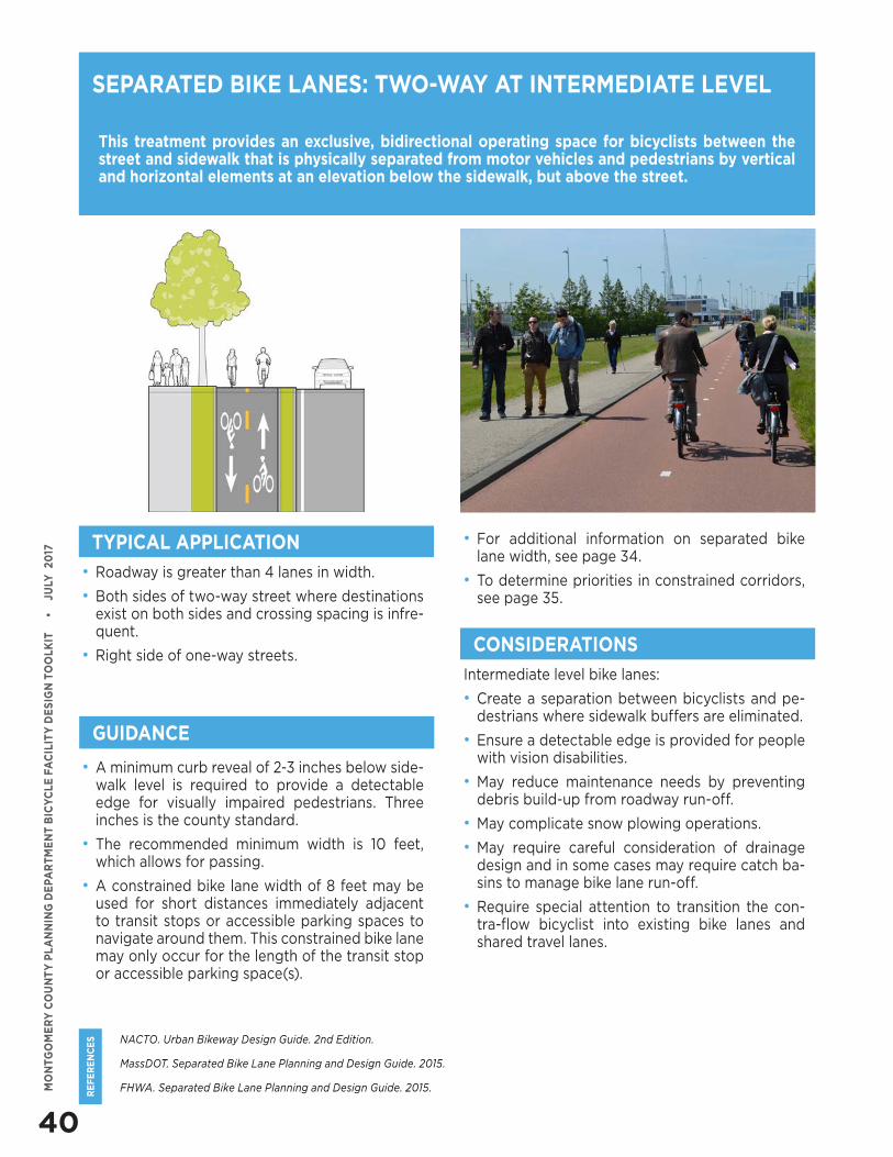
40
RE
FE
RE
NC
ES
MO
NTG
OM
ER
Y C
OU
NT
Y P
LA
NN
ING
DE
PAR
TM
EN
T B
ICY
CLE
FA
CIL
ITY
DE
SIG
N T
OO
LKIT
•
J
ULY
20
17
NACTO. Urban Bikeway Design Guide. 2nd Edition.
MassDOT. Separated Bike Lane Planning and Design Guide. 2015.
FHWA. Separated Bike Lane Planning and Design Guide. 2015.
This treatment provides an exclusive, bidirectional operating space for bicyclists between the street and sidewalk that is physically separated from motor vehicles and pedestrians by vertical and horizontal elements at an elevation below the sidewalk, but above the street.
SEPARATED BIKE LANES: TWO-WAY AT INTERMEDIATE LEVEL
• Roadway is greater than 4 lanes in width.
• Both sides of two-way street where destinations exist on both sides and crossing spacing is infre-quent.
• Right side of one-way streets.Intermediate level bike lanes:
• Create a separation between bicyclists and pe-destrians where sidewalk buffers are eliminated.
• Ensure a detectable edge is provided for people with vision disabilities.
• May reduce maintenance needs by preventing debris build-up from roadway run-off.
• May complicate snow plowing operations.
• May require careful consideration of drainage design and in some cases may require catch ba-sins to manage bike lane run-off.
• Require special attention to transition the con-tra-flow bicyclist into existing bike lanes and shared travel lanes.
TYPICAL APPLICATION
CONSIDERATIONS
GUIDANCE
• A minimum curb reveal of 2-3 inches below side-walk level is required to provide a detectable edge for visually impaired pedestrians. Three inches is the county standard.
• The recommended minimum width is 10 feet, which allows for passing.
• A constrained bike lane width of 8 feet may be used for short distances immediately adjacent to transit stops or accessible parking spaces to navigate around them. This constrained bike lane may only occur for the length of the transit stop or accessible parking space(s).
• For additional information on separated bike lane width, see page 34.
• To determine priorities in constrained corridors, see page 35.
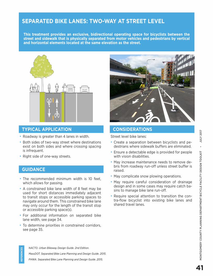
41
RE
FE
RE
NC
ES
MO
NTG
OM
ER
Y C
OU
NT
Y P
LA
NN
ING
DE
PAR
TM
EN
T B
ICY
CLE
FA
CIL
ITY
DE
SIG
N T
OO
LKIT
•
J
ULY
20
17
NACTO. Urban Bikeway Design Guide. 2nd Edition.
MassDOT. Separated Bike Lane Planning and Design Guide. 2015.
FHWA. Separated Bike Lane Planning and Design Guide. 2015.
This treatment provides an exclusive, bidirectional operating space for bicyclists between the street and sidewalk that is physically separated from motor vehicles and pedestrians by vertical and horizontal elements located at the same elevation as the street.
SEPARATED BIKE LANES: TWO-WAY AT STREET LEVEL
• Roadway is greater than 4 lanes in width.
• Both sides of two-way street where destinations exist on both sides and where crossing spacing is infrequent.
• Right side of one-way streets.
Street level bike lanes:
• Create a separation between bicyclists and pe-destrians where sidewalk buffers are eliminated.
• Ensure a detectable edge is provided for people with vision disabilities.
• May increase maintenance needs to remove de-bris from roadway run-off unless street buffer is raised.
• May complicate snow plowing operations.
• May require careful consideration of drainage design and in some cases may require catch ba-sins to manage bike lane run-off.
• Require special attention to transition the con-tra-flow bicyclist into existing bike lanes and shared travel lanes.
TYPICAL APPLICATION CONSIDERATIONS
GUIDANCE
• The recommended minimum width is 10 feet, which allows for passing.
• A constrained bike lane width of 8 feet may be used for short distances immediately adjacent to transit stops or accessible parking spaces to navigate around them. This constrained bike lane may only occur for the length of the transit stop or accessible parking space(s).
• For additional information on separated bike lane width, see page 34.
• To determine priorities in constrained corridors, see page 35.
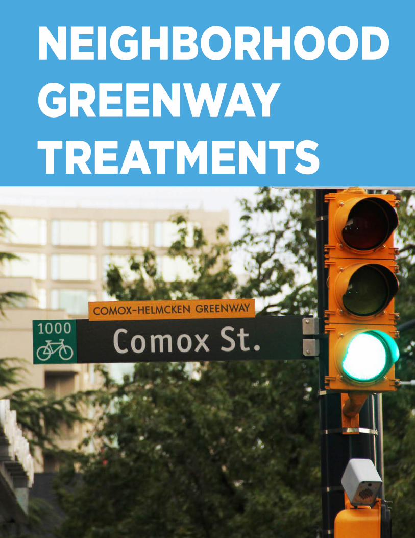
NEIGHBORHOOD GREENWAY TREATMENTS
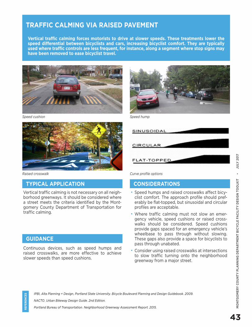
43
RE
FE
RE
NC
ES
MO
NTG
OM
ER
Y C
OU
NT
Y P
LA
NN
ING
DE
PAR
TM
EN
T B
ICY
CLE
FA
CIL
ITY
DE
SIG
N T
OO
LKIT
•
J
ULY
20
17
IPBI, Alta Planning + Design, Portland State University. Bicycle Boulevard Planning and Design Guidebook. 2009.
NACTO. Urban Bikeway Design Guide. 2nd Edition.
Portland Bureau of Transportation. Neighborhood Greenway Assessment Report. 2015.
Vertical traffic calming forces motorists to drive at slower speeds. These treatments lower the speed differential between bicyclists and cars, increasing bicyclist comfort. They are typically used where traffic controls are less frequent, for instance, along a segment where stop signs may have been removed to ease bicyclist travel.
Vertical traffic calming is not necessary on all neigh-borhood greenways. It should be considered where a street meets the criteria identified by the Mont-gomery County Department of Transportation for traffic calming.
• Speed humps and raised crosswalks affect bicy-clist comfort. The approach profile should pref-erably be flat-topped, but sinusoidal and circular profiles are acceptable.
• Where traffic calming must not slow an emer-gency vehicle, speed cushions or raised cross-walks should be considered. Speed cushions provide gaps spaced for an emergency vehicle’s wheelbase to pass through without slowing. These gaps also provide a space for bicyclists to pass through unabated.
• Consider using raised crosswalks at intersections to slow traffic turning onto the neighborhood greenway from a major street.
TRAFFIC CALMING VIA RAISED PAVEMENT
TYPICAL APPLICATION CONSIDERATIONS
GUIDANCE
Continuous devices, such as speed humps and raised crosswalks, are more effective to achieve slower speeds than speed cushions.
Speed cushion Speed hump
Raised crosswalk Curve profile options
NEIGHBORHOOD GREENWAY TREATMENTS
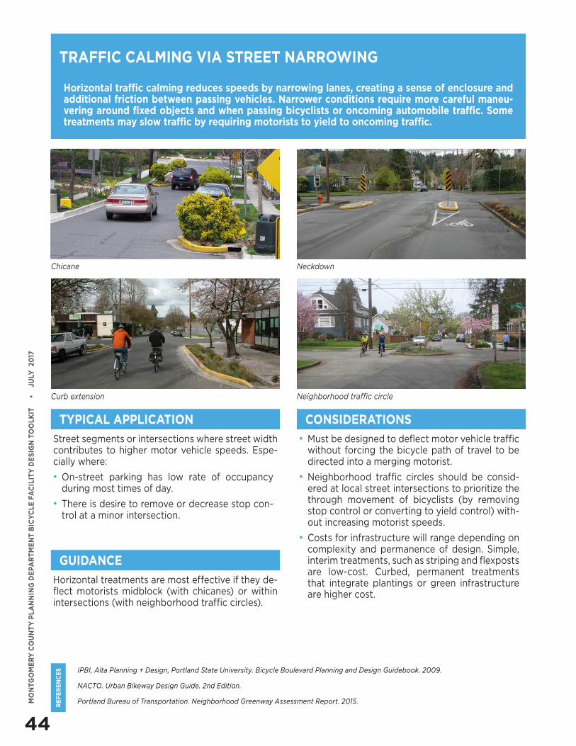
44
RE
FE
RE
NC
ES
MO
NTG
OM
ER
Y C
OU
NT
Y P
LA
NN
ING
DE
PAR
TM
EN
T B
ICY
CLE
FA
CIL
ITY
DE
SIG
N T
OO
LKIT
•
J
ULY
20
17
IPBI, Alta Planning + Design, Portland State University. Bicycle Boulevard Planning and Design Guidebook. 2009.
NACTO. Urban Bikeway Design Guide. 2nd Edition.
Portland Bureau of Transportation. Neighborhood Greenway Assessment Report. 2015.
Horizontal traffic calming reduces speeds by narrowing lanes, creating a sense of enclosure and additional friction between passing vehicles. Narrower conditions require more careful maneu-vering around fixed objects and when passing bicyclists or oncoming automobile traffic. Some treatments may slow traffic by requiring motorists to yield to oncoming traffic.
Street segments or intersections where street width contributes to higher motor vehicle speeds. Espe-cially where:
• On-street parking has low rate of occupancy during most times of day.
• There is desire to remove or decrease stop con-trol at a minor intersection.
• Must be designed to deflect motor vehicle traffic without forcing the bicycle path of travel to be directed into a merging motorist.
• Neighborhood traffic circles should be consid-ered at local street intersections to prioritize the through movement of bicyclists (by removing stop control or converting to yield control) with-out increasing motorist speeds.
• Costs for infrastructure will range depending on complexity and permanence of design. Simple, interim treatments, such as striping and flexposts are low-cost. Curbed, permanent treatments that integrate plantings or green infrastructure are higher cost.
TRAFFIC CALMING VIA STREET NARROWING
TYPICAL APPLICATION CONSIDERATIONS
GUIDANCE
Horizontal treatments are most effective if they de-flect motorists midblock (with chicanes) or within intersections (with neighborhood traffic circles).
Chicane Neckdown
Curb extension Neighborhood traffic circle
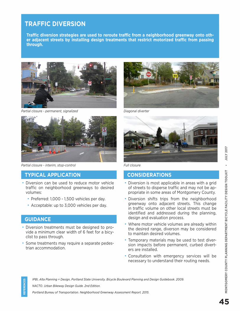
45
RE
FE
RE
NC
ES
MO
NTG
OM
ER
Y C
OU
NT
Y P
LA
NN
ING
DE
PAR
TM
EN
T B
ICY
CLE
FA
CIL
ITY
DE
SIG
N T
OO
LKIT
•
J
ULY
20
17
IPBI, Alta Planning + Design, Portland State University. Bicycle Boulevard Planning and Design Guidebook. 2009.
NACTO. Urban Bikeway Design Guide. 2nd Edition.
Portland Bureau of Transportation. Neighborhood Greenway Assessment Report. 2015.
Traffic diversion strategies are used to reroute traffic from a neighborhood greenway onto oth-er adjacent streets by installing design treatments that restrict motorized traffic from passing through.
• Diversion can be used to reduce motor vehicle traffic on neighborhood greenways to desired volumes:
• Preferred: 1,000 - 1,500 vehicles per day.
• Acceptable: up to 3,000 vehicles per day.
• Diversion is most applicable in areas with a grid of streets to disperse traffic and may not be ap-propriate in some areas of Montgomery County.
• Diversion shifts trips from the neighborhood greenway onto adjacent streets. This change in traffic volume on other local streets must be identified and addressed during the planning, design and evaluation process.
• Where motor vehicle volumes are already within the desired range, diverson may be considered to maintain desired volumes.
• Temporary materials may be used to test diver-sion impacts before permanent, curbed divert-ers are installed.
• Consultation with emergency services will be necessary to understand their routing needs.
TRAFFIC DIVERSION
TYPICAL APPLICATION CONSIDERATIONS
GUIDANCE
• Diversion treatments must be designed to pro-vide a minimum clear width of 6 feet for a bicy-clist to pass through.
• Some treatments may require a separate pedes-trian accommodation.
Partial closure - permanent, signalized Diagonal diverter
Partial closure - interim, stop-control Full closure
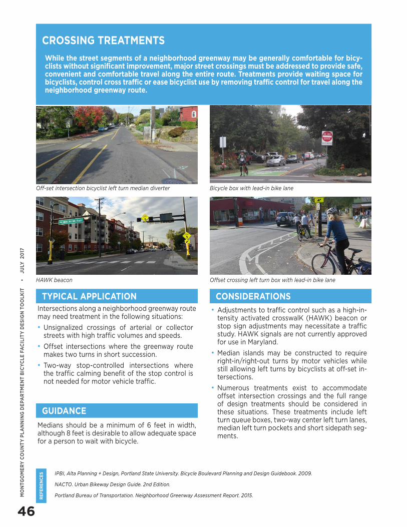
46
RE
FE
RE
NC
ES
MO
NTG
OM
ER
Y C
OU
NT
Y P
LA
NN
ING
DE
PAR
TM
EN
T B
ICY
CLE
FA
CIL
ITY
DE
SIG
N T
OO
LKIT
•
J
ULY
20
17
IPBI, Alta Planning + Design, Portland State University. Bicycle Boulevard Planning and Design Guidebook. 2009.
NACTO. Urban Bikeway Design Guide. 2nd Edition.
Portland Bureau of Transportation. Neighborhood Greenway Assessment Report. 2015.
While the street segments of a neighborhood greenway may be generally comfortable for bicy-clists without significant improvement, major street crossings must be addressed to provide safe, convenient and comfortable travel along the entire route. Treatments provide waiting space for bicyclists, control cross traffic or ease bicyclist use by removing traffic control for travel along the neighborhood greenway route.
Intersections along a neighborhood greenway route may need treatment in the following situations:
• Unsignalized crossings of arterial or collector streets with high traffic volumes and speeds.
• Offset intersections where the greenway route makes two turns in short succession.
• Two-way stop-controlled intersections where the traffic calming benefit of the stop control is not needed for motor vehicle traffic.
• Adjustments to traffic control such as a high-in-tensity activated crosswalK (HAWK) beacon or stop sign adjustments may necessitate a traffic study. HAWK signals are not currently approved for use in Maryland.
• Median islands may be constructed to require right-in/right-out turns by motor vehicles while still allowing left turns by bicyclists at off-set in-tersections.
• Numerous treatments exist to accommodate offset intersection crossings and the full range of design treatments should be considered in these situations. These treatments include left turn queue boxes, two-way center left turn lanes, median left turn pockets and short sidepath seg-ments.
CROSSING TREATMENTS
TYPICAL APPLICATION CONSIDERATIONS
GUIDANCE
Medians should be a minimum of 6 feet in width, although 8 feet is desirable to allow adequate space for a person to wait with bicycle.
Off-set intersection bicyclist left turn median diverter Bicycle box with lead-in bike lane
HAWK beacon Offset crossing left turn box with lead-in bike lane
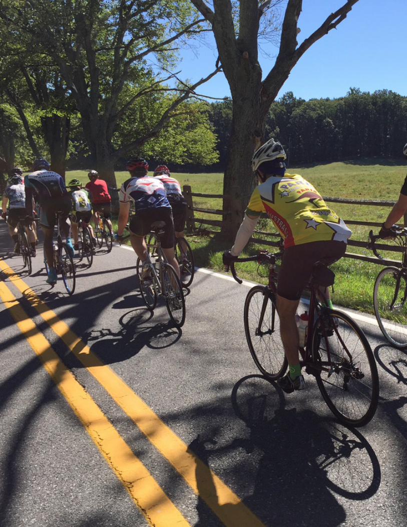


APPENDIX CISSUE PAPERS
INTRODUCTION
The Montgomery County Planning Department contracted the Toole Design Group to research best practices in bicycling planning, and apply this research to inform recommendations for the county’s Bicycle Master Plan. This section of the appendix is a compendium of the resulting research reports.
1. Elements of a World-Class Bicycle Plan2. Bikeway Classification3. Advisory Bike Lanes4. Are Separated Bike Lanes a Replacement for
Dual Bikeways?5. How Should Montgomery County Use Signed
Shared Roadways in Master Plans?6. Separated Bike Lanes versus Shared Use Paths7. Two-Way Bikeways on Both Sides of the Street8. Phasing Separated Bike Lanes9. Incremental Implementation10. Economic Benefits of Bicycling Infrastructure for
Montgomery County
2 MONTGOMERY COUNTY BICYCLE MASTER PLAN | APPENDIX C
ELEMENTS OF A WORLD-CLASS BICYCLE PLAN
1.1 INTRODUCTIONWhat Makes a World-Class Place for Bicycling?
A world-class bicycling city typically has a high rate of bicycling, a low rate of serious injuries and fatalities from bike-related crashes, and residents expressing a high level of satisfaction regarding bicycling conditions. In Copenhagen, Denmark, for example, 30 percent of all trips and 45 percent of work and school trips in 2014 were made by bicycle, but there was only one bicycling fatality and 94 percent of bicycling Copenhageners consider the city to be bicycle-friendly.
Creating such an environment where bicycling is an accepted, appealing, safe and convenient choice requires strategically applied infrastructure, policy and programming. The Cycling Embassy of Denmark, a network of cycling professionals from private companies, local authorities and non-governmental organizations in that country, refers to the “carrot, the stick, and the tambourine” as a means of encouraging bicycling, discouraging car use and celebrating bicycling culture.
The carrot generally refers to a comprehensive and connected network of high quality, low-stress bicycling infrastructure. The stick refers to policies such as motor vehicle parking restrictions and fees, limiting cars in urban centers and congestion charges that make driving more costly and less convenient. The tambourine represents promotional campaigns and programs that foster a culture of bicycling in a community. The carrot and tambourine are fairly common tools employed by American cities competing for bicycle-friendly status. But use of the stick is
common in only a few major American cities and remains rare across most of the United States.
How Does a Plan Lead to a World-Class Place for Bicycling?
Creating a world-class bicycling environment requires a commitment on many levels of the planning process. Leading European cities have integrated bicycle planning into the fabric of their transportation departments, established innovative bicycle facility design guidelines and made steady investments in bicycling infrastructure, block by block and curb by curb to build their networks. In some ways, many of these communities have integrated bicycling so deeply into their transportation planning processes that a separate bicycle master plan may, at this point, be superfluous.
1
2
3
4
In some ways, many of these communities have integrated bicycling so deeply into their transportation planning processes that a separate bicycle master plan may, at this point, be superfluous.
Ed. Note: The reluctance to make driving less convenient or more costly is likely one of the factors keeping even the leading American communities from entering the ranks of consensus world-class bicycling cities.
3MONTGOMERY COUNTY BICYCLE MASTER PLAN | APPENDIX C
01
Perhaps most importantly, a world-class plan sets the tone for a world-class place. Such a plan is ambitious and forward-looking in envisioning a future where bicycling is inclusive, widespread, easy, comfortable and efficient. While planners must understand the context and boundaries of the plan, they should not limit the
Understanding World-Class Plans
This paper draws on ideas from more than a dozen plans for world-class bicycling communities and local jurisdictions. The plan elements and key topics described in the following section were identified as those fundamental to creating a world-class plan. A brief summary of each plan is provided in an appendix to this report. Reviewed plans include:
• Houten, Netherlands• Utrecht, Netherlands• Vauban, Germany• London, England• Fort Collins, CO• Boulder, CO• Davis, CA• Portland, OR• Madison, WI• Bellingham, WA• Atlanta, GA region• Richfield, MN• Hennepin County, MN• Santa Clara and San Mateo Counties, CA• Fairfax County, VA• Howard County, MD• Washington, DC
World-class plans can float ideas that will transform bicycling in the community, even if they are not likely or palatable at the present time.
5
In the American context, a bicycle master plan is essential to creating a bicycle-friendly place because bicycling has yet to reach a level of integration into urban and suburban planning processes. The master plan for a defined area within a city or a county serves as a reference and touchstone for bicycling during any planning process and can help answer the question of whether a specific planning or design decision will help move the community toward the plan’s vision.
An ideal plan vision reflects the unique priorities of its community and helps guide development of goals that are served by clear and coherent strategies for improving bicycling conditions. On a functional level, infrastructure projects related to cycling must be identified through a formal planning process to be eligible for federal funds, and many local funding sources also require a project to be in a plan.
The ultimate impact of a well-made plan, however, is dependent on the degree to which it is implemented. Serious exploration of how projects are implemented must be included in a world-class plan, but the plan development process itself should also be viewed as one of its strongest tools for implementation. This process can touch many diverse community members, bringing them together around a shared vision and building the support for change that can be drawn upon as designs, budgeting and other decisions are debated and decided.
vision for what a community’s bicycling future can be. Focused, realistic recommendations that are easy to implement in the short term can pave the way for more ambitious ideas. As the recommendations of the plan are implemented to improve the bicycling environment over time and spur increased ridership, more community members will see these visionary ideas as realistic and desirable means of further improving bicycling.
4 MONTGOMERY COUNTY BICYCLE MASTER PLAN | APPENDIX C
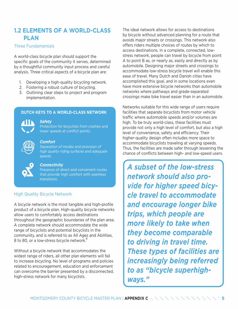
1.2 ELEMENTS OF A WORLD-CLASS PLANThree Fundamentals
A world-class bicycle plan should support the specific goals of the community it serves, determined by a thoughtful community input process and careful analysis. Three critical aspects of a bicycle plan are:
1. Developing a high-quality bicycling network. 2. Fostering a robust culture of bicycling. 3. Outlining clear steps to project and program
implementation.
A subset of the low-stress network should also pro-vide for higher speed bicy-cle travel to accommodate and encourage longer bike trips, which people are more likely to take when they become comparable to driving in travel time. These types of facilities are increasingly being referred to as “bicycle superhigh-ways.”
6
DUTCH KEYS TO A WORLD-CLASS NETWORK
Safety Protection for bicyclists from crashes and lower speeds at conflict points.
ComfortSeparation of modes and provision of high quality riding surfaces and adequate spaces.
Connectivity Presence of direct and convenient routes that provide high comfort with seamless transitions.
High Quality Bicycle Network
A bicycle network is the most tangible and high-profile product of a bicycle plan. High-quality bicycle networks allow users to comfortably access destinations throughout the geographic boundaries of the plan area. A complete network should accommodate the wide range of bicyclists and potential bicyclists in the community, and is referred to as All Ages and Abilities, 8 to 80, or a low-stress bicycle network.
Without a bicycle network that accommodates the widest range of riders, all other plan elements will fail to increase bicycling. No level of programs and policies related to encouragement, education and enforcement can overcome the barrier presented by a disconnected, high-stress network for many bicyclists.
The ideal network allows for access to destinations by bicycle without advanced planning for a route that avoids major streets or crossings. This network also offers riders multiple choices of routes by which to access destinations. In a complete, connected, low-stress network, people can travel by bicycle from point A to point B as, or nearly as, easily and directly as by automobile. Designing major streets and crossings to accommodate low-stress bicycle travel will enable this ease of travel. Many Dutch and Danish cities have accomplished this goal, and in some locations even have more extensive bicycle networks than automobile networks where pathways and grade-separated crossings make bike travel easier than in an automobile.
Networks suitable for this wide range of users require facilities that separate bicyclists from motor vehicle traffic where automobile speeds and/or volumes are high. To be truly world-class, these facilities must provide not only a high level of comfort, but also a high level of convenience, safety and efficiency. Their higher-quality design often includes more space to accommodate bicyclists traveling at varying speeds. Thus, the facilities are made safer through lessening the chance of conflicts between high- and low-speed users.
5MONTGOMERY COUNTY BICYCLE MASTER PLAN | APPENDIX C
Bicycling Culture
Creating a world-class bicycling community requires more than just building a bicycle network. The network needs to be promoted and supported by a vibrant bicycling culture. A world-class bicycle plan reaches beyond infrastructure to address programmatic elements and foster a culture of bicycling.
Indicators of a healthy bicycling culture can include high profile events, popular and festive group rides, places with a reputation as a bicycling destination, or simply a common acceptance among most people that bicycling is a normal, practical and useful mode of transportation. It is not enough to produce support materials for bicycling, such as maps or guides; a world-class plan helps identify ways in which those materials can reach and be relevant to all community members.
Bicycle master plans can support a bicycling culture by recommending programs – often developed in partnership with community groups or public agencies – to engage a wide range of community members in bicycling activities. It is important to engage agencies that may not be considered players in the transportation or recreation arenas, as they can help planning or transportation agencies reach wider audiences. School districts, for example, can champion district-wide bicycle education programs. Bike shops, clubs, advocacy organizations and health-focused organizations and others may play an active role in establishing and advancing local bike culture through hosting events and keeping bicycling in the public eye.
The enhancement of bicycling culture can even start during the planning process by starting a community dialog. In some ways, the plan document may be less important than the discussions, strategizing, collaboration, public engagement and momentum that is built among staff and the community during the plan development. This process brings bicycling to the forefront of public discourse for a time, spurring a mini-surge in the bicycling culture, leading to more public and political support, and making the topic more top-of-mind for staff across agencies.
Bicycle Plan Implementation
A plan must lead directly into implementation. It is sometimes said by planners and engineers that their
favorite plan is the one that gets built. This translation from ideas to reality requires that practical considerations be made during the planning process that will impact implementation later. Several questions should be raised to determine the likelihood of success in overcoming common obstacles. For example, is there likely to be a sufficient right-of-way in a transportation corridor to fit the proposed bicycle facility? Are there large numbers of utilities in a roadway that will make implementation challenging, when another alternative corridor is available? Are there project review policies and design standards that must be changed or made more flexible to accommodate bicycle facilities? Are there redevelopment or street reconstructions planned that can create opportunities to implement a high-quality bicycle facility? Are the various public agencies charged with implementing and maintaining facilities working together and in agreement about the bike plan?
Many plans contain detailed information, including project lists, project prioritization criteria, funding sources and cost estimates to facilitate post-plan implementation. Often, the implementation of a plan is conducted by officials other than those of the plan’s primary authoring agency. Sufficient internal documentation should be kept by the authoring agency for the implementer to be able to understand how and why decisions were made so that the original goal can be achieved even if some necessary adjustments are made.
It is critical for the bicycle planner to understand how projects get implemented. Which department is responsible for implementation? Who owns the right-of-way? According to what time frame do important actions (e.g. repaving) take place? The more that the bicycle master plan recommendations are aligned with the daily operating procedures of the implementing agencies, the more likely implementation is to occur efficiently.
In addition, funding is a key determinant as to whether a plan will be implemented to its fullest potential. Finding early opportunities to build proposed projects can set a precedent for implementation – rather than a period of inactivity following the release of the plan. The plan itself may also recommend development of new financial structures to ensure consistent and adequate funding sources for the implementation of plan proposals.
6 MONTGOMERY COUNTY BICYCLE MASTER PLAN | APPENDIX C
boost the momentum of the plan and build public pressure to construct facilities or initiate bicycling programs.
Bicycle plans often make the case for bicycling, however, that information is often more useful to explain to the public, agency staff and elected officials why the process, the plan and the resulting outcomes are important. Making the case for bicycling, such as explaining its benefits to the local economy, is also put to good effect during bicycle facility implementation as well.
Case Study: Richfield, MN – Community Feedback n a Suburban Context
Jack Broz, the traffic engineer for Richfield, MN, described how important it was that the plan reflected the priorities of the community:
“It is all about understanding the community. Richfield is a first ring suburb of Minneapolis – it’s not Minneapolis. Many folks have a template [that they think of when they think of planning for bicycling] – a dense urban setting. There’s a reason people live here and not in Minneapolis. Planners need to understand what makes a suburb different. Our plan focuses on activities within the community. Access to schools and parks is more important than commuting.
We have a strong reputation and we have to be responsive to the community. We recently had a proposed cycle track on higher volume, county road. But it was not desirable for families. Instead it became more of a trail design because that’s what the community was looking for. Community input made a huge difference.”
Inclusive Process
Agencies should design a public process that brings new people to the table and shows participants how their input was incorporated. Many communities have an existing, vocal, small group of residents who will advocate for bicycling. While these people will continue to be important allies, development of the bicycle plan is a chance to bring more people into the tent. A public process that reaches young people, elderly, more women, lower-income people and people of color to the table will result in a plan that is more
1.3 KEYS
Bicycle plans address a number of topics, but the topics are among the most important. They should be the focus of the plan development process and the document itself.
PLAN DEVELOPMENT AND THEMES
Focused and Strategic Plan
The strongest plans tell a coherent story about where communities are going and how they are going to get there. They have a plausible theory of change and set the path for progress with each component and recommendation contributing thoughtfully to the whole. The weakest bicycle master plans amount to lists of tasks, lacking context and the sense that the whole is greater than the sum of its parts. Fort Collins, CO, Portland, OR and the Atlanta, GA region, for example, have developed bicycle master plans that are built on a clear vision and theory of change. These plans reveal a clear approach to the bicycle network, embrace innovative design, call for strategic and supportive policies and programs, and offer specific implementation methods.
Planning Process
While most of the recommendations in this paper inform the content of a world-class bicycle master plan, it is also vital to consider the process by which this plan is developed. A robust, inclusive and thoughtful process can result in a plan that is reflective of community values and goals, and is thus more likely to gain support for implementation.
Public Support
The planning process can be used to build arguments and gain support for bicycling in a community. In advertising and promoting community meetings related to the development of the plan, an agency has the opportunity to make the case for bicycling to the public and within their own agency. Meetings, surveys and other opportunities to influence the plan can build community excitement about bicycling that carries over to implementation. Speaker series and presentations, organized rides and other events can supplement outreach and help build interest. That excitement can
7MONTGOMERY COUNTY BICYCLE MASTER PLAN | APPENDIX C
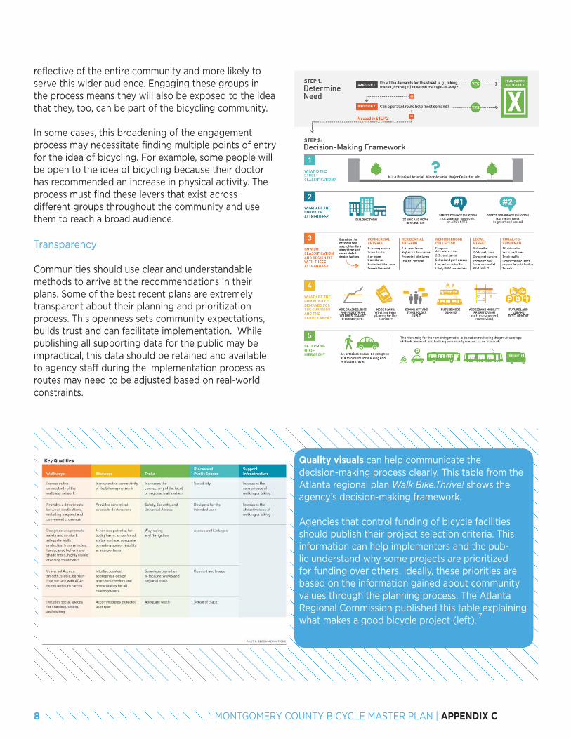
reflective of the entire community and more likely to serve this wider audience. Engaging these groups in the process means they will also be exposed to the idea that they, too, can be part of the bicycling community.
In some cases, this broadening of the engagement process may necessitate finding multiple points of entry for the idea of bicycling. For example, some people will be open to the idea of bicycling because their doctor has recommended an increase in physical activity. The process must find these levers that exist across different groups throughout the community and use them to reach a broad audience.
Transparency
Communities should use clear and understandable methods to arrive at the recommendations in their plans. Some of the best recent plans are extremely transparent about their planning and prioritization process. This openness sets community expectations, builds trust and can facilitate implementation. While publishing all supporting data for the public may be impractical, this data should be retained and available to agency staff during the implementation process as routes may need to be adjusted based on real-world constraints.
Quality visuals can help communicate the decision-making process clearly. This table from the Atlanta regional plan Walk.Bike.Thrive! shows the agency’s decision-making framework.
Agencies that control funding of bicycle facilities should publish their project selection criteria. This information can help implementers and the pub-lic understand why some projects are prioritized for funding over others. Ideally, these priorities are based on the information gained about community values through the planning process. The Atlanta Regional Commission published this table explaining what makes a good bicycle project (left).
7
8 MONTGOMERY COUNTY BICYCLE MASTER PLAN | APPENDIX C
Vision, Goals and Objectives
Strong visioning and goal-setting as part of the planning process can build consensus among stakeholders and the public, and establish mutually agreed upon end points to keep conversations on track. The most important outcome of determining a vision, goals and objectives is to provide an overarching framework for the plan. Planners should determine by what means these components will guide the planning process, which will in turn dictate how much effort to put into their development.
A review of vision, goals, and objectives sections from several bike plans showed a wide range in quality of these sections. The best plans include specific measurable outcomes with completion dates, known as performance measures. Performance measures should be considered part of the vision, goals and objectives section that directs the planning process, and they should also be associated with the implementation process and the tracking of progress after the plan is complete. The plan’s recommendations should contribute to measurable progress toward the performance measure targets.
Use of Data
Historically, bicycling activity has not been documented with the same level of data that is available for automobile planning and engineering. World-class transportation plans use data for developing recommendations, prioritizing improvements and evaluating outcomes against benchmarks (performance measures). Examples of each of these uses include level of traffic stress analysis, bicycle level of service analysis, crash frequency and rate calculations, and assessments of accessibility via the bicycle network.
Using data throughout the plan development process also leads to defensible recommendations that can be upheld under scrutiny. Supporting data is necessary in the implementation process as competing interests vie for funding, roadway space and scarce resources. A world-class planning process will equip the community with analysis to back up its priorities. Plans should also recommend the implementation of additional routine data collection methods that will provide valuable information to track changes in the bicycle environment, such as bike counts and more detailed crash reporting.
It should be noted that data need not only be tracked in its relation to physical infrastructure and ridership. It is also important to understand the reach of education, encouragement and enforcement efforts. Several communities today include questions about bicycling on their annual or bi-annual citizen surveys to gauge changing attitudes about bicycling. Some communities gather data about resident participation in bicycle classes or rides as well.
Strategies for Evaluating Progress
Evaluation strategies provide a way for both the public and the implementing agency to monitor progress on implementation over time. Performance measurement plans offer a clear, publicly accessible and consistent format to track and report progress. The performance measures should link to the plan’s goals and objectives. A tracking matrix typically includes the performance measure, baseline measure, performance target, status and information on the data source. Agencies should consider issuing a public Implementation Report Card based on this information. Several years after Seattle adopted its bicycle master plan, for example, it released its follow-up Implementation Plan 2015-2019, which includes a “goals table” with status updates about specific improvements.
The world-class standard for evaluation is the Bicycle Account from Copenhagen. The Bicycle Account relies on public data and public opinion surveys to evaluate bicycling conditions in the city. It provides a biannual comprehensive review of the city’s bike network, including public satisfaction surveys regarding maintenance of the network (surface quality and snow removal), availability of bicycle parking and bikeway facility width. Bicyclists are also questioned about perceived safety, so planners can track the impact of improved infrastructure on residents’ sense of safety. The Bicycle Account has been adapted for U.S. communities by the Washington, DC-based League of American Bicyclists.
8
9
9MONTGOMERY COUNTY BICYCLE MASTER PLAN | APPENDIX C
Incorporating Equity
American communities have become increasingly aware that bicycling infrastructure is often unevenly distributed. To address such inequities, communities are beginning to develop definitions of equity and equity-based goals, performance measures and gap analyses for inclusion in their bicycle master plans. Widespread interest in and acceptance of bicycling is an indication of a world-class bicycling community, and ensuring equitable access to all elements of bicycling will help communities reach that point.
As bicycle and pedestrian master plans address equity, they have developed different definitions of the term. The report Active Transportation Equity: A Scan of Existing Master Plans by the Alliance for Biking and Walking and League of American Bicyclists provides a wide-ranging review of definitions and incorporation of equity into bicycle and pedestrian plans.
Some plans include equity as a specific goal. For example, Madison, WI developed a bicycle master plan to include the following goal: Provide equitable access to the benefits of bicycling. Every individual, regard-less of age, gender, income or race, should have access to bicycle facilities that allow for safe and convenient transportation. Low-income neighborhoods that are isolated from high quality transportation facilities like shared-use paths need to be brought into the system.
Communities are also developing equity-based performance measures. For example, Eugene, OR measures density of pedestrian and bicycle facilities in areas withhigher concentrations of racial and ethnic minorities, and low-income households compared to other parts of Eugene. An equity gap analysis evaluates the coverage of an existing or proposed bicycle network based on the ability of different vulnerable populations to access it. Such analyses have been conducted in communities such as Portland, OR and Chicago, IL.
Case Study: Portland State University Equity Analysis of Portland’s draft Bicycle Master Plan.
In 2009, the City of Portland hired Portland State University to conduct an equity analysis with the goal of making bicycling more attractive to historically disadvantaged groups. The analysis identified areas where disadvantaged populations live, work, learn, play and shop for groceries. Because the built-out 2030 bicycle network would ultimately cover the entire city, the question of equity in the future was more about project priority and timing of implementation than about network coverage or lack of coverage. The report, therefore, made recommendations about project phasing.
Visual Clarity of Plans
The visual appeal of bicycle plans has improved in recent years. Both the public audience and agency practitioners benefit from clear, informative maps, charts and graphics. An attractive document shows an agency is committed to making its plans accessible to the public and can make it easier for the public to support a plan.
Informational visuals can be almost as impactful on an external audience as the narrative of the plan. The use of visuals in bicycle plans includes:
• Maps• Tables• Photos• Renderings• Infographics
10
11
12
13
10 MONTGOMERY COUNTY BICYCLE MASTER PLAN | APPENDIX C
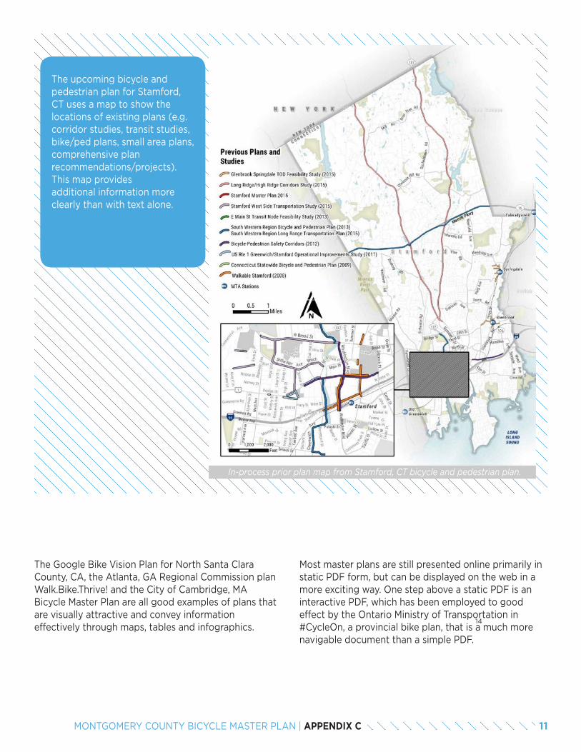
Most master plans are still presented online primarily in static PDF form, but can be displayed on the web in a more exciting way. One step above a static PDF is an interactive PDF, which has been employed to good effect by the Ontario Ministry of Transportation in #CycleOn, a provincial bike plan, that is a much more navigable document than a simple PDF.
14
The upcoming bicycle and pedestrian plan for Stamford, CT uses a map to show the locations of existing plans (e.g. corridor studies, transit studies, bike/ped plans, small area plans, comprehensive plan recommendations/projects). This map provides additional information more clearly than with text alone.
In-process prior plan map from Stamford, CT bicycle and pedestrian plan.
The Google Bike Vision Plan for North Santa Clara County, CA, the Atlanta, GA Regional Commission plan Walk.Bike.Thrive! and the City of Cambridge, MA Bicycle Master Plan are all good examples of plans that are visually attractive and convey information effectively through maps, tables and infographics.
11MONTGOMERY COUNTY BICYCLE MASTER PLAN | APPENDIX C
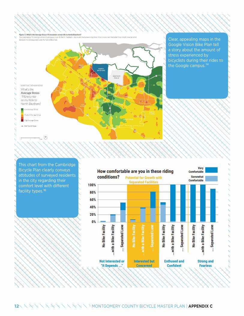
Clear, appealing maps in the Google Vision Bike Plan tell a story about the amount of stress experienced by bicyclists during their rides to the Google campus.
This chart from the Cambridge Bicycle Plan clearly conveys attitudes of surveyed residents in the city regarding their comfort level with different facility types.
14
16
12 MONTGOMERY COUNTY BICYCLE MASTER PLAN | APPENDIX C
PHYSICAL INFRASTRUCTURE ELEMENTS
Bicycle Facility Standards
Master plans identify projects for the construction or implementation of bicycle facilities, but they also present an opportunity to comment on the current and future state of facilities. Physical bicycle infrastructure must be high-quality to attract and retain riders from all backgrounds and skill levels; for example, bike lanes designed without gutter seams, separated facilities that are wide enough to accommodate expected bicycle volumes and off-street facilities that are constructed with materials that will not degrade quickly as they age. If there are current deficiencies with facility design and implementation, a world-class master plan must provide guidance to ensure high-quality facilities are realized by implementing agencies Design and construction of these facilities indicates a community’s level of interest and investment in bicycling, and they must be of high quality to create a world-class experience.
Network Planning Methods
Networks are a central part of bicycle master plans. Therefore, planners have developed several methods of planning and evaluating bicycling networks.
Engineering Standards in the Netherlands
Dutch bicycle networks are widely regarded as world-class in their facilitation of easy bicycle travel. Engineer-ing guidance for these networks is provided through the Dutch CROW Manual, which describes the following qualities:
• Cohesion
» The “mesh width” – the distance to the next network segment – is no more than 820 feet.
» Centers and important amenities are interconnected.
» At least 70 percent of all bicycle journeys are made on the bicycle network.
• Directness
» The average detour time is minimized. » The number of intersections where cyclists do not have the right of way is minimized.
» Stopping for bicyclists is minimized.
17
• Safety
» Conflicts with crossing traffic are avoided. » Vehicle types are separated. » Speed at conflict points is reduced. » Road classifications are recognizable to the road users.
» Bicycling treatments are uniform (solutions that are characteristic of one road type should not be used on another).
• Comfort
» Encounters between bicyclists and cars are minimized.
» Destinations are easy to find. » The network is comprehensible (bicyclists can easily make a mental map of their routes).
• Attractiveness
» Network provides “social safety” (feeling of personal safety).
13MONTGOMERY COUNTY BICYCLE MASTER PLAN | APPENDIX C
Analyzing Networks in Denmark
Planners in Denmark ask the following questions to determine the completeness or cohesiveness of a bicycle network:
• Does the cycling infrastructure link residential areas with primary cycling destinations, such as schools, educational institutions and employment centers?
• Are the routes direct? • Is it easy to get to shops, sports facilities,
entertainment venues and traffic terminals? • Are the residential locations linked, providing
cyclists with shortcuts that make it faster to bike than drive on local journeys?
• Has an overall hierarchy been established (formalized or informal) that gives priority to primary routes rather than side streets and local routes, so that most cyclists are attracted to primary routes?
• Is the flow broken by poor lighting, annoying barriers, too many signal intersections or poor maintenance?
• Does the existing cycling infrastructure live up to the newest construction standards?
• Does the plan accommodate experienced as well as vulnerable cyclists?
• Are school route plans coordinated with the cycling infrastructure plan?
• Are there recreational options for “Sunday” cyclists and cycling tourists?
• If the infrastructure is initially established to a relatively low standard, have provisions been made for improvements over time, so that, for example, signed routes can be upgraded to cycle lanes, which in turn can be upgraded to cycle tracks?
• Is the mesh-size of the urban cycling infrastructure appropriate?
• Are enough provisions for supplementary, segregated off-road tracks included in the plan?
• Are cycle tracks planned for roads with fast moving traffic?
• Can the speed limit for vehicles be reduced until cycle path construction is completed?
18
Case Study: Portland’s three-pronged strategy for a complete network.
From a sophisticated analysis of the city’s existing and potential network of bikeways, the Portland, OR Bicycle Plan for 2030 was developed according to the following three-pronged strategy:
1. Form a finer-grained bikeway network.A dense bikeway network has the advantages of limiting out-of-direction travel and providing a variety of route options to each destination. Having more route options allows bicyclists of different skills and comfort levels to identify routes best suited to their transportation needs. Streets optimized for bicycle travel translate to savings in time and energy that help to make bicycling more attractive than driving.
2. Emphasize low-stress bicycle routes.Many residents who do not bicycle regularly would ride more often if they could minimize their exposure to automobile traffic and lower their stress. Low-stress bicycle facilities, including trails, low-traffic shared roadways (such as bicycle boulevards) and cycle tracks, are bikeways that are separated physically or spatially from higher-volume vehicular roadways. Emphasizing development of a low-stress network of streets and trails provides an effective strategy for advancing the critical principles of cohesion, comfort, directness, safety and attractiveness commonly identified as international best practices for bikeway design.
3. Ensure access to common destinations.The Portland Bicycle Plan for 2030 promotes bicycle facilities on all main streets and recommends that they be designed to provide as much separation as feasible from high volumes of traffic. The plan identifies facilities such as wide bike lanes, buffered bike lanes and cycle tracks as appropriate to provide separation between bicyclists and motor vehicle traffic.
19
20
21
22
14 MONTGOMERY COUNTY BICYCLE MASTER PLAN | APPENDIX C
Multimodal Integration
Bicycle plans in areas with robust transit operations should carefully integrate bicycle and transit planning. Connecting bicycling to transit increases the “catchment area” of transit stations and increases the total possible trip length for bicycle riders. This combination of bicycling and transit replaces longer car trips and can lead to reduced emissions. Some bicycle plans elevate transit integration into a top-level goal and assign a transit integration performance measure to it.
Plans should discuss the importance of bicycle and transit integration to all transit operations (commuter and light rail, Metro, Amtrak, intercity and intracity bus, bike share). Recommendations should include working with transit agencies and identifying the specific partners. The plan should encourage bikes-on-board transit vehicles, secure, covered bike parking at transit stations and bike share stations located near transit stations and in adjacent neighborhoods to allow home-to-transit trips. Full integration of bike share and transit payment systems is the world-class ideal.
Master plans should recommend bike-transit link studies for high-use transit stations to develop specific bike-transit connection strategies and low-stress bicycle routes to these stations. Attention should be paid to facilitate easy transfers across modes, including wayfinding, signs, pavement striping and curb cuts. Plans can also encourage bike racks on taxis and car share vehicles.
End of Trip Facilities
When bicyclists arrive at their destinations, they need to be confident they will have safe and secure places to park their bikes. Planners should work with transit agencies, business districts and private developers to encourage the provision of convenient and secure bicycle parking. Covered or secure long-term parking should be provided at all transit stations. Short-term bike parking should be plentiful in commercial districts. Additionally, end-of-trip facilities like showers, locker rooms and bicycle maintenance stations can promote bike commuting.
World-class bicycling communities help ensure the provision of high-quality parking through the inclusion of bike parking standards in zoning codes. Provision of additional amenities may be incentivized through elements in the development review process. In addition, world-class plans provide policy and implementation guidance to agencies for improving end-of-trip facilities, even in older buildings lacking such amenities.
Case study: Showers and bicycle maintenance stations in Madison, WI
Madison is already a great place for bicycling, but to make bicycling an easy, everyday choice for more riders, the city recognizes a need for more robust end-of-trip facilities. Implementation of these recommendations would create the environment to make bicycling the easy choice.
• Enact policies and laws to ensure appropriate levels of bicycle parking are provided by private property owners.
• Provide ample, secure, well designed, well lit, attractive and conveniently located bicycle parking facilities.
• Work with businesses and campuses to locate on-site bicycle parking.
• Expand and improve bicycle sharing. • Support the provision of facilities such as
showers and bicycle maintenance stations.
» Ensure that all appropriate public buildings include showers and locker facilities in new building projects and in buildings being rehabilitated.
» Encourage and provide incentives for private developers, building owners and employers to provide showers and locker room facilities for employees.
» Work with fitness clubs in or near employment centers to create arrangements whereby, for a small fee, bicyclists could use their shower facilities.
» Increase the number of bicycle fix-it stations with tire pumps and basic tools located throughout the urban area. In areas where appropriate, build facilities modeled on the Dawley Bike Hub in Fitchburg, WI with bathrooms, tools, parking, and direct trail access.
» Develop a downtown Madison bicycle station. 15MONTGOMERY COUNTY BICYCLE MASTER PLAN | APPENDIX C
• Build, enhance and promote multi-modal connections between bicycling and driving.
» Locate park–and-pedal lots on shared-use paths that have direct access to employment centers.
• Enhance multi-modal connections between bicycling and transit.
» Explore options to increase the bicycle carrying capacity on buses without interfering with transit operations. This support may include front exterior racks that hold three bikes or on-board bicycle space.
» Provide adequate short-term bicycle parking and long-term bicycle storage for transportation centers like transit transfer points and park-and-ride lots. The parking may include secure and weather-protected areas.
NON-INFRASTRUCTURE ELEMENTS
One of the most important aspects of cultivating a world-class bicycling environment is to make bicycling an everyday activity that is visible and accepted by all community members. This goal is particularly difficult to achieve in some communities where the perception is that everybody drives and nobody bicycles. Sometimes bicycling is perceived to be too dangerous to replace other transportation modes. High-quality policies and programs can challenge these views by raising the profile of bicycling, bringing more people into the bicycling community and employing education and enforcement strategies to improve safety and perceptions of safety.
The Danish idea of “the carrot, the stick and the tambourine” (see page 3) to encourage cycling speaks to the interconnectivity of infrastructure, policy and programs. The policies and programs from American planning agencies charged with developing bicycle plans are addressed in the following section.
Policy Context
To succeed, bicycle planning must be integrated into the fabric of a transportation agency. This concept, known as “institutionalization,” means that bicycling is considered as a matter of course through the regular
proceedings of agency operations and not as an add-on or a special case. An effective way of achieving this integration is by ensuring that thejurisdiction’s policies support the plan’s bicycling objectives. Bicycle plans should recommend that engineering manuals and standards, funding policies and criteria, and zoning policies should be updated to be consistent with the goals and recommendations of the bicycle plan.
A community can institute many policies to support bicycling. These policy types include speed reduction policies to set design speeds and lower and enforce speed limits; policies to accommodate bicycling in construction zones; Vision Zero plans that aim to eliminate traffic fatalities; land use and development codes that allow for short block lengths, mixed-use developments with street-fronting retail and a connected network of streets; complete streets policies, implementation strategies (see Florida) and design guidance (see Boston); requirements to reduce car parking; and maintenance policies that prioritize streets in the bicycle network.
Programs and Bike Culture
Davis, CA, is proudly known as America’s Bicycling Capital. Portland, OR, has built a reputation as the best city for bicycling. Other cities around the country are at earlier stages, but are striving to foster a positive bicycling culture to attract residents and employers. The following section focuses on non-infrastructure elements that help build a healthy culture around biking.
Program Leadership
Identifying a single government entity that will take responsibility for bicycle programming is important to the success of any bicycle plan. In Fort Collins, CO, staff in the city’s transportation planning department oversee infrastructure implementation and programs, including working with local employers to host bicycling classes, partnering with the school district, directing a bicycle ambassador program, organizing open streets events and other efforts to improve bicycling in the city. These efforts are coordinated through the FC Bikes program within the department.
Bike Arlington in Arlington, VA, is another local example of this type of government effort and is part of
16 MONTGOMERY COUNTY BICYCLE MASTER PLAN | APPENDIX C
Arlington County Commuter Services. These types of government-led efforts are critical to building bike culture when capacity and leadership are not present from outside groups.
Plans commonly call for partnerships with community groups to deliver targeted programs for specific groups, such as women, new residents, seniors, family biking and people of color, members of the LGBT community, recent immigrants or refugees. The Washington Area Bicyclists Association’s (WABA) Women on Bicycles Program is a national model for this type of effort. Partnerships with individual community members can involve residents who volunteer to disseminate bicycle information to neighbors, friends, coworkers and others. A model for such a partnership is Fort Collins’ Bicycle Ambassadors program with its wide reach and suite of programming.
Culture and Identity
Hosting bicycling events – both small and large – is great way to build and cultivate a bicycling culture. These programs do not have to be hosted by county government, but the county can provide institutional support and facilitate permitting, as needed. One of the most common types of bicycling events is a Cyclovia (also known as Open Streets or Sunday Parkways), which involves closing streets to automobile traffic to show residents a new way to look at and experience their surroundings.
Community rides are also popular. “Tweed rides” remind people that spandex isn’t required for riding a bike. For people who do prefer less leisurely riding, hosting charity rides, competitive rides and even professional races can engage large numbers of people.
World-class communities for bicycling also celebrate bicycling as part of their identity. This status is reflected in marketing for the community, whether to tourists or developers or people relocating to the area, and reflected visually in the public realm. Some of the most bicycle-friendly places in the U.S. and abroad have taken opportunities to create the following highly visible infrastructure for bicycling:
Demonstration or pop-up infrastructure projects can build support among the public for bicycling projects and provide a temporary highly visible place for bicycling in the community. Demonstration events can also help convince skeptics, both internal and external to a planning agency, that a given bicycle facility could actually exist in a particular location without negative effects on other transportation modes.
Education and Information
Almost all plans include recommendations related to bicyclist or motorist education. Popular recommendations include good road user behavior programs, bicycle safety awareness campaigns, adult and child bicycle education, bicyclists legal training (classes, guides, handouts), bike and transit education and training, local Safe Routes to School programs and legal quick guides to reporting a crash. Ensuring that all grade school children receive bicycle education is an excellent way to build a safe bicycling culture for years to come. Education can also be critical for agency staff across the board to ensure they understand and are invested in what makes a world-class bicycling environment.
Providing maps and trip planning tools can make bicycling feel more accessible to more people. Mobile technology is pushing the envelope for bicycle route finding. Route mapping is being developed that allows the user to plan a route so that they do not exceed their tolerance for traffic stress. Plans also recommend interactive wayfinding kiosks with real time weather, traffic and routing information for cyclists.
• Collaboration with architects to develop bike- oriented buildings and architecture.
• Visible bike-related sculpture and support facilities, and iconic, architectural non-motorized bridges.
• Artful, whimsical wayfinding that makes it easy and memorable to bike.
25
24
23
26
17MONTGOMERY COUNTY BICYCLE MASTER PLAN | APPENDIX C
Enforcement
Common enforcement recommendations include partnering with police on three-foot passing and speeding enforcement stings. Positive enforcement programs, such as handing out “tickets” worth a free ice cream to children for good bicycling behavior, can build community support and good will.
Evaluation
Evaluation is the part of bicycle programming most often overseen by local government. World-class evaluation can help push the boundaries of the field of bicycle planning and engineering. Count data collection is an area that is growing in the leading bicycle cities, counties and states. The development of a robust counting program of continuous automated counters provides benchmarks for ridership, helps calculate crash exposure rates and can aid in making the case for bicycle infrastructure improvements. 27
PLANNING FOR IMPLEMENTATION
The process used during the creation of the plan and the strategy for implementation after the plan is adopted can determine the amount of community and agency buy-in and help or hinder implementation.
Prioritization Process
A large list of projects and programs lacking prioritization is not a useful outcome of a bicycle master plan. By creating a prioritized list, a community can move forward from the plan with concrete steps for implementation. Each community should develop its own prioritization process based on local conditions and plan objectives. For instance, if a plan goal is increased ridership, projects in areas with high opportunity for bicycling should be prioritized, i.e. areas with a higher density of diverse land uses, high percentages of short trips made by other transportation modes and good connectivity to existing bicycle infrastructure. This said, all projects in the network should be considered for implementation when opportunities such as resurfacing or redevelopment occur.
Methodology for Prioritization
Prioritization methodologies vary from plan to plan. Most often, infrastructure recommendations are prioritized into a clear, tiered list, while programmatic and policy recommendations are not. Structuring these recommendations into a hierarchy may necessarily require more qualitative judgments, but an ambitious world-class plan will need to pinpoint those programs and policies warranting investment first. Prioritization of programs and policies should be done through discussion with stakeholders about community priorities and identifiable roadblocks to implementation.
It is important to consider the programs that would change the character of biking in the community, such as district-wide bicycling education, and policy changes that must occur to enable or ease implementation of projects. For instance, some requirements for traffic studies may indirectly make it more difficult to construct bicycle projects. Projects requiring these policy changes may be high priorities and thus spur action to execute changes.
18 MONTGOMERY COUNTY BICYCLE MASTER PLAN | APPENDIX C
A typical bicycle network prioritization process will flow directly from the plan’s performance measures and will consider how well each recommendation addresses the plan’s vision as defined by its goals and objectives. While this process varies from community to community, a national resource has been developed through the Transportation Research Board’s National Cooperative Highway Research Program (NCHRP) Report 803, Pedestrian and Bicycle Transportation Along Existing Roads, which is adaptable by communities and provides a clear, easily explainable process by which to prioritize infrastructure projects.
Case Studies: Fort Collins, CO – Scoring projects to determine priorities
The City of Fort Collins prioritized infrastructure projects and program recommendations in its bicycle master plan by scoring them according to the “Triple Bottom Line” framework that the city employs for all types of projects. Specific questions in the three areas of economic, environmental and social impacts were developed for infrastructure and program recommendations. For instance, one question in the environmental impacts category asked “Does the project limit the need for additional impervious pavement?” The yes/no answers to questions were summed and these tallies placed projects into high, medium or low priority categories qualitatively.
Additionally, a quantitative score was developed for infrastructure recommendations based on criteria important to stakeholders: demand analysis, crash history, removal of barriers and public input.
Separate methodologies were used to prioritize corridors and intersections since some difficult locations did not lie on identified routes. These locations were often major intersections where experienced riders using bike lanes on major streets still felt uncomfortable or unsafe. The intersections of local streets with arterial roadways were also highly prioritized where the local street was part of a low-stress network. Many of these locations had unsafe crossings which could inhibit the success of the low-stress network if not improved. Corridors were placed into year-long tiers of implementation based on the assumed city budget for project implementation.
Corridors were identified with consideration of providing logical start and end points to improve low-stress network connectivity.
Project Lists and Documentation
Project lists should include planning-level cost estimates. Some communities use cost as a prioritization criterion in developing a cost-benefit analysis for each project. Communities may also choose to prioritize projects exclusive of cost and regardless of their place on in the prioritization list. Low-hanging fruit projects, such as paint-only projects (e.g. lane diet, road diet, shared lane markings) on streets with upcoming resurfacing, should be programmed right away. This immediate action sends a message that the plan is already having an impact on the ground. Initial planning, and sometimes design, can be completed for high-priority projects that can be used to strengthen grant applications later.
Both the publicly available and non-publicly available documentation used to develop the plan should provide enough information for implementers who did not participate in the planning process to understand the rationale behind the recommendations.
Some of the information that should be documented in the plan include:
• Recommendations and actions, each with an assigned priority and responsibility.
• Project list, estimated cost, length. • Project cost assumptions. • Existing conditions summary.• Public outreach process.
Case Study: Portland, Oregon -- Three-part implementation strategy
The Portland Bicycle Plan for 2030 recommends three implementation strategies: the immediate implementation strategy, the 80 percent implementation strategy and the world-class implementation strategy. Each is associated with funding scenarios that provide a starting point for projects that the City of Portland expects to build in the future.
28
29
19MONTGOMERY COUNTY BICYCLE MASTER PLAN | APPENDIX C
The immediate implementation strategy presents a suite of projects to be completed within five years of plan adoption. This suite was selected to meet expected funding levels ($10-14 million) and includes projects that are relatively economical (bike boulevards, striping) that address equity issues, expand access and overcome barriers.
The 80 percent plan is not tied to a timeline and focuses on spreading funding over a wide geographic area such that 80 percent of Portlanders are within a quarter mile of a low-stress bikeway. This strategy again focuses on bike boulevards but also includes some signature trail projects.
The world-class plan is based on implementation of separated and buffered bike lanes on main commercial streets and other high-volume roadways. It is understood that this strategy will be costly and that its implementation depends upon a large shift in funding priorities. The plan makes clear that projects in the 80 percent and world-class lists can be implemented at any time if funds are available and, indeed, the implementation of projects in Portland since the adoption of this plan in 2010 has included some projects from each list and some that were not proposed in the original plan.
Maintenance Strategies
Consistent maintenance of bicycle facilities is critical to keeping them accessible, usable and desirable, and a world-class master plan considers maintenance strategies in its review of the current and future bicycling environment. Maintenance includes pavement marking and signage upkeep, street sweeping, snow removal and surface repairs and assessments from potholes to gutter seams and root heave on trails.
As separated bicycle facilities are becoming more common, transportation agencies are tasked with developing more sophisticated strategies for maintaining bicycle facilities separate from standard roadway maintenance. Some communities empower residents to report bicycle facility maintenance issues. Such citizen participation can lessen a public agency’s burden of tracking locations and indicates a concerted interest in ensuring the usability of bike facilities.
Some communities choose to incorporate maintenance costs into project cost estimates. Plan stakeholders should determine whether that strategy or an alternative way of estimating an overall maintenance budget for planned facilities will better serve future funding requests.
CONCLUSION: MONTGOMERY COUNTY, MD –PREPARING FOR THE BICYCLING FUTURE
Montgomery County, MD, is already primed with many of elements to become a world-class place for bicycling through the development of its Bicycle Master Plan. A well-loved trail system already exists. Three separated bike lanes are already on the ground with more coming in 2017. Bike share use is growing. Bike parking is being improved. Wayfinding routes are being added.
More importantly, community members have been en-gaged in making the County a better place to bicycle for decades. These riders are now united with those who seek low-stress facilities for themselves and their families. Politicians and agency leaders are recognizing and responding to this interest. Businesses and developers are realizing the value of an improved bicycle network. And motivated staff across agencies see the opportunity to move the County forward.
This combination of existing and emerging support can help drive the development of an ambitious world-class bicycle plan that will help residents, leaders, and staff buy into a vision and its implementation. Development of this plan will be another step toward creating the bicycle culture that will help the County become a world-class place for bicycling.
20 MONTGOMERY COUNTY BICYCLE MASTER PLAN | APPENDIX C
1.4 REVIEW OF INTERNATIONAL BICYCLE MASTER PLANS
This section provides a summary of bicycle master plans from all over the world and the U.S., including communities comparable to Montgomery County, MD, to identify the elements that make up a world-class bicycle plan.
APPROACH
International examples of world-class suburban bicycling communities in Houten, Netherlands, and Freiberg and Vauban, Germany, as well as suburban London, England were reviewed. To find the best bicycle plans in the U.S., we reviewed the plans of the communities competing to be the most bicycle friendly communities – the five Platinum Bicycle Friendly Communities, according to the League of American Bicyclists: Boulder and Fort Collins, CO; Davis, CA; Portland, OR; and Madison, WI.
In addition, small city, suburban, regional, and County-level bicycle plans were reviewed based on their national reputation for excellence and innovative approaches. These plans were developed for Bellingham, WA, the Atlanta region, Richfield, MN, Hennepin County, MN, and North Santa Clara County, CA. Finally, the team reviewed bicycle plans for Montgomery County’s neighbors: Fairfax County, VA; Howard County, MD; Washington, DC, and Tysons Corner, VA.
Many of the cities whose plans were reviewed for this white paper have developed specific plans for becoming a world-class bicycling community, making them good models for Montgomery County. The cities of Portland, OR; Boulder and Fort Collins, CO; Davis, CA; and Madison, WI are now pursuing the League of American Bicyclists’ new Diamond rating, which is modeled on international standards of bicycle friendliness. Google’s vision for its campus and surrounding area in North Santa Clara County, CA, is “North County-as-Copenhagen.”
The following is a brief summary of the distinctive parts of each plan studied for this report, organized around these questions:
30
31
• Why was this plan included in this report?• What are the notable elements or sections of the
plan?• What are the transferrable ides to borrow for
Montgomery County?
INTERNATIONAL PLANS
The following international cities have developed innovative plans for bicycling in suburban contexts.
Houten, Netherlands
Why this location is included:
Houten, a suburb of Utrecht in the Netherlands with a population of 43,900, was designed and built from scratch to prioritize bicycling and walking. It is a real-life example that answers the question: what would happen if we could start over and design our suburbs around transit, walking and bicycling instead of the automobile?
Notable bicycle-friendly elements:
Each of the community’s two train stations is surrounded by a two-kilometer wide ring road. The town is connected by a 129-kilometer network of bicycle paths. The 31 residential districts are only accessible to cars by the outer ring roads, while the network of paths for cyclists and pedestrians passes directly through the town center. Most schools and important destinations are located along a primary bicycle/pedestrian thoroughfare. Bicycling is generally the fastest and most direct transportation mode.
Transferrable idea for Montgomery County:
Because it was built on a greenfield from the ground up, Houten is more of a theoretical model than a practical one for Montgomery County, but there are lessons to be learned from the experiment. The concept of “filtered permeability” for cyclists and pedestrians is the planning and design approach that allows bicyclists and pedestrians to travel along more direct routes than the more restricted routes for cars. In Montgomery County, a similar arrangement might mean creating path connections between neighborhoods where there is no road, creating more direct connections for bicyclists.
32
21MONTGOMERY COUNTY BICYCLE MASTER PLAN | APPENDIX C
Vauban, Germany
Why this location is included:
Vauban, outside of Freiburg, Germany, is a model car-light suburb. Located on a former French barracks and redeveloped as a residential enclave, the town prioritized travel by tram, walking and bicycling. Bicycling and walking make up a combined 64 percent of all trips. In a 2002 survey, 81 percent of residents from car-free households said life without owning a car was “easy” or “very easy.”
Notable bicycle-friendly elements:
Vauban physically separates car parking from the majority of housing units and has lowered minimum parking requirements. Car access to residential streets is permitted for picking up and dropping off only. Many streets are marked as “play streets” to prioritize children over motor vehicles. Parking is provided in garages located outside the town center.Transferrable idea for Montgomery County:Montgomery County could experiment with lower parking requirements in areas with good access to transit and high-quality bicycle facilities.
Outer London. The Mayor’s Vision For Cycling
Why this plan is included:
Although London is a large city, it has many suburban areas within its boundaries. The Mayor’s Vision for Cycling, unveiled by London Mayor Boris Johnson in 2013, calls for major investments both in the city center, along major corridors and in outer London communities.
Notable bicycle-friendly elements:
The plan calls for “‘Mini-Hollands” in the suburbs, bikeways inspired by bicycling-friendly routes in the Netherlands, and would increase cycle spending specifically dedicated to outer London by more than 30 times (roughly equivalent to $150 million). Between one and three volunteering outer London boroughs would be made into Mini-Hollands.
33
Transferrable idea for Montgomery County:
In addition to the Mini-Hollands in the suburbs idea, the plan includes the corporate-sponsored Better Barclays Cycle Superhighways to provide direct bicycling access into central London on high-quality separated bicycling facilities. Also, the plan includes a “quietway” network on low traffic streets, similar to bicycle boulevards in the U.S., featuring cut-throughs for bicyclists to increase connectivity.
LEADING U.S. CITIES – PLATINUM BICYCLE-FRIENDLY COMMUNITY CITIES
The following U.S. cities have achieved Platinum Bicycle-Friendly Community status, in many cases having developed a “getting to Platinum” plan. They are now racing to be the first American cities to achieve Diamond status, a more bicycle-friendly rating than Platinum.
Fort Collins, Colorado. 2014 Bicycle Master Plan
Why this plan is included:
Fort Collins is rated by the League of American Bicyclists as a Platinum Bicycle Friendly Community and has both urban centers and lower-density residential areas similar to Montgomery County.
Notable bicycle-friendly elements:
The Fort Collins Bicycle Master Plan is known for its level of traffic stress analysis. It includes a clear table describing the existing bicycle facilities and roadway conditions associated with different levels of traffic stress. The plan also contains a clear and informative table of performance measures. The snow removal maintenance map identifies the roadway or trail owner to facilitate the maintenance and implementation process.
Transferrable idea for Montgomery County:
The Fort Collins plan includes several different network analyses that could be relevant to Montgomery County, including a safety analysis, a demand analysis and the low stress network analysis.
35
34
22 MONTGOMERY COUNTY BICYCLE MASTER PLAN | APPENDIX C
Boulder, Colorado, Transportation Master Plan Bicycle Element and Complete Streets Bicycle Action Plan Why this plan is included:
Boulder is rated by the League of American Bicyclists as a Platinum Bicycle Friendly Community.
Notable bicycle-friendly elements:
The City of Boulder’s Living Laboratory, a pilot program to test new street designs for enhancing travel safety, involves pre- and post-evaluation and on-going analysis to improve the city’s bicycle network in a continuous fashion. This approach includes demonstration projects, such as an E-bike pilot program on multi-use paths, protected cycle tracks, back-in angle parking and variations of buffered bike lanes.
Transferrable idea for Montgomery County:
Boulder is constantly testing new ideas and learning what works in the community. The Living Laboratory approach does not assume that learning is done once the research for the plan is completed. The City evaluates its projects and new ideas, and tweaks its plans on an on-going basis.
Davis, CA. Bicycle Action Plan: Beyond Platinum
Why this plan is included:
Davis is rated by the League of American Bicyclists as a Platinum Bicycle Friendly Community, with its explicit goal of being a world-class bicycling city.
Notable bicycle-friendly elements:
Many communities adopt the themes of the League’s Bicycle Friendly Community Program: engineering, education, enforcement, encouragement and evaluation and planning. The City of Davis embraces these goals and has added equity and enjoyment to the list. Davis is also thinking big in terms of bicycling events in the city and plans to host a Bicycle World’s Fair in 2017.
Transferrable idea for Montgomery County:
The Davis bicycle master plan has a notable emphasis on quantitative measurement. The City of Davis is using the League’s Diamond status criteria to track its own progress. The city regularly documents its percentage of trips to work and school by bike; fatality and crash rates per 10,000 daily riders; percentage of people who feel safe riding their bikes on city streets; public satis-faction survey results, and network completeness.
Portland, OR, Bicycle Plan for 2030 Why this plan is included:
The League of American Bicyclists rate Portland as a Platinum Bicycle Friendly Community.
Notable bicycle-friendly elements:
Portland’s Bicycle Plan for 2030 provides a clear and insightful policy framework for bicycle improvement. The city has embraced the idea of the 20-minute neighborhood where daily needs can be met within an easy walking or bicycling distance. The city’s goal is to make bicycling more attractive than driving for trips of three miles or less and create new bike parking policies. The city classifies bicycle street types into major city bikeways, city bikeways, local service bikeways and bicycle districts. Criteria for major city bikeways are continuity, high-level of use, collectors, strategic areas, funneling functionality and equitable spacing.
The plan’s network recommendations call for a fine-grained bikeway network that serves key destinations. For example, it recommends the city “prioritize bikeway improvements that serve regional and town centers, main streets, employment centers, commercials districts, transit centers and stations, institutions, schools, parks and recreational destinations.”
Transferrable idea for Montgomery County:
The plan profiles individual bicyclists and describes their experience of riding a bike in Portland. For each cyclist, it includes a photograph, a map of a typical route and quotations about the ride.
38
37
36
23MONTGOMERY COUNTY BICYCLE MASTER PLAN | APPENDIX C
Madison, WI. “Making Madison the Best Place in the Country to Bicycle” and 2015 Bicycle Transportation Plan for the Madison Metropolitan Area and Dane County
Why this plan is included:
Madison is now a Platinum Bicycle Friendly Community. The name of one of its plans is “Making Madison the Best Place in the Country to Bicycle.”
Notable bicycle friendly elements:
Madison’s plan includes a healthy emphasis on land use, including these specific recommendations:
• Create a community of compact, walkable, transit and bicycle-oriented, mixed-use neighborhoods, districts and corridors.
• Include specific recommended bicycle connections to major activity centers in neighborhood plans.
• Review and strengthen the local zoning ordinance to ensure adequate on-site pedestrian and bicycle access, parking and circulation.
• Review and strengthen the subdivision ordinance to ensure a connected street network with bicycle facilities.
Transferrable idea for Montgomery County:
The master plan’s “Timeline Index” includes a table of recommendations with a calendar (month/year/season) for implementation.
REGIONAL PLAN EXAMPLE
The following section describes a plan prepared by a metropolitan planning organization to show an example of a high quality regional plan.
Walk Bike Thrive!: Atlanta Regional Bicycle & Pedestrian Plan (2016)
Why this plan is included:
Atlanta Regional Council’s plan is recent (2016) and highly regarded. The region is characterized by various land uses that are similar to those found in Montgomery County.
Notable bicycle-friendly elements:
The plan is well designed with an attractive layout and informative text and graphics describing the framework of the plan. Its sophisticated theory of change is organized into two parts: the first part describes a regional framework for walking and biking, and the second part describes how local jurisdictions and regional partners can build bicycling and walking networks.
Transferrable idea for Montgomery County:
The plan includes a toolkit for local implementation that might be helpful for the smaller communities inside Montgomery County. The plan is also structured around the idea of 20-minute neighborhoods (those where most daily needs are reachable within a 20-minute walk) that may be applicable to Montgomery County.
SUBURBAN PLANS
Richfield, Minnesota “Sweets Streets” Program Why this program is included:
The Minneapolis suburb of Richfield is earning praise for having one of the best suburban bicycle plans in the country.
Notable bicycle-friendly elements:
The plan, completed in 2012, aims to “link major destination points within the city, including trails connecting to other communities, to encourage visitors and residents to get out and bike.”
Richfield’s Sweet Streets program was a marketing campaign that turned into a funding channel after issuing roadway construction bonds. Within next five years, city officials plan to have milled and overlaid all local streets, and reconstructed all their arterials, which will allow them to implement 100 percent of the bicycle master plan.
Transferrable idea for Montgomery County:
This plan has a distinct focus on specific community needs and the places frequented by local residents. “It is about circulation [within the community], bike rides, and friendly trips to ice cream shop,” says City of
39
40
41
42
43
44
24 MONTGOMERY COUNTY BICYCLE MASTER PLAN | APPENDIX C
Richfield Transportation Engineer Jack Broz. “Those priorities drove the routes for the bike plan, so it supports what people want to do. It is not prioritized on commuters; it is prioritized on families.” Broz notes that people moved to Richfield and not nearby Minneapolis because they aren’t looking for the same things that people in bigger cities want: “What works in Minneapolis might not work in Richfield.”
COUNTY PLANS
Hennepin County, MN
Why this plan is included:
Hennepin County, MN, was recently designated a Bicycle Friendly Community by the League of American Bicyclists. The county has a similar range of place types as Montgomery County.
Notable bicycle-friendly elements:
The bicyclists on the cover of the Hennepin County bicycle plan are dressed in everyday clothing (not spandex) and express their joy in bicycling. The goal was to create a plan for everyone in the community and the city worked to humanize plan. The people in the photos were interviewed by planners and their comments about bicycling are included in the document. This public engagement was very intentional. The team went into the community and made a point to reach otherwise under-represented groups of bicyclists.
The plan includes a list of “top 25 gaps,” which made building out the system a lot more approachable – the county has released several RFPs for their new “bike gap” program. The plan includes design guidance and specific mode share goals.
Transferrable idea for Montgomery County:
The inclusion of profiles of real bicyclists makes this plan feel approachable by a wider audience. Both written profiles and photos of a wide range of residents (varied ages, genders, races, etc.) should be included in Montgomery County’s Bicycle Master Plan.
46
45
Google Bike Vision Plan – North Santa Clara County
Why this plan is included:
This is an example of a recent and high quality county bike plan. Santa Clara County is heavily car-oriented, has many large arterial streets that form barriers for bicyclists, and is seeing large amounts of redevelopment. Note that this plan is about access to the Google campus, not bicycle infrastructure improvements on the campus itself.
Notable bicycle-friendly elements:
Google’s plan notes that most bicycling maps show the existing bike network, and some even show notable barriers to access. But what they don’t show is an actual on-the-street experience for someone trying to ride their bike from one place to another. The Google plan asks these pertinent questions: If you’re riding your bike in North County for the first time, will it be a harrowing experience or an easy breeze? Are there any barriers or high-stress locations that are blocking otherwise easy access? What would it take to get more people in North County to feel comfortable getting on a bicycle?”
Transferrable idea for Montgomery County:
To develop the recommended bike network, this plan follows four principles: continuity, connectivity, convenience and completeness. The plan also includes a visualization that compares a bicyclist’s actual distance with the distance a trip feels, based on the amount of stress experienced by the rider. Maps include major access barriers for bicyclists, a priority corridor network and existing and proposed low stress routes. These could be good models for the Montgomery County Bicycle Master Plan.
47
48
25MONTGOMERY COUNTY BICYCLE MASTER PLAN | APPENDIX C
49
50
51
52
WASHINGTON, DC, REGION PLANS
The following plans are from jurisdictions neighboring Montgomery County.
Fairfax County Bicycle Master Plan, 2014
Why the plan is included:
The Fairfax County Plan is a countywide plan in the same region as Montgomery County. Similar to Montgomery County, Fairfax has varied land uses and densities (though highly suburban in many areas) and most trips between destinations require travel on a major (often state-maintained) arterial.
Notable bicycle-friendly elements:
The Fairfax County Bicycle Master Plan presents extensive recommendations for the county.
The plan notes that the existing bikeway network is more than 350 miles and proposed bicycling improvements would add more than 1,100 miles. Recommended facilities include bicycle lanes and other on-road bicycle facilities and treatments, shared use paths, cycle tracks, bicycle/pedestrian bridges and underpasses, intersection improvements, trail access improvements and other accommodations.
Transferrable idea for Montgomery County:
As part of its performance measures, the Fairfax County plan uses Arlington and Montgomery Counties and the District of Columbia as comparisons for bicycling levels. Montgomery County could produce a similar benchmarking report to compare progress with its neighbors.
See also the Tysons Corner Bicycle Master Plan, 2010.
Howard County Bicycle Master Plan, 2015
Why this plan is included:
Howard County is in the same region and state as Montgomery County, and recently completed a Bicycle Master Plan that aims to encourage a wide range of people to ride bikes.
Notable bicycle-friendly elements:
The theme of the Howard County Bicycle Master Plan is comfort for all, using a low stress framework. The plan focuses on connecting people and places, and Howard County to surrounding jurisdictions, removing barriers to these connections extending the existing pathway networks and closing gaps within these networks.
Transferrable idea for Montgomery County:
The Bike Howard plan prioritizes projects according to three tiers: a short-term network, a mid-term network and a long-term network using a specific set of criteria.
Move DC Bicycle Element
Why this plan element is included:
Washington, DC, borders Montgomery County and has seen a major increase in bicycle ridership over the past decade, providing a strong local example of executing one of Montgomery County’s plan goals.
Notable bicycle-friendly elements:
The Bicycle Element is one part of the DC’s multimodal long-range transportation plan called MoveDC. The element includes recommendations to provide more and better bicycle facilities, enact more bicycle friendly policies and provide more bicycle-related education, promotion and enforcement.
The “Vision to Reality” section is a good example of an implementation strategy. The plan identifies $293 million in infrastructure recommendations (using planning-level estimates). Projects areprioritized and organized into four tiers of bicycle and trail capital investments.
Transferrable idea for Montgomery County:
Many of the recommendations in the Bicycle Element
may be applicable to Montgomery County.
26 MONTGOMERY COUNTY BICYCLE MASTER PLAN | APPENDIX C
END NOTES
1. Copenhagen City of Cyclists: The Bicycle Account 2014. http://www.cycling-embassy.dk/wp-content/uploads/2015/05/Copenhagens-Biycle-Account-2014.pdf2. The report, Collection of Cycle Concepts 2012, uses the word “whip” instead of “stick,” but stick is used here because of its more common usage in the U.S. 3. Collection of Cycle Concepts 2012, Cycling Embassy of Denmark. http://www.cycling-embassy.dk/wp-content/uploads/2013/12/Collection-of-Cycle-Concepts-2012.pdf4. Pucher and Buehler “Making Cycling Irresistible” Transport Reviews, Vol. 28, 2008. http://bikeportland.org/wp-content/uploads/2007/11/pucherbuehlermakingcyclingirresistible.
pdf 5. In the 1990s, then-Seattle Bike/Ped Coordinator Pete Lagerwey entered the office of a long-time trail planner who had half a dozen bike plans from the past 20 years mounted
in his office. Lagerwey was impressed and complimented the planner. “This?,” the planner said, “No, this is my wall of shame. None of these great plans ever got implemented.”6. 8 to 80 networks are appropriate for a wide range of bicyclists, from children (age 8) to elderly adults (age 80). These bicyclists have an increased need for separation from
traffic.7. Walk.Bike.Thrive! Atlanta Regional Commission, 2016. http://www.atlantaregional.com/transportation/bicycle--pedestrian8. Bicycle Account from Copenhagen. http://www.cycling-embassy.dk/2015/05/06/new-bicycle-account-from-copenhagen/9. Bicycle Account Guidelines: Measuring, Tracking and Reporting Progress to Inspire Better Biking in Your Community. http://bikeleague.org/sites/default/files/Bicycle_Account_
Guidelines.pdf 10. Active Transportation Equity: A Scan of Existing Master Plans, Advocacy Advance, May 2015 http://www.advocacyadvance.org/docs/ActiveTransportationEquityScan.pdf 11. Eugene Pedestrian and Bicycle Master Plan, 2012. http://www.pedbikeinfo.org/pdf/PlanDesign_SamplePlans_Local_Eugene2012.pdf12. Equity of Access to Bicycle Infrastructure: GIS Methods for Investigating the Equity of Access to Bike Infrastructure, Rachel Prelog, Texas A&M University, September 2015. http://
www.bikeleague.org/sites/default/files/bike_equity_index_final_2.pdf 13. Equity Analysis of Portland’s Draft Bicycle Master Plan – Findings, Jennifer Dill, Ph.D. and Brendon Haggerty, Portland State University Center for Transportation Studies, Sep-
tember 24, 2009. http://www.bikeleague.org/sites/default/files/bikeleague/bikeleague.org/programs/bicyclefriendlyamerica/communities/pdfs/portland_bicycle_master_plan_equity_report_final.pdf
14. http://www.mto.gov.on.ca/english/publications/pdfs/ontario-cycle-strategy.pdf15. http://altaplanning.com/wp-content/uploads/Google-Bike-Vision-Plan_high_res.pdf16. http://www.cambridgema.gov/CDD/Transportation/bikesincambridge/bicyclenetworkplan17. The Dutch Design Manual for Bicycle Traffic, known as the CROW Manual, page 6518. Collection of Cycle Concepts 2012, Cycling Embassy of Denmark, “Is the Plan Cohesive?,” p. 61. http://www.cycling-embassy.dk/wp-content/uploads/2013/12/Collection-of-Cy-
cle-Concepts-2012.pdf 19. Portland Bicycle Plan for 2030, part 3: the Bicycle Transportation System, page 41. https://www.portlandoregon.gov/transportation/44597?a=379134 20. Portland Bicycle Plan for 2030, p41.21. Portland Bicycle Plan for 2030, p42.22. Portland Bicycle Plan for 2030, p43.23. https://veloapartments.prospectportal.com/; http://www.archdaily.com/83307/8-house-big; http://www.wsj.com/articles/developers-build-luxury-bike-friendly-build-
ings-1411660659 http://www.fastcodesign.com/1663586/a-bike-rack-that-rises-in-the-sky-like-a-ferris-wheel
24. http://www.gizmodo.com.au/2013/06/5-robotic-bike-parking-systems-that-solve-an-urban-dilemma/25. https://en.wikipedia.org/wiki/Tilikum_Crossing; https://goo.gl/fYq2O226. https://www.google.com/search?q=lisbon+portugal+bikeway+belem&tbm=isch&tbo=u&source=univ&sa=X&ved=0ahUKEwiNk5KbqpTNAhUYK1IKHewjBVMQsAQINw&bi-
w=1745&bih=88627. Programs in Boulder, CO, and Minneapolis, MN, are of note on the city scale. The Delaware Valley Regional Planning Commission has an exemplary regional program.28. Pedestrian and Bicycle Transportation Along Existing Roads—ActiveTrans Priority Tool Guidebook, NCHRP Report 803, 2015 http://www.pedbikeinfo.org/pdf/PlanDesign_Tools_
APT_Guidebook.pdf29. Strategic implementation plan, Portland Bicycle Plan 2030 https://www.portlandoregon.gov/transportation/44597?a=37913630. Plans for Western Australia (Perth region) and Melbourne were also reviewed, but were excluded here for space and applicability.
Western Australian Bicycle Network Plan 2014-2031. http://www.transport.wa.gov.au/mediaFiles/active-transport/AT_CYC_P_WABN_Plan.pdf; BICYCLE PLAN 2016–2020 http://www.melbourne.vic.gov.au/SiteCollectionDocuments/city-of-melbourne-bicycle-plan-2016-2020.pdf
31. The Portage County Countywide Bicycle & Pedestrian Plan, 2014, was also review, but excluded here for space. https://stevenspoint.com/DocumentCenter/View/871
32. Case Study: Houten, Utrecht, the Netherlands, Nicole Foletta, ITDP Europe http://www.itdp.org/wp-content/uploads/2014/07/22.-092211_ITDP_NED_Desktop_Houten.pdf33. Case Study: Vauban, Freiburg, Germany https://www.itdp.org/wp-content/uploads/2014/07/26.-092211_ITDP_NED_Vauban.pdf34. The Mayor’s Vision for Cycling in London: An Olympic Legacy for all Londoners, Mayor of London, Transport for London, Greater London Authority, March 2013 http://content.tfl.
gov.uk/gla-mayors-cycle-vision-2013.pdf 35. Fort Collins, Colorado. 2014 Bicycle Master Plan http://www.fcgov.com/bicycling/pdf/2014BicycleMasterPlan_adopted_final.pdf36. City of Boulder Bicycle System Plan, https://www-static.bouldercolorado.gov/docs/transportation-master-plan-tmp-2014-1-201408271459.pdf
Complete Streets Bicycle Action Plan https://www-static.bouldercolorado.gov/docs/complete-streets-bicycle-action-plan-1-201406181359.pdf 37. City of Davis, Bicycle Action Plan: Beyond Platinum http://cityofdavis.org/home/showdocument?id=979 38. Portland, OR, Bicycle Plan for 2030. http://www.portlandoregon.gov/transportation/44597?a=379130 39. City of Madison, Mayor’s Platinum Bicycling Committee Report, “Making Madison the Best Place in the Country to Bicycle,” April 2, 2008 https://www.cityofmadison.com/traffi-
cEngineering/documents/PlatinumAdopted040808sm.pdf Bicycle Transportation Plan for the Madison Metropolitan Area and Dane County, 2015 http://www.madisonareampo.org/planning/documents/Final_BTP_2015_web.pdf
40. Walk Bike Thrive!: Atlanta Regional Bicycle & Pedestrian Plan (2016) http://www.atlantaregional.com/transportation/bicycle--pedestrian41. http://richfieldsweetstreets.org/bigpicture; http://www.cityofrichfield.org/home/showdocument?id=77842. Richfield is Hailed for Bullish Bike Plans, John Reinan, Star Tribune, February 25, 2016. http://www.startribune.com/richfield-is-hailed-for-bullish-bike-plans/370205551/
3 Steps to Bicycle friendly Suburbs, Jeff Pearson, American Bicyclist Magazine, Bikeleague.org, June 4, 2015. http://bikeleague.org/content/3-steps-bicycle friendly-suburbs 43. City of Richfield Bicycle Master Plan, Final Version 6-1-12. http://www.cityofrichfield.org/home/showdocument?id=77844. http://richfieldsweetstreets.org/bigpicture 45. Phone interview, Jack Broz, Transportation Engineer, Public Works, City of Richfield, June 29, 2016.46. Hennepin County. http://www.hennepin.us/residents/transportation/biking
http://www.hennepin.us/~/media/hennepinus/residents/transportation/documents/bicycle-transportation-plan.pdf?la=en 47. Google Bike Vision Plan – North Santa Clara County
https://16294-presscdn-0-20-pagely.netdna-ssl.com/wp-content/uploads/Google-Bike-Vision-Plan_high_res.pdf 48. See also Santa Clara Valley Transportation Authority: http://www.vta.org/projects-and-programs/planning/bike-plan49. http://www.fairfaxcounty.gov/fcdot/pdf/bike/bicycle_master_plan_draft-final.pdf50. http://www.fairfaxfederation.org/pdf/TysonsCornerBicycleMasterPlan111118.pdf 51. https://bikehoward.com/ 52. http://www.wemovedc.org/resources/Final/Part%202_Plan_Elements/Bicycle.pdf
27MONTGOMERY COUNTY BICYCLE MASTER PLAN | APPENDIX C
BIKEWAYCLASSIFICATION
Classification of bikeway types is an important step to help planners comprehend how parts of the bike network function and work together. The need for a new bikeway classification system in Montgomery County springs from the introduction of new facility types in the Bicycle Master Plan update, as well as a need to better link policy objectives to the network classification system. Creation of a network classification system that has real policy impacts in the decision-making process can help move the bike plan from lines on a map to a truly useful tool.
Classification also provides planners and the public with an understanding of the level of bicycle accommodation on streets in the network and guidance about prioritization and implementation. This paper refers to two types of bikeway classification:
• Facility classification: groups bikeways by the type of facility; for example, separated bike lanes, bike lanes, shared roadways and trails.
• Network classification: provides a framework for understanding a given bikeway’s function or importance in the network, typically by designating primary and secondary networks.
The approach taken by Montgomery County to each of these types of bikeway classification can play an important role in the county’s efforts to create a world-class bicycle plan and to be an exemplar of suburban bicycling in the U.S. Using network classification as a means of indicating critical routes will facilitate the creation of a connected low-stress network. This is not to say that every primary bikeway would be separated bike lanes on a major street, but every primary bikeway would play a key role in providing a low-stress connection. A higher network classification would indicate a route’s fundamental importance to the bike network and guide county staff in making facility design decisions.
This paper provides an overview of Montgomery County’s current classification schemes for bikeways. This overview is followed by a summary of classification practices from a number of local and national cities. Finally, recommendations are presented for how Montgomery County should move forward with classification in its Bicycle Master Plan update. It should be noted that this paper focuses on bikeway classification for the purposes of master-planning and implementation, not for creating bicycling maps or wayfinding.
53
2.1 CURRENT MONTGOMERY COUNTY BIKEWAY CLASSIFICATIONSMontgomery County’s existing classification scheme was developed for the 2005 Countywide Functional Bikeways Master Plan and includes both facility classification and network classification. Facilities are categorized by type and include:
• Shared use path• Bike lane• Signed shared roadway• Dual bikeway • Cycle tracks
Facility types were not grouped by bicyclist level of comfort or degree of separation provided from automobile traffic.
The county uses countywide and local routes for network classification. Countywide routes comprise about two-thirds of the network and were the focus of the 2005 Plan. These routes generally are located on arterial streets and provide longer distance connections, linking major destinations throughout the county. Local routes are those that feed into the county route system, typically from smaller neighborhood origins and destinations. The countywide/local designation has no inherent relationship to the prioritization or implementation of facilities.
54
28 MONTGOMERY COUNTY BICYCLE MASTER PLAN | APPENDIX C
02
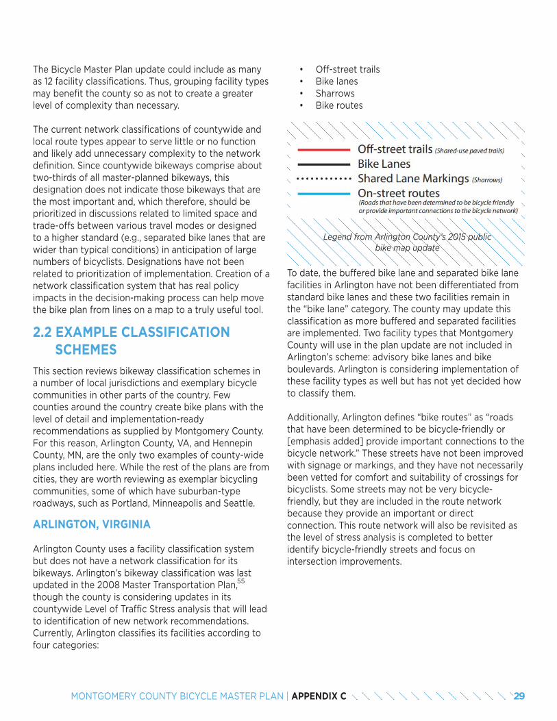
The Bicycle Master Plan update could include as many as 12 facility classifications. Thus, grouping facility types may benefit the county so as not to create a greater level of complexity than necessary.
The current network classifications of countywide and local route types appear to serve little or no function and likely add unnecessary complexity to the network definition. Since countywide bikeways comprise about two-thirds of all master-planned bikeways, this designation does not indicate those bikeways that are the most important and, which therefore, should be prioritized in discussions related to limited space and trade-offs between various travel modes or designed to a higher standard (e.g., separated bike lanes that are wider than typical conditions) in anticipation of large numbers of bicyclists. Designations have not been related to prioritization of implementation. Creation of a network classification system that has real policy impacts in the decision-making process can help move the bike plan from lines on a map to a truly useful tool.
2.2 EXAMPLE CLASSIFICATION SCHEMESThis section reviews bikeway classification schemes in a number of local jurisdictions and exemplary bicycle communities in other parts of the country. Few counties around the country create bike plans with the level of detail and implementation-ready recommendations as supplied by Montgomery County. For this reason, Arlington County, VA, and Hennepin County, MN, are the only two examples of county-wide plans included here. While the rest of the plans are from cities, they are worth reviewing as exemplar bicycling communities, some of which have suburban-typeroadways, such as Portland, Minneapolis and Seattle.
ARLINGTON, VIRGINIA
Arlington County uses a facility classification system but does not have a network classification for its bikeways. Arlington’s bikeway classification was last updated in the 2008 Master Transportation Plan, though the county is considering updates in its countywide Level of Traffic Stress analysis that will lead to identification of new network recommendations. Currently, Arlington classifies its facilities according to four categories:
Legend from Arlington County’s 2015 public bike map update
To date, the buffered bike lane and separated bike lane facilities in Arlington have not been differentiated from standard bike lanes and these two facilities remain in the “bike lane” category. The county may update this classification as more buffered and separated facilities are implemented. Two facility types that Montgomery County will use in the plan update are not included in Arlington’s scheme: advisory bike lanes and bike boulevards. Arlington is considering implementation of these facility types as well but has not yet decided how to classify them.
Additionally, Arlington defines “bike routes” as “roads that have been determined to be bicycle-friendly or [emphasis added] provide important connections to the bicycle network.” These streets have not been improved with signage or markings, and they have not necessarily been vetted for comfort and suitability of crossings for bicyclists. Some streets may not be very bicycle-friendly, but they are included in the route network because they provide an important or direct connection. This route network will also be revisited as the level of stress analysis is completed to better identify bicycle-friendly streets and focus on intersection improvements.
55
• Off-street trails• Bike lanes• Sharrows• Bike routes
29MONTGOMERY COUNTY BICYCLE MASTER PLAN | APPENDIX C
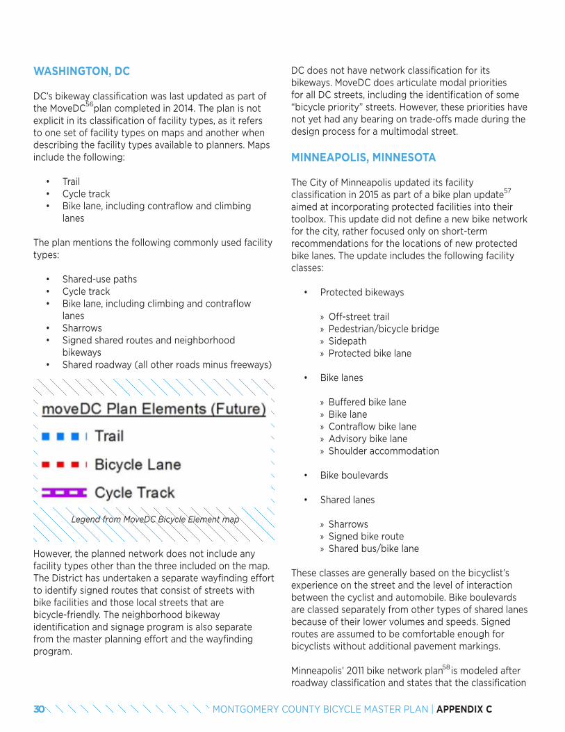
WASHINGTON, DC
DC’s bikeway classification was last updated as part of the MoveDC plan completed in 2014. The plan is not explicit in its classification of facility types, as it refers to one set of facility types on maps and another when describing the facility types available to planners. Maps include the following:
• Trail• Cycle track• Bike lane, including contraflow and climbing
lanes
The plan mentions the following commonly used facility types:
• Shared-use paths• Cycle track• Bike lane, including climbing and contraflow
lanes• Sharrows• Signed shared routes and neighborhood
bikeways• Shared roadway (all other roads minus freeways)
Legend from MoveDC Bicycle Element map
However, the planned network does not include any facility types other than the three included on the map. The District has undertaken a separate wayfinding effort to identify signed routes that consist of streets with bike facilities and those local streets that are bicycle-friendly. The neighborhood bikeway identification and signage program is also separate from the master planning effort and the wayfinding program.
DC does not have network classification for its bikeways. MoveDC does articulate modal priorities for all DC streets, including the identification of some “bicycle priority” streets. However, these priorities have not yet had any bearing on trade-offs made during the design process for a multimodal street.
MINNEAPOLIS, MINNESOTA
The City of Minneapolis updated its facility classification in 2015 as part of a bike plan update aimed at incorporating protected facilities into their toolbox. This update did not define a new bike network for the city, rather focused only on short-term recommendations for the locations of new protected bike lanes. The update includes the following facility classes:
• Protected bikeways
» Off-street trail » Pedestrian/bicycle bridge » Sidepath » Protected bike lane
• Bike lanes
» Buffered bike lane » Bike lane » Contraflow bike lane » Advisory bike lane » Shoulder accommodation
• Bike boulevards
• Shared lanes
» Sharrows » Signed bike route » Shared bus/bike lane
These classes are generally based on the bicyclist’s experience on the street and the level of interaction between the cyclist and automobile. Bike boulevards are classed separately from other types of shared lanes because of their lower volumes and speeds. Signed routes are assumed to be comfortable enough for bicyclists without additional pavement markings.
Minneapolis’ 2011 bike network plan is modeled after roadway classification and states that the classification
56
57
58
30 MONTGOMERY COUNTY BICYCLE MASTER PLAN | APPENDIX C
purpose is to help prioritize projects and make better use of limited funds. The classification is as follows:
• Arterial Bikeway: Routes of regional significance that attract the highest number of bicyclists and are intended to form a “spider web” pattern centered on downtown Minneapolis.
» Principal arterials spaced at two-mile intervals designed for grade separation and faster speed.
» Minor arterials spaced at one-mile intervals. » May be situations where two arterial bikeways are located parallel to one another in close proximity because their differing facility types serve different user groups.
• Collector Bikeway: Feeds into arterial bikeways; spaced at half-mile intervals to capture bicyclists from every part of the city.
• Neighborhood Bikeway: Feeds into collector bikeways; found in every neighborhood and ineligible for regional funding.
While the intent of this scheme is to prioritize bikeways, it has not been used this way in practice. Minneapolis maintains a robust bicycle counting program that city staff found to be a better indication of the importance of any given bikeway project than network classification. Connections to locations with higher existing counts or locations with high counts and deficient facilities have been prioritized.
HENNEPIN COUNTY, MINNESOTA
Hennepin County completed a bike plan in 2015 that is separate from the Minneapolis plan detailed above. The Hennepin plan classes bicycle facilities according to the following groups:
• Off-street
» Multi-use trail » Cycle track » Protected bike lane
• On-street
» Cycle track » Protected bike lane » Buffered bike lane » Bike lane » Shoulder » Bicycle boulevard
These broad classes were chosen to avoid being overly prescriptive on facility type throughout the county. Hennepin County recognized that it would not be the implementing agency for many of the recommended facilities and wanted to leave flexibility for other jurisdictions. Additionally, the level of effort needed for further facility specificity throughout the network was not possible in the scope of this planning effort.
Network classification consists of a planrecommendation to designate an “enhanced bicycle network.” This recommendation emerged from the public engagement process where it was clear that bicyclists and potential bicyclists sought a greater amount of separation from automobile traffic. This classification touched on both facility type and network function with the recommended characteristics:
• Facility type is off-street trail, cycle track or protected bike lane.
• Part of Minneapolis’ protected bike lane network.• Within a priority regional bikeway corridor as
identified in Metropolitan Council Regional Bicycle System Study.
• Part of a route that spans major barriers (e.g., river, railroad, highway).
• Connects major activity centers.
This framework has not yet been used for implementation in Hennepin County, nor has the county used these criteria to identify its enhanced bicycle network.
59
31MONTGOMERY COUNTY BICYCLE MASTER PLAN | APPENDIX C
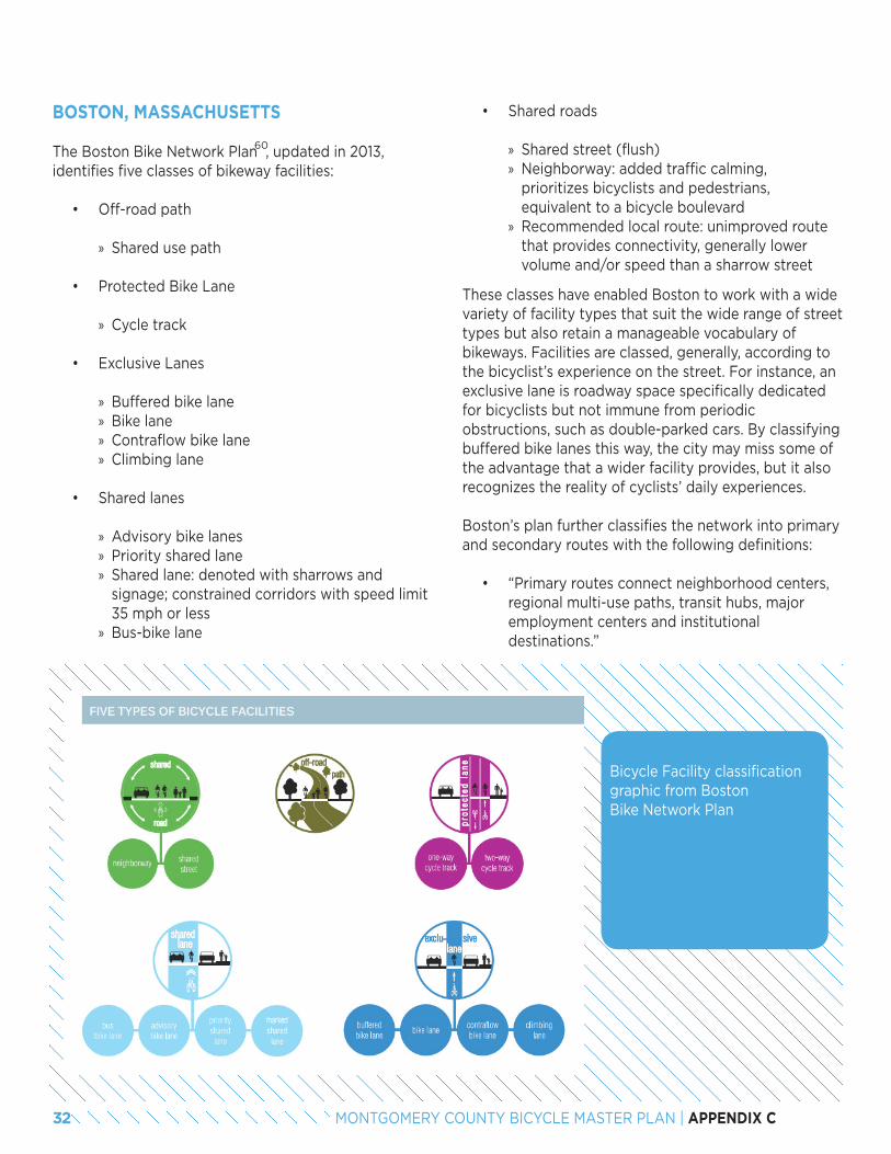
BOSTON, MASSACHUSETTS
The Boston Bike Network Plan , updated in 2013, identifies five classes of bikeway facilities:
• Off-road path
» Shared use path
• Protected Bike Lane
» Cycle track
• Exclusive Lanes
» Buffered bike lane » Bike lane » Contraflow bike lane » Climbing lane
• Shared lanes
» Advisory bike lanes » Priority shared lane » Shared lane: denoted with sharrows and signage; constrained corridors with speed limit 35 mph or less
» Bus-bike lane
60
• Shared roads
» Shared street (flush) » Neighborway: added traffic calming, prioritizes bicyclists and pedestrians, equivalent to a bicycle boulevard
» Recommended local route: unimproved route that provides connectivity, generally lower volume and/or speed than a sharrow street
Bicycle Facility classification graphic from Boston Bike Network Plan
These classes have enabled Boston to work with a wide variety of facility types that suit the wide range of street types but also retain a manageable vocabulary of bikeways. Facilities are classed, generally, according to the bicyclist’s experience on the street. For instance, an exclusive lane is roadway space specifically dedicated for bicyclists but not immune from periodic obstructions, such as double-parked cars. By classifying buffered bike lanes this way, the city may miss some of the advantage that a wider facility provides, but it also recognizes the reality of cyclists’ daily experiences.
Boston’s plan further classifies the network into primary and secondary routes with the following definitions:
• “Primary routes connect neighborhood centers, regional multi-use paths, transit hubs, major employment centers and institutional destinations.”
32 MONTGOMERY COUNTY BICYCLE MASTER PLAN | APPENDIX C
• Provide long distance routes• Carry the highest volumes• Have as much separation from traffic as
possible• Include all major bridges
• “Secondary routes stretch into neighborhoods and provide access to local businesses and neighborhood destinations.”
• Connect schools, neighborhood stores, parks, transit hubs and the primary network routes
• Have varying levels of bicyclist volumes and separation from traffic
These definitions are helpful in conceptualizing the network and prioritizing facilities at a high level, but in practice, the designations have not had a clear effect on implementation. Closing gaps in the existing facilities along primary routes was prioritized, but the five-year action plan consists of streets and trails that are both primary and secondary routes. Implementation has been based more on opportunities and in response to problems rather than guided by a goal of improving the primary routes first.
SEATTLE, WASHINGTON
The 2014 Seattle Bike Plan identified five facility types for its network, which only group bike lane types together:
• Off-street• Cycle track• Neighborhood greenway• In-street, minor separation (buffered bike lane,
bike lane, climbing lane)• Shared street (sharrow)
Each facility type is designated for use on streets with certain speed, traffic and functional classification criteria. Though not every recommendation conforms to these usage standards, they provide a framework for network development that leads to a system with greater separation between bicyclists and automobiles on higher-speed, higher-volume streets.
The Citywide and Local classifications have little bearing on facility implementation other than to prescribe a set of facility options. While the plan identifies high-demand segments of the Citywide Network as a near-term priority, further project prioritization does not rely on a bikeway’s classification as citywide or local.
61
Seattle’s network classification is the only one examined for this study that links network classification to available facility types by calling for exclusively low-stress facilities to be used in the Citywide Network so that citywide routes are accessible to “all ages and abilities.” In practice, this connection means that some facility types, such as bike lanes that may result in a low-stress riding environment on low-volume, low-speed roads, are not included in the citywide network. The classifications are defined as below:
• Citywide Network:
» Provide short distance connections to neighborhood destinations, as well as connections to destination clusters across neighborhoods and throughout the city.
» Allow people of all ages and abilities to access all major destinations on this network.
» Composed of cycle tracks, neighborhood greenways and off-street multi-use trails.
• Local Connectors:
» Provide access to and parallel the Citywide Network and serve destinations.
» Lower level of separation with bike lanes, buffered bike lanes and shared roadways also in facility toolkit.
» May provide a more direct route, but may include facility types and streets that are not appropriate for all ages and abilities.
33MONTGOMERY COUNTY BICYCLE MASTER PLAN | APPENDIX C
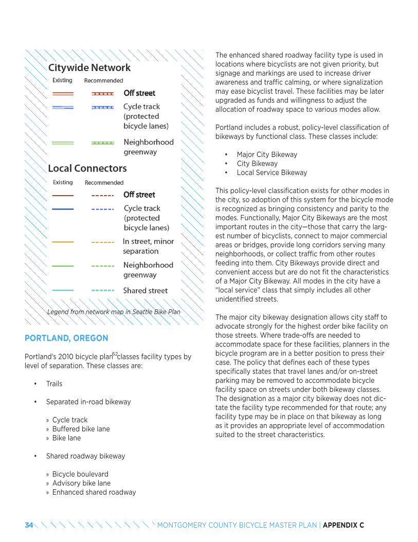
Legend from network map in Seattle Bike Plan
PORTLAND, OREGON
Portland’s 2010 bicycle plan classes facility types by level of separation. These classes are:
• Trails
• Separated in-road bikeway
» Cycle track » Buffered bike lane » Bike lane
• Shared roadway bikeway
» Bicycle boulevard » Advisory bike lane » Enhanced shared roadway
62
The enhanced shared roadway facility type is used in locations where bicyclists are not given priority, but signage and markings are used to increase driver awareness and traffic calming, or where signalization may ease bicyclist travel. These facilities may be later upgraded as funds and willingness to adjust the allocation of roadway space to various modes allow.
Portland includes a robust, policy-level classification of bikeways by functional class. These classes include:
• Major City Bikeway• City Bikeway• Local Service Bikeway
This policy-level classification exists for other modes in the city, so adoption of this system for the bicycle mode is recognized as bringing consistency and parity to the modes. Functionally, Major City Bikeways are the most important routes in the city—those that carry the larg-est number of bicyclists, connect to major commercial areas or bridges, provide long corridors serving many neighborhoods, or collect traffic from other routes feeding into them. City Bikeways provide direct and convenient access but are do not fit the characteristics of a Major City Bikeway. All modes in the city have a “local service” class that simply includes all other unidentified streets.
The major city bikeway designation allows city staff to advocate strongly for the highest order bike facility on those streets. Where trade-offs are needed to accommodate space for these facilities, planners in the bicycle program are in a better position to press their case. The policy that defines each of these types specifically states that travel lanes and/or on-street parking may be removed to accommodate bicycle facility space on streets under both bikeway classes. The designation as a major city bikeway does not dic-tate the facility type recommended for that route; any facility type may be in place on that bikeway as long as it provides an appropriate level of accommodation suited to the street characteristics.
34 MONTGOMERY COUNTY BICYCLE MASTER PLAN | APPENDIX C
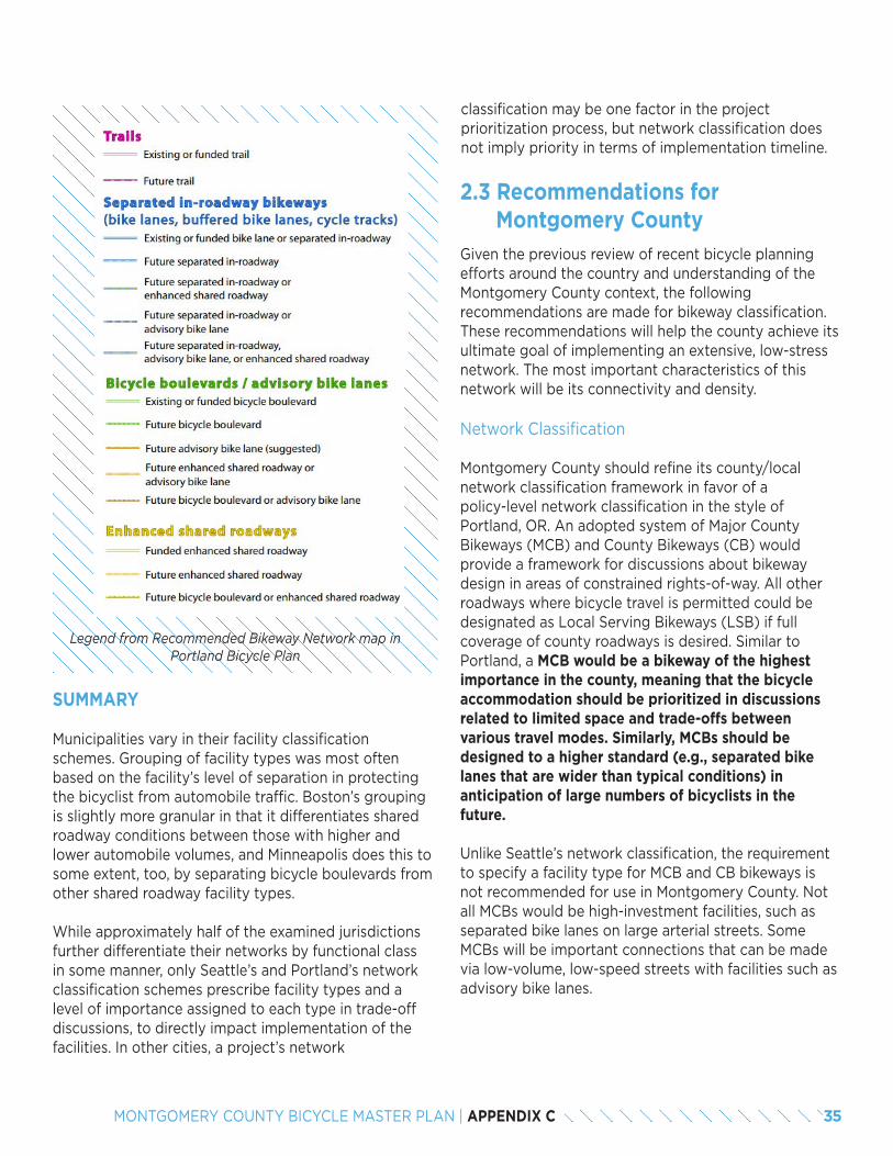
Legend from Recommended Bikeway Network map in Portland Bicycle Plan
SUMMARY
Municipalities vary in their facility classification schemes. Grouping of facility types was most often based on the facility’s level of separation in protecting the bicyclist from automobile traffic. Boston’s grouping is slightly more granular in that it differentiates shared roadway conditions between those with higher and lower automobile volumes, and Minneapolis does this to some extent, too, by separating bicycle boulevards from other shared roadway facility types.
While approximately half of the examined jurisdictions further differentiate their networks by functional class in some manner, only Seattle’s and Portland’s network classification schemes prescribe facility types and a level of importance assigned to each type in trade-off discussions, to directly impact implementation of the facilities. In other cities, a project’s network
2.3 Recommendations for Montgomery CountyGiven the previous review of recent bicycle planning efforts around the country and understanding of the Montgomery County context, the following recommendations are made for bikeway classification. These recommendations will help the county achieve its ultimate goal of implementing an extensive, low-stress network. The most important characteristics of this network will be its connectivity and density.
Network Classification
Montgomery County should refine its county/local network classification framework in favor of a policy-level network classification in the style of Portland, OR. An adopted system of Major County Bikeways (MCB) and County Bikeways (CB) would provide a framework for discussions about bikeway design in areas of constrained rights-of-way. All other roadways where bicycle travel is permitted could be designated as Local Serving Bikeways (LSB) if full coverage of county roadways is desired. Similar to Portland, a MCB would be a bikeway of the highest importance in the county, meaning that the bicycle accommodation should be prioritized in discussions related to limited space and trade-offs between various travel modes. Similarly, MCBs should be designed to a higher standard (e.g., separated bike lanes that are wider than typical conditions) in anticipation of large numbers of bicyclists in the future.
Unlike Seattle’s network classification, the requirement to specify a facility type for MCB and CB bikeways is not recommended for use in Montgomery County. Not all MCBs would be high-investment facilities, such as separated bike lanes on large arterial streets. Some MCBs will be important connections that can be made via low-volume, low-speed streets with facilities such as advisory bike lanes.
classification may be one factor in the project prioritization process, but network classification does not imply priority in terms of implementation timeline.
35MONTGOMERY COUNTY BICYCLE MASTER PLAN | APPENDIX C
The definition of criteria for MCBs should occur during the network development process. It is impossible to know before the entire network is developed what criteria will best capture those streets that serve a critical network function. A preliminary list is given below, but this list should be viewed as draft and subject to change during the plan development process. One or more of the following could be required for MCB designation:
• Access to major destinations: employment centers, key commercial zones/corridors, transit facilities
• Access to multiple neighborhoods• Connections to major trails
Network classification should not be viewed as a prioritization scheme, however. The class of a bikeway project will need to be combined with other factors determined by the county in order to create a priori-tized project list for the bike plan.
Facility Classification
Montgomery County should adopt a grouped classification of facility types in order to make the network easier to comprehend and better reflect the county’s interest in level of traffic stress. Some of the 12 facility types noted below share similar functional characteristics and it is unnecessary to differentiate them on a plan map. The simplified map will provide an adequate level of understanding while not being overly detailed. By defining facility groups based on their level of separation from traffic, planners with knowledge of the street network will be able to understand how comfortable for cyclists a given facility type recommendation will be on that street.
It should be noted, however, that the same facility type has different stress levels in different applications. For instance, a buffered bike lane can be a low-stress facility where the speed limit and number of lanes are low, but the extra width between the rider and automobiles cannot overcome the stress of higher speed traffic or a wide roadway.
63
Montgomery County should classify bikeway facilities as outlined below.
• Shared use paths
» Trail (separate right-of-way) » Sidepath (within a street right-of-way)
• Separated bike lanes
• Bike lanes
» Buffered bike lanes » Bike lanes » Climbing lanes » Contraflow lanes » Advisory bike lanes » Shoulder accommodation
• Bicycle boulevards
• Shared roadways
» Priority shared lane markings » Shared lane markings
64, 65
36 MONTGOMERY COUNTY BICYCLE MASTER PLAN | APPENDIX C
END NOTES53. It should be noted that network classification and the importance of a given route to the network is only one component of a prioritization scheme. Overall prioritization of the
bike network for phased implementation is not addressed in this paper.54. Montgomery County developed the dual bikeway facility type in the 2005 Countywide Bikeways Functional Master Plan to recognize differing levels of ability and comfort
among bicyclists and to recognize the two functions (transportation and recreation) served by a bike network. Dual bikeways include both an on-street bikeway and an off-road shared use path on the same roadway.
55. http://arlingtonva.s3.amazonaws.com/wp-content/uploads/sites/31/2014/02/DES-MTP-Bicycle-Element.pdf56. http://www.wemovedc.org/57. http://www.minneapolismn.gov/www/groups/public/@publicworks/documents/images/wcms1p-144745.pdf58. http://www.minneapolismn.gov/www/groups/public/@publicworks/documents/webcontent/convert_275983.pdf59. http://www.hennepin.us/~/media/hennepinus/residents/transportation/bike/bike-plan/bicycle-transportation-plan.pdf60. http://www.cityofboston.gov/images_documents/Boston%20Bike%20Network%20Plan%2C%20Fall%202013_FINAL_tcm3-40525.pdf61. http://www.seattle.gov/transportation/bikemaster.htm62. https://www.portlandoregon.gov/transportation/4459763. The full level of facility specificity should be maintained in the project/bikeway table portion of the plan so this information is available to readers.64. Bicycle boulevards are separated from other shared roadway facilities because they provide a different level of comfort for bicyclists. A bicycle boulevard design will include
traffic calming, intersection improvements to ease crossing major streets and may include some traffic diversion to lower volumes. These elements are not included in the other shared roadway facilities.
65. Montgomery County may wish to begin discussions regarding the nomenclature used for these facilities. While “bicycle boulevard” is used by some communities, with Berkeley, CA being a notable pioneering user, many jurisdictions are beginning to use terms that reference the benefit of these streets to a broader audience. “neighborway,” “neighbor-hood greenway,” “neighborhood bikeway” and “neighborhood slow street” have all been used for this facility type and imply benefits to pedestrians and residents as well as bicyclists.
37MONTGOMERY COUNTY BICYCLE MASTER PLAN | APPENDIX C
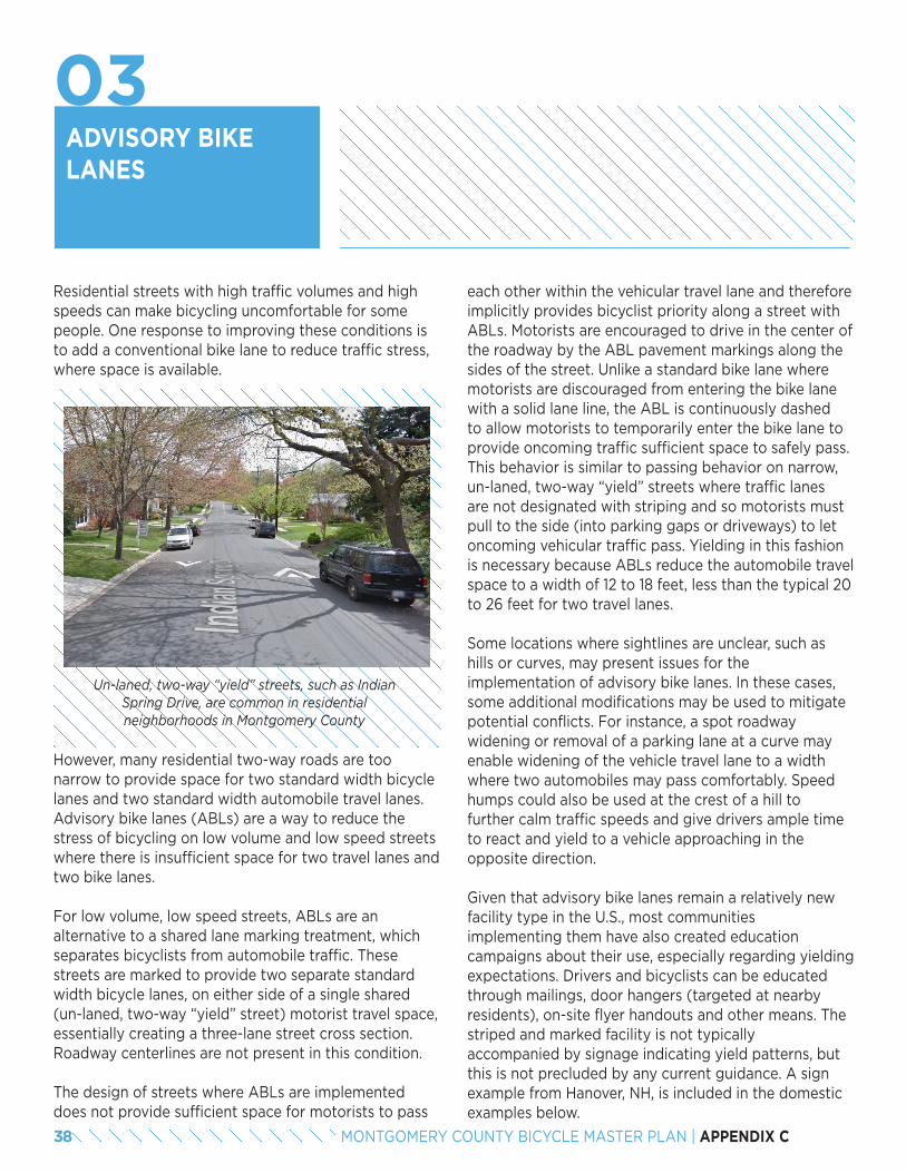
ADVISORY BIKELANES
Residential streets with high traffic volumes and high speeds can make bicycling uncomfortable for some people. One response to improving these conditions is to add a conventional bike lane to reduce traffic stress, where space is available.
each other within the vehicular travel lane and therefore implicitly provides bicyclist priority along a street with ABLs. Motorists are encouraged to drive in the center of the roadway by the ABL pavement markings along the sides of the street. Unlike a standard bike lane where motorists are discouraged from entering the bike lane with a solid lane line, the ABL is continuously dashed to allow motorists to temporarily enter the bike lane to provide oncoming traffic sufficient space to safely pass. This behavior is similar to passing behavior on narrow, un-laned, two-way “yield” streets where traffic lanes are not designated with striping and so motorists must pull to the side (into parking gaps or driveways) to let oncoming vehicular traffic pass. Yielding in this fashion is necessary because ABLs reduce the automobile travel space to a width of 12 to 18 feet, less than the typical 20 to 26 feet for two travel lanes.
Some locations where sightlines are unclear, such as hills or curves, may present issues for the implementation of advisory bike lanes. In these cases, some additional modifications may be used to mitigate potential conflicts. For instance, a spot roadway widening or removal of a parking lane at a curve may enable widening of the vehicle travel lane to a width where two automobiles may pass comfortably. Speed humps could also be used at the crest of a hill to further calm traffic speeds and give drivers ample time to react and yield to a vehicle approaching in the opposite direction.
Given that advisory bike lanes remain a relatively new facility type in the U.S., most communities implementing them have also created education campaigns about their use, especially regarding yielding expectations. Drivers and bicyclists can be educated through mailings, door hangers (targeted at nearby residents), on-site flyer handouts and other means. The striped and marked facility is not typically accompanied by signage indicating yield patterns, but this is not precluded by any current guidance. A sign example from Hanover, NH, is included in the domestic examples below.
Un-laned, two-way “yield” streets, such as Indian Spring Drive, are common in residential neighborhoods in Montgomery County
However, many residential two-way roads are too narrow to provide space for two standard width bicycle lanes and two standard width automobile travel lanes. Advisory bike lanes (ABLs) are a way to reduce the stress of bicycling on low volume and low speed streets where there is insufficient space for two travel lanes and two bike lanes.
For low volume, low speed streets, ABLs are an alternative to a shared lane marking treatment, which separates bicyclists from automobile traffic. These streets are marked to provide two separate standard width bicycle lanes, on either side of a single shared (un-laned, two-way “yield” street) motorist travel space, essentially creating a three-lane street cross section. Roadway centerlines are not present in this condition.
The design of streets where ABLs are implemented does not provide sufficient space for motorists to pass
38 MONTGOMERY COUNTY BICYCLE MASTER PLAN | APPENDIX C
03
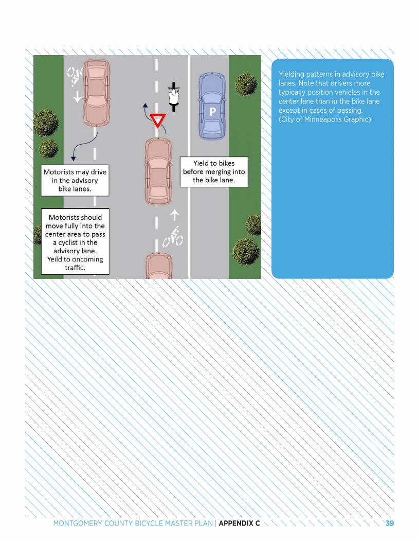
Yielding patterns in advisory bike lanes. Note that drivers more typically position vehicles in the center lane than in the bike lane except in cases of passing. (City of Minneapolis Graphic)
39MONTGOMERY COUNTY BICYCLE MASTER PLAN | APPENDIX C
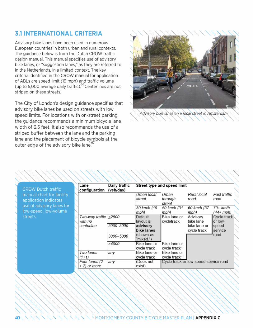
Advisory bike lanes on a local street in Amsterdam
3.1 INTERNATIONAL CRITERIAAdvisory bike lanes have been used in numerous European countries in both urban and rural contexts. The guidance below is from the Dutch CROW traffic design manual. This manual specifies use of advisory bike lanes, or “suggestion lanes,” as they are referred to in the Netherlands, in a limited context. The key criteria identified in the CROW manual for application of ABLs are speed limit (19 mph) and traffic volume (up to 5,000 average daily traffic). Centerlines are not striped on these streets.
The City of London’s design guidance specifies that advisory bike lanes be used on streets with low speed limits. For locations with on-street parking, the guidance recommends a minimum bicycle lane width of 6.5 feet. It also recommends the use of a striped buffer between the lane and the parking lane and the placement of bicycle symbols at the outer edge of the advisory bike lane.
66
67
CROW Dutch traffic manual chart for facility application indicates use of advisory lanes for low-speed, low-volume streets.
40 MONTGOMERY COUNTY BICYCLE MASTER PLAN | APPENDIX C
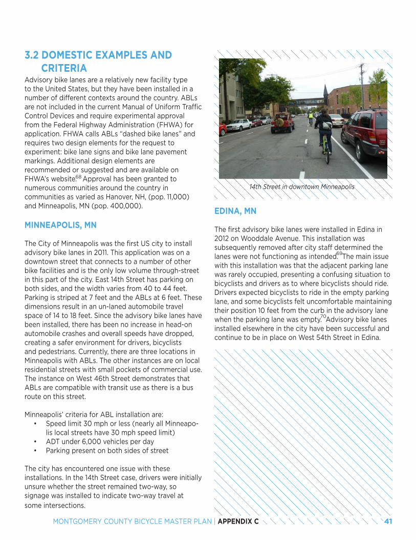
3.2 DOMESTIC EXAMPLES AND CRITERIAAdvisory bike lanes are a relatively new facility type to the United States, but they have been installed in a number of different contexts around the country. ABLs are not included in the current Manual of Uniform Traffic Control Devices and require experimental approval from the Federal Highway Administration (FHWA) for application. FHWA calls ABLs “dashed bike lanes” and requires two design elements for the request to experiment: bike lane signs and bike lane pavement markings. Additional design elements are recommended or suggested and are available on FHWA’s website. Approval has been granted to numerous communities around the country in communities as varied as Hanover, NH, (pop. 11,000) and Minneapolis, MN (pop. 400,000).
MINNEAPOLIS, MN
The City of Minneapolis was the first US city to install advisory bike lanes in 2011. This application was on a downtown street that connects to a number of other bike facilities and is the only low volume through-street in this part of the city. East 14th Street has parking on both sides, and the width varies from 40 to 44 feet. Parking is striped at 7 feet and the ABLs at 6 feet. These dimensions result in an un-laned automobile travel space of 14 to 18 feet. Since the advisory bike lanes have been installed, there has been no increase in head-on automobile crashes and overall speeds have dropped, creating a safer environment for drivers, bicyclists and pedestrians. Currently, there are three locations in Minneapolis with ABLs. The other instances are on local residential streets with small pockets of commercial use. The instance on West 46th Street demonstrates that ABLs are compatible with transit use as there is a bus route on this street.
Minneapolis’ criteria for ABL installation are:• Speed limit 30 mph or less (nearly all Minneapo-
lis local streets have 30 mph speed limit)• ADT under 6,000 vehicles per day• Parking present on both sides of street
The city has encountered one issue with these installations. In the 14th Street case, drivers were initially unsure whether the street remained two-way, so signage was installed to indicate two-way travel at some intersections.
68
14th Street in downtown Minneapolis
EDINA, MN
The first advisory bike lanes were installed in Edina in 2012 on Wooddale Avenue. This installation was subsequently removed after city staff determined the lanes were not functioning as intended. The main issue with this installation was that the adjacent parking lane was rarely occupied, presenting a confusing situation to bicyclists and drivers as to where bicyclists should ride. Drivers expected bicyclists to ride in the empty parking lane, and some bicyclists felt uncomfortable maintaining their position 10 feet from the curb in the advisory lane when the parking lane was empty. Advisory bike lanes installed elsewhere in the city have been successful and continue to be in place on West 54th Street in Edina.
69
70
41MONTGOMERY COUNTY BICYCLE MASTER PLAN | APPENDIX C
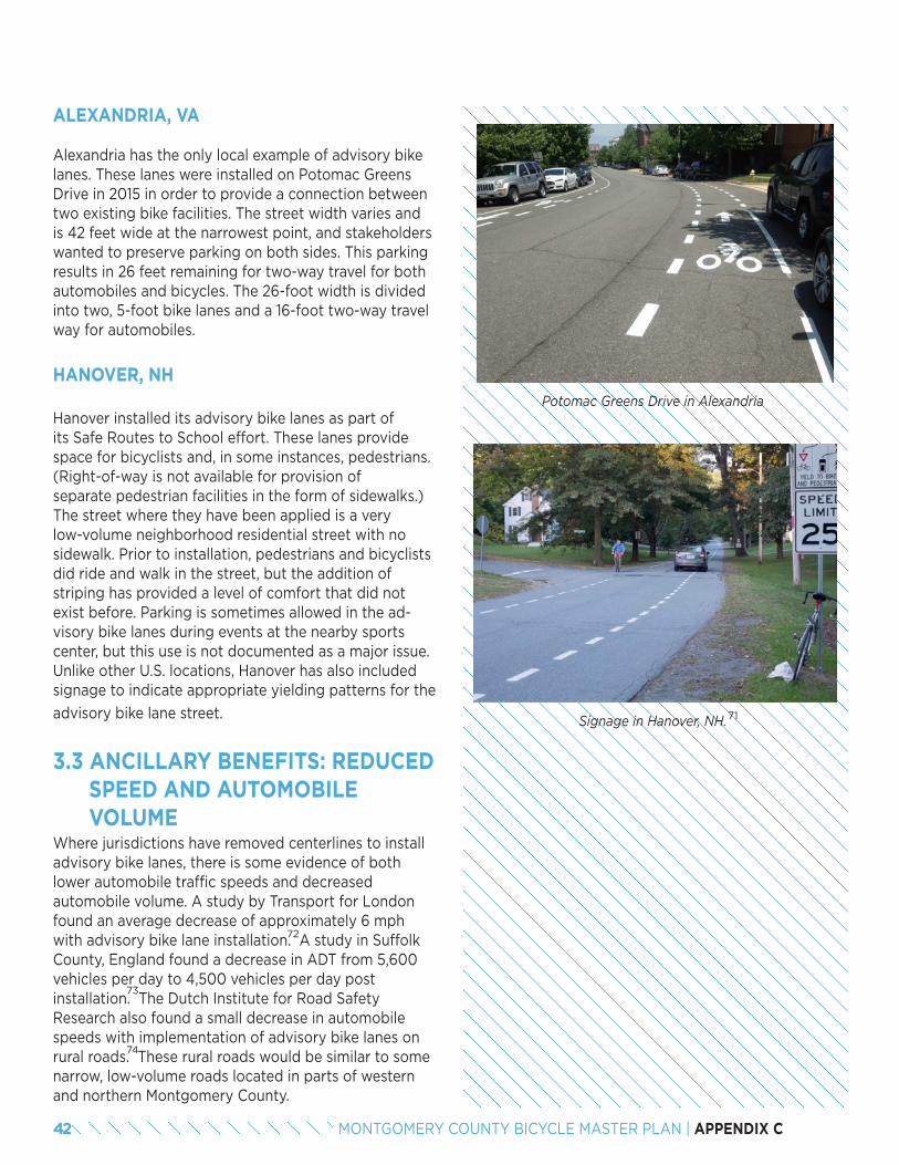
Signage in Hanover, NH.
ALEXANDRIA, VA
Alexandria has the only local example of advisory bike lanes. These lanes were installed on Potomac Greens Drive in 2015 in order to provide a connection between two existing bike facilities. The street width varies and is 42 feet wide at the narrowest point, and stakeholders wanted to preserve parking on both sides. This parking results in 26 feet remaining for two-way travel for both automobiles and bicycles. The 26-foot width is divided into two, 5-foot bike lanes and a 16-foot two-way travel way for automobiles.
71
Potomac Greens Drive in Alexandria
HANOVER, NH
Hanover installed its advisory bike lanes as part of its Safe Routes to School effort. These lanes provide space for bicyclists and, in some instances, pedestrians. (Right-of-way is not available for provision of separate pedestrian facilities in the form of sidewalks.) The street where they have been applied is a very low-volume neighborhood residential street with no sidewalk. Prior to installation, pedestrians and bicyclists did ride and walk in the street, but the addition of striping has provided a level of comfort that did not exist before. Parking is sometimes allowed in the ad-visory bike lanes during events at the nearby sports center, but this use is not documented as a major issue. Unlike other U.S. locations, Hanover has also included signage to indicate appropriate yielding patterns for the
advisory bike lane street.
3.3 ANCILLARY BENEFITS: REDUCED SPEED AND AUTOMOBILE VOLUMEWhere jurisdictions have removed centerlines to install advisory bike lanes, there is some evidence of both lower automobile traffic speeds and decreased automobile volume. A study by Transport for London found an average decrease of approximately 6 mph with advisory bike lane installation. A study in Suffolk County, England found a decrease in ADT from 5,600 vehicles per day to 4,500 vehicles per day post installation. The Dutch Institute for Road Safety Research also found a small decrease in automobile speeds with implementation of advisory bike lanes on rural roads. These rural roads would be similar to some narrow, low-volume roads located in parts of western and northern Montgomery County.
74
72
73
42 MONTGOMERY COUNTY BICYCLE MASTER PLAN | APPENDIX C
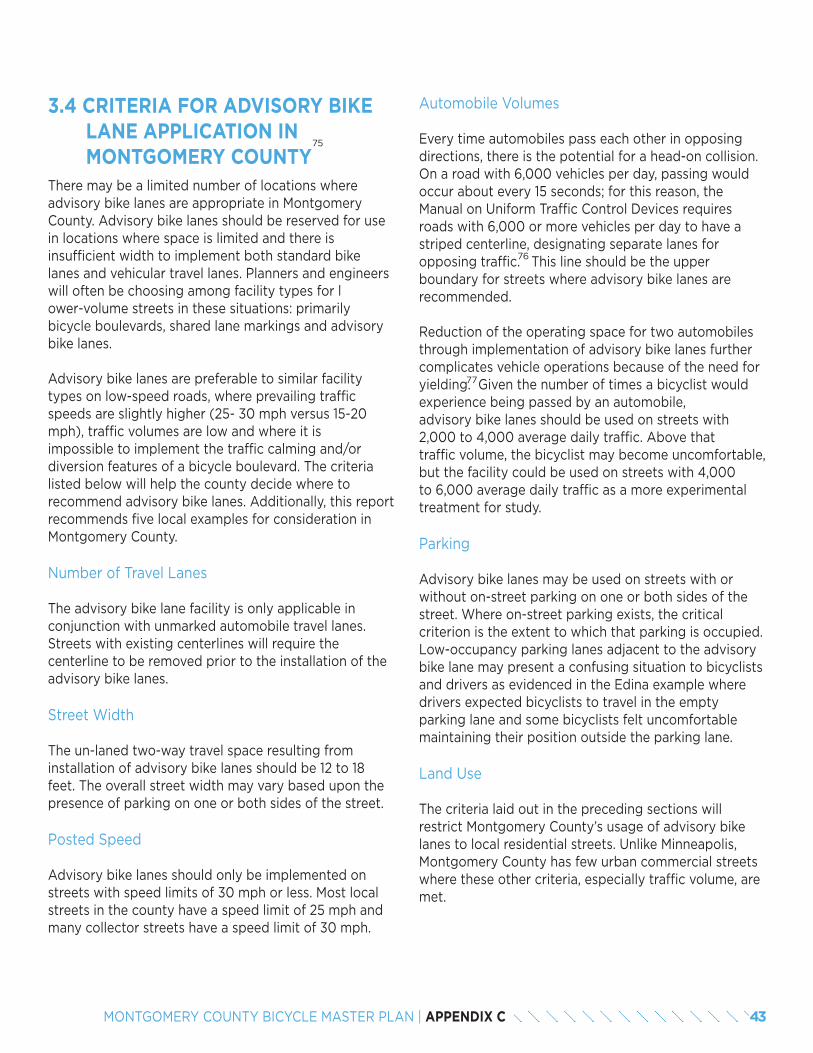
3.4 CRITERIA FOR ADVISORY BIKE LANE APPLICATION IN MONTGOMERY COUNTY There may be a limited number of locations where advisory bike lanes are appropriate in Montgomery County. Advisory bike lanes should be reserved for use in locations where space is limited and there is insufficient width to implement both standard bike lanes and vehicular travel lanes. Planners and engineers will often be choosing among facility types for lower-volume streets in these situations: primarily bicycle boulevards, shared lane markings and advisory bike lanes.
Advisory bike lanes are preferable to similar facility types on low-speed roads, where prevailing traffic speeds are slightly higher (25- 30 mph versus 15-20 mph), traffic volumes are low and where it is impossible to implement the traffic calming and/or diversion features of a bicycle boulevard. The criteria listed below will help the county decide where to recommend advisory bike lanes. Additionally, this report recommends five local examples for consideration in Montgomery County.
Number of Travel Lanes
The advisory bike lane facility is only applicable in conjunction with unmarked automobile travel lanes. Streets with existing centerlines will require the centerline to be removed prior to the installation of the advisory bike lanes.
Street Width
The un-laned two-way travel space resulting from installation of advisory bike lanes should be 12 to 18 feet. The overall street width may vary based upon the presence of parking on one or both sides of the street.
Posted Speed
Advisory bike lanes should only be implemented on streets with speed limits of 30 mph or less. Most local streets in the county have a speed limit of 25 mph and many collector streets have a speed limit of 30 mph.
75
Automobile Volumes
Every time automobiles pass each other in opposing directions, there is the potential for a head-on collision. On a road with 6,000 vehicles per day, passing would occur about every 15 seconds; for this reason, the Manual on Uniform Traffic Control Devices requires roads with 6,000 or more vehicles per day to have a striped centerline, designating separate lanes for opposing traffic. This line should be the upper boundary for streets where advisory bike lanes are recommended.
Reduction of the operating space for two automobiles through implementation of advisory bike lanes further complicates vehicle operations because of the need for yielding. Given the number of times a bicyclist would experience being passed by an automobile, advisory bike lanes should be used on streets with 2,000 to 4,000 average daily traffic. Above that traffic volume, the bicyclist may become uncomfortable, but the facility could be used on streets with 4,000 to 6,000 average daily traffic as a more experimental treatment for study.
Parking
Advisory bike lanes may be used on streets with or without on-street parking on one or both sides of the street. Where on-street parking exists, the critical criterion is the extent to which that parking is occupied. Low-occupancy parking lanes adjacent to the advisory bike lane may present a confusing situation to bicyclists and drivers as evidenced in the Edina example where drivers expected bicyclists to travel in the empty parking lane and some bicyclists felt uncomfortable maintaining their position outside the parking lane.
Land Use
The criteria laid out in the preceding sections will restrict Montgomery County’s usage of advisory bike lanes to local residential streets. Unlike Minneapolis, Montgomery County has few urban commercial streets where these other criteria, especially traffic volume, are met.
76
77
43MONTGOMERY COUNTY BICYCLE MASTER PLAN | APPENDIX C
CRITERIA SUMMARY
• Number of motorists travel lanes: Un-laned, bi- directional travel
• Street width: will vary, but must result in un-laned travel way of 12 to 18 feet
• Posted speed: 30 mph or less• Traffic volume: 2,000 to 4,000 average daily
traffic (ADT) recommended; 4,000 to 6,000 ADT for experimental treatment with evaluation
• On-street parking: If parking present, should be majority occupied majority of the time
• Lane use: Local residential streets
3.5 EXAMPLES OF ADVISORY BIKE LANES IN MONTGOMERY COUNTY
Several locations are possibilities for the application of advisory bike lanes. They were identified using the county’s bicycle level of traffic stress analysis, street width measurements and a review of speed limits, adjacent land use and network connectivity. These streets are provisional locations pending traffic counts that would validate the applicability of advisory bike lanes.
• Olney Mill Road from Olney Laytonsville Road (MD 108) to Gold Mine Road
• Whittier Boulevard from River Road (MD 190) to Wilson Lane (MD 188)
• Indian Spring Drive from Caroline Avenue to University Boulevard (MD 193)
• Lamberton Drive from Arcola Avenue to Charlton Drive
78
44 MONTGOMERY COUNTY BICYCLE MASTER PLAN | APPENDIX C
END NOTES66. CROW, Design Manual for Bicycle Traffic, p 108.67. http://content.tfl.gov.uk/lcds-chapter4-cyclelanesandtracks.pdf68. https://www.fhwa.dot.gov/environment/bicycle_pedestrian/guidance/mutcd/dashed_bike_lanes.cfm69. http://current.mnsun.com/2013/03/26/edina-council-agrees-to-change-wooddale-bike-lanes/70. http://streets.mn/2013/04/17/advisory-bike-lanes-on-wooddale-ave-to-be-removed/71. Copyright 2014 The Dartmouth, Inc. All rights reserved. Reprinted with Permission.72. http://content.tfl.gov.uk/centre-line-removal-trial.pdf73. http://www.apbp.org/?page=2009_2_Advisory74. http://www.swov.nl/rapport/R-2003-17.pdf75. Dimensional criteria for application is detailed in the Bicycle Facility Design Toolkit that identifies minimum and preferred dimensions, and the advantages and disadvantages of
different configurations.76. See Section 3B.01 Yellow Center Line Pavement Markings and Warrants, Standard 09.77. Minneapolis has not seen increased head-on collisions where advisory bike lanes have been implemented.78. Advisory bike lane widths both with and without on-street parking will be detailed in the design toolkit.
45MONTGOMERY COUNTY BICYCLE MASTER PLAN | APPENDIX C
ARE SEPARATED BIKE LANES A REPLACEMENT FOR DUAL BIKEWAYS?
The dual bikeway facility type was developed in the 2005 Montgomery County Bikeways Functional Master Plan to “meet the needs of the total range of bicyclists.” A dual bikeway consists of both an off-road sidepath and an on-road bicycle facility on the same street. In locations where space is available, the on-street facility is typically recommended to be a bike lane; where space is unavailable, the on-street facility it is typically recommended to be a signed shared roadway.
The dual bikeway facility type is unique to Montgomery County and was recommended in locations where the county wanted to provide separation from high-speed, high-volume traffic for what today the industry refers to as Interested but Concerned riders, those who are less comfortable riding in an unprotected facility on those types of streets. The additional bike lane or shared roadway facility was provided to accommodate riders who are comfortable riding near or sharing the road with high-speed, high-volume traffic, prefer to travel at a higher speed and do not want to be impeded by slower moving bicyclists and pedestrians.
The advent of separated bike lanes provides Montgomery County with a new tool for accommodating a wide range of cyclists. This report evaluates whether separated bike lanes are a replacement for the dual bikeway facility type in some or all situations.
4.1 APPLICABILITY OF SEPARATED BIKE LANES TO DIFFERENT BICYCLISTSBicyclists can be categorized based on how much separation from traffic is necessary for them to feel comfortable riding a bicycle. Interested but Concerned bicyclists express an interest in bicycling more, but are concerned for their safety. They require separation from traffic to feel comfortable riding on most non-residential roads. Separated bike lanes can be a replacement for the off-road portion of a dual bikeway since bicyclists are still physically separated from auto-mobile traffic.
Confident bicyclists require less separation from traffic to feel comfortable riding a bicycle. On high volume and high speed roads, many would be comfortable bicycling in a conventional bike lane and some would be comfortable bicycling in traffic. They tend to be more concerned about the ability to travel unimpeded by pedestrians than by the physical separation from traffic. If designed appropriately, separated bike lanes can appeal to many confident bicyclists. For those confident bicyclists who would otherwise ride in a conventional bike lane, a separated bike lane is appealing if it is wide enough to allow faster bicyclists to pass slower bicyclists.
For those confident commuter bicyclists who would otherwise ride in the street, separated bike lanes can be appealing if they are designed to provide the same quality of riding environment as the street. Commuting bicyclists often ride during peak periods when traffic volumes are at their highest, so higher speed travel (up to approximately 18 mph) and the ability to pass other bicyclists should be considered in the design process. Of course, some bicyclists in this group will always prefer riding in the street.
46 MONTGOMERY COUNTY BICYCLE MASTER PLAN | APPENDIX C
04
For those recreational bicyclists traveling in groups, a separated bike lane is inappropriate because the space is too confining for larger groups and higher speed bi-cycling. A group would potentially take over the entire width of a two-way separated bike lane, impeding oncoming traffic. The width of a one-way facility would not allow for the typical passing movements conducted within a group. Bicycling in the street would be more appropriate for this audience. These riders will also tend to ride on the high-volume, high-speed roads when traffic volumes are lower, such as weekend mornings, so the on-street facility will likely also be more comfortable.
In summary, if designed with sufficient separation from traffic, wide enough to enable passing and higher speed travel, separated bike lanes can be a replacement for dual bikeways for most Interested but Concerned bicyclists and many, but not all, confident bicyclists.
4.2 RECOMMENDATIONS FOR MONTGOMERY COUNTY
1. Discontinue use of the dual bikeway as a facility type and utilize separated bike lanes or shared use paths in their place.
When dual bikeways are recommended as a combined shared use path and bike lane, they may be difficult or infeasible to implement due to space constraints in many locations. Furthermore, separated bike lanes can be considered enhancements over conventional bike lanes when designed to enable passing.
As discussed in Section 5, signed shared roadways are not a bicycle facility type and are not recommended to be included in master plans. It is appropriate to use signs and pavement markings, such as “Bikes May Use the Full Lane” or sharrows, on roadways in Montgomery County, but these decisions should be made on a case-by-case basis at the time of implementation, not as part of the master planning process.
2. Select the appropriate separated bikeway type using the criteria established in Section 6.
Separated bike lanes are not always needed to replace dual bikeways. In fact, shared use paths may be more appropriate in many contexts than separated bike lanes.
Pedestrian demand along the study corridor should be the primary consideration for practitioners choosing
between the two facility types. Just as separation from automobiles enhances safety and comfort for people bicycling and driving, separation between people walking and bicycling may be necessary to eliminate potential conflicts and maintain a comfortable and attractive facility. Where observed or anticipated pedestrian demand is low, conflicts between people walking and bicycling may be infrequent. In this situation, a shared use path may comfortably and safely satisfy both bicycle and pedestrian demand. Where pedestrian volumes are observed or anticipated to be high, separate facilities should be provided for bicyclists.
Some corridors may transition from shared use paths to separated bike lanes as land use becomes more mixed or commercial, thus attracting higher pedestrian volumes. These transitions are likely along corridors that are largely residential with periodic commercial nodes at intersecting arterial streets.
3. Consider use of Bikes May Use Full Lane signage and/or sharrows where space constraints necessitate a shared use path rather than a separated bike lane.
The master plan should recommend a shared use path or separated bike lanes based on an understanding of available right-of-way and the level of pedestrian activity. In some locations, space may not be available currently to implement the recommended separated bike lane facility, and a shared use path could be constructed in the interim. Where this is the case, pedestrians and bicyclists will share limited space. On a case-by-case basis, the implementing agency should consider whether additional signage or markings on the street should be provided to notify drivers of the presence of bicyclists in the street who prefer to ride there than to share a congested path with pedestrians.
4. Consider use of Bikes May Use Full Lane signage and/or sharrows on known popular recreational group ride routes where separated bike lanes or shared use paths are provided.
The implementing agency should consider providing additional signage or markings on streets where shared use path or separated bike lanes are recommended in the master plan and are known popular recreational group ride routes. Many recreational riders who cycle these routes will do so during lower traffic off-peak periods and ride in the travel lane to move at higher speeds. Drivers will be reminded that bicyclists may be
47MONTGOMERY COUNTY BICYCLE MASTER PLAN | APPENDIX C
present on the roadway and that they should change lanes to pass.
5. Ensure separated bike lane and shared use path design standards specify high-quality materials and construction.
These facility types will only provide an adequate substitute for on-street facilities for all rider types if they are designed to provide as high quality an experience as the street. Some existing off-street facilities are not constructed to an adequate width or a quality such that all bicyclists view them as an adequate substitute for riding in the street. Proper width and construction can ensure that separated bike lanes or shared use paths are, in fact, replacements for dual bikeways. Separated bike lanes (whether in-street or outside the curb) and shared use paths should:
• Have proper drainage.• Be designed and constructed with a quality
subbase to minimize the development of surface defects and bumps over time, and to provide same or better quality of surface as the adjacent roadway.
• Avoid grade changes at driveway crossings.• Provide adequate width based on expected
volumes of bicyclists (and pedestrians).• Include appropriate intersection design.
6. Where existing curb-to-curb widths permit provision of bike lanes by lane diets, implement bike lanes as an interim facility before construction of a separated facility or where the existing sidepath is substandard.
Some confident bicyclists will feel comfortable in a bike lane facility even on high speed, high volume streets. Where it is possible to implement bike lanes cheaply and quickly, they should be added in locations where a separated facility is recommended in the master plan or already exists as a substandard sidepath. These decisions should be made at the time of implementation and bike lane space should be repurposed over time to provide the highest quality (widest pathway and buffer) sidepath or separated bike lane possible.
4.3 EXAMPLES WHERE SEPARATED BIKE LANES CAN REPLACE DUAL BIKEWAYS
The recommendations outlined above should be implemented consistently throughout the county on streets formerly identified as dual bikeways. The five corridors listed below were identified for dual bikeway facilities in the 2005 Master Plan. If the county desires to continue to include them in its master-planned bicycle network, separated bike lanes or shared use paths should be the recommended facility type.
Most of the length of these corridors consists of low-density residential land use where most residences front on adjacent streets. These areas are more appropriate for a shared use path since there are not many generators of short pedestrian trips nearby. For each of the five corridors below, locations are identified where the county may wish to indicate a separated bike lane facility instead because of anticipated higher pedestrian volumes.
University Boulevard from New Hampshire Avenue to Georgia Avenue
• Commercial nodes: Columbia Pike, Georgia Avenue, New Hampshire Avenue
• School areas: Eastern Middle School, Montgomery Blair High School, Northwood High School
River Road from Western Avenue to Seven Locks Road
• Commercial node: Little Falls Parkway/Bethesda
Germantown Road from Clopper Road to Frederick Road
• Commercial node: Middlebrook Road
New Hampshire Avenue from Prince George’s County to Lockwood Drive
• Commercial/mixed use node: White Oak• Commercial node: University Boulevard, Ethan
Allen Avenue
Norbeck Road from Georgia Avenue to Layhill Road
• Currently no major pedestrian generators
48 MONTGOMERY COUNTY BICYCLE MASTER PLAN | APPENDIX C
HOW SHOULD MONTGOMERY COUNTY USE SIGNED SHARED ROADWAYS IN MASTER PLANS?
Signed shared roadways are streets that are shared by both bicycles and motor vehicles. In Montgomery County, signed shared roadways are typically implemented with wide outside curb lanes (to provide space for motorists to pass bicyclists within the lane), bikeable shoulders on the side of the road, shared lane (“sharrow”) pavement markings or on low volume / low speed streets.
As Montgomery County moves forward with a new Bicycle Master Plan that focuses on creating a connected, low-stress network, there is a question as to whether to maintain the signed shared roadway as a master-planned bikeway facility. This report discusses the purpose of signed shared roadways, provides an overview of national guidance, evaluates the current use of signed shared roadways in Montgomery County, presents treatments that implement the signed shared roadway designation and provides a recommendation for the county’s use of the designation moving forward.
5.1 PURPOSE OF SIGNED SHAREDROADWAYS
Signed shared roadways serve three functions for bicy-clists:
• Provide wayfinding• Are identified on a public bicycle map• Provide some type of treatment on the roadway
such as a sharrow and/or regulatory signage in the form of “Bikes May Use Full Lane” signs.
The first function, wayfinding, is helpful for bicyclists who are unfamiliar with the bike network. Wayfinding planning involves the identification of existing good bike routes and development of a detailed signage plan, whereas network master planning identifies the locations for future roadway improvements for bicyclists. Because of these differing goals, the two planning processes are best completed separately. Since it will likely take 10 to 20 years to implement many of the recommendations in the Bicycle Master Plan, a separate wayfinding plan is needed to help direct bicyclists to major countywide facilities recommended in the master plan. Furthermore, in Montgomery County, wayfinding and network planning are each overseen by different agencies (Montgomery County Department of Transportation and Montgomery County Planning Department, respectively).
49MONTGOMERY COUNTY BICYCLE MASTER PLAN | APPENDIX C
05
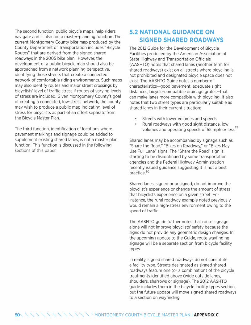
The second function, public bicycle maps, help riders navigate and is also not a master-planning function. The current Montgomery County bike map produced by the County Department of Transportation includes “Bicycle Routes” that are derived from the signed shared roadways in the 2005 bike plan. However, the development of a public bicycle map should also be approached from a network planning perspective, identifying those streets that create a connected network of comfortable riding environments. Such maps may also identify routes and major street crossings by bicyclists’ level of traffic stress if routes of varying levels of stress are included. Given Montgomery County’s goal of creating a connected, low-stress network, the county may wish to produce a public map indicating level of stress for bicyclists as part of an effort separate from the Bicycle Master Plan.
The third function, identification of locations where pavement markings and signage could be added to supplement existing shared lanes, is not a master plan function. This function is discussed in the following sections of this paper.
5.2 NATIONAL GUIDANCE ON SIGNED SHARED ROADWAYSThe 2012 Guide for the Development of Bicycle Facilities produced by the American Association of State Highway and Transportation Officials (AASHTO) notes that shared lanes (another term for shared roadways) exist on all streets where bicycling is not prohibited and designated bicycle space does not exist. The AASHTO Guide notes a number of characteristics—good pavement, adequate sight distances, bicycle-compatible drainage grates—that can make lanes more compatible with bicycling. It also notes that two street types are particularly suitable as shared lanes in their current situation:
• Streets with lower volumes and speeds.• Rural roadways with good sight distance, low
volumes and operating speeds of 55 mph or less.
Shared lanes may be accompanied by signage such as “Share the Road,” “Bikes on Roadway,” or “Bikes May Use Full Lane” signs. The “Share the Road” sign is starting to be discontinued by some transportation agencies and the Federal Highway Administration recently issued guidance suggesting it is not a best practice.
Shared lanes, signed or unsigned, do not improve the bicyclist’s experience or change the amount of stress that bicyclists experience on a given street. For instance, the rural roadway example noted previously would remain a high-stress environment owing to the speed of traffic.
The AASHTO guide further notes that route signage alone will not improve bicyclists’ safety because the signs do not provide any geometric design changes. In the upcoming update to the Guide, route wayfinding signage will be a separate section from bicycle facility types.
In reality, signed shared roadways do not constitute a facility type. Streets designated as signed shared roadways feature one (or a combination) of the bicycle treatments identified above (wide outside lanes, shoulders, sharrows or signage). The 2012 AASHTO guide includes them in the bicycle facility types section, but the future update will move signed shared roadways to a section on wayfinding.
79
80
50 MONTGOMERY COUNTY BICYCLE MASTER PLAN | APPENDIX C
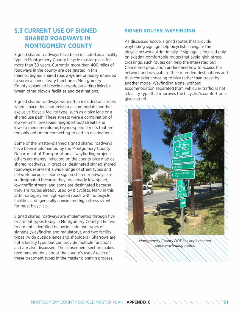
5.3 CURRENT USE OF SIGNEDSHARED ROADWAYS IN MONTGOMERY COUNTY
Signed shared roadways have been included as a facility type in Montgomery County bicycle master plans for more than 30 years. Currently, more than 400 miles of roadways in the county are designated in this manner. Signed shared roadways are primarily intended to serve a connectivity function in Montgomery County’s planned bicycle network, providing links be-tween other bicycle facilities and destinations.
Signed shared roadways were often included on streets where space does not exist to accommodate another exclusive bicycle facility type, such as a bike lane or a shared use path. These streets were a combination of low-volume, low-speed neighborhood streets and low- to medium-volume, higher-speed streets that are the only option for connecting to certain destinations.
Some of the master-planned signed shared roadways have been implemented by the Montgomery County Department of Transportation as wayfinding projects, others are merely indicated on the county bike map as shared roadways. In practice, designated signed shared roadways represent a wide range of street types and network purposes. Some signed shared roadways are so designated because they are already low-speed, low-traffic streets, and some are designated because they are routes already used by bicyclists. Many in this latter category are high-speed roads with no bicycle facilities and generally considered high-stress streets for most bicyclists.
Signed shared roadways are implemented through five treatment types today in Montgomery County. The five treatments identified below include two types of signage (wayfinding and regulatory), and two facility types (wide outside lanes and shoulders). Sharrows are not a facility type, but can provide multiple functions and are also discussed. The subsequent section makes recommendations about the county’s use of each of these treatment types in the master planning process.
SIGNED ROUTES: WAYFINDING
As discussed above, signed routes that provide wayfinding signage help bicyclists navigate the bicycle network. Additionally, if signage is focused only on existing comfortable routes that avoid high-stress crossings, such routes can help the Interested but Concerned population understand how to access the network and navigate to their intended destinations and thus consider choosing to bike rather than travel by another mode. Wayfinding alone, without accommodation separated from vehicular traffic, is not a facility type that improves the bicyclist’s comfort on a given street.
Montgomery County DOT has implemented some wayfinding routes
51MONTGOMERY COUNTY BICYCLE MASTER PLAN | APPENDIX C
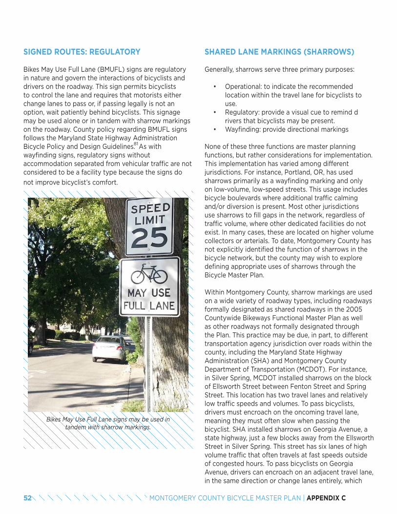
SIGNED ROUTES: REGULATORY
Bikes May Use Full Lane (BMUFL) signs are regulatory in nature and govern the interactions of bicyclists and drivers on the roadway. This sign permits bicyclists to control the lane and requires that motorists either change lanes to pass or, if passing legally is not an option, wait patiently behind bicyclists. This signage may be used alone or in tandem with sharrow markings on the roadway. County policy regarding BMUFL signs follows the Maryland State Highway Administration Bicycle Policy and Design Guidelines. As with wayfinding signs, regulatory signs without accommodation separated from vehicular traffic are not considered to be a facility type because the signs do
not improve bicyclist’s comfort.
Bikes May Use Full Lane signs may be used in tandem with sharrow markings.
SHARED LANE MARKINGS (SHARROWS)
Generally, sharrows serve three primary purposes:
• Operational: to indicate the recommended location within the travel lane for bicyclists to use.
• Regulatory: provide a visual cue to remind d rivers that bicyclists may be present.
• Wayfinding: provide directional markings
None of these three functions are master planning functions, but rather considerations for implementation. This implementation has varied among different jurisdictions. For instance, Portland, OR, has used sharrows primarily as a wayfinding marking and only on low-volume, low-speed streets. This usage includes bicycle boulevards where additional traffic calming and/or diversion is present. Most other jurisdictions use sharrows to fill gaps in the network, regardless of traffic volume, where other dedicated facilities do not exist. In many cases, these are located on higher volume collectors or arterials. To date, Montgomery County has not explicitly identified the function of sharrows in the bicycle network, but the county may wish to explore defining appropriate uses of sharrows through the Bicycle Master Plan.
Within Montgomery County, sharrow markings are used on a wide variety of roadway types, including roadways formally designated as shared roadways in the 2005 Countywide Bikeways Functional Master Plan as well as other roadways not formally designated through the Plan. This practice may be due, in part, to different transportation agency jurisdiction over roads within the county, including the Maryland State Highway Administration (SHA) and Montgomery County Department of Transportation (MCDOT). For instance, in Silver Spring, MCDOT installed sharrows on the block of Ellsworth Street between Fenton Street and Spring Street. This location has two travel lanes and relatively low traffic speeds and volumes. To pass bicyclists, drivers must encroach on the oncoming travel lane, meaning they must often slow when passing the bicyclist. SHA installed sharrows on Georgia Avenue, a state highway, just a few blocks away from the Ellsworth Street in Silver Spring. This street has six lanes of high volume traffic that often travels at fast speeds outside of congested hours. To pass bicyclists on Georgia Avenue, drivers can encroach on an adjacent travel lane, in the same direction or change lanes entirely, which
81
52 MONTGOMERY COUNTY BICYCLE MASTER PLAN | APPENDIX C
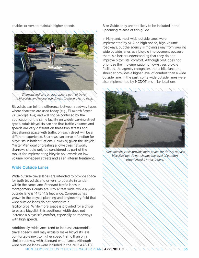
enables drivers to maintain higher speeds.
Sharrows indicate an appropriate path of travel to bicyclists and encourage drivers to move over to pass.
Bicyclists can tell the difference between roadway types where sharrows are used today (e.g., Ellsworth Street vs. Georgia Ave) and will not be confused by the application of the same facility on widely varying street types. Adult bicyclists can see that traffic volumes and speeds are very different on these two streets and that sharing space with traffic on each street will be a different experience. Sharrows can serve a function for bicyclists in both situations. However, given the Bicycle Master Plan goal of creating a low-stress network, sharrows should only be considered as part of the toolkit for implementing bicycle boulevards on low-volume, low-speed streets and as an interim treatment.
Wide Outside Lanes
Wide outside travel lanes are intended to provide space for both bicyclists and drivers to operate in tandem within the same lane. Standard traffic lanes in Montgomery County are 11 to 12 feet wide, while a wide outside lane is 14 to 14.5 feet wide. Consensus has grown in the bicycle planning and engineering field that wide outside lanes do not constitute a facility type. While more space is provided for a driver to pass a bicyclist, this additional width does not increase a bicyclist’s comfort, especially on roadways with high speeds.
Additionally, wide lanes tend to increase automobile travel speeds, and may actually make bicyclists less comfortable next to higher speed traffic than on a similar roadway with standard width lanes. Although wide outside lanes were included in the 2012 AASHTO
Bike Guide, they are not likely to be included in the upcoming release of this guide.
In Maryland, most wide outside lanes were implemented by SHA on high-speed, high-volume roadways, but the agency is moving away from viewing wide outside lanes as a bicycle improvement because there is a better understanding that they do not improve bicyclists’ comfort. Although SHA does not prioritize the implementation of low-stress bicycle facilities, the agency recognizes that a bike lane or a shoulder provides a higher level of comfort than a wide outside lane. In the past, some wide outside lanes were also implemented by MCDOT in similar locations.
Wide outside lanes provide more space for drivers to pass bicyclists but do not change the level of comfort
experienced by most riders.
53MONTGOMERY COUNTY BICYCLE MASTER PLAN | APPENDIX C
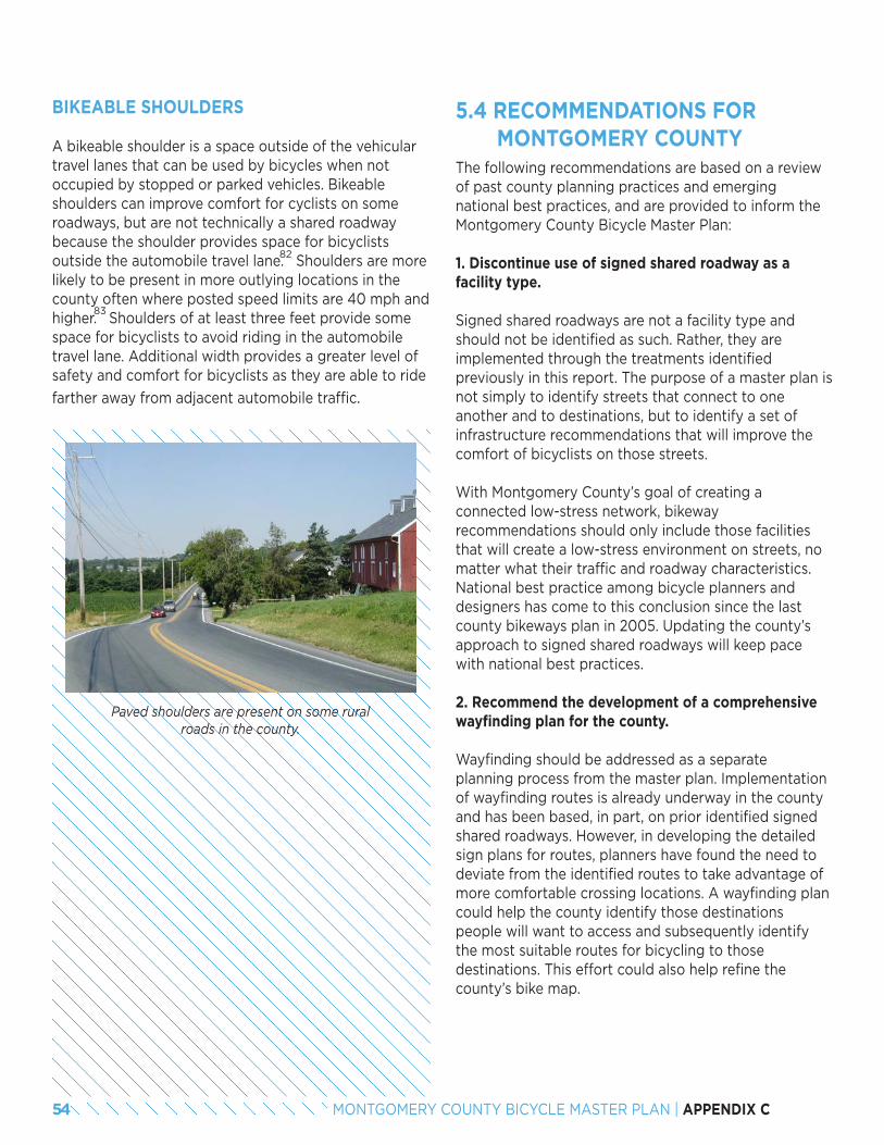
Paved shoulders are present on some rural roads in the county.
BIKEABLE SHOULDERS
A bikeable shoulder is a space outside of the vehicular travel lanes that can be used by bicycles when not occupied by stopped or parked vehicles. Bikeable shoulders can improve comfort for cyclists on some roadways, but are not technically a shared roadway because the shoulder provides space for bicyclists outside the automobile travel lane. Shoulders are more likely to be present in more outlying locations in the county often where posted speed limits are 40 mph and higher. Shoulders of at least three feet provide some space for bicyclists to avoid riding in the automobile travel lane. Additional width provides a greater level of safety and comfort for bicyclists as they are able to ride
farther away from adjacent automobile traffic.
5.4 RECOMMENDATIONS FOR MONTGOMERY COUNTYThe following recommendations are based on a review of past county planning practices and emerging national best practices, and are provided to inform the Montgomery County Bicycle Master Plan:
1. Discontinue use of signed shared roadway as a facility type.
Signed shared roadways are not a facility type and should not be identified as such. Rather, they are implemented through the treatments identified previously in this report. The purpose of a master plan is not simply to identify streets that connect to one another and to destinations, but to identify a set of infrastructure recommendations that will improve the comfort of bicyclists on those streets.
With Montgomery County’s goal of creating a connected low-stress network, bikeway recommendations should only include those facilities that will create a low-stress environment on streets, no matter what their traffic and roadway characteristics. National best practice among bicycle planners and designers has come to this conclusion since the last county bikeways plan in 2005. Updating the county’s approach to signed shared roadways will keep pace with national best practices.
2. Recommend the development of a comprehensive wayfinding plan for the county.
Wayfinding should be addressed as a separate planning process from the master plan. Implementation of wayfinding routes is already underway in the county and has been based, in part, on prior identified signed shared roadways. However, in developing the detailed sign plans for routes, planners have found the need to deviate from the identified routes to take advantage of more comfortable crossing locations. A wayfinding plan could help the county identify those destinations people will want to access and subsequently identify the most suitable routes for bicycling to those destinations. This effort could also help refine the county’s bike map.
82
83
54 MONTGOMERY COUNTY BICYCLE MASTER PLAN | APPENDIX C
3. Discontinue use of signed routes in the master plan.
Neither regulatory signage alone in the form of Bikes May Use Full Lane signs, nor wayfinding signs improve the comfort or connectivity of streets. The identification of signed routes should be completed through a way-finding plan. Montgomery County may wish to consider use of Bike May Use the Full Lanesigns on a case-by-case basis as discussed in the dual bikeways section of this report.
4. Discontinue use of wide outside lanes as a facility type.
Wide outside lanes do not improve the comfort of a road for bicyclists and may, in fact, decrease comfort by leading to increased automobile travel speeds. This facility type is incompatible with the county’s goal of providing a low-stress network. The county should consider restriping wide outside lanes as narrowed lanes with shoulders if three feet are available for shoulder width. Striped shoulders have been shown to increase bicyclists’ comfort even if the total width of the outside lane and shoulder are the same as a wide outside lane, such as an 11-foot travel lane and 3-foot shoulder versus a 14-foot travel lane.
5. Develop a sharrow use policy.
Montgomery County currently does not define the purpose of shared lane markings in its network. The county should develop a sharrow use policy and may frame that policy based upon two uses – as part of bicycle boulevards and as an interim treatment. Both of these uses will be decided by the implementing agency at the time of facility design and are not expected to be outlined in the Bicycle Master Plan. Sharrows may be appropriate in a range of situations, but should not be recommended as an independent facility type in this Master Plan.
Sharrows may be a treatment option on low-volume, low-speed streets designated as bicycle boulevards. In this context, sharrows can serve a wayfinding function and also reinforce bicyclists’ right to control the lane.
Additionally, sharrows may be a treatment that is used as an interim marking on streets master-planned for other facilities. For instance, a street may be designated for a separated bike lane and serve a critical network function in connecting to major destinations or other
pieces of the bicycle network. However, implementation of the separated bike lane may take years, and in the intervening time, a sharrow can help a segment of the bicycling population navigate high-speed, high-volume roads. The sharrow marking would indicate to drivers that they should expect bicyclists and should change lanes to pass.
6. Recommend other bicycle facilities on some local streets formerly identified as signed shared roadways.
Connectivity is one of the most important characteristics of a bicycle network. Signed shared roadway recommendations in the past have consisted, in part, of local streets that are already comfortable for bicycling. However, these route recommendations are not restricted to those fully connected low-stress routes with comfortable crossings of major streets. Bicycle boulevard, advisory bike lane and/or sharrow recommendations should appear as part of the county’s network to improve the comfort of streets. Additionally, the plan should identify those locations where crossing improvements (i.e., signals, medians, crosswalks, etc.) are necessary to provide low-stress crossings that connect low-stress streets to one another.
84
55MONTGOMERY COUNTY BICYCLE MASTER PLAN | APPENDIX C

END NOTES79. Note: Maryland state law prohibits bicycling on roads with speed limits greater than 50 mph. While bicyclists may use the shoulder on these roads, they may only enter travel
lanes if making a left turn, crossing the roadway or if the shoulder is overlaid with a right turn lane, a merge lane, a bypass lane or any other marking that breaks the continuity of the shoulder.
80. http://mutcd.fhwa.dot.gov/knowledge/faqs/faq_part9.htm#signsq581. http://roads.maryland.gov/ohd2/bike_policy_and_design_guide.pdf82. Implementation of bikeable shoulders is often inconsistent, resulting in variable effective widths for bicycle operation. As a result, bicyclists will often be forced to transition into
the automobile travel lane, where shoulders narrow or drop, and share the lane with automobiles.83. These speeds create higher stress levels for most bicyclists, but riders who are more tolerant of higher traffic stress may be comfortable on roads with higher speeds where
either traffic volume is low or shoulders are present.84. The Bicycle Level of Service methodology says that riders who were part of that study indicate an increased level of comfort with shoulder striping. This may not increase com-
fort for all riders, but some, likely more confident riders, will feel more comfortable in the restriped context.
56 MONTGOMERY COUNTY BICYCLE MASTER PLAN | APPENDIX C
SEPARATED BIKE LANES VERSUS SHARED USE PATHS
6.1 RECOMMENDATIONS FOR MONTGOMERY COUNTYThe decision to provide a shared or separated bicycle space should be supported by a planning process to analyze benefits and tradeoffs, facility configuration and feasibility, given corridor constraints. The following discussion outlines the critical considerations for choosing between a separated bike lane and a shared use path facility.
It should be noted that these criteria are general in nature and leave many design decisions to the planners and designers at time of facility implementation. Additional factors, such as right-of-way availability, utility location constraints, adjacent property owners’ desires and others, will weigh in the decision between implementation of a separated bike lane or a shared use path. These recommendations provide a general framework for considering this choice.
Additionally, planners should use these recommendations with an eye toward anticipated and desired pedestrian and bicycle volumes on a given corridor. A given corridor today may not have high pedestrian volumes, but with the addition of more varied and active land uses, that volume may change. Planners should also note that future separated bike facilities may encourage more bicycle trips by helping additional people choose to bicycle for their trips rather than driving. A lack of bicyclists today in a corridor should not be an indication of a lack of latent demand.
Considerations for Separated Bike Lane versus Shared Use Path Choice
Pedestrian demand along the study corridor should be the primary consideration for planners. Just as separation from automobiles enhances safety and comfort for people bicycling and driving, separation between people walking and bicycling may be necessary to eliminate potential conflicts and maintain
Once the decision to provide physical separation from traffic is made, planners must then determine whether to provide a separated bike lane or a shared use path. Separated bike lanes and shared use paths are both critical components of low-stress bicycling networks that are designed to appeal to all ages and bicycling abilities. Both increase the safety, comfort and attractiveness of the bicycling environment by physically separating bicyclists from motor vehicle traffic. Both facilitate direct and convenient connections to destinations, transit services and other bicycle facilities. However, each has practical differences in context, design and application.
Separated bike lanes are an exclusive space for bicyclists along or within a roadway that is physically separated from automobiles and pedestrians by vertical and horizontal elements. Separated bike lanes may be constructed as a one-way pair located on both sides of the street in the direction of travel, or they may be constructed as a two-way bikeway.
Two-way separated bike lanes can also be constructed in the center of a two-way street; however, this design is generally not preferred because it creates more potential points of conflicts between turning automobiles and bicycles, separates bicyclists from destinations along the roadway, and places bicyclists between opposing directions of traffic. Space constraints will often dictate which facility is feasible in retrofit situations where moving curbs or expansion of the right-of-way is not possible. Design considerations for separated bike lane configurations are addressed in the bicycle facility design toolkit.
Shared use paths provide a shared space for all non-motorized users (e.g., people bicycling, walking, jogging, skating, etc.). They are often referred to as sidepaths when parallel to a roadway within the right-of-way or trails when located along another alignment. Shared use paths provide for two-way travel in all cases and are often marked with a centerline to distinguish directionality.
57MONTGOMERY COUNTY BICYCLE MASTER PLAN | APPENDIX C
06
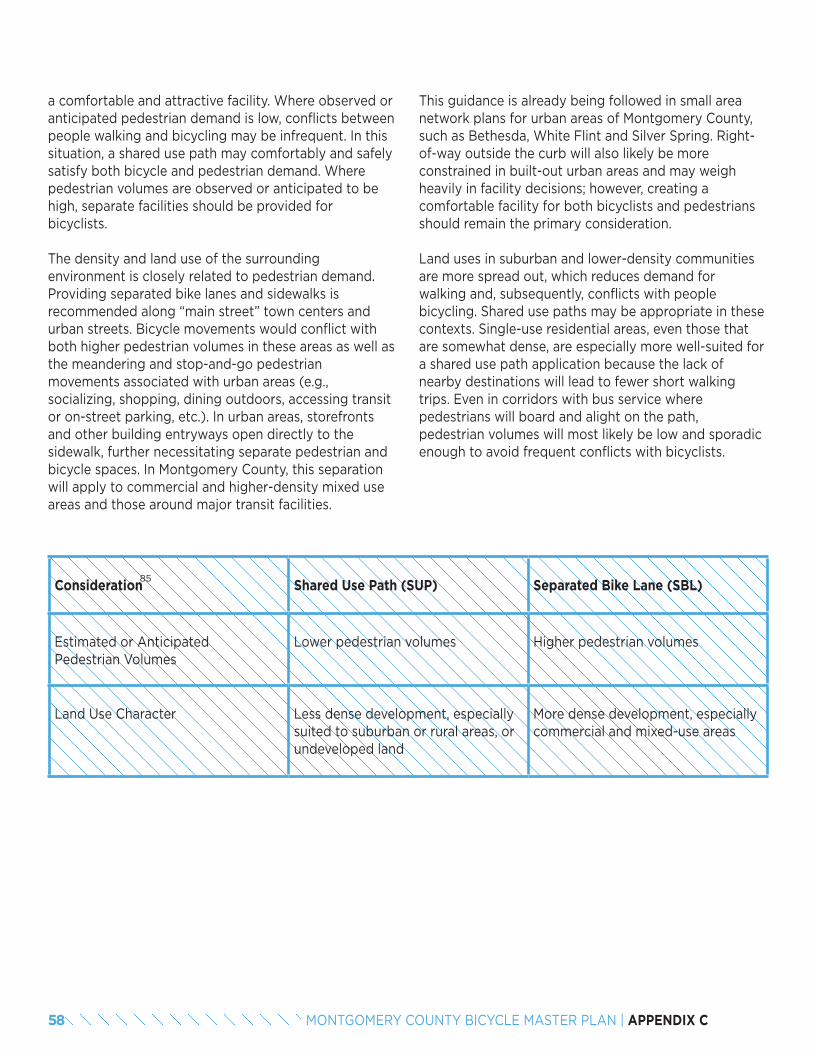
a comfortable and attractive facility. Where observed or anticipated pedestrian demand is low, conflicts between people walking and bicycling may be infrequent. In this situation, a shared use path may comfortably and safely satisfy both bicycle and pedestrian demand. Where pedestrian volumes are observed or anticipated to be high, separate facilities should be provided for bicyclists.
The density and land use of the surrounding environment is closely related to pedestrian demand. Providing separated bike lanes and sidewalks is recommended along “main street” town centers and urban streets. Bicycle movements would conflict with both higher pedestrian volumes in these areas as well as the meandering and stop-and-go pedestrian movements associated with urban areas (e.g., socializing, shopping, dining outdoors, accessing transit or on-street parking, etc.). In urban areas, storefronts and other building entryways open directly to the sidewalk, further necessitating separate pedestrian and bicycle spaces. In Montgomery County, this separation will apply to commercial and higher-density mixed use areas and those around major transit facilities.
This guidance is already being followed in small area network plans for urban areas of Montgomery County, such as Bethesda, White Flint and Silver Spring. Right-of-way outside the curb will also likely be more constrained in built-out urban areas and may weigh heavily in facility decisions; however, creating a comfortable facility for both bicyclists and pedestrians should remain the primary consideration.
Land uses in suburban and lower-density communities are more spread out, which reduces demand for walking and, subsequently, conflicts with people bicycling. Shared use paths may be appropriate in these contexts. Single-use residential areas, even those that are somewhat dense, are especially more well-suited for a shared use path application because the lack of nearby destinations will lead to fewer short walking trips. Even in corridors with bus service where pedestrians will board and alight on the path, pedestrian volumes will most likely be low and sporadic enough to avoid frequent conflicts with bicyclists.
Consideration Shared Use Path (SUP) Separated Bike Lane (SBL)
Estimated or Anticipated Pedestrian Volumes
Lower pedestrian volumes Higher pedestrian volumes
Land Use Character Less dense development, especially suited to suburban or rural areas, or undeveloped land
More dense development, especially commercial and mixed-use areas
85
58 MONTGOMERY COUNTY BICYCLE MASTER PLAN | APPENDIX C
6.2 EXAMPLE APPLICATION IN MONTGOMERY COUNTY: FALLS ROADFalls Road (MD 189) is a two-lane arterial in the southwestern portion of Montgomery County. It connects MacArthur Boulevard at the western end to Maryland Avenue at the eastern end approaching downtown Rockville. The street expands to a median-separated, four-lane cross section as it approaches Interstate-270 and narrows again on the approach to Rockville.
The posted speed limit is 35 mph, and shoulder width on both sides of the road varies frequently between approximately one to four feet. These characteristics make Falls Road a high stress road today. A shared use path of a substandard width exists on Falls Road from MacArthur Boulevard to River Road. Another, wider section of shared use path exists from Dunster Road to Wooton Parkway. These two facilities provide a lower stress bicycling environment in those segments, but they are disconnected.
Land uses along Falls Road ares primarily single-family residential (fronting on side streets) along its approximately seven-mile length, with the exception of the commercial center at Potomac Village and interspersed school, religious and recreational uses (e.g., Falls Road Golf Course, Falls Road Park). Pedestrian volumes are low along the corridor; little commercial use is located nearby that would generate short pedestrian trips except in Potomac Village and the existing shared use paths for recreational use. Pedestrian volume is also generated along the corridor from county RideOn buses 47 and 56 close to Rockville, and Washington Metropolitan Area Transit Authority bus T2 from River Road north.
Given the low-density land use characteristics and low anticipated volumes of pedestrians along the Falls Road corridor, the appropriate bicycle facility would likely be a shared use path. A shared facility here would enable both bicyclists and pedestrians to utilize the facility with little anticipated conflict. Additionally, such a facility would provide access to destinations mentioned above and to the existing shared use path network.
END NOTES85. An additional criterion often raised is the presence and frequency of driveway
crossings. Both separated bike lanes and shared use paths can be designed to standards that minimize and mitigate conflicts between bicyclists and drivers at these crossings. Drivers entering/existing driveways may encounter bicyclists along the road edge in bike lanes or in a shared lane situation as well. Driveway frequency may, however, be one criterion when choosing a side of the street for construction of a two-way separated bike lane or a shared use path. This frequency must be weighed against bicyclists’ access to the destinations for which the facility is constructed in the first place.
59MONTGOMERY COUNTY BICYCLE MASTER PLAN | APPENDIX C
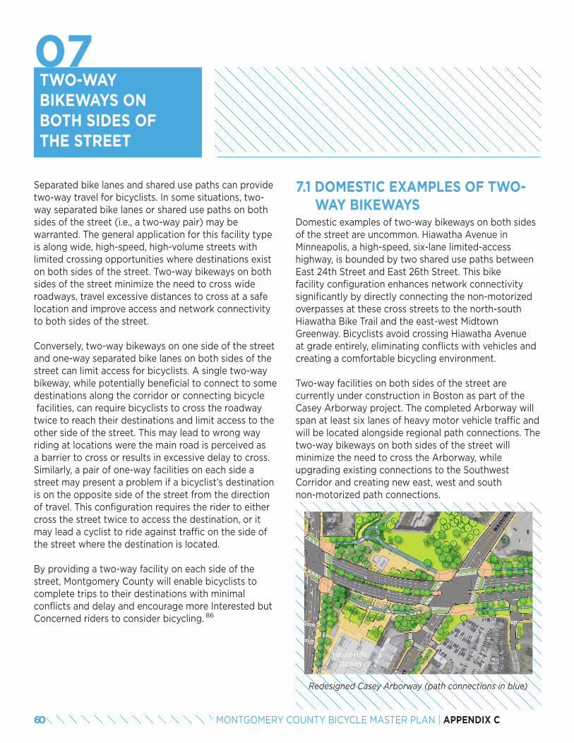
TWO-WAY BIKEWAYS ON BOTH SIDES OF THE STREET
7.1 DOMESTIC EXAMPLES OF TWO- WAY BIKEWAYSDomestic examples of two-way bikeways on both sides of the street are uncommon. Hiawatha Avenue in Minneapolis, a high-speed, six-lane limited-access highway, is bounded by two shared use paths between East 24th Street and East 26th Street. This bike facility configuration enhances network connectivity significantly by directly connecting the non-motorized overpasses at these cross streets to the north-south Hiawatha Bike Trail and the east-west Midtown Greenway. Bicyclists avoid crossing Hiawatha Avenue at grade entirely, eliminating conflicts with vehicles and creating a comfortable bicycling environment.
Two-way facilities on both sides of the street are currently under construction in Boston as part of the Casey Arborway project. The completed Arborway will span at least six lanes of heavy motor vehicle traffic and will be located alongside regional path connections. The two-way bikeways on both sides of the street will minimize the need to cross the Arborway, while upgrading existing connections to the Southwest Corridor and creating new east, west and south non-motorized path connections.
Separated bike lanes and shared use paths can provide two-way travel for bicyclists. In some situations, two-way separated bike lanes or shared use paths on both sides of the street (i.e., a two-way pair) may be warranted. The general application for this facility type is along wide, high-speed, high-volume streets with limited crossing opportunities where destinations exist on both sides of the street. Two-way bikeways on both sides of the street minimize the need to cross wide roadways, travel excessive distances to cross at a safe location and improve access and network connectivity to both sides of the street.
Conversely, two-way bikeways on one side of the street and one-way separated bike lanes on both sides of the street can limit access for bicyclists. A single two-way bikeway, while potentially beneficial to connect to some destinations along the corridor or connecting bicycle facilities, can require bicyclists to cross the roadway twice to reach their destinations and limit access to the other side of the street. This may lead to wrong way riding at locations were the main road is perceived as a barrier to cross or results in excessive delay to cross. Similarly, a pair of one-way facilities on each side a street may present a problem if a bicyclist’s destination is on the opposite side of the street from the direction of travel. This configuration requires the rider to either cross the street twice to access the destination, or it may lead a cyclist to ride against traffic on the side of the street where the destination is located.
By providing a two-way facility on each side of the street, Montgomery County will enable bicyclists to complete trips to their destinations with minimal conflicts and delay and encourage more Interested but Concerned riders to consider bicycling. 86
Redesigned Casey Arborway (path connections in blue)
60 MONTGOMERY COUNTY BICYCLE MASTER PLAN | APPENDIX C
07
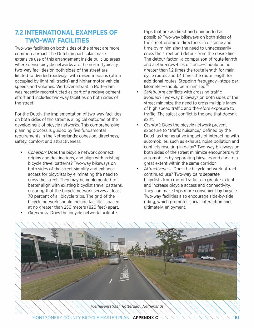
7.2 INTERNATIONAL EXAMPLES OF TWO-WAY FACILITIESTwo-way facilities on both sides of the street are more common abroad. The Dutch, in particular, make extensive use of this arrangement inside built-up areas where dense bicycle networks are the norm. Typically, two-way facilities on both sides of the street are limited to divided roadways with raised medians (often occupied by light rail tracks) and higher motor vehicle speeds and volumes. Vierhavensstraat in Rotterdam was recently reconstructed as part of a redevelopment effort and includes two-way facilities on both sides of the street.
For the Dutch, the implementation of two-way facilities on both sides of the street is a logical outcome of the development of bicycle networks. This comprehensive planning process is guided by five fundamental requirements in the Netherlands: cohesion, directness, safety, comfort and attractiveness.
• Cohesion: Does the bicycle network connect origins and destinations, and align with existing bicycle travel patterns? Two-way bikeways on both sides of the street simplify and enhance access for bicyclists by eliminating the need to cross the street. They may be implemented to better align with existing bicyclist travel patterns, ensuring that the bicycle network serves at least 70 percent of all bicycle trips. The grid of the bicycle network should include facilities spaced at no greater than 250 meters (820 feet) apart.
• Directness: Does the bicycle network facilitate
Vierhavensstraat, Rotterdam, Netherlands
trips that are as direct and unimpeded as possible? Two-way bikeways on both sides of the street promote directness in distance and time by minimizing the need to unnecessarily cross the street and detour from the desire line. The detour factor—a comparison of route length and as-the-crow-flies distance—should be no greater than 1.2 times the route length for main cycle routes and 1.4 times the route length for additional routes. Stopping frequency—stops per kilometer—should be minimized.
• Safety: Are conflicts with crossing traffic avoided? Two-way bikeways on both sides of the street minimize the need to cross multiple lanes of high speed traffic and therefore exposure to traffic. The safest conflict is the one that doesn’t exist.
• Comfort: Does the bicycle network prevent exposure to “traffic nuisance,” defined by the Dutch as the negative impacts of interacting with automobiles, such as exhaust, noise pollution and conflicts resulting in delay? Two-way bikeways on both sides of the street minimize encounters with automobiles by separating bicycles and cars to a great extent within the same corridor.
• Attractiveness: Does the bicycle network attract continued use? Two-way pairs separate bicyclists from motor traffic to a greater extent and increase bicycle access and connectivity. They can make trips more convenient by bicycle. Two-way facilities also encourage side-by-side riding, which promotes social interaction and, ultimately, enjoyment.
87
61MONTGOMERY COUNTY BICYCLE MASTER PLAN | APPENDIX C

7.3 RECOMMENDATIONS FOR MONTGOMERY COUNTYA two-way bikeway on both sides of the street is intended to serve a unique function within the county’s bicycle network. This facility type should only be recommended where all recommended criteria are met because of the significant level of investment needed to implement these facilities.
Additionally, other network and roadway reconfiguration options should be investigated before settling on the choice to recommend a two-way bikeway on both sides of the street. Parallel routes on low-volume, low-speed streets may be available and feasibly implemented with a lower level of investment than a two-way bikeway. Planners should also consider whether changes are feasible to the street in question: Is it possible to add more safe, comfortable crossings? Is it possible to reduce the number of travel lanes and make crossing easier? These types of changes may not be feasible in retrofit projects, but the design of a new street in a developing or redeveloping area should take these questions into consideration.
It should be noted that a two-way pair may be used for a short segment within a commercial area and transition back to a two-way facility on one side of the street outside of this area. These segments can provide critical connections and access for bicyclists on major streets that may otherwise create a barrier.
Recommended criteria for application of two-way bike-ways on both sides of the street are:
• Long distances between safe, comfortable crossings (typically 800 to 1,000 feet ).
• Wide automobile travelway cross section (five or more lanes).
• Presence of destinations/active land uses on both sides of the street.
Long distances between crossings where destinations are present on both sides of the street may lead bicyclists to undertake different unsafe behaviors based upon configuration of the bike facility provided:
• One-way pairs (conventional or separated bike lane): Bicyclists may ride against traffic in the one-way facility to avoid crossing the street to reach their destinations. However, their movements would not be accommodated in the
design of the facility either in width (for passing) or signage and marking (for alerting drivers).
• Two-way facility (shared use path or separated bike lane) on one side of the road: Bicyclists may cross at unmarked crossings; drivers may not expect these crossings, which pose a greater risk on wide, high-speed roads. Bicyclists may also ride on the sidewalk on the non-bicycle facility side of the street, leading to increased conflict with pedestrians in this limited space and with automobiles entering/exiting from driveways where bicyclists are unexpected.
A street must have a wide cross section, four lanes or more, to consider this facility application. The width of the street makes crossing less safe through exposure to multiple lanes of traffic and oftentimes high traffic speeds. Wider streets often also have longer signal phasing. This longer signal presents further delay to bicyclists who may need to cross the street twice to reach their destinations and continue a trip if a facility is only provided on one side of the street.
The criteria for crossing distances are only applicable where a bicyclist has a reason to access both sides of the street. A street that meets the other criteria would not warrant two-way facilities on both sides if it abuts a large private property or a park with one entrance, for instance. Corridors with destinations on both sides of the street are likely to have commercial or mixed-use land uses.
Many locations that meet the criteria for two-way facilities on both sides of the street will also have high pedestrian volumes, owing to the density of destinations and likely coincidence of transit lines along the corridor. In most cases, this large number of pedes-trians will mean separated bike lanes are preferred to help alleviate conflicts between pedestrians and bicyclists.
88
62 MONTGOMERY COUNTY BICYCLE MASTER PLAN | APPENDIX C
7.4 EXAMPLE APPLICATION IN MONTGOMERY COUNTY: ROCKVILLE PIKE
Rockville Pike is perhaps the quintessential example of a street that is well-suited to a two-way pair facility due to the distance between safe, comfortable crossings, a wide street cross section and presence of active commercial destinations on both sides of the street. The White Flint Separated Bike Lane Network calls for a separated bike lane on Rockville Pike, but this planning documents does not specify cross sections for these recommendations to provide flexibility in implementation.
Rockville Pike is a six-lane street in this segment, though turn lanes increase this width at every intersection, and this width creates a major barrier to accessing both sides of the street. Safe, comfortable crossings are spaced farther apart than is practical for bicyclists making short neighborhood trips in this area. Crossings are spaced, on average, 850 feet apart from one another, a distance which slightly exceeds the threshold stated above.
Commercial destinations are located on both sides of the road throughout White Flint today, and anticipated redevelopment will only intensify these land uses and bring a greater number of residents to the area. Businesses front on Rockville Pike, and while some access may be possible from side streets in the network, two-way facilities on both sides of the street will enable bicyclists (and non-bicyclists) to conceptualize arriving at these businesses by bicycle.
The two-way pair would be recommended to begin at Flanders Avenue—the beginning of commercial use on both sides of the street—on the south end and continue to meet the two-way pair at the Rockville city line. On Rockville Pike and at other locations in the county, trade-offs would need to be made to accommodate the increased space needs for two-way facilities on both sides of the street. If two-way bikeways are not provided on both sides of the road through the White Flint area, it can be expected that people will be less likely to choose to bike for their trip, bicycle on the sidewalk or bicycle in the wrong direction on a one-way bikeway. These possible outcomes are in conflict with the county’s goals for providing a safe, connected, low-stress network that attracts more residents and visitors to choose bicycling.
END NOTES86. Interested but Concerned riders are more comfortable when given greater
separation from high-speed, high-volume traffic. They comprise approximately 60 percent of the population.
87. This logic becomes important for short trips, such as those the county may desire to capture within a mixed-use neighborhood. Undue delay on a quick run for errands will dissuade a resident from choosing to bike instead of drive.
88. Lower thresholds may be considered where a high density of destinations exists on both sides of the street.
63MONTGOMERY COUNTY BICYCLE MASTER PLAN | APPENDIX C
PHASING SEPARATED BIKE LANES
8.1 BENEFITS AND CONSIDERATIONS FOR SEPARATION TYPES
According to the Federal Highway Administration’s Sep-arated Bike Lane Planning and Design Guide, separation types should be selected based on considerations such as available space, cost, presence of on-street parking, maintenance and aesthetics. Table 1 on the following pages reviews the different methods for creating separated bike lanes and describes the level of protection and comfort provided by such lanes to bicyclists, as well as aesthetics, costs and other considerations, based on guidance in the MassDOT Separated Bike Lane Planning and Design Guide and the FHWA Separated Bike Lane Planning and Design Guides.
In Table 1, cost is separated into two categories: capital costs and operating costs. These two considerations must be taken into account when deciding on a separation type for bike lanes to ensure that
Separated bike lanes (SBLs) are a relatively new facility type in Montgomery County. As described in prior reports, separated bike lanes are critical elements of high-comfort, low-stress bicycling networks. Many agencies have implemented separated bike lanes as low-cost retrofits projects (e.g., using flex posts and paint within the existing right-of-way) and others are constructing more permanent forms of separation, such as curb-separated bike lanes, that represent an ultimate desired design standard. Although low-cost separation types can be easier to implement, agencies have noted maintenance costs and issues with aesthetics, and some separation types provide a lower level of protection from adjacent automobile traffic. This report explores best practices for bike lane separation types and recommends guidance and criteria for a phased implementation approach that begins with interim treatments and transitions into ultimate separated bike lane designs.
resources are available to keep the facility in a state of good repair once the initial investment is made. Capital costs include those of materials and labor to construct the separated bike lane. For separation provided by flexible delineator posts, for instance, capital costs include striping and the flexible delineator posts. For separation provided by a raised median, capital costs include construction of the median, plus any necessary changes to stormwater or other utilities within the limits of disturbance. Operating costs include typical maintenance, such as sweeping and snow clearance, replacement costs for materials (e.g., damaged delineator posts) and upkeep (e.g., seasonal maintenance and watering for planters or planted medians).
An additional consideration for separation types is sight lines related to child bicyclists. While most adult bicyclists will be visible to adjacent drivers above any type of separation, smaller child bicyclists may not be. Specifically, use of parked cars, concrete barriers or tall planters as separating elements may prevent drivers from seeing child bicyclists. Design considerations need to be taken into account at driveways and intersections for these separation types to ensure adequate open space (or lower barriers) for improved sight lines. These considerations also apply to recumbent bicyclists.
64 MONTGOMERY COUNTY BICYCLE MASTER PLAN | APPENDIX C
08

Interim Separated Bike LanesAs with many jurisdictions, Montgomery County is focusing its efforts at building a network of separated bike lanes as quickly as possible to provide responsiveness to public demands for improved bicycling and to allow ongoing evaluation of new approaches to bikeways. Projects on Woodglen Drive and Nebel Street in White Flint and Spring Street in Silver Spring are early efforts in this approach. These projects substantially improve the comfort of bicycling by reducing traffic stress and make bicycling accessible to a greater segment of the population. Because there is a strong desire to implement a network of bikeways as quickly as possible, these projects tend to employ interim designs that are lower cost and may need to be upgraded over time to incorporate urban design and stormwater management opportunities and to achieve the lowest stress possible. Three features of interim separated bike lanes are discussed below.
Separated Bike Lane Widths
Interim separated bike lanes will have the following widths:
• One-way separated bike lanes: 5.0 ft minimum, exclusive of shy distances.• Two-way separated bike lanes: 8.0 ft minimum, exclusive of shy distances.
Intersections
While the ultimate objective is to implement protected intersections along separated bike lanes, this will not be feasible with many interim projects. Bike boxes and two-stage turn queue boxes are ways to im-prove intersections in the interim until full protected intersections can be implemented. Bike lane drops are not appropriate for interim separated bike lanes.
Separation from Traffic
Interim separated bike lanes address separation from traffic using flexible delineator posts, planters, park-ing stops or concrete barriers, and are shown on the following pages. These forms of separation help to reduce the stress of bicycling, and can be improved over time as funding becomes available.
Interim separated bike lanes on Nebel Street in White Flint can be upgraded over time by development approvals or county projects
65MONTGOMERY COUNTY BICYCLE MASTER PLAN | APPENDIX C
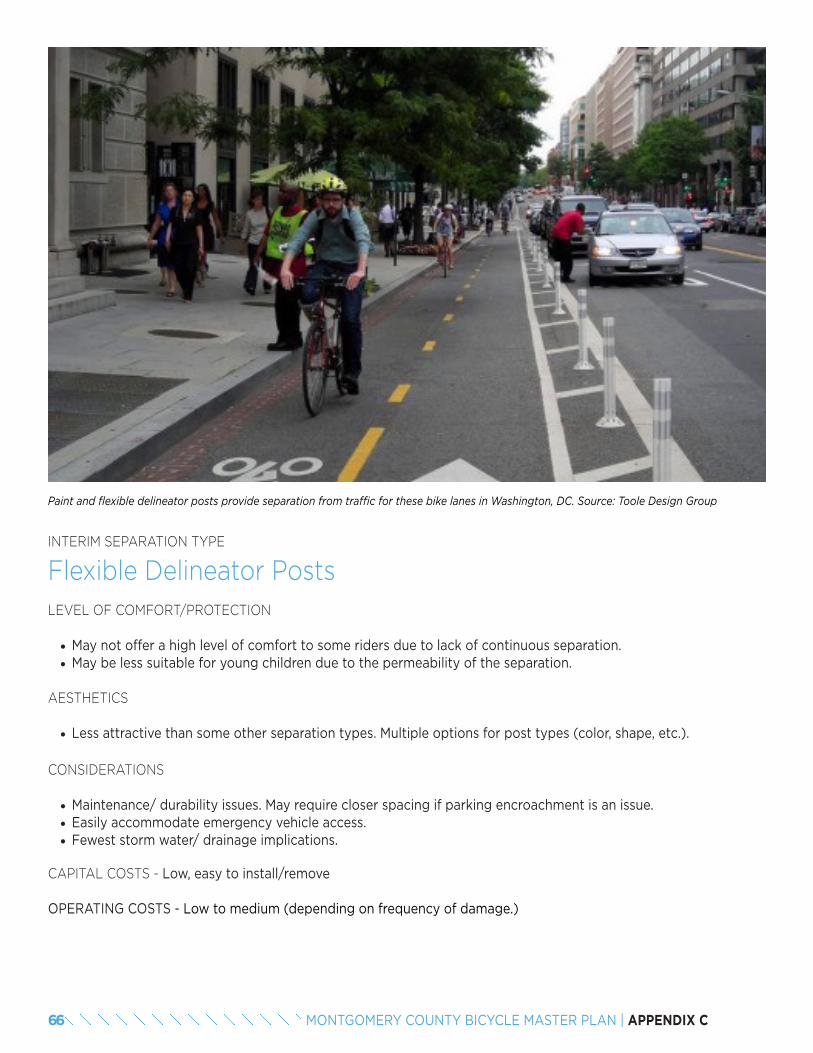
INTERIM SEPARATION TYPE
Flexible Delineator PostsLEVEL OF COMFORT/PROTECTION
• May not offer a high level of comfort to some riders due to lack of continuous separation.• May be less suitable for young children due to the permeability of the separation.
AESTHETICS
• Less attractive than some other separation types. Multiple options for post types (color, shape, etc.).
CONSIDERATIONS
• Maintenance/ durability issues. May require closer spacing if parking encroachment is an issue.• Easily accommodate emergency vehicle access.• Fewest storm water/ drainage implications.
CAPITAL COSTS - Low, easy to install/remove
OPERATING COSTS - Low to medium (depending on frequency of damage.)
Paint and flexible delineator posts provide separation from traffic for these bike lanes in Washington, DC. Source: Toole Design Group
66 MONTGOMERY COUNTY BICYCLE MASTER PLAN | APPENDIX C
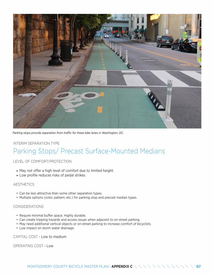
INTERIM SEPARATION TYPE
Parking Stops/ Precast Surface-Mounted MediansLEVEL OF COMFORT/PROTECTION
• May not offer a high level of comfort due to limited height.• Low profile reduces risks of pedal strikes.
AESTHETICS
• Can be less attractive than some other separation types. • Multiple options (color, pattern, etc.) for parking stop and precast median types.
CONSIDERATIONS
• Require minimal buffer space. Highly durable.• Can create tripping hazards and access issues when adjacent to on-street parking.• May need additional vertical objects or on-street parking to increase comfort of bicyclists.• Low impact on storm water drainage.
CAPITAL COST - Low to medium
OPERATING COST - Low
Parking stops provide separation from traffic for these bike lanes in Washington, DC.
67MONTGOMERY COUNTY BICYCLE MASTER PLAN | APPENDIX C
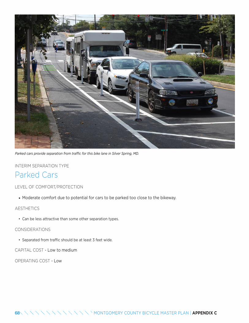
INTERIM SEPARATION TYPE
Parked CarsLEVEL OF COMFORT/PROTECTION
• Moderate comfort due to potential for cars to be parked too close to the bikeway.
AESTHETICS
• Can be less attractive than some other separation types.
CONSIDERATIONS
• Separated from traffic should be at least 3 feet wide.
CAPITAL COST - Low to medium
OPERATING COST - Low
Parked cars provide separation from traffic for this bike lane in Silver Spring, MD.
68 MONTGOMERY COUNTY BICYCLE MASTER PLAN | APPENDIX C
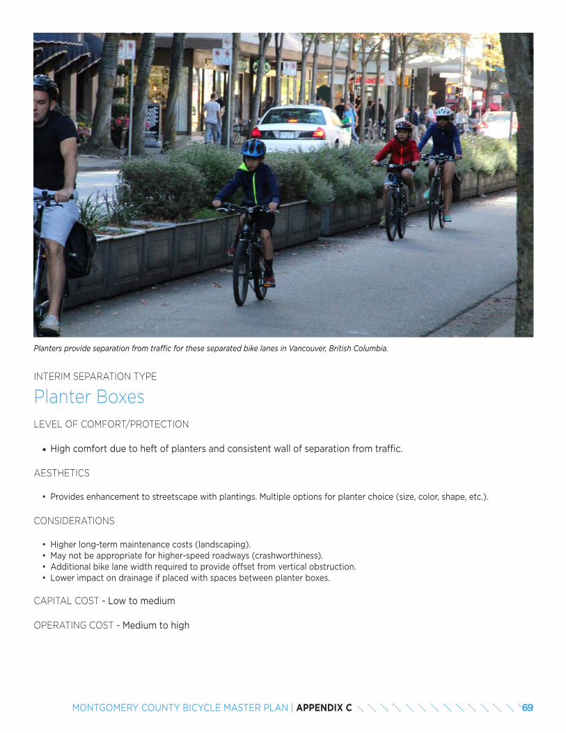
INTERIM SEPARATION TYPE
Planter BoxesLEVEL OF COMFORT/PROTECTION
• High comfort due to heft of planters and consistent wall of separation from traffic.
AESTHETICS
• Provides enhancement to streetscape with plantings. Multiple options for planter choice (size, color, shape, etc.).
CONSIDERATIONS
• Higher long-term maintenance costs (landscaping).• May not be appropriate for higher-speed roadways (crashworthiness). • Additional bike lane width required to provide offset from vertical obstruction.• Lower impact on drainage if placed with spaces between planter boxes.
CAPITAL COST - Low to medium
OPERATING COST - Medium to high
Planters provide separation from traffic for these separated bike lanes in Vancouver, British Columbia.
69MONTGOMERY COUNTY BICYCLE MASTER PLAN | APPENDIX C
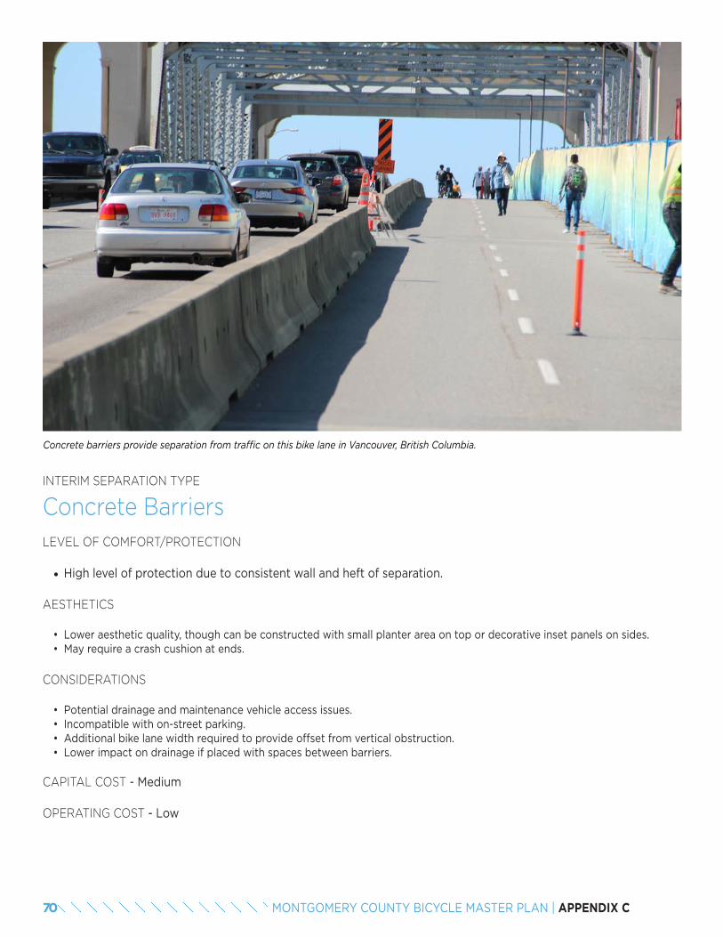
INTERIM SEPARATION TYPE
Concrete BarriersLEVEL OF COMFORT/PROTECTION
• High level of protection due to consistent wall and heft of separation.
AESTHETICS
• Lower aesthetic quality, though can be constructed with small planter area on top or decorative inset panels on sides.• May require a crash cushion at ends.
CONSIDERATIONS
• Potential drainage and maintenance vehicle access issues.• Incompatible with on-street parking.• Additional bike lane width required to provide offset from vertical obstruction.• Lower impact on drainage if placed with spaces between barriers.
CAPITAL COST - Medium
OPERATING COST - Low
Concrete barriers provide separation from traffic on this bike lane in Vancouver, British Columbia.
70 MONTGOMERY COUNTY BICYCLE MASTER PLAN | APPENDIX C
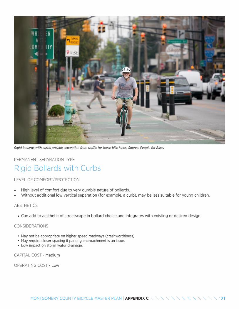
PERMANENT SEPARATION TYPE
Rigid Bollards with CurbsLEVEL OF COMFORT/PROTECTION
• High level of comfort due to very durable nature of bollards. • Without additional low vertical separation (for example, a curb), may be less suitable for young children.
AESTHETICS
• Can add to aesthetic of streetscape in bollard choice and integrates with existing or desired design.
CONSIDERATIONS
• May not be appropriate on higher speed roadways (crashworthiness).• May require closer spacing if parking encroachment is an issue. • Low impact on storm water drainage.
CAPITAL COST - Medium
OPERATING COST - Low
Rigid bollards with curbs provide separation from traffic for these bike lanes. Source: People for Bikes
71MONTGOMERY COUNTY BICYCLE MASTER PLAN | APPENDIX C
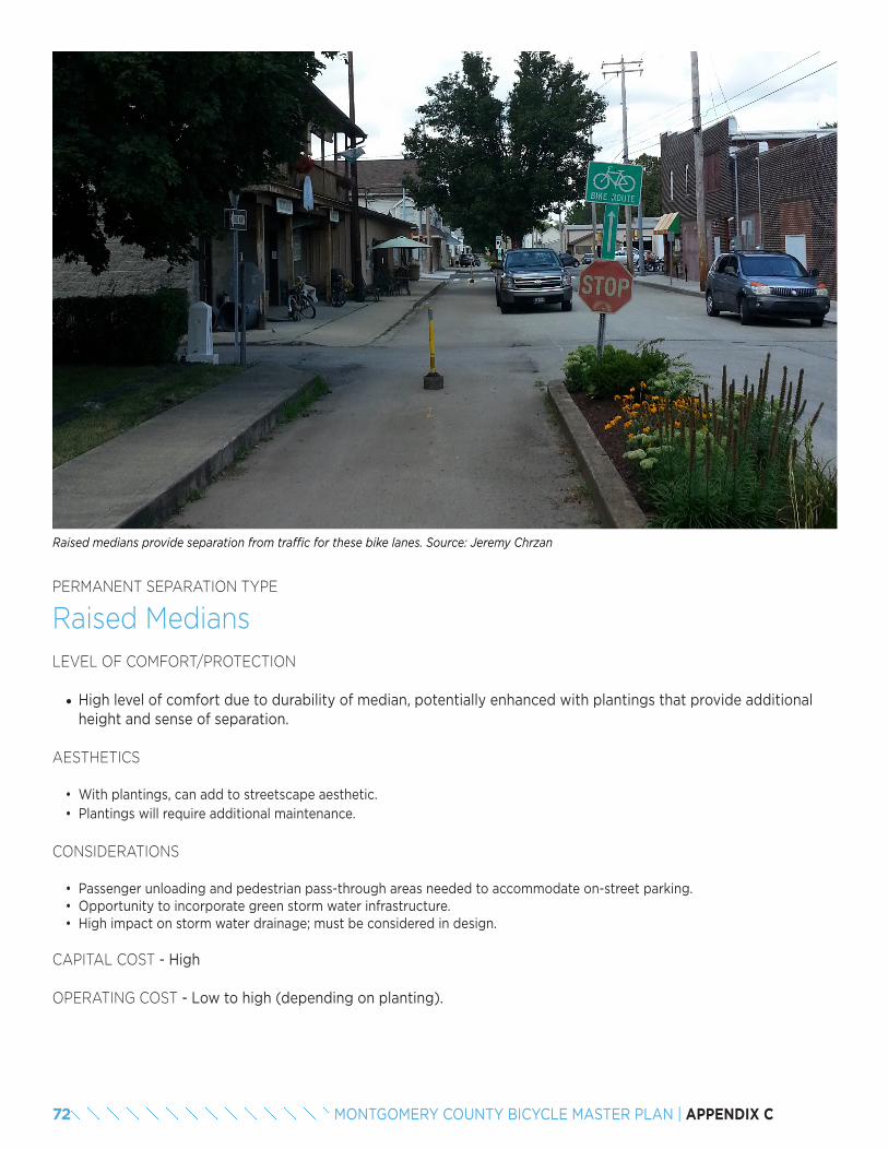
PERMANENT SEPARATION TYPE
Raised MediansLEVEL OF COMFORT/PROTECTION
• High level of comfort due to durability of median, potentially enhanced with plantings that provide additional height and sense of separation.
AESTHETICS
• With plantings, can add to streetscape aesthetic.• Plantings will require additional maintenance.
CONSIDERATIONS
• Passenger unloading and pedestrian pass-through areas needed to accommodate on-street parking.• Opportunity to incorporate green storm water infrastructure.• High impact on storm water drainage; must be considered in design.
CAPITAL COST - High
OPERATING COST - Low to high (depending on planting).
Raised medians provide separation from traffic for these bike lanes. Source: Jeremy Chrzan
72 MONTGOMERY COUNTY BICYCLE MASTER PLAN | APPENDIX C
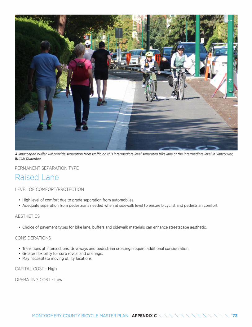
PERMANENT SEPARATION TYPE
Raised LaneLEVEL OF COMFORT/PROTECTION
• High level of comfort due to grade separation from automobiles.• Adequate separation from pedestrians needed when at sidewalk level to ensure bicyclist and pedestrian comfort.
AESTHETICS
• Choice of pavement types for bike lane, buffers and sidewalk materials can enhance streetscape aesthetic.
CONSIDERATIONS
• Transitions at intersections, driveways and pedestrian crossings require additional consideration. • Greater flexibility for curb reveal and drainage.• May necessitate moving utility locations.
CAPITAL COST - High
OPERATING COST - Low
A landscaped buffer will provide separation from traffic on this intermediate level separated bike lane at the intermediate level in Vancouver, British Columbia.
73MONTGOMERY COUNTY BICYCLE MASTER PLAN | APPENDIX C

74 MONTGOMERY COUNTY BICYCLE MASTER PLAN | APPENDIX C
8.2 PLANNING CONSIDERATIONS
Phasing may be necessary for implementing separated bike lanes due to project cost or space limitations necessitating interim design solutions. In the longer term, an ultimate design could be constructed to replace the interim condition in coordination with a larger project. Given that separated bike lanes are a newer facility type, a shorter-term design could also allow for proof of concept and continued evaluation by the implementing agency before making a substantial public investment in permanent infrastructure. Additionally, bicycling demand or motor vehicle volumes may change over time, requiring a higher level of protection from traffic or more space to accommodate higher bicycling volumes.
Lower-cost retrofits or demonstration projects
Lower-cost retrofits or demonstration projects allow for quick implementation, provide responsiveness to public perception and permit ongoing evaluation. Separation types for interim separated bike lanes often include non-permanent separation, such as flexible delineator posts, planters, parking stops, concrete barriers and rigid ballards with curbs.
Interim approaches allow the agency to:
• Test the separated bike lane configuration for bicyclists and traffic operations.
• Evaluate public reaction, design performance and safety effectiveness.
• Make changes if necessary. • Transition to permanent design.
Permanent separation
Permanent separation provide a high level of protection and often have greater potential for placemaking, quality aesthetics and integration with features such as green stormwater management infrastructure. Agencies often implement permanent separation designs by leveraging private development (potentially through developer contribution), major capital construction and including separated bike lanes in roadway reconstruction designs. Examples of permanent separation include raised medians and grade-separated bike lanes at an intermediate or a sidewalk level.
75MONTGOMERY COUNTY BICYCLE MASTER PLAN | APPENDIX C

89
8.3 TRANSITION FROM A LOW-COST TO A MORE PERMANENT DESIGN
Interim designs using lower cost materials may allow communities to implement separated bike lane projects more quickly. However, concerns about aesthetics, comfort for all users and incorporation of signal designs make a transition to permanent design desirable. Low-cost materials, aside from planters, do not tend to enhance the streetscape and designers often raise concerns about the visual impact of flexible delineator posts and concrete barriers. Some users may also feel less comfortable with low-cost separation types due to the lack of a consistent vertical separation and durability of materials (delineator posts) or low height (parking stops).
Finally, since agencies often try to implement interim designs in a low-cost manner, budget is rarely available for study and implementation of traffic signal modification specifically for bicycle accommodation. The high cost of traffic signal modifications, adding bicycle-specific signals or installing additional vehicle traffic signals would significantly increase the cost and potentially hinder quick implementation of interim projects. Research has also documented lower bicyclist compliance at locations where bicyclists are directed to follow pedestrian signals. Without these improvements, interim designs may not function as well for bicyclists, pedestrians and drivers as a permanent design incorporating these signal changes.
Nationally, transitions from interim to permanent design are rare because of the relatively short time period during which separated bike lanes have been in place in this country. A recent survey of 40 cities across the U.S. showed 87.5 percent use low-cost, flexible design materials to implement separated bike lanes. People for Bikes’ 2016 “Quick Builds for Better Streets: A New Project Delivery Model for U.S. Cities” describes a process for implementation of a “quick build” (under one year from recommendation to implementation) design.
Recent examples suggest that quick builds may be able to demonstrate the benefits of the project, which could potentially position an agency favorably for additional funding to transition to more permanent materials. Many agencies set a timeline for a pilot installation to evaluate the design outcomes (one year or two years) from bicyclist user and traffic impacts
perspectives. However, there are few agencies so far that have created a direct link between quick builds and permanent reconstruction projects.
Example: Second Avenue, Seattle, WA
In fall 2014, the City of Seattle implemented a quick build separated bike lane on Second Avenue in its central business district. Initially, the two-way bike lane was separated using flexible delineator posts and adjacent on-street parking. Seattle also implemented bicycle signals and two-stage turn queue boxes at all intersections. During the pilot installation, the city evaluated the separated bike lane design and made minor changes to address issues, including “no turn on red” signs and pavement markings at loading locations and driveways. The existing signal poles required the bicycle signals be installed adjacent to vehicle signals, resulting in instances of non-compliance by some motorists.
Second Avenue separated bike lane, before (above) and after (below) upgrades to pedestrian crossings and
additional planter boxes.
76 MONTGOMERY COUNTY BICYCLE MASTER PLAN | APPENDIX C
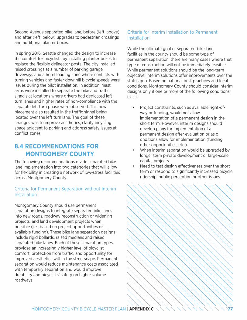
Second Avenue separated bike lane, before (left, above) and after (left, below) upgrades to pedestrian crossings and additional planter boxes.
In spring 2016, Seattle changed the design to increase the comfort for bicyclists by installing planter boxes to replace the flexible delineator posts. The city installed raised crossings at a number of parking garage driveways and a hotel loading zone where conflicts with turning vehicles and faster downhill bicycle speeds were issues during the pilot installation. In addition, mast arms were installed to separate the bike and traffic signals at locations where drivers had dedicated left turn lanes and higher rates of non-compliance with the separate left turn phase were observed. This new placement also resulted in the traffic signal being located over the left turn lane. The goal of these changes was to improve aesthetics, clarify bicycling space adjacent to parking and address safety issues at conflict zones.
8.4 RECOMMENDATIONS FOR MONTGOMERY COUNTY
The following recommendations divide separated bike lane implementation into two categories that will allow for flexibility in creating a network of low-stress facilities across Montgomery County.
Criteria for Permanent Separation without Interim Installation
Montgomery County should use permanent separation designs to integrate separated bike lanes into new roads, roadway reconstruction or widening projects, and land development projects when possible (i.e., based on project opportunities or available funding). These bike lane separation designs include rigid bollards, raised medians and raised separated bike lanes. Each of these separation types provides an increasingly higher level of bicyclist comfort, protection from traffic, and opportunity for improved aesthetics within the streetscape. Permanent separation would reduce maintenance costs associated with temporary separation and would improve durability and bicyclists’ safety on higher volume roadways.
Criteria for Interim Installation to Permanent Installation
While the ultimate goal of separated bike lane facilities in the county should be some type of permanent separation, there are many cases where that type of construction will not be immediately feasible. While permanent solutions should be the long-term objective, interim solutions offer improvements over the status quo. Based on national best practices and local conditions, Montgomery County should consider interim designs only if one or more of the following conditions exist:
• Project constraints, such as available right-of-way or funding, would not allow implementation of a permanent design in the short term. However, interim designs should develop plans for implementation of a permanent design after evaluation or as c onditions allow for implementation (funding, other opportunities, etc.).
• When interim separation would be upgraded by longer term private development or large-scale capital projects.
• Need to test design effectiveness over the short term or respond to significantly increased bicycle ridership, public perception or other issues.
77MONTGOMERY COUNTY BICYCLE MASTER PLAN | APPENDIX C
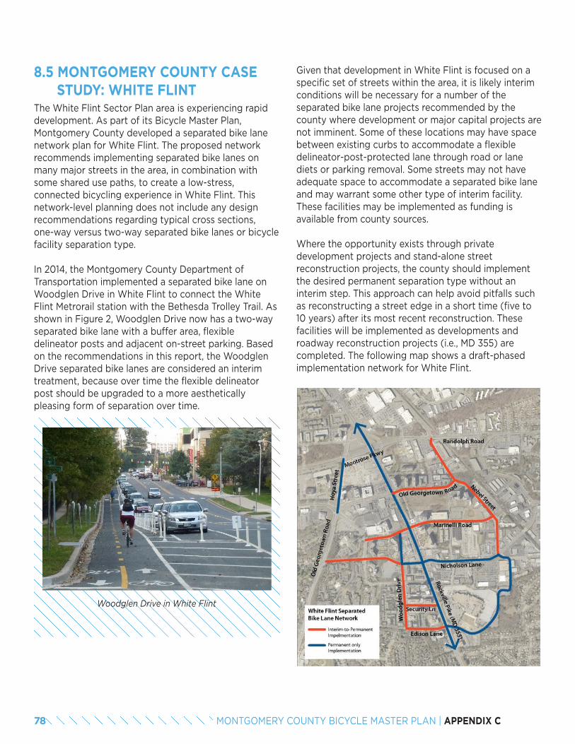
8.5 MONTGOMERY COUNTY CASE STUDY: WHITE FLINTThe White Flint Sector Plan area is experiencing rapid development. As part of its Bicycle Master Plan, Montgomery County developed a separated bike lane network plan for White Flint. The proposed network recommends implementing separated bike lanes on many major streets in the area, in combination with some shared use paths, to create a low-stress, connected bicycling experience in White Flint. This network-level planning does not include any design recommendations regarding typical cross sections, one-way versus two-way separated bike lanes or bicycle facility separation type.
In 2014, the Montgomery County Department of Transportation implemented a separated bike lane on Woodglen Drive in White Flint to connect the White Flint Metrorail station with the Bethesda Trolley Trail. As shown in Figure 2, Woodglen Drive now has a two-way separated bike lane with a buffer area, flexible delineator posts and adjacent on-street parking. Based on the recommendations in this report, the Woodglen Drive separated bike lanes are considered an interim treatment, because over time the flexible delineator post should be upgraded to a more aesthetically pleasing form of separation over time.
Woodglen Drive in White Flint
Given that development in White Flint is focused on a specific set of streets within the area, it is likely interim conditions will be necessary for a number of the separated bike lane projects recommended by the county where development or major capital projects are not imminent. Some of these locations may have space between existing curbs to accommodate a flexible delineator-post-protected lane through road or lane diets or parking removal. Some streets may not have adequate space to accommodate a separated bike lane and may warrant some other type of interim facility. These facilities may be implemented as funding is available from county sources.
Where the opportunity exists through private development projects and stand-alone street reconstruction projects, the county should implement the desired permanent separation type without an interim step. This approach can help avoid pitfalls such as reconstructing a street edge in a short time (five to 10 years) after its most recent reconstruction. These facilities will be implemented as developments and roadway reconstruction projects (i.e., MD 355) are completed. The following map shows a draft-phased implementation network for White Flint.
78 MONTGOMERY COUNTY BICYCLE MASTER PLAN | APPENDIX C

END NOTES89. People for Bikes, “Quick Builds for Better Streets: A New Project Delivery Model for U.S. Cities” http://b.3cdn.net/bikes/675cdae66d727f8833_kzm6ikutu.pdf
79MONTGOMERY COUNTY BICYCLE MASTER PLAN | APPENDIX C
80 MONTGOMERY COUNTY BICYCLE MASTER PLAN | APPENDIX C
INCREMENTAL IMPLEMENTATION
9.1 CONTINUITYDepending on the scale of the development project, the developer may only be responsible for improving a portion of a street (i.e., a portion of a block or a portion of a longer corridor). These piecemeal segments create challenges in providing a continuous bicycle facility. To provide continuity between new bicycle facilities associated with private development and the larger bicycle network, it may be necessary for the county to participate in bicycle network improvements between the segment proposed by the private developer and the nearest bicycle facility connection. Without such public improvements in the remainder of the corridor, bicycle facilities completed as part of private development may remain isolated and disconnected from the rest of the network.
In addition to this connectivity concern, design characteristics also present a continuity challenge on corridors with separated bike lanes (SBLs). Unlike other bikeway types, SBLs can be implemented many different ways (varying widths, separation types, etc.). Without an overall concept plan to guide implementation of separated bike lanes, piecemeal
Private land development presents an opportunity to implement high-quality bicycle facilities while providing new funding sources in addition to public investment. However, the incremental nature of developer-led implementation poses challenges. This report discusses best practices, project examples and process recommendations for addressing these challenges within the context of the Montgomery County Bicycle Master Plan infrastructure recommendations.
Connected bicycle networks of low-stress facilities are critical in both attracting Interested but Concerned riders and also increasing bicycle trips in Montgomery County. While the Bicycle Master Plan will lay out recommendations for such a complete network, the manner in which individual bicycle facility projects are implemented will have tremendous impact on the overall efficacy of the network. If individual facilities are implemented in a piecemeal fashion, rather than as a complete corridor, the result will be a series of dis-connected bicycle facilities. Piecemeal implementation is unlikely to result in a high quality network and will neither increase ridership nor lead to a consistent experience for users.
For example, a small segment of a separated bike lane may be implemented as part of a development opportunity while the rest of a street remains unchanged or with a lower quality facility. The county’s bicycle network should not include such abrupt changes in level of traffic stress. For these reasons, Montgomery County must consider implementation from the outset of the planning process so that a deliberate approach can be used to deliver a cohesive network.
Bicycle facilities are constructed in Montgomery County via three methods:
1. Capital projects implemented by the county.2. Capital projects implemented by the state of
Maryland.3. Private developer-implemented projects.
This report focuses on issues associated with the implementation of bicycle facilities as part of the development review process. Presently, as part of the county’s development review and approval process, reviewers consult numerous functional master plans, area sector plans and roadway design standards to determine whether any improvements are recommended within the vicinity of the applicant’s proposed development.
As a result of these documents, the developer may be required to retrofit or reconstruct adjacent streets to make them compliant with current standards and master plan recommendations. For the purposes of this report, the challenges associated with bicycle facility implementation through the development review process have been categorized into three areas: continuity, design and timing.
09
81MONTGOMERY COUNTY BICYCLE MASTER PLAN | APPENDIX C
projects could result in varying widths of SBLs, different separation types, or, at worst, lack of provision of adequate space for a bikeway. SBLs that are implemented with varying design treatments may feel discontinuous to users, who may experience a lower overall quality of the bicycle facility than would be expected if the corridor was executed from a cohesive concept plan.
9.2 DESIGNThe lack of design guidelines for bicycle facilities and staff training presents a challenge to both project reviewers and private sector developers. This absence of guidance presents a problem because, in some cases, reviewers need to act as advocates for high quality bikeway design throughout the development review process and ensure that all reviewers have the same goals for providing a bicycle facility.
Additionally, such guidelines help developers understand the spatial requirements associated with different facility types at the earliest stages of the site planning process. A lack of design guidance can lead to confusion and permit a higher level of design flexibility than is desirable when implementing the highest quality bicycle facility.
9.3 TIMINGDevelopers typically have building and site plans designed to an advanced stage before they are submitted to agencies for transportation review. This plan development can create resistance to changes to incorporate bicycle facility design where changes to the building footprint or access to the property are required.
9.4 BICYCLE FACILITY IMPLEMENTATION CONTEXT
Implementation of bikeways is aided by Montgomery County’s complete streets policy, included in the Montgomery County Road Code (Bill No. 33-13). The policy states that all transportation facilities (i.e., private development, construction, reconstruction and streetscaping) be planned and designed for the “safe and convenient travel” of all users. The policy also states that bikeways and walkways must be included in projects. Bikeways included in projects must be consistent with or exceed the adopted Bicycle Master Plan.
Development review processes also impact the implementation of bicycle facilities. The county’s development review process includes the Local Area Transportation Review (LATR) and Transportation Policy Area Review (TPAR); both were updated in 2016. All developments, both those that warrant a full traffic study and smaller ones, must consider impacts to bicyclists and pedestrians, and comply with existing roadway standards and master plans. Existing policies also recognize the high level of bicycle and pedestrian activity in certain areas, such as central business districts and Metro Station Policy Areas, which should be considered in the assessment of bicycle and pedestrian facilities for a proposed development.
The county also has a transportation impact tax, which is assessed based on policy area and land use type, and may be used by the Montgomery County Department of Transportation for implementation of bicycle facilities. Where the applicant demonstrates that improvements cannot be implemented within six years, the county can accept payment of a fee-in-lieu. Policy documents also note that transportation impacts from new development may be reduced by providing bicycle facilities as a method of travel demand management, though there is limited applicability of this policy.
Additional impacts to facility implementation in the development process are included in the 2016 revision to the county Subdivision Staging Policy. This policy, which is updated every four years, ensures that the development review process and metrics reflect the vision of encouraging multimodal travel and transit-oriented development.
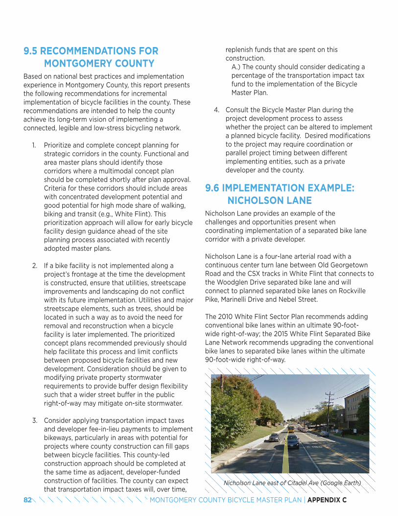
82 MONTGOMERY COUNTY BICYCLE MASTER PLAN | APPENDIX C
9.5 RECOMMENDATIONS FOR MONTGOMERY COUNTY
Based on national best practices and implementation experience in Montgomery County, this report presents the following recommendations for incremental implementation of bicycle facilities in the county. These recommendations are intended to help the county achieve its long-term vision of implementing a connected, legible and low-stress bicycling network.
1. Prioritize and complete concept planning for strategic corridors in the county. Functional and area master plans should identify those corridors where a multimodal concept plan should be completed shortly after plan approval. Criteria for these corridors should include areas with concentrated development potential and good potential for high mode share of walking, biking and transit (e.g., White Flint). This prioritization approach will allow for early bicycle facility design guidance ahead of the site planning process associated with recently adopted master plans.
2. If a bike facility is not implemented along a project’s frontage at the time the development is constructed, ensure that utilities, streetscape improvements and landscaping do not conflict with its future implementation. Utilities and major streetscape elements, such as trees, should be located in such a way as to avoid the need for removal and reconstruction when a bicycle facility is later implemented. The prioritized concept plans recommended previously should help facilitate this process and limit conflicts between proposed bicycle facilities and new development. Consideration should be given to modifying private property stormwater requirements to provide buffer design flexibility such that a wider street buffer in the public right-of-way may mitigate on-site stormwater.
3. Consider applying transportation impact taxes and developer fee-in-lieu payments to implement bikeways, particularly in areas with potential for projects where county construction can fill gaps between bicycle facilities. This county-led construction approach should be completed at the same time as adjacent, developer-funded construction of facilities. The county can expect that transportation impact taxes will, over time,
replenish funds that are spent on this construction.
A.) The county should consider dedicating a percentage of the transportation impact tax fund to the implementation of the Bicycle Master Plan.
4. Consult the Bicycle Master Plan during the project development process to assess whether the project can be altered to implement a planned bicycle facility. Desired modifications to the project may require coordination or parallel project timing between different implementing entities, such as a private developer and the county.
9.6 IMPLEMENTATION EXAMPLE: NICHOLSON LANE
Nicholson Lane provides an example of the challenges and opportunities present when coordinating implementation of a separated bike lane corridor with a private developer.
Nicholson Lane is a four-lane arterial road with a continuous center turn lane between Old Georgetown Road and the CSX tracks in White Flint that connects to the Woodglen Drive separated bike lane and will connect to planned separated bike lanes on Rockville Pike, Marinelli Drive and Nebel Street.
The 2010 White Flint Sector Plan recommends adding conventional bike lanes within an ultimate 90-foot-wide right-of-way; the 2015 White Flint Separated Bike Lane Network recommends upgrading the conventional bike lanes to separated bike lanes within the ultimate 90-foot-wide right-of-way.
Nicholson Lane east of Citadel Ave (Google Earth)
83MONTGOMERY COUNTY BICYCLE MASTER PLAN | APPENDIX C
In late 2014, as the Montgomery County Planning Department was reviewing several development applications along Nicholson Lane, it became apparent that a plan was needed to guide retrofit of separated bike lanes into Nicholson Lane. Without a concept plan, the county could lose the opportunity to incorporate bike lanes on this road altogether. In response, the Montgomery County Department of Transportation commissioned concept designs for separated bike lanes on Nicholson Lane from Rockville Pike (MD 355) to Nebel Street.
The concept designs called for a two-part approach. First, since very little of the required right-of-way is currently available, designs were prepared for an interim shared use path on the north side of Nicholson Lane, between Rockville Pike and Citadel Avenue. Second, designs were prepared to replace the shared use path on the north side and the existing sidewalk on the south side with a permanent design that included raised separated bike lanes and sidewalks on both sides of the street as right-of-way becomes available.
The permanent design will be implemented gradually in the following manner: Developers will be required to dedicate right-of-way, establish curb lines, locate storm water facilities, plant trees, build sidewalks and set aside space for the separated bike lanes in their permanent locations. The county will add the separated bike lanes when a critical number of properties have redeveloped so that the segments of separated bike lanes will be connected with shared use paths where rights-of-way are not yet available. Over time, the shared use paths will be upgraded to separated bike lanes and sidewalks.
At the time the separated bike lane concept was being designed, a site plan for the White Flint View development had already been approved, a site plan for the East Village at North Bethesda Gateway project was under consideration and submittal of the Saul Center site plan was imminent. While it has not yet been possible to amend the White Flint View site plan to include the planned separated bike lane, the East Village at North Bethesda Gateway and Saul Center projects will incorporate separated bike lanes.
The East Village at North Bethesda Gateway segment design was not without challenges:
• At the time of concept development for the separated bike lane, developers already had an approved stormwater management concept design. Therefore, to incorporate separated bike lanes into the project, the developer had to alter the locations and sizes of the stormwater management facilities to accommodate the increase in impervious surfaces and altered curb locations.
• A significant challenge was the requirement for the stormwater to be managed on-site that constrained the design of the separated bike lane.
• An additional challenge was the necessity of designing around existing utility poles. Avoiding these poles resulted in a narrowing of the buffer to 4 feet in one segment and a widening to 10 feet in another. The possibility of undergrounding these utilities was raised during the design development process, but the developer was not able to accommodate that additional cost as part of the project.
If the concept design was available earlier in the development process, a better design of the separated bike lane may have been possible by enabling stormwater to be treated within the public right-of-way, improving the quality of the bike lane and safety of users at intersections with driveways and streets intersections, and relocating utility poles to more favorable locations.
84 MONTGOMERY COUNTY BICYCLE MASTER PLAN | APPENDIX C
ECONOMIC BENEFITS OF BICYCLING INFRASTRUCTURE FOR MONTGOMERY COUNTY
The Montgomery County Bicycle Master Plan, as envisioned by Planning Department staff, will create a high-quality, low-stress bicycle network in the county. This network has the potential to benefit the overall transportation system, improve the health of the population and support economic development. It is important for decision-makers to articulate these expected benefits to stakeholders who may question the need for bicycle network improvements. This report focuses on the economic benefits of investing in bicycling infrastructure and summarizes the most relevant research into the impacts of providing low-stress bicycle facilities.
A robust bicycling network is important for a community’s economy for many reasons. Increasingly, people are choosing to live in places that provide a range of transportation options, including safe and comfortable bicycling, along with walking and transit. Recognizing this shift, large employers are locating in these bicycling- and walking-friendly communities, and providing end-of-trip bicycling amenities to their employees. This report explains how local businesses benefit from a complete bicycle network by describing how customers who travel by bike tend to spend more time at these establishments over the course of a month than customers who drive, and how bike parking can be provided more cost-effectively than car parking.
Research shows that bicycling infrastructure projects tend to cost less than other transportation projects and create more jobs-per-dollar than other transportation projects. Bicycling, one of the most popular outdoor recreation activities, contributes to tourism revenue at a higher average rate than other activities.
Finally, this report describes how people who travel by bicycle save money on transportation and often have lower healthcare costs because they tend to have a healthier lifestyle, which leaves them with more money to spend at local businesses. Because limited roadway space leads to necessary trade-offs between automobile parking and provision of bike facilities, this report pays particular attention to the business impacts of replacing parking with bicycle facilities. A growing number of studies indicate that removing on-street parking can help local businesses.
Since much of the improvement in bicycling in the U.S. has occurred in cities that have invested in bicycle infrastructure, most of the studies of its economic impacts are from cities and not from county jurisdictions. Some of those cities, though, have similar average population densities to Montgomery County, such as Indianapolis, which is discussed in a following case study. There are also many statewide, regional and trail-based studies that document the impact of visitor spending, health savings, and business benefits on broader scales and non-urban contexts that are relevant to Montgomery County. These studies are summarized in Table 1.
10
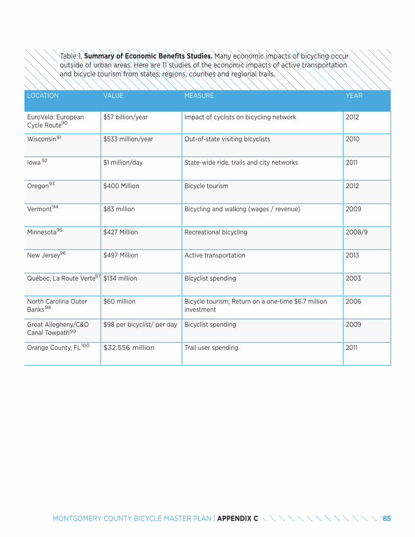
85MONTGOMERY COUNTY BICYCLE MASTER PLAN | APPENDIX C
LOCATION VALUE MEASURE YEAR
EuroVelo: European Cycle Route
$57 billion/year Impact of cyclists on bicycling network 2012
Wisconsin $533 million/year Out-of-state visiting bicyclists 2010
Iowa $1 million/day State-wide ride, trails and city networks 2011
Oregon $400 Million Bicycle tourism 2012
Vermont $83 million Bicycling and walking (wages / revenue) 2009
Minnesota $427 Million Recreational bicycling 2008/9
New Jersey $497 Million Active transportation 2013
Québec, La Route Verte $134 million Bicyclist spending 2003
North Carolina Outer Banks
$60 million Bicycle tourism; Return on a one-time $6.7 million investment
2006
Great Allegheny/C&O Canal Towpath
$98 per bicyclist/ per day Bicyclist spending 2009
Orange County, FL $32.556 million Trail user spending 2011
Table 1. Summary of Economic Benefits Studies. Many economic impacts of bicycling occur outside of urban areas. Here are 11 studies of the economic impacts of active transportation and bicycle tourism from states, regions, counties and regional trails.
90
91
92
93
94
95
96
97
98
99
100
86 MONTGOMERY COUNTY BICYCLE MASTER PLAN | APPENDIX C
10.1 PEOPLE ARE CHOOSING TO LIVE IN BICYCLE-FRIENDLY PLACES
Real estate is booming in places that provide a range of transportation options, including safe and comfortable bicycling, along with walking and transit. Millennials especially are seeking communities where they do not need to own a car.
• A 2015 survey of 20 to 37 year-olds in the Washington, D.C., area, including parts of Montgomery County called “Millennials Inside the Beltway,” found that half the surveyed millennials (also referred to as “Generation Y”) own bicycles and “Many Gen[eration] Yers emphasize the need for more dedicated bike lanes to improve safety.” Six and a half percent of respondents said they bicycle daily. A third of millennials surveyed (those living in urban zip codes inside the Capital Beltway) do not own a car.
• According to a 2014 survey of 18 to 34 year-olds in urban areas by the Rockefeller Foundation and Transportation for America, four in five millennials say they want to live in places where they have a variety of options to get to jobs, schools or daily needs.
• The Urban Land Institute’s community survey, “America in 2015,” found that 63 percent of millennials would prefer to live in locations where they do not need a car. Fewer than 50 percent of people in other generations (generation X, baby boomers, silent generation) have this same preference. So as more millennials begin to make their own choices in locations (e.g., enter the labor force), demand for walkable, bikeable, transit-accessible locations will rise.
101
102
103
10.2 BUSINESSES ARE LOCATING IN BICYCLE-FRIENDLY PLACES AND ARE CREATING BICYCLE-FRIENDLY WORKPLACES.
Employers are locating and relocating in bicycling- and walking-friendly communities, and providing end-of-trip bicycling amenities to their employees, such as secure bicycle parking and shower/locker room facilities. Leaders of cities and counties are publicly competing with each other for bicyclists and “the jobs that come with them.”
• Suburban communities are responding to these trends by making efforts to become more bicycle-friendly. In 2013, the League of American Bicyclists reported, “Suburbs join the rise of Bicycle Friendly Communities,” announcing that suburban communities like Menlo Park, CA, Elmhurst, IL, Reston, VA, and Richfield, MN, were leading the way for bicycle-friendliness. Both Rockville and Bethesda are rated by the organization as Bronze Bicycle Friendly Communities.
• Similarly, businesses are competing with each other for employees by providing end-of-trip facilities. One measure of this competition is the growing number of businesses designated as Bicycle Friendly Businesses. There are now 1,090 Bicycle Friendly Business in 49 states.
• Montgomery County businesses and developers recognize the benefit of a robust bicycle network to their bottom lines:
» “Today’s generation of knowledge workers, and the employers seeking to recruit them, want to be in a dynamic location with a variety of transportation options. At Pike & Rose [a new White Flint development], on-site bike storage facilities and a growing network of protected bike lanes surrounding the property help create a truly multi-modal environment, enhancing our ability to attract major office tenants.” – Ramsey Meiser, Senior VP, Development, Federal Realty Investment Trust
104
105
106
87MONTGOMERY COUNTY BICYCLE MASTER PLAN | APPENDIX C
» “The more commute options available in a development equates to a more attractive project for potential tenants and their employees. Bicycle facilities in a project provide a healthy, economic alternative to the single occupant vehicle.” – Alan H. Gottlieb, Chief Operating Officer, Lerner Enterprises
» “Not only is biking to work vastly healthier and cheaper than the alternative of cars or public transportation, but it also has far- reaching effects that extend past the individual level. People who cycle to work will relieve increasing health care costs. Less cars on the road means less traffic, less pollution, and most importantly, a more productive community for employers.” – Jim Young, Vice President of Corporate Facilities and Real Estate, Marriott International
» “A robust bicycle network is an important component of the Great Seneca Science Corridor Master Plan. The proposed bike network will provide a vital link between homes, worksites, stores, entertainment venues, recreation amenities and CCT stations, reducing reliance on cars and thereby reducing traffic and pollution. Johns Hopkins University supports efforts to make our community more sustainable, and having a strong bicycle network is an important part of those efforts. JHU also encourages employees and students to bike to work. Biking to work takes cars off the roads, reduces air pollution and helps keep our employees healthy. The economic bene-fits of a healthy workforce are clear: increased employee productivity and punctuality, fewer sick-related absences and lower health care costs.” – Leslie Weber, Director, Campus, Government and Community Affairs for MontgomeryCounty, Johns Hopkins University
10.3 BICYCLISTS MAKE GOOD CUSTOMERS
Local businesses benefit from a complete bicycle network: customers who travel by bike tend to spend more time at these businesses over the course of a month than customers who drive.
• A study of 78 businesses in the Portland, OR region, including suburban locations, found that bicyclists make more customer-trips per month and spend more overall during that time at restaurants, drinking establishments and convenience stores.
• In the East Village of New York City, a neighborhood with separated bike lanes, bicyclists spend an average of $163 per week, compared to $143 among drivers.
• Making it easier for customers to reach commercial establishments by bike can make customers more likely to visit. Eighty-two percent of Capital Bikeshare members said that the presence of a bikeshare station near a business would make them somewhat or much more likely to patronize it.
107
108
109
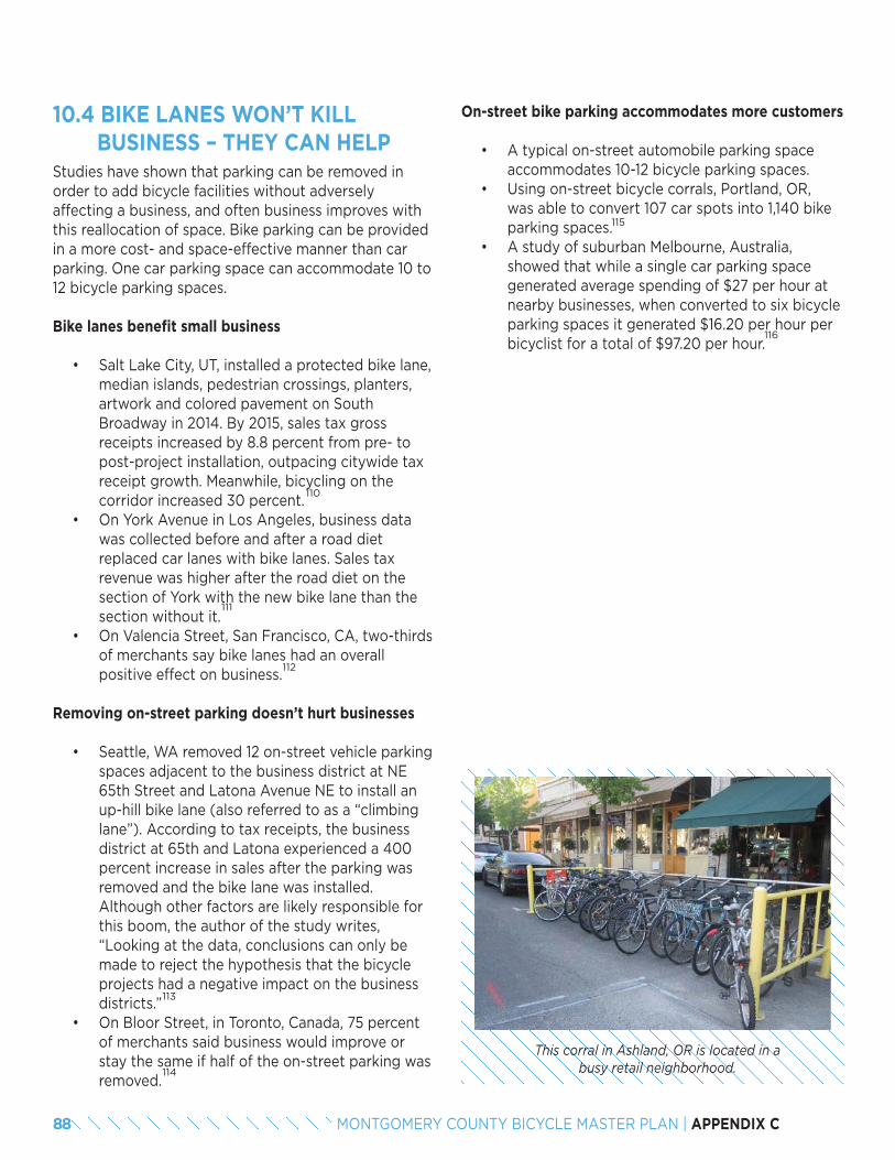
88 MONTGOMERY COUNTY BICYCLE MASTER PLAN | APPENDIX C
10.4 BIKE LANES WON’T KILL BUSINESS – THEY CAN HELP
Studies have shown that parking can be removed in order to add bicycle facilities without adversely affecting a business, and often business improves with this reallocation of space. Bike parking can be provided in a more cost- and space-effective manner than car parking. One car parking space can accommodate 10 to 12 bicycle parking spaces.
Bike lanes benefit small business
• Salt Lake City, UT, installed a protected bike lane, median islands, pedestrian crossings, planters, artwork and colored pavement on South Broadway in 2014. By 2015, sales tax gross receipts increased by 8.8 percent from pre- to post-project installation, outpacing citywide tax receipt growth. Meanwhile, bicycling on the corridor increased 30 percent.
• On York Avenue in Los Angeles, business data was collected before and after a road diet replaced car lanes with bike lanes. Sales tax revenue was higher after the road diet on the section of York with the new bike lane than the section without it.
• On Valencia Street, San Francisco, CA, two-thirds of merchants say bike lanes had an overall positive effect on business.
Removing on-street parking doesn’t hurt businesses
• Seattle, WA removed 12 on-street vehicle parking spaces adjacent to the business district at NE 65th Street and Latona Avenue NE to install an up-hill bike lane (also referred to as a “climbing lane”). According to tax receipts, the business district at 65th and Latona experienced a 400 percent increase in sales after the parking was removed and the bike lane was installed. Although other factors are likely responsible for this boom, the author of the study writes, “Looking at the data, conclusions can only be made to reject the hypothesis that the bicycle projects had a negative impact on the business districts.”
• On Bloor Street, in Toronto, Canada, 75 percent of merchants said business would improve or stay the same if half of the on-street parking was removed.
110
111
112
113
114
This corral in Ashland, OR is located in a busy retail neighborhood.
On-street bike parking accommodates more customers
• A typical on-street automobile parking space accommodates 10-12 bicycle parking spaces.
• Using on-street bicycle corrals, Portland, OR, was able to convert 107 car spots into 1,140 bike parking spaces.
• A study of suburban Melbourne, Australia, showed that while a single car parking space generated average spending of $27 per hour at nearby businesses, when converted to six bicycle parking spaces it generated $16.20 per hour per bicyclist for a total of $97.20 per hour.
115
116
89MONTGOMERY COUNTY BICYCLE MASTER PLAN | APPENDIX C
10.5 BICYCLISTS SAVE MONEY ON TRANSPORTATION THEY CAN SPEND ON LOCAL BUSINESSES
People who travel by bicycle save money on transportation and often have lower healthcare costs, due to a more active lifestyle, which leaves them with money to spend at local businesses.
• The American Automobile Association estimates that on average it costs $9,767 a year to own and operate an automobile (with ranges from $6,967 to $11,599, depending on the car-type).
• Typical estimates of the annual cost of bicycling range from $100 to $300.
117
118
10.6 BICYCLING ATTRACTS VISITORS. BICYCLE TOURISM IS BIG BUSINESS.
Bicycling is one of the most popular outdoor recreation activities and many communities are using bicycling facilities and trails to attract bicycling tourists, who spend more on average than other tourists.
• A 2004 study for the Virginia Department of Conservation on the Washington and Old Dominion Trail in suburban Northern Virginia found that 1.7 million users visit the trail annually, generating $7 million in spending in Northern Virginia businesses.
• Bicycle tourists tend to spend more than other visitor types. A 2013 study of bicycle tourism in Montana showed that bicycling tourists spend about $75 a day per person compared to $58 for visitors who arrived by car.
119
120
10.7 BUILDING BICYCLE INFRASTRUCTURE CREATES JOBS AND IS COST-EFFECTIVE.
Bicycling infrastructure projects tend to cost less than other transportation projects, and because they are labor-intensive and raw material-light relative to other projects, they create more jobs-per-dollar than other transportation projects.
• A study of transportation construction projects in Baltimore, MD, showed that bicycle infrastructure projects created 13 jobs per $1 million spent, while road projects created 7 jobs per $1 million spent.
• Building a bicycle transportation network is cost-effective relative to other modes. By 2007, Portland, OR had led the nation in building a more than 300-mile bikeway network for the cost of a single mile of urban freeway ($60 million).
121
122
10.8 ACTIVE TRANSPORTATION SAVES MONEY ON HEALTH CARE COSTS.
• A 2011 study conducted by the University of Northern Iowa’s Sustainable Tourism and Environment Program found that the 25,000 regular bicycle commuters and 150,000 recreational bicyclists in Iowa save the state $87 million in health care costs.
• Between 2007 and 2011, a period in which corporate health care costs increased 24 percent nationally, the healthcare costs of a Twin Cities, MN, manufacturer, Quality Bicycle Parts (QBP), dropped by 4.4 percent. The manufacturer’s own study showed that the cost savings resulted in large part from employee participation in its health reward program, which encouraged employees to bike to work. QBP estimates that its wellness program saved the company $903,000 over three years.
123
124
90 MONTGOMERY COUNTY BICYCLE MASTER PLAN | APPENDIX C
Case Study: Indianapolis, IN
Indianapolis, IN, is a city with a similar average population density (2,282 residents/mi2) as Montgomery County (2,100 residents/mi2) that has made significant investments in its bicycling network in recent years and is already seeing quantifiable returns. At the 2013 National Bike Summit, (now-former) Mayor Greg Ballard made the connection between bicycling and economic development, saying “We’ve added bike lanes and expanded our greenways to better connect residents to jobs, neighborhoods and great amenities to attract a new generation of talent.”
The 8-mile-long Indianapolis Cultural Trail is a high-profile downtown walking and biking facility connecting arts and cultural locations in the city. Since the trail was built, property values increased by a total of $1 billion, while generating at least $300 million in new construction along or near the trail and supporting an estimated 11,372 jobs.
Further from downtown, proximity to the popular Monon Trail, which connects the suburbancommunities of Carmel and Westfield to Indianapolis, has been shown to have a positive impact on property values. A home’s value increases by an average of $13,000 if it is within a half mile of the trail, compared to an identical home further away from the trail.
125
126
END NOTES90. http://www.europarl.europa.eu/RegData/etudes/etudes/join/2012/474569/IPOL-TRAN_ET(2012)474569_EN.pdf91. http://www.adventurecycling.org/default/assets/File/USBRS/Research/Wisconsin_bicycling_Final_Report.pdf92. http://www.peoplepoweredmovement.org/site/images/uploads/Economic_and_Health_Benefits_of_Bicycling_in_Iowa.pdf93. http://www.deanrunyan.com/doc_library/bicycletravel.pdf94. http://www.localmotion.org/reports95. http://www.tourism.umn.edu/96. http://njbikeped.org/portfolio/economic/97. http://www.routeverte.com/index_e.php?page=retombees_e98. http://www.ncdot.gov/bikeped/ 99. http://www.adventurecycling.org/default/assets/File/USBRS/Research/GAPeconomicImpactStudy200809.pdf100. http://www.adventurecycling.org/default/assets/File/USBRS/Research/Economic%20impact%20-%20FL%20Orange%20County%20Trail%205-11.pdf101. M. Leanne Lachman & Deborah L. Brett, Millennials Inside the Beltway: Optimistic Urbanists, 2015. http://washington.uli.org/wp-content/uploads/sites/56/2015/11/ULI_GenYRe-
port_101415_singles.pdf102. Global Strategy Group, Rockefeller Millennials Survey, 2014. http://t4america.org/wp-content/uploads/2014/04/RF-Millennials-Survey-Topline.pdf103. Urban Land Institute, America in 2015. http://uli.org/wp-content/uploads/ULI-Documents/America-in-2015.pdf104. Tom Fucoloro, “Chicago Mayor: I want Seattle’s bikers and the jobs that come with them,” December 17, 2012. http://www.seattlebikeblog.com/2012/12/17/chicago-mayor-i-want-
seattles-bikers-and-the-jobs-that-come-with-them/ ; Tom Fucoloro, “Mayor McGinn to Rahm Emanuel: Seattle will keep its bikers, thank you,” February 20, 2013. http://www.seattlebikeblog.com/2013/02/20/mayor-mcginn-to-rahm-emanuel-seattle-will-keep-its-bikers-thank-you/
105. Liz Murphy, “Suburbs Join the Rise of Bicycle Friendly Communities,” October 15, 2013. http://bikeleague.org/content/suburbs-join-rise-bicycle-friendly-communities106. Amelia Neptune, “There are now 1,090 bicycle friendly businesses in 49 states,” December 10, 2015. http://www.bikeleague.org/content/there-are-now-1090-bicycle-friendly-
businesses-49-states107. Kelly J. Clifton, Consumer Behavior and Travel Mode Choices, November 2012. http://kellyjclifton.com/Research/EconImpactsofBicycling/OTRECReport-ConsBehavTravelChoic-
es_Nov2012.pdf108. Transportation Alternatives, East Village Shopper Study: A Snapshot of the Travel and Spending Patterns of Residents and Visitors in the East Village, 2012. https://www.transalt.
org/sites/default/files/news/reports/2012/EV_Shopper_Study.pdf 109. Capital Bikeshare Member Survey Report, 2014. http://www.capitalbikeshare.com/assets/pdf/cabi-2014surveyreport.pdf110. Salt Lake City Division of Transportation, 300 South Progress Report: Broadway Protected Bike Lane, September, 2015. https://drive.google.com/file/d/0B8tOk7_upXv5djhCajg-
1Z0I3bmhTVTIxWldwRzA0YjJWNW9R/view111. York Blvd: The Economics of a Road Diet, http://nacto.org/docs/usdg/yorkblvd_mccormick.pdf112. https://www.sfbike.org/download/bikeplan/bikelanes.pdf113. https://docs.google.com/file/d/0B0xHj6OM3QVWMUxScjZuMndxVkk/edit114. http://www.bikeleague.org/sites/default/files/bikeleague/bikeleague.org/programs/bicyclefriendlyamerica/bicyclefriendlybusiness/pdfs/toronto_study_bike_lanes_parking.pdf115. On-street corrals consist of a segment of parking lane where bike racks are installed. Typically, the space is demarcated by bollards, curb stops or other physical barriers.116. Alison Lee, What is the Economic Contribution of Cyclists Compared to Car Drivers in Inner Suburban Melbourne’s Shopping Strips?, 2008. http://colabradio.mit.edu/wp-con-
tent/uploads/2010/12/Final_Thesis_Alison_Lee.pdf117. American Automobile Association, “Your Driving Costs: How Much Are You Really Paying to Drive?”, 2015. http://exchange.aaa.com/wp-content/uploads/2015/04/Your-Driving-
Costs-2015.pdf 118. Victoria Transport Policy Institute, “Transportation Cost and Benefit Analysis II – Vehicle Costs.” http://www.vtpi.org/tca/tca0501.pdf119. .M. Bowker, John C. Bergstrom, Joshua Gill, and Ursula Lemanski, The Washington & Old Dominion Trail: An Assessment of User Demographics, Preferences, and Economics,
2004. http://headwaterseconomics.org/wphw/wp-content/uploads/Trail_Study_21-washington-and-old-dominion-trail.pdf 120. Institute for Tourism and Recreation Research, University of Montana, Analysis of Touring Cyclists: Impacts, Needs and Opportunities, 2013. https://www.adventurecycling.org/
default/assets/File/USBRS/Research/Multi-dayCyclingStudyWeb.pdf 121. Heidi Garrett-Peltier, Estimating the Employment Impacts of Pedestrian, Bicycle, and Road Infrastructure, October 2011. http://www.peri.umass.edu/fileadmin/pdf/published_
study/PERI_ABikes_October2011.pdf122. Roger Geller, Build it and they will come: Portland Oregon’s experience with modest investments in bicycle transportation, April 2011. http://www.portlandoregon.gov/transpor-
tation/article/370893123. University of Northern Iowa Sustainable Tourism and Environment Program, Economic and Health Benefits of Bicycling in Iowa, Fall 2011.http://iowabicyclecoalition.org/wp-con-
tent/uploads/2012/04/2012-Economic-Impact-Study.pdf124. Quality Bike Products Health and Wellbeing Program, http://www.streetsblog.org/wp-content/uploads/2012/03/Quality-Bike-Products-Health-Reward-Program.pdf 125. Jessica Majors and Sue Burow, Assessment of the Impact of the Indianapolis Cultural Trail: A Legacy of Gene and Marilyn Glick, March 2015. http://indyculturaltrail.org.s3.ama-
zonaws.com/wp-content/uploads/2015/07/15-C02-CulturalTrail-Assessment.pdf126. G. Lindsey, J. Man, S. Payton, K. Dickson, Property Values, Recreation Values, and Urban Greenways, Journal of Park and Recreation Administration, Fall 2004.
http://staff.washington.edu/kwolf/Archive/Classes/ESRM304_SocSci/304%20Soc%20Sci%20Lab%20Articles/Lindsey_2004.pdf
91MONTGOMERY COUNTY BICYCLE MASTER PLAN | APPENDIX C
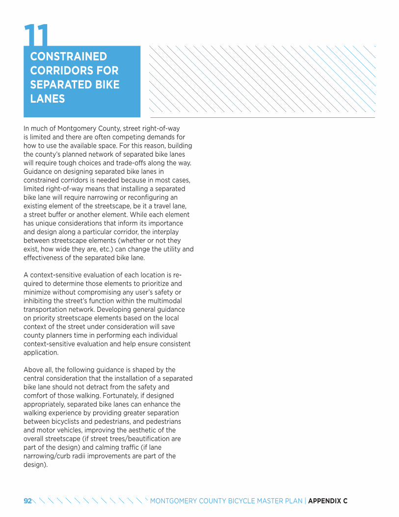
92 MONTGOMERY COUNTY BICYCLE MASTER PLAN | APPENDIX C
CONSTRAINED CORRIDORS FOR SEPARATED BIKE LANES
In much of Montgomery County, street right-of-way is limited and there are often competing demands for how to use the available space. For this reason, building the county’s planned network of separated bike lanes will require tough choices and trade-offs along the way. Guidance on designing separated bike lanes in constrained corridors is needed because in most cases, limited right-of-way means that installing a separated bike lane will require narrowing or reconfiguring an existing element of the streetscape, be it a travel lane, a street buffer or another element. While each element has unique considerations that inform its importance and design along a particular corridor, the interplay between streetscape elements (whether or not they exist, how wide they are, etc.) can change the utility and effectiveness of the separated bike lane.
A context-sensitive evaluation of each location is re-quired to determine those elements to prioritize and minimize without compromising any user’s safety or inhibiting the street’s function within the multimodal transportation network. Developing general guidance on priority streetscape elements based on the local context of the street under consideration will save county planners time in performing each individual context-sensitive evaluation and help ensure consistent application.
Above all, the following guidance is shaped by the central consideration that the installation of a separated bike lane should not detract from the safety and comfort of those walking. Fortunately, if designed appropriately, separated bike lanes can enhance the walking experience by providing greater separation between bicyclists and pedestrians, and pedestrians and motor vehicles, improving the aesthetic of the overall streetscape (if street trees/beautification are part of the design) and calming traffic (if lane narrowing/curb radii improvements are part of the design).
11
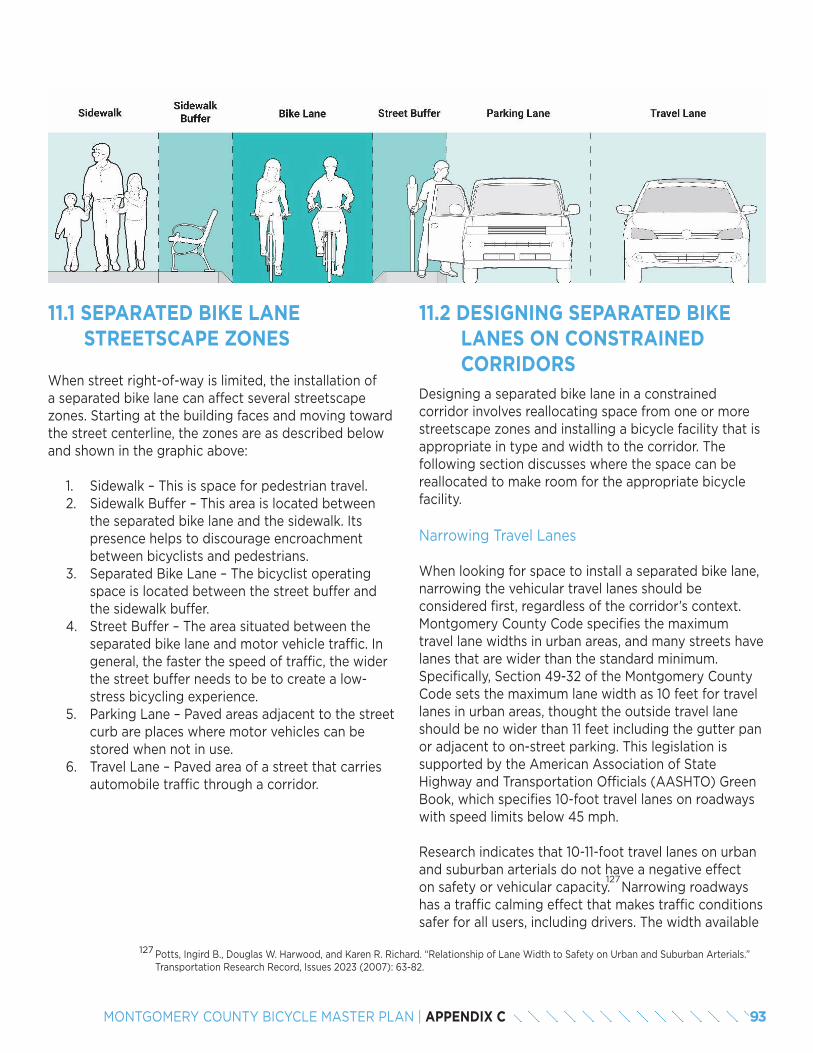
93MONTGOMERY COUNTY BICYCLE MASTER PLAN | APPENDIX C
11.1 SEPARATED BIKE LANE STREETSCAPE ZONES
When street right-of-way is limited, the installation of a separated bike lane can affect several streetscape zones. Starting at the building faces and moving toward the street centerline, the zones are as described below and shown in the graphic above:
1. Sidewalk – This is space for pedestrian travel. 2. Sidewalk Buffer – This area is located between
the separated bike lane and the sidewalk. Its presence helps to discourage encroachment between bicyclists and pedestrians.
3. Separated Bike Lane – The bicyclist operating space is located between the street buffer and the sidewalk buffer.
4. Street Buffer – The area situated between the separated bike lane and motor vehicle traffic. In general, the faster the speed of traffic, the wider the street buffer needs to be to create a low-stress bicycling experience.
5. Parking Lane – Paved areas adjacent to the street curb are places where motor vehicles can be stored when not in use.
6. Travel Lane – Paved area of a street that carries automobile traffic through a corridor.
11.2 DESIGNING SEPARATED BIKE LANES ON CONSTRAINED CORRIDORS
Designing a separated bike lane in a constrained corridor involves reallocating space from one or more streetscape zones and installing a bicycle facility that is appropriate in type and width to the corridor. The following section discusses where the space can be reallocated to make room for the appropriate bicycle facility.
Narrowing Travel Lanes
When looking for space to install a separated bike lane, narrowing the vehicular travel lanes should be considered first, regardless of the corridor’s context. Montgomery County Code specifies the maximum travel lane widths in urban areas, and many streets have lanes that are wider than the standard minimum. Specifically, Section 49-32 of the Montgomery County Code sets the maximum lane width as 10 feet for travel lanes in urban areas, thought the outside travel lane should be no wider than 11 feet including the gutter pan or adjacent to on-street parking. This legislation is supported by the American Association of State Highway and Transportation Officials (AASHTO) Green Book, which specifies 10-foot travel lanes on roadways with speed limits below 45 mph.
Research indicates that 10-11-foot travel lanes on urban and suburban arterials do not have a negative effect on safety or vehicular capacity. Narrowing roadways has a traffic calming effect that makes traffic conditions safer for all users, including drivers. The width available
127
Potts, Ingird B., Douglas W. Harwood, and Karen R. Richard. “Relationship of Lane Width to Safety on Urban and Suburban Arterials.” Transportation Research Record, Issues 2023 (2007): 63-82.
127
94 MONTGOMERY COUNTY BICYCLE MASTER PLAN | APPENDIX C
for a separated bike lane as a result of this lane narrowing depends on how wide and how many travel lanes currently exist. As an example, on a 4-lane road with 12-foot-wide lanes, narrowing to 10- and 11-foot-wide lanes provides 6 feet that could be reallocated for a separated bike lane.
Eliminating On-Street Parking
Depending on parking lane width, removing one on-street parking lane can provide 7 or more feet for separated bike lanes.
Eliminating Travel Lanes
If a road has more travel lanes than necessary based on traffic volume, travel lanes can be removed to provide space for separated bike lanes. There are other instances when travel lane removal should be considered due to the safety or operational benefits of fewer lanes. Planners should discuss the implications of travel lane removal with county engineers. Depending on travel lane width, lane removal could garner 10 or more feet for separated bike lanes.
Narrowing or Eliminating the Sidewalk Buffer
The space separating the sidewalk from the separated bike lane, which may hold landscaping or street furniture, can be minimized or removed to provide space for the bicycle facility.
Narrowing the Street Buffer
In general, the recommended street buffer width is 6 feet. In constrained conditions, street buffers may be narrowed to 2 feet.
Narrowing Separated Bike Lanes to Minimum Widths
While the ideal width for separated bike lanes is a function of expected peak hour use, in constrained circumstances, there are minimum recommended widths. For one-way separated bike lanes adjacent to curbs, lanes should be at least 5 feet wide. A width of 4 feet is allowed for short sections if vertical separation is not directly adjacent to the bike lane (e.g., curb, planter).
For a two-way facility, a minimum width of 8 feet is recommended. If more than 150 bicyclists are expected to use the planned facility during the peak hour, wider minimums are recommended. On constrained corridors with steep grades, wider bike lanes may be provided in the uphill roadway direction to enable faster moving bicyclists to pass slower ones.
Narrowing the Sidewalk
If the sidewalk is wider than necessary to accommodate current and planned pedestrian demand, it can be narrowed to provide space for a separated bike lane. Minimum sidewalk width in an urban context is 5 feet. As described below, this minimum sidewalk width is almost always the last resort, as bike facilities should enhance and not compromise the quality of the pedestrian environment.
11.3 DEFINING STREET TYPES
This section presents four different street types and recommends a hierarchy that can help planners and implementers consider where to repurpose space for separated bike lanes in a constrained urban environment.
Traffic Priority
These are streets that carry significant traffic volumes and are major regional travel arteries. Roads that fall into this type include Georgia Avenue and Veirs Mill Road in Montgomery County. When identifying space for separated bike lanes on these corridors, planners should use the following order of operations:
1. Narrowing travel lanes to minimum widths.2. Eliminating on-street parking: Vehicles
searching for parking and entering or exiting parking spaces slow through traffic and create vehicular conflicts. On-street parking is not critical to the function of these roads.
3. Narrowing or eliminating the sidewalk buffer.4. Narrowing the street buffer: On these streets,
higher traffic speeds and volumes make the street buffer very important for bicyclist comfort, especially if there is no on-street parking.
5. Narrowing the separated bike lane.
95MONTGOMERY COUNTY BICYCLE MASTER PLAN | APPENDIX C
6. Narrowing the sidewalk: This reduction would only be appropriate in areas where current or projected pedestrian volumes are low.
7. Eliminating travel lanes: This action should only be considered as a last resort because lane removal may create operational issues for the street.
Café Priority
These are streets with continuous ground-floor retail where outdoor seating and the pedestrian environment are particularly important. One example of this type of street is Woodmont Avenue between Elm Street and Bethesda Avenue in Montgomery County. On these streets, sidewalks and sidewalk buffers should not be narrowed. These streets rely on ample pedestrian space as an essential part of their public realm, facilitating commerce and social exchange. Planners looking to install separated bike lanes on these corridors should consider the following order of operations to provide the necessary space.
1. Narrowing travel lanes to minimum widths.2. Eliminating travel lanes.3. Eliminating on-street parking: This action may
have an adverse effect on retail businesses, but nearby off-street parking may be able to accom-modate short- and long-term parking need.
4. Narrowing the street buffer.5. Narrowing the separated bike lane.
On-Street Parking Priority
These are streets with high-demand on-street parking and limited or no off-street short-term parking options located within one or two blocks. One example of this type of street is Cordell Avenue from Old Georgetown Road to Wisconsin Avenue in Montgomery County. On these streets, on-street parking should remain part of the street design. Land uses on these streets require on-street parking to be successful. Planners looking to install separated bike lanes on these corridors should consider the following order of operations to provide the necessary space.
1. Narrowing travel lanes to minimum widths.2. Eliminating travel lanes.3. Narrowing or eliminating the sidewalk buffer.4. Narrowing the street buffer.
5. Narrowing the separated bike lane.6. Narrowing the sidewalk: This action would only
be appropriate in areas where current or projected pedestrian volumes are low.
Bikeway Priority
These are streets identified as priorities in the Bicycle Master Plan. They connect major destinations where no low-stress bikeway alternatives currently exist within three blocks. An example street is Bradley Boulevard between Wisconsin Avenue and Glenbrook Road in Montgomery County. Planners looking to install separated bike lanes on these corridors should consider the following order of operations to provide the necessary space.
1. Narrowing travel lanes to minimum widths.2. Eliminating on-street parking.3. Eliminating travel lanes.4. Narrowing or eliminating the sidewalk buffer.5. Narrowing the street buffer.6. Narrowing the separated bike lane.7. Narrowing the sidewalk: This action would only
be appropriate in areas where current or project-ed pedestrian volumes are low.
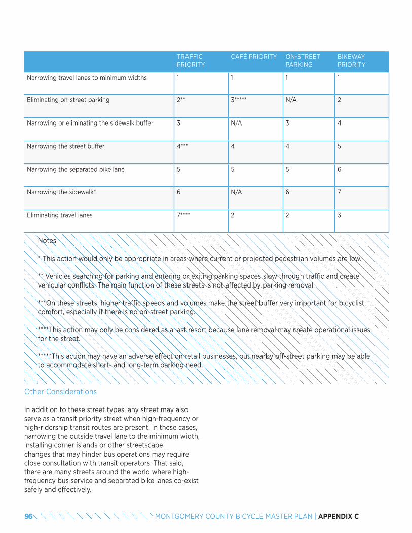
96 MONTGOMERY COUNTY BICYCLE MASTER PLAN | APPENDIX C
TRAFFIC PRIORITY
CAFÉ PRIORITY ON-STREET PARKING
BIKEWAY PRIORITY
Narrowing travel lanes to minimum widths 1 1 1 1
Eliminating on-street parking 2** 3***** N/A 2
Narrowing or eliminating the sidewalk buffer 3 N/A 3 4
Narrowing the street buffer 4*** 4 4 5
Narrowing the separated bike lane 5 5 5 6
Narrowing the sidewalk* 6 N/A 6 7
Eliminating travel lanes 7**** 2 2 3
Notes
* This action would only be appropriate in areas where current or projected pedestrian volumes are low.
** Vehicles searching for parking and entering or exiting parking spaces slow through traffic and create vehicular conflicts. The main function of these streets is not affected by parking removal.
***On these streets, higher traffic speeds and volumes make the street buffer very important for bicyclist comfort, especially if there is no on-street parking.
****This action may only be considered as a last resort because lane removal may create operational issues for the street.
*****This action may have an adverse effect on retail businesses, but nearby off-street parking may be able to accommodate short- and long-term parking need.
Other Considerations
In addition to these street types, any street may also serve as a transit priority street when high-frequency or high-ridership transit routes are present. In these cases, narrowing the outside travel lane to the minimum width, installing corner islands or other streetscape changes that may hinder bus operations may require close consultation with transit operators. That said, there are many streets around the world where high-frequency bus service and separated bike lanes co-exist safely and effectively.
97MONTGOMERY COUNTY BICYCLE MASTER PLAN | APPENDIX C
11.4 SORTING COUNTY STREETS INTO TYPES
Sorting streets into categories or types based on their role, purpose, and surrounding land use characteristics can help planners make decisions about what elements of the street design to prioritize. However, assigning street types is complicated, because most streets serve multiple purposes. The categories presented in the previous section are not intended to be exclusive. Similarly, a particular street may reflect the characteris-tics of multiple street types as the surrounding land use changes.
There are two main approaches for applying new street typologies and using them in the planning process: a countywide approach and a local approach. These approaches are often tied to a comprehensive complete streets plan that provides guidelines for the design of all street elements (not just separated bike lanes in constrained corridors).
The first approach to applying new types is to go through a process of categorizing county streets. This countywide process would be similar to the designation of functional classifications that is adopted as part of Montgomery County’s Master Plan of Highways and could potentially be adopted as part of an area master plan. Jurisdictions often undertake this process through a committee of staff from various divisions (planning, engineering, traffic, public works, transit, etc.). The group considers the characteristics and long-term vision of each street (and its surrounding land use contexts), and makes designations as a committee about each street’s appropriate type. This collaborative process can build broader consensus, but can also be very time-consuming and potentially contentious.
A second countywide approach for categorizing streets that has worked for some jurisdictions is for one staff person with a strong familiarity with the county to develop a first draft map with each street’s designation and circulate it to other staff for review and comment. The outcomes from this approach may be similar to the committee approach, but the process may be more streamlined. Often, there is agreement about many roadways and only a few streets may require focused discussion and debate.
One downside to a countywide approach is that designations represent a snapshot in time: decisions about a street’s context and purpose may not be relevant in a few years when a specific design decision is being contemplated.
Another alternative approach for designating street types is to consider the guidance provided in this document as advisory input and part of a localized, context-sensitive design process for each individual street. When a new project arises where a separated bike lane is being considered in a constrained environ-ment, county staff could use this guidance to make an appropriate decision about which street type fits the context of the corridor. This approach would allow more flexibility as land use character, development plans, and transportation networks evolve over time. For this reason, the localized approach is recommended for Montgomery County when separated bike lanes are considered as part of the Bicycle Master Plan.
11.5 CONCLUSIONThe ultimate priority for a specific street is a place-based decision that will help determine what methods and tools can be used to provide bike facilities (on that street).

98 MONTGOMERY COUNTY BICYCLE MASTER PLAN | APPENDIX C

APPENDIX DLEVEL OF TRAFFIC STRESS METHODOLOGY
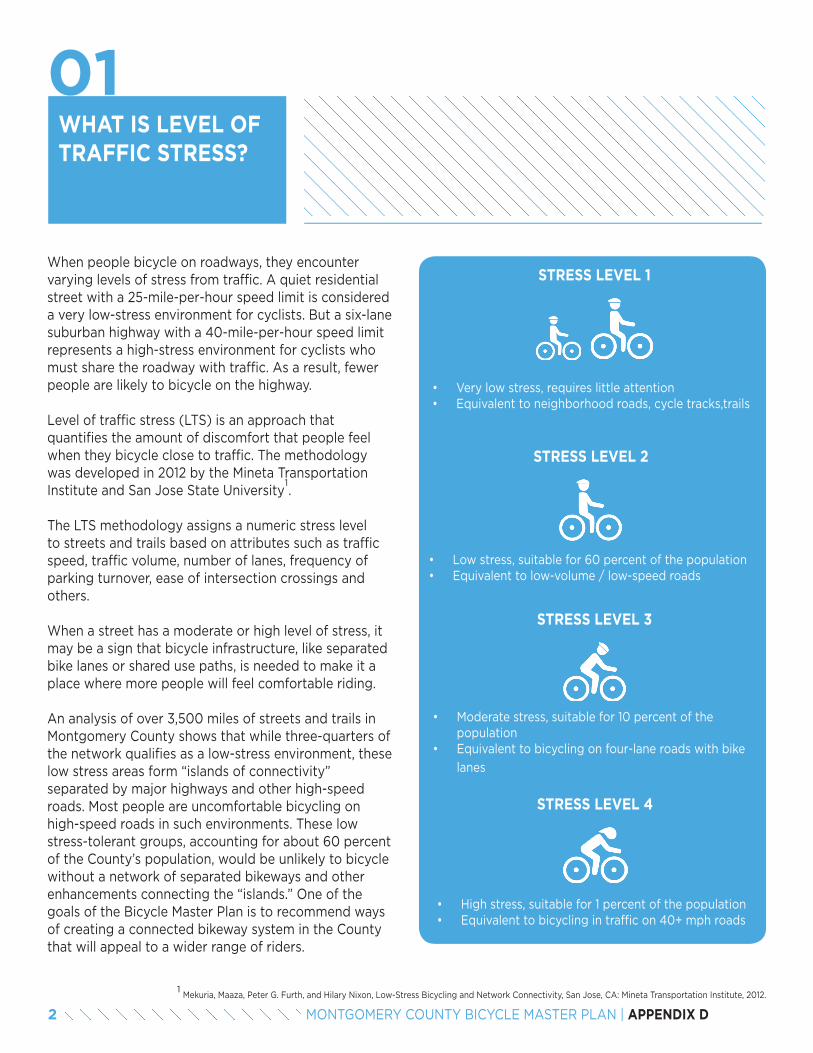
WHAT IS LEVEL OF TRAFFIC STRESS?
When people bicycle on roadways, they encounter varying levels of stress from traffic. A quiet residential street with a 25-mile-per-hour speed limit is considered a very low-stress environment for cyclists. But a six-lane suburban highway with a 40-mile-per-hour speed limit represents a high-stress environment for cyclists who must share the roadway with traffic. As a result, fewer people are likely to bicycle on the highway.
Level of traffic stress (LTS) is an approach that quantifies the amount of discomfort that people feel when they bicycle close to traffic. The methodology was developed in 2012 by the Mineta Transportation Institute and San Jose State University .
The LTS methodology assigns a numeric stress level to streets and trails based on attributes such as traffic speed, traffic volume, number of lanes, frequency of parking turnover, ease of intersection crossings and others.
When a street has a moderate or high level of stress, it may be a sign that bicycle infrastructure, like separated bike lanes or shared use paths, is needed to make it a place where more people will feel comfortable riding.
An analysis of over 3,500 miles of streets and trails in Montgomery County shows that while three-quarters of the network qualifies as a low-stress environment, these low stress areas form “islands of connectivity” separated by major highways and other high-speed roads. Most people are uncomfortable bicycling on high-speed roads in such environments. These low stress-tolerant groups, accounting for about 60 percent of the County’s population, would be unlikely to bicycle without a network of separated bikeways and other enhancements connecting the “islands.” One of the goals of the Bicycle Master Plan is to recommend ways of creating a connected bikeway system in the County that will appeal to a wider range of riders.
1
Mekuria, Maaza, Peter G. Furth, and Hilary Nixon, Low-Stress Bicycling and Network Connectivity, San Jose, CA: Mineta Transportation Institute, 2012.1
STRESS LEVEL 1
• Very low stress, requires little attention• Equivalent to neighborhood roads, cycle tracks,trails
• Low stress, suitable for 60 percent of the population• Equivalent to low-volume / low-speed roads
• Moderate stress, suitable for 10 percent of the population
• Equivalent to bicycling on four-lane roads with bike
lanes
• High stress, suitable for 1 percent of the population• Equivalent to bicycling in traffic on 40+ mph roads
STRESS LEVEL 2
STRESS LEVEL 3
STRESS LEVEL 4
01
2 MONTGOMERY COUNTY BICYCLE MASTER PLAN | APPENDIX D
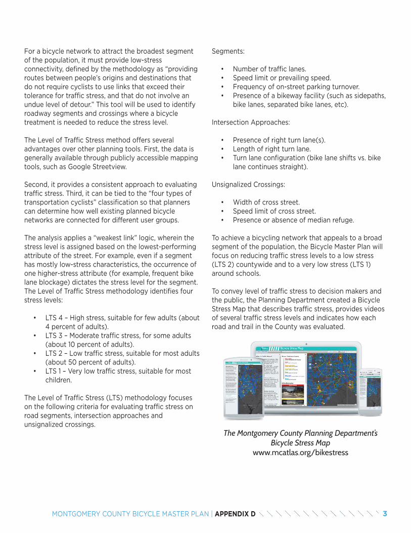
For a bicycle network to attract the broadest segment of the population, it must provide low-stress connectivity, defined by the methodology as “providing routes between people’s origins and destinations that do not require cyclists to use links that exceed their tolerance for traffic stress, and that do not involve an undue level of detour.” This tool will be used to identify roadway segments and crossings where a bicycle treatment is needed to reduce the stress level.
The Level of Traffic Stress method offers several advantages over other planning tools. First, the data is generally available through publicly accessible mapping tools, such as Google Streetview.
Second, it provides a consistent approach to evaluating traffic stress. Third, it can be tied to the “four types of transportation cyclists” classification so that planners can determine how well existing planned bicycle networks are connected for different user groups.
The analysis applies a “weakest link” logic, wherein the stress level is assigned based on the lowest-performing attribute of the street. For example, even if a segment has mostly low-stress characteristics, the occurrence of one higher-stress attribute (for example, frequent bike lane blockage) dictates the stress level for the segment.The Level of Traffic Stress methodology identifies four stress levels:
• LTS 4 – High stress, suitable for few adults (about 4 percent of adults).
• LTS 3 – Moderate traffic stress, for some adults (about 10 percent of adults).
• LTS 2 – Low traffic stress, suitable for most adults (about 50 percent of adults).
• LTS 1 – Very low traffic stress, suitable for most children.
The Level of Traffic Stress (LTS) methodology focuses on the following criteria for evaluating traffic stress on road segments, intersection approaches and unsignalized crossings.
Segments:
• Number of traffic lanes. • Speed limit or prevailing speed.• Frequency of on-street parking turnover.• Presence of a bikeway facility (such as sidepaths,
bike lanes, separated bike lanes, etc).
Intersection Approaches:
• Presence of right turn lane(s).• Length of right turn lane.• Turn lane configuration (bike lane shifts vs. bike
lane continues straight).
Unsignalized Crossings:
• Width of cross street.• Speed limit of cross street.• Presence or absence of median refuge.
To achieve a bicycling network that appeals to a broad segment of the population, the Bicycle Master Plan will focus on reducing traffic stress levels to a low stress (LTS 2) countywide and to a very low stress (LTS 1) around schools.
To convey level of traffic stress to decision makers and the public, the Planning Department created a Bicycle Stress Map that describes traffic stress, provides videos of several traffic stress levels and indicates how each road and trail in the County was evaluated.
The Montgomery County Planning Department’s Bicycle Stress Map
www.mcatlas.org/bikestress
3MONTGOMERY COUNTY BICYCLE MASTER PLAN | APPENDIX D
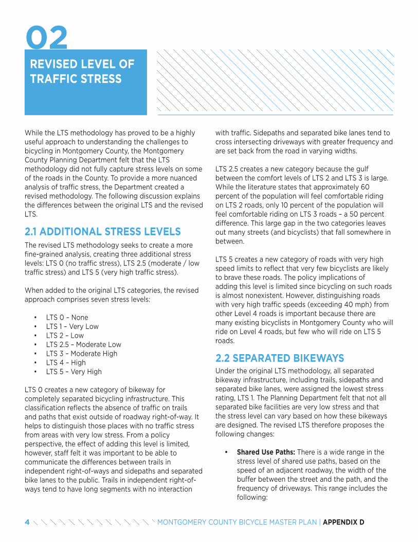
REVISED LEVEL OF TRAFFIC STRESS
The revised LTS methodology seeks to create a more fine-grained analysis, creating three additional stress levels: LTS 0 (no traffic stress), LTS 2.5 (moderate / low traffic stress) and LTS 5 (very high traffic stress).
When added to the original LTS categories, the revised approach comprises seven stress levels:
• LTS 0 – None• LTS 1 – Very Low• LTS 2 – Low• LTS 2.5 – Moderate Low• LTS 3 – Moderate High• LTS 4 – High• LTS 5 – Very High
LTS 0 creates a new category of bikeway for completely separated bicycling infrastructure. This classification reflects the absence of traffic on trails and paths that exist outside of roadway right-of-way. It helps to distinguish those places with no traffic stress from areas with very low stress. From a policy perspective, the effect of adding this level is limited, however, staff felt it was important to be able to communicate the differences between trails in independent right-of-ways and sidepaths and separated bike lanes to the public. Trails in independent right-of-ways tend to have long segments with no interaction
with traffic. Sidepaths and separated bike lanes tend to cross intersecting driveways with greater frequency and are set back from the road in varying widths.
LTS 2.5 creates a new category because the gulf between the comfort levels of LTS 2 and LTS 3 is large. While the literature states that approximately 60 percent of the population will feel comfortable riding on LTS 2 roads, only 10 percent of the population will feel comfortable riding on LTS 3 roads – a 50 percent difference. This large gap in the two categories leaves out many streets (and bicyclists) that fall somewhere in between.
LTS 5 creates a new category of roads with very high speed limits to reflect that very few bicyclists are likely to brave these roads. The policy implications of adding this level is limited since bicycling on such roads is almost nonexistent. However, distinguishing roads with very high traffic speeds (exceeding 40 mph) from other Level 4 roads is important because there are many existing bicyclists in Montgomery County who will ride on Level 4 roads, but few who will ride on LTS 5 roads.
Under the original LTS methodology, all separated bikeway infrastructure, including trails, sidepaths and separated bike lanes, were assigned the lowest stress rating, LTS 1. The Planning Department felt that not all separated bike facilities are very low stress and that the stress level can vary based on how these bikeways are designed. The revised LTS therefore proposes the following changes:
• Shared Use Paths: There is a wide range in the stress level of shared use paths, based on the speed of an adjacent roadway, the width of the buffer between the street and the path, and the frequency of driveways. This range includes the following:
While the LTS methodology has proved to be a highly useful approach to understanding the challenges to bicycling in Montgomery County, the Montgomery County Planning Department felt that the LTS methodology did not fully capture stress levels on some of the roads in the County. To provide a more nuanced analysis of traffic stress, the Department created a revised methodology. The following discussion explains the differences between the original LTS and the revised LTS.
2.1 ADDITIONAL STRESS LEVELS
02
2.2 SEPARATED BIKEWAYS
4 MONTGOMERY COUNTY BICYCLE MASTER PLAN | APPENDIX D
» Independent rights-of-way: Independent rights-of-way, such as railroad and utility corridors or along waterways were assumed to have a LTS 0 (ie, no traffic stress), except where they cross a street.
» Sidepaths with wide buffers and few driveways: Sidepaths are assumed to be suitable for most children (LTS 1) if the sidepath is separated from traffic by a minimum 5-foot-wide buffer, has few driveways and a posted speed limit of 35 mph or less. On higher speed roads, the LTS is 2, unless there is a very wide buffer separating the sidepath from traffic.
» Sidepaths with narrow buffers and many driveways: Sidepaths are assumed to have a stress level of LTS 2 (suitable for most adults) when the sidepath is separated from traffic by less than a 5-foot-wide buffer, has many driveways or a posted speed limit of 35 mph or less. On higher speed roads, the stress level is LTS 2.5.
• Separated Bike Lanes: Separated bike lanes that are buffered from traffic by a row of parked cars or a wide landscaped generate a lower level of stress. When the separation consists of flexible delineator posts or bollards, there is a higher level of stress, depending on the speed of traffic and the number of traffic lanes.
» Buffered by on-street parking: A separated bike lane that is buffered from traffic by on-street parking has a stress level of LTS 1 (suitable for many children).
» Buffered by a wide separation: A separated bike lane that is buffered from traffic by a landscaped panel has a stress level of LTS 1 (suitable for most children) when the posted speed limit is 35 mph or less. On roads with speeds of more than 35 mph, the stress level rises to LTS 2 (suitable for most adults), unless the buffer is wide.
» Buffered by flexible delineator posts or bollards: While flexible delineator posts and bollards provide some separation from traffic, the buffer is typically narrow and generally is unsuitable for children (except on 2 to 3 lane roads with a maximum speed limit of 25 mph). Over 35 mph, the road has a stress level of LTS 2.5 (suitable for some adults).
According to the original LTS methodology, bike lanes that are frequently blocked (by double-parked cars, cars pulling in and out of a parking space, and people getting in and out of cars) increase the stress level to LTS 3 because cyclists are forced to temporarily merge into the adjacent travel lane.
While areas with high parking turnover create additional stress, the original LTS approach assumes that only LTS 3 cyclists will bicycle in this environment (roughly 10 percent of the adult population). While we lack empirical data to prove it, it seems excessive to assume that only 10 percent of the adult population will be comfortable bicycling on streets with a high degree of parking turnover. Therefore, the revised level of traffic stress assigns a stress level of 2.5 to bike lanes that are frequently blocked. (Note: our proxy for frequently blocked bike lanes was presence in a commercial area.)
2.3 EFFECT OF FREQUENTLY BLOCKED BIKE LANES
5MONTGOMERY COUNTY BICYCLE MASTER PLAN | APPENDIX D
The original Level of Traffic Stress treats roads such as Sligo Creek Parkway the same as a two-lane residential street with a 25-mph speed limit and a painted centerline. However, many bicyclists would consider Sligo Creek Parkway to be the more stressful experience because it lacks context cues to advise motorists to expect bicyclists.
To reflect that many cyclists experience more stress on roads such as Sligo Creek Parkway, the Planning Department used the presence of on-street parking and lower traffic volumes (less than 6,000 daily vehicles) to differentiate residential two-lane streets from two-lane streets like Sligo Creek Parkway. Therefore, 2 to 3 lane streets with 25-mph speed limits and a centerline and no on-street parking are moderate stress roads (LTS 3). The presence of on-street parking reduces the stress level. Where on-street parking is not present, the street may still be categorized as low stress as long as it has fewer than 6,000 vehicles per day. While parking is not a perfect proxy for capturing these variables, it is a good estimator of whether a street is likely to be in an environment that will generate less stress for cyclists.
Additionally, the original level of traffic stress treats 2 to 3 lane roads with 25 mph speed limits and no centerline as very low stress roads (LTS 1). However, on roads without higher traffic volumes (less than 3,000 vehicles per day), the LTS was increased to 2 (low stress).
2.4 ARE ALL TWO-LANE ROADS CREATED EQUAL?
The original LTS states that speeds of 40 mph or faster trigger a high stress level (LTS 4). The revised LTS reduces the stress level to moderate (LTS 3) on 2 to 3 lane roads with bike lanes and on 4 to 5 lane roads with a raised median.
2.5 SPEED TRIGGER FOR TABLE 3: CRITERIA FOR BIKE LANES NOT ALONGSIDE A PARKING LANE
As discussed previously, the addition of a LTS 2.5 category allows the large gap between the stress tolerance of the LTS 2 and LTS 3 categories to be bridged and identify an intermediate level of stress. This new category was used in several instances:
• For undivided roads with bike lanes that are infrequently obstructed and a posted speed limit of 25 or 30 mph, the original LTS is 1 or 2 (depending on the bike lane width) if there are 2 to 3 lanes, LTS 3 if there are 4 to 5 lanes, and LTS 3 if there are 6 or more lanes. The addition of the LTS 2.5 category allows for differentiation between the 4 to 5 lane roads and the 6 and wider lane roads.
2.6 ADDITIONAL UTILIZATION OF THE LTS 2.5 CATEGORY
Stress levels on streets identified as industrial in the County’s master plans are assigned a minimum LTS of 2.5, given the greater volume of truck traffic on these roads.
2.7 INDUSTRIAL STREETS
6 MONTGOMERY COUNTY BICYCLE MASTER PLAN | APPENDIX D

7MONTGOMERY COUNTY BICYCLE MASTER PLAN | APPENDIX D
DIFFERENCES BETWEEN ORIGINAL AND REVISED LEVELS OF TRAFFIC STRESS
The following charts summarize the differences between the original level of traffic stress and the revised LTS. The changes are evaluated in mixed traffic, roads with bike lanes and roads with separated bikeways (sidepaths, independent rights-of-way and separated bike lanes).
Notes
a. if road is residential or posted speed limit is less than 25 mph
b. if there is a raised medianc. if Average Daily Traffic is less than 6,000 ADTd. if Average Daily Traffic is less than 3,000 ADTe. if buffer is wide f. if a road is residential and buffer is at least 5 feet
wide
03
= differences from original level of traffic stress
8 MONTGOMERY COUNTY BICYCLE MASTER PLAN | APPENDIX D
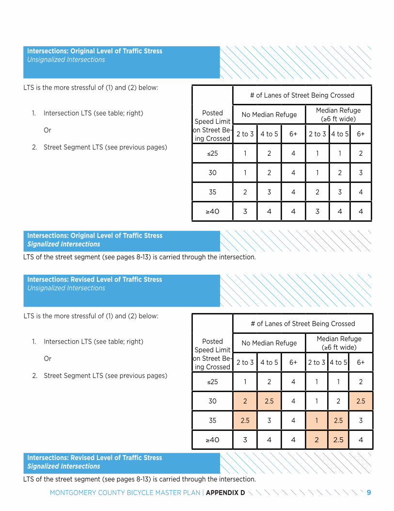
Posted Speed Limit
on Street Be-ing Crossed
# of Lanes of Street Being Crossed
No Median RefugeMedian Refuge
(≥6 ft wide)
2 to 3 4 to 5 6+ 2 to 3 4 to 5 6+
≤25 1 2 4 1 1 2
30 1 2 4 1 2 3
35 2 3 4 2 3 4
≥40 3 4 4 3 4 4
Intersections: Original Level of Traffic StressUnsignalized Intersections
LTS is the more stressful of (1) and (2) below:
1. Intersection LTS (see table; right) Or
2. Street Segment LTS (see previous pages)
Intersections: Revised Level of Traffic StressUnsignalized Intersections
LTS is the more stressful of (1) and (2) below:
1. Intersection LTS (see table; right) Or
2. Street Segment LTS (see previous pages)
Intersections: Original Level of Traffic StressSignalized Intersections
Posted Speed Limit
on Street Be-ing Crossed
# of Lanes of Street Being Crossed
No Median RefugeMedian Refuge
(≥6 ft wide)
2 to 3 4 to 5 6+ 2 to 3 4 to 5 6+
≤25 1 2 4 1 1 2
30 2 2.5 4 1 2 2.5
35 2.5 3 4 1 2.5 3
≥40 3 4 4 2 2.5 4
LTS of the street segment (see pages 8-13) is carried through the intersection.
Intersections: Revised Level of Traffic StressSignalized Intersections
LTS of the street segment (see pages 8-13) is carried through the intersection.
9MONTGOMERY COUNTY BICYCLE MASTER PLAN | APPENDIX D
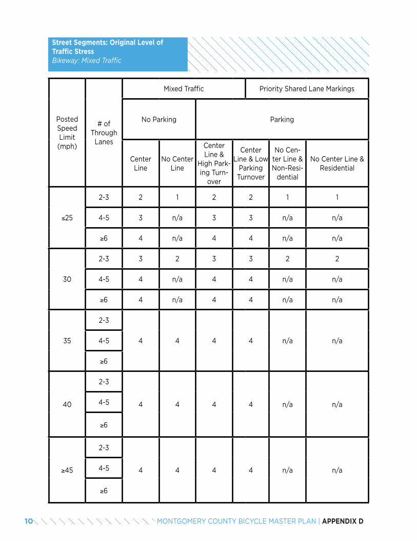
Street Segments: Original Level of Traffic StressBikeway: Mixed Traffic
Posted Speed Limit (mph)
# of Through
Lanes
Mixed Traffic Priority Shared Lane Markings
No Parking Parking
Center Line
No Center Line
Center Line &
High Park-ing Turn-
over
Center Line & Low
Parking Turnover
No Cen-ter Line & Non-Resi-
dential
No Center Line & Residential
≤25
2-3 2 1 2 2 1 1
4-5 3 n/a 3 3 n/a n/a
≥6 4 n/a 4 4 n/a n/a
30
2-3 3 2 3 3 2 2
4-5 4 n/a 4 4 n/a n/a
≥6 4 n/a 4 4 n/a n/a
35
2-3
4 4 4 4 n/a n/a4-5
≥6
40
2-3
4 4 4 4 n/a n/a4-5
≥6
≥45
2-3
4 4 4 4 n/a n/a4-5
≥6
10 MONTGOMERY COUNTY BICYCLE MASTER PLAN | APPENDIX D
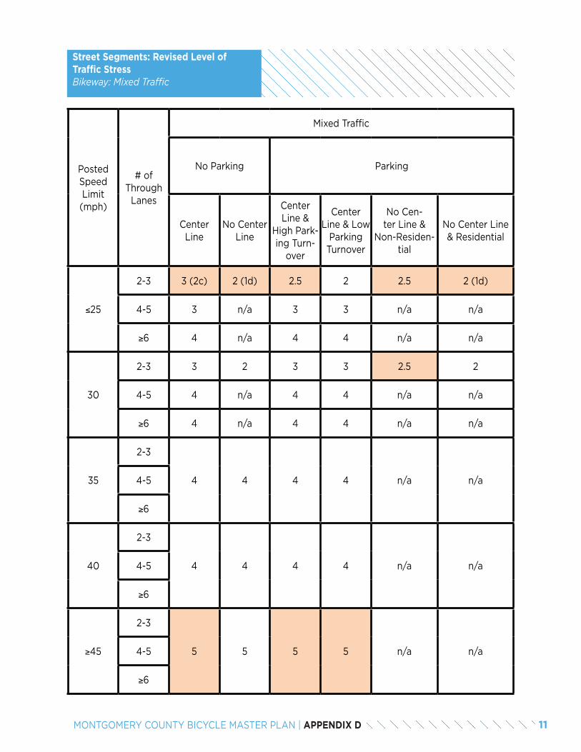
Street Segments: Revised Level of Traffic StressBikeway: Mixed Traffic
Posted Speed Limit (mph)
# of Through
Lanes
Mixed Traffic
No Parking Parking
Center Line
No Center Line
Center Line &
High Park-ing Turn-
over
Center Line & Low
Parking Turnover
No Cen-ter Line &
Non-Residen-tial
No Center Line & Residential
≤25
2-3 3 (2c) 2 (1d) 2.5 2 2.5 2 (1d)
4-5 3 n/a 3 3 n/a n/a
≥6 4 n/a 4 4 n/a n/a
30
2-3 3 2 3 3 2.5 2
4-5 4 n/a 4 4 n/a n/a
≥6 4 n/a 4 4 n/a n/a
35
2-3
4 4 4 4 n/a n/a4-5
≥6
40
2-3
4 4 4 4 n/a n/a4-5
≥6
≥45
2-3
5 5 5 5 n/a n/a4-5
≥6
11MONTGOMERY COUNTY BICYCLE MASTER PLAN | APPENDIX D
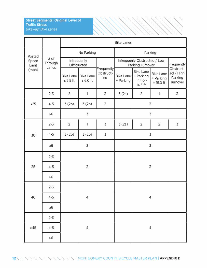
Street Segments: Original Level of Traffic StressBikeway: Bike Lanes
Posted Speed Limit (mph)
# of Through
Lanes
Bike Lanes
No Parking Parking
Infrequenly Obstructed
Frequently Obstruct-
ed
Infrequenly Obstructed / Low Parking Turnover Frequently
Obstruct-ed / High Parking
Turnover
Bike Lane ≤ 5.5 ft
Bike Lane ≥ 6.0 ft
Bike Lane + Parking
Bike Lane + Parking = 14.0 - 14.5 ft
Bike Lane + Parking = 15.0 ft
≤25
2-3 2 1 3 3 (2a) 2 1 3
4-5 3 (2b) 3 (2b) 3 3
≥6 3 3
30
2-3 2 1 3 3 (2a) 2 2 3
4-5 3 (2b) 3 (2b) 3 3
≥6 3 3
35
2-3
3 34-5
≥6
40
2-3
4 44-5
≥6
≥45
2-3
4 44-5
≥6
12 MONTGOMERY COUNTY BICYCLE MASTER PLAN | APPENDIX D
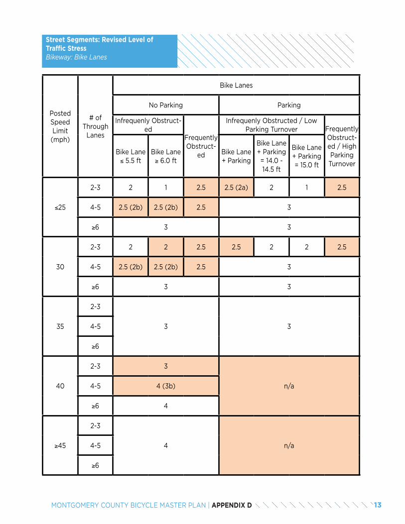
Posted Speed Limit (mph)
# of Through
Lanes
Bike Lanes
No Parking Parking
Infrequenly Obstruct-ed
Frequently Obstruct-
ed
Infrequenly Obstructed / Low Parking Turnover Frequently
Obstruct-ed / High Parking
Turnover
Bike Lane ≤ 5.5 ft
Bike Lane ≥ 6.0 ft
Bike Lane + Parking
Bike Lane + Parking = 14.0 - 14.5 ft
Bike Lane + Parking = 15.0 ft
≤25
2-3 2 1 2.5 2.5 (2a) 2 1 2.5
4-5 2.5 (2b) 2.5 (2b) 2.5 3
≥6 3 3
30
2-3 2 2 2.5 2.5 2 2 2.5
4-5 2.5 (2b) 2.5 (2b) 2.5 3
≥6 3 3
35
2-3
3 34-5
≥6
40
2-3 3
n/a4-5 4 (3b)
≥6 4
≥45
2-3
4 n/a4-5
≥6
Street Segments: Revised Level of Traffic StressBikeway: Bike Lanes
13MONTGOMERY COUNTY BICYCLE MASTER PLAN | APPENDIX D
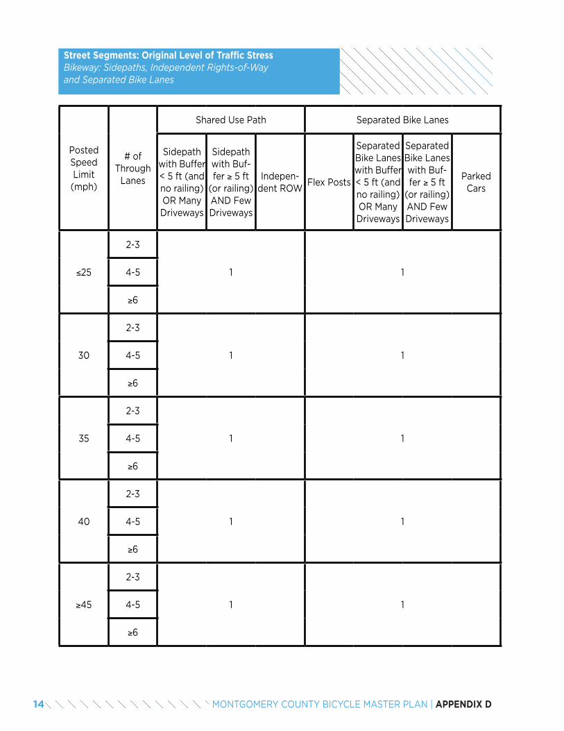
Street Segments: Original Level of Traffic StressBikeway: Sidepaths, Independent Rights-of-Way and Separated Bike Lanes
Posted Speed Limit (mph)
# of Through
Lanes
Shared Use Path Separated Bike Lanes
Sidepath with Buffer < 5 ft (and no railing) OR Many Driveways
Sidepath with Buf-fer ≥ 5 ft
(or railing) AND Few Driveways
Indepen-dent ROW
Flex Posts
Separated Bike Lanes with Buffer < 5 ft (and no railing) OR Many Driveways
Separated Bike Lanes with Buf-fer ≥ 5 ft
(or railing) AND Few Driveways
Parked Cars
≤25
2-3
1 14-5
≥6
30
2-3
1 14-5
≥6
35
2-3
1 14-5
≥6
40
2-3
1 14-5
≥6
≥45
2-3
1 14-5
≥6
14 MONTGOMERY COUNTY BICYCLE MASTER PLAN | APPENDIX D
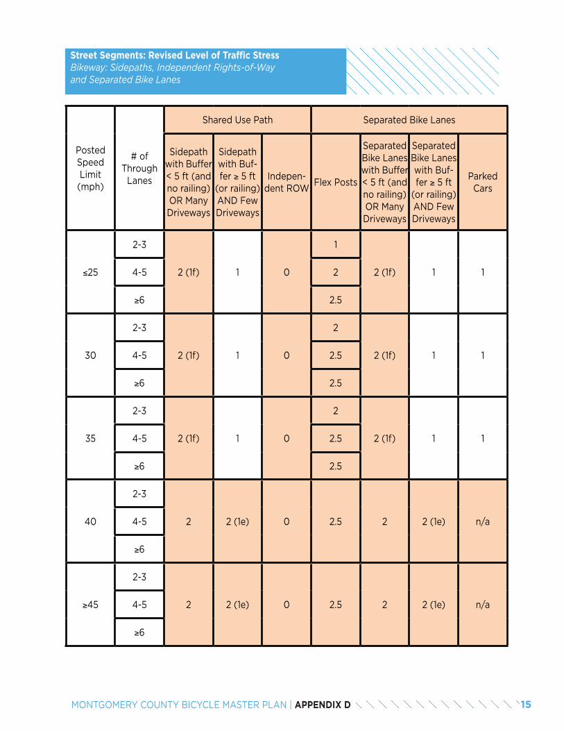
Posted Speed Limit (mph)
# of Through
Lanes
Shared Use Path Separated Bike Lanes
Sidepath with Buffer < 5 ft (and no railing) OR Many Driveways
Sidepath with Buf-fer ≥ 5 ft
(or railing) AND Few Driveways
Indepen-dent ROW
Flex Posts
Separated Bike Lanes with Buffer < 5 ft (and no railing) OR Many Driveways
Separated Bike Lanes with Buf-fer ≥ 5 ft
(or railing) AND Few Driveways
Parked Cars
≤25
2-3
2 (1f) 1 0
1
2 (1f) 1 14-5 2
≥6 2.5
30
2-3
2 (1f) 1 0
2
2 (1f) 1 14-5 2.5
≥6 2.5
35
2-3
2 (1f) 1 0
2
2 (1f) 1 14-5 2.5
≥6 2.5
40
2-3
2 2 (1e) 0 2.5 2 2 (1e) n/a4-5
≥6
≥45
2-3
2 2 (1e) 0 2.5 2 2 (1e) n/a4-5
≥6
Street Segments: Revised Level of Traffic StressBikeway: Sidepaths, Independent Rights-of-Way and Separated Bike Lanes
15MONTGOMERY COUNTY BICYCLE MASTER PLAN | APPENDIX D
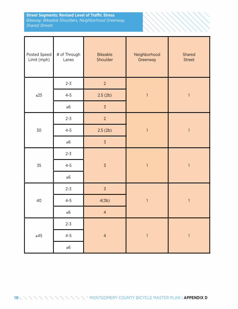
Posted Speed Limit (mph)
# of Through Lanes
Bikeable Shoulder
Neighborhood Greenway
SharedStreet
≤25
2-3 2
1 14-5 2.5 (2b)
≥6 3
30
2-3 2
1 14-5 2.5 (2b)
≥6 3
35
2-3
3 1 14-5
≥6
40
2-3 3
1 14-5 4(3b)
≥6 4
≥45
2-3
4 1 14-5
≥6
Street Segments: Revised Level of Traffic StressBikeway: Bikeable Shoulders, Neighborhood Greenway, Shared Streets
16 MONTGOMERY COUNTY BICYCLE MASTER PLAN | APPENDIX D

17MONTGOMERY COUNTY BICYCLE MASTER PLAN | APPENDIX D

18 MONTGOMERY COUNTY BICYCLE MASTER PLAN | APPENDIX D

APPENDIX EBIKEWAY PRIORITIZATION METHODOLOGY
2 MONTGOMERY COUNTY BICYCLE MASTER PLAN | APPENDIX E
The network of bikeways recommended in the Bicycle Master Plan is extensive and is likely to be only partial-ly completed during the 25-year life of this plan. Such a large network is proposed so that opportunities to implement the preferred bicycling network are not lost when unforeseen circumstances arise. At the same time, it is important to identify priorities within the network, so the most important bikeways and facilities are con-structed first.
The Bicycle Master Plan creates a new approach to un-derstanding potential bicycle demand by converting the regional travel demand model to a potential demand model for bicycling. This analysis was a primary factor in prioritizing bikeway recommendations and is tied to the goals and objectives of the plan.
Specifically, Goal 2 and Goal 3 include five metrics that measure progress in increasing low-stress connectivity:
• Metric 2.1: Percentage of potential bicycle trips that can be made on a low-stress bicycling network.
• Metric 2.2: Percentage of dwelling units within 2 miles of each Red Line, Brunswick Line, Purple Line and Corridor Cities Transitway station that are con-nected to the transit station on a low-stress bicy-cling network.
• Metric 2.3: Percentage of dwelling units within one mile of elementary schools, 1.5 miles of middle schools and 2 miles of high schools that are con-nected to the schools on a very low-stress bicycling network.
• Metric 2.4: Percentage of dwelling units within 2 miles of public libraries, recreation centers and re-gional / recreational parks that are connected to the public facility on a low-stress bicycling network.
• Metric 3.1: Percentage of potential bicycle trips that can be made on a low-stress bicycling network in Census tracts where the median income is below 60 percent of the Montgomery County average median income.
An evaluation of the connectivity metrics in the Bicycle Master Plan relies on three major inputs:
• The proposed low-stress bicycling network in Mont-gomery County.
• A 2040 matrix of all trips focused on areas that are likely to generate the most bicycling in Montgomery County.
• Refined geographic units of analysis by reducing the size of transportation analysis zones (TAZs) into smaller geographic areas.
Input 1: Low-Stress Bicycling Network
In order to attract the broadest segment of the pop-ulation to bicycle, Montgomery County must create a bicycling network that does not exceed people’s tol-erance for traffic stress and does not require an exces-sive level of detour. While currently about 75 percent of street mileage in Montgomery County is low-stress, these streets largely represent “islands of connectivity” that are separated by arterial roads and environmental barriers such that only 18 percent of trips can be made by bicycle.
The Bicycle Master Plan recommends a network of low-stress bikeways to connect residential communities to the places in the county where people want to go, including transit stations, employment centers, retail destinations, public facilities and other activity centers. All roads were assigned a level of traffic stress using the methodology explained in Appendix D.
Input 2: 2040 Trip Table
A subset of the regional travel demand model was se-lected to be included in the connectivity analysis. While there are certainly some daily bike trips between Mont-gomery County and all jurisdictions in the region, the likelihood that a trip will be made by bicycle decreases with distance. It is therefore possible to remove many areas in the region from the analysis while still creating a useful representation of potential demand.
INTRODUCTION DATA INPUTS
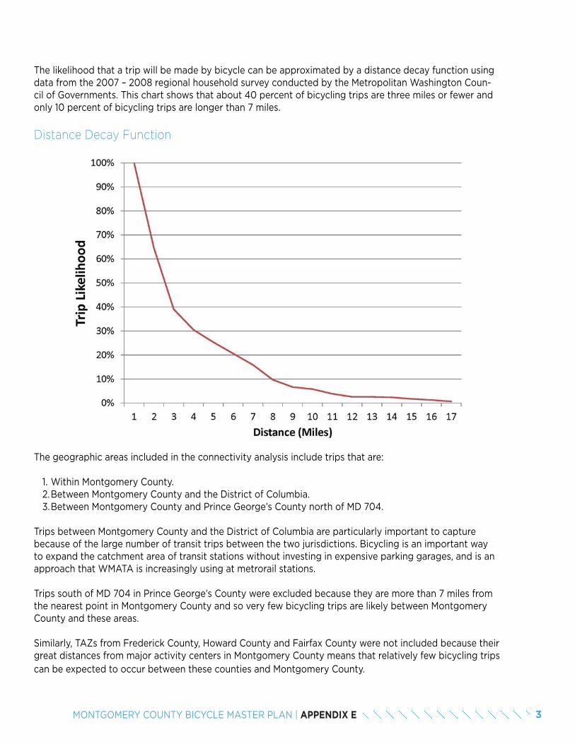
3MONTGOMERY COUNTY BICYCLE MASTER PLAN | APPENDIX E
The likelihood that a trip will be made by bicycle can be approximated by a distance decay function using data from the 2007 – 2008 regional household survey conducted by the Metropolitan Washington Coun-cil of Governments. This chart shows that about 40 percent of bicycling trips are three miles or fewer and only 10 percent of bicycling trips are longer than 7 miles.
Distance Decay Function
The geographic areas included in the connectivity analysis include trips that are:
1. Within Montgomery County.2. Between Montgomery County and the District of Columbia.3. Between Montgomery County and Prince George’s County north of MD 704.
Trips between Montgomery County and the District of Columbia are particularly important to capture because of the large number of transit trips between the two jurisdictions. Bicycling is an important way to expand the catchment area of transit stations without investing in expensive parking garages, and is an approach that WMATA is increasingly using at metrorail stations.
Trips south of MD 704 in Prince George’s County were excluded because they are more than 7 miles from the nearest point in Montgomery County and so very few bicycling trips are likely between Montgomery County and these areas.
Similarly, TAZs from Frederick County, Howard County and Fairfax County were not included because their great distances from major activity centers in Montgomery County means that relatively few bicycling trips can be expected to occur between these counties and Montgomery County.
4 MONTGOMERY COUNTY BICYCLE MASTER PLAN | APPENDIX E
Input 3: Geographic Units for Measuring Bicycle Travel
Just as travel demand models are helpful at understanding future travel patterns via automobile or transit, they can also be used to understand future travel by bicycle. Since their geographic unit of measurement – TAZs – is too large to adequately distinguish areas where barriers to connectivity exist for bicycling, a smaller unit of geography is needed. Census blocks are ideal, since, typically, if people can bicycle to a Census block, they are able to access all of the attractions on that block.
Unfortunately, focusing on Census blocks in this plan would lead to a dataset that is unmanageably large. To keep the size of the dataset manageable, our analysis uses Census blocks in urban areas of Montgomery County, such as Downtown Silver Spring, Bethesda and Wheaton. In suburban and rural Montgomery County, Census blocks are combined into groups of about four to five contiguous blocks. TAZs are retained as units of geography for Washing-ton, DC and Prince George’s County.
ADJUSTMENTS TO TRIP TABLE The 2040 trip table, showing travel patterns in the future, was adjusted to:
• Convert transit trips to potential bicycling trips.• Disaggregate trip table from TAZs to smaller geographies.
Adjustment 1: Converting Transit Trips to Potential Bicycling Trips
Many trips in the travel demand model that are transit trips could include bicycle trips as the mode of access to the transit station. Since the travel demand model does not identify where transit was accessed, assumptions where made to determine which portion of the overall trip could be made by bicycle:
What are Productions and Attractions?
For home-based trips, the production is always at the home end of the trip, whether home is the starting point or the ending point. In trips without a home end (non-home-based trips), productions are defined as the starting point of the trip. For home-based trips, the attraction end of the trip is the non-home end of the trip, whether that location is the starting or ending point of the trip. For non-home- based trips, attractions are defined as the ending point of the trip.
• For transit trips produced in Montgomery County where the attraction is in the District of Columbia or Prince George’s County, the attraction location was converted to the Census block for the Montgomery County rail station that is closest to the production location. For example, for trips that are produced in Aspen Hill and attracted to Union Station in the District of Columbia, the production remains Aspen Hill and the attraction becomes the Glenmont Metrorail Station.
• For transit trips where the production is in the District of Columbia or Prince George’s County and the attraction is in Montgomery County, the production location was converted to the Census block for the Montgomery County rail station that is closest to the attraction location. For example, for a trip that is produced in Georgetown and is attracted to Rock Spring area of Bethesda, the production becomes the Grosve-nor Metrorail Station and the attraction remains Rock Spring.
• For transit trips where both the production and attraction arein Montgomery County, the production and attraction were converted to the Census blocks for the closest rail stations in Montgomery County and became two potential bicycle trips. For example, for a trip that starts at Aspen Hill and ends at the Montgomery County Planning Department, one potential bicycling trip became from Aspen Hill to the Glenmont Metrorail Station and the second potential bicycling trip became from the Silver Spring Metrorail Station to the Montgomery County Planning Department.
5MONTGOMERY COUNTY BICYCLE MASTER PLAN | APPENDIX E
Adjustment 2: Trip Table Disaggregation
The travel demand model was from TAZs to smaller geographic units within Montgomery County. Trips between TAZs were disaggregated based on the number of productions and attractions in each geographic unit.
A. Trip productions were distributed based on the forecast number of households in the geographic unit in the year 2040.
B. Trip attractions were distributed based on a summation of the following equations for different area types in the Metropolitan Washington Council of Governments Version 2.3 travel forecasting model calibration report:
HBW_Attr_1-2 = 1.118 x TOTEMPHBW_Attr_3+ = 0.8546 x TOTEMPHBS_Attr_1-2 = 1.995 x RETEMP + 0.301 x TOTPOPHBS_Attr_3+ = 3.102 x RETEMP + 0.221 x TOTPOPHBO_Atttr_1-2 = 0.425 x NONRETEMP + 1.012 x TOTPOPHBO_Attr_3+ = 1.084 x NONRETEMP + 0.588 x RETEMP + 0.777 x TOTEMPNHW_Attr_1-2 = 0.944 x RETEMP + 0.557 x OFFEMP + 0.656 x OTHEREMPNHW_Attr_3+ = 0.807 x RETEMP + 0.522 x OFFEMP + 0.507 X OTHEREMPNHO_Attr_1-2 = 0.097 x NONRETEMP + 1.498 x RETEMP + 0.300 x TOTPOPNHO_Attr_3+ = 0.178 x NONRETEMP + 2.784 x RETEMP + 0.184 x TOTPOP
Total population (TOTPOP) is included in the MWCOG cooperative land use forecasts Round 8.3). Employment for retail (RETEMP), non-retail (NONRETEMP), office (OFFEMP) and other (OTHEREMP) was calculated by converting the square footage for each land use type in the Montgomery County Planning Department’s parcel file to office, retail, industrial and other land use jobs using the following job factors:
a. Office: 250 square feet jobb. Retail: 400 square feet per jobc. Industrial: 450 square feet per jobd. Other: 500 square feet per job
The above equations also require assumptions about the area type, based on its population and employment den-sities. (For example, 1-2 refers to areas types 1 and 2; 3+ refers to area types 3, 4, 5 and 6.) Each block was assigned an area type from 1 to 6 using Table 24 from the MWCOG Version 2.3 travel forecasting model calibration report:
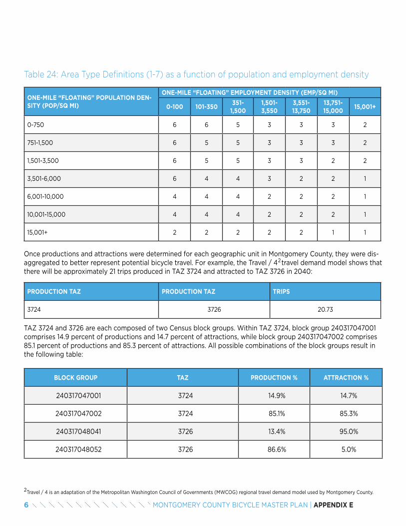
6 MONTGOMERY COUNTY BICYCLE MASTER PLAN | APPENDIX E
Table 24: Area Type Definitions (1-7) as a function of population and employment density
ONE-MILE “FLOATING” POPULATION DEN-SITY (POP/SQ MI)
ONE-MILE “FLOATING” EMPLOYMENT DENSITY (EMP/SQ MI)
0-100 101-350351-
1,5001,501-3,550
3,551-13,750
13,751-15,000
15,001+
0-750 6 6 5 3 3 3 2
751-1,500 6 5 5 3 3 3 2
1,501-3,500 6 5 5 3 3 2 2
3,501-6,000 6 4 4 3 2 2 1
6,001-10,000 4 4 4 2 2 2 1
10,001-15,000 4 4 4 2 2 2 1
15,001+ 2 2 2 2 2 1 1
Once productions and attractions were determined for each geographic unit in Montgomery County, they were dis-aggregated to better represent potential bicycle travel. For example, the Travel / 4 travel demand model shows that there will be approximately 21 trips produced in TAZ 3724 and attracted to TAZ 3726 in 2040:
PRODUCTION TAZ PRODUCTION TAZ TRIPS
3724 3726 20.73
TAZ 3724 and 3726 are each composed of two Census block groups. Within TAZ 3724, block group 240317047001 comprises 14.9 percent of productions and 14.7 percent of attractions, while block group 240317047002 comprises 85.1 percent of productions and 85.3 percent of attractions. All possible combinations of the block groups result in the following table:
BLOCK GROUP TAZ PRODUCTION % ATTRACTION %
240317047001 3724 14.9% 14.7%
240317047002 3724 85.1% 85.3%
240317048041 3726 13.4% 95.0%
240317048052 3726 86.6% 5.0%
Travel / 4 is an adaptation of the Metropolitan Washington Council of Governments (MWCOG) regional travel demand model used by Montgomery County.2
2
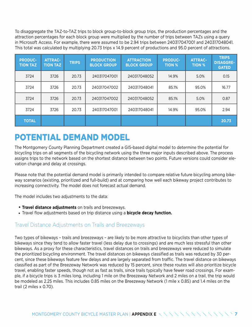
7MONTGOMERY COUNTY BICYCLE MASTER PLAN | APPENDIX E
To disaggregate the TAZ-to-TAZ trips to block group-to-block group trips, the production percentages and the attraction percentages for each block group were multiplied by the number of trips between TAZs using a query in Microsoft Access. For example, there were assumed to be 2.94 trips between 240317047001 and 240317048041. This total was calculated by multiplying 20.73 trips x 14.9 percent of productions and 95.0 percent of attractions.
PRODUC-TION TAZ
ATTRAC-TION TAZ
TRIPSPRODUCTION BLOCK GROUP
ATTRACTION BLOCK GROUP
PRODUC-TION %
ATTRAC-TION %
TRIPS DISAGGRE-
GATED
3724 3726 20.73 240317047001 240317048052 14.9% 5.0% 0.15
3724 3726 20.73 240317047002 240317048041 85.1% 95.0% 16.77
3724 3726 20.73 240317047002 240317048052 85.1% 5.0% 0.87
3724 3726 20.73 240317047001 240317048041 14.9% 95.0% 2.94
TOTAL 20.73
POTENTIAL DEMAND MODELThe Montgomery County Planning Department created a GIS-based digital model to determine the potential for bicycling trips on all segments of the bicycling network using the three major inputs described above. The process assigns trips to the network based on the shortest distance between two points. Future versions could consider ele-vation change and delay at crossings.
Please note that the potential demand model is primarily intended to compare relative future bicycling among bike-way scenarios (existing, prioritized and full-build) and at comparing how well each bikeway project contributes to increasing connectivity. The model does not forecast actual demand.
The model includes two adjustments to the data:
• Travel distance adjustments on trails and breezeways.• Travel flow adjustments based on trip distance using a bicycle decay function.
Travel Distance Adjustments on Trails and Breezeways
Two types of bikeways – trails and breezeways – are likely to be more attractive to bicyclists than other types of bikeways since they tend to allow faster travel (less delay due to crossings) and are much less stressful than other bikeways. As a proxy for these characteristics, travel distances on trails and breezeways were reduced to simulate the prioritized bicycling environment. The travel distances on bikeways classified as trails was reduced by 30 per-cent, since these bikeways feature few delays and are largely separated from traffic. The travel distance on bikeways classified as part of the Breezeway Network was reduced by 15 percent, since these routes will also prioritize bicycle travel, enabling faster speeds, though not as fast as trails, since trails typically have fewer road crossings. For exam-ple, if a bicycle trips is 3 miles long, including 1 mile on the Breezeway Network and 2 miles on a trail, the trip would be modeled as 2.25 miles. This includes 0.85 miles on the Breezeway Network (1 mile x 0.85) and 1.4 miles on the trail (2 miles x 0.70).
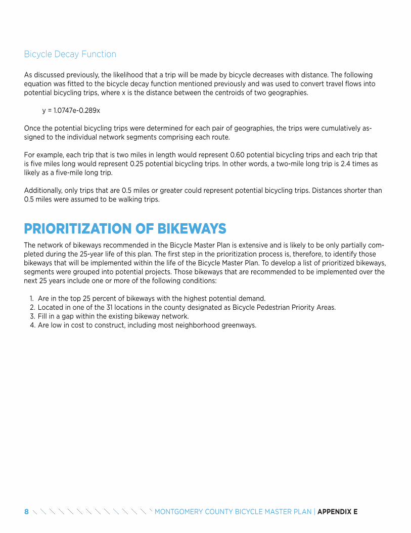
8 MONTGOMERY COUNTY BICYCLE MASTER PLAN | APPENDIX E
Bicycle Decay Function
As discussed previously, the likelihood that a trip will be made by bicycle decreases with distance. The following equation was fitted to the bicycle decay function mentioned previously and was used to convert travel flows into potential bicycling trips, where x is the distance between the centroids of two geographies.
y = 1.0747e-0.289x
Once the potential bicycling trips were determined for each pair of geographies, the trips were cumulatively as-signed to the individual network segments comprising each route.
For example, each trip that is two miles in length would represent 0.60 potential bicycling trips and each trip that is five miles long would represent 0.25 potential bicycling trips. In other words, a two-mile long trip is 2.4 times as likely as a five-mile long trip.
Additionally, only trips that are 0.5 miles or greater could represent potential bicycling trips. Distances shorter than 0.5 miles were assumed to be walking trips.
PRIORITIZATION OF BIKEWAYSThe network of bikeways recommended in the Bicycle Master Plan is extensive and is likely to be only partially com-pleted during the 25-year life of this plan. The first step in the prioritization process is, therefore, to identify those bikeways that will be implemented within the life of the Bicycle Master Plan. To develop a list of prioritized bikeways, segments were grouped into potential projects. Those bikeways that are recommended to be implemented over the next 25 years include one or more of the following conditions:
1. Are in the top 25 percent of bikeways with the highest potential demand.2. Located in one of the 31 locations in the county designated as Bicycle Pedestrian Priority Areas.3. Fill in a gap within the existing bikeway network.4. Are low in cost to construct, including most neighborhood greenways.
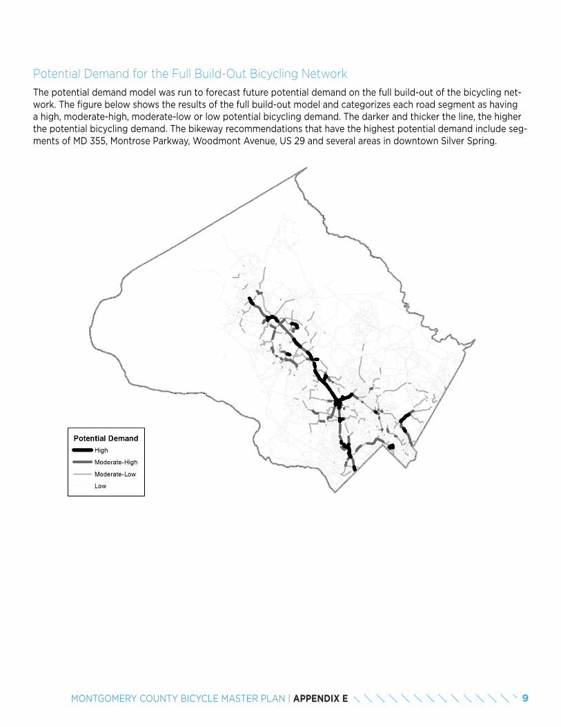
9MONTGOMERY COUNTY BICYCLE MASTER PLAN | APPENDIX E
Potential Demand for the Full Build-Out Bicycling Network
The potential demand model was run to forecast future potential demand on the full build-out of the bicycling net-work. The figure below shows the results of the full build-out model and categorizes each road segment as having a high, moderate-high, moderate-low or low potential bicycling demand. The darker and thicker the line, the higher the potential bicycling demand. The bikeway recommendations that have the highest potential demand include seg-ments of MD 355, Montrose Parkway, Woodmont Avenue, US 29 and several areas in downtown Silver Spring.
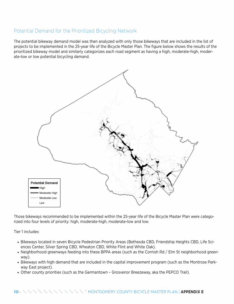
10 MONTGOMERY COUNTY BICYCLE MASTER PLAN | APPENDIX E
Potential Demand for the Prioritized Bicycling Network
Those bikeways recommended to be implemented within the 25-year life of the Bicycle Master Plan were catego-rized into four levels of priority: high, moderate-high, moderate-low and low.
Tier 1 includes:
• Bikeways located in seven Bicycle Pedestrian Priority Areas (Bethesda CBD, Friendship Heights CBD, Life Sci-ences Center, Silver Spring CBD, Wheaton CBD, White Flint and White Oak).
• Neighborhood greenways feeding into these BPPA areas (such as the Cornish Rd / Elm St neighborhood green-way).
• Bikeways with high demand that are included in the capital improvement program (such as the Montrose Park-way East project).
• Other county priorities (such as the Germantown – Grosvenor Breezeway, aka the PEPCO Trail).
The potential bikeway demand model was then analyzed with only those bikeways that are included in the list of projects to be implemented in the 25-year life of the Bicycle Master Plan. The figure below shows the results of the prioritized bikeway model and similarly categorizes each road segment as having a high, moderate-high, moder-ate-low or low potential bicycling demand.
11MONTGOMERY COUNTY BICYCLE MASTER PLAN | APPENDIX E
Tier 2 includes:
• Bikeways located in the remaining Bicycle Pedestrian Priority Areas.
Tier 3 includes:
• Remaining neighborhood greenways.• Highest demand bikeways located outside of the Bicycle Pedestrian Priority Areas. • High demand recreational bicycling routes.
Tier 4 includes:
• All remaining bikeways that are recommended for completion within the 25-year life of the plan.• Several heavily-used recreational bicycling routes.
The full build-out and prioritized bicycling networks were evaluated based on the connectivity metrics in the Bicycle Master Plan. The results are shown in the table below.
OBJECTIVE METRICEXISTING TARGET FULL
BUILD2018 2033 2043
GOAL 2: CREATE A HIGHLY-CONNECTED, CONVENIENT AND LOW-STRESS BICYCLING NETWORK
2.1Percentage of potential bicycle trips that can be made on a low-stress bicy-cling network.
18% TBD TBD TBD
2.2
Percentage of dwelling units within 2 miles of each Red Line, Brunswick Line, Purple Line and Corridor Cities Transitway station in Montgomery County that are connected to the transit station on a low-stress bicy-cling network.
Red Line 10% 37% 64% 80%
Brunswick Line 12% 37% 62% 74%
Purple Line 4% 37% 71% 77%
Corridor Cities Transitway 0% 34% 69% 74%
2.3
Percentage of dwelling units within one mile of elementary schools, 1.5 miles of middle schools and 2 miles of high that are connected to the transit station on a very low-stress bicycling network.
Elementary Schools 26% 29% 32% 59%
Middle Schools 11% 17% 22% 48%
High Schools 6% 11% 16% 32%
2.4
Percentage of dwelling units within 2 miles of public libraries, recreation centers and regional / recreational parks that are connected to the transit station on a low-stress bicycling network.
Public Libraries 8% 34% 60% 84%
Recreation Centers 13% 27% 40% 74%
Recreational and Regional Parks 13% 27% 40% 74%
3.1Percentage of potential bicycle trips that can be made on a low-stress bicycle network in areas where the median income is below 60 percent of the County average median income.
TBD TBD TBD TBD

12 MONTGOMERY COUNTY BICYCLE MASTER PLAN | APPENDIX E

APPENDIX FSHORT-TERM BICYCLE PARKING SUPPLY ANALYSIS
TABLE OF CONTENTS
1. Introduction 2. Methodology
2.1 Existing Supply of Short-Term Bicycle Parking 2.2 Target Supply for Short-Term Bicycle Parking2.3 Deficit of Short-Term Bicycle Parking
3. Bicycle Pedestrian Priority Area Analyses
3.1 Aspen Hill 3.2 Bethesda Central Business District 3.3 Clarksburg Town Center 3.4 Cloverleaf 3.5 Flower-Piney Branch-Arliss 3.6 Four Corners 3.7 Friendship Heights3.8 Germantown Town Center3.9 Glenmont3.10 Kensington3.11 Montgomery Hills3.12 Olney Town Center3.13 Piney Branch-University3.14 Shady Grove Metro Station3.15 Silver Spring Central Business District3.16 Takoma / Langley Crossroads3.17 Westbard3.18 Wheaton Central Business District 3.19 White Flint
4. Summary and Recommendations
3 5
6
45
2 MONTGOMERY COUNTY BICYCLE MASTER PLAN | APPENDIX F
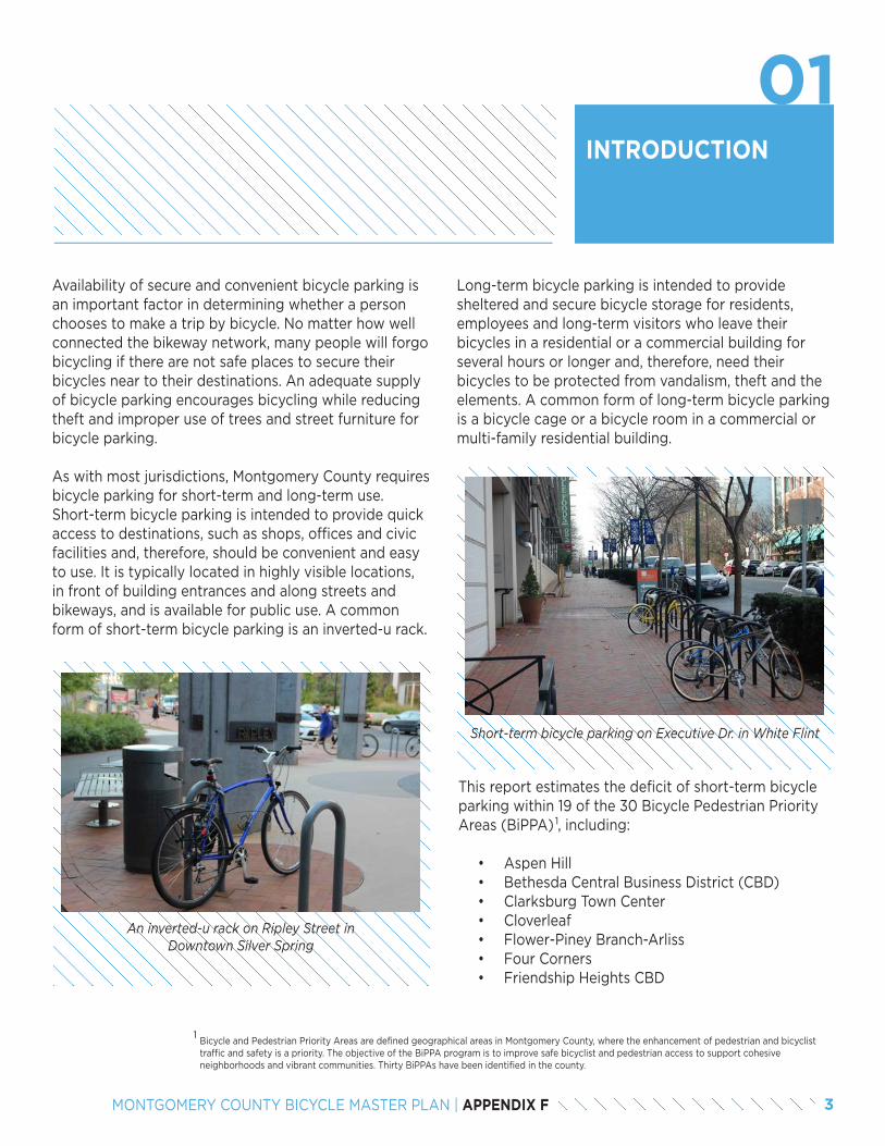
INTRODUCTION
Availability of secure and convenient bicycle parking is an important factor in determining whether a person chooses to make a trip by bicycle. No matter how well connected the bikeway network, many people will forgo bicycling if there are not safe places to secure their bicycles near to their destinations. An adequate supply of bicycle parking encourages bicycling while reducing theft and improper use of trees and street furniture for bicycle parking.
As with most jurisdictions, Montgomery County requires bicycle parking for short-term and long-term use. Short-term bicycle parking is intended to provide quick access to destinations, such as shops, offices and civic facilities and, therefore, should be convenient and easy to use. It is typically located in highly visible locations, in front of building entrances and along streets and bikeways, and is available for public use. A common form of short-term bicycle parking is an inverted-u rack.
Bicycle and Pedestrian Priority Areas are defined geographical areas in Montgomery County, where the enhancement of pedestrian and bicyclist traffic and safety is a priority. The objective of the BiPPA program is to improve safe bicyclist and pedestrian access to support cohesive neighborhoods and vibrant communities. Thirty BiPPAs have been identified in the county.
01
An inverted-u rack on Ripley Street in Downtown Silver Spring
Long-term bicycle parking is intended to provide sheltered and secure bicycle storage for residents, employees and long-term visitors who leave their bicycles in a residential or a commercial building for several hours or longer and, therefore, need their bicycles to be protected from vandalism, theft and the elements. A common form of long-term bicycle parking is a bicycle cage or a bicycle room in a commercial or multi-family residential building.
Short-term bicycle parking on Executive Dr. in White Flint
This report estimates the deficit of short-term bicycle parking within 19 of the 30 Bicycle Pedestrian Priority Areas (BiPPA) , including:
• Aspen Hill• Bethesda Central Business District (CBD)• Clarksburg Town Center• Cloverleaf• Flower-Piney Branch-Arliss• Four Corners• Friendship Heights CBD
1
1
3MONTGOMERY COUNTY BICYCLE MASTER PLAN | APPENDIX F
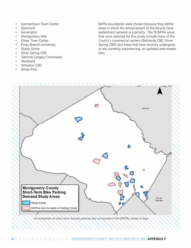
• Germantown Town Center• Glenmont• Kensington• Montgomery Hills• Olney Town Center• Piney Branch-University• Shady Grove• Silver Spring CBD• Takoma/Langley Crossroads• Westbard• Wheaton CBD• White Flint
BiPPA boundaries were chosen because they define areas in which the enhancement of the bicycle (and pedestrian) network is a priority. The 19 BiPPA areas that were selected for this study include many of the County’s commercial centers (Bethesda CBD, Silver Spring CBD) and areas that have recently undergone, or are currently experiencing, an updated area master plan.
An evaluation of short-term bicycle parking was conducted in the BiPPAs shown in blue
4 MONTGOMERY COUNTY BICYCLE MASTER PLAN | APPENDIX F
METHODOLOGY
Data on the existing supply of short-term bicycle parking in Montgomery County was collected via a crowdsource application developed and maintained by Arlington County located at www.rackspotter.com. Using this application, Planning Department staff and volunteers identified more than 1,000 bicycle racks throughout the county and provided a street address, a photo, parking capacity, rack type and a brief description of each rack including its surroundings. This data was then downloaded into Excel and transferred into ArcMap for analysis.
The Rackspotter data required a substantial amount of cleaning to ensure a consistent approach to identifying the location of each rack and removing duplicate bike racks so the count was accurate. Each bicycle rack was associated with a block address and designated as being located on the even or odd side of the road. For example, bicycle racks at the Montgomery County Planning Department were assigned to the 8700 block of Georgia Avenue on the odd side of the street.
02
2.1 EXISTING SUPPLY OF SHORT-TERM BICYCLE PARKING
A target supply for short-term bicycle parking was calculated for each parcel in the 19 BiPPAs using the short-term bicycle parking requirements found in the Montgomery County Zoning Ordinance . The ordinance includes different multipliers of bicycle parking per square foot of development for each land use category, including office, retail, institutional, government, cultural and multi-family residential. For example, one bicycle parking space is required for every 10,000 square
2.2 TARGET SUPPLY FOR SHORT-TERM BICYCLE PARKING
of retail space, with 85 percent of spaces for short-term bicycle parking and 15 percent of spaces for long-term bicycle parking. Therefore, a block with 200,000 square feet of retail spaces would require 20 bicycle parking spaces, with 17 short-term spaces and 3 long-term spaces.
The target supply for all parcels was summed for each side of a block to determine the target supply for that block face. As some buildings have entrances on more than one side of a block, the target for those buildings was split between each side of the block. As with existing supply, target supply of bicycle parking was associated with a block address and categorized according to the odd or even sides of the street.
Development standards have not always required short-term bicycle parking, and have not required them at the current standard rates. As a result, there is a deficit of short-term bicycle parking in most areas of Montgomery County.
A comparison of existing supply and target supply was conducted for each block face. For those block faces where existing supply met or exceeded target supply, it was determined that there was a sufficient supply of short-term bicycle parking. For those block faces where target supply exceeded existing supply, the deficit of short-term bicycle parking was identified.
2.3 DEFICIT OF SHORT-TERM BICYCLE PARKING
See Section 6.2.4.C of the zoning code.2
2
5MONTGOMERY COUNTY BICYCLE MASTER PLAN | APPENDIX F
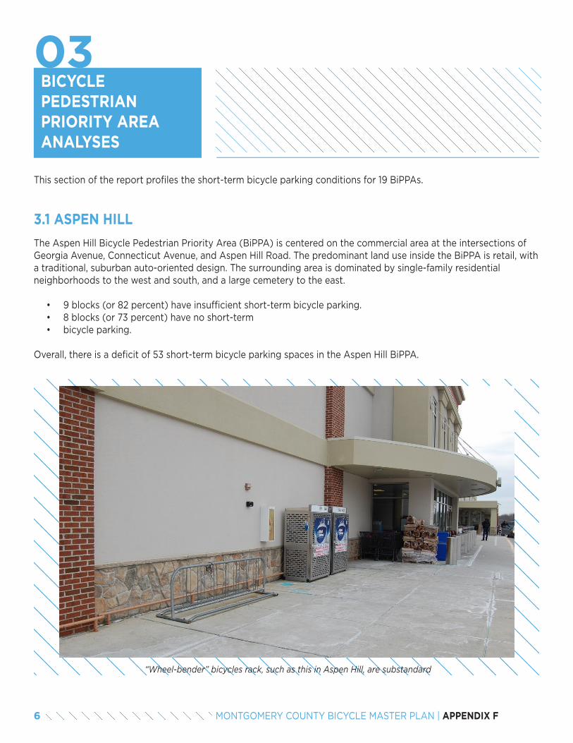
BICYCLE PEDESTRIAN PRIORITY AREA ANALYSES
03
The Aspen Hill Bicycle Pedestrian Priority Area (BiPPA) is centered on the commercial area at the intersections of Georgia Avenue, Connecticut Avenue, and Aspen Hill Road. The predominant land use inside the BiPPA is retail, with a traditional, suburban auto-oriented design. The surrounding area is dominated by single-family residential neighborhoods to the west and south, and a large cemetery to the east.
• 9 blocks (or 82 percent) have insufficient short-term bicycle parking.• 8 blocks (or 73 percent) have no short-term • bicycle parking.
Overall, there is a deficit of 53 short-term bicycle parking spaces in the Aspen Hill BiPPA.
3.1 ASPEN HILL
This section of the report profiles the short-term bicycle parking conditions for 19 BiPPAs.
“Wheel-bender” bicycles rack, such as this in Aspen Hill, are substandard
6 MONTGOMERY COUNTY BICYCLE MASTER PLAN | APPENDIX F
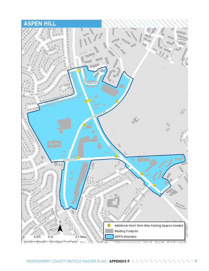
ASPEN HILL
7MONTGOMERY COUNTY BICYCLE MASTER PLAN | APPENDIX F
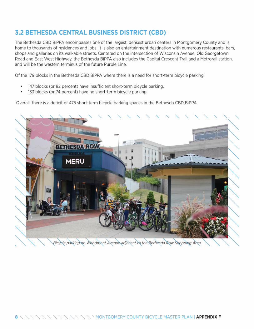
The Bethesda CBD BiPPA encompasses one of the largest, densest urban centers in Montgomery County and is home to thousands of residences and jobs. It is also an entertainment destination with numerous restaurants, bars, shops and galleries on its walkable streets. Centered on the intersection of Wisconsin Avenue, Old Georgetown Road and East West Highway, the Bethesda BiPPA also includes the Capital Crescent Trail and a Metrorail station, and will be the western terminus of the future Purple Line.
Of the 179 blocks in the Bethesda CBD BiPPA where there is a need for short-term bicycle parking:
• 147 blocks (or 82 percent) have insufficient short-term bicycle parking.• 133 blocks (or 74 percent) have no short-term bicycle parking.
Overall, there is a deficit of 475 short-term bicycle parking spaces in the Bethesda CBD BiPPA.
3.2 BETHESDA CENTRAL BUSINESS DISTRICT (CBD)
Bicycle parking on Woodmont Avenue adjacent to the Bethesda Row Shopping Area
8 MONTGOMERY COUNTY BICYCLE MASTER PLAN | APPENDIX F
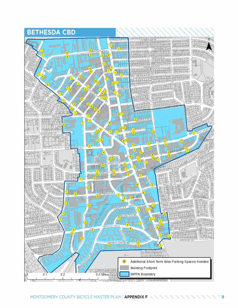
BETHESDA CBD
9MONTGOMERY COUNTY BICYCLE MASTER PLAN | APPENDIX F
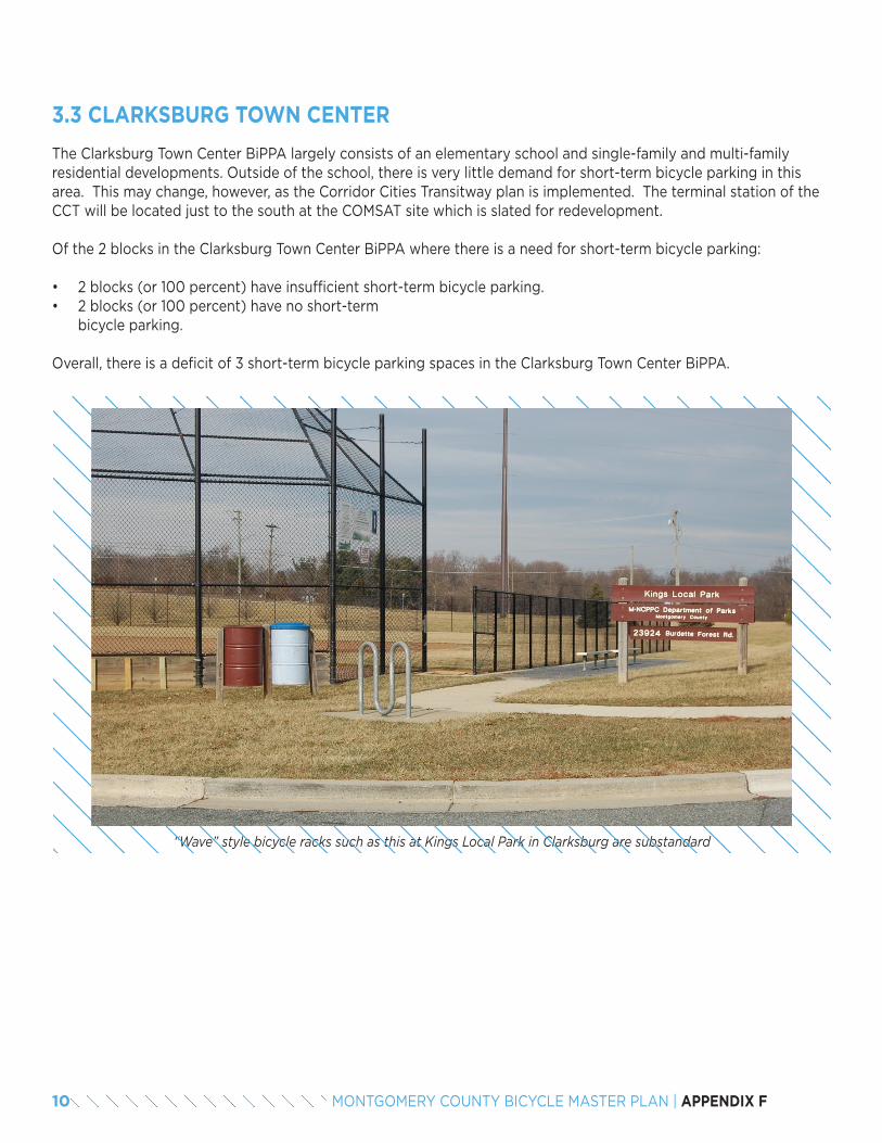
The Clarksburg Town Center BiPPA largely consists of an elementary school and single-family and multi-family residential developments. Outside of the school, there is very little demand for short-term bicycle parking in this area. This may change, however, as the Corridor Cities Transitway plan is implemented. The terminal station of the CCT will be located just to the south at the COMSAT site which is slated for redevelopment.
Of the 2 blocks in the Clarksburg Town Center BiPPA where there is a need for short-term bicycle parking:
• 2 blocks (or 100 percent) have insufficient short-term bicycle parking.• 2 blocks (or 100 percent) have no short-term
bicycle parking.
Overall, there is a deficit of 3 short-term bicycle parking spaces in the Clarksburg Town Center BiPPA.
3.3 CLARKSBURG TOWN CENTER
“Wave” style bicycle racks such as this at Kings Local Park in Clarksburg are substandard
10 MONTGOMERY COUNTY BICYCLE MASTER PLAN | APPENDIX F
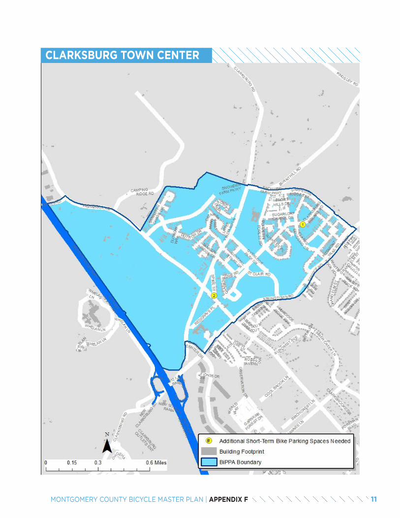
CLARKSBURG TOWN CENTER
11MONTGOMERY COUNTY BICYCLE MASTER PLAN | APPENDIX F
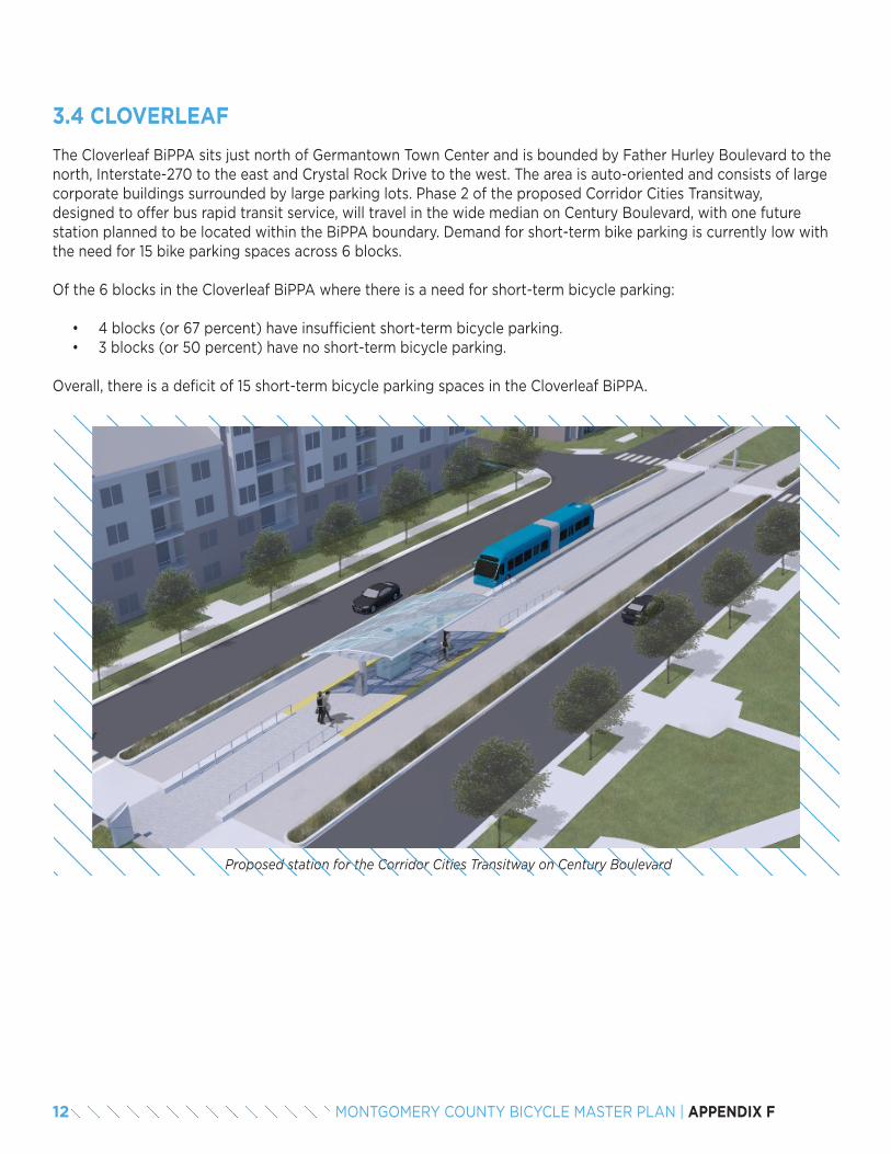
The Cloverleaf BiPPA sits just north of Germantown Town Center and is bounded by Father Hurley Boulevard to the north, Interstate-270 to the east and Crystal Rock Drive to the west. The area is auto-oriented and consists of large corporate buildings surrounded by large parking lots. Phase 2 of the proposed Corridor Cities Transitway, designed to offer bus rapid transit service, will travel in the wide median on Century Boulevard, with one future station planned to be located within the BiPPA boundary. Demand for short-term bike parking is currently low with the need for 15 bike parking spaces across 6 blocks.
Of the 6 blocks in the Cloverleaf BiPPA where there is a need for short-term bicycle parking:
• 4 blocks (or 67 percent) have insufficient short-term bicycle parking.• 3 blocks (or 50 percent) have no short-term bicycle parking.
Overall, there is a deficit of 15 short-term bicycle parking spaces in the Cloverleaf BiPPA.
3.4 CLOVERLEAF
Proposed station for the Corridor Cities Transitway on Century Boulevard
12 MONTGOMERY COUNTY BICYCLE MASTER PLAN | APPENDIX F
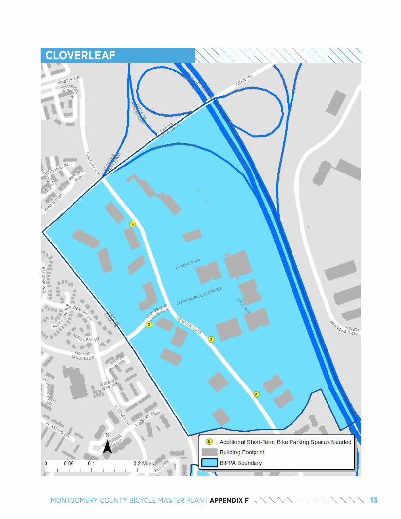
CLOVERLEAF
13MONTGOMERY COUNTY BICYCLE MASTER PLAN | APPENDIX F
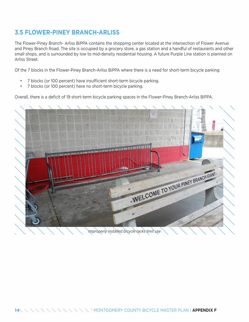
The Flower-Piney Branch- Arliss BiPPA contains the shopping center located at the intersection of Flower Avenue and Piney Branch Road. The site is occupied by a grocery store, a gas station and a handful of restaurants and other small shops, and is surrounded by low to mid-density residential housing. A future Purple Line station is planned on Arliss Street.
Of the 7 blocks in the Flower-Piney Branch-Arliss BiPPA where there is a need for short-term bicycle parking:
• 7 blocks (or 100 percent) have insufficient short-term bicycle parking.• 7 blocks (or 100 percent) have no short-term bicycle parking.
Overall, there is a deficit of 19 short-term bicycle parking spaces in the Flower-Piney Branch-Arliss BiPPA.
3.5 FLOWER-PINEY BRANCH-ARLISS
Improperly installed bicycle racks limit use
14 MONTGOMERY COUNTY BICYCLE MASTER PLAN | APPENDIX F
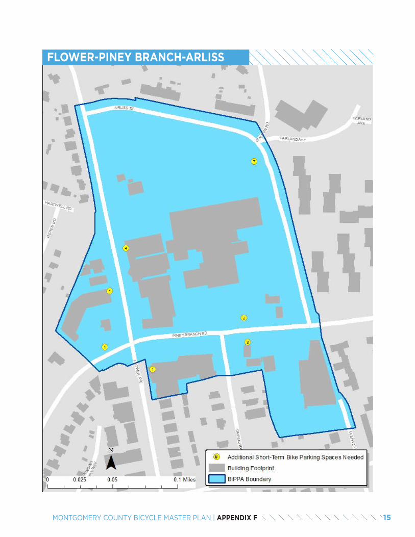
FLOWER-PINEY BRANCH-ARLISS
15MONTGOMERY COUNTY BICYCLE MASTER PLAN | APPENDIX F
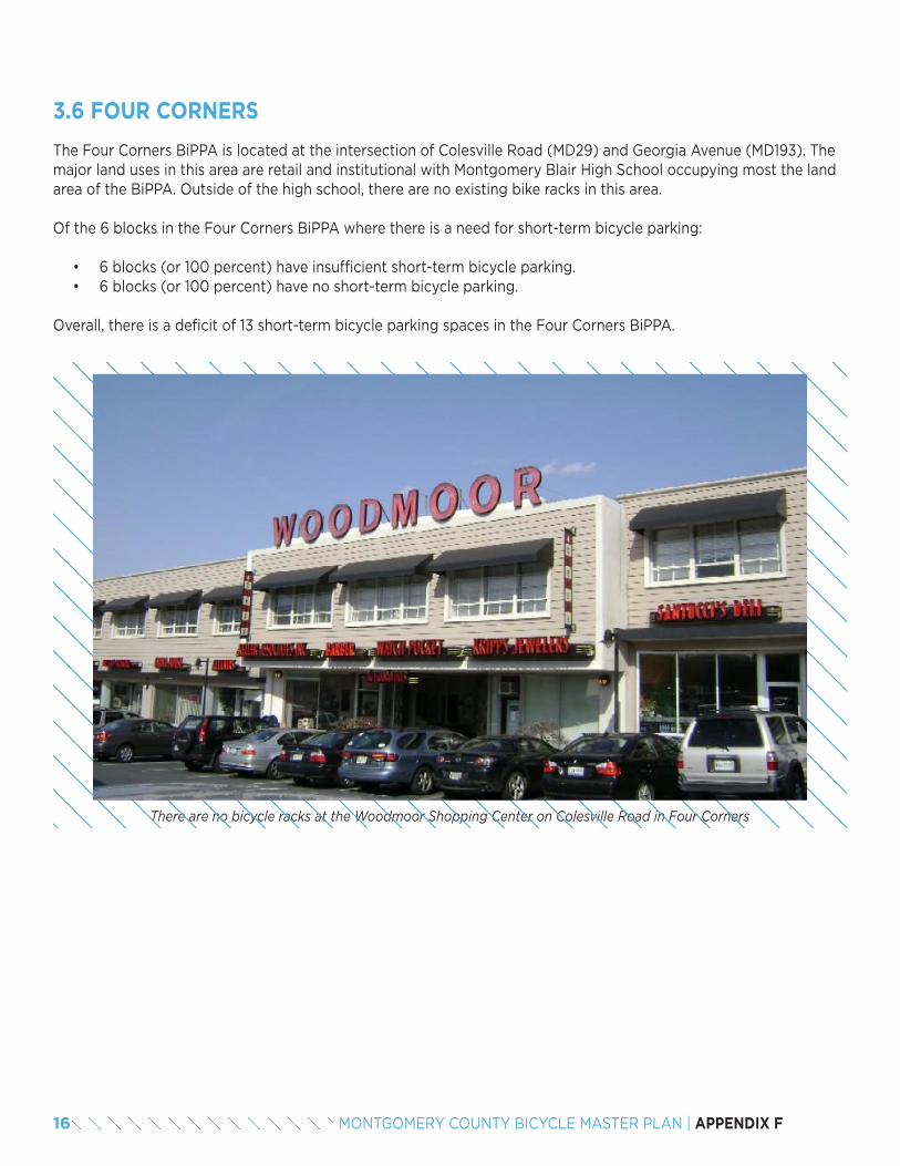
The Four Corners BiPPA is located at the intersection of Colesville Road (MD29) and Georgia Avenue (MD193). The major land uses in this area are retail and institutional with Montgomery Blair High School occupying most the land area of the BiPPA. Outside of the high school, there are no existing bike racks in this area.
Of the 6 blocks in the Four Corners BiPPA where there is a need for short-term bicycle parking:
• 6 blocks (or 100 percent) have insufficient short-term bicycle parking.• 6 blocks (or 100 percent) have no short-term bicycle parking.
Overall, there is a deficit of 13 short-term bicycle parking spaces in the Four Corners BiPPA.
3.6 FOUR CORNERS
There are no bicycle racks at the Woodmoor Shopping Center on Colesville Road in Four Corners
16 MONTGOMERY COUNTY BICYCLE MASTER PLAN | APPENDIX F
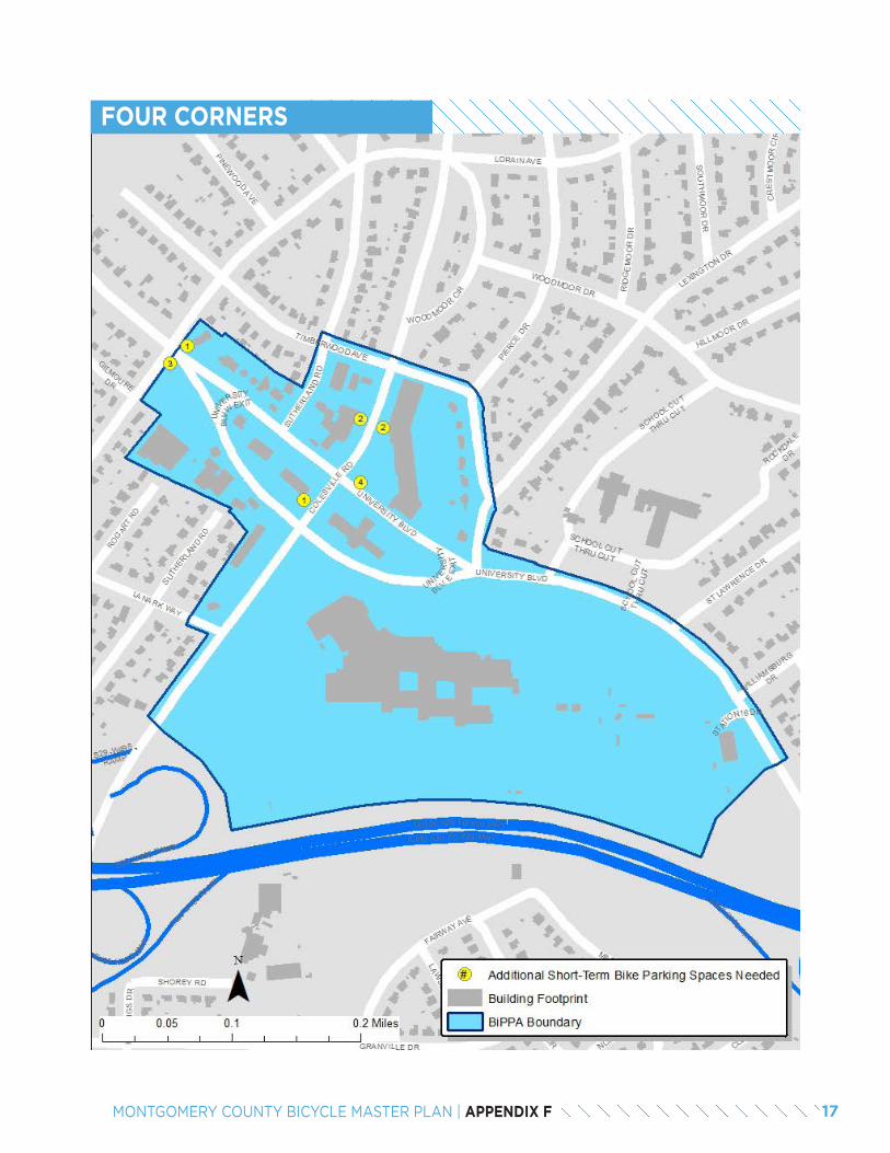
FOUR CORNERS
17MONTGOMERY COUNTY BICYCLE MASTER PLAN | APPENDIX F
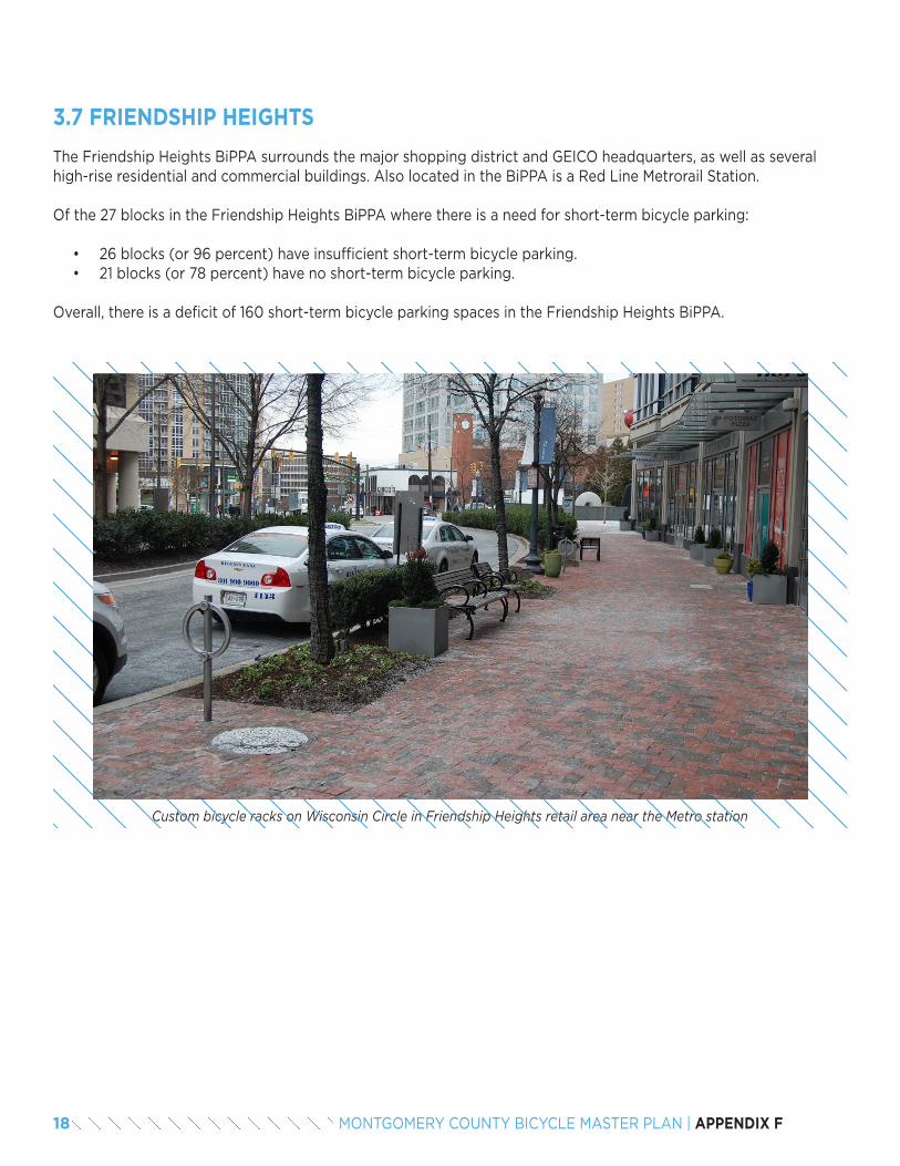
The Friendship Heights BiPPA surrounds the major shopping district and GEICO headquarters, as well as several high-rise residential and commercial buildings. Also located in the BiPPA is a Red Line Metrorail Station.
Of the 27 blocks in the Friendship Heights BiPPA where there is a need for short-term bicycle parking:
• 26 blocks (or 96 percent) have insufficient short-term bicycle parking.• 21 blocks (or 78 percent) have no short-term bicycle parking.
Overall, there is a deficit of 160 short-term bicycle parking spaces in the Friendship Heights BiPPA.
3.7 FRIENDSHIP HEIGHTS
Custom bicycle racks on Wisconsin Circle in Friendship Heights retail area near the Metro station
18 MONTGOMERY COUNTY BICYCLE MASTER PLAN | APPENDIX F
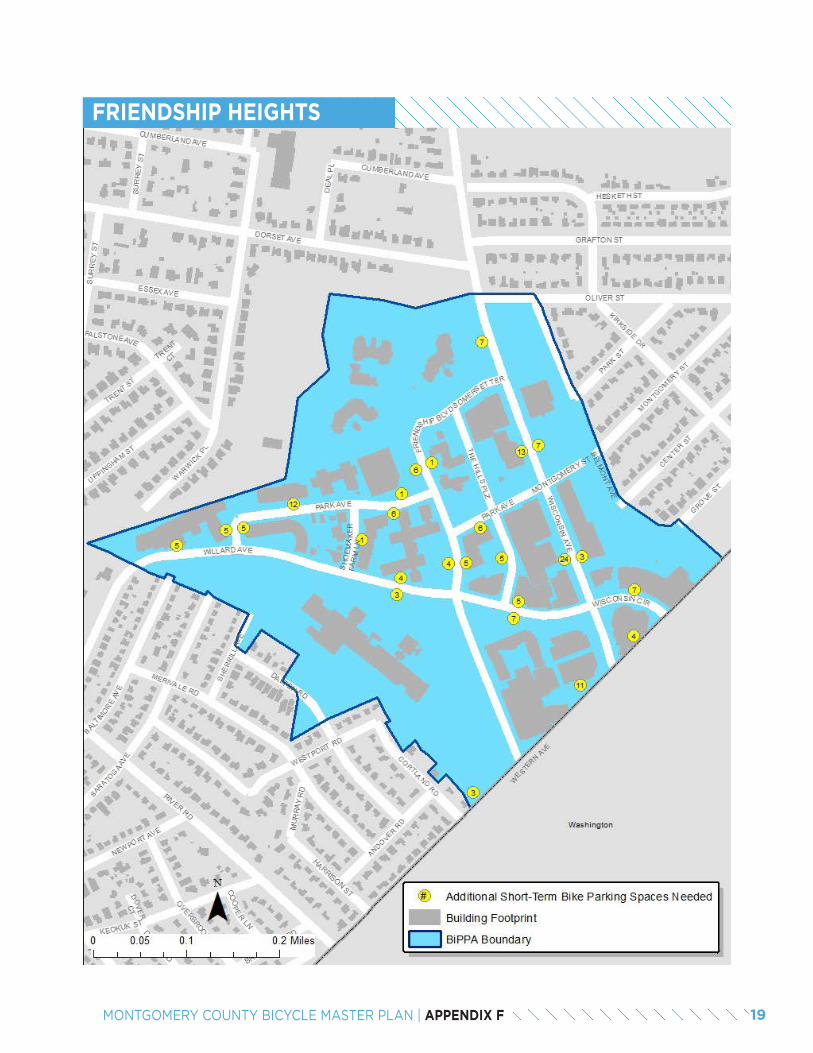
FRIENDSHIP HEIGHTS
19MONTGOMERY COUNTY BICYCLE MASTER PLAN | APPENDIX F
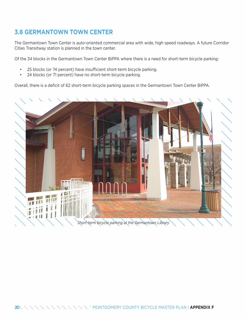
The Germantown Town Center is auto-oriented commercial area with wide, high speed roadways. A future Corridor Cities Transitway station is planned in the town center.
Of the 34 blocks in the Germantown Town Center BiPPA where there is a need for short-term bicycle parking:
• 25 blocks (or 74 percent) have insufficient short-term bicycle parking.• 24 blocks (or 71 percent) have no short-term bicycle parking.
Overall, there is a deficit of 62 short-term bicycle parking spaces in the Germantown Town Center BiPPA.
3.8 GERMANTOWN TOWN CENTER
Short-term bicycle parking at the Germantown Library
20 MONTGOMERY COUNTY BICYCLE MASTER PLAN | APPENDIX F
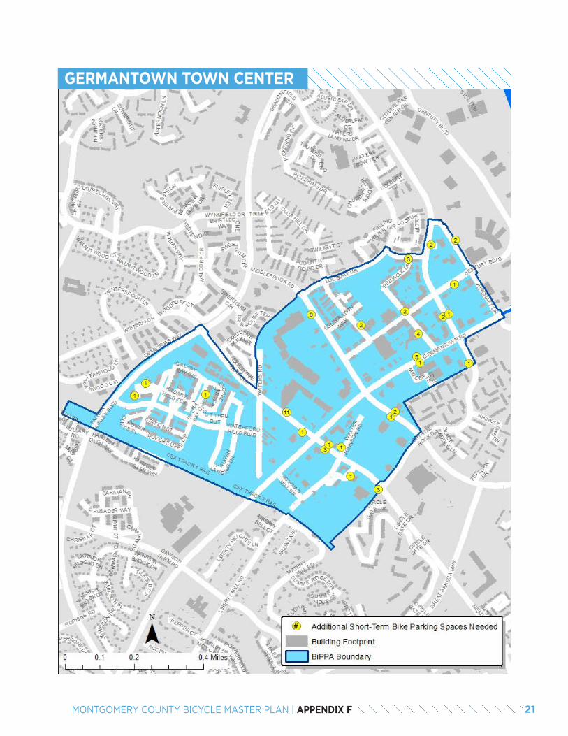
GERMANTOWN TOWN CENTER
21MONTGOMERY COUNTY BICYCLE MASTER PLAN | APPENDIX F
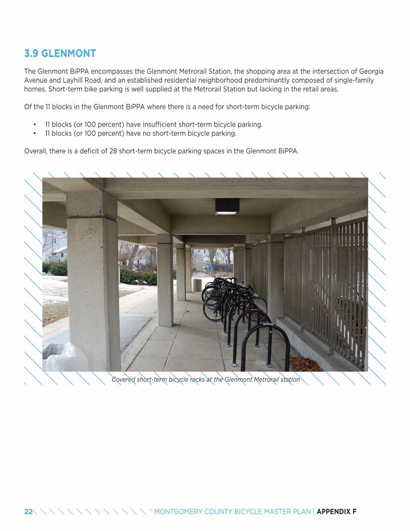
The Glenmont BiPPA encompasses the Glenmont Metrorail Station, the shopping area at the intersection of Georgia Avenue and Layhill Road, and an established residential neighborhood predominantly composed of single-family homes. Short-term bike parking is well supplied at the Metrorail Station but lacking in the retail areas.
Of the 11 blocks in the Glenmont BiPPA where there is a need for short-term bicycle parking:
• 11 blocks (or 100 percent) have insufficient short-term bicycle parking.• 11 blocks (or 100 percent) have no short-term bicycle parking.
Overall, there is a deficit of 28 short-term bicycle parking spaces in the Glenmont BiPPA.
3.9 GLENMONT
Covered short-term bicycle racks at the Glenmont Metrorail station
22 MONTGOMERY COUNTY BICYCLE MASTER PLAN | APPENDIX F
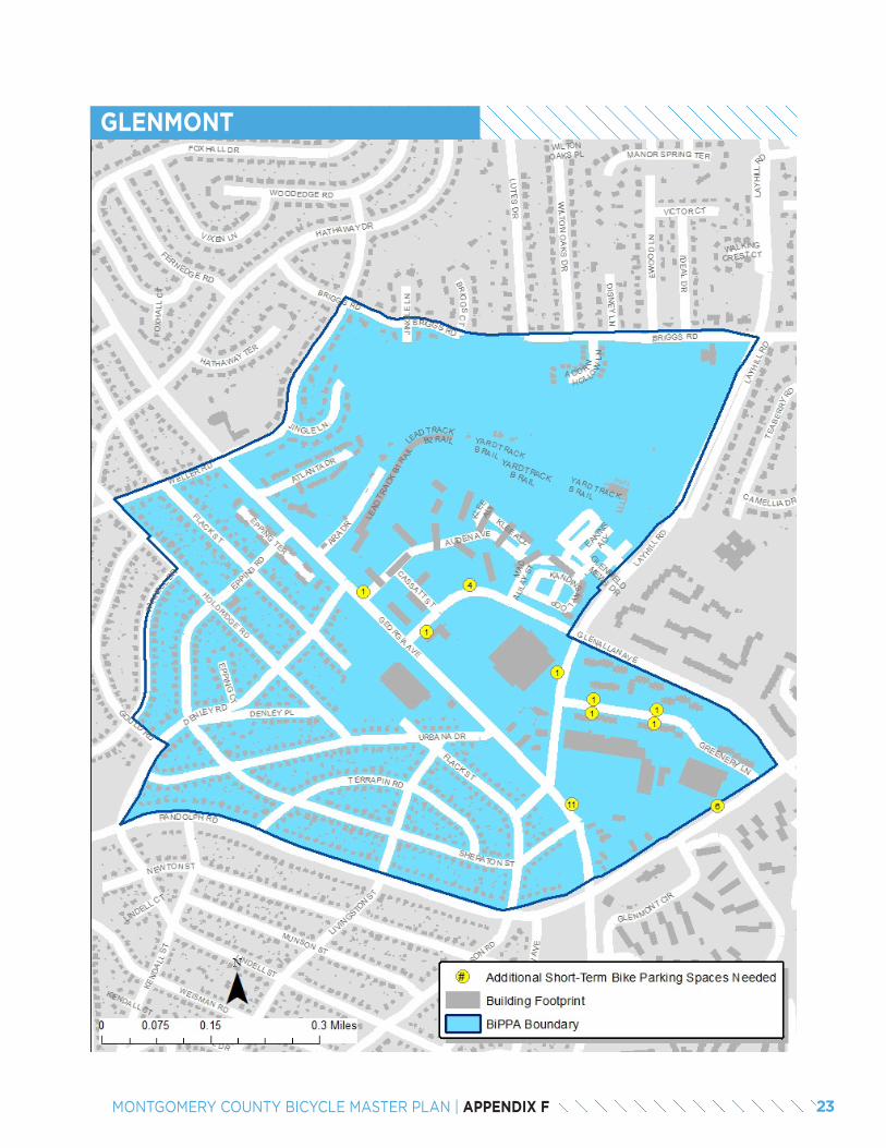
GLENMONT
23MONTGOMERY COUNTY BICYCLE MASTER PLAN | APPENDIX F
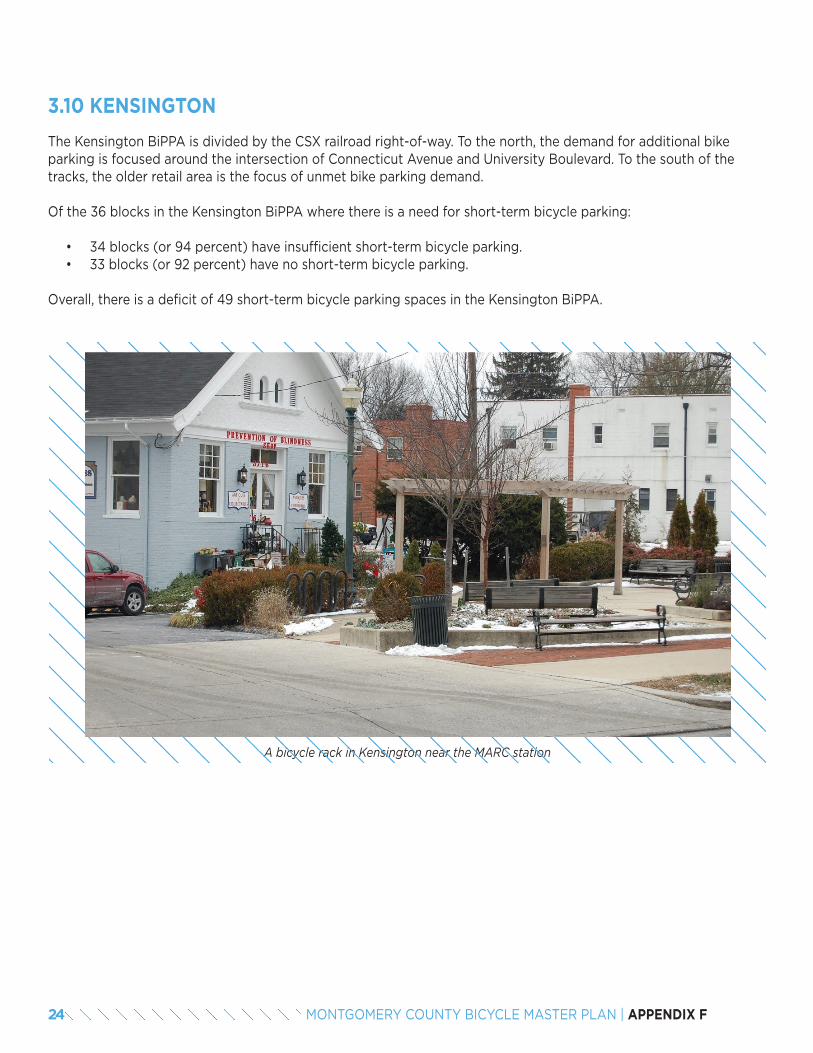
The Kensington BiPPA is divided by the CSX railroad right-of-way. To the north, the demand for additional bike parking is focused around the intersection of Connecticut Avenue and University Boulevard. To the south of the tracks, the older retail area is the focus of unmet bike parking demand.
Of the 36 blocks in the Kensington BiPPA where there is a need for short-term bicycle parking:
• 34 blocks (or 94 percent) have insufficient short-term bicycle parking.• 33 blocks (or 92 percent) have no short-term bicycle parking.
Overall, there is a deficit of 49 short-term bicycle parking spaces in the Kensington BiPPA.
3.10 KENSINGTON
A bicycle rack in Kensington near the MARC station
24 MONTGOMERY COUNTY BICYCLE MASTER PLAN | APPENDIX F
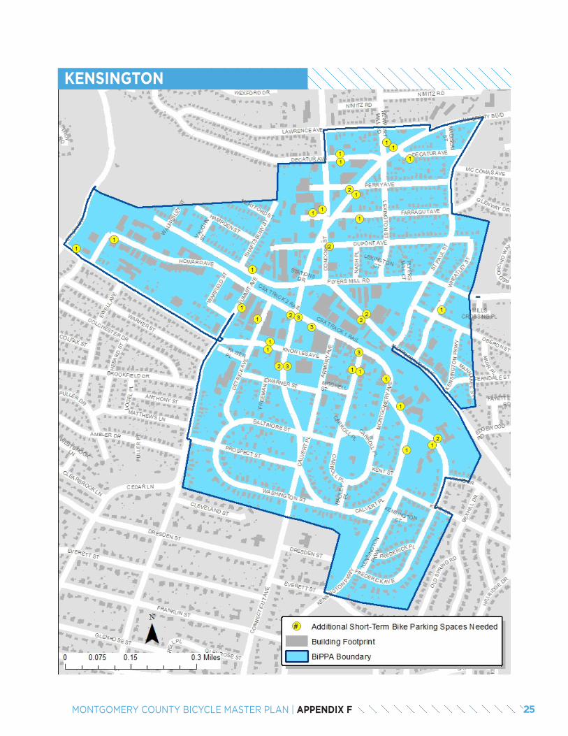
KENSINGTON
25MONTGOMERY COUNTY BICYCLE MASTER PLAN | APPENDIX F
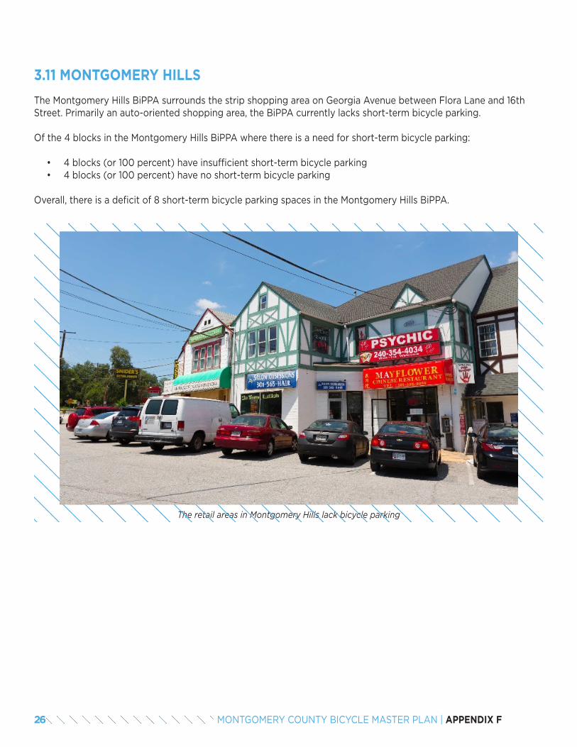
The Montgomery Hills BiPPA surrounds the strip shopping area on Georgia Avenue between Flora Lane and 16th Street. Primarily an auto-oriented shopping area, the BiPPA currently lacks short-term bicycle parking.
Of the 4 blocks in the Montgomery Hills BiPPA where there is a need for short-term bicycle parking:
• 4 blocks (or 100 percent) have insufficient short-term bicycle parking• 4 blocks (or 100 percent) have no short-term bicycle parking
Overall, there is a deficit of 8 short-term bicycle parking spaces in the Montgomery Hills BiPPA.
3.11 MONTGOMERY HILLS
The retail areas in Montgomery Hills lack bicycle parking
26 MONTGOMERY COUNTY BICYCLE MASTER PLAN | APPENDIX F
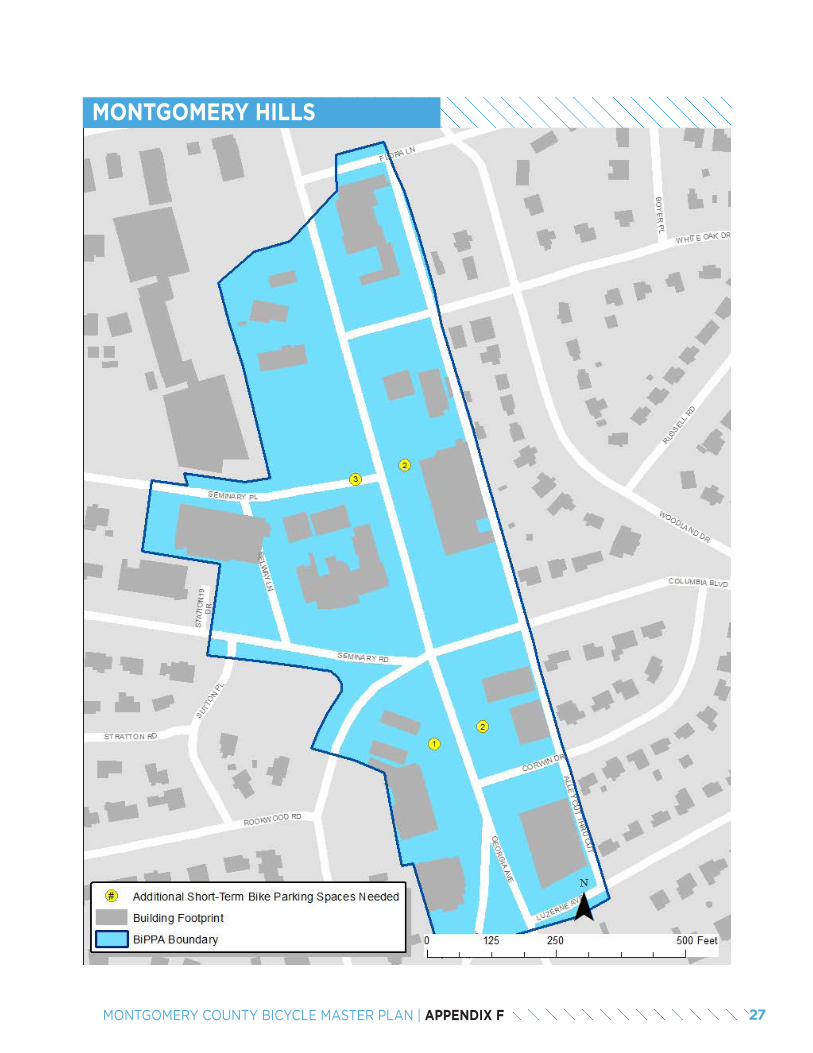
MONTGOMERY HILLS
27MONTGOMERY COUNTY BICYCLE MASTER PLAN | APPENDIX F
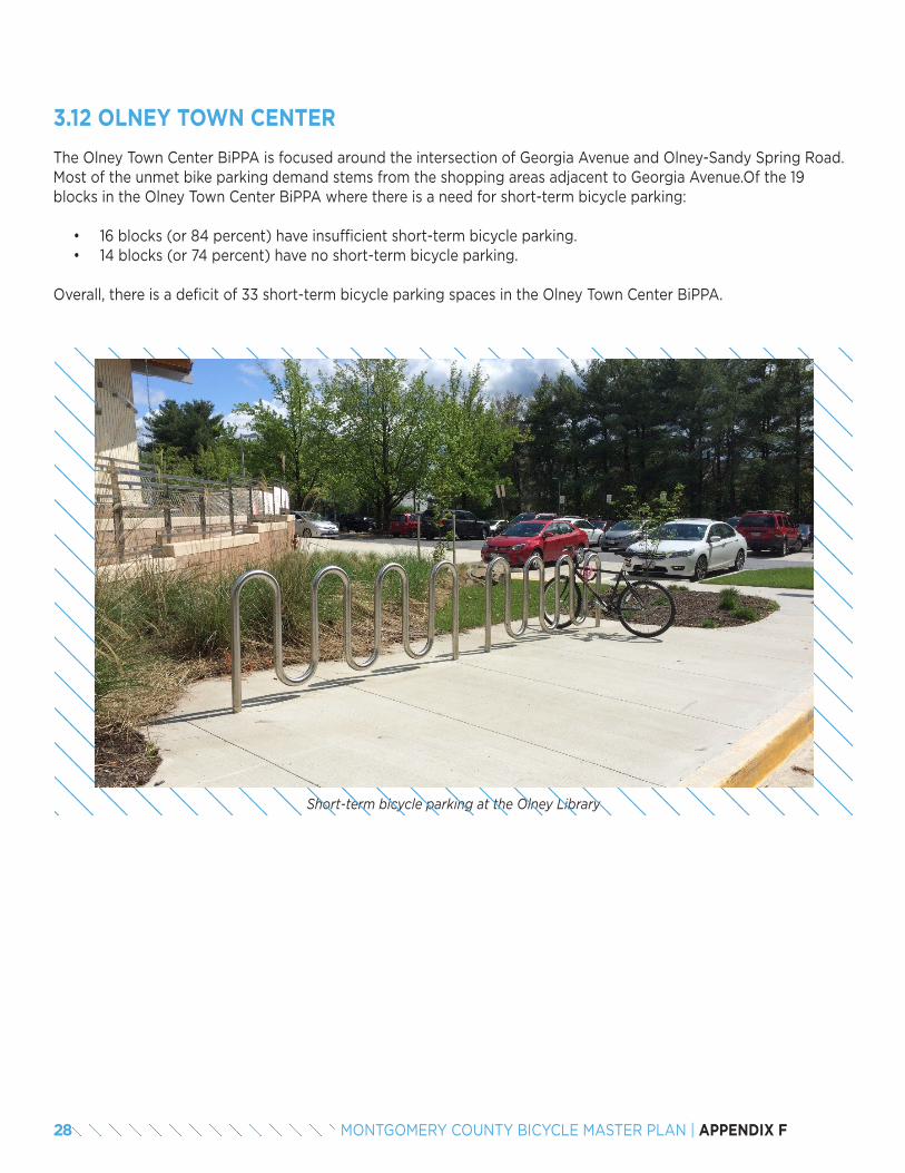
The Olney Town Center BiPPA is focused around the intersection of Georgia Avenue and Olney-Sandy Spring Road. Most of the unmet bike parking demand stems from the shopping areas adjacent to Georgia Avenue.Of the 19 blocks in the Olney Town Center BiPPA where there is a need for short-term bicycle parking:
• 16 blocks (or 84 percent) have insufficient short-term bicycle parking.• 14 blocks (or 74 percent) have no short-term bicycle parking.
Overall, there is a deficit of 33 short-term bicycle parking spaces in the Olney Town Center BiPPA.
3.12 OLNEY TOWN CENTER
Short-term bicycle parking at the Olney Library
28 MONTGOMERY COUNTY BICYCLE MASTER PLAN | APPENDIX F
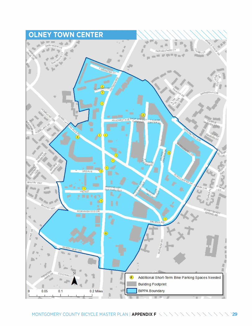
OLNEY TOWN CENTER
29MONTGOMERY COUNTY BICYCLE MASTER PLAN | APPENDIX F
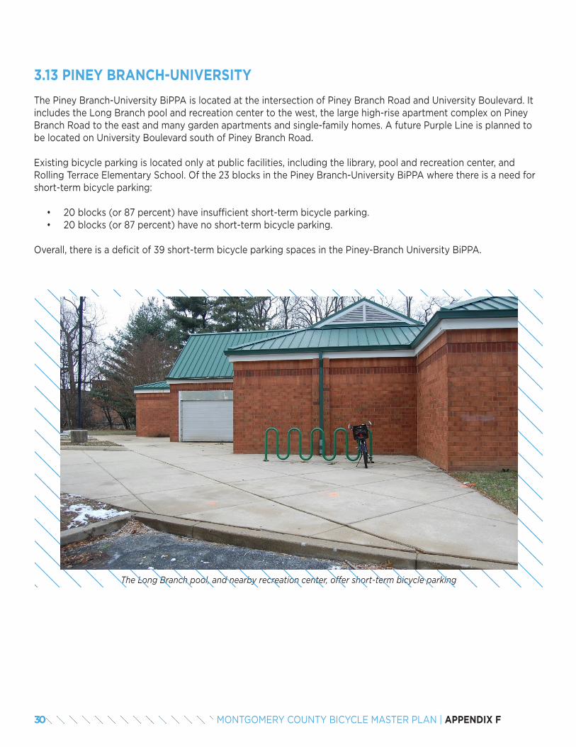
The Piney Branch-University BiPPA is located at the intersection of Piney Branch Road and University Boulevard. It includes the Long Branch pool and recreation center to the west, the large high-rise apartment complex on Piney Branch Road to the east and many garden apartments and single-family homes. A future Purple Line is planned to be located on University Boulevard south of Piney Branch Road.
Existing bicycle parking is located only at public facilities, including the library, pool and recreation center, and Rolling Terrace Elementary School. Of the 23 blocks in the Piney Branch-University BiPPA where there is a need for short-term bicycle parking:
• 20 blocks (or 87 percent) have insufficient short-term bicycle parking.• 20 blocks (or 87 percent) have no short-term bicycle parking.
Overall, there is a deficit of 39 short-term bicycle parking spaces in the Piney-Branch University BiPPA.
3.13 PINEY BRANCH-UNIVERSITY
The Long Branch pool, and nearby recreation center, offer short-term bicycle parking
30 MONTGOMERY COUNTY BICYCLE MASTER PLAN | APPENDIX F
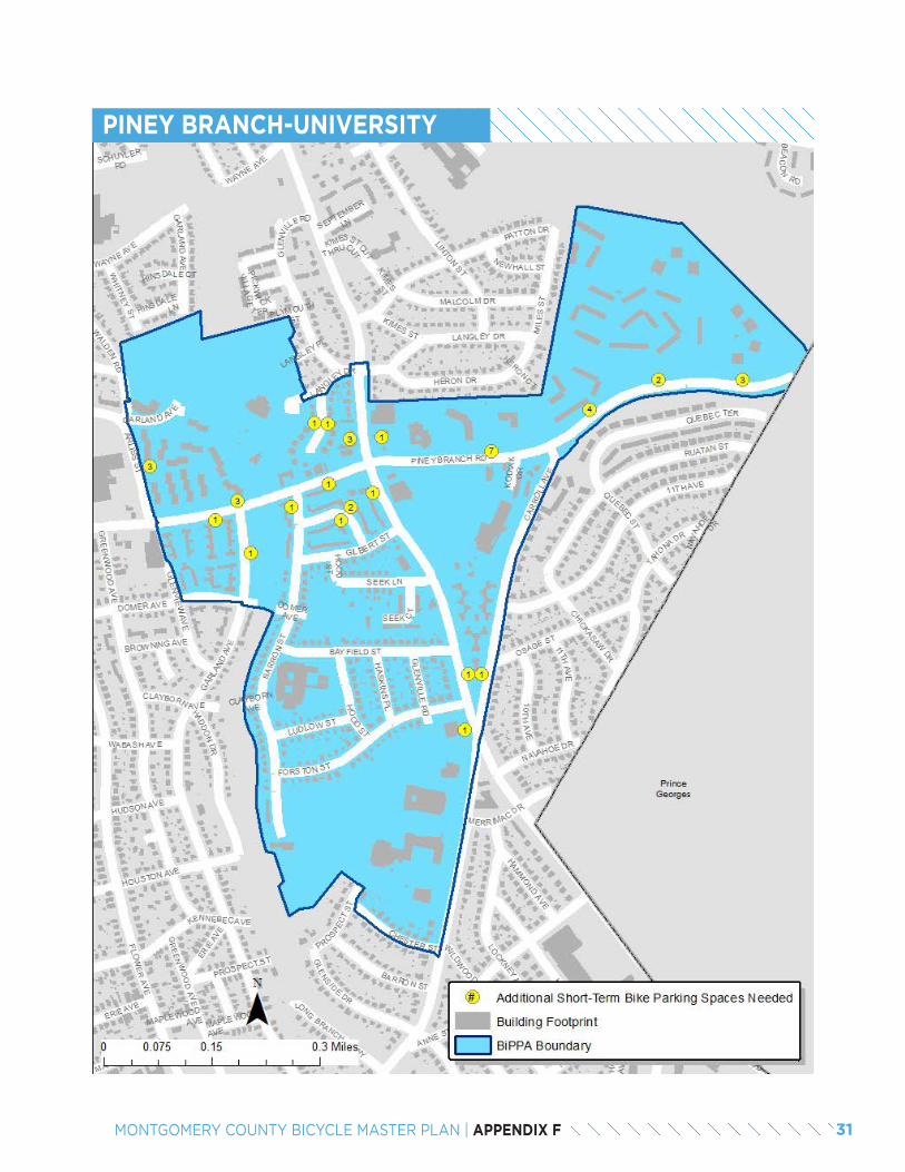
PINEY BRANCH-UNIVERSITY
31MONTGOMERY COUNTY BICYCLE MASTER PLAN | APPENDIX F
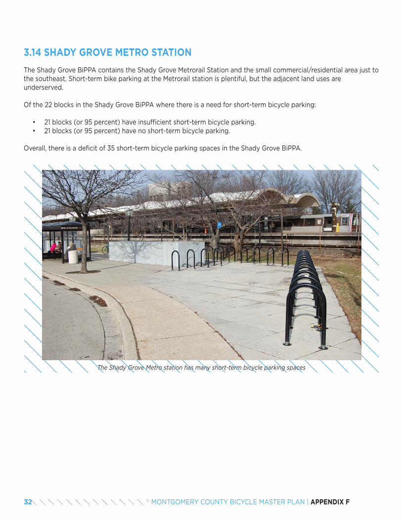
The Shady Grove BiPPA contains the Shady Grove Metrorail Station and the small commercial/residential area just to the southeast. Short-term bike parking at the Metrorail station is plentiful, but the adjacent land uses are underserved.
Of the 22 blocks in the Shady Grove BiPPA where there is a need for short-term bicycle parking:
• 21 blocks (or 95 percent) have insufficient short-term bicycle parking.• 21 blocks (or 95 percent) have no short-term bicycle parking.
Overall, there is a deficit of 35 short-term bicycle parking spaces in the Shady Grove BiPPA.
3.14 SHADY GROVE METRO STATION
The Shady Grove Metro station has many short-term bicycle parking spaces
32 MONTGOMERY COUNTY BICYCLE MASTER PLAN | APPENDIX F
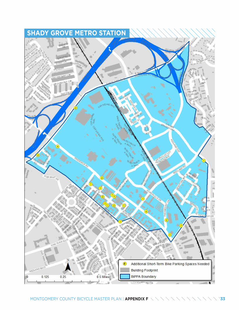
SHADY GROVE METRO STATION
33MONTGOMERY COUNTY BICYCLE MASTER PLAN | APPENDIX F
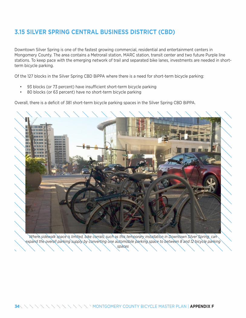
Downtown Silver Spring is one of the fastest growing commercial, residential and entertainment centers in Mongomery County. The area contains a Metrorail station, MARC station, transit center and two future Purple line stations. To keep pace with the emerging network of trail and separated bike lanes, investments are needed in short-term bicycle parking.
Of the 127 blocks in the Silver Spring CBD BiPPA where there is a need for short-term bicycle parking:
• 93 blocks (or 73 percent) have insufficient short-term bicycle parking• 80 blocks (or 63 percent) have no short-term bicycle parking
Overall, there is a deficit of 381 short-term bicycle parking spaces in the Silver Spring CBD BiPPA.
3.15 SILVER SPRING CENTRAL BUSINESS DISTRICT (CBD)
Where sidewalk space is limited, bike corrals, such as this temporary installation in Downtown Silver Spring, can expand the overall parking supply by converting one automobile parking space to between 8 and 12 bicycle parking
spaces
34 MONTGOMERY COUNTY BICYCLE MASTER PLAN | APPENDIX F
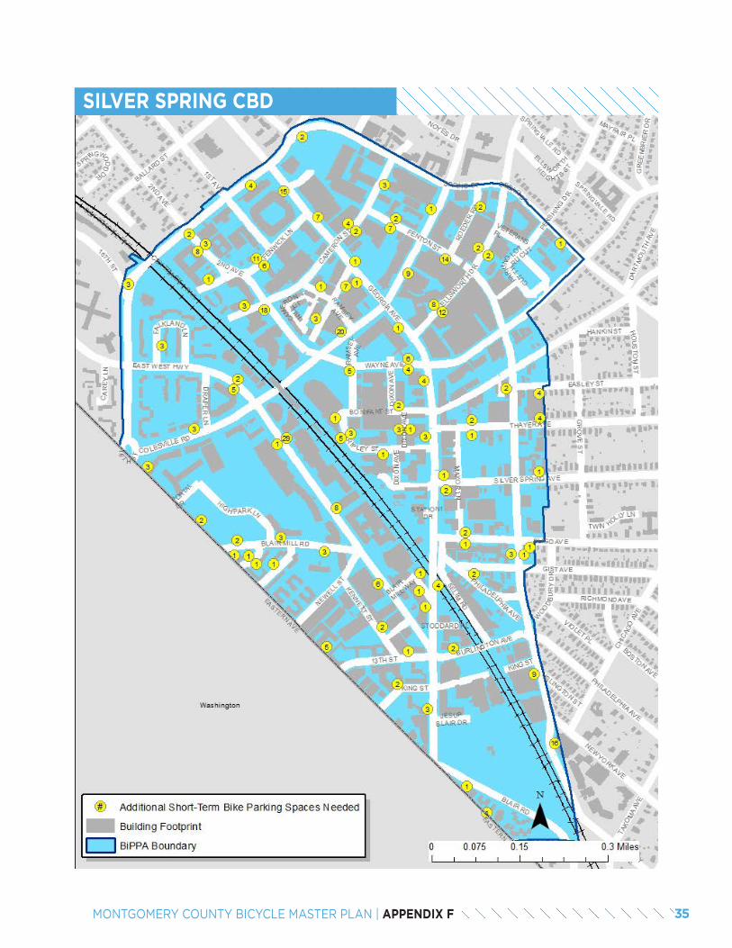
SILVER SPRING CBD
35MONTGOMERY COUNTY BICYCLE MASTER PLAN | APPENDIX F

The Takoma / Langley Crossroads BiPPA largely occupies the southwest quadrant at the intersection of New Hampshire Avenue and University Boulevard. While it currently encompasses an auto-oriented shopping center, this BiPPA may change with the opening of the Takoma / Langley Transit Center and future Purple Line Station.
Of the 11 blocks in the Takoma / Langley Crossroads BiPPA where there is a need for short-term bicycle parking:
• 8 blocks (or 73 percent) have insufficient short-term bicycle parking.• 8 blocks (or 73 percent) have no short-term
bicycle parking.
Overall, there is a deficit of 32 short-term bicycle parking spaces in the Takoma / Langley Crossroads BiPPA.
3.16 TAKOMA/LANGLEY CROSSROADS
The Takoma / Langley Transit center offers 20 covered parking spaces directly adjacent to the bus bays
36 MONTGOMERY COUNTY BICYCLE MASTER PLAN | APPENDIX F
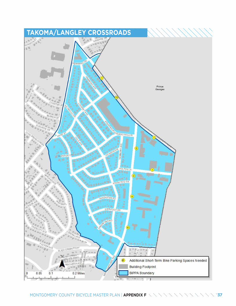
TAKOMA/LANGLEY CROSSROADS
37MONTGOMERY COUNTY BICYCLE MASTER PLAN | APPENDIX F
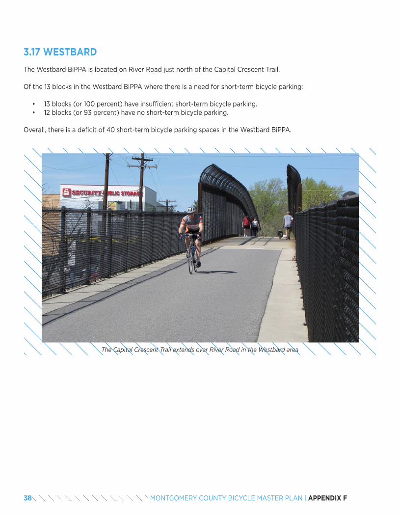
The Westbard BiPPA is located on River Road just north of the Capital Crescent Trail.
Of the 13 blocks in the Westbard BiPPA where there is a need for short-term bicycle parking:
• 13 blocks (or 100 percent) have insufficient short-term bicycle parking.• 12 blocks (or 93 percent) have no short-term bicycle parking.
Overall, there is a deficit of 40 short-term bicycle parking spaces in the Westbard BiPPA.
3.17 WESTBARD
The Capital Crescent Trail extends over River Road in the Westbard area
38 MONTGOMERY COUNTY BICYCLE MASTER PLAN | APPENDIX F
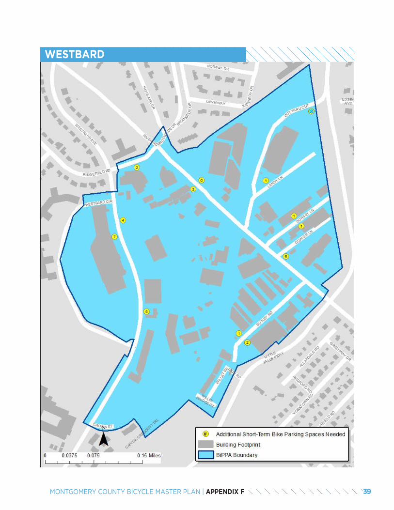
WESTBARD
39MONTGOMERY COUNTY BICYCLE MASTER PLAN | APPENDIX F
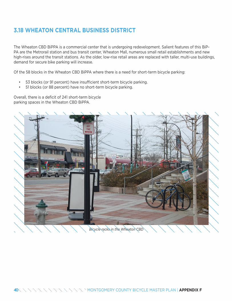
The Wheaton CBD BiPPA is a commercial center that is undergoing redevelopment. Salient features of this BiP-PA are the Metrorail station and bus transit center, Wheaton Mall, numerous small retail establishments and new high-rises around the transit stations. As the older, low-rise retail areas are replaced with taller, multi-use buildings, demand for secure bike parking will increase.
Of the 58 blocks in the Wheaton CBD BiPPA where there is a need for short-term bicycle parking:
• 53 blocks (or 91 percent) have insufficient short-term bicycle parking.• 51 blocks (or 88 percent) have no short-term bicycle parking.
Overall, there is a deficit of 241 short-term bicycle parking spaces in the Wheaton CBD BiPPA.
3.18 WHEATON CENTRAL BUSINESS DISTRICT
Bicycle racks in the Wheaton CBD
40 MONTGOMERY COUNTY BICYCLE MASTER PLAN | APPENDIX F
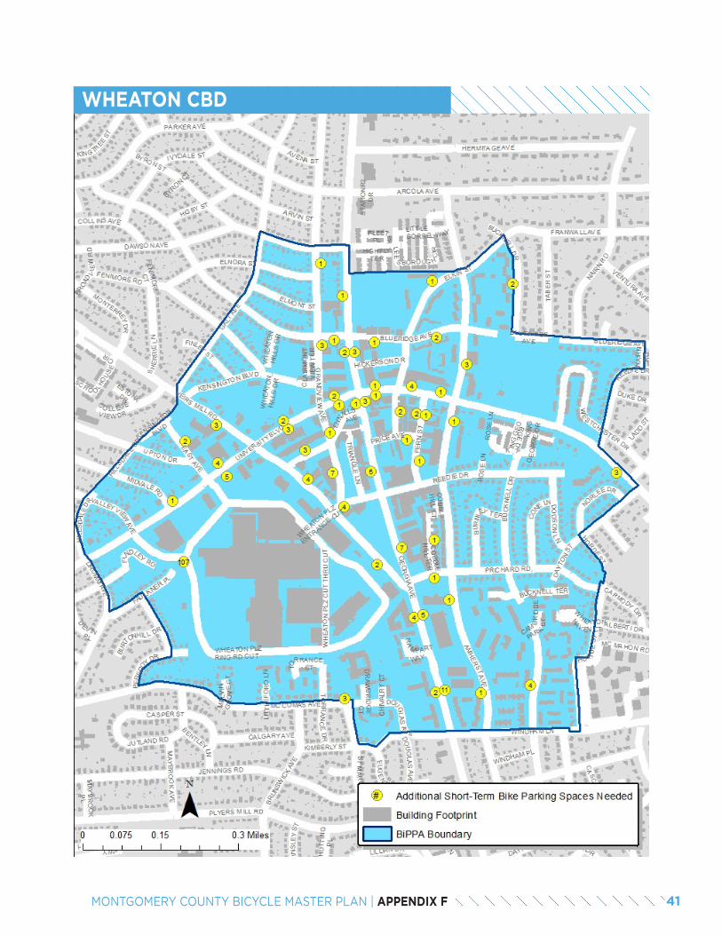
WHEATON CBD
41MONTGOMERY COUNTY BICYCLE MASTER PLAN | APPENDIX F
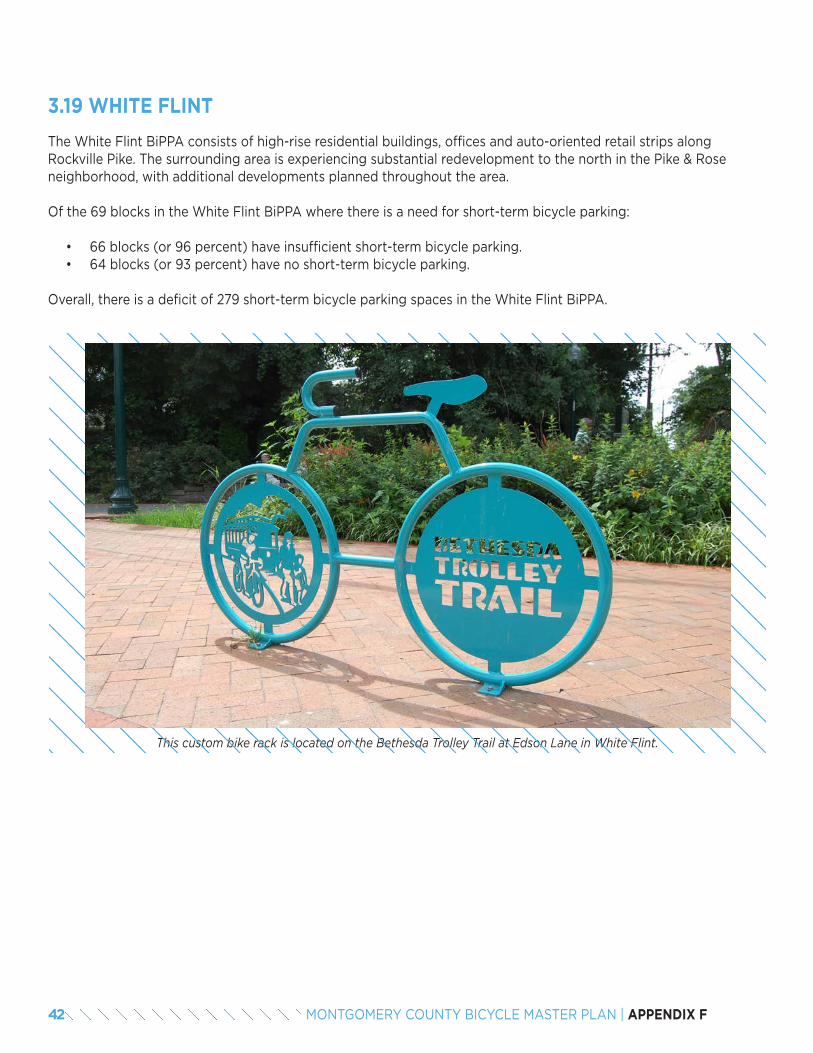
The White Flint BiPPA consists of high-rise residential buildings, offices and auto-oriented retail strips along Rockville Pike. The surrounding area is experiencing substantial redevelopment to the north in the Pike & Rose neighborhood, with additional developments planned throughout the area.
Of the 69 blocks in the White Flint BiPPA where there is a need for short-term bicycle parking:
• 66 blocks (or 96 percent) have insufficient short-term bicycle parking.• 64 blocks (or 93 percent) have no short-term bicycle parking.
Overall, there is a deficit of 279 short-term bicycle parking spaces in the White Flint BiPPA.
3.19 WHITE FLINT
This custom bike rack is located on the Bethesda Trolley Trail at Edson Lane in White Flint.
42 MONTGOMERY COUNTY BICYCLE MASTER PLAN | APPENDIX F
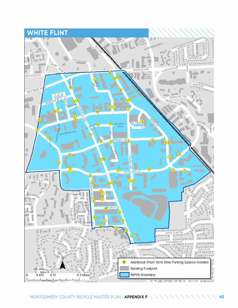
WHITE FLINT
43MONTGOMERY COUNTY BICYCLE MASTER PLAN | APPENDIX F
SUMMARY &RECOMMENDATIONS
04
Summary
This report evaluated the deficit of short-term bicycle parking spaces in 19 Bicycle Pedestrian Priority Areas (BiPPAs) in Montgomery County. Overall, 665 out of the 1,152 blocks analyzed have a need for short-term bicycle parking. Of these, 78 percent currently have no short-term bicycle parking and 85 percent have insufficient short-term bicycle parking based on the bicycle parking rates in Montgomery County’s Zoning Ordinance. In total, 1,965 additional, short-term bicycle parking spaces are needed to meet these parking rates. Almost 80 percent of this deficit occurs in five areas: Bethesda CBD (475 spaces), Friendship Heights CBD (160 spaces), Silver Spring CBD (381 spaces), Wheaton CBD (241 spaces), and White Flint (279 spaces).
Recommendations
Montgomery County should establish a bicycle parking program to reduce the deficit of short-term bicycle parking. Additional responsibilities of this program would be to:
• Develop a bicycle parking implementation plan aimed at improving bicycle parking in commercial buildings, transit stations, schools, recreation centers, libraries, other public facilities and multi-family residential buildings.
• Maintain the geospatial inventory of short-term parking used in this analysis and expand it to include long-term bicycle parking at commercial and multi-family residential buildings.
• Ensure that all new bicycle racks conform to industry standards.
• Replace substandard bike racks with those that conform to industry standards.
• Increase the supply of long-term bicycle parking spaces in transit stations, commercial areas and multi-family dwelling units.
44 MONTGOMERY COUNTY BICYCLE MASTER PLAN | APPENDIX F
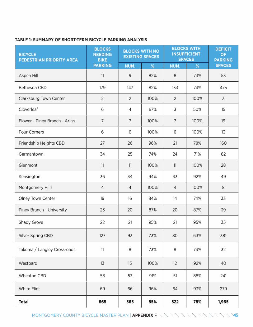
BICYCLE PEDESTRIAN PRIORITY AREA
BLOCKS NEEDING
BIKE PARKING
BLOCKS WITH NO EXISTING SPACES
BLOCKS WITH INSUFFICIENT
SPACES
DEFICIT OF
PARKING SPACESNUM. % NUM. %
Aspen Hill 11 9 82% 8 73% 53
Bethesda CBD 179 147 82% 133 74% 475
Clarksburg Town Center 2 2 100% 2 100% 3
Cloverleaf 6 4 67% 3 50% 15
Flower - Piney Branch - Arliss 7 7 100% 7 100% 19
Four Corners 6 6 100% 6 100% 13
Friendship Heights CBD 27 26 96% 21 78% 160
Germantown 34 25 74% 24 71% 62
Glenmont 11 11 100% 11 100% 28
Kensington 36 34 94% 33 92% 49
Montgomery Hills 4 4 100% 4 100% 8
Olney Town Center 19 16 84% 14 74% 33
Piney Branch - University 23 20 87% 20 87% 39
Shady Grove 22 21 95% 21 95% 35
Silver Spring CBD 127 93 73% 80 63% 381
Takoma / Langley Crossroads 11 8 73% 8 73% 32
Westbard 13 13 100% 12 92% 40
Wheaton CBD 58 53 91% 51 88% 241
White Flint 69 66 96% 64 93% 279
Total 665 565 85% 522 78% 1,965
TABLE 1: SUMMARY OF SHORT-TERM BICYCLE PARKING ANALYSIS
45MONTGOMERY COUNTY BICYCLE MASTER PLAN | APPENDIX F

46 MONTGOMERY COUNTY BICYCLE MASTER PLAN | APPENDIX F

APPENDIX GBICYCLE PARKING RECOMMENDATIONS AT
TRANSIT STATIONS
Bicycle parking is needed at all Metrorail Red Line, MARC, Purple Line and Corridor Cities Transitway stations. This appendix includes recommendations for the number of long-term and short-term bicycle parking spaces, as well as the spatial requirements, at each station using the six-step process outlined below.
STEP #1: FORECAST AM PEAK PERIOD BOARDINGS IN 2040
The starting point for determining the recommended number of bicycle parking spaces at transit stations was to request ridership forecasts from the Washington Met-ropolitan Transit Authority (WMATA) and Maryland Tran-sit Authority (MTA). The information provided by these transit authorities was presented in different formats. The Planning Department converted the data to 2040 AM peak period boarding forecasts as follows:
• Red Line: WMATA provided 2040 peak period (both AM and PM) boarding forecasts at Red Line stations. These forecasts were converted to AM peak period boarding estimates by applying a fac-tor based on 2016 ridership data.
• Purple Line: MTA provided 2040 daily boarding forecasts for Purple Line stations and indicated that AM peak period boardings were estimated to be 12.5 percent of total daily boardings.
• Corridor Cities Transitway: MTA provided 2040 AM peak period boarding forecasts by station.
• MARC Brunswick Line: MTA provided 2016 AM peak period boardings for each station. A one per-cent annual growth factor was assumed for each station to forecast 2040 AM peak period board-ings.
STEP #2: DETERMINE CATCHMENT AREA OF EACH TRANSIT STATION
To determine the recommended number of bicycle park-ing spaces at each transit station, a catchment area (or bike shed) was assumed for each transit station based on the existing road network, rather than a simple radi-us. The catchment areas were assumed to be between 0.5 and 2.0 miles from commuter rail stations (Red Line and MARC) and between 0.5 and 1.0 miles for light rail
(Purple Line) and bus rapid transit (Corridor Cities Tran-sitway) stations.
The lower threshold is intended to reflect that it is gen-erally more efficient to walk than to ride a bicycle within a distance of about 0.5 miles from a transit station. The upper threshold is intended to reflect a rough spacing between stations and the distance that most people can bicycle in a 10 to 15-minute trip, which is typically as-sumed to be the amount of time people will spend trav-eling to a transit station.
Next, the number of dwelling units was calculated with-in each transit station’s catchment area. Dwelling units located within two station catchment areas on the same transit line were assigned to the closest station. For each transit station, the total number of dwelling units in its catchment area was calculated as a percentage of dwell-ing units in all station areas for each transit line. For ex-ample, the Forest Glen catchment area contains 7,500 dwelling units within a 0.5 to 2.0-mile distance. This number is 9 percent of the 85,100 dwelling units located within the catchment area of Red Line stations in Mont-gomery County.
See the map to the right.
2 MONTGOMERY COUNTY BICYCLE MASTER PLAN | APPENDIX G
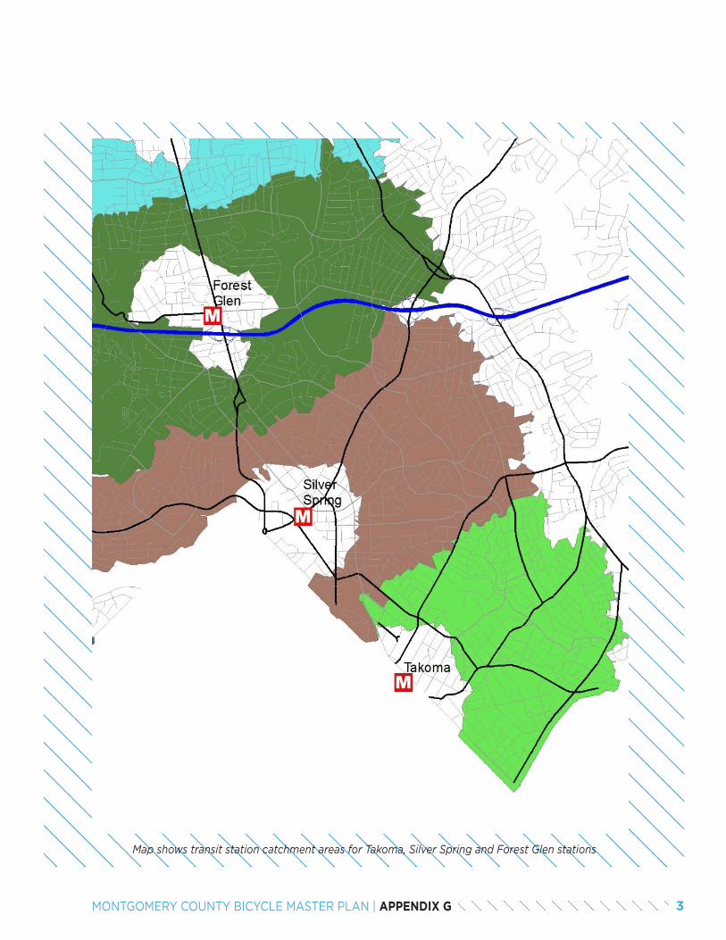
Map shows transit station catchment areas for Takoma, Silver Spring and Forest Glen stations
3MONTGOMERY COUNTY BICYCLE MASTER PLAN | APPENDIX G
STEP #3: DETERMINE GOAL-BASED ESTIMATE OF BICYCLE PARKING SPACES PER TRANSIT LINE
The number of bicycle parking spaces recommended for each transit line was calculated by setting a goal of 6.5 percent of AM peak period station boardings arriving at stations by bicycle. This percentage is based on guide-lines established by the Association of Pedestrian and Bicycle Professionals (APBP) that recommends provid-ing long-term bicycle parking spaces for 5 percent of AM peak period boardings and providing short-term bicycle parking spaces for 1.5 percent of AM peak period board-ings .
For example, about 68,000 AM peak period boardings are forecast to be shared among the 10 Red Line sta-tions located within Montgomery County and outside of the City of Rockville. If 6.5 percent of boardings access Red Line stations by bicycle, this number would equate to 4,412 bicycle parking spaces at all Red Line stations in Montgomery County.
STEP #4: DETERMINE GOAL-BASED ESTIMATE OF BICYCLE PARKING SPACES PER TRANSIT STATION
The number of recommended bicycle parking spaces per station was determined by apportioning the total the number of bicycle parking spaces for each transit line based on the number of dwelling units in each station area as a percentage of the total. For example, because the Forest Glen Red Line station is about 9 percent of the total dwelling units located within the catchment area of all Red Line stations in Montgomery County, the For-est Glen Station requires 388 bicycle parking spaces or 9 percent of the total 4,412 total spaces for the Red Line.
STEP #5: RECOMMENDED LONG-TERM AND SHORT-TERM BICYCLE PARKING SPACES BY STATION
The recommended number of long-term and short-term bicycle parking spaces was based on the guidelines es-tablished by the Association of Pedestrian and Bicycle Professionals. These guidelines that recommend provid-ing long-term bicycle parking spaces for 5 percent of AM peak period boardings and providing short-term bicycle parking spaces for 1.5 percent of AM peak period board-ings. Numbers are rounded and it was assumed that all stations should have at least 10 short-term bicycle park-ing spaces.
For those stations located in residential neighborhoods with little opportunity for redevelopment, no long-term bicycle parking spaces are recommended. These include Purple Line stations at Dale Drive and Manchester Place.
For those stations that do not yet have demand esti-mates, including the proposed White Flint MARC sta-tion and the Corridor Cities Transitway Phase 2, it is rec-ommended that they have a minimum of 20 long-term spaces and 6 short-term spaces. As ridership estimates become available, these recommendations should be up-dated.
For the Boyd MARC station, whose existing boardings are heavily constrained by parking availability, 20 long-term bicycle parking spaces are recommended.
Additional long-term bicycle parking spaces are recom-mended at the Lyttonsville Purple Line station. Unlike the other transit stations where bicycle parking require-ments are likely to be driven by residential access, the Lyttonsville station is likely to be driven by access to em-ployment at the Forest Glen Annex of the United States Army.
STEP #6: ESTIMATING SQUARE FOOT-AGE REQUIREMENTS BY STATION
The final step is to estimate the square footage require-ment for bicycle parking at each transit station. Long-term bicycle parking spaces are assumed to require 9 square feet per space and short-term bicycle parking spaces are assumed to require 20 square feet per space. A 20 percent contingency is applied to each station.
1
1 Bicycle Parking Guidelines 2nd Edition, Association of Pedestrian and Bicycle Professionals, 2010, page 3-3.
4 MONTGOMERY COUNTY BICYCLE MASTER PLAN | APPENDIX G
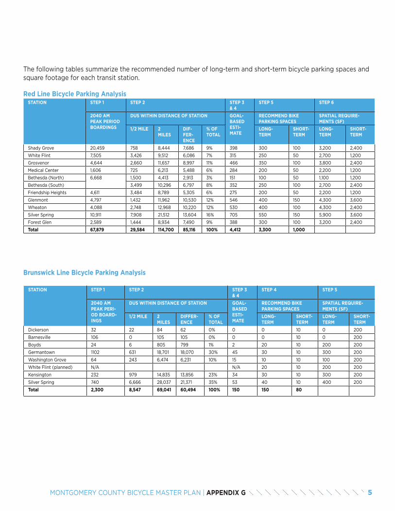
The following tables summarize the recommended number of long-term and short-term bicycle parking spaces and square footage for each transit station.
Red Line Bicycle Parking Analysis
Brunswick Line Bicycle Parking Analysis
STATION STEP 1 STEP 2 STEP 3 & 4
STEP 5 STEP 6
2040 AM PEAK PERIOD BOARDINGS
DUS WITHIN DISTANCE OF STATION GOAL-BASED ESTI-MATE
RECOMMEND BIKE PARKING SPACES
SPATIAL REQUIRE-MENTS (SF)
1/2 MILE 2 MILES
DIF-FER-ENCE
% OF TOTAL
LONG-TERM
SHORT-TERM
LONG-TERM
SHORT-TERM
Shady Grove 20,459 758 8,444 7,686 9% 398 300 100 3,200 2,400
White Flint 7,505 3,426 9,512 6,086 7% 315 250 50 2,700 1,200
Grosvenor 4,644 2,660 11,657 8,997 11% 466 350 100 3,800 2,400
Medical Center 1,606 725 6,213 5,488 6% 284 200 50 2,200 1,200
Bethesda (North) 6,668 1,500 4,413 2,913 3% 151 100 50 1,100 1,200
Bethesda (South) 3,499 10,296 6,797 8% 352 250 100 2,700 2,400
Friendship Heights 4,611 3,484 8,789 5,305 6% 275 200 50 2,200 1,200
Glenmont 4,797 1,432 11,962 10,530 12% 546 400 150 4,300 3,600
Wheaton 4,088 2,748 12,968 10,220 12% 530 400 100 4,300 2,400
Silver Spring 10,911 7,908 21,512 13,604 16% 705 550 150 5,900 3,600
Forest Glen 2,589 1,444 8,934 7,490 9% 388 300 100 3,200 2,400
Total 67,879 29,584 114,700 85,116 100% 4,412 3,300 1,000
STATION STEP 1 STEP 2 STEP 3 & 4
STEP 4 STEP 5
2040 AM PEAK PERI-OD BOARD-INGS
DUS WITHIN DISTANCE OF STATION GOAL-BASED ESTI-MATE
RECOMMEND BIKE PARKING SPACES
SPATIAL REQUIRE-MENTS (SF)
1/2 MILE 2 MILES
DIFFER-ENCE
% OF TOTAL
LONG-TERM
SHORT-TERM
LONG-TERM
SHORT-TERM
Dickerson 32 22 84 62 0% 0 0 10 0 200
Barnesville 106 0 105 105 0% 0 0 10 0 200
Boyds 24 6 805 799 1% 2 20 10 200 200
Germantown 1102 631 18,701 18,070 30% 45 30 10 300 200
Washington Grove 64 243 6,474 6,231 10% 15 10 10 100 200
White Flint (planned) N/A N/A 20 10 200 200
Kensington 232 979 14,835 13,856 23% 34 30 10 300 200
Silver Spring 740 6,666 28,037 21,371 35% 53 40 10 400 200
Total 2,300 8,547 69,041 60,494 100% 150 150 80
5MONTGOMERY COUNTY BICYCLE MASTER PLAN | APPENDIX G
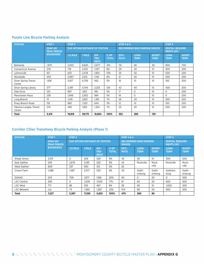
Purple Line Bicycle Parking Analysis
Corridor Cities Transitway Bicycle Parking Analysis (Phase 1)
STATION STEP 1 STEP 2 STEP 3 & 4 STEP 5
2040 AM PEAK PERIOD BOARDINGS
DUS WITHIN DISTANCE OF STATION RECOMMEND BIKE PARKING SPACES SPATIAL REQUIRE-MENTS (SF)
1/2 MILE 1 MILE DIF-FER-ENCE
% OF TOTAL
ESTI-MATE
LONG-TERM
SHORT-TERM
LONG-TERM
SHORT-TERM
Bethesda 1,875 2,943 8,820 5,877 31% 110 80 30 900 700
Connecticut Avenue 278 718 2,255 1,537 8% 29 20 10 200 200
Lyttonsville 167 623 2,478 1,855 10% 35 50 10 500 200
Woodside 203 2,067 3,212 1,145 6% 21 20 10 200 200
Silver Spring Transit Center
1,618 5,817 6,759 942 5% 18 10 10 100 200
Silver Spring Library 377 2,491 4,744 2,253 12% 42 40 10 400 200
Dale Drive 120 897 1,813 916 5% 17 0 10 0 200
Manchester Place 239 1,948 2,932 984 5% 18 0 10 0 200
Long Branch 111 1,419 2,810 1,391 7% 26 30 10 300 200
Piney Branch Road 155 893 1,533 640 3% 12 10 10 100 200
Takoma-Langley Transit Center
274 495 1,819 1,324 7% 25 20 10 200 200
Total 5,415 19,816 39,175 18,864 100% 352 280 130
STATION STEP 1 STEP 2 STEP 3 & 4 STEP 5
2040 AM PEAK PERIOD BOARDINGS
DUS WITHIN DISTANCE OF STATION RECOMMEND BIKE PARKING SPACES
SPATIAL REQUIRE-MENTS (SF)
1/2 MILE 1 MILE DIF-FER-ENCE
% OF TOTAL
ESTI-MATE
LONG-TERM
SHORT-TERM
LONG-TERM
SHORT-TERM
Shady Grove 3,531 0 529 529 9% 43 30 10 300 200
East Gaither 249 2,675 3,195 520 9% 42 Rockville Rock-ville
Rockville Rock-villeWest Gaither 609 337 650 313 5% 25
Crown Farm 1,488 1,487 2,017 530 9% 43 Gaith-ersburg
Gaith-ersburg
Gaithers-burg
Gaith-ersburg
DANAC 243 709 1,877 1,168 20% 94 0 20 0 500
LSC Central 390 0 1,009 1,009 17% 81 60 20 600 500
LSC West 717 86 553 467 8% 38 90 10 1,000 200
LSC Belward n/a 73 1,360 1,287 22% 104 80 20 900 500
Total 7,227 5,367 11,190 5,823 100% 470 260 80
6 MONTGOMERY COUNTY BICYCLE MASTER PLAN | APPENDIX G
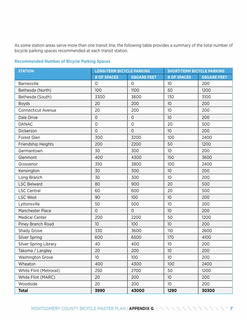
As some station areas serve more than one transit line, the following table provides a summary of the total number of bicycle parking spaces recommended at each transit station.
Recommended Number of Bicycle Parking Spaces
STATION LONG-TERM BICYCLE PARKING SHORT-TERM BICYCLE PARKING
# OF SPACES SQUARE FEET # OF SPACES SQUARE FEET
Barnesville 0 0 10 200
Bethesda (North) 100 1100 50 1200
Bethesda (South) 3300 3600 130 3100
Boyds 20 200 10 200
Connecticut Avenue 20 200 10 200
Dale Drive 0 0 10 200
DANAC 0 0 20 500
Dickerson 0 0 10 200
Forest Glen 300 3200 100 2400
Friendship Heights 200 2200 50 1200
Germantown 30 300 10 200
Glenmont 400 4300 150 3600
Grosvenor 350 3800 100 2400
Kensington 30 300 10 200
Long Branch 30 300 10 200
LSC Belward 80 900 20 500
LSC Central 60 600 20 500
LSC West 90 100 10 200
Lyttonsville 50 500 10 200
Manchester Place 0 0 10 200
Medical Center 200 2200 50 1200
Piney Branch Road 10 100 10 200
Shady Grove 330 3600 110 2600
Silver Spring 600 6500 170 4100
Silver Spring Library 40 400 10 200
Takoma / Langley 20 200 10 200
Washington Grove 10 100 10 200
Wheaton 400 4300 100 2400
White Flint (Metrorail) 250 2700 50 1200
White Flint (MARC) 20 200 10 200
Woodside 20 200 10 200
Total 3990 43000 1290 30300
7MONTGOMERY COUNTY BICYCLE MASTER PLAN | APPENDIX G

8 MONTGOMERY COUNTY BICYCLE MASTER PLAN | APPENDIX G

APPENDIX HSILVER SPRING TO GLENMONT BIKEWAY
INTRODUCTION
This concept plan details the development of a bikeway between the Glenmont Metrorail station and downtown Silver Spring via downtown Wheaton. While the original intent of the plan was to introduce the county to the neighborhood greenway concept, the presence of Interstate-495 in the plan area presents several design challenges that make a continuous neighborhood greenway complicated and costly to implement. Therefore, this short-term concept includes segments of sidepaths and conventional bike lanes, rather than one continuous neighborhood greenway along the corridor. The Bicycle Master Plan, however, could recommend a continuous neighborhood greenway between Glenmont and Silver Spring, as a long-term recommendation.
While sidepaths and bike lanes are recognized bikeway types, neighborhood greenways do not yet exist in Montgomery County. Also known as bicycle boulevards or slow streets, neighborhood greenways are streets with low volumes of motorized traffic (less than 2,000 vehicles per day), slow vehicular speeds (less than or equal to 25 mph) and are designed to give priority to bicycling and walking.
Neighborhood greenways use signs, pavement markings and speed and volume management measures to discourage through-trips by motor vehicles and create safe, convenient crossings of busy arterial streets. Specific infrastructure treatments can be installed to help bridge gaps in the low-stress street network to slow traffic and/or improve safety. Some of these treatments may be:
• Traffic diverters (full or partial) at key intersections to reduce cut-through traffic while permitting passage by pedestrians and bicyclists.
• Assigning priority to the neighborhood greenway at intersections with stop controls at two legs so bicyclists can ride with few interruptions.
• Neighborhood traffic circles and mini-round-abouts at minor intersections to slow traffic but allow bicyclists to maintain momentum.
• Measures to reduce traffic speeds, including speed humps, speed cushions, chicanes and neckdowns.
• Wayfinding signage to guide bicyclists to the neighborhood greenway and key destinations along it.
• Shared lane markings (sharrows) where appropriate to alert drivers to the path bicyclists need to take on a shared roadway.
• Crossing improvements at the intersection of major streets, including traffic signals, median refuges and curb extensions, to facilitate safe walking and bicycling crossings.
Many of the recommendations in this concept plan are detailed in the design toolkit in the appendix to the Bicycle Master Plan.
SECTIONS OF THE CONCEPT PLAN
Routes Considered1
Comparison of Routes2
Preferred Routes3
Bikeway Treatments for Preferred Route
4
2 MONTGOMERY COUNTY BICYCLE MASTER PLAN | APPENDIX H
01
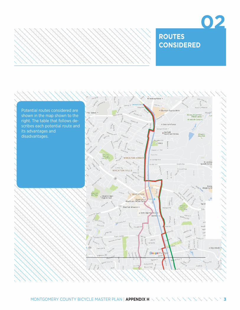
ROUTES CONSIDERED
Potential routes considered are shown in the map shown to the right. The table that follows de-scribes each potential route and its advantages and disadvantages.
3MONTGOMERY COUNTY BICYCLE MASTER PLAN | APPENDIX H
02
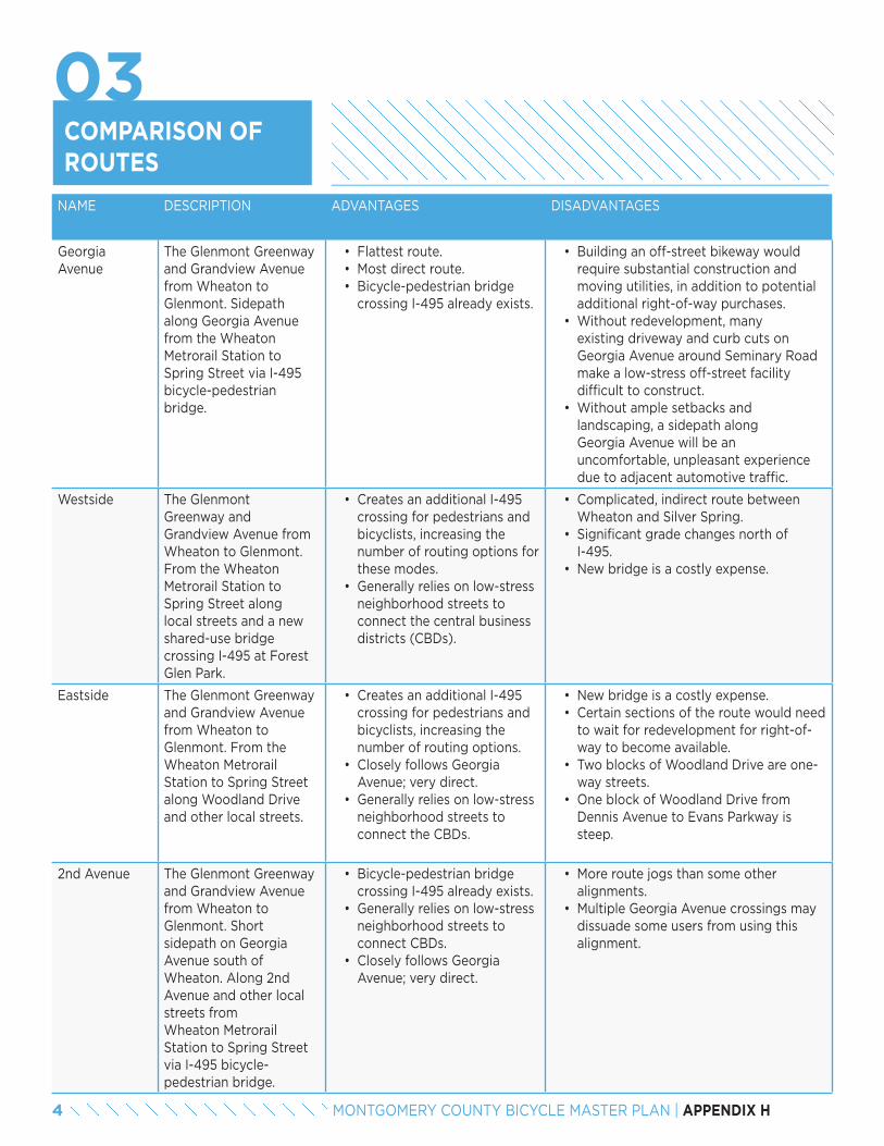
NAME DESCRIPTION ADVANTAGES DISADVANTAGES
Georgia Avenue
The Glenmont Greenway and Grandview Avenue from Wheaton to Glenmont. Sidepath along Georgia Avenue from the Wheaton Metrorail Station to Spring Street via I-495 bicycle-pedestrian bridge.
• Flattest route.• Most direct route.• Bicycle-pedestrian bridge
crossing I-495 already exists.
• Building an off-street bikeway would require substantial construction and moving utilities, in addition to potential additional right-of-way purchases.
• Without redevelopment, many existing driveway and curb cuts on Georgia Avenue around Seminary Road make a low-stress off-street facility difficult to construct.
• Without ample setbacks and landscaping, a sidepath along Georgia Avenue will be an uncomfortable, unpleasant experience due to adjacent automotive traffic.
Westside The Glenmont Greenway and Grandview Avenue from Wheaton to Glenmont. From the Wheaton Metrorail Station to Spring Street along local streets and a new shared-use bridge crossing I-495 at Forest Glen Park.
• Creates an additional I-495 crossing for pedestrians and bicyclists, increasing the number of routing options for these modes.
• Generally relies on low-stress neighborhood streets to connect the central business districts (CBDs).
• Complicated, indirect route between Wheaton and Silver Spring.
• Significant grade changes north of I-495.
• New bridge is a costly expense.
Eastside The Glenmont Greenway and Grandview Avenue from Wheaton to Glenmont. From the Wheaton Metrorail Station to Spring Street along Woodland Drive and other local streets.
• Creates an additional I-495 crossing for pedestrians and bicyclists, increasing the number of routing options.
• Closely follows Georgia Avenue; very direct.
• Generally relies on low-stress neighborhood streets to connect the CBDs.
• New bridge is a costly expense.• Certain sections of the route would need
to wait for redevelopment for right-of-way to become available.
• Two blocks of Woodland Drive are one-way streets.
• One block of Woodland Drive from Dennis Avenue to Evans Parkway is steep.
2nd Avenue The Glenmont Greenway and Grandview Avenue from Wheaton to Glenmont. Short sidepath on Georgia Avenue south of Wheaton. Along 2nd Avenue and other local streets from Wheaton Metrorail Station to Spring Street via I-495 bicycle- pedestrian bridge.
• Bicycle-pedestrian bridge crossing I-495 already exists.
• Generally relies on low-stress neighborhood streets to connect CBDs.
• Closely follows Georgia Avenue; very direct.
• More route jogs than some other alignments.
• Multiple Georgia Avenue crossings may dissuade some users from using this alignment.
COMPARISON OF ROUTES
03
4 MONTGOMERY COUNTY BICYCLE MASTER PLAN | APPENDIX H
PREFERRED ROUTE
04
After considering estimated cost of construction, feasibility and topography, the study team selected the 2nd Avenue route to pursue as a short-term bikeway between the Glenmont Metrorail Station and downtown Silver Spring.
Starting at the Glenmont Metrorail Station, the bikeway travels south along the Glenmont Greenway, located on the west side of Georgia Avenue between the Metro parking garage and the sidewalk. After crossing Randolph Road the bikeway turns right (west) onto Maston Street and then left (south) onto Grandview Avenue. Entering the Wheaton CBD, it turns left (east) onto Blueridge Avenue, crosses Georgia Avenue, and then turns right (south) onto Amherst Avenue and crosses University Blvd. The bikeway heads right (west) onto Plyers Mill Road, crosses Georgia Avenue a second time, and travels left (south) along the west side of Georgia Avenue for a block. It then turns right (west) onto Evans Drive and left (south) onto Douglas Avenue, then heads right (west) on Darrow Street and left (southwest) onto McKenney Avenue. It turns right (west) onto Hildarose Drive, left (south) onto Greeley Avenue, and right (west) onto Clark Place, and then left (south) onto Darcy Forest Drive. The bikeway turns left (east) onto Forest Glen Drive, traveling along the north side of the road, and then turns right (south) onto the west side of Georgia Avenue. It travels straight along the Interstate-495 bicycle-pedestrian bridge / underpass, heads right (west) onto Lansdowne Way via a u-turn to the right and a left turn, turns left (south) on 2nd Ave, left (east) on Riley Rd for 50 feet to turn right (south) through Montgomery Hills Park, and then right (west) on Seminary Pl for 50 feet to turn left (south) on Seminary Rd. It then crosses Linden Lane and continues straight (south) onto 2nd Avenue, crosses 16th street, and terminates at Spring Street.
5MONTGOMERY COUNTY BICYCLE MASTER PLAN | APPENDIX H
BIKEWAY TREATMENTS FORPREFERRED ROUTE
This section details the improvements recommended to create a low-stress bikeway between Glenmont and downtown Silver Spring. A comprehensive wayfinding plan should also be completed to direct users to the neighborhood greenway and help them navigate it. Proposed treatments are described starting at the Glenmont Metrorail Station and heading south to downtown Silver Spring.
The Glenmont Greenway
Treatment: Sidepath
From the Glenmont Metrorail Station, the bikeway travels south along the Glenmont Greenway on the west side of Georgia Avenue and will pass over Randolph Road when the ongoing interchange project is complete.
This analysis presupposes that the reconstructed Randolph Road intersection has adequate crossing facilities and signal timing, which provides sufficient bicyclist crossing time.
1. Roads intersecting the Glenmont Greenway (Sheraton Drive, Judson Road and Urbana Drive) should have signage installed beneath their existing stop signs that advises drivers to look for two-way bicycle traffic on the greenway. See example (right).
05
Mason Street
Treatment: Neighborhood Greenway
The bikeway turns west onto Mason Street and then south onto Grandview Avenue.
2. Install a marked crosswalk at the intersection of Georgia Avenue and Mason Street.
• This crosswalk will aid northbound bicyclists transitioning from to Mason Street to the Glenmont Greenway by improving motorist awareness of crossing activity.
Grandview Avenue from Mason Street to Arcola Avenue
Treatment: Neighborhood Greenway
3. Construct a traffic circle at the intersection of Mason Street and Grandview Avenue.
• This traffic circle will reduce motor vehicle speeds while allowing bicyclists to travel smoothly through the intersection.
4. Install speed cushions.
• This treatment will slow motorized traffic without impeding bicyclists.
5. Switch stop signs from north/south to east/west at Lindell Street, Henderson Avenue, Parker Avenue, and Arcola Avenue.
• This improvement prioritizes the neighborhood greenway as the through movement, making it more convenient and quicker to use.
• With the removal of the reorientation of the stops signs along Grandview Avenue, traffic calming may be needed.
6. Tighten the curb radius at the northwest corner of Weisman Road and Grandview Avenue.
• This tightened radius will slow southbound right turns and northbound left turns, making the intersection safer for all road users.
6 MONTGOMERY COUNTY BICYCLE MASTER PLAN | APPENDIX H
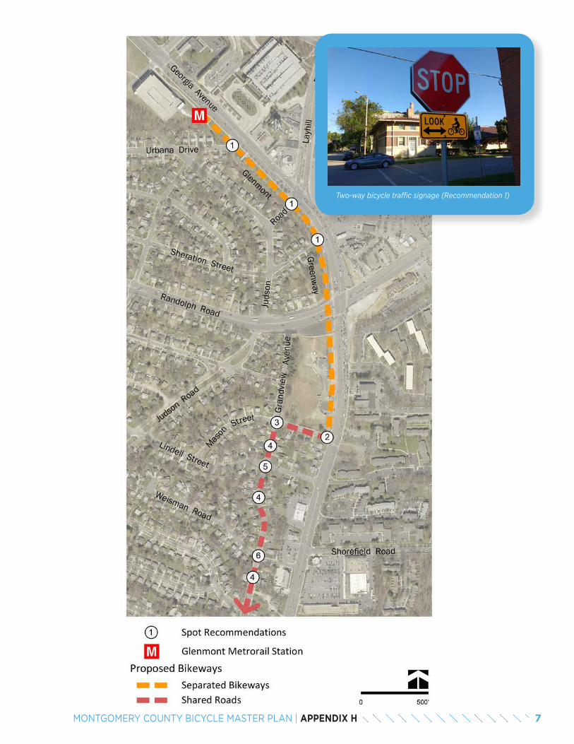
7MONTGOMERY COUNTY BICYCLE MASTER PLAN | APPENDIX H
Two-way bicycle traffic signage (Recommendation 1)
Grandview Avenue from Arcola Avenue to Blueridge Avenue
Treatment: Neighborhood Greenway
4. Install speed cushions.
• This treatment will slow motorized traffic while not impeding bicyclists.
5. Switch stop signs from north/south to east/west at Dawson Avenue.
• This improvement prioritizes the neighborhood greenway as the through movement, making it more convenient and quicker to use.
7. Because Grandview Avenue is an existing one-way street in the southbound direction, a six-foot northbound contraflow bicycle lane should be striped. The 10-foot southbound travel lane should be upgraded with shared lane markings. This recommendation requires the removal of vehicular parking on the east side of the roadway.
• Grandview Avenue is the most direct route to access the Glenmont area. Creating the contraflow bicycle lane in the northbound direction provides for two-way bicycle travel.
8. The parking lot exit near the intersection of Grandview Avenue and Blueridge Avenue should be signed to inform drivers to watch for contraflow bicycle traffic. See example for Recommendation 1.
Blueridge Avenue from Grandview Avenue to Elkin Street
Treatment: Separated Bike Lanes
9. Adjust signal timing to add an east/west leading bicycle/pedestrian interval or allow for left turns from Blueridge Avenue onto Georgia Avenue that are only possible during a protected phase.This treatment will slow motorized traffic while not impeding bicyclists.
• Both recommendations are intended to reduce left-hook collisions between bicyclists and turning motor vehicles.
8 MONTGOMERY COUNTY BICYCLE MASTER PLAN | APPENDIX H
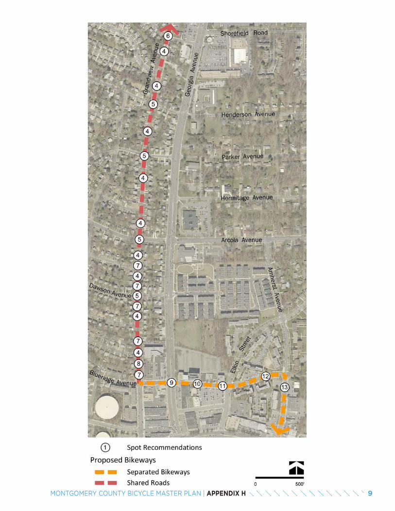
9MONTGOMERY COUNTY BICYCLE MASTER PLAN | APPENDIX H
Amherst Avenue from Blueridge Avenue to University Boulevard
Treatment: Separated Bike Lanes
13. Expand the master-planned right-of-way to 90 feet to have a 7 foot raised separated bike lane, a 3 foot buffer, a 8 foot parking lane, and a 11 foot travel lane in each direction.
• These lanes provide dedicated space for bicyclists in both directions and preserve on-street parking on both sides of the street.
Amherst Avenue from University Blvd to Windham Lane
Treatment: Separated Bike Lanes
14. Adjust signal timing to add a north/south leading bicycle/pedestrian interval or allow for left-turns from Amherst Avenue onto University Boulevard that are only possible during a protected phase.
• Both recommendations are intended to reduce left-hook collisions between bicyclists and turning motor vehicles.
15. Reconfigure Amherst Avenue to have a 7 foot raised separated bike lane, a 6 foot buffer, two 11 foot travel lanes, a 8 foot parking lane, a 6 foot buffer, and a 7 foot separated bike lane.
• These lanes provide dedicated space for bicyclists in both directions.
• This reconfiguration removes one parking lane.
16. Install a median on west leg of Prichard Road and Amherst Avenue intersection.
• This median will narrow the wide roadway and moderate the approach speeds of vehicles crossing the Amherst Avenue neighborhood greenway.
10. Reconfigure Blueridge Avenue to have a 7 foot raised separated bike lane, a 6 foot buffer, two 11 foot travel lanes, a 6 foot buffer, and a 7 foot separated bike lane.
• These lanes provide dedicated space for bicyclists in both directions.
• This reconfiguration removes both parking lanes.
Blueridge Avenue from Elkin Street to Amherst Avenue
Treatment: Separated Bike Lanes
11. Install a median immediately on Blueridge Avenue west of Elkin Street.
• This median will create a left-turn bay and match the number of approach lanes to receiving lanes. It will also narrow the roadway, calm traffic and make this street more comfortable for bicycling.
12. With redevelopment, expand the master-planned right-of-way to 80 feet to have a 7 foot raised separated bike lane, a 6 foot buffer, a 8 foot parking lane, two 11 foot travel lanes, a 6 foot buffer, and a 7 foot raised separated bike lane.
• These separated bike lanes provide dedicated space for bicyclists in both directions.
• This reconfiguration removes one parking lane.
10 MONTGOMERY COUNTY BICYCLE MASTER PLAN | APPENDIX H
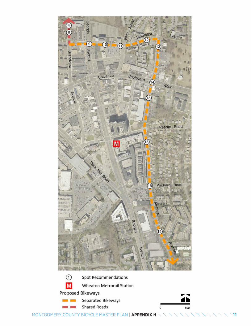
11MONTGOMERY COUNTY BICYCLE MASTER PLAN | APPENDIX H
Plyers Mill Road from Amherst Avenue to Georgia Avenue
Treatment: Neighborhood Greenway
The bikeway turns west onto Plyers Mill Road.
18. At the intersection of Plyers Mill Road and Amherst Avenue, create a westbound left turn bay by installing a median island (shown below). This measure could be accomplished in the interim by striping a new median rather than constructing a new island.
• This median will make it easier for eastbound bicyclists to turn left onto Amherst Avenue because they will only have to cross one lane of traffic.
19. Install bicycle boxes at both the eastern and western approaches to Georgia Avenue.
• These bicycle boxes will provide bicyclists a place to safely position themselves while waiting to cross Georgia Avenue.
20. Adjust signal timing to add an east/west leading bicycle/pedestrian interval or facilitate left turns from Plyers Mill Road onto Georgia Avenue during a protected phase.
• Both of these potential recommendations are intended to reduce left-hook collisions between bicyclists and turning motor vehicles.
Amherst Avenue from Windham Lane to Plyers Mill Road
Treatment: Neighborhood Greenway
17. Install regularly placed speed cushions.
• This treatment will slow motorized traffic without impeding bicyclists.
Georgia Avenue
Treatment: Sidepath
The bikeway turns south onto Georgia Avenue and then west onto Evans Drive.
21. Replace the existing sidewalk with a 10-foot-wide (preferred) sidepath separated by landscaping from the roadway and reconfigure the curb area at the southwest corner of Plyers Mill Road and the northwest corner of Evans Drive to accommodate bicycles.
• This facility, set back from Georgia Avenue’s heavy traffic, will provide a direct, convenient connection between Plyers Mill Road and Evans Drive for bicyclists. The sidewalk in this area is too narrow for shared pedestrian/bicycle use. The sidepath should be positioned behind any bus stops on this side of the roadway.
22. A marked crosswalk should be installed at the intersection of Georgia Avenue and Evans Drive.
• The crosswalk will aid northbound bicyclists transitioning onto the sidepath by advising motorists to look for crossing bicyclists.
Douglas Avenue
Treatment: Neighborhood GreenwayThe bikeway turns south onto Douglas Avenue.
23. Install speed cushions on the block south of Darrow Street and on the two blocks north of Darrow Street.
• The traffic calming will moderate traffic speeds and make the turn between Douglas Avenue and Darrow Street safer, while not impeding bicyclists.
12 MONTGOMERY COUNTY BICYCLE MASTER PLAN | APPENDIX H
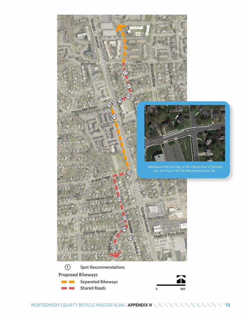
13MONTGOMERY COUNTY BICYCLE MASTER PLAN | APPENDIX H
Westbound left turn bay at the intersection of Georgia Ave and Plyers Mill Rd (Recommendation 18)
23. Install speed cushions on the block south of Darrow Street and on the two blocks north of Darrow Street.
• The traffic calming will moderate traffic speeds and make the turn between Douglas Avenue and Darrow Street safer, while not impeding bicyclists.
McKenney Avenue
Treatment: Neighborhood Greenway
The bikeway turns southwest onto McKenney Avenue.
24. Reconfigure the intersection of McKenney Avenue and Darrow Street to create a “T” intersection.
• The reconfigured intersection will slow motor vehicle speeds for traffic between McKenney Avenue and Douglas Avenue, improving bicyclist safety.
25. Install speed cushions to the north and south of Dexter Avenue (see below).
• The traffic calming will moderate traffic speeds along these stretches of road without impeding bicycle traffic.
26. Switch the stop signs at intersection of Dexter Avenue and McKenny Avenue to face Dexter Avenue.
• This improvement prioritizes the neighborhood greenway as the through-movement, making it more convenient and quicker to use.
Hildarose Drive, Greeley Avenue, Clark Place and Darcy Forest Drive
Treatment: Neighborhood Greenway
27. Switch the stop signs at the intersection of Clark Place and Arthur Avenue to face arther Avenue and Belvedere Boulevard.
• This improvement prioritizes the neighborhood greenway as the through-route, making it more convenient and quicker to use for bicyclists.
Darcy Forest Drive from Kimball Place to Forest Glen Road
Treatment: Neighborhood Greenway
28. This road should be striped with an 8-foot parking lane, a 10-foot travel lane in each direction and a 6-foot climbing lane.
• The climbing lane will provide dedicated space to bicyclists as they proceed northbound on Darcy Forest Drive. Due to the steep grade, cyclists will be travelling much slower than motor vehicles and the climbing lane will improve motorist-bicyclist interactions on this street.
Forest Glen Road
Treatment: Sidepath
The bikeway turns east and continues along the north side of Forest Glen Drive and then turns south onto Georgia Avenue toward the Interstate-495 bicycle- pedestrian bridge. Several improvements are recommended for this segment along Forest Glen Drive.
29. A marked crosswalk should be striped at the north leg of the intersection of Forest Glen Road and Darcy Forest Drive.
• This crosswalk will improve safety and motorist awareness of bicyclists traveling southbound on Darcy Forest Drive who turn east onto the Forest Glen Road sidepath.
30. The through/left-turn lane Kiss and Ride/Bus Loop exit lane should be removed to create room for a median. The remaining outbound lane will be used for all turns.
• This median will break up the crossing for bicyclists and pedestrians.
14 MONTGOMERY COUNTY BICYCLE MASTER PLAN | APPENDIX H
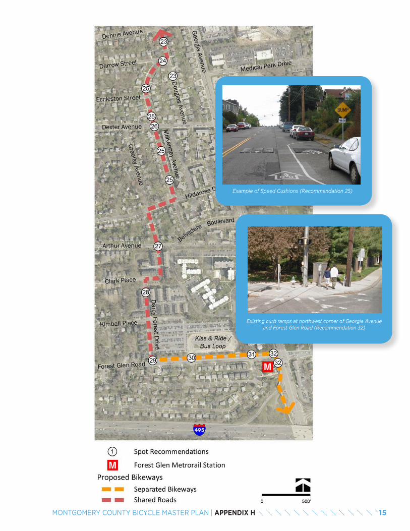
15MONTGOMERY COUNTY BICYCLE MASTER PLAN | APPENDIX H
•
Example of Speed Cushions (Recommendation 25)
Existing curb ramps at northwest corner of Georgia Avenue and Forest Glen Road (Recommendation 32)
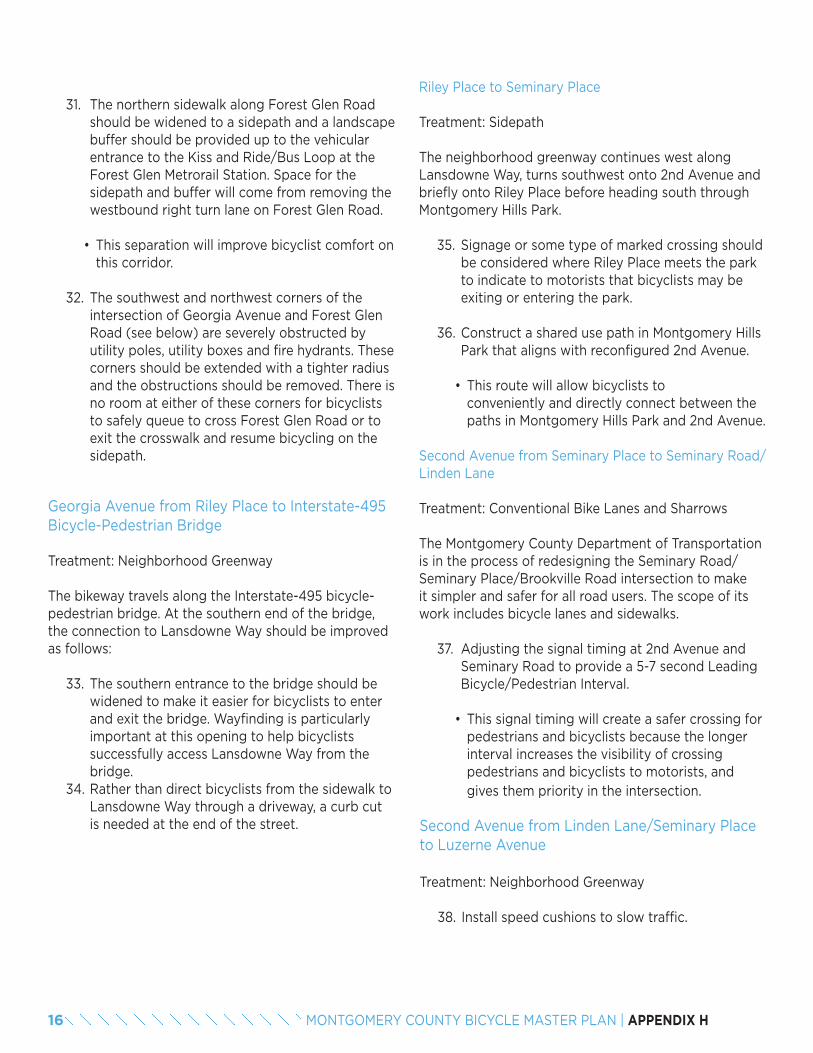
31. The northern sidewalk along Forest Glen Road should be widened to a sidepath and a landscape buffer should be provided up to the vehicular entrance to the Kiss and Ride/Bus Loop at the Forest Glen Metrorail Station. Space for the sidepath and buffer will come from removing the westbound right turn lane on Forest Glen Road.
• This separation will improve bicyclist comfort on this corridor.
32. The southwest and northwest corners of the intersection of Georgia Avenue and Forest Glen Road (see below) are severely obstructed by utility poles, utility boxes and fire hydrants. These corners should be extended with a tighter radius and the obstructions should be removed. There is no room at either of these corners for bicyclists to safely queue to cross Forest Glen Road or to exit the crosswalk and resume bicycling on the sidepath.
Georgia Avenue from Riley Place to Interstate-495 Bicycle-Pedestrian Bridge
Treatment: Neighborhood Greenway
The bikeway travels along the Interstate-495 bicycle- pedestrian bridge. At the southern end of the bridge, the connection to Lansdowne Way should be improved as follows:
33. The southern entrance to the bridge should be widened to make it easier for bicyclists to enter and exit the bridge. Wayfinding is particularly important at this opening to help bicyclists successfully access Lansdowne Way from the bridge.
34. Rather than direct bicyclists from the sidewalk to Lansdowne Way through a driveway, a curb cut is needed at the end of the street.
Riley Place to Seminary Place
Treatment: Sidepath
The neighborhood greenway continues west along Lansdowne Way, turns southwest onto 2nd Avenue and briefly onto Riley Place before heading south through Montgomery Hills Park.
35. Signage or some type of marked crossing should be considered where Riley Place meets the park to indicate to motorists that bicyclists may be exiting or entering the park.
36. Construct a shared use path in Montgomery Hills Park that aligns with reconfigured 2nd Avenue.
• This route will allow bicyclists to conveniently and directly connect between the paths in Montgomery Hills Park and 2nd Avenue.
Second Avenue from Seminary Place to Seminary Road/Linden Lane
Treatment: Conventional Bike Lanes and Sharrows
The Montgomery County Department of Transportation is in the process of redesigning the Seminary Road/Seminary Place/Brookville Road intersection to make it simpler and safer for all road users. The scope of its work includes bicycle lanes and sidewalks.
37. Adjusting the signal timing at 2nd Avenue and Seminary Road to provide a 5-7 second Leading Bicycle/Pedestrian Interval.
• This signal timing will create a safer crossing for pedestrians and bicyclists because the longer interval increases the visibility of crossing pedestrians and bicyclists to motorists, and gives them priority in the intersection.
Second Avenue from Linden Lane/Seminary Place to Luzerne Avenue
Treatment: Neighborhood Greenway
38. Install speed cushions to slow traffic.
16 MONTGOMERY COUNTY BICYCLE MASTER PLAN | APPENDIX H
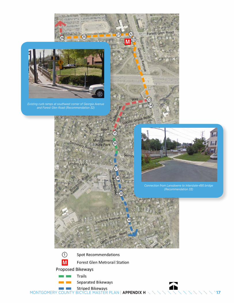
17MONTGOMERY COUNTY BICYCLE MASTER PLAN | APPENDIX H
Existing curb ramps at southwest corner of Georgia Avenue and Forest Glen Road (Recommendation 32)
Connection from Lansdowne to Interstate-495 bridge (Recommendation 33)
Second Avenue from Luzerne Avenue to 16th Street
Treatment: Conventional Bike Lane
39. This section of 2nd Avenue is sufficiently wide for a climbing lane to be installed, providing bicyclists with dedicated northbound roadway space. The downhill direction should be marked with shared lane markings to let motorists know where bicyclists will be located on the roadway.
Second Avenue from 16th Street to Spring Street
Treatment: Neighborhood Greenway
Currently, 2nd Avenue in Silver Spring is a signed bicycle route that helps connect the Georgetown Branch Trail to Downtown Silver Spring. As a result, traffic-calming measures exist between 16th Street and Spring Street, and include speed humps and a peak-di-rection access prohibition at 16th Street and Spring Street for all users except transit vehicles, bicyclists and pedestrians. These two treatments significantly reduce the volume and speed of motorized vehicles along this section of the bikeway.
At the intersection of Second Avenue and 16th Street, recommended treatments include:
40. Install corner islands at the southeast and northwest corners of the 2nd Avenue/16th Street intersection.
• The corner islands will slow right turns, tighten intersection geometry and reduce intersection crossing distances.
41. Install a curb extension on the northeast side of 2nd Avenue.
• This curb will narrow the roadway, slowing vehicular speed. It also allows cars pulling out of the driveway at 2nd Avenue and 16th Street to be more visible to bicyclists.
42. Adjusting signal timing to provide a 5-7 second Leading Pedestrian/Bicycle Interval.
• This timed signal will create a safer crossing for pedestrians and bicyclists because the longer interval increases the visibility of crossing pedestrians and bicyclists to motorists, and gives them priority in the intersection.
18 MONTGOMERY COUNTY BICYCLE MASTER PLAN | APPENDIX H
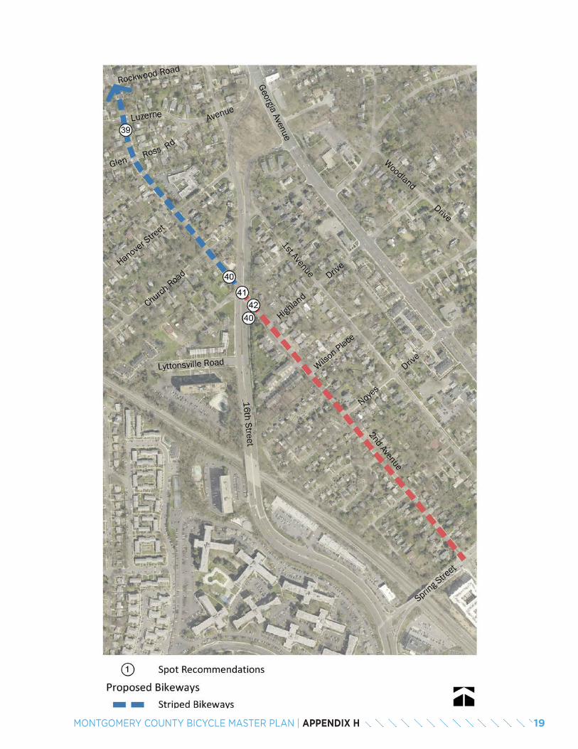
19MONTGOMERY COUNTY BICYCLE MASTER PLAN | APPENDIX H

20 MONTGOMERY COUNTY BICYCLE MASTER PLAN | APPENDIX H

APPENDIX IBREEZEWAY NETWORK
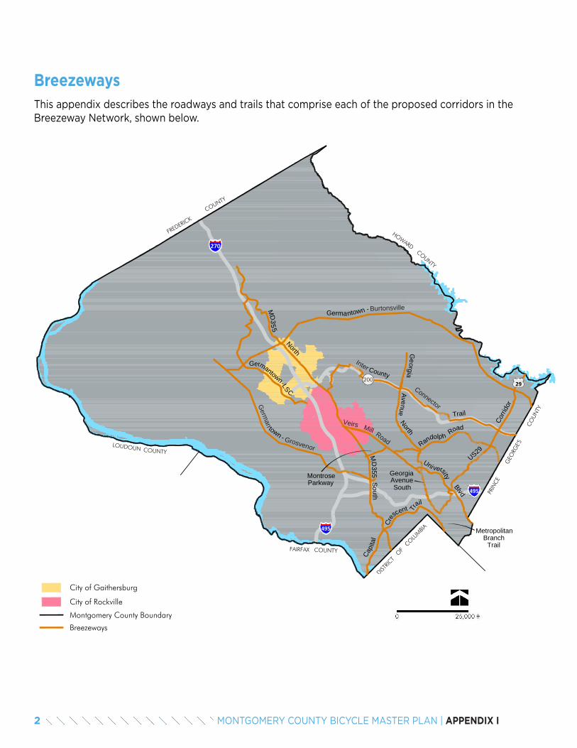
0 25,000 ft
Breezeways
FAIRFAX COUNTY
LOUDOUN COUNTY
FREDERICK
COUNTY
HOWARDCOUNTY
DISTRIC
T O
F C
OLU
MBIA
PRIN
CE
G
EORG
E'S
CO
UNTY
Montgomery County Boundary
270270
495
495
City of Gaithersburg
City of Rockville
200
GermaBurtonsville
Inter
ConnectorGerm
an
Grosvenor
Veirs Mill Road
Breezeways
Germantown-LSC
MD
North
355
Cap
US29Randolph Road
North
Uni versityBlvd
MD
355S
outh
Countyita
l
Cres
c Tr
ilnt
a
MetropolitanBranch
Trail
MontroseParkway
29
ntown -
Trail
Corri
dor
town -
Ge
Avenueorgia
GeorgiaAvenueSouth
e
BreezewaysThis appendix describes the roadways and trails that comprise each of the proposed corridors in the Breezeway Network, shown below.
2 MONTGOMERY COUNTY BICYCLE MASTER PLAN | APPENDIX I
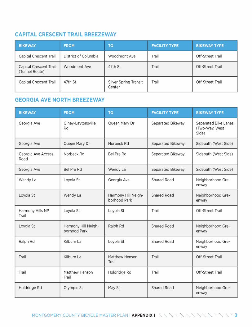
BIKEWAY FROM TO FACILITY TYPE BIKEWAY TYPE
Capital Crescent Trail District of Columbia Woodmont Ave Trail Off-Street Trail
Capital Crescent Trail (Tunnel Route)
Woodmont Ave 47th St Trail Off-Street Trail
Capital Crescent Trail 47th St Silver Spring Transit Center
Trail Off-Street Trail
CAPITAL CRESCENT TRAIL BREEZEWAY
BIKEWAY FROM TO FACILITY TYPE BIKEWAY TYPE
Georgia Ave Olney-Laytonsville Rd
Queen Mary Dr Separated Bikeway Separated Bike Lanes (Two-Way, West Side)
Georgia Ave Queen Mary Dr Norbeck Rd Separated Bikeway Sidepath (West Side)
Georgia Ave Access Road
Norbeck Rd Bel Pre Rd Separated Bikeway Sidepath (West Side)
Georgia Ave Bel Pre Rd Wendy La Separated Bikeway Sidepath (West Side)
Wendy La Loyola St Georgia Ave Shared Road Neighborhood Gre-enway
Loyola St Wendy La Harmony Hill Neigh-borhood Park
Shared Road Neighborhood Gre-enway
Harmony Hills NP Trail
Loyola St Loyola St Trail Off-Street Trail
Loyola St Harmony Hill Neigh-borhood Park
Ralph Rd Shared Road Neighborhood Gre-enway
Ralph Rd Kilburn La Loyola St Shared Road Neighborhood Gre-enway
Trail Kilburn La Matthew Henson Trail
Trail Off-Street Trail
Trail Matthew Henson Trail
Holdridge Rd Trail Off-Street Trail
Holdridge Rd Olympic St May St Shared Road Neighborhood Gre-enway
GEORGIA AVE NORTH BREEZEWAY
3MONTGOMERY COUNTY BICYCLE MASTER PLAN | APPENDIX I
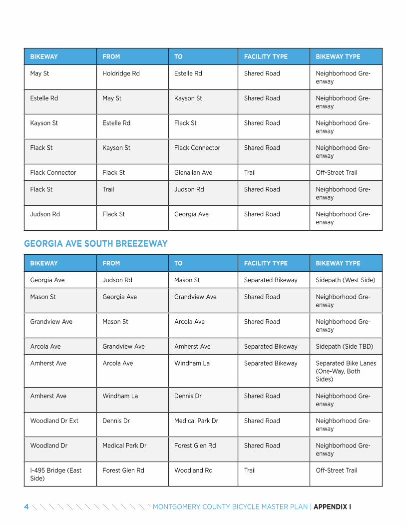
BIKEWAY FROM TO FACILITY TYPE BIKEWAY TYPE
May St Holdridge Rd Estelle Rd Shared Road Neighborhood Gre-enway
Estelle Rd May St Kayson St Shared Road Neighborhood Gre-enway
Kayson St Estelle Rd Flack St Shared Road Neighborhood Gre-enway
Flack St Kayson St Flack Connector Shared Road Neighborhood Gre-enway
Flack Connector Flack St Glenallan Ave Trail Off-Street Trail
Flack St Trail Judson Rd Shared Road Neighborhood Gre-enway
Judson Rd Flack St Georgia Ave Shared Road Neighborhood Gre-enway
GEORGIA AVE SOUTH BREEZEWAY
BIKEWAY FROM TO FACILITY TYPE BIKEWAY TYPE
Georgia Ave Judson Rd Mason St Separated Bikeway Sidepath (West Side)
Mason St Georgia Ave Grandview Ave Shared Road Neighborhood Gre-enway
Grandview Ave Mason St Arcola Ave Shared Road Neighborhood Gre-enway
Arcola Ave Grandview Ave Amherst Ave Separated Bikeway Sidepath (Side TBD)
Amherst Ave Arcola Ave Windham La Separated Bikeway Separated Bike Lanes (One-Way, Both Sides)
Amherst Ave Windham La Dennis Dr Shared Road Neighborhood Gre-enway
Woodland Dr Ext Dennis Dr Medical Park Dr Shared Road Neighborhood Gre-enway
Woodland Dr Medical Park Dr Forest Glen Rd Shared Road Neighborhood Gre-enway
I-495 Bridge (East Side)
Forest Glen Rd Woodland Rd Trail Off-Street Trail
4 MONTGOMERY COUNTY BICYCLE MASTER PLAN | APPENDIX I
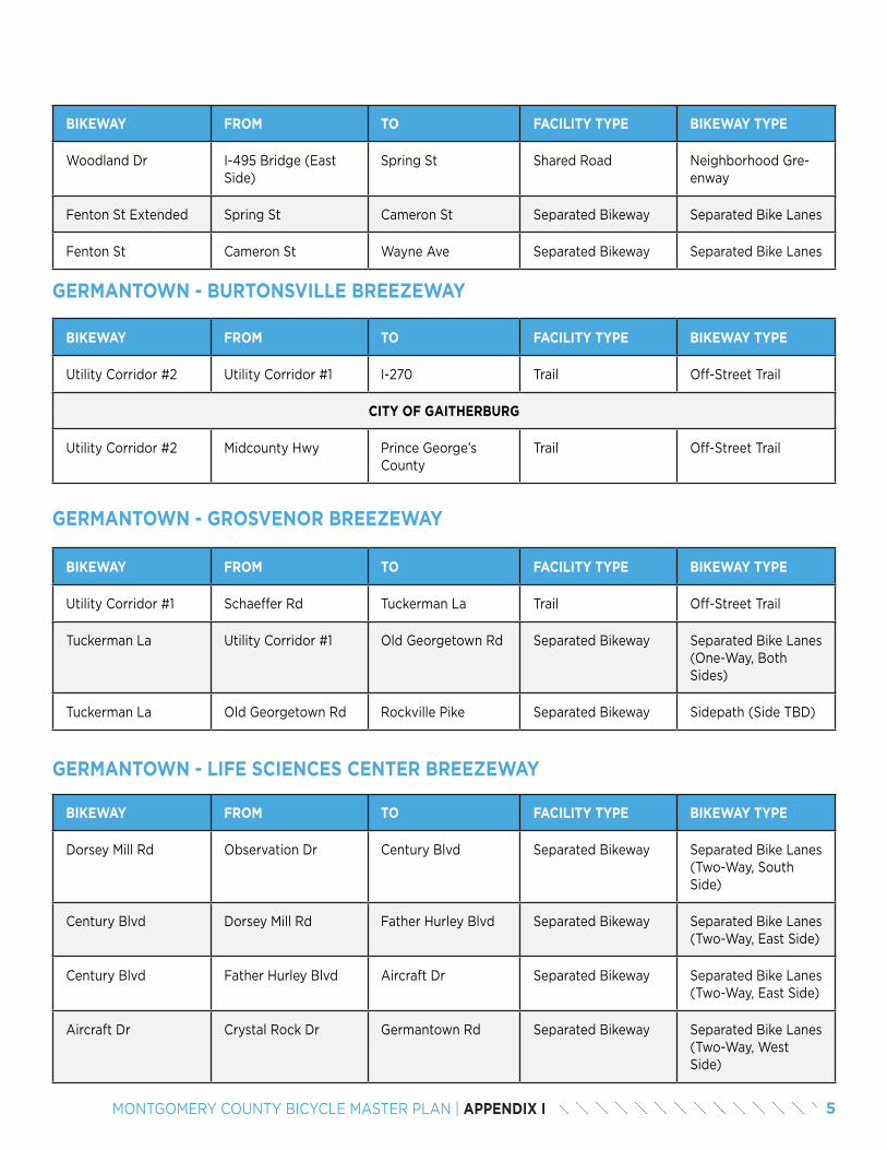
BIKEWAY FROM TO FACILITY TYPE BIKEWAY TYPE
Woodland Dr I-495 Bridge (East Side)
Spring St Shared Road Neighborhood Gre-enway
Fenton St Extended Spring St Cameron St Separated Bikeway Separated Bike Lanes
Fenton St Cameron St Wayne Ave Separated Bikeway Separated Bike Lanes
BIKEWAY FROM TO FACILITY TYPE BIKEWAY TYPE
Utility Corridor #2 Utility Corridor #1 I-270 Trail Off-Street Trail
CITY OF GAITHERBURG
Utility Corridor #2 Midcounty Hwy Prince George’s County
Trail Off-Street Trail
GERMANTOWN - BURTONSVILLE BREEZEWAY
BIKEWAY FROM TO FACILITY TYPE BIKEWAY TYPE
Utility Corridor #1 Schaeffer Rd Tuckerman La Trail Off-Street Trail
Tuckerman La Utility Corridor #1 Old Georgetown Rd Separated Bikeway Separated Bike Lanes (One-Way, Both Sides)
Tuckerman La Old Georgetown Rd Rockville Pike Separated Bikeway Sidepath (Side TBD)
GERMANTOWN - GROSVENOR BREEZEWAY
BIKEWAY FROM TO FACILITY TYPE BIKEWAY TYPE
Dorsey Mill Rd Observation Dr Century Blvd Separated Bikeway Separated Bike Lanes (Two-Way, South Side)
Century Blvd Dorsey Mill Rd Father Hurley Blvd Separated Bikeway Separated Bike Lanes (Two-Way, East Side)
Century Blvd Father Hurley Blvd Aircraft Dr Separated Bikeway Separated Bike Lanes (Two-Way, East Side)
Aircraft Dr Crystal Rock Dr Germantown Rd Separated Bikeway Separated Bike Lanes (Two-Way, West Side)
GERMANTOWN - LIFE SCIENCES CENTER BREEZEWAY
5MONTGOMERY COUNTY BICYCLE MASTER PLAN | APPENDIX I
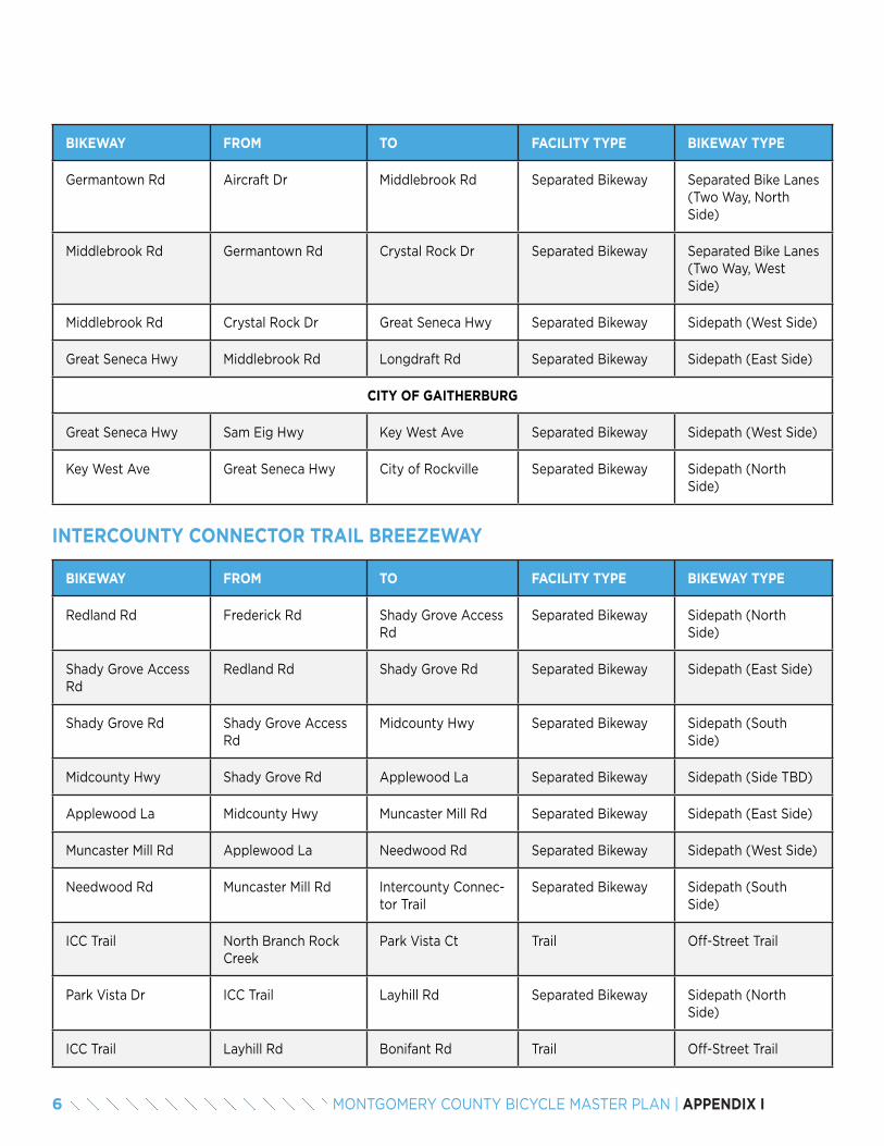
BIKEWAY FROM TO FACILITY TYPE BIKEWAY TYPE
Redland Rd Frederick Rd Shady Grove Access Rd
Separated Bikeway Sidepath (North Side)
Shady Grove Access Rd
Redland Rd Shady Grove Rd Separated Bikeway Sidepath (East Side)
Shady Grove Rd Shady Grove Access Rd
Midcounty Hwy Separated Bikeway Sidepath (South Side)
Midcounty Hwy Shady Grove Rd Applewood La Separated Bikeway Sidepath (Side TBD)
Applewood La Midcounty Hwy Muncaster Mill Rd Separated Bikeway Sidepath (East Side)
Muncaster Mill Rd Applewood La Needwood Rd Separated Bikeway Sidepath (West Side)
Needwood Rd Muncaster Mill Rd Intercounty Connec-tor Trail
Separated Bikeway Sidepath (South Side)
ICC Trail North Branch Rock Creek
Park Vista Ct Trail Off-Street Trail
Park Vista Dr ICC Trail Layhill Rd Separated Bikeway Sidepath (North Side)
ICC Trail Layhill Rd Bonifant Rd Trail Off-Street Trail
INTERCOUNTY CONNECTOR TRAIL BREEZEWAY
BIKEWAY FROM TO FACILITY TYPE BIKEWAY TYPE
Germantown Rd Aircraft Dr Middlebrook Rd Separated Bikeway Separated Bike Lanes (Two Way, North Side)
Middlebrook Rd Germantown Rd Crystal Rock Dr Separated Bikeway Separated Bike Lanes (Two Way, West Side)
Middlebrook Rd Crystal Rock Dr Great Seneca Hwy Separated Bikeway Sidepath (West Side)
Great Seneca Hwy Middlebrook Rd Longdraft Rd Separated Bikeway Sidepath (East Side)
CITY OF GAITHERBURG
Great Seneca Hwy Sam Eig Hwy Key West Ave Separated Bikeway Sidepath (West Side)
Key West Ave Great Seneca Hwy City of Rockville Separated Bikeway Sidepath (North Side)
6 MONTGOMERY COUNTY BICYCLE MASTER PLAN | APPENDIX I
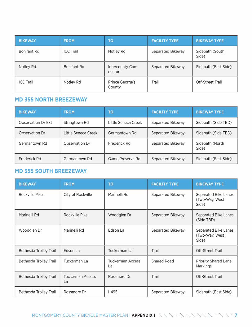
MD 355 NORTH BREEZEWAY
BIKEWAY FROM TO FACILITY TYPE BIKEWAY TYPE
Observation Dr Ext Stringtown Rd Little Seneca Creek Separated Bikeway Sidepath (Side TBD)
Observation Dr Little Seneca Creek Germantown Rd Separated Bikeway Sidepath (Side TBD)
Germantown Rd Observation Dr Frederick Rd Separated Bikeway Sidepath (North Side)
Frederick Rd Germantown Rd Game Preserve Rd Separated Bikeway Sidepath (East Side)
MD 355 SOUTH BREEZEWAY
BIKEWAY FROM TO FACILITY TYPE BIKEWAY TYPE
Rockville Pike City of Rockville Marinelli Rd Separated Bikeway Separated Bike Lanes (Two-Way, West Side)
Marinelli Rd Rockville Pike Woodglen Dr Separated Bikeway Separated Bike Lanes (Side TBD)
Woodglen Dr Marinelli Rd Edson La Separated Bikeway Separated Bike Lanes (Two-Way, West Side)
Bethesda Trolley Trail Edson La Tuckerman La Trail Off-Street Trail
Bethesda Trolley Trail Tuckerman La Tuckerman Access La
Shared Road Priority Shared Lane Markings
Bethesda Trolley Trail Tuckerman Access La
Rossmore Dr Trail Off-Street Trail
Bethesda Trolley Trail Rossmore Dr I-495 Separated Bikeway Sidepath (East Side)
BIKEWAY FROM TO FACILITY TYPE BIKEWAY TYPE
Bonifant Rd ICC Trail Notley Rd Separated Bikeway Sidepath (South Side)
Notley Rd Bonifant Rd Intercounty Con-nector
Separated Bikeway Sidepath (East Side)
ICC Trail Notley Rd Prince George’s County
Trail Off-Street Trail
7MONTGOMERY COUNTY BICYCLE MASTER PLAN | APPENDIX I
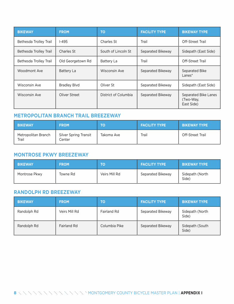
METROPOLITAN BRANCH TRAIL BREEZEWAY
BIKEWAY FROM TO FACILITY TYPE BIKEWAY TYPE
Metropolitan Branch Trail
Silver Spring Transit Center
Takoma Ave Trail Off-Street Trail
MONTROSE PKWY BREEZEWAY
BIKEWAY FROM TO FACILITY TYPE BIKEWAY TYPE
Montrose Pkwy Towne Rd Veirs Mill Rd Separated Bikeway Sidepath (North Side)
RANDOLPH RD BREEZEWAY
BIKEWAY FROM TO FACILITY TYPE BIKEWAY TYPE
Randolph Rd Veirs Mill Rd Fairland Rd Separated Bikeway Sidepath (North Side)
Randolph Rd Fairland Rd Columbia Pike Separated Bikeway Sidepath (South Side)
BIKEWAY FROM TO FACILITY TYPE BIKEWAY TYPE
Bethesda Trolley Trail I-495 Charles St Trail Off-Street Trail
Bethesda Trolley Trail Charles St South of Lincoln St Separated Bikeway Sidepath (East Side)
Bethesda Trolley Trail Old Georgetown Rd Battery La Trail Off-Street Trail
Woodmont Ave Battery La Wisconsin Ave Separated Bikeway Separated Bike Lanes*
Wisconsin Ave Bradley Blvd Oliver St Separated Bikeway Sidepath (East Side)
Wisconsin Ave Oliver Street District of Columbia Separated Bikeway Separated Bike Lanes (Two-Way, East Side)
8 MONTGOMERY COUNTY BICYCLE MASTER PLAN | APPENDIX I
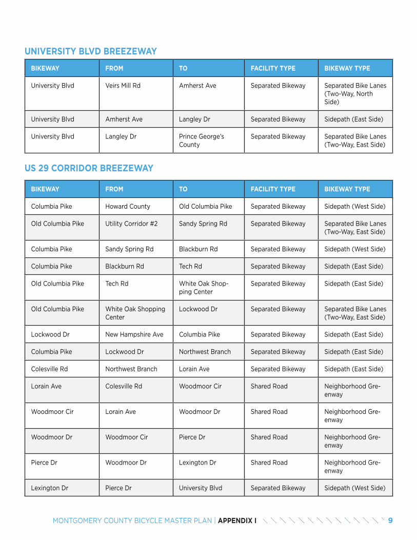
UNIVERSITY BLVD BREEZEWAY
BIKEWAY FROM TO FACILITY TYPE BIKEWAY TYPE
University Blvd Veirs Mill Rd Amherst Ave Separated Bikeway Separated Bike Lanes (Two-Way, North Side)
University Blvd Amherst Ave Langley Dr Separated Bikeway Sidepath (East Side)
University Blvd Langley Dr Prince George’s County
Separated Bikeway Separated Bike Lanes (Two-Way, East Side)
US 29 CORRIDOR BREEZEWAY
BIKEWAY FROM TO FACILITY TYPE BIKEWAY TYPE
Columbia Pike Howard County Old Columbia Pike Separated Bikeway Sidepath (West Side)
Old Columbia Pike Utility Corridor #2 Sandy Spring Rd Separated Bikeway Separated Bike Lanes (Two-Way, East Side)
Columbia Pike Sandy Spring Rd Blackburn Rd Separated Bikeway Sidepath (West Side)
Columbia Pike Blackburn Rd Tech Rd Separated Bikeway Sidepath (East Side)
Old Columbia Pike Tech Rd White Oak Shop-ping Center
Separated Bikeway Sidepath (East Side)
Old Columbia Pike White Oak Shopping Center
Lockwood Dr Separated Bikeway Separated Bike Lanes (Two-Way, East Side)
Lockwood Dr New Hampshire Ave Columbia Pike Separated Bikeway Sidepath (East Side)
Columbia Pike Lockwood Dr Northwest Branch Separated Bikeway Sidepath (East Side)
Colesville Rd Northwest Branch Lorain Ave Separated Bikeway Sidepath (East Side)
Lorain Ave Colesville Rd Woodmoor Cir Shared Road Neighborhood Gre-enway
Woodmoor Cir Lorain Ave Woodmoor Dr Shared Road Neighborhood Gre-enway
Woodmoor Dr Woodmoor Cir Pierce Dr Shared Road Neighborhood Gre-enway
Pierce Dr Woodmoor Dr Lexington Dr Shared Road Neighborhood Gre-enway
Lexington Dr Pierce Dr University Blvd Separated Bikeway Sidepath (West Side)
9MONTGOMERY COUNTY BICYCLE MASTER PLAN | APPENDIX I
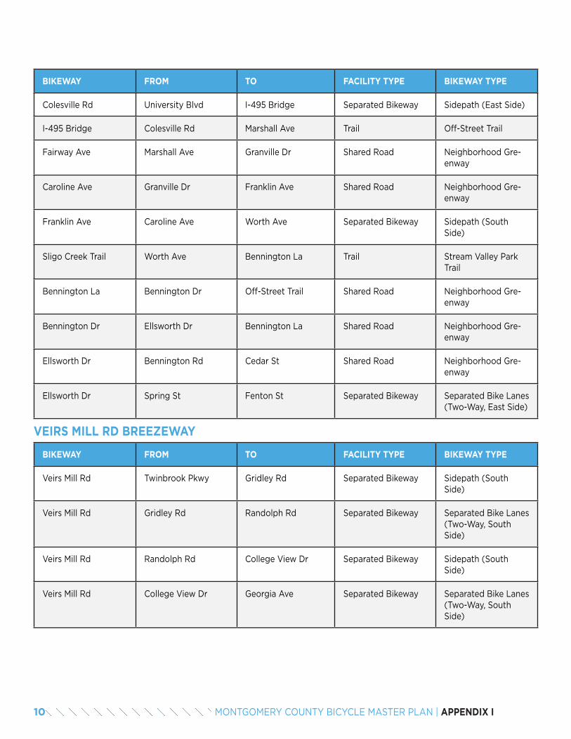
VEIRS MILL RD BREEZEWAY
BIKEWAY FROM TO FACILITY TYPE BIKEWAY TYPE
Veirs Mill Rd Twinbrook Pkwy Gridley Rd Separated Bikeway Sidepath (South Side)
Veirs Mill Rd Gridley Rd Randolph Rd Separated Bikeway Separated Bike Lanes (Two-Way, South Side)
Veirs Mill Rd Randolph Rd College View Dr Separated Bikeway Sidepath (South Side)
Veirs Mill Rd College View Dr Georgia Ave Separated Bikeway Separated Bike Lanes (Two-Way, South Side)
BIKEWAY FROM TO FACILITY TYPE BIKEWAY TYPE
Colesville Rd University Blvd I-495 Bridge Separated Bikeway Sidepath (East Side)
I-495 Bridge Colesville Rd Marshall Ave Trail Off-Street Trail
Fairway Ave Marshall Ave Granville Dr Shared Road Neighborhood Gre-enway
Caroline Ave Granville Dr Franklin Ave Shared Road Neighborhood Gre-enway
Franklin Ave Caroline Ave Worth Ave Separated Bikeway Sidepath (South Side)
Sligo Creek Trail Worth Ave Bennington La Trail Stream Valley Park Trail
Bennington La Bennington Dr Off-Street Trail Shared Road Neighborhood Gre-enway
Bennington Dr Ellsworth Dr Bennington La Shared Road Neighborhood Gre-enway
Ellsworth Dr Bennington Rd Cedar St Shared Road Neighborhood Gre-enway
Ellsworth Dr Spring St Fenton St Separated Bikeway Separated Bike Lanes (Two-Way, East Side)
10 MONTGOMERY COUNTY BICYCLE MASTER PLAN | APPENDIX I

11MONTGOMERY COUNTY BICYCLE MASTER PLAN | APPENDIX I

12 MONTGOMERY COUNTY BICYCLE MASTER PLAN | APPENDIX I

APPENDIX JNEIGHBORHOOD CONNECTORS
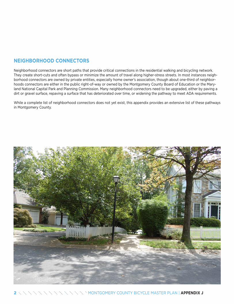
NEIGHBORHOOD CONNECTORS
Neighborhood connectors are short paths that provide critical connections in the residential walking and bicycling network. They create short-cuts and often bypass or minimize the amount of travel along higher-stress streets. In most instances neigh-borhood connectors are owned by private entities, especially home owner’s association, though about one-third of neighbor-hoods connectors are either in the public right-of-way or owned by the Montgomery County Board of Education or the Mary-land National Capital Park and Planning Commission. Many neighborhood connectors need to be upgraded, either by paving a dirt or gravel surface, repaving a surface that has deteriorated over time, or widening the pathway to meet ADA requirements.
While a complete list of neighborhood connectors does not yet exist, this appendix provides an extensive list of these pathways in Montgomery County.
2 MONTGOMERY COUNTY BICYCLE MASTER PLAN | APPENDIX J
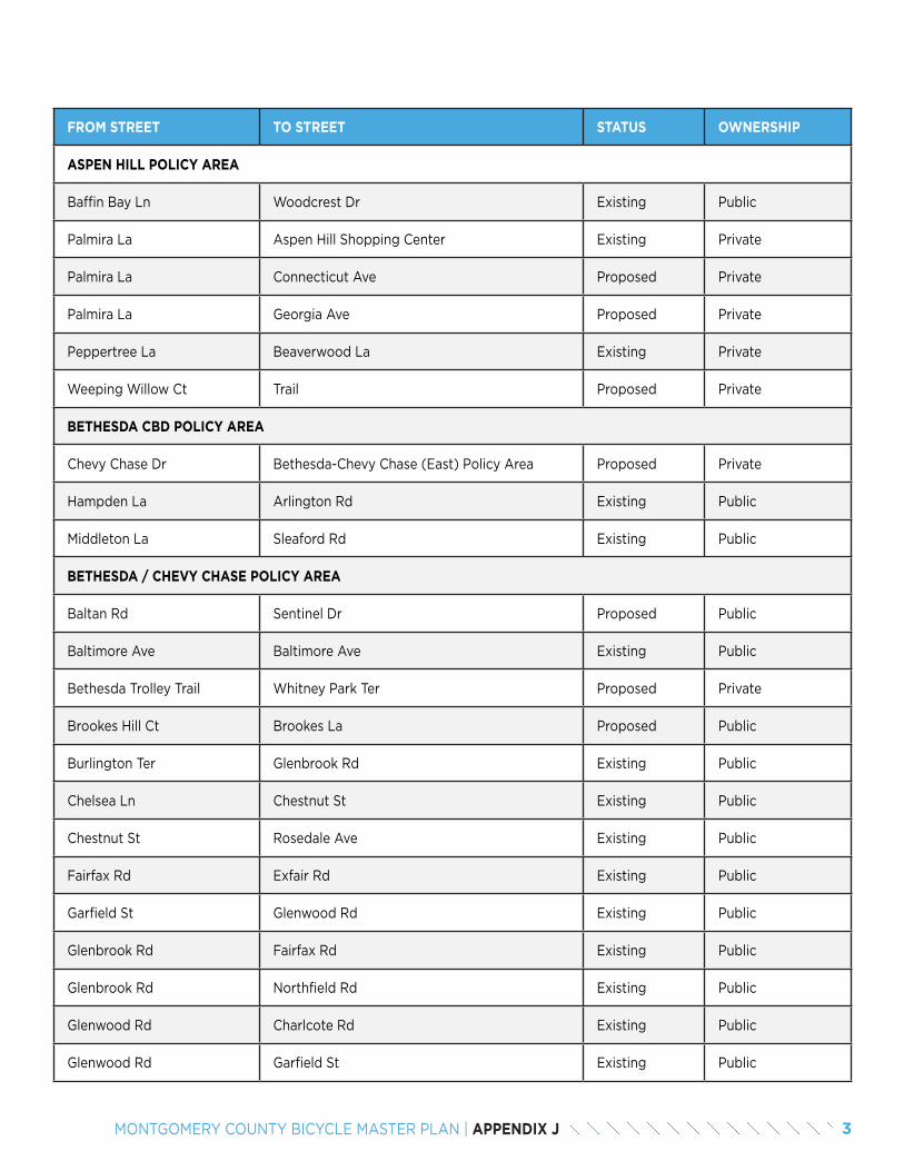
FROM STREET TO STREET STATUS OWNERSHIP
ASPEN HILL POLICY AREA
Baffin Bay Ln Woodcrest Dr Existing Public
Palmira La Aspen Hill Shopping Center Existing Private
Palmira La Connecticut Ave Proposed Private
Palmira La Georgia Ave Proposed Private
Peppertree La Beaverwood La Existing Private
Weeping Willow Ct Trail Proposed Private
BETHESDA CBD POLICY AREA
Chevy Chase Dr Bethesda-Chevy Chase (East) Policy Area Proposed Private
Hampden La Arlington Rd Existing Public
Middleton La Sleaford Rd Existing Public
BETHESDA / CHEVY CHASE POLICY AREA
Baltan Rd Sentinel Dr Proposed Public
Baltimore Ave Baltimore Ave Existing Public
Bethesda Trolley Trail Whitney Park Ter Proposed Private
Brookes Hill Ct Brookes La Proposed Public
Burlington Ter Glenbrook Rd Existing Public
Chelsea Ln Chestnut St Existing Public
Chestnut St Rosedale Ave Existing Public
Fairfax Rd Exfair Rd Existing Public
Garfield St Glenwood Rd Existing Public
Glenbrook Rd Fairfax Rd Existing Public
Glenbrook Rd Northfield Rd Existing Public
Glenwood Rd Charlcote Rd Existing Public
Glenwood Rd Garfield St Existing Public
3MONTGOMERY COUNTY BICYCLE MASTER PLAN | APPENDIX J
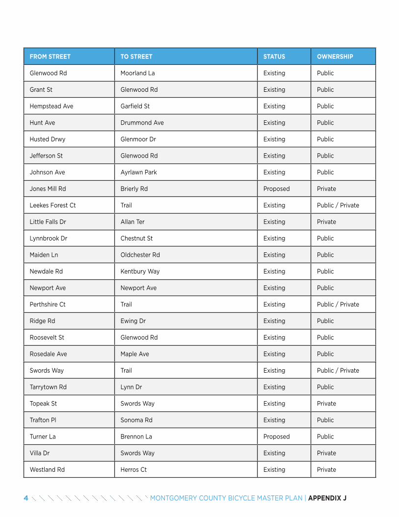
FROM STREET TO STREET STATUS OWNERSHIP
Glenwood Rd Moorland La Existing Public
Grant St Glenwood Rd Existing Public
Hempstead Ave Garfield St Existing Public
Hunt Ave Drummond Ave Existing Public
Husted Drwy Glenmoor Dr Existing Public
Jefferson St Glenwood Rd Existing Public
Johnson Ave Ayrlawn Park Existing Public
Jones Mill Rd Brierly Rd Proposed Private
Leekes Forest Ct Trail Existing Public / Private
Little Falls Dr Allan Ter Existing Private
Lynnbrook Dr Chestnut St Existing Public
Maiden Ln Oldchester Rd Existing Public
Newdale Rd Kentbury Way Existing Public
Newport Ave Newport Ave Existing Public
Perthshire Ct Trail Existing Public / Private
Ridge Rd Ewing Dr Existing Public
Roosevelt St Glenwood Rd Existing Public
Rosedale Ave Maple Ave Existing Public
Swords Way Trail Existing Public / Private
Tarrytown Rd Lynn Dr Existing Public
Topeak St Swords Way Existing Private
Trafton Pl Sonoma Rd Existing Public
Turner La Brennon La Proposed Public
Villa Dr Swords Way Existing Private
Westland Rd Herros Ct Existing Private
4 MONTGOMERY COUNTY BICYCLE MASTER PLAN | APPENDIX J
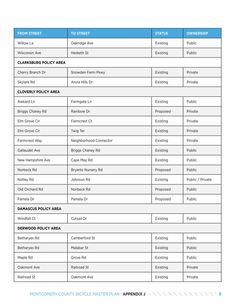
FROM STREET TO STREET STATUS OWNERSHIP
Willow La Oakridge Ave Existing Public
Wisconsin Ave Hesketh St Existing Public
CLARKSBURG POLICY AREA
Cherry Branch Dr Snowden Farm Pkwy Existing Private
Skylark Rd Arora Hills Dr Existing Private
CLOVERLY POLICY AREA
Awkard Ln Farmgate Ln Existing Public
Briggs Chaney Rd Rainbow Dr Proposed Private
Elm Grove Cir Farmcrest Ct Existing Private
Elm Grove Cir Twig Ter Existing Private
Farmcrest Way Neighborhood Connector Existing Private
Gallaudet Ave Briggs Chaney Rd Existing Public
New Hampshire Ave Cape May Rd Existing Public
Norbeck Rd Bryants Nursery Rd Proposed Public
Notley Rd Johnson Rd Existing Public / Private
Old Orchard Rd Norbeck Rd Proposed Public
Pamela Dr Pamela Dr Proposed Public
DAMASCUS POLICY AREA
Windfall Ct Cutsail Dr Existing Public
DERWOOD POLICY AREA
Betharyes Rd Camberford St Existing Public
Betharyes Rd Malabar St Existing Public
Maple Rd Grove Rd Existing Public
Oakmont Ave Railroad St Existing Private
Railroad St Oakmont Ave Existing Private
5MONTGOMERY COUNTY BICYCLE MASTER PLAN | APPENDIX J
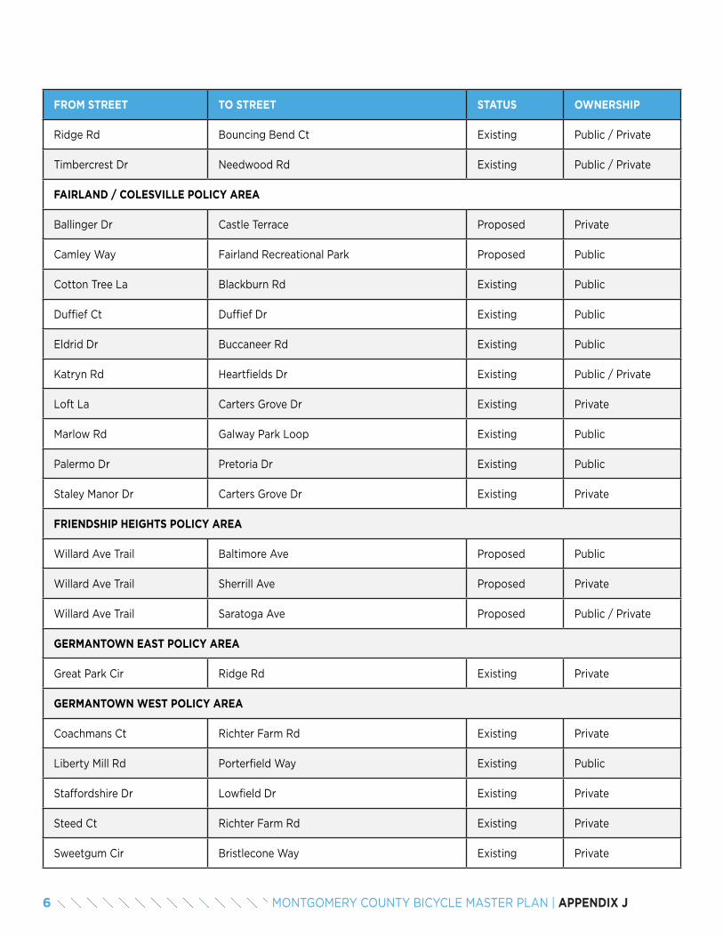
FROM STREET TO STREET STATUS OWNERSHIP
Ridge Rd Bouncing Bend Ct Existing Public / Private
Timbercrest Dr Needwood Rd Existing Public / Private
FAIRLAND / COLESVILLE POLICY AREA
Ballinger Dr Castle Terrace Proposed Private
Camley Way Fairland Recreational Park Proposed Public
Cotton Tree La Blackburn Rd Existing Public
Duffief Ct Duffief Dr Existing Public
Eldrid Dr Buccaneer Rd Existing Public
Katryn Rd Heartfields Dr Existing Public / Private
Loft La Carters Grove Dr Existing Private
Marlow Rd Galway Park Loop Existing Public
Palermo Dr Pretoria Dr Existing Public
Staley Manor Dr Carters Grove Dr Existing Private
FRIENDSHIP HEIGHTS POLICY AREA
Willard Ave Trail Baltimore Ave Proposed Public
Willard Ave Trail Sherrill Ave Proposed Private
Willard Ave Trail Saratoga Ave Proposed Public / Private
GERMANTOWN EAST POLICY AREA
Great Park Cir Ridge Rd Existing Private
GERMANTOWN WEST POLICY AREA
Coachmans Ct Richter Farm Rd Existing Private
Liberty Mill Rd Porterfield Way Existing Public
Staffordshire Dr Lowfield Dr Existing Private
Steed Ct Richter Farm Rd Existing Private
Sweetgum Cir Bristlecone Way Existing Private
6 MONTGOMERY COUNTY BICYCLE MASTER PLAN | APPENDIX J
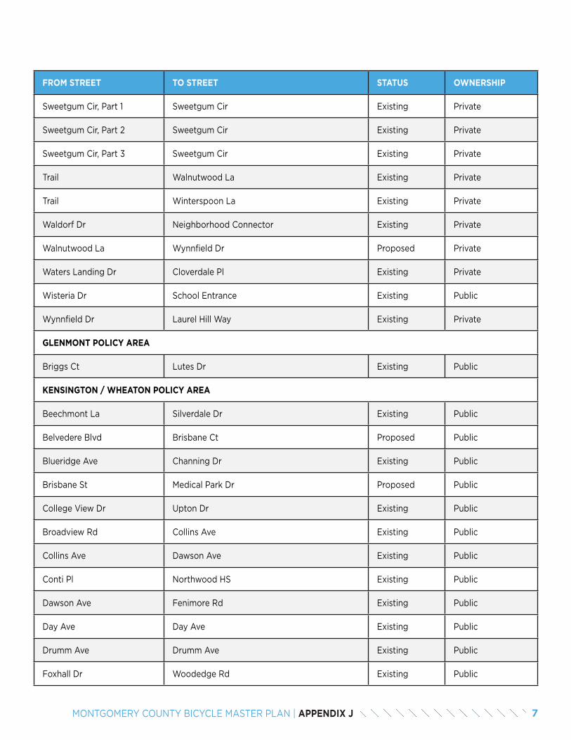
FROM STREET TO STREET STATUS OWNERSHIP
Sweetgum Cir, Part 1 Sweetgum Cir Existing Private
Sweetgum Cir, Part 2 Sweetgum Cir Existing Private
Sweetgum Cir, Part 3 Sweetgum Cir Existing Private
Trail Walnutwood La Existing Private
Trail Winterspoon La Existing Private
Waldorf Dr Neighborhood Connector Existing Private
Walnutwood La Wynnfield Dr Proposed Private
Waters Landing Dr Cloverdale Pl Existing Private
Wisteria Dr School Entrance Existing Public
Wynnfield Dr Laurel Hill Way Existing Private
GLENMONT POLICY AREA
Briggs Ct Lutes Dr Existing Public
KENSINGTON / WHEATON POLICY AREA
Beechmont La Silverdale Dr Existing Public
Belvedere Blvd Brisbane Ct Proposed Public
Blueridge Ave Channing Dr Existing Public
Brisbane St Medical Park Dr Proposed Public
College View Dr Upton Dr Existing Public
Broadview Rd Collins Ave Existing Public
Collins Ave Dawson Ave Existing Public
Conti Pl Northwood HS Existing Public
Dawson Ave Fenimore Rd Existing Public
Day Ave Day Ave Existing Public
Drumm Ave Drumm Ave Existing Public
Foxhall Dr Woodedge Rd Existing Public
7MONTGOMERY COUNTY BICYCLE MASTER PLAN | APPENDIX J
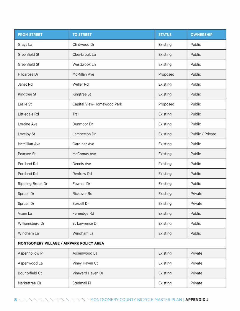
FROM STREET TO STREET STATUS OWNERSHIP
Grays La Clintwood Dr Existing Public
Greenfield St Clearbrook La Existing Public
Greenfield St Westbrook Ln Existing Public
Hildarose Dr McMillan Ave Proposed Public
Janet Rd Weller Rd Existing Public
Kingtree St Kingtree St Existing Public
Leslie St Capital View-Homewood Park Proposed Public
Littledale Rd Trail Existing Public
Loraine Ave Dunmoor Dr Existing Public
Lovejoy St Lamberton Dr Existing Public / Private
McMillian Ave Gardiner Ave Existing Public
Pearson St McComas Ave Existing Public
Portland Rd Dennis Ave Existing Public
Portland Rd Renfrew Rd Existing Public
Rippling Brook Dr Fowhall Dr Existing Public
Spruell Dr Rickover Rd Existing Private
Spruell Dr Spruell Dr Existing Private
Vixen La Fernedge Rd Existing Public
Williamsburg Dr St Lawrence Dr Existing Public
Windham La Windham La Existing Public
MONTGOMERY VILLAGE / AIRPARK POLICY AREA
Aspenhollow Pl Aspenwood La Existing Private
Aspenwood La Viney Haven Ct Existing Private
Bountyfield Ct Vineyard Haven Dr Existing Private
Markettree Cir Stedmall Pl Existing Private
8 MONTGOMERY COUNTY BICYCLE MASTER PLAN | APPENDIX J
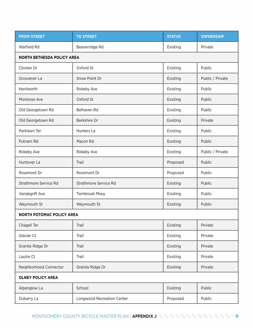
FROM STREET TO STREET STATUS OWNERSHIP
Warfield Rd Beaverridge Rd Existing Private
NORTH BETHESDA POLICY AREA
Cloister Dr Oxford St Existing Public
Grosvenor La Snow Point Dr Existing Public / Private
Kenilworth Rokeby Ave Existing Public
Montrose Ave Oxford St Existing Public
Old Georgetown Rd Belhaven Rd Existing Public
Old Georgetown Rd Berkshire Dr Existing Private
Parklawn Ter Hunters La Existing Public
Putnam Rd Macon Rd Existing Public
Rokeby Ave Rokeby Ave Existing Public / Private
Huntover La Trail Proposed Public
Rosemont Dr Rosemont Dr Proposed Public
Strathmore Service Rd Strathmore Service Rd Existing Public
Vandegrift Ave Twinbrook Pkwy Existing Public
Weymouth St Weymouth St Existing Public
NORTH POTOMAC POLICY AREA
Chagall Ter Trail Existing Private
Glacier Ct Trail Existing Private
Granite Ridge Dr Trail Existing Private
Lautre Ct Trail Existing Private
Neighborhood Connector Granite Ridge Dr Existing Private
OLNEY POLICY AREA
Alpenglow La School Existing Public
Dubarry La Longwood Recreation Center Proposed Public
9MONTGOMERY COUNTY BICYCLE MASTER PLAN | APPENDIX J
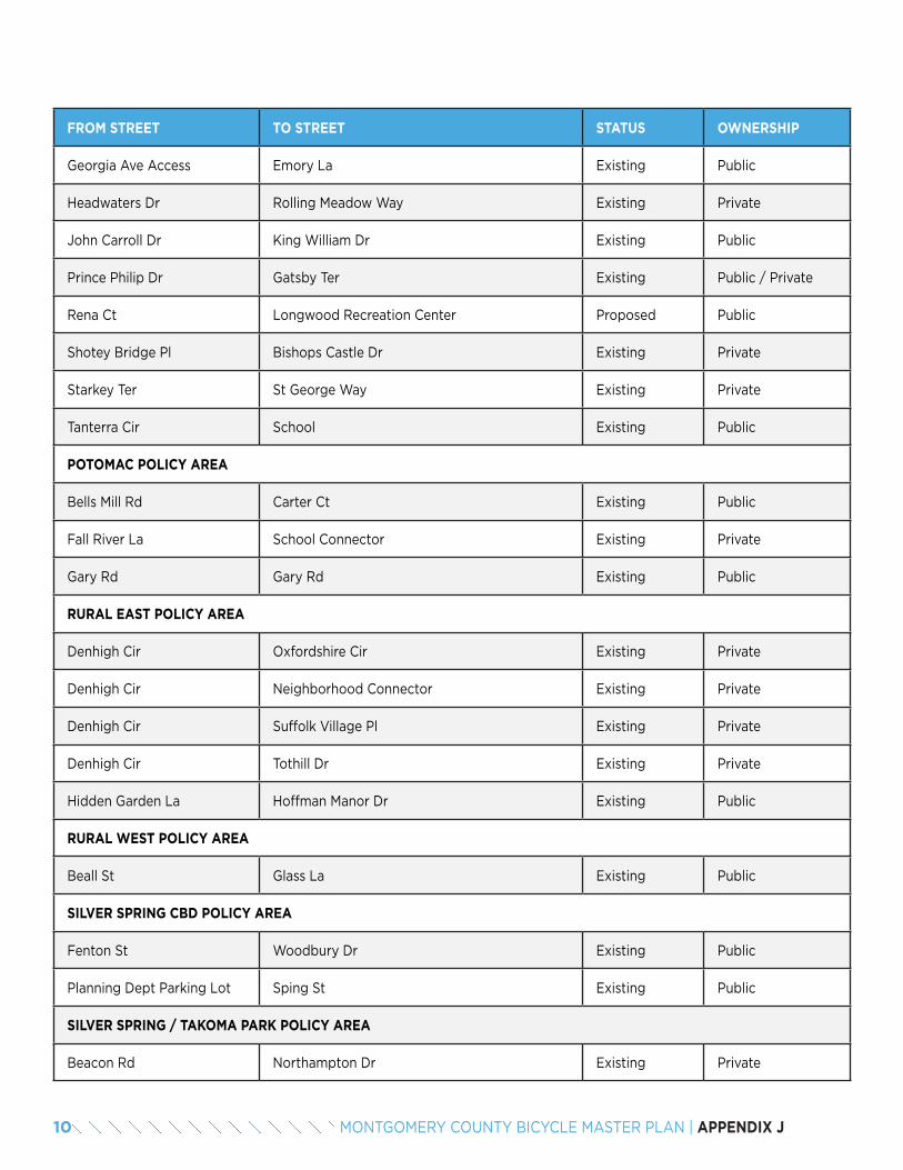
FROM STREET TO STREET STATUS OWNERSHIP
Georgia Ave Access Emory La Existing Public
Headwaters Dr Rolling Meadow Way Existing Private
John Carroll Dr King William Dr Existing Public
Prince Philip Dr Gatsby Ter Existing Public / Private
Rena Ct Longwood Recreation Center Proposed Public
Shotey Bridge Pl Bishops Castle Dr Existing Private
Starkey Ter St George Way Existing Private
Tanterra Cir School Existing Public
POTOMAC POLICY AREA
Bells Mill Rd Carter Ct Existing Public
Fall River La School Connector Existing Private
Gary Rd Gary Rd Existing Public
RURAL EAST POLICY AREA
Denhigh Cir Oxfordshire Cir Existing Private
Denhigh Cir Neighborhood Connector Existing Private
Denhigh Cir Suffolk Village Pl Existing Private
Denhigh Cir Tothill Dr Existing Private
Hidden Garden La Hoffman Manor Dr Existing Public
RURAL WEST POLICY AREA
Beall St Glass La Existing Public
SILVER SPRING CBD POLICY AREA
Fenton St Woodbury Dr Existing Public
Planning Dept Parking Lot Sping St Existing Public
SILVER SPRING / TAKOMA PARK POLICY AREA
Beacon Rd Northampton Dr Existing Private
10 MONTGOMERY COUNTY BICYCLE MASTER PLAN | APPENDIX J

FROM STREET TO STREET STATUS OWNERSHIP
Beacon Rd Southampton Dr Existing Private
Columbia Blvd Flora Ter Existing Public
Devon Rd Park Crest Dr Existing Public
East West Hwy Access Donnybrook Dr Existing Public
Edgevale Rd Watson Rd Existing Public / Private
Ellingson Dr Blaine Dr Existing Public
Franklin Ave Sudbury Rd Existing Public
Highland Dr Dale Dr Existing Public
Lanier Dr Richland St Existing Public
Leonard Dr East West Hwy Existing Public
Mansfield Rd Fleetwood Pl Existing Public
Northhampton Dr Beacon Rd Existing Private
Northhampton Dr Neighborhood Connector Existing Private
Noyes Dr Alton Pkwy Existing Public
Piney Branch Rd Carroll Ave Existing Public
Poplar Ave Circle Ave Proposed Public
Poplar Ave Circle Ave Proposed Public
Richland St Quinton Rd Existing Public
Southhampton Dr Sidewalk Existing Private
Spencer Rd Kansas Ave Existing Public
Spencer Rd Spencer Rd Existing Public
Three Oaks Dr Melbourne Ave Existing Private
Wayne Ave Wayne Pl Existing Public
WHEATON CBD POLICY AREA
Blueridge Ave Taber St Existing Public
11MONTGOMERY COUNTY BICYCLE MASTER PLAN | APPENDIX J
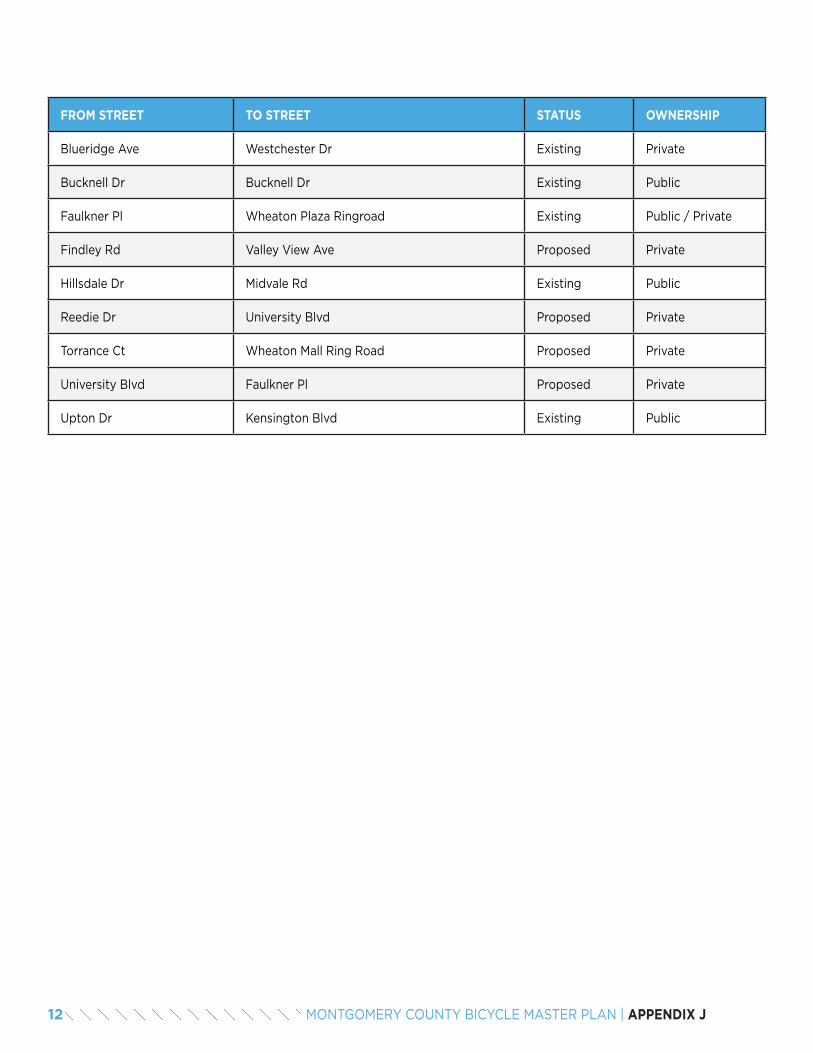
FROM STREET TO STREET STATUS OWNERSHIP
Blueridge Ave Westchester Dr Existing Private
Bucknell Dr Bucknell Dr Existing Public
Faulkner Pl Wheaton Plaza Ringroad Existing Public / Private
Findley Rd Valley View Ave Proposed Private
Hillsdale Dr Midvale Rd Existing Public
Reedie Dr University Blvd Proposed Private
Torrance Ct Wheaton Mall Ring Road Proposed Private
University Blvd Faulkner Pl Proposed Private
Upton Dr Kensington Blvd Existing Public
12 MONTGOMERY COUNTY BICYCLE MASTER PLAN | APPENDIX J

13MONTGOMERY COUNTY BICYCLE MASTER PLAN | APPENDIX J

14 MONTGOMERY COUNTY BICYCLE MASTER PLAN | APPENDIX J

APPENDIX KBICYCLE PARKING GUIDELINES
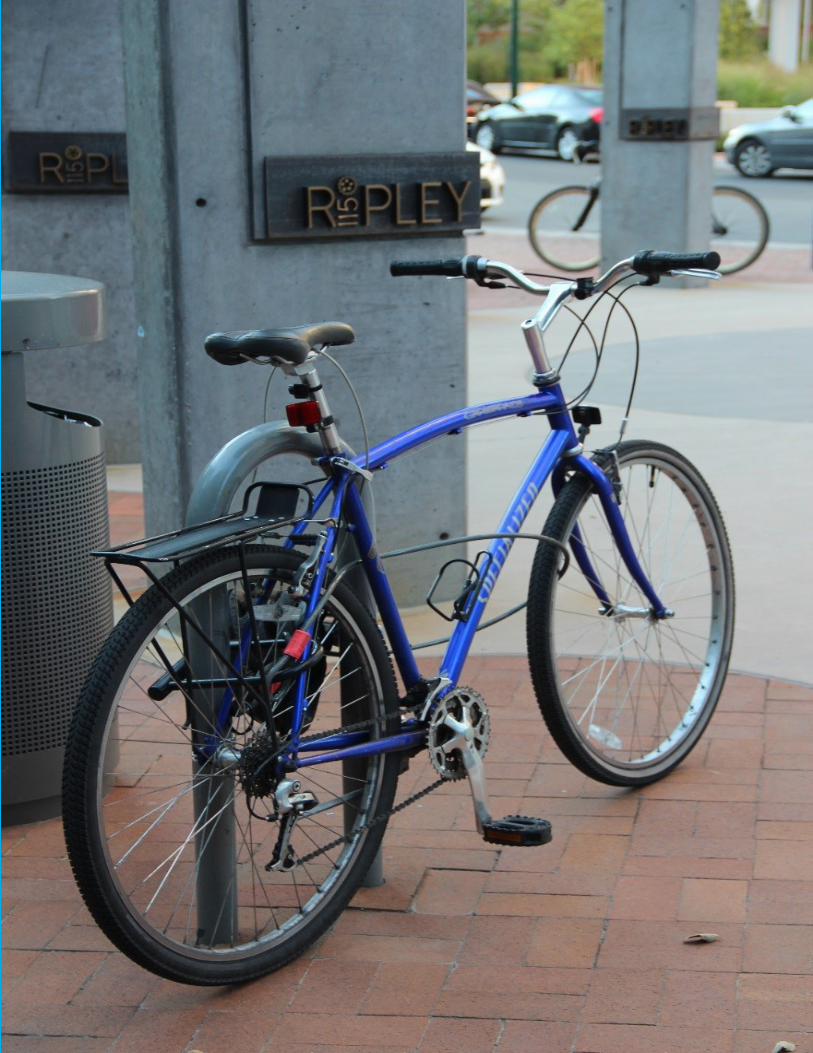
3MONTGOMERY COUNTY BICYCLE MASTER PLAN | APPENDIX K
01Bicycling is increasing in Montgomery County and across the region. As the number of cyclists grows, the need for safe, secure and accessible bicycle parking is becoming more apparent. Recognizing this need, Montgomery County included a major overhaul to the bicycle parking required of new developments in its 2014 zoning ordinance. Whereas the previous ordinance calculated bicycle parking requirements as a percentage of automobile parking with a maximum of 20 bicycle parking spaces, the new ordinance calculates bicycle parking requirements based on land use category with a maximum of 100 bicycle parking spaces. This change to the zoning code will help ensure appropriate levels of bicycle parking for Montgomery County employees and residents as part of new development projects.
These bicycle parking guidelines are intended as a resource to help devel-opers, planners, architects and property owners provide high-quality bicycle parking in Montgomery County. The guidelines summarize the requirements in the County Code with citations and identify recommended practices and practices to avoid. The full text of the County Code is available online at: http://www.montgomerycountymd.gov/mcg/countycode.html.
The guidelines are divided into five sections:
1. Short-Term Bicycle Parking2. Long-Term Bicycle Parking3. Wayfinding4. Security5. Bicycle Support Facilities
1
1 Trends and Determinants of Cycling in the Washington, DC Region, Mid-Atlantic Universities Transportation Center
http://ntl.bts.gov/lib/47000/47100/47120/VT-2009-05.pdf
INTRODUCTION
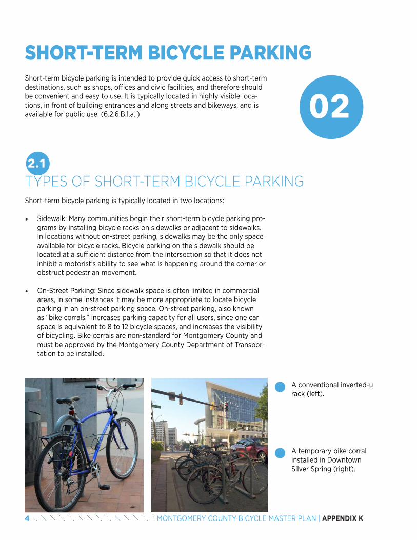
4 MONTGOMERY COUNTY BICYCLE MASTER PLAN | APPENDIX K
02
SHORT-TERM BICYCLE PARKINGShort-term bicycle parking is intended to provide quick access to short-term destinations, such as shops, offices and civic facilities, and therefore should be convenient and easy to use. It is typically located in highly visible loca-tions, in front of building entrances and along streets and bikeways, and is available for public use. (6.2.6.B.1.a.i)
2.1TYPES OF SHORT-TERM BICYCLE PARKINGShort-term bicycle parking is typically located in two locations:
• Sidewalk: Many communities begin their short-term bicycle parking pro-grams by installing bicycle racks on sidewalks or adjacent to sidewalks. In locations without on-street parking, sidewalks may be the only space available for bicycle racks. Bicycle parking on the sidewalk should be located at a sufficient distance from the intersection so that it does not inhibit a motorist’s ability to see what is happening around the corner or obstruct pedestrian movement.
• On-Street Parking: Since sidewalk space is often limited in commercial areas, in some instances it may be more appropriate to locate bicycle parking in an on-street parking space. On-street parking, also known as “bike corrals,” increases parking capacity for all users, since one car space is equivalent to 8 to 12 bicycle spaces, and increases the visibility of bicycling. Bike corrals are non-standard for Montgomery County and must be approved by the Montgomery County Department of Transpor-tation to be installed.
A conventional inverted-u rack (left).
A temporary bike corral installed in Downtown Silver Spring (right).
5MONTGOMERY COUNTY BICYCLE MASTER PLAN | APPENDIX K
2.2BICYCLE PARKING REQUIREMENTS
Total bicycle parking space requirements are based on a metric specific to each use, a maximum number of total bicycle parking spaces and a percent of the total spaces that are intended for short-term and long-term use. The bicycle parking space table is provided in Appendix A and Appen-dix B.
2.3RELATIONSHIP TO THE STREET
A lack of convenient bicycle racks often results in bicycles locked to sign posts, trees and street furniture. Bicycles locked to these objects are vul-nerable to damage and theft, and can damage the object to which they are locked. If not properly located, bicycle racks can impede pedestrian travel on the sidewalk, access to buildings and emergency responders. Therefore:
• Each bicycle parking facility is prohibited from obstructing pedestrian traffic or interfering with the use of the pedestrian area. (6.2.6.B.1.b)
• Each parked bicycle must be accessible without moving another bicycle. (6.2.6.B.1.f)
• Any sidewalk rack that is parallel to the curb must be located 2 feet from the curb face. (6.2.6.B.1.c)
• Any sidewalk rack aligned perpendicular to the curb must be located so that the nearest vertical component of the rack is a minimum of 4 feet from the curb. (6.2.6.B.1.d)
• Each sidewalk rack must be a minimum of 14 feet from any stand alone fire hydrant. (6.2.6.B.1.e)
• A bicycle parking facility must have an aisle a minimum of 4 feet in width behind all occupied parking racks to allow room for bicycle maneuvering. (6.2.6.B.1.g) This will also provide clear space for ADA accessibility along the sidewalk.
Short-term bicycle parking adjacent to the street is typically located parallel, perpendicular or diagonal to the curb.
• Parallel to the curb: Short-term bicycle parking is located parallel to the curb when there is a desire to limit the amount that bicycles protrude into the sidewalk.
• Perpendicular to the curb: Short-term bicycle parking is located per-pendicular to the curb when more parking spaces are desired and when there is sufficient sidewalk space.
• Diagonal to the curb: Short-term bicycle parking is located diago-nal to the curb when more parking spaces are desired and sidewalk space is somewhat limited.
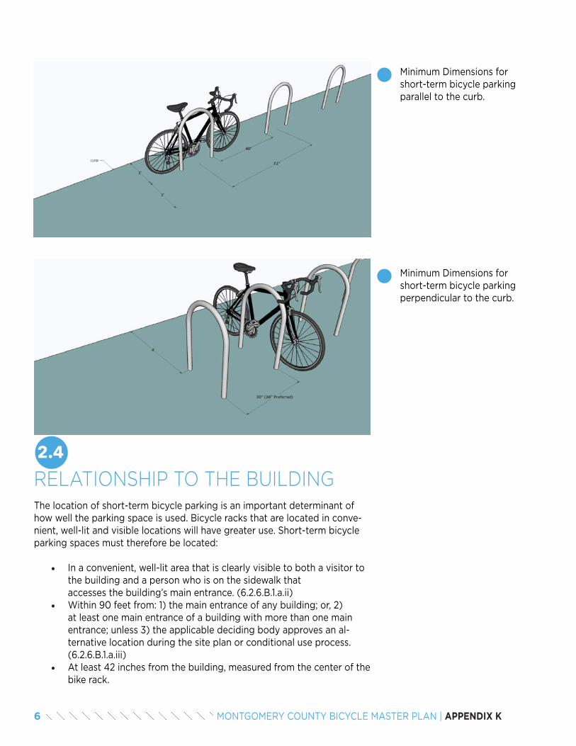
6 MONTGOMERY COUNTY BICYCLE MASTER PLAN | APPENDIX K
Minimum Dimensions for short-term bicycle parking parallel to the curb.
Minimum Dimensions for short-term bicycle parking perpendicular to the curb.
2.4RELATIONSHIP TO THE BUILDINGThe location of short-term bicycle parking is an important determinant of how well the parking space is used. Bicycle racks that are located in conve-nient, well-lit and visible locations will have greater use. Short-term bicycle parking spaces must therefore be located:
• In a convenient, well-lit area that is clearly visible to both a visitor to the building and a person who is on the sidewalk that accesses the building’s main entrance. (6.2.6.B.1.a.ii)
• Within 90 feet from: 1) the main entrance of any building; or, 2) at least one main entrance of a building with more than one main entrance; unless 3) the applicable deciding body approves an al-ternative location during the site plan or conditional use process. (6.2.6.B.1.a.iii)
• At least 42 inches from the building, measured from the center of the bike rack.

7MONTGOMERY COUNTY BICYCLE MASTER PLAN | APPENDIX K
2.5RACK SELECTION
Accessibility to and proper location of parking facilities are not the only requirements in the provision of high-quality bicycle parking. The most accessible and well-located bicycle parking is insufficient if bicyclists are concerned about their security or the security of their bicycles. Bicy-cles parked in both short- and long-term spaces benefit from being in a visible location with moderate to high levels of pedestrian traffic. The presence of people diminishes the risks of theft and damage. Bicycle parking located in well-lit, high-visibility areas can increase the safety of people using the bicycle parking.
Proper rack selection is essential for secure bicycle parking. The requirements specified in the Montgomery County Zoning Ordinance reflect best practices recognized by the Association of Pedestrian and Bicycle Professionals (APBP), rack manufacturers and other bicycle-friendly jurisdictions. Secure bicycle racks tend to be fairly straightforward. In fact, a simple, easy-to-use rack is inherently more secure because a typical bicyclist is more likely to use it properly. Racks known as “inverted-u” racks are the preferred style in most cases. Other considerations that enhance the security of bicycle parking include:
• Anchors and installation: Installing bicycle racks into concrete is the most secure option. If bicycle racks are being installed after concrete has been poured, or in an interior space that cannot be drilled, the racks should be affixed with tamper-resistant hardware. Anchor bolts should be approximately 6 inches long and drilled into a concrete base.
• Bicycle rack materials: Bicycle racks are now available in a range of materials and finishes. It is important to select racks manufactured with thick exterior walls that resist cutting by tools commonly used by thieves, including bolt cutters and hand saws. The rack finish should be rust-resistant, as rusting can compromise the strength of the rack over time. Powdercoat or thermoplastic fin-ish options are available.
• Type of lock: Bicyclists are expected to provide their own locks to secure their bicycle to a rack, but developers and property manage-ment companies can provide signage to educate users about the proper way to lock a bicycle. As required by the Montgomery County Zoning Ordinance, all bicycle racks must be compatible with a stan-dard U-lock, which is much more difficult to sever than a cable lock.
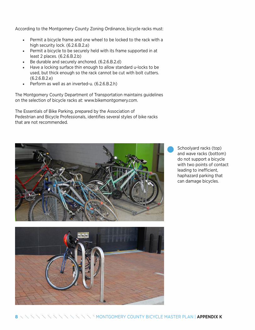
8 MONTGOMERY COUNTY BICYCLE MASTER PLAN | APPENDIX K
According to the Montgomery County Zoning Ordinance, bicycle racks must:
• Permit a bicycle frame and one wheel to be locked to the rack with a high security lock. (6.2.6.B.2.a)
• Permit a bicycle to be securely held with its frame supported in at least 2 places. (6.2.6.B.2.b)
• Be durable and securely anchored. (6.2.6.B.2.d)• Have a locking surface thin enough to allow standard u-locks to be
used, but thick enough so the rack cannot be cut with bolt cutters. (6.2.6.B.2.e)
• Perform as well as an inverted-u. (6.2.6.B.2.h)
The Montgomery County Department of Transportation maintains guidelines on the selection of bicycle racks at: www.bikemontgomery.com.
The Essentials of Bike Parking, prepared by the Association of Pedestrian and Bicycle Professionals, identifies several styles of bike racks that are not recommended.
Schoolyard racks (top) and wave racks (bottom) do not support a bicycle with two points of contact leading to inefficient, haphazard parking that can damage bicycles.
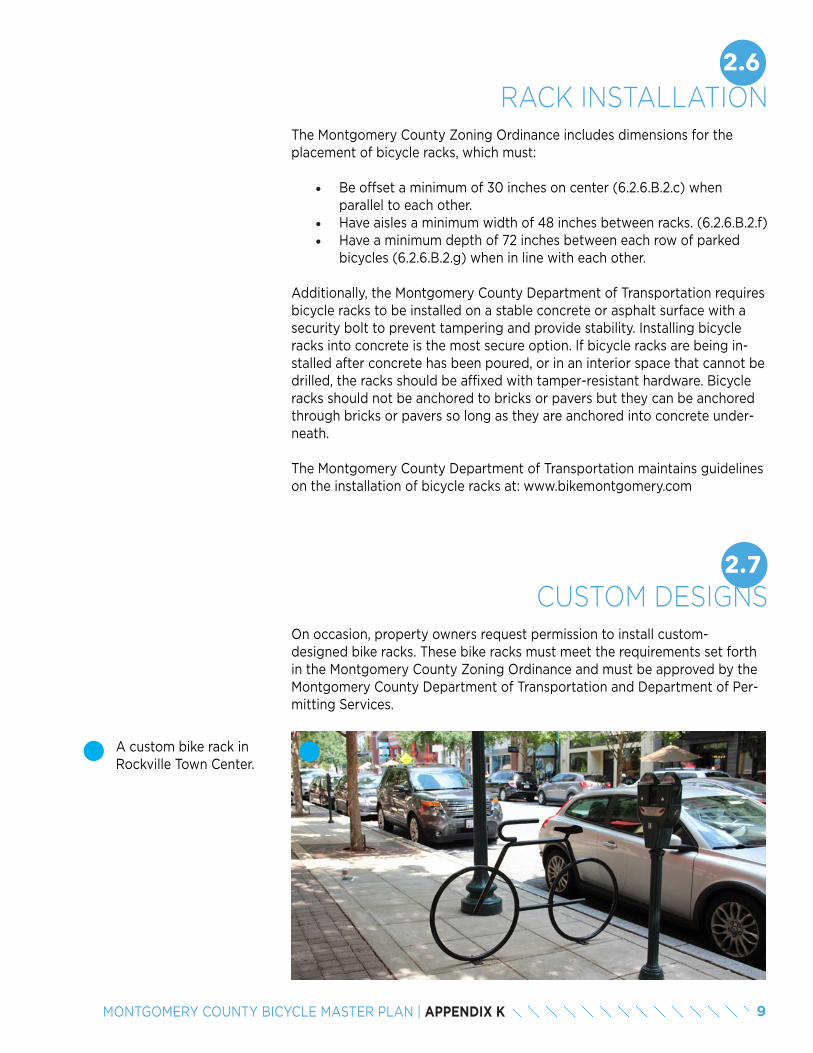
9MONTGOMERY COUNTY BICYCLE MASTER PLAN | APPENDIX K
A custom bike rack in Rockville Town Center.
2.6RACK INSTALLATION
The Montgomery County Zoning Ordinance includes dimensions for the placement of bicycle racks, which must:
• Be offset a minimum of 30 inches on center (6.2.6.B.2.c) when parallel to each other.
• Have aisles a minimum width of 48 inches between racks. (6.2.6.B.2.f)• Have a minimum depth of 72 inches between each row of parked
bicycles (6.2.6.B.2.g) when in line with each other.
Additionally, the Montgomery County Department of Transportation requires bicycle racks to be installed on a stable concrete or asphalt surface with a security bolt to prevent tampering and provide stability. Installing bicycle racks into concrete is the most secure option. If bicycle racks are being in-stalled after concrete has been poured, or in an interior space that cannot be drilled, the racks should be affixed with tamper-resistant hardware. Bicycle racks should not be anchored to bricks or pavers but they can be anchored through bricks or pavers so long as they are anchored into concrete under-neath.
The Montgomery County Department of Transportation maintains guidelines on the installation of bicycle racks at: www.bikemontgomery.com
2.7CUSTOM DESIGNS
On occasion, property owners request permission to install custom-designed bike racks. These bike racks must meet the requirements set forth in the Montgomery County Zoning Ordinance and must be approved by the Montgomery County Department of Transportation and Department of Per-mitting Services.
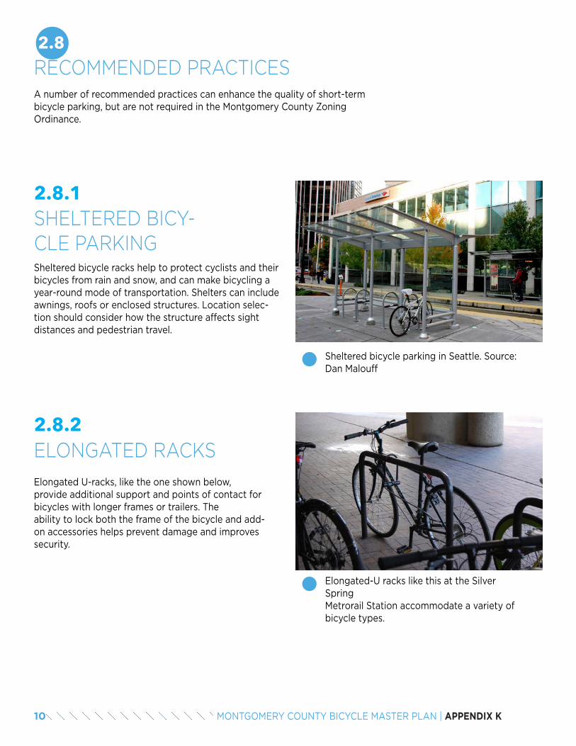
10 MONTGOMERY COUNTY BICYCLE MASTER PLAN | APPENDIX K
2.8RECOMMENDED PRACTICESA number of recommended practices can enhance the quality of short-term bicycle parking, but are not required in the Montgomery County Zoning Ordinance.
Sheltered bicycle racks help to protect cyclists and their bicycles from rain and snow, and can make bicycling a year-round mode of transportation. Shelters can include awnings, roofs or enclosed structures. Location selec-tion should consider how the structure affects sight distances and pedestrian travel.
2.8.1SHELTERED BICY-CLE PARKING
Sheltered bicycle parking in Seattle. Source: Dan Malouff
Elongated U-racks, like the one shown below, provide additional support and points of contact for bicycles with longer frames or trailers. The ability to lock both the frame of the bicycle and add-on accessories helps prevent damage and improves security.
2.8.2ELONGATED RACKS
Elongated-U racks like this at the Silver Spring Metrorail Station accommodate a variety of bicycle types.
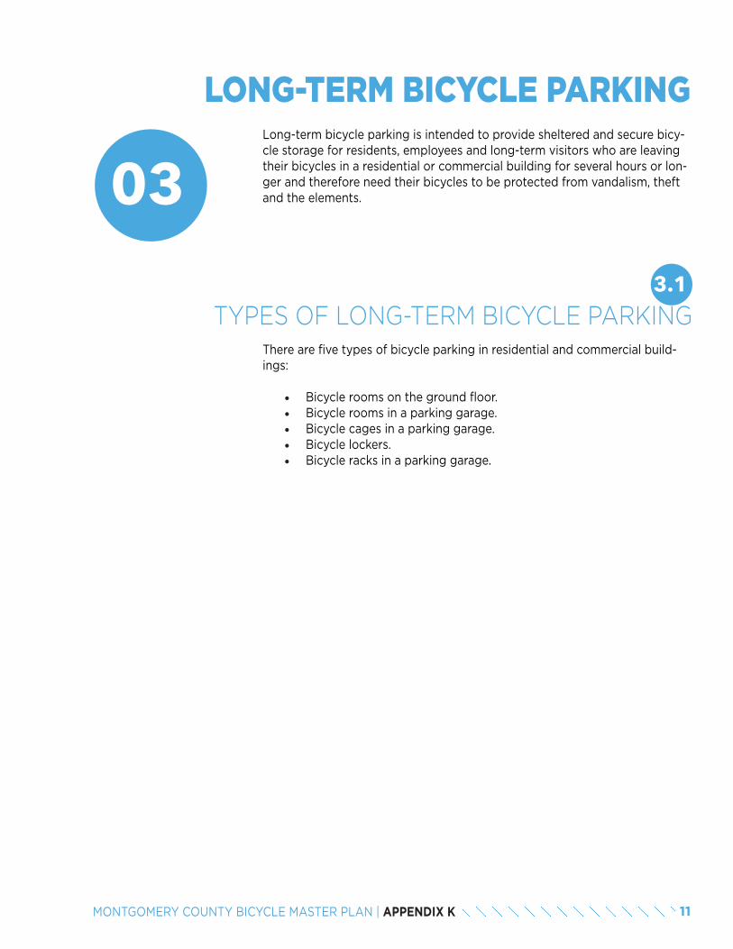
11MONTGOMERY COUNTY BICYCLE MASTER PLAN | APPENDIX K
03
LONG-TERM BICYCLE PARKINGLong-term bicycle parking is intended to provide sheltered and secure bicy-cle storage for residents, employees and long-term visitors who are leaving their bicycles in a residential or commercial building for several hours or lon-ger and therefore need their bicycles to be protected from vandalism, theft and the elements.
3.1TYPES OF LONG-TERM BICYCLE PARKING
There are five types of bicycle parking in residential and commercial build-ings:
• Bicycle rooms on the ground floor.• Bicycle rooms in a parking garage.• Bicycle cages in a parking garage.• Bicycle lockers.• Bicycle racks in a parking garage.
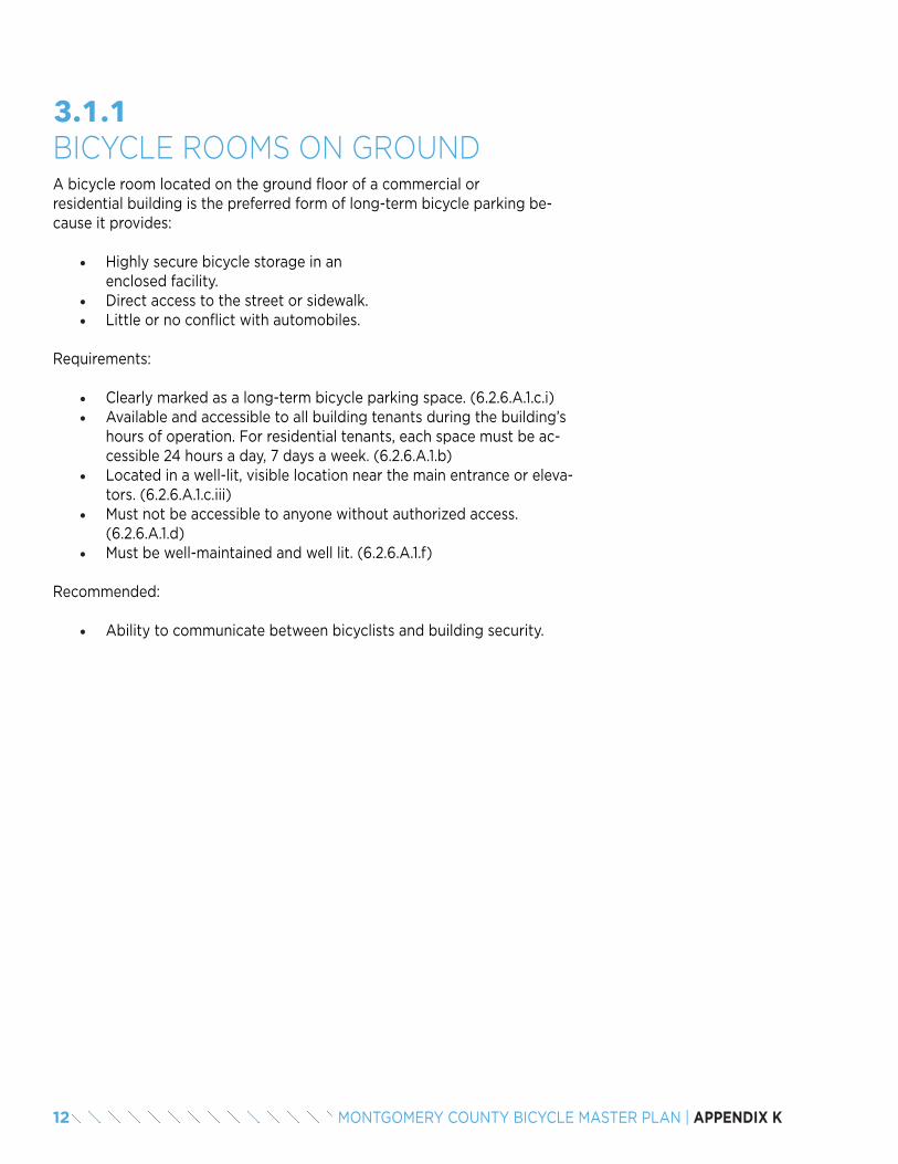
12 MONTGOMERY COUNTY BICYCLE MASTER PLAN | APPENDIX K
A bicycle room located on the ground floor of a commercial or residential building is the preferred form of long-term bicycle parking be-cause it provides:
• Highly secure bicycle storage in an enclosed facility.
• Direct access to the street or sidewalk.• Little or no conflict with automobiles.
Requirements:
• Clearly marked as a long-term bicycle parking space. (6.2.6.A.1.c.i)• Available and accessible to all building tenants during the building’s
hours of operation. For residential tenants, each space must be ac-cessible 24 hours a day, 7 days a week. (6.2.6.A.1.b)
• Located in a well-lit, visible location near the main entrance or eleva-tors. (6.2.6.A.1.c.iii)
• Must not be accessible to anyone without authorized access. (6.2.6.A.1.d)
• Must be well-maintained and well lit. (6.2.6.A.1.f)
Recommended:
• Ability to communicate between bicyclists and building security.
3.1.1BICYCLE ROOMS ON GROUND
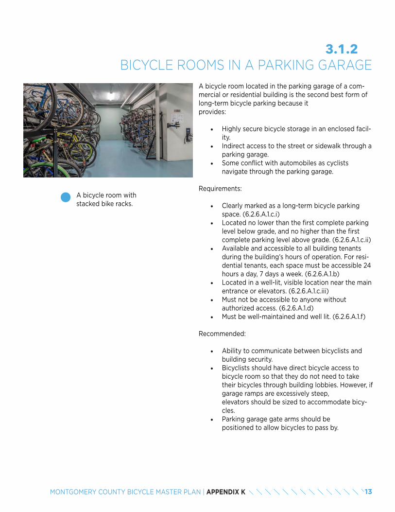
13MONTGOMERY COUNTY BICYCLE MASTER PLAN | APPENDIX K
A bicycle room located in the parking garage of a com-mercial or residential building is the second best form of long-term bicycle parking because it provides:
• Highly secure bicycle storage in an enclosed facil-ity.
• Indirect access to the street or sidewalk through a parking garage.
• Some conflict with automobiles as cyclists navigate through the parking garage.
Requirements:
• Clearly marked as a long-term bicycle parking space. (6.2.6.A.1.c.i)
• Located no lower than the first complete parking level below grade, and no higher than the first complete parking level above grade. (6.2.6.A.1.c.ii)
• Available and accessible to all building tenants during the building’s hours of operation. For resi-dential tenants, each space must be accessible 24 hours a day, 7 days a week. (6.2.6.A.1.b)
• Located in a well-lit, visible location near the main entrance or elevators. (6.2.6.A.1.c.iii)
• Must not be accessible to anyone without authorized access. (6.2.6.A.1.d)
• Must be well-maintained and well lit. (6.2.6.A.1.f)
Recommended:
• Ability to communicate between bicyclists and building security.
• Bicyclists should have direct bicycle access to bicycle room so that they do not need to take their bicycles through building lobbies. However, if garage ramps are excessively steep, elevators should be sized to accommodate bicy-cles.
• Parking garage gate arms should be positioned to allow bicycles to pass by.
3.1.2BICYCLE ROOMS IN A PARKING GARAGE
A bicycle room with stacked bike racks.
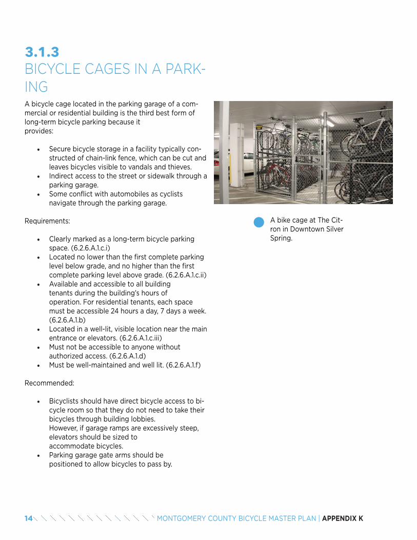
14 MONTGOMERY COUNTY BICYCLE MASTER PLAN | APPENDIX K
A bicycle cage located in the parking garage of a com-mercial or residential building is the third best form of long-term bicycle parking because it provides:
• Secure bicycle storage in a facility typically con-structed of chain-link fence, which can be cut and leaves bicycles visible to vandals and thieves.
• Indirect access to the street or sidewalk through a parking garage.
• Some conflict with automobiles as cyclists navigate through the parking garage.
Requirements:
• Clearly marked as a long-term bicycle parking space. (6.2.6.A.1.c.i)
• Located no lower than the first complete parking level below grade, and no higher than the first complete parking level above grade. (6.2.6.A.1.c.ii)
• Available and accessible to all building tenants during the building’s hours of operation. For residential tenants, each space must be accessible 24 hours a day, 7 days a week. (6.2.6.A.1.b)
• Located in a well-lit, visible location near the main entrance or elevators. (6.2.6.A.1.c.iii)
• Must not be accessible to anyone without authorized access. (6.2.6.A.1.d)
• Must be well-maintained and well lit. (6.2.6.A.1.f)
Recommended:
• Bicyclists should have direct bicycle access to bi-cycle room so that they do not need to take their bicycles through building lobbies. However, if garage ramps are excessively steep, elevators should be sized to accommodate bicycles.
• Parking garage gate arms should be positioned to allow bicycles to pass by.
3.1.3BICYCLE CAGES IN A PARK-ING
A bike cage at The Cit-ron in Downtown Silver Spring.
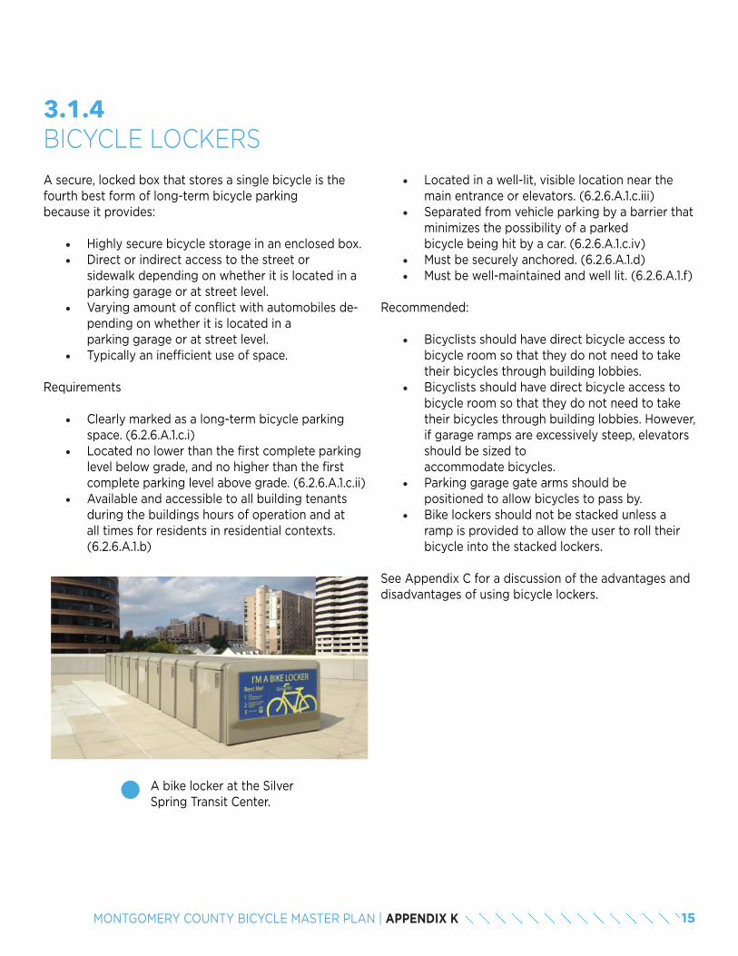
15MONTGOMERY COUNTY BICYCLE MASTER PLAN | APPENDIX K
• Located in a well-lit, visible location near the main entrance or elevators. (6.2.6.A.1.c.iii)
• Separated from vehicle parking by a barrier that minimizes the possibility of a parked bicycle being hit by a car. (6.2.6.A.1.c.iv)
• Must be securely anchored. (6.2.6.A.1.d)• Must be well-maintained and well lit. (6.2.6.A.1.f)
Recommended:
• Bicyclists should have direct bicycle access to bicycle room so that they do not need to take their bicycles through building lobbies.
• Bicyclists should have direct bicycle access to bicycle room so that they do not need to take their bicycles through building lobbies. However, if garage ramps are excessively steep, elevators should be sized to accommodate bicycles.
• Parking garage gate arms should be positioned to allow bicycles to pass by.
• Bike lockers should not be stacked unless a ramp is provided to allow the user to roll their bicycle into the stacked lockers.
See Appendix C for a discussion of the advantages and disadvantages of using bicycle lockers.
3.1.4BICYCLE LOCKERS
A bike locker at the Silver Spring Transit Center.
A secure, locked box that stores a single bicycle is the fourth best form of long-term bicycle parking because it provides:
• Highly secure bicycle storage in an enclosed box.• Direct or indirect access to the street or
sidewalk depending on whether it is located in a parking garage or at street level.
• Varying amount of conflict with automobiles de-pending on whether it is located in a parking garage or at street level.
• Typically an inefficient use of space.
Requirements
• Clearly marked as a long-term bicycle parking space. (6.2.6.A.1.c.i)
• Located no lower than the first complete parking level below grade, and no higher than the first complete parking level above grade. (6.2.6.A.1.c.ii)
• Available and accessible to all building tenants during the buildings hours of operation and at all times for residents in residential contexts. (6.2.6.A.1.b)
16 MONTGOMERY COUNTY BICYCLE MASTER PLAN | APPENDIX K
Bicycle racks located in a parking garage of a commer-cial or a residential building is the least preferred form of long-term bicycle parking because it provides:
• Less secure bicycle storage because bicycles are accessible to vandals and thieves.
• Indirect access to the street or sidewalk through a parking garage.
• Some conflict with automobiles as cyclists navigate through the parking garage.
Requirements
• Clearly marked as a long-term bicycle parking space. (6.2.6.A.1.c.i)
• Located no lower than the first complete parking level below grade, and no higher than the first complete parking level above grade. (6.2.6.A.1.c.ii)
• Available and accessible to all building tenants during the buildings hours of operation and at all times for residents in residential contexts. (6.2.6.A.1.b)
• Located in a well-lit, visible location near the main entrance or elevators. (6.2.6.A.1.c.iii)
• Separated from vehicle parking by a barrier that minimizes the possibility of a parked bicycle being hit by a car. (6.2.6.A.1.c.iv)
• Must be well-maintained and well lit. (6.2.6.A.1.f)
Recommended:
• Bicyclists should have direct bicycle access to bicycle room so that they do not need to take their bicycles through building lobbies. However, if garage ramps are excessively steep, elevators should be sized to accommodate bicycles.
• Parking garage gate arms should be positioned to allow bicycles to pass by.
3.1.5BICYCLE RACKS IN A PARK-ING
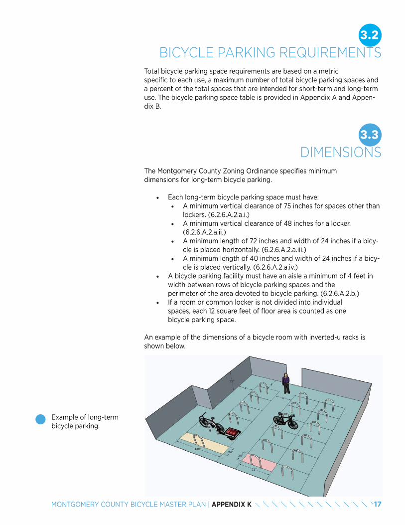
17MONTGOMERY COUNTY BICYCLE MASTER PLAN | APPENDIX K
3.2BICYCLE PARKING REQUIREMENTS
Total bicycle parking space requirements are based on a metric specific to each use, a maximum number of total bicycle parking spaces and a percent of the total spaces that are intended for short-term and long-term use. The bicycle parking space table is provided in Appendix A and Appen-dix B.
3.3DIMENSIONS
The Montgomery County Zoning Ordinance specifies minimum dimensions for long-term bicycle parking.
• Each long-term bicycle parking space must have:• A minimum vertical clearance of 75 inches for spaces other than
lockers. (6.2.6.A.2.a.i.)• A minimum vertical clearance of 48 inches for a locker.
(6.2.6.A.2.a.ii.)• A minimum length of 72 inches and width of 24 inches if a bicy-
cle is placed horizontally. (6.2.6.A.2.a.iii.)• A minimum length of 40 inches and width of 24 inches if a bicy-
cle is placed vertically. (6.2.6.A.2.a.iv.)• A bicycle parking facility must have an aisle a minimum of 4 feet in
width between rows of bicycle parking spaces and the perimeter of the area devoted to bicycle parking. (6.2.6.A.2.b.)
• If a room or common locker is not divided into individual spaces, each 12 square feet of floor area is counted as one bicycle parking space.
An example of the dimensions of a bicycle room with inverted-u racks is shown below.
Example of long-term bicycle parking.
18 MONTGOMERY COUNTY BICYCLE MASTER PLAN | APPENDIX K
3.4RECOMMENDED PRACTICESA number of recommended practices can enhance the quality of long-term bicycle parking, but are not required by the Montgomery County Zoning Ordinance.
Entrances to long-term bicycle parking locations should be designed with bicyclist’s needs in mind:
• Doorways should be wide enough for a bicyclist to comfortably walk through with a bicycle and a trailer.
• Automated doors should be considered, as they eliminate the need for a bicyclist to hold the door open while maneuvering a bicycle through the doorway.
• There should be adequate space on either side of the door for a bicycle to maneuver and bicyclists to wait for someone else to enter or exit.
• The panel for the key fob or access code should be visible and easily accessed by the user, who will be simultaneously maneuvering a bicycle and operating the door.
3.4.1ENTRANCES
Since long-term bicycle parking is often not visible from the street or building entrance, wayfinding should be provided to direct bicyclists to the appropriate location. Pavement markings and signage should be used to iden-tify the routes bicyclists will use to access the long-term parking area. The signs and markings also serve as visual reminders to other garage users to expect bicyclists.
3.4.2WAYFINDING
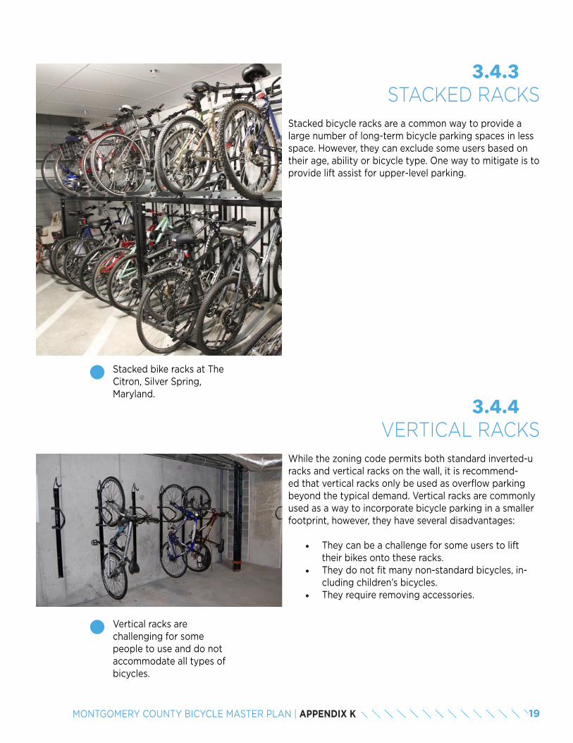
19MONTGOMERY COUNTY BICYCLE MASTER PLAN | APPENDIX K
While the zoning code permits both standard inverted-u racks and vertical racks on the wall, it is recommend-ed that vertical racks only be used as overflow parking beyond the typical demand. Vertical racks are commonly used as a way to incorporate bicycle parking in a smaller footprint, however, they have several disadvantages:
• They can be a challenge for some users to lift their bikes onto these racks.
• They do not fit many non-standard bicycles, in-cluding children’s bicycles.
• They require removing accessories.
3.4.4VERTICAL RACKS
Vertical racks are challenging for some people to use and do not accommodate all types of bicycles.
Stacked bicycle racks are a common way to provide a large number of long-term bicycle parking spaces in less space. However, they can exclude some users based on their age, ability or bicycle type. One way to mitigate is to provide lift assist for upper-level parking.
3.4.3STACKED RACKS
Stacked bike racks at The Citron, Silver Spring, Maryland.
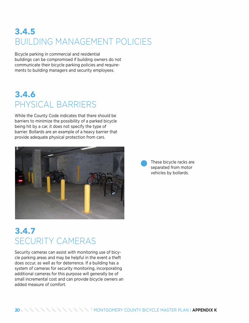
20 MONTGOMERY COUNTY BICYCLE MASTER PLAN | APPENDIX K
Bicycle parking in commercial and residential buildings can be compromised if building owners do not communicate their bicycle parking policies and require-ments to building managers and security employees.
3.4.5BUILDING MANAGEMENT POLICIES
While the County Code indicates that there should be barriers to minimize the possibility of a parked bicycle being hit by a car, it does not specify the type of barrier. Bollards are an example of a heavy barrier that provide adequate physical protection from cars.
3.4.6PHYSICAL BARRIERS
These bicycle racks are separated from motor vehicles by bollards.
Security cameras can assist with monitoring use of bicy-cle parking areas and may be helpful in the event a theft does occur, as well as for deterrence. If a building has a system of cameras for security monitoring, incorporating additional cameras for this purpose will generally be of small incremental cost and can provide bicycle owners an added measure of comfort.
3.4.7SECURITY CAMERAS
21MONTGOMERY COUNTY BICYCLE MASTER PLAN | APPENDIX K
The footprint of a standard bicycle parking space is 24 inches wide by 72 inches deep. While a standard bicy-cle fits comfortably within that footprint, non-standard bicycles, such as tricycles, cargo bicycles, tandems and recumbents, require additional space (see Appendix E for examples). These non-standard bicycles are likely to become more common over time because a variety of bicycle models accommodates a diverse range of various ages, abilities, needs and interests. Furthermore, accessories, such as baskets, rear racks, child seats and trailers, can also increase the footprint of a standard bicy-cle.
In order to accommodate non-standard bicycles and ac-cessories, 10 percent of long-term parking spaces should be 8 feet long . These larger spaces will help prevent spillover into access aisles and ensure racks are used as efficiently as possible.
Longer bicycle racks should also include signs that asks bicyclists to reserve these spaces for longer bicycles un-less no other space is available.
3.4.8ACCOMMODATING LONGER
BICYCLES
2
2 There are no national best practices for the amount of parking that should accommodate larger bicycles. The bicycle parking standards in Cambridge, Massachusetts require enclosed rack areas with 20 or more racks to provide at least 5 percent of spaces an additional 2 feet in length to accommodate tandem bicycles and bicycles with trailers. As interest in bicycling for all utilitarian purposes grows, the need for larger bicycle parking spaces in Montgomery County will increase.
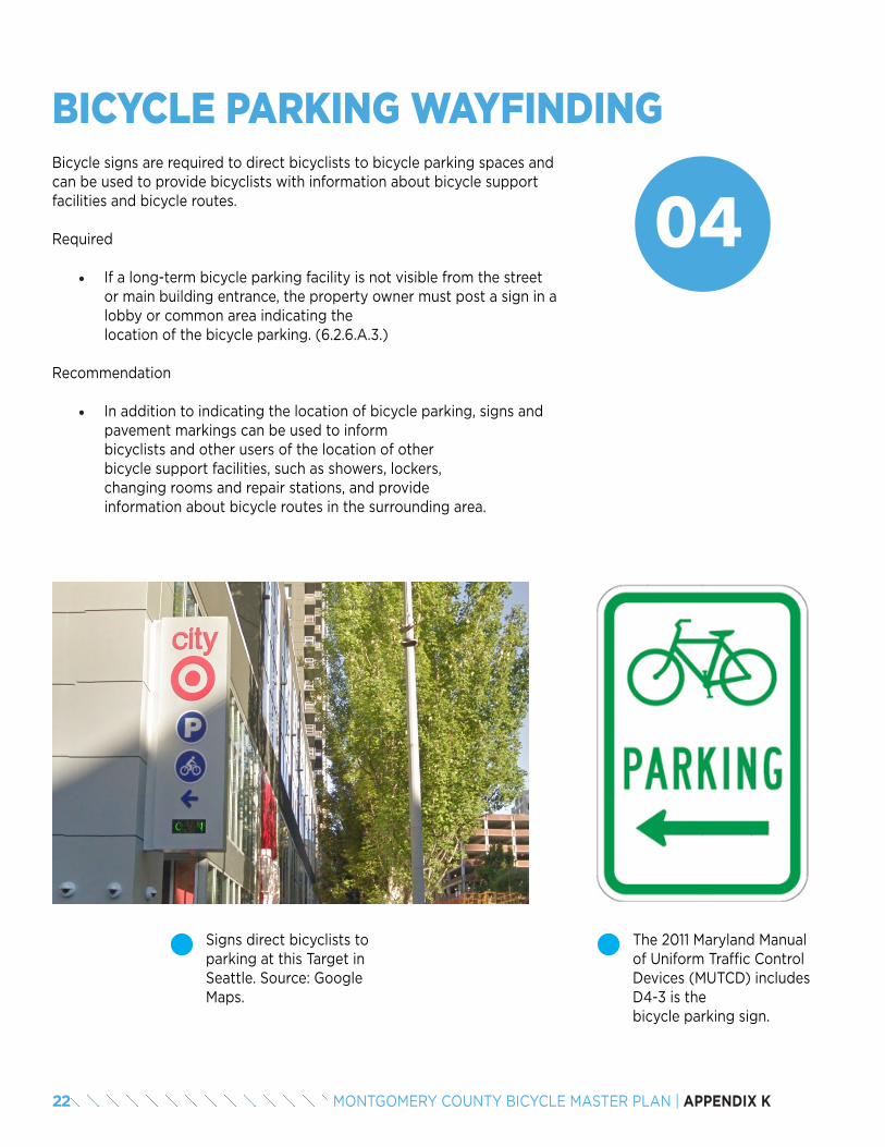
22 MONTGOMERY COUNTY BICYCLE MASTER PLAN | APPENDIX K
Signs direct bicyclists to parking at this Target in Seattle. Source: Google Maps.
04
BICYCLE PARKING WAYFINDINGBicycle signs are required to direct bicyclists to bicycle parking spaces and can be used to provide bicyclists with information about bicycle support facilities and bicycle routes.
Required
• If a long-term bicycle parking facility is not visible from the street or main building entrance, the property owner must post a sign in a lobby or common area indicating the location of the bicycle parking. (6.2.6.A.3.)
Recommendation
• In addition to indicating the location of bicycle parking, signs and pavement markings can be used to inform bicyclists and other users of the location of other bicycle support facilities, such as showers, lockers, changing rooms and repair stations, and provide information about bicycle routes in the surrounding area.
The 2011 Maryland Manual of Uniform Traffic Control Devices (MUTCD) includes D4-3 is the bicycle parking sign.
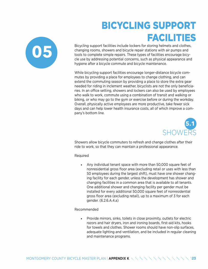
23MONTGOMERY COUNTY BICYCLE MASTER PLAN | APPENDIX K
05 Bicycling support facilities include lockers for storing helmets and clothes, changing rooms, showers and bicycle repair stations with air pumps and tools to complete simple repairs. These types of facilities encourage bicy-cle use by addressing potential concerns, such as physical appearance and hygiene after a bicycle commute and bicycle maintenance.
While bicycling support facilities encourage longer-distance bicycle com-mutes by providing a place for employees to change clothing, and can extend the commuting season by providing a place to store the extra gear needed for riding in inclement weather, bicyclists are not the only beneficia-ries. In an office setting, showers and lockers can also be used by employees who walk to work, commute using a combination of transit and walking or biking, or who may go to the gym or exercise before or during the workday. Overall, physically active employees are more productive, take fewer sick days and can help lower health insurance costs, all of which improve a com-pany’s bottom line.
BICYCLING SUPPORT FACILITIES
5.1SHOWERS
Showers allow bicycle commuters to refresh and change clothes after their ride to work, so that they can maintain a professional appearance.
Required
• Any individual tenant space with more than 50,000 square feet of nonresidential gross floor area (excluding retail or uses with less than 50 employees during the largest shift), must have one shower chang-ing facility for each gender, unless the development has shower and changing facilities in a common area that is available to all tenants. One additional shower and changing facility per gender must be installed for every additional 50,000 square feet of nonresidential gross floor area (excluding retail), up to a maximum of 3 for each gender. (6.2.6.A.4.a)
Recommended
• Provide mirrors, sinks, toilets in close proximity, outlets for electric razors and hair dryers, iron and ironing boards, first-aid kits, hooks for towels and clothes. Shower rooms should have non-slip surfaces, adequate lighting and ventilation, and be included in regular cleaning and maintenance programs.
24 MONTGOMERY COUNTY BICYCLE MASTER PLAN | APPENDIX K
5.2LOCKERSLockers provide a space to store clothing, tools and supplies away from work areas.
Required
• If a long-term bicycle storage facility is required for a nonresidential use, the facility must have a minimum of 0.3 clothing lockers for each required long-term storage space for each gender. Each clothing locker must be:
• A minimum of 12 inches wide, 18 inches deep, and 36 inches high.
• Available for use during all hours that employees are on-site.
• Installed adjacent to the showers and changing facilities in a safe and secured area. (6.2.6.A.4.b)
Recommended
• All lockers should be secure and designed to ensure proper ventila-tion. Additional lockers can be provided for those who walk or jog to work, or exercise during the workday. Locker use should be moni-tored on a regular basis to ensure cleanliness and availability. The dimensions specified in the Montgomery County Zoning Ordinance will accommodate most hangers, which are about 18 inches in length. However, taller, deeper lockers better accommodate hanging cloth-ing.
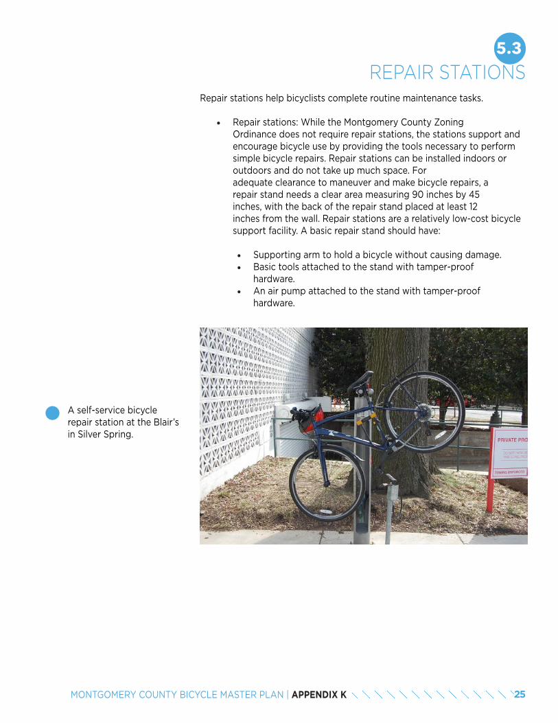
25MONTGOMERY COUNTY BICYCLE MASTER PLAN | APPENDIX K
5.3REPAIR STATIONS
Repair stations help bicyclists complete routine maintenance tasks.
• Repair stations: While the Montgomery County Zoning Ordinance does not require repair stations, the stations support and encourage bicycle use by providing the tools necessary to perform simple bicycle repairs. Repair stations can be installed indoors or outdoors and do not take up much space. For adequate clearance to maneuver and make bicycle repairs, a repair stand needs a clear area measuring 90 inches by 45 inches, with the back of the repair stand placed at least 12 inches from the wall. Repair stations are a relatively low-cost bicycle support facility. A basic repair stand should have:
• Supporting arm to hold a bicycle without causing damage.• Basic tools attached to the stand with tamper-proof
hardware.• An air pump attached to the stand with tamper-proof
hardware.
A self-service bicycle repair station at the Blair’s in Silver Spring.