Embed Size (px)
Citation preview
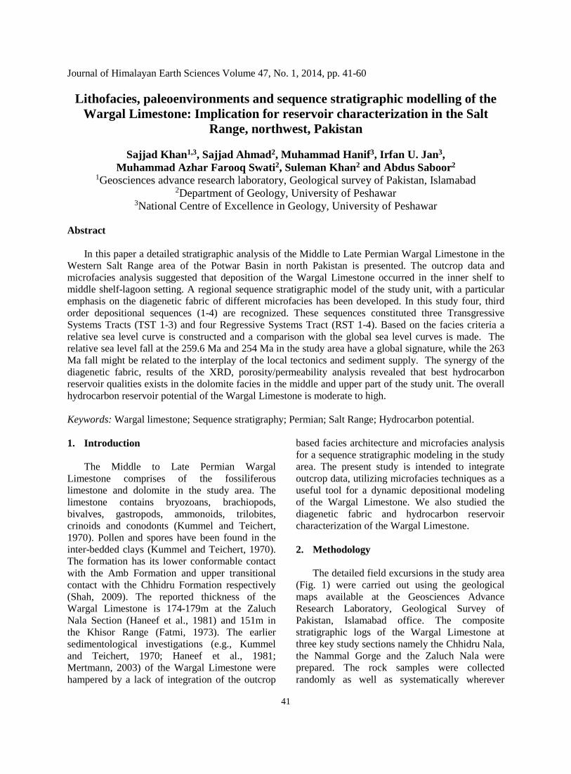
Journal of Himalayan Earth Sciences Volume 47, No. 1, 2014, pp. 41-60
Lithofacies, paleoenvironments and sequence stratigraphic modelling of the Wargal Limestone: Implication for reservoir characterization in the Salt
Range, northwest, Pakistan
Sajjad Khan1,3, Sajjad Ahmad2, Muhammad Hanif3, Irfan U. Jan3, Muhammad Azhar Farooq Swati2, Suleman Khan2 and Abdus Saboor2
1Geosciences advance research laboratory, Geological survey of Pakistan, Islamabad 2Department of Geology, University of Peshawar
3National Centre of Excellence in Geology, University of Peshawar
Abstract
In this paper a detailed stratigraphic analysis of the Middle to Late Permian Wargal Limestone in the Western Salt Range area of the Potwar Basin in north Pakistan is presented. The outcrop data and microfacies analysis suggested that deposition of the Wargal Limestone occurred in the inner shelf to middle shelf-lagoon setting. A regional sequence stratigraphic model of the study unit, with a particular emphasis on the diagenetic fabric of different microfacies has been developed. In this study four, third order depositional sequences (1-4) are recognized. These sequences constituted three Transgressive Systems Tracts (TST 1-3) and four Regressive Systems Tract (RST 1-4). Based on the facies criteria a relative sea level curve is constructed and a comparison with the global sea level curves is made. The relative sea level fall at the 259.6 Ma and 254 Ma in the study area have a global signature, while the 263 Ma fall might be related to the interplay of the local tectonics and sediment supply. The synergy of the diagenetic fabric, results of the XRD, porosity/permeability analysis revealed that best hydrocarbon reservoir qualities exists in the dolomite facies in the middle and upper part of the study unit. The overall hydrocarbon reservoir potential of the Wargal Limestone is moderate to high.
Keywords: Wargal limestone; Sequence stratigraphy; Permian; Salt Range; Hydrocarbon potential. 1. Introduction
The Middle to Late Permian Wargal
Limestone comprises of the fossiliferous limestone and dolomite in the study area. The limestone contains bryozoans, brachiopods, bivalves, gastropods, ammonoids, trilobites, crinoids and conodonts (Kummel and Teichert, 1970). Pollen and spores have been found in the inter-bedded clays (Kummel and Teichert, 1970). The formation has its lower conformable contact with the Amb Formation and upper transitional contact with the Chhidru Formation respectively (Shah, 2009). The reported thickness of the Wargal Limestone is 174-179m at the Zaluch Nala Section (Haneef et al., 1981) and 151m in the Khisor Range (Fatmi, 1973). The earlier sedimentological investigations (e.g., Kummel and Teichert, 1970; Haneef et al., 1981; Mertmann, 2003) of the Wargal Limestone were hampered by a lack of integration of the outcrop
based facies architecture and microfacies analysis for a sequence stratigraphic modeling in the study area. The present study is intended to integrate outcrop data, utilizing microfacies techniques as a useful tool for a dynamic depositional modeling of the Wargal Limestone. We also studied the diagenetic fabric and hydrocarbon reservoir characterization of the Wargal Limestone.
2. Methodology
The detailed field excursions in the study area
(Fig. 1) were carried out using the geological maps available at the Geosciences Advance Research Laboratory, Geological Survey of Pakistan, Islamabad office. The composite stratigraphic logs of the Wargal Limestone at three key study sections namely the Chhidru Nala, the Nammal Gorge and the Zaluch Nala were prepared. The rock samples were collected randomly as well as systematically wherever
41
variations in the lithological characters were found.
The rock thin sections were studied under the
Nikon Polarizing Microscope at the National Centre of Excellence in Geology and the Department of Geology, University of Peshawar for the detailed petrographic analysis and subsequent use in the paleo-environmental interpretation. The integration of the outcrop data and microfacies techniques deciphered the depositional setting of the study unit.
The XRD analysis revealed the discrimination
of carbonate minerals (calcite and dolomite) while the quantitative petrophysical data of different microfacies were collected for the better
hydrocarbon reservoir characterization of the different microfacies types.
3. Stratigraphic framework
In the Salt Range, the stratigraphic units range
in age from Pre-Cambrian to Recent (Fig. 2) while the Ordovician, Silurian, Devonian, and Carboniferous strata are absent throughout the region. The stratigraphic sequence of the Salt Range pinches out laterally to the point of vanishing. For example, the well-developed Mesozoic sequence is present in the Western Salt Range and in the Trans Indus Ranges but in most of the Central and Eastern Salt Range the Triassic and perhaps all of the Cretaceous strata are conspicuously absent (Shah, 1977).
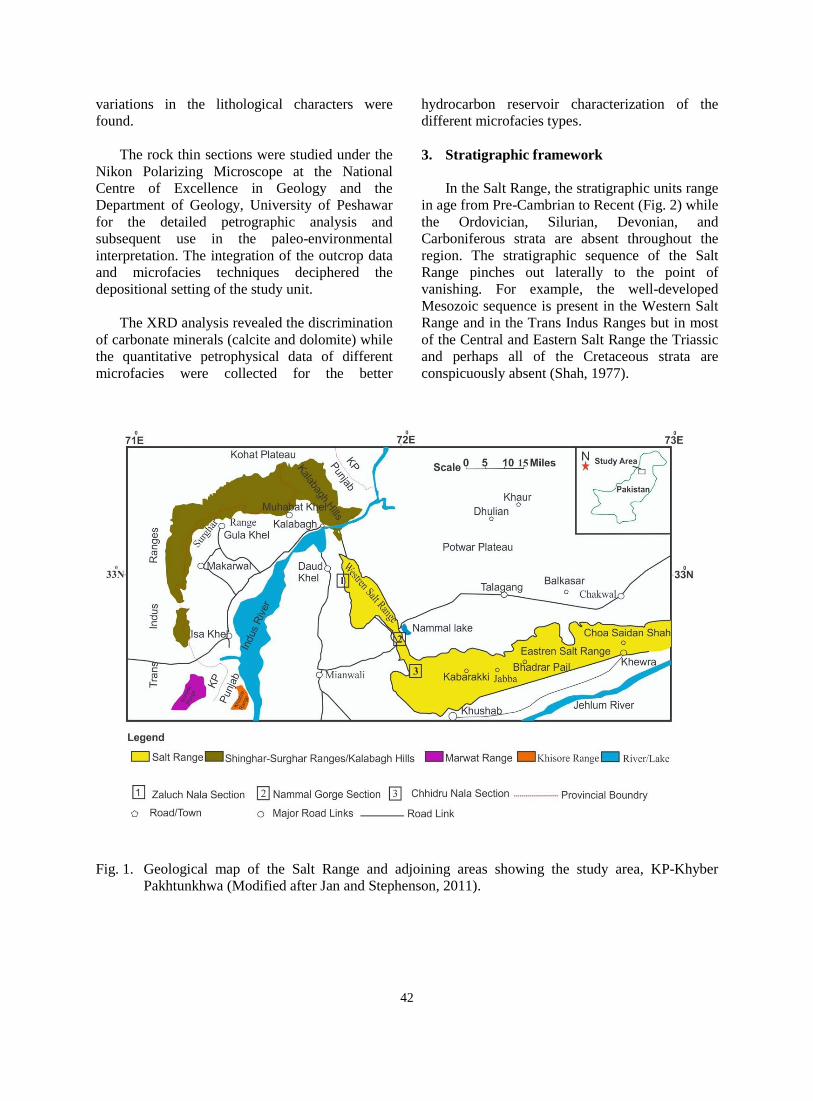
Fig. 1. Geological map of the Salt Range and adjoining areas showing the study area, KP-Khyber
Pakhtunkhwa (Modified after Jan and Stephenson, 2011).
42
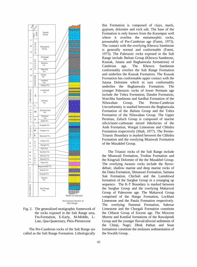
Fig. 2. The generalized stratigraphic framework of the rocks exposed in the Salt Range area, Fm-Formation, E-Early, M-Middle, L-Late, Qua-Quaternary, Pleis-Pleistocene
The Pre-Cambrian rocks of the Salt Range are
called as the Salt Range Formation. Lithologically
this Formation is composed of clays, marls, gypsum, dolomite and rock salt. The base of the Formation is only known from the Karampur well where it overlies the metamorphic rocks, presumably of Pre-Cambrian age (Fatmi, 1973). The contact with the overlying Khewra Sandstone is generally normal and conformable (Fatmi, 1973). The Paleozoic rocks exposed in the Salt Range include Jhelum Group (Khewra Sandstone, Kussak, Jutana and Baghanwala formations) of Cambrian age. The Khewra Sandstone conformably overlies the Salt Range Formation and underlies the Kussak Formation. The Kussak Formation has conformable upper contact with the Jutana Dolomite which in turn conformably underlies the Baghanwala Formation. The younger Paleozoic rocks of lower Permain age include the Tobra Formation, Dandot Formation, Warchha Sandstone and Sardhai Formation of the Nilawahan Group. The Permo-Cambrian Unconformity is marked between the Baghanwala Formation of the Jhelum Group and the Tobra Formation of the Nilawahan Group. The Upper Permian, Zaluch Group is composed of marine siliciclastic-carbonate mixed lithofacies of the Amb Formation, Wargal Limestone and Chhidru Formation respectively (Shah, 1977). The Permo-Triassic Boundary is marked between the Chhidru Formation and the overlying Mianwali Formation of the Musakhel Group.
The Triassic rocks of the Salt Range include
the Mianwali Formation, Tredian Formation and the Kingriali Dolomite of the the Musakhel Group. The overlying Jurassic rocks include the fluvio-deltaic, shallow marine and deep marine rocks of the Datta Formation, Shinawari Formation, Samana Suk Formation, Chichali and the Lumshiwal formation of the Surghar Group in a younging up sequence. The K-T Boundary is marked between the Surghar Group and the overlying Makarwal Group of Paleocene age. The Makarwal Group comprised of the Hangu Formation, Lockhart Limestone and the Patala Formation respectively. The overlying Nammal Formation, Sakesar Limestone and the Chorgali Formation constitute the Chharat Group of Eocene age. The Miocene Murree and Kamlial formations of the Rawalpindi Group and the younger fluvial/alluvial sediments of the Chinji, Nagri, Dhok Pathan and Soan formations constitute the molasses sedimentation of the Siwalik Group.
43
3.1. Stratigraphic sections 3.1.1. Nammal Gorge section
The Nammal Gorge Section is located in the Western Salt Range (Fig. 1) near District Mianwali Punjab, Pakistan. The Upper Permian, Mesozoic and Cenozoic rocks are well exposed in the Nammal Gorge (Afzal, 2004). The oldest exposed rocks belong to the Permian Zaluch Group that consists of Wargal and Chhidru formations respectively. The overlying Triassic Musakhel Group comprising of the Mianwali Formation, Tredian Formation and the Kingriali Dolomite (Shah, 2009 and this study). The boundary between the Permian and Triassic is a Paraconformity (Kummel and Teichert, 1970). A thick sequence of the Jurassic Surghar Group consisting of the Datta and Samana Suk formations overlies the Musakhel Group. The Cretaceous succession is missing while the Paleocene succession unconformably overlies the Surghar Group. The Makarwal Group comprises of the Hangu Formation, Lockhart Limestone and the Patala Formation in a younging up sequence. The Eocene succession includes the Chharat Group that consists of the Nammal Formation and Sakesar Limestone.
3.1.2. Zaluch Nala section
The Zaluch Nala Section is located in the Western Salt Range (Fig. 1) where the Carboniferous to Eocene rocks are well exposed. The Tobra Formation, a basal unit of the lower Permian Nilawahan Group is the oldest exposed unit. It is overlain by the Warchha Sandstone and Sardhai Formation respectively. The overlying Upper Permian Zaluch Group comprises of the Amb Formation, Wargal Limestone and the Chhidru Formation. The Mesozoic succession includes; Musakhel Group of Triassic age that includes the Mianwali Formation, Tredian Formation and the Kingriali Dolomite. The overlying Surghar Group includes; Datta Formation, Shinawari Formation and the Samana Suk Formation of Jurassic age and the Chichali, Lumshiwal formations of Cretaceous age (Ahmed et al., 2005 and this study). The Cretaceous sequence is overlain by the Hangu Formation, Lockhart Limestone and the Patala Formation of Paleocene age, whereas the youngest rocks exposed in the Section belongs to the Eocene age and are represented by the Nammal Formation and the Sakesar Limestone.
3.1.3. Chhidru Nala section The Chhidru Nala Section is situated in the
Western Salt Range (Fig. 1) where the Nilawahan Group (Tobra, Dandot, Warchha and Sardai formations) grades upward into the Zaluch Group (Amb, Wargal and Chhidru formations) of Upper Permian age. The Chhidru Formation has a para -conformable contact with the early Triassic Mianwali Formation of the Musakhel Group. The overlying Tredian Formation is conformably overlain by the Kingriali Dolomite. The upper boundary of the Kingriali Dolomite with the Datta Formation is disconformable (Ahmed et al., 2005). The Datta Formation marks the base of the Jurassic sequence and grade upward into the carbonates of the Samana Suk Formation. The Samana Suk Formation is in turn overlain by the Paleocene succession that includes the Hangu Formation, Lockhart Limestone and the Patala Formation respectively, whereas the exposed youngest rocks belongs to the Eocene age and are represented by the Nammal Formation and the Sakesar Limestone.
4. Results 4.1. Lithofacies
Based on lithology and primary sedimentary
features, the Wargal Limestone is divided into nine different lithofacies in all study sections (Figs 3A-D). These lithofacies are designated the WF code where W stands for the Wargal Limestone and F for the Facies while 1-9 are different types. These facies are described as follows; the WF-1 makes the basal part and is composed of thin bedded, light brown finely crystalline sandy limestone. The WF-2 is finely crystalline argillaceous, fossiliferous limestone. The WF-3 is light to olive grey medium to thick bedded limestone while the WF-4 is finely crystalline, thick bedded to massive dolomite. The WF-5 is dominated by light grey to olive grey, medium-thick bedded limestone, which is inter-bedded with the fossiliferous shale in the lower part and dolomite with chert nodules in the upper part. The WF-6 is represented by light grey medium bedded fossiliferous limestone and the WF-7 is composed of light to olive grey medium bedded limestone. The WF-8 is light to olive grey, thin-medium bedded argillaceous dolomite and the WF-9 is composed of thin bedded, light to olive grey argillaceous highly fossiliferous limestone and shale.
44
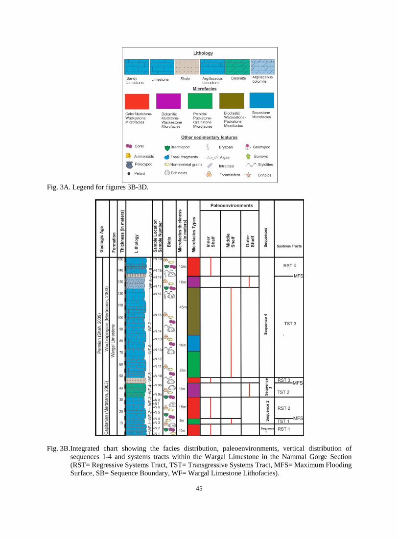
Fig. 3A. Legend for figures 3B-3D.
Fig. 3B. Integrated chart showing the facies distribution, paleoenvironments, vertical distribution of
sequences 1-4 and systems tracts within the Wargal Limestone in the Nammal Gorge Section (RST= Regressive Systems Tract, TST= Transgressive Systems Tract, MFS= Maximum Flooding Surface, SB= Sequence Boundary, WF= Wargal Limestone Lithofacies).
45
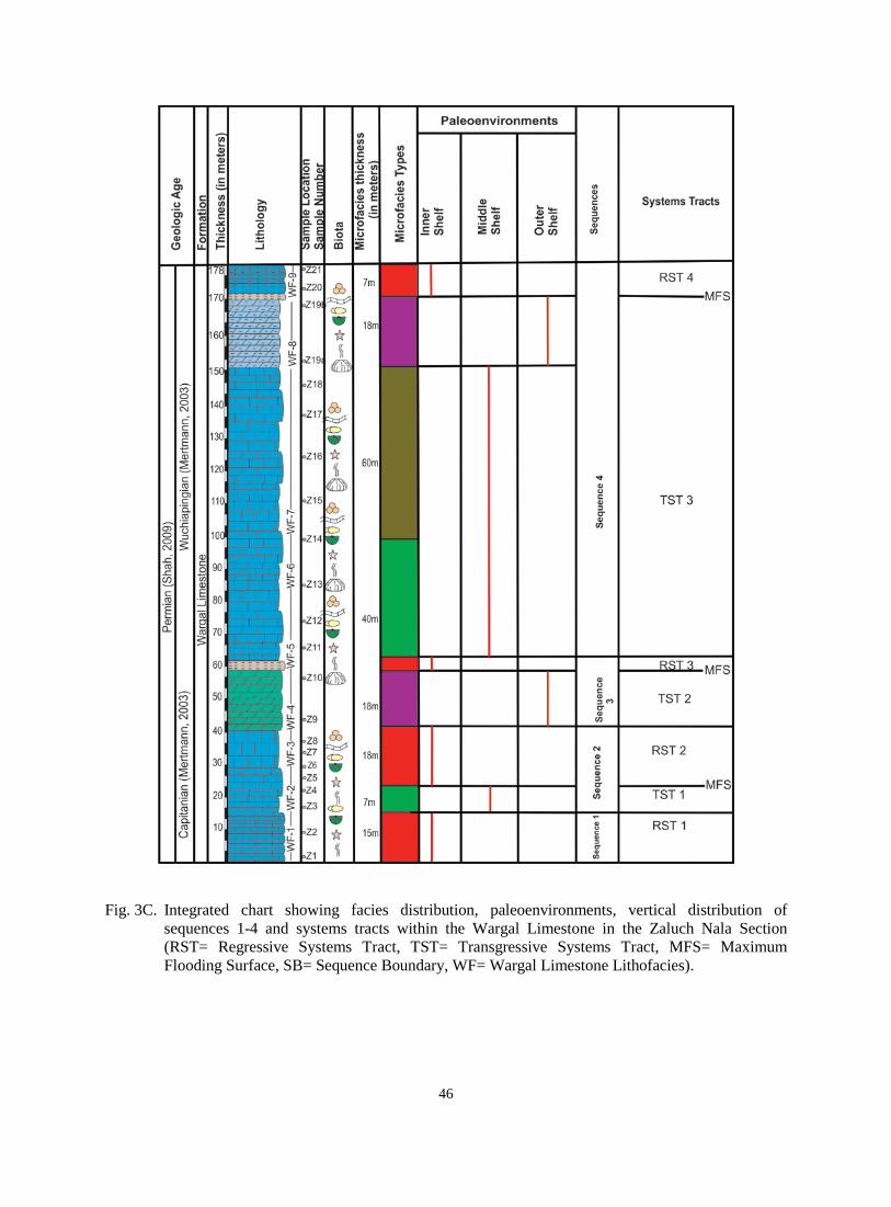
Fig. 3C. Integrated chart showing facies distribution, paleoenvironments, vertical distribution of sequences 1-4 and systems tracts within the Wargal Limestone in the Zaluch Nala Section (RST= Regressive Systems Tract, TST= Transgressive Systems Tract, MFS= Maximum Flooding Surface, SB= Sequence Boundary, WF= Wargal Limestone Lithofacies).
46
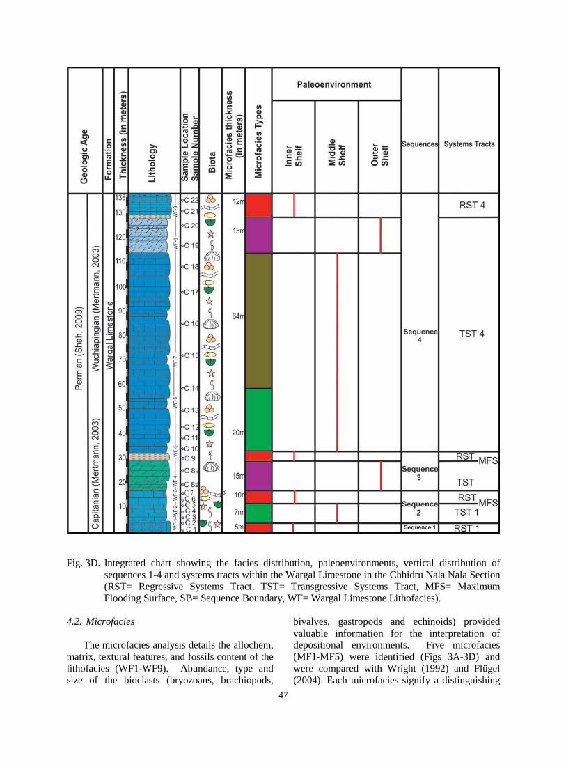
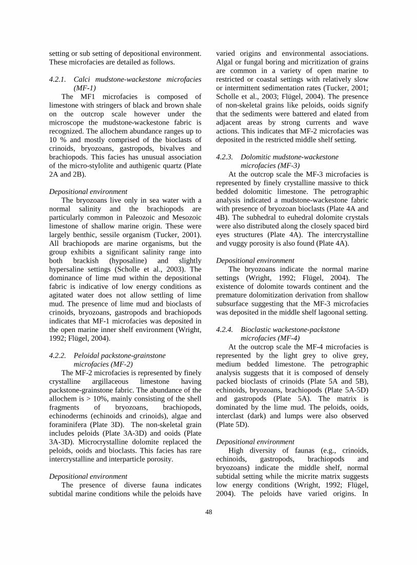
Fig. 3D. Integrated chart showing the facies distribution, paleoenvironments, vertical distribution of
sequences 1-4 and systems tracts within the Wargal Limestone in the Chhidru Nala Nala Section (RST= Regressive Systems Tract, TST= Transgressive Systems Tract, MFS= Maximum Flooding Surface, SB= Sequence Boundary, WF= Wargal Limestone Lithofacies).
4.2. Microfacies
The microfacies analysis details the allochem,
matrix, textural features, and fossils content of the lithofacies (WF1-WF9). Abundance, type and size of the bioclasts (bryozoans, brachiopods,
bivalves, gastropods and echinoids) provided valuable information for the interpretation of depositional environments. Five microfacies (MF1-MF5) were identified (Figs 3A-3D) and were compared with Wright (1992) and Flügel (2004). Each microfacies signify a distinguishing
47
setting or sub setting of depositional environment. These microfacies are detailed as follows.
4.2.1. Calci mudstone-wackestone microfacies
(MF-1) The MF1 microfacies is composed of
limestone with stringers of black and brown shale on the outcrop scale however under the microscope the mudstone-wackestone fabric is recognized. The allochem abundance ranges up to 10 % and mostly comprised of the bioclasts of crinoids, bryozoans, gastropods, bivalves and brachiopods. This facies has unusual association of the micro-stylolite and authigenic quartz (Plate 2A and 2B).
Depositional environment
The bryozoans live only in sea water with a normal salinity and the brachiopods are particularly common in Paleozoic and Mesozoic limestone of shallow marine origin. These were largely benthic, sessile organism (Tucker, 2001). All brachiopods are marine organisms, but the group exhibits a significant salinity range into both brackish (hyposaline) and slightly hypersaline settings (Scholle et al., 2003). The dominance of lime mud within the depositional fabric is indicative of low energy conditions as agitated water does not allow settling of lime mud. The presence of lime mud and bioclasts of crinoids, bryozoans, gastropods and brachiopods indicates that MF-1 microfacies was deposited in the open marine inner shelf environment (Wright, 1992; Flügel, 2004).
4.2.2. Peloidal packstone-grainstone
microfacies (MF-2) The MF-2 microfacies is represented by finely
crystalline argillaceous limestone having packstone-grainstone fabric. The abundance of the allochem is > 10%, mainly consisting of the shell fragments of bryozoans, brachiopods, echinoderms (echinoids and crinoids), algae and foraminifera (Plate 3D). The non-skeletal grain includes peloids (Plate 3A-3D) and ooids (Plate 3A-3D). Microcrystalline dolomite replaced the peloids, ooids and bioclasts. This facies has rare intercrystalline and interparticle porosity.
Depositional environment
The presence of diverse fauna indicates subtidal marine conditions while the peloids have
varied origins and environmental associations. Algal or fungal boring and micritization of grains are common in a variety of open marine to restricted or coastal settings with relatively slow or intermittent sedimentation rates (Tucker, 2001; Scholle et al., 2003; Flügel, 2004). The presence of non-skeletal grains like peloids, ooids signify that the sediments were battered and elated from adjacent areas by strong currents and wave actions. This indicates that MF-2 microfacies was deposited in the restricted middle shelf setting. 4.2.3. Dolomitic mudstone-wackestone
microfacies (MF-3) At the outcrop scale the MF-3 microfacies is
represented by finely crystalline massive to thick bedded dolomitic limestone. The petrographic analysis indicated a mudstone-wackestone fabric with presence of bryozoan bioclasts (Plate 4A and 4B). The subhedral to euhedral dolomite crystals were also distributed along the closely spaced bird eyes structures (Plate 4A). The intercrystalline and vuggy porosity is also found (Plate 4A).
Depositional environment
The bryozoans indicate the normal marine settings (Wright, 1992; Flügel, 2004). The existence of dolomite towards continent and the premature dolomitization derivation from shallow subsurface suggesting that the MF-3 microfacies was deposited in the middle shelf lagoonal setting.
4.2.4. Bioclastic wackestone-packstone
microfacies (MF-4) At the outcrop scale the MF-4 microfacies is
represented by the light grey to olive grey, medium bedded limestone. The petrographic analysis suggests that it is composed of densely packed bioclasts of crinoids (Plate 5A and 5B), echinoids, bryozoans, brachiopods (Plate 5A-5D) and gastropods (Plate 5A). The matrix is dominated by the lime mud. The peloids, ooids, interclast (dark) and lumps were also observed (Plate 5D). Depositional environment
High diversity of faunas (e.g., crinoids, echinoids, gastropods, brachiopods and bryozoans) indicate the middle shelf, normal subtidal setting while the micrite matrix suggests low energy conditions (Wright, 1992; Flügel, 2004). The peloids have varied origins. In
48
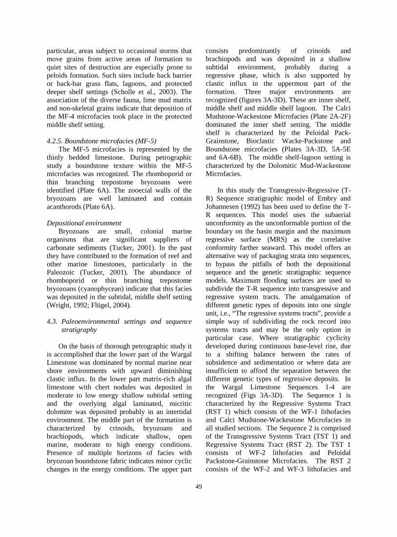
particular, areas subject to occasional storms that move grains from active areas of formation to quiet sites of destruction are especially prone to peloids formation. Such sites include back barrier or back-bar grass flats, lagoons, and protected deeper shelf settings (Scholle et al., 2003). The association of the diverse fauna, lime mud matrix and non-skeletal grains indicate that deposition of the MF-4 microfacies took place in the protected middle shelf setting.
4.2.5. Boundstone microfacies (MF-5)
The MF-5 microfacies is represented by the thinly bedded limestone. During petrographic study a boundstone texture within the MF-5 microfacies was recognized. The rhomboporid or thin branching trepostome bryozoans were identified (Plate 6A). The zooecial walls of the bryozoans are well laminated and contain acanthorods (Plate 6A).
Depositional environment
Bryozoans are small, colonial marine organisms that are significant suppliers of carbonate sediments (Tucker, 2001). In the past they have contributed to the formation of reef and other marine limestones, particularly in the Paleozoic (Tucker, 2001). The abundance of rhomboporid or thin branching trepostome bryozoans (cyanophycean) indicate that this facies was deposited in the subtidal, middle shelf setting (Wright, 1992; Flügel, 2004).
4.3. Paleoenvironmental settings and sequence
stratigraphy
On the basis of thorough petrographic study it is accomplished that the lower part of the Wargal Limestone was dominated by normal marine near shore environments with upward diminishing clastic influx. In the lower part matrix-rich algal limestone with chert nodules was deposited in moderate to low energy shallow subtidal setting and the overlying algal laminated, micritic dolomite was deposited probably in an intertidal environment. The middle part of the formation is characterized by crinoids, bryozoans and brachiopods, which indicate shallow, open marine, moderate to high energy conditions. Presence of multiple horizons of facies with bryozoan boundstone fabric indicates minor cyclic changes in the energy conditions. The upper part
consists predominantly of crinoids and brachiopods and was deposited in a shallow subtidal environment, probably during a regressive phase, which is also supported by clastic influx in the uppermost part of the formation. Three major environments are recognized (figures 3A-3D). These are inner shelf, middle shelf and middle shelf lagoon. The Calci Mudstone-Wackestone Microfacies (Plate 2A-2F) dominated the inner shelf setting. The middle shelf is characterized by the Peloidal Pack-Grainstone, Bioclastic Wacke-Packstone and Boundstone microfacies (Plates 3A-3D, 5A-5E and 6A-6B). The middle shelf-lagoon setting is characterized by the Dolomitic Mud-Wackestone Microfacies.
In this study the Transgressiv-Regressive (T-
R) Sequence stratigraphic model of Embry and Johannesen (1992) has been used to define the T-R sequences. This model uses the subaerial unconformity as the unconformable portion of the boundary on the basin margin and the maximum regressive surface (MRS) as the correlative conformity farther seaward. This model offers an alternative way of packaging strata into sequences, to bypass the pitfalls of both the depositional sequence and the genetic stratigraphic sequence models. Maximum flooding surfaces are used to subdivide the T-R sequence into transgressive and regressive system tracts. The amalgamation of different genetic types of deposits into one single unit, i.e., “The regressive systems tracts”, provide a simple way of subdividing the rock record into systems tracts and may be the only option in particular case. Where stratigraphic cyclicity developed during continuous base-level rise, due to a shifting balance between the rates of subsidence and sedimentation or where data are insufficient to afford the separation between the different genetic types of regressive deposits. In the Wargal Limestone Sequences 1-4 are recognized (Figs 3A-3D). The Sequence 1 is characterized by the Regressive Systems Tract (RST 1) which consists of the WF-1 lithofacies and Calci Mudstone-Wackestone Microfacies in all studied sections. The Sequence 2 is comprised of the Transgressive Systems Tract (TST 1) and Regressive Systems Tract (RST 2). The TST 1 consists of WF-2 lithofacies and Peloidal Packstone-Grainstone Microfacies. The RST 2 consists of the WF-2 and WF-3 lithofacies and
49
Calci Mudstone-Wackestone Microfacies. The Sequence 3 is comprised of the Transgressive Systems Tract (TST 2) and Regressive Systems Tract (RST 3). The TST 2 comprises of the WF-4 lithofacies and the Dolomitic Mudstone-Wackestone Microfacies. The RST 3 consists of the WF-2 and WF-3 lithofacies and Calci Mudstone-Wackestone Microfacies. The Sequence 4 is comprised of the Transgressive
Systems Tract (TST 3) and Regressive Systems Tract (RST 4). The TST 3 comprises of the WF-6 to WF-8 lithofacies. The Bioclastic Wacke-Packstone Microfacies, Peloidal Packstone-Grainstone Microfacies, Dolomitic Mudstone-Wackestone Microfacies and Boundstone Microfacies constitute the TST 3. The RST 4 consists of the WF-9 lithofacies and Calci Mudstone-Wackestone Microfacies.
Plate-1
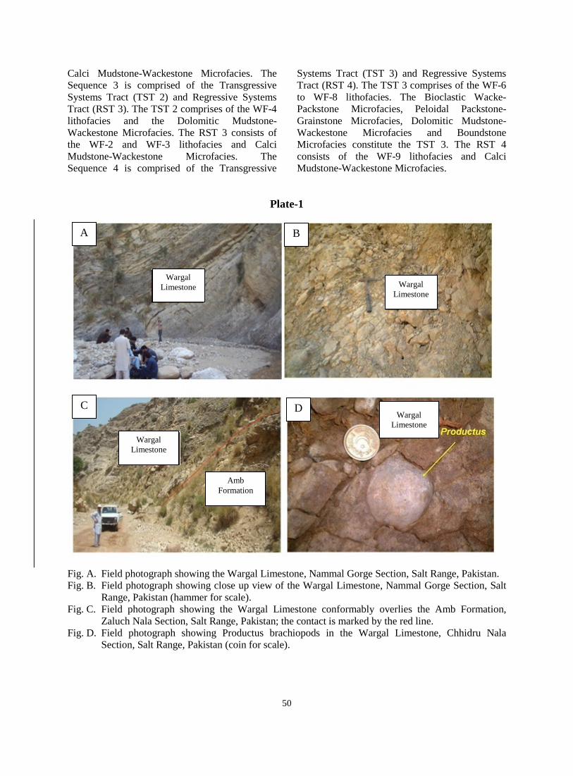
Fig. A. Field photograph showing the Wargal Limestone, Nammal Gorge Section, Salt Range, Pakistan. Fig. B. Field photograph showing close up view of the Wargal Limestone, Nammal Gorge Section, Salt
Range, Pakistan (hammer for scale). Fig. C. Field photograph showing the Wargal Limestone conformably overlies the Amb Formation,
Zaluch Nala Section, Salt Range, Pakistan; the contact is marked by the red line. Fig. D. Field photograph showing Productus brachiopods in the Wargal Limestone, Chhidru Nala
Section, Salt Range, Pakistan (coin for scale).
A
Wargal Limestone Wargal
Limestone
B
Wargal Limestone
Amb Formation
D Wargal
Limestone
C
50
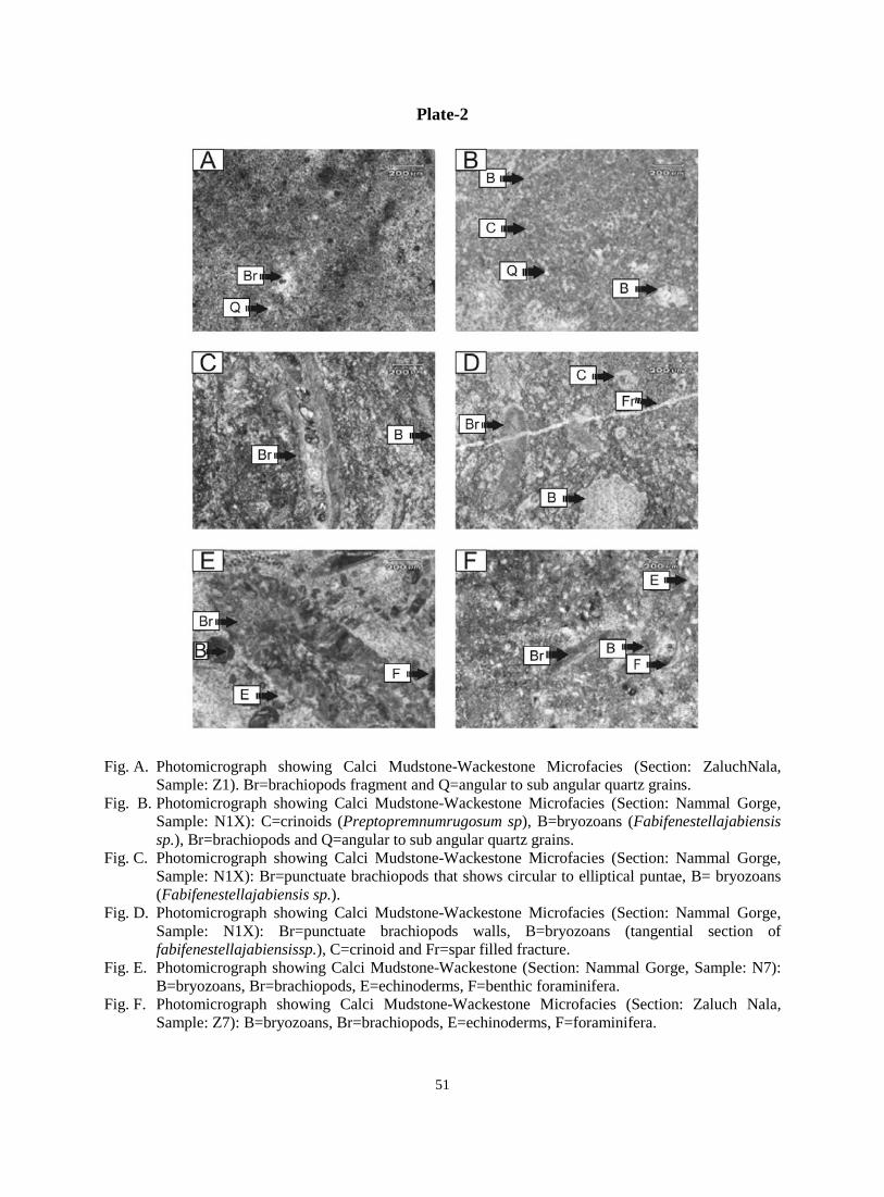
Plate-2
Fig. A. Photomicrograph showing Calci Mudstone-Wackestone Microfacies (Section: ZaluchNala, Sample: Z1). Br=brachiopods fragment and Q=angular to sub angular quartz grains.
Fig. B. Photomicrograph showing Calci Mudstone-Wackestone Microfacies (Section: Nammal Gorge, Sample: N1X): C=crinoids (Preptopremnumrugosum sp), B=bryozoans (Fabifenestellajabiensis sp.), Br=brachiopods and Q=angular to sub angular quartz grains.
Fig. C. Photomicrograph showing Calci Mudstone-Wackestone Microfacies (Section: Nammal Gorge, Sample: N1X): Br=punctuate brachiopods that shows circular to elliptical puntae, B= bryozoans (Fabifenestellajabiensis sp.).
Fig. D. Photomicrograph showing Calci Mudstone-Wackestone Microfacies (Section: Nammal Gorge, Sample: N1X): Br=punctuate brachiopods walls, B=bryozoans (tangential section of fabifenestellajabiensissp.), C=crinoid and Fr=spar filled fracture.
Fig. E. Photomicrograph showing Calci Mudstone-Wackestone (Section: Nammal Gorge, Sample: N7): B=bryozoans, Br=brachiopods, E=echinoderms, F=benthic foraminifera.
Fig. F. Photomicrograph showing Calci Mudstone-Wackestone Microfacies (Section: Zaluch Nala, Sample: Z7): B=bryozoans, Br=brachiopods, E=echinoderms, F=foraminifera.
51
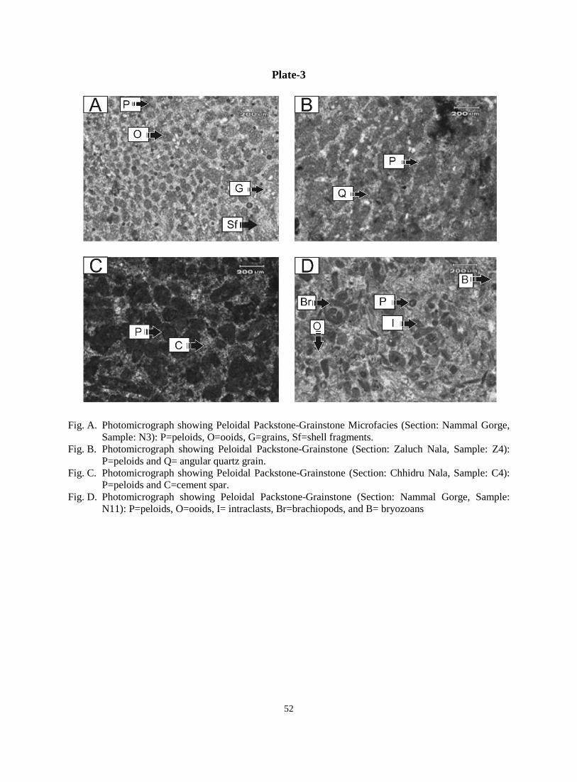
Plate-3
Fig. A. Photomicrograph showing Peloidal Packstone-Grainstone Microfacies (Section: Nammal Gorge, Sample: N3): P=peloids, O=ooids, G=grains, Sf=shell fragments.
Fig. B. Photomicrograph showing Peloidal Packstone-Grainstone (Section: Zaluch Nala, Sample: Z4): P=peloids and Q= angular quartz grain.
Fig. C. Photomicrograph showing Peloidal Packstone-Grainstone (Section: Chhidru Nala, Sample: C4): P=peloids and C=cement spar.
Fig. D. Photomicrograph showing Peloidal Packstone-Grainstone (Section: Nammal Gorge, Sample: N11): P=peloids, O=ooids, I= intraclasts, Br=brachiopods, and B= bryozoans
52
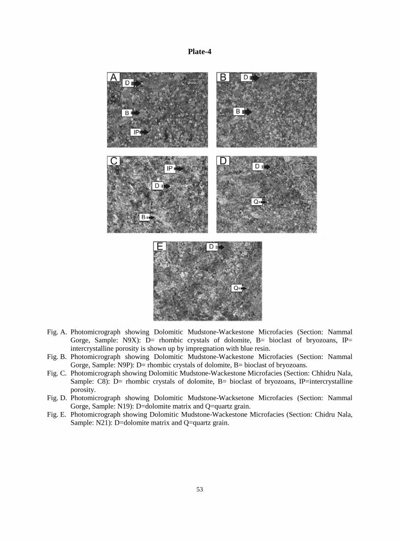
Plate-4
Fig. A. Photomicrograph showing Dolomitic Mudstone-Wackestone Microfacies (Section: Nammal Gorge, Sample: N9X): D= rhombic crystals of dolomite, B= bioclast of bryozoans, IP= intercrystalline porosity is shown up by impregnation with blue resin.
Fig. B. Photomicrograph showing Dolomitic Mudstone-Wackestone Microfacies (Section: Nammal Gorge, Sample: N9P): D= rhombic crystals of dolomite, B= bioclast of bryozoans.
Fig. C. Photomicrograph showing Dolomitic Mudstone-Wackestone Microfacies (Section: Chhidru Nala, Sample: C8): D= rhombic crystals of dolomite, B= bioclast of bryozoans, IP=intercrystalline porosity.
Fig. D. Photomicrograph showing Dolomitic Mudstone-Wacksetone Microfacies (Section: Nammal Gorge, Sample: N19): D=dolomite matrix and Q=quartz grain.
Fig. E. Photomicrograph showing Dolomitic Mudstone-Wackestone Microfacies (Section: Chidru Nala, Sample: N21): D=dolomite matrix and Q=quartz grain.
53
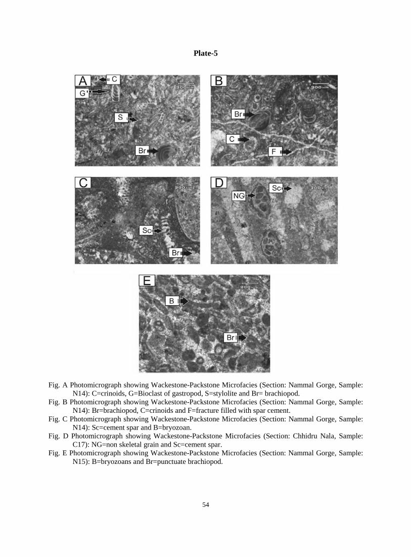
Plate-5
Fig. A Photomicrograph showing Wackestone-Packstone Microfacies (Section: Nammal Gorge, Sample: N14): C=crinoids, G=Bioclast of gastropod, S=stylolite and Br= brachiopod.
Fig. B Photomicrograph showing Wackestone-Packstone Microfacies (Section: Nammal Gorge, Sample: N14): Br=brachiopod, C=crinoids and F=fracture filled with spar cement.
Fig. C Photomicrograph showing Wackestone-Packstone Microfacies (Section: Nammal Gorge, Sample: N14): Sc=cement spar and B=bryozoan.
Fig. D Photomicrograph showing Wackestone-Packstone Microfacies (Section: Chhidru Nala, Sample: C17): NG=non skeletal grain and Sc=cement spar.
Fig. E Photomicrograph showing Wackestone-Packstone Microfacies (Section: Nammal Gorge, Sample: N15): B=bryozoans and Br=punctuate brachiopod.
54
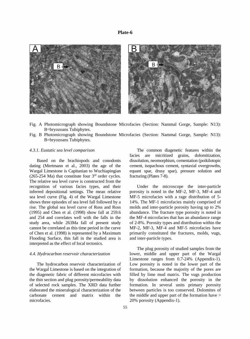
Plate-6
Fig. A Photomicrograph showing Boundstone Microfacies (Section: Nammal Gorge, Sample: N13): B=bryozoans Tubiphytes.
Fig. B Photomicrograph showing Boundstone Microfacies (Section: Nammal Gorge, Sample: N13): B=bryozoans Tubiphytes.
4.3.1. Eustatic sea level comparison
Based on the brachiopods and conodonts
dating (Mertmann et al., 2003) the age of the Wargal Limestone is Capitanian to Wuchiapingian (265-254 Ma) that constitute four 3rd order cycles. The relative sea level curve is constructed from the recognition of various facies types, and their inferred depositional settings. The mean relative sea level curve (Fig. 4) of the Wargal Limestone shows three episodes of sea level fall followed by a rise. The global sea level curve of Ross and Ross (1995) and Chen et al. (1998) show fall at 259.6 and 254 and correlates well with the falls in the study area, while 263Ma fall of present study cannot be correlated as this time period in the curve of Chen et al. (1998) is represented by a Maximum Flooding Surface, this fall in the studied area is interpreted as the effect of local tectonics. 4.4. Hydrocarbon reservoir characterization
The hydrocarbon reservoir characterization of
the Wargal Limestone is based on the integration of the diagenetic fabric of different microfacies with the thin section and plug porosity/permeability data of selected rock samples. The XRD data further elaborated the mineralogical characterization of the carbonate cement and matrix within the microfacies.
The common diagenetic features within the facies are micritized grains, dolomitization, dissolution, neomorphism, cementation (poikilotopic cement, isopachous cement, syntaxial overgrowths, equant spar, drusy spar), pressure solution and fracturing (Plates 7-8).
Under the microscope the inter-particle
porosity is noted in the MF-2, MF-3, MF-4 and MF-5 microfacies with a rage distribution of 5-14%. The MF-1 microfacies mainly comprised of molds and inter-particle porosity having up to 2% abundance. The fracture type porosity is noted in the MF-4 microfacies that has an abundance range of 2-8%. Porosity types and distribution within the MF-2, MF-3, MF-4 and MF-5 microfacies have primarily constituted the fractures, molds, vugs, and inter-particle types.
The plug porosity of studied samples from the
lower, middle and upper part of the Wargal Limestone ranges from 0.7-24% (Appendix-1). Low porosity is noted in the lower part of the formation, because the majority of the pores are filled by lime mud matrix. The vugs production by dissolution enhanced the porosity in the formation. In several units primary porosity between particles is too conserved. Dolomites of the middle and upper part of the formation have > 20% porosity (Appendix-1).
55
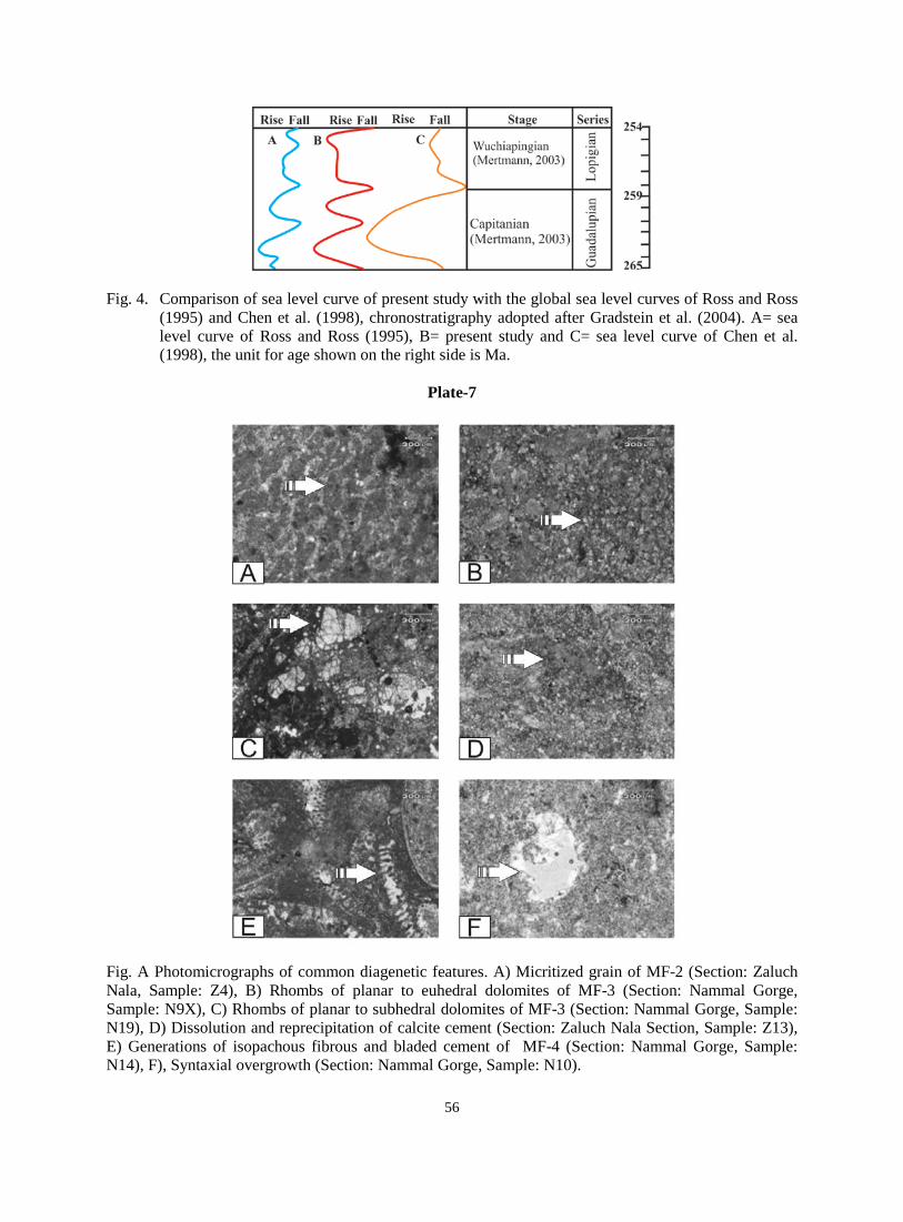
Fig. 4. Comparison of sea level curve of present study with the global sea level curves of Ross and Ross
(1995) and Chen et al. (1998), chronostratigraphy adopted after Gradstein et al. (2004). A= sea level curve of Ross and Ross (1995), B= present study and C= sea level curve of Chen et al. (1998), the unit for age shown on the right side is Ma.
Plate-7
Fig. A Photomicrographs of common diagenetic features. A) Micritized grain of MF-2 (Section: Zaluch Nala, Sample: Z4), B) Rhombs of planar to euhedral dolomites of MF-3 (Section: Nammal Gorge, Sample: N9X), C) Rhombs of planar to subhedral dolomites of MF-3 (Section: Nammal Gorge, Sample: N19), D) Dissolution and reprecipitation of calcite cement (Section: Zaluch Nala Section, Sample: Z13), E) Generations of isopachous fibrous and bladed cement of MF-4 (Section: Nammal Gorge, Sample: N14), F), Syntaxial overgrowth (Section: Nammal Gorge, Sample: N10).
56
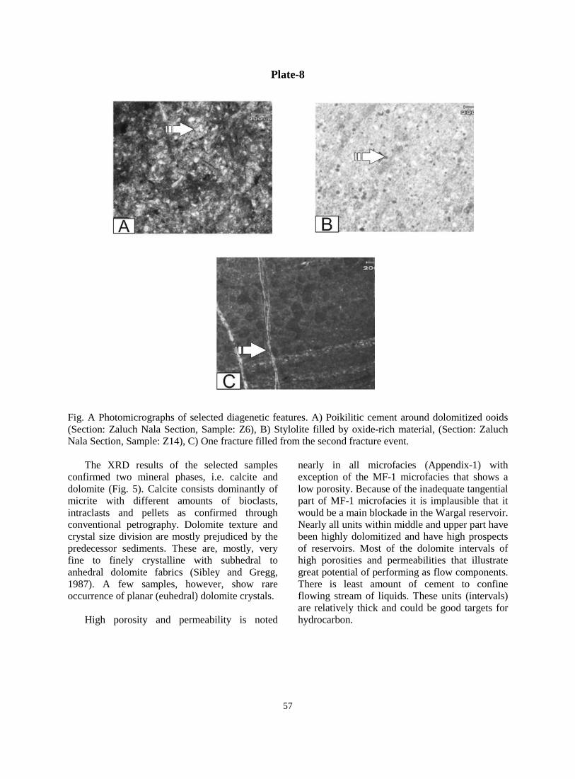
Plate-8
Fig. A Photomicrographs of selected diagenetic features. A) Poikilitic cement around dolomitized ooids (Section: Zaluch Nala Section, Sample: Z6), B) Stylolite filled by oxide-rich material, (Section: Zaluch Nala Section, Sample: Z14), C) One fracture filled from the second fracture event.
The XRD results of the selected samples confirmed two mineral phases, i.e. calcite and dolomite (Fig. 5). Calcite consists dominantly of micrite with different amounts of bioclasts, intraclasts and pellets as confirmed through conventional petrography. Dolomite texture and crystal size division are mostly prejudiced by the predecessor sediments. These are, mostly, very fine to finely crystalline with subhedral to anhedral dolomite fabrics (Sibley and Gregg, 1987). A few samples, however, show rare occurrence of planar (euhedral) dolomite crystals.
High porosity and permeability is noted
nearly in all microfacies (Appendix-1) with exception of the MF-1 microfacies that shows a low porosity. Because of the inadequate tangential part of MF-1 microfacies it is implausible that it would be a main blockade in the Wargal reservoir. Nearly all units within middle and upper part have been highly dolomitized and have high prospects of reservoirs. Most of the dolomite intervals of high porosities and permeabilities that illustrate great potential of performing as flow components. There is least amount of cement to confine flowing stream of liquids. These units (intervals) are relatively thick and could be good targets for hydrocarbon.
57
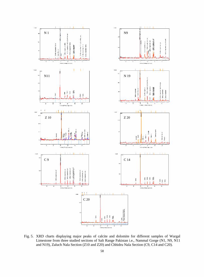
Fig. 5. XRD charts displaying major peaks of calcite and dolomite for different samples of Wargal
Limestone from three studied sections of Salt Range Pakistan i.e., Nammal Gorge (N1, N9, N11 and N19), Zaluch Nala Section (Z10 and Z20) and Chhidru Nala Section (C9, C14 and C20).
N 1 N9
N11 N 19
Z 10 Z 20
C 9 C 14
C 20
58
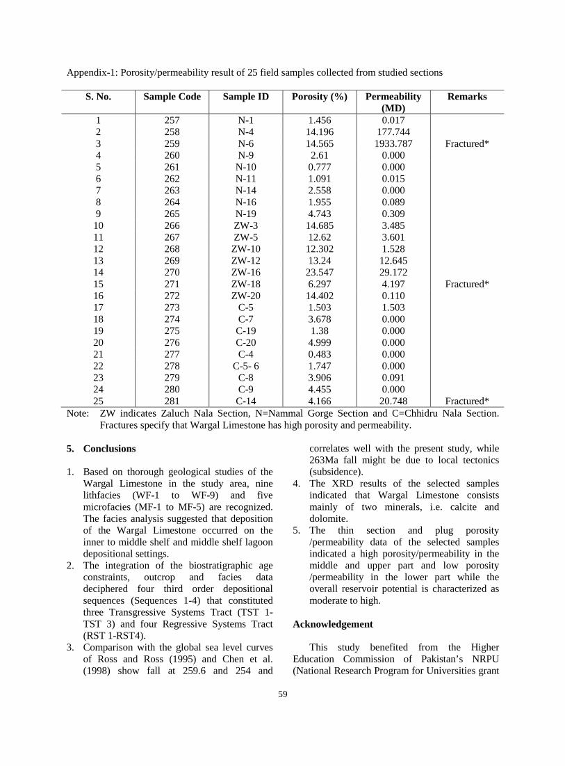
Appendix-1: Porosity/permeability result of 25 field samples collected from studied sections
S. No. Sample Code Sample ID Porosity (%) Permeability (MD)
Remarks
1 257 N-1 1.456 0.017 2 258 N-4 14.196 177.744 3 259 N-6 14.565 1933.787 Fractured* 4 260 N-9 2.61 0.000 5 261 N-10 0.777 0.000 6 262 N-11 1.091 0.015 7 263 N-14 2.558 0.000 8 264 N-16 1.955 0.089 9 265 N-19 4.743 0.309
10 266 ZW-3 14.685 3.485 11 267 ZW-5 12.62 3.601 12 268 ZW-10 12.302 1.528 13 269 ZW-12 13.24 12.645 14 270 ZW-16 23.547 29.172 15 271 ZW-18 6.297 4.197 Fractured* 16 272 ZW-20 14.402 0.110 17 273 C-5 1.503 1.503 18 274 C-7 3.678 0.000 19 275 C-19 1.38 0.000 20 276 C-20 4.999 0.000 21 277 C-4 0.483 0.000 22 278 C-5- 6 1.747 0.000 23 279 C-8 3.906 0.091 24 280 C-9 4.455 0.000 25 281 C-14 4.166 20.748 Fractured*
Note: ZW indicates Zaluch Nala Section, N=Nammal Gorge Section and C=Chhidru Nala Section. Fractures specify that Wargal Limestone has high porosity and permeability.
5. Conclusions 1. Based on thorough geological studies of the
Wargal Limestone in the study area, nine lithfacies (WF-1 to WF-9) and five microfacies (MF-1 to MF-5) are recognized. The facies analysis suggested that deposition of the Wargal Limestone occurred on the inner to middle shelf and middle shelf lagoon depositional settings.
2. The integration of the biostratigraphic age constraints, outcrop and facies data deciphered four third order depositional sequences (Sequences 1-4) that constituted three Transgressive Systems Tract (TST 1-TST 3) and four Regressive Systems Tract (RST 1-RST4).
3. Comparison with the global sea level curves of Ross and Ross (1995) and Chen et al. (1998) show fall at 259.6 and 254 and
correlates well with the present study, while 263Ma fall might be due to local tectonics (subsidence).
4. The XRD results of the selected samples indicated that Wargal Limestone consists mainly of two minerals, i.e. calcite and dolomite.
5. The thin section and plug porosity /permeability data of the selected samples indicated a high porosity/permeability in the middle and upper part and low porosity /permeability in the lower part while the overall reservoir potential is characterized as moderate to high.
Acknowledgement
This study benefited from the Higher
Education Commission of Pakistan’s NRPU (National Research Program for Universities grant
59
to Dr. Irfan U. Jan as principle investigator), National Centre of Excellence in Geology and Department of Geology, University of Peshawar research funds. References Afzal, J., 2004. Permian brachiopods (silicified)
form Wargal (upper part) and Chhidru formations, Nammal gorge, western salt range, Pakistan (taxonomy, biostratigraphy and paleo-environments). Annual technical conference, Islamabad, 10, 8-9.
Ahmed, S., Khan, I., Ahmed, I., 2005. Structure and stratigraphy of the Paleozoic and Mesozoic sequence in the vicinity of Zaluch Nala, western Salt Range Pakistan. Pakistan Journal of Hydrocarbon Research, 15, 1-8.
Chen, Z.Q., Yin, Y., Shi, G.R., 1998. Permian transgression regression sequences and sea- level changes of South China. Royal Society of Victoria, Proceedings, 10, 345-367.
Embry, A., Johannessen, E., 1992. T-R sequence stratigraphy, facies analysis and reservoir distribution in the upper-most Triassic-Lower Jurassic succession, western Sverdrup Basin, Arctic Canada. In: Vorren, T.O., Bergsager, E., Dahl-Stamnes, O.A., Holter, E., Johansen, B., Lie, E., Lund, T.B. (Eds.), Arctic geology and Petroleum Potential, Norwegian Petroleum Society (Special Publication), 2, 121-146.
Fatmi, A.N., 1973. Litho-stratigraphic units of the Kohat-Potwar province, Indus Basin, Pakistan. Geological of Pakistan, Memoir, 10, 1-80.
Flügel, E., 2004. Microfacies of carbonate rocks, analysis, interpretation and application. Springer, Berlin.
Gradstein, F., Ogg, J., Smith, A.G., 2004. A Geologic Time Scale. Cambridge University press, Cambridge.
Haneef, M., Gilmar, E.H., Rahman, O.U., 1981. Sections of Wargal Limestone, Western Salt Range, Pakistan. Geological Bulletin, University of Peshawar, 14, 63-71.
Jan, I.U., Stephenson, M.H., 2011. Palynology and correlation of the Upper Pennsylvanian Tobra Formation from Zaluch Nala, Salt Range, Pakistan. Palynology, 35, 212-225.
Kummel, B., Teichert, C., 1970. Stratigraphic nomenclature, stratigraphy and paleontology of Permian-Triassic boundary beds, Salt and Trans Indus Ranges, West Pakistan. Geology Department University press Kansas (special publication), 4.
Mertmann, D., 2003. Evolution of marine Permian Carbonate platform in the Salt Range Pakistan. Journal of Paleogeography, Paleoclimatology, Paleoecology, 191, 373-384.
Ross, C.A., Ross, J.R.P., 1995. Permian sequence stratigraphy. In: Scholle, P.A., Peryt, T.M., Ulmer-Scholle, D.S. (Eds.), The Permian of Northern Pangea, 1.
Shah, S.M.I., 1977. Precambrian. In: Shah, S.M.I. (Eds.) Stratigraphy of Pakistan. Geological Survey of Pakistan, Memoir, 12, 1-5.
Shah, S.M.I., 2009. Stratigraphy of Pakistan, Geological Survey of Pakistan, Memoir, 22.
Sibley, D. F., Gregg, J. M., 1987. Classification of dolomite rock textures. Journal of Sedimentary Petrology, 57, 955-963.
Teichert, C., Kummel, B., 1970. Stratigraphic nomenclature, stratigraphy and paleontology of Permian-Triassic boundary beds, Salt and Trans Indus Ranges, West Pakistan. Geology Department University press Kansas (special publication) 4.
Tucker, M.E., Wright, V.P., 2001. Carbonate Sedimentology, Blackwell Science, Cambridge, 482.
Wright, V.P., 1992. Limestone classification. In: Scholle, P.A., Ulmer-Scholle, D,S. (Eds.), A color guide to the petrography of carbonate rocks, Grains, textures, porosity, diagenesis. American Association of Petroleum Geologists, Memoir, 77, 474.
60


