Embed Size (px)
Citation preview

1
Author version: J. Coast. Res.: 25(2); 2009; 459-468
Late Quaternary seismic sequence stratigraphy of the Gulf of Kachchh, northwest of India
Laju Michael*, D. Gopala Rao§, K.S. Krishna* and K.H. Vora*
*National Institute of Oceanography, §Department of Geology, Dona Paula, Osmania University, Goa – 403004, Hyderabad – 500007, India India Ph: +91 832 2450384 [email protected]
ABSTRACT
High-resolution seismic reflection and bathymetric data in 10 to 50 m water depth in the Gulf of
Kachchh, northwest of India, have been analysed together with earlier results from the area. They have
revealed geomorphic features and Late Quaternary seismic sequence stratigraphy of 25 m thick
sediments. Seabed topography is uneven except in the east carpeted by thick acoustically transparent to
semitransparent sediment clays and stratified limestone beds. The sediments consist of (i) the transparent
unit “A” up to 12 m thick, (ii) thick 8 to 10 m diffuse seismic reflection free unit “D” and (iii) 4 to 5 m
thick hummocky reflections unit “K”. The geomorphic/sub-surface features are pinnacles (1 to 2 m
high) and mounds (4 to 5 m high) on the seafloor and subsurface in the south and west, valleys (1 to 3
m) on the seafloor in the south and subsurface in the north, on laps of reflectors in the north. They mark
corals, seafloor incisions, and sediment influx. Spatial shifts of valleys that mark a high energy tidal
regime incising the seafloor in paleo and present times appear to be due to neotectonics: subsidence and
uplift. Based on the seismic images and on correlation with the sea level curve published by other
authors, the pinnacles, mounds and the hummocky reflectors are interpreted as corals (live and relict)
formed in subaqueous conditions. The reflection-free sediments are coral debris sands mostly derived
during the interglacial period of late Pleistocene and Holocene when the gulf was exposed to arid
climates during lowered sea levels, around Last Glacial Maximum (centered ~18 ka). Access to unique
sedimentary records of the Late Quaternary climates/sea level changes even of decadal scale can be
retrieved by collecting sediments/corals from shallow drill wells in the gulf.

2
INTRODUCTION
The Gulf of Kachchh, ~ 125 km long and 75 km wide (the longest along the northwest coast of
India), lies between the mainland of Kachchh in the north and the Saurashtra/Kathiawar peninsula in the
south and is open to the Arabian Sea in the west (Figure 1). The nonhostile conditions, high 3-6 knots
tidal currents (Figure 2) and the macrotidal (semidiurnal with ~ 6 m maximum wave heights) regime of
the gulf are unfavourable for conducting any underwater investigations in the area, and thus
understanding of the geologic structure and origin of the gulf is elusive. Geomorphology of the seafloor
(Kunte et al., 2005; Wagle, 1979), the presence of corals (Hashmi, Nair, and Kidwani, 1978;
Purnachandra Rao et al., 2003; Wafer, 1986; Wagle, 1979) and seismic images of surface coral mounds
(Gopala Rao, 1988) have been studied. Corals grow in relation to the lowest tide, the highest level of
survival (Taylor et al., 1987); as such, corals are well-known indicators of the then shallow marine
conditions and are proxy indicators of sea level variations related to climate changes. After some level
of growth, corals are known to grow laterally with flat tops. Siddall et al, (2003) have noted sea level
changes of the order of 35 m during abrupt climate changes during Glacial Maxima (LGM). Some of the
corals of the gulf have been dated ~11 ka (Purnachandra Rao et al., 2003). Miliolites of the age group
200-140, 115-75 and 70-50 ka underlain by gravel cemented with calcium carbonates occur along the
coasts of Saurashtra mainland (BASKARAN et al., 1986).
Uplift of marine sediments of Late Quaternary (Chamyal, Maurya, and Raj, 2003) and Holocene (Juyal
et al., 1995; Prakash et al., 2000) of Saurashtra and Kachchh peninsula and the submergence of coastal
areas i.e., Bet Dwarka sometime after 3,870 yr BP (Gaur, Vora, and Sundaresh, 2007; Rao, 1996; Vora
et al., 2002) are the recent results marking neotectonics of the onshore areas surrounding the gulf. The
Bhuj area of Kachchh experienced uplift after the 2001 Bhuj earthquake (Chandrasekhar et al., 2004).
Marine sediments of the interglacial (~125 ka) and postglacial maximum (6 ka) are noted above sea
level, marking transgressed phases of the sea (Chamyal, Maurya, and Raj, 2003). All of these point to
transgression and regression of sea levels and inundation of the places during the late Pleistocene-
Holocene period and neotectonics. But the relative role of neotectonics and the sea level changes is still
unresolved and possibly could be better explained with authenticity from more geological information.
Further, understanding of surface and subsurface geology and their morphological changes would reflect
the geological processes affecting evolution of the gulf.

3
The present investigations of seismic sequence stratigraphy analyses are aimed (i) to study
geomorphic features, surface geology, and neotectonics of the area and (ii) contribute to understanding
neotectonics and sea level changes affecting the Late Quaternary geology.
GEOLOGICAL SETTING
The asymmetrically rifted subbasins of the Kachchh mainland comprises a series of east-west
trending half grabens and have undergone cycles of subaqueous and submarine conditions (Biswas,
2005). The east-west trending Gulf of Kachchh forms the southernmost part of the Kachchh mainland
sedimentary basin. Its sediments increase in thickness up to 4 km towards the south, underlain by basalts
and Mesozoic sediments. A NE-SW trending North Kathiawar Fault (NKF) in the middle of the gulf
limits southern extension of the subbasins (Biswas, 2005). The coastline surrounding the gulf consists of
low-level coastal plains with inundations, deep inlets, a number of offshore islands, and several river
mouths (Figure 2). The islands covered by mud and mangrove swamps are surrounded by coral reefs in
the form of fringing reefs, platform reefs, patch reefs, and coral pinnacles. Miliolites occur extensively
along almost the entire coasts of Saurashtra and in the mainland interiors and overlie the Deccan traps
(Chamyal, Maurya, and Raj, 2003). Late Cretaceous/early Tertiary Deccan volcanics and thick
Mesozoic sediments underlie them.
Aeolian sediments overlying fluvial sediments correlating to the global arid phase of the Last
Glacial Maximum (Chamyal, Maurya, and Raj, 2003) and the presence of coral limestone, reefs, raised
beaches and oyster beds of the coast ~180 m above mean sea level (Srivastava, 1965) have been noted.
Their presence has been attributed to marine transgression during the Pleistocene (Lele, 1973) and
upliftment (Srivastava, 1965 and several others).
The presence of basalts at >200 m sub-surface depth has been interpreted from magnetic
anomalies at the entrance of the gulf (Gopala Rao, Bhattacharya, and Krishna Rao, 1977). Studies
deciphering structure and tectonics, geological processes, and evolution of the basin are presently
interesting to know in view of Mesozoic sediments and their hydrocarbons prospects.

4
BATHYMETRY AND SEISMIC INVESTIGATIONS
A dual frequency Echo-sounder, Odom-echo track unit, was installed on a small fishing vessel
for bathymetric measurements. The lower frequency (33 KHz) energy provided relatively more
penetration whereas better resolution is provided by higher frequency (210 KHz). The predicted tidal
data were applied for correction of bathymetric data. The bathymetric data obtained along the lines are
presented in the form of contours in Figure 3. The water depth data are generally in agreement with the
existing data of Hydrographic chart no LD (7) 203, but the present results provide much more detailed
continuous profiles of seafloor topography.
A high-resolution seismic continuous profiler (EG&G three elements, sparker array, 200-300
joules energy) system was deployed for acquisition of about 640 km line subbottom data along two E-W
and three NW-SE profiles in the Gulf of Kachchh. For interpretation of the shallow seismic data, two-
way travel times are converted into depth sections, taking into account the velocity of sound as 1500 m/s
for the water column and underneath sediments. Hence, the depths to various subbottom layers are
apparent depths as the seismic velocities in the sediments are uncorrected for actual velocities.
High-resolution seismic-reflection records are interpreted following the sequence stratigraphy
interpretation analysis (Mitchum, Vail, and Sangree, 1977; Schlager, 1991; Vail, Mitchum, and
Thompson, 1977; Van Wagoner et al., 1988). The Holocene sea level variations (fourth and fifth order)
cycles of shorter time intervals (Hernandez-Molina, Somoza, and Lobo, 2000; Shackelton, 2000 and
Siddall et al., 2003; Trincardi and Field, 1991) have been considered to unravel the sedimentation
history and paleoclimates.
DATA ANALYSIS
The seafloor topography is even in the east and uneven to rugged in other parts and consists of
rises and valleys of varied dimensions. The interpreted seismic sections in 10 to 50 m water depths
(Figure 4) have revealed the stratal reflection pattern and seismic structure of ~25 m thick sediments.
Acoustically transparent to semitransparent seismic unit “A”, 1-12 m thick, is underlain mostly by
uneven to discontinuous near parallel reflectors in the west compared to the east (Figures 4 and 5a). The
unit is maximum 12 m thick and transparent, underlain by near parallel continuous reflectors in the east.
Also prominent reflectors are noted at 2-12 m and 20-25 m depth in the east and at 2-10, 4-25, and 15-20

5
m in the west (Figure 4). In the middle and west, two to three thick continuous parallel reflectors occur
and for large part are underlain mostly by diffuse seismic reflection free unit “D” or hummocky
reflection surfaces unit “K” or both (Figure 5a). The unit “D” occurs at varied depths in the south
(Figure 5b). In the southwest and middle of the gulf, the unit “D” is considerably thick, 5 to 6 m
(Figures 5b and c), and occurs beneath 1 to 2 m thick parallel reflectors of unit “A”. The unit “K”
(Figures 5b and 5c) consists of diffuse reflectors packs that are 4 to 5 m thick, plateau-like in structure,
and occur beneath the units “D” and/or “A”. It occurs at 8 m to 25 m depth with large, up to 10 m relief
in the southwest (Figure 5c). Its reflectors are very uneven, hummocky, and weak, often overlain by
diffuse seismic reflection free unit “D” of varied thickness. It is at shallow depth in the northwest and
reflectors of unit “A” directly rest on them (Figure 4; Line 04) as the unit “D” is either thin or absent.
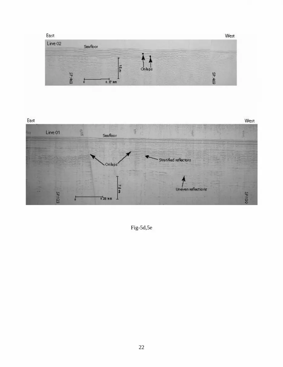
On lap of reflectors within the upper unit is another distinct feature (Figure 5d and 5e) noted
among reflectors in the northwest (Figure 4, Line 01) and southeast (Figure 4, Line 02). They mark
prograded sedimentation to the west (Figures 5d and 5e). Numerous valleys of varied dimensions with
steep flanks (Figure 5f, line 04 location in Figure 4) occur at seafloor in the middle of the gulf. To their
north/northwest they occur beneath ~2 m thick sediments (Figure 5g, line 04 location in Figure 4). The
valleys are cut and fill type. The ones underneath sediments are the past incisions of the seafloor by
strong currents but are presently buried under a thin veneer of Recent clastics.
The seafloor undulations, appearing as pinnacles and mounds/plateaus-like structures, are are 1 to
2 m high in general and some are even more and occur at several places inside the gulf (Figure 4, Lines
01 and 02). Similar structures also occur at two subsurfaces, 4 to 8 m depths in the middle, south, and
southwest of the gulf. They are discontinuous with steep, 2-10 m relief flanks. In the middle and
southwest, they are overlain by parallel reflectors (Figures 5b, 5c and 5h). The mounds in the southwest
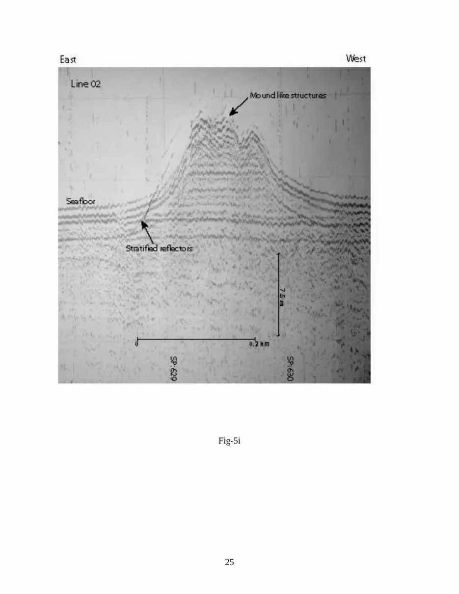
are exceptionally high, 4-5 m, and 4 m wide (Figure 5h). A large seafloor mound, 12 m high and ~ 2 m
wide, occurs in the southwest on top of stratified continuous prominent reflectors (Figure 5i), indicating
hard surfaces on which it had grown. Its crest consists of three small highs/notches, a characteristic
feature pointing to colonization of the organisms building the mounds. Thus, the mound/pinnacle-like
structures occur at three depth levels: (i) on the surface (Figure 5i and Line 02 in Figure 4; in about 45 m
waters), (ii) at 4 to 6 m subsurface in the middle of the gulf (Figure 5h) and (iii) at 8 to 25 m depth in the
west and middle of the gulf (Figure 5b, 5c; and Line 02 in Figure 4). Most of the mounds are 1 to 8 m
wide and several meters high (Figure 4).

6
MORPHOLOGICAL INTERPRETATION
The seafloor of the gulf is relatively smooth in the east and even to rugged in the south,
southwest and northwest due to the presence of pinnacles, mounds, and valleys. The number of valleys
of varied dimensions with steep walls occurring at the seafloor in the southeast and subsurface in the
north (Line 04 in Figure 4, figures 5f and 5g) mark cut and in-fill sediments and spatial shift of scouring.
Rugged topography with steep, >6 m scarps of the seafloor in 20 and 60 m water depths (Wagle, 1979),
relict coral rocks 10,000 – 11,000 yrs B.P (Purnachandra Rao, 2003), and high tidal currents of 3.1–5.9
knots have been noted in the gulf (Figure 2; Naval Hydrographic Office, 1976). The infill sediments of
the valleys of the north indicate sediments deposition and a decrease in bottom energy due to shallow
waters otherwise there is a high energy environment in the past. They might be due to the strong E-W
flowing tidal currents of the gulf (Figure 2) or the rivers flowing into the gulf. A number of N-S flowing
streams, including Bhukhi, Nagvanti, and Rukmavati, are structurally controlled and pour water and
sediments into the gulf (Chamyal, Maurya and Raj, 2003). The valley-type seafloor morphological
features are not present on parallel lines 03 and 05 or on E-W lines 01 and 02. If the rivers flowing into
the gulf are causing them, they are likely to be seen on the other lines as well as definitely on line 02.
However, that is not the case. Most likely they are, therefore, caused by the strong E-W flowing
currents. The area affected by scouring in the past is presently experiencing sediment depositional
regime due to the relocation of the strong tidal currents to further south. It means the past high-energy
areas of bottom waters reached to still conditions/shallow depths. Uplift of the northern Kachchh at
different times in Holocene, including 8,500 yr BP, has been reported (Prakash et al., 2000). Due to
uplift of the seafloor caused by neotectonic activity, the deep water area in the north became shallow,
and therefore the seafloor became closer to the coast i.e., within the sedimentation reaches.
Consequently the deeper depths area of the gulf were affected by the current i.e., in the present location
in the middle of the gulf. The scouring of the seafloor is not observed in south, and the tidal currents are
also relatively weak, 3 knots. The numerous islands and shoals that are present in the south dam the tidal
currents resulting in dissipation of energy otherwise strong, up to 5 knots akin to them in the north
(Figure 2). Thus, the spatial shift and changes in the currents strength appear to be controlled by the
neotectonics and geomorphic features of the gulf.

7
SEISMIC DATA INTERPRETATION
The three aspects/characteristics of seismic units acoustic character, stratal pattern, and structure have
been utilized to infer sediment type. The upper sediments, unit “A” of ~12 m maximum thick, are
acoustically transparent to semitransparent and are finer clastics, clays. On lap of reflectors within the
unit “A” in the east and north (Figure. 5d and 5e) is a characteristic feature to note the sediments influx
(clastics) from the main land brought by the rivers flowing in to the gulf otherwise tide dominated area.
The mounds and pinnacles on the seafloor and at depth with large relief are typical in the south
(Figures 5h and 5i, Lines 01, 02, 04 and 05). They could be sedimentary rocks patchy coral build ups
and/or their relicts or sandy features like sand waves or bars. Coral mounds at the seafloor are
interpreted in the area (Gopala Rao, 1988). In the case of sand bodies in the tide-dominated gulf, the
most likely features are beach, berm, cliff. Seismic images did not show any fluid flows or pock marks
at the seafloor, periodicity, and, more interestingly, any chaotic to discontinuous strong reflections
within them. The high-resolution seismic images of the Algarve, Portugal (Iberian peninsula) (Moura et
al., 2007), supported by the actual mapping of their cross sections at dug sites, clearly show several
parallel-inclined, always strong reflectors beneath sand bodies/build ups and are the best examples to
demonstrate their presence from imaging itself.
The images in the study area as well could be due to (i) basaltic rocks carpeted by
laterite/alluvium similar to the interior main land and (ii) coral mounds/plateaus like the ones occurring
at several places along shores of the southern coast and on the seafloor. Hard basaltic rock surfaces
capped by laterites (weathered basalts) would give rise to intense high amplitude reflections as the hard
reflecting surfaces of them cause total reflection of the seismic energy because of high impedance
contrast between the rocks and finer sediments. Instead we noticed packs of three to four weak
continuous hummocky reflectors. If the images are due to laterites and basaltic rocks, stratified reflectors
of the laterites at least in some places (pockets) are likely to occur, but that is not the case again.
Moreover basalts are interpreted at much deeper depths inside the gulf (Gopala Rao, Bhattacharya, and
Krishna Rao et al., 1977). If the images reflect the onshore geology extended into the offshore (the gulf),
their seismic images would be alike in the north and south but they are quite contrasting. The reflection
patterns, amplitudes, and structure resemble the coral mounds images noted at the seafloor earlier by
Gopala Rao (1988) and Wagle (1979). Hummocky topography of sedimentary rocks (miliolites and

8
aeolian) have been reported on the Kachchh mainland, marking the arid phase of Last Glacial Maximum
(Chamyal, Maurya, and Raj, 2003). Then hummocky topography of the plateaus of unit “K” at 4-25 m
depth beneath the reflection free unit “D” in the south and middle of the gulf (Figures 5c-f) could be
buried corals. Coral samples living (Bakus, 1994; Wafer, 1986) and relict (~11 kyr old) (Purnachandra
Rao et al., 2003) have also been sampled in the area. We envisage corals are built on hard surfaces and
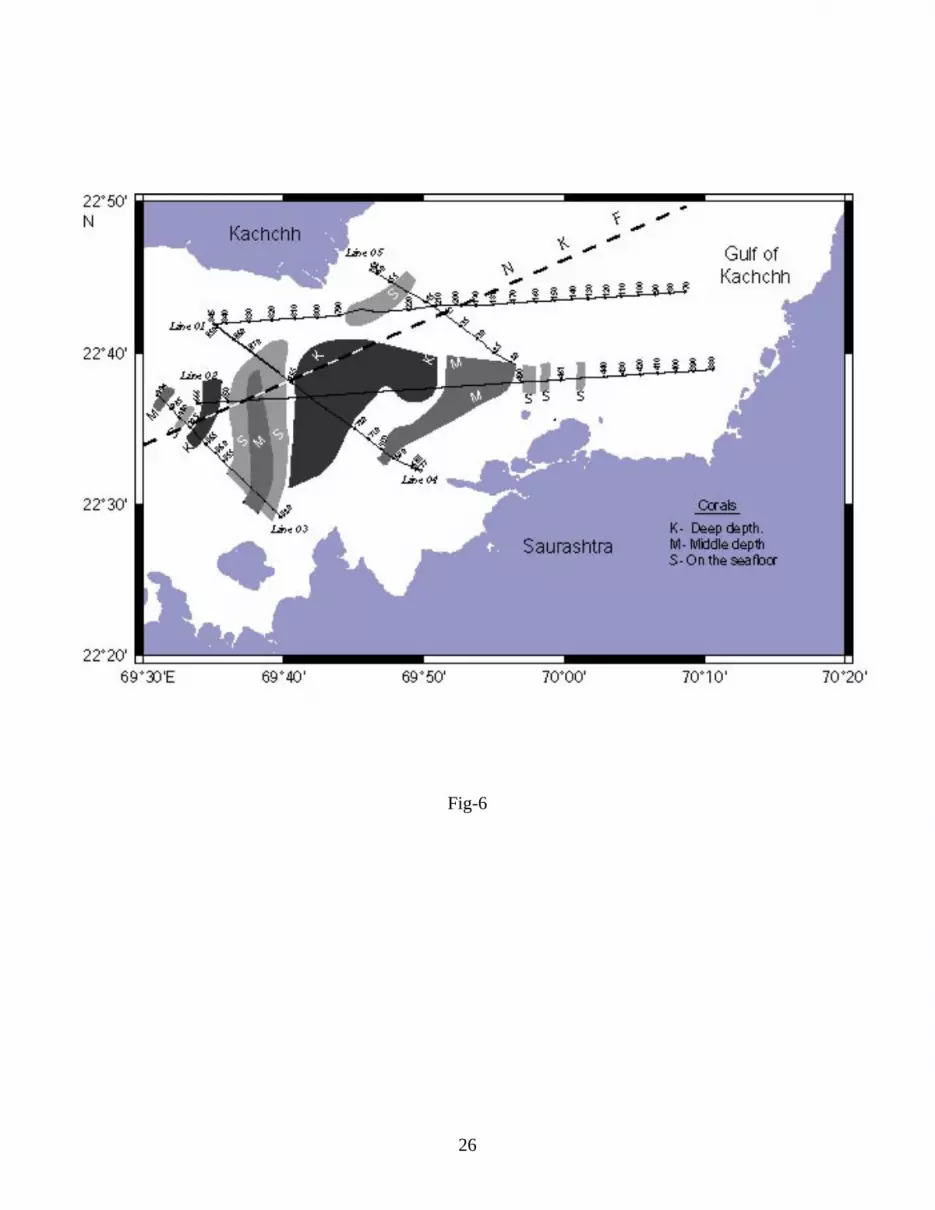
buried later under sediments. The patchy and limited distribution of them along the northern coast
(Figure 6) is under the influence of the E-W flowing high tidal currents of the past and present sediments
influx from the numerous rivers flowing into the gulf. The diffuse reflections unit “D” and mounds at
mid-depth could be coralline sands/coral debris, accumulated fluvial fine-grained sediments, and relict
corals. After the boon of the coral growth of transgressed seas of late Pleistocene, regression in sea
levels might have reached the corals at subaerial conditions during the Last Glacial Maxima (~18 ka or
so). Destruction of the corals resulting in coral sands and relict corals might have occurred during the
subaerial to arid conditions. Thus, it appears that the middepth mounds are relict corals that are remnants
of the corals grown subsequently during the transitions i.e. interglacial periods. The corals at the three
different depths (subsurface and surface) levels are grown at different times under changing
environment and oceanographic conditions. The deeper ones are more widely spread in the center of the
gulf compared to the middepth and surface mounds which are sparsely distributed (Figure 6).
CORRELATIONS BETWEEN EUSTATIC CURVES AND SEISMIC DATA
Considering the subsurface occurrence of the seismic units, corals at different depths, we propose spatial
and temporal changes of coral growth and correlate them with a published sea level curve of the last 100
ka following Shackelton (2000) and Siddall et al. (2003) (Figure 7). The coral mounds at 4 to 25 m
subsurface in the middle and west of the gulf are considered grown during the period >23 ka a
transgressive phase of sea level. Therefore we believe they represent relict corals of the geological past,
Late Pleistocene (Figure 7). Reefs and oysters are reported along the coastal cliffs of southern Saurashtra
and Kachchh during transgressed sea levels of ~125 ka (Baskaran et al., 1986; Chamyal, Maurya, and
Raj, 2003; Lele, 1973). The middepth corals mounds amidst reflection-free coral debris/sands are again
relict corals of the past grown subsequently and also remnants of the deep corals as they were destroyed
during adverse climatic condition. Corals (Faviidae) of ~11 ka have been reported in the gulf
(Purnachandra Rao et al., 2003; see in Figure 1 SK 148 /23a and b). Live and relict corals have been
identified in the gulf (Gopala Rao, 1988; Hashimi et al., 1978; Wafar, 1986; Wagle, 1979) and at various

9
heights of the southern coast. The discretely occurring present day corals at the seafloor in the east,
northwest and southeast mark less abundance due to the unfavored environmental conditions for their
growth (Figure 6). The distribution, depth, and mode of occurrence of the relict coral mounds “K”, the
diffuse seismic reflections “D” and the overlying strata and on correlation with the known corals age, we
envisage that they resulted during the transgressed and regressed phases of the seas (Figure 7) (i) present
to 12 ka, (ii) in between glacial maxima during the 12 to 23 ka centered around 18 ka BP, and (iii)
during 23 to 100 ka and above. A schematic representation of their depth of occurrence against sea level
curve depicts the relict to recent corals growth and sedimentation (Figures 8a-c).
The historical records also show starved sediment inputs into the gulf during the periods.
Transgressive phases of sea levels, ~125 ka and postglacial maximum (6 ka) have limited sedimentation
near coasts only. Therefore during the long spell of time, between 23 and 100 ka, corals have grown
abundantly in the west and middle of the gulf, being within the euphotic zone (Figure 8c). The middepth
corals in the middle of the gulf buried under Holocene sediments are the ones grown during subsequent
sea level rises during the Last Glacial Minima, i.e., post-12 ka in addition to relicts of the deeper ones
(Figure 8b). The seafloor corals of the east and southwest are the Recent ones. The accumulated large
coral debris in the form of fine sands deposited during the Last Glacial Maxima centered around 18 ka
mark subaqueous to arid and semiarid conditions in the gulf, which appear on seismic records as diffuse
or reflection free unit “D” at mid-depth levels (Figures 5b and 5c). The absences of stratified reflectors
at these depths further note negligible fluvial and/or aeolian sediment inputs into the gulf during the
period. Recent corals on the seafloor with limited extent compared to the ones formed at depths indicate
unfavorable conditions for their growth in the gulf.
We therefore propose three time periods for the coral growth at different locations in the south,
middle, and west of the gulf under transgressed sea and conducive environment during Late Pleistocene-
Holocene interglacial periods (Figure 8). The sedimentation regime (nutrients supply), climate, rainfall,
hinterland geology, surface topography and associated benthic conditions might have also contributed
greatly for the corals growth during the Holocene and Late Pleistocene periods.
Sampling the corals and sediments from shallow, 20 m bore-well in 10 to 20 m water depth will
enable access to the best sediment records of the last 100 ka. Their synthesis would yield high-resolution
records, decadal, very short duration of sea level variations and climates. The role of neotectonics the

10
amount of subsidence/uplift via-a-vis sealevel changes, during the period can also be more precisely
estimated.
NEOTECTONICS
We have noted the spatial shift of valleys of varied dimensions with steep walls occurring at
seafloor in the south and sub-surface in the north (Line 04 in Figure 4, Figures 5f and 5g). They have
been explained due to uplift of the northern Kachchh coast and adjoining seafloor, relocation of the
strong tidal currents to the middle of the gulf and deposition of 2 to 3 m thick sediments carpeting the
paleo-valleys of the north. The changes have even resulted in sparsely grown corals of the present along
the northern coast of the gulf (Figure 6). An age constraint of ~ 5 ka for the neotectonics activity, i.e.,
upliftment resulting in spatial shifts of the erosional activity, has been proposed based on overlying
sediments 2-3 m thickness and sedimentation rate (Somayajulu, Bhusan, and Sarkar, 1998) in the inner
shelf of the Kachchh coast. Upliftment of coral limestone, reefs, raised beaches and oyster beds along
the coast ~ 180 m above mean sea level (Srivastava, 1965), marine sediments of Late Quaternary
(Baskaran et al., 1986; Chamyal, Maurya, and Raj, 2003) and Holocene (Juyal et al., 1995; Prakash et
al., 2000) and Recent (Chandrasekhar et al., 2004) mark post-Pleistocene-Holocene neotectonics of the
Saurashtra and Kachchh peninsula. Contrary to that, submergence of coastal areas i.e., Bet Dwarka
sometime after 3,870 yr BP (Gaur, Vora and Sundaresh, 2007; Rao, 1996; Vora et al., 2002) has also
been reported.
The plate driving forces of the west (across the Carlsberg Ridge) are thrust on the mainland and also the
southern-most subbasin of the main Kachchh basin encompassing the gulf and limited by the E-W North
Kathiawar fault. Eventually, thrusting and shearing of the crustal blocks of the intraplate regions are
eminent and will create instabilities among the rifted basins bounded by faults leading to vertical
movements and certainly along the pre-existing faults, the NKF. Relocations and colonization of the
corals are the result of sediments influx into the gulf and high-tidal regime of the early Holocene. The
shifts in tidal currents of the gulf to the south and reliefs of the marine sedimentary strata of the coasts
mark the neotectonics of the past and more recent records of the ongoing tectonics of the area. In view
of the above the uplift and submergence of the coastal areas surrounding the Gulf of Kachchh are
envisaged as ongoing neotectonics.

11
CONCLUSIONS
The high-resolution seismic reflection investigations of the Gulf of Kachchh in 10 to 50 m water depths
have enabled the interpretation of the Late Pleistocene-Holocene period seismic sequence stratigraphy of
sediments mostly consisting of corals and coral sands and stratified upper sediment layers. The presence
or absence of corals is explained due to transgression and regression phases of the sea levels of the Late
Pleistocene-Holocene period in correlation with global sea level changes, and three intervals of time for
their growth are suggested: (i) the widespread subsurface relict corals with large reliefs and abundantly
grown during the Late Pleistocene transgressed sea; (ii) the subsurface corals amidst coral debris at the
middepth of the Holocene period and relicts of the older corals. The coral debris and sands were derived
from destruction of corals during lowered sea levels of the Last Glacial Maxima around 18 ka; and (iii)
the Recent ones on the seafloor.
The neotectonics, sedimentation, and nonhostile conditions have led to less abundant coral
growth on the seafloor, especially in the north and east and at middepths of the gulf. The inferred
upliftment of the northern coasts and subsidence along the southern coasts of the gulf mark ongoing
neotectonics and corroborate the earlier findings on tectonics. The plate driving forces from west create
the instabilities along the pre-existing faults. Shallow drill cores, ~20 m deep in 10-15 m water, and
analyses of sediment samples will enable access to sedimentary records of the climate changes of the
last 100 ka and constrain the sea level changes of the Late Quaternary period.
ACKNOWLEDGEMENT
The work was carried out as part of the CSIR Network Programme “Study of Mesozoic sediments
for Hydrocarbon exploration – SMM0004” and DGH project “Marine seismic and Magnetotelluric
survey in Gulf of Kachchh region”. Council of Scientific and Industrial Research and Directorate
General of Hydrocarbons have supported the work. DST and CSIR have provided the financial support
to DGR during the work. This is National Institute of Oceanography contribution number 4380.

12
LITERATURE CITED
Bakus, G.J., 1994. Coral Reef Ecosystems. Oxford: IBM, 232p. Baskaran, M.; Marathe, A.R.; Rajaguru, S.N., and Somayajulu, B.L.K., 1986.
Geochronology of paleolithic cultures in the Hiren valley, Saurashtra, India. Journal of Archeaological Science, 13, 505–514.
Biswas, S.K., 2005. A review of structure and tectonics of Kutch basin, western India, with special reference to earthquakes. Current Science, 88, 1592–1600.
Chandrasekhar, D.V.; Mishra, D.C.; Singh, B.; Vijayakumar, V., and Burgamann R., 2004. Source parameters of the Bhuj earthquake, India of January 26, 2001 from height and gravity changes. Geophysical Research Letters, 31, L19608.
Chamyal, L.S.; Maurya, D.M., and Raj R., 2003. Fluvial systems of the drylands of western India: a synthesis of Late Quaternary environmental and tectonic changes.Quaternary International, 104, 69–86.
Gaur, A.S.; Vora, K.H., and Sundaresh., 2007. Shoreline changes during the last 2000 years on the Saurashtra coast of India: Study based on archaeological evidences. Current Science, 92, 103–110.
Gopala Rao, D., 1988. A shallow seismic reflection study of the Gulf of Kutch, northwest India-Observations on its structural evolution. Marine Geology, 82, 277–283.
Gopala Rao, D.; Bhattacharya, G.C., and Krishna Rao, K.S.V.R., 1977. Magnetic anomalies at the mouth of the Gulf of Kutch. Indian Journal of Marine Sciences, 7,120–122.
Hashmi, N.H.; Nair, R.R., and Kidwai, R.M., 1978. Sediments of the Gulf of Kutch– a High Energy Tide dominated Environment. Indian Journal of Marine Sciences, 7, 1–7.
Hernandez-Molina, F.J., Somoza, L., And Lobo, F., 2000. Seismic stratigraphy of the Gulf of Cadiz continental shelf: a model for late-Quaternary very high resolution sequence stratigraphy and response to sea-level fall. In: Hunt, D., Gawthorpe, R. (Eds.), Sedimentary responses to forced regression. Geological Society of London Special Publication, 172, 329–362.
Juyal, N.; Pant, R.K.; Bhushan, R., and Somayajulu, B.L.K., 1995. Radiometric dating of the Late Quaternary sea-levels of the Saurashtra coast, western India; an experiment with oyster and clam shells. Geological Society of India Memoir, 32, 372–379.
Kunte, P.D.; Zhao, C.; Osawa, T., and Sugimori Y., 2005. Sediment distribution study in the Gulf of Kachch, India from 3D hydrodynamic model simulation and satellite data. Journal of Marine Systems, 55, 139–153.

13
Lele, V.S., 1973. The miliolite limestone of Saurashtra, Western India. Sedimentary Geology, 10, 301–310.
Marathe, A.R., 1981. Geoarchaeology of the Hiren Valley, Saurashtra, India. Pune: Deccan College and Post Graduate Research Institute, 130p.
Merh, S.S., and Chamyal, L.S., 1993. The Quaternary sediments in Gujarat. Current Science, 64, 823–827.
Mitchum, R.M.; Vail, P.R., and Sangree, J.B., 1977. Seismic stratigraphy and global changes of sea-level. Part 6. Stratigraphic interpretation of seismic reflection patterns in depositional sequences. In: Payton, C.E. (ed.), Seismic Stratigraphy Applications to Hydrocarbon Exploration. American Association of Petroleum Geologists Memoir, 26, 117–133.
Moura, D.; Veiga-Pires, C.; Albardeiro, L.; Boski, T.; Rodrigues, A.L., and Tareco, H., 2007. Holocene sea level fluctuations and coastal evolution in the central Algarve (southern Portugal). Marine Geology, 237, 127–142.
Naval Hydrographic Office, 1976. Chart No. L. D (7) 203. Pillai, C.S.G.; Rajagopal, M.S., and Varghese, M.A., 1980. Preliminary report on the
reconnaissance survey of the major coastal and marine ecosystems in Gulf of Kutch. Marine Fisheries Information Service Technical and Evaluation Series (CMFRI, Cochin) 14, 16–20.
Prakash, B.; Kumar, S.; Rao, M.S.; Giri, S.C.; Kumar, C.S.; Gupta, S., and Srivastava, P., 2000. Holocene tectonic movements and stress fields in the western Gangetic plains. Current Science, 79, 438–449.
Purnachandra Rao, V.; Rajagopalan, G.; Vora, K.H., and Almeida, F., 2003. Late Quarternary sea level and environmental changes from relic carbonate deposits of the western margin of India. Proceedings of the Indian Academy of Science (Earth and Planetary Sciences, 112 (1), 1–25.
Rao, S.R., 1996. From Dwaraka to Kurukshetra. Journal of Marine Archaeology, 5/6, 61–71.
Schlager, W., 1991. Depositional bias and environmental change-important factors in sequence stratigraphy. Sedimentary Geology, 70, 109–130.
Shackelton, N.J., 2000. A 100,000 year ice age cycle identified and found to lag temperature, carbon-dioxide, and orbital eccentricity. Science, 289, 1897–1902.
Siddall, M.; Rohling, E.J.; Almogi-Labin.; Hemleben, Ch.; Meischner, D.; Schmeizer, I., and Smeed, D.A., 2003. Sea-level fluctuations during the last glacial cycle. Nature, 423, 853–858.

14
Somayajulu, B.L.K.; Bhusan, R., and Sarkar, A. 1998. Sediment deposition rates on the
Continental margins of the eastern Arabian Sea using 210 Pb, 137 Cs and 14 C. IAEA-SM-354.
Srivastava, P.K., 1965. A note on the Quaternary geology of Saurashtra Peninsula: Quaternary Journal of Geology, Minerology and Metallurgical Society of India., 1, 55–63.
Taylor, F.W.; Frohlich, C.; Lecolle, J., and Strecker, M., 1987. Analysis of partially emerged corals and reef terraces in the central Vanuatu Arc: comparison of contemporary coseismic and nonseismic with Quaternary vertical movements. Journal of Geophysical Research, 92, 4905–4933.
Thakkar, M.G.; Maurya, D.M.; Rachna, R., and Chamyal, L.S., 1999. Quaternary tectonic history and terrain evolution of the area around Bhuj, Mainland Kachchh, Western India. Journal of the Geological Society of India, 53, 601–610.
Trincardi, F. and Field, M.E., 1991. Geometry, lateral variation, and preservation of downlapping regressive shelf deposits: Eastern Tyrrhenian Sea margin, Italy. Journal of Sedimentary Petrology, 61, 775–790.
Vail, P.R.; Mitchum, R.M. Jr., and Thompson, M.S., 1977. Seismic stratigraphy and global changes of sea-level, part 4: global cycles of relative changes of sea level. In:Payton, C.E. (ed.), Seismic Stratigraphy–Applications to Hydrocarbon Exploration.American Association of Petroleum Geologists Memoir, 26, 63–81.
Van Wagoner, J.C.; Posamntier, H.W.; Mitchum, R.M.; Vail, P.R.; Sarg, J.F.; Loutit, T.S., and Hardenbol, J., 1988. An overview of the fundamentals of the sequence stratigraphy and key definitions. In: Wilgus, C.K., Hastings, B.S., Kendall, C.G. St.C., Posamentier, H. W., Ross, C.A., and Van Wagoner, J.C. (eds.), Sea-level Changes–An Integrated Approach. Society of Economic Paleontologists and mineralogists Special Publication., 42, 39–45.
Vora, K.H.; Gaur, A.S.; Price, D., and Sundaresh, 2002. Cultural sequence of Bet Dwarka Island based on thermoluminescence dating. Current Science, Vol.82, No. 11, 1351–1356.
Wafar, M.V.M., 1986. Corals and coral reefs of India. Proceedings of the Indian Academy of Sciences (Plant Section Supplementary), 19–43.
Wagle, B.G., 1979. Geomorphology of the Gulf of Kutch. Indian Journal of Marine Sciences, 8, 123–126.

15
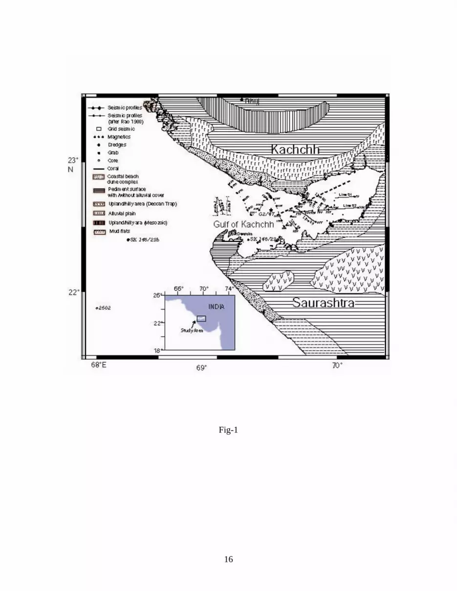
Figure 1. Track chart shows survey lines and numbers indicate shot points.
Figure 2. Bathymetry map showing 20 and 50 m depth contours and magnitudes (in knots) and direction of currents in the Gulf of Kachchh area. Box shows the area of present study.
Figure 3. Bathymetry map of the study area is prepared from the present investigations. Depths in meters.
Figure 4. Interpreted line drawings of the seismic records.
Figure 5. (a) Seismic images of acoustically transparent sediments, parallel reflectors of upper seismic unit, diffuse/seismic reflection free unit at 4 to 6 m depth (SP 543-545 along Line 02). (b) Seismic reflection record between (SP 587-591 along Line 02) shows stratified parallel reflectors and hummocky reflectors and the in-between acoustically transparent diffuse/seismic reflection free unit in the west of the gulf (top). (c) Seismic record showing stratified parallel reflectors, diffuse/seismic reflection free unit, and hummocky reflection unit in the southwest of the gulf (SP 652-659 along Line 02) (bottom). (d) Seismic record showing high amplitude near parallel upper unit reflectors and onlaps of sediment reflectors in the north of the gulf (near SP 463-469 along Line 02) (top). (e) On lap of reflectors between stratified parallel reflectors and uneven surface at 12–15 m subsurface depth in the north of the gulf (SP 122-130 along Line 01) (bottom). (f) Seismic record showing deep valleys or incisions on the seafloor in the north of the gulf (SP 862-872 along Line 04) (top). (g) Seismic records show buried valleys or cuts
underneath sediments and underlain by uneven reflectors in the north of the gulf (SP 850-859 along Line 04) (bottom). (h) Seismic images of the middepth mound-like structures amidst parallel reflectors in the middle of the gulf (SP 506-509 along line 02). (i) A mound-like structure on the seafloor pinches out on either side against stratified parallel reflectors beneath (SP 628-631 along Line 02) in the southwest of the gulf.
Figure 6. Map shows the distribution of buried and surface corals/coral mounds. K, M, and S represent deep, middle depth, and seafloor corals, respectively.
Figure 7. Sealevel curves of Shackelton et al (2000) and Siddall et al. (2003) are shown with continuous and dotted lines, respectively. The stratified parallel reflectors of upper seismic unit, diffuse/seismic reflection free unit, and hummocky reflection unit at deeper depths are correlated to the sea level curve for the 100 ky.
Figure 8. Coral growth in the Gulf of Kachchh during Pleistocene and Holocene (~100 ky to present). (a) Present corals at the seafloor and subsurface reflectors. (b) Relict buried corals grown from 23 ky to 12 ky. (c) Relict buried corals grown before 23 ky.
16
Fig-1

17
Fig-2

18
Fig-3

19
Fig-4

20
Fig-5a

21
Fig-5b,5c
22
Fig-5d,5e

23
Fig-5f, 5g

24
Fig-5h
25
Fig-5i
26
Fig-6

27
Fig-7

28
Fig-8
29
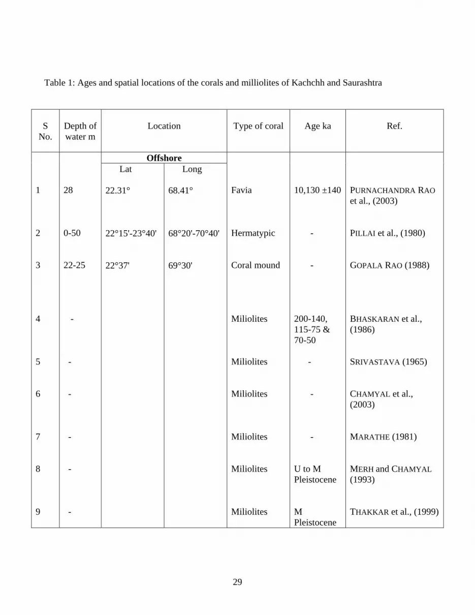
Table 1: Ages and spatial locations of the corals and milliolites of Kachchh and Saurashtra
S No.
Depth of water m
Location
Type of coral
Age ka
Ref.
1 2 3 4 5 6 7 8 9
28 0-50 22-25 - - - - - -
Offshore Favia Hermatypic Coral mound Miliolites Miliolites Miliolites Miliolites Miliolites Miliolites
10,130 ±140 - - 200-140, 115-75 & 70-50 - - - U to M Pleistocene M Pleistocene
PURNACHANDRA RAO et al., (2003) PILLAI et al., (1980) GOPALA RAO (1988) BHASKARAN et al., (1986) SRIVASTAVA (1965) CHAMYAL et al., (2003) MARATHE (1981) MERH and CHAMYAL (1993) THAKKAR et al., (1999)
Lat 22.31° 22°15'-23°40' 22°37'
Long 68.41° 68°20'-70°40' 69°30'


