Embed Size (px)
Citation preview

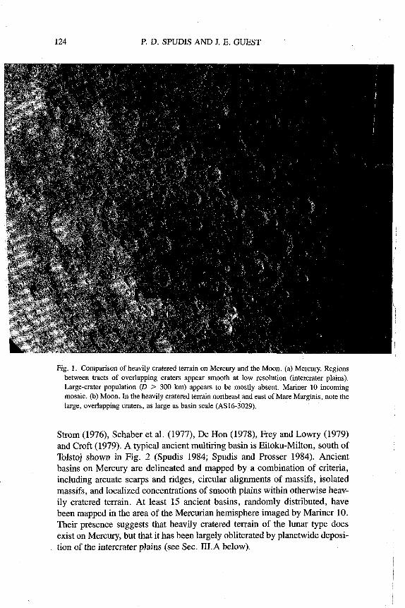
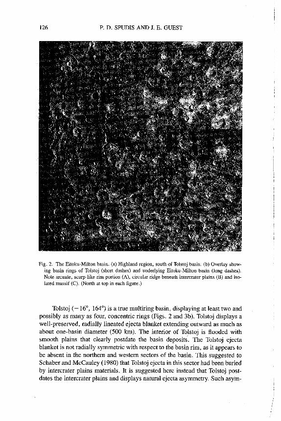
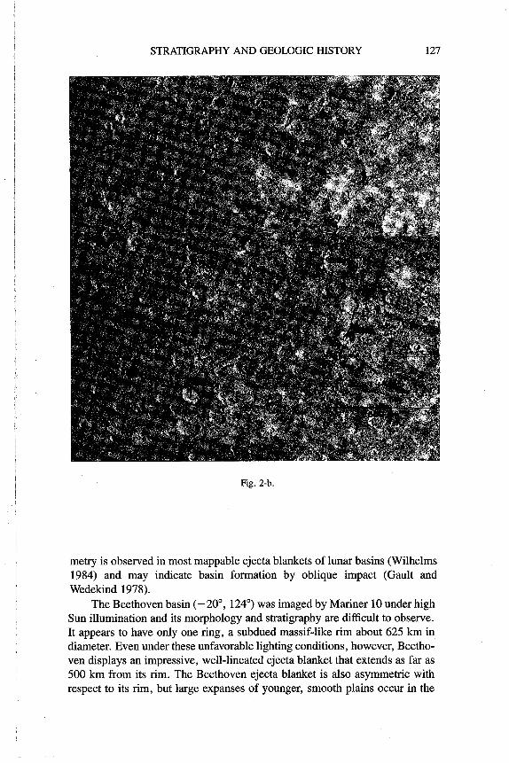
STRATIGRAPHY AND GEOLOGIC HISTORY OF MERCURY
PAUL D. SPUDIS U.S. Geological Survey
and
JOHN E. GUEST University of London Observatory
The history of Mercury can be reconstructed through photogeological analysis of global geologic relations of rock-stratigraphic units. Mercurian stratigraphy is subdivided into five time-stratigraphic systems based on mappable basin and crater deposits. These systems are the pre-Tolstojan (oldest), Tolstojan, Cal- orian, Mansurian, and Kuiperian (youngest). The pre-Tolstojan system includes crater and multiring basin deposits and extensive intercrater plains materials that were emplaced before the Tolstoj basin impact; at least some of these plains may be of volcanic origin. The Tolstojan system, defined at its base by Tolstoj basin deposits, includes deposits of that basin and other basin, crater and plains materials. The Calorian system comprises Caloris basin materials, which constitute an extensive stratigraphic datum, and subsequent widespread smooth plains materials. The global extent, depositional settings and age rela- tions of Mercurian smooth plains indicate that they are predominantly of vol- canic origin. Widespread thrust faults, indicating a period of global compres- sion, finished their development in mid-Calorian time. Smaller-scale regional compression is evidenced by numerous wrinkle ridges within the smooth plains materials. If Mercury's impact-jlm history is similar to the Moon's, most of these major geologic events were probably completed within the first I to 1.5 Gyr of Mercurian history. The Mansurian and Kuiperian systems, defined by the

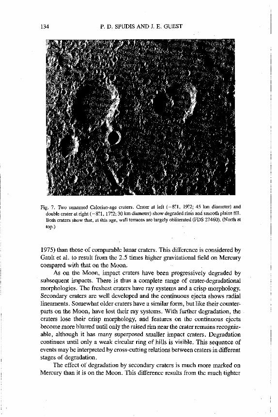
STRATIGRAPHY AND GEOLOGIC HISTORY 119
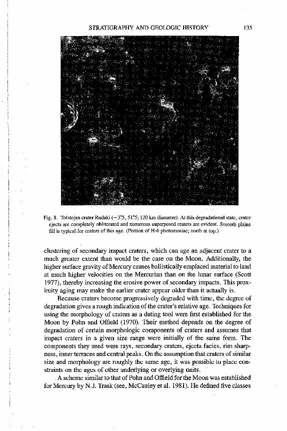
craters Mansur and Kuiper, include only impact crater deposits; no evidence for regional volcanic or tectonic activity of this age has been recognized. Thus, Mercury appears to have completed most of its geologic evolution early in its history. This primitiveness makes Mercury an important object for the study of the comparative geologic evolution of the terrestrial planets.
I. GEOLOGIC MAPPING OF MERCURY
The geologic map is an important weapon in the armory of a geologist tackling the problems of understanding the stratigraphy and surface history of a planet. The work of W. Smith and others in the early 19th Century first demonstrated the value of geologic mapping in the interpretation of a plane- tary surface. They recognized that the different types of rocks could be orga- nized into identifiable 3-dimensional units, or strata, and that the distribution and geometrical form of these could be expressed in map form by drawing together a large number of individual observations into an understandable synopsis. Relative ages of a succession of rocks-their order of emplace- ment-could be determined from the geometrical relations between defined strata. They also recognized that strata of different ages contained assem- blages of distinctive fossils that allow worldwide time correlations between different rock units. The science of stratigraphy was thus developed in which rock units could be studied and placed in time sequence to enable geologists to interpret the geologic history and evolution of the Earth's surface.
Studies of the stratigraphy and the geologic histories of planetary bodies other than the Earth have, perforce, relied to a large extent on photogeological techniques. The Moon was the first body to receive such attention. In a paper that was to be a landmark in the history of lunar studies, Shoemaker and Hackman (1962) showed that the Moon could be mapped geologically by using telescopic observations with resolutions no better than 0.5 km and that the stratigraphy and thus surface history could be determined. Since that time, the geologic history of the Moon has been studied in considerable detail and geologic mapping has been aided and tested by the study of rocks from Apollo and Soviet landings on the near side of the Moon. Analyses of lunar samples largely confirmed the stratigraphic sequence established photogeologically. The techniques of lunar geologic mapping developed since the early 1960s and their stratigraphic implications have been discussed extensively by Mutch (1970), Wilhelms (1970,1984,1987~) and Wilhelms and McCauley (197 1). The extension of these techniques for use on other planetary bodies with dif- ferent surfaces and conditions has been reviewed by Wilhelms (1972,1987b).
The Moon is a relatively easy body to map geologically as it has no atmosphere and thus was molded by fewer and less complex processes than those which operate on planets like the Earth. Individual lunar rock bodies of different origins and ages can be identified by photogeological techniques with relative confidence because each unit has a distinctive morphology.
P. D. SPUDIS AND J. E. GUEST
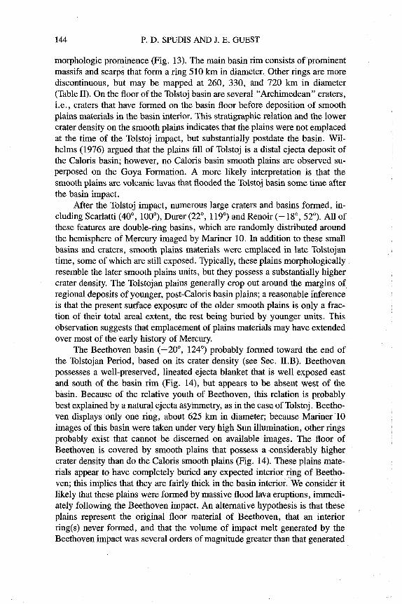
Without the aid of fossils, relative ages of units must be determined by super-
I position and cross-cutting relations between the units. On a planet such as
I Mars, which has a much more complex history involving many different pro- cesses, geologic mapping sensu strict0 is more difficult. Here, mapped units of distinctive morphology may in some cases represent su$aces of different I origins and ages, rather than the rock units into which the landforms are cut
I (Milton 1974). On other planetary bodies such as Ganymede, the geologic map may be more akin to a tectonic map until further data on the nature of the
I crustal materials become available.
I Before the three Mariner 10 flybys in 1974 and 1975, very little was known of the geology of Mercury. This innermost planet lies within 28 an- gular degrees of the Sun and thus is difficult to study with Earth-based tele- scopes, which can obtain resolutions of no better than 300 km. Astronomical observations show faint albedo markings (see, e.g., Murray et al. 1972). Po- larimetric and photometric observations (Lyot 1929; Hameen-Anttila et al. 1970; McCord and Adarns 1972a; Dollfus and Auriere 1974) indicated that the surface texture of Mercury is similar to that of the Moon; this similarity implies that the surface has been broken by impact cratering.
I The Mariner 10 images provided the first data that could be used in a I truly geological investigation of the surface (Murray et al. 1974). The first
flyby was an equatorial pass at about 700 km distance at closest approach on I the dark side of the planet. The second was a south polar pass at about 50,000 I I
km. The third and final flyby was over the northern hemisphere at just under I 400 km. The most valuable material was supplied by the first two flybys
which produced over 2000 useful pictures, the best resolution being near 100 m for a few photographs taken at closest approach. Less than 50% of the surface of the planet was observed by Mariner 10, and the best resolution of the pictures that cover most of this area was at 1 to 1.5 km. Mariner 10 provided images of Mercury that are comparable to Earth-based photographs of the Moon. Because this was a flyby mission, the pictures suffer from the same problems as those taken of the Moon with a telescope on Earth. The images become progressively foreshortened toward the limbs, thus making interpretation less reliable as foreshortening becomes more severe. In addi- tion, for each of the flybys, the lighting geometry was virtually the same. This means that close to the terminator small-scale topography is enhanced and the effects of albedo are relatively weak, whereas the reverse is the case towards the limbs. Nevertheless, Mariner 10 provided excellent imagery for pho- togeological studies, although the variable lighting geometry from one area to another somewhat reduces the consistency of global mapping. A bonus was that the second flyby coverage overlapped in places with that from the first flyby, providing stereoscopic pairs that can be used for'qualitative examina- tion of surface morphology. The recovery of images taken during the third flyby, which were intended to cover specific areas at very high resolution, was hampered by technical problems on Earth. Because of the consequently lim-

STRATIGRAPHY AND GEOLOGIC HISTORY 121
ited coverage, these images are less valuable to geologic studies than had been hoped.
As expected, the virtual lack of an atmosphere and the similarity in many respects of Mercurian to lunar processes made Mercury ideal for pho- togeologic mapping of the type already carried out for the lunar surface. Al- though the image resolution is less than that obtained by many of the Lunar Orbiter and Apollo missions, the success of lunar geologic mapping based on telescopic observations promised similar success in applying the same tech- niques to Mariner 10 images of Mercury.
The first geologic map of Mercury based on Mariner 10 images was prepared by Trask and Guest (1975), who used mainly first-encounter pic- tures. This map was termed a geologiclterrain map because the mapping scale, image resolution, and variable lighting conditions commonly made it necessary to combine several rock units of different lithologies and ages as "terrain units" on the basis of distinctive landforms. Despite these handicaps, this mapping provided a basis for discussing the broad geologic history of the planet and for subsequent mapping. Geologic mapping of the southern hemi- sphere based on the second-encounter pictures was later carried out by Guest and O'Donnell(1977) and O'Donnell(1980).
The next stage in the geologic mapping of Mercury was the preparation of 1:5,000,000 scale quadrangle sheets published by the U.S. Geological Sur- vey (Holt 1978). So far, seven such sheets have been produced showing the geology in more detail than had been possible at the scale used by Trask and Guest (1975). This more detailed mapping has been reassessed with new global mapping by Spudis (in preparation). It is the new synoptic map that is the basis for part of this chapter.
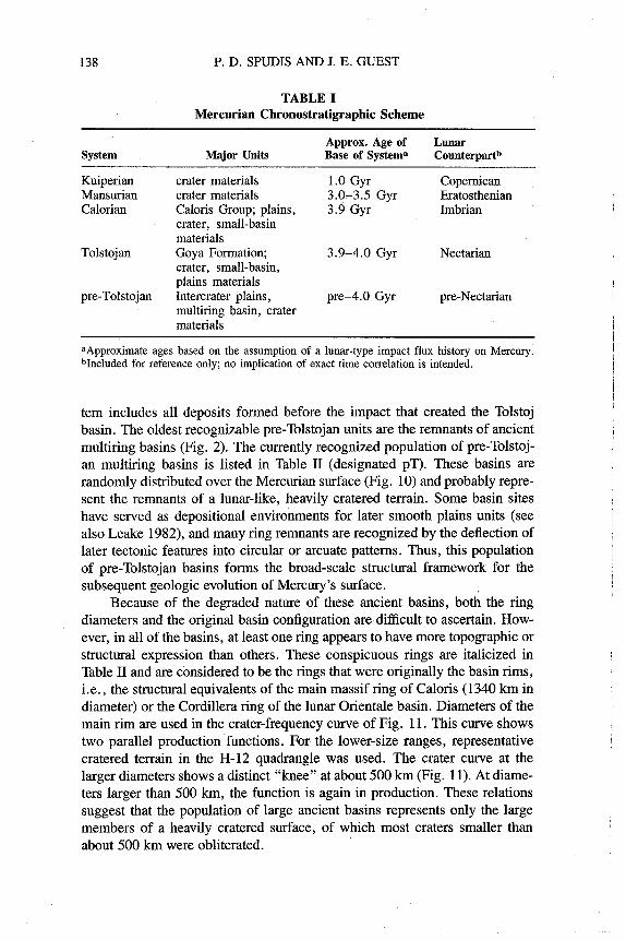
The production of a new global map was facilitated by the development of a Mercurian time-stratigraphic system (Spudis 1985) that is based on the rock-stratigraphic classification developed during quadrangle mapping and the definition and subdivision of the Caloris Group by McCauley et al. (1981). The formal time-stratigraphic scheme was defined on the basis of recogni- zable crater and basin deposits, as will be described in detail below. This new system has enabled a planetwide correlation of geologic events on Mercury, and it also readily facilitates interplanetary correlations with similar systems developed for the Moon (see, e.g., Wilhelms 1984) and Mars (Scott and Carr 1978).
11. GEOLOGIC TERRAINS
Mercury's surface may be divided into several morphologic and physio- graphic categories, including basins, craters, plains and tectonic features. The geomorphology of Mercury has been reviewed by Gault et al. (1977) and in detail by Strom (1979,1984). In the following section, we review briefly the surface features of Mercury, with the specific aim of categorizing them into

122 P. D. SPUDIS AND J. E. GUEST
geologic provinces (McCauley and Wilhelms 1971) that will form the basis for the planetwide stratigraphy to be described below.
A. Cratered Terrain and Intercrater Plains
During the initial Mariner 10 encounters, it was recognized that Mercury is a heavily cratered body (Murray et al. 1974; Gault et al. 1975); thus com- parisons naturally centered on lunar similarities. In the post-Apollo period, an outline of lunar history was perceived to be well understood (Wilhelms 1984), and many studies of Mercurian craters made detailed comparisons to the pop- ulations and densities observed in the heavily cratered lunar highlands (see, e.g., Murray et al. 1974; Gault et al. 1975; Strom 1977).
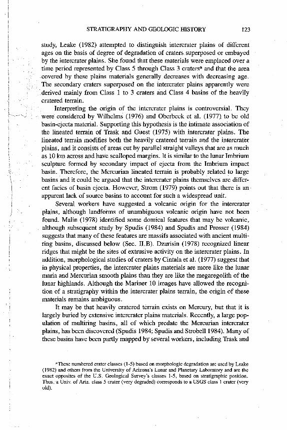
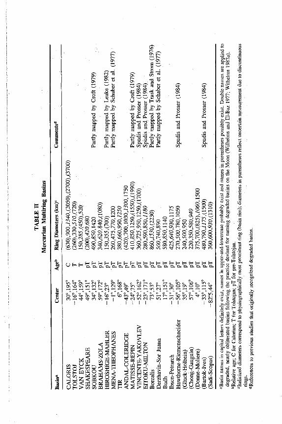
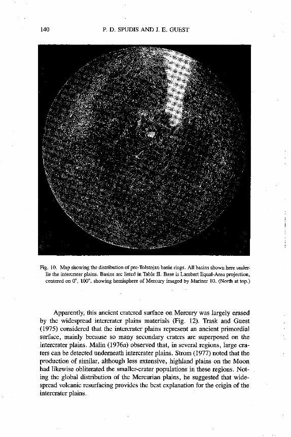
It was soon apparent that although Mercury displays regions of high crater density, its most densely cratered surfaces are not as heavily cratered as the lunar highlands (Fig. 1). This difference is due primarily to large ex- posures of intercrater plains, which also are present in the lunar highlands, but in restricted quantities (Strom 1977). At no place on Mercury do we find heavily cratered regions of overlapping large craters and basins like those that characterize the lunar highlands. The first-order implications of this observa- tion are that Mercury has undergone some type of early resurfacing and that this resurfacing was more intense than comparable activity on the Moon.
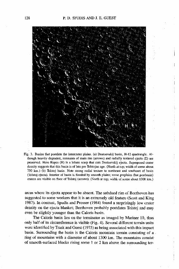
The intercrater plains were first recognized, described, and mapped as a terrain unit by Trask and Guest (1975). The intercrater plains were defined as the level to gently rolling terrain between and around the cratered terrain. Superposed on the plains are numerous craters < 10 km in diameter. Many of these small craters are elongate and shallow or are open on one side; crater clusters as well as crater chains are common, and thus their morphology and distribution is similar to that of secondary impact craters. Trask and Guest (1975) believed that the only likely sources for these craters were the large craters and basins of the heavily cratered terrain. However, they realized that the crater rims of the heavily cratered terrain are narrow and that there is little evidence of surrounding continuous ejecta; but since Mercurian crater ejecta sheets are emplaced close to the crater (Gault et al. 1975), they argued that the crater ejecta would become more readily degraded than the more extensive lunar ejecta sheets. On the basis of these observations, Trask and Guest (1975) postulated that the majority of the intercrater plains predate the heavily cratered terrain. Murray et al. (1975) went further by suggesting that a global volcanic event that supposedly formed the intercrater plains wiped out most of the early craters.
Further study and the availability of the second-encounter images of the southern hemisphere showed that the intercrater plains have a more complex stratigraphy in relation to the heavily cratered terrain. Malin (1976a), Guest and O'Donnell (1977) and Strom (1977) found a number of old craters that had been embayed or covered by intercrater plains materials. Thus, some of the highland craters must predate parts of the intercrater plains. In a detailed