Embed Size (px)
Citation preview
Intracanyon basalt lavas of the Debed River (northern Armenia), part of aPliocene–Pleistocene continental flood basalt province in theSouth Caucasus
Hetu Sheth a,⁎, Khachatur Meliksetian b, Hripsime Gevorgyan b, Arsen Israyelyan b, Gevorg Navasardyan b
a Department of Earth Sciences, Indian Institute of Technology Bombay, Powai, Mumbai 400076, Indiab Institute of Geological Sciences, Armenian National Academy of Sciences, 24a Marshal Baghramian Avenue, 0019 Yerevan, Armenia
a b s t r a c ta r t i c l e i n f o
Article history:
Received 19 November 2014
Accepted 21 February 2015
Available online 5 March 2015
Keywords:
Volcanism
Continental flood basalts
Debed River
Armenia
South Caucasus
Late Pliocene to Early Pleistocene (~3.25–2.05 Ma), 200–400 m thick basalt lavas outcrop in the South Caucasus
region, including the Kars–Erzurum Plateau (northeastern Turkey), the Javakheti Plateau (Georgia–Armenia),
and the Lori Plateau (northern Armenia). These fissure-fed, rapidly erupted fluid lavas filled pre-existing river
valleys over many tens of kilometres. The basalts exposed in the Debed River canyon, northern Armenia, are
~200 m thick and of three morphological types: (1) basal pillow basalts and hyaloclastites, overlain by
(2) columnar-jointed pahoehoe sheet flows, in turn overlain by (3) slabby pahoehoe and rubbly pahoehoe
flows. The lower andmiddle lavas show evidence for damming of river drainage, likemany lavas of the Columbia
River flood basalt province, Scotland, Ireland, and Iceland. There is also evidence for syn-volcanic faulting of the
early lavas. Related basalts also outcrop in the Gegham Uplands and the Hrazdan River basin in Armenia. This
3.25–2.05 Ma South Caucasus basalt province, covering parts of Turkey, Georgia and Armenia, has an estimated
areal extent of ~15,000 km2 and volume of ~2250 km3. Because its main geological features are remarkably like
those of many continental flood basalt (CFB) provinces, we consider it a true, albeit small, CFB province. It is the
smallest and youngest CFB in theworld. An analogue closely similar inmajor features is the LateMioceneAltos de
Jalisco CFB province in thewestern Trans-Mexican Volcanic Belt. Both provinces formed during lithospheric pull-
apart and transtensional faulting. Their broader significance is in showing flood basalt size distribution to be a
continuum without natural breaks, with implications for geodynamic models.
© 2015 Elsevier B.V. All rights reserved.
1. Introduction
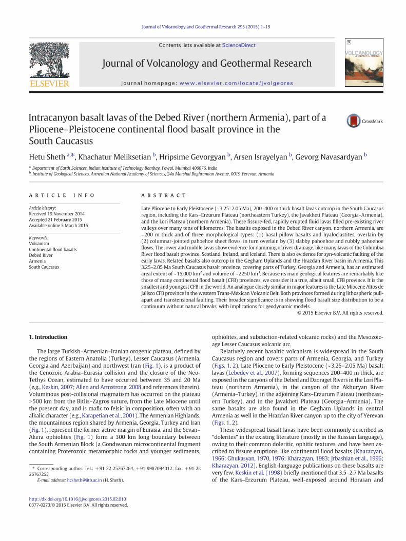
The large Turkish–Armenian–Iranian orogenic plateau, defined bythe regions of Eastern Anatolia (Turkey), Lesser Caucasus (Armenia,Georgia and Azerbaijan) and northwest Iran (Fig. 1), is a product ofthe Cenozoic Arabia–Eurasia collision and the closure of the Neo-Tethys Ocean, estimated to have occurred between 35 and 20 Ma(e.g., Keskin, 2007; Allen and Armstrong, 2008 and references therein).Voluminous post-collisional magmatism has occurred on the plateauN500 km from the Bitlis–Zagros suture, from the Late Miocene untilthe present day, and is mafic to felsic in composition, often with analkalic character (e.g., Karapetian et al., 2001). The ArmenianHighlands,the mountainous region shared by Armenia, Georgia, Turkey and Iran(Fig. 1), represent the former active margin of Eurasia, and the Sevan–Akera ophiolites (Fig. 1) form a 300 km long boundary betweenthe South Armenian Block (a Gondwanan microcontinental fragmentcontaining Proterozoic metamorphic rocks and younger sediments,
ophiolites, and subduction-related volcanic rocks) and the Mesozoic-age Lesser Caucasus volcanic arc.
Relatively recent basaltic volcanism is widespread in the SouthCaucasus region and covers parts of Armenia, Georgia, and Turkey(Figs. 1, 2). Late Pliocene to Early Pleistocene (~3.25–2.05 Ma) basaltlavas (Lebedev et al., 2007), forming sequences 200–400 m thick, areexposed in the canyons of the Debed andDzoraget Rivers in the Lori Pla-teau (northern Armenia), in the canyon of the Akhuryan River(Armenia–Turkey), in the adjoining Kars–Erzurum Plateau (northeast-ern Turkey), and in the Javakheti Plateau (Georgia–Armenia). Thesame basalts are also found in the Gegham Uplands in centralArmenia as well in the Hrazdan River canyon up to the city of Yerevan(Figs. 1, 2).
These widespread basalt lavas have been commonly described as“dolerites” in the existing literature (mostly in the Russian language),owing to their common doleritic, ophitic textures, and have been as-cribed to fissure eruptions, like continental flood basalts (Kharazyan,1966; Ghukasyan, 1970, 1976; Kharazyan, 1983; Jrbashian et al., 1996;Kharazyan, 2012). English-language publications on these basalts arevery few. Keskin et al. (1998) briefly mentioned that 3.5–2.7 Ma basaltsof the Kars–Erzurum Plateau, well-exposed around Horasan and
Journal of Volcanology and Geothermal Research 295 (2015) 1–15
⁎ Corresponding author. Tel.: +91 22 25767264, +91 9987094012; fax: +91 22
25767253.
E-mail address: [email protected] (H. Sheth).
http://dx.doi.org/10.1016/j.jvolgeores.2015.02.010
0377-0273/© 2015 Elsevier B.V. All rights reserved.
Contents lists available at ScienceDirect
Journal of Volcanology and Geothermal Research
j ourna l homepage: www.e lsev ie r .com/ locate / jvo lgeores
Kagizman (Fig. 1), constitute the latest stages of the 11–2.7Ma collision-related volcanism in this region. Lebedev et al. (2007, 2008a,b) haveprovided geochemical data andK–Ar ages on the basalts of the JavakhetiPlateau and discussed their regional stratigraphic correlations. Theystate that these lavas flowed along pre-existing river valleys for manytens of kilometres. Geochemical data on their counterparts in northernand northwestern Armenia have been provided by Neill et al. (2013)and Meliksetian et al. (2014). However, there are no recent studies de-scribing the physical volcanology of thesewidespread basalt lavas. Herewe describe and discuss the geological and volcanological features andthe eruption environments of basalts exposed in the Debed River can-yon in northern Armenia (Fig. 2). We then discuss why the 3.25–2.05 Ma basalt province covering parts of Turkey, Georgia andArmenia (Fig. 2) should be considered a continental flood basalt (CFB)province, and what such a recognition implies for CFB size distribution,our conceptual understanding of CFB volcanism, as well as geodynamicmodels.
2. Petrography, geochemistry, and petrogenesis
Kharazyan (1966), who described pillow basalts and hyaloclastitesof the Debed River canyon near Tumanyan (Fig. 1), provided threemajor oxide analyses, and Neill et al. (2013) analysed seven samplesof these basalts collected from the area between Tashir, Amasia andArpi Lake (Fig. 1) for major and trace elements and Sr–Nd isotopic ra-tios. Neill et al. (2013) describe the rocks as sub-ophitic dolerites withrare phenocrysts of plagioclase or clinopyroxene, the latter commonlyrimmed or replaced by amphibole. Ten analysed samples are low-
MgO (4.7–6.9 wt.%) basalts with little isotopic evidence for crustal con-tamination. The SINCLAS norm calculation program of Verma et al.(2002) shows that, of the ten samples, four are basaltic trachyandesites(mugearite), three are trachybasalts (hawaiites), and one is a subalkalicbasalt, whereas two are classified as alkali basalts (the pillow basalt andhyaloclastite of Kharazyan, 1966). The seven samples of Neill et al.(2013) have normative hypersthene (1.6–12.3 wt.%). Meliksetian et al.(2014) state that these “plateau basalts” are mostly medium-K basalts,trachybasalts and basaltic trachyandesites, with a narrow silica range(SiO2 = 48–53 wt.%) and low MgO (b7 wt.%). Their trace element andSr–Nd isotopic data suggest ≤10% melting of a mantle source whichwas moderately enriched by Mesozoic Tethyan subduction input. TheSr–Nd isotopic ratios (87/86Sr = 0.7041–0.7045, 143/144Nd = 0.5128–0.5129 and εNd = +3 to +5) are homogeneous and among the most“depleted” (mantle-like) in magmatic rocks of the Turkish–Armenian–Iranian Plateau, indicating negligible crustal contamination. Neill et al.(2013) propose that the trigger for this plateau basalt magmatismsome 25 million years after the initial Arabia–Eurasia collision may besmall-scale lithospheric mantle delamination and lower lithosphericheating, during asthenospheric upwelling following the break-off ofthe Tethyan slab.
3. Morphological features of the Debed River flood basalts: field
observations and interpretations
The Debed River flood basalts are ~200 metres thick and form flat-topped plateaus with the stepped, “trap” landscape (Fig. 3a, b), typicalof continental flood basalt (CFB) provinces like the Deccan or the
50 km
GEORGIA
ARMENIA
TURKEY
NAKH
CHIVAN
(AZERBAIJAN
)IRAN
Yerevan
Tbilisi
Erzurum
Kars
KagizmanHorasan
Ararat
(5165 m)
Aragats
(4090 m)
Tashir
Vanadzor
L E S S E R C A U C A S U S
G R E A T
C A U C A S U S
Lake Sevan
40o40o
42o44o
46o
41o
Tendurek
(3584 m)
Kars-Erzurum PlateauAZERBAIJAN
41o
Eastern Anatolia
Arpi
Lake
BLACK
SEA
Pambak-Sevan-
Syunik Fault
Tumanyan
Haghpat
Alaverdi
44o
39o
StepanavanOdzun
Javakheti
Plateau
Lori Plateau
Amasia
Gegham
Uplands
ARM
ENIA
AZERBAIJAN
TURKEY
IRAN
GEORGIA
RUSSIA
Black SeaCaspian
Sea
Great Caucasus Mountains
Pontid
e-Sev
an-A
kera
sut
ure
area
enlarged
above
43o45o
45o
Fig. 1.Map of Armenia and surrounding countries, showing some major topographic and geological features, as well as localities mentioned in the text (filled circles). Some of the major
Miocene–Quaternary stratovolcanoes in the region are shown (filled triangles). The box over the northern part of Armenia shows the area of the present study. Based partly on Neill et al.
(2013).
2 H. Sheth et al. / Journal of Volcanology and Geothermal Research 295 (2015) 1–15
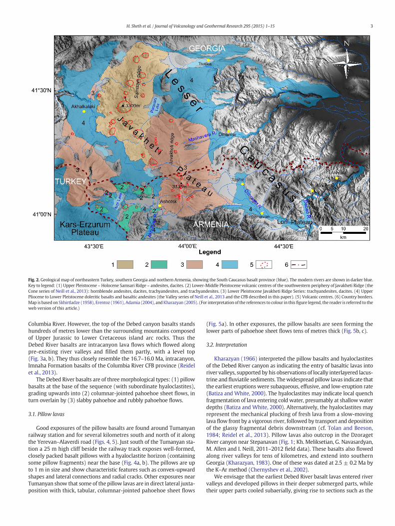
Columbia River. However, the top of the Debed canyon basalts standshundreds of metres lower than the surrounding mountains composedof Upper Jurassic to Lower Cretaceous island arc rocks. Thus theDebed River basalts are intracanyon lava flows which flowed alongpre-existing river valleys and filled them partly, with a level top(Fig. 3a, b). They thus closely resemble the 16.7–16.0 Ma, intracanyon,Imnaha Formation basalts of the Columbia River CFB province (Reidelet al., 2013).
The Debed River basalts are of threemorphological types: (1) pillowbasalts at the base of the sequence (with subordinate hyaloclastites),grading upwards into (2) columnar-jointed pahoehoe sheet flows, inturn overlain by (3) slabby pahoehoe and rubbly pahoehoe flows.
3.1. Pillow lavas
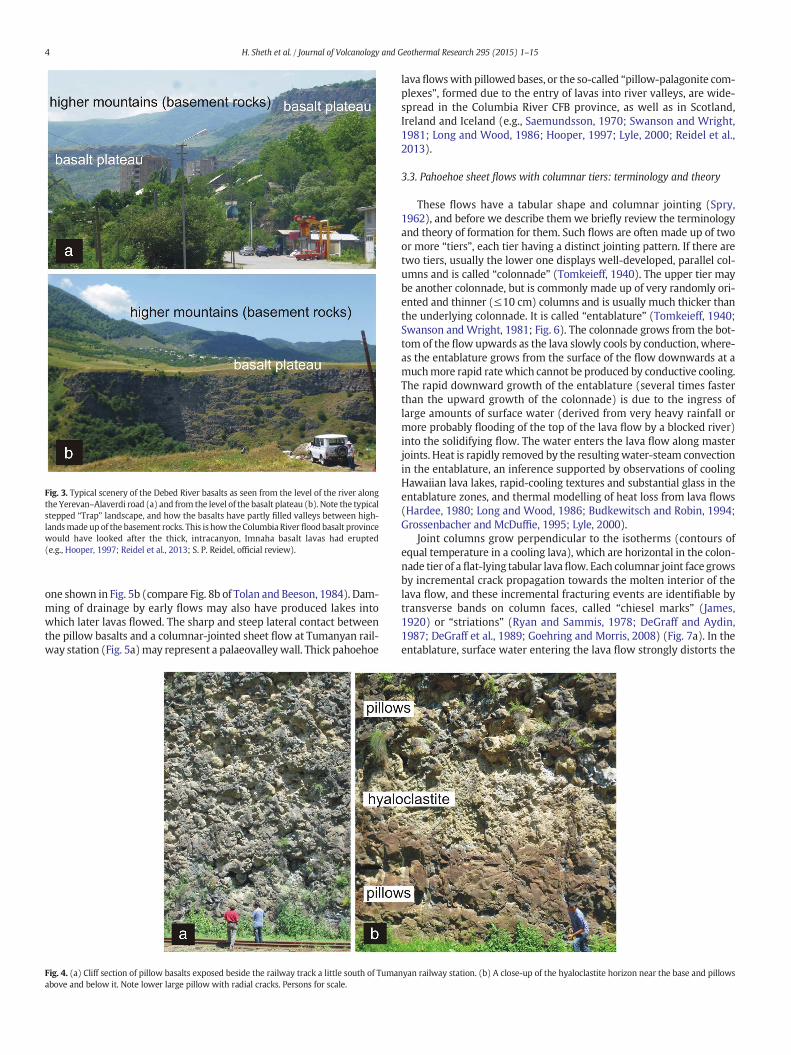
Good exposures of the pillow basalts are found around Tumanyanrailway station and for several kilometres south and north of it alongthe Yerevan–Alaverdi road (Figs. 4, 5). Just south of the Tumanyan sta-tion a 25 m high cliff beside the railway track exposes well-formed,closely packed basalt pillows with a hyaloclastite horizon (containingsome pillow fragments) near the base (Fig. 4a, b). The pillows are upto 1 m in size and show characteristic features such as convex-upwardshapes and lateral connections and radial cracks. Other exposures nearTumanyan show that some of the pillow lavas are in direct lateral juxta-position with thick, tabular, columnar-jointed pahoehoe sheet flows
(Fig. 5a). In other exposures, the pillow basalts are seen forming thelower parts of pahoehoe sheet flows tens of metres thick (Fig. 5b, c).
3.2. Interpretation
Kharazyan (1966) interpreted the pillow basalts and hyaloclastitesof the Debed River canyon as indicating the entry of basaltic lavas intoriver valleys, supported by his observations of locally interlayered lacus-trine and fluviatile sediments. Thewidespread pillow lavas indicate thatthe earliest eruptions were subaqueous, effusive, and low-eruption rate(Batiza and White, 2000). The hyaloclastites may indicate local quenchfragmentation of lava entering cold water, presumably at shallowwaterdepths (Batiza and White, 2000). Alternatively, the hyaloclastites mayrepresent the mechanical plucking of fresh lava from a slow-movinglava flow front by a vigorous river, followed by transport and depositionof the glassy fragmental debris downstream (cf. Tolan and Beeson,1984; Reidel et al., 2013). Pillow lavas also outcrop in the DzoragetRiver canyon near Stepanavan (Fig. 1; Kh. Meliksetian, G. Navasardyan,M. Allen and I. Neill, 2011–2012 field data). These basalts also flowedalong river valleys for tens of kilometres, and extend into southernGeorgia (Kharazyan, 1983). One of these was dated at 2.5 ± 0.2 Ma bythe K–Ar method (Chernyshev et al., 2002).
We envisage that the earliest Debed River basalt lavas entered rivervalleys and developed pillows in their deeper submerged parts, whiletheir upper parts cooled subaerially, giving rise to sections such as the
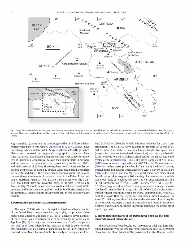
Fig. 2. Geological map of northeastern Turkey, southern Georgia and northern Armenia, showing the South Caucasus basalt province (blue). The modern rivers are shown in darker blue.
Key to legend: (1) Upper Pleistocene – Holocene Samsari Ridge – andesites, dacites. (2) Lower-Middle Pleistocene volcanic centres of the southwestern periphery of Javakheti Ridge (the
Cone series of Neill et al., 2013): hornblende andesites, dacites, trachyandesites, and trachyandesites. (3) Lower Pleistocene Javakheti Ridge Series: trachyandesites, dacites. (4) Upper
Pliocene to Lower Pleistocene doleritic basalts and basaltic andesites (the Valley series of Neill et al., 2013 and the CFB described in this paper). (5) Volcanic centres. (6) Country borders.
Map is based on Skhirtladze (1958), Erentoz (1961), Adamia (2004), and Kharazyan (2005). (For interpretation of the references to colour in this figure legend, the reader is referred to the
web version of this article.)
3H. Sheth et al. / Journal of Volcanology and Geothermal Research 295 (2015) 1–15
one shown in Fig. 5b (compare Fig. 8b of Tolan and Beeson, 1984). Dam-ming of drainage by early flows may also have produced lakes intowhich later lavas flowed. The sharp and steep lateral contact betweenthe pillow basalts and a columnar-jointed sheet flow at Tumanyan rail-way station (Fig. 5a)may represent a palaeovalleywall. Thick pahoehoe
lava flowswith pillowed bases, or the so-called “pillow-palagonite com-plexes”, formed due to the entry of lavas into river valleys, are wide-spread in the Columbia River CFB province, as well as in Scotland,Ireland and Iceland (e.g., Saemundsson, 1970; Swanson and Wright,1981; Long and Wood, 1986; Hooper, 1997; Lyle, 2000; Reidel et al.,2013).
3.3. Pahoehoe sheet flows with columnar tiers: terminology and theory
These flows have a tabular shape and columnar jointing (Spry,1962), and before we describe them we briefly review the terminologyand theory of formation for them. Such flows are often made up of twoor more “tiers”, each tier having a distinct jointing pattern. If there aretwo tiers, usually the lower one displays well-developed, parallel col-umns and is called “colonnade” (Tomkeieff, 1940). The upper tier maybe another colonnade, but is commonly made up of very randomly ori-ented and thinner (≤10 cm) columns and is usually much thicker thanthe underlying colonnade. It is called “entablature” (Tomkeieff, 1940;Swanson andWright, 1981; Fig. 6). The colonnade grows from the bot-tom of the flow upwards as the lava slowly cools by conduction, where-as the entablature grows from the surface of the flow downwards at amuchmore rapid ratewhich cannot be produced by conductive cooling.The rapid downward growth of the entablature (several times fasterthan the upward growth of the colonnade) is due to the ingress oflarge amounts of surface water (derived from very heavy rainfall ormore probably flooding of the top of the lava flow by a blocked river)into the solidifying flow. The water enters the lava flow along masterjoints. Heat is rapidly removed by the resultingwater-steam convectionin the entablature, an inference supported by observations of coolingHawaiian lava lakes, rapid-cooling textures and substantial glass in theentablature zones, and thermal modelling of heat loss from lava flows(Hardee, 1980; Long and Wood, 1986; Budkewitsch and Robin, 1994;Grossenbacher and McDuffie, 1995; Lyle, 2000).
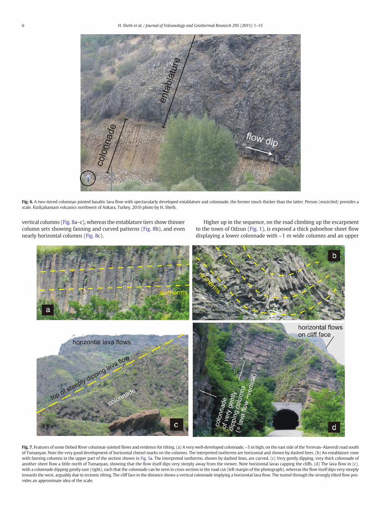
Joint columns grow perpendicular to the isotherms (contours ofequal temperature in a cooling lava), which are horizontal in the colon-nade tier of a flat-lying tabular lavaflow. Each columnar joint face growsby incremental crack propagation towards the molten interior of thelava flow, and these incremental fracturing events are identifiable bytransverse bands on column faces, called “chiesel marks” (James,1920) or “striations” (Ryan and Sammis, 1978; DeGraff and Aydin,1987; DeGraff et al., 1989; Goehring and Morris, 2008) (Fig. 7a). In theentablature, surface water entering the lava flow strongly distorts the
Fig. 3. Typical scenery of the Debed River basalts as seen from the level of the river along
the Yerevan–Alaverdi road (a) and from the level of the basalt plateau (b). Note the typical
stepped “Trap” landscape, and how the basalts have partly filled valleys between high-
landsmade up of the basement rocks. This is how theColumbia River floodbasalt province
would have looked after the thick, intracanyon, Imnaha basalt lavas had erupted
(e.g., Hooper, 1997; Reidel et al., 2013; S. P. Reidel, official review).
Fig. 4. (a) Cliff section of pillow basalts exposed beside the railway track a little south of Tumanyan railway station. (b) A close-up of the hyaloclastite horizon near the base and pillows
above and below it. Note lower large pillow with radial cracks. Persons for scale.
4 H. Sheth et al. / Journal of Volcanology and Geothermal Research 295 (2015) 1–15
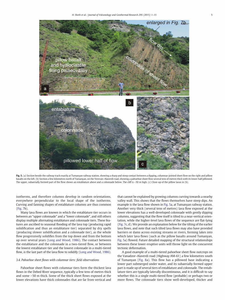
isotherms, and therefore columns develop in random orientations,everywhere perpendicular to the local shape of the isotherms.Curving and fanning shapes of entablature columns are thus common(Fig. 7b).
Many lava flows are known in which the entablature tier occurs inbetween an “upper colonnade” and a “lower colonnade”, and still othersdisplaymultiple alternating entablature and colonnade tiers. These fea-tures are ascribed to seasonal flooding of the lava top (producing rapidsolidification and thus an entablature tier) separated by dry spells(producing slower solidification and a colonnade tier), as the wholeflow progressively solidifies from the top down and from the bottomup over several years (Long and Wood, 1986). The contact betweenthe entablature and the colonnade in a two-tiered flow, or betweenthe lowest entablature tier and the lowest colonnade in a multi-tieredflow, is the last part of the lava flow to solidify (Long andWood, 1986).
3.4. Pahoehoe sheet flows with columnar tiers: field observations
Pahoehoe sheet flows with columnar tiers form the thickest lavaflows in the Debed River sequence, typically a few tens of metres thickand some N50 m thick. Some of the thick sheet flows exposed at thelower elevations have thick colonnades that are far from vertical and
that cannot be explained by growing columns curving towards a nearbyvalley wall. This shows that the flows themselves have steep dips. Anexample is the lava flow shown in Fig. 5a, at Tumanyan railway station.Another very thick (several tens of metres) lava flow exposed at thelower elevations has a well-developed colonnade with gently dippingcolumns, suggesting that the flow itself is tilted to a near-vertical orien-tation, while the higher-level lava flows of the sequence are flat-lying(Fig. 7c, d).Weprovide an explanation below for the tilting of the earlierlava flows, and note that such tilted lava flows may also have providedbarriers or dams across existing streams or rivers, forming lakes intowhich later lava flows (such as the pillow basalts around Tumanyan,Fig. 5a) flowed. Future detailed mapping of the structural relationshipsbetween these lower eruptive units will throw light on the concurrenttectonic deformation.
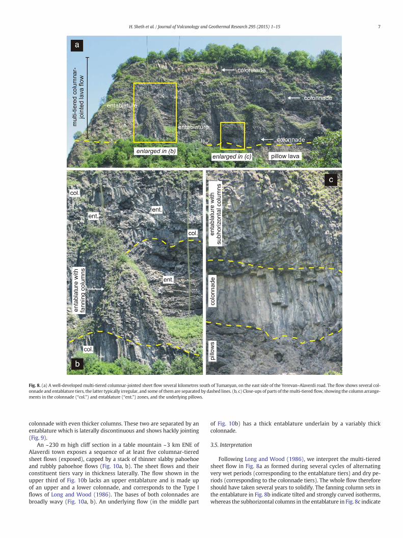
A good example of a multi-tiered pahoehoe sheet flow outcrops onthe Vanadzor–Alaverdi road (Highway AM-61) a few kilometres southof Tumanyan (Fig. 8a). This flow has a pillowed base indicating alower part submerged under water, and its subaerially formed upperpart ismade up of several tiers of entablature and colonnade. The entab-lature tiers are typically laterally discontinuous, and it is difficult to saywhether this is a single multi-tiered flow (probable) or perhaps two ormore flows. The colonnade tiers show well-developed, thicker and
Fig. 5. (a) Section beside the railway track exactly at Tumanyan railway station, showing a sharp and steep contact between a dipping, columnar-jointed sheet flowon the right and pillow
basalts on the left. (b) Section a few kilometres north of Tumanyan, on the Yerevan–Alaverdi road, showing a pahoehoe sheetflow several tens ofmetres thickwith its lower half pillowed.
The upper, subaerially formed part of the flow shows an entablature above and a colonnade below. The cliff is ~50 m high. (c) Close-up of the pillow lavas in (b).
5H. Sheth et al. / Journal of Volcanology and Geothermal Research 295 (2015) 1–15
vertical columns (Fig. 8a–c), whereas the entablature tiers show thinnercolumn sets showing fanning and curved patterns (Fig. 8b), and evennearly horizontal columns (Fig. 8c).
Higher up in the sequence, on the road climbing up the escarpmentto the town of Odzun (Fig. 1), is exposed a thick pahoehoe sheet flowdisplaying a lower colonnade with ~1 m wide columns and an upper
Fig. 6. A two-tiered columnar-jointed basaltic lava flow with spectacularly developed entablature and colonnade, the former much thicker than the latter. Person (encircled) provides a
scale. Kizilçahamam volcanics northwest of Ankara, Turkey. 2010 photo by H. Sheth.
Fig. 7. Features of some Debed River columnar-jointed flows and evidence for tilting. (a) A verywell-developed colonnade, ~5m high, on the east side of the Yerevan–Alaverdi road south
of Tumanyan. Note the very good development of horizontal chiesel marks on the columns. The interpreted isotherms are horizontal and shown by dashed lines. (b) An entablature zone
with fanning columns in the upper part of the section shown in Fig. 5a. The interpreted isotherms, shown by dashed lines, are curved. (c) Very gently dipping, very thick colonnade of
another sheet flow a little north of Tumanyan, showing that the flow itself dips very steeply away from the viewer. Note horizontal lavas capping the cliffs. (d) The lava flow in (c),
with a colonnade dipping gently east (right), such that the colonnade can be seen in cross-section in the road cut (left margin of the photograph), whereas the flow itself dips very steeply
towards the west, arguably due to tectonic tilting. The cliff face in the distance shows a vertical colonnade implying a horizontal lava flow. The tunnel through the strongly tilted flow pro-
vides an approximate idea of the scale.
6 H. Sheth et al. / Journal of Volcanology and Geothermal Research 295 (2015) 1–15
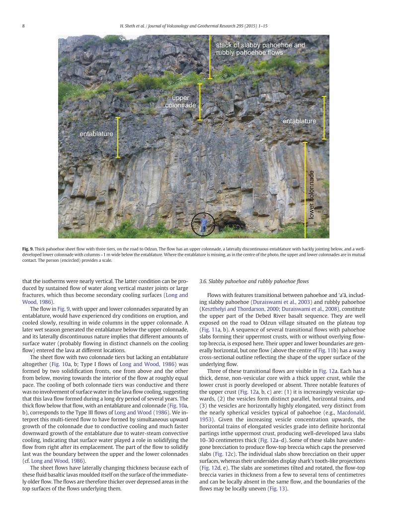
colonnade with even thicker columns. These two are separated by anentablature which is laterally discontinuous and shows hackly jointing(Fig. 9).
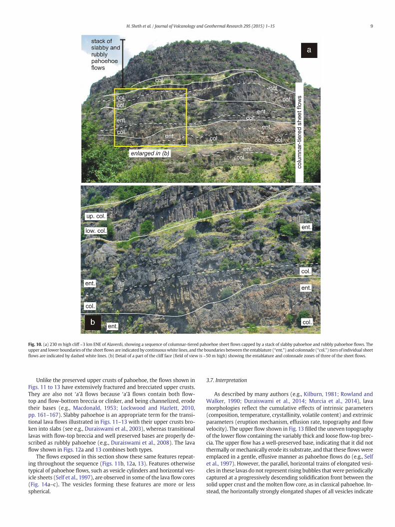
An ~230 m high cliff section in a table mountain ~3 km ENE ofAlaverdi town exposes a sequence of at least five columnar-tieredsheet flows (exposed), capped by a stack of thinner slabby pahoehoeand rubbly pahoehoe flows (Fig. 10a, b). The sheet flows and theirconstituent tiers vary in thickness laterally. The flow shown in theupper third of Fig. 10b lacks an upper entablature and is made upof an upper and a lower colonnade, and corresponds to the Type Iflows of Long and Wood (1986). The bases of both colonnades arebroadly wavy (Fig. 10a, b). An underlying flow (in the middle part
of Fig. 10b) has a thick entablature underlain by a variably thickcolonnade.
3.5. Interpretation
Following Long and Wood (1986), we interpret the multi-tieredsheet flow in Fig. 8a as formed during several cycles of alternatingvery wet periods (corresponding to the entablature tiers) and dry pe-riods (corresponding to the colonnade tiers). The whole flow thereforeshould have taken several years to solidify. The fanning column sets inthe entablature in Fig. 8b indicate tilted and strongly curved isotherms,whereas the subhorizontal columns in the entablature in Fig. 8c indicate
Fig. 8. (a) A well-developed multi-tiered columnar-jointed sheet flow several kilometres south of Tumanyan, on the east side of the Yerevan–Alaverdi road. The flow shows several col-
onnade and entablature tiers, the latter typically irregular, and some of them are separated by dashed lines. (b, c) Close-ups of parts of themulti-tiered flow, showing the column arrange-
ments in the colonnade (“col.”) and entablature (“ent.”) zones, and the underlying pillows.
7H. Sheth et al. / Journal of Volcanology and Geothermal Research 295 (2015) 1–15
that the isotherms were nearly vertical. The latter condition can be pro-duced by sustained flow of water along vertical master joints or largefractures, which thus become secondary cooling surfaces (Long andWood, 1986).
The flow in Fig. 9, with upper and lower colonnades separated by anentablature, would have experienced dry conditions on eruption, andcooled slowly, resulting in wide columns in the upper colonnade. Alater wet season generated the entablature below the upper colonnade,and its laterally discontinuous nature implies that different amounts ofsurface water (probably flowing in distinct channels on the coolingflow) entered the lava at different locations.
The sheet flow with two colonnade tiers but lacking an entablaturealtogether (Fig. 10a, b; Type I flows of Long and Wood, 1986) wasformed by two solidification fronts, one from above and the otherfrom below, moving towards the interior of the flow at roughly equalpace. The cooling of both colonnade tiers was conductive and therewasno involvement of surfacewater in the lavaflow cooling, suggestingthat this lava flow formed during a long dry period of several years. Thethickflowbelow that flow,with an entablature and colonnade (Fig. 10a,b), corresponds to the Type III flows of Long and Wood (1986). We in-terpret this multi-tiered flow to have formed by simultaneous upwardgrowth of the colonnade due to conductive cooling and much fasterdownward growth of the entablature due to water-steam convectivecooling, indicating that surface water played a role in solidifying theflow from right after its emplacement. The part of the flow to solidifylast was the boundary between the upper and the lower colonnades(cf. Long and Wood, 1986).
The sheet flows have laterally changing thickness because each ofthese fluid basaltic lavasmoulded itself on the surface of the immediate-ly older flow. Theflows are therefore thicker over depressed areas in thetop surfaces of the flows underlying them.
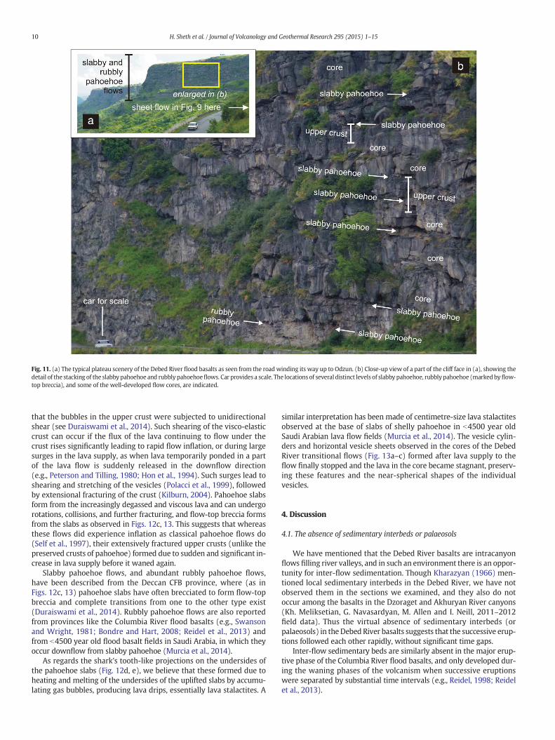
3.6. Slabby pahoehoe and rubbly pahoehoe flows
Flows with features transitional between pahoehoe and ‘a’ā, includ-ing slabby pahoehoe (Duraiswami et al., 2003) and rubbly pahoehoe(Keszthelyi and Thordarson, 2000; Duraiswami et al., 2008), constitutethe upper part of the Debed River basalt sequence. They are wellexposed on the road to Odzun village situated on the plateau top(Fig. 11a, b). A sequence of several transitional flows with pahoehoeslabs forming their uppermost crusts, with or without overlying flow-top breccia, is exposed here. Their upper and lower boundaries are gen-erally horizontal, but one flow (above the centre of Fig. 11b) has a wavycross-sectional outline reflecting the shape of the upper surface of theunderlying flow.
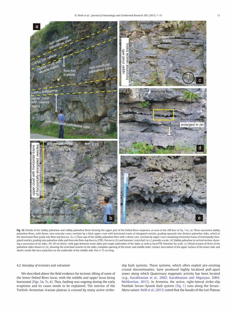
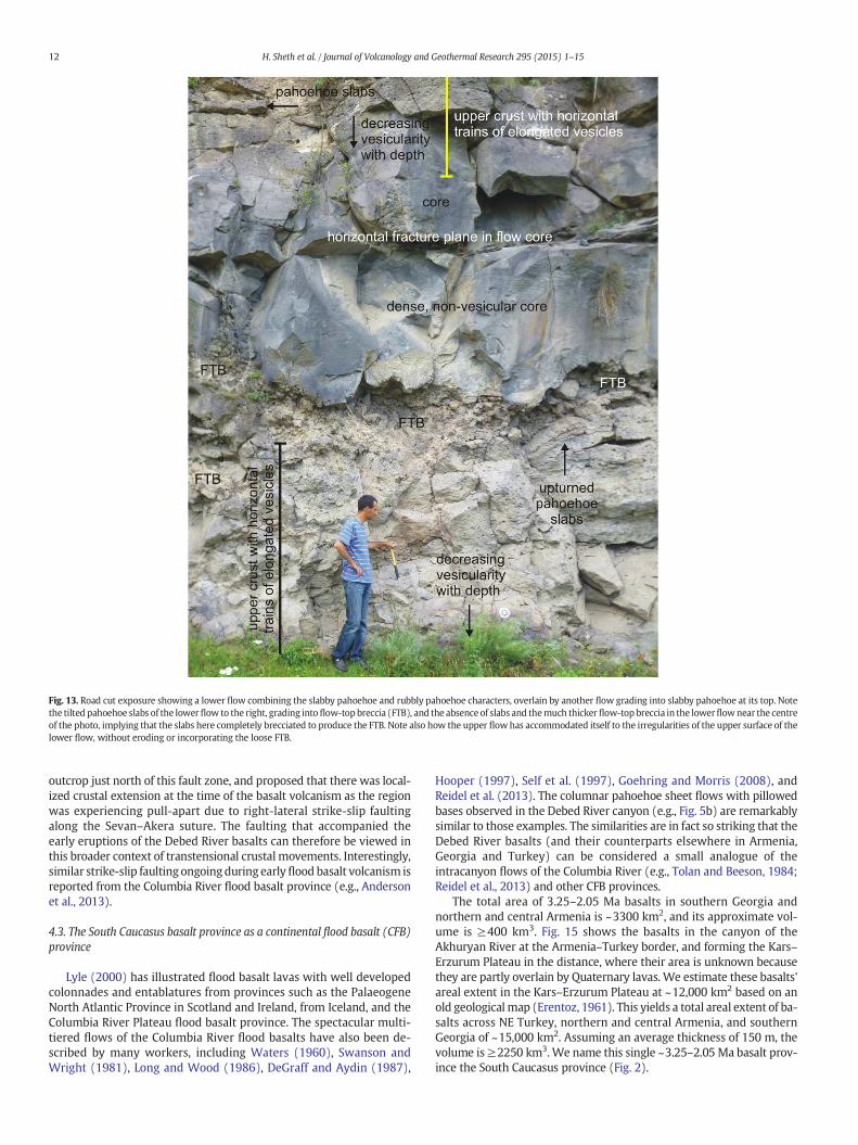
Three of these transitional flows are visible in Fig. 12a. Each has athick, dense, non-vesicular core with a thick upper crust, while thelower crust is poorly developed or absent. Three notable features ofthe upper crust (Fig. 12a, b, c) are: (1) it is increasingly vesicular up-wards, (2) the vesicles form distinct parallel, horizontal trains, and(3) the vesicles are horizontally highly elongated, very distinct fromthe nearly spherical vesicles typical of pahoehoe (e.g., Macdonald,1953). Given the increasing vesicle concentration upwards, thehorizontal trains of elongated vesicles grade into definite horizontalpartings inthe uppermost crust, producing well-developed lava slabs10–30 centimetres thick (Fig. 12a–d). Some of these slabs have under-gone brecciation to produce flow-top breccia which caps the preservedslabs (Fig. 12c). The individual slabs show brecciation on their uppersurfaces, whereas their undersides display shark's tooth-like projections(Fig. 12d, e). The slabs are sometimes tilted and rotated, the flow-topbreccia varies in thickness from a few to several tens of centimetresand can be locally absent in the same flow, and the boundaries of theflows may be locally uneven (Fig. 13).
Fig. 9. Thick pahoehoe sheet flow with three tiers, on the road to Odzun. The flow has an upper colonnade, a laterally discontinuous entablature with hackly jointing below, and a well-
developed lower colonnadewith columns ~1mwide below the entablature.Where the entablature ismissing, as in the centre of the photo, the upper and lower colonnades are inmutual
contact. The person (encircled) provides a scale.
8 H. Sheth et al. / Journal of Volcanology and Geothermal Research 295 (2015) 1–15
Unlike the preserved upper crusts of pahoehoe, the flows shown inFigs. 11 to 13 have extensively fractured and brecciated upper crusts.They are also not ‘a’ā flows because ‘a’ā flows contain both flow-top and flow-bottom breccia or clinker, and being channelized, erodetheir bases (e.g., Macdonald, 1953; Lockwood and Hazlett, 2010,pp. 161–167). Slabby pahoehoe is an appropriate term for the transi-tional lava flows illustrated in Figs. 11–13 with their upper crusts bro-ken into slabs (see e.g., Duraiswami et al., 2003), whereas transitionallavas with flow-top breccia and well preserved bases are properly de-scribed as rubbly pahoehoe (e.g., Duraiswami et al., 2008). The lavaflow shown in Figs. 12a and 13 combines both types.
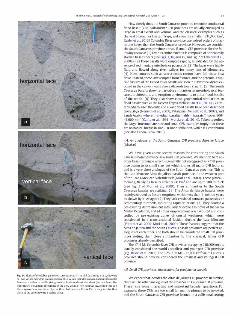
The flows exposed in this section show these same features repeat-ing throughout the sequence (Figs. 11b, 12a, 13). Features otherwisetypical of pahoehoe flows, such as vesicle cylinders and horizontal ves-icle sheets (Self et al., 1997), are observed in some of the lava flow cores(Fig. 14a–c). The vesicles forming these features are more or lessspherical.
3.7. Interpretation
As described by many authors (e.g., Kilburn, 1981; Rowland andWalker, 1990; Duraiswami et al., 2014; Murcia et al., 2014), lavamorphologies reflect the cumulative effects of intrinsic parameters(composition, temperature, crystallinity, volatile content) and extrinsicparameters (eruption mechanism, effusion rate, topography and flowvelocity). The upper flow shown in Fig. 13 filled the uneven topographyof the lower flow containing the variably thick and loose flow-top brec-cia. The upper flow has a well-preserved base, indicating that it did notthermally ormechanically erode its substrate, and that these flowswereemplaced in a gentle, effusive manner as pahoehoe flows do (e.g., Selfet al., 1997). However, the parallel, horizontal trains of elongated vesi-cles in these lavas do not represent rising bubbles thatwere periodicallycaptured at a progressively descending solidification front between thesolid upper crust and the molten flow core, as in classical pahoehoe. In-stead, the horizontally strongly elongated shapes of all vesicles indicate
Fig. 10. (a) 230 m high cliff ~3 km ENE of Alaverdi, showing a sequence of columnar-tiered pahoehoe sheet flows capped by a stack of slabby pahoehoe and rubbly pahoehoe flows. The
upper and lower boundaries of the sheet flows are indicated by continuouswhite lines, and the boundaries between the entablature (“ent.”) and colonnade (“col.”) tiers of individual sheet
flows are indicated by dashed white lines. (b) Detail of a part of the cliff face (field of view is ~50 m high) showing the entablature and colonnade zones of three of the sheet flows.
9H. Sheth et al. / Journal of Volcanology and Geothermal Research 295 (2015) 1–15
that the bubbles in the upper crust were subjected to unidirectionalshear (see Duraiswami et al., 2014). Such shearing of the visco-elasticcrust can occur if the flux of the lava continuing to flow under thecrust rises significantly leading to rapid flow inflation, or during largesurges in the lava supply, as when lava temporarily ponded in a partof the lava flow is suddenly released in the downflow direction(e.g., Peterson and Tilling, 1980; Hon et al., 1994). Such surges lead toshearing and stretching of the vesicles (Polacci et al., 1999), followedby extensional fracturing of the crust (Kilburn, 2004). Pahoehoe slabsform from the increasingly degassed and viscous lava and can undergorotations, collisions, and further fracturing, and flow-top breccia formsfrom the slabs as observed in Figs. 12c, 13. This suggests that whereasthese flows did experience inflation as classical pahoehoe flows do(Self et al., 1997), their extensively fractured upper crusts (unlike thepreserved crusts of pahoehoe) formed due to sudden and significant in-crease in lava supply before it waned again.
Slabby pahoehoe flows, and abundant rubbly pahoehoe flows,have been described from the Deccan CFB province, where (as inFigs. 12c, 13) pahoehoe slabs have often brecciated to form flow-topbreccia and complete transitions from one to the other type exist(Duraiswami et al., 2014). Rubbly pahoehoe flows are also reportedfrom provinces like the Columbia River flood basalts (e.g., Swansonand Wright, 1981; Bondre and Hart, 2008; Reidel et al., 2013) andfrom b4500 year old flood basalt fields in Saudi Arabia, in which theyoccur downflow from slabby pahoehoe (Murcia et al., 2014).
As regards the shark's tooth-like projections on the undersides ofthe pahoehoe slabs (Fig. 12d, e), we believe that these formed due toheating and melting of the undersides of the uplifted slabs by accumu-lating gas bubbles, producing lava drips, essentially lava stalactites. A
similar interpretation has been made of centimetre-size lava stalactitesobserved at the base of slabs of shelly pahoehoe in b4500 year oldSaudi Arabian lava flow fields (Murcia et al., 2014). The vesicle cylin-ders and horizontal vesicle sheets observed in the cores of the DebedRiver transitional flows (Fig. 13a–c) formed after lava supply to theflow finally stopped and the lava in the core became stagnant, preserv-ing these features and the near-spherical shapes of the individualvesicles.
4. Discussion
4.1. The absence of sedimentary interbeds or palaeosols
We have mentioned that the Debed River basalts are intracanyonflows filling river valleys, and in such an environment there is an oppor-tunity for inter-flow sedimentation. Though Kharazyan (1966) men-tioned local sedimentary interbeds in the Debed River, we have notobserved them in the sections we examined, and they also do notoccur among the basalts in the Dzoraget and Akhuryan River canyons(Kh. Meliksetian, G. Navasardyan, M. Allen and I. Neill, 2011–2012field data). Thus the virtual absence of sedimentary interbeds (orpalaeosols) in theDebed River basalts suggests that the successive erup-tions followed each other rapidly, without significant time gaps.
Inter-flow sedimentary beds are similarly absent in the major erup-tive phase of the Columbia River flood basalts, and only developed dur-ing the waning phases of the volcanism when successive eruptionswere separated by substantial time intervals (e.g., Reidel, 1998; Reidelet al., 2013).
Fig. 11. (a) The typical plateau scenery of the Debed River flood basalts as seen from the road winding its way up to Odzun. (b) Close-up view of a part of the cliff face in (a), showing the
detail of the stacking of the slabby pahoehoe and rubbly pahoehoeflows. Car provides a scale. The locations of several distinct levels of slabby pahoehoe, rubbly pahoehoe (markedbyflow-
top breccia), and some of the well-developed flow cores, are indicated.
10 H. Sheth et al. / Journal of Volcanology and Geothermal Research 295 (2015) 1–15
4.2. Interplay of tectonics and volcanism
We described above the field evidence for tectonic tilting of some ofthe lower Debed River lavas, with the middle and upper lavas beinghorizontal (Figs. 5a, 7c, d). Thus, faulting was ongoing during the earlyeruptions and its cause needs to be explained. The interior of theTurkish–Armenian–Iranian plateau is crossed by many active strike-
slip fault systems. These systems, which often exploit pre-existingcrustal discontinuities, have produced highly localized pull-apartzones along which Quaternary magmatic activity has been located(e.g., Karakhanian et al., 2002; Karakhanian and Abgaryan, 2004;Meliksetian, 2013). In Armenia, the active, right-lateral strike-slipPambak–Sevan–Syunik fault system (Fig. 1) runs along the Sevan–Akera suture. Neill et al. (2013) noted that the basalts of the Lori Plateau
Fig. 12. Details of the slabby pahoehoe and rubbly pahoehoe flows forming the upper part of the Debed River sequence, as seen in the cliff face in Fig. 11a. (a) Three successive slabby
pahoehoe flows, with dense, non-vesicular cores, overlain by a thick upper crust with horizontal trains of elongated vesicles, grading upwards into distinct pahoehoe slabs, which in
the lowermost flow grade into flow-top breccia. (b, c) Close-ups of the slabby pahoehoe flowwith a dense core, overlain by upper crust containing horizontal trains of horizontally elon-
gatedvesicles, grading into pahoehoe slabs and then intoflow-top breccia (FTB). Person in (b) andhammer (encircled) in (c) provide a scale. (d) Slabbypahoehoe invertical section, show-
ing a succession of six slabs (10–30 cm thick), with gaps between some slabs and rough undersides of the slabs, as well as local FTB. Hammer for scale. (e) Detail of parts of three of the
pahoehoe slabs shown in (d), showing the stretched vesicles in the slabs, complete opening of the lower and middle slabs' contact, brecciation of the upper surface of the lower slab, and
shark's tooth-like lava stalactites on the underside of the middle slab. Pen is 15 cm long.
11H. Sheth et al. / Journal of Volcanology and Geothermal Research 295 (2015) 1–15
outcrop just north of this fault zone, and proposed that there was local-ized crustal extension at the time of the basalt volcanism as the regionwas experiencing pull-apart due to right-lateral strike-slip faultingalong the Sevan–Akera suture. The faulting that accompanied theearly eruptions of the Debed River basalts can therefore be viewed inthis broader context of transtensional crustal movements. Interestingly,similar strike-slip faulting ongoingduring earlyflood basalt volcanism isreported from the Columbia River flood basalt province (e.g., Andersonet al., 2013).
4.3. The South Caucasus basalt province as a continental flood basalt (CFB)
province
Lyle (2000) has illustrated flood basalt lavas with well developedcolonnades and entablatures from provinces such as the PalaeogeneNorth Atlantic Province in Scotland and Ireland, from Iceland, and theColumbia River Plateau flood basalt province. The spectacular multi-tiered flows of the Columbia River flood basalts have also been de-scribed by many workers, including Waters (1960), Swanson andWright (1981), Long and Wood (1986), DeGraff and Aydin (1987),
Hooper (1997), Self et al. (1997), Goehring and Morris (2008), andReidel et al. (2013). The columnar pahoehoe sheet flows with pillowedbases observed in the Debed River canyon (e.g., Fig. 5b) are remarkablysimilar to those examples. The similarities are in fact so striking that theDebed River basalts (and their counterparts elsewhere in Armenia,Georgia and Turkey) can be considered a small analogue of theintracanyon flows of the Columbia River (e.g., Tolan and Beeson, 1984;Reidel et al., 2013) and other CFB provinces.
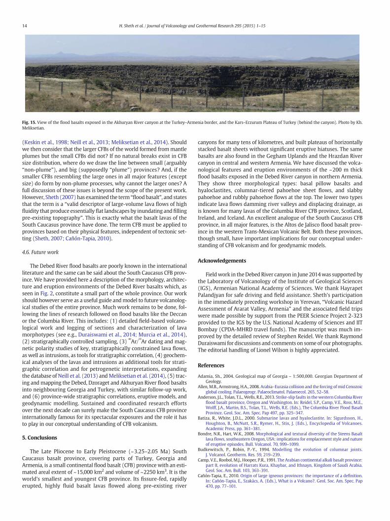
The total area of 3.25–2.05 Ma basalts in southern Georgia andnorthern and central Armenia is ~3300 km2, and its approximate vol-ume is ≥400 km3. Fig. 15 shows the basalts in the canyon of theAkhuryan River at the Armenia–Turkey border, and forming the Kars–Erzurum Plateau in the distance, where their area is unknown becausethey are partly overlain by Quaternary lavas. We estimate these basalts'areal extent in the Kars–Erzurum Plateau at ~12,000 km2 based on anold geologicalmap (Erentoz, 1961). This yields a total areal extent of ba-salts across NE Turkey, northern and central Armenia, and southernGeorgia of ~15,000 km2. Assuming an average thickness of 150 m, thevolume is≥2250 km3. We name this single ~3.25–2.05Ma basalt prov-ince the South Caucasus province (Fig. 2).
Fig. 13. Road cut exposure showing a lower flow combining the slabby pahoehoe and rubbly pahoehoe characters, overlain by another flow grading into slabby pahoehoe at its top. Note
the tilted pahoehoe slabs of the lowerflow to the right, grading intoflow-top breccia (FTB), and the absence of slabs and themuch thickerflow-top breccia in the lowerflownear the centre
of the photo, implying that the slabs here completely brecciated to produce the FTB. Note also how the upper flowhas accommodated itself to the irregularities of the upper surface of the
lower flow, without eroding or incorporating the loose FTB.
12 H. Sheth et al. / Journal of Volcanology and Geothermal Research 295 (2015) 1–15
How closely does the South Caucasus province resemble continentalflood basalt (CFB) volcanism? CFB provinces are usually envisaged aslarge in areal extent and volume, and the classical examples such asthe vast Siberian or Deccan Traps, and even the smaller (210,000 km2,Reidel et al., 2013) Columbia River province, are indeed orders of mag-nitude larger than the South Caucasus province. However, we considerthe South Caucasus province a true, if small, CFB province, for the fol-lowing reasons: (1) Over its entire extent it is composed of horizontallystacked basalt sheets (see Figs. 3, 10, and 15, and Fig. 7 of Lebedev et al.,2008a). (2) These basalts were erupted rapidly, as indicated by the ab-sence of sedimentary interbeds or palaeosols. (3) The lavas were highlyfluid and flowed along river valleys for many tens of kilometres.(4) Point sources such as scoria cones cannot have fed these lavaflows. Instead, these lavas erupted fromfissures, and the potential erup-tive fissures of the Debed River basalts are seen in subvertical dykes ex-posed in the canyon walls above Alaverdi town (Fig. 1). (5) The SouthCaucasus basalts show remarkable similarities in morphological fea-tures, architecture, and eruption environments to other flood basaltsof the world. (6) They also show close geochemical similarities toflood basalts such as the Deccan Traps (Meliksetian et al., 2014). (7) “In-termediate-size” tholeiitic and alkalic flood basalts have been describedfrom Libya (Németh et al., 2003), Patagonia (Németh et al., 2007), andSaudi Arabia where individual basaltic fields (“harrats”) cover 900–46,000 km2 (Camp et al., 1991; Murcia et al., 2014). Taken together,the large, intermediate-size and small CFB examples imply that thereare no natural breaks in size CFB size distribution, which is a continuum(see also Cañón-Tapia, 2010).
4.4. An analogue of the South Caucasus CFB province: Altos de Jalisco
(Mexico)
We have given above several reasons for considering the SouthCaucasus basalt province as a small CFB province. Wemention here an-other basalt province which is generally not recognized as a CFB prov-ince owing to its small size, but which shows all major CFB featuresand is a very close analogue of the South Caucasus province. This isthe Late Miocene Altos de Jalisco basalt province in the western partof the Trans-Mexican Volcanic Belt (Mori et al., 2009). These plateau-forming, flat-lying basalts cover 8000 km2 and are up to 700 m thick(see Fig. 3 of Mori et al., 2009). Their similarities to the SouthCaucasus basalts are striking: (1) The Altos de Jalisco basalts weremainlyextruded as fissure eruptions within less than 1 million yearsas shown by K–Ar ages. (2) They lack erosional contacts, palaeosols orsedimentary interbeds, indicating rapid eruptions. (3) They flooded apre-existing depression cut into Early Miocene ash flows of the SierraMadre Occidental, and (4) their emplacement was favoured and con-trolled by pre-existing zones of crustal weakness, which werereactivated in a transtensional fashion during the Late Miocene(Ferrari et al., 2000; Mori et al., 2009). These features suggest that theAltos de Jalisco and the South Caucasus basalt provinces are perfect an-alogues of each other, and both should be considered small CFB prov-inces noting their close similarities to the classical, larger CFBprovinces already described.
The 17–5Ma Columbia River CFB province, occupying 210,000 km2, isusually considered the world's smallest and youngest CFB province(e.g., Reidel et al., 2013). The 3.25–2.05 Ma, ~15,000 km2 South Caucasusprovince should now be considered the smallest and youngest CFBprovince.
4.5. Small CFB provinces: implications for geodynamic models
We expect that, besides the Altos de Jalisco CFB province in Mexico,there will be other analogues of the small South Caucasus CFB province.These raise some interesting and important broader questions. Forexample, these CFBs are too small for mantle plumes to be invoked,and the South Caucasus CFB province formed in a collisional setting
Fig. 14. Blocks of the slabby pahoehoe cores exposed in the cliff face in Fig. 11a, b, showing
(a) twovesicle cylinders in cross-section, (b) a vesicle cylinder in cross-section (horizontal
face) and another in profile giving rise to a horizontal vesicular sheet (vertical face). The
interpreted movement directions of the very volatile-rich residual lava rising through
the stagnant lava are shown by the thin black arrows. Pen is 15 cm long. (c) Another
block of the core showing a vesicle sheet.
13H. Sheth et al. / Journal of Volcanology and Geothermal Research 295 (2015) 1–15
(Keskin et al., 1998; Neill et al., 2013; Meliksetian et al., 2014). Shouldwe then consider that the larger CFBs of the world formed frommantleplumes but the small CFBs did not? If no natural breaks exist in CFBsize distribution, where do we draw the line between small (arguably“non-plume”), and big (supposedly “plume”) provinces? And, if thesmaller CFBs resembling the large ones in all major features (exceptsize) do form by non-plume processes, why cannot the larger ones? Afull discussion of these issues is beyond the scope of the present work.However, Sheth (2007) has examined the term “floodbasalt”, and statesthat the term is a “valid descriptor of large-volume lava flows of highfluidity that produce essentially flat landscapes by inundating andfillingpre-existing topography”. This is exactly what the basalt lavas of theSouth Caucasus province have done. The term CFB must be applied toprovinces based on their physical features, independent of tectonic set-ting (Sheth, 2007; Cañón-Tapia, 2010).
4.6. Future work
The Debed River flood basalts are poorly known in the internationalliterature and the same can be said about the South Caucasus CFB prov-ince. We have provided here a description of the morphology, architec-ture and eruption environments of the Debed River basalts which, asseen in Fig. 2, constitute a small part of the whole province. Our workshould however serve as a useful guide andmodel to future volcanolog-ical studies of the entire province. Much work remains to be done, fol-lowing the lines of research followed on flood basalts like the Deccanor the Columbia River. This includes: (1) detailed field-based volcano-logical work and logging of sections and characterization of lavamorphotypes (see e.g., Duraiswami et al., 2014; Murcia et al., 2014),(2) stratigraphically controlled sampling, (3)
40
Ar/39
Ar dating and mag-netic polarity studies of key, stratigraphically constrained lava flows,as well as intrusions, as tools for stratigraphic correlation, (4) geochem-ical analyses of the lavas and intrusions as additional tools for strati-graphic correlation and for petrogenetic interpretations, expandingthe database of Neill et al. (2013) andMeliksetian et al. (2014), (5) trac-ing andmapping the Debed, Dzoraget and Akhuryan River flood basaltsinto neighbouring Georgia and Turkey, with similar follow-up work,and (6) province-wide stratigraphic correlations, eruptive models, andgeodynamic modelling. Sustained and coordinated research effortsover the next decade can surely make the South Caucasus CFB provinceinternationally famous for its spectacular exposures and the role it hasto play in our conceptual understanding of CFB volcanism.
5. Conclusions
The Late Pliocene to Early Pleistocene (~3.25–2.05 Ma) SouthCaucasus basalt province, covering parts of Turkey, Georgia andArmenia, is a small continental flood basalt (CFB) province with an esti-mated areal extent of ~15,000 km2 and volume of ~2250 km3. It is theworld's smallest and youngest CFB province. Its fissure-fed, rapidlyerupted, highly fluid basalt lavas flowed along pre-existing river
canyons for many tens of kilometres, and built plateaus of horizontallystacked basalt sheets without significant eruptive hiatuses. The samebasalts are also found in the Gegham Uplands and the Hrazdan Rivercanyon in central and western Armenia. We have discussed the volca-nological features and eruption environments of the ~200 m thickflood basalts exposed in the Debed River canyon in northern Armenia.They show three morphological types: basal pillow basalts andhyaloclastites, columnar-tiered pahoehoe sheet flows, and slabbypahoehoe and rubbly pahoehoe flows at the top. The lower two typesindicate lava flows damming river valleys and displacing drainage, asis known for many lavas of the Columbia River CFB province, Scotland,Ireland, and Iceland. An excellent analogue of the South Caucasus CFBprovince, in all major features, is the Altos de Jalisco flood basalt prov-ince in the western Trans-Mexican Volcanic Belt. Both these provinces,though small, have important implications for our conceptual under-standing of CFB volcanism and for geodynamic models.
Acknowledgements
Fieldwork in theDebed River canyon in June 2014was supported bythe Laboratory of Volcanology of the Institute of Geological Sciences(IGS), Armenian National Academy of Sciences. We thank HayrapetPalandjyan for safe driving and field assistance. Sheth's participationin the immediately preceding workshop in Yerevan, “Volcanic HazardAssessment of Ararat Valley, Armenia” and the associated field tripswere made possible by support from the PEER Science Project 2-323provided to the IGS by the U.S. National Academy of Sciences and IITBombay (CPDA-MHRD travel funds). The manuscript was much im-proved by the detailed review of Stephen Reidel. We thank RaymondDuraiswami for discussions and comments on some of our photographs.The editorial handling of Lionel Wilson is highly appreciated.
References
Adamia, Sh., 2004. Geological map of Georgia – 1:500,000. Georgian Department ofGeology.
Allen,M.B., Armstrong, H.A., 2008. Arabia–Eurasia collision and the forcing ofmid Cenozoicglobal cooling. Palaeogeogr. Palaeoclimatol. Palaeoecol. 265, 52–58.
Anderson, J.L., Tolan, T.L.,Wells, R.E., 2013. Strike-slip faults in thewestern Columbia Riverflood basalt province, Oregon and Washington. In: Reidel, S.P., Camp, V.E., Ross, M.E.,Wolff, J.A., Martin, B.S., Tolan, T.L., Wells, R.E. (Eds.), The Columbia River Flood BasaltProvince. Geol. Soc. Am. Spec. Pap 497, pp. 325–347.
Batiza, R., White, J.D.L., 2000. Submarine lavas and hyaloclastite. In: Sigurdsson, H.,Houghton, B., McNutt, S.R., Rymer, H., Stix, J. (Eds.), Encyclopedia of Volcanoes.Academic Press, pp. 361–381.
Bondre, N.R., Hart, W.K., 2008. Morphological and textural diversity of the Steens Basaltlava flows, southeastern Oregon, USA: implications for emplacement style and natureof eruptive episodes. Bull. Volcanol. 70, 999–1099.
Budkewitsch, P., Robin, P.-Y., 1994. Modelling the evolution of columnar joints.J. Volcanol. Geotherm. Res. 59, 219–239.
Camp, V.E., Roobol, M.J., Hooper, P.R., 1991. The Arabian continental alkali basalt province:part II, evolution of Harrats Kura, Khaybar, and Ithnayn, Kingdom of Saudi Arabia.Geol. Soc. Am. Bull. 103, 363–391.
Cañón-Tapia, E., 2010. Origin of large igneous provinces: the importance of a definition.In: Cañón-Tapia, E., Szakács, A. (Eds.), What is a Volcano?. Geol. Soc. Am. Spec. Pap470, pp. 77–101.
Fig. 15. View of the flood basalts exposed in the Akhuryan River canyon at the Turkey–Armenia border, and the Kars–Erzurum Plateau of Turkey (behind the canyon). Photo by Kh.
Meliksetian.
14 H. Sheth et al. / Journal of Volcanology and Geothermal Research 295 (2015) 1–15
Chernyshev, I.V., Lebedev, V.A., Arakelyants, M.M., Jrbashyan, R.T., Ghukasyan, Y.G., 2002.Geochronology of the Aragats volcanic center, Armenia: evidence from K–Ar dating.Dokl. Earth Sci. 384, 393–398 (in Russian).
DeGraff, J.M., Aydin, A., 1987. Surface morphology of columnar joints and its significanceto mechanics and direction of joint growth. Geol. Soc. Am. Bull. 99, 605–617.
DeGraff, J.M., Long, P.E., Aydin, A., 1989. Use of joint-growth directions and rock texturesto infer thermal regimes during solidification of basaltic lava flows. J. Volcanol.Geotherm. Res. 38, 309–324.
Duraiswami, R.A., Dole, G., Bondre, N., 2003. Slabby pahoehoe from the western Deccanvolcanic province: evidence for incipient pahoehoe-‘a’ā transitions. J. Volcanol.Geotherm. Res. 121, 195–217.
Duraiswami, R.A., Bondre, N.R., Managave, S., 2008. Morphology of rubbly pahoehoe(simple) flows from the Deccan volcanic province: implications for style of emplace-ment. J. Volcanol. Geotherm. Res. 177, 822–836.
Duraiswami, R.A., Gadpallu, P., Shaikh, T.N., Cardin, N., 2014. Pahoehoe-‘a’ā transitions inthe lava flow fields of the western Deccan Traps, India — implications for emplace-ment dynamics, flood basalt architecture and volcanic stratigraphy. In: Sheth, H.C.,Vanderkluysen, L. (Eds.), Flood Basalts of Asia. J. Asian Earth Sci 84, pp. 146–166.
Erentoz, C., 1961. Geological map of Turkey – 1:500,000. Turkish Geological Survey.Ferrari, L., Conticelli, S., Vaggelli, G., Petrone, C.M., Manetti, P., 2000. Late Miocene
volcanism and intra-arc tectonics during the early development of the Trans-Mexican Volcanic Belt. Tectonophysics 318, 161–185.
Ghukasyan, Y.G., 1970. Dolerite basalts of the middle course of the river basin of Akhurian(nearby Vagramaberd village), Armenian S.S.R. Izvestiya 23, 44–52 (in Russian).
Ghukasyan, Y.G., 1976. On the issue of geological interrelationship between doleritic ba-salts of the Akhurian canyon and Aragats volcanic series (Armenian S.S.R.). Isvestiya29, 26–31.
Goehring, L., Morris, S.W., 2008. Scaling of columnar joints in basalt. J. Geophys. Res. 113,B10203. http://dx.doi.org/10.1029/2007JB005018.
Grossenbacher, K.A., McDuffie, S.M., 1995. Conductive cooling of lava: columnar joint di-ameter and stria width as functions of cooling rate and thermal gradient. J. Volcanol.Geotherm. Res. 69, 95–103.
Hardee, H.C., 1980. Solidification in Kilauea Iki lava lake. J. Volcanol. Geotherm. Res. 7,211–223.
Hon, K., Kauahikaua, J., Denlinger, R., MacKay, K., 1994. Emplacement and inflation ofpahoehoe sheetflows: observations andmeasurements of active lavaflowsonKilaueavolcano, Hawaii. Geol. Soc. Am. Bull. 106, 351–370.
Hooper, P.R., 1997. The Columbia River flood basalt province: current status. In: Mahoney,J.J., Coffin, M.F. (Eds.), Large Igneous Provinces: Continental, Oceanic, and PlanetaryFlood Volcanism. Am. Geophys. Union Geophy. Monogr 100, pp. 1–27.
James, A.V.G., 1920. Factors producing columnar structures in lavas and its occurrencenear Melbourne, Australia. J. Geol. 28, 458–469.
Jrbashian, R.T., Kazarian, G.A., Karapetian, S.G., Meliksetian, Kh.B., Mnatsakanian, A.,Shirinian, K.G., 1996. Meso-Cenozoic basaltic volcanism in the northeastern part ofArmenian Highland. Lett. Armen. Acad. Sci. Earth Sci 49, 19–32 (in Russian).
Karakhanian, A., Abgaryan, Y., 2004. Evidence of historical seismicity and volcanism in theArmenian Highland (from Armenian and other sources). Ann. Geophys. 47, 793–810.
Karakhanian, A., Djrbashian, R., Trifonov, V., Philip, H., Arakelian, S., Avagian, A., 2002.Holocene-historical volcanism and active faults as natural risk factors for Armeniaand adjacent countries. J. Volcanol. Geotherm. Res. 113, 319–344.
Karapetian, S.G., Jrbashian, R.T., Mnatsakanian, A.Kh., 2001. Late collision rhyolitic volca-nism in the north-eastern part of the Armenian Highland. J. Volcanol. Geotherm.Res. 112, 189–220.
Keskin, M., 2007. Eastern Anatolia: a hotspot in a collision zone without a mantle plume.In: Foulger, G.R., Jurdy, D.M. (Eds.), Plates, Plumes, and Planetary Processes. Geol. Soc.Am. Spec. Pap 430, pp. 693–722.
Keskin, M., Pearce, J.A., Mitchell, J.G., 1998. Volcano-stratigraphy and geochemistry ofcollision-related volcanism on the Erzurum–Kars Plateau, northeastern Turkey.J. Volcanol. Geotherm. Res. 85, 355–404.
Keszthelyi, L., Thordarson, Th., 2000. Rubbly pahoehoe: a previously undescribed butwidespread lava type transitional between ‘a’ā and pahoehoe. Geol. Soc. Am. Abstr.Programs 32, 7.
Kharazyan, E.Kh., 1966. Pillow lavas and hyaloclastites of the river basin of Debed(Armenian S.S.R.). Izvestiya 19, 29–40 (in Russian).
Kharazyan, E. Kh., 1983. Geology of recent volcanism of north-west part of Armenian SSR(basins of riversDzoraget andAkhuryan). Unpubl. Ph.D. thesis, ArmGeologia, Yerevan,55 p (in Russian).
Kharazyan, E.Kh., 2005. Geological Map of Armenia - 1:500,000. Ministry of NatureProtection of Republic of Armenia.
Kharazyan, E.Kh., 2012. Geology and Quaternary volcanism of Armenia. Rational Use andEfficient Development of Mineral Resources of Armenia vol. 14. GEOID, Yerevan(619 pp.).
Kilburn, C.R.J., 1981. Pahoehoe and ‘a’ā lavas: a discussion and continuation of the modelof Peterson and Tilling. J. Volcanol. Geotherm. Res. 11, 373–382.
Kilburn, C.R.J., 2004. Fracturing as a quantitative indicator of lava flow dynamics.J. Volcanol. Geotherm. Res. 139, 209–224.
Lebedev, V.A., Bubnov, S.N., Chernyshev, I.V., Chugaev, A.V., Dudauri, O.Z., Vashakidze,G.T., 2007. Geochronology and genesis of subalkaline basaltic lava rivers at the
Dzhavakheti Highland, Lesser Caucasus: K–Ar and Sr–Nd isotopic data. Geochem.Int. 45, 211–225.
Lebedev, V.A., Bubnov, S.N., Dudauri, O.Z., Vashakidze, G.T., 2008a. Geochronology of Pli-ocene volcanism in the Dzhavakheti Highland (the Lesser Caucasus), part 1: westernpart of the Dzhavakheti Highland. Stratigr. Geol. Correl. 16, 204–224.
Lebedev, V.A., Bubnov, S.N., Dudauri, O.Z., Vashakidze, G.T., 2008b. Geochronology of Pli-ocene volcanism in the Dzhavakheti Highland (the Lesser Caucasus), part 2: easternpart of the Dzhavakheti Highland. Regional geological correlation. Stratigr. Geol.Correl. 16, 553–574.
Lockwood, J.P., Hazlett, R.W., 2010. Volcanoes: Global Perspectives. Wiley-Blackwell(541 pp.).
Long, P.E., Wood, B.J., 1986. Structures, textures, and cooling histories of Columbia Riverbasalt flows. Geol. Soc. Am. Bull. 97, 1144–1155.
Lyle, P., 2000. The eruption environment of multi-tiered columnar basalt lava flows.J. Geol. Soc. Lond. 157, 715–722.
Macdonald, G.A., 1953. Pahoehoe, ‘a’ā, and block lava. Am. J. Sci. 251, 169–191.Meliksetian, Kh., 2013. Pliocene–Quaternary volcanism of the Syunik upland. Archäologie
in Armenien II, pp. 247–258.Meliksetian, Kh., Neill, I., Allen, M., Navasardyan, G., 2014. Plateau basaltic volcanism in a
syn-collisional setting (South Caucasus). Geophys. Res. Abstr. 16 (EGU2014-6703).Mori, L., Gómez-Tuena, A., Schaaf, P., Goldstein, S.L., Pérez-Arvizu, O., Solís-Pichardo, G.,
2009. Lithospheric removal as a trigger for flood basalt magmatism in the Trans-Mexican Volcanic Belt. J. Petrol. 50, 2157–2186.
Murcia, H., Németh, K., Moufti, M.R., Lindsay, J.M., El-Masry, N., Cronin, S.J., Qaddah, A.,Smith, I.E.M., 2014. Late Holocene lava flow morphotypes of northern Harrat Rahat,Kingdom of Saudi Arabia: implications for the description of continental lava fields.In: Sheth, H.C., Vanderkluysen, L. (Eds.), Flood Basalts of Asia. J. Asian Earth Sci 84,pp. 131–145.
Neill, I., Meliksetian, Kh., Allen, M.B., Navasardyan, G., Karapetyan, S., 2013. Pliocene–Quaternary volcanic rocks of NW Armenia: magmatism and lithospheric dynamicswithin an active orogenic plateau. Lithos 180–181, 200–215.
Németh, K., Suwesi, S.K., Peregi, Z., Gulacsi, Z., Ujszaszi, J., 2003. Plio/Pleistocene flood ba-salt related scoria and spatter cones, rootless lava flows, and pit craters, Al Haruj alAbyad, Libya. GeoLines 15, 98–103.
Németh, K., Martin, U., Haller, M.J., Alric, V.I., 2007. Cenozoic diatreme field in Chubut(Argentina) as evidence of phreatomagmatic volcanism accompanied with extensivePatagonian plateau basalt volcanism? Episodes 30, 217–223.
Peterson, D.W., Tilling, R.I., 1980. Transition of basaltic lava from pahoehoe to ‘a’ā, Kilaueavolcano, Hawaii: field observations and key factors. J. Volcanol. Geotherm. Res. 7,271–293.
Polacci, M., Cashman, K.V., Kauahikaua, J.P., 1999. Textural characterization of thepahoehoe-‘a’ā transition in Hawaiian basalt. Bull. Volcanol. 60, 595–609.
Reidel, S.P., 1998. Emplacement of Columbia River flood basalt. J. Geophys. Res. 103,27393–27410.
Reidel, S.P., Camp, V.E., Tolan, T.L., Martin, B.S., 2013. The Columbia River flood basaltprovince: stratigraphy, areal extent, volume, and physical volcanology. In: Reidel,S.P., Camp, V.E., Ross, M.E., Wolff, J.A., Martin, B.S., Tolan, T.L., Wells, R.E. (Eds.), TheColumbia River Flood Basalt Province. Geol. Soc. Am. Spec. Pap 497, pp. 1–43.
Rowland, S.K., Walker, G.P.L., 1990. Pahoehoe and ‘a’ā in Hawaii: volumetric flow ratecontrols the lava structure. Bull. Volcanol. 52, 615–628.
Ryan, M.P., Sammis, C.G., 1978. Cyclic fracture mechanisms in cooling basalt. Geol. Soc.Am. Bull. 89, 1295–1308.
Saemundsson, K., 1970. Interglacial lava flows in the lowlands of southern Iceland and theproblem of two-tiered columnar jointing. Jökull 20, 62–77.
Self, S., Thordarson, Th., Keszthelyi, L., 1997. Emplacement of continental flood basalt lavaflows. In: Mahoney, J.J., Coffin, M.F. (Eds.), Large Igneous Provinces: Continental,Oceanic, and Planetary Flood Volcanism. Am. Geophys. Union Geophy. Monogr 100,pp. 381–410.
Sheth, H.C., 2007. ‘Large Igneous Provinces (LIPs)’: definition, recommended terminology,and a hierarchical classification. Earth-Sci. Rev. 85, 117–124.
Skhirtladze, N.I., 1958. Post-Palaeogene Effusive Volcanism of Georgia. Publishing Houseof the Academy of Sciences of the Georgian SSR, Tbilisi, p. 368 (in Russian).
Spry, A., 1962. The origin of columnar jointing, particularly in basalt flows. J. Aust. Geol.Soc. 8, 191–216.
Swanson, D.A., Wright, T.L., 1981. The regional approach to studying the Columbia RiverBasalt Group. In: Subbarao, K.V., Sukheswala, R.N. (Eds.), Deccan Volcanism and Re-lated Basalt Provinces in Other Parts of the World. Geol. Soc. Ind. Mem 3, pp. 58–80.
Tolan, T.L., Beeson, M.H., 1984. Intracanyon flows of the Columbia River Basalt Group inthe lower Columbia River Gorge and their relationship to the Troutdale Formation.Geol. Soc. Am. Bull. 95, 463–477.
Tomkeieff, S.I., 1940. The basalt lavas of the Giant's Causeway district of Northern Ireland.Bull. Volcanol. 6, 89–146.
Verma, S.P., Torres-Alvarado, I.S., Sotelo-Rodriguez, Z.T., 2002. SINCLAS: standard igneousnorm and volcanic rock classification system. Comput. Geosci. 28, 711–715.
Waters, A.C., 1960. Determining direction of flow in basalts. Am. J. Sci. 258A, 350–366.
15H. Sheth et al. / Journal of Volcanology and Geothermal Research 295 (2015) 1–15


