Embed Size (px)
Citation preview

Imaging the Seismic Crustal Structure of the Western Mexican Margin between
19�N and 21�N
RAFAEL BARTOLOME,1 JUANJO DANOBEITIA,1 FRANCOIS MICHAUD,2 DIEGO CORDOBA,3 and LUIS A. DELGADO-ARGOTE4
Abstract—Three thousand kilometres of multichannel (MCS)
and wide-angle seismic profiles, gravity and magnetic, multibeam
bathymetry and backscatter data were recorded in the offshore area
of the west coast of Mexico and the Gulf of California during the
spring 1996 (CORTES survey). The seismic images obtained off
Puerto Vallarta, Mexico, in the Jalisco subduction zone extend
from the oceanic domain up to the continental shelf, and signifi-
cantly improve the knowledge of the internal crustal structure of
the subduction zone between the Rivera and North American (NA)
Plates. Analyzing the crustal images, we differentiate: (1) An
oceanic domain with an important variation in sediment thickness
ranging from 2.5 to 1 km southwards; (2) an accretionary prism
comprised of highly deformed sediments, extending for a maxi-
mum width of 15 km; (3) a deformed forearc basin domain which
is 25 km wide in the northern section, and is not seen towards the
south where the continental slope connects directly with the
accretionary prism and trench, thus suggesting a different defor-
mational process; and (4) a continental domain consisting of a
continental slope and a mid slope terrace, with a bottom simulating
reflector (BSR) identified in the first second of the MCS profiles.
The existence of a developed accretionary prism suggests a sub-
duction–accretion type tectonic regime. Detailed analysis of the
seismic reflection data in the oceanic domain reveals high ampli-
tude reflections at around 6 s [two way travel time (twtt)] that
clearly define the subduction plane. At 2 s (twtt) depth we identify
a strong reflection which we interpret as the Moho discontinuity.
We have measured a mean dip angle of 7� ± 1� at the subduction
zone where the Rivera Plate begins to subduct, with the dip angle
gently increasing towards the south. The oceanic crust has a mean
crustal thickness of 6.0–6.5 km. We also find evidence indicating
that the Rivera Plate possibly subducts at very low angles beneath
the Tres Marias Islands.
Key words: Rivera Plate, Middle America Trench, crustal
structure, seismic imaging, subduction plate, BSR.
1. Introduction
The tectonics, seismicity and magmatism in the
western part of central Mexico is largely controlled
by the subduction of the Cocos and Rivera oceanic
plates beneath the North American (NA) Plate, the
Middle America Trench (MAT) being the morpho-
logic expression of the subduction contact (Fig. 1).
The Rivera Plate is a key structural element to
understand the complex geodynamic interactions that
occur at the western coast of Mexico. ATWATER
(1970) was the first to suggest the existence of this
microplate. Since then, several authors have shown
that the Rivera Plate is kinematically distinct from the
NA and Cocos Plates (EISSLER and MCNALLY, 1984;
BANDY and YAN, 1989; DEMETS and STEIN, 1990),
although the precise location of the Rivera-Cocos
boundary is still controversial since no clear bathy-
metric features can be clearly associated with the
plate boundary (EISSLER and MCNALLY, 1984; BOURGOIS
and MICHAUD, 1991). Seafloor accretion occurs along
the western boundary Rivera plate, at the Pacific-
Rivera Rise (PRR), whereas to the east, the litho-
sphere of the Rivera plate is consumed at the trench
where the plate has been dated as late Miocene
(*9 Ma) based on seafloor magnetic anomalies
(KLITGORD and MAMMERICKX, 1982). The age of the
Cocos Plate varies along the MAT, with jumps in
ages occurring across several fracture zones. Thus,
the younger and shallower Cocos crust near the
Rivera Plate is dated as 10 Ma whereas at 90�W it is
dated at 25 Ma old (COUCH and WOODCOCK, 1981).
1 Centre Mediterrani d0Investigacions Marines i Ambientals
(CMIMA), Unidad de Tecnologıa Marina-CSIC, Passeig Marıtim
de la Barceloneta 37-49, 08003, Barcelona, Spain. E-mail:
[email protected] Geosciences Azur, UMR 6526, Universite Pierre et Marie-
Curie, La Darse, BP 48, 06235 Villefranche-sur-Mer Cedex,
France.3 Universidad Complutense de Madrid, 28040 Ciudad Uni-
versitaria, Madrid, Spain.4 CICESE, Carr. Tijuana-Ensenada km 107, 22800 Ensena-
da, Baja California, Mexico.
Pure Appl. Geophys. 168 (2011), 1373–1389
� 2010 Springer Basel AG
DOI 10.1007/s00024-010-0206-x Pure and Applied Geophysics

There are still points to be clarified regarding the
Rivera Plate subduction patterns. Among them, the
convergence direction and rate (KOSTOGLODOV and
BANDY, 1995; DEMETS and WILSON, 1997; BANDY
et al., 1998; DEMETS and TRAYLEN, 2000), the recent
strike-slip deformation (BANDY et al., 2005), the
seismic activity (NIXON, 1982), and a plausible evo-
lution model for the junction area of the East Pacific
Rise (EPR), the Rivera Transform and the MAT
(MAMMERICKX, 1984; BOURGOIS et al., 1988; DEMETS
and WILSON, 1997; BANDY et al., 1998; MICHAUD
et al., 2001; BANDY et al., 2005). In terms of seismic
data, only a few single channel seismic profiles are
available in the literature (BOURGOIS et al., 1988;
BOURGOIS and MICHAUD, 1991; KHUTORSKOY et al.,
1994; MICHAUD et al., 1996) and one threefold profile
(BANDY et al., 2005). These data show active shallow
strike-slip tectonics and a subsidence in the upper
(first second twtt) continental slope area at 18.5�N,
although the subducting Rivera Plate crustal structure
remains unidentified. Therefore, the studies of the
internal structure of the overriding plate have relied
primarily on potential field data (BANDY et al., 1993;
BANDY et al., 1999). The subduction of the Rivera
Plate remains a matter of debate due to the poorly
controlled shape of the subducted plate (EISSLER and
MCNALLY, 1984; PARDO and SUAREZ, 1993; BANDY
et al., 1999), and the low background seismicity
compared to the rest of the MAT to the south.
Regarding this low seismicity, there are few historical
earthquakes at the Rivera-NA plate boundary, which
raises the possibility that the Rivera Plate subducts
aseismically (NIXON, 1982). However, some of the
largest destructive earthquakes reported in recent
history occurred offshore of the Jalisco region
(19�N), such as the 1932 (Ms 8.1 and Ms 7.8) Jalisco
earthquakes (SINGH et al., 1985) and the 9 October
1995 (Mw 8.0, 17 km depth epicentre and 5 m of
tsunami) Colima earthquake in the southeast flank of
the region (COURBOULEX et al., 1997). The main event
of the 1995 earthquake was a subduction related
thrust event that activated normal faults along the
northwest margin of Manzanillo (19�N and 105�W,
Fig. 1), clearly showing present day plate conver-
gence. However, it is not clear if the Mw 7.4 event of
22 January 2003 occurred along the current thrust
interface between the Rivera and NA Plates (SINGH
et al., 2003).
The angle of subduction of the Rivera Plate has
been computed by accurately relocating hypocenters
(e.g., PARDO and SUAREZ, 1993, 1995). The inferred
Wadatti-Benioff zone indicates a steeper dip for the
Rivera Plate than the adjacent Cocos Plate. This has
led to the proposal of a step in the slab between the
Cocos and Rivera Plates at the present time (FERRARI
et al., 2001) due to the slab rollback mechanism,
acting on the Rivera Plate underlying the NA Plate,
during a period of very low convergence rate
(19 mm/year on average) between 8.5 and 4.6 Ma
(DEMETS and TRAYLEN, 2000). The seismicity causes
a significant seismic hazard to the coastal regions of
Mexico, as well as areas considerably inland,
including Mexico City (CURRIE et al., 2002). A strong
understanding of the Mexico subduction region
(geometry, seismic zone of subduction, faults and
rupture width, etc.) and detailed information about
the crustal structure along the Rivera Plate are
required to carry out seismic hazard studies. Other
constraints are comprehension of the limits of the
lateral and vertical extent of the Rivera Plate as well
Figure 1General tectonic setting of western Mexico. Four lithospheric
plates act in the area: Pacific, Rivera, Cocos and North American.
Arrows indicate relative convergence rates (cm/year) between the
oceanic and continental plates. Red stars show rupture zones for the
1932 and 1995 events (PACHECO et al., 1997). Black square
highlights the area of Fig. 2. TMI Tres Marias Islands, MAT Middle
America Trench, EPR East Pacific Rise
1374 R. Bartolome et al. Pure Appl. Geophys.

as plate tectonic models, including the opening of the
Gulf of California.
For these reasons, in 1996, the Spanish R/V Hes-
perides and the Mexican R/Vs Altair and Humboldt
surveyed the northwestern Mexican margin between
16�N and 30�N in a geophysical experiment named
the Crustal Offshore Research Transect by Extensive
Seismic Profiling, or CORTES-P96 (DANOBEITIA
et al., 1997). Swath bathymetry, backscattering and
multichannel seismic reflection data profiles (Fig. 2)
were acquired within the Rivera subduction zone
extending from 21�N to 19�N. In this paper, we
present five post-stack time migrated MCS sections
(Fig. 3) that show for the first time in this area,
seismic images from the Earth’s surface down to the
Mohorovicic discontinuity (Moho) that enable us to
seismically characterize the crustal structure of the
overriding and subducting plates offshore Puerto
Vallarta, describe the spatial distribution of the
incoming plates (sediment, crust and mantle litho-
sphere) and identify some of the processes occurring
in this area.
2. Geological Setting
The western margin of Mexico between 26�N and
23�N is structurally composed of a transform margin
made up of a set of spreading centers linked by a fault
system (Fig. 1). The right lateral fault system is the
southward prolongation of the San Andreas Fault
across the Gulf of California. The 70 km Tamayo
transform fault connects the southernmost spreading
segment in Gulf of California (the Alarcon Rise) with
the PRR at 23�N. This spreading center, located
between 23�N and 19�N, is the western plate
boundary between the Rivera and Pacific Plates and
its spreading velocities have fluctuated between
intermediate and fast rates over the past 10 Ma
(average full spreading rate of around 9.7 cm/year,
DEMETS and TRAYLEN, 2000). The Rivera Transform
is the southern plate boundary between the Rivera
and Pacific Plates and the MAT the eastern plate
boundary between the Rivera and NA Plates.
The geodynamic history since 25 Ma starts with
the collision of the Pacific-Farallon seafloor-spread-
ing center against the convergent western margin of
NA. This collision marked the beginning of a major
change in the tectonic evolution and volcanism of
western NA (ATWATER, 1970, 1989). Some authors
propose a final reorganization in the Middle Miocene
(6.5–3.5 Ma) triggered by the jump of the EPR to its
present location, transferred by the development of
the Rivera Transform (MAMMERICKX, 1984; MAMM-
ERICKX and KLITGORD, 1982; LONSDALE, 1991).
Alternatively, LONSDALE (1995) proposes that the
northward propagation of the EPR to its present
location took place without any clear early connec-
tion with the PRR, suggesting a broad diffuse dextral
shear zone connecting the two spreading centers
before the full development of the Rivera Transform.
Even if the connection between the EPR and the
Rivera Transform is imprecise, multibeam and
backscatter data collected during the CORTES-P96
experiment pointed out that the EPR reached the
Figure 2Location of ship tracks of the CORTES geophysical profiles,
numbered from 201 to 205, acquired offshore of Puerto Vallarta
and analyzed in the present study. Additional bathymetry data is
from surveys of the R/V Jean Charcot and R/V Marion Dufresne
(Mona survey), the NGDC database and GEBCO (2008) (30 min arc
cell grid resolution). Shaded Bathymetry has been displayed
illuminated from the west. MMR Maria Magdalena Rise. Black
square shows the study area
Vol. 168, (2011) Imaging the Seismic Crustal Structure 1375

trench (MICHAUD et al., 2001). This suggests that the
EPR extended northward of the Rivera Transform,
consistent with the findings of BANDY (1992) based on
marine magnetic data, and subducted beneath the NA
plate before 2 Ma without the need of any connection
with the Rivera Transform. The convergence rate
reported at the MAT shows significant variations
during the last 10 Ma, with convergence stopping
between 2.5 and 1 Ma (DEMETS and TRAYLEN, 2000).
The current reported value of Rivera-NA relative
convergence rate is a matter of debate. It ranges from
2.0 cm/year, based on the accurately located hypo-
centers of local and teleseismic earthquakes (PARDO
and SUAREZ, 1995), to 5 cm/year based on seismo-
tectonic relationships (KOSTOGLODOV and BANDY,
1995) which relate seismic characteristics of sub-
duction zones (maximum magnitudes, maximum
seismic depths, etc.) to plate tectonic parameters
(convergence rates, age of the oceanic lithosphere,
etc.). The most recent estimations derived from
reconstruction of magnetic anomalies for the last
0.78 Ma, give Rivera Plate convergence rates of
3.3–4.3 cm/year along the NA Plate in the area of the
Jalisco Block (BANDY and PARDO, 1994; DEMETS and
WILSON, 1997; BANDY et al., 1998; DEMETS and
TRAYLEN, 2000).
The mechanism (slab-pull) that powers the sub-
duction and moves the plate is well known and is
caused by slightly more dense mantle lithosphere of
the Rivera Plate than that underlying North American
Plate, with one peculiarity. As density excess
increases as the lithosphere ages and thickens, and the
lithosphere becomes negatively buoyant (namely,
subducting) when it is 10–30 million years old
(DAVIES, 1992), the \10 Ma buoyant crust of the
Rivera Plate resists subduction. This resistance
results in a strong coupling between plates having
higher magnitude earthquakes and shallower dips
compared to those plates subducting old lithospheres.
The strain regime behind the magmatic arc for the
subducting of the young Rivera lithosphere is
expected to be strongly compressional (folding and
thrusting), and the maximum magnitude earthquakes
must occur under these conditions (young and fast
lithosphere) beneath the continental crust arcs (STERN,
2002).
The direction of convergence between the Rivera
and NA Plates at the MAT becomes progressively
more oblique (in a counter-clockwise sense relative
to the trench-normal direction) northward along the
end of the MAT (19�N–21�N), commonly termed the
Jalisco subduction zone (JSZ) (e.g. BANDY, 1992;
LONSDALE, 1995; KOSTOGLODOV and BANDY, 1995;
DeMets and WILSON, 1997; DEMETS and TRAYLEN,
2000). This area comprises the northern part of the
MAT between the Tres Marias Islands and the
southern tip of the Colima Rift (Fig. 1). The depth of
the slab under western Mexico is poorly constrained,
but local earthquake data indicate a Benioff zone for
the Rivera Plate bending from around 10� at 20 km
depth to 50� at 40 km depth, whereas the Cocos Plate
is sub-horizontal at the same depth (PARDO and
SUAREZ, 1993). This change of dip angle is unrelated
to the thermal structure of the slabs and the present
rate of subduction due to the similar age and com-
parable subduction rates of both plates. A rollback of
the slab when the relative convergence between the
Figure 33D shaded relief bathymetry of the study area, looking eastward.
MCS lines have been projected on the seafloor to aid in the
interpretation of seismic data. Black arrows mark the deformation
front, emphasizing the increasing distance towards the trench with
latitude. The collision with MAT of seamount chains oriented
perpendicular to the MAT, observed along the margin, push the
frontal sediment prism towards the coast as is observed between the
second and third black arrow. Note the sediment infill of the trench
by the Puerto Vallarta Canyon. Bathymetric data is described in
Fig. 2
1376 R. Bartolome et al. Pure Appl. Geophys.

Rivera and NA Plates decreased to a very low rate at
the end of Miocene was proposed as a plausible
explanation (FERRARI et al., 2001).
The Jalisco Block (JB) is bounded landwards by
the Tepic-Zacoalco Rift on the NE and by the Colima
Rift on the SE (Fig. 1). Rifting and volcanism have
been proposed to be associated with the northwest-
ward detachment of the JB from the NA Plate (LUHR
et al., 1985) at the very low rate of \5 mm/year
(DEMETS and STEIN, 1990; BANDY and PARDO, 1994),
starting in the Pliocene–Quaternary. Recent strike-
slip deformation within the forearc region of the JSZ
has also been reported by shallow (\1 s twtt pene-
tration) seismic data collected offshore the Jalisco
Block (BANDY et al., 2005). That study also provided
additional evidence for recent subsidence within
the area offshore of Manzanillo in agreement with
previous works (MERCIER DE LEPINAY et al., 1997;
RAMIREZ-HERRERA and URRUTIA-FUCUGAUCHI, 1999).
The uplift-subsidence history proposed for the
entire margin along the JSZ from the Tres Marias
Islands to the Manzanillo area starts with uplift and
emergence before the late Miocene (6.5 Ma) and
continuing subsidence during the late Miocene–
Lower Pliocene until the Pliocene–Quaternary
boundary (*2 Ma). Regional subsidence of an active
margin is generally related to tectonic erosion. After
the Pliocene–Quaternary boundary, the Tres Marias
began to be uplifted (MCCLOY et al., 1988), whereas
the Manzanillo area started to subside, certainly due
to the fragmentation associated with the development
of the JB during the Pliocene–Quaternary, at a sub-
sidence rate of 0.35 mm/year (MERCIER DE LEPINAY
et al., 1997). For the Holocene period, in the active
tectonic margin environment of the Jalisco area, a
new model is proposed where the coseismic subsi-
dence (centimetre-scale) produced by large offshore
earthquakes is rapidly recovered during the post-
seismic and interseismic periods, yielding a general
coastal uplift (RAMIREZ-HERRERA et al., 2004). In
other words, the slow long-term uplift is considered
the most important factor to the total net vertical
motion (uplift) of the Jalisco area. Based on the first
reported organisms dated with radiocarbon along the
Jalisco coast, an average rate of about 3 mm/year for
tectonic uplift since 1,300 years BP has been com-
puted (RAMIREZ-HERRERA et al., 2004).
3. MCS Data
The data set analysed in this study is composed of
five MCS profiles (profiles 201–205, Fig. 2), totalling
280 km and acquired during the CORTES-P96
cruise, is located in the subducting domain of the
Rivera Plate off Puerto Vallarta, at the contact with
the NA Plate. The five seismic profiles used in this
work have three different orientations with respect to
the direction of the trench axis: profiles 203 and 205
are perpendicular, profiles 202 and 204 are oblique
and profile 201 is parallel to the MAT (Fig. 2). The
profiles were acquired using a 2.4 km long streamer
with 96 channels at 2 ms sampling interval, towed
165 m behind the ship at 9 m depth. The source used
by the Spanish R/V Hesperides was a tuned airgun
array of 50 l (3,000 in3). The shooting rate was 30 s.
Quality control and preliminary stacking were done
onboard, while final processing of MCS data through
9 s (twtt) and a 16-fold coverage stack and migration
was done at the Department of Geophysics of the
Institute of Earth Sciences Jaume Almera and in the
Unidad de Tecnologia Marina-CSIC (Barcelona,
Spain).
The seismic processing flow includes band-pass
filtering (5–9–58–62.5 Hz), editing of noisy traces,
divergence correction, and internal mute to reduce the
water bottom multiple effects. After CMP sorting, a
minimum phase predictive deconvolution was per-
formed (50–350 ms). Stacking velocity analysis
every 200 CDP maximum interval and NMO cor-
rection were performed. The profiles were finally
Kirchhoff post-stack time migrated. The final MCS
sections were band-pass filtered, normalized and
trace mixed.
In the following sections, the components of the
subduction zone are described, and their interactions
are discussed.
4. Analysis of MCS Data and Discussion
4.1. Shallow Crustal Structure
The northernmost profile 205 (Fig. 4) provides the
first ever reported seismic image of the active margin
in the area offshore of Puerto Vallarta. The upper and
Vol. 168, (2011) Imaging the Seismic Crustal Structure 1377
western part of profile 205 was already published in a
study of the heat flow through the margin (MINSHULL
et al., 2005). From offshore to onshore (NE orienta-
tion) we have identified the following morphological
features: deformation front (CMP 1,500), trench (CMP
2,500), accretionary prism (CMP 2,500–3,600), a well-
developed forearc basin (CMP 3,600–5,600), backstop
limit at (CDP 4800), and continental slope and mid slope
terrace (CMP 5,600–6,400). We also recognized the
presence of erosion as mass wasting affecting the slope
is also identified (CMP 5,700–6,300).
The joint interpretation of profiles 205 (Fig. 4),
204 (Fig. 5), 202 (Fig. 6) and 203 (Fig. 7) in the
oceanic domain indicate that the trench-fill sediments
progressively thicken landward. The maximum thick-
ness of the trench-fill decreases towards the south
being around 2 s twtt in profile 205 (CMP 2,400,
Fig. 4), 1.52 s twtt in profile 204 (CMP 2,200,
Fig. 5), 0.85 s twtt in profile 202 (CMP 14,000,
Fig. 6), and 0.6 s twtt in profile 203 (CMP 1,200,
Fig. 7), respectively. Assuming an average P-wave
velocity of 2.5 km/s for the sedimentary cover as
suggested by the velocity analysis of the MCS data,
we obtain a maximum thickness of 2.5 km for
section 205, 1.9 km for 204, 1.1 km for 202 and
0.75 km for 203. The different thickness and defor-
mation of the shallower reflectors between the
northern and southern profiles may be explained by
increasing infill of terrigenous sediments associated
with drainage from the head of the Puerto Vallarta
Canyon (Fig. 3), pointed to in profile 205 (CMP
3,700 and 4,100; Fig. 4) and profile 201 (CMP 4,700,
Fig. 8). The trench-fill sediments show a significant
deformation seaward of the trench in the northern
sections 205 (CMP 1,900–2,400, Fig. 4) and 204
(CMP 2,100–2,400, Fig. 5), indicating a recent
deformation at the northern end of the MAT. The
observed sediment thickness in the trench off Puerto
Vallarta, despite the decreasing tendency observed
southwards due to the infill of the Puerto Vallarta
Canyon, is similar to that observed in the Cascadia
and southwest Japan subduction zones, which are of
comparable age and covered with 1.5–3.5 km of
sediment (WANG et al., 1995). Nevertheless, opposite
of what has been observed in the trench off Puerto
Vallarta, a lack of a thick cover of sediments
(*200 m) has been noticed to the south and
especially in the area of the boundary between the
Rivera and Cocos Plates. Of potential importance is the
sediment thickness on top of the plate that slows the rate
of cooling of the oceanic lithosphere and thus changes
its thermal structure. A poor sediment cover for the
Rivera Plate has been assumed during the computation
of the thermal modeling in the Mexico subduction zone
published by CURRIE et al. (2002). Therefore, in light of
these new crustal images, thermal models may need to
be revised, at least in the northern part of the Rivera
Plate, to be consistent with the new seismic observa-
tions. In addition, the crust of the Rivera Plate may be
warm enough to melt (\10 Ma and slowly subducted),
possibly aided by greater friction across the subduction
interfaces, producing adakites such as the ones inves-
tigated by FERRARI et al. (2001). This also has to be
considered during the modelling. One should bear in
mind that sediments in most subducted zones melt but
subducted crust only melts when it is young and hot
enough (JOHNSON and PLANK, 1999).
The southernmost profiles 202 (CMP 15,000,
Fig. 6) and 203 (CMP 400, Fig. 7) clearly illustrate a
set of normal faults reaching the surface. The
structure of the subducting plate consists of grabens
and horsts that are products of the extensional stress
due to bending of the plate, which might facilitate
sediment subduction and the percolation of fluids.
These faults, arriving up to the seafloor, might
indicate recent tectonic activity related to the dip
augmentation of the Rivera Plate since 8.5 Ma, when
bending occurred at the time the Rivera Plate slowed
the convergence (7.2–4.8 Ma) as recorded by the
trenchward migration of the volcanic front (FERRARI
et al., 2001). Fluids are likely to percolate and
circulate along these faults deep into the overriding
plate, probably favouring the formation of gas
hydrates and significantly cooling the oceanic plate
as shown by marine heat flow observations (ZIAGOS
et al., 1985; PROL-LEDESMA et al., 1989; KHUTORSKOY
et al., 1994). The increase of the amount of fluids
(including asthenospheric rising) started in the Plio-
cene and released from the subducting slab of the
Rivera Plate due to the increase of the convergence is
confirmed by the subsequent volcanic rate increment
(FERRARI et al., 2001). The distance from the trench
axis to the deformation front differs from one section
to another as well. From north to south, the
1378 R. Bartolome et al. Pure Appl. Geophys.

deformation front is 12 km westward from the trench
axis in section 205 (CMP 1,500, Fig. 4), 5 km in
profiles 204 (CDP 1,400, Fig. 5) and 202 (14,100,
Fig. 6), and the distance is undetectable in the
southern profile 203 (Fig. 7), as we can summarize
in Fig. 3 by the black arrows. The basement is also
faulted beneath the sedimentary layers at 1.1–1.3 s
twtt (1.3–1.6 km depth) in the northern sections
(CMP 1,200, Fig. 4; CMP 3,000, Fig. 5).
Nevertheless, the existence of an accretionary
prism observed in seismic sections indicates a
subduction–accretion tectonic regime along this seg-
ment of the Rivera margin, in contrast with what has
been observed previously (MERCIER DE LEPINAY et al.,
Figure 4Top panel shows the un-interpreted time migration section of profile 205 (see the text for processing sequence). Left-inner box (as well as
Fig. 2) shows the location of the profile; bottom panel displays the interpreted profile, with noticeable features such as the Moho discontinuity
detected around 8.0–8.5 s twtt (CMP 1,000–1,800), the interruption of the BSR due to the Puerto Vallarta Canyon (CMP 3,500–4,000) or a
high slump (CMP 3,000) at the accretionary prism. M Moho discontinuity
Vol. 168, (2011) Imaging the Seismic Crustal Structure 1379

1997) off Manzanillo. Whereas subduction–accretion
characterizes the Rivera margin in the study area and
off Acapulco (100�W) according to the results from
DSDP Leg 66 (MOORE et al., 1982), subduction–
erosion controls the subduction of the Rivera–Cocos
Plates off Manzanillo (104�W), during at least the last
8 Ma (FERRARI et al., 2001). This difference in
tectonic regimes, of areas only 500 km apart, has
been related with a variation in the geometry of the
slab along the trench: the downgoing slab is steeper
beneath the JB than off Acapulco (PARDO and SUAREZ,
1993). However, we observe chains of seamounts
stretching hundreds of km seaward of, and perpen-
dicular to, the MAT, offshore (Fig. 3). When
subducted, these seamounts destabilize the overlying
seafloor and leave a morphological trace across the
continental slope that marks their path beneath the
surface, as has been described along the MAT along
the Costa Rica margin (VON HUENE et al., 2004).
A chain of seamounts is pointed directly at profile
202 and the southern part of profile 201 where a
morphological elevation of the seafloor is observed in
the bathymetric and seismic data (Figs. 3, 6, 8). We
speculate that a seamount collision and subduction is
responsible for the lack of an extensive accretionary
prism observed in line 204 (Fig. 5, CMP 2,100).
Subducted seamounts push back the frontal sediment
prism after entering the subduction zone leaving a
gap the size of the seamount in the continental slope.
Seamount subduction is a key point for the study of
local tsunami generation.
Landwards, the continental domain is character-
ized by a forearc basin exhibiting two primarily
sequences, an undeformed upper sequence (CMP
4,700–5,700, Fig. 4) separated from a deformed
lower sequence by a major unconformity (CMP
3,600–5,700, Fig. 4). The upper undeformed seq-
uence ranges in thickness from few meters until 0.5 s
twtt and is mainly composed of sub-horizontal strata.
The lower sequence ranges from 1 to 2 s twtt thick
and appears to be part of a large and thick basin. The
stratigraphic units off Manzanillo sampled during
submersible dives were a granitic and volcanic, well-
rounded conglomerate overlying pre-Eocene (Late
Cretaceous–Palaeocene) plutonic rocks that correlate
with the onshore coastal plutonic belt of the Jalisco
Block (MERCIER DE LEPINAY et al., 1997). A similar
unconformity exists in the well studied stratigraphy
of the Tres Marias Islands, 250 km northward of the
Manzanillo area, where MCCLOY et al. (1988)
described massive fine- to medium-grained sand-
stone, deposited in a non-marine or shallow-marine
environment, on top of pre-Eocene granites. The
same planktonic assemblages and lithology (siltstone,
mudstone and sandstone layers), indicating upper
Miocene to lower Pliocene ages, have been described
above the conglomerate in both areas. Correlating
sedimentary sequences with those observed in the
seismic sections suggests that the lower seismic
sequence is part of the upper Miocene to lower Pliocene
marine basin possibly associated with the opening of the
Gulf of California. This could explain why this basin is
not present southward as illustrated along the profiles
204, 202 and 203. The above stratigraphic sequence
shows the plutonic rocks extending to the trench axis.
The shallow crustal structure of section 201
(Fig. 8) reveals a continental mid slope terrace
underlain by sediments with a maximum thickness
of 0.5 s twtt (about 375 m), which shows a change of
reflectivity that we interpret to be the top of the
continental basement. The location of the southern
limit of the forearc basin at CMP 5,200 in the profile
201 could indicate a change in the geodynamic
setting such as the southern end of the influence of
the opening of the Gulf of California.
In the shallow continental domain, strong bottom
simulating reflections (BSR) have been clearly
imaged along the five MCS profiles (Figs. 4, 5, 6,
7, 8). The presence of a BSR is frequently related to
the presence of gas hydrates in the marine sediments,
although gas hydrates have also been encountered in
regions without BSR (YUAN and EDWARDS, 2000).
There are at least two types of origins for the
occurrence of BSR. One is related to the presence of
gas hydrates causing a negative acoustic impedance
contrast between sediments containing gas hydrate
and free gas underneath the gas hydrate stability zone
(PECHER et al., 1996). Therefore, these BSRs have
reversed polarity. The other origin has been related
with the strong positive acoustic impedance contrast
between silicate rich sediments of the different
diagenetic stages: opal A, opal CT and quartz
(KASTNER et al., 1977). Therefore, diagenesis-related
BSRs have the same polarity as the seafloor
1380 R. Bartolome et al. Pure Appl. Geophys.

Figure 5Top panel shows the un-interpreted time migration section of profile 204 (see the text for processing sequence). Left-inner box as well as
Fig. 2, shows the location of the profile; bottom panel displays the interpreted profile, with noticeable features such as high-reflective zones
beneath 4 s twtt (CMP 700) that could represent gas-charged zones likely expulsed at vertical channels (see text for more details) and the
Moho discontinuity around 8.0–8.5 s twtt (CMP 2,000–3,400). M Moho discontinuity
Vol. 168, (2011) Imaging the Seismic Crustal Structure 1381
reflection. The BSR identified in seismic data off
Puerto Vallarta have a reversed polarity with respect
to the seafloor (MINSHULL et al., 2005), consequently
related with the presence of natural gas hydrates. The
formation of natural gas hydrates is well-known and
widely described as a global phenomenon that has
been recognized all along the Eastern Pacific margin
[e.g. Costa Rica (PECHER et al., 1998); northern
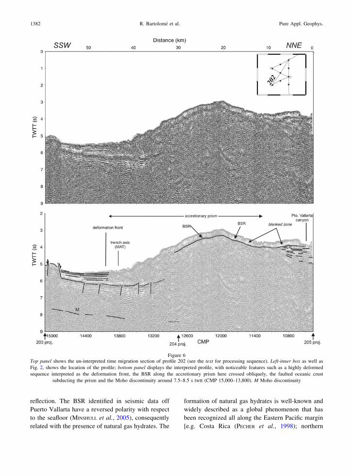
Figure 6Top panel shows the un-interpreted time migration section of profile 202 (see the text for processing sequence). Left-inner box as well as
Fig. 2, shows the location of the profile; bottom panel displays the interpreted profile, with noticeable features such as a highly deformed
sequence interpreted as the deformation front, the BSR along the accretionary prism here crossed obliquely, the faulted oceanic crust
subducting the prism and the Moho discontinuity around 7.5–8.5 s twtt (CMP 15,000–13,800). M Moho discontinuity
1382 R. Bartolome et al. Pure Appl. Geophys.

Figure 7Top panel shows the un-interpreted time migration section of profile 203 (see the text for processing sequence). Left-inner box as well as
Fig. 2, shows the location of the profile; bottom panel displays the interpreted profile, with noticeable features such as the high reflective zones
beneath 4 s twtt (CMP 3,000) that could represent gas-charged zones and a surface expression of near-vertical channels. In this southernmost
profile, the deformation front coincides with the trench axis
Vol. 168, (2011) Imaging the Seismic Crustal Structure 1383

California (BROOKS et al., 1991); Peru (PECHER et al.,
1996); Pacific ocean off Mexico, Guatemala and
Panama (SHIPLEY et al., 1979); Gulf of California
(LONSDALE, 1985)]. We have detected the widespread
distribution of the BSR not only in the accretionary
prism offshore of Puerto Vallarta, but also in the
forearc basin, the continental slope and the mid slope
terrace. A BSR is, however, absent in areas affected
by slumping, as can be observed in profile 205 (CDP
3,500–4,000, Fig. 3). A similar situation has been
described in the Peruvian margin (PECHER et al.,
1998). We speculate that the gas may escape through
the fractures that appear to cross the base of gas
hydrate stability zone near CDP 800 in profile 204
(Fig. 5). Vertical fluid expulsion channels and sea-
floor venting sites have also been recognized in
northern Cascadia (HYNDMAN et al., 2001) and the Sea
of Okhotsk (LUDMANN and WONG, 2003) linked with
Figure 8Top panel shows the un-interpreted time migration section of profile 201 (see the text for processing sequence). Left-inner box as well as
Fig. 2, shows the location of the profile; bottom panel displays the interpreted profile, with noticeable features such as a low reflectivity of the
blanked zone above the BSR (CMP 7,600–8,500) and the Moho discontinuity around 7 s twtt on the southernmost part of the line (CMP
9,000–9,700). M Moho discontinuity
1384 R. Bartolome et al. Pure Appl. Geophys.

BSR. When these structures reach the seafloor, they
are associated either with pockmarks or with dome-
like structures (profile 204, CMP 700). The pale
reflectivity above the BSR, known as a blanked zone
(e.g., KORENAGA et al., 1997), is clearly recognized in
all the profiles at 0.2 s twtt below the BSR and it has
been associated with hydrate cementation or porosity
filling suppressing the impedance contrasts between
the layers (Figs. 5, 6, 7, 8).
4.2. Deep Crustal Structure
Seismic imaging is the best method to investigate
the structure of subduction zones and becomes highly
dependent on the material properties (seismic veloc-
ities) and the depth of the earthquakes in the specific
case of seismic tomographic imaging. Producing
images of a young lithosphere with shallow earth-
quakes becomes challenging, but in the meantime, we
have imaged the deep crustal structure using active
multichannel seismics. The analysis and interpreta-
tion of the MCS profiles allows us to identify, for the
first time in the area of the subduction Rivera Plate,
the major structures of the margin at deep crustal
levels.
Seismic images show crustal thickness of 3 s twtt
for the subducting Rivera Plate (roughly *6.5 km
thick) and measured dip angles of subduction, from
Figure 9Block diagram showing the top of the subducted slab of the Rivera Plate, with a dip angle of 6� in the northern part of the block and 8� in the
south under the Jalisco Block. This dip distribution suggests that the Rivera Plate is also being subducted to the north. Blue-areas are well
controlled by the seismic lines whereas black-areas are inferred from the interpolation. Note the presence of subducted ridges
Vol. 168, (2011) Imaging the Seismic Crustal Structure 1385
north to south, of 6� in profile 205 (Fig. 4), 6.5� in
profile 204 (Fig. 5), and 8� in profile 203 (Fig. 7).
This decreasing tendency towards the north is related
to the termination of the subduction north of profile
205 in the oceanic domain. These values are consis-
tent with the 10� dipping Wadatti-Benioff zone at
20 km depth estimated from local seismicity data by
PARDO and SUAREZ (1993).
To illustrate the geometry of the top of the
subducted slab off Puerto Vallarta, we compute a 3D
block diagram (Fig. 9) using the depth (in seconds
twtt) obtained from the MCS sections and using a
nearest neighbour average algorithm. The area well
controlled by existing data is displayed in blue in the
block diagram, whereas the interpolated areas are
shown in black. The 3D block points out the eastward
subduction of the Rivera Plate beneath the continent
with an average dip angle of 7� ± 1� as previously
discussed. Surprisingly, it seems also to subduct, or
bend, towards the north. This result agrees with an
oblique convergence between the Rivera and NA
Plates at 20.95�N 106.25�W (KOSTOGLODOV and
BANDY, 1995). New additional seismic data and
geologic sampling north of Puerto Vallarta will
facilitate answering specific questions such as the
age of Maria Magdalena Rise (MMR, Fig. 2), a
bathymetric feature of about 500 m relief located at
the northern ending of the Jalisco subduction zone in
the area of Tres Marias Islands. The uplift of the Tres
Marias escarpment may be helped by the gently
northward convergence of the Rivera Plate under the
North American Plate, where upper Miocene hemi-
pelagic muds crops out (LONSDALE, 1989) as a
consequence of a history of successive processes of
subduction and opening of the Gulf of California.
Also, the nature of the underlying crust (oceanic or
continental), which is still under discussion (LONS-
DALE, 1995) and may be related to a previous location
of the EPR before a westward jump during the
opening of the Gulf of California, could be resolved
acquiring new geophysical and geological data.
5. Conclusions
The new seismic data presented herein provide
new insight into the crustal structure at the contact
between the Rivera and North American Plates, off-
shore of Puerto Vallarta. We summarized our
conclusions as follows:
1. The Rivera Plate subducts beneath the NA Plate
with, from north to south in the trench axis, a dip
angle ranging from 6� to 8�. Although data are not
conclusive, the subduction seems to continue
northward and the Tres Marias Islands could be
uplifted as a consequence of this subduction.
2. Tectonic observations based on MCS data indicate
that there are significant structural differences from
north to south of 20.2�N. In the trench-fill wedge, the
sedimentary infill is 2.5 km thick near the trench
axis, and there is evidence of normal faulting at the
top of the oceanic crust. The topography of the slope
is quite rough due to slumping and a well developed,
25 km-wide, forearc basin is constituted of two
primary sequences. These two sequences have been
split by a major unconformity; the lower unit is of
Miocene age. South of 20.2�N the forearc basin is not
seen; instead, the upper continental crust is com-
posed of one stratigraphic sequence with a faulted
thin sedimentary cover (0.75 km) below the seafloor,
west of the trench, which is another indication of
recent deformation.
3. We identify a BSR at 0.25–0.4 s twtt in the
seismic data with reverse polarity with respect to
the seafloor, demonstrating the occurrence of gas
hydrates offshore northwestern Mexico between
19�N and 21�N. Vertical expulsion morphologies
have been observed proving fluid circulation
through the detected active fault systems despite
the relatively thick sedimentary coverage.
4. The set of nearly vertical normal faults, formed by
plate flexure, reaching the surface in the oceanic
crust west of the Middle America Trench seems to
help, when subducted, the circulation of fluids
(fluid percolation) and the formation of gas
hydrates in the continental domain.
5. The presence of a well developed accretionary
prism suggests a subduction–accretion type
regime instead of a subduction erosion regime as
is present along the convergent margin of the
Rivera Plate off Manzanillo. This difference may
be related with a variation in the geometry of the
downgoing slab along the trench.
1386 R. Bartolome et al. Pure Appl. Geophys.
Acknowledgments
Funding is from the Spanish National Research
Project (ANT94-0182-C02-01/02). Additional fund-
ing comes from INSU-France, ORSTOM-IRD,
France bilateral cooperation (HF1997-077), and
CSIC/CONACYT 0894PT, the Secretarıa de Marina
of Mexico, CICESE project 644107 and by CIRIT
(Project 1995SGR00438). We acknowledge the cap-
tain and crew of the R/V Hesperides, Altair and
Humboldt, and all the scientific and technical staff
that participated in the CORTES-P96 seismic exper-
iments for their support during the experiment, and
the Mexican authorities for facilitating work within
their exclusive economic zone. The figures were done
using the Generic Mapping Tools-GMT, Wessel, P.
& Smith, W., (1995). R. Bartolome acknowledges the
financial support of the Spanish Ministry of Science
and Innovation (Ramon y Cajal program).
REFERENCES
ATWATER, T. (1970), Implications of plate tectonics for the Ceno-
zoic tectonic evolution of western North America, Geol. Soc. Am.
Bull. 81, 3513–3536.
ATWATER, T. (1989), Plate Tectonic history of the Northeast Pacific
and Western North America, in The Eastern Pacific Ocean and
Hawaii—The Geology of North America N, Winterer, R. W.E.,
Hussong, L., Decker D.M., Eds: Geological Society of America,
Boulder, pp. 21–72.
BANDY, W.L., and YAN, C.Y. (1989), Present-day Rivera-Pacific
and Rivera-Cocos relative plate motions (abstract), Eos trans.
Am. Geophys. Union, 70, 1342.
BANDY, W.L. (1992), Geological and geophysical investigation of
the Rivera-Cocos plate boundary: implications for plate frag-
mentation, Ph.D. Dissertation, Texas A&M University, College
Station, 195 p.
BANDY, W., MORTERA-GUTIERREZ, C.A., and URRUTIA-FUCUGAUCHI, J.
(1993), Gravity field of the southern Colima Graben, Mexico,
Geofis. Intern. 32, 561–567.
BANDY, W., and PARDO, M. (1994), Statistical examination of the
existence and relative motion of the Jalisco and Southern Mexico
blocks, Tectonics 13, 755–768.
BANDY, W.L., KOSTOGLODOV, V., and MORTERA-GUTIERREZ, C.A.
(1998), Southwest migration of the instantaneous Rivera-Pacific
Euler pole since 0.78 Ma, Geof. Int. 37, 153–169.
BANDY, W., KOSTOGLODOV, V., HURTADO-DIAZ, A., and MENA, M.
(1999), Structure of the southern Jalisco subduction zone, Mex-
ico, as inferred from gravity and seismicity, Geofısica
Internacional 38 (3), 127–136.
BANDY, W.L., MICHAUD, F., BOURGOIS, J., CALMUS, T., DYMENT, J.,
MORTERA-GUTIERREZ, C.A., ORTEGA-RAMIREZ, J., PONTOISE, B.,
ROYER, J.-Y., SICHLER, B., SOSSON, M., REBOLLEDO-VIEYRA, M.,
BIGOT-CORMIER, F., DIAZ-MOLINA, O., HURTADO-ARTUNDUAGA,
A.D., PARDO-CASTRO, G., and TROUILLARD-PERROT, C. (2005),
Subsidence and strike-slip tectonism of the upper continental
slope off Manzanillo, Mexico, Tectonophysics 398, 115–140.
BOURGOIS, J., RENARD, V., AUBOUIN, J., BANDY, W., BARRIER, E.,
CALMUS, T., CARFANTAN, J. C., GUERRERO GARCIA, J., MAMMER-
ICKX, J., MERCIER DE LEPINAY, B., MICHAUD, F., and SOSSON, M.
(1988), Fragmentation en cours du continent Nord Americain:
les frontieres sous marines du bloc de Jalisco (Mexique), C.
R. Acad. Sc. Paris 307 II, 1121–1130.
BOURGOIS, J., and MICHAUD, F. (1991), Active fragmentation of the
North American plate at the Mexican Triple Junction Area off
Manzanillo (Mexico), Geomarine Letters 11, 59–65.
BROOKS, J.M., FIELD, M.E., and KENNICUTT II, M.C. (1991),
Observations of gas hydrates in marine sediments, offshore
northern California, Marine Geology 96, 103–109.
COUCH, R., and WOODCOCK, S. (1981), Gravity and structure of the
continental margins of southwestern Mexico and northwestern
Guatemala, J. Geophys. Res. 86, 1829–1840.
COURBOULEX, F., SINGH, S.K., PACHECO, J.F., and AMMON, C.J.
(1997), The 1995 Colima-Jalisco, Mexico, earthquake (Mw=8):
a study of the rupture process, Geophys. Res. Lett. 24,
1019–1022.
CURRIE, C.A., HYNDMAN, R.D., WANG, K., KOSTOGLODOV, V. (2002),
Thermal models of the Mexico subduction zone: Implications for
the megathrust seismogenic zone, Journal of Geophy. Res. 107,
No. B12.
DANOBEITIA, J.J., CORDOBA, D., DELGADO-ARGOTE, L.A., MICHAUD,
F., BARTOLOME, R., FARRAN, M., and CORTES-P96 Working
Group (1997), Expedition gathers new data on crust beneath
Mexican West Coast, EOS Trans. Am. Geophys. Union 78 (49),
565–572.
DAVIES, G. F. (1992), On the emergence of plate tectonics, Geology
20,963–966.
DEMETS, C., and STEIN, S. (1990), Present-Day kinematics of the
Rivera Plate and Implications for Tectonics in Southwestern
Mexico, J. Geophys. Res. 95 (B13), 21931–21948.
DEMETS, C., and WILSON, D. (1997), Relative motions of the
Pacific, Rivera, North American and Cocos plates since 0.78 Ma,
J. Geophys. Res. 102, 2789–2806.
DEMETS, C., and TRAYLEN, S. (2000), Motion of the Rivera plate
since 10 Ma relative to the Pacific and North American plates
and the mantle, in The Influence of plate interaction on post-
Laramide magmatism and tectonics in Mexico, FERRARI, L.,
STOCK, J., URRUTIA-FUCUGAUCHI J., Eds: Tectonophysics 318
(1–4), 119–159.
EISSLER, H. K., and MCNALLY, K. C. (1984), Seismicity and tec-
tonics of the Rivera Plate and implications for the 1932 Jalisco,
Mexico, earthquake, J. Geophys. Res. 89, 4520–4530.
FERRARI, L., PETRONE, CH., and FRANCALANCI, L. (2001), Generation
of oceanic-island basalt type volcanism in the western Trans-
Mexican volcanic belt by slab rollback, asthenosphere infiltra-
tion and variable flux meeting, Geology 29, 507–510.
GEBCO, 2008 Bathymetric dataset, http://www.gebco.net/.
HYNDMAN, R.D., SPENCE, G.D., CHAPMAN, R., RIEDEL, M., and
EDWARDS, R.N. (2001), Geophysical studies of marine gas
hydrate in northern Cascadia, in: Natural Gas Hydrates:
Occurrence, and Detection Geophysical Monograph 124,
American Geophysical Union.
JOHNSON, M.C., and PLANK, T. (1999), Dehydration and melting
experiments constrain the fate of subducted sediments, Geochem.
Geophys. Geosyst., vol. 1, p.1999GC000014.
Vol. 168, (2011) Imaging the Seismic Crustal Structure 1387
KASTNER, M., KEENE, J.B., and GIESKES, J.M. (1977), Diagenesis of
siliceous oozes-I. Chemical controls on the rate of opal-A to
opal-CT transformation an experimental study, Geochimica et
Cosmochimica Acta 41, 1041–1059.
KHUTORSKOY, M.D., DELGADO-ARGOTE, L.A., FERNANDEZ, R., KON-
ONOV, V.I., and POLYAK, B.G. (1994), Tectonics of the offshore
Manzanillo and Tecpan basins, Mexican Pacific, from heat flow,
bathymetric and seismic data, Geofıs. Intern. 33, 161–185.
KLITGORD, K., and MAMMERICKX, J. (1982), Northern East Pacific
rise: magnetic anomaly and bathymetric framework, J. Geophys.
Res. 100, 24367–24392.
KORENAGA, J., HOLBROOK, W.S., SINGH, S.C., and MINSHULL, T.A.
(1997), Natural gas hydrates on the southeast U.S. margin:
Constraints from full waveform and travel time inversions of
wide-angle seismic data, J. Geophys. Res. 102, 15345–15365.
KOSTOGLODOV, V., and BANDY, W. (1995), Seismotectonic con-
straints on the convergence rate between the Rivera and North
America plates, J. Geophys. Res. 100, 17977–17989.
LONSDALE, P. (1985) A transform Continental Margin rich in
hydrocarbons, Gulf of California, The American Association of
Petroleum Geologists Bulletin 69 (7), 1160–1180.
LONSDALE, P. (1989), Geology and tectonic history of the Gulf of
California, in The Eastern Pacific Ocean and Hawaii, Geological
Society of America WINTERER, E.L., HUSSONG, D.M., DECKER,
R.W., Eds: The Geology of North America, pp. 499–521.
LONSDALE, P., (1991) Structural patterns of the Pacific floor off-
shore of peninsular California, in The Gulf and Peninsular
province of the Californias, DAUPHIN, J.P., SIMONEIT, B.R.T., Eds:
Am. Assoc. Pet. Geol. Mem. 47, pp. 87–125.
LONSDALE, P. (1995), Segmentation and disruption of the East
Pacific Rise in the mouth of the Gulf of California, Mar. Geo-
phys. Res. 17, 323–359.
LUDMANN, T., and WONG, H.K. (2003), Characteristics of gas
hydrate occurrences associated with mud diapirism and gas
scape structures in the northwestern Sea of Okhotsk, Marine
Geology 201, 269–286.
LUHR, J.F., NELSON, S.A., ALLAN, J.F., and CARMICHAEL, I.S.E.
(1985), Active rifting in SW Mexico: manifestations of an
incipient eastward spreading-ridge jump, Geology 13, 54–57.
MAMMERICKX, J., and KLITGORD, K. (1982), Northern East Pacific
Rise: evolution from 25 m.y.B.P. to the Present, J. Geophys. Res.
87, 6751–6759.
MAMMERICKX, J. (1984), The Morphology of propagating spreading
centers: New and old, J. Geophys. Res. 89, 1817–1828.
MCCLOY, C., INGLE, J.C., and BARRON, J.A. (1988), Neogene stra-
tigraphy, foraminifera, diatoms, and depositional history of
Marıa Madre Island Mexico: Evidence of Early Neogene marine
conditions in the southern Gulf of California, Marine Micropa-
leontology 13, 193–212.
MERCIER DE LEPINAY, B., MICHAUD, F., and the Nautimate team
(1997), Large Neogene Subsidence along the Middle America
trench off Mexico (18�-19�N): Evidence from Submersible
Observations, Geology 25 (5), 387–390.
MICHAUD, F., MERCIER DE LEPINAY, B., BOURGOIS, J., and CALMUS, T.
(1996), Evidence for active extensional tectonic features within
the Acapulco trench fill at the Rivera-North America plate
boundary, C.R.Acad. Sci., Paris t. 321 serie IIa, 521–528.
MICHAUD, F., DANOBEITIA, J.J., BARTOLOME, R., CARBONELL, R.,
DELGADO-ARGOTE, L., CORDOBA, D., and MONFRET, T. (2001), Did
the East Pacific rise subduct beneath the North America plate
(western Mexico)?, Geo-Marine Letters 20, 168–173.
MINSHULL, T., BARTOLOME, R., BYRNE, S., and DANOBEITIA, J. J.
(2005), Low heat flow from young oceanic lithosphere at the
Middle America Trench off Mexico, Earth and Planetary
Science Letters, 239, 33–41, doi:10.1016/j.epsl.2005.05.045.
MOORE, J. C., WATKINS, J. S., and SHIPLEY, T. H (1982) Summary of
accretionary processes, Leg 66 DSDP: Offscraping, underplat-
ing, and deformation of the slope apron: Initial Reports of the
Deep Sea Drilling Project, v. 66, U.S. Government Printing
Office Washington D.C., pp. 825–836.
NIXON, G.T. (1982), The relatioship between Quaternay volca-
nism in central Mexico and the seismicity and structure of
subducted oceanic lithosphere, Geol. Soc. Am. Bull. 93,
514–523.
PACHECO, F.J., SINGH, S.K., DOMINGUEZ, J., HURTADO, A., QUINTANAR,
L., JIMENEZ, Z., YAMAMOTO, J., GUTIERREZ, C., SANTOYO, M., BANDY,
W., GUZMAN, M., and KOSTOGLODOV, V. (1997), The October 9, 1995
Colima-Jalisco, Mexico earthquake (Mw 8): An aftershock study
and a comparison of this earthquake with those of 1932, Geophys.
Res. Lett. 24 (17), 2223–2226.
PARDO, M., and SUAREZ, G. (1993), Steep subduction geometry of
the Rivera plate beneath the Jalisco Block in western Mexico,
Geophys. Res. Lett. 20, 2391–2394.
PARDO, M., and SUAREZ, G. (1995), Shape of the subducted Rivera
and Cocos plates in southern Mexico: Seismic and tectonic
implications. J. Geophys. Res. 100, 12,357–12,373.
PECHER, I. A., MINSHULL, T. A., SINGH, S.C., and VON HUENE, R.
(1996), Velocity structure of a bottom simulating reflector off-
shore Peru: Results from full waveform inversion, Earth Planet.
Sci. Lett. 139, 459–469.
PECHER, I. A., RANERO, C. R., VON HUENE, R., MINSHULL, T. A., and
SINGH, S. C. (1998), The nature and distribution of bottom sim-
ulating reflectors at the Costa Rican convergent margin, Earth
Planet. Sci. Lett. 139, 459–469.
PROL-LEDESMA, R. M., SUGROBOV, V. M., FLORES, E. L., JUAREZ, G.,
SMIRNOV, Y. B., GORSHKOV, A. P., BONDARENKO, V. G., RASHI-
DOVM, V. A., NEDOPEKIN, L. N., and GAVRILOV, V. A. (1989), Heat
flow variations along the Middle America Trench, Mar. Geophys.
Res. 11, 69–76.
RAMIREZ-HERRERA, M.T., and URRUTIA-FUCUGAUCHI, J. (1999),
Morphotectonic zones along the coast of the Pacific conti-
nental margin, southern Mexico, Geomorphology 28, 237–
250.
RAMIREZ-HERRERA, M. T., KOSTOGLODOV, V., and URRUTIA-FUCU-
GAUCHI, J. (2004), Holocene emerged notches and tectonic uplift
along the Jalisco coast, Southwest Mexico, Geomorphology 58,
291–304.
SHIPLEY, T. H., HOUSTON, M. H., and BUFFER, R.T. (1979), Seismic
evidence for widespread possible gas hydrate horizons on con-
tinental slopes and rises, Am. Assoc. Pet. Geol. Bull. 63,
2204–2213.
SINGH, S. K., PONCE, L., and NISHENKO, S. (1985), The great jalisco,
Mexico earthquake of 1932: subduction of the Rivera plate, Bull.
Seismic. Soc. Amer. 75, 1301–1313.
SINGH, S.K., PACHECO, J.F., ALCANTARA, L., REYES, G., ORDAZ, M.,
IGLESIAS, A., ALCOCER, S.M., GUTIERREZ, C., VALDES, C.,
KOSTOGLODOV, V., REYES, C., MIKUMO, T., QUAAS, R., and
ANDERSON, J. G. (2003), A Preliminary Report on the Tecoman,
Mexico Earthquake of 22 January 2003 (Mw7.4) and its effects,
Seismological Research Letters 74, 279–289.
STERN. R.J. (2002), Subduction zones, Reviews of Geophysics,
40, 4.
1388 R. Bartolome et al. Pure Appl. Geophys.

VON HUENE, R., RANERO, C. R., and WATTS, P. (2004), Tsunamigenic
slope failure along the Middle America Trench in two tectonic
settings, Marine Geology 203, 303–317.
WANG, K., HYNDMAN, R.D., YAMANO, M. (1995), Thermal regime of
the southwest Japan subduction zone: Effects of age history of
the subducting plate, Tecnonophysics 248, 53–69.
YUAN, J., and EDWARDS, R. N. (2000), The assessment of marine gas
hydrates through electrical remote sounding: Hydrate without a
BSR?, Geophysical Research Letters 27 (16), 2397–2400.
ZIAGOS, J. P., BLACKWELL, D. D., and MOOSER, F. (1985), Heat flow
in southern Mexico and the thermal effects of subduction, J.
Geophy. Res. 90, 5410–5420.
(Received February 15, 2010, revised August 13, 2010, accepted August 16, 2010, Published online November 16, 2010)
Vol. 168, (2011) Imaging the Seismic Crustal Structure 1389


