Embed Size (px)
Citation preview
JOURNAL OF GEOPHYSICAL RESEARCH, VOL. 93, NO. B9, PAGES 10,081-10,094, SEPTEMBER 10, 1988
Crustal Structure of East Central Oregon' Relation Between Newberry Volcano and Regional Crustal Structure
R. D. CATCHINGS
U.S. Geological Survey, Menlo Park, California Department of Geophysics, Stanford University, California
W. D. MOONEY
U.S. Geological Survey, Menlo Park, California
A 180-km-long seismic refraction transect from the eastern High Cascades, across Newberry Volcano, to the eastern High Lava Plains is used to investigate the subvolcanic crustal and upper mantle velocity structure there. Near-surface volcanic flows and sedimentary debris (1.6-4.7 km/s), ranging from 3 to 5 km in thickness, overlie subvolcanic Basin and Range structures. East and west of Newberry Volcano, the subvolcanic basement (5.6 km/s) has been downwarped, producing 5-km-deep basins. The midcrust (8- to 28-km depth) is characterized by velocities ranging from 6.1 to 6.5 km/s and varies laterally in thicknesses. The lower crust is characterized by an unusually high velocity (about 7.4 km/s), and its geometry mirrors the subvolcanic basement geometry. The Moho is located at a depth of 37 km and represents a transition to an upper mantle velocity of 8.1 km/s. The shallow subsurface (1.2 km) beneath Newberry Volcano is characterized by high-velocity (5.6 km/s, versus 4.1 km/s for the surrounding area) intrusions and appears to be located on a basement high. Beneath the seismic refraction array at Newberry Volcano, an absence of low-velocity anomalies suggests that large silicic magma chambers do not exist in the upper crust, but apparent high attenuation of the seismic wave field may be consistent with either partial melts in small volumes, elevated crustal temperatures, and/or poor geophone- recording site coupling. The east central Oregon velocity structure is nearly identical to that of the northwestern Nevada Basin and Range and the Modoc Plateau of northeastern California, and vari- ations in the deep crustal structure about Newberry Volcano are consistent with tectonism involving crustal underplating, melting, and extension. If paleomagnetic estimates of extension in the east central Oregon area are correct, the North American continent experienced significant growth through exten- sion, underplating, and volcanism in east central Oregon. Comparison of east central Oregon with other continental back arc areas shows similarities in crustal thickness, velocity, and heat flow.
INTRODUCTION
East central Oregon is divided into several physiographic provinces including the High Cascades, High Lava Plains, and the Basin and Range. Our study area is within this region and is bordered by the Western Cascade Range, the Blue Moun- tains and Columbia Plateau, the Snake River Plain, and the Basin and Range on the west, north, east, and south, respec- tively (Figure la). Two of these provinces, the Columbia Pla- teau and the Snake River Plain, along with the Yellowstone Plateau jointly form one of the world's largest continental basaltic provinces, estimated at more than 280,000 km 2 [Thompson, 1977]. Similarly, much of the remainder of east central Oregon is covered by basaltic volcanic and sedi- mentary debris which make the subbasalt upper crust inac- cessible to direct geologic investigation. Continental volcanic plateaus, such as those of the Pacific Northwestern United States, represent a key element in understanding crust-mantle interactions and processes of continental growth and exten- sion; yet the geologic inaccessibility, combined with the fact that little seismic exploration of the crust has been attempted, makes the subvolcanic crustal structure in these areas largely unknown.
In order to investigate the regional crustal structure of east central Oregon, the U.S. Geological Survey conducted a seis-
mic investigation of the crustal structure there concurrently with an effort to investigate the local crustal structure of New- berry Volcano, a large shield volcano on the eastern boundary of the High Cascade Range and a potential source of geother- mal energy. This east central Oregon (ECO) regional profile originated in the High Cascades roughly 30 km west of New- berry Volcano and trended approximately 180 km east across the High Lava Plains (Figure 1). The ECO seismic transect was centered on the Newberry area because, in addition to its importance as a geothermal site, Newberry Volcano is of great tectonic interest, as it is situated at the intersection of Cascade and Basin and Range tectonism, a continental arc to back arc transition. Furthermore, Newberry Volcano marks the west- ernmost point of a complex pattern of volcanism which pro- gressively increases in age as it trends toward the Nevada Basin and Range and toward the Snake River Plain [Christiansen and McKee, 1978]. In this paper we present crustal and upper mantle velocity and density models for the High Cascades/High Lava Plains region of east central Oregon and discuss the relation between Newberry Volcano and the regional crustal structure.
REGIONAL GEOLOGIC AND TECTONIC SETTING
This paper is not subject to U.S. copyright. Published in 1988 by the American Geophysical Union.
Paper number 7B 1051.
The regional geology and tectonics of east central Oregon are dominated by continental flood basalts and extensional faulting, which are attributed to subduction-related (back arc) extension and volcanism associated with the subduction of the
10,081
10,082 CATCHINGS AND MOONEY: CRUSTAL STRUCTURE OF EAST CENTRAL OREGON
WASHINGTON
I 234
• HIGH LAVA PLAINS
ß / i:. '; I NEVADA : I
o .,oo ,vl -- ,:.,o,=.,.,:. ,:'co
NTS
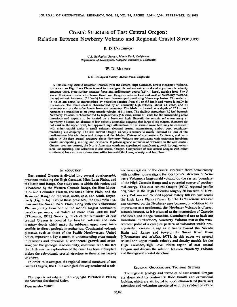
Fig. 1. (a) Physiographic map of Oregon with the east central Oregon (ECO) seismic profile and shot point locations. Shot points along the seismic transect are shown as large dots. (b) Regional location map of the Pacific Northwest with locations of some other recently acquired seismic refraction profiles near the ECO transect. Transect 1 is within the Columbia Plateau [Catchings and Mooney, 1988], transect 2 is within the High Cascade Range [Leaver et al., 1984], transect 3 is within the Modoc Plateau and southern Cascade Range of northern California [Catchings, 1983; Zucca et al., 1986], and transect 4 is from southern Nevada to Boise, Idaho [Hill and Pakiser, 1966].
Juan De Fuca plate beneath North America [Hamilton and Myers, 1966' Scholz et al., 1971' Karig and densky, 1972' Thompson, 1972' Thompson and Burke, 1974' Hammond, 1979' McKee et al., 1983]. Paleomagnetic studies and geologic ob- servations suggest that the Cascade/Sierra Nevada back arc region has undergone large amounts of extension and rotation since the Eocene, which have apparently resulted in up to 250 km of displacement across parts of the region [Hamilton and Myers, 1966' Simpson and Cox, 1977' Magill and Cox, 1981' Frei, 1986]. Such large estimates of extension and rotation have led to speculation that some of the physiographic prov- inces are underlain by rifted or oceanic-type crust [Hamilton and Myers, 1966].
The surface geology and the tectonics of the arc and back arc system vary greatly from province to province, but a con- stant feature in each of these provinces is the abundance of rocks of basaltic composition. Below, we briefly summarize the surface geology and tectonics of the provinces surrounding our study area in order to provide background information for our conclusion section.
The Cascade Range is an active volcanic arc centere d ap- proximately 250 km east of the boundary between the north- eastwardly subducting Juan De Fuca plate and the North American plate. The Cascade Range is divided into two sub- provinces, the older Western Cascades and the younger High Cascades. Rocks of the Western Cascades range in age from Eocene to late Miocene and range in composition from olivine basalt to rhyolite, but pyroxene andesite is the predominate composition [Williams, 1949]. Rocks of the High Cascades generally range in age from 0 to 5 m.y. [Hammond, 1979] and are primarily basaltic in composition, but these rocks also range in composition from olivine basalt to rhyolite. Most of the volcanoes of the High Cascades are basaltic shield vol- canoes, although the larger composite volcanoes are primarily andesite [McBirney, 1978]. The Cascade system has experi-
enced a complex tectonic history of block faulting and vol- canism [Hammond, 1979] as evidenced by recent potential field and seismic surveys which show that parts of the present High Cascade Range are built within or near the edge of an extensive graben system [Couch et al., 1982; Catchings, 1983; Blakely et al., 1985; Zucca et al., 1986; Fuis et al., 1987].
The Blue Mountains Province, a region consisting of Paleo- zoic, Mesozoic, and early Tertiary metamorphic rocks, is lo- cated east of the Cascade Range and north of our immediate study area. The Blue Mountains are one of the few areas in eastern Oregon not largely covered by Cenozoic volcanics, and as a result, more detailed geologic and tectonic infor- mation is available. Cenozoic lavas and continentally derived sedimentary rocks surround inliers of Paleozoic and Mesozoic eugeosynclinal rocks, suggesting that much of the Blue Moun- tains represent oceanic and island-arc rocks which have been accreted to the North American continent [Brooks and Val- lier, 1978; Dickinson and Thayer, 1978]. Based on faulting relationships and stratigraphy, Barrash et al. [1983] suggest that the Blue Mountains experienced a complicated tectonic history of folding between 17 and 10 m.y., uplift (with strike- slip faulting in the northwest and extensional faulting in the east) between 10 and 4 m.y., and mild deformation from 4 m.y. to the present.
The Columbia Plateau, north of our study area, covers over 200,000 km 2 in parts of Washington, Oregon, and Idaho and represents the third largest continental volcanic plateau on Earth (exceeded only by the Parana Basin of Brazil and the Deccan Traps of India). Prior to extrusion of massive Miocene basalt flows between 17 and 13.5 m.y. ago, the crust beneath and around the Columbia Plateau was apparently subjected to extension, which is observed in metamorphic core com- plexes [Rhodes, 1986] and grabens of apparent Eocene age [Buza, 1979; Catchings and Mooney, 1988]. High-angle re- ve] se faulting and folding of the surficial basalt have produced
CATCHINGS AND MOONEY.' CRUSTAL STRUCTURE OF EAST CENTRAL OREGON 10,083
a series of valleys and ridges which vary in strike, but strike- slip and normal faulting are also observed, making the present deep stress field poorly known within the Columbia Plateau. The northern Columbia Plateau is believed to be underlain by the edge of the North American craton, while the southern part of the Columbia Plateau is postulated to be underlain by accreted terranes [Barrash et al., 1983; Kistler, 1978].
The High Lava Plains are located east of the Cascade Range and form a transitional boundary between the Basin and Range to the south and the Blue Mountains/Columbia Plateau to the north. Within the High Lava Plains, the transi- tional area is marked by the Brothers Fault Zone [Lawrence, 1976], a northwest trending zone of normal and strike-slip faulting. Exposed Basin and Range physiography is absent north of the Brothers Fault Zone, although surface normal faulting has been observed there [Stewart, 1978]. The vol- canics of the High Lava Plains range in composition from basalt to rhyolite and range in age from about 0 to 17 m.y. [Christiansen and McKee, 1978]. Much of the most recent basaltic and rhyolitic volcanism occurs near Newberry Vol- cano, a large shield volcano located near the High Cas- cade/High Lava Plains/Basin and Range boundary. From Newberry Volcano, basaltic volcanism occurs in a narrow zone slightly oblique to the trend of the Brothers Fault Zone and extends eastward toward the Oregon-Idaho border [Christiansen and McKee, 1978]. Progressively older vol- canism can also be traced from Newberry Volcano south- eastward to the northwestern Nevada Basin and Range [Mac- Leod et al., 1976]. Thus Newberry Volcano, which is marked by Recent rhyolitic and basaltic volcanism, appears to repre- sent both the eastern edge of Cascade volcanism and the lead- ing edge of a propagating volcanic front from the southeast.
Situated east of the High Lava Plains and our study area, the western Snake River Plain is a Miocene basalt-filled rift
which trends northwest-southeast along the Oregon-Idaho border I-Mabey, 1976]. Both Miocene rhyolitic and basaltic rocks are present within the western Snake River Plain, but the younger volcanism appears to be basaltic [Mabey, 1976]. Normal faults which bound the western Snake River Plain
attest to its extensional tectonic history, believed to have re- sulted from movement of the North American plate over a hot spot [Christiansen and McKee, 1978].
The Basin and Range of east central Oregon, south of our study area, has an uppermost crust which consists largely of Pal½ozoic to Mesozoic metamorphic rocks and plutonic rocks of granitic composition [Hamilton and Myers, 1966], but much of the region is also covered by basaltic to rhyolitic volcanics and sedimentary debris. McKee et al. [1983] have demonstrated that many of the basaltic volcanics are identical to those found in many oceanic ridges or back arc regions. The rhyolitic volcanism follows a pronounced northwestward migration from the Basin and Range of northwestern Nevada to Newberry Volcano and is estimated to have migrated at a rate of about 1 cm/yr over the last 11 m.y. [MacLeod et al., 1976]. The rhyolitic volcanism appears to have migrated con- currently with a similar northwestward migration of normal faulting from the Basin and Range.
The regional geology and tectonics are thus complex and indicative of the active tectonism which has shaped the crust and upper mantle within this back arc region.
PREVIOUS SEISMIC STUDIES
Previous estimates of the crustal thickness (45 km) and upper mantle velocity (7.9-8.0 km/s) of east central Oregon were based on earthquake studies [Dehlinger et al., 1965;
Chiburis, 1966], gravity studies (G. P. Woollard, in Steinhart and Meyer [1961]; Couch et al. [1982]), and based indirectly on lateral extrapolations of the crustal and upper mantle ve- locity structure of the surrounding geologic provinces, includ- ing the High Cascades, the western Snake River Plain, the Modo½ Plateau/southern Cascade Range, and the Columbia Plateau. However, as we demonstrate below, comparison of the interpreted crustal and upper mantle velocity structure of the surrounding provinces shows that the regional crustal structure is highly variable and difficult to extrapolate from province to province. West of east central Oregon, beneath the axis of the Oregon Cascade Range, Leaver et al. 1-1984] deter- mined velocities ranging from 2.9 to 6.5 km/s for the upper and middle crust, 7.0-7.1 km/s for the lower crust (28- to 44-km depth), and 7.7 km/s for the upper mantle (at 44-km depth) beneath the axis of the Oregon Cascade Range. To the east, within the western Snake River Plain, Hill and Pakiser [1966] determined crustal velocities ranging from 5.2 to 6.7 km/s and an upper mantle velocity of 7.9 km/s (at 40-km depth). To the south, within the Modo½ Plateau/southern Cas- cade Range area, Zucca et al. [1986] determined upper and middle crustal velocities ranging from 2.5 to 6.5 km/s (to 28-km depth), lower crustal velocities of 7.0-7.3 km/s (from 28- to 38-kin depth), and an undetermined upper mantle ve- locity at about 38-km depth. North of east central Oregon, Catchin,Is and Mooney [1988] found the central Columbia Plateau to be underlain by a continental rift structure with upper crustal velocities ranging from 5.0 to 6.8 km/s, a lower crustal velocity of 7.5 km/s (from 25- to 39-km depth), and an upper mantle velocity of 8.4 km/s (at 39-kin depth). Within our study area, the only other active seismic studies have been conducted locally at Newberry Volcano, where Stauber et al. [1985] and Achauer et al. [this issue] have used seismic tomo- graphic methods to investigate the detailed shallow crustal structure in search of possible magma chambers. They, as did we in this study, found Newberry Volcano to be underlain by high-velocity rocks at shallow depths relative to the sur- rounding area. However, they also reported some lower- velocity anomalies north of our study area.
Although the regional crustal structure has been investi- gated seismically in some of the provinces of the Pacific Northwest, none of these deep seismic profiles has been within east central Oregon. Furthermore, many of these profiles in the surrounding provinces were not reversed, the spatial sam- pling was sparse, and interprovince measurements were not available, resulting in an incomplete knowledge of the crustal and upper mantle structure in the region.
SEISMIC FIELD SURVEY AND
MODELING METHOD
Six shot points were situated along the ECO seismic profile, with five of the six shot points located symmetrically about Newberry Volcano (Figure 1). Shot points were located ap- proximately every 15 km within 30 km east and west of New- berry Volcano. A total of nine 900- to 1800-kg shots were fired (the longer offset shot points were fired twice, once per deploy- ment) into a linear array of 120 USGS cassette recording seismographs, which were deployed twice, resulting in a total of 240 recording sites (see Cotton and Catchings [1988] for details of the seismic survey).
Seismic modeling was initially accomplished by one- dimensional ray tracing and then remodeled using a two- dimensional ray tracing algorithm written by J. H. Luetgert (written communication, 1985) and based on theory by Cer- veny et al. [-1977]. From one-dimensional ray tracing, initial

10,084 CATCHINGS AND MOONEY' CRUSTAL STRUCTURE OF EAST CENTRAL OREGON
NEWBERRY VOLCANO
o 5o
I , ' SP1 SP2
10-
20-
30-
BROTHERS FAULT ZONE
100 150 180
• I , , I , , , , I , , [ 'P5 •.7SP6 ß 1 1.6 X ß
4.1 _2 / \ /••___- 0 4? 3••'- 5.6
5 6.1
? 6.5
8 7.4
lO
-20
30
50 ß , o
8.15
I I I I I I I I I I I I I I I I 50 I00 150
DISTAN C E (KM)
-40
5O
leo
Fig. 2. Seismically derived crustal velocity model. Seismic P wave velocities are in km/s. Depth is relative to sea level, and distance is relative to shot point 1, located west of Newberry Volcano. Vertical exaggeration is 1.3:1. Numbers 1-9 refers to layers 1-9 described in the text. The dashed parts of the layer boundaries are constrained by gravity data without seismic constraints.
velocities and depths were determined for each shot point and made into a composite two-dimensional model. That initial two-dimensional model was then input into the two- dimensional ray tracing program, where near-vertical and wide-angle reflections were modeled in detail for each shot point in order to constrain the structural boundaries. Once the structural boundaries were determined, the seismic veloci- ties were reevaluated in order to account for the effects of
structure. By determining the structure in this manner, we have much greater confidence in our model because the model is based on both wide-angle reflection data and refraction data.
The observed and calculated travel times generally match to within a few tens of milliseconds, suggesting that the error in depth to reflecting and refracting boundaries for the shallow crust is probably no more than several hundred meters. Be- cause of the complex geometry of the seismic model, some of the travel times were determined based on diffraction-source
modeling, where travel times to sharp corners in the model were first calculated, and then a source was placed at that corner in order to compute the travel time to the surface. This method was adopted because of the inability of ray theory to approximate true diving and refracting energy near complex structures. Because we adopted this technique, reflectivity and ray-density synthetic seismogram calculations became imprac- tical [McMechan and Mooney, 1980]. Therefore although the average velocity of the layers is well constrained, details of the velocity structure, such as its gradational character within dis- crete layers and at layer boundaries, are not well constrained with amplitude information. Within each layer, velocity gradi- ents were estimated by the changes in slopes of first arrivals for the upper crust, and velocity gradients within deeper layers were less reliably estimated by the alignment of secondary arrivals.
Similarly, between shot points 1 and 5, where the shot den-
sity is higher (every 15 km), details in the variation of layer depths and geometries are better constrained because of the multiple-reversing coverage, but where the shot density is lower (such as between shot points 5 and 6), the details of the shallow crustal structure are less well determined. The deep crustal structure is similarly affected because the long-offset shot points (shot points 1, 5, and 6; Figure 1) are far apart, with only three reversing shot points. From these shot points, deep crustal layers are averaged over at least 1 km (• 1 wave- length); therefore small and abrupt variations in the crustal layers are not modeled. However, larger variations in the sub- surface structure are seismically modeled, and when combined with gravity modeling, which we present below, such features are further constrained.
SEISMIC MODEL AND INTERPRETATION
The ECO seismic model consists of a nine-layer crustal and upper mantle model (Figure 2) with average layer velocities ranging from 1.6 to 8.1 km/s. We recognize three layers (layers 1, 2, and 3) above the crystalline basement with average veloc- ities of 1.6, 4.1, and 4.7 km/s. Layer 1 is observed locally, primarily in the old lake beds and sedimentary basins, but layer 2 is regional in extent, being observed over the entire length of the ECO profile. Layer 3 is present over much of the seismic transect but is confined to the deeper parts of the major subbasalt basins. Layer 4 (5.6 km/s), which we interpret as crystalline basement, is continuous across the transect, and within the upper to middle crust, we have modeled two ad- ditional layers (layers 5 and 6) with velocities of 6.1 and 6.2 kin/s, respectively. The middle to lower crust is also composed of two layers (layers 7 and 8) with velocities of 6.5 and 7.4 km/s at average depths (below the surface) of about 20 and 30 km, respectively. The Moho is located at about 37 km below the surface and is an approximately planar boundary which
CATCHINGS AND MOONEY: CRUSTAL STRUCTURE OF EAST CENTRAL OREGON 10,085
,. 0
40 60 ß '
$P3 sP4 $P5
C 5•
4i ?
• 2! ... 1 x
-1-
-2
$P1 $P2 $P3 v ........ ß .......
D o - :
• 10 --
40
L
6
"'" ...... ' ...... $P4 $P5
160 ...,
SP6
5
4
3
2
1
0
-1
-2 "•8o
30
,40
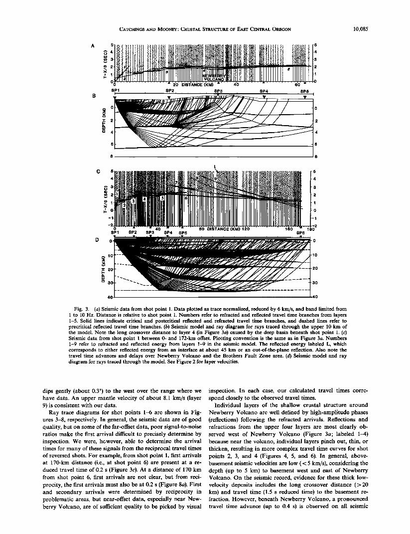
Fig. 3. (a) Seismic data from shot point 1. Data plotted as trace normalized, reduced by 6 km/s, and band limited from 1 to 10 Hz. Distance is relative to shot point 1. Numbers refer to refracted and reflected travel time branches from layers 1-5. Solid lines indicate critical and postcritical reflected and refracted travel time branches, and dashed lines refer to precritical reflected travel time branches. (b) Seismic model and ray diagram for rays traced through the upper 10 km of the model. Note the long crossover distance to layer 4 (in Figure 3a) caused by the deep basin beneath shot point 1. (c) Seismic data from shot point 1 between 0- and 172-km offset. Plotting convention is the same as in Figure 3a. Numbers 1-9 refer to refracted and reflected energy from layers 1-9 in the seismic model. The reflected energy labeled L, which corresponds to either reflected energy from an interface at about 45 km or an out-of-the-plane reflection. Also note the travel time advances and delays over Newberry Volcano and the Brothers Fault Zone area. (d) Seismic model and ray diagram for rays traced through the model. See Figure 2 for layer velocities.
dips gently (about 0.3 ø ) to the west over the range where we have data. An upper mantle velocity of about 8.1 km/s (layer 9) is consistent with our data.
Ray trace diagrams for shot points 1-6 are shown in Fig- ures 3-8, respectively. In general, the seismic data are of good quality, but on some of the far-offset data, poor signal-to-noise ratios make the first arrival difficult to precisely determine by inspection. We were, hawever, able to determine the arrival times for many of these signals from the reciprocal travel times of reversed shots. For example, from shot point 1, first arrivals at 170-km distance (i.e., at shot point 6) are present at a re- duced travel time of 0.2 s (Figure 3c). At a distance of 170 km from shot point 6, first arrivals are not clear, but from reci- procity, the first arrivals must also be at 0.2 s (Figure 8a). First and secondary arrivals were determined by reciprocity in problematic areas, but near-offset data, especially near New- berry Volcano, are of sufficient quality to be picked by visual
inspection. In each case, our calculated travel times corre- spond closely to the observed travel times.
Individual layers of the shallow crustal structure around Newberry Volcano are well defined by high-amplitude phases (reflections) following the refracted arrivals. Reflections and refractions from the upper four layers are most clearly ob- served west of Newberry Volcano (Figure 3a; labeled 1-4) because near the volcano, individual layers pinch out, thin, or thicken, resulting in more complex travel time curves for shot points 2, 3, and 4 (Figures 4, 5, and 6). In general, above- basement seismic velocities are low ( < 5 km/s), considering the depth (up to 5 km) to basement west and east of Newberry Volcano. On the seismic record, evidence for these thick low- velocity deposits includes the long crossover distance (>20 km) and travel time (1.5 s reduced time) to the basement re- fraction. However, beneath Newberry Volcano, a pronounced travel time advance (up to 0.4 s) is observed on all seismic
10,086 CATCHINGS AND MOONEY' CRUSTAL STRUCTURE OF EAST CENTRAL OREGON
A
-20 0 DISTANCE (KM) 20 40
SP1 SP2 SP3 SP4 SP5
B
,.,o
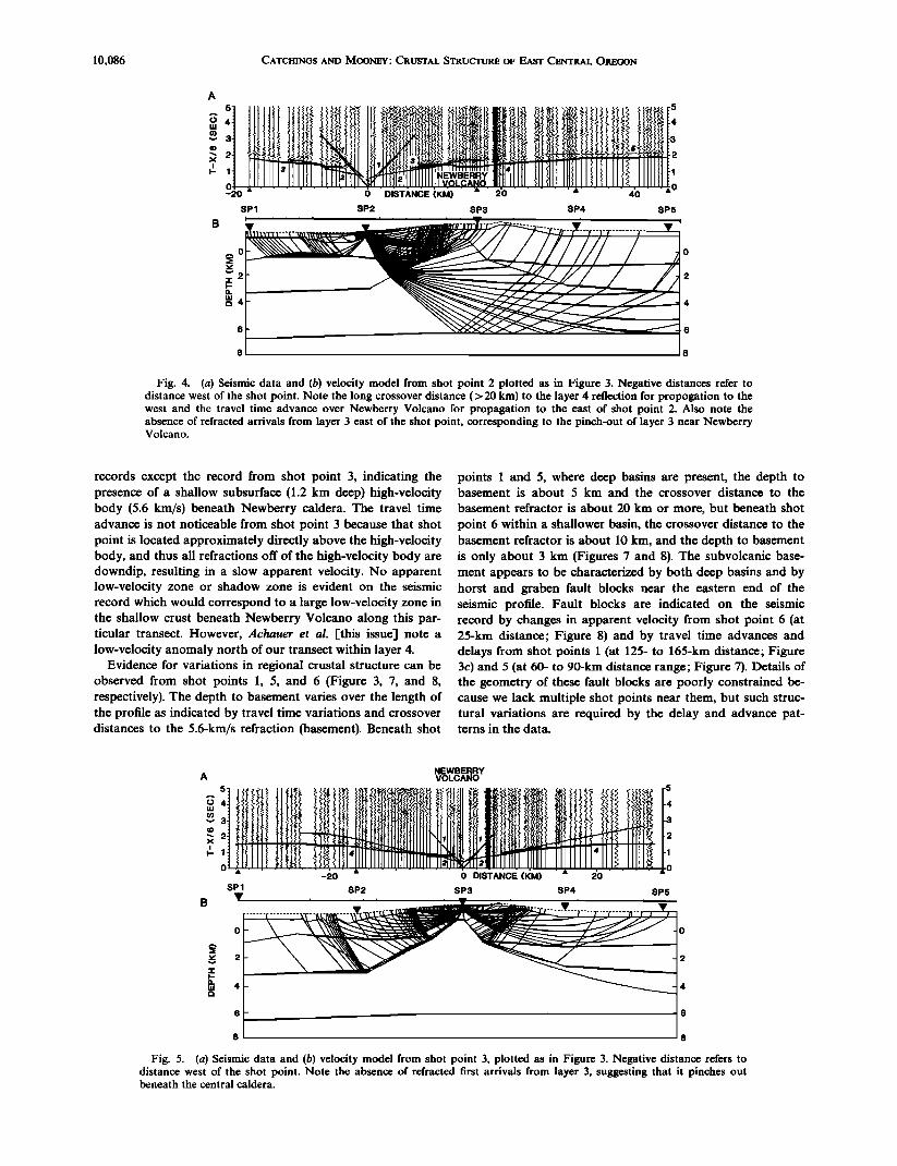
Fig. 4. (a) Seismic data and (b) velocity model from shot point 2 plotted as in Figure 3. Negative distances refer to distance west of the shot point. Note the long crossover distance (> 20 kin) to the layer 4 reflection for propogation to the west and the travel time advance over Newberry Volcano for propagation to the east of shot point 2. Also note the absence of refracted arrivals from layer 3 east of the shot point, corresponding to the pinch-out of layer 3 near Newberry Volcano.
records except the record from shot point 3, indicating the presence of a shallow subsurface (1.2 km deep) high-velocity body (5.6 km/s) beneath Newberry caldera. The travel time advance is not noticeable from shot point 3 because that shot point is located approximately directly above the high-velocity body, and thus all refractions off of the high-velocity body are downdip, resulting in a slow apparent velocity. No apparent low-velocity zone or shadow zone is evident on the seismic record which would correspond to a large low-velocity zone in the shallow crust beneath Newberry Volcano along this par- ticular transect. However, Achauer et al. [this issue] note a low-velocity anomaly north of our transect within layer 4.
Evidence for variations in regional crustal structure can be observed from shot points 1, 5, and 6 (Figure 3, 7, and 8, respectively). The depth to basement varies over the length of the profile as indicated by travel time variations and crossover distances to the 5.6-km/s refraction (basement). Beneath shot
points 1 and 5, where deep basins are present, the depth to basement is about 5 km and the crossover distance to the
basement refractor is about 20 km or more, but beneath shot point 6 within a shallower basin, the crossover distance to the basement refractor is about 10 kin, and the depth to basement is only about 3 km (Figures 7 and 8). The subvolcanic base- ment appears to be characterized by both deep basins and by horst and graben fault blocks near the eastern end of the seismic profile. Fault blocks are indicated on the seismic record by changes in apparent velocity from shot point 6 (at 25-kin distance; Figure 8) and by travel time advances and delays from shot points 1 (at 125- to 165-km distance; Figure 3c) and 5 (at 60- to 90-kin distance range; Figure 7). Details of the geometry of these fault blocks are poorly constrained be- cause we lack multiple shot points near them, but such struc- tural variations are required by the delay and advance pat- terns in the data.
NEWBERRY A VOLCANO
....... -•0 ...... •) DIstANcE (!•M) .... 2'0 ' ' SP1
B 1!' ............. •---;
0
8
SP2 SP3 SP4 SP5
Fig. 5. (a) Seismic data and (b) velocity model from shot point 3, plotted as in Figure 3. Negative distance refers to distance west of the shot point. Note the absence of refracted first arrivals from layer 3, suggesting that it pinches out beneath the central caldera.

CATCHINGS AND MOONEY.' CRUSTAL STRUCTURE OF EAST CENTRAL OREGON 10,087
ß ' '-•0 ..... -•0' ' DISIA'N6E [KM) ' •) ....... SP1 SP2 SP3 SP4 SP5
Fig. 6. (a) Seismic data and (b) velocity model from shot point 4, plotted as in Figure 3. Negative distance refers to distance west of shot point 4. Note the absence of refracted first arrivals from layer 3 west of the shot point, and note the travel time advance over Newberry Volcano.
Seismic evidence for the substantial thickness of the upper crust (6.2 km/s or less) in the Newberry area includes the long crossover distance (up to 140 km) to higher velocities (Figures 3c, 7a, and 8a). Weak reflected energy in the distance and time ranges, 25-50 km and 2-3 s (Figure 3c), 15-45 km and 2-3 s (Figure 7a), and 25-60 km and 1-3 s (Figure 8), either corre- sponds to reflections from a boundary with a small velocity contrast (6.1-6.2 km/s) or it corresponds to reflections from the base of a thin low-velocity layer. We cannot distinguish between the two possibilities, but it is clear that the velocity of the crust between 5- and 18-km depth is no more than 6.2 km/s. The lack of significant change in slope in the first arriv- als between 75 and 140 km from the shot points and the weak amplitudes suggests that the velocity is nearly constant in the middle crust (12- to 18-km depth) and that the velocity gradi- ent there is low. Refractions from the 6.5-, 7.4-, and 8.1-km/s layers are not observed as first arrivals over long distances, but these velocity discontinuites are suggested by the reflected energy from these boundaries, and their minimum velocities
can be estimated by the alignment of critical reflection points and secondary arrivals from shot points 1 and 5 (Figures 3c and 7a, respectively). The velocities of these layers can also be measured from shot point 6 (Figure 8) by aligning the critical reflection points with the reciprocal travel times from shot points 1 and 5. An arched geometry is required for the lower crustal layers by the curvature of reflected arrivals from each of the long-offset shot points and by the observed apparent velocities. The arched geometry of layer 8 can also be ob- served in the abrupt termination of the high-amplitude, wide- angle reflected energy at the 110-km distance and 2-s time range (Figure 3c), resulting from an abrupt change in dip of the top of the layer 8 reflector (Figure 2). Such detail modeling of these types of features and qualitatively accounting for the amplitudes of reflected energy from all of the seismic records provide effective constraints on the average velocity of the lower crust.
High-amplitude energy in the later parts of the seismic sec- tions may provide further information about the upper
A 5
O,
-1'
-2
-60 0 DISTANCE (KM)
/.
FAULT ......................... . .................... !! !, }!t•. ',.•.?.•,?.9)l:L P,•.V. ....... . ............. & .... - 2
60 100
SP1
o
• lO
i-. 20
30
sP2 sP3 sP4 sP5 sP6
lO
3o
40 40
Fig. 7. (a) Seismic data and (b) velocity model from shot point 5, plotted as in Figure 3. Negative distance refers to distance west of shot point 5. Note the travel time advance at 70 km, followed by a travel time delay associated with the Brothers Fault Zone and the pronounced travel time advance over Newberry Volcano.
10,088 CATCHINGS AND MOONEY: CRUSTAL STRUCTURE OF EAST CENTRAL OREGON
SP1
L
SP2 SP3 SP4 SP5
5
o
SP6
0 0
• lO lO
a. 20 20
30 30 ___
40 40
Fig. 8. (a) Seismic data and (b) velocity model from shot point 6, plotted as in Figure 3. Distance is relative to shot point 6. Note the travel time delay over the Brothers Fault Zone and the reflection labeled L (not modeled) corresponding to either an out-of-the-plane reflection or a reflection from the upper mantle at about 45-km depth.
mantle. For example, later reflected energy in the 3- to 5-s reduced time range and 100- to 170-km distance range (la- beled L, Figures 3c and 8) may correspond to energy from a deep reflector located at about 45 km. We have not, however, included this layer in the seismic model because this arrival is not clear from all three long-range shot points. Such a bound- ary would, however, be consistent with the Moho depth ob- served to the west under the Cascade Range by Leaver et al. [1984].
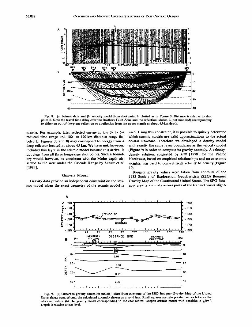
GRAVITY MODEL
Gravity data provide an independent constraint on the seis- mic model when the exact geometry of the seismic model is
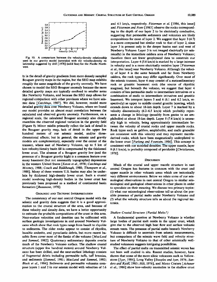
used. Using this constraint, it is possible to quickly determine which seismic models are valid approximations to the actual crustal structure. Therefore we developed a density model with exactly the same layer boundaries as the velocity model (Figure 9) in order to compute its gravity anomaly. A velocity- density relation, suggested by Hill [1978] for the Pacific Northwest, based on empirical relationships and mean atomic weights, was used to convert from velocity to density (Figure 10).
Bouguer gravity values were taken from contours of the 1982 Society of Exploration Geophysicists (SEG) Bouguer Gravity Map of the Continental United States. The SEG Bou- guer gravity anomaly across parts of the transect varies slight-
... _901,,,,,,, ,,,, ,,,, I,,, I,,, I,,, •,1 , , , I , , , •. -90 •-llO C • •_ 110
•]I•••..••ER•V • .•. • -130 • 130 CALCULA•D
• 150 • -150
• 170 • -170
190 • ' • I , , , I , , , I , , , I , , ••• , , , I , L, I , '•['-190 0 20 40 •0 80 100 120 140 I•0 180
lO
2o
3o
NEWBERRY D I $ T R N œ E { K M ] BROTHERS $P1 VOLCANO FAULT ZONE $P6 ..... I, •'{• I , , , I ,2.•;, I , , , I , , , I , , , I , , , I , , ,v
0 -- • 2.43 / • -- 2.64
2.75
2.76 •
2.90
- 3.11
4O 3.30
• • , I i , , I • , , I , • , I , , , I , , , I , , , I , , , I , , ,
-o
2o
3o
4o
Fig. 9. (a) Observed gravity values (in mGals) taken from contours of the SEG Bouguer Gravity Map of the United States (large squares) and the calculated anomaly shown as a solid line. Small squares are interpolated values between the observed values. (b) The gravity model corresponding to the east central Oregon seismic model with densities in g/cm 3. Depth is relative to sea level.
CATCHINGS AND MOONEY: CRUSTAL STRUCTURE OF EAST CENTRAL OREGON 10,089
3'8t ' ' ' ' ' ' t ,-- 3.6
• 3.4
>, 3.0 ß • 2.8
• 2.6 '•"'•' • 2.4 2.2
Velocity (km/s)
Fig. 10. A comparison between the velocity-density relationship used in our gravity model (asterisks) with the velocity-density re- lationship suggested by Hill [1978] (solid line) for the Pacific North- west.
ly in the detail of gravity gradients from more densely sampled Bouguer gravity maps in the region, but the SEG map exhibits roughly the same magnitude of the gravity anomaly. We have chosen to model the SEG Bouguer anomaly because the more detailed gravity maps are typically confined to smaller areas like Newberry Volcano, and because the SEG map allows for regional comparison with other provinces where we have seis- mic data [Catchings, 1987]. We did, however, model more detailed gravity data over Newberry Volcano, where we found our model provides an almost exact correlation between the calculated and observed gravity anomaly. Furthermore, on a regional scale, the calculated Bouguer anomaly also closely resembles the observed regional variation in the gravity field (Figure 9). Minor misfits primarily reflect the lack of detail in the Bouguer gravity map, lack of detail in the upper few hundred meters of our seismic model, and/or three- dimensional effects; but in general, the seismic and gravity models are complementary, especially over the center of the transect, where east of Newberry Volcano, up to 5 km of low-velocity/density basin fill is compensated by the thickened lower crust. The absence of a Bouguer gravity low (and the presence of a Bouguer gravity high) is a common feature over many basement (but not necessarily topographic) depressions in the western United States [Eaton et al., 1978; Catchings and Mooney, 1988; Couch and R•iddihough, 1988; Thompson et al., 1988]. Many of these western U.S. basins may also be under- lain by thickened high-density lower crust. Such a crustal model involving high-density bodies in the lower crust has previously been proposed as a method of continental basin formation [Beaumont, 1978].
GEOLOGIC AND TECTONIC INTERPRETATION
The consistency of our east central Oregon model with the seismic and gravity data suggests that it is a good approxi- mation to the crustal structure of the area, and because of
these velocity and density data, we have a better opportunity to estimate the probable compositions of the crust in this area. Near-surface velocities and densities can be calibrated with
surface geologic investigations in and around Newberry Vol- cano which show that rock types range from basalt to rhyolite to sediments. The older rocks appear to consist of rhyolite, basaltic andesitc, and pyroelastic debris, but more recent ba- saltic flows cover most of the flanks of the volcano [MacLeod and Samreel, 1982]. Quaternary sedimentary deposits overlie much of the Newberry Volcano surface. The shallow crustal structure (upper few hundred meters) around Newberry Vol- cano has been drilled, and the near-surface lithology consists of fragmental debris including permeable tuffs, tuff breccias, and sediments [Samreel, 1981; MacLeod and Samreel, 1982; Black et al., 1984]. Sediments and permeable volcanics com- pose layers 1 and 2 in our seismic model with velocities of 1.6
and 4.1 km/s, respectively. Fitterman et al. [1986, this issue] and Fitterman and Neev [1985] observe the rocks correspond- ing to the depth of our layer 2 to be electrically conductive, suggesting that permeable sediments and volcanics are likely compositions for most of layer 2. We suggest that layer 3 (4.7) is a more compacted but similar rock to that of layer 2, since layer 3 is present only in the deeper basins east and west of Newberry Volcano. Layer 3 is not imaged electrically (or seis- mically) in the immediate caldera area of Newberry Volcano; therefore there are fewer geophysical data to constrain our interpretation. Layer 4 (5.6 km/s) is marked by a large increase in velocity and is a more electrically resistive layer [Fitterman et al., this issue] near Newberry Volcano. Although the veloci- ty of layer 4 is the same beneath and far from Newberry caldera, the rock types may differ significantly. Over most of the seismic transect, layer 4 may consist of a metasedimentary rock or granitic basement rock (the source of rhyolitic magmas), but beneath the volcano, we suggest that layer 4 consists of less permeable marie to intermediate intrusives or a combination of marie to intermediate intrusives and granitic basement. We interpret layers 5 and 6 (6.1 and 6.2 km/s, re- spectively) as upper to middle crustal granitic layering, which extends down to about 18-km depth. Layer 7 is marked by a velocity discontinuity (6.2-6.5 km/s) which probably repre- sents a change in lithology (possibly from gneiss to an am- phibolite) at about !8-km depth. Layer 8 (7.4 km/s) is unusu- ally high in velocity, being approximately intermediate be- tween the velocity of crustal rocks and upper mantle rocks. Rock types such as gabbro, amphibolite, and marie granulite are consistent with this velocity and may represent mantle- derived rocks, which have been magmatically underplated to the lower crust [Furlong and Fountain, 1986]. This concept is consistent with our modeled densities. The upper mantle, layer 9 (8.1 km/s), is probably composed of peridotitc [Christiansen, !978].
DISCUSSION
Much of the crustal and upper mantle structure in east central Oregon has features in common with the crust and upper mantle in other volcanic areas which are tectonically very different environments. Below we relate some of our seis- mological observations in east central Oregon to similar seis- mological and geological observations in other places in order to speculate on their meaning. We discuss two primary topics: (1) what our seismological observations tell us about the pos- sible presence of partial melts under Newberry Volcano and (2) what the velocity structure tells us about the regional tec- tonics.
Shallow Crustal Structure (Partial Melts?)
A fundamental question at Newberry Volcano is whether large bodies of partial melt reside in the upper crust, which give rise to the observed high heat flow and surface volcanic stream vents. The presence of partial melts beneath Newberry Volcano is difficult to ascertain from seismic measurements,
but comparison of the seismic wave field and velocity struc- ture of Newberry Volcano to that of other seismically well- studied volcanoes suggests intriguing possibilities.
The effect of partial melts on transmitted seismic waves has not been well studied in situ. Recent studies, however, have shown that some of the more silicic volcanoes such as Yellow-
stone [Iyer, 1984], Long Valley [Steeples and Iyer, 1976; San- ders and Ryall, 1983; Hill, 1976-1, and Mono Craters rAchauer et al., 1986] show low-velocity anomalies ;.n the shallow crust
10,090 CATCHINGS AND MOONEY' CRUSTAL STRUCTURE OF EAST CENTRAL OREGON
A 123 • 122 • 121 • 120 ø
42o ß , ,
I• • •', BASIN AND RANGE--•_•I /_oc
41" • 12 ½" Lines ß Shot• int
• Province
lb '•M' 'Sb [ • • Boundories MEDICINE LK.
VOLCANO CASCADE RANGE MODOC PLATEAU
a KLAMATH MTN S. SP2 SP4 SP5 SP9 SPI2
4.7 6,0- 6.!
6.5 6.2- 6.3
I--. 16
• 24
32
6.5 -6.6
7.0-7.3
6.1- 6.2 6.3•
6.4-6.5
••6.4 -6.5 6.4
120 80 40 0 40 80 DISTANCE (KM)
SW WEST EAST SE
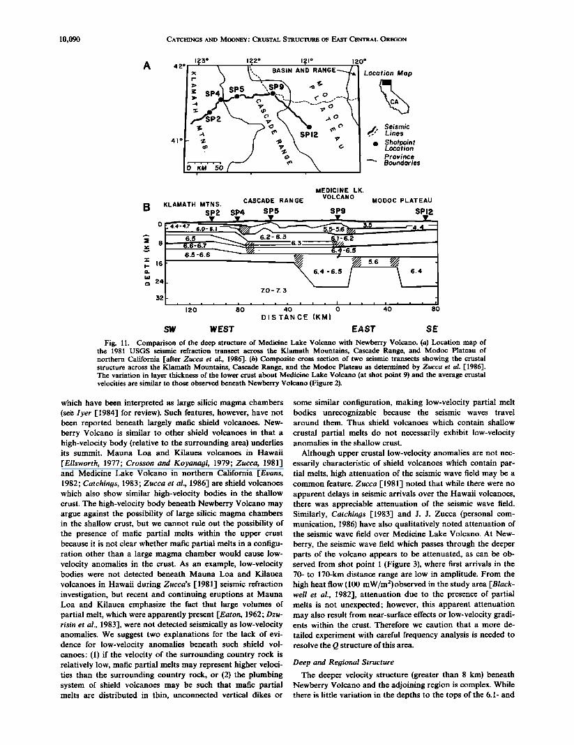
Fig. 11. Comparison of the deep structure of Medicine Lake Volcano with Newberry Volcano. (a) Location map of the 1981 USGS seismic refraction transect across the Klamath Mountains, Cascade Range, and Modoc Plateau of northern California I-after Zucca et al., 1986]. (b) Composite cross section of two seismic transects showing the crustal structure across the Klamath Mountains, Cascade Range, and the Modoc Plateau as determined by Zucca et al. 1-1986]. The variation in layer thickness of the lower crust about Medicine Lake Volcano (at shot point 9) and the average crustal velocities are similar to those observed beneath Newberry Volcano (Figure 2).
which have been interpreted as large silicic magma chambers (se• lyer [1984] for review). Such features, however, have not been reported beneath largely marie shield volcanoes. New- berry Volcano is similar to other shield volcanoes in that a high-velocity body (relative to the surrounding area) underlies its summit. Mauna Loa and Kilauea volcanoes in Hawaii
[Ellsworth, 1977; Crosson and Koyanagi, 1979; Zucca, 1981] and Medicine Lake Volcano in northern California [Evans, 1982; Catchings, 1983; Zucca et al., 1986] are shield volcanoes which also show similar high-velocity bodies in the shallow crust. The high-velocity body beneath Newberry Volcano may argue against the possibility of large silicic magma chambers in the shallow crust, but we cannot rule out the possibility of the presence of mafic partial melts within the upper crust because it is not clear whether marie partial melts in a configu- ration other than a large magma chamber would cause low- velocity anomalies in the crust. As an example, low-velocity bodies were not detected beneath Mauna Loa and Kilauea
volcanoes in Hawaii during Zucca's [1981] seismic refraction investigation, but recent and continuing eruptions at Mauna Loa and Kilauea emphasize the fact that large volumes of partial melt, which were apparently present [Eaton, 1962; Dzu- risin et al., 1983-1, were not detected seismically as low-velocity anomalies. We suggest two explanations for the lack of evi- dence for low-velocity anomalies beneath such shield vol- canoes: (1) if the velocity of the surrounding country rock is relatively low, mafic partial melts may represent higher veloci- ties than the surrounding country rock, or (2) the plumbing system of shield volcanoes may be such that mafic partial melts are distributed in thin, unconnected vertical dikes or
some similar configuration, making low-velocity partial melt bodies unrecognizable because the seismic waves travel around them. Thus shield volcanoes which contain shallow
crustal partial melts do not necessarily exhibit low-velocity anomalies in the shallow crust.
Although upper crustal low-velocity anomalies are not nec- essarily characteristic of shield volcanoes which contain par- tial melts, high attenuation of the seismic wave field may be a common feature. Zucca [1981] noted that while there were no apparent delays in seismic arrivals over the Hawaii volcanoes, there was appreciable attenuation of the seismic wave field. Similarly, Catchings [1983] and J. J. Zucca (personal com- munication, 1986) have also qualitatively noted attenuation of the seismic wave field over Medicine Lake Volcano. At New-
berry, the seismic wave field which passes through the deeper parts of the volcano appears to be attenuated, as can be ob- served from shot point 1 (Figure 3), where first arrivals in the 70- to 170-kin distance range are low in amplitude. From the high heat flow (100 mW/m2)observed in the study area [Black- well et al., 1982], attenuation due to the presence of partial melts is not unexpected; however, this apparent attenuation may also result from near-surface effects or low-velocity gradi- ents within the crust. Therefore we caution that a more de-
tailed experiment with careful frequency analysis is needed to resolve the Q structure of this area.
Deep and Regional Structure
The deeper velocity structure (greater than 8 kin) beneath Newberry Volcano and the adjoining region is complex. While there is little variation in the depths to the tops of the 6.1- and
CATCHINGS AND MOONEY: CRUSTAL STRUCTURE OF EAST CENTRAL OREGON 10,091
6.2-km/s layers and the Moho, the depths to the tops of the 6.5-km/s (midcrustal) and 7.4-km/s (lower crustal) layers are greater beneath Newberry Volcano than beneath areas to either the east or the west. The 7.4-km/s layer mirrors the subvolcanic basement (5.7-km/s layer) topography, forming a sinusoidal shape with respect to Newberry Volcano, whereby its thickness is a minimum beneath the volcano and is a maxi-
mum to the east and west.
This sinusoidal character of the lower crust is also observed
in the area of Medicine Lake Volcano, another large Cascade shield volcano, where Zucca et al. [1986] and Catchin,is [1983] observed as much as a 10-km increase in the thickness of the lower crustal layer to the southeast and west relative to its thickness beneath Medicine Lake Volcano (Figure 11). Subsequent remodeling of the Zucca et al. data and additional gravity modeling [Catchings, 1987] confirm the sinusoidal character of the lower crustal layer with respect to Medicine Lake Volcano and shows the local and regional velocity struc- ture of both Newberry and Medicine Lake to be similar.
The geological significance of this thickening and thinning of the lower crust beneath the shield volcanoes is unclear, but lateral offsets between surface volcanoes and the thickened
lower crustal layer have been observed in some continental rift zones, where the bulk of the volcanism occurs on the flanks of the rift's graben, offset from the thickened lower crust. This observation may be important in understanding the exten- sional processes which shaped east central Oregon and other such areas because such variations in lower crustal thickness
with respect to the surface volcanism may reflect the com- plexities of the regional stress field in extensional or rifting areas [ten Brink and Brocher, 1987].
Although, in east central Oregon, a classical continental rift zone like the Rio Grande, Rhine Graben, or the East African riff is not recognized, the crust there has undergone a large amount of rotation and extension [Magill and Cox, 1981; Hamilton and Myers, 1966], the resulting prevolcanic surface expression of which has not previously been determined from seismic data. However, based on gravity and aeromagnetic data, subvolcanic depressions in basement (grabens) have been identified in east central Oregon by Couch et al. [1982] and Blakely et al. [ 1985]. These subvolcanic depressions, which we also recognize, may be an indicator of prevolcanic continental extension and rifting. A further indicator of this extension may be the thickened, high-velocity (7.4 km/s) lower crust beneath the subvolcanic basins; such a combined geometrical and ve- locity structure has previously been recognized only beneath continental rift zones [Mooney et al., 1983], and it has been previously recognized in the Pacific Northwest region within the Columbia Plateau by Catchings and Mooney [1988].
If continental extension and rifting have been active beneath east central Oregon, the present-day lower crust (7.4 km/s) can be explained in terms of intrusive mixing of mantle-derived magmas with the preexisting lower crust. Alternatively, the boundary between the present-day middle crust (6.5 km/s) and the lower crust (7.4 km/s) may represent the preextension "fossil" Moho, and the present lower crust (7.4 km/s layer) may have resulted from magmatic crustal underplating [Fur- long and Fountain, 1986], which essentially thickened the crust. If palcomagnetic and geologic studies which indicate that up to 250 km of extension has taken place over the northern Basin and Range region since the Tertiary [Frei, 1986; Hamilton and Myers, 1966] are valid for the High Lava Plains region, then magmatic underplating may have been an important process in maintaining the present-day crustal thickness (37 km). With such large amounts of extension, the
present-day, 37-km-thick crust (including the 7.4-km/s' layer) requires that either the crust was unusually thick prior to the Tertiary, large volumes of intrusive additions have been added within the crust, or crustal underplating has been an active process.
Within the back arc area of the Pacific Northwest, crustal
underplating may have been widespread, also occurring (as evidenced by a high-velocity lower cr•t) beneath the Colum- bia Plateau associated with an Eocene rift [Catchings and Mooney, 1988], beneath the Modoc Plateau [Zucca et al., 1986; Catchings, 1987, chap. 5], and in the northwestern Nevada Basin and Range [Catchings, 1987, chap. 3; Thomp- son et al., 1988]. The tectonic processes which produced this type of crustal structure in east central Oregon apparently result from a complex interaction of Cascade volcanism and Basin and Range type extension; Newberry Volcano is a prod- uct of subduction-related arc (Cascade) volcanism and the ex- tensional faulting and rhyolitic volcanism which migrated to the Newberry area from northern Nevada.
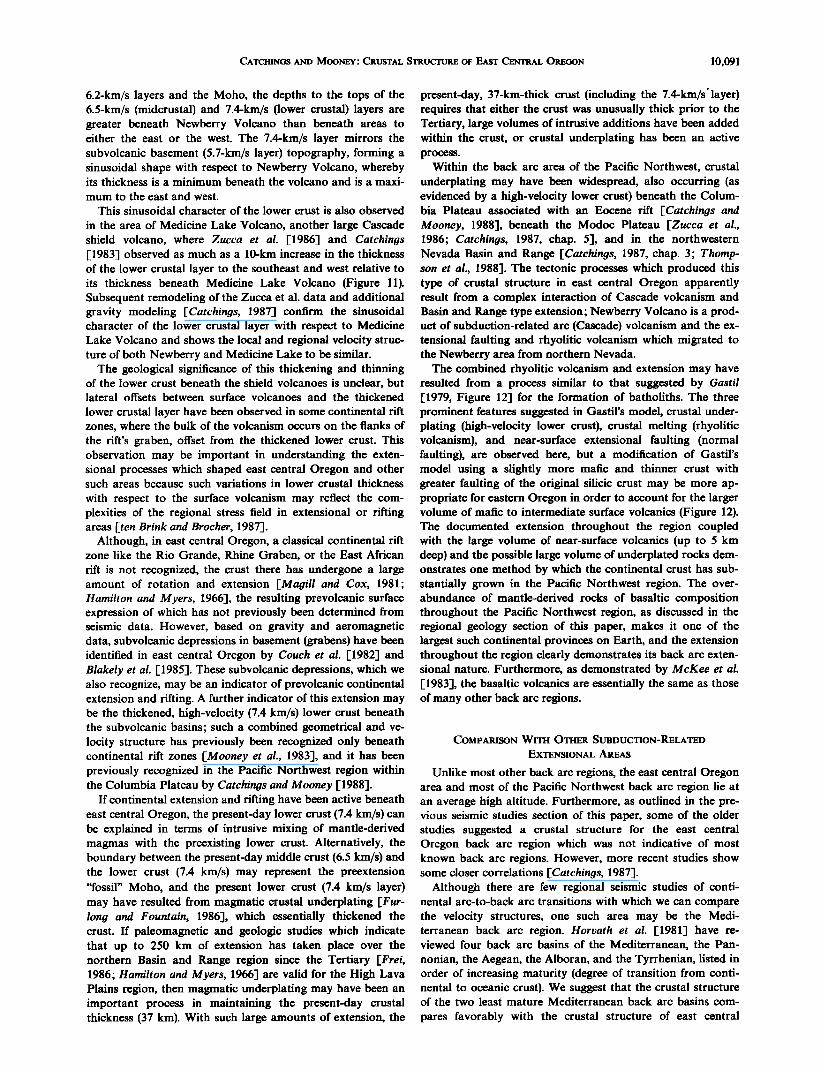
The combined rhyolitic volcanism and extension may have resulted from a process similar to that suggested by Gastil [1979, Figure 12] for the formation of batholiths. The three prominent features suggested in Gastil's model, crustal under- plating (high-velocity lower crust), crustal melting (rhyolitic volcanism), and near-surface extensional faulting (normal faulting), are observed here, but a modification of Gastil's model using a slightly more mafic and thinner crust with greater faulting of the original silicic crust may be more ap- propriate for eastern Oregon in order to account for the larger volume of mafic to intermediate surface volcanics (Figure 12). The documented extension throughout the region coupled with the large volume of near-surface volcanics (up to 5 km deep) and the possible large volume of underplated rocks dem- onstrates one method by which the continental crust has sub- stantially grown in the Pacific Northwest region. The over- abundance of mantle-derived rocks of basaltic composition throughout the Pacific Northwest region, as discussed in the regional geology section of this paper, makes it one of the largest such continental provinces on Earth, and the extension throughout the region clearly demonstrates its back arc exten- sional nature. Furthermore, as demonstrated by McKee et al. [1983], the basaltic volcanics are essentially the same as those of many other back arc regions.
COMPARISON WITH OTHER SUBDUCTION-RELATED
EXTENSIONAL AREAS
Unlike most other back arc regions, the east central Oregon area and most of the Pacific Northwest back arc region lie at an average high altitude. Furthermore, as outlined in the pre- vious seismic studies section of this paper, some of the older studies suggested a crustal structure for the east central Oregon back arc region which was not indicative of most known back arc regions. However, more recent studies show some closer correlations [Catchings, 1987].
Although there are few regional seismic studies of conti- nental arc-to-back arc transitions with which we can compare the velocity structures, one such area may be the Medi- terranean back arc region. Horvath et al. [1981] have re- viewed four back arc basins of the Mediterranean, the Pan- nonian, the Aegean, the Alboran, and the Tyrrhenian, listed in order of increasing maturity (degree of transition from conti- nental to oceanic crust). We suggest that the crustal structure of the two least mature Mediterranean back arc basins com-
pares favorably with the crustal structure of east central
10,092 CATCHINGS AND MOONEY' CRUSTAL STRUCTURE OF EAST CENTRAL OREGON
0-
$0'
40
NEWBERR• VOLCANO SUBVOLCANIC
-I0
T SITION • SILIClC CRUST •
-30
40
Fig. 12. Conceptual underplating and crustal melting model which may be applicable to Newberry Volcano [after Gastil, 1979]. What is left of the original crust (preunderplating and prevolcanic crust) extends from about 5-km to about 25-km depth over the sub- volcanic basins. The crustal additions include the thick sequence of near-surface volcanics and sediments and the subcrustal underplated rocks. Melting of the original silicic crust may be the source of rhyo- lites in the Newberry area.
Oregon in terms of velocity structure, depths of major litho- spheric layers, depths of crystalline basement below sea level, and heat flow. The crystalline upper and middle crustal veloci- ties are nearly the same (6.0-6.8 km/s for the Aegean, 5.7-6.9 km/s for the Pannonian, 5.6-6.5 km/s for east central Oregon), and the depth to the base of these layers varies between 25 and 30 km. Below 30 km, each of these areas is underlain by rocks with velocities which are intermediate between velocities
of normal lower crust and normal upper mantle (7.6-7.8 km/s for the Aegean, 7.5 km/s for the Pannonian, 7.4 km/s for east central Oregon). In east central Oregon, we recognize a deeper refractor (8.1 km/s) at a depth of about 37 kin, which may not be observed in the Mediterranean data due to lack of spatial sampling of the seismic wave field (if it is present). The near- surface basement depth (below sea level) in both the Medi- terranean and east central Oregon also compares favorably (up to 2.0 km for the Aegean, up to 4 km for the Pannonian, and up to 3.5 km for east central Oregon). The primary differ- ence in the shallow crustal structure between the two regions is that the Mediterranean area is covered by water and sedi- ment (up to 4 km) and the east central Oregon area is covered by basalt and sediment (up to 5 km, 1.5 km of which is above sea level). Heat flow in both areas is high and also compares well (up to 90 mW/m 2 for the Aegean, up to 110 mW/m 2 for the Pannonian, and up to 100 mW/m • for east central Oregon) (see Horvath et al. [1981] for Mediterranean compi- lation).
CONCLUSIONS
We are able to make several conclusions regarding both the local velocity structure of Newberry Volcano and the regional velocity structure of the eastern Cascade/High Lava Plains region of east central Oregon based on seismic refraction/wide-angle reflection data. Beneath the central cal- dera, Newberry Volcano is characterized by a shallow high- velocity (5.6 kin/s) body within the upper 1.2 km of the crust. The high-velocity body is interpreted as intermediate to mafic intrusions into the shallow crust. The flanks of Newberry are characterized by somewhat lower velocities (4.1-4.7 km/s), which we correlate with the surface volcanics. Upper crustal low-velocity anomalies are not observed in our seismic data, suggesting that large silicic magma chambers are not present in the shallow crust immediately beneath our seismic refrac- tion array. However, apparent high attenuation of the seismic
wave field may suggest the presence of marie partial melts in an undetermined configuration of the volcanic plumbing system or within the regional crustal structure. Alternatively, the observed attenuation may be due to elevated temperatures (low-velocity gradients) within the crust or simply due to near- surface conditions.
The crustal and upper mantle velocity structure of the east- ern Cascade/High Lava Plains consists of up to 5 km of vol- canic and sedimentary debris (4.1-4.7 kin/s) overlying crys- talline basement rocks (5.6 km/s). Basement rocks have been brittlely extended, resulting in the formation of subsurface horst and graben structures and deep basins. Upper to middle crustal layers (6.1-6.2 kin/s; 8- to 20-km depth) and middle to lower crustal layers (6.5 and 7.4 km/s; 20-38 km) are laterally variable in structure, with the lower crust (7.4-km/s layer) showing appreciable structural variations which correlate in- versely with variations in the near-surface basement. Where the near-surface basement is depressed, forming a subsurface basin, the lower crust (7.4-km/s layer) is thickest (and shallow- est). Beneath Newberry Volcano, the lower crust (7.4-km/s layer) is thinnest (about 3 km thick) but thickens beneath the Cascade Range, west of Newberry, and beneath the High Lava Plains, east of Newberry. Lateral variations in the depth of subsurface basins are not reflected in the regional gravity because the gravity.is compensated by thickening of the lower crust (7.4-km/s layer) beneath the basins. The thickened lower crust may indicate magmatic crustal underplating which has effectively maintained a thick (37 km) crust despite large amounts of crustal extension. An upper mantle velocity of 8.1 km/s is estimated based on secondary arrivals. The regional velocity structure below basement is similar to that of both the northwestern Nevada Basin and Range and the Modoc Plateau of northeastern California.
Comparison of the crustal structure of east central Oregon with other continental back are regions, such as that of the Mediterranean, shows similarities in crustal velocities, thick- ness, and in heat flow, and geological investigations have shown that the basaltic volcanism in the area is much like that
of other back arc regions.
Acknowledgments. We wish to express our appreciation to the U.S. Geological Survey's Geothermal Program for providing funding for the acquisition and interpretation of these data. We thank the U.S. Geological Survey's Deep Continental Studies Program and Stanford University NSF grant EAR-84-17309 for providing continu- ing funding for data analysis. We express our appreciation to J. A. Cotton for assistance in many aspects of this work. The efforts of the U.S. Geological Survey's seismic refraction field crew, Thomas Reed, Vicki Sutton, Ed Criley, Ron Kaderabik, Janice Murphy, Bob Col- burn, Pat Meador, Nan McGregor-Scott, Coyn Criley, Julie Shemeta, Will Kohler, AI Walter, John Van Shack, and Wendy Grant, are greatly appreciated. We are indebted to J. H. Luetgert for providing his seismic processing and analysis software. Discussions and reviews by G. A. Thompson, Mark Zoback, Norm Sleep, Steve Holbrook, Tom Brocher, John Evans, and Dave Fitterman are greatly appreci- ated.
REFERENCES
Achauer, U., L. Greene, J. R. Evans, and H. M. Iyer, Nature of the magma chamber underlying the Mono Craters area, eastern Cali- fornia, as determined from teleseismic travel time residuals, d. Geo- phys. Res., 91, 13,873-13,891, 1986.
Achauer, U., J. R. Evans, and D. A. Stauber, High-resolution seismic tomography of compressional wave velocity structure at Newberry Volcano, Oregon Cascade Range, d. Geophys. Res., this issue.
Barrash, W., J. Bond, and R. Venkatakrishnan, Structural evolution of the Columbia Plateau in Washington and Oregon, Am. J. $ci., 283, 897-935, 1983.
CATCHINGS AND MOONEY.' CRUSTAL STRUCTURE OF EAST CENTRAL OREGON 10,093
Beaumont, C., The evolution of sedimentary basins on a viscoelastic lithosphere: Theory and examples, Geophys. d. R. Astron. Soc., 55, 471-497, 1978.
Black, G. L., G. R. Priest, and N.M. Woller, Temperature data and drilling history of the Sandia National Laboratories well at New- berry caldera, Oregon, Geology, 46, 7-9, 1984.
Blackwell, D. D., R. G. Bowen, D. A. Hull, J. Riccio, and J. L. Steele, Heat flow, arc volcanism, and subduction in northern Oregon, d. Geophys. Res., 87, 8735-8754, 1982.
Blakely, R. J., R. C. Jachens, R. W. Simpson, and R. W. Couch, Tectonic setting of the southern Cascade Range as interpreted from its magnetic and gravity fields, Geol. Soc. Am. Bull., 96, 43-48, 1985.
Brooks, H. C., and T. L. Vallier, Mesozoic rocks and tectonic evolu- tion of eastern Oregon and western Idaho, in Mesozoic Pale- ogeography of the Western United States, Pacific Coast Pale- ogeography Symposium 2, edited by D. G. Howell and K. A. Mc- Dougall, pp. 133-145, Society of Economists, Paleontologists, and Mineralogists, Pacific Section, Los Angeles, Calif., 1978.
Buza, J. W., Dispersal patterns and paleogeographic implications of lower and middle Tertiary fluvatile sandstones in the Chiwaukum graben, east central Cascade Range, Washington, in Cenozoic Pale- ogeography of the Western United States, edited by J. M. A•- metrout, M. R. Cole, and H. TerBest, Jr., pp. 63-73, Society of Economic Paleontologists and Mineralogists, Pacific Section, Ba- kersfield, Calif., 1979.
Catchings, R. D., Crustal structure from seismic refraction in the Medicine Lake area of the Cascade Range and Modoc Plateau, northern California, 97 pp., Masters thesis, Uiv. of Wisconsin- Madison, 1983.
Catchings, R. D., Crustal structure of the northwestern United States, 185 pp., Doctoral thesis, Stanford Univ., Calif., 1987.
Catchings, R. D., and W. D. Mooney, Crustal structure of the Colum- bia Plateau: Evidence for continental rifting, J. Geophys. Res., 93, 459-474, 1988.
Cerveny, V., I. A. Molotkov, and I. Psencik, Ray Method in Seismol- ogy, 213 pp., Karlova University, Prague, 1977.
Chiburis, E. F., Crustal structures in the Pacific Northwest states from velocity dispersion of seismic surface waves, 90 pp., Ph.D. dissertation, Oreg. State Univ., Corvallis, 1966.
Christiansen, N. I., Ophiolites, seismic velocities, and oceanic crustal structure, Tectonophysics, 47, 131-157, 1978.
Christiansen, R. L., and E. H. McKee, Late Cenozoic volcanic and tectonic evolution of the Great Basin and Columbia Intermontane
regions, Mere. Geol. Soc. Am., 152, 283-311, 1978. Cotton, J. A., and R. D. Catchings, Data report for the 1984 U.S.
Geological Survey east central Oregon refraction experiment, U.S. Geol. Surv. Open File Rep., in press, 1988.
Couch, R. W., and R. P. Riddihough, The western continental margin of North America: Baja, California to the Queen Charlotte Islands, Mem. Geol. Soc. Am., in press, 1988.
Couch, R. W., G. S. Pitts, M. Gemperle, D. D. Braman, and C. H. Veen, Gravity anomalies in the Cascade Range in Oregon: Struc- tural and thermal implications, Open File Rep. 0-82-9, 66 pp., Oreg. Dep. of Geol. and Miner. Ind., Portland, 1982.
Crosson, R. S., and R. Y. Koyanagi, Seismic velocity structure below the island of Hawaii from earthquake data, J. Geophys. Res., 84, 2331-2342, 1979.
Dehlinger, P., E. F. Chiburis, and M. M. Collver, Local travel-time curves and their geologic implications for the Pacific northwest states, Bull. Seismol. Soc. Am., 55, 587-607, 1965.
Dickinson, W. R., and T. P. Thayer, Paleogeographic and paleotec- tonic implications of Mesozoic stratigraphy and structure in the John Day inlier of central Oregon, in Mesozoic Paleogeography of the Western United States, Pacific Coast Paleogeography Symp. 2, edited by D. G. Howell and K. A. McDougall, pp. 147-161, Pacific Section, Society of Economists, Paleontologists, and Mineralogists, Los Angeles, Calif., 1978.
Dzurisin, D., R. Y. Koyanagi, and T. English, Magma supply at Kil- auea Volcano, Hawaii, 1956-83, Eos Trans. AGU, 64, 900, 1983.
Eaton, G. P., R. R. Wahl, H. J. Prostka, D. R. Mabey, and M.D. Kleinkopf, Regional gravity and tectonic patterns: Their relation to late Cenozoic epierogeny and lateral spreading in the western Cordillera, Mem. Geol. Soc. Am., 152, 51-91, 1978.
Eaton, J.P., Crustal structure and volcanism in Hawaii, in The Crust of the Pacific Basin, Geophys. Monogr. 6, edited by G. A. Mac- Donald and H. Kuno, pp. 13-29, AGU, Washington, D.C., 1962.
Ellsworth, W. L., Three-dimensional structure of the crust and mantle beneath the island of Hawaii, 327 pp., Doctoral thesis, Mass. Inst. of Technol., Cambridge, 1977.
Evans, J. R., Compressional-wave velocity structure of the Medicine lake Volcano and vicinity from teleseismic relative travel time re- siduals, Tech. Program Soc. Explor. Geophys. Annu. Meeting, 52, 482-485, 1982.
Fitterman, D. V., and D. K. Neev, Transient sounding investigation at Newberry Volcano, Oregon, Trans. Geotherm. Resour. Counc., 9, 407-410, 1985.
Fitterman, D. V., R. J. Bisdorf, W. D. Stanley, and A. A. R. Zohdy, Geothermal significance of an extensive conductor beneath New- berry Volcano, Oregon, V. E. McKelvy Forum on Mineral and Energy Resources, U.S. Geol. Surv. Circ., 974, 16, 1986.
Fitterman, D. V., W. D. Stanley, and R. J. Bisdorf, Electrical structure of Newberry Volcano, Oregon, J. Geophys. Res., this issue.
Frei, L. S., Additional paleomagnetic results from the Sierra Nevada: Further constraints on Basin and Range extension and northward displacement in the western United States, Geol. Soc. Am. Bull., 97, 840-849; 1986.
Fuis, G. S., J. J. Zucca, W. D. Mooney, and B. Milkereit, A geologic interpretation of seismic-refraction results in northeastern Califor- nia, Geol. Soc. Am. Bull., 98, 53-65, 1987.
Furlong, K. P., and D. M. Fountain, Continental crustal underplat- ing: Thermal considerations and seismic-petrologic consequences, J. Geophys. Res., 91, 8285-9294, 1986.
Gastil, R. G., A conceptual hypothesis for the relation of different tectonic terranes to plutonic eraplacement, Geology, 7, 542-544, 1979.
Hamilton, W., and W. B. Myers, Cenozoic tectonics of the western United States, Rev. Geophys., 4, 509-549, 1966.
Hammond, P. E., A tectonic model of the evolution of the Cascade Range, in Cenozoic Paleogeography of the Western United States, Pacific Coast Paleogeography Symp. 3, edited by J. M. Armentrout and M. R. Cole, pp. 219-237, Society of Economists, Paleon- tologists, and Mineralogists, Bakersfield, Calif., 1979.
Hill, D. P., Structure of Long Valley caldera, California, from a seis- mic refraction experiment, J. Geophys. Res., 81, 745-753, 1976.
Hill, D. P., Seismic evidence for the structure and Cenozoic tectonics of the Pacific Coast states, Mem. Geol. Soc. Am., 152, 145-174, 1978.
Hill, D. P., and L. C. Pakiser, Seismic-refraction study of crustal structure between the Nevada Test Site and Boise, Idaho, Geol. Soc. Am. Bull., 78, 685-704, 1966.
Horvath, F., H. Berckhemer, and L. Stegena, Models of Medi- terranean back-arc formation, in Extensional Tectonics Associated With Convergent Plate Boundaries, edited by F. J. Vine, FRS, and A. G. Smith, pp. 165-183, London Royal Society, Great Britain, 1981.
Iyer, H. M., Geophysical evidence for the locations, shapes, sizes, and internal structures of magma chambers beneath regions of Quater- nary volcanism, Philos. Trans. R. Soc. London, Sev. A, 310, 473-510, 1984.
Karig, D. E., and W. Jensky, The proto-Gulf of California, Earth Planet. Sci. Lett., 17, 169-174, 1972.
Kistler, R. W., Mesozoic paleogeography of California: A viewpoinl from isotope geology, in Mesozoic Paleogeography of the Western United States, Pacific Coast Paleogeography Symp. 2, edited by D. G. Howell and K. A. McDougall, pp. 75-84, Pacific Section, So- ciety of Economists, Paleontologists, and Mineralogists, Los Ange- les, Calif., 1978.
Lawrence, R. D., Strike-slip faulting terminates the Basin and Range province in Oregon, Geol. Soc. Am. Bull., 87, 846-850, 1976.
Leaver, D. S., W. D. Mooney, and W. M. Kohler, A seismic refraction study of the Oregon Cascades, J. Geophys. Res., 89, 3121-3134, 1984.
Mabey, D. R., Interpretation of a gravity profile across the western Snake River Plain, Idaho, Geology, 4, 53-55, 1976.
MacLeod, N. S., and E. A. Sammel, Newberry Volcano, Oregon: A Cascade Range geothermal prospect, Oreg. Geol., 44, 123-131, 1982.
MacLeod, N. S., G. W. Walker, and E. H. McKee, Geothermal signif- icance of eastward increase in age of upper Cenozoic rhyolitic domes in southeast Oregon, Proc. U. N. Symp. Der. Use Geotherm. Resour. 2nd, 1, 455-474, 1976.
Magill, J., and A. Cox, Post-Oligocene tectonic rotation of the Oregon Western Cascade Range and the Klamath Mountains, Ge- ology, 9, 127-131, 1981.
McBirney, H. R., Volcanic evolution of the Cascade Range, Earth Planet. Sci. Lett., 6, 1437-1456, 1978.
McKee, E. H., W. A. Duffield, and R. J. Stern, Late Miocene and early Pliocene basaltic rocks and their implications for crustal structure, northern California and south central Oregon, Geol. Soc. Am. Bull., 94, 292-306, 1983.
10,094 CATCHINGS AND MOONEY: CRUSTAL STRUCTURE OF EAST CENTRAL OREGON
McMechan, G. A., and W. D. Mooney, Asymptotic ray theory and synthetic seismograms for laterally varying structures: Theory and application to the Imperial Valley, California, Bull. Seisrnol. Soc. Am., 70, 2021-2055, 1980.
Mooney, W. D., M. C. Andrews, A. Ginzburg, D. A. Peters, and R. M. Hamilton, Crustal structure of the northern Mississippi Em- bayment and comparison with other continental rift zones, Tec- tonophysics, 74, 327-348, 1983.
Rhodes, B. P., Metamorphism of the Spokane Dome mylonitic zone, Preist River Complex: Constraints on the tectonic evolution of northeastern Washington and northern Idaho, d. Geol., 94, 539- 556, 1986.
Sammel, E. A., Results of test drilling at Newberry Volcano, Oregon, and some implications for geothermal prospects in the Cascades, Geotherrn. Resour. Counc. Bull., 10, 3-8, 1981.
Sanders, C. O., and F. Ryall, Geometry of magma bodies beneath Long Valley, California, determined from anomalous earthquake signals, Geophys. Res. Lett., 10, 2597-2609, 1983.
Scholz, C. H., M. Barazangi, and M. L. Sbar, Late Cenozoic evolution of the Great Basin, western United States, as an ensialic interarc basin, Geol. Soc. Am. Bull., 82, 2979-2990, 1971.
Simpson, R. W., and A. Cox, Paleomagnetic evidence for tectonic rotation of the Oregon Coast Range, Geology, 5, 585-589, 1977.
Stauber, D. A., H. M. Iyer, W. D. Mooney, and P. B. Dawson, Three- dimensional P velocity structure of the summit caldera of New- berry Volcano, Oregon, Trans. Geotherrn. Resour. Counc., 9, 411- 415, 1985.
Steeples, D. W., and H. M. Iyer, Low velocity zone under Long Valley as determined from teleseismic events, d. Geophys. Res., 81, 849- 860, 1976.
Steinhart, J. S., and R. P. Meyer, Explosion studies of continental structure, 409 pp., Carnegie Institution of Wash. Publ., 622, 1961.
Stewart, J. H., Basin-Range structure in western North America: A review, Mern. Geol. Soc. Am., 152, 1-31, 1978.
ten Brink, U.S., and T. M. Brocher, Multichannel seismic evidence for a subcrustal intrusive complex under Oahu and a model for Hawaiian volcanism, d. Geophys. Res., 92, 13,687-13,707, 1987.
Thompson, G. A., Cenozoic basin range tectonism in relation to deep structure, paper presented at the 24th International Geological Congress, Montreal, 1972.
Thompson, G. A., and D. B. Burke, Regional geophysics of the Basin and Range province, Annu. Rev. Earth Planet. Sci., 2, 213-237, 1974.
Thompson, G. A., R. D. Catchings, E. B. Goodwin, W. S. Holbrook, C. Jarchow, J. McCarthy, C. Mann, and D. Okaya, Geophysics of the western Basin and Range province, Mem. Geol. Soc. Am., i •n press, 1988.
Thompson, R. N., Columbia/Snake River-Yellowstone magmatism in the context of western U.S.A. Cenozoic geodynamics, Tec- tonophysics, 39, 621-636, 1977.
Williams, H., Geology of the Shasta Valley and adjacent Cascades, northern California, Geol. Soc. Am. Bull., 60, 1947-1949, 1949.
Zucca, J. J., The crustal structure of Kileauea and Mauna Loa vol- canoes, Hawaii, from seismic refraction and gravity data, 121 pp., Doctoral thesis, Stanford Univ., Calif., 1981.
Zucca, J. J., G. S. Fuis, B. Milkereit, W. D. Mooney, and R. D. Catchings, Crustal structure of northeastern California, d. Geophys. Res., 91, 7359-7382, 1986.
R. D. Catchings and W. D. Mooney, U.S. Geological Survey, 345 Middlefield Road, MS 977, Menlo Park, CA 94025.
(Received June 2, 1987; revised February 18, 1988;
accepted February 18, 1988.)


