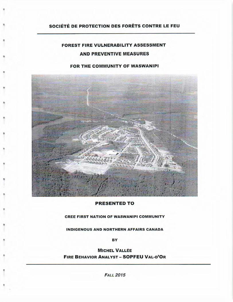
Embed Size (px)
Citation preview
'Ifie. Cree !first !J\[ation of 'Waswanipi
1 Chief Louis Gull Street
Waswanipi (Quebec)
·.q'-<Ja-f'.. JOY 3CO
November23~ . 2017
Mr. Isaac Voyageur, Regional Administrator Attn: Lucas Del Vecchio, CNG ESIA Secretariat Cree Nation Government 277 Duke Street, Suite 100 Montreal, QC H3C 2M2
TEL: (819) 753-2587 FAX: (819) 753-2555
Re: Letter of Intent - Request for an Attestation of Exemption and submission of preliminary information for the project: Second Entry Point Into The Community - Cree First Nation of Waswanipi
Dear Mr. Voyageur,
Pursuant to the Environmental and Social Impact Assessment (ESIA) and review procedure established by the James Bay and Northern Quebec Agreement (JBNQA), and in accordance with its paragraph 22.5.11 , I am transmitting to you the preliminary information about the project entitled Second Entry Point Into The Community - Cree First Nation of Waswanipi.
The Cree First Nation of Waswanipi wishes to create an evacuation road connecting the community to provincial highway 11 3, constituting a public security measure.
According to the JBNQA Section 22 Schedules 1 and 2, this project is not automatically subject or exempted from the requirement for impact assessment; therefore, we request an Attestation of Exemption.
This project should not be subject to the ESIA Procedure as its impacts are limited, as described in the attached project notice.
Please communicate with our technical advisor, Mr. Luc Levesque, Eng. (cell: (514) 214-7226) for any technical information concerning this community project.
Respectfully,
~~ Rhonda Oblin Cooper Director of Capital Works
Att: Preliminary Information dated November 23rd. 2017 Appendix A - SOPFEU Report Appendix B - EnviroCree Environmental Characterization Appendix C -WSP Multi-Criteria Analysis Appendix D - WSP Preliminary Plans Appendix E - WSP Technical Note Appendix F - WSP Preliminary Geotechnical Drilling Report Appendix G- Schedule
Page 1 of 1


Second entry point into the community Cree First Nation of Waswanipi
1. Project Proponent (natural or legal person)
Name: Cree First Nation of Waswanipi
Civic address: 1, Chief Louis R. Gull Street, Diom Blacksmith Building
Waswanipi, Quebec J0Y 3C0
Postal address (if different): 1, Chief Louis R. Gull Street, P.O. Box 30
Waswanipi, Quebec J0Y 3C0
Telephone: (819) 753-2587
Fax: (819) 753-2555
Email: [email protected] Person in charge of the project: Mme Rhonda Oblin Cooper, Director of Capital Works
Québec enterprise number (NEQ) assigned by the Registraire des entreprises du Québec
N/A
2. Consultant Commissioned by the Proponent
Name: WSP Canada Inc.
Civic address: 3, Principale St North, Suite 200
Amos (Quebec)
J9T 2K5
Telephone: (819) 732-0457
Fax: (819) 732-0458
Email: [email protected] Person in charge of the project:
Jason Bertrand-Brochu
Québec enterprise number (NEQ) assigned by the Registraire des entreprises du Québec 1148357057
Second entry point into the community Cree First Nation of Waswanipi
2
3. Project Title Second Entry Point Into The Community – Cree First Nation of Waswanipi.
4. Project Objectives and Justification The main objective is to create an evacuation road connecting the community of Waswanipi to provincial highway 113, constituting a public security measure. Indeed, as pointed out by the Society for the Protection of Forests Against Fire (SOPFEU) in a report on the evaluation of Waswanipi's vulnerability to forest fires, the community is considered highly at-risk due to the lack of road infrastructure to get in and out of the community (see SOPFEU’s report in Appendix A of this project notice). The report mentions there is only one access road to the community, contributing to make it vulnerable in the event of a forest fire in the area. On another note, although there are in fact two (2) accesses connecting the community to highway 113 (the main access is Poplar Street and the secondary access is an unnamed gravel road; see figure 1 of the environmental characterization report prepared by EnviroCree and presented in Appendix B of this project notice) it appears that
1) Poplar Street is adjacent to a gas station, which could potentially compromise the main access in the event of an accident or spill (hydrocarbons are flammable materials and environmental contaminants);
2) the gravel road is not optimal as it leads to a section of highway 113 that is sloping and curving, raising road safety issues (see WSP’s multi-criteria analysis, prepared in collaboration with Quebec’s Department of Transportation (MTMDET) and presented in Appendix C of this project notice).
Thus, the purpose of this project is to provide the community of Waswanipi with a paved evacuation road that can also be used as a regular access road and designed to meet MTMDET’s safety standards.
5. Project Location
The project is situated in the vicinity of the Cree community of Waswanipi, in the territory of the Eeyou Istchee James Bay Regional Government, in the administrative region of Nord-du-Quebec. More specifically, most of the retained evacuation road route is on Waswanipi's Category I lands, while a short stretch (approximately 170 m out of the approximately 700-m long route) is located in highway 113 corridor, in Category III lands. A location plan is shown in Appendix 3 of EnviroCree’s characterization report. Option 7 is the retained alignment for the evacuation road. The shapefiles that were used to draft this plan come from WSP for the proposed routes and from the Cree Nation Government (CNG) for the land categories. Central geographical coordinates are as follows: UTM NAD 83 49°42'20.90"N ; 75°57'26.08"W.
Second entry point into the community Cree First Nation of Waswanipi
3
6. Description of Project and Alternatives Under Study
Road Route Options Initially, two (2) alternatives were considered for the evacuation road route
1) a new road to be built between the community and highway 113 (proposed road route would run in front of the Justice Facility, following Chief Louis R. Gull Street);
2) the existing unnamed gravel road connecting the community to highway 113. These alternatives constituted the initial options, i.e. options A & B, respectively (see map in Appendix 1 of EnviroCree’s characterization report). Option B had been considered as this road was already built and operational. Finally, it was discarded for road safety reasons, as previously mentioned in section 4 above. Option A, meanwhile, consisted of a brand new access road but its route was eventually modified so as to take the road stretch running in front of the justice facility and move it behind the building. Indeed, on one hand, too much circulation in front of the building was not desirable. On the other hand, the new positioning would soften the slope inclination of the hill present in that area (as the elevation of the community is approximately 310 m and that of highway 113 is around 292 m), and bring the evacuation road closer to the new firehall which will be located in an upcoming municipal development. Thus, various route alternatives were derived from option A, leading to options 5, 6, and 7 (see map in Appendix 2 of EnviroCree’s characterization report). Finally, option 7 was retained as the slope inclination was appropriate, from a technical point of view, and the route length was shorter than that of option 6. Also, option 7 crosses a narrower section of the permanent watercourse flowing along highway 113 than that of option 5. From an environmental point of view, no major constraint was noted for option 7. Option 7 has an approximate length of 700 m (see WSP’s plans presented in Appendix D of this project notice). A stretch of approximately 300 m is situated in wetlands (see map in Appendix 8 of EnviroCree’s characterization report, and maps of WSP). This option is integrated into the community’s urban master plan. Road Specifications As described in WSP’s technical note, the selected road model is type D (either a regional or local road according to MTMDET’s standards). The road is comprised of two 3.5-m wide paved lanes and two 2-m wide unpaved shoulders. The width of the right-of-way is 30 m (which means there is about 10 m between the shoulder and the right-of-way boundary on each side). A sectional view is shown on page 2 of WSP’s technical note (presented in Appendix E of this project notice). The structure of the road will consist of a 600-mm sub-foundation of MG-112 and a 300-mm foundation of MG-20. A Type 5 geotextile membrane will be installed under the infrastructure to prevent migration of fine particles. Paving will consist of a 60-mm base layer of ESG-14 and a 40-mm running surface of ESG-10. An additional backfill (road overload) will be deposited to avoid road deformation risk in
Second entry point into the community Cree First Nation of Waswanipi
4
wetlands. This backfill will consist of a 1.5-m thick layer of granular materials. This concept will be optimized following the completion of the geotechnical investigation that is currently underway (WSP’s preliminary drilling report is presented in Appendix F of this project notice). Drainage ditches will be put in place, on either side of the road. These will channel the water to sedimentation basins. The latter will be constructed outside of the riparian strip (more than 20 meters) of the wetlands. Preliminary Logging and Surveys Central-line deforestation is a preliminary, 10-m wide deforestation (out of the final 30-m wide right-of-way) to allow for land surveying and geotechnical work. This deforestation was carried out by Mishtuk (forestry company based in Waswanipi) in early September 2017. Deforestation was mechanized for the "terrestrial" part of the route; the wetland portion was deforested manually (with chainsaws). Mishtuk owns an intervention permit issued by the MFFP (Quevillon Management Unit) for the portion of the road located in Category III lands. The MFFP considers Category I lands as private, which means that an intervention permit is not required for deforestation. The deforestation of the right-of-way will be completed by Mishtuk, during construction work in 2018. Land surveying required a total station with a GPS base. The land surveyor would walk the road route and record GPS data. The geotechnical work required the presence of a conventional track mounted drill rig to determine the soil composition (stratigraphic description of the organic/topsoil layer & mineral/native soil layer) and depth of bedrock (see WSP’s preliminary drilling report). Site work consisted in drilling 5 boreholes (2 of which were converted into open standpipes for groundwater reading). Soil samples were collected at regular intervals during borehole drilling using a standard, B caliber (51 mm diameter) split spoon sampler (SS). Bedrock samples were recovered using an NQ (inside diameter: 48 mm) caliber core barrel. Various parameters were measured. The soil brought to the surface was put back into the cylindrical hole thus created. Plans have been prepared on a preliminary basis (Appendix D of this project notice). Construction Firstly, there will be organization of the construction site, which involves the mobilization of the work team and the machinery necessary for the full execution of the contract. Subsequently, the contractor will settle down the site facilities on a previously authorized site. Unless otherwise specified in the contract clauses, excavators and dump trucks will proceed to the right-of-way stripping (removal of the organic layer from the soil surface, consisting mainly of black soil and wood debris) and excavation of these materials for transport to an authorized site, i.e. the existing Waswanipi disposal site, which may be subject to authorization by the MDDELCC (in view of its final closure following the construction of a new disposal site in 2018). Blasting will be required to achieve a safe and secure road profile. Blasted materials will be reused to backfill the road infrastructure.
Second entry point into the community Cree First Nation of Waswanipi
5
Granular materials from existing borrow pits will be used to backfill the pavement structure (MG-20 and MG-112). The choice of the borrow pit is not yet determined but some are considered, notably
- Lake Short road borrow pit, located in Waswanipi’s Category I lands (about 10 km away from the community);
- Highway 113’s km 231 borrow pit, on public lands (about 15 km away from the community);
- Desmaraisville’s borrow pit (about 30 km away from the community). Trucks will dump granular materials in the right-of-way and these will be arranged using bulldozers and graders. The granular materials will be compacted (between 95 and 98 % depending on the layers). A geogrid will be installed at certain locations (in wetlands) to increase the bearing capacity of the road. Three HDPE (High Density Polyethylene) culverts will be installed to ensure wetlands drainage and permanent watercourse flow. The culverts will be embedded in the backfill approximately 2-3 m below grade. A dust suppressant will be applied on the road when it is built but not yet paved. Hydraulic seeding will be done to revegetate bare-ground areas. The installation of road signs and street lights (at the intersection of highway 113 and the evacuation road) will be carried out. The nearest asphalt production plant is in Ouje-Bougoumou. Paving and pavement marking are planned for the summer of 2020. Exploitation When the road is completely finished, abrasives could be spread as needed, during the winter.
7. Environmental Components and Main Constraints to Project Implementation A recent ecological characterization of the project site was conducted by EnviroCree in the summer of 2017. This study describes in detail the biophysical environment where the construction is planned. A summary is presented below. Physical Environment At the regional level (ecological region 6a, Matagami Lake plain), the climate is of the type ‘continental subpolar subhumid’ which makes for a short growing season. The hydrographic network is very developed and is comprised of several large lakes (e.g. Waswanipi, Gull) and rivers (e.g. Nottaway, Broadback). The relief is a little hilly, with slope inclinations usually varying between 0-3 %, at an altitude of 300-400 m. The overburden (quaternary surface deposits) comprises organic deposits in lower places and clay or sandy mineral deposits in higher places (glaciolacustrine deposits left by proglacial lake Ojibway, and, in a smaller proportion, glacial deposits like indifferentiated till).
Second entry point into the community Cree First Nation of Waswanipi
6
Locally, the selected route follows a slope that descends from the community towards highway 113. Biological Environment Given the rigorous climatic conditions, the vegetation is poorly diversified, with a high proportion of coniferous forests, among which the black spruce is the most frequent. The balsam fir, white birch and trembling aspen are also encountered, as well as jack pine and tamarack. The black spruce grows in humid depressions or badly drained ground covered by an organic soil; these stations are covered with sphagnum and ericaceous species. In dryer stations, the black spruce may grow together with the jack pine, over abundant mosses and ericaceous species. Vegetation Where the evacuation road route ties up with the community, in the vicinity of the justice facility, anthropogenic disturbances (deforestation) have occurred so that the original forest cover is now an open environment with associated plant species. The tree layer is virtually absent. The shrub layer is composed of the pin cherry, mountain ash, serviceberry and raspberry; the herbaceous layer is composed of species such as fireweed and orange hawkweed. Otherwise, along the route, the forest cover is typical of the boreal forest, with ecological types such as the spruce-moss or ericaceous spruce forest and the black spruce-balsam fir forest, including understory shrubs such as northern bush-honeysuckle, bunchberry, goldthread, yellow clintonia, wild lily-of-the-valley and stiff clubmoss. Wetlands Three (3) wetlands are found on the selected route, namely an ombrotrophic peatland (bog), a wooded minerotrophic peatland (wooded fen) and a riparian marsh. Species found in peatlands, other than black spruce and Labrador tea, are tamarack, willow, horsetail, cloudberry and sphagnum. The vegetation of the marsh is composed of shrubs (such as willow, speckled alder and sweet gale) and hydrophytes (such as sedge and marsh cinquefoil). These types of wetlands are common to Waswanipi’s ecological region. Watercourse The evacuation road crosses an unnamed, sinuous permanent watercourse that runs along highway 113 through the marsh, and flows into Waswanipi River. The watercourse has an estimated width of 3-4 m and an estimated depth of 1-2 m. The current is slow as the stream meanders almost flat. The banks are natural and covered with vegetation (shrubs and herbaceous species); no signs of erosion were observed. Aquatic vegetation consists of floating and emergent plants. The watercourse bottom is comprised of organic matter where observable (not a rocky/gravelly bottom). This type of habitat may be appropriate for pike and perch, especially as spawning habitat. Otherwise, stream characteristics do not show good spawning potential for any of the potentially present species. Also, this type of habitat does not correspond to the lake sturgeon’s preferential habitat (i.e. large rivers where they feed on the bottom, and spawning beds in swift current waters); the lake sturgeon is the only precarious fish species potentially present. A beaver dam and house were seen a little downstream of the route.
Second entry point into the community Cree First Nation of Waswanipi
7
Wildlife Numerous wildlife species whose distribution areas straddle the study area are potentially present. Precarious Species Requests to Quebec Natural Heritage Data Center (CDPNQ) revealed there is no mention of precarious plants & animals listed for the study area. Field inventories in the road route did not reveal the presence of any precarious plant species. Precarious animal species presence potential analysis revealed low/fair probability for about half of the species in the study area. Regulated habitats, protected areas No regulated plant habitat straddles the road route. Apart the permanent watercourse that is considered as ‘fish habitat’, no other regulated wildlife habitat straddles the road route. References to suitable habitats for flycatchers, swallows and nighthawks are listed in the Ministry of Forests, Wildlife and Parks (MFFP) directory but these habitats are not regulated and the MFFP states that ultimately this has no impact on the project. No protected area intersects the road route. Human Environment The Cree community of Waswanipi is comprised of Category I & II lands and hosted 1,759 people in 2016 (Statistics Canada 2017). In comparison, Lebel-sur-Quevillon, a non-Aboriginal community geographically close to Waswanipi, hosted 2,187 people in 2016. For information purposes, this community is thus similar in size to Waswanipi and counts two paved access roads connecting to highway 113. A request to the Ministry of Culture and Communications revealed that there are no archaeological sites listed for the study area.
8. Primary Impacts Anticipated
Negative Impacts The clearing of the right-of-way and the construction of the road will lead to the permanent loss of various habitats (open environment, coniferous forest, peatlands and marshes) for a total area of 0.021 km², or 2.1 ha (considering a width of 30 m and length of 700 m), including 0.9 ha of wetlands (300-m long). When blasting, dust, noise and vibrations could be emitted. When backfilling, emissions of dust, noise and greenhouse gases (CO, CO2) by machinery are expected. Leakage and / or loss of fuel, oils and grease may occur. There may be a temporary and local increase in suspended matter in the watercourse. When the evacuation route is operational, collisions between vehicles and various wildlife
Second entry point into the community Cree First Nation of Waswanipi
8
species may occur. Positive Impacts Public safety will be increased for the community, especially by improving the
- evacuation capacity of residents; - compliance of the intersection with MTMDET’s standards; - intervention capacity for emergency services.
Given the mandates granted to various contractors, job opportunities have been and will be generated, particularly those for Waswanipi’s workers and companies. Mitigation Measures During the work, the contractor must comply with environmental requirements specified in the general contract clauses. In addition to these general clauses, specific clauses or specific environmental requirements will be imposed. These general and specific conditions constitute mitigation measures of impacts on the environment. Environmental clauses are presented in Appendix G of this project notice (an English version may be provided upon request). These mitigation measures are summarized in the following paragraphs and are notably based on the provisions of the Regulation on Sustainable Forest in the Domain of the State Management (RADF) governing road construction activities on lands in the domain of the State (Category III lands; provisions will also apply for the portion of the route located on Category I lands). Importantly, a construction site supervisor will be present throughout the construction to monitor work and ensure it is done properly. In addition, a biologist will be present from time to time to validate the application of mitigation measures. Equipment, Vehicles and Machinery
- As far as possible, machinery with low contact pressure on the ground will be used (e.g. tracked machinery, large tires, etc.);
- On-site circulation of machinery and mobile equipment will be controlled by a traffic plan;
- No traffic will be allowed outside the planned work areas or outside servitudes; - Vehicles will have to go to a refueling area located more than 60 m away from the natural
high-water mark (HWM); - The equipment will be in good working order, clean and free of leaks at all times. Any
equipment or machinery showing leakage signs of oil or any other environmentally harmful substance shall immediately be taken away from the site and repaired;
- Equipment leaving the site must be clean and free of leaks. Protection of Air Quality
- Engines will be adjusted and will operate according to the manufacturer's instructions; - Idling of any vehicle, equipment and machinery will be avoided to the maximum when
not in use; - Construction equipment that produces excessive exhaust emissions, due to improper
adjustment for example, will be repaired as soon as possible; - The equipment’s antipollution system will be maintained in good condition.
Second entry point into the community Cree First Nation of Waswanipi
9
Protection of the Natural Environment and Wildlife
- An environmental protection plan and an environmental emergency plan will be in force during construction;
- Construction work will respect the fish habitat work periods for the Nord-du-Quebec region (July 15 – August 31st);
- All necessary measures will be taken to prevent the immersion, dumping or accidental spillage of debris, harmful substances, contaminants, suspended solids (SS) and fine particles into the watercourse (e.g. sediment barriers, turbidity curtains);
- Bare ground and embankments will be stabilized (by vegetation, rip rap or retaining wall);
- If necessary, soil protection measures will be implemented on traffic & work areas in order to increase the bearing capacity of the soil and limit rutting (e.g.: wooden mattress, embankment on a geotextile membrane). Protective measures will be removed at the end of the work;
- If soil protection measures cannot be adequately managed, access to the riparian strip (20 m from the HWM) will be prohibited in the spring as soon as the soil begins to thaw;
- In summer, no water pumping station will be installed on the shore or shoreline of the watercourse. The station will be installed more than 20 m from the HWM, in a holding tank (in order to be able to recover any potential leak of lubricant or fuel) and its integrity checked daily;
- Should pumping water be necessary and carried out in the permanent watercourse, the low water flow will be checked in order to allow pumping of a sufficient water quantity without affecting the aquatic life. Pumps will be equipped with flowmeters;
- Any pumping device shall be equipped with a strainer to prevent aspiration of fish or other aquatic organisms;
- Regarding equipment and machinery, biodegradable, non-toxic lubricants that meet one of the international environmental certifications recognized by the MDDELCC (Environmental Choice Program CCD, The Flower, Der Blue Engel and Good Environmental Choice Australia Standards : Lubricants) will be privileged as far as possible. Material safety datasheets (MSDSs) for new products will be provided for approval;
- No debris will be released into the natural environment. All debris accidentally introduced into the natural environment will have to be removed as soon as possible and in such a way as not to further disturb the receiving environment.
Protection Against Noise
- Machinery, equipment and any vehicle will have functional mufflers at all times. Management of Water
- Decanted and non-reused water will be discharged directly to the natural environment (towards a vegetation zone) or transported (pumped) more than 20 m away from the watercourse HWM;
Second entry point into the community Cree First Nation of Waswanipi
10
Management of Hydrocarbons and Hazardous Materials - Petroleum products and all other hazardous materials will be stored at a specific
temporary location, more than 60 meters from the HWM of any watercourse or water body. These products and materials will be stored on waterproof berms and protected from impacts and natural elements;
- To contain leaks and avoid any risk of accidental spill, oil recovery bins (or absorbent pads) will be put under stationary equipment and machinery (generators, compressors, etc.). These bins will be kept functional at all times (i.e. drained regularly after any rain or snowfall);
- The handling and distribution of fuel will be carried out so as to prevent any soil or water contamination.
Management of Hazardous and Non-Hazardous Residual Materials
- Residual materials (hazardous and non-hazardous) will be temporarily stored on-site, more than 60 m away from the HWM of any water body, on a site designed for this purpose, and where there is no risk of soil, groundwater and surface water contamination;
- Residual materials temporarily stored on construction site will be grouped in the same location and disposed off-site daily, in an authorized location;
- Residual hazardous materials will be stored in identified leak-proof containers, on retention berms, protected from impacts and natural elements. This requirement applies to work in terrestrial environments, wetlands and water;
- Construction site will be cleaned as the work goes and kept free of waste, rubbish or other materials, substances or equipment that are not necessary for the execution of the work.
Management and Prevention of Spills
- The management of spills will be done according to the following procedure: in the event of an environmental incident, the contractor informs the site supervisor right away and notifies the authorities. The contractor controls the leak, confines the spill to prevent it from expanding and reaching sensitive areas, and makes the necessary corrections in agreement with the authorities and/or the site supervisor;
- At all times, there will be sufficient emergency kits on site for the recovery of petroleum products. The kits will include enough absorbent material to allow for quick and effective response, both in the aquatic and terrestrial environments. The contents of the kit will be adapted to the volume of the largest hydrocarbon reservoir on a work site (i.e. machinery and equipment). The kits will be easily accessible for a quick response. Workers likely to use those kits will be properly trained;
- A smaller kit, adapted to site activities, will also be present in each vehicle (all mobile equipment);
- Hydrophobic devices (booms) will be put in the watercourse to contain any accidental spill of petroleum products.
9. Public Information and Consultation Processes
A first presentation of the project had already been made to the community’s administration at the initial design stage (when the proposed routes were Options A and B). In addition, the project had been reviewed by the community planner.
Second entry point into the community Cree First Nation of Waswanipi
11
As the project has evolved, a public presentation is planned in Waswanipi at the annual general assembly in January 2018 (the exact date remains to be determined). Regarding the community’s concerns (known at the present time), they relate mostly to security aspects, such as:
- the importance of having a safe access; - the respect of the speed limit in the 50 km/h zone.
10. Project Schedule
A schedule is included in Appendix H of this project notice. Meetings between the various stakeholders (Waswanipi, WSP, MTMDET) were held on a few occasions in 2016. A first environmental study was conducted by EnviroCree in October of the same year. Comparison of options A and B, by WSP, followed in November. In the spring of 2017, a multi-criteria analysis was conducted by WSP (to select the best option), followed in the summer by the selection of the road route (option 7) and the related environmental study, carried out by EnviroCree. The preliminary deforestation of the route was done by Mishtuk in September 2017. WSP land surveyed the same month, followed by the preparation of preliminary plans and specifications and geotechnical drilling in October 2017. The first draft of the tender documents for contractors is planned for the end of 2017, so that they are ready to be submitted to bidders in February 2018. The start of construction is planned for the end of May 2018. Paving of the evacuation road will be completed in 2020.
11. Subsequent Phases and Related Projects
Although the construction of the evacuation route is planned for the summer of 2018, paving will be carried out later, in 2020 (to allow for 2 freeze/thaw cycles and any settlement to occur). In fact, there will only be a short stretch of the evacuation road (30-50 m long) that will be paved where it connects to highway 113, to prevent granular materials from spreading on the latter. The rest of the paving will be done in a separate project.

Second entry point into the community Cree First Nation of Waswanipi
12
12. Signature of the Applicant I, (name of applicant or authorized signatory, position), hereby certify that the information provided in this preliminary information form is accurate to the best of my knowledge. __________________________________________ 2017-12-01 Signature of applicant or authorized signatory Date _________________________________________ 2017-12-01 Signature of applicant or authorized signatory Date
Second entry point into the community Cree First Nation of Waswanipi
APPENDIX A
SOPFEU Forest Fire Vulnerability Assessment for
Waswanipi

n
n
n
Ill
•
..
•
•
SOCIETE DE PROTECTION DES FORETS CONTRE LE FEU
FOREST FIRE VULNERABILITY ASSESSMENT
AND PREVENTIVE MEASURES
FOR THE COMMUNITY OF WASWANIPI
PRESENTED TO
CREE FIRST NATION OF WASWANIPI COMMUNITY
INDIGENOUS AND NORTHERN AFFAIRS CANADA
BY
MICHEL VALLEE
FIRE BEHAVIOR ANALYST-SOPFEU VAL·D'OR
FALL 2015
SOCIETE DE PROTECTION DES FORETS CONTRE LE FEU
FOREST FIRE VULNERABILITY ASSESSMENT
AND PREVENTIVE MEASURES
FOR THE COMMUNITY OF WASWANIPI
TABLE OF CONTENTS
Pages
INTRODUCTION . . . . . . . . . . . . . . . . . . . . . . . . . . . . . . . . . . . . . . . . . . . . . . . . . . . . . . . . . . . . . . . . . . . . . . . . . . . 1
FIRE ENVIRONMENT IN WASWANIPI .................. .... .. .. .. .. .. .. .... 2
FIRE BEHAVIOUR IN WASWANIPI ...... .. ...... .. ........ ..
WILDFIRE THREAT ASSESSMENT FOR THE COMMUNITY .. ............... ..
9
15
RECOMMENDATIONS FOR WASWANIPI ...... .. .... .. .. .. ...... .... ............ 29
CONCLUSIONS OF THE STUDY.......... .. ......................... .. .. ... . ..... 32
,..
A
•
•
•
•
II

"
1. INTRODUCTION
In order to ensure the safety of the community and the continued implementation of its multidimensional forest resources, SOPFEU was given the mandate by Indigenous and Northern Affairs Canada to perform this forest fire vulnerability study.
The objective of the study is to help the community of Waswanipi to reduce disaster risks and to be better prepared to intervene when lives and property are at risk of wildfires.
Due to their geographical location or intensity, some forest fires can threaten a forest community, and thus require immediate action, while the application of preventive measures can mitigate the effects of an approaching fire and reduce the damage caused by it.
The study has several components. First, it describes the fire environment near Waswanipi . Then it includes a status report concerning the vulnerability of infrastructure in regard to forest fires. Finally, it lists several recommendations to ensure effective protection of infrastructure as well as efficient emergency measures for the community.
Waswanipi Vulnerability Study 2015 Page 1-32
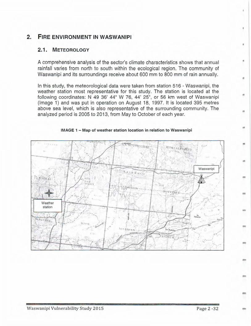
2. FIRE ENVIRONMENT IN WASWANIPI
2.1. METEOROLOGY
A comprehensive analysis of the sector's climate characteristics shows that annual rainfall varies from north to south within the ecological region. The community of Waswanipi and its surroundings receive about 600 mm to 800 mm of rain annually.
In this study, the meteorological data were taken from station 516 - Waswanipi, the weather station most representative for this study. The station is located at the following coordinates: N 49 36' 44" W 76, 44' 25" , or 56 km west of Waswanipi (Image 1) and was put in operation on August 18, 1997. It is located 395 metres above sea level, which is also representative of the surrounding community. The analyzed period is 2005 to 2013, from May to October of each year.
IMAGE 1 - Map of weather station location in relation to Waswanipi
~"'li"'i I "' O"tn\tlrtitl'-· . ' I • ,
Waswanipi Vulnerability Study 2015
....... .....
·"
Page 2 -32
•
•
•
..
•
•
---
-
l!l
"
Ill
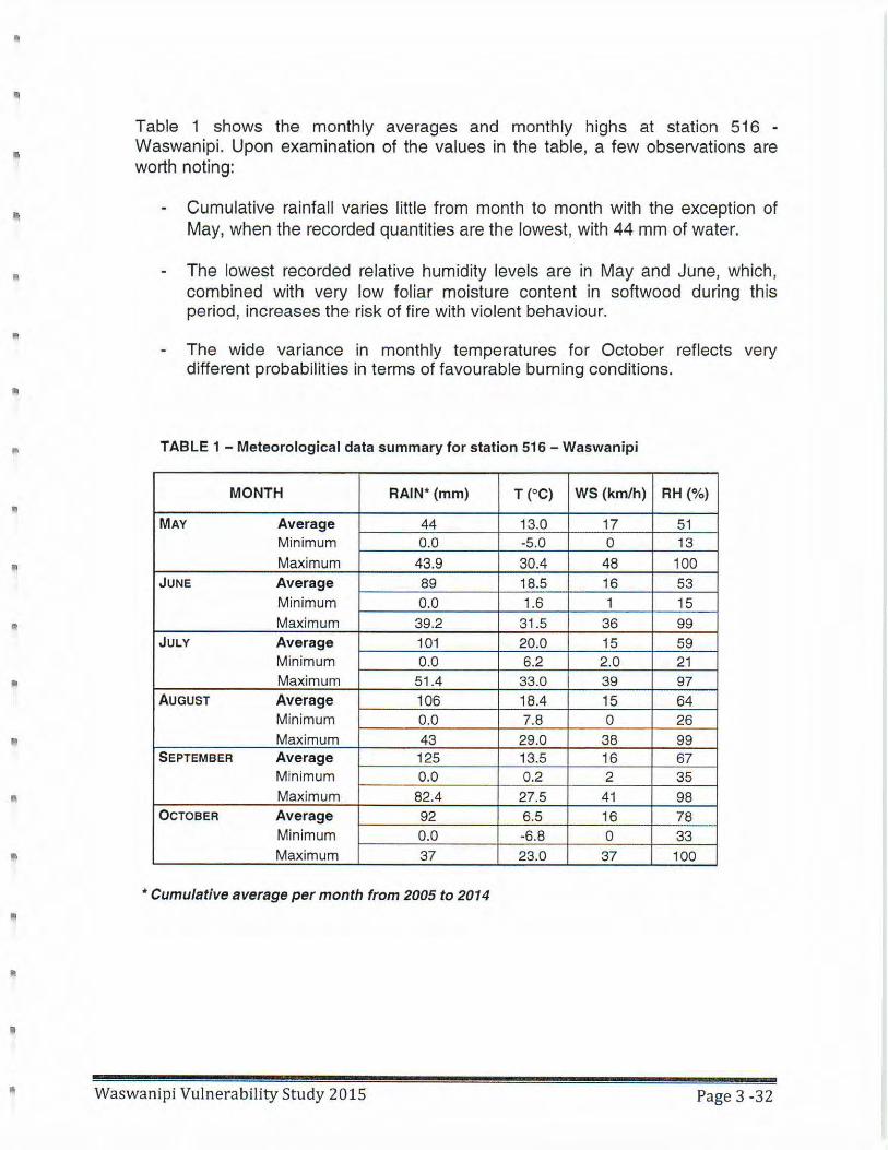
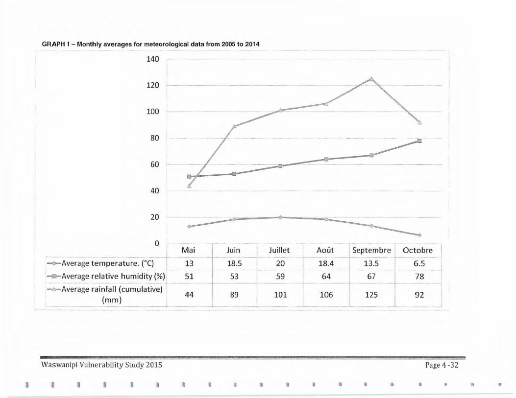
Table 1 shows the monthly averages and monthly highs at station 516 -Waswanipi. Upon examination of the values in the table, a few obseNations are worth noting:
Cumulative rainfall varies little from month to month with the exception of May, when the recorded quantities are the lowest, with 44 mm of water.
The lowest recorded relative humidity levels are in May and June, which, combined with very low foliar moisture content in softwood during this period, increases the risk of fire with violent behaviour.
The wide variance in monthly temperatures for October reflects very different probabilities in terms of favourable burning conditions.
TABLE 1 - Meteorological data summary for station 516 - Waswanipi
MONTH RAIN* (mm) T (°C) WS (km/h) RH(%)
MAY Average 44 13.0 17 51 Minimum 0.0 -5.0 0 13 Maximum 43.9 30.4 48 100
JUNE Average 89 18.5 16 53 Minimum 0.0 1.6 1 15 Maximum 39.2 31.5 36 99
JULY Average 101 20.0 15 59 Minimum 0.0 6.2 2.0 21 Maximum 51.4 33.0 39 97
AUGUST Average 106 18.4 15 64 Minimum 0.0 7.8 0 26 Maximum 43 29.0 38 99
SEPTEMBER Average 125 13.5 16 67 Minimum 0.0 0.2 2 35 Maximum 82.4 27.5 41 98
OCTOBER Average 92 6.5 16 78 Minimum 0.0 -6.8 0 33 Maximum 37 23.0 37 100
•Cumulative average per month from 2005 to 2014
Waswanipi Vulnerability Study 2015 Page 3 -32
GRAPH 1 - Monthly averages for meteorological data from 2005 to 2014
140
120
100
80
60
40
20 ·- 7 ·-- 0 o;;...--- ---- - ----·--
. -o ·1- I
1 Mai Juin , Juillet ____ L . ----- . ·:-i---- --j-- - --
-<>-Average temperature. (0 C) I 13 18.5 I 20
-<>-Average relative humidit-y(%)1· -- -51 - . 53 I 59 --- ---- --- - ·-- - --- ----i--------~Average rainfall (cumulative)
44 I
89 ·
101 (mm) I ! J
--- ----- --- --- "'--------~---- -·- -----
-1 ·•· r 1 - - - - - I
~--~o_ut __ 1,~eptemb_~e L_Octo~~- I I I '
-~- _ 1s .~ ___ , 1~_.s -+--- 6.~ i : 64 'L 67 I 78 I -1- --- ---··1 ----- -t---· -- --·i
I 106 I 125 1' 92 I _: _____ ----- -·-- ·------- ·- ·--· -- __ J
Waswani pi Vulnerability Study 2015 Page 4 -32
I I I I I I J • I I I • ,. iii ill
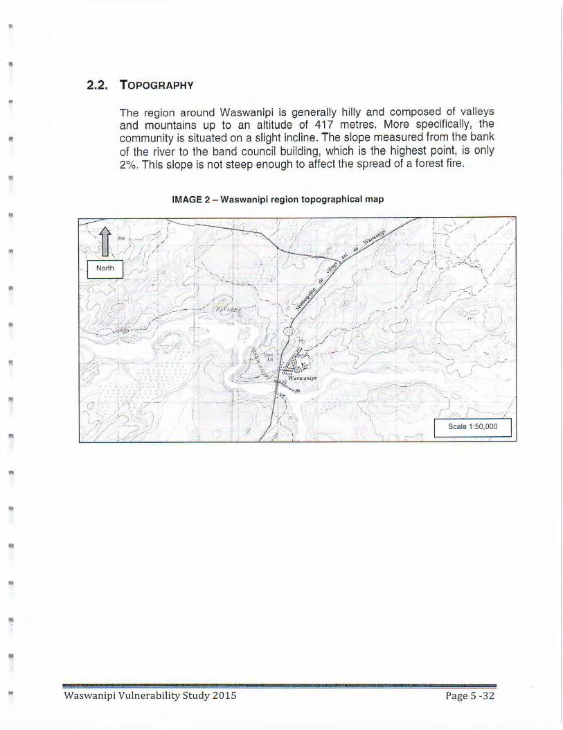
• 2.2. TOPOGRAPHY
The region around Waswanipi is generally hilly and composed of valleys and mountains up to an altitude of 417 metres. More specifically, the
• community is situated on a slight incline. The slope measured from the bank of the river to the band council building, which is the highest point, is only 2%. This slope is not steep enough to affect the spread of a forest fire.
•
l!I
IMAGE 2 - Waswanipi region topographical map
Waswanipi Vulnerability Study 2015
;:.-, )
I x 0
/ ' -, / \
~ '-,'~-"" )_) ;:... - ....-1·
~r-, I I
Scale 1 :50,000
Page 5 -32
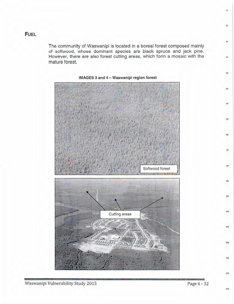
FUEL
The community of Waswanipi is located in a boreal forest composed mainly of softwood, whose dominant species are black spruce and jack pine. However, there are also forest cutting areas, which form a mosaic with the mature forest.
IMAGES 3 and 4 - Waswanipi region forest
Waswanipi Vulnerability Study 2015 Page 6 - 32
•
a
•
•
-
•
..
-
-
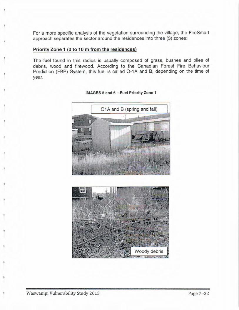
For a more specific analysis of the vegetation surrounding the village, the FireSmart approach separates the sector around the residences into three (3) zones:
Priority Zone 1 (Oto 10 m from the residences)
The fuel found in this radius is usually composed of grass, bushes and piles of debris, wood and firewood . According to the Canadian Forest Fire Behaviour Prediction (FBP) System, this fuel is called 0-1A and B, depending on the time of year.
IMAGES 5 and 6 - Fuel Priority Zone 1
01 A and B (spring and fall)
Waswanipi Vulnerability Study 2015 Page 7 -32
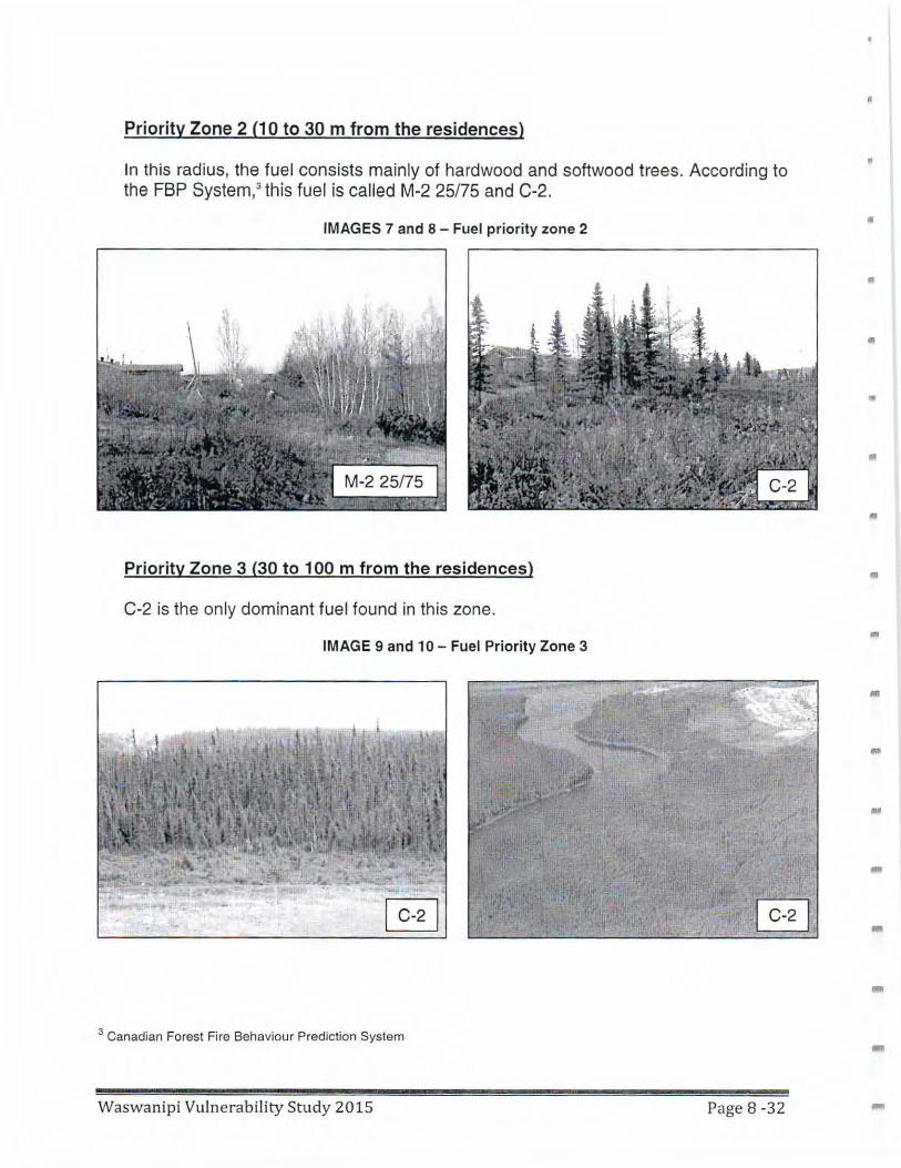
Priority Zone 2 (1 Oto 30 m from the residences)
In this radius, the fuel consists mainly of hardwood and softwood trees. According to the FBP System,3 this fuel is called M-2 25/75 and C-2.
IMAGES 7 and 8 - Fuel priority zone 2
Priority Zone 3 (30 to 100 m from the residences)
C-2 is the only dominant fuel found in th is zone.
IMAGE 9 and 1 O - Fuel Priority Zone 3
3 Canadian Forest Fire Behaviour Prediction System
Waswanipi Vulnerability Study 2015 Page 8 -32
•
•
•
•
•
l!I
"'
•
Ill
.. -
•
!I
II
"
3. FIRE BEHAVIOUR IN WASWANIPI
3.1. HISTORY OF FIRES IN THE REGION
Having knowledge of a region's history of forest fires can help in assessing the fire situations that could be faced on a given territory.
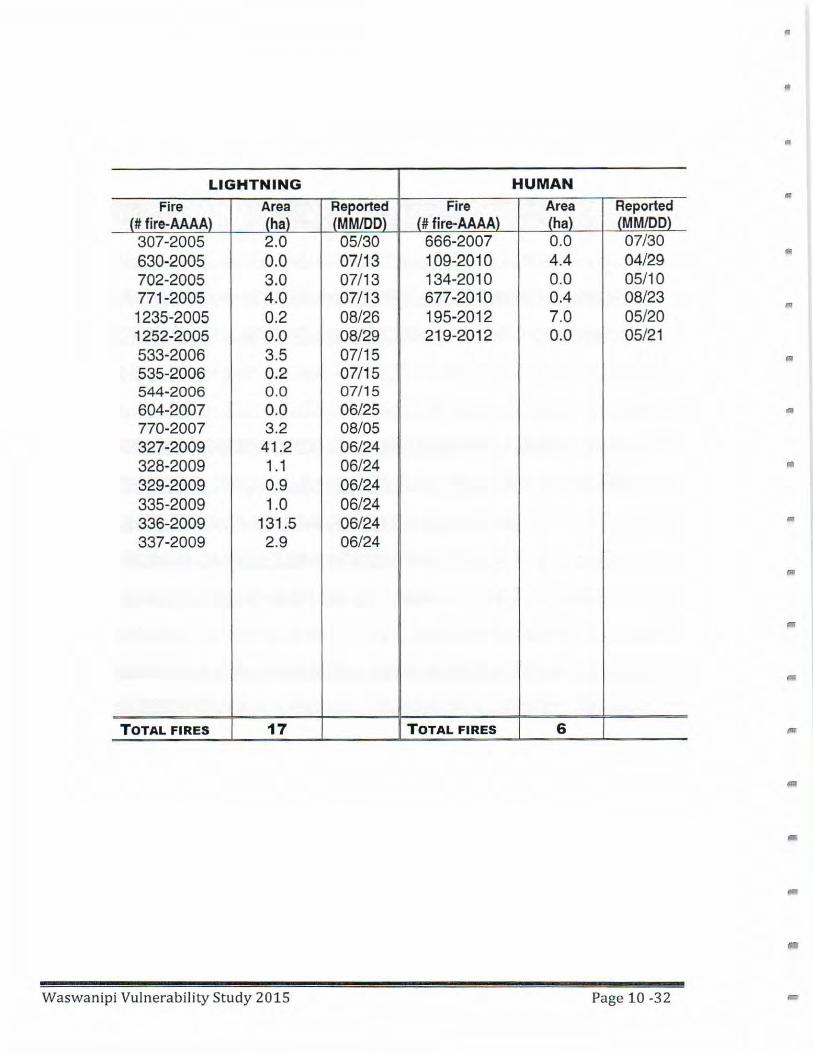
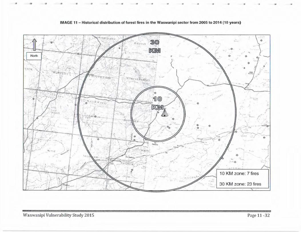
The susceptibility assessment standards for wildfires in communities established in forest areas, drawn from The FireSmart Guidebook for Community Protection5 uses a fire history in the community area to be protected, over a period of 10 years in a radius of 10 km. Research in the SOPFEU historical database of wildfires shows that four (4) fires were reported within 1 O km of the community. In order to have a comprehensive picture of the regional fires system, the research radius was increased to 30 km, rendering a total of 23 fires on an average area of nine (9) hectares.
Past fires were divided into two categories according to their general cause, whether human or natural (lightning) . For the Waswanipi region, we can observe that far more fires were caused by lightning (17) than by humans (6).
5 Government of Alberta, FIRESMART Guidebook for Community Protection , February 2013. Chapter 1 - p. 17.
(consulted online at http://wildfire.alberta.ca/fire-smart/fire-smart-communities/fire-smart-communityleaders/docu men ts/Fi re Sm a rt-GuideComm un ityP rotection-Nov2013. pdf
Waswanipi Vulnerability Study 2015 Page 9 -32
"
•
•
LIGHTNING HUMAN a
Fire Area Reported Fire Area Reported (# fire-AAAA) (ha) lMM/DD) (# fire-AAAA) (ha) (MM/00) 307-2005 2.0 05/30 666-2007 0.0 07/30 630-2005 0.0 07/13 109-2010 4.4 04/29 702-2005 3.0 07/13 134-2010 0.0 05/10 771-2005 4.0 07/13 677-2010 0.4 08/23
"' 1235-2005 0.2 08/26 195-2012 7.0 05/20 1252-2005 0.0 08/29 219-2012 0.0 05/21 533-2006 3.5 07/15 535-2006 0.2 07/15 544-2006 0 .0 07/ 15 604-2007 0.0 06/25 770-2007 3.2 08/05 327-2009 41 .2 06/24 328-2009 1.1 06/24 329-2009 0.9 06/24 335-2009 1.0 06/24 336-2009 131.5 06/24 337-2009 2.9 06/24
All
TOTAL FIRES 17 TOTAL FIRES 6
Waswanipi Vulnerability Study 2015 Page 10 -32
• .. • • .. :• ... .. .. • .. • • • .. • ••
IMAGE 11 - Historical distribution of forest fires in the Waswanipi sector from 2005 to 2014 {10 years)
'~ '- ... -' \ ' ' .. \: f ) f_ ',_
' ' ' I
~
• I ~-
~ -· . · /
,_
..:....~. ~! '~·--- ' ' ' ' ' I . ' I ... ,.,, ,,
=·1-·-.J - ·-,, ,,,, \. ~ ' ,,,,; ... ·: ' I ' '
"'t I. 4 / I .. '41
·I _ .• - •l\''' f • ,~_ J "" -:-~"'-" --;.,..--
, -- --. ,
J ,... - ... r- - J
Waswanipi Vulnerability Study 2015
..... \. ""
~W1 ~
:.. ..... .... - -, I < ,f ~ ..... i_ · ' .... ..; -....
' ' f
' It.:-.... •'
r
.. I
+
+ • . . _ _,.,,, +
,., .. ;..\
..._,.,...
~ . ~ .
!~·-- -
'• '
...............
~· •
,·
,: .. ,_f•
,• ..
u ...
. ;·~·~ ~:~~~,;.· ' . "* \-:.'---;_:._,:.-
r ~ .. '"1 ... ·:.,, (a --J"'··-.."!::::.:;..---=- >:f:'.-;;;:.;·;.~ '~- ' ~ -~ , ~--" "'"'"· ':' . . ,., - . ... -' -::i~·- ' ·-(-- ._, I • .. ._I• .... , ···~(
}
i ,. ·---~· .. -.
'(
.. ... , .
·..:...:.- - _._,,,... .. - ~ ~·"""
• . -
. -·-... ._.. .,.
.. "' . '
-,,..
. ". .. + ,_ ,_
; .... J.r. .•
n '4. ll f _
10 KM zone: 7 fires
30 KM zone: 23 fires
Page 11 · 32
,,.,
3.2 FOREST FIRE BEHAVIOUR PREDICTION
In order to evaluate the different behaviours of fires that could occur in the territory during the months favourable to forest fires, certain days with weather conditions conducive to forest fires were selected based on meteorological data from 2005 to 2014. A forest fire behaviour prediction study was carried out for each type of fuel in the Waswanipi sector.
Waswanipi Vulnerability Study 2015 Page 12 -32
•
..
a
..
-
"
• MAY METEOROLOGICAL DATA ON: 2006/05/101:00 PM
• Fuel Temp RH ws Rain ROS Type Intensity Area 1 h Dist. (FBP) {oC) {%) {km/h) (mm) (m/min) (kw/m) (ha) 1h (m) C·2 7 Cl 50 2,000 4 420
01-A 22.0 26 24 0.0 56 s 14.ooa 175 3,360 S-2 5 s HIIIIIIIJ 2 300
JUNE METEOROLOGICAL DATA ON; 2005/06/121 ;00 PM Fuel Temp RH ws Rain ROS Type Intensity Area 1h Dist.
(FBP) {oC) {%) {km/h) {mm) (m/min) (kw/m) (ha) 1h (m) .. C-2 7 Cl>50 14.ooa 5.5 420
01-A 27.5 57 15 0.4 12 s 1 ,500 10 720 S-2 4 s a,ooa 0.8 240
JULY METEOROLOGICAL DATA ON: 2006/07/131 :00 PM
• Fuel Temp RH ws Rain ROS Type Intensity Area 1h Dist. (FBP) {oC) (%) (km/h) (mm) (m/min) kw/m) (ha) 1h (m) C-2 19 cc 1IHllIIIOl 39 1,140
01-8 29.2 34 19 0.0 - - - . -S-2 10 s ~llIIIlll 11 600
AUGUST METEOROLOGICAL DATA ON: 2011/08/181 :00 PM Fuel rmp RH ws Rain ROS Type Intensity Area 1h Dist. (FBP) (oC) (%) (km/h) (mm) (m/min) (kw/m) (ha) 1h (m) C-2 3 Cl 50 2000 1.5 180
01-8 23.0 49 17 0.0 - - - - -S-2 2 s 17,ooa 1.1 120
.. SEPTEMBER METEOROLOGICAL DATA ON: 2005/09/181 :00 PM
Fuel Temp RH ws Rain ROS Type Intensity Area 1h Dist. (FBP) (oC) (%) (km/h) (mm) (m/min) (kw/m) (ha) 1h (m) C-2 7 Cl>50 ~.ooa 5.5 420
01-8 20.1 50 16 0.0 10 s 1,500 7 600 S-2 3 s lllilllill 1 180
OCTOBER METEOROLOGICAL DATA ON: 2011/10/13 1 :00 PM Fuel Temp RH WS Rain ROS Type Intensity Area 1 h Dist. (FBP) (oC) (%) (km/h) (mm) (m/min) (kw/m) (ha) 1h (m)
• C-2 3 Cl50 1,250 1 180 01-B 13.8 65 12 0.0 10 1,500 7 600 S-2 2 s 17.00d 1 .1 120
Intervention limitations of tanker aircraft
Waswanipi Vulnerability Study 2015 Page 13 -32
I
GRAPH 2 - Frontal intensity per t~pe of fuel and technical limitations of firefightino tactics
12000
10000
-E ....... 8000 ~ -IV ~
§ 6000 ... ..... •Q) ~
'iii c: Q) 4000 ~ c:
2000
0
10000
8000
4000 4000
n.soo
Mai Ju in
l"c.i .. · · '.:.I Intervention l imitations of ground forces
I ~~": I Intervention l imitations of tanker aircraft
Waswanipi Vulnerability Study 2015
t I 11 'I ,.
I
10000 10000
7000
2000
0 0
Ju ill et AoOt
Mo is
11 • ,.
10000 ~
~ .. °').
7000
C-2
• 0 1 4000
S-2
1500 12sa1soo
Septembre Oct obre
Page 14 -32
• • • • • • '&
•
•
"
•
By analyzing these fire behaviour predictions, it is possible to understand what kind of behaviour we might face in terms of the fuel near the community. A fire with a frontal intensity > 4000 kilowatts I m becomes difficult for ground teams to control at the head, while an intensity of 10,000 kW I m is the limit for tanker aircraft. In the predictions performed, July has the highest intensity at the head with C-2 and S-2 fuels , beyond the limits of intervention of ground teams and tanker aircraft. For 01-A fuel , we can see that rates of spread are very rapid, with 56 metres I minute when curing rate is 100%. It is important never to underestimate this fuel, which seems common but is highly flammable in spring and autumn, with favourable climatic conditions. In reality, however, it would be unlikely for a grass fire to travel such a great propagation distance (3.3 km) to come close to or reach the community since there is not a large expanse of grass in the vicinity.
4. WILDFIRE THREAT ASSESSMENT FOR THE COMMUNITY
The wildfire threat assessment for the Waswanipi community is comprehensive in nature. The aim is to highlight the most common problems observed in terms of nearby vegetation, the state of structures, and other factors regarding the FireSmart status of a small community. For this evaluation, the Wildfire Threat Assessment Model was used. This form uses a rating system for the dangers of forest fires for a given community and is based on criteria from the FireSmart manual, FireSmart -Protecting Your Community from Wildfire, https://www.firesmartcanada.ca/resourceslibrary/protecting-your-community-from-wildfire, by Partners in Protection.
The in-field observations of the community are based on seven (7) main factors:
• building materials; • outside of buildings; • nearby vegetation; • topography; • infrastructure (roads, streets); • firefighting efforts; and • ignition and fire prevention.
In the FireSmart approach, there are four (4) levels of wildfire threat used to classify a community. These levels are defined by adding the points obtained for each factor in the form: "Low: <20 points," "Moderate: 21-30 points," "High: 31-50 points" and "Extreme: 51 to 75+ points." The community of Waswanipi received a score of fil_ points, so this community is considered at risk with respect to the threat of forest fires.
Waswanipi Vulnerability Study 2015 Page 15 -32
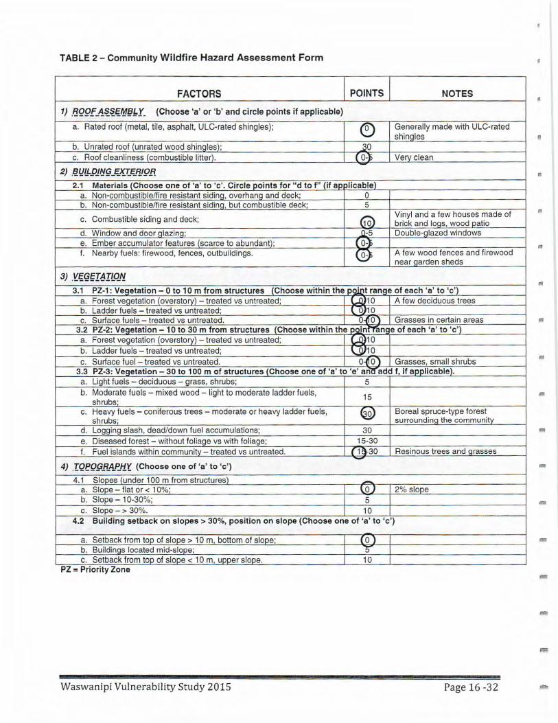
TABLE 2 - Community W ildfire Hazard Assessment Form
FACTORS POINTS NOTES
t) .FJ.Q9f_~~~€¥~~Y- (Choose 'a' or 'b' and circle points if applicable)
a. Rated roof (metal, tile, asphalt, ULC-rated shingles); ® Generally made with ULC-rated shingles fl
b. Unrated roof (unrated wood shinales); ~o c. Roof cleanliness (combustible litter). ( 0-l> Verv clean
-2) ~Y!l-Pl~§_E;}£t~~l9.R II
2.1 Materials (Choose one of 'a' to 'c'. Circle points for " d to f" (if ap Jlicable) a. Non-combustible/fire resistant siding, overhang and deck; 0 b. Non-combustible/fire resistant sidina, but combustible deck; 5
c. Combustible siding and deck; 60) Vinyl and a few houses made of brick and loas, wood patio
d. Window and door glazing; 0-5 Double-glazed windows e. Ember accumulator features (scarce to abundant); ( 0-} f. Nearby fuels: firewood, fences, outbuildings. ® A few wood fences and firewood
near aarden sheds
3) Y.~<i;I~ILQ"! • 3.1 PZ-1: Vegetation - Oto 1 O m from structures (Choose within the ooint range of each 'a' to 'c ')
a. Forest veqetation (overstorv) - treated vs untreated; Lll>10 A few deciduous trees b. Ladder fuels - treated vs untreated; l 0) 10 c. Surface fuels - treated vs untreated. 0-<f 0 ) Grasses in certain areas
3.2 PZ-2: Vegetation - 1 O to 30 m from structures (Choose within the PoinfTan~ e of each 'a' to 'c') a. Forest vegetation (overstory) - treated vs untreated; Lll>10 b. Ladder fuels - treated vs untreated; \..]}10 c. Surface fuel - treated vs untreated. o-i1o) Grasses, small shrubs •
3.3 PZ-3: Vegetation - 30 to 100 m of structures (Choose one of 'a' to 'e' anl! add f, If aoolicable). a. Light fuels - deciduous - grass, shrubs; 5 b. Moderate fuels - mixed wood - light to moderate ladder fuels, 15 shrubs; c. Heavy fuels - coniferous trees - moderate or heavy ladder fuels, ~ Boreal spruce-type forest
shrubs· surrounding the communitv d. Logging slash, dead/down fuel accumulations; 30 e. Diseased forest - without foliage vs with foliage; 15-30 f. Fuel islands within community - treated vs untreated. ( 1S.30 Resinous trees and arasses -
4) .IQT!Q9RA.f'_#i'(, (Choose one of 'a' to 'c')
4.1 Slopes (under 100 m from structures) -a. Slope - flat or< 10%; l oJ 2% slope b. Slope - 10-30%; 5 c. Slope - > 30%. 10
4.2 Building setback on slopes > 30%, position on slope (Choose one of 'a' to 'c')
a. Setback from top of slope> 10 m, bottom of slope; ( 0 ) -b. Buildings located mid-slope; 0 c. Setback from too of slooe < 10 m, uooer slooe. 10
PZ = Priority Zone
Waswanipi Vulnerability Study 2015 Page 16 -32
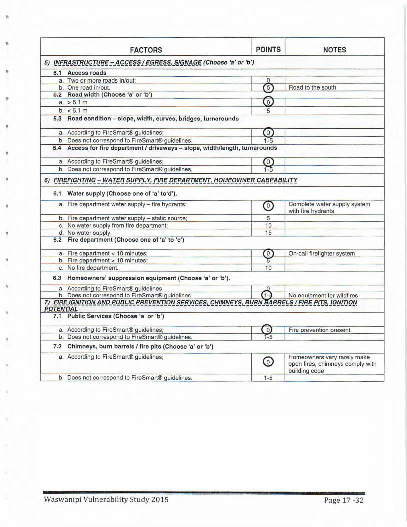
FACTORS POINTS NOTES 5) fllffiAS:.."f..~..L!.t:;.Illli/%:J!f.fl%§§lg_G.B .. E;.~~-~gflp._G_tg (Choose 'a ' or 'b ')
5.1 Access roads a. Two or more roads in/out; Q b. One road in/out. ( 5) Road to the south
5.2 Road w idth {Choose 'a' or 'b ') --
a. > 6.1 m loJ b. < 6.1 m 5
5.3 Road condition - slope, width, curves, bridges, turnarounds
a. According to FlreSmart® guidelines; ( OJ b. Does not correspond to FireSmart® guidelines. 1-5
5.4 Access for fire department I driveways - slope, width/length, turnarounds
a. According to FireSmart® guidelines; ( 0) b. Does not correspond to FireSmart® guidelines. F5
• 6) f.l~fl<Jlj[l_N_G_ = ~~ IEgf1 §JJ..f'..f...L_Y_i fl/1/g P.Fl'_4_F!T_A1fif:!I,_l:f.QM.F_QVf!J~fl-G.~§l!~~lLJT't
6.1 Water supply (Choose one of 'a' to'd').
a. Fire department water supply - fire hydrants; ® Complete water supply system with fire hvdrants
b. Fire department water suooly - static source; 5 c. No water supply from fi re department; 10 d. No water suoolv. 15
6.2 Fire department (Choose one of 'a' to 'c ')
a. Fire department < 10 minutes· ( 0 ) On-call firefiohter system b. Fire department > 10 minutes; 5 c. No fi re deoartment. 10
6.3 Homeowners' suppression equipment (Choose 'a' or 'b ').
a. AccordinQ to FireSmart® QUidelines _l)
b. Does not corresoond to FireSmart® QUidelines {, _, No equipment for wildfires ~ El.fl..f_IPJJJ[IQ.f.!~IJP_ell§~/.P_e8§Y§IJILQ~§..f.flY1£€§~£~LA1..~€r~~YBIJ_f!A~Bg~§ifl~€P1T_~JglJLTJQY. POTENTIAL
7.1 Public Services (Choose 'a' or ' b')
-a. Accordina to FireSmart® guidelines; { OJ Fire prevention present b. Does not corresoond to FireSmart® Quidelines. 1-5
7.2 Chimneys, burn barrels I fire pits (Choose 'a' or ' b')
a. According to FireSmart® guidelines; (Q) Homeowners very rarely make open fi res, chimneys comply with buildinQ code
b. Does not corresoond to FireSmart® QUidelines. 1-5
Waswanipi Vulnerabili ty Study 2015 Page 17 -32

FACTORS POINTS NOTES ..
7.3 Ignition potential (Choose all factors that apply)
a. Topographic features adversely affect fire behaviour; ~ b. Elevated probability of human or natural ignitions; l\QJ~
c. Periodic exposure to extreme fire weather or winds; (.0-) d. Other. Q-5
Community Wildfire Hazard Assessment: Total Score (add up all points) u •
Low< 20 Moderate 21-30 • u:~h ,., . c-•
c Extreme 51-75 + ") 81 pts
•
•
Waswanipi Vulnerability Study 2015 Page 18 -32
•
•
•
II
•
•
fl
•
..
•
•
COMMUNITY WILDFIRE HAZARD FACTORS
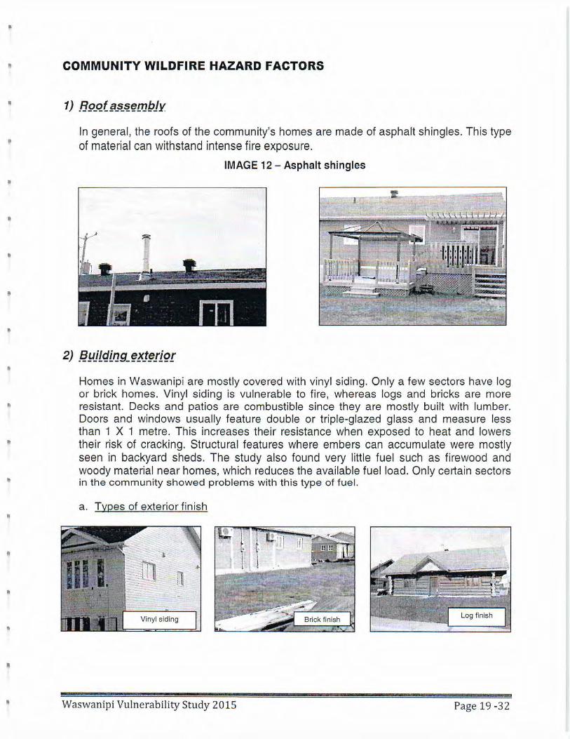
In general, the roofs of the community's homes are made of asphalt shingles. This type of material can withstand intense fire exposure.
IMAGE 12 - Asphalt shingles
Homes in Waswanipi are mostly covered with vinyl siding. Only a few sectors have log or brick homes. Vinyl siding is vulnerable to fire, whereas logs and bricks are more resistant. Decks and patios are combustible since they are mostly built with lumber . Doors and windows usually feature double or triple-glazed glass and measure less than 1 X 1 metre. This increases their resistance when exposed to heat and lowers their risk of cracking. Structural features where embers can accumulate were mostly seen in backyard sheds. The study also found very little fuel such as firewood and woody material near homes, which reduces the available fuel load. Only certain sectors in the community showed problems with this type of fuel.
a. Types of exterior finish
Vinyl siding
Waswanipi Vulnerability Study 2015 Page 19 -32
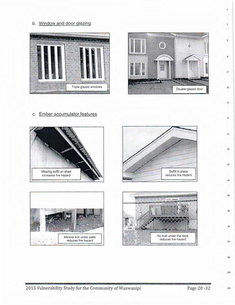
b. Window and door glazing
c. Ember accumulator features
Missing soffit on shed increases fire hazard
2015 Vulnerability Study fo r the Community of Waswanipi
Soffit in place reduces fire hazard
reduces fire hazard
Page 20 -32
..
"
•
•
•
..
..
-
"
I
d. Nearby fuels
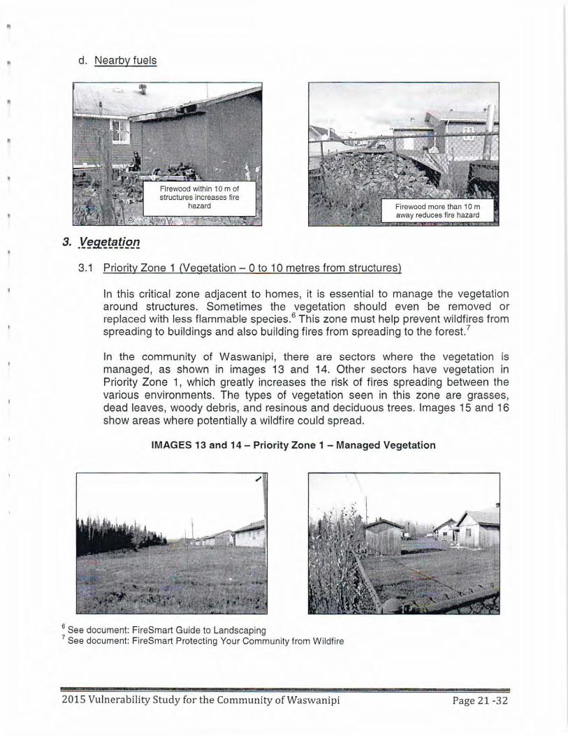
3.1 Priority Zone 1 (Vegetation - 0 to 10 metres from structures)
In this critical zone adjacent to homes, it is essential to manage the vegetation around structures. Sometimes the vegetation should even be removed or replaced with less flammable species.6 This zone must help prevent wildfires from spreading to buildings and also building fires from spreading to the forest.7
In the community of Waswanipi, there are sectors where the vegetation is managed, as shown in images 13 and 14. Other sectors have vegetation in Priority Zone 1, which greatly increases the risk of fires spreading between the various environments. The types of vegetation seen in this zone are grasses, dead leaves, woody debris, and resinous and deciduous trees. Images 15 and 16 show areas where potentially a wildfire could spread.
IMAGES 13 and 14 - Priority Zone 1 - Managed Vegetation
6 See document: FireSmart Guide to Landscaping 7 See document: FireSmart Protecting Your Community from Wildfire
2015 Vulnerability Study for the Community of Waswanipi Page 21-32
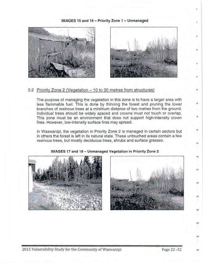
IMAGES 15 and 16- Priority Zone 1 - Unmanaged
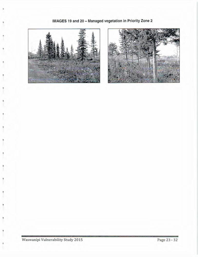
3.2 Priority Zone 2 (Vegetation - 1 Oto 30 metres from structures)
The purpose of managing the vegetation in this zone is to have a larger area with less flammable fuel. This is done by thinning the forest and pruning the lower branches of resinous trees at a minimum distance of two metres from the ground. Individual trees should be widely spaced and crowns must not touch or overlap. This zone must be an environment that does not support high-intensity crown fires. However, low-intensity surface fires may spread.
In Waswanipi, the vegetation in Priority Zone 2 is managed in certain sectors but in others the forest is left in its natural state. These untouched areas contain a few resinous trees, but mostly deciduous trees, shrubs and surface grasses.
IMAGES 17 and 18 - Unmanaged Vegetation in Priority Zone 2
201 5 Vulnerability Study for the Community of Waswanipi Page 22 -32
•
•
•
•
•
"'
•
..
-
--
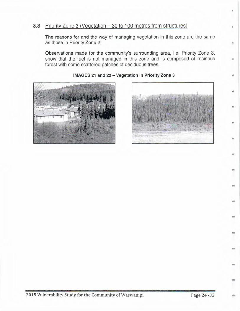
IMAGES 19 and 20 - Managed vegetation in Priority Zone 2
"'
"
II
•
•
I!
•
It
"
II
• Waswanipi Vulnerability Study 2015 Page 23 - 32
3.3 Priority Zone 3 (Vegetation - 30 to 100 metres from structures) •
The reasons for and the way of managing vegetation in this zone are the same as those in Priority Zone 2. •
ObseNations made for the community's surrounding area, i.e. Priority Zone 3, show that the fuel is not managed in this zone and is composed of resinous • forest with some scattered patches of deciduous trees.
IMAGES 21 and 22 - Vegetation in Priority Zone 3 •
"'
n
•
..
fll
-
--
2015 Vulnerability Study for the Community of Waswanipi Page 24 -32 -
•
•
I
I
II
•
•
•
•
4) .[gp_qgf§JP}JY.
4.1 Slope (within 100 metres of structures)
4.2
In the Canadian Forest Fire Behavior Prediction (FBP) System,8
an upslope is considered to have an accelerator effect on a wildfire's rate of spread comparable to wind. It is therefore an important factor to consider.
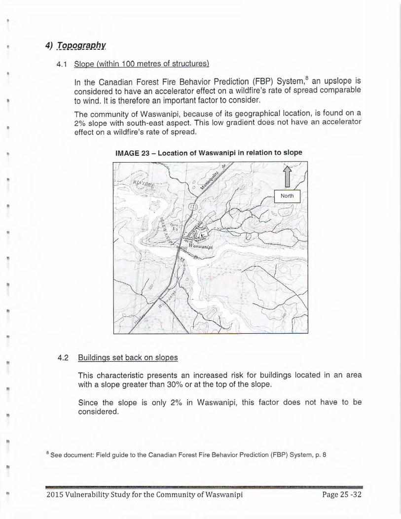
The community of Waswanipi , because of its geographical location, is found on a 2% slope with south-east aspect. This low gradient does not have an accelerator· effect on a wildfire's rate of spread.
IMAGE 23 - Location of Waswanipi in relation to slope
,.- . .; '\ / . ,,.·
.:: - - - RJ.~ ·r~ftp - ,. 'T ....... ~ I -- . . \
Buildings set back on slopes
.-. .. ·--:. _ .......
This characteristic presents an increased risk for buildings located in an area with a slope greater than 30% or at the top of the slope.
Since the slope is only 2% in Waswanipi , this factor does not have to be considered .
8 See document: Field guide to the Canadian Forest Fire Behavior Prediction (FBP) System, p. 8
2015 Vulnerability Study for the Community of Waswanipi Page 25 -32
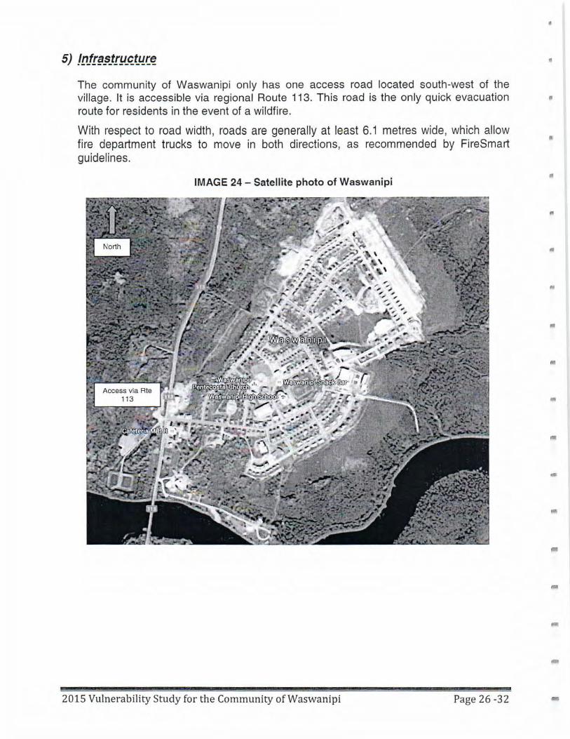
The community of Waswanipi only has one access road located south-west of the village. It is accessible via regional Route 113. This road is the only quick evacuation route for residents in the event of a wildfire.
With respect to road width, roads are generally at least 6.1 metres wide, which allow fire department trucks to move in both directions, as recommended by FireSmart guidelines.
IMAGE 24 - Satellite photo of Waswanipi
2015 Vulnerability Study for the Community of Waswanipi Page 26 -32
I
•
"
II
•
..
•
...
•
..
..
•
-
•
"
II
•
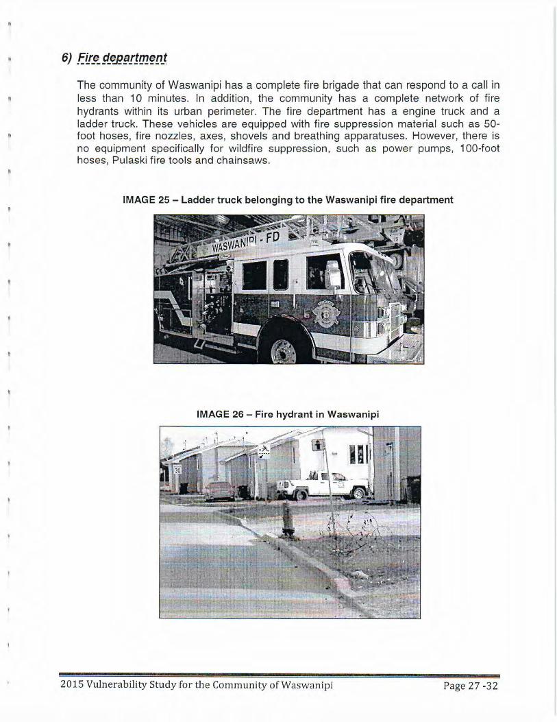
The community of Waswanipi has a complete fire brigade that can respond to a call in less than 10 minutes. In addition, the community has a complete network of fire hydrants within its urban perimeter. The fire department has a engine truck and a ladder truck. These vehicles are equipped with fire suppression material such as 50-foot hoses, fire nozzles, axes, shovels and breathing apparatuses. However, there is no equipment specifically for wildfire suppression , such as power pumps, 100-foot hoses, Pulaski fire tools and chainsaws .
IMAGE 25 - Ladder truck belonging to the Waswanipi fire department
IMAGE 26 - Fire hydrant in Waswanipi
2015 Vulnerability Study for the Community of Waswa nipi Page 27 -32
•
The community of Waswanipi has comprehensive and quality public services such as a water supply system, a sewer system, a police department, a f ire department and a • public safety department that can coordinate emergency preparedness.
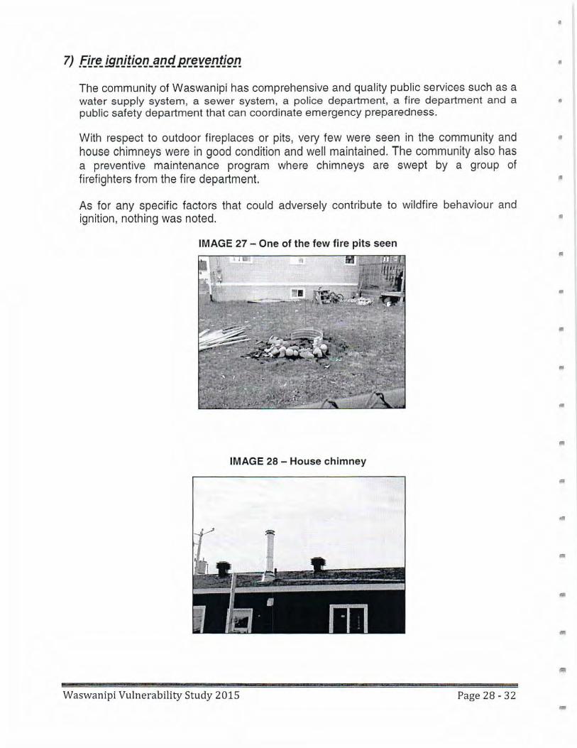
With respect to outdoor fireplaces or pits, very few were seen in the community and house chimneys were in good condition and well maintained. The community also has a preventive maintenance program where chimneys are swept by a group of firefighters from the fire department.
As for any specific factors that could adversely contribute to wildfire behaviour and ignition, nothing was noted. •
IMAGE 27 - One of the few fire pits seen •
•
•
..
•
IMAGE 28 - House chimney
-Waswanipi Vulnerability Study 2015 Page 28 - 32
•
II
II
•
•
•
•
5. Recommendations for Waswanipi
The recommendations for the community of Waswanipi in this vulnerability study are based on observed facts and on interactions with the local population. The objective of these recommendations is to reduce risks and losses and to better prepare the community to take action when lives and properties are exposed to the dangers of wildfires.
Two types of protective measures are suggested here: passive and active. The passive measures make it possible to anticipate the event, preparing buildings and the immediate environment for the passage of a fire. Such preparation diminishes the intensity of fires, reducing the risk that buildings will ignite. The active measures, on the other hand, prepare the community to take various actions when a wildfire occurs in the vicinity .
Waswanipi Vulnerability Study 2015 Page 29 - 32
•
7.1 Passive protection measures • According to the vulnerability study conducted in Waswanipi, the community is considered high-risk with respect to wildfires. The main points to correct so as to reduce risks for the community concern landscaping and the management of .. surrounding vegetation.
There is a program that is considered the Canadian reference in the reduction of wildfire risks. The guidelines of the FireSmart program deal mainly with the management of vegetation and fuels close to homes and infrastructures. Below we present a summary of the recommendations that, in our view, will produce the best results in the case of Waswanipi.
Recommendations for Priority Zone 1
The elimination and replacement of fuels are the principal vegetation management strategies for Priority Zone 1.
This zone must reduce the danger for a building from an approaching wildfire and also diminish the probability that the fire will spread from a building to vegetation. The minimum distance between a building and non-landscaped fuels must be 10 metres. Annual grasses within a radius of 10 metres around the building must be cut or mowed to a maximum height of 1 O centimetres. Plant debris and felled or fallen trees must be removed once a year. Old, diseased, and dead trees are more likely to ignite and spread fire, and must be eliminated. We encourage owners to replace existing vegetation by less flammable species, while taking ecological factors into account. Vegetation growing outside the area immediately surrounding the building must be thinned and pruned to prevent fire from spreading. Firebreak corridors should be installed where sloping ground and orientation increase the danger for buildings and vegetation.
Recommendations for Priority Zone 2
Priority Zone 2 must be an environment that does not feed a high-intensity crown blaze. A surface fire can spread in this zone, but it will be of low intensity and can be easily extinguished.
The reduction of fuels (rather than their elimination) is the principal vegetation limitation strategy for Priority Zone 2. Actions should focus on coniferous forests and on coniferous trees in mixed forests. We do not recommend the thinning of deciduous forest (e.g. , aspen) or the elimination of deciduous trees in a mixed forest. These types of forests prevent fire propagation during most of the year. On flat terrain , Priority Zone 2 is concentric and is 20 metres in width. It starts 10 metres away from the walls of a building and ends 30 metres away from it. On sloping terrain, the width of Priority Zone 2 must be increased.
Etude de vulnerabilite Waswanipi 2015 Page 30 -32
"
•
•
..
..
For an effective reduction of fuels in Priority Zone 2, a considerable effort must be made at the outset, followed by a program of regular maintenance.
Thinning forest cover in Zone 2
Thinning includes the selective cutting of highly flammable tree species. The purpose of thinning is to leave the forest with trees that are more fire-resistant and further apart from each other. The crowns of these trees should not touch or overlap. Appropriate tree spacing reduces the probability of lateral fire propagation from one tree crown to another.
The management of combustible materials is an effective way to curtail the risk of damage when a wildfire occurs near a community in a forest setting such as Waswanipi. A program of this kind also encourages community involvement and allows the community to exercise its own leadership. The promotion of this strategy among the population may be carried out with support from Indigenous and Northern Affairs Canada and SOPFEU.
The implementation of a strategy such as the FireSmart Canada Community Recognition Program (FSCCRP) helps ensure that tangible, long-term results are achieved.
7.2 Active protection measures
As an active protection measure, SOPFEU recommends that the firefighters of the Waswanipi brigade receive training to be first responders when wildfires occur. After this training, they will be able to prepare their equipment and coordinate their response more effectively. Moreover, the purchase of equipment for fighting wildfires (hoses, fire engines, etc.) will allow them to optimize their attack on the fire and limit its spread.
Whether they have human or natural causes, wildfires are difficult events to predict when they spring up in the forest. A well-trained and well-equipped team is therefore a key element in the success of the initial attack. An aggressive approach in this sense makes it possible to limit the harmful consequences that a wildfire can have on a community and its environment.
8. Conclusion of the study
The location of the Waswanipi community in the boreal forest, where most of the forest cover is made up of resinous trees, places it in the extreme high-risk category in the months of June and July. It is during this period that frontal intensity and firebrandpropagation distance can be the highest.
Waswanipi Vulnerability Study 2015 Page 31 - 32
Various measures can be taken to reduce the Waswanipi community's vulnerability when wildfires occur. Besides establishing protection zones 1 and 2, a care for building homes with fire-resistant materials diminishes the risk of damage and loss.
Although the proximity of the secondary SOPFEU base at Chibougamau is an advantage when a wildfire starts at some distance from Waswanipi, this does not guarantee the community's protection.
Among other measures, the presence of a well-trained and well-equipped fire brigade ready to carry out the first attack will effectively limit spreading and protect nearby buildings.
However, it is by combining these active and passive prevention measures, as well as by investing in education and prevention, that a community like Waswanipi will be better protected against the risks of damage and loss in the event of a wildfire. Establishing protection zones, possessing the required equipment, providing the necessary training, and organizing training reinforcement every spring are elements that will help protect human lives and infrastructures when a wildfire occurs.
Waswanipi Vulnerability Study 2015 Page 32 - 32
"'
II
Second entry point into the community Cree First Nation of Waswanipi
APPENDIX B
EnviroCree Environmental Characterization of Road
Route Option 7

WASWANIPI 2ND ENTRY POINT ENVIRONMENTAL OUTLOOK
ADDENDUM
Version :
Preliminary
Project :
ENV-2016-16
EnviroCree Ltd
September 2017

Waswanipi 2nd Entry Point Environmental Outlook - Addendum
Cree First Nation of Waswanipi Project ENV-2016-16
2017-09-26
iii
Cree First Nation of Waswanipi 1, Chief Louis R. Gull Street
Waswanipi, Qc
J0Y 3C0
Waswanipi 2nd Entry Point Environmental Outlook
Addendum
Version
Preliminary
Project
ENV-2016-16
Prepared by :
EnviroCree Ltd
24, Amisk Street
Mistissini (QC) G0W 1C0
Phone: (418) 923-2887
Fax: (418) 923-2335
www.envirocree.com
2017-09-26


Waswanipi 2nd Entry Point Environmental Outlook - Addendum
Cree First Nation of Waswanipi Project ENV-2016-16
Preliminary version 2017-09-26
v
Work Team
Cree First Nation of Waswanipi
Luc Lévesque, eng. Consultant
EnviroCree Ltd
Alexis Deshaies, M.Sc. Biologist, Project Manager
Clifford MacLeod Technical Assistant
Alexis Deshaies, biol., M.Sc. (ABQ #3933) Project Manager

Waswanipi 2nd Entry Point Environmental Outlook - Addendum
Cree First Nation of Waswanipi Project ENV-2016-16
Preliminary version 2017-09-26
vii
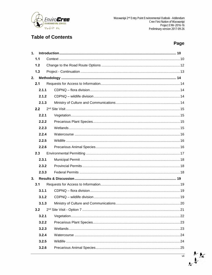
Table of Contents
Page
1. Introduction .......................................................................................................................... 10
Context .............................................................................................................................. 10
Change to the Road Route Options .................................................................................. 12
Project - Continuation ........................................................................................................ 13
2. Methodology ........................................................................................................................ 14
Requests for Access to Information ................................................................................... 14
2.1.1 CDPNQ – flora division .............................................................................................. 14
2.1.2 CDPNQ – wildlife division .......................................................................................... 14
2.1.3 Ministry of Culture and Communications ................................................................... 14
2nd Site Visit ....................................................................................................................... 15
2.2.1 Vegetation .................................................................................................................. 15
2.2.2 Precarious Plant Species........................................................................................... 15
2.2.3 Wetlands .................................................................................................................... 15
2.2.4 Watercourse .............................................................................................................. 16
2.2.5 Wildlife ....................................................................................................................... 16
2.2.6 Precarious Animal Species ........................................................................................ 16
Environmental Permitting .................................................................................................. 17
2.3.1 Municipal Permit ........................................................................................................ 18
2.3.2 Provincial Permits ...................................................................................................... 18
2.3.3 Federal Permits ......................................................................................................... 18
3. Results & Discussion .......................................................................................................... 19
Requests for Access to Information ................................................................................... 19
3.1.1 CDPNQ – flora division .............................................................................................. 19
3.1.2 CDPNQ – wildlife division .......................................................................................... 19
3.1.3 Ministry of Culture and Communications ................................................................... 20
2nd Site Visit - Option 7 ...................................................................................................... 21
3.2.1 Vegetation .................................................................................................................. 22
3.2.2 Precarious Plant Species........................................................................................... 23
3.2.3 Wetlands .................................................................................................................... 23
3.2.4 Watercourse .............................................................................................................. 24
3.2.5 Wildlife ....................................................................................................................... 24
3.2.6 Precarious Animal Species ........................................................................................ 25

Waswanipi 2nd Entry Point Environmental Outlook - Addendum
Cree First Nation of Waswanipi Project ENV-2016-16
Preliminary version 2017-09-26
viii
Permitting ........................................................................................................................... 26
3.3.1 Municipal Permit ........................................................................................................ 26
3.3.2 Provincial Permits ...................................................................................................... 26
3.3.3 Federal Permits ......................................................................................................... 27
4. Conclusion ........................................................................................................................... 28
List of Figures
Figure 1 : Project location and existing entry points .......................................................................... 11
List of Appendices
Appendix 1 Map provided by the Cree First Nation of Waswanipi – Road route options A & B
Appendix 2 Map provided by WSP – Road route options 5, 6 & 7
Appendix 3 Map of the proposed road routes with regards to land categories
Appendix 4 Request for Access to Information to the CDPNQ – flora division
Appendix 5 Request for Access to Information to the CDPNQ – wildlife division, and wildlife
species potentially present in the study area
Appendix 6 Request for Access to Information to the MCC – archaeological sites
Appendix 7 List of TVLPS and assessment of the presence potential
Appendix 8 Map of the wetlands
Appendix 9 List of TVLAS and assessment of the presence potential
Appendix 10 Preliminary Information Form
Appendix 11 Derogation to the RNI Form
Appendix 12 Request for Review Form
Photographic Report

Waswanipi 2nd Entry Point Environmental Outlook - Addendum
Cree First Nation of Waswanipi Project ENV-2016-16
Preliminary version 2017-09-26
ix
List of Acronyms
CDPNQ Natural Heritage Data Center of Quebec
CEAA Canadian Environmental Assessment Agency
CNG Cree Nation Government
C of A Certificate of Authorization
COMEV Evaluating Committee
COMEX Review Committee
DFO Department of Fisheries and Oceans
EIJBRG Eeyou Istchee James Bay Regional Government
EQA Environmental Quality Act
ESIA Environmental and Social Impact Assessment
Ft Feet
GPS Global Positioning System
JBNQA James Bay and Northern Quebec Agreement
Km Kilometer
MCC Ministry of Culture and Communications
MDDELCC Ministry of Sustainable Development, Environment, and Fight Against Climate
Change
MFFP Ministry of Forests, Wildlife and Parks
MTQ Ministry of Transportation of Quebec
RNI Regulation Respecting Standards of Forest Management for Forests in the Domain
of the State
SEG Science, Education and Wildlife Management
SIEF Ecoforest Information System
TVLAS Threatened, Vulnerable or Likely to be so Designated Animal Species
TVLPS Threatened, Vulnerable or Likely to be so Designated Plant Species
UTM Universal Transverse Mercator

Waswanipi 2nd Entry Point Environmental Outlook - Addendum
Cree First Nation of Waswanipi Project ENV-2016-16
Preliminary version 2017-09-26
10
1. Introduction
Context
The Cree community of Waswanipi is located along Quebec provincial highway 113, between
Lebel-sur-Quevillon and Chibougamau, in the administrative region of Nord-du-Quebec, more
precisely in Eeyou Istchee James Bay.
There currently is only one (1) entry point1 connecting Waswanipi to highway 113 that is safe
enough for road circulation: Poplar Street, as shown in Figure 1. Moreover, this entry point
neighbors a gas station.
All of this has the community’s authorities working on a 2nd entry point (another short road
connecting the community to highway 113).
Initially, two (2) different road routes were considered, namely options A & B (Appendix 1).
Thus, in October 2016 EnviroCree carried out an early-stage environmental outlook of options A &
B to get an overview of any potential environmental issues and provide recommendations. Further
to the site visit, a report2 was drafted and submitted to Waswanipi. Option B was recommended as
it consists of a gravel road (shown in Figure 1) which is already built and therefore causes a smaller
environmental footprint. Indeed, a right-of-way is cleared and a culvert is installed where the road
crosses a wetland.
1 There actually is a second access road connecting the community to highway 113 but its design rises safety issues for utilization as a regular entry point – see section 1.2. 2 See report entitled Waswanipi 2nd Entry Point Environmental Outlook.
Waswanipi 2nd Entry Point Environmental Outlook - Addendum
Cree First Nation of Waswanipi Project ENV-2016-16
Preliminary version 2017-09-26
11
Figure 1 : Project location and existing entry points
Waswanipi 2nd Entry Point Environmental Outlook - Addendum
Cree First Nation of Waswanipi Project ENV-2016-16
Preliminary version 2017-09-26
12
Change to the Road Route Options
Waswanipi 2nd entry point project has evolved since the 1st site visit carried out last year, in the fall
of 2016. Some decisions were taken and some precisions were made over the winter and in the
spring of 2017.
Among other things, engineering firm WSP has been retained to provide professional assistance
(road design and conception, surveying, plans, etc.) and a few other road routes have been
proposed (adding options to those initially considered).
Although EnviroCree preliminarily recommended option B as the best road route from an
environmental point of view, it turned out that this option was not recommended from a technical point of view. Indeed, this gravel road connects the community to a somewhat inclined and curvy
stretch of highway 113, and raises safety issues. Thus, option B was discarded.
Also, option A’s route was revised and some alternatives were proposed, namely options 5, 6, 7
(Appendix 2). Instead of running in front of the Justice Facility (as option A was), the new routes
would rather run behind it. On one hand, too much circulation in front of the justice building was not
desirable. On the other hand, the new positioning would allow for connection to an upcoming
municipal development hosting the new firehall and thus creates a shorter way out in case of an
emergency. The new road routes would also allow for consideration of various slope inclinations
(as the community and highway 113 have different elevations).
Consequently, none of the initial road route options (A & B) were retained.
Instead, options 5 and 6 were contemplated for the 2nd site visit (that site visit was planned to
determine the best one between the two, particularly on a technical level as those options were
designed with different slope inclinations). As option 5 was the preferred route, it was surveyed
first. It turned out that option 5 satisfied technical criteria, so option 6 was finally not surveyed.
A slight modification was then made to option 5’s route. More precisely, it was moved to a narrower
section of the marsh that borders highway 113. This change led to option 7, which is the road
route retained for the 2nd entry point. This 701-meter long road route will thus be the link between
the contemplated municipal development at the end of Pine Street, in the vicinity of the Justice
Facility, and highway 113.
In short, this explains why the 2nd site visit covered a new road route (option 7) which had not
previously been described by EnviroCree in the 1st report.

Waswanipi 2nd Entry Point Environmental Outlook - Addendum
Cree First Nation of Waswanipi Project ENV-2016-16
Preliminary version 2017-09-26
13
Project - Continuation
Further to the 1st site visit, the next steps were to
request information from ministries to better define potential environmental issues;
conduct a 2nd site visit when conditions are more suitable (in the spring or summer); and
confirm the required environmental permitting for project advancement.

Waswanipi 2nd Entry Point Environmental Outlook - Addendum
Cree First Nation of Waswanipi Project ENV-2016-16
Preliminary version 2017-09-26
14
2. Methodology
Requests for Access to Information
Requests for access to information were sent to various ministries in January 2017. The requests
considered a 5-km radius circular study area, centered between options A & B3. GPS coordinates
of the study area center were as follows: UTM NAD 83 Zone 18 430582 E; 5506038 N.
2.1.1 CDPNQ – flora division
A request was sent to the MDDELCC (Ministry of Sustainable Development, Environment, and the
Fight Against Climate Change), more precisely to the CDPNQ (Natural Heritage Data Center of
Quebec, flora division) to get information on the presence/absence of precarious plant species in
the study area (threatened, vulnerable and likely to be so designated plant species, TVLPS).
2.1.2 CDPNQ – wildlife division
A request was sent to the MFFP, more precisely to the CDPNQ (wildlife division) to get information
on the presence/absence of
Precarious animal species in the study area (threatened, vulnerable and likely to be so
designated animal species, TVLAS);
Protected wildlife habitats in the study area;
Wildlife sites of interest in the study area;
Wildlife species (micro-mammals, bats, amphibians & reptiles, fish and woodland caribou)
in the study area;
2.1.3 Ministry of Culture and Communications
A request was sent to the Ministry of Culture and Communications (MCC) to get information on the
presence/absence of archaeological sites in the study area.
3 At the time of sending the requests, options A & B were still valid. Nonetheless, the study area is large enough and encompasses the new road route option 7.
Waswanipi 2nd Entry Point Environmental Outlook - Addendum
Cree First Nation of Waswanipi Project ENV-2016-16
Preliminary version 2017-09-26
15
2nd Site Visit
The site visit took place during the summer, which is a suitable time of the year to carry out
biological inventories. A photographic report is presented at the very end of the report.
The EnviroCree team consisted of Mr. Alexis Deshaies (biologist) and Mr. Clifford MacLeod
(technical assistant). The WSP team consisted of Mr. Charles Roy (senior technician) and Mr.
Sébastien Quévillon (land surveyor).
EnviroCree’s part of the field work consisted of making observations & taking pictures of the natural
environment, while the WSP team was flagging the centerline of option 7’s road route.
2.2.1 Vegetation
The ecoforest information system (SIEF)’s online ecoforest map was consulted prior to field work
to get an overview of the ecological types (biotopes) present in the study area (MFFP 2017a). The
Ecological Type Recognition Guide for ecological regions 6a & 6b (Blouin and Berger 2005) was
also consulted to get an idea of Waswanipi region’s typical vegetation stratums (tree, shrub,
herbaceous and moss species).
In the field, the natural environment was characterized for each biotope through observation and
description of the vegetation. The floristic inventory was carried out in a station which was as
representative as possible of the ecological type (1 station/biotope). Specimens were identified to
the species level (whenever possible), using field guides (Brouillet et al. 2010; Farrar 1996;
Fleurbec 1987; Lamoureux 2002; Landry 2013 (I and II); Lapointe 2014; Leboeuf 2007; Marie-
Victorin 1995; Williams 2008).
2.2.2 Precarious Plant Species
The list of TVLPS potentially present in the study area was put together prior to field work, using
guides (CDPNQ 2016; Labrecque et al. 2014; Tardif et al. 2016). Next, an assessment of the
TVLPS presence potential as a function of the study area’s habitats was carried out, to ensure
identification efforts in the field would be put on species with a higher likelihood of encounter.
In the field, attention was paid at all times during the site visit to identify precarious plant species,
focusing on the ones with the best presence potential.
2.2.3 Wetlands
In the office, the wetlands were delimited by photo-interpretation and using MDDELCC’s northern
wetlands cartography information (Cédric Villeneuve, pers. comm.).
In the field, bio-physical indicators were used (use of criteria to determine the presence of typical
wetland vegetation or hydromorphic soils; Bazoge et al. 2015). Thus, the simplified delineation
method was used to place the boundary between the wetlands and the terrestrial environment.
Waswanipi 2nd Entry Point Environmental Outlook - Addendum
Cree First Nation of Waswanipi Project ENV-2016-16
Preliminary version 2017-09-26
16
This method consists of:
Determining the mandatory and optional wetland plant species (indicator species);
Determining the soil type (as required); and,
Determining the hydrological indicators (as required).
2.2.4 Watercourse
A permanent watercourse runs by highway 113 but it was not comprehensively characterized (i.e.
characterization of the biological, physical, and chemical components) as activities necessary to
do so were not included in the mandate (experimental fishing among other things). Nonetheless,
some observations were made.
2.2.5 Wildlife
In the office, the study area’s potential wildlife species were listed using information provided by
the MFFP and field guides (AARQ 2017; Bernatchez and Giroux 2000; Bider and Matte 1994;
Desroches and Rodrigue 2004; Desrosiers et al. 2002; Godfrey 1972; NatureInstruct 2017; Paquin
and Caron 2004; Peterson 1999; Prescott and Richard 2004). The singing of birds and frogs was
also reviewed prior to field work.
In the field, the description of the terrestrial and avian fauna consisted of making direct observations
of animals, recording visual signs (tracks, holes, droppings, burrows, huts, etc.) and listening to
animals singing or making sounds, revealing their presence. Certain rocks and tree trunks on the
ground, chosen at random or according to their habitat potential, were returned to verify the
presence of salamanders and snakes (opportunistic observations; Bouthillier et al. 2015; Larochelle
et al., 2015). Thus, the inventory simply consisted of observations made during the site visit, over
a few daytime hours. The inventory did not take place at dusk, include installation of catching gear
(traps, nets, etc.) nor imply catches or manipulation of animals (hence no SEG permit request was
submitted to the MFFP). Specimens were identified to the species level (whenever possible), using
field guides.
2.2.6 Precarious Animal Species
Like the precarious plant species, the study area’s potentially present TVLAS were listed prior to
field work, using information presented in the MFFP website (MFFP 2017b). Next, an assessment
of the TVLAS presence potential as a function of the study area’s habitats was carried out, to
ensure identification efforts in the field would be put on species with a higher likelihood of encounter.
In the field, the description of the precarious fauna consisted of making direct observations and
recording visual & auditory signs of presence. Attention was paid at all times during the site visit,
focusing on the TVLAS with the best presence potential. Thus, the inventory simply consisted of
what was possible to observe during the site visit, over a few daytime hours. The inventory did not
take place at dusk, include installation of catching gear (traps, nets, etc.) nor imply catches or
manipulation of animals (hence no SEG permit request was submitted to the MFFP).
Waswanipi 2nd Entry Point Environmental Outlook - Addendum
Cree First Nation of Waswanipi Project ENV-2016-16
Preliminary version 2017-09-26
17
Environmental Permitting
Waswanipi is located in the James Bay and Northern Quebec Agreement (JBNQA) territory of
application, which implements, among other things:
1) A specific land regime4
The territory is divided into lands of category
I (lands for the use and exclusive benefit of the Cree First Nations)
II (public lands where the Cree have exclusive hunting/fishing/trapping rights)
III (public lands)
The particularity of the present project is that it straddles two land categories. Almost all of
the road route is in category IA lands, but highway 113 and a 500-ft wide strip are in
category III lands (Appendix 3).
2) A specific environmental protection regime4
This regime outlines development projects that are mandatorily subject to (and mandatorily
exempt from) the Environmental and Social Impact Assessment (ESIA) process,
implements the Evaluating and Review Committees (COMEV and COMEX, respectively),
allows for Cree consultation, etc.
The ESIA process includes 5 steps:
Preliminary information (the proponent sends the project notice to the COMEV)
Guidelines (the COMEV provides the proponent with directions about the ESIA)
ESIA (the proponent carries out the impact assessment)
Review (the COMEX reviews the impact assessment)
Decision (the project is authorized or unauthorized)
Any project listed as mandatorily exempt from the ESIA process does not have to go
through an impact assessment. On the other hand, any project listed as mandatorily subject to the ESIA process must undergo the procedure.
The particularity of the present project is that it may correspond to both types of project:
- Any municipal street or sidewalk (mandatorily exempt from the ESIA procedure)
- Any access road to a locality… (mandatorily subject to the ESIA procedure)
As a result, all of this has the environmental permitting requirements vary according to the situation,
hence written and oral communications were made with various entities (municipal bodies,
provincial and federal ministries) to get confirmations on the necessary legal and regulatory
requirements to move the project forward.
4 This only consists of a general explanation; it is not meant to be an exhaustive description.
Waswanipi 2nd Entry Point Environmental Outlook - Addendum
Cree First Nation of Waswanipi Project ENV-2016-16
Preliminary version 2017-09-26
18
2.3.1 Municipal Permit
The Eeyou Istchee James Bay Regional Government (EIJBRG) replaces the James Bay
Municipality (MBJ) since January 1st, 2014, and exercises the same competencies, duties, and
powers in respect of category III lands in the Eeyou Istchee James Bay territory. Given the road
route spans over category I and III lands, verifications were made with a representative of the Cree
First Nation of Waswanipi and the municipal inspector of the EIJBRG, respectively, to confirm the
required municipal permitting.
2.3.2 Provincial Permits
ESIA – MDDELCC
As the 2nd entry point project mostly takes place on category I lands, the evaluation of the project
falls under the responsibility of the regional administrator of the COMEV (i.e. the director of the
Environment and Remedial Works Department of the Cree Nation Government (CNG)). Thus, an
analyst of the CNG was contacted regarding the necessity to carry out an ESIA.
Certificate of Authorization, Article 22 of the Environmental Quality Act (EQA) – MDDELCC
The 2nd entry point project implies road construction in wetlands. Article 22 of the EQA stipulates
that any proponent undertaking a project in wetlands must first obtain a certificate of authorization
(C of A). Thus, legislation verifications were made.
Slashing Permit & Road Construction Authorization – MFFP
The 2nd entry point project implies road construction in a forest in the domain of the State (public
lands), and slashing the road right-of-way. Slashing and building a road on public lands require,
respectively, a permit and a construction authorization which are emitted by the MFFP. Verifications
regarding the impact of the land categories on the permitting requirements were made with the
latter.
2.3.3 Federal Permits
Environmental Assessment – Canadian Environmental Assessment Agency (CEAA)
The CEAA is responsible for the Canadian Environmental Assessment Act (2012) which enables
the Regulations Designating Physical Activities. These Regulations identify the physical activities
that constitute the designated projects that may require an environmental assessment by the
CEAA. The 2nd entry point project’s characteristics were compared against those of the designated
projects listed in the Regulations.
Department of Fisheries and Oceans (DFO
The Fisheries Act requires that projects avoid causing serious harm5 to fish unless authorized by
the Minister of Fisheries and Oceans Canada. This applies to work being conducted in or near
waterbodies that support fish that are part of or that support a commercial, recreational or Aboriginal
fishery. As the 2nd entry point project involves work conducted in a watercourse, verifications with
the DFO were made to confirm the implications.
5The death of fish or any permanent alteration to, or destruction of, fish habitat.

Waswanipi 2nd Entry Point Environmental Outlook - Addendum
Cree First Nation of Waswanipi Project ENV-2016-16
Preliminary version 2017-09-26
19
3. Results & Discussion
Requests for Access to Information
3.1.1 CDPNQ – flora division
TVLPS
No TVLPS occurrences are listed in the MDDELCC’s data bank for the considered study area.
This does not mean there are no TVLPS in the study area. This simply means that among all of the
TVLPS occurrences currently known to the MDDELCC, none are located in the study area. So,
TVLPS could actually be present in the study area as the MDDELCC does not make the difference
between areas where there certainly are no TVLPS and areas that have not been inventoried yet.
For this reason, the MDDELCC highlights that inventories must be carried out in the field, as
required.
Request made to and response from the MDDELCC are provided in Appendix 4.
3.1.2 CDPNQ – wildlife division
TVLAS
No TVLAS occurrences are listed in the MFFP’s data bank for the considered study area.
This does not mean there are no TVLAS in the study area. This simply means that among all of the
TVLAS occurrences currently known to the MFFP, none are located in the study area. So, TVLAS
could actually be present in the study area as the MFFP does not make the difference between
areas where there certainly are no TVLAS and areas that have not been inventoried yet. For this
reason, the MFFP highlights that inventories must be carried out in the field, as required.
Request made to and response from the MFFP are provided in Appendix 5.
Protected Wildlife Habitats
The ministry mentions there are no protected wildlife habitats nor spawning grounds listed for the
considered study area – but the ministry specifies that fish habitats remain protected whether they
are listed or not.
Although no experimental fishing was conducted in the watercourse near highway 113, considering
it flows into Waswanipi River which contains fish, the watercourse is de facto designated as a fish
habitat (by stream connections).
Thus, option 7 does cross a protected wildlife habitat. However, as the provisions of the Regulation
Respecting Standards of Forest Management for Forests in the Domain of the State (RNI) apply to
the present project, compliance with those provisions guarantee the protection of fish and is
sufficient for the MFFP (Christine Lambert, pers. comm.). It is therefore not necessary to obtain a
special authorization from the ministry given the RNI is respected and the project may move forward
anyway.
Waswanipi 2nd Entry Point Environmental Outlook - Addendum
Cree First Nation of Waswanipi Project ENV-2016-16
Preliminary version 2017-09-26
20
Wildlife Sites of Interest
There is good nesting potential for bird species such as nighthawks, swallows and flycatchers
(there are mentions of presence of these species in the study area). The ministry recommends to
avoid the nesting period (which spans from late may to mid-august) when implementing the project
but specifies that, at the end of the day, it does not impact the project (Karen Savard, pers. comm.).
Wildlife Species
Lists of micro-mammals, bats, amphibians & reptiles, and fish potentially present in the study area
were provided by the MFFP and are presented in Appendix 5. Larger mammals and birds
potentially present in the study area were listed using field guides and are also presented in
Appendix 5.
Regarding the woodland caribou, there are no mentions of its presence in a 2-km radius circle
around Waswanipi, but individuals may be passing in that area (Jean-François Simard, pers.
comm.). However, considering there are much disturbances in that area (highway 113, community,
etc.) and knowing that woodland caribous prefer landscapes dominated by large tracts of mature
coniferous forest (with relatively low amounts of disturbance; they tend to avoid roads) (Rudolph et al. 2012), the probability of encounter is low.
3.1.3 Ministry of Culture and Communications
Archaeological Sites
No archaeological sites are listed in the MCC’s data bank for the considered study area.
This does not mean there are no archaeological sites in the study area. This simply means that
among all of the archaeological sites currently known to the MCC, none are located in the study
area. Thus, archaeological sites could actually be present in the study area and for this reason, the
MCC highlights that an archaeological potential study is recommended, as required.
Request made to and response from the MCC are provided in Appendix 6.
Waswanipi 2nd Entry Point Environmental Outlook - Addendum
Cree First Nation of Waswanipi Project ENV-2016-16
Preliminary version 2017-09-26
21
2nd Site Visit - Option 7
The 2nd site visit took place on July 5th, 2017, in the morning. The weather was sunny with a light
wind (2 on Beaufort’s scale).
MDDELCC’s Ecological Framework
The MDDELCC's Quebec Reference Ecological Framework is an ecological mapping and
classification tool for the territory. In a global and hierarchical approach, it recognizes terrestrial
ecosystems and hydrosystems as spatial entities whose mapping can be obtained by several levels
of perception (MDDELCC, 2017).
Waswanipi is located in the Mistassini Highlands Natural Province (Province G). The highlands of
Mistassini are delimited to the south-east by the boundary between the Superior and Grenville
geological provinces, to the north by the northern limit of the Otish Mountains, and to the west by
the silt and glacio-lacustrine clay plain of the Abitibi and James Bay lowlands.
MFFP’s Ecological Classification
The purpose of MFFP’s Ecological Classification, which is a hierarchical system, is to describe the
ecological diversity of Quebec's forests and to present its distribution (MFFP, 2017c). Waswanipi’s
ecological classification is as follows (MFFP 2017a):
Level Code Description
Vegetation Zone Z2 Boreal Forest
Vegetation Sub-Zone Z21 Continuous Boreal Forest
Bioclimatic Domain 6 Spruce-Moss Forest
Bioclimatic Sub-Domain 6O Western Spruce-Moss Forest
Ecological Region 6a Matagami Lake Plain
Ecological Sub-Region 6a-T Matagami Lake Plain
Regional Landscape 122 Waswanipi Lake
Ecological District 122Z012 Renault Lake Hills
Blouin and Berger (2005) give the following description of Waswanipi’s ecological region (6a):
The climate is of the type ‘continental subpolar subhumid’ which makes for a short growing
season.
Average Annual Temperature (°C) -2,5 - 0
Growing Season Length (day) 150 - 160
Average Annual Precipitation (mm) 800 - 900
Snow Cover (%) 25 - 30
The hydrographic network is very developed and is comprised of several large lakes (e.g.
Waswanipi, Gull) and rivers (e.g. Nottaway, Broadback).
The relief is a little hilly, with slope inclinations usually varying between 0-3 %, at an altitude
of 300-400 m.
Waswanipi 2nd Entry Point Environmental Outlook - Addendum
Cree First Nation of Waswanipi Project ENV-2016-16
Preliminary version 2017-09-26
22
The overburden (quaternary surface deposits) comprises organic deposits in lower places
and clay or sandy mineral deposits in higher places (glaciolacustrine deposits left by
proglacial lake Ojibway, and, in a smaller proportion, glacial deposits like indifferentiated
till).
The region is very little inhabited and mostly comprises lands in the domain of the State
(i.e. public, category III lands).
Given the rigorous climatic conditions, the vegetation is poorly diversified, with a high
proportion of coniferous forests, among which the black spruce is the most frequent. The
balsam fir, white birch and trembling aspen are also encountered. The black spruce grows
in humid depressions or badly drained ground covered by an organic soil; these stations
are covered with sphagnum and ericaceous species. In dryer stations, the black spruce
may grow together with the jack pine, over abundant mosses and ericaceous species.
3.2.1 Vegetation
Based on the SIEF’s ecoforest map, option 7’s road route straddles 6 ecological types (MFFP
2017a):
Ecological Type Description
RS22* Balsam fir forest with black spruce over thin-thick mineral deposit, of medium texture and mesic drainage
RE22* Black spruce forest with mosses or ericaceous plants over thin-thick mineral deposit, of medium texture and mesic drainage
RE39* Black spruce forest with sphagnum over organic deposit, of hydric drainage (bog)
RE26* Black spruce forest with mosses or ericaceous plants over thin-thick mineral deposit, of fine texture and sub-hydric drainage
RE38 Black spruce forest with sphagnum over organic deposit or thin-thick mineral deposit, of hydric drainage (fen)
MA18R Marsh
*Waswanipi region’s most frequent ecological types (or those of particular interest)
The site visit started near the Justice Facility, where the new neighborhood will be implemented.
Since this area has undergone disturbances (slashing and geotechnical work previously done in
anticipation of the municipal development), the environment is mostly comprised of open habitats,
hosting leafy species intolerant to shade. The tree stratum is virtually absent; the shrub and
herbaceous stratums comprise species such as pin cherry (Prunus pennsylvanica), mountain-ash
(Sorbus sp.), serviceberry (Amelanchier sp.) raspberry (Rubus idaeus), fireweed (Epilobium angustifolium) and species that prefer disturbed areas like hawkweeds (Hieracium sp.) (see
photographic report). Without disturbances, the ‘natural’ vegetation of this location would normally
be the balsam fir forest with black spruce.
Waswanipi 2nd Entry Point Environmental Outlook - Addendum
Cree First Nation of Waswanipi Project ENV-2016-16
Preliminary version 2017-09-26
23
Moving along the road route towards highway 113, there currently is a forest standing on a small
hill. Going up the hill, the tree stratum is mostly comprised of black spruce (Picea mariana), balsam
fir (Abies balsamea) and trembling aspen (Populus tremuloides); the jack pine (Pinus banksiana)
is also present. The shrub and herbaceous stratums comprise the northern bush-honeysuckle
(Diervilla lonicera), bunchberry (Cornus canadensis), goldthread (Coptis groenlandica), yellow
clintonia (Clintonia borealis), wild lily-of-the-valley (Maïanthemum canadense) and stiff clubmoss
(Lycopodium annotium).
On top of the hill, there is the typical black spruce and moss forest.
Going downhill, there is the typical black spruce forest with ericaceous plants, namely Labrador tea
(Ledum groenlandicum).
The lower section of the hill and the foot of the hill mark the boundary between the terrestrial
habitats and the wetlands (the vegetation of which is described below in section 3.2.3).
3.2.2 Precarious Plant Species
Prior to field work, Tables 1 and 2, which list the study area’s precarious plant species (for forest
and open habitats, respectively) and indicate the best observation periods for their identification
and their preferential habitats, were put together (Appendix 7).
Tables 1 and 2 show that the inventory was carried out at an appropriate time of the year (during
summer) as it is preferable to observe most of the TVLPS during the summer and/or throughout
the growing season.
Tables 1 and 2 revealed that most of the TVLPS are likely to be found near wetlands (marshes,
swamps, peatlands), riparian environments (rocky, gravelly, sandy shores) and some terrestrial
habitats (dunes, fields of blocks/boulders, outcrops). In turn, reviewing the ecoforest map revealed
that there are not such terrestrial and riparian habitats along the road route, but there are wetlands
(peatland and marsh). This preliminary analysis thus allowed to assess the presence potential of
the precarious plant species through discrimination of the habitats.
The inventory focused on precarious plant species most likely to be found in forested habitats and
wetlands as these are the biotopes present in the study area. No TVLPS were inventoried.
3.2.3 Wetlands
Along the road route, the lower section of the hill and the foot of the hill mark a change in the
physical conditions of the environment. The relief flattens (lower place) and the water table is very
high and even exposed in some places. Saturated water in the first 30-cm layer of the soil
constitutes an hydrological clue (Bazoge et al. 2015). In turn, these conditions influence the
vegetation. Indeed, plant species growing in that kind of habitat must be able to stand such humid
conditions. ‘Mandatory’ and ‘optional’ wetland plant species are called ‘indicator’ species.
Waswanipi 2nd Entry Point Environmental Outlook - Addendum
Cree First Nation of Waswanipi Project ENV-2016-16
Preliminary version 2017-09-26
24
There is a peatland, more precisely a bog (wetland that has no water table; it gets water only from
rain and snow, and therefore has very few nutrients and conditions are acidic) followed by a wooded
peatland, more precisely a wooded fen (wetland that has a water table). The delimitation of the
wooded fen, based on observations made in the field and shown on the wetlands map in Appendix
8, does not correspond precisely to that of the MDDELCC (it is actually larger). Besides black
spruce and Labrador tea, speckled alder (Alnus rugosa), tamarack (Larix laricina), willow (Salix
sp.), woodland horsetail (Equisetum sylvaticum), cloudberry (Rubus chamaemorus) and sphagnum
(Sphagnum sp.) are encountered (which are all indicator species).
Further along the road route, the wooded fen becomes a marsh. Besides standing dead trees, the
tree stratum is absent; there are shrubs (alder, willow) and the vegetation is dominated by
hydrophytes such as sedge (Carex sp.), sweet gale (Myrica gale), and marsh cinquefoil (Comarum palustre).
A watercourse runs through the marsh, along highway 113.
3.2.4 Watercourse
A permanent, sinuous watercourse, flowing south-west and into Waswanipi River, runs by highway
113. It has an approximate width of 3-4 meters and approximate depth of 1-2 meters. The flow
speed is slow as the slope is gentle (almost flat actually). No signs of erosion were observed. The
shores are natural and covered in vegetation (shrubs and herbaceous plants). Aquatic vegetation
consists of plants with floating leaves and emerging plants and could be a suitable habitat for pike
(Esox lucius), notably (potential spawning ground).
Although no experimental fishing was carried out, the watercourse is considered as a fish habitat
by both the provincial and federal governments as it eventually connects to Waswanipi River, which
is a fishy river (stream connections). The fish species potentially present in Waswanipi River – and
therefore in the study area’s watercourse – are listed in Appendix 5.
A beaver (Castor canadensis) dam was seen on the watercourse, slightly downstream of the
proposed road route.
No experimental fishing, sediment & water sampling and in situ physico-chemical parameters
measuring was carried out.
3.2.5 Wildlife
The lists of wildlife potentially present in the study area are presented in Appendix 5.
No official wildlife inventory was carried out in the field – it was only direct observations and visual
& auditory clues that were recorded during the site visit, over a few daytime hours. In forested
habitats, some signs of wildlife activity were observed, namely a burrow, a dead tree damaged by
wood-peckers and some small game trails, likely made by snow-shoe hares (Lepus americanus)
or porcupines (Erethizon dorsatum). A red squirrel (Tamiasciurus hudsonicus) was heard, as well
as some birds, like the black-capped chickadee (Poecile atricapillus), common raven (Corvus

Waswanipi 2nd Entry Point Environmental Outlook - Addendum
Cree First Nation of Waswanipi Project ENV-2016-16
Preliminary version 2017-09-26
25
corax), and red-breasted nuthatch (Sitta canadensis). A northern flicker (Colaptes auratus) and a
dark-eyed junco (Junco hyemalis) were seen.
3.2.6 Precarious Animal Species
The main findings of the presence potential assessment carried out in the office prior to field work
are presented in Table 3 (Appendix 9).
In the field, no TVLAS were observed, but it was only direct observations and visual & auditory
clues that were recorded during the site visit, over a few daytime hours. Although no proper TVLAS
inventory was carried out, the season was suitable for the site visit as summer is the best time of
the year for field observation (presence of breeding birds, migratory bats, etc.).
Waswanipi 2nd Entry Point Environmental Outlook - Addendum
Cree First Nation of Waswanipi Project ENV-2016-16
Preliminary version 2017-09-26
26
Permitting
3.3.1 Municipal Permit
No permit is required from the EIJBRG to move the project forward. The regional government
recommends to consult various ministries (MTQ, MDDELCC, etc.) to obtain all the necessary
permits (René Pichette, pers. comm.). Similarly, no permit is required from Waswanipi (Marcel
Quessy, pers. comm.)
3.3.2 Provincial Permits
ESIA – MDDELCC
The CNG is of the opinion that the 2nd entry point project is mandatorily subject to the ESIA process
and as such, the preliminary information must be sent to the COMEV (the preliminary information
form is presented in Appendix 10). However, assuming the project notice is as comprehensive as
possible, the COMEV might deem appropriate to shorten the process (i.e. discontinue the
procedure after the first step) (Pernilla Talec, pers. comm.).
Certificate of Authorization (C of A), Article 22 of the EQA – MDDELCC
The 2nd entry point project implies road construction in wetlands.
Article 22 of the EQA stipulates that any proponent undertaking a project in a wetland must first
obtain a C of A. However, the Regulation on the Application of the EQA lists the kind of projects
that are subtracted to the application of article 22. One of them is constructions subject to the RNI.
Road construction on public lands (category III lands) is subject to the RNI and therefore does not
require a C of A (in other words, it is the provisions of the RNI that will serve as the environmental
monitoring framework & protection measures). Road construction on category I lands also is
subject to the RNI (Mrs. Sabrina Morissette, pers. comm.).
On another note, road construction in a wooded peatland (like the wooded fen present on the road
route), including material backfilling, complies with the RNI provisions. However, road construction
in an unwooded peatland (like the bog present on the road route) must be done when the ground
is frozen and cannot involve backfilling. Should these conditions not be met, a derogation to the
RNI must be submitted to the MFFP (Appendix 11).
Logging Permit & Road Construction Authorization – MFFP
The 2nd entry point project implies construction of a road in a forest in the domain of the State
(category III lands). A permit for slashing the road right-of-way and an authorization to build the
road is required for that stretch. The rest of the road route is located on category I lands, considered
as private land, and therefore does not require a permit (Mrs. Diane Lacasse, pers. comm.).
Waswanipi 2nd Entry Point Environmental Outlook - Addendum
Cree First Nation of Waswanipi Project ENV-2016-16
Preliminary version 2017-09-26
27
3.3.3 Federal Permits
Environmental Assessment – CEAA (Canadian Environmental Assessment Agency)
The Regulations Designating Physical Activities identify the physical activities that constitute the
designated projects that may require an environmental assessment by the CEAA. As the 2nd entry
point project’s characteristics do not fit any of the Regulations’ designated projects description, it
does not have to go through the federal environmental assessment process.
DFO (Department of Fisheries and Oceans)
The Fisheries Act requires that projects avoid causing serious harm to fish unless authorized by
the Minister of Fisheries and Oceans Canada. This applies to work being conducted in or near
waterbodies that support fish that are part of or that support a commercial, recreational or Aboriginal
fishery.
Although no experimental fishing was carried out in the study area’s watercourse, the latter is
nonetheless considered as a fish habitat by the DFO as it connects to Waswanipi River which is a
fish habitat (stream connections).
Road construction projects involving the installation of culverts are subject to a request for review
(Karine Nantel, pers. comm.). The request for review form is presented in Appendix 12.

Waswanipi 2nd Entry Point Environmental Outlook - Addendum
Cree First Nation of Waswanipi Project ENV-2016-16
Preliminary version 2017-09-26
28
4. Conclusion
In conclusion, here is a summary of the main findings of the study.
Requests for Access to Information
MDDELCC (CDPNQ – flora)
No precarious plant species occurrences are listed for the study area
MFFP (CDPNQ – wildlife)
No precarious animal species occurrences are listed for the study area
The watercourse is the only protected wildlife habitat (fish habitat). Provisions of
the RNI include protection measures.
There is good nesting potential for some birds (no incidence on the project)
Various wildlife species may potentially be present in the study area
MCC
No archaeological sites are listed for the study area
2nd Site Visit
Vegetation
Mostly comprised of typical coniferous forest
TVLPS
No precarious plant species were seen during the inventory
Wetlands
A bog, a wooded fen and a marsh are present in the study area
Watercourse
A permanent stream which constitutes a fish habitat is present in the study area
(no comprehensive characterization was carried out)
Wildlife
Various birds and signs of wildlife activity were observed during the site visit (no
comprehensive inventory was carried out)
TVLAS
No precarious animal species were identified (no comprehensive inventory was
carried out; only based on observations made during the site visit)
Permits
Municipal
No municipal permit is required, either by the EIJBRG or Waswanipi
Provincial
The preliminary information of the ESIA must be submitted to the COMEV
No C of A (Article 22) is required as the project is subject to the RNI
A derogation to the RNI is required
A logging permit and authorization for construction is required from the MFFP (for
the stretch of road located on category III land)
Federal
No evaluation of the project by the CEAA is required
A request for project review must be submitted to the DFO

Waswanipi 2nd Entry Point Environmental Outlook - Addendum
Cree First Nation of Waswanipi Project ENV-2016-16
Preliminary version 2017-09-26
29
Although EnviroCree recommends to conduct a proper characterization of the watercourse, wildlife
species and TVLAS, no environmental issues are foreseen at the present time, based on
observations made during the second site visit.
In order to move the project forward, EnviroCree recommends to fill out the preliminary information
and request for review forms and submit them to the COMEV and DFO, respectively.
Waswanipi 2nd Entry Point Environmental Outlook - Addendum
Cree First Nation of Waswanipi Project ENV-2016-16
Preliminary version 2017-09-26
30
REFERENCES
AARQ, 2017. Atlas des Amphibiens et des Reptiles du Québec. Site internet
http://www.atlasamphibiensreptiles.qc.ca
Bazoge, A., D. Lachance et C. Villeneuve, 2015. Identification et délimitation des milieux humides du Québec méridional, MDDELCC, Direction de l’expertise en biodiversité et Direction de
l’aménagement et des eaux souterraines. 64 p. + annexes.
Bernatchez, L. et M. Giroux, 2000. Les poissons d’eau douce du Québec et leur répartition dans l’est du Canada. Broquet. 3250 p.
Bider, J. R. et S. Matte, 1994. Atlas des amphibiens et des reptiles du Québec. Société d’histoire
naturelle de la vallée du St-Laurent et ministère de l’Environnement et de la Faune du Québec,
Direction de la faune et des habitats, Québec, 106 p.
Blouin, J. et J.-P. Berger, 2005. Guide de reconnaissance des types écologiques de la région écologique 6a – Plaine du lac Matagami et 6b – Plaine de la baie de Rupert. MRNF, Direction des
inventaires forestiers, Division de la classification écologique et productivité des stations.
Bouthillier L., N. Tessier, C. Laurendeau et S. Pelletier, 2015. Protocole d’inventaire des salamandres du Québec. MFFP, 9 p. + annexes.
Brouillet, L., F. Coursol, S.J. Meades, M. Favreau, M. Anions, P. Bélisle et P. Desmet, 2010+.
VASCAN, la Base de données des plantes vasculaires du Canada. http://data.canadensys.net/vascan
CDPNQ, 2016. Les 410 espèces vasculaires en situation précaire au Québec selon la phénologie et l’habitat. CDPNQ, 12 p.
Desroches, J.-F. et D. Rodrigue, 2004. Amphibiens et reptiles du Québec et des Maritimes. Éditions
Michel Quintin, 288 p.
Desrosiers, N., R. Morin et J. Jutras, 2002. Atlas des micromammifères du Québec. Société de la
faune et des parcs du Québec. Direction du développement de la faune. Québec. 92 p.
Farrar, J. L. 1996. Les arbres du Canada. Éditions Fides. 502 p.
Fleurbec, 1987. Plantes sauvages des lacs, rivières et tourbières. Fleurbec. 400 p.
Godfrey, W. E., 1972. Encyclopédie des oiseaux du Québec. Les éditions de l’Homme. 663 p.
Labrecque, J., N. Dignard, P. Petitclerc, L. Couillard, A. O. Dia et D. Bastien, 2014. Guide de reconnaissance des habitats forestiers des plantes menacées ou vulnérables. Abitibi-Témiscamingue et Nord-du-Québec (secteur sud-ouest). MFFP et MDDELCC. 148 p.
Waswanipi 2nd Entry Point Environmental Outlook - Addendum
Cree First Nation of Waswanipi Project ENV-2016-16
Preliminary version 2017-09-26
31
Lacasse, D., 2017. Personal communication. Logging permits, Quévillon Natural Resources
Management Unit, MFFP, Lebel-sur-Quévillon, Québec.
Lambert, C., 2017. Personal communication. Direction of the Wildlife Management, MFFP,
Chibougamau, Québec.
Lamoureux, G., 2002. Flore printanière. Fleurbec éditeur. 576 p.
Landry, L.-M., 2013 (I). Les espèces floristiques indigènes des milieux terrestres du Québec. 167
p.
Landry, L.-M., 2013 (II). Les espèces floristiques typiques des milieux humides du Québec. 120 p.
Lapointe, M., 2014. Plantes de milieux humides et de bord de mer du Québec et des Maritimes. Éditions Michel Quintin. 455 p.
Larochelle, M., N. Tessier et L. Bouthillier, 2015. Protocole standardisé pour l’inventaire de couleuvres associées aux habitats de début de succession au Québec. MFFP, Secteur de la
Faune, 7 p. + annexes
Leboeuf, M., 2007. Arbres et plantes forestières du Québec et des Maritimes. Éditions Michel
Quintin. 391 p.
Marie-Victorin, Fr. 1995. Flore laurentienne. 3e édition mise à jour par L. Brouillet, S.G. Hay et I.
Goulet en collaboration avec M. Blondeau, J. Cayouette et J. Labrecque. Les Presses de
l’Université de Montréal, Montréal. 1093 p.
MDDELCC, 2017. Online Quebec Reference Ecological Framework website. Consulted on June
12, 2017.
http://www.mddelcc.gouv.qc.ca/biodiversite/aires_protegees/provinces/partie1_2.htm#cadre_ecol
ogique
MFFP 2017a. Online ecoforest map. Consulted on June 12, 2017.
https://geoegl.msp.gouv.qc.ca/igo/mffpecofor/?id=79afc4def1
MFFP 2017b. Online list of threatened, vulnerable, and likely to be so designated animal species.
Consulted on June 12, 2017.
http://www3.mffp.gouv.qc.ca/faune/especes/menacees/liste.asp
MFFP 2017c. Ecological Classification website. Consulted on June 12, 2017.
http://www.mffp.gouv.qc.ca/forets/inventaire/inventaire-systeme.jsp
Morissette, S., 2017. Forestry Engineer, Joint Working Groups Coordinator, Direction of Nord-du-
Québec Forests Management, MFFP, Lebel-sur-Quévillon, Québec.
Nantel, K., 2017. Personal communication. Biologist, Fisheries Protection Division, Regulatory
Reviews, DFO, Mont-Joli, Québec.
Waswanipi 2nd Entry Point Environmental Outlook - Addendum
Cree First Nation of Waswanipi Project ENV-2016-16
Preliminary version 2017-09-26
32
NatureInstruct, 2017. Dendroica : une aide pour l’identification des oiseaux de l’hémisphère occidental. Site internet (http://www.natureinstruct.org/dendroica/).
Paquin, J. et G. Caron, 2004. Guide d’identification des oiseaux du Québec et des Maritimes. Éditions Michel Quintin. 224 p.
Peterson, R. T., 1999. Le guide des oiseaux du Québec et de l’est de l’Amérique du Nord. Éditions
Marcel Broquet inc. 385 p.
Pichette, R., 2017. Personal communication. Municipal inspector, civil engineering technician,
EIJBRG, Matagami, Québec.
Prescott, J. et P. Richard, 2004. Mammifères du Québec et de l’est du Canada. 2e édition. Éditions
Michel Quintin. 399 p.
Rudolph, T. D., P. Drapeau, M.-H. St-Laurent, et L. Imbeau, 2012. Status of woodland caribou (Rangifer tarandus caribou) in the James Bay region of Northern Quebec. Scientific report
presented to the Ministère des Ressources naturelles et de la Faune du Québec and the Grand
Council of the Crees (Eeyou Istchee). Montreal, QC. 72 p.
Savard, K., 2017. Personal communication. Wildlife technician, Direction of the Wildlife
Management, MFFP, Chibougamau, Québec.
Simard, J.-F., 2017. Personal communication. Direction of the Wildlife Management, MFFP,
Chibougamau, Québec.
Talec, P., 2017. Personal communication. Environmental Analyst, CNG, Montréal, Québec.
Tardif, B., B. Tremblay, G. Jolicoeur et J. Labrecque. 2016. Les plantes vasculaires en situation précaire au Québec. CDPNQ. Gouvernement du Québec, MDDELCC, Direction de l’expertise en
biodiversité, Québec, 420 p.
Villeneuve, C., 2017. Personal communication. Ecological cartography technician, Direction of the
Biodiversity Expertise, MDDELCC, Québec, Québec.
Williams, M. D., 2008. Arbres du Québec et de l’est de l’Amérique du Nord : guide d’identification. Broquet. 406 p.


Appendix 1 –
Map provided by the Cree First Nation of Waswanipi – Road route
options A & B

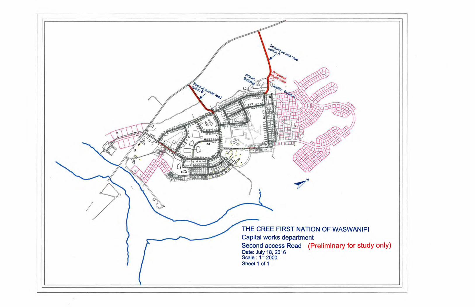
I
THE CREE FIRST NATION OF WASWANIPI Capital works department Second access Road (Preliminary for study only) Date: July 18, 2016 Scale : 1 = 2000 Sheet 1 of 1


Appendix 2 –
Map provided by WSP – Road route options 5, 6 & 7

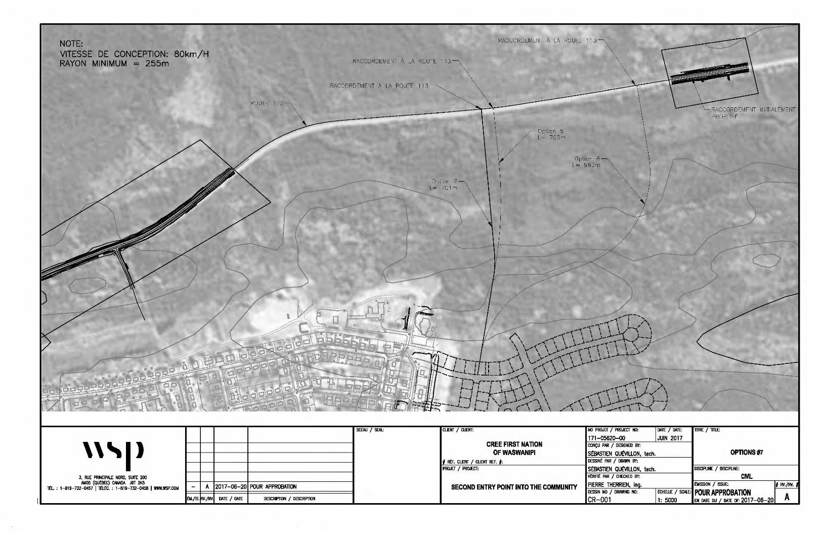
NOTE: VITESSE DE CONCEPTION: BOkm/H RAYON MINIMUM = 255m
'''I>
ROUTE 113
3, RUE PRINCIPALE NORD, SUllE 200 AMOS (QU~EC) CN«JA J9T 21<5
T£1.. : 1--!119-732-007 I m£c. : 1-819-732--0458 I WWW.WSP.COM A 2017-06-20 POUR APPROBATION
£11./IS. ./FN Of.TE I DATE DESCRIPTION / DESCRIPTION
RACCORDEMENT A LA ROUTE 113
RACCORDEMENT A LA ROUTE 11.3
RACCORDEMENT A LA ROUTE 11.3
INITIALEMENT
SCE:AU I SfAI..:
Option 7 L= 701 m
cuoo I Cl.JOO:
Option 5 L= 705m
Option 6 L= 98.3m
NO PROJET I PROJECT NO:
171-05620-00 CREE FIRST NATION CONCU PAR I DESIGNED BY:
OF WASWANIPI S£8ASTIEN QU£VILLON, tech.
Oi\TE I Oi\TE: 1TTRE I 1Tll£:
JUIN 2017
OPTIONS#7 ...,#,__R_£F_. _cu_oo___,/_c_u_oo_RE_F.__,#,__: _________ _____.,,. DESSIN£ PAR I DRAWN BY:
PROJET / PROJECT: S£8ASTIEN QU£VILLON, tech. DISCIPLINE / DISCIPLINE: ~V£R7=--IA£~~=AR~/~C~H=E~~E=D~~.!........:..:-'-"--~~~---1 CML
PIERRE THERRIEN, in • £MISSION I ISSUE: 1-'--"=-:...=--..c.-=...:....c::'-'-"-"L-----.--,-----,-------I
DESSIN NO I DRAWING NO: £cHEU£ I SCALE: POUR APPROBATION SECOND ENTRY POINT INTO THE COMMUNITY
CR-001 1: 5000 EN Oi\TE DU Of.TE OF: 2017-06-20
# FN.jFN.
A

Appendix 3 –
Map of the proposed road routes with regards to land categories

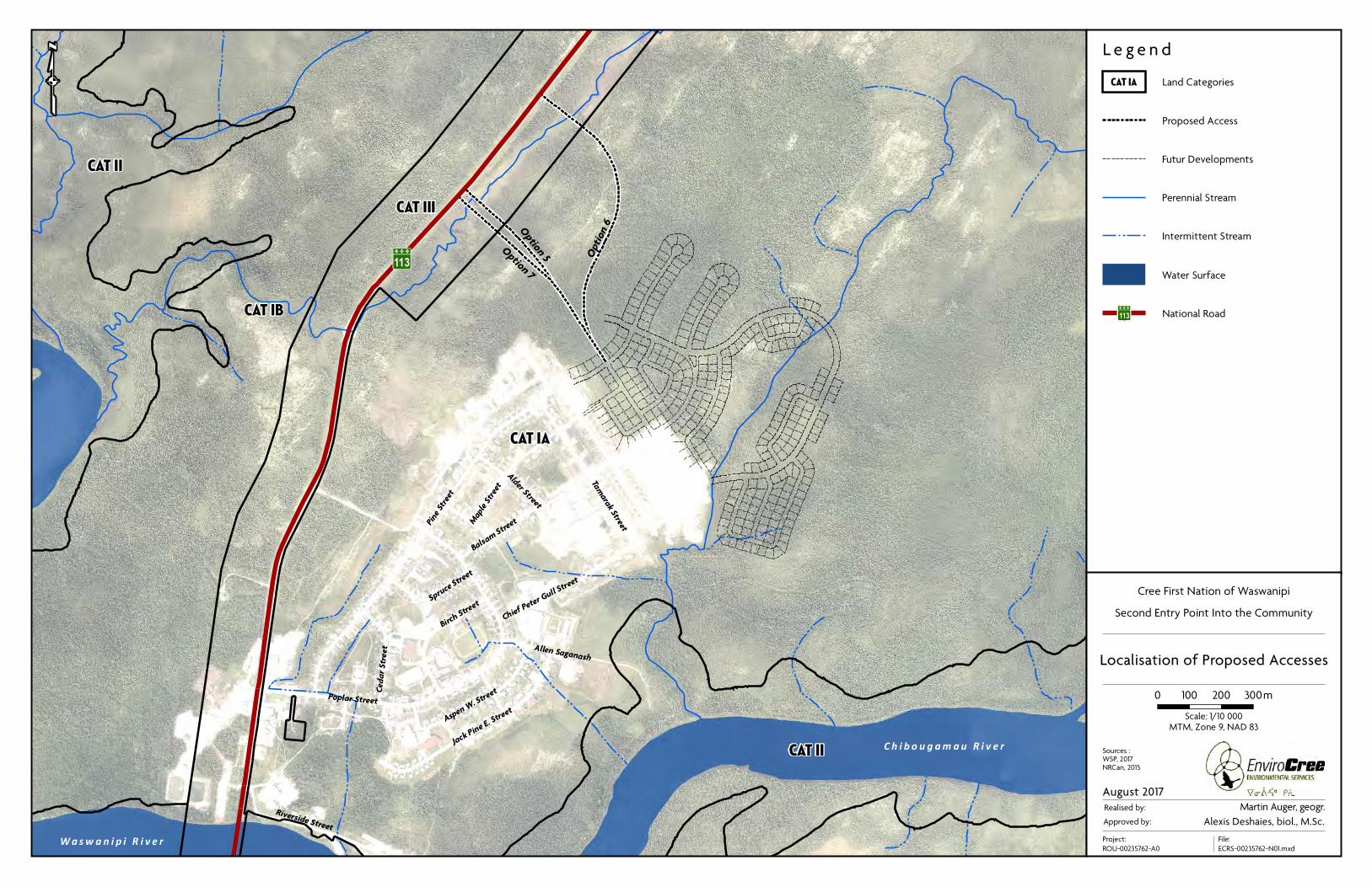
Opt
ion 6O
ption 5
Option 7
W a s w a n i p i R i v e r
CAT III
C h i b o u g a m a u R i v e r
113
Pine
Stree
t
Poplar Street
Tamarak Street
Map
le Stree
t
Birch
Stree
t
Riverside Street
Cedar Street Allen Saganash
Alder Street
Spru
ce St
reet
Chief
Peter
Gull St
reet
Jack P
ine E.
Stree
t
Balsa
m Stree
t
Aspen W
. Stree
t
CAT IA
CAT IB
CAT II
CAT II
qL e g e n d
Cree First Nation of Waswanipi
Second Entry Point Into the Community
Localisation of Proposed Accesses
0 100 200 300m
Approved by:
August 2017
MTM, Zone 9, NAD 83
Realised by: Martin Auger, geogr.
Project:
ROU-00235762-A0
Alexis Deshaies, biol., M.Sc.
Sources :WSP, 2017NRCan, 2015
File:
ECRS-00235762-N01.mxd
Scale: 1/10 000
Intermittent Stream
Perennial Stream
Futur Developments
Proposed Access
Land CategoriesCAT IA
Water Surface
National Road113


Appendix 4 –
Request for Access to Information to the CDPNQ – flora division

Siège social Administration et correspondance
24, Amisk Street, Mistissini (Qc) G0W 1C0 26, 19e Rue, bureau 200, Rouyn-Noranda (Qc) J9X 2M3
Tél.: (418) 923-2887 Cell.: (418) 925-7187 Tél.: (819) 762-2888 Téléc.: (819) 762-4814
[email protected] [email protected]
Le 18 janvier 2017
Par courriel
M. Benoît Larouche Répondant CDPNQ - flore MDDELCC 180, boul. Rideau, bureau 1.04 Rouyn-Noranda (Québec) J9X 1N9
Objet : Requête relative aux espèces menacées, vulnérables ou susceptibles d’être
ainsi désignées
Monsieur Larouche,
Par la présente, nous vous faisons parvenir au nom de notre client, la Nation crie de Waswanipi, une
demande officielle d’information concernant les espèces floristiques menacées, vulnérables ou
susceptibles d’être ainsi désignées.
Cette demande s’inscrit dans le cadre d’un projet de développement d’une 2e voie d’accès à cette
communauté. Par conséquent, nous désirons savoir si des espèces menacées ou vulnérables ont été
répertoriées pour ledit secteur, et ce, dans un rayon de 5 km, dont les coordonnées centrales sont les
suivantes :
UTM Zone 18 NAD83 0430582 E ; 5506038 N
Cette information est nécessaire afin de décrire de la façon la plus précise et complète que possible la
biodiversité du secteur. Ceci permettra de planifier les activités futures dans le respect des éléments
naturels présents et de la Loi sur les espèces menacées ou vulnérables.
Si vous avez des questions n’hésitez pas à communiquer avec nous.
Nous espérons le tout à votre convenance et vous prions d’agréer, Monsieur Larouche, nos plus
cordiales salutations.
Alexis Deshaies, biol., M.Sc. Chargé de projet

Direction régionale de l’analyse et de l’expertise de l’Abitibi-Témiscamingue et du Nord-du-Québec
180, boul. Rideau, local 1.04 …2 Rouyn-Noranda (Québec) J9X 1N9 Téléphone : (819) 763-3333, poste 245
Télécopieur : (819) 763-3202 Courriel : [email protected] Internet : http://www.mddelcc.gouv.qc.ca
Ce papier contient des fibres recyclées après consommation.
PAR COURRIEL Rouyn-Noranda, le 31 janvier 2017 Monsieur Alexis Deshaies EnviroCri ltée 150, rue Marchand, bureau 600 Drummondville (Québec) J2C 4N1 N/Réf. 7970-08-01-00088-00 401561757 Objet : Demande relative aux espèces rares ou menacées – Secteur Waswanipi Monsieur, En réponse à votre demande d'information du 18 janvier 2017 concernant les espèces floristiques menacées ou vulnérables de la région du Nord-du-Québec relativement au secteur Waswanipi, veuillez prendre connaissance de ce qui suit. Le Centre de données sur le patrimoine naturel du Québec (CDPNQ) est un outil servant à colliger, analyser et diffuser l'information sur les espèces menacées. Les données provenant de différentes sources (spécimens d'herbiers et de musées, littérature scientifique, inventaires récents, etc.) sont intégrées graduellement, et ce, depuis 1988. Une partie des données existantes n'est toujours pas incorporée au Centre si bien que l'information fournie peut s'avérer incomplète. Une revue des données à être incorporées au Centre ainsi que des recherches sur le terrain s’avèrent essentielles pour obtenir un portrait général des espèces menacées du territoire à l'étude. De plus, la banque de données ne fait pas de distinction entre les portions de territoires reconnues comme étant dépourvues de telles espèces et celles non inventoriées. Pour ces raisons, l'avis du CDPNQ concernant la présence, l'absence ou l'état des espèces menacées d'un territoire particulier n'est jamais définitif et ne doit pas être considéré comme un substitut aux inventaires de terrain requis dans le cadre des évaluations environnementales.
2
À la suite de la consultation des informations du CDPNQ, nous vous avisons de l’absence, pour votre zone à l’étude sous évaluation, de mentions de plantes menacées, vulnérables ou susceptibles d’être ainsi désignées. En vous remerciant de l'intérêt que vous portez au Centre de données sur le patrimoine naturel du Québec, nous demeurons disponibles pour répondre à vos questions. Veuillez agréer, Monsieur, nos meilleures salutations. BL/da Benoît Larouche, biol., M.Sc.
Service municipal, hydrique et milieu naturel
Espèces floristiques à risque - rayon de 150 km de Waswanipi
Nom latin - (no d'occurrence)
Nom français
Localisation / Caractérisation
Latitude / Longitude Qualité - Précision Indice de biodiversité Dernière observation
FLORE
Cephaloziella grimsulana - (19143)
céphalozielle sombre
Réserve faunique Assinica, rivière Assinica, au pont sur la chute de la rivière, en aval du pont, rive droite. / Étroite dépression humide dans les rochers exposés aux abords de la chute. Alt. 300 m.
50,654 / -75,658 E (Existante, à déterminer) - S (Seconde, 150 m) B5.04 2004-07-24
Meilleure source : HERBIERS 2001 -. Banque de données sur les spécimens d'herbier, active depuis 2001; continuellement mise à jour. Centre de données sur le patrimoine naturel du Québec (CDPNQ). Gouvernement du Québec, ministère du Développement durable, de l'Environnement et des Parcs, Direction du patrimoine écologique et des parcs. Québec, Québec.
Cladopodiella francisci - (17747)
vénusté des forêts
Réserve faunique Assinica, rive sud-ouest du lac Assinica, / Pessière fermée d épinette noire à Pleurozium schreberi, sur le sol minéral dans une dépression.
50,475 / -75,322 E (Existante, à déterminer) - S (Seconde, 150 m) B1.07 2004
Meilleure source : HERBIERS 2001 -. Banque de données sur les spécimens d'herbier, active depuis 2001; continuellement mise à jour. Centre de données sur le patrimoine naturel du Québec (CDPNQ). Gouvernement du Québec, ministère du Développement durable, de l'Environnement et des Parcs, Direction du patrimoine écologique et des parcs. Québec, Québec.
Drosera linearis - (4642)
droséra à feuilles linéaires
Environ 3 km à l'est du lac Opataouaga. / Fen non structuré à sphaignes et Carex. Drainage mauvais avec écoulement à la surface. 1975 : Aucune précision sur le nombre d'individus, début de fructification la deuxième semaine de juillet.
50,381 / -76,631 H (Historique) - G (Général, > 8000 m) B0.00 1975-07-14
Meilleure source : HERBIERS 2001 -. Banque de données sur les spécimens d'herbier, active depuis 2001; continuellement mise à jour. Centre de données sur le patrimoine naturel du Québec (CDPNQ). Gouvernement du Québec, ministère du Développement durable, de l'Environnement et des Parcs, Direction du patrimoine écologique et des parcs. Québec, Québec.
1 – Nombre total d'occurrences pour cette requête : 21
1page de 10
2017-03-28Imprimé le :

Nom latin - (no d'occurrence)
Nom français
Localisation / Caractérisation
Latitude / Longitude Qualité - Précision Indice de biodiversité Dernière observation
Drosera linearis - (16080)
droséra à feuilles linéaires
MRC Jamésie, municipalité de la Baie-James, tourbière Cikwanikaci. Accès : Par la rivière Laflamme, tout près de l'Île Cikwanikaci. Accès : En auto jusqu'à la rivière Laflamme, une demi-heure de bateau (hors-bord 20 forces) et une demi-heure de marche. / Fen structuré ridé de 3 à 4 km2, avec quelques mares dont une de 3 ha. Sol minéral, argile de l'enclave Barlow-Ojibway, pH entre 6,5 et 7. Sur le bord d'un flark. 2006 : 2 colonies d'une cinquantaine d'individus, la deuxième semaine de juillet.
49,049 / -77,381 C (Passable) - S (Seconde, 150 m) B5.03 2006-07-10
Meilleure source : FORMTER 2001 -. Banque de données sur les formulaires de terrain, active depuis 2001; continuellement mise à jour. Centre de données sur le patrimoine naturel du Québec (CDPNQ). Gouvernement du Québec, ministère du Développement durable, de l'Environnement et des Parcs, Direction du patrimoine écologique et des parcs. Québec, Québec.
Eleocharis robbinsii - (19116)
éléocharide de Robbins
MRC Jamésie, municipalité de la Baie-James, tourbière Cikwanikaci. Accès : Par la rivière Laflamme, tout près de l'Île Cikwanikaci. / Fen structuré ridé de 3 à 4 km2, avec quelques mares dont une de 3 hectares. Sol minéral, argile de l'enclave Barlow-Ojibway. pH entre 6,5 et 7. Microhabitat : Sur le bord d'un flark. 2009 : Une vingtaine de tiges.
49,05 / -77,374 D (Faible, non viable) - S (Seconde, 150 m) B5.04 2009
Meilleure source : FORMTER 2001 -. Banque de données sur les formulaires de terrain, active depuis 2001; continuellement mise à jour. Centre de données sur le patrimoine naturel du Québec (CDPNQ). Gouvernement du Québec, ministère du Développement durable, de l'Environnement et des Parcs, Direction du patrimoine écologique et des parcs. Québec, Québec.
Hieracium robinsonii - (4039)
épervière de Robinson
Rivière Bell, rapide Cold Spring. / Rochers granitiques; pleine fructification la quatrième semaine de juillet.
49,654 / -77,535 H (Historique) - M (Minute, 1500 m) B5.04 1957-07-31
Meilleure source : HERBIERS 2001 -. Banque de données sur les spécimens d'herbier, active depuis 2001; continuellement mise à jour. Centre de données sur le patrimoine naturel du Québec (CDPNQ). Gouvernement du Québec, ministère du Développement durable, de l'Environnement et des Parcs, Direction du patrimoine écologique et des parcs. Québec, Québec.
Hudsonia tomentosa - (4565)
hudsonie tomenteuse
Lac Girouard, secteur nord, le long de la rivière Mégiscane. / Haut du littoral sablonneux; abondant; seule espèce qui croît; colonie d'environ 50 m carrés; pleine fructification la quatrième semaine de juillet.
48,539 / -76,273 E (Existante, à déterminer) - S (Seconde, 150 m) B5.04 1993-07-29
2page de 10
2017-03-28Imprimé le :

Nom latin - (no d'occurrence)
Nom français
Localisation / Caractérisation
Latitude / Longitude Qualité - Précision Indice de biodiversité Dernière observation
Meilleure source : HERBIERS 2001 -. Banque de données sur les spécimens d'herbier, active depuis 2001; continuellement mise à jour. Centre de données sur le patrimoine naturel du Québec (CDPNQ). Gouvernement du Québec, ministère du Développement durable, de l'Environnement et des Parcs, Direction du patrimoine écologique et des parcs. Québec, Québec.
Hudsonia tomentosa - (21781)
hudsonie tomenteuse
MRC de la Jamésie, municipalité de la Baie-James, Réserve de parc national Assinica, à 1 km au nord de la confluence des rivières Brock et Chibougamau. / Dunes de sable actives malgré les peuplements de pin gris qui y poussent. 2009 : Aucune précision sur le nombre d'individus, la troisième semaine de juillet.
50,018 / -75,089 BC (Bonne à passable - S (Seconde, 150 m) B4.07 2009-07-17
Meilleure source :
Hudsonia tomentosa - (14819)
hudsonie tomenteuse
Lac Labeau, rive nord / Haut de plage sablonneuse, clairsemée de vieux pins gris, sable fixé, au-dessus de la limite des hautes eaux; Pente environ 20%, exposition sud-sud-ouest; avec mousses (dont Rhacomitrium sp.) et lichens (principalement Cladonia stellaris, aussi C. mitis et Stereocaulon sp.), Vaccinium vitis-idaea, Vaccinium angustifolium, Calamagrostis stricta subsp. inexpansa, Deschampsia flexuosa; Entre 10 000 et 100 000 colonies sur environ 2500 m2.
50,759 / -75,254 D (Faible, non viable) - S (Seconde, 150 m) B5.04 2004
Meilleure source : Gganon, J. 2004. Information sur une occurrence d'Hudsonia tomentosa au lac Labeau. 1 p.
Hudsonia tomentosa - (18662)
hudsonie tomenteuse
MRC de la Jamésie, municipalité de la Baie-James, nord de la rivière Broadback. / Formations sableuses qui ressemblent beaucoup à des dunes (forme avec une crête et légèrement archée). 2008 : Aucune caractérisation.
50,742 / -75,418 AC (Excellente à passable) - S (Seconde, 150 m) B4.07 2008-07-16
Meilleure source : FORMTER 2001 -. Banque de données sur les formulaires de terrain, active depuis 2001; continuellement mise à jour. Centre de données sur le patrimoine naturel du Québec (CDPNQ). Gouvernement du Québec, ministère du Développement durable, de l'Environnement et des Parcs, Direction du patrimoine écologique et des parcs. Québec, Québec.
Hudsonia tomentosa - (18661)
hudsonie tomenteuse
MRC de la Jamésie, municipalité de la Baie-James, nord de la rivière Broadback. 2 sous-populations séparées par environ 1,3 km. / Formations sableuses qui ressemblent beaucoup à des dunes (forme avec une crête et légèrement archée). 2008 : Aucune caractérisation. 2007 : Aucune caractérisation.
50,75 / -75,937 AC (Excellente à passable) - S (Seconde, 150 m) B4.07 2008-07-16
3page de 10
2017-03-28Imprimé le :

Nom latin - (no d'occurrence)
Nom français
Localisation / Caractérisation
Latitude / Longitude Qualité - Précision Indice de biodiversité Dernière observation
Meilleure source : FORMTER 2001 -. Banque de données sur les formulaires de terrain, active depuis 2001; continuellement mise à jour. Centre de données sur le patrimoine naturel du Québec (CDPNQ). Gouvernement du Québec, ministère du Développement durable, de l'Environnement et des Parcs, Direction du patrimoine écologique et des parcs. Québec, Québec.
Jungermannia caespiticia - (19235)
jongermanne grégaire
Nord-du-Québec, lac Assinica, site de la pourvoirie Broadback, à proximité du site d'atterrissage des hélicoptères. / Sol minéral sableux sur un site de grattage. Alt. 358 m.
50,547 / -75,292 E (Existante, à déterminer) - S (Seconde, 150 m) B1.07 2009-07-09
Meilleure source : HERBIERS 2001 -. Banque de données sur les spécimens d'herbier, active depuis 2001; continuellement mise à jour. Centre de données sur le patrimoine naturel du Québec (CDPNQ). Gouvernement du Québec, ministère du Développement durable, de l'Environnement et des Parcs, Direction du patrimoine écologique et des parcs. Québec, Québec.
Marsupella sparsifolia - (19258)
marsupelle arrondie
Nord-du-Québec, mont de l'Antenne du lac Cachista. / Partie basse d'un escarpement vertical haut de 10 m, avec Scapania neorea.
50,478 / -75,063 E (Existante, à déterminer) - S (Seconde, 150 m) B1.04 2009-07-12
Meilleure source : HERBIERS 2001 -. Banque de données sur les spécimens d'herbier, active depuis 2001; continuellement mise à jour. Centre de données sur le patrimoine naturel du Québec (CDPNQ). Gouvernement du Québec, ministère du Développement durable, de l'Environnement et des Parcs, Direction du patrimoine écologique et des parcs. Québec, Québec.
Nardia insecta - (19260)
nardie bilobée
Réserve faunique Assinica, rivière Assinica, au pont sur la chute de la rivière, en amont du pont, rive droite. / Gravier dénudé, humide et perturbé en contrebas de la route. Alt. 300 m.
50,654 / -75,658 E (Existante, à déterminer) - S (Seconde, 150 m) B5.04 2004-07-24
Meilleure source : HERBIERS 2001 -. Banque de données sur les spécimens d'herbier, active depuis 2001; continuellement mise à jour. Centre de données sur le patrimoine naturel du Québec (CDPNQ). Gouvernement du Québec, ministère du Développement durable, de l'Environnement et des Parcs, Direction du patrimoine écologique et des parcs. Québec, Québec.
Schistochilopsis capitata - (19402)
lophozie des sables
Nord-du-Québec, rivière Assinica, près du pont. / Site de grattage, bord de chemin, terre jaune, avec Drosera rotundifolia et Jungermannia gracillima.
50,653 / -75,656 E (Existante, à déterminer) - S (Seconde, 150 m) B1.07 2009-07-10
4page de 10
2017-03-28Imprimé le :

Nom latin - (no d'occurrence)
Nom français
Localisation / Caractérisation
Latitude / Longitude Qualité - Précision Indice de biodiversité Dernière observation
Meilleure source : HERBIERS 2001 -. Banque de données sur les spécimens d'herbier, active depuis 2001; continuellement mise à jour. Centre de données sur le patrimoine naturel du Québec (CDPNQ). Gouvernement du Québec, ministère du Développement durable, de l'Environnement et des Parcs, Direction du patrimoine écologique et des parcs. Québec, Québec.
Trichophorum clintonii - (7253)
trichophore de Clinton
Matagami, rivière Bell, rapides du Chenal. / Rochers en bordure du rapide, milieu ouvert; pleine fructification la première semaine de juillet.
49,756 / -77,61 H (Historique) - M (Minute, 1500 m) B5.04 1954-07-06
Meilleure source : HERBIERS 2001 -. Banque de données sur les spécimens d'herbier, active depuis 2001; continuellement mise à jour. Centre de données sur le patrimoine naturel du Québec (CDPNQ). Gouvernement du Québec, ministère du Développement durable, de l'Environnement et des Parcs, Direction du patrimoine écologique et des parcs. Québec, Québec.
Trichophorum clintonii - (7265)
trichophore de Clinton
Rivière Nottaway, deuxième rapide en aval du lac Soscumica. / Rochers feldspathiques. 1991 : Aucune précision sur le nombre d'individus, en post-fructification la quatrième semaine d'août.
50,347 / -77,691 H (Historique) - S (Seconde, 150 m) B5.04 1991-08-29
Meilleure source : HERBIERS 2001 -. Banque de données sur les spécimens d'herbier, active depuis 2001; continuellement mise à jour. Centre de données sur le patrimoine naturel du Québec (CDPNQ). Gouvernement du Québec, ministère du Développement durable, de l'Environnement et des Parcs, Direction du patrimoine écologique et des parcs. Québec, Québec.
Trichophorum clintonii - (7251)
trichophore de Clinton
Rivière Bell, chute Kiask, environ 70 Km au nord de Senneterre, 3,3 Km à l'est de la route 113, 700 m au nord de l'embouchure de la rivière Cuvillier. / Cran rocheux le long de la rivière.
48,988 / -77,017 H (Historique) - S (Seconde, 150 m) B5.04 1952-09-04
Meilleure source : HERBIERS 2001 -. Banque de données sur les spécimens d'herbier, active depuis 2001; continuellement mise à jour. Centre de données sur le patrimoine naturel du Québec (CDPNQ). Gouvernement du Québec, ministère du Développement durable, de l'Environnement et des Parcs, Direction du patrimoine écologique et des parcs. Québec, Québec.
Utricularia geminiscapa - (20872)
utriculaire à scapes géminés
MRC de la Jamésie, municipalité de la Baie-James, canton Thémines, tourbière Cikwanikaci, près des rivières Laflamme et Bernetz. Accès en bateau par la rivière Laflamme. / Tourbière minérotrophe à structure ridée, dans un flark garni par cette espèce. Avec, sur le bord Utricularia cornuta, U. macrorhiza, Carex exilis, C. michauxiana, Rhynchospora alba, etc. 2010 : Environ 1000 individus, répartis sur plus de 1000 m2, la troisième semaine d'août.
5page de 10
2017-03-28Imprimé le :

Nom latin - (no d'occurrence)
Nom français
Localisation / Caractérisation
Latitude / Longitude Qualité - Précision Indice de biodiversité Dernière observation
49,045 / -77,398 AB (Excellente à bonne) - S (Seconde, 150 m) B4.03 2010-08-15
Meilleure source :
Utricularia resupinata - (5370)
utriculaire résupinée
MRC de la Jamésie, municipalité de la Baie-James, lac de la Mule. / Rivage argileux, herbier aquatique. 1990 : Aucune précision sur le nombre d'individus, en début de fructification la première semaine de septembre.
49,018 / -74,767 H (Historique) - M (Minute, 1500 m) B5.04 1990-09-06
Meilleure source : HERBIERS 2001 -. Banque de données sur les spécimens d'herbier, active depuis 2001; continuellement mise à jour. Centre de données sur le patrimoine naturel du Québec (CDPNQ). Gouvernement du Québec, ministère du Développement durable, de l'Environnement et des Parcs, Direction du patrimoine écologique et des parcs. Québec, Québec.
Utricularia resupinata - (5359)
utriculaire résupinée
MRC La Vallée-de-l'Or, ville de Senneterre, lac Kiask. / Rivage, sol organique, herbaçaie. 1990 : Aucune précision sur le nombre d'individus, en début de fructification la première semaine de septembre.
48,991 / -76,664 H (Historique) - M (Minute, 1500 m) B5.04 1990-09-06
Meilleure source : HERBIERS 2001 -. Banque de données sur les spécimens d'herbier, active depuis 2001; continuellement mise à jour. Centre de données sur le patrimoine naturel du Québec (CDPNQ). Gouvernement du Québec, ministère du Développement durable, de l'Environnement et des Parcs, Direction du patrimoine écologique et des parcs. Québec, Québec.
6page de 10
2017-03-28Imprimé le :
2 – Nombre total d'espèces pour cette requête : 13
Nom latin
Nom commun Rangs de priorité Statut Total Nombre d'occurrences dans votre sélection Nombre
Statut canadien Cosepac / Lep G N S Requête A B C D X H F E I Autres* au Québec**
FLORECephaloziella grimsulana G2G4 N2N3 S1S2 Susceptible 1 0 0 0 0 0 0 0 1 0 0 5
céphalozielle sombre
X (Aucun) / X (Aucun)
Cladopodiella francisci G3G5 NNR S1S2 Susceptible 1 0 0 0 0 0 0 0 1 0 0 1
vénusté des forêts
X (Aucun) / X (Aucun)
Drosera linearis G4 N4 S3 Susceptible 2 0 0 1 0 0 1 0 0 0 0 17
droséra à feuilles linéaires
X (Aucun) / X (Aucun)
Eleocharis robbinsii G4G5 NNR S3 Susceptible 1 0 0 0 1 0 0 0 0 0 0 9
éléocharide de Robbins
X (Aucun) / X (Aucun)
Hieracium robinsonii G3 N2N3 S3 Susceptible 1 0 0 0 0 0 1 0 0 0 0 12
épervière de Robinson
X (Aucun) / X (Aucun)
Hudsonia tomentosa G5 N4N5 S3 Susceptible 5 0 3 0 1 0 0 0 1 0 0 55
hudsonie tomenteuse
X (Aucun) / X (Aucun)
Jungermannia caespiticia G4 N1N2 S1 Susceptible 1 0 0 0 0 0 0 0 1 0 0 1
jongermanne grégaire
X (Aucun) / X (Aucun)
Marsupella sparsifolia G3G4 N2N3 S1 Susceptible 1 0 0 0 0 0 0 0 1 0 0 1
marsupelle arrondie
7page de 10
2017-03-28Imprimé le :
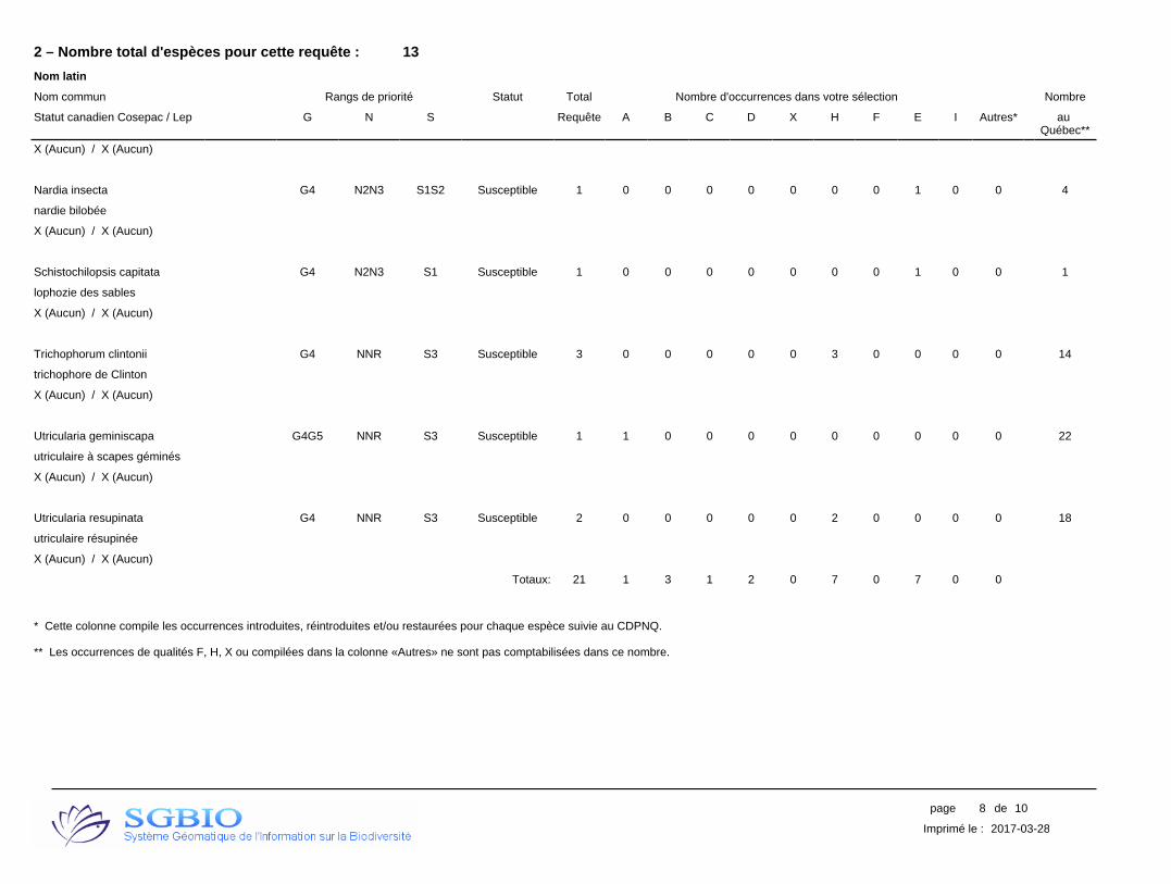
2 – Nombre total d'espèces pour cette requête : 13
Nom latin
Nom commun Rangs de priorité Statut Total Nombre d'occurrences dans votre sélection Nombre
Statut canadien Cosepac / Lep G N S Requête A B C D X H F E I Autres* au Québec**
X (Aucun) / X (Aucun)
Nardia insecta G4 N2N3 S1S2 Susceptible 1 0 0 0 0 0 0 0 1 0 0 4
nardie bilobée
X (Aucun) / X (Aucun)
Schistochilopsis capitata G4 N2N3 S1 Susceptible 1 0 0 0 0 0 0 0 1 0 0 1
lophozie des sables
X (Aucun) / X (Aucun)
Trichophorum clintonii G4 NNR S3 Susceptible 3 0 0 0 0 0 3 0 0 0 0 14
trichophore de Clinton
X (Aucun) / X (Aucun)
Utricularia geminiscapa G4G5 NNR S3 Susceptible 1 1 0 0 0 0 0 0 0 0 0 22
utriculaire à scapes géminés
X (Aucun) / X (Aucun)
Utricularia resupinata G4 NNR S3 Susceptible 2 0 0 0 0 0 2 0 0 0 0 18
utriculaire résupinée
X (Aucun) / X (Aucun)
Totaux: 21 1 3 1 2 0 7 0 7 0 0
* Cette colonne compile les occurrences introduites, réintroduites et/ou restaurées pour chaque espèce suivie au CDPNQ.
** Les occurrences de qualités F, H, X ou compilées dans la colonne «Autres» ne sont pas comptabilisées dans ce nombre.
8page de 10
2017-03-28Imprimé le :

Signification des termes et symboles utilisés
Rang de priorité : Rang décroissant de priorité pour la conservation (de 1 à 5), déterminé selon trois échelles : G (GRANKe; l'aire de répartition totale) N (NRANKe; le pays) et S (SRANKe; la province ou l'État) en tenant compte principalement de la fréquence et de l'abondance de l'élément. Seuls les rangs 1 à 3 traduisent un certain degré de précarité. Dans certains cas, les rangs numériques sont remplacés ou nuancés par les cotes suivantes :B : population animale reproductrice (breeding); H : historique, non observé au cours des 20 dernières années (sud du Québec) ou des 40 dernières années (nord du Québec); M : population animale migratrice; N : population animale non reproductrice; NA : présence accidentelle / exotique / hybride / présence potentielle / présence rapportée mais non caractérisée / présence rapportée mais douteuse / présence signalée par erreur / synonymie de la nomenclature / existant, sans occurrence répertoriée; NR : rang non attribué; Q : statut taxinomique douteux; T : taxon infra-spécifique ou population isolée; U : rang impossible à déterminer; X : éteint ou extirpé; ? : indique une incertitude
Qualité des occurrences : A : excellente; B : bonne; C : passable; D : faible; E : à caractériser; F : non retrouvée; H : historique; X : disparue; I : introduite
Précision des occurrences : S : 150 m de rayon; M : 1,5 km de rayon; G : 8 km de rayon; U : > 8 km de rayon
Indice de biodiversité : 1: Exceptionnel; 2: Très élevé; 3: Élevé; 4: Modéré; 5: Marginal; 6: Indéterminé (pour plus de détails, voir à la page suivante)
Acronymes des herbiers : BL : MARCEL BLONDEAU; BM : Natural history museum; CAN : Musées nationaux; CCO : Université de Carleton; DAO : Agriculture Canada; DS : California academy of sciences; F : Field museum of natural history; GH : Gray; GR : Christian Grenier; ILL : University of Illinois; JEPS : Jepson herbarium; K : kew; LG : Université de Liège; MI : Université du Michigan; MO : Missouri; MT : MLCP (fusionné à MT); MT : Marie-Victorin; MTMG : Université McGill; NB : University of New Brunswick; NY : New York; OSC : Oregon state university; PM : Pierre Morisset; QFA : Louis-Marie; QFB-E : Forêts Canada; QFS : Université Laval; QK : Fowler; QSF : SCF; QUE : Québec; SFS : Rolland-Germain; TRTE : Toronto; UC : University of California; UQTA : Université du Québec; US : Smithsonian; V : Royal British Columbia museum; WAT : Waterloo university; WS : Washington state
9page de 10
2017-03-28Imprimé le :
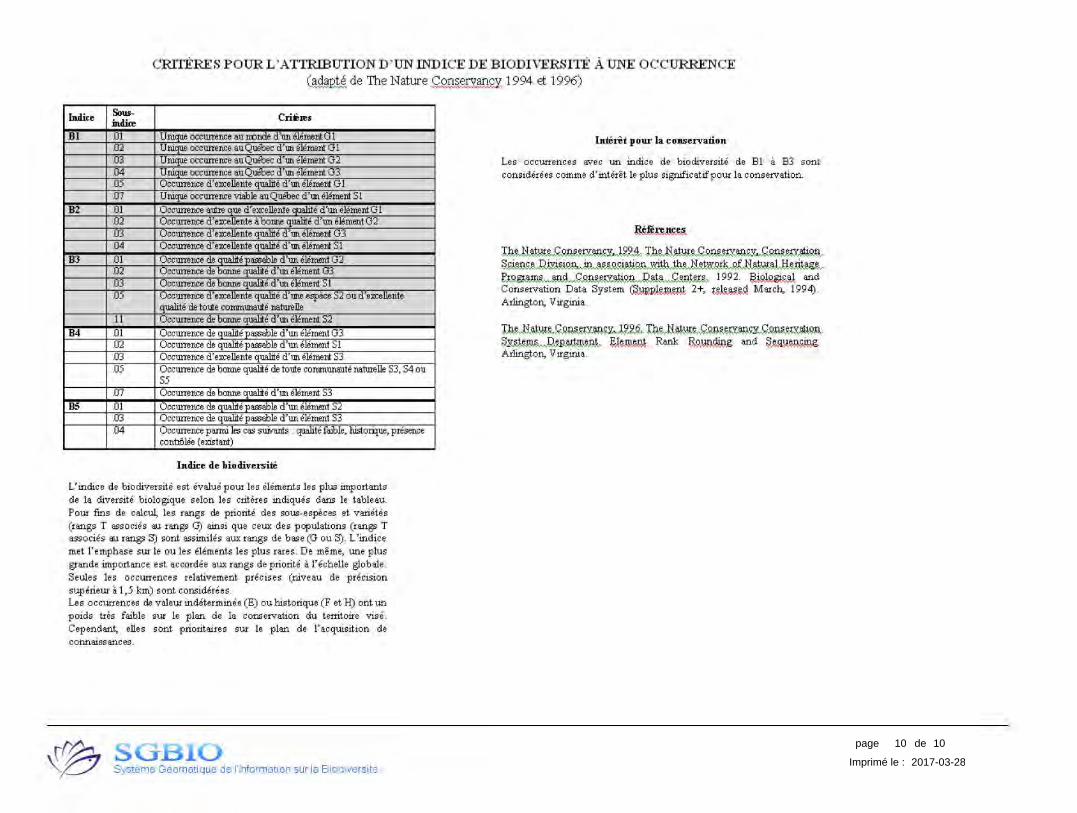
10page de 10
2017-03-28Imprimé le :
CRITERES P OUR L 'ATTRIBUTION D'UN IND ICE DE BIODIVERSITE AUNE OCCURRENCE ~de The Nature~ 1994 et 1996)
lndice Sous- Crieres indire
Bl .01 U nitrue occurrence au rronde d'un element GI .02 Unique occurrence au Que'bec d'un element GI .03 Unique occurrence auQue'bec d'un element G2 .04 U nitrue occurrence au Que'bec d'un element G3 .05 Occurrence d'excellente qualite d'un element GI .07 Unique occurrence viable auQue'bec d'un element SI
B2 .01 Occurrence aulre que d' excellente cruarite d'un element GI .02 Occurrence d'excellente a bonne qualite d'un element G2 .03 Occurrence d'excellente qualite d'un element G3 .04 Occurrence d'excellente qualite d'un element SI
BJ .01 Occurrence de qualite passable d'un element G2 .02 Occurrence de bonne qualite d'un ere.men! G3 .03 Occurrence de bonne qualite d'un element SI .05 Occurrence d'excellente qualite d'une espece S2 ou d'excellente
qualite de toule communaule naturelle .I I Occurrence de bonne qualite d'un element S2
B4 .01 Occurrence de ciualite passable d'un element G3 .02 Occurrence de qualite passable d'un element SI .03 Occurrence d'excellente qualite d'un element S3 .05 Occurrence de bonne qualite de toule communaute naturelle S3, S4 ou
S.5 .07 Occurrence de bonne qualite d'un element S3
B5 .QI Occurrence de qualite passable d'un element S2 .03 Occurrence de qualite passable d'un element S3 .04 Occurrence panni !es cas suiva.nts : qualite faible, historque, presence
contiilee (existant)
lndice de biodiversite
L'indice de biodiversite est evalue pour les elements !es plus importants de la cliversite biologique selon !es criteres incliques dans le tableau. Pour fins de calcul, !es rangs de priorite des sous-especes et varietes (rangs T associes 8ll rangs G) ainsi que ceux des populations (rangs T associes 8ll rangs S) sont assimites aux rangs de base (Gou S). L'indice met l' emphase sur le ou !es elements les plus rares. De meme, une plus grande importance est accordee aux rangs de priorite a l'echelle globale. Seules les occurrences relativement precises (niveau de precision supeneur a 1,5 km) sont considerees. Les occurrences de valeur indeterminee (E) ou historique (F et H) ont un poids tres faible sur le plan de la conservation du territoire vise. Cependant, elles sont prioritaires sur le plan de !'acquisition de connaissances.
\~ SGBIO ~ Systeme Geomatique de !'Information sur la Biodiversite
Intent pour la conservation
Les occurrences avec un indice de biodiversite de Bl a 83 sont considerees comme d'interet le plus significatifpour la conservation.
Conservation Data System Cfum~ 2+, Arlington, Virginia.
~rruv~~~~~~mkgn. ~~ Rank ~ and ~~Arlington, Virginia.

Appendix 5 –
Request for Access to Information to the CDPNQ – wildlife
division, and wildlife species potentially present in the study
area


Direction de la gestion de la faune du Nord-du-Québec
Secteur de la faune et des parcs
Demande d’information faunique 1 Identification Prénom Alexis Nom Deshaies Titre Monsieur Adresse (n°, rue, app.) 150 rue Marchand, bureau 600 Municipalité Province Code postal Drummondville QC J2C 4N1
Firme Services exp / EnviroCri Ltée
Numéros de téléphone Bureau Poste Autre (819) 478-8191 6327 (819) 279-6521
Adresse de courriel électronique [email protected]
Organisme promoteur du projet Cree Nation of Waswanipi
2 Description précise du projet La communauté crie de Waswanipi envisage de procéder à l’instauration d’une 2e voie d’accès à la communauté, via la route provinciale 113, puisque présentement il n’y en a qu’une seule, qui de surcroît, avoisine une station-service (ce qui pourrait potentiellement mener à un problème d’accessibilité en cas d’accident situé à cette seule voie d’accès).
3 Définir le type d’évaluation environnementale qui motive cette demande
Autorisation du ministère du Développement durable, de l’Environnement et de la Lutte contre les changements climatiques (MDDELCC) (Loi 72 sur la restauration des terrains contaminés)
Demande de certificat d’autorisation pour construire des aqueducs et des égouts (Loi sur la qualité de l’environnement du Québec (LQE), article 32, MDDELCC)
Demande de certificat d’autorisation pour des travaux en milieu hydrique (Loi sur la qualité de l’environnement du Québec (LQE), article 22, MDDELCC)
Demande d’autorisation pour réaliser une activité dans un habitat faunique (Loi sur la conservation et la mise en valeur de la faune (LCMVF), article 128.7, MFFP)
Évaluation environnementale d’Environnement Canada
Autorisation de Pêches et Océans Canada en vertu de l’article 35 de la Loi sur les pêches
Certificat d’autorisation municipale : permis ou certification
Permis de la municipalité : travaux dans les cours d’eau de leur juridiction
X Autres (Le projet est encore en phase préliminaire, mais il s’agit d’informations souhaitées)
4 Localisation géographique précise du site d’étude Joindre un fichier de forme de la zone et ou des points à l’étude Coordonnées géographiques en degrés décimales (NAD 83) UTM Zone 18 NAD83 0430582 E ; 5506038 N
5 Km de rayon d’investigation
Nom du plan d’eau Nom ou numéro du bassin hydrographique
X Joindre une carte du site
(Suite demande d’information faunique)
5 Informations demandées
X Mentions d’espèces fauniques à statut : Centre de données sur le patrimoine naturel du Québec
X Habitats de reproduction du poisson
X Habitats fauniques cartographiés en vertu du Règlement sur la protection des habitats fauniques de la LCMVF
Espèces de poisson : liste simple
X Sites d’intérêt faunique
X Herpétofaune
X Micromammifères (chiroptères, souris, etc.)
Animaux à fourrure : statistiques sportives et/ou autochtones : Années de à
Chasse au gros gibier : statistiques sportives et/ou autochtones : Années de à
Caribou forestier et migrateur : précisez la donnée demandée
Observations ornithologiques (veuillez communiquer avec le Regroupement Québec Oiseaux)
X Périodes sensibles pour la reproduction des différentes espèces de poisson
Liste des poissons hôtes des moules indigènes du Québec
X Méthodologie pour obtenir une autorisation du MFFP, si nécessaire
Territoire faunique structuré
Autres 5a Protocoles d’échantillonnage standardisé
Référez-vous au site ftp suivant pour l’obtention des protocoles standardisés :
ftp://ftp.mrn.gouv.qc.ca/public/reg06/monteregie/Protocoles_standardises/
Ce formulaire doit être retourné par courrier électronique à l’adresse suivante :
Direction de la gestion de la faune du Nord-du-Québec Secteur des opérations régionales
...2
951, boulevard Hamel Chibougamau (Québec) G8P 2Z3 Téléphone : 418 748-7701
Télécopieur : 418 748-3338 www.mffp.gouv.qc.ca
PAR COURRIEL Chibougamau, le 7 février 2017 Monsieur Alexis Deshaies Services exp inc./ EnviroCri Ltée 150, rue Marchand, bureau 600 Drummondville (Québec) J2C 4N1 Objet : Requête concernant l’instauration d’une 2ième voie d’accès à la
communauté de Waswanipi – projet en phase préliminaire Monsieur, En réponse à votre courriel du 18 janvier 2017, nous vous transmettons les informations suivantes :
• La lettre réponse officielle du Centre de données sur le patrimoine naturel du Québec (CDPNQ);
• La liste des périodes sensibles à la reproduction du poisson; • La liste des espèces de micromammifère et de chiroptère présentes dans la
région Nord-du-Québec. À noter que la Direction de la gestion de la faune du Nord-du-Québec (DGFa-10) ne possède aucune mention pour votre secteur.
• Liste des espèces de l’herpétofaune potentiellement présentes dans le secteur des travaux. À noter que la DGFa-10 ne ne posséde aucune mention pour votre secteur.
Compte tenu de la description du projet inscrite dans la demande, la DGFa-10 a exclu la section de la rivière Waswanipi de son analyse. En effet, compte tenu de la nature du projet, il apparaît inopportun de vous transmettre les informations demandées concernant cette section de votre aire d’étude. Aucun habitat faunique cartographié et aucune frayère ne sont répertoriés dans la zone d’étude analysée. En ce qui concerne l’habitat du poisson, qu’il soit cartographié ou non, il demeure protégé en vertu de la Loi sur la conservation et la mise en valeur de la faune (LCMVF) et du Règlement sur les habitats fauniques (RHF).
Pour les sites d’intérêt faunique, il y a un bon potentiel pour la nidification de certaines espèces d’oiseau tels que les engoulevents, les hirondelles ainsi que les moucherolles. En effet, il existe des mentions pour ces espèces. Pour obtenir de l’information générale sur
page 2
la faune aviaire, référez-vous au Regroupement Québec Oiseaux : http://www.quebecoiseaux.org/index.php/sospop.
Pour préciser les espèces de micromammifère et de l’herpétofaune qui peuvent fréquenter le territoire à l’étude, nous vous invitons à consulter le guide des mammifères du Québec ainsi que le site internet de l’Atlas des amphibiens et reptiles du Québec au lien suivant : http://www.atlasamphibiensreptiles.qc.ca/. Pour connaître les détails sur la procédure concernant les demandes d’autorisation délivrée en vertu de l’article 128.6 de la LCMVF pour effectuer une activité dans un habitat faunique, veuillez consulter le site Web suivant : http://www.mddelcc.gouv.qc.ca/Industriel/demande/. Veuillez toutefois noter que l’absence d’une ou plusieurs espèces pour un secteur donné ne signifie pas que cette ou ces espèces ne sont pas présentes sur ce territoire, puisque des inventaires exhaustifs n’ont pas été faits pour l’ensemble des espèces sur notre territoire. De plus, la répartition spatiale de toute espèce peut changer selon l’évolution des écosystèmes et en réponse à des pressions environnementales de cause naturelle ou anthropique. En tout temps, la DGFa-10 invite le demandeur à transmettre toute mention faunique dans le secteur visé par les travaux et dans les environs. Le demandeur peut envoyer ses observations à l’adresse [email protected] en indiquant le nom et les coordonnées de l’observateur, le nombre d’individus observés, la date et les coordonnées géographiques précises. Les données demeurent la propriété du ministère des Forêts, de la Faune et des Parcs. Vous ne pouvez vendre, donner, prêter, échanger ou transmettre ces informations à des tiers sans notre accord. De plus, l’information transmise doit être utilisée uniquement pour les travaux cités dans votre demande. Aussi, une demande écrite devra nous être acheminée pour toute autre utilisation de ces informations. Veuillez noter qu’aucune partie de celles-ci ne peut être utilisée à des fins lucratives par l’utilisateur autorisé. Veuillez recevoir, Monsieur, mes salutations les meilleures.
Karen Savard Technicienne de la faune P.J. (4)
Direction de la gestion de la faune du Nord-du-Québec Secteur des opérations régionales
951, boulevard Hamel
Chibougamau (Québec) G8P 2Z3 Téléphone : 418 748-7701 Télécopieur : 418 748-3338
www.mddefp.gouv.qc.ca
PAR COURRIEL Chibougamau, le 7 février 2017 Monsieur Alexis Deshaies Services exp inc. / EnviroCri Ltée 150, rue Marchand, bureau 600 Drummondville (Québec) J2C 4N1 Objet : Requête concernant la présence d'espèces fauniques menacées,
vulnérables ou susceptibles d'être ainsi désignées – Instauration d’une 2e voie d’accès à la communauté de Waswanipi
Monsieur, La présente fait suite à votre demande d'information du 18 janvier 2017, adressée au Centre de données sur le patrimoine naturel du Québec (CDPNQ) - volet faune de la région Nord-du-Québec, concernant l’objet en titre. Le CDPNQ est un outil servant à colliger, analyser et diffuser l'information sur les espèces menacées. Les données provenant de différentes sources (spécimens d'herbiers et de musées, littérature scientifique, inventaires récents, etc.) y sont intégrées graduellement, et ce, depuis 1988. Toutefois, une partie des données existantes n'est toujours pas incorporée au Centre, si bien que l'information fournie peut s'avérer incomplète. Une revue des données à être incorporées au Centre ainsi que des recherches sur le terrain s'avèrent essentielles pour obtenir un portrait général des espèces menacées du territoire à l'étude. De plus, la banque de données ne fait pas de distinction entre les portions de territoires reconnues comme étant dépourvues de certaines espèces et les portions non inventoriées. Pour ces raisons, l'avis du CDPNQ concernant la présence, l'absence ou l'état des espèces menacées d'un territoire particulier n'est jamais définitif et ne doit pas être considéré comme un substitut aux inventaires de terrain requis dans le cadre des évaluations environnementales. À la suite de la consultation des informations du CDPNQ, nous vous avisons de l’absence de mentions d’espèces fauniques menacées, vulnérables ou susceptibles d’être ainsi désignées dans les deux zones à l’étude.
…2
page 2
Afin de faire du CDPNQ l'outil le plus complet possible, il nous serait utile de recevoir vos données relatives aux espèces menacées issues d'inventaires reliés à ce projet. Veuillez noter que les données pour les nouvelles occurrences nous intéressent particulièrement, mais que les mises à jour d'occurrences déjà connues sont toutes aussi importantes. En vous remerciant de l'intérêt que vous portez au Centre de données sur le patrimoine naturel du Québec, nous demeurons disponibles pour répondre à vos questions. Veuillez recevoir, Monsieur, nos salutations les meilleures. Karen Savard, technicienne de la faune CDPNQ - volet faune
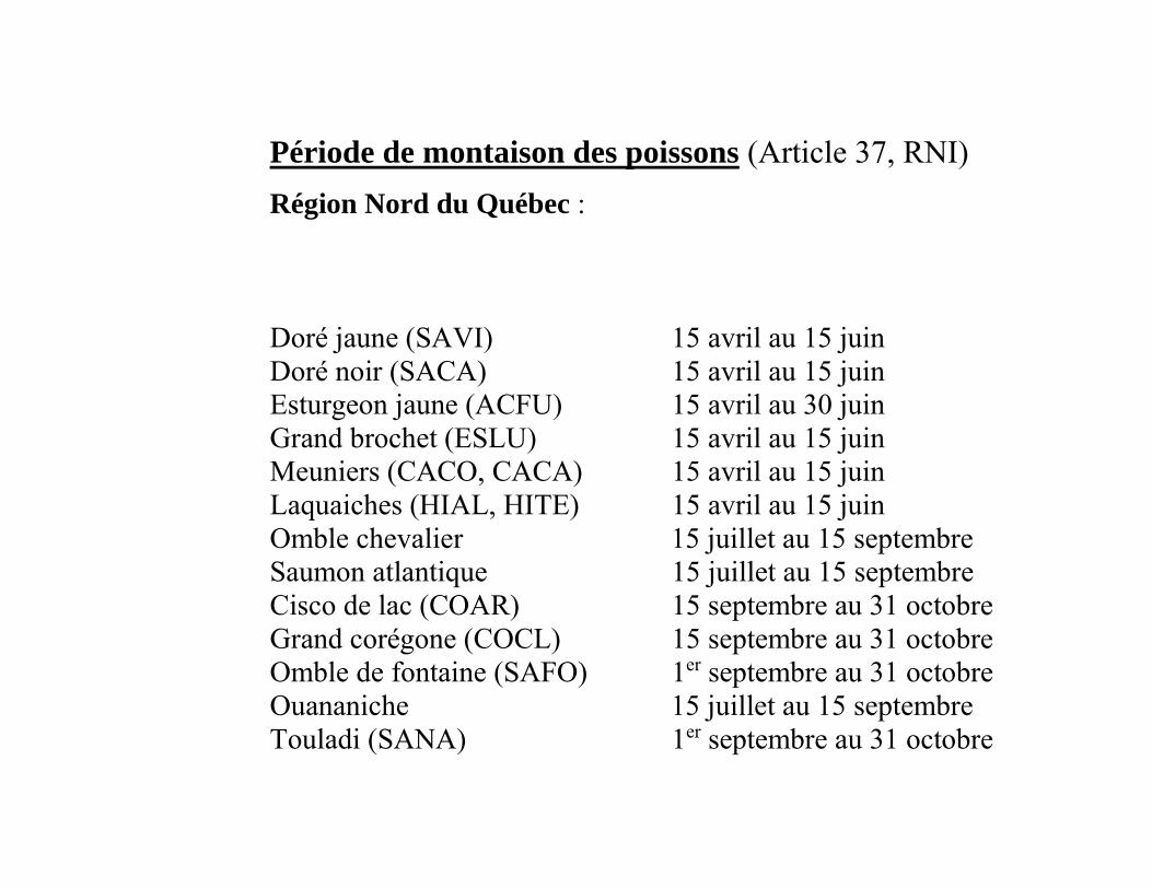
Période de montaison des poissons (Article 37, RNI)
Région Nord du Québec : Doré jaune (SAVI) 15 avril au 15 juin Doré noir (SACA) 15 avril au 15 juin Esturgeon jaune (ACFU) 15 avril au 30 juin Grand brochet (ESLU) 15 avril au 15 juin Meuniers (CACO, CACA) 15 avril au 15 juin Laquaiches (HIAL, HITE) 15 avril au 15 juin Omble chevalier 15 juillet au 15 septembre Saumon atlantique 15 juillet au 15 septembre Cisco de lac (COAR) 15 septembre au 31 octobre Grand corégone (COCL) 15 septembre au 31 octobre Omble de fontaine (SAFO) 1er septembre au 31 octobre Ouananiche 15 juillet au 15 septembre Touladi (SANA) 1er septembre au 31 octobre
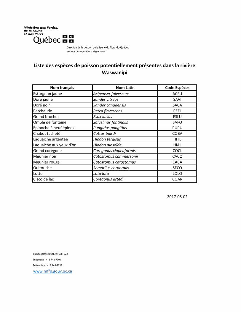
Nom français Nom Latin Code Espèces
Esturgeon jaune Acipenser fulvescens ACFU
Doré jaune Sander vitreus SAVI
Doré noir Sander canadensis SACA
Perchaude Perca flavescens PEFL
Grand brochet Esox lucius ESLU
Omble de fontaine Salvelinus fontinalis SAFO
Épinoche à neuf épines Pungitius pungitius PUPU
Chabot tacheté Cottus bairdi COBA
Laquaiche argentée Hiodon tergisus HITE
Laquaiche aux yeux d'or Hiodon alosoïde HIAL
Grand corégone Coregonus clupeaformis COCL
Meunier noir Catostomus commersonii CACO
Meunier rouge Catostomus catostomus CACA
Ouitouche Semotilus corporalis SECO
Lotte Lota lota LOLO
Cisco de lac Coregonus artedi COAR
2017-08-02
Chibougamau (Québec) G8P 2Z3
Téléphone : 418 748-7701
Télécopieur : 418 748-3338
www.mffp.gouv.qc.ca
Liste des espèces de poisson potentiellement présentes dans la rivière
Waswanipi
Direction de la gestion de la faune du Nord-du-Québec
Secteur des opérations régionales
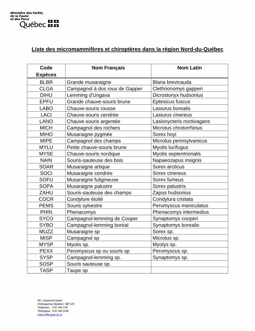
951, boulevard Hamel Chibougamau (Québec) G8P 2Z3 Téléphone : 418 748-7701 Télécopieur : 418 748-3338
www.mffp.gouv.qc.ca
Liste des micromammifères et chiroptères dans la région Nord-du-Québec
Code Nom Français Nom Latin Espèces
BLBR Grande musaraigne Blaria brevicauda CLGA Campagnol à dos roux de Gapper Clethrionomys gapperi DIHU Lemming d'Ungava Dicrostonyx hudsonius EPFU Grande chauve-souris brune Eptesicus fuscus LABO Chauve-souris rousse Lasiurus borealis LACI Chauve-souris cendrée Lasiurus cinereus LANO Chauve-souris argentée Lasionycteris noctivagans MICH Campagnol des rochers Microtus chrotorrhinus MIHO Musaraigne pygmée Sorex hoyi MIPE Campagnol des champs Microtus pennsylvanicus MYLU Petite chauve-souris brune Myotis lucifugus MYSE Chauve-souris nordique Myotis septentrionalis NAIN Souris-sauteuse des bois Napaeozapus insignis SOAR Musaraigne artique Sorex arcticus SOCI Musaraigne cendrée Sorex cinereus SOFU Musaraigne fuligineuse Sorex fumeus SOPA Musaraigne palustre Sorex palustris ZAHU Souris-sauteuse des champs Zapus hudsonius COCR Condylure étoilé Condylura cristata PEMS Souris sylvestre Peromyscus maniculatus PHIN Phenacomys Phenacomys intermedius SYCO Campagnol-lemming de Cooper Synaptomys cooperi SYBO Campagnol-lemming boréal Synaptomys borealis MUZZ Musaraigne sp Sorex sp. MISP Campagnol sp Microtus sp. MYSP Myotis sp. Myotys sp. PEXX Peromyscus sp ou souris sp Peromyscus sp. SYSP Campagnol-lemming sp. Synaptomys sp. SOSP Souris sauteuse sp. TASP Taupe sp
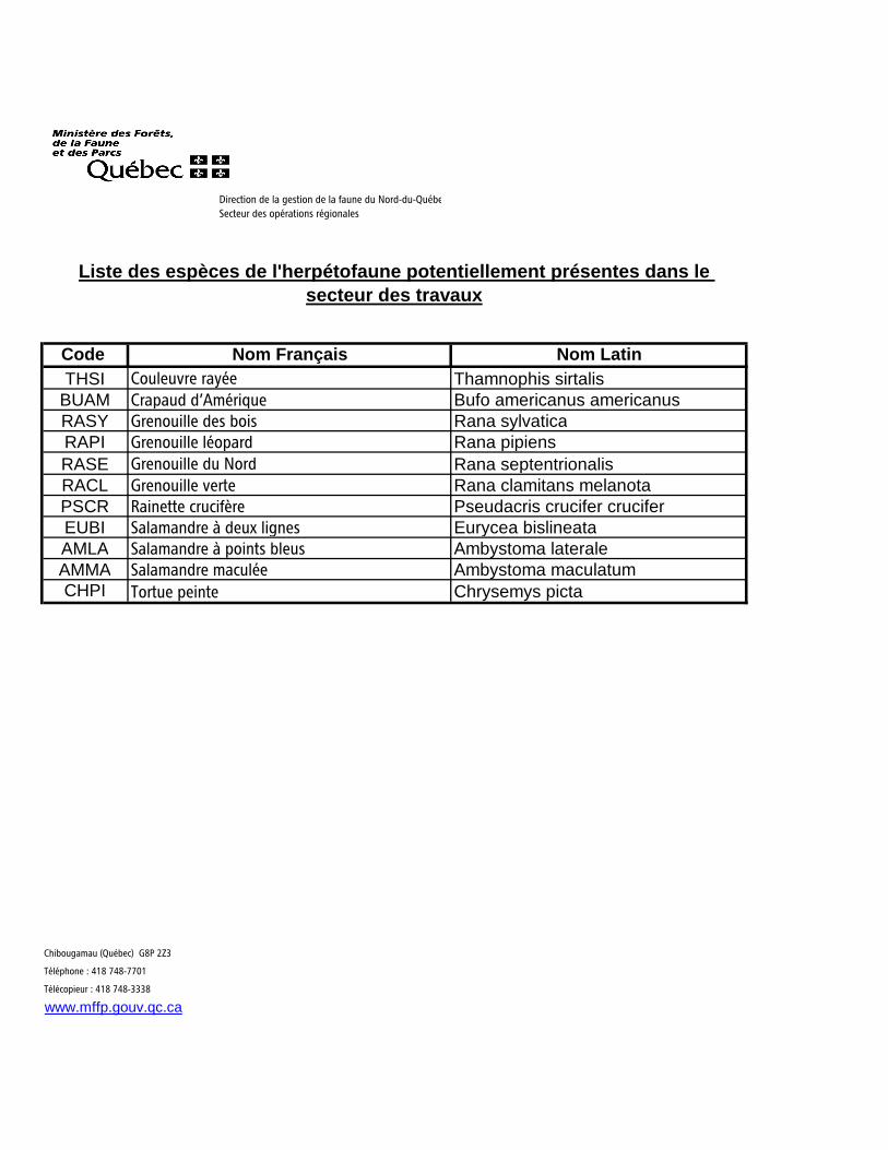
Code Nom Français Nom LatinTHSI Couleuvre rayée Thamnophis sirtalis
BUAM Crapaud d’Amérique Bufo americanus americanusRASY Grenouille des bois Rana sylvaticaRAPI Grenouille léopard Rana pipiensRASE Grenouille du Nord Rana septentrionalisRACL Grenouille verte Rana clamitans melanotaPSCR Rainette crucifère Pseudacris crucifer cruciferEUBI Salamandre à deux lignes Eurycea bislineataAMLA Salamandre à points bleus Ambystoma lateraleAMMA Salamandre maculée Ambystoma maculatumCHPI Tortue peinte Chrysemys picta
Chibougamau (Québec) G8P 2Z3
Téléphone : 418 748-7701
Télécopieur : 418 748-3338
www.mffp.gouv.qc.ca
Liste des espèces de l'herpétofaune potentiellement présentes dans le secteur des travaux
Direction de la gestion de la faune du Nord-du-Québec
Secteur des opérations régionales
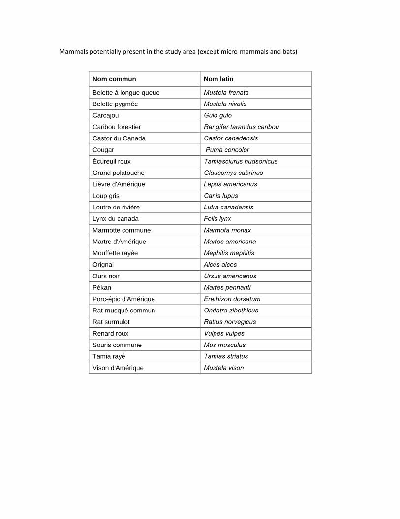
Mammals potentially present in the study area (except micro-mammals and bats)
Nom commun Nom latin
Belette à longue queue Mustela frenata
Belette pygmée Mustela nivalis
Carcajou Gulo gulo
Caribou forestier Rangifer tarandus caribou
Castor du Canada Castor canadensis
Cougar Puma concolor
Écureuil roux Tamiasciurus hudsonicus
Grand polatouche Glaucomys sabrinus
Lièvre d'Amérique Lepus americanus
Loup gris Canis lupus
Loutre de rivière Lutra canadensis
Lynx du canada Felis lynx
Marmotte commune Marmota monax
Martre d'Amérique Martes americana
Mouffette rayée Mephitis mephitis
Orignal Alces alces
Ours noir Ursus americanus
Pékan Martes pennanti
Porc-épic d'Amérique Erethizon dorsatum
Rat-musqué commun Ondatra zibethicus
Rat surmulot Rattus norvegicus
Renard roux Vulpes vulpes
Souris commune Mus musculus
Tamia rayé Tamias striatus
Vison d'Amérique Mustela vison
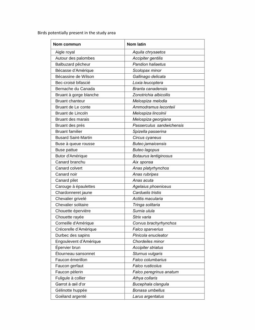
Birds potentially present in the study area
Nom commun Nom latin
Aigle royal Aquila chrysaetos
Autour des palombes Accipiter gentilis
Balbuzard pêcheur Pandion haliaetus
Bécasse d’Amérique Scolopax minor Bécassine de Wilson Gallinago delicata
Bec-croisé bifascié Loxia leucoptera
Bernache du Canada Branta canadensis
Bruant à gorge blanche Zonotrichia albicollis
Bruant chanteur Melospiza melodia
Bruant de Le conte Ammodramus leconteii Bruant de Lincoln Melospiza lincolnii Bruant des marais Melospiza georgiana
Bruant des prés Passerculus sandwichensis
Bruant familier Spizella passerina
Busard Saint-Martin Circus cyaneus
Buse à queue rousse Buteo jamaicensis
Buse pattue Buteo lagopus
Butor d'Amérique Botaurus lentiginosus
Canard branchu Aix sponsa
Canard colvert Anas platyrhynchos
Canard noir Anas rubripes
Canard pilet Anas acuta
Carouge à épaulettes Agelaius phoeniceus
Chardonneret jaune Carduelis tristis
Chevalier grivelé Actitis macularia
Chevalier solitaire Tringa solitaria
Chouette épervière Surnia ulula
Chouette rayée Strix varia
Corneille d'Amérique Corvus brachyrhynchos
Crécerelle d’Amérique Falco sparverius
Durbec des sapins Pinicola enucleator Engoulevent d’Amérique Chordeiles minor Épervier brun Accipiter striatus
Étourneau sansonnet Sturnus vulgaris
Faucon émerillon Falco columbarius
Faucon gerfaut Falco rusticolus
Faucon pèlerin Falco peregrinus anatum
Fuligule à collier Athya collaris
Garrot à œil d'or Bucephala clangula
Gélinotte huppée Bonasa umbellus
Goéland argenté Larus argentatus
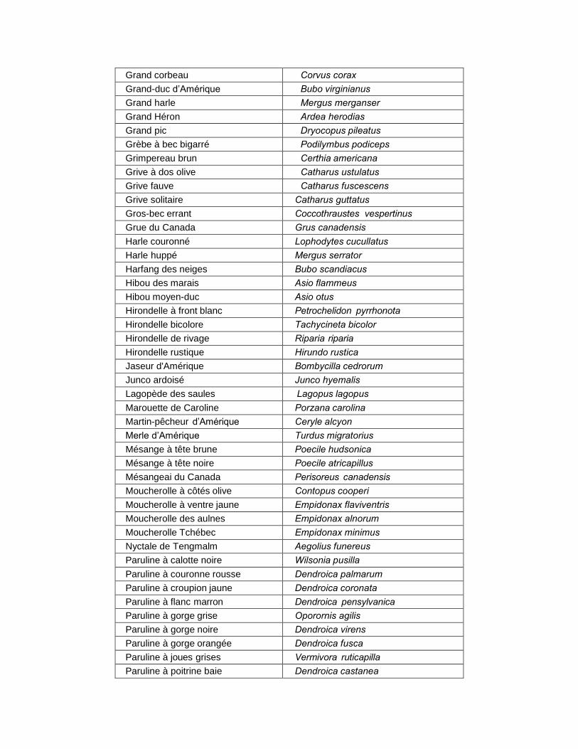
Grand corbeau Corvus corax
Grand-duc d’Amérique Bubo virginianus
Grand harle Mergus merganser Grand Héron Ardea herodias
Grand pic Dryocopus pileatus
Grèbe à bec bigarré Podilymbus podiceps
Grimpereau brun Certhia americana
Grive à dos olive Catharus ustulatus
Grive fauve Catharus fuscescens
Grive solitaire Catharus guttatus
Gros-bec errant Coccothraustes vespertinus
Grue du Canada Grus canadensis
Harle couronné Lophodytes cucullatus
Harle huppé Mergus serrator Harfang des neiges Bubo scandiacus
Hibou des marais Asio flammeus
Hibou moyen-duc Asio otus
Hirondelle à front blanc Petrochelidon pyrrhonota
Hirondelle bicolore Tachycineta bicolor Hirondelle de rivage Riparia riparia
Hirondelle rustique Hirundo rustica
Jaseur d'Amérique Bombycilla cedrorum
Junco ardoisé Junco hyemalis
Lagopède des saules Lagopus lagopus
Marouette de Caroline Porzana carolina
Martin-pêcheur d’Amérique Ceryle alcyon
Merle d’Amérique Turdus migratorius
Mésange à tête brune Poecile hudsonica
Mésange à tête noire Poecile atricapillus
Mésangeai du Canada Perisoreus canadensis
Moucherolle à côtés olive Contopus cooperi Moucherolle à ventre jaune Empidonax flaviventris
Moucherolle des aulnes Empidonax alnorum
Moucherolle Tchébec Empidonax minimus
Nyctale de Tengmalm Aegolius funereus
Paruline à calotte noire Wilsonia pusilla
Paruline à couronne rousse Dendroica palmarum
Paruline à croupion jaune Dendroica coronata
Paruline à flanc marron Dendroica pensylvanica
Paruline à gorge grise Oporornis agilis
Paruline à gorge noire Dendroica virens
Paruline à gorge orangée Dendroica fusca
Paruline à joues grises Vermivora ruticapilla
Paruline à poitrine baie Dendroica castanea
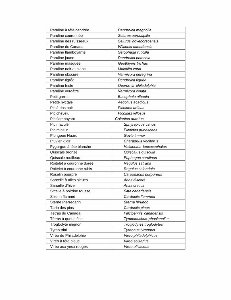
Paruline à tête cendrée Dendroica magnolia
Paruline couronnée Seiurus aurocapilla
Paruline des ruisseaux Seiurus noveboracensis
Paruline du Canada Wilsonia canadensis
Paruline flamboyante Setophaga ruticilla
Paruline jaune Dendroica petechia
Paruline masquée Geothlypis trichas
Paruline noir et blanc Mniotilta varia
Paruline obscure Vermivora peregrina
Paruline tigrée Dendroica tigrina
Paruline triste Oporornis philadelphia
Paruline verdâtre Vermivora celata
Petit garrot Bucephala albeola
Petite nyctale Aegolius acadicus
Pic à dos noir Picoides articus
Pic chevelu Picoides villosus
Pic flamboyant Colaptes auratus
Pic maculé Sphyrapicus varius
Pic mineur Picoides pubescens
Plongeon Huard Gavia immer Pluvier kildir Charadrius vociferus
Pygargue à tête blanche Haliaeetus leucocephalus
Quiscale bronzé Quiscalus quiscula
Quiscale rouilleux Euphagus carolinus
Roitelet à couronne dorée Regulus satrapa
Roitelet à couronne rubis Regulus calendula
Roselin pourpré Carpodacus purpureus
Sarcelle à ailes bleues Anas discors
Sarcelle d’hiver Anas crecca
Sittelle à poitrine rousse Sitta canadensis
Sizerin flammé Carduelis flammea
Sterne Pierregarin Sterna hirundo
Tarin des pins Carduelis pinus
Tétras du Canada Falcipennis canadensis
Tétras à queue fine Tympanuchus phasianellus
Troglodyte mignon Troglodytes troglodytes
Tyran tritri Tyrannus tyrannus
Viréo de Philadelphie Vireo philadelphicus
Viréo à tête bleue Vireo solitarius
Viréo aux yeux rouges Vireo olivaceus

Appendix 6 –
Request for Access to Information to the MCC – archaeological
sites

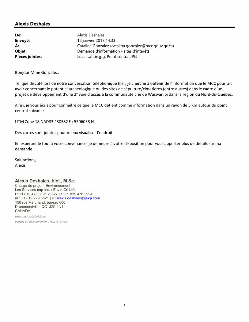
1
Alexis Deshaies
De: Alexis Deshaies
Envoyé: 18 janvier 2017 14:33
À: Catalina Gonzalez ([email protected])
Objet: Demande d'information - sites d'intérêts
Pièces jointes: Localisation.jpg; Point central.JPG
Bonjour Mme Gonzalez,
Tel que discuté lors de notre conversation téléphonique hier, je cherche à obtenir de l’information que le MCC pourrait
avoir concernant le potentiel archéologique ou des sites de sépulture/cimetières (entre autres) dans le cadre d’un
projet de développement d’une 2e voie d’accès à la communauté crie de Waswanipi dans la région du Nord-du-Québec.
Ainsi, je vous écris pour connaître ce que le MCC détient comme information dans un rayon de 5 km autour du point
central suivant :
UTM Zone 18 NAD83 430582 E ; 5506038 N
Des cartes sont jointes pour mieux visualiser l’endroit.
En espérant le tout à votre convenance, je demeure à votre disposition pour vous apporter plus de détails sur ma
demande.
Salutations,
Alexis
Alexis Deshaies, biol., M.Sc. Chargé de projet - Environnement Les Services exp inc. / EnviroCri Ltée t : +1.819.478.8191 x6327 | f : +1.819.478.2994 m : +1.819.279.6521 | e : [email protected] 150 rue Marchand, bureau 600 Drummondville, QC J2C 4N1 CANADA
exp.com | avis juridique
pensez à l'environnement : lisez à l'écran


Mlnlsttre d• la Culture •t des Communications II II
Quebec nu Direction de l'Outaouais, de l'Abitibi-Temiscamingue et du Nord·du·Qu~bec
Rouyn-Noranda, le 1 o fevrier 2017
Monsieur Alexis Deshaies, biol., M.Sc. Charge de projet - Environnement Les Services exp inc I EnviroCri Ltee 150, rue Marchand, bureau 600 Drummondville (Quebec) J2C 4N1
Objet : Demande d'information - Waswanipi
Monsieur,
En reponse a votre demande d'information datee du 18 janvier 2017, et apres consultation de la banque informatisee de I' lnventaire des sites archeologiques du Quebec (ISAQ), nous vous informons qu'il n'y a pas de sites archeologiques touches par la zone d'etude.
Nous vous rappelons que l'ISAQ ne represente que les sites archeologiques connus jusqu'a present. Ainsi, nous vous invitons a contacter un archeologue ou une firme d'archeologues qui vous fournira un avis professionnel sur le potential archeologique du territoire vise par le projet mentionne en titre. L'avis indiquera aussi les modalites a suivre s'il existe un potential ou non.
Pour de plus amples renseignements sur les dispositions legales relatives a la protection du patrimoine archeologique et des biens qui beneficient d'un statut, nous vous prions de consulter la Loi sur le patrimoine culture! disponible a l'adresse internet suivante : http://www.mcc.gouv.qc.ca/index.php?id=5121.
Entin, ii est important de souligner que ces renseignements ne sont fournis qu'a titre indicatif et n'engagent pas le ministere de la Culture et des Communications pour tout avis subsequent qu'il pourrait etre amene a donner dans le cadre de la Loi sur la qualite de l'environnement.
Veuillez agreer, Monsieur, !'expression de mes sentiments les meilleurs.
Mathieu Beaudry Adjoint a la direction, bureau de Rouyn-Noranda
ROUYN·NORANDA 145, avenue Quebec Rouyn-Noranda (Quebec) J9X 6M8 nrephone: 819 763-3517 rerecopleur ; 819 763-3382 Courriel : dratna@m«ROuy.ac ti www.mcc.gouv.qc.ca
GATINEAU 170, rue de tHlltel·de·Vi It 4e etage, bureau 4. 140 Gatineau (Quebec) J8X 40 nl~phone : 819 772·3002 Tel~copieur : 819 772·3950 Courriel : [email protected]


Appendix 7 –
List of TVLPS and assessment of the presence potential

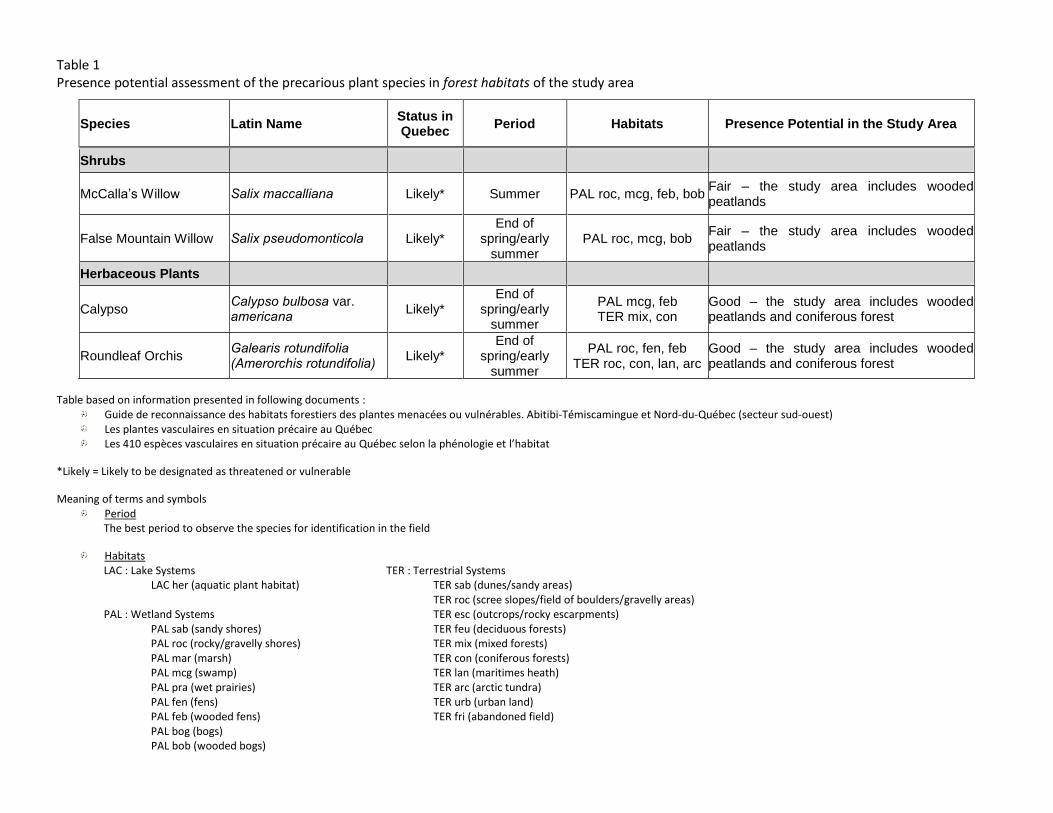
Table 1 Presence potential assessment of the precarious plant species in forest habitats of the study area
Species Latin Name Status in Quebec
Period Habitats Presence Potential in the Study Area
Shrubs
McCalla’s Willow Salix maccalliana Likely* Summer PAL roc, mcg, feb, bob Fair – the study area includes wooded peatlands
False Mountain Willow Salix pseudomonticola Likely* End of
spring/early summer
PAL roc, mcg, bob Fair – the study area includes wooded peatlands
Herbaceous Plants
Calypso Calypso bulbosa var. americana Likely*
End of spring/early
summer
PAL mcg, feb TER mix, con
Good – the study area includes wooded peatlands and coniferous forest
Roundleaf Orchis Galearis rotundifolia (Amerorchis rotundifolia) Likely*
End of spring/early
summer
PAL roc, fen, feb TER roc, con, lan, arc
Good – the study area includes wooded peatlands and coniferous forest
Table based on information presented in following documents : Guide de reconnaissance des habitats forestiers des plantes menacées ou vulnérables. Abitibi-Témiscamingue et Nord-du-Québec (secteur sud-ouest) Les plantes vasculaires en situation précaire au Québec Les 410 espèces vasculaires en situation précaire au Québec selon la phénologie et l’habitat
*Likely = Likely to be designated as threatened or vulnerable
Meaning of terms and symbols Period
The best period to observe the species for identification in the field
Habitats LAC : Lake Systems TER : Terrestrial Systems
LAC her (aquatic plant habitat) TER sab (dunes/sandy areas) TER roc (scree slopes/field of boulders/gravelly areas)
PAL : Wetland Systems TER esc (outcrops/rocky escarpments) PAL sab (sandy shores) TER feu (deciduous forests) PAL roc (rocky/gravelly shores) TER mix (mixed forests) PAL mar (marsh) TER con (coniferous forests) PAL mcg (swamp) TER lan (maritimes heath) PAL pra (wet prairies) TER arc (arctic tundra) PAL fen (fens) TER urb (urban land) PAL feb (wooded fens) TER fri (abandoned field)
PAL bog (bogs) PAL bob (wooded bogs)
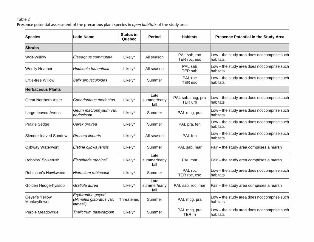
Table 2 Presence potential assessment of the precarious plant species in open habitats of the study area
Species Latin Name Status in Quebec
Period Habitats Presence Potential in the Study Area
Shrubs
Wolf-Willow Elaeagnus commutata Likely* All season PAL sab, roc TER roc, esc
Low – the study area does not comprise such habitats
Woolly Heather Hudsonia tomentosa Likely* All season PAL sab TER sab
Low – the study area does not comprise such habitats
Little-tree Willow Salix arbusculoides Likely* Summer PAL roc TER esc
Low – the study area does not comprise such habitats
Herbaceous Plants
Great Northern Aster Canadanthus modestus Likely* Late
summer/early fall
PAL sab, mcg, pra TER urb
Low – the study area does not comprise such habitats
Large-leaved Avens Geum macrophyllum var. perincisum Likely* Summer PAL mcg, pra
Low – the study area does not comprise such habitats
Prairie Sedge Carex prairea Likely* Summer PAL pra, fen Low – the study area does not comprise such habitats
Slender-leaved Sundew Drosera linearis Likely* All season PAL fen Low – the study area does not comprise such habitats
Ojibway Waterwort Elatine ojibwayensis Likely* Summer PAL sab, mar Fair – the study area comprises a marsh
Robbins’ Spikerush Eleocharis robbinsii Likely* Late
summer/early fall
PAL mar Fair – the study area comprises a marsh
Robinson’s Hawkweed Hieracium robinsonii Likely* Summer PAL roc
TER roc, esc Low – the study area does not comprise such habitats
Golden Hedge-hyssop Gratiola aurea Likely* Late
summer/early fall
PAL sab, roc, mar Fair – the study area comprises a marsh
Geyer’s Yellow Monkeyflower
Erythranthe geyeri (Mimulus glabratus var. jamesii)
Threatened Summer PAL mcg, pra Low – the study area does not comprise such habitats
Purple Meadowrue Thalictrum dasycarpum Likely* Summer PAL mcg, pra
TER fri Low – the study area does not comprise such habitats
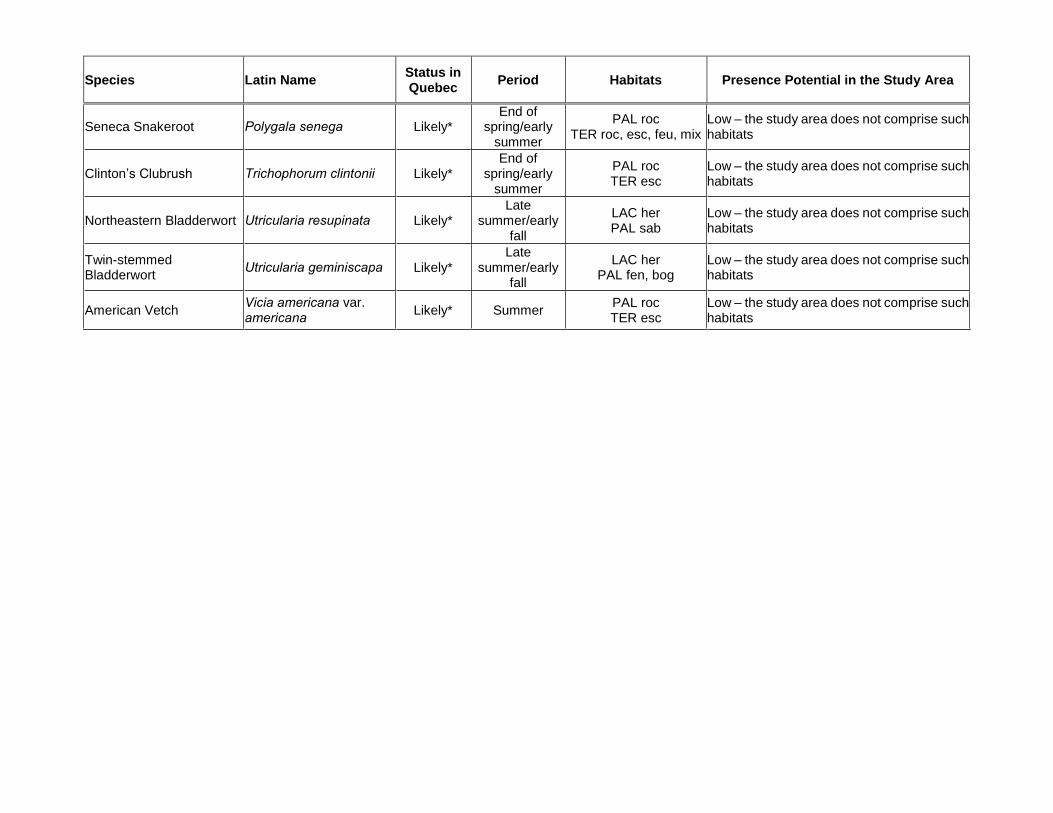
Species Latin Name Status in Quebec
Period Habitats Presence Potential in the Study Area
Seneca Snakeroot Polygala senega Likely* End of
spring/early summer
PAL roc TER roc, esc, feu, mix
Low – the study area does not comprise such habitats
Clinton’s Clubrush Trichophorum clintonii Likely* End of
spring/early summer
PAL roc TER esc
Low – the study area does not comprise such habitats
Northeastern Bladderwort Utricularia resupinata Likely* Late
summer/early fall
LAC her PAL sab
Low – the study area does not comprise such habitats
Twin-stemmed Bladderwort
Utricularia geminiscapa Likely* Late
summer/early fall
LAC her PAL fen, bog
Low – the study area does not comprise such habitats
American Vetch Vicia americana var. americana Likely* Summer
PAL roc TER esc
Low – the study area does not comprise such habitats


Appendix 8 –
Map of the wetlands

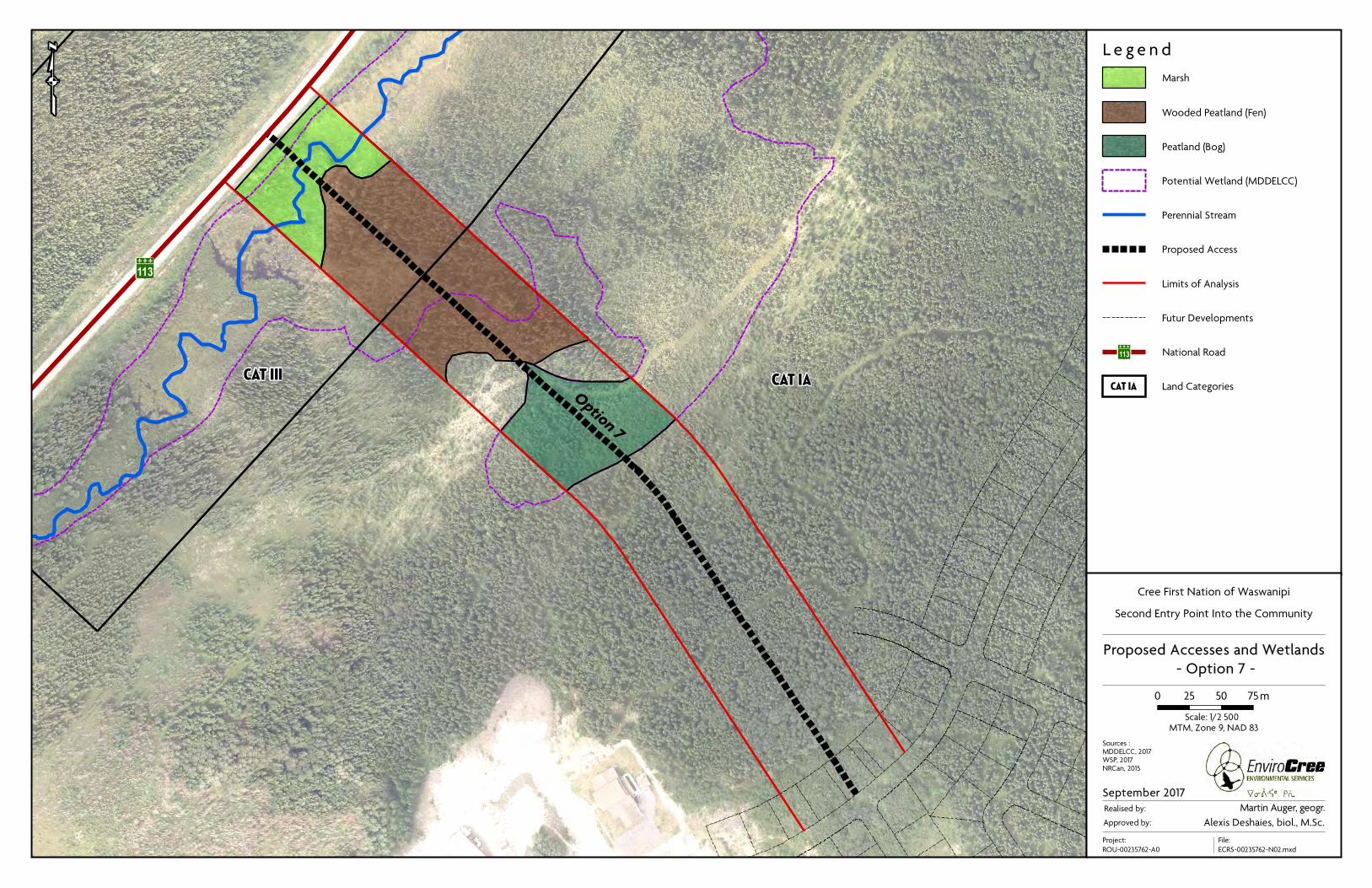
Option 7
CAT III
113
CAT IA
qL e g e n d
Cree First Nation of Waswanipi
Second Entry Point Into the Community
Proposed Accesses and Wetlands
- Option 7 -
0 25 50 75m
Approved by:
September 2017
MTM, Zone 9, NAD 83
Realised by: Martin Auger, geogr.
Project:
ROU-00235762-A0
Alexis Deshaies, biol., M.Sc.
Sources :MDDELCC, 2017WSP, 2017NRCan, 2015
File:
ECRS-00235762-N02.mxd
Scale: 1/2 500
Futur Developments
Land CategoriesCAT IA
National Road113
Perennial Stream
Potential Wetland (MDDELCC)
Proposed Access
Limits of Analysis
Marsh
Wooded Peatland (Fen)
Peatland (Bog)


Appendix 9 –
List of TVLAS and assessment of the presence potential

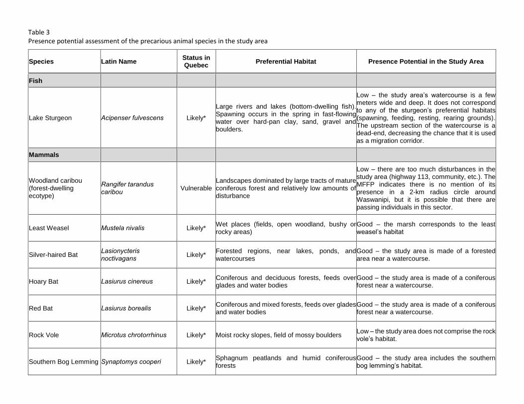
Table 3 Presence potential assessment of the precarious animal species in the study area
Species Latin Name Status in Quebec
Preferential Habitat Presence Potential in the Study Area
Fish
Lake Sturgeon Acipenser fulvescens Likely*
Large rivers and lakes (bottom-dwelling fish). Spawning occurs in the spring in fast-flowing water over hard-pan clay, sand, gravel and boulders.
Low – the study area’s watercourse is a few meters wide and deep. It does not correspond to any of the sturgeon’s preferential habitats (spawning, feeding, resting, rearing grounds). The upstream section of the watercourse is a dead-end, decreasing the chance that it is used as a migration corridor.
Mammals
Woodland caribou (forest-dwelling ecotype)
Rangifer tarandus caribou Vulnerable
Landscapes dominated by large tracts of mature coniferous forest and relatively low amounts of disturbance
Low – there are too much disturbances in the study area (highway 113, community, etc.). The MFFP indicates there is no mention of its presence in a 2-km radius circle around Waswanipi, but it is possible that there are passing individuals in this sector.
Least Weasel Mustela nivalis Likely* Wet places (fields, open woodland, bushy or rocky areas)
Good – the marsh corresponds to the least weasel’s habitat
Silver-haired Bat Lasionycteris noctivagans Likely*
Forested regions, near lakes, ponds, and watercourses
Good – the study area is made of a forested area near a watercourse.
Hoary Bat Lasiurus cinereus Likely* Coniferous and deciduous forests, feeds over glades and water bodies
Good – the study area is made of a coniferous forest near a watercourse.
Red Bat Lasiurus borealis Likely* Coniferous and mixed forests, feeds over glades and water bodies
Good – the study area is made of a coniferous forest near a watercourse.
Rock Vole Microtus chrotorrhinus Likely* Moist rocky slopes, field of mossy boulders Low – the study area does not comprise the rock vole’s habitat.
Southern Bog Lemming Synaptomys cooperi Likely* Sphagnum peatlands and humid coniferous forests
Good – the study area includes the southern bog lemming’s habitat.
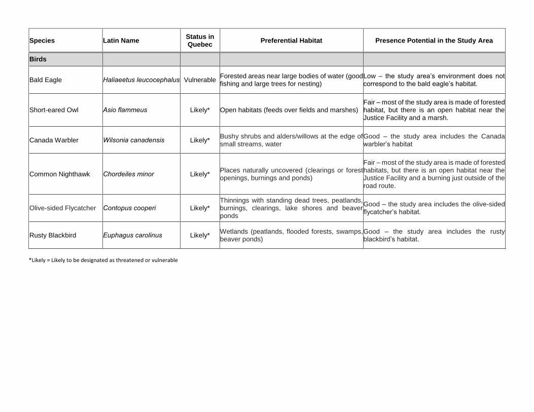
Species Latin Name Status in Quebec
Preferential Habitat Presence Potential in the Study Area
Birds
Bald Eagle Haliaeetus leucocephalus Vulnerable Forested areas near large bodies of water (good fishing and large trees for nesting)
Low – the study area’s environment does not correspond to the bald eagle’s habitat.
Short-eared Owl Asio flammeus Likely* Open habitats (feeds over fields and marshes) Fair – most of the study area is made of forested habitat, but there is an open habitat near the Justice Facility and a marsh.
Canada Warbler Wilsonia canadensis Likely* Bushy shrubs and alders/willows at the edge of small streams, water
Good – the study area includes the Canada warbler’s habitat
Common Nighthawk Chordeiles minor Likely* Places naturally uncovered (clearings or forest openings, burnings and ponds)
Fair – most of the study area is made of forested habitats, but there is an open habitat near the Justice Facility and a burning just outside of the road route.
Olive-sided Flycatcher Contopus cooperi Likely* Thinnings with standing dead trees, peatlands, burnings, clearings, lake shores and beaver ponds
Good – the study area includes the olive-sided flycatcher’s habitat.
Rusty Blackbird Euphagus carolinus Likely* Wetlands (peatlands, flooded forests, swamps, beaver ponds)
Good – the study area includes the rusty blackbird’s habitat.
*Likely = Likely to be designated as threatened or vulnerable

Appendix 10 –
Preliminary Information Form

DIRECTION GÉNÉRALE DE L’ÉVALUATION
ENVIRONNEMENTALE ET STRATÉGIQUE
Preliminary information on a project in a northern region
September 2016

Ministère du Développement durable, de l’Environnement et de la Lutte contre les changements climatiques
INTRODUCTION Sections 22 and 23 of the James Bay and Northern Québec Agreement (JBNQA) establish an environmental and social protection regime for northern Québec. They also address areas of federal and Québec jurisdiction. Areas falling under Québec jurisdiction were entrenched in Chapter II of the Environment Quality Act (R.S.Q., c. Q-2) (EQA). Chapter II of the EQA sets out the environmental and social impact assessment and review procedures for the territories of James Bay and Nunavik (http://www.mddelcc.gouv.qc.ca/evaluations/mil-nordique/index-en.htm). Different procedures apply in southern Québec and the Moinier region. Projects automatically subject to one of the procedures for northern Québec are listed in Schedule A of the EQA, and projects automatically exempt from the procedures are listed in Schedule B. Projects not listed in either of the schedules, or so-called “grey-zone” projects, must be submitted to the Ministère du Développement durable, de l’Environnement et de la Lutte contre les changements climatiques for a decision as to whether or not they should be submitted to the applicable assessment and review procedure. No person may carry out or undertake any project referred to in Schedule A of the EQA or any “grey zone” project in a northern region unless a certificate of authorization or an attestation of exemption is issued by the Minister, in accordance with sections 154 and 189 of the EQA. For the purposes of obtaining the certificate or attestation, the proponent of a project must transmit the preliminary information for the planned project to the Ministère. Transmission of the preliminary information is the first step in the assessment and review procedure. It takes the form of a written notice informing the Ministère of the proponent’s intention to undertake a given project. The attached preliminary information form1 sets out the information that must be provided to describe the general nature of the project. The information must be clearly and concisely presented and include only those elements needed to enable a clear understanding of the project and its anticipated impacts. The proponent must submit at least ten (10) hard copies of the preliminary information and any supporting documents as well as at least four (4) electronic copies in PDF (Portable Document Format), all in French. The proponent should also submit five (5) hard copies and four (4) electronic copies in English. Additional copies may be requested depending on the scope of the project. The rules for submitting documents in electronic format are contained in the appendix. Concerning the rules to follow for the filing of electronic documents, we invite you to comply with the instructions presented in the following document produced by BAPE under the southern procedure while making the necessary adjustments : http://www.bape.gouv.qc.ca/sections/documentation/DocumPDF.pdf
1 The project proponent may also submit the preliminary information in another form.
Ministère du Développement durable, de l’Environnement et de la Lutte contre les changements climatiques 2
In addition, as of the entry into force of sections 115.5 to 115.12 of the EQA on November 4, 2011, an applicant for a certificate of authorization issued under this Act must file, as a condition for the issue, a “Déclaration du demandeur ou du titulaire d’une autorisation délivrée en vertu de la Loi sur la qualité de l'environnement (L.R.Q., c. Q-2)” along with any other documents required by the Minister. This requirement does not apply to projects deemed exempt from the assessment and review procedure for which an attestation of exemption is issued. The guide and forms relating to said declaration are available online at the following address: http://www.mddelcc.gouv.qc.ca/lqe/index.htm. The applicant’s declaration is confidential and a single copy must be submitted. Since August 13, 2016, changes have been made to the fees applicable to the requests of authorization foreseen in chapter 2 of the Environment Quality Act. We invite you to look at our web site for more information about these fees : http://www.mddelcc.gouv.qc.ca/ministere/tarification/ministere.htm (and clic the link Évaluation environnementale, Milieu nordique). The preliminary information form, duly completed by the project proponent, and the documents related to the applicant’s declaration and the pricing must be sent to the following address:2 Madame Marie Renée Roy, sous-ministre Provincial Administrator for the James Bay and Northern Québec Agreement Ministère du Développement durable, de l’Environnement et de la Lutte contre les changements climatiques Édifice Marie-Guyart, 30e étage 675, boul. René-Lévesque Est, boîte 02 Québec (Québec) G1R 5V7 Telephone: 418-521-3933 Fax: 418-644-8222 As soon as the Ministère receives the preliminary information form, the project is entered in the public register provided for in section 118.5 of the EQA http://www.registres.mddlcc.gouv.qc.ca/#LQE. The preliminary information and all other documents submitted during the course of the assessment and review procedure may be made available for public consultation. Furthermore, in accordance with the EQA, the preliminary information is transmitted to the Evaluating Committee, for projects located in the James Bay territory, or to the Kativik Environmental Quality Commission, for projects located in Nunavik. These bodies are responsible for studying the preliminary information and, in the case of projects listed in Schedule A of the EQA, making recommendations or giving an opinion, respectively, on the directives regarding the type, scope and extent of the impact assessment statement the proponent must prepare. In the case of “grey zone” projects, these bodies respectively make recommendations or a decision regarding the advisability of submitting or not submitting the project to the assessment and review procedure and, if the project is submitted, the directives for the project. They transmit their recommendations, opinions and decisions to the Ministère, which makes the final decision to either 2 Projects located on Category I lands reserved for the Crees must be submitted to the Regional Environment
Administrator, which is a Cree body (see Section 22 of the JBNQA).

Ministère du Développement durable, de l’Environnement et de la Lutte contre les changements climatiques 3
exempt the project, in which case it issues an attestation of exemption, or to submit the project, in which case it issues directives. The Evaluating Committee is a tripartite advisory body composed of representatives of the governments of Canada and Québec and the Cree Regional Authority. The Kativik Environmental Quality Commission is a bipartite body composed of Inuit, Naskapi and Québec government representatives. In the exercise of their functions, both bodies give due consideration to the following principles set out in sections 152 and 186 of the EQA:
a) the protection of the hunting, fishing and trapping rights of the Native people in the territory;
b) the protection of the environment and social milieu; c) the protection of the Native people, of their societies, communities and economy; d) the protection of the wildlife, of the physical and biological milieu and of the ecological
systems of the territory; e) the rights and guarantees of the Native people in Category II lands; f) the participation of the Crees, Inuit and Naskapis in the application of the environmental
and social protection regime; g) any rights and interest of non-Native people; and h) the right of the persons acting lawfully to carry out projects in the territory.

Ministère du Développement durable, de l’Environnement et de la Lutte contre les changements climatiques 4
À l’usage du Ministère
Date de réception : Numéro de dossier :
1. Project proponent (natural or legal person)
Name:
Civic address:
Postal address (if different from civic address):
Telephone:
Fax:
Email:
Person in charge of the project:
Mandatory: Québec enterprise number (NEQ) assigned by the Registraire des entreprises du Québec

Ministère du Développement durable, de l’Environnement et de la Lutte contre les changements climatiques 5
2. Consultant commissioned by the proponent (if applicable)
Name:
Civic address:
Postal address (if different from the civic address):
Telephone:
Fax:
Email:
Person in charge of the project:
Mandatory: Québec enterprise number (NEQ) assigned by the Registraire des entreprises du Québec
Where the proponent has commissioned a consultant, the proponent must submit a resolution attesting that the consultant was mandated to submit this application.
3. Project title
4. Project objectives and justification Indicate the main objectives and the reasons for implementing the project.
Ministère du Développement durable, de l’Environnement et de la Lutte contre les changements climatiques 6
5. Project location Indicate the location(s) where the project is likely to be carried out, the categories of land (I, II and III), the municipalities and, as a requirement, the geographic coordinates (degrees.minutes.seconds) in GEO NAD83 datum. Include an appendix containing a topographic or cadastral map illustrating the project location. The shape files used to produce the location map must be attached to the electronic version of the preliminary information.
6. Description of project and alternatives under study For each phase of the project (site development, construction, operation and restoration, if applicable), describe the principle characteristics of each project alternative, including planned activities, developments and work (clearing, dynamiting, backfilling, etc.). Briefly describe the operating procedures, technologies used, required equipment and material, raw materials, etc. Attach all documents that will help get a better grasp of project characteristics (plan, sketches and drawings, cross-section, etc.).
7. Environmental components and main constraints to project implementation For all the sites affected, briefly describe the state of the natural and human environments prior to implementation of the project, as well as the constraints to its implementation.
Ministère du Développement durable, de l’Environnement et de la Lutte contre les changements climatiques 7
8. Primary impacts anticipated Briefly describe the primary impacts likely to occur in the natural and human environments as a result of each phase of the project (site development, construction, operation and restoration, if applicable).
For “grey zone” projects, provide sufficient information to enable an assessment of the project’s environmental and social impacts with a view to determining whether or not the project should be submitted to the environmental and social impact assessment and review procedure. Explain the planned mitigation and restoration measures, if any.
9. Public information and consultation processes The Ministère encourages project proponents to inform and consult the public at the beginning of the planning stage as well as during preparation of the impact statement to ensure more effective integration of the project in the community and environment. Explain the various forms of public information and consultation already carried out or expected to be carried out during the project planning stage, including exchanges with the local populations, in particular the Crees, Inuit or Naskapis, and, if applicable, state the concerns expressed.
10. Project schedule Indicate the timetable for implementation of each phase of the project, bearing in mind the time required for each stage of the procedure, preparation of the impact statement, public consultations or information sessions held by the proponent or responsible committees, etc.

Ministère du Développement durable, de l’Environnement et de la Lutte contre les changements climatiques 8
11. Subsequent phases and related projects If applicable, discuss subsequent phases of the proposed project, as well as any other project likely to influence the project design.
12. Signature of the applicant
I, (name of applicant or authorized signatory, position), hereby certify that the information provided in this preliminary information form is accurate to the best of my knowledge. __________________________________________ __________________________ Signature of applicant or authorized signatory Date

Appendix 11 –
Derogation to the RNI Form


À L'USAGE DU MFFP
Numéro de la demande:------------------------------------------------------------------
( année,unite d'aménagement, # séquentiel)
DEMANDE DE DÉROGATION POUR LA CONSTRUCTION D'UN CHEMIN
PRÈS D'UN LAC, D'UN COURS D'EAU OU DANS UNE TOURBIÈRE NON BOISÉE
DANS LES FORÊTS DU DOMAINE DE L'ÉTAT (art. 17 ou art. 93 et 94 du RNI)
1 IDENTIFICATION DU DEMANDEUR: À L'USAGE DU MFFP
Demandeur : Numéro du bénéficiaire : ----------------------------------------------------------------------------------------------------------------------------------- ---------------------------
Responsable des travaux :
(nom et adresse)
Téléphone : Télécopieur : Courrier électronique :------------------- ----------------------------------
2 LOCALISATION DU LAC, DU COURS D'EAU
OU DE LA TOURBIÈRE
l'écotone riverain
Identification:
Feuillet: formulaire prévu à cet effet.
Longitude: * Cochez les cases qui s'appliquent
Latitude:
No. du bassin hydrographique:
B- Dans les 60 m d'un cours d'eau à écoulement permanent (1)
Ligne de vol et numéro de
photo (facultatif): C- Dans les 30 m d'un cours d'eau à écoulement intermittent (1)
Numéro de l'UA: D- Endroit où le sol présente une couche indurée
Secteur d'intervention: E- Situation A ou B sur plus de 300 m de longueur
Nom du chantier de récolte: F- Tourbière non boisée avec sol gelé à une profondeur de moins de 35 cm
No. du segment de chemin:(1)
Distance mesurée entre la berge du lac ou du cours d'eau et l'emprise du chemin du côté du cours d'eau ou
du lac.
3
Dérogation identifiée à la PRAN/PAFI. version no
4 DESCRIPTION DU PROJET EN DÉROGATION ET JUSTIFICATION(S) DE LA DEMANDE
Décrire la nature du projet en dérogation (caractéristiques ou particularités techniques, etc.) :
Lac ou cours d'eau à écoulement permanent Annexer un croquis (vue en survol) de la partie du chemin en dérogation en
Distance du Longueur de Distance minimale Sur une longueur de (m) indiquant les distances du plan d'eau ( 5, 20 et 60 m) ou l'emplacement par
plan d'eau l'empiétement au plan d'eau rapport à la tourbière, ainsi que la localisation des ponceaux de drainage,
total (m) (m) les bassins de sédimentation pour gérer les eaux de la surface du chemin et
0 m à 5 m maintenir le drainage naturel, de même que les traversées de cours
> 5 m à 20 m d'eau si requises au projet.
> 20 m à 60 m Indiquer :
> 60 m* Largeur (m) du déboisement de
TOTAL 0 0 l'emprise du chemin :
*Sol avec couche indurée imperméable
Largeur (m) du déboisement de l'emprise
du chemin du coté du plan d'eau :
Cours d'eau à écoulement intermittent
Distance du Longueur de Distance minimale Sur une longueur de (m) Date approx. du début des travaux : plan d'eau l'empiétement au plan d'eau (visant la dérogation)
total (m) (m)
0 m à 20 m Durée estimée des travaux :> 20 m à 30 m (visant la dérogation)> 30 m*TOTAL 0 0 Durée estimée d'utilisation du chemin :*Sol avec couche indurée imperméable
Chemin d'hiver : Non Oui
Décrire les mesures de protection du milieu aquatique par rapport au projet de dérogation:
En plus de respecter les normes minimales prévues dans le RNI, dont notamment le respect de la pente du talus du remblai du chemin du côté du lac
ou du cours d'eau [1,5(H) : 1(V)] et la stabilisation du talus si l'érosion risque de créer un apport de sédiments dans le milieu aquatique, je m'engage à
appliquer les mesures de protection suivantes :
Aucune récolte ne sera réalisée entre l'emprise du chemin en dérogation et le plan d'eau
Matériel utilisé pour la stabilisation du talus:
Circulation de machinerie entre l'emprise du chemin et le lac ou le cours d'eau?: oui non
Autres mesures de protections:
Mis à jour : 14 avril 2016
(Demandeur autre qu'un BGAd, acheteur BMMB, CvAF. CtAF, forêt de proximité)
Ne s'applique pas
du MFFP, par le demandeur, en vertu de la LQE et/ou de la LCMVF. Remplir le
A- Dans les 60 m d'un lac (1)
IDENTIFICATION PRÉALABLE DE LA DÉROGATION À LA PRAN/PAFI
2. Autres types de dérogation*
(Titulaire d'une entente, d'une autorisation ou d'un contrat en vertu de la LADTF)
Si coché, une autorisation doit être obtenue du MDDELCC et/ou des Opérations régionales
-------------------------------------------------------------------
TYPE DE DÉROGATION
1. Avec empiètement sur le lit d'un lac, d'un cours d'eau ou dans
Numéro de la demande:
4 DESCRIPTION DU PROJET EN DÉROGATION ET JUSTIFICATION(S) DE LA DEMANDE (SUITE)
Décrire le meilleur tracé alternatif qui respecte les distances visées à l'article 17 du RNI et/ou conditions particulières visées aux articles 93 et 94:
Dessiner sur une carte topographique/hydrographique (échelle 1:20 000) le tracé en dérogation, le tracé alternatif ainsi que les
chemins existants (joindre en annexe, de préférence en fichier shapefile (shp) en précisant no. de carte correspondante).
Décrire les raisons topographiques, hydrographiques et autres qui motivent le choix du projet en dérogation par rapport au tracé
alternatif et/ou aux chemins existants:
5 DESCRIPTION DES MILIEUX ADJACENTS AU SITE DU PROJET EN DÉROGATION
Type Composition du lit Vitesse de l'eau Morphologie
Lac vase nulle rectiligne
Étang sable lente sinueux
Rivière gravier moyenne tortueux
Ruisseau galet,bloc rapide
roc cascade
Date
d'observation:chute
d'eau (m): étiage Hauteur de la
Non normal chute (m):
crue
Oui Non Date d'observation:
absente
0-10% argile
11-20% sable
21-30% gravier
31-40%
> 41% espèces dominantes:
Peuplement forestier ( voir figure, section c )
Peuplement forestier ( voir figure, section d )
Note: Pour les dérogations aux articles 93 et 94, le promoteur doit décrire le milieu pour faciliter la concertation des ministères concernés
6 SIGNATURE DE LA DEMANDE
Signature du demandeur ( section 1 )¹ Date
Mis à jour : 14 avril 2016
¹ Pour les demandes provenant d'un BGAd, d'un acheteur de bois du BMMB, d'une CvAF, d'un CtAF ou d'une forêt de proximité, la demande doit être
signée par un ingénieur forestier
Pente maximale du terrain (mesurée dans les 60 m à partir de l'emprise du chemin):
Largeur (m) occupée par le peuplement:
Essences présentes :
Pente maximale du terrain :
Milieu aquatique ( voir figure, section a )
Largeur du cours
Niveau d'eau:Végétation aquatique: Oui
Si une récolte est prévue, préciser le type:
Indiquer toutes particularités observées: étang à castor, frayère potentielle, rivière à saumon ou autres:
Remarques:
Figure illustrant les différentes limites
Essences présentes :
arbustes
arbres épars
roc
Largeur (m) de l'écotone riverain :
galet,bloc
Observation de poissons:
Écotone riverain ( voir figure, section b )
Végétation
mousses
herbacées
Pente maximale Type de dépôt
(transversale)
Numéro de la demande:
7 MESURES DE PROTECTION ADDITIONNELLES REQUISES PAR LE MFFP ET LE MDDELCC (à l'usage des ministères)
Situation requérant une concertation du secteur des Opérations régionales ainsi que du MDDELCC.
La concertation implique la poursuite d'objectifs généraux communs (tant environnementaux, sociaux, qu'économiques), la
poursuite d'objectifs spécifiques communs à rencontrer dans la situation visée, l'analyse et/ou l'élaboration conjointe des
solutions envisagées pour finalement décider ensemble de la position ou de l'orientation à prendre.
Position du MFFP et/ou du MDDELCC
En tout temps, conservation du tapis végétal entre le chemin et le cours d'eau.
Talus du remblai, côté cours d'eau ou lac: Stabilisation par couverture végétale avec pente 1.5X longueur/ 1X hauteur ou moindre
Talus du remblai, côté cours d'eau ou lac: Stabilisation avec membrane géotextile et enrochement avec pente de 1.5X longueur / 1X hauteur
ou moindre
Talus du remblai, côté opposé au cours d'eau ou lac: Stabilisation par couverture végétale avec pente 1.5 X longueur / 1X hauteur
ou moindre
Talus du remblai, côté opposé au cours d'eau ou lac: Stabilisation avec membrane géotextile et enrochement avec pente de
1.5X longueur / 1X hauteur ou moindre
Déblais: Stabilisation par couverture végétale avec pente de 1.5X longueur / 1X hauteur ou moindre
Déblais: Stabilisation avec membrane géotextile et enrochement avec pente de 1.5X longueur / 1X hauteur
Enrochement des fossés
Si chemin en pente vers le cours d'eau, lac ou traversée: Dévier les eaux de drainage naturel et des fossés vers des zones de
végétation à plus de 20 m de tous les lacs ou cours d'eau en installant des ponceaux de cm à tous les m, calculé selon
cette règle: 500 / % de la pente. Ces ponceaux devront être installés à un angle de 30 degrés par rapport à l'axe du chemin.
Bloquer les eaux de fossés à la hauteur de ces ponceaux pour canaliser l'eau
En aval des ponceaux de drainage, stabiliser le sol à l'aide de pierres sur une distance de m en direction du cours d'eau
Des bassins de sédimentation doivent être construits en amont des ponceaux de drainage. Obligation de vider les bassins
Des bassins de sédimentation doivent être construits en aval des ponceaux de drainage. Obligation de vider les bassins
Tout travail doit être fait dans le respect de l'article 25 du RNI (et de la fiche VOIC "Cas d'érosion")
La surface du chemin doit être de forme arrondie (couronne) et maintenue dans cet état jusqu'à la fin des travaux et du transport
des bois
La surface de chemin devra être profilée de façon à canaliser les eaux de surface sur le coté opposé du lac ou du cours d'eau
Le matériau de la surface du chemin doit être de granulométrie grossière. Les sols limoneux ou argileux sont proscrits
Une digue (bourrelet) doit être créée à la limite de l'accotement côté cours d'eau. Elle doit être maintenue jusqu'à la fin des travaux
et du transport de bois
Créer une dépression (ventre de bœuf) au niveau de la surface du chemin (voir schéma à la p.14 des Saines pratiques - Voirie et installation des ponceaux )
Surélever le chemin (voir schéma à la p.14 des Saines pratiques - Voirie et installation des ponceaux )
Appliquer les saines pratiques pour la voirie et l'installation de ponceaux
( http://www.mrnf.gouv.qc.ca/publications/forets/entreprises/sainespratiques.pdf )
Appliquer les modalités prévues dans les sites fauniques d'intérêt (SFI)
Ne pas exécuter les travaux en période de pluies abondantes ou prendre les mesures nécessaires pour empêcher l'apport de
sédiments vers le cours d'eau ou le lac
Ces travaux doivent être faits en continu. Les travaux de stabilisation des sols, de canalisation des eaux de surface de chemin,
de fossés et de drainage naturel doivent se faire sans délai déraisonable, dès la construction du chemin
Aucune coupe d'arbres ou passage de machinerie entre le chemin en dérogation et le lac ou le cours d'eau
Aucune gravière entre le chemin en dérogation et le lac ou le cours d'eau
Informer le bureau de l'UG au début des travaux
Autres :
Représentant de la LCMVF Signature :
Titre: Nom:
Représentant de la LQE Signature :
Titre: Nom:
Représentant RNI Signature :
Titre: Nom:
8 APPROBATION DU MFFP
La présente approbation est conditionnelle au respect des mesures de protection décrites aux points 4 et 7, et sous
réserve des conditions suivantes à être respectées:
Les raisons qui motivent ce refus sont les suivantes:
Ministère des Forêts, de la Faune et des Parcs
__________________________________ ___________________
Chef de l'unité de gestion Date
Mis à jour : 14 avril 2016
OUI
NON


Appendix 12 –
Request for Review Form


Rtq;uest ft)r Re~iew A) Cootati 1iBtormatron
lilli~3#>111 :
~fTO"•TI:
~~ur11rn~
l'<Wl Cl:I$
~ o l'l(l><o~'l""' nm•Vill«l' r;,m;r1 c .,.., c N->
.Sft!<I ..i:ti:m;il Olfiil<I:
Cm~~ITT;JIC;<F.lloiif{~
lllsi~•*"" '
I I ~fTO"•TI:
"°"',.tr• m "'l"
P<&!l ClX!..
r " ~i!!:'l ~l!ri!j'OfOfill{J [Off :nm1 (')'!l!;t~ "ll!'M~lll (>1111_.;t
· n da
ts l!'e ~ n ~Cfw. i'J:I""' iel'I.~!OOi' ciuJJ"l ~l.lr~? 0 'I';.. C .t.:a
l'.lt.o s j00.r ~Klii:Mi;nul<1t .. olli'l a "°-' 0 .... r1< i11ho,.!O.bolkloihi!H!iJ l'l"il\lf.i;iol;" 0 -y., 0 r<o
Y_.,l'I• !"'f!~ ~<}>? B~r~WllUIP"'IJ•l~~~)""~!"°r.mryl l «0$!r~JI~
I
11111.!loa -•~1J~fll'ol'Ql~raoi·gflim'i!(;[
.i..-1 ... 11ock;l? 0 YEi 0 f.la
~;i'IJi<..tidi-wi;~ori!••Mlll'l r~O(I.
Ll ~-I.I•• Clo••ili'11' D ""1Joll:¥'1J"lil"1 R.rwhtl
D ~lh!!l Ll l!«Tm
D l!l.l• lll)f~hmt:!.
D ll>:'ll-Ll !!:ml l;iiM; .. f iWT P"S D Bro.1w.1m 0 6'\l!Jl(i
Ll e.MeCr"""'ll' p °'"""'"f" D ~~
Ll (),, ' 0 El<"""1l::!lflJ ..... nft!g
D CIC>tli Ll Dro"1'Q ( f=..m.
n C¥:<• D r'il!Wf!l'l l UOlf!I. Ll n .. Mom.:.1m nr,.Jm) rl Grcwmol<r~:->:n
D ll•OlfJU
El lil-Pi.m-•lm n lct B!UJ,.
Ll LOll!is .. l"OJ( 11111'
D l.ogl'lm::•>I o~,
Ll 01<11 'Hm Dop:ml
0 1"1.ln
D l'l i)!'itl"~.....,, ... A-~I
Ll Sil!"' 'l'iorl. 0 Sho!dr.o Fro;,.."1on
D :illfYf&l!lrr.tll'l"!-I F~ LI s.r-wm r oi:ng
p TollllJS ~llldruflt AA>H
D T i<JWil!l~l'll~lllrl LI r..i...,, 0 i'hlOf r<rl l'Ol 5M~lt:5
D \~11_.,. l'llal11r1 I rlill ~,r.; Ll l'Hl:t'OJM n W>l•rwmo ""'lgim:o• D \'i"~ Ll l'lt ...... , n ''lbj Pi?"Nt! :stJWU"OJi
[l:i u~ .
W.. • 'J'lll"Pf11"'1~lhri'1!dftt""'•"b•mll"le:l!r•l ·«~•!doldoi::>11run1..-"J""l"/ 0 .,.., 0 t.•
rrt!irnooi1>1>,.;m,fo'ld-..Jiio mtn.1.;..
~""llnol,.<1"'1~uodl"~' L«ll>:I• ~------~N L~• ~------~W
IM ~ ~----------' ~--------'gis!·g
N:rt!kr ~---------'
ll;\;IH1 !iii! (ltiflb n1J:!J11] l.t.; ~.,rq,; ~'~in iiil (ii ~II 10.!L.M
imlol~Co:il>ru~LUl./.1(>'Mi, lf.. 11!.1
.rlop;Ji;y, a~. f..,,t.1:1 Golllt/. :.m:..:
;mool""~" ..J ~f<11i:tc~.;t
lilmo •I .. ~1t...,..l•I or·~>!·
ti) bmtff) tl~· Q! u.~ Allllai!~ E'll r11ri~m
~----------------~
~cril)'llo po>!onW!om ti1=• li'"'1-'.i.c t•1U>1"'1:uo!l>o~1tjecl11111,.., ~
ClO<J""'l ~ITjol Qi,,i)J; [La..il:-..iil Oar. l':o tw.l;lll:UYI ~I !ho lllo~<ij-"1 Lir.1 ~·d "'llor(Rf><llTllJ
Cll'lnr « 5t>"11 llih"'1. Os.Tl ~lu jlb1'>
0\'!';ttnd; l~"ll
',..., "'""" "" r.a ~••R>l' 1:i l'J'l'~!tl D MHat a.rl'<!llmr.vmll d 11~µ.:rl~ WJ;dnl):m
D 011!n<J t. tnwig. ~~"" ~\ll!""l'~""' LI a~ crrmnmm,.,oliYtlJ••«<li..- o1n1:t1.ms D C<o:\f'll D ~l«l
LI Fm "'""'I" '""" n G1llilJil
D ~l>l-~W'/oll<i 1:10111'1JO<l!!:ils~n:Jt n F\:JtHhStl ol llM!t Wllh .., ... u.hl'o ~.,
l\\ltt.nbocfi!ll""'(i.o. ilirai:;1i)illil:Jirlllhcl.'ii.r? 0 .,..,
r.,..__o«=tollll.
D Ft.n~I cr:I rciltial eir ~l!.-d:n:: h ¥i:.IH
O Rl~Fli!""l LI Sl!Mn~li! n..u.t lr.Uf"J D SIIWm:: rD"m..o.11
D ~.l~Hl~•'ill
LI u.. ol iltlmi.l "''i>"'it n ~"lfi""'"Carnr~ 0 \Y~i.r ~olft'Jll'I
LI 1'1....-.mmm
w. u-.. r.n ha~ it.i.-.•m 11!-i"fTI"""~? 0 V« 0 N<>
~tl....lhlylllt.:<i..inm..ormit~• •«llr1fi:h10 fo
Ylll ~rpJti"the•"~ fl«i <flll/1;· [] .,..,, [] Uo [] l..h•n"'"' ~o 11'11 (ti>" !WI·)!<" llJlp:!, p<M:lt ~!!'Jr lt1"'1 •~= "1. Jk;t;iq~1
.Muhmu?

I• 'toll~IUl'llllni"«m!Oll').lr (ii<F
lht-imi 'tlihi<Jl ... ~, ... -~-;ooj-'{¥'{-t ---~, ml•".! ttJ §\OOJ'{ffi' r.;~'llo.lt;,~J<iloll1lo §IMl!lffiYt 141"1.loc<:l['J ~§_'llOIV'l __ 'ft ___ ~ r ~.f.lY~~!(l,lo)r!',~lli'i'" _...,.
I ~ ,.,,... ..J"""r>i •l'.e..""3 look m:I foll h>llL!l lla!MI ~~<.mt. cl U.. Im! peM<I> d!..tll!d •lir .. ?
J•lw p...,;i , ~!l
I
Y,llyoo~~!JXl~I~ · ~ 1'"'1 foi<lftb)llW'l'\li~ 0 v.. D tO>
r1r.,l:U.ltf.,ll1111<S.i o.lll<tltp-..,.,,111~praA:!o""''""'
ifll-Ml'J~-.Odllnd"""-~~bo11P'Or4~11nd 'L!liij;(iir<»•·""r<rnr~.m..i~rolm;i~L0: ..... 1Q:>ir..,,J~Q <11Hls lol5 im tiil hol>Lll>
latot)'fillllrN~ft ..i~~nil~Orl"""!=illll::f.."<J""~·-=l>rp>:i<Woi!l.l10 1\o! [l ..,.
1r1.,,, kbii~ ohl:ll <11 .... t
I•
F] Si.gneture
.oi~ ...... l""•~l>J~- ... ...i rg~ooioo;lojt.fOJ'i)·-"".W«lf'1""~""1""t..P"1«•<"-~ •• 'hl iitm>o,.nti;.,, ~ <ilho.fliliru .ui Punul hl:nu1:n ... b<"""!OO <uioflllo~o1'hl FIW.)'.1£1 l mllbo !mil JHk
~tl't.-9'1'1<(1 ll-"'l.l-!'!ll. U l0< '!~MltM:l3!t-•~lo. ·:"11>1 <1Nl>!it"n~.,...~"'1P~·"""
~bi Nl:D.J.lhi,'n f:r.d,.H:J ii M~Jiin\tl U'm.n.IDi i:iiJi blil.lll!i:.Di°b ~~1~ ~ tbrf.li.: '-'Iii~ i-1Tllfl ~1u.idtf
c.JJujifs ~1ti &ll'l2p Elin~ d l'!!IWJl~.gG.CJ Cfh 13:mfr~"1-Cnffll~ ~iJMllwl .tDU"'rtcm.t:Uin71
>•-·ltl.o ... ~ ... --~ • ..,.......,.,, .. _.1>;,n,.,,,,11~

Photographic Report

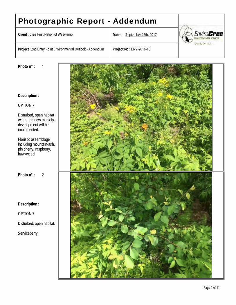
Photographic Report - Addendum
Client : Cree First Nation of Waswanipi Date : September 26th, 2017
Project : 2nd Entry Point Environmental Outlook - Addendum Project No : ENV-2016-16
Page 1 of 11
Photo n° : 1 Description : OPTION 7 Disturbed, open habitat where the new municipal development will be implemented. Floristic assemblage including mountain-ash, pin cherry, raspberry, hawkweed
Photo n° : 2 Description : OPTION 7 Disturbed, open habitat. Serviceberry.
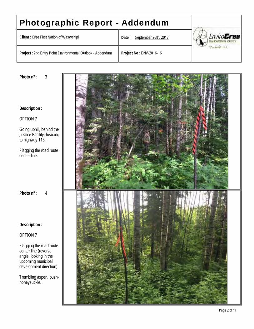
Photographic Report - Addendum
Client : Cree First Nation of Waswanipi Date : September 26th, 2017
Project : 2nd Entry Point Environmental Outlook - Addendum Project No : ENV-2016-16
Page 2 of 11
Photo n° : 3 Description : OPTION 7 Going uphill, behind the Justice Facility, heading to highway 113. Flagging the road route center line.
Photo n° : 4 Description : OPTION 7 Flagging the road route center line (reverse angle, looking in the upcoming municipal development direction). Trembling aspen, bush-honeysuckle.
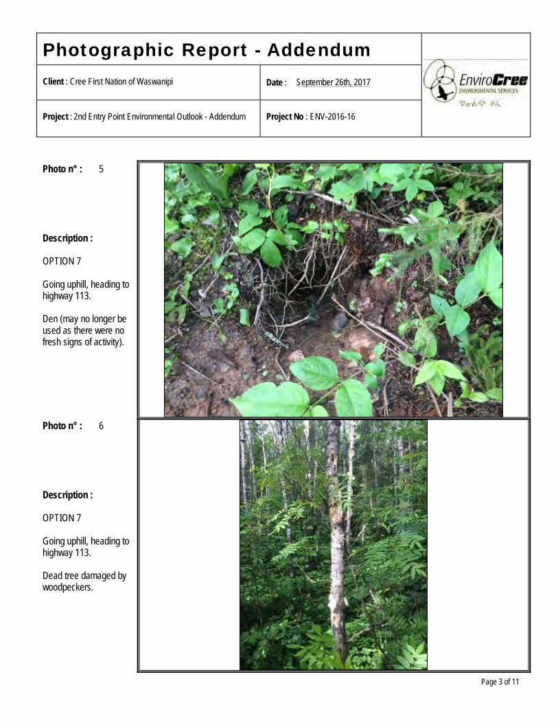
Photographic Report - Addendum
Client : Cree First Nation of Waswanipi Date : September 26th, 2017
Project : 2nd Entry Point Environmental Outlook - Addendum Project No : ENV-2016-16
Page 3 of 11
Photo n° : 5 Description : OPTION 7 Going uphill, heading to highway 113. Den (may no longer be used as there were no fresh signs of activity).
Photo n° : 6 Description : OPTION 7 Going uphill, heading to highway 113. Dead tree damaged by woodpeckers.
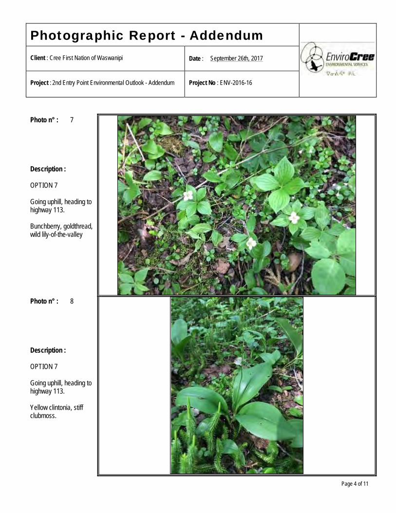
Photographic Report - Addendum
Client : Cree First Nation of Waswanipi Date : September 26th, 2017
Project : 2nd Entry Point Environmental Outlook - Addendum Project No : ENV-2016-16
Page 4 of 11
Photo n° : 7 Description : OPTION 7 Going uphill, heading to highway 113. Bunchberry, goldthread, wild lily-of-the-valley
Photo n° : 8 Description : OPTION 7 Going uphill, heading to highway 113. Yellow clintonia, stiff clubmoss.
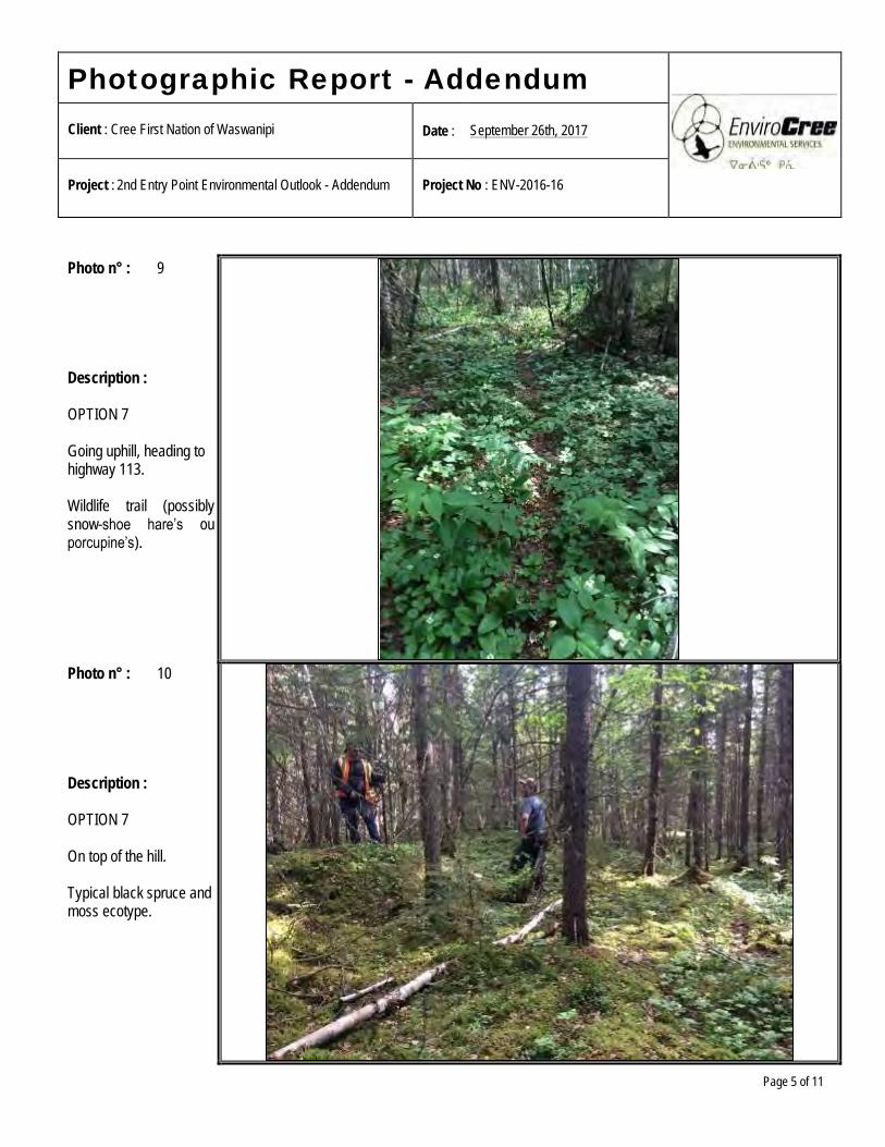
Photographic Report - Addendum
Client : Cree First Nation of Waswanipi Date : September 26th, 2017
Project : 2nd Entry Point Environmental Outlook - Addendum Project No : ENV-2016-16
Page 5 of 11
Photo n° : 9 Description : OPTION 7 Going uphill, heading to highway 113. Wildlife trail (possibly snow-shoe hare’s ou porcupine’s).
Photo n° : 10 Description : OPTION 7 On top of the hill. Typical black spruce and moss ecotype.
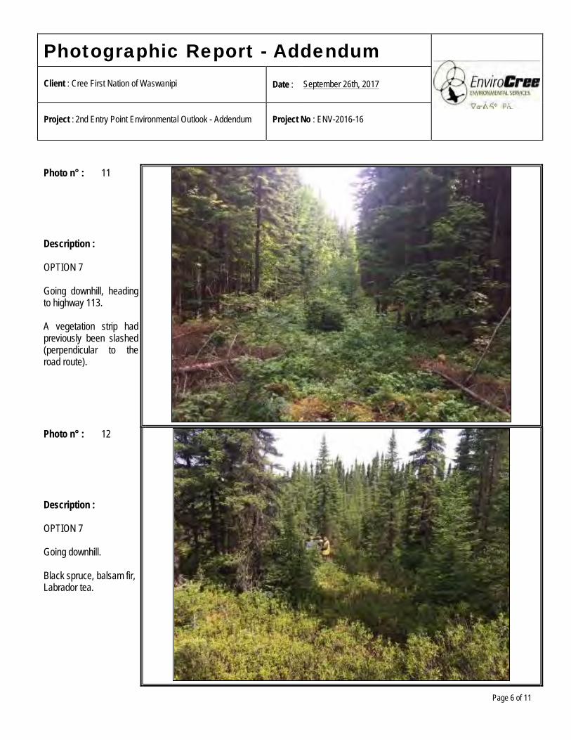
Photographic Report - Addendum
Client : Cree First Nation of Waswanipi Date : September 26th, 2017
Project : 2nd Entry Point Environmental Outlook - Addendum Project No : ENV-2016-16
Page 6 of 11
Photo n° : 11 Description : OPTION 7 Going downhill, heading to highway 113. A vegetation strip had previously been slashed (perpendicular to the road route).
Photo n° : 12 Description : OPTION 7 Going downhill. Black spruce, balsam fir, Labrador tea.
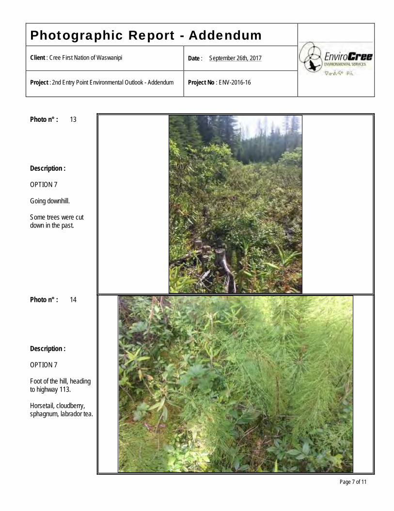
Photographic Report - Addendum
Client : Cree First Nation of Waswanipi Date : September 26th, 2017
Project : 2nd Entry Point Environmental Outlook - Addendum Project No : ENV-2016-16
Page 7 of 11
Photo n° : 13 Description : OPTION 7 Going downhill. Some trees were cut down in the past.
Photo n° : 14 Description : OPTION 7 Foot of the hill, heading to highway 113. Horsetail, cloudberry, sphagnum, labrador tea.
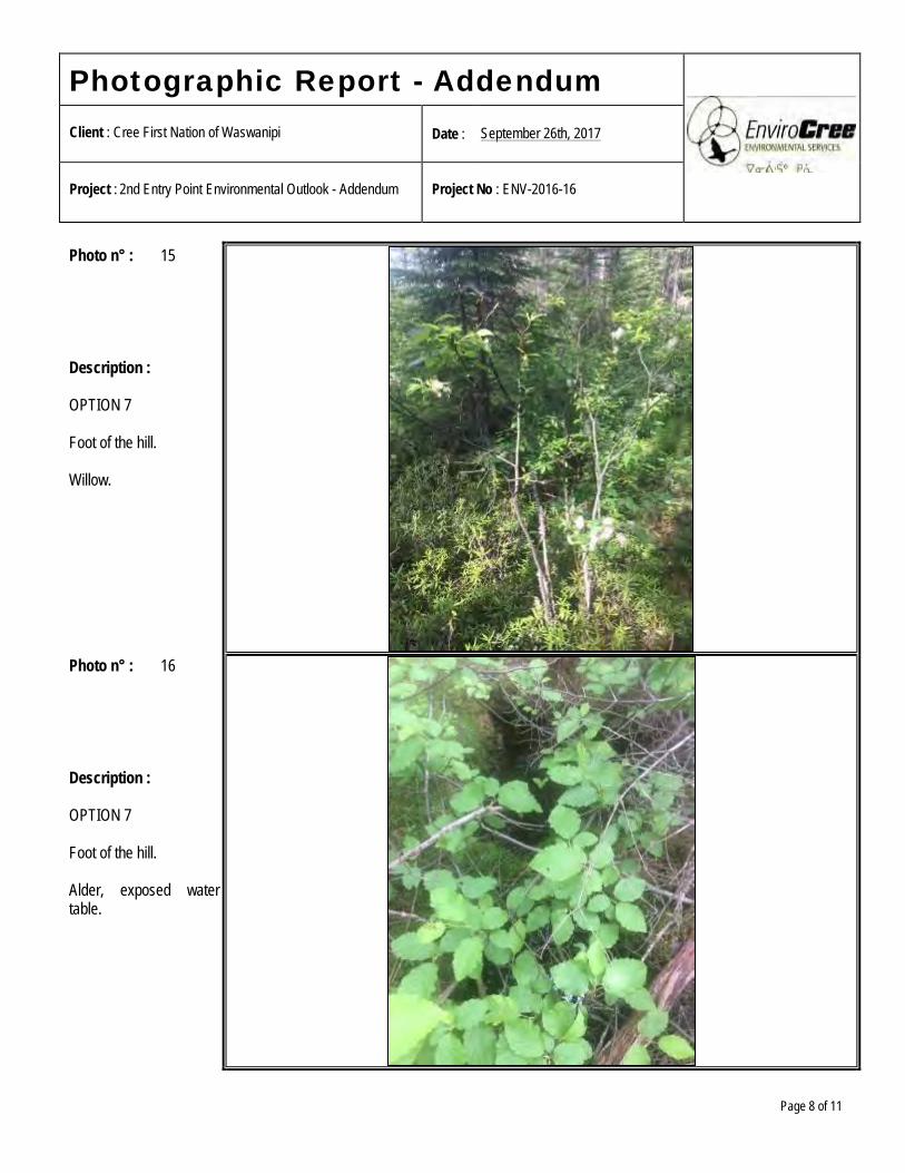
Photographic Report - Addendum
Client : Cree First Nation of Waswanipi Date : September 26th, 2017
Project : 2nd Entry Point Environmental Outlook - Addendum Project No : ENV-2016-16
Page 8 of 11
Photo n° : 15 Description : OPTION 7 Foot of the hill. Willow.
Photo n° : 16 Description : OPTION 7 Foot of the hill. Alder, exposed water table.
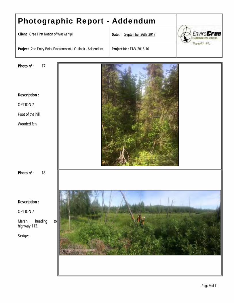
Photographic Report - Addendum
Client : Cree First Nation of Waswanipi Date : September 26th, 2017
Project : 2nd Entry Point Environmental Outlook - Addendum Project No : ENV-2016-16
Page 9 of 11
Photo n° : 17 Description : OPTION 7 Foot of the hill. Wooded fen.
Photo n° : 18 Description : OPTION 7 Marsh, heading to highway 113. Sedges.
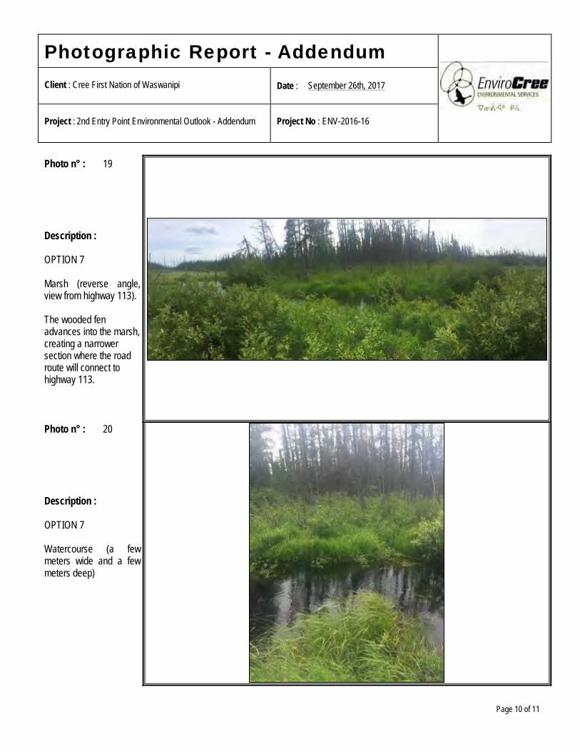
Photographic Report - Addendum
Client : Cree First Nation of Waswanipi Date : September 26th, 2017
Project : 2nd Entry Point Environmental Outlook - Addendum Project No : ENV-2016-16
Page 10 of 11
Photo n° : 19 Description : OPTION 7 Marsh (reverse angle, view from highway 113). The wooded fen advances into the marsh, creating a narrower section where the road route will connect to highway 113.
Photo n° : 20 Description : OPTION 7 Watercourse (a few meters wide and a few meters deep)
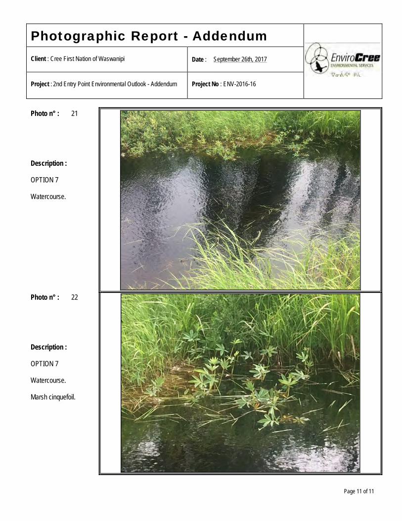
Photographic Report - Addendum
Client : Cree First Nation of Waswanipi Date : September 26th, 2017
Project : 2nd Entry Point Environmental Outlook - Addendum Project No : ENV-2016-16
Page 11 of 11
Photo n° : 21 Description : OPTION 7 Watercourse.
Photo n° : 22 Description : OPTION 7 Watercourse. Marsh cinquefoil.


Second entry point into the community Cree First Nation of Waswanipi
APPENDIX C
WSP Multi-Criteria Analysis

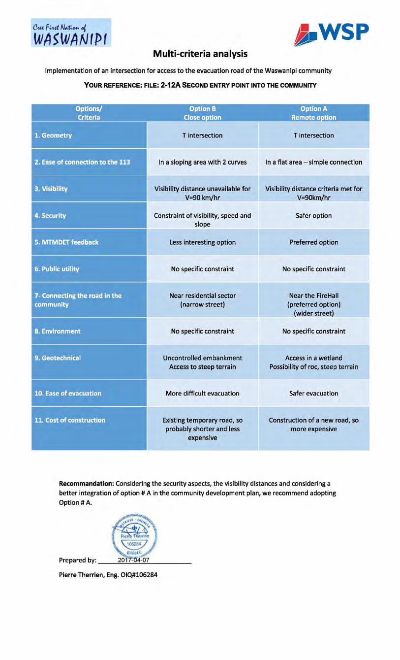
C1UF~N~ot
WASWANtPt j.WSP Multi-criteria analysis
Implementation of an intersection for access to the evacuation road of the Waswanipi community
YOUR REFERENCE: FILE: 2·12A5ECOND ENTRY POINT INTO THE COMMUNITY
Options/ Option B Option A Criteria Close option Remote option
1. Geometry
2. Ease of connection to the 113
3. Visibility
4. Security
5. MTMDET feedback
6. Public utility
7-Connecting the road in the community
8. Environment
9. Geotechnical
10. Ease of evacuation
T intersection
In a sloping area with 2 curves
Visibility distance unavailable for V=90 km/hr
Constraint of visibility, speed and slope
Less interesting option
No specific constraint
Near residential sector (narrow street)
No specific constraint
Uncontrolled embankment Access to steep terrain
More difficult evacuation
Existing temporary road, so probably shorter and less
expensive
T intersection
In a flat area -simple connection
Visibility distance criteria met for V=90km/hr
Safer option
Preferred option
No specific constraint
Near the FireHall (preferred option)
(wider street)
No specific constraint
Access in a wetland Possibility of roe, steep terrain
Safer evacuation
Construction of a new road, so more expensive
Recommandation: Considering the security aspects, the visibility distances and considering a better integration of option# A in the community development plan, we recommend adopting
Option# A.
Pierre Therrien, Eng. 010#106284


Second entry point into the community Cree First Nation of Waswanipi
APPENDIX D
WSP Preliminary Plans

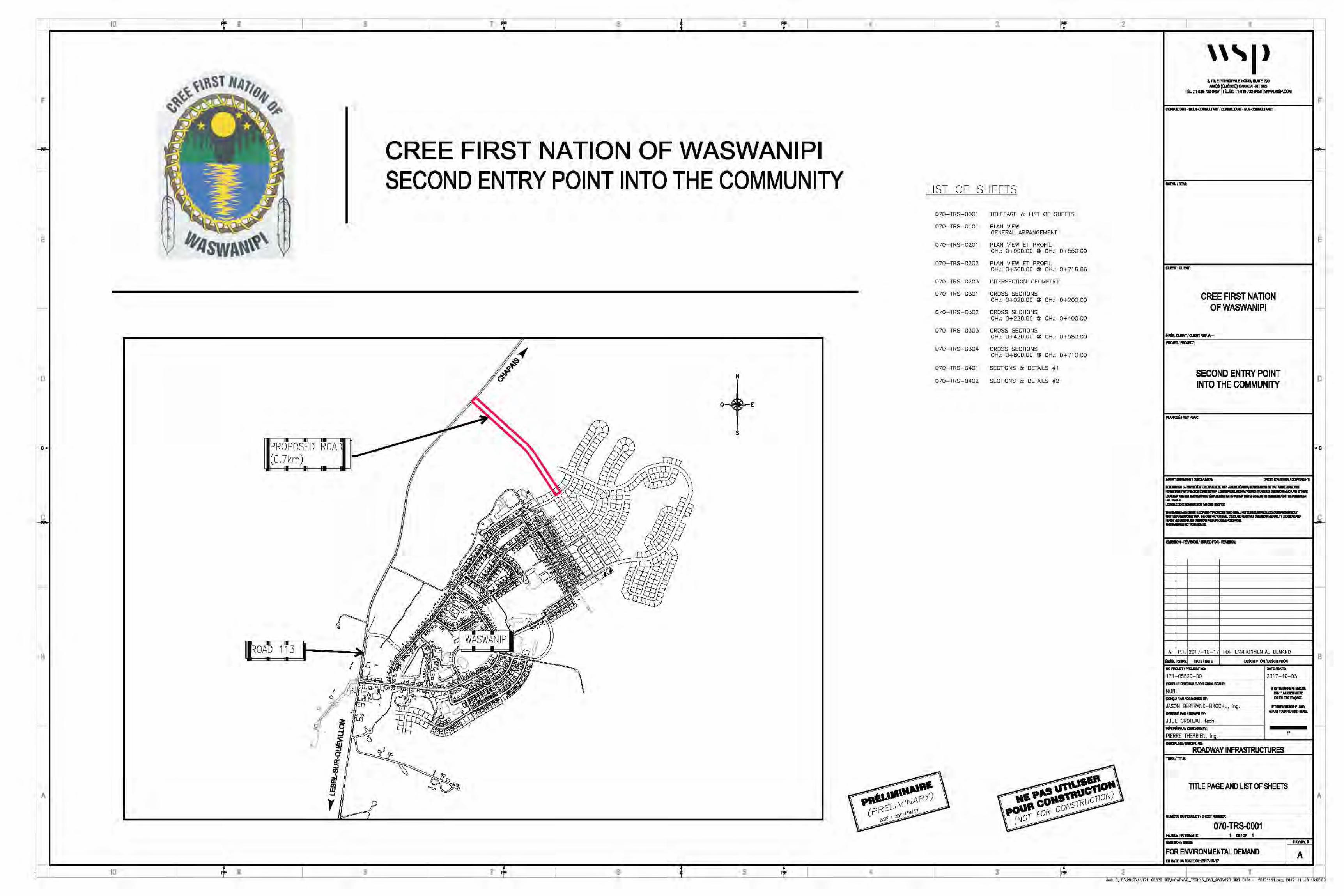
10 9
F
E
D
B
A
10 9
PROPOSED ROAD (0.7km)
,
8
• "1/.
p --1
8
7 6 5
CREE FIRST NATION OF WASWANIPI SECOND ENTRY POINT INTO THE COMMUNITY
0 E
s
\
7 6 5
4 3
LIST OF SHEETS
070-TRS-0001 TITLEPAGE &: LIST OF SHEETS
070-TRS-0101 PLAN VIEW GENERAL ARRANGEMENT
070-TRS-0201 PLAN VIEW ET PROFIL CH.: 0+000.00 @ CH.: 0+550.00
070-TRS-0202 PLAN VIEW ET PROFIL CH.: 0+300.00 @ CH.: 0+716.66
070-TRS-0203 INTERSECTION GEOMETRY
070-TRS-0301 CROSS SECTIONS CH.: 0+020.00 @ CH.: 0+200.00
070-TRS-0302 CROSS SECTIONS CH.: 0+220.00 @ CH.: 0+400.00
070-TRS-0303 CROSS SECTIONS CH.: 0+420.00 @ CH.: 0+580.DO
070-TRS-0304 CROSS SECTIONS CH.: 0+600.00 @ CH.: O+ 710.00
070-TRS-0401 SECTIONS &: DETAILS # 1
070-TRS-0402 SECTIONS &: DETAILS #2
\
l\ -
4 3
2
2
1
'''I>
CREE FIRST NATION OF WASWANIPI
tl&.llBIT/QEllRIF.11:-_,_ SECOND ENlRY POINT INTO THE COMMUNITY
ll-llllA~Wl8lBllll.lE·---...... ..:mllll!UlM.-m-. ... ,_ .. l'llM\'lllMDWllEW. LblC ,._\Wta.WIUI MMIUl911fill uum .. &11-llllmM1111•!Mml9lm-m ...,..~ -Lfl:llll£11Ect-IEllllMt!IE-
NO~IPIDETllQ:
171-05620-00
mt;UOM/-ll'f.
JASON BERTR/IND-BROCHU, ing. Dlll8N!IWll-ll'f.
JULIE CROTEAU, tech. YERlft!.PMl-11'1: PIERRE THERRIEN, in . -N!l-li!:
2017-10-03
•11m-·-1M11,.AMB.\Ul!E llal51S~
F1*111Aaldf'l.Cllll IOUl'RllllllD!Blllll.
,.
RONJWAY INFRASTRUCTURES 11TIE.11111E:
TITlE PAGE AND LIST OF SHEETS
070-TRS-0001 I IE/CIF I
t!WAl¥.t
FOR ENVIRONMENTAL DEMAND A Elllll'l!EDU/Dm~21117·10.17
1
E
D
A
A~h D. P:\2011\1\171-0S82D-OD\lnfraTra\2_1ECH\SJW>_CAIJ\07D-1RS-D101 - 20171114.ct.9, 2017-11-16 15::SB:SJ
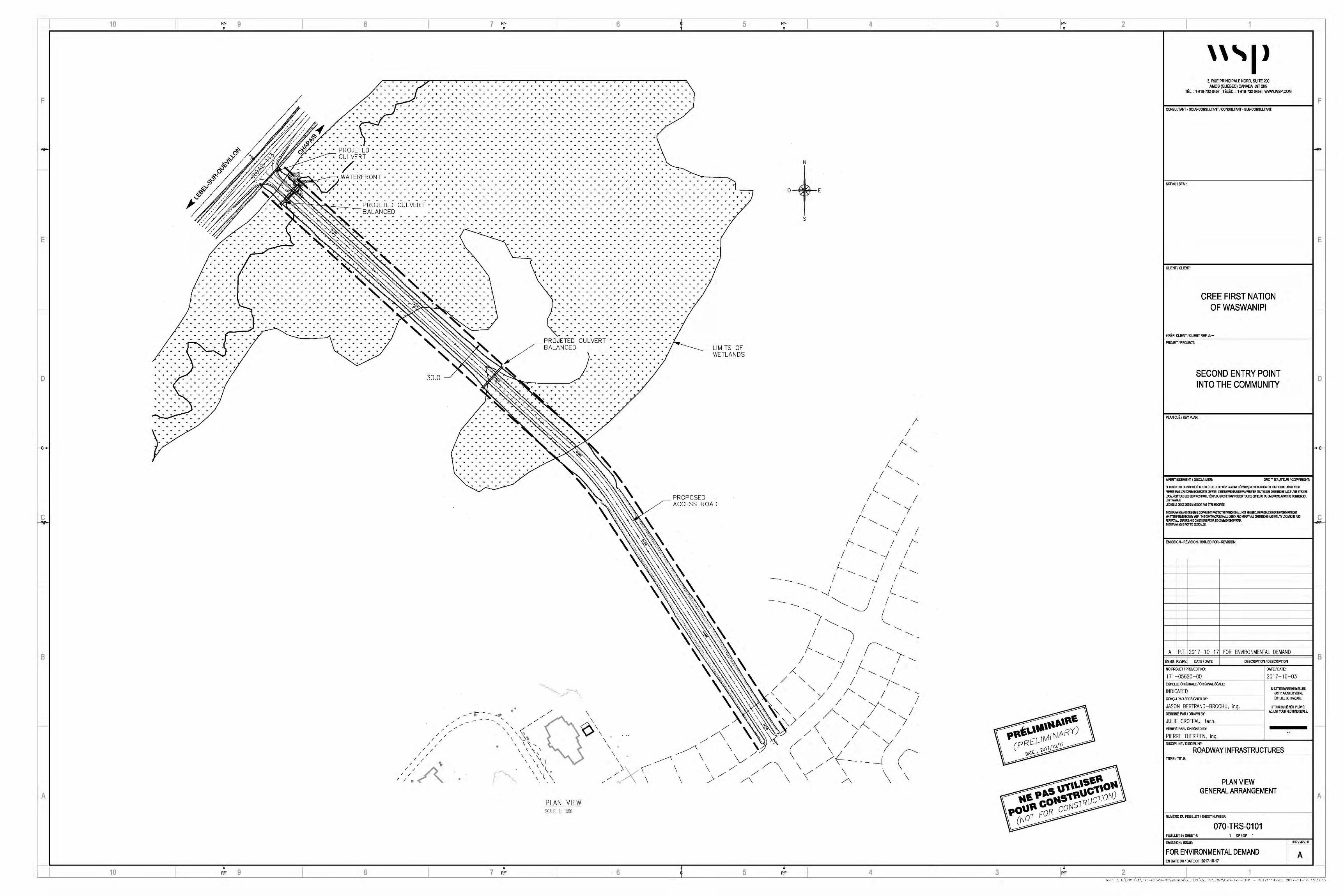
10
F
E
D
B
A
10
PF 9 8
• •
• •
• • • ... + + +
• • ;·.---...;.r
• •
PROJETED • • •
CULVERT • • ... / .. /. + + + •
• • •
•
• • •
• • •
+ + ... + + ... ...
• • • + ... ... +
... ... ... ...
• •
... ... + + ... + ... ... + ... ... ... ...
• • • ... + ... + ... ... + ... ... + ... ... + ...
... ... ... + ... ... ... ... ... ... ... ... ... ... ... ... ... +
+ ... ... ... ... ... ... ... ... ... ... ... ... + ... ... ... ... ... ... ... + ... ... ... ... + + ... ... ... ... ... ... ... ... ... + ... ... ... + ...
... + ... ... + ... ... ... ... ... ... + + ... "' ... ... + ... ... + + + ... ..................................................................
... ... ... ... ... ... ... ... ... ... ... ... ... ... ... ... ... ... ... ... ... ... ... + ... ... ... ... + ... ... + ... ... ... ... + ... ... ... ... ... + ... + ... ... + ...
• • • + ... + ... + ... ... + + + ...
• • • •
• • • • • •
• • • + + + +
• • • • • • • •
+ ... ... + ... ... ... ... ... ... ... + + ...
• • • • •
• •
• • • •
... + ... ... +
•
PF 9
--~-... + + ... ... + + + ... ...
... + + + +
... "' ... + ... ... ... + ... ... +
8
... + ... ...
• • • ... + ... ...
... ... + ...
CULVERT
• • • •
•
7 PF 6
• + • • • • • • • • • • • + • • • + • • • • • • • • • • • • • • • + + • • • • • • • • • • • • • • • • • • • • • • • • • • • • •
• • • • • • • • • • • • • • • • • • • • • • • • • • • • • • •
+ + + + + + ... + + + + + + + + ... + ... + + ... + + ... ... + ...
... + ... + + ... ... + ... + + + + + + + + ... ... + ... + ... ... + + +
• • • • • • • • • • • • • • • • • • • • • • • • • • • • •
• • • • • • • • • • • • • • •
• • • • • • • • • • • • • • • • • • • • • • • • • • • • •
• • • • • • • • • • • • • • • • • • • • • • • • • • • • • • • • • • • • • • • • • •
• • • • • • • • • • • • • • • • • • • • • • • • • • • • •
• • • • • • • • • • • • • • • • • • • • • • • • • • • •
• • • • •
+ + + + + + + + ... + ... + ... + ... + + ... + + ...
+ ... ... + + ... + + ... ... + ... + ... + + + + + + ...
• • • • • • • • • • • • • • • • • • • • • • •
• • • • • • • • •
• • • • • • • • • • • • • • • • • • • • •
• • • • • • • • • • • • • • • • • • • • • • • • • • • • • • • • • •
• • • • • • • • • • • • • • • • • • • • •
• • • • • • • • • • • • • • • • • • • • •
• • • • • • • •
• • • • • •
• • • • • •
• • • • • • • •
• • • • •
• • • • • •
• •
• • •
• •
• •
• • • • • • • • •
• • • • • •
• • • • • •
• • •
• • • • • •
• • •
• • • • • •
... + ... + ... ... + ... ... ... + + + ... ... ... ... + + ...
... + ... + + ... ... ... + + ... ... + ... + + ... + +
+ + ... + + ... ... + ... ... + ... + ... ... ...
... + ... + ... ... +
... ... "' ... ... ... "' ... + ... ... ... ... ...
... + + ... ... + ... ... ... ... +
• • • • • •
• •
+ ... + + + ... + + ... + ... + ... ... ... ... + + ...
+ + ... ... ... ... ... + + ... + + ... + + ... + + + ... ... + ... + ... + ... ... + ... ... + ... ... + ... ... + ...
... ... + ... ... ... ... ... ... ... ... ... ... + ... ... + ...
... ... ... ... ... ... ... ... ... + ... ... ... ... ... ... ... + ... + ... + + ... ... ... ... ... ... ... ... + ... ... ... +
+ + ... ... ... ... ... + + ... + + ... + + ... + + ... ... ... + ... ... ... ... + ... ... ... ... + ... ... ... ...
... ... ... ... ... ... ... ... ... ... ... ... ... ... ... ... ... ... + ... ... + ... ... + ... ... ... ... ... +
... + ... + ... ... + ... + + ... ... + + ... ...
+ ... + ... ... + +
"' ... ... "' ... ... ...
5
• • • •
• • • • • •
• • • • •
PROJETED CULVERT BALANCED
• •
+ ... ... ... ... +
... ... ... ... ... ... ... LIMITS OF WETLANDS
30.0
/
/
/
/ /
/ /
/
/
... + ... ... + ... ... ... + ... ... + + ... ... ... + +
... + ... + + ... + ... ... ... "' ... ... ... ... ...
~---------~'+ ... ... + ... + + +
• • • •
... + ... +
... ... "' ... ... + + ... + + ... ...
... ... ... ... ... ... ... ... + ... + + ... ... +
... ... ... ... ... ... ... ... ... + + + ... + + ... ... ... ...
... ... ... ... + "' ... ... "'
... ... ... ... "' ... ... ... ...
/
/
+ ... ... + ... ... + ... ... ... + ... + + ... ...
•
• •
+ ... + + + + ... + + + + ... + ... + ... ... + ... + +
... ... + ... ... + ... ...
... "' ... ... ... "' ... ... ... ... ... ... ...
+ + ... +
• • • •
\
<()\\ \
\
PROPOSED ACCESS ROAD
/ /
I /
/ \ \ ~~\
•
PLAN VIEW SCH: I: 1 s:o
7 PF
// ~,x·\
6
\ \ \ > /
/\
5
p
~ \
p
/ (
\
N
s
4
I
I !___
I !--.
I ( '----/ '---
I
l '--. I
f-. --....__ I
{_
-J I ~J
/\
4
I /'
I i-
i --....__
l I
l
3
3
2
~
\
2
1
'''I> 3, RUE PRINCIPALE NORD, SUITE200
AMOS (QUoBEC) CANADA J9T 21<6 TOL: 1-819-732-04571ToloC.:1-819-732-0458 I WWW.WSP.COM
CONSULTANT· SOUS-CONSULTANT J CONSULTANT· SUB-CONSll_TANT:
SCEAU f SEAL:
CLIENT/CLIENT:
CREE FIRST NATION OF WASWANIPI
# Re:. CLIENT I CLIENT REF. It.-
PROJET I PROJECT:
SECOND ENTRY POINT INTO THE COMMUNITY
PLAN CU:. I KEV PLAN:
AVERTISSEMENT I Dlsa.Ari.ER: DROIT D'AUTEUR/ COPYRIGHT:
CE IJESSIN EST L.Al'10'Rlfil MB..l.ECTIJEl.1£ OE WSP. AUCUtE FEv!SION, REPROOJCllON OU TOOT AlJllE l.&\GE nm PERMIS SANS L'AIJTORISATION B:JllTE DEVIS'. L'ENTRE~EIJROEW.A YERIFER ll.IUTE$ L.E$ lllMENSllHIAUX PLANS ETFAIRE LOCALISER TU.5 LES SERYK:ES CVTIUT5 PUBUQUES ETRN'PORlER TOUlU Elft\JRS OU ~ISSltHIAVNff DE ca.IMENCER LfS TRAVAUX. L'ECHB.Lf IE CE DESSIN NE oorr PAS ~ MOmFEE
THIS DllAwtlG AND llESIUN IS COPYRIGHT IWTECTED l'l'HK:H SIWJ.NOT IEU5Ell, REPIUJJCED OR RElllSED WllllOIJT WR~ PERMIS!ION BYWSP. THE CONTRACTOR SHAil CHECKMD VERIFY ,Ill DlilENSIONSAND UTILITY LOCATIONS AND REPORT AU. mROOSAllD twlSSICM PRIOO TO ct'M.IEMCINGWM< THIS DMwtlG IS "OT TO BE SCAl.ED.
EMISSION· ~ISION /ISSUED FOR· REVISION:
A P.T. 2017-10-17 FOR ENVIRONMENTAL DEMAND
~M./IS. RVJRV. DATE/DATE DESCRIPTION I DESCRIPTION
NO PROJET I PROJECT NO:
171-05620-00 E.CHEUE ORIGINALE ! ORIGINAL SCl\LE:
INDICATED CONCU PAR/ DESIG~D BY:
JASON BERTRAND-BROCHU, ing. DESSINE. PAR I D~WN BY:
JULIE CROTEAU, tech. V~RIFIE PAR.I CHECKED BY:
PIERRE THERRIEN, in DISCIPLINE I DISCIPLINE:
DATE I DATE:
2017-10-03
SI CETlE BARRE NE MESURE PAS 1'.AllBIERVOTRE ~CHELL£ DE 'fW\CAGE.
IFTHIS BARIS NOT 1' LONG, ADJlJSTYOU~ PLO"TmG SCALE.
1'
ROADWAY INFRASTRUCTURES TITRE I TnLE:
PLAN VIEW GENERAL ARRANGEMENT
NUME.RO DU FEUILLET I SHEET NUMBER:
070-TRS-0101 FEUUET #I SHEET#: DEIOF
EMISSION I ISSUE:
FOR ENVIRONMENTAL DEMAND EN DATE DU/DATEOF: 2017-10-17
1
#RV.IRV.#
A
F
E
D
c
B
A
A·d· "':, Pc\?'117\ I\ 171-'1.'ifi?0-'10\hrrcTrn\? _ -FC:H\.'i_ "':AO_:".Al'l\070-TRS-'1101 - ?'1171114 dw~. ?017-11-' i'i 1.'ic.'\7,1.'\
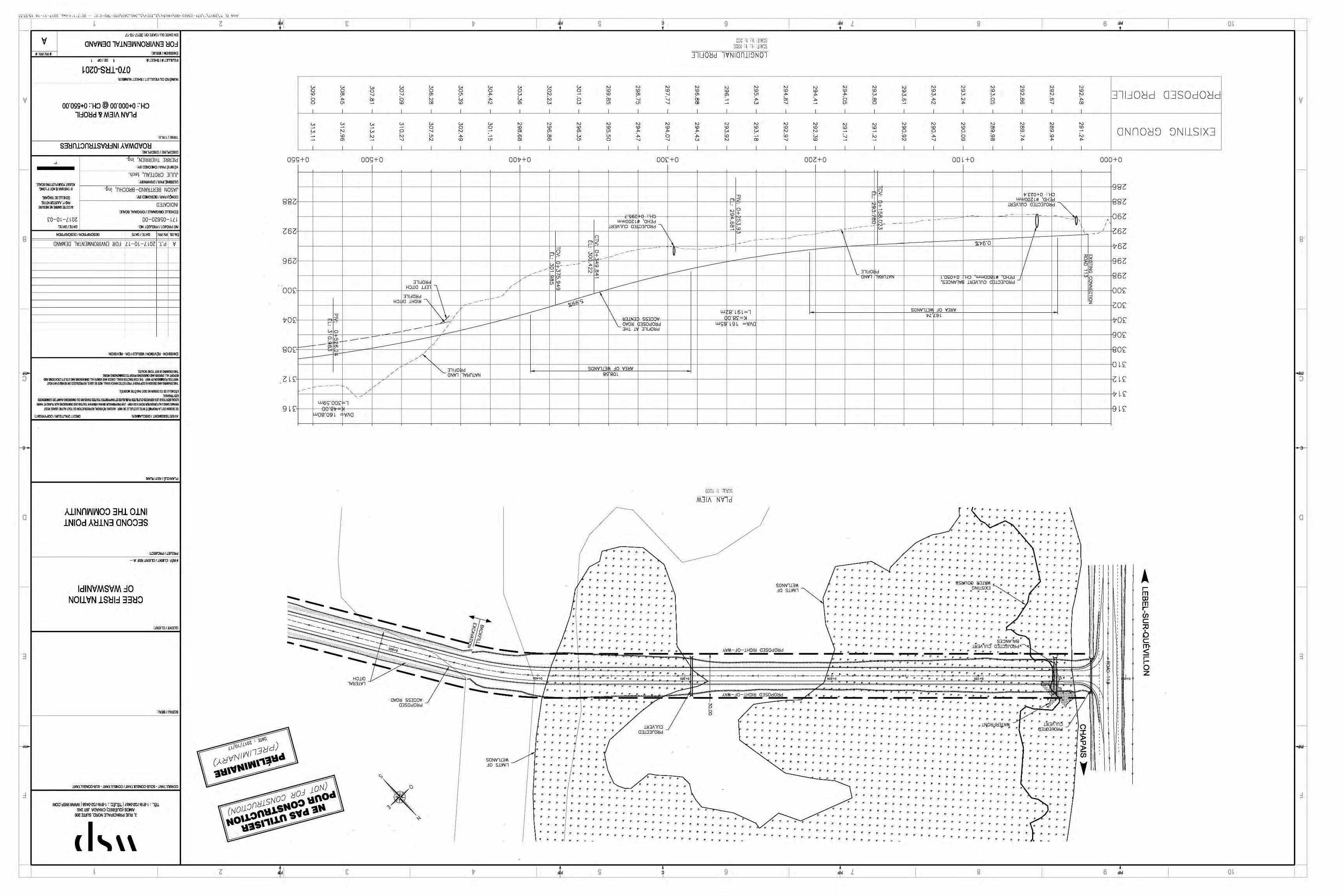
,_.,_,L,_.,c; l ~ ,- 'l-L lUl ·L>·"P t' l 'L ,ur.:; - 'u 'u-~1:u-uLu\uv~-uv:._ -,;\H:J..:I_ - r.:;\Ll'l'"Ju1\uu-ur.:;yc;u- lL l \ l \L 'Ul\'d ':._ 'PJlf
~ z £ v d S 9 d L B 6 d o~ '--- ~· ~~ ........ ~~~~~~~~~~~~~..-~~~~~~~~~~ ....... ~~~~~~~~~~~~~~~~~~~~~~~~~~~~~~-'-~~~~~~~~~~~...._~~~~~~~~~~~~~~~~~~---~~~~~~~~~~~~~~~~~~~~~~~~~~~~~~~---~~~~~~~~~~~~~~~~~~ .....
'rJ
'-----
8
i-::i
1-s--
a
'--
3
'--
i---
:I
v # 'AM/"i\}:J#
·'
l~ -o f-l~OZ: :::10 3.l\iC Ina 3.l\iC N3
ON'rJV\130 l'rJlN3VllNQ}:llAN3 }:IQ:! :3nss1 I NOISSl~;I
~ ::10/3(] ~ '.# 1331-iS I I .13Tln3::1
~ozo-S~!-OLO =11:::iewnN 831-!S 113111n3:1 na mi~wnN
OO'OSS+O :·H::i@ 00'000+0 :·H::i 11.:IQ}:ld ~ M31A N'rJld
S3}:1nl:Jn}:llS'rJ}:l.:INIA'rJMO'rJ0}:1 :3w1 I 3Mlll
:3Nl1dlOSICI / 3Nl1dlOSICI
llut 'N31~~3H1 3~~31d :;.a a3*E1-1n /}:JVd ~l:lll:l~A
·3w.is Df.lilOld ~llOA!SflroY 'ONOl .I !OfJ SI llV9 SIHl:ll
·4001 'nv:irn~:i 311nr :;.a NM'd!Cl I Wd ~NISS3Cl
·6ut 'nH:J0~8-0NV~1~38 NOSVr :,1.e a~oiS3a /l:IV'd nONro ·3~ 3!l 3113H:)~
3illOAmnN·.~SVd 3tlnS3W 3N 3Wfll 3ll3:J IS
rn-o 1-L IOG :31VC]/3!VCI
NOLldl1:1:'.lS3Cl I NOLldl~Cl
031V:JIONI :~ 1\INIElll:IO / 31\INIEll}:JQ 3TEl-IO;I
OO-OC:9SO- IL I :ON l:'.l3rOMd ! 13rQ1:1d ON
3.lVCl 13.lVCl "AHJ"j\}jl 'SV"W~
ONV~30 1V1N3~NO~IAN3 ~OJ ILl-Ol-LIOZI Td I V
:NOISIA3tl -1:10::1 Cl3nSSI I NOISI~ - NOISSl~;I
"031VlS :1!1011.0N SI tlNNMIOSIHl >i110M!JNON3N'm 0100~ SN:ll&a,.., OWSWllJ3 Tit' WOdlll
lllfll SNOIJY.X'fl Alllllfl OllY SNOISN3l'llCI TW ~llBA DW~~H:l TMIS '!101.'.M:U.N003Hl 'dSMAe NOESl'll:l3d N3.W~ lOOHlJM a~ HO rH:'ll"OJHd~ 'a::sn31l lON TMIS H:llllil\ aE'.131.0Hd lH!'l!H.ld):l SI N!'ll!Hl DNV tlNNMIOSIHl
:O;ll:Haow ~ Wd .llCXl 3N NISS303:J 30 31~1 XllV1\1tllJ.S31
'!13:MWN.'Xl 30 JNtAVstlllSSll'll no 9'!1113~3 S3.l00.1 H3llDdcM:1l3 S31t1111nd s;1r11n.aS3:'.W:l3S S31 !nll ll3Sl'Tf.ID1 ~~13 Sll'fld xnYSMJISN31'410 S3l S3JJIOl lffilliji\ 'l!Mlllfl3Rkml.J.N3.l 'dSIA30 31llfl';I tOJ.'tSHllflV.l StNS Sll'llBd
l.S3.N :E'o'9'1 'lllJ1IV .l00.1 no NQlJ.j)(]ffild~ 'NOIS~ 3Nn:inv 'dSM 31l 31131ll:l3l'BlNI ~~.otl\ll lS3 NISS3Cl 'l:l
:1H~ll:IJ.dOO ll:ln3ln\i,Cl lJml(] :1:13.wros1a / !N3N3SSl!H3f\V
:N\i'ld A3}1 / ;110 N\ild
AllNnVllVllO:::> 3Hl O!NI lNIOd A~!N3 ON0:::>3S
=~31'Q}jd / 13rD'!:Jd
- :, ·.::13H l.N311::> / !N3no · ::l;IH #
ldlNVMSVM :JO NOl!VN 1SHl:l 33H:::>
:1N3nO/lN3110
:1\13S I oo:IS
:l.NVl.TlSN0013nS- l.NVJ.lnSNoo f l.NVllnSNOO-snOS- !NVllnSNOO
~<XJdSMNnM I ~~c,111e·>: ·00101 I t9W"~&,~1e·>: ·101 '™i 1111' VO'INVO (03SonO) SOVIV
ore 3.uns 'CJllON 31Vdl:JNl~d 3n~ ·c
(1,\\
ti"'
\\..
OOl :1 :;, :J VJS COOi :1 H TVJS
311.:JOCJd lVNIOnll~NOl
"" 0
"' 0
"" 0 co .p. Ul
(jJ 0
"" co
(.,< D
"" D
(jJ
D Ol
N co
(.,< 0 Ul (jJ <D
"" 0 .p. .p. N
(jJ
0 (.,<
(jJ Ol
"" D N N (jJ
(jJ
0
0 (jJ
N <D <D OJ Ul
N
"' 00
--.J Ul
N <O
"" --.J
N
"' Ol
OJ co
N <D
"' N
"' Ul .p. (jJ
N <O .p. OJ --.J
N <O ... ...
N <O ... 0 Ul
N <O (jJ
00 D
N <D (jJ
Ol
N
"' (.,<
.p. N
N <O (jJ
N .,..
N
"' (.,<
0 Ul
N
"' N 00 Ol
N <O N Ol
N
"' N .p. co
Jl IJO;:Jd 0 <D --.J
I I I I I I I I I I
"" (jJ (jJ ""
I
~
~
I I I I I "
' I I I I
"" N <O m
(jJ
N
D N --.J
(jJ
0
" "' N
(.,< 0 N ...
(jJ
0 N <O co Ol (JJ
N
'° Ol
00 Ol
N <D Ol (jJ Ul
N <D Ul
"' D
N <D ... :,..
N <D ... 0 --.J
N <O .,,. .,,. (jJ
N <D (.,<
<D N
N <D (jJ
N <O N <O --.J
N <D N
"" "' I
N <O
--.J
N
'° N
N
"' D <O N
N <O a :,..
N <O 0 0
N (JJ
<O
<O (JJ
N 00 <O
"" ... N 00 <O
<O .,..
N <D
N .,,. ONnO;:J~ ~
~
I I I I "'
I
Ul
I I I
--.J
I I
(JJ
I I I I I
--.J
I "' I I I
O<:;<:;+O OO<:;+O oot+o 00£:+0 ooz:+o oo ~+o 000+0
I I I I I I I I I
ggz:I I I ' I I I I I I I I I I I I I I I I I ' I I I I
' ' ' ' ' ' ' ' I I 1 I I I I I I I I I I I -U O I I I 1 r;I~ i < I I \ .. .. I I
' ' ' ' '
• , .. "o "'"" ,.,, ' , ,gz
""""" • ·o~i" ~ C i C "''"°"' "~ o I ~3A1n8 m 83ro~d \ <:n t;: · .CJl 1~3Al 8 m18Jro: d ~ , ! ;;gz
96Z
~"' ~o _i;::r- -- . I (jJ J - -~, /I 6Z '
/ Z:6Z 0 --
~1< %176'0 1\--< 0
f:-'l:S "'~ , :,..c:; \ / ~\:! I I I I --/~l'...>J N[o ---- \ D°'1
;.
~l'i? I --·· - ,_, ____ _ t6Z:
f.95z I I l I / -· , :_I~ N ::. 311.JO d ::: ti 1 _ :311..:IO~d ,,-- ~ (.o __ _.J------ ._,,,y1 iv<.11u.v1i " -u nJ UH.:ld ..,. n i-o6Z
0 O(' I I I I H8110 1.J31 \ / .p. _____... 'S38NVW: rn3Aln8 O~D3rO~d ~ 0 ::z..· 1 I I I CD z I 311.JO~d \ / ------·-\ z 0£
I I I I I H8 10 1H81~ ""\ - - - - '- - ~ c; <:1
1
I I T T I Lr " u 0
I I :i:J ""\, / ~~ ' \ W 8'161~1 SONVll:l' .JO \f3~V z ~(';0£ -\70£, , ,.. / n·nn,~ 1'L' 91 I I I I I I
.. -- - I L.------- \..OVO~ b3SOdO~d wc,;~·l9l VAO 1 1 1 1 1 ,-\70£ lN o - .-- / ------ :3Hl 1" :311..:IO~d
0 - , -""~- - - / ;0£ 80£ ~ ~ / /
///"" ;;0£
// "'- 311.JO~d SONVll:l .JO V3~V D l £ l l £I I I I / ONVl lv~nlVN g< 'go I I I I
I I I I ; I I I : : : : : I I I I I I I I 17 I(' I I I I I I I I 1'(_, l-L
- ', / t l £ ,_ /
9 l £I lw:!i!t"f v:a I I I I I I I I I I I I I I I I I I I I I I I I I 19 l £
OO: I : l llvJS
M31/\ NVld
' ., '
' " ' ' ' ' ' ' ' ' ... ,. ,. ...
' ' ' ' ' ' ' ' ' ' ' ' ' ' ' ' ' ' ' ' ' ' ' • ' ' ' ' ' ' ' ... ,.. I<' ... ' ' ' ' ' • ' ' ' ' ' ' ' ' ... ... ... I" ' ' ' ' ' ' ' ' ,.. ... ... ... ' ' ' ' ' ' ' ' ' ' ' ' '
... ... ... ,.. ' ' ' ' ' ' ' ,. ,. " ... ' . "
' ' ' ' ' • • ' ' • ' ' ,.
4 ' ' ... ... I<',
... .... ... ... ... ' ' ' ' ' ' ' ' ' ' ' ' ~
' ' ' ' ' ' ' ' ' ' ' ' ' ' • ' • • • " ' ' ' ' ' ' ' ' ' ' ' ' ' ' ' ' ' ' ' ' ' ' ' • ' ' ' ' ' ' ' ' ' ' " ' ' '
' ' ' ' ' ' ' ' '
' ' ' ' ' ' ' ' ' ' ' ' ' ' ' ' ' ' ' '
' ' ' ' ' ' ' • • ' ' ' ' ' ' ~ ' '
" " ' ' ' ' ' ' ' ' '
' ' ' ' ' ' ' '
' ' '
' ' '
I I
1 I I
I
I 1Q+O
L\)a\/ L\G1 ·. 1~~G
(;.?:JVN I VI/ 113 ?::! d)
"tll'""'"''"'-a."" Jl
1 ~
SONV1.l3M ~ .JO Sll~ll
' • ' ' ' ' • '
• . '
' ' ' ' ' '
' ' ' ' ... ... ,,,, ' • ' . • ' ' ' ' ' ' ' ' ' • ' ' ' ' ' ' ' ' • • • '
I I
1 I
\f
4 J tjOJ loN)
(No11Jnti~:_~"o~ \lC\od "o'i.::"''i.C\ s"" "ttl J\
\\ ll~ """"'
s
~_,o ..,,
'
' ' • ,,
"'
' ' ' ' ' ' ' • ' • ' ' ' ' ' ' ' ' ' '
... ... , ... ' ' I<' " I ,.. ' ' ... "' ' ... ' ' ... ,.. , ,. • ' ... 11: 1 ,.
' ' ,.. ,.. , ... • ' ... I' ) ...
' ' ... l" f ...
" " ,.. .., , ... ' '
,.. l"I "'
' ' ' ' ' ' ' ' ' ' ' ' ' ' ' ' ' ' ' ' " " " ' ' '
' ' '
' ' ' '
~
' ' ' ' ' '
' ' ' ' . ' ' '
• ' ' ' ' ' ' ' ' ' ' ' ' ' ' ' ' ' ' ' ' ' ' ' ' ' ' " " • " ' ' • •
' • ' ... ,. ... I<' ... ...
~. ' ' ' ' ' ' ' ' ' • ' ' ' ' ' ' ' ' ' ,-,....._____ ' ' '
' ' ' ' ' ' ' ' ' ' ' ' ' ' ' ,.
' ' ' ' ' ' ' ' ' ' ' ' ' ' ' ' ' ' ' ' ' " ' ' ' " ' ' ' ' ' ' " ' ' ' ' ' ' ' ' ' ' ' ' " ' • " ' " " ' " " ' ' • ' ' " ' ' ' • • • ' •
' ' ' ' ' • ' ' ' ' ' ' ' ' ' ' ' ' ' • ' ' ' • ' ' ' ' ' • ' ' ' ' ' ' ' ' ' ' ' ' ' ' ' ' ' ' ' • ' ' ' ' ' ' ' ' ' ' ' ' ' ' ' • • • ' ' ' ' ' ' ' ' ' ' " ' ' • ' ' ' • ' ' ' ' ' ' ' ' ' ' ' ' ' ' ' ' ' ' ' ' ' ' ' ' ' ' ' ' ' ' ' ' ' ' ' ' ' ' ' ' ' • ' ' ' ' ' ' • ' '
' ' ' • ' ' ' ' ' ' • • ' ' ' ' ' ' ' ' '
' ' ' ' ' ' ' ' ' ' ' ' ' '
' ' ' ' ' ' ' ' ' ' ' ' ' '
' ' ' ' ' ' '
' ' ' ' ' ' ' ' ' ' ' ' ' '
' ' • ' ' ' ' ' ' ' ' ' ' ' ' '
' '
' ' '
' ' ' ' ' '
' ' • '
' ' ' ' ,,
' ,,
' ' ' ' ' ' ' ' ' ' • ' ' ' ' ' ' '
' ' ' ' ' ' '
' ' ' ' ' ' ' ' ' ' ' I
I~ m CJ m r;-
1. ~
1l
I ~. < r r 0 z
OJSOdO;:Jd 'rJ
~NllSIXJ
1--
8
1--
~
1-9-
a
'--
3
, __
hild-
:I
f- ..___,__,__,__,__,__,__,__,__,__,__,__.___,__,__,__,__,__,__,__,__,__,__,__,__,__,__,__,__,__,__,__,__,__,__,__,__,__,__,__,__,__,__,__,__,__,__,__,__,__,__,__,__,__,__,__,__,__,__,__,__,__,__,__,__,__,__,.__,__,__,__,__,__,__,__,__,__,__,__,__,__,__,__,__,__,__,__,__,__,__,..---.__,--.__,__,__,__,__,__,__,__,__,__,__,
~ z d i £ v I d s 9 d L I B I 6 d o~
F
E
D
B
EXISTING
A PROPOSED
-
/ /
/ /
/
/
/\ \ \ /
\ / ~
\ ~
// \ \
\
\ (
\ \ -- --\ \ LIMITS OF WETLANDS
LATERAL DITCH
\ \-\ \ \_ - -1
L\
-
08.58 AREA F WETLAND
30'.:
30::
PROPOSED 'L ACCESS ROAD --·;!
/
,.,.-
PLAN VIEW S·:AI F: I 1000
/ I
I ---~~-
L.,....---- L.Oo
--- / --- -- -- 0 l"'1
PROPOSED RIGHT-OF-WAY
---
0 0 0 ,.,
- f- --
~-:::::r "l
-308
PR FILE AT THE , I ------ • .--
304t--~P~R<~P~O~S~ED'.;ffiROTIA'ij-~\~;;:---t---t~--t--i..--:::::::::=--'"""'~V--------t./~,r;~~,-~'/ ""'--t---t-----j----t~<~f·~g··_-t---t-----j----t---t-----t----t----:G>li~t----t---t304 302t-----t----t--.~-;-\ z SSm~g~~0:::::::0"T"f-----t----t-_-_-:-::-~-,,--'-j---~\~i1 "-.~R~IG~H~T~Djl ~C~H ---t----j--t---t----r------i----r---t-----t----t----t-j-----t---j
_ _.>--- ,.- ..- PROFILE 30CJ+----~I----------::o!--""'+--+---,.~md'-+,, ----+--... ~/L/_-+----+---\--1Lf-~'E~~=-::D=1rc~H-+----+---+----+----t-----t----+----+---+----+----1------t----+300
-~ 'u PROFILE 29'.:Prto=-~~---=--f-----+-~~;+---+---!!,::~· .Glf " ---~-~~·'+-----jf-----+----+-----+----+-------1-----+-----+-----+----+-----j-----+-----f-----+----+-----t
' N ;:
29~6+----+-----t-:-:~~~~:j-,.-"'f--·--_----'_j~~-r-"-'"_·· __ +-----t----+----+----+---+----l-----+---+-----t----+----+----+---+----1-----+---+296 - --- - - . + 0 >'l<L
___ i- -- orri P 294+-=.c.-r-----t---,~--+--=t--t----+----+----t---+---f----+----+---+---+----+---+---t----1----+---+---+---1 f". w
u
0+300 0+400 0+500 0+600 o+ 70©+ 716.66
I I I I I I I I I I I I I I I I I I
\ \__
r-1
I- -
I
j
I
GROUND 0 LO LO Ol N
L[)
"' <D Ol N
<D ro <D Ol N
Cl) <!)
Cl)
Ol N
0
"'
N L[)
" 0
" N 0
m 0 L[)
m Ol m
0
" Ol Cl)
Cl) L[)
L[)
I
..,. 0
PROFILE
I
"' " 0)
m N
I
lO Cl)
Ol m N
I
"' 0
0
"'
I
n N N 0 n
I I I
m n L[) 0
"'
"' I
0)
N <!)
0
"'
I
m 0
" 0
"'
I
ro
" 0
"'
I
"' ..,. 0)
0 n
LONGITUDINAL PROFILE SCA.E: H. I: I OOJ SCA F: V: I: 700
I
0 0 Ol 0
"'
I
" ..,. m 0
"'
I
<D ro Ol 0 n
I
0
I
m
"' 0
I I
m
"' 0
I
<!)
lO 0
I
0 L[)
0
ll -
_.., \
_.., I
' ''I> 3, RUE PRINCIPALE NORD, SUITE200
AMOS (QUoBEC) CANADA J9T 21<6 TOL' 1-819-732-04571ToloC.'1-819-732-0458 I WWW.WSP.COM
CONSULTANT· SOUS-CONSULTANT J CONSULTANT· SUB-CONSll_TANT:
SCEAU f SEAL:
CLIENT/CLIENT:
CREE FIRST NATION OF WASWANIPI
# Re:. CLIENT I CLIENT REF. It.-
PROJET I PROJECT:
SECOND ENTRY POINT INTO THE COMMUNITY
PLAN CLE I KEY PLAN:
AVERTISSEMENT I Dlsa.Ari.ER: DROIT D'AUTEUR/ COPYRIGHT:
CE IJESSIN EST L.Al'10'Rlffi MB..l.ECTIJEl.1£ DE WSP. AUCUtE FEviSION, REPROOJCllON OU TOOT AUTRE l.&\GE nm PERMIS SANS L'AIJTORISATION ~ITE DEVIS'. L'ENTRE~EURDEW.A VIORJ~ ll.llJTE$ LH DIMENSHJISAUX PLANS ETFAIRE
LOCJil.ISER TU.5 LES SERYK:ESDVTIUTEI PUBUQUES ETRN'PORlER TOUlU ERJRS OU ~ISSltHIAVNfl DE ca.IMENCER LfS TRAVAUX. L°ECHB.LE IE CE DESSIN NE DOIT PAS ~ MOOlfEE
THIS DllAwtlG AND DESIGN IS COPYRIGHT PltiJfECTBI l'!'Ht;:H SIWJ.NOT l!EU83l, REPIUJJCED OR RElllSED WllllOUT WRITTEN PERMIS90N BYWSP. THE CONTRACTOR SHAil CHECKMD VERIFY ,IJ.l IJlilENSIONS AND UTILITY LOCATIONS AND REPORT AU. mRCR!AllD !1111SSICM PRIOO TO CMEMCINGWM< THIS DMwtlG IS "OT TO BE SCAl.ED.
EMISSION- RE\llSION I ISSUED FOR- REVISION:
A P.T. 2017-10-17 FOR ENVIRONMENTAL DEMAND
~M./IS. RVJRV. DATE/DATE DESCRIPTION I DESCRIPTION
NO PROJET I PROJECT NO:
171-05620-00 E.CHEUE ORIGINALE ! ORIGINAL SCl\LE:
INDICATED CONCU PAR/ DESIG~D BY:
JASON BERTRAND-BROCHU, ing. DESSINE. PAR I D~WN BY:
JULIE CROTEAU, tech. VERIFI~ PAR.I CHECKED BY:
PIERRE THERRIEN, inq. DISCIPLINE I DISCIPLINE:
DATE I DATE:
2017-10-03
SI CETlE BARRE NE MESURE PAS 1'.AIUSTIRVOTRE ~CHELLE DE 'fW\CAGE.
IFTHIS BARIS NOT 1' LONG, ADJlJSTYOU~ Pl.OTTWG SC,1,1.E.
1'
ROADWAY INFRASTRUCTURES TITRE I TnLE:
PLAN VIEW & PROFIL CH.: 0+300.00@ CH.: 0+716.66
NUM~RO DU FEUILLET I SHEET NUMBER:
070-TRS-0202 FEUUET #I SHEET#: 1 DE/OF 1
EMISSION I ISSUE:
FOR ENVIRONMENTAL DEMAND EN DATE DU/DATEOF: 2017-10-17
#RV.IRV.#
A
F
-
E
-
D
c ..p/I'-
B
-
A
A·1+ ~ Pc\?'117\ I\ 171-'1.'ifi?0-'10 \hrrcTrn\? _ FC:H\'1_ "':AO_:".Al'l\070-TRS-'1101 - ?'1171114 dw~. ?017-11-' i'i 1.'ic.'\7,1.'\
F
E
D
c
B
A
10 PF 9 8 7 p
EXISTING AERIAL ELECTRIC LINE
6 5
PROJECTED PAVED SHOULDER EDGE SLOPE 6%
p 4 3 2
_..., \
-
------- 'l!llil --------- 'l!llil ---------
.......C LEBEL-SUR-QUEVILLON ~~~~~~~~~---J
-1---------------t---------------40.0 i-----------------------40.0---------------------+---l------------------40.0 P-ill
-rr1·.-r.-.·rn·rr1-r("l"l"("l"r1·rr1·rrr•·r1·1-rn·r1·1·r(·1·r1·r1·1·1·r.-.-r ·1·r1·1·1·1·1·1·(-.-1·1·r1·1·r1·1·r1·n- -1·1- -1·1- "(". --.. -- -. --·n- -n·1·1·1·1·1·1·1·1·1·1·· rrrrr1·1·r1·1·r1·1·r1----- ---- ---- -- I I I I I r ' 11 I r1·rr1·1-r1·1·r1·1·rr-rrr·rr1·rr1·1·r1·1·r1·1·r1·rrn·r····r1·1·rr1·r1·1·r1·1·r1·rrn·r.-.·r.-.·r1·1·r1·1·r1·rrr·1·r1·rrrrrn·r1·1·r1·1·r1·rrr· 1·1·1·1·1-1 ·n·1·1·1·1·1·1·1·1·1-1·r·r1·n·1·1·1·1·1·1·1·1·r·1·1·1·1·1·1·1·1·1· -n- "[" ---.. -.. ----.. --.. -- --. --. -. --n·1·1·1·11·1·1·1·1·1·n·1·1·1· - 1·r1·1·r1·1·r•·rr1·rrn·r1·1·r1·r-1·1·r·1·1·1·1·n-1·1·1·1·1·1·1·n·1·n·1·n·1·1·r·1·1·r1·1·1·1·1·1·1·1·1·1·1·1·1·1·1·1·1·1·1·1·1·1·n·r··1·1·r1·r·1·r1·1·r1·1·r1·1·r1·r1·r~ L'_IJ I - --'-'--'---'--
--- ---- ---- ---- ---- I I ' I " I " I " I " I " I "j ,. ·n· .,.,. .,.,. .,.,. ""j"""l"""l"""l"""l"""l""j"""l"""l"""l"""l"""j "j " " -- ---- --- --- I I I I I I I I I I '--------- ---- ---- ---- - - - --- -- --1 --- ---- I I I I I I l \ 1 I I I I l11l1.1 .. 1.1 .. 1.1 .. 1.1 .. 1.1 .. 11 .. 1.1 .. 1.1 •• •.1_.,_1 __ _ ,_L_,_1_._1_1_._1_1_._1_L_,_1_1_1_1_1_,_L_,_1_._1_1_._1_1_._1_1_1_1_1.i_1_1_1_1_1_,_1_1_._1_1_ _1_1.r_1_1_1_1_1.i_1_1_._._1_1_1_1_._1_1_._1_1_ 1_1_L_1_L.1_l.1_1_l_._1_l_._1_l_._1_l_1_1_L_1_l_._1_l_._1_1_1_1_l_._1_L_1_L_1.1.1.1.l.._._l_._1.l...1.l.1.1.L.1.L.1.L1.1.l.1.1.L.1.L.1.L_1_l_1_1_/_1_1_1_._._1_._1_1_._1_1_._1_1.i_1_L_,_f.1_1_1_1_ 1_1_1_ ,_1_1_,_1_1.r_1_L.i.L .•. L_1_L_1.\.1_1J.1.1.l.1.1.L.1J.1_,_L_,_l_._._L_1_L_1_L_1_L.1 .. 1.1 .. 1.1 .. 1.1 ... 1 .. 1.1 .. 1.1 .. 1.1 •• 1.1. -•-•- .1.1 .. 1.1 .. 1.1 .. 1.1 .. 1.1 .. 1.1 •• 1.1 .. 1.1 .. 1.1 .. 1.1_ .1.1_ -'-'- .1.1 .. 1.1 .. 1.1 .. 1.1.l 1.1.L.1 .. 1.1 .1.1.L.1.L.1.L.1.L .•. l.r.1.l...1.l...1.L.1.L.1_L_,_L_1_L_1_L._._L_1_L_1_L_1_L.1.L_,_L_,_L.1.l.1.1. _1_1_ .1.1-.1.1. -1-1--1-1-·1·1--1·1· -•-1-·1·1-·1·1· ·1·1-·1·'- ·'·1--.. -
P--01
P-12
M-01 ---A----
M-06
~~-A----
I I I I I I I 11 I I I I I I I I I l,,l,,l,,l,,L_,.l.,_,.1.,.,.l.,_,.l.,_,.l.,.,.l., . ..l.,_,.l.,_,.l.,_,.l.,_,.l.,_,.l.,.,.1.,.,.l.,.,.l.,.,./.,_,./.,.,J,,l,,1--1--1 I 111_1 ___ 1 11,,1,,_1.,,.1_,_,J,_,_ I I I I I I I I ' I I I .. 1.1 .. I.I .. 1.1- .I.I .. I.I- .I.I.·'-'- .I.I .. I.I .. 1.1 .. I.I .1.1- .I.I- .1.1. --... ----. -- ---. -. -•.I .. 1.1. _u_ .I.I •• r.1 .. I.I- .I.I- .1.1 .. I.I- _I.I-. ----_I .. I.I .. I.I .. I.I .. I.I .. I.I .. I.I •• I.I •• I.I .I.I .. I.I .. I.I. --· --
--···
10
i-----------------+------------50.0----------------------------j
EXISTING DITCH
--··. .---------- ~.
·-~--
PF 9
EXISTING WATER COURSE
----··~
8
PROJECTED PAVED SHOULDER EDGE
SLOPE 4%
I
I P-10
I I~ 0 Vl
1: "' 0 i::>
I
I~ I~
I I
~--·---!/ 1··· pl • .
7 p
-·
.-.-. ----. ---.----;---
.~
-;------,-----------
;---;---
: . ' ~ :•
-- -
6
MARKING OF THE OUTER M--03 EDGE LINE (TYPICAL)
ct I
---A----P--ffi
PROJECTED
·--
PLAN VIEW SCAlI: I: 200
-- ' - . ---- . -
-.
5
I I I
P--03
I
p
-. .
. . •
PROJECTED PAVED SHOULDER EDGE SLOPE 4%
EXISTING DITCH
PROJECTED CULVERT BALANCES
4
P--04
CHAPAIS ......
TABLE OF COORDINATES INTERSECTION
(MTM NAD-83. FUSEAU 10)
EAST NORTH POI NT
{X) {Y)
P-01 343640. 7320 5507920.5259
P-02 343665. 7705 5507951.8286
P-03 343692.3361 5507981. 7328
P-04 343720.3289 5508010.3675
P-05 343717.0154 5507995.3987
P-06 343699.8094 5507970.5321
P-07 343701.6119 5507952.5639
P-08 343723.1522 5507931. 6809
P-09 343718.6441 5507926.3205
P-10 343695. 7598 5507945.7214
P-11 343677.0658 5507945.2269
P-12 343640.8409 5507910.5776
M-01 343667.6345 5507950.1348
M-02 343694.3447 5507979.9545
M-03 343697.1572 5507972.8174
M-04 343698. 7624 5507953. 7980
M-05 343694. 2022 5507948.4837
M-06 34367 4.4 718 5507947.5774
3
ELEV.
(Z)
Exist ing
Exist ing
Exist ing
Exist ing
-
-
--
-
-
2
1
'''I> 3, RUE PRINCIPALE NORD, SUITE 200
AMOS (QUEBEC) CANADA J9T 2K5 TEL.: 1-819-732-0457 I TELEC.: 1-819-732-0458 I WWW.WSP.COM
CONSULTANT - SOUS-CONSUL TANT I CONSUL TANT - SUB-CONSUL TANT:
SCEAU/ SEAL:
CLIENT I CLIENT:
CREE FIRST NATION OF WASWANIPI
#REF. CLIENT I CLIENT REF.#:-
PROJET I PROJECT:
SECOND ENTRY POINT INTO THE COMMUNITY
PLAN CLE f KEY PLAN
AVERTISSEMENT I DISCLAIMER: DROIT D'AUTEUR I COPYRIGlfT:
CE l:ESSIN EST LA PROPRIETI: INTEliECTUELLE DE WSP. AUCIJ'jE Rtv!SION, REPRODUCTION OU TOlJT AUTRE USAGE NEST PERMIS SANS L'AUTORISATlON B:RITE DE WSP. LENTREPRENEUR DEVRA Vi:RIFIER TOIJTES lES DIMENSIONS AUX PLANS ET FAIRE LOCALISER TOUS LES SER\.llCES DUTIUT'ES PUBLIQUES ET R.l.PPORTER TOUTES ERREURS OU l).11S$10NS AVAITT DE COMllENCER LESTRll\.'AUX. L'EcHEllE OE CE DESSIN NE OOIT P,l.S ETRE ~DIFIEE.
THIS DRAWING AND DESIOO IS COPYRIGHT PROTECTED WHICH SIW.lNOT BE USED, REPRODUCED OR REVISED wm+::ll1T WRITTEN PE11MISSION BY WSP. THE CONTRACTOR SHALL aiECK AND VERIFY AU. DIMENS!Cffl llND VTIUTY LOCATIONS AND REPORT All ERRORS AND OMISSIONS PRIOR TO COMMENCING WORK. THIS DRAWING IS NOT TO BE SCALED.
EMISSION - REVISION f ISSUED FOR- REVISION:
A P.T. 2017-10-17 FOR ENVIRONMENTAL DEMAND
EM./IS. RV./RV. DATE/DATE DESCRIPTION f DESCRIPTION
NO F'ROJET I PROJECT NO:
171-05620-00 ECHELLE ORIGINALE f ORIGINAL SCALE:
INDICATED CONCIJ PAR I DESIGNED BY:
JASON BERTRAND-BROCHU, ing. DESSINE PAR f DRAWN BY:
JULIE CROTEAU, tech. VER I FIE PAR/ CHECKED BY
PIERRE THERRIEN, ing . DISCIPLINE I DISCIPLINE:
DATE/DATE:
2017-10-03
SI CETTE BARRE NE MES URE PAS 1', AJlJSTER VOTRE
ECHELLE DE "fRACAGE.
IF 11--llS BARIS NOT 1" LONG, ADJUSTYOOR PLOmNG SCALE.
1·
ROADWAY INFRASTRUCTURES TITRE I TITI.E:
INTERSECTION GEOMETRY
NUMERO DU FEUILLET ! SHEET NUMBER:
070-TRS-0203 FEUILLET #/SHEET#: 1 DEIOF 1
EMISSION/ ISSUE #RV.IRV.#
FOR ENVIRONMENTAL DEMAND A EN DATE DU I DATE OF: 2017-10-17
1
F
E
D
c
B
A
Arch D, P:\2017\ 1\171-05620-00\lnfraTra\2._ TECH\5_DAO_CAD\070-TRS-0101 - 20171114.dwg, 2017-11-16 16: 10:16
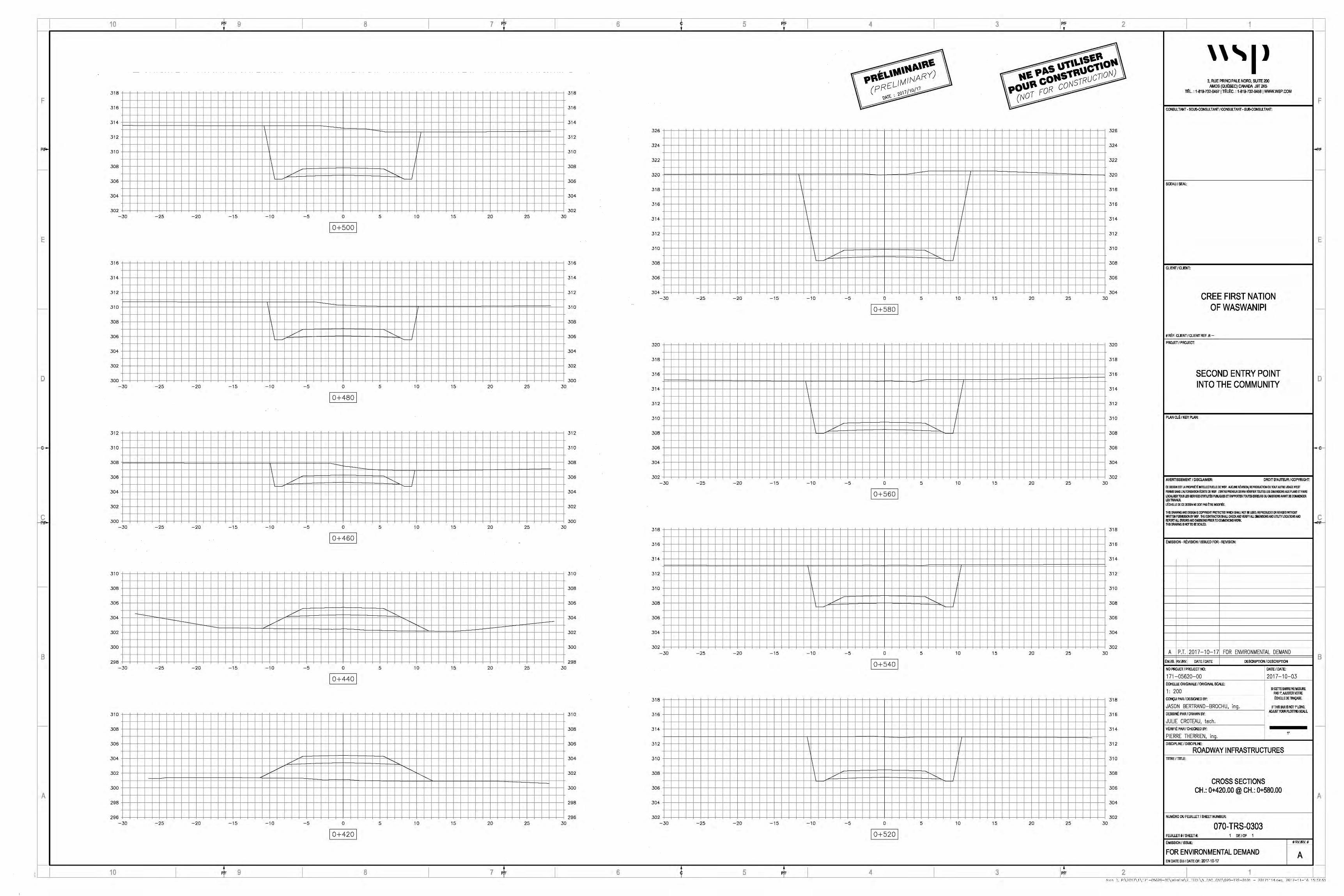
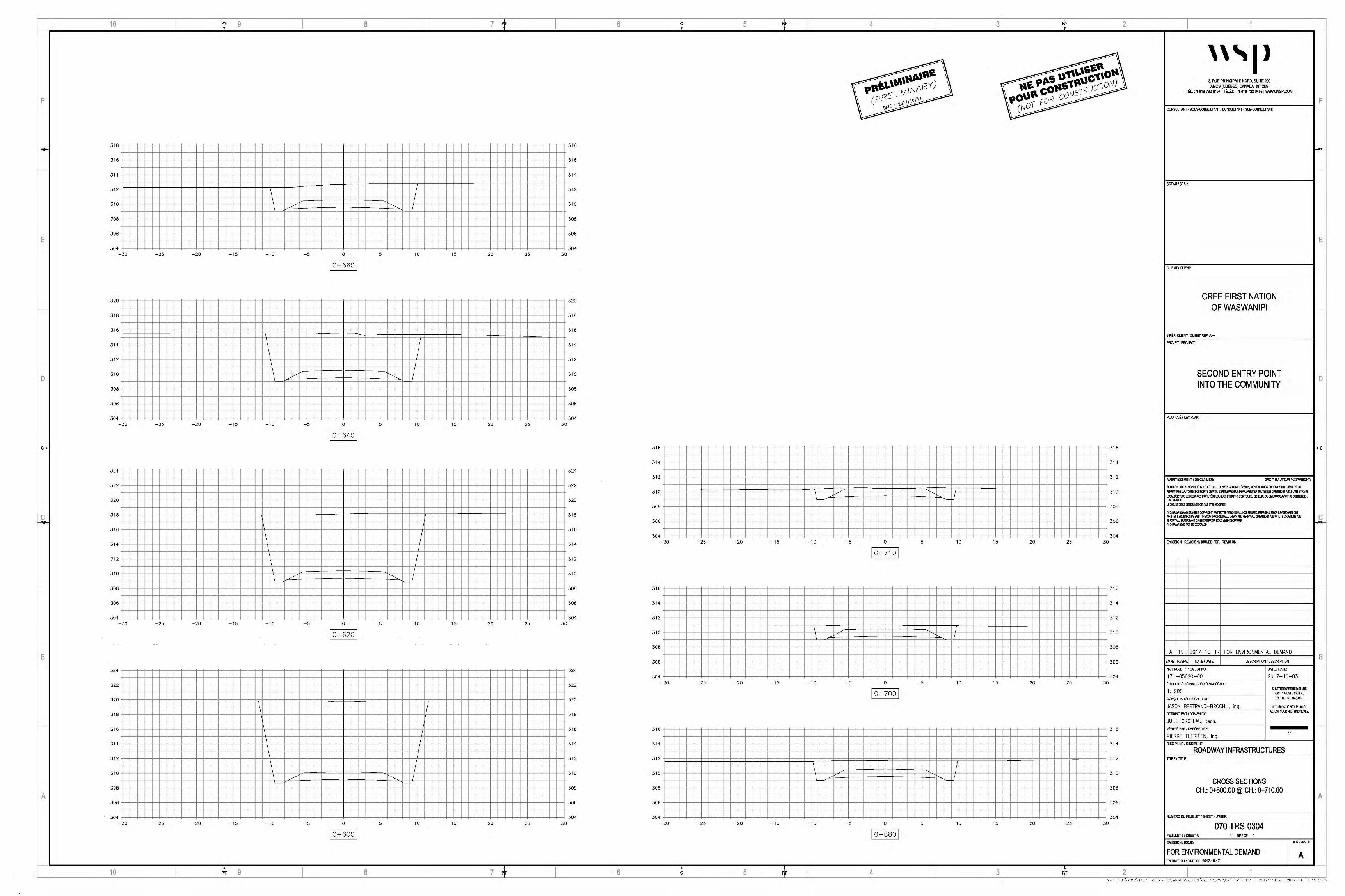
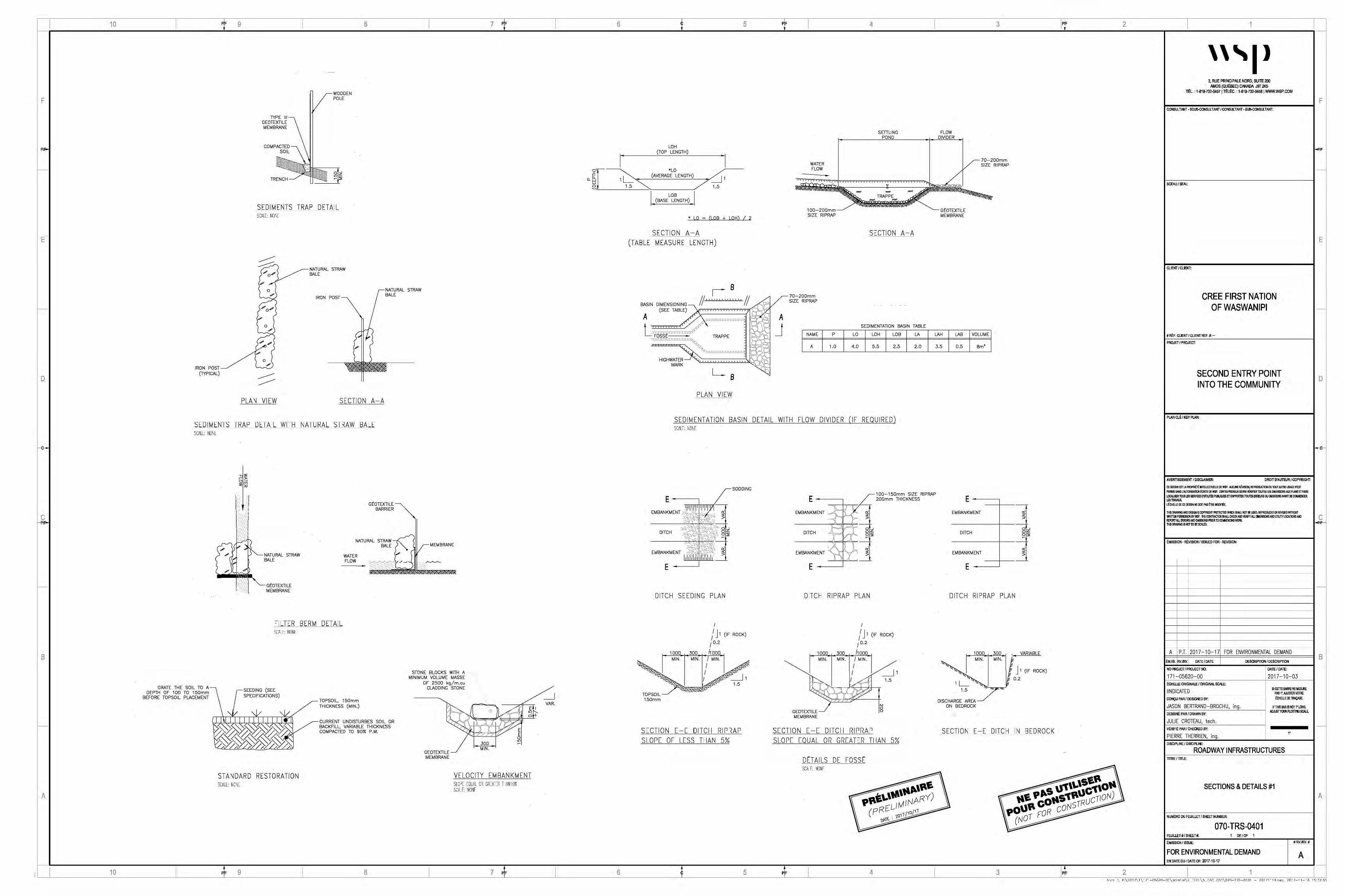
F
E
D
B
A
1YPE Ill GEOTEXTILE MEMBRANE
COMPACTED SOIL
TRENCH
rWOODEN I POLE
SEDIMENTS TRAP DETAIL SCl,LE: ~IO~IE
~ _,,,, ; ~NATURAL STRAW
o.; ~ BALE
.; /
0 .; y-:;)
0 .;
0 [/"'
IRON POST
)
NATURAL STRAW BALE
IRON POST/.; o.;
(1YPICAL)
PLAN VIEW SECTION A-A
SEDIMENTS TRAP DETAIL WITH NATURAL STRAW BALE SCI.LE: ~JONE
GEOTEXTILE BARRIER
NATURAL STRAW~ BALE ("-.. ~.,,,---MEMBRANE
GRATE THE SOIL TO A DEPTH OF 100 TO 150mm
BEFORE TOPSOIL PLACEMENT
)
GEOTEXTILE MEMBRANE
WATER FLOW
FILTER BERM DETAIL \CAI F: 110NF
,-- SEEDING (SEE SPECIFICATIONS)
II I I I I I I I I•
TOPSOIL, 150mm THICKNESS (MIN.)
CURRENT UNDISTURBES SOIL OR BACKFILL, VARIABLE THICKNESS COMPACTED TO 90% P.M.
.; '
STONE BLOCKS WITH A MINIMUM VOLUME MASSE
OF 2500 kg/m.cu CLADDING STONE
GEOTEXTILE MEMBRANE
\
MIN.
STANDARD RESTORATION SC.~LE ~ONE
VELOCITY EMBANKMENT SLOPE ECLl~L CR GiEATER THl.1110% SC.~I F IONF
_J VAR.
LOH
' (TOP LENGTH)
I a_ [r 0 (AVERAG'i-OLENGTH) ~1 e_ 1.5 """' 7 1.5
LOB (BASE LENGTH)
' LO ~ (LOB + LOH) I 2
SECTION A-A (TABLE MEASURE LENGTH)
WATER FLOW
100-200mm SIZE RIPRAP
B fl I // I ,,,.----70-20Dmm
11_,,,,,,,,,,,,,,
11 ~v s1zE RIPRAP
BASIN DIMENSIONING (SEE TABLE)
A ' :: a I ,:...
A 'l'.'.L'.'l'.'1'.'l'.'l':l'.'.l'.'l'.'l'.'l'.'l'_'l'.'l'_'!
SETTLING POND
TRAPPE - -
SECTION A-A
L, .. ,.'l''l'1'.'C.'l''''l'1'.'·'l'.'l'.'l'.'l1>"'"'(· • J SEDIMENTATION BASIN TABLE
FOSSt TRAPPE -,r:.r:.r:.r;:r;.r:.r:.r:.r;:r;.r:.r:.r;,r:.r.J.:-,.., .. ,...
HIGHWATER MARK
'0.--t,.. ··r,.,r:.r;,r;,i;,r;,r:,r;,r.-,r.-.1:,r;,1;,10,r:.1.
</., ••• .
PLAN VIEW
NAME
A
p LO LOH LOB
1.0 4.0 5.5 2.5
SEDIMENTATION BASIN DETAIL WITH FLOW DIVIDER (IF REQUIRED) SCAJ:: 11Ul1l
LA
2.0
FLOW DIVIDER
~70-200mm / SIZE RIPRAP
/ ~-
GEOTEXTILE MEMBRANE
LAH LAB
3.5 0.5
VOLUME
Bm'
_r-100-150mm SIZE RIPRAP E ---~ / 200mm THICKNESS E--~
E
DITCH SEEDING PLAN
I
/ J 1 (IF ROCK)
I 0.2
1000 300 /1000
SECTION E-E DITCH RIPRAP SLOPE OF LESS THAN 5%
,._,,,- +......-.--r--.-EM BANK M ENT ,..ti'-- { k' "' - ;:- ::;
DITCH
~~L--: EMBANKMENT 1"' ' 'y ' ;l:
, _
E
DITCH RIPRAP PLAN
' 1000
~MIN.
1'--
GEOTEXTILE MEMBRANE
300 MIN. I MIN.
I I / /
(IF ROCK)
~1 1.5
N g
SECTION E-E DITCH RIPRAP SLOPE EQUAL OR GREATER THAN 5%
Dt'TAILS DE FOSSt SCALE: llCllE
,, -
-->-----
EMBANKMENT
-------+----DITCH
o· o~ 0"' ~
-------+----
EMBANKMENT
--r---
E
DITCH RIPRAP PLAN
1000 300 MIN. MIN.
1.5
VARIABLE
fl' ; ;' J 1 (IF ROCK)
0.2
DISCHARGE AREA ON BEDROCK
......., \
SECTION E-E DITCH IN BEDROCK
~
I
' ''I> 3, RUE PRINCIPALE NORD, SUITE200
AMOS (QUoBEC) CANADA J9T 21<6 TOL: 1-819-732-04571ToloC.:1-819-732-0458 I WWW.WSP.COM
CONSULTANT· SOUS-CONSULTANT J CONSULTANT· SUB-CONSll_TANT:
SCEAU f SEAL:
CLIENT/CLIENT:
CREE FIRST NATION OF WASWANIPI
# Re:. CLIENT I CLIENT REF. It.-
PROJET I PROJECT:
SECOND ENTRY POINT INTO THE COMMUNITY
PLAN CLE I KEY PLAN:
AVERTISSEMENT I Dlsa.Ari.ER: DROIT D'AUTEUR/ COPYRIGHT:
CE IJESSIN EST L.Al'10'Rlffi MB..l.ECTIJEl.1£ DE WSP. AUCUtE FEviSION, REPROOJCllON OU TOOT AUTRE l.&\GE nm PERMIS SANS L'AIJTORISATION ~ITE DEVIS'. L'ENTRE~EURDEW.A VIORJ~ ll.llJTE$ LH DIMENSHJISAUX PLANS ETFAIRE
LOCJil.ISER TU.5 LES SERYK:ESDVTIUTEI PUBUQUES ETRN'PORlER TOUlU ERJRS OU ~ISSltHIAVNfl DE ca.IMENCER LfS TRAVAUX. L°ECHB.LE IE CE DESSIN NE DOIT PAS ~ MOOlfEE
THIS DllAwtlG AND DESIGN IS COPYRIGHT PltiJfECTBI l'!'Ht;:H SIWJ.NOT l!EU83l, REPIUJJCED OR RElllSED WllllOUT WRITTEN PERMIS90N BYWSP. THE CONTRACTOR SHAil CHECKMD VERIFY ,IJ.l IJlilENSIONS AND UTILITY LOCATIONS AND REPORT AU. mRCR!AllD !1111SSICM PRIOO TO CMEMCINGWM< THIS DMwtlG IS "OT TO BE SCAl.ED.
EMISSION- RE\llSION I ISSUED FOR- REVISION:
A P.T. 2017-10-17 FOR ENVIRONMENTAL DEMAND
~M./IS. RVJRV. DATE/DATE DESCRIPTION I DESCRIPTION
NO PROJET I PROJECT NO:
171-05620-00 E.CHEUE ORIGINALE I ORIGINAL SCl\LE:
I INDICATED CONCU PAR/ DESIG~D BY:
JASON BERTRAND-BROCHU, ing. DESSINE. PAR I D~WN BY:
JULIE CROTEAU, tech. V~RIFI~ PAR.I CHECKED BY:
PIERRE THERRIEN, inq. DISCIPLINE I DISCIPLINE:
DATE/DATE:
2017-10-03
SI CETlE BARRE NE MESURE PAS 1'.AIUSTIRVOTRE ~CHELLE DE 'fW\CAGE.
IFTHIS BARIS NOT 1' LONG, ADJlJSTYOU~ Pl.OTTWG SC,1,1.E.
1'
ROADWAY INFRASTRUCTURES TITRE I TnLE:
SECTIONS & DETAILS #1
NUM~RO DU FEUILLET I SHEET NUMBER:
070-TRS-0401 FEUUET #I SHEET#: 1 DE/OF 1
EMISSION I ISSUE: #RV.IRV.#
FOR ENVIRONMENTAL DEMAND A EN DATE DU/DATEOF: 2017-10-17
F
-
E
-
D
c ..p/I'-
B
-
A
A·d· "':, Pc\?'117\ I\ 171-'1.'ifi?0-'10 \hrrcTrn\? _ FC:H\'1_ "':AO_:"'.Al'l\070-TRS-'1101 - ?'1171114 dw~. ?017-11-' i'i 1 Cic.'\7,1.'\
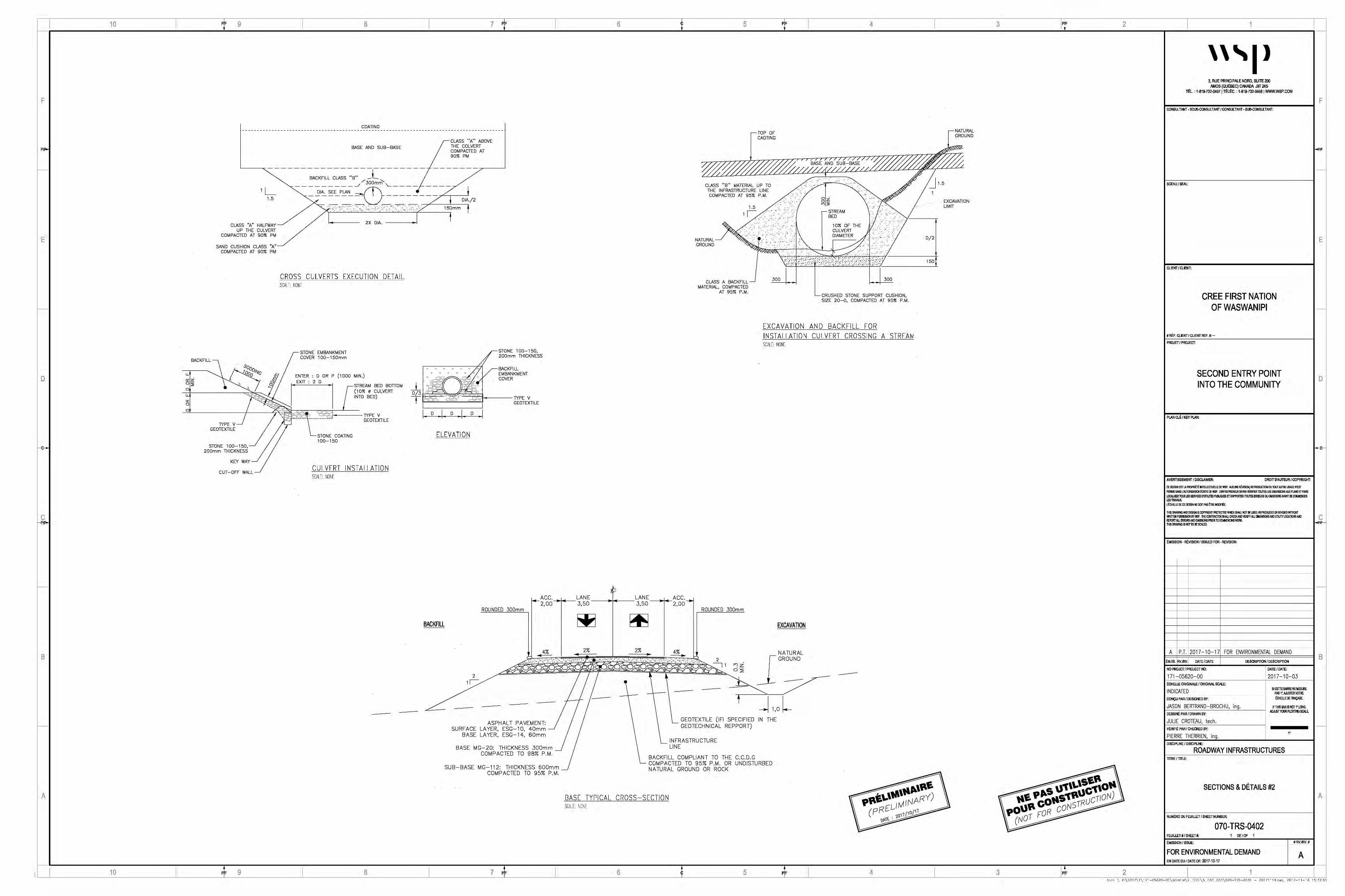
F
E
D
B
A
COATING
BASE AND SUB-BASE CLASS "A" ABOVE THE COLVERT COMPACTED AT 90% PM
-----~ACK:L~CLASS ~B-::---L ------- --/i _....,..30Dmrfi"
---------~ L____ ---- j 1 ~ - _'.JI~ SE~PLAi:!_ TI-------/ I DIA./2
CLASS "A" HALFWAY UP THE CULVERT
COMPACTED AT 90% PM
SANO CUSHION CLASS "A" COMPACTED AT 90% PM
"~:?. ~ '•. T·•-:S ---Z-./ 150mm ! 2X DIA. ___ _,I I
CROSS CULVERTS EXECUTION DETAIL SCALl l"Ol"l
STONE 100-150, 200mm THICKNESS
-TOP OF CAOTING
-NATURAL GROUND
-
%r~~/~)Y5~~;~~y5~;;~ CLASS "B" MATERIAL UP TO , .::' .,·,, :·.· . . .·. ' .... : ··:•. J 1 .5
THE INFRASTRUCTURE LINE . •. •· 1 COMPACTED AT 95% P.M. .. .,.
....... 8~ .. 1-5 ':_"'STREAM . · ... > ~
B~~% OF THE /_> ' )·' '---~ 1 I. " .·i •
" ........ · ·' .. , .. · \ DIAMETER : " .. ·~
NATURAL GROUND
CULVERT )
~·· ·~:· ., ... '--:i·~ .••.. "" ~-,~_//'.'. ·.- ........ -1~ ,. . : ·> / .......... ' -..
CLASS A BACKFILL -MATERIAL, COMPACTED
AT 95% P.M.
300 30D
-CRUSHED STONE SUPPORT CUSHION, SIZE 20-0, COMPACTED AT 95% P.M.
EXCAVATION AND BACKFILL FOR INSTALLATION CULVERT CROSSll'1G A STREAM SCALC: ~1011[
D/2
150
EXCAVATION LIMIT
BACKFILL
STONE EMBANKMENT COVER 100-150mm
"-0'. z o:;; 0
O'. 0
0
TYPE V_J GEOTEXTILE
STONE 100-150, 200mm THICKNESS
KEY WAY
CUT-OFF WALL
ENTER : D OR P (1000 MIN.) EXIT ' 2 D
STREAM BED BOTTOM (10% o CULVERT INTO BED)
f ~ ~-. ~~[=~< ~~' ='::=1
==-TYPE V ~ 1: _____ --------=--1 GEOTEXTILE
T
STONE COATING 100-150
CULVERT 11'1STALLATION SCAI f, NONF
/
.,.. • ... ...- • fi 1 / EMBANKMENT • • • • • •i /• ~BACKFILL "' -.g - ,....-., "' COVER
_i_ • ' ~ : ! D/3
T I D I D I D I
ELEVATION
TYPE V GEOTEXTILE
~ACC.--->f __ LANE ______ LANE ____ Acc .....
2,00 3,50 3,50 2,00 ROUNDED 300mm
BACKFILL
~ 2% 2% ----±!._
ROUNDED 300mm
EXCAVATION
_j 1,0 l-ASPHALT PAVEMENT:
SURFACE LA YER, ESG-1 0, 40mm BASE LA YER, ESG-14, 60mm
BASE MG-20: THICKNESS 300mm COMPACTED TO 98% P.M.
SUB-BASE MG-112: THICKNESS 600mm COMPACTED TO 95% P.M.
GEOTEXTILE (IFI SPECIFIED IN THE ~ GEOTECHNICAL REPPORT)
~INFRASTRUCTURE LINE
BACKFILL COMPLIANT TO THE C.C.D.G COMPACTED TO 95% P.M. OR UNDISTURBED NATURAL GROUND OR ROCK
BASE TYPICAL CROSS-SECTION SCAI f, llCIF
,, -
__.., I
~
I
' ''I> 3, RUE PRINCIPALE NORD, SUITE200
AMOS (QUoBEC) CANADA J9T 21<6 TOL' 1-819-732-04571ToLoC.'1-819-732-0458 I WWWWSP.COM
CONSULTANT· SOUS-CONSULTANT J CONSULTANT· SUB-CONSll_TANT:
SCEAU f SEAL:
CLIENT/CLIENT:
CREE FIRST NATION OF WASWANIPI
# Re:. CLIENT I CLIENT REF. It.-
PROJET I PROJECT:
SECOND ENTRY POINT INTO THE COMMUNITY
PL.AN CLE I KEY PLAN:
AVERTISSEMENT I Dlsa.Ari.ER: DROIT D'AUTEUR/ COPYRIGHT:
CE IJESSIN EST L.Al'10'Rlffi MB..l.ECTIJEl.1£ DE WSP. AUCUtE FEviSION, REPROOJCllON OU TOOT AUTRE l.&\GE nm PERMIS SANS L'AIJTORISATION ~ITE DEVIS'. L'ENTRE~EURDEW.A VIORI~ ll.llJTE$ LH DIMENSllJISAUX PLANS ETFAIRE LOCJil.ISER TU.5 LES SERYK:ESDVTIUTEI PUBUQUES ETRN'PORTER TOUlU ERJRS OU ~ISSltHIAVNfl DE ca.IMENCER LES TRAVAUX. L°ECHB.LE IE CE DESSIN NE DOIT PAS ~ MOOlfEE:
THIS DllAwtlG AND DESIGN IS COPYRIGHT Plti}[ECTBI l'!"Ht;:H SIWJ.NOT l!EU83l, REPRIDJCED OR REl/ISED WllllOUT WRITTEN PERMIS90N BYWSP. THE CONTRACTOR SHAil CHECKMD VERIFY ,IJ.l IJlilENSIONS AND UTILITY LOCATIONS AND REPORT AU. mRCR!AllD !1111SSICM PRIOO TO CMEMCINGWM< THIS OMwtlG IS "OT TO BE SCAl.ED.
EMISSION- RE\llSION I ISSUED FOR- REVISION:
A P.T. 2017-10-17 FOR ENVIRONMENTAL DEMAND
~M./IS. RVJRV. DATE/DATE DESCRIPTION I DESCRIPTION
NO PROJET I PROJECT NO:
171-05620-00 E.CHEUE ORIGINALE I ORIGINAL SCl\LE:
INDICATED CONCU PAR/ DESIG~D BY:
JASON BERTRAND-BROCHU, ing. DESSINE. PAR I D~WN BY:
JULIE CROTEAU, tech. V~RIFI~ PAR.I CHECKED BY:
PIERRE THERRIEN, inq. DISCIPLINE I DISCIPLINE:
DATE/DATE:
2017-10-03
SI CETlE BARRE NE MESURE PAS 1'.AIUSTIRVOTRE ~CHELLE DE 'fW\CAGE.
IFTHIS BARIS NOT 1' LONG, ADJlJSTYOU~ Pl.OTTWG SC,1,1.E.
1'
ROADWAY INFRASTRUCTURES TITRE I TnLE:
SECTIONS & DETAILS #2
NUM~RO DU FEUILLET I SHEET NUMBER:
070-TRS-0402 FEUUET #I SHEET#: 1 DE/OF 1
EMISSION I ISSUE: #RV.IRV.#
FOR ENVIRONMENTAL DEMAND A EN DATE DU/DATEOF: 2017-10-17
F
-
E
-
D
c -<Pll'-
B
-
A
A·d· "':, Pc\?'117\ I\ 171-'1.'ifi?0-'10 \hrrcTrn\? _ FC:H\'1_ "':AO_:"'.Al'l\070-TRS-'1101 - ?'1171114 dw~. ?017-11-' i'i 1 Cic.'\7,1.'\


Second entry point into the community Cree First Nation of Waswanipi
APPENDIX E
WSP Technical Note

~ f;.ur~1
WA5WANtPt
SECOND ENTRY POINT INTO HE COMMUNITY WASWANIPI
TECHNICAL NOTE
WSP
3, PRINCIPALE ST NORTH, Office 200
AMOS (QUEBEC) J9T 2K5
PHONE: +l 819-732-0457
FAX: +l 819-732-0458
WSP.COM
'''P

SECOND ENTRY POINT INTO THE COMMUNITY WASWANIPI CREE FIRST NATION OF WASWANIPI
TECHNICAL NOTE (VERSION 1)
PROJET NO.: 171-05620·00
DATE: 2017-10·14
WSP
3. PRINCIPALE ST NORTH. Office 200
AMOS (QUEBEC) J9T 2K5
PHONE: +1 819•732·0457
FAX: +1 819·732-0458
WSP.COM

SIGNATURES
PREPARED BY al l %1/A \7 'b
/
Jason Bertrand-Brochu
Ing. Jr.
REVIEW~~
Pierre Therrien
Ing.
()o I 7- - I() - EJ 'f Date
Date
This report was prepared by Jason Bertrand-Brochu for the account of Cree First Nation of Waswanipi, in accordance with the professional services agreement. The disclosure of any information contained in this report is the sole responsibility of the intended recipient. The material in it reflects Jason Bertrand-Brochu's best judgement in light of the information available to it at the time of preparation. Any use which a third party makes of this report, or any reliance on or decisions to be made based on it, are the responsibility of such third parties. Pierre Therrien accepts no responsibility for damages, if any, suffered by any third party as a result of decisions made or actions based on this report. This limitations statement is considered part of this report.
The original of the technology-based document sent herewith has been authenticated and will be retained by WSP for a minimum of ten years. Since the file transmitted is now out of WSP's control and its integrity can no longer be ensured, no guarantee may be given with regards to any modifications made to this document.
SECOND ENTRY POINT INTO THE COMMUNITY CREE FIRST NATION OFWASWANIPI
WSP N°.171-0S620-00
PAGEV


PRODUCTION TEAM
CREE FIRST NATION OF WASWANIPI
Technical Advisor
WSP CANADA INC. (WSP)
Project Manager
Project Manager
Design
Geotechnical engineer
Draftswoman
SECOND ENTRY POINT INTO THE COMMUNITY CREE FIRST NATION OF WASWANIPI
Luc Levesque
Pierre Therrien
Charles Roy
Jason Bertrand-Brochu
Kristina Bondy
Julie Croteau
WSP N°.17l-OS620-00
PAGE VII


1 PRESENTATION OF THE TECHNICAL
ASPECTS
1.1 MANDATE
The mandate consists in the preparation of tender documents and the preparation of complementary studies for the construction of a second access to the community of Waswanipi. The project also includes the following technical aspects:
• Deforestation of the road corridor;
• Construction of approximately 700 m of paved road that connects Highway 113 to the community of Waswanipi (Pine Street);
• Assessment of drainage profiles;
• Culvert design;
• Road lighting (113 - 2nd acces intersection);
• Installation of a safety barrier;
• Sign age and permanent marking;
• Study of options regarding the presence of a wetland in the center line of the road;
• Geotechnical study;
• Protection of the environment according to the applicable standards and regulations.
1.2 DESIGN CRITERIA
This section outlines the various criteria that were used to develop the design of the 2nd access to the Waswanipi community.
1.2. 7 ROAD TEMPLATE
The road template used for the design of the road corridor is a type D road, either a regional, collector or local road (according to MTMDET standards). This road includes 2 lanes of 3.5 meters wide and 2 unpaved shoulders of 2 meters. The street right-of-way is 30 meters wide, approximately 10 meters on either side of the shoulder (see the cross-section below).A geotechnical study in currently in progress in order to validate the hypotheses.
The road structure consists of a 600 mm sub-foundation of MG-112, a 300 mm foundation of MG-20. In addition, a geotextile membrane will be installed under the road infrastructure to counteract the migration of fine particles to the road structure. The asphalt pavement will consist of a base layer of 60 mm in ESG-14 and a road surface in ESG-10 (see the cross-section below).
SECOND ENTRY POINT INTO THE COMMUNITY CREE FIRST NATION OFWASWANIPI
WSP N°.l7l-OS620-00
PAGEl
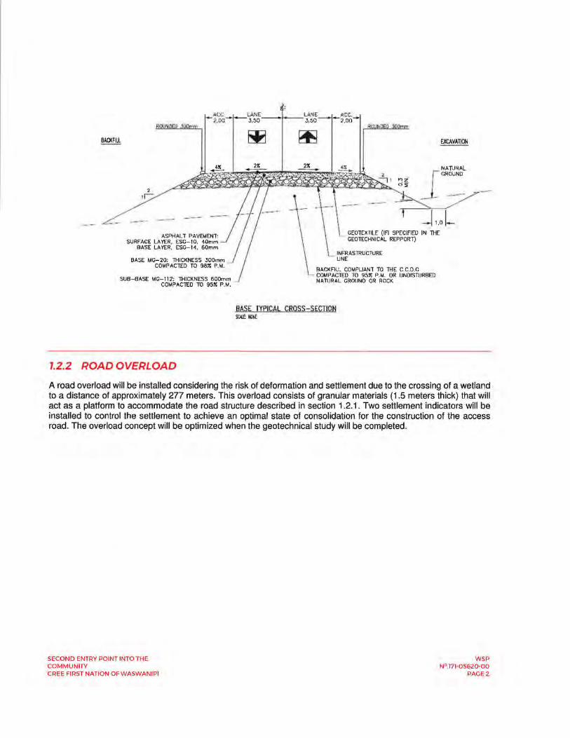
AC!;. LA!'<E LANE ACC. - 2.00- - 3,50- - 3,50 - -2.00-
BACKFILL
2 1r:
ASPHALT PAVEMENT: SURFACE LAYER, ESG-10, 40mm
BASE LAYER, ESG-1~. 60mm
BASE MG-20; THICKNESS 300mm COMPACTED TO 987. P.M.
SUB-BASE MG-112: THICKNESS 600mm COMPACTED TO 957. P.M.
1.2.2 ROAD OVERLOAD
GEOTEXTILE (IFI SPECIFIED IN lHE GEOTECHNICAL REPPORT)
llACKFILL COMPLIANT TO THE C C.D G COMPACTED TO 95% P.M, OR UNDISTURBED NATURAL GROUND OR ROCK
BASE TYPICAL CROSS-SECTION SCIJ..E: NONE
NA WR AL GROUND
A road overload will be installed considering the risk of deformation and settlement due to the crossing of a wetland to a distance of approximately 277 meters. This overload consists of granular materials (1.5 meters thick) that will act as a platform to accommodate the road structure described in section 1.2.1. Two settlement indicators will be installed to control the settlement to achieve an optimal state of consolidation for the construction of the access road. The overload concept will be optimized when the geotechnical study will be completed.
SECOND ENTRY POINT INTO THE COMMUNITY CREE FIRST NATION OF WASWANIPI
WSP N°.171-05620-00
PAGE2

Second entry point into the community Cree First Nation of Waswanipi
APPENDIX F
WSP Preliminary Geotechnical Drilling Report

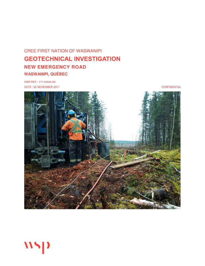
CREE FIRST NATION OF WASWANIPI
GEOTECHNICAL INVESTIGATION NEW EMERGENCY ROAD WASWANIPI, QUÉBEC
WSP REF.: 171-05620-00
DATE : 24 NOVEMBER 2017 CONFIDENTIAL


CREE FIRST NATION OF WASWANIPI
GEOTECHNICAL INVESTIGATION NEW EMERGENCY ROAD WASWANIPI, QUÉBEC
CONFIDENTIAL WSP REF.: 171-05620-00 DATE : 24 NOVEMBER 2017
PRELIMINARY REPORT WSP CANADA INC. FLOOR 16 1600 RENÉ-LÉVESQUE BLVD WEST MONTRÉAL QC H3H 1P9 CANADA TEL.: +1-514-340-0046 FAX: +1-514-340-1337 WSP.COM


CREE FIRST NATION OF WASWANIPI GEOTECHNICAL INVESTIGATION NEW EMERGENCY ROAD
WSPWSP REF.: 171-05620-00
I
QUALITY MANAGEMENT
VERSION DATE DESCRIPTION
1 Preliminary version

Reference to mention:
WSP. 2017. Geotechnical Investigation, New Emergency Road, Waswanipi, Québec. Report produced for Cree First Nation of Waswanipi. WSP Ref.: 171-05620-00. Number of pages and tables, figures, maps and appendices.
CREE FIRST NATION OF WASWANIPI GEOTECHNICAL INVESTIGATION NEW EMERGENCY ROAD
WSPWSP REF.: 171-05620-00
III
SIGNATURES PREPARED BY
Kristina Bondy, Eng., M.Eng. Geotechnical Project Manager
REVIEWED BY
Michel Kuntz, Ph.D. Eng. Geotechnical Project Engineer
This report was prepared by WSP Canada Inc. (WSP) for the account of Cree First Nation of Waswanipi, in accordance with the professional services agreement. The disclosure of any information contained in this report is the sole responsibility of the intended recipient. The material in it reflects WSP’s best judgement in light of the information available to it at the time of preparation. Any use which a third party makes of this report, or any reliance on or decisions to be made based on it, are the responsibility of such third parties. WSP accepts no responsibility for damages, if any, suffered by any third party as a result of decisions made or actions based on this report. This limitations statement is considered part of this report.
The original of the technology-based document sent herewith has been authenticated and will be retained by WSP for a minimum of ten years. Since the file transmitted is now out of WSP’s control and its integrity can no longer be ensured, no guarantee may be given with regards to any modifications made to this document.


PRODUCTION TEAM CREE FIRST NATION OF WASWANIPI
CREE FIRST NATION OF WASWANIPI GEOTECHNICAL INVESTIGATION NEW EMERGENCY ROAD
WSPWSP REF.: 171-05620-00
V
Project Manager Marcel Quessy
WSP CANADA INC. (WSP)
Project Manager Kristina Bondy, Eng., M.Eng.
Site Technician Marc Olivier Leblanc Morin, Jr. Eng.
Surveyor Benoît Collins, Tech.
SUBCONSULTANTS
Drilling Company Forage Giroux

CREE FIRST NATION OF WASWANIPI GEOTECHNICAL INVESTIGATION NEW EMERGENCY ROAD
WSPWSP REF.: 171-05620-00
VII
STATEMENT OF LIABILITY This report was prepared by WSP Canada Inc. (WSP) solely for Cree First Nation of Waswanipi, all other stakeholders are third parties.
Neither WSP nor Cree First Nation of Waswanipi declare, certify or warrant to any third party, either expressly or implicitly:
─ Accuracy, entirety or utility;
─ Intellectual property rights, or other proprietary rights, of any person or party;
─ Merchantability, adaptation for a particular purpose;
─ Any information, product or process disclosed, described or recommended in this report.
WSP and Cree First Nation of Waswanipi disclaim any and all liability whatsoever resulting in any way from the use made by a third party of any information, product or process disclosed, described or recommended in this report. WSP and Cree First Nation of Waswanipi disclaim any liability arising from any third party reliance on any information, statement or recommendation contained in this report. If a third party uses any information, product or process disclosed, described or recommended in this report, or relies on it, they do so at their own risk.

CREE FIRST NATION OF WASWANIPI GEOTECHNICAL INVESTIGATION NEW EMERGENCY ROAD
WSPWSP REF.: 171-05620-00
IX
TABLE OF CONTENTS
1 INTRODUCTION .................................................. 1
1.1 Context ................................................................................. 1
1.2 Geotechnical Objectives ..................................................... 1
1.3 Content of the Report ......................................................... 1
2 SITE AND PROJECT DESCRIPTION ................. 3
3 METHODS OF INVESTIGATION ......................... 5
3.1 Location of Underground Infrastructure ........................... 5
3.2 Drilling Work ........................................................................ 5
3.2.1 Stratigraphic Drilling ........................................................................................ 5
3.2.2 Open Standpipes ............................................................................................. 6
3.3 Sampling Procedures ......................................................... 6
3.3.1 Soil ................................................................................................................... 6
3.3.2 Rock ................................................................................................................. 6
3.4 Surveying ............................................................................. 7
3.5 Management of Borehole Cuttings .................................... 7
3.6 Laboratory Program ............................................................ 7
3.6.1 Geotechnical Laboratory ................................................................................. 7
3.6.2 Environmental Laboratory ............................................................................... 8
3.7 Quality Assurance and Quality Control Program ............ 8
4 SOIL DESCRIPTION ......................................... 11
4.1 Topsoil ................................................................................ 11
4.2 Native Soil .......................................................................... 11
4.3 Rock .................................................................................... 12
5 GROUNDWATER CONDITIONS ....................... 13
6 CHEMICAL ANALYSIS FOR SOIL DISPOSAL ......................................................... 15
7 CONCLUSIONS AND RECOMMENDATIONS ...................................... 17
7.1 Project Description ........................................................... 17
7.2 Road Section Between Station 0+000 and 0+450........... 17
7.2.1 Preparation of Infrastructure and backfilling ................................................ 17
WSP WSP REF.: 171-05620-00 X
CREE FIRST NATION OF WASWANIPIGEOTECHNICAL INVESTIGATION
NEW EMERGENCY ROAD
7.2.2 settlement and stability issues ...................................................................... 18
7.3 road section between Station 0+450 and 0+716 ............. 18
7.3.1 Excavation in Bedrock .................................................................................. 19
7.3.2 Reuse of Blasted Rock Debris...................................................................... 19
7.3.3 Transition Zones ............................................................................................ 19
7.4 Culverts .............................................................................. 19
7.4.1 Preparation of Supporting Soil and Embedment ......................................... 19
7.4.2 Drying and Cofferdam ................................................................................... 20
7.5 Excavation .......................................................................... 21
7.5.1 Unsupported Excavation ............................................................................... 21
7.5.2 Supported Excavation ................................................................................... 22
7.5.3 Groundwater Control ..................................................................................... 23
7.5.4 Transition Slopes ........................................................................................... 23
7.6 Roadway ............................................................................. 23
7.6.1 Roadway Structure ........................................................................................ 23
7.6.2 Data for Design of Roadway Structure ........................................................ 23
7.6.3 Retained Method for Dimensionning ............................................................ 24
7.6.4 Proposed Roadway Structure on Soil .......................................................... 24
7.6.5 Proposed Roadway Structure on Bedrock ................................................... 25
7.6.6 Preparation of Infrastructure (Paved Areas) ................................................ 25
7.6.7 Drainage ........................................................................................................ 26
7.6.8 Connection Joints .......................................................................................... 26
7.7 General Construction Recommendations ...................... 26
7.7.1 Frost Protection ............................................................................................. 26
7.7.2 Sensitivity of Subsoils ................................................................................... 27
7.7.3 Reuse of Excavated Soils ............................................................................. 27
7.7.4 Quality Control ............................................................................................... 27
8 BIBLIOGRAPHY ................................................ 28
TABLES
TABLE 3-1 COORDINATES, ELEVATION, DEPTH AND STATION OF BOREHOLES ................................... 7
TABLE 3-2 NUMBER OF GEOTECHNICAL ANALYSES PERFORMED ......................................................... 8
TABLE 3-3 CHEMICAL ANALYSES ......................................... 8
TABLE 4-1 SUMMARY OF SOIL STRATIGRAPHY – DEPTH (ELEVATION) IN METERS ..................... 11
TABLE 4-2 RESULTS OF GRAIN SIZE AND SEDIMENTATION ANALYSES ON NATIVE DEPOSIT .............................................................. 12
CREE FIRST NATION OF WASWANIPI GEOTECHNICAL INVESTIGATION NEW EMERGENCY ROAD
WSPWSP REF.: 171-05620-00
XI
TABLE 4-3 RESULTS OF ATTERBERG LIMITS AND WATER CONTENTS ON NATIVE DEPOSIT ....... 12
TABLE 5-1 GROUNDWATER DEPTH AND ELEVATION ...... 13
TABLE 6-1 ENVIRONMENTAL SOIL CLASSIFICATION ....... 15
TABLE 7-1 GEOTECHNICAL PARAMETERS FOR LATERAL PRESSURE CALCULATIONS ............ 22
TABLE 7-2 RECOMMENDED ROADWAY STRUCTURE WITHOUT INSULATION ...................................... 24
FIGURES
FIGURE 2-1 FIELDWORK OPERATIONS .................................. 3
APPENDICES
A LIMITATIONS AND GENERAL CONDITIONS OF THE STUDY
B SITE LOCATION PLAN
C BOREHOLE LOGS
D GEOTECHNICAL LABORATORY RESULTS
E CHEMICAL ANALYSIS CERTIFICATES

CREE FIRST NATION OF WASWANIPI GEOTECHNICAL INVESTIGATION NEW EMERGENCY ROAD
WSPWSP REF.: 171-05620-00
1
1 INTRODUCTION
1.1 CONTEXT
As part of a community development project, the Cree First Nation of Waswanipi mandated WSP Canada Inc. (WSP) in September 2017 to carry out a geotechnical investigation with regards to a new emergency road in Waswanipi, Québec.
The investigation was conducted in accordance with the terms of the offer of professional services P17-11038-17 and dated 6 April 2017.
According to the information provided by the client, the project consists of a new section of road on the eastern part of the town allowing for a second entry into the community as well as an emergency road. In addition, the project includes the installation of three (3) culverts. The site location plan in Appendix B shows the location of the new road and the boreholes performed as part of the investigation.
This report describes the work performed, the results of the geotechnical investigation allowing to identify the nature and properties of the existing subsoil as well as the groundwater conditions present on site in order to provide comments and recommendations relative to the construction of the above-mentioned project.
1.2 GEOTECHNICAL OBJECTIVES
The objectives of the geotechnical investigation consist in identifying the nature and characteristics of the subsurface soils as well as the groundwater conditions prevailing on the site in order to provide comments and recommendations regarding the design and construction of the project.
The geotechnical recommendations consist of, without being limited to:
─ Excavations, slopes and temporary supports;
─ Groundwater management;
─ Preparation and installation of culverts;
─ Paving preparation;
─ Roadway structure;
─ All other comments pertinent to the project.
1.3 CONTENT OF THE REPORT
In order to meet the various objectives of the study and as mentioned in the offer of professional services, the work carried out under this mandate consisted of:
─ Drilling five (5) boreholes to a depth of 5 m;
─ Installation of two (2) open standpipes in order to monitor groundwater conditions;
WSP WSP REF.: 171-05620-00 2
CREE FIRST NATION OF WASWANIPIGEOTECHNICAL INVESTIGATION
NEW EMERGENCY ROAD
─ Soil sampling as required by the ministère du Développement durable, de l’Environnement et de la Lutte contre les changements climatiques (MDDELCC);
─ Perform grain size distribution analyses, Atterberg limits and water content analyses on soil samples in the laboratory to characterise the soil conditions;
─ Perform chemical analyses to determine any potential soil contamination;
─ Surveying of boreholes;
─ Issue geotechnical recommendations and comments.
This report presents in the following order: a brief description of the site and project, the methodology and sampling procedures used, the nature and characteristics of the soil and rock, the results of the geotechnical and chemical analyses, the groundwater conditions as well as the geotechnical recommendations that apply to the project.
The report also includes five (5) appendices:
─ Limitations and general conditions of the study (Appendix A)
─ Site location plan (Appendix B);
─ Individual borehole logs (Appendix C);
─ Geotechnical laboratory results (Appendix D);
─ Chemical analysis certificates (Appendix E).
This report is subject to certain limiting conditions that arise from the problem inherent to the phenomena of contamination and to geological, geotechnical and hydrogeological profiles of any site subject to investigation by sampling. It is important to emphasize that these conditions and limitations are an integral part of this report and provides better understanding. The details of these conditions and limitations are provided in Appendix A.
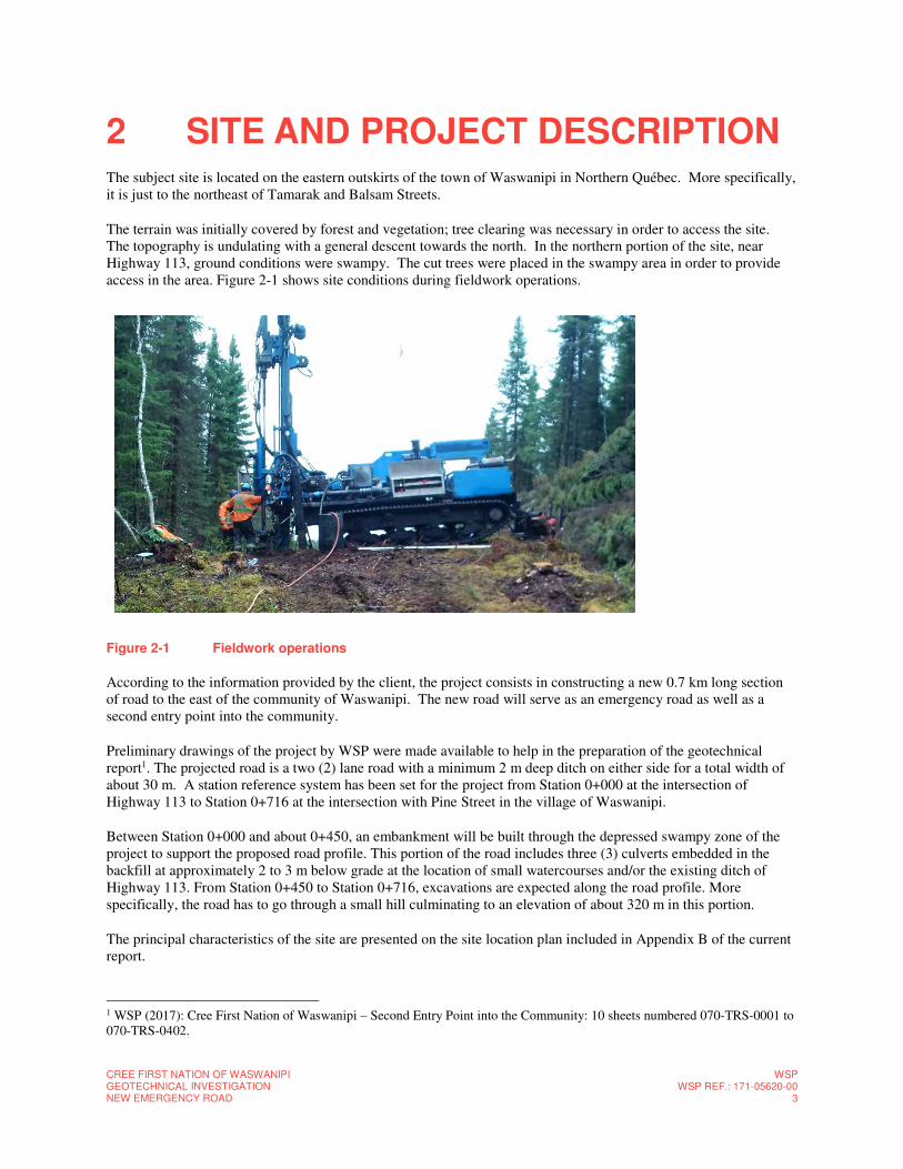
CREE FIRST NATION OF WASWANIPI GEOTECHNICAL INVESTIGATION NEW EMERGENCY ROAD
WSPWSP REF.: 171-05620-00
3
2 SITE AND PROJECT DESCRIPTION The subject site is located on the eastern outskirts of the town of Waswanipi in Northern Québec. More specifically, it is just to the northeast of Tamarak and Balsam Streets.
The terrain was initially covered by forest and vegetation; tree clearing was necessary in order to access the site. The topography is undulating with a general descent towards the north. In the northern portion of the site, near Highway 113, ground conditions were swampy. The cut trees were placed in the swampy area in order to provide access in the area. Figure 2-1 shows site conditions during fieldwork operations.
Figure 2-1 Fieldwork operations
According to the information provided by the client, the project consists in constructing a new 0.7 km long section of road to the east of the community of Waswanipi. The new road will serve as an emergency road as well as a second entry point into the community.
Preliminary drawings of the project by WSP were made available to help in the preparation of the geotechnical report1. The projected road is a two (2) lane road with a minimum 2 m deep ditch on either side for a total width of about 30 m. A station reference system has been set for the project from Station 0+000 at the intersection of Highway 113 to Station 0+716 at the intersection with Pine Street in the village of Waswanipi.
Between Station 0+000 and about 0+450, an embankment will be built through the depressed swampy zone of the project to support the proposed road profile. This portion of the road includes three (3) culverts embedded in the backfill at approximately 2 to 3 m below grade at the location of small watercourses and/or the existing ditch of Highway 113. From Station 0+450 to Station 0+716, excavations are expected along the road profile. More specifically, the road has to go through a small hill culminating to an elevation of about 320 m in this portion.
The principal characteristics of the site are presented on the site location plan included in Appendix B of the current report.
1 WSP (2017): Cree First Nation of Waswanipi – Second Entry Point into the Community: 10 sheets numbered 070-TRS-0001 to 070-TRS-0402.

CREE FIRST NATION OF WASWANIPI GEOTECHNICAL INVESTIGATION NEW EMERGENCY ROAD
WSPWSP REF.: 171-05620-00
5
3 METHODS OF INVESTIGATION This section describes the different activities undertaken for this mandate as well as the methodologies applied. The location of the boreholes were determined by WSP in consultation with Cree First Nation of Waswanipi.
The fieldwork was carried on 26th to 31st October 2017 and consisted of:
─ Location of underground infrastructure via member companies of Info-Excavation;
─ Drilling of five (5) boreholes to a depth of 5 m;
─ Installation of two (2) open standpipes in two (2) of the five (5) boreholes;
─ The selection and analysis of soil samples collected during borehole drilling (geotechnical laboratory testing and chemical analysis)
─ Surveying of boreholes.
The methodologies applied during the field investigation are described in section 3.1 to 3.5 whereas the geotechnical laboratory tests and chemical analyses are presented in section 3.6 and 3.7.
3.1 LOCATION OF UNDERGROUND INFRASTRUCTURE
Prior to the beginning of fieldwork, a request to locate underground infrastructure below the ground surface at the project site was made to member companies of Info-Excavation. Following this request, no companies were contacted due to the absence of underground infrastructure at the project site.
3.2 DRILLING WORK
Borehole drilling was completed simultaneously for geotechnical and environmental soil characterisation. The fieldwork was carried on from 26th to 31st October 2017. Borehole drilling, soil and rock sampling and supervision of the fieldwork was performed by a member of WSP’s technical staff.
3.2.1 STRATIGRAPHIC DRILLING
Site work consisted in drilling five (5) boreholes, identified as 17F01 through 17F05, in order to meet the various objectives of the study. The boreholes reached depths varying between 4.70 m and 5.49 m (elevations of 291.78 m and 285.07 m). The location of the boreholes are presented on the site location plan in Appendix B.
The boreholes were drilled by means of a conventional track mounted drill rig equipped for soil and rock sampling and operated by a driller and his drilling assistant from the company Forage Giroux, who acted as a subcontractor to WSP.
Soil samples were collected at regular intervals during borehole drilling using a standard, B caliber (51 mm diameter), split spoon sampler (SS). During sampling, standard penetration “N” values were measured according to the American Society for Testing and Materials Standard ASTM D1586. This value corresponds to the number of blows required to penetrate the standard split spoon B 300 mm when hit with a hammer weighing 63.5 kg and having a free fall height of 760 mm. This test provides information on the compactness of granular soils.
WSP WSP REF.: 171-05620-00 6
CREE FIRST NATION OF WASWANIPIGEOTECHNICAL INVESTIGATION
NEW EMERGENCY ROAD
Bedrock samples were recovered using an NQ (inside diameter: 48 mm) caliber core barrel.
A complete stratigraphic description, consisting of the nature and composition of the various formations encountered, the nature of debris, if present, as well as all any other pertinent information, was carried out for each borehole. The data collected on site was compiled in the borehole logs presented in Appendix C. Explanatory notes relative to the borehole logs, the description of the stratigraphic units and the methodology for in situ tests are also presented in Appendix C of this report.
All of the recovered geotechnical soil and bedrock samples collected on site were transported to our laboratory where they were logged and visually identified for presentation purposes of this report.
3.2.2 OPEN STANDPIPES
Following soil and rock sampling, an open standpipe consisting of a PVC pipe, whose annular space has been filled with a calibrated sand, was installed in the bottom of boreholes 17F01 and 17F05 in order to obtain a groundwater reading. The open standpipe was isolated at the surface by means of a water tight seal in order to prevent surface water from entering the borehole. The details of the installation are illustrated on the borehole logs provided in Appendix C.
3.3 SAMPLING PROCEDURES
3.3.1 SOIL
During borehole drilling, soil samples were collected at regular intervals using a split spoon having a length of 0.61 m. The cleaning procedures for sampling instruments (split spoons), the transportation and the storage of samples follow the methodologies described in the documents listed in section 8.
Environmental samples were collected in glass jars previously prepared by the laboratory responsible for chemical analyses and kept cool in a cooler until they were sent to the laboratory. The soils destine for VOC analysis were collected in glass vials containing methanol, while samples for other compounds were placed in 250 ml jars and filled to ¾ as much as possible. Some soil samples were taken as duplicates when the residual soil volume permitted it.
The geotechnical samples were placed and sealed in transparent bags for laboratory analysis. The samples were classified according to the ASTM D-2487-00 unified soil classification system standard entitled “Standard Classification of Soils for Engineering Purposes (Unified Soil Classification System)”.
The boreholes samples will be stored for a period of six (6) months, after which they will be discarded, unless otherwise requested by the Client.
3.3.2 ROCK
Bedrock was sampled using an NQ (inside diameter: 48 mm) calibre core barrel for boreholes 17F02 and 17F03 until a depth of 4.83 m and 4.70 m (elevation of 315.34 m and 291.78 m) respectively. The recovery rate as well as the RQD (rock quality index) were measured. The RQD provides information on the quality of the rock in situ.
Rock core samples were kept and stored in wood boxes.
CREE FIRST NATION OF WASWANIPI GEOTECHNICAL INVESTIGATION NEW EMERGENCY ROAD
WSPWSP REF.: 171-05620-00
7
3.4 SURVEYING
The coordinates, elevation and borehole depths are indicated in Table 3-1 below. The elevation and coordinates of the boreholes were taken by a WSP surveyor using a GPS Trimble R8 apparatus, which has an accuracy to the millimeter, and according to the MTM NAD83 system. The borehole survey was carried out on 10 November 2017.
Table 3-1 Coordinates, Elevation, Depth and Station of Boreholes
Borehole No. Nord
(m)
Est
(m)
Geodetic Elevation
(m)
Depth attained*
(m)
Station**
17F01 5507454.711 344143.864 311.66 4.88 0+710
17F02 5507560.545 344071.749 320.17 4.83 0+580
17F03 5507729.076 343942.068 296.48 4.70 0+370
17F04 5507819.908 343844.236 292.78 4.88 0+200
17F05 5507910.336 343736.595 290.56 5.49 0+060
*Depth with respect to the ground surface. **Approximate value
Borehole stations were inferred from the preliminary plan view & profile drawings 070-TRS-0201 and 070-TRS-0202 of the project which was provided by WSP’s design group.
3.5 MANAGEMENT OF BOREHOLE CUTTINGS
Borehole cutting showing no signs of contamination were used to fill the cavities left by the drilling of boreholes.
3.6 LABORATORY PROGRAM
3.6.1 GEOTECHNICAL LABORATORY
All of the soil samples were visually inspected by a member of WSP technical and sent to WSP’s internal laboratory located in Lachine, Quebec.
Geotechnical laboratory testing was conducted on representative samples of the subsoil and bedrock. The purpose of these laboratory tests was to determine the geotechnical engineering properties of the subsurface soil and rock for use in analysis. Table 3-2 shows the number of samples selected based on the analysis performed.
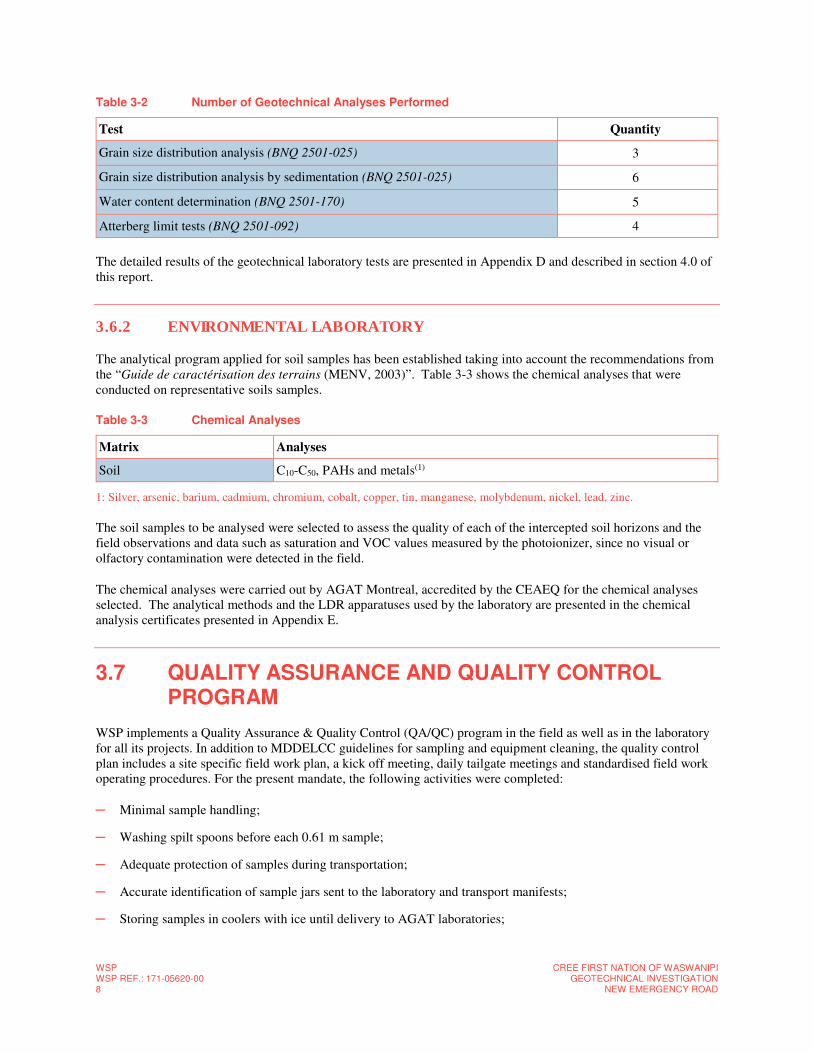
WSP WSP REF.: 171-05620-00 8
CREE FIRST NATION OF WASWANIPIGEOTECHNICAL INVESTIGATION
NEW EMERGENCY ROAD
Table 3-2 Number of Geotechnical Analyses Performed
Test Quantity
Grain size distribution analysis (BNQ 2501-025) 3
Grain size distribution analysis by sedimentation (BNQ 2501-025) 6
Water content determination (BNQ 2501-170) 5
Atterberg limit tests (BNQ 2501-092) 4
The detailed results of the geotechnical laboratory tests are presented in Appendix D and described in section 4.0 of this report.
3.6.2 ENVIRONMENTAL LABORATORY
The analytical program applied for soil samples has been established taking into account the recommendations from the “Guide de caractérisation des terrains (MENV, 2003)”. Table 3-3 shows the chemical analyses that were conducted on representative soils samples.
Table 3-3 Chemical Analyses
Matrix Analyses
Soil C10-C50, PAHs and metals(1)
1: Silver, arsenic, barium, cadmium, chromium, cobalt, copper, tin, manganese, molybdenum, nickel, lead, zinc.
The soil samples to be analysed were selected to assess the quality of each of the intercepted soil horizons and the field observations and data such as saturation and VOC values measured by the photoionizer, since no visual or olfactory contamination were detected in the field.
The chemical analyses were carried out by AGAT Montreal, accredited by the CEAEQ for the chemical analyses selected. The analytical methods and the LDR apparatuses used by the laboratory are presented in the chemical analysis certificates presented in Appendix E.
3.7 QUALITY ASSURANCE AND QUALITY CONTROL PROGRAM
WSP implements a Quality Assurance & Quality Control (QA/QC) program in the field as well as in the laboratory for all its projects. In addition to MDDELCC guidelines for sampling and equipment cleaning, the quality control plan includes a site specific field work plan, a kick off meeting, daily tailgate meetings and standardised field work operating procedures. For the present mandate, the following activities were completed:
─ Minimal sample handling;
─ Washing spilt spoons before each 0.61 m sample;
─ Adequate protection of samples during transportation;
─ Accurate identification of sample jars sent to the laboratory and transport manifests;
─ Storing samples in coolers with ice until delivery to AGAT laboratories;

CREE FIRST NATION OF WASWANIPI GEOTECHNICAL INVESTIGATION NEW EMERGENCY ROAD
WSPWSP REF.: 171-05620-00
9
─ Analysis of one field duplicate sample for every 10 field samples analyzed (or 10%). These samples are assessed for quality based on a relative percent difference (RPD) comparison calculation.
In addition, the results of the QA/QC program implemented by AGAT (blanks, duplicate percent recovery of spiked samples, reference materials, etc.) are presented in the analytical certificates of analysis provided in Appendix E.

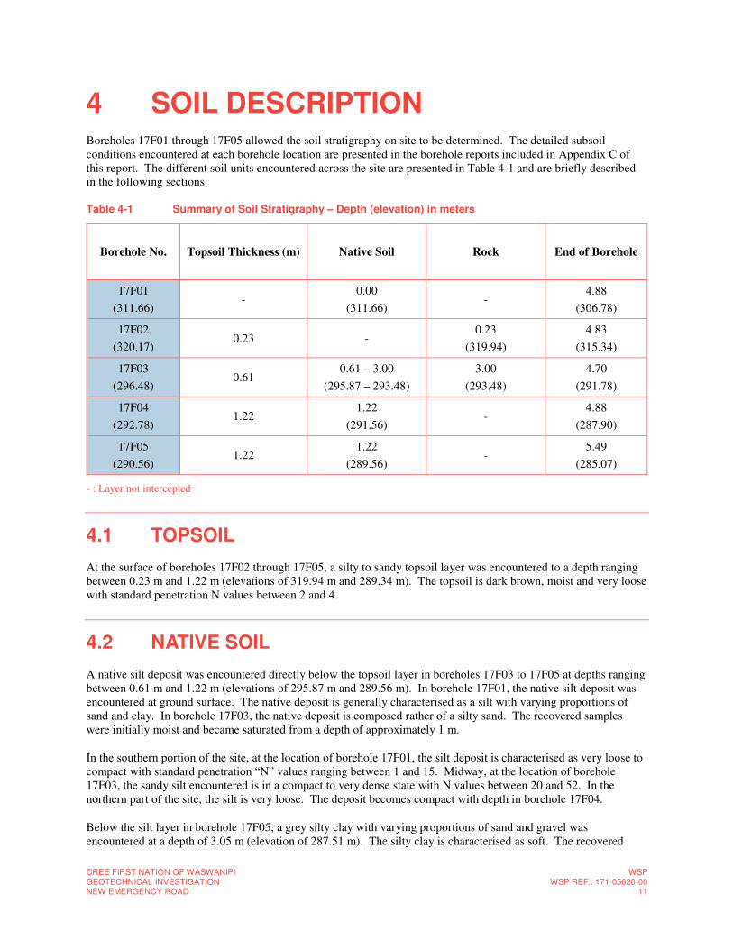
CREE FIRST NATION OF WASWANIPI GEOTECHNICAL INVESTIGATION NEW EMERGENCY ROAD
WSPWSP REF.: 171-05620-00
11
4 SOIL DESCRIPTION Boreholes 17F01 through 17F05 allowed the soil stratigraphy on site to be determined. The detailed subsoil conditions encountered at each borehole location are presented in the borehole reports included in Appendix C of this report. The different soil units encountered across the site are presented in Table 4-1 and are briefly described in the following sections.
Table 4-1 Summary of Soil Stratigraphy – Depth (elevation) in meters
Borehole No. Topsoil Thickness (m) Native Soil Rock End of Borehole
17F01
(311.66) -
0.00
(311.66) -
4.88
(306.78)
17F02
(320.17) 0.23 -
0.23
(319.94)
4.83
(315.34)
17F03
(296.48) 0.61
0.61 – 3.00
(295.87 – 293.48)
3.00
(293.48)
4.70
(291.78)
17F04
(292.78) 1.22
1.22
(291.56) -
4.88
(287.90)
17F05
(290.56) 1.22
1.22
(289.56) -
5.49
(285.07)
- : Layer not intercepted
4.1 TOPSOIL
At the surface of boreholes 17F02 through 17F05, a silty to sandy topsoil layer was encountered to a depth ranging between 0.23 m and 1.22 m (elevations of 319.94 m and 289.34 m). The topsoil is dark brown, moist and very loose with standard penetration N values between 2 and 4.
4.2 NATIVE SOIL
A native silt deposit was encountered directly below the topsoil layer in boreholes 17F03 to 17F05 at depths ranging between 0.61 m and 1.22 m (elevations of 295.87 m and 289.56 m). In borehole 17F01, the native silt deposit was encountered at ground surface. The native deposit is generally characterised as a silt with varying proportions of sand and clay. In borehole 17F03, the native deposit is composed rather of a silty sand. The recovered samples were initially moist and became saturated from a depth of approximately 1 m.
In the southern portion of the site, at the location of borehole 17F01, the silt deposit is characterised as very loose to compact with standard penetration “N” values ranging between 1 and 15. Midway, at the location of borehole 17F03, the sandy silt encountered is in a compact to very dense state with N values between 20 and 52. In the northern part of the site, the silt is very loose. The deposit becomes compact with depth in borehole 17F04.
Below the silt layer in borehole 17F05, a grey silty clay with varying proportions of sand and gravel was encountered at a depth of 3.05 m (elevation of 287.51 m). The silty clay is characterised as soft. The recovered
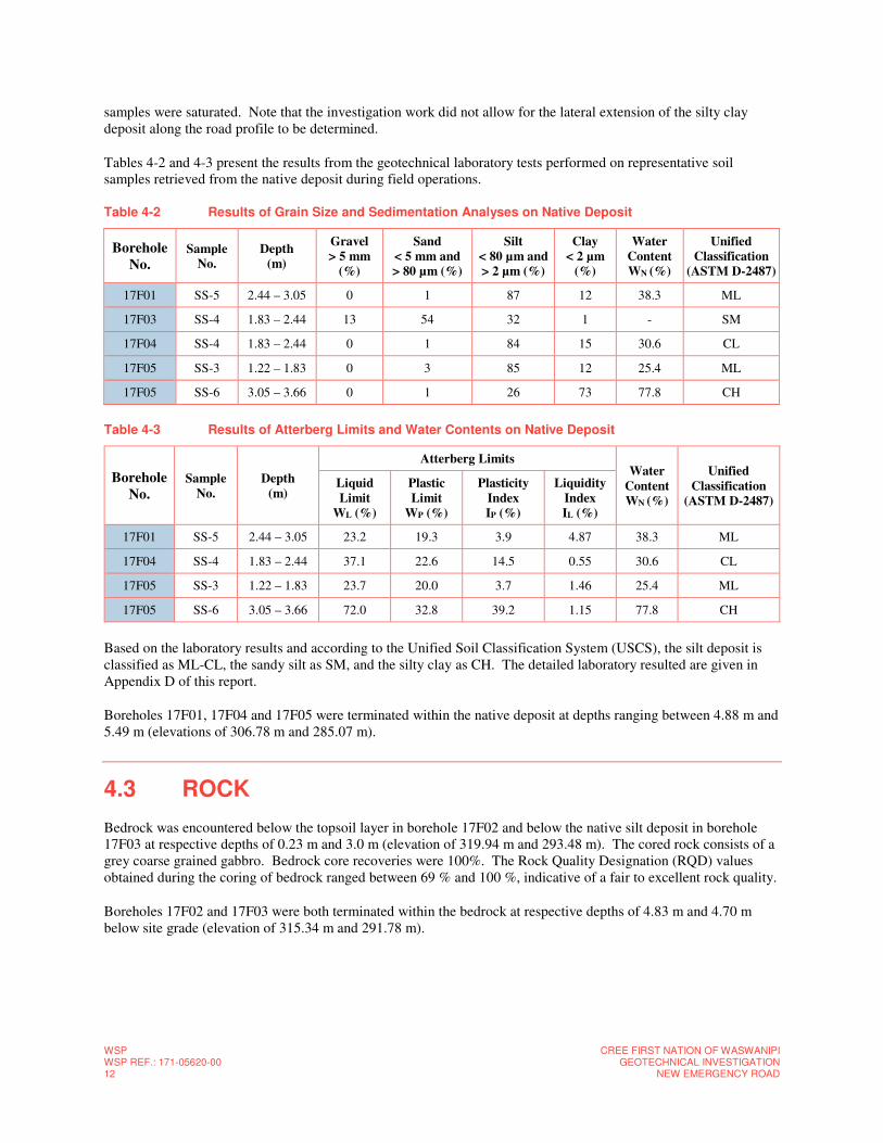
WSP WSP REF.: 171-05620-00 12
CREE FIRST NATION OF WASWANIPIGEOTECHNICAL INVESTIGATION
NEW EMERGENCY ROAD
samples were saturated. Note that the investigation work did not allow for the lateral extension of the silty clay deposit along the road profile to be determined.
Tables 4-2 and 4-3 present the results from the geotechnical laboratory tests performed on representative soil samples retrieved from the native deposit during field operations.
Table 4-2 Results of Grain Size and Sedimentation Analyses on Native Deposit
Borehole
No. Sample
No.
Depth
(m)
Gravel
> 5 mm
(%)
Sand
< 5 mm and
> 80 µm (%)
Silt
< 80 µm and
> 2 µm (%)
Clay
< 2 µm
(%)
Water
Content
WN (%)
Unified
Classification
(ASTM D-2487)
17F01 SS-5 2.44 – 3.05 0 1 87 12 38.3 ML
17F03 SS-4 1.83 – 2.44 13 54 32 1 - SM
17F04 SS-4 1.83 – 2.44 0 1 84 15 30.6 CL
17F05 SS-3 1.22 – 1.83 0 3 85 12 25.4 ML
17F05 SS-6 3.05 – 3.66 0 1 26 73 77.8 CH
Table 4-3 Results of Atterberg Limits and Water Contents on Native Deposit
Borehole
No.
Sample
No.
Depth
(m)
Atterberg Limits Water
Content
WN (%)
Unified
Classification
(ASTM D-2487)
Liquid
Limit
WL (%)
Plastic
Limit
WP (%)
Plasticity
Index
IP (%)
Liquidity
Index
IL (%)
17F01 SS-5 2.44 – 3.05 23.2 19.3 3.9 4.87 38.3 ML
17F04 SS-4 1.83 – 2.44 37.1 22.6 14.5 0.55 30.6 CL
17F05 SS-3 1.22 – 1.83 23.7 20.0 3.7 1.46 25.4 ML
17F05 SS-6 3.05 – 3.66 72.0 32.8 39.2 1.15 77.8 CH
Based on the laboratory results and according to the Unified Soil Classification System (USCS), the silt deposit is classified as ML-CL, the sandy silt as SM, and the silty clay as CH. The detailed laboratory resulted are given in Appendix D of this report.
Boreholes 17F01, 17F04 and 17F05 were terminated within the native deposit at depths ranging between 4.88 m and 5.49 m (elevations of 306.78 m and 285.07 m).
4.3 ROCK
Bedrock was encountered below the topsoil layer in borehole 17F02 and below the native silt deposit in borehole 17F03 at respective depths of 0.23 m and 3.0 m (elevation of 319.94 m and 293.48 m). The cored rock consists of a grey coarse grained gabbro. Bedrock core recoveries were 100%. The Rock Quality Designation (RQD) values obtained during the coring of bedrock ranged between 69 % and 100 %, indicative of a fair to excellent rock quality.
Boreholes 17F02 and 17F03 were both terminated within the bedrock at respective depths of 4.83 m and 4.70 m below site grade (elevation of 315.34 m and 291.78 m).
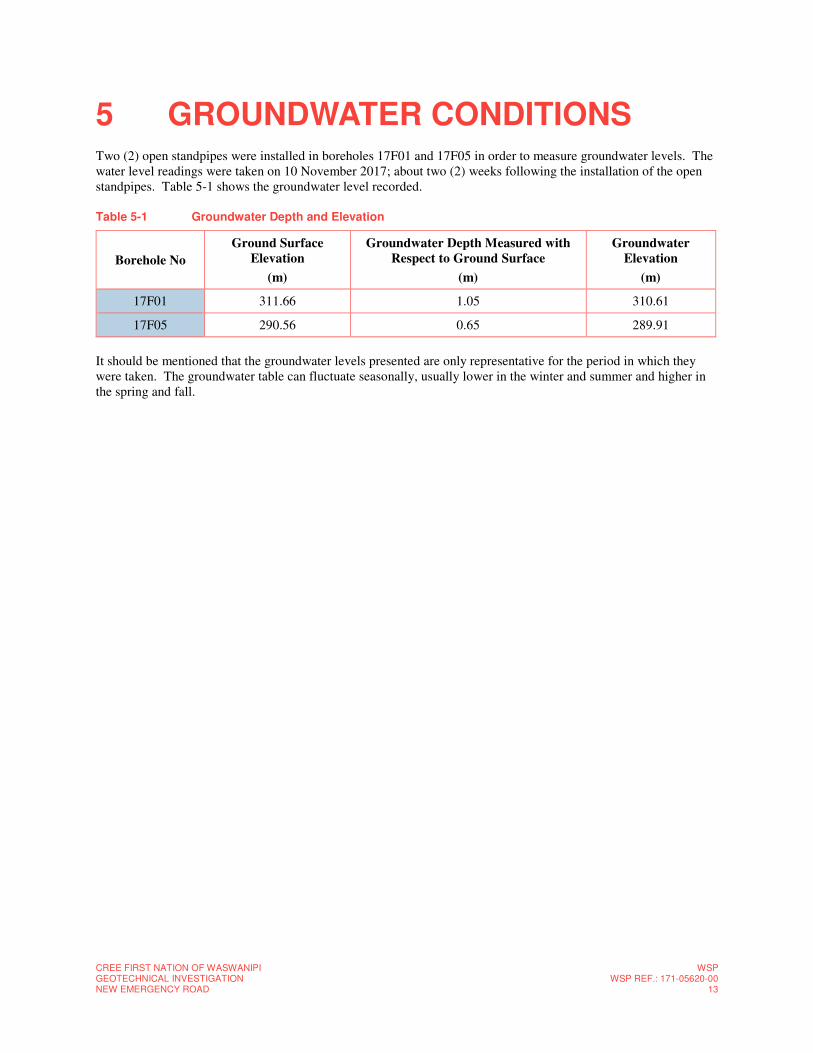
CREE FIRST NATION OF WASWANIPI GEOTECHNICAL INVESTIGATION NEW EMERGENCY ROAD
WSPWSP REF.: 171-05620-00
13
5 GROUNDWATER CONDITIONS Two (2) open standpipes were installed in boreholes 17F01 and 17F05 in order to measure groundwater levels. The water level readings were taken on 10 November 2017; about two (2) weeks following the installation of the open standpipes. Table 5-1 shows the groundwater level recorded.
Table 5-1 Groundwater Depth and Elevation
It should be mentioned that the groundwater levels presented are only representative for the period in which they were taken. The groundwater table can fluctuate seasonally, usually lower in the winter and summer and higher in the spring and fall.
Borehole No
Ground Surface
Elevation
(m)
Groundwater Depth Measured with
Respect to Ground Surface
(m)
Groundwater
Elevation
(m)
17F01 311.66 1.05 310.61
17F05 290.56 0.65 289.91

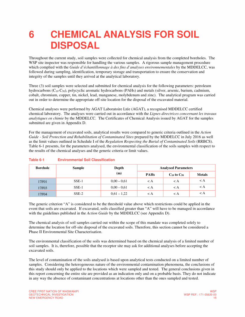
CREE FIRST NATION OF WASWANIPI GEOTECHNICAL INVESTIGATION NEW EMERGENCY ROAD
WSPWSP REF.: 171-05620-00
15
6 CHEMICAL ANALYSIS FOR SOIL DISPOSAL
Throughout the current study, soil samples were collected for chemical analysis from the completed boreholes. The WSP site inspector was responsible for handling the various samples. A rigorous sample management procedure which complied with the Guide d’échantillonnage à des fins d’analyses environnementales by the MDDELCC, was followed during sampling, identification, temporary storage and transportation to ensure the conservation and integrity of the samples until they arrived at the analytical laboratory.
Three (3) soil samples were selected and submitted for chemical analysis for the following parameters: petroleum hydrocarbons (C10-C50), polycyclic aromatic hydrocarbons (PAHs) and metals (silver, arsenic, barium, cadmium, cobalt, chromium, copper, tin, nickel, lead, manganese, molybdenum and zinc). The analytical program was carried out in order to determine the appropriate off-site location for the disposal of the excavated material.
Chemical analyses were performed by AGAT Laboratoire Ltée (AGAT), a recognised MDDELCC certified chemical laboratory. The analyses were carried out in accordance with the Lignes directrices concernant les travaux
analytiques en chimie by the MDDELCC. The Certificates of Chemical Analysis issued by AGAT for the samples submitted are given in Appendix D.
For the management of excavated soils, analytical results were compared to generic criteria outlined in the Action
Guide - Soil Protection and Rehabilitation of Contaminated Sites prepared by the MDDELCC in July 2016 as well as the limit values outlined in Schedule I of the Regulation Respecting the Burial of Contaminated Soils (RRBCS). Table 6-1 presents, for the parameters analysed, the environmental classification of the soils samples with respect to the results of the chemical analyses and the generic criteria or limit values.
Table 6-1 Environmental Soil Classification
Borehole Sample Depth
(m)
Analysed Parameters
PAHs C10 to C50 Metals
17F01 SSE-1 0,00 – 0,61 < A < A < A
17F03 SSE-1 0,00 – 0,61 < A < A < A
17F04 SSE-2 0,61 – 1,22 < A < A < A
The generic criterion “A” is considered to be the threshold value above which restrictions could be applied in the event that soils are excavated. If excavated, soils classified greater than “A” will have to be managed in accordance with the guidelines published in the Action Guide by the MDDELCC (see Appendix D).
The chemical analysis of soil samples carried out within the scope of this mandate was completed solely to determine the location for off-site disposal of the excavated soils. Therefore, this section cannot be considered a Phase II Environmental Site Characterisation.
The environmental classification of the soils was determined based on the chemical analysis of a limited number of soil samples. It is, therefore, possible that the receptor site may ask for additional analyses before accepting the excavated soils.
The level of contamination of the soils analysed is based upon analytical tests conducted on a limited number of samples. Considering the heterogeneous nature of the environmental contamination phenomena, the conclusions of this study should only be applied to the locations which were sampled and tested. The general conclusions given in this report concerning the entire site are provided as an indication only and on a probable basis. They do not indicate in any way the absence of contaminant concentrations at locations other than the ones sampled and tested.

WSP WSP REF.: 171-05620-00 16
CREE FIRST NATION OF WASWANIPIGEOTECHNICAL INVESTIGATION
NEW EMERGENCY ROAD
The environmental interpretation of the chemical analysis results presented in this report refer to the environmental guidelines in effect at the time the report was produced. The levels of contamination presented in this report are considered to be valid only at the time sampling took place, since these levels can be modified subsequently by human activities on the investigated site or on adjacent properties.
CREE FIRST NATION OF WASWANIPI GEOTECHNICAL INVESTIGATION NEW EMERGENCY ROAD
WSPWSP REF.: 171-05620-00
17
7 CONCLUSIONS AND RECOMMENDATIONS
7.1 PROJECT DESCRIPTION
According to the information provided by the Client, the project involves the construction of a new road to the east of the community of Waswanipi. The new road will serve as a second entry point into the community as well as an emergency road.
For this project, three (3) underground culverts, consisting in a high density polyethylene (HDPE) pipe are also planned. With regards to the new roadway structure, no traffic data has been provided. However, it has been assumed as new local road. It is also understood that the asphalt layer of the new road will only be applied in 2020 to allow for two (2) freeze/thaw cycles and any settlement to occur.
Based on the afore-mentioned information, the geotechnical findings at the boreholes locations as well as the results of the laboratory tests and assuming they are representative of the subsoil conditions across the entire site, the following geotechnical recommendations and comments are provided. In the following sections the given station values are approximate and used to indicate the location of the main features.
The conditions encountered between the boreholes or elsewhere on the site may differ from those observed at the location of the boreholes. Therefore, it is recommended that excavations be inspected by a geotechnical engineer in order to ensure the representativeness of the boreholes and, if necessary, detect any unobservable particularities during reconnaissance work that could affect the conclusions and recommendations given in this report.
Moreover, any changes in the location, nature or design of the project should be communicated in order to assess their impact and, if necessary, modify the recommendations provided in this report.
7.2 ROAD SECTION BETWEEN STATION 0+000 AND 0+450
According to the preliminary design, an embankment will be built starting from the existing Highway 113 (Station 0+000) and ending southward at about Station 0+450 to support the new road in the swampy sector of the project. The proposed height of the embankment varies from about 2 m to more than 4 m along most of the road profile depending on the current ground surface elevation to abruptly reduce and become eventually zero at Station 0+450.
7.2.1 PREPARATION OF INFRASTRUCTURE AND BACKFILLING
Prior to the installation of the embankment, the underlying infrastructure shall be prepared as follows:
─ Remove all topsoil, organic materials or non-compactable soils as well as any unsuitable soils until the required elevations;
─ Inspect the bottom of the excavation for any soft or remoulded areas and ensure that the soils are stable and undisturbed. Excavate all soft or unstable or unsuitable soil and backfill with a well graded granular material compacted to 90 % of the maximum dry density as determined with the modified effort compaction test (2700 kJ/m3);
WSP WSP REF.: 171-05620-00 18
CREE FIRST NATION OF WASWANIPIGEOTECHNICAL INVESTIGATION
NEW EMERGENCY ROAD
─ Compact the exposed surface (bottom of the excavation at the planned level) to 90 % the maximum dry density in order to obtain a rigid infrastructure, without excessive zones of deflection.
─ Soft, unstable or unsuitable soils encountered during compaction shall be excavated and replaced with a compactable, well graded material;
─ Considering both the sensitivity of the native soil and the high water level, special attention should be paid to avoid disturbing/remoulding the soil at the bottom of the excavation. Compaction of the exposed surface as specified above may be difficult to achieve and the use of a 75 mm thick layer of lean concrete could constitute as a solution to protect the bottom of the excavation. Alternatively, a minimum 300 mm thick layer of MG-20 compacted to 95 % the maximum dry density as determined with the modified effort compaction test can be used to protect the bottom of the excavation.
Once all unsuitable soils have been removed, the embankment can constructed by using a suitable, well graded granular fill, such as an MG-112, MG-20 or acceptable Class B meeting the requirements of the Standard BNQ 2560-114. The fine content (< 80 microns) of the backfill material should be less than 10% in order to be non-frost-susceptible and to limit any frost heave issues. The granular fill shall be placed in thin layers not exceeding 300 mm in thickness and uniformly compacted to at least 95% of the maximum dry density as determined with the modified effort compaction test.
The native subsoil will be extremely sensitive to disturbance by water and mechanical equipment. Earth moving operations will have to be carried out properly to avoid excessive remoulding of the subsoils and to minimise the necessity of over-excavation. Prepared subgrade surfaces should be inspected and approved by experienced geotechnical personnel.
7.2.2 SETTLEMENT AND STABILITY ISSUES
Due to the presence of about a 2.5 m thick soft silty clay layer in the sector of the borehole 17F05, consolidation settlement is expected beneath the 2 to 3 m high road embankment. Additional boreholes would be needed to evaluate both the settlement amplitude and the consolidation rate as well as the extent of the clay layer along the road profile. This sector should be backfilled as early as possible in the construction schedule to give enough time to the compressible deposit to consolidate.
In addition to this zone, the embankment will lie on loose silty soils. Any settlement associated with this layer should occur during the time of construction. However, due to the nature of these soils, it is advisable to monitor the loading process in order to prevent the subsoils being loaded too quickly and risking failure.
Furthermore, it is advised to carry out a stability analysis on the proposed embankment in order to evaluate the appropriate slopes as well as the stability of the underlying subsoils seeing as they could be loaded with as much as 4 m of backfill. Further in situ investigation is strongly recommended to better evaluate the bearing capacity of the existing subsoils.
7.3 ROAD SECTION BETWEEN STATION 0+450 AND 0+716
This section of the project cuts through a small hill. Since the rock profile is unknown, the north and south limit of the rock excavation cannot be precisely defined at this time. At both ends of the rock excavation, transition zones are expected where the road structure will be excavated within the native soils.
CREE FIRST NATION OF WASWANIPI GEOTECHNICAL INVESTIGATION NEW EMERGENCY ROAD
WSPWSP REF.: 171-05620-00
19
7.3.1 EXCAVATION IN BEDROCK
Most of the section implies excavation in sound bedrock consisting of gabbro with RQD between 75 and 100%. A comparison between the projected road profile and the existing topography indicates that the required excavation may be as high as 10 m. The ditches on either side of the road also requires an additional 2 m deep excavation.
Bedrock can be excavated with a mechanical shovel at the surface and more probably by blasting as the excavation proceeds. Slopes of 1.0 H: 10 V are recommended in sound rock: however some changes may be required depending on the actual conditions in the field to reach stable slopes. Additional boreholes may be required to a depth of the projected road profile to better evaluate the rock properties (joints, fractures, weathering, etc.) which help to optimize the blasting operations.
7.3.2 REUSE OF BLASTED ROCK DEBRIS
Blasted rock may be reused to build the embankment as long as the waste rock calibre complies with the requirements for backfill. Given the expected volume of basted rock, crushing and sieving to obtain an engineered granular material may be a suitable option.
7.3.3 TRANSITION ZONES
Excavations in the native soil to the north and south of the excavated rock, will be required to install the proposed road structure. Section 7.5.4 provides details on the transitions required from soil to rock.
7.4 CULVERTS
The project includes the installation of three (3) underground culverts at Stations 0+025, 0+050 and 0+295 (approximate stations). It is expected that the culverts will consist in a high density polyethylene (HDPE) pipes. Based on the preliminary design drawings, the elevation at which the culverts will be installed is that of the current soil profile. Therefore, each structure will be fully embedded within the road embankment at about 2.5 m below the top of the projected road surface.
For the preparation and installation of the HDPE, it is recommended to follow the guidelines given in the MTMDET’s standard drawing III-4-007A. The designer will determine, if necessary, if the installation of the culverts shall equally respect the “Cahier des Charges et Devis Généraux” prescribed by the Town of Waswanipi.
7.4.1 PREPARATION OF SUPPORTING SOIL AND EMBEDMENT
Prior to the installation of the culverts, it is recommended to prepare the supporting soil as follows, once the excavation has reached the expected depth:
─ Remove all topsoil, organic materials or non-compactable soils as well as any unsuitable soils until the required elevations;
─ Inspect the bottom of the excavation for any soft or remoulded areas and ensure that the soils are stable and undisturbed. Excavate all soft or unstable or unsuitable soil and backfill with a well graded granular material compacted to 90 % of the maximum dry density as determined with the modified effort compaction test (2700 kJ/m3);
WSP WSP REF.: 171-05620-00 20
CREE FIRST NATION OF WASWANIPIGEOTECHNICAL INVESTIGATION
NEW EMERGENCY ROAD
─ Compact the exposed surface (bottom of the excavation at the planned level) to 90 % the maximum dry density in order to obtain a rigid infrastructure, without excessive zones of deflection;
─ Soft, unstable or unsuitable soils encountered during compaction shall be excavated and replaced with a compactable, well graded material;
─ Considering the sensitivity of the native soil, special attention should be paid to avoid disturbing/remoulding the soil at the bottom of the excavation. The use of a 75 mm thick layer of lean concrete could constitute as a solution to protect the bottom of the excavation. Alternatively, a minimum 300 mm thick layer of MG-20 compacted to 95 % the maximum dry density as determined with the modified effort compaction test can be used to protect the bottom of the excavation.
Below all of the pipes, at the bottom of the excavation, it is recommended to place a layer of crushed stone consisting of MG 20 (in accordance with the BNQ 2560-114 standard) or equivalent and having a minimum thickness of 300 mm. The crushed stone shall be placed in maximum layers of 150 mm thick and compacted to 95 % of the maximum dry density as determined with the modified effort compaction test (BNQ 2501-255). The granular layer shall exceed the width of the pipe by 1000 mm and should be constructed with maximum exterior slopes of 2.0V:1H.
In order to avoid deformations at the infrastructure level, it is recommended to improve the rigidity of the soils using a biaxial geogrid placed within the crushed stone layer below the HDPE pipe. A BX1100 geogrid from Texel or an equivalent geogrid can be used effectively to reduce occasional deformations resulting from the consolidation of the underlying materials. The final thickness of the crushed stone layer will be determined by the amount of infrastructure material that can be economically excavated, in addition to the granular material required for the installation of the HDPE pipe. Nonetheless, it is recommended to place the geogrid on a granular layer, consisting of MG 56, of at least 200 mm thick. A minimum 150 mm thick granular layer consisting of MG 20 shall be placed above the geogrid to avoid damaging it from the circulation of construction equipment.
Covering of the pipes shall be completed in layers with a maximum thickness of 150 mm and compacted to at least 90 % of the modified effort compaction test (NQ 2501-255). The granular materials used to cover the pipes should be similar to those used to prepare the supporting soils below the pipes and they should be placed up to about half of the height of the pipe. Subsequently, the granular material should be placed in maximum layers of 300 mm thick and compacted to at least 90 % of the modified effort compaction test up to a height of 300 mm above the crest of the pipe.
Backfilling of the excavations shall be conducted in thin layers with a maximum thickness of 300 mm and compacted to 90 % the maximum dry density as determined with the modified effort compaction test up to the infrastructure level.
Compaction equipment must never come in contact with the pipe at any time. Furthermore, for the first meter above the pipe as well as over the entire length of the excavation, only the use of light compaction equipment, not exceeding a total applied force of 5,000 kg, is permitted.
Due to groundwater conditions, we do not recommend the installation of insulation around the pipes. It is assumed that the insulation will tend to rise due to the high-water level.
7.4.2 DRYING AND COFFERDAM
The installation of the culverts may eventually involve excavation below the groundwater level. In such case, a cofferdam may be required, combined with or without a temporary retaining system and drying of the enclosure. The type of retaining system must take into account that construction will be carried out below the groundwater level and that pumping of the groundwater will be necessary.
CREE FIRST NATION OF WASWANIPI GEOTECHNICAL INVESTIGATION NEW EMERGENCY ROAD
WSPWSP REF.: 171-05620-00
21
As in the case of the temporary excavations (see section 7.5), water infiltration rates may vary, even considerably, depending on the soil conditions encountered, the groundwater conditions as well as the depth and water tightness of the cofferdam or temporary retaining system used.
The use of an unsealed temporary retaining system such as soldier piles and wood lagging walls seems more or less appropriate. It would require pumping to begin prior to excavation works to lower the groundwater level by at least 600 mm below the bottom of the excavation. Given the rectangular shape of the excavation, pumps will be required along the length of the excavation with a given spacing and sufficient capacity to lower the water level over the entire excavation.
The use of an unsealed temporary retaining system also presents risks of internal erosion of the surrounding soil caused by seepage and as a result, settlement could occur below the roadway structure and other structures in the soil nearby. Special attention should be paid to this potential problem and appropriate measures in the form of geotextile or granular filters should be provided if needed.
The use of a water tight retaining system such as sheet piles appears to be a more practical solution. The screen of sheet piles below the bottom of the excavation must be sufficient to ensure the stability of the bottom of the excavation and prevent the formation of pipping.
Alternatively, the stream can be diverted according to industry standards. The chosen method remains the responsibility of the contractor.
Temporary retaining systems and pumping of the excavation shall be entrusted to contractors of recognised competence in these fields. The methods of execution and the construction of such work is important to ensure the quality of the work and behaviour of the soil. An appropriate quality control program should be applied during construction.
The geotechnical parameters recommended in Table 7-1 for lateral pressure calculations can be applied for the retaining system.
Depending on the work schedule, excavation below the water table may also be carried out during the winter time to take advantage of the frozen soils to excavate the loose native soils without support and replace them with appropriate granular materials that will form the granular foundation of the culvert.
7.5 EXCAVATION
Based on the stratigraphy of the site and our comprehension of the project, some excavations may be required through the native silt deposit for both the culverts and the transition zones
7.5.1 UNSUPPORTED EXCAVATION
Open pit excavations can be performed for this project. In order to provide stability, it is recommended that the walls of the excavations be sloped; a slope of 2.0-2.5H:1V in the native deposit should provide adequate short-term stability as long as the soils are drained according to the recommendations given in section 7.2.
Excavations must be carried out according to the Provincial safety code for construction work “Loi sur la santé et
sécurité du travail” as defined by the Commission des normes, de l’équité, de la santé et de la sécurité au travail (CNESST).
Temporary, unsupported excavation slopes remain the responsibility of the contractor at all times and should be adjusted depending on true subsoil conditions encountered at the time of construction (soil density, presence of water, debris, evidence of local instability, etc.). Flatter slopes than those mentioned above may be required locally.
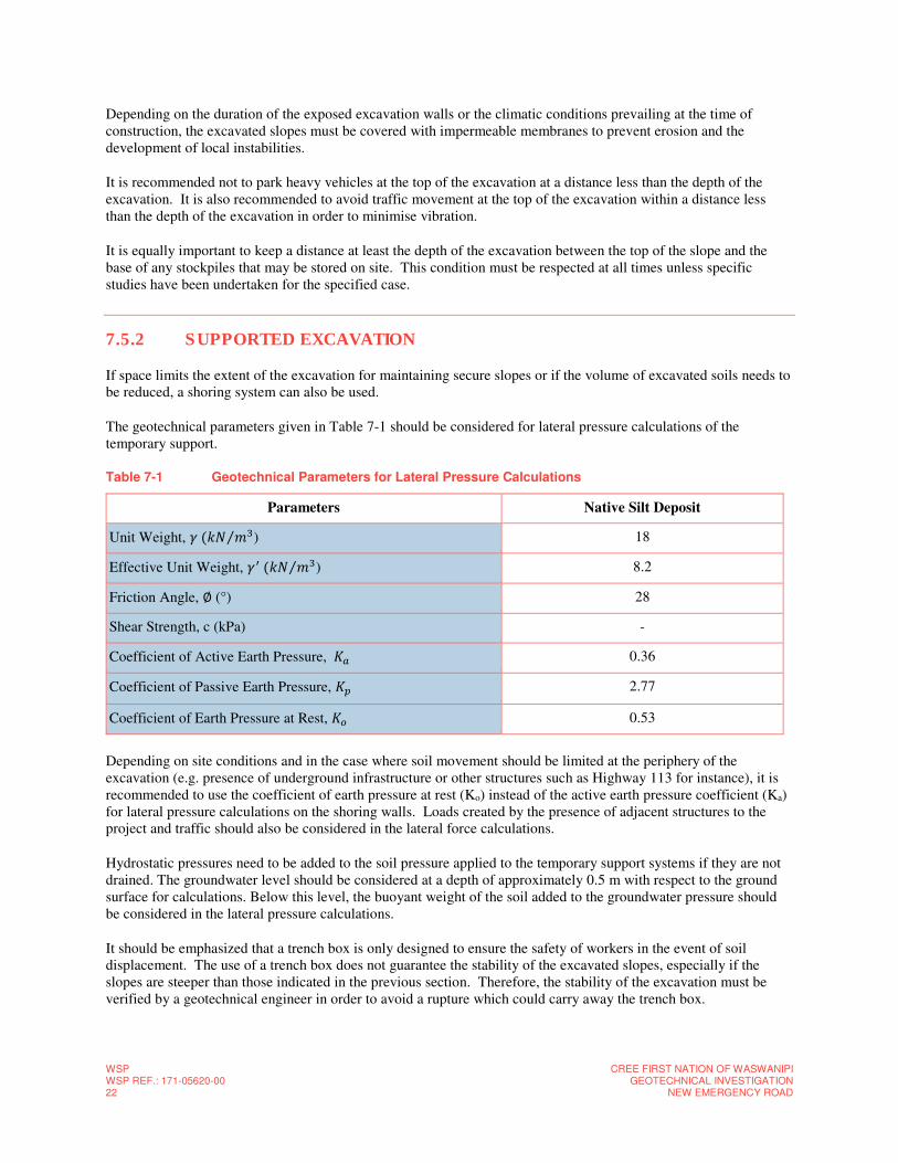
WSP WSP REF.: 171-05620-00 22
CREE FIRST NATION OF WASWANIPIGEOTECHNICAL INVESTIGATION
NEW EMERGENCY ROAD
Depending on the duration of the exposed excavation walls or the climatic conditions prevailing at the time of construction, the excavated slopes must be covered with impermeable membranes to prevent erosion and the development of local instabilities.
It is recommended not to park heavy vehicles at the top of the excavation at a distance less than the depth of the excavation. It is also recommended to avoid traffic movement at the top of the excavation within a distance less than the depth of the excavation in order to minimise vibration.
It is equally important to keep a distance at least the depth of the excavation between the top of the slope and the base of any stockpiles that may be stored on site. This condition must be respected at all times unless specific studies have been undertaken for the specified case.
7.5.2 SUPPORTED EXCAVATION
If space limits the extent of the excavation for maintaining secure slopes or if the volume of excavated soils needs to be reduced, a shoring system can also be used.
The geotechnical parameters given in Table 7-1 should be considered for lateral pressure calculations of the temporary support.
Table 7-1 Geotechnical Parameters for Lateral Pressure Calculations
Parameters Native Silt Deposit
Unit Weight, �(�� ��⁄ ) 18
Effective Unit Weight, �(�� ��⁄ ) 8.2
Friction Angle, ∅ (°) 28
Shear Strength, c (kPa) -
Coefficient of Active Earth Pressure, �� 0.36
Coefficient of Passive Earth Pressure, � 2.77
Coefficient of Earth Pressure at Rest, �� 0.53
Depending on site conditions and in the case where soil movement should be limited at the periphery of the excavation (e.g. presence of underground infrastructure or other structures such as Highway 113 for instance), it is recommended to use the coefficient of earth pressure at rest (Ko) instead of the active earth pressure coefficient (Ka) for lateral pressure calculations on the shoring walls. Loads created by the presence of adjacent structures to the project and traffic should also be considered in the lateral force calculations.
Hydrostatic pressures need to be added to the soil pressure applied to the temporary support systems if they are not drained. The groundwater level should be considered at a depth of approximately 0.5 m with respect to the ground surface for calculations. Below this level, the buoyant weight of the soil added to the groundwater pressure should be considered in the lateral pressure calculations.
It should be emphasized that a trench box is only designed to ensure the safety of workers in the event of soil displacement. The use of a trench box does not guarantee the stability of the excavated slopes, especially if the slopes are steeper than those indicated in the previous section. Therefore, the stability of the excavation must be verified by a geotechnical engineer in order to avoid a rupture which could carry away the trench box.
CREE FIRST NATION OF WASWANIPI GEOTECHNICAL INVESTIGATION NEW EMERGENCY ROAD
WSPWSP REF.: 171-05620-00
23
7.5.3 GROUNDWATER CONTROL
The groundwater level was measured in boreholes 17F01 and 17F05 on 10 November 2017 and was recorded at a respective depths of 1.05 m and 0.65 m.
Depending on climate conditions and/or on the time of year construction takes place, infiltrations caused from surface water runoff or perched water lenses in the soil could also occur during excavation.
Prior to the excavation work and at the location of the excavations, a suitable drainage system must be set up in order to lower the groundwater level by 500 mm below the excavation. It should be noted that the groundwater level must be maintained at least 500 mm below the proposed excavation level throughout the entire construction.
Pumping rates may vary, even considerably at times, depending on the type of soil encountered and the groundwater conditions at the time of construction. Soils having a large proportion of fine particles will be encountered during excavation work. Therefore, pre-emptive measures must be taken to prevent soil erosion caused by flowing water, by providing, where necessary and depending on the system selected, the appropriate geotextiles or granular filters.
Drainage work should be carried out by an experienced contractor specialised in this field.
7.5.4 TRANSITION SLOPES
Given the variability in the composition of the subsoils, in the case where the backfill used to fill the excavation has a different frost resistance to the surrounding soil, it is recommended to provide longitudinal and transversal slopes in the excavation in order to minimise the effect of differential heave caused by frost.
The transitions can be designed according to the standards by the ministère des Transports, de la Mobilité durable et de l’Électrification des transports (MTMDET) as specified in the MTMDET standards for road structures entitled Tome II – Construction routière. The transitions can also follow the specifications indicated in the guide prepared by the Centre d’expertise et de recherche en infrastructures urbaines (CERIU) and entitled Remblayage des
tranchées : sommaire des pratiques courantes au Québec et recommandations.
7.6 ROADWAY
7.6.1 ROADWAY STRUCTURE
The following section provides recommendations regarding the roadway structure for the new road. The stratigraphy presented in section 4 of the report was used to establish design data.
7.6.2 DATA FOR DESIGN OF ROADWAY STRUCTURE
No traffic data (AADT, ECAS, etc.) was available at the time of this study. According to the information available, the new emergency road is located on the edge of the community of Waswanipi. Currently this area of the town remains unoccupied. Design assumptions were considered and the roadway structure recommended for the proposed road was established based on the following elements, reflecting a local road, hardly used by heavy traffic:
─ Average annual daily traffic (AADT) : < 1000 (assumption);
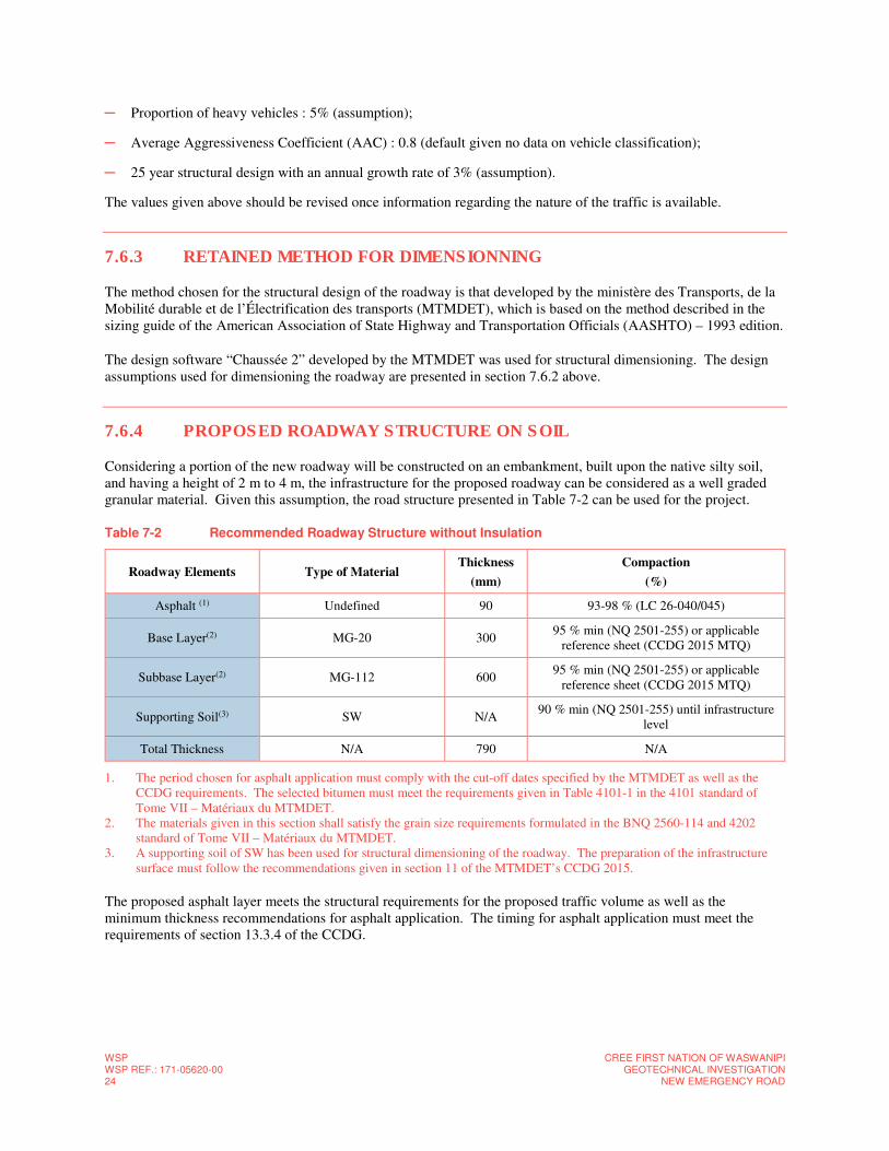
WSP WSP REF.: 171-05620-00 24
CREE FIRST NATION OF WASWANIPIGEOTECHNICAL INVESTIGATION
NEW EMERGENCY ROAD
─ Proportion of heavy vehicles : 5% (assumption);
─ Average Aggressiveness Coefficient (AAC) : 0.8 (default given no data on vehicle classification);
─ 25 year structural design with an annual growth rate of 3% (assumption).
The values given above should be revised once information regarding the nature of the traffic is available.
7.6.3 RETAINED METHOD FOR DIMENSIONNING
The method chosen for the structural design of the roadway is that developed by the ministère des Transports, de la Mobilité durable et de l’Électrification des transports (MTMDET), which is based on the method described in the sizing guide of the American Association of State Highway and Transportation Officials (AASHTO) – 1993 edition.
The design software “Chaussée 2” developed by the MTMDET was used for structural dimensioning. The design assumptions used for dimensioning the roadway are presented in section 7.6.2 above.
7.6.4 PROPOSED ROADWAY STRUCTURE ON SOIL
Considering a portion of the new roadway will be constructed on an embankment, built upon the native silty soil, and having a height of 2 m to 4 m, the infrastructure for the proposed roadway can be considered as a well graded granular material. Given this assumption, the road structure presented in Table 7-2 can be used for the project.
Table 7-2 Recommended Roadway Structure without Insulation
Roadway Elements Type of Material Thickness
(mm)
Compaction
(%)
Asphalt (1) Undefined 90 93-98 % (LC 26-040/045)
Base Layer(2) MG-20 300 95 % min (NQ 2501-255) or applicable
reference sheet (CCDG 2015 MTQ)
Subbase Layer(2) MG-112 600 95 % min (NQ 2501-255) or applicable
reference sheet (CCDG 2015 MTQ)
Supporting Soil(3) SW N/A 90 % min (NQ 2501-255) until infrastructure
level
Total Thickness N/A 790 N/A
1. The period chosen for asphalt application must comply with the cut-off dates specified by the MTMDET as well as the CCDG requirements. The selected bitumen must meet the requirements given in Table 4101-1 in the 4101 standard of Tome VII – Matériaux du MTMDET.
2. The materials given in this section shall satisfy the grain size requirements formulated in the BNQ 2560-114 and 4202 standard of Tome VII – Matériaux du MTMDET.
3. A supporting soil of SW has been used for structural dimensioning of the roadway. The preparation of the infrastructure surface must follow the recommendations given in section 11 of the MTMDET’s CCDG 2015.
The proposed asphalt layer meets the structural requirements for the proposed traffic volume as well as the minimum thickness recommendations for asphalt application. The timing for asphalt application must meet the requirements of section 13.3.4 of the CCDG.
CREE FIRST NATION OF WASWANIPI GEOTECHNICAL INVESTIGATION NEW EMERGENCY ROAD
WSPWSP REF.: 171-05620-00
25
7.6.4.1 FROST PROTECTION
It should be noted that the thickness of the proposed roadway structure does not completely protect the supporting soils against frost action (approximately 2.5 m). In fact, the additional costs that would be required to do so does not seem justified, given the additional benefit to be obtained. These roadway structures do however provide the recommended partial protection in this area (MTMDET zone 3). Although the roadway structures offer only a partial protection against frost, based on the practices in Quebec, the proposed thicknesses for the roadway structure are sufficient to offer a relatively long pavement life, depending on the care taken during the preparation of the infrastructure.
7.6.4.2 ADDITIONAL RECOMMENDATIONS
The material used as a subbase layer must comply with the filter criteria for an anticontamination layer, according to the standard NQ 2560-114, in order to limit the migration of fine particles found in the infrastructure materials towards the material used as a subbase layer. By default, a type III geotextile membrane, according to the standard 13101 of Tome VII – Matériaux from the MTMDET, shall be placed between the infrastructure materials and the subbase layer.
The asphalt layer should be placed using pavers over the entire width of the roadway to be covered by adjacent and successive strips, paved in a single operation, in order to eliminate the presence of cold joints. However, if this operation cannot be conducted at once, a cold joint adhesive shall be applied to the cold asphalt strip prior to laying the adjacent asphalt strip.
7.6.5 PROPOSED ROADWAY STRUCTURE ON BEDROCK
The road structure provided in Table 7-2 may also be used on bedrock. However, the road structure should also be designed according to the recommendations given in the MTMDET standard drawing 004 in Tome II – Construction
routière – Chaussée sur roc.
7.6.6 PREPARATION OF INFRASTRUCTURE (PAVED AREAS)
Site preparation for the construction of paved area shall include the following steps in order to ensure good behaviour of the roadway over the long term.
─ The first step consists in excavating soils and bedrock until the infrastructure level so that the roadway structure shown in Table 7-2 can be constructed;
─ If organic soils (topsoil or peat) are encountered in the area (see stratigraphy) or in the depth of excavation, they should be excavated up to 1 m below the infrastructure level;
─ Perform a proof rolling test over the surface of the future roadway to verify the presence of unstable, loose and/or flexible soils;
─ If necessary, soft or unstable areas shall be excavated and replaced with an engineered fill (crushed stone). The engineered fill must be placed in 300 mm layers and compacted to at least 95 % the maximum dry density as obtained by the modified effort compaction test.
The infrastructure shall be prepared according to the indications applicable in article 11.10 of the CCDG 2015. More specifically and in order to minimise deformations and premature cracking of the paved surface, it is recommended to profile the infrastructure surface so as to obtain the required slopes, in order to allow infiltrated water to seep towards permanent and effective drains. The infrastructure surface must be free of any remoulded soil
WSP WSP REF.: 171-05620-00 26
CREE FIRST NATION OF WASWANIPIGEOTECHNICAL INVESTIGATION
NEW EMERGENCY ROAD
and must not have been subject to any deformations. These deformation are caused, for example, by the passage of construction equipment during earthworks and before the installation of roadway materials.
The materials used for the construction of the proposed structures as well as the installation methods will have to comply with the applicable requirements of the MTMDET 2016 CCDG, the MTMDET standards collection, notably Tome VII – Matériaux du MTQ, the collection of testing methods from the MTMDET Pavement Laboratory, Standard NQ 2560-114, Standard NQ-2560-600 (if applicable) and Standard NQ 2501-255.
7.6.7 DRAINAGE
Drainage of a flexible roadway is an important element to ensure the projected service life. The permanent drainage of the infrastructure surface and the materials composing the roadway structure can be ensured by peripheral drains, ditches (according to the designer), by openings in catch basins or by any other technique that can effectively evacuate water that could seep into the granular foundation of the roadway structure.
The preliminary design includes at least a 2 m deep ditches on both sides of the road. Drainage ditches should be designed with 2H: 1V slopes in soils. The slopes should be protected by rock fill in order to prevent slope erosion. The type of rock fill will be the choice of the designer. For ditches excavated in the bedrock, steeper slopes can be designed and surface protection is not needed.
The infrastructure level, the granular foundation and the asphalt layer needs to be sloped sufficiently to direct water towards peripheral drains or ditches and around the paved surfaces. The drainage system must maintain the water level in the soil at least 500 mm below the level of infrastructure.
Appropriate drainage measures should be undertaken during roadway construction to eliminate runoff and seepage that could accumulate at the bottom of the excavations.
7.6.8 CONNECTION JOINTS
The following works should be carried out for the connection of the surface layer to the existing roadway structure:
─ Milling of the existing roadway over a width of 600 mm and to a thickness equal to the new surface layer;
─ Installation of a membrane which reduces the reflection of cracks on the joint. This will partially overlap the milled roadway and the new pavement of the intermediate layer. The membrane must be installed according to the manufacturer's requirements;
─ Installation of a bonding binder (bitumen emulsion) on the milled surface and the rest of the surface to be covered, at the residual rate of 0.3 l/m2;
─ Apply a cold joint adhesive on cold asphalt joints before placing the hot surface coating, as directed by the manufacturer.
7.7 GENERAL CONSTRUCTION RECOMMENDATIONS
7.7.1 FROST PROTECTION
CREE FIRST NATION OF WASWANIPI GEOTECHNICAL INVESTIGATION NEW EMERGENCY ROAD
WSPWSP REF.: 171-05620-00
27
For non-heated structures, a minimum frost protection depth of 2.5 m below the finished ground surface level is required. Alternatively, the use of isolation foam can be used, according to the designer, to reduce the frost protection depth.
7.7.2 SENSITIVITY OF SUBSOILS
Considering the high content of the fine particles, the underlying native soil deposit exposed at the bottom of the excavations will be highly sensitive to remoulding. Remoulding can be caused by weather conditions such as rain, freezing and thawing or by the circulation of machinery or workers on site. Significant remoulding may result in loss of bearing capacity resulting in additional deformations or settlement in the soil.
7.7.3 REUSE OF EXCAVATED SOILS
The reuse of excavated soil as a class 2 material to backfill the excavations must be evaluated and approved by a geotechnical expert. The native granular material found on the site could be reused in this project but is conditional to the following paragraphs.
Considering that the date of construction is unknown, it is recommended to complete additional tests (test pits, laboratory tests such as water contents and grain size distributions, etc.) just prior to the start of construction where it is planned to reuse the excavated material as backfill in order to ensure soil conditions permit reuse depending on the time of year construction work is planned.
Excavated soils acceptable for backfilling may be temporarily stored on site (in piles), whereas non-conforming soils should be disposed elsewhere on site (e.g. for landscaping), if it is acceptable from an environmental point of view.
The installation or use of acceptable excavated materials should be carried out during appropriate climate conditions; dry and sunny weather. The reuse of excavated materials is also conditional on water contents being adequate to allow for a compaction of 95% the maximum dry reference density. Furthermore, if present, debris and inclusions of topsoil or organic soil must be removed from the soil before reuse. The excavated material will also have to respect environmental criteria given by the Ministry of Sustainable Development, the Environment and the Fight against Climate Change (MDDELCC).
7.7.4 QUALITY CONTROL
During construction work, quality control measures on the following elements by qualified geotechnical personnel is recommended:
─ Verification of backfilling and compaction operations;
─ Verification of construction techniques;
─ Verification of material quality (backfill, asphalt, concrete, etc.) and their installation;
─ Etc.

WSP WSP REF.: 171-05620-00 28
CREE FIRST NATION OF WASWANIPIGEOTECHNICAL INVESTIGATION
NEW EMERGENCY ROAD
8 BIBLIOGRAPHY ─ BUREAU DE NORMALISATION DU QUÉBEC (2013) Soils – Determination of the Water-Density relation –
Modified Effort Compaction Test CAN/BNQ 2501-255 Standard.
─ BUREAU DE NORMALISATION DU QUÉBEC (2014) Civil Engineering Work - Aggregates. BNQ 2560-114 Standard.
─ Centre d’expertise et de recherche en infrastructures urbaines (2007) Remblayage des tranchées : sommaire des
pratiques courantes au Québec et recommandations.
─ MENV (2003) Guide de caractérisation des terrains. Ministère de l’Environnement du Québec. Service des lieux contaminés.
─ Ministère des Transports, de la Mobilité durable et de l’Électrification des transports (2017) Cahier des charges
et devis généraux – Infrastructures routières. Les publications du Québec.
─ Ministère des Transports, de la Mobilité durable et de l’Électrification des transports (2017) Tome II –
Construction routière. Les publications du Québec.
─ Ministère des Transports, de la Mobilité durable et de l’Électrification des transports (2017) Tome VII –
Matériaux. Les publications du Québec.

APPENDICES
CREE FIRST NATION OF WASWANIPI GEOTECHNICAL INVESTIGATION NEW EMERGENCY ROAD
WSPWSP REF.: 171-05620-00.
1
A LIMITATIONS AND GENERAL CONDITIONS OF THE STUDY

Limitations and General Conditions of the Study
This report is intended solely for the Client named. The material in it reflects our best judgment in light of the
information available to WSP Canada Incorporated (WSP) at the time of preparation. Unless otherwise agreed in
writing by WSP, it shall not be used to express or imply warranty as to the fitness of the property for a particular
purpose. No portion of this report may be used as a separate entity, it is written to be read in its entirety.
The conclusions and recommendations given in this report are based on information determined at the borehole
locations. The information contained herein in no way reflects on the environment aspects of the project, unless
otherwise stated. Subsurface and groundwater conditions between and beyond the test holes may differ from those
encountered at the test hole locations, and conditions may become apparent during construction, which could not be
detected or anticipated at the time of the site investigation. The benchmark and elevations used in this report are
primarily to establish relative elevation differences between the boreholes locations and should not be used for other
purposes, such as grading, excavating, planning, development, etc.
The design recommendations given in this report are applicable only to the project described in the text and then only
if constructed substantially in accordance with the details stated in this report.
The comments made in this report on potential construction problems and possible methods are intended only for the
guidance of the designer. The number of test holes may not be sufficient to determine all the factors that may affect
construction methods and costs. For example, the thickness of surficial topsoil or fill layers may vary markedly and
unpredictably. The contractors bidding on this project or undertaking the construction should, therefore, make their
own interpretation of the factual information presented and draw their own conclusions as to how the subsurface
conditions may affect their work. This work has been undertaken in accordance with normally accepted geotechnical
engineering practices.
Any use which a third party makes of this report, or any reliance on or decisions to be made based on it, are the
responsibility of such third parties. WSP accepts no responsibility for damages, if any, suffered by any third party as
a result of decisions made or actions based on this report.
We accept no responsibility for any decisions made or actions taken as a result of this report unless we are
specifically advised of and participate in such action, in which case our responsibility will be as agreed to, at that
time.


APPENDICES
B SITE LOCATION PLAN

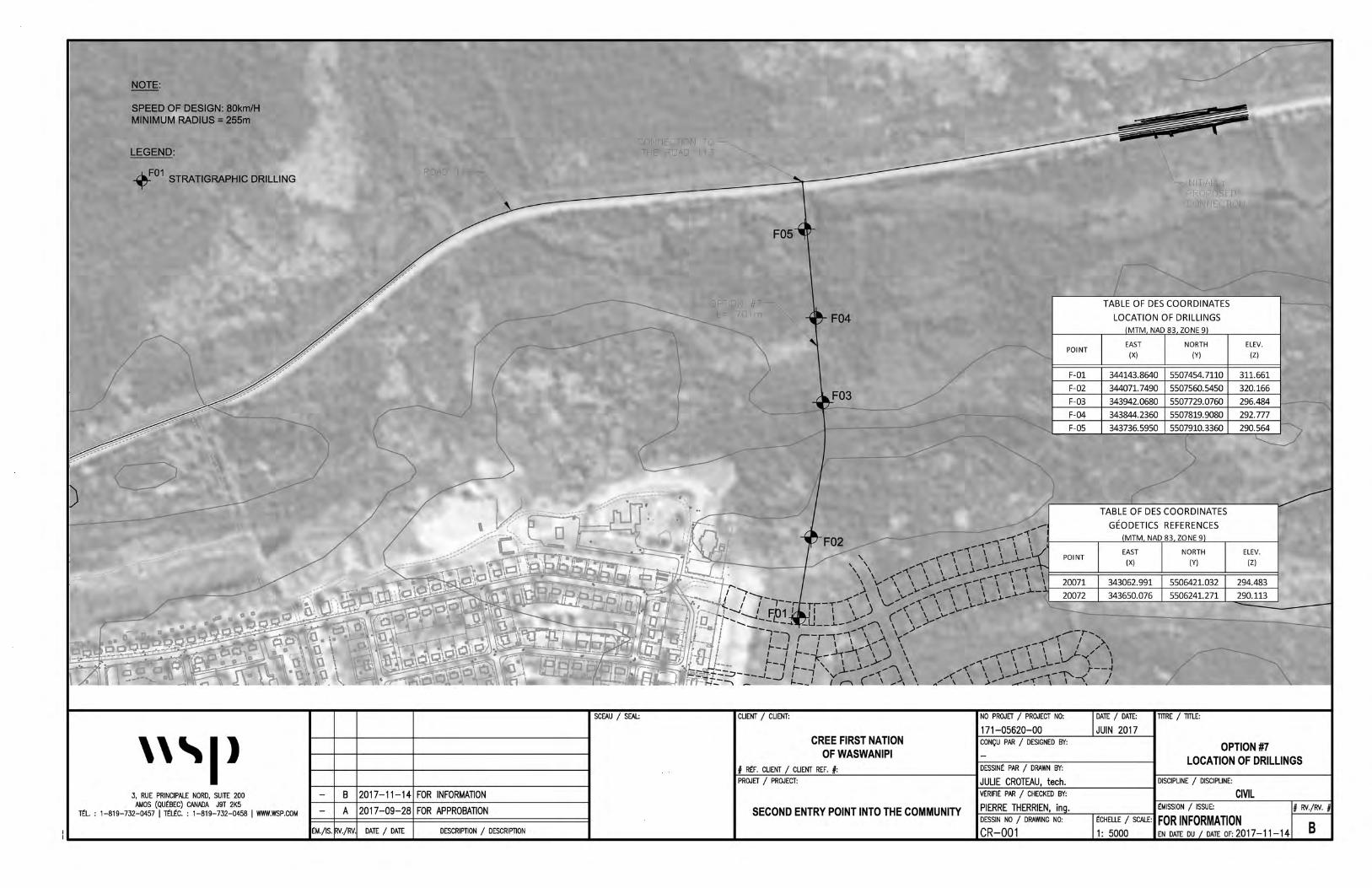
D
NOTE:
SPEED OF DESIGN: 80km/H MINIMUM RADIUS= 255m
LEGEND:
~01 STRATIGRAPHIC DRILLING
'''I> 3, RUE PRINCIPALE NORD, SUITE 200
AMOS (OUtBEC) CANADA J9T 2K5 ~L : 1-819-732-0457 I rrltC. : 1-819-732-0458 I WWW.WSP.COM
RrlAD 113 ~
B 2017-11-14 FOR INFORMATION
A 2017-09-28 FOR APPROBATION
tM./IS. FN./FN DATE / DATE DESCRIPTION / DESCRIPTION
'- lNNEC:-101~ TO~ THE ROAD 113
F05
LPTION #7-L- 701m
SCEAU / SEAL: CLIENT / CLIENT:
F04
CREE FIRST NATION OF WASWANIPI
# RtF. CLIENT / CLIENT REF. #: PROJET I PROJECT:
\
\_INITIALLY PROPOSED CONNECTION
POINT
F-01
F-02
F-03
F-04
F-05
TABLE OF DES COORDINATES
LOCATION OF DRILLINGS MTM NAD 83 ZONE 9
EAST NORTH
(X) (Y)
344143.8640 5507454. 7110
344071.7490 5507560.5450
343942.0680 5507729.0760
343844.2360 5507819.9080
343736.5950 5507910.3360
TABLE OF DES COORDINATES
GEODETICS REFERENCES MTM NAD 83 ZONE 9
EAST NORTH
(X) (Y)
343062.991 5506421.032
343650.076 5506241.271
... 'f-~.,.. ..... , ,.,.'f"--(' \ I .. >\
_.... .... ('"' \ \ I J- ,, \ ,.,.-, \ \ \ V v I
.... ~ \ \ 1-- \ .... -< \ \ ,...)-- 1"---4
ELEV.
(Z)
311.661
320.166
296.484
292.777
ELEV.
(Z)
294.483
290.113
,,.< \ \ >-~,.,. --t--""-< I A/ :I. .... ......--i: ,,_.._~ ' - -'''---------------------
NO PROJET / PROJECT NO: DATE / DATE: TITRE I TITLE:
171-05620-00 JUIN 2017 CONQU PAR / DESIGNED BY: OPTION#7
DESSINt PAR / DRAWN BY: LOCATION OF DRILLINGS
JULIE CROTEAU, tech. DISCIPLINE / DISCIPLINE:
vtRIFlt PAR / CHECKED BY: CIVIL
SECOND ENTRY POINT INTO THE COMMUNITY PIERRE THERRIEN, in . tMISSION I ISSUE: # FN./FN. # DESSIN NO / DRAWING NO: tCHELLE I SCALE: FOR INFORMATION CR-001 1: 5000 EN DATE OU DATE OF: 2017-11-14 B

APPENDICES
C BOREHOLE LOGS

1
2
3
4
5
1
2
3
4
5
DE
PT
H (
m)
5
10
15
5
10
15
DE
PT
H (
ft)
311.660.00
311.050.61
310.441.22
309.222.44
307.394.27
306.784.88
EL
EV
AT
ION
(m
)/D
EP
TH
Ground surfaceNative soil: Compact,grey-brown,silt with some sand,moist.Presence of roots.Becoming loose.
Becoming very loose.
Very loose, grey, silt with someclay and traces of sand,saturated.
Compact, grey, sandy silt withsome clay, saturated.
End of borehole.
DESCRIPTION
SY
MB
OL
SS-1
SS-2
SS-3
SS-4
SS-5
SS-6
SS-7
SS-8
TY
PE
NU
MB
ER
SU
B-S
AM
PL
E
ST
AT
E
33
72
100
74
66
57
57
RE
CO
VE
RY
11
8
1
3
4
2
15
N, N
c o
r R
QD
1-5-6-4
3-4-4-4
2-1-0-0
2-2-1-1
1-2-2-2
1-1-1-0
2-5-10-12
6 in/15cm Blow Counts
20 40 60 8020 40 60 8020 40 60 8020 40 60 80
GRAPHIC
20 40 60 8020 40 60 80
GRAPHIC
20 40 60 8020 40 60 80
GRAPHIC
20 40 60 8020 40 60 80
GRAPHIC
INS
TA
LL
AT
ION
2017
-11-
10
SDWl = 23,2%Wp = 19,3%w = 38,3%
TESTS
1-10%10-20%20-35%35-50%
Date:
Borehole type : Borehole size :
2017-11-10
1.05Depth :
ROCK QUALITY DESIGNATIONQUALIFICATIONVery poorPoorFairGoodExcellent
% RQD<25
25-5050-7575-90
90-100
<12 kPa12-25 kPa25-50 kPa
50-100 kPa100-200 kPa
>200 kPa
PARTICLE SIZE RANGE Clay SiltSandGravel CobbleBoulder
Very softSoftFirmStiffVery StiffHard
WATER LEVEL
CONSISTENCY SHEAR STRENGTH (Cu)
DENSITYVery looseLooseCompactDenseVery dense
"N"0-4
4-1010-3030-50>50
TERMINOLOGY
"traces""some"adjective (ey, y)"and"
Remoulded
SYMBOLS
Diamond drilling
Lost
Depth :
Drilling contractor :
Client :
Location :
Prepared by : Checked by : Borehole depth :
Date (start) :
Project :
Location plan N° :
Date:
SAMPLE TYPE
171-05620-00
Kristina Bondy, eng., M. eng.
5507454.711
344143.864
4.88
2017-10-31
17F01
311.66
STRATIGRAPHY
Project N° :
Z:
Y:
X:
BOREHOLE REPORT
Geodesic coordinatesMTM 9 (NAD-1983)
Production date 2017-11-20
SAMPLING: grain size analysis: chemical analysis : liquid limit: plastic limit: water content: undrained shear strength: remoulded shear strength: compressive strength
Page 1 of 1
Sample SS-1: environmental samplingHW: Hammer Weight
Auger sampleSplit spoon sampleShelby tube Rock coreGrab sample
N: Standard penetration indexR: Refusal HW: Hammer weightR.Q.D: Rock Quality Designation % R.Q.D = Core > 4 po. (10 cm)
drilled length
Intact
Σ
SAMPLE STATE
Borehole N°
Geotechnical Study - New Emergency Road
WS
P_A
NG
LAIS
_WA
SW
AN
IPIs
ty.s
ty
GSACAWlWpwSu
Cur
UCS
CONSULTANT :
ASSSSTRCGS
< 0.002 mm0.002 to 0.075 mm
0.075 to 4.75 mm4.75 to 75 mm75 to 300 mm
> 300mm
Remarks:
W w Wp l
: N (standard pen.): Nc (dynamic pen.): Cu (laboratory): Cur (laboratory): Cu (site): Cur (site)
W w Wp lW w Wp lW w WlW w Wp l
Core size : HQ
CLIENT :
Cree First Nation of Waswanipi
Waswanipi, Quebec.Forage GirouxAugerBWMarc-Olivier Morin-Leblanc, jr. eng.
1
2
3
4
5
1
2
3
4
5
DE
PT
H (
m)
5
10
15
5
10
15
DE
PT
H (
ft)
320.170.00
319.940.23
315.344.83
EL
EV
AT
ION
(m
)/D
EP
TH
Ground surfaceTopsoil: Loose, brown, sandy,moist.Grey gabbro, coarse grained, fairto excellent quality.
End of borehole.
DESCRIPTION
SY
MB
OL
RC-1
RC-2
RC-3
RC-4
RC-5
TY
PE
NU
MB
ER
SU
B-S
AM
PL
E
ST
AT
E
100
100
100
100
100
RE
CO
VE
RY
69
92
72
84
89
N, N
c o
r R
QD
6 in/15cm Blow Counts
20 40 60 8020 40 60 8020 40 60 8020 40 60 80
GRAPHIC
20 40 60 8020 40 60 80
GRAPHIC
20 40 60 8020 40 60 80
GRAPHIC
20 40 60 8020 40 60 80
GRAPHIC
INS
TA
LL
AT
ION
TESTS
1-10%10-20%20-35%35-50%
Date:
Borehole type : Forage Giroux
Borehole size :
Depth :
ROCK QUALITY DESIGNATIONQUALIFICATIONVery poorPoorFairGoodExcellent
% RQD<25
25-5050-7575-90
90-100
<12 kPa12-25 kPa25-50 kPa
50-100 kPa100-200 kPa
>200 kPa
PARTICLE SIZE RANGE Clay SiltSandGravel CobbleBoulder
Very softSoftFirmStiffVery StiffHard
WATER LEVEL
CONSISTENCY SHEAR STRENGTH (Cu)
DENSITYVery looseLooseCompactDenseVery dense
"N"0-4
4-1010-3030-50>50
TERMINOLOGY
"traces""some"adjective (ey, y)"and"
Remoulded
SYMBOLS
Diamond drilling
Lost
Depth :
Drilling contractor :
Client :
Location :
Prepared by : Checked by : Borehole depth :
Date (start) :
Project :
Location plan N° :
Date:
SAMPLE TYPE
171-05620-00
Kristina Bondy, eng., M. eng.
5507560.545
344071.749
Casing
Waswanipi, Quebec.
Marc-Olivier Morin-Leblanc, jr. eng.
4.83
2017-10-27
17F02
320.17
STRATIGRAPHY
Project N° :
Z:
Y:
X:
BOREHOLE REPORT
Geodesic coordinatesMTM 9 (NAD-1983)
Production date 2017-11-20
SAMPLING: grain size analysis: chemical analysis : liquid limit: plastic limit: water content: undrained shear strength: remoulded shear strength: compressive strength
Page 1 of 1
Auger sampleSplit spoon sampleShelby tube Rock coreGrab sample
N: Standard penetration indexR: Refusal HW: Hammer weightR.Q.D: Rock Quality Designation % R.Q.D = Core > 4 po. (10 cm) drilled length
Intact
Σ
SAMPLE STATE
Borehole N°
BW
Geotechnical Study - New Emergency Road
WS
P_A
NG
LAIS
_WA
SW
AN
IPIs
ty.s
ty
GSACAWlWpwSu
Cur
UCS
CONSULTANT :
ASSSSTRCGS
< 0.002 mm0.002 to 0.075 mm
0.075 to 4.75 mm4.75 to 75 mm75 to 300 mm
> 300mm
Remarks:
W w Wp l
: N (standard pen.): Nc (dynamic pen.): Cu (laboratory): Cur (laboratory): Cu (site): Cur (site)
W w Wp lW w Wp lW w WlW w Wp l
Core size : HQ
CLIENT :
Cree First Nation of Waswanipi
1
2
3
4
5
1
2
3
4
5
DE
PT
H (
m)
5
10
15
5
10
15
DE
PT
H (
ft)
296.480.00
295.870.61
294.651.83
294.042.44
293.483.00
291.784.70
EL
EV
AT
ION
(m
)/D
EP
TH
Ground surfaceTopsoil: Very loose, brown,sandy, moist.
Native soil: Compact, grey, siltysand with some gravel andtraces of clay, saturated.
Becoming very dense.
Becoming compact.
Grey gabbro, coarse grained,excellent quality.
End of borehole.
DESCRIPTION
SY
MB
OL
SS-1
SS-2
SS-3
SS-4
SS-5
RC-6
RC-7
TY
PE
NU
MB
ER
SU
B-S
AM
PL
E
ST
AT
E
34
70
34
38
41
100
100
RE
CO
VE
RY
4
20
27
52
29
98
100
N, N
c o
r R
QD
1-2-2-3
6-10-10-13
12-12-15-19
6-11-41-53
12-14-15-11 /15 cm
6 in/15cm Blow Counts
20 40 60 8020 40 60 8020 40 60 8020 40 60 80
GRAPHIC
20 40 60 8020 40 60 80
GRAPHIC
20 40 60 8020 40 60 80
GRAPHIC
20 40 60 8020 40 60 80
GRAPHIC
INS
TA
LL
AT
ION
SDGSAw = 10,5%
TESTS
1-10%10-20%20-35%35-50%
Date:
Borehole type : Borehole size :
Depth :
ROCK QUALITY DESIGNATIONQUALIFICATIONVery poorPoorFairGoodExcellent
% RQD<25
25-5050-7575-90
90-100
<12 kPa12-25 kPa25-50 kPa
50-100 kPa100-200 kPa
>200 kPa
PARTICLE SIZE RANGE Clay SiltSandGravel CobbleBoulder
Very softSoftFirmStiffVery StiffHard
WATER LEVEL
CONSISTENCY SHEAR STRENGTH (Cu)
DENSITYVery looseLooseCompactDenseVery dense
"N"0-4
4-1010-3030-50>50
TERMINOLOGY
"traces""some"adjective (ey, y)"and"
Remoulded
SYMBOLS
Diamond drilling
Lost
Depth :
Drilling contractor :
Client :
Location :
Prepared by : Checked by : Borehole depth :
Date (start) :
Project :
Location plan N° :
Date:
SAMPLE TYPE
171-05620-00
Kristina Bondy, eng., M. eng.
5507729.076
343942.068
4.70
2017-10-27
17F03
296.48
STRATIGRAPHY
Project N° :
Z:
Y:
X:
BOREHOLE REPORT
Geodesic coordinatesMTM 9 (NAD-1983)
Production date 2017-11-20
SAMPLING: grain size analysis: chemical analysis : liquid limit: plastic limit: water content: undrained shear strength: remoulded shear strength: compressive strength
Page 1 of 1
Sample SS-1 : environmental sampling
Auger sampleSplit spoon sampleShelby tube Rock coreGrab sample
N: Standard penetration indexR: Refusal HW: Hammer weightR.Q.D: Rock Quality Designation % R.Q.D = Core > 4 po. (10 cm)
drilled length
Intact
Σ
SAMPLE STATE
Borehole N°
Geotechnical Study - New Emergency Road
WS
P_A
NG
LAIS
_WA
SW
AN
IPIs
ty.s
ty
GSACAWlWpwSu
Cur
UCS
CONSULTANT :
ASSSSTRCGS
< 0.002 mm0.002 to 0.075 mm
0.075 to 4.75 mm4.75 to 75 mm75 to 300 mm
> 300mm
Remarks:
W w Wp l
: N (standard pen.): Nc (dynamic pen.): Cu (laboratory): Cur (laboratory): Cu (site): Cur (site)
W w Wp lW w Wp lW w WlW w Wp l
Core size : HW
CLIENT :
Cree First Nation of Waswanipi
Waswanipi, Quebec.Forage GirouxAugerBWMarc-Olivier Morin-Leblanc, jr. eng.
1
2
3
4
5
1
2
3
4
5
DE
PT
H (
m)
5
10
15
5
10
15
DE
PT
H (
ft)
292.780.00
291.561.22
289.733.05
289.123.66
287.904.88
EL
EV
AT
ION
(m
)/D
EP
TH
Ground surfaceTopsoil: Very loose,brownish-grey, silty, saturated.
Native soil : Very loose, grey, siltwith some clay and traces ofsand, saturated.
Compact, grey, silty sand,saturated.
Compact, grey, sand with somesilt, saturated.
End of borehole upon refusal.
DESCRIPTION
SY
MB
OL
SS-1
SS-2
SS-3
SS-4
SS-5
SS-6
SS-7
SS-8
TY
PE
NU
MB
ER
SU
B-S
AM
PL
E
ST
AT
E
2
100
100
100
66
41
16
62
RE
CO
VE
RY
HW
HW
HW
HW
HW
22
12
18
N, N
c o
r R
QD
10-11-11-8
8-6-6-4
6-12-6-150
6 in/15cm Blow Counts
20 40 60 8020 40 60 8020 40 60 8020 40 60 80
GRAPHIC
20 40 60 8020 40 60 80
GRAPHIC
20 40 60 8020 40 60 80
GRAPHIC
20 40 60 8020 40 60 80
GRAPHIC
INS
TA
LL
AT
ION
SDWl = 37,1%Wp = 22,6%w = 30,6%
TESTS
1-10%10-20%20-35%35-50%
Date:
Borehole type : Borehole size :
Depth :
ROCK QUALITY DESIGNATIONQUALIFICATIONVery poorPoorFairGoodExcellent
% RQD<25
25-5050-7575-90
90-100
<12 kPa12-25 kPa25-50 kPa
50-100 kPa100-200 kPa
>200 kPa
PARTICLE SIZE RANGE Clay SiltSandGravel CobbleBoulder
Very softSoftFirmStiffVery StiffHard
WATER LEVEL
CONSISTENCY SHEAR STRENGTH (Cu)
DENSITYVery looseLooseCompactDenseVery dense
"N"0-4
4-1010-3030-50>50
TERMINOLOGY
"traces""some"adjective (ey, y)"and"
Remoulded
SYMBOLS
Diamond drilling
Lost
Depth :
Drilling contractor :
Client :
Location :
Prepared by : Checked by : Borehole depth :
Date (start) :
Project :
Location plan N° :
Date:
SAMPLE TYPE
171-05620-00
Kristina Bondy, eng., M. eng.
5507819.908
343844.236
4.88
2017-10-27
17F04
292.78
STRATIGRAPHY
Project N° :
Z:
Y:
X:
BOREHOLE REPORT
Geodesic coordinatesMTM 9 (NAD-1983)
Production date 2017-11-20
SAMPLING: grain size analysis: chemical analysis : liquid limit: plastic limit: water content: undrained shear strength: remoulded shear strength: compressive strength
Page 1 of 1
Sample SS-2: environmental samplingHW: Hammer Weight
Auger sampleSplit spoon sampleShelby tube Rock coreGrab sample
N: Standard penetration indexR: Refusal HW: Hammer weightR.Q.D: Rock Quality Designation % R.Q.D = Core > 4 po. (10 cm)
drilled length
Intact
Σ
SAMPLE STATE
Borehole N°
Geotechnical Study - New Emergency Road
WS
P_A
NG
LAIS
_WA
SW
AN
IPIs
ty.s
ty
GSACAWlWpwSu
Cur
UCS
CONSULTANT :
ASSSSTRCGS
< 0.002 mm0.002 to 0.075 mm
0.075 to 4.75 mm4.75 to 75 mm75 to 300 mm
> 300mm
Remarks:
W w Wp l
: N (standard pen.): Nc (dynamic pen.): Cu (laboratory): Cur (laboratory): Cu (site): Cur (site)
W w Wp lW w Wp lW w WlW w Wp l
Core size : HW
CLIENT :
Cree First Nation of Waswanipi
Waswanipi, Quebec.Forage GirouxAuger BWMarc-Olivier Morin-Leblanc, jr. eng.
1
2
3
4
5
1
2
3
4
5
DE
PT
H (
m)
5
10
15
5
10
15
DE
PT
H (
ft)
290.560.00
289.341.22
287.513.05
286.294.27
285.075.49
EL
EV
AT
ION
(m
)/D
EP
TH
Ground surfaceTopsoil: Very loose, dark brown,silty, moist.
Native soil: Loose, grey, silt withsome clay and traces of sand,saturated.Presence of roots.
Soft, grey, silty clay with tracesof sand, saturated.
Becoming with traces of gravel.
End of borehole.
DESCRIPTION
SY
MB
OL
SS-1
SS-2
SS-3
SS-4
SS-5
SS-6
SS-7
SS-8
SS-9
TY
PE
NU
MB
ER
SU
B-S
AM
PL
E
ST
AT
E
2
2
54
79
41
100
100
100
100
RE
CO
VE
RY
3
2
7
HW
HW
HW
HW
HW
HW
N, N
c o
r R
QD
2-1-2-0
1-1-1-1
4-4-3-3
6 in/15cm Blow Counts
20 40 60 8020 40 60 8020 40 60 8020 40 60 80
GRAPHIC
20 40 60 8020 40 60 80
GRAPHIC
20 40 60 8020 40 60 80
GRAPHIC
20 40 60 8020 40 60 80
GRAPHIC
INS
TA
LL
AT
ION
2017
-11-
10
SDGSAWl = 23,7%Wp = 20%w = 25,4%
Wl = 72%Wp = 32,8%w = 77,8%
SD
TESTS
1-10%10-20%20-35%35-50%
Date:
Borehole type : Borehole size :
2017-11-10
0.65Depth :
ROCK QUALITY DESIGNATIONQUALIFICATIONVery poorPoorFairGoodExcellent
% RQD<25
25-5050-7575-90
90-100
<12 kPa12-25 kPa25-50 kPa
50-100 kPa100-200 kPa
>200 kPa
PARTICLE SIZE RANGE Clay SiltSandGravel CobbleBoulder
Very softSoftFirmStiffVery StiffHard
WATER LEVEL
CONSISTENCY SHEAR STRENGTH (Cu)
DENSITYVery looseLooseCompactDenseVery dense
"N"0-4
4-1010-3030-50>50
TERMINOLOGY
"traces""some"adjective (ey, y)"and"
Remoulded
SYMBOLS
Diamond drilling
Lost
Depth :
Drilling contractor :
Client :
Location :
Prepared by : Checked by : Borehole depth :
Date (start) :
Project :
Location plan N° :
Date:
SAMPLE TYPE
171-05620-00
Kristina Bondy, eng., M. eng.
5507910.336
343736.595
5.49
2017-10-26
17F05
290.56
STRATIGRAPHY
Project N° :
Z:
Y:
X:
BOREHOLE REPORT
Geodesic coordinatesMTM 9 (NAD-1983)
Production date 2017-11-20
SAMPLING: grain size analysis: chemical analysis : liquid limit: plastic limit: water content: undrained shear strength: remoulded shear strength: compressive strength
Page 1 of 1
HW: Hammer Weight
Auger sampleSplit spoon sampleShelby tube Rock coreGrab sample
N: Standard penetration indexR: Refusal HW: Hammer weightR.Q.D: Rock Quality Designation % R.Q.D = Core > 4 po. (10 cm)
drilled length
Intact
Σ
SAMPLE STATE
Borehole N°
Geotechnical Study - New Emergency Road
WS
P_A
NG
LAIS
_WA
SW
AN
IPIs
ty.s
ty
GSACAWlWpwSu
Cur
UCS
CONSULTANT :
ASSSSTRCGS
< 0.002 mm0.002 to 0.075 mm
0.075 to 4.75 mm4.75 to 75 mm75 to 300 mm
> 300mm
Remarks:
W w Wp l
: N (standard pen.): Nc (dynamic pen.): Cu (laboratory): Cur (laboratory): Cu (site): Cur (site)
W w Wp lW w Wp lW w WlW w Wp l
Core size : HW
CLIENT :
Cree First Nation of Waswanipi
Waswanipi, Quebec.Forage GirouxAugerBWMarc-Olivier Morin-Leblanc, jr. eng.

APPENDICES
D GEOTECHNICAL LABORATORY RESULTS

0.001 0.01 0.1 1 10Grain size (mm)
10
20
30
40
50
60
70
80
90
100
Pas
sin
g p
ou
rcen
tag
e (%
)
0.001 0.01 0.1 1 10Grain size (mm)
10
20
30
40
50
60
70
80
90
100
Pas
sin
g p
ou
rcen
tag
e (%
)
0.002 mm 0.01 mm 0.08 mm 0.4 mm 2 mm 5 mm 20 mm 80 mm
FINE PARTICULES SAND GRAVEL
CLAY SILT FINE MEDIUM COARSE FINE COARSE
Legend CLAY SILT SAND GRAVEL
11.8 87.6 0.6 0.0
1.2 31.7 54.1 13.0
15.5 83.9 0.5 0.0
11.7 85.3 3.0 0.0
73.2 25.7 1.1 0.0
Legend 0.002 mm 0.08 mm 0.16 mm 0.315 mm 0.63 mm 1.25 mm 2.5 mm 5 mm 10 mm 14 mm 20 mm 28 mm 40 mm 56 mm 80 mm
11.78 99.40 100.00 100.00 100.00 100.00 100.00 100.00 100.00 100.00 100.00 100.00 100.00 100.00 100.00
1.24 32.90 45.28 58.94 68.90 75.50 81.21 87.00 91.89 93.47 95.53 99.54 100.00 100.00 100.00
15.53 99.46 100.00 100.00 100.00 100.00 100.00 100.00 100.00 100.00 100.00 100.00 100.00 100.00 100.00
11.70 97.04 98.66 99.19 99.61 99.99 100.00 100.00 100.00 100.00 100.00 100.00 100.00 100.00 100.00
73.22 98.89 100.00 100.00 100.00 100.00 100.00 100.00 100.00 100.00 100.00 100.00 100.00 100.00 100.00
Legend Survey Sample Depth (m) Description D10 D30 D60 Cu Cc USCS WN Remark
17F01 5 2.44 - 3.05 Silt, some clay. - 0.0093 0.0207 - - - 38.3 -
17F03 4 1.83 - 2.44 Silty sand, some gravel, traces ofclay.
0.0135 0.0697 0.3341 24.8080 1.0787 SM 10.5 4 + 5
17F04 4 1.83 - 2.44 Silt, some clay. - 0.0063 0.0164 - - - 30.6 -
17F05 3 1.22 - 1.83 Silt, some clay, traces of sand. - 0.0093 0.022 - - - 25.4 3 + 4
17F05 6 3.05 - 3.66 Silty clay, traces of sand. - - - - - - 77.8 6 + 7
2017-11-20 13:00:04Y:\geote
c_80\S
tyle
\lab\L
ab_G
ranulo
_et sédim
ento
_E
N_W
AS
WA
NIP
I.sty
U
:\E
nvironnem
ent\G
éote
chniq
ue\D
- L
ogic
iel LO
G\G
eote
c_princip
al_
20171115.m
db
Client :
Location :Date (start) :
Project :
Location plan N° :
171-05620-00
Waswanipi, Quebec.2017-10-31
17F01, 17F03, 17F04, 17F05
Project N° :
GRAIN SIZE DISTRUBUTION
ANALYSIS REPORT
Page 1 of 1
Survey N°
Geotechnical Study - New Emergency Road
Consultant : Client :
Cree First Nation of Waswanipi
Prepared by : Sonia Bagué, jr. eng. Date : Checked by : Abdelwahab Kamel, eng. Date :2017-11-10 2017-11-10
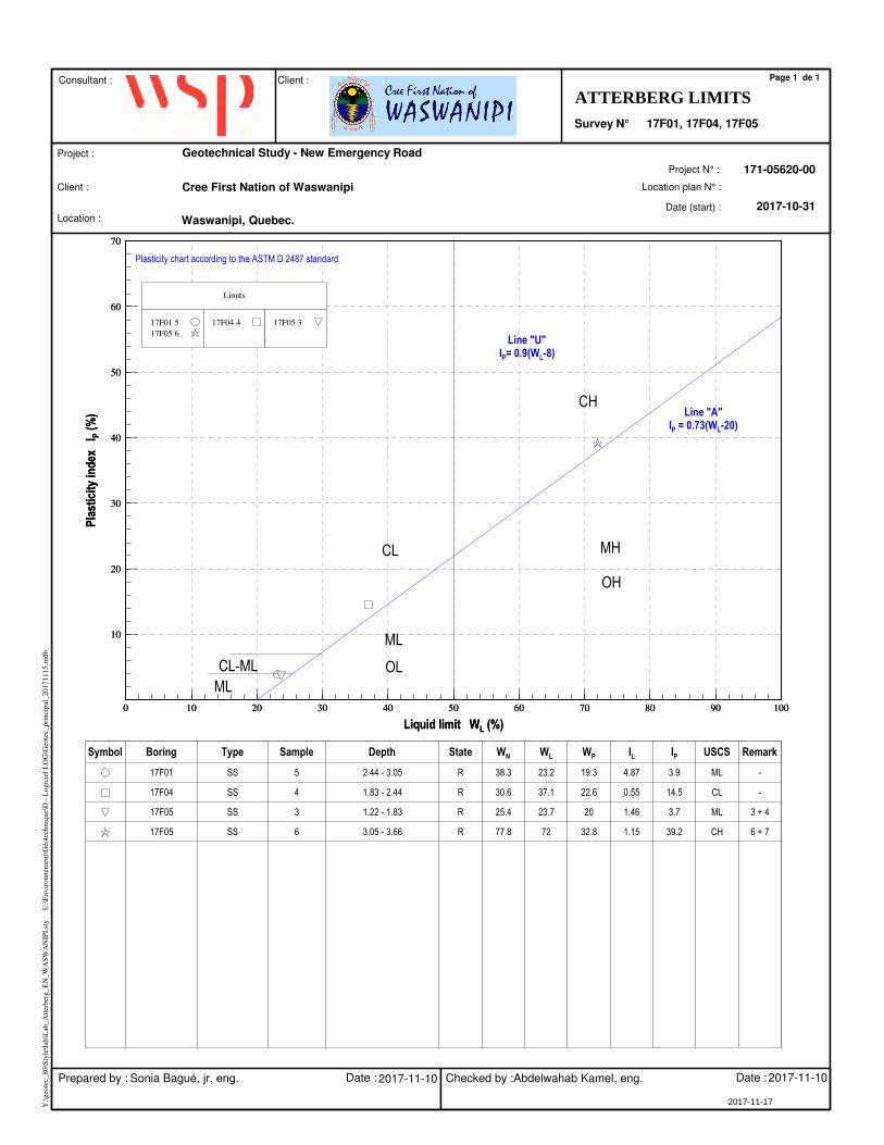
0 10 20 30 40 50 60 70 80 90 100
Liquid limit WL (%)
10
20
30
40
50
60
70
Pla
stic
ity
ind
ex
I P (
%)
0 10 20 30 40 50 60 70 80 90 100
Liquid limit WL (%)
10
20
30
40
50
60
70
Pla
stic
ity
ind
ex
I P (
%)
Limits
17F01 517F05 6
17F04 4 17F05 3
Symbol Boring Type Sample Depth State WN WL WP IL IP USCS Remark
17F01 SS 5 2.44 - 3.05 R 38.3 23.2 19.3 4.87 3.9 ML -
17F04 SS 4 1.83 - 2.44 R 30.6 37.1 22.6 0.55 14.5 CL -
17F05 SS 3 1.22 - 1.83 R 25.4 23.7 20 1.46 3.7 ML 3 + 4
17F05 SS 6 3.05 - 3.66 R 77.8 72 32.8 1.15 39.2 CH 6 + 7
Y:\g
eote
c_80
\Sty
le\la
b\L
ab_A
tterb
erg_
EN
_WA
SWA
NIP
I.st
y
U:\E
nvir
onne
men
t\Géo
tech
niqu
e\D
- L
ogic
iel L
OG
\Geo
tec_
prin
cipa
l_20
1711
15.m
db
CH
MHCL
ML
ML
CL-ML
Plasticity chart according to the ASTM D 2487 standard
Line "U"IP= 0.9(WL-8)
Line "A"IP = 0.73(WL-20)
OH
OL
Client :
Location :Date (start) :
Project :
Location plan N° :
171-05620-00
Waswanipi, Quebec.2017-10-31
Project N° :
ATTERBERG LIMITS
Page 1 de 1
Survey N°
Geotechnical Study - New Emergency Road
Consultant : Client :
Cree First Nation of Waswanipi
2017-11-17
Prepared by : Sonia Bagué, jr. eng. Date : Checked by :Abdelwahab Kamel, eng. Date :2017-11-10 2017-11-10
17F01, 17F04, 17F05

APPENDICES
E CHEMICAL ANALYSIS CERTIFICATES

CLIENT NAME: WSP CANADA INC.1600, René-Lévesque ouest, 16ème étageMONTRÉAL, QC H3H1P9 (514) 340-0046
9770 ROUTE TRANSCANADIENNE
ST. LAURENT, QUEBEC
CANADA H4S 1V9
TEL (514)337-1000
FAX (514)333-3046
http://www.agatlabs.com
Jalel Rouissi, ChimisteSOIL ANALYSIS REVIEWED BY:
Robert Roch, ChimisteTRACE ORGANICS REVIEWED BY:
DATE REPORTED:
PAGES (INCLUDING COVER): 11
2017-11-10
1VERSION*:
Should you require any information regarding this analysis please contact your client services representative at (514) 337-1000
17M280951AGAT WORK ORDER:
ATTENTION TO: Kristina Bondy
PROJECT: 171-05620-00
All samples will be disposed of within 30 days following analysis. Please contact the lab if you require additional sample storage time.
Laboratories (V1)
*NOTES
Page 1 of 11
This version replaces and cancels all previous versions, if applicable. Reproduction of this document is prohibited, in whole or part, unless authorised in writing by the laboratory. Theresults relate only to the samples analyzed
17F03/CF-117F01/CF-1 17F04/CF-2SAMPLE DESCRIPTION:
SoilSoilSoilSAMPLE TYPE:
2017-10-27 2017-10-272017-10-31DATE SAMPLED:
8883468 8883470 8883471G / S: A RDLUnit G / S: B G / S: C G / S: DParameter
<0.5 <0.5 <0.5Silver 0.52mg/kg 20 40 200
<5.0 <5.0 <5.0Arsenic 5.06mg/kg 30 50 250
77[<A] <20 72[<A]Barium 20340mg/kg 500 2000 10000
<0.9 <0.9 <0.9Cadmium 0.91.5mg/kg 5 20 100
59[<A] <45 48[<A]Chromium 45100mg/kg 250 800 4000
<15 <15 <15Cobalt 1525mg/kg 50 300 1500
<40 <40 <40Copper 4050mg/kg 100 500 2500
<5 <5 <5Tin 55mg/kg 50 300 1500
251[<A] 51[<A] 336[<A]Manganese 101000mg/kg 1000 2200 11000
<2 <2 <2Molybdenum 22mg/kg 10 40 200
<30 <30 <30Nickel 3050mg/kg 100 500 2500
<30 <30 <30Lead 3050mg/kg 500 1000 5000
<100 <100 <100Zinc 100140mg/kg 500 1500 7500
RDL - Reported Detection Limit; G / S - Guideline / Standard: A Refers to QC PTC 2016 A, B Refers to QC PTC 2016 B, C Refers to QC PTC 2016 C, D Refers to QC RESC (Annex 1)Guideline values are for general reference only. The guidelines provided may or may not be relevant for the intended use. Refer directly to the applicable standard for regulatory interpretation.
Comments:
8883468-8883471 Elevated RDLs indicate the degree of sample dilutions prior to the analysis to keep analytes within the calibration range or reduce matrix interference.
This version replaces and cancels all previous versions, if applicable. Reproduction of this document is prohibited, in whole or part, unless authorised in writing by the laboratory. The results relate only to the samples analyzed
Certificate of Analysis
ATTENTION TO: Kristina Bondy CLIENT NAME: WSP CANADA INC.
AGAT WORK ORDER: 17M280951
DATE RECEIVED: 2017-11-06 DATE REPORTED: 2017-11-10
PROJECT: 171-05620-00
SAMPLED BY:MARC-OLIVIER SAMPLING SITE:WASWANIPI
Total Extractable Metals (soil)
9770 ROUTE TRANSCANADIENNE
ST. LAURENT, QUEBEC
CANADA H4S 1V9
TEL (514)337-1000
FAX (514)333-3046
http://www.agatlabs.com
CERTIFICATE OF ANALYSIS (V1)
Certified By:
Page 2 of 11
AGAT Laboratories’ procedure for signatures and signatories adheres strictly to the requirements of accreditation ISO 17025:2005 as required by CALA, SCC and MDDELCC where applicable. All electronic signatures on AGAT certificates are password protected and all signatories meet their regional and scope of accreditation requirements and are approved by CALA, SCC and MDDELCC.
17F03/CF-117F01/CF-1 17F04/CF-2SAMPLE DESCRIPTION:
SoilSoilSoilSAMPLE TYPE:
2017-10-27 2017-10-272017-10-31DATE SAMPLED:
8883468 8883470 8883471G / S: A RDLUnit G / S: B G / S: C G / S: DParameter
<0.1 <0.1 <0.1Acenaphtene 0.10.1mg/kg 10 100 100
<0.1 <0.1 <0.1Acenaphtylene 0.10.1mg/kg 10 100 100
<0.1 <0.1 <0.1Anthracene 0.10.1mg/kg 10 100 100
<0.1 <0.1 <0.1Benzo (a) anthracene 0.10.1mg/kg 1 10 34
<0.1 <0.1 <0.1Benzo (a) pyrene 0.10.1mg/kg 1 10 34
<0.1 <0.1 <0.1Benzo (b) fluoranthene 0.10.1mg/kg 1 10 136
<0.1 <0.1 <0.1Benzo (j) fluoranthene 0.10.1mg/kg 1 10 136
<0.1 <0.1 <0.1Benzo (k) fluoranthene 0.10.1mg/kg 1 10 136
<0.1 <0.1 <0.1Benzo (c) phenanthrene 0.10.1mg/kg 1 10 56
<0.1 <0.1 <0.1Benzo (g,h,i) perylene 0.10.1mg/kg 1 10 18
<0.1 <0.1 <0.1Chrysene 0.10.1mg/kg 1 10 34
<0.1 <0.1 <0.1Dibenzo (a,h) anthracene 0.10.1mg/kg 1 10 82
<0.1 <0.1 <0.1Dibenzo (a,i) pyrene 0.10.1mg/kg 1 10 34
<0.1 <0.1 <0.1Dibenzo (a,h) pyrene 0.10.1mg/kg 1 10 34
<0.1 <0.1 <0.1Dibenzo (a,l) pyrene 0.10.1mg/kg 1 10 34
<0.1 <0.1 <0.1Dimethyl-7,12 benzo (a) anthracene 0.10.1mg/kg 1 10 34
<0.1 <0.1 <0.1Fluoranthene 0.10.1mg/kg 10 100 100
<0.1 <0.1 <0.1Fluorene 0.10.1mg/kg 10 100 100
<0.1 <0.1 <0.1Indeno (1,2,3-cd) pyrene 0.10.1mg/kg 1 10 34
<0.1 <0.1 <0.1Methyl-3 cholanthrene 0.10.1mg/kg 1 10 150
<0.1 <0.1 <0.1Naphtalene 0.10.1mg/kg 5 50 56
<0.1 <0.1 <0.1Phenanthrene 0.10.1mg/kg 5 50 56
<0.1 <0.1 <0.1Pyrene 0.10.1mg/kg 10 100 100
<0.1 <0.1 <0.1Methyl-1 naphtalene 0.10.1mg/kg 1 10 56
<0.1 <0.1 <0.1Methyl-2 naphtalene 0.10.1mg/kg 1 10 56
<0.1 <0.1 <0.1Dimethyl-1,3 naphtalene 0.10.1mg/kg 1 10 56
<0.1 <0.1 <0.1Trimethyl-2,3,5 naphtalene 0.10.1mg/kg 1 10 56
26.5 43.7 21.3Moisture 0.1%
This version replaces and cancels all previous versions, if applicable. Reproduction of this document is prohibited, in whole or part, unless authorised in writing by the laboratory. The results relate only to the samples analyzed
Certificate of Analysis
ATTENTION TO: Kristina Bondy CLIENT NAME: WSP CANADA INC.
AGAT WORK ORDER: 17M280951
DATE RECEIVED: 2017-11-06 DATE REPORTED: 2017-11-10
PROJECT: 171-05620-00
SAMPLED BY:MARC-OLIVIER SAMPLING SITE:WASWANIPI
PAHs (soil)
9770 ROUTE TRANSCANADIENNE
ST. LAURENT, QUEBEC
CANADA H4S 1V9
TEL (514)337-1000
FAX (514)333-3046
http://www.agatlabs.com
CERTIFICATE OF ANALYSIS (V1)
Certified By:
Page 3 of 11
AGAT Laboratories’ procedure for signatures and signatories adheres strictly to the requirements of accreditation ISO 17025:2005 as required by CALA, SCC and MDDELCC where applicable. All electronic signatures on AGAT certificates are password protected and all signatories meet their regional and scope of accreditation requirements and are approved by CALA, SCC and MDDELCC.
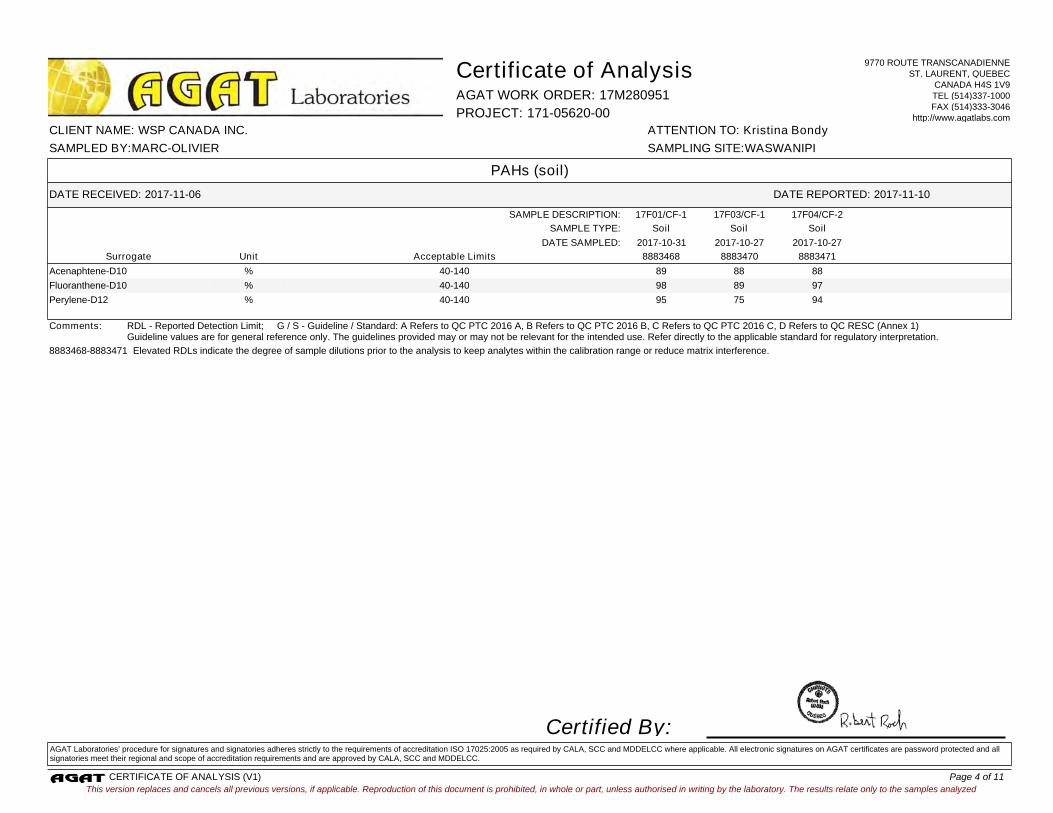
17F03/CF-117F01/CF-1 17F04/CF-2SAMPLE DESCRIPTION:
SoilSoilSoilSAMPLE TYPE:
2017-10-27 2017-10-272017-10-31DATE SAMPLED:
Acceptable Limits 8883468 8883470 8883471UnitSurrogate
89 88 88Acenaphtene-D10 % 40-140
98 89 97Fluoranthene-D10 % 40-140
95 75 94Perylene-D12 % 40-140
RDL - Reported Detection Limit; G / S - Guideline / Standard: A Refers to QC PTC 2016 A, B Refers to QC PTC 2016 B, C Refers to QC PTC 2016 C, D Refers to QC RESC (Annex 1)Guideline values are for general reference only. The guidelines provided may or may not be relevant for the intended use. Refer directly to the applicable standard for regulatory interpretation.
Comments:
8883468-8883471 Elevated RDLs indicate the degree of sample dilutions prior to the analysis to keep analytes within the calibration range or reduce matrix interference.
This version replaces and cancels all previous versions, if applicable. Reproduction of this document is prohibited, in whole or part, unless authorised in writing by the laboratory. The results relate only to the samples analyzed
Certificate of Analysis
ATTENTION TO: Kristina Bondy CLIENT NAME: WSP CANADA INC.
AGAT WORK ORDER: 17M280951
DATE RECEIVED: 2017-11-06 DATE REPORTED: 2017-11-10
PROJECT: 171-05620-00
SAMPLED BY:MARC-OLIVIER SAMPLING SITE:WASWANIPI
PAHs (soil)
9770 ROUTE TRANSCANADIENNE
ST. LAURENT, QUEBEC
CANADA H4S 1V9
TEL (514)337-1000
FAX (514)333-3046
http://www.agatlabs.com
CERTIFICATE OF ANALYSIS (V1)
Certified By:
Page 4 of 11
AGAT Laboratories’ procedure for signatures and signatories adheres strictly to the requirements of accreditation ISO 17025:2005 as required by CALA, SCC and MDDELCC where applicable. All electronic signatures on AGAT certificates are password protected and all signatories meet their regional and scope of accreditation requirements and are approved by CALA, SCC and MDDELCC.
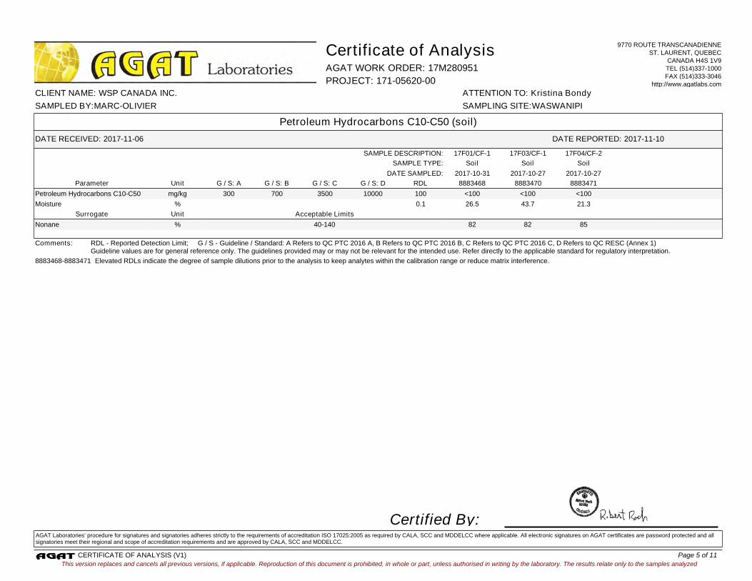
17F03/CF-117F01/CF-1 17F04/CF-2SAMPLE DESCRIPTION:
SoilSoilSoilSAMPLE TYPE:
2017-10-27 2017-10-272017-10-31DATE SAMPLED:
8883468 8883470 8883471G / S: A RDLUnit G / S: B G / S: C G / S: DParameter
<100 <100 <100Petroleum Hydrocarbons C10-C50 100300mg/kg 700 3500 10000
26.5 43.7 21.3Moisture 0.1%
Acceptable LimitsUnitSurrogate
82 82 85Nonane % 40-140
RDL - Reported Detection Limit; G / S - Guideline / Standard: A Refers to QC PTC 2016 A, B Refers to QC PTC 2016 B, C Refers to QC PTC 2016 C, D Refers to QC RESC (Annex 1)Guideline values are for general reference only. The guidelines provided may or may not be relevant for the intended use. Refer directly to the applicable standard for regulatory interpretation.
Comments:
8883468-8883471 Elevated RDLs indicate the degree of sample dilutions prior to the analysis to keep analytes within the calibration range or reduce matrix interference.
This version replaces and cancels all previous versions, if applicable. Reproduction of this document is prohibited, in whole or part, unless authorised in writing by the laboratory. The results relate only to the samples analyzed
Certificate of Analysis
ATTENTION TO: Kristina Bondy CLIENT NAME: WSP CANADA INC.
AGAT WORK ORDER: 17M280951
DATE RECEIVED: 2017-11-06 DATE REPORTED: 2017-11-10
PROJECT: 171-05620-00
SAMPLED BY:MARC-OLIVIER SAMPLING SITE:WASWANIPI
Petroleum Hydrocarbons C10-C50 (soil)
9770 ROUTE TRANSCANADIENNE
ST. LAURENT, QUEBEC
CANADA H4S 1V9
TEL (514)337-1000
FAX (514)333-3046
http://www.agatlabs.com
CERTIFICATE OF ANALYSIS (V1)
Certified By:
Page 5 of 11
AGAT Laboratories’ procedure for signatures and signatories adheres strictly to the requirements of accreditation ISO 17025:2005 as required by CALA, SCC and MDDELCC where applicable. All electronic signatures on AGAT certificates are password protected and all signatories meet their regional and scope of accreditation requirements and are approved by CALA, SCC and MDDELCC.
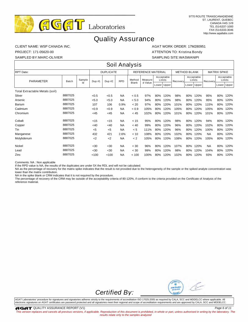
Total Extractable Metals (soil)
Silver 8887025 <0.5 <0.5 NA < 0.5 97% 80% 120% 98% 80% 120% 95% 80% 120%
Arsenic 8887025 <5.0 <5.0 NA < 5.0 94% 80% 120% 98% 80% 120% 95% 80% 120%
Barium 8887025 107 106 0.9% < 20 97% 80% 120% 101% 80% 120% 115% 80% 120%
Cadmium 8887025 <0.9 <0.9 NA < 0.9 105% 80% 120% 105% 80% 120% 105% 80% 120%
Chromium
8887025 <45 <45 NA < 45 102% 80% 120% 101% 80% 120% 101% 80% 120%
Cobalt 8887025 <15 <15 NA < 15 95% 80% 120% 98% 80% 120% 94% 80% 120%
Copper 8887025 <40 <40 NA < 40 99% 80% 120% 96% 80% 120% 102% 80% 120%
Tin 8887025 <5 <5 NA < 5 111% 80% 120% 96% 80% 120% 100% 80% 120%
Manganese 8887025 432 421 2.6% < 10 108% 80% 120% 102% 80% 120% NA 80% 120%
Molybdenum
8887025 <2 <2 NA < 2 105% 80% 120% 108% 80% 120% 105% 80% 120%
Nickel 8887025 <30 <30 NA < 30 96% 80% 120% 107% 80% 120% NA 80% 120%
Lead 8887025 <30 <30 NA < 30 99% 80% 120% 98% 80% 120% 104% 80% 120%
Zinc 8887025 <100 <100 NA < 100 100% 80% 120% 102% 80% 120% 93% 80% 120%
Comments: NA : Non applicableIf the RPD value is NA, the results of the duplicates are under 5X the RDL and will not be calculated.NA as the percentage of recovery for the matrix spike indicates that the result is not provided due to the heterogeneity of the sample or the spiked analyte concentration was lower than the matrix contribution.NA in the spike blank or CRM indicates that it is not required by the procedure.The percentage of recovery of the CRM may be outside of the acceptability criteria of 80-120%, if conform to the criteria provided on the Certificate of Analysis of the reference material.
Certified By:AGAT Laboratories’ procedure for signatures and signatories adheres strictly to the requirements of accreditation ISO 17025:2005 as required by CALA, SCC and MDDELCC where applicable. All electronic signatures on AGAT certificates are password protected and all signatories meet their regional and scope of accreditation requirements and are approved by CALA, SCC and MDDELCC.
This version replaces and cancels all previous versions, if applicable. Reproduction of this document is prohibited, in whole or part, unless authorised in writing by the laboratory. Theresults relate only to the samples analyzed
AGAT WORK ORDER: 17M280951
Dup #2
Lower Upper Lower Upper Lower Upper
Quality Assurance
ATTENTION TO: Kristina Bondy
CLIENT NAME: WSP CANADA INC.
PROJECT: 171-05620-00
SAMPLING SITE:WASWANIPISAMPLED BY:MARC-OLIVIER
Soil Analysis
PARAMETERSample
IdBatch Dup #1
MethodBlank
RPD
AcceptableLimitsMeasure
d Value
AcceptableLimits
Recovery
AcceptableLimits
Recovery
REFERENCE MATERIAL METHOD BLANK MATRIX SPIKERPT Date: DUPLICATE
9770 ROUTE TRANSCANADIENNE
ST. LAURENT, QUEBEC
CANADA H4S 1V9
TEL (514)337-1000
FAX (514)333-3046
http://www.agatlabs.com
QUALITY ASSURANCE REPORT (V1) Page 6 of 11
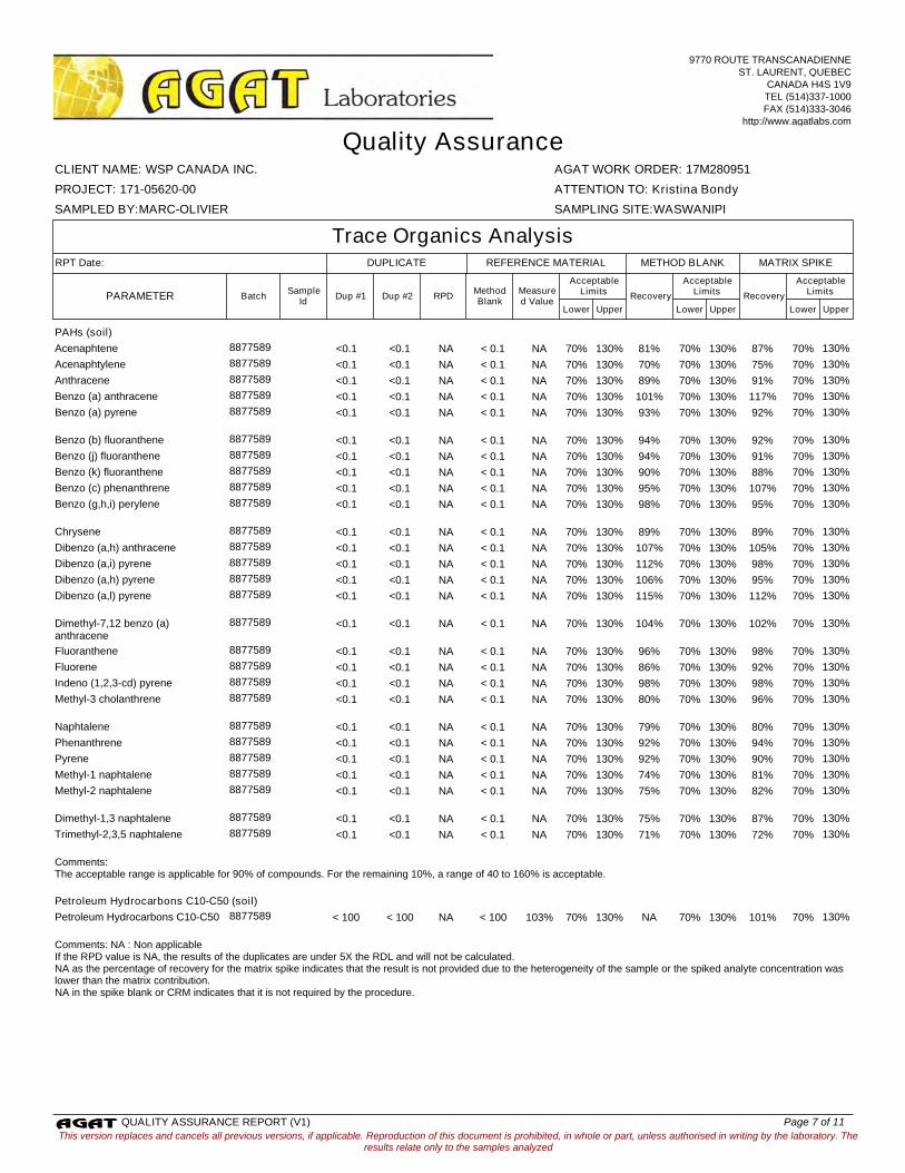
PAHs (soil)
Acenaphtene 8877589 <0.1 <0.1 NA < 0.1 NA 70% 130% 81% 70% 130% 87% 70% 130%
Acenaphtylene 8877589 <0.1 <0.1 NA < 0.1 NA 70% 130% 70% 70% 130% 75% 70% 130%
Anthracene 8877589 <0.1 <0.1 NA < 0.1 NA 70% 130% 89% 70% 130% 91% 70% 130%
Benzo (a) anthracene 8877589 <0.1 <0.1 NA < 0.1 NA 70% 130% 101% 70% 130% 117% 70% 130%
Benzo (a) pyrene
8877589 <0.1 <0.1 NA < 0.1 NA 70% 130% 93% 70% 130% 92% 70% 130%
Benzo (b) fluoranthene 8877589 <0.1 <0.1 NA < 0.1 NA 70% 130% 94% 70% 130% 92% 70% 130%
Benzo (j) fluoranthene 8877589 <0.1 <0.1 NA < 0.1 NA 70% 130% 94% 70% 130% 91% 70% 130%
Benzo (k) fluoranthene 8877589 <0.1 <0.1 NA < 0.1 NA 70% 130% 90% 70% 130% 88% 70% 130%
Benzo (c) phenanthrene 8877589 <0.1 <0.1 NA < 0.1 NA 70% 130% 95% 70% 130% 107% 70% 130%
Benzo (g,h,i) perylene
8877589 <0.1 <0.1 NA < 0.1 NA 70% 130% 98% 70% 130% 95% 70% 130%
Chrysene 8877589 <0.1 <0.1 NA < 0.1 NA 70% 130% 89% 70% 130% 89% 70% 130%
Dibenzo (a,h) anthracene 8877589 <0.1 <0.1 NA < 0.1 NA 70% 130% 107% 70% 130% 105% 70% 130%
Dibenzo (a,i) pyrene 8877589 <0.1 <0.1 NA < 0.1 NA 70% 130% 112% 70% 130% 98% 70% 130%
Dibenzo (a,h) pyrene 8877589 <0.1 <0.1 NA < 0.1 NA 70% 130% 106% 70% 130% 95% 70% 130%
Dibenzo (a,l) pyrene
8877589 <0.1 <0.1 NA < 0.1 NA 70% 130% 115% 70% 130% 112% 70% 130%
Dimethyl-7,12 benzo (a) anthracene
8877589 <0.1 <0.1 NA < 0.1 NA 70% 130% 104% 70% 130% 102% 70% 130%
Fluoranthene 8877589 <0.1 <0.1 NA < 0.1 NA 70% 130% 96% 70% 130% 98% 70% 130%
Fluorene 8877589 <0.1 <0.1 NA < 0.1 NA 70% 130% 86% 70% 130% 92% 70% 130%
Indeno (1,2,3-cd) pyrene 8877589 <0.1 <0.1 NA < 0.1 NA 70% 130% 98% 70% 130% 98% 70% 130%
Methyl-3 cholanthrene
8877589 <0.1 <0.1 NA < 0.1 NA 70% 130% 80% 70% 130% 96% 70% 130%
Naphtalene 8877589 <0.1 <0.1 NA < 0.1 NA 70% 130% 79% 70% 130% 80% 70% 130%
Phenanthrene 8877589 <0.1 <0.1 NA < 0.1 NA 70% 130% 92% 70% 130% 94% 70% 130%
Pyrene 8877589 <0.1 <0.1 NA < 0.1 NA 70% 130% 92% 70% 130% 90% 70% 130%
Methyl-1 naphtalene 8877589 <0.1 <0.1 NA < 0.1 NA 70% 130% 74% 70% 130% 81% 70% 130%
Methyl-2 naphtalene
8877589 <0.1 <0.1 NA < 0.1 NA 70% 130% 75% 70% 130% 82% 70% 130%
Dimethyl-1,3 naphtalene 8877589 <0.1 <0.1 NA < 0.1 NA 70% 130% 75% 70% 130% 87% 70% 130%
Trimethyl-2,3,5 naphtalene 8877589 <0.1 <0.1 NA < 0.1 NA 70% 130% 71% 70% 130% 72% 70% 130%
Comments: The acceptable range is applicable for 90% of compounds. For the remaining 10%, a range of 40 to 160% is acceptable.
Petroleum Hydrocarbons C10-C50 (soil)
Petroleum Hydrocarbons C10-C50 8877589 < 100 < 100 NA < 100 103% 70% 130% NA 70% 130% 101% 70% 130%
Comments: NA : Non applicableIf the RPD value is NA, the results of the duplicates are under 5X the RDL and will not be calculated.NA as the percentage of recovery for the matrix spike indicates that the result is not provided due to the heterogeneity of the sample or the spiked analyte concentration was lower than the matrix contribution.NA in the spike blank or CRM indicates that it is not required by the procedure.
This version replaces and cancels all previous versions, if applicable. Reproduction of this document is prohibited, in whole or part, unless authorised in writing by the laboratory. Theresults relate only to the samples analyzed
AGAT WORK ORDER: 17M280951
Dup #2
Lower Upper Lower Upper Lower Upper
Quality Assurance
ATTENTION TO: Kristina Bondy
CLIENT NAME: WSP CANADA INC.
PROJECT: 171-05620-00
SAMPLING SITE:WASWANIPISAMPLED BY:MARC-OLIVIER
Trace Organics Analysis
PARAMETERSample
IdBatch Dup #1
MethodBlank
RPD
AcceptableLimitsMeasure
d Value
AcceptableLimits
Recovery
AcceptableLimits
Recovery
REFERENCE MATERIAL METHOD BLANK MATRIX SPIKERPT Date: DUPLICATE
9770 ROUTE TRANSCANADIENNE
ST. LAURENT, QUEBEC
CANADA H4S 1V9
TEL (514)337-1000
FAX (514)333-3046
http://www.agatlabs.com
QUALITY ASSURANCE REPORT (V1) Page 7 of 11

This version replaces and cancels all previous versions, if applicable. Reproduction of this document is prohibited, in whole or part, unless authorised in writing by the laboratory. Theresults relate only to the samples analyzed
AGAT WORK ORDER: 17M280951
Dup #2
Lower Upper Lower Upper Lower Upper
Quality Assurance
ATTENTION TO: Kristina Bondy
CLIENT NAME: WSP CANADA INC.
PROJECT: 171-05620-00
SAMPLING SITE:WASWANIPISAMPLED BY:MARC-OLIVIER
Trace Organics Analysis (Continued)
PARAMETERSample
IdBatch Dup #1
MethodBlank
RPD
AcceptableLimitsMeasure
d Value
AcceptableLimits
Recovery
AcceptableLimits
Recovery
REFERENCE MATERIAL METHOD BLANK MATRIX SPIKERPT Date: DUPLICATE
9770 ROUTE TRANSCANADIENNE
ST. LAURENT, QUEBEC
CANADA H4S 1V9
TEL (514)337-1000
FAX (514)333-3046
http://www.agatlabs.com
Certified By:AGAT Laboratories’ procedure for signatures and signatories adheres strictly to the requirements of accreditation ISO 17025:2005 as required by CALA, SCC and MDDELCC where applicable. All electronic signatures on AGAT certificates are password protected and all signatories meet their regional and scope of accreditation requirements and are approved by CALA, SCC and MDDELCC.
QUALITY ASSURANCE REPORT (V1) Page 8 of 11
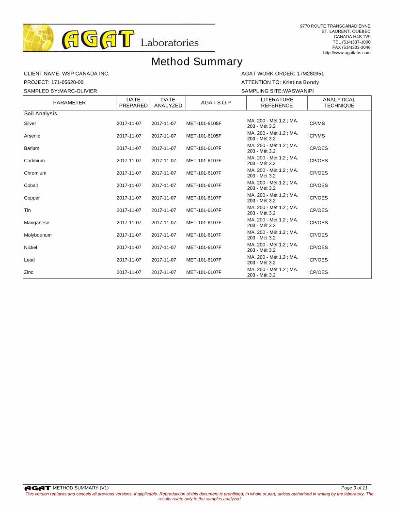
Soil Analysis
Silver MET-101-6105FMA. 200 - Mét 1.2 ; MA. 203 - Mét 3.2
ICP/MS2017-11-07 2017-11-07
Arsenic MET-101-6105FMA. 200 - Mét 1.2 ; MA. 203 - Mét 3.2
ICP/MS2017-11-07 2017-11-07
Barium MET-101-6107FMA. 200 - Mét 1.2 ; MA. 203 - Mét 3.2
ICP/OES2017-11-07 2017-11-07
Cadmium MET-101-6107FMA. 200 - Mét 1.2 ; MA. 203 - Mét 3.2
ICP/OES2017-11-07 2017-11-07
Chromium MET-101-6107FMA. 200 - Mét 1.2 ; MA. 203 - Mét 3.2
ICP/OES2017-11-07 2017-11-07
Cobalt MET-101-6107FMA. 200 - Mét 1.2 ; MA. 203 - Mét 3.2
ICP/OES2017-11-07 2017-11-07
Copper MET-101-6107FMA. 200 - Mét 1.2 ; MA. 203 - Mét 3.2
ICP/OES2017-11-07 2017-11-07
Tin MET-101-6107FMA. 200 - Mét 1.2 ; MA. 203 - Mét 3.2
ICP/OES2017-11-07 2017-11-07
Manganese MET-101-6107FMA. 200 - Mét 1.2 ; MA. 203 - Mét 3.2
ICP/OES2017-11-07 2017-11-07
Molybdenum MET-101-6107FMA. 200 - Mét 1.2 ; MA. 203 - Mét 3.2
ICP/OES2017-11-07 2017-11-07
Nickel MET-101-6107FMA. 200 - Mét 1.2 ; MA. 203 - Mét 3.2
ICP/OES2017-11-07 2017-11-07
Lead MET-101-6107FMA. 200 - Mét 1.2 ; MA. 203 - Mét 3.2
ICP/OES2017-11-07 2017-11-07
Zinc MET-101-6107FMA. 200 - Mét 1.2 ; MA. 203 - Mét 3.2
ICP/OES2017-11-07 2017-11-07
This version replaces and cancels all previous versions, if applicable. Reproduction of this document is prohibited, in whole or part, unless authorised in writing by the laboratory. Theresults relate only to the samples analyzed
AGAT WORK ORDER: 17M280951
Method Summary
ATTENTION TO: Kristina Bondy
CLIENT NAME: WSP CANADA INC.
PROJECT: 171-05620-00
SAMPLED BY:MARC-OLIVIER SAMPLING SITE:WASWANIPI
ANALYTICALTECHNIQUE
DATEPREPARED
PARAMETER AGAT S.O.PLITERATUREREFERENCE
DATEANALYZED
9770 ROUTE TRANSCANADIENNE
ST. LAURENT, QUEBEC
CANADA H4S 1V9
TEL (514)337-1000
FAX (514)333-3046
http://www.agatlabs.com
METHOD SUMMARY (V1) Page 9 of 11
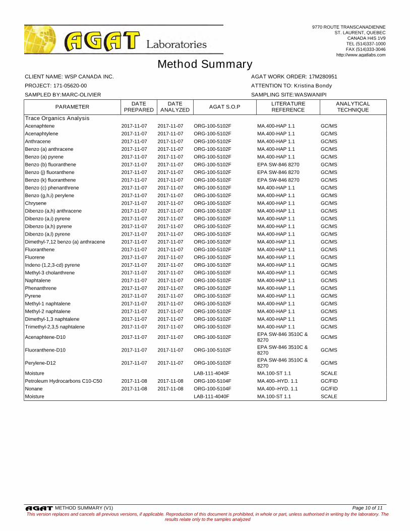
Trace Organics Analysis
Acenaphtene ORG-100-5102F MA.400-HAP 1.1 GC/MS2017-11-07 2017-11-07
Acenaphtylene ORG-100-5102F MA.400-HAP 1.1 GC/MS2017-11-07 2017-11-07
Anthracene ORG-100-5102F MA.400-HAP 1.1 GC/MS2017-11-07 2017-11-07
Benzo (a) anthracene ORG-100-5102F MA.400-HAP 1.1 GC/MS2017-11-07 2017-11-07
Benzo (a) pyrene ORG-100-5102F MA.400-HAP 1.1 GC/MS2017-11-07 2017-11-07
Benzo (b) fluoranthene ORG-100-5102F EPA SW-846 8270 GC/MS2017-11-07 2017-11-07
Benzo (j) fluoranthene ORG-100-5102F EPA SW-846 8270 GC/MS2017-11-07 2017-11-07
Benzo (k) fluoranthene ORG-100-5102F EPA SW-846 8270 GC/MS2017-11-07 2017-11-07
Benzo (c) phenanthrene ORG-100-5102F MA.400-HAP 1.1 GC/MS2017-11-07 2017-11-07
Benzo (g,h,i) perylene ORG-100-5102F MA.400-HAP 1.1 GC/MS2017-11-07 2017-11-07
Chrysene ORG-100-5102F MA.400-HAP 1.1 GC/MS2017-11-07 2017-11-07
Dibenzo (a,h) anthracene ORG-100-5102F MA.400-HAP 1.1 GC/MS2017-11-07 2017-11-07
Dibenzo (a,i) pyrene ORG-100-5102F MA.400-HAP 1.1 GC/MS2017-11-07 2017-11-07
Dibenzo (a,h) pyrene ORG-100-5102F MA.400-HAP 1.1 GC/MS2017-11-07 2017-11-07
Dibenzo (a,l) pyrene ORG-100-5102F MA.400-HAP 1.1 GC/MS2017-11-07 2017-11-07
Dimethyl-7,12 benzo (a) anthracene ORG-100-5102F MA.400-HAP 1.1 GC/MS2017-11-07 2017-11-07
Fluoranthene ORG-100-5102F MA.400-HAP 1.1 GC/MS2017-11-07 2017-11-07
Fluorene ORG-100-5102F MA.400-HAP 1.1 GC/MS2017-11-07 2017-11-07
Indeno (1,2,3-cd) pyrene ORG-100-5102F MA.400-HAP 1.1 GC/MS2017-11-07 2017-11-07
Methyl-3 cholanthrene ORG-100-5102F MA.400-HAP 1.1 GC/MS2017-11-07 2017-11-07
Naphtalene ORG-100-5102F MA.400-HAP 1.1 GC/MS2017-11-07 2017-11-07
Phenanthrene ORG-100-5102F MA.400-HAP 1.1 GC/MS2017-11-07 2017-11-07
Pyrene ORG-100-5102F MA.400-HAP 1.1 GC/MS2017-11-07 2017-11-07
Methyl-1 naphtalene ORG-100-5102F MA.400-HAP 1.1 GC/MS2017-11-07 2017-11-07
Methyl-2 naphtalene ORG-100-5102F MA.400-HAP 1.1 GC/MS2017-11-07 2017-11-07
Dimethyl-1,3 naphtalene ORG-100-5102F MA.400-HAP 1.1 GC/MS2017-11-07 2017-11-07
Trimethyl-2,3,5 naphtalene ORG-100-5102F MA.400-HAP 1.1 GC/MS2017-11-07 2017-11-07
Acenaphtene-D10 ORG-100-5102FEPA SW-846 3510C & 8270
GC/MS2017-11-07 2017-11-07
Fluoranthene-D10 ORG-100-5102FEPA SW-846 3510C & 8270
GC/MS2017-11-07 2017-11-07
Perylene-D12 ORG-100-5102FEPA SW-846 3510C & 8270
GC/MS2017-11-07 2017-11-07
Moisture LAB-111-4040F MA.100-ST 1.1 SCALE
Petroleum Hydrocarbons C10-C50 ORG-100-5104F MA.400–HYD. 1.1 GC/FID2017-11-08 2017-11-08
Nonane ORG-100-5104F MA.400–HYD. 1.1 GC/FID2017-11-08 2017-11-08
Moisture LAB-111-4040F MA.100-ST 1.1 SCALE
This version replaces and cancels all previous versions, if applicable. Reproduction of this document is prohibited, in whole or part, unless authorised in writing by the laboratory. Theresults relate only to the samples analyzed
AGAT WORK ORDER: 17M280951
Method Summary
ATTENTION TO: Kristina Bondy
CLIENT NAME: WSP CANADA INC.
PROJECT: 171-05620-00
SAMPLED BY:MARC-OLIVIER SAMPLING SITE:WASWANIPI
ANALYTICALTECHNIQUE
DATEPREPARED
PARAMETER AGAT S.O.PLITERATUREREFERENCE
DATEANALYZED
9770 ROUTE TRANSCANADIENNE
ST. LAURENT, QUEBEC
CANADA H4S 1V9
TEL (514)337-1000
FAX (514)333-3046
http://www.agatlabs.com
METHOD SUMMARY (V1) Page 10 of 11

Second entry point into the community Cree First Nation of Waswanipi
APPENDIX G
WSP Environmental Clauses

Clauses techniques particulières Second entry point into Environnement the community of Waswanipi
Page 1 de 42
WSP N/Dossier : 171-05620-00
Émis pour demande environnementale Le 23 novembre 2017
1.0 GÉNÉRALITÉS
La protection de l’environnement doit être assurée conformément aux exigences du CCDG (édition 2017) et du chapitre 9 « Mesures d’atténuation environnementales temporaires » du Tome II – Construction routière de la collection des Normes - Ouvrages routiers du ministère des Transports, de la Mobilité durable et de l’Électrification des Transports (MTMDET). Les stipulations du présent devis, qui complète ou invalide certains articles de ces références, s’appliquent à tous les devis spéciaux. Dans le cadre de ses travaux, l’entrepreneur doit prendre en compte que certaines sections des travaux se déroulent près de zones et de régions sensibles au niveau environnemental. Notamment, le milieu humide entre les chaînages +/- 0+000 @ 0+200 et +/- 0+300 @ 0+400.
Plusieurs intervenants sont concernés par la protection des milieux naturels et des efforts particuliers doivent être mis de l’avant pour protéger l’environnement. L’entrepreneur doit baliser les limites des terrassements projetés, de déboisement et de décapage des sols. Le tout afin d’éviter tout débordement en dehors de l’emprise des travaux prévus et dans les milieux naturels.
2.0 OBLIGATIONS RÉGLEMENTAIRES DE L'ENTREPRENEUR
En complément de l’article 6.14 du CCDG, l’entrepreneur doit se conformer aux lois, directives, normes et règlements relatifs à la protection de l’environnement émanant du gouvernement du Québec et du gouvernement du Canada.
Le choix de la méthode de travail de l’entrepreneur à l’intérieur des limites des travaux doit se conformer aux autorisations détenues par la municipalité de Waswanipi.
Toutes les clauses environnementales du présent contrat s'appliquent également à tout aménagement temporaire réalisé dans les limites des travaux et sur tout site ou chemin nécessaire à l'extérieur desdites limites (aire de chantier, aire de rebuts, chemin de déviation, chemin d'accès, site d'emprunt, servitudes, etc.).
3.0 PLAN D'ACTION POUR LA PROTECTION DE L'ENVIRONNEMENT
Pour la réalisation du présent projet, voici une identification des risques et impacts environnementaux possibles :
� Éviter la contamination de l’eau (voir articles 3.0 « Plan d’action pour la protection de l’environnement », 7.0 « Ravitaillement, équipement à essence, entretien et circulation de la machinerie », 8.0 « Installations de chantier, sites divers et chemins d'accès », 10.0 « Protection des cours d’eau et milieux humides », 11.0 « Batardeaux », 12.0 « Dérivation temporaire d’un cours d’eau », 13.0 « Fossés et bandes riveraines », 14.0 « Contrôle de l’érosion sur le chantier » et 15.0 « Rideau de turbidité » du présent devis);
Clauses techniques particulières Second entry point into Environnement the community of Waswanipi
Page 2 de 42
WSP N/Dossier : 171-05620-00
Émis pour demande environnementale Le 23 novembre 2017
� Gestion des hydrocarbures (voir article 4.0 « Plan d'urgence environnementale et 7.0 « Ravitaillement, équipement à essence, entretien et circulation de la machinerie » du présent devis;
� Limiter les émissions atmosphériques (voir article 17.0 « Protection de la qualité de l’air et gestion des poussières » du présent devis);
� Limiter la consommation d’énergie (voir article 7.0 « Ravitaillement, équipement à essence, entretien et circulation de la machinerie » du présent devis);
� Protection du milieu naturel (faune, flore et milieu naturel) (voir les articles 9.0 « Déboisement » et 10.0 « Protection des cours d’eau et milieux humides » du présent devis);
� Organisation du chantier (voir les articles 5.0 « Propreté du chantier », 6.0 « Restauration des sites temporaires utilisés à l’extérieur de l’emprise » et 8.0 « Installations de chantier, sites divers et chemins d'accès ».
Le plan d’action pour la protection de l’environnement de l’entrepreneur doit démontrer comment celui-ci entend respecter ou prendre en considération les objectifs énoncés.
Le plan d'action contient notamment les éléments suivants :
� Identification du responsable en environnement, de ses qualifications et de ses responsabilités;
� Organigramme de communication du chantier;
� Ordonnancement des travaux;
� Indication des sites nécessitant la délimitation physique (clôture, ruban, etc.) des bandes riveraines (cours d'eau et lacs) où le couvert végétal doit être conservé le plus longtemps possible avant la réalisation des terrassements;
� Plans et positionnement d’ouvrages temporaires (batardeaux, canaux de dérivation, bassins de sédimentation, aires de nettoyage de bétonnière, etc.) à l’intérieur de l’emprise et pour tous autres travaux situés à l’extérieur de cette emprise (site d’entreposage temporaire, site de rebuts, etc.);
� Localisation et combinaison des méthodes de contrôle de l’érosion (incluant des rideaux de turbidité) prescrites dans le présent devis, dans les dessins normalisés et au CCDG pour les travaux;
� Détermination des fossés qui doivent être détournés vers des zones de végétation;
� Prévision des zones à engazonner sans délai et à recouvrir avec des matelas de fibre de bois ou de paille;
� Surveillance météo;
� Plans d'aménagement des bureaux de chantier, des stationnements, des aires de rebuts ou autres sites nécessaires aux travaux (volume de matériaux projetés, chemins d’accès, superficie utilisée, qualité des sols sous-jacents, localisation des cours d'eau, des milieux humides et des lacs, protection des arbres, terrassement, etc.);
Clauses techniques particulières Second entry point into Environnement the community of Waswanipi
Page 3 de 42
WSP N/Dossier : 171-05620-00
Émis pour demande environnementale Le 23 novembre 2017
� Un plan de contrôle de l’érosion et de gestion des sédiments incluant les méthodes et fréquences de nettoyage et d’entretien des fosses de captation, des bermes filtrantes, des trappes à sédiments, des barrières à sédiments et des aires de nettoyage des bétonnières;
� Méthode d’enlèvement des structures de traversée des cours d’eau et méthode de remise en état des lieux pour éviter l’érosion;
� Méthode de déboisement, protection des arbres;
� Et tous autres travaux connexes;
� Etc. Dès le début des travaux, l'entrepreneur doit avoir en sa possession sur le chantier le matériel nécessaire pour réaliser les interventions prescrites au présent document. L'entrepreneur doit intervenir immédiatement pour tout événement jugé dommageable par le surveillant ou susceptible de causer un dommage à l’environnement.
4.0 PLAN D'URGENCE ENVIRONNEMENTALE
Sept jours avant de débuter les travaux, l’entrepreneur doit préparer et soumettre pour approbation du surveillant, un programme de prévention et un plan d’urgence environnementale, en informer les travailleurs et le mettre en œuvre lorsque nécessaire. Le plan d’urgence environnementale doit comprendre :
� Les objectifs du programme de prévention et plan d’urgence;
� L’analyse des dangers des travaux pour l’environnement;
� La liste des situations pouvant mettre en danger l’environnement;
� Les mesures préventives afférentes aux situations dangereuses;
� Le suivi et mesures correctives du programme de prévention et plan d’urgence;
� Les différentes interventions et procédures complètes et détaillées à réaliser en cas de déversement ou d’accident (terrestre ou aquatique);
� Un exemple du rapport d’événement avec photo avant et après;
� Fiches d’inspections hebdomadaires des véhicules ou autres machineries;
� La liste des personnes, entreprises, organismes ou toute autre autorité à contacter en cas d’urgence ou de déversement ainsi que la description des rôles et responsabilité de chacun.
Quatre copies du programme de prévention et du plan d’urgence environnementale approuvés par les autorités concernées doivent être remises au surveillant.
Déversement accidentel de contaminants
L’entrepreneur doit informer Urgence Environnement et Environnement Canada de tout accident ou déversement pouvant perturber l’environnement, peu importe la quantité déversée. Les numéros de téléphone doivent être affichés dans la roulotte de chantier.
Clauses techniques particulières Second entry point into Environnement the community of Waswanipi
Page 4 de 42
WSP N/Dossier : 171-05620-00
Émis pour demande environnementale Le 23 novembre 2017
URGENCE ENVIRONNEMENT
Téléphone : 1-866-694-5454, sans frais 24 heures sur 24.
RÉSEAU D’ALERTE D’ENVIRONNEMENT CANADA Téléphone: 1-866-283-2323, 24 heures sur 24.
L’entrepreneur doit signaler au surveillant chaque déversement dans un délai maximum de vingt-quatre (24) heures, suite à l’évènement. Ces épisodes seront considérés clos sur avis du surveillant en conséquence de son suivi. Tel que stipulé à l’article 10.4.2 du CCDG, l’entrepreneur doit disposer en permanence sur le chantier des trousses d’urgence de récupération de produits pétroliers. Les trousses doivent comprendre suffisamment de rouleaux absorbants pour permettre d’intervenir sur la largeur du cours d’eau ou de permettre de confiner les produits pétroliers à l’intérieur du périmètre de la machinerie en cause en aménageant une estacade flottante. Avant le début des travaux, l’entrepreneur doit transmettre au surveillant les sites de dispositions et le nom des sous-traitants spécialisés en récupération de déversement d’hydrocarbure ou autres.
5.0 PROPRETÉ DU CHANTIER
Le chantier doit être libre en tout temps de déchets qu'il s'agit de contenants vides de toutes sortes ou autres à moins qu'ils ne soient placés dans un récipient étanche destiné à cette fin. Gérer les déchets solides et les matériaux secs selon les modalités du Règlement sur les déchets solides (C.Q-2, r.3.2) et du Règlement sur l’enfouissement et l’incinération de matières résiduelles (D. 451-2005).
De plus, conformément à l'article 20 de la Loi sur la qualité de l'environnement, il est interdit de jeter des débris de toutes sortes dans un cours d'eau, dans un lac et dans l'environnement y compris tous les arbres ou parties d’arbres qui tombent dans un cours d'eau ou dans un lac. Dans le cas contraire, les retirer sans délai.
Aucun brûlage de déchets, de débris, de bois ou autre n’est permis sur le chantier.
6.0 RESTAURATION DES SITES TEMPORAIRES UTILISÉS À L’EXTÉRIEUR DE L’EMPRISE
Sans restreindre les obligations et la portée de l’article 6.9 du CCDG, l’entrepreneur doit faire approuver par le surveillant les aires de rebuts, les chemins temporaires et les autres sites hors emprise qu’il entend aménager. Pour ce faire, il doit adresser les localisations des sites dans les sept jours avant leur utilisation au surveillant de chantier.
Restauration
En plus des prescriptions des articles 7.11 et 11.2.1 du CCDG, avant la fin des travaux, l'entrepreneur doit remettre dans leur état original les sites temporaires utilisés à l'extérieur de l'emprise (chemin d'accès ou de déviation, aire d'entreposage, site de concassage, etc.) en respectant les prescriptions suivantes :
Clauses techniques particulières Second entry point into Environnement the community of Waswanipi
Page 5 de 42
WSP N/Dossier : 171-05620-00
Émis pour demande environnementale Le 23 novembre 2017
� Le régalage assurant l'intégration au relief naturel et l'écoulement naturel des eaux;
� La protection contre l'érosion;
� L'enlèvement de tout débris ou de tout équipement;
� La restauration de la végétation par engazonnement et plantation conformément à la section 19 du CCDG et les spécifications de l'article 11.2.1 du CCDG., concernant les travaux sur les terres forestières du domaine public.
7.0 RAVITAILLEMENT, ÉQUIPEMENT À ESSENCE, ENTRETIEN ET CIRCULATION DE LA MACHINERIE
L'entretien et le nettoyage de la machinerie, ainsi que son ravitaillement en carburant et en lubrifiant ainsi que les vidanges d’huile doivent être effectuées dans les aires prévues à cette fin et situées à une distance d’au moins 60 mètres d’un cours d’eau, d’un lac ou de toute autre étendue d'eau et à plus de 20 mètres d’un cours d’eau intermittent ou fossé et égouts. Ces distances remplacent celles stipulées à l’article 10.4.3.1 du CCDG. Ces aires doivent être installées dans des endroits où il n’existe aucun risque de contamination du milieu hydrique ou municipal (incluant le réseau pluvial, sanitaire et mixte). Ces conditions s’appliquent également à tous équipements à essence utilisés par l’entrepreneur.
De plus, aucune machinerie isolée ou équipement à essence ne doit demeurer sur un batardeau, une jetée ou à moins de 60 mètres d'un cours d'eau ou d'un lac pendant les heures de fermeture du chantier. Dans l'impossibilité de respecter cette prescription, des mesures de protection de l'environnement doivent être appliquées (surveillance ou autre).
Lorsqu’il y a circulation à proximité d’un cours d’eau ou d’un lac, les ornières causées par la machinerie doivent être bloquées ou détournées pour éviter le transport de sédiments vers le milieu hydrique. Pour la traversée des cours d'eau avec la machinerie, l'entrepreneur doit aménager un pont ou un ponceau temporaire en suivant toutes les prescriptions du présent document. Au besoin, les routes et les voies publiques adjacentes au chantier empruntées par les engins de chantier et les camions doivent être nettoyées. Au besoin, les chemins d’accès non pavés doivent être régalés et un abat-poussière doit être épandu sur les chemins d’accès non pavés empruntés par les camions. Durant le transport des matériaux contenant des particules fines, des bâches doivent être fixées solidement pour les recouvrir en tout temps.
8.0 INSTALLATIONS DE CHANTIER, SITES DIVERS ET CHEMINS D'ACCÈS
En plus des spécifications des documents techniques et de l’article 10.2 du CCDG, les locaux de chantier, leurs dépendances et stationnements, ainsi que tout autre site nécessaire aux travaux et à l’organisation du chantier, notamment les aires de rebuts, doivent être installés ou aménagés à une distance d'au moins 60 mètres (forêts du domaine de l'État ou à l'extérieur de la bande riveraine sur les terres du domaine privé) des cours d’eau permanents ou des lacs et à plus de 20 mètres des cours d’eau intermittents ou fossé.
Clauses techniques particulières Second entry point into Environnement the community of Waswanipi
Page 6 de 42
WSP N/Dossier : 171-05620-00
Émis pour demande environnementale Le 23 novembre 2017
De plus, les locaux de chantier et aires d’entreposage de la machinerie doivent être situés à une distance qui n’a aucun impact sur les secteurs habités.
Les sites déjà déboisés ou perturbés doivent être utilisés en premier lieu pour l’installation des locaux de chantier, sites d’entreposage et chemins d’accès. En d'autres cas, une autorisation du surveillant est nécessaire en plus des autorisations écrites du propriétaire. Lorsque l'entrepreneur doit aménager un chemin pour donner accès à un site d'emprunt, à un site de concassage, à un site d’entreposage, à une aire de rebuts, à un local de chantier ou à tout autre site nécessaire à l'exécution des travaux, il doit aménager un seul chemin d'accès par site. Ce chemin doit bifurquer rapidement de la route afin d’avoir le moins possible d’empreinte environnementale, tout en respectant les règles de sécurités et de conception routière applicables à ces ouvrages.
Les chemins d'accès temporaires aux sites doivent être démantelés et restaurés à la fin des travaux à moins d'indication contraire du surveillant.
Il est également à noter qu’aucun déboisement à l’extérieur de l’emprise identifiée au plan ne sera permis pour l’installation des aires de chantier.
9.0 DÉBOISEMENT
Les travaux de déboisement requis pour le projet, tel qu’indiqué aux plans et à la demande du surveillant de chantier, se font conformément à l’article 11.2 du CCDG. L’abattage d’arbres isolés se fait selon les articles 11.2.4, 11.2.5 et 11.2.7 du CCDG. Les superficies et limites exactes de déboisement sont présentées aux plans et elles doivent être validées sur le site. Les travaux incluent également la récupération, le transport et la disposition des volumes de bois commerciaux de même que le déchiquetage et la disposition des volumes de bois non commerciaux.
Implantation des zones à déboiser
Les limites des zones à déboiser, tel qu’indiqué aux plans doivent être marquées et être autorisées par le surveillant avant que ne débutent les travaux de déboisement. Cette implantation consiste à positionner des rubans sur les limites proposées afin de s’assurer que les opérations de déboisement atteignent et ne dépassent pas les limites prévues des travaux. L’implantation doit être faite en suivant les critères suivants :
� Pose d’un piquet/ruban à un intervalle de 5 mètres ou plus rapproché;
� Positionnement des piquets/rubans suivant une précision de 30 cm dans les deux axes;
� Implantation des piquets/rubans effectuée à l’aide d’un GPS.
Clauses techniques particulières Second entry point into Environnement the community of Waswanipi
Page 7 de 42
WSP N/Dossier : 171-05620-00
Émis pour demande environnementale Le 23 novembre 2017
Travaux de déboisement
Lorsque des arbres doivent être protégés à proximité d’une aire de travail, l’entrepreneur peut dégager ces aires de travail par élagage des arbres en conformité avec les dessins normalisés IV-10-002 et IV-10-003 inclut à l’annexe 3.
La bande de protection riveraine bande de 20 mètres (en fonction de la pente du talus) longeant les cours d’eau, les milieux humides et les plans d’eau doivent être maintenus en tout temps à l’exception des endroits requis pour la mise en place des infrastructures.
La végétation riveraine doit être délimitée et conservée le plus longtemps possible avant la réalisation des terrassements. Dans une bande de 20 mètres longeant les cours d’eau, les milieux humides et les plans d’eau; le couvert végétal (strate arbustive) doit être conservé jusqu’au début des travaux et le coupage des arbres doit se faire à ras de terre de manière à conserver les souches.
À l’exception des berges, des fossés et des bandes riveraines des cours d’eau (haut de talus + 20 mètres) et des zones de coupe sélective, les travaux peuvent se faire à l’aide d’abatteuses dans les endroits accessibles.
L’entrepreneur doit effectuer l’abattage des arbres de manière à diriger leur chute à l’intérieur des aires à déboiser. L’entrepreneur ne doit laisser aucun résidu de coupe dans les cours d’eau et les secteurs non touchés par les travaux.
Si l’entrepreneur utilise une débroussailleuse pour couper les arbres et arbustes, il doit éviter que les copeaux de bois soient expulsés hors emprise ou à toute autre zone sensible (cours d’eau, plan d’eau, milieux humides, quartier résidentiel, etc.).
Dans une bande de 5 mètres de part et d’autre des cours d’eau, les arbres de plus de 10 cm de diamètre doivent être coupés de façon manuelle selon les précisions du document 110 et conformément aux spécifications DS-115-ENV-106 ci-joint.
Destination des matériaux provenant du déboisement
En complément des spécifications du document technique et de l’article 11.2.3 du CCDG, le bois d’une valeur commerciale, coupé dans l’emprise, est la propriété de l’entrepreneur qui ne peut le brûler, l’enterrer ou le détruire.
Il est à noter que le brûlage des débris ligneux, des volumes de bois non commerciaux et branches sont strictement interdits à l’intérieur et à l’extérieur des emprises. Aucun matériau ne peut être entreposé à l’intérieur de l’emprise après la date de fin des travaux.
Récupération du bois commercial déjà coupé et débris végétaux
Sur le site des travaux, peuvent déjà avoir effectué certains travaux de déboisement (coupage à ras de terre) dans le cadre de travaux d’implantation, de sondages pédologiques, etc.
Clauses techniques particulières Second entry point into Environnement the community of Waswanipi
Page 8 de 42
WSP N/Dossier : 171-05620-00
Émis pour demande environnementale Le 23 novembre 2017
Aux endroits ayant fait l’objet des travaux susmentionnés, les débris ligneux et le bois commercial doivent être récupérés, transportés et valorisés. Si la valorisation est impossible, l’entrepreneur peut disposer sous approbation du surveillant.
10.0 PROTECTION DES COURS D’EAU ET MILIEUX HUMIDES
Généralités
Le tableau suivant dresse la liste de ces cours d’eau ainsi que leurs caractéristiques environnementales.
Numéro du cours d’eau (Nom) Chaînage Type
d’écoulement Potentiel d’habitat
du poisson CE1 0+023 Drainage Non CE2 0+050 Permanent Oui CE3 0+295 Intermittent Non
Période de restriction de travaux dans les cours d’eau
Les travaux doivent être exécutés en dehors des périodes sensibles pour le poisson. Par conséquent, aucun travaux en milieu aquatique ne peut être réalisé entre le 1 septembre et le 14 juillet inclusivement, soit pour le cours d’eau situés au chaînage 0+050.
Ouvrages temporaires dans un cours d'eau ou dans un lac
En plus des spécifications des articles 10.3.7 et 10.3.8 du CCDG, les travaux relatifs aux ouvrages temporaires, notamment les digues, les chemins de déviation et d’accès ainsi que les ponts et ponceaux temporaires, doivent être réalisés conformément à l'article 15.2.2 du CCDG au regard du pourcentage de matières fines des sols utilisés et des autres exigences de conception mentionnées.
Conformément à l’article 10.4.1 du CCDG, les matériaux d’emprunt utilisés pour la construction de ces ouvrages ne doivent pas provenir d'un cours d'eau ou d'un lac et ni de ses berges. Cependant, les matériaux granulaires du lit de toute section de cours d'eau remaniée doivent être récupérés pour les besoins de restauration du nouveau lit.
Conformément à l'article 10.4.3.5 du CCDG, ces ouvrages doivent être protégés contre l'érosion par de la stabilisation notamment à l’aide d’un géotextile ou d’un empierrement. De plus, ils doivent être conçus pour résister aux crues susceptibles de survenir pendant la période des travaux.
Conformément à l’article 10.4.3.2.3 du CCDG, les eaux provenant de l’assèchement des excavations et des batardeaux doivent être évacuées dans un bassin de sédimentation ou dans une zone de végétation. Les eaux évacuées dans une zone de végétation peuvent se faire seulement sous l’acceptation du surveillant. Dans cette zone de végétation, l’extrémité du boyau d'évacuation doit être mise en place à plus de 60 mètres d'un cours d'eau, d’un milieu humide ou d'un lac. Dans l’éventualité de l’inefficacité de cette méthode, l’entrepreneur devra utiliser un bassin de sédimentation.
Clauses techniques particulières Second entry point into Environnement the community of Waswanipi
Page 9 de 42
WSP N/Dossier : 171-05620-00
Émis pour demande environnementale Le 23 novembre 2017
11.0 BATARDEAUX
Conception
Les batardeaux doivent être conçus et construits selon les exigences de l’article 15.2 du CCDG et conformément aux spécifications particulières suivantes :
Matériaux :
Le batardeau comportant des particules de moins de 5 mm doit être conçu de façon à éliminer la migration de particules fines à l’extérieur de celui-ci. Pour ce faire, l’entrepreneur utilise :
� Une géomembrane imperméable. La géomembrane doit être installée en tenant compte de la séquence d’installation et de démantèlement et des mesures d’atténuation décrites aux articles « Séquence d’installation » et « Gestion des eaux de pompage » du présent document. Les matériaux granulaires utilisés pour la construction des ouvrages ne doivent pas provenir du lit d’un cours d’eau ou plan d’eau ni de ses berges ni d’aucune source située à moins de 75 mètres du milieu aquatique.
Exigences particulières de conception
En plus des spécifications de l’article 15.2.2 du CCDG, le batardeau doit être conçu de manière à résister aux débits susceptibles de survenir durant la période de réalisation des travaux.
Travaux préparatoires
À l’intérieur de l’emprise de la route et/ou de la servitude de construction, la préparation du littoral et des berges aux fins d’installation du batardeau est incluse dans les travaux préparatoires.
À moins d’avis contraire, les matériaux du lit de toute section de cours d’eau remaniée doivent être récupérés afin de restaurer le lit du cours d’eau à la fin des travaux.
Gestion des eaux de pompage
L’entrepreneur doit assécher le batardeau et gérer les eaux de pompage de manière à limiter les impacts environnementaux.
Les eaux de pompage doivent obligatoirement être envoyées dans un bassin de sédimentation ou sous acceptation du surveillant dans une zone de végétation. Le rejet des eaux dans le cours d’eau ne doit pas contenir de matières en suspension au-delà du bruit de fond du cours d’eau et visibles à l’œil nu.
Les eaux de pompage qui sont recueillies dans des bassins de sédimentation temporaires formés par excavation ou construction autres (conteneur, etc.). Ces ouvrages doivent être conçus par un professionnel en fonction des particularités du site selon les exigences de l’article bassin de sédimentation.
Clauses techniques particulières Second entry point into Environnement the community of Waswanipi
Page 10 de 42
WSP N/Dossier : 171-05620-00
Émis pour demande environnementale Le 23 novembre 2017
Pour ce qui est du rejet dans une zone de végétation, le boyau d’évacuation doit être mis en place hors des milieux humides et à plus de 60 mètres de la LNHE d’un cours d’eau et d’un lac ou de la limite d’emprise des travaux. Le filtre naturel doit être situé dans un champ de graminées assez dense pour filtrer et retenir les sédiments.
L’entrepreneur doit déplacer régulièrement la sortie d’eau pour bien répartir les dépôts sédimentaires afin d’éviter de détruire la végétation en place.
Démantèlement et remise en état
Tel qu’indiqué à l’article 15.2.5.1 du CCDG, lorsque le batardeau n’est plus nécessaire, l’entrepreneur doit l’enlever. De plus, la mise en suspension de particules fines doit être minimisée pendant les travaux de démantèlement et pendant la remise en état du lit et des rives du lac ou du cours d’eau.
L’enlèvement s’effectue de l’aval vers l’amont. Le démantèlement du batardeau doit être effectué en suivant la séquence inverse de celle de l’installation, soit :
� Enlever les matériaux ayant servi à l’étanchement du batardeau (matériaux fins);
� Retirer la membrane et/ ou le géotextile;
� Retirer les matériaux de 5 mm et plus ayant servi à protéger l’aire de travail.
Les matériaux doivent être retirés du cours d’eau ou du lac et de ses rives de manière à retrouver la granulométrie et le profil du lit qui prévalaient avant l’intervention.
Le plan de réaménagement doit prévoir la remise en état complète des surfaces perturbées, notamment les rives et le littoral, par l’enlèvement de tous les matériaux et le rétablissement des conditions de sol et de drainage prévalant avant les travaux ou leur équivalent, afin de permettre la recolonisation des sites par la végétation, avec au minimum un couvert de plantes herbacées.
12.0 DÉRIVATION TEMPORAIRE D'UN COURS D'EAU
La dérivation temporaire d'un cours d’eau doit se faire conformément à la figure 9.4-5 incluse en annexe 2 du présent document à moins d’exigences contraires dans les documents du contrat.
Le lit du canal de dérivation et ses rives doivent être stabilisés par un empierrement ou par la pose d'un géotextile. L'entrepreneur doit choisir le matériau de stabilisation adéquat en fonction notamment du débit du cours d'eau, des vitesses d'eau, de la pente du lit du canal et de la nature des sols. Le choix doit être approuvé par le surveillant. Aménager le raccordement aval de la dérivation temporaire avec le cours d’eau naturel de façon harmonieuse pour limiter le développement de foyers d’érosion en rive opposée.
Les aires désaffectées utilisées lors du détournement des eaux du cours d’eau doivent être remblayées et remises dans leur état naturel.
L'aménagement et le démantèlement de cet ouvrage temporaire doivent respecter les prescriptions de l'article « Ouvrages temporaires dans un cours d'eau ou dans un lac » du présent document.
Clauses techniques particulières Second entry point into Environnement the community of Waswanipi
Page 11 de 42
WSP N/Dossier : 171-05620-00
Émis pour demande environnementale Le 23 novembre 2017
Installation d'un ponceau dans l’habitat du poisson
Tous les travaux d'empierrement du lit du cours d’eau et des extrémités d'un ponceau ou d'un pont doivent être réalisés avant la mise en eau.
Dans le cas d’un ouvrage construit en plus d’une séquence, dont l’une de ses parties est mise en eau, les travaux d'empierrement susmentionnés, bien que temporaires pour cette partie, doivent être exécutés avant la mise en eau ou les sols doivent faire l'objet de mesures de protection particulières contre l'érosion.
À moins de spécifications contraires aux documents du contrat, le lit du cours d'eau doit être empierré à partir de l'extrémité de l'ouvrage jusqu'à la limite des sols remaniés (voir l'article « Contrôle de l'érosion sur le chantier »), le tout conformément aux dessins en annexe 2.
13.0 FOSSÉS ET BANDES RIVERAINES
À l'approche d'un cours d'eau ou d'un milieu humide, les fossés doivent être déviés vers l'extérieur de l'emprise et la végétation doit être préservée dans les 20 mètres du cours d’eau ou d'un milieu humide, cette distance est mesurée à partir de la ligne naturelle des hautes eaux.
Dans les cas de fortes pentes, plusieurs déviations sont nécessaires, et ce, à tous les 30 mètres.
Dans l'impossibilité de dévier un fossé, celui-ci doit être empierré sur une longueur minimum de 20 mètres de part et d'autre du cours d'eau.
L'enrochement doit être réalisé immédiatement lors du creusage du fossé, le tout tel que montré à la figure 6.3-1 en annexe 2.
Fosse de captation
L'extrémité en amont d'un empierrement dans un fossé doit être complétée par le creusage d'une ou plusieurs fosses de captation d'une largeur de 1 mètre, d'une longueur de 2 mètres et d'une profondeur de 600 mm. Cette fosse permettra de capter les sédiments transportés pendant la période de reprise de la végétation. La fosse de captation doit être nettoyée avant la fermeture du chantier. Le tout tel que montré au dessin DS-115-ENV-102 ci-joint à l’annexe 2. L’aménagement de bermes filtrantes et de trappes à sédiments dans le fossé peut également jouer un rôle semblable.
Fossé de décharge
Lors du creusage d'un fossé de décharge à l'extérieur de l'emprise, l'entrepreneur doit déposer les matériaux excavés le plus loin possible du fossé et stabiliser les rives et le chemin d'accès en replaçant le couvert végétal et les arbustes en massif, au fur et à mesure du retrait de la machinerie.
Clauses techniques particulières Second entry point into Environnement the community of Waswanipi
Page 12 de 42
WSP N/Dossier : 171-05620-00
Émis pour demande environnementale Le 23 novembre 2017
Une lisière de végétation de 3 mètres de largeur doit être laissée en place entre le fossé et le chemin d'accès. Le régalage final du chemin doit présenter une pente qui dirige les eaux de ruissellement du côté opposé au fossé de décharge.
14.0 CONTRÔLE DE L'ÉROSION SUR LE CHANTIER
Afin d'éviter l'ensablement et l'envasement dans les cours d'eau, dans les milieux humides et dans les lacs, l'entrepreneur doit conserver le couvert végétal et les arbustes dans la bande riveraine jusqu'au tout début des travaux de terrassement aux abords de ces milieux sensibles.
Toute intervention sur le chantier pouvant causer l’érosion et le transport de sédiments, vers le milieu récepteur, doit être accompagnée simultanément de mesures de captation de sédiments afin d’éviter l’ensablement et l’envasement des fossés ou des conduites pluviales et milieux naturels (cours d’eau, etc.). Un plan de contrôle de l’érosion et de gestion des sédiments doit être prévu au plan d’action pour la protection de l’environnement. Lorsque la topographie le permet, tous les fossés temporaires doivent être détournés vers des zones de végétation à 20 mètres des cours d'eau ou des lacs.
Au fur et à mesure de l'achèvement des travaux, tous les endroits remaniés doivent être stabilisés immédiatement de façon permanente (ex. : ensemencement empierrement ou autre). Si un délai est nécessaire, les moyens de contrôle de l'érosion doivent demeurer en place afin de capter tout matériau érodé. Les matériaux accumulés doivent être excavés et disposés dans un site à cet effet.
De plus, des matelas de fibre de bois ou de paille doivent être installés sur tous les talus de remblais ou de déblais constitués de matériaux autres que la pierre et le roc. Cette mesure s’applique à un talus d’une longueur de plus de 10 mètres mesurée suivant la pente lorsqu'elle est égale à 1V : 2H ou plus abrupte.
Dès qu'une résurgence est détectée dans un talus, elle doit immédiatement faire l'objet d'un empierrement. Les fossés de crêtes (obligatoirement construits avant les déblais) et les fossés dissipateurs (dans les pentes de talus) doivent être empierrés immédiatement.
Pour les interventions à moins de 30 mètres d'un cours d'eau (permanent et intermittent sauf pour un ponceau de drainage qui ne se collecte pas à l’extérieur de l’emprise) ou d’un lac, aucun délai n'est autorisé. L'empierrement du lit remanié des cours d'eau, des fossés non détournés, des extrémités des ponts et des ponceaux, des rives ainsi que la stabilisation des sols doit être réalisé immédiatement, entre autres, par les moyens suivants :
� À moins d’avis contraire dans les documents du contrat, la terre végétale doit être excavée et entreposée dans un site préalablement approuvé par le propriétaire;
� Les empierrements de pierres nettes doivent être réalisés jusqu'à la ligne naturelle des hautes eaux (période de retour de 2 ans) pour les rives et jusqu'à 300 mm au-dessus des extrémités des ponceaux, et ce, sur la largeur du cours d'eau mesurée à ladite ligne naturelle des hautes eaux. Le lit d'un cours d'eau doit être empierré sur l'ensemble des sols remaniés;
Clauses techniques particulières Second entry point into Environnement the community of Waswanipi
Page 13 de 42
WSP N/Dossier : 171-05620-00
Émis pour demande environnementale Le 23 novembre 2017
� L'entrepreneur doit prendre toutes les mesures nécessaires pour éviter la contamination des empierrements sous la ligne naturelle des hautes eaux par les matériaux fins lors des opérations d'épandage et de régalage sur la bande riveraine. Notamment, la couche de terre végétale doit être au minimum 50 mm en retrait du revêtement de pierres sur laquelle elle est appuyée;
� L’entrepreneur doit recouvrir de terre végétale et ensemencer les talus et les berges au fur et à mesure de l’avancement des travaux de nivellement ;
� L’engazonnement doit être effectué de façon manuelle, mécanique, hydraulique ou au moyen de plaques de gazon;
� Le mélange à gazon utilisé pour l'ensemencement manuel temporaire doit respecter les spécifications de la section 19 du CCDG. Dans le cas où le mélange à gazon spécifié au CCDG ne peut être respecté, le mélange doit être constitué en totalité de semences de plantes indigènes afin d’éviter la propagation de plantes envahissantes ;
� Sauf exception pour les plaques de gazon, les engazonnements doivent être protégés par un matelas de fibre de bois ou de paille (ensemencement de type H3 conformes aux spécifications de la section 19 du CCDG) ;
� Au besoin, un ensemencement temporaire peut être utilisé, avec l’approbation du surveillant, pour des travaux temporaires pendant plusieurs semaines.
Le tout doit être réalisé au minimum dans les zones de 30 mètres de chaque côté du cours d'eau ou du lac pour le talus de la route et le talus de déblai jusqu'à l'emprise et au-delà si les travaux ont excédé ladite emprise.
Toute suspension des travaux dans un secteur particulier ou sur l'ensemble du chantier (fin de semaine, hiver ou autre cause) doit être précédée de travaux préventifs de stabilisation des sols.
Tout amoncellement temporaire de matériaux non consolidés (tas de terre) et localisés à moins de 60 mètres d'un cours d'eau ou d’un lac, pour une période de plus de vingt-quatre (24) heures, doit être protégé, aux frais de l’entrepreneur, contre l'érosion notamment à l'aide d'une barrière géotextile ou d'un filtre en ballots de paille, afin d'éviter le transport de sédiments vers le cours d'eau ou le lac.
L'entrepreneur doit assurer quotidiennement l'entretien et le maintien en bon état de tous les ouvrages de protection de l'environnement prescrits au présent contrat afin qu'ils soient efficients en tout temps.
Lorsque nécessaire afin de compléter une méthode de contrôle de l’érosion prescrite dans le présent document, exceptionnellement, une membrane géotextile de type III peut être utilisée sur approbation du surveillant comme matériau de recouvrement des sols pour la stabilisation temporaire de talus ou de fossés
Clauses techniques particulières Second entry point into Environnement the community of Waswanipi
Page 14 de 42
WSP N/Dossier : 171-05620-00
Émis pour demande environnementale Le 23 novembre 2017
Bassin de sédimentation
Conformément à l’article 10.4.3.2.3 du CCDG et à la figure 9.4-4 en annexe 2, l’entrepreneur doit aménager des bassins de sédimentation durant les travaux, de manière à éviter l’apport de sédiments dans les cours d’eau, les lacs, les milieux humides à l’extérieur du chantier et dans les réseaux municipaux. Cet ouvrage doit être conçu et signé par un professionnel en fonction des particularités du site, du débit à recevoir et à évacuer et du type de sol à traiter (grosseur des particules à retenir). L’entrepreneur et le professionnel sont responsables de l’efficacité de leurs bassins.
Lorsque le bassin de sédimentation est rempli à 50 %, il doit être nettoyé. Les sédiments retirés doivent être disposés hors des milieux aquatiques, humides et riverains. De plus, un dernier nettoyage doit être réalisé à la fermeture temporaire prolongée du chantier ainsi qu’à la fin des travaux. Un nettoyage préventif doit également être réalisé lors d’une alerte météorologique annonçant de fortes pluies ou des journées successives de pluies. Les sédiments doivent être gérés selon la réglementation en vigueur.
Un positionnement préliminaire devra être fait sur le plan d’action pour la protection de l’environnement afin que le surveillant valide le positionnement avant le début des travaux. Le bassin de sédimentation doit être localisé hors du littoral ou de la rive d’un lac ou d’un cours d’eau et des milieux humides.
Les eaux provenant des bassins ne doivent provoquer aucune érosion de l’entrée jusqu’au cours d’eau ou autre exutoire.
La capacité minimale d'un bassin est de 20 mètres cubes. La dimension du bassin varie en fonction de la grosseur des particules de sol et du débit d’entrée.
Il est interdit d’aménager ces dispositifs dans le littoral ou sur les rives d’un cours d’eau.
Berme filtrante et trappe à sédiments
Conformément à l’article 10.4.3.2.1 du CCDG et aux détails de la figure 9.4-3 en annexe, l’entrepreneur doit aménager des bermes filtrantes et trappes à sédiments dès le début des travaux de terrassement et de drainage, de manière à éviter l’apport de sédiments dans les cours d’eau, dans les lacs, les milieux humides et les égouts municipales.
Lorsqu'une trappe à sédiments est remplie à 50 %, les sédiments retenus doivent être enlevés et, lorsque nécessaire, le matériau filtrant doit être nettoyé ou remplacé. De plus, un dernier nettoyage doit être réalisé à la fermeture temporaire prolongée d'un chantier ainsi qu'à la fermeture permanente. Un nettoyage préventif doit également être réalisé lors d'une alerte météorologique annonçant de fortes pluies ou des journées successives de pluies. Lorsqu’un nettoyage est requis par le surveillant, l’entrepreneur dispose de vingt-quatre (24) heures pour réaliser les travaux sous peine de se voir imposer les dispositions de l’article « Défaut de l’entrepreneur » du présent document.
Une unité de berme filtrante est constituée d’une trappe à sédiment en amont et de trois bermes de pierre (voir détails : de la figure 9.4-3 à l’annexe 2).
Clauses techniques particulières Second entry point into Environnement the community of Waswanipi
Page 15 de 42
WSP N/Dossier : 171-05620-00
Émis pour demande environnementale Le 23 novembre 2017
Un positionnement préliminaire doit être fourni au plan d’action pour la protection de l’environnement afin que le surveillant valide le positionnement.
Filtre en ballots de paille
L'entrepreneur doit installer des filtres en ballots de paille entre les secteurs de terrassement et les cours d’eau, les lacs, les milieux humides et les égouts municipaux conformément aux détails de la figure 9.4-1, jointe en annexe 2 du présent document ou les placer en travers dans les fossés de manière à éviter l’apport de sédiments hors du site.
Les ballots doivent être solidement ancrés et tout ballot détérioré doit être remplacé dans les vingt-quatre (24) heures. Un positionnement préliminaire doit être fourni au plan d’action pour la protection de l’environnement afin que le surveillant valide le positionnement.
Barrière à sédiments
Conformément à l’article 10.4.3.2.2 du CCDG et aux détails à la figure 9.4-2 jointe en annexe 2, l’entrepreneur doit installer des barrières de membrane géotextile durant les travaux de terrassement de manière à éviter l’apport de sédiments dans les cours d’eau, les lacs, les milieux humides et les égouts municipales. L’entrepreneur doit également mettre en place ces barrières sur le contour des sites d’entreposage temporaires ou de rebuts situés à proximité d’un cours d’eau et tout autre endroit demandé par le surveillant. La membrane géotextile doit être de type V et avoir 1 mètre de hauteur. Les barrières de membrane géotextile doivent demeurer en place et fonctionnelles jusqu’à la fin des travaux soit la stabilisation des talus ou autres par un empierrement ou la reprise de l’ensemencement. Un positionnement préliminaire doit être fourni au plan d’action pour la protection de l’environnement afin que le surveillant valide le positionnement.
15.0 RIDEAU DE TURBIDITÉ
Lors de la réalisation des travaux aux abords d’un cours d’eau, des précautions particulières doivent être respectées afin de limiter la mise en suspension de sédiments.
Un rideau de turbidité est installé dans les cours d’eau, perpendiculairement à la rive de ceux-ci, afin de dévier et contenir les sédiments à l’intérieur d’un espace délimité et permettre leur dépôt au sol.
Le rideau de turbidité est constitué d’un géotextile maintenu à la verticale à l’aide d’une gaine qui contient une ligne de flottaison à son rebord supérieur ainsi qu’à l’aide d’une autre gaine cousue sur son bord inférieur servant au lestage du géotextile au fond de l’eau. Le rideau doit former une unité continue et le lestage doit permettre que le bas du rideau appuie en entier sur le fond du cours d’eau ou plan d’eau à l’aide d’une chaîne suffisamment lourde. Préalablement à sa mise en place, il est préférable d’effectuer un profil bathymétrique au droit du site de son installation afin que la hauteur du rideau soit le mieux ajustée possible.
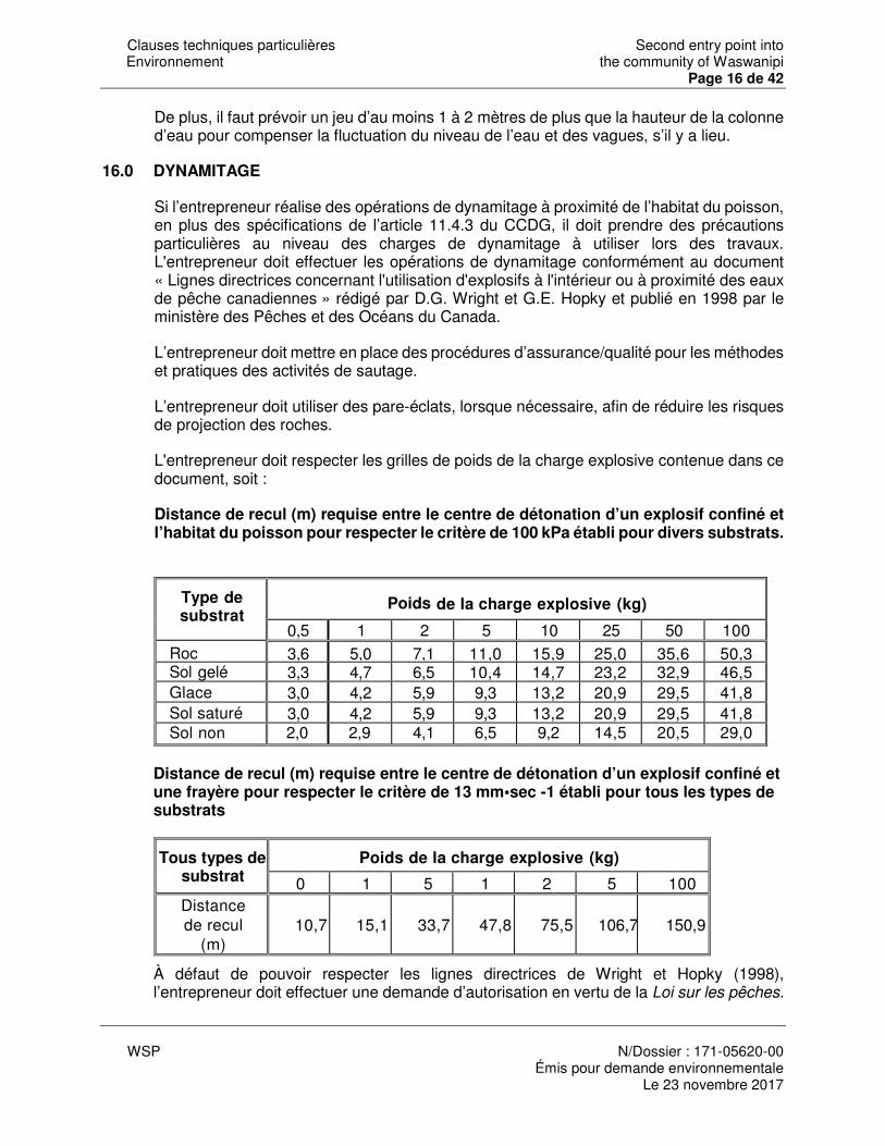
Clauses techniques particulières Second entry point into Environnement the community of Waswanipi
Page 16 de 42
WSP N/Dossier : 171-05620-00
Émis pour demande environnementale Le 23 novembre 2017
De plus, il faut prévoir un jeu d’au moins 1 à 2 mètres de plus que la hauteur de la colonne d’eau pour compenser la fluctuation du niveau de l’eau et des vagues, s’il y a lieu.
16.0 DYNAMITAGE
Si l’entrepreneur réalise des opérations de dynamitage à proximité de l’habitat du poisson, en plus des spécifications de l’article 11.4.3 du CCDG, il doit prendre des précautions particulières au niveau des charges de dynamitage à utiliser lors des travaux. L'entrepreneur doit effectuer les opérations de dynamitage conformément au document « Lignes directrices concernant l'utilisation d'explosifs à l'intérieur ou à proximité des eaux de pêche canadiennes » rédigé par D.G. Wright et G.E. Hopky et publié en 1998 par le ministère des Pêches et des Océans du Canada.
L’entrepreneur doit mettre en place des procédures d’assurance/qualité pour les méthodes et pratiques des activités de sautage.
L’entrepreneur doit utiliser des pare-éclats, lorsque nécessaire, afin de réduire les risques de projection des roches.
L'entrepreneur doit respecter les grilles de poids de la charge explosive contenue dans ce document, soit :
Distance de recul (m) requise entre le centre de détonation d’un explosif confiné et l’habitat du poisson pour respecter le critère de 100 kPa établi pour divers substrats.
Type de substrat
Poids de la charge explosive (kg)
0,5 1 2 5 10 25 50 100 Roc 3,6 5,0 7,1 11,0 15,9 25,0 35,6 50,3 Sol gelé 3,3 4,7 6,5 10,4 14,7 23,2 32,9 46,5 Glace 3,0 4,2 5,9 9,3 13,2 20,9 29,5 41,8 Sol saturé 3,0 4,2 5,9 9,3 13,2 20,9 29,5 41,8 Sol non saturé
2,0 2,9 4,1 6,5 9,2 14,5 20,5 29,0
Distance de recul (m) requise entre le centre de détonation d’un explosif confiné et une frayère pour respecter le critère de 13 mm•sec -1 établi pour tous les types de substrats
Tous types de substrat
Poids de la charge explosive (kg)
0 1 5 1 2 5 100 Distance de recul
(m)
10,7
15,1
33,7
47,8
75,5
106,7
150,9
À défaut de pouvoir respecter les lignes directrices de Wright et Hopky (1998), l’entrepreneur doit effectuer une demande d’autorisation en vertu de la Loi sur les pêches.
Clauses techniques particulières Second entry point into Environnement the community of Waswanipi
Page 17 de 42
WSP N/Dossier : 171-05620-00
Émis pour demande environnementale Le 23 novembre 2017
17.0 PROTECTION DE LA QUALITÉ DE L’AIR ET GESTION DES POUSSIÈRES
Mesures générales
Tel que mentionné à l’article 3 du présent devis, l’entrepreneur doit démontrer dans son plan d’action pour la protection de l’environnement les mesures qu’il entend mettre en place pour gérer l’émission des poussières provenant du chantier. L'entrepreneur doit prendre les moyens requis pour réduire l'émission de polluants dans l'air, notamment des poussières provenant des activités et équipements de construction. L’entrepreneur est responsable du contrôle des poussières pendant la durée du présent contrat sur le site des travaux, les aires de dépôt des matériaux sur le chantier ainsi que les rues donnant accès au chantier durant les heures de travail. De plus, dans le cas d’émissions atmosphériques non contrôlées (par ex. : poussières, gouttelettes, fumées, gaz, etc. provenant des travaux, équipements ou contenants défectueux, etc.), l’entrepreneur doit prendre des mesures immédiates pour faire cesser l’émission et, lorsque possible, récupérer les contaminants émis. L'entrepreneur doit aussi informer le surveillant avant de procéder à tout traitement de cette nature. Lorsque possible, utiliser des équipements de nettoyage munis d’aspirateur.
Réglementation et permis
L’entrepreneur doit se conformer aux normes du MDDELCC. L’entrepreneur doit prendre toutes les mesures nécessaires afin d’éviter les rejets dans l’air ambiant de poussières, silice, amiante et autres contaminants. L’entrepreneur ainsi que les sous-traitants effectuant des travaux susceptibles de produire des émissions de particules doivent soumettre leur méthode de travail au surveillant pour acceptation.
Contrôle de la poussière à l’aide d’abat-poussières
L’entrepreneur doit effectuer le nombre d’application d’abat-poussières ou d’épandage d’eau nécessaire quotidiennement sur les chemins d’accès non pavés empruntés par les engins de chantier et les camions afin de réduire les émissions de poussières et de contrôler leur dispersion. Plusieurs applications par jour peuvent être nécessaires dépendamment des conditions météorologiques et des activités au chantier. L’entrepreneur doit limiter la vitesse à 20 km/h sur le chantier afin de minimiser la lever la poussière. L’entrepreneur doit utiliser de l’eau comme abat-poussière ou un produit certifié par le Bureau de normalisation du Québec (BNQ) et répondre aux exigences écotoxicologiques stipulées dans la norme NQ 2410-300 « Abat-poussières pour routes non asphaltées et autres surfaces similaires ». De plus, il doit respecter rigoureusement les taux d’épandage recommandés. Le chlorure de calcium ou autres (accepté par le surveillant) doit être utilisé pour contrôler la poussière à la place d’arrosage en période de gel et il doit être appliqué uniformément.
Clauses techniques particulières Second entry point into Environnement the community of Waswanipi
Page 18 de 42
WSP N/Dossier : 171-05620-00
Émis pour demande environnementale Le 23 novembre 2017
L’entrepreneur doit s’assurer que la végétation ou le sol qui sera utilisé pour les plantations ne soit pas traité.
L’entrepreneur doit ajuster l’application des abat-poussières en fonction des conditions météorologiques. Les abat-poussières ne doivent jamais être épandus durant une averse ou lorsqu’une averse est prévue dans la journée. Lors de l’épandage de lignosulfonates, l’entrepreneur doit s’assurer qu’il n’y ait pas de précipitations importantes prévues dans les 48 heures suivant son application.
Contrôle de la poussière sur les rues publiques donnant accès au chantier
L’entrepreneur est responsable du nettoyage journalier des voies publiques empruntées par les camions provenant du chantier. Ce nettoyage doit être fait à l’aide d’un balai automoteur de type aspirateur muni de jet d’eau. Les balais sans jet d’eau ne sont pas autorisés. L’entrepreneur a la responsabilité de s’assurer de la propreté des voies publiques. Lors du transport sur les voies publiques, le chargement des camions-bennes doit être recouvert de façon étanche et sécuritaire. En cas de déversement sur les voies publiques (rues et trottoirs), l’entrepreneur doit effectuer le nettoyage immédiatement.
Contrôle de la poussière générée par les travaux d’excavation ou de chargement et déchargement de matériaux divers
Lors du chargement (à l’aide d’un chargeur, d’une rétrocaveuse, d’une excavatrice, d’une pelle, etc.) de matériaux de déblais ou d’agrégats, l’entrepreneur doit réduire la hauteur de chute de ces matériaux à ce qui est strictement requis afin de minimiser la génération de poussières. L’entrepreneur doit éviter, dans la mesure du possible le chargement et le déchargement dans les zones exposées à des vents défavorables.
Contrôle de la poussière des dépôts de matériaux
L’entrepreneur doit utiliser les méthodes suivantes afin de contrôler la poussière et l’érosion par le vent des piles « actives » et « inactives » des dépôts de matériaux. L’entrepreneur doit positionner l’emplacement des amoncellements d’agrégats, de pierres ou autres matières suffisamment loin des résidences ou autres sites jugés sensibles. Si c’est impossible, l’entrepreneur doit prévenir le soulèvement des particules par le vent en les arrosant, en les clôturant ou en les recouvrant à ses frais. La méthode retenue doit être soumise au surveillant de chantier pour son approbation et être cohérente avec les procédures de gestion des sols contaminés spécifiées au devis, s’il y a lieu.
Avis du surveillant
Sur avis du surveillant d’une problématique associée à l’émission de poussière, l’entrepreneur doit prendre action pour remédier à la situation à l’intérieur d’un délai d’une heure.
Clauses techniques particulières Second entry point into Environnement the community of Waswanipi
Page 19 de 42
WSP N/Dossier : 171-05620-00
Émis pour demande environnementale Le 23 novembre 2017
18.0 DÉFAUT DE L’ENTREPRENEUR
Le non-respect de l'une ou l'autre des clauses du présent document est passible d'une retenue permanente au montant de deux mille dollars (2 000 $) applicable à titre de dommages et intérêts liquidés pour chacune des infractions, et ce, sur simple constatation des faits par le surveillant ou par l'un de ses représentants. Il en est de même pour le non-respect des articles du CCDG relatifs à la protection de l'environnement. Toute infraction non corrigée la journée suivante est de nouveau passible d’une retenue de cinq cents dollars (500 $). Il en est de même pour chacune des journées suivantes, soit jusqu’à ce que l’anomalie soit corrigée. De plus, toutes dépenses reliées à des dommages causés à l’environnement par l’exécution des travaux sont aux frais de l’entrepreneur notamment en ce qui concerne les expertises de caractérisation et d’analyse, les travaux d’aménagement d’habitats fauniques de remplacement et les indemnités.
Clauses techniques particulières Second entry point into Environnement the community of Waswanipi
Page 20 de 42
WSP N/Dossier : 171-05620-00
Émis pour demande environnementale Le 23 novembre 2017
ANNEXE 1 Formulaire : Plan d’action pour la protection de l’environnement
Le plan d’action pour la protection de l’environnement (PAPE) doit répondre aux exigences de l’article « Plan d’action pour la protection de l’environnement » du présent devis.
Les espaces prévus pour les explications sont à titre indicatif seulement.
Des documents tels que des plans, des dessins et des documents officiels doivent être joints au formulaire afin de compléter ou préciser les explications soumises. La case « document(s) joint(s) » doit être cochée pour chacune des sections complétées par un ou plusieurs documents.
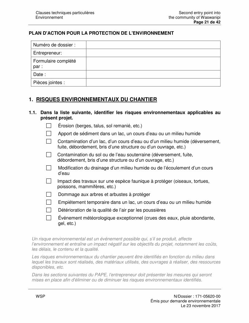
Clauses techniques particulières Second entry point into Environnement the community of Waswanipi
Page 21 de 42
WSP N/Dossier : 171-05620-00
Émis pour demande environnementale Le 23 novembre 2017
PLAN D'ACTION POUR LA PROTECTION DE L'ENVIRONNEMENT
Numéro de dossier :
Entrepreneur:
Formulaire complété par :
Date :
Pièces jointes :
1. RISQUES ENVIRONNEMENTAUX DU CHANTIER
1.1. Dans la liste suivante, identifier les risques environnementaux applicables au présent projet.
Érosion (berges, talus, sol remanié, etc.)
Apport de sédiment dans un lac, un cours d’eau ou un milieu humide
Contamination d’un lac, d’un cours d’eau ou d’un milieu humide (déversement, fuite, débordement, bris d’une structure ou d’un ouvrage, etc.)
Contamination du sol ou de l’eau souterraine (déversement, fuite, débordement, bris d’une structure ou d’un ouvrage, etc.)
Modification du drainage d’un milieu humide ou de l’écoulement d’un cours d’eau
Impact des travaux sur une espèce faunique à protéger (oiseaux, tortues, poissons, mammifères, etc.)
Dommage aux arbres et arbustes à protéger
Empiétement temporaire dans un lac, un cours d’eau ou un milieu humide
Détérioration de la qualité de l’air par les poussières
Événement météorologique exceptionnel (crues des eaux, pluie abondante, gel, etc.)
Un risque environnemental est un événement possible qui, s’il se produit, affecte l’environnement et entraîne un impact négatif sur les objectifs du projet, notamment les coûts, les délais, le contenu et la qualité.
Les risques environnementaux du chantier peuvent être identifiés en fonction du milieu dans lequel les travaux sont réalisés, des matériaux utilisés, des ouvrages à réaliser, des ressources disponibles, etc.
Dans les sections suivantes du PAPE, l’entrepreneur doit présenter les mesures qui seront mises en place afin d'éliminer ou de diminuer les risques environnementaux identifiés.
Clauses techniques particulières Second entry point into Environnement the community of Waswanipi
Page 22 de 42
WSP N/Dossier : 171-05620-00
Émis pour demande environnementale Le 23 novembre 2017
2. COMMUNICATION EN CHANTIER
2.1. Identifier le ou les responsables en environnement sur le chantier.
Nom du responsable :
Fonction
Coordonnées :
Document(s) joint(s)
2.2. Fournir l’organigramme de communication du chantier
L’organigramme doit notamment inclure les noms, prénoms, fonctions, organisations et coordonnées des personnes avec qui communiquer selon le besoin.
Document(s) joint(s)
3. ORGANISATION DU CHANTIER
3.1. Présenter le calendrier et l’ordonnancement de toutes les activités de protection de l’environnement lors des travaux.
Dans le calendrier, les activités de protection de l’environnement doivent être associées aux étapes des travaux de chantier correspondantes. Si une activité de protection de l’environnement comprend plusieurs phases (ex. aménagement, démantèlement, mise en eau, nettoyage, etc.), elles doivent toutes être indiquées dans le calendrier.
Document(s) joint(s)
3.2. Indiquer, sur un plan, les périmètres de protection où le couvert végétal doit être conservé de manière permanente ou temporaire jusqu’à la réalisation des travaux de terrassement
Le couvert végétal comprend entre autres les arbres, les arbustes, les plantes terrestres et le gazon.
Sur le plan, il doit être possible de distinguer les périmètres de protection permanents des périmètres de protection temporaires.
Les exigences concernant les périmètres de protection sont présentes à l’article « Exigences environnementales pour le déboisement » du présent devis, le cas échéant.
Document(s) joint(s)
Clauses techniques particulières Second entry point into Environnement the community of Waswanipi
Page 23 de 42
WSP N/Dossier : 171-05620-00
Émis pour demande environnementale Le 23 novembre 2017
3.3. Fournir les plans d’aménagement et de localisation des installations de chantier, des sites divers des chemins d’accès et des chemins de déviation temporaires ainsi que les méthodes et ouvrages de protection de l’environnement relatifs à ces installations.
Sont visés dans cette section : les locaux de chantier et leurs dépendances, les stationnements, les sites d’entretiens et d’entreposages de la machinerie, les sites d’entreposage des matériaux, les sites de concassage et de conditionnement du béton, les sites de nettoyages des bétonnières, les sites d’entreposage des rebuts, les chemins d’accès et les chemins de déviation temporaires ainsi que tout autre site nécessaire aux travaux.
Les plans doivent notamment inclure les dimensions, la superficie utilisée, le volume de matériaux projetés, la localisation des lacs, des cours d’eau et des milieux humides, les zones de terrassement, les bâtiments, les arbres isolés et toute autre information jugée pertinente.
Les méthodes et les ouvrages de protection de l’environnement relatifs aux installations, aux sites et aux chemins concernent notamment, la gestion des eaux de ces sites, la stabilisation des talus et la protection des lacs et des cours d’eau à proximité.
Les exigences concernant l’aménagement des installations de chantier, des sites divers et des chemins temporaires sont présentes à l’article « Installations de chantier, sites divers, chemins d’accès et chemins de déviation temporaire » du présent devis.
Document(s) joint(s)
4. PLAN DE CONTRÔLE DE L’ÉROSION ET DES SÉDIMENTS
4.1. Indiquer, sur un plan, les zones du chantier ayant un potentiel d’érosion et les classer selon leur degré de risque d’érosion (faible, moyen, élevé)
L’érosion est un mécanisme de transformation du relief d’un site par des agents d’érosion naturels tels que l’eau, le vent, la gravité ou la température. Certaines caractéristiques d’un site comme les pentes fortes, les sols limoneux ou riches en sable fin et les sites dénudés de végétation peuvent augmenter le potentiel d’érosion. Les sites ayant un potentiel d’érosion peuvent donc être identifiés et classés en fonction de ces caractéristiques et des agents d’érosion pouvant se manifester.
Le plan doit montrer les zones selon leur degré de risque d’érosion (faible, moyen ou élevé).
Document(s) joint(s)
4.2. Indiquer, sur un plan, les zones du site des travaux à stabiliser sans délai et décrire la ou les méthodes utilisées.
Clauses techniques particulières Second entry point into Environnement the community of Waswanipi
Page 24 de 42
WSP N/Dossier : 171-05620-00
Émis pour demande environnementale Le 23 novembre 2017
Les zones à stabiliser sans délai correspondent aux surfaces de sol mises à nu durant les travaux (zones déboisées, zones de terrassement, talus de déblai ou de remblai, sols remaniés, etc.) ou aux matériaux non consolidés mis en réserve.
La description des méthodes de stabilisation utilisées doit comprendre leur nature, leurs dimensions et les matériaux utilisés.
Les détails concernant le choix des mesures et ouvrages de stabilisation sont présents à l’article « Contrôle de l’érosion et des sédiments » du présent devis.
Document(s) joint(s)
4.3. Décrire les méthodes et les ouvrages de contrôle de l’érosion et des sédiments qui seront installés sur le chantier et fournir les plans de localisation de ceux-ci.
Les méthodes et ouvrages de contrôle de l’érosion et des sédiments requis sur le chantier, incluant les sites hors emprise, doivent être décrits dans la présente section (barrières à sédiments, méthodes et ouvrages de stabilisation des talus, bermes et trappes à sédiment, bassins de sédimentation, rideaux de turbidité, etc.).
La description doit notamment comprendre leur nature, leurs dimensions, leur capacité, les matériaux utilisés et leur fréquence d’entretien, le cas échéant.
Les détails concernant le choix des mesures et ouvrages de contrôle de l’érosion et des sédiments sont présents à l’article « Contrôle de l’érosion et des sédiments » du présent devis.
Document(s) joint(s)
4.4. Fournir la description, les plans d’aménagements et de localisation ainsi que la séquence d’aménagement et de démantèlement des ouvrages provisoires prévus dans le littoral ou la rive d’un lac ou d’un cours d’eau ou dans un milieu humide. Ces plans doivent être signés par un ingénieur si le surveillant le requiert. Décrire et indiquer sur un plan les mesures de protection de l’environnement associées à ces ouvrages provisoires.
Sont visés dans cette section : les batardeaux, les canaux de dérivation, les quais, les jetées, les ponts et les ponceaux temporaires et tout autre ouvrage provisoire prévu dans le littoral ou la rive d'un lac ou d'un cours d'eau.
La description et les plans doivent notamment inclure le type d’ouvrage provisoire, les dimensions et les matériaux utilisés.
La description de la séquence d’aménagement et de démantèlement de chacun des ouvrages provisoire doit inclure les étapes de construction de l’ouvrage, de mise en eau, d’installation des mesures de protection de l’environnement, de pompage de l’eau, de nettoyage de l’ouvrage, de démantèlement de l’ouvrage, etc.
Les exigences concernant les ouvrages provisoires sont présentes à l’article « Ouvrages provisoires dans les lacs et les cours d’eau » du présent devis, le cas échéant.
Clauses techniques particulières Second entry point into Environnement the community of Waswanipi
Page 25 de 42
WSP N/Dossier : 171-05620-00
Émis pour demande environnementale Le 23 novembre 2017
Document(s) joint(s)
4.5. Fournir l’avis écrit d’un ingénieur civil spécialisé en hydraulique/le plan de pompage/autres requis pour l’interruption temporaire du cours d’eau.
Joindre l’avis écrit d’un ingénieur civil spécialisé en hydraulique au présent formulaire.
Document(s) joint(s)
Le plan de pompage doit notamment inclure la capacité du système de pompage, la durée du pompage ainsi qu’une description des installations (pompe, zone de rejet de l’eau, mesures de protection du poisson, protection contre l'érosion, etc.).
Document(s) joint(s)
4.6. Fournir la description, un plan d'aménagement et un plan de localisation des passages à gué prévus pour les travaux et décrire les mesures de protection de l’environnement proposées.
La description des passages à gué doit inclure la séquence d’installation et de démantèlement ainsi que les détails de leur aménagement (matériaux, dimensions, mesures de protection des cours d’eau et des berges, signalisation, etc.).
Les exigences concernant les passages à gué sont présentes à l’article « Traversées de cours d’eau » du présent devis, le cas échéant.
Document(s) joint(s)
4.7. Fournir la description et la séquence de reconstitution d’un cours d’eau.
Pour chaque section de cours d’eau à reconstituer, indiquer le type de matériaux utilisés, les dimensions de la section du cours d’eau, les étapes de reconstitution, les mesures de contrôle de l’érosion et des sédiments et, le cas échéant, les aménagements particuliers pour le libre passage du poisson.
Les exigences concernant la reconstitution d’un cours d’eau sont présentes à l’article « Reconstitution du lit ou des rives d’un lac ou d’un cours d’eau » du présent devis.
Document(s) joint(s)
Clauses techniques particulières Second entry point into Environnement the community of Waswanipi
Page 26 de 42
WSP N/Dossier : 171-05620-00
Émis pour demande environnementale Le 23 novembre 2017
4.8. Indiquer, sur un plan, les fossés qui doivent être détournés vers des zones de végétation ou empierrés ;
Pour les fossés détournés vers des zones de végétation, indiquer la distance entre l’exutoire du fossé et le lac ou le cours d’eau le plus près. Pour les fossés empierrés, indiquer le calibre de l’empierrement utilisé et la longueur de la section empierrée.
Les exigences concernant les fossés sont présents aux articles « Fossés temporaires dans la bande riveraine » et « Revêtement de protection » du présent devis, le cas échéant.
Document(s) joint(s)
4.9. Fournir la description des mesures de contrôle de l’érosion et des sédiments mis en place préalablement à la suspension des travaux pour l’hiver, aux périodes de restriction ou aux congés annuels et un plan de localisation de ces mesures.
La description doit inclure le type de mesures utilisées, leurs dimensions, leur capacité, les matériaux utilisés et leur fréquence d’entretien, le cas échéant.
Indiquer la durée de chacun des arrêts des travaux.
Document(s) joint(s)
5. PLAN D’URGENCE ENVIRONNEMENTALE
5.1. Identifier les urgences environnementales potentielles associées au présent projet, particulièrement pour les milieux sensibles.
Une urgence environnementale est toute situation qui menace, altère ou est sur le point de détériorer la qualité de l’eau, de l’air, du sol ou de l’environnement dans lequel évolue l’être humain et qui nécessite une intervention immédiate.
Le déversement de produits pétroliers ou d’autres matières dangereuses ainsi que l’inondation de l’aire des travaux, si applicable, doivent obligatoirement être traités.
Document(s) joint(s)
5.2. Décrire les mesures préventives afférentes à chacune des urgences environnementales identifiées.
Pour chaque risque environnemental identifié au point précédent, décrire les mesures de préventions ou d’atténuations à mettre en place pour diminuer la probabilité que se produise

Clauses techniques particulières Second entry point into Environnement the community of Waswanipi
Page 27 de 42
WSP N/Dossier : 171-05620-00
Émis pour demande environnementale Le 23 novembre 2017
l’événement dommageable pour l’environnement. Les mesures préventives peuvent être, par exemple, la mise en place de mesures de protection de l’environnement ou d’ouvrages provisoires supplémentaires, des changements dans le calendrier de réalisation des travaux, des changements de dimensionnement ou d’emplacement des ouvrages provisoires, etc.
Document(s) joint(s)
5.3. Énumérer les différentes interventions à réaliser pour chacune des urgences identifiées.
Pour chacun des risques environnementaux identifiés précédemment, dresser la liste des interventions à réaliser si l’événement se produisait et des procédures à suivre pour chacune de ces interventions. Au besoin, fournir un schéma de la procédure à suivre.
L’information à transmettre comprend notamment les coordonnées des personnes responsables et la description des rôles et responsabilités de chacune d’elles, la procédure de communication, l’équipement disponible, les plans ou cartes des trajets à privilégier, etc.
Document(s) joint(s)
5.4. Fournir la procédure de rétablissement à suivre à la suite d’une urgence environnementale.
Pour chacun des risques environnementaux identifiés précédemment, fournir une procédure préliminaire de rétablissement du site et de tout élément de l’environnement qui pourrait être endommagé par l’événement. La procédure doit inclure les activités destinées à restaurer le milieu environnant à un état jugé sécuritaire et acceptable par le surveillant.
Document(s) joint(s)
5.5. Indiquer le lieu où le plan d’urgence environnementale sera affiché durant toute la période des travaux pour que ce dernier puisse être vu par tous les employés.
Document(s) joint(s)
6. QUALITÉ DE L’AIR

Clauses techniques particulières Second entry point into Environnement the community of Waswanipi
Page 28 de 42
WSP N/Dossier : 171-05620-00
Émis pour demande environnementale Le 23 novembre 2017
6.1. Décrire les méthodes de travail et les mesures prévues pour protéger la qualité de l’air en milieu habité.
Indiquer les interventions à réaliser lorsque les seuils de quantité de poussière dans l’air inscrits au CCDG sont atteints et préciser les produits utilisés.
Indiquer, sur un plan, les zones où un abat-poussières sera appliqué et préciser le ou les produits utilisés ainsi que leurs composantes, le cas échéant.
Les exigences concernant les abat-poussières sont présentes à l’article « Protection de la qualité de l’air et gestion des poussières » du présent devis, le cas échéant.
Document(s) joint(s)
7. MATIÈRES DANGEREUSES RÉSIDUELLES (MISES AUX REBUTS)
7.1. Fournir une liste des matières dangereuses résiduelles qui seront générées et mises aux rebuts.
La liste des matières dangereuses résiduelles doit contenir une estimation de la quantité de chacune des matières et le nom et l’adresse de l’entreprise autorisée où elle sera acheminée pour la gestion finale.
Exemples de matières dangereuses résiduelles: les restes de peinture, d’enduit et de décapant, les huiles usées, le carburant, la peinture décapée contenant du plomb, les matières ou objets dont la surface est contaminée par une matière dangereuse, etc.
Document(s) joint(s)
8. INFORMATIONS COMPLÉMENTAIRES
Clauses techniques particulières Second entry point into Environnement the community of Waswanipi
Page 29 de 42
WSP N/Dossier : 171-05620-00
Émis pour demande environnementale Le 23 novembre 2017
8.1. Fournir toute information complémentaire pertinente.
Document(s) joint(s)
9. SIGNATURE
9.1. Signature de l’entrepreneur
L’entrepreneur est responsable de la conception, de la mise en œuvre, de l’efficacité et du suivi des mesures figurant dans le présent Plan d’action pour la protection de l’environnement et dans les documents joints à celui-ci.
Signature de l’entrepreneur : Date :
ANNEXE 2
Clauses techniques particulières Second entry point into Environnement the community of Waswanipi
Page 30 de 42
WSP N/Dossier : 171-05620-00
Émis pour demande environnementale Le 23 novembre 2017
Figures et dessins spécifiques ISTES DES FIGURES ET DESSINS SPÉCIFIQUES
Figure 6.3-1 Détournement de l’eau vers une zone de végétation 115-31
Figure 9.4-1 Exemple d’ancrage de ballot de paille pour disposition en série
115-32
Figure 9.4-2 Installation d’une barrière à sédiments munie d’un géotextile 115-33
Figure 9.4-3 Trappe à sédiments et berme filtrante érigée dans un fossé routier
115-34
Figure 9.4-4 Bassin de sédimentation 115-35
Figure 9.4-5 Étape de réalisation d’une dérivation temporaire d’un cours d’eau
115-36
DS-115-ENV-101 Rideau de turbidité 115-37
DS-115-ENV-102 Fosse de captation dans un fossé 115-38
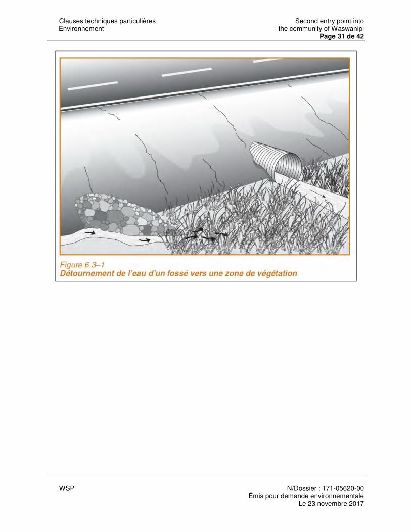
Clauses techniques particulières Second entry point into Environnement the community of Waswanipi
Page 31 de 42
WSP N/Dossier : 171-05620-00
Émis pour demande environnementale Le 23 novembre 2017
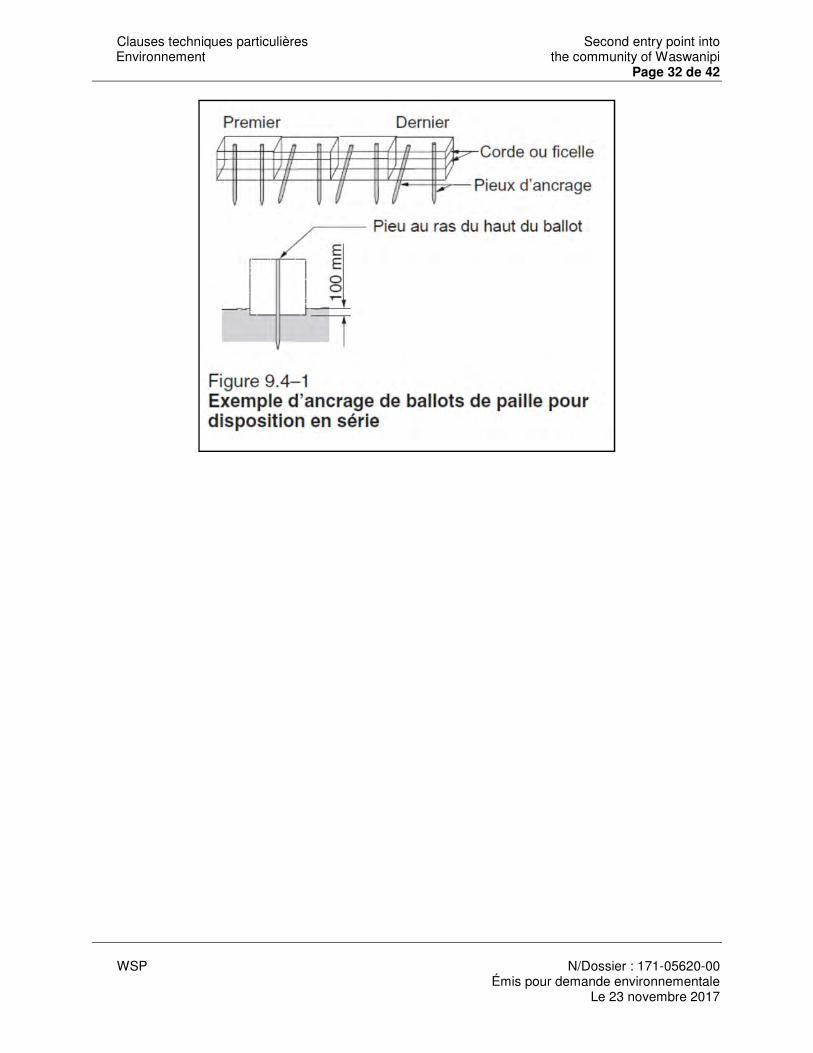
Clauses techniques particulières Second entry point into Environnement the community of Waswanipi
Page 32 de 42
WSP N/Dossier : 171-05620-00
Émis pour demande environnementale Le 23 novembre 2017
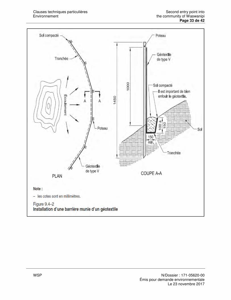
Clauses techniques particulières Second entry point into Environnement the community of Waswanipi
Page 33 de 42
WSP N/Dossier : 171-05620-00
Émis pour demande environnementale Le 23 novembre 2017
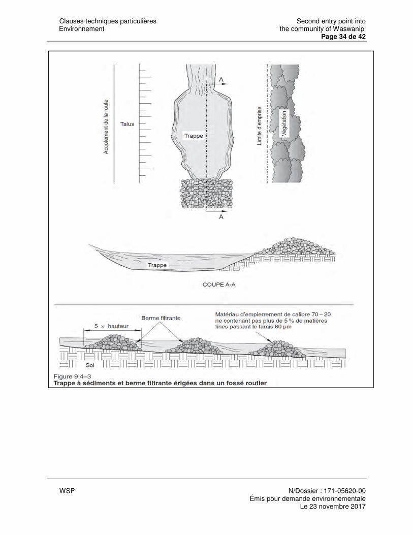
Clauses techniques particulières Second entry point into Environnement the community of Waswanipi
Page 34 de 42
WSP N/Dossier : 171-05620-00
Émis pour demande environnementale Le 23 novembre 2017
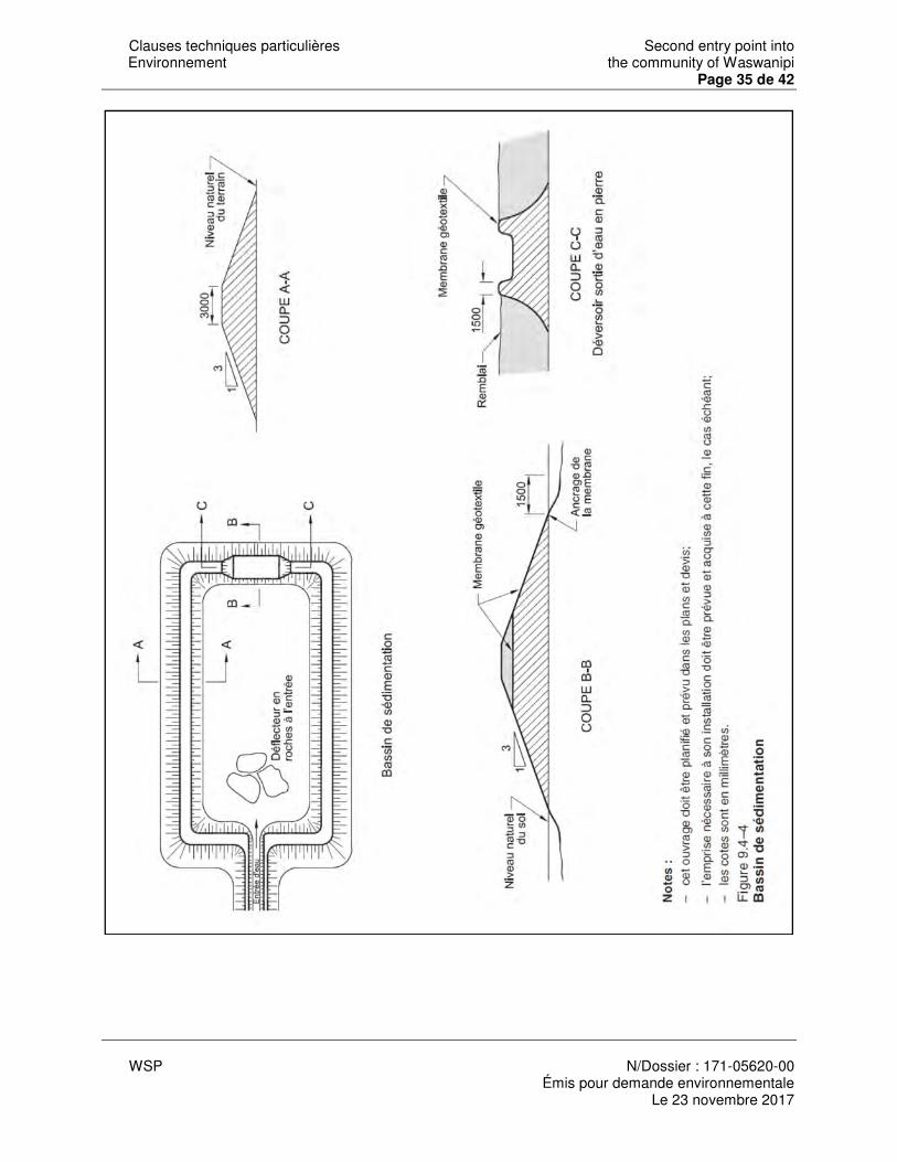
Clauses techniques particulières Second entry point into Environnement the community of Waswanipi
Page 35 de 42
WSP N/Dossier : 171-05620-00
Émis pour demande environnementale Le 23 novembre 2017
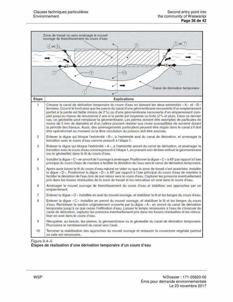
Clauses techniques particulières Second entry point into Environnement the community of Waswanipi
Page 36 de 42
WSP N/Dossier : 171-05620-00
Émis pour demande environnementale Le 23 novembre 2017
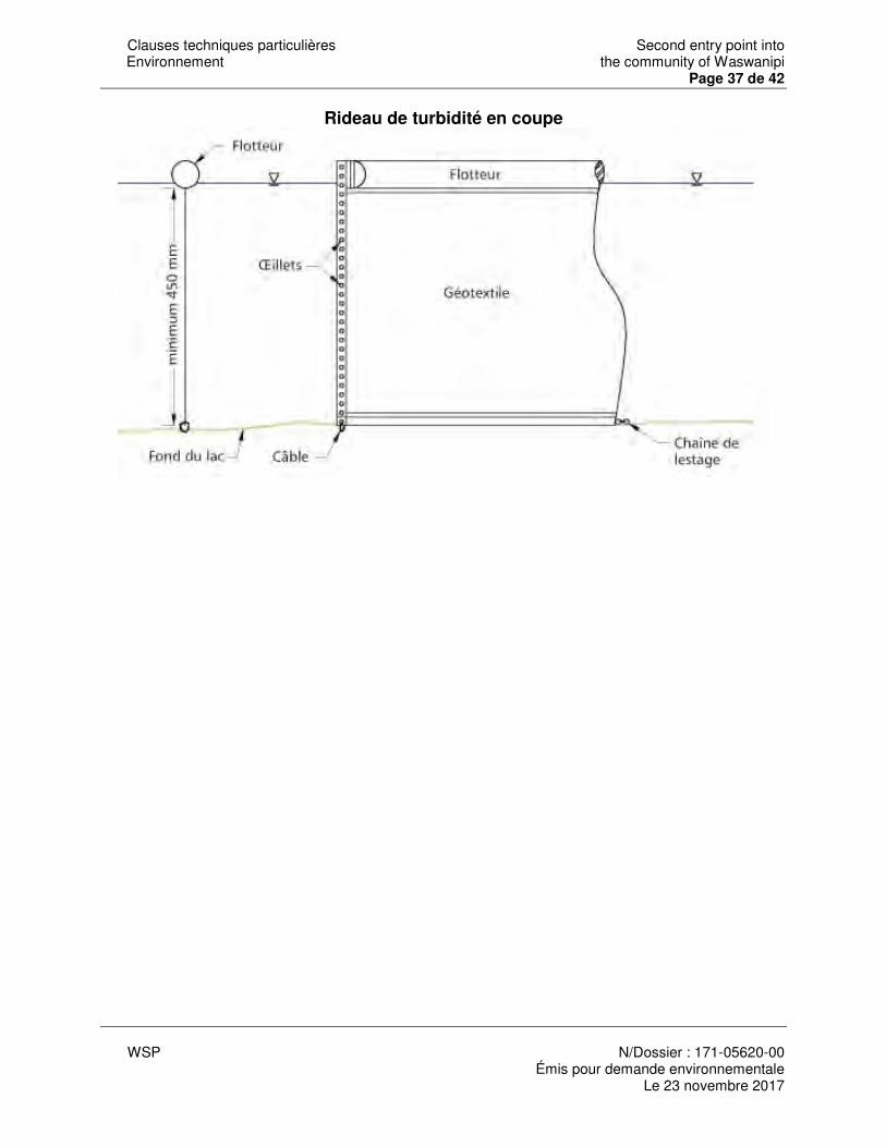
Clauses techniques particulières Second entry point into Environnement the community of Waswanipi
Page 37 de 42
WSP N/Dossier : 171-05620-00
Émis pour demande environnementale Le 23 novembre 2017
Rideau de turbidité en coupe
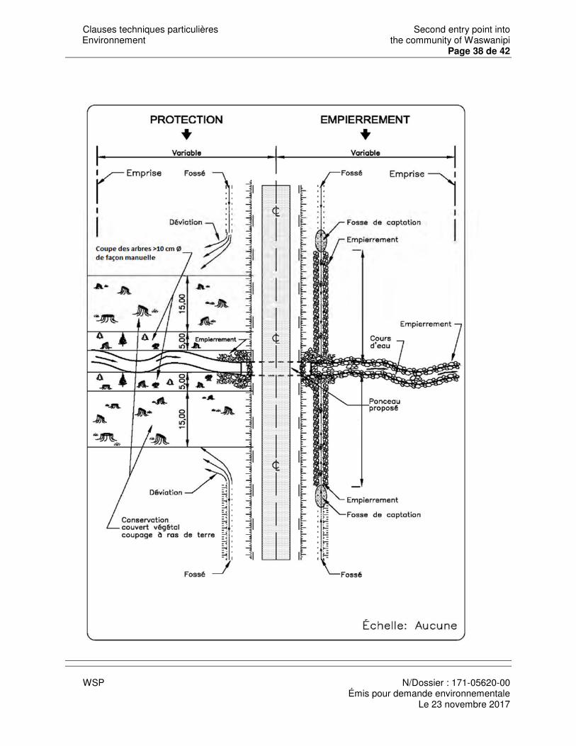
Clauses techniques particulières Second entry point into Environnement the community of Waswanipi
Page 38 de 42
WSP N/Dossier : 171-05620-00
Émis pour demande environnementale Le 23 novembre 2017
Clauses techniques particulières Second entry point into Environnement the community of Waswanipi
Page 39 de 42
WSP N/Dossier : 171-05620-00
Émis pour demande environnementale Le 23 novembre 2017
ANNEXE 3 Dessins normalisés
LISTE DES DESSINS NORMALISÉS DN-IV-10-001 Périmètre de protection à conserver en milieu boisé 115-41
DN-IV-10-002 Périmètre de protection à conserver en milieu boisé 115-42
DN-IV-10-003 Dégagement des aires de travaux pas élagage 115-43
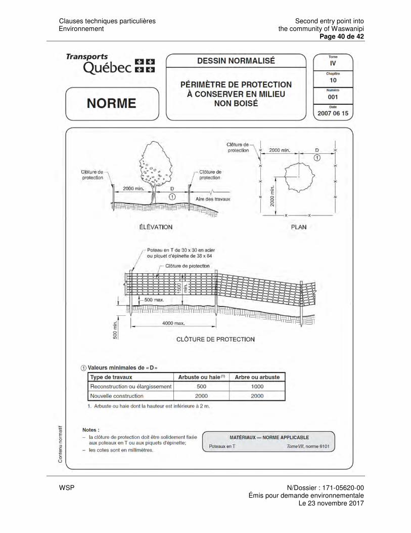
Clauses techniques particulières Second entry point into Environnement the community of Waswanipi
Page 40 de 42
WSP N/Dossier : 171-05620-00
Émis pour demande environnementale Le 23 novembre 2017
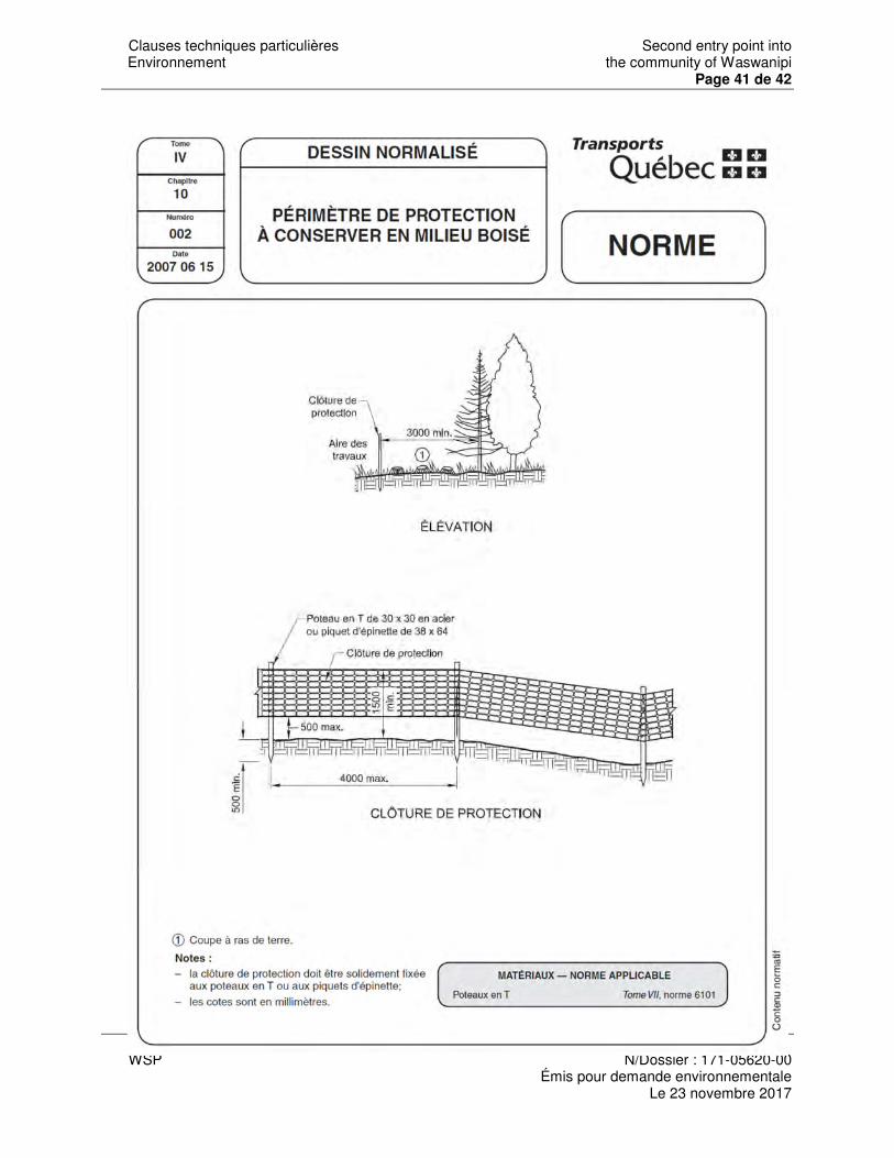
Clauses techniques particulières Second entry point into Environnement the community of Waswanipi
Page 41 de 42
WSP N/Dossier : 171-05620-00
Émis pour demande environnementale Le 23 novembre 2017
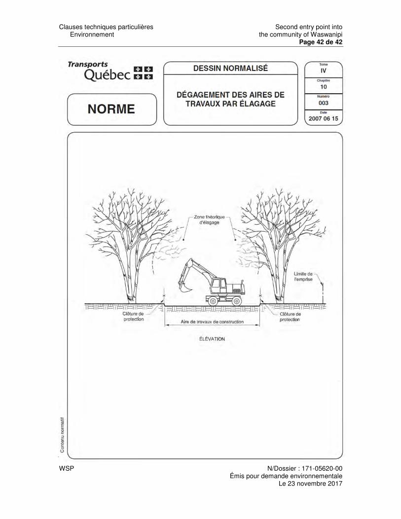
Clauses techniques particulières Second entry point into Environnement the community of Waswanipi
Page 42 de 42
WSP N/Dossier : 171-05620-00
Émis pour demande environnementale Le 23 novembre 2017

Second entry point into the community Cree First Nation of Waswanipi
APPENDIX H
Schedule

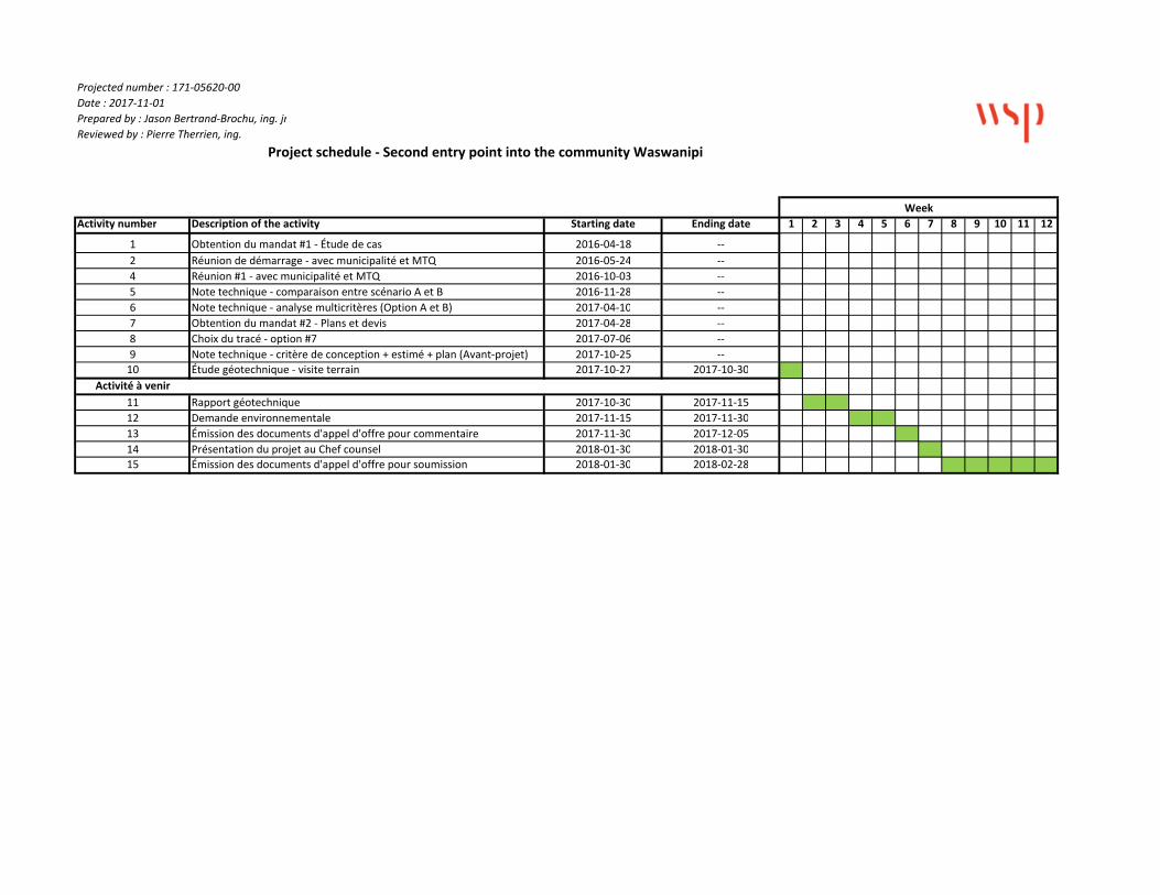
Projected number : 171‐05620‐00 Date : 2017‐11‐01 Prepared by : Jason Bertrand‐Brochu, ing. jrReviewed by : Pierre Therrien, ing.
Activity number Description of the activity Starting date Ending date 1 2 3 4 5 6 7 8 9 10 11 12
1 Obtention du mandat #1 ‐ Étude de cas 2016‐04‐18 ‐‐2 Réunion de démarrage ‐ avec municipalité et MTQ 2016‐05‐24 ‐‐4 Réunion #1 ‐ avec municipalité et MTQ 2016‐10‐03 ‐‐5 Note technique ‐ comparaison entre scénario A et B 2016‐11‐28 ‐‐6 Note technique ‐ analyse multicritères (Option A et B) 2017‐04‐10 ‐‐7 Obtention du mandat #2 ‐ Plans et devis 2017‐04‐28 ‐‐8 Choix du tracé ‐ option #7 2017‐07‐06 ‐‐9 Note technique ‐ critère de conception + estimé + plan (Avant‐projet) 2017‐10‐25 ‐‐10 Étude géotechnique ‐ visite terrain 2017‐10‐27 2017‐10‐30
Activité à venir11 Rapport géotechnique 2017‐10‐30 2017‐11‐1512 Demande environnementale 2017‐11‐15 2017‐11‐3013 Émission des documents d'appel d'offre pour commentaire 2017‐11‐30 2017‐12‐0514 Présentation du projet au Chef counsel 2018‐01‐30 2018‐01‐3015 Émission des documents d'appel d'offre pour soumission 2018‐01‐30 2018‐02‐28
Week
Project schedule ‐ Second entry point into the community Waswanipi


