Embed Size (px)
Citation preview
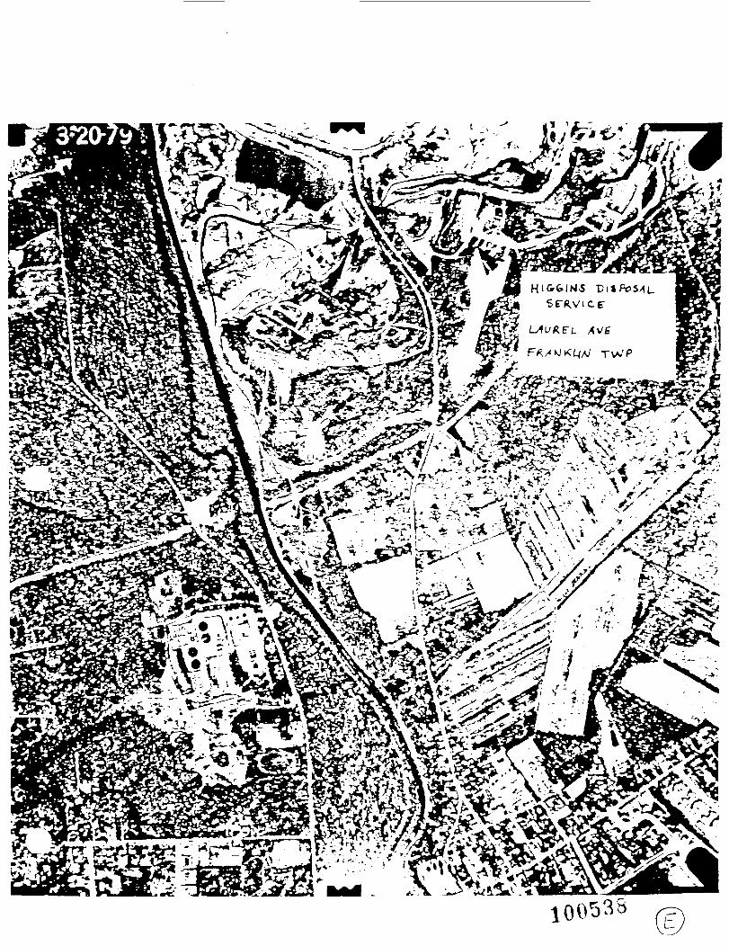
HIGGINS DISPOSAL SERVICE121 LAUREL AVENUE, KINGSTONSOMERSET COUNTY, NEW JERSEY
REFERENCE
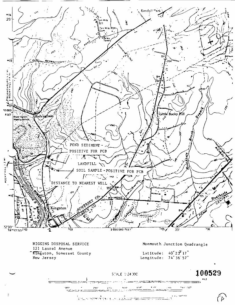
A. U.S.G.S. MAP, MONMOUTH JUNCTION QUADRANGLEB. U.S.G.S. WETLANDS MAP, MONMOUTH JUNCTION/ROCKY HILL QUADSC. SOMERSET COUNTY ROAD MAPD. FRANKLIN TOWNSHIP TAX MAPE. AERIAL PHOTOGRAPH-- HIGGINS DISPOSAL SERVICEF. NEW JERSEY STATE ATLAS - BASE MAP - SHEET 28G. NEW JERSEY STATE ATLAS - GEOLOGIC OVERLAY - SHEET 28H. INFORMATION OF REGIONAL GEOLOGY AND AQUIFERI. NEW JERSEY STATE ATLAS - WATER SUPPLY OVERLAY - SHEET 28J. SOIL SURVEY OF SOMERSET COUNTYK. SITE VISIT (LOWRY)L. SITE VISIT (VAN ECK)M. ADMINISTRATIVE ORDER OF OCTOBER 8, 1982N. INFORMATION ON LOCAL WELL CONTAMINATION0. . SAMPLING PLAN AND RESULTS FROM HIGGINS DISPOSAL SERVICEP. POTASLE WELL COUNT, FRANKLIN TOWNSHIPQ. FRANKLIN TOWNSHIP HEALTH DEPARTMENT CORRESPONDENCER. SOUTH BRUNSWICK TOWNSHIP HEALTH DEPARTMENT CORRESPONDENCES. INFORMATION ON USE OF DELAWARE AND RARITAN CANALT. WELL LOGSU. ROCKY HILL WATER DEPARTMENT WELL INFORMATIONV. AGRICULTURAL USE IN THE AREAW. DEPARTMENT OF FISH, GAME AND WILDLIFE CORRESPONDENCE.X. 103C NOTIFICATION FORMY. CONVERSATION WITH MR. HIGGINS
HS161:mz
HIC^INS DISPOSAL SERVICE121 LAUREL AVENUE, KINGSTON -SOMERSET COUNTY, NEW JERSEY
V .REFERENCE
A. U.S.G.S. MAP. MONMOUTH JUNCTION QUADRANGLE, 1954, PHOTOREVISED 1970
B. NATIONAL WETLANDS INVENTORY MAPS OVERLAIN ONTO U.S.G.S. MAPS: MONMOUTHJUNCTION QUAD (APRIL, 1976) AND ROCKY HILL QUAD (NOVEMBER, 1975)
C. SOMERSET COUNTY ROAD MAP, HAGSTROM, 1983
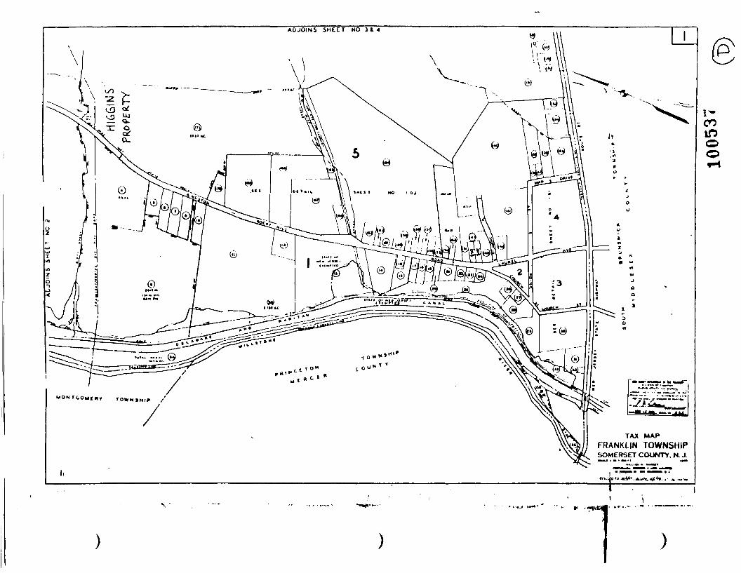
D. FRANKLIN TOWNSHIP TAX MAP, REVISION OF 10/1/82%
E. AERIAL PHOTOGRAPH - HIGGINS DISPOSAL SERVICE, 3/29/79 BY KEYSTONE AERIALSURVEY, PHILADELPHIA
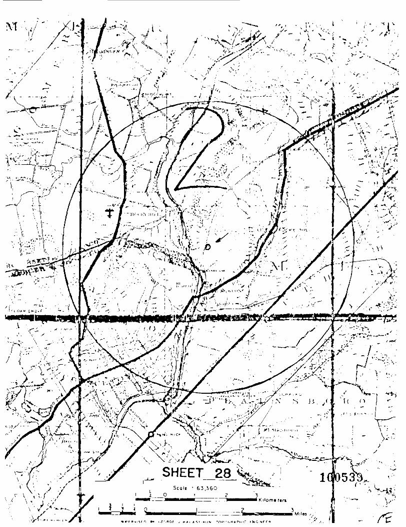
F. NEW JERSEY STATE ATLAS - BASE MAP - SHEET 28, STATE OF NEW JERSEY,DEPARTMENT OF CONSERVATION AND DEVELOPMENT, EDITION OF 1937
•
G. NEW JERSEY STATE ATLAS - GEOLOGIC OVERLAY - SHEET 28, BUREAU OF GEOLOGY ANDTOPOGRAPHY, 1977
-H. INFORMATION OF REGIONAL GEOLOGY AND AQUIFER, MEMO TO DAVID BENNECK [sic]FROM WILLIAM KRAMER AND LORRI SCRUGGS DATED 12/17/86
MEMO TO PAT BONO FROM WILLIAM KRAMER DATED 11/20/86
GEOLOGIC COMPILATION MAP KEY, MONMOUTH JUNCTION QUADRANGE, DAVID P. HOPPER,1984
MEMO TO DAVID VAN ECK FROM HUGH HOUGHTON AND ROBERT LANDLE DATED 9/25/87
I. NEW JERSEY STATE ATLAS - WATER SUPPLY OVERLAY - SHEET 28, BUREAU OF GEOLOGYAND TOPOGRAPHY, COMPILATION AS OF AUGUST 1975
J. SOIL SURVEY OF SOMERSET COUNTY. BY THE UNITED STATES DEPARTMENT OFAGRICULTURE, SOIL CONSERVATION SERVICE, ET AL., 1976
K. HAZARDOUS WASTE INVESTIGATION, LOWRY, 4/29/82
L. MEMO TO FILE: SITE RECONNAISSANCE, DAVID VAN ECK, 10/2 AND 10/6/86
M. ADMINISTRATIVE ORDER OF OCTOBER 8, 1982
N. INFORMATION ON LOCAL WELL CONTAMINATION, NJDEP SAMPLING, 1985
O. SAMPLING PLAN AND RESULTS FROM HIGGINS DISPOSAL SERVICE, NJDEP SAMPLING1986, 1987 v
100527
- 2 -• * x __,^
~' »
P. MEMO TO FILE: POTABLE WELL COUNT IN FRANKLIN TOWNSHIP. DAVID VAN ECK/CAROLGRAUBART, 1986 -
Q. FRANKLIN TOWNSHIP HEALTH DEPARTMENT CORRESPONDENCE, TO CAROL GRAUBART FROMV MICHAEL BONK, 8/5/66
R. SOUTH BRUNSWICK TOWNSHIP HEALTH DEPARTMENT CORRESPONDENCE. TO ROBERT HATTONFROM ROBERT 0. HARRIS, 8/5/86
S. INFORMATION ON USE OF DELAWARE AND RARITAN CANAL, CORRESPONDENCE WITH NEWJERSEY WATER SUPPLY AUTHORITY, NOVEMBER 1986 TO JUNE 1987
T. WELL LOGS
U. ROCKY HILL WATER DEPARTMENT INFORMATION
V. AGRICULTURAL USE IN THE AREA, MEMO FROM D. VAN ECK TO FILE: 10/2/86
W. DEPARTMENT OF FISH, GAME AND WILDLIFE CORRESPONDENCE, MEMO FROM RUSSELLCOOKINGHAM TO JOHN J. TRELA, 1986
•
X. 103C NOTIFICATION FORM FROM FMC, 1981
Y. CONVERSATION WITH MR. BIGGINS, MEMO FROM D. VAN ECK TO FILE: 9/16/87
UNATTACHED REFERENCES:DANGEROUS PROPERTIES OF HAZARDOUS MATERIALS 6TH EDITION-N. IRV1NG SAXUNCONTROLLED HAZARDOUS WASTE SITE RANKING SYSTEM/A USERS MANUAL - USEPA (1984)
100528
;x\
X POND SEDIMENT -POSITIVE FOR PCB
DISTANCE TO NEAREST WELL'
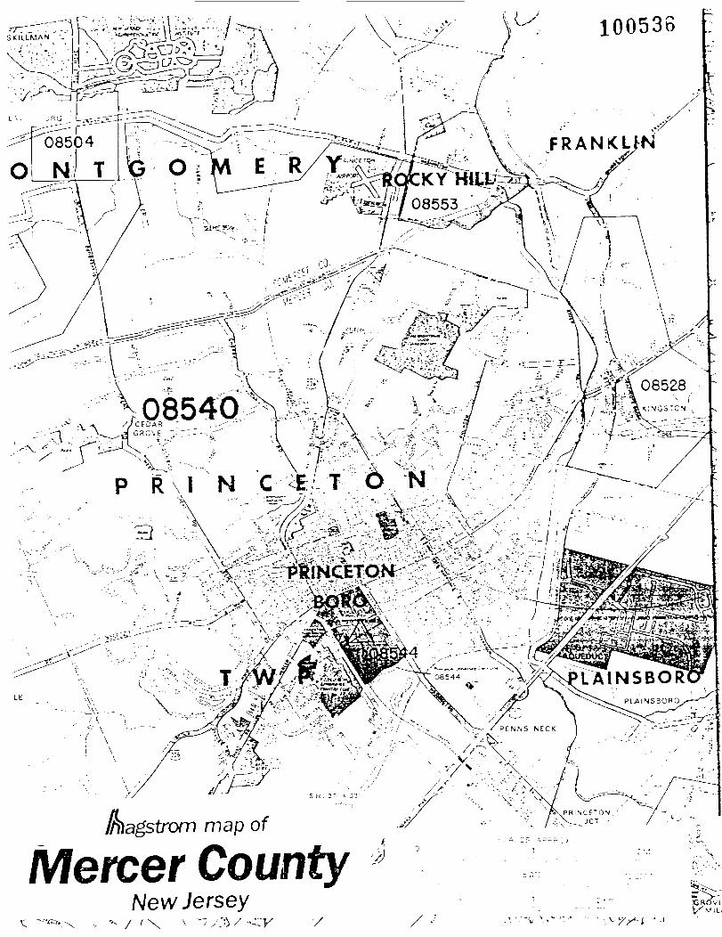
HIGGINS DISPOSAL SERVICE121 Laurel Avenue'Kingston, Somerset CountyNew Jersey
Monmouth Junction Quadrangle
Latitude: 4CT2:ri7"Longitude: 74" 36'57"
100529ir-v !•*»"
OSGOOl
OOCfZ I 3nv2S

"-> .
UJ
•"" •"
•—
• r.
*— i .. • \
r. J
: -, - ,.•
<., -v
/—,
-; '.j -- ,
•.L-
s ,-• i'- v -.
C/.
II?! W
-o if.
<v
! -^ •- p ^I
rj ' -I
,l|
' r-
q -< :•:
1 £
- ." _,
££
i., .
-7 JH cf r<
, -IV
-t- ;
-rH -,-
I
rt a,
"7
•^.'-•<->
)r: e
R <-'
,;. J
•: ;.' '!- ...
L" "I •••' -'
'() -I"'
»*
•(
'' { '
' '
r • •
/"»iu-j?o;:j'- :--!.^i:,y!:: ••-•-J-l-i .;;:U- :;: ^ '::'-'- «! <u
"in" 1 „ rj;j
-v ,; ;.; . o'- :^4 ^ J ; "J o
•' ;•;, JT . . jfi*
^
^
?J -'
''' "'
^'"
r'-i
?V
2 1
°-J
^ /5
,, o jJ
-d n, ,;
v J
Tu
.I.'
^/V^ ^:o' H
;J.;; •• •::."!•},-; !3
u«""
r^
U1
^-l 7' u, V
.-7"' -i'd
'i•H ?'S -Sg V .«•; •• "'P ->M
-S
^^
-^
cI-^
-'-
.o
S»
^83
!^:-
:^'•^••3^
dj:^:^--:s^'?(/)
. -'
v
I-.'••
"^ *-'
U
U) .,
'i
^ H $
c ..':: -' u „?'II
ni ^i
' '•>
;!•».
^ -^
- •« ' 'i •/! ,i
.;j .
-T
L,
S-._
, .r
. y;
,,, ,-
, .f
y,
M
IH< 4J -H
.''
i.. ,iJ •/'
'-J •'.' f;
10 M-I
-H i'j
-i ..-'
•.-! .'.'
:; ".> •:.
• O r-i
.u u:
i' -.
- - :'
• •!•' -;- 1
3 n: c •<• j-
.. \
u> iy ''.' ";
c c
•.' .c. 1 •'.' i 1. :-. ...
.•• o :-t
gj 0 o
ru ;,' •- •.
.i' "J -n
* .rj -H
.,., yT
., >ifi .
in.,:'Ill
,fl fQ
'- >-i r-;
:' T> o,
- O
u, ;^ pj
O '«o -1
'-C
10
4J
'i .'J
%%!-. ; y •:-• •'.- •''••: M r? 4J dtJ
to|t;~.: :: ll '" .'„ "" ::' •:•••: 'VU 1,
C1 :
: r ' »M
' ' '.
''• '" '-
-I-
1
o ui '•.,..
: 'V
TJ ;-| o,! u)rK'' c
•",-. ,,'-7i-o^^(
i"" .. ?••
:• :' V
! !-' -.C,, ?j
•>••' rc? '- f: •. „, ,'•; T'
n ••• ''1
~r^c
I j-. b
Sand
>!-iU
-.'-and(-.'-a
I *
I i
1-iVji
1—r.iu,,
rorwuuc
Vascular
Ms-! Jj'fi
'-Ctobole/G
r.vBl
!'-•{i .1__r-Itouldcr
f— H
oatlng
rriy !
^^^
•T^'! ^ "'
!U^.
»J)Jicrvcnt Algol
-Cobolo/C
nivol
j— Do ul dor
— Iw
drocX
l\
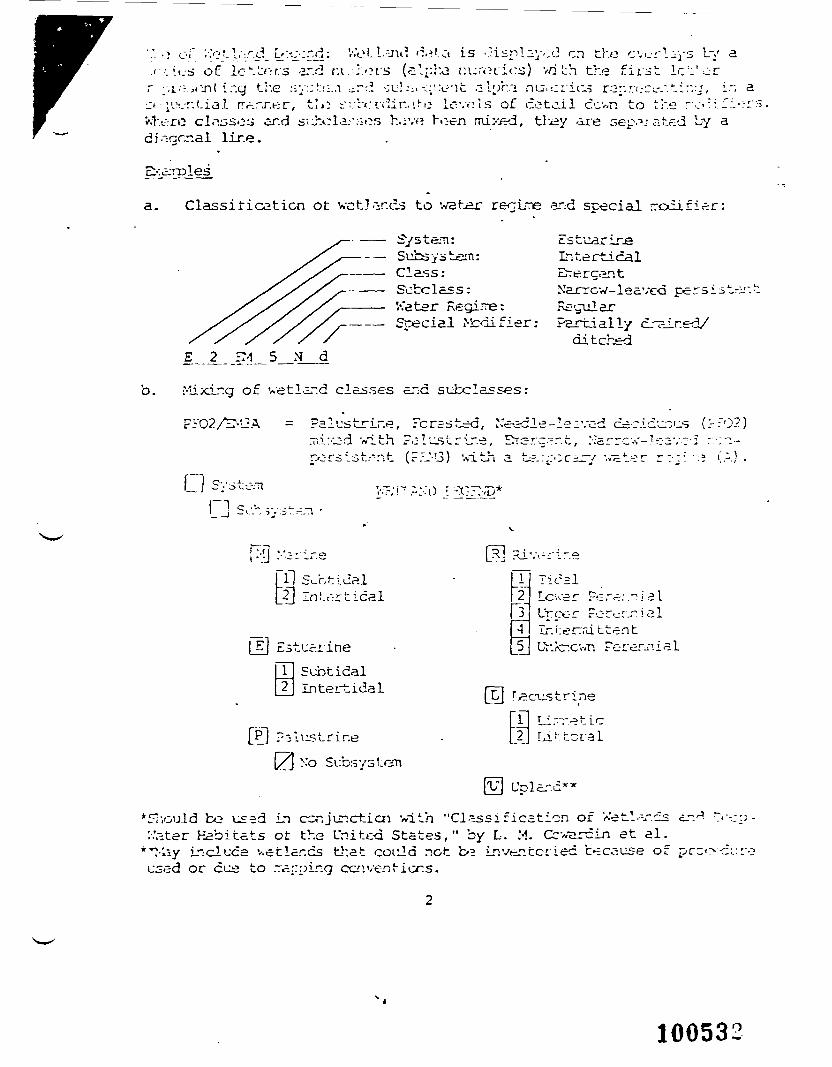
'.". ••» oiT '.•.'otV-.r.d [s'.'^-.r.d: V.'ot. Lind d.»Ui is •.lisnl^yod en tho cvurly/s by a. < • • • . tus of IcV^r/s ar.rl ru ;;.oi-s (s'-ph.a r.ur.Hios) vn Lh the first Ic'i'or.r ;-.i.-::i.:j-\l'i.-.g the sy:;!::;.;i .j.rd -;uh;. <.;.'.x-"it alphi nu;,eric.? rr3r-.r:i.-ci.-/.tin-j, in a^t • iivr.tia.l rr^.rj-.er, tlo ^v'r<:v('ir.,'.i-e Ic-vols of entail ccwr. to the rc-: 1'-:.-':i"V.t.v-ro clnssos ar.d s'-^:cla.--:-;«?s h.i'.v? h>:-en mix-ed, th^y 'ii'e sep^.? ated by adiogcr.al lir.e.
a. Classification ot wet]/vies to wetar reoiTe arid special rrodifi.er:
System: EsIntertical
Subclass: Narrow-leave-d persist-r..V.'ater Regime: R£-<rularSpecial ^difier: Partially drained/
ditched
b. Mixir.g of wetland classes and subclasses:
FrO2/r:-L3A = FalustrLr.e, Feres ted, Needle-leaved ce.Tii:C;d '«ith ?.:lu.strir.e, Errsrc.-.-.t, :-?arrcrorsist.---:it (r.-J-l3) '.sith a te.:;:•;r.^JT/ vat.
c.icunu.s (?T02)
Cl System v-i--.:o
_(T In i.d-r tidal
=. LStuai'ineSubtidalIntei~tidal
Pj ?-slustrine[/] N'o Sub.sy
1~2i4
_5_
liC2lLcwer Per^.-.nLrcor Fc-r^:^.Ir;i:ermittentUr.kr.cvvn Pere
ialial
mi
Fl Li—.^tic2|
YV\ U
*£Tr,ould bo used in cor.junctiai with "Classification of Xetl.-r.cs'.-.'ater Habitats ot the United States," by L. M. Cc' rcin et al.
"^•liv Induce v.etlar.cs tl:at coiild not b»3 inventcried because ofused or cus to rarpir.g ccnventiers.
100532
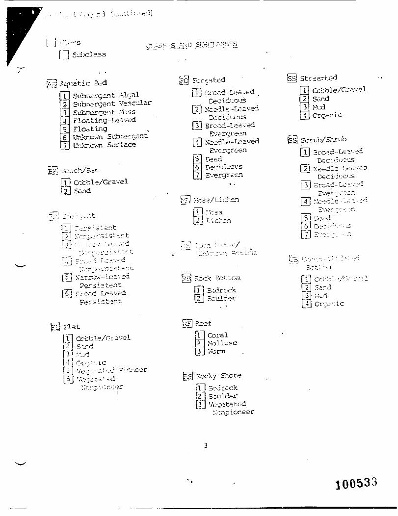
• .. i r , , " r.d (o.-:-.i-:;-.-:.:-.i)
f"]] S-J.
£-^ .^-^tic BedIT Subrercent Alcal12. SiJhrorcjent Vascularj 3_ Sucrercent :-V;ss
nestingp,, Jhkr.c---.Ti Suhrergsnt[7J UrJe-.c-.sn Surface
Ccbcle/GravelSar.d
i / IM
^CJ Forested(31 Brcv:d -Leaved
_ Ceciduoijs[2J >:ce-2J e -Leaved
[3] Sroid-IeavedEverrjre-.3n
[T] Ne--31e-LcdvedEverqre-en
5Ceeicueus
7 E-.'ergre-en
Ul :T.SS
Cobble/C-r^.vr-1SoTid>!udCrcanjc
So rub/Shrub
Ceeicueus
3or- -:i '-r-riT
[f]Ero-d-r^.v«Persistent
[I]"
Tj Ccbble/C-cavel2"! C.-.r.d
•• i-.-. = - . . c5] Vo::=-"-••!-.-J Pie6j Vo-iti' -:d
r^;efYl Coral
7.ccky Sr.ore3?-.:jrockEould-rVco5tat£K
100533
01
M fc
2 p
a i?
X?
•' i
0 .-»•
A' I.
; ,-•
h r
- ;w
iu
i- »~
tj
M r
- 11
- <
|r-
•*.
t—• r
r\ iii
>i> O
>-
• <T
>"J u.
sr a 1-1 n-
iSB
^ni •
?Sk
rSS'
:?^
::rI--
in
(--• x
: i
'1. 'i
ii
LT [
u !ii
;.i
)••
• ':'
;;'.
>-•
£•
[•••
I-*-
(f> (
••• .
--•
n ft
h> b
•: ' "•
(0 (b
i-
B 1
1 fe
l|§..
tn h1
LH
rr n
". J
/ n
rrC
-I U
M
O
IO
TJ]
§ iT<
fu
n> p
i (-r
fl)
rr
—'l.
o lli
h <
* '3
rr
Cj "%
{!'
rr (P
n c/)
15
b
I r h
o (n
in< ill
rr
,a <OJ
rrw*
f-
-^ s
;'0
tn
O
o) h
o» M
ru y
•oi&
s&'S
- n
< H
I < ;
/irj
fti ii
i fl;
fl>
"-
D •
-* Q
I —*
n r
r S
,
in '
r.rr
.'• :§ !-••
n,
rr b
rr r
r
M
»!•
_
P
* ••
p 83
P. (
V P
-
rr
rrt-'
H-
"i n
o -g
a, 'X
;!]
ft o'1
fu $< •ft
rr
M i
^•i b
'rr
rr c rr ft.
i< in
!/i I.',
H 9
I—
H-
>
,-r -A
z 'H
ri
Oin
H
'I**1 oi
I I o
K •v
p C; ° A 'j
^iP
p^*
f O
u>
tLftE
B|3
:JS
&K
M
(D (U
'ft
Co
,-l,t
I.-
H- III)
ill
X ''"
; 'fl
Qi
MA
in
o
fu ij
rf
y ui
r- i
-li
.'ll
I-
- :>l
S"»
" '7
O n
i-;'.•
rr
o
m(n
n&
ID p
(V
w n
f]i
n r
H4 P
-j f-'
•"' H
"i
b"H
P-*
M 1/
1 n>
c:
n> r
rP'
fi 0
O in
t-
'uQ
H'
rs ai
M n
c o
i c o
*n>
IT r
u (D
M h
i-«
a;
b .-J
h j
_- fu
p'
Mrr
O' ^
n
h
a OJ
rrp
, m '.3 rr
S i—• K;
l2l£
lv
c
i-ti'
O
rr a 0) Ig.
51

.°.! r:li_::rr.t '".o -J'^rs: IT:! cv'.-fl.-iyj v.oro pror-.r.-.-j :;ri.--.-.rily by s'^r: - . - ~ . :.: -•-r,;vilv-,is of hjch alU rv--':2 aori^.l nrof-.-^cMprs. V.'et]ar.c:s vc-re icor.i: : ••: 5on tho phcto.-raphs b-s.xi en vogotaticn, visible hydrolc<jy, and >je:-;rif.r.yLn accordance with "Clas.sificaLien of v.' r. lands ar.d Ceep-V7ater H.-.bi-atsof th«* 1-Yiit.ed States." The ac-rial phot-cordons typically reflect c :=-.ci!-;.cr..5curing the sr>:-oific year ar.d season when t]~«=y were taken. Ln £cci~\cn,th.^re is a rr^z'cin of error inliorer.t in the use of aerial photographs.Tr.i^, a detailed cr.-ths-crci^-.d and historical analysis ot a single sitemay result in a revision of the wetland bour.caries established through
•photographic irL=?rpr3taLicn.. In addition, sore s.-rall ve til ends ar.d t/.c--eobscured by dr?.- e fcrost ccver rray net be ir.eluded en this rap. F-ec.er.?!,State, ar.d lcc- 1 rce^ilahcry ac.::r.ci.e.s with jurisdictions over wecler.ds,Tay ceirir.e ar.d describe ver.Ir-r.cis in a different rrarr.ar than that u..ed i~.t/iis Inventory. There is no attempt, in either the design or productsof this Inventory, to derir.e the lirrits of proprietary jurisdicticr. ofany Federal, State, or loc=.l ccvtrrr.-rsrr.t or to establish 'th.e ceo-r.v-Mealsccce of the re-^jlatory pra:rer:s and prcprietazy jurisdicticrj5 that rrayaffect such activities.
.-dditicnal Infonration. Contact the appropriate Xeticr.al '.-."etlandsInventory Regional TrNetl,;T.d Ccordinator at th.e following US Fish "AV,:i]d1ife Ser-/ice Recicr.al Office:
-rion
LI-r.TJ = :o =\iil-'.rf-.: s:::1-./? '.-.92. >: ? :.-=: - - . I -r: .'--:t. r-:-:-vc. "'. 97222
a v.-:—^ r:.:T-r----:X, US F::h T^ •:!!•:!:'- '. :'•
:vi.rr-::ot-.». Wiso^rjin. Illinois, Lifiivia Pen Elric>.r.-n, C3 Tish 2'..5 '•'il-illfe r.:-r.'lce."-ichi-;---.. CKio . Fe?-:cal E-.iilciro. rt. ."i-ellir.-; (^5,'TC?).
Citio-;. ITJ 55111CCM: 612/72S-3593 H3: 72S--553
Ark.insoS. Lcuisiarta. Florida. Mississippi, Jcrsn H?f.-.er. t"S Fljh and w- lo l i f -e Son.-ice.Alalvwa. OTorgia, Ssuth CarciLna. Torth PO =o:< 7SC67, Atl^-.t*. CA 20.M7OSTT3lu-.4, T-r.-.- -.sr:-. ^antucJr/. Puerto Rico art: -504/Scl-J731 FTS: 257-4731
.".'.ir , V-:rr>.Tit, r:?v :-X:v.;!iir-j, ^:•.w V';rk. F.il.;h Tlr.er. 'J3 Fish ir.d Wil - i l i fn r-:-.-i :•;.V.-i:--:.i'-::.-:-:fj. C-.r.-.o---i:io.-t. ^S>?-? r-?l-rd. Cr.-j'c >•.---:>• ^-.tor; 3;:ito TOO. ?:. •„- n C:rr.?•::•-.;;•/!•.- -.i.i, t:,v Jorj-vy. D:-l-.--.r». ,VA -0:153•Vr/lii-.^. Vi;-5t Virginia . Vlr-; 'n i . j (X3i: 6t7/765-5;CO F;-3: 'Ji^-riH
Mctit.-ri, -.^-:i:in.j. :!cr'Lh D..<o^.i. 3vj':h HUj'i-.a H.v.~^m. 13 Kirsh •J.-.-J '•i lcli:-? ?.;•:-.>:Vota. :-''-:r-i.-Vj>. iA,-»h, CnlctTrJo, rV--:-v»-s, TO =VDX 25s3, Djr.vor ~-f-J;nl O^.-.trr, D.-v.-. ?r
00 60225
Crd^r Fern is recruired and can be obtained by writing to the =cr_ro£5 •".th.e lett^r'/.ead.
10053')
r\SW^KS*--
«&.. •^V-"^Ti^
CO-I I.
iT'
ft' -' /rr
' •,-
0854$.E C A R _ ' ..---->
- .
As
'CEG H C V
08528\ i
k K I N G S T C N
•6 '•t- .•;-,'
-T A/'- -•/-T" -••'' "^ /~ ~-.*i
•"*:~V -^
»A.V ,^7
"^
•"" J'" -"/
"/
j t
-\-c-'^ / ^ (
—> - \ ~-'~<'.W3'.---•'&&•},?d M,^-\ ^J^v*^---^-\\ .-- <- ' V—.»'f .^•-•V;J--=
>'
— ^ \. ;-'
A \
VN .-. / -if ''•• .-„.'•'- \v-- -:*"-'•; --; • \ -^-'-<-%£?_----s:\\-; n' ^-v»%#K'NS.-.-. .--.-v.. - ^^.'-^ "::.:^:^:-;-.v- / ""
\ ..;...' ^ ' - 4 "\-.rr \ .- ^-^1|>r- . : -'.••":. '-•. ,.' \ '.' - "' ; ';. . T~--
//
*%tLE
•if '-;.%k -'•
' ''Xx":?V.>•->--- I
A\— - ->1\V---. _, .M&5 '//
t-.^rfj-- •--.^7.:- ..--,
. L- - - »7 91 , - •
NECK
'LAINSBOR!I N S B O R Q ^ -
^%3
c 27 >. 33'
map of
Mercer CountyNew Jersey
^wv. ;'K/'- •:;;:^
:J7
. P R I N C E T O N ,
""•\^~ JCT
\ \ - y;
ADJOINS SHCCT NO 314
TAX MAPFRANKLIN TOWNSHIPSOMERSET COUNTY. N. J
10053S
-•/ . '
w;
:• ' \
T ' r ^
/'
! u l> ' ",
•-.:•••-' v /•
J
-v*A
^L
i I ^-rVk s1.OF-
-s^;
"'•'&$ft" -i'-Jv
\\
D . f
• rV .--,, .if, v.- X
1 •, ' • -.'
"74" \ V ' - 1 -/ - • - - - •-• •».•
' V^.- -V
IX : ~-^<r~-*'^—^
: ~A. . 1 *~f
•H. *.-
&
'•&..
^
T-^.'1
•--', •-* • •.' ""•' ~i '•- \1 '- V-.
; ' K ; V\^
,.-.W:.<x' • L*1--
V : <^-.-^W--,
' ^i.n* . p- -_.
] -:, t J»l . M ^ ; , J , , , , , . , ..
,« U^ -... ' .- - - ^-'f , /--'
-*T\-
V ( \ ' - ' • ' / './\v-//' \\ ; o,-'',; x V ^
1 . \fr ' - * I w. Ui i i
/*-,
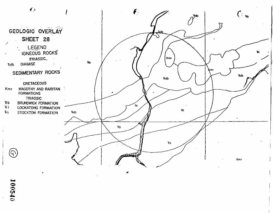
GEOLOGIC OVERLAVSHEET 28
X
-. LEGENDIGNEOUS ROCKS*
TRIASSKL•fcdb DIABASE
/SEDIMENTARY ROCKS
CRETACEOUSKmr MAGOTHY AND RARITAN
FORMATIONSTRIASSIC
Tib BRUNSWICK FORMATIONT» I LOCKATONG FORMATION"Ss STOCKTON FORMATION
Kmr
oOf
LrfV pmtnl i «ir turth
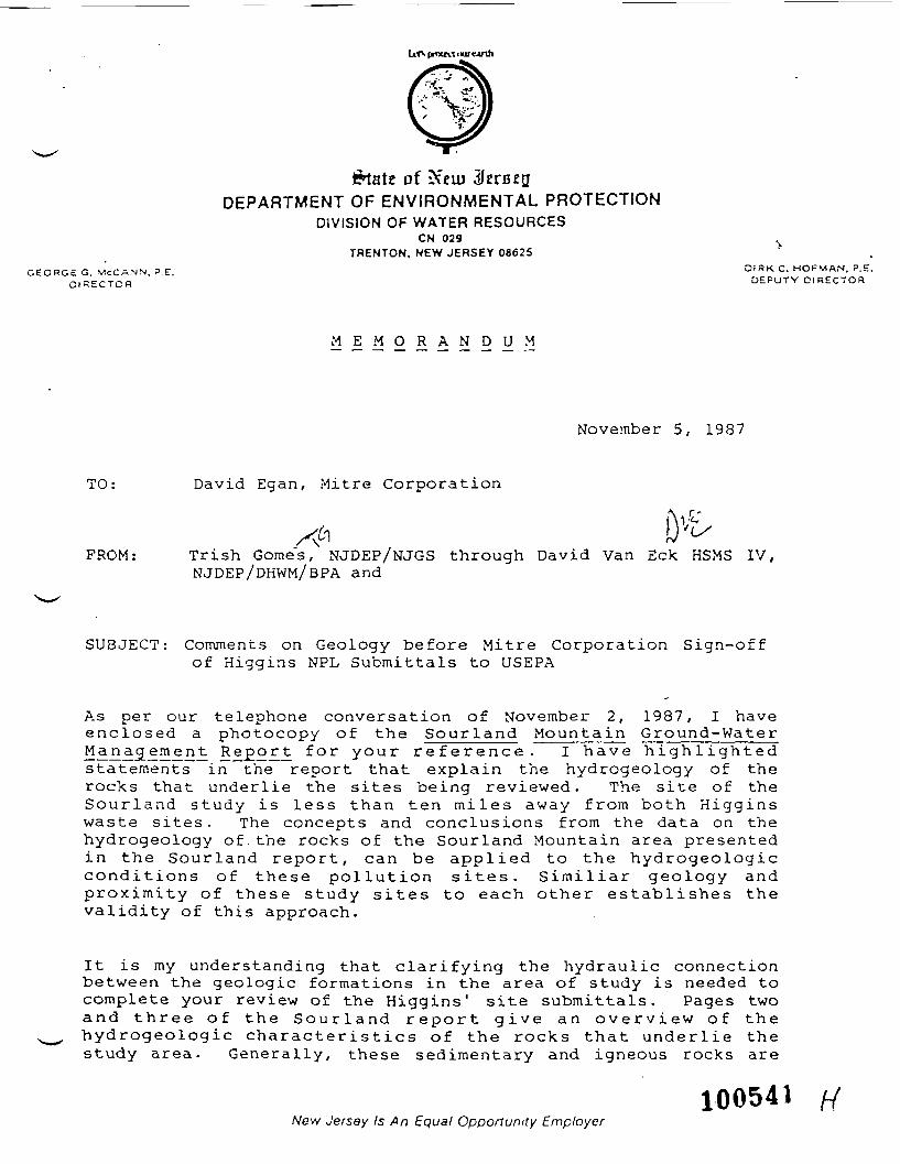
of iDEPARTMENT OF ENVIRONMENTAL PROTECTION
DIVISION OF WATER RESOURCESCN 029
TRENTON, NEW JERSEY 08625GEORGE G M'CCA.NN, PE. O I S K C . HOFMAN, P.E.
DIRECTOR DEPUTY DIRECTOR
M E M O R A N D U M
November 5, 1987
TO: David Egan, Mitre Corporation
FROM: Trish Gome's, NJDEP/NJGS through David Van Eck HSMS IV,NJDEP/DHWM/BPA and
SUBJECT: Comments on Geology before Mitre Corporation Sign-offof Higgins NPL Submittals to USEPA
As per our telephone conversation of November 2, 1987, I haveenclosed a photocopy of the Sour land Mounta in Ground-WaterI I SI..?:!!.6..!} Re go r t for your r e f e r e n c e . I h a v e h i g h l i g h t e dstatements in the report that explain the hydrogeology of therocks that underlie the sites being reviewed. The site of theSour l and s tudy is less than ten miles away f rom both H i g g i n swaste sites. The concepts and conclusions from the data on thehydrogeology of the rocks of the Sourland Mountain area presentedin the Sour l and report , can be applied to the hydrogeologiccondit ions of these pol lu t ion sites. S imi l ia r geology andproximity of these study sites to each other establishes thevalidity of this approach.
It is my understanding that c lar i fying the hydraulic connectionbetween the geologic formations in the area of study is needed tocomplete your review of the Higgins' site submittals. Pages twoand th ree of the S o u r l a n d r epor t g ive an o v e r v i e w of thehydrogeologic charac ter i s t ics of the rocks that u n d e r l i e thestudy area. Generally, these sedimentary and igneous rocks are
100541New Jersey Is An Equal Opportunity Employer
hard, fractured and have low ground-water availability, inaddition, that availability changes from place to place. Ho'rdon(1984) has documented the inability to differentiate thesedimentary geologic units from each other due to theirgradational properties. Hordon (1984) states, that argillite anddiabase are low yielding lithologic units. He does not, howeverdifferentiate hydraulic characteristics by geologic formation,but rather by fracture systems, (page 10). References thatHordon (1984) makes to permeability of the rocks in the studyarea are done on the basis of fractures in consolidated rocks,not by geologic formation. Page 19 of the Hordon (1984) report,>explains the fracturing characteristics of the geologicformations in question. He states that better yields in theargillite and diabase are associated with faulting or a weatheredzone. The direction of the main set of fractures occurring inthese geologic formations orient close that to the strike ofbedding (N 65 E) . This regional orientation of fractures is notformation dependent. The rocks under discussion have similarfracture system orientations and were subject to the sametectonic stresses. This should give the casual observer enoughevidence to deduce a hydraulic connection between all of therocks in question.
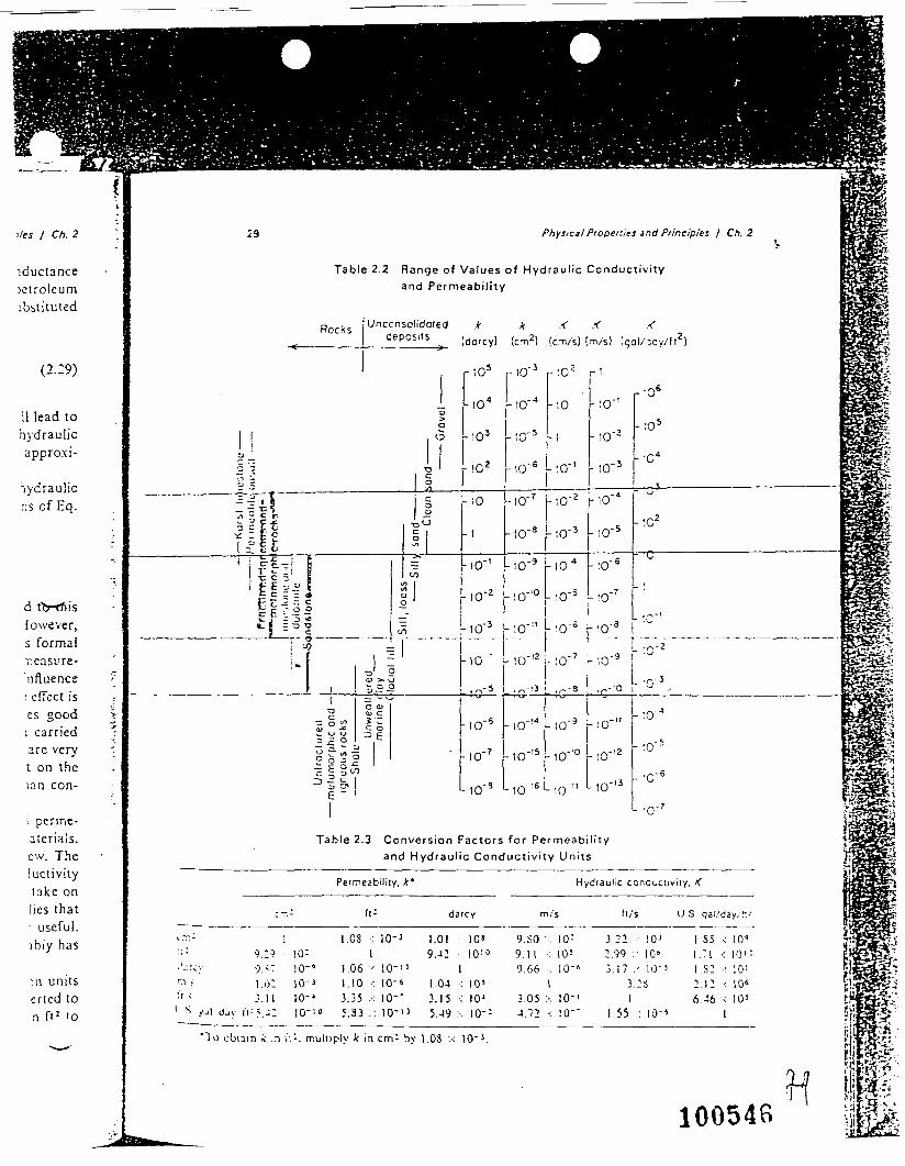
Table 2.2 of Groundwater (Freeze and Cherry, 1979) documentshydraulic conductivity and permeability for a variety of rocks.This table illustrates that the range of values for fracturedigneous and metamorphic rocks is within several orders ofmagnitude of values for that of sandstone. I have included thistable to assist in your efforts to establish a relativepermeability for the rocks under study here. I have also includeda table of yield values for wells in and around the Higginssites. This table also shows the lithology from the well log foreach well. I will caution you on attempting to derive a relativepermeability from this data, for the following reasons; 1) Thetechnique of applying high and low yield values to even arelative permeability value is "unscientific". 2) The credibilityof data from these well logs, submitted to the state by welldrillers, is questionable.
I have also enclosed an additional copy of a memo you receivedfrom Hugh Houghton of the New Jersey Geological Survey. Thismemo clearly describes the structural aspects of the geologicformations in question and demonstrates the directional nature offractures in the rocks under study, hence, their hydraulicconnection. The list of references that support his conclusionsis exhaustive, and available to you upon request.
Any other questions on the geology of the area can be addressedto Trish Gomes at the N.J. Geological Survey, telephone (609)984-6587. I hope this information has been of some assistance incompleting the review of the Higgins site submittals.
100542
c: Carole Peterson NPL coordinator USEPA Region IIWayne Hutchinson Bureau Chief GWRERobert Canace Supervisor GWRE
Enclosures
100543

SUMMARY OF YIELDS AND GEOLOGIC FORMATIONS FROMNEAR HIGGINS FARM AND HIGGINS DISPOSAL SERVICE
LOCAL WELL LOGS
Permit #
28143572814336282678232851283482281202323 ———
281490228232528213828965128544828129328 821 ?285211
•p2888328431Rocky Hill well
YIELD gal/min
33124141060
Iqt./min.1582013104202027
20540
Rocky Hill well £2 115
FORMATION
shaleshalediabaseshaleshaleshale0-120 sand120-165 diabasediabasediabasesandstoneargillitediabasediabasediabasediabasesandstonesandstoneshaleshaleshale
100541H
^/•^v.
- •••-v:7^.-:---"-^-•-^••-^^-^- •-. ^ -;:r-::-::^•
R, Allan FreezeDepartment of Geological Sciences
University of British ColumbiaVancouver, British Columbia
John A, CherryDepartment of Earth Sciences
University of WaterlooWaterloo. Ontario
GROUHDWATERPrentice-Hall. Inc.
Englewood Cliffs. New Jersey 07632
100545 H
{\
i/es / Ch. 2
iductancepetroleumjbstituted
(2.29)
11 lead tohydraulicappro.xi-
lydraulicns of Eq.
'f-
d ttj-rfiisiowever,s formalneasure- -nfluence '>'
• effect ises good *i carried 'are very "t on thelan con-
i perme-aterials.ew. Theluctivitylake onlies that• useful.ibiy has
>n unitserted to71 f<2 '0
••— -
29 Physical Properties and Principles / Ch. 2 vTable 2.2 Range of Values of Hydraulic Conductivity
and Permeability
Rocks Unccnsolidoted k k X K <^ ' deposits ^ !dorcy) {cm2) (crTlA) (m/s) .;qa|/,oy/f)
2)
e - * •>
i»>O
1! 6oC —o 3 -a
3= | §
flU §sift ?-* r I? °\ ? 1 t1 ^-1 1 z
tc 51 | <"C P -. i) C "> 1t E - — * °C c - - « aj
r;°5
- t o 4
-103
-,o.
-10
- I
-IOH
-IO'2F r - = c o 'i 1 7 o o - |c F - 3 •» = i^M0? J5 Mo-3. , . . . . . . . . . . . .
!- I- 10 'V 9a >. o
———————————————————— j ——— MJ ———————— 0^' 005 «> c
^°^ IsO) -^ CO^ <-» u Z3 £3^2 o0331~ £ °£3!&|
6 ~ '
•- -^ ———
-!0-S
-to'7
-ID'9
r-tO'3 r tO 2 rt
r 'O6
- to-4 - t o - t o - '
- to-5 - i - t o - 2
j-IO'6 r tOH - !0"3
-to'7 -to'2 -to-4
-10'8 - tO ' 3 -!0'5
-10'9 -IO"4 -:0"6
-!0'!0 -lO'3 -'O'7
-to-" ho-6 ['0-a
" . >
- to 5
-•c4
.^3 ————————————————————— ————
-to2
^
~ '
"~-~[
--•f 1 - _.;-2 —— - —— - ——— —-!0-'2U;0-7 - tO'9 j '"
L -r-3.^-•3 |_ ,^-3 ,r-'0 1 'u -,„
-.o-14 -to'9 -to-"
-ID"'5 -to"0 -to''2
- to- '6 - to-" *-io-'3
|
- to-4
- to'5
- to - 5
L&Sgpmml1ils§t.JOE*.
1I§P:
HPifejg feiIPwH§2
11•io-7 :» -*<r.TrY-^c~*" '0 ?aS«)fife
jS^^• Sf^jjfSTable 2.3 Conversion Factors for Permeabi l i ty Jy3SB5?§5
and Hydraulic Conductivity Units IrfilisSi
~~ ——————————————————————————————————————————————————————————————————— PiffillSPetmeability. A* Hydraulic concuciivny. K to SSSs» ^%»-cffc B^ jftgf-^
:-.; ft: darcy rn/s fl/s US. gal/day/K' |f SJjgiZfr-' ' —————————————————————————————————— ' ————————————————————————————————————————————————————————————————————————————————————————————————————————— t
'.: ] 1.08 : 10-J 1.01 . 1 0 s 9.SO ' 10: 3.22 . !0J I . S 5 < 1 0 ' •::: 9.2-) I0: 1 9.42 I010 9.1 1 .•: 10! 2.99 : 10" 1.71 < 10 i: j> !-:r.-y 9.<- ]Q-« 1.06 x 10"" 1 9 . 6 6 . - : 1 0 - « 3 . I 7 . ' 1 0 - S 1 . S 2 - : 10'ri > l.i)2 10-] 1.10 : 10-' 1.04 : 10' I 3.28 2.I2-:10« \•< < :-.ll 10-' 3.35 .•: 10-' 3.15 •: IOJ 3.05:-. 10'1 1 6.-J6 v I0! !
1 S yjl djy IV 5.-: I0-;i) 5 . S 3 : : 1 0 - | J 5.49 ;•. 10'- 4.72 < 10-' I . S S . t l O ' 4 1 |
"To obtain *: ,n i';:. muliiply k in cm- by 1.08 x IO"3. i
i
H 110054B ;
ijggSfiHBM?*
'"'P^^ ai*ll
J fcj- .**-/ -
r -fcvf*
is
*y, i
o OL
- ;XX.
tyi
».
*- ....
...
n. f
f^'*
u t
o**
it
,•£ft)
.
43
r «
n. —
o•n
rr
i
t t—
"3
t *l
"1
u
U.
r»
o
rt O
O
3i.r §
2
B>
O t
O
»«i
O
r *
tM
«
a.
d -1
c-
*> k.
-^.,
.,.tr
^^^T
A-^
9^L
•/•
• -•
3
Q.
vi LJ
t)0*
3' t
•1
•- •/»
rr r
n c
••*
M
»-
Mrt
-^
' M
f*
i V
3 at
r»
(.
rt
rtW
Or
t
o rr
'
r>
O
-T
i •i 3
•/» /i i
»-
51
** c*. c
-•* :
1 61:»
33
ex
— o
•"» c u ?3 t 1 1
t/l
-1
o
rr o
•»
o *
•• ""
• "
w
" o
'i
D -
i •/
• -1
*•-
o M
c
t M
t
>-•
o
> rr
3 a
B
»
o t
3 o
r»
* »••
• o
>
• -<
•«j
_.
f-|
V.
QJ
4n
<
•/> »
t
*-
m
n
n''-
* n
«-i
->3 »
-*•
i/» x
O
»—
n
^- »•••
o.
a*
*i
n x
o
o
>
•O
<-.
o
'» r
i *-
••
• o
>-
;i •
». L
; o
-• »t
3
fi *<
•< 3
«t
*t *
i -I
i—
n
o
• "
•« '»
•/•
*
i -1
>.
w
O
3
/' n.
O
3
3
B>
B>
3U
»
5
3
tv •
<
Oi
*-
n
<t
•»
V>
'<
r»
^-
1>
»-
*1 T
*J C
* "J
'/»
t
• C
l/»
U
j r.
3
'•*>
•</«
ifl
*-•
b»
*
O.
*•'
t>
»
O
O
J**
V
*•'
O
*•*
t C
W
'/*
'<
r
ft»
rt
M
r«
wi
»'
' -n
»-
-•
t o
** »
' o
" »-
rr.
r?
3
• ••
3
-i •/
» n
n'
---i
»••
wi
-n •
« i
« 3
'-^
iw
3" B
> ut
r*
lm
TI
>rj
*»
n
±T
3
'/»
1
3"
»/»
•<
•-*
-»,
»•-•
<e
f
C
»-•
BJ
(.1
•
»-'
•-•
B>
•-•
3
B>
</i
Ifn
C
> 7
1
fci
3* 3
O
•
^>
O
'J' W
I
-|
n
Ul '«
O
U
' O
U> a,
/C *••
*»
O V
'»
^*
O. M
If*
. ^£ -|
• -
tu (X
*i
ri
C
BJ H
•
M
—
II
—•
-1 3
rt
T
3 -
>»
. '/*
>
C
•
i»
CT
wi
u
|w
>
>.
.—
<
fc»
»-.
O
*'
3
"J
O
•— f
B>
O*
O.
B>
U
''•
ft»
M-
tn
• •(
O *
*J
i'/
(i.
O
O
(t
I*
-H V
^'< t
i
rt >
3 -
1 n
. o "j
*-»
r*
(7
*o
'»t-i
'-»
'iT
)-i3
O
w^
'C^
J •-
-o.o
nn
.fti
ijo
ft**
-''<
t
T3
r»
tfl j"
i
_
,t
^ i|
».«
»'
-i
«t rt
«-•
3
O '«
t
r-*
»> ' •
'1 n
w
H t
3
o
T
JO
* •
0o
O
M f
t »t
•••»
-* o
it
3"
M
i-»
f»
»«• »
*•
*t»
3
n.
'-* n
»(
k*-
o
3
J C
t
ft.
X.
Ort
^
3
»-
Vi •£
_ li.
r»
*••
•-•
- ri
?
| ^
C
3
^» B
* t
O.
i M
O
tj >
^»
«
O
»*
O
M,
1
TJ
t 15
3
(t
ui
rt
o
t 3
n
t
IP
Oi
ri
u
3
1
••-
ft.
»•• *
f M
- ri T
J 3
»-•
B
>
* 3
n
"1
O B
»
3
>t
1 U
t •*
" 1
O
. O
J-
a—
4 3
^
W 3
rt
'<
W
-•
OQ rl
C
L r*
H
3
t
C »»
B »1
rf
-|
r»
c
— **•«
O
•—
»—
X
rt
i ,
r,
«)
»-.
B
I '**
B>
^*-
B>
'
U"
3
O
B>
ft>
O
<V
W
»
3
3'
n
O*
V*
1 < n
. •
t Q
ft*
^
w
r. c
f •
• '.'
n *'
n in
o.
3 u*
j^*
B
J ix
ft
n* o
. t
o <
w B
J u
3 »-
• u.
- C
3
"^
^ O
M
^'
o
•
: ;
1
w
it>
t t
• '/»
3
Ci,
"/i
fci
O
v> '•*.
it
»1
B>
O
L».
.->
X »
- ^
TO o
•»
-+»
i
•• :»-
>".
B
. — B
I n v
B
>
ft-
<»
ii C
v
H--
3 •
-- *i
t C
*-
O O
6*
D
t x
w
* '
'•
i '"
• '
;1
*" "i
O
*1
'**
'
"J
O. H
I n ' T
'«
i
q
CT*
3
f*
ft« /»
o.
3—
o
ti 3
tj
w>
t rt
t
.1 •
>
• .
n •
* •<
3
M t
o a
Ci.
«-i o
"i
-
a*
»-•
n ^
»-.
rf
r^
CL
bl
'•*
rt
1
'd
n.
3
3
' L*
r* fX
tu
3
r»
I/i
(\,
I rl
1 j
O
»-' >
' fit
O ft)
'l> t
B
) 3
lh
•—
rt
ft) »
- *-
B*
3C i
(t
-^i >
•*
r j'
- c:
(t
c a*
at
o t
•/» f
t B
* r»
3 -^
.^t 3
r*
. *<
> ^
•A
3
H*>
*"
ft>
n.
3 -"in
3
. *
'! C
r
O
6*
3
V
't H
••
- •-
• •-
» r
t rr
.'
fV
" C
O
•
H
3b<
o
rt T
^ »—
o
•-
' o
• i '
• i
"*
.r
*-*>
«* r
* r>
tt
t> O
n
o o*
ft*
ftl
n* T
I n
o •*
•« M
- n
i/i
in
n 3
rt
. .
i n
ft n>
M-
•«,
T ^
e
n. :
r o
no.
«^»
< r
t ;i
3 n'
rt
n i«
»•
/» M
» 3
i- •/•
>t
o "
-i *•
-
• 3
.c
El
•• T
i »'
o
r !j
n w
r.
t o
•/• n
. -•
»t
^
'« 1
1 T
-j
1
t 3
C
f t
f'
' f.i
b>
r-
| »-•
r»
rj
1
H- w
o
3
O
*"
(>
M
»-*
rv
»'• fl
(u»•
. "J
*-
• O
'*
't *,?
• n
f
! -i
i
n
<
^- n
3
n
B
' »
»
*-• r
* M
, i
n
-n n
ti
rt
**, w
.;
>••
.
BJ B
* 3-
*i
*-• t
:••
3
t M
. i
- «i
. . -
i» i
/» t:
B
I *»
• M
w »
— i
*t
o B
I J
f hi
rr
»••
- •
io1
3 -
^i «•
M.
n
bi
t t
n.
0.
»t
ci •
' •-
D
. »•'•
'«
rr
'9
-i
»••
• •
u
3
*• t
3
C
n.
o*
ft* a.
M t
?" 3
«-
- t
•— a.
B
* •-
- m
•
,1 »
— x,
..^
»—
n B
J >-
h i-»
M, •
< t
r » «
i 3
i'' 3
O »
-• u
. t
*o
c t
•y.
n,
O
fti
( in
*i
•)
i"
. i
o
i«
O
*•*
3
O
C1 '<
O
A«.'
O
ft
• *1
O
'r.
i
B'
O.
t -\
j 3-
— n
o'
M.
u
:* .
i ;
.,,
i .
r <
M fv,
-1 »
i -1
n
o.
" M
o*
M
3
-m r
t »• c
i.O
3
t -r
M .
-•»
-'•(
-,
i .
• t
rr
* —
n
ft'
33
"ft
3 '
O
n«
c-
iO
t
^-
n »-
. **
. B
' 3
3 -j'
\: o
-i n
M -
», u
<
a>
BJ
rx.
u* »
» *t
n
o 'J
o>
•/»
n.
•A »^
,_,
it »_
. c.
t
o •*
* •
-i *)
M
,--
n.
»— o
i»
rt
t n.
o.'-
*. -
T
rr
o
*J 3
•' o>
BI •
t •»
»•(
•-.
C> 3
—
•••-
-
' -i
,-
,.•-
ft
. ft
i O
••
-•
*-
••''•
^"
'"
•—
H
'^
-C
rt
_i
'.> ;)
ftJ
rt
r» rt
1
- C
W
•-
- '?
*
• O
.-,
-i
'<
3
O.
O
C
l/i
—
r» i
n
u"<
rt
•-
o
t
O.i«-
in
t,
ft. -
• rt
o.
n
".
:1
<
. t.i
u
:l ^*
»/i
. '/i
3
3
q
rt
B
J *-
• •
tu M
'/*
• •-
'>
n.
»n
U
".
!r
**"
ft
»»
r»
•-
. ,v
.
n
»•
. -T
) •
&>
i
*-
3
-W
30
rt
B
* rt
rt
B
I \K
)f
i ,
o u-
•«
T.
-t
BI
'<
3 ft
. :r
r*.
r B
- t:
c o
a 3
In'
i .«
>i <
b -i
zj
M
n f»
m
;j
-I
t p
» o
i"
** o
. '•
DESCRIPTION
*1 VA?!
M <nex
. u D-
p •ri
O ^
f;r-.
0 "7Z u- — i
O
C/1
-H
^-
3—
a.
o o en
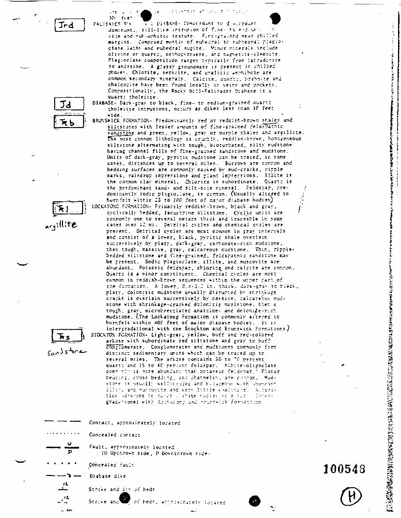
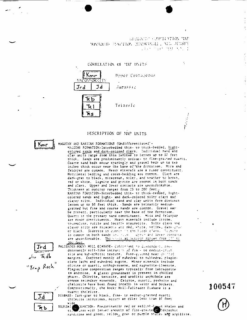
. t ' i lSV»E- Co-ni.-frd.int to -i .-..: rd^nt *^dom:r .ant . . i: 11 -!: > f i r t r i u i o n cf f.r.t • t c r - j . u r . . r.si:e and < u b - o r h i t i c t e n t u r e . r . r t - ^ r a .r.rd n t ^ r ch:'.'.edm a r g i n s . Competed roostiy of eu^ . t J ra j to suir.edrJl r l a c . : 3 -c lase l a t h s and euhedra! v j g i t e . V i n o r n-.- .-craif i n c l u d eo l i v i n e or quar t : , o r t h o p * r c i e n e . arc rr.acriet: t e-i i n.en: t e ,P lag ' .oc ias f conposit iep. r.r.ges t y p i c a l l y fror I ar ridc-r J itto andesine. A glassy groundmass is present ir. ch : l iedpha^e*. Ch io r i t e , s e r i o i t e , and u r a l i t i c ir .rhibcle arecommon secondary T.:nera!s. C a i c i t e . c-jsrt:. r -re ' - ini te ar.dc h a l c o c ; t e have beer, found l o c a ! l > ir. v r i r s and pocVet i .Compos i t iona l ly. the Roci.y H: : 1 - r a l : ?aa i< D i a b a s e i« aquart: tholeii te .
DIABASE- Dark-gray to b l a c k , f ine- tc- a -eJ iu t r -gra ined ouar::t h o l e i i t e in t rus ions , occurs as d i X e s less than 1C fee:wide .
BRUNSK1CK FORMATION- Predoir.ir.ant ly red or reddi5h-br;»r shaj^_s andsi listor.es wi th lesser anounts of f in f -g ra ined fe id jps th icsandstone and jjreer., ye! lo^, j:ray or purple sha'.e; and a r e i l l iTTT* most cori^ior. l i t ho iegy is crur.bly. r edd i sn - t r cwr , hon^is i l t i t one a l t e r n a t i n g w i t h tous'n. b io tu rba ted , s i l t y n-jcstonehaving channel f i l l s of f ine-grained sandstone and mudstone.Units of dark-gray , pyr i t i c ^udsrone car. be t raced , ir. socecases , d i s t ances up to several s i les . Burrows are ccr.-on andbedding surfaces are corjionly r.arked by mud-cracks, ripplenarks, raindrop in;pre5sions and p lan t impress ions . I l i i t e isthe corjDon c lay i r ineral . Chior i te is subordinate. Quart: isthe p redominan t sane- and s i l t -s : :e c ineral . Fe ldspar , pre-doa.ir .antly sodic pi agio- '.ase , is cerr.or.. f l i sua l ly a l tered tohorrfels w i t h i n 23 to ]OC feet of r.a;or diabas- bodies)
LOCmTONC rORH^7ION- Tr i r ca r i ly reddish-brawn, b l a c k and £ray ,c y c l i c a l l y bedded, lacustr ine s i l t s tane . Cyclic ur.its areco-j:ion!y one to several otters t h i c k and t raceable ir. somecases over IT iri. D e t r i t a j cycles ard chemica l ocies arepre.-ent. De t r i t a l cycjes are rocst con.-r,on in cray ir.;erva!sand consist of a lower, b l a c k , p y r i t i c shale over!air.successively by platy, dark-gray, carbonate-rich rudstone.then tough , cassive, f ray , calcareous r.udstone. Tn;n, r ipple-bsddec s i l t s t o n e ard f i r . e -grs ined , f e l d s p a t h i c saridstcr i t - caybe present . Sodic p l a y i o c l a s e , i l ' i t e . and Tuscov i t e areabur.dant. Fotassic f e ldspa r , chlori t t^ and c a l c i t s are cor.-or..Quartz is a minor constituent. Checical cycles are mostcoTjT>or. ir. readish-trowr. sequences w i t h i n the upper rar t .ofthe forr.a: icr.. A lover . 0 . - -3 . - ir.. t h i c k . car».-i:r3\ tc riac'i.p l a t y , colon-.itic mudstcne u s u a l l y d i s rup ted by sf . r i r .kaescracks is over la in success ively by r.assive. caicar?;"jr riud-stone with shrinkage-cracked ddior.itic r^rlstone. the" atough, gray , mic robrecc ia t ed ar.alcir>e- and doio~.:ie-richmudstone. (.The Lock at op. £ ronriation is cormoniy a l t e r e d tchorr.fels w i t h i n 40C feet of major d iabase bodies . It uintergradat ior .a l w i t h the Stockton and Erur .swick rorr.it ions}
STOCKTON FCRMATIOX- Light-gray, yellow, buff and red-coloredarkose w i t h subordinate red s i l t s t o n e and gray tc buffconglomerate. Conglomerates and r-udstor.es- coic-nonly forrd i s t i n c t s ed imen ta ry ur i ts w h i c h car. be t raced up tcseveral m i l e s . Tne a r k o s e con ta ins 50 to "C percentquar t : and 15 to AC p e r c e n t f e ldspar . A l b : t e - o l i s o c l a s eceir.- -.'.- is '?cre abur.di.il *.-.ar 2cta55i.c f e : d ? p a r . ' FJar.arbeiicir .c. eras; bedd:-:;;. an: c'r.ar.ne! i- .. sr? c.-'.-an. u.ud-> t o ~ e '-; 'jJUi'.ll; ve!:-:-r::ec ar.c r . :ii rec'j:- w . t h iou-.rir.ti 1'.".'-. a-d Tu: ::ov:te 3nd ver v V . t T i e > -o'. '.:.;• e . V:t.-i-t ic r . - .d-s.-tnt tc - r^ - ->- r . .;~5J.s- ;-.•;:?; 15 ,T ; - _ r . '.:•-•.''•g r a d e ' i o n a l w i t h [._-.-; a; or; -nj -.r-.r;-:.-k For-:.a: ; .T.S
ff
SS
u••••i
S>
ItJ_It
Contact, approxirately located
Concealed contact
Fault, approximately located(U Uptr.rowr. side, P Dowr.thro-n side.
Concealed rault
Diabase dike
Strike and d:r of beds
01 bed;, ar-r.-i:.-..,: • l\ ;o:Ared
100548
X <
>Cr
e s
X *
*o *
o 5s
-»
U
I*.
'1
.:
3.
(^'
-1
. . n
fj
rl
11
1••
(
0
V-
< .
;i - •
iv •ii
'/•;.i
<r
> <v
C
it -•
•".
»• /
-..i
.)
i*•i
-.
0
.•; •
»,/-.
:i t* 1
1•:
;* b*
*9
•'*
'. 1•i
r-'•
Xi -,
, IV
'r.
• »
>'
l^
. ••
1.
.*.
Mc.
r '
• •>'
v
•
•1
,«
..
•/• u
• *.
,i a
•V
— ut
, a*
i-»i
'^ *
'O
'1
3•J
/>
! "•
1 *
fl
1.
« If
>*
-1
-'.
C*
n '
O
.*•—
.
1*w
...
ca
. :i
.- :»
i/i
.-•
• u
•-.
r.
. t:
"O C
'. J
D O
* M
t
r.' f
» ;j
u_J
*'l .'
til
t>
•.,
. m
-
•- -
j:-»•
in
*• •
•"!
;o »
••0
,- .
»i,
iu -
«-
t «•
: i/i
a "j
o(-
o .;
z. r
. •
o„ ,- rj M ^ ,| .
•—
U
u>
f .
u
rt I
* *-
• c.. i
< •
•; a
*o
* L.
1»•
• i
M -
u
O
y -l
3
- L
i C
M-
• i .-o
n
«B.-:
•-
fi w>
t.. -
j >*
U
L>
tJ
••
<
/•;i
•/.
A' u
n
*o•/.
•*
.t
~t,
ft rt
•)
.. .-
i;.
oi r.
c r.
u T
* -
• ••
If. ft .
>
• «•
•i.
r. .
rt
• i i..
i/i fi r
' ••
'i,
;v-.-
, o :
r,
. .;,
. . .-
• r»
,i
.- ;:
c i*
o i"
• *'
•1
fl
',-. >
• ''.1
L
Ul
/ .
•* "'
•y.
U
fi •
*.^
<v u. i
. :i
r1
. "
*-
•* <
j '3
LI
. ,l
, L
. .f
>
1 rl
(,,
r,
r*
»••
IVK,
»7
«-»
>i :
i M
no-
t/« —
r,
:J•«
n
u
iv
f-*-
rv
n */
. M
, •<
n -1
•—
U f
i O
"
'<(J
. »»
u
'1
I/I
3^-
^- *1
•/-
.J.
O t
a'. -1
l~
tr»
.1
. t-
y
O;:
v •-
i-
•', •
• —
t. •
• •/
>•:
•--
». a
•
*;>rf
•». L
I L"
I f-
' '••i.
. ft,
f*l O
J. •
..,
C b-
i '•
o ;i
o »-
•
-u
•»,
• i, n
«.
•
x:
i t:
<'!
f!it
;• in
u.
^-' f
t t:
t»•
f .-
i a
X *
-. it
• f»
••:
js<
U -1
-
••
i/.
in•
iV
J-
•'<
f»
-fl
0-l
-,-
•D
«; i
/. |_
C
i/io'
r*
i'i cj
• l>
3" .
• r
a•"
IV
^ i
•n IA
rt
ar»
"
u •'-
*- '
- .
1. l
_O
. .
ti n.
• "
i-;l .
— . ri
....
"1
'•I
H :l
i/i 1.1
•'
II••
:i >•
u1..
». I-.,
r.,
•V (
.' :i
"'f
'1 1 O
<-
i- 1
rv
M(
J'
M .
Li I .
v.
fl.
rvft
:L "
-i
-«.
. ...
u.
U».f»
n.
C1
. ifi
•'IV . ....
O
0
' '.*
}!.':'
I/i C
. 'I
1.
C
i•1
• -
i Jii "
"'
iv
i i
' •
u: c in f .l. i IV
t*. !>
' ^
rv
... i... (
JD
HL
. T
...
;i o- <
--i
oa
t.
- •»
m
:i i/.
'.£
'•'••:
n a
> •
i/. *
:'-"x
.„.'.*
O
M
r> <
"CT
0
u
C '
•>.
M ;i
•!
•a
(ruu
U
i:
—O
•-
rv
</
,.
I/I I/. .
r 1
rt• -
M
1
O
it in
•u
o :»
-•
M,
r«I/I
M
ft*
...
1 Li
3i
:i • •
b0
Ou.
— d'
.-. i
urv
f ui
i /
'-4
..,
b-n i , M
r. .v
,-
^' •
i ii
i/i
A*
i/.
rv .
BI •:
il ••
-1•C
)n
a \e.
•a.
p
-
O ' .
•1
'f-•
S.
-J>
O
u.
l'•1 3
.
• 1
C..
'. r
la
it
rt>..
-i
"•I/I
LI
O• i
r*
ii
a
it r/
Cl
ft M II...
.•
in:i
LJ ;
ic.
n v
5 • n
r*
1£ it
• i .
ait
i-v.
c:
u1
-1 A
.o
-a4:
i: •
U
U' a:?
CTbi
rv
iu
rl
O n
:o f
T H
O V
I l''
r*
.*
i1
>•• n
»•
• v
ii:J
»
:c n
•K
-'O
^
i».
l—
O
•.
rt, C
.
X
• f
a
a'
*• n
»-. -
in
-i•1
L.
u.
-0IV '••.
^1.
• L
j r> x-X L M'I rv ;.'.
uu r M it^J
i/i
L.
I/i
n. n
r:
i:I/.
M
-Ia
< o
•:LI
rt
M, i
t•1
•'.
'<ii
ni
*:r
o a
• i,\/i
.llj
r-
c s.
n.-
ft rt
.. t
n
It -I
it U
, ,..
•• n :
i:>
•<
«i/i
i/i rv 7J
^•'
'«.
IVfi
t •
\ni
rvI.I
*1 U
o- r
t •!
•.
'ti n
u :>
•iU
M
-
C
rlIt
Ui
• •
tfl
!*i
It
——
t"M
1
CJ
t.i
1 i
11
J r-
r; ••
'r.
3
Ul
r--
-1<
M
l •ft
3., u
i. tn
.r.
•-
3'••
^!
J»l
rt
a
•*•
'.-.
It
'.1.
M ft
...
Iti i n
i
Of
.'
•-•
3..'
A
.a M
i"
IV
O
O
~rt
.
JJ
U9
-J ft*
r~
Ul
.-
nu .
ci in
i)r,
a, a
rt
r,
0
— •
*n .
K- M
-.
• i/.
11
»,
o- •
:i i-
in c
. •
u. 3 t: i
-1 •
< ra
.(. •
») «
: -
uC
-1
<»
1B
iv
'<
V
U '<
•i M
•
*., .
L-I
0 n
r. .
ft *
•rv
o -
UI
...
r-
HI
,. ?
• 5
x d
•a ,i
> f
, .
rna
" 1
0 .
i-•.'.
n •-
• m
(V
0 U
«
-^
j,
., i/. --
I C
~
••f
• H
;\
^r->
ft h
vrit
o •'!
-1 '»
n3
"' S-
" ."
m
n, b,
i-.
a C/
i'. n
O I
'.! .
- o' IB
.; <j
> —
•£
":'£
••/•L
I •
O
I . Q
. '•£.
w"
ft •
-1.
H
Id
t^
r^"
L.
Q
• •
rv
w
''<
i3
i? .
*C
l C
l •
Wft
3
••
•o
n r-
c s •
d
• ^
.- in
o.
;j «
•—.
't-U
, ..
UI
i 3'
»* r.
Ill
it
G•
3. t
u.
u
0
o i
v u. UI
Ii -1
r«
t b
ivt
„
L..
;l II
• ni
U
•' O'.!•
O
f' fl.
•».' rv'
ivir.
u.
Ol
!-• •1
.. It
u.
3 rt
1. O
O •it.
»rv
TIV
*
'ri
'<
. r"
3 «r.
- 1 rr
-_i
rv IL 3
ki n»
I/I
tLi: Li l/i|
• •
a O•1
•-
UI
U3
fi.
'f.
~rv
ri
l'\-
J*
'**
>ci
CT
cr
5-IV
) IJ
ft-
W
•n
u
a
3n
r..
b.
ex1
O
O
O
.1
3
3•ij
a
rv
rft
•1
b.
H.
O.
u II.
rt
ir.
I/I
•il
o
-J-
biv
T)
L,
nfi
•<.!
. •
CX
rt
IV
IV-1
6.
.<••
3ij
r c.
r-
LI
:J
1
(rw
a
-i
-i w rt •u *••
r»
'>-
>j
i Jv
C
rvLI
b
i).T
T
rl
rx
-^
w
:••Cj
••:
-i3
•« il
a M
up.
o X
f..0
r-
0
C
d
3LI
ft.
u.
"1
r.
O1
IV i— "
^>
tO
V
r.
•'
L.
r-t
O'
IV
ItU
. U
.•1 o r. f.- it .
*
• o o <J1 Ol
J^
..A
T n?
v*
•. -"
..;•/"
.•"
<.»• M
»-
V
Left prated our earth
GEORGE G. McCANN. P.E.DIRECTOR
DEPARTMENT OF ENVIRONMENTAL PROTECTIONDIVISION OF WATER RESOURCES
CN 029TRENTON, NEW JERSEY 08625
2 5DIRK C. HOFMAN, P.E.DEPUTY DIRECTOR
M J 2 M O R A N D £ M
FROM: Hugh Houghtorry Bureau of Geologvgpand Topography andRobert C. La ndle^^th rough Richa rd T*r~~Cerbone, Bureau ofGround-Water Po l lu t ion Analys is , New Jersey GeologicalSurvey Element
T O : D a v i d V a n E c k , 3u reau o f P l a n n i n g a n d A s s e s s m e n t ,Hazardous Waste Management D i v i s i o n
SUBJECT: L a u r e l A v e n u e W e l l s , F r a n k l i n Townsh ip , SomersetCounty- Frac ture charac ter i s t ics and h y d r o g e o l o g y otbedrock in southern F r a n k l i n Township
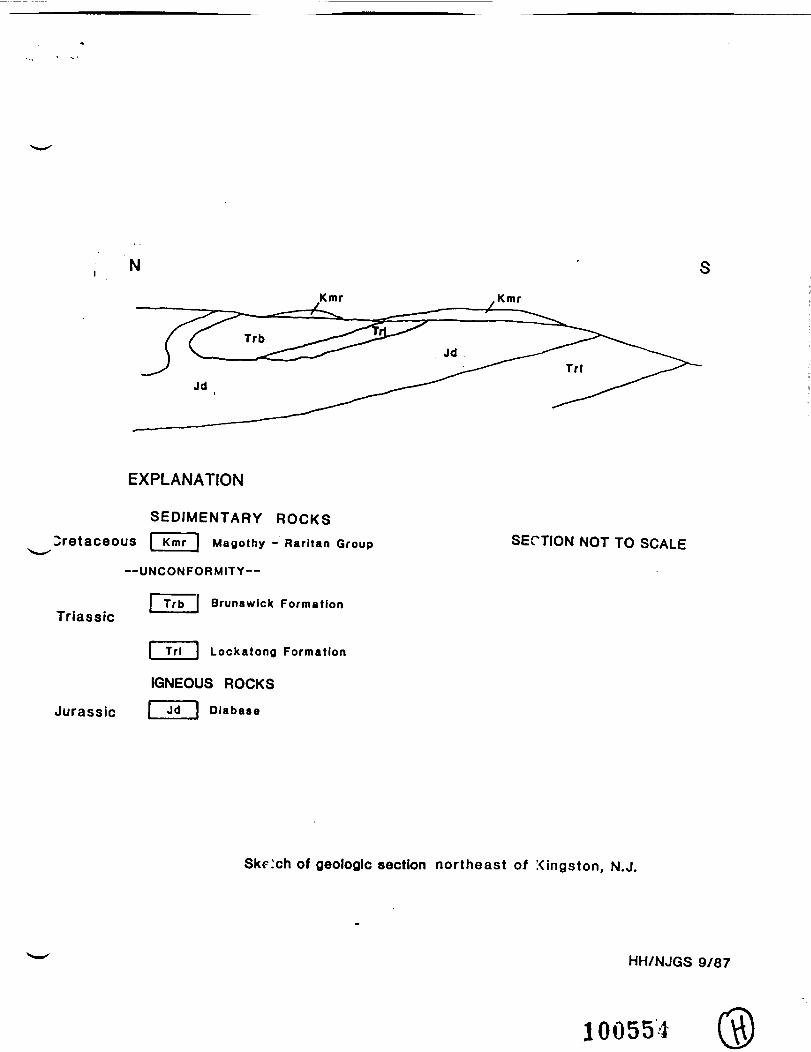
B e d r o c k in the area of concern cons is t s of upper L o c k a t o n gFormat ion and Lower Brunswick Format ion of late Triassic age, andi n t r u s i v e i g n e o u s d i a b a s e o f e a r l i e s t J u r a s s i c age. Thes e d i m e n t a r y rocks dip to the n o r t h - n o r t h w e s t , m o s t l y at 15-18degrees. D i p s a r e h i g h e r near t he K i n g s t o n q u a r r y f a u l t zone.The d iabase i n t r u s i o n i s somewha t d i s co rdan t in the K i n g s t o narea , tha t is , i t cuts across the s e d i m e n t a r y l ayers at ano b l i q u e ang l e . The d iabase is n e a r l y c o n c o r d a n t to bedd ingf a r the r to the east and towards the west where it forms the RockyH i l l s i l l . T h e b e d r o c k i s o v e r l a i n i n p l a c e s b y n e a r l yh o r i z o n t a l beds of p o o r l y c o n s o l i d a t e d p e b b l y s a n d s t o n e ,i d e n t i f i e d as part of the upper Cretaceous R a r i t a n - M a g o t h y Group.The geology of the area of concern is depicted in a sketch crosssection attached to this memorandum.
The upper L o c k a t o n g F o r m a t i o n cons i s t s m o s t l y o f l i g h t to d a r kg r a y a r g i l l i t e , a rock composed of q u a r t z s i l t or f i n e sandframework grains t ight ly cemented wi th abundant clay minera l s ,m o s t l y i l l i t e , and d o l o m i t e o r a n a l c i m e . A r g i 1 1 i t e b e d s r a n g ein t h i c k n e s s f r o m about 2m to more than 7m and are r h y t h m i c a l l yinterbedded w i t h th in beds (gene ra l ly less than 2 m ) o f da rk greyto black l amina ted s i l ts tone or s i l ty mudstone. A sequence of reda r g i l l i t e beds several hundred feet th ick occurs near the top ofthe f o r m a t i o n and is shown as a band of B r u n s w i c k F o r m a t i o n( T r b ) o n some pub l i shed maps. Present nomenc la tu re w o u l d designate
New Jersey Is An Equal Opportunity Employer 100551
these beds as T r l r , red beds in the Lockatong Formation.
The lower pa r t of the B r u n s w i c k F o r m a t i o n consis ts m o s t l y ofr e d d i s h - b r o w n s i l t s t o n e and s i l t y muds tone . These rocks a relaminated on a f ine scale; bedding can be thin (less than 0.5cm)to very th ick (more than 2 m ) .
In sparsely f r ac tu r ed diabase, a r g i l l i t e , and hard s i l ts tone mostg r o u n d wa te r i s s tored in and t r a n s m i t t e d t h r o u g h j o i n t s andf a u l t s ( secondary f r a c t u r e porosi ty) . The charac ter i s t ics ofground-water-bear ing f rac tu res are discussed below:
1) P r inc ipa l water-bear ing f rac tures in both the sedimentaryrocks and diabase are high-angle jo ints and fau l t s .
2) H i g h - a n g l e j o i n t s a re n e a r l y p e r p e n d i c u l a r to bedd ingplanes in the sedimentary rocks, and near ly perpendicular to theplane of in t rus ion of the diabase, throughout most of the Newarkbas in .
3) P e r p e n d i c u l a r i t y of f r a c t u r e s i n d i c a t e s tha t they f o r m e daf te r the deposit ion and 1 i t h i f i ca t i on of the sedimentary rocks,a f t e r the emplacement of the diabase, and before s u b s t a n t i a lt i l t i n g of these rocks to the i r present d ip ang le . Jo in t s andfau l t s in both the sedimentary rocks and diabase, therefore , havea common mode and time of emplacement.
4) The or ienta t ion of pr incipal f ractures is consistent on thescale of t housands of feet or l a rge r . T h r o u g h o u t much of theN e w a r k b a s i n the t r end of p r i n c i p a l j o i n t s and f a u l t s i s in therange 020 to 050 degrees (N20E to N50E) . Ind iv idua l f ractures orgroups of f r a c t u r e s may be c o n t i n u o u s o v e r more t han a t h o u s a n dfee t in the case of s e m i - a r t e s i a n c o n d i t i o n s , or over g r e a t e rdistances where water-table conditions occur.
5) Mos t j o i n t s in the diabase are expected to c o n t i n u e in tothe a d j a c e n t s e d i m e n t a r y rocks. The d i abase and s e d i m e n t a r yrocks may also have d is t inc t f rac tu re sets which d i f f e r f r o m eachother in spacing or orientaion.
6) The c o n t a c t s between d iabase and s e d i m e n t a r y rock a reexpected to e x h i b i t changes in t r a n s m i s s i v i t y and g r o u n d - w a t e rf l o w v e l o c i t y d u e t o c h a n g e s i n f r a c t u r e d e n s i t y . W h i l er e f r a c t i o n of f l o w l ines may occur a t these b o u n d a r i e s , thegeneral d i rec t ion of f l o w should remain constant.
A mapped f a u l t in the area of concern is exposed in the Kings tont rap rock qua r ry . The f a u l t trends about 020 degrees ( N 2 0 E ) w i thsou theas tward n o r m a l d i sp lacement . Th i s f a u l t cuts both theL o c k a t o n g a r g i l l i t e and the d i abase , as shown by the o f f s e t o ff o r m a t i o n contacts and the j ux t apos i t i on of the two rock types inthe q u a r r y . The f a u l t consists of two or more zones of in tense ly
100552
fractured rock, several meters wide. Other unmapped fault zoneshave been observed in the area surrounding the Kingston quarryfault. Fault zones are important loci of ground water movement,due to greatly increased fracture permeability. The presence ofmajor fault zones in the area of concern increases the range ofinterconnection of fracture sets.
If you have any questions concerning the above comments, do nothesitate to call.
HH/RCL/ibm
c: Christopher Mallery, Northern Bureau of Regional EnforcementCarol Graubart, Bureau of Planning and AssessmentDick Dalton, Bureau of Geology and TopographyHK/WFA/File
100553
N
Kmr Kmr
EXPLANATION
SEDIMENTARY ROCKSCretaceous I Kmr I Magothy - Rarltan Group
^ * I
--UNCONFORMITY—
| Trb _[ Brunswick FormationTriassic
| Trl I Lockatong Formation
IGNEOUS ROCKS
Jurassic j ^d | Diabase
SECTION NOT TO SCALE
SkF.'ch of geologic section northeast of Kingston, N.J.
HH/NJGS 9/87
100554
Left protect mvurth 1 1 DEC 198§
rDEC 8 1986&tate nf Neui
DEPARTMENT OF ENVIRONMENTAL PROTECTIOfl£.j*- *; • ;-:DIVISION OF WATER RESOURCES ! *""
CN 029 . •TRENTON, NEW JERSEY 08625
GEORGE G. MeCANN, P.E. DIRK C. HOFMAN, P.E.
°IRECTOR M E M O R A N D U M , D.PUTV o,RECTOR
2 0 1986TO: Pat Bono, Bureau of Water Supply
FROM.: William Kramer through Walteis-Samsel ,Supervising Geologist, Bureau of Ground WaterPollution Analysis, New Jersey Geological Survey
SUBJECT: Higgins Farm Well Restriction Area, MontgomeryTownship, Somerset County
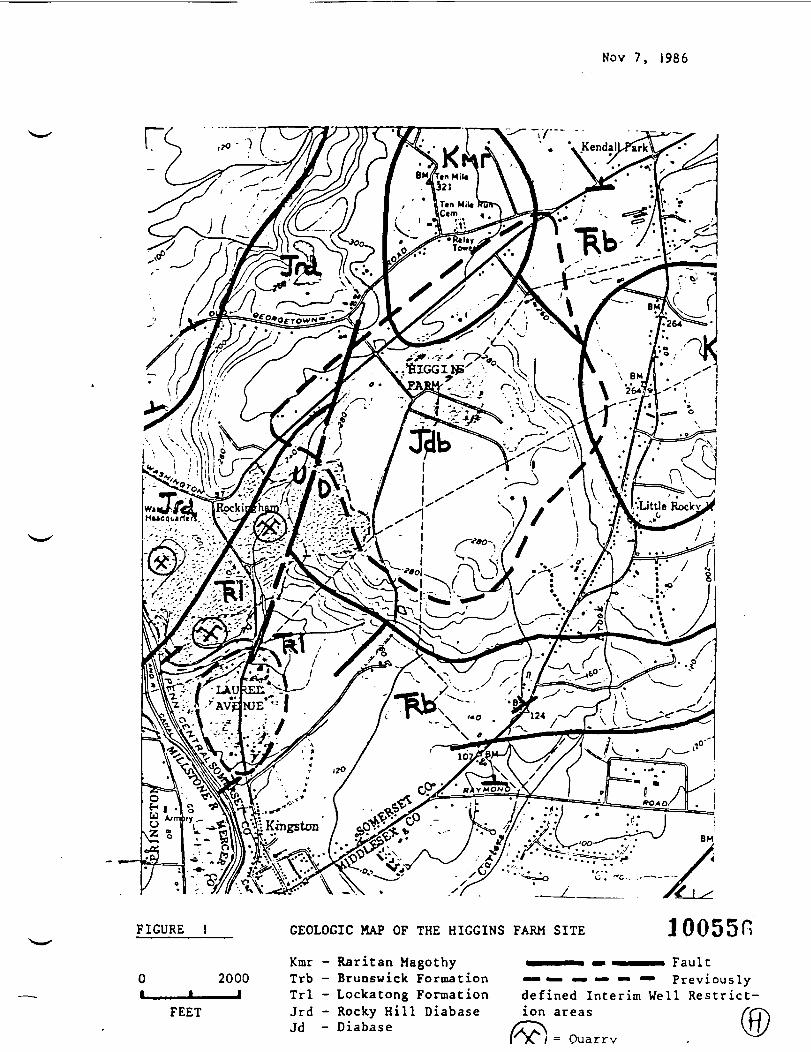
The Higgins Farm site rests on a plateau that is drained bystreams to the NE, SE and SW. The site is underlain byJurassic Age diabase (Figure 1). The Raritan Magothyformation overlies the diabase on a small portion of thesite. The Lockatong and Brunswick Formations also outcropin the area and strike"NE-SW. A fault zone cutting throughthe diabase and Lockatong Formation is oriented NNE-SSW andpasses through the nearby quarry.
A concern relative to ground-water flow is whether de-watering is occurring at the quarry ( SW of Higgins Farm). Adewatering operation may act to induce ground-water flow tothe SW from the Higgins Farm s'ite.
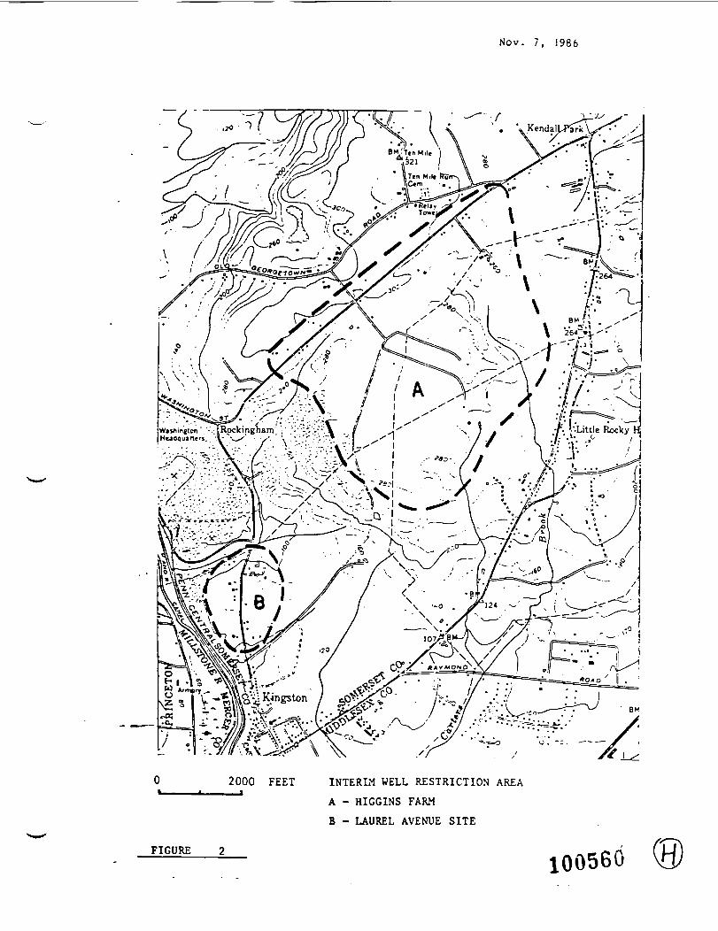
An Interim well restriction area is shown in Figure 2.Periodic sampling beyond this area is recommended until suchtime that ground-water flow direction is determined and athreatened area can be defined.
1. Determine whether or not supply wells are present alongRoute 27 between Kingston and Route 518. If so, thesewells should be located on a map and sampled. It maybe advisable to tie these wells into public water at afuture date.
2. Sample additional supply wells at the 11 locationsshown in Figure 3. Wells should be analyzed using EPAMethod 624 + 15 and 625 + 25.
WK:edg
c: Tom Donahue, Northern Region, BFO , DWM •David Benheck, HSRT^HSMAHK/WFA/File - --' 100555
New Jersey Is An Equal Opportunity Employer
Nov 7, 1986
r
FIGURE I GEOLOGIC MAP OF THE HIGGINS FARM SITE loossn0•
Kmr - Raritan Magothy «MWV • ••«•••» Fault2000 Trb - Brunswick Formation — •— «••—••-• Previously
1 * Trl - Lockatong Formation defined Interim Well Restrict-FEET Jrd - Rocky Hill Diabase ion areas
Jd - Diabase= Quarrv (0)
UO, pwrct iu car*22 DEC 1986
-*tate of XPUI 3ersryDEPARTMENT OF ENVIRONMENTAL PROTECTION
DIVISION OF WATER RESOURCESGEOLOGICAL SURVEY ELEMENT
CN 02929 Arctic Parkway
Trenton, N.J. 08625GEORGE G. MCCANN. P.E.
DIRECTOR
M E M 0 R A N D. U_M DEC 17DIRtfC. HOFMAN, P.E.
DEPUTY DIRECTOR
HAIG F. KASABACHSTATE GEOLOGIST
TO:
FROM:
SUBJECT:
David Benneck, DHSM, HSR
.,._,_„,-__...__ _.1d Lorri Scrugqs, throughWal£eq£/5amsel and Steven Spayd$,7Section Chiefs,Bureau of Ground Water Pollution Analysis,New Jersey Geological Survey
Kydrogeology of the Higgins Farm/Laurel AvenueSites - Franklin Township, Somerset County
As per your request, we are submitting background informa-tion on the above referenced sites to assist in the hazard-ous site ranking process.
The Laurel Avenue site is underlain by the Lockatong Forma-tion, a Triassic age lacustrine deposit consisting of wellsorted, fine-grained, fractured sedimentary rock units. TheLockatong is cyclically bedded and primarily composed ofreddish-brown, black and gray siltstone, red and grayshales, and dark gray argillite with interbedded feldspathicsandstone units. The dominant joint pattern is reported tobe generally parallel to the strike, which trends northeast-southwest and dips 75 degrees to the southeast. Althoughthe Lockatong is generally not a high yielding aquifer atmost locations in New Jersey, in the Franklin Township areait is the main water supply for the Laurel Avenue residents.The Lockatong is reported to be 1450 feet thick in theFranklin Township area.
No site specific data are available, but well records fromnearby areas indicate that the ground water in this portionof the Lockatong is approximately 45 feet below grade.AtfeTage well depth is 125 -feet. Ground-water is believed tobe under water table conditions. The ground-water flowdirection at the site is predicted to be southwest towardthe Millstone River.
New Jersey Is An Equal Opportunity Employer 10055
The Higgins Farm site rests on a plateau that is drained bystreams to the northeast, southeast, and southwest. Thesite is underlain by Jurassic Age diabase (Figure 1). TheRaritan Magothy formation overlies the diabase on a smallportion of the site. The Lockatong and Brunswick Formationsalso outcrop in the area and strike northeast-southwest. Afault zone cutting through the diabase and Lockatong Forma-tion is oriented NNE-SSW and passes through the nearbyquarry.
A concern relative to ground-water flow is whether de-watering is occurring at the quarry (southwest of HigginsFarm). A dewatering operation may act to induce ground-water flow to the southwest from the Higgins Farm site.
A hornfels zone is expected to exist at the contact betweenthe diabase and Lockatong and Brunswick Formations. Horn-fels are fine-grained, massive metamorphased shales thatform when magmas are intruded into lower temperature rocks(contact metamorphism). The hornfels zone occurs at thecontact between the diabase (solidified magma) and theintruded shale. The hornfels zone is expected to have lowerpermeability relative to the Lockatong and Brunswick Forma-tions. As a result, the hornfels may act to restrictground-water flow from the diabase into the Lockatong andBrunswick Formations.
The presence of a fault zone that intersects the diabase andLockatong, as shown in Figure 1, may have reinstated frac-turing in the hornfels near the faulted area. Therefore,ground-water flow between the two formations may occur.
With regard to aquifer boundary conditions, streams andrivers do not necessarily act as ideal discharging boundar-ies to ground-water flow. Contaminant flow below streams,particularly in bedrock aquifers, has been demonstrated inother ground-water pollution cases. Whether or not flowoccurs beneath a surface water body (e.g., the MillstoneRiver) depends on site specific conditions.
The regional geology over a three mile radius from each ofthe sites is consistent with the trends shown in Figure 1.The northeast-southwest trending Brunswick and Lockatongunits are the most predominant formations, with smalloverlying areas of the unconsolidated Raritan-Magothy _formation.
100553
If you have any questions or need additional information,please do not hesitate to contact us.
WK/LS:edg
Attachments
c: Tom Donahue, DWM, BFO ParsippanyJanice Brogle, Water SupplyChris Mallory, DWR, Enforcement, ParsippanyKK/WFA/File
100559
Nov. 7, 1986
iiftinjton" • .jRpckingham. V •'.'•Headquarters, 'V '^*/ • X- \ -'
2000 FEET INTERIM WELL RESTRICTION AREA
A - HIGGINS FARM
B - LAUREL AVENUE SITE
FIGURE 100560 0)

Nov. 7, 1986
0t_
2000
FEETADDITIONAL AREAS FOR SAMPLING OF WATER SUPPLY WELLS
FIGURE 3
100561
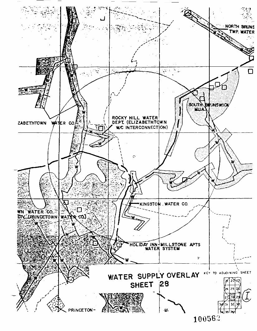
NORTH 8RUNSTWP. WATER
ROCKY HILL WATERDEPT (ELIZABETHTQWN
W>C INTERCONNECT ON, m
/
HOLIDAY INNWATER
MILLSTONE APTSSYSTEM
r^- *^—Tl i-rkj'T. >—-r-Tj.' P*.^t3P
PRINCETON
100562
LEGEND
w
AREA SERVED BY PRIVATE WATER SERVICE COMPANIES
AREA SERVED BY REGIONALLY OWNED WATER SERVICECOMPANIES
AREA SERVED BY MUNICIPALLY OWNED WATER SERVICECOMPANIES
AREA NOT PRESENTLY SERVED BY WATER SERVICE
PUBLIC SUPPLY WELLS
SURFACE WATER JNTAKE
MAJOR WATER MAINS
TOWNSHIP BOUNDARIES
COUNTY BOUNDARIES
STATE BOUNDARIES
ALL MAP COORDINATES ARE FOR THE LOWER LEFT
HAND CORNER
LOCATION AND OWNERS Of PUBUC SUPPLY WELLS28-01-715 Hopevell Borough28-02-119 Ellrabethtovn Water Company28-02-135 Ellzabethtovn Water Company28-02-175 Elizabeth Water Company28-02-179 Ellsabethtovn Water Company28-02-498 Rocky Hill Realty Co.-28-02-661 Brunsvlcktovn Water Company28-02-665 Brunsvlcktovn Water Company28-02-982 Manor Real Estate and Trust Co.28-03-195 Franklin House Bldg. Corp.28-03-417 Brunsvlcktovn Water Co.28-03-418 Brunsvlcktovn Water Co.28-03-419 Brunsvlcktovn Water Co.28-03-432 St. Augustine's School28-03-891 South Brunsvick MUA28-03-898 South Brunsvick MUA28-03-975 South Brunsvick MUA
100563
SOIL SURVEY OF
Somerset County, New Jersey
United States Department of AgricultureSoil Conservation ServiceIn cooperation with
[ New Jersey Agricultural Experiment Station| Cook College, Rutfers, The State Universityand theNew Jersey Department of Agriculture
jState Soil Conservation Committee
100564

— SHEET NUMBER 42 ;" ~ >V : .
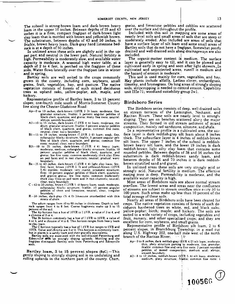
SOMERSET COUNTY, NEW JERSEY 13
The subsoil is strong-brown loam and dark-brown heavyloam in the upper 10 inches. Between depths of 25 and 43inches it is a firm, compact fragipan of dark-brown lightclay loam that is mottled with brown and yellowish brown.The substratum, between depths of 43 and 50 inches, isfriable, brown heavy loam. Dark-gray hard limestone bed-rock is at a depth of 50 inches.
In unlimed areas these soils are slightly acid in the up-per part and neutral in the lower part. Natural fertility ishigh. Permeability is moderately slow, and available watercapacity is moderate. A seasonal high water table, at adepth of 2 to 4 feet, is perched on the fragipan of thesesoils. Water flows laterally over the fragipan late in winterand in spring.
Hartley soils are well suited to the crops commonlygrown in the county, including corn, soybeans, smallgrains, fruit, vegetables, hay, and pasture. The nativevegetation consists of forests of such mixed deciduoustrees as upland oaks, yellow-poplar, ash, maple, andhickory.
Representative profile of Hartley loam, 3 to 15 percentslopes; one-fourth mile south of Morris-Somerset Countyline along the Chester-Gladstone Road:
Ap—0 to 10 inches, dark-brown UOYR 33) loam: moderate, fine,granular structure: friable: 5 percent angular pebbles ofblack chert, quattzite. and gneiss: many fine roots: oeutral:abrupt, smooth boundary.
A2—10 to 15 inches, dark-brown (7.5YR 44) loam: moderate, me-dium, granular structure: friable: 5 percent angular pebblesof black chert, quanzite. and gneiss: common fine roots,neutral: clear, wavy boundary.
Bl —15 to 19 inches, strong-brown ("7.SYR 5 6) Icam: weak, fine,subangular blocky structure: friable: 5 percent angular peb-bles of black chert, quanzite. and gneiss: common fineroots; neutral: clear, wavy boundary.
B2t—19 to 25 inches, dark-brown 17.5YR -4 4) heavy loam:moderate, medium, subangular blocky structure: friable: 10percent angular pebbles of black chert, quanzite. andgneiss: few fine roots; common moderately thick clay filmson ped faces and in root channels: neutral; gradual, wavyboundary.
Bx—25 to 43 inches, dark-brown (7.SYR 44) light clay loam: few.fine, faint , brown ( I O Y R 5 3) and yellowish-brown (10YR5/6) mottles; moderate, very coarse, prismatic structure:f irm: 10 percent angular pebbles of black chert, quartzite,and granite gneiss: few fine roots; common moderatelythick clay films on ped taces and in root channels; neutral;clear, wavy boundary.
C —43 to 50 inches, brown (7.5YR 5 4) heavy loam; weak, moderate,subangular blocky structure; friable: 10 percent angularpebbles of chen and limestone: neutral: clear, irregularboundary.
R —50 inches, dark-gray (N 4 ,01 limestone interbedded with th instrata of shale.
The solum ranges from 40 to 60 inches in thickness. Depth to bed-rock ranges from 4 to 8 feet. Coarse fragments make up 5 to 15percent of the soil.
The Ap horizon has a hue of IOYR to 7.5YR, a value of 3 or 4, andI chroma of 3 or 4.
The Bt horizon commonly has a hue of 7.5YR to IOYR. a value of4 or 5. and a chroma of 4 to 6. This horizon ranges from heavy loamto clay loam.
The C horizon typically has a hue of 7.SYR but ranges to SYR andIOYR. Value and chroma are 3 or 4. This horizon is commonly loam.but in places it is sandy loam and their gravelly equivalents.
Hartley toils are associated with the well-drained Pattenburg andEdneyvillf S011T~bn strongly sloping uplands. Mottling and thefragipan distinguish Banley soils from Pattenburg and Edneyvillesoils.
Bartley loam, 3 to 15 percent slopes (BaC).—Thisgently sloping to strongly sloping soil is on undulating androlling uplands in the northern part of the county. Chert,
gneiss, and limestone pebbles and cobbles are scatteredover the surface and throughout the profile.
Included with this soil in mapping are some areas ofnearly level soils and small areas of soils that are steep ormoderately eroded. Also included are areas of soils thathave a surface layer of silt loam and some small areas ofBartley soils that do not have a fragipan. Somewhat poorly-drained and well-drained soils along drainageways are alsoincluded. j
The organic-matter content is medium. The surfacelayer is generally easy to till, and it can be plowed andcultivated early in spring and soon after light showers.,Incultivated and unprotected areas, runoff is medium a*ndthe hazard of erosion is moderate.
This soil is used mainly for corn, vegetables, and hay.Hay plants include alfalfa, Ladino clover, orchardgrass,timothy, and bromegrass. On long: areas of strongly slopingsoils, stripcropping is needed to control erosion. Capabilityunit IIIe-71; woodland suitability group 2wl.
Birdsboro SeriesThe Birdsboro series consists of deep, well-drained soils
on stream terraces of the Lamington, Neshanic, andRaritan Rivers. These soils are nearly level to stronglysloping. They are on benches scattered alorg the majorstreams. They formed in old stream sediment of mixedcomposition, mainly red sandstone, siltstone, and shale.
In a representative profile in a cultivated area, the sur-face layer is dark reddish-gray silt loam about 8 inchesthick. The subsurface layer is 4 inches of reddish-brownsilt loam. The upper 7 inches of the subsoil is reddish-brown heavy silt loam, and the lower 19 inches is darkreddish-brown light silty clay loam that contains somerounded pebbles. Between depths of 38 and 56 inches thesubstratum is dark reddish-brown sandy loam, andbetween depths of 56 and 70 inches it is dark reddish-brown stratified sand and gravel.
In unlimed areas these soils are very1 strongly acid orstrongly acid. Natural fertility is medium. The effectiverooting zone is deep. Permeability is moderate, and theavailable water capacity is high.
Most areas of Birdsboro soils are above normal streamoverflow. The lowest areas and areas near the confluenceof streams are subject to stream overflow once every 50 to100 years. Such areas make up less than 10 percent of thetotal acreage of these soils. '
Nearly all areas of Birdsboro soils have been cleared forcrops. The native vegetation consists of forests of such de-ciduous hardwood trees as white, red, and black oaks;yellow-poplar; birch; maple; and hickory. The soils aresuited to a wide variety of crops, including vegetables andfruit, nursery, and other specialized crops; and they areexcellent for corn, soybeans, and small grains.
Representative profile of Birdsboro silt loam, 2 to 6percent slopes, in Branchburg Township; in a road cutalong U.S. Highway 202, one-half mile west of the northbranch of the Raritan River: • - j =•
Ap—0 to 8 inches, dark reddish-gray (5YR 4 / 2 ) silt loam; moderate.thin, platy structure parting to moderate, fine, g ranu la r ;friable; common fine and very fine roots; 2 percent roundedpebbles of mixed composition; medium acid; abrupt.smooth boundary. ]
A2—8 to 12 inches, reddish-brown (SYR 54) silt loam: moderate.medium, platy structure; friable: common fine roots; 1
100560

14 SOIL SURVEY
percent rounded pebbles of mixed composition; stronglyacid; cleir. wavy boundary.
B2H—12 to 19 inches, reddish-brown (SYR 4 / 4 ) heavy silt loam;moderate, medium, subangular blocky structure; friable;few Tine roots; 1 percent rounded pebbles; few thin clayfilms on ped faces and in pores; many silt coatings on pedfaces; very strongly acid; clear, wavy boundary.
B22t—19 to 38 inches, dark reddisb-brown"(2.5YR 3/4) light siltyclay loam; moderate, medium, angular blocky structure:slightly firm; 1 percent rounded pebbles; common thin clayfilms on ped faces; very strongly acid; clear, wavyboundary.
I1C1-38 to 56 inches, dark reddish-brown (SYR 3/4) sandy loam;massive; very friable; strongly acid; abrupt, smoothboundary.
I1C2—56 to 70 inches, dark reddish-brown (SYR 3/4) stratified sandand gravel of mixed composition; strongly acid.
The sol urn ranges from 30 to 40 inches in thickness. Depth toshale bedrock is generally 6 to 10 feet or more. Coarse fragments ofmixed composition make up 0 to 15 percent of the solum.
The Ap horizon has a hue of 10YR, 7.5YR, SYR, and 2.5YR; avalue of 3 or 4: and a chroma of 2 or 3. In wooded areas color in theAl horizon commonly is 7.5YR 3/2 or SYR 3/2.
The Bt horizon has a hue of 2.5YR, SYR. and 7.SYR; a value of 3or 4; and a chroma of 3 to 5. The Bl horizon is typically light siltyclay loam, but in places it ranges to heavy loam, sandy clay loam,clay loam, and heavy silt loam.
In the C horizon hue. value, and chroma are commonly SYR 3/4,but hue ranges to 2.SYR and 7.SYR. This horizon ranges from sandyloam to clay loam and contains varying amounts of gravel, cobbles,and shale. The content of gravel ranges from 0 to 30 percent in theIIC1 horizon and from 10 to 50 percent in the IIC2 horizon.
Birdsboro soils are on the higher parts of stream terraces adjacentto the moderately well drained to somewhat poorly drained Rarilansoils on nearly level flats and the poorly drained, gray Lamingtonsoils in slight depressions. They are adjacent to Rowland andBowmansville soils on flood plains. They are near areas of themoderately deep Penn soils, the shallow Klinesville soils, and themoderately deep Reaville soils on uplands.
Birdsboro soils are deeper, less shaly, and more gravelly thanPenn, Klinesville, and Reaville soils. They do not have the gray mot-tles and the firm, slowly permeable fragipan that are typical ofRan tan soils. They do not have the mottles that are characteristic ofRowland and Bowmansville soils.
Birdsboro silt loam, 0 to 2 percent slopes(BdA).—This nearly level, well-drained soil is on streamterraces in the vaJleys of the major streams. In a fewplaces bedrock is as close to the surface as 4 feet.
Included with this soil in mapping are some areas ofmore sloping, moderately eroded soils and areas of soilsthat have a surface layer of loam. Also included are somesmall areas where the surface layer is as much as 25percent gravel. Small areas of Raritan and Penn soils arealso included.
The organic-matter content is medium. The surfacelayer is generally in good tilth, and it can be plowed andworked early in spring. Runoff is slow, and the hazard oferosion is slight. The soil can be cultivated continuouslyunder a high level of management. Smoothing the surfaceimproves runoff in some areas.
This soil is used for the commonly grown field crops andfor hay and pasture. Cover crops and minimum tillage areneeded to maintain the organic-matter content and goodtilth. Capability unit 1-55; woodland suitability group 2ol.
Birdsboro silt loam, 2 to 6 percent slopes(BdB).—This gently sloping soil is on undulating terraces inthe valleys, oX-the major streams. It has the profiledescribed as representative of the series. In a few placesbedrock is as close to the surface as 4 feet.
Included with this soil in mapping are some areas ofmoderately eroded soils and areas of soils that have a sur-face layer of loam or sandy loam. Also included are some
small areas where the surface layer is as much as 25percent gravel and areas of Penn and Raritan soils.
The organic-matter content is medium. The surfacelayer is generalry easy to till, and it can be plowed andworked early in spring. In cultivated areas runoff is me-dium and the hazard of erosion is moderate.
This soil is used mainly for general crops. Less than 5percent of the total acreage is wooded. Contour stripcrop-ping and minimum tillage are needed on long slopes tomaintain the organic-matter content and good tilth and tocontrol runoff and erosion. Capability unit He-55; wood-land suitability group 2ol.
Birdsboro silt loam, 6 to 12 percent slopes(bdC).—This strongly sloping soil is on sharp breaksbetween flood plains and terraces in the valleys of themajor streams. It has a profile similar to the one describedas representative of the series, but it has more gravel scat-tered throughout the surface layer. Also, depth tostratified sand and gravel in this soil is about 3 feet.
Included with this soil in mapping are some areas oferoded soils where patches of subsoil are exposed if the soilis plowed. Also included are areas where the surface layeris loam or gravelly sandy loam.
The organic-matter content is medium. The surfacelayer is generally easy to till, and the soil can be plowedand cultivated early in spring and soon after heavy rain.Runoff is rapid in cultivated areas, and the hazard of ero-sion is moderate.
This soil is used for general field crops common to thecounty. It is suited to corn, soybeans, small grains, grasses,and legumes. Most of the acreage is used for hay orpermanent pasture. Contour cultivation, stripcropping,and minimum tillage are needed to control runoff and ero-sion and to maintain the organic-matter content and goodtilth in cultivated areas. Capability unit Hle-55; woodlandsuitability group 2ol.
Bowmansville SeriesThe Bowmansville series consists of deep, poorly
drained soils on the flood plains of the major rivers andsmaller streams in the county. Along the Rarilan, Lam-ington, and Millstone Rivers these soils formed in mixedsediment, mainly glacial till and granite gneiss thatwashed from the upper part of the Raritan River basin.Along the small streams they formed in sediment thatwashed mostly from red shale, siltstone. or fine-grainedsandstone on uplands.
In a representative profile in a cultivated area, the sur-face layer is mottled, reddish-brown silt loam 9 inchesthick. The subsurface layer is 8 inches of mottled, weak-red silt loam. The upper part of the subsoil is 9 inches ofmottled, gray light clay loam. The lower part, betweendepths of 26 and 38 inches, is mottled, gray sandy clayloam. The upper 9 inches of the substratum is mottled,reddish-gray fine sandy loam. The lower part of the sub-stratum, between depths of 47 and 60 inches, is reddish-brown, stratified sand and gravel.
These soils are strongly acid or ve*y strongly acid in theupper part and strongly acid or medium acid in the lowerpart. Natural fertility is medium. Permeability ismoderately slow, and the available water capacity is high.The water table is at the surface late in fall , in winter, andearly in spring. .
100567

64 SOIL SURVEY
TABLE 7.—Estimated soil propertieslAn asterisk in the first column indicates that at least one mapping unit in this series is made up of two or more kinds of soil. The soils in such
other series that appear in the first column of this table. Absence of data indicates that soil is too vari
Soil series andmap symbols
Abbottetown : AbA, AbB. . . . .
Am well: AmB, AmC,AnB, AnC.
Arendtsville: ArB, ArC......
Hartley: BaC...... __ ....
Birdsboro: BdA, BdB, BdC_.
Bucks: BuB, BuC2. __ .....
Califon: CaB, CcB... .......
Chalfont: CdB, CdC. C«B,CeC.C«E.
Depth to—
Bedrock
/•«*3J-4J
3}->5
>5
>4
>5
3}->5
3f->5
>5
3}->5
Seasonalhigh water
table
FtttH»
1-4
>4
2-4
>4
0-1(Very
fre-quentlyflooded.)
>4
i-2j
HI
Depthfrom
surface
JndUt0-9&-19
lfr-3536-48
48
0-1414-2121-36
36-60
0-15
15-43
43-60
0-1515-2525-43
43-50
50
0-1212-383S-5656-70
0-1717-47
47-#>
0-2525-3535-44
44
0-1111-22
22-52
52-65
0-1515-M)40-50
50
USDA lerture
Pilt Ipum _ _ _ _ _ _ - - . - - -Silt loam, silty clay loamSilt loam... ._ - - - . . - . - - - - - - -
Red shale bedrock.
Clay loam. .................
Gravelly loam, gravellysandy clay loam.
Limestone bedrock.
Silt loam ...................
Stratified sand and gravel ....
Silt loam...................Clay loam, sandy clay loam,
fine sandy loam.Stratified sand and gravel. . ..
Ri]( InurnS H loam. ..................
Shale bedrock.
Argillite bedrock.
Classification
Unified
ML or CLM L o r C LML or CLML, CL. SM,
or SC
ML or CLML or CLML, CL, GM,
or GCSM, SC. ML,
CL, GM,orGC
ML, CL, SM,or SC
ML or CL
GM or SM
ML or CLML or CLML, CL, SM,
orSCSM or SC
ML or CLML or CLSM or SCSM, GM, SC,
orGC
M L o r C LML, CL, SM,
orSCSM, GM, SC,
GC, G\V-SM,GP-GM,SP-SM, orSW-SM
ML or CLML or CLGM, SM, ML,
or CL
ML or CLML, CL, SC,
orSMSM, SC, ML,
orCLSM, SC, ML, _
or CL
ML or CLML or CLML or CL
AASHTO
A-4 or A-6A-4 or A-6A-4 or A-6A-4 or A-€
A-4 or A-6A-4 or A-6A-4 or A-6
A-4
A-4 or A-6
A-4, A-5.A-6, orA-7
A-2 or A-4
A-4 or A-6A-4 or A-6A-4 or A-6
A-2, A-4,or A-5
A-4 or A-6A-4 or A-6A-2 or A-4A-2
A-4 or A-GA-4 or A-6
A-l or A-2
A-4A-4A-2 or A-4
A-4 or A-6A-4 or A-6
A-4 or A-6
A-2 or A-4
A-4 or A-6A-4 or A-6A-4
Coarsefractiongreaterthan
3 inches
Ptfcnl0-20-20-20-5
0-100-100-10
O-iO
0-5
0-5
5-10
0-50-50-10
0-5
0-20-20-20-1
0-50-5
0-5
5-15
0-100-10
0-10
0-10
0-50-50-10
100568

90 SOIL SURVEY
TABLE 10.—Degree and kind of limitali,lorn
AbbotAbA
AmweAmi
'I
AmC
Arendt
Bartlei
Bird;Bd
Bd
Bd
Soil serifs andmap symbols
1st own:,AbB.
1:3,AnB....._. ......
J,AnC..... ........
sville: ArB, ArC...
f. BaC. ..........
iboro:A.......... .. ..
1
B.......
•
e._..._.
Foundations for dwellings —
With basements
Severe: seasonalhigh water tableperched at adepth of i foot toli feet.
Severe : seasonalhigh water tableperched at adepth of 1 foot to4 feet.
Severe: • season alhigh water tableperched at adepth of 1 foot to4 feet.
Slight..............
Moderate: seasonalhigh water tableperched overfragipan at a depthof 2 to 4 feet.
Slight..............
Slight..............
Moderate: stronglysloping.
Without basements
Severe: seasonalhigh water tableperched at adepth of j foot tolifeet.
Severe: seasonalhigh water tableperched at adepth of 1 foot to4 feet.
Severe: seasonalhigh water tableperched at adepth of 1 foot to4 feet.
Moderate: frostaction potential.
Moderate: seasonalhigh water tableperched at adepth of 2 u> 4feet.
Moderate: frostaction potential.
Moderate: frostaction potential.
sloping; frostaction potential.
Septic-tankabsorption fields
Severe : seasonalhigh water tableperched at adepth of \ foot toH feet; slowpermeability insubsoil; bedrockat a depth of 3}to 4} feet.
Severe: seasonalhigh water tableperched at adepth of 1 foot to4 feet ; alow per-meability in fragi-pan ; hard bedrockat a depth of 3}to more than 5feet in places.
Severe: seasonalhigh water tableperched at adepth of 1 foot to4 feet ; slow per-meability in fragi-pan ; hard bedrockat a depth of 3}to more than 5feet in places.
Slight: hazard ofground-waterpollution.
Severe: seasonalhigh water tableperched overIrappan at a depthof 2 to 4 feet ;moderately slowpermeability.
Slight: hazard ofground-waterpollution.
Slight: hazard ofground-waterpollution.
Moderate: stronglysloping; hazard ofground-waterpollution.
Sewage lagoons
Moderate: bedrockal a depth of 3}to 41 feet; AbB isgently Eloping.
Moderate: gentlysloping; hard bed-rock at a depth of3} to more than 5feet in places.
Severe : stronglysloping.
Severe : moderatelyrapid permeabilityin substratum.
Severe: stronglysloping.
Severe : moderateto rapid perme-ability.
Severe: moderateto rapid perme-ability.
Severe: moderateto rapid perroe-.ability; stronglysloping.
Sanitary landfills'
Severe: seasonalhigh water table jperched at adepth of i foot «)l ifeet;nppablebedrock at adepth of 31 to 41feet.
Severe: seasonalhigh water tableperched at adepth of 1 foot to4 feet ; hard bed-rock at a depth of3i to more than5 feet in places.
Severe : seasonalhigh water tab'eperched at adepth of 1 fc.^1 to4 feet ; hard bed-rock at a dep;h of3J to more man5 feel in places.
Severe: moderatelyrapid permeabilityin substratumcreates hazard ofground-waterpollution.
Severe: seasonalhigh water tableperched at adepth of 2 to 4feet: hazard ofground-waterpollution in frac-tured limestonebe-*— k.
Severe: rapid pe:-meability in sub-stratum createshazard of ground-water pollution.
Severe: rapid per-meability in sub-stratum createshazard of ground-water pollution.
Severe: rapid per-- meability in sub-
stratum createshazard of ground-water pollution.
100569
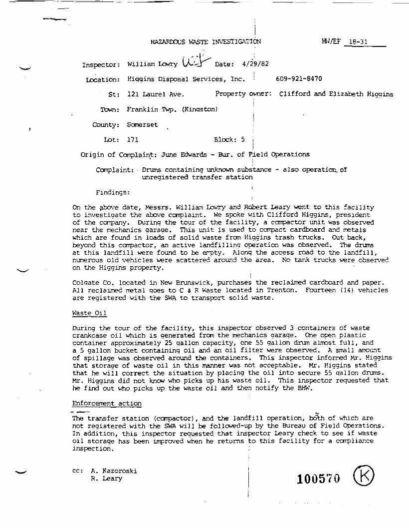
HAZARDOUS WASTE INVESTIGATION HW/EF __18-31I — — -
Inspector: William Lowry (^'<3 Date: 4/29/82i
Location: Higgins Disposal Services, Inc. I 609-921-8470
St: 121 Laurel Ave. Property owner: Clifford and Elizabeth Higgins(i
Town: Franklin Twp. (Kingston)i
County: Somerset i
Lot: 171 Block: 5 >\
Origin of Complaint: June Edwards - Bur. of Field Operations
Complaint: • Drums containing unknown substance - also operation. Ofunregistered transfer station
iFindings:
On the above date, Messrs. William Lowry and Robert Leary went to this facilityto investigate the above complaint. We spoke with Clifford Higgins, presidentof the company. During the tour of the facility, a compactor unit was observednear the mechanics garage. This unit is used to compact cardboard and metalswhich are found in loads of solid waste from Higgins trash trucks. Out back,beyond this compactor, an active landfilling operation was observed. The drumsat this landfill were found to be erpty. Along the access road to the landfill,numerous old vehicles were scattered around the area. No tank trucks were observedon the Higgins property.
jColqate Co. located in New Brunswick, purchases the reclaimed cardboard and paper.All reclaimed metal qoes to C & R Waste located in Trenton. Fourteen (14) vehiclesare registered with the SWA to transport solid waste.
Waste Oil
During the tour of the facility, this inspector observed 3 containers of wastecrankcase oil which is generated from the mechanics garage. One open plasticcontainer approximately 25 gallon capacity, one 55 gallon drum almost full, anda 5 gallon bucket containing oil and an oil filter were observed. A small amountof spillage was observed around the containers, This inspector informed Mr. Kigginsthat storage of waste oil in this manner was not acceptable. Mr. Higgins statedthat he will correct the situation by placing the oil into secure 55 gallon drums.Mr. Higgins did not know who picks up his waste oil. This inspector requested thathe find out who picks up the waste oil and then notify the BHW.
Enforcement action
The transfer station (compactor), and the landfill operation, both of which arenot registered with the SWA will be followed-up by the Bureau of Field Operations.In addition, this inspector requested that inspector Leary check to see if wasteoil storage has been improved when he returns to this facility for a complianceinspection. i
cc: A. KazoroskiR. Leary 100570
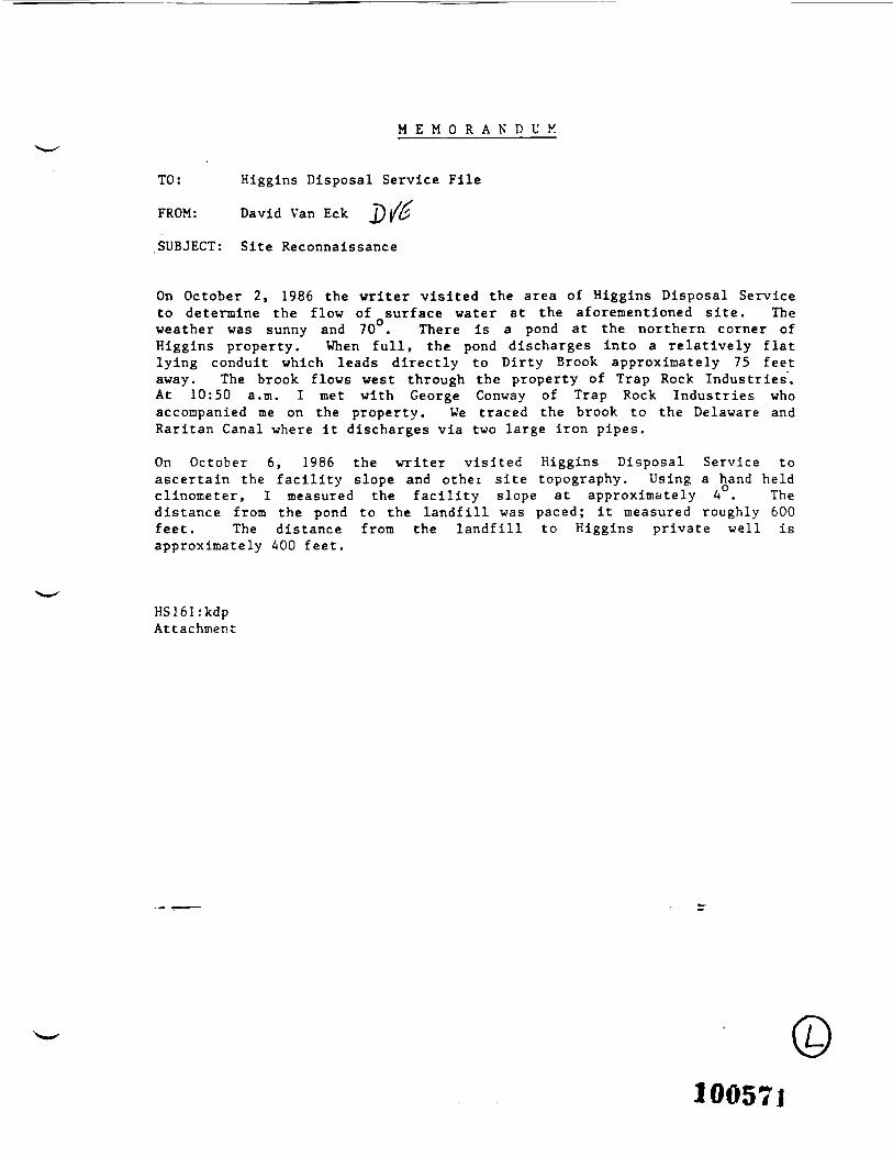
M E M O R A N D U M
TO: Higgins Disposal Service File
FROM: David Van Eck
SUBJECT: Site Reconnaissance
On October 2, 1986 the writer visited the area of Higgins Disposal Serviceto determine the flow of surface water at the aforementioned site. Theweather was sunny and 70°. There is a pond at the northern corner ofHiggins property. When full, the pond discharges into a relatively flatlying conduit which leads directly to Dirty Brook approximately 75 feetaway. The brook flows west through the property of Trap Rock Industries.At 10:50 a.m. I met with George Conway of Trap Rock Industries whoaccompanied me on the property. We traced the brook to the Delaware andRaritan Canal where it discharges via two large iron pipes.
On October 6, 1986 the writer visited Higgins Disposal Service toascertain the facility slope and other site topography. Using a hand heldclinometer, I measured the facility slope at approximately 4 . Thedistance from the pond to the landfill was paced; it measured roughly 600feet. The distance from the landfill to Higgins private well isapproximately 400 feet.
HS161:kdpAttachment
100571
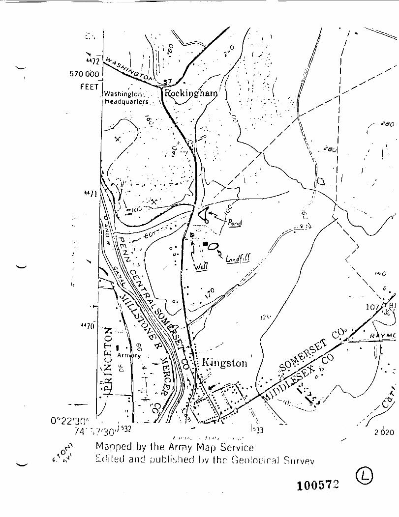
0°22'3074
Mapped by the Army Map ServiceEdited and published hv the Geo!nc!iral Survey
100572
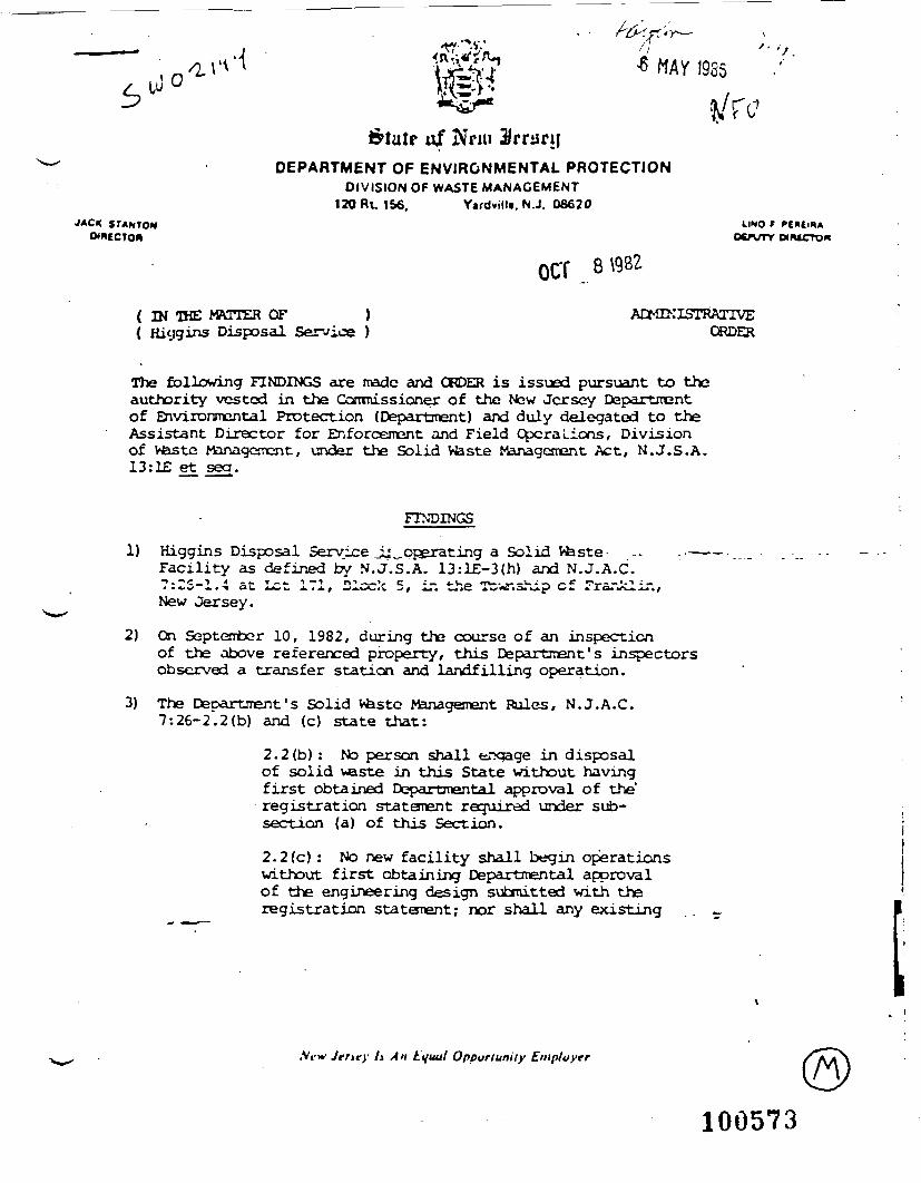
0
&tutr of Nnu 3/rriirijDEPARTMENT OF ENVIRONMENTAL PROTECTION
DIVISION OF WASTE MANAGEMENT130 RL 156. Vtrdvillt. N.J. 08620
JACK STANTON LINO 'oenmr
OCT 8
( IN THE MATTER OF ){ Hiygins Disposal Service )
ADMir.'ISTRAnVEORDER
The following FINDINGS are made and ORDER is issued pursuant to theauthority vested in the Commissioner of the New Jersey Departmentof Environmental Protection (Department) and duly delegated to theAssistant Director for Enforcement and Field Opera Lions, Divisionof Waste Management, under the Solid Waste Management Act, N.J.S.A.13:1£ et seg.
FINDINGS
1) Higgins Disposal Service Jj^operating a Solid Waste- .- -••Facility as defined by N.J.S.A. 13:lE-3(h) and N.J.A.C.•*-- s 'C_T 4 **. T-4- 1 -M rf» - ,V C »•— 4-W« TV-. — - U * — ^£ «_-_i . t .' _4 » * . W -. » •» at. AJM l_ J. * J. / W.A,l^.jV -^ / A«« «^AC A W»«*OJ,*_4.p C*. A .LCU 4ft . <!-**/
New Jersey.
2) On September 10, 1982, during the course of an inspectionof the above referenced property, this Department's inspectorsobserved a transfer station and landfilling operation.
3) The DepartJTent ' s Solid Waste Management Rules, N.J.A.C.7 : 26-2. 2 (b) and (c) state that:
2.2(b) : No person shall enqage in disposalof solid waste in this State without havingfirst obtained Departmental approval of the'registration statanent required under sub-section (a) of this Section.
2.2(c) : No new facility shall begin operationswithout first obtaining Departmental approvalof the engineering design submitted with theregistration statement; nor shall any existing .
w Jtnty ti An Lyuul Opportunity Empluyrr
100573
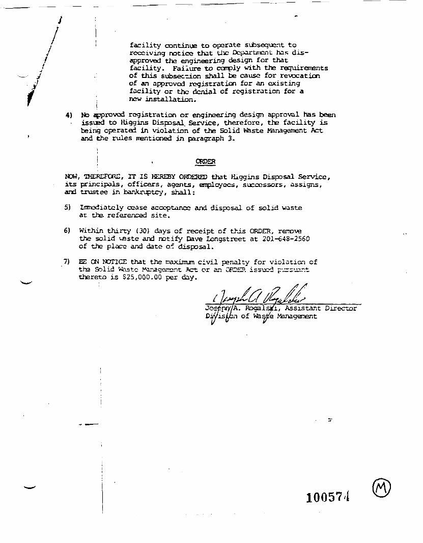
' ! facility continue to operate si±>sequent toreceiving notice that Uic Department; has dis-
/ approved the engineering design for thatj facility. Failure to corply with the requirementsy . of this subsection shall be cause for revocation
. j of an approved registration for an existingj facility or the denial of registration for af j new installation." i
4) No approved registration or engineering design approval has been• issued to Higgins Disposal. Service, therefore, the facility is
being operated in violation of the Solid Vvbste tonagement Act' and the rules mentioned in paragraph 3.
i| . ORDER
NOW, THEREFORE, IT IS HEREBY ORDERED that Higgins Disposal Service,its principals, officers, agents, employees, successors, assigns,and trustee in bankruptcy, shall:
5) Inmediatcly cease acceptance and disposal of solid wasteat the referenced site.
6) Within thirty (30) days of receipt of this ORDER, removethe solid veste and notify Dave Longstreet at 201-648-2560of the place and date o* disposal.
7) EE ON NOTICE that the maximun civil penalty for violation ofthe Solid Wtistc Managerrsnt Act or an CFOEP. issued pursuar.tthereto is $25,000.00 per day.
. Ragalsjci, Assistant DirectorDivision of W&s4e >fanagenent
10057^1

bcc: D is t r ic t Engineer-Bry
Statr nf Nnu .
iI
,J '\~
DEPARTMENT OF ENVIRONMENTAL PROTECTIONDIVISION OF WATER RESOURCES
CN 039 iTRENTON. NEW JERSEY 0862S
JOHN w GASTON jn. r.E. ; OIRK C.MOFMAN.P.C.OIHECTOH DEPUTY DIRECTOR
October 1. 1985 I
Mr. John CarlanoFranklin Township Health Department935 Hamilton Street \Somerset, New Jersey 08873
Dear Mr. Carlano:
Summarized below are the results of analysis of water samples collected by thisoffice on August 26. 1985, and analyzed for volatile organics by the StateDepartment of Health Laboratory. These samples were collected from four non-public wells on Laurel Avenue in Franklin Township (a copy of these results areattached).
OMAMlfm ;
Location: 82 Laurel Ave. 85 Laurel Ave. 95 Laurel Ave. 122 Laurel Ave.unoccupied Uhcccupied Vfeisrer Beviss -
BtJToforrn 12 - ' ~Carbon Tetrachloride 61 - 66 2.0Chlorcbenzene 6.3 -Chloroform 300 5.7 , 169 J 4.3DibrcmxhlorcmBthane - 11 - - -1.1 Dichloroethane 9.0 - -1.2 Dichloroethane 7.5 - _ ; -1.1 Dichlorosthene 22 - -1,2Dichloroethene 130 - 3.8 !1.2 Dichloropropane 5.3 - " i "Tetrachloroethene 130 - 27 -1.1.1 Trichloroethane 140 - 6.1 ' -1.1.2 Trictiloroethane 32 - 20 ! -Trichloroethene 230 - 19TridiloroflupronEthane 4.8 - - .. r -
Although there are no current standards for these contaminants in water, legislationcommonly referred to as A-280 will establish maximum permissible levels in thecoming year. It is expected that levels for most of them will be considerably lessthan 100 ppb. In anticipation of more stringent standards to be adopted, we arecurrently viewing these specific contaminants with concern and we are. therefore,using a stricter judgemental approach to determine the acceptability of the supply
Id0575

Franklin Township Health DepartmentOctober 1, 1985Page 2
whenever they are present. Our approach is based on potential adverse healtheffects which may result from lifetime exposure to water containing such con-tamination. The higher the levels, the greater the health risk to susceptibleindividuals and the greater the need to seek water of better quality. The goalover the long term is to reduce exposure to the lowest levels that are achievableso as to minimize the overall risk.
For these reasons, it is required that you warn, in writing, the owners and usersof the well at 82 and 95 Laurel Avenue that the levels of contaminants as shown,are not acceptable in drinking water and it is our (DEP) position that these wellsmust not be used for potable purposes. A permanent alternate source of water ofacceptable quality such as that derived from the extension of a community publicwater supply must be made available, if practical. If this is impractical, thena new central public water supply must be created. If housing is sparse, thenadequate point of use treatment of the existing well supplies must be promotedprovided adequate local regulatory control is maintained over treatment unitsinstalled. Provision for implementation of these measures must be expedited atthe local level. We will provide guidance and assistance as needed.
It is recommended that you warn, in writing, the owner and user of the well at122 Laurel Avenue that water from it should not be used indefinitely for drinking,cooking, bathing, or other purposes if better quality water can be made readilyavailable. Development of an alternate prime source, eventual provision forpublic water supply, or adequate point of use treatment of the existing well supplyshould be promoted to minimize long term continued consumer exposure.
At present, the well at 85 Laurel Avenue was not contaminated, but chances arethat additional pumping and monitoring will demonstrate that it will be similarlyaffected in time.
Since groundwater conditions and water quality may vary with time and sincelaboratory error is possible, it may be desirable for the owners to have additionalsamples analyzed in certified laboratories that are available. Also, other wellsin the immediate area may be affected and the extent of the problem may needfurther delineation through your office. For a listing of certified labs in yourarea call (609) 292-3950.
The Division of Water Resources Enforcement Element will attempt to determine thesource of this contamination. In this regard, would you have any knowledge of alikely source? If so, please provide that information to those persons from ourEnforcement Element when they contact you.
By copy-»*-this letter, other offices are being alerted to this problem.
Raymond B g). Chief3ureau of Safe Drinking Water
RB/leccc: See Attached
100576
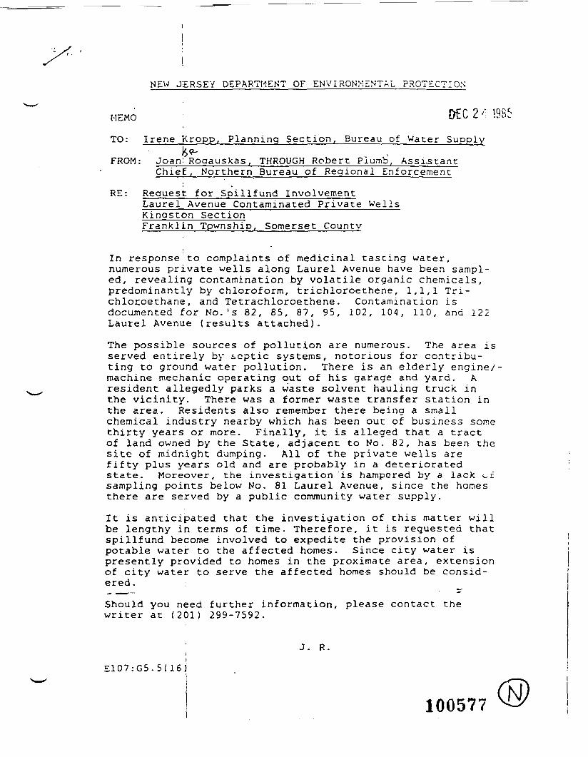
NEW JERSEY DEPARTMENT OF ENVIRONMENTAL PROTECTION
MEMO ; DEC 2 <; 1965TO: Irene kropp, Planning Section, Bureau of Water Supply
FROM : Joan: Rogauskas, THROUGH Robert Plumb, Assi.stantChief, Northern Bureau of Regional Enforcement
RE: Request for Spillfund InvolvementLaurel Avenue Contaminated Private WellsKingston SectionFranklin Tpwnship, Somerset County
In response to complaints of medicinal tasting water,numerous private wells along Laurel Avenue have been sampl-ed, revealing contamination by volatile organic chemicals,predominantly by chloroform, trichloroethene, 1,1,1 Tri-chlocoethane, and Tetrachloroethene. Contamination isdocumented for No.'s 82, 85, 87, 95, 102, 104, 110, and 122Laurel Avenue (results attached).
The possible sources of pollution are numerous. The area isserved entirely by septic systems, notorious for contribu-ting to ground water pollution. There is an elderly engine/-machine mechanic operating out of his garage and yard. Aresident allegedly parks a waste solvent hauling truck inthe vicinity. There was a former waste transfer station inthe area. Residents also remember there being a smallchemical industry nearby which has been out of business somethirty years or more. Finally, it is alleged that a tractof land owned by the State, adjacent to No. 82, has been thesite of midnight dumping. All of the private wells arefifty plus years old and are probably in a deterioratedstate. Moreover, the investigation is hampered by a lack <~isampling points below No. 81 Laurel Avenue, since the homesthere are served by a public community water supply.
It is anticipated that the investigation of this matter willbe lengthy in terms of time. Therefore, it is requested thatspillfund become involved to expedite the provision ofpotable water to the affected homes. Since city water ispresently provided to homes in the proximate area, extensionof city water to serve the affected homes should be consid-ered.
Should you need further information, please contact thewriter at (201) 299-7592.
J. R.(
IE107:G5.5(16)
100577
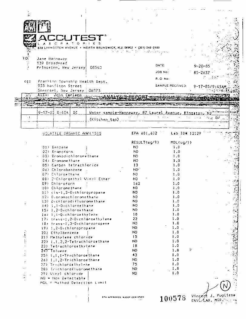
?TO;
L A B O R A T O678 LIVINGSTON AVENUE
i e sNORTH BRUNSWICK, NJ. M»C2 • C201) 24S-0100
Jane Hannawoy139 Droadm-adPHnceton, New J e r s e y 06540
DATE:
JOB No.:
9-20-85
65-2637
cc : F r a n k l i n Tounship Health Dept.935 HarM Uon Street
P. O. No.:
SAMPLE RECEIVED: 9-17-85/9:So.nc- rset , ;>leu J e r s e y OB°73 • ' ""- / '.'•>' >'jt"^-l
.,£,-. _.ATTN: • • • • • • •
~ -a^"frhlg*—-• - ^=-»4a^^Cotvrx^*(E
jo_hi\ la r n no-- - |jAfjj' ^^^ jPiQgT^g" £^? i 7^ v "^ '' irtfeT^ lS i '-^^
^g^U i ^^Cjflt-* —— • —— gumMjy^m^aa^L^ ^^ ., ^- ' -T^r^V SS?I •'• ' ' —— ."•-,:§
9-17-35 8 :40A SC Uater sample-Hannauay, 87 LflurcL^Vinue, Klnaiton. 'NJ^'W —— < \<~ff £
YQLA"
0! ) E02) E
' •" ' • • ' !• >' r ' "!'(Ki tchen tap) ' '- " " ••-<•'»:-, - -;4;
' • " --.T/j• - :rii
V
" 1 L E ORGANIC A A W L Y S I S EPA 601 ,602 " Ltb ID« 12129 "" ••-"• ?>?-ffi' ~>V9
RESULT(uo/1) HDL(uo/l) v ' v:'^? n : e n e ND 1.0 •> . - ;<rorrio^orrn ND 1.0 . ~*-'
03) Bromodi chl orome th ine ND 1.0 . ' "^0 -1 > Eromome t h a n e ND 1 .0 ' • ' • ' • - . t t
i V .
05) Cirbon t e t r ich lor i de 13 1.0 . V^Do) Ch 1 o r o b e n r e n r , NL> 1.0 -r,?0 7 > C h l o r o f t h a n e ' ND 1.0 '-'"'•OS) 2 - Chl o roe th y 1 U i n y ] E t h e r ND ' 1.0 . '09) C h l o r o f o r m 162 1.0 . ",^10) Ch 1 orcxne th ine ND 1.0 r'v;1 1 ) c12' P13) 014) 1
15) 11 6 -> 117) t18; t19) 120) E
i s - l , 3 - D i c h l o r o p r o p * n » ND 1.0 . ' - " ' ' <ib ronochloronie l th ine ND 1.0 -; :i c h 1 or od i i 1 uorome thine ND 1.0 ••i-
, 1 - D i c n o roe th ine ND 1.0 '•" •*"'., 2 - D i c M o r o e th ine . ND 1.0 . . ..\-^, ! -Di ch 1 o roe thy 1 en* 10 1.0 "J .r i n « - l , 2 - D i c h l o r o » t h y l « n t 22 1.0 ". \r 4 n s - 1 , 3-D i ch 1 o r o p r o p e n e ND 1.0, 2-Di C h 1 o rop rop ine ND 1.0 . . -i.t h y l ben T. en* ND 1.0 ..*>'?
21) M e t h y U n e chlon'de 15 1.0 ~ r&22) 1 , 1 , 2 , 2 - T e t r i c h l o r o * th ine ND 1.0 ,V£23) Te t r t c h l o r o e t h y l e n e 18 1.0 . ,~;2-moluene ND 1.0 - ' . -.'25) 126) 1
, 1 , 1 - T r i c h l o r o e thine 43 1.0 tV, 1 ,2-Tr i c h l o r o e th«n* ND '1.0 ',;
27) Tr i ch 1 oroi t h y l t n* 73 ' 1.0 "((-_26) T
.; . 29) y- i c h l o r o ^ l u o r ort* th ine ND 1.0 " »• -'^ Jnyl c h l o r i d e ND 1 .0 ' J.;* j
*' ND » r^on D e t e c t i b l e •- -.s'MDl. != M v t h o d D e t r c t i p n L i m i t ^ / / T i l ' •
II* A JLJ*FAOVCD. NJOfP 100578 J. Pug L i e s *. MGR."•>•. ' 'M
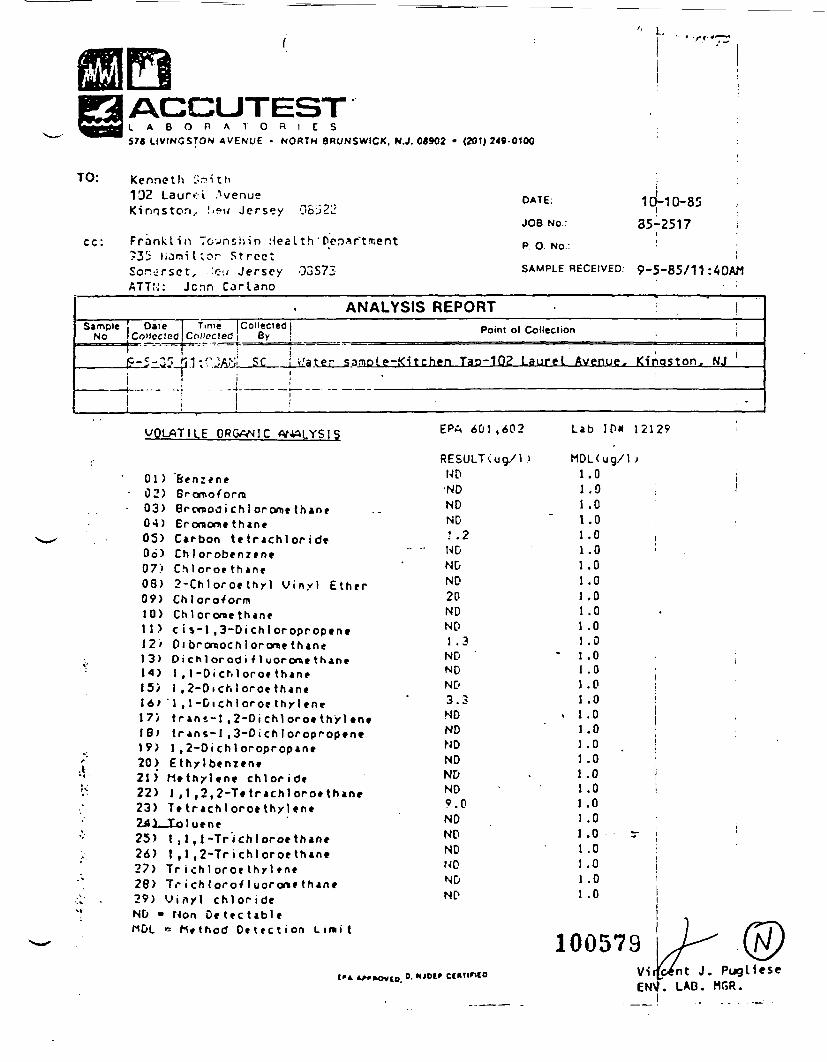
ACCUTESTL A B O R A T O R I E S578 LIVINGSTON AVENUE • NORTH BRUNSWICK, N.J. 08902 • (201)249-0100
'' L,
TO: 'Kenneth ioith1'J2 Laurel AvenueKinnstori.. Sew Jersey 081J22
Franklin Townshin Health'Der>*r~trr.ent12,'; lioniltor StreetSor-.c-rset, .:*>.; Jersey 03S7ZATTU: Jcnn Carlano
10-10-85i35-2517
DATE:
JOB No.:
P. O. No.: : :
SAMPLE RECEIVED: 9-5-85/11 :40AM
ANALYSIS REPORTSample j Oaie | Time Collected!
No I Collected Collected! By j Point of Collection
;r JASL££__Lii8ter sample-Kitchen Tap-102 Laurel Avenue. Kingston, NJIi '
VOLATILE QRGW^IC
01 )02)03)0*1)05)06)07)08)09)10)11)12>13)
I 5 >16)1 7 >1 8 )
20)21)22)23)
BrorooformBromodi chl ororae th»n»ErorBom* thineCarbon te trachlor id«Ch I orobenzcnvChlo roe th ine2-Ch1oro* thy l V iny l EtherChloroformChlororae thanec i $-1 ,3-Dichl oroprop«n»Di bromochl orome thaneOi chl orodi f 1 uororae thaneI , 1-DicMoro* thaneI ,2-Oichloroe thane
'\ ,l-Dichloro*thyl*netr ini-1 ,2-Di chl oro» t h y l tnttr ans-l ,3-Dich 1 oropropene1 , 2-Oi ch I oropropaneEthylbenien*M t t h y l t n e chloride1 ,1 ,2,2-Tetrachloro«thaneT* t rach to ro* thyl «ne
25) t ,1,1-Trichtoroethane26) ! ,1 ,2-Tr ichloroe than*27) Tr i ch I oroe thy I »ne28) Tr i ch t orofluorone than*29) V iny l ch lo r ideND - Mon Oe tec tab! e
B M*thod D e t e c t i o n L i m i t
EPn 601,602
RESULT<ug/lJND•NDNDND: .2NDNDND20NDND1 .3ND 'NDND3.3NDNDNDNDNDND9.0NDNDNDNDNDND
Lab IP« 12129
.0
.0
.0
.0
.000000000000000000000
1 .01 .01 .01 .0
1005790. NJDf' Ct*TIF1(0
ENVViro*nt J. PugUese
LAB. MGR.
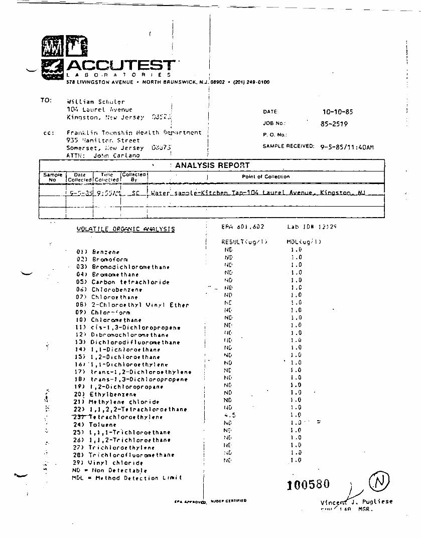
L A B O R A T O R I E S j578 UVINGSTON AVENUE • NORTH BRUNSWICK, N.J. 08902 • (201)249-0100
cc:
William Schuler10-'« Laurel Avenue !Kingston, r,'i-w Jersey 0-i ZJ:
i
Franklin Township Health Oiy935 l-ani Itrr. StreetSomerset, i.'ew Jersey G~:J7.5'ATT!-;: Jofm Carlano :
DATE 10-10-85
JOB NO.: ' 85-2519
P. O. No.:
SAMPLE RECEIVED: 9-5-85/11:40AM
i ANALYSIS REPORTSample
NoDate | Tune
Coneciedl CollectedCollected! • |
By ! 1i
*trr>-33|_9'r>'>A.'l: SC Uatpr sar.nle-Ki tehen;
Point of Collection
Tap-IDi t auppt Avenu^j. Kingston. NJ
i '•
ORGWIC
01 )02)03)0-1)05)Oo)07>06)09)10)11)12'13)14)15)16)17)18>IV)20)21)22)
25>26)27)28)29)NO -
BenzeneBronxoforraBrornodi chl orome thaneBroraone thaneCarbon tf trachlor id*Ch 1 orobenzen*Ch lo roe thane2-Ch!oroe thy l V iny l EtherChlor-^ormChlorome thanec i *-l ,3-Dichloroprop«ntDi bPomochl orome t h a n eOi ch 1 orodi i 1 uorcwe thane1 , 1-DicMoroe thane1 ,2-Oichloroe thane
' 1 , l - 0 i c h l o r o e t h y l e n « f{r »nt-l ,2-Di chl oroe thy \ tn«tr ans-1 ,3-Oi ch 1 oropropen*1 ,2-Oi chl oropropaneEthylbenzentM»thylene <;hlor ideI ,1 ,2,2-Tt trachlorotthane
trachloroethxUneToluene1 ,1 ,1-Tr ichloroethan*1 ,1 ,2-Tr ichloroe thaneTr i chl oroe thyl »neTr i chl oroHuorone thaneV i n y l ch lo r ide
Hon D e t e c t a b l eM»thod D e t e c t i o n Lin»it
€r»
EPn 601.402
NDNDNONONDUDNO
NONDND
NDNDNONDNONDNDNDUD
ND
NO
L a b I D K 1 .
MDLiug/1)1.0• .01 .01 .01 .01 .C
.0
.0
.0
01 .01.01 .01 .0I .0t .0
.0
.0
.00
i .01.0
0000
1 .0
100580Cf M1FIIO Vincerrt J. Pugliese
r«"i S i »n MRR.
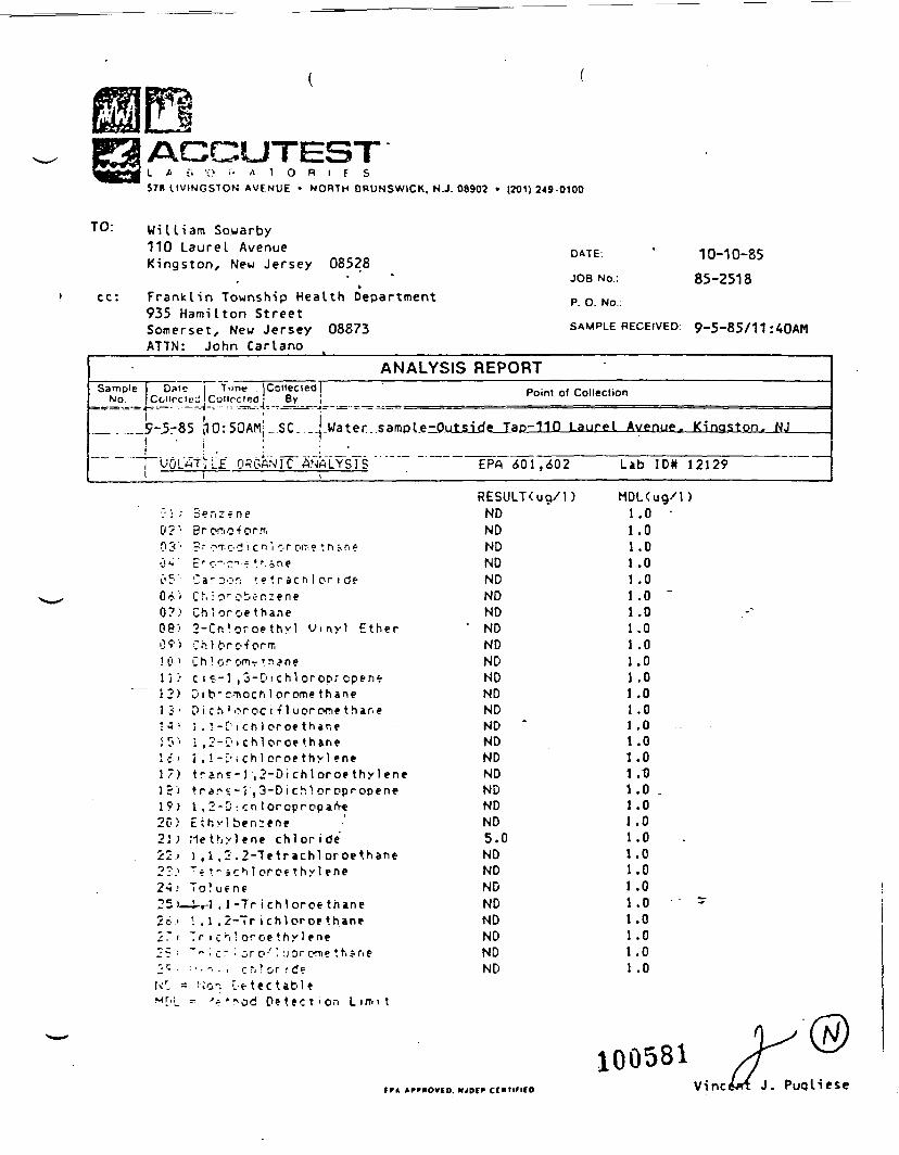
ACCUTESTL * t. ••:> •'- A 1 O R I F S578 LIVINGSTON AVENUE • NORTH DRUNSWICK, N.J. 08902 • (201) 2«9-0100
TO: William Sowarby110 Laurel AvenueKingston, New Jersey 08528
cc: Franklin Township Health Department935 Hamilton StreetSomerset, New Jersey 08873ATTN: John Carlano
DATE: * 10-10-85
JOB NO.: 85-2518P. O. No.:
SAMPLE RECEIVED: 9.5-85/11 :4QAM
ANALYSIS REPORTSample 1 Date
NO jCciircn1
- (
ji UC/Lf-1
Tune'^-.""f—
i ,10: 50 A
t^L£ ORi
[Collected]0( By 1
Mj SC_ __| Water..sampl.e-0u
PANIC ANALYSIS1
Point of Collection
tside Tap-110 Laurel Avenue^ Kingston,
EPA 6"01 ,602 Lab ID* 12129
NJ
denzrne
0 3 '0 "4•, c, •.O A ,0?)OP'09)!0 il i >32)i :<•
17)15)19)20
2s.
Ur.M[.|
r" OT-o-i i c n i or o(T:e t n ->n«
C a " Dor; •.« *. r a c n 1 or i deCM or •?te r. i e n eCh!oroe thane2-Cn!oroethyl Vinyl EtherCh 1 orc'^ orrr,Ch ! or c-m- manecis-1 ,3-DichloroDrcpene-Di b" c--nocti 1 orome thane0 i ch ! oroe i 11 u or one t har. ej.!-[ ich)oroe thane• ,2-C11 chl oroe thanej ,1-i'iChloroethylenetran?-r,2-Dichloroethylenetran^-I,3-Dich!oroproDene1 .2-D:cnloropropan-eEthvlben:eneriethiyl«ne chlorideI,1,2.2-TetrachloroethaneT*t~icMoroethyleneTo!uene-t-i-1 .1 -Tr j chl oroe thanei.1.2-Tr i chloroe thaneTr i c'i! oroe thyl ene~" • c~•'• c.r o'' -jorom? thane••••'.. i r ~i! or ! d?: N'0". L-e tec table• 'r'riod Detect'on L i f f t i t
RESULT<uo/l)NDNDNDNDNDNDNDNDNDNDNDNDNDND *NDNDNDNDNDND5.0NDNDNDNDNDNDNDND
MDL(ug/l>1.0 •1
I11111
11111
.0
.0
.0
.0
.0 -
.0
.0
.0
.0
.0
.0
.0
.0
.0
.0
.0
.0 .
.0
.0
.0
.0
.0
.0
.0
.0
.0
.0
.0
100581tn Apmovfo. Mjotf ccuriFtco Vine J. Puqliese

1005
82

2/00 BURZAU OF ?GT;J>LE VATZRRECORD OF INCOMING PBOBLIMS
PERSON CALLING:
ADDRESS:
( /yvv, /?~i DATE RECEIVES:
TELEP110HE f-^.WATER SUPPLY IJA'OLVED:
MUNICIPALITY:
, t.Vv "ft i , ^ //S
COtOTT: •INATURE OF PROBLEM:
Dirty "Water Q , Low Pr ess-ore O, Ko Water O, Taste O , Odor O , SicJ-j-.-£«f -^—
PERSOI! IIG CALL:
DETAILS OF PP03LD.I:
K.-V
L JL
U
i-c
-7IZ J\J^L
TAXZii t RESULTS: kut

, o,.n _•«-' \jju «\L.« JCJ JLJ'AKJ MLlN J Ul' I-."* VIK«_l"VMi;iV I Al_ I'f _ - _ .6/&< •* .
^- '
EMERGENCY/POTABLE WATER CONTAMINATION COMPLAINT T '-
DATE CALL RECD ft - 7 j - fr 5______ PERSON/OFFICE/^ x1
COMPLAINT ANTS NAME CT^orqr.- U\. L/rvo^y.'
AFFILIATION In-..-. KocV^ J W<it ^-W~\f ^ L -L>V . PHONE
ADDRESS _____________ Townitilp
IS THE COMPLAINT RELATED TO: LS Individual Well D Community Croundwater SupplyD Community Surface Water Supply
NATURE OF COMPLAINT
Location of Alleged ConUmination ^5"Z 7,CTC( Hf /
Are other hom«, wells affected? 1 4- <3-fL>or*~, M^r.^f S6 L g ? < . < r f /
When did the problem fint come to your attention? o '-
Descripu'on'of Problem:
Taste
Odor
Color. Turbidity
Health Effect-
Reaction with Cooking Vessels
Frequency: O Strong D Weak D Corutint D Recurring D Occurs After Rain-
Evidence of Problem: O Penooal Experience D Neighborhood Experience [^3 Dau lX"*cfeJd Other
HAS THE LOCAL/COUNTY HEALTH DEPARTMENT BEEN NOTIFIED? CO YES CD NO
HAVE THE LOCAL OFFICIALS BEEN NOTIFIED? D YES D NO
1005&4
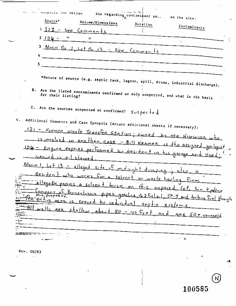
-•Jl.iJJ I (_• Lc Llie lol
Source*
. . >J. '' •- ible regarding^concami^anc so...
*Nature of source (e.g. septic tank, lagoon, spill, druas, industrial discharge).II
B. Are the listed contaminants confirmed or only suspected, and what is the basisfor their listing?
C. Are the sources suspected or confirmed? 5uS?ecT<2 d_
Additional Convenes and Case Synopsis (Attach additional sheets if necessary):/2| -
Rev. 10/83
100585
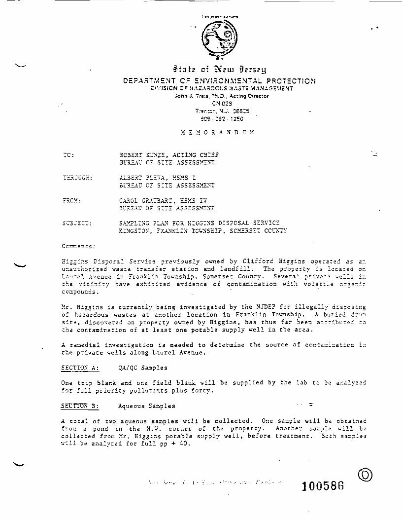
of ?DEPARTMENT OF ENV5r.GNME.NTAL PROTECTION
DIVISION Cr HAZA3DCCS WASTE MANAGcMINTJoftn J. Trela. 'YD.. Acting Cirzetor
CN 0237r-r:=n. N.J. 066:5
509 -:92- '2EC
M E M O R A N D U M
TC: ROBERT iTJNZE, ACTING CHIEFBUREAU CF SITE ASSESSMENT
THROUGH: AL5ERT PLEVA, KSMS IBUREAU OF SITE ASSESSMENT
FRCM: CAROL GRAU3ART, HSMS 17BUREAU OF SITE ASSESSMENT
SAMPLING PLAN FOR HIGGIN3 DISPOSAL SERVICEKINGSTON, FRANKLIN TOWNSHIP, SOMERSET COUNTY
Ccr
Eiggir.s Disposal Service previously owned by Clifford Higgins operatad as ar.unauthorized waste transfar station and landfill. The property is located or.Laurel Avenue in Franklin Township, Somerset County. Several private veils inthe vicinity have exhibited evidence of contamination with volatile organiccompounds.
Mr. Hig'ins is currently being investigated by the NJDE? for illegally disposingof hazardous wastes at another location in Franklin Township. A buried drussite, discovered on property owned by Higgins, has thus far been attributed tothe contamination of at least one potable supply well in the area.
A remedial investigation is needed to determine the source of contamination ir.the private wells along Laurel Avenue.
SECTION A: QA/QC Samples
One trip blank and one field blank vill be supplied by the lab to be analyzedfor full priority pollutants plus forty.
•SETTTTDN B: Aqueous Samples ' " ~
A total of two aqueous samples will be collected. One sample will be obtainedfroc a pond in the N.W. corner of the property. Another sample will bacollected fron Mr. Kiggins potable supply well, before treatment. Both samplesvill be analyzed for full pp + 40.
100588
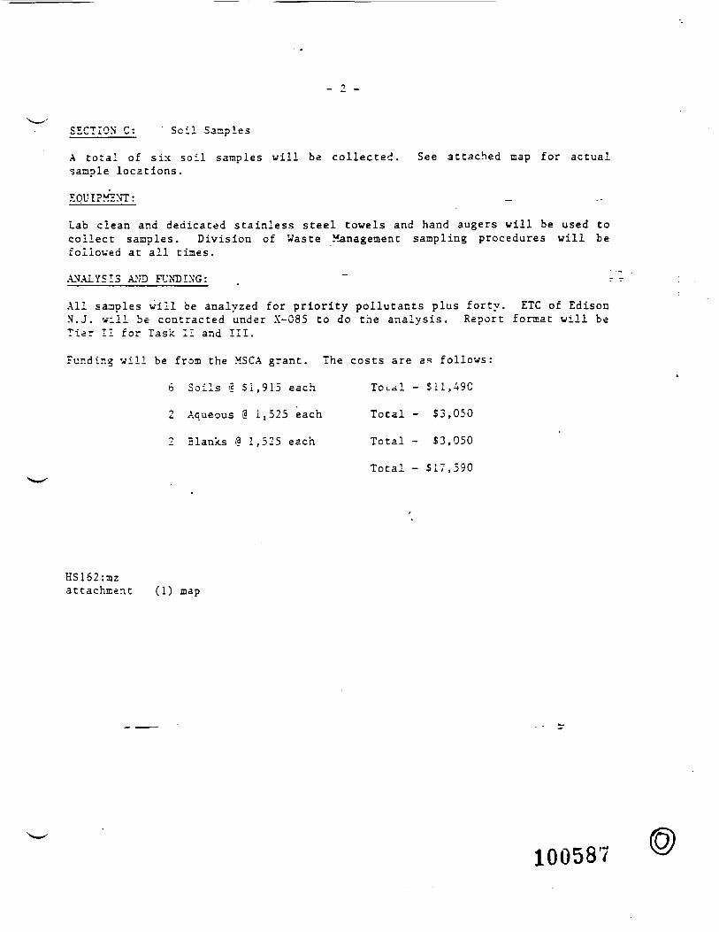
SECTION C: ' Soil Samples
A total of six soil samples will be collected. See attached map for actualsample locations.
EQUIPMENT:
Lab clean and dedicated stainless steel towels and hand augers will be used tocollect samples. Division of Waste Management sampling procedures will befollowed at all tines.
ANALYSIS AND FUNDING; . ~ '-
All samples will be analyzed for priority pollutants plus forty. ETC of EdisonK.J. will be contracted under X-085 to do the analysis. Report format will beTier II for Task II and III.
Funding will be from the MSCA grant. The costs are as follows:
6 Soils *3 Si ,915 each Total - $11,490
2 Aqueous 9 It525 each Total - $3,050
2 Blanks I? 1,525 each Total - $3,050
Total - $17,590
HS162:aizat tachment (1) map
100587
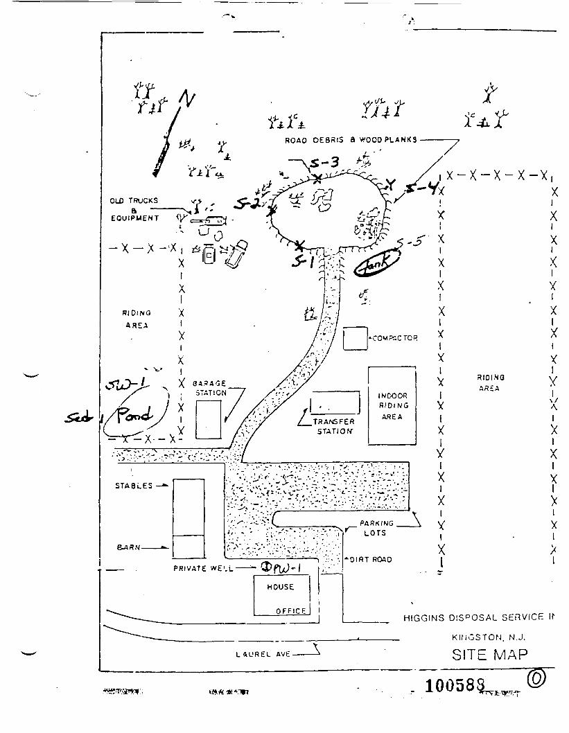
ROAD DEBRIS 8 W O O D P L A N K 3
OLD TRUCKSa —
EQUIPMENT
- X - X
i X — X ~~ X ~ X ~X
R l D l N O
AREA
5TA8LES -*•
aARN_-^
,;'-/^v -';:i?r:?vgg |
•"•'- 'tJr' - "• .'•'•.•'.-'•T**'** "".'
^"^-rV-'v^'-SV^-^-
PRIVATE WE'.L
_ PARKINGLOTS
"OIRT ROAD
XIXI
VIXI
XIXIX
L A U R E L AVE
__ HIGGINS DIS°OSAL SERVICE
___ KINGSTON. N.J.
SITE MAP
100588^
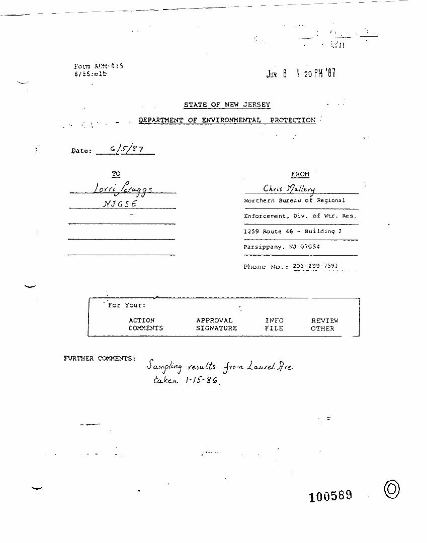
fona A.UM-O.IS6/iS:nib JUN 8 I 20 PH '81
STATE OF NEW JERSEY
DEPARTMENT OF ENVIRONMENTAL PROTECTION'
Date:
TO
LQl'ft
FROM '
(7<JNorthern Bureau of Regional
Enforcen>ent, Div. of Wt_r. Res.
1259 Route 46 - Building 2
Parsippany, NJ 07054
Phone N o . : 201-299-7592
For Your:
ACTIONCOMMENTS
'
APPROVALSIGNATURE
INFOFILE
REVIEWOTHER
FURTHER COMMENTS:J -fro -n 2.
^J. a,us &i
100589
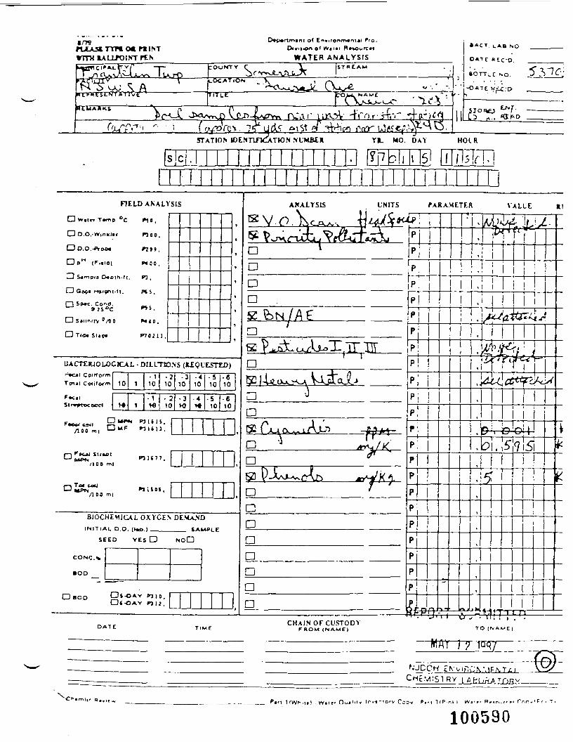
a/79nX»TTH
MUNTD*p*rimtnT Of Environment*! Pro,
WATER ANALYSIS
• ACT LAB NO
LOCATION
TTTIT
;S T R E A M
QjLT> 4'rn.r-jrfri" -4^'l£_i^nndA
3) ' £*'„'
5TATIO.V IDE* TWN M UMBER YR. MO. DAY HOIR
s C 1 t /"TUFTI
CD w,[t-r T«
FIELD ANALYSIS
<np °C f\t ,
D D.O.'WinkUr W C O .
Dp- (F..
LJ S^mplg C
O Q««* mi
O Tie* St«p
rm.a] P«80.
' •Ptf t- f t . *O .
Bnt-M. P»5.
o°c «S.
/t a MIO,
• P7021J .
f
f
1
'
t
,
t
^
UACTtJUOLOCICAL - DILLTIO.NS (tEQL'ESTED)r Cil ColMor
F»cil
m - 1 - 2m 10 1 10 10
• 1 -2>«• 1 W 10
• 310
•3M)
.410
- 4ve
- 510
•510
•610
•610
SMT «u,'l:f— ) >"n-eJ iirxt ini4i7
/I 00 m|
DiSL"*1/10C
B10C
INlTlX
SE
CONC.»
•oo
O BOO
PI1SOI,m|
HEMJCAL OXYGEN DE.MA.NDIL DO. (U*> ) tAliOl r
.ED VES D NOL"D
" ————
OS-DAY i>a 10.D«-OAY P31J.
——— 1
ANALYSIS UNITS
^ Vo^ri3u^^*iS*rr«^kiD 1
fARAMETER VALUE Rt
tP; IPp;
n p.Dn .K &N/A£a 'S t) -rV ,1 c 1 TT~ TTTr jtAXj^ CAXVJ-^ -i— , 11 Ui——— LJL "* - jJLXr-^l - -
at£|4^ouo< \od[aJl>D 'n52 fAa<x iAu5 JIM
n '* "*il*Djy] y_X\j-\^£'vr} ***~ij K 0-DCDaaDan
p;ppp [
P:p
1
p;
•
1
I
i
p ipP:p;pppppppppnV -O^V
^
X3t
^
,
M.' iL1./-^T
I
1 *1
,
^
•l W-
.JA^2^rr4-r
/t^y^f/ Jfr^a-^r
1 *^ %^"v.
,
,
(
T—
cttfp^S
C? C C;ld\. 5"" 9 5
-*-• ————— - ———————————— i ———————————————————————— M'.I J,, i — er^Vtf_.-T.. CHAIN OF CUSTODYDATC TIME FROM (NAME) TO [
1
^,/
f•N.
>,AM£|
"MAY I
N'JCCH EC HcMI
Ch«ml|f n«wlr^. l nv«"10 'v
100590
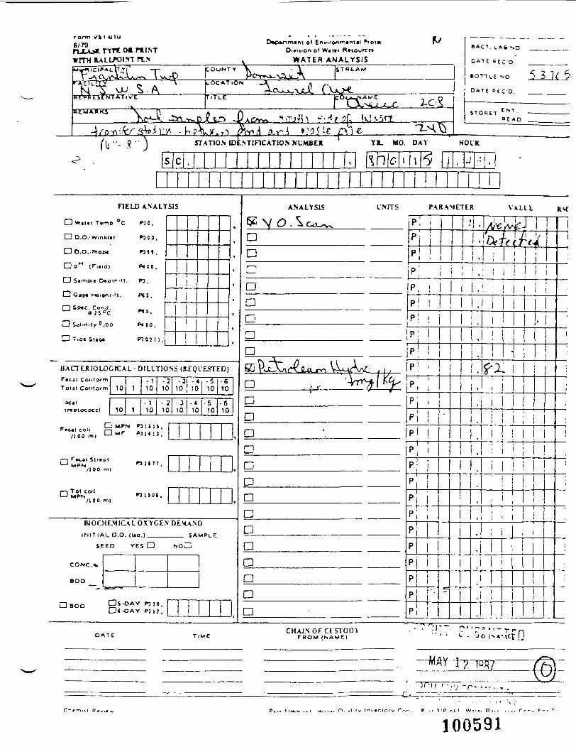
r arm v k I <J I u8/79
o( W«tri Rn
WATER ANALYSIS
STATION IDENTIFICATION NUMBER
s c . 1 ! l
nELD ANALYSIS
O w.i.r T»mp °C PIO.
Do.O.-Wmkur P5CO
D O.O.-Prooe P755
D BH (F,.io) P « O O .
O G*9* (ieijni.fi. Pfi.
I 1 SJXC. Cone.0 JS°C P1».
CD Solin.ty 0,00 P-ilO,
HD Tice Sligc P7021 1 ,
,
,
,
,
,
t1
t
BACTERIOLOGICAL - DILUTIONS (B-EQl'ESTED)f»c tl Cot if (xmTot j l COIHO'm 1
OCllmcioccccl 1
- 10 1 10
- 10 1 10
• 210
• 210
^•c*l coli O **"* P3U15.
[-> F^*l Slr.pt'—' MPN
/ I C O ml
D Tol C04IMPT I
/I 00 ml
8JOCHLM1 M 1 T 1 A L O
SEED
CONC.%
BOD
nit TI .
PJ 1 S O C ,
•31 -410 ] 10
• 310 10
• 510
• 510
•610
•610
i
i
t
CALOXYCE.NDEM.
VES a NOL
Dnoo DS-OAY P:,O.Dt-DAY P) 12,
OiD
SAMPLE
J
.
ANALYSIS L'NITS
an
ppip j
PARAMETER
1
•
1
1
' 1 *
VALlt RSf
/LC/V^J, QthefU, i
—— T~-
I
———— r~
^ ,P.' i ,: ! !DDD
p 11
p !p
n pn50 PvI Ar-^W™ VWW , ,
a •.,- '^y- 1 naDrn
nnacanDDaa
ppppp
1
t
1
1
pppp
1
p;pppp jpp
I
"
i . !t
,i •
i
iiiii
1
"
j^X,
— i— i .
i
,1— — i — i
.
*
I
i
i
1
1
!
1
|
l
1
i
1
!
|;
1
.
CHAJN OFClSTOLnF R O M ( N A M E ) It
MAY 1
100591
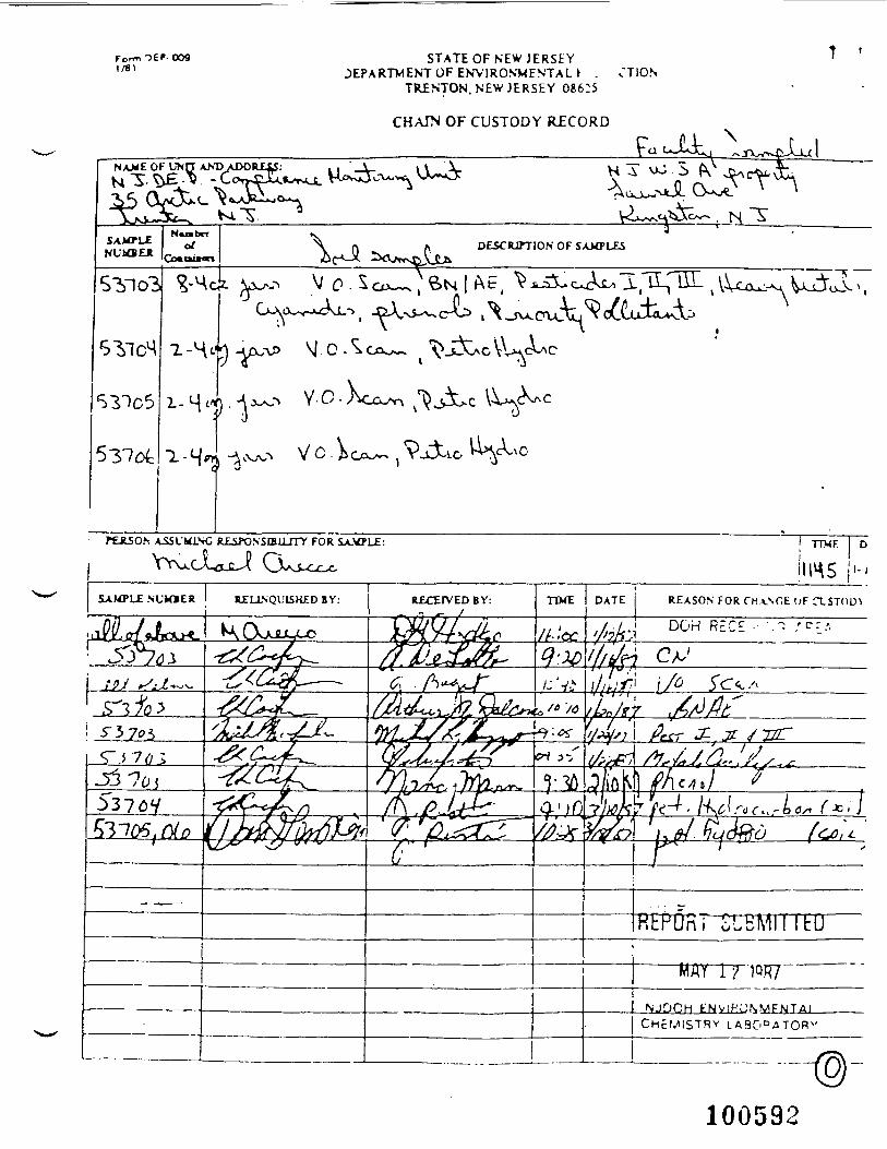
Form OEP- OO91/B1
STATE OF NEW J E R S E YDEPARTMENT OF ENV1ROVMENTAL * . CTION
TRENTON. NEW JERSEY 08625
CHAIN OF CUSTODY RECORD
DESCRJTT10N OF SAMPLES
G R£iPONStBILrTY FOR SA.VPLE
100592
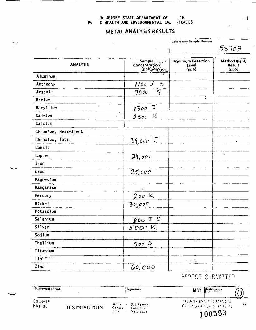
:« JERSEY STATE DtPAJTNEHT Of LTHC HEALTH AW EKVIROWCXTAL LA* ,TO*IES
METAL ANALYSIS RESULTS
- 1
L»bor»lory Sample Niunb«r
ANALYSIS
Almlnua
Antleony
Arsenic
Barium
Beryllium
Cadmium
Calcium
Chrc*1um, HexavalcntChroalum, Total
Cobalt
Copper
Iron
Lead
Magnesia*
Kjmgar«&c
Mercury
MlclcelPoUsslu*Selenium
Silver
Sodium
Thallium
T1t«fi1u*
T1rr ——
Z1nc
Sample ,.,.--Concentration1 '
(PP^^f/^L-
lltc T S70 cc S
!3o° T
^5oc K
^soco 3"
21 00o
25. oco
,ICC <
3£?){^^c>
f 00 T S5" oco K
5"oo 5
60^ ODD
Minimum D«t*ctionLtvtl(ppb)
•
- -.- r-
Mtthod BlankResult
'(ppb)
•
SuptrvL»or (Pr in t ) MAY
CHEM-14Q C86 DISTRIBUTION:
While • SubAj tncvC»n«ry • Com Fi l rPink M r u l » L 4 b 100593
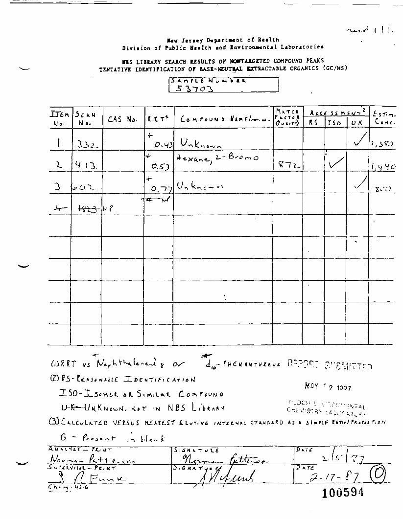
J«r*«r D«p*rt»«nc of H e a l t hDivii ion of Public Heal th and Inviron»cnc«l Laboratories
US LIBRAJIY SLAJLCH USULTS OK MOTTAlCETED COHPOUWD PEAKSTENTATIVI LDWTIFICATIOH OF BASE-WUTEAL EmUCTABLE ORCAH1CS (GC/MS)
A n r L £ N u ~. t i I.
Uo. Mo. M«. JY A *£//•"-.K k T C M
F ( L C T « tkttc Si n EIS/TR S
•^ K >A 0 -
3.-J-
(Z) Pi -
iff
i Ft (.
K . « T i w N B 5
;--- • • «. • v </ ; ' •
M/3Y 1 ? 1007
— f(0
A/ o>an v-r /
}JV
( T K -
MA. -T
1Z_100594
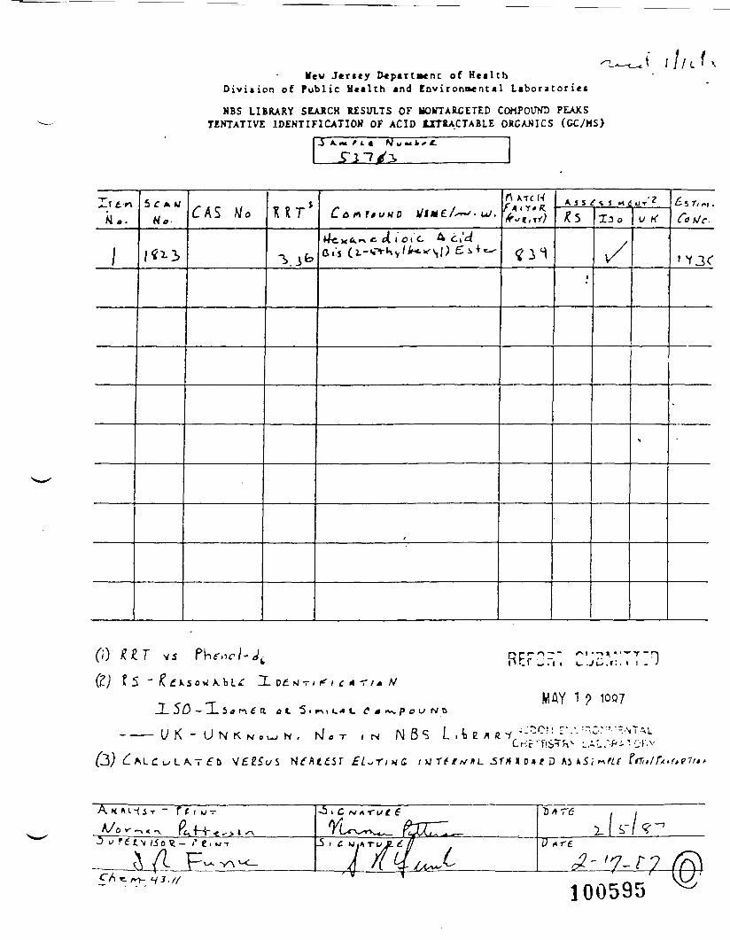
Mew Jersey Department of H e a l t hDiv i s ion of Publ ic Hea l t h and E n v i r o n m e n t a l L a b o r a t o r i e s
NBS LIBRARY SEARCH RESULTS OF HOrTARCETED COMPOUND PEAKSTENTATIVE IDENTIFICATION OF ACID 1XTOACTABLE ORCANICS (CC/MS)
3*. «• f i * H ami* e.
5 t Afcf (TAS UTn *-rc N
U K"
1 01 C
0} Dr1"*^"*" /M •->«, «""r -nn L r J ,~i i c . j L> . i : . i i - J
JL 50 - X 5^ t-v £ a.
£t>
MAY 1 ? 1QQ7
IN N8S L , t e£L~,YinG. i >J TC/ v /I L
rCnc -'llS^n^
X o* * D Ai t>rte~it f
A - r
/»>-
i £
100595
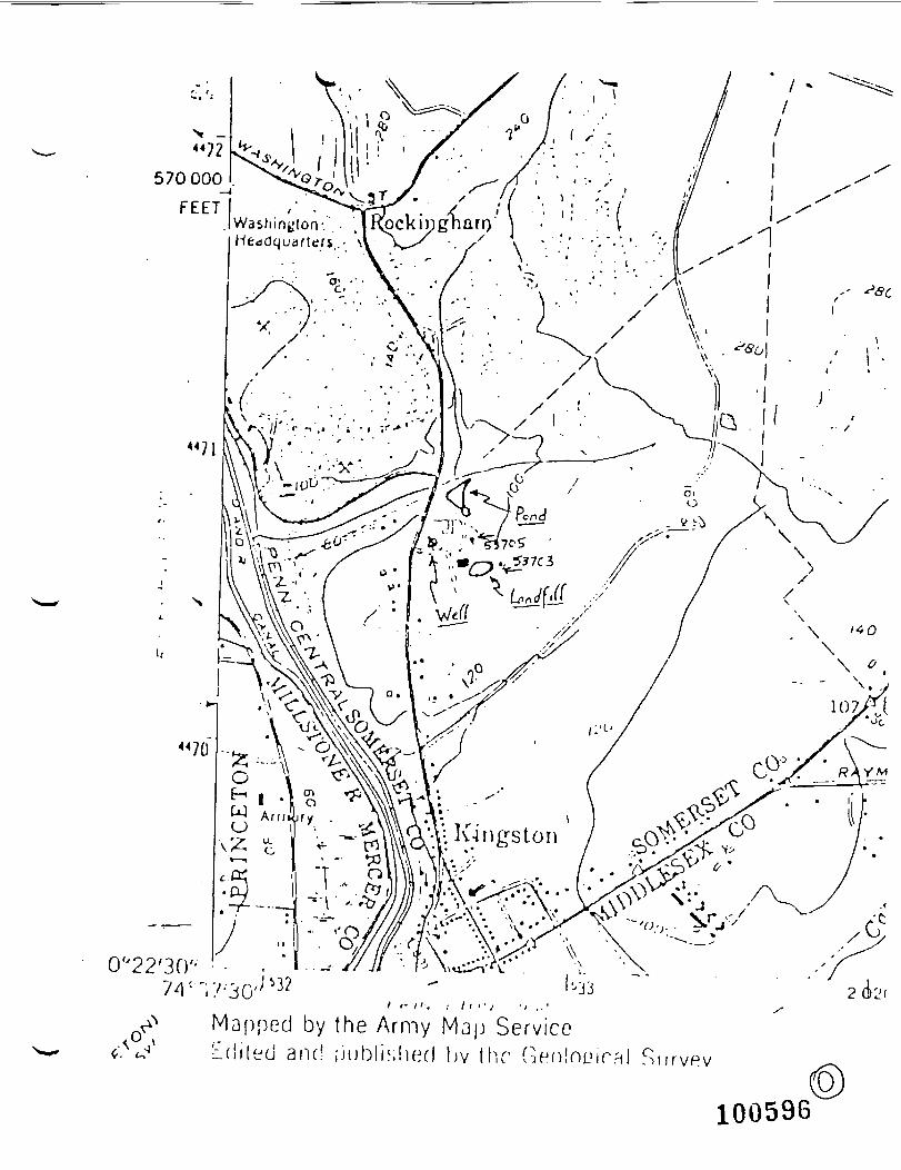
0'J22'3(Y-I I- II-. I 11 '• / •/ ..'
Mapped by the Army Map ServiceEdiled and uublished bv Ihr Gi
100596
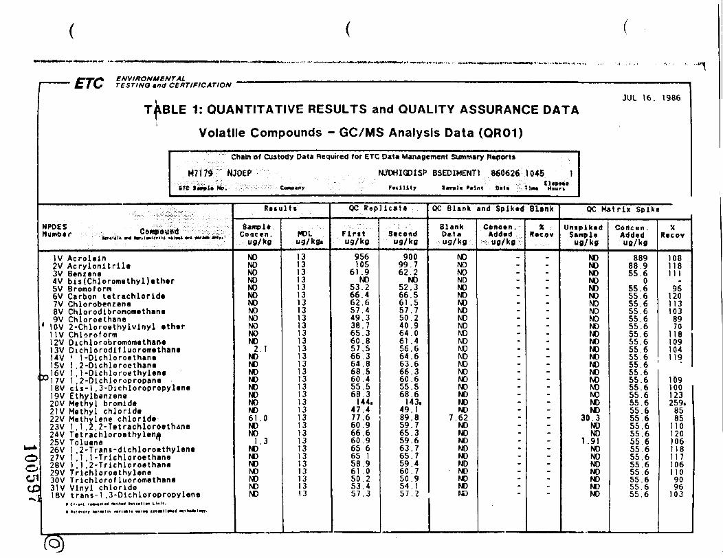
ENVIRONMENTAL
u^OOenCD
( JUL 16. 1986TJXBLE 1: QUANTITATIVE RESULTS and QUALITY ASSURANCE DATA
i
NPDES
Volatile Compounds - GC/MS Analysis Data (QR01)
Chain of Custody Data Required for ETC D*U Management Summary Reports
M717d NJDEP NJDHIGDlSf BSEOIMENT1 o60626 104S 1BTC l*iHiplt> No. . : Company . Fvcilitj 3kvnpl« l»oin« D»U Tim*) »4our»
.-.•.. :':'' :. ' :.v : " ..• " . :-
HUmOer »CT»HI« «^ fcrrl«oll'-IU ,4lm» *»*«/«» *M»i
IV Acroleln2V Acrylonltrile3V Benzene4V bis(Chloromethyl)ether5V Bromoform6V Carbon tetrachloride7V Chlorobenzene8V Chlorodlbromomethane9V Chloroethane
1 10V 2-Chloroethylvinyl ether11V Chloroform12V Oichlorobromomethane13V Dichlorodif luoromethane14V ' 1-Dichloroethane15V 1 ,2-Dlchloroethane
~16V 1 ,1-Dichloroethylene°17V 1 ,2-Dichloropropane
18V c ls-1 ,3-Dichloropropylene19V Ethylbenzene20V Methyl bromide21V Methyl chloride22V Methylene chloride23V 1 .1 .2.2-Tetrachlor6ethane24V Tetrachloroethylena25V Toluene q
26V 1 .2-Trans-dichloroethylene27V 1 .1 ,1-Trichloroethane28V 1 .1 ,2-Trichloroethane29V Trlchloroethylene30V Trlchlorof luoromethane31V Vinyl chloride18V trans-1 ,3-Dlchloropropylene
Retults
SampleConcen.
ug/kg
NONONONONONONONONONONONO
2 . 1NONONONONONONONO61.0NONO
1 .3NONONONONONONO
MOLug/kg.
1313131313131313131313131313131313131313131313131313131313131313
QC Replicate
Ftrttug/kg
956105
61 .9NO
53.266.462.657.449.338 .765.360.857.566.364.868.560.455.568.3
144.47 .477.660.966.660.965 665 158.961 .050.253.457 .3
Secondug/kg
90099.762.2
NO52.366.561.557.750.240.964.061 .456.664.663.666.360.655.568.6
143.49.189.859.765.359.663 .765.759.460 .750.95 4 . 1
OC Blank and Spiked Blank
BlankD«taug/kg
NONONONONONONONONONONONONONONONONONONONONO
7.62NONONONONONO
• NONONO
5 7 . 2 NO
ContenAdded'ug/kg
.-
---------------.-------
X ,****."
_----------------------_-------
OC Matrix Spike
UniplkedSampleug/kg
NONONONONONONONONONONONONONONONONONONONONO
30.3NONO
1.91NONONONONONONO
Cbitcen .Addedug/kg
88988 955.6
055.655.655.655.655.655.655.655.655.6
XRecov
1081181 1 1
961201131038970
118109104
556 11955 . 655.655.655.655.655.655.655.655.655.655.655.655 655.655.655.655 655.6
109100123259.
8585
1101201061181 1 71061109096
103
fo)
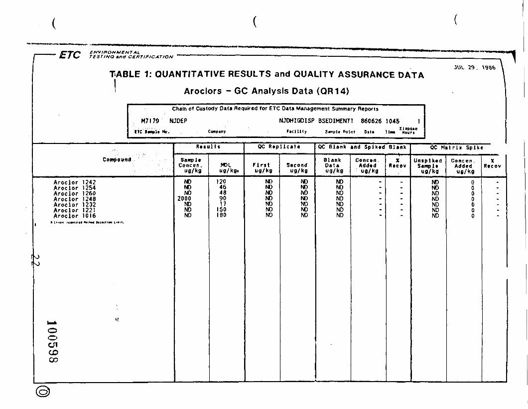
ENVIRONMENTALTESTINO mntt CERTIFICATION
TABLE 1: QUANTITATIVE RESULTS and QUALITY ASSURANCE DATAJUL 29. \9B6
I Aroclors - GC Analysis Data (QR14)
Chain of Custody Data Required for ETC Data Management Summary Reports
M7I79 NJDEP NJDHIGDISP BSEDIMENTl 8606261045 1ETC lwipl< No. Compiny FicUity 3mipU Point Oil* Tint Hourj
Compound
Aroclor 1242Aroclor 1254Aroclor 1260Aroclor 1248Aroclor 1232Aroclor 1221Aroclor 1016
• CHtMl rt«MMI« Hfllh«4 HlfCtlM Him.
O
OO
CDGO
Resu l t s
SampleConcen ,
ug/kg
NONONO
2000NONONO
MDLug/kg*
12046489017
150180
OC Repl icate
Firstug/kg
NONONONONONONO
Secondug/kg
NONONONONONONO
OC Blank and Spiked Blank
BlankData
NONONONONONONO
Concen .Addedug/kg
-
XMecov
-
OC Matr ix Spike
UniplkedSampleug/kg
NONONONONONONO
Concen .Addedug/kg
0000000
XRecov
-

ENVIPOVMENTAL\
(•0oCJ1CDCD
"" KH* TESTING tncf CERTIFICATIOH
JUL 16. 1986
TA3LE 1: CUANTIl ATIVE RESULTS and QUALITY ASSURANCE DATA
Volatile Compounds - GC/MS Analysis D Ua (QR01)
Chain of Custody Data Requirec! for ETC Data Management Summary Reports
M7174 iJJDEP NJDHIGDISP SSOII.I 860626 1140 1ETC S»npJc No. Company l icll lty 3«m'l" Point 0*1- Time Hours
NPDES „ .Number Compound
IV Acrolein2V Acryloni t r i le3V Benzene4V bis(Chloromethyl)ether5V Bromoform6V Carbon let rachloride7V Chlorobenzene8V Chlorodibromomethane9V Chloroethane
10V 2-Chloroethylvinyl ether1 IV Ch loro form12V Dichlorobromometliane13V Dichlorodif luoromethane14V 1 1 -Dichloroethane15V 1 ,2-Dichloroethane16V 1 , 1 -Dichloroethy lene17V 1 ,2-Dichloropropnne18V c i s - 1 ,3-Dichloropropylene19V Ethylbenzene20V Methyl bromide21V Methyl chloride22V Methylene chloride.23V 1 , 1 ,2 ,2-Tetrachloroethano24V Tetrachloroethylr;ne25V Toluene 'f26V 1 2-Tr,ins-diehloroethylene27V 1 1 ,1 -T r i ch lo roe thane28V 1 . 1 ' ,2 -Tr ich loroethane29V Tnchloroethy lenr?,10V Tr ich lorof luoromi?thane31V Vinyl chlor ide18V t r a n s - l ,3-Dichloropropylone
1 _. ——————
,r> .ul t s
Samp ieConcrn .
ug/'<9
NDNDNDNDNDNDNDNDNDNDNDNDNDNDNDNDNDNDNDNDND30. )NDND
1 .'1NDNDNDNDNDNDND
MOLug/kg.
1
QC R e p l i c a t e
F i rs ti'g/kg
956105
61 9ND
53.266.462.65 7 . 44 9 . 33 8 . 765.360.857 .566.364 .868.560.455.568 3
144.4 7 . 47 7 . 660.966.660.965.665. 158.961 .05 0 . 253.45 7 . 3
Secondug/kg
90099 762 2
ND52 366 561 .557 .750.240 .964 .061 .456.664.663.666.360 655.568 6
143.49 189 859.765 359 663 765 759 460. 750 954 15 7 . 2
QC Bl ink and Sp iked Hlan't
BlarkDaliug/l<g
MONDNDNDNDNDNDNONDNDNDNDNDNDMDNDNDNONDNOND
7.62NONDNDNDNDND
• NONDNDND
Concen .Addedug/kg
.~
_----.
-
-
-
%Recov
-
_
_---•::
-
-
QC. Mat rix Sp ike
Uni,pikndSampl>>
ug/kg
NONONONONONONONONONONONONONONONONONONONONO
30 3NDNO
1 .91NONONONONONONO
Concen .Addedug/kg
88988 955 6
055 655.655 655.655 655 655.655 655 655.655 655 655 655 655 655.655 655.655.655 655 655 655 655 655 655 655.655 6
XR e c o v
1081181 1 1
961201131038970
118109104119iri:100123259,
8585
1101201061 181 171061 109096
IOJ
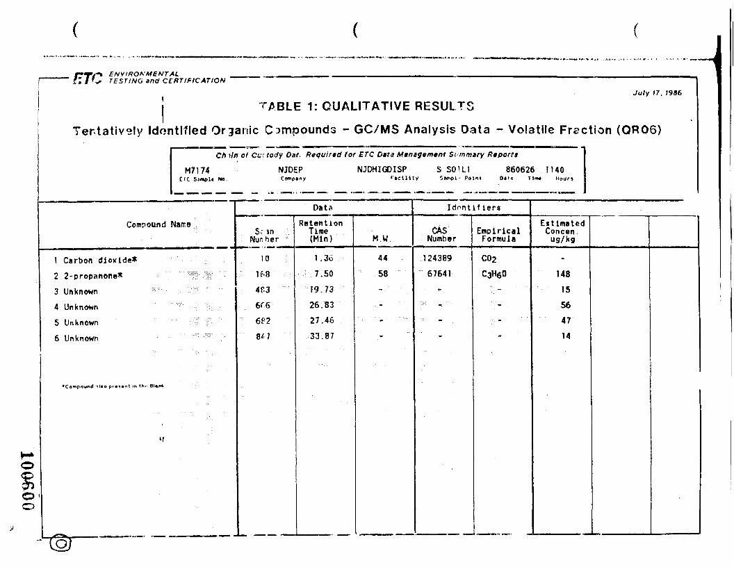
ENVIRONMENTALTESTING and CERTIFICATION
July 17. 1986
TABLE 1: QUALITATIVE RESULTSTentatively Identified Organic Compounds - GC/MS Analysis Data - Volatile Fraction (QR06)
M7174£<C Sl««>l« NO
Ch »/ir of Cu: tody Cat., Requir/td tor ETC Data Mtntgemtnt Summary Reportt
NJDEP NJDHIGDISP S SCHUGomel • Point
860626 1140D«te Tliw« Hour)
Compound Name
1 Carbon dioxide*2 2-propanone*3 Unknown4 Unknown5 Unknown6 Unknown
•Compound ~>
8'
Data
inber
0.8 :-•••
^.3 ••'••'6
P2 ;;
tl
RetentionTime(Min)
1.36• 7.50
19.7326.8327.4633.87
M.W.
44
58
- "- "-• • - • -
Identifiers
CASNumber
12438967641
• -•••>•: , "
- .
EmpiricalFormula
C02C3H60
..._ .. .
-
EstimatedConcen.ug/kg
-14815564714
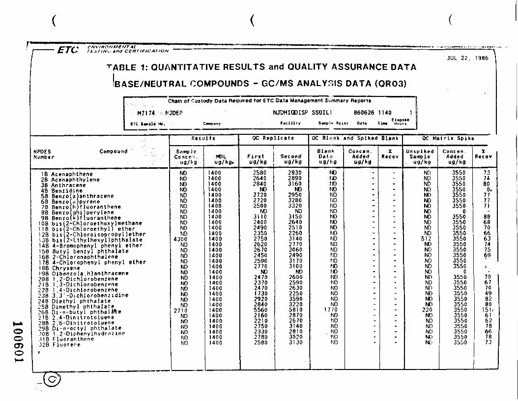
LI C» rtsriN^. tnd CERTIFICATION \
JUL 22. 1986
TABLE 1: QUANTITATIVE RESULTS and QUALITY ASSURANCE DATA
NPDESNumbir
BASE/NEUTRAL COMPOUNDS - GC/MS ANALYSIS DATA (QR03)
Chain of Custody Data Required for ETC Data Management Summary Reports
M7174 MDEP NJDHIGDISP SSOIL1 860626 1140 1ETC lm<»I» Ho* Compjny Fjcility 3«npl» Point D»l» Tim* Hours
Compound
IB Acenaphthene2B Acenaphthylene38 Anthracene4B BenzidmeSB Benzo68 Benzo7B Benzo8B Benzo9 B Benzo . . _ . . . .
a
P
anthracenepyrenef luoranthene
ghijperylenek)f luoranthene
lOB bis 2-Chloroethoxy)methaneI IB bis 2-Chloroethyl) etherI 28 bis 2-Chloroisopropyl)ether13B bis 2-Lthylhexyl)phthalate1 48 4-Bromophenyl phenyl ether!5B Butyl benzyl phthalateI6B 2-ChloronaphthaleneI 78 4-Chlorophenyl phenyl etherI 8B Chrysene19B Dibenzofa ,h)anthracene20B I ,2-Dichlorobenzene218 I ,3-Dlchlorobenzene228 I .4-Dichlorobenzene23B 3.3'-Djchlorobenzidine248 Diethyl phthalate •258 Dimethyl phthalate268 Di-n-butyl phthalafte278 2 4-Dinitrotoluene288 2/6-Dinltrotoluene298 Di -n-octy l phthalate.308 I ,2-Diphenylhydr?zlnn.118 Fluoranthene328 Fluorere
R e s u l t s
SampleConcpn .
ug/l<g
NDNDNDNDNDNDNDNDNDNDNDND
4300NDNDNDNDNDNDNDNDNDNDNDND
2710NDNDNDNDNDND
MDLug/kg.
14001400140014001400140014001400140014001400140014001400140014001400140014001400140014001400140014001400140014001400140014001400
QC Repl icate1
First"3/kg
258026402840
ND272027202500
NO3110240024902350275026202670245025902770
ND2470237024701730292028405560216022102750233027802580
Second"9/kg
283028903160
ND295032803320
ND3150264025102260314027703060249031703100
NO2600259026302250359032205810287026703140281030203130
QC Bl/mk and Spiked Blank
BlankDat.iug/l<g
NDNDnoNDNDNDNDNDHONDNDNDNDNDNDNDNDNDNDNDNDNDNDNDND
1 7 / 0NDNDNDNDNDND
Concen .Addedug/kfl
-~
----
:-
-
XRecov
-
_----™
-
-
QC Matr ix Spike
UnspikedSampleug/kg
NDNDNDNDNONDNDNDNONDNDND
512NDNDNDNDNONONONDNONDNDND
220NDNDNDNONONO
Concen .AddedUfl/kg
3550355035503550355035503550
03550355035503550355035503550355035503550
03550355035503550355035503550355035503550355035503550
XRecov
7374800.
777771
8868706663747569
706770498280
I5K616278667873
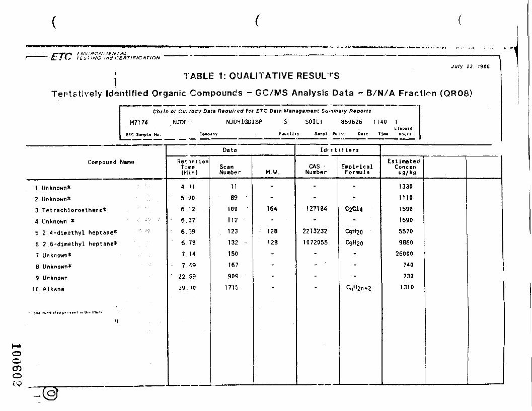
CTS*&7 / Cx ind CERTIFICATION
\
July 22. (986
TABLE 1: QUALITATIVE RESULTS
Tentatively Identified Organic Compounds - GC/WS Analysis Data - B/N/A Fraction (QR08)
Chtln el Custody Data Required tor ETC Datn Management Summary Rtport*
M7174 NJDr ' NJDHIGDISP S SOILI 860626
ETC S»»j»l« No. Company Facility Sjmp). Point
1140 1EUpied
D»le Tim* Hour*
Compound Name
1 Unknown*2 Unknown*3 Tetrachloroethone*4 Unknown *5 2.4-dimethyl heptane*6 2,6-dimethyl heptane*7 Unknown*B Unknown*9 Unknown
10 Alkane
'f
i
DataRetentionTime(Mm)
4 11
5.90
6. 12
6.37
6.59
6 . 78
7.14
7.49
22 . 59
39.00
ScanNumber
1189
100
112
123132ISO1679091715
M.W.
-
-
164
128
128•
--
Idr nt if iers
CASNumber
-
-
127184-
22132321072055
---
EmpiricalFormula
-
-
C2C14'-
CQH20
C9H20---
EstimatedConcen .ug/kg
1330mo1590
1690
5570
986026000
740
730
1310
oo
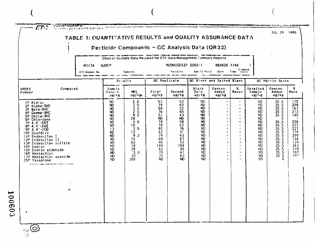
/- /r/V^ 11 :.HN , -,,./1'tnriP'CAr to J 1JVJL 29 . \986
TABLE 1: QUANTITATIVE RESULTS and QUALITY ASSURANCE DATAi
1 Pesticide Compounds - GC Analysis Data (QR32)
Chain of Custody Data Required for ETC Data Management Tummary Reports
M7174 NJDCP NJDHIGDISP SSOIl.l 860626 1140 1E lipteo
E1C Itmplr No. ComMny F»ci l i ty 3<n>i !e Poini Out Time Hours
NPDES CompoundNumber
IP Aldrin2P Alpha-BHC3P Beta-BHC4P Gamma -BHC5P Delta-BHC6P Chlordane7P 4. 4 '-DOT8P 4. 4 '-DDE9P 4. 4 '-ODD
10P Dieldnn1 IP Endosul fan I12P Endosu l fan 1113P Endosul fan s u l f a t e14P Endrin15P Endrin aldehyde16P Heptachlor1 7P Heptachlor epox ide25P Toxaphene
Rr-. ult s
SampleConc i n .
ug/kg
NONDNDNDNDNDNDND13NDNDNDNDNDNDNDNDNO
MDLug/kg.
5 . 02 52.52.59 .0
285 . 0
102 5
139 .2
10621829
5 .033
280
QC Repl ica te
Fir»»ug/kg
6274597651ND78788062746946
103427070ND
Secondug/kg
5362526543ND586276
636752
108456163ND
OC Blank and Spiked Blank
BlankDa' aug/kg
NDNDNDNDNDNDNDNDNDNDNDNDNDNDNDNDNDND
Conccn .Addedug/kg
-
„
--
-
-
%Recov
-
~
--
-
-
OC Mat rix Spike
UnspikedSample
ug/Kg
NDNDNDNDNDNDNDNDNDNDNDNDNDNDNDNDNDND
ConcenAddedug/kg
35.535.535.535.535.5
035.535.535.535 535.535.535.535.535.535.535.5
0
XR e c o
175208167213145
220221227174209194129303119197
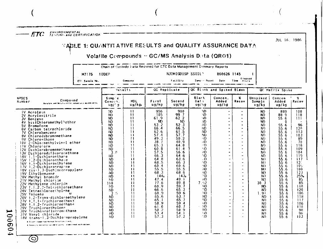
ENVIRONMENTALTt',T/Nt. and CERTIFICATION
TAJBLE 1: GUYiNTn ATIVE REiULTS and QUALITY ASSURANCE DATA
Volatile Compounds -- GC/MS Analysis D;ita (QR01)
JUL 16. 1986
Chain of Cu
M7175 NJDEPEI': S*"oJt Mo.
NPOES _ .Number . _ ., ,nmp,? " ", . . «,„„•
IV Acrolein2V Acrylonitrile3V Benzene4V bis(Chloromethyl oth<3r5V Bromoform6V Carbon tctrachloride7V Chlorobenrene8V Chlorodibromometliane9V Chloro«thane10V 2-Chlo.-oethylvinvl ether1 IV Chloroform12V Dichlorobromomethane13V Diclilorodi f luoror.ethane
K-*OOCDO
14V 1 1 -Dichloroethare15V 1 .2-Di :hlorootha;!916V 1 . 1 -Dichlorocthy i ene17V 1 , 2-Dichloronrop-'ne18V cis- 1 . 3-Dichlor orropylene19V Ethylbcn/ene20V Methyl bromid?21V Methyl chlon-Je22V Methylene chlori<J<? ,23V 1 . 1 .2,.?-Tet rjchloroethane24V Tetracliloroethylnne'25V Toluene »f26V 1 ,2-Tr.ins-dichloroethylene27V 1 1 1- frichloroethani28V 1.1 .2-Trichloroerhan-?29V Tnchloroethy lenn30V Tr ichlorof luorom<-thane31V Vinyl chloride18V trans- 1 .3-Dichlo.-opropylcne
''e
S-imp eConcc- T .
1'9/' 3
NDMONDNDNDNONDNDNDNDMDND3.P
NDNDMDNDNDNDNDMD160NDND2.!.
MDNDNONONDMDND
t e r. u 1 1 s
eT .
3
n
MDLug/kg.
1
1
OC Replicate
Firstug/kg956105
61 .9NO
53.266.462.657.449.338.765.360.857.566.364.868.560.455.568.3144,
47.477.660.966.660.965.665.158.961 .050.253.457.3
Secondug/kg
90099 762 2ND
52 366.561 .557.750.240.964.061 .456.664 663.666 360.655 568.6143,
49 189.859.765.359 663.765.759 460.750 954. 157.2
OC Blink and Spiked Blank
B 1 a r ItDat i
MDNDMD:\JDi\JQNDMDNO•••IDMO"D•MOAIDMO.10MOMOMDMD1*10ND
7.')2MD"IDMOMDMDMD
• MOMOiJOMO
Concen .Addedug/kg
-------------------------------
Racov
.----------------.-------------
OC Mat rix Spike
UnspikcdSampleug/kg
NDNDNONONONONONONONONONONONONONDNONONONONO
30.3NDNO
1 .91NONONONONONONO
ConccnAddedufl/kg
88988 955 6
055 655.655 655 655 655 655 655.655 655 655 655 655 655 655 655 655 655 655 655 655 655 655 655 655 655 655 655 6
Recov
1081 1 81 1 1
961201 1 31038970
1 1810910411911 712:10',100123259.8585
1 1 012010611 81 1 71061 109096103
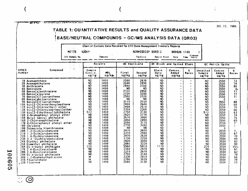
/ ^tnit -etknriCA.iou " "" I
JUL 22. 1986TABLE 1: QUANTITATIVE RESULTS and QUALITY ASSURANCE DATA
NPDESNumber
BASE/NEUTRAL COMPOUNDS - GC/MS ANALYSIS DATA (QR03)
Chain of Custody Data Required for ETC Data Management Summary Reports
M7t7S NJDEP NJDHIGDISP SS0112 860626 H45 IETC Sample Ho, Company Facility Sample Point Oat* TlM Hour*
Compound
IB Acenaphthene2B Acenaphthylene38 Anthracene48 Benzidine58 Benzo6B Benzo78 Benzo
a anthracenea pyreneb f luoranthene
88 Benzo(ghi Jperylene98 Benzo(k ) f luoranthene
108 bis 2-Chloroethoxy)methane118 bis 2-Chloroethyl) ether128 bis 2-Chloroisopropyl)ether138 bis 2-Ethylhexyl)phthalate148 4-Bromophenyl phenyl158 Butyl
etherbenzyl phthalate
168 2-Chloronaphthalene178 4-Chlorophenyl phenyl ether188 Chrysene198 Dibenzo(a.h)anthracene208 1 .2-Dichlorobenzene218 1 ,3-Dichloroben7ene228 1 ,4-Dichlorobenzene238 3. 3' -Dichlorobenzidine248 Diethyl phthalate258 Dimethyl phthalatt268 Oi-n-buty l phthaLate278 2.4-Dini t roto luent288 2.6-Dinitrotoluene298 D i -n -oc ty l phthalate308 1 .2-Diphenylhydrazine318 Fluoranthene
, 328 Fluorene
Resu l t s
Samp leC o n c c - n .
ug/'<gNDNDNONONONONONDNDNDNDND
512NDNDNDNDNDNDNDNDNDNDNDND
220NDNDNDNTMND
MOLug/kfli
14001400140014001400140014001400140014001400140014001400140014001400140014001400140014001400140014001400140014001400140014001400
QC Repl icate
Fir»tug/kg
258026402840
NO272027202500
ND3110240024902350275026202670245025902770
ND2470237024701730292028405560216022)02750233027802580
Secondug/kg
283028903160
NO295032803320
ND3150264025102260314027703060249031703100
ND2600259026302250359032205810287026703140281030203130
QC Blank and Spiked Blank
BlankDataug/kg
NDNDNDNONONONDNDNDNDNONDNDNDNDNDNONDNDNDNDNDNDNDND
1 7 / 0NDNONDNDNDND
Conccn .Addedug/kg
.--..---------
•--------------:
XRecov
.--...---.-------------------~
QC Mat r ix Spike
UnsplkedSampleug/kg
NDNDNDNDNDNONDNONDNDNDND
512NDNDNDNDNDNDNDNDNDNDNDND
220NDNONDNDNDND
ConccnAddedug/kg
3550355035503550355035503550
03550355035503550355035503550355035503550
03550355035503550355035503550355035503550355035503550
XRecov
7374800.
777771
88687066637475697"/
7.6770498280
151,616278667873
( -J
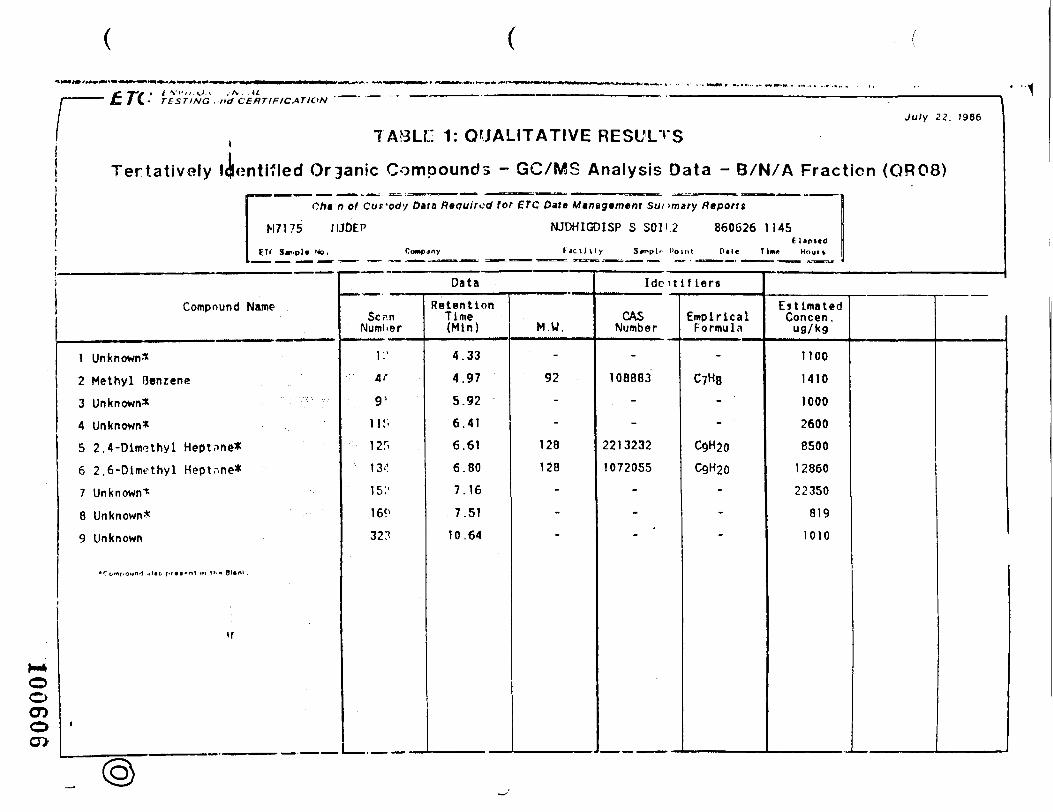
£ ff i t V l ' , / .U .< .-A. .ti/{.• TESTING ,nd CERTIFICATION
July 22. 1986
f: 1: QUALITATIVE RESULTS
Tertatively !<Untified Organic Compounds - GC/MS Analysis Data - B/N/A Fraction (QR08)
Cht n of Cufody Data Required lor ETC Dais Mtnagtmem Sunmary Reports
M7175 flJOEP NJDHIGDISP S SOI I 2 860626 1145Eltpscd
E" S*r>pl* Mo. Company Fdci l i ly 3*'>pl" I'olnl Pile Tim Hour*
Compound Name
1 Unknown*
2 Methyl Benzene
3 Unknown*
4 Unknown*
5 2. 4 -Dimethyl Heptnne*
6 2.6-Dimethyl Heptnne*
7 Unknown*
8 Unknown*
9 Unknown
n
Data
Sc.-inNuml-er
i:'V91
11!-
125
13''
15.''
16?'
32.T
RetentionTime(Min)
4.33
4.97
5.92
6.41
6.61
6.80
7.16
7.51
10.64
M.W.
-
92-
-
128
128
-
-
Idoitlf lers
CASNumber
-
108883
-
-
2213232
1072055
-
-
EmpiricalFormula
-
C7H8
- '
- '
C9H20
C9H20-
-
EstimatedConcen .
ufl/kg
1100
1410
1000
2600
8500
12860
22350
819
1010
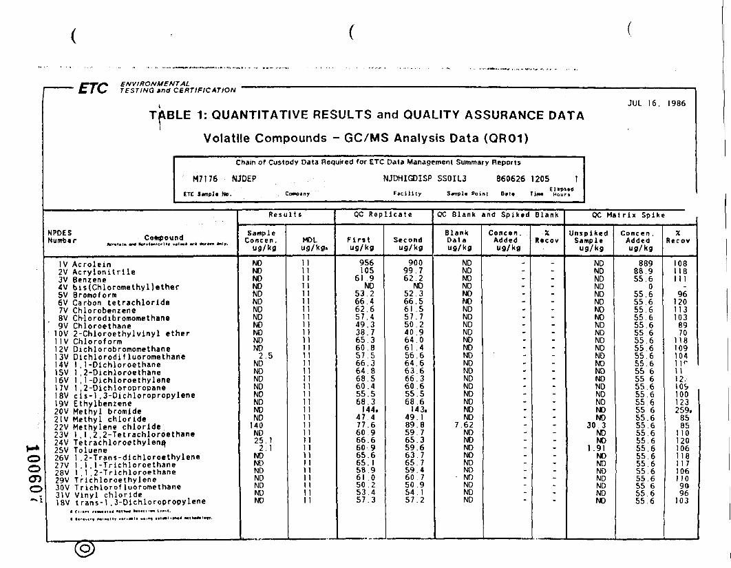
ENVIRONMENTAL"" "" C/l' TESTING »nd CERTIFICATION ' ~~ •""——'• •• "-• - • " —— j
JUL 16. 1986TABLE 1: QUANTITATIVE RESULTS and QUALITY ASSURANCE DATA
I
Volatile Compounds - GC/MS Analysis Data (QR01)
Chain of Custody Data Required for ETC Data Management Summary Reports
M7176 NJDEP NJDHIGDISP SSOIL3 860626 1205 1ETC J«npl« No. Contciny Facility 3jmpl« Point 0»t« Tim* Hours
NPDES rn.rf,n,,hdNumt«r Compound ^ ^
IV Acrolein2V Acrylonitrile3V Benzene4V bis(Chloromethyl)ether5V Bromoform6V Carbon tetrachloride7V Chlorobenzene8V Ch-lorodibromomethane9V Chloroethane
10V 2-Chloroethylvinyl ether1 IV Chloroform12V Dichlorobromomethane13V Dichlorodif luoromethane14V 1 , 1-Dichloroethane15V 1 ,2-Dichloroethane16V 1 . 1 -Dichloroethylene17V 1 ,2-Dichloropropane18V c is -1 ,3-Dichloropropylene19V Ethylberuene20V Methyl bromide21V Methyl chloride22V Methylene chloride23V 1 .1 ,2.2-Tetrachloroethane24V Tetrachloroethylena25V Toluene26V 1 .2-Trans-dichloroethylene27V 1 , 1 . 1 -Trichloroethane28V 1 . 1 .2-Trichloroethane29V Trichloroethylene30V Trichlorof luoromethane31V Vinyl chloride18V trans-1 ,3-Dichloropropylene
' — ( M< «tlw»l^y
R e s u l t s
Samp 1 eConcen ,
ug/kg
NDNONDNDNDNDNONONDNDNDND
2.5NDNDNDNDNONDNDND
140ND25.1
2 . 1NDNDNDNDNDNDND
MDLug/kg.
11111 111111111111111111 11111111111111111111111111 1111 111111 11 111
QC Rep l i ca te
Firstug/kg
956105
61 9ND
53.266.462.65 7 . 449.33 8 . 765.360.857.566.364.868.560.455.568.3
144.4 7 . 477 .660.966.660.965.665.158.961 .050.253.457.3
Secondug/kg
90099.762.2
NO52.366.561 .55 7 . 750.240 .964.061 .456.664.663.666.360.655.568.6
143.49 .189.859.765.359.663.765 .759.460 750.95 4 . 15 7 . 2
OC Blank and Spiked Blank
BlankDataug/kg
NDNDNDNONDNDNDNDNDNDNDNDNDNDNDNDNDNDNDNDND
7.62NDNONDNDNONDNONDNDND
Concen.Addedug/kg
.-----------
'----------.~
--
-
XRvcov
.----------------------_
_-:-
QC Mat rix Spike
UnspikedSample
ug/kg
NDNDNDNDNDNDNDNDNDNDNDNDNDNDNDNDNDNDNDNDND
30 3NDNO
1.91NONDNONONDNDND
Concen .Addedug/kg
88988 955.6
055.655 655 655 655.655.655.655 655 655.655 655.655 655.655 655 655.655.655 655 655.655.655 655.655 655 655 655.6
XRecov
1081181 1 1
961201131038970
118109104IK1 112.109100123259.
8585
1 101201061181 1 71061 109096
103
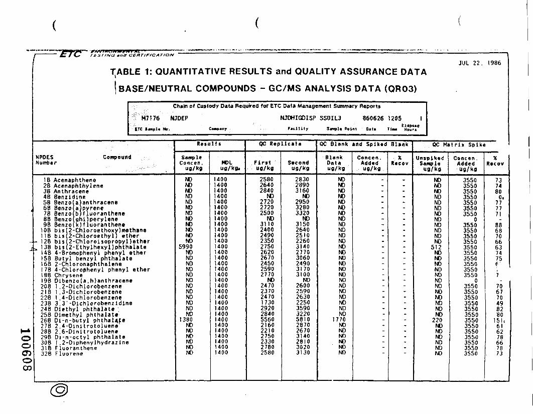
1 ————— £r /O" rfsrr/va
'
J
H*OOcnoOD
mnct CERTIFICATION '
JUL 22. 1986TABLE 1: QUANTITATIVE RESULTS and QUALITY ASSURANCE DATA
NPDESNumber
BASE/NEUTRAL COMPOUNDS - GC/MS ANALYSIS DATA (QR03)
Chain of Custody Data Required for ETC Data Management Summary Reports
M7176 NJOEP NJOHIGDISP SSOIL3 8606261205 1ETC Simple Mo, Cempiny F»cility S*nj>l« Point Oil* Tim* Mourj
Compound
1 B Acenaphthene28 Acenaphthylene38 Anthracene4B Benzidine5B Benzo6B Benzo78 Benzo8B Benzo _ .. .
a)anthracenea)pyreneb)f luorantheneahiloervlene
9B Benzo (k ) f luoranthene10B bisi 2-Chloroethoxy)methane118 b is i 2-Chloroethyl) ether
- 12B bisi 2-Chloroisopropyl)etherb. 138 bis(2-Ethylhexyl)phthalate
148 4-Bromophenyl phenyl ether158 Butyl benzvl phthalate168 2-Chloronaphthalene1 7B 4-Chloro0henyl phenyl ether188 Chrysene19B D ibenzo fa , h)anthracene208 1 ,2-Dichlorobenzene218 1 ,3-Dichlorobenzene228 1 ,4-Dichlorobenzene238 3.3'-Dichlorobenzldlne24B Diethyl phthalate25B Dimethyl phthalate268 Di-n-butyl phthala,fe27B 2.4-Dinitrotoluene288 2.6-Dinitrotoluene298 Di-n-octy l phthalate308 1 ,2-Diphenylhydrazine318 Fluoranthene328 Fluorene
Resul ts
SampleConcen,
ug/kg
NONONONONONONONONONONONO
5990NONONONONONONONONONONONO
1380NONONONONONO
MDLug/kg.
14001400140014001400140014001400140014001400140014001400140014001400140014001400140014001400140014001400140014001400140014001400
QC Replicate
Pintug/kg
258026402840
NO272027202500
NO3110240024902350275026202670245025902770
NO2470237024701730292028405560216022102750233027802580
Secondug/kg
283028903160
NO295032803320
NO3150264025102260314027703060249031703100
NO2600259026302250359032205810287026703140281030203130
OC Blank and Spiked Blank
BlankDataug/kg
NONONONONONONONONONONONONONONONONONONONONONONONONO
1770NONONONONONO
Concen .Added"9/kg
_.--...._.-.-------------
.--"*
-
XRecov
_....-._.--_-------------~
--;-
OC Matrix Spike
UnspikedSampleug/kg
NONONONONONONONONONONONO
512NONONONONONONONONONONONO
220NONONONONONO
Concen .Addedug/kg
3550355035503550355035503550
03550355035503550355035503550355035503550
03550355035503550355035503550355035503550355035503550
XRecov
7374800.
777771
88687066637475e,7
-706770498280
6l'6278667873
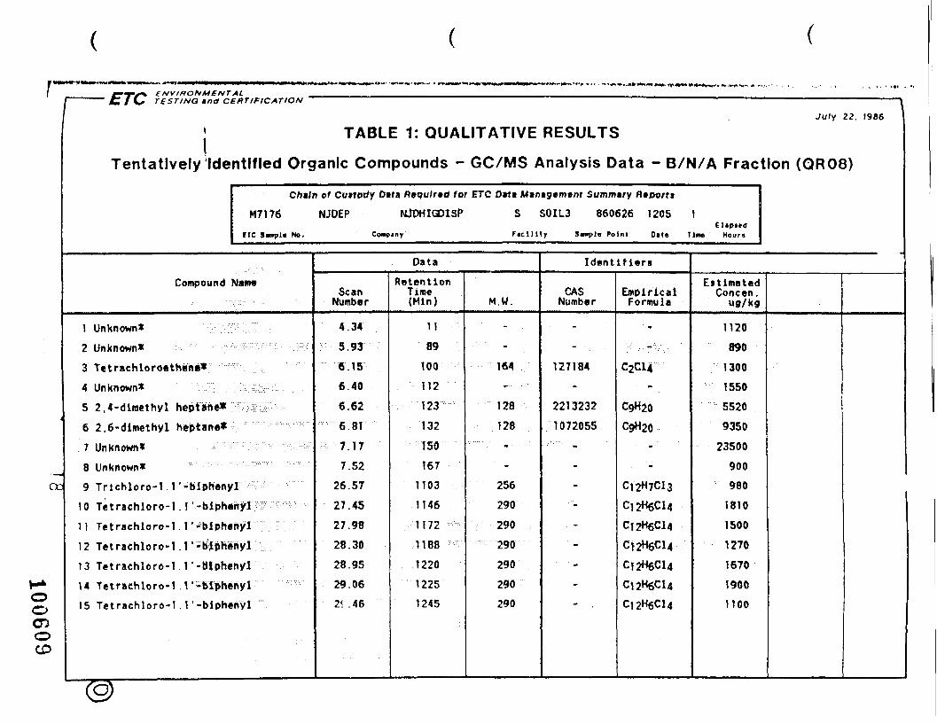
ENVIRONMENTAL
cc
1>)
C 1 \* TESTING *nd CERTIFICATION ~~ ~~ ~ ———————————— '
July 22. 1986 1
j TABLE 1: QUALITATIVE RESULTS
Tentatively Identified Organic Compounds - GC/MS Analysis Data - B/N/A Fraction (QR08)
Chtln of Cuttocfy Dtta Required for ETC Dtt* Mtntgtmtm Summtry Ripotti
M7176 NJOEP NJOHIGDISP S SOIL3 860626 1205 1
riC S«np]« Ho, Cowcjny Facility S«npl> Point D*t« Tine Hours
Compound Name
1 Unknown* T •2 Un known* ' • v/::'W ••;^^^-^. ' , ::::;/
3 Tetrachloroethene* r4 Unknown* : :
5 2.4-dimethyl heptane* j
6 2,6-dimethyl heptane*. 7 Unknown* . . • . , , . ; : . • , : : • , : • : • : - • : • • . ' • : . ..:•.; • • • •
8 Unknown*9 Trlchloro-1 r-biphenyl
10 Tetrachloro-1 . r-biphenyl11 Tetrachloro-1 . 1 '-blphenylr '
12 Tetrachloro-1 . 1 '-biphenyF13 Tetrachloro-I . 1 '-BIphenyl
14 Tetrachloro-1 . 1 '-blpheriyl15 Tetrachloro-1 . 1 '-blphenyl
Data
ScanNumber
4.34
5.93
6.15
6.40
6.62
6.81
7.17
7.5226.57
27.45
27.98
28.30
28.95
29.06
2^ .46
RetentionTirae(Min)
11
89
100
112
123
132
ISO
167
1103
1146
1172
1188
1220
1225
1245
M.W.
'
• ;• '•'.' ' - • •164
' • '
128
128
-
256
290
290
290
290
290
290
Identifiers
CA$Number
-
. - -:
127184
-
2213232
1072055
• • '
-
-
-
-
-
-
EmpiricalFormula
• »
;::. ; . - ' , .
C2C14
C$H20
C$H20•-..-
-
C,2H7Cl3
C12H6C14
C12H6C14
Ct2H6Cl4
CJ2H6C14
C12H6C14
EstimatedConcen .
ua/kg
1120
890
1300
1550
5520
9350
23500
900
980
1810
1500
1270
1670
1900
1100ooCDoCD

/' " ' t / C- rtsriNG ana CERTIFICATION ' 'July 22. T986
1
Tentatively Ide
TABLE 1: QUALITATIVE RESULTS
ntlfled Organic Compounds - GC/MS Analysis Data - B/N/A Fraction (Qfl08)
Chiln of Cuttody Data Required tor ETC O»n Mintgtment Summary Rtportt
M7176 NJDEP NJDHIGOISP S SOIL3 860626 1205 1EXpltd
ETC S«np)» No. Comp«ny Faci l i ty Simple Point D»t« Tin* Houri
Compound Name
16 Pentachloro-1 . I '-biphcnyl
17 Pentachloro-1 . 1 '-biphenyl
18 Alkane
19 Unknown
20 Alkane21 Unknown
f2 Unknown
3
«f
Data
ScanNumber
29.63
30.50
37.22
37.50
39.01
39.26
42.45
RetentionTime(Min)
1253
1296
1625
1639
1713
1725
1881
M.W.
324
324
-
-
-
-
Identifiers
CASNumber
-
-
-
-
-
-
EmpiricalFormula
C12H5C15
Ci2HsCl5
CnH2n+2-
CnH2n+2-
"
EstimatedConcen .
ufl/kg
1310
880
2800
1000
2810
1030
1180
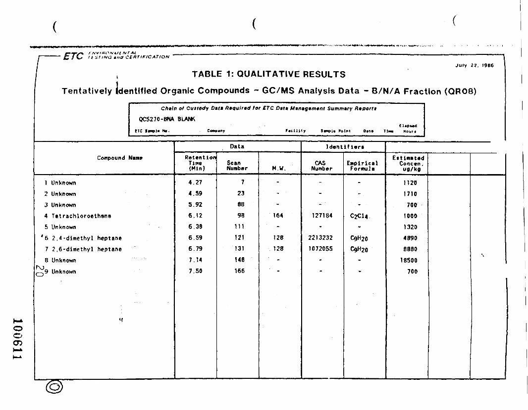
MT At.r C/\s It iV/^G mna CERTIFICATION
July 22. 1966
\Tentatively Ide
TABLE 1: QUALITATIVE RESULTS
ntifled Organic Compounds - GC/MS Analysis Data - B/N/A Fraction (QR08)
Chain of Cuttody Difa ftaquirtd for £TC Data M»n*g»m»nt Summary Riporrt
QC5270-BNA BLANK
ETC Itmpl* Me. Comsiny Ficilitr Jvnpl* Point Out tin* Hour*
Compound Name
1 Unknown
2 Unknown
3 Unknown
4 Tetrachloroethene
5 Unknown
*6 2.4-dimethyl heptane
7 2.6-dimcthyl heptane
8 Unknown
Q9 Unknown
«f
Data
RetentionTime(Min)
4.27
4.59
5.92
6. 12
6.38
6.59
6.79
7.14
7.50
ScanNumber
7
23
88
98
111
121
131
148
166
M.W.
"
- •
164
-
128
128'
"
Identifiers
CA$Number
-
-
-
127184
-
2213232
1072055-
EmolrlcalFormula
-
-
-
C2C14-
C9H20
C9H20.
w
EstimatedConcen.ug/kg
1120
1710
700
1000
1320
4890
8880
18500
700
\
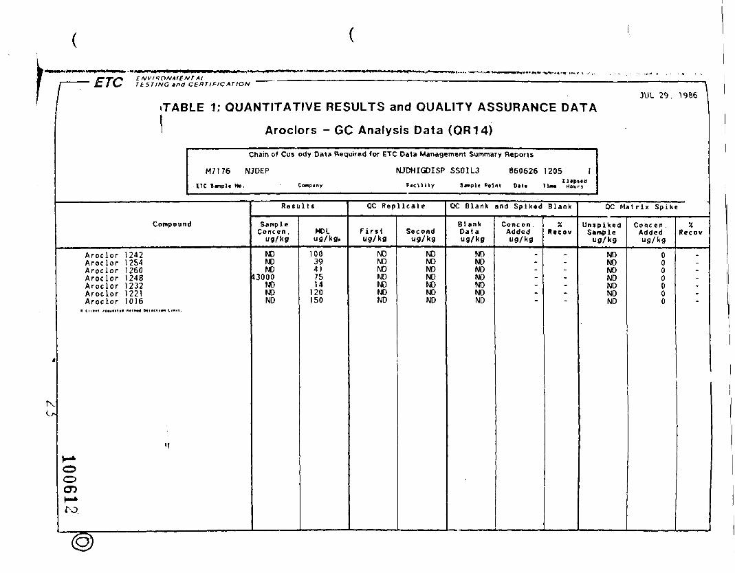
4
IX
1 ' ' • fZ 1 \* T tSTING tnd CERTIFICATION " "
•TABLE 1: QUANTITATIVE RESULTS and QUALITY ASSURANCE DATA
Aroclors - GC Analysis Data (QR14)
Chain of Cus ody Data Required for ETC Data Management Summary Reports
M7176 NJDEP NJDHIGDISP SSOIL3 860626 1205 1
ETC S«mpl« No. Conpiny Fjcility Simple Point 0<lt Tim* Hours
Compound
Aroclor 1242Aroclor I 254Aroclor 1260Aroclor 1248Aroclor 1232Aroclor 1221Aroclor 1016
OO
r-*ro.
»f
Resul t s
SampleConcen ,
NDNDND
43000NDNDND
MDL
10039417514
120150
QC Repl ica te
Firstug/kg
NDNDNDNDNDNDND
Secondug/kg
NDNDNDNDNDNDND
QC Blank and Spiked Blank
BlankDataug/kg
NDNDNDNDNDNDND
Concen .Addedug/kg
-
Recov
-
JUL 29. 1986
QC Matr ix Spike
UnsplkedSample
ug/kg
NDNDNDNDNDNDND
Cone en .Addedug/kg
0000000
•4Recov
-

ENVIRONMENTAL
, JUL 16. 1986TA-BLE 1: QUANTITATIVE RESULTS and QUALITY ASSURANCE DATA
'Volatile Compounds - GC/MS Analysis Data (QR01)
Chain of Custody Data Required for ETC Data Management Summary Reports
M7177 NJOEP NJDHIGDlSrV SS01U 860626 1300 1I TC I «"••!• Up. Coms.ny Ftcllity Implt Point D«t» Tim* Hours
Number C6«pdund_ . ; ^^ : . „ . ; ' • ' •
IV Acrolein2V Acrylonitrlle3V Benzene4V bu(Chloromethyl)ether5V Bromoform6V Carbon tetrachlorlde7V Chlorobenzene6V Chlorodibromomethane9V Chloroethane
10V 2-Chloroethylvlnyl etherIIV Chloroform12V Dichlorobromomethane13V Dichlorodif luoromethane14V 1 . 1-DichloroethaneJ5V 1 .2-Dichloroethane16V 1 . 1-Dichloroethylene17V 1 ,2-Dichloropropane18V c l f -1 ,3-Dichloropropylene
> 19V Ethylbenzene20V Methyl bromide21V Methyl chloride22V Methylene chloride23V 1 .1 .2.2-Tetrachloroe'thane24V Tetrachloroethylene..25V Toluene '26V 1 ,2-Trans-dlchloroethylene27V 1 , 1 . 1-Trlchloroethane2BV 1 . 1 .2-Trichloroethane29V Trlchloroethylene30V Tr ich lorof luoromethane31V Vinyl chloride18V t rans-1 ,3-Dlchloropropylene
Retul tc
SampleConcen,
ug/kg
NONONONONONONONONONO
1.4NONONONONONONONONONO74.011NO
1 .3NONONONO
2.9NONO
MDLug/kg.
111
11
QC Repl icate
Fir«tug/kg
956105
61 9NO
53.266.462.657.449.338 .765.360.857.566.364.868.560.455.568.3
144,4 7 . 477.660.966.660.965.665.158.961 .050.253.457.3
Secondug/kg
90099.762.2
NO52.366.561.557 .750.240 .964.061 .456.664.663.666.360.655.568.6
143.49.189.859.765.359.663.765.759.46 0 . 750.954.157 ?
QC Blank and Spiked Blank
BlankDataug/kg
NONONONONONONONONONONONONONONONONONONONONO
7.62NONONONONONONONONONO
Conften.Addedug/kg
.--------------..
_---
'_"*
~-
-
*Recow
_--------------_
.----_"*
--
-
QC Matrix Spike
UntpikedSampleug/kg
NONONONONONONONONONONONONONONONONONONONONO
30.3NONO
1.91NONONONONONONO
Concen .Addedug/kg
88988.955.6
055.655.655 655.655 655 655 655 655 655 655 655 655 655.655.655.655.655.655.655.655.655.655.655.655.655.655.655.6
XRecov
108118111
96120113103
8970
118109104ir1 112J109100123259.
8585
1101201061181171061109096
103
ooO5
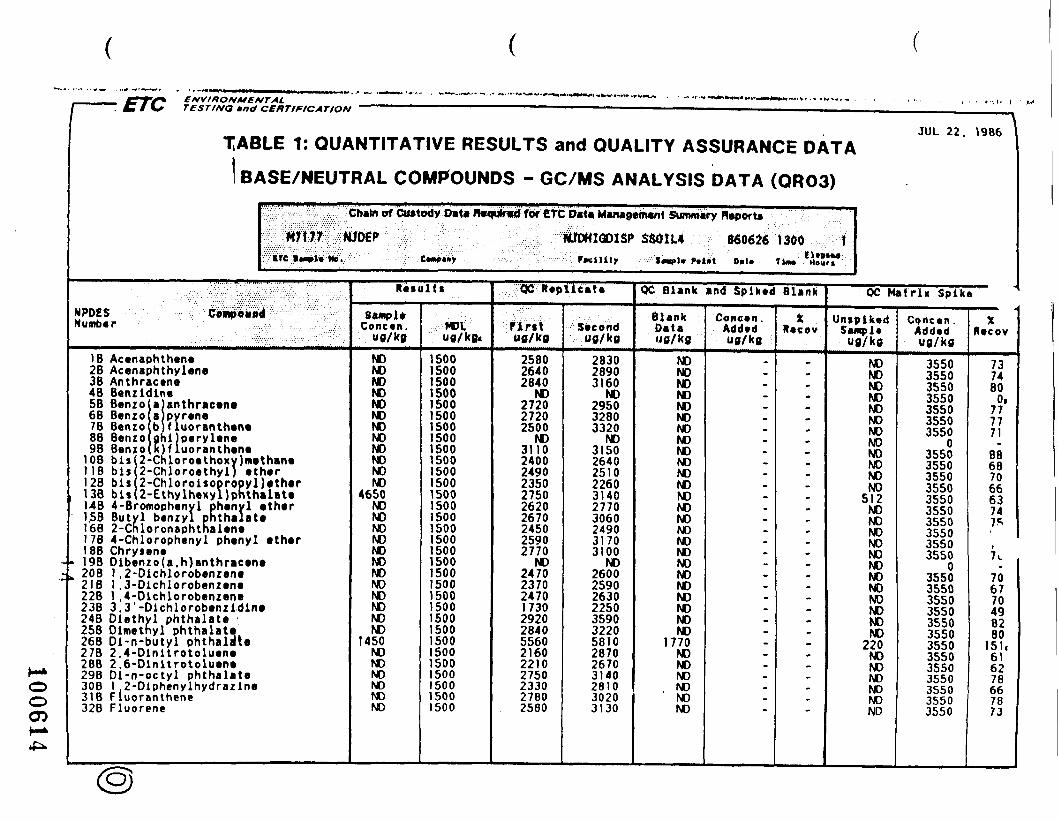
oi!giL
03CT>
<NJ(M• ^
CO
S
ouj
a
O
S
< 2i
<CO
O<
c/5I-
-J
IIO
co•o
2«
Ow
O
I- i
^ w
tS z
O
uj-
Z
C
A.
OX
ua
VI!
r~-—
i co ao o vo <*>
ifCD so
— —
(Moo\ooom
r~- CO CO 1/3 (O
\o r~ 10 r~ r
^^oooooooooooooooooooooo^ooooooo
in m
mtn
in vo in
in
inin
inm
inin
LO
inin
ininininininm
ininmm
LOLO
in in
m 10 in
m m
m
inin
LO
inin
inm
inin
tnintoinuom
inmm
inmm
mro
o^ ro fo ro
ro ro
ro
ro ro
ro ro
ro ro
o ro
to
ro ro
ro ro
ro ro
ro ro
ro r*j ro
ro PO
UJ
i i i i i i i i
i i i i i i i i i i i i i i i i i i i i i i i i i i i i i i i
oooQoooQooooooooooQoo
roa>vDZm
oo<MZm
coco—
eT>fM<*> —
oo
oo
oo
oo
o»
— p
gn
— coo —
oo
oQ
oo
oQ
oo
oo
oo
oo
oo
Qo
oo
oo
oo
oo
oo
oo
co^
rvZr^
fMo
Z —
oo
Mn
iocxi^m
w~-Z
LOVOCO ^-r«-in
—
"»^
nf~
<o
tfl^m
r»-
«M CM
CM —
oo
oo
oo
oo
oo
oo
oo
oo
oo
oo
oo
oo
oo
oo
oo
oo
-H «
X
•
-.
«
• c
O-C
X~
« •
C
U
• • C
-O
-J
«--<
a c
« c
• • c
c c
-<
«TO
••a
mc
.c c
.c x
-< i--^
».c
«.c
u
• • • M ••'-H
c c
«^ a
• *• • *> o
xa—«£*•—
« a
jc N
I M K
I c •*• a
a • • a
L-O
C
-^ C
JC
£ O
>>
O_
C <
0
*• c C
C •
W—
«.C 3
3£
T)
•O •
Id X
«<
-> *• «
" X
O
-C—
« c
• •
«J
3—
< «
«-'—
<—
«-• X
u.c^-L
.L.9v
>v^
V'^
«-*
x <a^
^>
^ao«axi£oo££
c • o • o o o o£. x—«.e c
•-> o o o t.f *^ a*'** a-H t>
c—i
«-• u 3 a 3 <-i-<--« c x a •
x «- »- i- o**.c oo
xc• x«
c x—«^—
< o o o > • «~i «j:
- o o o~«.c a—<»- u—
< c «).C.C
c •> « a.~~<-—i-i—
«JSJ: c e a «—
«—<—
«.c a x^
«->x«jc
_ r-^jr^^r«-« a • o o •—
.c.c.c u .-«.*•-.-«4J .c -• i
£.J
C.
U --^
<fl M
.O O
VJC O
U O
UJ
O.A
t~
U.C
OU
OO
-^
4<
-H
>»
3C
CO
Ck
CC
aaiv^9> .
-—
-_
(0 a t.-4 o o oc C
.C•*-~~^ I
I I
I £
O
O9
M—
<—
l-HO
X£
^-<
»4
O -<
10
01
i O O
CM
fMfS
ltvi p-^—<—
< « C
O i £
•* I O
O
i O t- t.
«>
«>
«->
-'-<-•'
31
1 £
-4
I C
i O
O
CO
CO
CO
CO
cOC
DC
OC
OC
DO
OC
OO
OC
DC
QC
DC
OC
OC
OC
QC
OC
QC
OcO
CO
GD
OD
OO
eOC
DC
OC
OO
O
<NJC
SJC
>JfN<M
(M(M
(N<M
<MT
*5n
100614
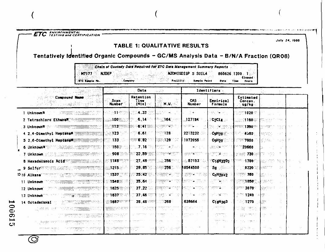
TEST I NO mna CCKTIFICATION
July 24, 1900
,JeTABLE 1: QUALITATIVE RESULTS
Tentatively Identified Organic Compounds - GC/MS Analysis Data - B/N/A Fraction (QR08)
Ctnln of Cuttotty Dft• Riqutnd tor ETC D«ft Mtnigimtnt Summary Riportt
S S01U &60626 1300 1S«npl« Point Oat* TiM Houri
••'1
^.^^•Oiii^J^^^j
1 Unknown* . :. ?, v . :-';- -::^ H21sS:i:pr
3 Un k n OWli*" : • ::y -^ "^ • • • >v.'': ;x / :x- ':::::": ' '?S:x?:?i':/?:?::::::: :-?M-S;?x-x :••••-•
5 ZVfi'-Diiwthy'l- iiJtiiiii ^^SS?/?/// ^ft ' IM l/H J UJM W"' • • " • " ' " ' • '>'• "•'•'•'•)•! /.'•.'•!-"/'•] "v '•Xv!vXvXi'"v!i!vXv: ''v." .v.v v.v.v . .••D unnnown*. ^•••.••••••^••••••:^:-^-^.';s/-.^.':^-^.'--^.^:::^7 1 IM I/H M^MI ' "•' "• ' ' •'•" ' '-'.' •.'•"". .".."- '.V.v.1.' :.'.•::;;.'.'::.'.'.'.''.';;.'"•'.'.''• -'.'.'.'::.".'.'.'.'•'•'• ••• '•
Un KnOWn . ; ;. ...; /.^:.^.^.-.y:.^^.-.SK^,^--.^-^
8 H*x a da c Biii-d i'C'; • Ac I'dxw ./: VSK^ /. ssjiiH oKH;:
_ 9 Su I f u r - ^ v :
»io Aikmr :-;. •c:;:-'-mMmmmmm^^m] \ Unknown "; :
12 Un k n OWIt • • ; • . . . : • • • • ; • • • - - : .-•-: :••••••• 'ff-:':'">?::':'' »• :'':/'v-xx-':':: ':':'':':;:-'/.'::::::x:.;':: : {"xx:/ • •;.'
1 3 Unknown v"""":;? lii;liie%^^ :5:;
14 0«tad«c«ftBl ;;; !f l!lZ^
• - - " - " " ' . " • - . • • . • • • . - ...;.;.;;.;;... ....... . . - • • • . • .-.•.-.-.. ..'. "- . • ' . • • . ' • . . . . . • . ' . • '.".. . • • • • • - • . . . . . -
• .•.-" ' . / • •-. ' .'.-'.''• -. -• .. • .."
. . ' : . . , . ; . : ' • • : ; • : - • - /- :••: D»t» -,,,<•.
ScatiNumber
:;:iiE
"vi'/Xv'-Xl ! W -i ft '•!'•!•'•'•- "•'.- •.-• . • • - . • . f f *^ O " ' '.' '
./§;:;! ?i 5^:-^;
x':'x. :1625:xx'x:'v^-';
"'•'..' ' T637 '•';•. • • • '
xy-;:-T687:':x x >•;•• •
RetentionTim*(Min)
,;•;.-; 4. 33 :;;j-\
:y-rrc.6i;:.xA:;.
•vv-JS-i-42 •.;::;::,
. -^
' ;-;LM.W.--;-
v;:W;.128:--.:;-:V:
15:p:vX-:^:;-,;;x:x:;
••"•'•'•>:/""•'• . • ' ** . • ' • . . '
Identifiers
CASNumber
;T27T84
2213232
1072055
57103
10544500
. x;.x.x;V;:r:: ;;/••;;;•
• . •• * / . •.•• . ! '
638664
EmpiricalFormula
C2C14
"OgH-zf €•••
::;CnHJ"**, :,;/.-;;. • -• » ..^. .
Ci8H3«0
EitinmUdConcert .
1020
20660
?:fff WO '
,,••;•-;,: 3070-:--..
1270ooCD
Cl
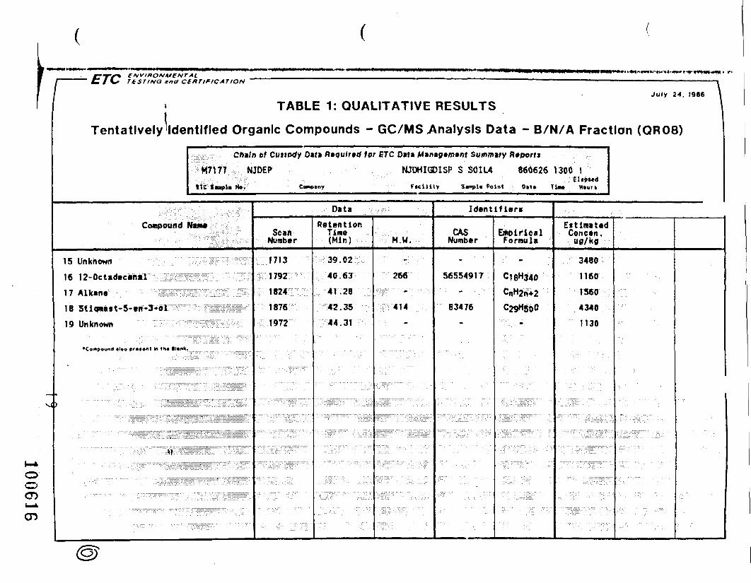
ooCDu»tGD
*T«IV^ ENVIRON'" — "" C 1 \* TtST/NO
Tentatively
ME NTtntt C
Ide
Compound
15 Unknown
16 12-0ct«d»csnal
17 Alkana .•; • ••^,!m18 StiqiB»st-5-en-3-o]
19 Unknown S
•Compound «l«o pr««ont to th
Lvpn
* (link
SUP
iplv
••-.-;•-:."
fHTIflCATION " ' ' ~ ————————————— — ——————————————————————— •
July 24. 1986 \
TABLE 1: QUALITATIVE RESULTS I
ntlfled Organic Compounds - GC/MS Analysis Data - B/N/A Fraction (QR08)
C/»/n of Cuttody Dutt Riqulrtd tor ETC Oita Min»g»m»nt Summary Rtportt
M7trt NJDEP NJDHIGDISP $ SOIL4 860626 1300 1• • : ' . - : : • • • • - . . • ' . • • : ' ' - . ' : . . . fl«P»«dtit Sopli N». Comoiny r»ci)ity Stmpl, Point D»t* Tinw Hgun
PtaM • ;' . •
lllISIIs?!!
•"•'/.'/.•/ .v.v.v.".1 .-.- v'. ;._/;.; •'•).'•;/;.;_
Data
ScanNumber
1713
MVZ "
w:\9M:r :•:.:'1876
; 1972
RetentionTime(Min)
39.02
40.63
41,28
42.35
44.31
••:VM.W. . '
266
414
Identified
GASNumber
56554917
B3476
EiWiflOalFormula
C18H340CnH2n>2C29H800
/.v/..v:v-::v;,-v.r ..,
EttimatadConctn.
u0/ka
3480
1160
1560
4340
1130

ENVIRONMENTALC 1 \* TESTING ma CERTIFICATION ~ —— —————————————— —— —————————————— |
, JUL 16, 1986•HABLE 1: QUANTITATIVE RESULTS and QUALITY ASSURANCE DATA
NPDCSNumber C^mpou
•V Acroleln2V Acrylonltrlle3V Benzene
Volatile Compounds - GC/MS Analysis Data (QR01)
Chain of Custody Data Required for ETC Data Management Summary Reports
M7178 NJDEP NJDH1GDISP SS01L5 8606261040 tITC tmfltHf. Cwnoiny F*cilily S«npl» Paint Oil* Tint Hours
I'll V .:::•: • • ; : • • ; ; • .-:•:•-:'>.
4V bl$(Chloromethyl)ether5V Bromoform6V Carbon tetrachlorldt7V Chlorobenzene8V Chlorodibromomethane9V Chloroethane
10V 2-Chloroethylvlnyl ether11V Chloroform12V Dlchlorobromomethane
•13V Dlchlorodlf luoromethane•14V 1 ,1-Dichloroethane15V 1 ,2-Dichloroethane16V 1-,1-Dlchloroethylene17V 1 ,2-Dichloropropane18V cls-1 ,3-Dichloropropylen«19V Ethylbenzcne20V Methyl bromide21V Methyl chloride22V Methylene chloride23V 1 .1 ,2.2-Tetrachloroethane24V TetrachloroethyleM25V Toluene26V 1 ,2-Trans-dichloroethylene27V 1 ,1 ,1-Trlchloroethane28V 1 . 1 .2-Trichloroethane29V Trlchloroethylene30V Trlchlorof luoromethane31V Vinyl chloride18V t rans-1 ,3-Dichloropropylene
• Client rtv**t*« IMIIM tatlctlM ll«lt.
- -«—'•"•
Result*
sampleConcen.
u0/k0
NONONONONONONONONONO
3.1NO
2.2NONONONONONONONO
621NO13.72 .2
NONONONO
7 . 1NONO
MDUufl/kfl.
111
QC Replicate
PintUfl/kfl
956105
61.9NO
53.266.462.657.449.338.765.360.857.566.364.868.560.455.568.3
144.47.477.660.966.660.965.665. 158.961 .050.253.457.3
Secondufl/kfl
90099.762.2
NO52.366.561.557 .750.240.964.061 .456.664.663.666.360.655.568.6
143.49.189.859.765.359.663.765.759.460 .750.954 .1i: .2
OC Blank and Spiked Blank
BlankDataug/kfl
NONONONONONONONONONONONONONONONONONONONONO
7.62NONONONONONONONONONO
Concen ,Addedufl/kfl
.-------------------
'
_
.-~~
_--
XRecov
_--------------------~
.-••_--
OC Matrix Spike
UntpiKedSampleUfl/kfl
NONONONONONONONONONONONONONONONONONONONONO
30.3NONO
1.91NONONONONONONO
Concen .AddedUfl/kfl
88988.955.6
055.655.655.655.655.655.655.655.655.655.655.655.655.655.655.655.655.655.655.655.655.655.655.655.655.655 655.655.6
XRecov
108118111
961201131038970
118109104pn1
10100123259.
8585
1101201061 181 1 71061 109096
10J
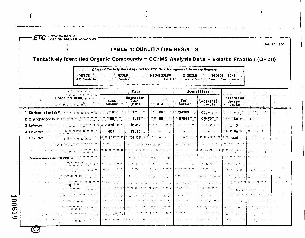
1 " C 1 \s TESTING »nd Cl
\1Tentatively Ider
5RTIFICATION "
July 17. 1986
TABLE 1: QUALITATIVE RESULTS
itlfled Organic Compounds - GC/MS Analysis Data - Volatile Fraction (QR06)
Cftiln of Cuttodf Out Rtqulnd tar ETC O»t« Mun»g»m»nt Summary Reports
M7iy6 MJDEP NJDHIGOI3P S SOILS 060626 1040i£t(; 4«t#l4i (•»,:.•:."•'.. Ce»|>«ny : F«eiJ»«y S«<»«>J« Pelnt :: DM* T>m« H«ur<
Compound : Htm»;:p:;.-;:;::-;¥':;.::
I Carbon 'dloxid«*:31Pn
2 2-propandne*':;-::? lll¥;:ffi3 Unknown ..'"•• ' '' ''"' ^SS
4 Unknown' ;:"'::'v''""7;:';.;:;..:-:Wffi"5 Unknown ;-'-'"""v:v''V'3Swfs
A »Co»««uf«J tl»A prWiM "'»» «H* W(iW(r .:•-
3 • • , - . • • • • • , - , .,,...,,y^
^ir^m^-^vi-
' " •::V:^:i^Z^^r^.f<...
Data
'"' Scan:-:-;Number
•':':r:'::::i;:r8'BS;-
;:165Sfl?
: -:::-::-37«;:p --
: -4BT^F;;;r• ;722:S':w:'
R«t»ntionTim*(Min)
W-K333PfE7;43-^7
;::::fi5:;«27;:;.;r•;;T;:'I9;70'- i:
:T?^9;{J6:-S :
:-^;"M.V.--^-":^-;.'44-:^m::•:•!;;••:• •58:;-::W-
" * • • • ' • ' . .
IdantlflBri
CASNumber
124389
?; 6764'I:vi:P-
• . -.••-• .••..' » • - • / • . •
E*oiriualFormula
fcoj^m-^:;C#wis :;-
;•• ";'-/.';*;•>:>•:'""•"•;':"•:
• :;•:•.. m • • : • • - . . • : . - • •
EttimattdConctn,ufl/kfl
'; ;5}:::::;:::::;v*:.v:'.::':?-;::/'.
•^mmw'm::•pf?- \S--m ;:••
.v-p:;:;-: JO"?^;
-I- -34$ •-:•-;
ooCDH->CO
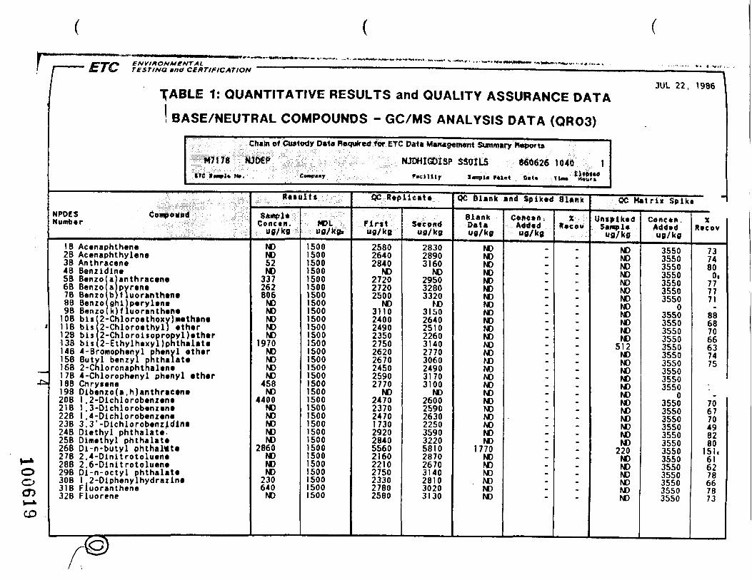
6190
0111
U>
OjO
Jh
jr\J
N>
Kir
^M
N)N
JfO
NJ
-
-n-r
i—O
KJ
MO
OO
cj—
• —
• — O
O*K
)OJ
^c
rcrc
rO'a
30
Da
3C
Da
JC
D»
)>H—
^—
*—«
- *—
**
>••"
- ..
. i*
. 3
i
i ^
i»
*.^
*.*
«.»
*-(
(90
99
O3
OO
j«<
zrir
x: -
> ,-~
--——
—N
MN
NN
NS
-SS
_
_ _ » r»
3- I
OO
O3
«• l-H
-H-0
N>
N>
N>
N)0
O O
O O
>- -I
« •
i» a
t *-
o >
->-o
'3-«
< o>
^>->
-i>»
• o
o
3 i
i i
i-—
-~—
——
-~Q
.»^C
3 3 O
O 3
3 C
»<
H- H
-- o
O r
t O
3 T
-i
C
T O
rn
O O
O 3
fOB
O"
0< 0
» >
— ft
3"
3"
<0 <
• 3
-r»
^->
-r»
>—
O
3-3
-3-—
—•
O O
«'O
r»
3-3
'3'^
-3'~
——
——
-3 «
rt
3'»
<r»
i^'<
T
3 3
"^->
—^
-0>
O 3
3 3
" 3
" H
» H
-*-•
»»-
-»W
••
• 3 3
"3-
3><
""
o o >
-3-i-
»o'-
« ?-
i 3-
f
5-<
S^
* T
* e
^*c-
i »•
•-
3-3
-0 O
3-3
-« O
OT 0-t
rlT
•<
r»"^
.?2-2
S 1
-1
->
3 -
»
3•<
r»
^-^
-r»
D>
>—
CT
« • • 3
*-3"O
X w
r»
r» »
<< 9
• •
«O
.3-C
C 3
-*-0
» •
3
3 3
r»
0> 3
T)
•< O
3"3"3
•—
3
O•
|G>
»a
WW
<->
3M
MM
3-
«»
-i-»
3-1
—-D
•<
O r» •
f»
•
01
-3 3
5?
«-»
» N
• •
• -t
3
-« 7
«—
^T
t-X
S-S
T
3M »
• •
* •
- *-3
3 3
•
• 3
•»
3'0
0—
—< •
• •
•
3«
•
»-
•
«<
W
^r>
<*9
'«
••
3
3
•—
r»
3
-^*r*
«
3* • -1
O>N
>C
DfO
Cj
OO
O
N> N
> S>
N>
N) N
) tO
M K
> CJ
oo
oo
oo
oo
oo
oo
oo
oo
oo
oo
oo
oo
oo
oo
Oo
oo
— 00
9 —
o\ o
o oo K
> en
ro a
v en f
f>
— —
CJN>
— &
^i^
j_ ro
vocn
ojvc
>o2o
^io
oo
oo
oo
oo
oo
oo
Oo
oro
cno»
—
uiNi
vO
— ao
ooON
— -*c
r^r>
joo
yiza
nO
oj
oo
oo
Oo
oo
Oo
oo
1 1
1 1
1 1
1 1
1 1
1 1
1 1
1 1
1 1
1 1
1 1
1 1
1 1
1 1
1 1
1 1
t I I I I
OJ CJ Co CA) Co CJ CJ CJ Cj CJ CU CA| CJ
CJ UJ CJ CJ CJ CJ CJ
C«> C*J CJ
CJ CJ Cv* CJ
C*> C*J CJ
f en en
yi tn
en en
tn tn
en en
en o«
en en
en en
en en
en en
en en
en en
en en
en en
enen en
en en
en en
en en
en en
en en
en
en en
en en
en en
en en
en en
en en
en en
en en
enO
O O
O O
O O
O O
O O
O O
O O
O O
O O
O O
O O
O O
O O
O O
O O
O
Coc
ocna
oKj —
— o
r^>
voo
-jo
ien
& e
o ON
o o
o OB
i —
— J -
~J o
o J
» u>
C -
O
£5 o..
- at n ; o
0* • a
I Q
1=> i
-
r 8
- g
1 S
-i c r s.
03
>>
5 H > H < W
O o TJ O z o a> i H
o
w
o s>
^
a
? 5
i s
o <2
CO
>
Cj
N)
10 00
v>; 1 o* 5^ 4)f 5 o N
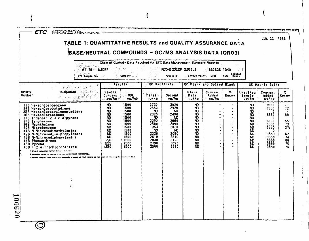
H*O0
' ETC TcSTlNQ tnctITALCERT If 1C AT ION
JUL 22. 1986T^BLE 1: QUANT»TATIVE RESULTS and QUALITY ASSURANCE DATA
(BASE/NEUTRAL COMPOUNDS - GC/MS ANALYSIS DATA (QROS)
NPDES CompdUtiNumber
338 Hexachlorobenzene348 Hexachlorobutadlene
Chain pf Custodv Data Required for ETC Data Management Summary Reports
M7178 i MJDEP hJJDHIGDISP SSOILS 8606261040 tZTC I«np)« MB. . Cawpiny : F»cllity 3«npl» Point 0*t* . TM» Mour»
35B Hexachlorocyclopentadlene368 Hexachloroethane378 Indenod ,2.3-c ,d)pyrene38B Isophorone398 Naphthalene40B Nitrobenzene4lB N-Nltrosodimethylamlne42B N-Nltrosodl-n-propylamlne438 N-Nltrosodlphenylamlne44B Phenanthrene45B Pyrene46B I ,2,4-Trlchlorobenzene
* • Clt tMt rt«MM1t« M1IM« Mtl«1lM Kail.
J 1 R*ct*lrr MrMllr v«n*l« w«t«if Mt*H0
"
roo
m» mtxMtinr-
Retultt
SampleConcen;
ug/kg
NONONONONONONONONONONO
156555
1350
MDLug/kg.
15001500150015001500150015001500150015001500150015001500
QC Replicate
Firituo/kg
27302550
NO2320
NO22902580
963NO
22202610283027902500
Secondug/kg
30202920
NO2490
NO266028902030
NO20902810312030902810
QC Blank and Spiked Blank
BlankDataug/kg
NONONONONONONONONONONONONONO
Concen,Addedug/kfi
.-_
_•
™
~
--
x.Recov
.-••
—
_~
—--
QC Matrix Spike
UntplkedSample
ug/kg
NONONONONONONONONONONONONONO
Concen .Addedug/kg
35503550
03550
0355035503550
035503550355035503550
XRecov
7772
66
657327,
6274807970
l.f' lj
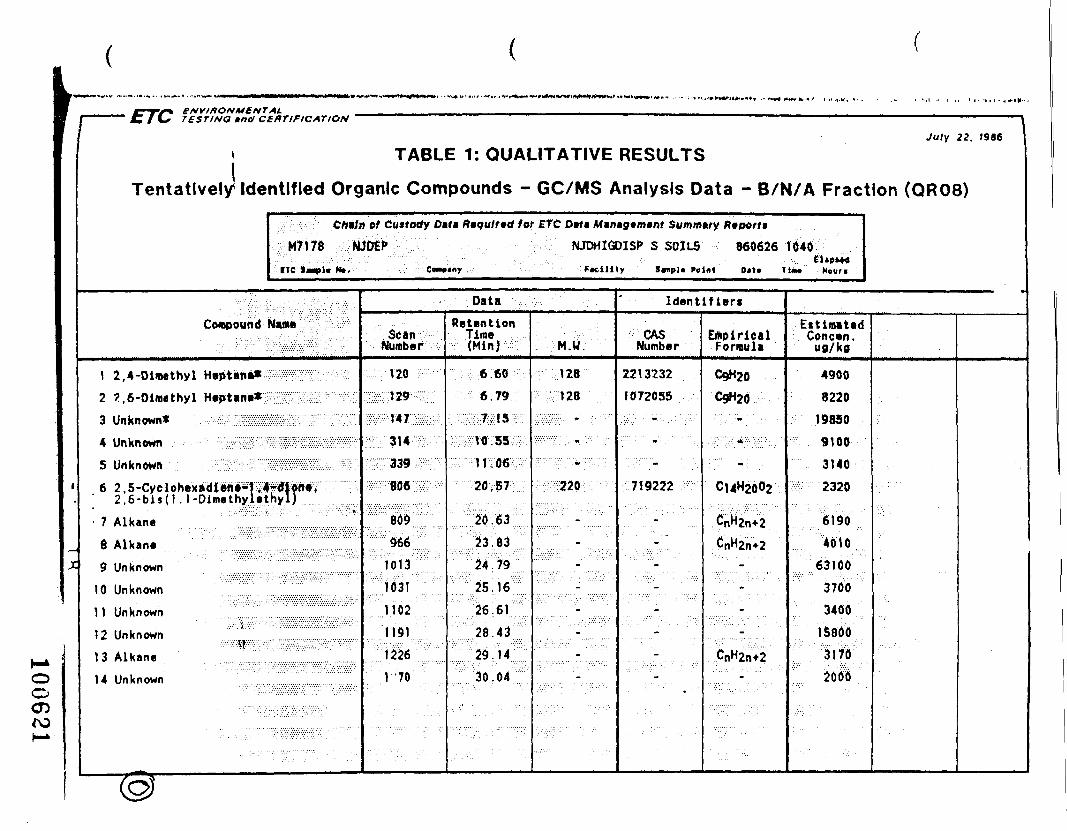
1
JC
•"" """•£/(., TESTING »na CERTIFICATION ' """ ' ' , ,. . „ ., . ,
July 22. »9S6
• TABLE 1: QUALITATIVE RESULTS
Tentatively' Identified Organic Compounds - GC/MS Analysis Data - B/N/A Fraction (QR08)
Crtfln of Custody Dtta R*qulr»d for ETC Dut» Min*yem»nt Summitry Rfport$
lM7i78 NJOEf NJDHIGDISP S SOILS 860626 1040
ITC tmmflm Ht. cW««y . FlcHlly S«np]« Point 0»>« TiM Houri
Compound Name C -Z
I 2, 4 -Dimethyl Heptane*2 ?,6-Dlmethyl Heptane*:
3 Unknown* .. y^ZZlBi
4 Unknown - • -/H - iSilffi
5 Unknown.. :* • VT:';M?iW6 2 . 5-Cye lohexadlene-f >4^f?i»*V i
2.6-b is (1 .l-Dimethy.lethyl)
• 7 Alkane
8 Alkane .' Z 1 .III.'9 Unknown
10 Unknown
1 1 Unknown ,. . '::.:,i:-:?:SS
12 Unknown• .?-::.'1:p:S:::'::::
13 Alkane
14 Unknown
. ................ • .
. • . . . , . .-• . . Data • ' : . ; ..'.;,. . ' " ' • ' . . .
ScanNumber
Vr: 120 ——— ;
:^29-w-ipvWi;S;K
^:^-809
;.;:: 966 ;;:;;;.1013
If" 31
S^w:.:
'. '.'..' J '70
RetentionTime(Min)
••;^:*:w^;-:€€'*• 79S;;-v3;.7^i5i:-.
20,57
::;:!:; S!:::;;.;;24:;79:v;..
25 J 6
26V61
... .. .
M.W.
128
• : ' : . :;::.:';.:1 28 •';.... :.:
;i' •>:-:.:: ' •' -::•• ':/
:22;;'::_
. • ' •"• ' •"-
. . ' . . . . . . ........
Identifiers
CASNumber
2213232
1072035
.,..: • • • - • , . . : • ; . . •
719222
Z:-:- :
-
-
EmpiricalFormula
C9H20
CgH20
• . - • . : • • - . ' , : •
C14H2002
'•M^-
:|-k--:-
EitimatBdConcen.
u0/k0
4900
8220
19850
9100
3140
2320
6190
4010
6310037003400
15800
31702000o
o05
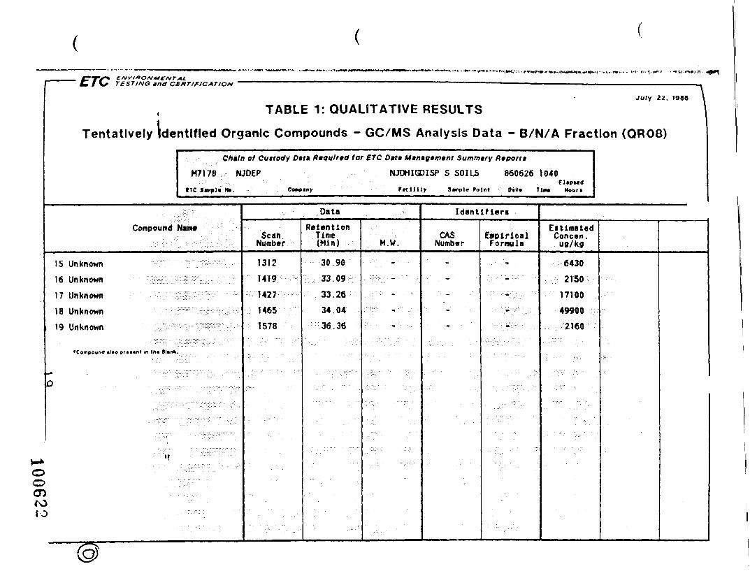
July 22. (986 \
, TABLE 1: QUALITATIVE RESULTS I
Tentatively Identified Organic Compounds - GC/MS Analysis Data - B/N/A Fraction (QR08)
C/>*/n of Custody Dtt» Riqulnd tor ETC Ditt Mtn»g»m»nt Summary Ftipon*
M7I78 NJDEP NJDHIGDISP S SOILS 8606261040
ITC Sample No. Conpiny FicHHy 3<mpl« Point 0(tt TlM Houri
Compound Nam
15 Unknown
16 Unknown ; •: •1 7 Unknown j r •18 Unknown >
19 Unknown S
• Compound Blto pr«t«nt in lh« Blank
O
"f
>>)}D
. . - • - . • •./.. •.-. • ;. • • . •• .
Data
ScanNumber
1312
1419
1427
1465
1578
RetentionTime(Min)
30.90
33.09
33.26
34;04
36.36
M.W.
: '•'..,• ' - ' -.,.:;-;,• _.•-,:• •:•
;/ - : > • - _ • • - • • •
. - : : ; ' , • ..
: • • ; . . . . ••:.-.' ..
Identifier!
CASNumber
-
-
• • • • - • • . -
' " . - • - •
' • . ' - • -
•
EmpiricalFormula
• . - • , : •
,:,•••;>::.:;:.-;;;• •
; , . : • • • - • • ; ; . • • • •
: •.•,-;-"•:... • • ;
; ; : • • : • -.; : : : : :v:.-.:
EitlmatadConcan.
ug/kg
6430
2150
17100
49900
2160
ooen

ENVIRONMENTAL• ' ' " C 1 \* TESTING undCERTIFICATION ' '" 1
JUL 29, 1986TABLE 1: QUANTITATIVE RESULTS and QUALITY ASSURANCE DATA\
\ Pesticide Compounds - GC Analysis Data (QR32)
; Chain of Custody Data Required for ETC Data M«rvsg«m«nt Summary Reports
M7170 MJDEP NJDHIODISP SSOILS 8606261040 1ITC I*npi« MB. Ccmptny Plcillty Sanplt Point D>t> Tim* Mouo
NPDES Compound . :•Number
IP Aldrin2P Alpha-BHC3P Beta-BHC4P Gamma -BHC5P Oelta-BHC6P Chlordana7P 4, 4 '-DOT8P 4. 4 '-DDE9P 4. 4 '-000
lOP DieldrinIIP Endosulfan I12P Endosulfan II13P Endosulfan sulfateUP Endrin15P Endrin aldehyde16P Heptachlor1 7P Heptachlor epoxide25P Toxaphene
Ratultt
SampleConcen.
"0/kfl
220NONONONONONONONONONONONONONONONONO
MDUug/kg.
5.22.62.62.69.3
295.2
102.6
139.4
106418305.2
34290
QC Repllcaia
Fintutf/kfl
6274597651NO78788062746946
108427070NO
Secondufl/kfl
5362526543NO586?7655636752
108456163NO
OC Blank and Spiked Blank
BlankDataufl/kfl
NONONONONONONONONONONONONONONONONONO
Concen .AddedUfl/kg
.--------------
-
XRecov
»--------------
-
QC Matrix Spike
UAtftikedSample
NONONONONONONONONONONONONONONONONONO
Concen.Added"fl/kfl
35.535.535.535.535.5
035.535.535.535.535.535.535.535 535 535.535 5
0
XRecov
175208167i\ 3145.
220221227174209194129303119
1'
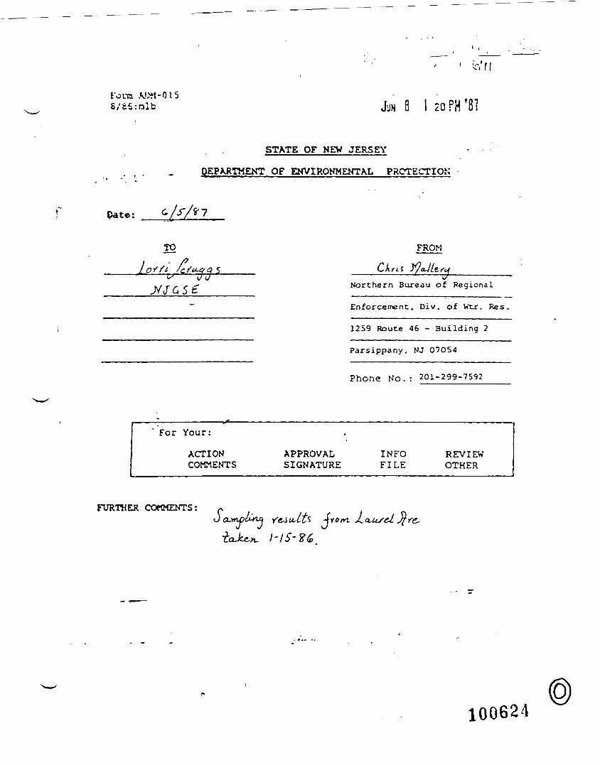
ft'/fFora A.OM-O.ISS/sS.-nlb 8 I 20 PH '8?
STATE OF NEW JERSEY
DEPARTMENT OF ENVIRONMENTAL PROTECTION
Pate:
TO FROM
QJ
Northern Bureau of Regional
Enforcement, Div. of Wtr. Res.
1259 Route 46 - Building 2
Parsippany, NJ 07054
Phone No . : 201-299-7592
For Your:
ACTIONCOMMENTS
•
APPROVALSIGNATURE
INFOFILE
REVIEWOTHER
FURTHER COMMENTS:Sc -(rorn
100624

tm __ruxstrmo*nrn
D*p»rtmtni of En»"onm«nt»i fiDivnton o' Wn»r Rnourc
WATER ANALYSIS
B A C T
DATE
U/tfftiV 7^UAS fti SISTATION IDEN Yi. MO. DAY HOIR
s c , «
HELD ANALYSIS
D watrr Txnp °C
O O.O.-Winkltr
Oo.O.-ProtM
D PM (F.,ia)
Z3 &>mpi« O«pin-H
O a*«* i-ttignf ft.
{"~| Sp*«. Cono.
D S»imity '/^O
O TK>» Slif*
UACTCUOLOCICAL •r-»ejl ConformTotJl Conform
Str*vrococd
10
>•
1
100.
p
MOO.
P
P
f
KIO.
V
I f
,
i
,
*
,
i
^
D1LLT1ONS (REQUESTED)
1
1
[~| urrj
/loo mi OMF
O f»c*J ttr»olMPts,
/1 00 ml
a Tat eatlUP* ..n oo mi
BIOCIINlTlA
SE
CONC.%
•oo
D BOO
HIL.
E
IMICD.O
O
- 1 - 210 10
• 1 - 2w to
•310
- 3M)
• 410
• 4
• 510
- 510
•610
•610
P3K1S.
P]
«
ALC
(*»vc
tXYGEN DEM)
s D NoC
D»-OAVD«-OAY
A.ND
SAMPLE
D
«!?;
ANALYSIS UNITS
^ V ri! ^&rr«£3uD *
fARAWETER VALUE I
CP:P
Pj
D LP<DnE &N/A£ns jSkiAzU-X IT ULD^ |-U.ou -<j\ VjJiTaJL*LJ 'JD
/"* _1 '5! ( xa CV^L/-U^ ap*\D '* **}J*D51 pJux-w<rta ^V^>DCDDDDaa
P.
P
P
P
P:pPipp
lifVL'* : '.t
prtt-fi
* 1
kJ.-
\ i1 ^
1
P:— (—p;ppppppppprfj
"-* ••*
*
-
,
. > te^
&4&i . iJ
,.4U
,
±
£
01.
*£
Wf- 1-M 1 -r . V — f.l1 • - -J \ I VJ v ' 1
. cV1— <
d^
&•
— •
|
n I$1 S
IIT \l..<* ——DATE
CHAIN OF CUSTODYF R O M (NAME) TO ( N A M E )
MAY I p
1(Wh.r»* W» Inventory Tnnv P«r t "» /P. r> h t W»i». O«.o..r
100625

rorm v f c l *MU8/79ruLAjt rm o« HUNTwrra BALLTOINT PEN
D*O*rtm«nt o< En«nronm«nl»l ProiDivision o* W«t«r Rriourcri
WATER ANALYSIS» A C T . L A 8 N O
DATE O E C - 0 .
STATlONIDE.NTinCATION NUMBER
s c , ! ! 1 c\\ \
FIELD ANALYSIS
D W«t«i T«mo °C PIO.
CD D.O.-WinKHf PJOO
O Sample Dvpin-ft. n,
Q C«9« M*i«M.ft. PtS.
O Salinity ' /CO P»IO,
CD Tia« Stl»e P702 1
BACTER10LC
Tolll COHIorrr
acjl(rtDiococcI
F.CJI COli r/ IOO mi L
GICAL-
10
10
Dfco-DMF
r-; F»tii SU.pt"— ' MPN
/ IOO ml
D Tot collMfTN
/ I O O m
1 ,
i
i
DILUTIONS (REQUESTED)
1
1
- i10
• 110
•210
- 210
-310
- 310
• 410
- 410
- 510
- 510
-610
-610
P) 1 1 1 ) ,
ft li 7
i
'•
PllSOf ,
BIOCHEMICAL CINITIAL O.O. (I«D
SEED VE
CONC.%
eoo
D BOD
)XYGEN DEM
sD *OL
DS-OAYO«-OAV
OiSA
_l
P318.PJ1J.
DMPL.E
ANALYSIS UNITS
DndDDd1
ppp
1
PARAMETER
1
i1
1J
* ! *
VALLE RH
tic A*="J
• &T(t£eXi ,i !
P \ } f: ,
P, : 1P!p;
n PaffiV^^^^^^W^ ;/ '
pp
1
a ,,- 'wy.lfy P; ;DDDd-nnDnDDDDDa
p
ppipppippPIpiPI~ T '—
P
P i
i
,
!
^
,
[ %
i
l
Ii
f
^
i
1_^
l
i
i1
— r—
i
t
t-1i
!
1
1
1
1
1
i
|
1
tI
,
!
DATECHAJNOFCtSTOD*
FROM (NAME)r£t !J
MAY 1 y wr
ln*tnio»v COD* 3 ( P . n k ) r R<?iourcti
10062G
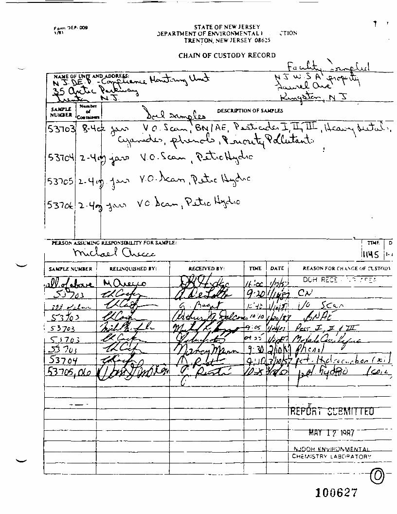
Form OEP- 0091/81
STATE OF NEW J E R S E YDEPARTMENT OF ENVIRONMENTAL > . JT10N
TRENTON NEW JERSEY 08625
CHAIN OF CUSTODY RECORD
100627
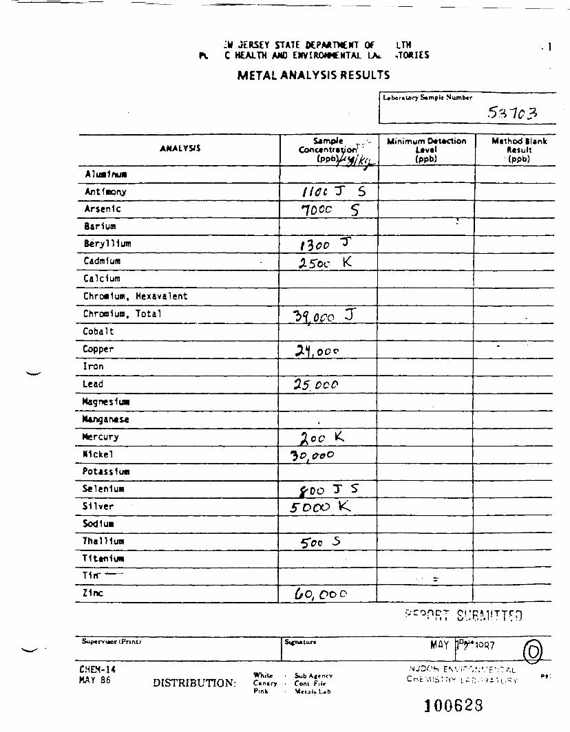
:« JERSEY STATE DEPARTMENT Of LTHC HEALTH AM) ENVIRONMENTAL LV
- 1
METAL ANALYSIS RESULTS
Laboratory Sample Number
53-703
ANALYSIS
Aluminum
Ant1mor\y
ArsenicBarium
Beryllium
Cadmium
Calcium
Chromium, HexavalentChromium, Total
CobaltCopper
Iron
LeadMagnesium
Hangar* s«Mercury
Nickel
Potassium
SeleniumSilverSodiumThallium
T1t«n1uw
T1rr ——
Z1nc
Sample ,,, .•-Concentration' '
fovwy/frL.L j
lice T Slocc S
tloc TA5oc K
"b^cco 3
aiooo55. oco
,Kc £
30,0-00
f> oo T S5"opo K
5*oo 5
6o; oo D
Minimum D«t*KtionLivtl(ppb)
•
- - - r
Mcthod BlankResult(ppb)
.
•
Supervisor (Print)
CHD4-14MAY 86 DISTRIBUTION:
s^ —— Mfly !Drioq7 |Q
NJOOh P\Yi~",.'.''.:F\": ALWhite - SubAjfncv Cr-f',S"|V , • -. v • 1 , - ,. P§:
C.n.ry . Com F,l* l-nc..,.s , ,tv L - .... <- H.-.tPink • Metal* L^b
100623

l i .B«w Jcricy D«p«rtMCQC of Hcclctt
Division of Public H««lth and Environmental Laboratories
LIBRARY SEA1CH USDLTS OP «0»TA1CETED COMPOUND PEAKSTENTATIVE IDENTIFICATION OP BASE-«UT»AL OETRACTABLE ORCANICS (CC/MS)
An r L fc N ^ -. k ft ft.
Uo. No. CAS Nd. C I T * F k.c r« I(tu CiT^
Si
a K e s c -
^ *> K. *
v/
(Z)
A H. bt
i , K«T
'? 10Q7
' ' ' ' ' ' ' : ' ' X T
- ft,
£K.i*, - VJ-6 ~7^————f
100629
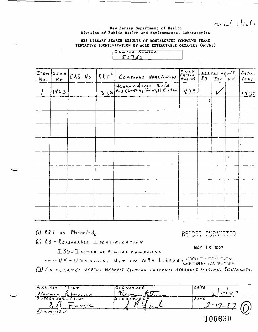
Mew Jersey Department of HealthDiviiion of Public Health and Environmental Laboratories
NBS LIBRARY SEARCH RESULTS OF UOrTARCETED COMPOUND PEAKSTENTATIVE IDENTIFICATION OF ACID 1XTIACTABLE ORCANICS (GC/MS)
:* l//^
.5 A.M r
5 -T Au>.
n ATC NA S S /•* S £ s r/ *j
CetJe.• 01 c
v/
CO . < : .
JL 5D - -L 5« T-l £ R. «t 5 i * \ > L « « «
UK- U N K N O W N , rJ . T
T/* N
IN N 6S L ft>s> x«
E"^« r /wC t\irti*r*L
MAY 1 ? 1007
0* t D
100630
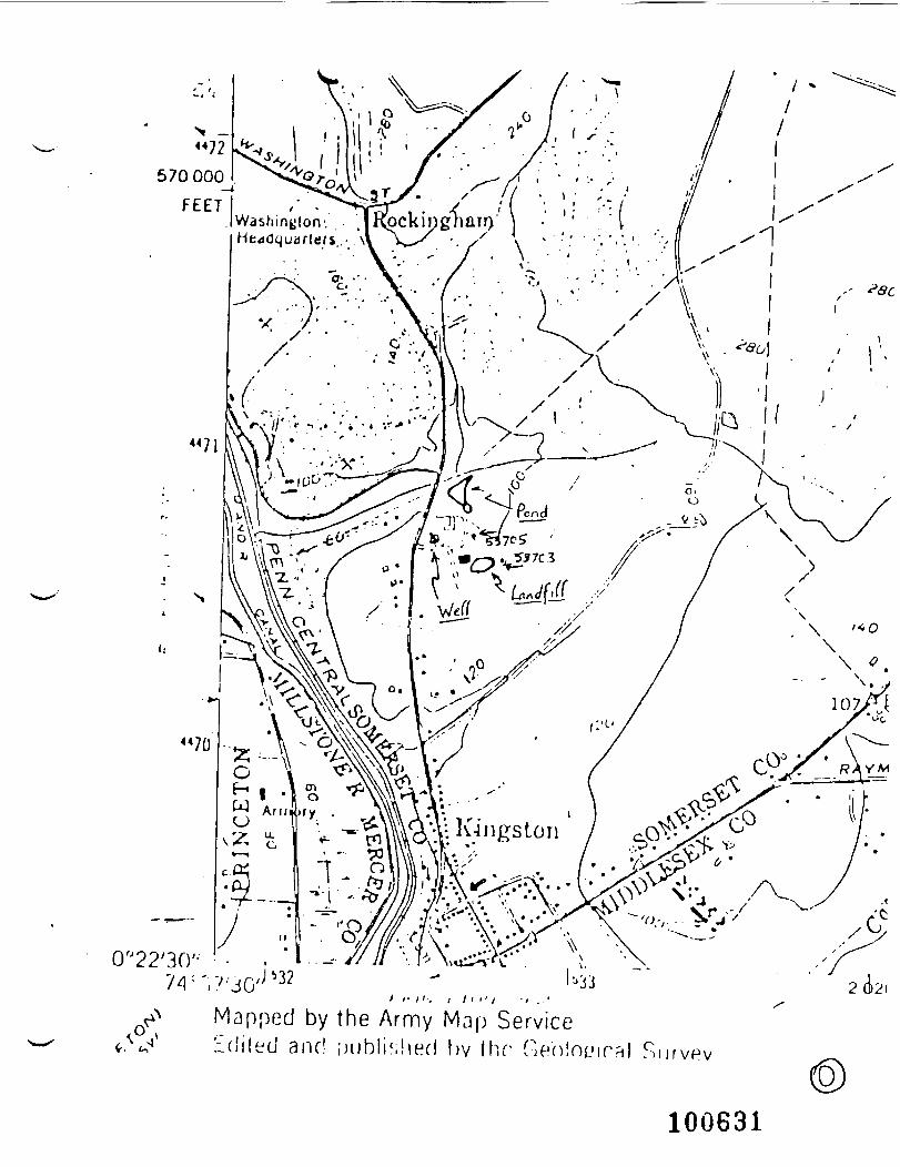
WashingtonHeadquarters
I f II; ; I l . '; •, . .
Mapped by the Army Map Servicefilled and uublishet! hv Ihr Gen!ru>ir?il f
100631
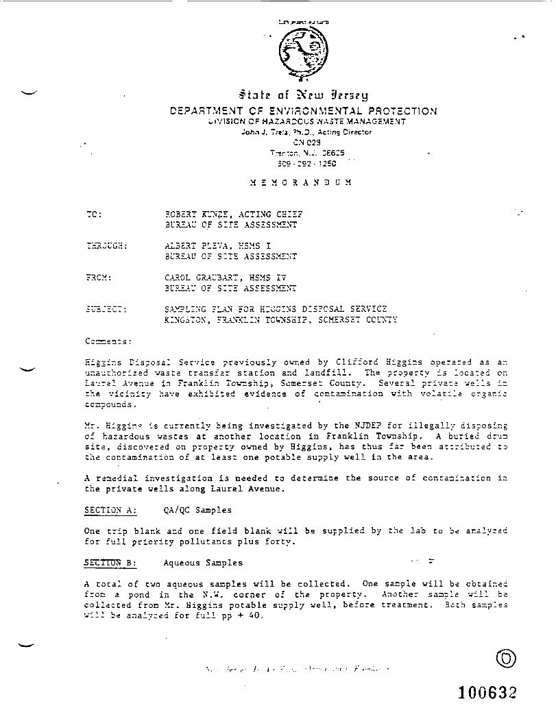
*tat? of ?5piii il^r^^yDEPARTMENT CF ENVIRONMENTAL PROTECTION
UV1SICN CF HAZARDOUS WASTE MANAGEMENTJohn J. Treia, "i.D.. Acting Director
CN 023Tr-r.t—. N.J. CESIS
=CS- :92 - 125C
M £ M 0 R A N D LT M
TC: ROBERT KUNZE, ACTING CHIEFBUREAU CF SITE ASSESSMENT
TS.~U.GH: ALBERT PLEVA, HSMS IBUREAU OF SITE ASSESSMENT
FRCM: CAROL GRAU3ART, HSMS 17BUREAU 0: SITE ASSESSMENT
SAMPLING PLAN FOR KIGGINS DISPOSAL SERVICEKINGSTON, FRANKLIN TOWNSHIP, SOMERSET COL"NTY
Cc:
Eiggir.s Disposal Service previously owr.ed by Clifford Higgins opera:sd as ar.ur.a-^chorizad vasta cransfar station and landfill. The property is located or.Laurel Avenue in Franklin Township, Somerset County. Several private veils i~the vicinity have exhibited evidence of contamination with volatile organicccspcunds.
Mr. Higgin= is currently being investigated by the NJDE? for illegally disposingof hazardous wastes at another location in Franklin Township. A buried crj-isite, discovered on property owned by Higgins, has thus far been attributed tothe contamination of at least one potable supply well in the area.
A remedial investigation is needed to detaraine the source of contamination ir.the private wells along Laurel Avenue.
SECTION A: QA/QC Samples
One trip blank and one field blank will be supplied by the lab to be ar.alyzadfor full priority pollutants plus forty.
5ETTTUS B: Aqueous Samples " " ^
A total of two aqueous samples will be collected. One sazple will be obtainedfrom a pond in the N.V. corner of the property. Another sample will bacollected fron Mr. Kiggins potable supply well, before treatment. Both sasplssvill be analyzed for full pp + 40.
100632
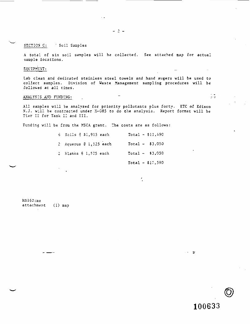
SECTION C; ' Soil Samples
A total of six soil samples will be collected. See attached map for actualsample locations.
EQUIPMENT;
Lab clean and dedicated stainless steel towels and hand augers will be used tocollect samples. Division of Waste Management sampling procedures will befollowed at all times.
ANALYSIS AND FUNDING; . ~ -
All samples will be analyzed for priority pollutants plus forty. ETC of EdisonM.J. will be contracted under X-C85 to do the analysis. Report format will beTier II for Task II and III.
Funding will be from the MSCA grant. The costs are as follows:
6 Soils <? 51,915 each Total - 511,490
2 Aqueous @ It525 each Total - $3,050
2 Blanks I? 1,525 each Total - $3,050
Total - 517,590
HS162:azattachment (1) mao
100633
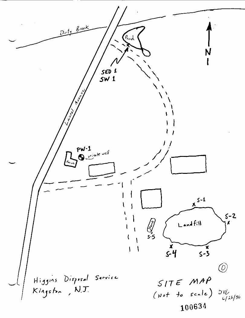
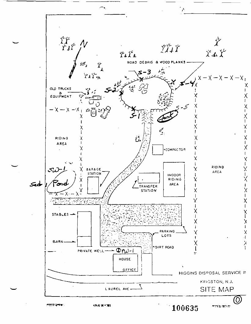
HIGGINS DIS°OSAL SERVICE It1
KINGSTON, N.J.
SITE MAP
100635
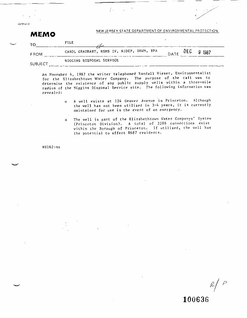
NEW JERSEY STATE DEPARTMENT OF ENVIRONMENTAL PROTECTIONMEMO ———TO __ ./- ___ ; ___________________
Ci'CAROL G R A U B A R T , HSMS IV, N J D E P , D H W M , BPA 0EC g
F ROM _ _ _ _ ___________ DATE ______ _HIGGINS DISPOSAL SERVICE
SUBJECT
An November 4, 1987 the writer telephoned Randall Vieser, Environmentalistfor the Elizabethtown Water Company. The purpose of the call was todetermine the existence of any public supply wells within a three-mileradius of the Higgins Disposal Service site. The following information wasrevealed :
o A well exists at 124 Grover Avenue in Princeton. Althoughthe well has not been utilized in 3-4 years, it is currentlymaintained for use in the event of an emergency.
o The well is part of the Elizabethtown Water Companys' System(Princeton Division). A total of 2286 connections existwithin the Borough of Princeton. If utilized, the well hasthe potential to affect 8687 residents.
HS162:mz
100636

y
!j^(jri^. >r:< ttmzfc-c•-,'M-^- -'-.WV/-1- :, te|4 >••=:.-, Hignts town Quad \-,,... . . , - . . M^^-M:
. •/* ' X- .-/ ;S1"-i,u j - •-•• ""-'~-'^r;!»^-:-,^.-r: .«. « ..-'•-"'.';••'. • "• ''> i'-t'-v\^V';\- ' '.-..••••v
•\ • • •'. ^ \ * • •. . t. •-'•' v\
••• ^"-- ;^:/--r'^'S"°r^'''^-<J '-—.-i-VTince'toh'' \
/ : :%r V v^^ \^•" • ' > ^--~^*-*^.^-^,'., •?>&> i:2»f £
•** " ^ •* • ' - . - £ -
o/ ' -4"-^. ^t Josephs "^^' <=s^ t_?Cj)-
\'^ '-r'— R^;O
TcStatt Fc-c«-i ,
Hjscc-a'^ '^ ''
100637
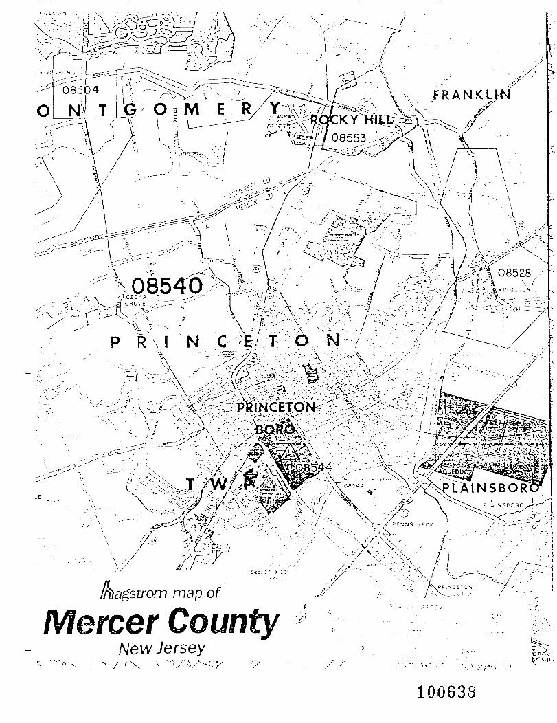
•-W>--< , ' , ' ~"~\\^:gNf%' ""^\f*'••.---.- -•?•-' ' ' ': '-:'- '''•\ V .'-••'•••' -.-. ; -'•''" '
* • " ' ^ -X -~
' ' • ' " ~~
•: x 23- /^H ' '""• ^ '/
foagstrom map of .&
Mercer County *& I **. m * f I S*\ Vf~* /~\\ /New Jersey(\ \ *~^:}/^ '/ /
100638
DEC 3 198?
Elizabethtown Water Company
November 18, 1987
NJDEP, CHWMBureau of Planning and Assessment65 Prospect StreetTrenton, NJ 08618Attention: Ms. Carol Garubart
Dear Ms. Garubart:
Enclosed are two copies of the well log for our Grover AvenueWell. The well location is approximately 124 Grover Avenue and islocated about 100 feet into the woods off of Grover Avenue.
Please feel free to contact me at (201) 654-1234, Extension 481 ifyou have any additional questions.
Very Truly Yours,
Rardall Vieser
mhEnclosure
100639
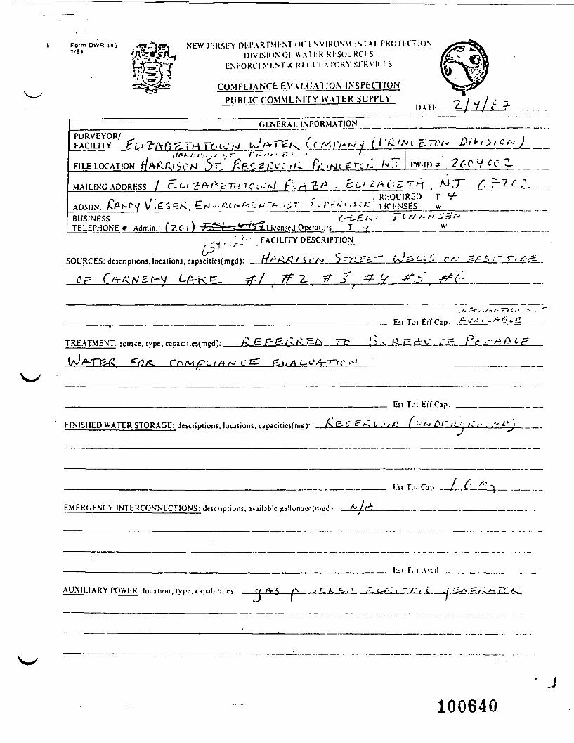
1 -faT DWR'ui • •13"v}STT» NEW JliRSUY DCI'ARTMI NT Ol I SVIKONMI.NT.AL PROITCTIONi\32£' rl DIVISION O l - W A T I :RR|-S(JLRCI:SWfw^ tM-'ORl I MI-.NTX Rl (,l I A W R Y SI'RVK IS4feH
COMPLIANCE EVALUATION INSPECTIONPUBLIC COMMUNITY WATER SUPPLY
DATI
GENERAL INFORMATIONPURVEYOR/FACILITY
FILE LOCATION . S 7 : ' ^ E o v ; ^ . A; ,N. grc/: /^T ..W-IP* . 2f-QMAILING ADDRESS / C.U-?*&S.Tt-tTCivt>J f't-AZA . g L- ' 2 /-V 0 E. T"H . Ao .' J~
" ' " " " " ; RhOLMREI) T V -.ADMIN. AcANpy V . E s EK. E/^ - • -c ^ g >>•• ^ »-> .•; •' - *> ^ _/; ?• '•'* * _• _*_<•• /: LICENSES w
~BUSINESS i . f f t t-i-£.'« •J 'j~c r/ * 'J - ''"TELEPHONE ? Admin.: TZC i ) ^^SJ=S^33SL;>:cnseJO[xtjiors. . T -( ________—— ._W——
^. •.' ~*,-: FACILITY DESCRIPTION- .... - ——.—————————————
SOURCES: descriptions, locations, capacities(mgd). nf^i^fH^Ct^ ^'r^EiL-^' i\;2-i-<-L. C^
Fsi Tot EffCap:
TREATMENT, source, type, capacitics(mgd): Av E.P&f-l£ tzf^——^_c———(^ v /•.^.^.rVv >" ^—( C , ^-/3 <• C^.
\rZ &i/AJ-<.'/4--r/r .-^
Est Tot EffCap:
FINISHED WATER STORAGE: descriptions, locations, capacities)^): . f\<=-5 s^ I >'v^—( *-:'" & C ti.<\ /sit . ,'"
EMERGENCY INTERCONNECTIONS: descnpiions. avajlable gjllonjccfnii;^ I
/ /" -.•_______ l\si Tui ("j;v _/._-i-_ '\_ .
_______ ._ ____..___ l-.ji I'ui AVJI) _. ._. ._ _..._
AUXILIARY PQWHR location, type, capabilities: '['*•< (^ -* C-J*-&-j± . /£- <-/-'t-7^1t..
J
100640
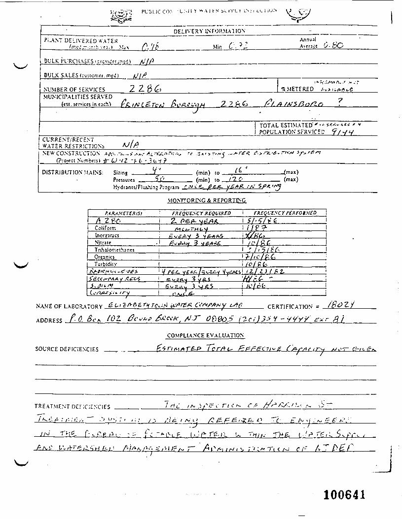
J.V-^--.; P U D L I C C O ' L . ' - i l Y v ^ A i h S b v . ( T L > LN;.
D E L I V E R Y INFORMATIONPI-ANT D E L I V E R E D A A T E H Annual
A\tntc U- pO
i BULK PURCHASES i:rcviJjr.T:d)
BULK SALES (;•--. i or.-, cr. mix')
NUMBER OF SERVICESMUNICIPALITIES SERVED
(cst. services in tacM r
tilt
22.6£; "4METFRED Av-niA^C
' " ' - / ' n ~ r / " * "?
\ pnpi;i ATION Srsvir^ <? / ^/ u! C U R R E N T / R E C E N T! WATER RfSTRiCTiONj NEW CONSTRUCTION AK-. .-/_.. > ,,A.-I (Project Nurr.bt:;;) jr f^ -/2 -J- £- -Jb
»f .-
DISTRIBUTION MAINS: V ''
Kydranis/FlLiihJns Program r
(min) to _(min) to _
'
It"tit-
v£.*#. /fJ SPA.'
(max)(muc)
MONTTOR1NC A REPORTING
FREQUENCY REQUIRED i FRSQl-E.^CY PERFOj.VEDA 2 V i 2~ SI'SColiform 1 At C A^ ~H L. :• / / P ?•InomrjcsNitrate .! £v-&i* 3 *j &*A£ 1 / u ' / f t f iTnhilorr.ethar.es iOrcar.icj i
i ': /'"5/>Y- Il?-/IL'-/P-t !
Turbidiu-i / z / ^ j / ^ z .
^B^_
NAME OF LABORATORY .JLt
ADDRESS A- <?. &-A /^^- ""'
CSr-<f#f- y L^ CERTIFICATION =
COMPLIANCE EVALUATION
SOURCE DEFiCiENCIES
T R E A T M E N T DC! ;c ;ENCICS /A. j
i.- VA/A/I/K-. j r / v t g / w r" Tt
J
100641
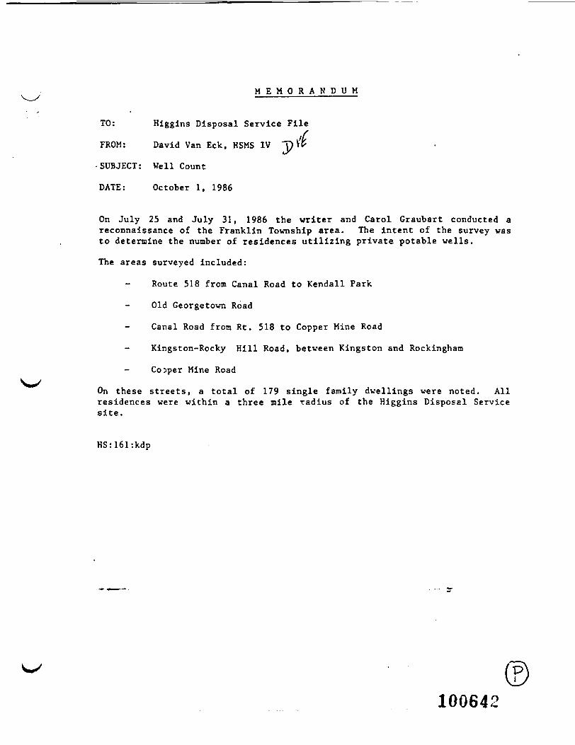
M E M O R A N D U M
TO: Higgins Disposal Service File
FROM: David Van Eck, HSMS IV ~p V'fr
•SUBJECT: Well Count
DATE: October 1, 1986
On July 25 and July 31, 1986 the writer and Carol Graubart conducted areconnaissance of the Franklin Township area. The intent of the survey wasto determine the number of residences utilizing private potable wells.
The areas surveyed included:
Route 518 from Canal Road to Kendall Park
- Old Georgetown Road
Canal Road from Rt. 518 to Copper Mine Road
Kingston-Rocky Hill Road, between Kingston and Rockinghaia
Cojper Mine Road
On these streets, a total of 179 single family dwellings were noted. Allresidences were within a three mile radius of the Higgins Disposal Servicesite.
HS:161:kdp
100642
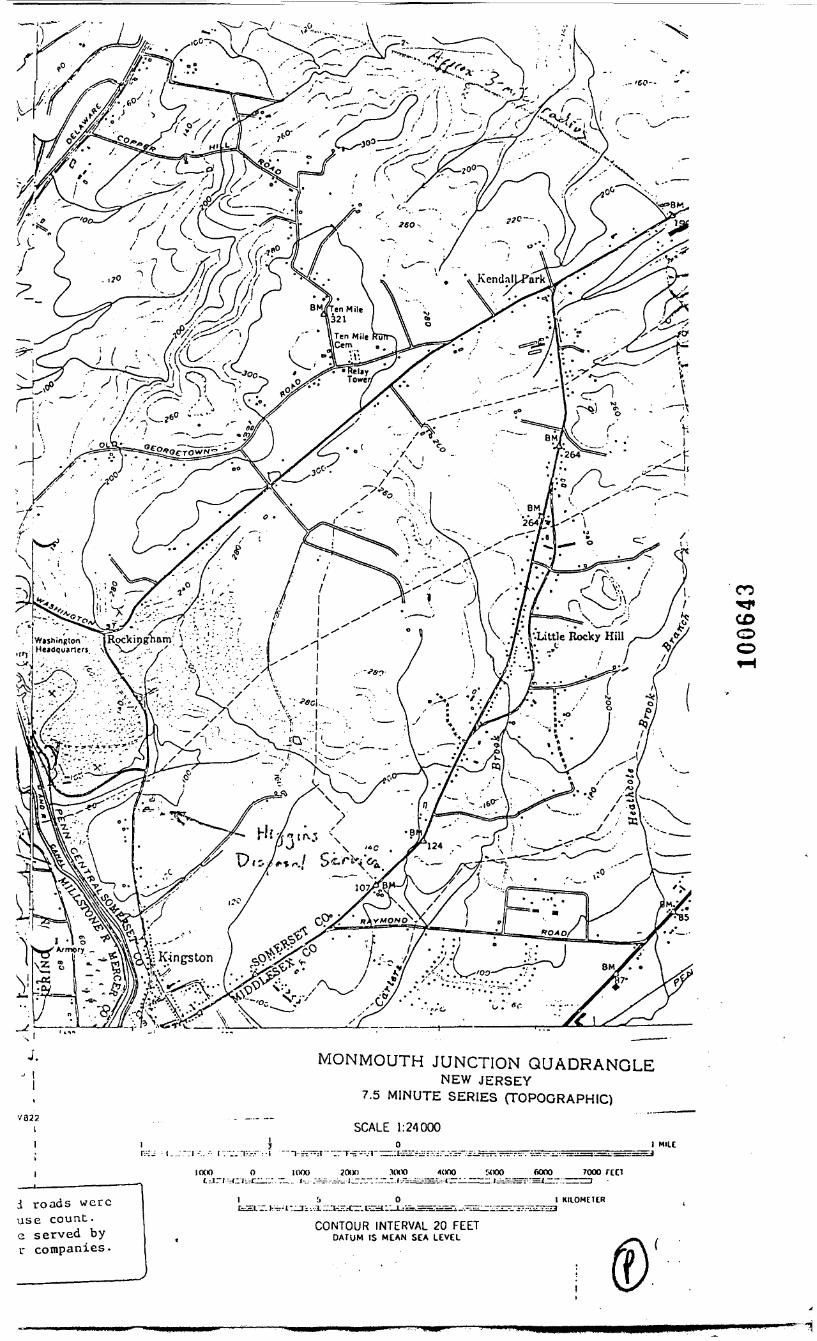
MONMOUTH JUNCTION QUADRANGLENEW JERSEY
7.5 MINUTE SERIES (TOPOGRAPHIC)V022
I SCALE 1:24000I MUC
••.T--.. •-• r: v-'i^:":-!
IOOO 0
i roads wereuse count,e served byr companies.
1000 2000 _ _ .nxx) lono _w»o
l _ 5 _ o __ _ _ _ __ _ __ i
CONTOUR INTERVAL 20 FEETDATUM IS MEAN SEA LEVEL
7000 red
KIIOMCHR
CO
CDOO
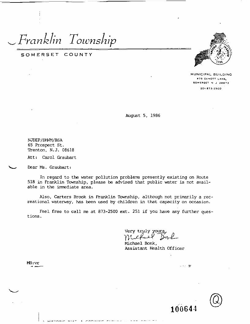
Fra n k li n Townsn ipS O M E R S E T C O U N T Y
MUNICIPAL BUILDING473 DtMOTT LANE.
SOMERSET N J O 8 8 7 3
2OI -873.Z5OO
August 5, 1986
NJDEP/DHWM/BSA65 Prospect St.Trenton, N.J. 08618Att: Carol Graubart
Dear Ms. Graubart:
In regard to the water pollution problems presently existing on Route518 in Franklin Township, please be advised that public water is not avail-able in the irrrrediate area.
Also, Carters Brook in Franklin Township, although not primarily a rec-reational waterway, has been used by children in that capacity on occasion.
Feel free to call me at 873-2500 ext. 251 if you have any further ques-tions .
Very truly yours
Michael Bonk,Assistant Health Officer
MB:vr
100641
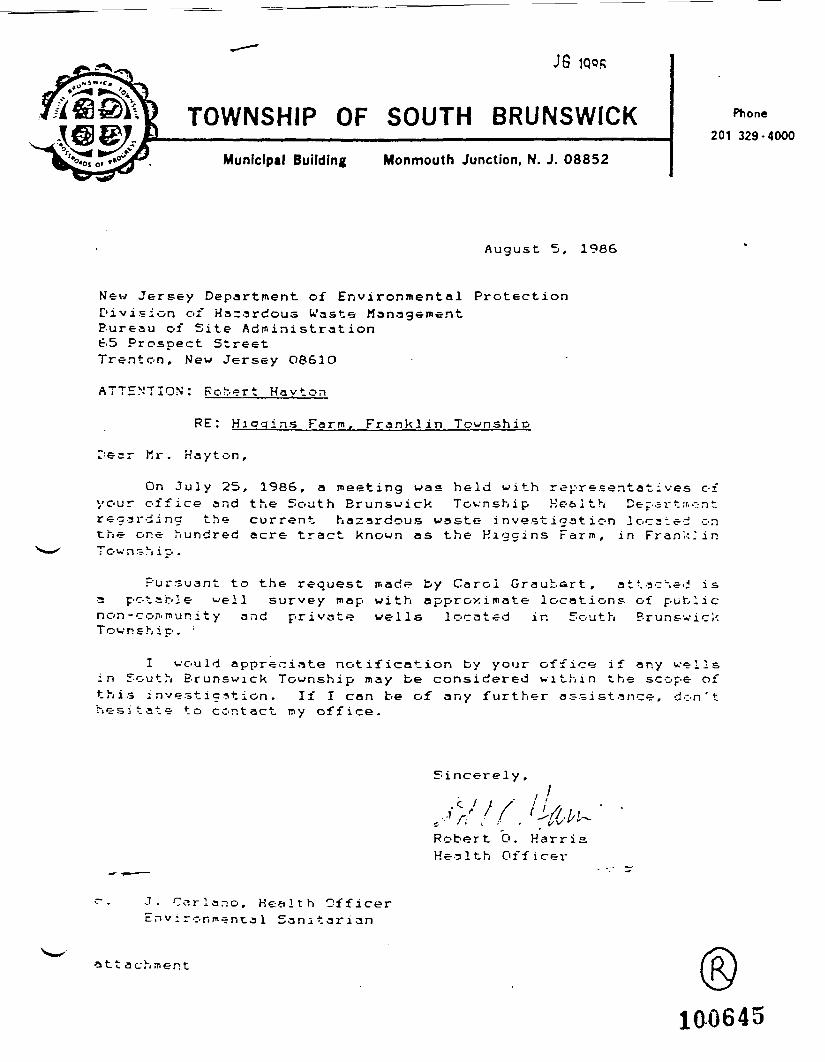
J6
TOWNSHIP OF SOUTH BRUNSWICKMunicipal Building Monmouth Junction, N. J. 08852
Phone201 329-4000
Augus t 5, 1986
New Jersey Department of Environmental ProtectionDivision of Hazardous U'aste ManagementBureau of Site Administration65 Prospect StreetTrenton, New Jersey O861O
ATTENTION': Robert Hayton
RE: Higgins Farm, Franklin Township
Dear Mr. Hayton,
On July 25, 1986, a meeting was held with representatives ofyour office and the South Brunswick Township Health Depart sr.^ntregarding the current hazardous waste investigation located onthe one hundred acre tract known as the Higgins Farm, in Frank.'in
Pursuant to the request made by Carol Graubart, attached isa potable well survey map with approximate locations of publicnon-community and private wells located in South BrunswickTownship. ;
I would appreciate notification by your office if any wellsin South Brunswick Township may be considered within the scope ofthis investigation. If I can be of any further assistance, don'thesitate to contact my office.
Sincerely,
Robert O. HarrisHealth Officer
J. Ccjrlano, Health OfficerEnvironmental Sanitarian
a 11 a c h ;ji e n t
100645
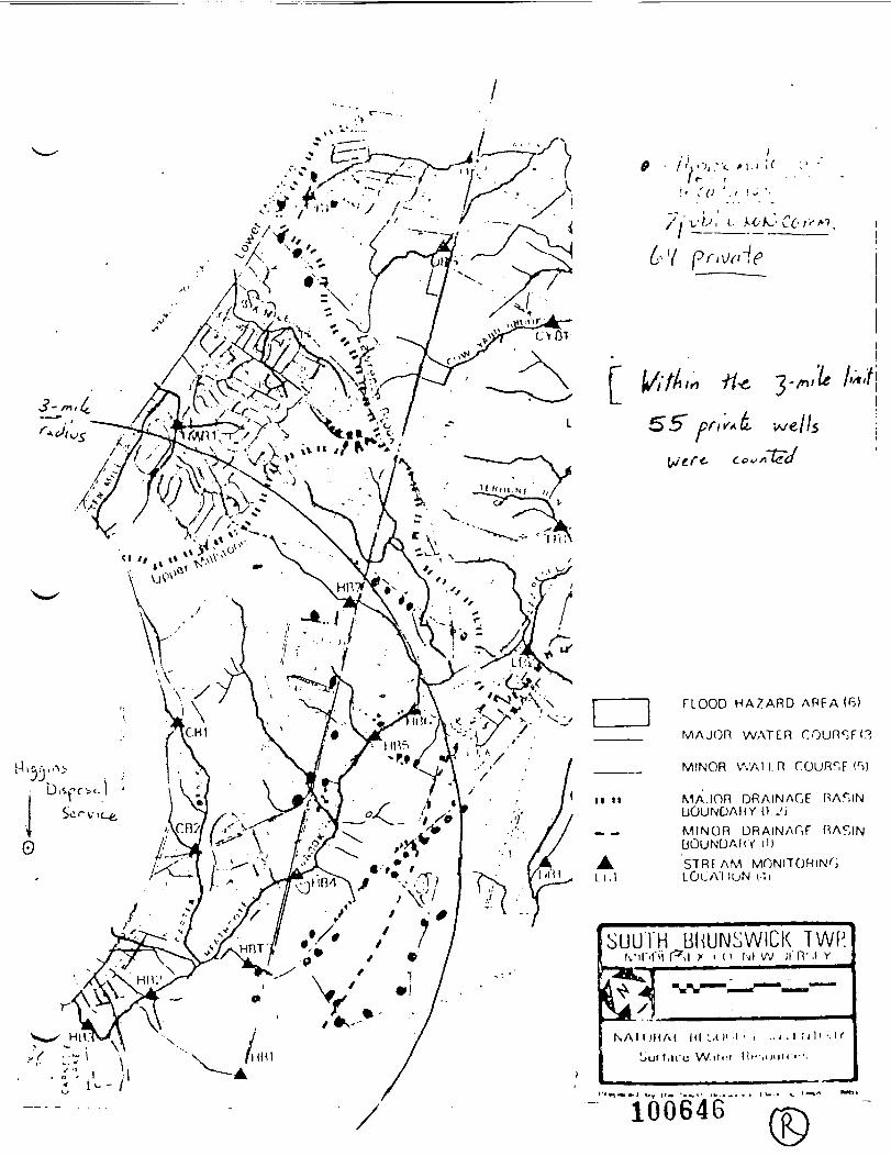
3 - mt(f_
r+tf{
r
II II
ALi.l
rV ";/."<.;»•'I f - - r
i • / (> J. i i -•
•e
CLOOD HAZARD ARFA (6)
MAJ(DR WATER COUR^FI.?
MINOR VVAl I. R r.OURr,F <r>)
MAJOR ORAINAGE RAr.INLlOUNDAHY O.JiMINOR ORAINAGF RAF.INUOUNDAKY H)STRFAM MONITORINGLOLA'1 luN i-'.i
iSUUiH BliUNSWlCK TWP.-infn r -.i x i 11 igi w j rn - . t Y
KAI UHAt HI Ul' ' ' ' ••' • I ; 'l' '•'
Liuf liico W.iin l l»-- . in in• '•• .
100646
SOURLAND MOUNTAIN GROUND WATER MANAGEMENT REPORT
ISr'*
I
IPrepared for
The N. w Jersey Department of Environmental Protection
Division of Water Resources
by the
Middlesex Somerset Mercer Resioral Study Council, Inc.
- an independent non-profit regionalplanning and research organization -
621 Alexander RoadPrinceton, NJ 08540
June, 1984
1C0647
- 19 - .
Argillite and diabase have practically no primary porosity. What little
ground water is contained in the formations is available only within the re-
latively few fractures and joints which tend to be widely spaced. Both form-
ations have been found to be among the worst in the entire state in terms of
ground water yield (Kasabach, 1966). Better yielding wells are invariably
associated with faults or with an overlying weathered zone. Most of the ground
water occurs under water-table (unconfined) conditions.
Although the Brunswick Shale has about the same primary porosity as the
Lockatong argillite, it is auch more fractured and therefore has a higher second-
ary porosity. Well yields in the shale can be expected to be higher en the aver-
age than wells drilled in the argillite and diabase. However, the Brunswick
Shale formation which extends from the Delaware River through Central New Jer-
sey to Bergen County and beyond into New York State varies in composition iron
southwest to northeast. The formation has more sandstone in the northeastern-——————————————,—
part of the state than in the area around the Sourlands; consequently, the
groundwater yield would tend to be higher in those portions which have more sar.c-
stone. The northern portion of the Brunswick Shale also benefits from glacial
deposits which act as a "sponge" and allow snore water to infiltrate into the
formation. Thus, the Brunswick Shale in the vicinity of the Sourlands is a
/\ worse aquifer than the same formation further north in the state.
The Stockton Sandstone formation is one of the better aquifers in the area. )
Both primary and secondary porosity are higher than in adjoining formations.
Ground water usually occurs under water-table conditions (Kasabach, 1966).
Since groundwater in all four formations (sandstone, shale, diabase and
argillite) occurs mostly in the void space of the fractured rock, well yields
100648
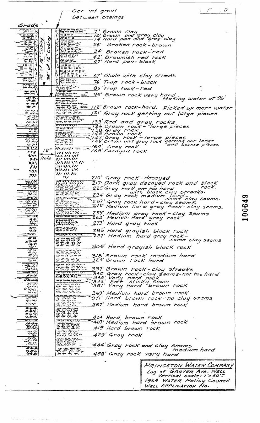
c&G/rrys
3TF >•
X*
V /O'.fi. arxT'qroy
47'
GroK<snred
pan- htacf<
'tlP^ 67'». A*/-^\v. •»/ '•//•«**./,/x. 76
uj'rfh day
\/ery
**A'^r w»~^~ i t *y ',•&. —_—• 112.
V*. x1//
'"-' "i /"x^wvvvs—————T-5.L'**>-~,.,~ ro<?K - ->/ara<s
\v.\Xxxc> isfx^C'xy/ / 4-3'G>f~oujr> ctncf gray rocX aiSf-t/n^ ot/f- largcr
OS /?,_^M. * • 4
,, , •Js-* ///f/^ Hole t)f
///•V\1//'V^V,//''//y o<
^ -Z/0' f^t~atj rocK- decayed'£/&'&'..' "2-17'.DarK gray d"<scay<sd rocK crnd b/acKmffi^Hf—- .225^rf-au t-oc.fi? ncrf- r'oo har-d ' ""—————————— ' blacK
*S"o/7^<y c/£7A/i\\ • ,:\.. _ — j^tf' O A-X— J . * . — - >U f »• _/ ^_ i_ _. , . _J _
•(••x^C-A ?& — Z5J' Medium tjrcfu rocK - <z/au Seamsarar Orcfif rocKry fo
grayish2.57' Medium hard qray roc.tf-
<5"f^^ W\<^
/// v\v ///\^v /// s\v» /// v\^\\\ Xx1/ \\\ /// xy\ /// V^ '/
2?/8( BrouJn
*£™'{~~ 33 7' <3rocun roc,K - c/ary sfrctyffz2>4O'^raty rock?- £/«•</ &<3crrm$- fjof-•34-5"' [^erU hard
I//I >f!SN 'x// ^ "^
.j -j ^^ ^'^ 3 ^' Medium hard broujn rack"^"3T/' Hard brouin roc^ — no day &<3ams
387' Medium hard broitjn roct/
\N\ xi-x \\\
<*•
roc.%' Medium hard broujn rocf<C
rock
S&arrrj£>
_4"Z9' <£ray rock
rock and
jOr58' f^ray rock y&ry hardhard
sccr/e : / '-Coorrcf/
A/o*
C5!f
COCDo
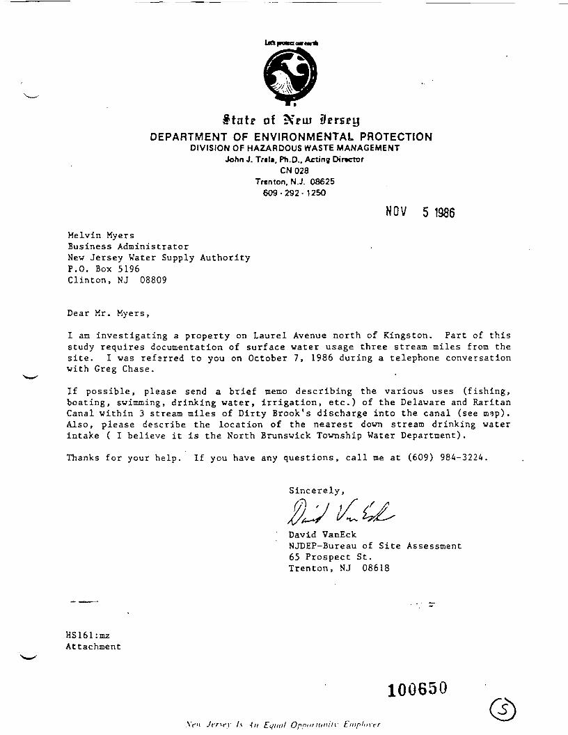
ilprseyDEPARTMENT OF ENVIRONMENTAL PROTECTION
DIVISION OF HAZARDOUS WASTE MANAGEMENTJohn J. Tr«l», Ph.D., Acting Director
CN028Trenton. N.J. 08625
609-292-1250
NOV 5 1986Melvin MyersBusiness AdministratorNew Jersey Water Supply AuthorityP.O. Box 5196Clinton, NJ 08809
Dear Mr. Myers,
I an investigating a property on Laurel Avenue north of Kingston. Part of thisstudy requires documentation of surface water usage three stream miles from thesite. I was refarred to you on October 7, 1986 during a telephone conversationwith Greg Chase.
If possible, please send a brief memo describing the various uses (fishing,boating, swimming, drinking water, irrigation, etc.) of the Delaware and RaritanCanal within 3 stream miles of Dirty Brook's discharge into the canal (see map).Also, please describe the location of the nearest down stream drinking waterintake ( I believe it is the North Brunswick Township Water Department).
Thanks for your help. If you have any questions, call me at (609) 984-3224.
Sincerely,
David VanEckNJDEP-Bureau of Site Assessment65 Prospect St.Trenton, NJ 08618
HS161:mzAttachment
AV't Jer\f\' l.\ in Eqiitil Oppuritiniiv Enip/mrr
100650Q)

\IEWARK 5EROCKY HILL,N.J.rRENTON ti''i t .-.-AS "ti T) i R.
100651SCALE : .MOOO

NEW JERSEY WATER SUPPLY AUTHORITY
P.O. BOX 5196 • CLINTON. N.J. 08809June • (201)638-6121
18, 1987
Mr. David Van EckN. J. Department of Environmental ProtectionDivision of Hazardous Waste ManagementBureau of Site Assessment65 Prospect StreetTrenton, N.J. 08618
Sub: Delaware and Raritan Canal Waterway Maintenance ProgramContinued Maintenance DredgingSediment Stockpile Site at Laurel AvenueFranklin Township, Somerset County
Dear Mr. Van Eck:
Your letter dated June 3, 1987 has been referred to me for response
Your belief that North Brunswick Township Water Department xs thenearest downstream drinking water intake is correct. This intake islocated at neuter Canal station 2242+08. Dirty Brook in the vicinity ofthe subject site is located at Reutter Canal Station 1916+00. Thedistance between the two Canal Stations is 32,608 feet approximately 6.18mi les .
With regard to other recreational uses, I suggest that you contactthe following agencies:
1. Delaware and Raritan Canal State ParkNew Jersey Division of Parks & ForestryP. 0. Box 8 - Canal RoadBelle Mead, New Jersey
Attn: Paul Stern, Park SuperintendentPhone: (201) 873-3050
2. Bureau of Freshwater FisheriesNew Jersey Division of Fish and GameP. 0. Box 394Lebanon, N.J. 08833
Attn: Robert W. Stewart, Senior BiologistPhone: (201) 236-2118
Very truly yours,
Ibrahim M. Shaikh,Supervising Environmental Engineer
sicc: M.
M.D.A.
J. Galley, NJWSA Chief Engr.H. Myers, NJWSA Bus. AdminisJ. Kroeck, NJWSA Div. Engr.G. Chase, NJWSA Div. O&M 100652 s

Form ADM-012
MEMO NEW JERSEY STATE DEPARTMENT OF ENVIRONMENTAL PROTECTIONHIGGINS DISPOSAL SERVICE FILE . <nn^
T0 _______________________________ DATE 1 B JW 1987• DAVID VAN ECK, HSMS IV, BUREAU OF PLANNING AND ASSESSMENT ^ .,-_^,x (, £
FROM ____________________________________-————————-———______________USES OF THE DELAWARE AND RARITAN CANAL
SUBJECT___________________________________—————___________________
On. 6/15/87, the writer spoke with Abe Shaikh of the New Jersey Water SupplyAuthority. He stated that although the Delaware and Raritan Canal is used forpotable purposes, there are no drinking water intakes within three (3) streammiles of Higgins Disposal Service.
The writer also spoke with Dorna Cooper of the Delaware and Raritan Canal StatePark concerning other uses of the canal. Ms. Cooper said the canal is used forfishing and boating. She added that people have also used the canal forswimming on occasion.
HS161:mzattachment: map
100653
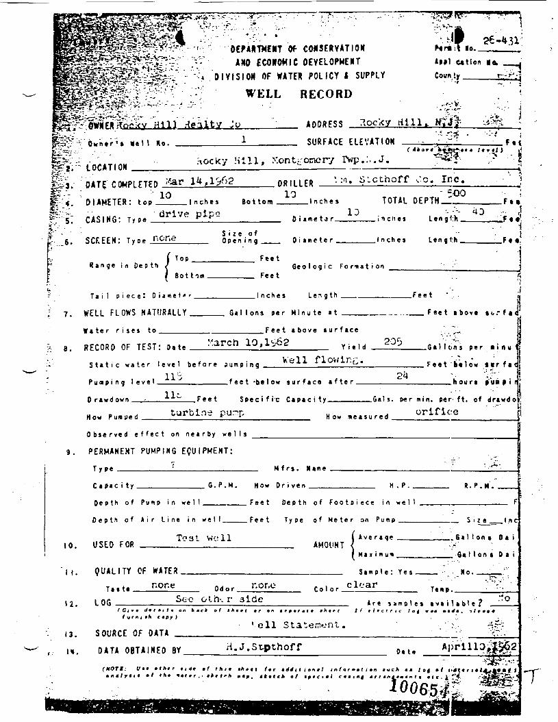
„__-,... DEPARTMENT Of CONSERVATIONtSSS^Sn -" -1V' AW ECONOMIC DEVELOPMENT
DIVIS ION OF WATER POLICY I SUPPLY
WELL RECORD
Nmlt lo.
«*-*3^?*.*-V- -.-: -: - - • - • • -t 3 tif -f • '*^£t*-*..-- .. -. .:7j£^f'*:^*Spr^< '-.->=^V*"—*- '^
cationCoun ty
..'-.•V,*r? •?"
ADDRESS 7>ocky Hi IK hfjj^I V-*jpV-1 Owif1* *•' t «»- 1 SURFACE ELEVATION
ItF- -- - >.T1AU Hocky Hill, Xontj-onery rwp.:..J.v*-f, "" LOC*'I°M _, .. , _ ————————— — - ———————
fe, n*TF r^PlfTFn Har 1 ,1'>££-"- -. ' 10W---4.- DIAMETER: top inches
1C ' •-?-v '•?. 6, -srF.FFNr T y o * none
( T O P• ' R a n g e i n D e p t h /• ^ Sot torn
Eb
; 7 WFI 1 Fl nW5 NATI IRA1I Y
W a t e r r i i e i t o
62 D R I I I F R • : n - S-cthoff10
Bot tom Inches TOTAL
10D i irni- t.» r i n c h e s
S i z e o fO p e n i n g D i a m e t e r I n c h e s
FeetG e o l o g i c F o r m a t i o n
Feet
1 nches l e n g t h
_ Ga 1 1 on* per M i n u t e at
Fee t a b o v e s u r f a c e
7 8 REcnun OF TFST- D.t* March 10,1^62 Y i ( > 1 r f 203
S t a t i c w a t e r l e v e l b e f o r e
P u ^ p i n 9 !< •«« ! J .
Dr*v<own f. . ^*-^ F e e t
HOM PU.ued turbin-3
O b s e r v e d e f f e c t o n n e a r b y
3 U m 0 i n , *ell flowlre.
f f « t -be low s u r ^ a c " a f t e r
S p e c i f i c C a p a c i t y , , ?» ' * - p*i-
*••"•••!' How m e a s u r e d
we l I s
• < -^-t . '-*'"~ ~ -ST * " »
,u-...^.,j-'!' • Ftl4*e'«j>iiJ?5:*" /•»»./) t•*•','- , • ' • I
vc. Inc. - • " "• 500 ;
DFPTH - F..
Length T • •'
LtnatK F««!
" ' •'' J
r?Fee t -•';.-. d
F e e t ibovt so.- f aci
-• * - . 1:.v. ^r"-- 1
Gal lon i per • t n u 1;-.r - - i
F e e t bt low »»r f a «;^" ' !
hour, ftia • i cjJ
min. per- ft. of d r a w d o '
orifice "~ [
9. PERMANENT PUMPING EQUIPMENT:
H f r s . Name•C«p»c i ty
De p th of Pump in we 1 1
D e p t h o f A i r L i n e i n
Teat,r, IISFD FOP
"I i. Q U A L I T Y CF WATER
12. lOf i Ste
1 ami lit c tfy )
-'. 13. SOURCE OF DATA
, u. D A T A O B T A I N E D BY
(MOTt: </«• »l*«r • , <tt
G . P . H . How D r i v e n H . P . * . P . II .
F«et D e p t h of F o o t p i ^ c * in * *11 . F
w e l l . F e e t T y p e of M e t e r on Pump , , .... $ i 7 e 1 n C
W'll ( A v e r a g e . . . . . . .Ga l lon* D i iAMflllHT /
^ M a x i m u m fia Mon t D a i
S i m p l e ; Y»» . _ .. '- - Ho- ,„..„""'
Odor r.Or.O C o l o r clc'ar T«IID. '-'•
oth,r 3lde 4re timol,. -B.n.ki.? "°
'ell Statement. .';:.. -•£;
H.J.Stpthoff ft . AprlllOjX$62V 4 V B - • ffi *^i *» ' 7
# ^ f A / • *A • t r /«r arfrf t t i on s 1 information Much • a J of # I* i»*f( * f i • 1^^ A* • rf >• «»ef/i »«^. « t « f c A of imtc i m I C 4 « i r t | « r r « n 4 r « « n r « * < c . 1; **^ ^^^^^^S'J%& ~T
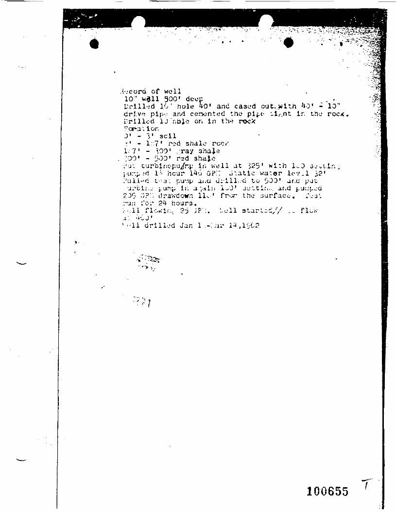
.i-jcord of well10" wail 300' deccUr ill-id 10' hole 40' and cased out, with '»0drJ.vr? pip-.- and cenonted the pipe- vi,-,nt ir.L'rillod 1J r;bjo on in the rock"cr-a; ior3' - 3' 3Cil-' - I::?' red shale? roc.-:1. 7 ' - ;,00' -ray sha}.e;00' - 500' rad shajc
i 'u-v turbinopu/r.p in well at 525' wi:h 1^0;-Li:'.p..'d 1 :- hcur l^o GP.:: J'.atic water lev.l1'ullrrc L-3 . nuTip aiiU ci:'lll..-G to t>00' ar.c p•j.vci:.j i.ur:p ir. a.v.iiii 1-0' j^tl:.., ar.d i-'J'''
^D1} ;}?:; drav.-cowr. 11. ' fr>^r iho
' -cn-j
.10"roc/<
52
1 ••!! drilled Jan 1 .-:.-ii'
starloc// .- flort
"'*'> --.•
100655
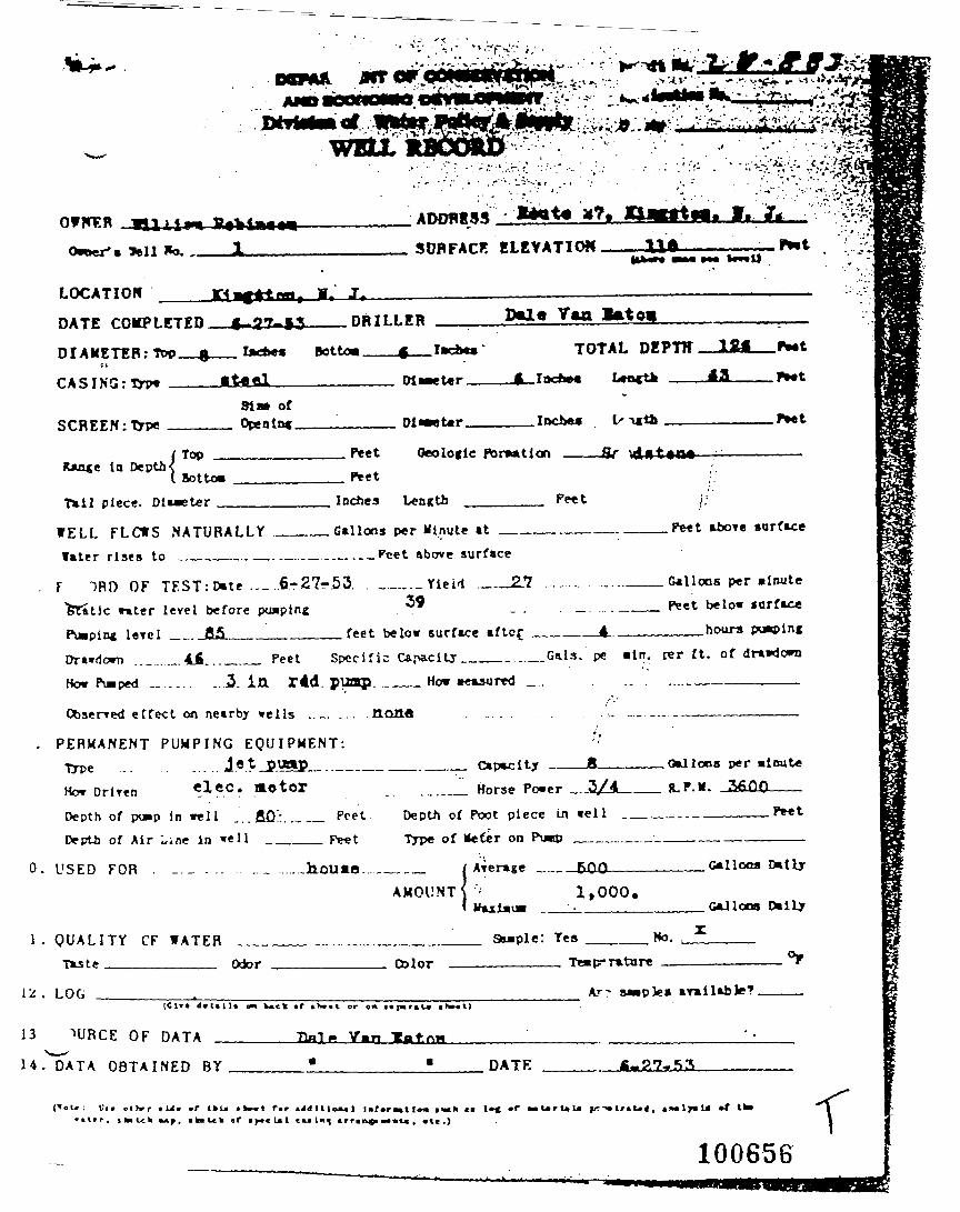
waxADOBtSS
"
B*«t«•&&
SOPFACF. ELEVATION f»*ti *M toMl)
LOCATION
DATE COMPLETED 4»27«i3———DRILLER ——
DIAMETER: Too__g__ !**•« Bottoa———f——I»dtl
CASING: Tnw ____liAfll——————————— Dli»et«r
TOTAL DEPTffJ3
SCREEN: TypeSIM orOpening. .Inches .P*et
in DepthTop Peet Oeoloclc Pon»tion ^dnt»o«Botto*
Tail piece. Diameter _ Inches Length Pe«t
.Gallons per Hinute at ——————————.WELL FLCWS NATURALLY __later rises to ...____.._.._..__.__.._Peet above surface
. F ~>Rn OF TEST: Date .._ ..6r-27-53. ____._Yie . ' l ._._i39
Peet above surface
feet below surface afte£ __.
>6tatSc water level before pu»pln_P__pin* level _. J55__________DT»«<1om .._....._. 44... _._ Peet Specific Capacity____..._Gals, pe Bin. rer ft. ofHo* Pulped „ . . _ . . ...2. in r4d. pUZKQ. ___ How measured _. .. . ...._____
Gallons per MinutePeet below surface___hours pwplng
Observed effect on nearby wells . . _ . . . . . .
. PERMANENT PUMPING EQUIPMENT:Type ... .....l«tj?«ffi._.._——Ho* Driven «1?.C? motorDepth of pwp in well ...fiQ:....._ PoetDepth of Air Line in wel l _____ [>et
0. USED FOR . _.- ... ..._ .....Jn.OU«ja..
none
_.__ Capacity .Gallons per minute
...._ Horse Power _._5/4_Depth of Foot piece in well _ _ — — L _ . _ —————— P*«tType of -leter on Pump ____._ _—————________
_ _ _ _ / Average __ 5QQ_________Galloca Dally
A M O U N T S 1,000.G-dlooa Daily
1 . Q U A L I T Y CF WATF.RTiste Odor Qllor
L-: . LOG
Sample : Yes Ho.TMip-Tatare ... °F
AT- sMpks arailable? ————
13 1URCE OF DATA Tin! * V»n -Ba*.--i '•
U. DATA ORTATNF.n BY * • DATE «.?,7*SS
: U» ,i>»r • U« «r tkU • W. t f.r• • l . r . italek »»f. itelck of > .< U1 tK ln^ arrtoif* m»al», •!«.)
10065S

COK3ERYATIOXDEVELOPMENT
OF WATER POLICY i SUPPLY
WELL R E C O R D
A D D R E S S
lo..e«t lon
Coun !y
SURFACE E L E V A T I O N( 41 k o r
F » t
?\ocky l i l l l , yontr;oncry
DATE COMPLETED :/Sar
' 10D I A M E T E R : t op _____ I n c h e s B o t t o m
D R I L L E R10
', :i. S'.cthoff I'.Q. Inc.
. I n c h e s TOTAL DEPTH- 500
r;; 5.*r '. '• '
C A S I N G : T y p edrive pipe
£-.,16. SCF.EEN: T y p e noneS i z e o fO p e n i n g
0 i ame t a r.
0 i an e te r .
ID. i n cn es Len g<:)i.
. I n c h e s Left g th .H. i
R a n g e i n D e p t hT o p
So t t o r n
F e e t
F e e tG e o I o g i c Fo r m a t i on
T a i l p i e c e ! D i a m e t e r .
WELL FLOWS NATURALLY.
. I n c h e s L e n g t h
G a l l o n s p e r M i n u t e » t
.Fee t • • / .
__ F e e t a bove ,,.!W a t e r r i s e s t o F e e t a b o v e s u r f a c e . " ~ 1
i/--,-^. i r\ 1 CKp ?0ri '••- '• '-.R f C n R f OF JFST: n. t« -.arcn u,i^^ Y i - , H ^j ft.]i;;ni B, r . : « u <
S t a t i c w a t e r l e v e l b e f o r e
Pu lp i ng 1 » v e 1
HO- p u « u e d turbins
o u m . i n g ^'H flOWipE. F.^V.law .., f.e
24 \- • '.' ' ,f *« t -be 'ow su r f» r» »M<?r . . .houri a y a a i n
S p e c i f i c C a p a c i t y G a l s , p* r min. p j f r - f t - n f drtwr|a
pur?n .. . orificet " 1 H o w m e a s u r e d
O b s e r v e d e f f e c t o n n e a r b y w e l l s
PERMANENT PUMPING EQUIPMENT:
T y p e ————————:—————————— H f r s . N a m e
C a p a c i t y G . P . M . H o w D r i v e n H . P. R . P . K .
D e p t h o f P u n p i n w e l l
D e p t h o f A i r L i n e i n w e l l _ _
To 31 we: 1110. USED FOR
F e e t D e p t h o f F o o t p i e c e i n w e l l
F e e t T y p K o f M e t e r on P u m p ___/
A v e r a g e _ _ _
F
._ S iz e.
AMOUNTMax i m urn
. . G a l l o n * 0 a i
_ 0«I I oni 0 a i
I |. Q U A L I T Y OF WATER. . S a m p l e : Y e s
12.
- '3-
•<: U.
T a t t e
LOG __
none Odor.. r.or.e Tenp . .Stc Gif t - - r aide
I u r n i
SOURCE OF D A T A
____________ A r e s a m p l e s a v a i l a b l e ?t y * f « j / t on b « e * of i h t r t or on tepmrtrt j n r « r . // t I t c t r i t tog • at m »4 m . t t r t
ell Statement .
D A T A O B T A I N E D BY H.J.Stpthoff Da te Apr l l lOyj
(HOT*: Vtt e f n r r i i ih • t I for i n /• o r • i f , on « u c A J o| > / ) > « ( » r i
10*0 6 57 S
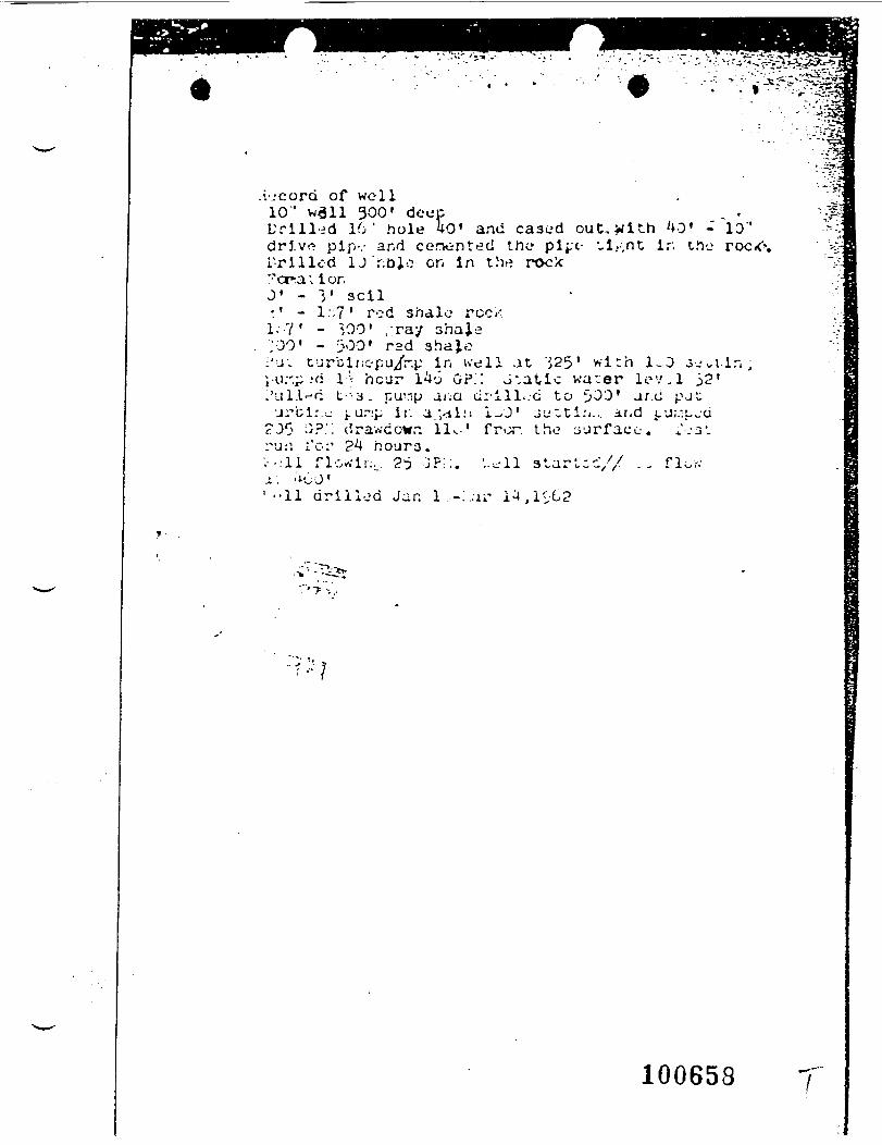
.vjcorti of well10" wail 300' deep , -Uri l l - fd 16' hole 40' and cased out,_wlth '»0' - ID"drj.ve pip-.- and cenonted the plj-c- t,i,.-,nt ir. the roci<\L'rilled 1J'r;bjo on in the rock"orra; ionJ1 - 3' sell'.' - I::?1 rod shale reck1.?' - ;,00' /ray shaje;00' - 300' rsd 3ha}.o
:'u; turbinc-pu/r.p in well at 'j25' w i t h 1-0 3-jutir. ,j-ii:'.^ --C l-:- hcur 1^6 GP.;: J 'at ic water lev.l 52'1'nl.l-fC t - ' - a : pur.p a/;Q ci:'ill..-G to 5>33' ar.o pJUj^bl:.:.- j. ur:p ii. av.iii! i-01 Ju^Ci.'i., and J,'J;.-.L_-U
?30 >'-p '^ drav.'ccwr. 11^-' fror therur, I'G:' 24 r.o-jra.•.-..•11 florin., ?i> :jp;:. \.^11 stara'. ;i'oJ'' • • 1 1 dr i l led Jan l..-:.;u' 1^,1S^2
100658
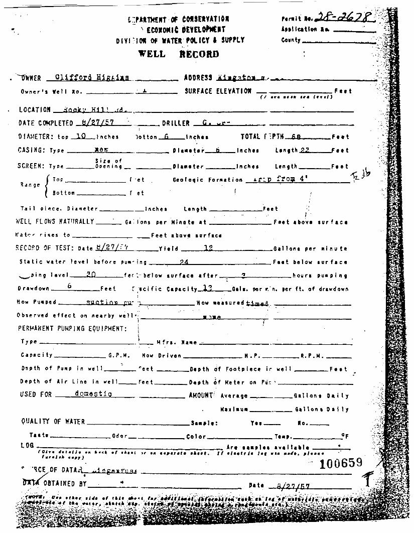
c:pAtTkErr of fer-lt ftt iI*
Clifford
ION Of WATER FOX I Of I SUFFLY
WELL RECORD
______ ADDRESS j_i
Conn ty
O w n e r ' s We 1 I No.
LOCATION _
SURFACE ELEVATION(/ «r« ••«• itt Itrtl)
F e e t
.</!.
DATE COMPLETED 6/27/57
DIAMETER: top _liL_l nches
CASING: Type ____
...___DRILLER G- ~r~
To t ton _______ I n en e s
D I a«eter
SCREEN: T y p e _____ O p e n i n g _ Dlare ter
TOTAL nPTH_£3_____Feet
. I n c h e s Length.22____Feet
. Inches Length______Feet
R a n g eTop
Sot torn
F -et
f et
G e o l o g i c Fo rma t i on -TIP frog 4*
(
Ta i l p i* !ce. D i a t e t e r .
WELL FLOWS NATURALLY.
K a t e - - r i s e s to_____
._I nches Length
G« i ons per K ino te at
.Feet
__Fee t above s u r f a c e
.Feet shove su r f ace
__Y le ld 13R E C O R D OF TEST: o.u b/27/;'V __
S t a t i c w a t e r l e v e l b e f o r e pun'ing_______24_______
s,_,»«ng level———2.Q_____fer'.-below su r face a f t e r
Drawdown———_!_____Feet f / i c i f i c Capacity_i2_
How Pumped_____-uct i n» pu- •-.___________How -easured flag j
O b s e r v e d e f f e c t on n e a r b y w e l l - ____________« i_^_________
PERMAKENT PUMPING EQUIPMENT: | '
Type___________________.!_
.Gal Ions per m i n u t e
Fee t b e l o w s u r f a c e
____hours p u n p i n g
Gait, per r.'n. per ft. of drawdown
C a p a c i ty. G . P . M .
O s p t h o f Pump in w e l l .
D e p t h o f A i r L i ne In we l l .
USED FOR donestio
•__. H f rs. Ma»e
How Dr i ven ___
r ee t ____
Feet____
H .P. . R . P . M .
. F e e t.Depth <>f F o o t p i e c e ir w e l l ____
Depth 6f Ke te r on P a r ' _______________
AMOUNT' Average _ _______ G a l l o n s D a i l y
Maxl-u- ________ Gal lons D a l l y
QUALITY OF WATER Yes Ho.Taste.
LOQ__, Odo r . .Color . Te«p..
(Olrm 1*tmilm fit h «c» *(fmralill e»fj)
Are aas ip les ava i l ab lelkt*t. // « / « « « r / « l»f »»•
" 'ICE .
IWM O
.OF
. ?!••• •
100659OBTAINED BY Pate r
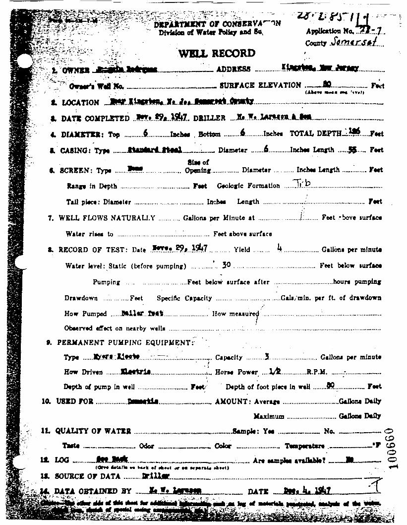
DMrfoo ofor COWWVA
Sa,
v ^t^OWNBR•"'•**.-•-.':•"
WELL RECORD., , ADDRESS -
— SURFACE ELEVATION . —— *. - <AWr« •»*••
— ..........
Own* W* Ka.' • • .
1 LOCATION .JR
I. DAT* COMPLSTED ;JHfo. •fc.Jflte. DRILLER ...Jfc..!». JMftm.lL.il*
4. DIAJOrTW: Top ..„.......$.......... ..Iach« , Bottom .........4.........Inche« TOTAL
I. CASING: Typ« .._._JU8*UnLJW«l __ .L..— DUm«t«r _.....fi............Ineh« L«nfth _ F»«tSiMof
«. SCREEN: Typt .......*•?. .... .. .......... Opentef............... Df»m«t«r ... ...... Inch** Ltn«th .._......... F«tt
In Depth ........................................ F»»t Geologic Formation ........ll..??................................._.....
Tail pl«c«: DJaaeter ...................................... Iflchee Length .......................,•.'...................._........... F«tt
7. WELL FLOWS NATURALLY ........... Gallona per Minute at ............ ........£........ Feet -bove lurfac*
Water rl»e* to ................................'....!.............. Feet above mrface
§. RECORD OF TEST: Date **&X..*9ji..&fl.......... Yield ......... k.................... Gallona per alnuta
Water level: Static (before pumping) ..........'.. 30 ............................................ Feet below lurfac*
Pumping ... .. . . . . . . . . . . . . ....Feet below iurface after ..................................hour* pumpdivf
Drawdown ... .......Feet Specific Capacity .................................Gali/mln. per ft of drawdown
................. How meuured' ..................................:........._......_..............
GaUoca per mlonte
How Pumped ......Mil«T. If*t.
OfaMrved effect on nearby welU
». PERMANENT PUMPING EQUIPMENT:
Typ* ...... fM.".Ilflrtt.......::.~:.....-......._......._. Capacity ..........5
How Driven ........Utlftrii.............................._„ Horn Power
Depth of pump In wtlJ ............................ Feet; Depth of foot piece In w«H ........JR................. Feet
10. U81D FOR ..................BMHt1i..............-...v..,..., AMOUNT: Averaft ..,........................_G*lJoM D*Uy
Maximum ............................ GeJka* D*fly
It QUALITY OF WATER ...........>...._.«._.».._....««.Jhunph: Ye« ....__._.._ No, —...————Ta*t4 .^.^.__.^_.. Odor ......_._~.~»-,-— Coior „,
UL LOO _.„.._
tt. SOURCE OF DATA ...........OriUM.
14. DATA OBTAINED BYu."**£•• *-. i . . --- -..
OCPCDOO
ifttfala IM^MM, <MJ
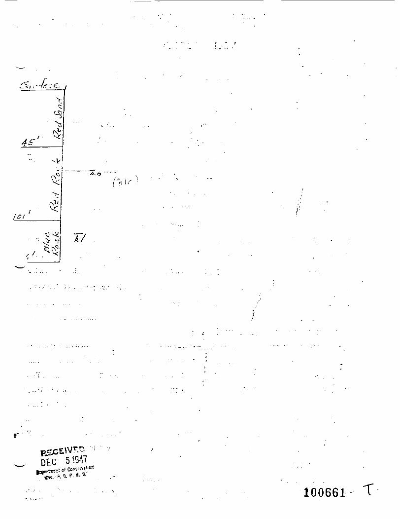
v
ICI
S 17
r'
DtC
100661
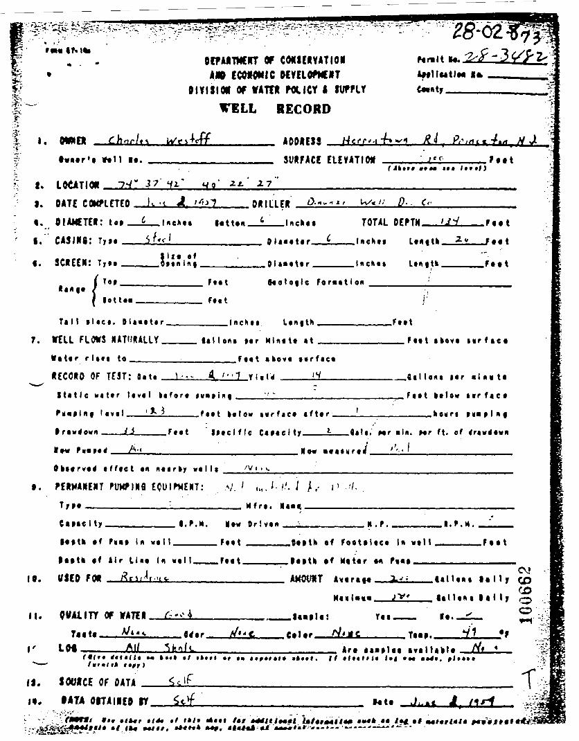
I ..•*•'
or COHSCIVATIOHA* CCOMMIC ftCVCLOf»CIIT
0IVI8IM Of WATT* POUCT I SVPFLf
TOLL RECORD
ADDRESS
iffllMtlM 10.
H Ji
tvnor'i tftll It. SURFACE ELEVATION•»*• • •* Itnl)
F o o t
I. LOtATION w o 17I. DATE COMPLETED
i. OIAMCTER: to*
I. CI5IM8: Ty io .
«. SCREEN: T,»._
. Inehot lotton.
DRILLER
TOTAL .Foot
Sl io of. d f o n I n f , , 0 l a«o to r , .Foot
tango( Too__
| lotto*
Ftot
Foit
toolofl le Foraat ion
Ta I I »l <co. D la«ot«r .
7. KLL FLOWS
•ator rlitt to
Lonf th
1*1 Ion* Mr Mlno to at
r
.Foot
__Foot akovo m r f a e c
Foot abovo t o r f a c o
OF TfST: Da to \ • • •
S t a t i c n a t o r l o v o l k o f o r o »M«» i« f
i v r f a c o a f t o r
. f lal Ions |or • !no to
F o o t lo tow nr f ac o
____hourt
I ravt fovn ——— Li . F o o t I f o c l f l e C « o « c i ty____L__fl«li. Mr «in. Mr ft. of Oawtfovn
____________________ Ko« • o a o y r o / ''•• '_______________
o f f o e t on no i rky w o l l * /V ' • v.
t. FERHAREJIT FUKF-IMfl ECUIrKEUT: .V.' i,,J-.'-'. •/ /.- i ' '/-
Tyoo————————————I__________ M f r o . «a««____________
Caiaelty__________l.f.M. No« Dr!von___;_________H.F. .l.r.M.
loot* of r«a» In v o l t . Foot
tootk of lir Lino In woll___Foot.
10. USED FOR flriJr.uc._____________
.Oooth of Foo to loeo In w o l l
JoatH tf Motor on fi«» __
. F o o t
ill !••» l o l l y
lal Ion • t a l l y
cv» -
If. CWAilTY OF VATER
Tar LM
foaolo: T o o .
CO
flrfor. , Co I or TOBO..4ro lanloo a v a l l a o l o
*>—' fwf»lit
f|. SOURCE OF DATA
i«. IATA OITAIIEO ITt »**
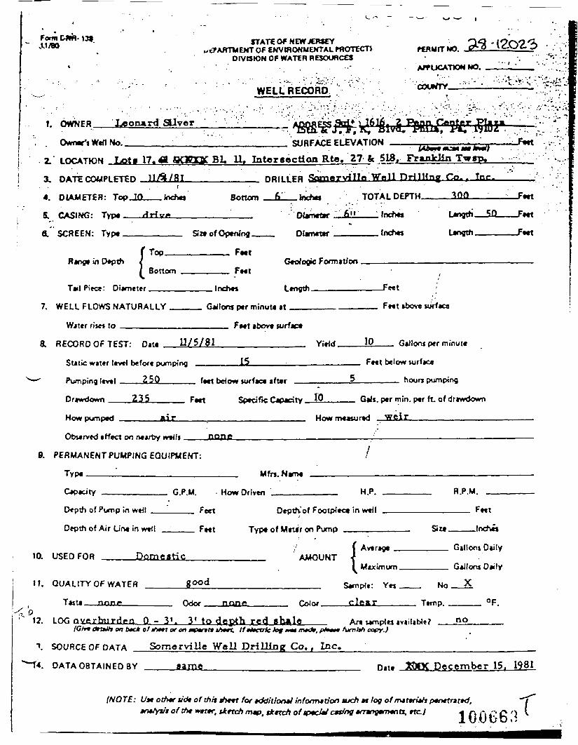
Form D*R-139OL1/BO STATE O* NEW JERSEY
sitARTWEWT OF ENVWONMEHTAL PROTECTlOIVtStON OF WATER RESOURCES
WELL RECORD
FERUITNO.
APPLICATION NO.
COUNTY. ': '
31-1202/3:*>-.• '•'•
1. OWNER Leonard alvcr
Owner'1 Wed No.. SURFACE ELEVATION
LOCATION Lot« 17. <l aOEQC Bl, 11, Intcraectioa Rte. 27 fc 518, Franklin Twrp»
3. DATE COMPLETED
4. DIAMETER: TopJU
SL CASING: Typ«__
6.' SCREEN: Type__
DRILLER «» Wall nulling Co.. Tnr.
lochej Bottom
Range in Depth !Size of Opening.
______ Feet
TOTAL DEPTH.
__Jnchej
300
Length.
BottomGeologic Formation
Tail Piece: Diameter. Inch** Ltnytti. -Fwt
7. WELL FLOWS NATURALLY
Wittr f ij« to _______
Gallons p«f minutt at
tbov* turfac*
RECORD OF TEST: Dm U/5/81 Yidd. 10
Fwt above iijrfaca
GaJloni per minute
Static water lev«4 belott pumping
Pumping l«v*l ___250____
Drawdown ___2i5_____ F«et
ft«l bdow turfaca after
Fr«t below vurface
______ hoorr pumping
Sped fie Capacity. 10
How pumped
__ Gals, per min. per ft. of driwdown
How measured weir____________
Obwrved «fleet on neartoy w*4ft JIQflC
9. PERMANENT PUMPING EQUIPMENT:
Type ————————————————— Mfn.Wame
12. LOG overburden Q - 31. 3* to depth red shale(Cfv* <*rtW» on twc* of ih»n or on «POT» iA*rt. If HH.U le lot MI mtd*.
An wmplw availabtt?furnish copy.)
no
SOURCE OF DATA Somorville Well DrilJing Co., Inc.
Fwt
-ftet
-Feet
Depth of Pump in
Depth of Air Une
10. USED FOR
weil
in wttl
Dom-
11. QUALITY OF WATER
T*,,. non.
Fe*t
eatic
good
(Vtnr n*>H'
Depth-'of FootpJe<
Type of Mrt*r on Pump
AMOUNT
e Me*
•^ in w»tl
1 Averaoc
1 Maximum
Sample: Yrj
clear
F^t
SIM , lnch*«
Gilloni Daily
Gillora Daily
Mo X
Ttmp, °F.
DATA OBTAINED BY name Date December 15. 1981
(NOTE: U* other tidt of thtt ift+rt for fddit/oruJ infofrrua'on tuch *t log of mtttrithpmrtnttd.»n*tyvt of ttM w*nr. tketch map. tkttch oftptcM c*dng »mnytm«na, rtc.) « /-. .-, -;. £> ')
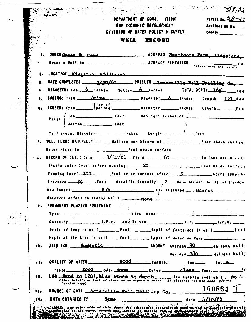
•^OCFAADfflTT Of CMS( IT I ON
CCMOMIC PCYELCfMCNT.OF VATTI POLICY I Stffftf
WELL iECOHD
ADDRESSf lwuar'a INK I*. SURFACE ELEYATI.ON Fa.
LOCATION ring i tan, MldrU«ia»I.
4.
I.
I.
DATE COHflEHO
DIAMETER: to-CMINI:
SCIfEl:
ro 1/30/61•'r ^Jl •"
» __ JD__Uckes lotton
DJ*!**lift efoaaiilnf
f t t l l l f f fM
6 l«*fc.«
0 (aba te r
Olaieter
A ttf '11^-^ ^^^^
TOTAL DE£ iHrtKf
_ .„ Inehci
T^M f 1 1 4
•TM lAl
L«n|tk_
Lenf tn
m^j » »^ r.*
— L21— /••
*..
lotto*
F a c t
Faat
F o r m a t i o n
7.Tal l p l tea. O l a a e t e r .
ITELL FLOWS HATUIULLY.
W a t e r r l iaa to_____
. Inchea Lenf th •'8aI Ieni per Mine to at
.Feet
— — F e e t akeve a v r f a c i
F«t t a k o v e a u r f a c e
s. RECORD OF TEST: Sate lallent par •!n « t<
F a a t ba lew air fae <
____.koura
S t a t i c w a t e r level ke fore puiplnf _____2Q______________
P««pl * f level_lQO______feet ke low a u r f a c e « f t « r g
Irawo'ewn———SO————Feet S p e c i f i c C a p a c I ty__i_2__«ala. per -in. Mr ft. of e 'rawrfow•/
lew P nape a"__________3nh______________.Mow •aaturid__
Oeaervee* e f f e c t on nea rky w a l l a
PERMAIEMT PVWII9
T y p e —————————
Capac l ty ______
Mfr t . Nave
________I.P.M. Mowf Driven____________».?.______
leptk ef Pme la we l l——————Feet——————Oept fc of Foo tp lece In w e l l
• eptk ef Air L ine In well___Feet______Oeptk of Mtter M •••»
USED F« ———tafcttiifl____________ AMOtmT
F e e t
II.
If.
•I.if.
food .Saaplei Yea——— le.a1*a* Te«»,__
l a l l |
•M
_____«|
/a/*/** «MT)
fOtftCE OF DATA _IATA
11 rv»4
Art aaaplea aval lakle——DO *
100664
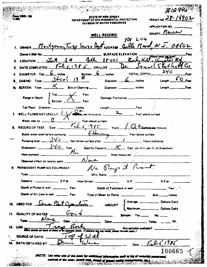
**
WVWOW Of WAT1R Ri»OUWC«lAPft«ATlO*l
In OvpthSottom
ic Formilion
loch«
7. WELL FLOWS NATURALLY
W««f rim to ___Q
p*f minut* it
Ft«t »bov« turfact
.Fwt ,'
Ft«t «bov« urfact
RECORD OF TEST: Dm Yt«ld. minuff
futic wrttf ltt«< btfort pumping _______
v«< ———t-i T ^ fret b«low wrfact ift»r
.. Put below
houn pumping
Ff«t Sptcific Captcity. G»Jf. per mm. p«r ft. of
How m«Mur*d
Obnind tH«ct on n«*rby w*4lt
•. PfRMANINTFXMMflNO EQUIPMENT:
Typ« ————————————————— Mfrt. N*rn«
G.P.M. HowDflvtn H.P. R.P.M.
of Pump in
0«p«t of AJr Un« in w»<t
Oplti of FootpMc* in
Typ« of M«i»r on F\jmp Si M.
ML UtfOFOR
If. OUAUTY Of WATf
SURFACf ILiVATrON
wt
;'|
f WiMCf Of DATA
f4. OATAOtTAINEOlY
^ ls

P«r»lt •Application
ow- ion of MTER POLICY *WELL RECORD
"UWNER Clifford ADDRESS
Owner ' j W e l l Ho. • J. SURFACE ELEYATIO*(/ trt ft,* itt Itrtl)
F e e t
LOCATION jtookv K i t *
DATE nOMPlFTFO 6/27/57
DIAMETER: top _1
CASING: Type _____ HE
_..___f)»mn> c. ~r~
I n c h e s lot ton _JL___ Inches
D i a m e t e rS i z e o f
SCREEN: T y p e ______ O p e n i n g _ D l a n e t e r
TOTAL nf»TH_&8_____F««t
. I nches Len|th.22____Feet
. Inches Length______Feet
R a n g eTop
Sot ton .
f et
r etGeologic Format ion AT1P frog 4*
I
Ta i I p i «ce. D i a m e t e r .
WELL FLOWS NATURALLY,
t fat? ' - r j « e s to______
Inches Len gth .FeetI
G« i ons per M l n a t e at
__ __Feet above sur face
___Yield ISRECORD OF TEST: f lat* B/27/fV _
S t a t i c w a t e r l e v e l b e f o r e pum'ing______2A______
<^s>ing level___iLQ_____fee'. beMow sur face a f te r
Drawdown___°_____Feet T s c i f i c Capacity_UL_
Feet a bove s u r f a c e
.Sal Ions per m i n u t e
F e e t be low s u r f a c e
____hours p u n p l n j
.Oali. per r.'n. §er ft. of d rawdown
How Pu«ped How m e a s u r e d
O b s e r v e d e f f e c t on nearby w e l l
PERMANENT PUMPING EQUIPMENT:
T y p e __________________
Capac i ty ________
H f rs . Naae
H .P.. .R .P .M.
. F e e t
________G.P.H. How Driven__________
D s p t h of Punp in we l l______Teet ______Depth of Foo tp iece ir w e l l
D e p t h of Air L ine In wel l___Feet_______Depth df Meter on Purr'________________
USED FOR donastlQ _________ AMOUNT' Average _^_______Gallons D a i l y
Max \murn
QUALITY OF WATER
Taste
1 09
Odor Cft lar
__ Are a a M B l e t
___ Sal 1 on a D a I 1 y
— Bo. ————
Teme,_________°F
fair* Jttfllm tit *«ct »f i t , , , I ,r „„fmraltti
«t t * f . // «/••(!•/• l»t »••
•;_•.-. f
,. >w^-: '.*/
10066)
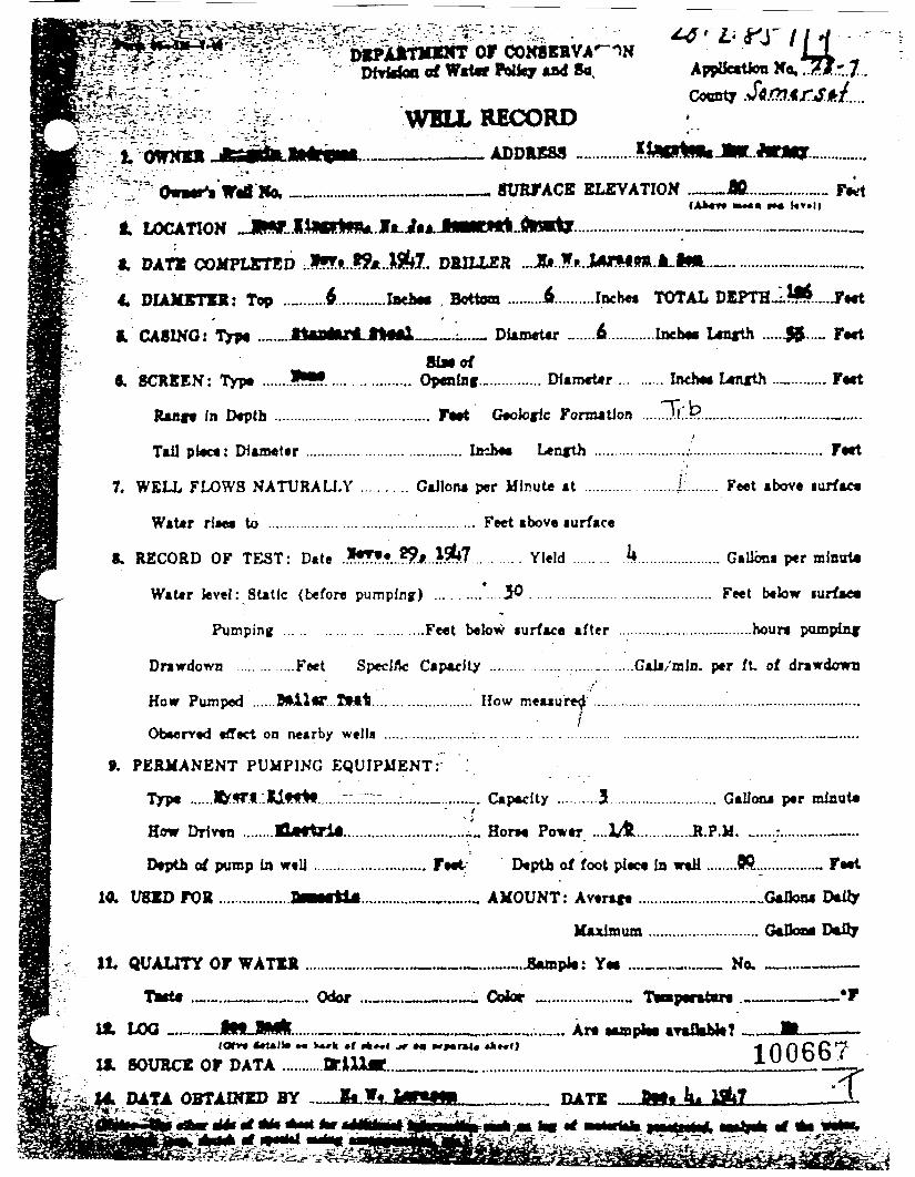
^-v-^-- - - • - - • " ;"%i,' . """"?••" DEPARTMINT OF CrC---.-:.. • ;-;';.' Dfvtofcn of W«t«r Wky and Appifcatfcm No,
Cocnty
i. OWNER
WBUL RECORD.____L_ ADDRESS ............
_._____ SURFACE ELEVATION . -M—
i. DATE COMPLETED ..*«*»...??A..M&7.. DRILLER ...JJjt..f.»..iMM»R.JLiia.«... ...........„......_..„.„.
4, DIAMETER: Top ..........A............Inch* , Bottom .........4.........Inche» TOTAL DEPTH-l $......F*«t
i. CASINO: Type .»._JtePt«ri.ltMl__.:..._ Diametar ... .6 ........,lncb«« Lnifth ......£$..... F*«tSiMof
«, SCREEN: Typt .......*•?..... ............ Opening................ Diam«t*r ... ...... Inch* Ltnfth .._......... F«t
Rant* In Depth ....................................... F«*t Gtotofk FonnatJon .....J.fi.l?.......................................i
Tail pl«c«: Diameter ...................................... Incb«« Length .......................,L............................... Fttt
7. WELL FLOWS NATURALI.Y ........... GaJlona per Minute at ............ ........£........ Feet above lurfaet
WaUr rf«« to .................. ............................. Feet above surface
8. RECORD OF TEST: Date .Iff».«..??f...l5?*7 . . . . . . . . . Yield ......... J*..................... GalJona per mlnota
Water level: Static (before pumpbig) ..........'. Jfl ............................................ F*et below iurf»e«
Pumping ... . . . . . . . . . . . . . . . . . ....Fe«t beksw iurface af ter .................................hour* pompinf
Drawdown ....'.. ... ....Feet Specific Capacity ......... ........ ................Gala/rain, per ft of drawdown
How Pumped ......B&ilMT...XMt........................ How meuure^ .............................;........._......................,•Obeerved effect on nearby wella ........................ .. ..... . ..:. . . . . . . . . . . . . ................................................—.....
9. PERMANENT PUMPING EQUIPMENT: :
Typa ......Ifcff.l.'.IjLtlrtf.......::..—:.....-..,...._.......,. Capacity ..........3........................... Gallona per minut«
How Drlvtn ........ELutrii..............................-^ Horn Power ....XA..............R.P.M. _.....;.......„...—..
Depth of pump In well ............................ F** Depth of foot pieca In waH ........Pft............... F»«l
10. USED FOR ..................BBMrti*...............-...,......... AMOUNT: Avtraft ............................ GafloM Dairy
Maximum ............................ GaDoaa Daily
It QUALITY OF WATER .................__._.„._._..._.Aunpk: Y« ...._......__ No, _...-———
TMt4 ,._.__.__.. Odor ...-._._._«..~ . Cotor _...................„ TafaparatBTt ...______—*F
ML LOO _......—JhHLJSMfc......—..—.._..————.—^._.——...._.,. Ar« aaaplaa araflab)*? ——B————CO*»« ArUlta •« w*»h •( A*«l jr *• MparM* »*»««) •* r\ f\ £> C ^
IX SOURCE OF DATA ...........arlU«.._..__............................................._..______lUUO^V
(|4 DATA OBTAINED BY -__Jfe.IU«5fflL_.____ DATE . Bttt ^ tfi7 "^"jfV-^ -*&!.. . - . . .

v
let
//. .
T/
100668
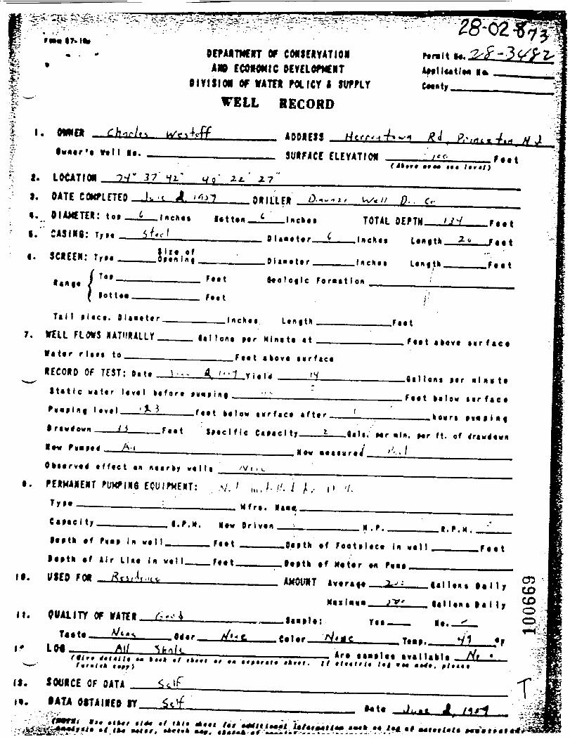
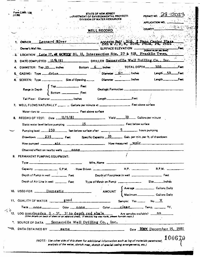
Fonnvt1/80
13$ STATE Of NEW JERSEY,&AKTWENT OF ENVIRONMENTAL PROTECT!
DIVISION OF WATEH RESOURCES
WELL RECORD
:v •'•'•AIT UCATTON NO.
'm.«frv - : v : ' • •••:••*:*;;.
1. OWNER Leonard SUver ^Owner'sWefl No.. SURFACE ELEVATION
Range in Depth !Top.
Bonom F^tGeologic Formation
T»l Piece: Diameter Inches Length Feet
7. WELL FLOWS NATURALLY
Water ri»« to _______
Colons per minute at Fwt »bove
Feet above surfaca
8. RECORD OF TEST: n,t. U/5/81 YWd. 10 G*llonj per minute
Sutic wjter level b«f<x* pumping
Pumping Itvel Z5Q_____
Drcwdown 235_____ F*rt
15
fwt briow iurf»c« iftcr
__ Feet below surface
_5_______ hour* pumping
10
How pomped
__ GWs. per min. pef ft. of driwdown
Howm*«tur»d weir______________
Oburvtd itfect on rvctrby wvtli .aonc9. PERMANENT PUMPING EQUIPMENT:
•T,
i 6*c* o/nWr or on Mpunre <A«rc //*M.t>k toy n<«m<c>>, pte«n hjmtth oopyj
"». SOURCE OF DATA Somerville Well Drilling Co. , Inc.
Ft«t
2. LOCATION Lota 17. A aQEOC Bl. 11. Intersection Rto. 27 fc 518. Franklin Twrp,
3. DATE COMPLETED uA/8J________ DRILLER fktTnQrvillo Wall Drilling Co.. Tnc.4. DIAMETER: Top_10__Inches Bottom __£L__inches TOTALDEPTH————Iflfl——_
SL CASING: Type ___driv£_____' Dlametw __&!]———1 Inches Length—Sfl———Feet
fi. SCREEN: Type ________ Sin of Opening ___ Diameter ——————Inches Length——————Feet
-Feet
NX
11.
>12.
njo*cirv
Depth of Pump in well
Depth of Air Line in well
USED FOR Dom<
QUALITY OF WATER
T««, non.
LOG overburden 0-
G.P.M.
Feet
Feet
satic
good
Odor
3'f 31 to <
Hn<_ RriwM
Depth-'of Footpie
Type of Mn*r on Pump
AMOUNT
none r«Jn,
icpth red ob*lc
HP
><^ in well
1 Average . .
I M.iimum
Sample: Yes No
clear T»mp,
Are umplei ivailablt?
H P U
F*..
Gallons Daily
Gallons Daily
X
OF
no
DATA OBTAINED BY game Date December 15. 1981
(NOTE: Ut» oth*f tidt of thit _Wr for »ddit!on*l infonrndon tucfi *t log or>mjferi»/jpen*tr»r»c'.' wmr, tkrtch /nap, tkrteh ofcpedW casing -fraojWTxno.
1006ZQ
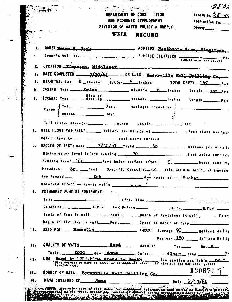
m Hi'
11! isi'i P^»t
*'Y' :T C'fc '' 7
•»E
ft*?
_J*. V
• •*
»
fe£-
i'to*
X
••*»
fe,
S$r
?*H
ud/
' fih
Ek* Itr Bo
i t*
«^^ ' '
KiK
**
*^ II pi pi
•gj
't'.'
ipl'u
P|f'
•H*1
''
Hfift
v
Bte'2 * ^ o >• m 3 • 1 . • » p» • > D I
» •• § €•»
•»m
?g
s ••
t •»
_, ts^
o
»•
5
•*s 5
r^
» ^ i
* _« -i i ^ :
^ 7 ji •
* •
i •
t •5 i•
h.* o o -
05 »
•vl
b*+
•r
"** -\
••k M t r- S 1 » k
.J
> >t«
ftB
t
.J k> V
. . 1 1 *
M
•
• •
-t • ff 1 t 4ftI ^ » n • — • ft •*
i i •
» _* . S
i.|
» 1
• »
i 4 • 1
•
*!
• •0 C »» f 5 * « •> 3 K i kk k • • » >« 4 • » I
X ft M • •i
1m
•
M £ * i
•* <
* 3
• «
• i
* i
r :41 «e m o i» 8 i | I f w —
4
»> < • : • St
» » » • • » • ^*
• •
V
•»»
• *
v
*r
•
0•*
-
»>
•«—
«
•v
• «^ 3
»ft
C—
—
ft•
——
« ft "ft
"ft
•
ft
•
ft
»*"
.«*.•
"»
3•
ft
•
V»••
r*
\»-
tr
0
0•*
-*
f ?
»•
0ft
~-~t
V
tft" n ft
• —
•
3•
« • — .
_ J • a •
•»• • • rff-
r» » ft n ** «« •> • •» X • o .*..,
• < ft 3 m •9 ft « C
•ft •
- s
**
»
I 5 » m •m —4 — £ JK 40 m o <r I —4 • *
X ^ •n • • m • • •
o - «• • I > ( > ~^~^
? 2
- i
I 5
«.? ••i •
a •
* <*
r«• • • n -* n o ft » n *^
>
"o «
-:^. .
• U
• » • -i
A•
» .
•
i" • X
y •
; ?
T > X
». -%
1!J
<
c*
•ft
•-fc ft*
i*
<«», s
.-« • * • • < • _j :> D ^> • • v • o
'
i
-* r* ft •» n
i •r-
ik
iE t
1•
1
t »
t 1
t f —
•i
r»» • *» n « ft r«>
ft • ft < • ft*
ft -^ O •* • K • ft 3 • * •x
i»
1• ^
• <r
:•
•
» i
I •
• i i
i
-«
a•
«>
»•V • m Ck O o o -n —4 m Cft
-4 o ft «p ft ^J ^ >> 0 > -< ft ^ IX. ? » » ^ > • • • k t 1 • E i*
•c • • •* i • • #*• 0 -* • ft r* ft a < • » c •* -» • n •
••« • 1*1
r- r- Tl
f— 9 «*
31
»»
•;4
30
>«•
r- -< •k ft o 3 • • ^ X 3 ** fti
ft f*
< 4 I
-4 ft w • n • o ft • • r» ft •» 3 n • • r- • a » 3-
^^ _
_
»i » » •*
a ft a « ••^
«.
e #* e*
I •H ft ft r»
• •^
— «
O ^ •»!
ft •> r* Ok
ft O O •k n i o • • ft 0 3
1 « I ^ • 4
• tft s » m »
• •H «« ft • M
3ft
3 0
•k
-fc
O ft • ft *« ft n
'
3 n yf • v r-
i•
<» •
•"•
.»•
1
» • •
> •
ft»
4k•
•
s = i £
^
rn
X X tm
-«
..«• fti
f»
•
0 ,t •*
* \
< S
- ;
» I v
•_ ,
e .
^»'
«*. • 3
. >
: .
ft
3»•
O•
jr-«
• •
1 I 3
: = m fl
- 3
: 2
? - > a
^ i ;
4
*
-W>
ft
1
ft
ft*
• O ft* - m r» ! 3 o j , j > *» r* j o r- wi 1 k J .1 I t I I I
»•
* r- g — 4 2 5 i •
i • r > 1 k k I \
».
w^ •
O * • ^ ft * r i
•
^C
ft c= 3» •n »> rk m m r— m -c •> -4 i i j i,'
! ••':.'
. '
; • ?*
r ' •
' '^'
i I
0^k
l
1 '
•'?.
" •C
' •*
''•"•
* O
'
«-gs
i£.?«
§«,
^5
8^
3s* ''•
'''»»
M
a
r»
5
« 2 2
aS
ft
1* c
*3
0
S 5
"
• '•
- S
B •<
5i
53
•» A
-«
? g
* g
r ?
> r > « ' If
*5
•? g
-f
f '
^ ! I
P *
»» [7
>I
k ^
I If
c A
-

tti
' " ' ' ' r : ' " " " ' "fTATIOf WtWJIWIY
IKVmOWHXTAt PHOTICTK*DIVISION Of WATtft BMCKMCf I
Pf MMIT MO.
fUBFACf ILIVATJON
It
lnch« Ltngth
ptf mirvjtt «t7. WILL FLOWS NATURALLY / \/<
a /\Wt1»f H«n to Ft«t «bov« turfact
HICOKOOFTEST: D«tt Yuld
(utic wtt*r pumping
J T v
.. Frtt twlow torf«ct
minute
f»«t b«!ow i fur houn pumping
Ofwrdown 3VO Sptcific Capacity. G»Ji. per mm. p»r ft. of aViwdown
How rrvtasurtd jl
tfftct on n«»rby
ft FHIMANENT PUMTINQ EQUintENT:
Typ.__________________ Mfrt. Namt
KowDflvtn H.P. R.F.M.
0«p<h of Pump In wt4l
i of Air Un« In F«»i
l>pth of ^
Typt of Wdtr on
»n
Sin.
t XXlACf Of DATA
R OATAOtTAINIOlY
l - v ' ^ - ' , - '^r- L — j vvrr';a^ i
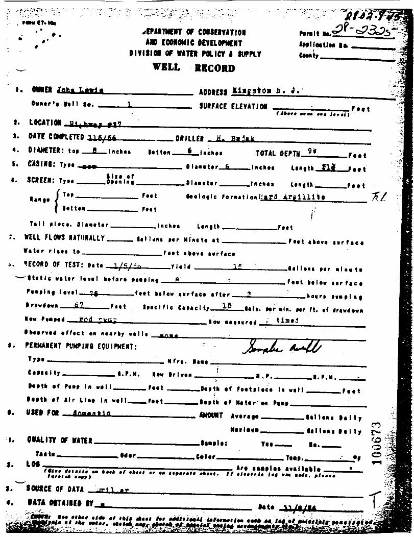
• •
_»
r-
-o§
*?
28
_>l
5 E
J &
s :
* "
2
* » «
0 s
s s
••»
_.8
« •
-•
«•
*»
«
? L
•0 <=
: f
^ M.
• •
cw
r»
r
I •»'
9
V
« a. o
1006
73
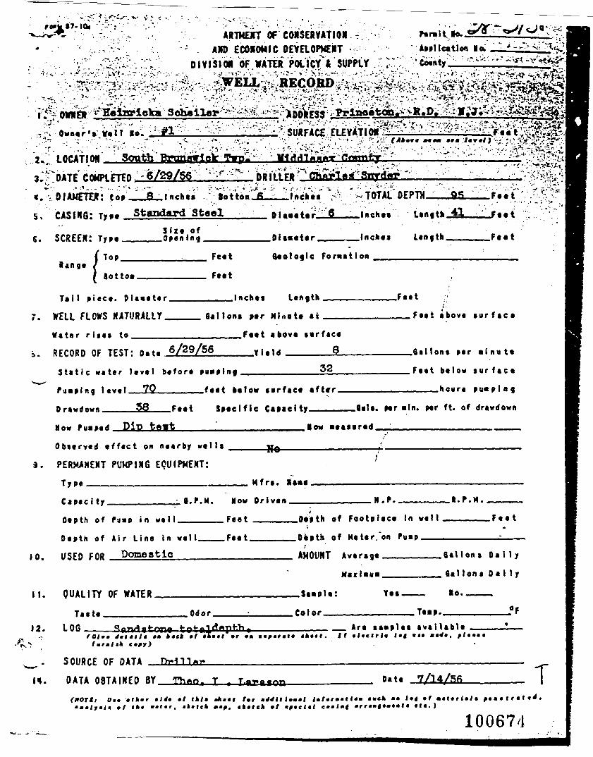
ARTMEiT OF COISERVATIOKAND ECONOMIC OEVROPMENT
01V131 Oil OF WATER POLItf * SUPPLYApplication la
. Owner's Well Ro
. LOCATIO*
E COMPLETED •' "6/29/56DIAMETER: . totton.fi.
5. CASING: Type Standard'Steel oi««eter_^fi-Slze of
S. SCREEN: Type_____Opening_________Diameter ———
-TOTAL DEPTH
.Inches
Bangt ( Top__
fiottoa.
Feet
Feet
Formation
.Inches Length F««t
Tail piece. Diameter.
7. WELL FLOWS NATURALLY.
Vater r i s e s to_____
.Inch*! Length
Gallon* per NUote at
.Feet
__Feet above s u r f a c e
RECORD OF TEST: n.*. 6/29/56
.Feet above serface
__Yield ______§_
32Stat ic water level before
Pumping level__7J2______feet below serface after.
Drawdown____5S___Feet Specif ic Capacity————
.6a1 Ions per m i n u t e
.Feet below s u r f a c e
____heura p u m p i n g
.Bals. per mln. per ft. of drawdown
Mow turned Dip tft«t .Mow aeasered.
Observed e f fec t on nearby w e l t s
PERMANENT PUMPING EQUIPMENT:
T y p e ——————————————————___ Mfrs. lame
Capac i ty. 8.P.M. How Driven.
Depth of Pump in we l l .
Depth of Air Line in wel l .
10. USED FOR Ponestic
F e e t
II. QUALITY OF WATER
.Depth of Footplece In well ———
.Depth of Meter."on Pump———————————:———
AMOUNT Average________Ball on s D a l l y
Maximum________Sallons D a l l y
.Sample: Yes——— >o.———
12.Taste.
LOG__.Odor. .Color. ,Te«p.
• • »«c* tl__ Are samples ava i l ab le
i*t *r •• •»••!. If e lectr ic J*< •«•lurmltk tffr)
SOURCE OF DATA _
DATA OBTAINED BY Th«ot T Date 7/14/Sfi
(HOT I, Ot» f l k f f •!*• fl •*••( Imrm*f. ittttk ft
l»ttrmtlt»m mutk »• !•« •!
100674
T
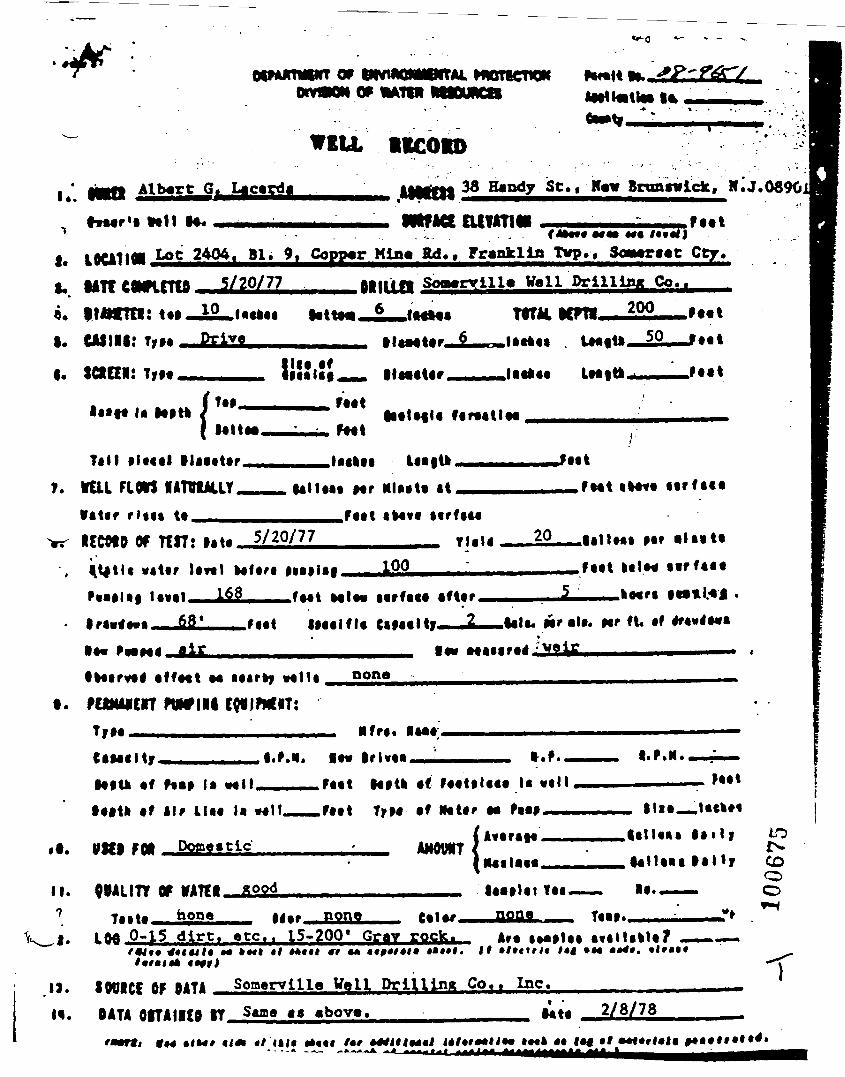
Mwrtcnon
WEU 1ICOID
M« •*• !•?•!}
IOCA110I Lot 2404, Bl. 9, Coppar Mina R4., Franklin Tvp., Soaaraat Cty.
I*.
T
f.
ft.
I. CAIIRI: TIM
Albert G. Lacarda 38 Handy St., Haw Brtmatilck, Mi
MlfACt Eltmttt
. 0896]
5/20/77 MUIM Soaarvill* Veil Drilling Co..
I MM*
• ItMtar
200
IM!IM __ llM«t«r, JMt
Mitt
7.
!«tt<ii
Tall fit««l llaa«t«r.VUL FLOW nmx.it
«"*•• lM|tl
talUM Mr MlMta «t______FMt
Mfftt*
iceofo of Ttn: •>«* 5/20/77 20
100 M«t IftM ttrftit
tall. Mr •!•. Hr ft* •'
• •« PM
• ffMt M
FUMAICIT rwniiTIM ——————
none
•tatIrivM, I.F.N.
NtU «f F«a» l» "*" •*•« Mitt •< fMtllMt U MM
••Ilk «f ilr HM !• Mil__.fMl TyM af MUf aa PM»__AMrttfl——•Mi !•••_„
W«l FOft Potaaatic-laitf
II.
V^i.
9VALITT OF VATCI,hone none
UatUt T«t-—.POP* T«f.
LM 0-15 dirt, etc.. 15-200* Gray rock. AM/•*•*•* ••^y)
Somarvllla Vail Drllllmt Co.. Inc.SOOICE OF OATADATA Or A 11(0 It Same a« abov«. 2/8/78
«*«tl
10
COCDo
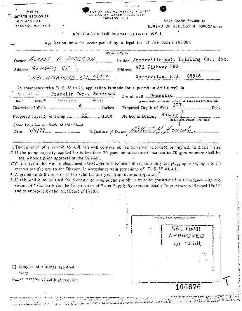
M«il to
JTTATE GEOLOGISTP.O. BC X 1 »8>
T«»E«.TO«., M.J. 38625
T OF ENV aC' -VESTAL ? - O T £ C ' ' .^.vi j .ON OF A A - E R o r t o ^ a c E S
TRENTCN. N. J.'/a^e Checks Payable to
BUREAU OF GEOLOGY & TOPOGRAPHY
APPLICATION FOR PERMIT TO DRILL WELL
Application must be accompanied by a legal fee of five dollars (S5.00).
iPrtnt or Typet
Owner £4 * ' . .
Address ^/^
Driller .Soireryille Veil -Drilling Co. , Inc.
9 7 2 K i £ h V a y 2 Q 2AddressSoEerville, 08876
In compliance with R. S. 58:4A-14, application is made for a permit to drill a well in
: Use of well .JP.o?.es tic.lot = block ^ (mimicipiliiy) (county)
Diameter of Well .........._......._._.........._.....—......inches
Proposed Capacity of Pump .............1Q .......... G.P.M. Method of Drilling ....'"
(icm^-public. domeitiC. ir2u«lr;il. dclic lufsjr, !«»•.. etc.)
200Prooosed Death of Well ._.........._............._.__._.Feet
(e»Vt-u>ol,
Show Locafion on Back of this SSeet.Date . .5/9/77....... ......_.„_..___.._ Si-nature of
1.The issuance of a ptrmit to dr i l l this well conveys no rights, ei ther expressed or implied, to divert water .2. If the pump capacity applied for is less than 70 opm. no subsequent increase to 70 gpm or more shall be
ide without prior approval of the Division.?TTfi the event this well is abandoned, the Owner will assume full responsibility for p lugging or sealing it in the
manner satsifactory to the Division, in accordance with provisions of R. S. 5S:4A-4.1.4. A permit to dri l l this well will be valid-for one year from date of approval.5. If this w e l l is to be used for domestic or semi-public supply i; must be constructed in accordance wi th pro-
visions of "Standards for the Coristrucnon of Water Supply Systems for Riiaity Improvemen t s (Revised !9t6'"and be approved by the local Board of Health.
Samples of cutt ings required"very .......... ... ................ ......._
samples of cut t ings required
f "~V.ELL PERMITI A P P R O V E Di MAT 15 ic7T.
100676 \
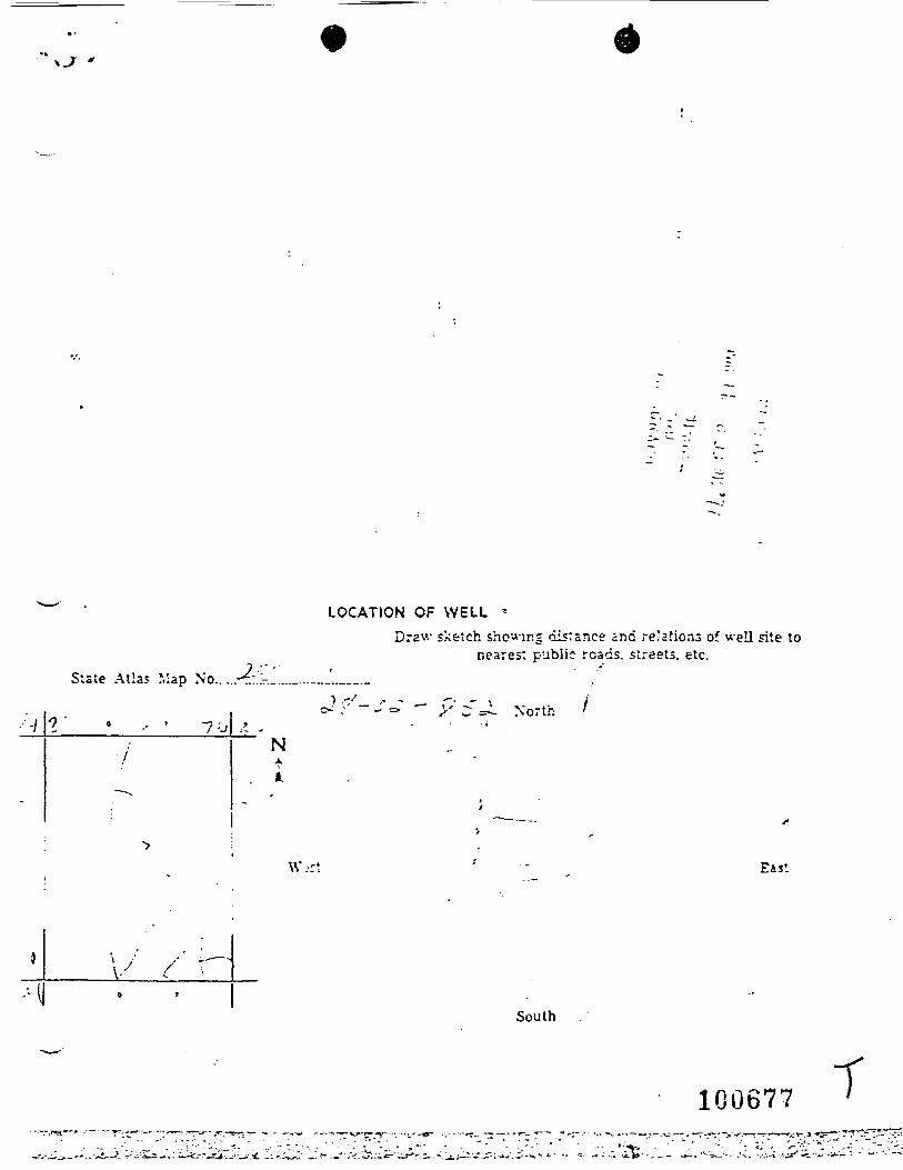
LOCATION OF WELL -Draw sketch showing distance and relations of well site to
nearest public roads, streets, etc.Slate Atlas Map No.
'•'70
NA
North
W.rt
South
100677 T
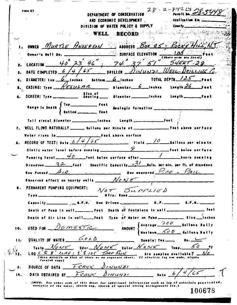
DEPARTMENT OF CONSERVATIONAND ECONOMIC OEVaOFMENT ,
DIVISION OF WATEI POLICY t SUPPLY
WELL RECORD ^
Ap»llc*tlM •»Coenty——:——
I. OWNER /?A/b£-ff*>A/ ADDRESS * - '•&£*& HtU0««r'« veil •«. SURFACE ELEVATION F««t
••«• •«•
I. OATP CQMM FTPft
«. DIAMETER: top _jL_Uc-oe
fl.MIPB
lotto* __A_lftcli««
;//A/LtfJ»
TOTAL nPPTH
SCREEN:
langa In Oeptb
OP«'ln| Oiaa«ttr lncli«» L«nfth F««t
Top Fttt
lotto..
Tai l Piece: DU-eter__
WELL FLOWS NATURALLY__
W a t e r r i t e s to.__
. Feet
.Inches
0«oloflc Foraatlon
Unfth F«»t
lalloM per Minute at
I. RECORD OF TEST:
S t a t i c wat t r
P y « » l n g l eve l
(>/'+/£<'F««f «bov« sur fac t
yi.ld
S t a t i c wat t r level before *n«»lnf
/ ft
Ora-<Jown 3_^
_ f«e t below t e r f a c e a f ter _
F««t S e c i f i c a a c l t__L2/
F««t «kov« • • r f tc .
9«llon. p*r • lueta
.Feet below e i r f e c e
koire pi*pin|
Spec i f i c Capacl ty
Now Pu-i«d
O b s e r v e d e f f e c t on nearby w a l l a
PERMANENT PUMPINQ EQUIPMENT:
Type ————————————————————
Now •••••red
A/ £r""^ _
flals. per ain. nr ft. of drawdown
O >?^ r / L-
Mfr«.
Ctnclty
Ottth of
. _ «.f.M. Now Orlvtn H.P. I. P.N.
in
10.
Otptlt of Air Lint in
USEO FQft .
F««t Depth »f Footplact l«
Fttt Typt of M«t«r on Pii'ap
AMOUNT
F««t
/•II. QUAUTY Of WATPB
\ T.it.
\\. LOB *'£
St«pU:Y«t
S i z e __ "lnch«i
1lon« D a M y
lo.
fmtmltlt *»fr)•Ifttrlc
3. SOURCE OF DATA /9 V*x
DATA OBTAINED BY D«t* /
Ontkt wtttr. i lxck
*•l l»t*rm»tl»m •««» •• !•« •/. •*•!<* •/ i^«ci«J ««•!•< <rr«B|*><*»« •(•.)
100678
.--*
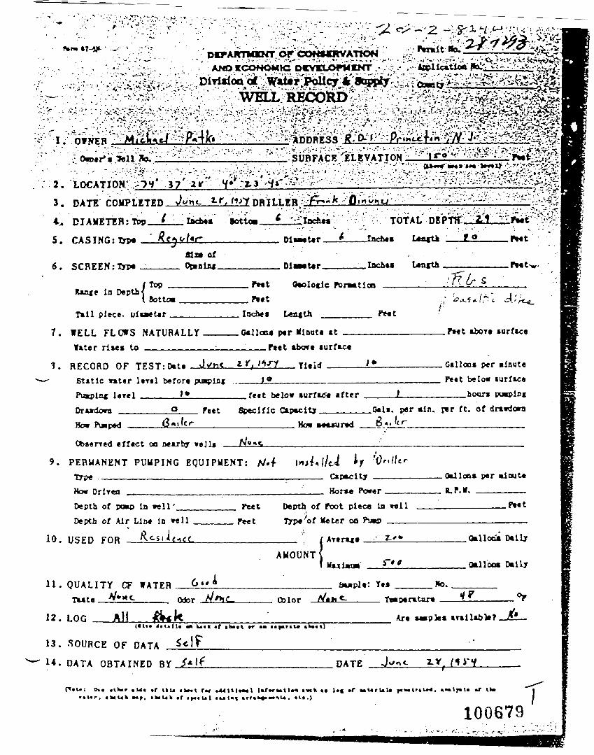
fern IT-5*
•" V^-^^•• - ; : • - -••:-,-;• r:^*" . -• -.-•• ^<zp4&&>*-&.• . -. i . ... > • "' ' - ™• • • - - . — • - ' • ^i^^m • f ^^ ^z :. . *. •••* M_ i
^
-'-^;"'--."^^"": • • ':'-;---'VsttRi^Rv¥LRYAT^' • - • • • ' • • - • • • - ' • • • v • • • - - - • • » • - • - • • ' • '
2.
3. DATE
4. DIAMETER: top.
5. CASING:trP* —
DRILLERSottoa. 'Vv • TOTAL nrPTtf;' 2/1 "
_Incht« L*a«tk _JLSL___ft«tMr* of
6. SCREEN:Typ«
la Depth
Dl«Mt«r. .Inchw
(Top OcolocicI Pt«t
Tall piece.
7. WELL FLOWS NATURALLYWater rlws to ————————
.laches Length __
.Gallon* per Minute at .F*«t torfac«. r»«t abort turfic«
*• * TltidI
1. RECORD OF TEST:D»t«Stmtic »«ter lrr«l b«fortPu»pln« lerel _____ LSDr»»tlo*n _______ Q f««t Specific Capacity
. Gallon* per MinuteFeet below mrface
fett below »urfKJ« tfter L
How Pwped sailer How0*li. per ain. jwr ft. of drawdownA , , f < r
Obaerred effect oo oearby veils
9. PERMANENT PUMPING EQUIPMENT: A/.-r
10.
11.
How DrlTMi . Horw Power
Depth of vmo la veil' Feet Depth of foot piece la veilDepth of Mr LlM in »ell r*et Trpt'ot Meter on Pu«j
A M O U N T S
Q U A L I T Y CF WATFR 6 « » * Saaple: Yt*
. ».n.PMt
Oallotva Daily
Oalloca Daily
No..tnr. 4* °F
12. LOG Art awplea trallabte?
13. SOURCE OF DATA _
U. DATA OBTAINED BY DATE
«u« *r •r ui
100679.m-
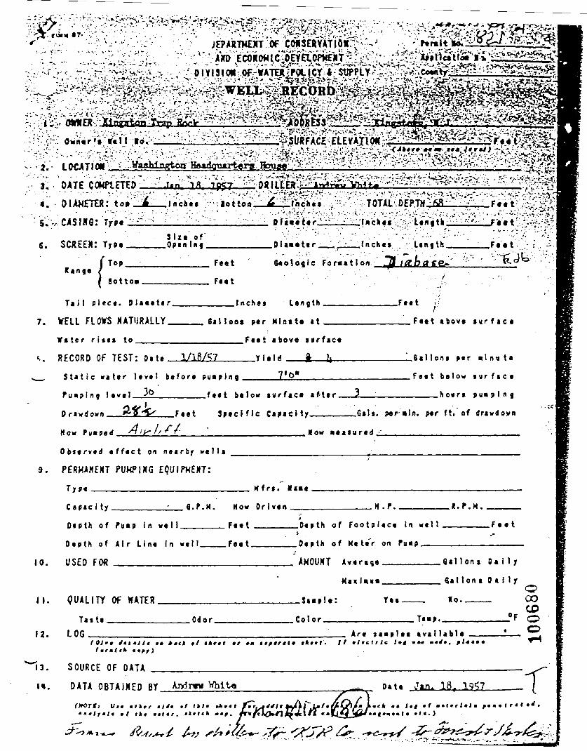
6. SCREEN
Ran ge
! TyD.
( To»
«otto»\
Tai l p iece. D iave te
S i z e o fOpen Inf.
r
Feet
Feet
Inches
10.
Dlaae te r . Jnches .Length. .Fa atGeologic F o r m a t i o n
L e n g t h .Feet
7. WELL FLOWS NATURALLYW a t e r r i t e s to
Sal loot per Hiaate at
'.. R E C O R D OF TEST: o « t « 1/18/5?
.Feet above s u r f a c e
__Y l a i d j h
S t a t i c w a t e r l e v e l b e f o r e p u a p i n g _ _ _ _
P u « . p l n j !•«•! yt>_______feet be low su r f ace a f t e r .
D r a w d o w n __24jil__Feet S p e c i f i c Capacity____
.Fee t above s u r f a c e
. Q a l l ons per *\ n t> te
, F e e t b e l o w s u r f a c e
____hours
.Sals. p«r«ln. per ft. of drawdown
H o w f u a o a d Xfyy // . M o w » e a s u r e d ,
O b s e r v e d e f f e c t o n n e a r b y w e l l s
P E R M A N E N T PUHPIKG EQUIPMENT:
T y p e ———————————————————— H f r s . Haie
C a p a c 1 t y ,H .
Oe p th of f BMP In we I I .
D e p t h o f A i r L i n e I n w e l l
USED FOR ___________
G . P . H . How Driven_________
_____Feet ______Depth of F o o t p i e c e In w e l l
_Feet______Depth of Me le'r on Pa«p———
.•..P.M.
. F e e t
II. Q U A L I T Y Of WATER
AMOUNT Average__
Maxim*___
_ J » « p l e : T e a .
. Q a l l o n t D a l l y
. Qal Ion a D a l l y
Ho. ___
12.
n.
T a s t eLOG__
.Odor . , C o l o r . Te.p..
Are l aap les a v a i l a b l ef *r ml I* « 9fj
S O U R C E OF DATA
It »ltcttlt I»t »**
DATA O B T A I N E D BY Ajy5r«* Whit* Date 1. 18, 1957
CO
OiH
:rm^fmek mt Itf ft *ml*rl»li
• •!••••I• « ( t . )
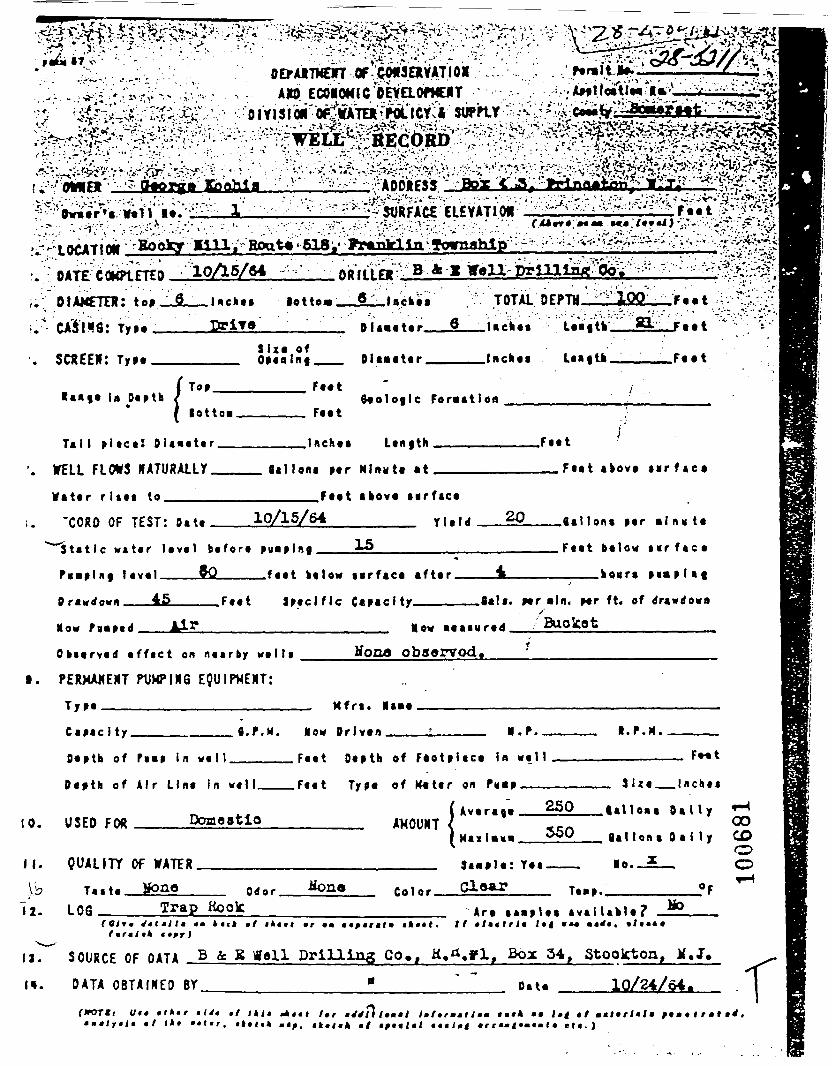
_ ™ ^^^^ - OEfAJtTKm Of ..CMSEXYATIOI
............. .,.;..——r———• ••/-£•:: 'y£jLtf;rOo_:' ;-•• • " . ' • - ' • •;- '';*->i;?^:
jl
;. DIAMETER: tot _JL__Hc»a« lot tea __£L_t •<:-••'.^^__ • ^ _ _ " . , • . ' ' ' * • ' " " * *
____ DTXTtt___________ Bl-a-t«r O
TOTAL DEPTH ' 1W
JFt«t
. SCREEN: TT»tS i z e of
Oitatttr . . Inch** .F««t
(la Daptb /
' iTo*.
l o t t O M .
T a l I p i a c a ! O la*a ta r__
'. WELL FLOWS HATURAUY__W a t a r r l s a t to_______
Faat
FaatB«ologlc Forattlon
____Inchat Lan.th
gallons par Nlnutt at
.F..t
__F«»l tkovt t i r f t e *
'CORD OF TEST: n.t. 10/15/64
»>rf«c«
Tl.,d 20
Stat ic w a t a r lava l ba fora puaplng____±5________
\m laval_____zQ______faat ba low nrfaca a f t a r .
.0*1 tons par - Inv ta
Faat ba low s i r f « c a
_____o«ra
45 _ F««t Ctatcity ft«tt. Hr aid. Hf ft. of drtwdowo
MOM fgipa. Mow
O b t a r v a d a f f a c t on naarby wa l l a
t. PERMANENT PUKPIXS EQUIPMENT:
T y p a ————————————————————
Hooa obaorvod,
Mfrt . Maio
Capac I ty.
Oaptb of
fl.F.M. Mow Orlvan I.P.M.
in w a l l .
Dapth of Air Lina In wa1l_
10. USED FOR ____Doao-tio
Faat Oaptb of F a o t p l a c a In w a l l
.Faat Typo of K«tar on Pmp ——— 3 U a _ _ I n c h a a
11. QUALITY Of WATER_______\'p T«.t« Hono____ 0 _ o r
12. L08_____Trap Koolc
( iv.r.,. 250 .all... D a l l y •""•-^n °°H-.I.MM «^° f lal lont D a l l y CO
O_____ Saaplo: Yaa——— Mo.-JE—. O
or.Arc
tkttt.a v a l l a k l a ?
1*1 ••«Mo
I»r«i•_ €tff)
itT^ S O U R C E OF DATA B & K tf»ll Drilling Co., K.^,yly BO.C 54, Stooktoa. M.J.
l». DATA O B T A I M E D BY_____________ "____ " " Data _____10/24/64.
I t*I,,
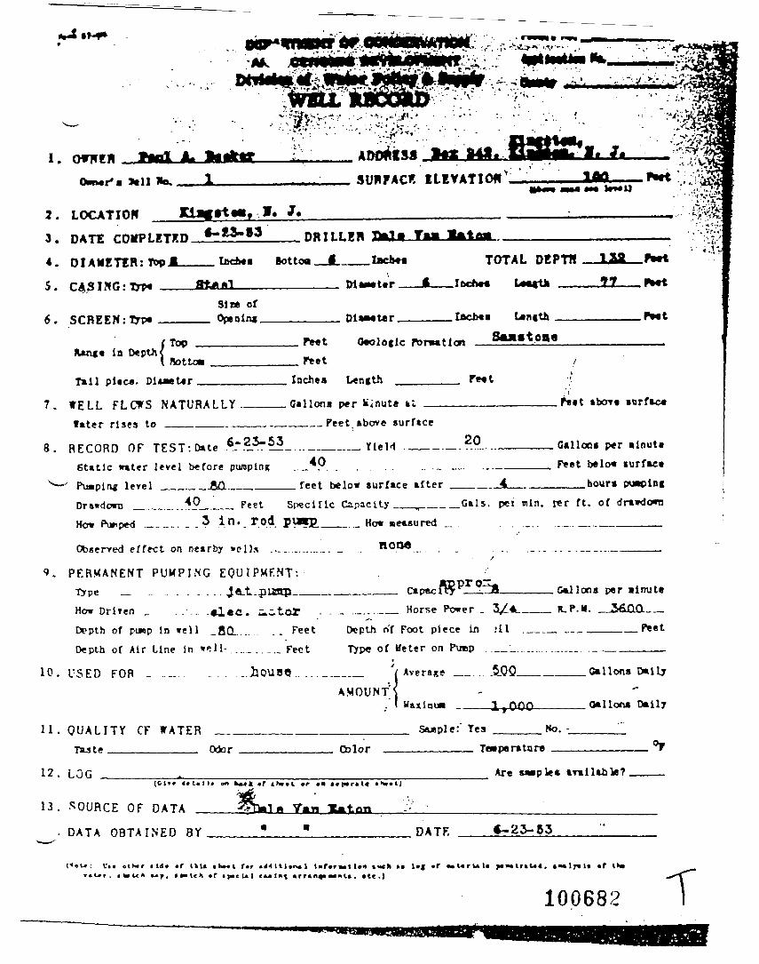
SUHFACK ELEYATIO*
LOCATIONDRILLER
B o t t o o I » c b * «
DATE COMPLETED
DIAMETER: Top A
CASING-.Tn*
TOTAL DEPTH
Size ofOpeningSCREEN :typ«
Tail pi«C4J. Inches L«n(th
7.
8.
W E L L FLCWS N A T U R A L L Y ..later rises to ___ ——— .. —
.Gallons per Minute ,N«t abort «nrfac«.______Feet above surface
RECORD OF TEST: Date ~ m . - ..._. —— ___ YieH40
20
.feet below surface after
Galloes p*r ainutflFeet below turface
___hoursStatic water level before pumpingPuapln* level _____-&Q_.______Drawdown _.„._.._*?____ Feet S^clflc Capacity__,____.Gals. p«J win. t*r ft. of drawdownHow Purped . _ _ _ - . . .. in«.*.o4. P^*P.___..._ How measured ..... . ._ . . ..._.._.._________
non«
10.
11.
Observed effect on nearby »clls ..............
PERMANENT PUMPING EQUIPMENT:Type _ ... .. . .... . .. J.«Lt.pUgpHow DriTen _ . . . . alec. uc-t-OTDepth of puop in well _f iQ_. . . ... .. FeetDepth of Air Line in well-........... Fe«t
USED FOR _. . . _ . . .. . . _.hOUB«... ...
Q U A L I T Y CF WATER __Taste ___________ Odor
.._.... __ Horse Power . V*Depth of Foot piece in :ll . _Typ« of Meter on P\nop _ '_...-....
f
___ ' /Average _ .5.0.QA M O U N T S
..' I 1,000
Gallons p«r -imittR.P.M. .JAQja__
_ __ _____Peet
.___Gallons Daily
____ Gallons Dally
: Yea No. -
Color
12. LOG __________.
13. SOURCE OF DATA
Are Maples arm liable?
DATA O B T A I N E D BY DATF.
«t>»r • lil« «f IkU f*r < 4 > t l t l » t M l l»r»r>.tl«n loch » !•( «r M u r la 1« y»n« i. 4««ir»i« *r i»«
100682 T
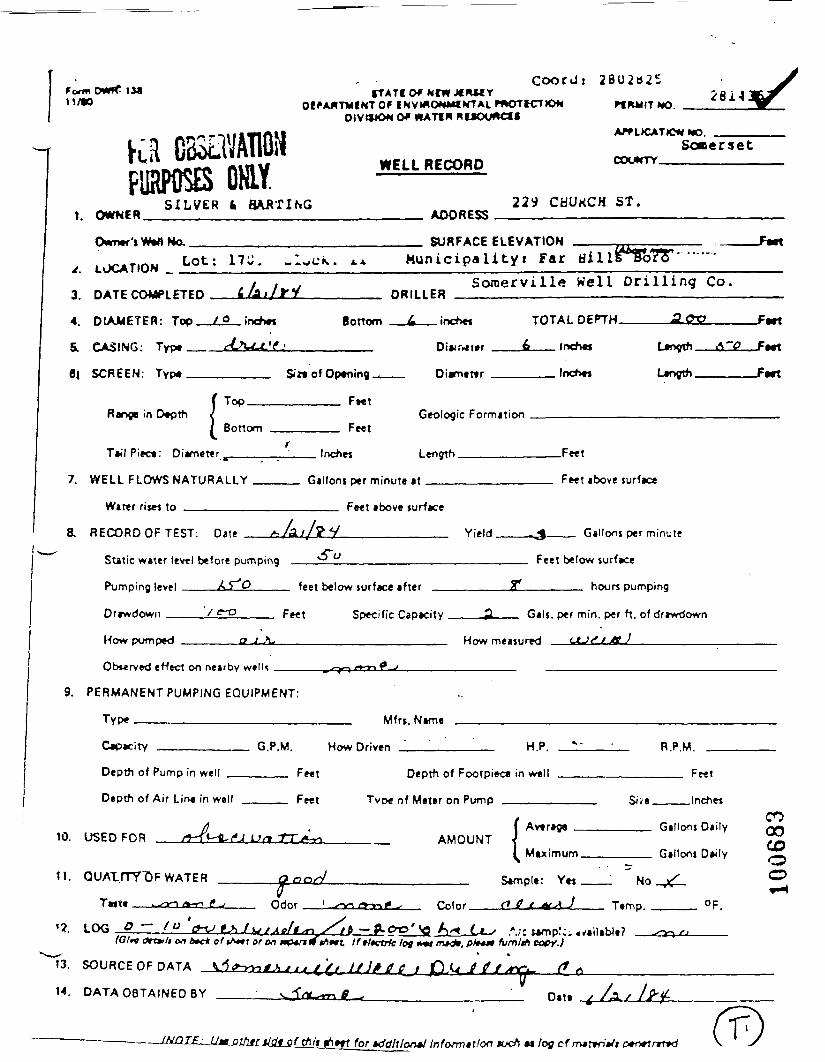
i i/n otft
PURPOSES OHLY.SILVER 4 HAATING
1, OWNER
, LJCATIOM L0t: 17J- -^
3 D*TF COW nrn 4^1/rV
4. DIAMETER: Top / o ;-<•*•«
6, CASING- Tyy* c_A~-*-'^-'
Coord: 28U2t325•TATI ofwrwjfKMY 28141
J»-™IWTOF INV»«0***«fMTALmOTICT»O*« «R*IIT MODIVttJON Of MtATtM HUCXMCtl
Somersetuwci i acrnon cxxwrrvnCkb OK>W^/~W
229 CHUKCH ST.ADOBF«
SURFACE El FVATION ^^^. Ax Municipality: Far Hil i *^o7T
Somerville Well Drilling Co.DRILLER
Botri _ 4 :~*»r TOTAI nfPTH AOXJ
ni«.Tjf»r 6 inchos t*ootfi A~<3
6| SCREEN: Typ«,,, ,., .. . _ . _ $i» of Oeumino , Diamcnr Incfvw L_fvrth
!
Top
Botlom
T_«'l Piec.: Di«met-r Ir
F«tGeologic Formation
Feet
_*M 1 «ioth F**t
</
JWt
Fitf
FMT
Fwr
7 WELl F10WS NATIJRAl 1 Y fijll™. r-r mim.tn if Feet »bove iurf»c*
Water ri«« to ,
8. RECORD OF TFST: Date /, /4 //?i .
Static w*ter l*v*l b*for« pumping ^
Feet above surface
y Yield -J Hallons p*r minut*
0 Feet below lurfice
Pumping |eyf| AJ ^ fp^t Kplr>w turfare after £* hour* Dumnina
Drawdown '/ ff-O F^t
How pump*d o J^\-
Ob**rv»d effort on n*»rby wcllt
9. PERMANENT PUMPING EQUIPMENT:
Type
Capa-iry C, P U
Depth of Pump in well F«tt
Depth of Air Line in well FMT.
10. USED FOR /J-T*- fe-f*^ lJ/» -fTji^
11. OUAirrTT)F WATER Qoo^0
Tmrtf f^m />-o /f.rf Ortor '
'?. LOG jO — /O ' -c^ > /f^f^e/g^ sfO/rf (trtuli on _»c* of «A«»t e^ on ttptnlfit
13. SOURCE OF DATA ^<*-xv,f^ / < t£<
14. DATA OBTAINED BY vj"«-*
— f^QT£^JjM._OlhtLJi^JLSL^liJ.
<;p*rif;r Cap»^i«y 3~ G-'« P*r m'n P*r ^. of rff-wrfown
How m*ittur»d tt-'t'././ff ^
Mfn rV_mB
HowDn'wsn " HP '«•- ' R PM
Depth of Footpi*f« in well Fr»t
Tunf of Metjr on P 'mp , , SJ>» lnch«
( Avtra^a , R»||(xn Diily
Maximum .. ., , ,. G'Moni D^i'ly
S_mpl_: YM No ^
Jb — ' fl-OO* <O A^ Cj—s *;r i*mp'~ _i/ailibJ«? ^^j fj
•rt Iffffctrfc/og n«f m*_lf, pV*»» fum/tfi copy.)* »
f/ yy;/^r / jO-0 It"**- " *
r. «? - Olt. /!/ /^^
rt»ff rb/- »ddltlon»l Information tuch M /oy cf rmttiitti D+twtrrttd \ ~s
COooCDOo
)
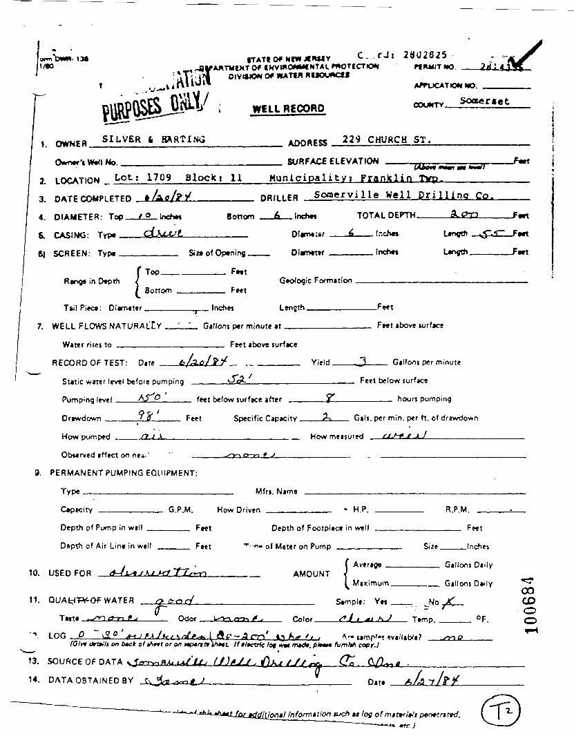
13*IKVmOWMtNTAUmOTICTKJ*!
OIV«*0« Of WATW RUOUACU
WELL RECORD
28U2825Pf MWT *O. ;*/
WO.
Soa«r«et
1. OWNER. SILVER fc BARTING ADDRESS 229 CHURCH ST.
O«mer'tWt<INo. SURFACE ELEVATION -Fwt
2. LOCATION _ Lot; 1709 Blocki 11 Mun ic ipa l i t y ! F r a n k l i n Tvp.
3. DATE COMPLETED
4. DIAMETER: Top_
&. CASING: Typ«——
6J SCREEN: Type__
Scxnerville Well D r i l l i n a Co.
tndm Bottom . [ncTMft TOTAL DEPTH. -Fwt
Si a of Optnirvg. Larvgth.
Rervg* in Dtpth !Top.
BottomGeologic Formation
T»'lPi*c«: Di«m«ter Lenflth.
7. WELL FLOWS NATURALLY
Water risej to _______
Gillont per minute it
Fwt above surface
RECORD OF TEST: Date Yield.
_F«t
Fret above ujrfact
__ Gallons per minute
Static water level before pumping
Pumping level Ay ^_____
Drawdown _____ ' f ____ Feet
feet below surface after
Feet below surface
_____ hours pumping
Specific Capacity
How pumped .. S1J JL
2-^ Gals, per min. per ft. of drawdown
_ How measured /iJ-e e * ]_________
Obverved affect on ne«,' L O r> t J
9. PERMANENT PUMPING EQUIPMENT:
11. WATER
Tart*.
LOG C
Color. Ttmp.
.or on Mf*nti vmi 11 tltctrtt lot
13. SOURCE OF DATA
14. DATA OBTAINED BY
<r>
D.t.
10.
C«p»ritY
Depth of Pump in wall
Depth of Air Line in wall .
USED FOB <4-/V«/>Mf,-(
G.P.M. How Driven
. Ff*t D*pth of Footpi»r«
.., ,, F»«t "*"••"» of M«t«r on Pump
^f~fJLf^r> AMOUNT
• HP
in well
| 6.vtrnpi
[ Maximum
R P M
Fwt
Sii* , InchM
G|llryi$ Qiily
Gillnni D*Jlv *00CDOO
tuch u tog ofmittfMi per»lrttvd.
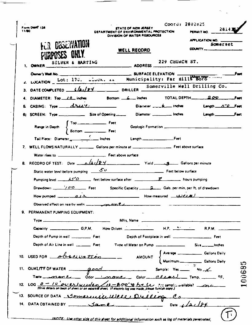
ti/to1M fTATIOf NIWJCRUY
OiPAIVTMCNTOf
Coordj 2 8 U 2 B 2 5PfRMITMO
2614:
PURPOSES ONLY.SILVER 4 BAATING
1 OWNFR
OMmM-tMMINa.
, LUCATMM L0t: 17-- «-«
3 RATE rO4APl PTFH £ /(_ i/f V
4. DIAMETER: Top _Z£_ inetm
& rA<IMn- Twn_ t4-\<A 'f '
OIVtSlON Of WATIM MUOUftCSSAPf LtCAT««< NO.
SoBersetMTFI 1 RFPnnn COL_*TV .-. , . , _,.,ff cki> nci**-rnw
229 CHUKCH ST.ADORFC-
SL/RFACC F( Fl/ATIrtN
K. x- Municipalityi Far Hill5mj?VSomerville Well Drilling Co.nnniFR
Bom?™ £ :~*-« TOTAI DEPTH a<«?
niair iM 4 InehM 1 M%nrh A~^
6| SCREEN- Typa Six* of Onanino , Divnatvr lnch*i Lanam
f Tnn
Bottom .
TailPiara- niarrwt-r
FeetGeologic Formation , .... _ .
IrvhM Lanoth F*«t
J -t
Jwt
/wt
7 WELI FLOWS NATIJRAI LY Gallons ner mimit. .t Feet above turf««.
Wat*r ri«M tn
B HFrORnOFTFST D-t. ^ /a //!
Static water level before pumping
Pumping level ... . /-* ^ f*"
Drawdown / C"T3 F««f
How pumped o J Jl-
Ob»*rv*d ««*ct on ne»'fr>v w»n« . ,_ .
9. PERMANENT PUMPING EQUIPMENT:
Type
Capacity G P M
Depth of Pump in wall . ... FMI
Depth of Air Line in well FMI
10. USED FOR /*-f>-ft-<«J Uti Trji*
11. QUATITTOF WATER Qoo^Q
T««» ta<rn <*-" ' *> Odor
12 LOG O — /O &TJ tAJi^/Ae/t^rt
Feet above surface
^ y Yif IH ^ Gallnnt per minnt*
-» w Fe*t below turfac*
helnw curfarj aftur ?* hour* pumping
Speckle Captc'ty 2L fi*'*, p»r min. p*r ft, o' dr»»«1'>< n
How m-»fiir*rf tff-Jf*./^ 7
Mfn Mama
Ho*nr;w«~ HP •»- RPU
; Dfpth o* F(x>Tpi»« in W*" Feet
Tun* of Mfrt' OH Pump . Sfvj |nr*>«
( Awaraga , Gallons Orlyi AMOUNT ^
^Maximum . , .. _ Gallons De-'y
* . Sampla; Yat ., . _.. NO jf
s/tt — <Lot>'^ A/^« Li^f *-<• •• ' i w ?
LOOOCOCDO__4
tOI<* (trmii on tec* o'«/M»r or on mp*f*lftf*tt Iffftetrfe let WH mtdt. p/N«* ft/m/y> copy.)• %
13. SOURCEOFDATA \A*^4\Jl^('/.IJ)»OclCH*ttl**^ <**
14. DATA OBTAINED BY sj"<*-~nf^ Date / ^/ />/
<ld« of (hit for KidMor*! Infomttlon mcfi M log ofmttfdtft ptmtrrttd,

M/n•TATfOfMl«XMMv C - . r J i 2802825
'AMTMtMTOf IHVWOWMf NTAL mOTI CTIOW Pf RMIT MOOIVWION Of WATIM ftUOUACt*
AffUCATlOW MO.
WELL RECORD
1. OWNER. SILVER fc HARTING ADDRESS 22* CHURCH ST.
No. SURFACE ELEVATION
2.
3.
4.
&
6)
LOCATION _ Lot; 1709 Blockt 11 Munic ipa l i ty i Franlcl in Tvp.
DATE COMPLETED
DIAMETER: Top.
CASING: Typt
SCREEN: Typt
indm Bottom
Soracrville Well Dri l l ina Co.
inchts
Sin of Opening.
TOTAL DEPTH.
_____ lr.ch«»
-Fwt
_F«tt
-Fttt
Range in Depth !Top.
Bottom
Tail Pitca : Diamtttr . . Inches Length.
7. WELL FLOWS NATURALlY
Water rises to _ ———————
Gallons per minute at
Fe«t above surface
RECORD OF TEST: n.t> Yield.
JFtn
Fwt above surface
__ Gallons per minute
Static water level before pumping Feet below surface
Pimping if»i h5TO
DrawHrMvn / fti
Hnuu pumpwH /> J A
fi»f t twin*, fiirftr* »ft»r ^ houn pumping
Fe*t Speri*ic Capacity . j!k G«u p*r m in p*r ft of drawdown
How m.,«, ,r*H /lt>1» V jj
Observed effect on nea,'
PERMANENT PUMPING EQUIPMEN I:
Type ————————————————— Mfrs. Name
Capacity H.P.
Depth of Pump in well
10.
11.
Depth of Air Lint in well
USED FOR
G.P.M. How Driven _________
___ Feet Depth of Footpiect in well
Feet •-••--• Of Meter on Pump _____
R.P.M.
._ AMOUNT( Average
Size.
Feet
.Inches
Tattt
I Maximum
Sampla: Yet
Gallons Daily
Gallons Daily
Odor. Color.
. JJo
Ttmp.
CDCOCOCDo
12. LOG 0 ^ .tOlM frtttli on 6*c* of VMM or on uptrt (* V»m If •/•ctrfc lot w«* /rwc%.
•
SOURCE OF DATA -J -- *±- • +j'l* > (t)*J/. fl*^ /J,
^-» samp'»« tvailable?fum&i copy. I
14. DATA OBTAINED BY D«t» X./3
'tiontl Informttlon tucf) at log of mittrMt penttnttd.
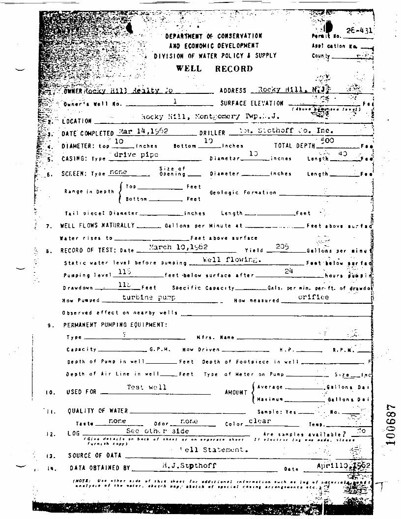
^m^~$£-£..'£V^&£*\
"-" ' - ' " OEPA&TWCNT Of CONSERVATIONAND ECONOMIC DEVELOPMENT
ION OF WATER POLICY I SUPPLY
P®i *-> OEPi•y^^Sft^v^-..•--:-. ^=-. 1M1s*S^£^vi~£.:' - -V- . *w
^S^-^t^v'.- ••••- D I V I S H, v>.V r7:*rr -7*" r^j^.'V,".'-..'
la.
•: '. . ;
26 -4 31 !
AM! C4tlon lo.
C o u n t y E, ""'.
r " .-;• WELL RECORD
Hill Realty Jo____'" A D D R E S S ?.ocky dill..O w n e r ' t We 11 No. SURFACE ELEVATION F.(
* ?i;r LOCATION Jtocky Hi l l , Xontf;orncry IVp.:..J.
I ..-6.
DATE/COMPLETED J.
DIAMETER: tOB 1Q
CASING: T y p e Url'
SCF.EEN: T y p e r-'C-ne
Bo t torn
DRILLER10
.icthoff Co. Inc.
I n c h e s TOTAL DEPTH500' . F « »
S i z e o fO p e n i n g Diame te r Inches
Length.
Leng th .
40
.Ftr
Top
7.
Bot torn
T a i l p i ece ! D i a m e t e r _ _
WELL FLOWS NATURALLY__
W a t e r r i s e s to________
F e e t
F e e t
. Inches
G e o 1 o g i c Fo rnat i on
Length ______
Ga1 Ions
.Feet • ; .
—— F e e t a b o v e i t , .-fa
'= : 8. R E C O R D OF TEST: D a t e
_________Feet a b o v e s u r f a c e
March 10,1^62
S t a t i c w a t e r l e v e l b e f o r e P u m p i n g
113
Y i e l d
flOWir.£.
205 ns per • i nw i j
P u n p i n g l e v e l .
D r a w d own
How
"
_____feet -be low s u r f a c e a f t e r .
F e e t S p e c i f i c Capac i ty____
.Gall onj*..
F e e t b « l o w »« r fac
____hours t'ua i i n
turbine Pu-p H o w m e a s u r e d
Gals , per nin. per-ft . of drawdo
orifice
9.
O b s e r v e d e f f e c t o n n e a r b y w e l l s
PERMANENT PUMPING EQUIPMENT:
T y p e —————————:———————————— H f r s . Name
C a p a c i ty G. P.M. How Or i v»n H . P. R . P . M .
D e p t h of Pump in we 1
10.
" I I.
12.
- 13.
,. U.
D e p t h o f A i r L i n e in we I I
Teat wellUSED FOR
F e e t D e p t h o f F o o t p i e c e i n w e l
. F e e t T y p e o f M e t e r on P u m p —/
A v e r a g e __AMOUNT
Ha « i nun
— S i z_e__ I n c;
. .Gal l on s Da i
_ f la11 on t 0 a i
QUALITY OF WATER
odor r.or,e C o l o r
S a m p l « ; Y e s .clear Ten p..
Sec oth-.r aide/ C J V 9 t
t u r n t i
A r e s a m p l e s a v a i l a b l e ?I I r l , c l r , c / o | . » ••*•. l i t *
SOURCE OF DATA' -o i l Statement.
D A T A OBTAINED BY H.J.Stpthoff Ot te Apr! 113 2
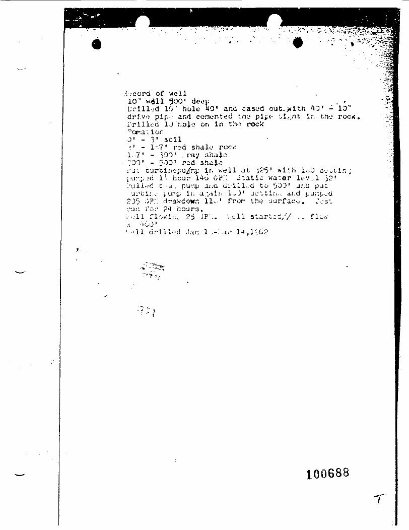
-.•/rvc-.^-vTjKSg5?3'••y.*<F??A**&a*:??l
.vjcord of well10" wail 300' deec
d 10' hole 40' and cased out ,wi th '10' -drive pip--- and cemented the pipe- ul,-,nt ir. theTrilled U r;t»J,o on in the? rock"crra; ionJ1 - I1 sell-' - I.?' rod shale rccK1-7' - *,00' ray sha}.e;00' - 300' red shajo;'u; fjrbinep'J/r.i: In well at }25' w i t h lv..O o-.-^j-u.-.^.-d l-:- hcur 1^6 GP.: J.atic water lev.l j21'ul.l'fC t - ' - a . pu-ip ai;G ci:'ill..-d to t»03' ar.c pju
•j^cir . j j.ur:p i:. a.vilii l^J' ju^ti.'i., ir,d i,j;.-.Ljd11.-' fr>^r the
,10"roc*
•-•-.11 flo^'i!.. 25 JP; : . '..t-11 3tart,-i/7 . . f lowj- ;^J'' • • 1 1 drilled Jar. 1 -:.;u- ia , l^C2
100688
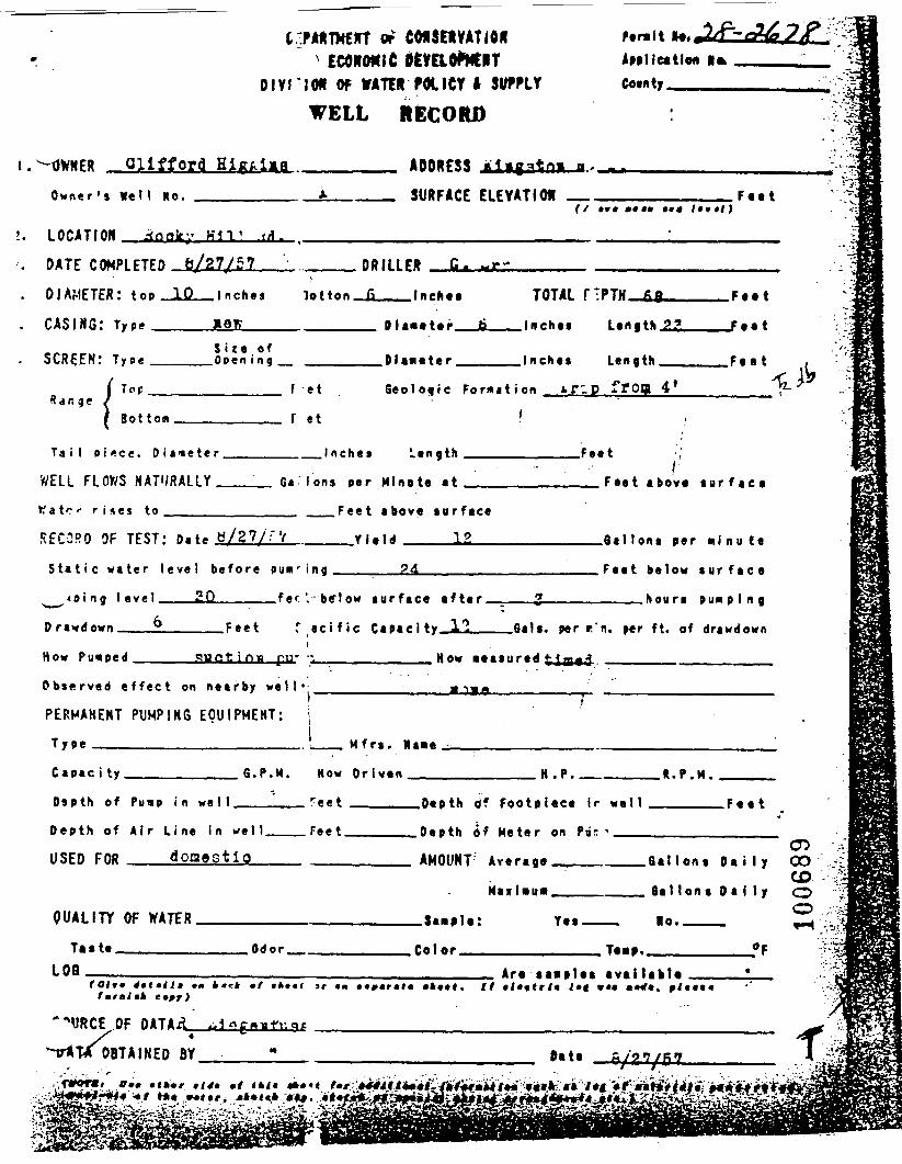
Qlifford
of CMSEftVATlOR' ECONOMIC ttmOfcClT
Olvri(W OF WATER FM.ICY I SUPPLY
WELL RECORD
ADDRESS
r«r»lt lAplllettlo* I•>COMty
Owner ' $ We 11 No.
LOCATION
SURFACE ELEVATION(/ twt ••«• •*• Itttl)
Ff t t
.(A.
DATE CQMPIFTFP 8/27/57
DIAMETER: top _1Q_I nchej
CASING: Type
___DRILLER C.
lo t ton _£____! nehe •
Diameter .S ize of
SCREEN: Tyo«______Open ing_ .Dlaneter.
TOTAL
.Inches
.Inches
Len|thJL2
F e t t
F e e t
Length F e a t
R d R lTop
Sot torn
f et
f et
G e o l o g i c F o r m a t i o n .trip frog 4*
Ta iI p i «ce. 0 i a n e t e r .
WELL FLOWS NATURALLY,
to_____
.Inches L e n g t h .Feet
Ga Ions per M lno te a t___
__ __Feet above su r f ace
___Yield 12
I
RECORD OF TEST: o.t» H/27/;'V _
S t a t i c w a t e r l eve l be fo re pumring______24______
>_^<»ing level___212_____fef I below sur face a f te r
Drawdown___6_____Feet f «c i f i c Capacity_il_
. Fee t above s u r f a c e
.Qal Ions per m l n u i t
Feet be low s u r f a c e
____hours
How Pu«ped How •etiured
.Qsls. per c'n. per ft. of drawdown
Obs«rved e f f ec t on nearby we l l
PERMANENT PUMPING EQUIPMENT:
M frs. Ma«e
C a e a c i t y fi.P.M.
Dsoth of Pufio i n wa 1 1 .
Depth of Air L ine In we l l
USED FOR doaestio
QUALITY OF HATTR
T»«t« Odor
L08 _
fmrfltk e»ff)
"^URCE OF OATAii ^l^f^nlTdfl
"TTAT* OBTAINED BY "• ..':. ..;. '' r
How Driven H.P. B-P.M.
reet , P-P»N 4* F^"»pl«e« ir wa l l F..*
Feet , ,,, D.pth Af U*t*r an PB- «
AMOIIMT: *v«r.g« , ,6. linn, p, i \ j fjn
CDM>vlHUtB_ . , . _ Ba l lon* D a l l y f^
O3*mf\m! Y«« la. ^
Calar T««e. «F
Ar« •*••!•• •valUkta •
t"
... .. ' .'.-'.. -.. : ..•.'•.-:- «. :«i*£jB :M^u*£ .i i " i<WJr i[*W j.*««i:i' ~* L --
•^
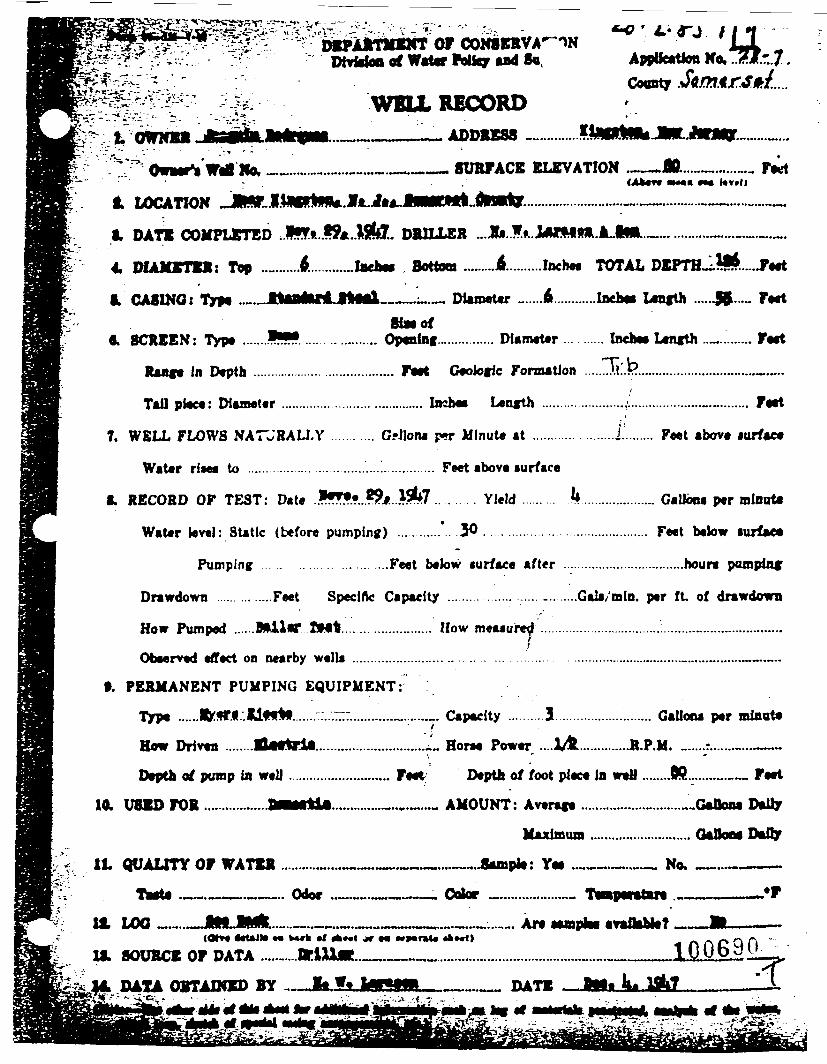
S ??-?S " 3S' :.' ~~~^': bEJ'AJrtittKT OF CONSCONBERVA^'W t _J9.r.7
t OWNER(Atotv •*•• ••« k»»l)
Applieation No,Coonty .
WELL RECORD_____ADDRESS
.«.___— SURFACE ELEVATION .——M...-™..-... Fed
A ff A^ A *w*¥/\%F BBBBB^V M AJBBUBetft* Ve> ev A A BBBBBBBBB^ftAV flB^BBlnV•k eWUvAlivJl ^^jigT^W^.fl.Tffwr.yTfTBBv.J>J»»-*BUI •mwiim jexw^ww. ** ..
i. DATE COMPLETED ..!•**..??*..*$!#.. DRILLER ...1»..!»..,
4. DIAMETER: Top .......... A............ behe» Bottom ......... A.........Incbea TOTAL DEPTH-l*l*.....Je«t
1 CASINO i Type .._JlMritoriLtlflil__..__ Diameter .. ...6 ..........Inchee Length .....JK..... FeetSlMOf
ft. SCREEN: Type .......Iff*..... ............ Opening._............. Diameter ...... Inchee Length .._......... Feet
Rang* In Depth ........................................ Fee* Geologic Formation .....Tti.i?...............................^.....
Tail piece: Diameter ....................................... Inchee Length ......................,:..................._._........ Feet
7. WELL FLOWS NATJRALLY .... . . . . . . . G-llona p*r Minute at ............ .....j ........ Feet above iurface
Water ri«ee to ...............................'....'............... Feet above surface
§. RECORD OF TEST: Date .>ff?«...?5fc ...^7......... Yield ......... k .................... Gallooa per ralnuU
Water level: Static (before pumping) ............'.. .30 ........................................... Feet below turfaeo
Pumping ... .. . . . . . . . . . ....Feet below surface after ..................................houra pumping
Drawdown .............Feet Specific Capacity .................................Gala/min. per ft of drawdown
How Pumped ......BftiUT tMt....................... How meaaure^ ..................................':.........„......-..............
Obeerved effect on nearby wella ................................................... .............................._...............—.-..
9. PERMANENT PUMPING EQUIPMENT:
Type ......B>sr.l.:ll«t*t......-.-..—:.....-.......».......,. Capacity ..........3........................... Gallooa per minute
How Driven ........ElurtrU..............................! Horn Power ....X&..............R.P.M. „.....:.......«...——
Depth of pump in well ............................ Feet Depth of foot piece in weti ......JHL........— Feet
10. USED FOR ..................B««rtl«.............._.._..^..- AMOUNT: Average ...........................^.Gaflone Daily
Maximum ............................ GeJJooe Dally
It QUALITY OF WATER ................__.__-._...._..Aunpk: Yea ..___.._ No. _...————
H, LOO .L.... ^^..JlNB, Bjlilfc,.... _-—.....,......_^n.n..i -._....-_««..._.. Ar* eampiea avaflahieT _™EJL———
IS. SOURCE OF DATA ..........BrlMjR..______.......................................„.._._____1006.9Q:
14 DATA OBTAINED BY ....Ji,f.*. I^ffffB———__ DATE
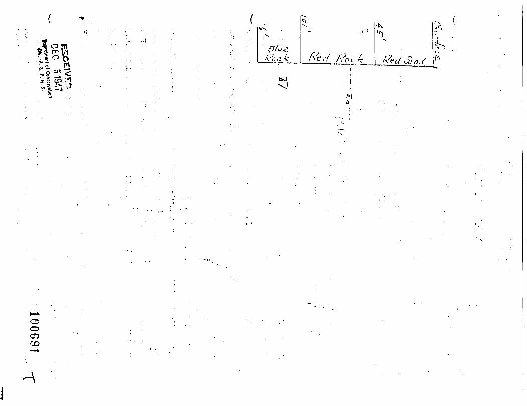
x S "( ,• a J* .'-
05CO
-\
Mo

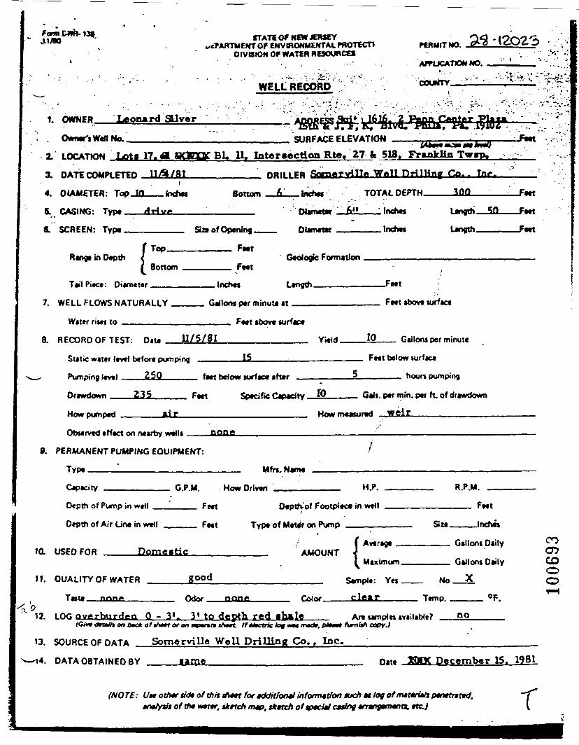
Form &*b- 139VV1/BO STATE Of NEW JERSEY
scPARTMENT OF ENVIRONMENTAL PROTECT*DIVISION OF WATER RESOURCES
rCRMITNO. -(2023
WELL RECORD
APPLICATION NO.
COUNTY____1_.
1. OWNER Leonard giver
. Owner's Wefl No.______•:.viq*afr
SURFACE ELEVATION -Feet2. LOCATION Lota 17. 41 aO-TK BL. 11. Intersection Rte. 27 fc 518, Franklin Tw«p.
3. DATE COMPLETED UA/&1___________ DRILLER &±*»rnill» Wall HrilUny Co. .
4. DIAMETER: Top_1Q___ Inches Bottom _JL__ inches TOTAL DEPTH————300
5. CASING: Type——Arjv*_____,______ Diameter —fall__.Inches Length
8. SCREEN: Type ________ Size of Opening___ Diameter______ Inches Length
Range in Depth !Top.
Bottom
Feet
Feet
Tail Piece: Diameter. Feet
7. WELL FLOWS NATURALLY
Witer rises to ______
Gallons per minuU it Feet above surface
Feet above surfa
RECORD OF TEST: n.t. 11/5/81 Yield. 10 Gallons per minute
Static water level before pumping
Pumping level 250____
Drawdown 235_____ Feet
15
feet below surface after
Feet below surface
_____ hours pumping
Specific Capacity. 10
How pumped
__ Gals, per min. per ft. of drawdown
How measured weir_____________
Observed effect on nearby wells
PERMANENT PUMPING EQUIPMENT:
Type ————————————————— Mfn.Wame
10.
11.
Depth of Pump in
Depth of Air Line
USED FOR
well , ...... . . F««
in w»ll FMt Ty
Domestic
QUALITY OF WATER g°°d
-„,. n __ Odor nnr?**
Depth- of Footpiec*
pe of Meter on Pump
AMOUNT
&
InMwll
( Average
I Maximum
imole: Yes
c iry clear
Feet
Size ———— Inches
Gallons Dtily
G llnn* O^ly
^f
T«mp OF,
12 LOG - 3*r 3* to depth red flbilc Art sarnpln no{Gh* dmUi on tec* at tt»*t of on _v_nt* -SWt Ifttfetriclot M« m«dr. pfene fum&i COPY.)
13. SOURCE OF DATA Somervilie Well Drilling Co., Inc.
COCDCOOo
DATA OBTAINED BY same Date H1OC December 15. 1981
(NOTE: Utt othtr tidt of th'n tfn*t tor Kktitloml information tuch w log of /nirana/iptnttuttd,wntr. tkrtcft m*>, tkttch of tptcltl eating arr-ogemeno. etc.; r
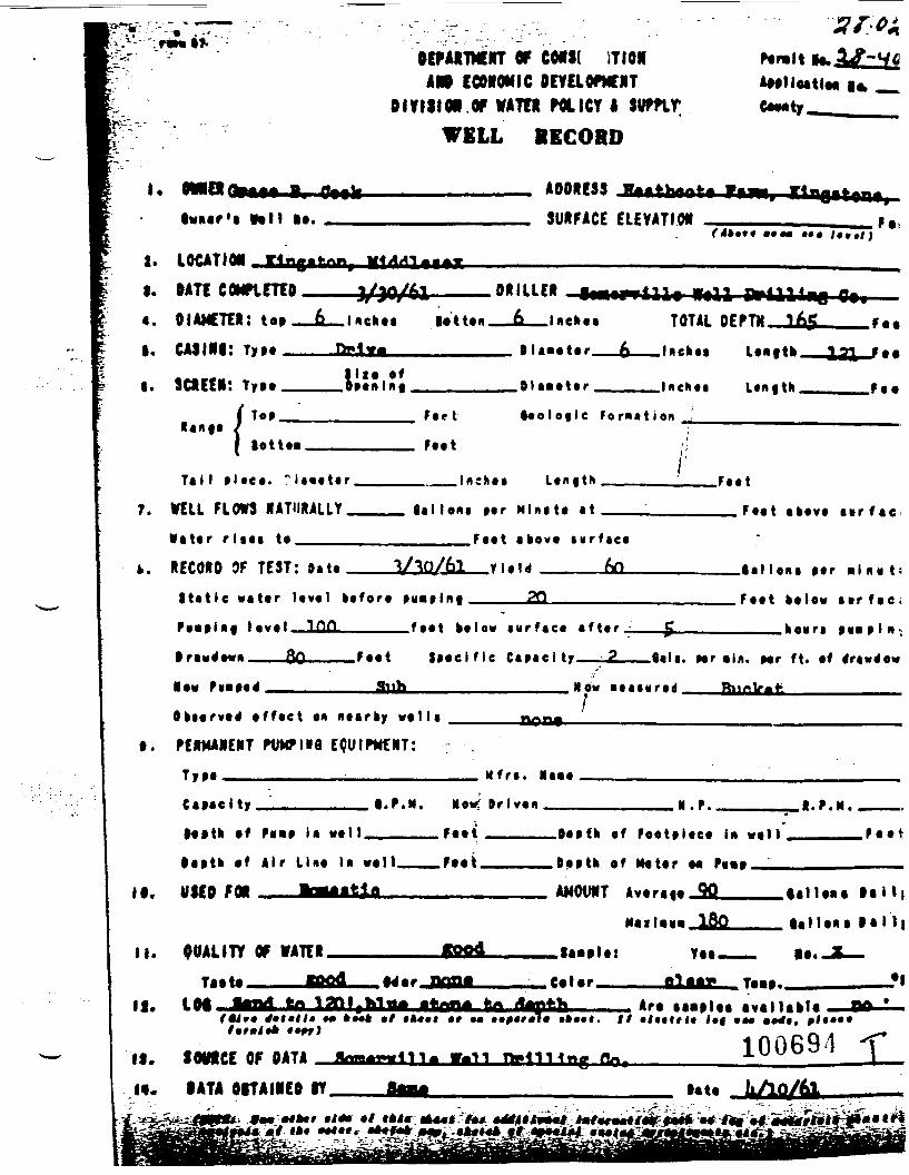
I.OwMr'a
OF co«i( ITIORAR9 CCOfOHIC PimOFICIIT
DIVISION OP VATTR POLICY I SUffirWELL BECORD
ADDRESS Itfthffftr ft'••. SURFACE ELEVATION
r <!»•*• ••••
2. LOCATIONI. DATE COMPLETED«. DIAMETER: toaI. CAJINI: TyM.
i. SCREEN:
3/30/61 DRILLER _.Mckoa
T>»*.<rM
lattan TOTAL nFPTii 1*5
-6——laefcaa Lanftk.l l t O f
L«it|tH.
F.c t
F««t
••ola«le F o r m a t i o n
Tal l a l a e a . " l a a a t a r .
7. VEIL FLOWS NATURALLY.W a t a r r laat to_____
••I lout Mr Mini tt at Ftat i « r f a e
Faat a k o v t t u r f a c a
». RECORD 9F TEST: Data
S t a t i c v a t a r lava l k a f o r a
P«*tl*f laval_lQfl ______ f a a t k a t o w i w r f a c a a f t a r .
.lalI OKI aar •!n « t;
Faat kalav aar fae ;
S t a e l f i c C a p a c i t y .tala. Nr *ln. Mr ft. af a*rawa*«M
• •v PUB paa* New l a a t H r a d .
Oktarvaa1 o f f a e t an naarky w a l l a
t. PERMANENT PVMPHfl EQUIPMENT:
TyM ——————————————————— M f r a . laaa
C a M e i t y , t.P.N. Mow? Dr lvan N.P . .
Mftk af Paata la wa l l .
loatk af Air Una la wall.
If. USED FOR
Faat
.Oaafh af Foatt laea In
.Oa» th of Katar M Pg«»
AMOUNT Avara|a_2Q __
F a a t
II. 00ALITY OF VATERTi
If. LOt
ftood laaala:
Calar.Art •••»!•••lt«trl« I»t i
__laHana la l l j
__ lallaaa lal Ij
Yet.—— it. 31Ufi_ Ta.a._______»•!
II. SOWCE OF DATAf«. DATA OITAINED IT
«. »!
100694
lit* kAQ/6l.**•**••' '1* •''*'*•»*•«/** Wtf 'l*^ M/*r»H/«^^M« MTa« «^ M rlal iiAairi
'V ' ^ fSt ^ liSI 'f ^
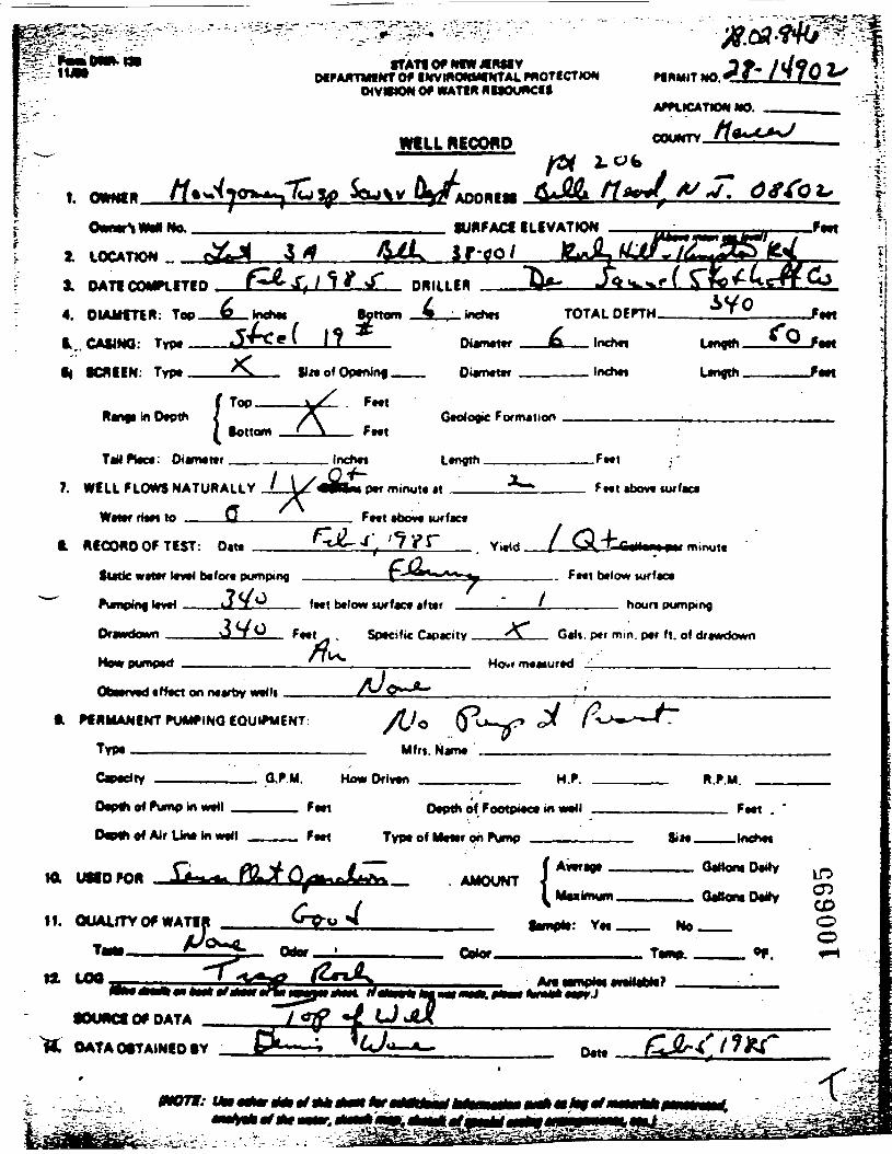
•***• Of MN * WtVMFAimMINTOf INVMONUfNTALPHOTICDON
OIVMtONOf WATIH MBSOUACU
WtLL RECOUP
APPLKATIO*! t»0.
No,
2. LOCATION _3. OATI COMPLETED4. DIAMETER: TOPB.. CASING:
B( SCREEN:
SURFACE ELEVATION ———IJt_ir.o/ ILJLtijUttt
DRILLER Jit Cf vu .,f
I f
Bottom TOTAL OCFTM
SlnofOptnJnf
In D«pthTopBottom Fttt
Di»iMt«r
Geologic Formttion
Ungth
TaMPWct: Dianwttr
7. WELL FLOWS NATURALLY J_i/'«llM(
ff ~
Inchvt Ltngth
p«f minute at __
F»tt
abovt turf act
Wrtar HtM to Fwt abovt turfact
t. ff RMANENT PUMf INQ EQUIPMENT: /,/c <Pu / -/-
Fwt
ECOMO OF TEST
Static wtttf »*»•<
PumpMfl 'twf
Drawdown
HowDLmokd
• DAM
btfort pumping
J</o3Vo
^
fMt
""A
^r '?yrf^— 7
btlow turfact afttr
Sptcific Capacity _^
VIH / Q-fG^-Jp^
L .. _ . . F»«l hvloMi turfaca
' .... h<»m PM"»piog
. . <\^ Gtlt per mm per fl of dr*»rini»n
W<>.« m« (ur*d
. t
C^-Hfy <J»" f
O^Mh a« Pump In M«4I f
Dwth of Air Un« In w t Fwt
4o«HDrl«Mi M.f. MfU^
(VfMh ftf FootpiAM id iMll ., r , Fft
Typ* of Mvttr oh Pv^p VM iiu 'ti
AAiVL AMO4JMT J ^rr¥T"—— • «WWWNI < r—I Mnkngm, . .. , . OaBor* D*ttv TJ
If. OUAifTYOf WAT1 ^Twnp.
Of DATA
OATAOtTAINIOBY
tHOTi: M_«olflrcl*«/fl*J*Mr*r
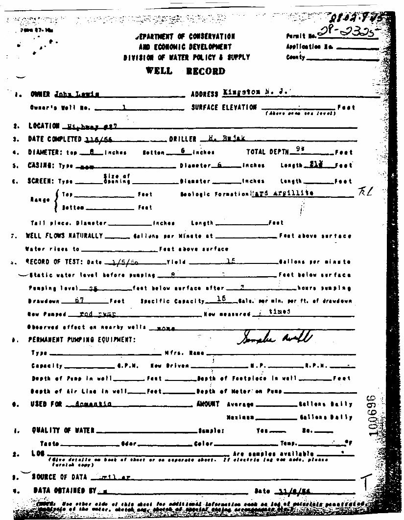
70M»t7.Mt- •
*»'
OF COfSCRVATIONECONOMIC ocvaoficiT
OIVISIM OF VATTI POLICY I fUPPLY
WELL BECORO
Par.lt M.Aatlleatla* I*
I. OVNEi ADDRESS *'•
Ovucr't ff«H I*. SURFACE ELEVATtOH*««• ••• /•»•!)
I. LOCATIOt3. DATE COMPLETED«. DIAMETER: toa
5. CASINt: TjrM
s. SHEEN: TrM
. Inchaa lottan.
DRILLEI _JL._L_liiChaa TOTAL DEPTH_1_ Fait
JJ"i?i .Ola-tttr .Inekts
FMt
Ta l l » l«ca. O l a v a t a r .
WELL FLOWS NATURALLY.
W a t a r Hit* to_____
.Inch**
••I Unt Mr Mlnitf «t
.Fttt
__Ftt t afeovt i i r f«e«
F««t akovt sur face
OF TEST: a.*. !/*/-»—/ /'Static vatar laval bafora MMlftfl
f t«t It low mrftca ift«r
F*«t iMtlfle C«f*c l
_____lallan* Mr a i n a t a
_____.Faat aalav i v r f a c a
—————;———.kauri
. Mf aln. Mr ft. af
god
i.
«f f«ct «
PERMANENT fWINg EQUIPMENT:
CtMel ty .
Mfra .
trlvan tt.rV .•.P.M.
F*«t . F a a t
t.
taata *f Air Llaa in wall.
USED FOR *"*
."aatk «f Faatalaea I* w a l l ———
.taata af Matar'M ••••_—___________
AMOVMT Avtraaa_______lallaa* t a l l y
I. OWALITY Of WATER. Yaa.
UlUaa t a l l y
la,———
Taata.LOf
,€«Ur.
ftttf 4ft»lt» •» •/ t*«*t «r ••Art aaaalaa avallahl*
. // * /t«lrJ« /•< •••
COcp§5
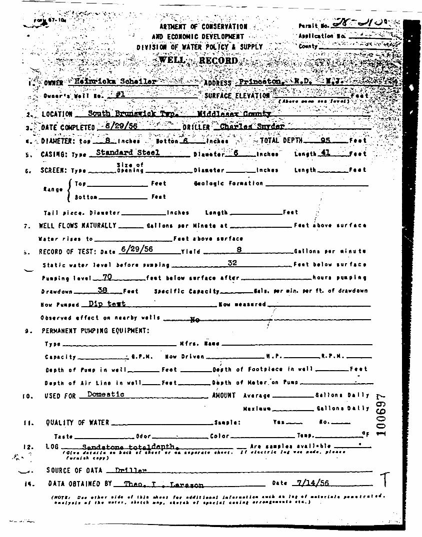
o« ST. tewARTMENT OF CONSERVATIOR -.
AMD ECONOMIC OEVaOPMERT01VI SI OR OF WATtt POL ftf & SUPPLY
COMPIETED -6/29/56_B_lnches
: Type Standard SteelDIAMETER: top
>-V- .:' * .'rf-' - •:-• >'• .•?••:' -^ •-" 'I'Botton_fL__lnchet ,• TOTAL DEPTH. .
5.Sire of
S. SCREEN: Type_____Opening ftl_««t>r Inches
Length _il_
Length___
r..t
F..t
!Top. Feet Geologic Formation
Tail piece. Diameter.
WELL FLOWS NATURALLY_Water rises to______
.Inches length,
Gallons per Mlnete at
.Feat
__.Feet above iu r faca
.Feet above serface
__Yield ______§_
32RECORD OF TEST: a.t. 6/29/56
Stat ic water level before puaping
Puaping l«v«1__7_Q________feet below serface after
Drawdown_____5S___Feet Specific Capacity———
Mow >u«i«d Dip tamt__________________.Row aeasired
.Oat tons par • ( n a t a
.Faat balow s u r f a c e
____hours pimping
Bals. par *ln. par ft. of drawdown
Obsarvad a f fac t on nearby wal ls
PERMANENT PUMPING EQUIPMENT:
Type ———————————————————— Mfrs. »a«e
Capac i ty. .N.P.
Depth of Pu«p in well .
10.
Depth of Air Line in well .
USED FOR Domestic
How Driven_________
Feet ______Depth of Footpiece In well
.Feet______Depth of Meter.'on Pu«p ———
.R.P.M.
. F e e t
II. QUALITY OF WATER
AMOUNT AverageMailau*
_3a«p1e: Yes
12.Taste.
LOG__.Odor. .Color. T««p.
Sal Ions Da I I y £>_.
f i a l l o n s D a l l y ^O
~" O___Of tH
Ho.
_ Are saaplas avai lable
SOURCE OF DATA Driller
DATA OBTAINED BY Th«o. T Date 7/14/fifi T(HOT*! Of* »lh»r
»f »»•ft tktl •*••! t»t lml»rmmH»m muck •»
*f*et»lf •! miltrimltt i e . )
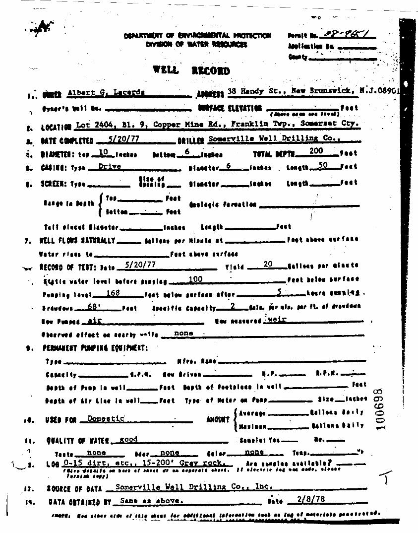
PtW>0>MPffM. HPTKmOKu
WELL 11COID
i*. Albert G. Ucarda
HaarU Vail la*
38 Handy St., Raw Bnmroick, 11'. J. 0690j
ntfAOL cuuttttf. lOUTIfll Lot 2404. Bl. 9, Copper Min> Rd., Franklin Twp., 3oa»raat Cty.I. Mrt^a^rrfa 5/20/77 aat.ita SoaarvilU Vail Drilling Co..———
10 lattaaj, ma itm—222—MatI. CAJlll: T,M
I. SCtCE*:
u Natlatt
Tilt tltcal llaaatarT. VUL FLOW lATVtAUY
titir rUtt «•^< ICCOIO Of Tttl: t^« 5/20/77
««tir lav«l Mfart
f«r««tlaa
Mr MlMta tt r*at.Fttt ikavt MrftM
TliU 20 aUvta
100168
68tirfaca aftaf ^
iMalfla CiMtlty 2 tala. par al«. iar «l« tf *ra««a«a
lav Ma«aratf;Ji2Jttoarvatf affaat aa aaar»y ^
t. PUMAicrrTIM —
none
Hfrt..l.P.N. lav t.P.. I.P.N.
•atu af Nil la -^" «*"« Mill af faatalaaa U «alt•aith af Air Uaa la vail..
faat00 i
it. IM..I...
CDlady olaity 2
II. OMIITt Of tATM_&22aTcttv^H ^one
V .1.none none «— r
0-15 dirt, etc.. 15-200* Gray rock. AM «Mi»taa atallalla? _
.1). SWICt OF OATA Sonarvllle Veil Drilling Co,. Inc.*
H. OATA OITAIKO it Sama a a abova, 2/8/78
i«M» •<*! «/ ll<f •*••!
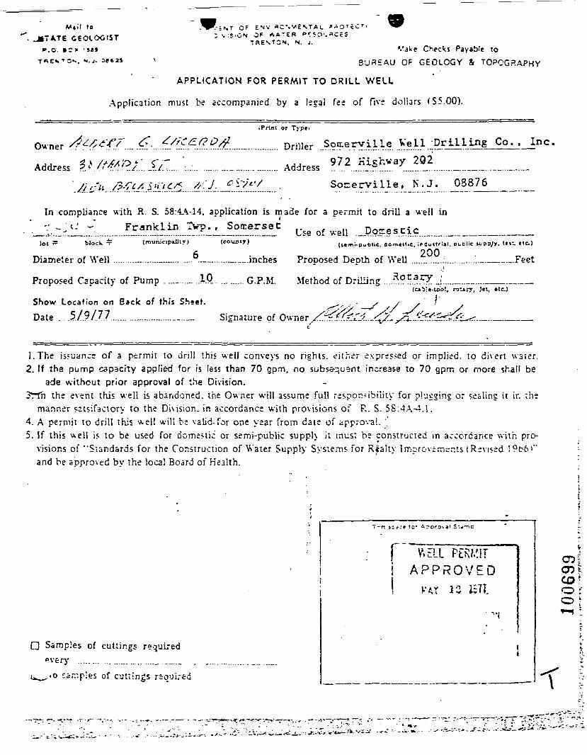
Mil! »o_J»7ATE GEOLOGIST
P.O. S~ X :»8»T«E'.T3s. M.J . 06625
"•;NT OF ENV «C'.V>\:S'GM OF A A T E R er
T3ENTCN, N. J.Vake Checks Payable to
BUREAU OF GEOLOGY & TOPOGRAPHY
APPLICATION FOR PERMIT TO DRILL WELL
Application must be accompanied by a legal fee of five dollars (S5.00).
iPrtnt or Type i
Owner . < .... . •.. / ./? ......_............ Driller ..S??eryille WeII ;Dr 111 JJg Co. , Inc.^ x //>fx'o *' c" "~ 972 KLcrvay 2Q2Address •?.l .<>. "'*.' .J.._?./.;...:..:.............__............... Address ... ......_.^....... ........_.........._...—.._ ...__..._...__
//' f'i: /?'?£* 5'i'i£/S &'•'/ __f - '^ . SocerviLle , K .J .
In compliance with R. S. 58:4A-14, application is made for a permit to drill a well inFranklin TV?., Somerset Use of well ._Dojrescic_,
lOt T= block * (munjcipillly) (county)
Diameter of Well .........._......._._.........._.....—......inches
Proposed Capacity of Pump ....._...... AP_ ......... G.P.M. Method of Drilling ...,r
Show Location on Back of this Sheet.
Date . .5/9/7.7...........—.—.....—.— Signature of Owner Z^r
(t«m^publie. aomen.e. ipjuilriil. BcBlie «;ppyy. In- He.)200Prooosed Deoth of Well ._.......:..............._.__._.Feet
j'ol, ralarr, J«t, «tc.)
1.The issuance of a permit to dri l l this well conveys no rights, either expressed or implied, to dhert water .2. If the pump capacity applied for is less than 70 opm, no subsequent increase to 70 gpm or more shall be
ade without prior approval of the Division.3rtn the event this well is abandoned, the Owner will assume full responsibility for pbegine or sealing it in the
manner satsifactory to the Division, in accordance with provisions of R. S. 5S:4A-4. 1.4. A permit to drill this wel! will be valid- for one year from date of approval.5. If this v^ell is to be used for domestic or semi-public supph it must be constructed in accordance with pro-
visions of "Standards for the Construction of Water Supply Sysiems for Riaity Improvements (Revised !9t6>"and be approved by the local Board of Health.
Samples of cuttings required
ca.-pies of cuttings req'jLred
j APPROVED
! k'AY 1C
\

Siste Atlas Map No.
LOCATION OF WELL *Draw sketch showing di5t£nce and relations of well site to
nearest public reads, streets, etc.
North
N
W.-rt Ess:
South
100700 t
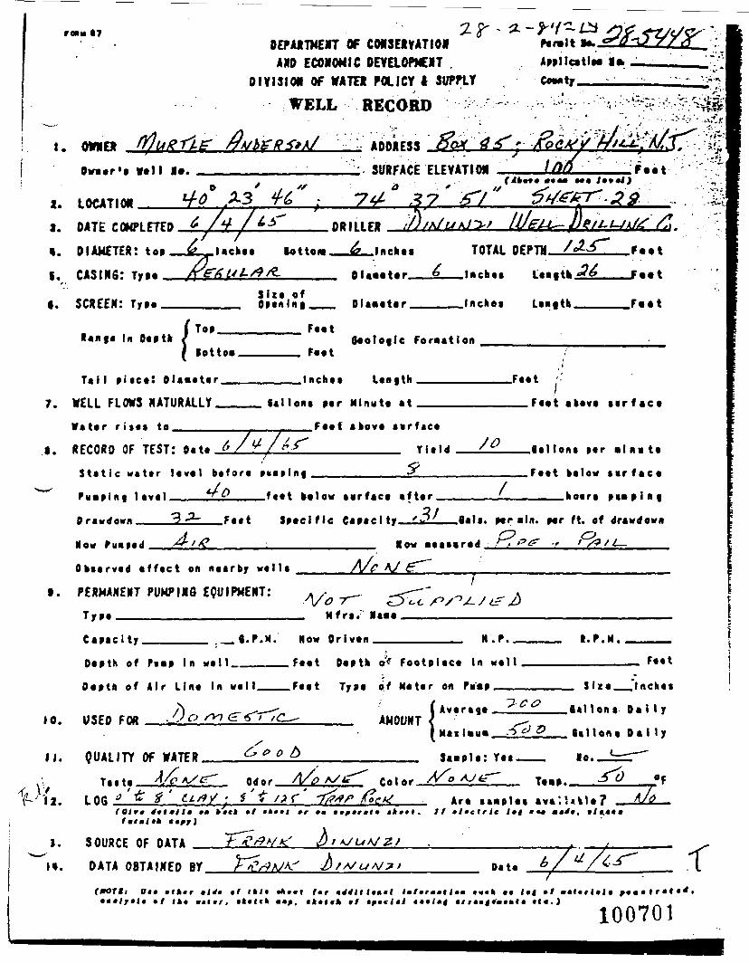
r«tn IT
I. OWNED
DEPARTMENT OF CONSERVATIONAND ECONOMIC DEVaOPNENT .
DIVISION OF WATER POLICY I SUPPLY
WELL RECORD ^
ADDRESS
ApillcatlM 1>
:"^i&\
2.
I.
I.
C.
Owaer's Veil I*.
LOCATION
SURFACE ELEVATION ;F«et
DATE COMPLETEDDIAMETER:CASING: Type
SCREEN: Type
DRILLER - L
S i z e ofOpenini .
.Inches
Olaaeter__£.
Dlaaeter____
TOTAL DPPTM /J.£~
.laches
.Inches
F««t
Feet
Range In Depth f Top. Feet
7.
lottoa.
Ta i l p iece! Olaaeter__
WELL FLOWS NATURALLY__
Water r i te* to._______
. Feet
.Inches
Geologic Foraatlon
Length
.1. RECORD OF TEST: Oat.
Sal Ions per Minute at ____
_____.Feet above surface
£l__________ Y i e l d
S t a t i c w a t e r level b e f o r e pvaplng___________•*
*? ft___f«et below t irface a f te r .Puap ing leve l
0 nwtf own
.Feet above sir f a c e
.8alIons per aln« te
.Feet below sar f a c e
____hoars p i a p l n g
.Feet Specif ic Capacity. .flali. per aln. per ft. of drawdown
Now Fnaped Now aeasared
I.
O k t t r v t d « f f t c t en nearby w t t l s
PERMANENT PUHPIMQ EQUIPMENT:
A/e A/
A/o T~"Mfr».
C a p a c i t y Now Dr iven H.f . I.P.N.
10.
11.
1 'U.
1.
Depth of f«ap In well_
Depth of Air Line In we
USED FOR __
Feet Depth oV Footpiece in we l l
Feet Type of Meter on Pu'ap ——
I Average ___
Feet
S ize_.Inch**
AMOUNT
QUALITY OF WATER
TiLOG
e o b Saaplt: Yes .
Odor . A/o Color .
_gallons D a i l y
£__ ta l lons Dal ly
T.... ^0 «F
Are aaap lea ava i !«k le?tmrmlt*
SOURCE OF DATA
•*••». It •lictrlc l»t >•«
DATA OBTAINED BY
Oit »tktr
Date
tf( t c t c f c
• r « <
100701
f
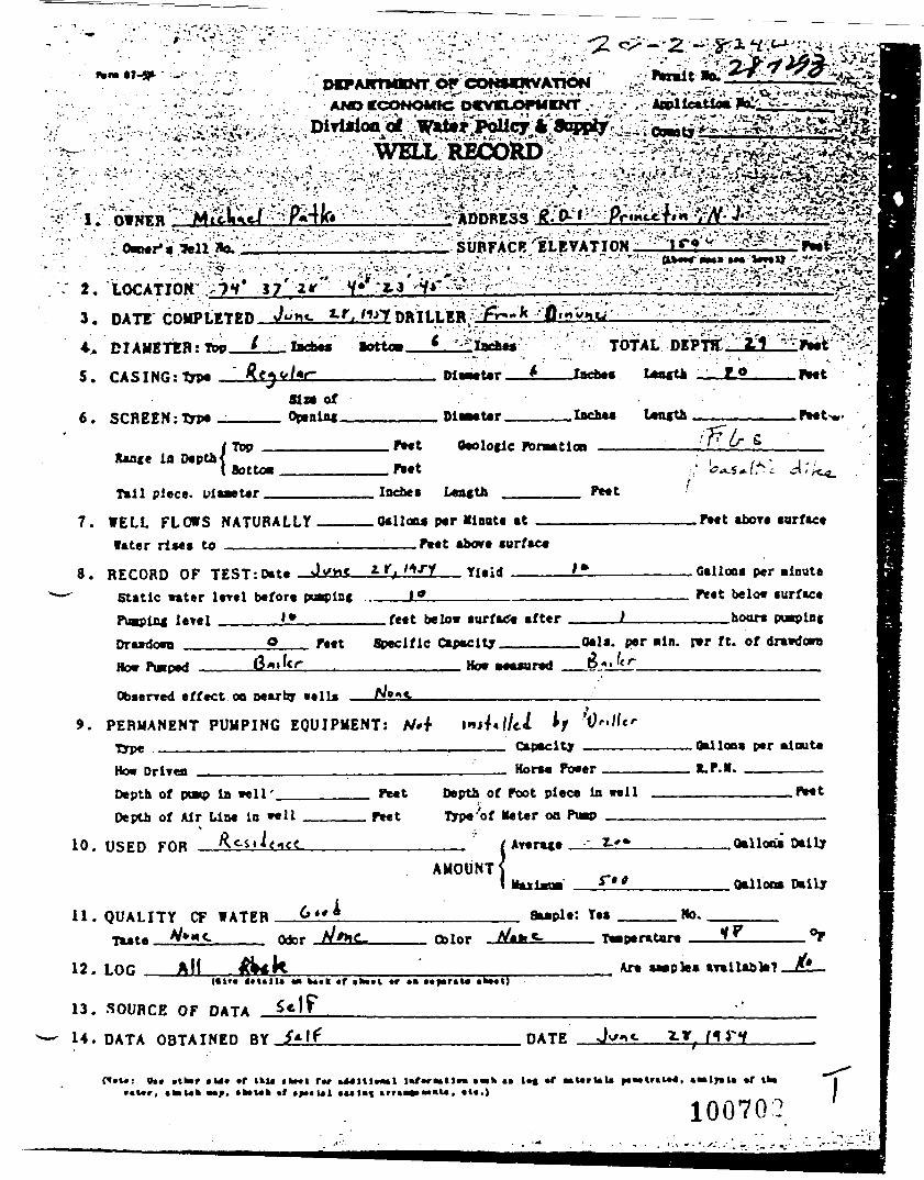
23
45.
6.
Owner* a*!!3*0.V'^^'7'"^?'^^.^
2V V* Z-3 •^*"-^'.'••>•"'"•'•'••• • • ' • • • • • - • •••\:^- •;/:- .f>-.<^-^<- ' N^^^H. - . - . • - - . ; — — — — — — • — — — — •——. . . . • . .•: . ,•••———-V',-. . • • : - • . • . - -.'-• •••. . . .-•- ;.:•••,,• .<.'•"• v -.••.•••.•.,<^?."-'^-J
DATE rniiPt:rr»n- J^*«- *r, WT PRTILER pr-"^ 'Omuim——'' ••-; ''.'••'•V:;.""'-'-"• : v'-""--.-t--^i• • • • ' / • • • • • • - ' • • ' ' ' ' • ' £ ' - :ATv' - -•"•'.'.'•'.'•'•''..'iu;..'' -..«i; --DIAMETER: Tbp__i___ I»c_*« wottoei——L__^Ia«±«« TOTAL DEPTH,,
CASING: typ« ^C^V/*r————————— Dle^Ur——*_
SCREEN :Typ«_tta ofOptniflf ________ DiwMter _____laches Length ————————Peet-w
Xance in Depth4Top Ptet Otolotlc foraationBottoa
Tail piece, uiaaeter _ Lea<th PMt
7.
8. RECORD OF TEST: Date
WELL FLO»S NATURALLYf»ter rl»e» to ———————
.Otlloa* ptr Minute atPeet above surface
_Tleid ————L!L.L*
feet below aurf-Ce afterStatic water lerel before pu_pln«PuipLnc leTel ._______LS_____—DrawdowB _______Q _ feet Specific Capacity.How taped —————(3«»kr——,——
l.-c. ^.'/*4,
_P*et abOTe surface
, Gallons per minutePeet below surface___hoars
0*1 •. per -In. r*r ft. of dravdowaHew M«sured
9.
Observed effect on oearby veils ——
PERMANENT PUMPING EQUIPMENT: A/.f \»»4<\lil h '__________________ Capacity _
DrlTcn ______________________———— Horse_____ Peet
.0*1 Ion* per oinut*R.F.M. _______
Depth of POMP la well'_>f Air Line in *«1
Depth of foot piece ia wellon Pump ___
10. USED FOR (AMOUNTS
.Gallons Dally
. Qalloo* Dally
11. QUALITY CF WATER : Yes No.
12. LOG AH Are SMpha(«tt. 4ftt |
13. SOURCE OF DATA _
14. DATA OBTAINED BY
«f
DATE
*V*: 0*« »r tkutk*Uk »f
f_r f-r_»ll« ink 41
100702
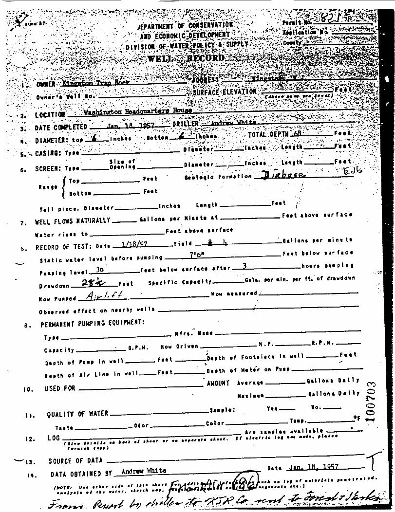
3' DATE COMPtETED4. DIAMETER: to»5.^CASING:
SCREEN: T»MTop
Tai l p iece. D iame te r .
7. WELL FLOWS NATURALLY
W a t e r r i ses to___
____Inches Length
Oat loat ptr Mlmle at
_Faat
.Ftet above t ur f a c e
i. RECORD OF TEST: Oa t t 1/18/S7
.Feet above surface
__Yield ft U
S t a t i c wate r level be fore pusiping_____7*6*—————
Pump ing level_J^_______feet below surface after
ar«wdBt.ii 0%%s F««t Spec i f i c Capacity———
A...I.ft.H o w
_________Qallons ptr m i n u t e
_______Feet below s u r f a c e
? _________hours pu lp ing
.fiats, per «ln. per ft. of drawdown
How measured.____________________
Observed e f f e c t on nearby w e l l s
9. PERMANENT PUMPING EQUIPMENT:
T y p e ———————————————————________ M f r s . »i«t
Q.P.M. How Orlven__
Depth of Pn»p in wtll______Fttt ___
C a p a c i t y.H .
Depth of Footpi tct In wtU . F e e t
Depth of Air Line in w e l l
USED FOR
.Feet. Depth of Mtte'r on Po«p
AMOUNT Average O a M y
G a l l o n s D a l l y O
QUALITY Of WATER
Are laaplet aval labt t(Ol*» 4»lmlli »m k*et •/ «»••! «r •• ••^•r*t* •» • •» . // tltctrtt Iff ••«
13. SOURCE OF DATA
it. DATA OBTAINED
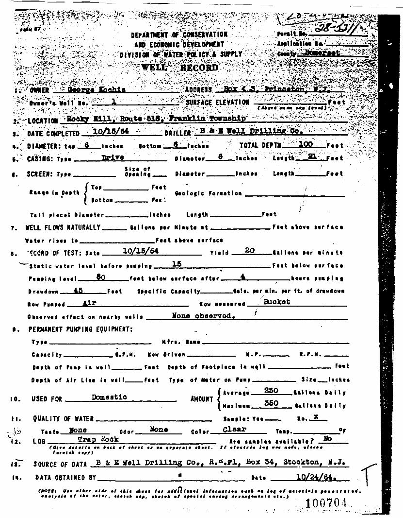
^S^^^a^r^V '': 'V: \^*Cf^^*^^|- '-H ." '•-*-^'^. 's.^"> ' t•• '•: ' • • - • • , • • ; • . < ' • 'V•''•*•' iV' '. "."T^ j ^y' J "T .1OEf AITMENT OF CMSPtVATIORAID ECONOMIC DEVaOPMOT
SURFACE ELEYATIO*frwaar'a Wall M.
^T • B1JP CflHPt FTFB 10/l5/(
a. DIAMETER: top _9__l «cht«
*T- CABINS. Ty«« Drire
f. SCftFFi: rraa
( TOPlotto*
Tail placa! Dlaaatar
7. WELL FLOWS NATURALLY
• •tar r !••• to ,,
s. ^CORD OF TFST: Da ta^""Static watar laval bafora
fimtl*t I*Y»' . ,._,_»0
Maw •••»•* ., ,A^F.
Obtarvad a f fac t on naarby
LA _-....' . ' • ' . ; -j
•otto*
I ' '
Siia of
Faat
F««-
laehaa
_ Bal lona par
Faat
10/15/64
py-plnt
faat balow
Spaclf le
wa l la
»n'Vni"r.-:'B-,*-l Tt ll- t»llllairt' Oai '; ": "•-• : ; -^^
6 i-Atf TOTAL DFPTM iggi *..*
Dla^tttr ^._._'"«^"" L«a|*fc" *r:«.r'««*
Bl«a«*ar. ,.„.,,.!•«••• *-«Bf th _. F«««
/Aaolofle Formation ,
l..t»h F..t
Ml*u*« a* _ _Fa«t >kav« t i r f aea
aoov* aarfaca
Ylfl't 2° .tt.l1a(i« p.r .l.^t.
15 „ _ _ , , P««t balfiw • • r f a e a•«»
t»rfa«« «*t»'_ , 4^ ko«r« p iaa lBf
Capaci ty .. __ _•»»•- p«r •!•. p«r ft. af rfravdawa
• thif.1»jk4>Haw •••lurad BUOlCet
Hone observed. ^t. PERMANENT PUKPIN6 EQUIPMENT:
Typa Mfra. laaa
Capac i ty . •.P.M. How Driven K.r. I . P . M .
Oapth of Pamp in wa l l .
Dapta of Air Lina In wall
USED FOR
Faat Oapth of Faotplaca In wal l
.Faat Type of Ma tar on P«M ——
F*«t
Siza__Inchaa
AMOUNT( Avtra|a__§§2__tal1oaa D a l l y
QUALITY OF WATERT..«. Hone
LOQ__Odor. Hone Color.
Sa*pla: Yaa .Clear
tt.non. D a i l y
lo._? —
Ta«p..Trap Hook
(Otr» 4»t*tl» •• *«t» •/ •*••( »r ••tfff)
Art aaaplaa availailt?•k«*(. If •l«cfrJ« 1*4 •*• a*^*. •!•*••
I»T SOURCE OF DATA B &: S Well Drilling Co»» H,^.ylt Box 54, Stoolcton,
l». DATA O B T A I N E D BY Data lO/24/64»
It*1*4
100704

••v ..y"vfciaj_ -,.; . -. ,*%$**
2. LOCATION KUftt«». »• J.
;*iSjta»<--'--:-y' ^v<>- - - -^r .', —— X>- . . • - • • :- - ;., ! "•'"^^fi|•'•-'';-^--' ' •-.- • - • .aMit ..' ' ;v^^
SURPACE ELEVATIOH'—— ————— 1M ——— '•H-,;^Mk*M awe ••• toMll • > ' ']• ••'V3£|•-.: i^
*, DATE COMPLETED *-**-*3 nniLI.rH fiftlft YftJL l*tAa_ X-vl
«. DIAMETER: Top J| ____ lacbes Botto«_J|
5. CASING: Typ« ——— »*JJ —————————Sl» of
ft . SCREEN: Type Oneninj _..._.
/ Top feetRan«e la Depth < ___1 nottn. feetTM1 pi^rt pi*—t«r Inches
7. W E L L FLOWS N A T U R A L L Y .Gallons
___ I»rbw« TOTAL DEPTH 122 .,P«-* *'1
. DtaMfer . 1 Incftt* LMftJi 77 . Pw«t
niBMtJtr laches L*«|th rw*t
Oeolotlr fnrwtlnn 8w««to«« j
/ !L«n«th . Feet
r-r m nut* »t feet above aarfaee
»it»r rl«<» t o . . . . . . . . F e e t above surface
8. RECORD OF TEST: Date 6".23"53
Static water level before punping .. *9. . . . . . . .
YleH ® CalloBB p«r mlnut*
Feet below surface
-,_ PxMpl^c l»*el BO feet below surface after 4 hours DusolaiDrawdown _ .__._.. .^P ____ Feet S;«cificHnm PlwnMl 3 in. T Od PV1>P
Observed effect on nearby wells ... ............
9 . P E R M A N E N T P U M P I N G E Q U I P M E N T :
How Driven _ . . .«l«c. BsdtOT -Depth of pump In well _ftQ_ .. FeetDepth of Air Line In *ell- ...._ . . ..._ Feet
10 l ;<sFr» FOR llOUQQ
H. Q U A L I T Y fF WATFRT««f» Odor
12. i.nr,
13. SOURCE OF DATA 2&wi A v»« i1 . DATA O R T A T N F D BY * *
•*
»»t»r , «tel<H **p» • b» l« h *f •^•ciftl c*Jl»«; a r r f tnQtwM
Capacity __ ,___ _ _ Gals, per mln. i«r ft. of drawdownHow Measured ,_L
none _ . . . . . . . _ _ _ . . . _____
Capaci??^ '~"A Ollmm par Bfmite
Hnr«* Powpr 3/4 R-P.M. 2&00
D*»ptb of FOO» pi^pp in _«11 ^etTyp* of Meter on Pu»p
'i Average .5.00 Gallons Dallj
AMOUNT'SI Has 1 DIM 1,000 0*1 Ions Daily
Sajsplef Tea Ho. -Ool'jr T««p«ratiir« °F
Are saaples available? ___
.Atari '• '
DATE 4-23-53
«U. «tc.) . *S\^
10070:

ADDRESSSURFACE ELEVATIOH —•-«••— *•*•»»
Outer's
LOCATION _________DATE COMPLETED __4-33-*3———DRILLER
DIAMETER: TopCASING:Tn» ————t*A*3—————————— Waiter
81M Of
SCREEN:
laete. ***** .f**t
Openlnc.
toTop
.Peet
______Incb««
Oeoloflc Por«atlon
piece. Dlaaeter __________ Inches Length ______
W E L L FLOWS N A T U R A L L Y ____Gallons per Minute at __.Water rises to ...____ ._.._.____.._Peet above surface
"CORD OF TEST: Date .._ .6r27-53 _.__._ Yield _._2.7
»»ter level before
Fe«t_Pe«t abore surface
.Gallons perPeet belo« surface
feet below surface after. ———————BTCI —.-_————— Gals. P< "in- v*r
^ ___ Peet Specific Capacitor———--— __________
.P. ;::. ".:AI» «-.»«——-- ;:;..:_:_Observed effect on ne.rby .ells --- non.
9 PERMANENT PUMPING EQUIPMENT:i«t_p.'uap._..——
elcc. motorHow Driven -Depth of P»P in »ell ...flQ--- —Depth of Air L.ne In «11 ————— F«t
_h.ou»ft-10. USED FOR - - - - - -
11. Q U A L I T Y CF W A T E R ——————.. — -.—
Taste ———— Wor
12. LOG
1' SOURCE OF DATA
O B T A I N E D BY
Capacity .. , 8Horse Power _.J5/4
0*1 Ions per -Inutc
.....__ R.P.M.
Depth of Foot piece in wellTyp* of MeCer on Pv«p ———— ._.. ____
___ tA M O U N T S
\
ATentRe __ BOO1,000.
ttaxiaui __ J
Sa_ple: Tea
Gallon*
Gallon* Dmlljr
Ho.
Color Te«jrT»tar«*"? 8»pks aT»llable».
.u. .f i»u •^•t r" — l l t— l •-'l, -/ .•-«» ••• "-«UI -1"' •""*'
,.,t^ .«^ » f •' ——"-u ^^tr'U<l- •~l"U " ""• aU. «t«.)
f
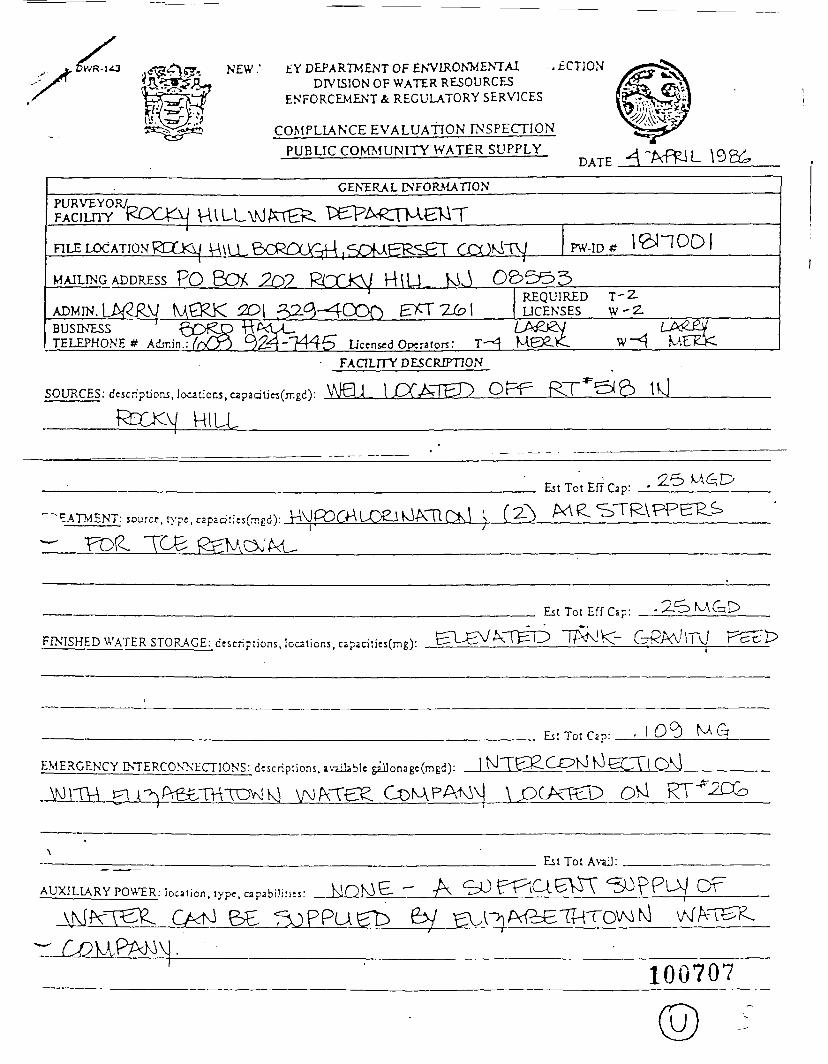
^ NEW ' EY DEPARTMENT OF ENVIRONMENTAiDIVISION OF WATER RESOURCES
ENFORCEMENT & REGULATORY SERVICES
.ECTION
COMPLIANCE EVALUATION INSPECTIONPUBLIC COMMUNITY WATER SUPPLY
DATE
GENERAL INFORMATION
RLE LOCATION PW-ID*
MAILING ADDRESS ?Q BOA HlU
ADMIN. u^Ry U£RK REQUIRED T-Z-LJCENSES W-2-
BUSINESSTELEPHONE* Admin.: Ucensed Openton:
FACILITY DESCRIPTION
, .nSOURCES: descri?tJoni,IocaUoR5,c2paalj«(jTigd;:
mu.J 1 CT^THT) OE^PA- — \ ^-^ -r^-* \-^ s
^ATMENT: source, tvpe. Mpadf:»faEd): VA\Jp3OALD&Jl^/CTir>.\ N
Es tTo tEfTCap: -
FINISHED WATER STORAGE: descriptions, locations, C3paci,ics(mg):
E i t T o t E f f C z p :
EMERGENCY INTERCONNECTIONS: descr ipt ions. i%iiJable gil]onagc(mEd):
Est Tot Cap: • 1 0^
Est Tot
AUXILIARY POUTR.: locaiion, type, capabilities:
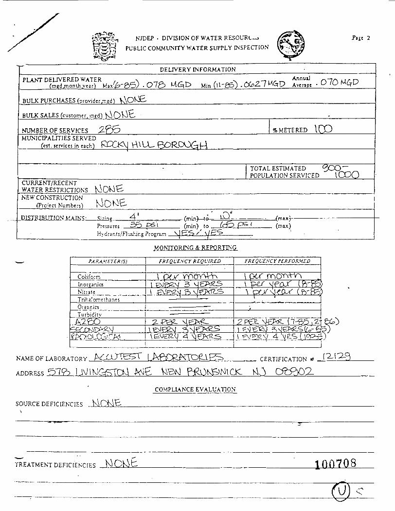
NJDEP - DIVISION OF WATER RESOURCE.PUBLIC COMMUNITY WATER SUPPLY INSPECTION
-Page 2
DELIVERY INFORMATION
• O70
BULK PURCHASES (provider^cd)
BULK SALES (customer, mcdl
NUMBER OF SERVICES %METER£D I CDMUNICIPALITIES SERVED
(csl. services in each) £CQ<\j \A\U- GOR-PQ^^
TOTAL ESTIMATED <3OO~~POPULATION SERVICED lOOQ
CURRENT/RECENTWATER RESTRICTIONSNEW CONSTRUCTION
(Project Numbers)
DISJJSIBJJJJQN.MAIk'S:Pressures ^O
-(min)—to-to
^mt*)-
Hydrants/Flushir.g Program
MONTTORING & REPORTING
ColiformLjiorcaru'csN i t r a t eTr ihaJomt thanss
3
OrganicsT u r b i d i t v
FREQVZSC Y PERFORMED
\P^
4cfi?)
NAAiE OF LABORATORY
ADDRESS P^OKSVNICXCERTIFICATION #
C££)OZ
SOURCE DEFICIENCIES\
COMPLIANCE EVALUATION
TREATMENT D E F I C I E N C I E S 100708
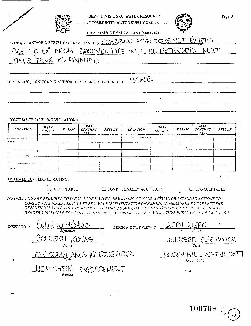
DEP - DIVISION OF WATER R£SOURCC
. . _jC COMMUNITY WATER SUPPLY ENSPEi.
** "* COMPLIANCE EVALUATION (Continued)
AND/OR DISTRIBUTION DEFICIENCIES QJS^PlPJvl P! P& UOT
ro . PIPE
Page 3
fe
LICENSING, MONITORING AND/OR REPORTING DEFICIENCIES
COMPLIANCE SAMPLING VIOLATIONS:
LOCATION
— -
£>xrxSOURCE fAAAM
MAXCONTMfiT
LEVELRESULT LOCA TJON
DATASOURCE fAJHM
MAXCO/fTMSi'T
LEVELRESULT
pyTRALL COMPLIANCE R.ATENG:
ACCEPTABLE D CONDITIONALLY ACCEPTABLE UNACCEPTABLE
N07TCE: YOU ARE REQUIRED TO INFORM THE NJD£J>. IN WRITING OF YOUR ACTUAL OR INTENDED ACTIONS TOCOMPLY WFTHNJ.SA. 58:12A-1 ETSEQ. VIA IMPLEMENTATION OF REMEDIAL MEASURES TO CORRECT THEDEFICIENCIES LISTED IN THIS REPORT. FAILURE TO ADEQUATELY RESPOND IN A TIMELY FASHION WILLRENDER YOU LIABLE FOR PENALTIES OF UP TO S5.000.00 FOR EACH VIOLATION. PURSUANT TON.J.A.C. 7:10-3.
Ds'SPECTORj PERSON rN1 A'iTT.ff
Name Title-
HILL WATER P6F]Orgzn izsricn
Region
100709
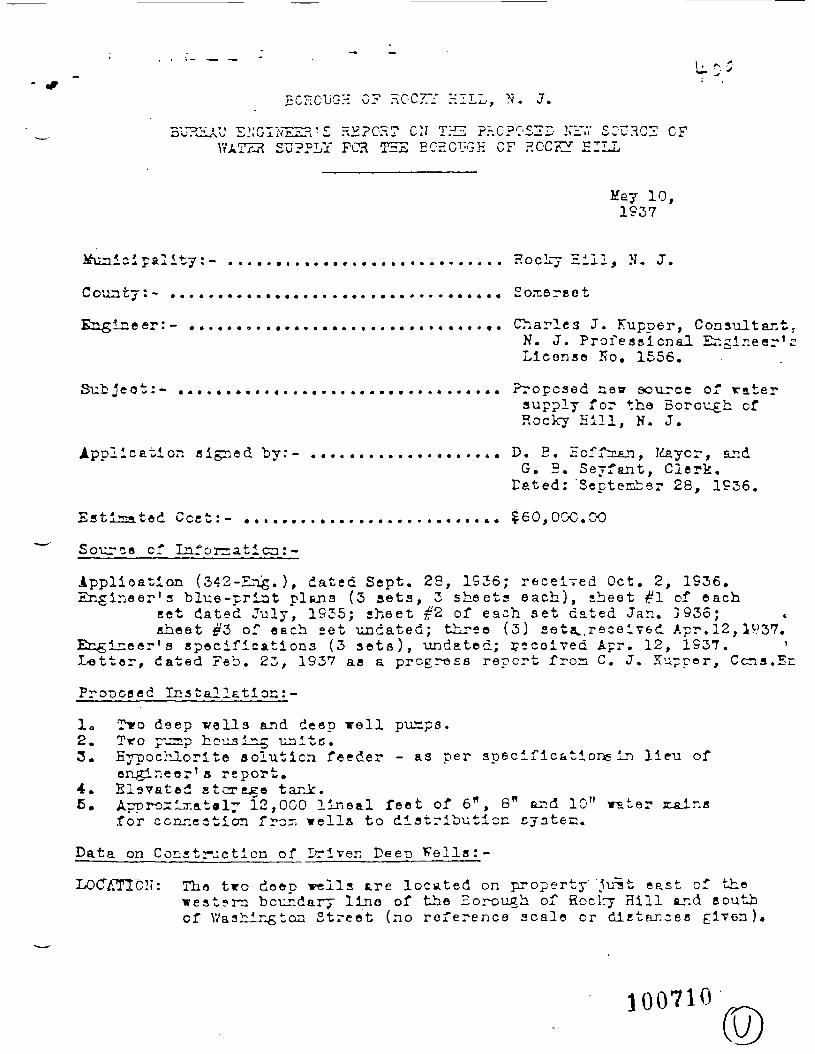
5CECUC-H 0? HCCr/ HILL, N. J.
5U72J/J S.'.'GIL'vEZH'S REPORT ON THE Pr.CPC'SZi: Nl'V SOURC2 CFSUPPLY FCR THE EOEGUGK CF ROCKY EILL
Hey 11937
Hoclry
County:- ................................... Somerset
Engineer:- ................................. Charles J. Kupper, Consult&nt rN. J. Professional Engineer 'sLicense !?o. 1556.
Subject:- .................................. Proposed new source of ratersupply for the Borough ofRocky Eill, N. J.
Application signed by:- .................... D. E. Hoffnian, Jdayor, andG. B. Seyfant, Clerk,
Dated: 'September 28, 1936.
Estimated Cost:- ........................... £60,000.00
Source of Inforsaticat-
ipplioation (342-En^.), dated Sept. 23, 1936; received Oct. 2, 1S36.Engineer's blue-print pltoia (3 sets, 3 sheets each) , sheet #1 of each
set dated July, 1935; sheet #2 of each set dated Jar.. ]936;sheet #3 of each set undated; three (3) seta,. r ece ived Apr . 12, I?-? 37.
Engineer's specifications (3 sets) , undated; :?ecoived Apr. 12, 1937. 'Letter, dated Feb. 23, 1937 as a progress report fron C. J. Kuppe r , Ccns.En
d Installation: -
10 Tiro deep veils and deep well punps.2. Tro puTap housing unite.3. Hypochlorite solution feeder - as per specifications in lieu of
engineer's report.4. Elevated stcrejzo tani:.5. Approzi^.ataly 12,000 lineal feet of 6", 6" and 10" \rater j^alns
for connection fron wells to distribution cyatec.
Data on Construction of Driven Dee-p Fells:-
LOCATION: Tho tiro doep veils tre located on property' 'lust east of thewest?ra boundary lino of the Borough of Soclry Hill tr.d southof V/ashington 3treet (no re fe rence scale or distances given )4
100710©
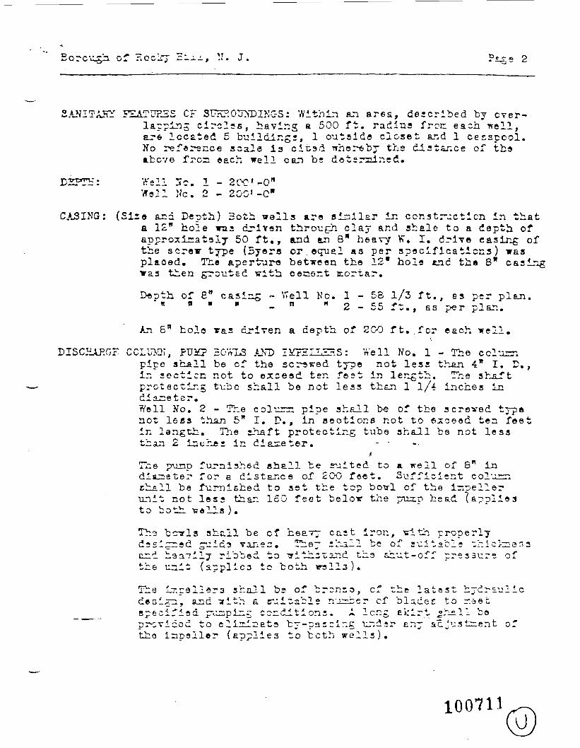
Borough of Hoclry c.-±±, ". J.
SANITASY FEATUFJiS CF SUI\HOUM>INC-S: Within an area, descr ibed by over-lapping circles, having a 500 ft. radius free each well,are located 5 buildings, 1 outsida closet and 1 cesspool.No reference scale is ci tad whereby the distance of theabove frcn each well can bs determined.
JDZPTH: Well Sc. 1 - 2PC'-On
Well ,Vc. 2 - 200' -C"
CASING: (Sire and Depth) Both wells are similar ir. construct ion in thata 12" hole was cLriten through clay and shale to a depth ofapproximately 50 f t . , and an 8" heavy V7. I. drive easing ofthe screw type (Syera or equal aa per specifications) wasplaoed. The aperture between the 12* hole end the 8* casingwas then grouted vith. cecent cortar.
Depth of 6" casirxg - Well No. 1 - 5 8 1/3 f t . , es per plan." " H « • _ H H O _ CC f-t- _ „ ~f.~ ~,~\ cr*"• *& — w ^ 4 . h / . , aa prr 1^ ^ J. tl*».
An 6" hole ras driven a depth of 200 f t . . f o r each well.
DISCHAP.GF COLU1OT, PUM? 30«1S AM5 li^ZLLSHS: Well No. 1 - The cclumpipe shall be of the screwed type not less than 4* I. D.,in section not to exceed ten fest in length. The shaftprotecting tube shall be not less than 1 1/4 inches indiameter.Well No. 2 - The coluznn pipe shall b« of the screved typenot less than 5" I. D., in sections not to exceed ten feetin length. The shaft protecting tube shall be not lessthan 2 Inches in diameter. - -
The p\inp furnished shall be suited to a well of 8" indiameter for e distance of 20O feet . Sufficient columnchall be furnished to set the top bovl of the ir^ellerunit not less than 160 f e e t below the piup head (appl ies
h3 bcTrls shall be of heav— cast iron, vri th properlyThedssi;iini hsavily ribbed to iTith^^ind ths shut-off pressure ofthe unit (appl ies to both rails).
Tha i-pallers shall bs of b ronco , cf the l a tes t hydraulicdesix^i, SLHC Trith a suitable n'^.cer cf blad.ec to r.aetspec i f ied pulping conditions. A long Ekir t jr_all boprcvicoc to eliriinata by-pas = ing undsr any acjustrent ofthe incsller (applies to both w e l l s ) .
100711 u

Borough cf Rocky 2ill
SCRZSN:
SEALING
A suction pipe 5* I. D. and 20 ft. long shall ba famishedfor Toll Nc. 1, -atiile a suction pipe 5* I. D. end 20 ft.long will be provided for well No. 2.
No provision made for scraer.ir-g due to type cf installation.
0? 7TELLS: At the hsnd of each, irell, the 6" driven pip* -riller.tend up into a pit above the concrets base of theIndividual well pnrrping stations. A flange will be beltedto the h*ad of the 8" casing, as shorm on plan, and a sealbetween the drop pipe and casing will be ef fec ted throughthe use of pure rubber gun cords and a sheet rubber gasketplaced between the upper and lower rings of the seal.
LOG: Well No. 1 Well No. 2
0' - 5! Fed clay and sand5! - 20' Dark purplish red
clayRed shaleHard r^d shale
rt n K
20' - 50'50' - 60'80' - 90'90' - 110' Hard light tnd
dark grey bailedshaleHard baked purple-rsd shaleEard baked greyehaleHard baked purple-redNorsaJ. red shaleHard purple-r-sd shale
O1 - 15' Yellow-crcm clayeysand and gravel
15'- 20' Ked-brovm sandy clayand pebblesSoft red shaleNorsial red sh^aleIXill red shaJLePurple-grey bal-ed shj».l'Grev baked shale
20'-36'36«-112»
112'-140'140'-1551
155'-155'no«-ii5»115'-130'
150'-ISO'16C'-190'190'-200'
165'-200' Dull red shale
Static *r&ter level: Vtell No . 1 - 4 7 'roll No. 2 - 46'
Wall llo. 1, on tsst - 12/25/36 - ilscharced 40 g.r.r.. at145 foot level. !::• lri3"a_^-c, th are f o r e ,
bo csp&bls cf p-urrping 40 g.p.n. of clsar crater having ats^Dsrature net to exceed £5 decroea ?. rr.sn driven at
o ^~5L w otal 290 f e e t .
T.'ell No. 2, en t-et - 2/1S/37 - discharged 115 g.p.r. itthe GO foot level. The punp installed, a: per apec i f i c i -tiors, shall be capable of piping 125 g.prr.-cf c lear ra terhaving a temperature not to excosd £S deer-sea F. zhsndriven at 1750 r.p.c. tgstinst a tots pulping head of 2£0 ft.
BLCW-C7?: A 2 1/2" blow-off pipe, equipped trith b r a f a -nippl* and c a p ,is carried out aide of the pulping s tat ion housing veil J < o . 2.Thi« se rvas the corrr;cn discharge line fror: both wel l s .
1007J u
corouzh of Scclry Hill, N. J
SAMPLING TIP: A l/2a co^oer -rater Eervioe to a basin ir.station No." 2 - as per plan - la tapped to tha 8" T inthis building. This tap ia srapla, in tha examiner'sopinion, since samples fror: either cf the t?ro wells nayte procured by tha individual operation of either cf the
Yi'ell No. 1. -. Tha well haad and pu=p unit will be housed in a ono-ntoryconcrete block structure rlth concrete foundation and 5*accent floor.
Well No. 2. - The veil head and puap unit will te housed in a or.e-stcrystructure of local stone with concrete foundation and Eu
cer.ent floor.
Storage: -
Both wells will discharge into one elevated steel storage tank having Rateel conical shaped cover. Ths capacity of the tank shall ba 100,000gallons and it vill be erected on property adjacent to the structurehousing rell No. 2.
Th* specif icatione on the ccn.2 trust ion cf this xmit call for tha install-ation of suitabla hatch near a ladder provided to pert^lt of rescy accessto tha inside of the tank.
A riveted ste*"1 riser pipe, 5 ft. in diameter, -is also called for vrhichahall be fi t ted vith the necessary pipe conneotions and manhole - willact as a settling basin fcr any sedlnent that cay be carried in thewater • A KS. shout ralva ( 6 R ) shall also be instilled at the batten ofthis ris3r pipe.
An 8* W. I. C7»rflc-s pips shell be securely fas tened ir.side the ria-sr,tnd shall be extended to a designated, point of dlsrh^.rge en the ground.
Tha results derived frcrs the complete erzaninaclcn of a sa^pls of vaterccllect^c. fro- veil io. 1 on January 6, 1957 ars as follorrs:
Ccll-c.9ro^snan grout:: Absent in all 5-10 c ,c . por t i cns ;__ 37CC, Bact./c.c. 1;" Color 0; turbidity 0; Odor" 0;
^ r**, * ~ ^ ^ ^ . Q * t> T-"^ Or^ T (^rt* m. "^ n r "^p-^» VJ*^ ' * -> f - . ^-o*-> p"V * T-V» .o Afc-« U -- .*. —. ••-> j, ^1 J • r \L -kJ» WJ. -L ^J » • — \J L. j_i C^» f -• — w ^ . ^ ^ w . » £4. O . . -. v^ v
Armenia 0, Alb'. Ar=onia .024, Nitri tes .CC5, Ni t ra tas4.50; Chlorides 12.0; Alkalinity 67.C; Total Hsrdnass64.0; Iron 0; pH 7.0; Manganese .015; Oxy. Consunsd 0.
100713CO)
M
^1
fl r-l
<»
"> p
VH
- i
-n
•- ^
o
itpj
•** ij
jiIO
(P
(0
lO
fj
t) rt)
f,c;
• •
o tl
o o
i 1 i-i
u cv) '~
OJ
f« •»( i; V
iin
o -. i -^ IP
O
•
VH
4-> w
i>: 1
••
i' (ft
a>
n
• O
%! />
*'< 1> 01
f . r-i ;.
«i cu -tj
a> (.
i -i h o
i/. 4 1 a> -u IP ,r •
f j TJn. O
(j, | .
rt (O
1, 4
J
{) QJ
l| r 1
.p
../, r) H
[/
0 4
Jdl r-|
• -.-I ri .|i n ;J
O
41
rf «'
«
O
O '(J
Crt ^
| o
n
,,
0(
r.|v<
• it ',~. r, K
r-i
n f-U
l 0 ,0
rj
-DO
|J
, n
^-|
|-;M
fi
fli •» ti
r_j <>
(j«, i «
o 'J tjio
« r4 w
n o
O
r-l L-I O o
tij •
iu O
<n
m
i r. 0
|*»
4
>
O.
xl
rM
'i to
«-N j i • ,-i
K
aJ r. 4J x>
O fl
C.) v
i do
(* p•••1
r| i-;
n
4>
[1,
4.5
O4-> h-
,-i ri >n o
•« «
o 4Jrl
i 1} cri o
• •> 4
> r-i IO
'Jl «i
<ur.
O>
"J
fi ^ 1
-^
4-»
r 1
V| ,M
- 1 r-l
n 0
H
r, •*,-<
.0
r
r<1]
•» 1
.f J
11 O
•
4-1
0?
v 1 0
r 1! ">
•-
O .. 1
•
ri 4J
r) f»
t-; c- •!-> o
:-. 01 c ,*] o
^i«
r-l
H r 1
C)
£~
- H
4i
p,
-tj ^J
«> n
«• ft)
fHa) r->
ui ;(
i o
|-» r;
<y ;, j rt
4> ft ,Q
o
«
4.1
H
1 4
J o
r n
0
OJ
1 -^
r I
f4 pj T
-l »V
) 1
rt
* <
O
J• H
:i o tt'i-i r: i:
f o
•P
. P< •• O
H t; T|
if ' ^
K
I •) n
i,U
.'1
O
. 0
r-l ^
"3
4-- rj
£ <u
o *
y ••> p
ii pi
q -H
o
,i m
I) fe
0
OJ O
t] .«
•-
ii
r- .(
(d H
f, - C
r-l LO
«
(-1
1=
vl
• D
r! 1.0 •
• «< oj
n p o
tn t-*~3
xl o
o P, • •
4-1 ry <D r-i r: r-
.p
0
• p.,')
<«C
~ rS
r|
rl <
U f
• oi
m '»
ij ,-i o
P
« r-l
cd
p
n j-!"^-^
«« • W
o *-• o
iu p.ti
• «
>•••>
to
o, n
od
o
xlJ
l«•>
'«
O
UM
> K
- •%
h
•>
«
4j'1
VH
J~ O
o 10 O
U
•- r>
^) C
ii-l
f-i rlr
l W
O
r-^('-
l rH
h>
X-i
'O r i
<u ui n TJ 'ji
do P
, v^ x> -P
,'I| f.) .-f
nt
rj v|
^-1
•
O
Jl
r- o
I • T
J f ,' £«
, i tn «
J o
«d
V(
••IP
•»•) C
J i 1
(i O
C
-fl oJ M
4-1
CI O
-X
r,
r-Jo
,-|
II ,-|
g
>, ft
f.
'i «•' n
o i-
(.> |l
H n
, ri
o
xJ o o
'.) •
iJ o
o t'j oj .y b M
»J oj r- <D ^, n
f': fi
q •, -i
t) fi, y"
Vf
«d %i -P
o
p,'.;
i; rl
o p, «j t<-
U
r-l T
) C
D
«(
C
O
f]..
- ti
"| >
l\
Ii Ij
*<.'1
^
•»!
O rH
fj
O, J
41
M1
i» o JLJ
si n 4->
;' '"
*
«
• M
el n
v-l
^ '-*
« ^H H n
'< -D
.- I .
«
~
tn
fJJ K«
,1
o
,, o.O
-P
Cf"
LH
o
E-i^
4-iM
rtO
,
Fl
' rH
O
•> • of
4J (P
P, «
) . xii-i -a
c • D
.<-; io - 1
xl •. < to
u c
rt <
1 «
) fn
rl
C,
1
f.'r_]
V)
f 1 4
* O
'J~> r-|
-H
OO
'. I
O
r I t>
"I
«1
,| .-4
1
to
XlrH
.C;
fi r-{ •&
l:)O
JO
''>
O
•) fi
X)
<D
nl M
XI
O
^ od
(Dr-l
• H
rJ
U
>4i 4
1 H
r-l '1
rl O
41 M
rj
"1 M
'-l V
-,'i« ;r
w
•• J 1| r)
a! ci
41
O
-^ :J
fl >
m
fj n x)
w 11 o
r. erf o
(.-; O
-H
4J •, i Tim
4-1
•rl if
.1'
f»»
(J
c: 4
3 P
. 8)
41 4-1
aj
, ( vi
p
C 4
J<D
rt E
) r; f r i
» »
-i o.r,' *i H
-ri
o o) (, jj
4J n
^i *i
fl • «
x") orH
-U
M
r-l
r-l f1
0
10
fl r-|
• «}
« (U
X
,' 0
4J
f] H
O
C
P
, 4-> If)
C) •, 1
"1
O
ft O
r-»
• T
-l t>
41
fl fli'n
f.;
rH U
) (V,
',-,
;j<U
J'-j 4> X
l «
'•* O
IH
O rH
<-< ;< H -iJ -H
ai o r-< o
oqi
(J,,-|
O rH
P
< »*< X
) W
wr.,
P,X
3 f).
O
O fl
(1n
p, fn
< o r< r, i-<41 ^
<n f-i a! P
, O p, ,1
ni oO
r-l
0
(-•» 0) 4
-1V
-~- .0 rn
« i Jt xJ <-)
,r|~-»TJ oi f< -v-f
o o r> n 41
O
«) 4
1 u
,C
j r-l
r) J, ,4
. tO
rl 4
1 i 1
Xl 4
J
1) *H
vl
P,
r-JP. o r' 43
r-i .r;
i «>C! m
-,4 x.| x>
a* 4J ol f<
r? c
4J aJ
ft 41•,|4
Ja
j v
i p
.OV
ipffin
,fj O
fl
»* a) 41 O
m tj
• 4-if_;r,'o
o n
»o
)-,
u
t, ~
* C
. -I iu
I d
m
v-ir< n
o o
a) 1
1 x]
>, u
f j Ti
o X
) -i j -H M
A 4i
1, a) (ti .[j
,H
v-l 4J aj K TI
1 trj ci
O fli 4
.1
r-l f-i
rt O
fr
i'. 0) l»
O
l rl
O 0
41 rl
i O
n rl
vH
M
rrj rH -rl v
4 M
"rl
, ( -r) CJ< N
»H
^4 X
j rH
O f-l
4-' rl
rj) r-J
B) 0
D
, IY1
;Ja) r< v TJ -H
o fi. ri
« ot)
J ) XI
f-. T
J fX e
j s 1 / ' xl
»H^—
f-iin <n.h-»
4>4J
" <
) 1
0
ft) 4>
r-l
Xj
«)
O
th,
I f«
4> 4
> P
I r-l
^J D
V. C
J01)
IT)
ft) C«
4-1
•.-> O
t) -'j ;< k N
41 o c:
fiP, o
u> xs i
c-riK
e>
' «
*>
<J
<D
CflM
4
->
P<
•• <H
«> ,r| -
v-i j-.
f,4 «•)41
-a i
m 4-i 43
o o
o «
»ft
f 1 0
*-(
q
4-1
14
»
01
W 4
->«
H »• < r» «
-ri u « p
,xi u
H
oo
xif]
no
riHrtrH
®-*
1 n r-f f i
0)
4->
J
X ]
I j X
i 0
0rt
f.1 ,rj O
f( rt
4J •• 1 ol 10
«
«< o r-i o
r D
|<
n, r
f-if«
r-<
(J
,fj N
X
I rt
d
rt /) <
D
4>
FI
l^«
««
b»
«-P
§
H^
19
ot-i^
QP
,
>-,'J-, 1
J1 IJ
•.I U
rjh. f
r: Mn; r,
- 1•11 o a) , ir , r i , i -, iM
.n ;i
I,< 1
O
O
"I17)
*
PI/)
T>
0.1
•" "" ,
t: j.i - 1 •() i.
o i)
"4
1 u
r,
.£-. oi "i - 1
;-," ,',' ' ,' '<
"oK
) -|J
4'
r'' T
)
r: <n
r!•*
1 O
.i I J
f 1
"• -rl
(0 a> ;) •[_•<
in
rj il .o -tf
ro r,
<D f-i
Hi P
,_ IN
O
n in
4
1
\^If.,
0 f,
•,(
\\ l-
ir
M -.1 ri
fj *i
•> r,•• i TI r«- xj
.u t\ |-<o ni
|5
(DO
'.J
V
r -1
4->
,-H
»] 'L
1 "1
W
-v
f
O «
H-j d
,i
^\ l -i r;
o ft -P
'ij I--,
\
<M
a
1
f; r:
« r-i
i^rjO•j
fi »
>
r-i M
i -itx .t
4J
v0
V
f\
'•> •(.)
'1 \\
'f 0
41^
r; f! 41 r, ii
v Y
f< f?<n T-I fl "J "v
4' 4
s M. o
dA
IJ /, N •(.!
o \H
\\ 4J
.p n) m
n
CD
\ \\J
*• "•>
>', 1 ^ <u o p,
N.N\xJO
--(/J
(1
) , r4
1'
t) \\\
, r)
43 rt 4'
w
<n V
"X_* • rt
- i «
CT
: 1\
>1
-N<fr ~
n l-i
r, vi
N41
nj O
T
)r. (.1
P0
4' "if
h-
C-l
i 1 fl n
•!' M-4
14
1,1
-1r)
f, r
1 .-( r>
>r> a
ff
fl '-1^
o, P M
.aflj
«
T) [f
rit-
T
j f,'
41
f- - 1 -7 o
o r
.'] P.
O fl
t) P
Si ,o ,(1
O ^
j r>
4!
r; o
10 1 1O
«
\4» ID
h
^1 r- -i
('.to n f|
r)o ci
fi ;.'
1 1 ,
r-l r-< ,V
0
1
''J S
-<;;j
r> fi r C
'
. CO
•" ?> (J
1 •
c: "J
y o
U3
._
p.
/T^
* *• vJ
fi "I rf>
n o
fi]
*-' JH *-i ,^> -P
tn
•^r!>O
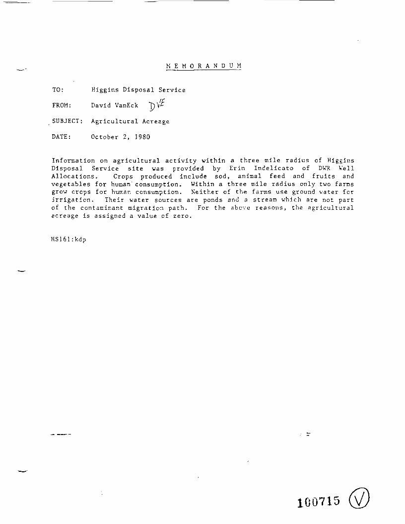
M E M O R A N D U M
TO: Higgins Disposal Service
FROM: David VanEck T)V
SUBJECT: Agricultural Acreage
DATE: October 2, 1980
Information on agricultural activity within a three mile radius of HigginsDisposal Service site was provided by Erin Indelicato of DWR WellAllocations. Crops produced include sod, animal feed and fruits andvegetables for human'consumption. Within a three mile radius only two farmsgrow crops for human consumption. Neither of the farms use ground vater forirrigation. Their water sources are ponds and a stream which are not partof the contaminant migration path. For the above reasons, the agriculturalacreage is assigned a value of zero.
HS161 :kdp
100715

D I V I S I O N OFCISK GAME AND W'LDLIFERUSSELL A. COOKINGHAM
DIRECTOR
3fprspyDEPARTMENT OF ENVIRONMENTAL
PROTECTION PLEASE RE=LY TOCN 400
TRENTON. NEW JERSEY C8625
M E M O R A N D U M
JOHN J. TRELA. Actlna DirectorDivision of Hazardous Waste Managemen
PU55ELL A. COOKINGHAM. DirectorDivision of Fish, Game and Wiidlli" e
5UBJEC7: EKDANGEPED 5PECIE5 - CRITICAL KABITA"
We have the following information reaarciing endangered (E; andtl'ircat =r:=-d 3p=ciSH within one- mile oi the three sites* and: catedin you request.
Hiaains Disposal 5erviceT
arassnopper sparrow < Amrnodramus sav annaru r\ - T) :Small to laroe weedy fields o£ wedium height, (scat-tered records from Kopewell Twp.). Known from with-in the one-mile radius.
wood turtle ^Cleinm^a i.nsculpta - E>; Occurs inhardwood forests, needs clean streams in or ad]acentto wet weadowa and farmland. Known fz^oa withing theone mile radius.
Habitat probably also exists for some of the other grasslandsbirds:
_s_j__ veeper sparrow <Pooecetes graaineus- E) - gros&y wieldswith adjacent hedgerows
bobolink (£>ol ichonvx 2?i!?i 9 Ha~ *^^ ~ grassy farm fieldsel HO f i e iyz l ea .C la ( e :e>peCl<31J.y it J. I a ± 1 a 1 1 er j. Cl £1 .
savannah sparrow < Passercu lus s§0^bfi?^?Dai?~ ^ }
extensive shortgraaa fields and peaturelands.
100716n
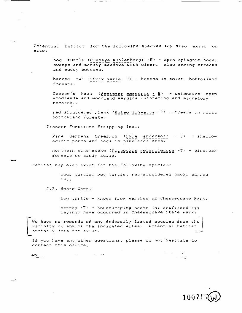
Potential habitat for the following species may also exist onsite :
bog turtle l^i = ii;E;i 2 5y£fi*D£?l§£2i ~^' ~ P&n sphagnum boga,awe.-nps and marshy meadowa with clear, alow noving streamsand muddy bottoms.
barred owl (Strix varia- T) - breeds in noiat bottomlandforests .
Cooper's hawk (Accirter cgooerii 2 5^ ~ extensive openwoodlands and woodland juargina (wintering and migratoryrecorca ) .
red - shouldered .hawk <3uteo ii'2?§r!d?~ '-"> ~ breeds in noiatbottomland for eat a.
Pioneer Furniture Stripping Inc.:
Pine Barrens treefrog (Hy.l§ §?} H £'!i± ~ EJ ~ shallowacidic pone a and bogs in pin elan da area.
northern pine anake < £'1 tucohl s rnel anoleucua -T) - pine/oakesta on sandy aoila.
Habitat may also exist for trie I'oilowing species:
wood turtle, bog turtle, r ec: - snoul aer ed haux, barredowl .
J.3. Moore Corp.
turtle - known from jnarehes of Cheseequake Park.
csT'rev < T ) - hou sekeeo i na nests <nc- confirmee, e--laying; nave occurred in Cheeciequaxe State Park.
••••"•
We have no records of any federally listed apeciea from thevicinity of any of the indicated aitea. Potential habitat•5 r o b a b 1 v d o e a r: c t e x i 3. t . . __
If you have any other queations, please do not heaitate tocontact thia office.
c y . . . . .
10071
FMC Corporation
Chemical Recs-—.r. & Deve;rc~er-'. CenlerUSH.grv.vayl Box 8Pripce'cn Ne\v Jersey 085JO(609)4522300
EPA ID NO. NJD000586164
29 May 1981
CERTIFIED MAIL P30 6893409RETURN RECEIPT REQUESTED
•/
•STvIC
US EPA Region 2Sites NotificationNew York, New York 10007
8 JUN 133!
R£: CERCLA - SUPERTUND SECTION 103(c) REPORTING
Gentlemen:
Enclosed is our form 8900-1 describing the non-FMC disposal siteused when FMC as the transporter of hazardous wastes, selectedthe disposal site.
Very truly yours,
///.Martin M. GurvitchManager, Environmental Control
End.
10071&
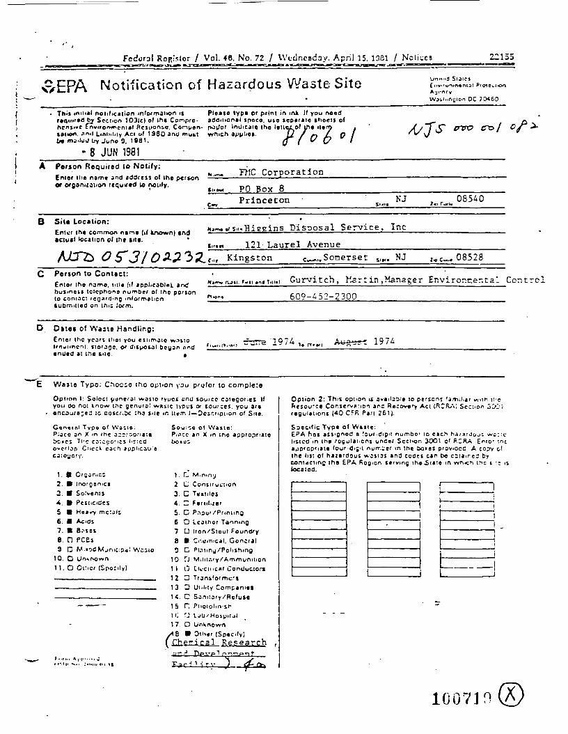
Fedora I Ropislor / Vol. 40._No. 72 / Wednesday. April 15. 1QC1 / Notices 22155
v>EPA Notification of Hazardous Waste Site Siaic»
AgrncyDC JCM60
This initial notification information is Pleaso type or prim in ink. If you needrequired by Section 103IC) of the Compro- additional jpeco. ute seperale shoell ofhcnjiwe tnvirorw^cntal Resuonso. Comuen- pO(/or Indicate the
•in<i LiAlniity Act of 1960 and mukt which applies,ilu J Lry Juno 0. 1981.
• 8 JUN 1981
separate snoels o(tlejLof ih« ilen> .
I) / t-\ L. O IO f & '
&VO /
A
B
Person Required to Notify:Enter the name and address of Ihe personOf CfDon"ation (cqutfvct to notify.
Sita Location:Enter |h« common name (if known) and•dual location of th» srt«.
WT& 0^31 oWbi
n.^. FMC Corporation
c..~< PO Box 8Princeton •C»r $'•"<
»o.~.er s.i.,Hiegins Disposal Service,
si..« 121 Laurel Avenue_c . , , Kingston e— «., Somerset s,»,
NJi
Inc
. NJ
i,r-w 085AO
i. e«. 08528C Person to Contact:
Entor ihe name, ml* (if applicable!, andbusmen telephone number ol the personto contact regarding informationSubmitted on ihis Jrxm.
i. r.n »n« T.II.) Gurvitch, ilart in,Manager Environaental Control
609-452-2300 __
D Ones of Waste Handling:truer Ihc ycart iliat you est imate w.iiioirnjuncni. itorarjo. or duposol began nndended it tno Silo «
,„„„„„, crrrre '1974 1c rirtll
E Waste Typo: oio tho you prefer to compleia
Option I: Soioct (jdneral wosic lyuci cnj source cotegones Ifyou Oo not know trie genu'9' wxsic tvPU't or sources, you areenc3ur»3«- ;c ocsc/.ic ;nj Site <r. li«m I— Dcsr.nonon of Sue.
Concrnl Typo of YVacie:P;cco an x in ihc a;rroon«iet>Crcs The CDlCCOnci I^Icdoverlap Ci>cck cocf. ipCJloyory
Sou:co of Wane:PI.TCC *n x m tno appropriate
\. OrSar.,cc2. Inor0onici
2. Solvents4. Pesticides5 Heavr mc:al;6. Acids7. B.isos
. IJ IL.C3
10. O Unkfxjwn11. O Oilier (SpOCily)
-
• IMII •-.. :....u in it
1 . C M.mntj2 O Construction3. O Textiles4. D Feruluer5 D P.ipur /Printmj6 Q Leather Tanning7 G Iron/Stool Found/y8 • Chemical. General
Wcsto 0- C PI.Tliny /Polishing10 TJ M.lit.-.ry/Ammunition1 1 (. j F.II.-CIIICXI Conjucion
IS !~j Pitotolin'sh10 rj i. ju / Hospit ji17 D Unknown
A% 9 Other (Specify)(Chemical R^seargh ,
r^r-n-;.-v "> ^o,
, - -
Option 2: This option it av«iiaai» to pt-so-.s Ijmihar w>in ["cFieiource Cor.ie'v»:ion an; Recovery ACI (RCrV>; Sec^on 30Jiregul»tioni (40 CFK Pari 261).
Specific Typ« of Wnie£PA hoi asJ'ljnod a four-dipit number to each hA;jujouc WO::Llisted in the rogulat.cnj under Scci>on 3O01 c' fiCRA £nio- meappropriate (our-dijit number in me aoies proviOcC A cop-y o!Ihe In: of hazardous wsstat and codes can be ciia.r.eJ bycont<tcnng ihe EPA Region serving the .Sine m v»n>cn ii^c i •• >ilocated.
100710
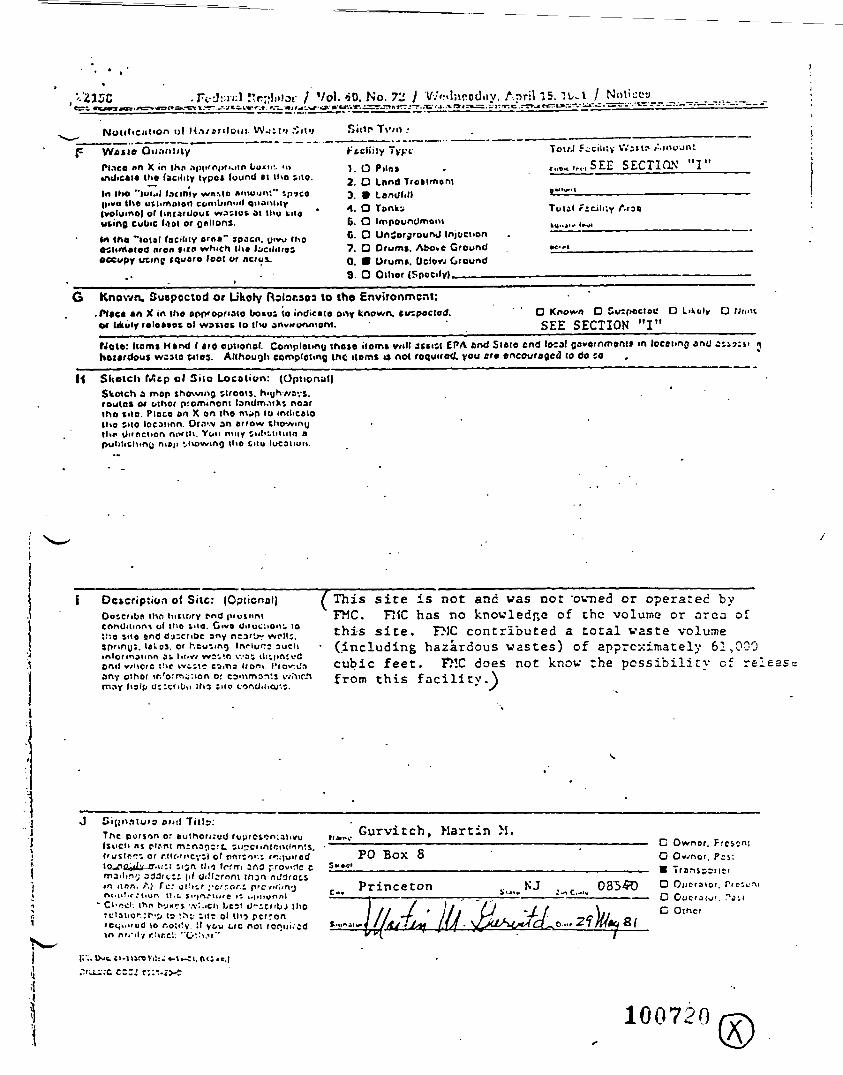
, 215C
Nottlicution t>( U.i/anloui-
. Fc-JMV.l r.r;;lii!ot- / Vol. «»0. No. 72 I VvVdnrodjiy. April 15. "!l/-l / f^l'i^j1___. _._.__...._.
T\'/n •
F Watte Qti.-iritJlyPlace «n X in Iho .i|>i>roi>i'.iln LIMIIL i»indicate (he (acidly typot lound n the ;no.In live "|ui.il laciniy WIMO • mount** ip'jco||ivti the utiimototl cornbiniMl Qiianiity(volume) o' hnrardout wasiot at thu Kiteuting cubic tool or fjnlioni.In the "total facility arna" jpacn. ytvu iho•Slimated (iron >KP which lh» Ijciliiioloccupy utinf iquaro foot or ncioi.
" . i
r-'tcliily 7vK«-' TolrJ Fccititv Wait? Aiooanl
1.0P.IO, . «....t(,,,SEE SECTiaN "I"2. O Lund Treatment3. • Lendtill 8^^ —————— — ————————————1. O Tiinki Total f icih;y AraeC. O Impoundment »M,.j... II..HC. O UnCerjrounJ Injection . — ' ~ "~7. Q Orumt. Above Ground •<•"0. • Urumi.. Oclovj Ground9. O Other (Spocily)__ ———————— . ——————————————————————————
G Known. Suspoctod or Utah/ Rolar.sos to tne Environment:.fMac* an X in the epn'opriaio bomu; to indicate oi>y tAown, tmpoctod.Of likoly releatet ol wattec to tlw
O Known D Smpoctot! O Likuly OSEE SECTION "I"
Npte: Horn* H»nd I «ro cpuonol. Comploimu those Horn* will a*»m EPA end Slftie end local ooveinmont* ift loeotmrj and iiihonrdouf wuto pies. AllhouQli completing me items i» not roquirotL you ere encouraged to do 10
II Sketch fJitp ol Silo Location: (Optional)Sketch a mop showing streets. r>njh//ays.roulot M other prominent landm.iik^ nearthe sue. Place on X on the m^p 10 mdicoioUio IMO locaunn. Of.Tv an arrow iho-/»ir\(jllir Ui'oclton no/IH You mny tnl iLinuin apulilichmQ niep vivo wing i i i o tiiu lucanun.
n o( Siic: (Opticnal)Doscribn iho hKiory rnd piusnntcnnOinnni ol tlio vio. Give Oiiuc:iOn^ 10"-o site anfl d-j:cribe any ncaf^r wrll;.spnno:. l»>.oJ. or heuling Inrluls aucl imlormaiion ai l>ov< WS;'.R was iti i i in 'vflon<! wuc<c (He wc;ic CiiTis Uom I'rovtJany oihor ir.'ormi:ion or comman'.j wiMC
(This site is not and was not "owned or operated byFMC. FltC has no knowledge of the volume or area ofthis site. FMC contributed a total waste volume
• (including hazardous wastes) of approximately 61,000cubic feet. FMC does not know the possibility of releas-.from this facility.^
Ci(|O>*>tur9 Mitl Titla:The pu/i<in o: aulhoruuOISuct> nj clrnt mina^iirt. stccnniciulnn'.s.I 'ustpr^ or r.lt(-mcvi) ol rn'to>-.i ir juircdlojin^ilv tr.ii-.i iijrx 11.-) Irrrri 2r\t3 provide cmailing 333ii.ii (cl Oi!l:rnni Ihjn r.J^roiiir. itnn. A) fc.' cl!*^.r ;rCT.or.i prcviilin-jnmil i r r i ion tl.-. t.'|r-i,-i,,,c 11 t.|inur>nl
• Chech (ho tvj«7t -.vl.ich l*cs: 0~:tnbJ Ihort:l3tior;r-Tj, 13 -,rn ;,t- Ol tl<^ perronicqi . i rud vo r.o;i!y. !t yt,u Lrc nol ronin.cdin n r j ' i f y r.^r.c'.: "G'.'i.v"
fi^e Gurvitch, Martin M.PO Box 8
Princeton
G Ownor. FroO Ov.'nor. Pis:• TrarnpDnnD Opcraioi. Pi
C Other
100720
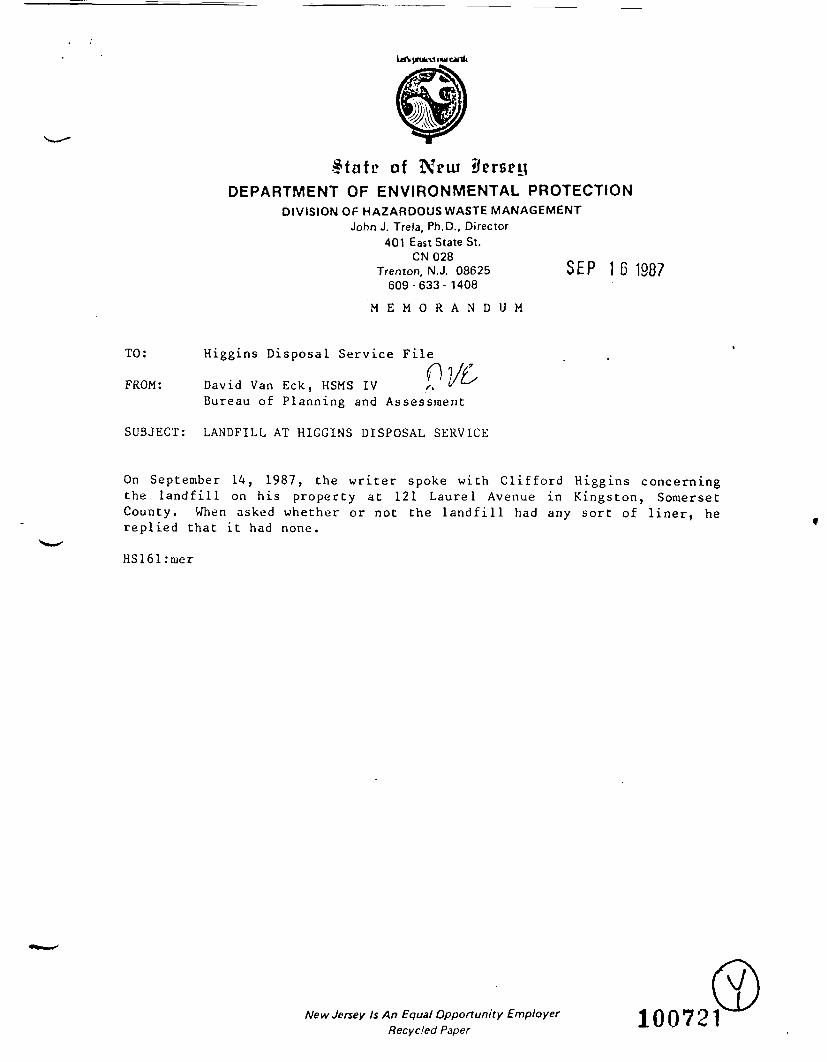
State of Nriu ilerseyDEPARTMENT OF ENVIRONMENTAL PROTECTION
DIVISION OF HAZARDOUS WASTE MANAGEMENTJohn J. Trela, Ph.D., Director
401 East State St.CN028
Trenton, N.J. 08625 SEP 16 1887609-633-1408
M E M O R A N D U M
TO: Higgins Disposal Service File
FROM: David Van Eck, HSMS IV ^ ^^x
Bureau of Planning and Assessment
SUBJECT: LANDFILL AT HIGGINS DISPOSAL SERVICE
On September 14, 1987, the writer spoke with Clifford Higgins concerningthe landfill on his property at 121 Laurel Avenue in Kingston, SomersetCounty. When asked whether or not the landfill had any sort of liner, hereplied that it had none.
HS161:mer
New Jersey Is An Equal Opportunity EmployerRecycled Paper


