Embed Size (px)
Citation preview

ORIGINAL ARTICLE
Geochemistry of a spring-dense karst watershed locatedin a complex structural setting, Appalachian Great Valley,West Virginia, USA
Dorothy J. Vesper Æ Rachel V. Grand ÆKristen Ward Æ Joseph J. Donovan
Received: 11 December 2007 / Accepted: 2 September 2008 / Published online: 14 October 2008
� Springer-Verlag 2008
Abstract The distribution and chemistry of the springs in
the Tuscarora Creek watershed is controlled by both geo-
logic structure and karst dissolution. The watershed is
located in eastern West Virginia in the structurally complex
Great Valley of the Appalachian Valley and Ridge province.
The upper portion of the stream parallels strike along a
mapped fault zone and is bordered by clastic rocks that
comprise North Mountain. The lower reaches of the stream
flow cross-strike through Cambro-Ordovician carbonates.
The controlling chemical signature in the spring water is
carbonate dissolution. Little evidence was seen for the
recharge from adjacent clastic rocks although differences in
the Ca/Mg molar ratio between springs indicated the pres-
ence of localized spring basins in headwater reaches. Na, Cl
and Ca generally increased from upstream to downstream in
the cross-strike reaches. Comparison of stream and cumu-
lative spring discharge was consistent with significant
groundwater base-flow contribution directly to the creek,
particularly in the strike-parallel region. The largest spring
in the watershed ([162 L/s) was sampled during and after a
large storm event along with the adjacent creek. The creek
displayed a typical dilution response with each flood pulse,
whereas the spring had only a limited or delayed response.
The overall chemical and thermal stability of the spring,
relative to the creek, indicated the lack of significant direct
hydraulic connection between the two. The conceptual
model for the area includes localized flowpaths in the
headwater region where the stream flow is parallel to strike
and a thrust fault. In addition to the shallow localized
flowpaths, a deeper, more regional flowpath likely exists for
a large spring further downstream.
Keywords Karst � Hydrogeology � Carbonate hydrology �Springs
Introduction
The Appalachian Valley and Ridge province is a highly
complex geologic region in which stratigraphy and struc-
ture play important roles in determining groundwater
movement. In areas underlain by carbonate rocks, such as
the Great Valley, rock dissolution and karst development
further complicate flow patterns for both groundwater and
surface water. A significant body of research has been
conducted related to the geochemistry and hydrogeology of
karst springs and aquifers. Understanding the karst system
in the Great Valley, particularly spring-creek interactions
on the scale of watersheds, requires incorporation of the
stratigraphic and structural framework.
Burton et al. (2002) studied the relationship between
structure and groundwater flow in the Valley and Ridge of
Pennsylvania. They found that bedding-plane partings
contributed significantly to the overall flowpaths and that
the dominant flow occurred parallel to dip direction.
Apparent groundwater ages, based on chlorofluorocarbons
(CFCs) and tritium/helium-3 (3H/3He) data, indicated that
water traveling down dip traveled more quickly than water
traveling updip or via cleavage fractures. By utilizing the
relative ages of groundwater along the two flowpaths, they
were able to identify the anisotropy and incorporate it into
the groundwater flow model. Similar results have been
D. J. Vesper (&) � K. Ward � J. J. Donovan
Department of Geology and Geography,
West Virginia University, Brooks Hall,
Morgantown, WV 26506-6300, USA
e-mail: [email protected]
R. V. Grand
CH2M-HILL, St Louis, MO 63102, USA
123
Environ Geol (2009) 58:667–678
DOI 10.1007/s00254-008-1541-4
found in slightly dipping clastic sedimentary rocks in the
Newark Basin, New Jersey using well testing, chemical,
and geophysical data (Mishalski and Britton 1997; Morin
et al. 1997).
The importance of folds to karst drainage has been
studied in the Alps and Jura Mountains (Goldscheider
2005; Perrin and Luetscher 2007). The Hochifen-Gotte-
sacker karst system, located along the German–Austrian
border, is folded but has only limited cross-strata faulting
(Goldscheider 2005). Where the limestone is not exposed it
is confined above and below by less-permeable units.
Tracer tests indicated that the synclinal axes and troughs
act as the main flow pathways in the system. In contrast,
folded limestones in the Aubonne catchment in the Jura
Mountains are cross-cut by strike-slip faults (Perrin and
Luetscher 2007). This system can be accessed via the
Longirod cave which provides empirical data of the
drainage system. Tracer tests and cave passage orientations
indicated that groundwater drainage is either parallel to
fold axes or approximately perpendicular to the folds but
trending with the strike-slip faults.
The purpose of this study was to evaluate the variability
of multiple springs in a small watershed and the degree to
which structure and stratigraphy control hydrology and
water chemistry. The overall goal was to refine a better
conceptual model for karst-water flow in the Great Valley
in West Virginia. Although recent work has linked struc-
ture and transmissivity for this area (McCoy and Kozar
2007), we need to better understand how springs and water
quality fit into the conceptual model. This is particularly
true given the importance of springs for water supply in the
region. Specific aims for this project included evaluating
(1) trends in spring water chemistry and spring-stream
interactions between the cross-strike and strike-parallel
stream sections, (2) the importance of deep flow to a large
water-supply spring, and (3) the relationship between
geologic structure, spring type and flowpath.
Regional setting and site description
Tuscarora Creek watershed is located in the eastern pan-
handle of West Virginia, USA (Fig. 1). It is part of the
Opequon Creek Watershed which flows northward into the
Potomac River and eventually into the Chesapeake Bay
(Fig. 1ii). The Opequon Creek watershed lies within the
Appalachian Great Valley (Fig. 1iii) which is bounded the
mountains of the Ridge and Valley to the west and the Blue
Ridge to the east (Fig. 1iii, iv). The Valley and Ridge
region is subdivided into two hydrogeomorphic units
(Fig. 1iv): siliciclastic (VRS) and carbonate (VRC). The
studied region of the Great Valley is within the VRC unit
with a central band of VRC shale (Fig. 1iv).
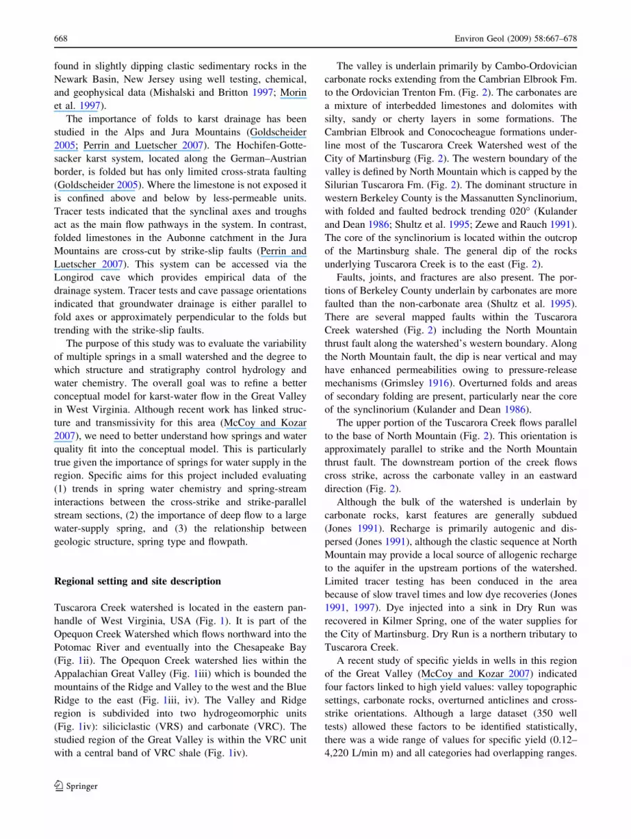
The valley is underlain primarily by Cambo-Ordovician
carbonate rocks extending from the Cambrian Elbrook Fm.
to the Ordovician Trenton Fm. (Fig. 2). The carbonates are
a mixture of interbedded limestones and dolomites with
silty, sandy or cherty layers in some formations. The
Cambrian Elbrook and Conococheague formations under-
line most of the Tuscarora Creek Watershed west of the
City of Martinsburg (Fig. 2). The western boundary of the
valley is defined by North Mountain which is capped by the
Silurian Tuscarora Fm. (Fig. 2). The dominant structure in
western Berkeley County is the Massanutten Synclinorium,
with folded and faulted bedrock trending 020� (Kulander
and Dean 1986; Shultz et al. 1995; Zewe and Rauch 1991).
The core of the synclinorium is located within the outcrop
of the Martinsburg shale. The general dip of the rocks
underlying Tuscarora Creek is to the east (Fig. 2).
Faults, joints, and fractures are also present. The por-
tions of Berkeley County underlain by carbonates are more
faulted than the non-carbonate area (Shultz et al. 1995).
There are several mapped faults within the Tuscarora
Creek watershed (Fig. 2) including the North Mountain
thrust fault along the watershed’s western boundary. Along
the North Mountain fault, the dip is near vertical and may
have enhanced permeabilities owing to pressure-release
mechanisms (Grimsley 1916). Overturned folds and areas
of secondary folding are present, particularly near the core
of the synclinorium (Kulander and Dean 1986).
The upper portion of the Tuscarora Creek flows parallel
to the base of North Mountain (Fig. 2). This orientation is
approximately parallel to strike and the North Mountain
thrust fault. The downstream portion of the creek flows
cross strike, across the carbonate valley in an eastward
direction (Fig. 2).
Although the bulk of the watershed is underlain by
carbonate rocks, karst features are generally subdued
(Jones 1991). Recharge is primarily autogenic and dis-
persed (Jones 1991), although the clastic sequence at North
Mountain may provide a local source of allogenic recharge
to the aquifer in the upstream portions of the watershed.
Limited tracer testing has been conduced in the area
because of slow travel times and low dye recoveries (Jones
1991, 1997). Dye injected into a sink in Dry Run was
recovered in Kilmer Spring, one of the water supplies for
the City of Martinsburg. Dry Run is a northern tributary to
Tuscarora Creek.
A recent study of specific yields in wells in this region
of the Great Valley (McCoy and Kozar 2007) indicated
four factors linked to high yield values: valley topographic
settings, carbonate rocks, overturned anticlines and cross-
strike orientations. Although a large dataset (350 well
tests) allowed these factors to be identified statistically,
there was a wide range of values for specific yield (0.12–
4,220 L/min m) and all categories had overlapping ranges.
668 Environ Geol (2009) 58:667–678
123

Their conceptual model for the region incorporated dis-
persed recharge along near-vertical bedding planes and
subsequent flow along bedding planes.
The 13 springs in this study are located along approxi-
mately 12 km of Tuscarora Creek (Fig. 2; Table 1). Nearly
all of the springs are small and have spring houses. The one
notable exception is Kilmer Spring (12-KMR), which is the
largest spring in the study and part of the water supply for
the City of Martinsburg. It discharges from three spring
houses; the flow is combined in an underground piping
system and fed by gravity to the city water-treatment plant.
In addition to the City of Martinsburg, the Berkeley County
Public Service District and many local landowners rely on
carbonate spring water sources for a large portion of their
water supplies.
This region is undergoing rapid development, particu-
larly in the Great Valley. In West Virginia’s Berkeley
County, the setting of Tuscarora Creek, the population
increased 28% between 1990 and 2000 (US Census Bureau
2006). The upstream part of the watershed is still rural
but downstream the watershed is becoming increasing
developed.
Fig. 1 The location of the study
site relative to (i) regional state
setting—with the Potomac
River Basin (shaded) (ii) the
Tuscarora Creek watershed
(black) within the Opequon
watershed (stippled); (iii)
physiographic regions, APMN
Appalachian Mountains, BR
Blue Ridge, PDUP Piedmont
Uplands, and MELO
Mesozoic Lowlands; (iv)
hydrogeomorphic units, VRSValley and Ridge Siliciclastic,
VRC Valley and Ridge
carbonate, BR Blue Ridge, and
PCR Piedmont crystalline.
Geospatial data modified from
files provided by the
Chesapeake Bay Program
(2008)
Environ Geol (2009) 58:667–678 669
123

Materials and methods
Discharge was measured for the springs and in Tuscarora
Creek using the sum of measured flows over a cross-sec-
tional profile (Buchanan and Somers 1969). Velocity was
measured at 60% of depth using a propeller meter on a
transect with 10–20 intervals across the stream, depending
on stream width. Depth was measured with a wading rod.
Replicate discharge measurements were made at least once
per location. These agreed within 10% with the exception
of Water Street Spring (13-WAT, up to 36% difference);
this spring run lacks straight reaches necessary for high-
quality discharge measurements. For all springs, the dis-
charge was measured during different hydraulic conditions
to provide a range of values. A datum was selected for each
spring for consistent measurement of stage and the depth to
water from the datum was determined during each spring
visit.
Seepage runs were conducted along the upper 5 km of
Tuscarora Creek in October and November 2004 (Fig. 3).
The intent was to compare gaining and losing reaches in
the upper strike-parallel and the lower cross-strike reaches.
During November, the measurements were made by two
teams. Both teams began and ended at the same location;
the four discharges measured at that location were within
8%. Not only does this reflect there was little change in the
stream over the course of the day, but it also provides a
level of accuracy for discharge determinations.
For a limited number of springs, continuous monitoring
was conducted using pressure transducers and data loggers.
The instruments were programmed to collect and save data
on frequent (10 min to 1 h) intervals. Some of the data
loggers also measured electrical conductivity (EC) and
temperature of the water. The pressure transducers were
calibrated using either air pressure or a hydraulic column in
the laboratory prior to installation in the springs and creeks.
The EC and temperature loggers were calibrated or
checked prior to use and periodically in the field.
Grab samples were collected from springs during the
interval from November 2003 and January 2005 on an
Fig. 2 Detailed geology of
watershed with spring locations,
generalized cross-section and
stratigraphic column. Springs
numbered accordingly to
Table 1. Data compiled and
modified from sources in Jones
(1991), Kulander and Dean
(1986), West Virginia
Geological and Economic
Survey (1968), and the West
Virginia GIS Data
Clearinghouse (2008)
670 Environ Geol (2009) 58:667–678
123

approximately monthly basis. The number of sampled
springs increased over that time as more springs were
identified and landowner access was obtained. Owing to
this enhanced later data set, the last four sampling events
were used to illustrate water chemistry so as to maximize
comparability between the locations.
Synoptic stream water samples were collected during
some sampling periods (Table 2). Springs with long spring
runs and no adjacent stream (springs 4, 6, 8 and 13) or
springs located in swampy areas with numerous small
resurgences (springs 2, 3, 7 and 10), were not included in
this comparison.
Additionally, storm-water samples were collected from
Kilmer Spring and adjacent in Tuscarora Creek between 22
June and 9 July 2006. These samples were collected using
automated water samplers on time intervals ranging from
1 h during the storm to as much as 6-h several days after
the storm peak. Rainfall data were collected using a tip-
ping-bucket rain gage at Kilmer Spring and measured a
total 11.6 cm of precipitation over this period. On-site field
data were collected for all monthly grab samples and most
storm samples. Calibrated hand meters were used to obtain
temperature (±0.04�), pH (±0.01) and EC (±1%) data.
Alkalinity was measured in the field using a two-point
titration method (American Public Health Association
2000) and reported as milligram per liter as HCO3-. The
alkalinity data were collected so that charge balance errors
could be calculated and the derived parameters (saturation
indices and CO2 partial pressures) could be estimated.
Water samples were field filtered using a tortuous-path
0.45-lm filter. Samples for cation analysis were preserved
using nitric or hydrochloric acid. The samples were kept
cold until transported to the analytical laboratory at the
National Center for Coal and Energy at West Virginia
University. The samples where held in the laboratory
refrigerator at 4C until analysis. Analysis was completed
for Ca, Mg, Na, K, Fe, and Mn using inductivity cou-
pled plasma—optical emission spectroscopy (ICP-OES)
according to EPA method 200.7. Iron and manganese
concentrations were nearly always below their 0.1 mg/L
detection limits. For most of the study, the anions (Cl, NO3,
and SO4) were measured using an Lachet 8000 colorimetric
autoanalyzer following EPA Methods 325.2, 353.3 and
375.2, respectively. The samples from the final three
sampling periods were analyzed for anions using ion
chromatography (IC) following EPA Method 300.0.
Although the change in method may have created some
bias in the data, the overall trends, as discussed below,
were not dependent on that change. Equipment blanks,
duplicates, and blind standards were analyzed with the
samples and indicated that major element chemistry was
acceptable.
Saturation indices for calcite (SIC) and dolomite (SID)
and the associated hypothetical carbon dioxide partial
pressures (PCO2) were calculated for the monthly samples
using Visual MINTEQ (Gustafsson 2005; USEPA 2000).
The mean charge balance error for major constituents was
less than six percent.
Table 1 Spring location and discharge data
ID on Fig. 2 ID Water supply UTM Coordinates Discharge (L/s)
n Range Mean
1 NWM No 753972–4370527 6 4.2–9.4 7.1
2–3 WG1 & WG2
(combined flow)
WG1-Private;
WG2-No
754259–4371064
754266–4371085
3 5.7–21 14.7
4 JSF No 754171–4371817 1 14.4 –
5 PHS No 754770–4372140 Unable to measure discharge—piped
from springhouse to fishing pond.
No flow during summer
6 DBR No 755197–4373129 2 2.8–3.4 –
7 BRK No 755347–4373119 2 1.2–3.4 –
8 DOD Private 755565–4373213 1 8.8 –
9 BEL Private 755913–4372843 7 23–38 32.2
10 TFS No 756884–4372591 Seep—too small to measure
11 OLN No 757377–4372473 6 3.7–9.3 6.2
12 KMR (Kilmer) Public 243691–4373141 15 Unknown [162
13 WAT (water street spring) No 245122–431249 12 15.7–33 23.6
UTM coordinates based on NAD_83 Datum. All springs are in zone 17S except for Water Street Spring (18S). Discharges measured between
November 03 and March 05—frequency dependent on identification and access. Water Street Spring is also known as the Martinsburg Water
Supply Spring (but is not currently used as a water supply). Discharge data for Kilmer Spring is based on water treated at plant—a minimum
value
Environ Geol (2009) 58:667–678 671
123

Results
Spring and stream discharge
The springs in the study, with the exception of Kilmer
Spring, were small with discharges less than 30 L/s
(Table 1). The exact discharge of Kilmer Spring was
unknown, but a minimum discharge was known from
water treatment operations. The entire spring output is
gravity fed to the Martinsburg treatment plant. Based on
plant records for 15 random dates between April 2004 and
August 2006, an average discharge of 162 L/s was treated
(Stephen Knipe, City of Martinsburg Director of Public
Utilities, personal communication 2006). However, the
total spring volume was greater than this; the excess
overflow water was not quantified by the plant. Given the
configuration of the spring and collection system, it was
not feasible to measure spring discharge for Kilmer at the
source area.
A seepage run was conducted on Tuscarora Creek in
November 2004; its purpose was to compare discharge in
creek sections which are parallel-strike and cross-strike.
Therefore, the study was conducted in the upper 5 km of
the creek (Fig. 3). Flow was measured in the creek and in
the springs flowing into the creek. The cumulative dis-
charge of the springs was not sufficient to account for the
stream flow, indicating the stream was gaining over the
distance measured (Fig. 3). Similar data collected during
October 2004 had comparable results.
The percent of baseflow contribution to the stream was
approximated by fitting an exponential equation to the
stream discharge data, a linear equation to the cumulative
spring flow data, and subtracting the difference (Fig. 3).
Using this approach for the November data, the baseflow
was calculated to contribute between 40 and 60% of the
flow to the stream. This likely overestimated baseflow
contribution inasmuch as it assumed that all of the springs
were identified and quantified. Whereas additional small
springs were likely to be present, they were unlikely to
change the general conclusion that a significant portion of
the water in Tuscarora Creek was acquired through base-
flow, not spring flow. Springs provided the greatest fraction
of input to stream discharge in the strike-parallel creek
reaches, whereas baseflow provided the greatest fraction of
flow in the cross-strike reaches.
Seasonal and spatial variation in carbonate chemistry
The spring water chemistry was classified as a calcium-
bicarbonate water type throughout the watershed. Chemical
changes in spring water from upstream to downstream were
generally subtle although some trends were observed. In
the upper sections of the watershed, where the stream flows
parallel to strike and a thrust fault, the carbonate constit-
uents (e.g., Ca, Mg, Ca/Mg molar ratios) were more
variable between springs than in the lower cross-strike
stream reaches (Fig. 4). Average concentrations from the
final four periods were used to best illustrate the trends
(Fig. 4), but individual sampling periods had similar
results.
Vertical bars, based on the standard deviation of four
sample periods, illustrate the temporal chemical variability
for each spring location (Fig. 4). Spring chemistry along
the strike-parallel reaches was variable both temporally
(indicated by the vertical bars) and spatially (comparing
between springs). The temporal variability in the chemistry
of the cross-strike springs was generally low. Chemical
concentrations in the cross-strike springs were generally
either consistent (Mg) or increasing with distance down-
stream (Ca, Na).
The concentrations of the carbonate-sourced constituents,
as demonstrated by Ca, typically increased downstream in
Fig. 3 (i) Discharge measurement locations in the upper Tuscarora
Creek Watershed. (ii) Results of seepage run, November 2004 for
Tuscarora Creek (stream) and cumulative spring discharge (spring).
Shaded areas illustrate calculated spring and direct input based on an
exponential fit to the stream data (R2 = 0.91) and a linear fit for the
spring input (R2 = 0.91). (iii) Fractional contribution of spring and
baseflow input to Tuscarora Creek. Distances on (ii) and (iii)
measured beginning with the most upstream perennial spring at 0
672 Environ Geol (2009) 58:667–678
123

Ta
ble
2S
um
mar
yo
fsp
rin
gw
ater
chem
istr
yd
ata
for
per
iod
s6
–9
Sp
rN
o.
(ID
)n(p
air)
Ran
ge
of
val
ues
,m
ean
;re
lati
ve
stan
dar
dd
evia
tio
n(a
s%
)
Tem
p
(�C
)
pH
Ca
(mg
/L)
Mg
(mg
/L)
Na
(mg
/L)
K (mg
/L)
Ca/
Mg
(M)
SO
4
(mg
/L)
Cl
(mg
/L)
NO
3
(mg
/L)
Alk
(mg
/Las
HC
O3)
Str
ike-
par
alle
l#
1(N
WM
)5(2
)9
.7–
15
12
.3;
18
%
6.6
4–
7.1
4
6.9
4;
3.3
%
75
.3–
85
.1
78
.5;
5.9
%
11
.4–
14
.7
13
.3;
12
%
3.4
7–
4.6
7
4.0
5;
14
%
1.4
9–
1.9
3
1.6
7;
11
%
3.1
–4
.0
3.6
;1
0%
19
.3–
20
.1
19
.8;
2.2
%
5.3
4–
6.2
1
5.6
8;
8.2
%
0.0
4–
1.0
1
0.6
6;
82
%
24
8–
38
8
31
6;
19
%
#2
(WG
U)4
(0)
12
.9–
13
.0
12
.9;
0.4
%
6.9
–7
.06
7.0
;1
.0%
74
.2–
99
.2
70
.7;
15
%
26
.1–
33
.2
28
.8;
11
%
2.2
1–
3.5
6
2.6
5;
24
%
1.6
6–
2.2
3
1.9
5;
13
%
1.5
–1
.8
1.7
;6
.3%
37
.1–
37
.7
37
.3;
0.9
%
4.6
1–
5.6
6
5.0
8;
10
%
4.5
8–
5.3
2
4.8
7;
8.2
%
31
3–
36
4
33
6;
6.7
%
#3
(WG
D)4
(0)
12
.6–
13
.1
12
.8;
1.6
%
6.9
2–
7.2
8
7.0
1;
2.2
%
68
.6–
90
.2
82
.8;
12
%
26
.3–
32
.1
29
.5;
8.2
%
1.9
6–
3.1
2.6
3;
19
%
1.9
8–
2.3
3
2.1
6;
8.0
%
1.6
–1
.7
1.7
;4
.8%
35
.7–
37
.2
36
.5;
2.1
%
4.8
2–
5.1
0
4.9
6;
4.0
%
0.6
2–
5.2
9
4.9
2;
6.9
%
31
3–
33
9
32
5;
3.4
%
#4
(JS
F)4
(0)
9.2
–1
2.3
10
.8;
13
%
6.8
2–
7.0
4
6.8
9;
1.5
%
27
.4–
69
.5
43
.2;
42
%
8.8
–1
8.3
11
.4;
41
%
2.8
–1
4.2
6.8
6;
74
%
1.1
3–
2.3
21
.58
;3
2%
1.9
–2
.5
2.3
;1
3%
16
.3–
16
.7
16
.4;
1.4
%
4.6
1–
7.9
3
6.2
7;
38
%
0.4
1–
0.5
8
0.5
2;
19
%
11
9–
26
6
16
6;
41
%
#5
(PH
S)8
(4)
11
.1–
17
.7
13
.9;
21
%
6.6
5–
6.9
9
6.7
8;
2.2
%
72
.9–
93
.0
87
.5;
11
%
21
.0–
23
.8
22
.2;
5.3
%
2.2
5–
3.3
9
2.9
1;
17
%
1.5
6–
2.4
5
1.9
2;
20
%
2.1
–2
.5
2.4
;8
.4%
21
.3–
21
.3
21
.3;
–
6.1
1–
6.8
2
6.4
7;
–
1.9
2–
2.0
2
1.9
7;
–
31
8–
34
4
33
2;
3.4
%
Tra
nsi
tio
n#
6(D
BR
)5(0
)1
1.1
–1
5.2
13
.1;
14
%
6.8
7–
7.0
5
6.9
4;
1.2
%
47
.4–
94
.6
69
.3;
28
%
13
.8–
20
.3
16
.4;
18
%
4.3
9–
8.5
3
6.7
0;
27
%
1.8
8–
9.8
1
4.1
4;
92
%
2.0
–2
.8
2.5
;1
4%
23
.2–
25
.1
23
.9;
4.4
%
8.8
1–
11
.6
10
.1;
14
%
1.3
5–
1.6
7
1.4
6;
13
%
20
7–
29
2
24
2;
16
%
#7
(BR
K)9
(0)
12
.2–
13
.7
12
.9;
4.9
%
7.0
8–
7.2
7
7.1
5;
1.2
%
53
.4–
69
.5
61
.6;
11
%
21
.4–
25
.1
22
.9;
6.7
%
3.2
8–
8.7
4
5.1
0;
48
%
1.7
5–
2.3
1
1.9
5;
13
%
1.4
–1
.7
1.6
;7
.6%
40
.7–
42
.7
41
.4;
2.7
%
8.3
0–
9.3
4
8.7
4;
6.2
%
2.4
2–
2.8
8
2.5
9;
9.8
%
23
3–
24
3
23
8;
1.9
%
#8
(DO
D)4
(0)
12
.2–
12
.4
12
.3;
0.7
%
6.8
3–
7.1
2
7.0
;1
.9%
68
.7–
78
.3
74
.2;
6.6
%
20
.6–
24
.9
23
.0;
8.2
%
1.2
1–
1.7
7
1.4
8;
20
%
1.6
4–
2.3
5
2.0
4;
15
%
1.7
–2
.1
1.9
;7
.8%
25
.2–
26
.8
26
.1;
3.1
%
3.7
8–
3.8
7
3.8
2;
1.6
%
3.1
4–
3.9
1
3.4
2;
12
%
30
4–
31
4
31
0;
1.5
%
Cro
ss-s
trik
e#
9(B
EL
)9(4
)1
2.4
–1
2.5
12
.5;
0.4
%
6.9
4–
7.2
7.0
8;
1.6
%
67
.2–
80
.4
73
.5;
8.0
%
24
.4–
31
.1
27
.3;
12
%
2.8
7–
4.0
4
3.4
8;
14
%
1.7
5–
2.3
3
2.0
2;
14
%
1.5
–1
.7
1.6
;6
.7%
20
.0–
20
.7
20
.5;
2.0
%
7.1
5–
8.0
9
7.4
7;
7.2
%
5.1
0–
5.6
5
5.2
8;
6.0
%
30
2–
33
4
31
8;
4.1
%
#1
0(T
FS
)3(0
)1
3–
13
.3
13
.2;
1.2
%
6.8
1–
6.8
7
6.8
3;
0.5
%
76
.8–
96
.6
88
.4;
12
%
24
.8–
26
.3
25
.6;
2.9
%
7.5
–1
1.6
9.4
1;
22
%
2.2
1–
2.4
6
2.3
7;
5.8
%
1.8
–2
.2
2.1
;8
.9%
24
.2–
25
.3
24
.8;
–
20
.0–
22
.7
21
.4;
–
4.8
3–
5.2
3
5.0
3;
–
35
6–
51
1
41
1;
21
%
#1
1(O
LN
)9(4
)1
1.8
–1
2.9
12
.5;
4.1
%
6.7
9–
7.0
2
6.8
9;
1.6
%
88
.3–
11
1
96
.6;
11
%
22
.5–
27
.5
24
.6;
9.0
%
3.1
6–
6.5
7
4.5
0;
34
%
2.3
2–
4.4
8
3.0
4;
32
%
2.1
–2
.5
2.4
;7
.4%
19
.4–
19
.6
19
.5;
–
7.9
8–
8.5
0
8.2
4;
–
2.7
3–
2.7
5
2.7
4;
–
38
7–
44
6
40
6;
6.7
%
#1
2(K
MR
)9(6
)1
2.5
–1
3.1
12
.7;
2.1
%
6.8
6–
7.0
7
6.9
4;
1.3
%
96
.2–
11
4
10
5;
8.1
%
19
.3–
27
.4
22
.5;
17
%
5.9
3–
9.2
8
7.5
0;
18
%
2.4
6–
3.4
7
2.9
5;
15
%
2.5
–3
.0
2.8
;8
.5%
21
.7–
23
.1
22
.4;
3.1
%
14
.4–
14
.6
14
.5;
–
3.9
2–
4.5
4
4.1
7;
7.9
%
35
3–
42
4
37
6;
8.6
%
#1
3(W
AT
)9(2
)1
4.2
–1
4.8
14
.5;
1.7
%
6.8
1–
7.0
2
6.9
2;
1.4
%
92
.1–
11
5
10
6;
9.4
%
21
.7–
23
.3
22
.2;
3.3
%
18
.1–
21
.9
20
.7;
8.7
%
3.0
7–
3.7
4
3.3
5;
8.8
%
2.5
–3
.0
2.8
;7
.5%
42
.3–
44
.3
43
.4;
2.3
%
44
.2–
47
.0
45
.9;
3.2
%
3.1
3–
3.3
0
3.2
0;
2.8
%
36
6–
41
5
38
8;
5.7
%
Max
imu
mre
po
rted
det
ecti
on
lim
it0
.10
.10
.10
.11
01
.00
.2
n=
tota
ln
um
ber
of
wat
ersa
mp
les
coll
ecte
dfr
om
that
spri
ng
;(p
air)
=n
um
ber
of
surf
ace
wat
ersa
mp
les
coll
ecte
dfr
om
Tu
scar
ora
Cre
ekad
jace
nt
toth
esp
rin
g.
Su
rfac
ew
ater
sam
ple
sco
llec
ted
con
curr
entl
yw
ith
spri
ng
wat
ersa
mp
les.
Th
eta
ble
incl
ud
eso
nly
lim
ited
per
iod
sso
that
they
can
be
com
par
edb
etw
een
loca
tio
ns.
Sta
tist
ics
bas
edo
n4
sam
ple
s(9
/19
/04
,1
1/1
9/0
4,1
/6/0
5,3
/9/0
5)
exce
pt
for
(1)
spri
ng
10
wh
ich
was
no
tsa
mp
led
on
9/1
9/0
4,
(2)
sulf
ate,
chlo
rid
ean
dn
itra
ted
ata
wh
ich
are
on
lyre
po
rted
for
the
last
3p
erio
ds
(th
ose
anal
yze
db
yIC
),(3
)a
few
case
sw
ith
on
ly
two
dat
ap
oin
tsd
ue
ton
ofl
ow
or
sam
ple
loss
:id
enti
fied
by
the
lack
of
RS
D(–
).T
his
tab
led
oes
no
tin
clu
de
the
sto
rmd
ata
fro
mK
ilm
erS
pri
ng
Environ Geol (2009) 58:667–678 673
123

the cross-strike stream-reach springs (Fig. 5i). Although
adjacent springs switched concentration order during occa-
sional months (e.g., March 2005), the trend was generally
consistent even through seasonal change. The Ca/Mg molar
ratio was typically less than three, but spring 1-NWM had a
ratio between 3 and 4, indicating slightly different source
waters (Fig. 4). Spring 1-NWM is the most upstream
perennial spring.
Na and Cl were found in their highest concentrations in
the furthest downstream spring (13-WAT) through all
sampling periods (Figs. 4, 5ii, iii); and Cl molar concen-
trations were present in excess of the Na molar
concentrations (Fig. 5iv). Both of these trends were
consistent for each period of data regardless of anion
analytical method. All IC-measured Cl concentrations fall
within the range measured calorimetrically. WAT spring is
located in an urban area that has been intensively modified,
and is not in its original natural setting. Ostracod data
indicated that the water being discharged is from a
groundwater source modified to discharge from a pipe
(Smith et al. 2004). This spring was historically used as a
water supply for Martinsburg (McColloch 1986).
The influence of urbanization may be seen in the City of
Martinsburg. Spring 13-WAT, located in downtown Mar-
tinsburg, had the highest measured concentrations of Na
and Cl (Fig. 5), common indicators of anthropogenic
sources (Panno et al. 2006). This spring has been altered
from its natural setting; it currently discharges from a metal
pipe but historical evidence (McColloch 1986), ostracod
data (Smith et al. 2004), and consistent chemistry (Fig. 4)
support that it is discharging groundwater. The presence of
elevated Na and Cl indicates that this spring may also be
influenced by contaminant sources.
Storm responses at Kilmer Spring and Tuscarora Creek
A total of 77 Kilmer Spring water and 88 Tuscarora Creek
water samples were collected during the June 2006 storm
event, of which 57 were analyzed for major cations. The
storm surge was recorded as two distinct stage peaks in the
creek (Fig. 6) but only a smaller, later surge was observed
in the spring. Although the magnitude of the peaks cannot
be compared given the different setting geometries, the
timing indicated that the spring was slower to respond and
returned to baseline more slowly. The EC in the creek
decreased during the storm pulses owing to dilution, but
was comparatively constant in Kilmer Spring.
For Ca, Mg, and SO4, the pre-storm concentrations were
similar; these diverged during the storm (Fig. 6). K was
significantly higher in the creek water throughout the
sampled period. In all cases, the chemical concentrations at
Kilmer Spring showed relatively little variation, whereas
the stream-water chemistry was diluted during the storm
(Fig. 6). The difference in the responses indicates that
rainfall input to Kilmer Spring is not rapidly transferred to
the spring.
Variation in Ca/Mg molar ratios
The molar relationship between Ca and Mg in the spring
waters illustrated the changes in water chemistry, and
possibly flowpaths, over a 12-km reach of Tuscarora Creek.
The most upstream springs (Fig. 7) had distinctly different
Ca/Mg ratios from each other indicating that these small
springs were being drawn from different and probably
nearby sources. The temporal and spatial variability in their
Fig. 4 Changes in spring water chemistry from upstream to down-
stream. Graphed values are averages for the last four sampling
periods; error bars indicate one standard deviation above and one
below. Geologic formations legend on Fig. 2
674 Environ Geol (2009) 58:667–678
123

water chemistry (Fig. 4) further supported the presence of
short, localized flowpaths to the springs in this area.
Longer, less discrete flowpaths could be expected to create
a more integrative chemistry at these springs. That is,
instead of the springs having distinct Ca/Mg ratios, the
chemistry would be more uniform spatially.
The next downstream group of springs (Fig. 7ii) are
located in a spring-dense area where Tuscarora Creek turns
from being a strike-parallel stream to a cross-strike stream.
The Ca/Mg ratios measured in these springs have over-
lapping ranges, suggesting that the flowpaths in this area
are less localized that further upstream or that the springs
are sourced from similar rocks. Springs in the cross-strike
reach (Fig. 7iii) are similar to the previous group.
Downstream springs Kilmer and WAT (Fig. 7iv, vi)
were similar to each other and have slightly higher Ca/Mg
ratios than the springs located upstream. The Ca–Mg
relationship at Kilmer spring was consistent across sea-
sonal and storm samples (Fig. 7iv, v). The Ca/Mg values in
Tuscarora Creek (Fig. 7vii) fell within the overall range
reported for the springs.
Variation in PCO2–SIc relationships
A total of 22 spring and stream-water sample pairs were
collected over the course of the study (Table 2). Samples
were collected upstream from the confluence of the stream
and spring flows. Comparison of all data indicated that
spring water samples had generally higher PCO2 and lower
SIC values than the surface water samples (Fig. 8i). As
spring water resurges, carbon dioxide degasses, resulting in
an increase in SIC. The reaction progress for the degassing
is illustrated by the sloped lines in Fig. 8. The relative
distribution of the spring and stream water samples is
consistent with the emergence of groundwater and its
subsequent degassing in the surface setting.
Some of the stream water samples had SIC values higher
than might be predicted by the degassing of the sampled
springs, suggesting that there may have been another water
source with a PCO2 similar to the springs but a higher SIC..
Baseflow contribution to the creek, as indicated by the
stream flow data (Fig. 3), could account for this contribu-
tion. However, there were no discernable patterns in the
PCO2 and SIc data spatially for the creek samples, and no
sample was obtained from the groundwater underneath the
creek.
The difference in PCO2 and SIC between spring waters
was not as great as the difference between springs and
stream water, but there some general changes based on the
average measured values (Fig. 8ii). Spring waters in the
upstream reaches (1–3), which had distinctively different
Ca/Mg molar ratios, had similar PCO2 and SIC values,
plotting near the average of the other spring data. Spring 4-
JSF, the flashiest of the springs, had the lowest SIC in water
and is the most likely spring to be fed by allogenic
recharge. Water from springs located near where the stream
turns direction (7–9) generally have low PCO2 and SIC
values than the downstream spring waters. Waters from the
Fig. 5 Concentrations of (i) Ca
(ii) Na, and (iii) Cl in
cross-strike springs (7 and
downstream). iv) Comparison
of molar concentrations of Cl
and Na. The line on (iv) has a
slope of 1
Environ Geol (2009) 58:667–678 675
123

furthest downstream springs (10–13) had the highest PCO2
and SIC values, possibly indicating longer flowpaths or
travel times.
Discussion
A conceptual model for groundwater flow in the Tuscarora
Creek watershed is a combination of localized and longer
flowpaths controlled primarily by stratigraphy and struc-
ture. In the headwater stream reaches, along the North
Mountain Fault and parallel to strike, there are numerous,
chemically variable springs and creek water is a mixture of
point-source contribution from springs and more diffuse
baseflow. The variability of the upstream reaches may be
controlled by stratigraphy, permeability along faults, or the
proximity to allogenic recharge from North Mountain.
Most of these springs (numbers 1 through 6) are mapped in
the Rockdale Run member of the Beekmantown Group.
This formation appears as a band between two mapped
thrust faults which place the Rockdale Run between the
Cambrian Elbook and Ordovician Martinsburg formations.
The only spring in the study that regularly turns turbid
(4-JSF, Personal Communication, Jim Smith spring owner
2004) is located in this reach and is the only spring that
identifiably flows directly from rock. The greater vari-
ability of these springs is supported by well and stream data
from other studies (Shultz et al. 1995), indicating greater
groundwater transmissivity along the fault. Alternatively, it
is possible that in the upstream areas the faults or lower
permeability zones in the Elbrook Fm. act as barriers to
flow, creating localized flowpaths through isolation. It has
been reported that many of the fault zones are cemented
and more likely to act as barriers than flowpaths (Jones
1991). However, transmissivity data collected by Shultz
et al. (1995) were higher in the upstream sections parallel
to strike and the thrust faults.
In the middle-watershed cross-strike reaches, there are
fewer springs and they have less chemical variability either
from each other or through time. However, the computed
fraction of the creek water that comes directly from base-
flow is more than 50%. The greater contribution of
baseflow in the cross-strike (approximately dip-parallel)
direction may be related to the relative scarcity of springs.
Kilmer Spring, a public water-supply source, is consid-
erably larger and more consistent in chemistry than all other
springs in the watershed. It is mapped on a thrust fault that
brings the Rockdale Run Fm. in contact with the Conoco-
cheague Fm. Its limited and delayed response to a major
rain event, while the adjacent Tuscarora Creek was highly
variable, indicated that the surface water is largely inde-
pendent of the water source for Kilmer. The source of water
at Kilmer Spring has been the focus of research and spec-
ulation in the past. High concentrations of bacteria have
been measured in spring water in the past (Hobba 1976) and
dye tracing from shallow injections (Hobba 1976; Jones
1991) indicate at least a partial component of shallow water
input. Apparent age dating of Kilmer Spring water has been
conducted by the US Geological Survey: estimated—ages
of atmospheric isolation of this water were determined to
fall between 4 and 8 years (Busenberg and Plummer 2008).
The authors also report that the tritium concentrations
suggest that the recharge for the 2004 water occurred in the
late 1990s, consistent with the 4–8 year age range.
A possible flowpath for the spring water at Kilmer Spring
would be along the synclinal bedding planes with upward
flow along fractures. Although stacked groundwater basins
have been identified in flat-lying carbonate rocks such as the
Fig. 6 Comparison of storm response in Kilmer Spring (black linesand symbols) and adjacent in Tuscarora Creek (gray lines and
symbols). Data from 2006
676 Environ Geol (2009) 58:667–678
123

Mammoth Cave region (Palmer 1981), the Valley and Ridge
province has more complex geologic structures and dip-
controlled flow parallel to bedding planes may be important.
Although the down-dip flowpath is only speculative based
on the data presented herein, studies in similar terrains
indicate that is a possible explanation for character of Kil-
mer Spring. In the Shenandoah Valley, the USGS found that
younger-age waters are found in the core of the synclinori-
um and older water along the limbs (Yager 2006). This
pattern could be modeled based on anisotropy that accounts
for flow both along bedding planes and cross-fractures
(Yager 2006). Age data from nested wells in folded and
fractured clastic rocks in Pennsylvania had similar patterns
with the dip direction along bedding-planes being an
important location for groundwater flow (Burton et al.
2002). Data from the Alps and the Jura Mountains
(Goldscheider 2005; Perrin and Luetscher 2007) also sup-
ports the importance of karstic flow along folds and cross-
cutting fractures. Underlying drains, that cross-cut fold
structures have been observed in the Jura Mountains (Perrin
and Luetscher 2007) and may also contribute to the larger
springs.
The chemical evolution of spring water in the water-
shed, as defined by PCO2 and SIC, is not a simple function
from upstream to downstream. However, localized
upstream flowpaths with more integrative downstream
flowpaths could account for this distribution. The largest
and least-variable spring has minimal local surface input as
evidenced by its delayed and attenuated response to a
major storm event.
Fig. 7 Comparison of Ca–Mg
molar ratios for different springs
in the watershed and for all
creek data (lower right). Solidlines for slopes of 1, 1.7, 2.5 and
5. X- and Y-axes consistent on
all graphs
Fig. 8 (i) SIC and PCO2 data for
both spring and stream waters.
(ii) For mean spring values
based on sampling periods 6–9.
Sloped lines for equilibrium
degassing calculated assuming
three Ca activities (aCa2?),
0.002, 0.001 and 0.005 (lowest)
Environ Geol (2009) 58:667–678 677
123

The exact ground-water flowpaths for the springs in
Tuscarora Creek Watershed cannot be determined. How-
ever, the presence of localized upstream spring basins plus
a more regional flow system are supported by changes in
geochemistry of the spring waters both temporally and
spatially.
Acknowledgments This project was funded by WV Water
Research Institute and the US Department of Agriculture, National
Research Initiative, grant number 2003-35102-13537. We would also
like to thank the City of Martinsburg and the spring owners for
property access; the Chesapeake Bay Program for providing regional
geospatial data that crosses state lines, and Dr. Jaime Toro for help
with the geologic cross-section.
References
American Public Health Association (2000) 2320 Alkalinity. In:
Clesceri LS, Greenberg AE, Trussell RR (eds) Standard Methods
for the Examination of Water and Wastewater, Seventeenth
Edition. American Public Health Association, Washington.
2:35–39
Buchanan TJ, Somers WP (1969) Discharge measurements at gaging
stations techniques of water-resources investigations of the
United States Geological Survey. United States Government
Printing Office, Washington, DC
Burton WC, Plummer LN, Busenberg E, Lindsey BD, Gburek WJ
(2002) Influence of fracture anisotropy on ground water ages and
chemistry, Valley and Ridge Province, Pennsylvania. Ground
Water 40:242–257
Busenberg E, Plummer LN (2008) Dating groundwater with trifluo-
romethyl sulfurpentafluoride (SF5CF3), sulfur hexafluoride
(SF6), CF3Cl (CFC-13) and CF2Cl2 (CFC-12). Water Resour
Res 44:W02431
Goldscheider N (2005) Fold structure and underground drainage
pattern in the alpine karst system Hochifen–Gottesacker. Eclo-
gae Geol Helv 98:1–17
Grimsley GP (1916) Jefferson, Berkeley, and Morgan Counties. WV
Geological Survey, Wheeling
Gustafsson JP (2005) Visual MINTEQ Version 2.40. Stockholm,
Sweden, Kungl Tekniska Hogskolan (KTH), Division of Land
and Water Resources
Hobba WAJ (1976) Ground-water hydrology of Berkeley County,
West Virginia. WV Geological and Economic Survey,
Morgantown
Jones WK (1991) The carbonate aquifer of the Northern Shenandoah
Valley of Virginia and West Virginia. In: Kastning EH, Kastning
KM (eds) Appalachian Karst. Proceedings of the Appalachian
Karst Symposium, Radford, pp 217–222
Jones WK (1997) Karst hydrology Atlas of West Virginia. Special
Publication 4. Karst Waters Institute, Charles Town, WV
Kulander BR, Dean SL (1986) Structure and tectonics of central and
southern Appalachian Valley and Ridge and Plateau Provinces,
West Virginia and Virginia. AAPG Bull 70(11):1674–1684
Michalski A, Britton R (1997) The role of bedding fractures in the
hydrogeology of sedimentary bedrock—evidence from the
Newark Basin, New Jersey. Ground Water 35:318–327
McColloch JS (1986) Springs of West Virginia. West Virginia
Geological and Economic Survey, Morgantown
McCoy KJ, Kozar MD (2007) Use of sinkhole and specific capacity
distributions to assess vertical gradients in a karst aquifer.
Environ Geol 54:921–935
Morin RH, Carleton GB, Poirier S (1997) Fractured-aquifer hydro-
geology from geophysical logs: the Passaic Formation, New
Jersey. Ground Water 35:328–338
Palmer AN (1981) A geologic guide to Mammoth Cave National
Park. Zephyrus Press, Teaneck
Panno SV, Hackley KC, Hwang H, Greenberg SE, Krapac IG,
Landsberger S, O’Kelly DJ (2006) Characterization and identi-
fication of Na–Cl sources in ground water. Ground Water
44:176–187
Perrin J, Luetscher M (2007) Inference of the structure of karst
conduits using quantitative tracer tests and geological informa-
tion: example of the Swiss Jura. Hydrogeol J 16:951–967
Shultz RA, Hobba WAJ, Kozar MD (1995) Geohydrology, ground-
water availability, and ground-water quality of Berkeley County,
West Virginia, with emphasis on the carbonate-rock area. US
Geological Survey Water-Resources Investigations Report 93-
4073, Charleston
Smith AJ, Palmer DF, Donovan J, Vesper D, Namjesnik-Dejanovic K
(2004) Ostracods and flow paths in the karst landscape of West
Virginia. Geol Soc Am Abstr Programs 36:161
US Census Bureau (2006) West Virginia quick facts. http://quickfacts.
census.gov/qfd/states/54/54003.html. Cited December 2006
USEPA (2000) MINTEQA2 Version 4.02. Cited December 2006
West Virginia Geological and Economic Survey (1968) 1968 State
Geology Map. 1:250000
West Virginia GIS Data Clearinghouse (2008) http://wvgis.wvu.edu/
data/data.php. Cited August 2008
Yager R (2006) Ground-water flow model of the Shenandoah Valley.
In: Paper presented at the Great Valley Water-Resources Science
Forum, Winchester, Virginia, 15 November 2006
Zewe BT, Rauch HW (1991) Influence of hydrogeologic setting and
lineaments on water-well yield in the Great Valley karst terrane
of eastern West Virginia. In: Kastning EH, Kastning KM (eds)
Appalachian Karst. Proceedings of the Appalachian Karst
symposium, Radford, pp 223–230
678 Environ Geol (2009) 58:667–678
123