Embed Size (px)
Citation preview

Smithsonian InstitutionArchives Center - NMAH
Earl Shaffer's Appalachian Trail Hike Diary, 1965Extracted on Aug-18-2014 03:42:06
The Smithsonian Institution continues to research information on its collections and is thankful to the digitalvolunteers who helped to transcribe this material. We look forward to using the work they created to further enrichour collections.
Before you incorporate this material into a for-profit publication or online project, please contact the ArchivesCenter - NMAH;
-
Please leave source and copyright information as is and avoid obscuring these details in the material;-Do not post this document as a whole to a social media site, such as a blog, Facebook page, Twitter feed, etc;-Researchers: if you deposit this material, please let Archives Center - NMAH know where the material isdeposited so that we can guide the community members to it.
-
Contact the Smithsonian Institution for the current status of this project and related material. To see this projectonline - or other transcription projects - please visit here.
Smithsonian Institution Transcription Center, Archives Center - NMAH
Smithsonian Institution Transcription Center, Archives Center - NMAH

Smithsonian Institution Transcription Center, Archives Center - NMAH
Smithsonian Institution Transcription Center, Archives Center - NMAH
QUALITY PAPER PRODUCTSPAPER KINGFOR ALL THE FAMILY
MEMO BOOK7037
15 cents
EASTERN TABLET - ALBANY, N.Y.
Earl Shaffer's Appalachian Trail Hike Diary, 1965Transcribed and Reviewed by Digital VolunteersExtracted Aug-18-2014 03:42:06
Smithsonian Institution Transcription Center, Archives Center - NMAH
Smithsonian Institution Transcription Center, Archives Center - NMAH
Smithsonian Institution Transcription Center, Archives Center - NMAH
Smithsonian Institution Transcription Center, Archives Center - NMAH
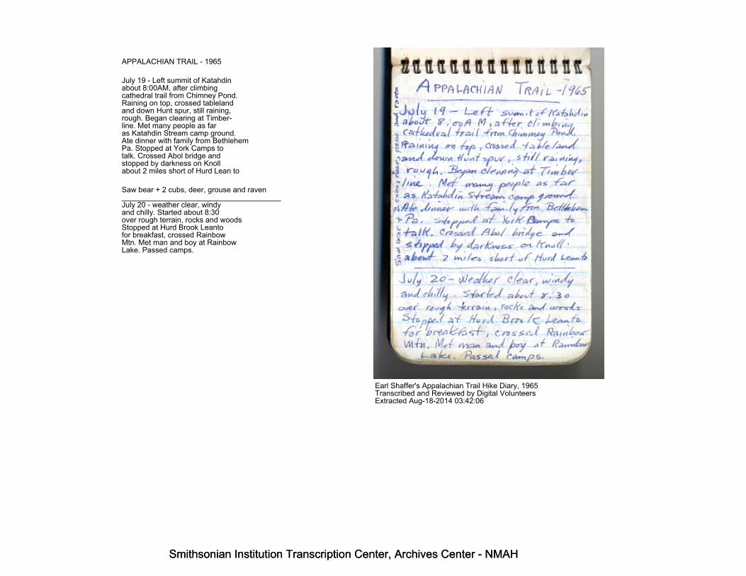
APPALACHIAN TRAIL - 1965
July 19 - Left summit of Katahdinabout 8:00AM, after climbingcathedral trail from Chimney Pond.Raining on top, crossed tablelandand down Hunt spur, still raining,rough. Began clearing at Timber-line. Met many people as faras Katahdin Stream camp ground.Ate dinner with family from BethlehemPa. Stopped at York Camps totalk. Crossed Abol bridge andstopped by darkness on Knollabout 2 miles short of Hurd Lean to
Saw bear + 2 cubs, deer, grouse and raven______________________________________July 20 - weather clear, windyand chilly. Started about 8:30over rough terrain, rocks and woodsStopped at Hurd Brook Leantofor breakfast, crossed RainbowMtn. Met man and boy at RainbowLake. Passed camps.
Earl Shaffer's Appalachian Trail Hike Diary, 1965Transcribed and Reviewed by Digital VolunteersExtracted Aug-18-2014 03:42:06
Smithsonian Institution Transcription Center, Archives Center - NMAH
Smithsonian Institution Transcription Center, Archives Center - NMAH
Smithsonian Institution Transcription Center, Archives Center - NMAH
Smithsonian Institution Transcription Center, Archives Center - NMAH
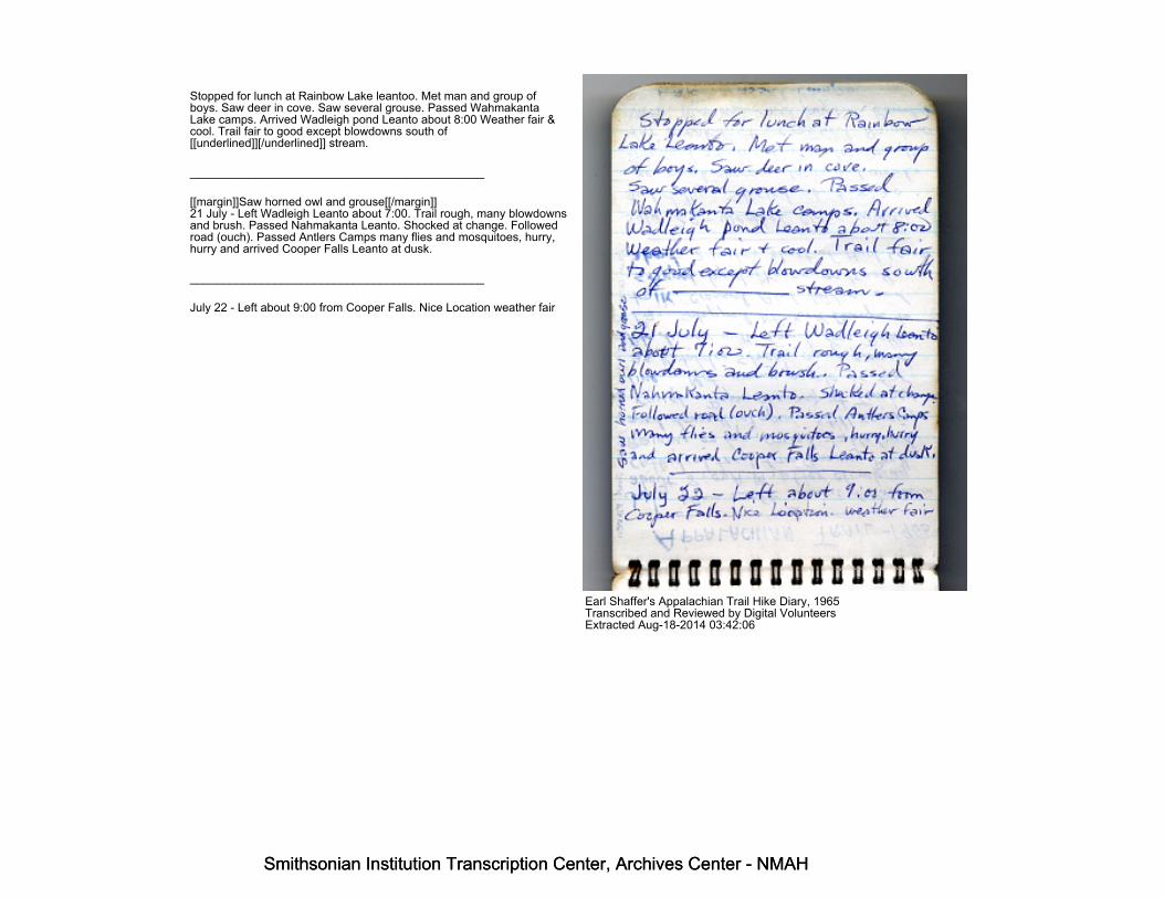
Stopped for lunch at Rainbow Lake leantoo. Met man and group ofboys. Saw deer in cove. Saw several grouse. Passed WahmakantaLake camps. Arrived Wadleigh pond Leanto about 8:00 Weather fair &cool. Trail fair to good except blowdowns south of[[underlined]][/underlined]] stream.
_____________________________________________
[[margin]]Saw horned owl and grouse[[/margin]]21 July - Left Wadleigh Leanto about 7:00. Trail rough, many blowdownsand brush. Passed Nahmakanta Leanto. Shocked at change. Followedroad (ouch). Passed Antlers Camps many flies and mosquitoes, hurry,hurry and arrived Cooper Falls Leanto at dusk.
_____________________________________________
July 22 - Left about 9:00 from Cooper Falls. Nice Location weather fair
Earl Shaffer's Appalachian Trail Hike Diary, 1965Transcribed and Reviewed by Digital VolunteersExtracted Aug-18-2014 03:42:06
Smithsonian Institution Transcription Center, Archives Center - NMAH
Smithsonian Institution Transcription Center, Archives Center - NMAH

Smithsonian Institution Transcription Center, Archives Center - NMAH
Smithsonian Institution Transcription Center, Archives Center - NMAH
Passed Yoke Pond camps. rough trailWent through extensive beaver pondarea. Lost trail, circled, sawbeaver while off trail. Found ATon road, then followed towermantrail up Whitecap. Back trackedto Leanto, arrived dark.
________________________________
July 23 (Fri) climbed to tower onWhitecap. Talked to fire lookout,sky cloudy, starting to clear, visibilityhazy. Stopped for lunch at White BrookLeanto. Many blowdowns. Markinggood. Came to road constructionnear Hermitage. Arrived at LongPond Camps about 5:30. Stoppedto talk. Went on to ChairbackGap Leanto. Trail good, weather cloudy.
___________________________________
July 24 - Left Chairback Gap about 7:00Trail fair, some brush and a few
Earl Shaffer's Appalachian Trail Hike Diary, 1965Transcribed and Reviewed by Digital VolunteersExtracted Aug-18-2014 03:42:06
Smithsonian Institution Transcription Center, Archives Center - NMAH
Smithsonian Institution Transcription Center, Archives Center - NMAH
Smithsonian Institution Transcription Center, Archives Center - NMAH
Smithsonian Institution Transcription Center, Archives Center - NMAH
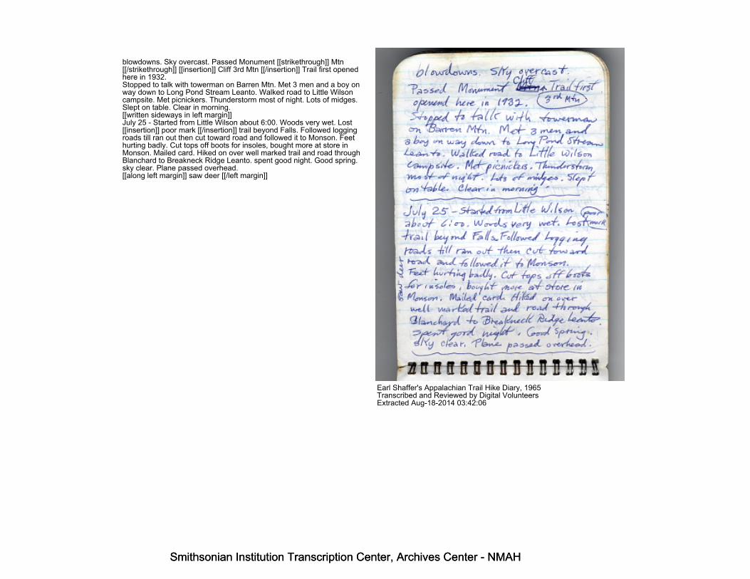
blowdowns. Sky overcast. Passed Monument [[strikethrough]] Mtn[[/strikethrough]] [[insertion]] Cliff 3rd Mtn [[/insertion]] Trail first openedhere in 1932.Stopped to talk with towerman on Barren Mtn. Met 3 men and a boy onway down to Long Pond Stream Leanto. Walked road to Little Wilsoncampsite. Met picnickers. Thunderstorm most of night. Lots of midges.Slept on table. Clear in morning.[[written sideways in left margin]]July 25 - Started from Little Wilson about 6:00. Woods very wet. Lost[[insertion]] poor mark [[/insertion]] trail beyond Falls. Followed loggingroads till ran out then cut toward road and followed it to Monson. Feethurting badly. Cut tops off boots for insoles, bought more at store inMonson. Mailed card. Hiked on over well marked trail and road throughBlanchard to Breakneck Ridge Leanto. spent good night. Good spring.sky clear. Plane passed overhead.[[along left margin]] saw deer [[/left margin]]
Earl Shaffer's Appalachian Trail Hike Diary, 1965Transcribed and Reviewed by Digital VolunteersExtracted Aug-18-2014 03:42:06
Smithsonian Institution Transcription Center, Archives Center - NMAH
Smithsonian Institution Transcription Center, Archives Center - NMAH
Smithsonian Institution Transcription Center, Archives Center - NMAH
Smithsonian Institution Transcription Center, Archives Center - NMAH
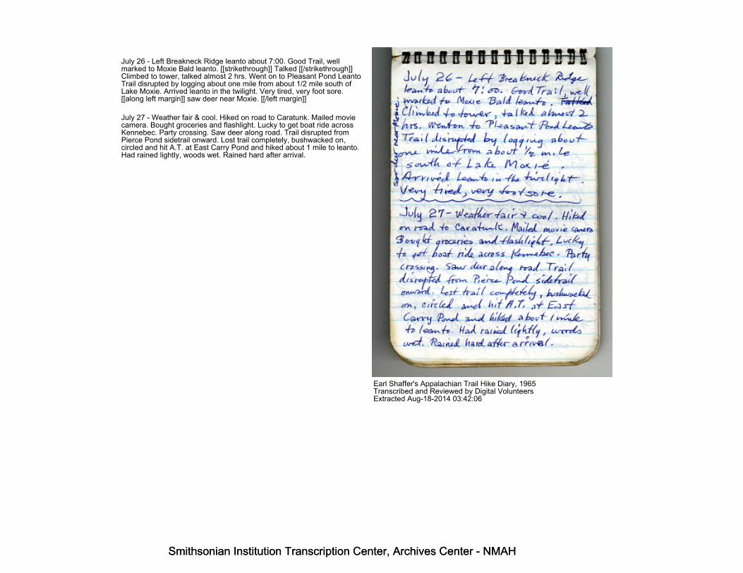
July 26 - Left Breakneck Ridge leanto about 7:00. Good Trail, wellmarked to Moxie Bald leanto. [[strikethrough]] Talked [[/strikethrough]]Climbed to tower, talked almost 2 hrs. Went on to Pleasant Pond LeantoTrail disrupted by logging about one mile from about 1/2 mile south ofLake Moxie. Arrived leanto in the twilight. Very tired, very foot sore.[[along left margin]] saw deer near Moxie. [[/left margin]]
July 27 - Weather fair & cool. Hiked on road to Caratunk. Mailed moviecamera. Bought groceries and flashlight. Lucky to get boat ride acrossKennebec. Party crossing. Saw deer along road. Trail disrupted fromPierce Pond sidetrail onward. Lost trail completely, bushwacked on,circled and hit A.T. at East Carry Pond and hiked about 1 mile to leanto.Had rained lightly, woods wet. Rained hard after arrival.
Earl Shaffer's Appalachian Trail Hike Diary, 1965Transcribed and Reviewed by Digital VolunteersExtracted Aug-18-2014 03:42:06
Smithsonian Institution Transcription Center, Archives Center - NMAH
Smithsonian Institution Transcription Center, Archives Center - NMAH

Smithsonian Institution Transcription Center, Archives Center - NMAH
Smithsonian Institution Transcription Center, Archives Center - NMAH
Stopped raining. Cut boughs.
_________________________
Fair weather in morning. Was cooking [[insertion]] July 28 [[/insertion]]when fisherman in boat came up and talked. Passed East Carry CampsTrail cut to pieces by logging most of the way to West Carry Pond. AtWest Carry Pond Camps talked to Storey's most of afternoon. Thunderstorm meanwhile. Started on at 5:00 climbed Little Bigelow and stoppedon summit at dark.
__________________________
[[in left margin]]July 29[[/margin]]Rained toward morning. Woods very wet. Got thoroughly soaked whileclimbing to Avery Peak(4055 el.) Went down to Avery Leanto in the [Col?]]. Built up fire anddried gear. Was about to nap when gang of boys from Y-camp arrived.Later talked to Fire Watchman and wife. Photod Avery Peak. Wenton over Horns, passed Leantos, and crossed valley, many mosquitos.
Earl Shaffer's Appalachian Trail Hike Diary, 1965Transcribed and Reviewed by Digital VolunteersExtracted Aug-18-2014 03:42:06
Smithsonian Institution Transcription Center, Archives Center - NMAH
Smithsonian Institution Transcription Center, Archives Center - NMAH

Smithsonian Institution Transcription Center, Archives Center - NMAH
Smithsonian Institution Transcription Center, Archives Center - NMAH
Arrived at Sugarloaf Leanto in latetwilight. Group of boys from Connecticutthere. Very friendly. Offered place incrowded Leanto. I slept nearby. Weatherchanged during night.
_______________________
July 30 - Cooked breakfast left earymost kids still asleep. Climbed to Sugarloafsummit. Sky-scudding clouds. Cold, strongwind. Visibility unlimited, could plainly seeKatahdin Mtns in all directions. Trailin good shape, past Spaulding Mtn.Leanto. Saw animal there, probably bobcatcrossed road, saw deer close. ClimbedSaddleback, crossed at sunset, talkedto watchman, scooted down, and afterdark by flashlight to Piazza RockLeanto. Weather clear and cool.
______________________________
July 31 - Left Piazza Rock about9:30. cold night. Several milesabout midway to highway is
Earl Shaffer's Appalachian Trail Hike Diary, 1965Transcribed and Reviewed by Digital VolunteersExtracted Aug-18-2014 03:42:06
Smithsonian Institution Transcription Center, Archives Center - NMAH
Smithsonian Institution Transcription Center, Archives Center - NMAH

Smithsonian Institution Transcription Center, Archives Center - NMAH
Smithsonian Institution Transcription Center, Archives Center - NMAH
brushy, beaver bogs and someblowdowns.
________________________
Piazza Rock - Sandy River Ponds (South)
________________________
[[margin]]Jumped deer along trail.[[/margin]]
Reached highway 4 and hitchhiked to Rangeleyfor supplies. Same man took me both ways.Continued on over good trail to Sabbath DayPond Leanto. Stopped for early supper,then slept on slope of Little Bemus Mtn.
________________________
Aug 1 - Cold night. Saw big buck deerwhen walking. Climbed to summit. Cloudfog in valled (foto to north) Crossed Bemusand Remis Mtns. Good trail butrugged. Good views of lakes [[Mooselookmeguntic]] northward.Stopped for dinner at Elephant Mtn. LeantoSky beginning to cloud over. Good trailto Highway 12. Trail to Squirrel RockLeanto rough, brushy, blowdowns, markingfair. Trail both sides Camp Keewadinrough, brushy, blowdowns, marking faultyat some key points. Slept near
Earl Shaffer's Appalachian Trail Hike Diary, 1965Transcribed and Reviewed by Digital VolunteersExtracted Aug-18-2014 03:42:06
Smithsonian Institution Transcription Center, Archives Center - NMAH
Smithsonian Institution Transcription Center, Archives Center - NMAH

Smithsonian Institution Transcription Center, Archives Center - NMAH
Smithsonian Institution Transcription Center, Archives Center - NMAH
Surplus Pond. Trail in that area tohighway okay.
______________________________
Aug 2. - Left early, passed SurplusPond, Andover B Road, and Frye BrookeLeanto. Good trail up Baldpate. Eastwind on summit about 75 MPH. withlight rain (west peak). on East Peak metcamp group of girls from Bethlehem, Pa.They were eating lunch and insisted on feedingme too. Descended to Grafton Notch Leantoand there met family of five and talked.She was from Portland Maine. Steep climbto summit of Old Speck Mtn. on good trail.Reached Speck Pond [[strikethrough]]Leanto[[/strikethrough]]Shelterand stayed overnight. Raining lightly.
___________________________
Aug 3. Rained during night. Cloud fogin morning. On good trail descended toMahousuc Notch. Some ice evident. TrailGood but tough. Good trail on to Full Goose[[?]][[strikethrough]]Leanto[[/strikethrough]] Shelter. Still cloudy withoccasional sun.
Earl Shaffer's Appalachian Trail Hike Diary, 1965Transcribed and Reviewed by Digital VolunteersExtracted Aug-18-2014 03:42:06
Smithsonian Institution Transcription Center, Archives Center - NMAH
Smithsonian Institution Transcription Center, Archives Center - NMAH

Smithsonian Institution Transcription Center, Archives Center - NMAH
Smithsonian Institution Transcription Center, Archives Center - NMAH
[[start page]]Good trail to Carlo Col shelter. Windy and light rain over summits. Sawraven on Goose Eye. Still cloudy and windy at Carlo Col. Met fatherand son from Chicago area trying to hike to Bigelow. Had heavy loads,Kelty pacts.
[[wavy line as page divider]]
[[left margin note: Saw eagle at Success Mtn.]]
Aug 4 - Blew clear and colder overnight. Visibility very good as crossedSuccess Mtn. View of Presidentials excellent. Stopped at GentianPond Shelter for early lunch and clean up for Gorham side trip. Went onover good trail as far as Page Pond. Brushy spots beyond. Missed [[uparrow]] turn and crossed Mt. Hayes to Gorham instead of cutoff. Gotfood supplies. Post office closed. Went to Rattle River shelter.
[[wavy line as page divider]]
Aug 5 - Returned to Gorham and bought tarp and film.
[[end page]]
Earl Shaffer's Appalachian Trail Hike Diary, 1965Transcribed and Reviewed by Digital VolunteersExtracted Aug-18-2014 03:42:06
Smithsonian Institution Transcription Center, Archives Center - NMAH
Smithsonian Institution Transcription Center, Archives Center - NMAH
Smithsonian Institution Transcription Center, Archives Center - NMAH
Smithsonian Institution Transcription Center, Archives Center - NMAH
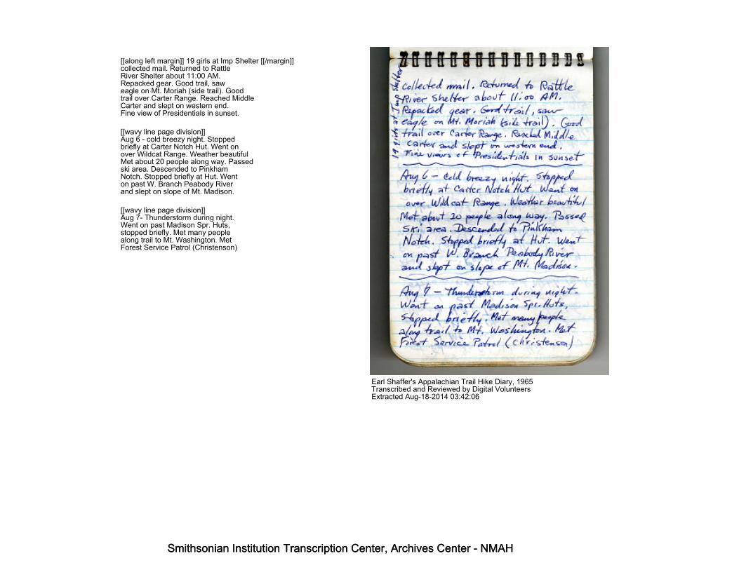
[[along left margin]] 19 girls at Imp Shelter [[/margin]]collected mail. Returned to RattleRiver Shelter about 11:00 AM.Repacked gear. Good trail, saweagle on Mt. Moriah (side trail). Goodtrail over Carter Range. Reached MiddleCarter and slept on western end.Fine view of Presidentials in sunset.
[[wavy line page division]]Aug 6 - cold breezy night. Stoppedbriefly at Carter Notch Hut. Went onover Wildcat Range. Weather beautifulMet about 20 people along way. Passedski area. Descended to PinkhamNotch. Stopped briefly at Hut. Wenton past W. Branch Peabody Riverand slept on slope of Mt. Madison.
[[wavy line page division]]Aug 7- Thunderstorm during night.Went on past Madison Spr. Huts,stopped briefly. Met many peoplealong trail to Mt. Washington. MetForest Service Patrol (Christenson)
Earl Shaffer's Appalachian Trail Hike Diary, 1965Transcribed and Reviewed by Digital VolunteersExtracted Aug-18-2014 03:42:06
Smithsonian Institution Transcription Center, Archives Center - NMAH
Smithsonian Institution Transcription Center, Archives Center - NMAH

Smithsonian Institution Transcription Center, Archives Center - NMAH
Smithsonian Institution Transcription Center, Archives Center - NMAH
at Edmond's Col. Weather sunny.Crossed Mt. Washington. Went onpast Lakes of Clouds Hut and Mispah Hut. Took wrong trail fromMizpah. Stopped and slept alongstream near Crawford Notch Park._______________________________________Aug 8 - Reached road at DryRiver Camp Ground, followed roadnorth one mile to road crossing. Skyclouded over. Reached Ethan Pondshelter, cooked meal. Went on toZealand Falls Hut. Thunderstormbegan as I arrived. Waited tillrain stopped. Had met familyand group of boys at ThoreauFalls. Started from Zealand Hut,began raining and continued all theway to Galehead Hut. Arrived about8:00 so decided to stay overnight._____________________________________
Earl Shaffer's Appalachian Trail Hike Diary, 1965Transcribed and Reviewed by Digital VolunteersExtracted Aug-18-2014 03:42:06
Smithsonian Institution Transcription Center, Archives Center - NMAH
Smithsonian Institution Transcription Center, Archives Center - NMAH

Smithsonian Institution Transcription Center, Archives Center - NMAH
Smithsonian Institution Transcription Center, Archives Center - NMAH
[[start page]]Aug 9 -- Rained all night. Rained until about 9:00. Started off and beganraining again. Reached Garfield Pond shelter, met several small groupsen route. Found about 20 in shelter. Roof leaky. Tried to start fire, failedWent on through rain to Mt. Lafayette and to Liberty Spring shelter.About 30 people there. Took more than hour to start fire. Sole hadcome loose on boot. Slept outside because of crowd. Rained duringnight._______________________________________Aug. 10 -- Rose soon after dawn. Camp boys and I managed fire, thenrained heavily and we held tarps above while others cooked. Finallystopped raining and began clearing. I sewed sole at front and went on toFranconia Notch. Cooked and dried out somewhat. Hitched ride to storebelow Flume House and back. Went on over Kinsman [[end page]]
Earl Shaffer's Appalachian Trail Hike Diary, 1965Transcribed and Reviewed by Digital VolunteersExtracted Aug-18-2014 03:42:06
Smithsonian Institution Transcription Center, Archives Center - NMAH
Smithsonian Institution Transcription Center, Archives Center - NMAH

Smithsonian Institution Transcription Center, Archives Center - NMAH
Smithsonian Institution Transcription Center, Archives Center - NMAH
[[start page]] Ridge. Began raining as I crossed South Kinsman andcontinued till I finally reached Eliza Brook Shelter. Failed to light fire. Atecold supper______________________________________________Aug. 11 -- Rained all night. Woods very wet and brushy for about twomiles. Needed no facewash, got it as fringe benefit. Then trail freshcleared to Kinsman Notch. Sky began clearing and woods dried as Iclimbed Beaver Brook and reached summit of Moosilauke. Viewtremendous. Descended to Glencliff. Continued past Wachipauki Pondand stopped and slept beside trail at dark about 1 mile from ArmingtonCabin.___________________________________________Aug. 12 -- Chilly night. Sky clear in morning. Stopped to cook breakfastat Armington Cabin. Continued over roads and some trail To Cube Mtn.Met two parties of hikers [[end page]]
Earl Shaffer's Appalachian Trail Hike Diary, 1965Transcribed and Reviewed by Digital VolunteersExtracted Aug-18-2014 03:42:06
Smithsonian Institution Transcription Center, Archives Center - NMAH
Smithsonian Institution Transcription Center, Archives Center - NMAH

Smithsonian Institution Transcription Center, Archives Center - NMAH
Smithsonian Institution Transcription Center, Archives Center - NMAH
[[start page]] on summit. Continued over Smarts Mtn. talked towatchman. Trail clear and marking good. Stayed at Smart's Mtn. Leanto.____________________________________________Aug 13 -- Light rain during night Started at daylight, no breakfast. Goodtrail and good marking over Holt's Ledge area and over Moose Mtn.Clear trail and good marking to Velvet Rocks Leanto. Saw deer enroute.Weather warm and sunny_____________________________________________Aug 14 -- Bought film and food in Hanover--went on to Norwich, Vt.bought tennis shoes. Good trail and marking to West Hartford. Mailedhome Bass boots, telescope and mosquito bar. Continued over goodtrail to Cloudland Cabin. Found it dismantled. Slept there__________________________________________[[end page]]
Earl Shaffer's Appalachian Trail Hike Diary, 1965Transcribed and Reviewed by Digital VolunteersExtracted Aug-18-2014 03:42:06
Smithsonian Institution Transcription Center, Archives Center - NMAH
Smithsonian Institution Transcription Center, Archives Center - NMAH

Smithsonian Institution Transcription Center, Archives Center - NMAH
Smithsonian Institution Transcription Center, Archives Center - NMAH
Aug 15 - Warm clear night. Heardbarred owl, snorting deer and belleringcattle. Ate cold breakfast and hadgood trail and marking to end ofDoc section. stopped for coffee andtalk at Bartletts. Went on toGulf Shelter, nice place. Marking (blue)fair, trail clear. Went on overgood trail to Stony Brook shelter.Cut down sleeping bag. Weather clear and cool.[[in margin]] Met Dick Kuhl.
Aug 16 - Deer came close during night.Hiked over good trail to Sherburne road. Hitched to post office. Man onway back knew Flemings andtook me there. Madeline and Mose gaveme lunch then drove me back to [[Symbol for Appalachian Trail]].Madeline hiked along to Gifford WoodsPark. Saw deer near park. [[in margin]] Saw deer near park. Talked toRanger Grace forseveral hours, went on over goodtrail past long Trail Lodge and [[endpage]]
Earl Shaffer's Appalachian Trail Hike Diary, 1965Transcribed and Reviewed by Digital VolunteersExtracted Aug-18-2014 03:42:06
Smithsonian Institution Transcription Center, Archives Center - NMAH
Smithsonian Institution Transcription Center, Archives Center - NMAH

Smithsonian Institution Transcription Center, Archives Center - NMAH
Smithsonian Institution Transcription Center, Archives Center - NMAH
[[start page]] Pico Camp to Cooper Lodge atsundown. Camp group there. Islept in woods. Chilly night.____________________________________________Aug 17--Tuesday--Started early fromCooper Lodge, over good trail. MetParis Walters and two companions.Bill Dixon & Bill Murny midway toGov. Clement Camp. Met two boys therefrom Rutland. Passed Clarendon ShelterMet 3 people soon after. Met 6 peopleat Buffum Shelter. Went on toGreenwall Shelter. No one there. arrivedat sunset, nice place. Good Trail all the way___________________________________________Aug. 18. Terrific thunder storm duringnight. Mountain rocked at one blast.Good trail to Little Rock Pond. Met6 people in that area. Went on toBig branch for lunch. Met man &8 boys at next shelter (near Baker Peak)and man, woman, and 2 girls short distancebeyond. Went on to Griffith shelter and [[end page]]
Earl Shaffer's Appalachian Trail Hike Diary, 1965Transcribed and Reviewed by Digital VolunteersExtracted Aug-18-2014 03:42:06
Smithsonian Institution Transcription Center, Archives Center - NMAH
Smithsonian Institution Transcription Center, Archives Center - NMAH

Smithsonian Institution Transcription Center, Archives Center - NMAH
Smithsonian Institution Transcription Center, Archives Center - NMAH
[[start page]] shared shelter with man + 2 sons.He had served in S. Pacific as a chaplain.____________________________________________Aug 19 -Thursday. Went on over [[strikethrough]] good [[/strikethrough]]brushytrail to Mad Tom Notch. Light rain fellall morning. Reached Bromley Lodge at noon.Saw 2 deer near top of Bromley Mtn.Thunderstorm at Lodge while I ate lunch.Went on to [[strikethrough]] road an [[/strikethrough]] road and went toManchester for food supplies. Backon trail went on to Swezey Camp,arriving about sundown. Sky cloudy.(nice place)_____________________________________________Aug 20 -Rained several times duringnight. Sky squally in morning but beganclearing as I started. Passed BournePond about 9:30 (photo). PassedStratton Pond, cooked at Willis RossCamp. Enroute to highway met Englishman,father, son, daughter and Fish Warden.Continued to Glastenbury Camp. trailbrushy, marking fair, cooked supper, thenwent on to Fay Fuller Camp, arrivingat dark. [[end page]]
Earl Shaffer's Appalachian Trail Hike Diary, 1965Transcribed and Reviewed by Digital VolunteersExtracted Aug-18-2014 03:42:06
Smithsonian Institution Transcription Center, Archives Center - NMAH
Smithsonian Institution Transcription Center, Archives Center - NMAH

Smithsonian Institution Transcription Center, Archives Center - NMAH
Smithsonian Institution Transcription Center, Archives Center - NMAH
Aug 21 - Saturday - Met father andson as leaving Fay Fuller. Missedturn beyond highway and lost trail,found it again, went on over HamlinHill to Thendarra Camp. No water, wenton past Sucker Pond, met 2 men onHondas, two more in Jeep. ArrivedSeth Warner Camp about 7 PM. Manand three boys there. I decided tostay night.[[along left margin]] Good trail, good marking]]
[[dividing line]]Aug. 22 - Rained at night. still rainingas I leave. Arrived at state line.Met 2 scout groups of 12 each and4 other boys enroute to Blackinton.Trail brushy in spots, marking fairto good. Good trail & very good markingover Mt. Greylock, Foggy & rainy. ReachedGreylock Leanto in the twilight, oneman there. Rained as I turned in.
[[dividing line]]Aug. 23 - Mon. Signs of clearing as Icook breakfast. Hiked downhill [[end page]]
Earl Shaffer's Appalachian Trail Hike Diary, 1965Transcribed and Reviewed by Digital VolunteersExtracted Aug-18-2014 03:42:06
Smithsonian Institution Transcription Center, Archives Center - NMAH
Smithsonian Institution Transcription Center, Archives Center - NMAH
Smithsonian Institution Transcription Center, Archives Center - NMAH
Smithsonian Institution Transcription Center, Archives Center - NMAH
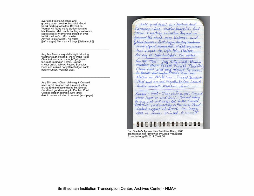
over good trail to Cheshire andgrocery store. Weather beautiful. Goodtrail & marking to Dalton. Beyond onWarner Hill found many blueberries andblackberries. Met couple hunting mushroomssouth slope of Warner Hill. Hiked on overtrail & road to Oct. Mtn. shelter.Arriving in late twilight. No water[[left margin]] Met man + 2 boys [[/left margin]]
_______________________________________________
Aug 24 - Tues. - very chilly night. Morningweather clear. Passed Finerty Pond (foto)Clear trail and road through Tyringhamto Great Barrington Forest. Saw noshelter on Mt. Wilcox. Passed BenedictPond and arrived Forgotten Bridge Leantobefore sunset. Weather clear.
________________________________________________
Aug 25 - Wed - Clear, chilly night. Crossedstate forest on good trail. Crossed valleyto Jug End and ascended to Mt. Everett.Good trail, good marking to Plantain Pond.Cooked supper at brook. Saw largedeer in ravine. climbed to summit [[end page]]
Earl Shaffer's Appalachian Trail Hike Diary, 1965Transcribed and Reviewed by Digital VolunteersExtracted Aug-18-2014 03:42:06
Smithsonian Institution Transcription Center, Archives Center - NMAH
Smithsonian Institution Transcription Center, Archives Center - NMAH

Smithsonian Institution Transcription Center, Archives Center - NMAH
Smithsonian Institution Transcription Center, Archives Center - NMAH
[[start page]]of Bear Mtn. and slept near memorial. Sunset beautiful - forecast rain-[[dividing line]]Aug 26 - Rain began at dawn. Hiked through wet woods over good trailto Salisbury, bought supplies, went on over Road to Falls Village. Goodtrail, good marking to Music Mtn. Intermittent rain. Cooked supper atMusic Mtn. Went on over fair trail (brush & blowdowns) to about 1 mileshort of Red Mtn. Leanto, stopped in dark and slept under pines.[[dividing line]]Aug 27 - Warm damp night, mosquitos. Went on to Red Mtn. Leanto andcooked breakfast and dried out. Hazy sun. Cleared and beautifulweather, good trail, good marking over Mohawk Mtn. to Cornwall bridge.Good trail & riverside road to Macedonia Brook Park and Leanto. 2 boysthere. Rest of family in campground.
[[end page]]
Earl Shaffer's Appalachian Trail Hike Diary, 1965Transcribed and Reviewed by Digital VolunteersExtracted Aug-18-2014 03:42:06
Smithsonian Institution Transcription Center, Archives Center - NMAH
Smithsonian Institution Transcription Center, Archives Center - NMAH
Smithsonian Institution Transcription Center, Archives Center - NMAH
Smithsonian Institution Transcription Center, Archives Center - NMAH
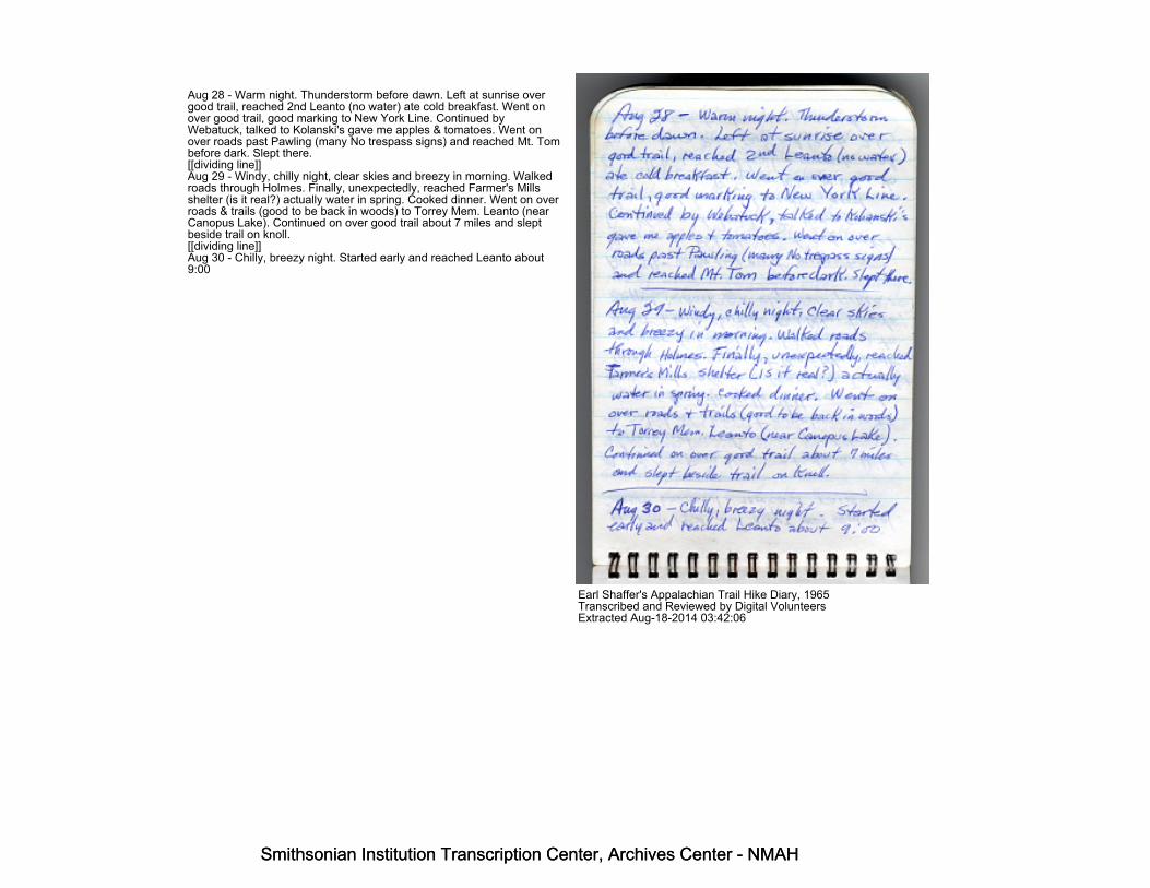
Aug 28 - Warm night. Thunderstorm before dawn. Left at sunrise overgood trail, reached 2nd Leanto (no water) ate cold breakfast. Went onover good trail, good marking to New York Line. Continued byWebatuck, talked to Kolanski's gave me apples & tomatoes. Went onover roads past Pawling (many No trespass signs) and reached Mt. Tombefore dark. Slept there.[[dividing line]]Aug 29 - Windy, chilly night, clear skies and breezy in morning. Walkedroads through Holmes. Finally, unexpectedly, reached Farmer's Millsshelter (is it real?) actually water in spring. Cooked dinner. Went on overroads & trails (good to be back in woods) to Torrey Mem. Leanto (nearCanopus Lake). Continued on over good trail about 7 miles and sleptbeside trail on knoll.[[dividing line]]Aug 30 - Chilly, breezy night. Started early and reached Leanto about9:00
Earl Shaffer's Appalachian Trail Hike Diary, 1965Transcribed and Reviewed by Digital VolunteersExtracted Aug-18-2014 03:42:06
Smithsonian Institution Transcription Center, Archives Center - NMAH
Smithsonian Institution Transcription Center, Archives Center - NMAH
Smithsonian Institution Transcription Center, Archives Center - NMAH
Smithsonian Institution Transcription Center, Archives Center - NMAH
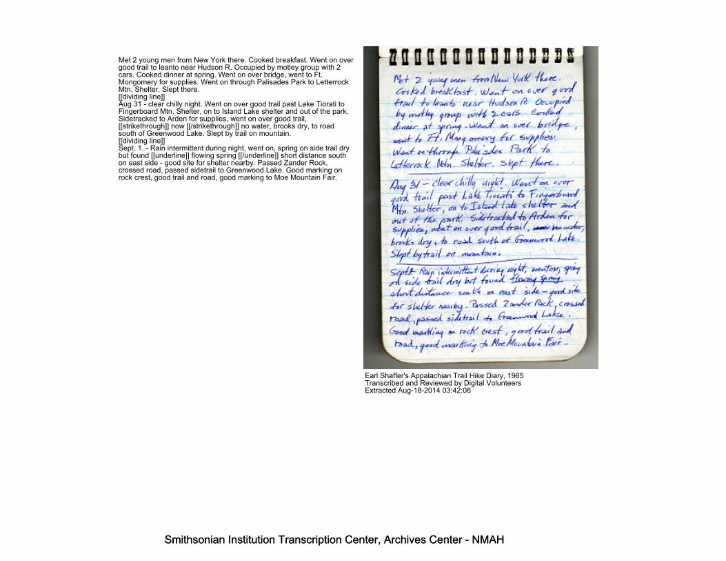
Met 2 young men from New York there. Cooked breakfast. Went on overgood trail to leanto near Hudson R. Occupied by motley group with 2cars. Cooked dinner at spring. Went on over bridge, went to Ft.Mongomery for supplies. Went on through Palisades Park to LetterrockMtn. Shelter. Slept there.[[dividing line]]Aug 31 - clear chilly night. Went on over good trail past Lake Tiorati toFingerboard Mtn. Shelter, on to Island Lake shelter and out of the park.Sidetracked to Arden for supplies, went on over good trail,[[strikethrough]] now [[/strikethrough]] no water, brooks dry, to roadsouth of Greenwood Lake. Slept by trail on mountain.[[dividing line]]Sept. 1. - Rain intermittent during night, went on, spring on side trail drybut found [[underline]] flowing spring [[/underline]] short distance southon east side - good site for shelter nearby. Passed Zander Rock,crossed road, passed sidetrail to Greenwood Lake. Good marking onrock crest, good trail and road, good marking to Moe Mountain Fair.
Earl Shaffer's Appalachian Trail Hike Diary, 1965Transcribed and Reviewed by Digital VolunteersExtracted Aug-18-2014 03:42:06
Smithsonian Institution Transcription Center, Archives Center - NMAH
Smithsonian Institution Transcription Center, Archives Center - NMAH

Smithsonian Institution Transcription Center, Archives Center - NMAH
Smithsonian Institution Transcription Center, Archives Center - NMAH
[[start page]]Good trail + marking to Vernon Valley. Heavy rain through valley. Easedas I stopped at dark on hill and slept by trail.[[line]]Sept. 2 [[underlined]]Damp night, cleared before dawn. Good trail + road, good marking pastUnionville (bought groceries) to High Point. Fine weather, good trailalong Kittatminy [[?]] past Machipacong shelter, saw 1 eagle, 40 deerand lots of squirrels and birds. Stopped at sunset + slept by trail nearroad gap at Culver Lake. Quarter moon.[[line]]Sept. 3 - Fri. - Chilly night. Fine weather, good marking to Blue Mtnlakes area, then good marking along roads several miles. Then goodtrail with viewpoints past sunfish Pond to Delaware Water Gap. Sawseveral deer during day. Bought groceries at store and slept nearLenape Lake[[line]]
Earl Shaffer's Appalachian Trail Hike Diary, 1965Transcribed and Reviewed by Digital VolunteersExtracted Aug-18-2014 03:42:06
Smithsonian Institution Transcription Center, Archives Center - NMAH
Smithsonian Institution Transcription Center, Archives Center - NMAH

Smithsonian Institution Transcription Center, Archives Center - NMAH
Smithsonian Institution Transcription Center, Archives Center - NMAH
Sept 4 - Got mail at Post Office + note that brother was waiting atShelter. [[vertical note, left hand margin: "saw rattlesnake"]] Went on toshelter - met Johnny, Davy, Sammy + Stevie. Went on over good trail -good marking past Smith's Gap and slept beside trail, using down bagJohnny had brought. Saw several deer and many grouse during day
----------------------------[[vertical note, left hand margin: "heard Whip-poor-will--first time"]]Sept. 5. No water, no breakfast, went on over good trail through gap,about mid morning came to a sidetrail, went to spring, dry so followedgully about 500 yds down to good spring. Cooked breakfast, went on,met man, found blueberries, met family of four, then two young men.Went on, good trail to Bake Oven Knob Leanto. Stopped for night.Weather clear no water
-----------------------------Sept 6 - Found no water, moonlit night. Fairly warm. Went on overgood trail to New Tripoli Leanto. Good water, cooked meal
Earl Shaffer's Appalachian Trail Hike Diary, 1965Transcribed and Reviewed by Digital VolunteersExtracted Aug-18-2014 03:42:06
Smithsonian Institution Transcription Center, Archives Center - NMAH
Smithsonian Institution Transcription Center, Archives Center - NMAH
Smithsonian Institution Transcription Center, Archives Center - NMAH
Smithsonian Institution Transcription Center, Archives Center - NMAH
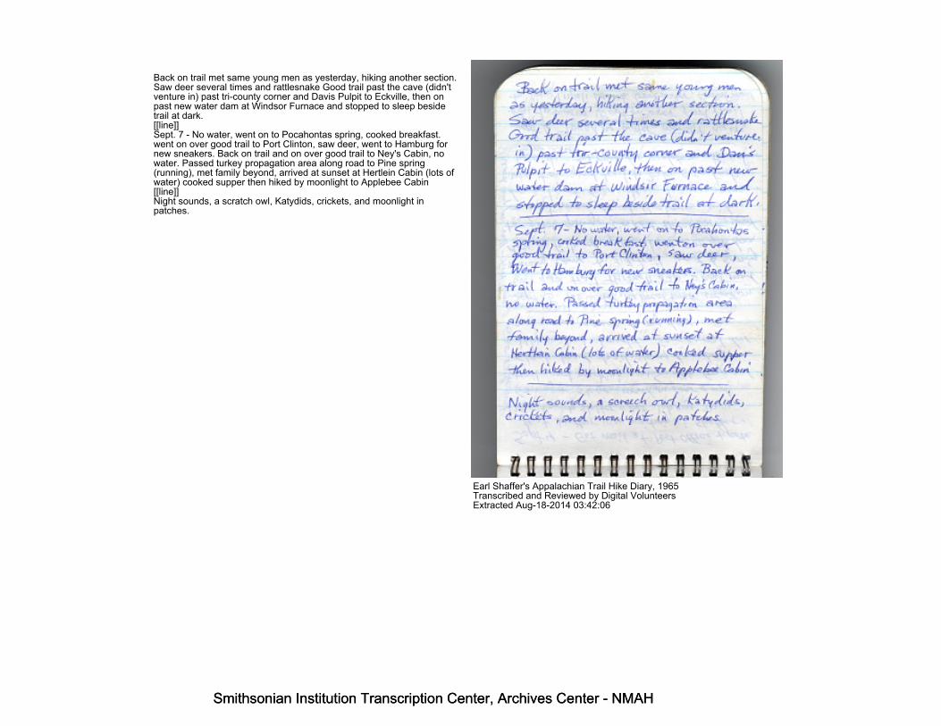
Back on trail met same young men as yesterday, hiking another section.Saw deer several times and rattlesnake Good trail past the cave (didn'tventure in) past tri-county corner and Davis Pulpit to Eckville, then onpast new water dam at Windsor Furnace and stopped to sleep besidetrail at dark.[[line]]Sept. 7 - No water, went on to Pocahontas spring, cooked breakfast.went on over good trail to Port Clinton, saw deer, went to Hamburg fornew sneakers. Back on trail and on over good trail to Ney's Cabin, nowater. Passed turkey propagation area along road to Pine spring(running), met family beyond, arrived at sunset at Hertlein Cabin (lots ofwater) cooked supper then hiked by moonlight to Applebee Cabin[[line]]Night sounds, a scratch owl, Katydids, crickets, and moonlight inpatches.
Earl Shaffer's Appalachian Trail Hike Diary, 1965Transcribed and Reviewed by Digital VolunteersExtracted Aug-18-2014 03:42:06
Smithsonian Institution Transcription Center, Archives Center - NMAH
Smithsonian Institution Transcription Center, Archives Center - NMAH

Smithsonian Institution Transcription Center, Archives Center - NMAH
Smithsonian Institution Transcription Center, Archives Center - NMAH
Sept 8 - warm night, slight over cast in morning. Went on over good trail,+ good marking, saw several deer + grouse + squirrels, to Swatara Gap.Good trail, fair marking to Rausch Gap. Good trail, good markingthrough St Anthony's wilderness, saw deer several times. Arrived in lightrain at Clark's Valley Leanto and stopped for night.[[line]]Sept. 9 - Cleared during night, warm. Went on over good trail totransmountain road, stopped restaurant, good trail to Duncannon. Gotmail, bought supplies, met Johnnie, unexpectedly near Sherman'sCreek. He took me home to re-equip and brought me back late inevening. Climbed past Hawk Rock and slept on top of Mtn. Moonlight.[[line]]Sept. 10 - Warm night, went on, good trail, good marking over CoveMtn. Saw deer, then to Darlington Leanto, [[end page]]
Earl Shaffer's Appalachian Trail Hike Diary, 1965Transcribed and Reviewed by Digital VolunteersExtracted Aug-18-2014 03:42:06
Smithsonian Institution Transcription Center, Archives Center - NMAH
Smithsonian Institution Transcription Center, Archives Center - NMAH

Smithsonian Institution Transcription Center, Archives Center - NMAH
Smithsonian Institution Transcription Center, Archives Center - NMAH
Stopped to cook dinner, went on across valley, marking good, talked topower linemen, stopped at store in Allen. Good trail and marking overWhite Rocks to Center Point Knob. Then on to Dark Hollow Leantoabout sundown.[[ line ]]Sept. 11 - Heard Whip-poor-will at night. Went on over good trail toWhisky Spring, Rocky Ridge, Tagg Run Leantos, to Pine GroveFurnace. Good weather. Waited till Ann + Fred came with Frances. Hadpicnic. Went on by flashlight past Pine Grove Cabin to Tom's RunLeantos.[[ line ]]Sept. 12 - Began raining at night and continued all day, past Milesburn[[?]], Birch Run, Quarry Gap, Caledonia and on to Tumbling Run LeantoArrived in twilight. (Had stopped at Michener Cabin Project and talked toBlackburns etc.[[end page]]
Earl Shaffer's Appalachian Trail Hike Diary, 1965Transcribed and Reviewed by Digital VolunteersExtracted Aug-18-2014 03:42:06
Smithsonian Institution Transcription Center, Archives Center - NMAH
Smithsonian Institution Transcription Center, Archives Center - NMAH

Smithsonian Institution Transcription Center, Archives Center - NMAH
Smithsonian Institution Transcription Center, Archives Center - NMAH
Sept. 13 - Rained during night. Went on over good trail, good marking,past PenMar. Weather foggy and light rain Good trail and marking toSmithsburg Road. Side tracked to town for mail + food. Went on overgood trail to Pine Knob Shelter, palatial Leanto. Still foggy and light rain.[[line]]Sept. 14 - Rain during night, still foggy as I went on past route 40 toWashington Memorial (built 1827) Rebuilt 1934. Stopped for lunch atCrampton Gap picnic ground (no water at shelter) Went on over goodtrail to Weaverton, crossed Potomac and hiked about halfway to KeysGap, stopped at deep dark and slept by trail. Weather clear but eastwind.[[line]]Sept. 15 - Foggy and light rain again in morning. Breakfast at KeyesGap Leanto (scanty, no water). Went on over good tail, good marking toWilson's Gap Shelter (stone). Plenty of water, cooked dinner, washedclothes. Went on
Earl Shaffer's Appalachian Trail Hike Diary, 1965Transcribed and Reviewed by Digital VolunteersExtracted Aug-18-2014 03:42:06
Smithsonian Institution Transcription Center, Archives Center - NMAH
Smithsonian Institution Transcription Center, Archives Center - NMAH

Smithsonian Institution Transcription Center, Archives Center - NMAH
Smithsonian Institution Transcription Center, Archives Center - NMAH
past Three Springs, shelter, weather clearing again during afternoon,kept on till deep dark, trying to reach Ashby Gap but finally stopped 3miles short and slept by trail.[[line]]Sept. 16 - Foggy again as I started at dawn, reached Ashby Gap about7:30 waited for bus, intending to go to Washington til 10:00 , in vain,then went on over good trail to Manassas Gap shelter and then the Gap,Linden, stopped at store and post office. Went on over good trail toMosby Shelter. Starting to rain and rather late so decided to stop fornight. Made alterations in sleeping bag.[[line]]Sept. 17 - 20 years ago today I was discharged from Army. Weatherfoggy and warm. Started on and within 2 miles was met by sister Annand 2 friends. They had come down to visit people in Luray. About 11:00entered Shenandoah park. Met young man at road
Earl Shaffer's Appalachian Trail Hike Diary, 1965Transcribed and Reviewed by Digital VolunteersExtracted Aug-18-2014 03:42:06
Smithsonian Institution Transcription Center, Archives Center - NMAH
Smithsonian Institution Transcription Center, Archives Center - NMAH

Smithsonian Institution Transcription Center, Archives Center - NMAH
Smithsonian Institution Transcription Center, Archives Center - NMAH
crossing; went on to Gravely Spring shelter, met Jim Wagner, from Ohio,hiked with him to Elkwallow Shelter and stopped for night. Weatherfoggy
-------------------------[[vertical note in left hand margin: "Met couple in morning"]]Sept 18 - Cleared during night, went on with Jim, passed Byrd's Nest #4,went on to Pass Mtn. Leanto and met couple with small son, man fromSeattle. Stopped at Panorama, went on past Mary's Rock (hazy) toByrd's Nest #3. Overrun with Scout Troop from Maryland. Talked awhile, then cooked supper, went on after dark to Shaver's HollowShelter
-------------------------Sept. 19 - Warm night, weather clear. Went on with Jim [[strikethrough]]past Pass Mts. Shelter, family there for weekend, stopped at Panorama,in Thornton Gap for snack, etc. Went on and stopped at Mary's Rock,some haze, went on past [[/strikethrough]] Stoneyman, Jim turned offtoward Byrd's Nest #2 and I went on to Big Meadow. Met G. Walker andothers from Washington
Earl Shaffer's Appalachian Trail Hike Diary, 1965Transcribed and Reviewed by Digital VolunteersExtracted Aug-18-2014 03:42:06
Smithsonian Institution Transcription Center, Archives Center - NMAH
Smithsonian Institution Transcription Center, Archives Center - NMAH

Smithsonian Institution Transcription Center, Archives Center - NMAH
Smithsonian Institution Transcription Center, Archives Center - NMAH
[[start page]]Many people in campground, went to store at wayside then on to BearFence Mtn. Shelter - saw large deer on trail. Weather clear________________________________________________________________________Sept. 20 - Warm night, clear sky. Met and talked with man at PocosinCabin. Weather hot & humid during day. Stopped and ate lunch atrestaurant in Swift Run Gap. Cooked supper at Pinefield Shelter, thenhurried on to Ivy Creek Shelter. Saw deer enroute, arrived late.________________________________________________________________________Sept. 21. Warm, clear night. Passed Campstore in morning, food supplylow but store not open. Sidetracked to see Doyle River Cabin. Stoppedto cook dinner at Black Rock Shelter. Spring dry but water farther down.Went on and cooked supper at Saw Mill Run. Spring dry but foundwater down ravine. Went on, saw deer, and stopped to sleep by the trailat the edge of the park________________________________________________________________________Good trail & marking throughout Shenandoah.[[end page]]
Earl Shaffer's Appalachian Trail Hike Diary, 1965Transcribed and Reviewed by Digital VolunteersExtracted Aug-18-2014 03:42:06
Smithsonian Institution Transcription Center, Archives Center - NMAH
Smithsonian Institution Transcription Center, Archives Center - NMAH

Smithsonian Institution Transcription Center, Archives Center - NMAH
Smithsonian Institution Transcription Center, Archives Center - NMAH
[[start page]]Sept. 22 - Warm, clear night. No food so left early without breakfast,Hiked over good trail across pasturelands and woods to Rockfish Gap.Saw bear enroute. Sidetracked to Afton for mail and supplies. Trail andmarking fair to good from Rockfish Gap to Humpback Gap. Passed rockshelter, water in brook, saw wild turkeys. Trail fair over Humpback Mtn.Marking Good, good viewpoints to Laurel Spring. Went on and slept onDevils Know at trailside. Showers in afternoon._____________________________________________[[left margin note: [[strike through]] Saw eagle [[/strike through]] Saweagle & squirrels]]Sept. 23 - Cleared during night. Started at day break. Trail and markinggood from Laurel Spring to Three Ridges overlook. At cold breakfastthere. Trail & marking good over Three Ridges, pas Maupin FieldShelter, to ---- shelter. Clouded over and light rain in early afternoon.Passed Gap, talked to Fire Warden. Light rain on The Priest, trail fair togood, brushy spots, marking good. Reached shelter about 6:00 andstayed__________________________________________
[[end page]]
Earl Shaffer's Appalachian Trail Hike Diary, 1965Transcribed and Reviewed by Digital VolunteersExtracted Aug-18-2014 03:42:06
Smithsonian Institution Transcription Center, Archives Center - NMAH
Smithsonian Institution Transcription Center, Archives Center - NMAH

Smithsonian Institution Transcription Center, Archives Center - NMAH
Smithsonian Institution Transcription Center, Archives Center - NMAH
[[start page]][[left margin note: saw deer heard turkeys]]Sept. 24 - Rainy and cool night. Fog and rain in morning. Trail Fair toGood to Rocky Mtn., weeds & brush, marking good. Trail to WigginsSpring Shelter, [[circled]]thunderstorm at noon [[/circled]][[arrow to insertin line above]] Fair to good, weeds and brush. To route 60 trail fair.weeds, briars & brush. Reached Brown Mtn. Shelter in twilight, with skyclearing.___________________________________________Sept. 25 - Clear and cool in morning. Trail to Pedlar dam Fair to goodwith brushy spots. Same to Punchbowl Shelter saw bear enroute. OverBluff Mtn. (visibility from Bluff Mtn. excellent)to James R. trail goodexcept spot near river. Marking good. Saw several deer enroute. TrailGood marking good from James R. past Matts Creek Shelter. Slept bytrail midway to Marble Springs Shelter. Weather clear.___________________________________________Sept. 26 - Chilly night. Cooked breakfast at Marble Springs Shelter.Good trail & marking to Thunder Mtn. Shelter. Heard turkeys. Cookeddinner at Thunder Mtn. Good trail past
[[end page]]
Earl Shaffer's Appalachian Trail Hike Diary, 1965Transcribed and Reviewed by Digital VolunteersExtracted Aug-18-2014 03:42:06
Smithsonian Institution Transcription Center, Archives Center - NMAH
Smithsonian Institution Transcription Center, Archives Center - NMAH

Smithsonian Institution Transcription Center, Archives Center - NMAH
Smithsonian Institution Transcription Center, Archives Center - NMAH
[[start page]]
Cornelius Creek Shelter. Trail + marking good to Shelter at Cove Creek.Picnickers at shelter, waited nearby till they left.______________________________Sept. 27 - Chilly nights. Trail good and good marking to BearwallowGap. Found and opened good spring about half mile south of roadcrossing. Trail good to Bobbletts Gap Shelter. Weather clear and cool.Saw chestnuts on tree. Good trail and marking past Wilson Creekshelter to Fullhardt Knob Shelter near sundown. Wind strong from theeast, turning cold.__________________________________Sept. 28 - chilly nights. Overcast sky. Reached Highway Rte 11 andstore over good trail. Good trail & marking over Tinker Mtn. (fair visibilityof fine views.) to Bennett Spring. From Bennett Spring to Fireroad trailfair, with blowdowns & brush. Marking good from Bennett Spring toCatawba Rd. Slept at trailside just beyond road.__________________________________Sept. 29 - Cool night. Clearing sky. Good trail & marking from CatawbaRoad
[[end page]]
Earl Shaffer's Appalachian Trail Hike Diary, 1965Transcribed and Reviewed by Digital VolunteersExtracted Aug-18-2014 03:42:06
Smithsonian Institution Transcription Center, Archives Center - NMAH
Smithsonian Institution Transcription Center, Archives Center - NMAH

Smithsonian Institution Transcription Center, Archives Center - NMAH
Smithsonian Institution Transcription Center, Archives Center - NMAH
past J L Hodges (bought honey) to Dragon's Tooth. Logging underwaybetween " " [[ditto marks referring to Dragon's Tooth]] and_____________ Cove. Trail a shambles. Marking good through Coveand along road past Trout Creek Shelter to Niday Shelter. Cookedsupper, then continued till dark, sleeping by the trail about midway onSinking Creek Mtn. East wind blowing and chilly_________________________________
Sept. 30 - Chilly night and morning. Left before sunrise, stopped to talkwith old man in shack on Mtn. Good trail and marking on Sinking CreekMtn. Reached store in valley at 9:00. Not open. Marking good on roadup mountain, good trail and marking past Big Pond Shelter (no water).Good marking on roads to War Branch Shelter (good water). Skyovercast. Good trail + marking to Bailey Gap Shelter (starting to rain sostopped early) No water in spring._________________________________
Earl Shaffer's Appalachian Trail Hike Diary, 1965Transcribed and Reviewed by Digital VolunteersExtracted Aug-18-2014 03:42:06
Smithsonian Institution Transcription Center, Archives Center - NMAH
Smithsonian Institution Transcription Center, Archives Center - NMAH
Smithsonian Institution Transcription Center, Archives Center - NMAH
Smithsonian Institution Transcription Center, Archives Center - NMAH
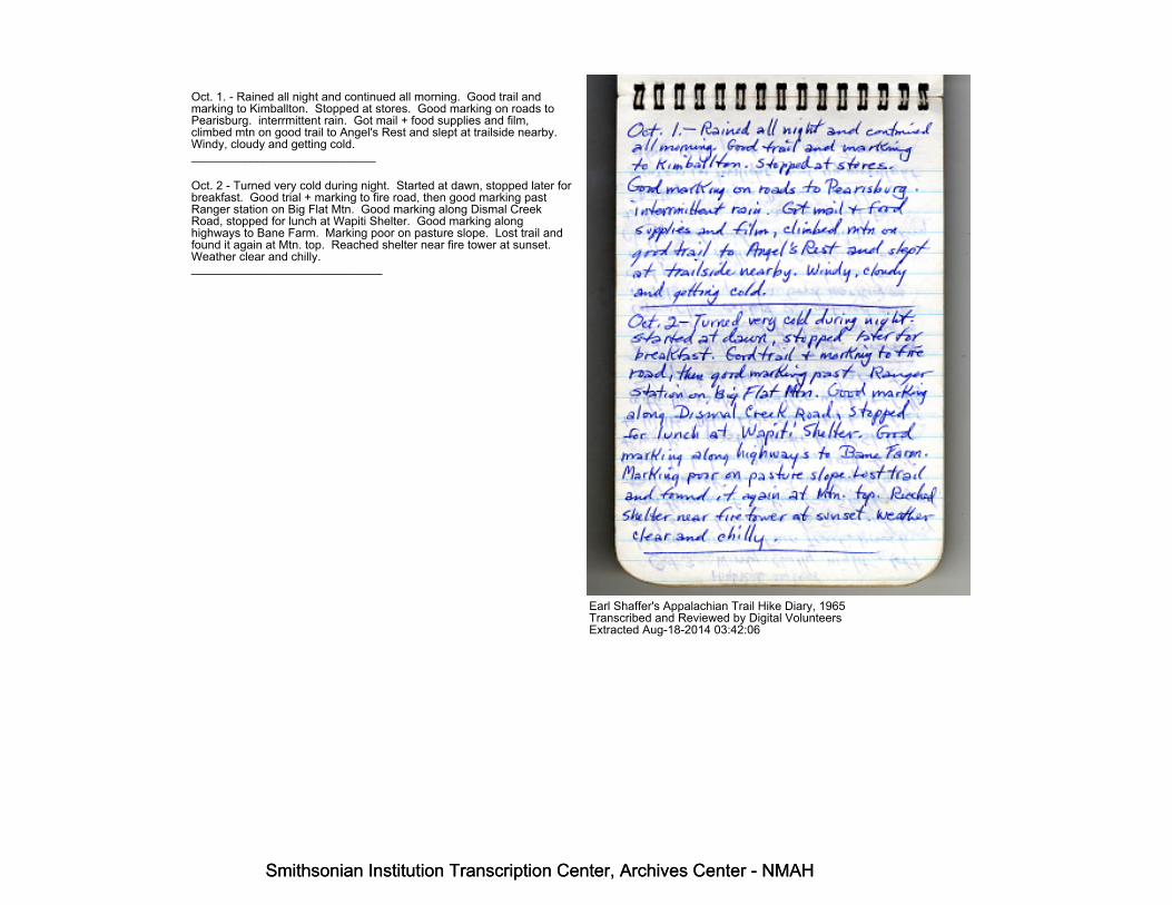
Oct. 1. - Rained all night and continued all morning. Good trail andmarking to Kimballton. Stopped at stores. Good marking on roads toPearisburg. interrmittent rain. Got mail + food supplies and film,climbed mtn on good trail to Angel's Rest and slept at trailside nearby.Windy, cloudy and getting cold.____________________________
Oct. 2 - Turned very cold during night. Started at dawn, stopped later forbreakfast. Good trial + marking to fire road, then good marking pastRanger station on Big Flat Mtn. Good marking along Dismal CreekRoad, stopped for lunch at Wapiti Shelter. Good marking alonghighways to Bane Farm. Marking poor on pasture slope. Lost trail andfound it again at Mtn. top. Reached shelter near fire tower at sunset.Weather clear and chilly._____________________________
Earl Shaffer's Appalachian Trail Hike Diary, 1965Transcribed and Reviewed by Digital VolunteersExtracted Aug-18-2014 03:42:06
Smithsonian Institution Transcription Center, Archives Center - NMAH
Smithsonian Institution Transcription Center, Archives Center - NMAH

Smithsonian Institution Transcription Center, Archives Center - NMAH
Smithsonian Institution Transcription Center, Archives Center - NMAH
High Rock ShelterOct 3 - Windy, chilly night. Left before sunrise. Fair trail, brush andsome blowdowns, to spur side trail. From there past Turkey GapShelter, good trail & marking. Good marking along road to highwaycrossing, good trail & marking past Monster Rock Shelter to Walker Mtn.L.O. Saw big buck deer with big rack. Weather windy & chilly stoppedat shelter near lookout.__________________________
Oct 4 - chilly windy night. Started at sunrise. Good trail & marking toGroseclose except 2 confused turns in Tilson Gap area. Good markingon road past Groseclose. Good trail + marking to Killinger CreekShelter. Chilly and windy. Good trail & marking to Teas, along road andon trail to [[strikethrough]] Dickey [[/strikethrough]] Raccoon BranchShelter. Went on in twilight and by moonlight along road past Iron Mtn.Inn and
Earl Shaffer's Appalachian Trail Hike Diary, 1965Transcribed and Reviewed by Digital VolunteersExtracted Aug-18-2014 03:42:06
Smithsonian Institution Transcription Center, Archives Center - NMAH
Smithsonian Institution Transcription Center, Archives Center - NMAH

Smithsonian Institution Transcription Center, Archives Center - NMAH
Smithsonian Institution Transcription Center, Archives Center - NMAH
slept by trail about 2 miles shortof Cherry Tree shelter---------------------------------Oct. 5. Cold, clear night. Startedat sunrise, passed Cherry Tree shelterGood trail & marking past StraightBranch Shelter to Sandy Flats Shelter.Met F.S. man Decker there & talked.Climbed to Feathercamp Tower for picof Mt. Rodgers & White Top. Good trail toDamascus, got food supplies, talked tomember of Mt. RATC, continued overgood trail till dark and by moonlightto shelter in Tennessee. Weather clear.-------------------------------------Oct 6 - Cool night. Good trail & markingpast firetower, Bristol road, talked tohunters. Continued over good trail pastseveral shelters, sky clouding over.Crossed valley on road, reached shelteroverlooking Watauga backwater afterdark, got water from far down. Startedraining, view of town below.
Earl Shaffer's Appalachian Trail Hike Diary, 1965Transcribed and Reviewed by Digital VolunteersExtracted Aug-18-2014 03:42:06
Smithsonian Institution Transcription Center, Archives Center - NMAH
Smithsonian Institution Transcription Center, Archives Center - NMAH

Smithsonian Institution Transcription Center, Archives Center - NMAH
Smithsonian Institution Transcription Center, Archives Center - NMAH
Oct. 7. Wind & rain during night.rained most of time during day. Trailgood, except blowdowns in burn areato road at Watauga Dam. Raining.Trail good from road, except blowdownsand brush near Horseshoe Church toHampton. Got mail & food supplies.Trail & marking good through LaurelFork Gorge. Sky clearing. Side trackedto Dennis Cove and slept in pavilion.Moon shining brightly.--------------------------------Oct. 8 - Rain storm during night.Clear and cold in morning, with wind.Good trail & marking past firetowerand on to road in valley. Trail fromroad across open summits to Roan Mtn Shelterpoor to fair, mostly, blowdowns, brush,briars and tangled weeds(recommend bypass this area with more direct approach via spur.[[strikethrough]] Markingmostly good past shelter over, open summit toroad gap.[[/strikethrough]]Slept in fringe of woods, ferociousthunder storm, ending during night.[[strikethrough along left margin]] slept in unto storm [[/strikethrough]]
Earl Shaffer's Appalachian Trail Hike Diary, 1965Transcribed and Reviewed by Digital VolunteersExtracted Aug-18-2014 03:42:06
Smithsonian Institution Transcription Center, Archives Center - NMAH
Smithsonian Institution Transcription Center, Archives Center - NMAH

Smithsonian Institution Transcription Center, Archives Center - NMAH
Smithsonian Institution Transcription Center, Archives Center - NMAH
Oct. 9 - Clear, cold and windy in morning.reache shelter about midmorning, trailoften rough. Marking and trail good overopen summits to road gap. Headwindsgusting to 60-75 miles per hour. Good trail& marking over Roam Mtn. and on toIron Mtn. Gap. Slept near road in Gap.-----------------------------------------Oct. 10 - Cool night, partly cloudy -Reached Cherry Gap Leanto over goodtrail & cooked breakfast. Trail fromCherry Gap to Forest Service Road fairwith blowdowns. Marking good alongroad over Unaka and along good trail to CurlyMaple Gap Leanto. Weather clear andcool. Good trail down rhododendron gorgeto Nolichucky River. Stopped at store.Good trail & marking to No Business Leanto-------------------------------------------Oct. 11 - Mon - Clear [[strikethrough]] mild[[/strikethrough]] cool night. Good trail& mark through. Rhododendron to route 19 W.Spiney Gap. Weather milder. [[from left margin - Big Bald ]]. Good trailto Sam's Gap and on along state line, past logging operation, somedisruption. Stopped at dark in gap above road gap and horses.[[strikethrough]] Spivey Gap [[/strikethrough]]
Earl Shaffer's Appalachian Trail Hike Diary, 1965Transcribed and Reviewed by Digital VolunteersExtracted Aug-18-2014 03:42:06
Smithsonian Institution Transcription Center, Archives Center - NMAH
Smithsonian Institution Transcription Center, Archives Center - NMAH
Smithsonian Institution Transcription Center, Archives Center - NMAH
Smithsonian Institution Transcription Center, Archives Center - NMAH
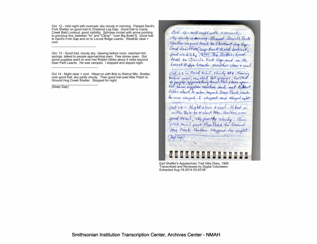
Oct. 12 - mild night with overcast, sky cloudy in morning. Passed Devil'sFork Shelter on good trail to Chestnut Log Gap. Good trail to CampCreek Bald Lookout, good visibility. [[phrase circled with arrow pointingto previous line, between "to" and "Camp": "over Big Butte"]]. Good trailto Devil's Fork Gap and on to Locust Ridge Leanto. Weather clear +cool._________________________
Oct. 13 - Good trail, cloudy sky, clearing before noon, reached Hotsprings, talked to people approaching town. Few stores open. Gotsome supplies went on and met Robert Gibbs about 4 miles beyondDeer Park Leanto. He was camped. I stopped and stayed night.__________________________
Oct 14 - Night clear + cool. Hiked on with Bob to Walnut Mtn. Shelter,over good trail, sky partly cloudy. Then good trail past Max Patch toGround Hog Creek Shelter. Stopped for night__________________________(Deep Gap)
Earl Shaffer's Appalachian Trail Hike Diary, 1965Transcribed and Reviewed by Digital VolunteersExtracted Aug-18-2014 03:42:06
Smithsonian Institution Transcription Center, Archives Center - NMAH
Smithsonian Institution Transcription Center, Archives Center - NMAH
Smithsonian Institution Transcription Center, Archives Center - NMAH
Smithsonian Institution Transcription Center, Archives Center - NMAH
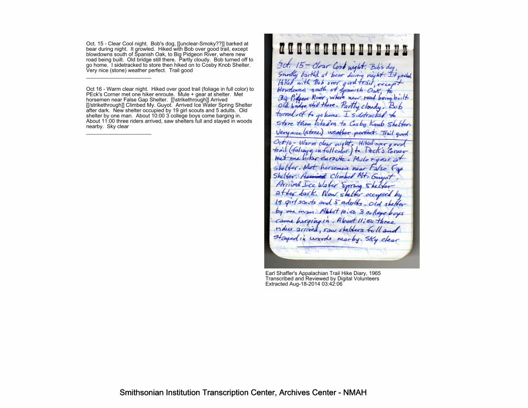
Oct. 15 - Clear Cool night. Bob's dog, [[unclear-Smoky??]] barked atbear during night. It growled. Hiked with Bob over good trail, exceptblowdowns south of Spanish Oak, to Big Pidgeon River, where newroad being built. Old bridge still there. Partly cloudy. Bob turned off togo home. I sidetracked to store then hiked on to Cosby Knob Shelter.Very nice (stone) weather perfect. Trail good______________________
Oct 16 - Warm clear night. Hiked over good trail (foliage in full color) toPEck's Corner met one hiker enroute. Mule + gear at shelter. Methorsemen near False Gap Shelter. [[\strikethrough]] Arrived[[/strikethrough]] Climbed My. Guyot. Arrived Ice Water Spring Shelterafter dark. New shelter occupied by 19 girl scouts and 5 adults. Oldshelter by one man. About 10:00 3 college boys come barging in.About 11:00 three riders arrived, saw shelters full and stayed in woodsnearby. Sky clear______________________
Earl Shaffer's Appalachian Trail Hike Diary, 1965Transcribed and Reviewed by Digital VolunteersExtracted Aug-18-2014 03:42:06
Smithsonian Institution Transcription Center, Archives Center - NMAH
Smithsonian Institution Transcription Center, Archives Center - NMAH

Smithsonian Institution Transcription Center, Archives Center - NMAH
Smithsonian Institution Transcription Center, Archives Center - NMAH
Oct. 17 - [[\strikethrough]] Mon. [[/strikethrough]] Sun - Met + talked withvarious hikers, (Mrs. Taft), passed Newfound gap. weather fine, manypeople. Passed Clingman's Dome, many people, passed Silar's Baldand arrived Halls' Cabin Site at dark weather still clear and balmy.________________________
Oct 18 - Clear cool night. Trail now marked, passed Thunderhead andSpence Field (cooked dinner) east wind and slight overcast. ReachedDoe Knob and passed Shuckstack Tower over good trail, visibility stillgood. Reached Fontana at dark. Slept near trail outside of town.________________________
Oct 19 - Went back to Fontana for mail and supplies. Sky cloudy andlight rain began as I started off about 11:00 A.M. Good trail and markingpast Wachecha Bald, footing treacherous on steep slopes, fell severaltimes. Trail mostly good, some brush
Earl Shaffer's Appalachian Trail Hike Diary, 1965Transcribed and Reviewed by Digital VolunteersExtracted Aug-18-2014 03:42:06
Smithsonian Institution Transcription Center, Archives Center - NMAH
Smithsonian Institution Transcription Center, Archives Center - NMAH

Smithsonian Institution Transcription Center, Archives Center - NMAH
Smithsonian Institution Transcription Center, Archives Center - NMAH
and blowdown, good marking to Tecoah Gap. Slept by trail on Mtn.south of gap._________________________
Oct. 20 - Damp, windy night. Trail mostly good, some brush andblowdown to Cheoah Bald, still raining, staying off trail on steep slopesto avoid falling (switchbacks needed) still fell several times. Good trailand marking from Cheoah to Wesser. Good trail + marking over WesserBald. Visibility from summit 50 ft. Trail from Wesser Bald to Cold SpringShelter fair to good, brushy spots. Arrived after dark.__________________________
Oct 21 - Rained all night. Trail from Cold Spring to Wayah Bald summitfair to good, with brushy spots + some blowdown. Ditto to Wallace GapDitto to [[large blank space]] Gap Shelter. Arrived at dark, rainingsteadily.___________________________
Earl Shaffer's Appalachian Trail Hike Diary, 1965Transcribed and Reviewed by Digital VolunteersExtracted Aug-18-2014 03:42:06
Smithsonian Institution Transcription Center, Archives Center - NMAH
Smithsonian Institution Transcription Center, Archives Center - NMAH
Smithsonian Institution Transcription Center, Archives Center - NMAH
Smithsonian Institution Transcription Center, Archives Center - NMAH
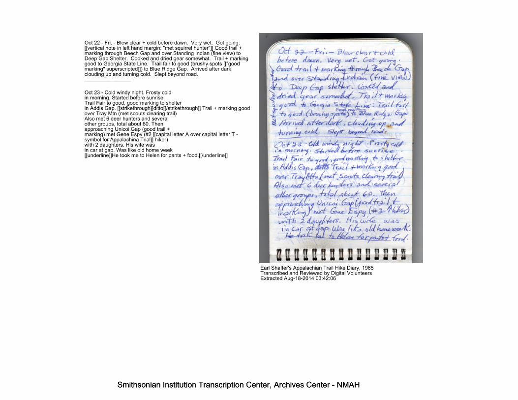
Oct 22 - Fri. - Blew clear + cold before dawn. Very wet. Got going.[[vertical note in left hand margin: "met squirrel hunter"]] Good trail +marking through Beech Gap and over Standing Indian (fine view) toDeep Gap Shelter. Cooked and dried gear somewhat. Trail + markinggood to Georgia State Line. Trail fair to good (brushy spots [["goodmarking" superscripted]]) to Blue Ridge Gap. Arrived after dark,clouding up and turning cold. Slept beyond road.________________
Oct 23 - Cold windy night. Frosty coldin morning. Started before sunrise.Trail Fair to good, good marking to shelterin Addis Gap. [[strikethrough]]ditto[[/strikethrough]] Trail + marking goodover Tray Mtn (met scouts clearing trail)Also met 6 deer hunters and severalother groups, total about 60. Thenapproaching Unicoi Gap (good trail +marking) met Gene Espy (#2 [[capital letter A over capital letter T -symbol for Appalachina Trial]] hiker)with 2 daughters. His wife wasin car at gap. Was like old home week[[underline]]He took me to Helen for pants + food.[[/underline]]
Earl Shaffer's Appalachian Trail Hike Diary, 1965Transcribed and Reviewed by Digital VolunteersExtracted Aug-18-2014 03:42:06
Smithsonian Institution Transcription Center, Archives Center - NMAH
Smithsonian Institution Transcription Center, Archives Center - NMAH
Smithsonian Institution Transcription Center, Archives Center - NMAH
Smithsonian Institution Transcription Center, Archives Center - NMAH
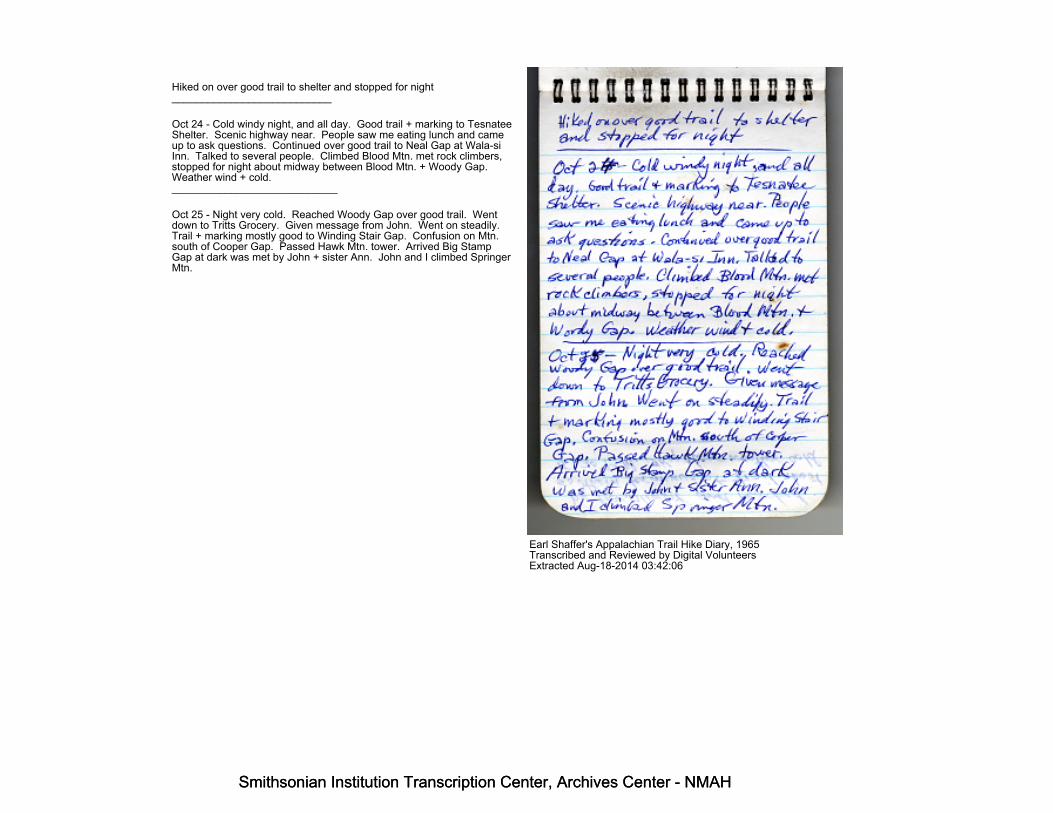
Hiked on over good trail to shelter and stopped for night___________________________
Oct 24 - Cold windy night, and all day. Good trail + marking to TesnateeShelter. Scenic highway near. People saw me eating lunch and cameup to ask questions. Continued over good trail to Neal Gap at Wala-siInn. Talked to several people. Climbed Blood Mtn. met rock climbers,stopped for night about midway between Blood Mtn. + Woody Gap.Weather wind + cold.____________________________
Oct 25 - Night very cold. Reached Woody Gap over good trail. Wentdown to Tritts Grocery. Given message from John. Went on steadily.Trail + marking mostly good to Winding Stair Gap. Confusion on Mtn.south of Cooper Gap. Passed Hawk Mtn. tower. Arrived Big StampGap at dark was met by John + sister Ann. John and I climbed SpringerMtn.
Earl Shaffer's Appalachian Trail Hike Diary, 1965Transcribed and Reviewed by Digital VolunteersExtracted Aug-18-2014 03:42:06
Smithsonian Institution Transcription Center, Archives Center - NMAH
Smithsonian Institution Transcription Center, Archives Center - NMAH

Smithsonian Institution Transcription Center, Archives Center - NMAH
Smithsonian Institution Transcription Center, Archives Center - NMAH
by flashlight and reached southern terminus about 8:30 P.M. Sky clearweather cold
Earl Shaffer's Appalachian Trail Hike Diary, 1965Transcribed and Reviewed by Digital VolunteersExtracted Aug-18-2014 03:42:06
Smithsonian Institution Transcription Center, Archives Center - NMAH
Smithsonian Institution Transcription Center, Archives Center - NMAH
Smithsonian Institution Transcription Center, Archives Center - NMAH
Smithsonian Institution Transcription Center, Archives Center - NMAH
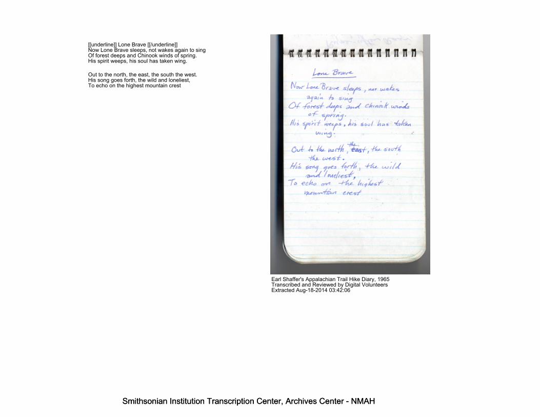
[[underline]] Lone Brave [[/underline]]Now Lone Brave sleeps, not wakes again to singOf forest deeps and Chinook winds of spring.His spirit weeps, his soul has taken wing.
Out to the north, the east, the south the west.His song goes forth, the wild and loneliest,To echo on the highest mountain crest
Earl Shaffer's Appalachian Trail Hike Diary, 1965Transcribed and Reviewed by Digital VolunteersExtracted Aug-18-2014 03:42:06
Smithsonian Institution Transcription Center, Archives Center - NMAH
Smithsonian Institution Transcription Center, Archives Center - NMAH
Smithsonian Institution Transcription Center, Archives Center - NMAH
Smithsonian Institution Transcription Center, Archives Center - NMAH
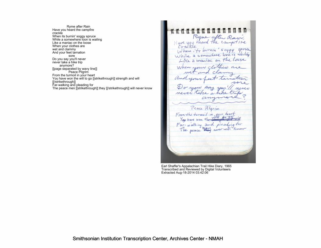
Ryme after RainHave you heard the campfirecrackleWhen its burnin' soggy spruceWhile a somewhere loon is wailingLike a maniac on the looseWhen your clothes arewet and clammyAnd your feet tarnation soreDo you say you'll nevernever take a hike trip anymore?[[page separated by wavy line]] Peace PilgrimFrom the turmoil in your heartYou have won the will to go [[strikethrough]] strength and will[[/strikethrough]]Far-walking and pleading forThe peace men [[strikethrough]] they [[/strikethrough]] will never know
Earl Shaffer's Appalachian Trail Hike Diary, 1965Transcribed and Reviewed by Digital VolunteersExtracted Aug-18-2014 03:42:06
Smithsonian Institution Transcription Center, Archives Center - NMAH
Smithsonian Institution Transcription Center, Archives Center - NMAH
Smithsonian Institution Transcription Center, Archives Center - NMAH
Smithsonian Institution Transcription Center, Archives Center - NMAH
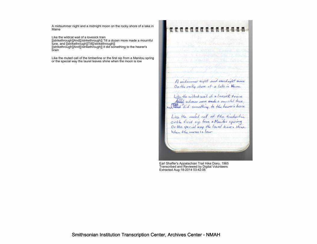
A midsummer night and a midnight moon on the rocky shore of a lake inMaine
Like the wildcat wail of a lovesick train[[strikethrough]]And[[/strikethrough]] Till a dozen more made a mournfultune. and [[strikethrough]]Till[[/strikethrough]][[strikethrough]]And[[/strikethrough]] it did something to the hearer'sbrain
Like the muted call of the timberline or the first sip from a Manitou springor the special way the laurel leaves shine when the moon is low
Earl Shaffer's Appalachian Trail Hike Diary, 1965Transcribed and Reviewed by Digital VolunteersExtracted Aug-18-2014 03:42:06
Smithsonian Institution Transcription Center, Archives Center - NMAH
Smithsonian Institution Transcription Center, Archives Center - NMAH

Smithsonian Institution Transcription Center, Archives Center - NMAH
Smithsonian Institution Transcription Center, Archives Center - NMAH
Essence of Worth
What is the most precious thing upon earth. Weighed in the balance andcharted for worth? Is it a diamond, a palace, a pearl a virginal girl
As Free as the air, Ah, [[strikethrough]]yes[[/strikethrough]], there'snumber oneLose it five minutes and living is done
Earl Shaffer's Appalachian Trail Hike Diary, 1965Transcribed and Reviewed by Digital VolunteersExtracted Aug-18-2014 03:42:06
Smithsonian Institution Transcription Center, Archives Center - NMAH
Smithsonian Institution Transcription Center, Archives Center - NMAH

Smithsonian Institution Transcription Center, Archives Center - NMAH
Smithsonian Institution Transcription Center, Archives Center - NMAH
Something moving on the mountain high and far against the skySomething on the blue Horizon where they say a trail goes by
It's a trail called Appalachian over rocks and under treesNorth and south across a nationAnd the things a hiker seesAre the peaks and lakes [[strikethrough]]mountains[[/strikethrough]] and[[strikethrough]]the[[/strikethrough]] valleys[[strikethrough]]Under sun and in the rain[[/strikethrough]]In the rain and in the sun
And the camp when day is done
Something moving far up yonder
Earl Shaffer's Appalachian Trail Hike Diary, 1965Transcribed and Reviewed by Digital VolunteersExtracted Aug-18-2014 03:42:06
Smithsonian Institution Transcription Center, Archives Center - NMAH
Smithsonian Institution Transcription Center, Archives Center - NMAH

Smithsonian Institution Transcription Center, Archives Center - NMAH
Smithsonian Institution Transcription Center, Archives Center - NMAH
Robert S. GibbsBox 909N. Wilkesboro, N.C. 28659
Huntsville Bible Church2400 Andrew Jackson WayHuntsville, ALA
Ken Haagenson & Mel Farmer539-4356 852-3707
T.M. GriffinSuches GA. (dude ranch)
Earl Shaffer's Appalachian Trail Hike Diary, 1965Transcribed and Reviewed by Digital VolunteersExtracted Aug-18-2014 03:42:06
Smithsonian Institution Transcription Center, Archives Center - NMAH
Smithsonian Institution Transcription Center, Archives Center - NMAH
Smithsonian Institution Transcription Center, Archives Center - NMAH
Smithsonian Institution Transcription Center, Archives Center - NMAH
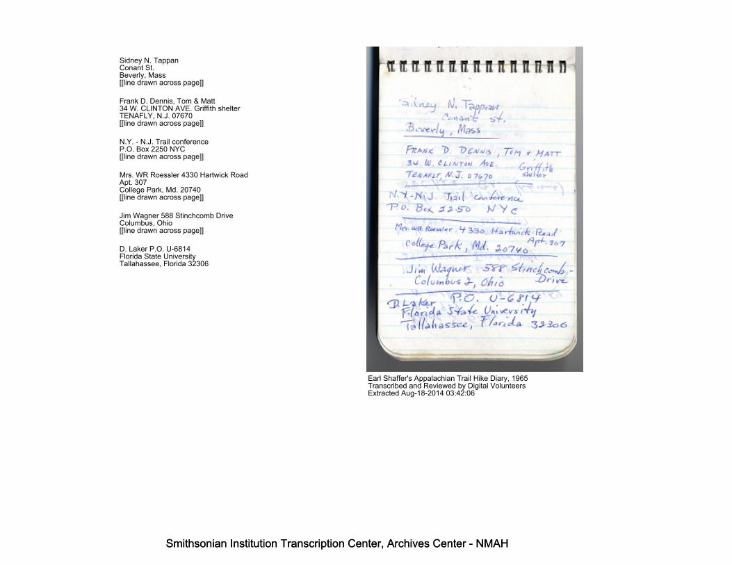
Sidney N. TappanConant St.Beverly, Mass[[line drawn across page]]
Frank D. Dennis, Tom & Matt34 W. CLINTON AVE. Griffith shelterTENAFLY, N.J. 07670[[line drawn across page]]
N.Y. - N.J. Trail conferenceP.O. Box 2250 NYC[[line drawn across page]]
Mrs. WR Roessler 4330 Hartwick RoadApt. 307College Park, Md. 20740[[line drawn across page]]
Jim Wagner 588 Stinchcomb DriveColumbus, Ohio[[line drawn across page]]
D. Laker P.O. U-6814Florida State UniversityTallahassee, Florida 32306
Earl Shaffer's Appalachian Trail Hike Diary, 1965Transcribed and Reviewed by Digital VolunteersExtracted Aug-18-2014 03:42:06
Smithsonian Institution Transcription Center, Archives Center - NMAH
Smithsonian Institution Transcription Center, Archives Center - NMAH
Smithsonian Institution Transcription Center, Archives Center - NMAH
Smithsonian Institution Transcription Center, Archives Center - NMAH
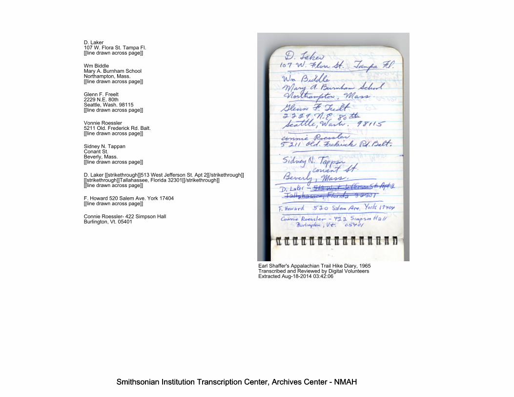
D. Laker107 W. Flora St. Tampa Fl.[[line drawn across page]]
Wm BiddleMary A. Burnham SchoolNorthampton, Mass.[[line drawn across page]]
Glenn F. Freelt2229 N.E. 80thSeattle, Wash. 98115[[line drawn across page]]
Vonnie Roessler5211 Old. Frederick Rd. Balt.[[line drawn across page]]
Sidney N. TappanConant St.Beverly, Mass.[[line drawn across page]]
D. Laker [[strikethrough]]513 West Jefferson St. Apt 2[[/strikethrough]][[strikethrough]]Tallahassee, Florida 32301[[/strikethrough]][[line drawn across page]]
F. Howard 520 Salem Ave. York 17404[[line drawn across page]]
Connie Roessler- 422 Simpson HallBurlington, Vt. 05401
Earl Shaffer's Appalachian Trail Hike Diary, 1965Transcribed and Reviewed by Digital VolunteersExtracted Aug-18-2014 03:42:06
Smithsonian Institution Transcription Center, Archives Center - NMAH
Smithsonian Institution Transcription Center, Archives Center - NMAH
Smithsonian Institution Transcription Center, Archives Center - NMAH
Smithsonian Institution Transcription Center, Archives Center - NMAH
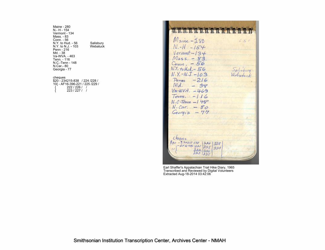
Maine - 280N.- H - 154Vermont - 134Mass. - 83Conn. - 56N.Y. to Hud. - 56 SalisburyN.Y. to N.J. - 103 WebatuckPenn - 216Md. - 38Va-WVA. - 463Tenn. - 116N.C.-Tenn - 148N.Car.- 80Georgia - 77
cheques$20 - 234215-838 / 224 /228 /10{ - AF16-396-221 / 225 /229 / { 222 / 226 / / { 223 / 227 / /
Earl Shaffer's Appalachian Trail Hike Diary, 1965Transcribed and Reviewed by Digital VolunteersExtracted Aug-18-2014 03:42:06
Smithsonian Institution Transcription Center, Archives Center - NMAH
Smithsonian Institution Transcription Center, Archives Center - NMAH

Smithsonian Institution Transcription Center, Archives Center - NMAH
Smithsonian Institution Transcription Center, Archives Center - NMAH
Maine - 280New Hamp. - 154Vermont - 134Mass. - 83Conn. - 56N.Y. to Hudson - 56 [[line drawn to text]]763 [[/line drawn to text]]N.Y - N.J. - 103Penna - 216Maryland - 38Va - W. Va. - 463Tenn - 116N.C. - Tenn - 148N. Car. - 80Georgia - 77
Earl Shaffer's Appalachian Trail Hike Diary, 1965Transcribed and Reviewed by Digital VolunteersExtracted Aug-18-2014 03:42:06
Smithsonian Institution Transcription Center, Archives Center - NMAH
Smithsonian Institution Transcription Center, Archives Center - NMAH

Smithsonian Institution Transcription Center, Archives Center - NMAH
Smithsonian Institution Transcription Center, Archives Center - NMAH
Smithsonian InstitutionArchives Center - NMAH
The mission of the Smithsonian is the increase and diffusion of knowledge - shaping the future by preserving ourheritage, discovering new knowledge, and sharing our resources with the world. Founded in 1846, theSmithsonian is the world's largest museum and research complex, consisting of 19 museums and galleries, theNational Zoological Park, and nine research facilities.Become an active part of our mission through theTranscription Center. Together, we are discovering secrets hidden deep inside our collections that illuminate ourhistory and our world.
Join us!The Transcription Center: https://transcription.si.eduOn Facebook: https://www.facebook.com/SmithsonianTranscriptionCenterOn Twitter: @TranscribeSI
Connect with the SmithsonianSmithsonian Institution: www.si.eduOn Facebook: https://www.facebook.com/SmithsonianOn Twitter: @smithsonian
Smithsonian Institution Transcription Center, Archives Center - NMAH
Smithsonian Institution Transcription Center, Archives Center - NMAH


