Embed Size (px)
Citation preview
222
A concealed cliff and wave-cut platform, Isle of Portland
A CONCEALED SEA CLIFF AND LOW-STAND WAVE-CUT PLATFORM
ON THE ISLE OF PORTLAND, DORSET, UK
R.W. GALLOIS
Gallois, R.W. 2013. A concealed sea cliff and low-stand wave-cut platform on the Isle of Portland, Dorset, UK.Geoscience in South-West England, 13, 222-227.
A topographical feature at the foot of an extensive landslipped area on the Isle of Portland, which appeared at first sight to be theback-face of a small coastal landslide, was proved by continuously cored site-investigation boreholes to be the top of a concealedc. 35 m-high cliff in Kimmeridge Clay that is fronted by a wave-cut platform at c. -20 m below present-day sea level. The platformis overlain in part by sand and gravel which is interpreted as a beach or shallow marine deposit. The cliff and wave-cut platformare now concealed beneath Pleistocene solifluction and landslide deposits of presumed late Pleistocene age. Comparison of theheight of the Portland wave-cut platform with those of submerged wave-cut platforms and raised beaches elsewhere on theWestern Approaches and English Channel coasts, some of which have been dated by amino-acid or radiometric methods, does notenable the age of the Portland platform to be determined. Differences in the rates of crustal subsidence and uplift along the Englishand French coasts during the past 500,000 years make it impossible to determine the heights with respect to global sea level atwhich the raised beaches and submerged platforms were formed. In the absence of quantitative evidence the simplestinterpretation is that the Portland wave-cut platform formed in a cool temperate climate during a still-stand period when sea levelwas falling, possibly in the early cooling phase of Marine Isotope Stage 5, c. 110,000 years ago.
92 Stoke Valley Rd., Exeter EX4 5ER, U.K.(E-mail: [email protected]).
Keywords: Isle of Portland, Dorset, concealed cliff, low sea level, Pleistocene, Holocene.
the Kimmeridge Clay: sandy and silty clay matrix with mostly small-and medium-sized siltstone clasts.
3) Solifluction and/or translational landslide deposits derived from the Kimmeridge Clay and reworked Portland Group debris: grey clay matrix with common small- and medium-sized siltstone, limestone and sandstone clasts.
4) Solifluction/mudflow deposit derived wholly from the Kimmeridge Clay: grey clay with few or no clasts.
DESCRIPTION
The Quaternary Deposits at the Upper Osprey site can bedivided into two distinct groups based on their distribution andthickness. In the middle and upper parts of the site, uphill froma well defined change in slope angle (Figure 1) that isinterpreted here as the top of a concealed cliff (see below), theDrift Deposits form a relatively thin (1.0 to 9.5 m thick)undulating sheet-like deposit made up of lenticular layers ofdrift types (1) to (3) that roughly mimic the shape of theground. They represent successive mudflow and translationallandslide deposits that moved across the top of the KimmeridgeClay. At their base, they locally rest on a layer of in situcomplexly folded Kimmeridge Clay with dips of up to 75º. Thisand similar structures in Lias Group mudstones at Lyme Regisand Seatown in west Dorset have been interpreted as creepfolds that formed intermittently in partially frozen, near-surface
INTRODUCTION
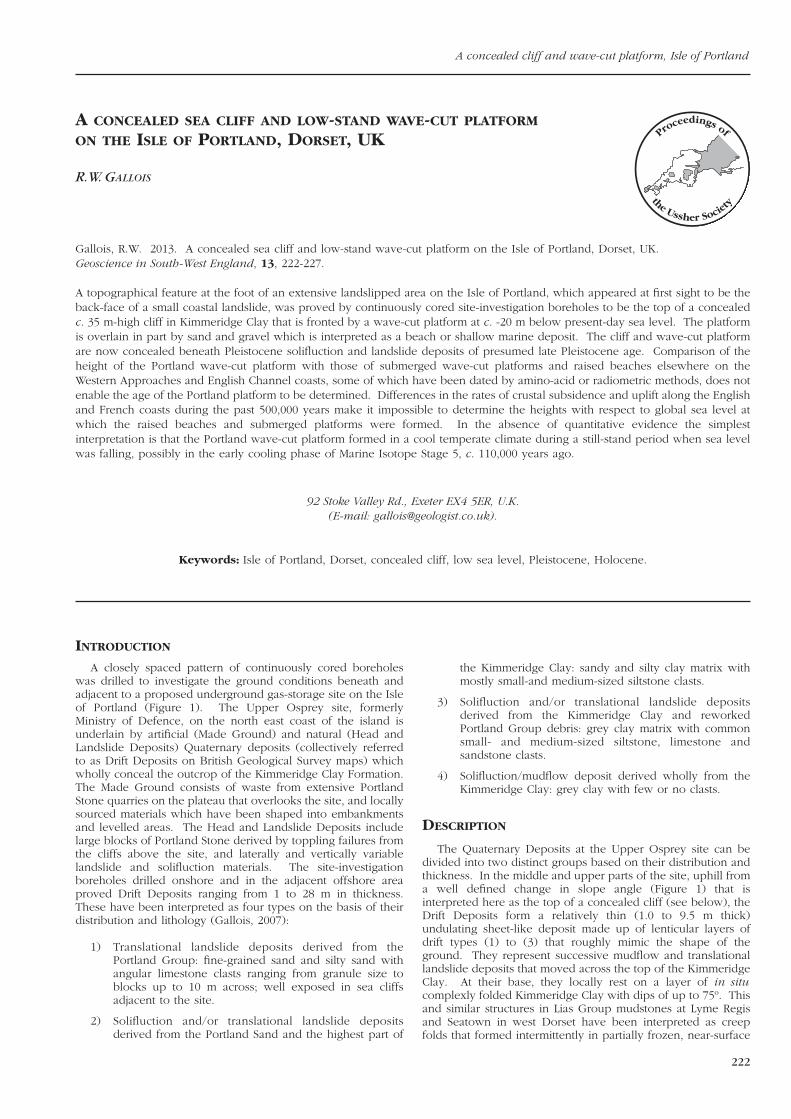
A closely spaced pattern of continuously cored boreholeswas drilled to investigate the ground conditions beneath andadjacent to a proposed underground gas-storage site on the Isleof Portland (Figure 1). The Upper Osprey site, formerlyMinistry of Defence, on the north east coast of the island isunderlain by artificial (Made Ground) and natural (Head andLandslide Deposits) Quaternary deposits (collectively referredto as Drift Deposits on British Geological Survey maps) whichwholly conceal the outcrop of the Kimmeridge Clay Formation.The Made Ground consists of waste from extensive PortlandStone quarries on the plateau that overlooks the site, and locallysourced materials which have been shaped into embankmentsand levelled areas. The Head and Landslide Deposits includelarge blocks of Portland Stone derived by toppling failures fromthe cliffs above the site, and laterally and vertically variablelandslide and solifluction materials. The site-investigationboreholes drilled onshore and in the adjacent offshore areaproved Drift Deposits ranging from 1 to 28 m in thickness.These have been interpreted as four types on the basis of theirdistribution and lithology (Gallois, 2007):
1) Translational landslide deposits derived from the Portland Group: fine-grained sand and silty sand with angular limestone clasts ranging from granule size to blocks up to 10 m across; well exposed in sea cliffs adjacent to the site.
2) Solifluction and/or translational landslide deposits derived from the Portland Sand and the highest part of
R.W. Gallois
223
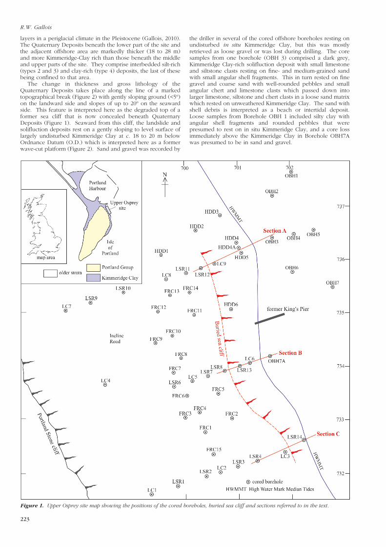
Figure 1. Upper Osprey site map showing the positions of the cored boreholes, buried sea cliff and sections referred to in the text.
layers in a periglacial climate in the Pleistocene (Gallois, 2010).The Quaternary Deposits beneath the lower part of the site andthe adjacent offshore area are markedly thicker (18 to 28 m)and more Kimmeridge-Clay rich than those beneath the middleand upper parts of the site. They comprise interbedded silt-rich(types 2 and 3) and clay-rich (type 4) deposits, the last of thesebeing confined to that area.
The change in thickness and gross lithology of theQuaternary Deposits takes place along the line of a markedtopographical break (Figure 2) with gently sloping ground (<5º)on the landward side and slopes of up to 20º on the seawardside. This feature is interpreted here as the degraded top of aformer sea cliff that is now concealed beneath QuaternaryDeposits (Figure 1). Seaward from this cliff, the landslide andsolifluction deposits rest on a gently sloping to level surface oflargely undisturbed Kimmeridge Clay at c. 18 to 20 m belowOrdnance Datum (O.D.) which is interpreted here as a formerwave-cut platform (Figure 2). Sand and gravel was recorded by
the driller in several of the cored offshore boreholes resting onundisturbed in situ Kimmeridge Clay, but this was mostlyretrieved as loose gravel or was lost during drilling. The coresamples from one borehole (OBH 3) comprised a dark grey,Kimmeridge Clay-rich solifluction deposit with small limestoneand siltstone clasts resting on fine- and medium-grained sandwith small angular shell fragments. This in turn rested on finegravel and coarse sand with well-rounded pebbles and smallangular chert and limestone clasts which passed down intolarger limestone, siltstone and chert clasts in a loose sand matrixwhich rested on unweathered Kimmeridge Clay. The sand withshell debris is interpreted as a beach or intertidal deposit.Loose samples from Borehole OBH 1 included silty clay withangular shell fragments and rounded pebbles that werepresumed to rest on in situ Kimmeridge Clay, and a core lossimmediately above the Kimmeridge Clay in Borehole OBH7Awas presumed to be in sand and gravel.

224
Figure 2. Sections across the concealed cliff: no vertical exaggeration. See Figure 1 for lines of sections.
A concealed cliff and wave-cut platform, Isle of Portland
R.W. Gallois
225
DISCUSSION
Evidence of Quaternary sea levels in the form of submarineand uplifted wave-cut platforms, the latter with and withoutoverlying marine beach deposits, is relatively common on thecoasts of the Western Approaches and English Channel wheresuch features are largely protected from Atlantic storms. Thereare published descriptions of raised beaches at heights rangingfrom 1 to 40 m above O.D. on the English and French coasts,some of which have been correlated with Marine Isotope Stages(MIS) as far back as MIS 13 (c. 500 ka BP) by amino-acid orradiometric dating and/or biostratigraphy. In South-WestEngland they include shelly raised-beach deposits betweenHallsands (MIS 5e) and Start Point (MIS 7) in Start Bay (Bates etal., 2003), Cornwall, and at Thatcher Rock (MIS 5e), Hope’sNose (MIS 7) and Berry Head (MIS 5e, 7 and 9?) in Torbay,Devon (Proctor and Smart, 1991). On the French coast, Coutardet al. (2006) recorded raised beach deposits in Normandy atheights of 1 to 38 m above the Nivellement Général de laFrance (NGF) which they correlated with the high sea levels ofinterglacial phases in MIS 5, 7, 9 and 11. On the Isle ofPortland, Dorset shelly raised-beach deposits exposed atPortland Bill at heights of c. 8 m [SY 6774 6828] and c. 14 mabove O.D. [SY 6755 6860] were determined by Davies andKeen (1985) to be 125,000 (MIS 5e) and 210,000 (MIS 7) yearsold respectively using amino-acid dating.
Cliff-like breaks of slope that have been interpreted asformer wave-cut platforms were recorded by Kelland (1975) at54 m and 65 m below O.D. in Start Bay, and a submerged cliffline with a base at c. 40-45 m below O.D. has been recordedaround much of the SW coast with the buried offshoreextensions of the channels the Rivers Plym, Tamar and Taw-Torridge graded to it (Donovan and Stride, 1975; Kidson, 1977;Eddies and Reynolds, 1988). There is no direct evidence of theage of the sea-level still-stands at which any of these submergedcliffs were formed.
Despite the relative abundance of evidence, the history ofchanges in relative sea-level (RSL) with respect to land level insouthern England and northern France during the Quaternaryremains poorly understood because of the geographicallyfragmentary nature of the evidence and the complex history ofland-sea movements. Global (eustatic) sea level is principallygoverned by the volume of the sea and its temperature, both ofwhich changed more rapidly in the Quaternary in response tofluctuations in global temperatures than at any time since thePermian. Local sea levels are governed by a combination ofeustatic changes, isostatic depression and uplift in and adjacentto those areas overlain by continental ice sheets, epeirogenic(crustal underplating) and tectonic (orogenic) crustalmovements. In the coastal areas of South-West England, theeffects of glacial isostatic rebound can be ignored from the MidPleistocene onwards as there is no reported evidence for a thickcontinental ice sheet south of the maximum extent of theAnglian Glaciation (MIS 12), 100 km north of the Channel coast.Epeirogenic movements related to basaltic underplatingbeneath the western British Isles have also been hypothesisedas a cause of differential uplift in the Pleistocene in SW Britain(Westaway, 2010), but the evidence for neither the underplatingnor the presumed Quaternary movements is well documentedat the present time.
During the last 40 years estimates of the maximum amountof global sea-level change in the Quaternary has remainedrelatively unchanged at c. 120 m ± 5 m (Donn et al., 1962; Muhset al., 2003). In contrast, even within southern Britain there arevariations of several hundred metres in the present-day heightsof Middle and Late Pleistocene near-shore marine andfreshwater deposits principally as a result of compressional andextensional movements related to changes in the tectonic stressfield consequent on the continuing collision of the Europeanand African Plates and the opening of the Atlantic Ocean.These movements affected relative sea levels across southernBritain unevenly in the Quaternary when existing fault lineswere reactivated to a greater or lesser extent. For example,
freshwater peats in the Bardsey Loom Formation (MIS 13 c. 550ka) are at 300 m below O.D. in the Celtic Sea (Tappin et al.,1994) and their probable correlatives at over 400 m below O.D.beneath the southern North Sea (Cameron et al., 1992). Theirpresumed onshore correlatives, the Cromer Forest BedFormation in Norfolk (Trimmer, 1851) and the SlindonFormation in Sussex (Prestwich, 1859), are at c. O.D. and 35-40m above O.D., respectively. If the correlations are correct andif these formations were deposited close to sea level asindicated by their sedimentology, the difference in RSLattributable to tectonic movements greatly exceeds thatattributable to eustatic changes in global sea level. None of thetopographical heights at which the Pleistocene beach depositsand wave-cut platforms in the SW region are preserved cantherefore be used independently as a guide to their ages.
In a comprehensive review of variations in Quaternarysea-levels on the Atlantic, Pacific, Gulf, Arctic and Hawaiiancoats of the USA Muhs et al. (2003) compared local rates ofuplift and/or subsidence of datable beach deposits and coralreefs to obtain a global sea-level curve for the past 500 ka. Nocomparable study is available for the Pleistocene of the UKlargely because of the scarcity of reliably datable deposits.However, different rates of RSL change in the Holocene overdistances (<100 km) that are too small to have been affected byeustatic, isostatic or epeirogenic movements have beenrecorded by Shennan and Horton (2002). They concluded thatthe relative rates of sea-level rise over the last 4,000 years hadbeen 0.63 mm year-1 for the Sussex coast, 0.49 mm year-1 for theDorset coast and 1.43 mm yr-1 for the Devon coast. World-widestudies have shown that global sea level has risen by c. 2 m orless since 4,000BP (Fleming et al.,1998). The fall in RSL that canbe attributed to tectonism is therefore close to zero for theDorset coast (0.49 minus 0.5 mm year-1) and 0.93 mm year-1
(1.43 minus 0.5 mm year-1) for the Devon coast during thisperiod. If a similar differential rate had been present over thepast 10 ka, then a wave-cut platform formed on the Devoncoast in 10 ka BP would now be c. 9 m lower than a platformformed at the same time on the Dorset coast. The most likelyexplanation for this difference over so short a distance is thatthe active Sticklepath Fault separates tectonic terranes that aresubsiding at different rates. This is reflected in the drainagepatterns in the region in which all the major rivers west of thefault (Dart, Tamar, Fowey, Fal) enter the sea via drownedvalleys while those to the east of the fault (Teign, Exe, Otter,Axe) enter via sediment-filled estuaries. When allowance ismade for the high degree of uncertainty and probable largeerrors in measuring past rates of RSL, it is clear that the present-day topographical positions of raised beaches and wave-cutplatforms are not a reliable guide to former global sea levels.
SUMMARY AND CONCLUSIONS
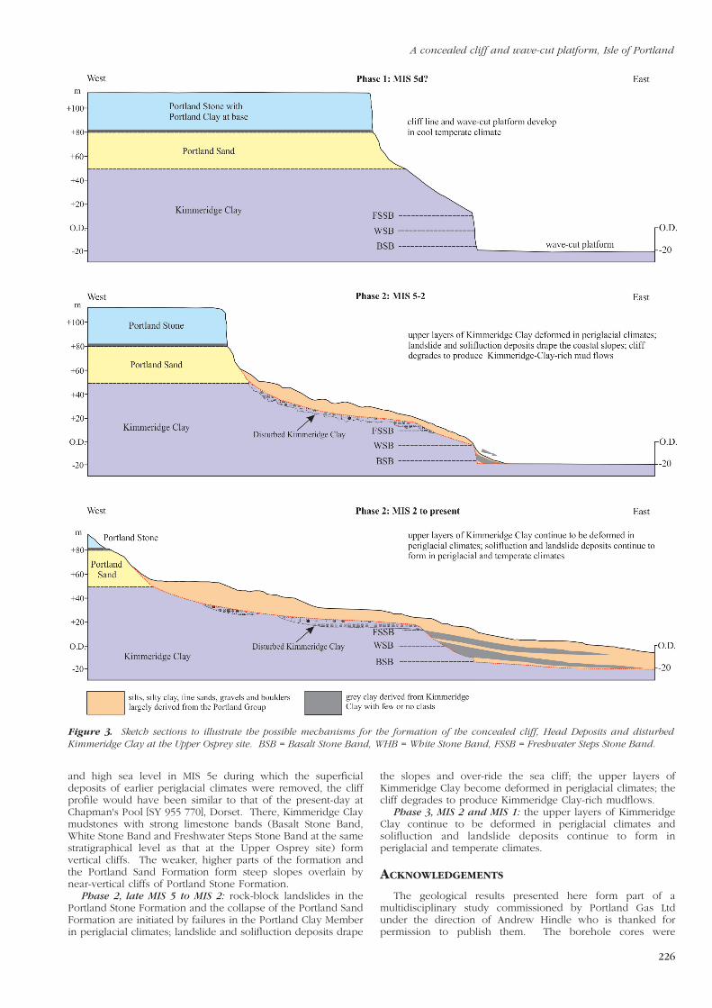
In the absence of quantitative data, the age of the submergedwave-cut platform and the associated beach deposits andconcealed cliff on the Isle of Portland are unknown. Assumingthat the only factor that has affected their present position withrespect to RSL are eustatic variations in sea level, then thesefeatures were formed either in a still-stand period during aperiod of rising sea level in a warming phase or during a fall insea level during a cooling phase. These conditions were mostrecently present in MIS 1 at c. 10 ka BP when sea level wasrising and in MIS 5 at c. 110 ka BP when it was falling. Theformer is not a possibility because the cliff and wave-cutplatform are overlain by periglacial deposits that could not haveformed in southern England after the end of the PleistocenePeriod (11.7 ka BP; Williams, 1965). The simplest assumptionis that the wave-cut platform was formed early in MIS 5 in whatwould have been a cool temperate climate following the warmtemperate climate of MIS 5e. The following succession ofevents (Figure 3) is suggested:
Phase 1, MIS 5d: stable cliff line and wave-cut platformdevelop during a still-stand period in a falling sea level in a cooltemperate climate. After a period of warm temperate climate
A concealed cliff and wave-cut platform, Isle of Portland
226
Figure 3. Sketch sections to illustrate the possible mechanisms for the formation of the concealed cliff, Head Deposits and disturbedKimmeridge Clay at the Upper Osprey site. BSB = Basalt Stone Band, WHB = White Stone Band, FSSB = Freshwater Steps Stone Band.
and high sea level in MIS 5e during which the superficialdeposits of earlier periglacial climates were removed, the cliffprofile would have been similar to that of the present-day atChapman's Pool [SY 955 770], Dorset. There, Kimmeridge Claymudstones with strong limestone bands (Basalt Stone Band,White Stone Band and Freshwater Steps Stone Band at the samestratigraphical level as that at the Upper Osprey site) formvertical cliffs. The weaker, higher parts of the formation andthe Portland Sand Formation form steep slopes overlain bynear-vertical cliffs of Portland Stone Formation.
Phase 2, late MIS 5 to MIS 2: rock-block landslides in thePortland Stone Formation and the collapse of the Portland SandFormation are initiated by failures in the Portland Clay Memberin periglacial climates; landslide and solifluction deposits drape
the slopes and over-ride the sea cliff; the upper layers ofKimmeridge Clay become deformed in periglacial climates; thecliff degrades to produce Kimmeridge Clay-rich mudflows.
Phase 3, MIS 2 and MIS 1: the upper layers of KimmeridgeClay continue to be deformed in periglacial climates andsolifluction and landslide deposits continue to form inperiglacial and temperate climates.
ACKNOWLEDGEMENTS
The geological results presented here form part of amultidisciplinary study commissioned by Portland Gas Ltdunder the direction of Andrew Hindle who is thanked forpermission to publish them. The borehole cores were
R.W. Gallois
227
examined in collaboration with Rita Arqueros and Rob Smith ofHydrock under the direction of Kevin Privett. Denys Brunsdenis thanked for helpful on-site discussions and advice.
REFERENCES
BATES, M.R., KEEN, D.H. and LAUTRIDOU, J-P. 2003. Pleistocene marine and periglacial deposits of the English Channel. Journal of Quaternary Science, 18, 319-337.
CAMERON, T.D.J., CROSBY, A., BALSON, P.S., JEFFERY, P.S., LOTT, G.K., BULAT, J.and HARRISON, D.J. 1992. The geology of the southern North Sea. United Kingdom Offshore Regional Report, HMSO, London.
COUTARD, S., LAUTRIDOU, J-P., RHODES, E. and CLET, M. 2006. Tectonic, eustatic and climatic significance of raised beaches of Val de Saire, Cotentin, Normandy, France. Quaternary Science Reviews, 25, 595-611.
DAVIES, K.H. and KEEN, D.H. 1985. The age of the Pleistocene marine deposits of Portland, Dorset. Proceedings of the Geologists’ Association, 96, 217-225.
DONN, W., FARRAND, W. and EWING, M. 1962. Pleistocene Ice Volumes and Sea Level Lowering. Journal of Geology, 70, 206-214.
DONOVAN, D.T. and STRIDE, A.H. 1975. Three drowned coastlines of probable Late Tertiary age around Devon and Cornwall. Marine Geology, 19, 35-40.
EDDIES, R.D. and REYNOLDS, J.M. 1988. Seismic characteristics of buried rock-valleys in Plymouth Sound and the River Tamar. Proceedings of the Ussher Society, 7, 36-40.
FLEMING, K., JOHNSTON, P., ZWARTZ, D., YOKOYAMA, Y., LAMBECK, K. and CHAPPELL, J. 1998. Refining the eustatic sea-level curve since the Last Glacial Maximum using far- and intermediate-field sites. Earth and Planetary Science Letters, 163, 327-342.
GALLOIS, R.W. 2007. The Geology of the Portland Gas Storage site, Upper Osprey, Isle of Portland. Appendix 4 of SRK Consultants Ltd Report No. 50088-SK-00-RPT-GE-001for Portland Gas Storage Ltd.
GALLOIS, R.W. 2010. Large-scale periglacial creep folds in Jurassic mudstones on the Dorset coast. Geoscience in south-west England, 12, 223-232.
KELLAND, N.C. 1975. Submarine geology of Start Bay determined by continuous seismic profiling and core sampling. Journal of the Geological Society of London, 131, 7-17.
KIDSON, C. 1977. Some problems of the Quaternary of the Irish Sea and the coast of south-west England. In: KIDSON, C. and TOOLEY, M.J. (Eds), The Quaternary history of the Irish Sea, Geological Journal Special Issue, 7. Seel House Press, Liverpool, 1-12 and 257-298.
MUHS, D.R., WEHMILLER, J.F., SIMMONS. K.R. and YORK, L.L. 2003. Quaternary sea-level history of the United States. Developments in Quaternary Science, 1, 147-183.
PRESTWICH, P. 1859. On the westward extension of the Old Raised Beach of Brighton; and on the extent of the sea-bed of the same period. Quarterly Journal of the Geological Society, 15, 215-221.
PROCTOR, C.J. and SMART, P.L. 1991. A dated cave sediment record of Pleistocene transgressions on Berry Head, southwest England. Journal of Quaternary Science, 6, 233-244.
SHENNAN, I. and HORTON, B. 2002. Holocene land- and sea-level changes in Great Britain. Journal of Quaternary Science, 17, 511-526.
TAPPIN, D.R., CHADWICK, R.A., JACKSON, A.A., WINGFIELD, R.T.R. and SMITH, N.J.P. 1994. The geology of Cardigan Bay and the Bristol Channel. United Kingdom Offshore Regional Report. HMSO, London.
TRIMMER, J. 1851. Generalizations respecting the erratic Tertiaries or Northern Drift, founded on the Mapping of the Superficial Deposits of a large portion of Norfolk. Journal of the Geological Society, 7, 19-31.
WESTAWAY, R. 2010. Cenozoic uplift of southwest England. Journal of Quaternary Science, 25, 419–432.
WILLIAMS, R.B.G. 1965. Permafrost in England during the last glacial period. Nature, 205, 1304-1305.


