Embed Size (px)
Citation preview
This article appeared in a journal published by Elsevier. The attachedcopy is furnished to the author for internal non-commercial researchand education use, including for instruction at the authors institution
and sharing with colleagues.
Other uses, including reproduction and distribution, or selling orlicensing copies, or posting to personal, institutional or third party
websites are prohibited.
In most cases authors are permitted to post their version of thearticle (e.g. in Word or Tex form) to their personal website orinstitutional repository. Authors requiring further information
regarding Elsevier’s archiving and manuscript policies areencouraged to visit:
http://www.elsevier.com/copyright
Author's personal copy
Ecological Engineering 36 (2010) 1383–1388
Contents lists available at ScienceDirect
Ecological Engineering
journa l homepage: www.e lsev ier .com/ locate /eco leng
Forecasting the effects of sea-level rise at Chongming Dongtan NatureReserve in the Yangtze Delta, Shanghai, China
Bo Tiana, Liquan Zhangb, Xiangrong Wanga,∗, Yunxuan Zhoub, Wen Zhangc
a Department of Environmental Science and Engineering, Fudan University, No 220 Handan Road, Shanghai 200433, Chinab State Key Laboratory of Estuarine and Coastal Research, East China Normal University, Shanghai 200062, Chinac Department of Natural Environmental Studies, The University of Tokyo, 5-1-5, Kashiwanoha, Kashiwa 277-8568, Japan
a r t i c l e i n f o
Article history:Received 20 January 2010Received in revised form 10 May 2010Accepted 6 June 2010
Keywords:Sea-level riseInundationWetland habitatNature conservationChongming Dongtan Nature Reserve
a b s t r a c t
Located at the mouth of the Yangtze Estuary, the Chongming Dongtan Nature Reserve is extremely vulner-able to climate change and especially to accelerated sea-level rise. We use a variety of data from remotesensing, an in situ global positioning system (GPS), tidal gauges, nautical charts, geographic spatial anal-ysis modeling and IPCC sea-level rise scenarios to forecast the potential impacts of increased sea levelon the coastal wetland habitat at Chongming Dongtan Nature Reserve. The results indicate that around40% of the terrestrial area of the Dongtan Reserve will be inundated by the year 2100 due to an estimated0.88 m increase in sea level. In particular, the Scirpus mariqueter communities and bare tidal flats are morevulnerable to sea-level rise. The limitations of this approach and the implication of the results for wetlandand ecosystem conservation as well as management are discussed.
© 2010 Elsevier B.V. All rights reserved.
1. Introduction
The existence of sea-level rise (SLR) is undeniable. The oceanshave the potential to increase in height at the coast at an accel-erated rate during this century and thereafter, due to the impactsof increased greenhouse gas concentrations responsible for globalwarming (IPCC, 2007) and the associated melting of polar andalpine glaciers and changes in ocean currents. Accelerated sea-levelrise will have far-reaching impacts on low-lying coastal regionsaround the world (Nicholls et al., 2007; Poulos et al., 2009; Snoussiet al., 2009). Chongming Dongtan Nature Reserve, one of the largestnature reserves in East Asia, is located at the mouth of YangtzeEstuary (Tian et al., 2008) and is highly susceptible to sea-level risedue to its low elevation and the lack of resources to mitigate suchthreats (Michener et al., 1997; Fussel, 2007).
Negative impacts of sea-level rise on estuaries include coastalerosion linked to increased storminess, periodic or permanentinundation, increased coastal storm flooding and salinization. Sucheffects will result in wetland loss, and thus habitat loss for shore-birds and a decline in wetland ecosystem services (Galbraith et al.,2002; Austin and Rehfisch, 2003; Craft et al., 2009). Such impacts onChongming Dongtan Nature Reserve will create adverse effects on
∗ Corresponding author. Tel.: +86 21 65643343; fax: +86 21 65643343.E-mail address: [email protected] (X. Wang).
tidal marshes, flats, creeks and channels, which provide importantspawning grounds for fish, and nesting and foraging habitats formigratory and residential birds. The potential negative impacts willbe spatially non-uniform because such changes depend on the mag-nitude of the relative sea-level rise, coastal morphology and humanintervention (CCSP, 2009). Among these impacts, inundation repre-sents an important component of coastal wetland habitat change.Inundation will be one of the primary responses to increased sealevel in Chongming Dongtan Nature Reserve because of the low gra-dient slope in the coastal wetland region, significantly decreasedsand sediment inputs from upstream sources in the Yangtze Riverand the effects of seawall construction which will prevent inlandwetland migration. However, the complex and interrelated pro-cesses of coastal dynamics such as erosion, accretion, biologicalprocesses and sediment transport balance have yet to be fullyexamined.
Several methods and modeling approaches have been used toevaluate the impact of increased sea level at different scales incoastal regions. Such techniques include the Sea Level AffectingMarshes Model (SLAMM) (Park et al., 1989), the Process OrientedSite-Specific Model (POSSM) (Morris et al., 2002; Rybczyk andCahoon, 2002), and the Wetland Change Model (WCM) (Nichollset al., 2007). These models have various limitations, includingcoarse resolution levels for landscape-scale models (e.g. SLAMM)and low confidence in site-specific model simulations. In contrast,elevation-based analyses for the assessment of inundation result-
0925-8574/$ – see front matter © 2010 Elsevier B.V. All rights reserved.doi:10.1016/j.ecoleng.2010.06.016
Author's personal copy
1384 B. Tian et al. / Ecological Engineering 36 (2010) 1383–1388
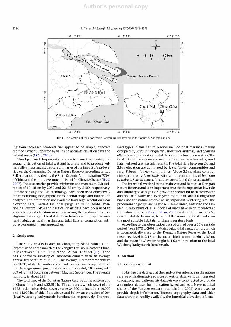
Fig. 1. The location of the Chongming Dongtan Nature Reserve in the mouth of Yangtze Estuary.
ing from increased sea-level rise appear to be simple, effectivemethods, when supported by valid and accurate elevation data andhabitat maps (CCSP, 2009).
The objective of the present study was to assess the quantity andspatial distribution of tidal wetland habitats, and to produce vul-nerability maps and statistical summaries of the impact of sea-levelrise on the Chongming Dongtan Nature Reserve, according to twoSLR scenarios provided by the State Oceanic Administration (SOA)of China and the Intergovernmental Panel for Climate Change (IPCC,2007). These scenarios provide minimum and maximum SLR esti-mates of 10–48 cm by 2050 and 22–88 cm by 2100, respectively.Remote sensing and GIS technology have been used extensivelyfor constructing topographic maps, habitat maps and inundationanalyses. For information not available from high-resolution Lidarelevation data, Landsat TM, tidal gauge, an in situ Global Posi-tioning System (GPS) and nautical chart data have been used togenerate digital elevation models covering the land–water areas.High-resolution Quickbird data have been used to map the wet-land habitat as tidal marshes and tidal flats in conjunction withobject-oriented image approaches.
2. Study area
The study area is located on Chongming Island, which is thelargest island at the mouth of the Yangtze Estuary in eastern China.It lies between 31◦25′–31◦38′N and 121◦50′–122◦05′E (Fig. 1) andhas a northern sub-tropical monsoon climate with an averageannual temperature of 15.3 ◦C. The average summer temperatureis c 26 ◦C, while the winter is cold with an average temperature of3 ◦C. Average annual precipitation is approximately 1022 mm, with60% of rainfall occurring between May and September. The averagehumidity is about 82%.
The total area of the Dongtan Nature Reserve at the eastern endof Chongming Island is 32,610 ha. The core area, which is east of the1998 reclamation dyke, covers some 24,600 ha, including 10,000and 14,000 ha of tidal flats above and below an elevation of 0 m(local Wushong bathymetric benchmark), respectively. The wet-
land types in this nature reserve include tidal marshes (mainlyoccupied by Scirpus mariqueter, Phragmites australis, and Spartinaalterniflora communities), tidal flats and shallow open waters. Thetidal flats with elevations of less than 2 m are characterized by mudflats, without any vascular plants. The tidal flats between 2.0 and2.9 m elevation are dominated by S. mariqueter communities andrarer Scirpus triqueter communities. Above 2.9 m, plant commu-nities are mostly P. australis with some communities of Imperatacylindrica, Suaeda glauca, Juncus setchuensis and Carex scabrifolia.
The intertidal wetland is the main wetland habitat at DongtanNature Reserve and is an important area that is exposed at low tideand submerged at high tide, providing shelter for both freshwaterand brackish water fish. Each year, more than 300,000 migratorybirds use the nature reserve as an important wintering site. Thepredominant groups are Anatidae, Charadriidae, Ardeidae and Lar-idae. A maximum of 113 species of birds have been recorded atthe nature reserve (Xu and Zhao, 2005) and in the S. mariquetermarsh habitats. However, bare tidal flat zones and tidal creeks arethe most suitable habitats for these migratory birds.
According to the observation data obtained over a 30-year tideperiod from 1978 to 2008 in Waigaoqiao tidal gauge station, whichis geographically close to the Dongtan Nature Reserve, the localmean sea level is 2.17 m, the mean ‘high’ water height is 3.5 m,and the mean ‘low’ water height is 1.03 m in relation to the localWushong bathymetric benchmark.
3. Method
3.1. Generation of DEM
To bridge the data gap at the land–water interface in the naturereserve with alternative sources of vertical data, various integratedtopography and bathymetric datasets were constructed to providea seamless dataset for inundation-based analysis. Navy nauticalcharts of the Yangtze estuary (published in 2005) were used toprovide depth information. Because topography data and Lidardata were not readily available, the intertidal elevation informa-
Author's personal copy
B. Tian et al. / Ecological Engineering 36 (2010) 1383–1388 1385
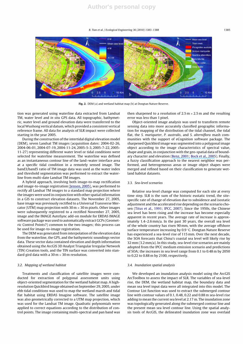
Fig. 2. DEM (a) and wetland habitat map (b) at Dongtan Nature Reserve.
tion was generated using waterline data extracted from LandsatTM, water level and in situ GPS data. All topographic, bathymet-ric, water level and ground elevation data were transferred to thelocal Wushong vertical datum, which provided a consistent verticalreference frame. All data for analysis of SLR impact were collectedstarting in the year 2005.
During the construction of the intertidal digital elevation model(DEM), seven Landsat TM images (acquisition dates: 2004-02-26,2004-06-01, 2004-07-19, 2004-11-24, 2005-5-3, 2005-7-22, 2005-11-27) representing different water level or tidal conditions wereselected for waterline measurement. The waterline was definedas an instantaneous contour line of the land–water interface areaat a specific tidal condition in a remotely sensed image. Theband3/band5 ratio of TM image data was used as the water indexand threshold segmentation was performed to extract the water-line from multi-date Landsat TM images.
A hybrid approach, involving both image-to-map rectificationand image-to-image registration (Jensen, 2005), was performed torectify all Landsat TM images to a standard map projection wherethe images were used in conjunction with other spatial informationin a GIS to construct elevation datasets. The November 27, 2005,base image was previously rectified to a Universal Transverse Mer-cator (UTM) map projection with 30 m × 30 m pixels. Other imageswere subsequently registered to a rectified November 27, 2005,image and the IMAGE AutoSync add-on module for ERDAS IMAGEsoftware package was used to automatically extract GCPs (Geomet-ric Control Points?) common to the two images; this process canbe used for image-to-image registration.
The DEM was generated from interpolation of the elevation datafrom the waterline, the GPS, and the bathymetric soundings vectordata. These vector data contained elevation and depth informationobtained using the ArcGIS 3D Analyst Triangular Irregular Network(TIN) Creation tools, and the TIN surface was converted into stan-dard gird data with a 30 m × 30 m resolution.
3.2. Mapping of wetland habitat
Treatments and classification of satellite images were con-ducted for extraction of polygonal assessment units usingobject-oriented segmentation for the wetland habitat map. A high-resolution Quickbird Image obtained on September 29, 2005, underebb tidal conditions was used to map the wetland marsh and tidalflat habitat using ERDAS Imagine software. The satellite imagewas also geometrically corrected to a UTM map projection, whichwas used for the Landsat TM image. Quadratic polynomials wereapplied to correct equations according to the distribution of con-trol points. The image containing multi-spectral and pan band was
then sharpened to a resolution of 2.5 m × 2.5 m and the resultingerror was less than 1 pixel.
Object-oriented image analysis was used to transform remotesensing data into more accurately classified geographic informa-tion for mapping of the distribution of the tidal channel, the tidalflat, the S. mariqueter, P. australis, and S. alterniflora mash com-munities with the support of eCognition software package. Thesharpened Quickbird image was segmented into a polygonal imageobject according to the image characteristics of spectral value,shape and grain, in conjunction with the geo-spatial data of bound-ary character and elevation (Benz, 2001; Bock et al., 2005). Finally,a fuzzy classification approach to the nearest neighbor was per-formed, and heterogeneous areas or image object shapes weremerged and refined based on their classification to generate wet-land habitat datasets.
3.3. Sea-level scenarios
Relative sea-level change was computed for each site at everytime step. SLR is the sum of the historic eustatic trend, the site-specific rate of change of elevation due to subsidence and isostaticadjustment and the accelerated rise depending on the scenario cho-sen (Titus et al., 1991; IPCC, 2007). Since the 1950s, the Chinesesea level has been rising and the increase has become especiallyapparent in recent years. The average rate of increase is approx-imately 1.4–2.6 mm/a. In the past 30 years, the overall sea levelof the whole country has risen 90 mm, with the average offshoresurface temperature increasing by 0.9 ◦C. Dongtan Nature Reservehas experienced a sea-level rise of 115 mm. Over the next decade,the SOA forecasts that China’s coastal sea level will likely rise by32 mm (3.2 mm/a). In this study, sea-level rise scenarios are mainlyadopted from the IPCC medium emission scenario and predictionsof SOA; the increases in sea level range from 0.1 to 0.48 m by 2050to 0.22 to 0.88 m by 2100, respectively.
3.4. Inundation spatial analysis
We developed an inundation analysis model using the ArcGISArcToolbox to assess the impact of SLR. The variables of sea-levelrise, the DEM, the wetland habitat map, the boundary data andmean sea level input data were all integrated into this model. TheContour List function was used to extract the submerged contourline with contour values of 0.1, 0.48, 0.22 and 0.88 m sea-level riseadding to mean the current sea level at 2.17 m. The inundation zonewas topologically generated along the submerged contour line andthe present mean sea level contour line. Using the spatial analy-sis tools of ArcGIS, the delineated inundation zone was overlaid
Author's personal copy
1386 B. Tian et al. / Ecological Engineering 36 (2010) 1383–1388
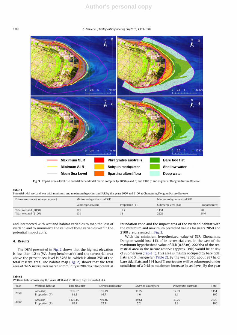
Fig. 3. Impact of sea-level rise on tidal flat and tidal marsh complex by 2050 (a and b) and 2100 (c and d) year at Dongtan Nature Reserve.
Table 1Potential tidal wetland loss with minimum and maximum hypothesized SLR by the years 2050 and 2100 at Chongming Dongtan Nature Reserve.
Future conservation targets (year) Minimum hypothesized SLR Maximum hypothesized SLR
Submerge area (ha) Proportion (%) Submerge area (ha) Proportion (%)
Tidal wetland (2050) 328 5.7 1151 20Tidal wetland (2100) 634 11 2229 38.6
and intersected with wetland habitat variables to map the loss ofwetland and to summarize the values of these variables within thepotential impact zone.
4. Results
The DEM presented in Fig. 2 shows that the highest elevationis less than 4.2 m (Wu Song benchmark), and the terrestrial areaabove the present sea level is 5768 ha, which is about 25% of thetotal reserve area. The habitat map (Fig. 2) shows that the totalarea of the S. mariqueter marsh community is 2087 ha. The potential
inundation zone and the impact area of the wetland habitat withthe minimum and maximum predicted values for years 2050 and2100 are presented in Fig. 3.
With the minimum hypothesized value of SLR, ChongmingDongtan would lose 11% of its terrestrial area. In the case of themaximum hypothesized value of SLR (0.88 m), 2229 ha of the ter-restrial area in the nature reserve (approx. 39%) would be at riskof submersion (Table 1). This area is mainly occupied by bare tidalflats and S. mariqueter (Table 2). By the year 2050, about 937 ha ofbare tidal flats and 191 ha of S. mariqueter will be submerged underconditions of a 0.48 m maximum increase in sea level. By the year
Table 2Wetland habitat losses by the years 2050 and 2100 with high estimated SLR.
Year Wetland habitat Bare tidal flat Scirpus mariqueter Spartina alterniflora Phragmites australis Total
2050Area (ha) 936.87 191.19 11.22 12.39 1151Proportion (%) 81.3 16.7 1.0 1.1 100
2100Area (ha) 1420.15 719.46 49.61 39.76 2229Proportion (%) 63.7 32.3 2.2 1.8 100
Author's personal copy
B. Tian et al. / Ecological Engineering 36 (2010) 1383–1388 1387
2100, about 1420 ha of bare tidal flats and 719 ha of S. mariqueterwill be at risk of inundation under the maximum predicted sea-level rise of 0.88 m. The S. mariqueter and bare tidal flat areas will bemore vulnerable to sea-level rise, which is important, because theselocalities represent a vital breeding area for migratory shorebirds.
5. Discussion and conclusions
5.1. Implications for conservation
Climate change and its associated effects, such as sea-level rise,have global implications that will increasingly affect the entireconservation area in the nature reserve. However, due to thecomplexity of interrelated coastal processes, the tidal wetlandchange caused by sea-level rise is masked by a multitude of factorsincluding waves, tidal currents, tidal surges, seaward and land-ward migrations of the marsh, sediment supply balances, crustalmotions, ground subsidence and climate change. While numer-ous studies have focused on shoreline change, estuarine erosion,sediment supply balance, saltwater intrusion and invasive plantson the Chongming Dongtan tidal wetland (Yang, 1999; Jing et al.,2007; Li and Zhang, 2008; Xiao et al., 2009), these studies are insuf-ficient to describe the potential wetland loss and deterioration thatwill result from climate change. This absence of scientific data andinformation about the impact of increased sea level will ultimatelyinfluence the protective policies, regulations, measurements anddecisions about the Chongming Dongtan Nature Reserve.
The identification, mapping and statistical summary of envi-ronmental impacts of the projected sea-level rise at ChongmingDongtan Nature Reserve represents an important initial step fordecision makers concerned with mitigation of the adverse impactsof sea-level rise. In this study, the inundation-based assessmentwas developed to inform policymakers, mangers and the publicabout the amount and spatial distribution of tidal wetland changeas a result of sea-level rise. The results indicate the zones mostvulnerable to sea-level rise at the Chongming Dongtan NatureReserve are the S. mariqueter zone, the bare tidal flat zone andthe tidal creeks, which are the most suitable habitats for migra-tory birds (Tian et al., 2008). A ∼30% loss of the S. mariquetermarsh community by the year 2100 would eliminate a rich inver-tebrate food source and cause deterioration in the estuarine foodweb for migrating birds (Strange et al., 2008); such a loss couldarise from human-induced stressors such as land reclamation, sea-wall constructions, overfishing and local pollution. As tidal marshesand flats submerge and decline in size and productivity, increasedcrowding in the remaining areas could lead to reductions in andeventually even exclusion of some local shorebird populations(Galbraith et al., 2002).
The impact assessment of increased sea level at ChongmingDongtan Nature Reserve indicates that it is crucial and neces-sary to incorporate the potential impacts of future increases insea level into conservation planning, actions and decision-making.Conservation of these areas requires present-day preparation toreduce the eventual adverse consequences of increased sea level.The direct approaches and fundamental pathways for adapting andmitigating the impacts of increased sea level include armouring,elevation and managed retreat (CCSP, 2009). However, to com-prehensively adapt wetland habitats and the wetland ecosystemfor conservation, special management actions must be considered,including the protection of S. mariqueter community and its tidalflat and reduction of anthropogenic stress (Kareiva et al., 2008).
5.2. Limitation and application
Tidal wetland habitat changes at Dongtan Nature Reserve inresponse to sea-level rise and related processes may include sev-
eral structural and functional changes, and inundation is only oneof a number of possible responses to sea-level rise (FitzGeraldet al., 2008). The complexities of tidal wetland change are notfully understood and are thus difficult to simulate mechanisti-cally. The region of mouth bars in the Yangtze Estuary and thesubmerged delta nearby are the major locations of sedimenta-tion resulting from the great amount of silt brought down theYangtze River (Yang, 1999). The eastern fringe of Chongming Dong-tan was advancing at a rate of between 150 and 300 m/year inprevious decades (Gao and Zhang, 2006). However, the supply ofsediment to the intertidal area is presently lower, due to the con-struction of dams in the Yangtze River and possibly also changesin water delivery by the river. Moreover, recent modeling stud-ies using a variety of approaches (GIS-based statistical models,different deterministic models) have shown that saltmarshes inparticular have a high capacity to follow sea-level rise, becauseany increase in inundation frequency could cause an increase insedimentation rate (Kirwan and Temmerman, 2009). Inundationmodeling is usually a simple, effective method wherein sea level isincreased by delineating an area at and below a specified land ele-vation to create the inundation zone (CCSP, 2009), with unavailableaccretion and process data applied across the entire conservationarea. The utility and applicability of the results based on inunda-tion analysis would present a base model for a possible suite ofscenarios. It would be interesting to compare the prediction tomore scenarios based on the rate of sediment accretion in the salt-marshes and mudflat, although it is a very complex task at thepresent.
Increased sea level is one of the most visible and immediatelyserious consequences of climate change for the general public andthe coastal science community. Appropriate methodologies andmodels are still needed to obtain reliable information about coastalwetland habitat change, resulting from climate change. Predic-tion of the consequences of climate change impacts, especiallyincreased sea level, in this nature reserve is a challenge becauseof the difficulty in identifying, accurately mapping and quantifyingthe physical response of the tidal wetlands to increased sea level,while taking into account the wide variety of other estuarine andcoastal processes as well as other human activities and impacts.To meet the need for more accurate, detailed and up-to-date sea-level rise vulnerability assessments and to incorporate this basemodel with the sediment accretion models, further studies andmore approaches are needed to provide more scenarios.
Acknowledgements
The authors would like to thank members of the Department ofEnvironmental Science and Engineering, Fudan University, Mr. JianMa and Dr. Bo Yang of The Nature Conservancy, and Mr. Guo-xianSong and Mr. Chen-dong Tang of Shanghai Forestry Bureau, Shang-hai, for their assistance with the collection of field data and helpfuldiscussions. We would particularly thank Professor Martin Kent,University of Plymouth, UK for valuable comments and linguis-tic checking. This research was funded by the China PostdoctoralScience Foundation, the Sci. & Tech. Support Planning Program ofthe National Ministry of Sci. & Tech. of China (No. 2008BAJ10B01),Project 200805080 and Open Fund of State key Laboratory of Estu-arine and Coastal Research, East China Normal University, China.
References
Austin, G.E., Rehfisch, M.M., 2003. The likely impact of sea level rise on waderswintering on estuaries. J. Nat. Conserv. 11, 43–58.
Benz, U., 2001. Defines imaging GmbH: object-oriented classification and featuredetection. IEEE Geosci. Remote Sens. Soc. Newsl. 9, 16–20.
Author's personal copy
1388 B. Tian et al. / Ecological Engineering 36 (2010) 1383–1388
Bock, M., Xofis, P., Mitchley, J., Rossner, G., Wissen, M., 2005. Object-orientedmethods for habitat mapping at multiple scales – case studies from NorthernGermany and Wye Downs, UK. J. Nat. Conserv. 13, 75–89.
CCSP (Climate Change Science Program), 2009. Coastal Sensitivity to Sea-level Rise:A Focus on the Mid-Atlantic Region. U.S. Environmental Protection Agency,Washington, DC.
Craft, C., Clough, J., Ehman, J., Joye, S., Park, R., Pennings, S., Guo, H., Machmuller,M., 2009. Forecasting the effects of accelerated sea-level rise on tidal marshecosystem services. Front. Ecol. Environ. 7 (2), 73–78.
FitzGerald, D.M., Fenster, M.S., Argow, B.A., Buyn Evich, I.V., 2008. Coastal impactsdue to sea-level rise. Annu. Rev. Earth Pl. Sci. 36, 601–647.
Fussel, H.M., 2007. Vulnerability: a generally applicable conceptual framework forclimate change research. Global Environ. Change 17, 155–167.
Galbraith, H., Jones, R., Park, R., Clough, J., Herrod Julius, S., Harrington, B., Page,G., 2002. Global climate change and sea level rise: potential losses of intertidalhabitat for shorebirds. Waterbirds 25 (2), 173–183.
Gao, Z.G., Zhang, L.Q., 2006. Multi-seasonal spectral characteristics analysis ofcoastal salt marsh vegetation in Shanghai, China. Estuar. Coast. Shelf Sci. 69,217–224.
IPCC (Intergovernmental Panel on Climate Change), 2007. Climate Change 2007: ThePhysical Science Basis. Cambridge University Press, Cambridge/New York.
Jensen, J.R., 2005. Introductory Digital Image Processing: A Remote Sensing Perspec-tive. Pearson Prentice Hall, Upper Saddle River, USA.
Jing, K., Ma, Z.J., Li, B., Li, J.H., Chen, J.K., 2007. Foraging strategies involved in habitatuse of shorebirds at the intertidal area of Chongming Dongtan, China. Ecol. Res.22, 559–570.
Kareiva, P., Enquist, C., Johnson, A., Julius, S.H., Lawler, J., Petersen, B., Pitelka, L.,Shaw, R., West, J.M., 2008. Synthesis and conclusions. In: Julius, S.H., West, J.M.(Eds.), Preliminary Review of Adaptation Options for Climate-sensitive Ecosys-tems and Resources. U.S. Environmental Protection Agency, Washington, DC, pp.9–66.
Kirwan, M., Temmerman, S., 2009. Coastal marsh response to historical and futuresea-level acceleration. Quaternary Sci. Rev. 28, 1801–1808.
Li, H.P., Zhang, L.Q., 2008. An experimental study on physical control of an exoticplant Spartina alterniflora in Shanghai, China. Ecol. Eng. 32, 11–21.
Michener, W.K., Blood, E.R., Bildstein, K.L., Brinson, M.M., Gardner, L.R., 1997. Climatechange, hurricanes and tropical storms and rising sea level in coastal wetland.Ecol. Appl. 7 (3), 770–801.
Morris, J.T., Sundareshwar, P.V., Nietch, C.T., Kjerfve, B., Cahoon, D.R., 2002.Responses of coastal wetlands to rising sea level. Ecology 83 (10), 2869–2877.
Nicholls, R.J., Wong, P.P., Burkett, V.R., Codignotto, J.O., Hay, J.E., McLean, R.F.,Ragoonaden, S., Woodroffe, C.D., 2007. Coastal systems and low-lying areas.In: Parry, M.L., Canziani, O.F., Palutikof, J.P., Linden, P.J., Hanson, C.E. (Eds.),Climate Change 2007: Impacts, Adaptation and Vulnerability. Cambridge Uni-versity Press, Cambridge/New York, pp. 315–356.
Park, R.A., Trehan, M.S., Mausel, P.W., Howe, R.C., 1989. The effects of sea level riseon U.S. coastal wetlands. In: Smith, J.B., Tirpak, D.A. (Eds.), The Potential Effectsof Global Climate Change on the United States. Hemisphere Publishing, NewYork, pp. 1–55.
Poulos, E.S., Ghionis, G., Maroukian, H., 2009. The consequences of a future eustaticsea-level rise on the deltaic coasts of Inner Thermaikos Gulf (Aegan Sea) andKyparissiakos Gulf (Ionian Sea), Greece. Geomorphology 17, 18–24.
Rybczyk, J.M., Cahoon, D.R., 2002. Estimating the potential for submergence for twosubsiding wetlands in the Mississippi River delta. Estuaries 25 (5), 985–998.
Snoussi, M., Ouchani, T., Khouakhi, A., Niang Diop, I., 2009. Impacts of sea-level riseon the Moroccan coastal zone: quantifying coastal erosion and flooding in theTangier Bay. Geomorphology 107, 32–40.
Strange, E.M., Shellenbarger Jones, A., Bosch, C., Jones, R., Kreeger, D., Titus, J.G., 2008.Mid-Atlantic coastal habitats and environmental implications of sea level rise.In: Titus, J.G., Strange, E.M. (Eds.), Background Documents Supporting ClimateChange Science Program Synthesis and Assessment Product 4.1: Coastal Eleva-tions and Sensitivity to Sea Level Rise. U.S. Environmental Protection Agency,Washington, DC, pp. 188–342.
Tian, B., Zhou, Y.X., Zhang, L.Q., Yuan, L., 2008. Analyzing the habitat suitability formigratory birds at the Chongming Dongtan Nature Reserve in Shanghai, China.Estuar. Coast. Shelf Sci. 80, 296–302.
Titus, J.G., Park, R.A., Leatherman, S.P., Weggel, J.R., Greene, M.S., Mausel, P.W.,Trehan, M.S., Brown, S., Grant, C., Yohe, G.W., 1991. Greenhouse effect and sea-level rise: loss of land and the cost of holding back the sea. Coast. Manage. 19,171–204.
Xiao, D.R., Zhang, L.Q., Zhu, Z., 2009. A study on seed characteristics and seed bank ofSpartina alterniflora at saltmarshes in the Yangtze Estuary, China. Estuar. Coast.Shelf Sci. 83, 105–110.
Xu, H.F., Zhao, Y.L., 2005. Scientific Survey on Chongming Dongtan Migratory BirdsNature Reserve of Shanghai. China Forestry Publishing House, Beijing.
Yang, S.L., 1999. Sedimentation on a growing intertidal island in the Yangtze Rivermouth. Estuar. Coast. Shelf Sci. 49, 401–410.