Embed Size (px)
Citation preview
DEEPSEATED LANDSLIDES MECHANISM ASSOCIATED TO BASAL HYDROSTATIC PRESSURE ON THE EASTERN SLOPES OF THE ABURRÁ VALLEY
Fabián Hoyos Patiño. Universidad Nacional de Colombia. Institutode Estudios de Infraestructura. Facultad de Minas. Medellín. [email protected] Echeverri Ramírez. Universidad Nacional de Colombia. Programa de Maestría en Ingeniería-Geotecnia. Facultad de Minas.Medellín.Marisol Salvá Ramírez. Escuela de Ingeniería de Antioquia. [email protected] Velásquez Pérez. Escuela de Ingeniería de Antioquia. Vieco Ingeniería de [email protected]
ABSTRACT
Some mass movements on high mountain slopes, can be explained asa process of progressive failure due to the particular hydrogeological conditions in which they occur: the silty regolith with low hydraulic conductivity constitutes a seal or aquiclude on the bedrock confined aquifer. The hydrostatic pressure on the top of the basement can reach a magnitude capable of fracturing the mantle of regolith thus initiating a process of progressive failure.
In this paper, we apply this model to explain some deep landslides on the eastern slopes of the Aburrá Valley, where thegeological and hydrogeological conditions, in which some they have occurred, fit this model.
For this purpose three landslides were analyzed by using limit equilibrium methods (Janbu, Bishop and Morgenstern & Price); afterwards forces on the regolith base were added simulating a hydrostatic pressure high enough to initiate a failure process. The results, which very approximately replicated the actual fault geometry, indicate that this is a plausible failure.
INTRODUCTION
The slopes stability analysis are based on models which considerits object as a closed system in which a balance of forces / moments engines versus stress/strength is drawn. Any external element (overload, dynamic loads, retainment structures, reinforcing elements, etc.) is integrated into the system is
reduced to a closed system the balance of which is iteratively calculated.
Artesian pressure in the high mountain slopes has been a variable overlooked in the stability analysis of slopes. Stresses associated with artesian pressure at the base of the soil mantle overlying fractured rock mass in the high mountain slopes is an external element that can well explain some mass movements. An exceptional increase of the water pressure at the regolith bedrock interface, or decreasing the regolith load on the rock massif due to the effect of secular erosion or manmade cuts, can lead to imbalance the forces in the soil mass triggering a process of progressive failure.
In this paper we present and illustrate the elements of analysisof this failure mechanism based on three selected case studies using secondary information on mass erosion events on the eastern slopes of the Aburrá Valley: Water Treatment Plant Manantiales, 1990, Urbanizacion Alto Verde, 2008, and Sanin-La Presidenta basin, 2010. Each of these cases was analyzed conventionally and with the addition of the force generated by the hydrostatic pressure on the regolith-bedrock limit using three different methods of limit equilibrium. In all three casesthe results of conventional analyzes gave factors of safety greater than one. Safety factors decreased to values close to one when the forces associated with the hydrostatic pressure at the top of the bedrock were introduced in this analysis. The magnitude of the forces needed to induce the failure conform to the increase in hydrostatic pressure above a basic level in two places where the position of the piezometric level has been monitored during more than ten years.
The numerical results presented here were obtained in developingthe thesis to qualify for the title of Civil Engineers of two ofthe authors.
CASE STUDIES
We selected three study cases of well-known landslides in Medellin the characteristics of which suggest that they conform to the proposed failure model.
Manantiales Water Treatment Plant
This site is located in the northern end of the city, approximately 1800 m above sea level. The regolith, formed by andosols, slope deposits and residual soil derived from dunite, about 20 m thick, overlays highly fractured dunite bedrock; the joints in the upper part of the fractured bedrock are filled with pale brownish silt. Water table was not found in the regolith during the exploratory stage. Cuts done during the construction process had a height up to 15 m. Analyses of pre-construction stability resulted in safety factors above 1.6
During construction of the plant in 1989, a rotational slide, preceded by the emergence of a spring at the base of the slope, occurred. The piezometric level was found several meters above the top of the bedrock in boreholes perforated at the crown and the body of the landslide.
Altoverde
Located in the East of the Aburrá Valley, about 1850 m above sealevel. The regolith, about 30 m thick, formed by andosols, slopedeposits with fragments of amphibolite and dunite, and residual soil derived from tectonic breccia, overlaying the amphibolite breccia bedrock. Cuts made in the land reclamation process had aheight up to 15 m. The water table is found at varying depths between 12 m and 15 m during the days of exploration.
In November 2008, a deep slide destroyed several new houses. Themass movement was preceded by the emergence of springs at the base of the slope that flooded several homes.
Sanin-La Presidenta Basin
In November 2010, a deep slide affected La Presidenta basin below the elevation 2150. After this event, a new permanent stream began to flow from the bottom half of the slide scar.
The regolith, about 11 m thick, is composed of andosols, slope deposits and residual soil derived from dunite. The discontinuities of fractured bedrock are filled with reddish silt. No water table was observed in the regolith. One of the authors observed an abnormal flow of water in the vicinity of the sliding body a few hours before the landslide.
The basic geotechnical information presented in Table 1, was obtained from firms Estec SA , Giovanni Arrieta Soil Engineering, Inteinisa SA , Vieco Soil Engineering Ltd, Solingral SA And Estec SA.
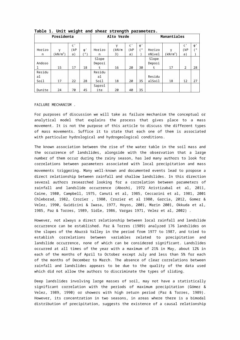
Table 1. Unit weight and shear strength parameters.Presidenta Alto Verde Manantiales
Horizon
γ (kN/m3)
c'(kPa)
φ'(°)
Horizon
γ (kN/m
3)
c'(kPa)
φ'(°)
HorizonNivel
γ (kN/m3)
c'(kPa)
φ'(°)
Andosol 15 17 18
SlopeDeposi
t 16 20 30
SlopeDeposi
t 17 2 28Residual Soil 17 22 28
ResidualSoil 18 20 35
ResidualSoil 18 12 27
Dunite 24 70 45Saprolite 20 40 35
FAILURE MECHANISM .
For purposes of discussion we will take as failure mechanism the conceptual oranalytical model that explains the process that gives place to a massmovement. It is not the purpose of this article to discuss the different typesof mass movements. Suffice it to state that each one of them is associatedwith particular hydrological and hydrogeological conditions.
The known association between the rise of the water table in the soil mass andthe occurrence of landslides, alongside with the observation that a largenumber of them occur during the rainy season, has led many authors to look forcorrelations between parameters associated with local precipitation and massmovements triggering. Many well-known and documented events lead to propose adirect relationship between rainfall and shallow landslides. In this directionseveral authors researched looking for a correlation between parameters ofrainfall and landslide occurrence (Aboshi, 1972 Aristizabal et al, 2011,Caine, 1980, Campbell, 1975, Canuti et al, 1985, Ceccarini et al, 1981, 2001Chleborad, 1982, Crozier , 1980, Crozier et al 1980, Garcia, 2012, Gomez &Velez, 1990, Guidicini & Iwasa, 1977, Hoyos, 2001, Marin 2001, Okkuda et al,1985, Paz & Torres, 1989, Sidle, 1986, Vargas 1971, Velez et al, 2002) .
However, not always a direct relationship between local rainfall and landslideoccurrence can be established. Paz & Torres (1989) analyzed 176 landslides onthe slopes of the Aburrá Valley in the period from 1977 to 1987, and tried toestablish correlations between variables related to precipitation andlandslide occurrence, none of which can be considered significant. Landslidesoccurred at all times of the year with a maximum of 21% in May, about 12% ineach of the months of April to October except July and less than 5% for eachof the months of December to March. The absence of clear correlations betweenrainfall and landslides appears to be due to the quality of the data usedwhich did not allow the authors to discriminate the types of sliding.
Deep landslides involving large masses of soil, may not have a statisticallysignificant correlation with the periods of maximum precipitation (Gómez &Velez, 1989, 1990) or showers with high return period (Paz & Torres, 1989).However, its concentration in two seasons, in areas where there is a bimodaldistribution of precipitation, suggests the existence of a causal relationship

with periodic type events; in this case, may well be the rains that have asimilar annual distribution. Thus, the correlation could be sought withspatially distant events whose magnitude may well be similar to local events,albeit with a delay that must be explained in terms of regionalhydrogeological conditions (Hoyos, 1990). In this case the most relevantcharacteristic of the precipitation in the recharge area probably would be thethe amount of accumulated rainfall that has a chance to infiltrate over agiven period, taking into consideration that the very heavy rains contributerelatively little to deep infiltration .
Further, there are cases in which apparently the relationship between localprecipitation and mass movements are inverse. This is the case of theBucaramanga Terrace, Northeastern Colombia, where most landslides occur inthe periods from June to August and December to February, which coincide withdry periods in the area (Hoyos et al, 1992). The temporal relationship betweenrainfall and landslides in the Bucaramanga Terrace is illustrated in Figure 1.In Figure 3 it can be seen the relationship between precipitation andpiezometric levels in the Water Treatment Plant Manantiales in the Valle deAburrá. It is worth noting that these records show observed piezometric levelvariations that can reach 10 m equivalent to 100 kPa.
Figure 1. Precipitation (broken line) and landslides (bars) in the BucaramangaTerrace relationship.
Figure 2. Precipitation and piezometric levels at Manantiales Water Treatment Plant.
Deep landslides can hardly be explained by the increased interstitial pressure following an event or series of events of local rain. There is enough empirical evidence that infiltrationon slopes of high slope is minimal and that groundwater in slopes of the Aburrá Valley comes from the neighboring highlands(Hoyos , 2001, 2007 , 2012 , Hoyos & Arnason , 1992, 1994 , Hoyos et al 2002).
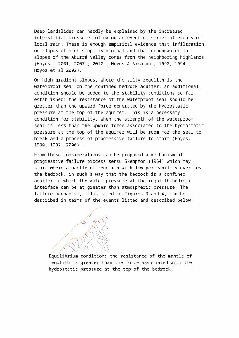
On high gradient slopes, where the silty regolith is the waterproof seal on the confined bedrock aquifer, an additional condition should be added to the stability conditions so far established: the resistance of the waterproof seal should be greater than the upward force generated by the hydrostatic pressure at the top of the aquifer. This is a necessary condition for stability, when the strength of the waterproof seal is less than the upward force associated to the hydrostaticpressure at the top of the aquifer will be room for the seal to break and a process of progressive failure to start (Hoyos, 1990, 1992, 2006) .
From these considerations can be proposed a mechanism of progressive failure process sensu Skempton (1964) which may start where a mantle of regolith with low permeability overlies the bedrock, in such a way that the bedrock is a confined aquifer in which the water pressure at the regolith-bedrock interface can be at greater than atmospheric pressure. The failure mechanism, illustrated in Figures 3 and 4, can be described in terms of the events listed and described below:
Equilibrium condition: the resistance of the mantle of regolith is greater than the force associated with the hydrostatic pressure at the top of the bedrock.

Change in the equilibrium conditions: a cut in the mantle of regolith, or increased hydrostatic pressure, or both, change the relationship between the resistance of the regolith and force associated with the hydrostatic pressure at the top of the bedrock.
Initial condition of progressive failure: mantle of regolith fissured by the effect of the force associated with the hydrostatic pressure at the top of the bedrock.
Collapse of the mass of regolith.
Figure 3. Schematic representation of the proposed failuremechanism with human intervention.
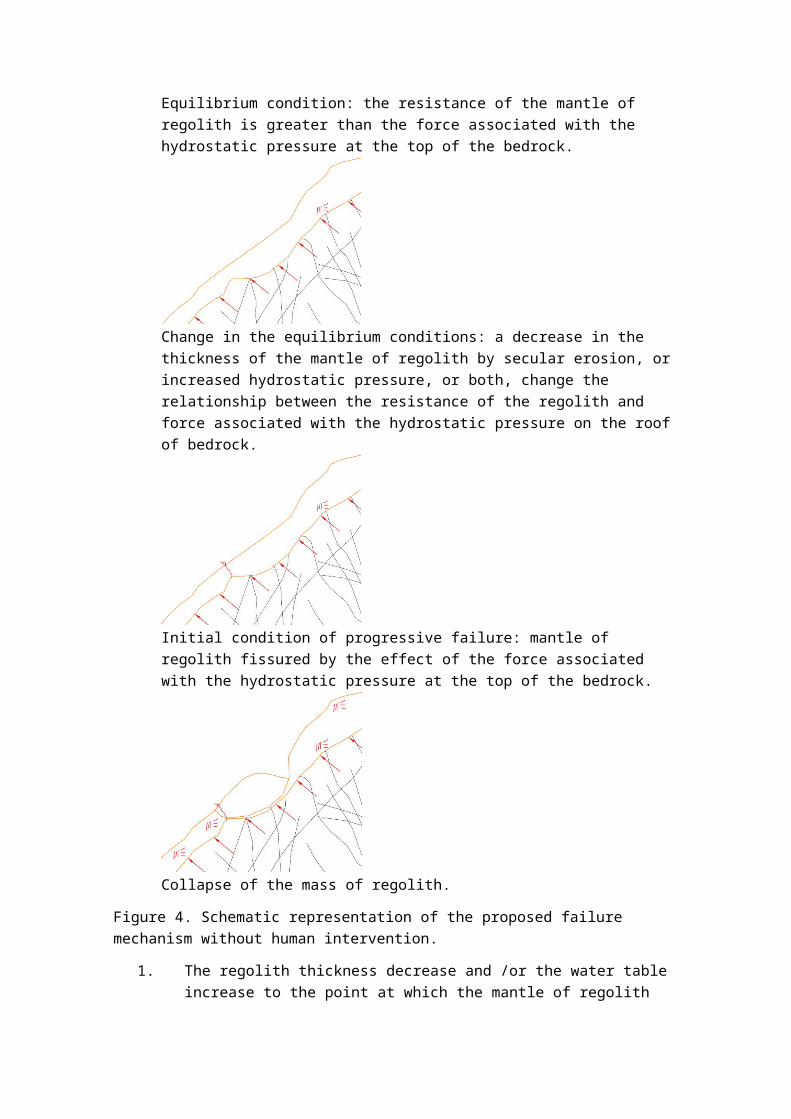
Equilibrium condition: the resistance of the mantle of regolith is greater than the force associated with the hydrostatic pressure at the top of the bedrock.
Change in the equilibrium conditions: a decrease in the thickness of the mantle of regolith by secular erosion, orincreased hydrostatic pressure, or both, change the relationship between the resistance of the regolith and force associated with the hydrostatic pressure on the roofof bedrock.
Initial condition of progressive failure: mantle of regolith fissured by the effect of the force associated with the hydrostatic pressure at the top of the bedrock.
Collapse of the mass of regolith.
Figure 4. Schematic representation of the proposed failure mechanism without human intervention.
1. The regolith thickness decrease and /or the water table increase to the point at which the mantle of regolith

resistance is less than the force generated by the hydrostatic pressure on the top of the aquifer.
2. The stress on the mantle of regolith induces the formation of a first fracture or set of fractures that can allow drainage of water from the aquifer to surface.
3. A process of progressive failure sensu Skempton (1964) starts from the initial fracture zone of weakness.
4. Collapse of the soil mass. The geometry of the sliding surface can be spherical, polyhedral or wedge, dependingon the particular conditions of the terrain.
Given these conditions, the location of a deep slip at a particular site will depend mainly on two factors: the increase in water pressure on the regolith-bedrock interface by effect ofthe variation in the piezometric level of the groundwater, and the occasional discharge from regolith coverage due to the secular surface erosion, shallow mass movements, or the execution of earthworks. One of these factors may be enough to trigger a deep slip although it may be considered that the current situation may be the result of the combination of more than one of these factors.
THE HYDROGEOLOGICAL SETTING
The hydrogeological system in the area between the Aburrá Valley, the bottom of which is 1500 m, and the San Nicolas Valley, at 2100 meters, is complex due to the existence of two major recharge areas: San Nicolás Valley, and Santa Elena - Piedras Blancas Planalto located between the two valleys to 2600m, and the average elevation differences between these three geomorphological units, from 400 to 1000 m. Although the regional hydrogeological system is more complex as more wide limits are considered, it is possible to propose valid generalizations if the analysis is restricted to the area between the Aburrá Valley and San Nicolas Valley.
The meadows, alluvial terraces and saprolitic hills in the San Nicolas Valley, the landscape of saprolitic hills in the Planalto Santa Elena and the eastern escarpment of the Aburrá Valley are relevant geomorphological units to be considered in the groundwater balance in the area of interest in this paper. The eastern slopes of the Aburrá Valley are built on cohesive residual soils of very low permeability derived from dunites,

amphibolites, schists and granitoides, and on extensive depositsof mud and debris flows. Secondary permeability is lower in the regolith that in the rock mass which has the characteristics of a confined aquifer. Typical values of hydraulic conductivity forthe regolith are 10-7 to 10-10 m/s , 10-5 to 10-6 m/s in the rock mass .
Regional hydrogeological investigation has led to a conceptual model based on the regional water balance, validated with the results of geophysical investigation, and isotopic and hydrogeochemical information (Hoyos & Arnason, 1994, 1996, Hoyoset al, 1996, Hoyos 2012, Rodríguez, 1989).
According to this model the groundwater in the Valley of Aburrá come mostly from San Nicolás Valley, and to a lesser extent fromthe Santa Elena highland; there are hydraulic connections between the Santa Elena highland, the San Nicolás Valley and theAburrá Valley, and between these two latter through the rock massif along joints in the rock. Additionally, the field of sinkholes in Santa Elena have a hydraulic connection with the Aburrá Valley slopes verified with isotopic tracers and chemicaltechniques, restricted to the sector between two small streams: Santa Elena and La Presidenta (Herrera et al, 2005, Hoyos, 1992,Rodriguez, 1989).
Hydrogeological investigations using stable isotopes of hydrogenand oxygen indicate that groundwater springs daylighting at elevation above 2100 comes entirely from the Santa Elena highland, while groundwater that surfaces in springs below elevation 1900 comes entirely from the San Nicolas Valley. Between 1900 and 2000 masl groundwater in the springs is a mixture of water from both recharge zones (Hoyos, 2012).
Based on the available data it can be argued that changes in thegroundwater level on the eastern slopes of the Aburrá Valley areassociated with changes in precipitation in the of Santa Elena Highland and the San Nicolas Valley with a presented a temporal lag estimated in several weeks.
Geomaterials in this system does not permit the free movement ofwater, except along its discontinuities, so that groundwater flow from recharge areas and valley bottoms occurs along discontinuities regolith and rock mass. An obvious exception to this asertion are the alluvial deposits on both valleys
The occurrence of springs that emerge with a pressure greater than the atmospheric one, and drilled wells where the groundwater level is above the regolith-bedrock indicates that the rock mass effectively functions as a confined aquifer for which the regolith constitutes the waterproof seal.
NUMERICAL ANALYSIS
In order to simulate the proposed conceptual model by existing software, a force equal to the hydrostatic pressure, distributedat the base of the regolith, or a hydraulic grade line whose position is defined according to the probable or possible characteristics of the aquifer should be added .
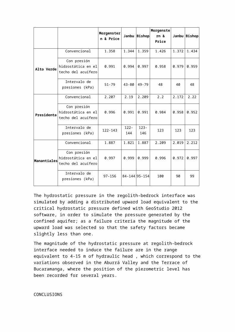
The GeoStudio 2012 and Slide 6.0 from Rockscience software were used for modeling purposes. Stability tests were run with both softwares in order to model the described failure process with two different utilities. In the case of Alto Verde and Manantiales the modeling process included the modification of the land surface with a cut, combined with a critical hydrostatic pressure at the base of the mantle of regolith, which triggered the landslide process. The results of the analyzes are in Table 2 .
Stability analyzes were initially performed in a conventional manner using Janbu , Bishop and Morgenstern & Price methods, with similar results. In all the cases the safety factor was greater than one. In a second stage the force required to cause failure associated with the hydrostatic pressure in the regolith-bedrock interface was introduced.
In using GeoStudio 2012, an artesian pressure is simulated belowthe impermeable regolith subjected to an additional pore pressure; for this purpose was modeled as impermeable the regolith down to the bedrock; the hydraulic grade line was relocated until searching a height at which the pressure caused,made the soil mass to come into imbalance and the safety factor became slightly less than one.
Tabla 2. Resumen de resultados de análisis de estabilidad.
Evento Condición Geostudio 2012 Slide 6.0
Morgenstern & Price Janbu Bishop
Morgenstern &Price
Janbu Bishop
Alto Verde
Convencional 1.358 1.344 1.359 1.426 1.372 1.434
Con presiónhidrostática en eltecho del acuífero
0.991 0.994 0.997 0.958 0.979 0.959
Intervalo depresiones (kPa) 51-79 43-80 49-79 48 40 48
Presidenta
Convencional 2.207 2.19 2.209 2.2 2.172 2.22
Con presiónhidrostática en eltecho del acuífero
0.996 0.991 0.991 0.984 0.958 0.952
Intervalo depresiones (kPa) 122-143 122-
144123-146 123 123 123
Manantiales
Convencional 1.887 1.821 1.887 2.209 2.019 2.212
Con presiónhidrostática en eltecho del acuífero
0.997 0.999 0.999 0.996 0.972 0.997
Intervalo depresiones (kPa) 97-156 84-144 95-154 100 90 99
The hydrostatic pressure in the regolith-bedrock interface was simulated by adding a distributed upward load equivalent to the critical hydrostatic pressure defined with GeoStudio 2012 software, in order to simulate the pressure generated by the confined aquifer; as a failure criteria the magnitude of the upward load was selected so that the safety factors became slightly less than one.
The magnitude of the hydrostatic pressure at regolith-bedrock interface needed to induce the failure are in the range equivalent to 4-15 m of hydraulic head , which correspond to thevariations observed in the Aburrá Valley and the Terrace of Bucaramanga, where the position of the piezometric level has been recorded for several years.
CONCLUSIONS
From the statements and data presented in this paper, follows:
1. In some cases the ground subject of stability evaluation has the characteristics of a confined aquifer in which theregolith serves as aquiclude. This condition can be found in high gradient slopes limited at the top by hilly terrain topography.
2. When the confined aquifer condition described in this paper is probable, the critical value of the hydrostatic pressure at the regolith-bedrock interface should be evaluated in order to introduce it in the analysis.
3. The ratio between the force associated with the hydrostatic pressure at the regolith-bedrock interface compared to the resistance of regolith less than unity should be considered as a necessary condition for stability on slopes.
4. The approach proposed in this paper can be substantially improved if the initial fracture condition in terms of thehydrostatic pressure required to produce it is tested and a crack is introduced as the trigger of progressive failure.
5. When the analysis shows the threat for mass movement that fits this type of mechanism, it is necessary to install drains to reduce the hydrostatic pressure at the base of the slope down to the regolith-bedrock interface.
REFERENCES.
Aboshi, T, 1977, Concentrated rainfall and slope failure, Manualfor Zonation on Areas Susceptible to Rain Induced Slope Failure,Asian Technical Committee on Geotechnology for Natural Hazards, ISSMFE, Japanese Geotechnical Society.
Área Metropolitana,2011, Modelo hidrogeológico conceptual de la ladera suroriental de Medellín (cuencas altas de las quebradas La Poblada, La Presidenta y La Sanín). Informe presentado por Solingral S.A Medellín.
Aristizábal, E., 2006, Geomorfología Aplicada a la Ocurrencia de Deslizamientos en el Valle de Aburrá, DYNA, 73(149), 5-16.
Aristizabal, E., González, T., Montoya, J., Vélez, J., Martínez,H., & Guerra, A., 2011. Análisis de umbrales empíricos de lluviapara el pronóstico de movimientos en masa en el Valle de Aburrá,Colombia. Revista EIA, 95-111.
Brand, E.W., 1985, Predictioning the performance of residual soil slopes, 11th International Conference on Soil Mechanics andFoundation Engineering, Proceedings, Stockholm. V3, 2541-2578.
Caine, N., 1980, Rainfall intensity duration control of shallow slides and debris flows, Geografiska Annalen, 62A, 23 27.
Campbell, R.H., 1975, Soil slips, debris flows and rainstorms inthe Santa Monica Mountains and Vicinity Southern California, U.S. Geological Survey Professional paper, #851
Canuti, P., Focardi, P. & Garzonico, C.A. 1985, Correlation between rainfall and landslides, Bulletin Geologie de l´Ingenieur, París.
Ceccarini, F., Focardi, P. & Zanchi, C., 1981, Modello per la previsione delle oscillazioni de falda in funzione dei parametriclimatici, Instituto Sperimentale Studio Difesa Suolo, Firenze #12, pp 161 164.
Chleborad, A. F., 2001, Preliminary method for anticipating the occurrence of precipitation-induced landslides in Seattle, Washington. U.S. Geological Survey .
Crozier, M.J., 1982, A technique for predicting the probability of mudflow and rapid landslide occurrence, International Seminar on Landslides and Mudflows, Alma Ata, USSR, Proceedings,pm 420-430, Unesco, Paris.
Crozier, M.J. & Eyles, , R.J., 1980, Assesing the probability ofrapid mass movement, New Zealand Institution of Engineers Technical Groups, 6, 1,2.47-2.51.
Crozier, M.J., Eyles, R.J., Marz, S.L., McConchie, J.A. & Owen, R.C., 1980, Distribution of landslips in Wairapapa hill country,New Zealand Journal of Geology and Geophysics, 23, 575-586.
García, E. F., 2012, Análisis numéricos acoplados para el estudio de infiltración y estabilidad de taludes. Primer Seminario de Movimientos en Masa Detonados por Lluvia. Medellín.
Gómez Isidro, Sully, 1989, Predicción de niveles freáticos a partir de la precipitación y su influencia en la estabilidad de taludes (caso de aplicación en la meseta de Bucaramanga). Tesis de Maestría. Universidad Nacional de Colombia. Medellín. 180p.
Gómez Isidro S., y Vélez M.V., 1990, Predicción de las fluctuaciones de niveles freáticos a partir de precipitaciones y
su influencia en la estabilidad de taludes en la Meseta de Bucaramanga, I Conferencia Colombiana de Geología Ambiental, Resúmenes, p. 20, Sociedad Colombiana de Geología, Medellín.
Gudicini, G. and Iwasa, O.Y., 1977, Tentative correlation rainfall and landslides in a humid tropic environment, Bulletin International Association Engineering Geology, Sao Paulo, #16, pp 13 20
Gudicini, G, & Iwasa, D., 1977, Tentative correlation between rainfall and landslides in a humid tropical environment, Bulletin of the International Association of Engineering Geology, Symposium on Landslides and other Mass Movements, 13-20.
Hermelin, M., 2005, Desastres de origen natural en Colombia 1979- 2004. Medellín: Fondo Editorial Universidad EAFIT.
Herrera, J., 2003, Carso de Alta Montaña en Santa Elena; Implicaciones Hidrológicas e Hidrogeológicas en el Valle de Aburrá. Tesis de Maestría. Posgrado en Recursos Hidráulicos. Medellín.
Herrera, J., Hoyos, F. & Vélez, I., 2004, El acuífero cársico delas dunitas de Medellín, Primer Congreso Colombiano de Hidrogeología, Memorias, Medellín. www.academia.edu
Hoyos, F, 1985, Régimen de aguas subterráneas en suelos residuales profundos derivados de rocas cristalinas en la Cordillera Central, II Simposio Colombiano de Hidrogeología, Memorias, p. 107-125, Bogotá.
Hoyos, F, 1990, Efectos de infiltraciones distantes en la inestabilidad de laderas de alta pendiente, Boletín de Vías, XVII, 71, 96-129.
Hoyos, F, 2001, Precipitaciones y deslizamientos, elementos hidrológicos e hidrogeológicos en el análisis de estabilidad de laderas, III Seminario Panamericano de deslizamientos, Memorias, 327-336, Cartagena.
Hoyos, F, 2007, Elementos hidrológicos e hidrogeológicos en el análisis de estabilidad de laderas. www.academia.edu.co
Hoyos, F., 2012. Discriminación de flujos subterráneos hacia el Valle de Aburrá desde el Planalto de Santa Elena y los Valles deSan Nicolás. Medellín. www.academia.edu
Hoyos, F., 2012. Hidrogeología de la zona central de Antioquia. Medellín. www.academia.edu
Hoyos, F. & Arnason, B., 1994, Claves isotópicas en la hidrogeología de alta montaña, Boletín de Vías, XXI, 90, 51-64.
Hoyos, F. & Arnason, B., 1996, El caso del gradiente cero: hidrología isotópica en la Zona Central de Antioquia. Seminario Nacional de hidráulica. Memorias pp195-206. Bogotá 1996
Hoyos, F., Arnason, B. & Salazar, B., 1996, Del altiplano al valle: una conexión hidráulica inferida a partir de información isotópica. Congreso Latinoamericano de Hidráulica. Memorias pp 379-389. Guayaquil 1996.
Hoyos, F, Vélez U., J & Vélez O., M.V., 1992,The Moses Rod, Bulletin of the Association of Engineering Geologists, XXXI, 133-149
Hormaza, M.,1991, Investigación Preliminar de las Causas Probables de Deslizamientos en las Laderas de Medellín. Medellín, Antioquia, Colombia: Tesis Facultad de Minas, Universidad Nacional.
INTEINSA S.A.,2008, Deslizamiento Alto Verde Sector La Cola del Zorro. Medellín.
Marín Nieto, L., 2001, Alerta temprana para deslizamientos causados por lluvias durante el Niño, III Simposio Panamericanode Deslizamientos, Memorias, 319-326, Cartagena.
Paz, C. y Torres P., 1989, Precipitación y su influencia sobre algunos deslizamientos en las laderas del Valle de Aburrá, Trabajo dirigido de grado, Facultad de Minas, Universidad Nacional de Colombia, Medellín, 174 p.
Polanco, C.,2000, inventario y sistematización de los eventos naturales ocurridos en los municipios jurisdicción de Corantioquia, entre los años 1920 y 1999. Medellín, Antioquia, Colombia: Tesis, Universidad de EAFIT.
Rodríguez, C., 1989, Control de deslizamientos con manejo del agua subterránea, I Simposio Suramericano de Deslizamientos, Memorias, 517-534, Paipa.
Salcedo, D., 2001, Características y aspectos socioeconómicos delos flujos torrenciales catastróficos de diciembre de 1999,en el
Estado Vargas y el Ärea Metropolitana de Caracas, III Simposio Panamericano de Deslizamientos, Memorias, 291-318, Cartagena
Sidle, R.C., Pearce, A.J., O Loughlin, C.L., 1985, Hillslope stability and land use, American Geophysical Union, Washington, 140 p.
Skempton, W., 1964, Long term stabililty of clay slopes, Geotechnique, 14, 75-101.
Vargas. M., 1971, Effects of rainfall in groundwater levels, Panamerican Conference on Soil Mechanics and Foundation Engineering, Proceedings, p 138-141, N. York.
Vélez, M V., Montoya, J. D., Moreno, H.A., Rhenals, R. L. & Polanco, C., 2002, La lluvia y su Influencia sobre los deslizamientos en el Departamento de Antioquia, Colombia.


