Embed Size (px)
Citation preview

JOURNAL OF SEDIMENTARY RESEARCH, VOL. 71, NO. 5, SEPTEMBER, 2001, P. 817–832Copyright q 2001, SEPM (Society for Sedimentary Geology) 1527-1404/01/071-817/$03.00
EQUATORIAL ARIDITY IN WESTERN PANGEA: LOWER PERMIAN LOESSITE AND DOLOMITICPALEOSOLS IN NORTHEASTERN NEW MEXICO, U.S.A.
JENNIFER L.P. KESSLER1, GERILYN S. SOREGHAN2, AND HERBERT J. WACKER3
1 Conoco Inc., P.O. Box 51266, Lafayette, Louisiana 70505, U.S.A.2 School of Geology and Geophysics, University of Oklahoma, Norman, Oklahoma 73019, U.S.A.
3 OXY U.S.A. Inc., #6 Desta Drive, Suite 6000, Midland, Texas 79705, U.S.A.e-mail: [email protected]
ABSTRACT: Lower Permian strata have been extensively cored in thesubsurface of the Bravo Dome field, northeastern New Mexico. Anal-ysis of core indicates that these strata consist of conglomeratic andsandy fluvial deposits and volumetrically significant eolian silt (loess-ite). Fluvial facies dominate the lower half of the study interval andinclude matrix-supported, massive conglomeratic debris-flow units andlaminated arkosic sandstone, whereas loessite dominates the upper halfof the study section and consists of massive, well-sorted quartzose silt-stone that locally reaches thicknesses as much as 120 m in the greaterstudy region. Paleosols are present throughout the study interval andconsist of protosols and dolosols, commonly exhibiting vertic features.Dolomite that is interpreted to be of pedogenic origin is an unusualbut volumetrically significant component in these paleosols.
Paleogeographic reconstructions and paleomagnetic data indicate thatthese strata accumulated at equatorial (3–88) latitudes, but depositionaland pedogenic evidence both suggest seasonally wet to markedly aridconditions from early Wolfcampian to early Leonardian time. The loes-site covers a substantial area (. 6000 km2), making this the largest pre-Cenozoic loess accumulation yet documented. This is significant, becauseloess generally suggests arid to semiarid conditions. Intercalated paleo-sols in the loessite section record repeated cessation of silt influx coupledwith landscape stability, which we relate to high-frequency oscillationbetween dry and slightly wetter conditions, possibly attributable to gla-cial–interglacial climatic conditions that prevailed at low latitudes. At alower frequency, the evolution from a predominance of fluvial to pri-marily eolian strata, in tandem with changes in pedogenic character,reflect a long-term aridification for the study interval. These data cor-roborate independent inferences of monsoon-induced equatorial aridityin western Pangea and help constrain the timing of the zonal-to-mon-soonal transition to earliest Permian time.
INTRODUCTION
During late Paleozoic time, North America obliquely straddled equatoriallatitudes, and some studies have suggested everwet conditions for this re-gion. For example, Ziegler (1990) depicts the equatorial region within 108north and south of Permian Pangea as predominantly everwet. Several stud-ies, however, have noted that western equatorial Pangea was generally dri-er. Briden and Irving (1964) first recognized the anomalous presence ofarid proxy indicators (e.g., eolian sandstone, evaporites) in equatorial re-gions of Pangea, whereas many later workers have inferred a megamon-soonal climate for Pangea, on the basis of both geologic data and climatemodeling (e.g., Robinson 1973; Nairn and Smithwick 1976; Parrish et al.1982; Rowley et al. 1985; Kutzbach and Gallimore 1989; Patzkowsky etal. 1991; Parrish 1993). Key attributes of the megamonsoon presumablyincluded cross-equatorial flow, seasonality, and equatorial aridity, whichshould have intensified as monsoonal development strengthened from Car-boniferous through Permian time (Parrish 1993).
The geologic record is the key data repository against which to calibratequalitative and quantitative paleoclimatic models and to constrain the onsetof Pangean monsoonal development. Paleosols are excellent paleoclimaticindicators because climate exerts a primary control on pedogenesis (e.g.,
Retallack 1990, 1997; Mack et al. 1993). Selected depositional facies alsoprovide key paleoclimatic data. In particular, eolian silt (or loess) suggestsarid to semiarid conditions and an abundant silt supply, but it has beenonly rarely recognized in the pre-Cenozoic geologic record (Murphy 1987;Fischer and Sarnthein 1988; Johnson 1989; Soreghan 1992; Carroll et al.1998; Chan 1999). In this paper, we use subsurface data from whole coresto document depositional and pedogenic characteristics and interpret pa-leoclimatic conditions through Early Permian time in northeastern NewMexico (western equatorial Pangea). Notably, Permian strata of this areaare entirely subsurface and previously poorly studied, but we argue thatthey are very significant because of the regionally extensive loessite andpedogenic dolomite that record seasonally wet to arid conditions at equa-torial latitudes.
GEOLOGIC SETTING
Tectonic Setting
The strata constituting the study interval lie in the shallow subsurface ofnortheastern New Mexico, mantling the Bravo dome paleohigh (Fig. 1).Bravo dome is a faulted, basement-cored, southeast-plunging projection ofthe Sierra Grande uplift that developed as a part of the extensive late Pa-leozoic deformation associated with the Ancestral Rocky Mountains (Fig.1; Roberts et al. 1976; Ross and Ross 1986; Broadhead 1990). Bravo domeyields eastward and southward to the Dalhart, Palo Duro, and Tucumcaribasins; it merges northwestward with the Sierra Grande uplift and south-eastward with the Amarillo uplift (Fig. 1). The pre-Permian basement-coreduplifts of northeastern New Mexico and the Texas Panhandle greatly influ-enced local deposition by providing large volumes of detritus for depositionin adjacent basins. Paleogeographic reconstructions indicate that the Bravodome region occupied equatorial latitudes (, 108 S to N; Fig. 1) fromPennsylvanian through Early Permian time (Scotese 1999). Paleomagnetic(inclination) data from the studied cores also confirms a low-latitude latePaleozoic position (Fig. 1).
Stratigraphic Setting
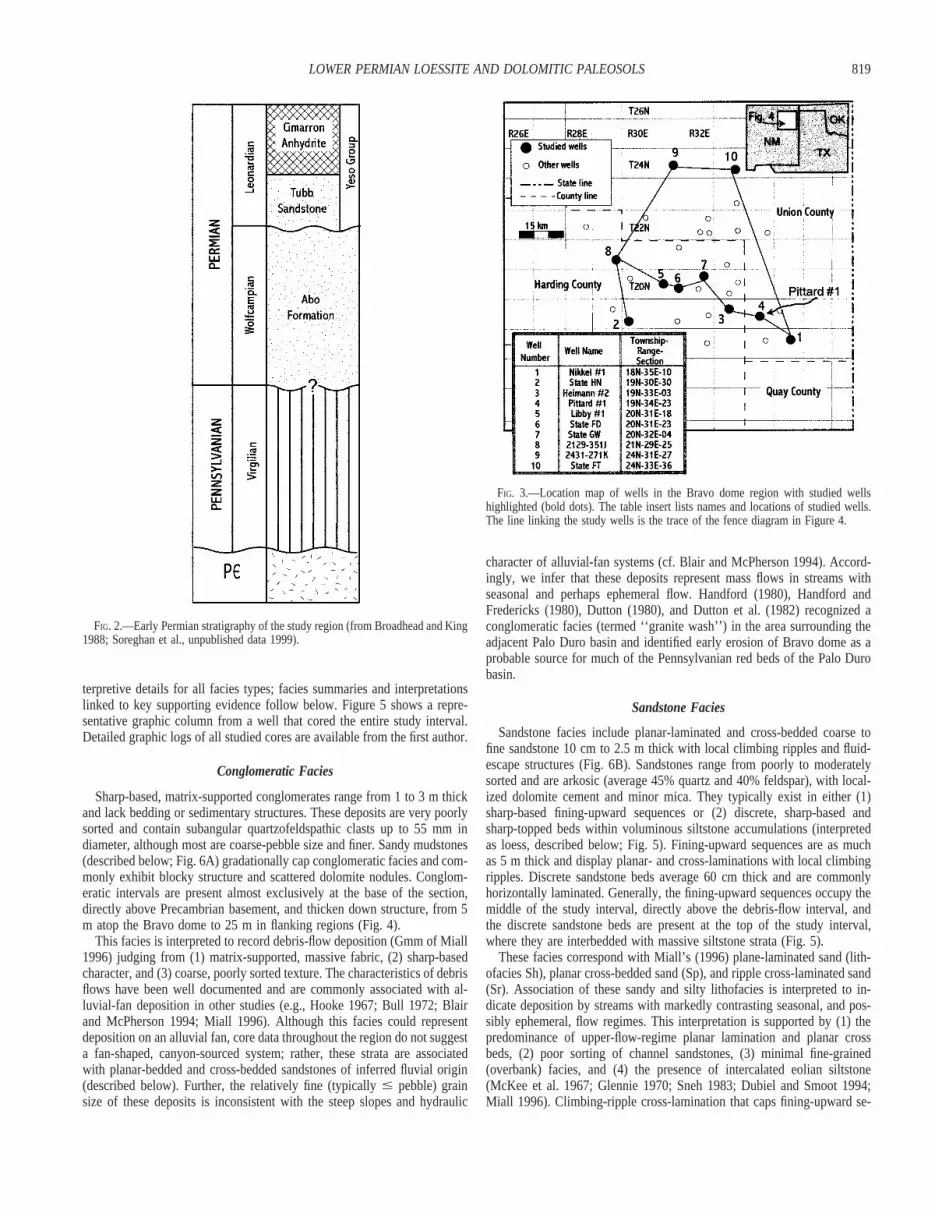
Within the Bravo dome region, the study interval rests nonconformablyon Precambrian basement and is capped by the Cimarron Anhydrite Mem-ber of the Yeso Formation (Leonardian; Fig. 2). The interval of interestincludes the Abo Formation and the superjacent Tubb Sandstone Memberof the Yeso Formation. Typically, dark-red arkosic sandstones of this in-terval are assigned to the Abo Formation, whereas the Tubb Sandstone inthis area consists of orange, quartzose siltstone. Wacker et al. (1995) noted,however, that what was once termed ‘‘Tubb Sandstone’’ in the area is nowrecognized as both Tubb Sandstone and Abo Formation; accordingly wewill hereafter refer to the study interval as the ‘‘Abo–Tubb’’ section. The‘‘Abo–Tubb’’ section irregularly mantles the Bravo dome paleohigh andso varies in thickness considerably (approximately 30–200 m) throughoutthe study area.
The Abo Formation in northeastern New Mexico consists generally offluvial facies (Broadhead and King 1988; Broadhead 1990; Nelis andWacker 1994). Broadhead (1990) suggested a possible beach and/or tidal-flat origin for the Tubb Sandstone over Bravo dome, although lack of

818 J.L.P. KESSLER ET AL.
FIG. 1.—Major late Paleozoic tectonic features(basins and uplifts) in the greater study area,southwestern U.S.A. Patterned areas are uplifts.The boxed region around Bravo dome denotesthe study area detailed in Figure 3. Diagonal lineis approximate 38 N (Asselian, earlyWolfcampian) to 88N (Artinskian, earlyLeonardian) paleolatitude line from Scotese(1999). Paleogeographic features are modifiedfrom Ross and Ross (1986) and Kocurek andKirkland (1998). The inset box displays aZijderveld plot of a loessite sample from theLibby #1 well that shows alternating fielddemagnetization steps from NRM to 120 mT.Each division is E24 A/m. Open squarescorrespond to horizontal component, and solidsquares correspond to vertical component. Thesample is oriented azimuthally, and therefore thedeclination cannot be used for analysis. Note theshallow (horizontal) orientation of the inclinationvector, which indicates a very low-latitude(equatorial) position at the time of magnetization(Early Permian, although later Permianremagnetization is also possible).
access to core or outcrop in the region made this determination difficultand tenuous. As detailed below, we suggest a fluvial and predominantlyeolian origin for the Abo–Tubb interval on Bravo dome.
The Abo–Tubb interval is very poorly fossiliferous and is difficult todate directly. Regional relations suggest a Wolfcampian age for the AboFormation of the study area, although local remnants of Pennsylvanian-aged strata may exist over Bravo dome (Wacker et al. 1995; R. Broadhead,personal communication 1999). Conventionally, the Tubb Sandstone hasbeen assigned an early Leonardian age (cf. Mazzullo et al. 1989). Broad-head and King (1988) suggested a slight disconformity at the Abo–Yesocontact in the Tucumcari basin on the basis of the sharp character of thecontact, although no physical evidence for a disconformity is apparent inthe Bravo dome cores. Sparse palynomorphs recovered from the sectioninclude several clearly reworked Middle Pennsylvanian forms and one in-tact grain consistent with a Late Pennsylvanian/Early Permian age (C. Eble,personal communication 1999). Additionally, apparently volcanic detritalzircons from the uppermost Abo–Tubb interval in one well yielded U–PbSHRIMP (Sensitive High Resolution Ion Microprobe) dates consistent witha maximum depositional age of Late Pennsylvanian to Early Permian(Wolfcampian; Soreghan et al. 2000). The limited available results thusspan the early Wolfcampian to the earliest Leonardian, although one cannotexclude a possible latest Pennsylvanian depositional age for some of thematerial.
METHODS
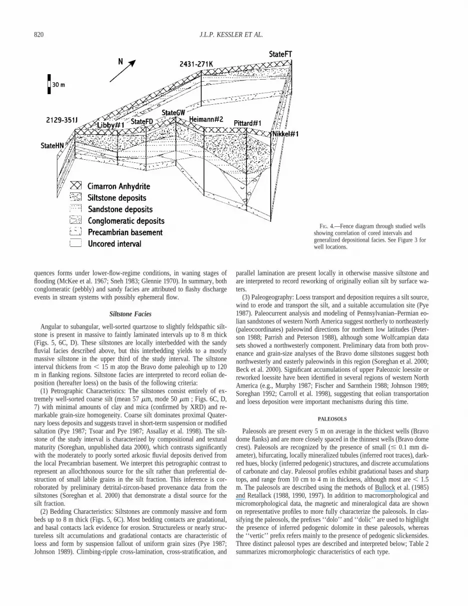
Amoco Production Company (now BP) provided access to slabbed cores,well logs, and selected analytical data (porosity/permeability and grain-sizeanalyses) from the Bravo Dome Carbon Dioxide Field of northeastern NewMexico (Fig. 3). More than 500 m of Abo–Tubb core from ten wells wasstudied; subsurface depths of the study interval range from 600 m (top inshallowest well) to 850 m (base in deepest well). Cores were selected foranalysis on the basis of the completeness of the cored interval and theirlocations relative to ‘‘strike’’ and ‘‘dip’’ transects across the Bravo dome
paleohigh. Selected wells contain only partial cores of the Abo–Tubb in-terval. Cored intervals were hung on the base of the Cimarron Anhydrite,a key paleohorizontal marker in both geophysical well logs and cores (Fig.4).
Cores were described and logged at centimeter-scale resolution to doc-ument lithology, sedimentary structures, pedogenic macromorphology, andcolor (using Munsell color chart), and they were photographed and sam-pled. Thin sections were stained with a potassium ferricyanide/alizarin red-S solution (Dickson 1965) and examined for depositional, diagenetic, andpedogenic features. Detailed phase identification and major-element andtrace-element analyses of selected phases were accomplished using back-scattered electron imaging and energy-dispersive X-ray analysis employinga Cameca SX50 electron microprobe equipped with a Kevex Delta-classEDXA detector with ultra-thin window. Selected (dolomitic) samples werealso examined using a Nuclide Cathodoluminoscope with a beam voltageof 10–12 kV and a beam current of 0.5 to 0.7 mA in a 20 mTorr vacuumunder an air atmosphere.
Four paleosol profiles were selected for detailed mineralogical and mag-netic analyses from the thickest Abo–Tubb section (Pittard #1 well; Fig.3) within the study area, in order to minimize the potential complicationof superimposed paleosol profiles (pedocomplexes). For magnetic analyses,a portable Bartington MS-2 magnetic susceptibility meter was used to ob-tain average drift-corrected, volume-normalized magnetic susceptibility at10 cm intervals under controlled conditions (uniform temperature and in-tersample measurement time). Measurements from core segments that hadbeen subjected to whole-core analysis (involving possible heating) werediscarded. For X-ray diffraction (XRD) analyses, both bulk samples andclay-mineral extracts were examined. Clays were dispersed in distilled wa-ter and then subsequently formed into oriented smears on glass sides. Slideswere then analyzed by a Rigaku Automatic D-Max Diffractometer.
DEPOSITIONAL FACIES
All facies are characterized as either conglomeratic facies, sandstonefacies, or siltstone facies. For simplicity, Table 1 lists descriptive and in-
819LOWER PERMIAN LOESSITE AND DOLOMITIC PALEOSOLS
FIG. 2.—Early Permian stratigraphy of the study region (from Broadhead and King1988; Soreghan et al., unpublished data 1999).
FIG. 3.—Location map of wells in the Bravo dome region with studied wellshighlighted (bold dots). The table insert lists names and locations of studied wells.The line linking the study wells is the trace of the fence diagram in Figure 4.
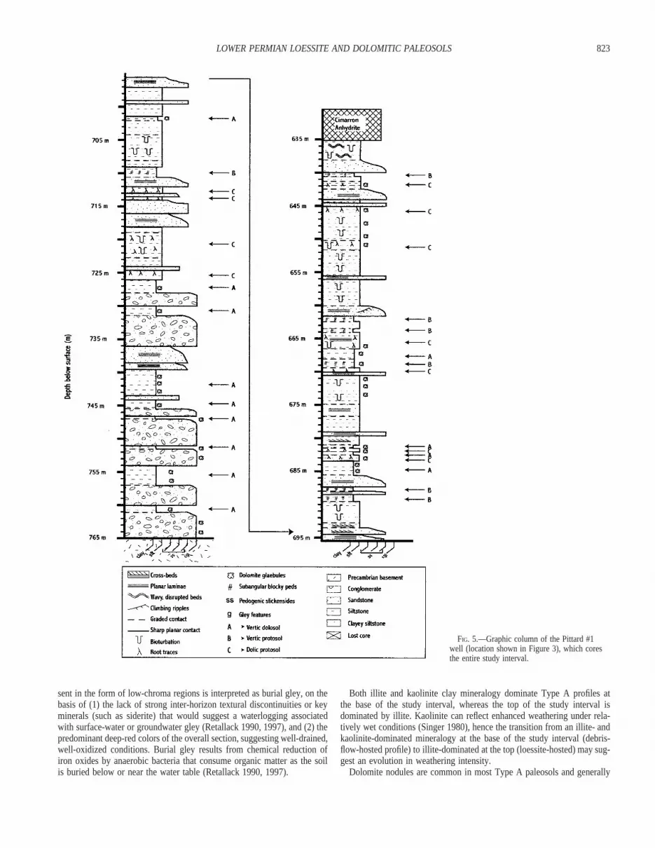
terpretive details for all facies types; facies summaries and interpretationslinked to key supporting evidence follow below. Figure 5 shows a repre-sentative graphic column from a well that cored the entire study interval.Detailed graphic logs of all studied cores are available from the first author.
Conglomeratic Facies
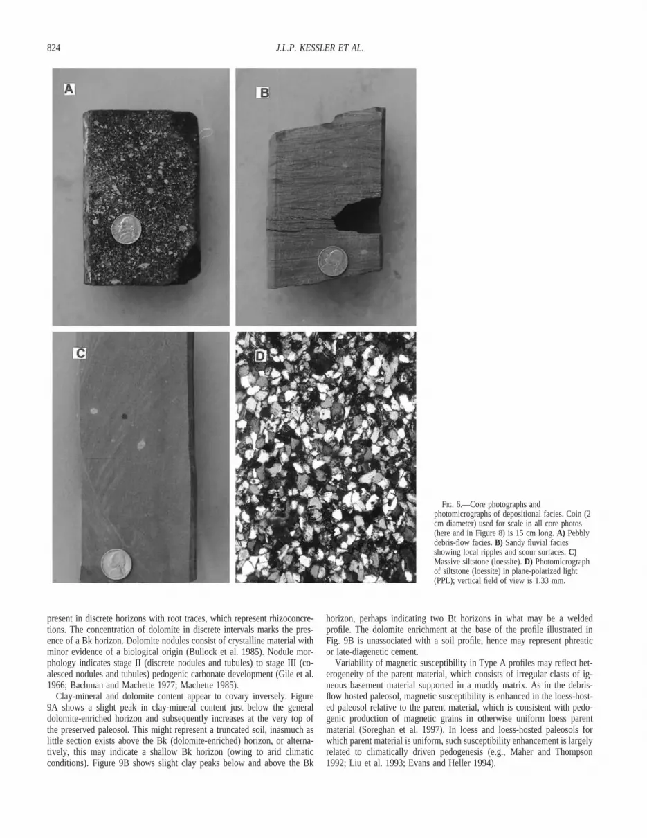
Sharp-based, matrix-supported conglomerates range from 1 to 3 m thickand lack bedding or sedimentary structures. These deposits are very poorlysorted and contain subangular quartzofeldspathic clasts up to 55 mm indiameter, although most are coarse-pebble size and finer. Sandy mudstones(described below; Fig. 6A) gradationally cap conglomeratic facies and com-monly exhibit blocky structure and scattered dolomite nodules. Conglom-eratic intervals are present almost exclusively at the base of the section,directly above Precambrian basement, and thicken down structure, from 5m atop the Bravo dome to 25 m in flanking regions (Fig. 4).
This facies is interpreted to record debris-flow deposition (Gmm of Miall1996) judging from (1) matrix-supported, massive fabric, (2) sharp-basedcharacter, and (3) coarse, poorly sorted texture. The characteristics of debrisflows have been well documented and are commonly associated with al-luvial-fan deposition in other studies (e.g., Hooke 1967; Bull 1972; Blairand McPherson 1994; Miall 1996). Although this facies could representdeposition on an alluvial fan, core data throughout the region do not suggesta fan-shaped, canyon-sourced system; rather, these strata are associatedwith planar-bedded and cross-bedded sandstones of inferred fluvial origin(described below). Further, the relatively fine (typically # pebble) grainsize of these deposits is inconsistent with the steep slopes and hydraulic
character of alluvial-fan systems (cf. Blair and McPherson 1994). Accord-ingly, we infer that these deposits represent mass flows in streams withseasonal and perhaps ephemeral flow. Handford (1980), Handford andFredericks (1980), Dutton (1980), and Dutton et al. (1982) recognized aconglomeratic facies (termed ‘‘granite wash’’) in the area surrounding theadjacent Palo Duro basin and identified early erosion of Bravo dome as aprobable source for much of the Pennsylvanian red beds of the Palo Durobasin.
Sandstone Facies
Sandstone facies include planar-laminated and cross-bedded coarse tofine sandstone 10 cm to 2.5 m thick with local climbing ripples and fluid-escape structures (Fig. 6B). Sandstones range from poorly to moderatelysorted and are arkosic (average 45% quartz and 40% feldspar), with local-ized dolomite cement and minor mica. They typically exist in either (1)sharp-based fining-upward sequences or (2) discrete, sharp-based andsharp-topped beds within voluminous siltstone accumulations (interpretedas loess, described below; Fig. 5). Fining-upward sequences are as muchas 5 m thick and display planar- and cross-laminations with local climbingripples. Discrete sandstone beds average 60 cm thick and are commonlyhorizontally laminated. Generally, the fining-upward sequences occupy themiddle of the study interval, directly above the debris-flow interval, andthe discrete sandstone beds are present at the top of the study interval,where they are interbedded with massive siltstone strata (Fig. 5).
These facies correspond with Miall’s (1996) plane-laminated sand (lith-ofacies Sh), planar cross-bedded sand (Sp), and ripple cross-laminated sand(Sr). Association of these sandy and silty lithofacies is interpreted to in-dicate deposition by streams with markedly contrasting seasonal, and pos-sibly ephemeral, flow regimes. This interpretation is supported by (1) thepredominance of upper-flow-regime planar lamination and planar crossbeds, (2) poor sorting of channel sandstones, (3) minimal fine-grained(overbank) facies, and (4) the presence of intercalated eolian siltstone(McKee et al. 1967; Glennie 1970; Sneh 1983; Dubiel and Smoot 1994;Miall 1996). Climbing-ripple cross-lamination that caps fining-upward se-
820 J.L.P. KESSLER ET AL.
FIG. 4.—Fence diagram through studied wellsshowing correlation of cored intervals andgeneralized depositional facies. See Figure 3 forwell locations.
quences forms under lower-flow-regime conditions, in waning stages offlooding (McKee et al. 1967; Sneh 1983; Glennie 1970). In summary, bothconglomeratic (pebbly) and sandy facies are attributed to flashy dischargeevents in stream systems with possibly ephemeral flow.
Siltstone Facies
Angular to subangular, well-sorted quartzose to slightly feldspathic silt-stone is present in massive to faintly laminated intervals up to 8 m thick(Figs. 5, 6C, D). These siltstones are locally interbedded with the sandyfluvial facies described above, but this interbedding yields to a mostlymassive siltstone in the upper third of the study interval. The siltstoneinterval thickens from , 15 m atop the Bravo dome paleohigh up to 120m in flanking regions. Siltstone facies are interpreted to record eolian de-position (hereafter loess) on the basis of the following criteria:
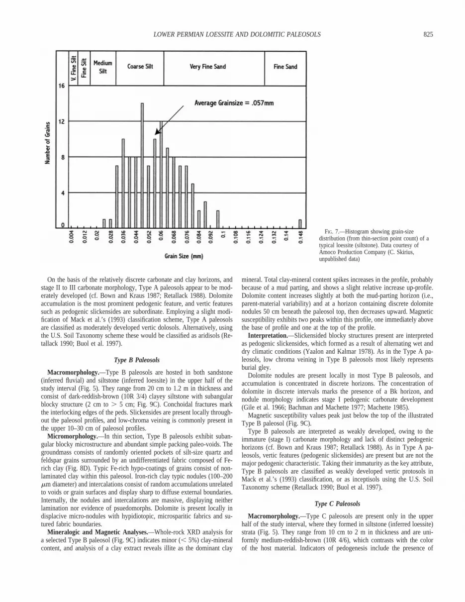
(1) Petrographic Characteristics: The siltstones consist entirely of ex-tremely well-sorted coarse silt (mean 57 mm, mode 50 mm ; Figs. 6C, D,7) with minimal amounts of clay and mica (confirmed by XRD) and re-markable grain-size homogeneity. Coarse silt dominates proximal Quater-nary loess deposits and suggests travel in short-term suspension or modifiedsaltation (Pye 1987; Tsoar and Pye 1987; Assallay et al. 1998). The silt-stone of the study interval is characterized by compositional and texturalmaturity (Soreghan, unpublished data 2000), which contrasts significantlywith the moderately to poorly sorted arkosic fluvial deposits derived fromthe local Precambrian basement. We interpret this petrographic contrast torepresent an allochthonous source for the silt rather than preferential de-struction of small labile grains in the silt fraction. This inference is cor-roborated by preliminary detrital-zircon-based provenance data from thesiltstones (Soreghan et al. 2000) that demonstrate a distal source for thesilt fraction.
(2) Bedding Characteristics: Siltstones are commonly massive and formbeds up to 8 m thick (Figs. 5, 6C). Most bedding contacts are gradational,and basal contacts lack evidence for erosion. Structureless or nearly struc-tureless silt accumulations and gradational contacts are characteristic ofloess and form by suspension fallout of uniform grain sizes (Pye 1987;Johnson 1989). Climbing-ripple cross-lamination, cross-stratification, and
parallel lamination are present locally in otherwise massive siltstone andare interpreted to record reworking of originally eolian silt by surface wa-ters.
(3) Paleogeography: Loess transport and deposition requires a silt source,wind to erode and transport the silt, and a suitable accumulation site (Pye1987). Paleocurrent analysis and modeling of Pennsylvanian–Permian eo-lian sandstones of western North America suggest northerly to northeasterly(paleocoordinates) paleowind directions for northern low latitudes (Peter-son 1988; Parrish and Peterson 1988), although some Wolfcampian datasets showed a northwesterly component. Preliminary data from both prov-enance and grain-size analyses of the Bravo dome siltstones suggest bothnorthwesterly and easterly paleowinds in this region (Soreghan et al. 2000;Beck et al. 2000). Significant accumulations of upper Paleozoic loessite orreworked loessite have been identified in several regions of western NorthAmerica (e.g., Murphy 1987; Fischer and Sarnthein 1988; Johnson 1989;Soreghan 1992; Carroll et al. 1998), suggesting that eolian transportationand loess deposition were important mechanisms during this time.
PALEOSOLS
Paleosols are present every 5 m on average in the thickest wells (Bravodome flanks) and are more closely spaced in the thinnest wells (Bravo domecrest). Paleosols are recognized by the presence of small (# 0.1 mm di-ameter), bifurcating, locally mineralized tubules (inferred root traces), dark-red hues, blocky (inferred pedogenic) structures, and discrete accumulationsof carbonate and clay. Paleosol profiles exhibit gradational bases and sharptops, and range from 10 cm to 4 m in thickness, although most are , 1.5m. The paleosols are described using the methods of Bullock et al. (1985)and Retallack (1988, 1990, 1997). In addition to macromorphological andmicromorphological data, the magnetic and mineralogical data are shownon representative profiles to more fully characterize the paleosols. In clas-sifying the paleosols, the prefixes ‘‘dolo’’ and ‘‘dolic’’ are used to highlightthe presence of inferred pedogenic dolomite in these paleosols, whereasthe ‘‘vertic’’ prefix refers mainly to the presence of pedogenic slickensides.Three distinct paleosol types are described and interpreted below; Table 2summarizes micromorphologic characteristics of each type.

821LOWER PERMIAN LOESSITE AND DOLOMITIC PALEOSOLS
TABLE 1.—Interpretation and description of depositional facies.
Lithofacies Description Genetic Interpretation§ Stratal Position Facies Association Key References
Matrix-supported con-glomerate
DRB*. Massive. Very poorly sorted. Subangularto angular. 1–3 m thick. Sharp base and grada-tional top.
Plastic debris flow de-posit (Gmm)
Lower ⅓ of the study in-terval
Gmm occurs at the base of fining upward se-quences that are capped by pedogenically al-tered Fm deposits
Bull 1972Hooke 1967Buck 1983Miall 1996
Sandy mudstone DRB*. Massive. Very poorly sorted. Subangular.50 cm–4 m thick. Sharp top and gradationalbase.
Overbank (waningflow) deposit (Fm)
Lower ⅓ of the study in-terval
Coarse to fine sandstone MRB†. Planar laminated. Subrounded to angular.Moderately to poorly sorted. 50 cm–2.5 mthick. Occur as (1) sharp-based fining-upwardsequence or (2) discrete, sharp-topped andsharp-based beds interbedded with siltstone.
Upper-flow-regimeplane bed flow de-posit (Sh)
Predominantly middle ⅓of the study intervalwith minor occurrencesin upper ⅓ of the studyinterval.
Fining-upward sequences of Sh are the mostcommon occurrence of ephemeral-stream de-posits. Sr occurs at the top of fining-upwardsequences. Generally, Sp and Sh are not asso-ciated in the same fining-upward sequences.Sp forms sharp-based and sharp-topped thinbeds that are interbedded within loessitic de-posits.
McKee et al. 1967Glennie 1970Turnbridge 1981Sneh 1983Turnbridge 1984Dubiel and Smoot 1994Miall 1996
Coarse to fine sandstone MRB†. Planar cross-bedded. Subrounded to an-gular. Moderately to poorly sorted. 50 cm–1cm thick. Occurs within a sharp-based fining-upward sequence.
Transverse and lin-guoid bedforms(Sp)
Middle ⅓ of the study in-terval
Medium to fine sandstone MRB†. Small-scale climbing ripple bedded. Sub-rounded to rounded. Moderately to well sorted.10–50 cm thick. Gradational top and base.
Lower-flow-regimeripple deposit (Sr)
Upper ½ of the study in-terval
Siltstone MRB†. Common strong parallel-laminated toplanar cross-bedded. Local climbing ripplesand wavy, disrupted beds. Subangular to sub-rounded. Very well sorted. Commonly biotur-bated. 50 cm–4 m thick. Sharp base and gra-dational top.
Fluvially reworkedeolian siltstone
Upper ½ of the study in-terval
Siltstone MRB†. Massive with faint parallel laminations.Subangular to subrounded. Very well sorted.Locally bioturbated. 50 cm–8 m thick. Sharpbase and gradational top.
Eolian siltstone(loess)
Upper ½ of the study in-terval
Loess deposits are commonly capped by paleo-sols. Thin beds of Sh (described above) arecommonly interbedded within loess deposits.
Pye 1987Tsoar and Pye 1987Johnson 1989Soreghan 1992
* DRB 5 Dark-reddish-brown, 10R 3/4 from Munsell color chart† MRB 5 Moderate-reddish-brown, 10R 4/6 from Munsell color chart§ Fluvial descriptive terms of Miall (1996) are applied to lithofacies where appropriate. These are defined as follows: Gmm 5 plastic debris flow, Fm 5 overbank (waning flow) deposits, Sh 5 upper flow regime plane
bed flow deposits, Sp 5 Transverse and linguoid bedforms, Sr 5 Lower-flow-regime ripple deposits.
Type A Paleosols
Macromorphology.—Type A paleosols formed in both conglomeraticand siltstone facies but are most common in the former (Fig. 5). Rangingfrom 20 cm to 4 m in thickness (typically , 2 m), they consist of dark-reddish-brown (10R 3/4), clayey siltstone and muddy to pebbly sandstone,with dolomite nodules and veins, slickensides, and subangular blocky struc-ture (Fig. 8). Dolomite nodules range from , 1 cm to nearly 9 cm indiameter and are present as nodules and vertically oriented cylindrical con-cretions, tubules, or veins. The dolomite is concentrated in discrete horizonsthat typically range from 10 cm to 1.2 m thick, but rarely reach 2 m thick(Fig. 9A, B). Subangular blocky structure consists of irregularly shapedpeds (soil aggregates) with interlocking faces. Low-chroma regions (5G 7/2 to 5B 7/1), although relatively uncommon, are present in the form ofreduction spots and ‘‘hairlike’’ veining throughout the soils, and locally as5 cm to 10 cm horizons at paleosol tops (Fig. 8).
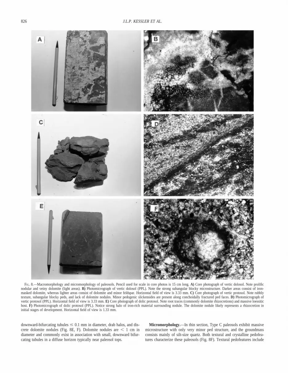
Micromorphology.—In thin section, Type A paleosols display suban-gular blocky microstructure with strongly developed peds and elongate sim-ple packing paleo-voids (Fig. 8). Voids are recognized by the presence ofpedogenic clay material lining a paleo-void. Silt-size quartz and feldspargrains are arranged in a crystallitic fabric and dominate the groundmass.Textural pedofeatures, such as Fe-rich clay coatings on grains and clayvoid infillings, are also present. Crystalline pedofeatures include typic nod-ules of microsparitic dolomite, with local circumgranular cracking. Nodulesare displacive, containing equigranular hypidiotopic (subhedral crystal fab-ric; cf. Bullock et al. 1985) grains with sutured fabric boundaries. Thedolomite ranges from micritic to sparitic with local spheroidal fabric.
Mineralogical and Magnetic Analyses.—Two type A paleosol profiles,one developed in a pebbly sandstone/mudstone (inferred debris-flow) unitand the other in siltstone (inferred loessite), were selected for mineralogicaland magnetic analyses (Fig. 9A, B).
XRD analyses for the debris-flow hosted profile (Fig. 9A) indicate onlyminor (, 5%) clay-mineral content. The clay-mineral content is relatively
consistent in the parent material but increases in discrete intervals in theupper part of the profile. Analysis of a clay extract indicates that illite andkaolinite are the dominant clay minerals in this profile. Dolomite distri-bution is heterogeneous in detail but ultimately confined to a macroscopic-ally discrete horizon in the upper part of the paleosol. Dolomite abundance,as indicated by both macroscopic and XRD analysis, peaks at the top ofthe debris-flow-hosted profile, approximately coincident with a relative re-duction in clay. In general, clay is enriched both above and below thedolomitic interval.
Magnetic susceptibility has been shown to commonly be enhanced inpedogenically altered horizons relative to parent material in studies of bothmodern and ancient soils (e.g., Ozdemir and Banerjee 1982; Singer andFine 1989; Soreghan et al. 1997). The enhancement can be particularlypronounced in loess-hosted soils, where it has been related to formation ofultra-fine-grained (superparamagnetic) magnetic minerals during pedogen-esis (Maher and Taylor 1988; Zhou et al. 1990). The magnetic suscepti-bility pattern for the debris-flow-hosted paleosol is somewhat variable butdisplays an overall increase in susceptibility upward.
Figure 9B shows mineralogic and magnetic analyses of a loess-hostedpaleosol. Clay-mineral content shows a slight enrichment upward withinthe profile and is generally higher in the paleosol relative to the parentloessite. XRD analysis of a clay extract from this profile indicates that illiteis the dominant clay mineral. Dolomite content is enriched in a discrete 30cm horizon near the top of the profile. As in the debris-flow hosted paleo-sol, magnetic susceptibility is significantly enhanced in the loess-hostedpaleosol relative to the parent material. The mineralogic and magnetic sus-ceptibility data all display an inflection at about 1 m above the base of theillustrated profile (Fig. 9B).
Interpretation.—Slickensided blocky structures observed in Type A pa-leosols are interpreted as pedogenic slickensides that formed as a result ofrepeated shrinking and swelling of clays under alternating wet and dryclimatic conditions (Yaalon and Kalmar 1978). Gleying that is locally pre-
822 J.L.P. KESSLER ET AL.
TAB
LE2.
—Pa
leos
olM
icro
mor
phol
ogy*
Pale
osol
Type
†M
icro
stru
ctur
ePe
dalM
ater
ial
Voi
dTy
peG
roun
dmas
sFa
bric
Type
Text
ural
Pedo
feat
ures
Cry
stal
line
Pedo
feat
ures
Mod
erat
ely
deve
lope
dve
rtic
dolo
sol
Or
...
Arid
isol
Suba
ngul
arbl
ocky
Abu
ndan
tand
stro
ngly
deve
l-op
edsu
bang
ular
bloc
kype
ds
Elon
gate
toin
ter-
conn
ecte
dsi
m-
ple
pack
ing
void
s
Coa
rse
mat
eria
l:si
lt-an
dsa
nd-s
ized
quar
tz&
feld
spar
Fine
mat
eria
l:m
icro
-sp
ariti
cdo
lom
ite
Cry
stal
litic
1.Ty
pic
exte
rnal
quas
i-(to
hypo
-)gr
ain
coat
ings
nN
onla
min
ated
ferr
ugin
ous
limpi
dcl
ayn
Diff
use
exte
rnal
boun
darie
sn
Loca
llyab
unda
ntan
dlo
wva
riabi
lity
2.Vo
idin
fillin
gsn
Ferr
ugin
ous
limpi
dcl
ayn
Diff
use
tosh
arp
exte
rnal
boun
darie
sn
Den
seco
mpl
ete
inte
rnal
fabr
icn
Ver
yab
unda
ntan
dlo
wva
riabi
lity
Pure
typi
cdo
lom
iteno
dule
sn
Prim
ary
mic
rosp
ariti
cdo
lom
iten
Diff
use
exte
rnal
boun
darie
sn
Equi
gran
ular
hypi
diot
icin
terv
alfa
bric
with
sutu
red
fabr
icbo
unda
ries
nD
ispl
aciv
en
Prom
inen
tcon
trast
and
low
varia
bilit
y
Wea
kly
deve
lope
dve
rtic
prot
osol
Or
...
Ince
ptis
ol
Suba
ngul
arbl
ocky
Abu
ndan
tand
stro
ngly
deve
l-op
edsu
bang
ular
bloc
kype
ds
Sim
ple
pack
ing
void
sC
oars
em
ater
ial:
silt-
size
dqu
artz
and
mi-
nor
feld
spar
Fine
mat
eria
l:he
mat
itecl
ay
Und
iffer
entia
ted
1.Ty
pic
exte
rnal
hypo
-gra
inco
atin
gsn
Non
lam
inat
edfe
rrug
inou
slim
pid
clay
nD
iffus
eex
tern
albo
unda
ries
nV
ery
abun
dant
and
low
varia
bilit
y2.
Typi
cno
dule
san
dsi
mpl
ein
terc
alat
ions
nN
onla
min
ated
(mas
sive
)fe
rrug
inou
slim
pid
clay
nR
ando
mly
dist
ribut
edn
Shar
pto
diff
use
exte
rnal
boun
darie
sn
No
evid
ence
ofps
eudo
mor
phn
Prom
inen
tcon
trast
and
low
varia
bilit
y
NO
NE
Wea
kly
deve
lope
ddo
licpr
otos
olO
r..
.En
tisol
Mas
sive
Non
eSi
mpl
epa
ckin
gvo
ids
Wel
lsor
ted
silt-
size
dqu
artz
and
min
orfe
ld-
spar
Cry
stal
litic
1.Ty
pic
exte
rnal
quas
i-(to
hypo
-)gr
ain
coat
ings
nN
onla
min
ated
ferr
ugin
ous
limpi
dcl
ayn
Diff
use
exte
rnal
boun
darie
sn
Occ
urlo
cally
and
low
varia
bilit
y2.
Void
infil
lings
nFe
rrug
inou
slim
pid
clay
nD
iffus
eto
shar
pex
tern
albo
unda
ries
nD
ense
com
plet
ein
tern
alfa
bric
nV
ery
abun
dant
and
low
varia
bilit
y
Pure
typi
cdo
lom
iteno
dule
s.n
Prim
ary
mic
rosp
ariti
cdo
lom
iten
Diff
use
tosh
arp
exte
rnal
boun
darie
sn
Equi
gran
ular
hypi
diot
icin
terv
alfa
bric
with
sutu
red
fabr
icbo
unda
ries
nD
ispl
aciv
en
Ass
ocia
ted
with
root
trace
sn
Prom
inen
tcon
trast
and
low
varia
bilit
y
*M
icro
mor
phol
ogy
term
inol
ogy
follo
ws
Bul
lock
etal
.(19
85).
†Pa
leos
olcl
assi
ficat
ions
follo
ws
US
Soil
Surv
ey(1
975)
and
Mac
ket
al.(
1993
).
823LOWER PERMIAN LOESSITE AND DOLOMITIC PALEOSOLS
FIG. 5.—Graphic column of the Pittard #1well (location shown in Figure 3), which coresthe entire study interval.
sent in the form of low-chroma regions is interpreted as burial gley, on thebasis of (1) the lack of strong inter-horizon textural discontinuities or keyminerals (such as siderite) that would suggest a waterlogging associatedwith surface-water or groundwater gley (Retallack 1990, 1997), and (2) thepredominant deep-red colors of the overall section, suggesting well-drained,well-oxidized conditions. Burial gley results from chemical reduction ofiron oxides by anaerobic bacteria that consume organic matter as the soilis buried below or near the water table (Retallack 1990, 1997).
Both illite and kaolinite clay mineralogy dominate Type A profiles atthe base of the study interval, whereas the top of the study interval isdominated by illite. Kaolinite can reflect enhanced weathering under rela-tively wet conditions (Singer 1980), hence the transition from an illite- andkaolinite-dominated mineralogy at the base of the study interval (debris-flow-hosted profile) to illite-dominated at the top (loessite-hosted) may sug-gest an evolution in weathering intensity.
Dolomite nodules are common in most Type A paleosols and generally
824 J.L.P. KESSLER ET AL.
FIG. 6.—Core photographs andphotomicrographs of depositional facies. Coin (2cm diameter) used for scale in all core photos(here and in Figure 8) is 15 cm long. A) Pebblydebris-flow facies. B) Sandy fluvial faciesshowing local ripples and scour surfaces. C)Massive siltstone (loessite). D) Photomicrographof siltstone (loessite) in plane-polarized light(PPL); vertical field of view is 1.33 mm.
present in discrete horizons with root traces, which represent rhizoconcre-tions. The concentration of dolomite in discrete intervals marks the pres-ence of a Bk horizon. Dolomite nodules consist of crystalline material withminor evidence of a biological origin (Bullock et al. 1985). Nodule mor-phology indicates stage II (discrete nodules and tubules) to stage III (co-alesced nodules and tubules) pedogenic carbonate development (Gile et al.1966; Bachman and Machette 1977; Machette 1985).
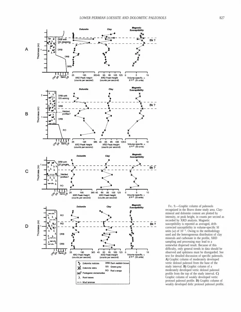
Clay-mineral and dolomite content appear to covary inversely. Figure9A shows a slight peak in clay-mineral content just below the generaldolomite-enriched horizon and subsequently increases at the very top ofthe preserved paleosol. This might represent a truncated soil, inasmuch aslittle section exists above the Bk (dolomite-enriched) horizon, or alterna-tively, this may indicate a shallow Bk horizon (owing to arid climaticconditions). Figure 9B shows slight clay peaks below and above the Bk
horizon, perhaps indicating two Bt horizons in what may be a weldedprofile. The dolomite enrichment at the base of the profile illustrated inFig. 9B is unassociated with a soil profile, hence may represent phreaticor late-diagenetic cement.
Variability of magnetic susceptibility in Type A profiles may reflect het-erogeneity of the parent material, which consists of irregular clasts of ig-neous basement material supported in a muddy matrix. As in the debris-flow hosted paleosol, magnetic susceptibility is enhanced in the loess-host-ed paleosol relative to the parent material, which is consistent with pedo-genic production of magnetic grains in otherwise uniform loess parentmaterial (Soreghan et al. 1997). In loess and loess-hosted paleosols forwhich parent material is uniform, such susceptibility enhancement is largelyrelated to climatically driven pedogenesis (e.g., Maher and Thompson1992; Liu et al. 1993; Evans and Heller 1994).
825LOWER PERMIAN LOESSITE AND DOLOMITIC PALEOSOLS
FIG. 7.—Histogram showing grain-sizedistribution (from thin-section point count) of atypical loessite (siltstone). Data courtesy ofAmoco Production Company (C. Skirius,unpublished data)
On the basis of the relatively discrete carbonate and clay horizons, andstage II to III carbonate morphology, Type A paleosols appear to be mod-erately developed (cf. Bown and Kraus 1987; Retallack 1988). Dolomiteaccumulation is the most prominent pedogenic feature, and vertic featuressuch as pedogenic slickensides are subordinate. Employing a slight modi-fication of Mack et al.’s (1993) classification scheme, Type A paleosolsare classified as moderately developed vertic dolosols. Alternatively, usingthe U.S. Soil Taxonomy scheme these would be classified as aridisols (Re-tallack 1990; Buol et al. 1997).
Type B Paleosols
Macromorphology.—Type B paleosols are hosted in both sandstone(inferred fluvial) and siltstone (inferred loessite) in the upper half of thestudy interval (Fig. 5). They range from 20 cm to 1.2 m in thickness andconsist of dark-reddish-brown (10R 3/4) clayey siltstone with subangularblocky structure (2 cm to . 5 cm; Fig. 9C). Conchoidal fractures markthe interlocking edges of the peds. Slickensides are present locally through-out the paleosol profiles, and low-chroma veining is commonly present inthe upper 10–30 cm of paleosol profiles.
Micromorphology.—In thin section, Type B paleosols exhibit suban-gular blocky microstructure and abundant simple packing paleo-voids. Thegroundmass consists of randomly oriented pockets of silt-size quartz andfeldspar grains surrounded by an undifferentiated fabric composed of Fe-rich clay (Fig. 8D). Typic Fe-rich hypo-coatings of grains consist of non-laminated clay within this paleosol. Iron-rich clay typic nodules (100–200mm diameter) and intercalations consist of random accumulations unrelatedto voids or grain surfaces and display sharp to diffuse external boundaries.Internally, the nodules and intercalations are massive, displaying neitherlamination nor evidence of psuedomorphs. Dolomite is present locally indisplacive micro-nodules with hypidiotopic, microsparitic fabrics and su-tured fabric boundaries.
Mineralogic and Magnetic Analyses.—Whole-rock XRD analysis fora selected Type B paleosol (Fig. 9C) indicates minor (, 5%) clay-mineralcontent, and analysis of a clay extract reveals illite as the dominant clay
mineral. Total clay-mineral content spikes increases in the profile, probablybecause of a mud parting, and shows a slight relative increase up-profile.Dolomite content increases slightly at both the mud-parting horizon (i.e.,parent-material variability) and at a horizon containing discrete dolomitenodules 50 cm beneath the paleosol top, then decreases upward. Magneticsusceptibility exhibits two peaks within this profile, one immediately abovethe base of profile and one at the top of the profile.
Interpretation.—Slickensided blocky structures present are interpretedas pedogenic slickensides, which formed as a result of alternating wet anddry climatic conditions (Yaalon and Kalmar 1978). As in the Type A pa-leosols, low chroma veining in Type B paleosols most likely representsburial gley.
Dolomite nodules are present locally in most Type B paleosols, andaccumulation is concentrated in discrete horizons. The concentration ofdolomite in discrete intervals marks the presence of a Bk horizon, andnodule morphology indicates stage I pedogenic carbonate development(Gile et al. 1966; Bachman and Machette 1977; Machette 1985).
Magnetic susceptibility values peak just below the top of the illustratedType B paleosol (Fig. 9C).
Type B paleosols are interpreted as weakly developed, owing to theimmature (stage I) carbonate morphology and lack of distinct pedogenichorizons (cf. Bown and Kraus 1987; Retallack 1988). As in Type A pa-leosols, vertic features (pedogenic slickensides) are present but are not themajor pedogenic characteristic. Taking their immaturity as the key attribute,Type B paleosols are classified as weakly developed vertic protosols inMack et al.’s (1993) classification, or as inceptisols using the U.S. SoilTaxonomy scheme (Retallack 1990; Buol et al. 1997).
Type C Paleosols
Macromorphology.—Type C paleosols are present only in the upperhalf of the study interval, where they formed in siltstone (inferred loessite)strata (Fig. 5). They range from 10 cm to 2 m in thickness and are uni-formly medium-reddish-brown (10R 4/6), which contrasts with the colorof the host material. Indicators of pedogenesis include the presence of
826 J.L.P. KESSLER ET AL.
FIG. 8.—Macromorphology and micromorphology of paleosols. Pencil used for scale in core photos is 15 cm long. A) Core photograph of vertic dolosol. Note prolificnodular and veiny dolomite (light areas). B) Photomicrograph of vertic dolosol (PPL). Note the strong subangular blocky microstructure. Darker areas consist of iron-masked dolomite, whereas lighter areas consist of dolomite and minor feldspar. Horizontal field of view is 3.33 mm. C) Core photograph of vertic protosol. Note rubblytexture, subangular blocky peds, and lack of dolomite nodules. Minor pedogenic slickensides are present along conchoidally fractured ped faces. D) Photomicrograph ofvertic protosol (PPL). Horizontal field of view is 3.33 mm. E) Core photograph of dolic protosol. Note root traces (commonly dolomite rhizocretions) and massive loessitichost. F) Photomicrograph of dolic protosol (PPL). Notice strong halo of iron-rich material surrounding nodule. The dolomite nodule likely represents a rhizocretion ininitial stages of development. Horizontal field of view is 1.33 mm.
downward-bifurcating tubules # 0.1 mm in diameter, drab halos, and dis-crete dolomite nodules (Fig. 8E, F). Dolomite nodules are , 1 cm indiameter and commonly exist in association with small, downward bifur-cating tubules in a diffuse horizon typically near paleosol tops.
Micromorphology.—In thin section, Type C paleosols exhibit massivemicrostructure with only very minor ped structure, and the groundmassconsists mainly of silt-size quartz. Both textural and crystalline pedofea-tures characterize these paleosols (Fig. 8F). Textural pedofeatures include
827LOWER PERMIAN LOESSITE AND DOLOMITIC PALEOSOLS
FIG. 9.—Graphic column of paleosolsrecognized in the Bravo dome study area. Clay-mineral and dolomite content are plotted byintensity, or peak height, in counts per second asrecorded by XRD analysis. Magneticsusceptibility is reported as averaged, drift-corrected susceptibility in volume-specific SIunits (k) of 1025. Owing to the methodologyused and the heterogeneous distribution of clayminerals and carbonate in the profile, XRDsampling and processing may lead to asomewhat dispersed result. Because of thisdifficulty, only general trends in data should beobserved and spikiness must be disregarded. Seetext for detailed discussion of specific paleosols.A) Graphic column of moderately developedvertic dolosol paleosol from the base of thestudy interval. B) Graphic column of amoderately developed vertic dolosol paleosolprofile from the top of the study interval. C)Graphic column of weakly developed verticprotosol paleosol profile. D) Graphic column ofweakly developed dolic protosol paleosol profile.
828 J.L.P. KESSLER ET AL.
grain and nodule coatings and void infillings. Fe-rich clay is present astypic external hypo-coatings that display diffuse external boundaries. Voidinfillings contain Fe-rich clay in a nonlaminated fabric. Crystalline pedo-features are identified by the presence of typic dolomite nodules that consistof equigranular hypidiotic (subhedral) micritic to microsparitic (# 30 mm;Bullock et. al 1985) dolomite with sutured fabric boundaries and diffuseexternal boundaries (Fig. 8F).
Mineralogic and Magnetic Analyses.—Figure 9D shows a Type C pa-leosol profile, which displays variability in both mineralogic features andmagnetic susceptibility. Clay-mineral content for example, exhibits pro-nounced variability (Fig 9D), although an overall low is present near thetop of the profile, with relative highs immediately above and below this.The general clay low is approximately coincident with a slight high in bothdolomite content and magnetic susceptibility.
Interpretation.—Downward-bifurcating tubules are interpreted as roottraces in these paleosols. As illustrated by the example in Figure 9D, bothmineralogic and magnetic profiles of Type C paleosols display variabilitythat could be related to minor parent-material heterogeneity (e.g., mud lam-inae at 60–80 cm) but also might indicate multiple superimposed (welded)discrete paleosol horizons. Also in Figure 9D, there are two macroscopi-cally discrete horizons with concentrations of root traces, and inflectionson both the magnetic and the mineralogic profiles commonly coincide (at70, 110, and 150–170 cm), suggesting superimposed paleosols.
Morphology of dolomite in Type C paleosols indicate stage I pedogeniccarbonate development (Gile et al. 1966; Bachman and Machette 1977;Machette 1985). Figure 9D shows that dolomite is confined to a discretehorizon, although XRD data appear more diffuse. The overall low degreeof horizonation suggests weak development in Type C paleosols (cf. Bownand Kraus 1987; Retallack 1988). Accordingly, they are classified as weak-ly developed dolic protosols using Mack et al.’s (1993) terminology, andas entisols using the U.S. Soil Taxonomy (Retallack 1990; Buol et al.1997).
Origin of Dolomite
Dolomite is a volumetrically important component of nearly all paleosolsin the study interval, both as discrete nodules that range from , 1 cm tonearly 9 cm in diameter and as coalesced nodules and tubules. The dolo-mitic nodules predominantly displace and locally encase host sediment (i.e.,sand and silt grains). Critical to understanding the significance of dolomiteis discerning between (1) a primary versus secondary (replacement) originand (2) a pedogenic versus phreatic origin.
Primary versus Secondary (Replacement) Origin.—Several petro-graphic observations suggest primary precipitation of dolomite rather thandolomitization of precursor calcite. Petrographically, the dolomite consistspredominantly of micrite to microsparite (# 30 mm), although it locallyreaches coarse crystalline (.100 mm) sizes. Under cathodoluminescence(CL), the dolomite appears a slightly mottled moderate red-orange. In con-trast, pervasive recrystallization and attendant dolomitization tends to resultin widespread crystal coarsening (e.g., Driese et al. 1993) and, potentially,chemical zoning detectable under CL (e.g., Soloman and Walkden 1985).Additionally, transmitted-light microscopy, back-scattered electron micros-copy, and XRD analyses all failed to reveal any trace of a precursor calcitephase. Samples from one well contain some calcite cement, but it is un-associated with dolomite and resides in nonpedogenic horizons. This calcitestains a mauve (ferroan) color, fills primary (intergranular) and secondary(intragranular, within dissolved feldspars) porosity in commonly poikilo-topic fabrics, and is interpreted to record late, localized (fault-associated)calcite cementation. Further, organic matter recovered from the study in-terval records a Thermal Alteration Index of 1 to 2, suggesting maximumburial temperatures of generally , 508 C (C. Eble, personal communication1999), although primary fluid inclusions in a coarsely crystalline dolomitein one thin section yielded homogenization temperatures of approximately
708C. Relatively low burial temperatures are also suggested by oxygenisotopes, which typically exhibit enriched (up to 4‰) d18O values (Sore-ghan and Engel, unpublished data 2000). All indicators suggest low burialtemperatures (consistent with the shallow core depths), which are lowerthan typical temperatures of burial dolomitization (Usdowski 1994). Ac-cordingly, we infer that these temperatures were insufficient for pervasiveburial dolomitization of a calcite precursor. Alternatively, the slightly ele-vated temperatures recorded by the fluid inclusion sample may record localrecrystallization of (precursor) dolomite.
Compositionally, microprobe analysis indicates that the dolomite is onlyslightly calcic (average, Ca(51) Mg(49)), with average trace-element concen-trations of 2958 ppm (Mn) and 552 ppm (Fe). Iron quenches and manga-nese augments luminescence (Machel and Burton 1991; Machel et al.1991), hence moderately bright reddish-orange luminescence is consistentwith relatively low to moderate concentrations of iron and higher concen-trations of manganese. Relatively high Mn in dolomite is consistent withhigh pH (alkalinity) and moderate Eh precipitation conditions, althoughperiodic reduction (suboxic conditions) was probably needed to incorporatesignificant Mn into the dolomite (Krumbein and Garrels 1952; Graham etal. 1988). Mn is reduced at higher reduction potentials than Fe, so it couldpresumably be incorporated into the carbonate more readily than Fe duringbrief episodes of suboxic conditions. Wright and Peeters (1989) docu-mented incorporation of Mn into otherwise highly oxidized carbonate pa-leosols and inferred vacillations in redox conditions during pedogenesis.Pedogenic dolomite is extremely rare but has been reported from soilsformed under saline conditions, in Mg-rich parent material, and under un-usual chemical conditions that cause high Mg:Ca ratios (Cline 1955; Bothaand Hughes 1992; Spotl and Wright 1992; Kohut et al 1995; Capo et al.2000). The mechanism that allowed dolomite formation in Bravo domepaleosols is unresolved and requires further study. Evaporative conditionsand/or eolian input of Mg-rich dust, for example, may have promoted do-lomite precipitation in the studied paleosols.
Pedogenic versus Phreatic Genesis.—Dolomite-rich horizons (‘‘dolo-cretes’’) have been attributed to both pedogenic and phreatic (groundwater)processes. Following Pimental et al. (1996) and Mack et al. (2000), severalkey attributes of the carbonate (in this case, dolomite) suggest a pedogenicrather than phreatic origin:
(1) Dolomite-rich intervals invariably exist in horizons that display in-dependent evidence for pedogenesis, including gradational bases and sharptops, and the presence of root traces, pedogenic slickensides, and ped struc-tures. Vertical alignment of dolomite nodules is present locally and likelyrepresents rhizocretions. Dolomite is not present in ‘‘parent’’ fluvial oreolian facies lacking evidence for pedogenesis.
(2) Dolomite concentrations within the study interval commonly existwithin very fine-grained, relatively impermeable units (e.g., clayey silt-stones), whereas phreatic dolomite typically accumulates in relativelycoarse, permeable horizons (e.g., channel sandstones).
(3) Phreatic dolomite commonly produces thick (up to 10 m), pervasivelycemented layers, whereas dolomite-rich horizons within the studied paleo-sols are typically , 1 m thick and consist of dolomite nodules and veinsconcentrated in a discrete interval near the top of the paleosol profile.
Overprinting of pedogenic carbonate by phreatic processes, however, hasbeen documented (e.g., Spotl and Wright 1992; Pimental et al. 1996; Wil-liams and Krause 1998), and dolomite in the study interval is characterizedby uniform, microsparitic fabrics that resemble ‘‘alpha’’ fabrics that Wright(1990) interpreted as products of groundwater evaporation. Alpha fabricshave, however, also been attributed to pedogenic processes in both modernand fossil soils (e.g., Wright 1982; Allen 1985; Allen 1986; Blodgett 1988).Further, alveolar–septal fabrics of biologic origin (‘‘beta’’ fabrics of Wright1990) are locally present in the studied paleosols, reinforcing a pedogenicinterpretation. Additionally, the predominantly dark-red hues suggest for-mation well above the water table.

829LOWER PERMIAN LOESSITE AND DOLOMITIC PALEOSOLS
FIG. 10.—Schematic paleogeographic modelfor the lower (early Wolfcampian) and upper(early Leonardian) study section in the Bravodome region.
DISCUSSION
Paleoclimatic Significance of Depositional Facies
Red beds can form in both arid and humid regions, although aridity,elevated temperatures, and seasonal precipitation favor their formation(Walker 1967; Schwertmann and Taylor 1977; Dubiel and Smoot 1994).Abundant hematite indicates elevated Eh and pH levels (Dubiel and Smoot1994), suggesting relatively oxidizing conditions typical of arid to season-ally wet climates.
Specific facies and, in particular, temporal evolution of facies throughthe study interval provide more detailed proxies of paleoclimatic parame-ters. Deposition of viscous plastic debris flows (represented by faciesGmm), for example, is favored by abundant sediment and little water,which is typical of arid climatic conditions. Additionally, ephemeral-streamflow is typically restricted to semiarid to arid regions with seasonal pre-cipitation (Dubiel and Smoot 1994; Miall 1996). Intercalation of loessitestrata with the fluvial units provides corroborating evidence for semiarid,windy conditions and a silt source. Confirmed loessite in the Bravo domearea is thick (up to 120 m) and covers an area of nearly 6000 km2 (greaterBravo dome region). Correlative (Lower Permian) strata texturally andcompositionally analogous to this loessite are present as the Red CaveFormation and equivalents throughout the Texas and Oklahoma panhandlesand contiguous regions of eastern Colorado and western Kansas (e.g., PaloDuro basin, Hugoton embayment; Handford 1980; Handford and Fredericks
1980), which covers an area of tens of thousands of square kilometers.Even at 6000 km2, the Bravo dome loessite represents the largest pre-Cenozoic loess field yet documented, and reflects sustained semiaridity ofregional rather than local significance.
In summary, depositional facies throughout the interval record semiarid toseasonally wet conditions; however, they also record a temporal evolution,from predominantly fluvial (gravelly and sandy ephemeral stream) to exclu-sively eolian (loess) facies (Fig. 10). We relate this evolution to a long-termaridification in the study region that was probably driven by both (1) north-ward continental drift from equatorial (# 38 N in early Wolfcampian) to lowlatitudes (# 88 N in early Leonardian), and (2) evolution of the Pangeanmegamonsoon, explored further below. The fluvial-to-eolian transition ob-served in the study area could also reflect a major transformation in thedrainage network to establish an eolian dust source. There is no evidence forsuch a transformation in the regional stratigraphy, however, and no apparentlocal source for the abundant silt. Superimposed on this long-term evolutionis a higher-frequency signal recorded by the abundant paleosols that punc-tuate the interval. Paleosol development, particularly in the loessite section,signals reduced silt influx (a proxy for vegetation cover and/or sedimentavailability) and generally wetter conditions that allowed extensive plant col-onization. Such abrupt, high-frequency alterations between [relatively] wetterand drier conditions at low latitudes have been inferred in upper Paleozoicstrata throughout North America and may be related to glacial (dry)–inter-glacial (wet) fluctuations (Cecil 1990; Soreghan 1994, 1997; Rankey 1997;
830 J.L.P. KESSLER ET AL.
West et al. 1997; Miller and Eriksson 1999). Similarly, Quaternary loess–paleosol couplets of the Chinese Loess Plateau have been correlated to thedeep-sea oxygen isotope record, and thereby linked to glacial–interglacialclimate variations (e.g., Kukla et al. 1988). Alternatively, glacioeustatic risesalone might have caused inundation and stability (with respect to eolian siltentrainment) in many regions surrounding the Bravo dome region, effectivelyeliminating the silt source during highstands.
Paleoclimatic Significance of Pedogenic Features
Soil development is sensitive to climate, but also reflects parent material,topography, organisms, and time (Jenny 1941). Biotic activity varied onlyminimally during the study interval, and interpretations attempt to minimizepossible effects of topography and pedocomplexes by focusing on paleosolsfrom a well located off-structure. Further, both strongly developed verticdolosols and moderately developed vertic protosols are hosted in all facies,suggesting that parent material is not the overriding control on their de-velopment. Relative maturation is inferred on the basis of attributes suchas the presence and degree of horizonation, carbonate accumulation anddevelopment, color intensity, presence and intensity of pedogenic structure,and obliteration of original sedimentary features (cf. Bown and Kraus 1987;Retallack 1988; Wright 1992). Estimated time of development for variouspedogenic features (e.g., vertic features, carbonate morphology, horizona-tion; cf. Buol et al. 1997; Gile et al. 1981; Birkeland 1999; Wilding andTessier 1988) suggests that weakly developed vertic protosols could haveformed in , 103 yr and that moderately developed vertic dolosols couldhave formed in 103 to 105 yr. From these points, and following many others(e.g., Retallack 1990; Mack and James 1992), there is close associationbetween the characteristics of mature paleosols and climatic regime. Hence,specific features (enumerated below) of the mature paleosols in the studysection can provide details of climatic conditions during paleosol forma-tion.
(1) Although pedogenic dolomite is rare and controversial, documentedcases have been associated with geochemical conditions that produce highMg/Ca ratios. Favorable conditions for elevating Mg/Ca ratios includehighly evaporative environments, variable (high) water tables, and forma-tion in Mg-rich parent materials (e.g., Sherman et al. 1962; Sobecki andKarathanasis 1987; Botha and Hughes 1992; Spotl and Wright 1992; Kohutet al. 1995; Capo et al. 2000). Windborne gypsiferous dust from Palo Durotidal flats may have provided a source for Mg and thereby dolomite in thestudy area. Significant Mn in the dolomite supports the inference of sea-sonality, inasmuch as periodic suboxic conditions would facilitate incor-poration of Mn into the dolomite (cf. Wright and Peeters 1989).
(2) Pedogenic slickensides and subangular blocky peds are present inthe studied paleosols; they form by repeated shrinking and swelling of clayminerals under conditions of seasonal wetting and drying (Yaalon and Kal-mar 1978). Vertic features present in paleosols throughout the study sectioncorroborate other evidence for seasonality.
(3) Clay mineralogy is often linked with climate in modern soils; XRDanalysis of paleosols from both the bottom and the top of the study intervalindicates minor amounts of clay minerals, consisting predominantly of illitebut with subordinate kaolinite in the basal section. The higher ratio ofkaolinite to illite in paleosols at the base of the study interval is interpretedto record [relatively] wetter (more intense weathering) conditions than pa-leosols higher in the study interval, although the kaolinite could alterna-tively reflect inheritance from an earlier, wetter, climatic regime becauseweathering can be affected by climatic as well as nonclimatic variables(Singer 1980). Given this, the kaolinitic clay mineralogy in the basal TypeA paleosol profile (Fig. 9A) hosted on material derived from weatheredPrecambrian basement could reflect an earlier climate regime. However,the absence of kaolinite in the loess-derived paleosols does imply a lackof intense weathering, suggesting drier conditions during the time con-strained by the loess-derived paleosols.
In summary, climatic interpretations derived from pedogenic featuresagree with interpretations derived from depositional facies. Both indicaterelatively arid but seasonally wet conditions in the lower part of the section(early Wolfcampian) that progressively evolved to markedly arid conditionsin the upper section (early Leonardian).
Implications for Early Permian Climate of Western Equatorial Pangea
During the time represented by the Abo–Tubb interval, the Bravo domeregion lay at equatorial (# 38N, early Wolfcampian) to very low latitudes(# 88N, early Leonardian), within the ‘‘equatorial and tropical everwet bi-ome’’ as described by Ziegler (1990). According to Ziegler (1990), land areasbetween 108N and S of the equator should have experienced everwet con-ditions, yet depositional and pedogenic evidence record seasonally wet tomarkedly arid conditions from earliest Permian (possibly latest Pennsylva-nian?) to late Early Permian time. Briden and Irving (1964) first documentedthe anomalous juxtaposition of arid proxy indicators at equatorial latitudesfor late Paleozoic time, whereas Robinson (1973) later described Pangea’sclimate as monsoonal. Parrish (1993) explicitly attributed equatorial aridityin Pangea to monsoonal circulation, which is supported by both modelingstudies (e.g., Nairn and Smithwick 1976; Parrish et al. 1982; Kutzbach andGallimore 1989; Patzkowsky et al. 1991) and geologic data (e.g., Parrish andPeterson 1988; Dubiel et al. 1991; Parrish 1995; Dubiel et al. 1996). Parrish(1993) suggested that the shift from a more zonal circulation during thePennsylvanian to increasingly monsoonal circulation in the Permian wouldhave resulted in equatorial aridity and marked seasonality. Many studies havepreviously documented a long-term aridification of low-latitude Pangea fromPennsylvanian to Permian time (e.g., Mack et al. 1979; Phillips et al. 1985;Rowley et al. 1985; Witzke 1990), and to some extent, a temporal trend ofaridification in any given low northern latitude region would be expectedfrom the northward drift of Pangea into the low-latitude arid belt. But thearidification documented here and in other studies took place entirely withinthe equatorial region and so reflects a significant climatic shift. Depositionaland pedogenic data from this study corroborate previous interpretations andmodel results and help constrain the timing of northern monsoonal onset tolatest Pennsylvanian–earliest Permian time.
SUMMARY
(1) Lower Permian (early Wolfcampian to early Leonardian) strata ofnortheastern New Mexico consist of matrix-supported, arkosic, pebbly con-glomerate and poorly sorted arkosic sandstone of fluvial origin and well-sorted massive siltstone of eolian origin (loessite). The loessite is thick (upto 120 m) and widespread (. 6000 km2), and represents the areally mostextensive pre-Cenozoic loess succession yet documented. Paleosols are pre-sent throughout the study interval and consist of dolosols, and dolomiticprotosols that commonly exhibit proxy indicators of seasonality in moistregimes (e.g., vertic features). Primary pedogenic dolomite is rare but is avolumetrically significant component of the studied paleosols.
(2) Interpretation of both depositional and pedogenic facies indicate sea-sonally wet to arid or semiarid conditions in this equatorial region through-out Early Permian time. Moreover, a long-term aridification trend fromearly Wolfcampian to early Leonardian time is recorded by the temporalevolution from fluvial to eolian strata and concomitant changes in pedo-genic character. At a higher temporal frequency, pedogenic developmentthroughout the stratigraphic section suggests episodic alteration from drierconditions that favored loess deposition to relatively wetter conditions thatfavored stability and pedogenesis. Such climatic changes may be related toglacial–interglacial cycles and corresponding changes in sea level that like-ly affected both silt source regions and landscape–vegetation relations withthe study area. If so, the record described here would represent a low-latitude response to glacial–interglacial scale climatic forcing.
(3) These data corroborate inferences of monsoon-induced equatorial
831LOWER PERMIAN LOESSITE AND DOLOMITIC PALEOSOLS
aridity in western Pangea and help constrain timing of the zonal-to-mon-soonal transition to earliest Permian time.
ACKNOWLEDGMENTS
This work is an outgrowth of JLPK’s M.S. thesis, supervised by GSS, and re-viewed by D. Elmore, K. Johnson, and M. Soreghan. JLPK thanks the Universityof Oklahoma (School of Geology and Geophysics), Phillips Petroleum Company,Amoco Foundation, and Conoco Inc. for fellowship and scholarship support duringher graduate studies. Partial support for this research was also provided by grantsfrom the American Association of Petroleum Geologists (grant-in-aid to JLPK),National Science Foundation (EAR-9805130 to GSS), and Conoco, Inc. (YoungProfessor Grant to GSS). We thank P. Jarrell and others at Amoco Production Com-pany (now BP), who provided permission for study, sampling, and publication ofdata from the Bravo Dome Carbon Dioxide Field, and to personnel at Amoco’sTulsa Core Facility (J. Denton, S. Richard) for aid in core layout and sampling.Critical analytical and technical support at the University of Oklahoma was providedby R. Conlon (thin section and XRD labs), G. Morgan (microprobe lab), and S.Seals (sample preparation). Many thanks to C. Eble (Kentucky Geological Survey)for palynological processing and analysis, R. Broadhead and F. Kottlowski (NewMexico Bureau of Mines and Mineral Resources) for discussions on the Pennsyl-vanian–Permian of northeastern New Mexico, and S. Driese, G. Mack, and G. Re-tallack for enduring countless questions regarding paleosols. J. Haggerty (Universityof Tulsa) and B. Kirkland (University of Texas) kindly provided access to CL mi-croscopes, and B. Goldstein (University of Kansas) kindly helped with a preliminaryfluid-inclusion analysis. We also thank reviewers M. Kraus, M. Blum, J. Mason, R.Dubiel, and Technical Editor J. Southard for constructive comments that substan-tially improved the manuscript. Finally, JLPK extends many thanks to N. Kesslerfor personal support throughout her studies at the University of Oklahoma.
REFERENCES
ALLEN, B.L., 1985, Micromorphology of aridisols, in Douglas, L.A., and Thompson, M.L.,eds., Soil Micromorphology and Soil Classification: Soil Science Society of America, Spe-cial Publication 15, p. 197–216.
ALLEN, J.R.L., 1986, Pedogenic calcretes in the Old Red Sandstone facies of the Anglo–Welsharea, southern Britain, in Wright, V.P., ed., Paleosols: Their Recognition and Interpretation:Oxford, U.K., Blackwell Scientific, p. 58–86.
ASSALLAY, A.M., ROGERS, C.D.F., SMALLEY, I.J., AND JEFFERSON, I.F., 1998, Silt: 2–62 mm, 9–4f: Earth-Science Reviews, v. 45, p. 61–88.
BACHMAN, G.D., AND MACHETTE, M.N., 1977, Calcic soils and calcretes in the southwesternUnited States: U.S. Geological Survey, Open-File Report 77–794, 163 p.
BECK, W.C., SOREGHAN, G.S., AND SOREGHAN, M.J., 2000, Paleowinds inferred from grain-sizetrends in Permian loessite of northeastern New Mexico (abstracts): Geological Society ofAmerica, Annual Meeting, Abstracts with Programs, v. 32, p. A-255.
BIRKELAND, P.W., 1999, Soils and Geomorphology, Third Edition: New York, Oxford Univer-sity Press, 430 p.
BLAIR, T.C., AND MCPHERSON, J.G., 1994, Alluvial fans and their natural distinction from riversbased on morphology, hydraulic processes, sedimentary processes, and facies assemblages:Journal of Sedimentary Research, v. A64, p. 450–489.
BLODGETT, R.H., 1988, Calcareous paleosols in the Triassic Dolores Formation, southwesternColorado: in Reinhardt, J., and Sigleo, W.R., eds., Paleosols and Weathering through Geo-logic Time: Techniques and Applications: Geological Society of America, Special Paper216, p. 103–121.
BOTHA, G.A., AND HUGHES, J.C., 1992, Pedogenic palygorskite and dolomite in a late sedimen-tary succession, northwestern Transvaal, South Africa: Geoderma, v. 53, p. 139–154.
BOWN, T.M., AND KRAUS, M.J., 1987, Integration of channel and floodplain suites, I. Devel-opmental sequence and lateral relations of alluvial paleosols: Journal of Sedimentary Pe-trology, v. 57, p. 587–601.
BRIDEN, J.C., AND IRVING, E., 1964, Paleolatitude spectra of sedimentary paleoclimatic indicators,in Nairn, A.E.M., ed., Problems in Paleoclimatology: London, Wiley, p. 199–224.
BROADHEAD, R.F., 1990, Bravo dome carbon dioxide field, in Beaumont, E.A., and Foster,N.H., eds., Structural Traps I, Tectonic Fold Traps: American Association of PetroleumGeologists, Treatise of Petroleum Geology, Atlas of Oil and Gas Fields, p. 213–232.
BROADHEAD, R.F., AND KING, W.E., 1988, Petroleum geology of Pennsylvanian and LowerPermian strata, Tucumcari basin, east-central New Mexico: New Mexico Bureau of Minesand Mineral Resources, Bulletin 119, 75 p.
BUCK, S.G., 1983, The Saiplass Quartzite Member: a braided system of gold and uraniumbearing channel placers within the Proterozoic Wiwatersan Supergroup of South Africa, inCollinson, J.D., and Lewin, J., eds., Modern and ancient fluvial systems: International As-sociation of Sedimentologists, Special Publication, v. 6, p. 549–562.
BULL, W.B., 1972, Recognition of alluvial fan deposits in the stratigraphic record, in Rigby,J.K., and Hamblin, W.K., eds., Recognition of Ancient Sedimentary Environments: SEPM,Special Publication 16, p. 63–83.
BULLOCK, P., FEDEROFF, N., JONGERIUS, A., STOOPS, G., AND TURSINA, T., 1985, Handbook for soilthin section description: Albrighton, Waine Research Publications, 152 p.
BUOL, S.W., HOLE, F.D., MCCRACKEN, R.J., AND SOUTHARD, R.J., 1997, Soil Genesis and Clas-sification, Fourth Edition: Ames, Iowa, Iowa State University Press, 527 p.
CAPO, R.C., WHIPKEY, C.E., BLACHEVE, J.R., AND CHADWICK, O.A., 2000, Pedogenic origin ofdolomite in a basaltic weathering profile, Kohala Peninsula, Hawaii: Geology, v. 28, p. 271–274.
CARROLL, A.R., STEPHENS, N.P., HENDRIX, M.S., AND GLENN, C.R., 1998, Eolian-derived siltstonein the Upper Permian Phosphoria Formation: implications for marine upwelling: Geology,v. 26, p. 1023–1026.
CECIL, C.B., 1990, Paleoclimate controls on stratigraphic repetition of chemical and siliclasticrocks: Geology, v. 18, p. 533–536.
CHAN, M.A., 1999, Triassic loessite of North-central Utah: Stratigraphy, petrophysical char-acter, and paleoclimatic implications: Journal of Sedimentary Research, v. 69, p. 447–485.
CLINE, M.G., 1955, Soil survey of the territory of Hawaii: U.S. Department of Agriculture,Soil Survey Series 1939, v. 25, 664 p.
DICKSON, J.A.D., 1965, A modified staining technique for carbonates in thin section: Nature,v. 205, p. 587.
DRIESE, S.G., MORA, C.I., AND COTTER, E., 1993, Buffalo Mountain paleosol, Duncannon Mem-ber of Catskill Formation (Upper Devonian) near Newport, PA, in Driese, S.G., Paleosols,Paleoclimate, and Paleoatmospheric CO2; Paleozoic Paleosols of Central Pennsylvania: Uni-versity of Tennessee, Department of Geological Sciences, Studies in Geology 22, p. 50–66.
DUBIEL, R.F., HUNTOON, J.E., CONDON, S.M., AND STANESCO, J.D., 1996, Permian deposystems,paleogeography, and paleoclimate of the Paradox basin and vicinity, in Longman, M.W.,and Sonnenfeld, M.D., eds., Paleozoic Systems of the Rocky Mountain Region: SEPM,Rocky Mountain Section, p. 427–444.
DUBIEL, R.F., PARRISH, J.T., PARRISH, J.M., AND GOOD, S.C., 1991, The Pangaean megamon-soon—Evidence from the Upper Triassic Chinle Formation, Colorado Plateau: PALAIOS,v. 6, p. 347–370.
DUBIEL, R.F., AND SMOOT, J.P., 1994, Criteria for interpreting paleoclimate from red beds—atool for Pangean reconstructions, in Embry, A.E., Beauchamp, B., and Glass, D.J., eds.,Pangea: Global Environments and Resources: Canadian Society of Petroleum Geologists,Memoir 17, p. 295–310.
DUTTON, S.P., 1980, Depositional systems and hydrocarbon resource potential of the Pennsyl-vanian system, Palo Duro and Dalhart basins, Texas Panhandle: The University of Texas atAustin, Bureau of Economic Geology, Geological Circular 80–8, 49 p.
DUTTON, S.P., GOLDSTEIN, A.G., AND RUPPEL, S.C., 1982, Petroleum potential of the Palo Durobasin, Texas Panhandle: The University of Texas at Austin, Bureau of Economic Geology,Report of Investigations no. 123, 87 p.
EVANS, M.E., AND HELLER, F., 1994, Magnetic enhancement and palaeoclimate: study of a loess/palaeosol couplet across the Loess Plateau of China: Geophysical Journal International, v.117, p. 257–264.
FISCHER, A.G., AND SARNTHEIN, M., 1988, Airborne silts and dune-derived sands in the Permianof the Delaware basin: Journal of Sedimentary Petrology, v. 58, p. 637–643.
GILE, L.H., HAWLEY, J.W., AND GROSSMAN, R.B., 1981, Soils and geomorphology in the Basinand Range area of southern New Mexico—guidebook to the Desert Project: New MexicoBureau of Mines and Mineral Resources, Memoir 39, 222 p.
GILE, L.H., PETERSON F.F., AND GROSSMAN, R.B., 1966, Morphological and genetic sequencesof carbonate accumulation in desert soils: Soil Science, v. 101, p. 347–360.
GLENNIE, K.W., 1970, Desert Sedimentary Environments: Amsterdam, Elsevier, Developmentsin Sedimentology 14, 222 p.
GRAHAM, R.D., HANNAM, R.J., AND UREN, N.C., EDS., 1988, Manganese in Soils and Plants:Dordrecht, The Netherlands, Kluwer Academic Publishers, 344 p.
HANDFORD, C.R., 1980, Lower Permian facies of the Palo Duro basin, Texas: depositionalsystems, shelf-margin evolution, paleogeography, and petroleum potential: The Universityof Texas at Austin, Bureau of Economic Geology, Report of Investigations Number 102,31 p.
HANDFORD, C.R., AND FREDERICKS, P.E., 1980, Facies patterns and depositional history of aPermian sabkha complex: Red Cave Formation, Texas Panhandle: The University of Texasat Austin, Bureau of Economic Geology, Geological Circular 80–9, 38 p.
HOOKE, R.LEB., 1967, Processes on arid-region fans: Journal of Geology, v. 75, p. 438–460.JENNY, H., 1941, Factors of Soil Formation: New York, McGraw-Hill, 281 p.JOHNSON, S.Y., 1989, Significance of loessite in the Maroon Formation (middle Pennsylvanian
to lower Permian), Eagle basin, Northwest Colorado: Journal of Sedimentary Petrology, v.59, p. 782–791.
KOCUREK, G. AND KIRKLAND, B.L., 1998, Getting to the source: aeolian influx to the PermianDelaware basin region: Sedimentary Geology, v. 117, p. 143–149.
KOHUT, C., MUEHLENBACHS, K., AND DUDAS, M.J., 1995, Authigenic dolomite in a saline soil inAlberta, Canada: Soil Science Society of America, Journal, v. 59, p. 1499–1504.
KRUMBEIN, W.C., AND GARRELS, R.M., 1952, Origin and classification of chemical sediments interms of pH and oxidation-reduction potential: Journal of Geology, v. 60, p. 1–33.
KUKLA, G., HELLER, F., MING, L.X., CHUN, X.T., SHENG, L.T., AND SHENG, A.Z., 1988, Pleistoceneclimates in China dated by magnetic susceptibility: Geology, v. 16, p. 811–814.
KUTZBACH, J.E., AND GALLIMORE, R.G., 1989, Pangaean climates—megamonsoons of the me-gacontinent: Journal of Geophysical Research, v. 94, p. 3341–3357.
LIU, X.M., SHAW, J., LIU, T.S., AND HELLER, F., 1993, Magnetic susceptibility of the Chineseloess–paleosol sequence: environmental change and pedogenesis: Geological Society ofLondon, Journal, v. 150, p. 583–588.
MACHEL, H.G., AND BURTON, E.A., 1991, Factors governing cathodoluminescence in calcite anddolomite, and their implications for studies of carbonate diagenesis, in Barker, C.E., andKopp, O.C., eds., Luminescence Microscopy: Quantitative and Qualitative Aspects: SEPM,Short Course 25, p. 37–57.
MACHEL, H.G., MASON, R.A., MARIANO, A.N., AND MUCCI, A., 1991, Causes and emissions of
832 J.L.P. KESSLER ET AL.
luminescence in calcite and dolomite, in Barker, C.E., and Kopp, O.C., eds., LuminescenceMicroscopy: Quantitative and Qualitative Aspects: SEPM, Short Course 25, p. 9–25.
MACHETTE, M.N., 1985, Calcic soils of southwestern United State: Geological Society of Amer-ica, Special Paper 203, p. 1–21.
MACK, G.H., COLE, D.R., AND TREVINO, L., 2000, The distribution and discrimination of shallow,authigenic carbonate in the Pliocene–Pleistocene Palomas Basin, southern Rio Grande rift:Geological Society of America, Bulletin, v. 112, p. 643–656.
MACK, G.H., AND JAMES, W.C., 1992, Paleosols for Sedimentologists: Geological Society ofAmerica, Short Course Manual, 127 p.
MACK, G.H., JAMES, W.C., AND MONGER, H.C., 1993, Classification of paleosols: GeologicalSociety of America, Bulletin, v. 105, p. 129–136.
MACK, G.H., SUTTNER, L.J., AND JENNINGS, J.R., 1979, Permo–Pennsylvanian climatic trends inthe Ancestral Rocky Mountains, in Baars, D.L., ed., Permianland: Four Corners GeologicalSociety, Field Symposium Guidebook, v. 9, p. 7–12.
MAHER, B.A., AND TAYLOR, R.M., 1988, Formation of ultra-fine-grained magnetite in soils:Nature, v. 336, p. 368–371.
MAHER, B.A., AND THOMPSON, R., 1992, Paleoclimatic significance of the mineral magneticrecord of the Chinese loess and paleosols: Quaternary Research, v. 37, p. 155–170.
MAZZULLO, S.J., HIPKE, W.E., WIEDEMEIR, T.H., WINGATE, T.P., GAYLORD, M.G., AND REID, A.M.,1989, Dynamic stratigraphy of the Tubb and Dean formations (Early Permian), northernMidland basin, Texas: West Texas Geological Society, Bulletin, v. 29, p. 5–11.
MCKEE, E.D., CROSBY, E.J., AND BERRYHILL, H.L., JR., 1967, Flood deposits, Bijou Creek, Col-orado, June 1965: Journal of Sedimentary Petrology, v. 37, p. 829–851.
MIALL, A.D., 1996, The Geology of Fluvial Deposits: Sedimentary Facies, Basin Analysis, andPetroleum Geology: Berlin, Springer-Verlag, 582 p.
MILLER, D.J., AND ERIKSSON, K.A., 1999, Linked sequence development and global change: TheUpper Mississippian record in the Appalachian basin: Geology, v. 27, p. 35–38.
MURPHY, K., 1987, Eolian origin of upper Paleozoic red siltstones at Mexican Hat and DarkCanyon, southeastern Utah [unpublished M.S. thesis]: Lincoln, Nebraska, University of Ne-braska, 128 p.
NAIRN, A.E.M., AND SMITHWICK, M.E., 1976, Permian paleogeography and climatology, in Falke,H., ed., The Continental Permian in Central, West, and South Europe: Boston, D. Reidel,p. 283–312.
NELIS, M.K., AND WACKER, H.J., 1994, Depositional and diagenetic controls on porosity inPermian Abo and Tubb sandstones, northeastern New Mexico (abstract): American Asso-ciation of Petroleum Geologists and SEPM, Annual Meeting Abstracts, v. 3, p. 222.
OZDEMIR, O., AND BANERJEE, S.K., 1982, A preliminary magnetic study of soil samples fromwest-central Minnesota: Earth and Planetary Science Letters, v. 59, p. 393–403.
PARRISH, J.T, 1993, Climate of the supercontinent Pangea: Journal of Geology, v. 101, p. 215–233.
PARRISH, J.T., 1995, Geologic evidence of Permian climate, in Scholle, P.A., Peryt, T.M., andUlmer-Scholle, D.S., eds., The Permian of Northern Pangea: Berlin, Springer-Verlag, p. 53–61.
PARRISH, J.T., AND PETERSON, F., 1988, Wind directions predicted from global circulation modelsand wind directions determined from eolian sandstones of the western United States—Acomparison: Sedimentary Geology, v. 56, p. 261–282.
PARRISH, J.T., ZIEGLER, A.M., AND SCOTESE, C.R., 1982, Rainfall patterns and the distribution ofcoals and evaporites in the Mesozoic and Cenozoic: Palaeogeography, Palaeoclimatology,Palaeoecology, v. 40, p. 67–101.
PATZKOWSKY, M.E., SMITH, L.H., MARKWICK, P.J., ENGBERTS, C.J., AND GYLLENHAAL, E.D., 1991,Application of the Fujita-Ziegler paleoclimate model: Early Permian and Late Cretaceousexamples: Palaeogeography, Palaeoclimatology, Palaeoecology, v. 86, p. 67–85.
PETERSON, F., 1988, Pennsylvanian to Jurassic eolian transportation systems in the westernUnited States: Sedimentary Geology, v. 56, p. 207–260.
PHILLIPS, T.L., PEPPER, R.A., AND DIMICHELE, W.A., 1985, Stratigraphic and interregional changesin Pennsylvanian coal-swamp vegetation: environmental inferences: International Journal ofCoal Geology, v. 5, p. 43–109.
PIMENTAL, N.L., WRIGHT, V.P., AND AZEVEDO, T.M., 1996, Distinguishing early groundwateralteration effects from pedogenesis in ancient alluvial basins: examples from the Paleogeneof southern Portugal: Sedimentary Geology, v. 105, p. 1–10.
PYE, K., 1987, Aeolian Dust and Dust Deposits: London, Academic Press, 334 p.RANKEY, E.C., 1997, Relations between relative changes in sea level and climate shifts: Penn-
sylvanian–Permian mixed carbonate–siliclastic strata, western United States: Geological So-ciety of America, Bulletin, v. 109, p. 1089–1100.
RETALLACK, G.J., 1988, Field recognition of paleosols, in Reinhardt, J. and Sigleo, W.R., eds.,Paleosols and Weathering through Geologic Time: Techniques and Applications: GeologicalSociety of America, Special Paper 216, p. 1–20.
RETALLACK, G.J., 1990, Soils of the Past: An Introduction to Paleopedology: Boston, Unwin-Hyman, 520 p.
RETALLACK, G.J., 1997, A colour guide to paleosols: Chichester, U.K., Wiley, 175 p.ROBERTS, J.W., BARNES, J.J., AND WACKER, H.J., 1976, Subsurface Paleozoic stratigraphy of the
northeastern New Mexico basin and arch complex, in Ewing, R.C., and Kues, B.S., eds.,Guidebook of Vermejo Park, northeastern New Mexico: New Mexico Geological Society,Guidebook 27, p. 141–152.
ROBINSON, P.L., 1973, Paleoclimatology and continental drift, in Tarling, D.H., and Runcorn,S.K., eds., Implications of Continental Drift to the Earth Sciences, I: London, AcademicPress, p. 449–476.
ROSS, C.A., AND ROSS, J.R.P., 1986, Paleozoic paleotectonics and sedimentation in Arizona andNew Mexico, in Peterson, J.A., ed., Paleotectonics and Sedimentation in the Rocky Moun-tain region: American Association of Petroleum Geologists, Memoir 41, p. 653–668.
ROWLEY, D.B., RAYMOND, A., PARRISH, J.T., LOTTES, A.L., SCOTESE, C.R., AND ZIEGLER, A.M.,
1985, Carboniferous paleogeographic, phytogeographic, and paleoclimatic reconstructions:International Journal of Coal Geology, v. 5, p. 7–42.
SCHWERTMANN, U., AND TAYLOR, R.M., 1977, Iron oxides, in Dixon, J.B., and Weed, S.B., eds.,Minerals in Soil Environments: Madison, Wisconsin, Soil Science Society of America, p.145–180.
SCOTESE, C.R., 1999, PALEOMAP Animations ‘‘Paleogeography,’’ PALEOMAP Project, De-partment of Geology, University of Texas at Arlington, Arlington, Texas.
SHERMAN, G.D., SCHULTZ, F., AND ALWAYS, F.J., 1962, Dolomitization in soils of the Red RiverValley, Minnesota: Soil Science Society of America, Journal, v. 94, p. 304–313.
SINGER, A., 1980, The paleoclimatic interpretation of clay minerals in soils and weatheringprofiles: Earth-Science Reviews, v. 15, p. 303–326.
SINGER, M.J., AND FINE, P., 1989, Pedogenic factors affecting magnetic susceptibility of northernCalifornia soils: Soil Science Society of America, Journal, v. 53, p. 1119–1127.
SNEH, A., 1983, Desert stream sequences in the Sinai Peninsula: Journal of Sedimentary Pe-trology, v. 53, p. 1271–1279.
SOBECKI, T.M., AND KARATHANASIS, A.D., 1987, Quantification ad compositional characterizationof pedogenic calcite and dolomite in calcic horizons of selected Aquolls: Soil Science So-ciety of America, Journal, v. 51, p. 683–690.
SOIL SURVEY STAFF, 1975, Soil Taxonomy: U.S. Department of Agriculture, Handbook No. 436,Washington D.C., Government Printing Office, 754 p.
SOLOMAN, S.T., AND WALKDEN, G.M., 1985, The application of cathodoluminescence to inter-preting the diagenesis of an ancient calcrete profile: Sedimentology, v. 32, p. 877–896.
SOREGHAN, G.S., 1992, Preservation and paleoclimatic significance of eolian dust in the An-cestral Rocky Mountains province: Geology, v. 20, p. 1111–1114.
SOREGHAN, G.S., 1994, The impact of glacioclimatic change on Pennsylvanian cyclostratigra-phy, in Embry, A.E., Beauchamp, B., and Glass, D.J., eds., Pangea: Global Environmentsand Resources: Canadian Society of Petroleum Geologists, Memoir 17, p. 523–543.
SOREGHAN, G.S., 1997, Walther’s law, climate change, and Upper Paleozoic cyclostratigraphyin the Ancestral Rocky Mountains: Journal of Sedimentary Research, v. 67, p. 1001–1004.
SOREGHAN, G.S, ELMORE, R.D., KATZ, B., COGOINI, M., AND BANERJEE, S., 1997, Pedogenicallyenhanced magnetic susceptibility variations in Paleozoic loessite: Geology, v. 25, p. 1003–1006.
SOREGHAN, M.J., SOREGHAN, G.S., AND HAMILTON, M.A., 2000, Paleowinds inferred from detritalzircon geochronology of upper Paleozoic loessite, western North America (abstract): Geo-logical Society of America, Annual Meeting, Abstracts with Programs, v. 32, p. A-255.
SPOTL, C., AND WRIGHT, V.P., 1992, Groundwater dolocretes from the Upper Triassic of theParis Basin, France: a case study on an arid, continental diagenetic facies: Sedimentology,v. 39, p. 1119–1136.
TSOAR, H., AND PYE, K., 1987, Dust transport and the question of desert loess formation:Sedimentology, v. 34, p. 139–153.
TURNBRIDGE, I.P., 1984, Facies for a sandy ephemeral stream and clay playa complex; theMiddle Devonian Trentishoe Formation of North Devon, U.K.: Sedimentology, v. 31, p.697–715.
USDOWSKI, E., 1994, Synthesis of dolomite and geochemical implications, in Purser, B., Tucker,M., and Zenger, D., eds., Dolomites—Volume in Honor of Dolomieu: International Asso-ciation of Sedimentologists, Special Publication 21, p. 345–360.
WACKER, H.J., MCCANTS, S.A., COSBAN, T.J., ALLISON, J.H., AND COLLIER, J.W., 1995, BravoDome CO2 Unit—Determination of Zero Net Pay Isopachous Line: New Mexico Oil Con-servation Commission, Case Number 11122.
WALKER, T.R., 1967, Formation of red beds in modern and ancient deserts: Geological Societyof America, Bulletin, v. 78, p. 353–368.
WEST, R.R., ARCHER, A.W., AND MILLER, K.B., 1997, The role of climate in stratigraphic patternsexhibited by late Paleozoic rocks exposed in Kansas: Palaeogeography, Palaeoclimatology,Palaeoecology, v. 128, p. 1–16.
WILDING, L.P., AND TESSIER D., 1988, Genesis of vertisols—shrink–swell phenomena, in Wild-ing, L.P. and Puentes, R., eds., Vertisols—Their Distribution, Properties, Classification, andManagement: Texas A&M University, Technical Monograph 18, p. 55–81.
WILLIAMS, C.A., AND KRAUSE, F.F., 1998, Pedogenic–phreatic carbonates on a Middle Devonian(Givetian) terrigenous alluvial–deltaic plain, Gilwood Member (Watt Mountain Formation),north central Alberta, Canada: Sedimentology, v. 45, p. 1105–1124.
WITZKE, B.J., 1990, Palaeoclimatic constraints for Palaeozoic palaeolatitudes of Laurentia andEuramerica, in McKerrow, W.S., and Scotese, C.R., eds., Palaeozoic Palaeogeography andBiogeography: Geological Society of London, Memoir 12, p. 57–73.
WRIGHT, V.P., 1982, Calcrete paleosols from the lower Carboniferous Llanelly Formation,South Wales: Sedimentary Geology, v. 33, p. 1–33.
WRIGHT, V.P., 1990, A micromorphological classification of fossil and recent calcic and petro-calcic microstructures, in Douglas L.A., ed., Soil Micromorphology: A Basic and AppliedScience: Amsterdam, Elsevier, p. 401–407.
WRIGHT, V.P., 1992, Paleosol recognition: a guide to early diagenesis in terrestrial settings, inWolf, K.H. and Chilingarian, G.V., eds., Diagenesis, III: Amsterdam, Elsevier, Develop-ments in Sedimentology 47, p. 591–619.
WRIGHT, V.P., AND PEETERS, C., 1989, Origins of some Early Carboniferous calcrete fabricsrevealed by cathodoluminescence: implications for interpreting the sites of calcrete forma-tion: Sedimentary Geology, v. 65, p. 345–353.
YAALON, D.H., AND KALMAR, D., 1978, Dynamics of cracking and swelling clay soils; displace-ment of skeletal grains, optimum depth of slickensides, and rate of intra-pedonic turbation:Earth Surface Processes, v. 3, p. 31–42.
ZHOU, L.P., OLDFIELD, F., YU, L., SHAW, J., AND AN, Z.S., 1990, Partly pedogenic origin ofmagnetic variations in Chinese loess: Nature, v. 346, p. 737–739.
ZIEGLER, A.M., 1990, Phytogeographic patterns and continental configurations during the Perm-ian period, in McKerrow, W.S., and Scotese, C.R., eds., Palaeozoic Palaeogeography andBiogeography: Geological Society of London, Memoir 12, p. 363–379.
Received 24 December 1999; accepted 24 January 2001.


