Embed Size (px)
Citation preview
Palaeogeography, Palaeoclimatology, Palaeoecology 376 (2013) 73–90
Contents lists available at SciVerse ScienceDirect
Palaeogeography, Palaeoclimatology, Palaeoecology
j ourna l homepage: www.e lsev ie r .com/ locate /pa laeo
The lost paleosols: Masked evidence for emergence and soil formation on theKimmeridgian Jura platform (NW Switzerland)
Richard Waite a,⁎, Daniel Marty b, André Strasser a, Andreas Wetzel c
a Départment de Géosciences, Université de Fribourg, Ch. du Musée 6, CH-1700 Fribourg, Switzerlandb Paléontologie A16, Section d'archéologie et paléontologie, Office de la culture, Hôtel des Halles, P.O. Box 64, 2900 Porrentruy 2, Switzerlandc Geologisches Institut, Universität Basel, Bernoullistrasse 32, CH-4056 Basel, Switzerland
⁎ Corresponding author at: Paleontological ResearchRoad, Ithaca, NY, 14850-1398, USA. Tel.: +1 607 273 66
E-mail address: [email protected] (R. Waite).
0031-0182/$ – see front matter © 2013 Elsevier B.V. Allhttp://dx.doi.org/10.1016/j.palaeo.2013.02.020
a b s t r a c t
a r t i c l e i n f oArticle history:Received 20 July 2012Received in revised form 17 February 2013Accepted 22 February 2013Available online 13 March 2013
Keywords:HardgroundKarstificationTrypanites ichnofaciesIron-hydroxide impregnationSoil erosion
Lagoonal carbonates of Kimmeridgian age in NWSwitzerland formed in a tropical epeiric sea and exhibit indica-tors of subaerial emergence such as tidal biolaminites, desiccation cracks, flat pebble conglomerates, and fenes-tral structures. Additionally, 30 dinosaur tracksites from at least six stratigraphic intervals indicate repeatedformation of land bridges between the platform and adjacent massifs. Populations of herbivorous and carnivo-rous dinosaurs necessitate substantial vegetation and consequently a soil cover, but no striking evidence ofpaleosols have been found within the track bearing sequences. However, two stratigraphic levels exposed innine outcrops exhibit distinctive hardgrounds that experienced early meteoric diagenesis during times ofemergence. Initial induration beganwith the precipitation of thinmicriticmeniscus cements. Contemporaneous-ly meteoric waters completely dissolved all aragonite leaving large voids. Iron-hydroxides were precipitatedin the uppermost 7–10 cm where they impregnated the porous micrite and constituted a separate cementgeneration, which caused a penetrative dark red staining. These aspects are suggestive of the formation ofMediterranean-type red soils on the emerged platform. During transgression, the soil was eroded and wave-cut hardgrounds were superimposed on the hardgrounds formed during regression. Erosion is evidenced bymicro-karst, truncatedGastrochaenolites isp. borings and the physical removal of steinkerns. The erodedmaterialincluding floral remains provided surplus nutrients leading to eutrophication. This food-rich environment sup-ported the mass-occurrence of gastropods in the nerineoid limestones and oysters (Nanogyra sp.) in the VirgulaMarls.
© 2013 Elsevier B.V. All rights reserved.
1. Introduction
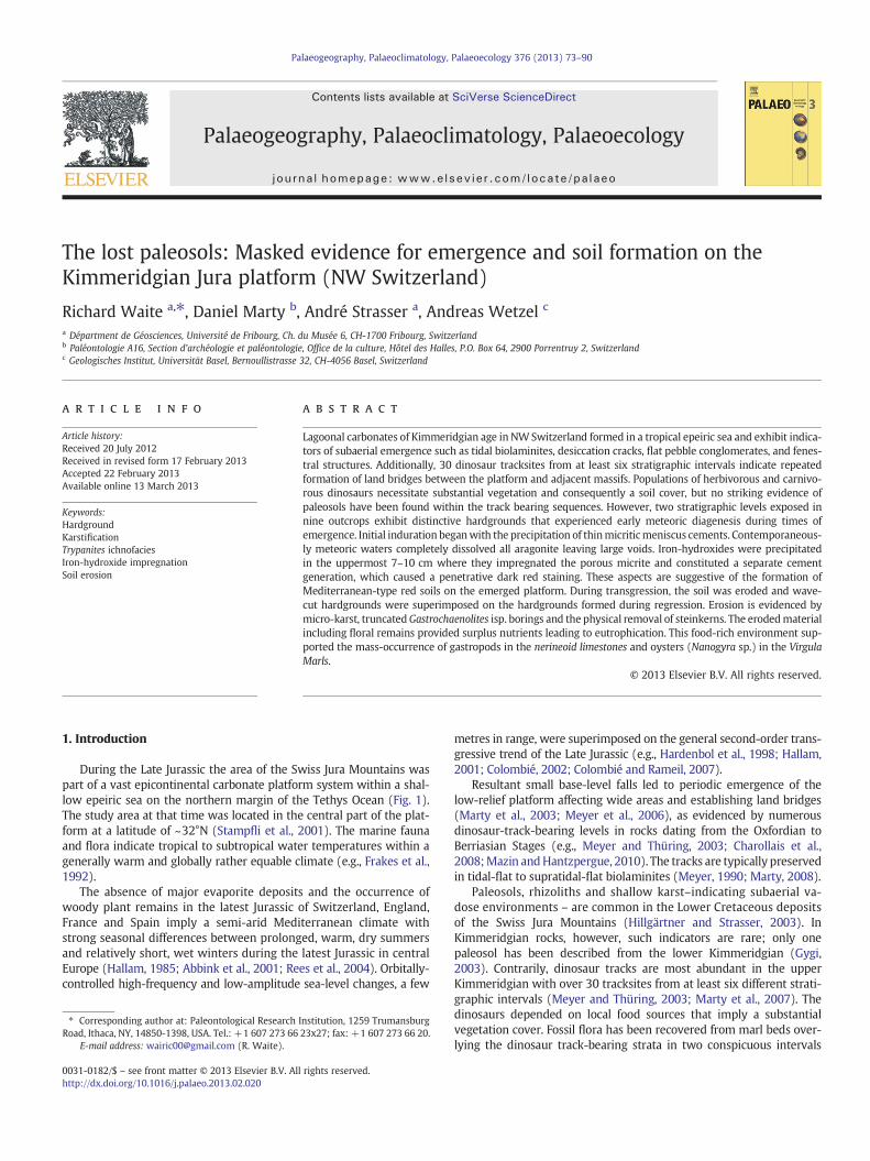
During the Late Jurassic the area of the Swiss Jura Mountains waspart of a vast epicontinental carbonate platform system within a shal-low epeiric sea on the northern margin of the Tethys Ocean (Fig. 1).The study area at that time was located in the central part of the plat-form at a latitude of ~32°N (Stampfli et al., 2001). The marine faunaand flora indicate tropical to subtropical water temperatures within agenerally warm and globally rather equable climate (e.g., Frakes et al.,1992).
The absence of major evaporite deposits and the occurrence ofwoody plant remains in the latest Jurassic of Switzerland, England,France and Spain imply a semi-arid Mediterranean climate withstrong seasonal differences between prolonged, warm, dry summersand relatively short, wet winters during the latest Jurassic in centralEurope (Hallam, 1985; Abbink et al., 2001; Rees et al., 2004). Orbitally-controlled high-frequency and low-amplitude sea-level changes, a few
Institution, 1259 Trumansburg23x27; fax: +1 607 273 66 20.
rights reserved.
metres in range, were superimposed on the general second-order trans-gressive trend of the Late Jurassic (e.g., Hardenbol et al., 1998; Hallam,2001; Colombié, 2002; Colombié and Rameil, 2007).
Resultant small base-level falls led to periodic emergence of thelow-relief platform affecting wide areas and establishing land bridges(Marty et al., 2003; Meyer et al., 2006), as evidenced by numerousdinosaur-track-bearing levels in rocks dating from the Oxfordian toBerriasian Stages (e.g., Meyer and Thüring, 2003; Charollais et al.,2008;Mazin andHantzpergue, 2010). The tracks are typically preservedin tidal-flat to supratidal-flat biolaminites (Meyer, 1990; Marty, 2008).
Paleosols, rhizoliths and shallow karst–indicating subaerial va-dose environments – are common in the Lower Cretaceous depositsof the Swiss Jura Mountains (Hillgärtner and Strasser, 2003). InKimmeridgian rocks, however, such indicators are rare; only onepaleosol has been described from the lower Kimmeridgian (Gygi,2003). Contrarily, dinosaur tracks are most abundant in the upperKimmeridgian with over 30 tracksites from at least six different strati-graphic intervals (Meyer and Thüring, 2003; Marty et al., 2007). Thedinosaurs depended on local food sources that imply a substantialvegetation cover. Fossil flora has been recovered from marl beds over-lying the dinosaur track-bearing strata in two conspicuous intervals
La CombeSur Combe Ronde
Delémont
Moutier
Saint-Imier
Pichoux
Frinvillier
BERN
Enges
Noirvaux
Grenchen
Grenchenberg
10 Km
Twannbach
Chasseral
Glovelier
Court
NeuchâtelValangin
ReuchenetteSolothurn
PorrentruyTchâfoué
Lommiswil
Biel/Bienne
Lake
Neu
châte
l
France
St. Blaise
Switzerland
BBasle
BernZurich
Shallow marine
Emerged areas
Deeper marine
Oceanic basin
Deep marine
Carbonate platforms
Study area
Geneva
A
Jura
Helvetic Shelf
30°
500 Km
Valaisan TroughUltrahelvetic Realm
Tethys Ocean
Paris Basin
CentralMassif
Vocontian Basin
35°
RhenishMassifC
Study area
Fig. 1. Geographical and palaeogeographical overview of the study area. A) Location of study area within Switzerland. B) Roadmap of the study area in NW Switzerland showing outcroplocations. C) Palaeogeographical reconstruction of central Europe for the Late Kimmeridgian to Early Tithonian showing the position of the study area in its paleogeographical context.Modified after Thierry et al. (2000).
74 R. Waite et al. / Palaeogeography, Palaeoclimatology, Palaeoecology 376 (2013) 73–90
(Meyer, 1994; Philippe et al., 2010). Both dinosaur tracks and fossilflora point to the existence of soils but no direct evidence of a soilcover has been found so far. Thus, evidence for past soils must beunravelled from the incomplete stratigraphic record. Circumstantialevidence suggests that soils formed on indurated surfaces duringsea-level lowstands but were subsequently eroded. Such surfaces areof stratigraphic and sequence-stratigraphic importance as they indi-rectly record depositional gaps in the rock record. It is the purposeof this paper to demonstrate that submarine hardgrounds belowflooding surfaces can store information of previous emergence andthat lost paleosols can thus be detected.
2. Geological setting
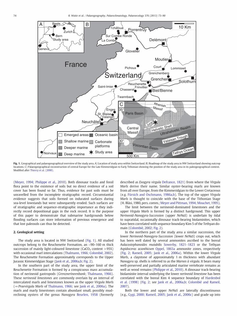
The study area is located in NW Switzerland (Fig. 1). All studiedoutcrops belong to the Reuchenette Formation, an ~90–160 m thicksuccession of mainly light-coloured limestone (CaCO3 content >95%)with occasional marl intercalations (Thalmann, 1966; Colombié, 2002).The Reuchenette Formation approximately corresponds to the UpperJurassic Kimmeridgian Stage (Jank et al., 2006a,b; Fig. 2).
In the southern part of the study area, the upper limit of theReuchenette Formation is formed by a conspicuous mass accumula-tion of nerineoid gastropods (Grenznerineenbank; Thalmann, 1966).These nerineoid limestones are commonly overlain by an interval ofintercalated marls and limestones known as the upper Virgula Marls(=Praevirgula Marls of Thalmann, 1966; see Jank et al., 2006a). Themarls and marly limestones contain abundant small, possibly mud-reclining oysters of the genus Nanogyra Beurlen, 1958 (formerly
described as Exogyra virgula Defrance, 1821) from where the VirgulaMarls derive their name. Similar oyster-bearing marls are knownfrom all over Europe, from the Kimmeridgian to the Lower Cretaceous(e.g. Fürsich and Oschmann, 1986a,b). The top of the upper VirgulaMarls is thought to coincide with the base of the Tithonian Stage(H. Bläsi, 1980, pers. comm.;Meyer and Pittman, 1994;Mouchet, 1995).
The limit between the nerineoid-dominated limestones and theupper Virgula Marls is formed by a distinct hardground. This upperNerineoid-Nanogyra-Succession (upper NeNaS) is underlain by tidalto supratidal, occasionally dinosaur track-bearing biolaminites, whichhave been correlatedwith sequence boundary Kim 5 of the Tethyan do-main (Colombié, 2002; Fig. 2).
In the northern part of the study area a similar succession, thelower Nerineoid-Nanogyra-Succession (lower NeNaS) crops out, whichhas been well dated by several ammonites ascribed to the borealAulacostephanoides mutabilis Sowerby, 1821–1823 or the TethyanAspidoceras acanthicum Oppel, 1863a ammonite zones, respectively(Fig. 2; Rameil, 2005; Jank et al., 2006a). Within the lower VirgulaMarls, a claystone of approximately 1 m thickness with abundantNanogyra sp. shells is referred to as theMarnes à virgula. It bears manywell-preserved and partially articulated marine vertebrate remains aswell as wood remains (Philippe et al., 2010). A dinosaur track-bearingbiolaminite interval underlying the lower nerineoid limestone has beencorrelated with the boreal Kim 4 sequence boundary of Hardenbolet al. (1998) (Fig. 2; see Jank et al., 2006a,b; Colombié and Rameil,2007).
Both the lower and upper NeNaS are laterally discontinuous(e.g., Gygi, 2000; Rameil, 2005; Jank et al., 2006c) and grade up into
Orthaspidoceras schilleri (OPPEL), Acanthicum zone
Aulacostephanus autissiodorensis (DURAND), Autissiodorensis zone
Prorasenia sp., Divisium zone
T Kim 5 DST = Tethyan sequence boundary Kim 5 dinosaur tracksB Kim 4 DST = Boreal sequence boundary Kim 4 dinosaur tracks
Forma-tion
Reu
chen
ette
For
mat
ion
Twannbach Formation
ReuchenetteFormation
l-NeNaS
Eroded during Tertiary time
u-NeNaS
Tw
annb
ach
For
mat
ion
Banné Marls
u-NeNaS?
153.54
152.70
152.01
150.86
149.99Ti 1
Kim 5
Kim 4
Kim 2
Kim 3
Kim 1153.98
150.86
149.99
151.48
151.85
152.23
152.74
153.54
153.98
Ti 1
Kim 7
Kim 5
Kim 4
Kim 3
Kim 2
Kim 6
Kim 1
R
T
SequencesBoreal
SequencesTethyan
T-R FaciesCycles
T-R FaciesCycles
MajorTransgressive-
RegressiveCycles
Series StagesLo
wer
Upp
erLo
wer
Upp
er J
uras
sic
Mal
mL.
Kim
mer
idgi
an(s
ensu
ang
lico)
U. K
imm
erid
gian
(sen
su a
nglic
o)
Tith
onia
nK
imm
erid
gian
150.7 (±3.0)
154.1 (±3.2)
(SE)Switzerland(NW)
TethyanAmmonite
ZonesSouthwestern
Europe
Beckeri
Eudoxus Cavouri
Acanthicum
Divisium
Hypselocyclum / Strombecki
Platynota153.85
153.23
152.10
151.85
Darwini / Albertinum
Hybonotum
Compsum
153.85
Cymodoce
Baylei
152.62
152.10
151.36
150.69
Elegans Gigas
Autissiodorensis
Eudoxus
Mutabilis
149.29Scitulus R
T
B Kim 4 DST
T Kim 5 DSTu-NeNaS
T
u-NeNaS?150.86Kim 5 T Kim 5 DSTT
ette
on
l-NeNaS152.01
Kim 4152.23
Kim 5
Kim 4152.10
151.85
Compsum B Kim 4 DSTFacies
discontinues
Boreal Ammonite
ZonesNorthwestern
Europe
Fig. 2. Bio- and sequence-chronostratigraphical compilation of the study area showing the stratigraphical position of the different marly intervals found in the Swiss Jura Mountains with their inferred ages after Thalmann (1966), Enay et al.(1984), Meyer (1994), Mouchet (1995), Hardenbol et al. (1998), Gygi (2000), Colombié (2002), Marty et al. (2003), Rameil (2005), and Jank et al. (2006a,b,c). The l-NeNaS (lower Nerineoid-Nanogyra-Succession) and u-NeNaS (upperNerineoid-Nanogyra-Succession) are dated on account of the associated ammonite fauna.Sequence-stratigraphical interpretations infer that Level 1500 in the Sur Combe Ronde section corresponds to the boreal Kim 4 sequence boundary of Hardenbol et al. (1998) (Jank et al., 2006a), while the track levels at Lommiswil cor-respond to the Tethyan Kim 5 sequence boundary of Hardenbol et al. (1998) (Colombié, 2002).
75R.W
aiteet
al./Palaeogeography,Palaeoclim
atology,Palaeoecology376
(2013)73
–90
76 R. Waite et al. / Palaeogeography, Palaeoclimatology, Palaeoecology 376 (2013) 73–90
a shallow-water carbonate facies. The similarity between the two suc-cessions suggests that they formed under analogous environmentalconditions.
For the Late Jurassic, water depths on the platform ranged betweenzero and few tens of metres (Colombié and Strasser, 2005; Strasser,2007). As the sediment thickness of generally >120 m in the com-pacted state for the Reuchenette Formation significantly exceeds boththe depositional water depth plus the space generated by sea-levelrise, accommodationmust have been provided by pronounced synsedi-mentary subsidence (Jank et al., 2006a). Late Kimmeridgian subsidenceis estimated to have reached 20 to 40 m/Myr (Wildi et al., 1989).
Carbonate production on the platform kept up with relative sea-level rise so that depositional environments remained shallow withintertidal episodes occurring repeatedly. Intermittent regressivephases led to emergence, cementation, erosion and reworking of thepreviously deposited sediment (Strasser and Samankassou, 2003).On this shallow, low-relief platform the low-amplitude regressivephases were sufficient to produce widespread emergence.
Sea-level changes and differential subsidence related to movementsalong pre-existing faults in the Hercynian basement (Allenbach, 2001;Wetzel et al., 2003) resulted in a highly structured platform with vari-able facies patterns (Hug, 2003; Jank et al., 2006a). Depending on subsi-dence, individual blocks formed swells or depressions.
3. Material and methods
The two stratigraphic intervals of theNeNaSwere studied in 17 out-crops ofwhich 10were logged in detail (Table. 1, Fig. 1). In the northernpart of the study area the lower NeNaS is typically developed at severalsites but the uppermost part of the Reuchenette Formation includingthe upper NeNaS or at least the contact to the Twannbach Formationhas mostly been eroded (Jank et al., 2006b). For the lower NeNaS theCourtedoux–Sur Combe Ronde section was chosen as the referencesection, and was completed with data from the very nearby sectionCourtedoux–Tchâfouè, located less than 0.5 km to the N of Sur CombeRonde.
In the southern part of the study area, the erosion was less pro-nounced and the upper NeNaS and lower Twannbach Formation arepreserved (Häfeli, 1966; Fig. 2). For the upper NeNaS the Reuchenetteand Frinvillier sections were chosen as reference sections. The sectionsLommiswil, St. Imier and a composite section from three outcrops in thearea of Neuchâtel were used for correlation and to document the lateralfacies variations and the regional extent.
Table 1List of geographical information for studied outcrops.
Name of section Canton Swiss coordinates
l-NeNaSGlovelier Jura 581.521/242.515Chevenez–La Combe Jura 567.760/249.660Courtedoux–Sur Combe Ronde Jura 568.890/250.040Courtedoux–Tchâfoué Jura 568.665/250.390
u-NeNaSChasseral Bern 569.110/217.855Court Bern 593.100/232.704Enges Neuchâtel 566.157/210.859Frinvillier Bern 586.065/224.335Grenchenberg Solothurn 594.770/228.088Lommiswil Solothurn 602.800/231.650Noirvaux Neuchâtel 529.450/190.025Pichoux Bern 584.138/236.519Reuchenette Bern 585.520/226.400Saint-Imier Bern 566.892/223.420St. Blaise Neuchâtel 564.695/208.860Twannbach Bern 577.858/216.403Valangin Neuchâtel 559.370/206.618
From the named outcrops, standard geological samples were ob-tained on average every 20–40 cm, or below and above bedding planeswhere facies changes were observed. For all sections excepting St. Imierat least one thin-section and one polished section were prepared fromeach sample and analysed with respect to micro- and macrofacies andcomposition.
Thin-sections were studied under a standard polarised light micro-scope and cold cathodoluminescence microscopywas applied to select-ed samples. Selected thin-sections were stained for dolomite (Dickson,1966). The mineralogical composition of selected samples was es-tablished by X-ray powder diffraction using a Philips PW 1710 dif-fractometer but clay mineral data was obtained from the literature.Diffractograms were recorded between 3° and 65° 2θ in step-scanmode (0.02°/step and 2 s/step). The copper X-ray tube was operatedat 40 kV and 40 mA. The CuKβ radiation was filtered with a graphitemonochromator. Quantitative phase analysis by Rietveld refinement(Bish and Post, 1993) was performed by applying the SIROQUANT soft-ware package (Taylor, 1991).
A Philips FEI XL30 SFEG Sirion Scanning Electron Microscopeequipped with an EDAX Energy Dispersive Spectrometer (EDS) wasused to obtain backscattered electron (BSE) images, EDS point analy-ses and chemical maps of polished and subsequently etched slabscoated with an ~4 nm carbon layer and covered with silver paintaround the lapped surface.
4. Section descriptions
For the purpose of this paper, only three sections are described indetail. The other sections are documented in Waite (2010).
4.1. Courtedoux–Sur Combe Ronde section
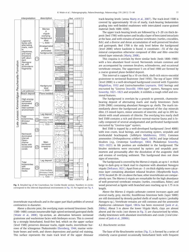
In the Sur Combe Ronde section (Fig. 3), two intervals have beenfound, each containing several dinosaur track levels (Marty et al.,2007). The log comprises the lower NeNaS and starts with a dinosaurtrack interval (intermediate dinosaur track-bearing levels sensu Martyet al., 2007; level 1000, top of bed 950). The lowermost dinosaur tracksare imprinted in a bioclastic peloidal pack- to grainstone and arecovered by biolaminites occasionally containing small marine bioclastsand burrows (beds 1000–1150). At least 10 bedding planes withinthe biolaminites exhibit dinosaur tracks and occasionally desiccationcracks. The biolaminites are capped by a 20–30 cm thick bed thatcontains oysters at the base and many marine vertebrate remains,
World Geodetic System-84 Map of Switzerland 1:25,000
07:11:38.91°E; 47:19:59.67°N No. 1085, St. Ursanne07:00:41.64°E; 47:23:49.11°N No. 1085, St. Ursanne07:01:35.43°E; 47:24:01.61°N No. 1085, St. Ursanne07:01:24.61°E; 47:24:12.09°N No. 1085, St. Ursanne
07:01:53.09°E; 47:06:39.49°N No. 1145, Bieler See07:20:50.96°E; 47:14:42.79°N No. 1106, Moutier06:59:35.72°E; 47:02:52.43°N No. 1144, Val de Ruz07:15:17.38°E; 47:10:11.39°N No. 1126, Büren A. A.07:22:10.56°E; 47:12:13.38°N No. 1126, Büren A. A.07:28:32.18°E; 47:14:08.77°N No. 1107, Balsthal06:30:48.46°E; 46:51:27.39°N No. 1182, St. Croix07:13:44.33°E; 47:16:45.76°N No. 1105, Bellelay07:14:51.26°E; 47:11:18.22°N No. 1126, Büren A. A.07:00:07.22°E; 47:09:39.03°N No. 1124, Les Bois06:58:27.02°E; 47:01:47.42°N No. 1144, Val de Ruz07:80:49.08°E; 47:05:53.74°N No. 1145, Bieler See06:54:15.56°E; 47:00:33.72°N No. 1144, Val de Ruz
1030
1050
1070
11001150
1200
1300
15001600
1650
1700
1800
1900
19502100
2200
2400
2500
2600
2700
2800
3500
4500
5000
1400
2300
950
2900
MW P Gm
MW P Gm
Bed
Bed
Lagoonal facies with alternating marls, marl- to claystones, and marly limestone with abun-dant Nanogyra sp. and echinoderm fragments
Nerineoid-dominated interval. Open-marine facies with occasional corals
Tidal biolaminites with dinosaur tracks
High-energy nerineoid- dominated shallow tidal-subtidal environment
Tidal biolaminites, dinosaur tracks
5
1
5
3
4
2
Intermediatedinosaur trackbearing levels
L 10001 m
Late
Jur
assi
c K
imm
erid
gian
Reu
chen
ette
For
mat
ion
interpretation
Marnes à
virgulaoverlying
hardgroundlevel
L 4000
Main nerineoid limestone
bed
Upperdinosaur trackbearing levels
L 1500
Hardground level
L 2000
Lag deposit
Lag deposit
Plane beddedLost paleosolBeach deposit
description
Amalgamatedand
perforatedhardgrounds
Fig. 3. Detailed log of the Courtedoux–Sur Combe Ronde section. Numbers in circlescorrespond to the inferred depositional environments in Fig. 10. For legend see Fig. 4.
77R. Waite et al. / Palaeogeography, Palaeoclimatology, Palaeoecology 376 (2013) 73–90
invertebrate macrofossils and in the upper part black pebbles of severalcentimetres in diameter.
Above a discrete joint, the overlying main nerineoid limestones (beds1300–1400) contain innumerable high-spirednerineoid gastropod shells(Waite et al., 2008). Up-section, an alternation between nerineoidgrainstone and wackestone facies with birdseyes occurs. This is coveredby a strongly bioturbated, fossil-free bed, which on the upper surface(level 1500) preserves dinosaur tracks, ripple marks, invertebrate bur-rows of the ichnogenus Thalassinoides Ehrenberg, 1944, marine verte-brate bones and teeth, and shows depressions and partial red staining.This surface represents the main track level of the upper dinosaur
track-bearing levels (sensu Marty et al., 2007). The track-level 1500 iscovered by approximately 10 cm of marly, track-bearing biolaminitesgrading into well-bedded mudstones with intercalated coarse-grainedmaterial (beds 1600–1650).
The upper track-bearing levels are followed by a 5–20 cm thick de-posit (bed1700)with oysters and locally a layer of brecciated intraclastsat the base, and with remains of marine vertebrates (turtles, crocodiles,fish) and a diverse and dense accumulation of well-preserved bivalvesand gastropods. Bed 1700 is the only level below the hardground(level 2000) where kaolinite is found; it constitutes ~5% of the claymineral composition otherwise composed of illite and illite–smectitemixed-layer minerals (Marty, 2008).
This coquina is overlain by three similar beds (beds 1800–1900)with a less abundant fossil record. Nerineoids remain common andare accompanied by common bivalves, echinoderms, and occasionalvertebrate remains. The uppermost 5 cm of bed 1900 are formed bya coarse-grained plane-bedded deposit.
This interval is capped by a 10 cm thick, shell-rich micro-oncoidalgrainstone to nerineoid floatstone (bed 1950). The top of layer 1950(level 2000) is a well-developed hardground covered with TrypanitesMägdefrau, 1932 and Gastrochaenolites Leymarie, 1842 borings andencrusted by “Liostrea Douvillé, 1904-type” oysters, Nanogyra nanaSowerby, 1821–1823 and serpulids; it exhibits a rough relief and ero-sional features.
The hardground is overlain by a greyish to greenish, chamosite-bearing deposit of alternating marls and marly limestones (beds2100–2900) containing abundant Nanogyra sp. shells. The marls im-mediately above the hardground are composed of the clay mineralsillite, I/S mixed-layers, minor amounts of smectite, and up to 20% ka-olinite with small amounts of chlorite. The overlying less marly shellbed 3500 contains a rich and diverse normal-marine fauna and is lo-cally composed of several amalgamated and perforated hardgroundsencrusted by “Liostrea-type” oysters.
Bed 3500 is topped by a well-developed hardground (level 4000)with iron crusts, local borings, and encrusting oysters, serpulids andterebratulid brachiopods (Sellithyris Middlemiss, 1959). Commonammonites (Orthaspidoceras schilleri Oppel, 1863b) and large infaunalbivalves (e.g., Ceratomya Sandberger, 1864; Pholadomya Sowerby,1821–1823) in life position are embedded in the hardground. Thebivalve steinkerns were encrusted by oysters and serpulids post-mortem and presumably after the dissolution of the aragonitic shelland erosion of overlying sediment. This hardground does not showsigns of emersion.
The hardground is covered by theMarnes à virgula, an up to 1 m thickbeige to dark-grey or black marl to claystone with abundant Nanogyravirgula (Defrance, 1821). Apart froman ~5 cm thick slightlymore calcar-eous layer containing abundant infaunal bivalves (Myophorella Bayle,1878) located 20–30 cmabove the base, other invertebrates are compar-atively rare. TheMarnes à virgula are remarkable for the high abundanceof well-preserved vertebrate remains (turtles, crocodilians, fishes) andwood preserved as lignite with branched axes reaching up to 1.75 m inlength.
Above the Marnes à virgula carbonate content increases again andseveral marly, grey, micritic, fossiliferous limestone beds (layer 5000)are still dominated by densely packed shells of small oysters (probablyNanogyra sp.). Vertebrate remains are still common and the ammoniteAspidoceras caletanum Oppel, 1863a has been recovered (Jank et al.,2006a). About 5 m above the lower Virgula Marls, clays are almostabsent and the rocks (not shown in Fig. 3) are characterised by white,chalky limestones with abundant invertebrates and corals (Coral Lime-stones of Jank et al., 2006b).
4.2. Reuchenette section
The base of the Reuchenette section (Fig. 5), is formed by a series ofrelatively coarse-grained occasionally bioturbated beds with frequent
Plane bedding
Macrofauna:
Cephalopods
Liostrea-type oysters
Brachiopods
Nerineoids
Echinoids
GastropodsBivalves
DunhamClassification:
P Packstone
M Mudstone
G Grainstone
W Wackestone
m Marl
Limestone
Marly limestone
Biolaminite
Sediment structures,lithology and components:
Birdseyes
Burrows Burrows
MarlNanogyra sp.
Bedded limestone
Nodular limestone
Irregular bedding
Marl/nodular marl
Regular bedding
Teepees
Dolomite
Fig. 4. Legend for Figs. 3, 5, 6 and 7.Classification of carbonate rocks after Dunham (1962).
1 m
1
4
5
3
4
2
5
Hardground Type IV
92
93
109
105
107
106
108
100
99b
96
98
95
99a
99c
97
103
101102
104
94
115
111
113
117
110
112
114
116
MW P Gm
MW P GmBed
Bed
interpretation
Lowernerineoid limestone
bed
Shell bed
Lagoonal facies with alternating marls, marl- to claystones, and marly limestone with abun-dant Nano-gyra sp. and echinoderm fragments
Shallow-water deposits.
Shallow-water deposits and tidal biolam-inites
Nerineoid- dominated interval. Open-marine facies with occasional corals
Late
Jur
assi
c K
imm
erid
gian
Reu
chen
ette
For
mat
ion
Lost paleosol
description
Uppernerineoid limestone
bed
Biolaminites
Twannbach Formation:Thin-bedded marls and limestonesT
ithon
ian
Shallow-water deposits and tidal biolam-inites
Marl- to claystone
Marl- to claystone
Fig. 5. Detailed log of the Reuchenette section. Numbers in circles correspond to thedepositional environments in Fig. 10. For legend see Fig. 4.
78 R. Waite et al. / Palaeogeography, Palaeoclimatology, Palaeoecology 376 (2013) 73–90
dasycladacean algae and biolaminites with birdseyes (bed 92). Theshallow-water interval is covered by wacke- to grainstones with fre-quent bivalve remains in bed 93,which grade into a nerineoidfloatstonein bed 94. Nerineoids occur throughout most of bed 96 but show thehighest abundance in the middle part of the bed.
Bed 97 is a discrete bed, on average 10 cm thick, which containsabundant, small–centimetre–sized–turreted gastropods. Its top is deve-loped as a conspicuous hardground. The surface is extremelyflat and hasa polished aspect but is heavily pocketed by Gastrochaenolites isp. bor-ings of approximately equal depth and diameter. Encrusting organismsare absent. Shells are replaced by blocky cement, and no micritic fillingsare observed. Iron-hydroxide impregnation of the rock is hardly deve-loped and subsequent staining is weak. Iron-hydroxide occurs primarilyas a millimetre-thick crust on the surface, which contains ~6% goethite.
The hardground is covered by the dark echinoderm-oyster-dominated marl and limestone intercalations of the upper VirgulaMarls. At the base of the marls (bed 98) numerous marine vertebrateremains are recorded in addition to complete and broken Nanogyra sp.shells and other bivalves. The abundance and diversity of the faunal ele-ments is low in the rest of the bed. The interface to the next bed is accen-tuated by centimetre-thick and metre-long branching Thalassinoides-type burrows. Throughout bed 99 the abundance of Nanogyra sp. shellsincreases to form aNanogyra shellbed at the top, which also contains tur-tle remains. The overlying marl bed (100) contains abundant completeand fragmented Nanogyra sp. shells and small fish teeth. A few largemarine vertebrate remains were found at the base. The two marl beds98 and 100 are similar to the Marnes à virgula bed of the lower VirgulaMarls. Bed 101 is a conspicuous coquina composed of very closely-packed, disarticulated and sometimes fragmented Nanogyra sp. shellsin a marly limestone matrix. Above the marl beds, the carbonate faciesis dominated by articulated, disarticulated and fragmented Nanogyrasp. and echinoderm remains. Except for the biolaminites in bed 111
echinoderm and Nanogyra sp. skeletal elements remain abundant up tothe base of the Twannbach Formation in bed 117.
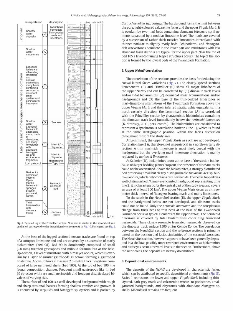
4.3. Frinvillier section
In the Frinvillier section (Fig. 6), the upper NeNaS is well exposedin steeply inclined strata. Because tectonic movements at this localitywere concentrated along the marls, they are deformed and thinnedand were, therefore, not sampled.
101
102
103
99
100
104
109
105
106
107
108
98
110
111
112
113
114
115
116
117118119
Bed 1 m
Bed MW P Gm
MW P Gm
Dinosaur tracks
Nerineoid limestone
bed
Teepees
description
5
1
5
2
4
5Lagoonal facies with alternating marls, marl- to claystones, and marly limestones with abundant Nanogyrasp. and echinoderm fragments
Nerineoid- dominated interval. Open-marine facies with sponges brachio-pods and corals.
Tidal biolaminites with dinosaur tracks
Lost paleosol
Shallow-water mudstones
Lagoonal facies with alternating limestone and nodular, ocasionally marly beds containing common to abundant small oysters and echinoderm fragments
1
Late
Jur
assi
c K
imm
erid
gian
Reu
chen
ette
For
mat
ion
interpretationT
ithon
ian
Shallow-water deposits
Twannbach Formation:
Thin-bedded marls and limestones
Shallow-water
Marl- to claystone
Marl- to claystone
Hardground Type II
Fig. 6. Detailed log of the Frinvillier section. Numbers in circles in the second columnon the left correspond to the depositional environments in Fig. 10. For legend see Fig. 4.
79R. Waite et al. / Palaeogeography, Palaeoclimatology, Palaeoecology 376 (2013) 73–90
At the base of the logged section dinosaur tracks are found on topof a compact limestone bed and are covered by a succession of marlybiolaminites (bed 98). Bed 99 is dominantly composed of small(~8 mm) turreted gastropods and miliolid foraminifera at the base.Up-section, a level of mudstone with birdseyes occurs, which is over-lain by a layer of similar gastropods as below, forming a gastropodfloatstone. Above follows a massive 2.5-metre thick floatstone com-posed of large nerineoid shells (bed 100). At the top of bed 100, thefaunal composition changes. Frequent small gastropods like in bed99 co-occur with rare small nerineoids and frequent disarticulated bi-valves of varying size.
The surface of bed 100 is a well-developed hardground with roughand sharp erosional features forming shallow crevices and grooves. Itis encrusted by serpulids and Nanogyra sp. oysters and is pocked by
Gastrochaenolites isp. borings. The hardground forms the limit betweenthe pure, light-coloured calcarenite facies and the upperVirgulaMarls. Itis overlain by two marl beds containing abundant Nanogyra sp. frag-ments separated by a nodular limestone level. The marls are coveredby a succession of rather thick massive limestones intercalated withthinner nodular to slightly marly beds. Echinoderm- and Nanogyra-rich wackestones dominate in the lower part and mudstones with lessabundant fossil detritus are typical for the upper part. Near the top ofbed 105 a level containing teepee structures occurs. The top of the sec-tion is formed by the lowest beds of the Twannbach Formation.
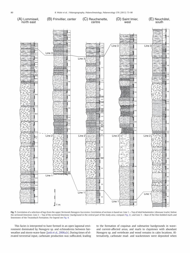
5. Upper NeNaS correlation
The correlation of the sections provides the basis for deducing thecoeval lateral facies variations (Fig. 7). The closely-spaced sectionsReuchenette (B) and Frinvillier (C) show all major lithofacies ofthe upper NeNaS and can be correlated by: (1) dinosaur track levelsand/or tidal biolaminites, (2) nerineoid mass accumulations and/orhardgrounds and (3) the base of the thin-bedded limestones ormarl–limestone alternations of the Twannbach Formation above theupper Virgula Marls and their inferred stratigraphic equivalents. In anorth-easterly direction, the Lommiswil section (A) is correlatedwith the Frinvillier section by characteristic biolaminites containingthe dinosaur track level immediately below the nerineoid limestones(K. Stransky, 2011, pers. comm.). The biolaminites are considered torepresent a synchronous correlation horizon (line 1), which is foundat the same stratigraphic position within the facies successionthroughout most of the study area.
At Lommiswil, the upper Virgula Marls as such are not developed.Correlation line 2 is, therefore, not unequivocal in a north-easterly di-rection. A thin marl-rich limestone is most likely coeval with thehardground but the overlying marl–limestone alternation is mainlyreplaced by nerineoid limestones.
At St. Imier (D), biolaminites occur at the base of the section but be-cause no larger bedding planes crop out, the presence of dinosaur trackscould not be ascertained. Above the biolaminites, a strongly bioturbatedbed preserving small but clearly distinguishable Thalassinoides isp. bur-rows occurs,which only contains rare nerineoids. The bed is toppedby awell-distinguished Nanogyra-encrusted hardground representing timeline 2; it is characteristic for the central part of the study area and coversan area of at least 300 km2. The upper Virgula Marls occur as a three-metre thick interval of Nanogyra-bearing marls and marly limestones.
To the south in the Neuchâtel section (E), the upper Virgula Marlsand the hardground below are not developed, and dinosaur trackscould not be found. Only the nerineoid limestones and the conspicuouschange from thick beds to thin beds at the base of the TwannbachFormation occur as typical elements of the upper NeNaS. The nerineoidlimestone is covered by tidal biolaminites containing truncatednerineoids. These closely resemble truncated nerineoids observed onthe dinosaur track surface 1500 at Sur Combe Ronde. The correlationbetween the Neuchâtel section and the reference sections is primarilybased on the position and facies similarities of the nerineoid limestone.The Neuchâtel section, however, appears to have been generally depos-ited in a shallow, possibly more restricted environment as biolaminitesand birdseyes occur at several levels in the section. Furthermore, abovethe nerineoids, the deposits are heavily dolomitised.
6. Depositional environments
The deposits of the NeNaS are developed in characteristic facies,which can be attributed to specific depositional environments (Fig. 8).Facies 1 represents the lower and upper Virgula Marls including thin-layered, dark-grey marls and calcarenitic wacke- to packstones, amal-gamated hardgrounds, and claystones with abundant Nanogyra sp.shells. Macrofossil remains are frequent.
(A) Lommiswil, north east
(B) Frinvillier, center (C) Reuchenette, centre
(D) Saint Imier, west
(E) Neuchâtel,south
101
102
103
99
100
104
109
105
106
107
108
98
110
111
112
113
114
115
116
106
107
108
109
110
111
112
113
114
115
101
102
103
099
100
104
105
116
92
93
109
105
107
106
108
100
99b
96
98
95
99a
99c
97
103
101102
104
94
115
111
113
117
110
112
114
116
Line 1
Line 1
Line 1
Line 1
Line 2 Line 2 Line 2 Line 2
Line 3
Line 3
Line 3 Line 3
112
107
108
109
110
111
104
100
101
103
105
106
102
99
98
97
96
95
B07b
B07a
B01a
B05
B06
B08
B09
B10
B11
B12
B13
B03
C25
B02
C22
C23
C24
1 m
Fig. 7. Correlation of a selection of logs from the upper Nerineoid-Nanogyra-Succession. Correlation of sections is based on: Line 1— Top of tidal biolaminites (dinosaur tracks) belowthe nerineoid limestone; Line 2 — Top of the nerineoid limestone (hardground in the central part of the study area; compare Fig. 2); and Line 3 — Base of the thin-bedded marls andlimestones of the Twannbach Formation. For legend see Fig. 4.
80 R. Waite et al. / Palaeogeography, Palaeoclimatology, Palaeoecology 376 (2013) 73–90
This facies is interpreted to have formed in an open lagoonal envi-ronment dominated by Nanogyra sp. and echinoderms between fair-weather and storm-wave-base (Jank et al., 2006a,b). During times of el-evated terrestrial input, carbonate production was suffocated, leading
to the formation of coquinas and submarine hardgrounds in wave-and current-affected areas, and marls to claystones with abundantNanogyra sp. and vertebrate and wood remains in calm locations. Al-ternatively, carbonate mud- and wackestones were deposited when
5-20 m
4
1
23
65
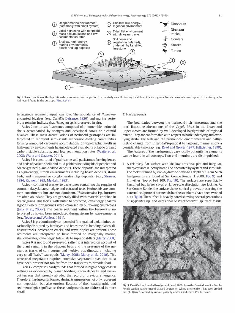
Deeper marine environment(commonly with small oysters)1
Shallow, high-energy, marine environments, beach and lag deposits
3
2Local high zone with nerineoid mass accumulations and low sedimentation rates
Turtles
Dinosaurs
DinosaurDinosaur tracks
Conifers
Sharks
Shallow, low-energy, lagoonal environment4
Tidal flat environmentwith dinosaur tracks5
Soil cover and vegetation (inferred), underlain by karstified limestone
6
Fig. 8. Reconstruction of the depositional environments on the platform in the study area illustrating the different facies regimes. Numbers in circles correspond to the stratigraph-ical record found in the outcrops (Figs. 3, 5, 6).
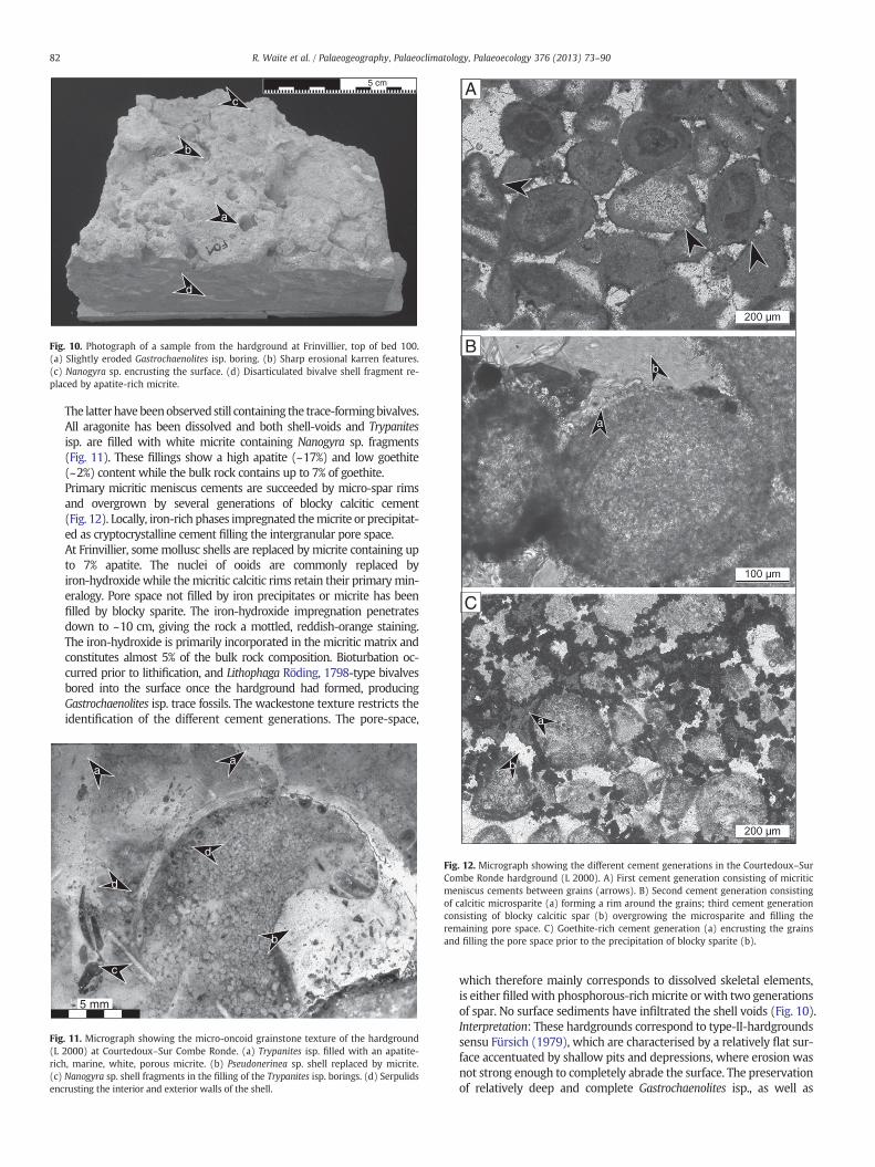
a
b
Fig. 9. Karstified and eroded hardground (level 2000) from the Courtedoux–Sur CombeRonde section. (a) Nerineoid-shaped depression where the steinkern has been erodedout. (b) Karren, formed by run-off possibly under a soil cover. Pen for scale.
81R. Waite et al. / Palaeogeography, Palaeoclimatology, Palaeoecology 376 (2013) 73–90
terrigenous sediment input was low. The abundance of Nanogyra-encrusted bivalves (e.g., Gervillia Defrance, 1820) and marine verte-brate remains indicate that Nanogyra sp. is preserved in situ.
Facies 2 comprises floatstones composed of innumerable nerineoidshells accompanied by sponges and occasional corals or diceratidbivalves. These mass accumulations of nerineoid gastropods are in-terpreted to represent semi-sessile suspension-feeding communitiesforming armoured carbonate accumulations on topographic swells inhigh-energy environments having elevated availability of labile organiccarbon, stable substrate, and low sedimentation rates (Waite et al.,2008; Waite and Strasser, 2011).
Facies 3 is constituted of grainstones and packstones forming lensesand beds of packed shells andmud pebbles including black pebbles andcoarse-grained plane-bedded deposits. These deposits are interpretedas high-energy, littoral environments including beach deposits, stormbeds, and transgressive conglomerates (lag deposits) (e.g., Strasser,1984; Kidwell, 1993; Meldahl, 1993).
Facies 4 consists of wacke- to packstones containing the remains ofcommon dasycladacean algae and ostracod tests. Nerineoids are com-mon constituents but are not dominant. Thalassinoides isp. burrowsare often abundant. They are generally filled with material enriched incoarse grains. This facies is attributed to protected, low-energy, shallowlagoons where firmgrounds were colonised by burrowing crustaceans(Jank et al., 2006c). The coarse sediment within the burrows is in-terpreted as having been introduced during storms by wave-pumping(e.g., Tedesco and Wanless, 1991).
Facies 5 is predominantly composed of fine-grained biolaminites oc-casionally disrupted by birdseyes and fenestrae. On bedding planes, di-nosaur tracks, desiccation cracks, and wave ripples are present. Thesesediments are interpreted to have formed on marginally marine,shallow-water, low-energy, tidal-flats to supratidal-flats (Marty, 2008).
Facies 6 is not found preserved, rather it is inferred on account ofthe plant remains in the adjacent beds and the presence of the nu-merous tracks of carnivorous and herbivorous dinosaurs includingvery small “baby” sauropods (Marty, 2008; Marty et al., 2010). Thisterrestrial megafauna requires extensive vegetated areas that musthave been present not too far from the tracksites to provide food.
Facies 7 comprises hardgrounds that formed in high-energy coastalsettings as evidenced by planar bedding, storm deposits, and wave-cut terraces that strongly abraded the record of previous emergence.Therefore, hardgrounds formed during transgression not only representnon-deposition but also erosion. Because of their stratigraphic andsedimentologic significance, these hardgrounds are addressed in moredetail.
7. Hardgrounds
The boundaries between the nerineoid-rich limestones and themarl–limestone alternations of the Virgula Marls in the lower andupper NeNaS are formed by well-developed hardgrounds of regionalextent. They are conformablewith respect to both underlying and over-lying strata. The hiati and the pronounced environmental and bathy-metric change from intertidal/supratidal to lagoonal/marine imply aconsiderable time gap (e.g., Read and Grover, 1977; Hillgärtner, 1998).
The features of the hardgrounds vary locally but unifying elementscan be found in all outcrops. Two end-members are distinguished:
1. A relatively flat surface with shallow erosional pits and irregular,sharp crevices is locally bored and encrusted by oysters and serpulids.The rock is stained by iron-hydroxide down to a depth of 10 cm. Suchhardgrounds are found at Sur Combe Ronde (L 2000; Fig. 9) andFrinvillier (top of bed 100; Fig. 10). The surfaces are superficiallykarstified but larger caves or large-scale dissolution are lacking. AtSur Combe Ronde, the surface shows conical grooves preserving theexternal sculpture of nerineoids but the steinkernshave beenwashedout (Fig. 9). The surface is heavily bored showing several generationsof Trypanites isp. and occasional Gastrochaenolites isp. trace fossils.
5 cm
c
b
a
d
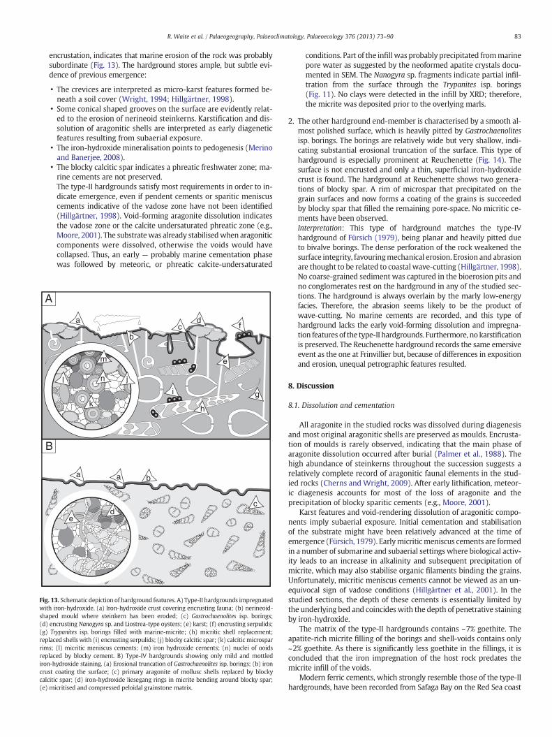
Fig. 10. Photograph of a sample from the hardground at Frinvillier, top of bed 100.(a) Slightly eroded Gastrochaenolites isp. boring. (b) Sharp erosional karren features.(c) Nanogyra sp. encrusting the surface. (d) Disarticulated bivalve shell fragment re-placed by apatite-rich micrite.
B
A
C
b
a
a
82 R. Waite et al. / Palaeogeography, Palaeoclimatology, Palaeoecology 376 (2013) 73–90
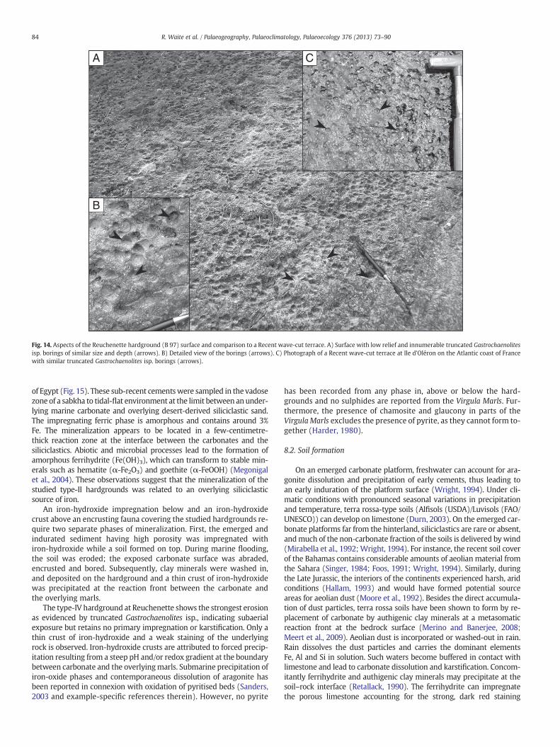
The latter havebeenobservedstill containing the trace-formingbivalves.All aragonite has been dissolved and both shell-voids and Trypanitesisp. are filled with white micrite containing Nanogyra sp. fragments(Fig. 11). These fillings show a high apatite (~17%) and low goethite(~2%) content while the bulk rock contains up to 7% of goethite.Primary micritic meniscus cements are succeeded by micro-spar rimsand overgrown by several generations of blocky calcitic cement(Fig. 12). Locally, iron-rich phases impregnated themicrite or precipitat-ed as cryptocrystalline cement filling the intergranular pore space.At Frinvillier, somemollusc shells are replaced by micrite containing upto 7% apatite. The nuclei of ooids are commonly replaced byiron-hydroxidewhile themicritic calcitic rims retain their primarymin-eralogy. Pore space not filled by iron precipitates or micrite has beenfilled by blocky sparite. The iron-hydroxide impregnation penetratesdown to ~10 cm, giving the rock a mottled, reddish-orange staining.The iron-hydroxide is primarily incorporated in the micritic matrix andconstitutes almost 5% of the bulk rock composition. Bioturbation oc-curred prior to lithification, and Lithophaga Röding, 1798-type bivalvesbored into the surface once the hardground had formed, producingGastrochaenolites isp. trace fossils. The wackestone texture restricts theidentification of the different cement generations. The pore-space,
5 mm
aa
d
d
c
b
Fig. 11. Micrograph showing the micro-oncoid grainstone texture of the hardground(L 2000) at Courtedoux–Sur Combe Ronde. (a) Trypanites isp. filled with an apatite-rich, marine, white, porous micrite. (b) Pseudonerinea sp. shell replaced by micrite.(c) Nanogyra sp. shell fragments in the filling of the Trypanites isp. borings. (d) Serpulidsencrusting the interior and exterior walls of the shell.
b
Fig. 12. Micrograph showing the different cement generations in the Courtedoux–SurCombe Ronde hardground (L 2000). A) First cement generation consisting of micriticmeniscus cements between grains (arrows). B) Second cement generation consistingof calcitic microsparite (a) forming a rim around the grains; third cement generationconsisting of blocky calcitic spar (b) overgrowing the microsparite and filling theremaining pore space. C) Goethite-rich cement generation (a) encrusting the grainsand filling the pore space prior to the precipitation of blocky sparite (b).
which therefore mainly corresponds to dissolved skeletal elements,is either filled with phosphorous-richmicrite or with two generationsof spar. No surface sediments have infiltrated the shell voids (Fig. 10).Interpretation: These hardgrounds correspond to type-II-hardgroundssensu Fürsich (1979), which are characterised by a relatively flat sur-face accentuated by shallow pits and depressions, where erosion wasnot strong enough to completely abrade the surface. The preservationof relatively deep and complete Gastrochaenolites isp., as well as
83R. Waite et al. / Palaeogeography, Palaeoclimatology, Palaeoecology 376 (2013) 73–90
encrustation, indicates that marine erosion of the rock was probablysubordinate (Fig. 13). The hardground stores ample, but subtle evi-dence of previous emergence:
• The crevices are interpreted as micro-karst features formed be-neath a soil cover (Wright, 1994; Hillgärtner, 1998).
• Some conical shaped grooves on the surface are evidently relat-ed to the erosion of nerineoid steinkerns. Karstification and dis-solution of aragonitic shells are interpreted as early diageneticfeatures resulting from subaerial exposure.
• The iron-hydroxide mineralisation points to pedogenesis (Merinoand Banerjee, 2008).
• The blocky calcitic spar indicates a phreatic freshwater zone; ma-rine cements are not preserved.The type-II hardgrounds satisfy most requirements in order to in-dicate emergence, even if pendent cements or sparitic meniscuscements indicative of the vadose zone have not been identified(Hillgärtner, 1998). Void-forming aragonite dissolution indicatesthe vadose zone or the calcite undersaturated phreatic zone (e.g.,Moore, 2001). The substratewas already stabilisedwhen aragoniticcomponents were dissolved, otherwise the voids would havecollapsed. Thus, an early — probably marine cementation phasewas followed by meteoric, or phreatic calcite-undersaturated
aa b
cmd
e
B
e
dc
b
a
g
h
il
k
j
m
n
A
f
Fig. 13. Schematic depiction of hardground features. A) Type-II hardgrounds impregnatedwith iron-hydroxide. (a) Iron-hydroxide crust covering encrusting fauna; (b) nerineoid-shaped mould where steinkern has been eroded; (c) Gastrochaenolites isp. borings;(d) encrusting Nanogyra sp. and Liostrea-type oysters; (e) karst; (f) encrusting serpulids;(g) Trypanites isp. borings filled with marine-micrite; (h) micritic shell replacement;replaced shells with (i) encrusting serpulids; (j) blocky calcitic spar; (k) calcitic microsparrims; (l) micritic meniscus cements; (m) iron hydroxide cements; (n) nuclei of ooidsreplaced by blocky cement. B) Type-IV hardgrounds showing only mild and mottlediron-hydroxide staining. (a) Erosional truncation of Gastrochaenolites isp. borings; (b) ironcrust coating the surface; (c) primary aragonite of mollusc shells replaced by blockycalcitic spar; (d) iron-hydroxide liesegang rings in micrite bending around blocky spar;(e) micritised and compressed peloidal grainstone matrix.
conditions. Part of the infill was probably precipitated frommarinepore water as suggested by the neoformed apatite crystals docu-mented in SEM. The Nanogyra sp. fragments indicate partial infil-tration from the surface through the Trypanites isp. borings(Fig. 11). No clays were detected in the infill by XRD; therefore,the micrite was deposited prior to the overlying marls.
2. The other hardground end-member is characterised by a smooth al-most polished surface, which is heavily pitted by Gastrochaenolitesisp. borings. The borings are relatively wide but very shallow, indi-cating substantial erosional truncation of the surface. This type ofhardground is especially prominent at Reuchenette (Fig. 14). Thesurface is not encrusted and only a thin, superficial iron-hydroxidecrust is found. The hardground at Reuchenette shows two genera-tions of blocky spar. A rim of microspar that precipitated on thegrain surfaces and now forms a coating of the grains is succeededby blocky spar that filled the remaining pore-space. No micritic ce-ments have been observed.Interpretation: This type of hardground matches the type-IVhardground of Fürsich (1979), being planar and heavily pitted dueto bivalve borings. The dense perforation of the rock weakened thesurface integrity, favouringmechanical erosion. Erosion and abrasionare thought to be related to coastal wave-cutting (Hillgärtner, 1998).No coarse-grained sediment was captured in the bioerosion pits andno conglomerates rest on the hardground in any of the studied sec-tions. The hardground is always overlain by the marly low-energyfacies. Therefore, the abrasion seems likely to be the product ofwave-cutting. No marine cements are recorded, and this type ofhardground lacks the early void-forming dissolution and impregna-tion features of the type-II hardgrounds. Furthermore, no karstificationis preserved. The Reuchenette hardground records the same emersiveevent as the one at Frinvillier but, because of differences in expositionand erosion, unequal petrographic features resulted.
8. Discussion
8.1. Dissolution and cementation
All aragonite in the studied rocks was dissolved during diagenesisandmost original aragonitic shells are preserved as moulds. Encrusta-tion of moulds is rarely observed, indicating that the main phase ofaragonite dissolution occurred after burial (Palmer et al., 1988). Thehigh abundance of steinkerns throughout the succession suggests arelatively complete record of aragonitic faunal elements in the stud-ied rocks (Cherns and Wright, 2009). After early lithification, meteor-ic diagenesis accounts for most of the loss of aragonite and theprecipitation of blocky sparitic cements (e.g., Moore, 2001).
Karst features and void-rendering dissolution of aragonitic compo-nents imply subaerial exposure. Initial cementation and stabilisationof the substrate might have been relatively advanced at the time ofemergence (Fürsich, 1979). Earlymicriticmeniscus cements are formedin a number of submarine and subaerial settings where biological activ-ity leads to an increase in alkalinity and subsequent precipitation ofmicrite, which may also stabilise organic filaments binding the grains.Unfortunately, micritic meniscus cements cannot be viewed as an un-equivocal sign of vadose conditions (Hillgärtner et al., 2001). In thestudied sections, the depth of these cements is essentially limited bythe underlying bed and coincideswith the depth of penetrative stainingby iron-hydroxide.
The matrix of the type-II hardgrounds contains ~7% goethite. Theapatite-rich micrite filling of the borings and shell-voids contains only~2% goethite. As there is significantly less goethite in the fillings, it isconcluded that the iron impregnation of the host rock predates themicrite infill of the voids.
Modern ferric cements, which strongly resemble those of the type-IIhardgrounds, have been recorded from Safaga Bay on the Red Sea coast
A
B
C
Fig. 14. Aspects of the Reuchenette hardground (B 97) surface and comparison to a Recent wave-cut terrace. A) Surface with low relief and innumerable truncated Gastrochaenolitesisp. borings of similar size and depth (arrows). B) Detailed view of the borings (arrows). C) Photograph of a Recent wave-cut terrace at Ile d'Oléron on the Atlantic coast of Francewith similar truncated Gastrochaenolites isp. borings (arrows).
84 R. Waite et al. / Palaeogeography, Palaeoclimatology, Palaeoecology 376 (2013) 73–90
of Egypt (Fig. 15). These sub-recent cementswere sampled in the vadosezone of a sabkha to tidal-flat environment at the limit between anunder-lying marine carbonate and overlying desert-derived siliciclastic sand.The impregnating ferric phase is amorphous and contains around 3%Fe. The mineralization appears to be located in a few-centimetre-thick reaction zone at the interface between the carbonates and thesiliciclastics. Abiotic and microbial processes lead to the formation ofamorphous ferrihydrite (Fe(OH)3), which can transform to stable min-erals such as hematite (α-Fe2O3) and goethite (α-FeOOH) (Megonigalet al., 2004). These observations suggest that the mineralization of thestudied type-II hardgrounds was related to an overlying siliciclasticsource of iron.
An iron-hydroxide impregnation below and an iron-hydroxidecrust above an encrusting fauna covering the studied hardgrounds re-quire two separate phases of mineralization. First, the emerged andindurated sediment having high porosity was impregnated withiron-hydroxide while a soil formed on top. During marine flooding,the soil was eroded; the exposed carbonate surface was abraded,encrusted and bored. Subsequently, clay minerals were washed in,and deposited on the hardground and a thin crust of iron-hydroxidewas precipitated at the reaction front between the carbonate andthe overlying marls.
The type-IV hardground at Reuchenette shows the strongest erosionas evidenced by truncated Gastrochaenolites isp., indicating subaerialexposure but retains no primary impregnation or karstification. Only athin crust of iron-hydroxide and a weak staining of the underlyingrock is observed. Iron-hydroxide crusts are attributed to forced precip-itation resulting from a steep pH and/or redox gradient at the boundarybetween carbonate and the overlyingmarls. Submarine precipitation ofiron-oxide phases and contemporaneous dissolution of aragonite hasbeen reported in connexion with oxidation of pyritised beds (Sanders,2003 and example-specific references therein). However, no pyrite
has been recorded from any phase in, above or below the hard-grounds and no sulphides are reported from the Virgula Marls. Fur-thermore, the presence of chamosite and glaucony in parts of theVirgula Marls excludes the presence of pyrite, as they cannot form to-gether (Harder, 1980).
8.2. Soil formation
On an emerged carbonate platform, freshwater can account for ara-gonite dissolution and precipitation of early cements, thus leading toan early induration of the platform surface (Wright, 1994). Under cli-matic conditions with pronounced seasonal variations in precipitationand temperature, terra rossa-type soils (Alfisols (USDA)/Luvisols (FAO/UNESCO)) can develop on limestone (Durn, 2003). On the emerged car-bonate platforms far from the hinterland, siliciclastics are rare or absent,andmuch of the non-carbonate fraction of the soils is delivered by wind(Mirabella et al., 1992; Wright, 1994). For instance, the recent soil coverof the Bahamas contains considerable amounts of aeolian material fromthe Sahara (Singer, 1984; Foos, 1991; Wright, 1994). Similarly, duringthe Late Jurassic, the interiors of the continents experienced harsh, aridconditions (Hallam, 1993) and would have formed potential sourceareas for aeolian dust (Moore et al., 1992). Besides the direct accumula-tion of dust particles, terra rossa soils have been shown to form by re-placement of carbonate by authigenic clay minerals at a metasomaticreaction front at the bedrock surface (Merino and Banerjee, 2008;Meert et al., 2009). Aeolian dust is incorporated or washed-out in rain.Rain dissolves the dust particles and carries the dominant elementsFe, Al and Si in solution. Such waters become buffered in contact withlimestone and lead to carbonate dissolution and karstification. Concom-itantly ferrihydrite and authigenic clay minerals may precipitate at thesoil–rock interface (Retallack, 1990). The ferrihydrite can impregnatethe porous limestone accounting for the strong, dark red staining
b
a
B
a
b
A
100 µm
100 µm
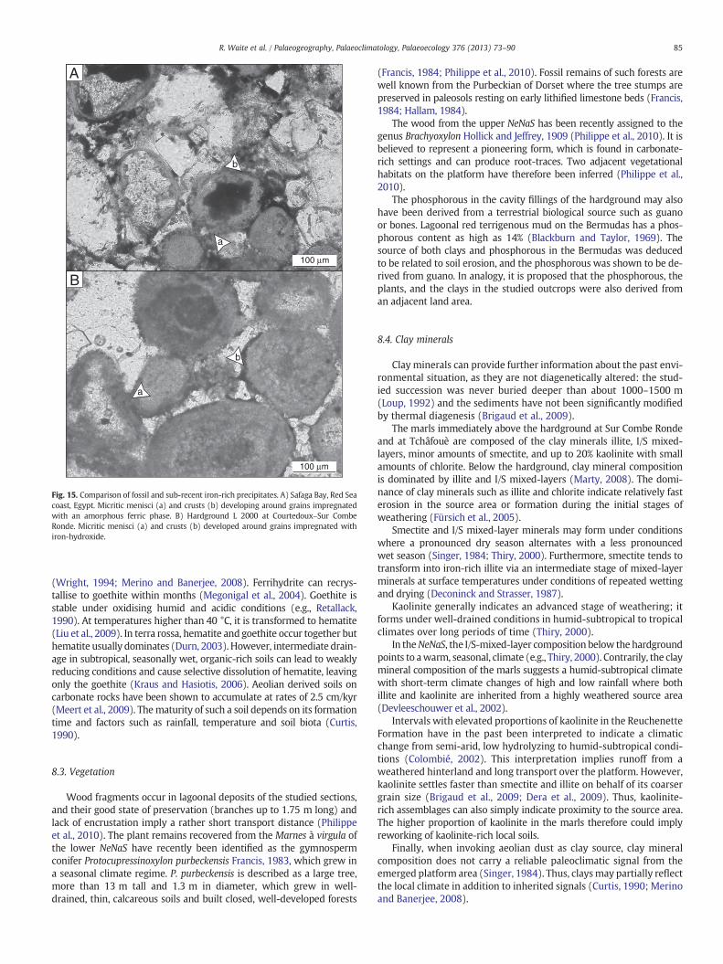
Fig. 15. Comparison of fossil and sub-recent iron-rich precipitates. A) Safaga Bay, Red Seacoast, Egypt. Micritic menisci (a) and crusts (b) developing around grains impregnatedwith an amorphous ferric phase. B) Hardground L 2000 at Courtedoux–Sur CombeRonde. Micritic menisci (a) and crusts (b) developed around grains impregnated withiron-hydroxide.
85R. Waite et al. / Palaeogeography, Palaeoclimatology, Palaeoecology 376 (2013) 73–90
(Wright, 1994; Merino and Banerjee, 2008). Ferrihydrite can recrys-tallise to goethite within months (Megonigal et al., 2004). Goethite isstable under oxidising humid and acidic conditions (e.g., Retallack,1990). At temperatures higher than 40 °C, it is transformed to hematite(Liu et al., 2009). In terra rossa, hematite and goethite occur together buthematite usually dominates (Durn, 2003). However, intermediate drain-age in subtropical, seasonally wet, organic-rich soils can lead to weaklyreducing conditions and cause selective dissolution of hematite, leavingonly the goethite (Kraus and Hasiotis, 2006). Aeolian derived soils oncarbonate rocks have been shown to accumulate at rates of 2.5 cm/kyr(Meert et al., 2009). Thematurity of such a soil depends on its formationtime and factors such as rainfall, temperature and soil biota (Curtis,1990).
8.3. Vegetation
Wood fragments occur in lagoonal deposits of the studied sections,and their good state of preservation (branches up to 1.75 m long) andlack of encrustation imply a rather short transport distance (Philippeet al., 2010). The plant remains recovered from the Marnes à virgula ofthe lower NeNaS have recently been identified as the gymnospermconifer Protocupressinoxylon purbeckensis Francis, 1983, which grew ina seasonal climate regime. P. purbeckensis is described as a large tree,more than 13 m tall and 1.3 m in diameter, which grew in well-drained, thin, calcareous soils and built closed, well-developed forests
(Francis, 1984; Philippe et al., 2010). Fossil remains of such forests arewell known from the Purbeckian of Dorset where the tree stumps arepreserved in paleosols resting on early lithified limestone beds (Francis,1984; Hallam, 1984).
The wood from the upper NeNaS has been recently assigned to thegenus Brachyoxylon Hollick and Jeffrey, 1909 (Philippe et al., 2010). It isbelieved to represent a pioneering form, which is found in carbonate-rich settings and can produce root-traces. Two adjacent vegetationalhabitats on the platform have therefore been inferred (Philippe et al.,2010).
The phosphorous in the cavity fillings of the hardground may alsohave been derived from a terrestrial biological source such as guanoor bones. Lagoonal red terrigenous mud on the Bermudas has a phos-phorous content as high as 14% (Blackburn and Taylor, 1969). Thesource of both clays and phosphorous in the Bermudas was deducedto be related to soil erosion, and the phosphorous was shown to be de-rived from guano. In analogy, it is proposed that the phosphorous, theplants, and the clays in the studied outcrops were also derived froman adjacent land area.
8.4. Clay minerals
Clay minerals can provide further information about the past envi-ronmental situation, as they are not diagenetically altered: the stud-ied succession was never buried deeper than about 1000–1500 m(Loup, 1992) and the sediments have not been significantly modifiedby thermal diagenesis (Brigaud et al., 2009).
The marls immediately above the hardground at Sur Combe Rondeand at Tchâfouè are composed of the clay minerals illite, I/S mixed-layers, minor amounts of smectite, and up to 20% kaolinite with smallamounts of chlorite. Below the hardground, clay mineral compositionis dominated by illite and I/S mixed-layers (Marty, 2008). The domi-nance of clay minerals such as illite and chlorite indicate relatively fasterosion in the source area or formation during the initial stages ofweathering (Fürsich et al., 2005).
Smectite and I/S mixed-layer minerals may form under conditionswhere a pronounced dry season alternates with a less pronouncedwet season (Singer, 1984; Thiry, 2000). Furthermore, smectite tends totransform into iron-rich illite via an intermediate stage of mixed-layerminerals at surface temperatures under conditions of repeated wettingand drying (Deconinck and Strasser, 1987).
Kaolinite generally indicates an advanced stage of weathering; itforms under well-drained conditions in humid-subtropical to tropicalclimates over long periods of time (Thiry, 2000).
In theNeNaS, the I/S-mixed-layer composition below the hardgroundpoints to awarm, seasonal, climate (e.g., Thiry, 2000). Contrarily, the claymineral composition of the marls suggests a humid-subtropical climatewith short-term climate changes of high and low rainfall where bothillite and kaolinite are inherited from a highly weathered source area(Devleeschouwer et al., 2002).
Intervals with elevated proportions of kaolinite in the ReuchenetteFormation have in the past been interpreted to indicate a climaticchange from semi-arid, low hydrolyzing to humid-subtropical condi-tions (Colombié, 2002). This interpretation implies runoff from aweathered hinterland and long transport over the platform. However,kaolinite settles faster than smectite and illite on behalf of its coarsergrain size (Brigaud et al., 2009; Dera et al., 2009). Thus, kaolinite-rich assemblages can also simply indicate proximity to the source area.The higher proportion of kaolinite in the marls therefore could implyreworking of kaolinite-rich local soils.
Finally, when invoking aeolian dust as clay source, clay mineralcomposition does not carry a reliable paleoclimatic signal from theemerged platform area (Singer, 1984). Thus, claysmay partially reflectthe local climate in addition to inherited signals (Curtis, 1990; Merinoand Banerjee, 2008).
86 R. Waite et al. / Palaeogeography, Palaeoclimatology, Palaeoecology 376 (2013) 73–90
8.5. Role of paleosols within the facies succession
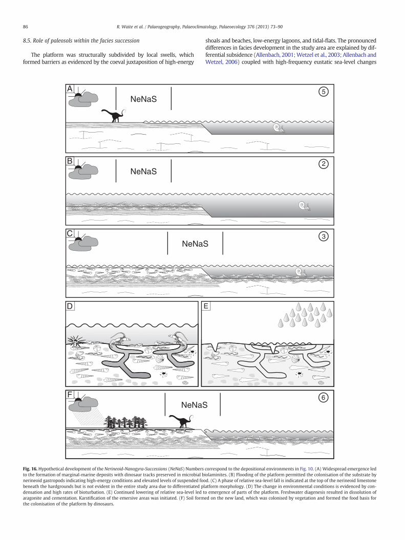
The platform was structurally subdivided by local swells, whichformed barriers as evidenced by the coeval juxtaposition of high-energy
ANeNaS
BNeNaS
CNeNaS
D E
FNeNaS
Fig. 16. Hypothetical development of the Nerineoid-Nanogyra-Successions (NeNaS) Numbersto the formation of marginal-marine deposits with dinosaur tracks preserved in microbial bnerineoid gastropods indicating high-energy conditions and elevated levels of suspended foobeneath the hardgrounds but is not evident in the entire study area due to differentiated pldensation and high rates of bioturbation. (E) Continued lowering of relative sea-level led taragonite and cementation. Karstification of the emersive areas was initiated. (F) Soil formthe colonisation of the platform by dinosaurs.
shoals and beaches, low-energy lagoons, and tidal-flats. The pronounceddifferences in facies development in the study area are explained by dif-ferential subsidence (Allenbach, 2001;Wetzel et al., 2003; Allenbach andWetzel, 2006) coupled with high-frequency eustatic sea-level changes
5
2
3
6
correspond to the depositional environments in Fig. 10. (A) Widespread emergence lediolaminites. (B) Flooding of the platform permitted the colonisation of the substrate byd. (C) A phase of relative sea-level fall is indicated at the top of the nerineoid limestoneatform morphology. (D) The change in environmental conditions is evidenced by con-o emergence of parts of the platform. Freshwater diagenesis resulted in dissolution ofed on the new land, which was colonised by vegetation and formed the food basis for
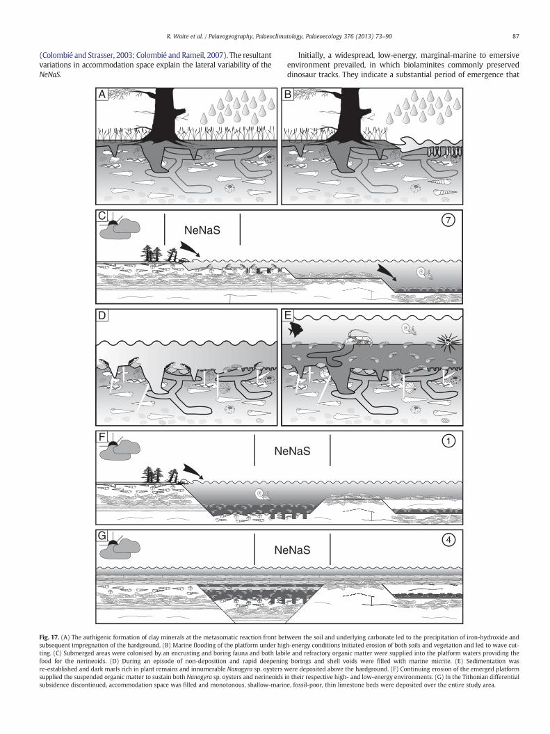
87R. Waite et al. / Palaeogeography, Palaeoclimatology, Palaeoecology 376 (2013) 73–90
(Colombié and Strasser, 2003; Colombié and Rameil, 2007). The resultantvariations in accommodation space explain the lateral variability of theNeNaS.
NeF
GNe
CNeNaS
BA
ED
Fig. 17. (A) The authigenic formation of clay minerals at the metasomatic reaction front betsubsequent impregnation of the hardground. (B) Marine flooding of the platform under higting. (C) Submerged areas were colonised by an encrusting and boring fauna and both labifood for the nerineoids. (D) During an episode of non-deposition and rapid deepeningre-established and dark marls rich in plant remains and innumerable Nanogyra sp. oysters wsupplied the suspended organic matter to sustain both Nanogyra sp. oysters and nerineoids isubsidence discontinued, accommodation space was filled and monotonous, shallow-marin
Initially, a widespread, low-energy, marginal-marine to emersiveenvironment prevailed, in which biolaminites commonly preserveddinosaur tracks. They indicate a substantial period of emergence that
1NaS
NaS4
7
ween the soil and underlying carbonate led to the precipitation of iron-hydroxide andh-energy conditions initiated erosion of both soils and vegetation and led to wave cut-le and refractory organic matter were supplied into the platform waters providing theborings and shell voids were filled with marine micrite. (E) Sedimentation wasere deposited above the hardground. (F) Continuing erosion of the emerged platform
n their respective high- and low-energy environments. (G) In the Tithonian differentiale, fossil-poor, thin limestone beds were deposited over the entire study area.
88 R. Waite et al. / Palaeogeography, Palaeoclimatology, Palaeoecology 376 (2013) 73–90
affected wide areas on the low-relief platform. A subsequent rise in sealevel led to the partial inundation of the platform and the intertidal tosupratidal facies was covered by — or graded into — a high-energygrainstone to nerineoid floatstone deposit. The persistent generationof accommodation during transgression permitted a prolonged phaseof stable environmental conditions for the deposition of the nerineoidlimestones (Fig. 16).
In the north of the study area, subsidence persisted, while a relativesea-level fall or filling-in by sediment led to a shallowing in the southernpart. Themarginallymarine, bioturbated beds that cap the nerineoid lime-stones usually show signs of complex formation (lag deposit, storm accu-mulation) and prolonged residence time at the sediment–water interface(strong external and internal encrustation of shells). Hardground forma-tion may have been initiated during this time. The continued drop inrelative sea level led to emergence and exposure of the carbonate to me-teoric water; aragonite was dissolved and early calcitic cements formed.Subsequently, microkarst- or karren-structures began to develop.
Contemporaneous formation of soil permitted vegetation to colo-nise the platform and provide the nutritional basis for the dinosaurs.The relatively minor karstification of the rock suggests that these con-ditions only prevailed for time spans of a few thousand years (Goebelet al., 1989; Bosák, 2008). The soil formation led to iron-hydroxideimpregnation of the underlying limestone (Fig. 17).
Theflat anddiscrete appearance of the surface suggests a newepisodeof relative sea-level rise, leading to flooding and abrasion by waves (e.g.,Santos et al., 2010). This caused reworking of soil and vegetation and ero-sion of the underlying rock, thereby forming awave-cut hardground. Thelabile organic matter and nutrients fertilised coastal waters and in turnprovided the nutritional basis for the widespread mass occurrences ofnerineoid gastropods and the oyster Nanogyra sp. (e.g., Hallock andSchlager, 1986;Waite et al., 2008). The hardgrounds initially experienceda period of sediment bypass, during which the rock was bored andencrusted, and apatite-rich micrite infiltrated or was precipitated fromthewater in the remaining pore-space (e.g., Santos et al., 2010). Differen-tial subsidence led to relative sea-level rise over the hardgrounds whileadjacent areas remained in intertidal or nerineoid facies.
Fine-grained marls accumulated once low-energy hydrodynamicconditions beneath fair-weather wave-basewere reached. Depositionalwater depth of the marls is unlikely to have been very deep, as signs ofemersion occur only a few metres below and above (Strasser, 2007).Therefore, water depth alone cannot account for the inhibition of car-bonate production. The alternation of clay- and carbonate-dominatedbeds is interpreted as resulting from episodic soil erosion on theemerged platform. The continuing import of terrigenous mud and nu-trients led to a perturbation of the carbonate production. The abun-dance of Nanogyra sp., the dark colour of the marls, and the commonoccurrence of plant remains imply high benthic food levels probablyfuelled by the removal of soil and vegetation cover during transgression(Riera and Richard, 1996). In the lower NeNaS, marl sedimentationterminated gradually and oyster-rich lagoonal limestones persist abovethe last marl bed for some metres, before coral limestones indicate areturn to shallow-marine oligotrophic conditions (Jank et al., 2006c).In the upper NeNaS, the Nanogyra-rich facies also persists for somemetres before shallow-water conditions are evidenced by the occur-rence of tidal biolaminites and teepee structures (Fig. 17). The changefrom Nanogyra-rich marls to Nanogyra-rich limestones is interpretedas the end of the terrigenous mud and nutrient supply suppressingthe carbonate production. Above the upper NeNaS, differential subsi-dence appears to have ceased and accumulation of homogeneous,thin-bedded, fossil-poor and predominantly shallow-marine sedimentsbegan (Twannbach Formation).
9. Conclusions
In the shallow-marine stratigraphic context of the studied sections,lithologic and geochemical data indicate subaerial exposure of the top
of the nerineoid-rich limestones prior to the submersion and depositionofNanogyra sp.-richmarls. Several lines of circumstantial evidence, suchasmicro-karst features,micriticmeniscus cements, void-producing ara-gonite dissolution, and iron impregnation support this observation.Paleosols formed on the emerged platforms, potentially fed by aeoliansiliciclastic sources, concomitantly cementing the underlying limemud, and thereby producing hardgrounds. The pH buffering potentialof the limestone surface lead to the precipitation of less soluble phasesfrom the pore water and the hardgrounds were impregnated with iron-hydroxide during soil formation under warm, seasonal, Mediterranean-like climatic conditions. Abundant herbivorous dinosaur tracks and fossilflorawithin the studied sections support local formation of soils and veg-etation on the platform. However, soils were subsequently eroded andthe hardgrounds heavily overprinted by wave action, encrustation, andboring during marine flooding. The juxtaposition of intertidal and la-goonal deposits necessitates tectonically driven differential subsidence.The reworked terrigenous mud and flora provided surplus nutrients,which supported mass accumulations of marine molluscs, but also ledto the eutrophication and partial suffocation of the carbonate factory.The terrigenous material was finally redeposited as marl in local depres-sions. Although in the past, these hardgrounds have been recognised asmaximum flooding surfaces, with the associated hiati, the new resultssuggest that these hiati may be substantially more important than previ-ously accounted for. Not only do these hardgrounds represent the time ofnon-deposition associatedwith sea level rise, they also represent the pre-ceding time for sea-level fall, soil formation, and subsequent soil erosion.Such long hiati — if not recognised — are problematic for sequence- andcyclostratigraphic interpretations. Taking into account the significanceof the time gaps represented by these — and similar — hardgroundswill likely change future correlations in shallowmarine carbonate strati-graphic analyses.
Acknowledgements
We would like to thank Susan M. Kidwell for her inspiring ideasregarding the terra rossa development and the Paléontologie A16, espe-cially Wolfgang A. Hug, for continued support of this research. Further-more, we wish to thank the reviewers Franz T. Fürsich and Ana Santosas well as the editor Finn Surlyk for their very detailed revisions of themanuscript and extremely constructive comments. We also acknowl-edge the Swiss Federal Roads Office for the funding of the excavationsat Sur CombeRonde andTchâfouè,which provided unique fresh sectionsincluding numerous bedding planes. Further thanks go to Karl Stranskyfor the permission to use his samples from the Lommiswil section;Anton Probst, president of the community council of Bellach, for the per-mission to work in the Lommiswil quarry, as well as the communitycouncil of Péry-Reuchenette and Ciments Vigier for the permission towork in the old Reuchenette quarry. The project was financed by theSwiss National Science Foundation (Project 20-109214.05).
References
Abbink, O., Targarona, J., Brinkhuis, H., Visscher, H., 2001. Late Jurassic to earliest Creta-ceous palaeoclimatic evolution of the southern North Sea. Global and PlanetaryChange 30, 231–256.
Allenbach, R.P., 2001. Synsedimentary tectonics in an epicontinental sea: a new interpre-tation of the Oxfordian basins of northern Switzerland. Eclogae Geologicae Helvetiae94, 265–287.
Allenbach, R.P., Wetzel, A., 2006. Spatial patterns of Mesozoic facies relationships and theage of the Rhenish Lineament: a compilation. International Journal of Earth Sciences95, 803–813.
Bayle, E., 1878. Fossiles principaux des terrains de la France. Explication de la cartegéologique de France, 4 (1). Atlas. Imprimèrie Nationale, Paris 1–158.
Beurlen, K., 1958. Die Exogyren. Ein Beitrag zur phyletischen Morphogenese der Austern.Neues Jahrbuch für Geologie und Paläontologie. Monatshefte 5 (B), 197–217.
Bish, D.L., Post, J.E., 1993. Quantitative mineralogical analysis using the Rietveld full-pattern fitting method. American Mineralogist 78, 932–940.
Blackburn, G., Taylor, R.M., 1969. Limestones and red soils of Bermuda. Geological Societyof America Bulletin 80, 1595–1597.
Bosák, P., 2008. Karst processes and time. Geologos 14, 19–36.
89R. Waite et al. / Palaeogeography, Palaeoclimatology, Palaeoecology 376 (2013) 73–90
Brigaud, B., Durlet, C., Deconinck, J.-F., Vincent, B., Pucéat, E., Thierry, J., Trouiller, A.,2009. Facies and climate/environmental changes recorded on a carbonate ramp:a sedimentological and geochemical approach on Middle Jurassic carbonates(Paris Basin, France). Sedimentary Geology 222, 181–206.
Charollais, J., Wernli, R., Meyer, C.A., Clavel, B., 2008. Découverte d'empreintes dedinosaures dans le Berriasien du Jura méridional (Ain, France). Archives Des Sciences60, 33–40.
Cherns, L., Wright, V.P., 2009. Quantifying the impacts of early diagenetic aragonite dis-solution on the fossil record. Palaios 24, 756–771.
Colombié, C., 2002. Sédimentologie, stratigraphie séquentielle et cyclostratigraphie duKimméridgien du Jura suisse et du Bassin vocontien (France): relations plate-forme — bassin et facteurs déterminants. PhD Thesis, GeoFocus. 4. Department ofGeosciences, University of Fribourg, Fribourg. pp. 1–198.
Colombié, C., Rameil, N., 2007. Tethyan-to-boreal correlation in the Kimmeridgian usinghigh-resolution sequence stratigraphy (Vocontian Basin, Swiss Jura, Boulonnais,Dorset). International Journal of Earth Sciences 96, 567–591.
Colombié, C., Strasser, A., 2003. Depositional sequences in the Kimmeridgian of theVocontian Basin (France) controlled by carbonate export from shallow-water plat-forms. Geobios 36, 675–683.
Colombié, C., Strasser, A., 2005. Facies, cycles, and controls on the evolutionof a keep-up carbonate platform (Kimmeridgian, Swiss Jura). Sedimentology52, 1207–1227.
Curtis, C.D., 1990. Aspects of climatic influence on the clay mineralogy and geochemistryof soils, paleosols and clastic sedimentary-rocks. Journal of the Geological Society147, 351–357.
Deconinck, J.-F., Strasser, A., 1987. Sedimentology, clay mineralogy and depositionalenvironment of Purbeckian green marls (Swiss and French Jura). Eclogae GeologicaeHelvetiae 80, 753–772.
Defrance, A., 1820. Gervillie. In: Cuvier, F. (Ed.), Dictionnaire des Sciences naturelles,22. Levrault, F.G., Le Normant, Paris, pp. 502–503.
Defrance, A., 1821. Huîtres. In: Cuvier, F. (Ed.), Dictionnaire des Sciences naturelles, 22.Levrault, F.G., Le Normant, Paris, pp. 20–33.
Dera, G., Pellenard, P., Neige, P., Deconinck, J.F., Puceat, E., Dommergues, J.L., 2009. Dis-tribution of clay minerals in Early Jurassic Peritethyan seas: palaeoclimatic signifi-cance inferred frommultiproxy comparisons. Palaeogeography, Palaeoclimatology,Palaeoecology 271, 39–51.
Devleeschouwer, X., Herbosch, A., Préat, A., 2002. Microfacies, sequence stratigraphy andclay mineralogy of a condensed deep-water section around the Frasnian/Famennianboundary (Steinbruch Schmidt, Germany). Palaeogeography, Palaeoclimatology, Pa-laeoecology 181, 171–193.
Dickson, J.A.D., 1966. Carbonate identification and genesis as revealed by staining. Journalof Sedimentary Petrology 36, 491–505.
Douvillé, J.H.F., 1904. Paléontologie, mollusques fossils. In: Morgan, J.D. (Ed.), Mis-sion Scientifique en Perse 3. Études géologiques. Partie 4. Ernest Leroux, Paris,pp. 191–380.
Dunham, R.J., 1962. Classification of carbonate rocks according to depositional texture.In: Ham,W.E. (Ed.), Classification of Carbonate Rocks—A Symposium: AAPGMemoir,1, pp. 108–121.
Durn, G., 2003. Terra rossa in the Mediterranean region: parent materials, compositionand origin. Geological Croatica 56, 83–100.
Ehrenberg, K., 1944. Ergänzende Bemerkungen zu den seinerzeit aus dem Miozänvon Burgschleintz beschriebenen Gangkeren und Bauten dekapoder Krebse.Palaeontologische Zeitschrift 23, 354–359.
Enay, R., Arnaud, M., Atrops, F., Barfety, J.-C., Beaudoin, B., Bernier, P., Bodeur, Y.,Boullier, A., Clavel, B., Contini, D., Dardeau, G., Debrand-Passard, S., Donze, P.,Elmi, S., Gaillard, C., Jaffrezo, M., Jautee, E., Lathuiliere, B., Marchand, D., Monleau,C., Menot, J.-C., Noël, D., Pascal, A., Peybernes, B., Remane, J., Tintant, H., Thierry,J., 1984. Jurassique supérieur: Malm. In: Debrand-Passard, S., Courbouleix, S.,Lienhardt, M.-J. (Eds.), Synthèse Géologique du Sud-Est de la France: MémoiresBureau de Recherches Géologique et Minières France, 125, pp. 223–286.
Foos, A.M., 1991. Aluminous lateritic soils, Eleuthera, Bahamas — a modern analog tocarbonate paleosols. Journal of Sedimentary Petrology 61, 340–348.
Frakes, L.A., Francis, J.E., Syktus, J.I., 1992. Climate Modes of the Phanerozoic; The His-tory of the Earth's Climate Over the Past 600 Million Years. Cambridge UniversityPress, Cambridge 1–288.
Francis, J.E., 1983. The dominant conifer of the Jurassic Purbeck Formation, England.Palaeontology 26, 277–294.
Francis, J.E., 1984. The seasonal environment of the Purbeck (Upper Jurassic) fossilforests. Palaeogeography, Palaeoclimatology, Palaeoecology 48, 285–307.
Fürsich, F.T., 1979. Genesis, environments, and ecology of Jurassic hardgrounds. NeuesJahrbuch für Geologie und Paläontologie Abhandlungen 158, 1–63.
Fürsich, F.T., Oschmann, W., 1986. Storm shell beds of Nanogyra virgula in the Upper Ju-rassic of France. Neues Jahrbuch für Geologie und Paläontologie Abhandlungen 172,141–161.
Fursich, F.T., Oschmann, W., 1986. Autecology of the Upper Jurassic oyster Nanogyravirgula (DEFRANCE). Paläontologische Zeitschrifft 60, 65–74.
Fürsich, F.T., Singh, I.B., Joachimski, M., Krumm, S., Schlirf, M., Schlirf, S., 2005.Palaeoclimate reconstructions of the Middle Jurassic of Kachchh (western India);an integrated approach based on palaeoecological, oxygen isotopic, and clay min-eralogical data. Palaeogeography, Palaeoclimatology, Palaeoecology 217, 289–309.
Goebel, K.A., Bettis, E.A., Heckel, P.H., 1989. Upper Pennsylvanian paleosol in StrangerShale and underlying Iatan Limestone, southwestern Iowa. Journal of SedimentaryPetrology 59, 224–232.
Gygi, R.A., 2000. Integrated Stratigraphy of the Oxfordian and Kimmeridgian (Late Jurassic)in Northern Switzerland and Adjacent Southern Germany. Birkhäuser Verlag, Basel1–151.
Gygi, R.A., 2003. Perisphinctacean ammonites of the Late Jurassic in northern Switzer-land — a versatile tool to investigate the sedimentary geology of an epicontinentalsea. Schweizerische Paläontologische Abhandlungen 123, 1–232.
Häfeli, C., 1966. Die Jura/Kreide-Grenzschichten im Bielerseegebiet (Kt. Bern). EclogaeGeologicae Helvetiae 59, 565–695.
Hallam, A., 1984. Continental humid and arid zones during the Jurassic and Cretaceous.Palaeogeography, Palaeoclimatology, Palaeoecology 47, 195–223.
Hallam, A., 1985. A review of Mesozoic climates. Journal of the Geological Society ofLondon 142, 433–445.
Hallam, A., 1993. Jurassic climates as inferred from the sedimentary and fossil record.Philosophical Transactions of the Royal Society of London. Series B, Biological Sciences341, 287–296.
Hallam, A., 2001. A review of the broad pattern of Jurassic sea-level changes and their pos-sible causes in the light of current knowledge. Palaeogeography, Palaeoclimatology,Palaeoecology 167, 23–37.
Hallock, P., Schlager, W., 1986. Nutrient excess and the demise of coral reefs and car-bonate platforms. Palaios 1, 389–398.
Hardenbol, J., Thierry, J., Farley, M.B., Jacquin, T., de Graciansky, P.C., Vail, P.R., 1998. Ju-rassic chronostratigraphy. In: de Graciansky, P.C., Hardenbol, J., Jacquin, T., Vail, P.R.(Eds.), Mesozoic and Cenozoic Sequence Stratigraphy of European Basins (SEPMSpecial Publication 60 (chart)).
Harder, H., 1980. Syntheses of glauconite at surface temperatures. Clays and Clay Min-erals 28, 217–222.
Hillgärtner, H., 1998. Discontinuity surfaces on a shallow-marine carbonate platform(Berriasian, Valanginian, France and Switzerland). Journal of Sedimentary Research68, 1093–1108.
Hillgärtner, H., Strasser, A., 2003. Quantification of high-frequency sea-level fluctua-tions in shallow-water carbonates; an example from the Berriasian–Valanginian(French Jura). Palaeogeography, Palaeoclimatology, Palaeoecology 200, 43–63.
Hillgärtner, H., Dupraz, C., Hug, W., 2001. Microbially induced cementation of carbon-ate sands: are micritic meniscus cements good indicators of vadose diagenesis?Sedimentology 48, 117–131.
Hollick, A., Jeffrey, E.C., 1909. Studies of Cretaceous coniferous remains from Kreischerville,N.Y. Memoirs of The New York Botanical Garden 3, 1–76.
Hug, W.A., 2003. Sequenzielle Faziesentwicklung der Karbonatplattform des SchweizerJura im Späten Oxford und frühesten Kimmeridge. PhD Thesis, GeoFocus, 7. De-partment of Geosciences, University of Fribourg, Fribourg. pp. 1–156.
Jank, M., Meyer, C.A., Wetzel, A., 2006a. Late Oxfordian to Late Kimmeridgian carbonatedeposits of NW Switzerland (Swiss Jura): stratigraphical and palaeogeographicalimplications in the transition area between the Paris Basin and the Tethys. Sedi-mentary Geology 186, 237–263.
Jank, M., Wetzel, A., Meyer, C.A., 2006b. A calibrated composite section for the Late Juras-sic Reuchenette Formation in northwestern Switzerland (?Oxfordian, Kimmeridgiansensu gallico, Ajoie-Region). Eclogae Geologicae Helvetiae 99, 175–191.
Jank, M., Wetzel, A., Meyer, C.A., 2006c. Late Jurassic sea-level fluctuations in NW Swit-zerland (Late Oxfordian to Late Kimmeridgian): closing the gap between the Bore-al and Tethyan realm in western Europe. Facies 52, 487–519.
Kidwell, S.M., 1993. Taphonomic expression of sedimentary hiatuses: field observa-tions on bioclastic concentrations and sequence anatomy in low, moderate andhigh subsidence settings. Geologische Rundschau 82, 189–202.
Kraus, M.J., Hasiotis, S.T., 2006. Significance of different modes of preservation tointerpreting paleoenvironmental and paleohydrological settings: examples from Pa-leogene paleosols, Bighorn Basin, Wyoming USA. Journal of Sedimentary Research76, 633–646.
Leymarie, M.A., 1842. Suite du mémoire sur le terrain Crétacé du Département de l'Aube. Mémoires de la Société Géologique de France 5, 1–34.
Liu, H., Guo, H., Li, P., Wei, Y., 2009. Transformation from δ-FeOOH to hematite in thepresence of trace Fe(II). Journal of Physics and Chemistry of Solids 70, 186–191.
Loup, B., 1992. Mesozoic subsidence and stretching models of the lithosphere inSwitzerland (Jura, Swiss Plateau and Helvetic realm). Eclogae Geologicae Helvetiae85, 541–572.
Mägdefrau, K., 1932. Über einige Bohrgänge aus dem unteren Muschelkalk von Jena.Paläontologische Zeitschrift 14, 150–160.
Marty, D., 2008. Sedimentology, taphonomy, and ichnology of Late Jurassic dinosaurtracks from the Jura carbonate platform (Chevenez–Combe Ronde tracksite, NWSwitzerland): insights into the tidal-flat palaeoenvironment and dinosaur diversity,locomotion, andpalaeoecology. PhD Thesis, GeoFocus. 21. Department ofGeosciences,University of Fribourg, Fribourg. pp. 1–278.
Marty, D., Hug, W.A., Iberg, A., Cavin, L., Meyer, C.A., Lockley, M.G., 2003. Preliminaryreport on the Courtedoux Dinosaur Tracksite from the Kimmeridgian of northernSwitzerland. Ichnos 10, 209–219.
Marty, D., Ayer, J., Becker, D., Berger, J.-P., Billon-Bruyat, J.-P., Braillard, L., Hug, W.A.,Meyer, C.A., 2007. Late Jurassic dinosaur tracksites of the Transjurane highway(Canton Jura, NW Switzerland): overview and measures for their protection andvalorisation. Bulletin für Angewandte Geologie 12, 75–89.
Marty, D., Belvedere, M., Meyer, C.A., Mietto, P., Paratte, G., Lovis, C., Thüring, B., 2010.Comparative analysis of Late Jurassic sauropod trackways from the Jura Mountains(NW Switzerland) and the central High Atlas Mountains (Morocco): implicationsfor sauropod ichnotaxonomy. Historical Biology 22, 109–133.
Mazin, J.M., Hantzpergue, P., 2010. Les traces de dinosaures des sites jurassiques français(Coisia, Loulle, Plagne). In: Billon-Bruyat, J.-P.c (Ed.), La frontière franco-suisse: unpetit pas pour les dinosaures. Colloque scientifique, Porrentruy 29.–30.10.2010, ab-stract book. Paléojura, Porrentruy, pp. 15–16.
Meert, J.G., Pruett, F.D., Merino, E., 2009. An “inverse conglomerate” paleomagnetic testand timing of in situ terra rossa formation at Bloomington, Indiana. Journal ofGeology 117, 126–138.
90 R. Waite et al. / Palaeogeography, Palaeoclimatology, Palaeoecology 376 (2013) 73–90
Megonigal, J.P., Hines, M.E., Visscher, P.T., 2004. Anaerobic metabolism: linkages totrace gases and aerobic processes. In: Schlesinger, W.H. (Ed.), Biogeochemistry.Elsevier-Pergamon, Oxford, pp. 317–424.
Meldahl, K.H., 1993. Geographic gradients in the formation of shell concentrations; Plio-Pleistocene marine deposits, Gulf of California. Palaeogeography, Palaeoclimatology,Palaeoecology 101, 1–25.
Merino, E., Banerjee, A., 2008. Terra rossa genesis, implications for karst, and eoliandust: a geodynamic thread. Journal of Geology 116, 62–75.
Meyer, C.A., 1990. Sauropod tracks from the Upper Jurassic Reuchenette Formation(Kimmeridgian Lommiswil, Kt Solothurn) of northern Switzerland. Eclogae GeologicaeHelvetiae 83, 389–397.
Meyer, C.A., 1994. Depositional environment and paleoecology of the Solothurn Turtle lime-stone (Kimmeridgian, Northern Switzerland). Geobios Mémoire spécial 16, 227–236.
Meyer, C.A., Pittman, J.G., 1994. A comparison between the Brontopodus ichnofacies ofPortugal, Switzerland and Texas. In: Lockley, M.G., Dos Santos, V.F., Meyer, C.A.,Hunt, A.P. (Eds.), Aspects of Sauropod Paleobiology. GAIA, Lisboa, pp. 5–14.
Meyer, C.A., Thüring, B., 2003. Dinosaurs of Switzerland. Comptes Rendus Palevol 2,103–117.
Meyer, C.A., Thüring, B., Wetzel, A., 2006. The hitch-hikers guide to the Late Jurassic —basement structures provide clues to dinosaur migration routes. Hantkeniana 5, 96.
Middlemiss, F.A., 1959. English Aptian Terebratulidae. Paleontology 2, 94–142.Mirabella, A., Costantini, E.A.C., Carnicelli, S., 1992. Genesis of a polycyclic Terra Rossa
(chromic cambisol on rhodic nitisol) at the Poggio del Comune in Central Italy.Zeitschrift für Pflanzenernährung und Bodenkunde 155, 407–413.
Moore, C.H., 2001. Carbonate reservoirs: porosity evolution and diagenesis in a sequencestratigraphic framework. Developments in Sedimentology, 55. Elsevier, Amsterdam1–460.
Moore, G.T., Hayashida, D.N., Ross, C.A., Jacobson, S.R., 1992. Paleoclimate of theKimmeridgian Tithonian (Late Jurassic) world. 1. Results using a general-circulationmodel. Palaeogeography, Palaeoclimatology, Palaeoecology 93, 113–150.
Mouchet, P., 1995. Le Kimméridgien du Jura central. Microfaciès, minéralogie etinterpétation séquentielle. PhD Thesis. Faculté de Sciences, Université de Neuchâtel,Neuchâtel. pp. 1–204.
Oppel, A., 1863a. Über jurassische Cephalopoden III. Paläontologische Mittheilungenaus dem Museum des Königlich bayerischen Staates 1, 163–266.
Oppel, A., 1863b. Über Ostindische Fossilreste aus den Secundären Ablagerungen vonSpiti und Gnari-Khorsum in Tibet. Paläontologische Mitteilungen aus dem Museumdes Königlich bayerischen Staates 4, 267–288.
Palmer, T.J., Hudson, J.D., Wilson, M.A., 1988. Paleoecological evidence for early aragonitedissolution in ancient calcite seas. Nature 335, 809–810.
Philippe, M., Billon-Bruyat, J.-P., Garcia-Ramos, J.C., Bocat, L., Gomez, B., Piñuela, L.,2010. New occurrences of the wood Protocupressinoxylon purbeckensis Francis: im-plications for terrestrial biomes in southwestern Europe at the Jurassic/Cretaceousboundary. Palaeontology 53, 201–214.
Rameil, N., 2005. Carbonate sedimentology, sequence stratigraphy and cyclostratigraphyof the Tithonian in the Swiss and French Jura Mountains. PhD Thesis, GeoFocus. 13.Geological Department, University of Fribourg, Fribourg. pp 1–246.
Read, J.F., Grover, G.A., 1977. Scalloped and planar erosion surfaces, Middle Ordovicianlimestones, Virginia: analogues of Holocene exposed karst or tidal rock platforms.Journal of Sedimentary Petrology 47, 956–972.
Rees, P.Mc., Noto, C.R., Parrish, J.M., Parrish, J.T., 2004. Late Jurassic climates, vegetation,and dinosaur distributions. Journal of Geology 112, 643–653.
Retallack, G.J., 1990. Soils of the Past: An Introduction to Paleopedology. Unwin Hyman,Boston 1–520.
Riera, P., Richard, P., 1996. Isotopic determination of food sources of Crassostrea gigasalong a trophic gradient in the estuarine bay of Marennes–Oléron. Estuarine, Coastaland Shelf Sciences 42, 347–360.
Röding, P.F., 1798. Museum Boltenianum sive catalogus cimeliorum e tribus regnisnaturæ quæ olim collegerat Joa. In: Fried Bolten, M.D. (Ed.), annos proto physicusHamburgensis. Pars secunda continens conchylia sive testacea univalvia, bivalvia &multivalvia. Trappii, T.J.C., Hamburgi, pp. 1–199 (p. d. per XL).
Sandberger, F., 1864. Beobachtungen im mittleren Jura des Badischen Oberlandes.Würzburger naturwissenschaftliche Zeitschrifft 5, 1–22.
Sanders, D., 2003. Syndepositional dissolution of calcium carbonate in neritic carbonateenvironments: geological recognition, processes, potential significance. Journal ofAfrican Earth Sciences 36, 99–134.
Santos, A., Mayoral, E., da-Silva, C.M., Cachão, M., Kullberg, J.C., 2010. Trypanitesichnofacies: Palaeoenvironmental and tectonic implications. A case study fromthe Miocene disconformity at Foz da Fonte (Lower Tagus Basin, Portugal).Palaeogeography, Palaeoclimatology, Palaeoecology 292, 35–43.
Singer, A., 1984. The paleoclimatic interpretation of clay-minerals in sediments — areview. Earth-Science Reviews 21, 251–293.
Sowerby, J.D.C., 1821–1823. The mineral conchology of Great Britain, 3–4. J.D.C.,Sowerby, London. Sowerby, G.B.I., 1821–1834. The Genera of Recent and FossilShells, for the Use of Students, in Conchology and Geology. G.B.I., Sowerby, London.
Stampfli, G., Borel, G., Cavazza, W., Mosar, J., Ziegler, P.A., 2001. The paleotectonic atlasof the periTethyan domain. European Geophysical Union, Karlsruhe 1 (CD).
Strasser, A., 1984. Black-pebble occurrence and genesis in Holocene carbonate sediments(Florida Keys, Bahamas, and Tunisia). Journal of Sedimentary Petrology 54, 1097–1109.
Strasser, A., 2007. Astronomical time scale for theMiddle Oxfordian to Late Kimmeridgianin the Swiss and French Jura Mountains. Swiss Journal of Geosciences 100, 407–429.
Strasser, A., Samankassou, E., 2003. Carbonate sedimentation rates today and in the past;Holocene of Florida Bay, Bahamas, and Bermuda vs. Upper Jurassic and Lower Creta-ceous of the Jura Mountains (Switzerland and France). Geologia Croatica 56, 1–18.
Taylor, J.C., 1991. Computer program for standardless quantitative analysis of mineralsusing the full powder diffraction profile. Powder Diffraction 6, 2–9.
Tedesco, L.P., Wanless, H.R., 1991. Generation of sedimentary fabrics and facies by re-petitive excavation and storm infilling of burrow networks, Holocene of SouthFlorida and Caicos Platform. B.W.I. Palaios 6, 326–343.
Thalmann, H.K., 1966. Zur Stratigraphie des oberen Malm im südlichen Berner undSolothurner Jura. Mitteilungen der naturforschenden Gesellschaft Solothurn 22,4–125.
Thierry, J., Barrier, E., Abbate, E., Alekseev, A.S., Ait, O.R., Ait, S.H., Bouaziz, S., Canerot, J.,Georgiev, G., Guiraud, R., Hirsch, F., Ivanik, M., Le, M.J., Le, N.Y.M., Medina, F., Mouty,M., Nazarevich, B., Nikishin, A.M., Page, K., Panov, D.L., Pique, A., Poisson, A.,Sandulescu, M., Sapunov, I.G., Seghedi, A., Soussi, M., Tchoumatchenko, P.V., Vaslet,D., Vishnevskaya, V., Volozh, Y.A., Voznezenski, A., Walley, C.O., Wong, T.E., Ziegler,M., Ait, B.L., Bergerat, F., Bracene, R., Brunet, M.F., Cadet, J.P., Guezou, J.C., Jabaloy, A.,Lepvrier, C., Rimmele, G., de, W.P., Baudin, F., Belaid, A., Bonneau, M., Coutelle, A.,Fekirine, B., Guillocheau, F., Hantzpergue, M., Hippolyte, J.C., Julien, M., Kokel, F.,Lamarche, J., Mami, L., Mansy, J.L., Mascle, G., Pascal, C., Robin, C., Sihamdi, N.,Saintot, A., Stephenson, R., Vera, J.A., Vuks, V.J., 2000. Early Tithonian (141–139 Ma).In: Dercourt, J., Gaetani, M., Vrielynck, B., Barrier, E., Biju Duval, B., Brunet, M.F.,Cadet, J.P., Crasquin, S., Sandulescu, M. (Eds.), Peri-Tethys Atlas; PalaeogeographicalMaps; Explanatory Notes. Commission for the Geologic Map of the World, Paris, pp.98–110.
Thiry, M., 2000. Palaeoclimatic interpretation of clay minerals in marine deposits: anoutlook from the continental origin. Earth-Science Reviews 49, 201–221.
Waite, R. 2010. The palaeoecology of high-spired gastropods and the lost palaeosols:depositional reconstructions on a shallow carbonate platform (Late Kimmeridgian,Swiss Jura Mountains). PhD Thesis, GeoFocus. 23. Department of Geosciences,University of Fribourg, Fribourg. pp. 1–149.
Waite, R., Strasser, A., 2011. A comparison of recent and fossil large, high-spired gastro-pods and their environments. The Nopparat Thara tidal flat in Krabi, South Thailandversus the Swiss Kimmeridgian carbonate platform. Facies 57, 223–248.
Waite, R., Wetzel, A., Meyer, C.A., Strasser, A., 2008. The paleoecological significance ofnerineoid mass accumulations from the Kimmeridgian of the Swiss Jura Mountains.Palaios 23, 548–558.
Wetzel, A., Allenbach, A., Allia, V., 2003. Reactivated basement structures affecting thesedimentary facies in a tectonically “quiescent” epicontinental basin: an examplefrom NW Switzerland. Sedimentary Geology 157, 153–172.
Wildi, W., Funk, H., Loup, B., Amato, E., Huggenberger, P., 1989. Mesozoic subsidencehistory of the European marginal shelves of the alpine Tethys (Helvetic realm,Swiss plateau and Jura). Eclogae Geologicae Helvetiae 82, 817–840.
Wright, V.P., 1994. Paleosols in shallow marine carbonate sequences. Earth-ScienceReviews 35, 367–395.


