Embed Size (px)
Citation preview
Available online at www.sciencedirect.com
1877–0428 © 2011 Published by Elsevier Ltd. Selection and/or peer-review under responsibility of The 2nd International Geography Symposium-Mediterranean Environmentdoi:10.1016/j.sbspro.2011.05.162
Procedia Social and Behavioral Sciences 19 (2011) 504–510
The 2nd International Geography Symposium GEOMED 2010
Environmental effects of stone pits in Hatay (Turkey)
Hüseyin Korkmaza*, Bayram Çetina, smail Egea, Atilla Karata a, Ahmet Boma, Emre Öz ahina
aMustafa Kemal University, Campus of Tayfur Sökmen, Faculty of Arts and Sciences, Department of Geography, 31040,
Antakya/Hatay/Turkey
Abstract
Open pit operation type is generally preferred in mining operations due to its applicability on all operable exposed
rock grounds, its minimum production loss and high production rate. Especially materials like marble, travertine,
limestone, dolomite, calcite and granite are mainly mined by open pit mining. Mined materials are put through
breaking, crushing and sifting processes in pit area or facilities established close by. Number of this type of open
pit mines in our country has increased in recent years.
Open stone pits in Hatay area in the scope of Group 1st, 2nd and 4th as defined in law and environmental problems
arising in relation to these are covered in this study. At the first step, stone pit operations in the province were
identified by using geology and topography maps, satellite images and field studies. Then, operation potentials and
environmental problems arising in relation to these were determined by field studies and surveys and suggestions on
solutions were introduced.
In the abovementioned studies it is determined that there are up to 90 stone pit operations and businesses in the
province area. Swift increase in the number of pits and businesses in last 15 years is noteworthy. Environmental
Impact Assessment reports were issued for only 11 of the operations that applied for permits in this time period.
Swift increase in the numbers of these pits and lack of concern for environment in their establishment have led to
environmental problems caused by these pits; problems like dust, tremors and disruption of natural landscape.
Detailed Environmental Impact Assessment reports have to be prepared and operations have to be inspected and
carried out in accord with findings of these reports to decrease these problems.
© 2011 Published by Elsevier Ltd. Selection and/or peer-review under responsibility of Recep Efe and Munir
Ozturk
Keywords: Hatay (Turkey), stone pit, open pit operation, environmental effects.
1. Introduction
Areas where natural rocks and minerals are mined for use in construction and industrial purposes with
open pit operations are called stone pits. Some of the minerals defined as in Group 1st, 2nd and 4th in the
Mining Law numbered 3213 are mined in stone pits in Turkey [1]. Mined materials are put through
breaking, crushing and sifting processes in pit area or facilities established close by. Number of this kind
of operations and businesses are on the rise in our country in recent years. Hatay Province is one of the
areas where this increase is observed. Open pit operation type is generally preferred in mining operations
due to its applicability on all operable exposed rock grounds, its minimum production loss and high
* Corresponding author. Tel.:+90-326-245-58-67/1120; fax: +90-326-245-58-66.
E-mail address: [email protected]
© 2011 Published by Elsevier Ltd. Selection and/or peer-review under responsibility of The 2nd International Geography Symposium-Mediterranean Environment
Hüseyin Korkmaz et al. / Procedia Social and Behavioral Sciences 19 (2011) 504–510 505
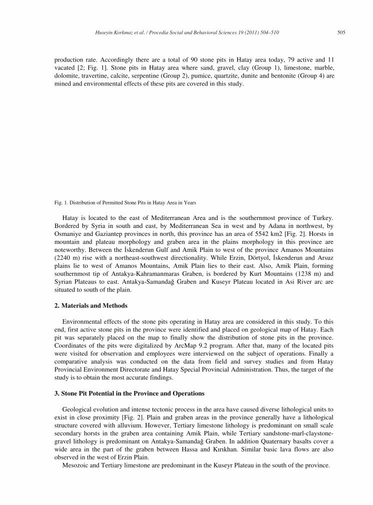
production rate. Accordingly there are a total of 90 stone pits in Hatay area today, 79 active and 11
vacated [2; Fig. 1]. Stone pits in Hatay area where sand, gravel, clay (Group 1), limestone, marble,
dolomite, travertine, calcite, serpentine (Group 2), pumice, quartzite, dunite and bentonite (Group 4) are
mined and environmental effects of these pits are covered in this study.
Fig. 1. Distribution of Permitted Stone Pits in Hatay Area in Years
Hatay is located to the east of Mediterranean Area and is the southernmost province of Turkey.
Bordered by Syria in south and east, by Mediterranean Sea in west and by Adana in northwest, by
Osmaniye and Gaziantep provinces in north, this province has an area of 5542 km2 [Fig. 2]. Horsts in
mountain and plateau morphology and graben area in the plains morphology in this province are
noteworthy. Between the skenderun Gulf and Amik Plain to west of the province Amanos Mountains
(2240 m) rise with a northeast-southwest directionality. While Erzin, Dörtyol, skenderun and Arsuz
plains lie to west of Amanos Mountains, Amik Plain lies to their east. Also, Amik Plain, forming
southernmost tip of Antakya-Kahramanmaras Graben, is bordered by Kurt Mountains (1238 m) and
Syrian Plateaus to east. Antakya-Samanda Graben and Kuseyr Plateau located in Asi River arc are
situated to south of the plain.
2. Materials and Methods
Environmental effects of the stone pits operating in Hatay area are considered in this study. To this
end, first active stone pits in the province were identified and placed on geological map of Hatay. Each
pit was separately placed on the map to finally show the distribution of stone pits in the province.
Coordinates of the pits were digitalized by ArcMap 9.2 program. After that, many of the located pits
were visited for observation and employees were interviewed on the subject of operations. Finally a
comparative analysis was conducted on the data from field and survey studies and from Hatay
Provincial Environment Directorate and Hatay Special Provincial Administration. Thus, the target of the
study is to obtain the most accurate findings.
3. Stone Pit Potential in the Province and Operations
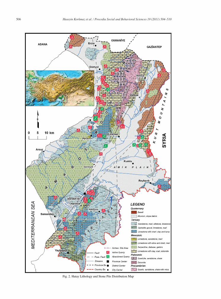
Geological evolution and intense tectonic process in the area have caused diverse lithological units to
exist in close proximity [Fig. 2]. Plain and graben areas in the province generally have a lithological
structure covered with alluvium. However, Tertiary limestone lithology is predominant on small scale
secondary horsts in the graben area containing Amik Plain, while Tertiary sandstone-marl-claystone-
gravel lithology is predominant on Antakya-Samanda Graben. In addition Quaternary basalts cover a
wide area in the part of the graben between Hassa and Kırıkhan. Similar basic lava flows are also
observed in the west of Erzin Plain.
Mesozoic and Tertiary limestone are predominant in the Kuseyr Plateau in the south of the province.
506 Hüseyin Korkmaz et al. / Procedia Social and Behavioral Sciences 19 (2011) 504–510
Fig. 2. Hatay Lithology and Stone Pits Distribution Map
Hüseyin Korkmaz et al. / Procedia Social and Behavioral Sciences 19 (2011) 504–510 507
Also, Mesozoic serpentine, diabase and gabbro lithologies exist at and around Yaylada ı to south of
the plateau, and Tertiary sandstone-marl-claystone lithology exist to east of the plateau. Amanos
Mountains have the highest lithological diversity in the province. Lithologic diversity of the area
consists of Precambrian and Paleozoic quartz, sandstone, mica and shale; Paleozoic, Mesozoic and
Tertiary limestone; Mesozoic serpantines, diabase, gabbro; Mesozoic and Tertiary marl, sandstone,
claystone and gravel. These units are deformed by fault lines at many points or their primary conditions
are changed by folding and fractures.
Limestone, clays, basalts and units of ophiolithic series (serpentine, diabase, gabbro) from diverse
geological periods mentioned above constitutes a great potential for stone pit operations in Hatay
province. History of stone pits in the province area goes back to archaic period. The pits opened this
period have mainly provided building material. Commercial stone pits appeared in the area after 1970s.
Even though the number of stone pits of this type were no more than 10 until 2005 [3], following the
Mining Law numbered 5177 facilitating mining operations coming into effect in June 2004, a swift
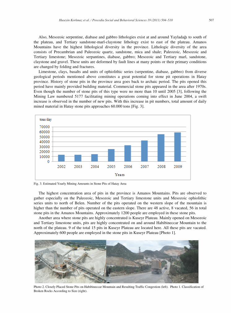
increase is observed in the number of new pits. With this increase in pit numbers, total amount of daily
mined material in Hatay stone pits approaches 60.000 tons [Fig. 3].
Fig. 3. Estimated Yearly Mining Amounts in Stone Pits of Hatay Area
The highest concentration area of pits in the province is Amanos Mountains. Pits are observed to
gather especially on the Paleozoic, Mesozoic and Tertiary limestone units and Mesozoic ophiolithic
series units to north of Belen. Number of the pits operated on the western slope of the mountain is
higher than the number of pits operated on the eastern slope. There are 48 active, 8 vacated, 56 in total
stone pits in the Amanos Mountains. Approximately 1200 people are employed in these stone pits.
Another area where stone pits are highly concentrated is Kuseyr Plateau. Mainly opened on Mesozoic
and Tertiary limestone units, pits are highly concentrated on and around Habibineccar Mountain to the
north of the plateau. 9 of the total 15 pits in Kuseyr Plateau are located here. All these pits are vacated.
Approximately 600 people are employed in the stone pits in Kuseyr Plateau [Photo 1].
Photo 2. Closely Placed Stone Pits on Habibineccar Mountain and Resulting Traffic Congestion (left). Photo 1. Classification of
Broken Rocks According to Size (right).
508 Hüseyin Korkmaz et al. / Procedia Social and Behavioral Sciences 19 (2011) 504–510
Another area worthy of notice in respect to stone pits in Hatay is the graben area containing Amik
Plain. 16 stone pits in total were opened on the Quaternary basalts and limestone forming secondary
horsts in the graben area. 15 of these pits are currently active, while one is vacated. Also there are 5
stone pits, 3 vacated, on the Mesozoic limestone forming western slopes of the Kurt Mountains
bordering the graben to the east and on the Tertiary limestone extensions of Syrian Plateaus. Other than
these, there are 2 stone pit operations on Quaternary basalts to northwest of Erzin. Approximately 430
people in total are employed in all these stone pit operations.
Materials mined from the abovementioned pits are used in construction, substructure, decoration and
industry areas. In addition to sand and gravel, products obtained by breaking limestone and basalts are
also used in construction sector [Photo 2].
Limestone is ground into sand for use as plaster, while basalts and limestone are broken into gravel
size for use as concrete ingredients. In addition limestone, basalt and serpentines are broken into gravel
(slug) or into blocks to be used as substructure material in road building. Materials used in decoration
are Mesozoic semi-crystallized limestone forming the secondary horsts in the graben bed and the
Mesozoic and Tertiary massif limestone materials mined from Kuseyr Plateau. On the other hand, some
clay types and calcites excavated from the stone pits are used as raw materials in many industries,
especially in fertilizer, paint and petrochemical industries.
4. Problems Arising from Stone Pits in Hatay Area
Establishment of stone pits in the province without necessary planning and without Environmental
Impact Assessment reports in many cases caused environmental problems. These problems can be listed
as visual and noise pollution, damage in plant cover and historical fabric, dust, improper land use and
traffic jam.
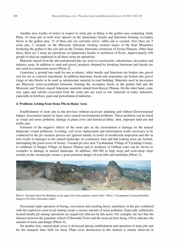
Foremost of the negative effects of the stone pits on the environment is damage on the natural
landscape (visual pollution). Leveling, soil cover replacement and reforestation works necessary to be
conducted in the pit vacation process are ignored mainly in result of insufficient inspection and this in
turn results in damages to the natural landscape. In conclusion, bare and bad looking areas are formed,
interrupting the green cover of forests. Vacated pit sites near Yayıkdamlar Village of Yaylada ı County,
to southeast of Sungur Village on Kuseyr Plateau and to northeast of Gölba ı Lake can be shown as
examples to damage in natural landscape. In addition, 200-300 m high steep and semi-steep slope
inclines in the vacated pits creates a great potential danger of rock falls and landslides [Photo 3].
Photo 4. Dursunlu Stone Pit (Building on the upper left is the grammar school) (left). Photo 3. Escarpments Creating Potential
Danger in Pit Sites (Dursunlu) (right).
Occasional night operation of boring, excavation and crushing heavy machinery in the pits combined
with the explosives used in pit mining create a serious amount of noise pollution. Especially settlements
located nearby pit mining operations are negatively affected by this noise. For example, the fact that the
distance between the grammar school of Dursunlu Town and the stone pit here being 150 m indicates the
amount of noise and danger [Photo 4].
On another note, natural plant cover is destroyed during establishment and operation of stone pits and
for the transport lines built for these. Plant cover destruction in this fashion is mainly observed in
Hüseyin Korkmaz et al. / Procedia Social and Behavioral Sciences 19 (2011) 504–510 509
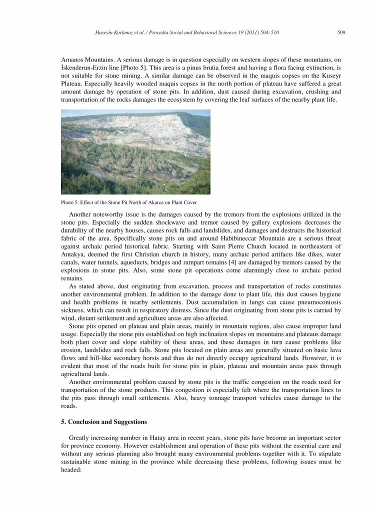
Amanos Mountains. A serious damage is in question especially on western slopes of these mountains, on
skenderun-Erzin line [Photo 5]. This area is a pinus brutia forest and having a flora facing extinction, is
not suitable for stone mining. A similar damage can be observed in the maquis copses on the Kuseyr
Plateau. Especially heavily wooded maquis copses in the north portion of plateau have suffered a great
amount damage by operation of stone pits. In addition, dust caused during excavation, crushing and
transportation of the rocks damages the ecosystem by covering the leaf surfaces of the nearby plant life.
Photo 5. Effect of the Stone Pit North of Akarca on Plant Cover
Another noteworthy issue is the damages caused by the tremors from the explosions utilized in the
stone pits. Especially the sudden shockwave and tremor caused by gallery explosions decreases the
durability of the nearby houses, causes rock falls and landslides, and damages and destructs the historical
fabric of the area. Specifically stone pits on and around Habibineccar Mountain are a serious threat
against archaic period historical fabric. Starting with Saint Pierre Church located in northeastern of
Antakya, deemed the first Christian church in history, many archaic period artifacts like dikes, water
canals, water tunnels, aqueducts, bridges and rampart remains [4] are damaged by tremors caused by the
explosions in stone pits. Also, some stone pit operations come alarmingly close to archaic period
remains.
As stated above, dust originating from excavation, process and transportation of rocks constitutes
another environmental problem. In addition to the damage done to plant life, this dust causes hygiene
and health problems in nearby settlements. Dust accumulation in lungs can cause pneumoconiosis
sickness, which can result in respiratory distress. Since the dust originating from stone pits is carried by
wind, distant settlement and agriculture areas are also affected.
Stone pits opened on plateau and plain areas, mainly in mountain regions, also cause improper land
usage. Especially the stone pits established on high inclination slopes on mountains and plateaus damage
both plant cover and slope stability of these areas, and these damages in turn cause problems like
erosion, landslides and rock falls. Stone pits located on plain areas are generally situated on basic lava
flows and hill-like secondary horsts and thus do not directly occupy agricultural lands. However, it is
evident that most of the roads built for stone pits in plain, plateau and mountain areas pass through
agricultural lands.
Another environmental problem caused by stone pits is the traffic congestion on the roads used for
transportation of the stone products. This congestion is especially felt where the transportation lines to
the pits pass through small settlements. Also, heavy tonnage transport vehicles cause damage to the
roads.
5. Conclusion and Suggestions
Greatly increasing number in Hatay area in recent years, stone pits have become an important sector
for province economy. However establishment and operation of these pits without the essential care and
without any serious planning also brought many environmental problems together with it. To stipulate
sustainable stone mining in the province while decreasing these problems, following issues must be
headed:
510 Hüseyin Korkmaz et al. / Procedia Social and Behavioral Sciences 19 (2011) 504–510
• First and foremost awareness on the fact that rocks have an important function on a healthy
environment must be cultivated.
• Preparation of a realistic Environmental Impact Assessment Report and permission according to
findings of this report must be rendered mandatory for any future stone mining operations.
• Stone pits must be directed to areas where plant cover damage on similar lithological units will be
minimum.
• Dust prevention measures for all operations must be rendered mandatory and supervision must be
established on this matter.
• Inspections must be carried out to see whether arrangements compatible with natural landscape after
leveling are conducted in vacated stone pits.
• Stone mining operation priority must be given to Kuseyr Plateau for reasons of lithological diversity,
inclination, plant cover, agricultural lands, settlement, population and economical development level.
• New stone pits should not be permitted on and around archeological sites and existing pits on and
around these areas should be closed.
References
[1] http://www.maden.org.tr/mevzuat/mevzuat_detay.php?kod=57
[2] Special Province Administration data. 2009; Hatay.
[3] SPA. Special Commission Report of the Eighth Five-Year Development Plan Mining. Industrial Raw Materials Building
Materials Sub-Commission II (Marble-Granite-Slate-Building Blocks (Slaty)) Working Group Report, Ankara; 2001.
http://ekutup.dpt.gov.tr/madencil/sanayiha/oik627.pdf.
[4] Korkmaz, H. Water in The Antakya From Its Establishment to Today, Fırat University, Journal of Social Science 2007;
17: 69-96.


