Embed Size (px)
Citation preview
_________*To whom correspondence should be addressed. Sevgi Tokgöz Güne , Dokuz Eylül University,
Department of Environmental Engineering, Izmir, Turkey
EFFECT OF A HAZARDOUS WASTE LANDFILL AREA ON
GROUNDWATER QUALITY
SEVGI TOKGÖZ GÜNES*, AYSEN TURKMANDokuz Eylül University, Department of Environmental Engineering, Izmir, Turkey
Abstract. In 1992, uncontrolled landfills in Izmir were closed on the ground that they threat the public health and Harmandalı Hazardous Wastes Landfill Area has been put into service by zmir Metropolitan Municipality. Harmandalı Region, which was selected as a sanitary landfill area, has an area of approximately 900 000 m2 and is located in the border of the city Izmir. Izmir is the third biggest city of Turkey with a population of 3.5 million. In this study, the probable impacts of Harmandalı Sanitary Landfill Area on groundwater quality have been investigated. In order to predict the effect land disposal site, “Computer Model of Two-Dimensional Solute Transport and Dispersion in Groundwater” has been applied to the Harmandalı area by using the available data. The results of the model have been controlled after eight years by groundwater analysis in the area.
Keywords: hazardous waste landfill; groundwater; contamination; computer model.
1. Introduction
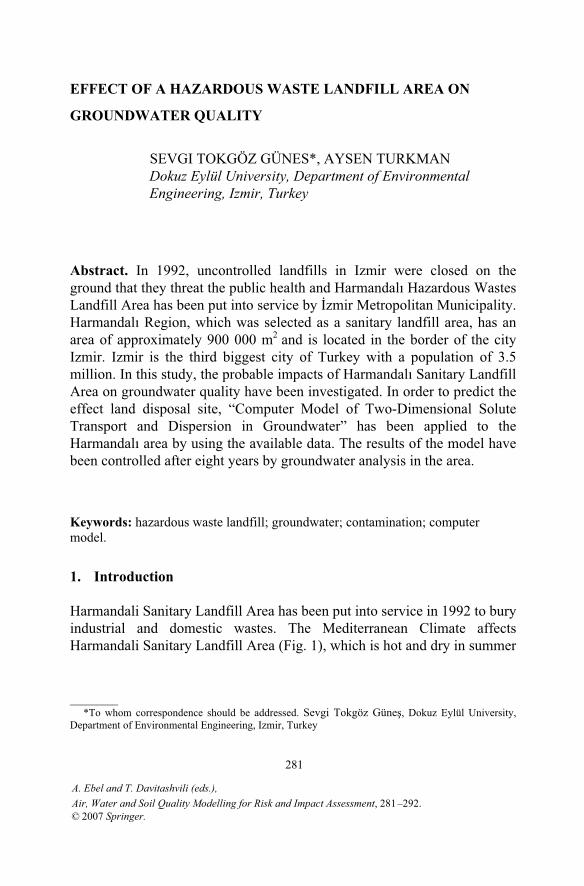
Harmandali Sanitary Landfill Area has been put into service in 1992 to bury industrial and domestic wastes. The Mediterranean Climate affects Harmandali Sanitary Landfill Area (Fig. 1), which is hot and dry in summer
A. Ebel and T. Davitashvili (eds.),
© 2007 Springer.
281
Air, Water and Soil Quality Modelling for Risk and Impact Assessment, 281 –292 .
282
and warm and rainy in winter. In the study area, the annual mean temperature and precipitation are 17.6°C and 700 mm, respectively. Toprevent the groundwater pollution that could be caused by leachate, hydrological and geological investigation drillings have been carried out in the landfill area and its surroundings (UKAM, 1990).
The soil investigations were carried to evaluate the suitability of the area. 24 boreholes have been opened in the area and the geological map, with a scale of 1/5000 has been prepared. At the end of in-situ studies, types and characteristics of geological layers and positions of faults have been determined. According to the results, locations of the test bores with “carrot” have been drilled. Standard penetration and rock quality tests have been done to determine their geotechnical characteristics of HarmandalıSanitary Landfill Area. According to these studies, alluvium consists of clays that are classified as hard or semi-hard and sands as semi-tight. To observe the effect of leachate, which would originate from solid wastes, 4 observation wells, having a depth of 30 m and a diameter of 2 , have been drilled. The results obtained from the boring tests and observations of the area have been evaluated and the geotechnical cross-section has been prepared.
Figure1. Map of the Harmandalı Sanitary Landfill Area.
S.T. GÜNES AND A. TURKMAN
EFFECT OF A HAZARDOUS WASTE LANDFILL AREA 283
To determine the hydraulic conductivity of land on the consolidated materials and/or on the rocky structure that spread out in the area pressurised and unpressurised (gravity) Packer test have been done. The results can be listed as follows (Çoban, 1992):
It has been determined that there is an impermeable layer above the pyroclastic unit; Groundwater table is not close to ground level, geological structures included impermeable layers; The Harmandalı Sanitary Landfill Area is not located in the region used for drinking water supply of villages.
Hydraulic conductivity coefficients of the layers have been determined in the range of between 10-7 to 10-10 m/sec. According to these data, the degree of hydraulic conductivity of the soil layers have been determined to vary from very low to practically impermeable, but generally it can be considered as impermeable.
2. Experimental studies
2.1. GROUNDWATER QUALITY ANALYSIS
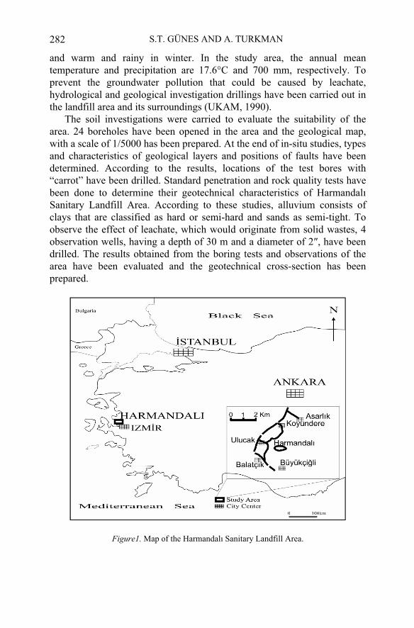
In the sanitary landfill area, it is necessary to know the chemical quality of water samples to estimate the effects on the groundwater and surroundings from the wastes. For this reason, water samples have been taken from the observation wells and other wells before the landfill was put into operation (Fig. 2).
2.2. GEOLOGICAL STUDIES
In Harmandalı Sanitary Landfill Area, three lithostratigraphic units were determined. These are classified from bottom to top as Harmandalı flysch, pyroclastic unit and alluvium. The Harmandalı flysch lies from the elevation of 30 m to 200 m and covers approximately half of studied area. The predominant lithology is mudstone that has no clear layer as a visible structure. In the most structure of Harmandalı Sanitary Landfill Area, there are thin laminations as mudstone. Their colors change from dark grey-black to light brown-red. Sandstones show a structure as a thin layer. It has been determined that a fault lies into northwest, north-north-west and south-south-east direction. Groundwater table has not been found in the test bores that is cut into the Harmandalı flysch. Mudstone layer of the Harmandalı flysch is impermeable and sandstone layer is relatively permeable (UKAM, 1990).
284
The Harmandalı flysch is covered by pyroclastic structure irregularly on a large scale in the studied area. According to their pore and cell structure, pyroclastic rocks could be divided into three lithologies; volcanic rocks, agglomerates and andesites. It has been determined that pyroclastic rocks spread out depending on paleotopograpy. Alluvium is located into the west side of investigation area and was occurred by transportation of pyroclastic material. Their thickness is 19 m. According to standard penetration studies, clays are classified as hard and semi-hard, sands as semi-tight.
Figure 2. Sampling points in Harmandali Sanitary Landfill Area.
Organic matter content of soil samples of the area change between 2.27-5.39% in surface horizons. Generally organic matter is in humus form and contains the specific forms of plant wastes. In deeper layers organic matter content falls to 0.26% (Çoban, 1992). Soil pH values ranges between 5.21-6.67.
S.T. GÜNES AND A. TURKMAN
EFFECT OF A HAZARDOUS WASTE LANDFILL AREA 285
2.3. WASTE INVESTIGATIONS IN HARMANDALI SANITARY LANDFILL AREA
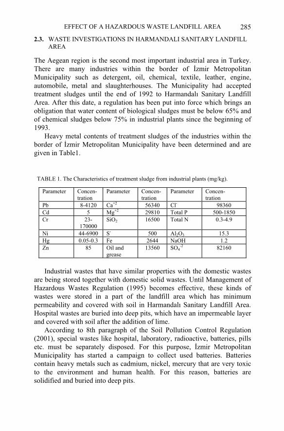
The Aegean region is the second most important industrial area in Turkey. There are many industries within the border of zmir Metropolitan Municipality such as detergent, oil, chemical, textile, leather, engine, automobile, metal and slaughterhouses. The Municipality had accepted treatment sludges until the end of 1992 to Harmandalı Sanitary Landfill Area. After this date, a regulation has been put into force which brings an obligation that water content of biological sludges must be below 65% and of chemical sludges below 75% in industrial plants since the beginning of 1993.
Heavy metal contents of treatment sludges of the industries within the border of zmir Metropolitan Municipality have been determined and are given in Table1.
TABLE 1. The Characteristics of treatment sludge from industrial plants (mg/kg).
Industrial wastes that have similar properties with the domestic wastes are being stored together with domestic solid wastes. Until Management of Hazardous Wastes Regulation (1995) becomes effective, these kinds of wastes were stored in a part of the landfill area which has minimum permeability and covered with soil in Harmandalı Sanitary Landfill Area. Hospital wastes are buried into deep pits, which have an impermeable layer and covered with soil after the addition of lime.
According to 8th paragraph of the Soil Pollution Control Regulation (2001), special wastes like hospital, laboratory, radioactive, batteries, pills etc. must be separately disposed. For this purpose, zmir Metropolitan Municipality has started a campaign to collect used batteries. Batteries contain heavy metals such as cadmium, nickel, mercury that are very toxic to the environment and human health. For this reason, batteries are solidified and buried into deep pits.
Parameter Concen-tration
Parameter Concen-tration
Parameter Concen- tration
Pb 8-4120 Ca+2 56340 Cl- 98360 Cd 5 Mg+2 29810 Total P 500-1850 Cr 23-
170000SiO2 16500 Total N 0.3-4.9
Ni 44-6900 S- 500 Al2O3 15.3 Hg 0.05-0.3 Fe 2644 NaOH 1.2 Zn 85 Oil and
grease13560 SO4
-2 82160
286
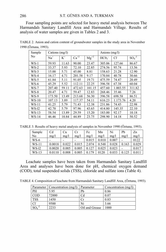
Four sampling points are selected for heavy metal analysis between The Harmandalı Sanitary Landfill Area and Harmandalı Village. Results of analysis of water samples are given in Tables 2 and 3.
TABLE 2. Anion and cation content of groundwater samples in the study area in November
1990 (Öztuna, 1993).
Cations (mg/l) Anions (mg/l) SampleNo Na+ K+ Ca+2 Mg+2 HC03
- Cl- SO4-2
WS-1 59.93 11.63 90.00 23.47 305.06 127.66 86.67 WS-2 33.37 5.93 72.10 22.85 274.56 95.74 13.56 WS-3 15.00 5.71 45.00 8.81 158.63 21.28 12.90 WS-4 16.17 4.71 201.58 9.17 170.84 40.78 30.66 WS-5 61.84 5.11 91.05 19.71 475.59 74.47 20.49 WS-6 45.29 5.52 112.11 22.25 396.58 67.38 60.04 WS-7 207.40 59.11 472.63 101.15 457.60 1.003.55 311.82 WS-8 20.47 4.71 59.47 12.83 268.46 35.46 7.26 WS-9 173.50 13.49 213.68 56.30 396.58 698.58 86.51 WS-10 107.13 3.89 117.37 54.11 616.23 1.173.76 4.20 WS-11 41.25 5.79 71.43 12.38 231.86 74.45 22.98 WS-l2 42.70 5.79 97.96 43.65 414.80 145.35 22.10 WS-13 58.54 13.89 29.59 15.20 183.00 92.17 10.18 WS-14 46.46 10.84 44.89 23.75 298.90 14.18 50.52
TABLE 3. Results of heavy metal analysis of samples in November 1990 (Öztuna, 1993).
SampleNo
Cdmg/l
Cumg/l
Crmg/l
Femg/l
Mnmg/l
Nimg/l
Pbmg/l
Znmg/l
WS-6 - - - 0.015 0.010 0.007 - 0122 WS-11 0.0018 0.022 0.015 2.074 0.548 0.028 0.163 0.029 WS-l2 0.0020 0.005 0.005 0.127 0.025 0.023 - 0.017 WS-13 0.0110 0.008 0.005 0.179 0120 0.033 0.125 0.011
Leachate samples have been taken from Harmandalı Sanitary Landfill Area and analyses have been done for pH, chemical oxygen demand (COD), total suspended solids (TSS), chloride and sulfate ions (Table 4).
TABLE 4. Composition of leachate from Harmandalı Sanitary Landfill Area, (Öztuna, 1993).
Parameter Concentration (mg/l) Parameter Concentration (mg/l) PH 5.95 Pb 0.86 COD 72000 Cd 0.07 TSS 1450 Cr 0.83 Cl- 9500 Ni 3.66 SO4
-2 2233 Oil and Grease 1000
S.T. GÜNES AND A. TURKMAN
EFFECT OF A HAZARDOUS WASTE LANDFILL AREA 287
3. Transport modelling
“Two-Dimensional Solute Transport and Dispersion in Groundwater Model” (Konikow and Bredehoeft, 1978) simulates solute transport in flowing groundwater and computes changes in concentration over time caused by the mixing (or dilution) from fluid sources. The model can be applied to a wide range of problem types and it is one of the most used models for solute-transport problems. It is applicable to one-or two-dimensional problems involving steady state or transient flow. The model assumes that the solute is nonreactive and that gradients of fluid density, viscosity, and temperature do not effect the velocity distribution. Computer model solves two simultaneous partial differential equations. One equation is the groundwater flow equation another is the solute-transport equation. The groundwater flow equation describes the head distribution in the aquifer and the solute-transport describes the chemical concentration in the system. The model can be used in aquifers that may be heterogeneous and/or anisotropic. The model uses an alternating direction implicit procedure to solve a finite-difference approximation to the groundwater flow equation.
There are four distinct processes in the model (Konikow and Bredehoeft, 1978):
Convective transport, in which dissolved chemicals are moving with the flowing groundwater; Hydrodynamic dispersion, in which molecular and ionic diffusion and small-scale variations in the velocity of flow through the porous media cause the paths of dissolved molecules and ions to diverge or spread from the age direction of groundwater flow;Fluid sources, where water of one composition is introduced into water of a different composition;Reactions, in which some amount of a particular dissolved chemical species may be added to or removed from the groundwater due to chemical and physical reactions in the water or between the water and the solid aquifer materials. The model is based on a rectangular, block-centred, finite-difference
grid. It allows the specification of any number of injection or withdrawal wells and of spatially varying diffuse recharge or discharge, saturated thickness, transmissivity, boundary conditions, and initial heads and concentrations. It contains up to five observation points. The numerical procedure used in this model requires that the area of interest be surrounded

288
by a no-flow boundary. No-flow boundaries can also be located elsewhere in the grid to simulate natural limits or barriers to groundwater flow. A constant-head boundary in the model can be applied to parts of the aquifer where the head will not change with time, such as recharge boundaries or areas beyond the influence of hydraulic stresses. In the model, adjusting the leakage term at the appropriate nodes simulates constant-head boundaries.
Assumptions related to the model are given as follows: Darcy's law is valid and hydraulic-head gradients are the only significant driving mechanism for fluid flow; No chemical reactions occur that affect the concentration of the solute, the fluid properties or the aquifer properties; The porosity and hydraulic conductivity of the aquifer are constant with time, and porosity is uniform in space; The aquifer is homogeneous and isotropic with respect to the coefficients of longitudinal and transverse dispersivity; Gradients of fluid density, viscosity and temperature do not effect the velocity distribution; Ionic and molecular diffusion are negligible contributors to the dispersive flux; Vertical variations in head and concentration are negligible.These assumptions affect the applicability and reliability of the model.
In the study, two different model areas (A- and B- model areas) have been determined. They have been established on 16*19 grids, and consist of four observations wells and a pumping well (Figure 3). Since the flow wasassumed to be steady state, the storage coefficient was set equal to zero. Although there are many parameters to monitor the groundwater pollution; chloride, oil and grease and cadmium were selected to be used in the model and the transport of heavy metal and chloride concentrations have been investigated in groundwater.
The A and B-model areas were simulated for a period of 400 years. This option consists of one pumping well located in a regional flow field that is controlled by two constant-head boundaries. For the A-model area, the contamination sources were defined in three central nodes along the up-gradient constant-head boundary and one node is in front of them in the model. For the B-model area, pollution sources are only three central nodes along the up-gradient constant-head boundary.
S.T. GÜNES AND A. TURKMAN
EFFECT OF A HAZARDOUS WASTE LANDFILL AREA 289
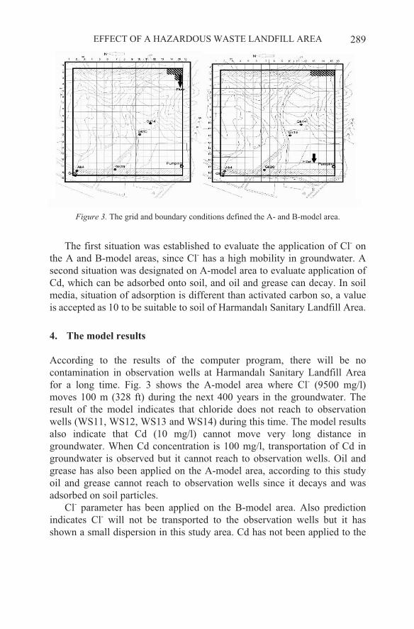
Figure 3. The grid and boundary conditions defined the A- and B-model area.
The first situation was established to evaluate the application of Cl- on the A and B-model areas, since Cl- has a high mobility in groundwater. A second situation was designated on A-model area to evaluate application of Cd, which can be adsorbed onto soil, and oil and grease can decay. In soil media, situation of adsorption is different than activated carbon so, a value is accepted as 10 to be suitable to soil of Harmandalı Sanitary Landfill Area.
4. The model results
According to the results of the computer program, there will be no contamination in observation wells at Harmandalı Sanitary Landfill Area for a long time. Fig. 3 shows the A-model area where Cl- (9500 mg/l) moves 100 m (328 ft) during the next 400 years in the groundwater. The result of the model indicates that chloride does not reach to observation wells (WS11, WS12, WS13 and WS14) during this time. The model results also indicate that Cd (10 mg/l) cannot move very long distance in groundwater. When Cd concentration is 100 mg/l, transportation of Cd in groundwater is observed but it cannot reach to observation wells. Oil and grease has also been applied on the A-model area, according to this study oil and grease cannot reach to observation wells since it decays and was adsorbed on soil particles.
Cl- parameter has been applied on the B-model area. Also prediction indicates Cl- will not be transported to the observation wells but it has shown a small dispersion in this study area. Cd has not been applied to the
290
B-model area because; they have not transported and dispersed in the A-model area where contaminants originate from the larger contaminated area than the B-model area. It was found that no transportation and dispersion of oil and grease have occurred in this B-model area.
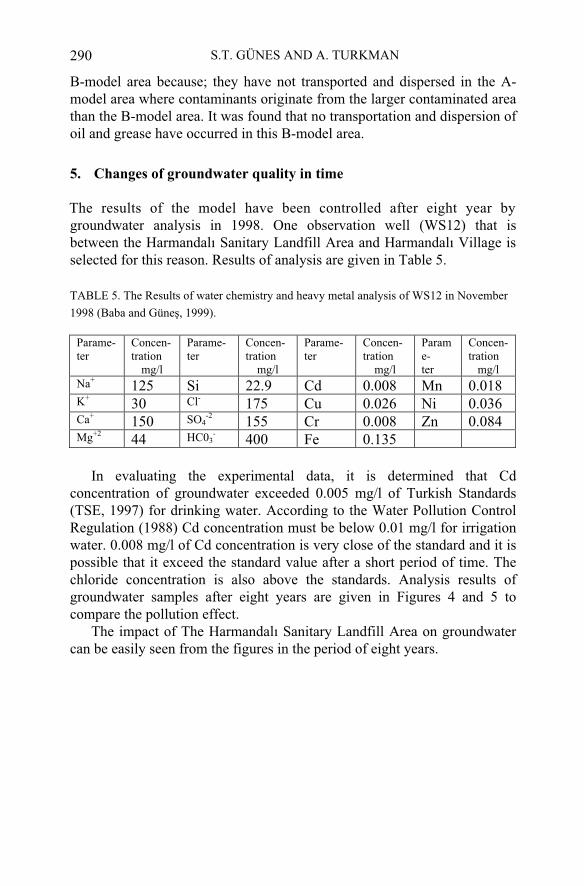
5. Changes of groundwater quality in time
The results of the model have been controlled after eight year by groundwater analysis in 1998. One observation well (WS12) that is between the Harmandalı Sanitary Landfill Area and Harmandalı Village is selected for this reason. Results of analysis are given in Table 5.
TABLE 5. The Results of water chemistry and heavy metal analysis of WS12 in November
1998 (Baba and Güne , 1999).
Parame-ter
Concen-tration
mg/l
Parame-ter
Concen-tration
mg/l
Parame-ter
Concen-tration
mg/l
Parame-ter
Concen-tration
mg/lNa+
125 Si 22.9 Cd 0.008 Mn 0.018 K+
30 Cl-175 Cu 0.026 Ni 0.036
Ca+150 SO4
-2155 Cr 0.008 Zn 0.084
Mg+244 HC03
-400 Fe 0.135
In evaluating the experimental data, it is determined that Cd concentration of groundwater exceeded 0.005 mg/l of Turkish Standards (TSE, 1997) for drinking water. According to the Water Pollution Control Regulation (1988) Cd concentration must be below 0.01 mg/l for irrigation water. 0.008 mg/l of Cd concentration is very close of the standard and it is possible that it exceed the standard value after a short period of time. The chloride concentration is also above the standards. Analysis results of groundwater samples after eight years are given in Figures 4 and 5 to compare the pollution effect.
The impact of The Harmandalı Sanitary Landfill Area on groundwater can be easily seen from the figures in the period of eight years.
S.T. GÜNES AND A. TURKMAN

EFFECT OF A HAZARDOUS WASTE LANDFILL AREA 291
0
100
200
300
400
500
Na K Ca Mg Cl HCO3 SO4
Co
nce
ntr
atio
ns (
mg
/l)
1990
1998
Figure 4. Comparison of the ions in well WS12 in 1990 and 1998.
0
0,02
0,04
0,06
0,08
0,1
0,12
0,14
0,16
Cd Cu Cr Fe Mn Zn Ni
Concentr
ations (
mg/l)
1990
1998
Figure 5. Comparison of the heavy metals well WS12 in 1990 and 1998.
292
6. Result and discussion
Harmandalı Sanitary Landfill Area has been evaluated with respect to mobility of contaminants by using two-dimensional solute transport and dispersion model in 1993. Although the prediction results of the computer model indicated very safe results and the contamination would take place after more than 100 years, the contamination has taken place earlier then expected. This might be attributed the permeability of the soil since the impermeable layer below the landfill area may not be uniform.
Another reason for the prediction to be not verified may be surface flow from the landfill area during the heavy rainy period. In fact, in the creek nearby, some pollutants have been detected originating from the landfill leachate.
At present no hazardous wastes are accepted to the Harmandali landfill area.
References
Baba, A., Tokgöz Güne , S., 1999, zmir Harmandalı Düzenli Atık Depolama Sahasınınyüzeysel ve yeraltısularına etkisi (Impacts of zmir Harmandalı Sanitary Landfill Area
Çoban, S., 1992, An approach to the environmental impact assessment of solid waste disposal plant”, Master Degree Thesis, Advisor: Prof. Dr. E. Erdin, zmir.
Hacettepe Üniversitesi Uluslararası Karst Su Kaynakları Uygulama ve Ara tırma Merkezi (UKAM), zmir Harmandalı Çöp Depolama Alanı zemin ara tırmaları raporu, Aralık1990, Ankara.
Konikow, L.F., Bredehoeft, J.D., 1984, Computer model of dimensional solute and dispersion in ground water, 2nd. ed., Techniques of Water Resources Investigations of The United States Geological Survey, Washington, Book 7, Chapter C2.
Management of Hazardous Wastes Regulation, Official Gazette, No: 22387, 1995. Oztuna, B., 1993, Evaluation of an Industrial Sludge Discharge Site With Respect to
Mobility of Contaminants, DEU, M.Sc. Thesis, Advisor: Prof. Dr. A. Türkman, zmir.Soil Pollution Control Regulation, Official Gazette, No: 24609, 2001. Turkish Standards Organization, TSE 266, 1997. Water Pollution Control Regulation, Official Gazette, No: 19919, 1988.
S.T. GÜNES AND A. TURKMAN
on surfacewater and groundwater), 4–5 Haziran, zmir, zmir Su Kongresi, pp. 263–275.