Embed Size (px)
Citation preview
Water Resources Management 18: 497–518, 2004.C© 2004 Kluwer Academic Publishers. Printed in the Netherlands.
497
Development of a Management Model for a SurfaceWaterlogged and Drainage Congested Area
ANIL K. LOHANI,1 NARAYAN C. GHOSH1,∗ and CHANDRANATH CHATTERJEE2
1National Institute of Hydrology, Roorkee 247 667, Uttranchal, India; 2Assistant Professor,Agricultural and Food Engineering Department, Indian Institute of Technology, Kharagpur-721302,India.(∗author for correspondence, e-mail: [email protected]; Fax: 133272123)
(Received: 24 June 2003; in final form: 20 April 2004)
Abstract. Inadequate drainage outlet causing surface waterlogging every year mainly during mon-soon period (June through October) over a depressed land of 1062 km2 in Mokama group of tals, India,led to a loss of one crop rotation. A management model aiming at minimization of the waterlogged areaunder constraints of control monsoon runoffs from tributaries discharge water to the depressed landhas been developed. Magnitudes of regulated flows are guided by irrigation water requirement of cropsgrown in commands of different tributaries joined to the depressed land. A nonlinear optimizationmodel has been envisaged and solved setting a total of 160 constraints satisfying conditions of waterrequirement for crops grown in two seasons and their time-dependent storage requirement. The opti-mization model has been solved using the Quantitative Systems for Business (QSB) software, whichconsiders a line search methodology for unconstrained problems, and a sequential unconstrainedminimization technique (SUMT) with penalty function methodology for constrained problems. Themanagement model provides a solution for strategic water resources development and managementin a basin having problems of scarcity, surplus and non-uniform distribution of surface water.
Key words: drainage congestion, inflow check, Mokama Tals, optimisation model, waterlogging
Introduction
Drainage congestion causing surface waterlogging and flooding of areas suitable forKharif crops (crops grown during monsoon season) and Rabi crops (crops grownduring winter season) are a common problem during monsoon season in mostof the downstream stretches of river basins in India (GFCC, 1986; Bhattacharya,1992). Cross barriers created by construction of roads, railroads, embankments,encroachment of river’s width by human interference besides natural depression ofsurface topography are main factors of drainage problems, however, other impor-tant factor is inadequate outlet condition in disposing off monsoon runoff. Duringmonsoon season, the main river despite draining of flows originating from its tribu-taries restricts drainage of flow creating inundation by backwater pressure over thelow-lying area. Inundated water is prompted for draining when a potential of headdifference towards the main river is established. Delayed monsoon or monsoonseason extending beyond October effects cultivation of Rabi crops grown on
498 A. K. LOHANI ET AL.
depressed lands due to the saturated soil moisture condition. This natural para-dox eventually transforms agricultural lands suitable for two crops into a singlecrop in a year.
Flood and drainage hazards originate basically due to inadequate carrying capac-ity of the outlet in accommodating a high-magnitude runoff hydrograph. A solutionto the problem of flood and drainage hazards can be thought of translating a sharp-peaked hydrograph to a flattened hydrograph satisfying the condition of outlet suchthat a clear passage of water is maintained, i.e. controlling the hydrograph by re-ducing the peak, and adjusting the volume of reduced peak by extending durationof the hydrograph (Chow, 1967; Chow et al., 1988; Singh, 1988). Translation ofa sharp-peaked hydrograph to a flattened hydrograph means delaying the runofffrom the catchment. Runoff can be delayed by controlling the hydrograph creatingstorage for excess flows and release of checked flows later (Maidment, 1993).
Investigations carried out by many experts, and organisations (GFCC, 1986;Sinha, 1992; SBIC, 1994) indicated that in India, total area prone to poor drainagecondition is about 3.3 million ha. The study area “Mokama group of Tals” in centralBihar constitutes 0.1 million ha. The word “Tal” is an Indian Hindi word repre-senting a surface water body created by natural depression of land. The Mokamagroup of tals, which has maximum surface impoundment of 1062 km2 remainswaterlogged for the entire monsoon period from June through October mainly be-cause of reverse water pressure from the outleting river, i.e. the river Ganga. Duringmonsoon season, water level in the river Ganga rises and exceeds water level ofthe tal area. Consequently, natural drainage of the tal area gets blocked, and runoffwaters from tributaries joining the tals inundate the depressed land. The continuedsubmergence of the tal area effects sowing of Kharif crops resulting in significantloss of agricultural production. However, by mid-October draining of water fromtal area starts with falling water level in the river Ganga. A successful Rabi cropcould only be grown in the tal area when submerged water is completely drainedout. Delayed draining of water from the tal area, beyond mid of October, harmssowing of Rabi crops severely. On the other hand, agricultural activities in the uppercatchment of the tal area during Kharif season as well as during Rabi season alsosuffer due to shortage of water. Thus, literally two opposite problems “surplus andscarcity” of water is clearly evident between the Mokama group of tals and in itsupper catchment, which contributes monsoon runoff water to the tal area.
Keeping above aspects in view, a management model aiming at minimizationof waterlogged area with constraints of inflows to the tal area and simultaneous useof constrained inflows at the upper catchment satisfying crop water requirement isconceptualised and formulated. The performance of the model has been tested andevaluated for different management scenarios.
Study Area
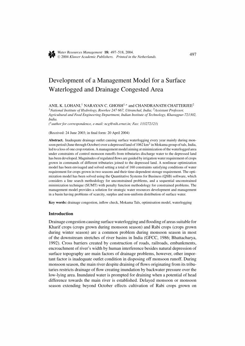
The study area (Figure 1) “Mokama group of Tals” is a naturally created depressedland of surface area 1062 km2, which extends from Fatuha in west to Lakhisarai in
SURFACE WATERLOGGED AND DRAINAGE CONGESTED AREA 499
Figure 1. Study area showing Mokama group of tals and different tributaries of Kiul-Haroharriver system joining the tal area.
east, and lies between latitude 25◦10′ N to 25◦35′ N and longitude 85◦5′ E to 86◦8′
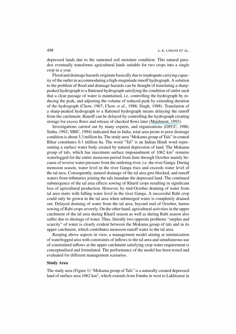
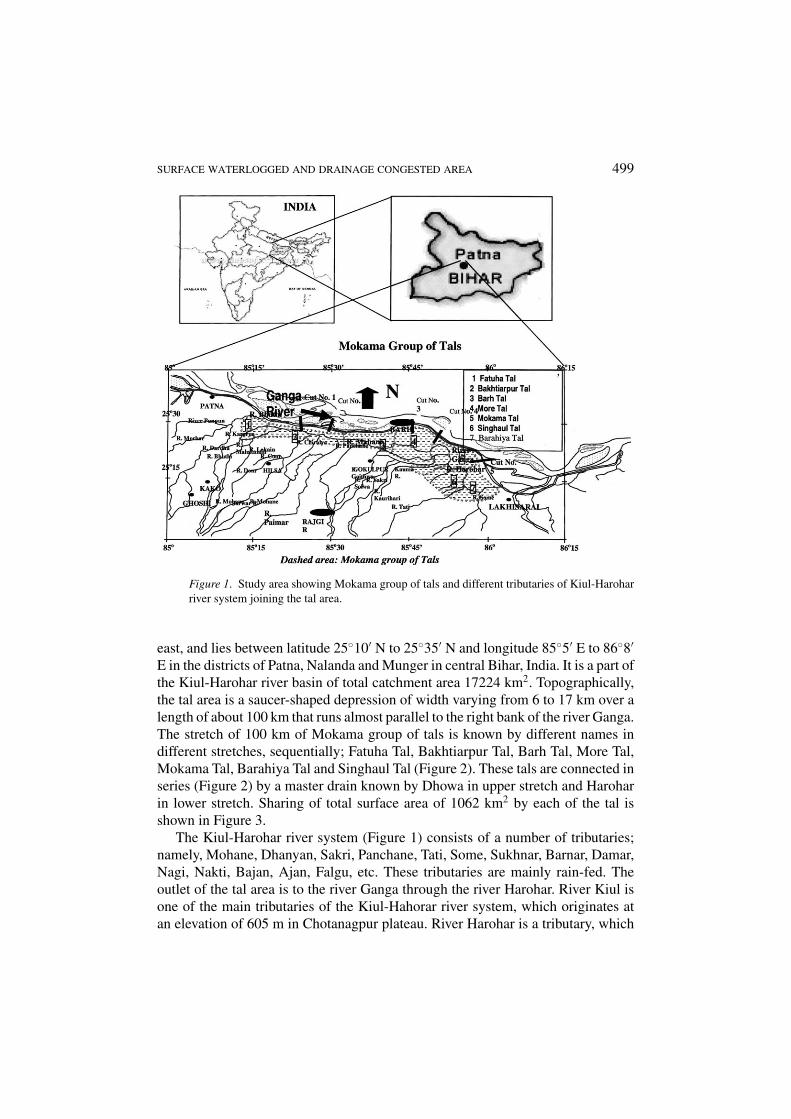
E in the districts of Patna, Nalanda and Munger in central Bihar, India. It is a part ofthe Kiul-Harohar river basin of total catchment area 17224 km2. Topographically,the tal area is a saucer-shaped depression of width varying from 6 to 17 km over alength of about 100 km that runs almost parallel to the right bank of the river Ganga.The stretch of 100 km of Mokama group of tals is known by different names indifferent stretches, sequentially; Fatuha Tal, Bakhtiarpur Tal, Barh Tal, More Tal,Mokama Tal, Barahiya Tal and Singhaul Tal (Figure 2). These tals are connected inseries (Figure 2) by a master drain known by Dhowa in upper stretch and Haroharin lower stretch. Sharing of total surface area of 1062 km2 by each of the tal isshown in Figure 3.
The Kiul-Harohar river system (Figure 1) consists of a number of tributaries;namely, Mohane, Dhanyan, Sakri, Panchane, Tati, Some, Sukhnar, Barnar, Damar,Nagi, Nakti, Bajan, Ajan, Falgu, etc. These tributaries are mainly rain-fed. Theoutlet of the tal area is to the river Ganga through the river Harohar. River Kiul isone of the main tributaries of the Kiul-Hahorar river system, which originates atan elevation of 605 m in Chotanagpur plateau. River Harohar is a tributary, which
500 A. K. LOHANI ET AL.
Figure 2. Sequence of tals in the Mokama group of tals.
Figure 3. Distribution showing sharing of 1062 km2 of tal area by different tals.
joins the river Kiul through its left bank. The upper catchment of the river system iscomprised of low hills of slopes varying with depression and valleys. A number oftributaries of the Kiul-Horahar river system bifurcate and rejoin each other at manylocations during the course of travel to the tal area (Figure 1) making it difficult toascertain their exact length.
The land use of the Kiul-Harohar basin can broadly be classified as forestland,land under miscellaneous trees and grooves, fallow, cultivable land, barren land,permanent pastures, and area under non-agricultural uses. The forest cover is about24 percent of the total basin area. The fallow, barren land and permanent pasturescover about 12.75 percent of the basin area. The net area under cultivation is about51 percent of the basin area. Paddy and wheat are the two main crops grown duringKharif and Rabi seasons, respectively. Besides these two main crops, during Kharifseason summer crops such as maize, millets, pulses, oilseed, potato, and during Rabiseason winter crops are also grown in scattered and pockets. Paddy crop requiresstanding water over the field, where as the irrigation water requirements for othercrops is mainly decided by the farmers on the basis of health of leaves of crops andsoil.
Soils of the tal area are gray to dark gray in color with textural formation havingrelatively low hydraulic conductivity (0.008–0.012 m/day). The soils of the river
SURFACE WATERLOGGED AND DRAINAGE CONGESTED AREA 501
system indicate mainly alluvial and deltaic alluvium. The upper catchment of thebasin shows presence of red, yellow, reddish yellow, grayish yellow type soils.The yellow soils are medium textured mixed with silt. The red and yellow typesoils are well drained having good fertility. The reddish yellow soils resemble theyellow soil of light textured.
Ten years annual average of rainfall show a magnitude of 1104 mm (devia-tion ranges between ±75 mm), out of which, 85 percent of the annual rainfalloccurs during monsoon months from June through October. The lower catchmentreceives less rainfall than the upper catchment. The variation is between 10 and15% of the basin average. Ninety percent dependable monsoon rainfall and seventy-five percent dependable monsoon rainfalls in the basin, respectively, are 993 and828 mm.
During the monsoon period, runoff water from the north flowing tributariesand backwater from the river Ganga often delay the drainage. Most of the tals getsubmerged almost every year with submergence of 50% and more of the total talarea. Due to this submergence, agricultural lands in the tal area remain uncultivatedparticularly during Kharif season. Rabi cultivation suffers if drainage of the talis delayed beyond mid-October. The reasons of waterlogging have been reported(GFCC, 1986) primarily due to (i) accumulation of water in low-lying areas, locallyknown by “Chaurs” and “Mauns” because of poor drainage condition and (ii)surplus water and irrigation induced waterlogging. In addition to the discharges offlow from the tributaries, the tal area also receives spilling water from the Punpunriver (a tributary of the Ganga located along the western reaches of the tal area)and the river Ganga. The upper region of the KiulHarohar catchment has very steepslope. Flood peaks, caused by heavy rains, run quickly from the upper catchmentand accumulates in the lower region, where the terrain is nearly flat. The Fatuhatal, Bakhtiarpur tal, Barh tal and More tal, which are by and large connected inseries, have submergence frequency variation between 50 and 75% in 5–8 years.The interval of frequency of submergence is very high for Mokama tal, Barahiyatal and Singhul tal compared to the other four.
A number of expert committees (Lal, 1976; Prasad, 1976), constituted by the fed-eral and state governments, had described the problems originating from drainagecongestion. The suggestions made by the committees to harness the problems in-clude; moderation of catchment runoff entering into the tals, back flow preven-tion, provision of additional drainage channels, improvement of irrigation facilities,channel improvement, etc. However, a comprehensive study caring for quantitativeestimation of the suggested remedial measures, and a strategic management ap-proach were missing in the proposals (Prasad, 1976; MTTDC, 1988; SBIC, 1994).
Formulation of Optimization Model
The surface waterlogging consequent to the inadequate drainage condition in thetal area and deficit of irrigation water requirement of crops grown in the upper
502 A. K. LOHANI ET AL.
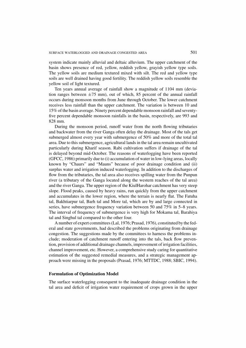
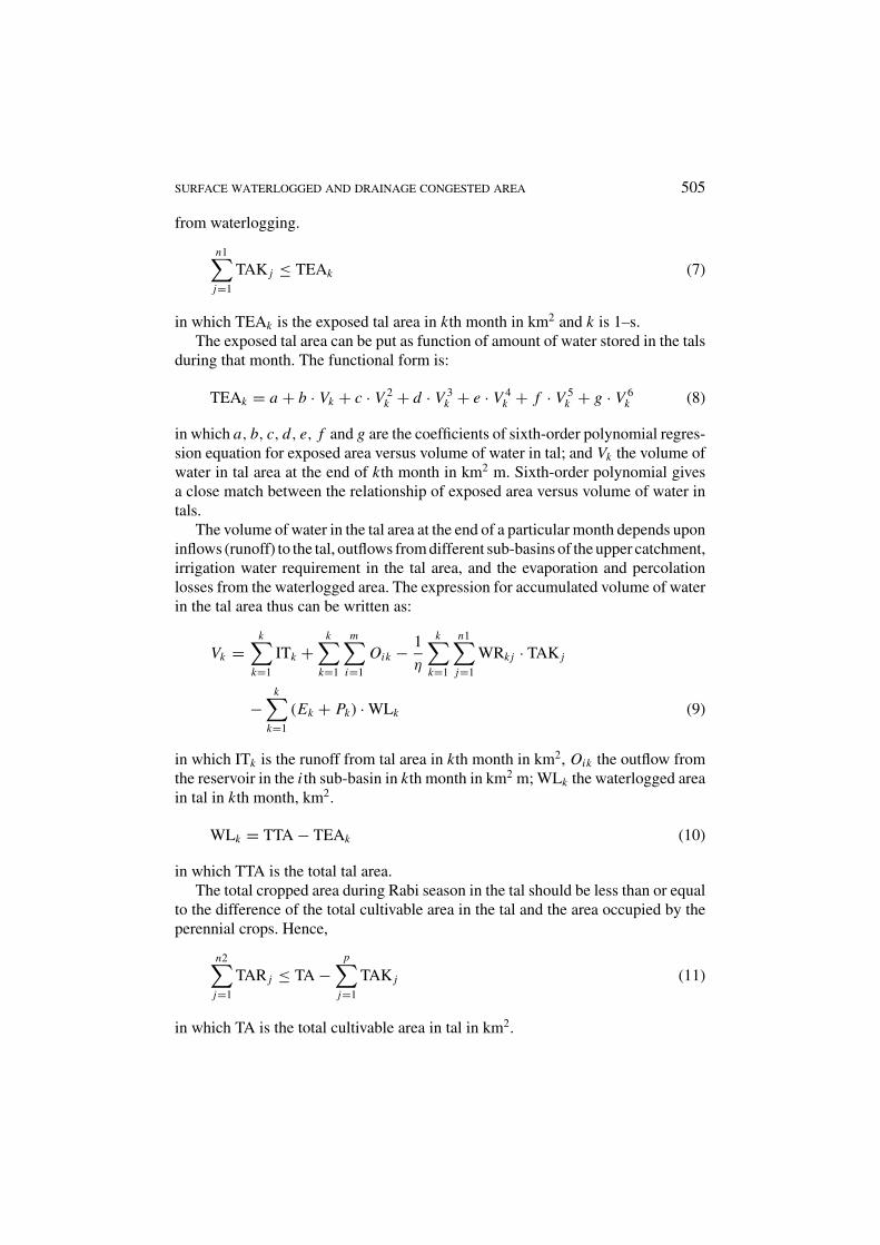
Figure 4. Schematic diagram of water balance of the tal area and the conceptualized schemeof the optimization model: Ii = inflows from different tributaries, Ip = precipitation on talarea, Qe = evaporation from water surface of tal water, Ql = infiltration from tal water andSik = proposed storage at catchment of different tributaries.
catchment of the Kiul-Harohar river system can be viewed as surplus and scarcityof water in the same catchment having a problem of management. An appropriatemanagement approach aiming at minimization of waterlogged area by storing mon-soon runoffs in different sub-basins of the main river system through surface storagefulfilling criteria of water requirement of crops grown in the respective commandscould be envisaged as a strategic solution to this problem. A schematic represen-tation of the conceptualization of the problem is given in Figure 4. Questions areobviously towards: (i) estimation of availability and determination of storage, (ii)setting up different alternatives and analysis of benefits. Formulating and solving anoptimization model under the constraints of requirement and dependability of watercould make answers to those questions. In formulation of the optimization model,the following points are considered as limiting conditions because of estimationdifficulties of the components and hence a rationalized approach is adopted.
(i) Overflow through the right bank of the river Punpun to the tal area is consideredinsignificant and hence ignored.
(ii) Backwater flow and seepage from the river Ganga to the tal area are considerednegligible in comparison to the basin inflows to the tals area.
(iii) The accumulated water in the tal area causing waterlogging during monsoonperiod is only because of the surface runoff from the catchment of the Kiul-Harohar basin.
The objective function thus stands as minimization of the waterlogged areacaused by the drainage congestion, which is equivalent to maximizing the cropped
SURFACE WATERLOGGED AND DRAINAGE CONGESTED AREA 503
area in the tals. Again, minimizing inflows into the tal area is equivalent to maxi-mizing storage of water in the upstream catchment, which would subsequently beused to meet crop water requirements in the upstream catchment as well as in thetals area. The maximization (optimization) problem is, therefore, formulated tak-ing into account the crop factors, monthly reservoir storage values in the upstreamcatchment and the area being exposed in the tals.
Objective Function
The objective function in mathematical notations can be written as:
maximizem∑
i=1
n1∑j=1
SBAKi j +n1∑j=1
TAK j+m∑
i=1
n2∑j=1
SBARi j +n2∑j=1
TAR j (1)
in which m is the number of sub-basins in the Kiul-Harohar basin; n1 and n2 arethe number of crops grown during Kharif and Rabi seasons, respectively; SBAKi j
the area of i th sub-basin allocated to j th crop in Kharif season in km2; TAK j the talarea allocated to j th crop in Kharif season in km2; SBARi j the area of i th sub-basinallocated to j th crop in Rabi season in km2; TAR j the tal area allocated to j th cropin Rabi season, km2.
This objective function is subjected to the following constraints.
STORAGE CONSTRAINTS FOR THE UPPER CATCHMENT
The storage constraints for the upper catchment for Kharif and Rabi seasons aregiven by:
Sik =k∑
k=1
Iik −k∑
k=1
Oik − 1
η
k∑k=1
n1∑j=1
WRk j · SBAKi j −k∑
k=1
(Ek + Pk) · SAik
(2)
in which s is the number of months in Kharif season; Sik the cumulative waterstorage in the reservoir of i th sub-basin in kth month in km2 m (assuming no deadstorage at the beginning of Kharif season); Iik the inflow (runoff) from the i th sub-basin to the reservoir in kth month in km2 m; Oik the outflow from the reservoir inthe i th sub-basin in kth month in km2 m; η the irrigation efficiency; WRk j the waterrequirement of j th crop in kth month in m; Ek the evaporation loss from reservoirin kth month in m; Pk the percolation loss from reservoir in kth month in m; SAik
the water spread of the reservoir in the i th sub-basin in kth month in km2 and i is1–m and k is 1–s.
The evaporation, crop coefficient, percolation loss and effective rainfall gov-ern the irrigation water requirement of a crop. The constraints for crop water
504 A. K. LOHANI ET AL.
requirement can be derived as:
WRk j = Ek · Kck j + Pkj − Rek (3)
in which WRk j is the irrigation water requirement of the j th crop in the kth monthin m; Ek the evaporation in the kth month; Kck j the crop coefficient of the j thcrop in kth month; Pkj the percolation loss for j th crop in kth month in m; Rek theeffective rainfall in kth month in m.
Sik =s∑
k=1
Iik −k+s∑k=1
Oik − 1
η
s∑k=1
n1∑j=1
WRk j · SBAKi j
−1
η
k∑k=1
n2∑j=1
WRk j · SBARi j−k+s∑k=1
(Ek + Pk) · SAik (4)
in which r is the number of months in rabi season; i is 1–m and k is 1–r.
AREA CONSTRAINTS
The area constraints for crops in the upper catchment and in the tal area are definedto account for total area available for cultivation during Kharif and Rabi seasons,the crop rotation, the soil texture, the topography and the affinity of the farmers toa specific crop. The area under waterlogging condition governs the area constraintsfor the tals.
The area constraints for the upper catchment are given by:
n1∑j=1
SBAKi j ≤ CAi (5)
n2∑j=1
SBARi j ≤ CAi −p∑
j=1
SBAKi j (6)
in which CAi is total cultivable area available for canal irrigation in i th sub-basin,km2 and i is 1 to m; p the number of perennial crops which are sown in Kharifseason but harvested only after Rabi season without additional water requirementduring Rabi season.
Area Constraints in Tal AreaSince the tal area gets waterlogged during monsoon season, total cropped areaduring Kharif season in the tals should be less than or equal to the area exposed
SURFACE WATERLOGGED AND DRAINAGE CONGESTED AREA 505
from waterlogging.
n1∑j=1
TAK j ≤ TEAk (7)
in which TEAk is the exposed tal area in kth month in km2 and k is 1–s.The exposed tal area can be put as function of amount of water stored in the tals
during that month. The functional form is:
TEAk = a + b · Vk + c · V 2k + d · V 3
k + e · V 4k + f · V 5
k + g · V 6k (8)
in which a, b, c, d, e, f and g are the coefficients of sixth-order polynomial regres-sion equation for exposed area versus volume of water in tal; and Vk the volume ofwater in tal area at the end of kth month in km2 m. Sixth-order polynomial givesa close match between the relationship of exposed area versus volume of water intals.
The volume of water in the tal area at the end of a particular month depends uponinflows (runoff) to the tal, outflows from different sub-basins of the upper catchment,irrigation water requirement in the tal area, and the evaporation and percolationlosses from the waterlogged area. The expression for accumulated volume of waterin the tal area thus can be written as:
Vk =k∑
k=1
ITk +k∑
k=1
m∑i=1
Oik − 1
η
k∑k=1
n1∑j=1
WRk j · TAK j
−k∑
k=1
(Ek + Pk) · WLk (9)
in which ITk is the runoff from tal area in kth month in km2, Oik the outflow fromthe reservoir in the i th sub-basin in kth month in km2 m; WLk the waterlogged areain tal in kth month, km2.
WLk = TTA − TEAk (10)
in which TTA is the total tal area.The total cropped area during Rabi season in the tal should be less than or equal
to the difference of the total cultivable area in the tal and the area occupied by theperennial crops. Hence,
n2∑j=1
TAR j ≤ TA −p∑
j=1
TAK j (11)
in which TA is the total cultivable area in tal in km2.
506 A. K. LOHANI ET AL.
WATER REQUIREMENT CONSTRAINTS
The water requirement constraint should be such that the monthly requirement ofwater in the command area should be less than or equal to the monthly availabilityof water. This is equivalent to stating that in any given month, the cumulative waterrequirement for crops should not exceed the cumulative water availability in thatmonth.
Water Requirement Constraints for Upper Catchment
1
η
k∑k=1
n1∑j=1
WRk j SBAKi j ≤k∑
k=1
Iik −k∑
k=1
Oik −k∑
k=1
(Ek + Pk) · SAik (12)
in which i = 1–m and k = 1–s.
1
η
k∑k=1
n2∑j=1
WRk j · SBARi j ≤s∑
k=1
Iik −k+s∑k=1
Oik − 1
η
s∑k=1
n1∑j=1
WRk j · SBAKi j
−k+s∑k=1
(Ek + Pk) · SAik (13)
in which i = 1–m and k = 1–r .
Water Requirement Constraints for Tal Area
1
η
k∑k=1
n1∑j=1
WRk j · TAK j ≤k∑
k=1
ITk +k∑
k=1
m∑i=1
Oik −k∑
k=1
(Ek + Pk) · WLk
(14)
in which k = 1–s.During Rabi season, tubewells water can also be used in the tal area in addition
to the outflows from the sub-basins to meet crop water requirements. Thus, waterrequirement constraint can be expressed as:
1
η
k∑k=1
n2∑j=1
WRk j · TAR j ≤s+k∑
k=s+1
m∑i=1
Oik +k∑
k=1
TUk (15)
in which TUk is the water available from tubewells in kth month in km2 m and k =1–r .
Further, it needs to be ensured that the outflow from the upper catchment betotally utilized for meeting the crop water requirements in the tal area during Rabi
SURFACE WATERLOGGED AND DRAINAGE CONGESTED AREA 507
season that would reduce the risk of waterlogging in tal area during Rabi season.The resulting constraint can thus be expressed as:
1
η
k∑k=1
n2∑j=1
WRk j · TAR j ≥s+k∑
k=s+1
m∑i=1
Oik (16)
AFFINITY CONSTRAINTS
Farmers of the region have a tendency to grow paddy crops during Kharif seasonand wheat crops during Rabi season in large scale, this may be because of ensuringstorage of their basic food requirement. To safeguard the interest of farmers, thelower limit of area under paddy cultivation is kept as 60% of total irrigated area.
SBAKi1 ≥ 0.6n1∑j=1
SBAKi j (17)
in which SBAKi1 is the area of i th sub-basin under paddy cultivation; and i = 1–m.Similarly, for Rabi season, the minimum area under wheat cultivation is kept as
55% of the total irrigated area.
SBARi1 ≥ 0.55n1∑j=1
SBARi j (18)
in which SBARi1 is the area of i th sub-basin under wheat cultivation and i = 1–m.
Cropping Pattern ConstraintsKeeping in view the cropping pattern of the area, constraints of cropping patternfor different crops have been fixed putting area as the limiting conditions.
STORAGE CONSTRAINT
The limiting values of the derived constraints (Equation (2) through Equation (18))would provide a solution to the objective function (Equation (1)) leading to mini-mization of waterlogged area in the tals during monsoon season. This minimizationis subjected to the reduction over inflows by construction of a number of waterstorage structures/reservoirs. However, from practical point of view, it may not bepossible to construct required numbers of water storage structures/reservoirs at atime. Survey and records (GFCC, 1986) indicated that about 30% of the total inflowfrom the upstream catchment are already in storage in different reservoirs locatedaround the upper catchment. This essentially suggests that additional storage overand above the existing ones would be required to minimize the waterlogged area in
508 A. K. LOHANI ET AL.
the tals’ area. The constraint for storage of water in the upper catchment can thusbe written as:
Sik + 1
η
k∑k=1
n1∑j=1
WRk j · SBAKi j +k∑
k=1
(Ek + Pk) · SAik ≤ c
(k∑
k=1
Iik
)(19)
in which c is a fraction taken as 0.4 and 0.5, i = 1–m and k = 1–s.
Input Data
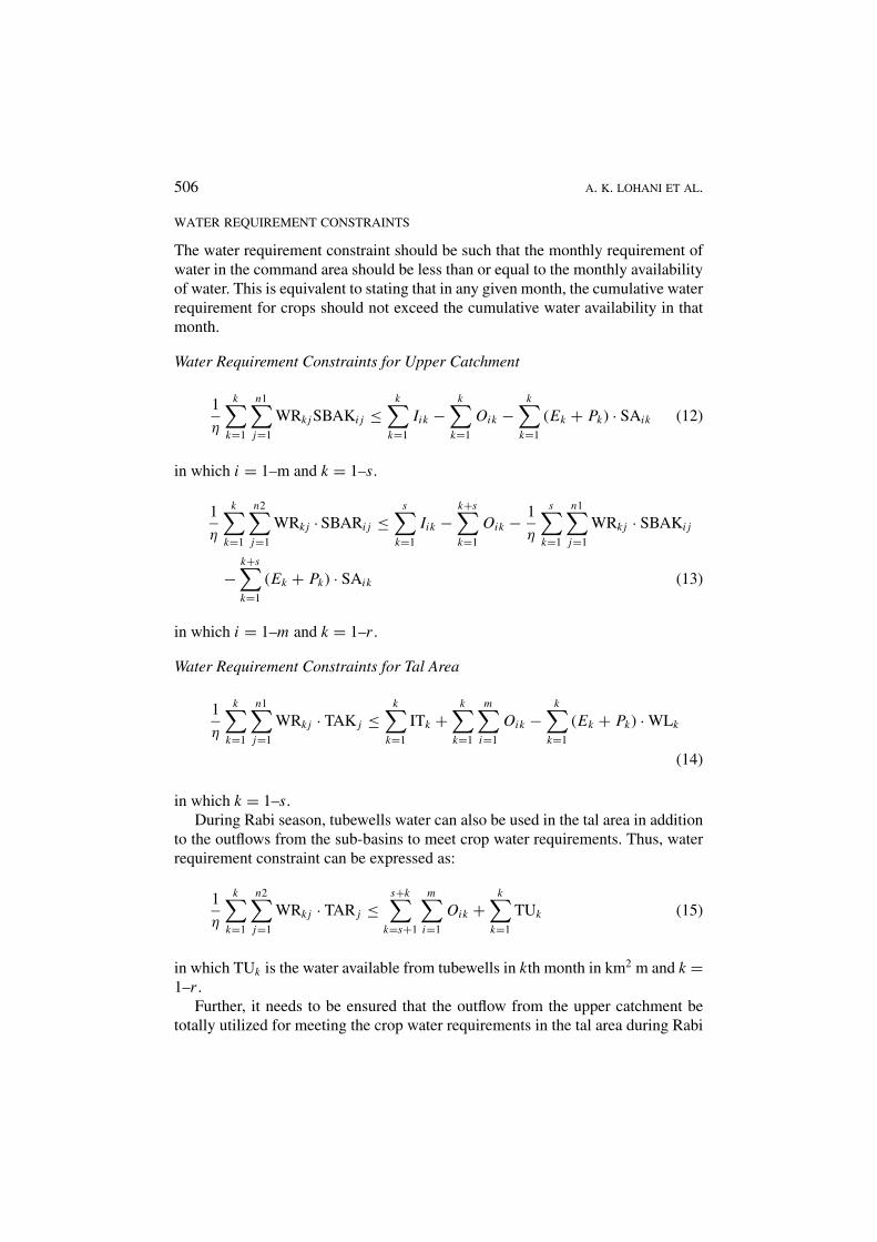
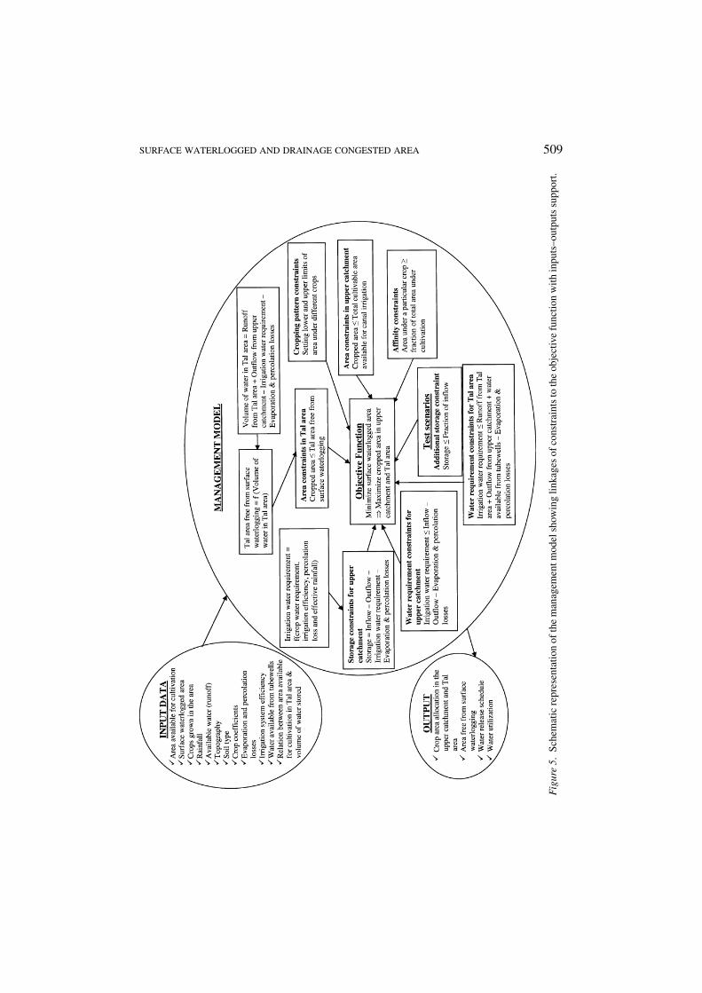
Obviously, the variables in Equation (1) through Equation (19) are subjected tosome boundary and limiting values, which are to be prescribed from the actualfield data before seeking a solution to the optimization problem. The derived con-straints (Equation (2) through Equation (19)) clearly define data and informationrequired as input to solve the objective function (Equation (1)). Figure 5 depictsa schematic representation of the management model with illustrations of inputdata requirement for different levels of computation. The required input data arecategorized as basin information (sub-basins, cultivable area, waterlogged area,etc.), cropping pattern and their base period, rainfall-runoff, topography, soil types,losses, irrigation system efficiency, water availability from tubewells, etc.
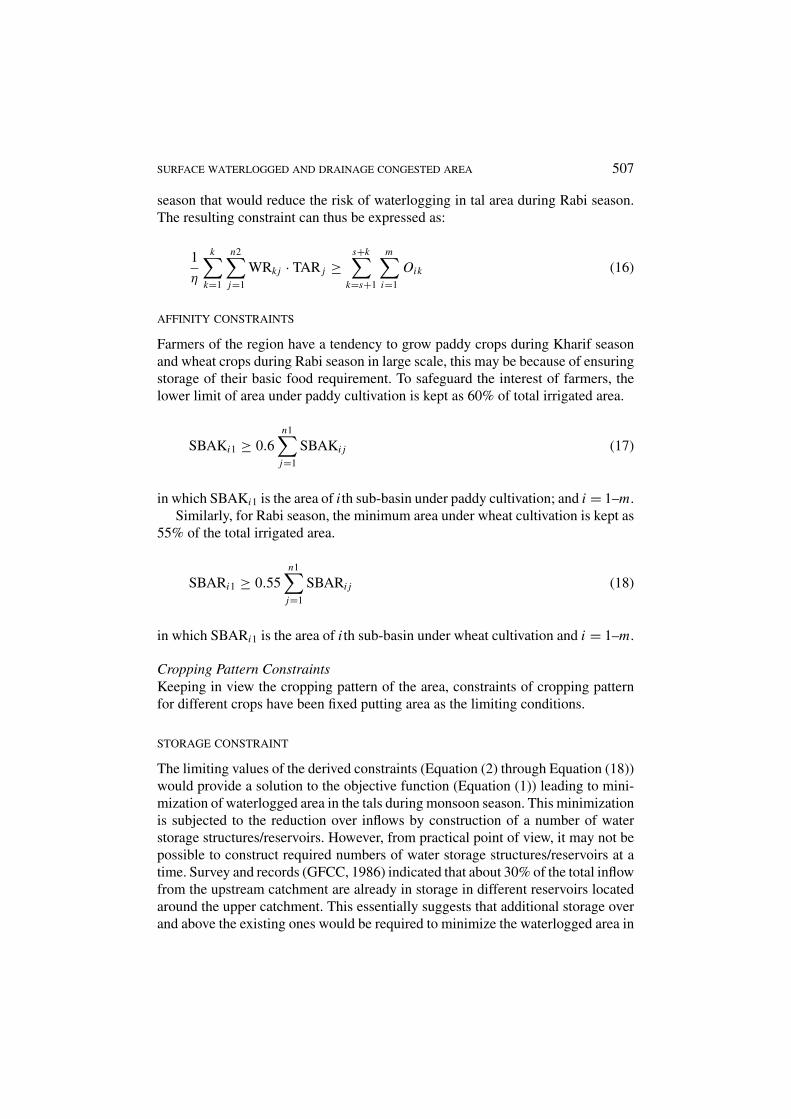
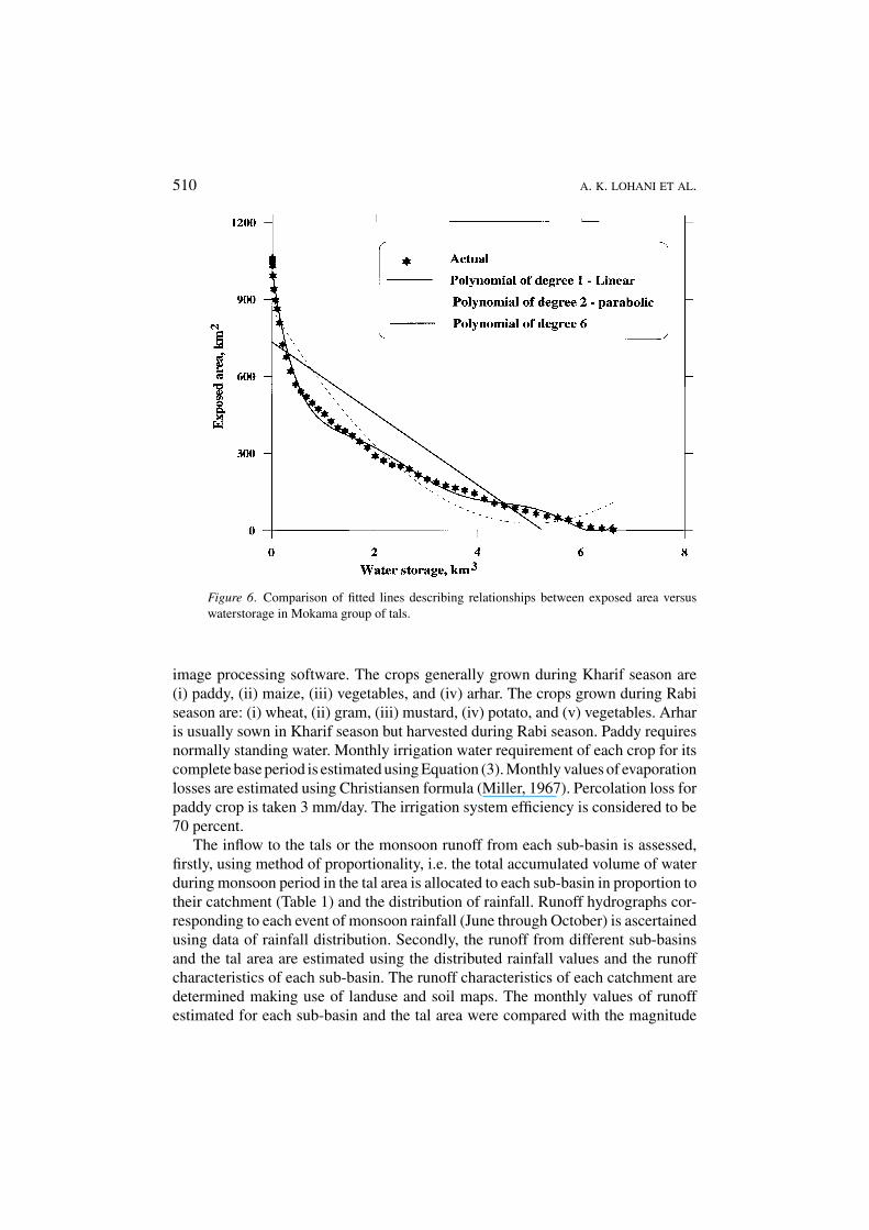
Using Geographical Information System (GIS), a digital elevation map (DEM)of the Mokama group of tals has been prepared. Making use of the DEM and thewaterlogged areas (and hence, the exposed area) for various storage capacities inthe tal, an area–capacity curve is developed. A comparison of fitted polynomialsbetween exposed area versus storage volume is shown in Figure 6. The best fit-ted curve giving r2 = 0.99 is found to be a sixth-order polynomial as given inEquation (20):
Ea = 1010.5 − 1374.4V + 1252.4V 2 − 596.7V 3 + 145.5V 4
− 17.4V 5 + 0.8V 6 (20)
in which Ea is the exposed area in km2, and V the storage volume in km3. Equa-tion (20) describes a nonlinear relationship, and hence, the optimization modelforms a nonlinear model.
Based on the topography and network system of tributaries, the Kiul-Haroharriver basin is divided into four major sub-basins excluding the waterlogged areain the tals. Area of each sub-basin is assessed making use of toposheet (1:25,000)in association with GIS software. The assessed area of each sub-basin is givenin Table 1. The crops usually grown during Kharif and Rabi seasons in four sub-basins and in the tal area are ascertained using data of existing cropping pattern, soiland topographic maps, and also from field survey. The landuse pattern is assessedusing Indian Remote Sensing (IRS) data, processed through ERDAS and ILWIS
SURFACE WATERLOGGED AND DRAINAGE CONGESTED AREA 509
Fig
ure
5.Sc
hem
atic
repr
esen
tatio
nof
the
man
agem
entm
odel
show
ing
linka
ges
ofco
nstr
aint
sto
the
obje
ctiv
efu
nctio
nw
ithin
puts
–out
puts
supp
ort.
510 A. K. LOHANI ET AL.
Figure 6. Comparison of fitted lines describing relationships between exposed area versuswaterstorage in Mokama group of tals.
image processing software. The crops generally grown during Kharif season are(i) paddy, (ii) maize, (iii) vegetables, and (iv) arhar. The crops grown during Rabiseason are: (i) wheat, (ii) gram, (iii) mustard, (iv) potato, and (v) vegetables. Arharis usually sown in Kharif season but harvested during Rabi season. Paddy requiresnormally standing water. Monthly irrigation water requirement of each crop for itscomplete base period is estimated using Equation (3). Monthly values of evaporationlosses are estimated using Christiansen formula (Miller, 1967). Percolation loss forpaddy crop is taken 3 mm/day. The irrigation system efficiency is considered to be70 percent.
The inflow to the tals or the monsoon runoff from each sub-basin is assessed,firstly, using method of proportionality, i.e. the total accumulated volume of waterduring monsoon period in the tal area is allocated to each sub-basin in proportion totheir catchment (Table 1) and the distribution of rainfall. Runoff hydrographs cor-responding to each event of monsoon rainfall (June through October) is ascertainedusing data of rainfall distribution. Secondly, the runoff from different sub-basinsand the tal area are estimated using the distributed rainfall values and the runoffcharacteristics of each sub-basin. The runoff characteristics of each catchment aredetermined making use of landuse and soil maps. The monthly values of runoffestimated for each sub-basin and the tal area were compared with the magnitude
SURFACE WATERLOGGED AND DRAINAGE CONGESTED AREA 511
Table I. Areal extent and cultivable area from four sub-basins of Kiul-Harohar river system
Area Percent of total Existing cultivableSub-basins (km2) area area (km2)
Falgu sub-basin 5747 33.4 1495
Dhadhar-Sakri sub-basin 5370 31.2 1393
Tati-Some sub-basin 2114 12.3 992
Kiul sub-basin 2930 17.0 1244
Tal area 1062 6.1 925
Total 17223 100 6049
Table II. Computed monthly runoff of different sub-basins and the tal area
Runoff (km2 · m)
Name of sub-basin June July August September October
Falgu 243.26 628.91 670.39 403.62 102.33
Dhadhar-Sakri 248.72 538.48 584.82 354.81 101.32
Tati-Some 99.64 191.49 218.06 138.06 36.88
Kiul 178.50 301.8 306.16 224.44 71.84
Tal area 50.05 101.34 113.08 73.99 18.46
of runoff computed from the proportion of accumulated water in the tal area. Ifthe computed runoff from all sub-basins exceeded the magnitude of accumulatedrunoffs in the tals, the computed values are limited to the accumulated volume. Theestimated runoff values of each sub-basin are given in Table 2.
Total runoff from the Kiul-Harohar river basin including the tal area for completemonsoon period is estimated as 6000 km2 m. The computed runoff from each sub-basin as given in Table 2 is taken as the limiting conditions of water availability tosolve the objective function.
Results and Discussion
The conceptualized management model illustrating the computational requirementsof different constraints and their linkages to the objective function is depicted inFigure 5. The input data requirements for the targeted outputs are also describedin Figure 5. It is clearly evident (Figure 5) that in order to achieve the optimizedvalue of the objective function a maximum of three-tier computational hierarchyfor the tal area and a two-tier computational hierarchy for storage constaints guidethe solution. However, the other constraints are guided by single-tier computationalburden.
The objective function (Equation (1)) of the nonlinear optimization model is tomaximize the cropped area in the tal as well as in the upstream catchment. A number
512 A. K. LOHANI ET AL.
of techniques (Dorfman et al., 1964; Himmelblau, 1972; Sakarovitch, 1983) andcommercial software are available to solve linear and nonlinear optimization prob-lems irrespective of number of constraints. The present problem is solved usingQuantitative Systems for Business (QSB) software developed by Yih-Long Changof Prentice Hall Inc. The module considers a line search methodology to solveunconstrained problems and a sequential unconstrained minimization technique(SUMT) with penalty function methodology to solve constrained problems. Anysize of problem can be solved using this software module depending upon avail-ability of memory in a computer. The formulated problem for two cropping seasonsconstitutes a total of 160 constraints.
The intended target in the solution is to bring as much area under cultivation fromthe waterlogged area and from the four sub-basins as given in Table 1, satisfyingcondition of crop water requirement and local factors such as affinity of farmers toany crop. The limiting boundary conditions are availability of water and cultivablecommand areas in each basin. The water availability again depends on rainfall, itsfrequency and intensity. More the rainfall, larger is the storage. Large storage in theupper catchment means bringing more area under cultivation. But large storage inthe tal area means getting less area exposed from waterlogging. On the other hand,more rainfall with close frequency means requirement of less irrigation water forcrops during Kharif season. Use of less irrigation water during Kharif season implieskeeping more storage for Rabi crops, or creating scope for unnecessary storage thanthe actual requirement during Rabi season to achieve the same target of minimizedwaterlogged area in the tals. Creation of excess storage over the actual requirementwill involve more cost. Hence, for achieving the optimized condition, parametersand values of each constraint need to be judiciously decided.
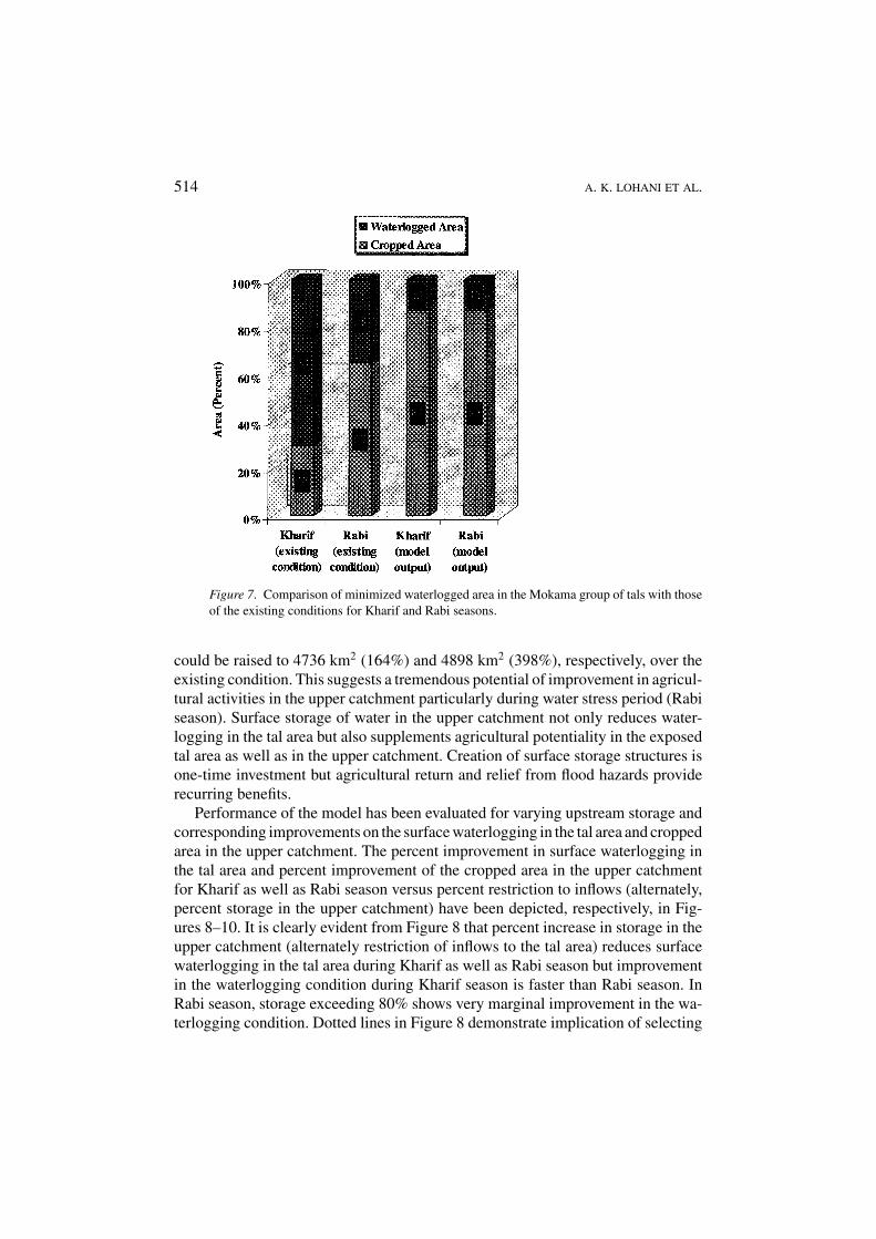
Results of the nonlinear optimization model corresponding to the prescribedinput values (Table 2) and the limiting conditions, are given in Table 3, whichsuggest optimized areas allocated under different crops during Kharif and Rabiseasons in the upper catchment as well as in the tal area. The value of the objec-tive function, i.e. maximized crop area in the tal as well as in the upper catchmentof the four sub-basins, corresponding to the given input is computed 11,441.84km2 out of total area of 17,223 km2. The corresponding improvement on the con-dition of waterlogging in the tal area is found to be 87%, implying that duringKharif season, out of the total waterlogged area of 1062 km2, only 137 km2 (13%)would remain waterlogged and balance 925 km2 (87%) could be brought underKharif crops cultivation. Similar is the case for Rabi season (Figure 7). DuringRabi season, out of 925 km2 of allocated cropped area, 883.4 km2 is demarcatedto Rabi crops other than the Arhar (41.60 km2). Arhar being an annual crop, itsarea is also included in the estimation of Kharif crop area for obtaining a realisticassessment of area actually being exposed from waterlogging in the tals. An areaapproximately 137 km2 (13%) is left out as residual of the optimization for boththe seasons. This residual is the supported storage of water requires supplementing
SURFACE WATERLOGGED AND DRAINAGE CONGESTED AREA 513
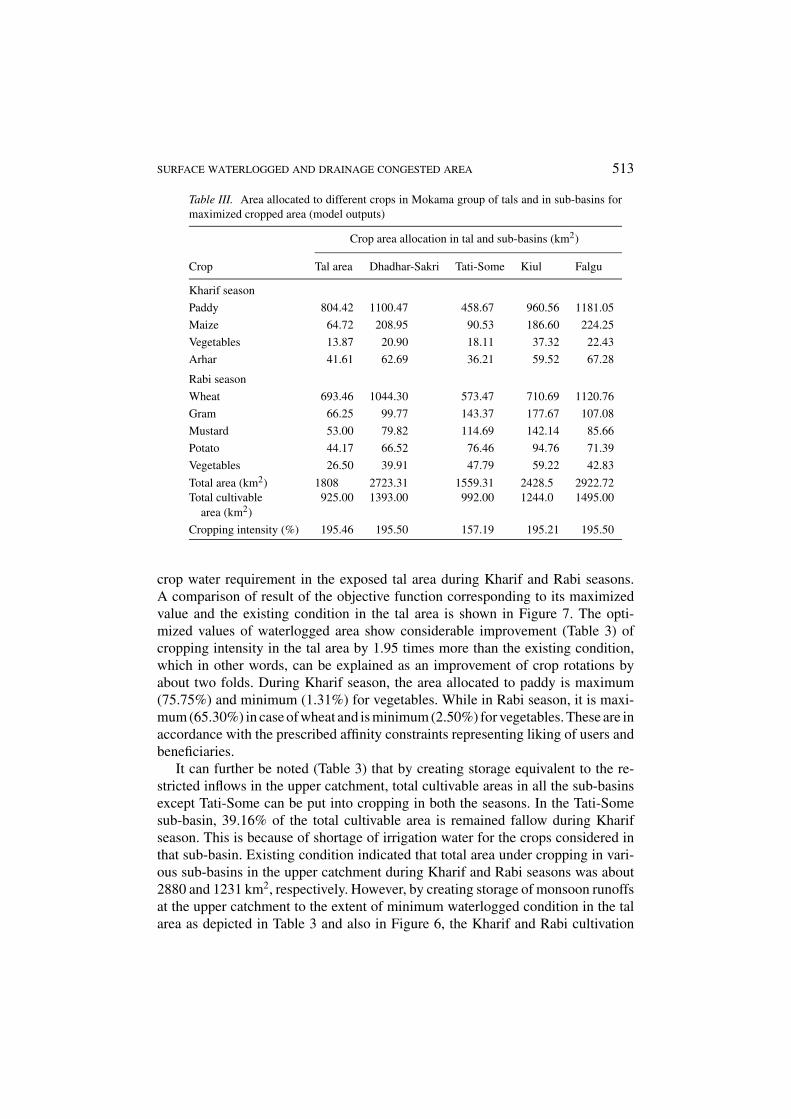
Table III. Area allocated to different crops in Mokama group of tals and in sub-basins formaximized cropped area (model outputs)
Crop area allocation in tal and sub-basins (km2)
Crop Tal area Dhadhar-Sakri Tati-Some Kiul Falgu
Kharif season
Paddy 804.42 1100.47 458.67 960.56 1181.05
Maize 64.72 208.95 90.53 186.60 224.25
Vegetables 13.87 20.90 18.11 37.32 22.43
Arhar 41.61 62.69 36.21 59.52 67.28
Rabi season
Wheat 693.46 1044.30 573.47 710.69 1120.76
Gram 66.25 99.77 143.37 177.67 107.08
Mustard 53.00 79.82 114.69 142.14 85.66
Potato 44.17 66.52 76.46 94.76 71.39
Vegetables 26.50 39.91 47.79 59.22 42.83
Total area (km2) 1808 2723.31 1559.31 2428.5 2922.72Total cultivable 925.00 1393.00 992.00 1244.0 1495.00
area (km2)
Cropping intensity (%) 195.46 195.50 157.19 195.21 195.50
crop water requirement in the exposed tal area during Kharif and Rabi seasons.A comparison of result of the objective function corresponding to its maximizedvalue and the existing condition in the tal area is shown in Figure 7. The opti-mized values of waterlogged area show considerable improvement (Table 3) ofcropping intensity in the tal area by 1.95 times more than the existing condition,which in other words, can be explained as an improvement of crop rotations byabout two folds. During Kharif season, the area allocated to paddy is maximum(75.75%) and minimum (1.31%) for vegetables. While in Rabi season, it is maxi-mum (65.30%) in case of wheat and is minimum (2.50%) for vegetables. These are inaccordance with the prescribed affinity constraints representing liking of users andbeneficiaries.
It can further be noted (Table 3) that by creating storage equivalent to the re-stricted inflows in the upper catchment, total cultivable areas in all the sub-basinsexcept Tati-Some can be put into cropping in both the seasons. In the Tati-Somesub-basin, 39.16% of the total cultivable area is remained fallow during Kharifseason. This is because of shortage of irrigation water for the crops considered inthat sub-basin. Existing condition indicated that total area under cropping in vari-ous sub-basins in the upper catchment during Kharif and Rabi seasons was about2880 and 1231 km2, respectively. However, by creating storage of monsoon runoffsat the upper catchment to the extent of minimum waterlogged condition in the talarea as depicted in Table 3 and also in Figure 6, the Kharif and Rabi cultivation
514 A. K. LOHANI ET AL.
Figure 7. Comparison of minimized waterlogged area in the Mokama group of tals with thoseof the existing conditions for Kharif and Rabi seasons.
could be raised to 4736 km2 (164%) and 4898 km2 (398%), respectively, over theexisting condition. This suggests a tremendous potential of improvement in agricul-tural activities in the upper catchment particularly during water stress period (Rabiseason). Surface storage of water in the upper catchment not only reduces water-logging in the tal area but also supplements agricultural potentiality in the exposedtal area as well as in the upper catchment. Creation of surface storage structures isone-time investment but agricultural return and relief from flood hazards providerecurring benefits.
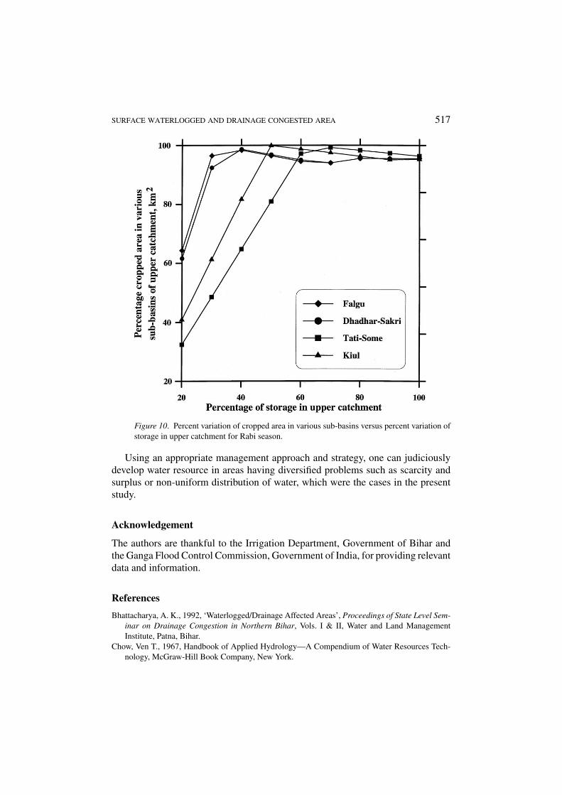
Performance of the model has been evaluated for varying upstream storage andcorresponding improvements on the surface waterlogging in the tal area and croppedarea in the upper catchment. The percent improvement in surface waterlogging inthe tal area and percent improvement of the cropped area in the upper catchmentfor Kharif as well as Rabi season versus percent restriction to inflows (alternately,percent storage in the upper catchment) have been depicted, respectively, in Fig-ures 8–10. It is clearly evident from Figure 8 that percent increase in storage in theupper catchment (alternately restriction of inflows to the tal area) reduces surfacewaterlogging in the tal area during Kharif as well as Rabi season but improvementin the waterlogging condition during Kharif season is faster than Rabi season. InRabi season, storage exceeding 80% shows very marginal improvement in the wa-terlogging condition. Dotted lines in Figure 8 demonstrate implication of selecting
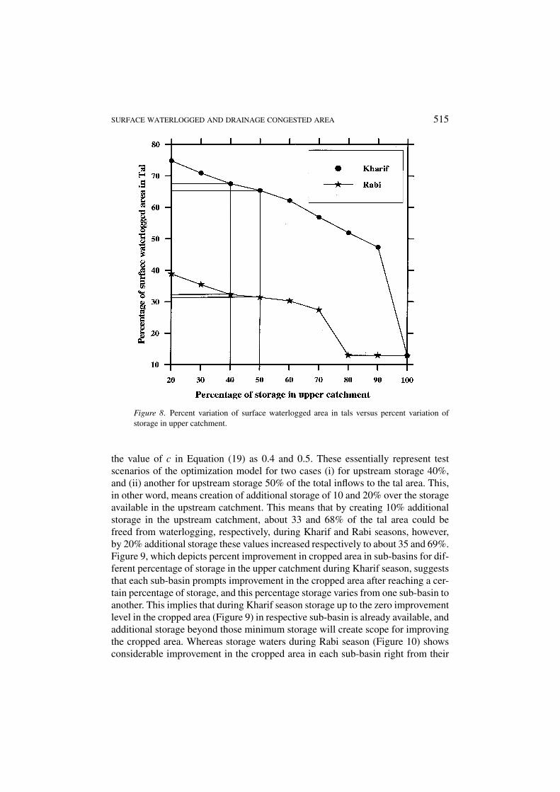
SURFACE WATERLOGGED AND DRAINAGE CONGESTED AREA 515
Figure 8. Percent variation of surface waterlogged area in tals versus percent variation ofstorage in upper catchment.
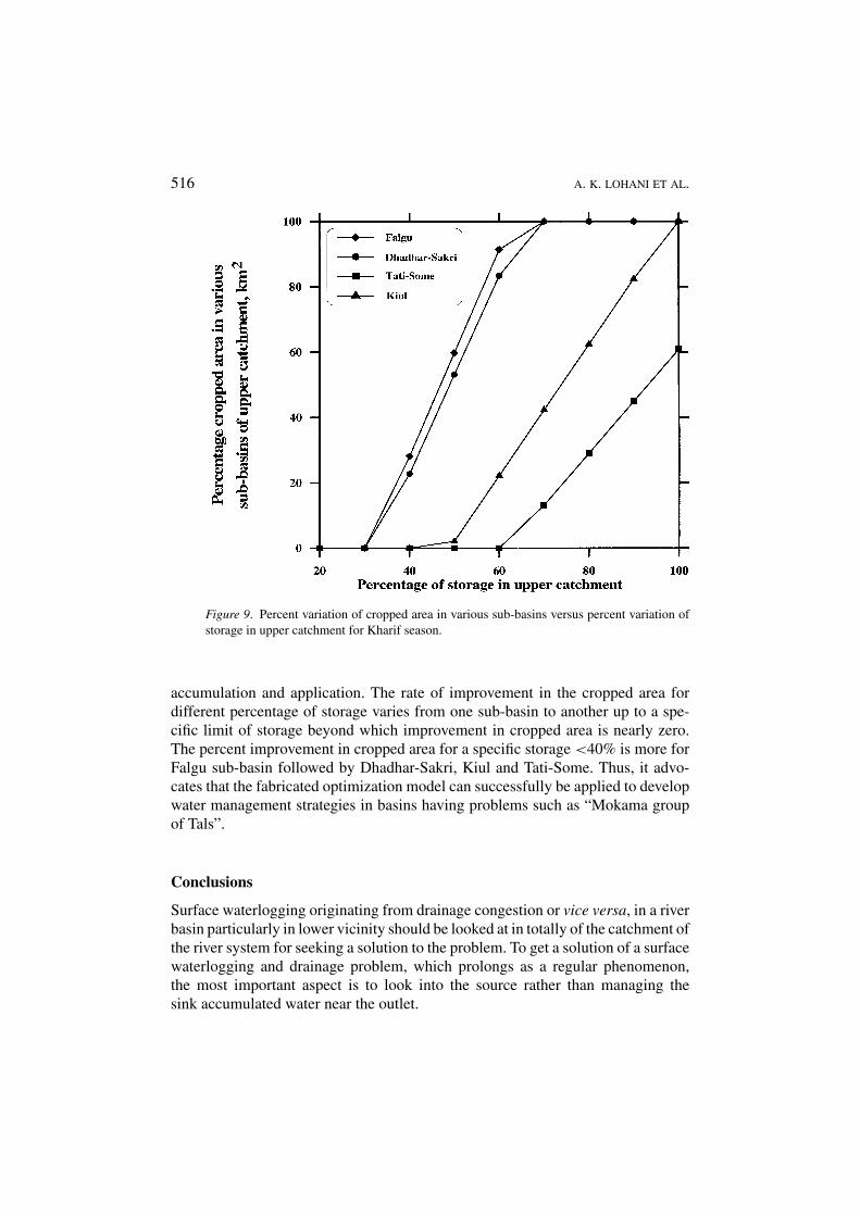
the value of c in Equation (19) as 0.4 and 0.5. These essentially represent testscenarios of the optimization model for two cases (i) for upstream storage 40%,and (ii) another for upstream storage 50% of the total inflows to the tal area. This,in other word, means creation of additional storage of 10 and 20% over the storageavailable in the upstream catchment. This means that by creating 10% additionalstorage in the upstream catchment, about 33 and 68% of the tal area could befreed from waterlogging, respectively, during Kharif and Rabi seasons, however,by 20% additional storage these values increased respectively to about 35 and 69%.Figure 9, which depicts percent improvement in cropped area in sub-basins for dif-ferent percentage of storage in the upper catchment during Kharif season, suggeststhat each sub-basin prompts improvement in the cropped area after reaching a cer-tain percentage of storage, and this percentage storage varies from one sub-basin toanother. This implies that during Kharif season storage up to the zero improvementlevel in the cropped area (Figure 9) in respective sub-basin is already available, andadditional storage beyond those minimum storage will create scope for improvingthe cropped area. Whereas storage waters during Rabi season (Figure 10) showsconsiderable improvement in the cropped area in each sub-basin right from their
516 A. K. LOHANI ET AL.
Figure 9. Percent variation of cropped area in various sub-basins versus percent variation ofstorage in upper catchment for Kharif season.
accumulation and application. The rate of improvement in the cropped area fordifferent percentage of storage varies from one sub-basin to another up to a spe-cific limit of storage beyond which improvement in cropped area is nearly zero.The percent improvement in cropped area for a specific storage <40% is more forFalgu sub-basin followed by Dhadhar-Sakri, Kiul and Tati-Some. Thus, it advo-cates that the fabricated optimization model can successfully be applied to developwater management strategies in basins having problems such as “Mokama groupof Tals”.
Conclusions
Surface waterlogging originating from drainage congestion or vice versa, in a riverbasin particularly in lower vicinity should be looked at in totally of the catchment ofthe river system for seeking a solution to the problem. To get a solution of a surfacewaterlogging and drainage problem, which prolongs as a regular phenomenon,the most important aspect is to look into the source rather than managing thesink accumulated water near the outlet.
SURFACE WATERLOGGED AND DRAINAGE CONGESTED AREA 517
Figure 10. Percent variation of cropped area in various sub-basins versus percent variation ofstorage in upper catchment for Rabi season.
Using an appropriate management approach and strategy, one can judiciouslydevelop water resource in areas having diversified problems such as scarcity andsurplus or non-uniform distribution of water, which were the cases in the presentstudy.
Acknowledgement
The authors are thankful to the Irrigation Department, Government of Bihar andthe Ganga Flood Control Commission, Government of India, for providing relevantdata and information.
References
Bhattacharya, A. K., 1992, ‘Waterlogged/Drainage Affected Areas’, Proceedings of State Level Sem-inar on Drainage Congestion in Northern Bihar, Vols. I & II, Water and Land ManagementInstitute, Patna, Bihar.
Chow, Ven T., 1967, Handbook of Applied Hydrology—A Compendium of Water Resources Tech-nology, McGraw-Hill Book Company, New York.
518 A. K. LOHANI ET AL.
Chow , Ven T., Maidment David R. and Mays, L. W., 1988, Applied Hydrology, McGraw-Hill Inc.,New York.
Dorfman, R., Samuelson, P. A. and Splow, R. M., 1964, Linear Programming & Economic Analysis,McGraw-Hill Intl., Tokyo.
Ganga Flood Control Commission (GFCC), 1986, Comprehensive Plan of Flood Control for theGanga Sub Basin, Part I, Vol. I, Patna.
Himmelblau, D. M., 1972, Applied Nonlinear Programming, McGraw-Hill Book Company, NewYork.
Lal, K. N., 1976, ‘Problems of Mokama Tal’, Proceeding of an All India Symposium, April 15–17,Bihar College of Engineering, Patna.
Maidment, D. R., 1993, Handbook of Hydrology, McGraw-Hill Inc., New York.Miller, D. E., 1967, ‘Available water in soil as influenced by extraction of soil water by plants’,
J. Agron. 59(5), 420–423.Prasad, T., 1976, ‘Application of Mathematical Modelling Technique to Mokama Tal Problems’,
Proceeding of an All India Symposium, April 15–17, Bihar College of Engineering, Patna.Report of Mokama Tal Technicl-cum-Development Committee (MTTDC), 1988, Water Resources
Department, Government of Bihar.Report of the Second Bihar Irrigation Commission (SBIC), 1994, Government of Bihar, India.Sakarovitch, M., 1983, Linear Programming, Springer-Verlag, New York.Sinha, I. N., 1992, ‘Water Logging and Drainage Problem in Bihar—An Approach’, Proceedings
of State Level Seminar on Drainage Congestion in North Bihar, Vols. I & II, Water and LandManagement Institute, Patna.
Singh, V. P., 1988, Hydrlogic Systems-Rainfall-Runoff Modelling, Vol. I, Prentice Hall, New Jersey.