Embed Size (px)
Citation preview

Appendix A Emissions Calculations


Page 1 of 17
Delta Dams Rodent Burrowing Remediation Project - Contra Costa County, Annual
CalEEMod Version: CalEEMod.2020.4.0
Date: 7/30/2021 1:34 PM
EMFAC Off-Model Adjustment Factors for Gasoline Light Duty Vehicle to Account for the SAFE Vehicle Rule Not Applied
Delta Dams Rodent Burrowing Remediation Project Contra Costa County, Annual
1.0 Project Characteristics
1.1 Land Usage
Land Uses Size Metric Lot Acreage Floor Surface Area Population
User Defined Industrial
User Defined Industrial
User Defined Industrial
1.00
1.00
1.00
User Defined Unit
User Defined Unit
User Defined Unit
79.03
15.70
8.10
3,442,546.80
683,892.00
352,836.00
0
0
0
1.2 Other Project Characteristics
Urbanization Rural Wind Speed (m/s) 2.2 Precipitation Freq (Days) 58
Climate Zone 4 Operational Year 2023
Utility Company Pacific Gas & Electric Company
CO2 Intensity 641.35 CH4 Intensity 0.029 N2O Intensity 0.006
(lb/MWhr) (lb/MWhr) (lb/MWhr)
1.3 User Entered Comments & Non-Default Data
Project Characteristics - Delta Dams Rodent Burrowing Remediation Project. Contra Costa County.
Land Use - Clifton Court Forebay = permanent: 46 acres and temporary: 33.03 acres
Dyer Reservoir = permanent: 8.4 acres and temporary: 7.3 acres Construction Phase - Work completed at CCF site September 2021 through October 2021 and all sites from May 2022 through October 2022.
Off-road Equipment - Default equipment assumed.
Off-road Equipment - Default equipment assumed.
Off-road Equipment - Default equipment assumed.

Page 2 of 17
Delta Dams Rodent Burrowing Remediation Project - Contra Costa County, Annual
CalEEMod Version: CalEEMod.2020.4.0
Date: 7/30/2021 1:34 PM
EMFAC Off-Model Adjustment Factors for Gasoline Light Duty Vehicle to Account for the SAFE Vehicle Rule Not Applied
Off-road Equipment - Default equipment assumed.
Off-road Equipment - Default equipment assumed.
Trips and VMT - Updated trip lengths based on distance to closest material facilities within area. Updated vendor trips to account for water trucks (two water trucks).
Grading - Material import based on project specific information. Distributed total over all phases.
Vehicle Emission Factors - Table Name Column Name Default Value New Value
tblAreaCoating Area_Nonresidential_Exterior 2239639 1721275
tblAreaCoating Area_Nonresidential_Interior 6718917 5163825
tblConstructionPhase NumDays 120.00 15.00
tblConstructionPhase NumDays 310.00 27.00
tblConstructionPhase NumDays 120.00 15.00
tblConstructionPhase NumDays 310.00 30.00
tblConstructionPhase NumDays 120.00 86.00
tblGrading AcresOfGrading 17.00 41.23
tblGrading AcresOfGrading 231.00 37.80
tblGrading AcresOfGrading 33.00 11.20
tblGrading AcresOfGrading 327.00 6.00
tblGrading AcresOfGrading 66.00 0.70
tblGrading MaterialImported 0.00 15,320.00
tblGrading MaterialImported 0.00 15,320.00
tblGrading MaterialImported 0.00 18,182.00
tblGrading MaterialImported 0.00 18,182.00
tblGrading MaterialImported 0.00 18,182.00
tblLandUse LandUseSquareFeet 0.00 3,442,546.80
tblLandUse LandUseSquareFeet 0.00 683,892.00
tblLandUse LandUseSquareFeet 0.00 352,836.00

Page 3 of 17
Delta Dams Rodent Burrowing Remediation Project - Contra Costa County, Annual
CalEEMod Version: CalEEMod.2020.4.0
Date: 7/30/2021 1:34 PM
EMFAC Off-Model Adjustment Factors for Gasoline Light Duty Vehicle to Account for the SAFE Vehicle Rule Not Applied
tblLandUse LotAcreage 0.00 79.03
tblLandUse LotAcreage 0.00 15.70
tblLandUse LotAcreage 0.00 8.10
tblProjectCharacteristics UrbanizationLevel Urban Rural
tblTripsAndVMT HaulingTripLength 20.00 15.00
tblTripsAndVMT HaulingTripLength 20.00 15.00
tblTripsAndVMT HaulingTripLength 20.00 15.00
tblTripsAndVMT HaulingTripLength 20.00 15.00
tblTripsAndVMT HaulingTripLength 20.00 15.00
tblTripsAndVMT HaulingTripNumber 1,915.00 1,867.00
tblTripsAndVMT HaulingTripNumber 1,904.00 1,867.00
tblTripsAndVMT HaulingTripNumber 3,809.00 3,734.00
tblTripsAndVMT HaulingTripNumber 3,809.00 3,734.00
tblTripsAndVMT HaulingTripNumber 3,809.00 3,734.00
tblTripsAndVMT VendorTripNumber 0.00 4.00
tblTripsAndVMT VendorTripNumber 0.00 4.00
tblTripsAndVMT VendorTripNumber 0.00 4.00
tblTripsAndVMT VendorTripNumber 0.00 4.00
tblTripsAndVMT VendorTripNumber 0.00 4.00
tblTripsAndVMT WorkerTripNumber 10.00 30.00
tblTripsAndVMT WorkerTripNumber 20.00 60.00
tblTripsAndVMT WorkerTripNumber 10.00 60.00

Page 4 of 17
Delta Dams Rodent Burrowing Remediation Project - Contra Costa County, Annual
CalEEMod Version: CalEEMod.2020.4.0
Date: 7/30/2021 1:34 PM
EMFAC Off-Model Adjustment Factors for Gasoline Light Duty Vehicle to Account for the SAFE Vehicle Rule Not Applied
2.0 Emissions Summary
2.1 Overall Construction
Unmitigated Construction
ROG NOx CO SO2 Fugitive
PM10
Exhaust
PM10
PM10 Total Fugitive
PM2.5
Exhaust
PM2.5
PM2.5 Total Bio- CO2 NBio- CO2 Total CO2 CH4 N2O CO2e
Year tons/yr MT/yr
2021 0.0975 1.2225 0.6518 2.0900e- 0.4049 0.0461 0.4510 0.1959 0.0426 0.2385 0.0000 193.6952 193.6952 0.0351 0.0148 198.9684
003
2022 0.2463 3.0188 1.6956 5.8600e- 1.0392 0.1128 1.1520 0.5375 0.1040 0.6415 0.0000 545.7968 545.7968 0.0907 0.0437 561.0754
003
Maximum 0.2463 3.0188 1.6956 5.8600e-003
1.0392 0.1128 1.1520 0.5375 0.1040 0.6415 0.0000 545.7968 545.7968 0.0907 0.0437 561.0754
Mitigated Construction
ROG NOx CO SO2 Fugitive
PM10
Exhaust
PM10
PM10 Total Fugitive
PM2.5
Exhaust
PM2.5
PM2.5 Total Bio- CO2 NBio- CO2 Total CO2 CH4 N2O CO2e
Year tons/yr MT/yr
2021 0.0975 1.2225 0.6518 2.0900e- 0.4049 0.0461 0.4510 0.1959 0.0426 0.2385 0.0000 193.6951 193.6951 0.0351 0.0148 198.9683
003
2022 0.2463 3.0188 1.6956 5.8600e- 1.0392 0.1128 1.1520 0.5375 0.1040 0.6415 0.0000 545.7965 545.7965 0.0907 0.0437 561.0751
003
Maximum 0.2463 3.0188 1.6956 5.8600e-003
1.0392 0.1128 1.1520 0.5375 0.1040 0.6415 0.0000 545.7965 545.7965 0.0907 0.0437 561.0751

Page 5 of 17
Delta Dams Rodent Burrowing Remediation Project - Contra Costa County, Annual
CalEEMod Version: CalEEMod.2020.4.0
Date: 7/30/2021 1:34 PM
EMFAC Off-Model Adjustment Factors for Gasoline Light Duty Vehicle to Account for the SAFE Vehicle Rule Not Applied
3.0 Construction Detail
Construction Phase
Phase
Number
Phase Name Phase Type Start Date End Date Num Days
Week
Num Days Phase Description
1
2
3
4
5
Staging/Access 1
High Priority Repairs
Staging/Access 2
Burrow Remediation
Drainage Channel/Intake
Channel/Tree Removal
Site Preparation
Grading
Site Preparation
Grading
Site Preparation
9/1/2021
9/22/2021
5/1/2022
5/21/2022
7/2/2022
9/21/2021
10/28/2021
5/20/2022
7/1/2022
10/31/2022
5
5
5
5
5
15
27
15
30
86
Acres of Grading (Site Preparation Phase): 41.23
Acres of Grading (Grading Phase): 37.8
Acres of Paving: 0
Residential Indoor: 0; Residential Outdoor: 0; Non-Residential Indoor: 0; Non-Residential Outdoor: 0; Striped Parking Area: 0 (Architectural Coating – sqft)

Page 6 of 17
Delta Dams Rodent Burrowing Remediation Project - Contra Costa County, Annual
CalEEMod Version: CalEEMod.2020.4.0
Date: 7/30/2021 1:34 PM
EMFAC Off-Model Adjustment Factors for Gasoline Light Duty Vehicle to Account for the SAFE Vehicle Rule Not Applied
OffRoad Equipment
Phase Name Offroad Equipment Type Amount Usage Hours Horse Power Load Factor
Staging/Access 1 Rubber Tired Dozers 3 8.00 247 0.40
Staging/Access 1 Tractors/Loaders/Backhoes 4 8.00 97 0.37
High Priority Repairs Excavators 2 8.00 158 0.38
High Priority Repairs Graders 1 8.00 187 0.41
High Priority Repairs Rubber Tired Dozers 1 8.00 247 0.40
High Priority Repairs Scrapers 2 8.00 367 0.48
High Priority Repairs Tractors/Loaders/Backhoes 2 8.00 97 0.37
Staging/Access 2 Rubber Tired Dozers 3 8.00 247 0.40
Staging/Access 2 Tractors/Loaders/Backhoes 4 8.00 97 0.37
Burrow Remediation Excavators 2 8.00 158 0.38
Burrow Remediation Graders 1 8.00 187 0.41
Burrow Remediation Rubber Tired Dozers 1 8.00 247 0.40
Burrow Remediation Scrapers 2 8.00 367 0.48
Burrow Remediation Tractors/Loaders/Backhoes 2 8.00 97 0.37
Drainage Channel/Intake Channel/Tree Rubber Tired Dozers 3 8.00 247 0.40
Removal Drainage Channel/Intake Channel/Tree Tractors/Loaders/Backhoes 4 8.00 97 0.37
Removal

Page 7 of 17
Delta Dams Rodent Burrowing Remediation Project - Contra Costa County, Annual
CalEEMod Version: CalEEMod.2020.4.0
Date: 7/30/2021 1:34 PM
EMFAC Off-Model Adjustment Factors for Gasoline Light Duty Vehicle to Account for the SAFE Vehicle Rule Not Applied
Trips and VMT
Phase Name Offroad Equipment
Count
Worker Trip
Number
Vendor Trip
Number
Hauling Trip
Number
Worker Trip
Length
Vendor Trip
Length
Hauling Trip
Length
Worker Vehicle
Class
Vendor Vehicle
Class
Hauling Vehicle
Class
Staging/Access 1
High Priority Repairs
Staging/Access 2
Burrow Remediation
Drainage Channel/Intake
Channel/Tree Removal
4
8
4
8
4
10.00
20.00
30.00
60.00
60.00
4.00
4.00
4.00
4.00
4.00
1,867.00
1,867.00
3,734.00
3,734.00
3,734.00
10.80
10.80
10.80
10.80
10.80
6.60
6.60
6.60
6.60
6.60
15.00
15.00
15.00
15.00
15.00
LD_Mix
LD_Mix
LD_Mix
LD_Mix
LD_Mix
HDT_Mix
HDT_Mix
HDT_Mix
HDT_Mix
HDT_Mix
HHDT
HHDT
HHDT
HHDT
HHDT

Page 8 of 17
Delta Dams Rodent Burrowing Remediation Project - Contra Costa County, Annual
CalEEMod Version: CalEEMod.2020.4.0
Date: 7/30/2021 1:34 PM
EMFAC Off-Model Adjustment Factors for Gasoline Light Duty Vehicle to Account for the SAFE Vehicle Rule Not Applied
3.1 Mitigation Measures Construction
3.2 Staging/Access 1 - 2021
Unmitigated Construction On-Site
ROG NOx CO SO2 Fugitive
PM10
Exhaust
PM10
PM10 Total Fugitive
PM2.5
Exhaust
PM2.5
PM2.5 Total Bio- CO2 NBio- CO2 Total CO2 CH4 N2O CO2e
Category tons/yr MT/yr
Fugitive Dust 0.1251 0.0000 0.1251 0.0588 0.0000 0.0588 0.0000 0.0000 0.0000 0.0000 0.0000 0.0000
Off-Road 0.0292 0.3037 0.1587 2.9000e- 0.0153 0.0153 0.0141 0.0141 0.0000 25.0768 25.0768 8.1100e- 0.0000 25.2796
004 003
Total 0.0292 0.3037 0.1587 2.9000e-004
0.1251 0.0153 0.1404 0.0588 0.0141 0.0729 0.0000 25.0768 25.0768 8.1100e-003
0.0000 25.2796
Unmitigated Construction Off-Site
ROG NOx CO SO2 Fugitive
PM10
Exhaust
PM10
PM10 Total Fugitive
PM2.5
Exhaust
PM2.5
PM2.5 Total Bio- CO2 NBio- CO2 Total CO2 CH4 N2O CO2e
Category tons/yr MT/yr
Hauling 5.2100e-
003
0.1431 0.0328 4.6000e-
004
0.0119 1.9300e-
003
0.0138 3.2700e-
003
1.8400e-
003
5.1100e-003 0.0000 45.5742 45.5742 1.5300e-
003
7.2200e-003 47.7643
Vendor 1.0000e-
004
1.9000e-
003
5.8000e-004 1.0000e-
005
1.8000e-004 3.0000e-
005
2.1000e-
004
5.0000e-
005
3.0000e-
005
8.0000e-005 0.0000 0.5844 0.5844 1.0000e-
005
9.0000e-005 0.6102
Worker 2.3000e-
004
1.7000e-
004
1.9800e-003 1.0000e-
005
5.9000e-004 0.0000 6.0000e-
004
1.6000e-
004
0.0000 1.6000e-004 0.0000 0.4925 0.4925 2.0000e-
005
2.0000e-005 0.4975
Total 5.5400e-003
0.1452 0.0353 4.8000e-004
0.0127 1.9600e-003
0.0146 3.4800e-003
1.8700e-003
5.3500e-003 0.0000 46.6511 46.6511 1.5600e-003
7.3300e-003 48.8721

Page 9 of 17
Delta Dams Rodent Burrowing Remediation Project - Contra Costa County, Annual
CalEEMod Version: CalEEMod.2020.4.0
Date: 7/30/2021 1:34 PM
EMFAC Off-Model Adjustment Factors for Gasoline Light Duty Vehicle to Account for the SAFE Vehicle Rule Not Applied
Mitigated Construction On-Site
ROG NOx CO SO2 Fugitive
PM10
Exhaust
PM10
PM10 Total Fugitive
PM2.5
Exhaust
PM2.5
PM2.5 Total Bio- CO2 NBio- CO2 Total CO2 CH4 N2O CO2e
Category tons/yr MT/yr
Fugitive Dust 0.1251 0.0000 0.1251 0.0588 0.0000 0.0588 0.0000 0.0000 0.0000 0.0000 0.0000 0.0000
Off-Road 0.0292 0.3037 0.1587 2.9000e- 0.0153 0.0153 0.0141 0.0141 0.0000 25.0768 25.0768 8.1100e- 0.0000 25.2795
004 003
Total 0.0292 0.3037 0.1587 2.9000e-004
0.1251 0.0153 0.1404 0.0588 0.0141 0.0729 0.0000 25.0768 25.0768 8.1100e-003
0.0000 25.2795
Mitigated Construction Off-Site
ROG NOx CO SO2 Fugitive
PM10
Exhaust
PM10
PM10 Total Fugitive
PM2.5
Exhaust
PM2.5
PM2.5 Total Bio- CO2 NBio- CO2 Total CO2 CH4 N2O CO2e
Category tons/yr MT/yr
Hauling 5.2100e-
003
0.1431 0.0328 4.6000e-
004
0.0119 1.9300e-
003
0.0138 3.2700e-
003
1.8400e-
003
5.1100e-003 0.0000 45.5742 45.5742 1.5300e-
003
7.2200e-003 47.7643
Vendor 1.0000e-
004
1.9000e-
003
5.8000e-004 1.0000e-
005
1.8000e-004 3.0000e-
005
2.1000e-
004
5.0000e-
005
3.0000e-
005
8.0000e-005 0.0000 0.5844 0.5844 1.0000e-
005
9.0000e-005 0.6102
Worker 2.3000e-
004
1.7000e-
004
1.9800e-003 1.0000e-
005
5.9000e-004 0.0000 6.0000e-
004
1.6000e-
004
0.0000 1.6000e-004 0.0000 0.4925 0.4925 2.0000e-
005
2.0000e-005 0.4975
Total 5.5400e-003
0.1452 0.0353 4.8000e-004
0.0127 1.9600e-003
0.0146 3.4800e-003
1.8700e-003
5.3500e-003 0.0000 46.6511 46.6511 1.5600e-003
7.3300e-003 48.8721

Page 10 of 17
Delta Dams Rodent Burrowing Remediation Project - Contra Costa County, Annual
CalEEMod Version: CalEEMod.2020.4.0
Date: 7/30/2021 1:34 PM
EMFAC Off-Model Adjustment Factors for Gasoline Light Duty Vehicle to Account for the SAFE Vehicle Rule Not Applied
3.3 High Priority Repairs - 2021
Unmitigated Construction On-Site
ROG NOx CO SO2 Fugitive
PM10
Exhaust
PM10
PM10 Total Fugitive
PM2.5
Exhaust
PM2.5
PM2.5 Total Bio- CO2 NBio- CO2 Total CO2 CH4 N2O CO2e
Category tons/yr MT/yr
Fugitive Dust 0.2528 0.0000 0.2528 0.1297 0.0000 0.1297 0.0000 0.0000 0.0000 0.0000 0.0000 0.0000
Off-Road 0.0566 0.6264 0.4169 8.4000e- 0.0268 0.0268 0.0247 0.0247 0.0000 73.5682 73.5682 0.0238 0.0000 74.1631
004
Total 0.0566 0.6264 0.4169 8.4000e-004
0.2528 0.0268 0.2796 0.1297 0.0247 0.1544 0.0000 73.5682 73.5682 0.0238 0.0000 74.1631
Unmitigated Construction Off-Site
ROG NOx CO SO2 Fugitive
PM10
Exhaust
PM10
PM10 Total Fugitive
PM2.5
Exhaust
PM2.5
PM2.5 Total Bio- CO2 NBio- CO2 Total CO2 CH4 N2O CO2e
Category tons/yr MT/yr
Hauling 5.2100e-
003
0.1431 0.0328 4.6000e-
004
0.0119 1.9300e-
003
0.0138 3.2700e-
003
1.8400e-
003
5.1100e-003 0.0000 45.5742 45.5742 1.5300e-
003
7.2200e-003 47.7643
Vendor 1.8000e-
004
3.4200e-
003
1.0500e-003 1.0000e-
005
3.2000e-004 6.0000e-
005
3.8000e-
004
9.0000e-
005
5.0000e-
005
1.5000e-004 0.0000 1.0519 1.0519 3.0000e-
005
1.5000e-004 1.0984
Worker 8.2000e-
004
6.2000e-
004
7.1100e-003 2.0000e-
005
2.1400e-003 1.0000e-
005
2.1500e-
003
5.7000e-
004
1.0000e-
005
5.8000e-004 0.0000 1.7731 1.7731 6.0000e-
005
6.0000e-005 1.7910
Total 6.2100e-003
0.1472 0.0409 4.9000e-004
0.0143 2.0000e-003
0.0163 3.9300e-003
1.9000e-003
5.8400e-003 0.0000 48.3991 48.3991 1.6200e-003
7.4300e-003 50.6537

Page 11 of 17
Delta Dams Rodent Burrowing Remediation Project - Contra Costa County, Annual
CalEEMod Version: CalEEMod.2020.4.0
Date: 7/30/2021 1:34 PM
EMFAC Off-Model Adjustment Factors for Gasoline Light Duty Vehicle to Account for the SAFE Vehicle Rule Not Applied
Mitigated Construction On-Site
ROG NOx CO SO2 Fugitive
PM10
Exhaust
PM10
PM10 Total Fugitive
PM2.5
Exhaust
PM2.5
PM2.5 Total Bio- CO2 NBio- CO2 Total CO2 CH4 N2O CO2e
Category tons/yr MT/yr
Fugitive Dust 0.2528 0.0000 0.2528 0.1297 0.0000 0.1297 0.0000 0.0000 0.0000 0.0000 0.0000 0.0000
Off-Road 0.0566 0.6264 0.4169 8.4000e- 0.0268 0.0268 0.0247 0.0247 0.0000 73.5681 73.5681 0.0238 0.0000 74.1630
004
Total 0.0566 0.6264 0.4169 8.4000e-004
0.2528 0.0268 0.2796 0.1297 0.0247 0.1544 0.0000 73.5681 73.5681 0.0238 0.0000 74.1630
Mitigated Construction Off-Site
ROG NOx CO SO2 Fugitive
PM10
Exhaust
PM10
PM10 Total Fugitive
PM2.5
Exhaust
PM2.5
PM2.5 Total Bio- CO2 NBio- CO2 Total CO2 CH4 N2O CO2e
Category tons/yr MT/yr
Hauling 5.2100e-
003
0.1431 0.0328 4.6000e-
004
0.0119 1.9300e-
003
0.0138 3.2700e-
003
1.8400e-
003
5.1100e-003 0.0000 45.5742 45.5742 1.5300e-
003
7.2200e-003 47.7643
Vendor 1.8000e-
004
3.4200e-
003
1.0500e-003 1.0000e-
005
3.2000e-004 6.0000e-
005
3.8000e-
004
9.0000e-
005
5.0000e-
005
1.5000e-004 0.0000 1.0519 1.0519 3.0000e-
005
1.5000e-004 1.0984
Worker 8.2000e-
004
6.2000e-
004
7.1100e-003 2.0000e-
005
2.1400e-003 1.0000e-
005
2.1500e-
003
5.7000e-
004
1.0000e-
005
5.8000e-004 0.0000 1.7731 1.7731 6.0000e-
005
6.0000e-005 1.7910
Total 6.2100e-003
0.1472 0.0409 4.9000e-004
0.0143 2.0000e-003
0.0163 3.9300e-003
1.9000e-003
5.8400e-003 0.0000 48.3991 48.3991 1.6200e-003
7.4300e-003 50.6537

Page 12 of 17
Delta Dams Rodent Burrowing Remediation Project - Contra Costa County, Annual
CalEEMod Version: CalEEMod.2020.4.0
Date: 7/30/2021 1:34 PM
EMFAC Off-Model Adjustment Factors for Gasoline Light Duty Vehicle to Account for the SAFE Vehicle Rule Not Applied
3.4 Staging/Access 2 - 2022
Unmitigated Construction On-Site
ROG NOx CO SO2 Fugitive
PM10
Exhaust
PM10
PM10 Total Fugitive
PM2.5
Exhaust
PM2.5
PM2.5 Total Bio- CO2 NBio- CO2 Total CO2 CH4 N2O CO2e
Category tons/yr MT/yr
Fugitive Dust 0.2057 0.0000 0.2057 0.1100 0.0000 0.1100 0.0000 0.0000 0.0000 0.0000 0.0000 0.0000
Off-Road 0.0238 0.2481 0.1477 2.9000e- 0.0121 0.0121 0.0111 0.0111 0.0000 25.0795 25.0795 8.1100e- 0.0000 25.2823
004 003
Total 0.0238 0.2481 0.1477 2.9000e-004
0.2057 0.0121 0.2178 0.1100 0.0111 0.1212 0.0000 25.0795 25.0795 8.1100e-003
0.0000 25.2823
Unmitigated Construction Off-Site
ROG NOx CO SO2 Fugitive
PM10
Exhaust
PM10
PM10 Total Fugitive
PM2.5
Exhaust
PM2.5
PM2.5 Total Bio- CO2 NBio- CO2 Total CO2 CH4 N2O CO2e
Category tons/yr MT/yr
Hauling 6.9600e-
003
0.2480 0.0570 9.0000e-
004
0.0238 2.1700e-
003
0.0259 6.5300e-
003
2.0800e-
003
8.6100e-003 0.0000 88.8479 88.8479 2.9100e-
003
0.0141 93.1166
Vendor 7.0000e-
005
1.5800e-
003
4.9000e-004 1.0000e-
005
1.8000e-004 2.0000e-
005
2.0000e-
004
5.0000e-
005
2.0000e-
005
7.0000e-005 0.0000 0.5708 0.5708 1.0000e-
005
8.0000e-005 0.5959
Worker 6.3000e-
004
4.6000e-
004
5.4500e-003 2.0000e-
005
1.7800e-003 1.0000e-
005
1.7900e-
003
4.7000e-
004
1.0000e-
005
4.8000e-004 0.0000 1.4330 1.4330 5.0000e-
005
4.0000e-005 1.4468
Total 7.6600e-003
0.2501 0.0630 9.3000e-004
0.0257 2.2000e-003
0.0279 7.0500e-003
2.1100e-003
9.1600e-003 0.0000 90.8517 90.8517 2.9700e-003
0.0142 95.1593

Page 13 of 17
Delta Dams Rodent Burrowing Remediation Project - Contra Costa County, Annual
CalEEMod Version: CalEEMod.2020.4.0
Date: 7/30/2021 1:34 PM
EMFAC Off-Model Adjustment Factors for Gasoline Light Duty Vehicle to Account for the SAFE Vehicle Rule Not Applied
Mitigated Construction On-Site
ROG NOx CO SO2 Fugitive
PM10
Exhaust
PM10
PM10 Total Fugitive
PM2.5
Exhaust
PM2.5
PM2.5 Total Bio- CO2 NBio- CO2 Total CO2 CH4 N2O CO2e
Category tons/yr MT/yr
Fugitive Dust 0.2057 0.0000 0.2057 0.1100 0.0000 0.1100 0.0000 0.0000 0.0000 0.0000 0.0000 0.0000
Off-Road 0.0238 0.2481 0.1477 2.9000e- 0.0121 0.0121 0.0111 0.0111 0.0000 25.0795 25.0795 8.1100e- 0.0000 25.2823
004 003
Total 0.0238 0.2481 0.1477 2.9000e-004
0.2057 0.0121 0.2178 0.1100 0.0111 0.1212 0.0000 25.0795 25.0795 8.1100e-003
0.0000 25.2823
Mitigated Construction Off-Site
ROG NOx CO SO2 Fugitive
PM10
Exhaust
PM10
PM10 Total Fugitive
PM2.5
Exhaust
PM2.5
PM2.5 Total Bio- CO2 NBio- CO2 Total CO2 CH4 N2O CO2e
Category tons/yr MT/yr
Hauling 6.9600e-
003
0.2480 0.0570 9.0000e-
004
0.0238 2.1700e-
003
0.0259 6.5300e-
003
2.0800e-
003
8.6100e-003 0.0000 88.8479 88.8479 2.9100e-
003
0.0141 93.1166
Vendor 7.0000e-
005
1.5800e-
003
4.9000e-004 1.0000e-
005
1.8000e-004 2.0000e-
005
2.0000e-
004
5.0000e-
005
2.0000e-
005
7.0000e-005 0.0000 0.5708 0.5708 1.0000e-
005
8.0000e-005 0.5959
Worker 6.3000e-
004
4.6000e-
004
5.4500e-003 2.0000e-
005
1.7800e-003 1.0000e-
005
1.7900e-
003
4.7000e-
004
1.0000e-
005
4.8000e-004 0.0000 1.4330 1.4330 5.0000e-
005
4.0000e-005 1.4468
Total 7.6600e-003
0.2501 0.0630 9.3000e-004
0.0257 2.2000e-003
0.0279 7.0500e-003
2.1100e-003
9.1600e-003 0.0000 90.8517 90.8517 2.9700e-003
0.0142 95.1593

Page 14 of 17
Delta Dams Rodent Burrowing Remediation Project - Contra Costa County, Annual
CalEEMod Version: CalEEMod.2020.4.0
Date: 7/30/2021 1:34 PM
EMFAC Off-Model Adjustment Factors for Gasoline Light Duty Vehicle to Account for the SAFE Vehicle Rule Not Applied
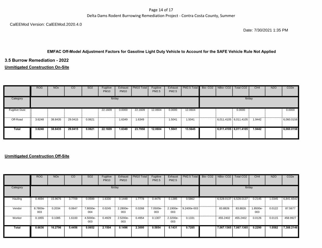
3.5 Burrow Remediation - 2022
Unmitigated Construction On-Site
ROG NOx CO SO2 Fugitive
PM10
Exhaust
PM10
PM10 Total Fugitive
PM2.5
Exhaust
PM2.5
PM2.5 Total Bio- CO2 NBio- CO2 Total CO2 CH4 N2O CO2e
Category tons/yr MT/yr
Fugitive Dust 0.3324 0.0000 0.3324 0.1809 0.0000 0.1809 0.0000 0.0000 0.0000 0.0000 0.0000 0.0000
Off-Road 0.0544 0.5827 0.4356 9.3000e- 0.0245 0.0245 0.0226 0.0226 0.0000 81.8019 81.8019 0.0265 0.0000 82.4633
004
Total 0.0544 0.5827 0.4356 9.3000e-004
0.3324 0.0245 0.3569 0.1809 0.0226 0.2035 0.0000 81.8019 81.8019 0.0265 0.0000 82.4633
Unmitigated Construction Off-Site
ROG NOx CO SO2 Fugitive
PM10
Exhaust
PM10
PM10 Total Fugitive
PM2.5
Exhaust
PM2.5
PM2.5 Total Bio- CO2 NBio- CO2 Total CO2 CH4 N2O CO2e
Category tons/yr MT/yr
Hauling 6.9600e-
003
0.2480 0.0570 9.0000e-
004
0.0238 2.1700e-
003
0.0259 6.5300e-
003
2.0800e-
003
8.6100e-003 0.0000 88.8479 88.8479 2.9100e-
003
0.0141 93.1166
Vendor 1.3000e-
004
3.1600e-
003
9.9000e-004 1.0000e-
005
3.6000e-004 3.0000e-
005
3.9000e-
004
1.0000e-
004
3.0000e-
005
1.4000e-004 0.0000 1.1416 1.1416 3.0000e-
005
1.7000e-004 1.1918
Worker 2.5300e-
003
1.8200e-
003
0.0218 6.0000e-
005
7.1400e-003 4.0000e-
005
7.1800e-
003
1.9000e-
003
3.0000e-
005
1.9300e-003 0.0000 5.7321 5.7321 1.8000e-
004
1.7000e-004 5.7872
Total 9.6200e-003
0.2530 0.0798 9.7000e-004
0.0313 2.2400e-003
0.0335 8.5300e-003
2.1400e-003
0.0107 0.0000 95.7216 95.7216 3.1200e-003
0.0144 100.0956

Page 15 of 17
Delta Dams Rodent Burrowing Remediation Project - Contra Costa County, Annual
CalEEMod Version: CalEEMod.2020.4.0
Date: 7/30/2021 1:34 PM
EMFAC Off-Model Adjustment Factors for Gasoline Light Duty Vehicle to Account for the SAFE Vehicle Rule Not Applied
Mitigated Construction On-Site
ROG NOx CO SO2 Fugitive
PM10
Exhaust
PM10
PM10 Total Fugitive
PM2.5
Exhaust
PM2.5
PM2.5 Total Bio- CO2 NBio- CO2 Total CO2 CH4 N2O CO2e
Category tons/yr MT/yr
Fugitive Dust 0.3324 0.0000 0.3324 0.1809 0.0000 0.1809 0.0000 0.0000 0.0000 0.0000 0.0000 0.0000
Off-Road 0.0544 0.5827 0.4356 9.3000e- 0.0245 0.0245 0.0226 0.0226 0.0000 81.8018 81.8018 0.0265 0.0000 82.4632
004
Total 0.0544 0.5827 0.4356 9.3000e-004
0.3324 0.0245 0.3569 0.1809 0.0226 0.2035 0.0000 81.8018 81.8018 0.0265 0.0000 82.4632
Mitigated Construction Off-Site
ROG NOx CO SO2 Fugitive
PM10
Exhaust
PM10
PM10 Total Fugitive
PM2.5
Exhaust
PM2.5
PM2.5 Total Bio- CO2 NBio- CO2 Total CO2 CH4 N2O CO2e
Category tons/yr MT/yr
Hauling 6.9600e-
003
0.2480 0.0570 9.0000e-
004
0.0238 2.1700e-
003
0.0259 6.5300e-
003
2.0800e-
003
8.6100e-003 0.0000 88.8479 88.8479 2.9100e-
003
0.0141 93.1166
Vendor 1.3000e-
004
3.1600e-
003
9.9000e-004 1.0000e-
005
3.6000e-004 3.0000e-
005
3.9000e-
004
1.0000e-
004
3.0000e-
005
1.4000e-004 0.0000 1.1416 1.1416 3.0000e-
005
1.7000e-004 1.1918
Worker 2.5300e-
003
1.8200e-
003
0.0218 6.0000e-
005
7.1400e-003 4.0000e-
005
7.1800e-
003
1.9000e-
003
3.0000e-
005
1.9300e-003 0.0000 5.7321 5.7321 1.8000e-
004
1.7000e-004 5.7872
Total 9.6200e-003
0.2530 0.0798 9.7000e-004
0.0313 2.2400e-003
0.0335 8.5300e-003
2.1400e-003
0.0107 0.0000 95.7216 95.7216 3.1200e-003
0.0144 100.0956

Page 16 of 17
Delta Dams Rodent Burrowing Remediation Project - Contra Costa County, Annual
CalEEMod Version: CalEEMod.2020.4.0
Date: 7/30/2021 1:34 PM
EMFAC Off-Model Adjustment Factors for Gasoline Light Duty Vehicle to Account for the SAFE Vehicle Rule Not Applied
3.6 Drainage Channel/Intake Channel/Tree Removal - 2022
Unmitigated Construction On-Site
ROG NOx CO SO2 Fugitive
PM10
Exhaust
PM10
PM10 Total Fugitive
PM2.5
Exhaust
PM2.5
PM2.5 Total Bio- CO2 NBio- CO2 Total CO2 CH4 N2O CO2e
Category tons/yr MT/yr
Fugitive Dust 0.3989 0.0000 0.3989 0.2187 0.0000 0.2187 0.0000 0.0000 0.0000 0.0000 0.0000 0.0000
Off-Road 0.1363 1.4226 0.8470 1.6400e- 0.0693 0.0693 0.0638 0.0638 0.0000 143.7894 143.7894 0.0465 0.0000 144.9520
003
Total 0.1363 1.4226 0.8470 1.6400e-003
0.3989 0.0693 0.4682 0.2187 0.0638 0.2825 0.0000 143.7894 143.7894 0.0465 0.0000 144.9520
Unmitigated Construction Off-Site
ROG NOx CO SO2 Fugitive
PM10
Exhaust
PM10
PM10 Total Fugitive
PM2.5
Exhaust
PM2.5
PM2.5 Total Bio- CO2 NBio- CO2 Total CO2 CH4 N2O CO2e
Category tons/yr MT/yr
Hauling 6.9600e-
003
0.2480 0.0570 9.0000e-
004
0.0238 2.1700e-
003
0.0259 6.5300e-
003
2.0800e-
003
8.6100e-003 0.0000 88.8479 88.8479 2.9100e-
003
0.0141 93.1166
Vendor 3.7000e-
004
9.0500e-
003
2.8300e-003 3.0000e-
005
1.0200e-003 1.0000e-
004
1.1200e-
003
3.0000e-
004
9.0000e-
005
3.9000e-004 0.0000 3.2727 3.2727 7.0000e-
005
4.8000e-004 3.4166
Worker 7.2600e-
003
5.2200e-
003
0.0625 1.8000e-
004
0.0205 1.1000e-
004
0.0206 5.4400e-
003
1.0000e-
004
5.5400e-003 0.0000 16.4321 16.4321 5.2000e-
004
4.9000e-004 16.5898
Total 0.0146 0.2623 0.1224 1.1100e-003
0.0452 2.3800e-003
0.0476 0.0123 2.2700e-003
0.0145 0.0000 108.5527 108.5527 3.5000e-003
0.0151 113.1230

Page 17 of 17
Delta Dams Rodent Burrowing Remediation Project - Contra Costa County, Annual
CalEEMod Version: CalEEMod.2020.4.0
Date: 7/30/2021 1:34 PM
EMFAC Off-Model Adjustment Factors for Gasoline Light Duty Vehicle to Account for the SAFE Vehicle Rule Not Applied
Mitigated Construction On-Site
ROG NOx CO SO2 Fugitive
PM10
Exhaust
PM10
PM10 Total Fugitive
PM2.5
Exhaust
PM2.5
PM2.5 Total Bio- CO2 NBio- CO2 Total CO2 CH4 N2O CO2e
Category tons/yr MT/yr
Fugitive Dust 0.3989 0.0000 0.3989 0.2187 0.0000 0.2187 0.0000 0.0000 0.0000 0.0000 0.0000 0.0000
Off-Road 0.1363 1.4226 0.8470 1.6400e- 0.0693 0.0693 0.0638 0.0638 0.0000 143.7892 143.7892 0.0465 0.0000 144.9518
003
Total 0.1363 1.4226 0.8470 1.6400e-003
0.3989 0.0693 0.4682 0.2187 0.0638 0.2825 0.0000 143.7892 143.7892 0.0465 0.0000 144.9518
Mitigated Construction Off-Site
ROG NOx CO SO2 Fugitive
PM10
Exhaust
PM10
PM10 Total Fugitive
PM2.5
Exhaust
PM2.5
PM2.5 Total Bio- CO2 NBio- CO2 Total CO2 CH4 N2O CO2e
Category tons/yr MT/yr
Hauling 6.9600e-
003
0.2480 0.0570 9.0000e-
004
0.0238 2.1700e-
003
0.0259 6.5300e-
003
2.0800e-
003
8.6100e-003 0.0000 88.8479 88.8479 2.9100e-
003
0.0141 93.1166
Vendor 3.7000e-
004
9.0500e-
003
2.8300e-003 3.0000e-
005
1.0200e-003 1.0000e-
004
1.1200e-
003
3.0000e-
004
9.0000e-
005
3.9000e-004 0.0000 3.2727 3.2727 7.0000e-
005
4.8000e-004 3.4166
Worker 7.2600e-
003
5.2200e-
003
0.0625 1.8000e-
004
0.0205 1.1000e-
004
0.0206 5.4400e-
003
1.0000e-
004
5.5400e-003 0.0000 16.4321 16.4321 5.2000e-
004
4.9000e-004 16.5898
Total 0.0146 0.2623 0.1224 1.1100e-003
0.0452 2.3800e-003
0.0476 0.0123 2.2700e-003
0.0145 0.0000 108.5527 108.5527 3.5000e-003
0.0151 113.1230

Page 1 of 17
Delta Dams Rodent Burrowing Remediation Project - Contra Costa County, Summer
CalEEMod Version: CalEEMod.2020.4.0
Date: 7/30/2021 1:35 PM
EMFAC Off-Model Adjustment Factors for Gasoline Light Duty Vehicle to Account for the SAFE Vehicle Rule Not Applied
Delta Dams Rodent Burrowing Remediation Project Contra Costa County, Summer
1.0 Project Characteristics
1.1 Land Usage
Land Uses Size Metric Lot Acreage Floor Surface Area Population
User Defined Industrial
User Defined Industrial
User Defined Industrial
1.00
1.00
1.00
User Defined Unit
User Defined Unit
User Defined Unit
79.03
15.70
8.10
3,442,546.80
683,892.00
352,836.00
0
0
0
1.2 Other Project Characteristics
Urbanization
Climate Zone
Rural
4
Wind Speed (m/s) 2.2 Precipitation Freq (Days)
Operational Year
58
2023
Utility Company Pacific Gas & Electric Company
CO2 Intensity 641.35 CH4 Intensity 0.029 N2O Intensity 0.006
(lb/MWhr) (lb/MWhr) (lb/MWhr)
1.3 User Entered Comments & Non-Default Data
Project Characteristics - Delta Dams Rodent Burrowing Remediation Project. Contra Costa County.
Land Use - Clifton Court Forebay = permanent: 46 acres and temporary: 33.03 acres
Dy Re ir t: 8.4 d t : 7.3 Construction Phase - Work completed at CCF site September 2021 through October 2021 and all sites from May 2022 through October 2022.
Off-road Equipment - Default equipment assumed.
Off-road Equipment - Default equipment assumed.
Off-road Equipment - Default equipment assumed.

Page 2 of 17
Delta Dams Rodent Burrowing Remediation Project - Contra Costa County, Summer
CalEEMod Version: CalEEMod.2020.4.0
Date: 7/30/2021 1:35 PM
EMFAC Off-Model Adjustment Factors for Gasoline Light Duty Vehicle to Account for the SAFE Vehicle Rule Not Applied
Off-road Equipment - Default equipment assumed.
Off-road Equipment - Default equipment assumed.
Trips and VMT - Updated trip lengths based on distance to closest material facilities within area. Updated vendor trips to account for water trucks (two water trucks).
Grading - Material import based on project specific information. Distributed total over all phases.
Table Name Column Name Default Value New Value
tblAreaCoating Area_Nonresidential_Exterior 2239639 1721275
tblAreaCoating Area_Nonresidential_Interior 6718917 5163825
tblConstructionPhase NumDays 120.00 15.00
tblConstructionPhase NumDays 310.00 27.00
tblConstructionPhase NumDays 120.00 15.00
tblConstructionPhase NumDays 310.00 30.00
tblConstructionPhase NumDays 120.00 86.00
tblGrading AcresOfGrading 17.00 41.23
tblGrading AcresOfGrading 231.00 37.80
tblGrading AcresOfGrading 33.00 11.20
tblGrading AcresOfGrading 327.00 6.00
tblGrading AcresOfGrading 66.00 0.70
tblGrading MaterialImported 0.00 15,320.00
tblGrading MaterialImported 0.00 15,320.00
tblGrading MaterialImported 0.00 18,182.00
tblGrading MaterialImported 0.00 18,182.00
tblGrading MaterialImported 0.00 18,182.00
tblLandUse LandUseSquareFeet 0.00 3,442,546.80
tblLandUse LandUseSquareFeet 0.00 683,892.00
tblLandUse LandUseSquareFeet 0.00 352,836.00

Page 3 of 17
Delta Dams Rodent Burrowing Remediation Project - Contra Costa County, Summer
CalEEMod Version: CalEEMod.2020.4.0
Date: 7/30/2021 1:35 PM
EMFAC Off-Model Adjustment Factors for Gasoline Light Duty Vehicle to Account for the SAFE Vehicle Rule Not Applied
tblLandUse LotAcreage 0.00 79.03
tblLandUse LotAcreage 0.00 15.70
tblLandUse LotAcreage 0.00 8.10
tblProjectCharacteristics UrbanizationLevel Urban Rural
tblTripsAndVMT HaulingTripLength 20.00 15.00
tblTripsAndVMT HaulingTripLength 20.00 15.00
tblTripsAndVMT HaulingTripLength 20.00 15.00
tblTripsAndVMT HaulingTripLength 20.00 15.00
tblTripsAndVMT HaulingTripLength 20.00 15.00
tblTripsAndVMT HaulingTripNumber 1,915.00 1,867.00
tblTripsAndVMT HaulingTripNumber 1,904.00 1,867.00
tblTripsAndVMT HaulingTripNumber 3,809.00 3,734.00
tblTripsAndVMT HaulingTripNumber 3,809.00 3,734.00
tblTripsAndVMT HaulingTripNumber 3,809.00 3,734.00
tblTripsAndVMT VendorTripNumber 0.00 4.00
tblTripsAndVMT VendorTripNumber 0.00 4.00
tblTripsAndVMT VendorTripNumber 0.00 4.00
tblTripsAndVMT VendorTripNumber 0.00 4.00
tblTripsAndVMT VendorTripNumber 0.00 4.00
tblTripsAndVMT WorkerTripNumber 10.00 30.00
tblTripsAndVMT WorkerTripNumber 20.00 60.00
tblTripsAndVMT WorkerTripNumber 10.00 60.00

Page 4 of 17
Delta Dams Rodent Burrowing Remediation Project - Contra Costa County, Summer
CalEEMod Version: CalEEMod.2020.4.0
Date: 7/30/2021 1:35 PM
EMFAC Off-Model Adjustment Factors for Gasoline Light Duty Vehicle to Account for the SAFE Vehicle Rule Not Applied
2.0 Emissions Summary
2.1 Overall Construction (Maximum Daily Emission) Unmitigated Construction
ROG NOx CO SO2 Fugitive
PM10
Exhaust
PM10
PM10 Total Fugitive
PM2.5
Exhaust
PM2.5
PM2.5 Total Bio- CO2 NBio- CO2 Total CO2 CH4 N2O CO2e
Year lb/day lb/day
2021 4.6603 59.1922 33.9487 0.1011 19.8189 2.3060 21.9520 9.9096 2.1311 11.8775 0.0000 10,547.4648 10,547.464 2.0750 1.0758 10,903.612
8 9
2022 4.2885 65.2765 34.4871 0.1609 30.9630 1.9057 32.8687 15.6389 1.7640 17.4029 0.0000 17,053.5919 17,053.591 2.1732 2.0870 17,716.238
9 0
Maximum 4.6603 65.2765 34.4871 0.1609 30.9630 2.3060 32.8687 15.6389 2.1311 17.4029 0.0000 17,053.5919 17,053.591 9
2.1732 2.0870 17,716.238 0
Mitigated Construction
ROG NOx CO SO2 Fugitive
PM10
Exhaust
PM10
PM10 Total Fugitive
PM2.5
Exhaust
PM2.5
PM2.5 Total Bio- CO2 NBio- CO2 Total CO2 CH4 N2O CO2e
Year lb/day lb/day
2021 4.6603 59.1922 33.9487 0.1011 19.8189 2.3060 21.9520 9.9096 2.1311 11.8775 0.0000 10,547.4648 10,547.464 2.0750 1.0758 10,903.612
8 9
2022 4.2885 65.2765 34.4871 0.1609 30.9630 1.9057 32.8687 15.6389 1.7640 17.4029 0.0000 17,053.5919 17,053.591 2.1732 2.0870 17,716.238
9 0
Maximum 4.6603 65.2765 34.4871 0.1609 30.9630 2.3060 32.8687 15.6389 2.1311 17.4029 0.0000 17,053.5919 17,053.591 9
2.1732 2.0870 17,716.238 0

Page 5 of 17
Delta Dams Rodent Burrowing Remediation Project - Contra Costa County, Summer
CalEEMod Version: CalEEMod.2020.4.0
Date: 7/30/2021 1:35 PM
EMFAC Off-Model Adjustment Factors for Gasoline Light Duty Vehicle to Account for the SAFE Vehicle Rule Not Applied
ROG NOx CO SO2 Fugitive PM10
Exhaust PM10
PM10 Total Fugitive PM2.5
Exhaust PM2.5
PM2.5 Total Bio- CO2 NBio-CO2 Total CO2 CH4 N20 CO2e
Percent Reduction 0.00 0.00 0.00 0.00 0.00 0.00 0.00 0.00 0.00 0.00 0.00 0.00 0.00 0.00 0.00 0.00
3.0 Construction Detail
Construction Phase
Phase
Number
Phase Name Phase Type Start Date End Date Num Days
Week
Num Days Phase Description
1
2
3
4
5
Staging/Access 1
High Priority Repairs
Staging/Access 2
Burrow Remediation
Drainage Channel/Intake
Channel/Tree Removal
Site Preparation
Grading
Site Preparation
Grading
Site Preparation
9/1/2021
9/22/2021
5/1/2022
5/21/2022
7/2/2022
9/21/2021
10/28/2021
5/20/2022
7/1/2022
10/31/2022
5
5
5
5
5
15
27
15
30
86
Acres of Grading (Site Preparation Phase): 41.23
Acres of Grading (Grading Phase): 37.8
Acres of Paving: 0
Residential Indoor: 0; Residential Outdoor: 0; Non-Residential Indoor: 0; Non-Residential Outdoor: 0; Striped Parking Area: 0 (Architectural Coating –

Page 6 of 17
Delta Dams Rodent Burrowing Remediation Project - Contra Costa County, Summer
CalEEMod Version: CalEEMod.2020.4.0
Date: 7/30/2021 1:35 PM
EMFAC Off-Model Adjustment Factors for Gasoline Light Duty Vehicle to Account for the SAFE Vehicle Rule Not Applied
OffRoad Equipment
Phase Name Offroad Equipment Type Amount Usage Hours Horse Power Load Factor
Staging/Access 1 Rubber Tired Dozers 3 8.00 247 0.40
Staging/Access 1 Tractors/Loaders/Backhoes 4 8.00 97 0.37
High Priority Repairs Excavators 2 8.00 158 0.38
High Priority Repairs Graders 1 8.00 187 0.41
High Priority Repairs Rubber Tired Dozers 1 8.00 247 0.40
High Priority Repairs Scrapers 2 8.00 367 0.48
High Priority Repairs Tractors/Loaders/Backhoes 2 8.00 97 0.37
Staging/Access 2 Rubber Tired Dozers 3 8.00 247 0.40
Staging/Access 2 Tractors/Loaders/Backhoes 4 8.00 97 0.37
Burrow Remediation Excavators 2 8.00 158 0.38
Burrow Remediation Graders 1 8.00 187 0.41
Burrow Remediation Rubber Tired Dozers 1 8.00 247 0.40
Burrow Remediation Scrapers 2 8.00 367 0.48
Burrow Remediation Tractors/Loaders/Backhoes 2 8.00 97 0.37
Drainage Channel/Intake Channel/Tree Rubber Tired Dozers 3 8.00 247 0.40
Removal Drainage Channel/Intake Channel/Tree Tractors/Loaders/Backhoes 4 8.00 97 0.37
Removal

Page 7 of 17
Delta Dams Rodent Burrowing Remediation Project - Contra Costa County, Summer
CalEEMod Version: CalEEMod.2020.4.0
Date: 7/30/2021 1:35 PM
EMFAC Off-Model Adjustment Factors for Gasoline Light Duty Vehicle to Account for the SAFE Vehicle Rule Not Applied
Trips and VMT
Phase Name Offroad Equipment
Count
Worker Trip
Number
Vendor Trip
Number
Hauling Trip
Number
Worker Trip
Length
Vendor Trip
Length
Hauling Trip
Length
Worker Vehicle
Class
Vendor Vehicle
Class
Hauling Vehicle
Class
Staging/Access 1
High Priority Repairs
Staging/Access 2
Burrow Remediation
Drainage Channel/Intake
Channel/Tree Removal
4
8
4
8
4
10.00
20.00
30.00
60.00
60.00
4.00
4.00
4.00
4.00
4.00
1,867.00
1,867.00
3,734.00
3,734.00
3,734.00
10.80
10.80
10.80
10.80
10.80
6.60
6.60
6.60
6.60
6.60
15.00
15.00
15.00
15.00
15.00
LD_Mix
LD_Mix
LD_Mix
LD_Mix
LD_Mix
HDT_Mix
HDT_Mix
HDT_Mix
HDT_Mix
HDT_Mix
HHDT
HHDT
HHDT
HHDT
HHDT

Page 8 of 17
Delta Dams Rodent Burrowing Remediation Project - Contra Costa County, Summer
CalEEMod Version: CalEEMod.2020.4.0
Date: 7/30/2021 1:35 PM
EMFAC Off-Model Adjustment Factors for Gasoline Light Duty Vehicle to Account for the SAFE Vehicle Rule Not Applied
3.1 Mitigation Measures Construction
3.2 Staging/Access 1 - 2021
Unmitigated Construction On-Site
ROG NOx CO SO2 Fugitive
PM10
Exhaust
PM10
PM10 Total Fugitive
PM2.5
Exhaust
PM2.5
PM2.5 Total Bio- CO2 NBio- CO2 Total CO2 CH4 N2O CO2e
Category lb/day lb/day
Fugitive Dust 16.6805 0.0000 16.6805 7.8354 0.0000 7.8354 0.0000 0.0000
Off-Road 3.8882 40.4971 21.1543 0.0380 2.0445 2.0445 1.8809 1.8809 3,685.6569 3,685.6569 1.1920 3,715.4573
Total 3.8882 40.4971 21.1543 0.0380 16.6805 2.0445 18.7250 7.8354 1.8809 9.7163 3,685.6569 3,685.6569 1.1920 3,715.4573
Unmitigated Construction Off-Site
ROG NOx CO SO2 Fugitive
PM10
Exhaust
PM10
PM10 Total Fugitive
PM2.5
Exhaust
PM2.5
PM2.5 Total Bio- CO2 NBio- CO2 Total CO2 CH4 N2O CO2e
Category lb/day lb/day
Hauling 0.7000 18.4301 4.3346 0.0615 1.6328 0.2568 1.8897 0.4476 0.2457 0.6933 6,697.6698 6,697.6698 0.2258 1.0612 7,019.5434
Vendor 0.0135 0.2444 0.0765 8.0000e- 0.0245 4.2500e- 0.0288 7.0500e- 4.0700e- 0.0111 85.8862 85.8862 2.0800e- 0.0126 89.6811
004 003 003 003 003
Worker 0.0334 0.0205 0.2928 7.7000e- 0.0822 4.4000e- 0.0826 0.0218 4.1000e- 0.0222 78.2520 78.2520 2.3300e- 2.0800e-003 78.9312
004 004 004 003
Total 0.7468 18.6951 4.7039 0.0631 1.7395 0.2615 2.0010 0.4764 0.2502 0.7266 6,861.8079 6,861.8079 0.2302 1.0758 7,188.1556

Page 9 of 17
Delta Dams Rodent Burrowing Remediation Project - Contra Costa County, Summer
CalEEMod Version: CalEEMod.2020.4.0
Date: 7/30/2021 1:35 PM
EMFAC Off-Model Adjustment Factors for Gasoline Light Duty Vehicle to Account for the SAFE Vehicle Rule Not Applied
Mitigated Construction On-Site
ROG NOx CO SO2 Fugitive
PM10
Exhaust
PM10
PM10 Total Fugitive
PM2.5
Exhaust
PM2.5
PM2.5 Total Bio- CO2 NBio- CO2 Total CO2 CH4 N2O CO2e
Category lb/day lb/day
Fugitive Dust 16.6805 0.0000 16.6805 7.8354 0.0000 7.8354 0.0000 0.0000
Off-Road 3.8882 40.4971 21.1543 0.0380 2.0445 2.0445 1.8809 1.8809 0.0000 3,685.6569 3,685.6569 1.1920 3,715.4573
Total 3.8882 40.4971 21.1543 0.0380 16.6805 2.0445 18.7250 7.8354 1.8809 9.7163 0.0000 3,685.6569 3,685.6569 1.1920 3,715.4573
Mitigated Construction Off-Site
ROG NOx CO SO2 Fugitive
PM10
Exhaust
PM10
PM10 Total Fugitive
PM2.5
Exhaust
PM2.5
PM2.5 Total Bio- CO2 NBio- CO2 Total CO2 CH4 N2O CO2e
Category lb/day lb/day
Hauling 0.7000 18.4301 4.3346 0.0615 1.6328 0.2568 1.8897 0.4476 0.2457 0.6933 6,697.6698 6,697.6698 0.2258 1.0612 7,019.5434
Vendor 0.0135 0.2444 0.0765 8.0000e- 0.0245 4.2500e- 0.0288 7.0500e- 4.0700e- 0.0111 85.8862 85.8862 2.0800e- 0.0126 89.6811
004 003 003 003 003
Worker 0.0334 0.0205 0.2928 7.7000e- 0.0822 4.4000e- 0.0826 0.0218 4.1000e- 0.0222 78.2520 78.2520 2.3300e- 2.0800e-003 78.9312
004 004 004 003
Total 0.7468 18.6951 4.7039 0.0631 1.7395 0.2615 2.0010 0.4764 0.2502 0.7266 6,861.8079 6,861.8079 0.2302 1.0758 7,188.1556

Page 10 of 17
Delta Dams Rodent Burrowing Remediation Project - Contra Costa County, Summer
CalEEMod Version: CalEEMod.2020.4.0
Date: 7/30/2021 1:35 PM
EMFAC Off-Model Adjustment Factors for Gasoline Light Duty Vehicle to Account for the SAFE Vehicle Rule Not Applied
3.3 High Priority Repairs - 2021
Unmitigated Construction On-Site
ROG NOx CO SO2 Fugitive
PM10
Exhaust
PM10
PM10 Total Fugitive
PM2.5
Exhaust
PM2.5
PM2.5 Total Bio- CO2 NBio- CO2 Total CO2 CH4 N2O CO2e
Category lb/day lb/day
Fugitive Dust 18.7230 0.0000 18.7230 9.6103 0.0000 9.6103 0.0000 0.0000
Off-Road 4.1912 46.3998 30.8785 0.0620 1.9853 1.9853 1.8265 1.8265 6,007.0434 6,007.0434 1.9428 6,055.6134
Total 4.1912 46.3998 30.8785 0.0620 18.7230 1.9853 20.7083 9.6103 1.8265 11.4368 6,007.0434 6,007.0434 1.9428 6,055.6134
Unmitigated Construction Off-Site
ROG NOx CO SO2 Fugitive
PM10
Exhaust
PM10
PM10 Total Fugitive
PM2.5
Exhaust
PM2.5
PM2.5 Total Bio- CO2 NBio- CO2 Total CO2 CH4 N2O CO2e
Category lb/day lb/day
Hauling 0.3889 10.2390 2.4081 0.0342 0.9071 0.1427 1.0498 0.2487 0.1365 0.3852 3,720.9277 3,720.9277 0.1254 0.5895 3,899.7463
Vendor 0.0135 0.2444 0.0765 8.0000e- 0.0245 4.2500e- 0.0288 7.0500e- 4.0700e- 0.0111 85.8862 85.8862 2.0800e- 0.0126 89.6811
004 003 003 003 003
Worker 0.0668 0.0411 0.5857 1.5500e- 0.1643 8.9000e- 0.1652 0.0436 8.2000e- 0.0444 156.5040 156.5040 4.6700e- 4.1700e-003 157.8624
003 004 004 003
Total 0.4691 10.5245 3.0703 0.0365 1.0959 0.1478 1.2437 0.2993 0.1414 0.4407 3,963.3178 3,963.3178 0.1322 0.6063 4,147.2898

Page 11 of 17
Delta Dams Rodent Burrowing Remediation Project - Contra Costa County, Summer
CalEEMod Version: CalEEMod.2020.4.0
Date: 7/30/2021 1:35 PM
EMFAC Off-Model Adjustment Factors for Gasoline Light Duty Vehicle to Account for the SAFE Vehicle Rule Not Applied
Mitigated Construction On-Site
ROG NOx CO SO2 Fugitive
PM10
Exhaust
PM10
PM10 Total Fugitive
PM2.5
Exhaust
PM2.5
PM2.5 Total Bio- CO2 NBio- CO2 Total CO2 CH4 N2O CO2e
Category lb/day lb/day
Fugitive Dust 18.7230 0.0000 18.7230 9.6103 0.0000 9.6103 0.0000 0.0000
Off-Road 4.1912 46.3998 30.8785 0.0620 1.9853 1.9853 1.8265 1.8265 0.0000 6,007.0434 6,007.0434 1.9428 6,055.6134
Total 4.1912 46.3998 30.8785 0.0620 18.7230 1.9853 20.7083 9.6103 1.8265 11.4368 0.0000 6,007.0434 6,007.0434 1.9428 6,055.6134
Mitigated Construction Off-Site
ROG NOx CO SO2 Fugitive
PM10
Exhaust
PM10
PM10 Total Fugitive
PM2.5
Exhaust
PM2.5
PM2.5 Total Bio- CO2 NBio- CO2 Total CO2 CH4 N2O CO2e
Category lb/day lb/day
Hauling 0.3889 10.2390 2.4081 0.0342 0.9071 0.1427 1.0498 0.2487 0.1365 0.3852 3,720.9277 3,720.9277 0.1254 0.5895 3,899.7463
Vendor 0.0135 0.2444 0.0765 8.0000e- 0.0245 4.2500e- 0.0288 7.0500e- 4.0700e- 0.0111 85.8862 85.8862 2.0800e- 0.0126 89.6811
004 003 003 003 003
Worker 0.0668 0.0411 0.5857 1.5500e- 0.1643 8.9000e- 0.1652 0.0436 8.2000e- 0.0444 156.5040 156.5040 4.6700e- 4.1700e-003 157.8624
003 004 004 003
Total 0.4691 10.5245 3.0703 0.0365 1.0959 0.1478 1.2437 0.2993 0.1414 0.4407 3,963.3178 3,963.3178 0.1322 0.6063 4,147.2898

Page 12 of 17
Delta Dams Rodent Burrowing Remediation Project - Contra Costa County, Summer
CalEEMod Version: CalEEMod.2020.4.0
Date: 7/30/2021 1:35 PM
EMFAC Off-Model Adjustment Factors for Gasoline Light Duty Vehicle to Account for the SAFE Vehicle Rule Not Applied
3.4 Staging/Access 2 - 2022
Unmitigated Construction On-Site
ROG NOx CO SO2 Fugitive
PM10
Exhaust
PM10
PM10 Total Fugitive
PM2.5
Exhaust
PM2.5
PM2.5 Total Bio- CO2 NBio- CO2 Total CO2 CH4 N2O CO2e
Category lb/day lb/day
Fugitive Dust 27.4261 0.0000 27.4261 14.6713 0.0000 14.6713 0.0000 0.0000
Off-Road 3.1701 33.0835 19.6978 0.0380 1.6126 1.6126 1.4836 1.4836 3,686.0619 3,686.0619 1.1922 3,715.8655
Total 3.1701 33.0835 19.6978 0.0380 27.4261 1.6126 29.0387 14.6713 1.4836 16.1548 3,686.0619 3,686.0619 1.1922 3,715.8655
Unmitigated Construction Off-Site
ROG NOx CO SO2 Fugitive
PM10
Exhaust
PM10
PM10 Total Fugitive
PM2.5
Exhaust
PM2.5
PM2.5 Total Bio- CO2 NBio- CO2 Total CO2 CH4 N2O CO2e
Category lb/day lb/day
Hauling 0.9388 31.9353 7.5417 0.1198 3.2660 0.2896 3.5556 0.8953 0.2771 1.1723 13,056.0274 13,056.027 0.4290 2.0690 13,683.308
4 4
Vendor 8.7800e- 0.2034 0.0647 7.8000e- 0.0245 2.2800e- 0.0268 7.0500e- 2.1900e- 9.2400e-003 83.8826 83.8826 1.8500e- 0.0122 87.5677
003 004 003 003 003 003
Worker 0.0928 0.0543 0.8050 2.2500e- 0.2464 1.2600e- 0.2477 0.0654 1.1600e- 0.0665 227.6201 227.6201 6.3000e- 5.7700e-003 229.4964
003 003 003 003
Total 1.0403 32.1930 8.4115 0.1228 3.5369 0.2931 3.8301 0.9677 0.2804 1.2481 13,367.5301 13,367.530 1
0.4372 2.0870 14,000.372 5

Page 13 of 17
Delta Dams Rodent Burrowing Remediation Project - Contra Costa County, Summer
CalEEMod Version: CalEEMod.2020.4.0
Date: 7/30/2021 1:35 PM
EMFAC Off-Model Adjustment Factors for Gasoline Light Duty Vehicle to Account for the SAFE Vehicle Rule Not Applied
Mitigated Construction On-Site
ROG NOx CO SO2 Fugitive
PM10
Exhaust
PM10
PM10 Total Fugitive
PM2.5
Exhaust
PM2.5
PM2.5 Total Bio- CO2 NBio- CO2 Total CO2 CH4 N2O CO2e
Category lb/day lb/day
Fugitive Dust 27.4261 0.0000 27.4261 14.6713 0.0000 14.6713 0.0000 0.0000
Off-Road 3.1701 33.0835 19.6978 0.0380 1.6126 1.6126 1.4836 1.4836 0.0000 3,686.0619 3,686.0619 1.1922 3,715.8655
Total 3.1701 33.0835 19.6978 0.0380 27.4261 1.6126 29.0387 14.6713 1.4836 16.1548 0.0000 3,686.0619 3,686.0619 1.1922 3,715.8655
Mitigated Construction Off-Site
ROG NOx CO SO2 Fugitive
PM10
Exhaust
PM10
PM10 Total Fugitive
PM2.5
Exhaust
PM2.5
PM2.5 Total Bio- CO2 NBio- CO2 Total CO2 CH4 N2O CO2e
Category lb/day lb/day
Hauling 0.9388 31.9353 7.5417 0.1198 3.2660 0.2896 3.5556 0.8953 0.2771 1.1723 13,056.0274 13,056.027 0.4290 2.0690 13,683.308
4 4
Vendor 8.7800e- 0.2034 0.0647 7.8000e- 0.0245 2.2800e- 0.0268 7.0500e- 2.1900e- 9.2400e-003 83.8826 83.8826 1.8500e- 0.0122 87.5677
003 004 003 003 003 003
Worker 0.0928 0.0543 0.8050 2.2500e- 0.2464 1.2600e- 0.2477 0.0654 1.1600e- 0.0665 227.6201 227.6201 6.3000e- 5.7700e-003 229.4964
003 003 003 003
Total 1.0403 32.1930 8.4115 0.1228 3.5369 0.2931 3.8301 0.9677 0.2804 1.2481 13,367.5301 13,367.530 1
0.4372 2.0870 14,000.372 5
Page 14 of 17
Delta Dams Rodent Burrowing Remediation Project - Contra Costa County, Summer
CalEEMod Version: CalEEMod.2020.4.0
Date: 7/30/2021 1:35 PM
EMFAC Off-Model Adjustment Factors for Gasoline Light Duty Vehicle to Account for the SAFE Vehicle Rule Not Applied
3.5 Burrow Remediation - 2022
Unmitigated Construction On-Site
ROG NOx CO SO2 Fugitive
PM10
Exhaust
PM10
PM10 Total Fugitive
PM2.5
Exhaust
PM2.5
PM2.5 Total Bio- CO2 NBio- CO2 Total CO2 CH4 N2O CO2e
Category lb/day lb/day
Fugitive Dust 22.1609 0.0000 22.1609 12.0604 0.0000 12.0604 0.0000 0.0000
Off-Road 3.6248 38.8435 29.0415 0.0621 1.6349 1.6349 1.5041 1.5041 6,011.4105 6,011.4105 1.9442 6,060.0158
Total 3.6248 38.8435 29.0415 0.0621 22.1609 1.6349 23.7958 12.0604 1.5041 13.5645 6,011.4105 6,011.4105 1.9442 6,060.0158
Unmitigated Construction Off-Site
ROG NOx CO SO2 Fugitive
PM10
Exhaust
PM10
PM10 Total Fugitive
PM2.5
Exhaust
PM2.5
PM2.5 Total Bio- CO2 NBio- CO2 Total CO2 CH4 N2O CO2e
Category lb/day lb/day
Hauling 0.4694 15.9676 3.7709 0.0599 1.6330 0.1448 1.7778 0.4476 0.1385 0.5862 6,528.0137 6,528.0137 0.2145 1.0345 6,841.6542
Vendor 8.7800e- 0.2034 0.0647 7.8000e- 0.0245 2.2800e- 0.0268 7.0500e- 2.1900e- 9.2400e-003 83.8826 83.8826 1.8500e- 0.0122 87.5677
003 004 003 003 003 003
Worker 0.1855 0.1085 1.6100 4.5000e- 0.4929 2.5200e- 0.4954 0.1307 2.3200e- 0.1331 455.2402 455.2402 0.0126 0.0115 458.9927
003 003 003
Total 0.6636 16.2796 5.4456 0.0652 2.1504 0.1496 2.3000 0.5854 0.1431 0.7285 7,067.1365 7,067.1365 0.2290 1.0582 7,388.2146

Page 15 of 17
Delta Dams Rodent Burrowing Remediation Project - Contra Costa County, Summer
CalEEMod Version: CalEEMod.2020.4.0
Date: 7/30/2021 1:35 PM
EMFAC Off-Model Adjustment Factors for Gasoline Light Duty Vehicle to Account for the SAFE Vehicle Rule Not Applied
Mitigated Construction On-Site
ROG NOx CO SO2 Fugitive
PM10
Exhaust
PM10
PM10 Total Fugitive
PM2.5
Exhaust
PM2.5
PM2.5 Total Bio- CO2 NBio- CO2 Total CO2 CH4 N2O CO2e
Category lb/day lb/day
Fugitive Dust 22.1609 0.0000 22.1609 12.0604 0.0000 12.0604 0.0000 0.0000
Off-Road 3.6248 38.8435 29.0415 0.0621 1.6349 1.6349 1.5041 1.5041 0.0000 6,011.4105 6,011.4105 1.9442 6,060.0158
Total 3.6248 38.8435 29.0415 0.0621 22.1609 1.6349 23.7958 12.0604 1.5041 13.5645 0.0000 6,011.4105 6,011.4105 1.9442 6,060.0158
Mitigated Construction Off-Site
ROG NOx CO SO2 Fugitive
PM10
Exhaust
PM10
PM10 Total Fugitive
PM2.5
Exhaust
PM2.5
PM2.5 Total Bio- CO2 NBio- CO2 Total CO2 CH4 N2O CO2e
Category lb/day lb/day
Hauling 0.4694 15.9676 3.7709 0.0599 1.6330 0.1448 1.7778 0.4476 0.1385 0.5862 6,528.0137 6,528.0137 0.2145 1.0345 6,841.6542
Vendor 8.7800e- 0.2034 0.0647 7.8000e- 0.0245 2.2800e- 0.0268 7.0500e- 2.1900e- 9.2400e-003 83.8826 83.8826 1.8500e- 0.0122 87.5677
003 004 003 003 003 003
Worker 0.1855 0.1085 1.6100 4.5000e- 0.4929 2.5200e- 0.4954 0.1307 2.3200e- 0.1331 455.2402 455.2402 0.0126 0.0115 458.9927
003 003 003
Total 0.6636 16.2796 5.4456 0.0652 2.1504 0.1496 2.3000 0.5854 0.1431 0.7285 7,067.1365 7,067.1365 0.2290 1.0582 7,388.2146

Page 16 of 17
Delta Dams Rodent Burrowing Remediation Project - Contra Costa County, Summer
CalEEMod Version: CalEEMod.2020.4.0
Date: 7/30/2021 1:35 PM
EMFAC Off-Model Adjustment Factors for Gasoline Light Duty Vehicle to Account for the SAFE Vehicle Rule Not Applied
3.6 Drainage Channel/Intake Channel/Tree Removal - 2022
Unmitigated Construction On-Site
ROG NOx CO SO2 Fugitive
PM10
Exhaust
PM10
PM10 Total Fugitive
PM2.5
Exhaust
PM2.5
PM2.5 Total Bio- CO2 NBio- CO2 Total CO2 CH4 N2O CO2e
Category lb/day lb/day
Fugitive Dust 9.2757 0.0000 9.2757 5.0854 0.0000 5.0854 0.0000 0.0000
Off-Road 3.1701 33.0835 19.6978 0.0380 1.6126 1.6126 1.4836 1.4836 3,686.0619 3,686.0619 1.1922 3,715.8655
Total 3.1701 33.0835 19.6978 0.0380 9.2757 1.6126 10.8883 5.0854 1.4836 6.5689 3,686.0619 3,686.0619 1.1922 3,715.8655
Unmitigated Construction Off-Site
ROG NOx CO SO2 Fugitive
PM10
Exhaust
PM10
PM10 Total Fugitive
PM2.5
Exhaust
PM2.5
PM2.5 Total Bio- CO2 NBio- CO2 Total CO2 CH4 N2O CO2e
Category lb/day lb/day
Hauling 0.1637 5.5701 1.3154 0.0209 0.5697 0.0505 0.6202 0.1562 0.0483 0.2045 2,277.2141 2,277.2141 0.0748 0.3609 2,386.6236
Vendor 8.7800e- 0.2034 0.0647 7.8000e- 0.0245 2.2800e- 0.0268 7.0500e- 2.1900e- 9.2400e-003 83.8826 83.8826 1.8500e- 0.0122 87.5677
003 004 003 003 003 003
Worker 0.1855 0.1085 1.6100 4.5000e- 0.4929 2.5200e- 0.4954 0.1307 2.3200e- 0.1331 455.2402 455.2402 0.0126 0.0115 458.9927
003 003 003
Total 0.3580 5.8821 2.9902 0.0262 1.0870 0.0553 1.1424 0.2939 0.0528 0.3468 2,816.3369 2,816.3369 0.0893 0.3846 2,933.1840

ROG NOx CO SO2 Fugitive
PM10
Exhaust
PM10
PM10 Total Fugitive
PM2.5
Exhaust
PM2.5
PM2.5 Total Bio- CO2 NBio- CO2 Total CO2 CH4 N2O CO2e
Category lb/day lb/day
Hauling 0.1637 5.5701 1.3154 0.0209 0.5697 0.0505 0.6202 0.1562 0.0483 0.2045 2,277.2141 2,277.2141 0.0748 0.3609 2,386.6236
Vendor 8.7800e-
003
0.2034 0.0647 7.8000e-
004
0.0245 2.2800e-
003
0.0268 7.0500e-
003
2.1900e-
003
9.2400e-003 83.8826 83.8826 1.8500e-
003
0.0122 87.5677
Worker 0.1855 0.1085 1.6100 4.5000e-
003
0.4929 2.5200e-
003
0.4954 0.1307 2.3200e-
003
0.1331 455.2402 455.2402 0.0126 0.0115 458.9927
Total 0.3580 5.8821 2.9902 0.0262 1.0870 0.0553 1.1424 0.2939 0.0528 0.3468 2,816.3369 2,816.3369 0.0893 0.3846 2,933.1840
Page 17 of 17
Delta Dams Rodent Burrowing Remediation Project - Contra Costa County, Summer
CalEEMod Version: CalEEMod.2020.4.0
Date: 7/30/2021 1:35 PM
EMFAC Off-Model Adjustment Factors for Gasoline Light Duty Vehicle to Account for the SAFE Vehicle Rule Not Applied
Mitigated Construction On-Site
ROG NOx CO SO2 Fugitive
PM10
Exhaust
PM10
PM10 Total Fugitive
PM2.5
Exhaust
PM2.5
PM2.5 Total Bio- CO2 NBio- CO2 Total CO2 CH4 N2O CO2e
Category lb/day lb/day
Fugitive Dust 9.2757 0.0000 9.2757 5.0854 0.0000 5.0854 0.0000 0.0000
Off-Road 3.1701 33.0835 19.6978 0.0380 1.6126 1.6126 1.4836 1.4836 0.0000 3,686.0619 3,686.0619 1.1922 3,715.8655
Total 3.1701 33.0835 19.6978 0.0380 9.2757 1.6126 10.8883 5.0854 1.4836 6.5689 0.0000 3,686.0619 3,686.0619 1.1922 3,715.8655
Mitigated Construction Off-Site

Page 1 of 15
Delta Dams Rodent Burrowing Remediation Project - Contra Costa County, Winter
CalEEMod Version: CalEEMod.2020.4.0
Date: 7/30/2021 1:38 PM
EMFAC Off-Model Adjustment Factors for Gasoline Light Duty Vehicle to Account for the SAFE Vehicle Rule Not Applied
Delta Dams Rodent Burrowing Remediation Project Contra Costa County, Winter
1.0 Project Characteristics
1.1 Land Usage
Land Uses Size Metric Lot Acreage Floor Surface Area Population
User Defined Industrial
User Defined Industrial
User Defined Industrial
1.00
1.00
1.00
User Defined Unit
User Defined Unit
User Defined Unit
79.03
15.70
8.10
3,442,546.80
683,892.00
352,836.00
0
0
0
1.2 Other Project Characteristics
Urbanization
Climate Zone
Rural
4
Wind Speed (m/s) 2.2 Precipitation Freq (Days)
Operational Year
58
2023
Utility Company Pacific Gas & Electric Company
CO2 Intensity 641.35 CH4 Intensity 0.029 N2O Intensity 0.006
(lb/MWhr) (lb/MWhr) (lb/MWhr)
1.3 User Entered Comments & Non-Default Data
Project Characteristics - Delta Dams Rodent Burrowing Remediation Project. Contra Costa County.
Land Use - Clifton Court Forebay = permanent: 46 acres and temporary: 33.03 acres
Dy Re ir t: 8.4 d t : 7.3 Construction Phase - Work completed at CCF site September 2021 through October 2021 and all sites from May 2022 through October 2022.
Off-road Equipment - Default equipment assumed.
Off-road Equipment - Default equipment assumed.
Off-road Equipment - Default equipment assumed.

Page 2 of 15
Delta Dams Rodent Burrowing Remediation Project - Contra Costa County, Winter
CalEEMod Version: CalEEMod.2020.4.0
Date: 7/30/2021 1:38 PM
EMFAC Off-Model Adjustment Factors for Gasoline Light Duty Vehicle to Account for the SAFE Vehicle Rule Not Applied
Off-road Equipment - Default equipment assumed.
Off-road Equipment - Default equipment assumed.
Trips and VMT - Updated trip lengths based on distance to closest material facilities within area. Updated vendor trips to account for water trucks (two water trucks).
Grading - Material import based on project specific information. Distributed total over all phases.
Table Name Column Name Default Value New Value
tblAreaCoating Area_Nonresidential_Exterior 2239639 1721275
tblAreaCoating Area_Nonresidential_Interior 6718917 5163825
tblConstructionPhase NumDays 120.00 15.00
tblConstructionPhase NumDays 310.00 27.00
tblConstructionPhase NumDays 120.00 15.00
tblConstructionPhase NumDays 310.00 30.00
tblConstructionPhase NumDays 120.00 86.00
tblGrading AcresOfGrading 17.00 41.23
tblGrading AcresOfGrading 231.00 37.80
tblGrading AcresOfGrading 33.00 11.20
tblGrading AcresOfGrading 327.00 6.00
tblGrading AcresOfGrading 66.00 0.70
tblGrading MaterialImported 0.00 15,320.00
tblGrading MaterialImported 0.00 15,320.00
tblGrading MaterialImported 0.00 18,182.00
tblGrading MaterialImported 0.00 18,182.00
tblGrading MaterialImported 0.00 18,182.00
tblLandUse LandUseSquareFeet 0.00 3,442,546.80
tblLandUse LandUseSquareFeet 0.00 683,892.00
tblLandUse LandUseSquareFeet 0.00 352,836.00

Page 3 of 15
Delta Dams Rodent Burrowing Remediation Project - Contra Costa County, Winter
CalEEMod Version: CalEEMod.2020.4.0
Date: 7/30/2021 1:38 PM
EMFAC Off-Model Adjustment Factors for Gasoline Light Duty Vehicle to Account for the SAFE Vehicle Rule Not Applied
tblLandUse LotAcreage 0.00 79.03
tblLandUse LotAcreage 0.00 15.70
tblLandUse LotAcreage 0.00 8.10
tblProjectCharacteristics UrbanizationLevel Urban Rural
tblTripsAndVMT HaulingTripLength 20.00 15.00
tblTripsAndVMT HaulingTripLength 20.00 15.00
tblTripsAndVMT HaulingTripLength 20.00 15.00
tblTripsAndVMT HaulingTripLength 20.00 15.00
tblTripsAndVMT HaulingTripLength 20.00 15.00
tblTripsAndVMT HaulingTripNumber 1,915.00 1,867.00
tblTripsAndVMT HaulingTripNumber 1,904.00 1,867.00
tblTripsAndVMT HaulingTripNumber 3,809.00 3,734.00
tblTripsAndVMT HaulingTripNumber 3,809.00 3,734.00
tblTripsAndVMT HaulingTripNumber 3,809.00 3,734.00
tblTripsAndVMT VendorTripNumber 0.00 4.00
tblTripsAndVMT VendorTripNumber 0.00 4.00
tblTripsAndVMT VendorTripNumber 0.00 4.00
tblTripsAndVMT VendorTripNumber 0.00 4.00
tblTripsAndVMT VendorTripNumber 0.00 4.00
tblTripsAndVMT WorkerTripNumber 10.00 30.00
tblTripsAndVMT WorkerTripNumber 20.00 60.00
tblTripsAndVMT WorkerTripNumber 10.00 60.00

Page 4 of 15
Delta Dams Rodent Burrowing Remediation Project - Contra Costa County, Winter
CalEEMod Version: CalEEMod.2020.4.0
Date: 7/30/2021 1:38 PM
EMFAC Off-Model Adjustment Factors for Gasoline Light Duty Vehicle to Account for the SAFE Vehicle Rule Not Applied
2.0 Emissions Summary
2.1 Overall Construction (Maximum Daily Emission) Unmitigated Construction
ROG NOx CO SO2 Fugitive
PM10
Exhaust
PM10
PM10 Total Fugitive
PM2.5
Exhaust
PM2.5
PM2.5 Total Bio- CO2 NBio- CO2 Total CO2 CH4 N2O CO2e
Year lb/day lb/day
2021 4.6519 60.1871 33.9554 0.1011 19.8189 2.3064 21.9523 9.9096 2.1315 11.8777 0.0000 10,542.2173 10,542.217 2.0752 1.0764 10,898.534
3 0
2022 4.2704 67.0221 34.4557 0.1607 30.9630 1.9063 32.8693 15.6389 1.7645 17.4035 0.0000 17,040.0135 17,040.013 2.1742 2.0888 17,703.201
5 5
Maximum 4.6519 67.0221 34.4557 0.1607 30.9630 2.3064 32.8693 15.6389 2.1315 17.4035 0.0000 17,040.0135 17,040.013 5
2.1742 2.0888 17,703.201 5
Mitigated Construction
ROG NOx CO SO2 Fugitive
PM10
Exhaust
PM10
PM10 Total Fugitive
PM2.5
Exhaust
PM2.5
PM2.5 Total Bio- CO2 NBio- CO2 Total CO2 CH4 N2O CO2e
Year lb/day lb/day
2021 4.6519 60.1871 33.9554 0.1011 19.8189 2.3064 21.9523 9.9096 2.1315 11.8777 0.0000 10,542.2173 10,542.217 2.0752 1.0764 10,898.534
3 0
2022 4.2704 67.0221 34.4557 0.1607 30.9630 1.9063 32.8693 15.6389 1.7645 17.4035 0.0000 17,040.0135 17,040.013 2.1742 2.0888 17,703.201
5 5
Maximum 4.6519 67.0221 34.4557 0.1607 30.9630 2.3064 32.8693 15.6389 2.1315 17.4035 0.0000 17,040.0135 17,040.013 5
2.1742 2.0888 17,703.201 5

Page 5 of 15
Delta Dams Rodent Burrowing Remediation Project - Contra Costa County, Winter
CalEEMod Version: CalEEMod.2020.4.0
Date: 7/30/2021 1:38 PM
EMFAC Off-Model Adjustment Factors for Gasoline Light Duty Vehicle to Account for the SAFE Vehicle Rule Not Applied
ROG NOx CO SO2 Fugitive PM10
Exhaust PM10
PM10 Total Fugitive PM2.5
Exhaust PM2.5
PM2.5 Total Bio- CO2 NBio-CO2 Total CO2 CH4 N20 CO2e
Percent Reduction 0.00 0.00 0.00 0.00 0.00 0.00 0.00 0.00 0.00 0.00 0.00 0.00 0.00 0.00 0.00 0.00
3.0 Construction Detail
Construction Phase
Phase
Number
Phase Name Phase Type Start Date End Date Num Days
Week
Num Days Phase Description
1
2
3
4
5
Staging/Access 1
High Priority Repairs
Staging/Access 2
Burrow Remediation
Drainage Channel/Intake
Channel/Tree Removal
Site Preparation
Grading
Site Preparation
Grading
Site Preparation
9/1/2021
9/22/2021
5/1/2022
5/21/2022
7/2/2022
9/21/2021
10/28/2021
5/20/2022
7/1/2022
10/31/2022
5
5
5
5
5
15
27
15
30
86
Acres of Grading (Site Preparation Phase): 41.23
Acres of Grading (Grading Phase): 37.8
Acres of Paving: 0
Residential Indoor: 0; Residential Outdoor: 0; Non-Residential Indoor: 0; Non-Residential Outdoor: 0; Striped Parking Area: 0 (Architectural Coating –

Page 6 of 15
Delta Dams Rodent Burrowing Remediation Project - Contra Costa County, Winter
CalEEMod Version: CalEEMod.2020.4.0
Date: 7/30/2021 1:38 PM
EMFAC Off-Model Adjustment Factors for Gasoline Light Duty Vehicle to Account for the SAFE Vehicle Rule Not Applied
OffRoad Equipment
Phase Name Offroad Equipment Type Amount Usage Hours Horse Power Load Factor
Staging/Access 1 Rubber Tired Dozers 3 8.00 247 0.40
Staging/Access 1 Tractors/Loaders/Backhoes 4 8.00 97 0.37
High Priority Repairs Excavators 2 8.00 158 0.38
High Priority Repairs Graders 1 8.00 187 0.41
High Priority Repairs Rubber Tired Dozers 1 8.00 247 0.40
High Priority Repairs Scrapers 2 8.00 367 0.48
High Priority Repairs Tractors/Loaders/Backhoes 2 8.00 97 0.37
Staging/Access 2 Rubber Tired Dozers 3 8.00 247 0.40
Staging/Access 2 Tractors/Loaders/Backhoes 4 8.00 97 0.37
Burrow Remediation Excavators 2 8.00 158 0.38
Burrow Remediation Graders 1 8.00 187 0.41
Burrow Remediation Rubber Tired Dozers 1 8.00 247 0.40
Burrow Remediation Scrapers 2 8.00 367 0.48
Burrow Remediation Tractors/Loaders/Backhoes 2 8.00 97 0.37
Drainage Channel/Intake Channel/Tree Rubber Tired Dozers 3 8.00 247 0.40
Removal Drainage Channel/Intake Channel/Tree Tractors/Loaders/Backhoes 4 8.00 97 0.37
Removal

Page 7 of 15
Delta Dams Rodent Burrowing Remediation Project - Contra Costa County, Winter
CalEEMod Version: CalEEMod.2020.4.0
Date: 7/30/2021 1:38 PM
EMFAC Off-Model Adjustment Factors for Gasoline Light Duty Vehicle to Account for the SAFE Vehicle Rule Not Applied
Trips and VMT
Phase Name Offroad Equipment
Count
Worker Trip
Number
Vendor Trip
Number
Hauling Trip
Number
Worker Trip
Length
Vendor Trip
Length
Hauling Trip
Length
Worker Vehicle
Class
Vendor Vehicle
Class
Hauling Vehicle
Class
Staging/Access 1
High Priority Repairs
Staging/Access 2
Burrow Remediation
Drainage Channel/Intake
Channel/Tree Removal
4
8
4
8
4
10.00
20.00
30.00
60.00
60.00
4.00
4.00
4.00
4.00
4.00
1,867.00
1,867.00
3,734.00
3,734.00
3,734.00
10.80
10.80
10.80
10.80
10.80
6.60
6.60
6.60
6.60
6.60
15.00
15.00
15.00
15.00
15.00
LD_Mix
LD_Mix
LD_Mix
LD_Mix
LD_Mix
HDT_Mix
HDT_Mix
HDT_Mix
HDT_Mix
HDT_Mix
HHDT
HHDT
HHDT
HHDT
HHDT

Page 8 of 15
Delta Dams Rodent Burrowing Remediation Project - Contra Costa County, Winter
CalEEMod Version: CalEEMod.2020.4.0
Date: 7/30/2021 1:38 PM
EMFAC Off-Model Adjustment Factors for Gasoline Light Duty Vehicle to Account for the SAFE Vehicle Rule Not Applied
3.1 Mitigation Measures Construction
3.2 Staging/Access 1 - 2021
Unmitigated Construction On-Site
ROG NOx CO SO2 Fugitive
PM10
Exhaust
PM10
PM10 Total Fugitive
PM2.5
Exhaust
PM2.5
PM2.5 Total Bio- CO2 NBio- CO2 Total CO2 CH4 N2O CO2e
Category lb/day lb/day
Fugitive Dust 16.6805 0.0000 16.6805 7.8354 0.0000 7.8354 0.0000 0.0000
Off-Road 3.8882 40.4971 21.1543 0.0380 2.0445 2.0445 1.8809 1.8809 3,685.6569 3,685.6569 1.1920 3,715.4573
Total 3.8882 40.4971 21.1543 0.0380 16.6805 2.0445 18.7250 7.8354 1.8809 9.7163 3,685.6569 3,685.6569 1.1920 3,715.4573
Unmitigated Construction Off-Site
ROG NOx CO SO2 Fugitive
PM10
Exhaust
PM10
PM10 Total Fugitive
PM2.5
Exhaust
PM2.5
PM2.5 Total Bio- CO2 NBio- CO2 Total CO2 CH4 N2O CO2e
Category lb/day lb/day
Hauling 0.6884 19.4073 4.4200 0.0615 1.6328 0.2572 1.8901 0.4476 0.2461 0.6937 6,699.0623 6,699.0623 0.2251 1.0614 7,020.9958
Vendor 0.0134 0.2573 0.0791 8.0000e- 0.0245 4.2600e- 0.0288 7.0500e- 4.0800e- 0.0111 85.8905 85.8905 2.0700e- 0.0126 89.6912
004 003 003 003 003
Worker 0.0325 0.0254 0.2711 7.1000e- 0.0822 4.4000e- 0.0826 0.0218 4.1000e- 0.0222 71.6075 71.6075 2.6500e- 2.4000e-003 72.3897
004 004 004 003
Total 0.7342 19.6900 4.7702 0.0630 1.7395 0.2619 2.0014 0.4764 0.2506 0.7270 6,856.5604 6,856.5604 0.2298 1.0764 7,183.0767

Page 9 of 15
Delta Dams Rodent Burrowing Remediation Project - Contra Costa County, Winter
CalEEMod Version: CalEEMod.2020.4.0
Date: 7/30/2021 1:38 PM
EMFAC Off-Model Adjustment Factors for Gasoline Light Duty Vehicle to Account for the SAFE Vehicle Rule Not Applied
Mitigated Construction On-Site
ROG NOx CO SO2 Fugitive
PM10
Exhaust
PM10
PM10 Total Fugitive
PM2.5
Exhaust
PM2.5
PM2.5 Total Bio- CO2 NBio- CO2 Total CO2 CH4 N2O CO2e
Category lb/day lb/day
Fugitive Dust 16.6805 0.0000 16.6805 7.8354 0.0000 7.8354 0.0000 0.0000
Off-Road 3.8882 40.4971 21.1543 0.0380 2.0445 2.0445 1.8809 1.8809 0.0000 3,685.6569 3,685.6569 1.1920 3,715.4573
Total 3.8882 40.4971 21.1543 0.0380 16.6805 2.0445 18.7250 7.8354 1.8809 9.7163 0.0000 3,685.6569 3,685.6569 1.1920 3,715.4573
Mitigated Construction Off-Site
ROG NOx CO SO2 Fugitive
PM10
Exhaust
PM10
PM10 Total Fugitive
PM2.5
Exhaust
PM2.5
PM2.5 Total Bio- CO2 NBio- CO2 Total CO2 CH4 N2O CO2e
Category lb/day lb/day
Hauling 0.6884 19.4073 4.4200 0.0615 1.6328 0.2572 1.8901 0.4476 0.2461 0.6937 6,699.0623 6,699.0623 0.2251 1.0614 7,020.9958
Vendor 0.0134 0.2573 0.0791 8.0000e- 0.0245 4.2600e- 0.0288 7.0500e- 4.0800e- 0.0111 85.8905 85.8905 2.0700e- 0.0126 89.6912
004 003 003 003 003
Worker 0.0325 0.0254 0.2711 7.1000e- 0.0822 4.4000e- 0.0826 0.0218 4.1000e- 0.0222 71.6075 71.6075 2.6500e- 2.4000e-003 72.3897
004 004 004 003
Total 0.7342 19.6900 4.7702 0.0630 1.7395 0.2619 2.0014 0.4764 0.2506 0.7270 6,856.5604 6,856.5604 0.2298 1.0764 7,183.0767

Page 10 of 15
Delta Dams Rodent Burrowing Remediation Project - Contra Costa County, Winter
CalEEMod Version: CalEEMod.2020.4.0
Date: 7/30/2021 1:38 PM
EMFAC Off-Model Adjustment Factors for Gasoline Light Duty Vehicle to Account for the SAFE Vehicle Rule Not Applied
3.3 High Priority Repairs - 2021
Unmitigated Construction On-Site
ROG NOx CO SO2 Fugitive
PM10
Exhaust
PM10
PM10 Total Fugitive
PM2.5
Exhaust
PM2.5
PM2.5 Total Bio- CO2 NBio- CO2 Total CO2 CH4 N2O CO2e
Category lb/day lb/day
Fugitive Dust 18.7230 0.0000 18.7230 9.6103 0.0000 9.6103 0.0000 0.0000
Off-Road 4.1912 46.3998 30.8785 0.0620 1.9853 1.9853 1.8265 1.8265 6,007.0434 6,007.0434 1.9428 6,055.6134
Total 4.1912 46.3998 30.8785 0.0620 18.7230 1.9853 20.7083 9.6103 1.8265 11.4368 6,007.0434 6,007.0434 1.9428 6,055.6134
Unmitigated Construction Off-Site
ROG NOx CO SO2 Fugitive
PM10
Exhaust
PM10
PM10 Total Fugitive
PM2.5
Exhaust
PM2.5
PM2.5 Total Bio- CO2 NBio- CO2 Total CO2 CH4 N2O CO2e
Category lb/day lb/day
Hauling 0.3824 10.7819 2.4556 0.0342 0.9071 0.1429 1.0500 0.2487 0.1367 0.3854 3,721.7013 3,721.7013 0.1250 0.5897 3,900.5532
Vendor 0.0134 0.2573 0.0791 8.0000e- 0.0245 4.2600e- 0.0288 7.0500e- 4.0800e- 0.0111 85.8905 85.8905 2.0700e- 0.0126 89.6912
004 003 003 003 003
Worker 0.0649 0.0507 0.5423 1.4200e- 0.1643 8.9000e- 0.1652 0.0436 8.2000e- 0.0444 143.2151 143.2151 5.3100e- 4.8000e-003 144.7794
003 004 004 003
Total 0.4607 11.0899 3.0769 0.0364 1.0959 0.1480 1.2440 0.2993 0.1416 0.4409 3,950.8069 3,950.8069 0.1324 0.6071 4,135.0239

Page 11 of 15
Delta Dams Rodent Burrowing Remediation Project - Contra Costa County, Winter
CalEEMod Version: CalEEMod.2020.4.0
Date: 7/30/2021 1:38 PM
EMFAC Off-Model Adjustment Factors for Gasoline Light Duty Vehicle to Account for the SAFE Vehicle Rule Not Applied
Mitigated Construction On-Site
ROG NOx CO SO2 Fugitive
PM10
Exhaust
PM10
PM10 Total Fugitive
PM2.5
Exhaust
PM2.5
PM2.5 Total Bio- CO2 NBio- CO2 Total CO2 CH4 N2O CO2e
Category lb/day lb/day
Fugitive Dust 18.7230 0.0000 18.7230 9.6103 0.0000 9.6103 0.0000 0.0000
Off-Road 4.1912 46.3998 30.8785 0.0620 1.9853 1.9853 1.8265 1.8265 0.0000 6,007.0434 6,007.0434 1.9428 6,055.6134
Total 4.1912 46.3998 30.8785 0.0620 18.7230 1.9853 20.7083 9.6103 1.8265 11.4368 0.0000 6,007.0434 6,007.0434 1.9428 6,055.6134
Mitigated Construction Off-Site
ROG NOx CO SO2 Fugitive
PM10
Exhaust
PM10
PM10 Total Fugitive
PM2.5
Exhaust
PM2.5
PM2.5 Total Bio- CO2 NBio- CO2 Total CO2 CH4 N2O CO2e
Category lb/day lb/day
Hauling 0.3824 10.7819 2.4556 0.0342 0.9071 0.1429 1.0500 0.2487 0.1367 0.3854 3,721.7013 3,721.7013 0.1250 0.5897 3,900.5532
Vendor 0.0134 0.2573 0.0791 8.0000e- 0.0245 4.2600e- 0.0288 7.0500e- 4.0800e- 0.0111 85.8905 85.8905 2.0700e- 0.0126 89.6912
004 003 003 003 003
Worker 0.0649 0.0507 0.5423 1.4200e- 0.1643 8.9000e- 0.1652 0.0436 8.2000e- 0.0444 143.2151 143.2151 5.3100e- 4.8000e-003 144.7794
003 004 004 003
Total 0.4607 11.0899 3.0769 0.0364 1.0959 0.1480 1.2440 0.2993 0.1416 0.4409 3,950.8069 3,950.8069 0.1324 0.6071 4,135.0239

Page 12 of 15
Delta Dams Rodent Burrowing Remediation Project - Contra Costa County, Winter
CalEEMod Version: CalEEMod.2020.4.0
Date: 7/30/2021 1:38 PM
EMFAC Off-Model Adjustment Factors for Gasoline Light Duty Vehicle to Account for the SAFE Vehicle Rule Not Applied
3.4 Staging/Access 2 - 2022
Unmitigated Construction On-Site
ROG NOx CO SO2 Fugitive
PM10
Exhaust
PM10
PM10 Total Fugitive
PM2.5
Exhaust
PM2.5
PM2.5 Total Bio- CO2 NBio- CO2 Total CO2 CH4 N2O CO2e
Category lb/day lb/day
Fugitive Dust 27.4261 0.0000 27.4261 14.6713 0.0000 14.6713 0.0000 0.0000
Off-Road 3.1701 33.0835 19.6978 0.0380 1.6126 1.6126 1.4836 1.4836 3,686.0619 3,686.0619 1.1922 3,715.8655
Total 3.1701 33.0835 19.6978 0.0380 27.4261 1.6126 29.0387 14.6713 1.4836 16.1548 3,686.0619 3,686.0619 1.1922 3,715.8655
Unmitigated Construction Off-Site
ROG NOx CO SO2 Fugitive
PM10
Exhaust
PM10
PM10 Total Fugitive
PM2.5
Exhaust
PM2.5
PM2.5 Total Bio- CO2 NBio- CO2 Total CO2 CH4 N2O CO2e
Category lb/day lb/day
Hauling 0.9124 33.6573 7.6962 0.1199 3.2660 0.2902 3.5561 0.8953 0.2776 1.1729 13,061.6844 13,061.684 0.4275 2.0700 13,689.216
4 2
Vendor 8.6900e- 0.2143 0.0672 7.8000e- 0.0245 2.2900e- 0.0268 7.0500e- 2.1900e- 9.2500e-003 83.9160 83.9160 1.8400e- 0.0122 87.6077
003 004 003 003 003 003
Worker 0.0904 0.0670 0.7495 2.0600e- 0.2464 1.2600e- 0.2477 0.0654 1.1600e- 0.0665 208.3512 208.3512 7.2000e- 6.6500e-003 210.5120
003 003 003 003
Total 1.0114 33.9386 8.5128 0.1227 3.5369 0.2937 3.8306 0.9677 0.2810 1.2486 13,353.9517 13,353.951 7
0.4366 2.0888 13,987.335 9

Page 13 of 15
Delta Dams Rodent Burrowing Remediation Project - Contra Costa County, Winter
CalEEMod Version: CalEEMod.2020.4.0
Date: 7/30/2021 1:38 PM
EMFAC Off-Model Adjustment Factors for Gasoline Light Duty Vehicle to Account for the SAFE Vehicle Rule Not Applied
Mitigated Construction On-Site
ROG NOx CO SO2 Fugitive
PM10
Exhaust
PM10
PM10 Total Fugitive
PM2.5
Exhaust
PM2.5
PM2.5 Total Bio- CO2 NBio- CO2 Total CO2 CH4 N2O CO2e
Category lb/day lb/day
Fugitive Dust 27.4261 0.0000 27.4261 14.6713 0.0000 14.6713 0.0000 0.0000
Off-Road 3.1701 33.0835 19.6978 0.0380 1.6126 1.6126 1.4836 1.4836 0.0000 3,686.0619 3,686.0619 1.1922 3,715.8655
Total 3.1701 33.0835 19.6978 0.0380 27.4261 1.6126 29.0387 14.6713 1.4836 16.1548 0.0000 3,686.0619 3,686.0619 1.1922 3,715.8655
Mitigated Construction Off-Site
ROG NOx CO SO2 Fugitive
PM10
Exhaust
PM10
PM10 Total Fugitive
PM2.5
Exhaust
PM2.5
PM2.5 Total Bio- CO2 NBio- CO2 Total CO2 CH4 N2O CO2e
Category lb/day lb/day
Hauling 0.9124 33.6573 7.6962 0.1199 3.2660 0.2902 3.5561 0.8953 0.2776 1.1729 13,061.6844 13,061.684 0.4275 2.0700 13,689.216
4 2
Vendor 8.6900e- 0.2143 0.0672 7.8000e- 0.0245 2.2900e- 0.0268 7.0500e- 2.1900e- 9.2500e-003 83.9160 83.9160 1.8400e- 0.0122 87.6077
003 004 003 003 003 003
Worker 0.0904 0.0670 0.7495 2.0600e- 0.2464 1.2600e- 0.2477 0.0654 1.1600e- 0.0665 208.3512 208.3512 7.2000e- 6.6500e-003 210.5120
003 003 003 003
Total 1.0114 33.9386 8.5128 0.1227 3.5369 0.2937 3.8306 0.9677 0.2810 1.2486 13,353.9517 13,353.951 7
0.4366 2.0888 13,987.335 9

Page 14 of 15
Delta Dams Rodent Burrowing Remediation Project - Contra Costa County, Winter
CalEEMod Version: CalEEMod.2020.4.0
Date: 7/30/2021 1:38 PM
EMFAC Off-Model Adjustment Factors for Gasoline Light Duty Vehicle to Account for the SAFE Vehicle Rule Not Applied
3.5 Burrow Remediation - 2022
Unmitigated Construction On-Site
ROG NOx CO SO2 Fugitive
PM10
Exhaust
PM10
PM10 Total Fugitive
PM2.5
Exhaust
PM2.5
PM2.5 Total Bio- CO2 NBio- CO2 Total CO2 CH4 N2O CO2e
Category lb/day lb/day
Fugitive Dust 22.1609 0.0000 22.1609 12.0604 0.0000 12.0604 0.0000 0.0000
Off-Road 3.6248 38.8435 29.0415 0.0621 1.6349 1.6349 1.5041 1.5041 6,011.4105 6,011.4105 1.9442 6,060.0158
Total 3.6248 38.8435 29.0415 0.0621 22.1609 1.6349 23.7958 12.0604 1.5041 13.5645 6,011.4105 6,011.4105 1.9442 6,060.0158
Unmitigated Construction Off-Site
ROG NOx CO SO2 Fugitive
PM10
Exhaust
PM10
PM10 Total Fugitive
PM2.5
Exhaust
PM2.5
PM2.5 Total Bio- CO2 NBio- CO2 Total CO2 CH4 N2O CO2e
Category lb/day lb/day
Hauling 0.4562 16.8286 3.8481 0.0599 1.6330 0.1451 1.7781 0.4476 0.1388 0.5864 6,530.8422 6,530.8422 0.2138 1.0350 6,844.6081
Vendor 8.6900e- 0.2143 0.0672 7.8000e- 0.0245 2.2900e- 0.0268 7.0500e- 2.1900e- 9.2500e-003 83.9160 83.9160 1.8400e- 0.0122 87.6077
003 004 003 003 003 003
Worker 0.1807 0.1340 1.4989 4.1200e- 0.4929 2.5200e- 0.4954 0.1307 2.3200e- 0.1331 416.7025 416.7025 0.0144 0.0133 421.0241
003 003 003
Total 0.6456 17.1770 5.4142 0.0648 2.1504 0.1499 2.3003 0.5854 0.1433 0.7287 7,031.4607 7,031.4607 0.2300 1.0605 7,353.2399

Page 15 of 15
Delta Dams Rodent Burrowing Remediation Project - Contra Costa County, Winter
CalEEMod Version: CalEEMod.2020.4.0
Date: 7/30/2021 1:38 PM
EMFAC Off-Model Adjustment Factors for Gasoline Light Duty Vehicle to Account for the SAFE Vehicle Rule Not Applied
Mitigated Construction On-Site
ROG NOx CO SO2 Fugitive
PM10
Exhaust
PM10
PM10 Total Fugitive
PM2.5
Exhaust
PM2.5
PM2.5 Total Bio- CO2 NBio- CO2 Total CO2 CH4 N2O CO2e
Category lb/day lb/day
Fugitive Dust 22.1609 0.0000 22.1609 12.0604 0.0000 12.0604 0.0000 0.0000
Off-Road 3.6248 38.8435 29.0415 0.0621 1.6349 1.6349 1.5041 1.5041 0.0000 6,011.4105 6,011.4105 1.9442 6,060.0158
Total 3.6248 38.8435 29.0415 0.0621 22.1609 1.6349 23.7958 12.0604 1.5041 13.5645 0.0000 6,011.4105 6,011.4105 1.9442 6,060.0158
Mitigated Construction Off-Site
ROG NOx CO SO2 Fugitive
PM10
Exhaust
PM10
PM10 Total Fugitive
PM2.5
Exhaust
PM2.5
PM2.5 Total Bio- CO2 NBio- CO2 Total CO2 CH4 N2O CO2e
Category lb/day lb/day
Hauling 0.4562 16.8286 3.8481 0.0599 1.6330 0.1451 1.7781 0.4476 0.1388 0.5864 6,530.8422 6,530.8422 0.2138 1.0350 6,844.6081
Vendor 8.6900e- 0.2143 0.0672 7.8000e- 0.0245 2.2900e- 0.0268 7.0500e- 2.1900e- 9.2500e-003 83.9160 83.9160 1.8400e- 0.0122 87.6077
003 004 003 003 003 003
Worker 0.1807 0.1340 1.4989 4.1200e- 0.4929 2.5200e- 0.4954 0.1307 2.3200e- 0.1331 416.7025 416.7025 0.0144 0.0133 421.0241
003 003 003
Total 0.6456 17.1770 5.4142 0.0648 2.1504 0.1499 2.3003 0.5854 0.1433 0.7287 7,031.4607 7,031.4607 0.2300 1.0605 7,353.2399


Appendix B Biological Resources Existing Conditions Report


Biological Resources Existing Conditions Report for the
Delta Dams Rodent Burrow Remediation Project
Alameda and Contra Costa Counties, California
Prepared for:
California Department of Water Resources 1416 Ninth Street, Room 604
Sacramento, California 95814
Contact: Sara Paiva-Lowry
Prepared by:
Contact: Laurie Monarres
Email: [email protected]
SEPTEMBER 2021

Printed on 30% post-consumer recycled material.

Table of Contents
SECTION PAGE NO.
ACRONYMS AND ABBREVIATIONS .............................................................................................................................. V
EXECUTIVE SUMMARY .............................................................................................................................................. VII
1 INTRODUCTION ............................................................................................................................................. 1
1.1 Purpose of the Report ............................................................................................................................ 1
1.2 Project Description ................................................................................................................................. 1
1.2.1 Clifton Court Forebay Dam ....................................................................................................... 1
1.2.2 Dyer Dam ................................................................................................................................... 3
1.2.3 Patterson Dam .......................................................................................................................... 5
1.3 Site Description and Location ................................................................................................................ 7
1.3.1 Clifton Court Forebay Dam ....................................................................................................... 7
1.3.2 Dyer Dam ................................................................................................................................... 8
1.3.3 Patterson Dam .......................................................................................................................... 9
2 APPLICABLE STATUTES AND REGULATIONS ............................................................................................... 11
2.1 Federal ................................................................................................................................................. 11
2.1.1 Federal Endangered Species Act .......................................................................................... 11
2.1.2 Migratory Bird Treaty Act ....................................................................................................... 11
2.1.3 Clean Water Act ..................................................................................................................... 12
2.1.4 Bald and Golden Eagle Protection Act .................................................................................. 12
2.2 State ..................................................................................................................................................... 13
2.2.1 California Endangered Species Act ....................................................................................... 13
2.2.2 California Fish and Game Code ............................................................................................ 13
2.2.3 Porter–Cologne Water Quality Control Act ........................................................................... 14
2.2.4 California Environmental Quality Act .................................................................................... 15
2.3 Regional ............................................................................................................................................... 15
2.3.1 East Alameda County Conservation Strategy ....................................................................... 15
3 SURVEY METHODS................................ ...................................................................................................... 17
3.1 Literature Review ................................................................................................................................. 17
3.2 Field Surveys ........................................................................................................................................ 17
3.2.1 Resource Mapping ................................................................................................................. 19
3.2.2 Flora ........................................................................................................................................ 19
3.2.3 Fauna ...................................................................................................................................... 20
3.2.4 Aquatic Resources Delineation ............................................................................................. 20
3.2.5 Special-Status Plant Surveys ................................................................................................ 21
3.2.6 Special-Status Wildlife Surveys ............................................................................................. 21
3.2.7 Wildlife Surveys for Delta Field Division Habitat Conservation Plan .................................. 23
12206.011 i September 2021

BIOLOGICAL RESOURCES EXISTING CONDITIONS REPORT FOR THE DELTA DAMS RODENT BURROW REMEDIATION PROJECT,
ALAMEDA AND CONTRA COSTA COUNTIES, CALIFORNIA
3.3 Survey Limitations ............................................................................................................................... 24
3.3.1 Flora ........................................................................................................................................ 24
3.3.2 Fauna ...................................................................................................................................... 24
4 ENVIRONMENTAL SETTING (EXISTING CONDITIONS) ................................................................................. 25
4.1 Vegetation Communities and Land Cover Types ............................................................................... 25
4.1.1 Bog and Marsh ....................................................................................................................... 28
4.1.2 Disturbed and Developed ...................................................................................................... 33
4.1.3 Dune ....................................................................................................................................... 34
4.1.4 Grass and Herb Dominated................................................................................................... 35
4.1.5 Riparian .................................................................................................................................. 37
4.1.6 Scrub ...................................................................................................................................... 40
4.2 Jurisdictional Aquatic Resources ........................................................................................................ 40
4.2.1 USACE Potential Waters of the United States ...................................................................... 41
4.2.2 RWQCB Potential Waters of the State .................................................................................. 41
4.2.3 CDFW-Jurisdictional Waters .................................................................................................. 42
4.3 Botany – Plant Diversity ...................................................................................................................... 43
4.4 Zoology – Wildlife Diversity ................................................................................................................. 43
4.4.1 Invertebrates .......................................................................................................................... 43
4.4.2 Fishes ..................................................................................................................................... 43
4.4.3 Reptiles and Amphibians ...................................................................................................... 43
4.4.4 Birds........................................................................................................................................ 44
4.4.5 Mammals ............................................................................................................................... 44
4.5 Sensitive Biological Resources ........................................................................................................... 44
4.5.1 Sensitive Natural Communities ............................................................................................ 44
4.5.2 Special-Status Plant Species ................................................................................................ 46
4.5.3 Special-Status Wildlife Species ............................................................................................. 48
4.5.4 Wildlife Movement ................................................................................................................. 70
5 REFERENCES AND PREPARERS.................................................................................................................. 77
5.1 References Cited ................................................................................................................................. 77
5.2 List of Preparers .................................................................................................................................. 85
TABLES
1 Soils within the Clifton Court Forebay Dam Study Area ..................................................................................... 7
2 Soils within the Dyer Dam Study Area ................................................................................................................ 8
3 Soils within the Patterson Dam Study Area ........................................................................................................ 9
4 Schedule of Surveys Conducted by Dudek, Clifton Court Forebay Dam ........................................................ 17
5 Schedule of Surveys Conducted by Dudek, Dyer Dam ................................................................................... 18
6 Schedule of Surveys Conducted by Dudek, Patterson Dam........................................................................... 19
12206.011 ii September 2021

BIOLOGICAL RESOURCES EXISTING CONDITIONS REPORT FOR THE DELTA DAMS RODENT BURROW REMEDIATION PROJECT,
ALAMEDA AND CONTRA COSTA COUNTIES, CALIFORNIA
7 Vegetation Communities within the Project Site ............................................................................................. 26
8 Acres of USACE Potential Waters of the United States by Biological Resources Study Area ....................... 41
9 Acres of RWQCB Potential Waters of the State by Biological Resources Study Area ................................... 41
10 Acres of CDFW-Jurisdictional Waters by Biological Resources Study Area ................................................... 42
11 Sensitive Natural Communities by Biological Resources Study Area ............................................................ 45
12 Wildlife Game Camera Study Preliminary Results .......................................................................................... 73
FIGURES
1 Project Location ................................................................................................................................................ 87
2A Soils–Clifton Court Forebay Dam ..................................................................................................................... 89
2B Soils–Dyer Dam ................................................................................................................................................. 91
2C Soils–Patterson Dam ........................................................................................................................................ 93
3 Hydrologic Setting ............................................................................................................................................. 95
4A Biological Study Area–Clifton Court Forebay Dam .......................................................................................... 97
4B Biological Study Area–Dyer Dam ..................................................................................................................... 99
4C Biological Study Area–Patterson Dam ........................................................................................................... 101
5A Vegetation Communities–Clifton Court Forebay Dam .................................................................................. 103
5B Vegetation Communities–Dyer Dam.............................................................................................................. 105
5C Vegetation Communities–Patterson Dam ..................................................................................................... 107
6A USACE-Delineated Aquatic Resources–Clifton Court Forebay Dam ............................................................ 109
6B USACE-Jurisdictional Areas–Dyer Dam .......................................................................................................... 111
6C USACE-Jurisdictional Areas–Patterson Dam ................................................................................................. 113
7A RWQCB-Delineated Aquatic Resources–Clifton Court Forebay Dam ........................................................... 115
7B RWQCB-Jurisdictional Areas–Dyer Dam ........................................................................................................ 117
7C RWQCB-Jurisdictional Areas–Patterson Dam ................................................................................................ 119
8A CDFW-Jurisdictional Areas–Clifton Court Forebay Dam ............................................................................... 121
8B CDFW-Jurisdictional Areas–Dyer Dam ........................................................................................................... 123
8C CDFW-Jurisdictional Areas–Patterson Dam .................................................................................................. 125
9 Special-Status Plants–Clifton Court Forebay Dam........................................................................................ 127
10A Wildlife Camera Stations–Dyer Reservoir ..................................................................................................... 129
10B Wildlife Camera Stations–Patterson Reservoir ............................................................................................. 131
11A Wildlife Camera Stations Results–Dyer Reservoir ........................................................................................ 133
11B Wildlife Camera Stations Results–Patterson Reservoir ............................................................................... 135
12A Wildlife Camera Stations Direction and Viewscape–Dyer Reservoir ........................................................... 137
12B Wildlife Camera Stations Direction and Viewscape–Dyer Reservoir ........................................................... 139
12206.011 iii September 2021

BIOLOGICAL RESOURCES EXISTING CONDITIONS REPORT FOR THE DELTA DAMS RODENT BURROW REMEDIATION PROJECT,
ALAMEDA AND CONTRA COSTA COUNTIES, CALIFORNIA
APPENDICES
A Plant Species Observed within the Project Site
B Wildlife Species Observed within the Project Site
C Special-Status Plant Species’ Potential to Occur within the Project Site
D Special-Status Wildlife Species’ Potential to Occur within the Project Site
12206.011
iv September 2021

Acronyms and Abbreviations
Acronym Definition
Bay–Delta San Francisco Bay/Sacramento–San Joaquin Delta
BCC Bird of Conservation Concern
BGEPA Bald and Golden Eagle Protection Act
CDFW California Department of Fish and Wildlife
CEQA California Environmental Quality Act
CEQA Guidelines State of California CEQA Guidelines
CESA California Endangered Species Act
CNDDB California Natural Diversity Database
CNPS California Native Plant Society
CRPR California Rare Plant Rank
DPS Distinct Population Segment
DWR California Department of Water Resources
FC candidate for federal listing as threatened or endangered
FE Federally listed as endangered
FESA federal Endangered Species Act
FP Fully Protected species by California Department of Fish and Wildlife
FT Federally listed as threatened
GIS geographic information system
HCP Habitat Conservation Plan
NMFS National Marine Fisheries Service
Project Delta Dams Rodent Burrow Remediation Project
RWQCB Regional Water Quality Control Board
SE State listed as endangered
SSC California Species of Special Concern
ST State listed as threatened
USACE U.S. Army Corps of Engineers
USFWS U.S. Fish and Wildlife Service
WL Watch List species
12206.011
v September 2021

BIOLOGICAL RESOURCES EXISTING CONDITIONS REPORT FOR THE DELTA DAMS RODENT BURROW REMEDIATION PROJECT,
ALAMEDA AND CONTRA COSTA COUNTIES, CALIFORNIA
INTENTIONALLY LEFT BLANK
12206.011
vi September 2021

Executive Summary
The California Department of Water Resources (DWR) is proposing the Delta Dams Rodent Burrow Remediation
Project (Project) to address dam stability and safety concerns at Clifton Court Forebay Dam in eastern Contra Costa
County and Dyer Dam and Patterson Dam in eastern Alameda County. The Project would involve rodent burrow
repairs and restoration measures, ongoing monitoring, and permanent measures to prevent future burrowing where
warranted. DWR also proposes to implement a Rodent Burrow Maintenance and Monitoring Plan, which describes
a program for routine inspections, burrow collapse, excavation, compaction, and backfilling. The purpose of this
report is to describe the existing conditions of biological resources within the Project site in terms of vegetation,
wildlife, special-status species and their habitat, jurisdictional aquatic resources, and wildlife movement. This report
is also intended to provide biological support for analysis of the Project under the California Environmental Quality
Act (CEQA) as well as applications to the California Department of Fish and Wildlife (CDFW) for an Incidental Take
Permit pursuant to Section 2081 of the California Endangered Species Act and a Lake and Streambed Alteration
Agreement pursuant to Section 1602 of the California Fish and Game Code.
Biological resources were identified through an extensive literature review and field surveys of the Project site at
each dam. This report describes biological resources identified during surveys conducted from December 2020 to
mid-June 2021, as well as special-status plants or animals for which suitable habitat is present and that could be
identified before the completion of surveys in August 2021. Focused special-status species surveys and
assessments included special-status plant surveys; a multispecies burrow assessment to identify habitat for
burrowing owl (Athene cunicularia), San Joaquin kit fox (Vulpes macrotis mutica) and American badger (Taxidea
taxus); subsequent protocol-level surveys for burrowing owl and San Joaquin kit fox; and a Swainson’s hawk (Buteo
swainsoni) nesting survey. Eagle surveys and a wildlife game camera study conducted for a future Habitat
Conservation Plan (HCP) within DWR’s Delta Field Division were conducted concurrently with Project surveys and
were also used to inform the report.
In total, 32 vegetation communities or land cover types were mapped within the Project site. Disturbed and
developed land cover types comprise most of the overall Project site because of their extent at Clifton Court Forebay
Dam, but are slightly less extensive than grassland and associated herbaceous communities at Dyer Dam and
Patterson Dam. Approximately 15 acres of riparian communities and 2.4 acres of scrub (coyote brush [Baccharis
pilularis] scrub) are only present at Clifton Court Forebay Dam. Bog and marsh communities occur at all three dams
but comprise a higher percentage of total land cover at Clifton Court Forebay Dam (15%) than at Dyer Dam and
Patterson Dam (3.4% at both). In total, 12 sensitive natural communities (CDFW 2020) were mapped, including
alkali heath marsh (1.9 acres), America bulrush marsh (1.8 acres), hardstem and California bulrush marshes (0.2
acres), two associations of iodine bush scrub (5.4 acres of Allenrolfea occidentalis/Distichlis spicata Provisional
Association and 7.5 acres of A. occidentalis Association), California brome–blue wildrye prairie (2.6 acres), needle
grass–melic grass grassland (17.9 acres), arroyo willow thickets (less than 0.05 acres), button willow thickets (1.4
acres), Gooding’s willow–red willow riparian woodland and forest (7.6 acres), Hind’s walnut and related stands (1.2
acres), and red alder forest (0.3 acres). Most of these communities occur at Clifton Court Forebay. These and other
communities are described in Section 4.1, Vegetation Communities and Land Cover Types, and Section 4.5.1,
Sensitive Natural Communities.
Jurisdictional aquatic resources include waters of the United States under the U.S. Army Corps of Engineers (USACE)
and Regional Water Quality Control Board (RWQCB) jurisdiction and CDFW-jurisdictional waters. Jurisdictional
aquatic resources are summarized in Section 4.2.
12206.011
vii September 2021

BIOLOGICAL RESOURCES EXISTING CONDITIONS REPORT FOR THE DELTA DAMS RODENT BURROW REMEDIATION PROJECT,
ALAMEDA AND CONTRA COSTA COUNTIES, CALIFORNIA
Dudek detected two special-status plant species during focused surveys of the Project site through April 2021: long-
styled sand-spurrey (Spergularia macrotheca var. longistyla), which has a California Rare Plant Rank (CRPR) of 1B
(considered rare throughout their range) and woolly rose-mallow (Hibiscus lasiocarpos var. occidentalis) (CRPR 1B).
Both species were observed in the southern portion of the Clifton Court Forebay Dam biological resources study
area. Special-status plant species are described in Section 4.5.2.
Twenty-two (22) special-status wildlife species have been directly observed or are considered to have high potential
to occur within or adjacent to the Project site. Vernal pool fairy shrimp (Branchinecta lynchi) has been observed in
alkali grassland south of Clifton Court Forebay and may still occur there. Six special-status fish species are known
to occur in or near Clifton Court Forebay: green sturgeon (Acipenser medirostris), Central Valley steelhead
(Oncorhynchus mykiss), Sacramento River winter-run Chinook salmon (Oncorhynchus tshawytscha), Central Valley
spring-run Chinook salmon, delta smelt (Hypomesus transpacificus), and longfin smelt (Spirinchus thaleichthys).
California tiger salamander (Ambystoma californiense) and California red-legged frog (Rana draytonii) have been
observed near all three dams and suitable habitat is present. Swainson’s hawk (Buteo swainsoni) is known to nest
in riparian habitat at Clifton Court Forebay but does not occur at Dyer Dam or Patterson Dam. Suitable habitat for
burrowing owl (Athene cunicularia) occurs at all three dams and the species or its sign was observed during 2021
field surveys. Other special-status bird species for which suitable nesting habitat occurs in or near the Project site
include northern harrier (Circus hudsonius), white-tailed kite (Elanus leucurus), loggerhead shrike (Lanius
ludovicianus), "Modesto" song sparrow (Melospiza melodia) at Clifton Court Forebay, and tricolored blackbird
(Agelaius tricolor). The Project site is within the northern range of San Joaquin kit fox (Vulpes macrotis mutica) but
there are few recent occurrences in the vicinity. Suitable habitat for American badger (Taxidea taxus) is present at
all three dams and sign was observed in the Clifton Court Forebay Dam and Patterson Dam study areas. Additional
information on these and other special-status wildlife species is provided in Section 4.5.3.
Wildlife movement through the Project site is constrained by existing water delivery infrastructure (i.e., canals,
reservoirs, access roads, facility fencing) so most medium- to large-bodied terrestrial species likely use the multiple
overchutes, underchutes, and road crossings to move across or around the reservoirs and aqueducts at the three
dams. The Dyer Dam and Patterson Dam Project sites are in the regional “Mt. Diablo-Diablo Range” critical linkage mapped by the Critical Linkages: Bay Area and Beyond project (Penrod et al. 2013) that extends from the southeast
flank of Mt. Diablo down to Del Puerto Canyon. Local movement at these sites is less constrained than at Clifton
Court Forebay because of large expanses of nearby annual grassland, but wildlife must still cross or move around
the South Bay Aqueduct and reservoirs.
12206.011
viii September 2021

1 Introduction
1.1 Purpose of the Report
The California Department of Water Resources (DWR) Delta Dams Rodent Burrow Remediation Project (Project)
would involve rodent burrow repairs and restoration measures, ongoing monitoring, and permanent measures to
prevent future burrowing where warranted. There are three dams that are part of the overall Project—Clifton Court
Forebay Dam, Dyer Dam, and Patterson Dam. For each site, the Project components were buffered by 300 feet to
create a biological resources study area (or study area); open reservoir waters, private lands, and sediment or
stormwater basins within the 300-foot buffer were considered when assessing species’ potential to occur, but were
excluded from resource mapping. Because some of the biological resources on each site differ, each site is
described separately in this report.
The purpose of this biological resources existing conditions report is to describe the existing conditions of biological
resources within the Project site in terms of vegetation, wildlife, special-status species and their habitat,
jurisdictional aquatic resources, and wildlife movement. This biological resources existing conditions report will be
used in the California Environmental Quality Act (CEQA) document to describe the sensitive biological resources
that occur or could potentially occur on the Project site. Additionally, this report is intended to provide biological
support for upcoming application to the U.S. Army Corps of Engineers (USACE), Regional Water Quality Control Board
(RWQCB), and California Department of Fish and Wildlife (CDFW).
1.2 Project Description
The Project would involve rodent burrow remediation (burrow collapse, excavation, compaction, and backfilling),
erosion prevention measures, restoration measures, ongoing monitoring, and permanent measures to prevent
future burrowing where warranted. These measures are described in DWR’s proposed Rodent Burrow Maintenance and Monitoring Plan. Initial remediation actions would be taken in 2021 and 2022. Ongoing monitoring would
continue in future years, and additional remediation and restoration measures may be warranted.
A more detailed description of the Project sites (Clifton Court Forebay Dam, Dyer Dam, and Patterson Dam) is
provided in Section 1.3, Site Description and Location. For additional Project description information and figures
depicting the Project, see the Initial Study for the Delta Dams Rodent Burrow Remediation Project (DWR 2021).
1.2.1 Clifton Court Forebay Dam
Burrowing activity has been identified at locations in all portions of the approximately 8-mile-long Clifton Court
Forebay Dam. The most extensive burrowing—and therefore the most severe damage—occurs mostly along three
segments (in the northwest corner, along the central portion of the western side, and along central and eastern
portions of the southern side), while less widespread individual burrow holes and burrow clusters occur throughout
all reaches of the dam. Burrow remediation activities are expected to affect a total of 37.5 acres of the downstream
face of Clifton Court Forebay Dam. Rodent burrow remediation work to restore the dam embankments and complete
burrow prevention measures would take place over 1 to 2 years. After construction, any materials not used or
reused in the Project would be hauled off site and reused, disposed of in a landfill, or recycled at a recycling facility.
Construction would include clearing and grubbing of trees and shrubs, including any stumps. Cleared and grubbed
12206.011
1 September 2021

BIOLOGICAL RESOURCES EXISTING CONDITIONS REPORT FOR THE DELTA DAMS RODENT BURROW REMEDIATION PROJECT,
ALAMEDA AND CONTRA COSTA COUNTIES, CALIFORNIA
vegetation would be removed from the site and disposed of at an approved location. Construction would occur
continuously during daylight hours between May and October in each year that construction takes place, with no
work occurring for 24 hours following a rain event.
Where shallow ruts and near-surface deformations occur, DWR would fill and compact these areas with native
soil of similar type to that of the downstream dam embankment slope. This would require use of lightweight and
heavy construction equipment such as skid-steer, dozer, backhoe, skip-loader, soil compactor, excavator, and
water truck. Fill material would be delivered to the site from a stockpile location using dump trucks or light -duty
trucks. No export of soil is anticipated for excavation and recompaction of the dam face, but some limited import
may be needed while armoring the dam. Rock, bedding material, mesh, or other suitable materials required for
armoring would be imported to the site via the existing or proposed construction access roads and staged in
staging areas or access roads.
Clifton Court Forebay Dam has a seepage collection system consisting of perimeter drainage channels and several
collection sumps. The drainage channels capture seepage water and convey it into the sumps, which continuously
pump water back into the forebay. Sump No. 4 is located at the northwest end of the dam and several large trees
within its footprint are proposed to be removed in the fall of 2021 to prevent leaves and limbs from obstructing the
intake pump screens.
DWR has identified a high-priority repair area at the Clifton Court Forebay intake channel to restore the slope and
install permanent improvement measures to prevent animal burrowing. The repairs include excavation, grouting,
backfill, and recompaction; installation of PVC-coated steel wire mesh and bedding material; and placement of
armoring rock. This work would occur on the downstream slope (channel side) from the downstream crest (at
approximately 16.5 feet above mean sea level) to an elevation of 4 feet, and be performed during low tide
conditions to avoid working directly within waters. Clearing and grubbing would occur on the downstream slope to
remove debris, vegetation, and existing riprap remains from original construction of the dam. Restoration of the
dam intake channel slope would require excavating to a depth of approximately 2 feet. After excavation has exposed
subgrade, any holes or cavities that remain would be grouted as needed. Grouting is expected to be performed on
a limited basis and as determined by the field engineer. Once grouting is complete, the excavated areas would be
backfilled and recompacted in lifts, back to the original design slope. The embankment slope would be backfilled
with a combination of impervious native soil, cementitious-soil slurry, or similar embankment material. It is
anticipated that any excavation and recompaction of the dam’s face would result in minor import or export of
materials. Following the recompaction effort, a layer of bedding material (6 inches thick) and wire mesh would be
placed over the restored embankment slope. The bedding material and PVC-coated steel wire mesh would be
placed on the entire remediation area. An 18-inch-thick layer of large armoring rock would be placed over the
bedding material and PVC wire mesh to deter future animal burrowing and prevent erosion within the intake channel
slope due to wave action.
1.2.1.1 Project Location, Access, and Staging
Clifton Court Forebay is located in Contra Costa County, California. The primary access to the dam is via Byron
Highway to Clifton Court Road, and a secondary access is provided from Byron Highway via the Skinner Fish
Facility entrance. The primary access point provides access to the west, north, and east dam segments. Typical
access to the south dam segment is also from Clifton Court Road, but this access point is subject to traffic load
restrictions because it passes over the intake control structure bridge. Thus, the additional access point through
the Skinner Fish Facility entrance would provide access to the southern dam embankment and intake channel
12206.011
2 September 2021

BIOLOGICAL RESOURCES EXISTING CONDITIONS REPORT FOR THE DELTA DAMS RODENT BURROW REMEDIATION PROJECT,
ALAMEDA AND CONTRA COSTA COUNTIES, CALIFORNIA
for heavy haul trucks or construction equipment. Clifton Court Forebay Dam is approximately 8 miles long,
impounds 28,653 acre-feet, and serves as the intake point and northernmost terminus of the California
Aqueduct. The dam embankment has a maximum height of 30 feet and a crest width of 20 feet. The overall crest
length of the dam is 36,500 feet (6.9 miles).
DWR has identified 11 staging areas around the perimeter of the dam totaling approximately 10.4 acres. Staging
areas would be used to stockpile material needed to implement the burrow remediation, including filling of ruts and
deformations. The materials would include rock, bedding material, wire mesh, or other materials required for
armoring and/or backfilling the burrow holes.
In addition to the access provided by the dam’s paved crest roadway, existing maintenance roads may be used along the dam toe. An additional maximum of 10.6 acres of permanent toe access roads may be necessary for
construction and long-term operations and maintenance. It is anticipated that any excavation and recompaction of
the dam’s face will require import. Rock, bedding material, wire mesh, or other materials required for armoring
and/or backfilling the burrow holes, will be imported to the site via the existing crest and maintenance access roads.
Placement of materials will be achieved from the dam crest and toe.
1.2.1.2 Construction Equipment
The following construction equipment would be used to implement the proposed dam remediation efforts:
• concrete truck • concrete pump truck
• skid-steer • skip-loader
• scraper • soil compactor
• grader • excavator
• dozer • dump truck
• backhoe • water truck
• mobile grout mixing plant
1.2.2 Dyer Dam
Dyer Dam is a relatively small dam, and rodent burrowing within its downstream embankment is relatively dense.
DWR’s Division of Safety of Dams classifies Dyer Dam as high hazard, indicating that its failure is likely to result in
the loss of at least one human life. These factors make Dyer Dam a candidate for excavation, recompaction, and
permanent armoring with wire mesh and rock. Burrowing occurs on all sides of Dyer Dam, with the west side
categorized as high priority and the north, east, and south sides categorized as medium priority. This includes
significant burrowing that has been observed along the east side of the dam in a slope above the crest roadway.
While this area is not within the dam prism, repairs are warranted to remediate burrowing activity that could
ultimately result in instability, potential embankment failure, and increased annual maintenance. Remediation is
expected to be required on approximately 5.54 acres of the dam.
Where shallow ruts and near-surface deformations occur, these areas would be filled with native soil of similar
type to that of the downstream dam embankment slope and this soil would be compacted. Depending on location,
size, burrow cluster density, and depths, burrow holes may alternatively be excavated and backfilled. Then native
12206.011
3 September 2021

BIOLOGICAL RESOURCES EXISTING CONDITIONS REPORT FOR THE DELTA DAMS RODENT BURROW REMEDIATION PROJECT,
ALAMEDA AND CONTRA COSTA COUNTIES, CALIFORNIA
soil, cementitious-soil slurry, low pressure grout, and/or similar embankment material would be used to backfill
holes and would be compacted level with the surrounding ground. For zones where heavy construction equipment
cannot be used, burrows may be filled by hand and/or lightweight equipment. Permanent armoring with wire
mesh and rock would be placed on the dam embankment to deter future rodent burrowing. Equipment for these
activities would include lightweight and heavy equipment such as skid-steer, grader, dozer, backhoe, skip-loader,
soil compactor, excavator, and water trucks. Some fill material would be needed to offset shrinkage of the
excavated and recompacted material. Imported fill materials would be delivered to the site using dump trucks or
light-duty trucks.
Surface runoff is collected by a V-shaped ditch and stormwater control feature that runs parallel to the north access
road west of Dyer Reservoir. Segments of the existing V-shaped ditch are unlined, while others are concrete lined.
These stormwater control features have been subject to ongoing failure that can be attributed to high drainage
velocities focused on the unlined segments of the V-shaped ditch design, poor foundation/embankment material,
and rodent burrowing along this reach. Approximately 1,300 linear feet of the existing V-shaped ditch and
stormwater control features are proposed for improvements that include regrading and concrete lining to improve
drainage and reduce erosion. Remediation of the existing embankment slope includes limited excavation,
backfilling and compaction, and concrete lining. Minor imported backfill, grouting, or soil-cement slurry may be used
to backfill cavities, cracks, or holes. The embankment slope would be restored where it shows signs of instability
and where recent internal erosion occurred during the V-shaped ditch and stormwater control feature failures.
Directly south of these ditch and stormwater control features, ongoing erosion is also occurring along a portion of
the south side of Entrance Road, which intersects with the South Bay Aqueduct. At this location, erosion along
Entrance Road is evident from deep furrows developing within interspersed areas of riprap. Similar to the original
stabilization methods, the bank slope along the southern side of Entrance Road will be stabilized using riprap. Fill
and riprap material would be delivered using dump trucks or light-duty trucks staged in staging areas or access
roads. A combination of soil fill and riprap will be placed in between the existing riprap at this location to repair and
stabilize the eroding slope. Additionally, accumulated sediment downstream of the culvert pipes under the road will
be excavated and removed to an upland disposal location.
1.2.2.1 Project Location, Access, and Staging
Dyer Reservoir is located in the Altamont Hills, approximately 7 miles northeast of Livermore in Alameda County.
Dyer Dam can be accessed from Dyer Road via the existing entrance road serving the reservoir facility. Access to
the entire toe of the dam and the dam facility is provided by an existing gravel road, which provides access to a
paved roadway atop the crest of the dam via ramps on the north and south side of the reservoir. Existing gravel
access roads and the paved crest road would provide access to the western embankment slope, while the
eastern embankment slope would be accessed from the paved crest road and from the upper settling pond
maintenance road.
DWR has identified three staging areas for remediation activities at Dyer Reservoir and Dam. The staging areas
would be located on both existing improved areas and undisturbed areas and would total approximately 5.11 acres.
Staging Area 1 is a rectangular area along the western side of the South Bay Aqueduct; Staging Area 2 is a roughly
triangular area south of the southeast corner of the dam; and Staging Area 3 is a roughly triangular area east of the
settling pond.
12206.011
4 September 2021

BIOLOGICAL RESOURCES EXISTING CONDITIONS REPORT FOR THE DELTA DAMS RODENT BURROW REMEDIATION PROJECT,
ALAMEDA AND CONTRA COSTA COUNTIES, CALIFORNIA
1.2.2.2 Construction Equipment
The following construction equipment would be used to implement the proposed dam remediation efforts:
• skid-steer • scraper
• dozer • water truck
• backhoe • dump trucks
• grader • flatbed trucks
• skip-loader • concrete truck
• soil compactor • mobile grout mixing plant
• excavator • concrete pump truck
1.2.3 Patterson Dam
Patterson Dam is a relatively small dam with relatively dense rodent burrowing within its downstream embankment.
DWR’s Division of Safety of Dams classifies Patterson Dam as high hazard, indicating that its failure is likely to result in the loss of at least one human life. These factors make Patterson Dam a candidate for excavation,
recompaction, and permanent armoring with wire mesh and rock. All areas of Patterson Dam are subject to high-
severity burrow damage. Remediation is expected to be required for the downstream dam face and the ascending
slope in the east side of the facility, adjacent to the crest road access ramp. The proposed Project would entail
filling shallow ruts and near-surface deformations near the ground surface with native soil of similar type to that of
the downstream dam embankment slope and compacting the fill material. Depending on location, size, burrow
cluster density, and depths, burrow holes may alternatively be excavated and backfilled. Then native soil,
cementitious-soil slurry, low pressure grout, and/or similar embankment material would be used to backfill holes
and would be compacted level with the surrounding ground. For zones where heavy construction equipment cannot
be used, burrows may be filled by hand and/or lightweight equipment. Permanent armoring with wire mesh and
rock would be placed on the dam embankment to deter future rodent burrowing. Due to steep downstream slope
(1.5:1 to 2:1), other suitable materials may be employed for permanent armoring. The permanent armoring area
may include a buffer area, as well as a cut-off trench wall that uses controlled low-strength material beyond the
dam toe. Equipment for this activity would include lightweight and heavy equipment such as skid-steer, dozer,
backhoe, skip-loader, soil compactor, and excavator. If needed, fill material would be delivered to the site from a
stockpile location using dump trucks and/or concrete trucks.
In order to comply with a DWR Division of Safety of Dams recommendation, the proposed Project also includes
improvements to the low-level outlet drainage channel. These improvements consist of vegetation removal, minor
regrading of channel invert slope, and placement of permanent vegetation and erosion control. Permanent
vegetation control (e.g., rock and geofabric) is proposed for approximately 180 linear feet of the trapezoidal channel
downstream of the concrete outfall structure. A one-time vegetation clearing and removal is proposed for
approximately 500 linear feet of the downstream drainage channel beyond the permanent drainage channel
improvements within DWR’s right-of-way. Minor concrete repairs are also proposed for spalled concrete and
exposed rebar at the wingwall outfall structure. A permanent maintenance road would be constructed adjacent to
the permanently improved drainage channel to provide better access for annual maintenance. The maintenance
road would include a vehicle turnaround area and would have a gravel surface.
12206.011
5 September 2021

BIOLOGICAL RESOURCES EXISTING CONDITIONS REPORT FOR THE DELTA DAMS RODENT BURROW REMEDIATION PROJECT,
ALAMEDA AND CONTRA COSTA COUNTIES, CALIFORNIA
The proposed Project includes minor modifications and improvements to drainage features in upland areas in the
northwest of Patterson Reservoir currently experiencing sheet flow. A damaged 18-inch-diameter corrugated metal
pipe culvert crossing near the toe access road and a second 12-inch-diameter corrugated metal pipe culvert
crossing near the maintenance building would both be replaced with improved high-density polyethylene culverts.
Existing drainage features upstream and downstream of the culverts would be modified to convey water more
efficiently to the main western drainage channel. The improvements may include excavating, regrading, and/or
lining of the drainage features and culverts.
1.2.3.1 Project Location, Access, and Staging
Patterson Reservoir is located approximately 1 mile east of Livermore. Patterson Dam can be accessed from
Patterson Pass Road. Approximately 1 mile to the west, Patterson Pass Road intersects with Greenville Road,
which then provides access to Interstate 580. Existing paved and gravel access roads within the Patterson
Reservoir facility would provide access to most of the construction areas within this site. A temporary construction
access area would be constructed north of the proposed staging area and existing settling pond on the east side
of the reservoir, and a second temporary construction access area would be provided through the existing
maintenance yard.
DWR has identified four staging areas for remediation activities at Patterson Dam and Reservoir, including an area
at the existing maintenance yard south of the reservoir, a staging area on currently undisturbed land surrounding
the existing settling pond east of the reservoir, and an area east of the temporary construction access area. These
staging areas have a combined acreage of approximately 4.63 acres. Access to the staging areas would be from
Patterson Pass Road on the existing paved and gravel access roads and from a new temporary construction access
area. The paved toe and crest roads may be used to repair the downstream dam embankment slope; however, the
crest road is narrow and would only be accessible to smaller vehicles and equipment. As noted previously, if this
limitation of the crest road prevents use of heavy construction equipment in certain areas, burrows may be filled by
hand and/or lightweight equipment.
1.2.3.2 Construction Equipment
The following construction equipment would be used to implement the proposed dam remediation efforts:
• skid-steer • scraper
• dozer • water truck
• backhoe • dump trucks
• grader • flatbed trucks
• skip-loader • concrete truck
• soil compactor • mobile grout mixing plant
• excavator • concrete pump truck
12206.011
6 September 2021

BIOLOGICAL RESOURCES EXISTING CONDITIONS REPORT FOR THE DELTA DAMS RODENT BURROW REMEDIATION PROJECT,
ALAMEDA AND CONTRA COSTA COUNTIES, CALIFORNIA
1.3 Site Description and Location
1.3.1 Clifton Court Forebay Dam
The Clifton Court Forebay Dam study area is located 10 miles northwest of the City of Tracy in Contra Costa County.
The study area is east of Byron Highway/Byron-Bethany Road (County Route J4), south of the Italian Slough, west
of the West Canal, and north of the Delta–Mendota Canal (Figure 1, Project Location). The study area is within the
U.S. Geological Survey 7.5-minute Clifton Court Forebay quadrangle map, Sections 13, 24, and 25 of Township 1S,
Range 3E; and Sections 07, 08, 17, 18, 19, 20, 30 of Township 1S, Range 4E. The approximate geographic center
of the study area is 121° 34’30.123”W, 37° 50’20.362”N.
The study area consists of the area between Clifton Court Forebay and the surrounding waterways, the California
Aqueduct, Old River, Italian Slough, and the West Canal. This area includes access roads, DWR facilities, developed
and disturbed habitat, and a variety of native and non-native vegetation communities. The Clifton Court Forebay
Dam study area is situated within a matrix of agricultural land uses. A small residential development, Kings Island,
is located within the Delta island complex located immediately to the north.
Within the Clifton Court Forebay Dam study area, average temperatures range from approximately 50°F to 73°F.
The study area receives an average annual rainfall of 12.03 inches per year (WRCC 2021).
Topography
The elevations within the study area at Clifton Court Forebay Dam range from 5 feet below mean sea level to 10
feet above mean sea level.
Soils
The U.S. Department of Agriculture Soil Survey mapped most of the study area as being underlain by the following soil
types (also known as soil map units): fluvaquents, Merritt loam, Ryde silt loam, Sacramento clay, Solano Loma, and water
(USDA 2021) (Table 1; Figure 2A, Soils–Clifton Court Forebay Dam).
Table 1. Soils within the Clifton Court Forebay Dam Study Area
Soil Code Soil Name Acreage
Fc Fluvaquents 183.3
FcF Fluvaquents, 0% to 2% slopes, frequently flooded 0.3
Md Merritt loam 0.3
Rh Ryde silt loam 48.2
Sa Sacramento clay 5.2
Sb Sacramento clay, alkali 24.5
Sh Solano loam 12.7
Sk Solano loam, strongly alkali 22.3
W Water 62.4
Total 359.3
Sources: USDA 2021.
Note: Totals may not sum due to rounding.
12206.011
7 September 2021

BIOLOGICAL RESOURCES EXISTING CONDITIONS REPORT FOR THE DELTA DAMS RODENT BURROW REMEDIATION PROJECT,
ALAMEDA AND CONTRA COSTA COUNTIES, CALIFORNIA
Hydrology
The Clifton Court Forebay Dam study area is located within the Clifton Court Forebay subwatershed (Hydrologic Unit
Code 12 180400030605), which drains 15,707 acres of the Old River Watershed (Hydrologic Unit Code 10
1804000306) (Figure 3, Hydrologic Setting).
1.3.2 Dyer Dam
The Dyer Dam study area is located northeast of Livermore in Alameda County. The study area for Dyer Dam is
located east of Dyer Road, north of Altamont Pass Road. (Figure 1). The Dyer Dam study area is within the U.S.
Geological Survey 7.5-minute Byron Hot Springs quadrangle, Section 17 of Township 2 South, and Range 3 East;
the approximate center of the study area is longitude 121°40ʹ24.55″W and latitude 37°45ʹ27.09″N
(37.757525; -121.673486).
The Dyer Dam study area includes the areas surrounding Dyer Reservoir and the South Bay Aqueduct, including
access roads, DWR facilities, disturbed habitat, and a variety of native and non-native vegetation communities. The
Altamont Landfill is east of the study area, there are some rural residences west of the study area, and the remaining
areas are farmland.
Within the Dyer Dam study area, average temperatures range from approximately 50°F to 73°F. The study area
receives an average annual rainfall of 12.03 inches per year (WRCC 2021).
Topography
The elevations within the Dyer Dam study area range from approximately 700 to 860 feet above mean sea level.
Soils
The U.S. Department of Agriculture Soil Survey mapped most of the site as being underlain by the following soil types
(also known as soil map units): Altamont clay, Cotati fine sandy loam, and Pescadero clay (USDA 2021) (Table 2;
Figure 2B, Soils–Dyer Dam).
Table 2. Soils within the Dyer Dam Study Area
Soil Code Soil Name Acreage
Aac Altamont clay, 3% to 15% slopes 20.1
Aad Altamont clay, 15% to 30% slopes 9.7
AmE2 Altamont clay, moderately deep, 30% to 45% slopes, eroded 0.6
CoC2 Cotati fine sandy loam, eroded 14.6
Pd Pescadero clay 13.6
Total 58.7
Sources: USDA 2021.
Note: Totals may not sum due to rounding.
12206.011
8 September 2021

BIOLOGICAL RESOURCES EXISTING CONDITIONS REPORT FOR THE DELTA DAMS RODENT BURROW REMEDIATION PROJECT,
ALAMEDA AND CONTRA COSTA COUNTIES, CALIFORNIA
Hydrology
The Dyer Dam study area is located within the Arroyo Las Positas Watershed Hydrologic Unit. Dyer Dam is located
within the Upper Arroyo Las Positas subwatershed (180500040203) (Figure 3).
1.3.3 Patterson Dam
The Patterson Dam study area is located just east of Livermore in Alameda County. The study area for Patterson
Dam is located on Patterson Pass Road, east of Greenville Road. (Figure 1). The Patterson Dam study area is
within the U.S. Geological Survey 7.5-minute Altamont quadrangle, Section 6 of Township 3 South, and Range
3 East; the approximate center of the study area is longitude 121°40ʹ49.90″W and latitude 37°41ʹ51.60″N
(37.697667; -121.680528).
The Patterson Dam study area includes the areas surrounding Patterson Reservoir and the South Bay Aqueduct,
including access roads, DWR facilities, disturbed habitat, and a variety of native and non-native vegetation
communities. The study area is immediately surrounded by farmland and rural residences. The limits of Livermore
are approximately 1 mile to the west of the study area.
Within the Patterson Dam study area, average temperatures range from approximately 50°F to 73°F. The study
area receives an average annual rainfall of 12.03 inches per year (WRCC 2021).
Topography
The elevations on the Patterson Dam study area range from approximately 645 to 700 feet above mean sea level.
Soils
The U.S. Department of Agriculture Soil Survey mapped most of the site as being underlain by the following soil types
(also known as soil map units): Linne clay loam, Rincon clay loam, and San Ysidro loam (USDA 2021) (Table 3; Figure 2C,
Soils–Patterson Dam).
Table 3. Soils within the Patterson Dam Study Area
Soil Code Soil Name Hydric Rating Acreage
LaE2 Linne clay loam, 30% to 45% slopes Partially hydric 12.6
RdB Rincon clay loam, 3% to 7% slopes Not hydric 13.8
Sy San Ysidro loam Partially hydric 8.6
Total 35.0
Sources: USDA 2021.
Note: Totals may not sum due to rounding.
Hydrology
The Patterson Dam study area is located within the Arroyo Seco subwatershed (180500040203) (Figure 3).
12206.011
9 September 2021

BIOLOGICAL RESOURCES EXISTING CONDITIONS REPORT FOR THE DELTA DAMS RODENT BURROW REMEDIATION PROJECT,
ALAMEDA AND CONTRA COSTA COUNTIES, CALIFORNIA
INTENTIONALLY LEFT BLANK
12206.011
10 September 2021

2 Applicable Statutes and Regulations
DWR will process all required permits and adhere to all relevant regulatory requirements as required for the Project.
Impacts to listed species, including take of individuals, will be covered through standard state and federal incidental
take permit processes as applicable.
2.1 Federal
2.1.1 Federal Endangered Species Act
The federal Endangered Species Act (FESA) of 1973 (16 USC 1531 et seq.), as amended, is administered by the
U.S. Fish and Wildlife Service (USFWS), National Oceanic and Atmospheric Administration, and National Marine
Fisheries Service (NMFS). This legislation is intended to provide a means to conserve the ecosystems upon which
endangered and threatened species depend, and provide programs for the conservation of those species, thus
preventing extinction of plants and wildlife. As part of this regulatory act, the FESA provides for designation of Critical
Habitat, defined in the FESA, Section 3(5)(A), as specific areas within the geographical range occupied by a species
where physical or biological features “essential to the conservation of the species” are found and that “may require special management considerations or protection.” Critical Habitat may also include areas outside the current
geographical area occupied by the species that are nonetheless “essential for the conservation of the species.” Under provisions of Section 9(a)(1)(B) of the FESA, it is unlawful to “take” any listed species. “Take” is defined in Section 3(19) of the FESA as, harassing, harming, pursuing, hunting, shooting, wounding, killing, trapping,
capturing, or collecting, or attempting to engage in any such conduct.
Section 7(a)(2) of the FESA directs federal agencies to consult with USFWS for any actions they authorize, fund, or
carry out that may jeopardize the continued existence of any listed species or result in the destruction or adverse
modification of federally designated Critical Habitat. Consultation begins when the federal agency submits a written
request for initiation to USFWS or NMFS, along with the agency’s Biological Assessment of its proposed action (if necessary), and USFWS or NMFS accepts that sufficient information has been provided to initiate consultation. If
USFWS or NMFS concludes that the action is not likely to adversely affect a listed species, the action may be
conducted without further review under the FESA. Otherwise, USFWS or NMFS must prepare a written Biological
Opinion describing how the agency’s action will affect the listed species and its Critical Habitat.
2.1.2 Migratory Bird Treaty Act
The Migratory Bird Treaty Act prohibits the take of any migratory bird or any part, nest, or eggs of any such bird. Under
the Migratory Bird Treaty Act, “take” is defined as pursuing, hunting, shooting, capturing, collecting, or killing, or attempting to do so (16 USC 703 et seq.). In December 2017, Department of the Interior Principal Deputy Solicitor Jorjani
issued a memorandum (M-37050) that interprets the Migratory Bird Treaty Act’s “take” prohibition to apply only to affirmative actions that have as their purpose the taking or killing of migratory birds, their nests, or their eggs;
unintentional or accidental take is not prohibited (M-37050). However, in August 2020, a federal court upheld the long-
standing interpretation of the Migratory Bird Treaty Act, such that it covers intentional and unintentional take. Additionally,
Executive Order 13186, Responsibilities of Federal Agencies to Protect Migratory Birds, requires that any project with
federal involvement address impacts of federal actions on migratory birds with the purpose of promoting conservation
of migratory bird populations (66 FR 3853–3856). Executive Order 13186 requires federal agencies to work with USFWS
to develop a memorandum of understanding. USFWS reviews actions that might affect migratory bird species.
12206.011
11 September 2021

BIOLOGICAL RESOURCES EXISTING CONDITIONS REPORT FOR THE DELTA DAMS RODENT BURROW REMEDIATION PROJECT,
ALAMEDA AND CONTRA COSTA COUNTIES, CALIFORNIA
2.1.3 Clean Water Act
Pursuant to Section 404 of the Clean Water Act, the USACE regulates the discharge of dredged and/or fill material
into “waters of the United States.” The term “wetlands” (a subset of waters) is defined as “those areas that are inundated or saturated by surface or groundwater at a frequency and duration sufficient to support, and that under
normal circumstances do support, a prevalence of vegetation typically adapted for life in saturated soil conditions.
Wetlands generally include swamps, marshes, bogs, and similar areas” (33 CFR 328.3[b]). In the absence of
wetlands, the limits of USACE jurisdiction in non-tidal waters, such as intermittent streams, extend to the “ordinary high water mark” (33 CFR 328.3[e]).
2.1.4 Bald and Golden Eagle Protection Act
Bald eagle (Haliaeetus leucocephalus) and golden eagle (Aquila chrysaetos) are federally protected under the Bald
and Golden Eagle Protection Act (BGEPA), which was passed in 1940 to protect bald eagles and amended in 1962
to include golden eagles (16 USC 668 et seq.). This act prohibits the take, possession, sale, purchase, barter, offer
to sell or purchase, export or import, or transport of bald eagles and golden eagles or their parts, eggs, or nests
without a permit issued by USFWS. The definition of “take” includes to pursue, shoot, shoot at, poison, wound, kill, capture, trap, collect, molest, or disturb. The definition of “disturb” has been further clarified by regulation as follows: “Disturb means to agitate or bother a bald or golden eagle to a degree that causes, or is likely to cause,
based on the best scientific information available, (1) injury to an eagle; (2) a decrease in its productivity, by
substantially interfering with normal breeding, feeding, or sheltering behavior; or (3) nest abandonment, by
substantially interfering with normal breeding, feeding, or sheltering behavior” (50 CFR 22.3).
The BGEPA prohibits any form of possession or taking of both eagle species, and the statute imposes criminal and
civil sanctions, as well as an enhanced penalty provision for subsequent offenses. Further, the BGEPA provides for
the forfeiture of anything used to acquire eagles in violation of the statute. The statute exempts from its prohibitions
on possession the use of eagles or eagle parts for exhibition, scientific, or Native American religious uses.
In November 2009, USFWS published the Final Eagle Permit Rule (74 FR 46836–46879) providing a mechanism
to permit and allow for incidental (i.e., nonpurposeful) take of bald and golden eagles pursuant to the BGEPA (16
USC 668 et seq.). The previous year, 2008, USFWS adopted Title 50, Part 22.11(a) of the Code of Federal
Regulations, which provides that a permit authorizing take under the FESA, Section 10, applies with equal force to
take of golden eagles authorized under the BGEPA. These regulations were followed by issuance of guidance
documents for inventory and monitoring protocols and for avian protection plans. In January 2011, USFWS released
its Draft Eagle Conservation Plan Guidance aimed at clarifying expectations for acquiring take permits by wind
power projects, consistent with the 2009 rule (USFWS 2011).
On December 16, 2016, USFWS adopted additional regulations regarding incidental take of golden eagles and their
nests (81 FR 91494 et seq.). Most of the new regulations address “programmatic eagle nonpurposeful take permits” such as those typically requested by members of the alternative energy industry, including wind farms. For example, the new regulations extend the duration of such permits from 5 to 30 years. In addition, the new
regulations modify the definition of the BGEPA “preservation standard” to mean “consistent with the goals of
maintaining stable or increasing breeding populations in all eagle management units and the persistence of local
populations throughout the service range of each species” (81 FR 91496–91497). This process has also resulted
in standardizing mitigation options for permitted take.
12206.011
12 September 2021

BIOLOGICAL RESOURCES EXISTING CONDITIONS REPORT FOR THE DELTA DAMS RODENT BURROW REMEDIATION PROJECT,
ALAMEDA AND CONTRA COSTA COUNTIES, CALIFORNIA
2.2 State
2.2.1 California Endangered Species Act
CDFW administers the California Endangered Species Act (CESA) (California Fish and Game Code, Section 2050
et seq.), which prohibits the “take” of plant and animal species designated by the Fish and Game Commission as endangered, candidate, or threatened in the State of California. Under the CESA, Section 86, take is defined
as “hunt, pursue, catch, capture, or kill, or attempt to hunt, pursue, catch, capture, or kill.” The CESA addresses
the take of threatened, endangered, or candidate species by stating the following (California Fish and Game Code,
Sections 2080–2085):
No person shall import into this state, export out of this state, or take, possess, purchase, or sell
within this state, any species, or any part or product thereof, that the Commission determines to
be an endangered species or a threatened species, or attempt any of those acts, except as
otherwise provided in this chapter, the Native Plant Protection Act (California Fish and Game Code,
Sections 1900–1913), or the California Desert Native Plants Act (Food and Agricultural Code,
Section 80001).
Sections 2081(b) and (c) of the California Fish and Game Code authorize take of endangered, threatened, or
candidate species if take is incidental to otherwise lawful activity and if specific criteria are met. In certain
circumstances, Section 2080.1 of the CESA allows CDFW to adopt a federal incidental take statement or a 10(a)
permit as its own, based on its findings that the federal permit adequately protects the species and is consistent
with state law. A Section 2081(b) permit may not authorize the take of “Fully Protected” species, “specially protected mammal” species, and “specified birds” (California Fish and Game Code, Sections 3505, 3511, 4700, 4800, 5050, 5515, and 5517). If a project is planned in an area where a Fully Protected species, specially protected
mammal, or a specified bird occurs, an applicant must design the project to avoid take.
2.2.2 California Fish and Game Code
2.2.2.1 Lake and Streambed Alteration Program
Under California Fish and Game Code, Section 1602, CDFW has authority to regulate work that will substantially divert
or obstruct the natural flow of or substantially change or use any material from the bed, channel, or bank of any river,
stream, or lake. CDFW also has authority to regulate work that will deposit or dispose of debris, water, or other material
where it may pass into any river, stream, or lake. CDFW’s regulation of work in these resources takes the form of a requirement for a Lake and Streambed Alteration Agreement and is applicable to any person, state, or local governmental
agency or public utility (California Fish and Game Code, Section 1601). CDFW jurisdiction includes ephemeral,
intermittent, and perennial watercourses (including dry washes) and lakes characterized by the presence of (1) defined
bed and banks and (2) existing fish or wildlife resources. In practice, CDFW-jurisdictional limits extend to the top of the
stream or lake bank or to the outer edge of riparian vegetation, if present. In some cases, CDFW jurisdiction may extend
to the edge of the 100-year floodplain. Because riparian habitats do not always support wetland hydrology or hydric soils,
wetland boundaries, as defined by Clean Water Act, Section 404, sometimes include only portions of the riparian habitat
adjacent to a river, stream, or lake. Therefore, jurisdictional boundaries under Section 1602 may encompass a greater
area than those regulated under Clean Water Act, Section 404.
12206.011
13 September 2021

BIOLOGICAL RESOURCES EXISTING CONDITIONS REPORT FOR THE DELTA DAMS RODENT BURROW REMEDIATION PROJECT,
ALAMEDA AND CONTRA COSTA COUNTIES, CALIFORNIA
2.2.2.2 Fully Protected Species and Resident and Migratory Birds
Sections 3511, 4700, 5050, and 5515 of the California Fish and Game Code designate certain birds, mammals, reptiles
and amphibians, and fish as Fully Protected species. Fully Protected species may not be taken or possessed without a
permit from the Fish and Game Commission. CDFW may not authorize the take of such species except (1) for necessary
scientific research, (2) for the protection of livestock, (3) when the species is a covered species under an approved
natural community conservation plan, or (4) as legislatively authorized by the passing of a State Assembly Bill.
In addition, the California Fish and Game Code prohibits the needless destruction of nests or eggs of native bird species
(California Fish and Game Code, Section 3503), and it states that no birds in the orders of Falconiformes or Strigiformes
(birds of prey) can be taken, possessed, or destroyed (California Fish and Game Code, Section 3503.5).
For the purposes of these state regulations, CDFW currently considers an active nest as one that is under
construction or in use and includes existing nests that are being modified. For example, if a hawk is adding to or
maintaining an existing stick nest in a tree, then it would be considered to be active and covered under these
California Fish and Game Code Sections.
2.2.2.3 California Native Plant Protection Act
The Native Plant Protection Act of 1977 (California Fish and Game Code, Sections 1900–1913) directed CDFW to
carry out the legislature’s intent to “preserve, protect and enhance rare and endangered plants in this State.” The
Native Plant Protection Act gave the Fish and Game Commission the power to designate native plants as
“endangered” or “rare,” and prohibited take, with some exceptions, of endangered and rare plants. When the CESA
was amended in 1984, it expanded on the original Native Plant Protection Act, enhanced legal protection for plants,
and created the categories of “threatened” and “endangered” species to parallel the FESA. The 1984 amendments
to the CESA also made the exceptions to the take prohibition set forth in Section 1913 of the Native Plant Protection
Act applicable to plant species listed as threatened or endangered under the CESA. The CESA categorized all rare
animals as threatened species under the CESA, but did not do so for rare plants, which resulted in three listing
categories for plants in California: rare, threatened, and endangered. The Native Plant Protection Act remains part
of the California Fish and Game Code, and mitigation measures for impacts to rare plants are specified in a formal
agreement between CDFW and project proponents.
2.2.3 Porter–Cologne Water Quality Control Act
The intent of the Porter–Cologne Water Quality Control Act is to protect water quality and the beneficial uses of
water, and it applies to both surface water and groundwater. Under this law, the State Water Resources Control
Board develops statewide water quality plans, and the Regional Water Quality Control Boards (RWQCBs) develop
basin plans that identify beneficial uses, water quality objectives, and implementation plans. The RWQCBs have the
primary responsibility to implement the provisions of both statewide and basin plans. All waters of the state are
regulated under the Porter–Cologne Water Quality Control Act, including isolated waters that are no longer regulated
by USACE. Recent changes in state procedures require increased analysis and mitigation. Developments with
impact to jurisdictional waters of the state must demonstrate compliance with the goals of the act by developing
stormwater pollution prevention plans, standard urban stormwater mitigation plans, and other measures to obtain
a Clean Water Act, Section 401 certification and/or Waste Discharge Requirement.
12206.011
14 September 2021

BIOLOGICAL RESOURCES EXISTING CONDITIONS REPORT FOR THE DELTA DAMS RODENT BURROW REMEDIATION PROJECT,
ALAMEDA AND CONTRA COSTA COUNTIES, CALIFORNIA
2.2.4 California Environmental Quality Act
CEQA requires identification of a project’s potentially significant impacts on biological resources and feasible mitigation measures and alternatives that could avoid or reduce significant impacts. The State of California CEQA
Guidelines (CEQA Guidelines), Section 15380(b)(1), defines endangered animals or plants as species or subspecies
whose “survival and reproduction in the wild are in immediate jeopardy from one or more causes, including loss of
habitat, change in habitat, overexploitation, predation, competition, disease, or other factors” (14 CCR 15000 et seq.). A rare animal or plant is defined in Section 15380(b)(2) as a species that, although not presently threatened
with extinction, exists “in such small numbers throughout all or a significant portion of its range that it may become endangered if its environment worsens; or … [t]he species is likely to become endangered within the foreseeable future throughout all or a significant portion of its range and may be considered ‘threatened’ as that term is used in the federal Endangered Species Act.” Additionally, an animal or plant may be presumed to be endangered, rare, or threatened if it meets the criteria for listing, as defined further in CEQA Guidelines, Section 15380(c). CEQA also
requires identification of a project’s potentially significant impacts on riparian habitats (e.g., wetlands, bays,
estuaries, and marshes) and other sensitive natural communities, including habitats occupied by endangered, rare,
and threatened species.
2.3 Regional
2.3.1 East Alameda County Conservation Strategy
The East Alameda County Conservation Strategy (Conservation Strategy) (ICF 2010) is a voluntary conservation plan
that was collaboratively developed by local and regulatory agencies between 2007 and 2009; the final draft was
completed in December 2010. The Conservation Strategy is not a formal Habitat Conservation Plan (HCP) in that it
does not require local agencies to conserve species and habitat prior to approving projects that impact listed
species and/or their habitat, nor does it have a corresponding programmatic incidental take permit from USFWS.
Instead, it is intended to streamline state and local permitting by providing guidance on avoidance, minimization,
and mitigation for project-level impacts on selected focal special-status species and sensitive habitats. Projects and
activities intended to benefit from the Conservation Strategy include urban and suburban growth and a variety of
road, water, and other needed infrastructure construction and maintenance activities. Because the Conservation
Strategy does not have corresponding permits, individual projects may need to implement different or more
avoidance, minimization, and mitigation measures than what is outlined therein. To avoid this from happening, the
USFWS and CDFW participated in the development of the Conservation Strategy with the intent that it would become
the blueprint for all mitigation and conservation in the region. Both agencies still refer to the Conservation Strategy
when reviewing project-level impacts on focal species and their habitat. The following local agencies also
participated in Conservation Strategy development:
• Alameda County Congestion • County of Alameda
Management Agency • East Bay Regional Park District
• Alameda County Resource Conservation District • Natural Resources Conservation Service
• Alameda County Waste Management Authority • San Francisco Bay Regional Water Quality
• City of Dublin Control Board
• City of Livermore • Zone 7 Water Agency
• City of Pleasanton
12206.011
15 September 2021

BIOLOGICAL RESOURCES EXISTING CONDITIONS REPORT FOR THE DELTA DAMS RODENT BURROW REMEDIATION PROJECT,
ALAMEDA AND CONTRA COSTA COUNTIES, CALIFORNIA
INTENTIONALLY LEFT BLANK
12206.011
16 September 2021

3 Survey Methods
Data regarding biological resources present on the Project site were obtained through a review of pertinent
literature, field surveys, and mapping. Each method is described in detail in this section.
3.1 Literature Review
Special-status biological resources present or potentially present within the Project site were identified through an
extensive literature search using the following sources: the USFWS Information for Planning and Consultation online
tool (USFWS 2020a), the CDFW California Natural Diversity Database (CNDDB) (CDFW 2021a, 2021b, 2021c), and
the California Native Plant Society (CNPS) Online Inventory of Rare and Endangered Vascular Plants (CNPS 2021a).
The Soil Survey Geographic Database for California (USDA 2021) was also reviewed to identify potentially occurring
special-status plants based upon known soil associations. Native plant community classifications used in this report
follow a Manual of California Vegetation Online (CNPS 2021b) and California Natural Community List (CDFW 2020).
To identify “established native resident or migratory wildlife movement corridors” that could be impacted by the Project (i.e., criterion (d) of the biological resources checklist in Appendix G to the CEQA Guidelines), Dudek
biologists reviewed the Critical Linkages: Bay Area and Beyond report (Penrod et al. 2013).
3.2 Field Surveys
Based on preliminary scoping conducted in October 2020, Dudek initiated biological field surveys of the Project site
in December 2020. Surveys were conducted on foot and in accordance with focused survey guidelines or protocols
where applicable. Survey dates, personnel, and weather conditions for each site are included in Tables 4, 5, and 6.
Table 4. Schedule of Surveys Conducted by Dudek, Clifton Court Forebay Dam
Date Hours Personnel Conditions
Aquatic Resources Delineation/Vegetation Mapping
12/16/2020 7:16 a.m. to 4:46 p.m. AG, CA 40°F–55°F; 70% cc; 0 mph wind
12/17/2020 7:00 a.m. to 1:37 p.m. AG, CA 50°F–57°F; 40%–50% cc; 0–3 mph wind
1/4/2021 10:30 a.m. to 4:30 p.m. AG, AS 63°F–NR; 5–15 mph wind
1/5/2021 7:37 a.m. to 5:37 p.m. AG 38°F–48°F; 30%–50% cc; 5–15 mph wind
1/6/2021 7:38 a.m. to 1:49 p.m. AG 34°F–38°F; 70%–100% cc; 0–10 mph wind
Rare Plants
4/14/2021 7:15 a.m. to 4:00 p.m. JH 52°F–72°F; 0–10% cc; 2–4 mph wind
4/15/2021 7:49 a.m. to 4:00 p.m. JH 55°F–75°F; 0% cc; 2 mph wind
4/20/2021 7:58 a.m. to 4:39 p.m. JH 49°F–64°F; NR; NR
7/14/2021 7:49 a.m. to 3:58 p.m. AG, CAA 63°F–89°F; 0% cc; 5 mph wind
7/15/2021 7:53 a.m. to 4:34 p.m. AG, CAA 64°F–89°F; 0% cc; 4 mph wind
7/20/2021 7:56 a.m.to 12:34 p.m. AG, CAA 68–79°F; 0% cc; 5–16 mph wind
General Wildlife Habitat Assessment
1/11/2021 12:55 p.m. to 3:00 p.m. BO, MR 63°F–68°F; 0% cc; 5–10 mph wind
12206.011
17 September 2021

BIOLOGICAL RESOURCES EXISTING CONDITIONS REPORT FOR THE DELTA DAMS RODENT BURROW REMEDIATION PROJECT,
ALAMEDA AND CONTRA COSTA COUNTIES, CALIFORNIA
Table 4. Schedule of Surveys Conducted by Dudek, Clifton Court Forebay Dam
Date Hours Personnel Conditions
Burrow Assessment/Burrowing Owl/San Joaquin Kit Fox
2/24/2021 10:23 a.m. to 5:00 p.m. AS, PK, TY 51°F–61°F; 0% cc; 5–21 mph wind
4/21/2021 6:00 a.m. to 10:00 a.m. TY 44°F–62°F; 0% cc; 5 mph wind
4/21/2021 5:30 p.m. to 8:30 p.m. TY 76°F–59°F; 0% cc; 15–20 mph wind
6/8/2021 5:45 a.m. to 10:30 a.m. TY 52°F—55°F; 0% cc; 20–30 mph wind
6/8/2021 5:30 p.m. to 8:15 p.m. TY 70°F—68°F; 0% cc; 20 mph wind
7/14/2021 7:45 a.m. to 12:06 p.m. MR 67°F–81°F; 0% cc; 2–5 mph wind
Swainson’s Hawk Nesting
3/22/2021 4:08 p.m. to 7:30 p.m. MR, TY 58°F–66°F; 10%–20% cc; 7–15 mph wind
4/14/2021 7:15 a.m. to 12:15 p.m.;
4:30 p.m. to 8:28 p.m.
TY 43°F–72°F; 0%–10% cc; 0–5 mph wind;
74°F–54°F; 10%–20% cc; 0–15 mph
6/23/2021 6:45 a.m. to 12:00 p.m. TY 61°F–82°F; 0% cc; 15 mph wind
Notes: cc = cloud cover; NR = not recorded.
Personnel: AG = Anna Godinho; AS = Allie Sennett; BO = Brock Ortega; CA = Callie Amoaku; CAA = Charles Adams; JH = Jeanette Halderman;
MR = Matt Ricketts;
PK = Paul Keating; TY = Tyler Young.
Table 5. Schedule of Surveys Conducted by Dudek, Dyer Dam
Date Hours Personnel Conditions
Aquatic Resources Delineation/Vegetation Mapping
12/15/2020 7:08 a.m. to 4:30 p.m. AG, CA 35°F–55°F; 10–40% cc; 0 mph wind
Rare Plants
3/5/2021 8:09 a.m. to 4:00 p.m. CAA, KD 43°F–65°F; 0% cc; 0–3 mph wind
05/11/2021 7:14 a.m.–4:05 p.m. TB 67–87°F; 0% cc; 0–5 mph wind
7/21/2021 7:30 a.m. to 10:30 a.m. AG, LB 63°F–75°F; 0% cc; 5–10 mph wind
General Wildlife Habitat Assessment
1/11/2021 11:00 a.m. to 12:20 p.m. BO, MR 55°F–60°F; 0% cc; 3–5 mph wind
Burrow Assessment/Burrowing Owl/San Joaquin Kit Fox
2/23/2021 6:00 a.m. to 8:26 a.m. AS, PK, TY 75°F–71°F; 0% cc; 5–10 mph wind
4/22/2021 6:00 a.m. to 8:15 a.m. TY 42°F–50°F; 0% cc; 5–10 mph wind
6/9/2021 9:00 a.m. to 11:00 a.m. TY 57°F–60°F; 5% cc; 10–15 mph wind
7/15/2021 7:53 p.m. to 8:45 p.m. MR 60°F–68°F; 0% cc; 10–23 mph wind
Swainson’s Hawk Nesting
3/22/2021 7:45 a.m. to 9:50 a.m. MR, TY 43°F–46°F; 0% cc; 5–12 mph wind
4/13/2021 8:35 a.m. to 12:00 p.m. TY 56°F–71°F; 0% cc; 12–18 mph wind
Note: cc = cloud cover.
Personnel: AG = Anna Godinho; AS = Allie Sennett; BO = Brock Ortega; CA = Callie Amoaku; CAA = Charles Adams; KD = Kathleen Dayton;
LB = Laura Burris; MR = Matt Ricketts; PK = Paul Keating; Tanya Baxter = TB; TY = Tyler Young.
12206.011
18 September 2021

BIOLOGICAL RESOURCES EXISTING CONDITIONS REPORT FOR THE DELTA DAMS RODENT BURROW REMEDIATION PROJECT,
ALAMEDA AND CONTRA COSTA COUNTIES, CALIFORNIA
Table 6. Schedule of Surveys Conducted by Dudek, Patterson Dam
Date Hours Personnel Conditions
Aquatic Resources Delineation/Vegetation Mapping
12/14/2020 10:41 a.m. to 5:00 p.m. CA 59°F–62°F; 0%–10% cc; 0–1 mph wind
Rare Plants
3/16/2021 8:52 a.m. to 12:19 p.m. KD, PH 39°F–54°F; 0% cc; 0–4 mph wind
05/11/2021 3:20 p.m.–3:50 p.m. MF, ML
7/20/2021 12:33 p.m. to 2:40 p.m. AG, LB 78°F–84°F; 0% cc; 5–10 mph wind
General Wildlife Habitat Assessment
1/11/2021 9:00 a.m. to 10:35 a.m. BO, MR 48°F–55°F; 0% cc; 3–5 mph wind
Burrow Assessment/Burrowing Owl/San Joaquin Kit Fox
2/23/2021 3:26 p.m. to 5:23 p.m. AS, PK, TY 75°F–71°F; 0% cc; 5–10 mph wind
4/22/2021 8:30 a.m. to 11:30 a.m. TY 53°F–64°F; 0% cc; 2 mph wind
6/9/2021 5:45 a.m. to 8:00 a.m. TY 48°F–54°F; 5% cc; 10--15 mph wind
7/15/2021 6:35 p.m. to 7:33 p.m. MR 70°F–73°F; 0% cc; 3–8 mph wind
Swainson’s Hawk Nesting
3/22/2021 7:45 a.m. to 9:50 a.m. MR, TY 43°F–46°F; 0% cc; 5–12 mph wind
4/13/2021 4:40 p.m. to 8:15 p.m. TY 71°F–54° F; 0% cc; 15–20 mph wind
Note: cc = cloud cover.
Personnel: AG = Anna Godinho; AS = Allie Sennett; BO = Brock Ortega; CA = Callie Amoaku; KD = Kathleen Dayton; LB = Laura Burris;
MF = Mackenzie Forgey; ML = Michele Laskowski; MR = Matt Ricketts; PH = Patrick Hendrix; PK = Paul Keating; TY = Tyler Young.
3.2.1 Resource Mapping
Vegetation community classifications in this report follow the California Natural Community List (CDFW 2020) and
were identified using descriptions from the Manual of California Vegetation Online (CNPS 2021b). Communities
were mapped to the alliance level except where mapping to the association level was necessary to determine
sensitivity. Specifically, where there was potential for the site to support a sensitive association listed in CDFW
(2020) within an alliance otherwise not sensitive, it was mapped to the association level. An alliance and/or
association is considered sensitive if indicated with a state rarity rank of S1–S3 or indicated as sensitive without a
rarity ranking in the California Natural Community List (CDFW 2020). Alliances were mapped based on constituent
species and membership rules as defined in the Manual of California Vegetation Online (CNPS 2021b). Non-natural
land covers and unvegetated communities that do not follow CDFW (2020) were identified as disturbed habitat,
general agriculture, open water, and urban/developed.
3.2.2 Flora
All plant species encountered during the field surveys were identified and recorded. Latin and common names for
plant species with a California Rare Plant Rank (CRPR) (formerly CNPS List) follow the CNPS Online Inventory of
Rare and Endangered Plants of California (CNPS 2020). For plant species without a CRPR, Latin names follow the
Jepson Interchange List of Currently Accepted Names of Native and Naturalized Plants of California (Jepson Flora
Project 2020), and common names follow the U.S. Department of Agriculture Natural Resources Conservation
Service Plants Database (USDA 2020). The list of plant species observed on site is presented in Appendix A, Plant
Species Observed within the Project Site.
12206.011
19 September 2021

BIOLOGICAL RESOURCES EXISTING CONDITIONS REPORT FOR THE DELTA DAMS RODENT BURROW REMEDIATION PROJECT,
ALAMEDA AND CONTRA COSTA COUNTIES, CALIFORNIA
3.2.3 Fauna
Wildlife species detected during field surveys by sight, calls, tracks, scat, or other sign were recorded. Binoculars
(8- to 10-times magnification) were used to identify observed wildlife. A list of wildlife species observed or detected
on site is presented in Appendix B, Wildlife Species Observed within the Project Site.
Latin and common names of animals follow Crother (2017) for reptiles and amphibians and the American
Ornithological Society (AOS 2020) for birds. Mammal names primarily follow Wilson and Reeder (2005), but some
species names reflect recent changes in taxonomy.
3.2.4 Aquatic Resources Delineation
From December 2020 to January 2021, Dudek biologists conducted an aquatic resources delineation of waters of
the United States/state on the Project site. Tables 4, 5, and 6 show the specific dates and times Dudek biologists
conducted the aquatic resources delineation on each site. The methods for delineating USACE, CDFW, and RWQCB
jurisdictional waters of the United States /state are summarized below.
USACE Jurisdictional Methods
The USACE wetlands delineation was performed in accordance with the 1987 U.S. Army Corps of Engineers
Wetlands Delineation Manual (USACE 1987), the Regional Supplement to the Corps of Engineers Wetland
Delineation Manual: Arid West Region (USACE 2008a), and A Field Guide to the Identification of the Ordinary High
Water Mark (OHWM) in the Arid West Region of the Western United States: A Delineation Manual (USACE 2008b).
CDFW Jurisdiction Methods
The delineation defined areas under the jurisdiction of the CDFW pursuant to Sections 1600–1603 of the California
Fish and Game Code. A predominance of hydrophytic vegetation, where associated with a stream channel, was
used to determine CDFW-regulated riparian areas. Streambeds under the jurisdiction of CDFW were delineated
using the Cowardin method of waters classification, which defines waters boundaries by a single parameter (i.e.,
hydric soils, hydrophytic vegetation, or hydrology).
RWQCB Jurisdiction Methods
Non-wetland waters subject to RWQCB jurisdiction were delineated to the extent of the top of bank, mapped as
the physical break in slope between the channel and surrounding upland. Wetland waters subject to RWQCB
jurisdiction were mapped based on methods described in the 1987 Corps of Engineers Wetlands Delineation
Manual (USACE 1987) and the Regional Supplement to the Corps of Engineers Wetland Delineation Manual: Arid
West Region (USACE 2008a). In 2019, the State Water Resources Control Board issued the State Wetland
Definition and Procedures for Discharges of Dredged or Fill Material to Waters of the State (SWRCB 2019). These
procedures define wetlands that encompass “the full range of wetland types commonly recognized in California,
including some features not protected under federal law, and reflects current scientific understanding of the
formation and functioning of wetlands.” The State Water Resources Control Board defines wetlands as: “An area is wetland if, under normal circumstances, (1) the area has continuous or recurrent saturation of the upper
substrate caused by groundwater, or shallow surface water, or both; (2) the duration of such saturation is
sufficient to cause anaerobic conditions in the upper substrate; and (3) the area’s vegetation is dominated by hydrophytes or the area lacks vegetation.”
12206.011
20 September 2021

BIOLOGICAL RESOURCES EXISTING CONDITIONS REPORT FOR THE DELTA DAMS RODENT BURROW REMEDIATION PROJECT,
ALAMEDA AND CONTRA COSTA COUNTIES, CALIFORNIA
Site-specific aquatic resources delineation reports were prepared for Clifton Court Forebay Dam and Dyer and
Patterson Dams and submitted to the USACE, CDFW, and RWQCB for verification.
3.2.5 Special-Status Plant Surveys
Dudek conducted focused surveys for special-status plant species in March, April, May, and July 2021, at the
appropriate phenological stage (blooming and fruiting) to detect and identify target species (Appendix C, Special-
Status Plant Species’ Potential to Occur within the Project Site).
Survey dates, personnel, and weather conditions for each site are included in Tables 4, 5, and 6. Field survey
methods and mapping of rare plants generally conformed to CNPS Botanical Survey Guidelines (CNPS 2001),
Protocols for Surveying and Evaluating Impacts to Special Status Native Populations and Natural Communities
(CDFW 2018), and General Rare Plant Survey Guidelines (Cypher 2002). The assessment consisted of one survey
pass that provided 100% coverage of the Project site.
Dudek biologists conducted pedestrian surveys, which consisted of walking straight-line transects with spacing of
approximately 66 feet (20 meters) throughout all habitats within each biological resources study area (Figure 4A,
Biological Study Area–Clifton Court Forebay Dam; Figure 4B, Biological Study Area–Dyer Dam; and Figure 4C,
Biological Study Area–Patterson Dam). The species locations were mapped using Esri ArcGIS Collector as point
records or polygons. The number of individuals within a polygon were estimated and the number of individuals
associated with each point were directly counted. The special-status plant observations were then digitized into the
geodatabase by a Dudek geographic information system (GIS) technician using ArcGIS software.
Prior to conducting each survey pass, representative populations of target species (i.e., reference sites) were visited
to confirm survey timing. Reference sites for special-status plant species were identified through an analysis of past
records documented in the CNDDB (CDFW 2021a), the Calflora online database (Calflora 2021), and the California
Consortium of Herbaria online database (CCH 2021). Reference site visits were conducted by Dudek botanist Laura
Burris on March 3 and 5, and July 9, 2021; Dudek biologists Laura Burris and Paul Keating on July 12, 2021; and
DWR botanist Jane Van Susteren on February 17, 2021.
Some target species reference populations could not be located due to lack of access or because the recorded
occurrences within the Project region were historic and no longer extant. Observation and herbarium records were
reviewed for these species to determine appropriate bloom time (CDFW 2021a; Calflora 2021; CCH 2021).
3.2.6 Special-Status Wildlife Surveys
Dudek conducted focused surveys for burrowing owl (Athene cunicularia) and nesting Swainson’s hawks (Buteo
swainsoni) and initiated camera surveys for San Joaquin kit fox from February to July 2021. In addition, special-
status wildlife observed while conducting other surveys, including observations of nests or other evidence of
breeding, were recorded in Esri ArcGIS Collector; the resulting information is incorporated into this report.
Methodology for the three types of focused special-status wildlife surveys is described below.
12206.011
21 September 2021

BIOLOGICAL RESOURCES EXISTING CONDITIONS REPORT FOR THE DELTA DAMS RODENT BURROW REMEDIATION PROJECT,
ALAMEDA AND CONTRA COSTA COUNTIES, CALIFORNIA
3.2.6.1 Burrow Assessment, Burrowing Owl Surveys, and San Joaquin Kit Fox Surveys
Dudek conducted a multispecies burrow assessment in areas of potentially suitable habitat (e.g., grasslands,
disturbed lands, roadside areas, ditches, and other open habitats where suitable burrow resources exist and are
relatively flat or have low slopes) on the Project site on February 23 and 24, 2021. Survey dates, personnel, and
weather conditions are included in Tables 4, 5, and 6. The assessment consisted of the biologists walking
straight-line transects with a maximum spacing of approximately 66 feet (20 meters) and recording the location
of all suitable burrows (e.g., those at least 4 inches [11 centimeters] in diameter or greater, and greater than
150 centimeters in depth) and/or burrow surrogates (e.g., rock cavities, pipes, culverts, debris piles) using Esri
ArcGIS Collector. All burrows were investigated for sign of burrowing owl occupancy, including regurgitated
castings (pellets) of prey remains, scat (whitewash), and feathers. The locations of any observed burrowing owls
were also recorded. Burrows were also investigated for sign of kit fox and American badger occupancy, including
prey remains, scat, tracks, and claw/scratch marks. Surveys were conducted under good weather conditions that
would permit clear detection of individuals should they occur on site. Other information, such as areas of
California ground squirrel (Spermophilus beecheyi) activity, and the presence of coyotes (Canis latrans) or other
canids—red fox (Vulpes vulpes) and grey fox (Urocyon cinereoargenteus)—were also documented. The burrow
assessment also coincided with the first of multiple required visits for protocol-level burrowing owl surveys (CDFG
2012) and early evaluation habitat assessment for San Joaquin kit fox (USFWS 1999), discussed below.
Dudek conducted a protocol-level burrowing owl breeding season survey in accordance with Appendices C and D of
CDFW’s Staff Report on Burrowing Owl Mitigation (CDFG 2012). The first survey visit coincided with the multispecies
burrow assessment described above. Subsequent visits focused on revisiting areas where burrowing owls or their
sign were previously observed to determine breeding status and areas with high burrow density to look for newly-
arrived owls. Survey details are provided in Tables 4, 5, and 6.
The February 2021 burrow assessment also served as the “one set of walking transects” to evaluate San Joaquin kit fox habitat suitability on the Project site in accordance with the early evaluation requirements in the San Joaquin
Kit Fox Survey Protocol for the Northern Range (USFWS 1999). Observations during the burrow assessment, as well
as a parallel burrow assessment and wildlife game camera study for the Delta Field Division HCP (see Section 3.2.7,
Wildlife Surveys for Delta Field Division Habitat Conservation Plan), indicated that subsequent spotlighting surveys
were unnecessary and that the deployment of camera stations at select locations identified as suitable for kit fox
movement would be sufficient to detect any kit foxes using the area. Methods for determining the number and
location of camera stations were developed in coordination with USFWS and CDFW.
3.2.6.2 Swainson’s Hawk Nesting Survey
From March to July 2021, Dudek conducted Swainson’s hawk nesting surveys in accordance with Recommended
Timing and Methodology for Swainson’s Hawk Nesting Surveys in California’s Central Valley (SHTAC 2000). The
survey focused on inspecting individual trees and groves of trees in the study area for evidence of Swainson’s hawk nesting and also documented evidence of nesting great-horned owl (Bubo virginianus), red-tailed hawk (Buteo
jamaicensis), red-shouldered hawk (Buteo lineatus), and other competitor species. Nesting habitat outside but
within 0.5 miles of the study area was also surveyed with spotting scopes in accordance with the Swainson’s Hawk Technical Advisory Committee (2000) survey guidelines. Where possible, trees were examined from multiple angles
for extended periods. Some areas within the 0.5-mile survey buffer, where biologists did not have access to private
roads and the Project is not proposing any activities, received relatively limited coverage. Survey dates, personnel,
and weather conditions are provided in Tables 4, 5, and 6.
12206.011
22 September 2021

BIOLOGICAL RESOURCES EXISTING CONDITIONS REPORT FOR THE DELTA DAMS RODENT BURROW REMEDIATION PROJECT,
ALAMEDA AND CONTRA COSTA COUNTIES, CALIFORNIA
3.2.7 Wildlife Surveys for Delta Field Division Habitat Conservation Plan
In February 2021, Dudek also began field surveys to inform a future HCP for operations and maintenance of the
California State Water Project and associated facilities within DWR’s Delta Field Division. The HCP study area
encompasses the entire DWR right-of-way and therefore contains the Project study area. Although the HCP wildlife
surveys are being conducted separately from the Project-specific surveys described above, they cover the same
areas and provide complementary information. All the above-listed surveys (burrow assessment, burrowing owl,
San Joaquin kit fox, Swainson’s hawk) were also conducted within the HCP study area in 2021. Specific additional
HCP survey efforts used to inform Section 4 of this report are briefly described below.
3.2.7.1 Eagle Surveys
Dudek is conducting annual ground-based surveys of the HCP study area to determine to what degree the right-of-
way is being used by golden eagles and/or bald eagles, including whether the right-of-way or its immediate vicinity
supports active eagle nests or is being used by eagles as part of an active nest territory. Three survey rounds were
completed during the 2021 nesting season, the first during the week of March 22 through 26 by Dudek biologists
Keith Babcock and Michelle Leis, the second by Keith Babcock the week of April 26 through 30, and the third by
Keith Babcock and Michelle Leis the week of May 24 through 28.
3.2.7.2 Wildlife Game Camera Study
Dudek initiated a wildlife game camera study of the larger HCP study area in March 2021; a fall component of the
study is anticipated to commence in September 2021. Approximately 188 potential wildlife crossings within the
HCP study area are being assessed as a part of a larger game camera study (crossings provided by DWR in February
2021). Potential wildlife crossings include culverts, overchutes, siphons, bridges, and roads. Crossings determined
to be unsuitable for wildlife use, such as collapsed culverts and broken overchutes, use were not assessed. Of the
total camera stations established, 14 were located among 7 potential crossings within or near the Project study
area: 3 crossings at Dyer Dam, and 4 crossings at Patterson Dam.
A minimum of two to four camera stations were set at each potential wildlife crossing location with one on each
side of the potential wildlife crossing determined by the biologist as most suitable for capturing wildlife use
through the Project study area. Additional camera stations were placed in the vicinity of the Project study area
(beyond the 300-foot buffer) to capture wildlife movements at a landscape scale (refer to Section 4.5.4).
Preferred camera sets either had a good direct view into the structure entrance, or view of surrounding areas
that led to the structure and to guide wildlife to the structure. One type of wildlife camera was used: Browning
Spec Op game cameras. Each camera was supplied with a 16 to 32-gigabyte memory SD card and high-
performance AA batteries. Digital cameras were set to fire immediately upon triggering and three shots were fired
per trigger event. The trigger delay was set at 0 to 1 second. Camera aperture settings were set in the mid-range
for better image sharpness and to capture the widest range of the site conditions. Cameras were unbaited and
no scent lure was applied. Station set-up varied based on the type of crossing assessed, as well as the
surrounding conditions. One method included driving a “T” post into the ground so that the attached camera would be at the appropriate height, roughly level with the crossing. As a result, some poles were slightly tilted.
Cameras were generally placed approximately 2 to 3 feet off the ground. Another method included attaching the
camera to an adjacent fence or railing with zip-ties, which afforded more flexibility in angling the cameras and
minimizing movement. Cable locks or chains were also used at each camera station for security as many stations
were established in areas that replaced when they could be traversed by the public. Forty cameras were placed
12206.011
23 September 2021

BIOLOGICAL RESOURCES EXISTING CONDITIONS REPORT FOR THE DELTA DAMS RODENT BURROW REMEDIATION PROJECT,
ALAMEDA AND CONTRA COSTA COUNTIES, CALIFORNIA
per session and generally covered 20 locations. Cameras were left in place for between 9 to 11 days before
being moved to the next set of locations. Batteries were replaced when they reached 0.33 capacity which
generally meant that they lasted for 3 to 4 rounds.
Once the cameras were collected, the SD cards were downloaded to the Dudek server and then uploaded to the
University of California, Davis Road Ecology Group’s Wildlife Observer Net, which is an automated artificial
intelligence photo analyzer that categorizes photos as either including animals or not, and also attempts to count
the number of animals. Once Wildlife Observer Net separated photos into two categories, those that contained
wildlife and those that did not, a Dudek biologist reviewed the “animal” photos to identify the species. In addition, an experienced biologist performed random spot-checks of the photos not deemed to include animal photos,
reviewed the species identifications, and difficult photos.
3.3 Survey Limitations
3.3.1 Flora
Direct observations of special-status plants were recorded during vegetation mapping, aquatic resources
delineations, rare plant surveys, and habitat assessments. Focused surveys for special-status plants were
conducted in the spring and summer of 2021. Fluctuations in annual plant populations and rates of germination
are associated with variations in rainfall and other climatic conditions. Therefore, in addition to focused surveys, an
emphasis was placed on conducting habitat assessments for special-status plant species (Appendix D, Special-
Status Wildlife Species’ Potential to Occur within the Project Site). In addition, reference checks were conducted for
occurrences of rare plants within the Project vicinity to determine appropriate survey timing.
3.3.2 Fauna
Limitations of the field surveys include a diurnal bias for most species and the absence of focused trapping for
mammals and reptiles, because trapping is generally only performed for select listed species. Additionally, due
to seasonal restrictions, vernal pool branchiopod (e.g., vernal pool fairy shrimp) surveys were not possible within
possible aquatic habitat features in the southern portion of the Clifton Court Forebay Dam study area. Surveys
were conducted mostly during the daytime to maximize potential for the detection of plants and most animals.
Birds represent the largest component of the vertebrate fauna, and because they are active in the daytime,
diurnal surveys maximize the number of observations of this portion of the fauna. Daytime surveys may result in
fewer observations of animals that are more active at night, such as mammals. However, the San Joaquin kit fox
and wildlife movement camera studies were able to capture some nighttime activity. In addition, many species
of reptiles and amphibians are nocturnal and/or secretive in their habits and are difficult to observe using
standard meandering transects. Despite these limitations, the survey work conducted within the Project study
area was extensive and provides an adequate overall assessment of faunal resources for purposes of evaluating
potential Project impacts. To account for survey limitations, special-status wildlife species having the potential
occur, based on pertinent distribution, habitat preference literature, and recorded off-site observations, are
included in the analysis.
12206.011
24 September 2021

4
4.1
Environmental Setting
(Existing Conditions)
Vegetation Communities and Land Cover Types
The acreages of the mapped vegetation associations and/or alliances and other land covers within the Project site
are presented in Table 7, including those that are considered sensitive biological resources by CDFW under CEQA
per the California Natural Community List (CDFW 2020); sensitive natural communities are included in Table 7 in
bold text. The term semi-natural stands is used to distinguish between natural vegetation communities and
vegetation types dominated by non-native plant species (Sawyer et al. 2009). The alliances and other land covers
are grouped in Table 7 by the generalized habitat. The locations of the vegetation community alliances and land
covers within the Project site are shown on Figure 5A, Vegetation Communities–Clifton Court Forebay Dam, Figure
5B, Vegetation Communities–Dyer Dam, and Figure 5C, Vegetation Communities–Patterson Dam, and are
described by generalized habitat type in Sections 4.1.1 through 4.1.6.
12206.011
25 September 2021

BIOLOGICAL RESOURCES EXISTING CONDITIONS REPORT FOR THE DELTA DAMS RODENT BURROW REMEDIATION PROJECT,
ALAMEDA AND CONTRA COSTA COUNTIES, CALIFORNIA
Table 7. Vegetation Communities within the Project Site
General
Category Alliance Name Vegetation Community
Clifton
Court
Forebay
Dam
Dyer
Dam
Patterson
Dam
Grand
Total
Bog and Marsh Alkali heath marsh Frankenia salina Association 1.9 — — 1.9
American bulrush marsh Schoenoplectus americanus Association 1.8 — — 1.8
Baltic and Mexican rush marshes Juncus arcticus var. balticus–(var. mexicanus)
Association
0.3 — — 0.3
Cattail marshes Typha (latifolia, angustifolia) Association — 0.6 0.7 1.3
Common and giant reed marshes Arundo donax Semi-natural Association 0.9 — — 0.9
Hardstem and California bulrush
marshes
Schoenoplectus acutus Association 0.2 — 0.0a 0.2
Iodine bush scrub Allenrolfea occidentalis/Distichlis spicata
Provisional Association
5.4 — — 5.4
Allenrolfea occidentalis Association 7.5 — — 7.5
Perennial pepper weed patches Lepidium latifolium Semi-natural Association 21.5 — — 21.5
Quailbush scrub Atriplex lentiformis Association 7.3 0.1 — 7.4
Salt grass flats Distichlis spicata Association 0.6 1.3 0.5 2.3
Smartweed–cocklebur patches Polygonum (amphibium, lapathifolium)
Association
7.1 — — 7.1
Bog and Marsh Subtotal 54.5 2.0 1.2 57.7
Disturbed and
Developed
N/A Disturbed Habitat 13.9 3.9 0.4 18.2
N/A General Agriculture 0.0a — — 0.0 a
N/A Open water 60.6 — 0.0a 60.7
N/A Urban/Developed 109.6 21.5 15.4 146.4
Disturbed and Developed Total 184.2 25.3 15.8 225.3
Dune Ice plant mats Carpobrotus (edulis) Semi-natural Association 1.9 — — 1.9
Dune Subtotal 1.9 — — 1.9
Grass and Herb
Dominated
California brome–blue wildrye prairie Elymus glaucus Association 2.6 — — 2.6
Needle grass–Melic grass grassland Needle grass–Melic grass grassland
(Nassella spp.–Melica spp.) Alliance
— 17.2 0.7 17.9
12206.011
26 September 2021

BIOLOGICAL RESOURCES EXISTING CONDITIONS REPORT FOR THE DELTA DAMS RODENT BURROW REMEDIATION PROJECT,
ALAMEDA AND CONTRA COSTA COUNTIES, CALIFORNIA
Table 7. Vegetation Communities within the Project Site
General
Category Alliance Name Vegetation Community
Clifton
Court
Forebay
Dam
Dyer
Dam
Patterson
Dam
Grand
Total
Perennial rye grass fields Lolium perenne–Hordeum marinum– Ranunculus californicus Semi-natural
Association
22.3 1.1 — 23.4
Poison hemlock or fennel patches Conium maculatum Semi-natural Association 12.7 — — 12.7
Upland mustards or star-thistle fields Brassica nigra Semi-natural Association 18.4 3.6 5.8 27.9
Carduus pycnocephalus–Silybum marianum
Provisional Semi-natural Association
— 2.5 2.5
Raphanus sativus Semi-natural Association — — 2.3 2.3
Wild oats and annual brome
grasslands
Wild oats and annual brome grasslands (Avena
spp.–Bromus spp.) Semi-natural Alliance
45.6 6.9 9.2 61.7
Grass and Herb Dominated Total 101.6 31.3 18.0 150.9
Riparian Arroyo willow thickets Salix lasiolepis Association — 0.0a — 0.0a
Button willow thickets Cephalanthus occidentalis Association 1.4 — — 1.4
Goodding’s willow–red willow riparian
woodland and forest
Salix gooddingii Association 7.6 — — 7.6
Himalayan blackberry–rattlebox– edible fig riparian scrub
Rubus armeniacus Semi-natural Association 4.1 — — 4.1
Hinds’s walnut and related stands Juglans hindsii Semi-natural Association 1.2 — — 1.2
Red alder forest Alnus rubra/Salix lasiolepis/Rubus spp.
Association
0.3 — — 0.3
Riparian Subtotal 14.6 0.0 14.7
Scrub Coyote brush scrub Baccharis pilularis/Annual grass–herb
Association
2.4 — — 2.4
Scrub Subtotal 2.4 — — 2.4
Grand Total 359.3 58.7 35.0 452.9
Notes: An alliance and/or association is considered sensitive (bolded above) if indicated with a state rarity rank of S1–S3 or indicated as sensitive without a rarity ranking in the
California Natural Community List (CDFW 2020). a 0.0 are values that are less than 0.05 acres.
12206.011
27 September 2021

BIOLOGICAL RESOURCES EXISTING CONDITIONS REPORT FOR THE DELTA DAMS RODENT BURROW REMEDIATION PROJECT,
ALAMEDA AND CONTRA COSTA COUNTIES, CALIFORNIA
4.1.1 Bog and Marsh
4.1.1.1 Alkali Heath Marsh Alliance (52.500.00)
Within the alkali heath marsh alliance, alkali heath (Frankenia salina) is greater than 30% cover in the herbaceous
layer, sometimes co-dominant with saltgrass (Distichlis spicata) or other herbs and subshrubs (CNPS 2021b). Cover
is open to continuous and less than 60 centimeters in height. This association occurs within coastal salt marshes,
brackish marshes, alkali meadows, and alkali playas. Within the Project site there is one association in the alkali
heath marsh alliance, as described below.
Frankenia salina Association (52.500.02)
Within the Clifton Court Forebay Dam biological resources study area, this association occurs in a small portion of
the seasonally inundated lowland between Clifton Court Forebay and the West Canal, in a matrix of facultative and
facultative wetland species. Within the study area, alkali heath constitutes approximate 60% relative cover and
Mediterranean barley (Hordeum marinum ssp. gussoneanum) constitutes approximately 40% relative cover.
Frankenia salina association comprises 1.9 acres of the Clifton Court Forebay Dam biological resources study area.
This association is considered sensitive (CDFW 2020).
4.1.1.2 American Bulrush Marsh Alliance (52.111.00)
Within the American bulrush marsh alliance, American bulrush (Schoenoplectus americanus) is greater than 50%
relative cover in the herbaceous layer with hardstem bulrush (S. acutus), California bulrush (S. californicus),
common threesquare (S. pungens), or cattail (Typha spp.) (CNPS 2021b). Emergent trees and shrubs such as willow
(Salix spp.) may be present at low cover. Cover is intermittent to continuous and less than 4 meters in height. This
alliance generally occurs along streams, around ponds and lakes, and in sloughs, swamps, fresh and brackish
marshes, and roadside ditches. Soils have a high organic content and are poorly aerated. Within the Project site
there is one association in the American bulrush alliance, as described below.
Schoenoplectus americanus Association (52.111.04)
Within the Clifton Court Forebay Dam biological resources study area, this association occurs in semi-permanently
flooded or seasonally inundated features such as ditches and freshwater emergent wetlands. Within the study area,
American bulrush constitutes between 70% and 75% relative cover with cattails ranging from 15% to 25%; one
stand of this vegetation community contains perennial pepper weed (Lepidium latifolium).
Schoenoplectus americanus association comprises 1.8 acres of the Clifton Court Forebay Dam biological resources
study area. This association is considered sensitive (CDFW 2020).
4.1.1.3 Baltic and Mexican Rush Marshes Alliance (45.562.00)
Within the Baltic and Mexican rush marshes alliance, Baltic rush (Juncus balticus) or Mexican rush (J. mexicanus)
is dominant or co-dominant (CNPS 2021b). This alliance generally occurs within wet and mesic meadows, along
stream banks, rivers, lakes, ponds, fens, and sloughs, and within freshwater, brackish, and alkaline marshes. Soils
are poorly drained, often with a thick organic layer. Within the Project site there is one association in the Baltic and
Mexican rush alliance, as described below.
12206.011
28 September 2021

BIOLOGICAL RESOURCES EXISTING CONDITIONS REPORT FOR THE DELTA DAMS RODENT BURROW REMEDIATION PROJECT,
ALAMEDA AND CONTRA COSTA COUNTIES, CALIFORNIA
Juncus arcticus var. balticus–(var. mexicanus) Association (45.562.08)
Within the Clifton Court Forebay Dam biological resources study area, this alliance occurs in an isolated freshwater
emergent wetland located south of Clifton Court Forebay. Within the study area, Baltic rush relative cover was
approximately 75% with ripgut brome (Bromus diandrus) at 10% cover with alkali heath at 5% cover.
Juncus arcticus var. balticus–(var. mexicanus) association comprises 0.3 acres of the Clifton Court Forebay Dam
biological resources study area. This association is not considered sensitive (CDFW 2020).
4.1.1.4 Cattail Marshes Alliance (52.050.00)
Within the cattail marsh alliance, narrowleaf cattail (Typha angustifolia) and/or broadleaf cattail (T. latifolia) is
greater than 50% relative cover in the herbaceous layer (CNPS 2021b) with nutsedges (Cyperus spp.), salt grass,
barnyardgrass (Echinochloa crus-galli), pale spike rush (Eleocharis macrostachya), rushes (Juncus spp.), annual
rabbitsfoot grass (Polypogon monspeliensis), knotweed (Persicaria spp.), or bulrush (Schoenoplectus spp.), among
others. Emergent trees and shrubs may be present at low cover, including willows. Cover is intermittent to
continuous and less than 1.5 meters in height. Soils may be clayey or silty. Within the Project site there is one
association in the cattail marshes alliance, as described below.
Typha (latifolia, angustifolia) Association (52.050.04)
Within the Dyer Dam biological resources study area, this association occurs in semi-permanently flooded
freshwater or brackish marshes. Within the Patterson Dam biological resources study area, this association occurs
within the semi-permanently flooded main drainage. Within the Dyer Dam biological resources study area, this
association occurs within a relocated drainage channel running north to south through the eastern portion of the
study area. Within these study areas, the Typha (latifolia, angustifolia) association is dominated narrowleaf cattail
ranging between 70% and 90% relative cover. Other species present include tall flatsedge (Cyperus eragrostis) and
fringed willowherb (Epilobium ciliatum).
Typha (latifolia, angustifolia) association comprises 0.6 acres of the Dyer Dam biological resources study area
and 0.7 acres of the Patterson Dam biological resources study area. This association is not considered
sensitive (CDFW 2020).
4.1.1.5 Common and Giant Reed Marshes Alliance (42.081.00)
Within the common and giant reed marsh alliance, common reed (Phragmites australis) or giant reed (Arundo
donax) are dominant in the herbaceous layer. This alliance occurs in riparian areas, along low-gradient streams and
ditches, and within semi-permanently flooded and slightly brackish marshes and impoundments (CNPS 2021b).
Within the Project site there is one association in the common and giant reed marshes alliance, as described below.
Arundo donax Semi-Natural Association (42.080.01)
Within the Clifton Court Forebay Dam biological resources study area, this association occurs intermittently along
the riprap embankments of Old River, the West Canal, and Italian Slough, and in sporadic stands within the southern
portion of the study area. The approximate relative cover for giant reed in the study area is 80%.
12206.011
29 September 2021

BIOLOGICAL RESOURCES EXISTING CONDITIONS REPORT FOR THE DELTA DAMS RODENT BURROW REMEDIATION PROJECT,
ALAMEDA AND CONTRA COSTA COUNTIES, CALIFORNIA
Arundo donax semi-natural association comprises 0.9 acres of Clifton Court Forebay Dam biological resources study
area. This association is not considered sensitive (CDFW 2020).
4.1.1.6 Hardstem and California Bulrush Marshes Alliance (52.128.00)
Within the hardstem bulrush and California bulrush alliance, hardstem bulrush (Schoenoplectus acutus) and/or
California bulrush (Schoenoplectus californicus) are dominant or co-dominant in the herbaceous layer (CNPS
2021b). Cover is intermittent to continuous, and less than 4 meters in height. This alliance occurs in brackish to
freshwater marshes, along stream shores, bars and channels of river mouth estuaries, around ponds and lakes, in
sloughs, swamps, and roadside ditches. Soils have a high organic content and are poorly aerated. Within the Project
site there is one association in the hardstem and California bulrush marshes alliance, as described below.
Schoenoplectus acutus Association (52.122.01)
Within the Clifton Court Forebay Dam biological resources study area, this association occurs within semi-
permanently flooded or seasonally inundated features such as ditches and freshwater emergent wetlands. Within
the Patterson Dam biological study area, this association occurs within the semi-permanently flooded main
drainages on site. Within these study areas, this community contains 80% relative cover of hardstem bulrush and
20% relative cover of poison hemlock (Conium maculatum).
Schoenoplectus acutus association comprises 0.2 acres of the Clifton Court Forebay Dam biological resources
study area and less than 0.05 acres of the Patterson Dam biological resources study area. This association is
considered sensitive (CDFW 2020).
4.1.1.7 Iodine Bush Scrub Alliance (36.120.00)
Within the iodine bush scrub alliance, iodine bush (Allenrolfea occidentalis) is greater than 2% absolute cover in
the shrub canopy, and no other shrub species is present at greater or equal cover (CNPS 2021b). Shrub canopy is
open to continuous, less than 2 meters in height, and includes shrubby seepweed (Suaeda nigra). Herbaceous layer
is variable and consists of saltgrass and alkali seaheath. This association occurs within dry lakebed margins,
hummocks, playas perches above current drainages, and seeps. Within the Project site there are two associations
in the iodine bush scrub alliance, as described below.
Allenrolfea occidentalis/Distichlis spicata Provisional Association (36.120.01)
Within the Clifton Court Forebay Dam biological resources study area, this association occurs within an alkaline flat
in the southern portion of the study area. Within the study area, this provisional association contains approximately
30% iodine bush and 20% Mediterranean barley; other associated species include common tarweed (Centromadia
pungens ssp. pungens), quailbush (Atriplex lentiformis), and bush seepweed.
Allenrolfea occidentalis/Distichlis spicata provisional association comprises 5.4 acres of the Clifton Court Forebay
Dam biological resources study area. This association is considered sensitive (CDFW 2020).
12206.011
30 September 2021

BIOLOGICAL RESOURCES EXISTING CONDITIONS REPORT FOR THE DELTA DAMS RODENT BURROW REMEDIATION PROJECT,
ALAMEDA AND CONTRA COSTA COUNTIES, CALIFORNIA
Allenrolfea occidentalis Association (36.120.04)
Within the Clifton Court Forebay Dam biological resources study area, this association occurs within a non-
jurisdictional drainage and alkaline flat in the southern portion of the study area. The study area also includes a
portion of a larger stand of this association to the west.
Allenrolfea occidentalis association comprises 7.5 acres of the Clifton Court Forebay Dam biological resources
study area. This association is considered sensitive (CDFW 2020).
4.1.1.8 Perennial Pepper Weed Patches Alliance (52.205.00)
Within the perennial pepper weed patches alliance, perennial pepperweed (Lepidium latifolium) is present at
greater than 30% absolute cover in the herbaceous layer with other non-natives present at greater than 90% cover
(CNPS 2021b). Cover is open to continuous and less than 2 meters in height. This alliance generally occurs in
intermittently and seasonally flooded fresh and saltwater marshes and riparian corridors. Within the Project site
there is one association in the perennial pepper weed patches alliance, as described below.
Lepidium latifolium Semi-Natural Association (52.205.02)
Within the Clifton Court Forebay Dam biological resources study area, this association occurs throughout seasonally
inundated lowlands of the study area. Within this study area, the Lepidium latifolium semi-natural association
contains 50% to 90% perennial pepperweed.
Lepidium latifolium semi-natural association comprises 21.5 acres of the Clifton Court Forebay Dam biological
resources study area. This association is not considered sensitive (CDFW 2020).
4.1.1.9 Quailbush Scrub Alliance (36.370.00)
Within the quailbush scrub alliance, quailbush or Torrey’s saltbush (Atriplex torreyi) is dominant in the shrub canopy
(CNPS 2021b). Shrub cover is open to intermittent and less than 5 meters in height; herbaceous layer is variable.
This alliance occurs on gentle to steep southeast and southwest-facing slopes. Soils are clays. Within the Project
site there is one association in the quailbush scrub alliance, as described below.
Atriplex lentiformis Association (36.370.01)
This association occurs within semi-permanently flooded or seasonally inundated features including non-
jurisdictional ditches and swales within the southern portion the Clifton Court Forebay Dam biological resources
study area. It occurs within the northwest portion of the Dyer Dam biological resources study area, west of the South
Bay Aqueduct. Within the study areas, the Atriplex lentiformis association occurs co-dominantly with iodine bush;
the distribution of relative cover is approximately 40% relative cover of quailbush and 30% relative cover of iodine
bush. Other associated species include salt grass and soft brome.
Atriplex lentiformis association comprises 7.3 acres of the Clifton Court Forebay Dam biological resources study
area and 0.1 acres of the Dyer Dam biological resources study area. This association is not considered sensitive.
12206.011
31 September 2021

BIOLOGICAL RESOURCES EXISTING CONDITIONS REPORT FOR THE DELTA DAMS RODENT BURROW REMEDIATION PROJECT,
ALAMEDA AND CONTRA COSTA COUNTIES, CALIFORNIA
4.1.1.10 Salt Grass Flats Alliance
Within the salt grass flats alliance, salt grass, spiny rush (Juncus acutus), and/or Cooper’s rush (Juncus cooperi)
are dominant or codominant in the herbaceous layer (CNPS 2021b). Cover is open to continuous and less than
1.5 meters in height. This alliance occurs in coastal salt marshes, inland habitats such as playas, swales, and
terraces along washes that may be intermittently flooded. Soils are often deep, alkaline or saline, and poorly
drained. When the soil is dry, the surface usually has salt accumulations. Within the Project site there is one
association in the salt grass flats alliance, as described below.
Distichlis spicata Association (41.200.13)
Within the Clifton Court Forebay Dam biological resources study area, this association occurs within semi-
permanently flooded or seasonally inundated features including a non-jurisdictional ditch and swale within the
southern portion of the study area. Within the Dyer Dam biological resources study area, this association occurs
within seasonally inundated features in the western portion of the study area. Within the Patterson Dam biological
resources study area, this association occurs adjacent to the semi-permanently flooded drainage to the west of
Patterson Reservoir. Within these study areas salt grass varies between 50% relative cover and 75% relative cover.
Distichlis spicata association comprises 0.6 acres of the Clifton Court Forebay Dam biological resources study area,
1.3 acres of the Dyer Dam biological resources study area, and 0.5 acres of the Patterson Dam biological resources
study area. This association is not considered sensitive (CDFW 2020).
4.1.1.11 Smartweed–Cocklebur Patches Alliance (42.207.00)
Within the smartweed-cocklebur patches alliance, smartweed (Persicaria lapathifolia, formerly Polygonum
lapathifolium) and/or cocklebur (Xanthium strumarium), or other knotweed species (Persicaria spp.) are dominant
or co-dominant in the herbaceous layer (CNPS 2021b). Cover is open to continuous and less than 1.5 meters in
height. This alliance occurs within marshes, regularly disturbed vernally wet pools, fields, and stream terraces.
Within the Project site there is one association in the smartweed–cocklebur patches alliance, as described below.
Polygonum (amphibium, lapathifolium) Association (42.207.02)
Within the Clifton Court Forebay Dam biological resources study area, this association occurs within a seasonally
inundated lowland between the West Canal and Clifton Court Forebay within a matrix of facultative and facultative
wetland species. Within the study area, the Polygonum (amphibium, lapathifolium) association contains
approximately 30% relative cover of longroot smartweed (Persicaria amphibia), 30% relative cover of cocklebur
(Xanthium strumarium), 30% relative cover of fat hen (Atriplex prostrata), and 10% relative cover of common
sunflower (Helianthus annuus).
Polygonum (amphibium, lapathifolium) association comprises 7.1 acres of the Clifton Court Forebay Dam biological
resources study area. This association is not considered sensitive.
12206.011
32 September 2021

BIOLOGICAL RESOURCES EXISTING CONDITIONS REPORT FOR THE DELTA DAMS RODENT BURROW REMEDIATION PROJECT,
ALAMEDA AND CONTRA COSTA COUNTIES, CALIFORNIA
4.1.2 Disturbed and Developed
4.1.2.1 Disturbed Habitat
Disturbed habitat within the Clifton Court Forebay Dam biological resources study area is composed of unpaved
access roads associated with Clifton Court Forebay operations and maintenance. While unpaved, these areas were
heavily compacted and mostly barren of vegetation. Where present, vegetation consisted of ruderal or disturbance-
tolerant non-native grasses and forbs.
Disturbed habitat within the Dyer Dam biological resources study area is composed of unpaved access roads,
earthen stormwater control features (e.g., drainage ditches), erosion control (e.g., riprap), and one gravel-lined
staging area in the northwest. These areas are highly disturbed due to ongoing maintenance and support sparse
ruderal or disturbance-tolerant non-native grasses and forbs.
Disturbed habitat within the Patterson Dam biological resources study area is limited to a landscaped hedge of
oleander (Nerium oleander) along a staging area to the south of Patterson Reservoir.
Disturbed habitat comprises 13.9 acres of the Clifton Court Forebay Dam biological resources study area, 3.9 acres
of the Dyer Dam biological resources study area, and 0.4 acres of the Patterson Dam biological resources study
area. Disturbed habitat is not considered sensitive.
4.1.2.2 General Agriculture
The Clifton Court Forebay Dam biological resources study area is adjoined to the south by agricultural fields and
associated unpaved access roads and irrigation channels. These lands contained both active and fallow row crops
at the time of the field surveys.
General agriculture comprises less than 0.05 acres of Clifton Court Forebay Dam biological resources study area.
General agriculture is considered sensitive is not considered sensitive.
4.1.2.3 Open Water
Within the Clifton Court Forebay Dam biological resources study area, open water consists of portions of the
relatively permanent waterways surrounding Clifton Court Forebay, including Old River to the north, Italian Slough
to the west, and the West Canal to the east. In addition, inundated areas of an unnamed drainage canal to the
south and the engineered ditch/sump complex that circumnavigates Clifton Court Forebay contains open water.
The water level within these areas likely fluctuates seasonally based on rainfall and California State Water Project
operations. Open water within the Patterson Dam biological resources study area is limited to an earthen drainage
channel to the east of Patterson Reservoir.
Within the Clifton Court Forebay Dam biological resources study area, open water comprises 60.6 acres of the study
area. There is less 0.05 acres of open water in the Patterson Dam biological resources study area.
12206.011
33 September 2021

BIOLOGICAL RESOURCES EXISTING CONDITIONS REPORT FOR THE DELTA DAMS RODENT BURROW REMEDIATION PROJECT,
ALAMEDA AND CONTRA COSTA COUNTIES, CALIFORNIA
4.1.2.4 Urban/Developed
Most land cover within the Clifton Court Forebay Dam biological resources study area is composed of urban and
developed lands (e.g., paved levee road, gravel embankments) and artificial structures associated with Clifton Court
Forebay infrastructure. Urban/developed areas with the Clifton Court Forebay Dam biological resources study area also
includes operations and maintenance areas including staging, parking, and laydown areas. Much of this area is devoid
of vegetation due to composition of the substrate (e.g., asphalt) and maintenance activities (e.g., mowing).
Most land cover within the Dyer Dam biological resources study area is composed of urban and developed lands
(e.g., access roads and staging areas) and artificial structures associated with Dyer Dam infrastructure. Developed
areas also include concrete-lined stormwater control features (e.g., V-ditches). These areas are mostly devoid of
vegetation due to the compaction and impermeable substrate.
Most land cover within the Patterson Dam biological resources study area is composed of urban and developed lands
(e.g., access roads and staging areas) and artificial structures associated with Patterson Dam infrastructure. Developed
areas also include stormwater control features (e.g., V-ditches). These areas are highly disturbed due to ongoing
maintenance and support sparse ruderal or disturbance-tolerant non-native grasses and forbs.
Urban/developed lands comprise 109.6 acres of the Clifton Court Forebay Dam biological resources study area,
21.5 acres of the Dyer Dam biological resources study area, and 15.4 acres of the Patterson Dam biological
resources study area. Urban/developed lands are not considered sensitive.
4.1.3 Dune
4.1.3.1 Ice Plant Mats Alliance (21.200.00)
Within the ice plant mats alliance, hottentot fig (Carpobrotus edulis) or other ice plant taxa are strongly
dominant (greater than 80% relative cover) (CNPS 2021b). The cover is intermittent to continuous and less
than 50 centimeters in height. This association generally occurs within bluffs, disturbed land, and sand dunes
of immediate coastline. Within the Project site there is one association in the ice plants mats alliance, as
described below.
Carpobrotus (edulis) Semi-Natural Association (21.200.01)
Within the Clifton Court Forebay Dam biological resources study area, this association occurs within one dense,
roadside patch between Old River and Clifton Court Forebay. With the study area, the Carpobrotus (edulis) semi-
natural association contains 90% relative cover of hottentot fig.
Carpobrotus (edulis) semi-natural association comprises 1.9 acres of within the Clifton Court Forebay Dam
biological resources study area. This association is not considered sensitive.
12206.011
34 September 2021

BIOLOGICAL RESOURCES EXISTING CONDITIONS REPORT FOR THE DELTA DAMS RODENT BURROW REMEDIATION PROJECT,
ALAMEDA AND CONTRA COSTA COUNTIES, CALIFORNIA
4.1.4 Grass and Herb Dominated
4.1.4.1 California Brome–Blue Wildrye Prairie Alliance (41.131.00)
Within the California brome–blue wildrye alliance, California brome, seaside brome (Bromus sitchensis
var. maritimus), blue wildrye, and/or western bracken fern (Pteridium aquilinum) are dominant or co-dominant in
the herbaceous layer. Cover is open to continuous and less than 1 meter in height. This alliance occurs within
basins, terraces, dry floodplains, steep mesic slopes, and forest openings. Within the Project site there is one
association in the California brome–blue wildrye prairie alliance, as described below.
Elymus glaucus Association (41.640.01)
Within the Clifton Court Forebay Dam biological resources study area, this association occurs within seasonally
inundated lowlands between Clifton Court Forebay and the West Canal, and between Clifton Court Forebay and Old
River in a matrix of facultative and facultative wetland species. Within the study area, this association contains
approximately 80% relative cover of blue wildrye.
Elymus glaucus association comprises 2.6 acres of the Clifton Court Forebay Dam biological resources study area.
This association is considered sensitive (CDFW 2020).
4.1.4.2 Needle Grass–Melic Grass Grassland Alliance (41.151.00)
Purple needle grass (Stipa pulchra, formerly Nassella pulchra) is greater than 5% absolute cover in the herbaceous
layer with other perennial grasses and herbs including wavyleaf soap plant (Chlorogalum pomeridianum), bluedicks
(Dipterostemon capitatus), and California poppy (Eschscholzia californica), among others (CNPS 2021b). Cover in
this alliance is open to continuous and less than 1 meter in height. This alliance generally occurs in all topographic
locations. Soils may be deep with high clay content, loamy, sandy, or silty derived from mudstone, sandstone, or
serpentine substrates. Within the Dyer Dam biological resources study area, this alliance occurs co-dominantly with
grazed annual grassland in the north and east. This alliance occurs co-dominantly with annual grassland in the
north and east of the Patterson Dam biological resources study area.
Within the Dyer Dam biological resources study area, a majority of the vegetated portion of the study area
(17.2 acres) is composed of needle grass–melic grass grassland (Nassella spp.–Melica spp.) alliance. The needle
grass–Melic grass grassland alliance comprises 0.7 acres of the Patterson Dam biological resources study area.
This alliance is considered sensitive (CDFW 2020).
4.1.4.3 Perennial Rye Grass Fields Alliance (41.321.00)
Within the perennial rye grass field alliance, perennial rye grass (Festuca perennis, formerly Lolium perenne) is
dominant or co-dominant with other non-natives in the herbaceous layer (CNPS 2021b). This association occurs in
lowlands with periodic flooding, disked fields, and uplands. Within the Project site there is one association in the
perennial rye grass fields alliance, as described below.
12206.011
35 September 2021

BIOLOGICAL RESOURCES EXISTING CONDITIONS REPORT FOR THE DELTA DAMS RODENT BURROW REMEDIATION PROJECT,
ALAMEDA AND CONTRA COSTA COUNTIES, CALIFORNIA
Lolium perenne–Hordeum marinum–Ranunculus californicus Semi-Natural Association (41.321.05)
Within the Clifton Court Forebay Dam biological resources study area, perennial rye grass occurred co-dominantly
with mouse barley (Hordeum marinum), another facultative grass, throughout uplands and seasonally inundated
depressions. Within the Dyer Dam biological resources study area, perennial rye grass occurred co-dominantly with
mouse barley within the wide drainage in the southern portion of the study area.
Lolium perenne–Hordeum marinum–Ranunculus californicus semi-natural association comprises 22.3 acres of
the Clifton Court Forebay Dam biological resources study area and 1.1 acres of the Dyer Dam biological resources
study area. This association is not considered sensitive.
4.1.4.4 Poison Hemlock or Fennel Patches Alliance (45.556.00)
Within the poison hemlock or fennel patches alliance, poison hemlock (Conium maculatum), fennel (Foeniculum
vulgare), or another non-native invasive plant of the Apiaceae family is dominant or co-dominant with other non-
native plants in the herbaceous layer (CNPS 2021b). Cover is open to continuous and less than 2 meters in height.
This association occurs within all topography, including wetlands. Within the Project site there is one association
in the poison hemlock or fennel patches alliance, which is described below.
Conium maculatum Semi-Natural Association (45.556.01)
Within the Clifton Court Forebay Dam biological resources study area, this association occurs within
seasonally inundated lowlands of the study area. Within this association, poison hemlock ranges from 70%
to 75% relative cover.
Conium maculatum semi-natural association comprises 12.7 acres of the Clifton Court Forebay Dam biological
resources study area. This association is not considered sensitive.
4.1.4.5 Upland Mustards or Star-Thistle Fields Alliance (42.013.00)
Black mustard (Brassica nigra), field mustard (Brassica rapa), Italian plumeless thistle (Carduus pycnocephalus),
Maltese star-thistle (Centaurea melitensis), yellow star-thistle (Centaurea solstitialis), cardoon (Cynara
cardunculus), Geraldton carnation weed (Euphorbia terracina), shortpod mustard (Hirschfeldia incana), Dyer’s
woad (Isatis tinctoria), cultivated radish (Raphanus sativus), or similar ruderal forbs are dominant in the
herbaceous layer of this alliance (CNPS 2021b). Cover is open to continuous and less than 2 meters in height.
Within the Project site there are three semi-natural associations in the upland mustards or star-thistle field
alliance, as described below.
Brassica nigra Semi-Natural Association (42.011.01)
Within the Clifton Court Forebay Dam biological resources study area, this association occurs in uplands adjacent
to annual grassland, urban/developed, and disturbed areas. Within the Dyer Dam biological resources study area,
this association occurs within the upland slopes on either side of the wide drainage in the southern portion of the
study area. Within the Patterson Dam study area, this association occurs on the south-facing slope of the South
Bay Aqueduct embankment, and within and adjacent to the main drainages on the study area.
12206.011
36 September 2021

BIOLOGICAL RESOURCES EXISTING CONDITIONS REPORT FOR THE DELTA DAMS RODENT BURROW REMEDIATION PROJECT,
ALAMEDA AND CONTRA COSTA COUNTIES, CALIFORNIA
Brassica nigra semi-natural association comprises 18.4 acres of the Clifton Court Forebay Dam biological resources
study area, 3.6 acres of the Dyer Dam biological resources study area, and 5.8 acres of the Patterson Dam biological
resources study area. This association is not considered sensitive.
Carduus pycnocephalus–Silybum marianum Provisional Semi-Natural Association (42.013.01)
With the Dyer Dam biological resources study area, this association occurs within the upland slopes on either side of
the wide drainage in the southern portion of the study area.
Carduus pycnocephalus–Silybum marianum provisional semi-natural association comprises 2.5 acres of the Dyer
Dam biological resources study area. This association is not considered sensitive.
Raphanus sativus Semi-Natural Association (42.011.04)
Within the Patterson Dam biological resources study area, this association occurs northwest of the reservoir and
southwest of the South Bay Aqueduct.
Raphanus sativus semi-natural association comprises 2.3 acres of the Patterson Dam biological resources study
area. This association is not considered sensitive.
4.1.4.6 Wild Oats and Annual Brome Grasslands Alliance (42.027.00)
Wild oat (Avena spp.), brome (Bromus spp.), and medusahead (Elymus caput-medusae) (“annual grasses”) are dominant or co-dominant (greater than 50% relative cover) in the herbaceous layer of this alliance (CNPS 2021b). A
variety of forb species also occur within this alliance, including burclover (Medicago polymorpha), dove weed (Croton
setiger), Russian thistle (Salsola tragus), and many others. Wild oats and annual brome grasslands occur in all
topographic settings in foothills, waste places, rangelands, and openings in woodlands. Large amounts of standing
dead plant material can be found during summer in years of abundant rainfall and light to moderate grazing pressure.
Although annual grassland habitats consist largely of non-native annuals, these effectively prevent the
reestablishment of native perennials over large areas and are considered climax communities (Kie 1988). This
association occurred within highly disturbed uplands of the Clifton Court Forebay Dam biological resources study area.
Within the Dyer Dam biological resources study area this association occurs within grazed pastureland in the western
and northern portion of the study area. Finally, within the Patterson Dam biological study area, this association
occurred within highly disturbed uplands of the northern and eastern portions of the study area.
The wild oats and annual brome grasslands comprises 45.6 acres of the Clifton Court Forebay Dam biological
resources study area, 6.9 acres of the Dyer Dam biological resources study area, and 9.2 acres of the Patterson
Dam biological resources study area. This association is not considered sensitive.
4.1.5 Riparian
4.1.5.1 Arroyo Willow Thickets Alliance (61.201.00)
Within the arroyo willow thickets alliance, arroyo willow (Salix lasiolepis) is dominant or co-dominant in the tall shrub
or low tree canopy (CNPS 2021b). Canopy is open to continuous and less than 10 meters in height; herbaceous
layer is variable. This alliance occurs on stream banks and benches, slope seeps, and stringers along drainages.
Within the Project site there is one association in the arroyo willow thickets alliance, as described below.
12206.011
37 September 2021

BIOLOGICAL RESOURCES EXISTING CONDITIONS REPORT FOR THE DELTA DAMS RODENT BURROW REMEDIATION PROJECT,
ALAMEDA AND CONTRA COSTA COUNTIES, CALIFORNIA
Salix lasiolepis Association (61.201.01)
Within the Dyer Dam biological resources study area, one fragmented stand of this association occurs within an
eroded side channel of the relocated drainage channel in the eastern portion of the study area. This stand consisted
of several arroyo willow saplings up to 7 feet in height, covered approximately 40% of the area, with a sparse
understory of ruderal grasses and forbs.
Salix lasiolepis association comprises less than 0.05 acres of the Dyer Dam biological resources study area. This
association is considered sensitive (CDFW 2020).
4.1.5.2 Button Willow Thickets Alliance (63.300.00)
Within the button willow thickets alliance, button willow (Cephalanthus occidentalis) is dominant in the shrub or
small tree canopy with willows and red osier (Cornus sericea) (CNPS 2021b). Canopy is continuous, intermittent, or
open, and less than 6 meters in height; herbaceous later is sparse or grassy. This alliance occurs within seasonally
flooded basins, sloughs, and oxbow basins on floodplains with subsurface water at the end of the growing season.
Soils are poorly aerated and finely textured. Within the Project site there is one association in the button willow
thickets alliance, as described below.
Cephalanthus occidentalis Association (63.300.01)
Within the Clifton Court Forebay Dam biological resources study area, intermittent thickets occur along and adjacent
to the riprap embankments of Italian Slough. Within this study area, buttonwillow comprises 40% to 50% of the
relative cover of the Cephalanthus occidentalis association.
Cephalanthus occidentalis association comprises 1.4 acres of the study area. This association is considered
sensitive (CDFW 2020).
4.1.5.3 Goodding’s Willow–Red Willow Riparian Woodland and
Forest Alliance (61.216.00)
Within the Goodding’s willow–red willow riparian woodland and forest alliance, Goodding’s willow (Salix gooddingii)
and/or red willow (S. laevigata) are dominant or co-dominant in the tree or shrub canopy (CNPS 2021b). Tree canopy
is open to continuous and less than 30 meters in height; shrub layer is sparse to continuous; herbaceous layer is
variable. This association generally occurs on terraces along large rivers, canyons, along floodplains of streams,
seeps, springs ditches, floodplains, lake edges, or low-gradient depositions. Within the Project site there is one
association in the Goodding’s willow–red willow riparian woodland and forest alliance, as described below.
Salix gooddingii Association (61.211.01)
Within the Clifton Court Forebay Dam biological resources study area, this association occurs in a dense stand
between the West Canal and Clifton Court Forebay in the northeastern corner of the study area, adjacent to two
non-jurisdictional drainages. The relative percent cover of Goodding’s black willow ranges from 10% to 80%.
Salix gooddingii association comprises 7.6 acres of the Clifton Court Forebay Dam biological resources study area.
This association is considered sensitive (CDFW 2020).
12206.011
38 September 2021

BIOLOGICAL RESOURCES EXISTING CONDITIONS REPORT FOR THE DELTA DAMS RODENT BURROW REMEDIATION PROJECT,
ALAMEDA AND CONTRA COSTA COUNTIES, CALIFORNIA
4.1.5.4 Himalayan Blackberry–Rattlebox–Edible Fig Riparian Scrub
Alliance (63.906.00)
Within the Himalayan blackberry–rattlebox–edible fig riparian scrub alliance, Himalayan blackberry (Rubus
ursinus), rattlebox (Sesbania punicea), or edible fig (Ficus carica) is dominant or co-dominant (CNPS 2021b). Shrub
canopy is intermittent to continuous, and herbaceous layer is open to intermittent. Shrubs and small trees are less
than 10 meters in height. This alliance occurs in pastures, forest plantations, roadsides, streamsides, river flats,
floodplains, fence lines, mesic disturbed areas, and right-of-way corridors. Within the Project site there is one
association in the Himalayan blackberry–rattlebox–edible fig riparian scrub alliance, as described below.
Rubus armeniacus Semi-Natural Association (63.906.01)
Within the Clifton Court Forebay Dam biological resources study area, this association occurs throughout the riprap
embankments of Old River, the West Canal, and Italian Slough, and in several thickets within the northern and
eastern portions of the study area.
Rubus armeniacus semi-natural association comprises 4.1 acres of the Clifton Court Forebay Dam biological
resources study area. This association is not considered sensitive.
4.1.5.5 Hinds’s Walnut and Related Stands Alliance (61.810.00)
Within the Hinds’s walnut and related stands alliance, Hind’s walnut (Juglans hindsii) or hybrids are dominant in
the tree canopy (CNPS 2021b). Tree canopy is intermittent to continuous and less than 25 meters in height; shrub
layer is open to intermittent; and herbaceous layer is sparse. This association occurs within intermittently flooded
or saturated riparian corridors, floodplains, stream banks, and terraces. Soils are alluvial. Within the Project site
there is one association in the Hinds’s walnut and related stands alliance, as described below.
Juglans hindsii Semi-Natural Association (61.810.02)
Within the Clifton Court Forebay Dam biological resources study area, this association made up one remnant stand
between the West Canal and Clifton Court Forebay, within a matrix of facultative and facultative wetland species.
This stand contains 25% relative cover of Northern California walnut, 50% relative cover of Himalayan blackberry,
and 25% tree tobacco (Nicotiana glauca).
Juglans hindsii semi-natural association comprises 1.2 acres of the Clifton Court Forebay Dam biological resources
study area. This association is considered sensitive (CDFW 2020).
4.1.5.6 Red Alder Forest Alliance (61.410.00)
Within the red alder forest alliance, red alder (Alnus rubra) is dominant or co-dominant in the tree canopy
(CNPS 2021b). Tree canopy is continuous and less than 40 meters in height; shrub layer is sparse to intermittent;
herbaceous layer is open to continuous, especially with ferns and forbs. This alliance occurs in stream and river
backwaters, banks, bottoms, flood plains, mouths, terraces, and slopes of all aspects. Within the Project site there
is one association in the red alder alliance, as described below.
12206.011
39 September 2021

BIOLOGICAL RESOURCES EXISTING CONDITIONS REPORT FOR THE DELTA DAMS RODENT BURROW REMEDIATION PROJECT,
ALAMEDA AND CONTRA COSTA COUNTIES, CALIFORNIA
Alnus rubra/Salix lasiolepis/Rubus spp. Association (61.410.05)
Within the Clifton Court Forebay Dam biological resources study area, this association occurs in a few, fragmented
stands along the riprap embankment of the West Canal at the check dam into Clifton Court Forebay in the southeast
corner of the study area. These stands contain approximately 20% relative cover of red alder, 10% cover of arroyo
willow, 20% relative cover of hardstem bulrush, and 20% prostrate knotweed (Polygonum aviculare). Other associated
species include Himalayan blackberry and poison hemlock.
Alnus rubra/Salix lasiolepis/Rubus spp. association comprises 0.3 acres of the Clifton Court Forebay Dam
biological resources study. This association is considered sensitive (CDFW 2021).
4.1.6 Scrub
4.1.6.1 Coyote Brush Scrub Alliance (32.060.00)
Within the coyote brush scrub alliance, coyote brush (Baccharis pilularis) is dominant to co-dominant (CNPS
2021b). Shrub canopy is variable and less than 3 meters in height; herbaceous layer is variable. This alliance
occurs within river mouths, stream sides, terraces, stabilized dunes of coastal bars, spits along the coastline,
coastal bluffs, open slopes, and ridges. Soils are variable, sandy to relatively heavy clay. Disturbances such as
road cuts or landslides create opportunities for light, wind-dispersed seed and xeric condition-tolerant scrub
species to establish (de Becker 1988). Within the Project site there is one association in the coyote brush
scrub alliance, as described below.
Baccharis pilularis/Annual Grass–Herb Association (32.060.20)
Within the Clifton Court Forebay Dam biological resources study area, this association occurs in an upland
area within the northwestern corner of the study area. The relative percent cover of coyote brush ranges from
50% to 70%.
Baccharis pilularis/annual grass–herb association comprises 2.4 acres of the Clifton Court Forebay Dam biological
resources study area. This association is not considered sensitive.
4.2 Jurisdictional Aquatic Resources
Jurisdictional aquatic resources include waters (i.e., wetlands and non-wetland waters) of the United States under
the jurisdiction of USACE, waters of the state under the jurisdiction of the RWQCB, and streams and lakes under
the jurisdiction of CDFW. The agencies tend to have overlapping jurisdiction over many resources; however, waters
of the state extend beyond USACE waters of the United States and CDFW regulates riparian vegetation beyond the
limits of waters of the United States/state.
Aquatic resources delineation reports were prepared for the Project site, including the biological resources study
areas for Clifton Court Forebay Dam, Dyer Dam, and Patterson Dam and submitted to the USACE, CDFW, and
RWQCB for verification.
Sections 4.2.1 through 4.2.3 below summarize the jurisdictional areas by resources agency.
12206.011
40 September 2021

BIOLOGICAL RESOURCES EXISTING CONDITIONS REPORT FOR THE DELTA DAMS RODENT BURROW REMEDIATION PROJECT,
ALAMEDA AND CONTRA COSTA COUNTIES, CALIFORNIA
4.2.1 USACE Potential Waters of the United States
Potential waters of the United States within the Project site total 85 acres and are composed of 20.4 acres of
wetlands and 64.6 acres of non-wetlands. Table 8 summarizes the potential USACE waters of the United States by
each biological resources study area (Figure 6A, USACE - Delineated Aquatic Resources–Clifton Court Forebay Dam;
Figure 6B, USACE-Jurisdictional Areas–Dyer Dam; Figure 6C, USACE-Jurisdictional Areas–Patterson Dam).
Table 8. Acres of USACE Potential Waters of the United States by Biological Resources Study Area
Feature Type
Clifton Court
Forebay Dam Dyer Dam Patterson Dam Total
Wetland 18.2 1.2 1.0 20.4
Non-wetland waters 64.1 0.5 0.0a 64.6
Totalb 82.4 1.6 1.0 85.0
Notes: USACE = U.S. Army Corps of Engineers. a 0.0 are values that are less than 0.05 acres. b Totals may not sum due to rounding.
Clifton Court Forebay Dam
Within the Clifton Court Forebay Dam biological resources study area, there are 82.4 acres of potential waters of
the United States under the jurisdiction of the USACE, including 18.2 acres of wetlands and 64.1 acres of non-
wetland waters.
Dyer Dam
Within the Dyer Dam biological resources study area, there are 1.6 acres of waters of the United States under the
jurisdiction of the USACE, including 1.2 acres of wetlands and 0.5 acres of non-wetland waters.
Patterson Dam
Within the Patterson Dam biological resources study area, there are 1.0 acres of waters of the United States under
the jurisdiction of the USACE, including 1.0 acres of wetlands and less than 0.05 acres of non-wetland waters.
4.2.2 RWQCB Potential Waters of the State
Potential waters of the state within the Project site total 87.6 acres and are composed of 20.4 acres of wetlands
and 67.2 acres of non-wetlands. Table 9 summarizes the potential RWQCB waters of the state by each biological
resources study area (Figure 7A, RWQCB–Delineated Aquatic Resources–Clifton Court Forebay Dam; Figure 7B,
RWQCB-Jurisdictional Areas–Dyer Dam; Figure 7C, RWQCB-Jurisdictional Areas–Patterson Dam.
Table 9. Acres of RWQCB Potential Waters of the State by Biological Resources Study Area
Feature Type Clifton Court Forebay Dam Dyer Dam Patterson Dam Total
Wetland 18.2 1.2 1.0 20.4
Non-wetland waters 64.6 2.4 0.2 67.2
Totala 82.8 3.6 1.2 87.6
Note: RWQCB = regional water quality control board. a Totals may not sum due to rounding.
12206.011
41 September 2021

BIOLOGICAL RESOURCES EXISTING CONDITIONS REPORT FOR THE DELTA DAMS RODENT BURROW REMEDIATION PROJECT,
ALAMEDA AND CONTRA COSTA COUNTIES, CALIFORNIA
Clifton Court Forebay Dam
Within the Clifton Court Forebay Dam biological resources study area, there are 82.8 acres of potential waters of the
state under the jurisdiction of the RWQCB, including 18.2 acres of wetlands and 64.6 acres of non-wetland waters.
Dyer Dam
Within the Dyer Dam biological resources study area, there are 3.6 acres of waters of the state under the jurisdiction
of the RWQCB, including 1.2 acres of wetlands and 2.4 acres of non-wetland waters.
Patterson Dam
Within the Patterson Dam biological resources study area, there are 1.2 acres of waters of the state under the
jurisdiction of the RWQCB, including 1.0 acres of wetlands and 0.2 acres of non-wetland waters.
4.2.3 CDFW-Jurisdictional Waters
CDFW-jurisdictional waters within the Project site total 65.7 acres and are composed of 4.1 acres of riparian habitat
and 61.6 acres of streambed. Table 10 summarizes the CDFW waters of the state by each biological resources
study area (Figure 8A, CDFW-Jurisdictional Areas–Clifton Court Forebay Dam; Figure 8B, CDFW-Jurisdictional Areas– Dyer Dam; Figure 8C, CDFW-Jurisdictional Areas–Patterson Dam).
Table 10. Acres of CDFW-Jurisdictional Waters by Biological Resources Study Area
Feature Type Clifton Court Forebay Dam Dyer Dam Patterson Dam Total
Riparian 1.9 1.2 1.0 4.1
Streambed 58.9 2.5 0.2 61.6
Total 60.8 3.7 1.2 65.7
Note: CDFW = California Department of Fish and Wildlife.
Clifton Court Forebay Dam
Within the Clifton Court Forebay Dam biological resources study area, there are 60.8 acres of CDFW-jurisdictional
waters, including 1.9 acres of riparian habitat and 58.9 acres of streambed.
Dyer Dam
Within the Dyer Dam biological resources study area, there are 3.7 acres of CDFW-jurisdictional waters, including
1.2 acres of riparian habitat and 2.5 acres of streambed.
Patterson Dam
Within the Patterson Dam biological resources study area, there are 1.2 acres of CDFW jurisdictional waters,
including 1.0 acres of riparian habitat and 0.2 acres of streambed.
12206.011
42 September 2021

BIOLOGICAL RESOURCES EXISTING CONDITIONS REPORT FOR THE DELTA DAMS RODENT BURROW REMEDIATION PROJECT,
ALAMEDA AND CONTRA COSTA COUNTIES, CALIFORNIA
4.3 Botany – Plant Diversity
A total of 220 species of plants were observed within the Project site during the 2021 surveys (Appendix A). Species
composition includes 115 (52%) native species and 107 (48%) non-native species occurring on site.
Within the Project site, six special-status plant species were observed—long-styled sand-spurrey (Spergularia
macrotheca var. longistyla; CRPR 1B.2), woolly rose-mallow (Hibiscus lasiocarpos var. occidentalis; CRPR 1B.2),
brittlescale (Atriplex depressa; CRPR 1B.2), heartscale (Atriplex cordulata var. cordulata; CRPR 1B.2 ); Mason's
lilaeopsis (Lilaeopsis masonii; CRPR 1B.1), and Suisun Marsh aster (Symphyotrichum lentum; CRPR 1B.2). These
species are discussed in Section 4.5.2, Special-Status Plant Species.
4.4 Zoology – Wildlife Diversity
The Project site supports habitat for common upland and some wetland wildlife species. Vegetation communities
in the study areas at Dyer and Patterson Dams are primarily grass- and herb-dominated and therefore provide
habitat for grassland wildlife species, while the study area at Clifton Court Forebay Dam has a wider variety of
vegetation communities, including riparian scrub and woodland, scrub, and marsh, in addition to grassland and
other herbaceous communities.
A total of 54 species were observed within the Project site during the 2020 and 2021 surveys. Of the total species
observed, 53 (98%) of these are native wildlife species. Species observed within the Project site were recorded
during focused surveys, habitat assessments, vegetation mapping, aquatic resources delineation, and sensitive
plant surveys. A cumulative list of wildlife species observed during these surveys is provided in Appendix B. Special-
status wildlife species that may occur but were not observed are discussed under Section 4.5.3, Special-Status
Wildlife Species. Latin and common names of animals follow Crother (2017) for reptiles and amphibians, American
Ornithological Society (AOS 2020) for birds, Wilson and Reeder (2005) for mammals, North American Butterfly
Association (NABA 2016) for butterflies, and Moyle (2002) for fish.
4.4.1 Invertebrates
No invertebrates were identified within the Project study areas by direct observation; however, a wide variety of
ants, bees, moths, butterflies, beetles, spiders, and other invertebrates undoubtedly occur within the study areas.
4.4.2 Fishes
Clifton Court Forebay is operated as a regulating reservoir within the tidally influenced region of the Delta to improve
operations of the California State Water Project Harvey O. Banks Pumping Plant and water diversions to the
California Aqueduct. Clifton Court Forebay is generally characterized by relatively shallow and uniform aquatic
habitat with limited structural diversity.
4.4.3 Reptiles and Amphibians
Three reptile and one amphibian species were observed within the Project site—western pond turtle (Actinemys
marmorata), western fence lizard (Sceloporus occidentalis), California kingsnake (Lampropeltis californiae), and
12206.011
43 September 2021

BIOLOGICAL RESOURCES EXISTING CONDITIONS REPORT FOR THE DELTA DAMS RODENT BURROW REMEDIATION PROJECT,
ALAMEDA AND CONTRA COSTA COUNTIES, CALIFORNIA
California red-legged frog (Rana draytonii). Western pond turtle and California red-legged frog are special-status
species and are discussed in Section 4.5.3. Other common reptile or amphibian species that likely occur within the
study areas include side-blotched lizard (Uta stansburiana), western skink (Plestiodon skiltonianus), western yellow-
billied racer (Coluber constrictor mormon), gophersnake (Pituophis catenifer), western rattlesnake (Crotalus
oreganus), western toad (Anaxyrus boreas halophilus), and Sierran treefrog (Pseudacris sierra).
4.4.4 Birds
A total of 46 species of birds were observed within the Project site or immediately off site during the surveys
conducted in 2020 and 2021 (Appendix B). Common species observed include red-tailed hawk, turkey vulture
(Cathartes aura), red-winged blackbird (Agelaius phoeniceus), common raven (Corvus corax), American crow
(Corvus brachyrhynchos), house finch (Haemorhous mexicanus), northern mockingbird (Mimus polyglottos),
mourning dove (Zenaida macroura), mallard (Anas platyrhynchos), and western kingbird (Tyrannus verticalis). A
total of 9 special-status bird species were observed, including golden eagle, Swainson’s hawk, northern harrier (Circus hudsonius), bald eagle, burrowing owl, white-tailed kite (Elanus leucurus), loggerhead shrike (Lanius
ludovicianus), song sparrow (“Modesto population”) (Melospiza melodia), and American white pelican (Pelecanus
erythrorhynchos). Other non-special-status species of local interest (i.e., not rare or declining, but with local
distribution and/or associated with a specific habitat type) include western meadowlark (Sturnella neglecta) and
savannah sparrow (Passerculus sandwichensis).
4.4.5 Mammals
Four mammals were detected within the Project site—California ground squirrel, coyote, North American river otter
(Lontra canadensis), and American badger (sign). Common species within the Project site include black-tailed
jackrabbit (Lepus californicus), Botta’s pocket gopher (Thomomys bottae), California vole (Microtus californicus),
and mule deer (Odocoileus hemionus). Common bat species that may occur include big brown bat (Eptesicus
fuscus), Brazilian free-tailed bat (Tadarida brasiliensis), Californian myotis (Myotis californicus), canyon bat
(Parastrellus hesperus), hoary bat (Lasiurus cinereus), and Yuma myotis (Myotis yumanensis).
4.5 Sensitive Biological Resources
The following resources are discussed in this section: habitat areas that are unique, are of relatively limited
distribution, or are of particular value to wildlife; plant and animal species present in the Project vicinity that are
given special recognition by federal, state, or local conservation agencies and organizations owing to declining,
limited, or threatened populations; and wildlife corridors and habitat linkages. Sources used for determination of
sensitive biological resources were included in Section 3.1, Literature Review.
4.5.1 Sensitive Natural Communities
As previously discussed, sensitive vegetation alliances and associations are indicated in the California Natural
Communities List (CDFW 2020). These vegetation communities are considered sensitive natural communities
for CEQA purposes. Sensitive vegetation communities found on the Project site are presented in Table 11,
organized by biological resources study area. Figures 5A, 5B, and 5C show the sensitive natural communities
present on the Project site.
12206.011
44 September 2021

BIOLOGICAL RESOURCES EXISTING CONDITIONS REPORT FOR THE DELTA DAMS RODENT BURROW REMEDIATION PROJECT,
ALAMEDA AND CONTRA COSTA COUNTIES, CALIFORNIA
Table 11. Sensitive Natural Communities by Biological Resources Study Area
General
Category Alliance Name Vegetation Community
Clifton
Court
Forebay
Dam
Dyer
Dam
Patterson
Dam Total
Bog and
Marsh
Alkali heath marsh Frankenia salina Association 1.9 — — 1.9
American bulrush
marsh
Schoenoplectus americanus
Association
1.8 — — 1.8
Hardstem and
California bulrush
marshes
Schoenoplectus acutus
Association
0.2 — 0.0a 0.2
Iodine bush scrub Allenrolfea occidentalis/
Distichlis spicata Provisional
Association
5.4 — — 5.4
Allenrolfea occidentalis
Association
7.5 — — 7.5
Bog and Marsh Subtotal 16.9 0.0a 16.9
Grass and
Herb
Dominated
California brome–blue
wildrye prairie
Elymus glaucus Association 2.6 — — 2.6
Needle grass–Melic
grass grassland
Needle grass–Melic grass
grassland (Nassella spp.– Melica spp.) Alliance
— 17.2 0.7 17.9
Grass and Herb Dominated Total 2.6 17.2 0.7 20.5
Riparian Arroyo willow thickets Salix lasiolepis Association — 0.0a — 0.0
Button willow thickets Cephalanthus occidentalis
Association
1.4 — — 1.4
Gooding’s willow–red
willow riparian
woodland and forest
Salix gooddingii Association 7.6 — — 7.6
Hinds’s walnut and related stands
Juglans hindsii Semi-natural
Association
1.2 — — 1.2
Red alder forest Alnus rubra/Salix lasiolepis/
Rubus spp. Association
0.3 — — 0.3
Riparian Subtotal 10.6 0.0a — 10.5
Grand Total 30.0 17.2 0.7 47.9
Note: a 0.0 are values that are less than 0.05 acres.
Clifton Court Forebay Dam
Within the Clifton Court Forebay Dam biological resources study area, there are 30.0 acres of sensitive natural
communities on site.
Dyer Dam
Within the Dyer Dam biological resources study area, there are 17.2 acres of sensitive natural communities on site.
12206.011
45 September 2021

BIOLOGICAL RESOURCES EXISTING CONDITIONS REPORT FOR THE DELTA DAMS RODENT BURROW REMEDIATION PROJECT,
ALAMEDA AND CONTRA COSTA COUNTIES, CALIFORNIA
Patterson Dam
Within the Patterson Dam biological resources study area, there are 0.7 acres of sensitive natural communities
on site.
4.5.2 Special-Status Plant Species
Special-status plant surveys were conducted to determine the presence or absence of plant species considered
endangered, rare, or threatened under CEQA Guidelines, Section 15380 (14 CCR 15000 et seq.). Endangered, rare,
or threatened plant species, as defined in CEQA Guidelines, Section 15380(b) (14 CCR 15000 et seq.), are referred
to as “special-status plant species” in this report and include endangered or threatened plant species recognized in the context of the CESA and the FESA and plant species with a CRPR of 1 or 2 (CDFW 2021c; CNPS 2020, 2021a).
Special-status plant species directly observed during focused surveys or known to occur in the surrounding region
are described in Appendix C. Appendix C includes descriptions of special-status plants’ known occurrences or
potential to occur within each study area based on their general biology (e.g., primary habitat associations, life form,
blooming period, and known elevation range). Focused surveys within the Project site were conducted in 2021
according to the methods presented in Section 3.2.5, Special-Status Plant Surveys.
4.5.2.1 Clifton Court Forebay Dam
Within the Clifton Court Forebay Dam biological resources study area, six special-status plant species were
observed—long-styled sand-spurrey (CRPR 1B.2), woolly rose-mallow (CRPR 1B.2), brittlescale (CRPR 1B.2),
heartscale (CRPR 1B.2 ); Mason's lilaeopsis (CRPR 1B.1), and Suisun Marsh aster (CRPR 1B.2). These species are
discussed below. Crownscale (Atriplex coronata var. coronata) was observed within the Clifton Court Forebay Dam
biological resources study area, but this species has a CRPR of 4.2, which is not considered special-status because
this occurrence is not significant locally1 and impacts to this occurrence would not be considered significant.
Special-status plant species that are not expected to occur or have a low potential to occur due to lack of suitable
habitat or because the site is outside of the known elevation range of the species are listed in Appendix C. These
species are not discussed further because no significant direct, indirect, or cumulative impacts are expected to result
from the proposed Project. Due, in part, to the extensive surveys conducted on site, there are no special-status plants
with a moderate or high potential to occur in the Clifton Court Forebay Dam biological resources study area.
Long-Styled Sand-Spurrey (CRPR 1B.2)
Long-styled sand-spurrey has a CRPR 1B.2. Long-styled sand-spurrey is a perennial herb found in meadows, seeps.
marshes, and swamps on alkaline soils. This species’ blooming period is between February and May. Long-styled
sand-spurrey celery occurs between 0 feet and 835 feet in elevation (CNPS 2020).
A total of approximately 30,263 long-styled sand-spurrey plants were observed within the southern portion of the
Clifton Court Forebay Dam biological resources study area by Dudek in 2021. Figure 9, Special-Status Plants–Clifton
Court Forebay Dam, shows the location of the long-styled sand-spurrey within the study area.
1 Plants with a CRPR of 4 that may be considered significant locally are: (1) the type locality; (2) populations at the periphery of a
species’ range; (3) areas where the taxon is especially uncommon; (4) areas where the taxon has sustained heavy losses; and (5)
populations exhibiting unusual morphology or occurring on unusual substrates.
12206.011
46 September 2021

BIOLOGICAL RESOURCES EXISTING CONDITIONS REPORT FOR THE DELTA DAMS RODENT BURROW REMEDIATION PROJECT,
ALAMEDA AND CONTRA COSTA COUNTIES, CALIFORNIA
Woolly Rose-Mallow (CRPR 1B.2)
Woolly rose-mallow has a CRPR 1B.2. Woolly rose-mallow is a perennial, rhizomatous herb and is found marshes
and seeps and often in riprap on the side of levees. This species’ blooming period is between June and September.
Woolly rose-mallow occurs between 0 feet and 395 feet in elevation (CNPS 2020).
A total of 11 individuals of woolly rose mallow were observed in the northern and southeastern portion of the Clifton
Court Forebay Dam biological resources study area. Figure 9 shows the location of the woolly rose-mallow within
the study area.
Brittlescale (CRPR 1B.2)
Brittlescale has a CRPR 1B.2. Brittlescale is an annual herb and is found in chenopod scrub, meadows and seeps,
plays, valley and foothill grasslands, and vernal pools on alkaline or clay soils. This species’ blooming period is between April and October. Brittlescale occurs between 5 and 1,050 and feet in elevation (CNPS 2021a).
A total of 10 individuals of brittlescale were observed on the south side of the Clifton Court Forebay biological
resources study area. Figure 9 shows the location of the brittlescale within the study area.
Heartscale (CRPR 1B.2 )
Heart scale has a CRPR 1B.2. Heartscale is an annual herb and is found in chenopod scrub, meadows and seeps,
and valley and foothill grasslands with sandy soils. This species’ blooming period is between April and October. Heartscale occurs between 0 and 1,835 feet in elevation (CNPS 2021)
A total of 14 individuals were observed on the north and west side of the Clifton Court Forebay biological resources
study area. Figure 9 shows the location of the heartscale within the study area.
Mason's lilaeopsis (CRPR 1B.1)
Mason’s lilaeopsis has a CRPR 1B.2. Mason’s lilaeopsis is a perennial, rhizomatous herb and is found in marshes
in brackish and freshwater and riparian scrub. This species’ blooming period is between April and November.
Mason’s lilaeopsis occurs between 0 and 35 feet in elevation (CNPS 2021).
A total of 512 individuals were observed on the west side of the Clifton Court Forebay biological resources study.
Figure 9 shows the location of the Mason’s lilaeopsis within the study area.
Suisun Marsh Aster (CRPR 1B.2)
Suisun Marsh aster has a CRPR 1B.2. Suisun Marsh aster is a perennial, rhizomatous herb and is found in marshes
and swamps in freshwater or brackish water. This species’ blooming period is between April and May. Suisun Marsh
aster occurs between 0 and 10 feet in elevation (CNPS 2021).
One individual was observed within the southeast portion of the Clifton Court Forebay biological resources study.
Figure 9 shows the location of the Suisun Marsh Aster within the study area.
12206.011
47 September 2021

BIOLOGICAL RESOURCES EXISTING CONDITIONS REPORT FOR THE DELTA DAMS RODENT BURROW REMEDIATION PROJECT,
ALAMEDA AND CONTRA COSTA COUNTIES, CALIFORNIA
4.5.2.2 Dyer Dam
No special-status plants were observed in the Dyer Dam biological resources study area. Special-status plant
species that are not expected to occur or have a low potential to occur due to lack of suitable habitat or because
the site is outside of the known elevation range of the species are listed in Appendix C. These species are not
discussed further because no significant direct, indirect, or cumulative impacts are expected to result from the
proposed Project. Due, in part, to the extensive surveys conducted on site, there are no special-status plants with
a moderate or high potential to occur in the Dyer Dam biological resources study area
4.5.2.3 Patterson Dam
No special-status plants were observed in the Patterson Dam biological resources study area. Special-status plant
species that are not expected to occur or have a low potential to occur due to lack of suitable habitat or because
the site is outside of the known elevation range of the species are listed in Appendix C. These species are not
discussed further because no significant direct, indirect, or cumulative impacts are expected to result from the
proposed Project. Due, in part, to the extensive surveys conducted on site, there are no special-status plants with
a moderate or high potential to occur in the Patterson Dam biological resources study area
4.5.3 Special-Status Wildlife Species
Special-status wildlife species include species that meet any of the following criteria (some species may meet
several criteria):
• Listed, proposed for listing, or candidates (FC) for listing as threatened (FT) or endangered (FE) under
the FESA
• Listed or candidates for listing as threatened (ST) or endangered (SE) under the CESA
• Designated as a Species of Special Concern (SSC) or a Watch List species (WL) by CDFW
• Designated a Bird of Conservation Concern (BCC) by USFWS
• Designated as a Fully Protected (FP) species by the California Fish and Game Code
• Meet the definition of rare, threatened, or endangered as described in the CEQA Guidelines, Section 15380
Appendix D describes the special-status wildlife species that have been observed; have low, moderate, or high
potential to occur; or are not expected to occur. The potential to occur is based on documented occurrences in the
region, life history and general habitat requirements, and overall suitability of the habitat within the Project area to
support such species.
Focused surveys for various wildlife species were conducted according to the methods presented in Section 3.2,
Field Surveys. A total of five special-status species were observed during surveys conducted by Dudek in 2020 and
2021. Special-status wildlife species observed or detected during surveys or with high potential to occur are
discussed in this section. Species with low or moderate potential to occur, but for which focused assessments were
conducted by Dudek in 2021 are also discussed below. The remaining species with low or moderate potential to
occur are listed in Appendix D.
12206.011
48 September 2021

BIOLOGICAL RESOURCES EXISTING CONDITIONS REPORT FOR THE DELTA DAMS RODENT BURROW REMEDIATION PROJECT,
ALAMEDA AND CONTRA COSTA COUNTIES, CALIFORNIA
4.5.3.1 Invertebrates
Vernal Pool Fairy Shrimp (Branchinecta lynchi), FT/None
Vernal pool fairy shrimp (Branchinecta lynchi) was federally listed as threatened on September 19, 1994 (59 FR
48136–48153) and is endemic to California and the Agate Desert of southern Oregon. It only occurs in vernal pools
or vernal pool-like habitats such as alkali pools, ephemeral drainages, stock ponds, roadside ditches, vernal swales,
and rock outcrop pools (Helm 1998); it has never been found in riverine, marine, or other permanent bodies of
water. Suitable pool types range from small, clear sandstone depressions to large, turbid, alkaline valley floor pools.
Although they have been collected from large pools, vernal pool fairy shrimp typically occur in smaller pools less
than 0.05 acres in size (Helm 1998; USFWS 2005). Vernal pool fairy shrimp have been observed in pools from early
December to early May (Eriksen and Belk 1999). To withstand the harsh environmental conditions after pools dry
up, vernal pool fairy shrimp eggs, or cysts, develop hard shells and remain dormant in the soil during the dry season.
Occurrence within Study Area
Clifton Court Forebay Dam
The CNDDB contains nine vernal pool fairy shrimp occurrences within 5 miles of the Clifton Court Forebay Dam
study area, two of which fall within or are near the study area. Occurrence number 631 is associated with a vernal
alkali plain with occasional shallow depressions at the southern end of the study area, approximately 0.3 miles
north–northeast of the Byron Highway/Herdlyn Road junction. Hundreds of adult vernal pool fairy shrimp were
observed in two pools at this location on February 24, 2009. This area is outside the Project site but a proposed
temporary toe access road runs along the northern edge of a 5.36-acre wetland with occasional shallow depressions
that may support the species. Occurrence number 630 is associated with a pool complex north of the Skinner Fish
Facility. Thousands of adult vernal pool fairy shrimp were observed in multiple pools in this area on February 23, 2009.
Vernal pool fairy shrimp have high potential to occur in the southwestern portion of the study area. Wetlands and
earthen ditches within grassland and scrub (e.g., iodine bush scrub) communities with hydrologic connectivity to
known CNDDB occurrences are assumed suitable for this species.
Dyer Dam
This species does not have potential to occur within the Dyer Dam study area.
Patterson Dam
This species does not have potential to occur within the Patterson Dam study area.
4.5.3.2 Fish
North American Green Sturgeon, Southern DPS (Acipenser medirostris), FT/SSC
On April 7, 2006, NMFS listed the Southern Distinct Population Segment (DPS) of the North American green
sturgeon as threatened under the FESA. The Southern DPS includes individual reproductive populations south of
the Eel River. Green sturgeon are found in the lower reaches of large rivers, including the Sacramento–San Joaquin
12206.011
49 September 2021

BIOLOGICAL RESOURCES EXISTING CONDITIONS REPORT FOR THE DELTA DAMS RODENT BURROW REMEDIATION PROJECT,
ALAMEDA AND CONTRA COSTA COUNTIES, CALIFORNIA
River basin, and in the Eel, Mad, Klamath, and Smith Rivers. Green sturgeon adults and juveniles are found
throughout the upper Sacramento River; they spawn predominantly in the upper Sacramento River and are found
primarily in the mainstem Sacramento River.
The green sturgeon is a primitive, bottom-dwelling fish found from Ensenada, Mexico, to the Bering Sea and Japan.
It is characterized by its large size (up to 7 feet long and 350 pounds), a long, round body, and “scutes,” or plates along dorsal and lateral sides. It is known to migrate up to 600 miles between freshwater and saltwater
environments and is commercially caught in the Columbia River and coastal Washington. Very little is known about
the life history of the green sturgeon relative to other fish species. It is an anadromous fish that spends most of its
life in salt water and returns to spawn in freshwater. It is slow growing and late maturing and may spawn as little
as every 4 to 11 years. Individuals congregate in the bays of these systems in summer, while some may travel
upstream to spawn in spring and summer.
Juvenile green sturgeon, between 6 months and 2 years of age, may rear in the Delta. Green sturgeon use these
areas to forage and rear until they reach osmoregulatory capacity to tolerate higher salinity concentrations.
Occurrence within Study Area
Clifton Court Forebay Dam
Green sturgeon may be present and entrained into Clifton Court Forebay during any month of the year. Adult and
juvenile green sturgeon are not likely to use shallow habitats near the embankment repair areas because they
prefer to occupy deep, low-light habitats. This species does not spawn in the Delta.
Dyer Dam
This species does not have potential to occur within the Dyer Dam study area.
Patterson Dam
This species does not have potential to occur within the Patterson Dam study area.
Critical Habitat
While the Project site is not within designated critical habitat for the Southern DPS of the North American green
sturgeon, critical habitat has been designated in Old River adjacent to Clifton Court Forebay. The critical habitat
designation includes the stream channel to the lateral extent of the ordinary high-water line (50 CFR 226.219).
Steelhead, Central Valley DPS (Oncorhynchus mykiss irideus pop. 11), FT
Historically, steelhead spawned and reared in most of the accessible upstream reaches of Central Valley rivers,
including the Sacramento and American Rivers and many of their tributaries. Compared with Chinook salmon,
steelhead generally migrated farther into tributaries and headwater streams where cool, well-oxygenated water
is available year-round. In the Central Valley, steelhead are now restricted to the upper Sacramento River
downstream of Keswick Reservoir; the lower reaches of large tributaries downstream of impassable dams; small,
perennial tributaries of the Sacramento River mainstem; and the San Francisco Bay/Sacramento–San Joaquin
Delta (Bay–Delta) system.
12206.011
50 September 2021

BIOLOGICAL RESOURCES EXISTING CONDITIONS REPORT FOR THE DELTA DAMS RODENT BURROW REMEDIATION PROJECT,
ALAMEDA AND CONTRA COSTA COUNTIES, CALIFORNIA
Occurrence within Study Area
Clifton Court Forebay Dam
Migrating Central Valley steelhead DPS can occur within Clifton Court Forebay and adjacent waters, primarily
between December and May.
Central Valley steelhead DPS do not spawn in the Delta.
Dyer Dam
This species does not have potential to occur within the Dyer Dam study area.
Patterson Dam
This species does not have potential to occur within the Patterson Dam study area.
Critical Habitat
Critical habitat for the Central Valley steelhead DPS was designated on August 12, 2005; a final designation was
published on September 2, 2005, with an effective date of January 2, 2006 (70 FR 52487). Critical habitat is
designated to include select waters in the Sacramento and San Joaquin River basins. While the Project site is not
within designated critical habitat for the Central Valley steelhead DPS, critical habitat has been designated in Old
River adjacent to Clifton Court Forebay.
Sacramento Winter-Run Chinook Salmon (Oncorhynchus tshawytscha), FE/SE
Adult Sacramento River winter-run Chinook salmon (Oncorhynchus tshawytscha) leave the ocean and migrate
through the Delta into the Sacramento River system from November through July. Salmon migrate upstream past
Red Bluff Diversion Dam on the Sacramento River from mid-December through July, and most of the spawning
population has passed Red Bluff Diversion Dam by late June. Winter-run Chinook salmon spawn from mid-April
through August, and incubation continues through October. The primary spawning grounds in the Sacramento River
are above Red Bluff Diversion Dam. Adult winter-run Chinook salmon generally do not enter the American River.
Occurrence within Study Area
Clifton Court Forebay Dam
Migrating winter-run Chinook salmon could occur within Clifton Court Forebay and adjacent waters, primarily
between December and May.
Winter-run Chinook salmon do not spawn in the Delta.
Dyer Dam
This species does not have potential to occur within the Dyer Dam study area.
12206.011
51 September 2021

BIOLOGICAL RESOURCES EXISTING CONDITIONS REPORT FOR THE DELTA DAMS RODENT BURROW REMEDIATION PROJECT,
ALAMEDA AND CONTRA COSTA COUNTIES, CALIFORNIA
Patterson Dam
This species does not have potential to occur within the Patterson Dam study area.
Critical Habitat
Essential Fish Habitat identified for Sacramento River winter-run Chinook salmon evolutionarily significant unit
includes migration, holding, and rearing habitat for the Sacramento River. Critical habitat for the winter-run Chinook
salmon evolutionarily significant unit was designated on June 16, 1993 by NMFS (58 FR 33212) with an effective
date of July 16, 1993. Critical habitat is designated to include the Sacramento River from Keswick Dam (River Mile
302) to Chipps Island (River Mile 0) and all waters westward including the San Francisco Bay north of the Bay Bridge
to the Golden Gate Bridge. The Project site is not within or in the vicinity of designated winter-run Chinook salmon
evolutionarily significant unit critical habitat.
Central Valley Spring-Run Chinook Salmon (Oncorhynchus tshawytscha), FT/ST
Central Valley spring-run Chinook salmon were historically the second most abundant run of Central Valley Chinook
salmon. They occupied the headwaters of all major river systems in the Central Valley where there were no natural
barriers. Adults returning to spawn ascended the tributaries to the upper Sacramento River, including the Pit,
McCloud, and Little Sacramento Rivers. They also occupied Cottonwood, Battle, Antelope, Mill, Deer, Stony, Big
Chico, and Butte Creeks and the Feather, Yuba, American, Mokelumne, Stanislaus, Tuolumne, Merced, San
Joaquin, and Kings Rivers. Spring-run Chinook salmon migrated farther into headwater streams where cool, well-
oxygenated water is available year-round. Historical records indicate that adult spring-run Chinook salmon enter
the mainstem Sacramento River in February and March and continue to their spawning streams, where they then
hold in deep, cold pools until they spawn. Spring-run Chinook salmon are sexually immature during their spawning
migration (Cramer and Demko 1997). Some adult spring-run Chinook salmon start arriving in the Feather River
below Fish Barrier Dam in June. They remain there until the fish ladder is opened in early September.
Occurrence within Study Area
Clifton Court Forebay Dam
Migrating spring-run Chinook salmon could occur within Clifton Court Forebay and adjacent waters, primarily
between December and May.
Spring-run Chinook salmon do not spawn in the Delta.
Dyer Dam
This species does not have potential to occur within the Dyer Dam study area.
Patterson Dam
This species does not have potential to occur within the Patterson Dam study area.
12206.011
52 September 2021

BIOLOGICAL RESOURCES EXISTING CONDITIONS REPORT FOR THE DELTA DAMS RODENT BURROW REMEDIATION PROJECT,
ALAMEDA AND CONTRA COSTA COUNTIES, CALIFORNIA
Critical Habitat
Essential Fish Habitat identified for Central Valley spring-run Chinook salmon evolutionarily significant unit includes
migration, holding, and rearing habitat for the Sacramento River. Critical habitat for the Central Valley spring-run
Chinook salmon was designated on August 12, 2005; a final designation was published on September 2, 2005,
with an effective date of January 2, 2006 (70 FR 52487). Critical habitat is designated to include selected waters
in the Sacramento River basin from approximately Redding (River Mile 302) to approximately Chipps Island (River
Mile 0) at the westward margin of the Delta and includes the Sacramento River. The Project site is not within or in
the vicinity of designated Central Valley spring-run Chinook salmon critical habitat.
Delta Smelt (Hypomesus transpacificus), FT/SE
The delta smelt is endemic to the Bay–Delta in California and is restricted to the area from San Pablo Bay upstream
through the Delta in Contra Costa, Sacramento, San Joaquin, Solano, and Yolo Counties (Moyle 2002). Their range
extends from San Pablo Bay upstream to Verona on the Sacramento River and Mossdale on the San Joaquin River.
The delta smelt has a fairly simple life history as a large majority of individuals live only 1 year (Bennett 2005; Moyle
et al. 2016), and because it is an endemic species (Moyle 2002), comprising only one genetic population (Fisch et
al. 2011) that completes its full life cycle in the northern reaches of the Bay–Delta (Merz et al. 2011).
The distribution of sub-adult delta smelt in fall (September to November) and adult delta smelt in winter (January
to May) does not extend as far south as Clifton Court Forebay; however, the distribution of delta smelt sub-
juveniles in spring (April to June) and juveniles in summer (July) may occasionally extend as far south as Clifton
Court Forebay. Additionally, the distribution of delta smelt adults in spring (March to April) may also extend as far
south as Clifton Court Forebay in some years. Data from the Summer Townet Survey shows that nearly 90% of the
delta smelt sampled in the summer are found in Suisun Bay, Suisun Marsh (Montezuma Slough), the Sacramento
and San Joaquin Rivers confluence, and in the lower Sacramento River. Delta smelt are essentially absent from the
east and south Delta during this period (CDFW 2021d). By summer (June and July), juveniles appear to have
retreated to and are concentrated in areas where they will remain for the following 6 months. These areas
include north and south Suisun Bay, the Sacramento and San Joaquin Rivers confluence, and the lower
Sacramento River, particularly around Decker Island, and notably, in the Cache Slough complex of channels. The
average distribution of delta smelt observed in Interagency Ecological Program monitoring surveys by location
indicates that delta smelt are generally absent from the south Delta (where Clifton Court Forebay is located) from
June through November/December (CDFW 2021e).
Delta smelt are a pelagic species, inhabiting open waters away from the bottom and shore associated structural
features. Captive delta smelt have been shown to avoid in-water structure like submerged aquatic vegetation
(Ferrari et al. 2014). The proliferation of submerged aquatic vegetation in areas that might otherwise be attractive
to delta smelt represents a significant habitat degradation, not only because it creates structure in the
water column, but also because it is associated with higher water transparency (Hestir et al. 2016), and a fish fauna
with which the delta smelt does not seem able to coexist (Nobriga et al. 2005; Conrad et al. 2016). Characterization
of delta smelt as an open-water fish appears to be accurate and does not imply occupation of a particular water
column depth (USFWS 2019).
12206.011
53 September 2021

BIOLOGICAL RESOURCES EXISTING CONDITIONS REPORT FOR THE DELTA DAMS RODENT BURROW REMEDIATION PROJECT,
ALAMEDA AND CONTRA COSTA COUNTIES, CALIFORNIA
Occurrence within Study Area
Clifton Court Forebay Dam
The presence of delta smelt within Clifton Court Forebay varies each year. The annual distribution of delta smelt
seasonally expands as adults disperse in response to winter flow increases that also coincide with seasonal
increases in turbidity and decreasing water temperature (Sommer et al. 2011). Every year some delta smelt
seasonally and transiently occupy Old and Middle Rivers in the south Delta, although there is a high risk of
entrainment when they do (Kimmerer 2008; Grimaldo et al. 2009). This species does not spawn in the south Delta.
Dyer Dam
This species does not have potential to occur within the Dyer Dam study area.
Patterson Dam
This species does not have potential to occur within the Patterson Dam study area.
Critical Habitat
On December 19, 1994, USFWS designated critical habitat for delta smelt in the following geographic areas (59 FR
65256): areas of all water and all submerged lands below ordinary high water and the entire water column bounded
by and contained in Suisun Bay (including the contiguous Grizzly and Honker Bays); the length of Goodyear, Suisun,
Cutoff, First Mallard (Spring Branch), Montezuma Sloughs, and Clifton Court Forebay; and the existing contiguous
waters contained within the Delta, as defined in Section 12220 of the California Water Code.
Longfin smelt (Spirinchus thaleichthys), FC/ST
Longfin smelt are found in open water channels and bays ranging from freshwater to seawater (Moyle 2002). The
longfin smelt occurring in the Bay–Delta is considered a DPS based on its separation from other populations of
longfin smelt (CDFG 2009). They are pelagic and facultative anadromous species, spawning in fresh water and
migrating to the ocean, usually as juveniles. Because they are facultatively anadromous, they can choose to migrate
to the ocean or not depending on the environmental conditions. Longfin smelt live for 2 years on average. The
spawning period in the Bay–Delta being as early as November and go until as late as June (CDFG 2009; Moyle
2002). Based on their preference for sandy substrates in tributaries to Lake Washington, they likely prefer similar
substrates in the Bay–Delta to spawn (USFWS 2017a).
Occurrence within Study Area
Clifton Court Forebay Dam
The presence of longfin smelt within Clifton Court Forebay varies each year. Longfin smelt seasonally and transiently
occupy Old and Middle Rivers in the south Delta, although there is a high risk of entrainment when they do. This
species does not spawn in the south Delta.
12206.011
54 September 2021

BIOLOGICAL RESOURCES EXISTING CONDITIONS REPORT FOR THE DELTA DAMS RODENT BURROW REMEDIATION PROJECT,
ALAMEDA AND CONTRA COSTA COUNTIES, CALIFORNIA
Dyer Dam
This species does not have potential to occur within the Dyer Dam study area.
Patterson Dam
This species does not have potential to occur within the Patterson Dam study area.
4.5.3.3 Amphibians and Reptiles
California Tiger Salamander (Ambystoma californiense), Central California DPS, FT/ST
All California tiger salamanders are federally listed; however, they are listed as three unique DPS: the Sonoma
County DPS and Santa Barbara County DPS are listed as endangered, and the Central DPS, including those in the
Project vicinity, are listed as threatened. All populations are listed as threatened under the CESA. California tiger
salamander occurs within low-elevation grassland and oak woodland communities of the Central Valley, coastal
valleys, and bordering foothills from at least Colusa County south to Santa Barbara and Tulare Counties (Shaffer et
al. 1993). They require areas that support fossorial rodents, whose burrows provide underground retreats during
the dry nonbreeding season, and with ponds, vernal pools, and intermittent streams that hold water during the
winter and spring to provide aquatic breeding habitat (Shaffer et al. 1993). Although breeding by tiger salamanders
has been documented in permanent ponds, if there are predatory fish or bullfrogs in the pond, breeding will most
likely be unsuccessful. Various trapping studies in Monterey and Solano Counties have shown that most
nonbreeding California tiger salamanders reside more than 100 yards, but within 0.6 and 1.2 miles, of breeding
ponds (Ford et al. 2013).
Occurrence within Study Area
Clifton Court Forebay Dam
The CNDDB contains 29 California tiger salamander occurrences within 5 miles of the Clifton Court Forebay Dam
study area, nearly all from the Diablo Range and foothills to the northwest, west, and southwest. Only two of these
occurrences are within the 1.3-mile maximum known dispersal distance of the species (Orloff 2011), and only one
of these is east of the Byron Highway, which presents a major barrier to terrestrial wildlife movement. The lone
occurrence east of the highway is an observation of an “unknown number of larvae and juveniles” in a “farm pond surrounded by grassland” on July 4, 1982 (Occ. No. 169) (CDFW 2021a). All the remaining CNDDB occurrences are west of the Byron Highway.
California tiger salamander is highly unlikely to occur within the Clifton Court Forebay Dam study area. Open water
within the drainages between the dam embankments and adjacent Delta levees in the northern part of the study
area resemble suitable aquatic breeding habitat, but are highly disturbed, of artificial origin, and isolated from
known or potential breeding sites (i.e., stock ponds) in the Diablo Range foothills west and southwest of the Byron
Highway. These areas, as well as remaining dam embankments in the study area, are also isolated from the
undeveloped lands surrounding the 1982 CNDDB occurrence by Italian Slough and the California Aqueduct. Both
canals would be considered permanent barriers to California tiger salamander movement (USFWS 2017b) because
of their width, depth, and non-native aquatic predator assemblage. Any tiger salamanders still occupying the area
between the Byron Highway and Clifton Court Forebay would not be able to traverse these features to access the
12206.011
55 September 2021

BIOLOGICAL RESOURCES EXISTING CONDITIONS REPORT FOR THE DELTA DAMS RODENT BURROW REMEDIATION PROJECT,
ALAMEDA AND CONTRA COSTA COUNTIES, CALIFORNIA
poor-quality habitat in the northern part of the study area, and it is highly unlikely they would attempt to do so.
Google Earth aerial imagery from March 2017 shows a seasonal pool surrounded by open grassland between the
California Aqueduct and Bruns Road, approximately 0.9 miles southwest of a proposed staging area east of the
Skinner Fish Facility. If this feature were occupied by tiger salamanders, there is some potential that individuals
could cross Byron Highway and venture into the southern staging areas during rain events. However, the feature
does not show on subsequent rainy season imagery (April 2018 and April 2019) and its habitat value therefore
appears limited. In summary, there is low potential for California tiger salamanders to occasionally venture into or
near the southern portion of the study area (including proposed staging areas) during the rainy season, but the
species is presumed absent from the remainder of Clifton Court Forebay Dam study area.
Dyer Dam
The CNDDB contains 15 California tiger salamander occurrences within 2 miles of Dyer Dam. Five of these
occurrences are within the 1.3-mile maximum known dispersal distance of the species (Orloff 2011). The remaining
occurrences fall within the grasslands and rolling hills to the north and west of the site, with a few occurrences
within the Altamont Landfill to the east. One CNDDB occurrence overlaps with the Dyer Dam study area boundary
(Occ. No. 1196) in which several individuals were discovered within the DWR construction site in 2010 and 2011
and relocated (CDFW 2021a). Other occurrences within the 1.3-mile radius of the dam are from between 1989 and
1992, except for Occ. No. 199, approximately 0.9 miles north of Dyer Dam, in which larvae and adults were collected
and/or observed between 1980 and 2007. All occurrences to the west of the site are separated from the study
area by the South Bay Aqueduct and Dyer Road.
California tiger salamander is likely to occur at Dyer Dam. Suitable upland (dispersal and refuge) habitat is present,
particularly in the grassy slopes north and east of the site where California ground squirrel burrows are abundant.
Potential upland habitat is also present in vegetated portions of the Dyer Dam study area (e.g., slope east of
reservoir between the reservoir crest road and the settling pond to the east), although these areas do not contain
as many burrows and are more disturbed than surrounding grassland. There is low potential for California tiger
salamanders to breed in seasonal wetlands or drainages supporting aquatic vegetation, although the species rarely
breeds in drainages with dense vegetation (Ford et al. 2013). In summary, California tiger salamander is assumed
present within the Dyer Dam study area because of its previous occurrence there during reservoir construction and
suitable dispersal and refuge habitat.
Patterson Dam
The CNDDB contains 10 California tiger salamander occurrences within 2 miles of Patterson Dam. Only 3 of these
occurrences are within the 1.3-mile maximum known dispersal distance of the species (Orloff 2011). The remaining
occurrences are generally located within the grasslands and rolling hills to the south and east of Patterson Dam,
with several occurrences on the eastern side of the South Bay Aqueduct, a barrier to salamander movement. The
three occurrences within 1.3 miles are from 1989 (Occ. No. 105), 1994 (Occ. No. 552), and 1998 (Occ. Num. 899).
The closest is approximately 0.1 miles to the south, where four salamanders were observed along Patterson Pass
and South Flynn Roads between 8:00 p.m. and 11:00 p.m. on November 25, 1989 (the specific locations are not
provided in the CNDDB). The most recent occurrence in the vicinity is from April 2020, where a dead adult was
found on Flynn Road N, approximately 2 miles northeast of the dam (Occ. No. 543).
12206.011
56 September 2021

BIOLOGICAL RESOURCES EXISTING CONDITIONS REPORT FOR THE DELTA DAMS RODENT BURROW REMEDIATION PROJECT,
ALAMEDA AND CONTRA COSTA COUNTIES, CALIFORNIA
California tiger salamander is likely to occur within the Patterson Dam study area. Suitable upland habitat is present
within the Patterson Dam study area, particularly in the pasture west of DWR’s property and the grassy slopes northeast of the South Bay Aqueduct where California ground squirrel burrows are abundant. Potential upland
habitat is also present in the downstream dam face, upper slope east of the dam, and staging areas east of the
dam, although these areas do not contain as many burrows and are more disturbed than surrounding pasture or
grassland. There is low potential for California tiger salamanders to breed in the low-outlet drainage channel in the
western portion of the Patterson Dam study area, but the dense vegetation likely precludes breeding and work in
the channel would be conducted during the nonbreeding season when individuals would not be present in aquatic
habitat. There is also a pond partially filled with emergent wetland vegetation approximately 350 feet west of the
low-outlet drainage channel that may be suitable for tiger salamander breeding. In summary, California tiger
salamander is assumed present within the Patterson Dam study area because of suitable dispersal and refuge
habitat, potential aquatic breeding habitat within known dispersal distance, and previous occurrences in the vicinity.
Critical Habitat
USFWS designated 382,666 acres of critical habitat for the Central DPS of California tiger salamander on August 10,
2004 (69 FR 48570); this designation was revised to 199,109 acres in 19 California counties on August 23, 2005
(70 FR 49380). The critical habitat designation included a description of primary constituent elements of California
tiger salamander, which are “physical and biological features…that are essential to the conservation of the species,
and that may require special management and protection.” These include such features as space for individual and population growth, nutritional and physical requirements (food, water, air, light, minerals), cover or shelter, breeding
sites, and habitats representative of those where the species historically occurred. The primary constituent elements
of critical habitat for the central population of California tiger salamander include the following:
• Aquatic Breeding Habitat: Standing bodies of freshwater ponds, vernal pools, and other ephemeral or
permanent waterbodies that typically support inundation during winter rains and hold water for a minimum
of 12 weeks in a year of average rainfall.
• Upland Habitat: Upland habitats adjacent and accessible to and from breeding ponds that contain small
mammal burrows or other underground habitat for California tiger salamanders.
• Dispersal Habitat: Accessible upland dispersal habitat between occupied locations that allow for movement
between such sites.
The Project site does not overlap with any designated critical habitat units for California tiger salamander. Unit 18
in the Central Valley Region is located approximately 6 miles west of the Project site.
California Red-legged Frog (Rana draytonii), FT, SSC
California red-legged frog occurs from sea level to elevations near 5,000 feet. It has been extirpated from 70% of
its former range and now is found primarily in coastal drainages of Central California, from Marin County south to
northern Baja California, and in isolated drainages in the Sierra Nevada, northern Coast, and northern Transverse
Ranges. Breeding habitat includes freshwater pools and backwaters within streams and creeks, ponds, marshes,
springs, and lagoons. They also frequently breed in artificial impoundments such as stock ponds (USFWS 2002).
During the nonbreeding season, California red-legged frogs need moist areas in which to take refuge from the heat
and predators, such as intermittent or ephemeral streams with dense riparian vegetation, overhanging banks, and
rootwads; springs or spring boxes; rodent burrows; and damp leaf litter in riparian woodlands (Ford et al. 2013).
USFWS (2002, 2019) considers freshwater habitat and associated upland habitat within 1 mile as red-legged frog
breeding, foraging, and dispersal habitat.
12206.011
57 September 2021

BIOLOGICAL RESOURCES EXISTING CONDITIONS REPORT FOR THE DELTA DAMS RODENT BURROW REMEDIATION PROJECT,
ALAMEDA AND CONTRA COSTA COUNTIES, CALIFORNIA
Occurrence within Study Area
Clifton Court Forebay Dam
The CNDDB contains 40 California red-legged frog occurrences within 5 miles of Clifton Court Forebay Dam, nearly all
from the Diablo Range and foothills to the northwest, west, and southwest. The only occurrence within 1 mile consists
of three locations to the southwest: two in the southern reaches of Italian Slough and one northwest of the intersection
of North Bruns Way and the Byron Highway. In Italian Slough, one juvenile was observed in a ditch approximately
2,100 feet west of the proposed staging areas west of the California Aqueduct and two adults were “observed in a canal” approximately 2,100 feet southwest of the proposed staging areas on February 24, 2009. At the third location
northwest of the intersection of North Bruns Way and the Byron Highway, two frogs were observed on January 16,
2003 (Occ. No. 862) (CDFW 2021a). All the remaining CNDDB occurrences are west of the Byron Highway.
California red-legged frog is highly unlikely to occur in the Clifton Court Forebay Dam study area. Freshwater pond
and wetland habitat occurs between the dam embankments and Italian Slough to the west/northwest and Old River
to the northeast, but surveys of these areas (including a protocol-level survey in 2013(DWR, unpubl. data) have not
found any red-legged frogs. These areas, as well as remaining dam embankments in the Project site, are also
isolated from occupied habitat to the southwest (i.e., CNDDB Occ. No. 862) by Italian Slough north of Clifton Court
Road and the California Aqueduct. Both canals are approximately 250 to 300 feet wide, over 10 feet deep, and
likely to support non-native aquatic predators. Any red-legged frogs occurring in the southern reaches of Italian
Slough northwest of the Skinner Fish Facility would not be expected to swim across such features to access
marginal aquatic habitat over 2.3 miles away. In summary, California red-legged frog is presumed absent from the
Project site due to the poor quality of available aquatic habitat and lack of habitat connectivity to potentially
occupied habitat north of the Skinner Fish Facility.
Dyer Dam
The CNDDB contains 15 California red-legged frog occurrences within 2 miles of Dyer Dam. However, many of these
occurrences are sensitive records in which locational information is suppressed by the CNDDB. The remaining
occurrences are located to the east of Dyer Dam outside of the 1-mile dispersal radius for California red-legged frog
and separated from Dyer Dam by the South Bay Aqueduct. California red-legged frog are also known to occur within
the Altamont Landfill, located approximately 1 mile east of the dam.
California red-legged frog is likely to occur within the Dyer Dam study area. Suitable nonbreeding aquatic habitat is
present in the northern portion of the relocated drainage channel that supports riparian and freshwater emergent
vegetation and the seasonal wetlands and swales in the western portion of Dyer Dam. These areas are within 1 mile
and are hydrologically connected to the known occurrence along Dyer Road. Grasslands to the north, east, and
south of Dyer Dam and vegetated areas within the site (e.g., western dam face, slope between reservoir and
reservoir crest road) also provide upland and dispersal habitat, but such areas are more likely to be used during
the rainy season when frogs move from aquatic nonbreeding sites to breeding sites (e.g., ponds). Therefore, the
likelihood of California red-legged frogs occurring in upland areas during Project construction is low. In summary,
California red-legged frog is assumed present within the Dyer Dam study area because of suitable aquatic, upland,
and dispersal habitat within 1 mile of a known occurrence, but they are more likely to occur in riparian and wetland
vegetation instead of uplands at the time of Project construction.
12206.011
58 September 2021

BIOLOGICAL RESOURCES EXISTING CONDITIONS REPORT FOR THE DELTA DAMS RODENT BURROW REMEDIATION PROJECT,
ALAMEDA AND CONTRA COSTA COUNTIES, CALIFORNIA
Patterson Dam
The CNDDB contains nine California red-legged frog occurrences within 2 miles of Patterson Dam. Of these
occurrences, three are located within the 1-mile dispersal radius for this species. All three occurrences were
documented prior to 2004. Occ. No. 95 is the closest documented occurrence to Patterson Dam, located
immediately southwest of the reservoir facility in an artificial drainage channel (CDFW 2021a). Numerous California
red-legged frog breeding observations (eggs, larvae, adults) were made at this location between 1991 and 2000.
Occ. No. 603 is located approximately 0.3 miles northwest of Patterson Dam, in which adults were observed within
an artificial pond from 2002 to 2004 (CDFW 2021a). Occ. No. 387 was approximately 0.14 miles northeast of
Patterson Dam in which one juvenile was observed in an artificial pond in 2000, however this location is separated
from the site by the South Bay Aqueduct. The remaining observations are located west of the Patterson Dam study
area, west of Greenville Road.
California red-legged frog is known to occur in the low-outlet drainage within the Patterson Dam study area and may
also occur in other areas. The downstream dam face, upper slope east of the dam, and staging areas east of the
dam are suitable upland and dispersal habitat, but frogs are unlikely to occur in these areas outside the rainy
season when Project construction is proposed. In summary, California red-legged frog is assumed present within
the Patterson Dam study area because of its known occurrence and suitable aquatic habitat in the drainage to the
west, and suitable upland and dispersal habitat within dispersal distance of aquatic habitat. It is more likely to occur
in wetland vegetation instead of uplands at the time of Project construction, however.
Critical Habitat
USFWS designated 4,140,440 acres of critical habitat for California red-legged frog in 28 California counties on
March 13, 2001 (66 FR 14625–14758). Critical habitat for this species has been revised several times since 2006,
with the most recent revision (and the one currently in effect) dated March 17, 2010, and comprising approximately
1,636,609 acres in 27 counties (75 FR 12816–12959). The primary constituent elements of critical habitat for
California red-legged frog, described in the 2010 designation, are summarized as follows:
• Aquatic Breeding Habitat: Standing bodies of fresh water (with salinities less than 4.5 ppt), including natural
and constructed (e.g., stock) ponds, slow-moving streams or pools within streams, and other ephemeral or
permanent water bodies that typically become inundated during winter rains and hold water for a minimum
of 20 weeks in all but the driest of years
• Aquatic Nonbreeding Habitat: Freshwater pond and stream habitats that may not hold water long enough
for the species to complete its aquatic life cycle but which provide for shelter, foraging, predator avoidance,
and aquatic dispersal of juvenile and adult California red-legged frogs. Other wetland habitats considered
to meet these criteria include, but are not limited to plunge pools within intermittent creeks, seeps, quiet
backwaters within streams during high water flows, and springs of sufficient flow to provide mesic surface
conditions during dry periods
• Upland Habitat: upland areas adjacent to or surrounding breeding and nonbreeding aquatic and riparian
habitat up to a distance of 1.6 kilometers (1 mile) in most cases (i.e., depending on surrounding landscape
and dispersal barriers) including various vegetation types such as grassland, woodland, forest, wetland, or
riparian areas that provide shelter, forage, and predator avoidance for the California red-legged frog
• Dispersal Habitat: Accessible upland or riparian habitat within and between occupied or previously
occupied sites that are located within 1 mile of each other, and that support movement between such sites
12206.011
59 September 2021

BIOLOGICAL RESOURCES EXISTING CONDITIONS REPORT FOR THE DELTA DAMS RODENT BURROW REMEDIATION PROJECT,
ALAMEDA AND CONTRA COSTA COUNTIES, CALIFORNIA
The Clifton Court Forebay Dam study area is located outside of critical habitat for California red-legged frog. Dyer Dam
is entirely located within the Mount Diablo critical habitat unit (CCS-2B). The northeastern/eastern edge of Patterson
Dam is located within the Arroyo Valle critical habitat unit (ALA-2). The Dyer and Patterson Dam study areas do not
support aquatic breeding habitat but do have nonbreeding aquatic habitat and upland and dispersal habitat.
Western Pond Turtle (Actinemys marmorata), SSC
The western pond turtle is uncommon to common in suitable aquatic habitat throughout California, west of the
Sierra–Cascade crest and absent from desert regions, except in the Mojave Desert along the Mojave River and its
tributaries. Western pond turtles typically forage on land and in quiet pools of water and, as omnivores with a broad
feeding niche, they eat almost anything they can capture (Bury 1986). While moving between pools within the
stream system, average distances were 354 meters (1,161 feet) for males, 169 meters (554 feet) for females, and
142 meters (466 feet) for juveniles. Holland (1994) reported that western pond turtles have been found up to one
kilometer (3,280 feet) from watercourses and can move up to five kilometers (3.1 miles) between drainages.
Although western pond turtles can move long distances, they are generally characterized as sedentary animals.
Occurrence within Study Area
Clifton Court Forebay Dam
Western pond turtle is known to occur in the Clifton Court Forebay Dam study area. There are multiple occurrences
in the southern portion of the study area, including February and March 2021 observations by Dudek biologists on
dam embankments and an April observation at Sump No. 4 in the northwest portion of the study area. DWR
biologists have also observed pond turtles in the drainages in the western, northwestern, and northeastern portions
of the study area and have documented nesting near the northeastern dam embankment (DWR, unpubl. data).
Grasslands adjacent to aquatic habitat features also provide suitable upland nesting habitat.
Dyer Dam
Western pond turtle has moderate potential to occur within the Dyer Dam study area. The only nearby occurrence
is a March 11, 1982, CNDDB occurrence approximately 530 feet southwest of Dyer Dam, although the exact
location and number of turtles observed is not reported (Occ. No. 120) (CDFW 2021a). DWR biologists have not
observed pond turtles during preconstruction surveys for similar maintenance projects in the last 5 years (DWR,
unpubl. data). Marginally suitable aquatic habitat is present in drainages within the study area and the nearby
reservoir is also suitable for this species. If these aquatic habitat features are used by pond turtles, surrounding
uplands could be used for nesting.
Patterson Dam
Western pond turtle has high potential to occur within the Patterson Dam study area. There is suitable habitat present
on site and there are CNDDB occurrences less than 2 miles southwest of the site (CDFW 2021a). Marginally suitable
aquatic habitat is present in drainages within the study area and the nearby reservoir is also suitable for this species.
If these aquatic habitat features are used by pond turtles, surrounding uplands could be used for nesting.
12206.011
60 September 2021

BIOLOGICAL RESOURCES EXISTING CONDITIONS REPORT FOR THE DELTA DAMS RODENT BURROW REMEDIATION PROJECT,
ALAMEDA AND CONTRA COSTA COUNTIES, CALIFORNIA
San Joaquin Coachwhip (Masticophis flagellum ruddocki), SSC
San Joaquin coachwhips occur in arid environments with open, sparsely vegetated land with little to no tree cover;
vegetation communities include grassland and saltbush scrub (Jennings and Hayes 1994). It can occur in a variety
of land types, including sandy or rocky, and flat or sloping topography (Stebbins 2003). It has been observed
climbing bushes such as saltbushes (Atriplex spp.) to survey its surrounding and look for prey, such as nesting
birds, and predators (Jennings and Hayes 1994). Coachwhips often burrow in rodent burrows for refuge and
possibly for oviposition (Stebbins 2003; Jennings and Hayes 1994). Within the Plan Area, this species is recorded
with herbaceous communities in topography with low relief. It occurs in elevation ranges from 65 to 2,950 feet
above mean sea level (Nafis 2021).
Occurrence within Study Area
Clifton Court Forebay Dam
San Joaquin coachwhip has high potential to occur within the Clifton Court Forebay Dam study area. There is
suitable habitat present in grassland and saltbush scrub in southern portion of study area.
Dyer Dam
This species has low potential to occur within the Dyer Dam study area. Suitable grassland habitat is present but
the study area is on the periphery of known range of species (CDFW 2021f) and there are no occurrences in the
vicinity of Dyer Dam.
Patterson Dam
This species has moderate potential to occur within the Patterson Dam study area. Suitable grassland habitat is
present and a CNDDB occurrence located 1.8 miles south–southwest of the site (CDFW 2021a).
4.5.3.4 Birds
Golden Eagle (Aquila chrysaetos), BCC/FP, WL
The golden eagle is a year-round, diurnally active species that is a permanent resident and migrant throughout
California. Golden eagles are more common in northeast California and the Coast Ranges than in Southern
California and the deserts. Foraging habitat for this species includes open habitats with scrub, grasslands, desert
communities, and agricultural areas.
Golden eagles breed from January through August, with peak breeding activity occurring from February through
July. Nest building can occur almost any time during the year. This species nests on cliffs, rock outcrops, large
trees, and artificial structures such as electrical transmission towers, generally near open habitats used for
foraging (Johnsgard 1990; Katzner et al. 2020; Scott 1985). Golden eagles commonly build, maintain, and
variably use multiple alternative nest sites in their breeding territories, routinely refurbishing and reusing
individual nests over many years. Generally, the nests are large platforms composed of sticks, twigs, and greenery
that are often 10 feet across and 3 feet high (Zeiner et al. 1990a). Pairs may build more than one nest and
attend to them prior to laying eggs (Katzner et al. 2020). Each pair can have up to 10 nests, but only 2 to 3 are
generally used in rotation from one year to the next. Some pairs use the same nest each year, and others use
alternate nests year after year, and still others apparently nest only every other year. Succeeding generations of
eagles may even use the same nest (Terres 1980).
12206.011
61 September 2021

BIOLOGICAL RESOURCES EXISTING CONDITIONS REPORT FOR THE DELTA DAMS RODENT BURROW REMEDIATION PROJECT,
ALAMEDA AND CONTRA COSTA COUNTIES, CALIFORNIA
Occurrence within Study Area
Clifton Court Forebay Dam
There is no suitable nesting habitat for golden eagle within the Clifton Court Forebay Dam study area. There is
moderate potential for this species to forage on site in the winter. One golden eagle was observed soaring just north
of the study area in April 2021.
Dyer Dam
There is no suitable nesting habitat for golden eagle within the Dyer Dam study area. There is high potential for this
species to forage on site in the winter. One individual was observed flying over the valley north of the reservoir
during the January 2021 wildlife habitat assessment and biologists conducting wildlife surveys for the Delta Field
Division HCP observed eagles soaring in the study area vicinity (approximately 0.5 miles north and 0.6 miles south)
in March and April.
Patterson Dam
There is no suitable nesting habitat for golden eagle within the Patterson Dam study area but DWR biologists
observed a pair nesting in a blue gum stand approximately 0.5 mile north of the study area from 2015 to 2019
(DWR, unpubl. data) and Dudek observed the nest is still active in 2021. Although not directly observed during
2021 field surveys, there is high potential for this pair to forage over the study area throughout the year.
Swainson’s Hawk (Buteo swainsoni), ST
Swainson’s hawk nests in California in the Central Valley, Klamath Basin, Northeastern Plateau, Lassen County,
and the Mojave Desert. This species breeds in riparian areas, stands of trees, and isolated trees in agricultural
environments, oak savannah, and juniper–sage flats. In the San Joaquin Valley, it typically nests in riparian areas
and in isolated tree clusters, often near rural residences or other areas with some human disturbance. Alfalfa fields
are the favored foraging areas of Swainson’s hawk in the Central Valley, but the species also forages in other low-
density row crops, undisturbed grasslands, rangelands, and fallow agricultural fields.
Occurrence within Study Area
Clifton Court Forebay Dam
One Swainson’s hawk nest was observed within the Clifton Court Forebay Dam study area in 2021. On April 21,
Dudek observed an adult flush from a nest in a willow (Salix sp.) adjacent to the West Canal approximately 0.6
miles north of the intake channel. The nest was abandoned on the subsequent June 23 visit, however. There is
suitable nesting habitat present in study area and vicinity and additional nests were observed outside of the study
area but within the Swainson’s hawk survey boundary. There are many nearby occurrences along Delta waterways
(e.g., Widdows Island, Coney Island) (CDFW 2021a; DWR, unpubl. data); one occurrence overlaps with the study
area and is a documented nest site (CDFW 2021a).
12206.011
62 September 2021

BIOLOGICAL RESOURCES EXISTING CONDITIONS REPORT FOR THE DELTA DAMS RODENT BURROW REMEDIATION PROJECT,
ALAMEDA AND CONTRA COSTA COUNTIES, CALIFORNIA
Dyer Dam
Swainson’s hawk is not expected to nest within the Dyer Dam study area due to lack of nesting habitat. Although
suitable nesting habitat is present within 0.5 miles of the study area, Dudek biologists did not observe any
Swainson's hawks within 0.5 miles during 2021 field surveys. The closest CNDDB locations are around the Clifton
Court Forebay Dam study area.
Patterson Dam
Swainson’s hawk is not expected to nest within the Patterson Dam study area due to lack of nesting habitat.
Although suitable nesting habitat is present within 0.5 miles of the study area, Dudek biologists did not observe any
Swainson's hawks within 0.5 miles during 2021 field surveys. The majority of the CNDDB occurrences are within
the Clifton Court Forebay Dam study area, but there is one record from 2017 approximately 2.5 miles southwest of
Patterson Dam documenting a nesting pair (CDFW 2021a).
Northern Harrier (Circus hudsonius), SCC
The northern harrier breeds throughout most of Canada and Alaska; south through the northern and central Great
Basin, Rocky Mountains, and Great Plains; in the northeastern United States; and in scattered locales from central,
coastal, and southwestern California south to Baja California, Mexico (Smith et al. 2020). Northern harriers winter
across most of the coterminous United States south through Mexico, Central America, the Bahamas, and Cuba. In
California, northern harriers breed in the Central Valley, Great Basin, most of the Coast Ranges, and in some coastal
areas from San Luis Obispo County southward (Davis and Niemela 2008). Northern harrier inhabits annual
grassland, lodgepole pine, and pine meadow habitats in the Central Valley, the Sierra Nevada, and northeastern
California (Zeiner et al. 1990a). This species is less common in the Central Valley, and permanently resides on the
northeastern plateau and coastal areas. Northern harrier breeds from sea level to 5,700 feet and nests on the
ground in shrubby vegetation, within tall grasses and forbs in wetland (Brown and Amadon 1968). Extensive grazing
general precludes nesting by northern harriers, which typically require relatively large tracts of undisturbed habitat
(Smith et al. 2020).
Occurrence within Study Area
Clifton Court Forebay Dam
One northern harrier was observed foraging near the northeast portion of the Clifton Court Forebay Dam study area
in December 2020 and in February 2021 a pair was observed in the same area displaying courtship. Another
foraging individual was observed in the western portion of the study area in December 2020. Northern harrier has
high potential to nest in portions of the Clifton Court Forebay Dam study area with dense ground cover. There is one
CNDDB record from 1989 within 5 miles of Clifton Court Forebay Dam (CDFW 2021a).
Dyer Dam
Northern harrier has high potential to nest within the Dyer Dam study area where there is dense groundcover. There
are no CNDDB occurrences within 5 miles of Dyer Dam (CDFW 2021a).
12206.011
63 September 2021

BIOLOGICAL RESOURCES EXISTING CONDITIONS REPORT FOR THE DELTA DAMS RODENT BURROW REMEDIATION PROJECT,
ALAMEDA AND CONTRA COSTA COUNTIES, CALIFORNIA
Patterson Dam
Northern harrier has high potential to nest within the Patterson Dam study area where the dense mustard west of
the reservoir provides high-quality-habitat. Dudek biologists observed a pair in this area during 2021 field surveys.
There are no CNDDB occurrences within 5 miles of Patterson Dam (CDFW 2021a).
White-Tailed Kite (Elanus leucurus), FP
White-tailed kite inhabits herbaceous and open cismontane habitats (Zeiner et al. 1990a). It is commonly
associated with certain types of agricultural areas (Grinnell and Miller 1944). This species is a year-round resident
in coastal and valley lowlands, and forages in open grasslands, meadows, farmlands, and emergent wetlands. It
will also use marginal habitats such as freeway edges and medians when foraging for voles and mice. Nests are
constructed in a variety of trees, with coast live oak perhaps the most common, and placed high in the crown on
thin branches (Peeters and Peeters 2005). Riparian areas adjacent to open space areas are also typically used for
nesting, and kites prefer dense, broad-leafed deciduous trees for nesting and night roosting (Brown and Amadon
1968). They also nest in young redwoods (Sequoia sempervirens) and mid-sized Douglas firs (Pseudotsuga
menziesii) in Northern California.
Occurrence within Study Area
Clifton Court Forebay Dam
White-tailed kite has high potential to nest and forage on site. There are suitable nesting trees in and around the
Clifton Court Forebay Dam study area. One CNDDB record within 5 miles from 1993 documented a nesting pair of
kites (CDFW 2021a).
Dyer Dam
White-tailed kite is not expected to nest within the Dyer Dam study area due to lack of nesting habitat. There is one
CNDDB record within 5 miles from 1996 documenting a nesting pair of kites (CDFW 2021a).
Patterson Dam
White-tailed kite is not expected to nest within the Patterson Dam study area due to lack of nesting habitat. One
white-tailed kite was observed perched in a tree at the northeastern edge of the study area during the 2021 field
surveys. There is one CNDDB record within 5 miles from 1996 documenting a nesting pair of kites (CDFW 2021a).
Bald Eagle (Haliaeetus leucocephalus), SE, FP
In California, most nesting bald eagles are found in the northern part of the state, but pairs nest locally south
through the Sierra Nevada, coastal counties in Central and Southern California, and on the Channel Islands. Bald
eagles typically nest in large conifers or on rock outcrops near aquatic features, but also occasionally in large
hardwoods, such as sycamores and oaks (Anthony et al. 1982). They usually nest in one of the largest trees
available near water and generally situated with a prominent overview of the surrounding area (Buehler 2020). Bald
eagles prefer to forage on fish and waterfowl, but their diet varies regionally and seasonally in response to locally
available resources, and often includes a variety of mammals as well as carrion, especially in winter (Todd et al.
1982; Stalmaster 1987; Ewins and Andress 1995; Buehler 2020).
12206.011
64 September 2021

BIOLOGICAL RESOURCES EXISTING CONDITIONS REPORT FOR THE DELTA DAMS RODENT BURROW REMEDIATION PROJECT,
ALAMEDA AND CONTRA COSTA COUNTIES, CALIFORNIA
Occurrence within Study Area
Clifton Court Forebay Dam
A pair of nesting bald eagles was observed at the northern edge of the Clifton Court Forebay Dam study area (Widdows
Island) in a eucalyptus tree during the March 2021 field surveys. An adult was in the nest incubating eggs.
Dyer Dam
Bald eagle is not expected to occur within the Dyer Dam study area. Suitable open-water foraging habitat with nearby
large trees for nesting is absent from the study area and vicinity.
Patterson Dam
Bald eagle is not expected to occur within the Patterson Dam study area. Suitable nesting habitat is absent from the
study area and vicinity. A bald eagle was observed flying just west of the study area by Dudek biologists during 2021
field surveys.
Burrowing Owl (Athene cunicularia), BCC/SSC
Burrowing owl occurs throughout North and Central America west of the eastern edge of the Great Plains south to
Panama. In California, it is a year-round resident of lowlands throughout much of the state; these resident
populations may be augmented by migrants from other parts of western North America in the winter (Gervais et al.
2008). Burrowing owl has disappeared as a breeding species from many portions of its former statewide range,
especially along the central and southern coasts (Gervais et al. 2008; Wilkerson and Siegel 2010).
Burrowing owls require habitat with three basic attributes: open, well-drained terrain; short, sparse vegetation; and
underground burrows or burrow surrogates such as culverts, concrete debris piles, or riprap (Klute et al. 2003).
They occupy grasslands, deserts, sagebrush scrub, agricultural areas (including pastures and untilled margins of
cropland), earthen levees and berms, coastal uplands, and urban vacant lots, as well as the margins of airports,
golf courses, and roads. This species also prefers sandy soils with higher bulk density and less silt, clay, and gravel
(Lenihan 2007).
Occurrence within Study Area
Clifton Court Forebay Dam
Dudek observed two burrowing owls in the southern portion of the Clifton Court Forebay Dam study area during the
2021 field surveys. Numerous suitable burrowing owl burrows were mapped during the 2021 burrow surveys. In
addition, DWR biologists have observed multiple burrowing owls in the study area since 2009, with most
observations in the grassland north of the Skinner Fish Facility (DWR, unpubl. data).
Dyer Dam
Burrowing owl has high potential to occur within the Dyer Dam study area. There is a CNDDB occurrence (Occ. No.
670) that overlaps the study area and indicates the former presence of a sizeable population (up to 19 pairs and
over 50 juveniles in 2006) in the mid-2000s. Dudek biologists observed burrowing owl sign (i.e., feathers and
pellets) in the proposed staging area northeast of the reservoir during 2021 field surveys and high-quality habitat
is present in the grasslands within the study area.
12206.011
65 September 2021

BIOLOGICAL RESOURCES EXISTING CONDITIONS REPORT FOR THE DELTA DAMS RODENT BURROW REMEDIATION PROJECT,
ALAMEDA AND CONTRA COSTA COUNTIES, CALIFORNIA
Patterson Dam
Burrowing owl has high potential to occur within the Patterson Dam study area. Burrowing owl sign (pellet and/or
feathers) was observed at two locations along the northern/northeastern portions of the study area during the
February 2021 burrow surveys.
Loggerhead Shrike (Lanius ludovicianus), BCC/SSC
Loggerhead shrike ranges throughout California in the lowlands and foothills. The largest breeding populations are
in portions of the Central Valley, the Coast Ranges, and the southeastern deserts (Humple 2008). The loggerhead
shrike is a resident in much of California, and migratory in the north. Winter visitors augment resident populations.
Preferred habitats for loggerhead shrikes are open areas that include scattered shrubs, trees, posts, fences, utility
lines, or other structures that provide hunting perches with views of open ground, as well as nearby spiny vegetation
or built structures (such as the top of chain-link fences or barbed wire) that provide a location to impale prey items
for storage or manipulation (Humple 2008). Loggerhead shrikes occur most frequently in riparian areas along the
woodland edge, grasslands with available perch and butcher sites, scrublands, and open canopied woodlands; they
can also occur in agricultural areas and rangelands, as well as developed areas such as mowed roadsides,
cemeteries, and golf courses. They rarely occur in heavily urbanized areas. For nesting, the height of shrubs and
presence of canopy cover are most important (Yosef 2020). Loggerhead shrikes nest in trees and shrubs, especially
thorny or spiny ones. In some cases, tumbleweeds and brush or debris (e.g., discarded rolls of barbed wire) piles
may be used for nesting (Ricketts, pers. obs. 2013).
Occurrence within Study Area
Clifton Court Forebay Dam
Loggerhead shrike was observed in the Clifton Court Forebay Dam study area during Dudek’s 2021 field surveys. Shrikes were observed perching in the northern and western portions of the study area in 2020 and 2021.
The study area provides high-quality nesting and foraging habitat for this species. Nesting habitat occurs in
scattered trees and shrubs (e.g., willow stands) and grassland and open areas provide foraging habitat.
Dyer Dam
One loggerhead shrike was observed perched on a fence during the 2021 field surveys within the Dyer Dam study
area. The Dyer Dam study area has limited shrubs and trees to provide nesting habitat; therefore, this species has
moderate potential to nest on site.
Patterson Dam
The Patterson Dam study area has limited shrubs and trees to provide nesting habitat; therefore, this species has
moderate potential to nest on site. This species likely forages on site.
Song Sparrow, Modesto population (Melospiza melodia), SSC
Song sparrows range from Mexico and Baja California through the United States and into southern Alaska. The
“Modesto population” is endemic to California in the north-central portion of the Central Valley with the highest
12206.011
66 September 2021

BIOLOGICAL RESOURCES EXISTING CONDITIONS REPORT FOR THE DELTA DAMS RODENT BURROW REMEDIATION PROJECT,
ALAMEDA AND CONTRA COSTA COUNTIES, CALIFORNIA
densities occurring in the Butte Sink area of the Sacramento Valley (Gardali 2008). Song sparrows occur in a wide
variety of marsh, forest, shrub, and riparian habitats. Nests are established in substrate with secure support
provided by the ground or vegetation that are concealed from predators.
Occurrence within Study Area
Clifton Court Forebay Dam
Song sparrows assumed to belong to the Modesto population were observed during 2021 field surveys and have
potential to occur throughout the Clifton Court Forebay Dam study area. There are CNDDB records in study area
and vicinity (CDFW 2021a).
Dyer Dam
The Dyer Dam study area is outside of the known range of this subspecies.
Patterson Dam
The Patterson Dam study area is outside of the known range of this subspecies.
Tricolored Blackbird (Agelaius tricolor), ST, SSC
Tricolored blackbirds are largely endemic to California, with more than 99% of the global population occurring in
the state. Breeding tricolored blackbirds occur in four general areas of the state: the Central Valley, the central
coast, the Sierra Nevada foothills, and Southern California. Madera, Merced, and Stanislaus Counties have the
greatest numbers of consistently breeding birds (Meese 2014).
Tricolored blackbirds nest in colonies, primarily in freshwater marshes dominated by dense stands of emergent
vegetation such as cattails and bulrushes, but they also nest in willows, blackberries, thistles, and nettles (Urtica
spp.). They are known to forage up to 5.6 miles from active breeding colonies (UC Davis 2020).
Occurrence within Study Area
Clifton Court Forebay Dam
This species has high potential to occur within the Project site. The Clifton Court Forebay Dam study area supports
nesting and foraging habitat for tricolored blackbird. There are small, scattered patches of marsh or blackberry
around Clifton Court Forebay Dam. There are CNDDB occurrences of tricolored blackbird documented within the
surrounding area (CDFW 2021a).
Dyer Dam
This species has high potential to occur within the Dyer Dam study area. Dyer Dam supports nesting and foraging
habitat for tricolored blackbird. There is a narrow channel dominated by cattails in the northeastern portion of Dyer
Dam. There are CNDDB occurrences of tricolored blackbird documented within the surrounding area (CDFW 2021a).
12206.011
67 September 2021

BIOLOGICAL RESOURCES EXISTING CONDITIONS REPORT FOR THE DELTA DAMS RODENT BURROW REMEDIATION PROJECT,
ALAMEDA AND CONTRA COSTA COUNTIES, CALIFORNIA
Patterson Dam
This species has high potential to occur within the Patterson Dam study area. Patterson Dam supports nesting
and foraging habitat for tricolored blackbird. There is narrow channel dominated by cattails along the western
portion of Patterson Dam. There are CNDDB occurrences of tricolored blackbird documented within the
surrounding area (CDFW 2021a).
4.5.3.5 Mammals
San Joaquin Kit Fox (Vulpes macrotis mutica), FT/SE
San Joaquin kit fox is endemic to California, occurring only on the San Joaquin Valley floor, surrounding foothills and
ranges, and smaller, adjacent valleys, from northern Ventura and Santa Barbara Counties north to Contra Costa and
San Joaquin counties. The three core subpopulations for the kit fox are in the Ciervo–Panoche region (western Fresno
and Merced counties and eastern San Benito County), western Kern County, and the Carrizo Plain (USFWS 2010).
San Joaquin kit fox occurs in arid lands with scattered shrubby vegetation underlain by loose-textured, sandy soils
suitable for burrowing and supporting primary prey (e.g., kangaroo rats [Dipodomys sp.]). Occupied communities
and land covers include valley sink scrub, valley saltbush scrub, upper Sonoran subshrub scrub, annual grassland,
grazed grasslands, petroleum fields, and urban areas in the southern portion of their range; valley sink scrub,
interior coast range saltbush scrub, upper Sonoran subshrub scrub, annual grassland, and the remaining native
grasslands in the central portion of their range; and annual grassland and valley oak woodland in the northern part
of their range (USFWS 1998). The Project site is in the northern portion of the range.
Occurrence within Study Area
Clifton Court Forebay Dam
The Clifton Court Forebay Dam study area is in the S1 (Alameda, Contra Costa, and San Joaquin Counties)
San Joaquin kit fox satellite population recovery area (USFWS 2010), where there have been no confirmed
observations since 2002 (USFWS 2020b). Extensive surveys using scent dogs between 2001 and 2003 did not
detect any kit foxes in surveyed portions of Alameda and Contra Costa Counties, including DWR (California
Aqueduct) and private (Bruns, Kelso/Bruns) parcels southwest of the study area (Smith et al. 2006).
The CNDDB contains 15 San Joaquin kit fox occurrences within 5 miles of the study area, all from the Diablo Range
and foothills to the northwest, west, and southwest. The most recent occurrence is approximately 1.5 miles south
of Clifton Court Forebay Dam and 0.45 miles northwest of the Kelso Road/Mountain House Road intersection,
where several dens were observed adjacent to the Delta–Mendota Canal on May 24, 2000 (Occ. No. 34) (CDFW
2021a). The closest occurrence is a “sighting sometime from 1972 through July 1975” approximately 0.5 miles
west of the northwest Clifton Court Forebay Dam embankment (Occ. No. 1033) (CDFW 2021a).
At the time of writing, Dudek is conducting a wildlife game camera study that is also intended to evaluate kit fox
use of the study area. Although several burrows of suitable dimensions for use by San Joaquin kit fox were found
during the initial February habitat assessment, no kit foxes or their sign have been detected during camera surveys
or other wildlife surveys (e.g., burrowing owl and Swainson’s hawk surveys) and subsequent surveys are unlikely to
detect any kit foxes due to the rarity of the species in this part of its range.
12206.011
68 September 2021

BIOLOGICAL RESOURCES EXISTING CONDITIONS REPORT FOR THE DELTA DAMS RODENT BURROW REMEDIATION PROJECT,
ALAMEDA AND CONTRA COSTA COUNTIES, CALIFORNIA
Dyer Dam
The Dyer Dam study area is in the S1 (Alameda, Contra Costa, and San Joaquin Counties) San Joaquin kit fox satellite
population recovery area (USFWS 2010), where there have been no confirmed observations since 2002 (USFWS
2020b). Extensive surveys using scent dogs conducted between 2001 and 2003 did not detect any kit foxes in
surveyed portions of Alameda and Contra Costa Counties, including DWR parcels (California Aqueduct, Bethany
Reservoir) northeast of Dyer Dam, Brush Creek Regional Preserve (approximately 1 mile west of Dyer Dam), and the
Lawrence Livermore National Laboratory Site 300 (approximately 7 miles east of Patterson Dam) (Smith et al. 2006).
The CNDDB contains 14 San Joaquin kit fox occurrences within 5 miles of Dyer Dam, all from the Diablo Range and
foothills. The most recent and closest occurrence to Dyer Dam, from August 20, 2002, was an observation of one
adult in the Brushy Creek Regional Preserve, approximately 1 mile to the northwest (Occ. No. 58).
At the time of writing, Dudek is conducting a wildlife game camera study that is also intended to evaluate kit fox
use of the study area. Although several burrows of suitable dimensions for use by San Joaquin kit fox were found
during the initial February habitat assessment, no kit foxes or their sign have been detected during camera surveys
or other wildlife surveys (e.g., burrowing owl and Swainson’s hawk surveys) and subsequent surveys are unlikely to
detect any kit foxes due to the rarity of the species in this part of its range.
Patterson Dam
The Patterson Dam study area is in the S1 (Alameda, Contra Costa, and San Joaquin Counties) San Joaquin kit fox
satellite population recovery area (USFWS 2010), where there have been no confirmed observations since 2002
(USFWS 2020b). Extensive surveys using scent dogs conducted between 2001 and 2003 did not detect any kit foxes
in surveyed portions of Alameda and Contra Costa Counties, including DWR parcels (California Aqueduct, Bethany
Reservoir) northeast of Dyer Dam, Brush Creek Regional Preserve (approximately 1 mile west of Dyer Dam), and the
Lawrence Livermore National Laboratory Site 300 (approximately 7 miles east of Patterson Dam) (Smith et al. 2006).
The CNDDB contains three occurrences within 5 miles of Patterson Dam study area, all from the Diablo Range and
foothills. The most recent and closest occurrence to Patterson Dam is a June 1989 observation of a den with four
individuals approximately 100 feet from South Flynn Road, approximately 0.9 miles to the northeast (Occ. No. 43).
At the time of writing, Dudek is conducting a wildlife game camera study that is also intended to evaluate kit fox
use of the study area. Although several burrows of suitable dimensions for use by San Joaquin kit fox were found
during the initial February habitat assessment, no kit foxes or their sign have been detected during camera surveys
or other wildlife surveys (e.g., burrowing owl and Swainson’s hawk surveys) and subsequent surveys are unlikely to
detect any kit foxes due to the rarity of the species in this part of its range.
American Badger (Taxidea taxus), SSC
American badger occurs throughout California except for the extreme northwestern coastal area (Zeiner et al.
1990b) and higher elevations of the Sierra Nevada. This species prefers dry, open, treeless areas, grasslands,
coastal scrub, agriculture, and pastures, especially with friable soils (Zeiner et al. 1990b). This species is considered
somewhat tolerant of human activities (Zeiner et al. 1990b).
12206.011
69 September 2021

BIOLOGICAL RESOURCES EXISTING CONDITIONS REPORT FOR THE DELTA DAMS RODENT BURROW REMEDIATION PROJECT,
ALAMEDA AND CONTRA COSTA COUNTIES, CALIFORNIA
Occurrence within Study Area
Clifton Court Forebay Dam
There is suitable habitat within the Clifton Court Forebay Dam study area and there are known occurrences from
the vicinity. American badger sign was observed in various locations within the study area (e.g., potential burrows
and burrows with bones) by Dudek biologists during the 2021 field surveys.
Dyer Dam
There is suitable habitat within the Dyer Dam study area and game cameras detected an individual badger near
the South Bay Aqueduct overchute in the southern portion of the study area in April 2021 as well as crossings to
the south (see Section 4.5.4.4, Game Camera Results).
Patterson Dam
There is suitable habitat within the Patterson Dam study area and several burrows of appropriate dimensions for
badger were observed by Dudek biologists during 2021 field surveys. An American badger skull and carcass were
found along the northern portion of the study area by Dudek biologists during the 2021 field surveys.
4.5.4 Wildlife Movement
Wildlife movement includes local and regional travels by species intended to satisfy one or more of their needs.
Wildlife corridors and habitat linkages help mitigate some of the impacts of habitat fragmentation by facilitating
wildlife movement and improving habitat connectivity.
Wildlife corridors are areas that connect suitable wildlife habitat in a region otherwise fragmented by rugged terrain,
changes in vegetation, or human disturbance. Natural features—such as canyon drainages, ridgelines, or areas with
vegetation cover—provide corridors for wildlife travel. Wildlife corridors are important because they provide access
to mates, food, and water; allow the dispersal of wildlife from high-density areas; and facilitate the exchange of
genetic traits between populations (Beier and Loe 1992).
Habitat linkages are patches of native habitat that function to join two larger patches of habitat. They serve as
connections between habitat patches and help reduce the adverse effects of habitat fragmentation. The linkage
represents a potential route for gene flow and long-term dispersal. Habitat linkages may serve as both habitat and
avenues of gene flow for small animals such as passerine birds, small mammals, reptiles, and amphibians. Habitat
linkages may be represented by continuous patches of habitat or by nearby habitat “islands” that function as “stepping stones” for dispersal.
The study area may function as a portion of the home ranges (e.g., foraging for food or water, defending territories,
searching for mates, breeding areas, or cover) for large-ranging species. For example, mule deer ranges are
approximately 121 to 2,812 acres (49 to 1,138 hectares) (Kie et al. 2002), depending on the habitats available.
Smaller species, such as butterflies, amphibians, reptiles, birds, and small mammals, have smaller home ranges;
therefore, individuals of these species present in the study area may spend most of their lives within the study area.
The dispersal of these smaller species occurs over multiple generations (Penrod et al. 2006).
12206.011
70 September 2021

BIOLOGICAL RESOURCES EXISTING CONDITIONS REPORT FOR THE DELTA DAMS RODENT BURROW REMEDIATION PROJECT,
ALAMEDA AND CONTRA COSTA COUNTIES, CALIFORNIA
4.5.4.1 Wildlife Movement and the Project Site
Clifton Court Forebay Dam
The Clifton Court Forebay Dam study area is located at the western edge of the San Joaquin Valley near its
transition to the rolling foothills of the Diablo Range west of the Byron Highway. Clifton Court Forebay and the
surrounding waterways—the California Aqueduct, the Old River, Italian Slough, and the West Canal—effectively
block most wildlife movement potential in the vicinity of the study area. Some movement potential exists within
the study area between Clifton Court Forebay and Bethany Reservoir to the southwest, but it is constrained by
DWR support facilities and roads, leaving canal termini, overchutes (e.g., bridges, siphons), and underchutes
(e.g., culverts), available for wildlife to use. Land is available to the north, but is generally fragmented by multiple
canals and other wide waterways.
Wildlife corridors are considered sensitive by resource and conservation agencies. The study area is not readily
identifiable as a corridor or linkage, because wildlife is not anticipated to normally move through the area due to
existing human-made features (e.g., water bodies, roads, facilities, and canals). The forebay and canal system likely
serve as barriers to wildlife movement from the surrounding ranchlands and Diablo foothills to the west for small,
ground-based wildlife including California tiger salamander. The forebay, canals, and other anthropogenic features
likely hinder San Joaquin kit fox movement as well. The Project site is not likely to be part of a regional corridor or
linkage for large mammals due to the physical constraints to movement. While Byron Highway, and other roads
represent a significant barrier to larger mammal (e.g., coyote, bobcat [Lynx rufus], mule deer) movement, it is
possible that occasional crossings may occur as multiple overchutes, underchutes, and road crossings are present
along the California Aqueduct within the study area. The reservoir and canals themselves prevent nearly all
movement across them for larger wildlife and smaller wildlife, such as San Joaquin kit foxes, raccoons, and rabbits;
this wildlife likely finds few areas like concrete bridges, culverts, and overchutes where they can cross. It should be
noted that the canals have allowed some atypical species (e.g., sea lion, American beaver, river otter) to move in
and out of the study area, but are not considered key movement species related to this Project.
Dyer Dam
The Dyer Dam study area is in the Altamont Hills of the Diablo Range in eastern Alameda County, approximately
7 miles northeast of Livermore and 2.3 miles north of Interstate 580. It is located in a large expanse of annual
grassland with various land uses such as wind energy facilities, private ranchland, waste management (i.e.,
Altamont Landfill approximately 0.5 miles to the east) through which most wildlife can move freely, although local
movements are constrained by the fence around the reservoir, the South Bay Aqueduct, and fencing associated
with other human land uses. Some movement potential exists within the study area at canal terminuses,
overchutes, and underchutes, available for wildlife to use to navigate over and around the South Bay Aqueduct.
The Dyer Dam study area is in the “Mt. Diablo-Diablo Range” critical linkage mapped by the Critical Linkages: Bay Area and Beyond project (Penrod et al. 2013). It is one of 14 landscape-level habitat linkages identified by Critical
Linkages that, together with the Bay Area Open Space Council’s Conservation Lands Network, provide a comprehensive plan for the preservation and maintenance of wildlife habitat connectivity throughout the nine-
county Bay Area. The preliminary mapping of this linkage was based on the estimated needs of mountain lion (Puma
concolor), bobcat (Lynx rufus), California quail (Callipepla californica), and American badger, but it is also intended
to serve several other species, such as San Joaquin kit fox, northern harrier, white-tailed kite, loggerhead shrike,
San Joaquin whipsnake, coast horned lizard, California red-legged frog, and western spadefoot.
12206.011
71 September 2021

BIOLOGICAL RESOURCES EXISTING CONDITIONS REPORT FOR THE DELTA DAMS RODENT BURROW REMEDIATION PROJECT,
ALAMEDA AND CONTRA COSTA COUNTIES, CALIFORNIA
Patterson Dam
The Patterson Dam study area is located on the eastern edge of the Livermore Valley approximately 1 mile east of
Livermore. Local wildlife movement is constrained by the South Bay Aqueduct. Additionally, movement in the vicinity of
Patterson Dam is constrained by development to the west, Patterson Pass Road to the south, and Interstate 580 to the
north. These combined barriers can be a substantial barrier to California tiger salamander, large mammals, and smaller
wildlife, though some movement is possible across the South Bay Aqueduct overchutes in the vicinity. The Patterson
Dam study area is also in the “Mt. Diablo-Diablo Range” critical linkage mapped by the Critical Linkages: Bay Area and Beyond project (Penrod et al. 2013) as described above for Dyer Dam.
4.5.4.2 Mountain Lions
Mountain lions are unlikely to occur in the Project site due to generally unsuitable habitat. More suitable mountain
lion habitat exists to the northeast in more mountainous and isolated habitat. Suitable prey species occur
throughout the region in the form of mule deer, rabbits, and other species. Because of the existing constraints to
movement, mountain lions are not expected to be affected by the Project.
4.5.4.3 Migrating Birds
The study area is located within the Pacific Flyway, which is a major north–south migration route for birds that travel
between North and South America. This is a broad-front route that covers much landscape. In Central California,
birds typically use the coast and Central Valley with east/west sub routes in the San Francisco Bay area (Kay 2015).
The Pacific Coast route is used by gulls, ducks, and other water birds. The longest and most important route of the
Pacific Flyway is that originating in northeastern Alaska. This route, which includes most waterfowl and shorebirds,
passes through the interior of Alaska and then branches such that large flights continue southeast into the Central
and Mississippi Flyways, or they turn in a southwesterly direction and pass through the interior valleys of California,
ending or passing through the Salton Sea. The southward route of long-distance migratory land birds of the Pacific
Flyway that typically overwinter south of the United States extends through the interior of California to the mouth of
the Colorado River, and on to winter quarters that may be located in western Mexico (USGS 2013). The Project sites
are located on the western edge of the Central Valley routes and the presence of the reservoirs and river-like
aqueduct attract migrating waterbirds. Evidence of this is provided by the large rafts of migrating waterfowl within
the reservoirs and aqueducts observed during field work.
Migration timing varies from species to species, and for some, there is little documentation of the timing. In general,
bird migration occurs March through April, and August through November. Small bird (passerine) migration occurs
mostly at night. Small birds avoid areas that are more turbulent over mountains; therefore, they mostly follow the
coast or inland areas to reach their wintering grounds farther south (e.g., Mexico to South America). Smaller birds
that do migrate through the mountains will generally seek out forested areas that provide cover during daylight
hours. Conversely, migrating raptors and other soaring birds tend to follow mountain ridges and use updrafts
created by the topography. Most raptorial species (other than turkey vultures and Swainson’s hawks migrating to and from Mexico) migrate across a broad and diffuse front and are not known to concentrate movements anywhere.
12206.011
72 September 2021

BIOLOGICAL RESOURCES EXISTING CONDITIONS REPORT FOR THE DELTA DAMS RODENT BURROW REMEDIATION PROJECT,
ALAMEDA AND CONTRA COSTA COUNTIES, CALIFORNIA
4.5.4.4 Game Camera Results
Twelve mammal species or species groups have been recorded by the wildlife game cameras within the Project
study area to date, including striped skunk (Mephitis mephitis), Virginia opossum (Didelphis virginana), bobcat,
California ground squirrel, coyote, American badger, gray fox (Urocyon cinereoargenteus), rabbits, and rodents
(Table 12). It should be noted that there is no way to determine how many unique individuals were photographed,
but an attempt was made to not double count individuals when photos were taken chronologically close to one
another. The observations summarized in Table 12 should be compared to discern relative use of an area by a
particular species. Refer to Figures 10A-B, 11A-B, and 12A-B for the location, direction and viewscape, and wildlife
recorded at each camera station.
A single American badger was detected at SBA-OC-001 within the Dyer Dam study area on April 9, 2021 (Table 12).
Individual badgers were also detected at a culvert and overchute approximately 390 feet (Camera ID SBA-UC-002)
and 0.2 miles (Camera ID SBA-OC-002) south of the Dyer Dam study area between April 10 and 18, 2021.
Table 12. Wildlife Game Camera Study Preliminary Results
Camera IDa
Location/
Surrounding Vegetation
Wildlife Species Observed and
Total Number of Records
Species
Total Number
of Records
Dyer Dam
SBA-OC-001-E Large open channel overchute
over South Bay Aqueduct, 0.4
miles south of Dyer Reservoir.
Surrounding vegetation
primarily consists of open
grassland.
American Badger
Coyote
1
5
SBA-OC-001-W Large open channel overchute American Badger 1
over South Bay Aqueduct, 0.4 Coyote 3
miles south of Dyer Reservoir. Rabbit sp. 1
Surrounding vegetation
primarily consists of open
grassland.
Racoon 1
SBA-OC-002-E Overchute pipe over South Bay Bobcat 2
Aqueduct, south of Dyer California Ground Squirrel 139
Reservoir. Surrounding Coyote 1
vegetation primarily consists of Rabbit sp. 19
open grassland. Racoon 5
Rodent sp. 1
SBA-OC-002-W Overchute pipe over South Bay American Badger 1
Aqueduct, south of Dyer California Ground Squirrel 49
Reservoir. Surrounding Rabbit sp. 3
vegetation primarily consists of Racoon 1
California annual grassland. Rodent sp. 4
12206.011
73 September 2021

BIOLOGICAL RESOURCES EXISTING CONDITIONS REPORT FOR THE DELTA DAMS RODENT BURROW REMEDIATION PROJECT,
ALAMEDA AND CONTRA COSTA COUNTIES, CALIFORNIA
Table 12. Wildlife Game Camera Study Preliminary Results
Camera IDa
Location/
Surrounding Vegetation
Wildlife Species Observed and
Total Number of Records
Species
Total Number
of Records
SBA-UC-002-E Culvert under South Bay
Aqueduct, south of Dyer
Reservoir. Camera facing east.
Surrounding vegetation
primarily consists of California
annual grassland.
Bobcat
California Ground Squirrel
Rabbit sp.
Racoon
Rodent sp.
1
4
69
2
11
SBA-UC-002W Culvert under South Bay
Aqueduct, south of Dyer
Reservoir. Camera facing west.
Surrounding vegetation
primarily consists of California
annual grassland.
American Badger
California Ground Squirrel
Rabbit sp.
Racoon
Rodent sp.
2
51
155
1
14
Patterson Dam
SBA-UC-009-E Culvert under South Bay
Aqueduct, north of Patterson
Reservoir. Surrounding
vegetation primarily consists of
California annual grassland.
California Ground Squirrel
Coyote
1
1
SBA-UC-009-W Culvert under South Bay
Aqueduct, north of Patterson
Reservoir. Surrounding
vegetation primarily consists of
California annual grassland.
Coyote
Rabbit Sp.
4
37
SBA-OC-011-E Overchute pipe over South Bay
Aqueduct, approx. 500 feet
north-northwest of Patterson
Reservoir. Surrounding
vegetation primarily consists of
California annual grassland.
Coyote 1
SBA-OC-011-W Overchute pipe over South Bay
Aqueduct, approx. 500 feet
north-northwest of Patterson
Reservoir. Surrounding
vegetation primarily consists of
California annual grassland.
Bobcat
California Ground Squirrel
Coyote
Rabbit sp.
Striped skunk
Virginia opossum
9
9
1
3
1
1
SBA-BR-005-NE Patterson Pass Road bridge
over the South Bay Aqueduct,
south of Patterson Reservoir.
Surrounding vegetation
primarily consists of California
annual grassland.
Domestic cat 1
12206.011
74 September 2021

BIOLOGICAL RESOURCES EXISTING CONDITIONS REPORT FOR THE DELTA DAMS RODENT BURROW REMEDIATION PROJECT,
ALAMEDA AND CONTRA COSTA COUNTIES, CALIFORNIA
Table 12. Wildlife Game Camera Study Preliminary Results
Camera IDa
Location/
Surrounding Vegetation
Wildlife Species Observed and
Total Number of Records
Species
Total Number
of Records
SBA-BR-005-NW Patterson Pass Road bridge
over the South Bay Aqueduct,
south of Patterson Reservoir.
Surrounding vegetation
primarily consists of California
annual grassland.
Coyote
Racoon
6
2
SBA-BR-005-SE Patterson Pass Road bridge
over the South Bay Aqueduct,
south of Patterson Reservoir.
Surrounding vegetation
primarily consists of California
annual grassland.
Rabbit sp.
Grey fox.
Striped skunk
5
4
1
SBA-BR-005-SW Patterson Pass Road bridge
over the South Bay Aqueduct,
south of Patterson Reservoir.
Surrounding vegetation
primarily consists of California
annual grassland.
Domestic cow 4
Notes: SBA = South Bay Aqueduct; OC = overcrossing; BR = bridge; UC = underchute.
Camera ID codes: [DWR facility]-[crossing type]-[location ID]-[camera orientation].
12206.011
75 September 2021

BIOLOGICAL RESOURCES EXISTING CONDITIONS REPORT FOR THE DELTA DAMS RODENT BURROW REMEDIATION PROJECT,
ALAMEDA AND CONTRA COSTA COUNTIES, CALIFORNIA
INTENTIONALLY LEFT BLANK
12206.011
76 September 2021

5
5.1
References and Preparers
References Cited
Anthony, R. G., R. L. Knight, G. T. Allen, B R. McClelland, and J. I. Hodges. 1982. “Habitat Use by Nesting and Roosting Bald Eagles in the Pacific Northwest,” 332–342. In Transactions of the Forty-Seventh North
American Wildlife and Natural Resources Conference, edited by K. Sabol. Washington, DC: Wildlife
Management Institute.
AOS (American Ornithological Society). 2020. Checklist of North and Middle American Birds. Accessed April 23,
2021. http://checklist.americanornithology.org/taxa/.
Beier P., and S. Loe. 1992. “A Checklist for Evaluating Impacts to Wildlife Movement Corridors.” Wildlife Society
Bulletin 20(4):434–440.
Bennett, W.A. 2005. “Critical Assessment of the Delta Smelt Population in the San Francisco Estuary, California.” San Francisco Estuary and Watershed Science 3(2). doi: http://escholarship.org/uc/item/0725n5vk.
Bever, A.J., M.L. MacWilliams, B. Herbold, L.R. Brown, and F.V. Feyrer. 2016. “Linking Hydrodynamic Complexity
to Delta Smelt (Hypomesus transpacificus) Distribution in the San Francisco Estuary, USA.” San Francisco
Estuary and Watershed Science 14(1). doi: http://dx.doi.org/10.15447/sfews.2016v14iss1art3.
Brown, L., and D. Amadon. 1968. Eagles, Hawks, and Falcons of the World. London, United Kingdom: Country Life Books.
Buehler, D.A. 2020. “Bald Eagle (Haliaeetus leucocephalus), version 1.0.” In Birds of the World, edited by A.F.
Poole and F.B. Gill. Ithaca, New York: Cornell Lab of Ornithology. Accessed September 10, 2020.
https://doi.org/10.2173/bow.baleag.01.
Bury, R.B. 1986. “Feeding Ecology of the Turtle, Clemmys marmorata.” Journal of Herpetology 20:515–521.
Calflora. 2021. Information on California Plants for Education, Research and Conservation. [web application].
2020. Berkeley, California: The Calflora Database [a non-profit organization]. Accessed March and April,
2021. http://www.calflora.org/.
CCH (Consortium of California Herbaria). 2021. Database. Accessed March and April 2021.
http://ucjeps.berkeley.edu/consortium/.
CDFG (California Department of Fish and Game). 2009. A Status Review of the Longfin Smelt (Spirinchus
thaleichthys) in California. January 23, 2009.
CDFG. 2012. Staff Report on Burrowing Owl Mitigation. March 7, 2012. Accessed 2015. http://www.dfg.ca.gov
/wildlife/nongame/docs/BUOWStaffReport.pdf.
CDFW. 2018. “Protocols for Surveying and Evaluating Impacts to Special Status Native Plant Populations and Sensitive Natural Communities.” March 20, 2018. Accessed May 10, 2021. https://nrm.dfg.ca.gov
/FileHandler.ashx?DocumentID=18959&inline.
12206.011
77 September 2021

BIOLOGICAL RESOURCES EXISTING CONDITIONS REPORT FOR THE DELTA DAMS RODENT BURROW REMEDIATION PROJECT,
ALAMEDA AND CONTRA COSTA COUNTIES, CALIFORNIA
CDFW. 2020. “California Natural Community List.” September 9, 2020. Accessed April 2021.
https://nrm.dfg.ca.gov/FileHandler.ashx?DocumentID=153398&inline.
CDFW. 2021a. RareFind, Version 5.0 (commercial subscription). California Natural Diversity Database (CNDDB).
Sacramento, California: CDFW, Biogeographic Branch. Accessed March and April 2021.
http://www.dfg.ca.gov/biogeodata/cnddb/rarefind.asp.
CDFW. 2021b. “Special Animals List.” California Natural Diversity Database. CDFW, Biogeographic Data Branch.
April 2021. Accessed April 2021. https://nrm.dfg.ca.gov/FileHandler.ashx?DocumentID=109406&inline
CDFW. 2021c. “Special Vascular Plants, Bryophytes, and Lichens List.” California Natural Diversity Database.
April 2021. Accessed March and April 2021.
CDFW. 2021d. “Delta Smelt Indices.” Data for the Bay Delta Region. Accessed March 26, 2021.
http://www.dfg.ca.gov/delta/data/townet/indices.asp?species=3.
CDFW. 2021e. “Bay Delta Region 20mm Survey Stations.” Accessed March 26, 2021. http://www.dfg.ca.gov
/ delta/data/20mm/stations.asp.
CDFW. 2021f. CWHR, Version 9.0 [GIS digital data]. California Wildlife Habitat Relationship (CWHR) System.
Sacramento, California: CDFW, California Interagency Wildlife Task Group. Accessed April 2021.
https://wildlife.ca.gov/Data/CWHR.
CNPS (California Native Plant Society). 2001. “CNPS Botanical Survey Guidelines.” Published December 9, 1983;
revised June 2, 2001. Accessed September 10, 2020. https://cnps.org/wp-content/uploads/2018/03
/cnps_survey_guidelines.pdf.
CNPS. 2020. “Inventory of Rare and Endangered Plants.” Online ed. Version 8-03 0.39. Sacramento, California:
CNPS. Accessed on October 29, 2020.
CNPS. 2021a. “Inventory of Rare and Endangered Plants.” Online ed. Version 8-03 0.39. Sacramento, California:
CNPS. Accessed March 31, April 1, 2021, and September 7, 2021. www.rareplants.cnps.org.
CNPS. 2021b. A Manual of California Vegetation, Online Edition. Sacramento, California: CNPS. Accessed April
2021. http://www.cnps.org/cnps/vegetation.
Conrad, J. L., A. J. Bibian, K. L. Weinersmith, D. De Carion, M.J. Young, P. Crain, and A. Sih. 2016. “Novel Species
Interactions in a Highly Modified Estuary: Association of Largemouth Bass with Brazilian Waterweed
Egeria densa.” Transactions of the American Fisheries Society 145(2):249–263.
Cramer, S.P., and D.B. Demko. 1997. The Status of Late-Fall and Spring Chinook Salmon in the Sacramento River
Basin Regarding the Endangered Species Act. Submitted to the National Marine Fisheries Service on
behalf of the Association of California Water Agencies and California Urban Water Agencies.
Crother, B.I. 2017. Scientific and Standard English Names of Amphibians and Reptiles of North America North of
Mexico, with Comments Regarding Confidence in our Understanding. 8th ed. Herpetological Circular No.
43. Ed. J.J. Moriarty. Shoreview, Minnesota: Society for the Study of Amphibians and Reptiles.
12206.011
78 September 2021

BIOLOGICAL RESOURCES EXISTING CONDITIONS REPORT FOR THE DELTA DAMS RODENT BURROW REMEDIATION PROJECT,
ALAMEDA AND CONTRA COSTA COUNTIES, CALIFORNIA
Cypher, E.A. 2002. “General Rare Plant Survey Guidelines.” Bakersfield, California: California State University,
Stanislaus, Endangered Species Recovery Program. Revised July 2002. http://www.fws.gov
/sacramento/ES/Survey-Protocols-Guidelines/Documents/rare_plant_protocol.pdf.
Davis, J.N., and C.A. Niemela. 2008. “Northern Harrier (Circus cyaneus).” In California Bird Species of Special Concern:
A Ranked Assessment of Species, Subspecies, and Populations of Birds of Immediate Conservation Concern
in California, edited by D.W. Shuford and T. Gardali, 149–155. Studies of Western Birds, no. 1. Camarillo,
California: Western Field Ornithologists and Sacramento, California: California Department of Fish and Game.
de Becker, S. 1988. “Coastal Scrub.” California Wildlife Habitat Relationships (CWHR) System Habitat Description.
Accessed September 22, 2020. https://nrm.dfg.ca.gov/FileHandler.ashx?DocumentID=67374&inline.
DWR (California Department of Water Resources). 2021. Initial Study for the Delta Dams Rodent Burrow Remediation
Project. Draft. Prepared by Dudek for the California Department of Water Resources. May 2021.
DWR (California Department of Water Resources). n.d. “Special-status species occurrence data from the Delta
Field Division” [GIS digital data]. Unpublished geodatabase files, provided by DWR Division of
Environmental Services (DES) to Dudek, on November 25, 2020.
Eriksen, C.H. and D. Belk. 1999. Fairy Shrimps of California’s Puddles, Pools, and Playas. Eureka, California: Mad
River Press Inc.
Ewins, P.J., and R.A. Andress. 1995. “The Diet of Bald Eagles, Haliaeetus leucocephalus, Wintering in the Lower
Great Lakes Basin, 1987–1995.” Canadian Field-Naturalist 109: 418–424.
Ferrari, M.C.O., L. Ranåker, K.L. Weinersmith, M.J. Young, A. Sih, and J.L. Conrad. 2014. “Effects of Turbidity and an Invasive Waterweed on Predation by Introduced Largemouth Bass.” Environmental Biology of
Fishes 97(1):79–90. doi: http://dx.doi.org/10.1007/s10641-013-0125-7.
Fisch, K.M., J.M. Henderson, R.S. Burton, and B. May. 2011. “Population genetics and conservation implications for the endangered delta smelt in the San Francisco Bay–Delta.” Conservation Genetics 12(6):1421–434.
Ford, L.D., P.A. Van Hoorn, D.R. Rao, N.J. Scott, P.C. Trenham, and J.W. Bartolome. 2013. Managing Rangelands
to Benefit California Red-legged Frogs & California Tiger Salamanders. Livermore, California: Alameda
County Resource Conservation District.
Gardali, T. “Song Sparrow (Melospiza melodia) (“Modesto” population).” In California Bird Species of Special
Concern: A Ranked Assessment of Species, Subspecies, and Distinct Populations of Birds of Immediate
Conservation Concern in California, edited by W.D. Shuford and T. Gardali, 400–404. Studies of Western
Birds, no. 1. California: Western Field Ornithologists (Camarillo), and California Department of Fish and
Game (Sacramento). February 4, 2008.
Gervais, J.A., D.K. Rosenberg, and L.A. Comrack. 2008. “Burrowing Owl (Athene cunicularia).” In California Bird
Species of Special Concern: A Ranked Assessment of Species, Subspecies, and Distinct Populations of
Birds of Immediate Conservation Concern in California, edited by W.D. Shuford and T. Gardali, 218–226.
Studies of Western Birds, No. 1. California: Western Field Ornithologists (Camarillo), and California
Department of Fish and Game (Sacramento). February 4, 2008.
12206.011
79 September 2021

BIOLOGICAL RESOURCES EXISTING CONDITIONS REPORT FOR THE DELTA DAMS RODENT BURROW REMEDIATION PROJECT,
ALAMEDA AND CONTRA COSTA COUNTIES, CALIFORNIA
Grimaldo, L.F., T. Sommer, N. Van Ark, G. Jones, E. Holland, P.B. Moyle, B. Herbold, and P. Smith. 2009. “Factors Affecting Fish Entrainment into Massive Water Diversions in a Tidal Freshwater Estuary: Can Fish Losses
be Managed?” North American Journal of Fisheries Management 29(5):1253–1270. doi:
http://dx.doi.org/10.1577/M08-062.1.
Grinnell, J., and A.H. Miller. 1944. “The Distribution of the Birds of California.” Pacific Coast Avifauna, No. 27.
Berkeley, California: Cooper Ornithological Club. December 30, 1944.
Helm, B.P. 1998. “Biogeography of Eight Large Branchiopods Endemic to California.” In Ecology, Conservation,
and Management of Vernal Pool Ecosystems—Proceedings from a 1996 Conference, edited by C. W.
Witham, E. T. Bauder, D. Belk, W. R. Ferren Jr. and R. Ornduff 124–139. Sacramento, California:
California Native Plant Society.
Hestir, E.L., D.H. Schoellhamer, J. Greenberg, T. Morgan-King, and S.L. Ustin. 2016. “The Effect of Submerged Aquatic Vegetation Expansion on a Declining Turbidity Trend in the Sacramento–San Joaquin River
Delta.” Estuaries and Coasts 1–13. doi: http://dx.doi.org/10.1007/s12237-015-0055-z.
Holland, D.C. 1994. The Western Pond Turtle; Habitat and History, 1993–1994 Final Report. Technical Report.
Portland, Oregon: Oregon Department of Fish and Wildlife Bonneville Power Administration.
Humple, D. 2008. “Loggerhead Shrike (Lanius ludovicianus).” In California Bird Species of Special Concern:
A Ranked Assessment of Species, Subspecies, and Distinct Populations of Birds of Immediate
Conservation Concern in California, edited by W.D. Shuford and T. Gardali, 271–277. Studies of
Western Birds No. 1. Camarillo, California: Western Field Ornithologists, and Sacramento,
California: California Department of Fish and Game. July 14, 2020.
ICF (ICF International). 2010. East Alameda County Conservation Strategy. Prepared for East Alameda
County Conservation Strategy Steering Committee. San Jose, California: ICF. October 2010.
http://www.eastalco-conservation.org/documents.html.
Jennings, M.R., and M.P. Hayes. 1994. Amphibian and Reptile Species of Special Concern in California. Final
report. Commissioned by the California Department of Fish and Game, Inland Fisheries Division
Endangered Species Project. November 1, 1994.
Jepson Flora Project. 2020. Jepson eFlora. Berkeley, California: University of California. Accessed December 6,
2020. http://ucjeps.berkeley.edu/interchange/index.html.
Johnsgard, P.A. 1990. “Golden Eagle.” In Hawks, Eagles, and Falcons of North America: Biology and Natural
History, 260–268. Washington, DC: Smithsonian Institution Press.
Katzner, T.E., M.N. Kochert, K. Steenhof, C.L. McIntyre, E.H. Craig, and T.A. Miller. 2020. “Golden Eagle (Aquila
chrysaetos).” In The Birds of the World, edited by P.G. Rodewalk. Ithaca, New York: Cornell Lab of
Ornithology. Published September 17, 2020. https://birdsoftheworld.org/bow/species/goleag
/cur/introduction.
12206.011
80 September 2021

BIOLOGICAL RESOURCES EXISTING CONDITIONS REPORT FOR THE DELTA DAMS RODENT BURROW REMEDIATION PROJECT,
ALAMEDA AND CONTRA COSTA COUNTIES, CALIFORNIA
Kay, J. 2015. “Birds are Dying as Drought Ravages Avian Highways.” National Geographic. July 16, 2015.
Accessed September 30, 2020. https://www.nationalgeographic.com/news/2015/07
/1579-birds-snowpack-drought-flyway-wetlands-California/.
Kie, J.G. 1988. “Annual Grassland.” California Wildlife Habitat Relationships (CWHR) System Habitat Description.
Updated by CWHR Staff, April 2005. Accessed September 22, 2020. https://nrm.dfg.ca.gov
/FileHandler.ashx?DocumentID=67384&inline.
Kie, J.G., R.T. Bowyer, M.C. Nicholson, B.B. Boroski, and E.R. Loft. 2002. “Landscape Heterogeneity at Different
Scales: Effects on Spatial Distribution of Mule Deer.” Ecology 83:530–544.
Kimmerer, W.J. 2008. “Losses of Sacramento River Chinook Salmon and Delta Smelt to Entrainment in Water
Diversions in the Sacramento–San Joaquin Delta.” San Francisco Estuary and Watershed Science 6(2).
http://escholarship.org/uc/item/7v92h6fs.
Klute, D.S., L.W. Ayers, M.T. Green, W.H. Howe, S.L. Jones, J.A. Shaffer, S.R. Sheffield, and T.S. Zimmerman. 2003.
Status Assessment and Conservation Plan for the Western Burrowing Owl in the United States.
Washington, DC: U.S. Fish and Wildlife Service.
Lenihan, C.M. 2007. “The Ecological Role of the California Ground Squirrel (Spermophilus beecheyi).” Ph.D.
Dissertation; University of California, Davis, California.
Meese, R.J. 2014. “Results of the 2014 Tricolored Blackbird Statewide Survey.” Davis, California: University of
California Davis, Department of Environmental Science & Policy.
Merz, J.E., S. Hamilton, P.S. Bergman, and B. Cavallo. 2011. “Spatial Perspective for Delta Smelt: A Summary of
Contemporary Survey Data.” California Fish and Game 97(4):164–189. https://nrm.dfg.ca.gov
/ FileHandler.ashx?DocumentID=46489.
Moyle, P.B. 2002. Inland Fishes of California. Revised and expanded. Berkeley, Los Angeles, and London:
University of California Press.
Moyle, P.B., B. Herbold, D.E. Stevens, and L.W. 1992. “Life History and Status of Delta Smelt in the Sacramento– San Joaquin Estuary, California.” Transactions of the American Fisheries Society 121(1):67–77. doi:
http://dx.doi.org/10.1577/1548- 8659(1992)1212.3.CO;2.
Moyle, P.B., L.R. Brown, and J.R. Durand, and J.A. Hobbs. 2016. “Delta Smelt: Life History and Decline of a Once-
Abundant Species in the San Francisco Estuary.” San Francisco Estuary and Watershed Science 14(2).
http://escholarship.org/uc/item/09k9f76s.
NABA (North American Butterfly Association). 2016. “Checklist of North American Butterflies Occurring North of
Mexico.” Adapted from North American Butterfly Association (NABA) Checklist & English Names of North American Butterflies, eds. B. Cassie, J. Glassberg, A. Swengel, and G. Tudor. 2nd ed. Morristown, New
Jersey: NABA. Accessed February 23, 2017. http://www.naba.org/pubs/enames2_3.html
Nafis, G. 2021. “San Joaquin Coachwhip - Coluber flagellum ruddocki.” CaliforniaHerps.com: California Reptiles
and Amphibians. Accessed 2021. http://www.californiaherps.com.
12206.011
81 September 2021

BIOLOGICAL RESOURCES EXISTING CONDITIONS REPORT FOR THE DELTA DAMS RODENT BURROW REMEDIATION PROJECT,
ALAMEDA AND CONTRA COSTA COUNTIES, CALIFORNIA
NatureServe. 2021. “Conservation Status Assessment.” Accessed April 2021. https://www.natureserve.org/
conservation-tools/conservation-status-assessment.
NABA (North American Butterfly Association). 2016. “Checklist of North American Butterflies Occurring North of
Mexico.” Adapted from North American Butterfly Association (NABA) Checklist & English Names of North American Butterflies, eds. B. Cassie, J. Glassberg, A. Swengel, and G. Tudor. 2nd ed. Morristown, New
Jersey: NABA. Accessed February 23, 2017. http://www.naba.org/pubs/enames2_3.html
Nobriga, M.L., F. Feyrer, R.D. Baxter, and M. Chotkowski. 2005. “Fish Community Ecology in an Altered River
Delta: Spatial Patterns in Species Composition, Life History Strategies, and Biomass.” Estuaries
28(5):776–785. doi: http://dx.doi.org/10.1007/BF02732915.
Orloff, S.G. 2011. “Movement Patterns and Migration Distances in an Upland Population of California Tiger
Salamander (Ambystoma californiense).” Herpetological Conservation and Biology 6:266–276.
Peeters, H., and P. Peeters. 2005. Raptors of California. Berkeley, California: University of California Press.
Penrod, K., C. Cabanero, P. Beier, C. Luke, W. Spencer, E. Rubin, R. Sauvajot, S. Riley, and D. Kamrat. 2006. South
Coast Missing Linkages Project: A Linkage Design for the Santa Monica-Sierra Madre Connection. June 2006.
Penrod, K., P.E. Garding, C. Paulman, P. Beier, S. Weiss, N.Schaefer, R. Branciforte, and K. Gaffney. 2013. Critical
Linkages: Bay Area & Beyond. Produced by Science & Collaboration for Connected Wildlands, Fair Oaks,
California, in collaboration with the Bay Area Open Space Council’s Conservation Lands Network.
https://www.dropbox.com/s/gsvzzzd75m0yzxs/Critical%20Linkages%20Full%20Report.pdf?dl=0.
Ricketts, M. 2013. Loggerhead shrike nest with five eggs in coil of barbed wire west of Scally Lane, approx. 750
feet south of State Route 12, Solano County (38.226383, -121.970659). Personal observation by M.
Ricketts (Dudek). May 23, 2013.
Sawyer, J.O., T. Keeler-Wolf, and J. Evens. 2009. A Manual of California Vegetation. Second edition. Sacramento:
California Native Plant Society.
Scott, T.A. 1985. “Human Impacts on the Golden Eagle Population of San Diego County from 1928 to 1981.” Master’s thesis; San Diego State University.
Shaffer, H.B., R.N. Fisher, and S.E. Stanley. 1993. Status Report: The California Tiger Salamander (Ambystoma
californiense). Final report for the CDFG.
SHTAC (Swainson’s Hawk Technical Advisory Committee). 2000. “Recommended Timing and Methodology for
Swainson’s Hawk Nesting Surveys in California’s Central Valley.” May 31, 2000. Accessed April 2020.
Smith, D.A., K. Ralls, B.L. Cypher, H.O. Clark Jr., P.A. Kelly, D.F. Williams, and J.E. Maldonado. 2006. Relative
abundance of endangered San Joaquin kit foxes (Vulpes macrotis mutica) based on scat–detection dog
surveys. The Southwestern Naturalist 51:210–219.
12206.011
82 September 2021

BIOLOGICAL RESOURCES EXISTING CONDITIONS REPORT FOR THE DELTA DAMS RODENT BURROW REMEDIATION PROJECT,
ALAMEDA AND CONTRA COSTA COUNTIES, CALIFORNIA
Smith, K.G., S.R. Wittenberg, R.B. MacWhirter, and K.L. Bildstein. 2020. “Northern Harrier (Circus cyaneus).” In The Birds of the World, edited by P.G. Rodewalk. Ithaca, New York: Cornell Lab of Ornithology. Published
March 4, 2020. Accessed May 2020. https://doi.org/10.2173/bow.norhar2.01.
Smith, D.A., K. Ralls, B.L. Cypher, H.O. Clark Jr., P.A. Kelly, D.F. Williams, and J.E. Maldonado. 2006. “Relative
Abundance of Endangered San Joaquin Kit Foxes (Vulpes macrotis mutica) Based on Scat–Detection Dog
Surveys.” The Southwestern Naturalist 51:210–219.
Sommer, T., F.H. Mejia, M. Nobriga, F. Feyrer, and L. Grimaldo. 2011. “The Spawning Migration of Delta Smelt in the Upper San Francisco Estuary.” Francisco Estuary and Watershed Science 9(2). https://escholarship.org/
uc/item/86m0g5sz.
Stalmaster, M.V. 1987. The Bald Eagle. New York, New York: Universe Books.
Stebbins, R.C. 2003. Western Reptiles and Amphibians. 3rd ed. Peterson Field Guide. New York, New York:
Houghton Mifflin Company.
SWRCB (State Water Resources Control Board). State Wetland Definition and Procedures for Discharges of Dredged or
Fill Material to Waters of the State. Adopted April 2, 2019. https://www.waterboards.ca.gov/water_issues/
programs/cwa401/docs/procedures_conformed.pdf.
Terres, J.K. 1980. “Hawk Family.” In The Audubon Society Encyclopedia of North American Birds, 477–478. New
York, New York: Alfred A. Knopf.
Todd, C.S., L.S. Young, R.B. Owen, and F.J. Gramlich. 1982. “Food Habits of Bald Eagles in Maine.” Journal of
Wildlife Management 46:636–645.
UC Davis (University of California, Davis). 2020. “About Tricolored Blackbirds.” Tricolored Blackbird Portal. Last updated
January 20, 2020. Accessed June 29, 2020. https://tricolor.ice.ucdavis.edu/about-tricolored-blackbirds.
USACE (U.S. Army Corps of Engineers). 1987. Corps of Engineers Wetlands Delineation Manual. Online ed.
Environmental Laboratory, Wetlands Research Program Technical Report Y-87-1. Vicksburg, Mississippi:
U.S. Army Engineer Waterways Experiment Station. January 1987. Accessed September 1, 2010.
http://www.fedcenter.gov/Bookmarks/index.cfm?id=6403&pge_id=1606.
USACE. 2008a. Regional Supplement to the Corps of Engineers Wetland Delineation Manual: Arid West Region
(Version 2.0). Environmental Laboratory, ERDC/EL TR-08-28. Vicksburg, Mississippi: U.S. Army Engineer
Research and Development Center. September 2008. Accessed September 24, 2012.
http://www.usace.army.mil/Portals/2/docs/civilworks/regulatory/reg_supp/trel08-28.pdf.
USACE. 2008b. A Field Guide to the Identification of the Ordinary High Water Mark (OHWM) in the Arid West
Region of the Western United States: A Delineation Manual. Prepared by R.W. Lichvar and S. M. McColley.
August 2008. http://www.dtic.mil/dtic/tr/fulltext/u2/a486603.pdf.
USACE. 2010. Updated Datasheet for the Identification of the Ordinary High Water Mark (OHWM) in the Arid West
Region of the Western United States. Wetland Regulatory Assistance Program, ERDC/CRREL TN-10-1.
Prepared by K.E. Curtis and R.W. Lichvar. Hanover, New Hampshire: U.S. Army Engineer Research and
Development Center Cold Regions Research and Engineering Laboratory. July 2010.
12206.011
83 September 2021

BIOLOGICAL RESOURCES EXISTING CONDITIONS REPORT FOR THE DELTA DAMS RODENT BURROW REMEDIATION PROJECT,
ALAMEDA AND CONTRA COSTA COUNTIES, CALIFORNIA
USDA. 2020. “California.” State PLANTS Checklist. Accessed December 6, 2020. http://plants.usda.gov/dl_state.html.
USDA. 2021. Web Soil Survey. USDA Natural Resources Conservation Service, Soil Survey Staff. Accessed
February 2021. https://websoilsurvey.sc.egov.usda.gov/App/HomePage.htm.
USFWS. 1999. San Joaquin Kit Fox Survey Protocol for the Northern Range. June 1999. https://www.fws.gov/
ventura/docs/species/protocols/sjkf/sfwo_kit-fox_protocol.pdf.
USFWS. 1998. Recovery Plan for Upland Species of the San Joaquin Valley, California. Portland, Oregon: USFWS,
Region 1. September 30, 1998.
USFWS. 2002. Recovery Plan for the California Red-legged Frog (Rana draytonii). Portland, Oregon: Region 1, U.S.
Fish and Wildlife Service. May 28, 2002.
USFWS. 2005. Recovery Plan for Vernal Pool Ecosystems of California and Southern Oregon. Portland, Oregon:
USFWS. Approved December 15, 2005.
USFWS. 2010. San Joaquin Kit Fox (Vulpes macrotis mutica), 5-Year Review: Summary and Evaluation.
Sacramento, California: USFWS. February 2010.
USFWS. 2011. Draft Eagle Conservation Plan Guidance. January 2011.
USFWS. 2017a. U.S. Fish and Wildlife Service Species Assessment and Listing Priority Assignment Form for
Longfin Smelt. July 27, 2017. Accessed April 2021. https://ecos.fws.gov/docs/candidate
/assessments/2019/r8/E0BC_V02.pdf
USFWS. 2017b. Recovery Plan for the Central California Distinct Population Segment of the California Tiger
Salamander (Ambystoma californiense). Sacramento, California: USFWS, Pacific Southwest Region.
https://www.fws.gov/sacramento/outreach/2017/06-14/docs/Signed_Central_CTS_Recovery_Plan.pdf.
USFWS. 2019. Biological Opinion for the Reinitiation of Consultation on the Coordinated Operations of the
Central Valley Project and State Water Project. Service File No. 08FBTD00-2019-F-0164. Sacramento,
California: USFWS. October 21, 2019.
USFWS. 2020a. IPaC (Information for Planning and Consultation) Search. Accessed December 18, 2020.
https://ecos.fws.gov/ipac/.
USFWS. 2020b. Species Status Assessment Report for the San Joaquin Kit Fox (Vulpes macrotis mutica).
Sacramento, California: USFWS. Accessed November 17, 2020. https://ecos.fws.gov
/ServCat/DownloadFile/185116.
USGS (U.S. Geological Survey). 2013. “Migration of Birds: Routes of Migration.” Northern Prairie Wildlife Research Center. Accessed October 6, 2020. https://www.sandiegocounty.gov/content/dam/sdc/pds/ceqa/
Soitec-Documents/Final-EIR-Files/references/rtcref/ch9.0/rtcrefaletters/F1%202014-12-19_
USGS2013_MigrationofBirds.pdf.
12206.011
84 September 2021

BIOLOGICAL RESOURCES EXISTING CONDITIONS REPORT FOR THE DELTA DAMS RODENT BURROW REMEDIATION PROJECT,
ALAMEDA AND CONTRA COSTA COUNTIES, CALIFORNIA
Wilkerson, R. L., and R. B. Siegel. 2010. “Assessing Changes in the Distribution and Abundance of Burrowing Owls
in California, 1993–2007.” Bird Populations 10:1–36.
Wilson, D.E., and D.M. Reeder, eds. 2005. Mammal Species of the World: A Taxonomic and Geographic
Reference. 3rd ed. Baltimore, Maryland: Johns Hopkins University Press.
WRCC (Western Regional Climate Center). 2021. “Historical Climate Information: Tracy Pumping Plant, California.” Accessed April and May 2021. https://wrcc.dri.edu/coopmap/#.
Yosef, R. 2020. “Loggerhead Shrike (Lanius ludovicianus), version 1.0.” In Birds of the World, edited by A.F. Poole
and F.B. Gill. Ithaca, New York: Cornell Lab of Ornithology. Accessed September 10, 2020. https://doi.org/
10.2173/bow.logshr.01.
Zeiner, D.C., W.F. Laudenslayer Jr., K.E. Mayer, and M. White, eds. 1990a. California’s Wildlife, Volume 2: Birds.
California Statewide Wildlife Habitat Relationships System. Sacramento: California Department of Fish
and Game. November 1990.
Zeiner, D.C., W.F. Laudenslayer Jr., K.E. Mayer, and M. White, eds. 1990b. California’s Wildlife, Volume 3:
Mammals. California Statewide Wildlife Habitat Relationships System. Sacramento: California
Department of Fish and Game. April 1990.
5.2 List of Preparers
Report Preparation
Callie Amoaku, Senior Biologist
Megan Enright, Principal/Biological Senior Project Manager
Anna Godinho, Biologist
Matt Ricketts, Senior Biologist
Emily Scricca, Biologist
Allie Sennett, Biologist
Tyler Young, Biologist
Senior Review
Megan Enright, Principal/Biological Senior Project Manager
Brock Ortega, Principal/Biological Senior Project Manager
Matt Ricketts, Senior Biologist
Graphics and GIS Mapping
Andrew Geis, GIS Analyst
Kirsten Zecher, Senior Mapping/Surveying Specialist
Publications Services
Nicole Sanchez-Sullivan, Technical Editor
Scott Graff, Technical Editor
12206.011
85 September 2021

BIOLOGICAL RESOURCES EXISTING CONDITIONS REPORT FOR THE DELTA DAMS RODENT BURROW REMEDIATION PROJECT,
ALAMEDA AND CONTRA COSTA COUNTIES, CALIFORNIA
INTENTIONALLY LEFT BLANK
12206.011
86 September 2021

BanksPumpingPlant
BethanyReservoir
SkinnerFishFacility
South BayPumping Plant
So ut h
Ba y
Aque
duct
OldRiver
Old
Riv
er
Old River
West Canal
South Bay Aqueduct
Califo rn
iaAqued
uct
Ol dR i
ver
I tal
ian
S lou
gh
Cali fo rn ia Aqueduct
Delt a
- Mendota Cana l
Old River
CliftonCourt
Forebay
PattersonReservoir
DyerReservoir
A l a m e d aC o u n t y
C o n t r aC o s t a
C o u n t y
S a nJ o a q u i nC o u n t y
205
580
Livermore
Tracy
Dyer
Rd
CliftonCourt Rd
PattersonPass Rd
Byron Hwy
BASEMAP SOURCE: DWR 2020; USGS 2020; ESRI World Imagery
Date:
5/10
/2021
- L
ast s
aved
by:
agre
is -
Pat
h: Z:
\Pro
jects\
DWR\
Task
s\j12
2061
1_De
ltaDa
m_SO
D\M
APDO
C\DO
CUM
ENT\
BREC
\Figu
re1-
Proje
ctLoc
ation
.mxd
0 21Miles
S o l a n oC o u n t y
S a nJ o a q u i n C o u n t y
S t a n i s l a u sC o u n t y
A l a m e d aC o u n t y
S a n t aC l a r a
C o u n t y
Antioch
Atherton
Benicia
Brentwood
Ceres
Clayton
Concord
Danville
Dublin
Escalon
Fairfield
FosterCity
Fremont
Hayward
Isleton
Lafayette
Lathrop
Livermore
Lodi
LosAltosHills
Manteca
Martinez
Milpitas
Modesto
Moraga
MountainView
Newark
Oakland
Oakley
Orinda
Patterson
PinolePittsburg
Pleasanton
Richmond
Rio Vista
Ripon
SanJose
SanLeandro
San Ramon
SantaClara
Stockton
Sunnyvale
Tracy
UnionCity
Vallejo
WalnutCreek
Project LocationDelta Dams Rodent Burrow Remediation Project
FIGURE 1

BIOLOGICAL RESOURCES EXISTING CONDITIONS REPORT FOR THE DELTA DAMS RODENT BURROW REMEDIATION PROJECT,
ALAMEDA AND CONTRA COSTA COUNTIES, CALIFORNIA
INTENTIONALLY LEFT BLANK
12206.011
88 September 2021

Date:
5/13
/2021
- L
ast s
aved
by: a
greis
- P
ath:
Z:\P
rojec
ts\DW
R\Ta
sks\j
1220
611_
Delta
Dam_
SOD\
MAP
DOC\
DOCU
MENT
\BRE
C\Fig
ure2
A-So
ils_C
CF.m
xd
Fc
Fc
Fc
Fc
Rh
Fc
Fc
Sb
Sk
Sk
Sb SaMd
FcF
Sh
ShSh
Sh
CliftonCourt
ForebayDa
mA c
cess
RdClifton Court Rd
Byron Hwy
OldR iver
I n t ake Channel
Old River
Old R iver
Old River
Old Riv er
Old Riv er
Old R iver
O ldRi
ver
Cali fo
rnia
Aqu
educ
t
West Canal
It al ian Slough
Soils - Clifton Court Forebay DamDelta Dams Rodent Burrow Remediation Project
FIGURE 2ASOURCE: USDA NRCS Soils; ESRI World Imagery
0 2,0001,000Feet
Study AreaSoils
Fc - FluvaquentsFcF - Fluvaquents, 0-2 percent slopes, frequently floodedMd - Merritt loamRh - Ryde silt loamSa - Sacramento claySb - Sacramento clay, alkaliSh - Solano loamSk - Solano loam, strongly alkaliWater

BIOLOGICAL RESOURCES EXISTING CONDITIONS REPORT FOR THE DELTA DAMS RODENT BURROW REMEDIATION PROJECT,
ALAMEDA AND CONTRA COSTA COUNTIES, CALIFORNIA
INTENTIONALLY LEFT BLANK
12206.011
90 September 2021

Date:
5/13
/2021
- L
ast s
aved
by: a
greis
- P
ath:
Z:\P
rojec
ts\DW
R\Ta
sks\j
1220
611_
Delta
Dam_
SOD\
MAP
DOC\
DOCU
MENT
\BRE
C\Fig
ure2
B-So
ils_D
yer.m
xd
DyerReservoir
Dyer Cana l
Sout
h Ba
y Aq
uedu
ct
Dyer
Rd
Pd
Pd
Pd
Pd
AaC
AaC
AaC
AaC
CoC2
CoC2
CoC2
AmE2
AmE2
AaD
AaD AaD
AaD
Soils - Dyer DamDelta Dams Rodent Burrow Remediation Project
FIGURE 2BSOURCE: USDA NRCS Soils; ESRI Imagery
0 400200Feet
Study AreaSoils
AaC - Altamont clay, 3-15 percent slopesAaD - Altamont clay, 15-30 percent slopesAmE2 - Altamont clay, moderately deep, 30-45 percent slopes, erodedCoC2 - Cotati fine sandy loam, erodedPd - Pescadero clay

BIOLOGICAL RESOURCES EXISTING CONDITIONS REPORT FOR THE DELTA DAMS RODENT BURROW REMEDIATION PROJECT,
ALAMEDA AND CONTRA COSTA COUNTIES, CALIFORNIA
INTENTIONALLY LEFT BLANK
12206.011
92 September 2021

Date:
5/13
/2021
- L
ast s
aved
by: a
greis
- P
ath:
Z:\P
rojec
ts\DW
R\Ta
sks\j
1220
611_
Delta
Dam_
SOD\
MAP
DOC\
DOCU
MENT
\BRE
C\Fig
ure2
C-So
ils_P
atter
son.
mxd Patterson
Reservoir
Sout hBay
A qu edu ctAc
cess
Ram
p
Entra
nce
Rd
Acce ss R d
Sa
Sa
Sa
LaE2
LaE2
LaE2
RdB
RdB
Soils - Patterson DamDelta Dams Rodent Burrow Remediation Project
FIGURE 2CSOURCE: USDA NRCS Soils; ESRI Imagery
0 400200Feet
Study Area Soils
LaE2 - Linne clay loam, 30-45 percent slopes, erodedRdB - Rincon clay loam, 3-7 percent slopesSa - San Ysidro loam

BIOLOGICAL RESOURCES EXISTING CONDITIONS REPORT FOR THE DELTA DAMS RODENT BURROW REMEDIATION PROJECT,
ALAMEDA AND CONTRA COSTA COUNTIES, CALIFORNIA
INTENTIONALLY LEFT BLANK
12206.011
94 September 2021

Date:
5/10
/2021
- L
ast s
aved
by:
agre
is -
Pat
h: Z:
\Pro
jects\
DWR\
Task
s\j12
2061
1_De
ltaDa
m_SO
D\M
APDO
C\DO
CUM
ENT\
BREC
\Figu
re3-
Hydr
ologic
Settin
g.mxd
CliftonCourt
Forebay
PattersonReservoir
DyerReservoir
San
Jo
a qu
i n C
ou
nt y
Al a
me d
a C
ou
nt y
C o n t r a C o s t a C o u n t y
A l a m e d a C o u n t y
84
205
580
Arroyo Seco180500040201
Upper Arroyo Las Positas180500040202 Mountain House Creek
180400030602
Brushy Creek180400030603
Califton Court Forebay180400030604
Lower Old River180400030605
Hydrologic SettingDelta Dams Rodent Burrow Remediation Project
FIGURE 3SOURCE: USGS 2020; ESRI Shaded Relief
0 21Miles
205
580
Tracy
Clifton Court Forebay
DyerReservoir
PattersonReservoir
Project SitesFlowlines
Canal/DitchStream/RiverPipelineOld River Watershed (HUC 10)
Subwatersheds (HUC 12) within OldRiver Watershed
Brushy CreekClifton Court ForebayLower Old RiverMountain House CreekArroyo Las Positas Watershed (HUC 10)
Subwatersheds (HUC 12) withinArroyo Las Positas Watershed
Arroyo SecoUpper Arroyo Las PositasLower Arroyo Las Positas

BIOLOGICAL RESOURCES EXISTING CONDITIONS REPORT FOR THE DELTA DAMS RODENT BURROW REMEDIATION PROJECT,
ALAMEDA AND CONTRA COSTA COUNTIES, CALIFORNIA
INTENTIONALLY LEFT BLANK
12206.011
96 September 2021

Date:
5/20
/2021
- L
ast s
aved
by: a
greis
- P
ath:
Z:\P
rojec
ts\DW
R\Ta
sks\j
1220
611_
Delta
Dam_
SOD\
MAP
DOC\
DOCU
MENT
\BRE
C\Fig
ure4
A-Bi
oStud
yAre
a_CC
F.mxd
CliftonCourt
ForebayClifton Court Rd
Byron Hwy
OldR iver
Old River
I n t ake Channel
Old R iver
Old Riv er
O ldRi
v er
Old River
Califo
rnia
Aqu
educ
t
West Canal
It al ian Slough
Old Riv er
Biological Study Area - Clifton Court Forebay DamDelta Dams Rodent Burrow Remediation Project
FIGURE 4ASOURCE: ESRI World Imagery
0 2,0001,000Feet
Study Area

BIOLOGICAL RESOURCES EXISTING CONDITIONS REPORT FOR THE DELTA DAMS RODENT BURROW REMEDIATION PROJECT,
ALAMEDA AND CONTRA COSTA COUNTIES, CALIFORNIA
INTENTIONALLY LEFT BLANK
12206.011
98 September 2021

Date:
5/13
/2021
- L
ast s
aved
by: a
greis
- P
ath:
Z:\P
rojec
ts\DW
R\Ta
sks\j
1220
611_
Delta
Dam_
SOD\
MAP
DOC\
DOCU
MENT
\BRE
C\Fig
ure4
B-Bi
oStud
yAre
a_Dy
er.m
xd
DyerReservoir
Dyer Cana l
South Bay Aqueduct
Dyer
Rd
Biological Study Area - Dyer DamDelta Dams Rodent Burrow Remediation Project
FIGURE 4BSOURCE: ESRI Imagery
0 400200Feet
Study Area

BIOLOGICAL RESOURCES EXISTING CONDITIONS REPORT FOR THE DELTA DAMS RODENT BURROW REMEDIATION PROJECT,
ALAMEDA AND CONTRA COSTA COUNTIES, CALIFORNIA
INTENTIONALLY LEFT BLANK
12206.011
100 September 2021

Date:
5/13
/2021
- L
ast s
aved
by: a
greis
- P
ath:
Z:\P
rojec
ts\DW
R\Ta
sks\j
1220
611_
Delta
Dam_
SOD\
MAP
DOC\
DOCU
MENT
\BRE
C\Fig
ure4
C-Bi
oStud
yAre
a_Pa
tters
on.m
xd
PattersonReservoir
South Bay Aqueduct
Acce
ss R
amp
Entra
nce
Rd
Acce ss R d
Biological Study Area - Patterson DamDelta Dams Rodent Burrow Remediation Project
FIGURE 4CSOURCE: ESRI Imagery
0 400200Feet
Study Area

BIOLOGICAL RESOURCES EXISTING CONDITIONS REPORT FOR THE DELTA DAMS RODENT BURROW REMEDIATION PROJECT,
ALAMEDA AND CONTRA COSTA COUNTIES, CALIFORNIA
INTENTIONALLY LEFT BLANK
12206.011
102 September 2021

Date:
5/20
/2021
- L
ast s
aved
by: a
greis
- P
ath:
Z:\P
rojec
ts\DW
R\Ta
sks\j
1220
611_
Delta
Dam_
SOD\
MAP
DOC\
DOCU
MENT
\BRE
C\Fig
ure5
A-Ve
geta
tion_
CCF.m
xd
CliftonCourt
Forebay
OldRiver
Old River
OldRiv e r
Old River
Old R iver
Old Ri v er
OldRi
v er
Cali fo
rnia
Aqu
educ
t
West Canal
It al ian SloughClifton Court Rd
Byron Hwy
Vegetation Communities - Clifton Court Forebay DamDelta Dams Rodent Burrow Remediation Project
FIGURE 5ASOURCE: ESRI World Imagery
0 2,0001,000Feet
Study AreaSensitive Vegetation Community
Generalized Vegetation CommunitiesBog and Marsh
Alkali heath marsh; Frankenia salinaAmerican bulrush marsh; Schoenoplectus americanusBaltic and Mexican rush marshes; Juncus arcticus var. balticus-var. mexicanusCommon and giant reed marshes; Arundo donaxHardstem and California bulrush marshes; Schoenoplectus acutusIodine bush scrub; Allenrolfea occidentalisIodine bush scrub; Allenrolfea occidentalis-Distichlis spicataPerennial pepper weed patches; Lepidium latifoliumQuailbush scrub; Atriplex lentiformisSalt grass flats; Distichlis spicataSmartweed-cocklebur patches; Polygonum-amphibium-lapathifolium
DuneIce plant mats; Carpobrotus-edulis
Grass and Herb DominatedCalifornia brome-blue wildrye prairie; Elymus glaucusPerennial rye grass fields; Lolium perenne-Hordeum marinum-Ranunculus californicusPoison hemlock or fennel patches; Conium maculatumUpland mustards or star-thistle fields; Brassica nigraWild oats and annual brome grasslands
RiparianButton willow thickets; Cephalanthus occidentalisGoodding’s willow-red willow riparian woodland and forest; Salix gooddingiiHimalayan blackberry-rattlebox-edible fig riparian scrub; Rubus armeniacusHinds�s walnut and related stands; Juglans hindsiiRed alder forest; Alnus rubra-Salix lasiolepis-Rubus spp.
ScrubCoyote brush scrub; Baccharis pilularis
OtherDisturbed and Developed

BIOLOGICAL RESOURCES EXISTING CONDITIONS REPORT FOR THE DELTA DAMS RODENT BURROW REMEDIATION PROJECT,
ALAMEDA AND CONTRA COSTA COUNTIES, CALIFORNIA
INTENTIONALLY LEFT BLANK
12206.011
104 September 2021

Date:
5/13
/2021
- L
ast s
aved
by: a
greis
- P
ath:
Z:\P
rojec
ts\DW
R\Ta
sks\j
1220
611_
Delta
Dam_
SOD\
MAP
DOC\
DOCU
MENT
\BRE
C\Fig
ure5
B-Ve
geta
tion_
Dyer
.mxd
DyerReservoir
Dyer Cana l
South Bay Aqueduct
Dyer
Rd
Vegetation Communities - Dyer DamDelta Dams Rodent Burrow Remediation Project
FIGURE 5BSOURCE: ESRI Imagery
0 400200Feet
Study AreaSensitive Vegetation Community
Generalized Vegetation CommunitiesBog and Marsh
Cattail marshes; Typha-latifolia-
Quailbush scrub; Atriplex lentiformis
Salt grass flats; Distichlis spicataGrass and Herb Dominated
Needle grass-Melic grass grasslandPerennial rye grass fields; Lolium perenne-Hordeum marinum-Ranunculus californicus
Upland mustards or star-thistle fields; Carduuspycnocephalus-Silybum marianumUpland mustards or star-thistle fields; BrassicanigraWild oats and annual brome grasslands
RiparianArroyo willow thickets; Salix lasiolepis
OtherDisturbed and Developed

BIOLOGICAL RESOURCES EXISTING CONDITIONS REPORT FOR THE DELTA DAMS RODENT BURROW REMEDIATION PROJECT,
ALAMEDA AND CONTRA COSTA COUNTIES, CALIFORNIA
INTENTIONALLY LEFT BLANK
12206.011
106 September 2021

Date:
5/13
/2021
- L
ast s
aved
by: a
greis
- P
ath:
Z:\P
rojec
ts\DW
R\Ta
sks\j
1220
611_
Delta
Dam_
SOD\
MAP
DOC\
DOCU
MENT
\BRE
C\Fig
ure5
C-Ve
geta
tion_
Patte
rson
.mxd
PattersonReservoir
Sou thBay
Aqued uc t
Acce
ss R
amp
Entra
nce
Rd
Acce ss R d
Vegetation Communities - Patterson DamDelta Dams Rodent Burrow Remediation Project
FIGURE 5CSOURCE: ESRI Imagery
0 400200Feet
Study Area
Generalized Vegetation CommunitiesBog and Marsh
Cattail marshes; Typha-latifolia-
Hardstem and California bulrush marshes; Schoenoplectus acutus
Salt grass flats; Distichlis spicata
Grass and Herb DominatedNeedle grass-Melic grass grasslandUpland mustards or star-thistle fields; Brassica nigra
Upland mustards or star-thistle fields; Raphanus sativus
Wild oats and annual brome grasslandsOther
Disturbed and Developed

BIOLOGICAL RESOURCES EXISTING CONDITIONS REPORT FOR THE DELTA DAMS RODENT BURROW REMEDIATION PROJECT,
ALAMEDA AND CONTRA COSTA COUNTIES, CALIFORNIA
INTENTIONALLY LEFT BLANK
12206.011
108 September 2021

Date:
9/15
/2021
- L
ast s
aved
by:
agre
is -
Pat
h: Z:
\Pro
jects\
DWR\
Task
s\j12
2061
1_De
ltaDa
m_SO
D\M
APDO
C\DO
CUM
ENT\
BREC
\Figu
re6A
-USA
CE_C
CF.m
xd
CliftonCourt
ForebayClifton Court Rd
Byron Hwy
OldR iver
Old River
I n t ake Channel
Old R iver
Old Riv er
O ldRi
v er
Old River
Califo
rnia
Aqued
uct
West Canal
It al ian S lough
Old Riv er
USACE - Delineated Aquatic Resources - Clifton Court Forebay DamDelta Dams Rodent Burrow Remediation Project
FIGURE 6ASOURCE: ESRI World Imagery
0 2,0001,000Feet
Study AreaWetland Sampling PointOHWM Transect
Delineated Aquatic ResourcesNon-wetland WatersWetland

BIOLOGICAL RESOURCES EXISTING CONDITIONS REPORT FOR THE DELTA DAMS RODENT BURROW REMEDIATION PROJECT,
ALAMEDA AND CONTRA COSTA COUNTIES, CALIFORNIA
INTENTIONALLY LEFT BLANK
12206.011
110 September 2021

Date:
5/26
/2021
- L
ast s
aved
by:
agre
is -
Pat
h: Z:
\Pro
jects\
DWR\
Task
s\j12
2061
1_De
ltaDa
m_SO
D\M
APDO
C\DO
CUM
ENT\
BREC
\Figu
re6B
-USA
CE_D
yer.m
xd
D-1
D-5
D-9
D-7
D-4
D-3
D-2
D-8D-11
D-10
D-6
D-1
D-2
D-6
D-3b
D-3aD-4b
D-4a
D-5a
D-5b
Feature 1
Feature 1
Feature 2
Feature 1
Feature 3
Feature 1
Feature 1
DyerReservoir
Dyer Can
al
Sout
h Ba
y Aq
uedu
ct
En trance
Rd
Access Rd (existing gravel)
Dyer
Rd
Dam Crest Rd (existing paved)
USACE-Jurisdictional Areas - Dyer DamDelta Dams Rodent Burrow Remediation Project
FIGURE 6BSOURCE: ESRI Imagery
0 400200Feet
Study AreaWetland Sampling PointOHWM Transect
USACE Waters of the U.S.Non-wetland WatersWetland

BIOLOGICAL RESOURCES EXISTING CONDITIONS REPORT FOR THE DELTA DAMS RODENT BURROW REMEDIATION PROJECT,
ALAMEDA AND CONTRA COSTA COUNTIES, CALIFORNIA
INTENTIONALLY LEFT BLANK
12206.011
112 September 2021

Date:
5/26
/2021
- L
ast s
aved
by:
agre
is -
Pat
h: Z:
\Pro
jects\
DWR\
Task
s\j12
2061
1_De
ltaDa
m_SO
D\M
APDO
C\DO
CUM
ENT\
BREC
\Figu
re6C
-USA
CE_P
atter
son.m
xd
P-1
P-2
P-3
P-2aP-2b
P-1b
P-1a
Feature 1
Feature 1
Feature 2
Feature 3
PattersonReservoir
South Bay Aqueduct
Entra
nce
Rd
Acce ss R d
USACE-Jurisdictional Areas - Patterson DamDelta Dams Rodent Burrow Remediation Project
FIGURE 6CSOURCE: ESRI Imagery
0 400200Feet
Study AreaWetland Sampling PointOHWM Transect
USACE Waters of the U.S.Non-wetland WatersWetland

BIOLOGICAL RESOURCES EXISTING CONDITIONS REPORT FOR THE DELTA DAMS RODENT BURROW REMEDIATION PROJECT,
ALAMEDA AND CONTRA COSTA COUNTIES, CALIFORNIA
INTENTIONALLY LEFT BLANK
12206.011
114 September 2021

Date:
9/15
/2021
- L
ast s
aved
by:
agre
is -
Pat
h: Z:
\Pro
jects\
DWR\
Task
s\j12
2061
1_De
ltaDa
m_SO
D\M
APDO
C\DO
CUM
ENT\
BREC
\Figu
re7A
-RW
QCB_
CCF.m
xd
CliftonCourt
ForebayClifton Court Rd
Byron Hwy
OldR iver
Old River
I n t ake Channel
Old R iver
Old Riv er
O ldRi
v er
Old River
Califo
rnia
Aqued
uct
West Canal
It al ian S lough
Old Riv er
RWQCB - Delineated Aquatic Resources - Clifton Court Forebay DamDelta Dams Rodent Burrow Remediation Project
FIGURE 7ASOURCE: ESRI World Imagery
0 2,0001,000Feet
Study AreaWetland Sampling PointOHWM Transect
Delineated Aquatic ResourcesNon-wetland WatersWetland

BIOLOGICAL RESOURCES EXISTING CONDITIONS REPORT FOR THE DELTA DAMS RODENT BURROW REMEDIATION PROJECT,
ALAMEDA AND CONTRA COSTA COUNTIES, CALIFORNIA
INTENTIONALLY LEFT BLANK
12206.011
116 September 2021

Date:
5/26
/2021
- L
ast s
aved
by:
agre
is -
Pat
h: Z:
\Pro
jects\
DWR\
Task
s\j12
2061
1_De
ltaDa
m_SO
D\M
APDO
C\DO
CUM
ENT\
BREC
\Figu
re7B
-RW
QCB_
Dyer.
mxd
D-1
D-5
D-9
D-7
D-4
D-3
D-2
D-8D-11
D-10
D-6
D-1
D-2
D-6
D-3b
D-3aD-4b
D-4a
D-5a
D-5b
Feature 1
Feature 1
Feature 3
Feature 1
Feature 2
Feature 1
Feature 1
Feature 1
DyerReservoir
Dyer Can
al
Sout
h Ba
y Aq
uedu
ct
En trance
Rd
Access Rd (existing gravel)
Dyer
Rd
Dam Crest Rd (existing paved)
RWQCB-Jurisdictional Areas - Dyer DamDelta Dams Rodent Burrow Remediation Project
FIGURE 7BSOURCE: ESRI Imagery
0 400200Feet
Study AreaWetland Sampling PointOHWM Transect
RWQCB Aquatic ResourcesNon-wetland watersWetland

BIOLOGICAL RESOURCES EXISTING CONDITIONS REPORT FOR THE DELTA DAMS RODENT BURROW REMEDIATION PROJECT,
ALAMEDA AND CONTRA COSTA COUNTIES, CALIFORNIA
INTENTIONALLY LEFT BLANK
12206.011
118 September 2021

Date:
5/26
/2021
- L
ast s
aved
by:
agre
is -
Pat
h: Z:
\Pro
jects\
DWR\
Task
s\j12
2061
1_De
ltaDa
m_SO
D\M
APDO
C\DO
CUM
ENT\
BREC
\Figu
re7C
-RW
QCB_
Patte
rson.m
xd
P-1
P-2
P-3
P-2aP-2b
P-1b
P-1a
Feature 1
Feature 1
Feature 2
Feature 3
PattersonReservoir
South Bay Aqueduct
Entra
nce
Rd
Acce ss R d
RWQCB-Jurisdictional Areas - Patterson DamDelta Dams Rodent Burrow Remediation Project
FIGURE 7CSOURCE: ESRI Imagery
0 400200Feet
Study AreaWetland Sampling PointOHWM Transect
RWQCB Aquatic ResourcesNon-wetland watersWetland

BIOLOGICAL RESOURCES EXISTING CONDITIONS REPORT FOR THE DELTA DAMS RODENT BURROW REMEDIATION PROJECT,
ALAMEDA AND CONTRA COSTA COUNTIES, CALIFORNIA
INTENTIONALLY LEFT BLANK
12206.011
120 September 2021

Date:
5/26
/2021
- L
ast s
aved
by:
agre
is -
Pat
h: Z:
\Pro
jects\
DWR\
Task
s\j12
2061
1_De
ltaDa
m_SO
D\M
APDO
C\DO
CUM
ENT\
BREC
\Figu
re8A
-CDF
W_C
CF.m
xd
CliftonCourt
ForebayClifton Court Rd
Byron Hwy
OldR iver
Old River
I n t ake Channel
Old R iver
Old Riv er
O ldRi
v er
Old River
Califo
rnia
Aqued
uct
West Canal
It al ian S lough
Old Riv er
CDFW-Jurisdictional Areas - Clifton Court Forebay DamDelta Dams Rodent Burrow Remediation Project
FIGURE 8ASOURCE: ESRI World Imagery
0 2,0001,000Feet
Study AreaWetland Sampling PointOHWM Transect
CDFW Aquatic ResourcesStreambedRiparian

BIOLOGICAL RESOURCES EXISTING CONDITIONS REPORT FOR THE DELTA DAMS RODENT BURROW REMEDIATION PROJECT,
ALAMEDA AND CONTRA COSTA COUNTIES, CALIFORNIA
INTENTIONALLY LEFT BLANK
12206.011
122 September 2021

Date:
5/26
/2021
- L
ast s
aved
by:
agre
is -
Pat
h: Z:
\Pro
jects\
DWR\
Task
s\j12
2061
1_De
ltaDa
m_SO
D\M
APDO
C\DO
CUM
ENT\
BREC
\Figu
re8B
-CDF
W_D
yer.m
xd
D-1
D-5
D-9
D-7
D-4
D-3
D-2
D-8D-11
D-10
D-6
D-1
D-2
D-6
D-3b
D-3aD-4b
D-4a
D-5a
D-5b
Feature 1
Feature 1
Feature 3
Feature 1
Feature 4
Swale 2
Feature 2
Swale 1
Feature 1
Feature 1
Feature 1
DyerReservoir
Dyer Can
al
Sout
h Ba
y Aq
uedu
ct
En trance
Rd
Access Rd (existing gravel)
Dyer
Rd
Dam Crest Rd (existing paved)
CDFW-Jurisdictional Areas - Dyer DamDelta Dams Rodent Burrow Remediation Project
FIGURE 8BSOURCE: ESRI Imagery
0 400200Feet
Study AreaWetland Sampling PointOHWM Transect
CDFW Aquatic ResourcesStreambedRiparian

BIOLOGICAL RESOURCES EXISTING CONDITIONS REPORT FOR THE DELTA DAMS RODENT BURROW REMEDIATION PROJECT,
ALAMEDA AND CONTRA COSTA COUNTIES, CALIFORNIA
INTENTIONALLY LEFT BLANK
12206.011
124 September 2021

Date:
5/26
/2021
- L
ast s
aved
by:
agre
is -
Pat
h: Z:
\Pro
jects\
DWR\
Task
s\j12
2061
1_De
ltaDa
m_SO
D\M
APDO
C\DO
CUM
ENT\
BREC
\Figu
re8C
-CDF
W_P
atter
son.
mxd
P-1
P-2
P-3
P-2aP-2b
P-1b
P-1a
Feature 1
Feature 1
Feature 2
Feature 3
PattersonReservoir
South Bay Aqueduct
Entra
nce
Rd
Acce ss R d
CDFW-Jurisdictional Areas - Patterson DamDelta Dams Rodent Burrow Remediation Project
FIGURE 8CSOURCE: ESRI Imagery
0 400200Feet
Study AreaWetland Sampling PointOHWM Transect
CDFW Aquatic ResourcesStreambedRiparian

BIOLOGICAL RESOURCES EXISTING CONDITIONS REPORT FOR THE DELTA DAMS RODENT BURROW REMEDIATION PROJECT,
ALAMEDA AND CONTRA COSTA COUNTIES, CALIFORNIA
INTENTIONALLY LEFT BLANK
12206.011
126 September 2021

Date:
5/13
/2021
- L
ast s
aved
by: a
greis
- P
ath:
Z:\P
rojec
ts\DW
R\Ta
sks\j
1220
611_
Delta
Dam_
SOD\
MAP
DOC\
DOCU
MENT
\BRE
C\Fig
ure9
-Spe
cialS
tatus
Plan
ts_CC
F.mxd
CliftonCourt
ForebayClifton Court Rd
Byron Hwy
Dam
AccessRd
OldR iver
I n t ake Channel
Old River
Old
R iver
Old Ri v er
O ldRi
ver
Old R iver
Califo
rnia
Aqu
educ
t
West Canal
It al ian Slough
Old Riv er
Special-Status Plants - Clifton Court Forebay DamDelta Dams Rodent Burrow Remediation Project
FIGURE 9SOURCE: DWR 2020; ESRI World Imagery
0 2,0001,000Feet
Study AreaSpecial-Status Plants (CRPR 1B.2)DWR Observation
woolly rose-mallow (Hibiscus lasiocarpos)Dudek Observation
woolly rose-mallow (Hibiscus lasiocarpos)long-styled sand-spurrey (Spergularia macrotheca)

BIOLOGICAL RESOURCES EXISTING CONDITIONS REPORT FOR THE DELTA DAMS RODENT BURROW REMEDIATION PROJECT,
ALAMEDA AND CONTRA COSTA COUNTIES, CALIFORNIA
INTENTIONALLY LEFT BLANK
12206.011
128 September 2021

Date:
9/9/
2021
- L
ast s
aved
by:
agre
is -
Path
: Z:\P
rojec
ts\DW
R\Ta
sks\j
1220
611_
Delta
Dam
_SOD
\MAP
DOC\
DOCU
MEN
T\BR
EC\F
igure
10A-
Wild
lifeCa
mera
Stat
ions_
Dyer
.mxd
SBA-OC-002-W
SBA-OC-001-ESBA-OC-001-W
SBA-UC-002-W
SBA-UC-002-E
SBA-OC-002-E
Dyer Reservoir
Sou t hBay
Aq ued uc t
Wildlife Camera Stations - Dyer ReservoirDelta Dams Rodent Burrow Remediation Project
FIGURE 10ASOURCE: DWR; ESRI World Imagery
0 500250Feet
Study AreaWildlife Camera Station

BIOLOGICAL RESOURCES EXISTING CONDITIONS REPORT FOR THE DELTA DAMS RODENT BURROW REMEDIATION PROJECT,
ALAMEDA AND CONTRA COSTA COUNTIES, CALIFORNIA
INTENTIONALLY LEFT BLANK
12206.011
130 September 2021

Date:
9/9/
2021
- L
ast s
aved
by:
agre
is -
Path
: Z:\P
rojec
ts\DW
R\Ta
sks\j
1220
611_
Delta
Dam
_SOD
\MAP
DOC\
DOCU
MEN
T\BR
EC\F
igure
10B-
Wild
lifeCa
mera
Stat
ions_
Patte
rson.
mxd
SBA-UC-009-E
SBA-BR-005-SW
SBA-OC-011-E
SBA-UC-009-W
SBA-BR-005-SE
SBA-OC-011-W
SBA-BR-005-NW SBA-BR-005-NE
PattersonReservoir
Sou t
hBa
yAq
u ed u
ct
Wildlife Camera Stations - Patterson ReservoirDelta Dams Rodent Burrow Remediation Project
FIGURE 10BSOURCE: DWR; ESRI World Imagery
0 400200Feet
Study AreaWildlife Camera Station

BIOLOGICAL RESOURCES EXISTING CONDITIONS REPORT FOR THE DELTA DAMS RODENT BURROW REMEDIATION PROJECT,
ALAMEDA AND CONTRA COSTA COUNTIES, CALIFORNIA
INTENTIONALLY LEFT BLANK
12206.011
132 September 2021

Date:
9/9/
2021
- L
ast s
aved
by:
agre
is -
Path
: Z:\P
rojec
ts\DW
R\Ta
sks\j
1220
611_
Delta
Dam
_SOD
\MAP
DOC\
DOCU
MEN
T\BR
EC\F
igure
11A-
Wild
lifeCa
mer
aSta
tions
_Res
ults_
Dyer.
mxd
SBA-OC-002-W
SBA-OC-001-ESBA-OC-001-W
SBA-UC-002-W SBA-UC-002-E
SBA-OC-002-E
Dyer Reservoir
South
Bay Aqu
educt
Wildlife Camera Stations Results - Dyer ReservoirDelta Dams Rodent Burrow Remediation Project
FIGURE 11ASOURCE: DWR; ESRI World Imagery
0 500250Feet
Study AreaWildlife Camera Station
Wildlife Camera Station ResultsAmerican badgerbobcatCalifornia ground squirrelcoyoterabbit spp.raccoonrodent spp.

BIOLOGICAL RESOURCES EXISTING CONDITIONS REPORT FOR THE DELTA DAMS RODENT BURROW REMEDIATION PROJECT,
ALAMEDA AND CONTRA COSTA COUNTIES, CALIFORNIA
INTENTIONALLY LEFT BLANK
12206.011
134 September 2021

Date:
9/9/
2021
- L
ast s
aved
by:
agre
is -
Path
: Z:\P
rojec
ts\DW
R\Ta
sks\j
1220
611_
Delta
Dam
_SOD
\MAP
DOC\
DOCU
MEN
T\BR
EC\F
igure
11B-
Wild
lifeCa
mer
aSta
tions
_Res
ults_
Patte
rson
.mxd
SBA-UC-009-E
SBA-BR-005-SW
SBA-OC-011-E
SBA-UC-009-W
SBA-BR-005-SE
SBA-OC-011-W
SBA-BR-005-NWSBA-BR-005-NE
PattersonReservoir
Sou thB
ayA
qued
uct
Sou t h Bay Aqu educt
Wildlife Camera Stations Results - Patterson ReservoirDelta Dams Rodent Burrow Remediation Project
FIGURE 11BSOURCE: DWR; ESRI World Imagery
0 500250Feet
Study AreaWildlife Camera Station
Wildlife Camera Station ResultsbobcatCalifornia ground squirrelcoyotedomestic catdomestic cowgrey foxrabbit spp.raccoonStriped skunkVirginia opossum

BIOLOGICAL RESOURCES EXISTING CONDITIONS REPORT FOR THE DELTA DAMS RODENT BURROW REMEDIATION PROJECT,
ALAMEDA AND CONTRA COSTA COUNTIES, CALIFORNIA
INTENTIONALLY LEFT BLANK
12206.011
136 September 2021

Date:
9/9/
2021
- L
ast s
aved
by:
agre
is -
Path
: Z:\P
rojec
ts\DW
R\Ta
sks\j
1220
611_
Delta
Dam
_SOD
\MAP
DOC\
DOCU
MEN
T\BR
EC\F
igure
12A-
Wild
lifeCa
mera
Stat
ions_
Dire
ction
View
scap
e_Dy
er.m
xd
SBA-OC-002-W
SBA-OC-001-E
SBA-OC-001-W
SBA-UC-002-W
SBA-UC-002-E
SBA -OC -002-E
Dyer Reservoir
S ou t
hB
a yA
qued
uct
Wildlife Camera Stations Direction and Viewscape - Dyer ReservoirDelta Dams Rodent Burrow Remediation Project
FIGURE 12ASOURCE: DWR; ESRI World Imagery
0 500250Feet
Study AreaWildlife Camera StationWildlife Camera Photo Direction
SBA-OC-001-W
SBA-OC-001-E
SBA-UC-002-E
SBA-OC-002-E
SBA-UC-002-W
SBA-OC-002-W

BIOLOGICAL RESOURCES EXISTING CONDITIONS REPORT FOR THE DELTA DAMS RODENT BURROW REMEDIATION PROJECT,
ALAMEDA AND CONTRA COSTA COUNTIES, CALIFORNIA
INTENTIONALLY LEFT BLANK
12206.011
138 September 2021

Date:
9/9/
2021
- L
ast s
aved
by:
agre
is -
Path
: Z:\P
rojec
ts\DW
R\Ta
sks\j
1220
611_
Delta
Dam
_SOD
\MAP
DOC\
DOCU
MEN
T\BR
EC\F
igure
12B-
Wild
lifeCa
mera
Stat
ions_
Dire
ction
View
scap
e_Pa
tters
on.m
xd
SBA-BR-005-NE
SBA-BR-005-SE
SBA-UC-009-W
SBA-OC-011-E
SBA-UC-009-E
SBA-BR-005-SW
SBA-OC-011-W
SBA-BR-005-NW
PattersonReservoir
South Bay Aqueduct
Wildlife Camera Stations Direction and Viewscape - Dyer ReservoirDelta Dams Rodent Burrow Remediation Project
FIGURE 12BSOURCE: DWR; ESRI World Imagery
0 500250Feet
Study AreaWildlife Camera StationWildlife Camera Photo Direction
SBA-UC-009-W
SBA-UC-009-E
SBA-OC-011-E
SBA-BR-005-NW
SBA-OC-011-W
SBA-BR-005-SW
SBA-BR-005-NE
SBA-BR-005-SE

BIOLOGICAL RESOURCES EXISTING CONDITIONS REPORT FOR THE DELTA DAMS RODENT BURROW REMEDIATION PROJECT,
ALAMEDA AND CONTRA COSTA COUNTIES, CALIFORNIA
INTENTIONALLY LEFT BLANK
12206.011
140 September 2021

Appendix A Plant Species Observed within the Project Site


APPENDIX A
PLANT SPECIES OBSERVED WITHIN THE PROJECT SITE
Vascular Species
Eudicots
ADOXACEAE—MUSKROOT FAMILY
Sambucus nigra ssp. caerulea—blue elderberry
AIZOACEAE—FIG-MARIGOLD FAMILY
Carpobrotus edulis—hottentot fig
Sesuvium verrucosum—western sea-purslane
AMARANTHACEAE—AMARANTH FAMILY
Amaranthus albus—prostrate pigweed
ANACARDIACEAE—SUMAC OR CASHEW FAMILY
Schinus molle—Peruvian peppertree
APIACEAE—CARROT FAMILY
Anthriscus caucalis—bur chervil
Conium maculatum—poison hemlock
Foeniculum vulgare—fennel
Lilaeopsis masonii—Mason’s lilaeopsis
Torilis arvensis—spreading hedgeparsley
APOCYNACEAE—DOGBANE FAMILY
Apocynum cannabinum—Indianhemp
Asclepias fascicularis—Mexican whorled milkweed
Nerium oleander—oleander
ARALIACEAE—GINSENG FAMILY
Hydrocotyle ranunculoides—floating marshpennywort
Hydrocotyle verticillata—whorled marshpennywort
ASTERACEAE—SUNFLOWER FAMILY
Achillea millefolium—common yarrow
Artemisia douglasiana—Douglas’ sagewort
Baccharis pilularis ssp. consanguinea—coyotebrush
Baccharis salicifolia—mulefat
Carduus pycnocephalus ssp. pycnocephalus—Italian plumeless thistle
Centaurea solstitialis—yellow star-thistle
Centaurea sulphurea—sulphur knapweed
12206.011
A-1 September 2021

APPENDIX A
PLANT SPECIES OBSERVED WITHIN THE PROJECT SITE
Centromadia fitchii—Fitch’s tarweed
Centromadia pungens ssp. pungens—common tarweed
Cirsium vulgare—bull thistle
Cynara cardunculus—cardoon
Deinandra lobbii—threeray tarweed
Dittrichia graveolens—stinkwort
Encelia californica—California brittle bush
Encelia farinosa—brittle bush
Erigeron bonariensis—asthmaweed
Erigeron canadensis—Canadian horseweed
Euthamia occidentalis—western goldentop
Gnaphalium palustre—western marsh cudweed
Grindelia camporum—Great Valley gumweed
Helenium puberulum—rosilla
Helianthus annuus—common sunflower
Helminthotheca echioides—bristly oxtongue
Heterotheca grandiflora—telegraphweed
Hypochaeris glabra—smooth cat’s ear
Lactuca serriola—prickly lettuce
Lagophylla ramosissima—branched lagophylla
Lasthenia fremontii—Fremont’s goldfields
Pluchea odorata—sweetscent
Pseudognaphalium luteoalbum—Jersey cudweed
Psilocarphus brevissimus—short woollyheads
Senecio vulgaris—old-man-in-the-Spring
Silybum marianum—blessed milkthistle
Sonchus asper—spiny sowthistle
Symphyotrichum lentum—Suisun Marsh aster
Symphyotrichum subulatum—eastern annual saltmarsh aster
Tragopogon dubius—yellow salsify
Xanthium strumarium—cocklebur
BETULACEAE—BIRCH FAMILY
Alnus rhombifolia—white alder
BORAGINACEAE—BORAGE FAMILY
Amsinckia intermedia—common fiddleneck
Amsinckia lycopsoides—tarweed fiddleneck
Amsinckia menziesii—Menzies’ fiddleneck
Heliotropium curassavicum—salt heliotrope
12206.011
A-2 September 2021

APPENDIX A
PLANT SPECIES OBSERVED WITHIN THE PROJECT SITE
BRASSICACEAE—MUSTARD FAMILY
Brassica nigra—black mustard
Hirschfeldia incana—shortpod mustard
Lepidium chalepense—lenspod whitetop
Lepidium latifolium—perennial pepper weed
Lepidium nitidum—shining pepperweed
Raphanus sativus—cultivated radish
Rorippa palustris ssp. palustris—hispid yellowcress
CARYOPHYLLACEAE—PINK FAMILY
Spergularia macrotheca var. longistyla—long-styled sand-spurrey
Spergularia marina—saltmarsh sand-spurrey
CHENOPODIACEAE—GOOSEFOOT FAMILY
Allenrolfea occidentalis—iodine bush
Atriplex argentea var. expansa—silverscale saltbush
Atriplex argentea—silverscale saltbush
Atriplex cordulata var. cordulata—heartscale
Atriplex coronata var. coronata—crownscale
Atriplex depressa—brittlescale
Atriplex lentiformis—quailbush
Atriplex prostrata—fat hen
Atriplex semibaccata—Australian saltbush
Bassia hyssopifolia—fivehorn smotherweed
Chenopodium album—lambsquarters
Chenopodium californicum—California goosefoot
Chenopodium murale—nettleleaf goosefoot
Dysphania ambrosioides—Mexican tea
Salicornia pacifica—Pacific swampfire
Salsola tragus—prickly Russian thistle
Suaeda nigra—bush seepweed
CONVOLVULACEAE—MORNING-GLORY FAMILY
Convolvulus arvensis—field bindweed
Cressa truxillensis—alkali weed
CUCURBITACEAE—GOURD FAMILY
Marah fabacea—California man-root
EUPHORBIACEAE—SPURGE FAMILY
Croton setiger—dove weed
12206.011
A-3 September 2021

APPENDIX A
PLANT SPECIES OBSERVED WITHIN THE PROJECT SITE
Euphorbia albomarginata—whitemargin sandmat
Ricinus communis—castorbean
Triadica sebifera—Chinese tallow
FABACEAE—LEGUME FAMILY
Astragalus gambelianus—Gambel’s dwarf milkvetch
Caesalpinia gilliesii—bird-of-paradise shrub
Lotus corniculatus—bird’s-foot trefoil
Lupinus microcarpus—valley lupine
Lupinus succulentus—hollowleaf annual lupine
Medicago polymorpha—burclover
Melilotus albus—yellow sweetclover
Melilotus indicus—annual yellow sweetclover
Trifolium hirtum—rose clover
Vicia benghalensis—purple vetch
Vicia villosa—winter vetch
FAGACEAE—OAK FAMILY
Quercus sp.—oak
FRANKENIACEAE—FRANKENIA FAMILY
Frankenia salina—alkali heath
GENTIANACEAE—GENTIAN FAMILY
Zeltnera muehlenbergii—Muhlenberg’s centaury
GERANIACEAE—GERANIUM FAMILY
Erodium botrys—longbeak stork’s bill
Erodium cicutarium—redstem stork’s bill
Erodium moschatum—musky stork’s bill
Geranium dissectum—cutleaf geranium
Geranium sp.—geranium
HALORAGACEAE—WATER-MILFOIL FAMILY
Myriophyllum sp.—watermilfoil
JUGLANDACEAE—WALNUT FAMILY
Juglans hindsii—Northern California black walnut
LAMIACEAE—MINT FAMILY
Lamium amplexicaule—henbit deadnettle
Lycopus americanus—American water horehound
12206.011
A-4 September 2021

APPENDIX A
PLANT SPECIES OBSERVED WITHIN THE PROJECT SITE
Marrubium vulgare—horehound
Mentha arvensis—wild mint
Pogogyne zizyphoroides—Sacramento mesamint
LYTHRACEAE—LOOSESTRIFE FAMILY
Lythrum hyssopifolia—hyssop loosestrife
MALVACEAE—MALLOW FAMILY
Hibiscus lasiocarpos var. occidentalis—woolly rose-mallow
Malva arborea—tree mallow
Malva parviflora—cheeseweed mallow
Malvella leprosa—alkali mallow
MORACEAE—MULBERRY FAMILY
Ficus carica—edible fig
Morus alba—white mulberry
MYRSINACEAE—MYRSINE FAMILY
Lysimachia arvensis—scarlet pimpernel
MYRTACEAE—MYRTLE FAMILY
Eucalyptus sp.—eucalyptus
OLEACEAE—OLIVE FAMILY
Fraxinus dipetala—California ash
Ligustrum lucidum—glossy privet
Olea europaea—olive
ONAGRACEAE—EVENING PRIMROSE FAMILY
Epilobium brachycarpum—tall annual willowherb
Epilobium ciliatum—fringed willowherb
Ludwigia peploides ssp. peploides—floating primrose-willow
Ludwigia peploides—floating primrose-willow
Oenothera elata—Hooker’s evening primrose
Oenothera sp.—evening-primrose
OROBANCHACEAE—BROOM-RAPE FAMILY
Bellardia trixago—Mediterranean lineseed
Castilleja exserta ssp. exserta—exserted Indian paintbrush
PAPAVERACEAE—POPPY FAMILY
Eschscholzia californica—California poppy
12206.011
A-5 September 2021

APPENDIX A
PLANT SPECIES OBSERVED WITHIN THE PROJECT SITE
PLANTAGINACEAE—PLANTAIN FAMILY
Plantago lanceolata—narrowleaf plantain
PLATANACEAE—PLANE TREE, SYCAMORE FAMILY
Platanus racemosa—California sycamore
POLYGONACEAE—BUCKWHEAT FAMILY
Persicaria amphibia—longroot smartweed
Persicaria hydropiper—marshpepper knotweed
Polygonum aviculare—prostrate knotweed
Rumex californicus—toothed willow dock
Rumex crispus—curly dock
Rumex salicifolius—willow dock
ROSACEAE—ROSE FAMILY
Prunus dulcis—sweet almond
Rosa californica—California rose
Rosa multiflora—multiflora rose
Rubus armeniacus—Himalayan blackberry
Rubus ursinus—California blackberry
RUBIACEAE—MADDER FAMILY
Cephalanthus occidentalis—button willow
SALICACEAE—WILLOW FAMILY
Populus fremontii—Fremont cottonwood
Salix exigua—sandbar willow
Salix gooddingii—Goodding’s willow
Salix laevigata—red willow
Salix lasiolepis—arroyo willow
SAPINDACEAE—SOAPBERRY FAMILY
Acer negundo—box-elder
SOLANACEAE—NIGHTSHADE FAMILY
Nicotiana glauca—tree tobacco
Nicotiana quadrivalvis—Indian tobacco
Solanum americanum—American black nightshade
Solanum carolinense—Carolina horsenettle
TAMARICACEAE—TAMARISK FAMILY
Tamarix ramosissima—tamarisk
12206.011
A-6 September 2021

APPENDIX A
PLANT SPECIES OBSERVED WITHIN THE PROJECT SITE
URTICACEAE—NETTLE FAMILY
Urtica dioica ssp. gracilis—California nettle
Urtica dioica—stinging nettle
VERBENACEAE—VERVAIN FAMILY
Phyla nodiflora—turkey tangle fogfruit
Verbena bonariensis—purpletop vervain
Verbena lasiostachys—western vervain
Ferns and Fern Allies
AZOLLACEAE—MOSQUITO FERN FAMILY
Azolla filiculoides—Pacific mosquitofern
Gymnosperms and Gnetophytes
PINACEAE—PINE FAMILY
Pinus sp.—pine
Monocots
AGAVACEAE—AGAVE FAMILY
Chlorogalum pomeridianum—wavyleaf soap plant
ARACEAE—ARUM FAMILY
Lemna minuta—least duckweed
ARECACEAE—PALM FAMILY
Chamaerops humilis—Mediterranean fan palm
Phoenix dactylifera—date palm
Washingtonia robusta—Washington fan palm
ASPARAGACEAE—ASPARAGUS FAMILY
Asparagus officinalis—garden asparagus
CYPERACEAE—SEDGE FAMILY
Bolboschoenus maritimus ssp. paludosus—cosmopolitan bulrush
Carex nebrascensis—Nebraska sedge
Carex obnupta—slough sedge
Cyperus eragrostis—tall flatsedge
Eleocharis sp.—beautiful spikerush
Schoenoplectus acutus—hardstem bulrush
Schoenoplectus americanus—American bulrush
Schoenoplectus triqueter—three-sided bulrush
12206.011
A-7 September 2021

APPENDIX A
PLANT SPECIES OBSERVED WITHIN THE PROJECT SITE
HYDROCHARITACEAE—WATERWEED FAMILY
Egeria densa—Brazilian waterweed
Elodea canadensis—Canadian waterweed
IRIDACEAE—IRIS FAMILY
Iris pseudacorus—paleyellow iris
JUNCACEAE—RUSH FAMILY
Juncus balticus—no common name
Juncus effusus ssp. effusus—lamp rush
Juncus occidentalis—western rush
Juncus xiphioides—irisleaf rush
POACEAE—GRASS FAMILY
Arundo donax—giant reed
Avena barbata—slender oat
Avena fatua—wild oat
Bromus diandrus—ripgut brome
Bromus hordeaceus—soft brome
Bromus madritensis—compact brome
Bromus rubens—red brome
Cortaderia jubata—purple pampas grass
Cortaderia selloana—Uruguayan pampas grass
Cynodon dactylon—Bermudagrass
Distichlis spicata—salt grass
Elymus glaucus ssp. glaucus—blue wildrye
Elymus triticoides—creeping ryegrass
Festuca arundinacea—tall fescue
Festuca myuros—rat-tail fescue
Festuca perennis—perennial rye grass
Hordeum brachyantherum—meadow barley
Hordeum marinum ssp. gussoneanum—Mediterranean barley
Hordeum murinum—mouse barley
Paspalum dilatatum—dallisgrass
Phalaris aquatica—Harding grass
Polypogon monspeliensis—annual rabbitsfoot grass
Setaria parviflora—marsh bristlegrass
Setaria sp.—bristlegrass
Sorghum halepense—Johnsongrass
Stipa pulchra—purple needlegrass
12206.011
A-8 September 2021

APPENDIX A
PLANT SPECIES OBSERVED WITHIN THE PROJECT SITE
PONTEDERIACEAE—PICKEREL-WEED FAMILY
Eichhornia crassipes—common water hyacinth
THEMIDACEAE—BRODIAEA FAMILY
Triteleia laxa—Ithuriel’s spear
TYPHACEAE—CATTAIL FAMILY
Typha angustifolia—narrowleaf cattail
Typha latifolia—broadleaf cattail
Typha sp.—cattail
Signifies introduced (non-native) species
12206.011
A-9 September 2021

APPENDIX A
PLANT SPECIES OBSERVED WITHIN THE PROJECT SITE
INTENTIONALLY LEFT BLANK
12206.011
A-10 September 2021

Appendix B Wildlife Species Observed within the Project Site


APPENDIX B
WILDLIFE SPECIES OBSERVED WITHIN THE PROJECT SITE
Amphibians
Frogs
RANIDAE—TRUE FROGS
Rana draytonii—California red-legged frog
Birds
Blackbirds, Orioles and Allies
ICTERIDAE—BLACKBIRDS
Agelaius phoeniceus—red-winged blackbird
Euphagus cyanocephalus—Brewer’s blackbird
Sturnella neglecta—western meadowlark
Cormorants
PHALACROCORACIDAE—CORMORANTS
Phalacrocorax auritus—double-crested cormorant
Falcons
FALCONIDAE—CARACARAS AND FALCONS
Falco sparverius—American kestrel
Finches
FRINGILLIDAE—FRINGILLINE AND CARDUELINE FINCHES AND ALLIES
Haemorhous mexicanus—house finch
Flycatchers
TYRANNIDAE—TYRANT FLYCATCHERS
Sayornis nigricans—black phoebe
Grebes
PODICIPEDIDAE—GREBES
Aechmophorus clarkii—Clark’s grebe
12206.011
B-1 June 2021

APPENDIX B
WILDLIFE SPECIES OBSERVED WITHIN THE PROJECT SITE
Hawks
ACCIPITRIDAE—HAWKS, KITES, EAGLES, AND ALLIES
Aquila chrysaetos—golden eagle
Buteo jamaicensis—red-tailed hawk
Buteo swainsoni—Swainson’s hawk
Elanus leucurus—white-tailed kite
Haliaeetus leucocephalus—bald eagle
Circus hudsonius—northern harrier
Herons and Bitterns
ARDEIDAE—HERONS, BITTERNS, AND ALLIES
Ardea alba—great egret
Ardea herodias—great blue heron
Jays, Magpies and Crows
CORVIDAE—CROWS AND JAYS
Corvus brachyrhynchos—American crow
Corvus corax—common raven
Kingfishers
ALCEDINIDAE—KINGFISHERS
Megaceryle alcyon—belted kingfisher
Kinglets
REGULIDAE—KINGLETS
Regulus calendula—ruby-crowned kinglet
Mockingbirds and Thrashers
MIMIDAE—MOCKINGBIRDS AND THRASHERS
Mimus polyglottos—northern mockingbird
New World Quail
ODONTOPHORIDAE—NEW WORLD QUAIL
Callipepla californica—California quail
12206.011
B-2 June 2021

APPENDIX B
WILDLIFE SPECIES OBSERVED WITHIN THE PROJECT SITE
New World Vultures
CATHARTIDAE—NEW WORLD VULTURES
Cathartes aura—turkey vulture
Owls
STRIGIDAE—TYPICAL OWLS
Athene cunicularia—burrowing owl
Bubo virginianus—great horned owl
Pelicans
PELECANIDAE—PELICANS
Pelecanus erythrorhynchos—American white pelican
Pigeons and Doves
COLUMBIDAE—PIGEONS AND DOVES
Zenaida macroura—mourning dove
Rails, Gallinules and Coots
RALLIDAE—RAILS, GALLINULES, AND COOTS
Fulica americana—American coot
Shorebirds
CHARADRIIDAE—LAPWINGS AND PLOVERS
Charadrius vociferus—killdeer
Shrikes
LANIIDAE—SHRIKES
Lanius ludovicianus—loggerhead shrike
Starlings and Allies
STURNIDAE—STARLINGS
* Sturnus vulgaris—European starling
12206.011
B-3 June 2021

APPENDIX B
WILDLIFE SPECIES OBSERVED WITHIN THE PROJECT SITE
Swallows
HIRUNDINIDAE—SWALLOWS
Petrochelidon pyrrhonota—cliff swallow
Wagtails and Pipits
MOTACILLIDAE—WAGTAILS AND PIPITS
Anthus rubescens—American pipit
Waterfowl
ANATIDAE—DUCKS, GEESE, AND SWANS
Anas platyrhynchos—mallard
Branta canadensis—Canada goose
Bucephala albeola—bufflehead
Mergus serrator—red-breasted merganser
Wood Warblers and Allies
PARULIDAE—WOOD-WARBLERS
Geothlypis trichas—common yellowthroat
Setophaga coronata—yellow-rumped warbler
Wrens
TROGLODYTIDAE—WRENS
Thryomanes bewickii—Bewick’s wren
New World Sparrows
PASSERELLIDAE—NEW WORLD SPARROWS
Melospiza lincolnii—Lincoln’s sparrow
Melospiza melodia—song sparrow
Passerculus sandwichensis—savannah sparrow
Passerella iliaca—fox sparrow
Pipilo maculatus—spotted towhee
Zonotrichia leucophrys—white-crowned sparrow
12206.011
B-4 June 2021

APPENDIX B
WILDLIFE SPECIES OBSERVED WITHIN THE PROJECT SITE
Mammals
Canids
CANIDAE—WOLVES AND FOXES
Canis latrans—coyote
Mustelids
MUSTELIDAE—WEASELS, SKUNKS, AND OTTERS
Lontra canadensis—North American river otter
Taxidea taxus—American badger
Squirrels
SCIURIDAE—SQUIRRELS
Spermophilus (Otospermophilus) beecheyi—California ground squirrel
Reptiles
Lizards
PHRYNOSOMATIDAE—IGUANID LIZARDS
Sceloporus occidentalis—western fence lizard
Snakes
COLUBRIDAE—COLUBRID SNAKES
Lampropeltis californiae—California kingsnake
Turtles
EMYDIDAE—BOX AND WATER TURTLES
Actinemys marmorata—northwestern pond turtle
12206.011
B-5 June 2021

APPENDIX B
WILDLIFE SPECIES OBSERVED WITHIN THE PROJECT SITE
INTENTIONALLY LEFT BLANK
12206.011
B-6 June 2021

Appendix C Special-Status Plant Species’ Potential to Occur
within the Project Site


APPENDIX C
SPECIAL-STATUS PLANT SPECIES’ POTENTIAL TO OCCUR WITHIN THE PROJECT SITE
Common
Name Scientific Name
Status
(Federal/State/
CRPR)
Primary Habitat Associations/ Life Form/
Blooming Period/ Elevation Range (feet) Potential to Occur: Clifton Court Forebay Dam Potential to Occur: Dyer Dam Potential to Occur: Patterson Dam
Sharsmith’s Allium None/None/1B.3 Chaparral, Cismontane woodland; Not expected to occur. The site is outside of the Not expected to occur. The site is outside of Not expected to occur. The site is outside of the
onion sharsmithiae serpentinite, rocky/perennial bulbiferous
herb/Mar–May/1,310–3,935
species’ known elevation range, there is no
suitable vegetation present, and this species is
not known to occur within the region of the site.
There are no serpentinite soils mapped on site
(Calflora 2021). This species was not observed
during April 2021 rare plant surveys.
the species’ known elevation range, there is
no suitable vegetation present, and this
species is not known to occur within the
region of the site. There are no serpentinite
soils mapped on site (Calflora 2021). This
species was not observed during March 2021
or May rare plant surveys.
species’ known elevation range and there is no
suitable vegetation present. This species was
not observed during March or May 2021 rare
plant surveys. There are no serpentinite soils
mapped on site (Calflora 2021).
large-flowered Amsinckia FE/SE/1B.1 Cismontane woodland, Valley and Not expected to occur. The site is outside of the Not expected to occur. This species was not Not expected to occur. This species was not
fiddleneck grandiflora foothill grassland/annual
herb/(Mar)Apr–May/886–1,800
species’ known elevation range. This species was not observed during April 2021 rare plant
surveys.
observed during March or May 2021 rare
plant surveys and the site is outside of the
known elevation range of the species.
observed during March or May 2021 rare plant
surveys and the site is outside of the known
elevation range of the species.
bent-flowered Amsinckia None/None/1B.2 Coastal bluff scrub, Cismontane Not expected to occur. The closest known Not expected to occur. The closest known Not expected to occur. The closest known
fiddleneck lunaris woodland, Valley and foothill grassland/
annual herb/Mar–June/10–1,640
occurrence of this species is 25 miles northwest
(CDFW 2021). Additionally, this species was not
observed during April 2021 rare plant surveys.
occurrence of this species is over 20 miles
northwest (CDFW 2021). Additionally, this
species was not observed during March or
May 2021 rare plant surveys.
occurrence of this species is over 20 miles
northwest (CDFW 2021). Additionally, this
species was not observed during March or May
2021 rare plant surveys.
Mt. Diablo Arctostaphylos None/None/1B.3 Chaparral (sandstone), Cismontane Not expected to occur. The site is outside of the Not expected to occur. No suitable vegetation Not expected to occur. No suitable vegetation
manzanita auriculata woodland/perennial evergreen shrub/
Jan–Mar/443–2,130
species’ known elevation range, there is no
suitable vegetation present, and this species is
not known to occur within the region of the site.
Additionally, it is a large perennial shrub that
would have been observed if present; no
Arctostaphylos (manzanita) species were observed
during April 2021 rare plant surveys.
present. Additionally, it is a large perennial
shrub that would have been observed if
present; no Arctostaphylos (manzanita)
species were observed during March 2021
rare plant surveys.
present. Additionally, it is a large perennial
shrub that would have been observed if present;
no Arctostaphylos (manzanita) species were
observed during March 2021 rare plant surveys.
Contra Costa Arctostaphylos None/None/1B.2 Chaparral (rocky)/perennial evergreen Not expected to occur. The site is outside of the Not expected to occur. The site is outside of Not expected to occur. The site is outside of the
manzanita manzanita ssp.
laevigata
shrub/Jan–Mar(Apr)/1,410–3,605 species’ known elevation range and there is no
suitable vegetation present. This perennial
evergreen species was not observed during April
2021 rare plant surveys.
the species’ known elevation range and there
is no suitable vegetation present. This species
was not observed during March 2021 rare
plant surveys.
species’ known elevation range and there is no
suitable vegetation present. This species was
not observed during March 2021 rare plant
surveys.
alkali milk- Astragalus None/None/1B.2 Playas, Valley and foothill grassland Not expected to occur. There are no playas, vernal Not expected to occur. The site is outside of Not expected to occur. The site is outside of the
vetch tener var. tener (adobe clay), Vernal pools; alkaline/
annual herb/Mar–June/3–195
pools, or grasslands with adobe clay on site.
Additionally, this species was not observed during
April 2021 rare plant surveys.
the species’ known elevation range. This species was not observed during March or
May 2021 rare plant surveys.
species’ known elevation range. This species
was not observed during March or May 2021
rare plant surveys.
heartscale Atriplex
cordulata var.
cordulata
None/None/1B.2 Chenopod scrub, Meadows and seeps,
Valley and foothill grassland (sandy);
saline or alkaline/annual herb/
Apr–Oct/0–1,835
Observed. 14 individuals were observed on the north
and west side of the Clifton Court Forebay biological
resources study area by Dudek in 2021.
Low potential to occur. Suitable habitat present
and species known to occur in the vicinity.
However, this species was not observed during
the July 2021 surveys.
Not expected to occur. Suitable habitat present
and species known to occur over 2 miles away
from the survey area. Additionally, this species
was not observed during the July 2021 surveys,
Lost Hills Atriplex None/None/1B.2 Chenopod scrub, Valley and foothill Not expected to occur. The site is outside of the Not expected to occur. This closest known Not expected to occur. This closest known
crownscale coronata var.
vallicola
grassland, Vernal pools; alkaline/
annual herb/Apr–Sep/164–2,080
species’ known elevation range. occurrence is over 65 miles south of the
site (CDFW 2021) and there are no alkaline
soils on site. Additionally, this species was not
observed during the May or July 2021 surveys.
occurrence is over 65 miles south of the site
(CDFW 2021) and there are no alkaline soils on
site. Additionally, this species was not observed
during May or July 2021 rare plant surveys.
brittlescale Atriplex
depressa
None/None/1B.2 Chenopod scrub, Meadows and seeps,
Playas, Valley and foothill grassland,
Vernal pools; alkaline, clay/
annual herb/Apr–Oct/3–1,045
Observed. 10 individuals were observed on the
south side of the Clifton Court Forebay biological
resources study area by Dudek in 2021.
Low potential to occur. Suitable grasslands
present and species known to occur in the
vicinity. However, this species as not
observed during the May or July 2021
surveys.
Low potential to occur. Suitable grasslands
present and species known to occur in the
vicinity. However, this species as not observed
during the May or July 2021 surveys.
12206.011
C-1 September 2021

APPENDIX C
SPECIAL-STATUS PLANT SPECIES’ POTENTIAL TO OCCUR WITHIN THE PROJECT SITE
Common
Name Scientific Name
Status
(Federal/State/
CRPR)
Primary Habitat Associations/ Life Form/
Blooming Period/ Elevation Range (feet) Potential to Occur: Clifton Court Forebay Dam Potential to Occur: Dyer Dam Potential to Occur: Patterson Dam
lesser Atriplex None/None/1B.1 Chenopod scrub, Playas, Valley and Low potential to occur. Suitable grasslands Low potential to occur. Suitable grasslands Low potential to occur. Suitable grasslands
saltscale minuscula foothill grassland; alkaline, sandy/
annual herb/May–Oct/49–655
present and species known to occur less than 2
miles from the site (CDFW 2021). However, this
species was not observed during July 2021 rare
plant surveys.
present and species known to occur in the
vicinity. However, this species was not
observed during the May or July 2021
surveys.
present and species known to occur in the
vicinity. However, this species was not observed
during the May or July 2021 surveys.
big-scale Balsamorhiza None/None/1B.2 Chaparral, Cismontane woodland, Valley Not expected to occur. The site is outside of the Not expected to occur. Although there is Low potential to occur. There is suitable
balsamroot macrolepis and foothill grassland; sometimes
serpentinite/perennial herb/
Mar–June/148–5,100
species’ known elevation range. This species was
not observed during April 2021 rare plant surveys.
suitable grassland on site, the closest known
location is over 7 miles from the site (CDFW
2021). Additionally, this species was not
observed during March or May 2021 rare
plant surveys.
grasslands on site and the species is known to
occur in the vicinity. However, this species was
not observed during March or May 2021 rare
plant surveys.
big tarplant Blepharizonia
plumosa
None/None/1B.1 Valley and foothill grassland; Usually
clay/annual herb/July–Oct/98–1,655
Not expected to occur. Suitable grassland present
and species known to occur in the region of the
site; however, the site is outside of the species’
known elevation range. Additionally, this species
was not observed during July 2021 rare plant
surveys.
Low to potential too occur. Suitable
grasslands present and species known to
occur in the vicinity. However, this species
was not observed during July 2021 rare plant
surveys
Low potential to occur. Suitable grasslands
present and species known to occur in the
vicinity. However, this species was not observed
during July 2021 rare plant surveys
Mt. Diablo Calochortus None/None/1B.2 Chaparral, Cismontane woodland, Not expected to occur. There is suitable riparian Not expected to occur. Suitable riparian Low potential to occur. There is suitable
fairy-lantern pulchellus Riparian woodland, Valley and foothill
grassland/perennial bulbiferous herb/
Apr–June/98–2,755
habitat and grasslands on site and the species is
known to occur less than 8 miles from the site
(CDFW 2021). However, this species was not
observed during April 2021 rare plant surveys.
habitat and grasslands on site. Species
known to occur approximately 4 miles away
(CDFW 2021). However, this species was not
observed during they May 2021 surveys.
grasslands on site and the species is known to
occur approximately 7 miles from the site
(CDFW 2021). However, this species was not
observed during the May 2021 surveys.
chaparral
harebell
Campanula
exigua
None/None/1B.2 Chaparral (rocky, usually serpentinite)/
annual herb/May–June/902–4,100
Not expected to occur. The site is outside of the
species’ known elevation range and there is no
suitable vegetation present.
Not expected to occur. No suitable
vegetation present.
Not expected to occur. The site is outside of the
species’ known elevation range and there is no
suitable vegetation present.
bristly sedge Carex comosa None/None/2B.1 Coastal prairie, Marshes and swamps
(lake margins), Valley and foothill
grassland/perennial rhizomatous herb/
May–Sep/0–2,050
Not expected to occur. There is suitable habitat on
site and the species is known to occur within the
region of the site. However, this species was not
observed during July 2021 rare plant surveys.
Not expected to occur. Although suitable
habitat is present on site, this species is not
known to occur within the region of the site.
Not expected to occur. Although suitable habitat
is present on site, this species is not known to
occur within the region of the site.
Lemmon’s Caulanthus None/None/1B.2 Pinyon and juniper woodland, Valley and Not expected to occur. The site is outside of the Not expected to occur. While there is Not expected to occur. While there is suitable
jewelflower lemmonii foothill grassland/annual herb/
Feb–May/262–5,180
species’ known elevation range. This species was not observed during April 2021 rare plant
surveys.
suitable grassland on site, the species is
not known to occur in the vicinity.
Additionally, this species was not observed
during March or May 2021 rare plant
surveys.
grassland on site, the species is not known to
occur in the vicinity. Additionally, this species
was not observed during March or May 2021
rare plant surveys.
Hoover’s
cryptantha
Cryptantha
hooveri
None/None/1A Inland dunes, Valley and foothill
grassland (sandy)/annual herb/
Apr–May/30–490
Not expected to occur. Although suitable habitat is
present on site, this species is not known to occur
within the region of the site.
Not expected to occur. The site is outside of
the species’ known elevation range. Not expected to occur. Although suitable habitat
is present on site, this species is not known to
occur within the region of the site.
Congdon’s Centromadia None/None/1B.1 Valley and foothill grassland (alkaline)/ Not expected to occur. There are suitable Low potential to occur. There are suitable Low potential to occur. There are suitable
tarplant parryi ssp.
congdonii
annual herb/May–Oct (Nov)/0–755 grasslands present and alkaline soils present and
species is known to occur in the region of the site.
However, this species was not observed during
July 2021 rare plant surveys.
grasslands present and alkaline soils present
and species is known to occur in the vicinity
of the site. However, this species was not
observed during the May or July 2021 rare
plant surveys.
grasslands present and alkaline soils present
and species is known to occur in the vicinity of
the site. However, this species was not observed
during the May or July 2021 rare plant surveys.
dwarf Chlorogalum None/None/1B.2 Chaparral (serpentinite)/perennial Not expected to occur. The site is outside of the Not expected to occur. The site is outside of Not expected to occur. The site is outside of the
soaproot pomeridianum
var. minus
bulbiferous herb/May–Aug/
1,000–3,280
species’ known elevation range, there is no
suitable vegetation present, and this species is
not known to occur within the region of the site.
The site lacks serpentine soils. Additionally, this
the species’ known elevation range, there is
no suitable vegetation present, and this
species is not known to occur within the
region of the site. The site lacks serpentine
species’ known elevation range and there is no
suitable vegetation present. The site lacks
serpentine soils. Additionally, this species was
12206.011
C-2 September 2021

APPENDIX C
SPECIAL-STATUS PLANT SPECIES’ POTENTIAL TO OCCUR WITHIN THE PROJECT SITE
Common
Name Scientific Name
Status
(Federal/State/
CRPR)
Primary Habitat Associations/ Life Form/
Blooming Period/ Elevation Range (feet) Potential to Occur: Clifton Court Forebay Dam Potential to Occur: Dyer Dam Potential to Occur: Patterson Dam
species was not observed during July 2021 rare
plant surveys
soils. Additionally, this species was not
observed during the May or July 2021 rare
plant surveys.
not observed during the May or July 2021 rare
plant surveys.
hispid bird’s-
beak
Chloropyron
molle ssp.
hispidum
None/None/1B.1 Meadows and seeps, Playas, Valley and
foothill grassland; alkaline/annual herb
(hemiparasitic)/June–Sep/3–510
Not expected to occur. Suitable grasslands and
alkaline soils present on site. Species known to
occur in the region. However, this species was not
observed during July 2021 rare plant surveys.
Not expected to occur. The site is outside of
the species’ known elevation range. Additionally, this species was not observed
during the July 2021 rare plant surveys.
Not expected to occur. The site is outside of the
species’ known elevation range. Additionally,
this species was not observed during the July
2021 rare plant surveys.
palmate-
bracted bird’s-
beak
Chloropyron
palmatum
FE/SE/1B.1 Chenopod scrub, Valley and foothill
grassland; alkaline/annual herb
(hemiparasitic)/May–Oct/16–510
Not expected to occur. Suitable grasslands and
alkaline soils present on site. Species known to
occur in the region. Site elevation slightly below
known elevation of species, but within 10 feet
above mean sea level. However, this species was
not observed during July 2021 rare plant surveys.
Not expected to occur. The site is outside of
the species’ known elevation range.
Additionally, this species was not observed
during the May or July 2021 rare plant
surveys.
Not expected to occur. The site is outside of the
species’ known elevation range. Additionally,
this species was not observed during the May or
July 2021 rare plant surveys.
Bolander’s
water-hemlock
Cicuta
maculata var.
bolanderi
None/None/2B.1 Marshes and swamps; Coastal, fresh or
brackish water/perennial herb/
July–Sep/0–655
Low potential to occur. Suitable marsh habitat
present and species known to occur in the region.
However, this species was not observed during
July 2021 rare plant surveys.
Not expected to occur. The site is outside of
the species’ known elevation range.
Additionally, this species was not observed
during the July 2021 rare plant surveys.
Not expected to occur. This species is not
known to occur within the region. Additionally,
this species was not observed during the July
2021 rare plant surveys.
Mt. Hamilton
thistle
Cirsium
fontinale var.
campylon
None/None/1B.2 Chaparral, Cismontane woodland, Valley
and foothill grassland; serpentinite seeps/
perennial herb/(Feb)Apr–Oct/328–2,915
Not expected to occur. The site is outside of the
species’ known elevation range and this species is
not known to occur within the region of the site.
This species was not observed during April 2021
rare plant surveys.
Not expected to occur. Although suitable
habitat is present on site, this species is not
known to occur within the region of the site.
Additionally, this species was not observed
during March, May, or July 2021 rare plant
surveys.
Not expected to occur. While there is suitable
grasslands present, the site lacks serpentinite
soils. Additionally, this species was not observed
during March, May, or July 2021 rare plant
surveys.
Livermore
tarplant
Deinandra
bacigalupii
None/SE/1B.1 Meadows and seeps (alkaline)/annual
herb/June–Oct/492–605
Not expected to occur. The site is outside of the
species’ known elevation range. Not expected to occur. While there is mesic
habitat on site, the site is outside of the
known elevation ranges of the species.
Additionally, this species was not observed
during July 2021 rare plant surveys.
Not expected to occur. While there is mesic
habitat on site, the site is outside of the known
elevation ranges of the species. Additionally,
this species was not observed during July 2021
rare plant surveys.
Hospital
Canyon
larkspur
Delphinium
californicum
ssp. interius
None/None/1B.2 Chaparral (openings), Cismontane
woodland (mesic), Coastal scrub/
perennial herb/Apr–June/640–3,590
Not expected to occur. The site is outside of the
species’ known elevation range and there is no
suitable vegetation present.
Not expected to occur. No suitable vegetation
present.
Not expected to occur. No suitable vegetation
present.
recurved
larkspur
Delphinium
recurvatum
None/None/1B.2 Chenopod scrub, Cismontane woodland,
Valley and foothill grassland; alkaline/
perennial herb/Mar–June/10–2,590
Low potential to occur. There is suitable
grasslands and alkaline soils present. However,
this species was not observed during April 2021
rare plant surveys.
Low potential to occur. There are suitable
grasslands present, but this species was not
observed during March 2021 rare plant
surveys.
Low potential to occur. There are suitable
grasslands present, but this species was not
observed during March 2021 rare plant surveys.
Mt. Diablo
buckwheat
Eriogonum
truncatum
None/None/1B.1 Chaparral, Coastal scrub, Valley and
foothill grassland; sandy/annual herb/
Apr–Sep(Nov–Dec)/10–1,145
Not expected to occur. Although suitable habitat is
present on site, this species is not known to occur
within the region of the site. Additionally, this
species was not observed during April and July
2021 rare plant surveys.
Not expected to occur. There is suitable
grasslands on site but the species primarily
occurs further west. Additionally, this species
was not observed during May or July 2021
rare plant surveys.
Not expected to occur. Although suitable habitat
is present on site, this species is not known to
occur within the region of the site. Additionally,
this species was not observed during May or
July 2021 rare plant surveys.
Jepson’s
coyote thistle
Eryngium
jepsonii
None/None/1B.2 Valley and foothill grassland, Vernal
pools; clay/perennial herb/Apr–Aug/
10–985
Not expected to occur. Although suitable habitat is
present on site, this species is not known to occur
within the region of the site. Additionally, this
species was not observed during April and July
2021 rare plant surveys.
Not expected to occur. While there are
suitable grasslands and clay soils on site,
there are no vernal pools present.
Additionally, this species was not observed
during May or July 2021 rare plant surveys.
Not expected to occur. Although suitable habitat
is present on site, this species is not known to
occur within the region of the site. Additionally,
this species was not observed during May or
July 2021 rare plant surveys.
Delta button-
celery
Eryngium
racemosum
None/SE/1B.1 Riparian scrub (vernally mesic clay
depressions)/annual / perennial herb/
(May) June–Oct/10–100
Not expected to occur. No vernally mesic clay
depressions present. Additionally, this species was
not observed during July 2021 rare plant surveys.
Not expected to occur. No suitable riparian
scrub or vernally mesic clay depressions
present. Additionally, this species was not
Not expected to occur. This species is not
known to occur within the region of the site, and
the site is outside of the species’ known elevation range. There are no vernally mesic
12206.011
C-3 September 2021

APPENDIX C
SPECIAL-STATUS PLANT SPECIES’ POTENTIAL TO OCCUR WITHIN THE PROJECT SITE
Common
Name Scientific Name
Status
(Federal/State/
CRPR)
Primary Habitat Associations/ Life Form/
Blooming Period/ Elevation Range (feet) Potential to Occur: Clifton Court Forebay Dam Potential to Occur: Dyer Dam Potential to Occur: Patterson Dam
observed during May or July 2021 rare plant
surveys.
clay depressions present. Additionally, this
species was not observed during May or July
2021 rare plant surveys.
spiny-sepaled Eryngium None/None/1B.2 Valley and foothill grassland, Vernal pools/ Not expected to occur. The site is outside of the Low potential to occur. The site has suitable Low potential to occur. The site has suitable
button-celery spinosepalum annual / perennial herb/Apr–June/
262–3,195
species’ known elevation range. Additionally, this
species was not observed during April 2021 rare
plant surveys.
grassland habitat; however, this species was
not observed during March or May 2021 rare
plant surveys
grassland habitat; however, this species was not
observed during March or May 2021 rare plant
surveys
diamond- Eschscholzia None/None/1B.1 Valley and foothill grassland (alkaline, Low potential to occur. While there is suitable Low potential to occur. While there is suitable Low potential to occur. While there is suitable
petaled rhombipetala clay)/annual herb/Mar–Apr/0–3,195 grasslands and soils present, this species was not grassland present, this species was not grassland present, this species was not
California observed during April 2021 rare plant surveys. observed during March 2021 rare plant observed during March 2021 rare plant surveys.
poppy surveys.
San Joaquin Extriplex None/None/1B.2 Chenopod scrub, Meadows and seeps, Low potential to occur. Suitable vegetation Low potential to occur. Suitable vegetation Low potential to occur. Suitable vegetation
spearscale joaquinana Playas, Valley and foothill grassland;
alkaline/annual herb/Apr–Oct/3–2,735
communities and alkaline soils present. However,
this species was not observed during April and July
2021 rare plant surveys.
communities and alkaline soils present.
However, this species was not observed
during May or July 2021 rare plant survey.
communities and alkaline soils present.
However, this species was not observed during
May or July 2021 rare plant survey.
talus fritillary Fritillaria
falcata
None/None/1B.2 Chaparral, Cismontane woodland, Lower
montane coniferous forest; serpentinite,
often talus/perennial bulbiferous herb/
Mar–May/984–5,000
Not expected to occur. The site is outside of the
species’ known elevation range, there is no
suitable vegetation present, and this species is
not known to occur within the region of the site.
The site lacks serpentinite soils (Caflora 2021).
This species was not observed during April 2021
rare plant surveys.
Not expected to occur. The site is outside of
the species’ known elevation range, there is
no suitable vegetation present, and this
species is not known to occur within the
region of the site. The site lacks serpentinite
soils (Caflora 2021). This species was not
observed during March or May 2021 rare
plant surveys.
Not expected to occur. The site is outside of the
species’ known elevation range and there is no
suitable vegetation present. The site lacks
serpentinite soils (Caflora 2021). This species
was not observed during March or May 2021
rare plant surveys.
Diablo Helianthella None/None/1B.2 Broadleafed upland forest, Chaparral, Not expected to occur. The site is outside of the Low potential to occur. While the site contains Low potential to occur. While the site contains
helianthella castanea Cismontane woodland, Coastal scrub,
Riparian woodland, Valley and foothill
grassland; Usually rocky, azonal soils.
Often in partial shade/perennial herb/
Mar–June/197–4,265
species’ known elevation range. This species was not observed during April 2021 rare plant
surveys.
suitable grassland habitat, this species was
not observed during March or May 2021 rare
plant surveys
suitable grassland habitat, this species was not
observed during March or May 2021 rare plant
surveys
Brewer’s Hesperolinon None/None/1B.2 Chaparral, Cismontane woodland, Valley Not expected to occur. The site is outside of the Low potential to occur. The site contains Low potential to occur. The site contains
western flax breweri and foothill grassland; usually serpentinite/
annual herb/May–July/98–3,100
species’ known elevation range and no
serpentinite soils are present on site.
suitable grasslands, but lacks serpentinite
soils. Because this species is not restricted to
serpentinite soils, there is a still a low
potential for it to occur on site. However, this
species was not observed during the May or
July 2021 rare plant survey.
suitable grasslands, but lacks serpentinite soils.
The species is known to occur in the vicinity.
Because this species is not restricted to
serpentinite soils, there is a still a low potential
for it to occur on site. However, this species was
not observed during the May or July 2021
surveys.
woolly rose- Hibiscus None/None/1B.2 Marshes and swamps (freshwater); Observed. Eleven individuals were observed in the Not expected to occur. The site is outside of Not expected to occur. The site is outside of the
mallow lasiocarpos var.
occidentalis
Often in riprap on sides of levees/
perennial rhizomatous herb (emergent)/
June–Sep/0–395
Clifton Court Forebay biological resources study
area by Dudek in 2021; one individual on the
north side of the study area and nine individuals
on the southeast side of the study area.
the species’ known elevation range. Additionally, this species was not observed
during July 2021 rare plant survey.
species’ known elevation range. Additionally,
this species was not observed during July 2021
rare plant survey.
Loma Prieta Hoita strobilina None/None/1B.1 Chaparral, Cismontane woodland, Riparian Not expected to occur. The site is outside of the Not expected to occur. Although suitable Not expected to occur. No suitable vegetation
hoita woodland; usually serpentinite, mesic/
perennial herb/May–July (Aug–Oct)/
98–2,820
species’ known elevation range and this species is not known to occur within the region of the
site.
habitat is present on site, this species is not
known to occur within the region of the site.
Additionally, this species was not observed
during May or July 2021 rare plant survey.
present. Additionally, this species was not
observed during May or July 2021 rare plant
survey.
Contra Costa
goldfields
Lasthenia
conjugens
FE/None/1B.1 Cismontane woodland, Playas (alkaline),
Valley and foothill grassland, Vernal
Not expected to occur. While there are suitable
grasslands and alkaline soils present, there are no
Not expected to occur. While there are
suitable grasslands, there are no vernal pools
Not expected to occur. While there are suitable
grasslands, there are no vernal pools present.
12206.011
C-4 September 2021

APPENDIX C
SPECIAL-STATUS PLANT SPECIES’ POTENTIAL TO OCCUR WITHIN THE PROJECT SITE
Common
Name Scientific Name
Status
(Federal/State/
CRPR)
Primary Habitat Associations/ Life Form/
Blooming Period/ Elevation Range (feet) Potential to Occur: Clifton Court Forebay Dam Potential to Occur: Dyer Dam Potential to Occur: Patterson Dam
pools; mesic/annual herb/Mar–June/
0–1,540
vernal pools present. The species is not known to
occur in the vicinity and was not observed during
April 2021 rare plant surveys.
present. The species is not known to occur in
the vicinity and was not observed during
March 2021 rare plant surveys.
The species is not known to occur in the vicinity
and was not observed during March 2021 rare
plant surveys.
Delta tule pea Lathyrus
jepsonii var.
jepsonii
None/None/1B.2 Marshes and swamps (freshwater and
brackish)/perennial herb/May–July
(Aug–Sep)/0–15
Not expected to occur. There is suitable marsh
habitat present on site. However, this species was
not observed during July 2021 rare plant surveys.
Not expected to occur. The site is outside of
the species’ known elevation range. Additionally, this species was not observed
during May or July 2021 rare plant surveys.
Not expected to occur. Although suitable habitat
is present on site, this species is not known to
occur within the region of the site, and the site
is outside of the species’ known elevation.
Additionally, this species was not observed
during May or July 2021 rare plant surveys.
legenere Legenere
limosa
None/None/1B.1 Vernal pools/annual herb/Apr–June/
3–2,885
Not expected to occur. There are no vernal pools
present and this species is not known to occur
within the region. Additionally, this species was
not observed during April 2021 rare plant surveys.
Not expected to occur. There are no vernal
pools present and this species is not known
to occur within the region. This species was
not observed during May 2021 rare plant
surveys.
Not expected to occur. There are no vernal pools
present.
Mt. Hamilton Leptosyne None/None/1B.2 Cismontane woodland (rocky)/annual Not expected to occur. The site is outside of the Not expected to occur. The site is outside of Not expected to occur. The site is outside of the
coreopsis hamiltonii herb/Mar–May/1,800–4,265 species’ known elevation range, there is no
suitable vegetation present, and this species is
not known to occur within the region of the site.
This species was not observed during April 2021
rare plant surveys.
the species’ known elevation range, there is
no suitable vegetation present, and this
species is not known to occur within the
region of the site. Additionally, this species
was not observed during March or May 2021
rare plant surveys.
species’ known elevation range and there is no
suitable vegetation present. This species was
not observed during March or May 2021 rare
plant surveys.
Mason’s Lilaeopsis None/SR/1B.1 Marshes and swamps (brackish or Observed. A total of 512 individuals were Not expected to occur. The site is outside of Not expected to occur. The site is outside of the
lilaeopsis masonii freshwater), Riparian scrub/perennial
rhizomatous herb/Apr–Nov/0–35
observed on the west side of the Clifton Court
Forebay biological resources study area were
observed by Dudek in 2021.
the species’ known elevation range. Additionally, this species was not observed
during May or July 2021 rare plant surveys.
species’ known elevation range. Additionally,
this species was not observed during May or
July 2021 rare plant surveys.
Delta mudwort Limosella
australis
None/None/2B.1 Marshes and swamps (freshwater or
brackish), Riparian scrub; Usually mud
banks/perennial stoloniferous herb/
May–Aug/0–10
Low potential to occur. There is suitable marsh
habitat present and the species is known to occur
in the vicinity. However, this species was not
observed during July 2021 rare plant surveys
Not expected to occur. The site is outside of
the species’ known elevation range. Additionally, this species was not observed
during May or July 2021 rare plant surveys.
Not expected to occur. The site is outside of the
species’ known elevation range. Additionally,
this species was not observed during May or
July 2021 rare plant surveys.
showy golden Madia radiata None/None/1B.1 Cismontane woodland, Valley and Not expected to occur. The site is outside of the Not expected to occur. While there is suitable Not expected to occur. While there is suitable
madia foothill grassland/annual herb/
Mar–May/82–3,985
species’ known elevation range and this species was not observed during April 2021 rare plant
surveys.
grassland present, the closest known location
is over 11 miles away (CDFW 2021).
Additionally, this species was not observed
during March or May 2021 rare plant surveys.
grassland present, the closest known location is
over 11 miles away (CDFW 2021). Additionally,
this species was not observed during March or
May 2021 rare plant surveys.
Hall's bush- Malacothamnus None/None/1B.2 Chaparral, Coastal scrub/perennial Not expected to occur. The site is outside of the Not expected to occur. There is no suitable Not expected to occur. No suitable
mallow hallii evergreen shrub/(Apr)May–Sep(Oct)/
33–2,490
species’ known elevation range, there is no
suitable vegetation present, and this species is
not known to occur within the region of the site.
Additionally, this species was not observed during
April 2021 or July 2021 rare plant surveys.
vegetation present and this species is not
known to occur within the region of the site.
Additionally, this species was not observed
during May or July 2021 rare plant surveys.
vegetation present. Additionally, this species
was not observed during May or July 2021 rare
plant surveys.
shining Navarretia None/None/1B.2 Cismontane woodland, Valley and Not expected to occur. The site is outside of the Not expected to occur. While there is suitable Not expected to occur. While there is suitable
navarretia nigelliformis
ssp. radians
foothill grassland, Vernal pools;
Sometimes clay/annual herb/
(Mar) Apr–July/213–3,280
species’ known elevation range. This species was
not observed during April or July 2021 rare plant
surveys.
grassland on site, there are no vernal pools.
Additionally, this species was not observed
during March, May, or July 2021 rare plant
surveys.
grasslands on site, there are no vernal pools.
Additionally, this species was not observed
during March, May, or July 2021 rare plant
surveys.
prostrate Navarretia None/None/1B.2 Coastal scrub, Meadows and seeps, Not expected to occur. This species is not known Not expected to occur. There are no suitable Not expected to occur. There are no suitable
vernal pool prostrata Valley and foothill grassland (alkaline), to occur within the region of the site and there are vernal pools on site but there is suitable vernal pools on site but there is suitable alkaline
navarretia Vernal pools; mesic/annual herb/
Apr–July/10–3,965
no suitable vernal pools on site. Additionally, this alkaline grasslands on site. However, this grasslands on site. However, this species was
12206.011
C-5 September 2021

APPENDIX C
SPECIAL-STATUS PLANT SPECIES’ POTENTIAL TO OCCUR WITHIN THE PROJECT SITE
Common
Name Scientific Name
Status
(Federal/State/
CRPR)
Primary Habitat Associations/ Life Form/
Blooming Period/ Elevation Range (feet) Potential to Occur: Clifton Court Forebay Dam Potential to Occur: Dyer Dam Potential to Occur: Patterson Dam
species was not observed during April or July
2021 rare plant surveys.
species was not observed during May or July
2021 rare plant surveys.
not observed during May or July 2021 rare plant
surveys.
Antioch Dunes Oenothera FE/SE/1B.1 Inland dunes/perennial herb/Mar–Sep/ Not expected to occur. No suitable vegetation Not expected to occur. The site is outside of Not expected to occur. The site is outside of the
evening- deltoides ssp. 0–100 present. This species was not observed during the species’ known elevation range and there species’ known elevation range, there is no
primrose howellii April 2021 rare plant surveys. is no suitable vegetation present. Additionally,
this species was not observed during March,
May, or July 2021 rare plant surveys.
suitable vegetation present, and this species is
not known to occur within the region of the site.
Additionally, this species was not observed
during the March, May, or July 2021 rare plant
surveys.
hairless Plagiobothrys None/None/1A Meadows and seeps (alkaline), Marshes Low potential to occur. While there are alkaline Not expected to occur. The site is outside of Not expected to occur. The site is outside of the
popcornflower glaber and swamps (coastal salt)/annual herb/
Mar–May/49–590
soils on site and mesic habitat, this species was
not observed during April 2021 rare plant surveys.
the species’ known elevation range. This species was not observed during March or
May 2021 rare plant surveys
species’ known elevation range. This species was not observed during March or May 2021
rare plant surveys
California Puccinellia None/None/1B.2 Chenopod scrub, Meadows and seeps, Low potential to occur. While there is suitable Low potential to occur. While there is suitable Low potential to occur. While there is suitable
alkali grass simplex Valley and foothill grassland, Vernal
pools; Alkaline, vernally mesic; sinks,
flats, and lake margins/annual herb/
Mar–May/7–3,050
vegetation communities and soils on site, this
species was not observed during April 2021 rare
plant surveys.
habitat present, this species was not
observed during March or May 2021 rare
plant surveys
habitat present, this species was not observed
during March or May 2021 rare plant surveys
marsh Scutellaria None/None/2B.2 Lower montane coniferous forest, Not expected to occur. This species occurs on wet Not expected to occur. This species occurs on Low potential to occur. This species occurs on
skullcap galericulata Meadows and seeps (mesic), Marshes and
swamps/perennial rhizomatous herb/
June–Sep/0–6,885
sites, meadows, streambanks, conifer forest
(Jepson Flora Project 2021) and all records of this
species are east of the site. Suitable habitat is
marginal. Additionally, this species was not
observed during July 2021 rare plant surveys.
wet sites, meadows, streambanks, conifer
forest (Jepson Flora Project 2021) and all
records of this species are east of the site.
Suitable habitat is marginal. Additionally, this
species was not observed during the July
2021 survey.
wet sites, meadows, streambanks, conifer forest
(Jepson Flora Project 2021) and all records of
this species are east of the site. Suitable habitat
is marginal. Additionally, this species was not
observed during the July 2021 survey.
chaparral Senecio None/None/2B.2 Chaparral, Cismontane woodland, Not expected to occur. No suitable vegetation Not expected to occur. No suitable Not expected to occur. No suitable vegetation
ragwort aphanactis Coastal scrub; sometimes alkaline/
annual herb/Jan–Apr(May)/49–2,620
present and the site is outside of the species’ known elevation. Additionally, this species was not
observed during April 2021 rare plant surveys
vegetation present. Additionally, this species
was not observed during the March or May
2021 survey.
present. This species was not observed during
March or May 2021 rare plant surveys.
long-styled Spergularia None/None/1B.2 Meadows and seeps, Marshes and Observed. A total of approximately 30,236 long- Low potential to occur. There is suitable Low potential to occur. There is suitable habitat
sand-spurrey macrotheca
var. longistyla
swamps; alkaline/perennial herb/
Feb–May/0–835
styled sand-spurrey individuals were observed
within the southern portion of the Clifton Court
Forebay biological resources study area by Dudek
in 2021.
habitat and soils present and the species is
known to occur within 2 miles of the Dyer
Dam study area. However, this species was
not observed during March or May 2021
surveys.
and soils present and the species is known to
occur within 2 miles of the Patterson Dam study
area. However, this species was not observed
during March or May 2021 surveys.
most beautiful Streptanthus None/None/1B.2 Chaparral, Cismontane woodland, Valley Not expected to occur. The site is outside of the Not expected to occur. The site is outside of Not expected to occur. While there are suitable
jewelflower albidus ssp.
peramoenus
and foothill grassland; serpentinite/
annual herb/(Mar)Apr–Sep (Oct)/
312–3,280
species’ known elevation range and this species is
not known to occur within the region of the site.
The site lacks serpentinite soils (Calflora 2021).
This species was not observed during April or July
2021 rare plant surveys.
the species’ known range and this species was not observed during March or May 2021
rare plant surveys. The site lacks serpentinite
soils (Calflora 2021).
grasslands site, the site lacks serpentinite soils
(Calflora 2021). Additionally, this species was
not observed during March or May 2021 rare
plant surveys.
Suisun Marsh
aster
Symphyotrichum
lentum
None/None/1B.2 Marshes and swamps (brackish and
freshwater)/perennial rhizomatous herb/
(Apr)May–Nov/0–10
Observed. One individual was observed within the
southeast portion of the Clifton Court Forebay
biological resources study area by Dudek in 2021.
Not expected to occur. The site is outside of
the species’ known elevation range. Additionally, this species would have been
observed during May or July 2021 surveys.
Not expected to occur. Although suitable habitat
is present on site, this species is not known to
occur within the region of the site, and the site
is outside of the species’ known elevation. Additionally, this species would have been
observed during May or July 2021 surveys.
12206.011
C-6 September 2021

APPENDIX C
SPECIAL-STATUS PLANT SPECIES’ POTENTIAL TO OCCUR WITHIN THE PROJECT SITE
Status
Common (Federal/State/ Primary Habitat Associations/ Life Form/
Name Scientific Name CRPR) Blooming Period/ Elevation Range (feet) Potential to Occur: Clifton Court Forebay Dam Potential to Occur: Dyer Dam Potential to Occur: Patterson Dam
saline clover Trifolium None/None/1B.2 Marshes and swamps, Valley and foothill Low potential to occur. There are suitable marshes Not expected to occur. This species is not Low potential to occur. There are suitable
hydrophilum grassland (mesic, alkaline), Vernal pools/
annual herb/Apr–June/0–985
and grasslands on site and alkaline soils but the
site lacks vernal pools. This species was not
observed during April 2021 rare plant surveys.
known to occur within the region of the site. marshes and grasslands on site and alkaline
soils but the site lacks vernal pools. This species
was not observed during March or May 2021
rare plant surveys.
caper-fruited Tropidocarpum None/None/1B.1 Valley and foothill grassland (alkaline Not expected to occur. There are no alkaline hills Not expected to occur. There are no alkaline Not expected to occur. There are no alkaline
tropidocarpum capparideum hills)/annual herb/Mar–Apr/3–1,490 on site and this species was not observed during hills on site and this species was not hills on site and this species was not observed
April 2021 rare plant surveys. observed during March 2021 rare plant during March 2021 rare plant surveys.
surveys.
oval-leaved Viburnum None/None/2B.3 Chaparral, Cismontane woodland, Lower Not expected to occur. The site is outside of the Not expected to occur. No suitable vegetation Not expected to occur. There is no suitable
viburnum ellipticum montane coniferous forest/perennial species’ known elevation range, there is no present. vegetation present and this species is not
deciduous shrub/May–June/705–4,590 suitable vegetation present, and this species is known to occur within the region of the site.
not known to occur within the region of the site.
Notes: DWR = California Department of Water Resources; USGS = U.S. Geological Survey.
The Clifton Court Forebay Dam study area is located 10 miles northwest of the City of Tracy in Contra Costa County, and includes the area between Clifton Court Forebay and the surrounding waterways, California Aqueduct, Old River, Italian Slough, and West Canal. This area includes access roads,
DWR facilities, developed and disturbed habitat, and a variety of native and non-native vegetation communities.
The Dyer Dam study area is located just east of the City of Livermore in Alameda County, and includes the areas surrounding Dyer Reservoir and the South Bay Aqueduct, including access roads, DWR facilities, disturbed habitat, and a variety of native and non-native vegetation communities.
The Patterson Dam study area is located just east of the City of Livermore in Alameda County, and includes the areas surrounding the Patterson Reservoir and South Bay Aqueduct, including access roads, DWR facilities, disturbed habitat, and a variety of native and non-native vegetation communities.
Region is defined as the USGS 7.5-minute in which the specified dam site is located, and the eight surrounding USGS 7.5-minute quadrangles.
Vicinity is defined as the USGS 7.5-minute in which the specified dam site is located.
Status Legend
Federal
FC: Candidate for federal listing as threatened or endangered
FE: Federally listed as endangered
FT: Federally listed as threatened
State
SCE: Candidate for state listing as endangered
SE: State listed as endangered
ST: State listed as threatened
SR: State listed as rare
CRPR: California Rare Plant Rank
1A: Plants presumed extirpated in California and either rare or extinct elsewhere
1B: Plants rare, threatened, or endangered in California and elsewhere
2A: Plants presumed extirpated in California, but common elsewhere
2B: Plants rare, threatened, or endangered in California, but more common elsewhere
3: Plants about which more information is needed – A Review List
4: Plants of Limited Distribution – A Watch List
Threat Rank
0.1 – Seriously threatened in California (over 80% of occurrences threatened/high degree and immediacy of threat)
0.2 – Moderately threatened in California (20%–80% occurrences threatened/moderate degree and immediacy of threat)
0.3 – Not very threatened in California (less than 20% of occurrences threatened/low degree and immediacy of threat or no current threats known)
References
Calflora. 2021. Information on California Plants for Education, Research and Conservation. [web application]. 2020. Berkeley, California: The Calflora Database [a non-profit organization]. Accessed April 1, 2021. http://www.calflora.org/.
CDFW (California Department of Fish and Wildlife). 2021. RareFind, Version 5.0 (commercial subscription). California Natural Diversity Database (CNDDB). Sacramento, California: CDFW, Biogeographic Branch. Accessed March and April 2021.
http://www.dfg.ca.gov/biogeodata/cnddb/rarefind.asp.
DWR (California Department of Water Resources). n.d. “Special-status species occurrence data from the Delta Field Division” [GIS digital data]. Unpublished geodatabase files, provided by DWR Division of Environmental Services (DES) to Dudek, on
November 25, 2020.
Jepson Flora Project. 2021. Jepson eFlora. Berkeley, California: University of California. Accessed April 05, 2021. https://ucjeps.berkeley.edu/eflora/.
12206.011
C-7 September 2021

APPENDIX C
SPECIAL-STATUS PLANT SPECIES’ POTENTIAL TO OCCUR WITHIN THE PROJECT SITE
INTENTIONALLY LEFT BLANK
12206.011
C-8 September 2021

Appendix D Special-Status Wildlife Species’ Potential to Occur
within the Project Site


APPENDIX D
SPECIAL-STATUS WILDLIFE SPECIES’ POTENTIAL TO OCCUR WITHIN THE PROJECT SITE
Common Name Scientific Name
Status
(Federal/State) Habitat
Potential to Occur: Clifton Court
Forebay Dam Potential to Occur: Dyer Dam Potential to Occur: Patterson Dam
Invertebrates
Crotch bumble bee Bombus crotchii None/PSE Open grassland and scrub communities
supporting suitable nesting resources within
primarily rodent burrows, crevices, and less
commonly holes in trees. Less important are
floral resources as they rely on many different
genera and fly miles to nectar resources.
Important nectar resources vary as plants com
into and out of bloom. Known to occur from
Oregon border to Mexico border generally east of
the eastern deserts and highest elevation areas.
Low potential to occur. Key
concentrations are from southern
Central Valley area. Closest known
locations are from early to mid-
1900s.
Low potential to occur. Key
concentrations are from southern
Central Valley area. Closest known
locations are from early to mid-
1900s.
Low potential to occur. Key
concentrations are from southern
Central Valley area. Closest known
locations are from early to mid-
1900s.
western bumble bee Bombus occidentalis None/PSE Open grassland and scrub communities
supporting suitable nesting resources within
primarily rodent burrows, crevices, and less
commonly holes in trees. Less important are
floral resources as they rely on many different
genera and fly miles to nectar resources.
Important nectar resources vary as plants com
into and out of bloom. Known to occur
throughout the west, but primarily along the
Sierra Nevada’s and general San Francisco metropolitan area and north coast area.
Low potential to occur. No recent
detections, with proximate ones from
the mid-1900s.
Low potential to occur. No recent
detections, with proximate ones from
the mid-1900s.
Low potential to occur. No recent
detections, with proximate ones from
the mid-1900s.
Conservancy fairy shrimp Branchinecta
conservatio
FE/None Larger, more turbid vernal pools, playa pools Not expected to occur. The study area
is outside the known range of the
species.
Not expected to occur. The study area
is outside the known range of the
species.
Not expected to occur. The study area
does not contain suitable habitat.
Outside the known range of the
species.
longhorn fairy shrimp Branchinecta
longiantenna
FE/None Sandstone outcrop pools, alkaline grassland
vernal pools, and pools within alkali sink and
alkali scrub communities
Low potential to occur. Suitable
habitat present in alkali flats with
shallow depressions in southern
portion of study area, but the species
is extremely rare and has not been
observed in the study area vicinity.
Not expected to occur. The study area
does not contain suitable habitat.
Not expected to occur. The study area
does not contain suitable habitat.
vernal pool fairy shrimp Branchinecta lynchi FT/None Vernal pools, seasonally ponded areas within
vernal swales, and ephemeral freshwater
habitats
High potential to occur. CNDDB
Occurrence No. 631 overlaps the
southern portion of the study area
where shallow depressions within
alkali flat occur and are assumed to
support the species.
Moderate potential to occur in study
area but not project site. Known to be
present nearby.
Not expected to occur. The study area
does not contain suitable habitat.
San Bruno elfin butterfly Callophrys mossii
bayensis
FE/None Coastal chaparral, on steep north-facing slopes,
and in fog-belt of the mountains near San
Francisco Bay
Not expected to occur. The study area
is outside the known range of the
species.
Not expected to occur. The study area
is outside the known range of the
species.
Not expected to occur. The study area
is outside the known range of the
species.
valley elderberry longhorn
beetle
Desmocerus
californicus
dimorphus
FT/None Occurs only in the Central Valley of California, in
association with blue elderberry (Sambucus
nigra ssp. caerulea)
Not expected to occur. No suitable
vegetation present.
Not expected to occur. No suitable
vegetation present.
Not expected to occur. No suitable
vegetation present.
Bay checkerspot butterfly Euphydryas editha
bayensis
FT/None Serpentine grassland in Santa Clara and San
Mateo Counties. Primary host plant is native
plantain (Plantago erecta) with two secondary
host plants: purple owl's-clover (Castilleja
densiflora) and exserted paintbrush (Castilleja
exserta).
Not expected to occur. The study area
is outside the known range of the
species.
Not expected to occur. The study area
is outside the known range of the
species.
Not expected to occur. The study area
is outside the known range of the
species.
12206.011
D-1 June 2021

APPENDIX D
SPECIAL-STATUS WILDLIFE SPECIES’ POTENTIAL TO OCCUR WITHIN THE PROJECT SITE
Common Name Scientific Name
Status
(Federal/State) Habitat
Potential to Occur: Clifton Court
Forebay Dam Potential to Occur: Dyer Dam Potential to Occur: Patterson Dam
vernal pool tadpole shrimp Lepidurus packardi FE/None Ephemeral freshwater habitats including
alkaline pools, clay flats, vernal lakes, vernal
pools, and vernal swales.
Not expected to occur. The study area
is outside the known range of the
species.
Not expected to occur. No suitable
habitat present. The study area is
outside the known range of the
species.
Not expected to occur. No suitable
habitat present. Outside the known
range of the species.
Fishes
green sturgeon (southern DPS) Acipenser medirostris FT/SSC Spawns in deep pools in large, turbulent,
freshwater rivers; adults live in oceanic waters,
bays, and estuaries
Moderate potential to occur.
Migrating individuals could occur in
the Old River, West Canal and Intake
Channel in late winter and early
spring but unlikely to use shallow
waters near the embankments. This
species does not spawn in the Delta.
Not expected to occur. The study area
does not contain suitable habitat.
Not expected to occur. The study area
does not contain suitable habitat.
steelhead - Central Valley DPS Oncorhynchus mykiss
irideus pop. 11
FT/None Spawning in tributaries to the Sacramento River
below Keswick Dam. Spawning occurs from
December-April in upper watershed streams with
cool, well-oxygenated water. Juveniles likely utilize
the edges of rivers and sloughs for foraging and
rearing as they emigrate, during late winter and
early spring (March through June).
Moderate potential to occur.
Migrating individuals could occur in
the Old River, West Canal and Intake
Channel in late winter and early
spring but unlikely to use shallow
waters near the embankments.
Not expected to occur. The study area
does not contain suitable habitat.
Not expected to occur. The study area
does not contain suitable habitat.
steelhead - Central California
coast DPS
Oncorhynchus mykiss
irideus pop. 8
FT/None Coastal basins from Redwood Creek south to the
Gualala River, inclusive; does not include
summer-run steelhead
Not expected to occur. The study area
is outside the known range of this DPS.
Not expected to occur. The study area
does not contain suitable habitat.
Not expected to occur. The study area
does not contain suitable habitat.
Chinook salmon [Sacramento
winter-run ESU]
Oncorhynchus
tshawytscha
FE/SE Within the Delta, winter-run adults begin to move
through the system in early winter (November– December). Juveniles likely utilize the edges of
rivers and sloughs for foraging and rearing as
they emigrate, during winter and early spring.
Spawning occurs primarily from mid-April to mid-
August, with peak activity occurring in May and
June in the Sacramento River reach between
Keswick Dam and the Red Bluff Diversion Dam.
Moderate potential to occur.
Migrating individuals could occur in
the Old River, West Canal and Intake
Channel in late winter and early
spring but unlikely to use shallow
waters near the embankments.
Not expected to occur. The study area
does not contain suitable habitat.
Not expected to occur. The study area
does not contain suitable habitat.
Chinook salmon [Central Valley
River spring-run ESU]
Oncorhynchus
tshawytscha
FT/ST Remnant, non-sustaining runs in Cottonwood,
Battle, Antelope, and Big Chico creeks; sizable,
consistent runs of naturally produced fish are
found only in Mill and Deer creeks (tributaries to
the Sacramento River). The Feather River Fish
Hatchery sustains the spring-run population on
the Feather River. Juveniles likely utilize the
edges of rivers and sloughs for foraging and
rearing as they emigrate, during late fall and
winter.
Moderate potential to occur.
Migrating individuals could occur in
the Old River, West Canal and Intake
Channel in late winter and early
spring but unlikely to use shallow
waters near the embankments.
Not expected to occur. The study area
does not contain suitable habitat.
Not expected to occur. The study area
does not contain suitable habitat.
delta smelt Hypomesus
transpacificus
FT/SE Sacramento–San Joaquin Delta; seasonally in
Suisun Bay, Carquinez Strait, and San Pablo Bay
Moderate potential to occur. Every
year some delta smelt seasonally and
transiently occupy the Old River in the
south Delta. Delta smelt sub-
juveniles, juveniles, and adults may
also extend as far south as Clifton
Court Forebay in some years during
different parts of the year. Migrating
individuals could occur in the Old
Not expected to occur. The study area
does not contain suitable habitat.
Not expected to occur. The study area
does not contain suitable habitat.
12206.011
D-2 June 2021

APPENDIX D
SPECIAL-STATUS WILDLIFE SPECIES’ POTENTIAL TO OCCUR WITHIN THE PROJECT SITE
Common Name Scientific Name
Status
(Federal/State) Habitat
Potential to Occur: Clifton Court
Forebay Dam Potential to Occur: Dyer Dam Potential to Occur: Patterson Dam
River, West Canal and Intake Channel
from December to June but unlikely to
use shallow waters near the
embankments. This species does not
spawn in the south Delta.
longfin smelt Spirinchus
thaleichthys
FC/ST San Francisco Estuary and Sacramento/San
Joaquin Delta, Humboldt Bay, and estuaries of
Eel River and Klamath River. Spawns from
November to May (peaking from February to
April) in estuarine waters and lower portions of
freshwater streams.
Moderate potential to occur. Longfin
smelt seasonally and transiently occupy
the Old River in the south Delta.
Migrating individuals could occur in the
Old River, West Canal and Intake
Channel from November to May but
unlikely to use shallow waters near the
embankments. This species does not
spawn in the south Delta.
Not expected to occur. The study area
does not contain suitable habitat.
Not expected to occur. The study area
does not contain suitable habitat.
eulachon Thaleichthys pacificus FT/None Found in Klamath River, Mad River, and
Redwood Creek and in small numbers in Smith
River and Humboldt Bay tributaries
Low potential to occur. One collected
at Skinner Fish Facility on April 27,
1984 (CDFW 2021a) but no recent
occurrences in the region. The study
area is outside the species’ primary distribution from Alaska to northern
California.
Not expected to occur. The study area
does not contain suitable habitat.
Not expected to occur. The study area
does not contain suitable habitat.
Amphibians
California tiger salamander Ambystoma
californiense
FT/ST, WL Annual grassland, valley–foothill hardwood, and
valley–foothill riparian habitats; vernal pools,
other ephemeral pools, and (uncommonly) along
stream courses and constructed pools if
predatory fishes are absent
Moderate potential to occur. One
1982 CNDDB occurrence 0.3 miles
west of site (CDFW 2021a) isolated
from dam embankments where most
work would occur but contiguous with
potential upland habitat in four
southwestern staging areas.
High potential to occur. CNDDB
occurrences within the study area
(CDFW 2021a) and suitable habitat
present.
High potential to occur. CNDDB
occurrence directly south of study
area (CDFW 2021a) and suitable
habitat present.
foothill yellow-legged frog Rana boylii None/SSC, SE Rocky streams and rivers with open banks in
forest, chaparral, and woodland
Not expected to occur. The study area
does not contain suitable habitat.
Not expected to occur. The study area
does not contain suitable habitat.
Not expected to occur. The study area
does not contain suitable habitat.
California red-legged frog Rana draytonii FT/SSC Lowland streams, wetlands, riparian woodlands,
livestock ponds; dense, shrubby or emergent
vegetation associated with deep, still or slow-
moving water; uses adjacent uplands
Moderate potential to occur.
Observed in 2009 approximately
2,100 feet southwest of study area
(CDFW 2021a), but this area is
isolated from the dam embankments
where most work would occur.
Individuals may occasionally venture
into or near westernmost staging area
during rain events, but work would
occur outside the rainy season.
Protocol-level surveys of the
drainages and wetlands between the
dam and adjacent Sacramento–San
Joaquin River Delta levees in the
northern portion of the study area in
2013 did not detect any red-legged
frogs (DWR, unpubl. data). The study
area is located outside designated
critical habitat for this species.
High potential to occur. Suitable
habitat present and species known to
occur in the study area vicinity.
Observed. Detected in the drainage
overlapping the western portion of the
study area during protocol-level
surveys in 2001, 2006, and 2007
(DWR, unpubl. data). Dudek biologists
also observed an adult red-legged
frog in this area (approximately 130
feet north of low-outlet drainage
channel) on January 13, 2021.
12206.011
D-3 June 2021

APPENDIX D
SPECIAL-STATUS WILDLIFE SPECIES’ POTENTIAL TO OCCUR WITHIN THE PROJECT SITE
Common Name Scientific Name
Status
(Federal/State) Habitat
Potential to Occur: Clifton Court
Forebay Dam Potential to Occur: Dyer Dam Potential to Occur: Patterson Dam
western spadefoot Spea hammondii None/SSC Primarily grassland and vernal pools, but also in
ephemeral wetlands that persist at least 3
weeks in chaparral, coastal scrub, valley–foothill
woodlands, pastures, and other agriculture
Moderate potential to occur. Potential
seasonal wetland habitat present and
the study area is within the known
range of the species (CDFW 2021b).
Moderate potential to occur. No
vernal pools present, but potential
seasonal wetland habitat present and
the study area is within the known
range of the species (CDFW 2021b).
Moderate potential to occur. No
vernal pools present, but potential
seasonal wetland habitat present and
two CNDDB occurrences within 2
miles to the southwest (CDFW 2021a)
Reptiles
western pond turtle Actinemys marmorata None/SSC Slow-moving permanent or intermittent streams,
ponds, small lakes, and reservoirs with
emergent basking sites; adjacent uplands used
for nesting and during winter
Observed. Regularly detected in
drainages and basking on dam
embankments by DWR biologists
(DWR, unpubl. data) and observed by
Dudek biologists during 2021 field
surveys. Nesting has been
documented near the northeastern
dam embankment (DWR, unpubl.
data) and grasslands in and near the
study area also suitable for nesting.
Moderate potential to occur. Suitable
habitat present but no recent
occurrences in vicinity and not found
during August 2020 preconstruction
survey for sediment basin
maintenance project (DWR 2020;
DWR, unpubl. data).
High potential to occur. Suitable
habitat present and CNDDB
occurrence less than 2 miles
southwest of the site.
northern California legless
lizard
Anniella pulchra None/SSC Coastal dunes, stabilized dunes, beaches, dry
washes, valley–foothill, chaparral, and scrubs;
pine, oak, and riparian woodlands; associated
with sparse vegetation and sandy or loose,
loamy soils
Not expected to occur. The study area
does not contain suitable habitat.
Not expected to occur. The study area
does not contain suitable habitat.
Not expected to occur. The study area
does not contain suitable habitat.
California glossy snake Arizona elegans
occidentalis None/SSC
Grasslands, fields, coastal sage scrub, and
chaparral. Prefers open sandy areas with
scattered brush. Also found in rocky areas.
Not expected to occur. The study area
does not contain suitable habitat.
Not expected to occur. The study area
does not contain suitable habitat.
Not expected to occur. The study area
does not contain suitable habitat.
San Joaquin coachwhip Masticophis flagellum
ruddocki
None/SSC Open, dry, treeless areas including grassland
and saltbush scrub
High potential to occur. Suitable
habitat present in grassland and
saltbush scrub in southern portion of
study area.
Low potential to occur. Suitable
grassland habitat present but study
area on periphery of the known range
of the species (CDFW 2021b) and
there are no occurrences in the
vicinity.
Moderate potential to occur. Suitable
grassland habitat present and CNDDB
occurrence located 1.8 miles south-
southwest of the site (CDFW 2021a).
Alameda whipsnake Masticophis lateralis
euryxanthus
FT/ST Open areas in chaparral and scrub habitat; also
adjacent grassland, oak savanna, and woodland
Not expected to occur. The study area
does not contain suitable habitat.
Not expected to occur. The study area
does not contain suitable habitat.
Not expected to occur. The study area
does not contain suitable habitat.
Blainville’s horned lizard Phrynosoma blainvillii None/SSC Open areas of sandy soil in valleys, foothills, and
semi-arid mountains including coastal scrub,
chaparral, valley–foothill hardwood, conifer,
riparian, pine–cypress, juniper, and annual
grassland habitats
Not expected to occur. The study area
does not contain suitable habitat.
Not expected to occur. The study area
does not contain suitable habitat.
Not expected to occur. The study area
does not contain suitable habitat.
giant gartersnake Thamnophis gigas FT/ST Freshwater marsh habitat and low-gradient
streams; also uses canals and irrigation ditches
Not expected to occur. The study area
does not contain suitable habitat.
Not expected to occur. The study area
does not contain suitable habitat.
Not expected to occur. The study area
does not contain suitable habitat.
Birds
golden eagle
(nesting and wintering)
Aquila chrysaetos BCC/FP Nests and winters in hilly, open/semi-open
areas, including shrublands, grasslands,
pastures, riparian areas, mountainous canyon
land, open desert rimrock terrain; nests in large
trees and on cliffs in open areas and forages in
open habitats
Not expected to occur (nesting). The
study area does not contain suitable
nesting habitat.
Moderate potential to occur
(wintering). Suitable foraging habitat
present. Observed flying over study
area during 2021 field surveys.
Not expected to occur (nesting). The
study area does not contain suitable
nesting habitat.
High potential to occur (wintering).
Suitable foraging habitat present.
Observed flying over study area during
2021 field surveys.
Not expected to occur (nesting). The
study area does not contain suitable
nesting habitat.
High potential to occur (wintering).
Suitable foraging habitat present.
12206.011
D-4 June 2021

APPENDIX D
SPECIAL-STATUS WILDLIFE SPECIES’ POTENTIAL TO OCCUR WITHIN THE PROJECT SITE
Common Name Scientific Name
Status
(Federal/State) Habitat
Potential to Occur: Clifton Court
Forebay Dam Potential to Occur: Dyer Dam Potential to Occur: Patterson Dam
Swainson’s hawk (nesting) Buteo swainsoni None/ST Nests in open woodland and savanna, riparian,
and in isolated large trees; forages in nearby
grasslands and agricultural areas such as wheat
and alfalfa fields and pasture
Observed. Observed nesting in
eastern portion of study area (outside
proposed work area) and study area
vicinity by Dudek during 2021 field
surveys. Many nearby occurrences
along Delta waterways (e.g., Widdows
Island, Coney Island) (CDFW 2021a;
DWR, unpubl. data).
Not expected to occur. The study area
does not contain suitable nesting
habitat.
Not expected to occur. The study area
does not contain suitable nesting
habitat.
northern harrier (nesting) Circus hudsonius None/SSC Nests in open wetlands (marshy meadows, wet
lightly-grazed pastures, old fields, freshwater
and brackish marshes); also in drier habitats
(grassland and grain fields); forages in
grassland, scrubs, rangelands, emergent
wetlands, and other open habitats
High potential to occur. Pairs
observed in suitable nesting habitat
by Dudek biologists during 2021 field
surveys. Nesting habitat present in
portions of the study area with dense
ground cover.
High potential to occur. Suitable
nesting habitat present in portions of
the study area with dense ground
cover.
High potential to occur. Pair observed
in suitable nesting habitat in western
portion of study area by Dudek
biologists during 2021 field surveys.
Dense ground cover in proposed
staging areas in eastern portion of
study area also suitable for nesting.
white-tailed kite (nesting) Elanus leucurus None/FP Nests in woodland, riparian, and individual trees
near open lands; forages opportunistically in
grassland, meadows, scrubs, agriculture,
emergent wetland, savanna, and disturbed
lands
High potential to occur. Suitable
nesting habitat present in study area
and vicinity.
Not expected to occur. The study area
does not contain suitable nesting
habitat. May occasionally forage over
the study area.
Not expected to occur. The study area
does not contain suitable nesting
habitat. May occasionally forage over
the study area. This species was
observed within the study area by
Dudek biologists during 2021 field
surveys.
bald eagle
(nesting and wintering)
Haliaeetus
leucocephalus
FDL, BCC/FP, SE Nests in forested areas adjacent to large bodies
of water, including seacoasts, rivers, swamps,
large lakes; winters near large bodies of water in
lowlands and mountains
Observed. Observed nesting at
northern edge of study area (Widdows
Island) during 2021 field surveys.
Not expected to occur. The study area
does not contain suitable nesting or
wintering habitat.
Not expected to occur. The study area
does not contain suitable nesting or
wintering habitat. Observed flying just
west of the study area by Dudek
biologists during 2021 field surveys.
American peregrine falcon
(nesting)
Falco peregrinus
anatum
FDL, BCC/FP,
SDL
Nests on cliffs, buildings, and bridges; forages in
wetlands, riparian, meadows, croplands,
especially where waterfowl are present
Not expected to occur. The study area
does not contain suitable nesting
habitat.
Not expected to occur. The study area
does not contain suitable nesting
habitat.
Not expected to occur. The study area
does not contain suitable nesting
habitat.
California black rail Laterallus jamaicensis
coturniculus
BCC/FP, ST Tidal marshes, shallow freshwater margins, wet
meadows, and flooded grassy vegetation;
suitable habitats are often supplied by canal
leakage in Sierra Nevada foothill populations
Low potential to occur. The study area
contains a small amount of potentially
suitable habitat (Tsao et al. 2015) but
it is at the southern periphery of the
species’ range in the Delta and there
are no nearby occurrences.
Not expected to occur. The study area
does not contain suitable habitat and
is outside of the species’ known geographic range.
Not expected to occur. The study area
does not contain suitable habitat and
is outside of the species’ known geographic range.
short-eared owl (nesting) Asio flammeus None/SSC Grassland, prairies, dunes, meadows, irrigated
lands, and saline and freshwater emergent
wetlands
Low potential to occur. The study area
contains suitable nesting habitat but
existing disturbance likely precludes
nesting.
Low potential to occur. The study area
contains suitable nesting habitat but
there are no known occurrences in
the vicinity and this species is rare in
the Bay Area.
Low potential to occur. The study area
contains suitable nesting habitat but
there are no known occurrences in
the vicinity and this species is rare in
the Bay Area.
burrowing owl (burrow sites Athene cunicularia None/SSC Nests and forages in grassland, open scrub, and Observed. Multiple breeding season High. CNDDB occurrence (no. 670) High potential to occur. Suitable
and some wintering sites) agriculture, particularly with ground squirrel
burrows
and wintering occurrences in study
area (DWR, unpubl. data). Also
observed in southern portion of study
area by Dudek during 2021 field
surveys.
overlaps study area; sign (feathers
and pellets) observed by Dudek
during 2021 field surveys.
burrows present. Sign (feathers;
pellet) observed by Dudek during
2021 field surveys.
12206.011
D-5 June 2021

APPENDIX D
SPECIAL-STATUS WILDLIFE SPECIES’ POTENTIAL TO OCCUR WITHIN THE PROJECT SITE
Common Name Scientific Name
Status
(Federal/State) Habitat
Potential to Occur: Clifton Court
Forebay Dam Potential to Occur: Dyer Dam Potential to Occur: Patterson Dam
least Bell’s vireo (nesting) Vireo bellii pusillus FE/SE Nests and forages in low, dense riparian thickets
along water or along dry parts of intermittent
streams; forages in riparian and adjacent
shrubland late in nesting season
Not expected to occur. The study area
is outside the known range of the
species.
Not expected to occur. The study area
is outside the known range of the
species.
Not expected to occur. The study area
is outside the known range of the
species.
loggerhead shrike (nesting) Lanius ludovicianus BCC/SSC Nests and forages in open habitats with
scattered shrubs, trees, or other perches.
High potential to occur. The study
area contains suitable nesting
habitat. Individuals observed by
Dudek biologists during 2021 field
surveys.
Moderate potential to occur. The
study area contains suitable but
limited nesting habitat. Individuals
observed by Dudek biologists during
2021 field surveys.
Moderate potential to occur. The
study area contains suitable but
limited nesting habitat.
grasshopper sparrow (nesting) Ammodramus
savannarum None/SSC
Nests and forages in moderately open grassland
with tall forbs or scattered shrubs used for
perches.
Not expected to occur. The study area
does not contain suitable nesting
habitat.
Low potential to occur. The study area
contains low-quality nesting habitat.
Low potential to occur. The study area
contains low-quality nesting habitat.
song sparrow
(“Modesto” population)
Melospiza melodia
(“Modesto” population)
None/SSC Nests and forages in emergent freshwater
marsh, riparian forest, vegetated irrigation
canals and levees, and newly planted valley oak
(Quercus lobata) restoration sites
Observed. Observed during 2021 field
surveys; multiple occurrences in study
area and vicinity (CDFW 2021a).
Not expected to occur. The study area
is outside of the known range of this
subspecies
Not expected to occur. The study area
is outside of the known range of this
subspecies
tricolored blackbird Agelaius tricolor None/SSC, ST Nests near freshwater, emergent wetland with High potential to occur. Suitable High potential to occur. Suitable High potential to occur. Observed in
(nesting colony) cattails or tules, but also in Himalayan
blackberrry; forages in grasslands, woodland,
and agriculture
nesting habitat present in study area. nesting habitat present in study area. study area vicinity during 2021 field
surveys. Suitable nesting habitat
present in study area.
saltmarsh common
yellowthroat (nesting)
Geothlypis trichas
sinuosa
BCC/SSC Nests and forages in emergent wetlands
including woody swamp, brackish marsh, and
freshwater marsh
Not expected to occur. The study area
is outside the known range of this
subspecies.
Not expected to occur. The study area
is outside the known range of this
subspecies.
Not expected to occur. The study area
is outside the known range of this
subspecies.
Mammals
pallid bat Antrozous pallidus None/SSC Grasslands, shrublands, woodlands, forests;
most common in open, dry habitats with rocky
outcrops, mines, or caves for roosting, but also
occasionally roosts in built structures and hollow
trees. Social and known to cluster in groups of
up to 100’s.
High potential to occur (foraging). The
study area provides suitable foraging
habitat.
Low potential to occur (day roosting).
The study area does not contain
suitable roosting habitat (i.e., mines,
rock crevices, or caves). Additionally,
this species infrequently day roosts in
structures.
High potential to occur (foraging). The
study area provides suitable foraging
habitat.
Low potential to occur (day roosting).
The study area does not contain
suitable roosting habitat (i.e., mines,
rock crevices, or caves). Additionally,
this species infrequently day roosts in
structures.
High potential to occur (foraging). The
study area provides suitable foraging
habitat.
Low potential to occur (day roosting).
The study area does not contain
suitable roosting habitat (i.e., mines,
rock crevices, or caves). Additionally,
this species infrequently day roosts in
structures.
Townsend’s big-eared bat Corynorhinus
townsendii
None/SSC Mesic habitats characterized by coniferous and
deciduous forests and riparian habitat, but also
xeric areas; roosts in limestone caves and lava
tubes, and occasionally built structures, and
tunnels. Since they are extremely sensitive to
disturbance, actively used structures are not
expected to provide good roosting habitat. While
they may roost in the 1,000’s they are not typically a clustering species.
Moderate potential to occur
(foraging). The study area provides
suitable foraging habitat.
Low potential to occur (day roosting).
The study area does not contain
normal roosting habitat and all
structures are frequently used so they
would likely be unsuitable for roosting
purposes.
Moderate potential to occur
(foraging). The study area provides
suitable foraging habitat.
Low potential to occur (day roosting).
The study area does not contain
normal roosting habitat and all
structures are frequently used so they
would likely be unsuitable for roosting
purposes.
Moderate potential to occur
(foraging). The study area provides
suitable foraging habitat.
Low potential to occur (day roosting).
The study area does not contain
normal roosting habitat and all
structures are frequently used so they
would likely be unsuitable for roosting
purposes.
western mastiff bat Eumops perotis
californicus
None/SSC Chaparral, coastal and desert scrub, coniferous
and deciduous forest and woodland; roosts in
crevices in rocky canyons and cliffs where the
canyon or cliff is vertical or nearly vertical, trees,
and tunnel.
Not expected to occur. The study area
is outside the known range of the
species and suitable habitat is not
present.
Not expected to occur. The study area
is outside the known range of the
species and suitable habitat is not
present.
Not expected to occur. The study area
is outside the known range of the
species and suitable habitat is not
present.
12206.011
D-6 June 2021

APPENDIX D
SPECIAL-STATUS WILDLIFE SPECIES’ POTENTIAL TO OCCUR WITHIN THE PROJECT SITE
Common Name Scientific Name
Status
(Federal/State) Habitat
Potential to Occur: Clifton Court
Forebay Dam Potential to Occur: Dyer Dam Potential to Occur: Patterson Dam
western red bat Lasiurus blossevillii None/SSC Forest, woodland, riparian, mesquite bosque,
and orchards, including fig, apricot, peach, pear,
Moderate potential to occur. The
study area contains suitable but
Not expected to occur. The study area
does not contain suitable roosting
Not expected to occur. The study area
does not contain suitable roosting
almond, walnut, and orange; roosts in tree
canopy. A solitary rooster.
limited tree foliage roosting habitat. habitat. habitat.
San Francisco dusky-footed Neotoma fuscipes None/SSC Forest habitats with a moderate canopy and Not expected to occur. The study area Not expected to occur. The study area Not expected to occur. The study area
woodrat annectens moderate to dense understory is outside of the known range of this is outside the known range of this is outside the known range of this
subspecies. subspecies. subspecies.
riparian brush rabbit Sylvilagus bachmani
riparius
FE/SE Dense thickets of wild rose, willows, and
blackberries growing along the banks of San
Not expected to occur. The study area
is outside the known range of this
Not expected to occur. The study area
is outside the known range of this
Not expected to occur. The study area
is outside the known range of this
Joaquin and Stanislaus Rivers species. Closest CNDDB occurrence is species. Closest CNDDB is more than species. Closest CNDDB is more than
more than 8 miles to the east. 10 miles to the east. 10 miles to the east.
American badger Taxidea taxus None/SSC Dry, open, treeless areas; grasslands, coastal
scrub, agriculture, and pastures, especially with
Observed. Suitable habitat present
and known occurrences from the
High potential to occur. Suitable
habitat present and known
High potential to occur. Several
burrows of appropriate dimensions for
friable soils vicinity. Sign of American badger were occurrences from the vicinity. badger observed by Dudek biologists
observed in various locations within during 2021 field surveys, An
the study area (e.g., potential burrows American badger skull and carcass
and burrows with bones) by Dudek was found along the northern portion
biologists during the 2021 field of the study area by Dudek biologists
surveys. during the 2021 field surveys.
San Joaquin kit fox Vulpes macrotis
mutica
FE/ST Grasslands and scrublands, including those that
have been modified; oak woodland, alkali sink
Moderate potential to occur. Smattering
of CNDDB occurrences in the study
Moderate potential to occur.
Smattering of CNDDB occurrences in
Moderate potential to occur.
Smattering of CNDDB occurrences in
scrubland, vernal pool, and alkali meadow area vicinity and the study area is at the the study area vicinity and the study the study area vicinity and the study
northern edge of the range. area is at the northern edge of the area is at the northern edge of the
range. range.
Notes: CNDDB = California Natural Diversity Database; USFWS = U.S. Fish and Wildlife Service; CDFW = California Department of Fish and Wildlife.
The Clifton Court Forebay Dam study area is located 10 miles northwest of the City of Tracy in Contra Costa County, and includes the area between Clifton Court Forebay and the surrounding waterways, California Aqueduct, Old River, Italian Slough, and West Canal. This area includes access roads,
DWR facilities, developed and disturbed habitat, and a variety of native and non-native vegetation communities.
The Dyer Dam study area is located just east of the City of Livermore in Alameda County, and includes the areas surrounding Dyer Reservoir and the South Bay Aqueduct, including access roads, DWR facilities, disturbed habitat, and a variety of native and non-native vegetation communities.
The Patterson Dam study area is located just east of the City of Livermore in Alameda County, and includes the areas surrounding the Patterson Reservoir and South Bay Aqueduct, including access roads, DWR facilities, disturbed habitat, and a variety of native and non-native vegetation communities.
Status Legend
Federal
BCC: USFWS—Birds of Conservation Concern
FC: Candidate for federal listing as threatened or endangered
FD: Federally delisted; monitored for 5 years
FE: Federally listed as endangered
FT: Federally listed as threatened
FPE: Federally proposed for listing as endangered
FPT: Federally proposed for listing as threatened
FPD: Federally proposed for delisting
State
FP: CDFW Fully Protected species
SE: State listed as endangered
ST: State listed as threatened
SCE: State candidate for listing as endangered
SCT: State candidate for listing as threatened
SCD: State candidate for delisting
SSC: California Species of Special Concern
WL: CDFW Watch List species
12206.011
D-7 June 2021

APPENDIX D
SPECIAL-STATUS WILDLIFE SPECIES’ POTENTIAL TO OCCUR WITHIN THE PROJECT SITE
References
CDFW (California Department of Fish and Wildlife). 2021a. RareFind, Version 5.0 (commercial subscription). California Natural Diversity Database (CNDDB). Sacramento, California: CDFW, Biogeographic Branch. Accessed April 2021.
http://www.dfg.ca.gov/biogeodata/cnddb/rarefind.asp.
CDFW. 2021b. CWHR, Version 9.0 [GIS digital data]. California Wildlife Habitat Relationship (CWHR) System. Sacramento, California: CDFW, California Interagency Wildlife Task Group. Accessed April 2021. https://wildlife.ca.gov/Data/CWHR.
DWR (California Department of Water Resources). 2020. “Cultural Resources Clearance for: OM-DFD-2020-012 Dyer Sediment Basin Maintenance Project.” Memo from B. Ahmed (DWR) to S.C. Heffner (DWR). September 1, 2020.
DWR. n.d. “Special-status species occurrence data from the Delta Field Division” [GIS digital data]. Unpublished geodatabase files, provided by DWR Division of Environmental Services (DES) to Dudek, on November 25, 2020.
Tsao, D.C., R.E. Melcer, Jr., and M. Bradbury. 2015. “Distribution and Habitat Associations of California Black Rail (Laterallus jamaicensis coturniculus) in the Sacramento–San Joaquin Delta.” San Francisco Estuary and Watershed Science 13.
http://escholarship.org/uc/item/6cn2h9tt.
12206.011
D-8 June 2021

Appendix C1 Archaeological Resources Inventory Report
Clifton Court Forebay
(Confidential)
Please contact Sara Paiva-Lowry ([email protected]) at DWR for additional information.


Appendix C2 Archaeological Resources Inventory Report
Dyer Reservoir and Dam and Patterson Reservoir and Dam
(Confidential)
Please contact Sara Paiva-Lowry ([email protected]) at DWR for additional information.


Appendix D1 Built Environment Inventory and Evaluation Report
Clifton Court Forebay


DRAFT
Built Environment Inventory and Evaluation Report for the
Delta Dams Rodent Burrow Remediation Project at
Clifton Court Forebay
Contra Costa County, California
Prepared for:
California Department of Water Resources 1416 Ninth Street, Room 604
Sacramento, California 95814
Contact: Sara Paiva-Lowry
Prepared by:
Contact: Kathryn Haley and Kate G. Kaiser
Email: [email protected], [email protected]
OCTOBER 2021

Printed on 30% post-consumer recycled material.

12206.011
i October 2021
Table of Contents
SECTION PAGE NO.
ACRONYMS AND ABBREVIATIONS ............................................................................................................................. III
1 EXECUTIVE SUMMARY .................................................................................................................................. 1
2 INTRODUCTION ............................................................................................................................................. 3
2.1 Project Description and Location .......................................................................................................... 3
2.1.1 Project Description ................................................................................................................... 3
2.1.2 Project Location, Access, and Staging ..................................................................................... 4
2.1.3 Construction Equipment ........................................................................................................... 5
2.2 Regulatory Setting .................................................................................................................................. 5
2.2.1 Federal....................................................................................................................................... 5
2.2.2 State .......................................................................................................................................... 7
2.3 Area of Potential Effect .......................................................................................................................... 9
3 RESEARCH AND FIELD METHODS ............................................................................................................... 11
3.1 Literature Review ................................................................................................................................. 11
3.1.1 California Historical Resources Information System Record Search ...................................... 11
3.1.2 Other Relevant Studies.......................................................................................................... 21
3.2 Archival Research ................................................................................................................................ 23
3.3 Field Survey ......................................................................................................................................... 24
3.3.1 Methods ................................................................................................................................. 24
3.3.2 Results .................................................................................................................................... 25
3.4 Interested Party Correspondence ....................................................................................................... 25
4 HISTORICAL OVERVIEW ............................................................................................................................... 27
4.1 General Historic Context ..................................................................................................................... 27
4.2 Water Management in California—Development of the State Water Project .................................. 27
4.2.1 Early Water Development ...................................................................................................... 28
4.2.2 Twentieth Century Water Management Planning ................................................................ 29
4.2.3 Construction and Implementation of the State Water Project ............................................ 31
4.2.4 The State Water Project After 1974: Realization and Expansion ....................................... 34
4.3 Historic Development of Clifton Court Forebay ................................................................................. 35
5 RESULTS OF IDENTIFICATION AND EVALUATION EFFORTS ......................................................................... 39
5.1 Site Description ................................................................................................................................... 39
5.2 National Register of Historic Places/California Register of Historic
Resources Statement of Significance .................................................................................................... 40
5.3 Integrity Discussion ............................................................................................................................. 41
5.4 Character-Defining Features ............................................................................................................... 42

BUILT ENVIRONMENT INVENTORY AND EVALUATION REPORT FOR THE DELTA DAMS RODENT BURROW REMEDIATION
PROJECT AT CLIFTON COURT FOREBAY, CONTRA COSTA COUNTY, CALIFORNIA
12206.011
ii October 2021
6 APPLICATION OF CRITERIA OF ADVERSE EFFECT ..................................................................................................... 43
6.1 Physical Effects of the Proposed Project ........................................................................................... 43
6.2 Clifton Court Forebay ........................................................................................................................... 43
6.2.1 Summary of Resource Significance ...................................................................................... 43
6.2.2 Analysis of Potential Adverse Effect ..................................................................................... 43
6.3 Finding of No Adverse Effect ............................................................................................................... 45
7 SUMMARY OF FINDINGS ............................................................................................................................. 47
8 REFERENCES AND PREPARERS.................................................................................................................. 49
8.1 References Cited ................................................................................................................................. 49
8.2 List of Preparers .................................................................................................................................. 52
TABLES
1 Clifton Court Forebay – Previously Conducted Technical Studies ................................................................. 11
2 Clifton Court Forebay – Previously Recorded Resources ............................................................................... 16
3 California Department of Water Resources–Held Previously Conducted Technical Studies ....................... 21
4 Application of Criteria of Adverse Effects for Clifton Court Forebay ............................................................... 43
5 Summary of Findings ........................................................................................................................................ 47
EXHIBITS
A SWP Project Components and their Dates of Completion (DWR 1974g, p. 13). .......................................... 33
B Illustration of Clifton Court Forebay Showing the Related Pump and Drainage Systems
(DWR 1974c, p. 210). ....................................................................................................................................... 37
C 1969 Aerial View Looking Northwest Over the Clifton Court Forebay Construction Site Showing
the Land Divisions within the Clifton Court Tract before the Completion of the Project (DWR n.d.). .......... 38
D 1969 Aerial View Looking Northwest Over the Clifton Court Forebay Construction
Site Showing the Inlet Structure and its Five Control Gates in the Foreground (DWR n.d.). ........................ 38
FIGURES
1 Project Location – Clifton Court Forebay ......................................................................................................... 53
2 Proposed Activities at Clifton Court Forebay ................................................................................................... 55
3 Clifton Court Forebay – Cultural Resources, Built Environment - Area of Potential Effects ......................... 57
APPENDICES
A Clifton Court Forebay DPR Update
B Interested Party Correspondence

12206.011
iii October 2021
Acronyms and Abbreviations
Acronym Definition
APE area of potential effect
CCaIC Central California Information Center
CEQA California Environmental Quality Act
CFR Code of Federal Regulations
CRHR California Register of Historic Resources
CVP Central Valley Project
Delta Sacramento–San Joaquin River Delta
DWR California Department of Water Resources
NHPA National Historic Preservation Act
NRHP National Register of Historic Places
NWIC Northwest Information Center
Project Delta Dams Rodent Burrow Remediation Project
Reclamation Bureau of Reclamation
SHPO State Historic Preservation Officer
SWP California State Water Project

BUILT ENVIRONMENT INVENTORY AND EVALUATION REPORT FOR THE DELTA DAMS RODENT BURROW REMEDIATION
PROJECT AT CLIFTON COURT FOREBAY, CONTRA COSTA COUNTY, CALIFORNIA
12206.011
iv October 2021
INTENTIONALLY LEFT BLANK

12206.011
1 October 2021
1 Executive Summary
This built environment inventory and evaluation report documents historical resources inventory efforts conducted
by Dudek for the Delta Dams Rodent Burrow Remediation Project (Project) at Clifton Court Forebay located in the
southwestern portion of Contra Costa County. The purpose of the Project is to address and remediate burrow holes
in the earthen embankments of the reservoir. Proposed improvements also include removal of trees, and repairs
to the intake channel for Clifton Court Forebay. The Project Area of Potential Effect (APE) falls within Public Lands
Survey System Sections 13, 24, and 25 of Township 1 South, Range 3 East, and Sections 7, 8, 17, 18, 19, 20, and
30 of Township 1 South, Range 4 East, Mount Diablo Baseline Meridian, of the Clifton Court Forebay U.S. Geological
Survey 7.5-minute quadrangle. This built environment inventory and evaluation report was conducted in compliance
with the California Environmental Quality Act and National Historic Preservation Act Section 106.
A records search of the Project site and surrounding 1 mile was completed by Northwest Information Center and
Central California Information Center staff on November 30, 2020, and December 23, 2020. Dudek conducted an
intensive, pedestrian-level cultural survey of the APE on January 13, 2021. One resource, Clifton Court Forebay
(recorded in both P-07-003122 and P-07-004698), constructed between 1967 and 1969, was identified within the
APE. Both records indicated that Clifton Court Forebay is eligible under National Register of Historic
Places/California Register of Historical Resources Criteria A/1 and C/3, retains the requisite integrity to convey its
significance, and is a contributing component to the California Aqueduct (1960–1974) and the California State
Water Project (1959–1974).
This report includes a summary of the results of the California Historical Resources Information System record search,
archival research efforts, historical context development, survey inventory, and previous findings and provides an
analysis and discussion of potential adverse effects. This report concludes that Clifton Court Forebay is considered an
individually eligible historic property under Section 106 of the National Historic Preservation Act and a historical resource
under the California Environmental Quality Act. Preparation of a detailed effects assessment indicates that the proposed
Project would have a less-than-significant impact on historical resources under the California Environmental Quality Act
and no adverse effect on historic properties in the APE under Section 106.

BUILT ENVIRONMENT INVENTORY AND EVALUATION REPORT FOR THE DELTA DAMS RODENT BURROW REMEDIATION
PROJECT AT CLIFTON COURT FOREBAY, CONTRA COSTA COUNTY, CALIFORNIA
12206.011
2 October 2021
INTENTIONALLY LEFT BLANK

12206.011
3 October 2021
2 Introduction
2.1 Project Description and Location
Clifton Court Forebay is located in southeast Contra Costa County, on the west side of California’s Central Valley at
the southwestern edge of the Sacramento–San Joaquin River Delta (Delta), approximately 10 miles northwest of
the City of Tracy and adjacent to Byron Road. The Project site lies in the Clifton Court Forebay U.S. Geological Survey
7.5-minute quadrangles, which fall on Public Lands Survey System Sections 13, 24, and 25 of Township 1 South,
Range 3 East, and Sections 7, 8, 17, 18, 19, 20, and 30 of Township 1 South, Range 4 East, Mount Diablo Baseline
Meridian (Figure 1, Project Location – Clifton Court Forebay, all figures are provided at the end of the report). The
forebay is surrounded on the northwest, north, and east sides by the Italian Slough, the Old River, and the West
Canal. Water from the Delta enters the forebay through a gated intake control structure at the southeast end of the
reservoir. This structure connects the forebay to the West Canal. Other related California State Water Project (SWP)
nearby features include the California Aqueduct intake channel, located along the southwest side of the forebay
reservoir, the Delta Fish Protective Facility (Skinner Fish Facility), and a control gate structure.
2.1.1 Project Description
The California Department of Water Resources (DWR) Delta Dams Rodent Burrow Remediation Project (Project)
would involve rodent burrow remediation (burrow collapse, excavation, compaction, and backfilling), erosion
prevention measures, restoration measures, ongoing monitoring, and permanent measures to prevent future
burrowing where warranted. These measures are described in DWR’s proposed Rodent Burrow Maintenance and
Monitoring Plan. Initial remediation actions would be taken in 2021 and 2022. Ongoing monitoring would continue
in future years, and additional remediation and restoration measures may be warranted.
Clifton Court Forebay is located 10 miles northwest of the City of Tracy in Contra Costa County. Clifton Court Forebay
Dam is an earthen dam that is subject to rodent burrowing that leads to piping and internal erosion. A burrow that
intercepts the phreatic surface (water level) within the dam can cause erodible material from the dam embankment
to migrate and be carried away. This “piping” action progresses upstream, elongating the pipe, until it reaches the
reservoir. Once connection is made to the reservoir, the piping can cause a catastrophic breaching of the dam,
ultimately leading to dam failure.
Burrowing activity has been identified at locations in all portions of the approximately 8-mile-long Clifton Court
Forebay Dam. The most extensive burrowing—and therefore the most severe damage—occurs mostly along three
segments (in the northwest corner, along the central portion of the western side, and along central and eastern
portions of the southern side), while less widespread individual burrow holes and burrow clusters occur throughout
all reaches of the dam. Burrow remediation activities are expected to affect a total of 37.5 acres of the downstream
face of Clifton Court Forebay Dam. Rodent burrow remediation work to restore the dam embankments and complete
burrow prevention measures would take place over 1 to 2 years. After construction, any materials not used or
reused in the Project would be hauled off site and reused, disposed of in a landfill, or recycled at a recycling facility.
Construction would include clearing and grubbing of trees and shrubs, including any stumps. Cleared and grubbed
vegetation would be removed from the site and disposed of at an approved location. Construction would occur
continuously during daylight hours between May and October in each year that construction takes place, with no
work occurring for 24 hours following a rain event.

BUILT ENVIRONMENT INVENTORY AND EVALUATION REPORT FOR THE DELTA DAMS RODENT BURROW REMEDIATION
PROJECT AT CLIFTON COURT FOREBAY, CONTRA COSTA COUNTY, CALIFORNIA
12206.011
4 October 2021
Where shallow ruts and near-surface deformations occur, DWR would fill and compact these areas with native
soil of similar type to that of the downstream dam embankment slope. This would require use of lightweight and
heavy construction equipment such as skid-steer, dozer, backhoe, skip-loader, soil compactor, excavator, and
water truck. Fill material would be delivered to the site from a stockpile location using dump trucks or light -duty
trucks. No export of soil is anticipated for excavation and recompaction of the dam face, but some limited import
may be needed while armoring the dam. Rock, bedding material, mesh, or other suitable materials required for
armoring would be imported to the site via the existing or proposed construction access roads and staged in
staging areas or access roads.
Clifton Court Forebay Dam has a seepage collection system consisting of perimeter drainage channels and several
collection sumps. The drainage channels capture seepage water and convey it into the sumps, which continuously
pump water back into the forebay. Sump No. 4 is located at the northwest end of the dam and several large trees
within its footprint are proposed to be removed in the fall of 2021 to prevent leaves and limbs from obstructing the
intake pump screens.
DWR has identified a high-priority repair area at the Clifton Court Forebay intake channel to restore the slope and install
permanent improvement measures to prevent animal burrowing. The repairs include excavation, grouting, backfill, and
recompaction; installation of PVC-coated steel wire mesh and bedding material; and placement of armoring rock. This
work would occur on the downstream slope (channel side) from the downstream crest (at approximately 16.5 feet above
mean sea level) to an elevation of 4 feet, and be performed during low tide conditions to avoid working directly within
waters. Clearing and grubbing would occur on the downstream slope to remove debris, vegetation, and existing riprap
remains from original construction of the dam. Restoration of the dam intake channel slope would require excavating to
a depth of approximately 2 feet. After excavation has exposed subgrade, any holes or cavities that remain would be
grouted as needed. Grouting is expected to be performed on a limited basis and as determined by the field engineer.
Once grouting is complete, the excavated areas would be backfilled and recompacted in lifts, back to the original design
slope. The embankment slope would be backfilled with a combination of impervious native soil, cementitious-soil slurry,
or similar embankment material. It is anticipated that any excavation and recompaction of the dam’s face would result
in minor import or export of materials. Following the recompaction effort, a layer of bedding material (6 inches thick) and
wire mesh would be placed over the restored embankment slope. The bedding material and PVC-coated steel wire mesh
would be placed on the entire remediation area. An 18-inch-thick layer of large armoring rock would be placed over the
bedding material and PVC wire mesh to deter future animal burrowing and prevent erosion within the intake channel
slope due to wave action.
2.1.2 Project Location, Access, and Staging
Clifton Court Forebay is located in Contra Costa County, California. The primary access to the dam is via Byron
Highway to Clifton Court Road, and a secondary access is provided from Byron Highway via the Skinner Fish
Facility entrance. The primary access point provides access to the west, north, and east dam segments. Typical
access to the south dam segment is also from Clifton Court Road, but this access point is subject to traffic load
restrictions because it passes over the intake control structure bridge. Thus, the additional access point through
the Skinner Fish Facility entrance would provide access to the southern dam embankment and intake channel
for heavy haul trucks or construction equipment. Clifton Court Forebay Dam is approximately 8 miles long,
impounds 28,653 acre-feet, and serves as the intake point and northernmost terminus of the California
Aqueduct. The dam embankment has a maximum height of 30 feet and a crest width of 20 feet. The overall crest
length of the dam is 36,500 feet (6.9 miles).

BUILT ENVIRONMENT INVENTORY AND EVALUATION REPORT FOR THE DELTA DAMS RODENT BURROW REMEDIATION
PROJECT AT CLIFTON COURT FOREBAY, CONTRA COSTA COUNTY, CALIFORNIA
12206.011
5 October 2021
DWR has identified 11 staging areas around the perimeter of the dam totaling approximately 10.4 acres. Staging
areas would be used to stockpile material needed to implement the burrow remediation, including filling of ruts and
deformations. The materials would include rock, bedding material, wire mesh, or other materials required for
armoring and/or backfilling the burrow holes.
In addition to the access provided by the dam’s paved crest roadway, existing maintenance roads may be used
along the dam toe. An additional maximum of 10.6 acres of permanent toe access roads may be necessary for
construction and long-term operations and maintenance. It is anticipated that any excavation and recompaction of
the dam’s face will require import. Rock, bedding material, wire mesh, or other materials required for armoring
and/or backfilling the burrow holes, will be imported to the site via the existing crest and maintenance access roads.
Placement of materials will be achieved from the dam crest and toe.
2.1.3 Construction Equipment
The following construction equipment would be used to implement the proposed dam remediation efforts:
• concrete truck
• skid-steer
• scraper
• grader
• dozer
• backhoe
• mobile grout mixing plant
• concrete pump truck
• skip-loader
• soil compactor
• excavator
• dump truck
• water truck
2.2 Regulatory Setting
This study was completed in compliance with federal cultural resources laws and regulations, including Section 106
of the National Historic Preservation Act (NHPA). Under Section 106, historic and archaeological districts, sites,
buildings, structures, and objects are assigned significance based on their exceptional value or quality in illustrating
or interpreting history, architecture, archaeology, engineering, and culture. The sections below provide the critical
federal and state regulatory framework by which historic properties and historic resources are identified and
evaluated, as well as the rubric by which adverse effects under NHPA Section 106 and significant impacts under
the California Environmental Quality Act (CEQA) are evaluated.
2.2.1 Federal
National Historic Preservation Act of 1966
The NHPA established the National Register of Historic Places (NRHP) and the President’s Advisory Council on
Historic Preservation, and provided that states may establish State Historic Preservation Officers (SHPOs) to carry
out some of the functions of the NHPA. Most significantly for federal agencies responsible for managing cultural
resources, Section 106 of the NHPA directs that

BUILT ENVIRONMENT INVENTORY AND EVALUATION REPORT FOR THE DELTA DAMS RODENT BURROW REMEDIATION
PROJECT AT CLIFTON COURT FOREBAY, CONTRA COSTA COUNTY, CALIFORNIA
12206.011
6 October 2021
[t]he head of any Federal agency having direct or indirect jurisdiction over a proposed Federal or
federally assisted undertaking in any State and the head of any Federal department or independent
agency having authority to license any undertaking shall, prior to the approval of the expenditure
of any Federal funds on the undertaking or prior to the issuance of any license, as the case may
be, take into account the effect of the undertaking on any district, site, building, structure, or object
that is included in or eligible for inclusion in the NRHP.
Section 106 also affords the President’s Advisory Council on Historic Preservation a reasonable opportunity to
comment on the undertaking (16 U.S. Code 470[f]).
The content of Title 36 of the Code of Federal Regulations, Part 800, implements Section 106 of the NHPA. It
defines the steps necessary to identify historic properties (those cultural resources listed in or eligible for listing in
the NRHP), including consultation with federally recognized Native American tribes to identify resources with
important cultural values; to determine whether or not they may be adversely affected by a proposed undertaking;
and to outline the process for eliminating, reducing, or mitigating the adverse effects.
The President’s Advisory Council on Historic Preservation provides methodological and conceptual guidance for
identifying historic properties. In Title 36 of the Code of Federal Regulations, Part 800.4, the steps necessary for
identifying historic properties are as follows:
• Determine and document the area of potential effect (APE) (36 CFR [Code of Federal Regulations] 800.16[d]).
• Review existing information on historic properties within the APE, including preliminary data.
• Confer with consulting parties to obtain additional information on historic properties or concerns about
effects to these.
• Consult with Native American tribes (36 CFR 800.3[f]) to obtain knowledge on resources that are identified
with places where they attach cultural or religious significance.
• Perform appropriate fieldwork (including phased identification and evaluation).
• Apply NRHP criteria to determine resource eligibility for NRHP listing.
Fulfilling these steps is generally thought to constitute a reasonable effort to identify historic properties within the
APE for an undertaking. The obligations of a federal agency must also assess whether an undertaking will have an
adverse effect on cultural resources. An undertaking will have an adverse effect when:
an undertaking may alter, directly or indirectly, any of the characteristics of a historic property that
qualify the property for inclusion in the National Register in a manner that would diminish the
integrity of the property's location, design, setting, materials, workmanship, feeling, or association.
Consideration shall be given to all qualifying characteristics of a historic property, including those
that may have been identified subsequent to the original evaluation of the property’s eligibility for
the National Register. Adverse effects may include reasonably foreseeable effects caused by the
undertaking that may occur later in time, be farther removed in distance or be cumulative (36 CFR
Part 800.5[1]).
The process of determining whether an undertaking may have an adverse effect requires the federal agency to
confer with consulting parties to appropriately consider all relevant stakeholder concerns and values. Consultation
regarding the treatment of a historic property may result in a Programmatic Agreement and/or Memorandum of

BUILT ENVIRONMENT INVENTORY AND EVALUATION REPORT FOR THE DELTA DAMS RODENT BURROW REMEDIATION
PROJECT AT CLIFTON COURT FOREBAY, CONTRA COSTA COUNTY, CALIFORNIA
12206.011
7 October 2021
Agreement between consulting parties that typically include the lead federal agency, SHPO, and other applicable
parties if they agree to be signatories to these documents. Treatment documents—whether resource-specific or
generalized—provide guidance for resolving potential or realized adverse effects to known historic properties or to
those that may be discovered during implementation of an undertaking. In all cases, avoidance of adverse effects
to historic properties is the preferred treatment measure, and it is generally the burden of the federal agency to
demonstrate why avoidance may not be feasible.
National Register of Historic Places
The resources identified within the APE have been previously evaluated in consideration of NRHP designation criteria.
NRHP guidelines for the evaluation of historic significance were developed to be flexible and to recognize the
accomplishments of all who have made significant contributions to the nation’s history and heritage. Its criteria are
designed to guide state and local governments, federal agencies, and others in evaluating potential entries in the
NRHP. For a property to be listed in or determined eligible for listing, it must be demonstrated to possess integrity
and to meet at least one of the following criteria:
A. That are associated with events that have made a significant contribution to the broad patterns of our history; or
B. That are associated with the lives of persons significant in our past; or
C. That embody the distinctive characteristics of a type, period, or method of construction, or that represent
the work of a master, or that possess high artistic values, or that represent a significant and distinguishable
entity whose components may lack individual distinction; or
D. That have yielded, or may be likely to yield, information important in prehistory or history.
Integrity is defined in NRHP guidance, “How to Apply the National Register Criteria,” as “the ability of a property to convey
its significance. To be listed in the NRHP, a property must not only be shown to be significant under the NRHP criteria,
but it also must have integrity” (Andrus and Shrimpton 2002). NRHP guidance further asserts that properties be
completed at least 50 years ago to be considered for eligibility. Properties completed fewer than 50 years before
evaluation must be proven to be “exceptionally important” (criteria consideration) to be considered for listing.
2.2.2 State
California Environmental Quality Act
As described further below, the following CEQA statutes and State of California CEQA Guidelines (CEQA
Guidelines) are of relevance to the analysis of archaeological, historic, and tribal cultural resources:
• California Public Resources Code Section 21084.1 and CEQA Guidelines Section 15064.5(a) define
“historical resources.” In addition, CEQA Guidelines Section 15064.5(b) defines the phrase “substantial
adverse change in the significance of an historical resource.” It also defines the circumstances when a
project would materially impair the significance of an historical resource.
• California Public Resources Code Sections 21083.2(b)-(c) and CEQA Guidelines Section 15126.4 provide
information regarding the mitigation framework for archaeological and historic resources, including
examples of preservation-in-place mitigation measures; preservation-in-place is the preferred manner of
mitigating impacts to significant archaeological sites because it maintains the relationship between
artifacts and the archaeological context and may also help avoid conflict with religious or cultural values of
groups associated with the archaeological site(s).

BUILT ENVIRONMENT INVENTORY AND EVALUATION REPORT FOR THE DELTA DAMS RODENT BURROW REMEDIATION
PROJECT AT CLIFTON COURT FOREBAY, CONTRA COSTA COUNTY, CALIFORNIA
12206.011
8 October 2021
More specifically, under CEQA, a project may have a significant effect on the environment if it may cause “a
substantial adverse change in the significance of an historical resource” (California Public Resources Code Section
21084.1; CEQA Guidelines Section 15064.5[b]). If a site is either listed or eligible for listing in the CRHR, or if it is
included in a local register of historic resources or identified as significant in a historical resources survey (meeting
the requirements of California Public Resources Code, Section 5024.1[q]), it is a historical resource and is
presumed to be historically or culturally significant for purposes of CEQA (California Public Resources Code Section
21084.1; CEQA Guidelines Section 15064.5[a]). The lead agency is not precluded from determining that a resource
is a historical resource even if it does not fall within this presumption (California Public Resources Code Section
21084.1; CEQA Guidelines Section 15064.5[a]).
A “substantial adverse change in the significance of an historical resource” reflecting a significant effect under
CEQA means “physical demolition, destruction, relocation, or alteration of the resource or its immediate
surroundings such that the significance of an historical resource would be materially impaired” (CEQA Guidelines
Section 15064.5[b][1]; California Public Resources Code Section 5020.1[q]). In turn, CEQA Guidelines Section
15064.5(b)(2) states the significance of an historical resource is materially impaired when a project:
1. Demolishes or materially alters in an adverse manner those physical characteristics of an historical
resource that convey its historical significance and that justify its inclusion in, or eligibility for, inclusion in
the California Register of Historical Resources; or
2. Demolishes or materially alters in an adverse manner those physical characteristics that account for its
inclusion in a local register of historical resources pursuant to section 5020.1(k) of the Public Resources
Code or its identification in an historical resources survey meeting the requirements of section 5024.1(g)
of the Public Resources Code, unless the public agency reviewing the effects of the project establishes by
a preponderance of evidence that the resource is not historically or culturally significant; or
3. Demolishes or materially alters in an adverse manner those physical characteristics of a historical resource
that convey its historical significance and that justify its eligibility for inclusion in the California Register of
Historical Resources as determined by a lead agency for purposes of CEQA.
Pursuant to these sections, the CEQA inquiry begins with evaluating whether a project site contains any “historical
resources,” then evaluates whether that project will cause a substantial adverse change in the significance of a
historical resource such that the resource’s historical significance is materially impaired.
California Register of Historical Resources
In California, the term “historical resource” includes but is not limited to “any object, building, structure, site, area,
place, record, or manuscript which is historically or archaeologically significant, or is significant in the architectural,
engineering, scientific, economic, agricultural, educational, social, political, military, or cultural annals of California”
(California Public Resources Code Section 5020.1[j]). In 1992, the California legislature established the California
Register of Historic Resources (CRHR) “to be used by state and local agencies, private groups, and citizens to
identify the state’s historical resources and to indicate what properties are to be protected, to the extent prudent
and feasible, from substantial adverse change” (California Public Resources Code Section 5024.1[a]). The criteria
for listing resources on the CRHR were expressly developed to be in accordance with previously established criteria
developed for listing in the NRHP, enumerated below. According to California Public Resources Code Section

BUILT ENVIRONMENT INVENTORY AND EVALUATION REPORT FOR THE DELTA DAMS RODENT BURROW REMEDIATION
PROJECT AT CLIFTON COURT FOREBAY, CONTRA COSTA COUNTY, CALIFORNIA
12206.011
9 October 2021
5024.1(c)(1–4), a resource is considered historically significant if it (i) retains “substantial integrity,” and (ii) meets
at least one of the following criteria:
1 Is associated with events that have made a significant contribution to the broad patterns of California’s
history and cultural heritage.
2 Is associated with the lives of persons important in our past.
3 Embodies the distinctive characteristics of a type, period, region, or method of construction, or represents
the work of an important creative individual, or possesses high artistic values.
4 Has yielded, or may be likely to yield, information important in prehistory or history.
In order to understand the historic importance of a resource, sufficient time must have passed to obtain a scholarly
perspective on the events or individuals associated with the resource. A resource less than 50 years old may be
considered for listing in the CRHR if it can be demonstrated that sufficient time has passed to understand its
historical importance (see 14 CCR 4852[d][2]). The criteria for the CRHR are nearly identical to those for the NRHP,
and properties listed or formally designated as eligible for listing in the NRHP are automatically listed in the CRHR,
as are the state landmarks and points of interest. The CRHR also includes properties designated under local
ordinances or identified through local historical resource surveys.
2.3 Area of Potential Effect
The APE is the geographic area or areas within which an undertaking may directly or indirectly cause changes in the
character or use of historic properties. Determination of the APE is influenced by a project’s setting, the scale and nature
of the undertaking, and the different kinds of effects that may result from the undertaking (36 CFR 800.16[d]).
The built environment APE for the Project is shown in Figure 3, Clifton Court Forebay – Cultural Resources, Built
Environment – Area of Potential Effects. The APE for this Project follows the maximum possible area of potential
impacts resulting from the proposed Project (see Figure 2), including all construction, repairs, easements, and
staging areas located in the Project area. Based on the construction proposed for this Project, the APE encompasses
the extent of the one historic-era built environment structure located in the Project area of direct impact: Clifton
Court Forebay. Clifton Court Forebay has been previously recorded and is over 45 years old. It is discussed in detail
in this report.

BUILT ENVIRONMENT INVENTORY AND EVALUATION REPORT FOR THE DELTA DAMS RODENT BURROW REMEDIATION
PROJECT AT CLIFTON COURT FOREBAY, CONTRA COSTA COUNTY, CALIFORNIA
12206.011
10 October 2021
INTENTIONALLY LEFT BLANK

12206.011
11 October 2021
3 Research and Field Methods
3.1 Literature Review
In preparation of the historical context, significance evaluation, integrity discussion, and application of criteria of
adverse effect sections of this report, Dudek first conducted extensive archival research on the Project area, DWR,
and the SWP. These research efforts are summarized below.
3.1.1 California Historical Resources Information System Record Search
A records search of the APE, including a 1-mile buffer was completed by Central California Information Center
(CCaIC) and Northwest Information Center (NWIC) staff on November 30, 2020, and December 23, 2020. While
the APE lies entirely within Contra Costa County, the 1-mile buffer falls partially into San Joaquin County,
necessitating a search at both the NWIC and the CCaIC. These searches included their collections of mapped
prehistoric, historical, and built-environment resources; California Department of Parks and Recreation Site
Records; technical reports; archival resources; and ethnographic references. Additional consulted sources included
the NRHP, California Inventory of Historical Resources/CRHR and listed Office of Historic Preservation
Archaeological Determinations of Eligibility, California Points of Historical Interest, California Historical Landmarks,
and California Department of Transportation Bridge Survey information. A complete overview of the Dudek record
search can be found in the Archaeological Resources Inventory Report for the Delta Dams Safety of Dams Project:
Clifton Court Forebay, Contra Costa County, California, prepared by Dudek for DWR (Giacinto et al. 2021).
Previously Conducted Cultural Resources Studies
CCaIC and NWIC records indicate that 83 previous cultural resources technical investigations have been conducted
within 1 mile of the Project site. Of these, 16 studies intersect the current Clifton Court Forebay Project site (Table 1).
Table 1. Clifton Court Forebay – Previously Conducted Technical Studies
Report ID Authors Year Title
Previous Technical Studies Intersecting the Project Site
S-008942 J. T. Ruckle 1974 Archeology of the California State Water Project
S-010040 Allan Bramlette, Mary
Praetzellis, Adrian
Praetzellis, and David
A. Fredrickson
1988 Archaeological and Historical Resources Within the Los
Vaqueros/Kellogg Study Area, Contra Costa and Alameda
Counties, California
S-010040a Allan G. Bramlette,
Mary Praetzellis,
Adrian Praetzellis,
Katherine M.
Dowdall, Patrick
Brunmeier, and David
A. Fredrickson
1991 Archaeological Resources Inventory for Los Vaqueros Water
Conveyance Alignments, Contra Costa County, California
S-011826 Dorothea J.
Theodoratus, Mary
Pyle Peters, Clinton
1980 Montezuma I and II Cultural Resources

BUILT ENVIRONMENT INVENTORY AND EVALUATION REPORT FOR THE DELTA DAMS RODENT BURROW REMEDIATION
PROJECT AT CLIFTON COURT FOREBAY, CONTRA COSTA COUNTY, CALIFORNIA
12206.011
12 October 2021
Table 1. Clifton Court Forebay – Previously Conducted Technical Studies
Report ID Authors Year Title
M. Blount, Pamela J.
McGuire, Richard D.
Ambro, Michael Crist,
Billy J. Peck, and
Myrna Saxe
S-016419 G. James West 1994 A Class III Archaeological Survey of the South Delta Water
Management Program Area, San Joaquin and Contra Costa
Counties, California
S-035187 Tiffany A. Schmid 2008 Archaeological Survey Report, Clifton Court Forebay Delta
Maintenance Project
S-038654 Rebecca H. Gilbert 2012 Department of Water Resources, Archaeological Survey
Report, Clifton Court Forebay Pump, Sump and Seep
Maintenance Project
S-038655 Rebecca Gilbert and
Tiffany Schmid
2012 Department of Water Resources, Archaeological Survey
Report, Clifton Court Forebay Beaver Den Repair Project
S-038656 Rebecca H. Gilbert
and Tiffany A. Schmid
2012 Department of Water Resources, Archaeological Survey
Report, Clifton Court Forebay Seepage Monitoring Station
Repair Project
S-046747 Monica Nolte 2015 Confidential, Department of Water Resources, Cultural
Resources Technical Report, Geotechnical Drilling near
Clifton Court Forebay, Contra Costa County, California
S-046748 Rebecca H. Gilbert 2012 Cultural Resources Inventory, Evaluation and Finding of
Effect Report for the Clifton Court Forebay Fishing Facility
Project, Contra Costa County, California
S-046748a Rebecca H. Gilbert 2012 Department of Water Resources Archaeological Survey
Report Clifton Court Forebay Pump, Sump, and Seep
Maintenance Project
S-046748b AECOM 2013 Updated Cultural Resources Inventory, Evaluation and
Finding of Effect Report for the Clifton Court Forebay Fishing
Facility Project, Contra Costa County, California
S-046748c William Guthrie 2012 COE_2012_1129_001: Determination of Eligibility and
Effect that Issuing a Permit (Undertaking) would have on
Cultural Resources within the Area of Potential Effects (APE)
for the Clifton Court Forebay Fishing Facility Project
S-046749 Meg Scantlebury 2013 Addendum 1 to the Built Historical Resources Evaluation
Report for the Bay Delta Conservation Plan Project,
Sacramento, Yolo, Solano, San Joaquin, Contra Costa, and
Alameda Counties, California
SJ-02391 West, J. G. 1994 A Class III Archaeological Survey of the South Delta Water
Management Program Area, San Joaquin and Contra Costa
Counties, California.
Previous Technical Studies within 1 Mile of the Project Site
S-006113 U.S. Bureau of
Reclamation, Mid-
Pacific Region, Office
of Environmental
Quality
1983 Class II Archaeological Survey, San Luis Drain and
Alternatives, Central Valley Project, San Luis Unit, California,
1983

BUILT ENVIRONMENT INVENTORY AND EVALUATION REPORT FOR THE DELTA DAMS RODENT BURROW REMEDIATION
PROJECT AT CLIFTON COURT FOREBAY, CONTRA COSTA COUNTY, CALIFORNIA
12206.011
13 October 2021
Table 1. Clifton Court Forebay – Previously Conducted Technical Studies
Report ID Authors Year Title
S-010508 G. James West 1982 Class II Archaeological Survey, Kellogg Unit Reformulation,
Contra Costa County, California
S-011849 G. James West and
Barry G. Scott
1990 A Class II Archaeological Survey of the South Delta Water
Management Program Area, San Joaquin and Contra Costa
Counties, California
S-012275 Melinda Romano 1990 Archaeological Survey and Cultural Resources Inventory,
Brentwood Alternative, California, PGT-PG&E Pipeline
Expansion Project
S-012800 Allan Bramlette, Mary
Praetzellis, Adrian
Praetzellis, Margaret
Purser, and David A.
Fredrickson
1990 Archaeological and Historical Resources Inventory for the
Vasco Road and Utility Relocation Project, Contra Costa and
Alameda Counties
S-016210 Paul Bouey 1992 Test excavations at PEP 11-24 (letter report)
S-017993 Brian Hatoff, Barb
Voss, Sharon
Waechter, Stephen
Wee, and Vance
Bente
1995 Cultural Resources Inventory Report for the Proposed Mojave
Northward Expansion Project
S-017993a Woodward-Clyde
Consultants
1995 Proposed Mojave Northward Expansion Project: Appendix A -
Native American Consultation
S-017993b Woodward-Clyde
Consultants
1995 Proposed Mojave Northward Expansion Project: Appendix B -
Looping Segments - Class 1
S-017993c Woodward-Clyde
Consultants
1995 Proposed Mojave Northward Expansion Project: Appendix C -
Monitoring and Emergency Discovery Plan
S-017993d Woodward-Clyde
Consultants
1995 Proposed Mojave Northward Expansion Project: Appendix D -
General Construction Information
S-017993e Woodward-Clyde
Consultants
1995 Proposed Mojave Northward Expansion Project: Appendix E -
Archaeological Site Records
S-017993f Woodward-Clyde
Consultants
1995 Proposed Mojave Northward Expansion Project: Appendix F -
Historic Features Evaluation Forms
S-017993g Woodward-Clyde
Consultants
1995 Proposed Mojave Northward Expansion Project: Appendix G -
Railroad Crossing Evaluation Forms
S-017993h Woodward-Clyde
Consultants
1995 Proposed Mojave Northward Expansion Project: Appendix H -
Crossing Diagrams and Plan View Maps
S-017993i Woodward-Clyde
Consultants
1995 Proposed Mojave Northward Expansion Project: Appendix I -
Railroad Depot NRHP Nomination Forms and Related
Records
S-017993j Woodward-Clyde
Consultants
1995 Proposed Mojave Northward Expansion Project: Appendix J -
Looping Segment and Compressor Station Site Records
S-017993k Woodward-Clyde
Consultants
1995 Proposed Mojave Northward Expansion Project: Appendix K -
Historic Site Records / Isolate Forms
S-017993l Woodward-Clyde
Consultants
1995 Proposed Mojave Northward Expansion Project: Appendix L –
Photo-documentation
S-017993m Woodward-Clyde
Consultants
1995 Proposed Mojave Northward Expansion Project: Appendix M -
Curricula Vitae of Key Preparers

BUILT ENVIRONMENT INVENTORY AND EVALUATION REPORT FOR THE DELTA DAMS RODENT BURROW REMEDIATION
PROJECT AT CLIFTON COURT FOREBAY, CONTRA COSTA COUNTY, CALIFORNIA
12206.011
14 October 2021
Table 1. Clifton Court Forebay – Previously Conducted Technical Studies
Report ID Authors Year Title
S-018762 Allen G. Pastron 1989 Cultural Resources Evaluation of the Proposed Mountain
House Planned Community, Alameda and San Joaquin
Counties, California
S-023674 Michael J. Moratto,
Richard M. Pettigrew,
Barry A. Price, Lester
A. Ross, Randall F.
Schalk, Rick Atwell,
Andrew Bailey, Gary
Bowyer, Robert U.
Bryson, Tim Canaday,
Dianne Gardner,
William Hildebrandt,
Kurt T. Katsura,
Clayton G. Lebow, Pat
Mikkelsen, Scott
Mumma, Lynda
Sekora, Nancy D.
Sharp, Craig Skinner,
Lou Ann Speulda,
Sharon Waechter,
and Judith A. Willig
1994 Archaeological Investigations, PGT-PG&E Pipeline Expansion
Project, Idaho, Washington, Oregon, and California: Volume 1
Project Overview, Research Design and Archaeological
Inventory
S-023674a William R.
Hildebrandt, Patricia
J. Mikkelsen, Amy G.
Gilreath, Sharon A.
Waechter, John E.
Berg, Paul D. Bouey,
C. Kristina Roper,
Randall T. Milliken,
Ricky G. Atwell,
Andrew J. Bailey,
Kelly McGuire,
Clayton G. Lebow,
Kurt T. Katsura, and
Jill Onken
1995 Volume IIC, Book 1 and 2 Summary Reports: Prehistoric
Sites, California
S-023674b Gary C. Bowyer, Lou
Ann Speulda, Lynda J.
Sekora, Lester A.
Ross, Andrew J.
Bailey, David Conca,
Fred Crisson, David
De Vries, Charles M.
Hodges, Michael
Ostrogorsky, Nancy
Renk, and David G.
Weatherby
1995 Volume III, Summary Reports: Historic Sites, Archaeological
Investigations, PGT- PG&E Pipeline Expansion Project, Idaho,
Washington, Oregon, and California

BUILT ENVIRONMENT INVENTORY AND EVALUATION REPORT FOR THE DELTA DAMS RODENT BURROW REMEDIATION
PROJECT AT CLIFTON COURT FOREBAY, CONTRA COSTA COUNTY, CALIFORNIA
12206.011
15 October 2021
Table 1. Clifton Court Forebay – Previously Conducted Technical Studies
Report ID Authors Year Title
S-023674c Ricky G. Atwell,
William R. Hildebrant,
Clayton G. Lebow,
Patricia Mikkelsen,
Michael J. Moratto,
Richard M. Pettigrew,
Lester A. Ross,
Randall F. Schalk,
Lynda J. Sekora, Lou
Ann Speulda, Gary C.
Bowyer, Charles M.
Hodges, Deborah
Jones, Michael
Ostrogorsky, and
Nancy D. Sharp
1995 Volume IV, Synthesis of Findings: Archaeological
Investigations, PGT- PG&E Pipeline Expansion Project, Idaho,
Washington, Oregon, and California
S-023674d Robert U. Bryson,
Craig E. Skinner,
Richard M. Pettigrew,
Kenneth R. Bethard,
Gary C. Bowyer,
Catherine S. Fowler,
Amy J. Gilreath,
Douglas R. Harro,
Williams R.
Hildebrandt, Sally
Ishikawa, Patricia
Mikkelsen, Janet M.
Mitchell, Michael J.
Moratto, Scott
Mumma, Margaret
Newman, Kathryn
Puseman, Matthew J.
Root, Linda Scott-
Cummings, Nancy D.
Sharp, Nancy A.
Stenholm, Gerald
Upshaw, Philip R.
Watson, and Eric
Wohlgemuth
1995 Volume V, Technical Studies: Archaeological Investigations,
PGT-P&E Pipeline Expansion Project, Idaho, Washington,
Oregon, and California
Source: California Historical Resources Information System Record search at NWIC and CCaIC, December 23, 2020.
Previously Recorded Cultural Resources
The CCaIC and NWIC records searches identified four previously recorded cultural resources within the Clifton Court
Forebay Project site: P-07-003093, P-07-003122, P-07-004507, and P-07-004698. These resources are described in
further detail below. There are an additional 44 cultural resources within a 1-mile radius of the Project site (Table 2).

BUILT ENVIRONMENT INVENTORY AND EVALUATION REPORT FOR THE DELTA DAMS RODENT BURROW REMEDIATION
PROJECT AT CLIFTON COURT FOREBAY, CONTRA COSTA COUNTY, CALIFORNIA
12206.011
16 October 2021
Table 2. Clifton Court Forebay – Previously Recorded Resources
Primary
ID Trinomial Name Type Age Attributes
CHRS Status
Code
Previously Recorded Resources Intersecting the Project Site
P-07-
003093/
P-39-
004856
CA-CCO-
000822H
West Canal Structure Historic Canal 6: Ineligible
P-07-
003122
None Clifton Court
Forebay
Structure Historic Reservoir 3D: Appears
Eligible
P-07-
004507
None GandA-809-62H;
Italian Slough,
Middle River, and
West Canal
Levee
Structure,
Site
Historic Roadbed; Canal;
Levee
none listed
P-07-
004698
CA-CCO-
000842H
Delta Field
Division
Facilities: Clifton
Court Forebay,
Skinner Delta
Fish Protective
Facility, Harvey O.
Banks Pumping
Plant
Building,
Structure,
Element of
district
Historic Ancillary building;
Public utility building;
Engineering structure;
Canal
3D: Appears
Eligible
Previously Recorded Resources within 1 Mile of the Project Site
P-01-
001783
CA-ALA-
000623H
Southern Pacific
Railroad
Structure Historic Railroad grade; Power
line; Engineering
structure; Bridge
—
P-01-
010435
None Segment of the
Delta Mendota
Canal and Intake
Channel (No.27)
Structure,
District
Historic Canal —
P-01-
010446
CA-ALA-
000595H
Segment of
PG&E
Distribution Line
(No. 7)
Structure Historic Engineering structure —
P-01-
010447
CA-ALA-
000596H
Segment of the
Tracy-Contra
Costa-Ygnacio
Transmission
Line (No. 5)
Structure,
Element of
district
Historic Engineering structure —
P-01-
010448
CA-ALA-
000597H
Segment of the
Tracy-Los
Vaqueros
Transmission
Line (No. 6)
Structure Historic Engineering structure —
P-01-
010449
CA-ALA-
000598H
Segment of
Hurley-Tracy
Transmission
Line (No. 4)
Structure Historic Engineering structure —

BUILT ENVIRONMENT INVENTORY AND EVALUATION REPORT FOR THE DELTA DAMS RODENT BURROW REMEDIATION
PROJECT AT CLIFTON COURT FOREBAY, CONTRA COSTA COUNTY, CALIFORNIA
12206.011
17 October 2021
Table 2. Clifton Court Forebay – Previously Recorded Resources
Primary
ID Trinomial Name Type Age Attributes
CHRS Status
Code
P-01-
010450
CA-ALA-
000599H
Segment of
Mountain House
Road (No. 3)
Structure Historic Road —
P-01-
010451
CA-ALA-
000600H
Segment of
Byron Bethany
Road (No.2)
Structure Historic Road —
P-01-
010951
None Delta Mendota
Canal
Construction
Spoil Piles
Structure Historic Engineering structure —
P-01-
010952
None Alternative Intake
Channel
Structure Historic Canal —
P-01-
010953
None Tracy Fish Facility Object Historic Ancillary building;
Government building;
Fish collection
structure
—
P-01-
011471
None Livermore Yacht
Club (No. 15)
Building,
District
Historic Multiple family
property; Ancillary
building; 1-3 story
commercial building;
Canal
—
P-07-
000072
CA-CCO-
000130
CCO-130 Site Prehistoric Habitation debris —
P-07-
000085
CA-CCO-
000143
CCO-143 Site Prehistoric Lithic scatter; Shell
bead
—
P-07-
000086
CA-CCO-
000144
CCO-144 Site Prehistoric Unknown —
P-07-
000413
CA-CCO-
000653
PEP 11-24 Site Prehistoric Lithic scatter; Burials —
P-07-
000813
CA-CCO-
000733H
Southern Pacific
Railroad
Building,
Structure
Historic Railroad grade;
Industrial building;
Engineering structure;
Bridge
—
P-07-
002546
None PG&E Substation
(No. 22)
Building,
Structure
Historic Ancillary building;
Public utility building;
Engineering structure
—
P-07-
002547
CA-CCO-
000738H
Byron Bethany
Irrigation District
Main Canal (No.
9)
Structure Historic Canal —
P-07-
002548
CA-CCO-
000739H
Segment of
PG&E
Distribution Line
No. 7
Structure Historic Engineering structure —
P-07-
002549
CA-CCO-
000740H
Segment of the
Tracy-Contra
Costa-Ygnacio
Structure Historic Engineering structure —

BUILT ENVIRONMENT INVENTORY AND EVALUATION REPORT FOR THE DELTA DAMS RODENT BURROW REMEDIATION
PROJECT AT CLIFTON COURT FOREBAY, CONTRA COSTA COUNTY, CALIFORNIA
12206.011
18 October 2021
Table 2. Clifton Court Forebay – Previously Recorded Resources
Primary
ID Trinomial Name Type Age Attributes
CHRS Status
Code
Transmission
Line (No. 5)
P-07-
002550
CA-CCO-
000741H
Segment of the
Tracy-Los
Vaqueros
Transmission
Line (No. 6)
Structure Historic Engineering structure —
P-07-
002551
CA-CCO-
000742H
Segment of
Hurley-Tracy
Transmission
Line (No. 4)
Structure Historic Engineering structure —
P-07-
002552
CA-CCO-
000743H
Segment of
Byron Bethany
Road (No. 2)
Structure Historic Road —
P-07-
002558
None Segment of the
Delta Mendota
Canal and Intake
Channel (No. 27)
Structure,
District
Historic Canal —
P-07-
002924
CA-CCO-
000795H
Segment of
Mountain House
Road (No. 3)
Structure Historic Road —
P-07-
002981
None Delta Mendota
Canal
Construction
Spoil Piles
Structure Historic Engineering structure —
P-07-
002982
None Alternative Intake
Channel
Structure Historic Canal —
P-07-
002983
None Tracy Fish
Collection Facility
Building,
Structure
Historic Ancillary building;
Government building;
Fish collection
structure
—
P-07-
003091
None Intake Channel
to Delta Pumping
Plant: State
Water Project
Structure Historic Canal —
P-07-
004508
None ISO-709-53 Other Prehistoric Isolated chert artifacts —
P-07-
004512
CA-CCO-
000829H
COTP0106-210 Structure,
Site
Historic Farmstead; Trash
scatter
—
P-07-
004516
None GandA-609-17H Site Historic Glass bottles;
Irrigation Ditch
—
P-07-
004517
None Ganda-609-18H Site Historic Glass bottles —
P-07-
004518
None Ganda-609-19H Site Historic Glass scatter —
P-07-
004519
None GandA-609-20H Site Historic Glass scatter —

BUILT ENVIRONMENT INVENTORY AND EVALUATION REPORT FOR THE DELTA DAMS RODENT BURROW REMEDIATION
PROJECT AT CLIFTON COURT FOREBAY, CONTRA COSTA COUNTY, CALIFORNIA
12206.011
19 October 2021
Table 2. Clifton Court Forebay – Previously Recorded Resources
Primary
ID Trinomial Name Type Age Attributes
CHRS Status
Code
P-07-
004520
None GandA-609-21H Site Historic Glass scatter —
P-07-
004730
None 1940 canal Structure Historic Canal —
P-39-
004309
None Byron-Bethany
Road; AKA
Bethany Rd., Co.
Rd. 2388; TRWP-
30
Structure Historic Road —
P-39-
004310
None Segment of
PG&E
Distribution Line
(No 7); Sierra
and San
Francisco Power
Company
Distribution Line
Structure Historic Engineering structure —
P-39-
004312
None Byron Bethany
Irrigation District
Main Canal
Structure Historic Canal —
P-39-
004348
CA-SJO-
000282H
Grant Line Canal Structure Historic Canal —
P-39-
004886
None Victoria Canal
and Levees
Structure Historic Engineering structure;
Canal
—
P-39-
005265
None ISO-609-22H Site Historic Trash scatter —
Source: California Historical Resources Information System Record search at NWIC and CCaIC, December 23, 2020.
P-07-003093/P-39-004856, West Canal
The West Canal travels along the east side of Clifton Court Forebay and extends about 3.5 miles from the west end
of the Grant Line/Fabian and Bell Canal to the west end of the Victoria and North Canal. It was initially recorded in
2003 by Madeline R. Bowen at Jones & Stokes Associates as part of the Cultural Resources Inventory and
Evaluation Report for the South Delta Improvement Program, Contra Costa and San Joaquin Counties, CA. According
to this record, the West Canal was constructed ca. 1890 as a cut-off to the Old River until the construction of Clifton
Court Forebay, at which point it became classified as a canal. The report associated with the record concludes that
the West Canal “does not appear to meet the criteria for listing in the NRHP or the CRHR” (Bowen 2003, p. 2)
However, it also concludes that “an argument could be made for eligibility under Criterion A of the NRHP or Criterion
1 of the CRHR for association with events that made a significant contribution to patterns of history in the
Sacramento-San Juaquin Delta in the area of irrigation and land development” (Bowen 2003, p. 2). According to
the DPR form, by the time of the 2003 record, the canal had lost its integrity of setting, design, materials, and
workmanship, which were compromised over time.

BUILT ENVIRONMENT INVENTORY AND EVALUATION REPORT FOR THE DELTA DAMS RODENT BURROW REMEDIATION
PROJECT AT CLIFTON COURT FOREBAY, CONTRA COSTA COUNTY, CALIFORNIA
12206.011
20 October 2021
P-07-003122, Clifton Court Forebay
Clifton Court Forebay was initially recorded in January 2012 by DWR and re-recorded and evaluated in May 2013
by Patricia Ambacher of AECOM as part of the Cultural Resources Inventory, Evaluation and Findings of Effect Report
for the Clifton Court Forebay Fishing Facility Project. In the 2013 site record by Ambacher, she recommended that
the forebay “appears to meet the Criteria A/1 and C/3 of the NRHP and the CRHR at the state level of significance
as a contributing element to the California Aqueduct.” The California Aqueduct had been determined eligible under
Criteria A/1 and C/3 of the NRHP and the CRHR and had received SHPO concurrence in July 2012 for its relationship
to the SWP and for its engineering and complex design (Donaldson 2012, p. 1). Ambacher recommended Clifton
Court Forebay was also eligible as a “critical component of the SWP” (Ambacher 2013, p. 3) regulating water flow
into the California Aqueduct.
Clifton Court Forebay was constructed between 1967 and 1969, which fall within the California Aqueduct’s period
of significance (1960–1974) (Ambacher 2013, pp. 2–5). Further, Ambacher writes that Clifton Court Forebay is a
contributor and “is a character-defining feature of the California Aqueduct” because it was a critical and planned
element of the SWP, as the location where the California Aqueduct begins (Ambacher 2013, p. 4). She also writes
that as a character-defining feature of the California Aqueduct, Clifton Court Forebay “serves as a focal point of the
aqueduct with regards to facilitating regulation of the surges a drawdown created during peak pumping periods,”
and “the feature gates, which are a character-defining feature of the [Clifton Court Forebay] . . . can be closed to
prevent backflow into the Delta at low tides” (Ambacher 2013, p. 4). Overall, Clifton Court Forebay “contributes to
the common engineering objective of the Aqueduct” (Ambacher 2013, p. 5). At the time of this record, Clifton Court
Forebay also retained all aspects of integrity necessary to convey its significance.
P-07-004507, Italian Slough, Middle River, and West Canal Levee
The levee includes three parts, the Italian Slough east levee, the southern levee for a portion of Middle River, and
the West Canal west levee, and was initially recorded in 2015 by Margaret Kress of DWR as part of the Revised
Archeological Survey Report for the Houston Canal and West Canal Erosion Repair Project: OM-DFD 2014-014,
Sacramento, California and 2019 by J. Lang and B. Cox of Garcia and Associates in the Cultural Resources Inventory
for the San Joaquin Valley Right-of-Way Maintenance Environmental Assessment Project prepared for Western Area
Power Administration, Folsom, California. The site record documents the canal levees surrounding Clifton Court
Forebay on the west, northwest, north, and east sides, and dates the West Canal to ca. 1890 and Italian Slough as
early as ca. 1870 (Kress 2015, p. 1). The site record prepared for the same resource by Garcia and Associates
gives measurements for the levee structure, citing it as approximately 60 feet wide at its base, 10 to 20 feet wide
at its top, and 10 to 15 feet higher on the water side (Lang and Cox 2009, p. 1). Neither record formally evaluates
the significance of the Italian Slough, Middle River, and the West Canal levee structure.
P-07-004698, Delta Field Division Facilities: Clifton Court Forebay, Skinner Delta Fish Protective Facility, Harvey O.
Banks Pumping Plant
The Delta Field Division Facilities, constructed 1963–1969, include Clifton Court Forebay, John E. Skinner Delta
Fish Protective Facility, and the Harvey O. Banks Pumping Plant (Banks Pumping Plant), which are located within
the Bay–Delta Conservation Plan Project study area. The site record was prepared by Monte Kim and James
Williams of ICF International as part of the Built Historical Resources Evaluation Report for the Bay Delta
Conservation Plan Project (Kim and Williams 2013, p. 1). This site record appears to re-record Clifton Court Forebay
as part of the Delta Field Division Facilities. The record includes the Skinner Fish Facility, a fish protection and data

BUILT ENVIRONMENT INVENTORY AND EVALUATION REPORT FOR THE DELTA DAMS RODENT BURROW REMEDIATION
PROJECT AT CLIFTON COURT FOREBAY, CONTRA COSTA COUNTY, CALIFORNIA
12206.011
21 October 2021
collection facility with 14 associated buildings. This is used to keep fish out of the Banks Pumping Plant located
downstream. The record also includes the Harvey O. Banks (Delta) Pumping Plant, which consists of an 11-pump
pumping station, an intake channel, and an electrical switchyard. The Delta Field Divisions Facilities were initially
recorded by ICF International in 2013 for Addendum 1: Built Historical Resources Evaluation Report for the Bay
Delta Conservation Plan Project. According to the site record (Kim and Williams 2013, p. 2):
The significance of this subsystem of the California State Water Project, constructed between 1963
and 1969, is due to the important role that its three components played as part of an expansive,
engineered water-conveyance system, which was designed to store water in Northern California
and distribute it to urban and agricultural areas elsewhere in the state. These three facilities of the
Delta Field Division also appear to be eligible for NRHP and CRHR listing as contributing elements
to a potential California State Water Project Historic District.
This Kim and Williams (2013) site record was created at roughly the same time and arrives at the same conclusion as
the Ambacher (2013) evaluation: that the Delta Field Division Facilities are eligible for their relationship to the larger SWP
system. The Kim and Williams (2013) record notes components of the Delta Field Division Facilities had not yet achieved
the 50-year threshold at the time of recording, but that those constructed prior to 1969—Clifton Court Forebay, the
Skinner Fish Facility, and the Harvey O. Banks Pumping Plant—appeared to be eligible at the state level of significance
for listing in the NRHP under Criteria A and C, and the CRHR under Criteria 1 and 3. They are also potentially eligible as
contributing elements of a suggested California State Water Project Historic District (Kim and Williams 2013, p. 10). This
historic district has only been suggested and has not been formally studied or defined.
3.1.2 Other Relevant Studies
California Department of Water Resources–Provided Reports
On September 2, 2021, DWR provided Dudek with four additional reports related to Clifton Court Forebay and the
proposed Project. These reports are listed in Table 3 and summarized below the table.
Table 3. California Department of Water Resources–Held Previously Conducted Technical Studies
Report Source Authors Year Title
Previous Technical Studies Intersecting the Project Site
DWR-provided Nolte, M. 2015 Cultural Resources Technical Report. Geotechnical Drilling
Near Clifton Court Forebay.
DWR-provided Kress, M. 2015 Cultural Resources Clearance for OMDFD- 2015-004: CCF
Gate Refurbishment
DWR-provided Nolte, M. 2016 Cultural Resources Clearance for OM-DFD-2016-042: Clifton
Court Forebay Fence Replacement –Phase I
DWR-provided Prince-Buitenhuys 2020 Cultural Resources Review OM-DFD-2020-011 BAPP V-Ditch
and Culvert Clearing CR-DFD-2020-008
Source: Reports provided to Dudek Built Environment staff on September 2, 2021.

BUILT ENVIRONMENT INVENTORY AND EVALUATION REPORT FOR THE DELTA DAMS RODENT BURROW REMEDIATION
PROJECT AT CLIFTON COURT FOREBAY, CONTRA COSTA COUNTY, CALIFORNIA
12206.011
22 October 2021
Cultural Resources Technical Report. Geotechnical Drilling Near Clifton Court Forebay (2015).
This cultural resources technical report was prepared by DWR’s Environmental Planning-Archaeology department
in 2015 in support of a project proposing to conduct geotechnical exploration near the northeastern extent of Clifton
Court Forebay. The project was prepared to comply with NHPA Section 106 and CEQA requirements. The Clifton
Court Forebay is eligible for the NRHP and CRHR and constitutes a historic resource under CEQA and a historic
property under Section 106. The project, as proposed, would not result in changes to the aspects of integrity or
significance of the Clifton Court Forebay. Therefore DWR recommended that the project would result in No
Significant Impacts to Historical Resources under CEQA (Section 15064.5), and a Finding of No Adverse Effect
under Section 106 (36 CFR 800.5[b]).
Cultural Resources Clearance for OMDFD-2015-004: CCF Gate Refurbishment (2015)
This memorandum was prepared by DWR’s Environmental Planning-Archaeology department in 2015 to satisfy
CEQA requirements in support of a project that proposed to remove and repair all five radial gates at Clifton Court
Forebay. This project was conducted after emergency repairs in 2013, when Gate No. 2 had a catastrophic failure.
Refurbishment of the radial gate features entailed sandblasting, recoating, seal replacement, and new anchorages,
which would take place off site, and repairs to the gate assembly and new anchor tendons at Gates Nos. 1, 3, and
5. The memorandum found that because Clifton Court Forebay was eligible for the NRHP and CRHR and the radial
gates were considered character-defining features, that Clifton Court Forebay constituted a historic resource under
CEQA. The memorandum further posed that repairs and refurbishments to the radial gates would be accomplished
using like materials and returning the original gates back to working condition, and the outcome was “no significant
impacts to historical resources.”
Cultural Resources Clearance for OM-DFD-2016-042: Clifton Court Forebay Fence Replacement –Phase I (2016)
This memorandum was prepared by DWR’s Environmental Planning-Archaeology department in 2016 to satisfy
CEQA requirements in support of a project that proposed to place up to 5,000 feet of right-of-way fencing along the
southeastern property line of Clifton Court Forebay. The project also included vegetation removal and gravel road
construction along the levee toe, as well as minor erosion repair along the levee crest. The memorandum recognized
that because Clifton Court Forebay was eligible for the NRHP and CRHR, it constituted a historic resource under
CEQA. According to the memorandum, further study was not conducted because the proposed work would not affect
either historic built environment resources.
Cultural Resources Review OM-DFD-2020-011 BAPP V-Ditch and Culvert Clearing CR-DFD-2020-008 (2020)
This memorandum was prepared by DWR’s Environmental Planning-Archaeology department in 2020 in support of
a project that proposed to remove accumulated dirt from road-adjacent ditches at the Banks Pumping Plant lower
intake channel. The project proposed to use a high pressure water hose to remove the dirt for a 2-mile-long segment
of ditch; then dirt would be removed with a skid steer and loader bucket and/or front end loader. The report
investigated the project’s potential impacts to the Banks Pumping Plant, which was recorded as a component of
the California State Water Project Delta Field Division Facilities (P-07-004698), and had been previously recorded
in 2013 by JRP Consulting (Kim and Williams 2013) and recommended eligible for the CRHR and NRHP under
Criteria A/1 and C/3. The proposed project activities were deemed to have no significant impact to historical
resources for the purposes of CEQA regarding the Banks Pumping Plant or the Delta Field Division Facilities (P-07-
004698) as a whole.

BUILT ENVIRONMENT INVENTORY AND EVALUATION REPORT FOR THE DELTA DAMS RODENT BURROW REMEDIATION
PROJECT AT CLIFTON COURT FOREBAY, CONTRA COSTA COUNTY, CALIFORNIA
12206.011
23 October 2021
Additional Reports and Records
Dudek has concluded that because Clifton Court Forebay was previously recommended eligible as a contributing
component of the California Aqueduct, the following DPR record and all records pertaining to the California
Aqueduct are also relevant. This record was shared with Dudek through a separate record search by Southern San
Joaquin Valley Information Center staff on November 11, 2020.
P-15-015820, California Aqueduct (Kern County)
The Kern County segments of the California Aqueduct were initially recorded in 2008 by Three Girls and a Shovel
LLC, and were re-recorded multiple times: in 2009 by JRP Historical Consulting LLC, in 2011 by AECOM, in 2012 by
Daly & Associates, in 2013 by ESA, in 2016 by Applied Earthworks Inc., and in 2015 by ASM Affiliates Inc. Site
records for other segments of the California Aqueduct, recorded in Fresno County as P-10-006207 and in Kings
County as P-16-000266, are also held by the Southern San Joaquin Valley Information Center, while other counties’
segments are held by their respective information centers. Each recording was for the same resource (the California
Aqueduct), but they were separate, as-needed segments for different projects. In the 2011 AECOM record by
Patricia Ambacher of AECOM, she recommended the California Aqueduct as eligible under NRHP Criteria A and C
and CRHR Criteria 1 and 3, with a period of significance spanning 1960–1974, the period of construction
(Ambacher 2011, p. 2). The California Aqueduct was also recommended eligible under Criterion Consideration G
for its exceptional significance, because at this time it did not yet meet the 50 year threshold for consideration.
Ambacher proposed that the California Aqueduct was the “largest and most significant” (Ambacher 2011, pp. 5,
25) of the water conveyance systems in the SWP, and “profoundly altered” (Ambacher 2011, p. 25) the distribution
of water across California, facilitating population increases and agricultural development of the San Joaquin Valley
and Southern California. Ambacher also noted that it was significant due to its open trapezoidal design, concrete
lining, and alignment and engineered relationship to the surrounding topography. In 2012, SHPO concurred with a
finding of individual eligibility for the entirety of the California Aqueduct (Donaldson 2012, pp. 1–2). This
determination automatically listed it in the CRHR.
3.2 Archival Research
California Department of Water Resources
In preparation of this report, DWR shared Bulletin 200, as well as multiple internal documents, PowerPoint
presentations, maps, fact sheets, and department learning tools with the built environment staff at Dudek. The
Bulletin 200 series is a comprehensive, six-volume bulletin that recounts the conceptualization, history, planning,
design, operation, customers and users, and planned future expansion for the SWP. It was completed and published
in 1974, the same year the SWP was deemed complete. Each volume discusses a different subject pertaining to
the larger SWP system:
• Volume I, “History, Planning, and Early Progress” (DWR 1974a)
• Volume II, “Conveyance Facilities” (DWR 1974b)
• Volume III, “Storage Facilities” (DWR 1974c)
• Volume IV, “Power and Pumping Facilities” (DWR 1974d)
• Volume V, “Control Facilities” (DWR 1974e)
• Volume VI, “Project Supplements” (DWR 1974f)

BUILT ENVIRONMENT INVENTORY AND EVALUATION REPORT FOR THE DELTA DAMS RODENT BURROW REMEDIATION
PROJECT AT CLIFTON COURT FOREBAY, CONTRA COSTA COUNTY, CALIFORNIA
12206.011
24 October 2021
Bulletin 200 and the various other bulletins and reports shared by DWR were used in the preparation of the general
DWR historical context statement, as well as the resource-specific historical context, both of which are in Section
4, Historical Overview.
California Water Libraries Collection, University of California Davis Library
Many DWR, California Department of Public Works, and Bureau of Reclamation (Reclamation) reports, bulletins, and
manuals were available through University of California Davis’ California Water Libraries collection, available as digitized
PDFs through the Internet Archive (archive.org) website. Any bulletin or report not provided by DWR was found through
this library collection. Historical information obtained from this collection was used in the preparation of the general DWR
historical context statement and the SWP-specific historical context, both of which are in Section 4.
Water Resources Collections & Archives, Special Collections and Archives, University of California Riverside Orbach
Science Library
General background information and primary sources, reports, maps, and photographs related to the history of
water management and infrastructure in California are held by the Water Resources Collections & Archives. Though
a digital collection was available, neither the Orbach Science Library nor the Special Collections and Archives at
University of California Riverside were open to researchers due to COVID-19 closures and in-person visit restrictions,
and as such, this collection was not fully available to Dudek staff for research. Digital collections were used in the
preparation of the general DWR historical context statement in Section 4. Dudek recommends future study of this
collection when it becomes available to the public.
California Water Library
The California Water Library is a digital repository that provides public access to reports, articles, essays, research,
white papers, and other materials published by the State of California, federal agencies, and environmental
stakeholders. Dudek used this repository to find state-published water bulletins that were otherwise unavailable
from the collections listed above. Digital collections were used in the preparation of the general DWR historical
context statement in Section 4.
Los Angeles County Library
Dudek utilized a local county library in order to gain access to physical books and newspaper articles not provided
through other venues. These items were used in the preparation of the general DWR historical context statement
in Section 4.
3.3 Field Survey
3.3.1 Methods
During the surface reconnaissance for archaeological resources, William Burns, MA, and Nicholas Hanten, MA,
completed a thorough photo documentation of Clifton Court Forebay in the Project APE on January 13, 2021. Dudek
Architectural Historians Kathryn Haley, MA, and Kate G. Kaiser, MSHP, conducted an in-depth review of the photo
documentation. The photo documentation was adequate to show specific structural details and to contextualize

BUILT ENVIRONMENT INVENTORY AND EVALUATION REPORT FOR THE DELTA DAMS RODENT BURROW REMEDIATION
PROJECT AT CLIFTON COURT FOREBAY, CONTRA COSTA COUNTY, CALIFORNIA
12206.011
25 October 2021
Clifton Court Forebay within the land surrounding the APE. Ms. Haley and Ms. Kaiser were able to view the character-
defining features, spatial relationships, observed alterations, and historic landscape features via the photo
documentation. All field notes, photographs, and records related to the current study are on file at the Dudek office
in Auburn, California.
3.3.2 Results
During the course of the pedestrian survey, Dudek identified one structure over 45 years old: Clifton Court Forebay
(P-01-003122, constructed 1967–1969), which has been previously recorded. Fieldwork photographs are not
included in this report and may be found in Appendix A. Clifton Court Forebay and its relationship to the Project APE
are indicated in Figure 2. Section 6, Application of Criteria of Adverse Effect, provides a detailed physical description
of Clifton Court Forebay within the Project area and the associated significance evaluation under all applicable
NRHP and CRHR criteria and integrity requirements. Photographs of the California Aqueduct from Dudek’s January
2021 site visit may be found in Appendix A.
3.4 Interested Party Correspondence
On May 11, 2021, Dudek Architectural Historian Kate G. Kaiser sent electronic contact letters to the Contra Costa
Historical Society, the East Contra Costa Historical Society, Museum of the San Ramon Valley, Alameda Architectural
Preservation Society, the Museum on Main in Pleasanton, and the Alameda County Historical Society. The letters briefly
described the proposed Project and requested information about cultural resources near the proposed Project area. Dudek
received a response from the Contra Costa Historical Society on May 25, 2021. The historical society assumed that Dudek
was asking that they conduct research into the proposed Project area. They did not identify any known cultural resources in
the proposed Project area, but outlined research opportunities available through their facility. Dudek responded to the
historical society on May 27, 2021, provided clarification regarding our correspondence, and thanked them for the
information regarding research opportunities available through their facility. Copies of all correspondence to and from
interested parties are located in Appendix B.

BUILT ENVIRONMENT INVENTORY AND EVALUATION REPORT FOR THE DELTA DAMS RODENT BURROW REMEDIATION
PROJECT AT CLIFTON COURT FOREBAY, CONTRA COSTA COUNTY, CALIFORNIA
12206.011
26 October 2021
INTENTIONALLY LEFT BLANK

12206.011
27 October 2021
4 Historical Overview
The following historic context provides an overview of the history of the Project area, development summary of the
APE, and specific relevant information on the built environment resource in the APE.
4.1 General Historic Context
The subject property is located on the edge of the San Joaquin Valley at the southeasternmost corner of Contra Costa
County where it meets San Joaquin and Alameda Counties. The San Joaquin Valley region of California’s Central Valley
has been settled since the prehistoric era. Spanish explorers first arrived in the valley in 1772 and named it San Joaquin
de los Tulares after the rushes and wetland plants that grew abundantly there. Despite multiple explorations to the region,
the Spanish did not establish any permanent settlements in the area (ARG 2000; Lewis et al. 1979; Tinkham 1880).
Following more than a decade of intermittent rebellion and warfare, New Spain (Mexico and the California territory)
won independence from Spain in 1821. In 1822, the Mexican legislative body in California decreed California ports
open to foreign merchants. Beginning in 1828, trappers including Jedediah Smith and John Work traveled to the
San Joaquin Valley to trap beaver at the French Camp settlement (south of present-day Stockton). Many pioneers
arriving in Central California during the 1840s passed through French Camp before making plans to stay
permanently in the valley, including the founder of Stockton, Charles M. Weber, who passed through in 1841.
Weber, along with his business partner, William Gulnac, applied for one of the many extensive land grants
distributed by the Mexican government in the interior of the state during this period in an effort to increase the
population inland from the more settled coastal areas. Despite this, the wetlands acreage that once surrounded
the subject property was never distributed as part of a Mexican land grant (Hoover et al. 2002, pp. 370–371).
The Mexican-American War ended with the Treaty of Guadalupe Hidalgo in 1848, ushering California into its
American Period. The APE for the Project is located in Contra Costa County which was designated among the 27
original counties of California on February 18, 1850. The early economic profile of the area surrounding the APE
during this period is closely tied to the Delta and its shipping potential as a physical outlet into the San Francisco
Bay. Shipping and freighting lines in the valley transported and outfitted hopeful California Gold Rush miners
heading from San Francisco into the Sierra Nevada goldfields. When the goldfields later dried up, shipping and
transportation continued as a major industry, but many new arrivals also refocused towards other economic
opportunities presented by the region. Agriculture emerged as a prosperous industry that benefited from the fertile,
alluvial soil and temperate climate in the valley. During the later nineteenth century, land in the valley became
valuable enough that companies such as the Old River Land and Reclamation Company purchased large swaths of
marshlands in the San Joaquin Valley and converted it for use as farmland. The process of creating earthen levees
and manually draining the delta wetlands through the use of dredges and pumps was known as land reclamation
(Hoover et al. 2002, p. 369; The Evening Mail 1898, p. 2).
4.2 Water Management in California—Development of
the State Water Project
The history associated with water management facilities in California is as vast and complex as the systems
themselves. To best understand the development of DWR and the SWP, it is important first to understand the

BUILT ENVIRONMENT INVENTORY AND EVALUATION REPORT FOR THE DELTA DAMS RODENT BURROW REMEDIATION
PROJECT AT CLIFTON COURT FOREBAY, CONTRA COSTA COUNTY, CALIFORNIA
12206.011
28 October 2021
context of water management policy and construction in California. The SWP was shaped by the successes and
shortfalls of numerous water management policies and projects at the local, state, and national level over many
decades. The following sections are intended to give a broad context of water development in California from the
Spanish and Mexican periods, to the mining and agriculturally dominated water needs in the nineteenth century, to
the engineered water reclamation solutions of the early twentieth century, and finally to the events and planning
which led to the founding of DWR and implementation of the SWP.
4.2.1 Early Water Development
Beginning in the Spanish era (circa 1769 to 1823), the larger missions and pueblos established by the Spanish
were located along rivers or coastal creeks. Various missions used neophyte laborers to exploit local water supplies,
dig wells, divert streams, and dam reservoirs for irrigation and livestock uses. Spanish law granted missions a right
to adequate water supply for their residents and irrigation and the result was often a collection of small-scale
earthen dams and stone- or wood-lined zanjas (canals or ditches) associated with each mission. After Mexico gained
independence in 1823, little changed with respect to water rights and supply, as the rights afforded to secular
ranchos were derived from those used by the missions, presidios, and pueblos of Spanish and Mexican settlements.
The cattle hide and tallow trade in Alta California rose as a major industry because cattle could graze on the
unimproved, arid lands of the vast rancho holdings, and although ranchos typically had small, irrigated gardens,
most never built substantial irrigation systems (Hanak et al. 2011, p. 21–22; JRP and Caltrans 2000, p. 11).
New water demands and uses emerged with the onset of the Gold Rush. First, the population of California exploded
during this period, quadrupling from roughly 92,000 before 1849, to 380,000 by 1860. Second, water was a key
tool in a type of industrial-scale gold mining called hydraulicking. Hydraulic miners in the Sierra Nevada foothills
diverted water from high elevation streams through flumes and penstocks to create hydraulic pressure, then used
that pressurized water to blast hillsides to expose gold. Hydraulic mining also generated competition for water
resources that ultimately led to disputes like Irwin v. Phillips (1855), in which the California Supreme Court sided
with appropriation rights used by most miners, rather than riparian rights (Cooper 1968, p. 36; Hanak et al. 2011,
pp. 22–23; JRP and Caltrans 2000, pp. 11–12).1
Hydraulic mining created environmental problems because mining debris floated downstream, which caused
waterways to build up with debris and then overflow their banks and flood adjacent land. Some private landowners
along rivers running through valley lands built their own flood protection levees, but these early efforts were small
scale and failed during seasonal floods made worse by hydraulic mining debris. Major flooding in 1862 and again
in 1865–1866 inundated farmland and pasture with mining waste–laden water. In 1868, the California legislature
approved local reclamation districts so that landowners could fund flood control projects, one of the first water
management strategies enacted at the state level. This new policy, however, was ultimately ineffectual because it
was still more economical to push floodwaters to neighboring land than to build a system of soundly engineered
levees (Hanak et al. 2011, pp. 23–25; JRP and Caltrans 2000, p. 12).
After the 1865–1866 floods, and other factors such as wheat market volatility and extended droughts, irrigated
agriculture started to replace cattle raising and dry-farmed crops in the San Joaquin and Sacramento Valleys. As
early as 1873, President Ulysses S. Grant directed the U.S. Army Corps of Engineers to study San Joaquin Valley
1 Appropriation rights or the rule of prior appropriation held that the right to water is “based on actual use, not ownership of land, and
there are no place-of-use restrictions. Moreover, in times of shortage, water is apportioned on the basis of first-in-time, first-in-right”
(Hanak et al. 2011, p. 23). Riparian rights in California were derived from English common law, guaranteeing the rights of any
landowner to surface water sources within or adjacent to their lands (Hanak et al. 2011, p. 23; Pisani 1984, pp. 34, 218, 246).

BUILT ENVIRONMENT INVENTORY AND EVALUATION REPORT FOR THE DELTA DAMS RODENT BURROW REMEDIATION
PROJECT AT CLIFTON COURT FOREBAY, CONTRA COSTA COUNTY, CALIFORNIA
12206.011
29 October 2021
and Sierra Nevada water resources for their potential as irrigation sources. The study concluded that a system of
canals that could transport water from the Sacramento Valley to the San Joaquin Valley for irrigation was warranted.
A few years later, newly appointed State Engineer William Hammond Hall started California’s first comprehensive
study of water resources by launching a 5-year study of Sacramento Valley rivers in 1878, the results of which led
to the first flood control plan for the Sacramento Valley in the 1880s (Cooper 1968, pp. 42–43; JRP and Caltrans
2000, pp. 12–13; USACE 1990, pp. 4–5).
California cities continued to grow, using surface water and groundwater as sources for municipal water supply as
the nineteenth century drew to a close. Some cities contracted with private water companies to provide water to
their citizens, while other communities and some agricultural landowners formed mutual water companies to serve
their needs. Larger cities like Los Angeles and San Francisco initially depended on private water companies as well,
but by the end of the century both were developing plans and acquiring reservoir sites and water rights for what
would become massive, municipally owned, inter-basin water supply systems. The population of California
continued to increase exponentially in the late 1880s and 1890s, in both urban and rural areas, as more rail lines
connected to the state to other parts of the nation and West Coast agriculture and industry grew. With the passage
of the Wright Irrigation Act in 1887, local irrigation districts finally had the legal toolkit to fund, build, and operate
conveyance systems for themselves. Some of these districts were formed and built as wholly new systems under
the act and others took over and expanded upon earlier irrigation schemes and networks (DWR 1957, p. 24; Hanak
et al. 2011, pp. 30–31; JRP and Caltrans 2000, pp. 14, 21–23).
4.2.2 Twentieth Century Water Management Planning
At the turn of the twentieth century, California cities started to recognize their water needs were outpacing what was
readily available. The state and federal government also began making efforts to ensure water supplies, as well as
regulate water rights. The U.S. Congress passed the Reclamation Act in 1902, beginning large-scale federal investment
in dams and reservoir projects for irrigation in the American West. With this, the “federal government promoted
occupation of undeveloped land with construction of irrigation systems and their fair distribution of water through
reclamation” and established the Bureau of Reclamation (Reclamation) (Herbert et al. 2004, p. 2-3). A year later, the
California Supreme Court struck down the historical rule of absolute ownership of groundwater and modified
groundwater rights to “safe yield” water extraction that did not affect other users in Katz v. Walkinshaw.2 The California
legislature also took steps towards state-sponsored flood control when it created the State Reclamation Board in 1911
to assist in management of the San Joaquin and Sacramento rivers. Lawmakers continued to refine state water policy,
this time revising water rights laws by passing the Water Commission Act in 1914, and the following year creating the
State Water Commission (later the State Water Resources Control Board) to oversee permits and diversion claims for
surface water throughout the state (Cooper 1968, p. 50; Hanak et al. 2011, pp. 32, 38; Herbert et al. 2004, p. 2-4).
As the new state water regulations were enacted, several California cities had already begun to turn to imported
water by the early decades of the twentieth century. San Diego was among several cities that started purchasing
privately developed reservoirs outside of city boundaries to supplement water supplies and provide for projected
growth. Others, like Los Angeles and San Francisco, embarked on large-scale engineered water projects that would
2 “Safe yield,” also called sustainable yield, is defined in DWR Bulletin 118 as “the amount of groundwater that can be continuously
withdrawn from a basin without adverse impact” (DWR 2003, p. 99). Bulletin 118 also further describes the 1903 Katz v.
Walkinshaw decision as a rejection of English Common Law doctrine of groundwater rights and adoption of the Doctrine of
Correlative Rights. The decision reflected that the Common Law approach was unsuitable for the natural water conditions in
California and that overlaying rights holders or appropriative rights holders should not be able to pump water in excess of what a
groundwater basin could sustain on a yearly basis.

BUILT ENVIRONMENT INVENTORY AND EVALUATION REPORT FOR THE DELTA DAMS RODENT BURROW REMEDIATION
PROJECT AT CLIFTON COURT FOREBAY, CONTRA COSTA COUNTY, CALIFORNIA
12206.011
30 October 2021
bring water from more distant sources, like the 233-mile (later extended to 419 miles) Los Angeles Aqueduct, the
initial phase of which was built between 1908 and 1913. The U.S. Congress passed the Raker Act in 1913, which
allowed San Francisco to dam the Tuolumne River into the Hetch Hetchy Reservoir and transport water 167 miles
to the Bay Area (1914–1934). In 1922, California entered the Colorado River Compact to supply several southern
California cities with water from the Colorado River. The Metropolitan Water District of Southern California was
formed in 1927 to bring Colorado River water to Los Angeles, as well as to suburbs not serviced by the Los Angeles
Department of Water and Power. Oakland and the East Bay cities formed the East Bay Municipal Utility District in
1923 to supply the nine member cities with water from the Mokelumne River (Cooper 1968, pp. 52, 59–68; DWR
1957, pp. 24–26; Hanak et al. 2011, pp. 33–36; Herbert et al. 2004, p. 2-3).
Meanwhile, a major drought struck the state in 1917 that left San Joaquin Valley farmers who relied on surface
water for irrigation at a disadvantage compared with cities, especially those served by new large, inter-basin
systems. In 1919, Colonel Robert B. Marshall of the U.S. Geological Survey published a study that was the first to
propose moving water from the northern Sacramento Valley to the southern San Joaquin Valley by way of an
integrated system of reservoirs and canals. The state legislature created the Department of Public Works in 1921
and authorized a series of studies that incorporated elements of Marshall’s proposal in developing the first
comprehensive plans for redistributing water from more abundant sources in northern California watersheds to
agricultural areas farther south. Ultimately, a lack of state funding led Reclamation to implement this concept as
the Central Valley Project (CVP) more than a decade later. Meanwhile, multiple federal and state agencies produced
a series of reports on various watersheds capabilities, and, in 1930, State Engineer Edward Hyatt proposed the
first State Water Plan. The plan proposed seven management units based upon the geographic regions of the state
(e.g., Great Central Valley, San Francisco Bay Basin), and which units to address first because of the acute water
needs of those regions. The plan proposed 24 reservoirs, 13 of which would have hydroelectric power features. The
plan stressed immediate development for certain plan features: the Kennett Reservoir (Shasta Dam), Contra Costa
Conduit, San Joaquin River-Kern County canal, Madera canal, Magunden-Edison pumping system, San Joaquin
River pumping system, the Delta cross channel, and Friant Reservoir. Other plan components, like Oroville
Reservoir, would be included in the Feather River Project, within the larger program ultimately known as the State
Water Project. For Southern California, Hyatt recommended importing Colorado River Water, leaving Northern and
Central California water for irrigation purposes (Cooper 1968, pp. 60–68; DPW 1930, pp. 37, 44-45; DWR 1974a,
p. 11; Hanak et al. 2011, pp. 33–36; Herbert et al. 2004, p. 2-6).
Hyatt’s State Water Plan was approved by the state legislature and authorized as the CVP in 1933. It passed voter
referendum by a slim margin as it was opposed by major energy companies, area-of-origin advocates,
conservationists, and senior water-rights holders. Although voters approved $170,000,000 in bonds to pay for the
initial project components, California was in the middle of a multi-year drought and the Great Depression and bonds
did not sell. The Roosevelt administration responded by funding the CVP as a New Deal federal reclamation project
to be implemented by Reclamation. Congressional approval of the CVP allowed construction to begin in 1937 and
Reclamation moved forward with five elements of Hyatt’s plan for initial construction: Kennett Dam (now Shasta
Dam), Contra Costa Conduit, Friant Dam, Madera Canal, and the Friant-Kern Canal, with the expectation that more
units that could be added over time. The project was hampered by diversion of resources to the war effort and did
not make its first water deliveries until 1944, but progress continued until Northern California water made it to the
southern San Joaquin Valley end of the system in 1951. Reclamation’s administration of the CVP brought certain
acreage and water user limitations, intended to support small farmers. This policy had worked well for small farms
in the East and Midwest, but it was problematic in California where much of the CVP service area was held in
established large land holdings and corporate ranches. Also, as California’s population boomed during and after
World War II, leading municipal and industrial users, who had been largely excluded in favor of agricultural interests

BUILT ENVIRONMENT INVENTORY AND EVALUATION REPORT FOR THE DELTA DAMS RODENT BURROW REMEDIATION
PROJECT AT CLIFTON COURT FOREBAY, CONTRA COSTA COUNTY, CALIFORNIA
12206.011
31 October 2021
in the CVP, to chafe against the acreage limitations (Cooper 1968, pp. 149, 152–153; DWR 1957, p. 26; DWR
1974a, p. 6; Hanak et al. 2011, pp. 45, 47–48; Herbert et al. 2004, p. 2-9; JRP and Caltrans 2000, p. 74).
4.2.3 Construction and Implementation of the State Water Project
Planning for a state water delivery system to complement the CVP and address some of its shortfalls began in 1945
with the State Water Resources Act. This authorized the State Water Resource Control Board, formerly the State
Water Resource Board, to conduct investigations of the water resources of California, including 1951 Bulletin No.
1, Water Resources of California (SWRB 1951), and 1955 Bulletin No. 2, Water Utilization and Requirements of
California. These two studies formed the basis for 1957 Bulletin No. 3, The California Water Plan, which presented
a plan for the “practical development of California’s water resources, both by local projects and a major State
project to meet the State’s ultimate needs” (DWR 2006, p. 11). As the statewide investigations progressed, State
Engineer A.D. Edmonston began planning for their implementation and in 1951 he presented the state legislature
with the Feather River Project that had its origins as part of Hyatt’s plan. The Feather River Project included a dam
on the river near Oroville, two powerplants, a Delta cross-channel, an electric transmission system, an aqueduct
between the Delta and Santa Clara and Alameda Counties, and an aqueduct “to transport water from the Delta to
the San Joaquin Valley and Southern California” (DWR 1974a, p. 7). That year the state legislature authorized the
“Feather River and Sacramento-San Joaquin Delta Diversion Projects” using the State Central Valley Project Act
(DWR 1974a, p. 7). The Feather River Project was revised and resubmitted in 1955 and in 1957. After the 1955
revision, the California legislature referred the Feather River Project report to engineering contractors, the Bechtel
Corporation, for independent review. The Bechtel Corporation issued their own report that agreed the engineered
elements were sound. Modifications proposed by the Bechtel Corporation were incorporated in the 1957 plan,
shortly after California created a new state agency, the DWR, to manage the project (Cooper 1968, pp. 190–193;
DWR 1974a, p. 7; DWR 2006, pp. 11–12; Hanak et al. 2011, p. 49; Herbert et al. 2004, pp. 2-12, 2-13).
Political groups in both Northern and Southern California began to voice opposition to the massive water project
during this period as well. State Assemblywoman Pauline Davis, representing seven Northern California counties,
rallied behind inclusion of county-of-origin rights in state law (Water Code Sections 10500–10506). In Southern
California, the Metropolitan Water District opposed any project that would not guarantee water deliveries and
requested a constitutional amendment to that effect. The City of San Francisco and Bay Area cities also perceived
the project as a threat to expanding their municipal water supply systems. The project’s biggest and most vocal
proponents, however, were farmers from the San Joaquin Valley and Santa Clara County. The most high-profile and
influential supporter was Edmund G. “Pat” Brown, then the state’s attorney general, who believed a statewide water
system was essential for the state’s future and pushed for its approval. His support for the SWP helped him win
election as California governor in 1958 and the project would ultimately be one of his proudest legacies (Cooper
1968, p. 209; Herbert et al. 2004, p. 2-14).
As both the political battle and SWP project planning continued, winter storms in 1955 caused flooding throughout
Northern and Central California. Major rainfalls on December 18 and 19 flooded the Eel River, Russian River, and San
Lorenzo River near the coast. On December 21 and 22 an intense rainfall period raised water levels in watersheds north
of San Francisco and caused flooding throughout the Bay Area, as well as the northern and coastal communities of
Klamath, Orick, Pepperwood, Weott, Myers Flat, Shively, Healdsburg, Cloverdale, Guerneville, Santa Cruz, Ben Lomond,
and Soquel. Continuous rainfall not only caused flooding directly, rising river levels caused other flood control measures
to fail. On Christmas Eve night, the Gum Tree Levee on the Feather River broke, sending a 21-foot wave into Yuba City,
killing 38 people and inundating Yuba City in 8 feet of water. Flood damages reached more than $200 million in direct

BUILT ENVIRONMENT INVENTORY AND EVALUATION REPORT FOR THE DELTA DAMS RODENT BURROW REMEDIATION
PROJECT AT CLIFTON COURT FOREBAY, CONTRA COSTA COUNTY, CALIFORNIA
12206.011
32 October 2021
losses alone. The floods were declared a national emergency and the California legislature responded by making
emergency appropriation funding available to the newly created DWR to start components of the Feather River Project,
touting the flood control aspects of the project. Construction began on Oroville facilities in May 1957 (DWR 1974a, p. 8;
Herbert et al. 2004, p. 2-13; JRP and Caltrans 2000, p. 82; USACE 1956, p. 11).
With site preparation work at Oroville underway, negotiations to resolve conflicts over water law in the state
legislature using a constitutional amendment fell short. By the end of 1958, discussions had reached a stalemate
as amendment proponents were unable to satisfy the various factions in the state legislature, and unable to get
the two-thirds majority vote. SWP proponents then discovered an alternate solution that required only a majority
vote while still offering Southern Californians the assurance they needed that the system would be constructed as
planned. The state would issue bonds to fund the SWP that specified in its financial language every major storage
and conveyance facility to be constructed. Because the state constitution prohibited the legislature from amending
bond terms while the debt remained to be paid, this effectively guaranteed the system’s construction. With this in
mind, state legislators pushed forward a more bi-partisan solution: the California Water Resources Development
Bond Act, called the Burns-Porter Act (Cooper 1968, pp. 221–223; Herbert et al. 2004, p. 2-16)
The Burns-Porter act included $1.75 billion in general obligation bond funds for the first phase of construction of the
SWP, to be paid by water and power users. It also included several additional acts, passed as a package, to assurances
and concessions to Northern Californian opponents. These include, but weren’t limited to, the Davis-Grunsky Act, which
made assurances to Northern Californians that water from their home areas would be available for future, local water
projects, and the Davis-Dolwig Act, which provided for recreational facilities and fish and wildlife enhancement projects,
such as fish hatcheries, as integral components of the SWP. These acts were passed in 1959 along with the Burns-Porter
Act. In 1960, the Metropolitan Water District entered negotiations with DWR for what would become the prototype water
service contract. The SWP would go on to service 31 agencies under contracts for long-term water supplies, from Plumas
County to the state’s southern border with Mexico. Just days after Metropolitan Water District signed its service contract,
voters ratified the Burns-Porter Act by a margin of nearly 174,000 votes in the 1960 election. Southern California
provided the critical support for the bond issue as every county in the north state voted against the measure, with the
exception of Butte County where Oroville Dam was to be constructed (Cooper 1968, pp. 224, 241; DWR 1974a, pp. 8,
21; DWR 2006, pp. 16, 25; Hanak et al. 2011, p. 49; JRP and Caltrans 2000, p. 82).
Because the Burns-Porter Act served as a guarantee of construction for Southern Californians, it named specific facilities
for development and their locations. Rather than a vague order for construction, the DWR would be held to the SWP
construction plans. The SWP called for construction of the Oroville and Upper Feather River dams and reservoir facilities;
the California Aqueduct, as well as all associated infrastructure such as conduits, tunnels, pumping facilities, dams, and
reservoirs, as needed; a few specifically defined branch aqueducts; levees and control structures; and water conservation
and supply measures in the Delta. The San Luis Unit of the CVP was authorized by Congress in 1959, to be jointly
operated by Reclamation and DWR. The constitutionality of Burns-Porter was challenged in courts, but in the end, DWR’s
authority to issue bonds and create water service contracts was affirmed. DWR went on to execute water supply contracts
for a total of nearly 3.5 million acre-feet of the original 4 million acre-feet projected minimum project yield (DWR 1974a,
pp. 9, 12–13; DWR 2006, p. 22; Water Code Sections 12934.d.1–7).
Construction had already begun on the Oroville facilities in 1957 under the emergency funding and a few select
projects, such as the South Bay Aqueduct, Bethany Reservoir, and Frenchman Dam and were started before 1960.
Construction on the remainder of the SWP system began after Burns-Porter was passed in 1960. The work was
staged from north to south, organized into regional divisions, and was completed in 1974. Exhibit A, below, shows
the mapped locations of all the SWP project components completed between 1959 and 1974, and their dates of
completion (Exhibit A) (DWR 2006, p. 22; Herbert et al. 2004, p. 2-21).

BUILT ENVIRONMENT INVENTORY AND EVALUATION REPORT FOR THE DELTA DAMS RODENT BURROW REMEDIATION
PROJECT AT CLIFTON COURT FOREBAY, CONTRA COSTA COUNTY, CALIFORNIA
12206.011
33 October 2021
Exhibit A. SWP project components and their dates of completion (DWR 1974g, p. 13).

BUILT ENVIRONMENT INVENTORY AND EVALUATION REPORT FOR THE DELTA DAMS RODENT BURROW REMEDIATION
PROJECT AT CLIFTON COURT FOREBAY, CONTRA COSTA COUNTY, CALIFORNIA
12206.011
34 October 2021
The engineering involved in the construction of the SWP was unparalleled for its time and the project overall was
exceptionally large in physical scale, as was the scale of planning and management required. For example, the
Oroville Dam was 770 feet tall at the crest, and at 6,920 feet it was more than 1 mile long and required 80 million
cubic yards of fill material (DWR 2006, p. 26). While earth fill dam technology had been around for millennia,
advancements in soil science and innovative engineering techniques allowed the height of Oroville Dam to be
substantially taller and longer than ever before. Other aspects of the SWP’s engineering importance are reflected
in the fact that the California Aqueduct measures 444 miles long, which rivals the length of the CVP canal system,
but SWP designs also account for earthquake fault crossings, challenging terrain crossings, and subsidence and
seismic issues, in addition to incorporating automation technology to operate all components. This fully automated
remote monitoring and control system allowed DWR operators to control dozens of pumping plants, check
structures, and other miscellaneous facilities from five regional control centers and the Project Operations Control
Center in Sacramento. DWR also borrowed the Project Management Information System used by Reclamation and
other federal agencies to manage project components, plans and specifications, right-of-way acquisition, and
construction activities, as well as to administer its 31 water supply contracts from one database application (DWR
1974e, pp. 1, 7; DWR 2006, p. 29; Herbert et al. 2004, pp. 2-21, 4-5–4-7).
As the initial phase of construction drew to a close in the 1970s, the SWP began to gain national recognition as a feat of
modern engineering. In 1967, Oroville Dam was named one of the seven wonders of engineering in California by the
California Society of Professional Engineers. The American Society of Civil Engineers (ASCE) gave Oroville Dam and the
Hyatt Powerplant an award for outstanding engineering achievement in 1969 and the National Society of Professional
Engineers named the SWP to its top 10 engineering achievements of 1971. The American Public Power Association gave
the Delta Pumping Plant the First Honor Award and the Oroville-Thermalito Hydroelectric powerplants the Honor Award
that same year. The ASCE not only gave SWP the ASCE Outstanding Civil Engineering Award for 1971, it later ranked the
SWP in the top 100 Greatest Engineering Achievements of the twentieth century in 2000, and a Civil Engineering
Monument of the Millennium in 2001 (DWR 2006, p. 29; Herbert et al. 2004, p. 2-27).
4.2.4 The State Water Project After 1974: Realization and Expansion
Water from Northern California finally reached Southern California via the California Aqueduct after the Edmonston
Pumping Plant was completed in 1971, and within two years, regular water deliveries were being made throughout the
state. The initial construction phase concluded in 1974 and DWR made efforts to expand the SWP as planned in Phase
II. However, with the advent of environmental regulation starting in the 1960s that gained substantial legislative traction
in the early 1970s, the proposed expansion projects of SWP Phase II were analyzed and debated more intensely than
projects completed during the first phase (DWR 1974a, pp. 78–83, 91; Hanak et al. 2011, p. 56).
As the environmental movement grew more powerful throughout California and the nation, the state and federal
government enacted several laws aimed at environmental and natural resources protection, including CEQA (1970),
the National Environmental Policy Act (1970), California Endangered Species Act (1970), California Wild and Scenic
Rivers Act (1972), Clean Water Act (1972), and Federal Endangered Species Act (1973). The outcome was that the
SWP expansion projects had to meet new standards for environmental analysis and mitigation that delayed or in
some cases limited the ability of the DWR to expand the SWP in the late 1970s and 1980s. For example, some
rivers in Northern California slated for SWP reservoirs were added to the Wild and Scenic Rivers list and had to
remain undeveloped. Other projects, such as the Peripheral Canal, Sites Reservoir, and the Los Banos Grande
Reservoir, also lacked public support for development because of their projected environmental impacts. This
resulted in implementation of only a few SWP expansion projects after 1974, which led to a lower annual water
yield than originally planned (DWR 2006, p. 34; Hanak et al. 2011, pp. 56–60).

BUILT ENVIRONMENT INVENTORY AND EVALUATION REPORT FOR THE DELTA DAMS RODENT BURROW REMEDIATION
PROJECT AT CLIFTON COURT FOREBAY, CONTRA COSTA COUNTY, CALIFORNIA
12206.011
35 October 2021
Droughts in 1976–1977 and another between 1987 and 1994 forced DWR to curtail water deliveries to both urban
and agricultural customers. In response, DWR purchased land in Kern County on the Kern Fan Element in 1988 to
bank water for droughts, but development of this water bank was delayed by legal and environmental disputes.
Starting in the mid-1990s, DWR worked with a select group of SWP water contractors to create the Monterey
Amendment, which resulted in restructuring water supply contracts. The Monterey Amendment was a statement of
principles that allowed water storage excess during wet years, established protection for water contractors against
sudden rate increases during drought years, and allowed contractors to take more water from Castaic Lake and
Lake Perris in Southern California. Another result of the Monterey Amendment was the development of the 1 million
acre-foot Kern Water Bank and its subsequent transfer to the privately controlled Kern Water Bank Authority. Over
the years, the Monterey Amendment faced several legal challenges by environmental groups, requiring revised
environmental documentation as recently as 2016. Other successful SWP Phase II expansions to the system
include the Coastal Branch Aqueduct (constructed 1993–1998) and the East Branch Aqueduct Extensions
(constructed 1998–2003 and 2005–2018), and their associated pumping plants, dams, and reservoirs (DWR
2006, pp. 44–45; DWR 2019, pp. 10, 319; Folmer 2018; Hanak et al. 2011, p. 67; WEF 2021).
Today, the main components of the SWP system date to the Phase I (1959–1974) construction and operate as initially
intended. The SWP provides flood control, power generation, recreation opportunities, and fish and wildlife habitat, as well
as serving its primary purpose—providing agricultural and municipal water supply for California. In efforts to meet its mission:
“to sustainably manage the water resources of California, in cooperation with other agencies, to benefit the state’s
people and protect, restore, and enhance the natural and human environments,” DWR continues to fulfill 29 water supply
contracts for public agencies and local water districts across the state. With ever-increasing water demands, DWR remains
charged with the challenge of planning for future SWP expansion and enhancement, while also continuing its operations,
maintenance. And repair of the existing system (DWR 2019, pp. 3–6, 10, 236–237; DWR 2021).
4.3 Historic Development of Clifton Court Forebay
The historical development of Clifton Court Forebay is discussed at length in the P-07-003122 Clifton Court Forebay
DPR record (Ambacher 2013), the P-07-004698 Delta Field Division Facilities DPR record (Kim and Williams 2013),
and the Clifton Court Forebay entry in the 1974 Bulletin 200: California State Water Project, Volume III Storage
Facilities context (DWR 1974c). The DPR entries are appended to this report in Appendix A, Clifton Court Forebay
DPR Update. Below is a brief summary of this historical context.
The development of Clifton Court Forebay began with early land reclamation efforts in the San Joaquin Delta
wetlands. In 1898, the Old River Land and Reclamation Company set out to drain and convert 4,000 acres of
company-owned land located west of Union Island and south of the Byron Tract, also both reclaimed lands, for use
as farmland. This newly reclaimed area was surrounded on three sides by earthen levees and canals and was
named the Clifton Court Tract (Kim and Williams 2013, p. 3; The Evening Mail 1898, p. 2).
In 1960, financing for the SWP was approved by the voters of California as a result of the Burns-Porter Act, which
authorized $1.75 billion in general obligation bonds to assist with funding for necessary water facilities for the SWP.
The unique configuration and location of the Clifton Court Tract was identified as an ideal site for a storage
component of the SWP to be located at the head of the California Aqueduct, which serves as the primary delivery
system of the SWP. The purpose of Clifton Court Forebay was to provide storage for off-peak pumping and to
regulate the flow into the Delta Pumping Plant. This management lessens potential surges and drawdown during
the height of pumping periods (Ambacher 2013, p. 3; Kim and Williams 2013, p. 3; DWR 1974c, p. 201).

BUILT ENVIRONMENT INVENTORY AND EVALUATION REPORT FOR THE DELTA DAMS RODENT BURROW REMEDIATION
PROJECT AT CLIFTON COURT FOREBAY, CONTRA COSTA COUNTY, CALIFORNIA
12206.011
36 October 2021
Preliminary planning for Clifton Court Forebay was underway early in 1965, which sought to locate a low, 30-foot
dam within the existing levees of the Clifton Court Tract (Exhibit B). Construction of the 28,653-acre-foot reservoir
began on December 12, 1967, and was completed during December 1969 (Exhibits C and D). Clifton Court Forebay
has served in its capacity as an importance storage component of the SWP since the time of its construction into
the present (Kim and Williams 2013, p. 3; DWR 1974c, p. 201).

BUILT ENVIRONMENT INVENTORY AND EVALUATION REPORT FOR THE DELTA DAMS RODENT BURROW REMEDIATION
PROJECT AT CLIFTON COURT FOREBAY, CONTRA COSTA COUNTY, CALIFORNIA
12206.011
37 October 2021
Exhibit B. Illustration of Clifton Court Forebay showing the related pump and drainage systems (DWR 1974c, p. 210).

BUILT ENVIRONMENT INVENTORY AND EVALUATION REPORT FOR THE DELTA DAMS RODENT BURROW REMEDIATION
PROJECT AT CLIFTON COURT FOREBAY, CONTRA COSTA COUNTY, CALIFORNIA
12206.011
38 October 2021
Exhibit C. 1969 aerial view looking northwest over the Clifton Court Forebay construction site showing the land
divisions within the Clifton Court Tract before the completion of the project (DWR 1969).
Exhibit D. 1969 aerial view looking northwest over the Clifton Court Forebay construction site showing the inlet
structure and its five control gates in the foreground (DWR 1969).

12206.011
39 October 2021
5 Results of Identification and
Evaluation Efforts
Clifton Court Forebay was initially recorded in January 2012 by DWR and re-recorded and evaluated in May 2013 by
Patricia Ambacher of AECOM (P-07-003122) as part of the Cultural Resources Inventory, Evaluation and Findings of
Effect Report for the Clifton Court Forebay Fishing Facility Project (Ambacher 2013, pp. 1–5). It was re-recorded the same
year, in 2013, as a component of the Delta Field Division Facilities (P-07-004698), constructed 1963–1969, by Monte
Kim and James Williams of ICF International as part of the Built Historical Resources Evaluation Report for the Bay Delta
Conservation Plan Project (Kim and Williams 2013, p. 1). The Delta Field Division Facilities included Clifton Court Forebay,
Skinner Fish Facility, and the Harvey O. Banks Pumping Plant. Both records evaluated Clifton Court Forebay using NRHP
and CRHR criteria and determined significance for listing in the NRHP under Criteria A and C and the CRHR under Criteria
1 and 3. Both records also recommended that Clifton Court Forebay was potentially a contributing component to a larger
potential district.3 In Ambacher (2013), the district proposed is the California Aqueduct, and in Kim and Williams (2013)
the suggested district is the California State Water Project Historic District.
This report serves to update the prior documentation and evaluation of this resource, as approaches to evaluating
elements of the SWP have evolved since Clifton Court Forebay was recorded in 2013. The evaluation affirms that Clifton
Court Forebay is eligible for listing in the NRHP and CRHR individually and as a component of the SWP, as part of its
original phase of construction, 1959–1974. Contributing components of Clifton Court Forebay include its earth fill
construction and materials, its shallow depth, its five-bay radial gate, and its overall role in the SWP as the functional
headwaters of the California Aqueduct. Clifton Court Forebay is, therefore, considered a historic resource for the purposes
of CEQA. See the DPR form update in Appendix A for a full evaluation and integrity discussion of Clifton Court Forebay.
5.1 Site Description
Clifton Court Forebay is a shallow reservoir formed by an earth fill dam, located approximately 10 miles northwest of the
City of Tracy in the southwest corner of Contra Costa County. It is located along the southwestern edge of the Delta and
at the head of the Northern San Joaquin Division of the California Aqueduct. It is part of the Delta Field Division facilities
located in this area. Clifton Court Forebay was constructed between 1967 and 1969, provides storage for off-peak
pumping, and permits regulation of flows into the Harvey O. Banks (Delta) Pumping Plant.
Clifton Court Forebay Dam was constructed inside the levee of the Clifton Court Tract. The dam is of notable
construction because it encircles the forebay as a levee on the northwest, north, east, and south sides, leaving only
the southwest side free for the California Aqueduct intake channel, rather than forming a single monolithic dam
and utilizing surrounding topography to form the reservoir. The dam measures 30 feet tall above its foundation,
though this height is only 14 feet above mean sea level. It measures 20 feet wide and 36,500 feet long, or 6.9
miles, at the dam crest. The waterside slope of the dam levee is treated with a cement-soil slurry, while the outer
side of the dam levee is compacted native soil, ballasted with uncompacted soil and organic materials on the outer
edge. The reservoir measures approximately 2.6 miles long and 2.1 miles wide, its maximum operating storage
volume is 28,653 acre-feet, and its minimum operating storage volume is 13,965 acre-feet.
3 Several previous significance evaluation records created for components of the SWP have suggested the potential for a SWP-
related historic district. It is important to note that to date, no such historic district has ever been formally documented or defined.

BUILT ENVIRONMENT INVENTORY AND EVALUATION REPORT FOR THE DELTA DAMS RODENT BURROW REMEDIATION
PROJECT AT CLIFTON COURT FOREBAY, CONTRA COSTA COUNTY, CALIFORNIA
12206.011
40 October 2021
Water from the Delta enters Clifton Court Forebay through a gated intake control structure at the southeast end of
the reservoir. This structure connects Clifton Court Forebay with the West Canal, which is a channel of the Old River.
The inlet works is a five-bay concrete structure and each bay features 20-foot-wide and 25.5-foot-tall radial gates
housed in a reinforced concrete gay-bay structure. Atop the inlet works is a 10-foot-wide vehicle bridge stop log
slots and a platform. There is a channel to the side of the inlet works covered in riprap.
There are also four pumps stationed around the forebay reservoir intended to dewater the outer sides of the dam
levee (those that do not face the interior reservoir). This is needed because there are canals with levees on the
opposite side, and drainage channels and ditches that form between Clifton Court Forebay Dam and the West
Canal, the Old River, Italian Slough, the California Aqueduct, or the pumping plant intake channel that are 14 feet
below sea level and must be kept clear of water.
Water leaves the forebay through the southwestern end of the reservoir, through a designed breach in the dam,
which opens to an earth-lined channel in the east levee of the Harvey O. Banks Pumping Plant intake channel. The
Harvey O. Banks Pumping Plant, intake channel, control gates, and the Skinner Fish Facility (P-07-004698) fall
outside of the Project APE.
5.2 National Register of Historic Places/California Register
of Historic Resources Statement of Significance
Clifton Court Forebay (P-07-003122) was initially recorded in January 2012 by DWR, and was re-recorded and
evaluated in May 2013 by Patricia Ambacher. In 2013, Ambacher recommended that Clifton Court Forebay
appeared eligible as a contributing resource to the California Aqueduct, which has already been determined eligible
for the NRHP and CRHR under Criteria A/1 and C/3 and Criterion Consideration G as the largest and most significant
of the water conveyance systems developed as part of the SWP and for its complex design necessary to redistribute
water throughout the State of California on a massive level (Donaldson 2012, pp. 1–2). Clifton Court Forebay was
constructed from 1967 to 1969, within the period of significance for the California Aqueduct (1960–1974)
established by Ambacher. Ambacher posed that Clifton Court Forebay was eligible under NRHP/CRHR Criteria A/1
as a “character-defining feature of the California Aqueduct” (Ambacher 2013, p. 4) because it was a critical and
planned element of the SWP, as the location where the California Aqueduct begins. She also posed that Clifton
Court Forebay was eligible under NRHP/CRHR Criteria C/3 because the forebay was a functional, designed
necessity for the continued operation of the California Aqueduct that facilitated regulation of surges and drawdown
in peak pumping periods, as well as preventing backflow into the Delta at low tides by closing its intake gates. A
complete significance statement may be found in the Ambacher (2013) DPR forms for Clifton Court Forebay, and
an update to this record is included in this report as Appendix A.
Clifton Court Forebay was also evaluated in August 2013 by Monte Kim and James Williams in conjunction with the
other Delta Field Division Facilities (P-07-004698): the John E. Skinner Delta Fish Protective Facility and the Harvey
O. Banks (Delta) Pumping Plant. The Kim and Williams (2013) record also poses that these facilities are eligible
under NRHP/CRHR Criteria A/1 and C/3 due to the important role that these facilities played as part of an
expansive, engineered water-conveyance system, which was designed to store and distribute water to customers
of the SWP throughout the state (Kim and Williams 2013, p. 2). Kim and Williams also pose that the Delta Field
Division Facilities are eligible as contributing components to a potential SWP historic district.

BUILT ENVIRONMENT INVENTORY AND EVALUATION REPORT FOR THE DELTA DAMS RODENT BURROW REMEDIATION
PROJECT AT CLIFTON COURT FOREBAY, CONTRA COSTA COUNTY, CALIFORNIA
12206.011
41 October 2021
Both Ambacher’s 2013 evaluation and Kim and Williams’s 2013 evaluation found that Clifton Court Forebay was
not eligible under either Criteria B/2 or D/4.
Dudek’s review of the CHRIS record search results, the BERD, and other repositories and databases indicates that
neither of these findings have been concurred with by SHPO. The purpose of Dudek’s recordation of Clifton Court
Forebay is to update tprior documentation and evaluation of this resource, as approaches to evaluating elements
of the SWP have evolved since 2013. It should be noted, that Clifton Court Forebay is a key structural feature of
the SWP and feeds the California Aqueduct, which was determined eligible in 2012 (Donaldson 2012, pp. 1–2).
However, the Clifton Court Forebay is eligible as an individual property/resource within its own right as a critical and
planned element of the SWP and as the functional California Aqueduct headwaters. Without the Clifton Court
Forebay, the California Aqueduct could not function as it does. It is also eligible individually for its design, facilitating
water flow from the Delta into the California Aqueduct.
During the 2021 field visit to Clifton Court Forebay, Dudek found that the forebay retains its character-defining
features: design as a shallow reservoir bound by a 6.9-mile-long earth fill dam, compacted and uncompacted native
soil materials, five-bay radial gate intake structure, and historical association with the California Aqueduct and its
role within the larger SWP. Clifton Court Forebay also appears to retain all aspects of integrity necessary to convey
its significance that were called out in both the Ambacher (2013) and Kim and Williams (2013) records.
Therefore, Clifton Court Forebay is individually eligible under NRHP/CRHR Criteria A/1 for its association with
California Aqueduct and as a critical component of the SWP system that distributes water throughout the state, as
well as under NRHP/CRHR Criteria C/3 for its design as the functional headwater/reservoir, regulating the surges
and drawdown for the California Aqueduct during peak pumping periods and preventing backflow into the Delta
during low tide. Clifton Court Forebay is individually eligible as a component of the SWP as part of its original phase
of construction, 1959–1974.
5.3 Integrity Discussion
Clifton Court Forebay retains sufficient integrity to convey its significance under NRHP/CRHR Criteria A/1 and C/3
as an individual historic property/resource. It retains integrity of location in its original location, situated between
the Old River, the West Canal, and Italian Slough in the southwestern portion of the Delta. It retains integrity of
setting as it retains its historically appropriate, agricultural and sparsely populated setting in the reclaimed Delta
marshlands. Integrity of design is retained as it retains the character-defining features of the low, 6.9-mile-long
earth fill dam encircling the forebay; the shallow depth reservoir; compacted soil, uncompacted soil and organics,
and cementitious soil slurry materials; the five-bay radial gate intake structure; and its historical association with
the SWP system. Integrity of materials and workmanship are retained as the original materials and construction
techniques are visible and all repairs have been undertaken with in-kind materials. Clifton Court Forebay is still able
to convey the feeling of a twentieth century large scale public works project and can still convey a sense of the time
and space in which it was constructed. Finally, Clifton Court Forebay retains integrity of association as it retains its
association with DWR and its historical associations with the California Aqueduct as a contributing component of
the largest conveyance system in the SWP. Clifton Court Forebay, therefore, retains the requisite level of integrity
to convey significance under Criteria A/1 and C/3.

BUILT ENVIRONMENT INVENTORY AND EVALUATION REPORT FOR THE DELTA DAMS RODENT BURROW REMEDIATION
PROJECT AT CLIFTON COURT FOREBAY, CONTRA COSTA COUNTY, CALIFORNIA
12206.011
42 October 2021
5.4 Character-Defining Features
Character-defining features of Clifton Court Forebay include the following:
• The low, 6.9-mile-long dam of earth fill construction, encircling nearly all of the forebay structure
• The shallow average depth of the forebay reservoir
• The combination of compacted soil, uncompacted soil mixed with organics, and cementitious soil slurry
that comprise the materials of the earth fill dam Clifton Court Forebay
• The five-bay radial gate intake structure in the southeastern corner of the reservoir
• The historical association with the California Aqueduct as its functional headwaters and with the SWP as a
statewide system

12206.011
43 October 2021
6 Application of Criteria of Adverse Effect
6.1 Physical Effects of the Proposed Project
The Project would entail rodent burrow and shallow rut remediation to Clifton Court Forebay Dam, which includes
filling and compacting areas where these occur and the clearing and grubbing of vegetation. Tree removal,
vegetation clearing, and grubbing activities are proposed in the ditch separating Clifton Court Forebay from the
surrounding channels, near Sump No. 4. The Project would also include a high-priority repair to the intake channel.
The intake channel repairs include excavation, grouting, backfill, and recompaction; installation of PVC-coated steel
wire mesh and bedding material; and placement of armoring rock to deter further animal burrowing. This work
would occur between the downstream crest and the downstream slope within the intake channel.
6.2 Clifton Court Forebay
6.2.1 Summary of Resource Significance
Clifton Court Forebay is individually eligible under NRHP/CRHR Criteria A/1 and C/3; historical and architectural
significance are expressed through the following major character-defining features:
• The low, 6.9-mile-long dam of earth fill construction encircling nearly all of the forebay structure
• The shallow average depth of the forebay reservoir
• The combination of compacted soil, uncompacted soil mixed with organics, and cementitious soil slurry
that comprise the materials of the earth fill dam Clifton Court Forebay
• The five-bay radial gate intake structure in the southeastern corner of the reservoir
• The historical association with the California Aqueduct as its functional headwaters and with the SWP as a
statewide system
6.2.2 Analysis of Potential Adverse Effect
The proposed Project activities were analyzed in consideration of the adverse effect examples provided in Title 36
of the Code of Federal Regulations, Part 800.5(a)(2). The Project will have no adverse effect on Clifton Court Forebay
within the APE. For a detailed assessment of potential adverse effects please refer to Table 4.
Table 4. Application of Criteria of Adverse Effects for Clifton Court Forebay
Examples of adverse effects. Adverse
effects on historic properties include, but
are not limited to: Evaluation
(i) Physical destruction of or damage to all
or part of the property;
No Adverse Effect. The Project would not demolish all or part of Clifton
Court Forebay.
(ii) Alteration of a property, including
restoration, rehabilitation, repair,
maintenance, stabilization, hazardous
No Adverse Effect. The purpose of this Project is to remediate rodent
burrows, remove trees near a sump, and repair the intake channel and
Clifton Court Forebay so it continues to function as part of the SWP.

BUILT ENVIRONMENT INVENTORY AND EVALUATION REPORT FOR THE DELTA DAMS RODENT BURROW REMEDIATION
PROJECT AT CLIFTON COURT FOREBAY, CONTRA COSTA COUNTY, CALIFORNIA
12206.011
44 October 2021
Table 4. Application of Criteria of Adverse Effects for Clifton Court Forebay
Examples of adverse effects. Adverse
effects on historic properties include, but
are not limited to: Evaluation
material remediation, and provision of
handicapped access, that is not consistent
with the Secretary’s Standards for the
Treatment of Historic Properties (36 CFR
part 68) and applicable guidelines;
The construction activities geared toward repairing rodent burrows and
shallow ruts in the earthen reservoir embankment have been
identified all around the 6.9-mile-long dam, and projected repairs
areas will encompass 64.58 acres of the downstream dam face. The
proposed fill materials for the rodent burrows would be substantially
similar in appearance to the existing reservoir embankment.
The removal of trees and vegetation grubbing at Sump No. 4 would
have no effect on Clifton Court Forebay and would not constitute an
adverse effect to the structure.
The high-priority repair to the intake channel in the southeast corner of
Clifton Court Forebay will not affect a character-defining features of the
intake channel (the intake gates or housing bay structure), nor will new
materials in the intake channel be visible from the intake gate or affect
its setting. The forebay itself and its intake gates (a character-defining
feature of Clifton Court Forebay) will continue to look and function as
they do currently. Overall, the proposed repairs appear to be
consistent with the Secretary’s Standards for the Treatment of Historic
Properties (36 CFR part 68) and applicable guidelines and would not
constitute an adverse effect to Clifton Court Forebay or its character-
defining features.
(iii) Removal of the property from its
historic location;
No Potential to Effect. No changes in location are proposed for this
Project.
(iv) Change of the character of the
property’s use or of physical features
within the property’s setting that contribute
to its historic significance;
No Adverse Effect. No changes to the use of Clifton Court Forebay are
proposed. No changes to the physical features of the structure’s
setting which contribute to its historic setting are proposed.
(v) Introduction of visual, atmospheric or
audible elements that diminish the
integrity of the property’s significant
historic features;
No Potential to Effect. Clifton Court Forebay’s historic integrity would
not be diminished by the introduction of new visual, atmospheric, or
audible elements.
(vi) Neglect of a property which causes its
deterioration, except where such neglect
and deterioration are recognized qualities
of a property of religious and cultural
significance to an Indian tribe or Native
Hawaiian organization; and
No Potential to Effect. Not applicable
(vii) Transfer, lease, or sale of property out
of Federal ownership or control without
adequate and legally enforceable
restrictions or conditions to ensure long-
term preservation of the property’s historic
significance.
No Potential to Effect. Clifton Court Forebay will not be transferred out
of DWR’s ownership or control as part of the proposed Project.

BUILT ENVIRONMENT INVENTORY AND EVALUATION REPORT FOR THE DELTA DAMS RODENT BURROW REMEDIATION
PROJECT AT CLIFTON COURT FOREBAY, CONTRA COSTA COUNTY, CALIFORNIA
12206.011
45 October 2021
6.3 Finding of No Adverse Effect
The NRHP- and CRHR-eligible Clifton Court Forebay would not be adversely impacted as a result of the proposed
Project. Therefore, Dudek recommends a Finding of No Adverse Effect to historic properties.

BUILT ENVIRONMENT INVENTORY AND EVALUATION REPORT FOR THE DELTA DAMS RODENT BURROW REMEDIATION
PROJECT AT CLIFTON COURT FOREBAY, CONTRA COSTA COUNTY, CALIFORNIA
12206.011
46 October 2021
INTENTIONALLY LEFT BLANK

12206.011
47 October 2021
7 Summary of Findings
As a result of archival research, review of previous records for Clifton Court Forebay (P-07-003122 and P-07-
004698), and the established eligibility finding for the California Aqueduct and SHPO concurrence in 2012
(Donaldson 2021, pp. 1–2), one previously recorded built environment property/resource over 45 years in age was
identified within the Project APE: Clifton Court Forebay. Table 5 summarizes these findings. Previous evaluations
indicate that Clifton Court Forebay is eligible as a district contributor to a historic district for the California Aqueduct
that has been recommended but never defined or formalized (Ambacher 2013, pp. 2–5). Another previous
evaluation indicated that Clifton Court Forebay was eligible as a “contributing element to a potential California State
Water Project Historic District” (Kim and Williams 2013, p. 2). Presently a historic district for the SWP has also not
yet been defined or formalized.
To clear up and better define the eligibility parameters, Dudek finds the Clifton Court Forebay individually eligible under
NRHP/CRHR Criteria A/1 and C/3. It is important for its association with the California Aqueduct (1960–1974) and as a
component of the larger SWP (1959–1974). As such, Clifton Court Forebay is considered a historic property under
Section 106 of the NHPA and a historical resource under CEQA. Preparation of a detailed effects assessment in Section
6.3 of this report indicates that the proposed Project would have a less-than-significant impact on historical resources
under CEQA and no adverse effect on historic properties in the APE under Section 106.
Table 5. Summary of Findings
APE
Map
Figure
Property
Name
Property
Type
NRHP
Significance
Criteria
Previous CHRS code
(if applicable) Current CHRS code
Section 106
Finding of
Effects
3 Clifton Court
Forebay
(1967–1969)
Dam and
Reservoir
A/1, C/3 3D: Appears eligible
for NRHP as a
contributor to a
NRHP-eligible district
through survey
evaluation
(Ambacher 2013)
3D (Kim and
Williams 2013)
3S: Appears eligible
for NRHP as an
individual property
through survey
evaluation
3CS: Appears eligible
for CRHR as an
individual property
through survey
evaluation
No adverse
effect

BUILT ENVIRONMENT INVENTORY AND EVALUATION REPORT FOR THE DELTA DAMS RODENT BURROW REMEDIATION
PROJECT AT CLIFTON COURT FOREBAY, CONTRA COSTA COUNTY, CALIFORNIA
12206.011
48 October 2021
INTENTIONALLY LEFT BLANK

12206.011
49 October 2021
8 References and Preparers
8.1 References Cited
Ambacher, P. 2011. “P-16-000266/P-15-015820/P-10-006207 (California Aqueduct).” DPR 523-series forms on file at
the CHRIS Southern San Joaquin Valley Information Center, California State University, Bakersfield. Prepared by
AECOM for DWR. With updates from Daly 2012, Ehringer 2013, Baloian 2016 and Carey et al. 2016.
Ambacher, P. 2013. “P-07-003122 (Clifton Court Forebay).” DPR 523-series forms on file at the CHRIS Northwest
Information Center, Sonoma State University, Rohnert Park, California. Prepared by AECOM for DWR.
Andrus, P.W. and R.H. Shrimpton. 2002. “How to Apply the National Register Criteria for Evaluation.” National
Register Bulletin 15. Accessed April 1, 2019. https://www.nps.gov/nr/publications/bulletins/
pdfs/nrb15.pdf.
ARG (Architectural Resources Group). 2000. Revised Draft Downtown Stockton Historic Resources Survey, Volumes I
and II. Prepared for the City of Stockton Community Development Department. September 2000.
Bowen, M.R. 2003. “P-07-003093 (West Canal, Contra Costa County)” and “P-39-004856 (West Canal, San
Joaquin County). DPR 523-series forms on file at the CHRIS Northwest Information Center, Sonoma State
University, Rohnert Park, CALIFORNIA and at the Central California Information Center, California State
University Stanislaus, Turlock, California. Prepared by Jones & Stokes for DWR.
Cooper, E. 1968. Aqueduct Empire: A Guide to Water in California, Its Turbulent History, and Its Management
Today. Glendale, California: The Arthur H. Clark Company.
Donaldson, M.W. 2012. “Re: Determinations of Eligibility for the 17 Proposed Seismic Retrofit Projects in Merced,
Fresno and Kings Counties.” FHWA120615A. July 3, 2012. Correspondence with Kelly Hobbs,
Environmental Branch Chief, Central Region, Environmental Division, Caltrans.
DPW (California Department of Public Works) 1930. Report to the Legislature of 1931 on State Water Plan 1930.
Bulletin No. 25. Sacramento, California: State of California, Department of Public Works, Division of Water
Resources, Edward Hyatt, State Engineer. Digitized by University of California Davis Library.
DWR (California Department of Water Resources). 1957. The California Water Plan. Bulletin No. 3. May 1957.
Sacramento, California: State of California, Department of Public Works, Division of Water Resources.
Digitized by University of California Davis Library.
DWR. 1969. “1960s” [photos]. Accessed March 2021. https://pixel-ca-dwr.photoshelter.com/
galleries/C0000x52WTooHqns/G0000hIog5cgsTmQ/1960s.
DWR. 1974a. “History, Planning, and Early Progress.” California State Water Project. Bulletin No. 200, Volume I.
November 1974. Sacramento, California: State of California, The Resources Agency, Department of Water
Resources. Provided by DWR.
DWR. 1974b. “Conveyance Facilities.” California State Water Project. Bulletin No. 200, Volume II. November 1974.
California: State of California, The Resources Agency, Department of Water Resources. Provided by DWR.

BUILT ENVIRONMENT INVENTORY AND EVALUATION REPORT FOR THE DELTA DAMS RODENT BURROW REMEDIATION
PROJECT AT CLIFTON COURT FOREBAY, CONTRA COSTA COUNTY, CALIFORNIA
12206.011
50 October 2021
DWR. 1974c. “Storage Facilities.” California State Water Project. Bulletin No. 200, Volume III. November 1974.
California: State of California, The Resources Agency, Department of Water Resources. Provided by DWR.
DWR. 1974d. “Power and Pumping Facilities.” California State Water Project. Bulletin No. 200, Volume IV.
November 1974. California: State of California, The Resources Agency, Department of Water Resources.
Provided by DWR.
DWR. 1974e. “Control Facilities.” California State Water Project. Bulletin No. 200, Volume V. November 1974.
California: State of California, The Resources Agency, Department of Water Resources. Provided by DWR.
DWR. 1974f. “Project Supplements.” California State Water Project. Bulletin No. 200, Volume VI. November 1974.
California: State of California, The Resources Agency, Department of Water Resources. Provided by DWR.
DWR. 1974g. California State Water Project in 1974. Bulletin No. 132-74. 1974. California: State of California,
The Resources Agency, Department of Water Resources.
DWR. 2003. California’s Groundwater. Bulletin 118. California: State of California, The Resources Agency,
Department of Water Resources. October 2003. Accessed February 17, 2021. https://water.ca.gov/-
/media/DWR-Website/Web-Pages/Programs/Groundwater-Management/Bulletin-118/Files/Statewide-
Reports/Bulletin_118_Update_2003.pdf.
DWR. 2006. State Water Project: Past, Present, and Future. Special Edition. California: State of California, The
Resources Agency, Department of Water Resources. Provided by DWR.
DWR. 2019. Management of the California State Water Project. Bulletin 132-17. January 2019. California: State
of California, The Resources Agency, Department of Water Resources. Provided by DWR.
DWR. 2021. “SWP Facilities.” Webpage. California Department of Water Resources. Accessed February 5, 2021.
https://water.ca.gov/Programs/State-Water-Project/SWP-Facilities.
Folmer, J. 2018. “Officials and engineers celebrate completion of the East Branch Extension of the State Water
Project.” In Highland Community News. Published March 1, 2018, updated September 12, 2018.
https://www.recordgazette.net/news/inland_empire/officials-and-engineers-celebrate-completion-of-the-
east-branch-extension-of-the-state-water-project/article_505ed348-1d6f-11e8-a6ba-cbf061ef7a85.html.
Giacinto, A., W. Burns, and R. Owen. 2021. Archaeological Resources Inventory Report for the Delta Dams Safety
of Dams Project: Clifton Court Forebay, Contra Costa County, California. Prepared by Dudek for DWR.
Hanak, E., J. Lund, A. Dinar, B. Gray, R. Howitt, J. Mount, P. Moyle, and B. Thompson. 2011. “Chapter 1: Floods,
Droughts and Lawsuits: A Brief History of California Water Policy.” In Managing California’s Water: From
Conflict to Reconciliation. E-book, Public Policy Institute of California. February 2011.
https://www.ppic.org/content/pubs/report/R_211EHChapter1R.pdf.
Herbert, R., T. Webb, and A. Blosser. 2004. “Historic Properties lnventory and Evaluation: Oroville Facilities, Butte
County, California.” Oroville Facilities Relicensing, FERC Project No. 2100. Prepared by JRP Historical
Consulting for DWR. Sacramento, California: JRP Historical Consulting.

BUILT ENVIRONMENT INVENTORY AND EVALUATION REPORT FOR THE DELTA DAMS RODENT BURROW REMEDIATION
PROJECT AT CLIFTON COURT FOREBAY, CONTRA COSTA COUNTY, CALIFORNIA
12206.011
51 October 2021
Hoover, M, H.E. Rensch, E.G. Rensch, and W.N. Abeloe. 2002. Historic Spots in California. 5th ed. Stanford,
California: Stanford University Press.
JRP and Caltrans (JRP Historical Consulting Services and the California Department of Transportation). 2000.
“Water Conveyance Systems in California: Historic Context Development and Evaluation Procedures.”
Prepared December 2000 for Caltrans. https://cawaterlibrary.net/wp-content/uploads/2017/04/Canals-
Ditches-CA-Water-History.pdf.
Kim, M. and J. Williams. 2013. “P-07-004698 (MPTO_002_001; California State Water Project, Delta Field
Division Facilities).” DPR 523-series forms on file at the CHRIS Northwest Information Center, Sonoma
State University, Rohnert Park, California. Prepared by ICF International for DWR.
Kress, M. 2015. “P-07-004507 (Italian Slough, Middle River, and West Canal Levee).” Recorded November 23,
2015. DPR 523-series forms on file at the CHRIS Northwest Information Center, Sonoma State University,
Rohnert Park, California.
Lang, J. and B. Cox. 2009. “P-07-004507 (Italian Slough, Middle River, and West Canal Levee).” Recorded August
11, 2009. On file at Northwest Information Center, Sonoma State University, Rohnert Park, California.
Prepared by Garcia & Associates for DWR.
Lewis, C, T. De Franco, and G.H. Lewis. 1979. The Guide to Stockton. Mercer Island, Washington: The Writing
Works Inc.
Pisani, D.J. 1984. From the Family Farm to Agribusiness, The Irrigation Crusade in California and the West, 1850-
1931. Berkeley, California: University of California Press.
SWRB (State Water Resources Board). 1951. Water Resources of California. Bulletin No. 1. Sacramento,
California: State of California, Publication of the State Water Resources Board. Accessed February 19,
2021. https://cawaterlibrary.net/wp-content/uploads/2019/11/Bulletin_1__1951.pdf
The Evening Mail. 1898. “An Immense Reclamation Plant.” Newspapers.com. The Evening Mail (Stockton,
California): January 8, 1898, p. 2. Accessed March 9, 2021.
Tinkham, G.H. 1880. A History of Stockton From Its Organization Up to the Present Time. San Francisco,
California: W.M. Hinton & Co. Accessed March 30, 2020. https://archive.org/download/
GR_4157/GR_4157.pdf.
USACE (U.S. Army Corps of Engineers). 1956. “Report on Floods of December 1955 and January 1956 in
Northern California Coastal Streams.” San Francisco, California: San Francisco District Corps of
Engineers, U.S. Army. https://s3.us-west-2.amazonaws.com/assets.valleywater.org/1955-
56%20Army%20Corps%20of%20Engineers%20Report%20on%20Northern%20Calif%20Floods.pdf.
USACE. 1990. “Engineers and Irrigation: Report of the Board of Commissioners on the Irrigation of the San
Joaquin, Tulare and Sacramento Valleys of the State of California, 1873.” Engineer Historical Studies,
Number 5. Fort Belvoir, Virginia: United States Army Corps of Engineers, Office of History.
https://www.publications.usace.army.mil/Portals/76/Publications/EngineerPamphlets/EP_870-1-39.pdf.
WEF (Water Education Foundation). 2021. “Monterey Amendment.” Accessed February 15, 2021.
https://www.watereducation.org/aquapedia/monterey-amendment.

BUILT ENVIRONMENT INVENTORY AND EVALUATION REPORT FOR THE DELTA DAMS RODENT BURROW REMEDIATION
PROJECT AT CLIFTON COURT FOREBAY, CONTRA COSTA COUNTY, CALIFORNIA
12206.011
52 October 2021
8.2 List of Preparers
Kathryn Haley, MA, Co-author, Senior Architectural Historian and Built Environment Project Lead
Kate G. Kaiser, MSHP, Co-author, Architectural Historian
Fallin E. Steffen, MPS, Co-author, Architectural Historian
Publications
Nicole Sanchez-Sullivan, Technical Editor
Hannah Wertheimer, Technical Editor

Project Location - Clifton Court ForebayDelta Dams Rodent Burrow Remediation Project
FIGURE 1BASEMAP SOURCE: DWR 1/8/2021; USGS 7.5-Minute Series Clifton Court Forebay Quadrangle
0 2,0001,000Feet
Project Site
S o n o m a
C o u n t yS o l a n o C o u n t y
A l a m e d a
C o u n t y
Alameda
Albany
Antioch
Benicia
Berkeley
Brentwood
Brisbane
Burlingame
Clayton
Colma
Concord
Dublin
El Cerrito
Emeryville
Fairfield
Foster CityFremont
Half MoonBay
Hayward
Hercules
Hillsborough
Isleton
Lafayette
Livermore
Martinez
MenloPark
Millbrae
Moraga
Napa
Newark
Oakland
Oakley
Orinda
Piedmont
Pinole Pittsburg
Pleasant Hill
Pleasanton
Richmond
Rio Vista
SanBruno
San Carlos
SanFrancisco
San Leandro
SanPablo
SanRafael
San Ramon
Sonoma
South SanFrancisco
Suisun City
Tiburon
Tracy
Union City
Vallejo
Walnut Creek
C O N T R A C O S T A
C O U N T Y
Project Site

BUILT ENVIRONMENT INVENTORY AND EVALUATION REPORT FOR THE DELTA DAMS RODENT BURROW REMEDIATION
PROJECT AT CLIFTON COURT FOREBAY, CONTRA COSTA COUNTY, CALIFORNIA
12206.011
54 October 2021
INTENTIONALLY LEFT BLANK

Segment 4
Segment 5
Tree Removal Area
Cli fton
Court
Forebay
Herdlyn Rd
i
O ld
Old River
D elt a-Men d ot a Can al
Ital ian S lough
Proposed Activities at Clifton Court ForebayDelta Dams Rodent Burrow Remediation Project
FIGURE 2SOURCE: DWR 2021-05-12; ESRI World Imagery
0 1,800900Feet
Project Site
Burrow Remediation Area
Staging Area
Tree Removal
Construction Access

BUILT ENVIRONMENT INVENTORY AND EVALUATION REPORT FOR THE DELTA DAMS RODENT BURROW REMEDIATION
PROJECT AT CLIFTON COURT FOREBAY, CONTRA COSTA COUNTY, CALIFORNIA
12206.011
56 October 2021
INTENTIONALLY LEFT BLANK

001041039
001081020
001041040
001041041
001081024
001081028
001081013
001081028
001111005
002250004
001091004
001091005
001101006002240001
001111004
001101007
001101001
002240XXX
001081018
Clifton CourtForebay
Clifton Court Rd
Intake Channel
O
Old River
Old
Ital ian S lough
Clifton Court Forebay - Cultural Resources - Built Environment - Area of Potential EffectsDelta Dams Rodent Burrow Remediation Project
FIGURE 3SOURCE: DWR 2021/05/13; Contra Costa County 2020; USGS 2020; ESRI World Imagery
0 2,0001,000Feet
Built Environment Property
Clifton Court Forebay - Historic Age
Built Environment APE
Contra Costa County Parcels

BUILT ENVIRONMENT INVENTORY AND EVALUATION REPORT FOR THE DELTA DAMS RODENT BURROW REMEDIATION
PROJECT AT CLIFTON COURT FOREBAY, CONTRA COSTA COUNTY, CALIFORNIA
12206.011
58 October 2021
INTENTIONALLY LEFT BLANK

Appendix A Clifton Court Forebay DPR Update


State of California ⎯ The Resources Agency Primary # P-07-003122 and P-07-004698
DEPARTMENT OF PARKS AND RECREATION HRI#
CONTINUATION SHEET Trinomial Page 1 of 1 *Resource Name or # (Assigned by recorder) Clifton Court Forebay
DPR 523L (1/95) *Required information
*Recorded by: Kate G. Kaiser *Date: 9/21/2021 Continuation ◼ Update
CHRIS Record search results indicate that there are two duplicate records for Clifton Court Forebay:
Clifton Court Forebay (P-07-003122) was initially recorded in January 2012 by DWR, and was re-recorded
and evaluated in May 2013 by Patricia Ambacher. In 2013, Ambacher recommended that Clifton Court
Forebay appeared eligible as a contributing resource to the California Aqueduct. While the California
Aqueduct has separately been determined eligible and received SHPO Concurrence, the Clifton Court
Forebay eligibility has not received concurrence from the SHPO to date.
Concurrently with the Ambacher report and record, Clifton Court Forebay was also evaluated in August
2013 by Monte Kim and James Williams as part of the Delta Field Division Facilities (P-07-004698), which
also included the John E. Skinner Delta Fish Protective Facility and the Harvey O. Banks (Delta) Pumping
Plant.
Dudek’s review of the CHRIS record search results, the BERD, and other repositories and databases
indicates that neither of these findings have been concurred with by SHPO. The purpose of Dudek’s
recordation of Clifton Court Forebay is to update the prior documentation and evaluation of this resource,
as approaches to evaluating elements of the SWP have evolved since 2013. The Clifton Court Forebay is
eligible as an individual property/resource within its own right as a critical and planned element of the
California State Water Project and as the functional California Aqueduct headwaters. Without the Clifton
Court Forebay, the California Aqueduct could not function as it does. It is also eligible individually for its
design, facilitating water flow from the Delta into the California Aqueduct.
Dudek recommends that one of these records and primary numbers be retired to avoid future confusion.
Dudek also research also indicates that the Clifton Court Forebay receive an updated CHRS code of 3S,
3CS. Previous site records are appended behind the 2021 update record.

Page 1 of 14 *Resource Name or #: (Assigned by recorder) Clifton Court Forebay
P1. Other Identifier: Delta Field Division Facilities
DPR 523A (9/2013) UPDATED 04/2021 *Required information
State of California The Resources Agency Primary # P-07-003122 and P-07-004698
DEPARTMENT OF PARKS AND RECREATION HRI #
PRIMARY RECORD Trinomial
NRHP Status Code 3S, 3CS
Other Listings
UPDATED 09/2021 Review Code Reviewer Date
*P2. Location: Not for Publication ◼ Unrestricted
*a. County Contra Costa and (P2c, P2e, and P2b or P2d. Attach a Location Map as necessary.)
*b. USGS 7.5' Quad Clifton Court Forebay, Calif. Date 1978
T 01S; R 03E; Sections 13, 24 and 25 ; Mt. Diablo B.M. T 01S; R 04E; Sections 7, 8, 17, 18, 19, 20 and 30 ; Mt. Diablo B.M.
c. Address not applicable City not applicable Zip not applicable
d. UTM: (Give more than one for large and/or linear resources) Zone 10S , 625258.06 mE/ 4189068.74 mN
e. Other Locational Data: (e.g., parcel #, directions to resource, elevation, decimal degrees, etc., as appropriate)
Clifton Court Forebay is located in southeast Contra Costa County, on the west side of California’s Central Valley at the southwestern edge of the Sacramento–San Joaquin River Delta (Delta), approximately 10 miles northwest of the City of Tracy and adjacent to Byron Road. (See Continuation Sheet)
*P3a. Description: (Describe resource and its major elements. Include design, materials, condition, alterations, size, setting, and
boundaries)
Clifton Court Forebay is a shallow reservoir formed by an earth fill dam, located approximately 10 miles northwest of the City of Tracy in the southwest corner of Contra Costa County. It is located along the southwestern edge of the Delta and at the head of the Northern San Joaquin Division of the California Aqueduct. It is part of the Delta Field Division facilities located in this area. Clifton Court Forebay was constructed between 1967 and 1969, provides storage for off-peak pumping, and permits regulation of flows into the Harvey O. Banks (Delta) Pumping Plant. (See Continuation Sheet)
*P3b. Resource Attributes: (List attributes / codes) HP22. Lake/river/reservoir
*P4. Resources Present: Building ◼ Structure Object Site District Element of District Other
(Isolates, etc.)
P5b. Description of Photo: (view,
date, accession #) Clifton Court Forebay, looking east (IMG_3783)
*P6. Date Constructed/Age and
Source: ◼ Historic Prehistoric
Both 1967-1969 (DWR 1974c)
*P7. Owner and Address:
California Department of Water Resources 1416 Ninth Street, Room 604 Sacramento, California 95814
*P8. Recorded by: (Name, affiliation,
and address) Kate Kaiser, MSHP, Architectural Historian, Dudek 853 Lincoln Way, Suite 208 Auburn, CA 95603
*P9. Date Recorded: 01/13/2021
*P10. Survey Type: (Describe)
Intensive-level survey
*P11. Report Citation: (Cite survey report and other sources, or enter "none.") Kaiser, K. and K. Haley. 2021. Built Environment
Inventory and Evaluation Report for the Delta Dams Rodent Burrow Remediation Project at Clifton Court Forebay Contra Costa County, California. Prepared by Dudek for California Department of Water Resources, April 2021
*Attachments: NONE ◼Location Map ◼Continuation Sheet ◼Building, Structure, and Object Record Archaeological Record District Record Linear Feature Record Milling Station Record Rock Art Record Artifact Record Photograph
Record Other (List):
P5a. Photograph or Drawing (Photograph required for buildings, structures, and
objects.)

Page 2 of 14 *Resource Name or # (Assigned by recorder) __ Clifton Court Forebay___
*Map Name: Clifton Court Forebay, Calif *Scale: 1:24,000 *Date of map: __1978_________
DPR 523J (Rev. 1/1995)(Word 9/2013) UPDATED 04/2021 *Required information
State of California Natural Resources Agency Primary # P-07-003122 and P-07-004698
DEPARTMENT OF PARKS AND RECREATION HRI#
LOCATION MAP Trinomial
LSA 2018

*Resource Name or # (Assigned by recorder) Clifton Court Forebay *NRHP Status Code 3S, 3CS
Page 3 of 14
DPR 523B (9/2013) UPDATED 04/2021 *Required information
State of California The Resources Agency Primary # P-07-003122 and P-07-004698
DEPARTMENT OF PARKS AND RECREATION HRI#
BUILDING, STRUCTURE, AND OBJECT RECORD
B1. Historic Name: Clifton Court Forebay
B2. Common Name: Clifton Court Forebay
B3. Original Use: Storage
B4. Present Use: Storage
*B5. Architectural Style: Utilitarian
*B6. Construction History: (Construction date, alterations, and date of alterations)
1959 – Burns-Porter Act enables funding for Clifton Court Forebay as part of the SWP 1965 – Clifton Court Forebay planning begins 1967 – Construction begins 1969 – Construction concludes 1974 – Construction of the California Aqueduct concludes and Clifton Court Forebay begins to operate as intended
*B7. Moved? ◼No Yes Unknown Date: Original Location:
*B8. Related Features:
B9a. Architect: California Department of Water Resources b. Builder: Gordon H. Ball Enterprises
*B10. Significance: Theme Water Development and Supply in California Area Engineering
Period of Significance 1967-1969 Property Type Dam and Reservoir Applicable Criteria A/1, C/3 (Discuss importance in terms of historical or architectural context as defined by theme, period, and geographic scope. Also address
integrity.)
Dudek finds the Clifton Court Forebay individually eligible under NRHP/CRHR Criteria A/1 and C/3. It is important for its association with the California Aqueduct (1960–1974) and as a component of the larger SWP (1959–1974). As such, Clifton Court Forebay is considered a historic property under Section 106 of the NHPA and a historical resource under CEQA. Clifton Court Forebay is individually eligible under NRHP/CRHR Criteria A/1 and C/3; historical and architectural significance are expressed through the following major character-defining features:
• The low, 6.9-mile-long dam of earth fill construction encircling nearly all of the forebay structure
• The shallow average depth of the forebay reservoir
• The combination of compacted soil, uncompacted soil mixed with organics, and cementitious soil slurry that comprise the materials of the earth fill dam Clifton Court Forebay
• The five-bay radial gate intake structure in the southeastern corner of the reservoir
• The historical association with the California Aqueduct as its functional headwaters and with the SWP as a statewide system
(See Continuation Sheet)
B11. Additional Resource Attributes: (List attributes and codes)
*B12. References:
(See Continuation Sheet)
B13. Remarks:
*B14. Evaluator: Kate Kaiser, MSHP *Date of Evaluation: 04/07/2021
(Sketch Map with north arrow required.)
(This space reserved for official comments.)

DPR 523L (Rev. 1/1995)(Word 9/2013) UPDATED 09/2021 *Required information
State of California Natural Resources Agency Primary# P-07-003122 and P-07-004698
DEPARTMENT OF PARKS AND RECREATION HRI #
Trinomial
CONTINUATION SHEET
Property Name: __ Clifton Court Forebay____________________________________________________
Page __4__ of __14__
P2e. Additional Location Data (Continued): The forebay lies in the Clifton Court Forebay, Calif. U.S. Geological Survey 7.5-minute quadrangles, which fall on Public Lands Survey System Sections 13, 24, and 25 of Township 1 South, Range 3 East, and Sections 7, 8, 17, 18, 19, 20, and 30 of Township 1 South, Range 4 East, Mount Diablo Baseline Meridian (Figure 1, Project Location – Clifton Court Forebay, all figures are provided at the end of the report). The forebay is surrounded on the northwest, north, and east sides by the Italian Slough, the Old River, and the West Canal. Water from the Delta enters the forebay through a gated intake control structure at the southeast end of the reservoir. This structure connects the forebay to the West Canal. Other related California State Water Project (SWP) nearby features include the California Aqueduct intake channel, located along the southwest side of the forebay reservoir, the Delta Fish Protective Facility (Skinner Fish Facility), and a control gate structure. *P3a.Description (Continued): Clifton Court Forebay Dam (Figures 3-10) was constructed inside the levee of the Clifton Court Tract. The dam is of notable construction because it encircles the forebay as a levee on the northwest, north, east, and south sides, leaving only the southwest side free for the California Aqueduct intake channel, rather than forming a single monolithic dam and utilizing surrounding topography to form the reservoir. The dam measures 30 feet tall above its foundation, though this height is only 14 feet above mean sea level. It measures 20 feet wide and 36,500 feet long, or 6.9 miles, at the dam crest. The waterside slope of the dam levee is treated with a cement-soil slurry, while the outer side of the dam levee is compacted native soil, ballasted with uncompacted soil and organic materials on the outer edge. The reservoir measures approximately 2.6 miles long and 2.1 miles wide, its maximum operating storage volume is 28,653 acre-feet, and its minimum operating storage volume is 13,965 acre-feet. Water from the Delta enters Clifton Court Forebay through a gated intake control structure at the southeast end of the reservoir. This structure connects Clifton Court Forebay with the West Canal, which is a channel of the Old River. The inlet works is a five-bay concrete structure and each bay features 20-foot-wide and 25.5-foot-tall radial gates housed in a reinforced concrete gay-bay structure. Atop the inlet works is a 10-foot-wide vehicle bridge stop log slots and a platform. There is a channel to the side of the inlet works covered in riprap. There are also four pumps stationed around the forebay reservoir intended to dewater the outer sides of the dam levee (those that do not face the interior reservoir). This is needed because there are canals with levees on the opposite side, and drainage channels and ditches that form between Clifton Court Forebay Dam and the West Canal, the Old River, Italian Slough, the California Aqueduct, or the pumping plant intake channel that are 14 feet below sea level and must be kept clear of water. Water leaves the forebay through the southwestern end of the reservoir, through a designed breach in the dam, which opens to an earth-lined channel in the east levee of the Harvey O. Banks Pumping Plant intake channel. The Harvey O. Banks Pumping Plant, intake channel, control gates, and the Skinner Fish Facility (P-07-004698) fall outside of the Project APE.
Figure 3. Clifton Court Forebay, looking west towards California Aqueduct intake channel (IMG_3800)

DPR 523L (Rev. 1/1995)(Word 9/2013) UPDATED 09/2021 *Required information
State of California Natural Resources Agency Primary# P-07-003122 and P-07-004698
DEPARTMENT OF PARKS AND RECREATION HRI #
Trinomial
CONTINUATION SHEET
Property Name: __ Clifton Court Forebay____________________________________________________
Page __5__ of __14__
Figure 4. Clifton Court Forebay, view looking northeast (IMG_3808
Figure 5. Clifton Court Forebay at California Aqueduct intake, looking north (IMG_3840)

DPR 523L (Rev. 1/1995)(Word 9/2013) UPDATED 09/2021 *Required information
State of California Natural Resources Agency Primary# P-07-003122 and P-07-004698
DEPARTMENT OF PARKS AND RECREATION HRI #
Trinomial
CONTINUATION SHEET
Property Name: __ Clifton Court Forebay____________________________________________________
Page __6__ of __14__
Figure 6. Clifton Court Forebay, gated intake control structure, looking southwest (IMG_3917)
Figure 7. Clifton Court forebay, gated intake control structure, looking northwest(IMG_3924)

DPR 523L (Rev. 1/1995)(Word 9/2013) UPDATED 09/2021 *Required information
State of California Natural Resources Agency Primary# P-07-003122 and P-07-004698
DEPARTMENT OF PARKS AND RECREATION HRI #
Trinomial
CONTINUATION SHEET
Property Name: __ Clifton Court Forebay____________________________________________________
Page __7__ of __14__
Figure 8. Clifton Court forebay, showing levee structure from access road, looking west (IMG_3949)
Figure 9. Clifton Court forebay, looking northeast (IMG_3786)

DPR 523L (Rev. 1/1995)(Word 9/2013) UPDATED 09/2021 *Required information
State of California Natural Resources Agency Primary# P-07-003122 and P-07-004698
DEPARTMENT OF PARKS AND RECREATION HRI #
Trinomial
CONTINUATION SHEET
Property Name: __ Clifton Court Forebay____________________________________________________
Page __8__ of __14__
Figure 10. Clifton Court forebay, looking southwest(IMG_0785)
*B10. Significance (Continued):
Historic Context: Development of Clifton Court Forebay
The historical development of Clifton Court Forebay is discussed at length in the P-07-003122 Clifton Court Forebay DPR record (Ambacher 2013), the P-07-004698 Delta Field Division Facilities DPR record (Kim and Williams 2013), and the Clifton Court Forebay entry in the 1974 Bulletin 200: California State Water Project, Volume III Storage Facilities context (DWR 1974c). Please refer to the original DPR records appended to the end of this update for a complete context.
The development of Clifton Court Forebay began with early land reclamation efforts in the San Joaquin Delta wetlands. In 1898, the Old River Land and Reclamation Company set out to drain and convert 4,000 acres of company-owned land located west of Union Island and south of the Byron Tract, also both reclaimed lands, for use as farmland. This newly reclaimed area was surrounded on three sides by earthen levees and canals and was named the Clifton Court Tract (Kim and Williams 2013, p. 3; The Evening Mail 1898, p. 2).
In 1960, financing for the SWP was approved by the voters of California as a result of the Burns-Porter Act, which authorized $1.75 billion in general obligation bonds to assist with funding for necessary water facilities for the SWP. The unique configuration and location of the Clifton Court Tract was identified as an ideal site for a storage component of the SWP to be located at the head of the California Aqueduct, which serves as the primary delivery system of the SWP. The purpose of Clifton Court Forebay was to provide storage for off-peak pumping and to regulate the flow into the Delta Pumping Plant. This management lessens potential surges and drawdown during the height of pumping periods (Ambacher 2013, p. 3; Kim and Williams 2013, p. 3; DWR 1974c, p. 201).
Preliminary planning for Clifton Court Forebay was underway early in 1965, which sought to locate a low, 30-foot dam within the existing levees of the Clifton Court Tract (Figure 11). Gordon H. Ball Enterprises was chosen as the general contractor in early 1967, and construction of the 28,653-acre-foot reservoir began on December 12, 1967, and was completed during December 1969 (Figure 12 and 13). The Clifton Court Forebay has served in its capacity as an importance storage component of the SWP since the time of its construction into the present (Kim and Williams 2013, p. 3; DWR 1974c, p. 201).

DPR 523L (Rev. 1/1995)(Word 9/2013) UPDATED 09/2021 *Required information
State of California Natural Resources Agency Primary# P-07-003122 and P-07-004698
DEPARTMENT OF PARKS AND RECREATION HRI #
Trinomial
CONTINUATION SHEET
Property Name: __ Clifton Court Forebay____________________________________________________
Page __9__ of __14__
Figure 11. Illustration of Clifton Court Forebay showing the related pump and drainage systems (DWR 1974c,
p. 210).

DPR 523L (Rev. 1/1995)(Word 9/2013) UPDATED 09/2021 *Required information
State of California Natural Resources Agency Primary# P-07-003122 and P-07-004698
DEPARTMENT OF PARKS AND RECREATION HRI #
Trinomial
CONTINUATION SHEET
Property Name: __ Clifton Court Forebay____________________________________________________
Page __10__ of __14__
Figure 12. Exhibit C. 1969 aerial view looking northwest over the Clifton Court Forebay construction site showing the land divisions within the Clifton Court Tract before the completion of the project (DWR n.d.).
Figure 13. 1969 aerial view looking northwest over the Clifton Court Forebay construction site showing the inlet structure and its five control gates in the foreground (DWR n.d.).
National Register of Historic Places/California Register of Historic Resources Statement of Significance Clifton Court Forebay (P-07-003122) was initially recorded in January 2012 by DWR and was re-recorded and evaluated in May 2013 by Patricia Ambacher. In 2013, Ambacher recommended that Clifton Court Forebay appeared eligible as a contributing resource to the California Aqueduct, which has already been determined eligible for the NRHP and CRHR under Criteria A/1 and C/3 and Criterion Consideration G as the largest and most significant of the water conveyance systems developed as part of the SWP and for its complex design necessary to redistribute water throughout the State of California on a massive level (Donaldson 2012, pp. 1–2). Clifton Court Forebay was constructed from 1967 to 1969, within the period of significance for the California Aqueduct (1960–1974) established by Ambacher. Ambacher posed that Clifton Court Forebay was eligible under NRHP/CRHR Criteria A/1 as a “character-defining feature of

DPR 523L (Rev. 1/1995)(Word 9/2013) UPDATED 09/2021 *Required information
State of California Natural Resources Agency Primary# P-07-003122 and P-07-004698
DEPARTMENT OF PARKS AND RECREATION HRI #
Trinomial
CONTINUATION SHEET
Property Name: __ Clifton Court Forebay____________________________________________________
Page __11__ of __14__
the California Aqueduct” (Ambacher 2013, p. 4) because it was a critical and planned element of the SWP, as the location where the California Aqueduct begins. She also posed that Clifton Court Forebay was eligible under NRHP/CRHR Criteria C/3 because the forebay was a functional, designed necessity for the continued operation of the California Aqueduct that facilitated regulation of surges and drawdown in peak pumping periods, as well as preventing backflow into the Delta at low tides by closing its intake gates. A complete significance statement may be found in the Ambacher (2013) DPR forms for Clifton Court Forebay, appended to this DPR update. Clifton Court Forebay was also evaluated in August 2013 by Monte Kim and James Williams in conjunction with the other Delta Field Division Facilities (P-07-004698): the John E. Skinner Delta Fish Protective Facility and the Harvey O. Banks (Delta) Pumping Plant. The Kim and Williams (2013) record also poses that these facilities are eligible under NRHP/CRHR Criteria A/1 and C/3 due to the important role that these facilities played as part of an expansive, engineered water-conveyance system, which was designed to store and distribute water to customers of the SWP throughout the state (Kim and Williams 2013, p. 2). Kim and Williams also pose that the Delta Field Division Facilities are eligible as contributing components to a potential SWP historic district. Kim and Williams’ evaluation is also appended to this DPR update. Both Ambacher’s 2013 evaluation and Kim and Williams’s 2013 evaluation found that Clifton Court Forebay was not eligible under either Criteria B/2 or D/4. Dudek’s review of the CHRIS record search results, the BERD, and other repositories and databases indicates that neither of these findings have been concurred with by SHPO. The purpose of Dudek’s recordation of Clifton Court Forebay is to update this prior documentation and evaluation of this resource as approaches to evaluating elements of the SWP has evolved since 2013. It should be noted, that Clifton Court Forebay is a key structural feature of the SWP and feeds the California Aqueduct, which was determined eligible in 2012 (Donaldson 2012, pp. 1–2). However, the Clifton Court Forebay is eligible as an individual property/resource within its own right as a critical and planned element of the SWP and as the functional California Aqueduct headwaters. Without the Clifton Court Forebay, the California Aqueduct could not function as it does. It is also eligible individually for its design, facilitating water flow from the Delta into the California Aqueduct. During the 2021 field visit to Clifton Court Forebay, Dudek found that the forebay retains its character-defining features: design as a shallow reservoir bound by a 6.9-mile-long earth fill dam, compacted and uncompacted native soil materials, five-bay radial gate intake structure, and historical association with the California Aqueduct and its role within the larger SWP. Clifton Court Forebay also appears to retain all aspects of integrity necessary to convey its significance that were called out in both the Ambacher (2013) and Kim and Williams (2013) records. Therefore, Clifton Court Forebay is individually eligible under NRHP/CRHR Criteria A/1 for its association with California Aqueduct and as a critical component of the SWP system that distributes water throughout the state, as well as under NRHP/CRHR Criteria C/3 for its design as the functional headwater/reservoir, regulating the surges and drawdown for the California Aqueduct during peak pumping periods and preventing backflow into the Delta during low tide. Clifton Court Forebay is individually eligible as a component of the SWP as part of its original phase of construction, 1959–1974. Integrity Discussion Clifton Court Forebay retains sufficient integrity to convey its significance under NRHP/CRHR Criteria A/1 and C/3 as an individual historic property/resource. It retains integrity of location in its original location, situated between the Old River, the West Canal, and Italian Slough in the southwestern portion of the Delta. It retains integrity of setting as it retains its historically appropriate, agricultural and sparsely populated setting in the reclaimed Delta marshlands. Integrity of design is retained as it retains the character-defining features of the low, 6.9-mile-long earth fill dam encircling the forebay; the shallow depth reservoir; compacted soil, uncompacted soil and organics, and cementitious soil slurry materials; the five-bay radial gate intake structure; and its historical association with the SWP system. Integrity of materials and workmanship are retained as the original materials and construction techniques are visible and all repairs have been undertaken with in-kind materials. Clifton Court Forebay is still able to convey the feeling of a twentieth century large scale public works project and can still convey a sense of the time and space in which it was constructed. Finally, Clifton Court Forebay retains integrity of association as it retains its association with DWR and its historical associations with the California Aqueduct as a contributing component of the largest conveyance system in the SWP. Clifton Court Forebay, therefore, retains the requisite level of integrity to convey significance under Criteria A/1 and C/3. Character-Defining Features Character-defining features of Clifton Court Forebay include the following:
o The low, 6.9-mile-long dam of earthfill construction, encircling nearly all of the forebay structure o The shallow average depth of the forebay reservoir o The combination of compacted soil, uncompacted soil mixed with organics, and cementitious soil slurry that comprise the

DPR 523L (Rev. 1/1995)(Word 9/2013) UPDATED 09/2021 *Required information
State of California Natural Resources Agency Primary# P-07-003122 and P-07-004698
DEPARTMENT OF PARKS AND RECREATION HRI #
Trinomial
CONTINUATION SHEET
Property Name: __ Clifton Court Forebay____________________________________________________
Page __12__ of __14__
materials of the earthfill dam Clifton Court Forebay o The five-bay radial gate intake structure in the southeastern corner of the reservoir o The historical association with the California Aqueduct as its functional headwaters and with the SWP as a statewide system
*B12. References (Continued):
Ambacher, P. 2011. “P-16-000266/P-15-015820/P-10-006207 (California Aqueduct).” DPR 523-series forms on file at the CHRIS Southern San Joaquin Valley Information Center, California State University, Bakersfield. Prepared by AECOM for DWR. With updates from Daly 2012, Ehringer 2013, Baloian 2016 and Carey et al 2016.
Ambacher, P. 2013. “P-07-003122 (Clifton Court Forebay).” DPR 523-series forms on file at the CHRIS Northwest Information Center, Sonoma State University, Rohnert Park, CA. Prepared by AECOM for DWR.
Andrus, P.W. and R.H. Shrimpton. 2002. “How to Apply the National Register Criteria for Evaluation.” National Register Bulletin 15. Accessed April 1, 2019. https://www.nps.gov/nr/publications/bulletins/pdfs/nrb15.pdf
ARG (Architectural Resources Group). 2000. Revised Draft Downtown Stockton Historic Resources Survey, Volumes I and II. Prepared for the City of Stockton Community Development Department. September 2000.
Bowen, M.R. 2003. “P-07-003093 (West Canal, Contra Costa County)” and “P-39-004856 (West Canal, San Joaquin County). DPR 523-series forms on file at the CHRIS Northwest Information Center, Sonoma State University, Rohnert Park, CA and at the Central California Information Center, California State University Stanislaus, Turlock, CA. Prepared by Jones & Stokes for DWR.
Cooper, E. 1968. Aqueduct Empire: A Guide to Water in California, Its Turbulent History, and Its Management Today. Glendale, California: The Arthur H. Clark Company.
Donaldson, M.W. 2012. “Re: Determinations of Eligibility for the 17 Proposed Seismic Retrofit Projects in Merced, Fresno and Kings Counties.” FHWA120615A. July 3, 2012. Correspondence with Kelly Hobbs, Environmental Branch Chief, Central Region, Environmental Division, Caltrans.
DPW (California Department of Public Works) 1930. Report to the Legislature of 1931 on State Water Plan 1930. Bulletin No. 25. Sacramento, California: State of California, Department of Public Works, Division of Water Resources, Edward Hyatt, State Engineer. Digitized by University of California Davis Library.
DWR (California Department of Water Resources). 1957. The California Water Plan. Bulletin No. 3. May 1957. Sacramento, California: State of California, Department of Public Works, Division of Water Resources. Digitized by University of California Davis Library.
DWR. 1974a. “History, Planning, and Early Progress.” California State Water Project. Bulletin No. 200, Volume I. November 1974. Sacramento, California: State of California, The Resources Agency, Department of Water Resources. Provided by DWR.
DWR. 1974b. “Conveyance Facilities.” California State Water Project. Bulletin No. 200, Volume II. November 1974. California: State of California, The Resources Agency, Department of Water Resources. Provided by DWR.
DWR. 1974c. “Storage Facilities.” California State Water Project. Bulletin No. 200, Volume III. November 1974. California: State of California, The Resources Agency, Department of Water Resources. Provided by DWR.
DWR. 1974d. “Power and Pumping Facilities.” California State Water Project. Bulletin No. 200, Volume IV. November 1974. California: State of California, The Resources Agency, Department of Water Resources. Provided by DWR.
DWR. 1974e. “Control Facilities.” California State Water Project. Bulletin No. 200, Volume V. November 1974. California: State of California, The Resources Agency, Department of Water Resources. Provided by DWR.
DWR. 1974f. “Project Supplements.” California State Water Project. Bulletin No. 200, Volume VI. November 1974. California: State of California, The Resources Agency, Department of Water Resources. Provided by DWR.

DPR 523L (Rev. 1/1995)(Word 9/2013) UPDATED 09/2021 *Required information
State of California Natural Resources Agency Primary# P-07-003122 and P-07-004698
DEPARTMENT OF PARKS AND RECREATION HRI #
Trinomial
CONTINUATION SHEET
Property Name: __ Clifton Court Forebay____________________________________________________
Page __13__ of __14__
DWR. 1974g. California State Water Project in 1974. Bulletin No. 132-74. 1974. California: State of California, The Resources Agency, Department of Water Resources.
DWR. 2003. California’s Groundwater. Bulletin 118. October 2003. California: State of California, The Resources Agency, Department of Water Resources. Accessed February 17, 2021. https://water.ca.gov/-/media/DWR-Website/Web-Pages/Programs/Groundwater-Management/Bulletin-118/Files/Statewide-Reports/Bulletin_118_Update_2003.pdf.
DWR. 2006. State Water Project: Past, Present, and Future. Special Edition. California: State of California, The Resources Agency, Department of Water Resources. Provided by DWR.
DWR. 2019. Management of the California State Water Project. Bulletin 132-17. January 2019. California: State of California, The Resources Agency, Department of Water Resources. Provided by DWR.
DWR. 2021. “SWP Facilities.” Webpage. California Department of Water Resources. Accessed February 5, 2021. https://water.ca.gov/Programs/State-Water-Project/SWP-Facilities.
DWR. n.d. “1960s” [photos]. Accessed March 2021. https://pixel-ca-dwr.photoshelter.com/galleries/C0000x52WTooHqns/G0000hIog5cgsTmQ/1960s.
Folmer, J. 2018. “Officials and engineers celebrate completion of the East Branch Extension of the State Water Project.” In Highland Community News. Published March 1, 2018, updated September 12, 2018. https://www.recordgazette.net/news/inland_empire/officials-and-engineers-celebrate-completion-of-the-east-branch-extension-of-the-state-water-project/article_505ed348-1d6f-11e8-a6ba-cbf061ef7a85.html
Giacinto, A., W. Burns, and R. Owen. 2021. Archaeological Resources Inventory Report for the Delta Dams Safety of Dams Project: Clifton Court Forebay, Contra Costa County, California. Prepared by Dudek for DWR.
Hanak, E., J. Lund, A. Dinar, B. Gray, R. Howitt, J. Mount, P. Moyle, and B. Thompson. 2011. “Chapter 1: Floods, Droughts and Lawsuits: A Brief History of California Water Policy.” In Managing California’s Water: From Conflict to Reconciliation. E-book, Public Policy Institute of California. February 2011. https://www.ppic.org/content/pubs/report/R_211EHChapter1R.pdf.
Herbert, R., T. Webb, and A. Blosser. 2004. “Historic Properties lnventory and Evaluation: Oroville Facilities, Butte County, California.” Oroville Facilities Relicensing, FERC Project No. 2100. Prepared by JRP Historical Consulting for DWR, Sacramento.
Hoover, M, H. E. Rensch, E. G. Rensch, and W. N. Abeloe. 2002. Historic Spots in California. 5th ed. Stanford, California: Stanford University Press.
JRP and Caltrans (JRP Historical Consulting Services and the California Department of Transportation). 2000. “Water Conveyance Systems in California: Historic Context Development and Evaluation Procedures.” Prepared December 2000 for Caltrans. https://cawaterlibrary.net/wp-content/uploads/2017/04/Canals-Ditches-CA-Water-History.pdf
Kim, M. and J. Williams. 2013. “P-07-004698 (MPTO_002_001; California State Water Project, Delta Field Division Facilities).” DPR 523-series forms on file at the CHRIS Northwest Information Center, Sonoma State University, Rohnert Park, CA. Prepared by ICF International for DWR.
Kress, M. 2015. “P-07-004507 (Italian Slough, Middle River, and West Canal Levee).” Recorded November 23, 2015. DPR 523-series forms on file at the CHRIS Northwest Information Center, Sonoma State University, Rohnert Park, CA.
Lang, J. and B. Cox. 2009. “P-07-004507 (Italian Slough, Middle River, and West Canal Levee).” Recorded August 11, 2009. On file at Northwest Information Center, Sonoma State University, Rohnert Park, CA. Prepared by Garcia & Associates for DWR.
Lewis, Cheryl, Toni De Franco, G.H. Lewis. 1979. The Guide to Stockton. Mercer Island, WA: The Writing Works, Inc.

DPR 523L (Rev. 1/1995)(Word 9/2013) UPDATED 09/2021 *Required information
State of California Natural Resources Agency Primary# P-07-003122 and P-07-004698
DEPARTMENT OF PARKS AND RECREATION HRI #
Trinomial
CONTINUATION SHEET
Property Name: __ Clifton Court Forebay____________________________________________________
Page __14__ of __14__
Pisani, D.J. 1984. From the Family Farm to Agribusiness, The Irrigation Crusade in California and the West, 1850-1931. Berkeley, California: University of California Press.
SWRB (State Water Resources Board). 1951. Water Resources of California. Bulletin No. 1. Sacramento, CA: State of California, Publication of the State Water Resources Board. Accessed February 19, 2021. https://cawaterlibrary.net/wp-content/uploads/2019/11/Bulletin_1__1951.pdf
The Evening Mail. 1898. “An Immense Reclamation Plant.” Newspapers.com. The Evening Mail (Stockton, CA): January 8, 1898, p. 2. Accessed March 9, 2021.
Tinkham, George H. 1880. A History of Stockton From Its Organization Up to the Present Time. San Francisco, CA: W.M. Hinton & Co. Accessed March 30, 2020. https://archive.org/download/GR_4157/GR_4157.pdf
USACE (U.S. Army Corps of Engineers). 1956. “Report on Floods of December 1955 and January 1956 in Northern California Coastal Streams.” San Francisco: San Francisco District Corps of Engineers, U.S. Army. https://s3.us-west-2.amazonaws.com/assets.valleywater.org/1955-56%20Army%20Corps% 20of%20Engineers%20Report%20on%20Northern%20Calif%20Floods.pdf.
USACE. 1990. “Engineers and Irrigation: Report of the Board of Commissioners on the Irrigation of the San Joaquin, Tulare and Sacramento Valleys of the State of California, 1873.” Engineer Historical Studies, Number 5. Fort Belvoir, Virginia: United States Army Corps of Engineers, Office of History. https://www.publications.usace.army.mil/Portals/76/Publications/EngineerPamphlets/EP_870-1-39.pdf.
WEF (Water Education Foundation). 2021. “Monterey Amendment.” Accessed February 15, 2021. https://www.watereducation.org/aquapedia/monterey-amendment.

b

b

b

b

b

b

b

b

b

b

a

a

a

Page 1 of 20 *Resource Name or #: MPTO_002_001
P1. Other Identifier: California State Water Project, Delta Field Division Facilities *P2. Location: Not for Publication Unrestricted *a. County: Contra Costa and Alameda *b. USGS 7.5' Quad: Clifton Court Forebay Date: 2012 T R 9E; ¼ of ¼ of Sec . B.M.
c. Address: 5280 Bruns Rd. City: Byron Zip: 94514 d. UTM: Zone: 10 S 623473.81 mE/ 4187410.56 mN e. Other Locational Data: See Continuation Sheet Elevation: 0-247 feet AMSL
*P3a. Description: (Describe resource and its major elements. Include design, materials, condition, alterations, size, setting, and boundaries)
The subject property consists of three components of the Delta Field Division of the California State Water Project (SWP):(1) the Clifton Court Forebay (CCF), (2) the John E. Skinner Delta Fish Protective Facility (Skinner Fish Facility), and (3)the Harvey O. Banks Delta Pumping Plant (Banks Pumping Plant). While the Delta Field Division encompasses more thana dozen SWP facilities in the Delta and Bay Area regions, the current evaluation addresses only the three Delta FieldDivision facilities located within the Bay-Delta Conservation Plan Project study area. Located in a rural area of ContraCosta and Alameda counties, within the western Sacramento-San Joaquin Delta and the Diablo Foothills, these threefacilities work together as a cohesive subsystem of the SWP, drawing and storing Delta fresh water and delivering it viapumps to the head of the California Aqueduct.
Clifton Court ForebaySituated at the head of the California Aqueduct in the southeastern corner of Contra Costa County, CCF is a SWP facilityused to retain Sacramento-San Joaquin Delta water before distributing it via the California and South Bay aqueducts.CCF is bounded on the north and west by the Italian Slough; on the northeast and southeast by Old River; on the east byan artificial channel, and on the south by CCF’s intake channel, private crop fields, (see Continuation Sheet.)
*P3b. Resource Attributes: HP4. Ancillary building, HP9. Public utility building, HP11. Engineering structure, HP20. Canal*P4. Resources Present: Building Structure Object Site District Element of District Other (Isolates, etc.)
P5b. Description of Photo: Overview of CCF. Camera facing northeast. 7/29/13.
*P6. Date Constructed/Age andSources: 1969 Historic Prehistoric Both
*P7. Owner and Address:State of California 5280 Bruns Rd. Byron, CA
*P8. Recorded by:Monte Kim & James Williams ICF International 630 K Street, Suite 400 Sacramento, CA 95814
*P9. Date Recorded: 7/29/13
*P10. Survey Type: Intensive
*P11. Report Citation: Addendum 1: Built Historical Resources Evaluation Report for the Bay Delta Conservation Plan Project (ICF2013)
*Attachments: NONE Location Map Sketch Map Continuation Sheet Building, Structure, and Object RecordArchaeological Record District Record Linear Feature Record Milling Station Record Rock Art Record Artifact Record Photograph Record Other (List):
DPR 523A (1/95) *Required Information
P5a. Photograph 1.
State of California The Resources Agency Primary # DEPARTMENT OF PARKS AND RECREATION HRI #
PRIMARY RECORD Trinomial NRHP Status Code 3D
Other Listings Review Code Reviewer Date
P-07-004698
CA-CCO-000842H
see also P-01-011649 CA-ALA-000683H

Page 2 of 20 *NRHP Status Code 3D*Resource Name or #: MPTO_002_001
B1. Historic Name: Clifton Court Forebay, John E. Skinner Delta Fish Protective Facility, Harvey O. Banks Delta Pumping Plant B2. Common Name: Clifton Court Forebay, Skinner Fish Facility, Banks Pumping Plant B3. Original Use: Water storage and conveyance, wildlife management B4. Present Use: Same
*B5. Architectural Style: N/A*B6. Construction History: Clifton Court Forebay completed 1969, Skinner Fish Facility completed 1968 with additions between 1980and 2006, Banks Pumping Plant completed 1969 with additions between 1987 and 2010. See section P3a for additional details. *B7. Moved? No Yes Unknown Date: N/A Original Location: N/A *B8. Related Features: See section P3a.B9a. Architect: California Department of Water Resources b. Builder: California Department of Water Resources
*B10. Significance: Theme: Water Conveyance Development in California During The Second Half of The Twentieth CenturyArea: Sacramento-San Joaquin Delta Period of Significance: 1963-1969 Property Type: reservoir, engineering structure, industrial building, ancillary building Applicable Criteria: NRHP Criteria A and C and CRHR Criteria 1 and 3.
The study-area components of the Delta Field Division of the California State Water Project—the Clifton Court Forebay, the John E. Skinner Delta Fish Protective Facility, and the Harvey O. Banks Pumping Plant—appear to be eligible for listing in the National Register of Historic Places (NRHP) at the state level of significance under Criteria A and C and the California Register of Historical Resources (CRHR) under Criteria 1 and 3. The significance of this subsystem of the California State Water Project, constructed between 1963 and 1969, is due to the important role that its three components played as part of an expansive, engineered water-conveyance system, which was designed to store water in Northern California and distribute it to urban and agricultural areas elsewhere in the state. These three facilities of the Delta Field Division also appear to be eligible for NRHP and CRHR listing as contributing elements to a potential California State Water Project Historic District.
As the second of two major multi-purpose water systems in California, the SWP was developed to provide, among other services, flood control, drinking and irrigation water for ill-served sections of the state, and water quality maintenance in the Sacramento-San Joaquin Delta. A major feat of engineering, the SWP consists of dozens of associated water storage and conveyance facilities whose coordinated operations provide water to millions of users through much of the state. Its federally operated counterpart, the Central Valley Project (CVP), preceded the SWP by several years, delivering water to the San Joaquin Valley by 1951. The California Department of Water Resources (DWR) constructed the first phases of the SWP in the late 1950s, ultimately building an integrated system that began with a hydro-electric dam on Northern California’s Feather River and delivering water to Southern California in 1972 (JRP 2000, 74,75,80, 82). (See Continuation Sheet)
B11. Additional Resource Attributes: HP39. Other (Levee, wildlife management facility)
*B12. References:See continuation sheet. B13. Remarks:
*B14. Evaluators:James Williams and Monte Kim, Ph.D. ICF International, 630 K Street, Suite 400, Sacramento, CA
*Date of Evaluation: August 2, 2013
DPR 523B (1/95) *Required Information
Sketch Map
(This space reserved for official comments.)
State of California The Resources Agency Primary # DEPARTMENT OF PARKS AND RECREATION HRI #
BUILDING, STRUCTURE, AND OBJECT RECORD
P-07-004698CA-CCO-000842H
see also P-01-011649 CA-ALA-000683H

Page 3 of 20 *Resource Name or # MPTO_002_001
*Recorded by: Monte Kim and James Williams *Date: August 2, 2013 Continuation Update
*P2e. Other Locational Data (continued): APNs: Contra Costa County: 001-031-007, 001-031-009, 001-031-011,001-031-012, 001-
031-021, 001-041-012, 001-041-024, 001-041-035, 001-041-039, 001-041-040, 001-081-028, 001-091-005, 001-101-007, 002-250-005;
Alameda County: 99B-7010-5
*P3a. Description (continued):
and the Skinner Fish Facility. CCF’s major components are a levee system, an intake channel and control gate, and an outlet channel.
Approximately 7.5 miles of 30-foot-high earthen levees hold as much as 28,653 acre feet of water in the reservoir. These barriers, constructed within the existing Clifton Court Tract levees in 1969, measure approximately 20 feet wide at the crown. The levee crown features an asphalt-paved access road, which is also used as a publicly-accessible bicycle route. Measurements for the base width of the levees were unavailable, but measurements using Google Earth suggest that the levees are as much as 145 feet across at the base. According to a 2012 Department of Water Resources (DWR) description, the levees are composed of three principal materials. DWR built the interior banks of a compacted mixture of silty and sandy clays, while a compacted mix of “clays, sands, and silts” form the outside slopes. “Waste materials, such as peats and soft organics” serve as “ballast” on the exterior slope, stabilizing the structure where necessary (DWR 2012, 19). Additional gravel and riprap covering protect the levees from erosion in some sections of the barrier. Minor associated features include at least three centrifugal pumps (Photo 2) situated on the levee’s exterior slope. Placed at irregular intervals along the embankment, the pumps draw seepage and surface water from an earthen drainage ditch (Photo 3) that runs parallel to much of the northern section of the levee (DWR 1974b, 202). Water pumped from the ditch flows into the forebay from concrete discharge openings built into the interior slope of the levee. In addition, there are at least two concrete-block boat ramps (Photo 4) on the inside of the embankment.
The CCF draws water from the Old River via a 900-foot artificial intake channel situated at the southeastern corner of the forebay. Water courses west from the confluence of the Old River and the West Canal to the end of the manmade inlet, where an intake mechanism regulates flows into the CCF using five steel radial gates (Photos 5 and 6). The steel and concrete gate assembly fills a 200-foot gap in the embankment and merges with the earthen levee slopes by way of two pairs of concrete wing walls—one on the inside of the forebay and the other on the outside. Four vertical concrete supports hold a concrete-bedded roadway and platform. The supports appear to separate the five 20-foot-wide inflow gates. The tops of the arched radial floodgate control structures emerge above the north side of platform with their convex sides facing south. The barriers are connected by 25-foot steel arms to an axis on the inside of the forebay. Operators open the intake system by mechanically pivoting the floodgates upward toward the interior of the CCF. Two adjoined single-story outbuildings sit atop the levee to the immediate southwest of the intake structure. The larger of the two is a 30-by-12-foot concrete building with a shed roof and two openings on its south façade. A smaller flat-roofed building clad in standing seam steel is located adjacent to the west wall of the larger building. It measures approximately 7 feet square (Photo 6).
A 575-foot wide, uncontrolled outlet sits on the west side of the CCF (Photo 7). It empties into the northernmost section of the Banks Pumping Plant intake channel, running south for approximately 3,200 feet before heading southwest for an additional 900 feet to the Skinner Fish Facility.
John E. Skinner Delta Fish Protective Facility The Skinner Fish Facility is a fish protective and data collection facility located just north of the area where the Byron Highway crosses the California Aqueduct (Photo 8). In addition to the site’s fish protection and collection mechanisms, the facility includes 14 associated buildings built between 1968 and 2008 (NETR Online, 1966, 1979, 1987, 1993; Google Earth 1993, 2002, 2004, 2006, 2008). Buildings at the site are clustered into three groupings: one just west of an intake channel, and two east of the channel, separated by a service roadway. The fish protection mechanism is situated mostly above and within the channel near the center of the facility (See Figure 1). The Skinner Fish Facility is bounded on the north by the CCF, on the south by the Byron Highway, and on the east and west by crop fields.
The centerpiece of the facility is the 1968-built fish protection mechanism (Figure 2 and Photo 9), installed to keep fish out of the Banks Pumping Plant downstream. Most of this steel and concrete structure straddles the concrete- and dirt-lined
State of California The Resources Agency Primary # DEPARTMENT OF PARKS AND RECREATION HRI #
CONTINUATION SHEET Trinomial
P-07-004698CA-CCO-000842H
see also P-01-011649 CA-ALA-000683H

Page 4 of 20 *Resource Name or # MPTO_002_001
*Recorded by: Monte Kim and James Williams *Date: August 2, 2013 Continuation Update
*P3a. Description (Continued):channel. Further upstream is a trash boom. This metal structure extends diagonally and southward from its anchor point on the northwest bank of the canal. A main beam supports a truss-like structure that floats on the water. Beneath the water level, a debris screen filters trash from the water and discourages large fish from entering the facility’s intake (California State Water Project 2011). Immediately downstream, the canal narrows slightly and a system of seven aquatic intake gates with a 15-by-170-foot walkway crosses the waterway. Beyond the walkway an array of subaquatic pipes open into the facility’s primary louvered diversion system. The louvers are composed of seven, 80-foot arrays of vent-like metal panels arranged in a zigzag alignment and partially submerged in the water (California State Water Plan 2013). This system creates turbulence near the water’s surface, which gently leads fish into the relatively calm depths and then into submerged pipelines that carry them to one of two secondary louvers, both situated to the immediate west of the channel. The secondary louvers are situated in a pair of 145-foot-long pools that widen gradually to a maximum of 35 feet. The northern ends of these pools open to pipelines that carry the fish to seven tanks located just west of the secondary louvers (Google Earth; California State Water Project 2011). According to the California State Water Project, these concrete tanks are 20 feet in diameter and hold water from 10 to 12 feet deep. DWR empties the collection tanks twice daily, taking the collected fish by truck to upstream locations on the Sacramento and San Joaquin rivers (California State Water Project 2011).
Immediately to the west of the primary louvers is a gantry crane in its resting location (Photo 9). Likely used to maintain the primary louvers, the moveable crane stands an estimated 70 feet tall on two pairs of legs, approximately 90 feet apart. Placed the same distance from one another are two parallel tracks running above the primary louvers for the width of the canal. The crane and track system likely allows operators to move the crane over the louvers and into a position suitable for conducting maintenance from above the channel.
The easternmost group of buildings is just east of the channel. Four buildings make up this grouping. Three of these likely composed the facility’s original 1968 building complex. Building 1 is a two- or three-story, flat-roofed, building constructed on a rectangular ground plan (Photos 10 and 11). Its mostly-concrete walls include what appear to be corrugated metal panels on portions of the east elevation and most of the south-facing main façade. A covered entry sits below the large metal panel on this wall. It includes full-length, metal-framed, fixed-pane windows and a covered breezeway that adjoins the building to Building 2. Large vents punctuate the east wall above and below the four metal panels placed on that wall. Building 2 (Photo 11), relatively small in comparison, is built in a style similar to that of Building 1. The concrete-block, single-story building sits on a rectangular plan and features an east-facing main façade. There are covered entryways at either end of the main façade. Both entries include an assembly consisting of a standard door, fixed-pane windows (ceiling-height in the case of the northern entry), and translucent glass or plastic panels built into sections of the window frame. To the south of Building 2 is Building 3 (Photo 12). This warehouse is of concrete-block construction and includes a flat roof and two open bays on its south side. On the west side of the building is an extension featuring a standing-seam metal south wall. Building 4 sits west of Building 1. It is a metal warehouse built between 1987 and 1993 (Photo 10).
The second grouping of modern, utilitarian buildings sits to the southeast of the protection mechanism, north of a set of tanks and other associated equipment, and west of several large shipping containers (Photo 13). Two of these buildings were erected between 1993 and 2002, and the remaining three were completed between 2002 and 2004 (Google Earth 1993, 2002, and 2004). Four of the 5 buildings in this group are visible from the public right-of-way. Near the southeastern corner of the fish protection mechanism are Buildings 5 and 6, which are rectangular, utilitarian buildings aligned parallel to each other in a north-south orientation. Of these, only Building 5 is visible from the right-of-way. The prefabricated, portable building includes a flat roof and what appears to be plywood siding. Building 7 stands just south of Buildings 5 and 6. Built between 2002 and 2004, it includes a corrugated-metal gabled roof and horizontal-plank siding. Building 8 sits to its east and is of similar, if not identical, construction. Finally, Building 9 is the southernmost building in this grouping. This circa-2002 building includes a shed roof and a rectangular plan.
The third grouping of buildings is similarly composed of four modern, utilitarian buildings. Buildings 10 and 11 date to around 2004 (Photo 14). Building 10 is a large metal warehouse with a low-pitched, gabled roof. Located to the south is Building 11, a portable trailer building. Building 12 (Photo 15) sits to the east of Building 10. The circa-2008 building possesses a flat roof and is situated near several containers and other associated equipment (Google Earth, 2004, 2006, 2008).
State of California The Resources Agency Primary # DEPARTMENT OF PARKS AND RECREATION HRI #
CONTINUATION SHEET Trinomial
P-07-004698CA-CCO-000842H
see also P-01-011649 CA-ALA-000683H

Page 5 of 20 *Resource Name or # MPTO_002_001
*Recorded by: Monte Kim and James Williams *Date: August 2, 2013 Continuation Update
*P3a. Description (Continued):
Harvey O. Banks Delta Pumping Plant The Banks Pumping Plant sits on the Alameda-Contra Costa county line in the Diablo Foothills approximately 2.5 miles southwest of the CCF. The resource consists of an eleven-pump pumping station, a 2.5 mile intake channel, and an electrical switchyard. As access to the site was limited, this evaluation of the resource was completed mostly by use of aerial images.
Water approaches the Banks Pumping Plant through a 3.3-mile-long intake channel (Photo 16). Constructed in two phases between 1963 and 1967 (DWR 1974c, 133), the riprap-lined, compacted earth channel begins at the CCF, traveling southward through the Skinner Fish Facility before passing under the former Mococo Line tracks and Byron Highway. From the south side of the highway, the canal flows southwest for a mile, before changing its course slightly northward. It then continues for another mile, before terminating at the Banks Pumping Plant. Between the highway and the pumping plant, the canal cuts between low hills that rise gradually in elevation. Two asphalt access roads flank the canal segment. The intake channel is of varied width and depth. It generally narrows and deepens as it approaches the pumping plant, although the canal widens to create a forebay where it meets the pump (DWR 1974c, 130-131).
At its southern end, the canal meets the Banks Pumping Plant building (Photo 17). Operational by 1967 and completed in 1969, the pumping plant sits at the end of an artificial ravine excavated from the Diablo Foothills. Aerial photographs show that the excavated bowl in which the pump station sits is roughly octagonal in shape, with an opening at its northeast to accommodate the intake channel. The steep, terraced walls of the bowl descend to a level base, on which the pump facility sits. The pump plant is composed of two principal parts: a reinforced concrete substructure and a steel-framed, concrete-walled superstructure that houses the pumps and other associated equipment. The superstructure sits near the intake channel water level and includes a multi-panel trash gate on its face and steel intake gates and suction elbows built within to manage water flow into the pumps (DWR 1974c, 194, 196). Secured to this base is the superstructure. A rectangular, flat-roofed, modern-style building houses the pumps and sits above a system of intake gates along the base of the building’s long side. Supported by a steel frame, the building measures approximately 500 feet by 60 feet and appears to reach the equivalent of two stories high (Google Earth 2013; Aquafornia 2008). A mostly featureless main elevation faces the canal. The façade is divided into 24 precast concrete wall panels of nearly uniform size (DWR 1974c, 192-193). Only the segments at the ends of the façade break the pattern, each measuring approximately half the width of the others. Near either end of the front of the building, large bays with what appear to be metal roll-up doors punctuate the façade (Aquafornia 2008). Between 1987 and 1993, DWR completed an addition at the western end of the building that housed four new pumps (DWR 1996; NETR Online). This addition maintains the appearance of the original building and is only apparent in the seam between the old and new section of the roof. A projection standing half the height of the rest of the building extends to the east (Aquafornia 2008). Eleven centrifugal pumps are housed within the superstructure, situated in concrete casings formed in the floor of the concrete substructure (DWR 1974c., 198). These pumps ultimately feed water into 11 corresponding primary discharge lines measuring 13.5 and 15 feet in diameter. The discharge pipelines transfer water 244 vertical feet into the neighboring hillside and empty their contents into the California Aqueduct. From there, the water flows to Bethany Reservoir and beyond (DWR 1974c, 196).
To the south and southeast of the Banks Pumping Plant in the hills above the facility sits an associated Delta Field Division building complex at 5280 Bruns Road in Byron. Due to the inaccessibility of the complex, several of the descriptions below are limited and based mostly on aerial photography available online. Building 1 is located between the southern edge of the ravine and a large parking lot. Built in circa 1966, it sits on an irregular ground plan and is oriented roughly east-west. Buildings 2, 3, 4, 5, and 6 are grouped to the northeast of Building 1 and are arranged around a relatively small parking area. All of these buildings were constructed between 1963 and 1966 (DWR 1988; NETR Online). Each of these has a narrow, rectangular ground plan, and Buildings 2, 3, 4, and 5 are oriented roughly east-to-west. The long side of Building 6 runs perpendicular to the long sides of the other four buildings in the group. Arranged in an L shape to the northeast and northwest of this group of buildings, there are at least nine small outbuildings or other minor structures. Historic aerial photos show that these were installed or erected sometime between 1987 and 2005, with the first of these buildings in place by 1987 (NETR Online). (Please see Figure 3 for the layout of the buildings at the Banks Pumping Plant facility).
State of California The Resources Agency Primary # DEPARTMENT OF PARKS AND RECREATION HRI #
CONTINUATION SHEET Trinomial
see also P-01-011649 CA-ALA-000683H

,
Page 6 of 20 *Resource Name or # MPTO_002_001
*Recorded by: Monte Kim and James Williams *Date: August 2, 2013 Continuation Update
*P3a. Description (Continued):South of Buildings 4 and 5 is Building 7 (Photo 18), erected as part of the original 1963-1969 complex (NETR Online). Building 7 is a split-level, shed-roofed building with two stories erected on an irregular ground plan. Partially visible from the public right-of-way, the modernistic, utilitarian building includes concrete exterior walls punctuated by a ribbon of fixed- pane windows that nearly meet the west elevation’s roofline. The visible portion of the south elevation is an uninterrupted concrete wall. To the south of Building 7 is Building 8. Aerial photographs show that the rectangular building is part of the original 1963-1969 complex. Its materials and architectural style are similar to the original 1968 Skinner Fish Facility buildings and Banks Pumping Plant Building 11 (see below). Building 9 (Photo 18) sits east of Building 7. It is a modern, metal-clad, gable warehouse dating to sometime between 1987 and 1993 (NETR Online). Building 10 is set far apart from the rest of the complex, sitting in the southwestern corner of the site. Aerial photos show that it was built by 1966. The gable-roofed building includes two flat-roofed extensions—one at the north, the other at the east. To its west is a large, cylindrical tank. Building 11 is a security booth at the complex’s Kelso Road entrance (Photo 20). Likely completed with the Banks Pumping Plant’s original buildings, the booth bears a stylistic resemblance to Banks Pumping Plant Building 7 and Skinner Fish Facility Buildings 1 and 2. Built with elements of the International Style, the security booth includes a rectangular plan, a flat roof and rough-hewn brick walls. The window and door assembly on the south and east walls include two ribbons of three, vertically-oriented, metal-framed, fixed-pane windows that meet at the junction of the east and south walls. Built into the frames beneath each window are opaque metal, plastic or glass panels, much like those found elsewhere in this complex and at the Skinner fish facility. The south window frame extends to incorporate a standard entry door, above which is another opaque panel built into the frame. A metal security fence adjoins the east wall and extends eastward across the adjacent entry roadway.
North of Building 10 and south of the pumping plant is an electrical switchyard. Aerial photographs suggest that the substation was under construction in 1966 (NETR Online 1966, 1979). In 2010, DWR expanded the switchyard, doubling it to its current size (Google Earth 2010, 2013).
*B10. Significance (continued):
California’s era of comprehensive multi-purpose water systems was decades in the making. By the early twentieth century, a number of persistent, water-related problems convinced planners that statewide management was necessary to address growing urban and rural water needs and saltwater intrusion in the Delta, among other issues. Although state authorities began to consider the feasibility of statewide water projects by the 1870s, it was not until 1919 that USGS Chief Geographer Robert B. Marshall issued the “first substantive blueprint” for a statewide water system. The fundamental elements of Marshall’s proposal were a dam on the upper Sacramento River and a pair of north-south canals that flanked the Central Valley. Marshall believed the system could achieve four pressing goals that would remain among the primary concerns of state water planners for decades: irrigating arid sections of the San Joaquin Valley, delivering water to Bay Area cities, improving the navigability of the Sacramento River, and halting the salt water intrusion that plagued southern Delta users. Despite an apparent need for comprehensive water planning, California voters rejected Marshall’s proposal three times (Rice et al 1996, 581-583; JRP 2000, 72-73).
Following this political defeat, elements of Marshall’s plan reemerged in a series of reports that State Engineer Edward Hyatt issued between 1927 and 1931. By 1931, Hyatt envisioned a large system of dams, reservoirs and canals designed to “exchange” water between the northern and southern Central Valley, in addition to facilities for the transfer of Colorado River water to Southern California (JRP 2000, 73-74; DWR 1974a, 5). Two years later, the California State Legislature approved the Central Valley Project Act of 1933, subjecting a $170 million bond measure for the project to a public referendum that December. Although voters approved the measure, the state bonds proved too difficult to market in the early years of the Great Depression (DWR 1974a, 6).
In 1935, the federal government agreed to take on the Central Valley Project as a job-creating component of President Franklin Delano Roosevelt’s New Deal. Plans for construction began under the direction of the Bureau of Reclamation, Delta Division. The Bureau embraced Hyatt’s expansive vision of the CVP, but opted in the short term to complete a scaled-down first phase of the project that consisted primarily of five integrated components designed to deliver water to Contra Costa County and the San Joaquin Valley. Under the initial plan, Shasta Dam served to store Upper Sacramento River water while also offering flood control on the lower reaches of that waterway. Water released from Shasta Dam in dry months flowed south, via the Sacramento River, into the Delta before being pumped into the Delta-Mendota Canal (DMC) at the Tracy Pumping Station (now C.W. “Bill” Jones Pumping Plant). The DMC mostly conveyed water to the San
State of California The Resources Agency Primary # DEPARTMENT OF PARKS AND RECREATION HRI #
CONTINUATION SHEET Trinomial
CA-CCO-000842H
see also P-01-011649 CA-ALA-000683H

Page 7 of 20 *Resource Name or # MPTO_002_001
*Recorded by: Monte Kim and James Williams *Date: August 2, 2013 Continuation Update
*B10: Significance (Continued):Joaquin Valley, although the Bureau diverted a minor portion of DMC water to the Contra Costa Canal. The majority of the DMC water found its way to the San Joaquin Valley where it replaced water transferred south from CVP’s Friant Dam via the Friant-Kern Canal. Wartime demands on resources postponed the completion of CVP until 1951, when the system made its first water deliveries. Subsequent additions would expand CVPs capacity and reach (JRP 2000, 74).
State Water Project When CVP water diversions began in the early 1950s, many potential water users did not have access to CVP water (Rice et al 1996, 583; JRP 2000, 80). In the San Joaquin Valley many farmers remained outside CVP’s service area or, in some cases, their large land holdings of more than 160 acres exceeded the acreage limit federal law placed on parcels receiving water from the CVP (JRP 2000, 80). In addition, since Southern California voters had largely rejected the CVP, the federal project did not initially expand to that section of the state. Meanwhile, rapid postwar population growth stressed the existing water supply in Southern California, underlining the region’s need for expanded water service (Rice et al 1996, 583; JPR 2000, 80). Growing demand for water distribution paired with State Engineer A.D. Edmonston’s belief that freshwater flowing from Northern California rivers into the San Francisco Bay constituted a “maldistribution” of valuable water resources (Ambacher 2011, 4).
It was primarily to address these growing water needs in the San Joaquin Valley and Southern California that the State Legislature authorized the Water Resources Board and it successor, the Department of Water Resources (DWR), to conduct a series of three studies. Reports issued in 1951 and 1955 consisted of data collected on the state’s water supply and projected water needs (DWR 1974a, 7; DWR 1957, xxv). The series culminated in 1957 with DWR’s Bulletin No. 3: The State Water Plan (DWR 1974a, 7). Supervised by State Engineer A.D. Edmonston, Bulletin No. 3 outlined the elements of a state-operated multi-purpose water system that would, among other functions, control floodwaters, generate hydroelectric power, distribute drinking and irrigation water, maintain proper levels of salinity in the Delta, and maintain the navigability of major aquatic routes (DWR 1957, xxv). This network of dams, reservoirs, canals, and other facilities would operate across most of the state, serving the Sacramento and San Joaquin Valleys, the San Francisco Bay Area, and Southern California.
Initial efforts to secure legislative approval of for the State Water Plan fell short. However, with Edmund “Pat” Brown’s 1958 election to the governorship, proponents of Edmonston’s ambitious proposal gained new ground. Early in his first term, Brown and a Democratic legislative majority mended the divisions between several competing parties to build a coalition of interests willing to back the plan (Chall 1981, viii-ix; Schiesl 2003). Through the resulting bill, the Burns-Porter Act of 1959, the State Legislature authorized DWR to implement the 1957 plan. The department’s SWP-related mandate included flood control responsibilities, the distribution of water according to “local needs,” and “augment[ing]” Delta water levels (DWR 1974a, 8). To fund the massive project, the bill required that the State subject a $1.75 billion bond measure to approval by public vote. A December 1960 referendum narrowly achieved this, garnering much of its support in Southern California (Ambacher 2011, 4; JRP 2000, 82).
In 1961, the Legislature approved the Davis-Dolwig Act, expanding SWP’s objectives. The law required that state planners conceive SWP projects “in a manner consistent with the full utilization of their potential for the enhancement of fish and wildlife and to meet recreational needs” (Legislative Analyst’s Office 2009). Davis-Dolwig’s recreational use mandate coincided with a postwar expansion in Delta-region recreational uses of the area’s waterways for sport fishing and recreational boating.
Feather River Project Edmonston intended the system outlined in 1957’s Bulletin No. 3 to supplement what became the first phase of the SWP. Six years before that report was issued, the Central Valley Act of 1951 authorized Edmonston’s Feather River Project (FRP), a plan designed largely to store Northern California water in the Delta and transfer it to other parts of the state. FRP included a dam, reservoir, and power plant on the Feather River near Oroville; a dam, afterbay, and electrical transmission system downstream at Thermalito; a Delta Cross-Channel to better manage the flow of water through the Delta; an aqueduct serving Alameda and Santa Clara counties; and another to deliver water to the San Joaquin Valley and Southern California, what would become the California Aqueduct (DWR 1974a, 7). In 1955, engineers modified the plan to add the San Luis Reservoir and extend the Alameda and Santa Clara County aqueduct to San Benito County in
State of California The Resources Agency Primary # DEPARTMENT OF PARKS AND RECREATION HRI #
CONTINUATION SHEET Trinomial
CA-CCO-000842H
see also P-01-011649 CA-ALA-000683H

Page 8 of 20 *Resource Name or # MPTO_002_001
*Recorded by: Monte Kim and James Williams *Date: August 2, 2013 Continuation Update
*B10: Significance (Continued):Southern California (DWR 1974a, 7). Clifton Court Forebay was not originally part of this system, but rather was conceived as the endpoint and storage reservoir for the proposed, and ultimately never constructed, Peripheral Canal (Werner 1965, 4).
A devastating flood visited Northern California in 1956, bringing spectacular disaster to Yuba City on the Feather River. The event convinced state authorities of the pressing need for Feather River flood control. Construction began on the Oroville Dam the following year (DWR 1974a, 8). DWR began construction on downriver FRP facilities only after the Burns-Porter bonds met voter approval in 1960 (Schiesl 2003). The South Bay Aqueduct was completed quickly between 1960 and 1962. The state began construction of the project-area portions of the Feather River Project, as well as many elements of the wider SWP in the 1960s. DWR began building the Banks Pumping Plant in 1963. The plant’s operation began in 1967, two years before the facility was complete. Skinner Fish Facility opened in 1968, while the Clifton Court Forebay first came into use in 1969. (For a more complete discussion of these resources, please see below.)
Most of the initial phase of SWP construction, including that of the subject resources, came between 1961 and 1972 (JRP 2000, 82). The South Bay Aqueduct was the first component to reach completion, delivering water to Alameda County users in 1962 (JRP 2000, 82; DWR 2001). In 1968, the California Aqueduct began serving irrigators in the San Joaquin Valley. The 1971 opening of A.D. Edmonston Pumping Plant north of Los Angeles allowed for the 444-mile aqueduct’s first deliveries south of the Tehachapi Mountains by 1972 (DWR 2013; JRP 2000, 82-83). In all, SWP operates 34 reservoirs, 20 pumping stations, 5 hydro-electric plants, and a 700-mile-long network of canals (Ambacher 2011, 5). Agreements with CVP have instituted a degree of integration between the two major water distribution systems (JRP 2000, 83). By 2011, SWP reached 25 million users and irrigated about 7,500,000 acres of crop land (Ambacher 2011, 5).
Harvey O. Banks Delta Pumping Plant Completed in 1969, the Harvey O. Banks Delta Pumping Plant (Banks Pumping Plant) sits approximately 4.5 miles south of Byron at the head of the California Aqueduct. The DWR facility draws water from the Sacramento-San Joaquin Delta, by way of Clifton Court Forebay, lifting it via pipeline 244 feet up the Mount Diablo Foothills into the California Aqueduct. Water discharged from the Banks Pumping Plant is mostly destined for use in the southern San Joaquin Valley and Southern California, although a portion of it is distributed to Alameda and Santa Clara counties through the South Bay Aqueduct.
Construction on the Banks Pumping Plant, its intake channel, and the associated John E. Skinner Delta Fish Protective Facility (Skinner Fish Facility) began in 1963. By 1966, the pumping facility and four associated buildings were nearly complete and the plant’s intake channel was largely excavated. The facility was SWP’s first major pumping plant. DWR used its “architectural motif” as the model for several subsequent SWP pumping plants (DWR 1974c, 194) Banks Pumping Plant began pumping water in 1967, two years before DWR completed Clifton Court Forebay (Lodi Sentinel-News). In its first years of operation, the pumping facility drew water through its 3-mile-long intake channel from a direct connection to Italian Slough. Seven massive centrifugal pumps with a collective maximum capacity of 4.1 billion gallons per day drew water from the slough. The 1969 completion of CCF allowed for a better-managed intake of water (Werner 1965, 2; DWR 1974b, 201). By storing water collected from the Old River in the forebay, DWR could effectively manage water flows to and from the pumps and limit pumping to the off-peak electrical hours between 10:00 PM and 8:00 AM, saving on the plant’s operating costs (Werner 1965, 2).
DWR expanded the Banks Pumping Plant in 1991, adding four pumps and increasing the plant’s capacity to 6.7 billion gallons per day (DWR 1988). The original incarnation of the plant included space within the facility for the addition of new pumps. The agency expanded the pump building at its northwest end sometime between 1987 and 1993 (DRW 1988; Historicaerials.com). Subsequent expansion efforts bought the current number of total pumps at the facility to 11 (DWR 1996). Banks Pumping Plant’s current capacity is approximately 6.9 billion gallons per day (U.S. Bureau of Reclamation 2011, 23-5).
The Banks Pumping Plant appears to be a contributor to the study-area subsection of the Delta Field Division of the California State Water Project, which appears eligible at the state level of significance under NRHP Criteria A and C, and
State of California The Resources Agency Primary # DEPARTMENT OF PARKS AND RECREATION HRI #
CONTINUATION SHEET Trinomial
CA-CCO-000842H
see also P-01-011649 CA-ALA-000683H

Page 9 of 20 *Resource Name or # MPTO_002_001*Recorded by: Monte Kim and James Williams *Date: August 2, 2013 Continuation Update
*B10: Significance (Continued):CRHR Criteria 1 and 3. It also appears eligible as a contributor to a potential California State Water Project Historic District. Although the facility has incurred several alterations since DWR completed it in the late 1960s, it retains sufficient integrity to convey its historical identity as a pumping plant. Buildings and structures constructed subsequent to the initial construction of the Banks Pumping Plant are not considered to be contributors to the study-area subsection of the Delta Field Division at this time. The facility, as a component of the Delta Field Division, appears to meet Criterion A/1 because of its association with the SWP and its role of storing Northern California water and distributing it to urban and rural agricultural areas of need elsewhere in the state, which allowed the region to sustain the marked population growth and economic development during the postwar period. The facility also appears to meet Criterion C/3 because of its engineering value as an important component of an expansive, multi-purpose water conveyance system, which was designed to exacting standards to achieve a coordinated flow of water. It also appears eligible because of the important role it has played as a critical component of the SWP, which is significant for its scale and complexity as a water conveyance system and its impact on increasing California’s population and expanding its economy.
John E. Skinner Delta Fish Protective Facility Situated on relatively high land on the former Clifton Court Tract, the Skinner Fish Facility site was in agricultural production as early as the turn of the twentieth century and remained in use as farmland until at least 1959 (NETR Online). In 1968 DWR opened Skinner Fish Facility southwest of the CCF on the Banks Pumping Plant intake channel. A product of the Davis-Dolwig Act’s requirement that SWP facilities planning take into account “the enhancement of fish and wildlife,” the plant initially was jointly operated by DWR and the Department of Fish and Game (Legislative Analyst’s Office 2009; Bay-Delta Fishery 1981, 1). By DWR’s account, the Skinner Fish Facility diverts 15 million fish per year from the Banks Pumping Plant downstream. The facility serves a secondary role as a data collection operation. DWR technicians count and measure fish from dozens of species in twice-daily sample collections (DWR 2011).
Construction began on the intake channel by 1963, and the fish protection mechanism and the first buildings associated with the resource appeared between then and the facility’s 1968 opening (DWR, 1974c,195; NETR Online). DWR added a new secondary fish diversion louver and a new collection tank in 1980 (Bay-Delta Fishery 1981, 1). Other than the mechanism on the channel, the construction of buildings and structures at the site was limited to the west side of the channel until the late 1980s or early 1990s. Expansion on the eastern side of complex continued until about 2008 and included the addition of 12 buildings and additional equipment (NETR Online 1987, 1993; Google Earth 1993, 2002, 2004, 2006, 2008).
The Skinner Fish Facility appears to be a contributor to the study-area subsection of the Delta Field Division of the California State Water Project, which appears eligible at the state level of significance under NRHP Criteria A and C, and CRHR Criteria 1 and 3. It also appears eligible as a contributor to a potential California State Water Project Historic District. Although the fish facility has incurred several alterations since DWR completed it in the late 1960s, it retains sufficient integrity to convey its historical identity as a fish protection complex. Buildings and structures built subsequent to the original facility are not considered contributors at this time. The original facility, as a component of the Delta Field Division, appears to meet Criterion A/1 because of its association with the SWP’s primary role of storing Northern California water and distributing it to urban and rural agricultural areas of need elsewhere in the state, which allowed the region to sustain the marked population growth and economic development during the early postwar period. The facility also appears to meet Criterion C/3 because of its engineering value as an important component of an expansive, multi-purpose water conveyance system, which was designed to exacting standards to achieve a coordinated flow of water. The facility does not appear to be eligible in its own right under Criterion C/3, however. Preceded by 17 years by the nearby and similarly-designed Tracy Fish Collection Facility, the Skinner Fish Facility is not novel within the Delta region. In addition, available sources do not suggest that the Skinner Fish Facility is individually significant as an engineering structure. However, the Skinner Fish Facility is a critical component of the SWP, which is significant for its scale and complexity as a water conveyance system and its impact on increasing California’s population and expanding its economy.
Clifton Court Forebay DWR created the CCF as part of the SWP in 1969 by inundating the agricultural fields of what had been the Clifton Court Tract. Owing to its relatively soft organic soils, the mostly marshy Clifton Court Tract was reclaimed relatively late in the process of California Delta reclamation. In the late nineteenth century the introduction of powerful mechanical dredging equipment allowed southern and western Delta landowners to construct levees and subsequently drain water from their
State of California The Resources Agency Primary # DEPARTMENT OF PARKS AND RECREATION HRI #
CONTINUATION SHEET Trinomial
see also P-01-011649 CA-ALA-000683H

Page 10 of 20 *Resource Name or # MPTO_002_001*Recorded by: Monte Kim and James Williams *Date: August 2, 2013 Continuation Update
*B10: Significance (Continued):
marshy land holdings. Settlers erected levees on the tract by 1901 (San Francisco Call 25 Feb 1901), and the land was in agricultural production by 1906 (San Francisco Call 18 Jan 1907). In 1916 there was at least one cattle ranch on the tract, operated by Martin Lund (Pacific Rural Press 1916, 336). Aerial photographs of the tract suggest that the land remained divided into crop fields as late as 1966 (NETR Online 1966), when the primary crop there was asparagus (Bauer 1965, 1).
Two levees protect the CCF from uncontrolled inundation. On the north, northwest, and east, turn-on-the-twentieth-century levees hold back the waters of the Italian Slough, Old River, and West Canal. United States Geological Survey Maps indicate that this barrier was in place by 1914, though it likely dated to the tract’s earliest reclamation (NETR Online). Around 1969, construction crews began work on the forebay, erecting a new levee on the south and southwest end that roughly paralleled the existing levees on the north, northwest, and the east. In 1969, after completing the intake system, crews intentionally breached the original West Canal levee, allowing Delta waters to fill the tract (DWR 1974c, 213). Although engineers intended the CCF to regulate flows from the SWP’s planned Peripheral Canal, DWR completed the canal before the final approval of the canal. Planners believed that the CCF’s premature completion in 1969 would allow the department to save on construction costs and eliminate the need to enlarge the Italian Slough for the Banks Pumping Plant intake (Werner 1965, 4-5).
While state water resource engineers conceived the forebay primarily as part of the SWP water conveyance system, the reservoir served a secondary function as a recreation facility. To fulfill the recreational use mandate of the Davis-Dolwig Act, the State Division of Parks and Beaches (DPB) proposed facilities at the CCF to accommodate fishing and other recreational activities. In 1966 DPB issued a report outlining the forebay’s potential extensive recreational use, with “water-associated recreation as its central theme” (Bauer 1966, 25). More expansive than the CCF’s current recreational function, the 1966 conception of the facility included a variety of options ranging from “beaches, boat ramps, picnic and camp areas to recreational innovations, such as mechanical water-ski tows, a giant slide and fishing villages” (Bauer 1966, 25). DPB believed that such a facility would have drawn urban users from the East Bay, Sacramento, Stockton, Fairfield, and Davis areas (Bauer 1966, 25). Current recreation uses are modest compared to early plans for the forebay and are limited mostly to fishing from the banks and bicycling or hiking along the levee-top service roadway.
The CCF appears to be a contributor to the study-area subsection of the Delta Field Division of the California State Water Project, which appears to be eligible at the state level of significance under NRHP Criteria A and C, and CRHR Criteria 1 and 3. It also appears eligible as a contributing element to a potential California State Water Project Historic District. The facility, as a component of the Delta Field Division of the SWP, appears to meet Criterion A/1 because of its association with the SWP and its role of storing Northern California water and distributing it to urban and rural agricultural areas of need elsewhere in the state, which allowed the region to sustain the marked population growth and economic development during the early postwar period. The facility also appears to meet Criterion C/3 because of its engineering value as an important component of an expansive, multi-purpose water conveyance system, which was designed to exacting standards to achieve a coordinated flow of water. It is a critical component of the SWP, which is significant for its scale and complexity as a water conveyance system and its impact on increasing California’s population and expanding its economy.
Although the portion of the Delta Field Division within the Bay-Delta Conservation Plan Project Area of Potential Effect is currently less than 50 years of age, most of it was initially constructed prior to 1969, falling within the period for which built resources are considered for historic significance for the purposes of the Bay Delta Conservation Plan Project. In conclusion, the components of the Delta Field Division presently under evaluation—the Clifton Court Forebay, the John E. Skinner Delta Fish Protective Facility, and the Harvey O. Banks Delta Pumping Plant—appear to be eligible at the state level of significance for listing in the National Register of Historic Places and the California Register of Historical Resources under NRHP Criteria A and C, and CRHR Criteria 1 and 3. These three components of the Delta Field Division also appear to be contributing elements to a potential California State Water Project Historic District. None of these components of the Delta Field Division appear to be significant under NRHP Criterion B or CRHR Criterion 2. Although former California Governor Edmund Brown was a well-known proponent of the SWP, he was only one of many individuals who worked to complete the project. Ultimately, his efforts, as well as those of other individuals with an association with the SWP, lack the level of singular importance and direct association necessary for listing in the NRHP under Criterion B and the CRHR under Criterion 2. The Delta Field Division facilities addressed in this evaluation also do
State of California The Resources Agency Primary # DEPARTMENT OF PARKS AND RECREATION HRI #
CONTINUATION SHEET Trinomial
see also P-01-011649 CA-ALA-000683H

Page 11 of 20 *Resource Name or # MPTO_002_001*Recorded by: Monte Kim and James Williams *Date: August 2, 2013 Continuation Update
*B10: Significance (Continued):
not appear to be significant under NRHP Criterion D or CRHR Criterion 4 as a source or likely source of important historical information, nor do they appear likely to yield important information about historic construction methods, materials, or technologies. Additionally, these Delta Field Division facilities were evaluated in accordance with Section 15064.5(a) (2)-(3) of the California Environmental Quality Act (CEQA) Guidelines using the criteria outlined in Section 5024.1 of the California Resources Code, and they do not appear to be historical resources for the purposes of CEQA
*B12. References (continued):
Ambacher, Patricia 2011 Evaluation of California Aqueduct in AECOM, 2012. Historical Resource Evaluation Report: 17 Bridges Seismic Retrofit Project. Sacramento.
Bauer, Otton F. 1966 Clifton Court Forebay Recreation Report. California Department of Parks and Beaches. Sacramento.
Bay-Delta Fishery Project 1981 The John E. Skinner Delta Fish Protective Facility, 1968-1980: A Summary of the First Thirteen Years Operation.
California Sacramento: Department of Fish and Game.
California Department of Water Resources (DWR) 1957 The California Water Plan, Bulletin No. 3. Sacramento.
1974a The California State Water Project, Volume I: History, Planning and Early Progress. Bulletin No. 200. Sacramento.
1974b The California State Water Project, Volume III: Storage Facilities. Bulletin 200. Sacramento.
1974c The California State Water Project, Volume IV: Power and Pumping Facilities. Bulletin 200. Sacramento.
1988 “Harvey O. Banks Delta Pumping Plant.” Sacramento.
1996 “Harvey O. Banks Delta Pumping Plant.” Sacramento.
2011 “California’s State Water Project: John E. Skinner Delta Fish Protective Facility.” Sacramento.
2012 Request for Qualifications No. 10071222. Available at http://www.bidsync.com/DPXViewer/RFQ_No._10071222_ Final.pdf?ac=auction&auc=1916084&rndid=1362278&docid=5191235. Accessed July 20, 2013.
Chall, Malca 1981 California Water Issues, 1950-1966. Berkeley: University of Califonia. Available at http://archive.org/stream/
califwatertapere00chalrich/califwatertapere00chalrich_djvu.txt. Accessed July 25, 2013.
Hayes, Daryl n.d “SWP and CVP Fish Protective Facilities.” California Bay-Delta Authority.
JRP Historical Consulting Services and California Department of Transportation (JRP) 2000 Water Conveyance Systems in California: Historic Context and Evaluation Procedures.
Legislative Analyst’s Office 2009 “The Davis-Dolwig Act: Fundamental Reform Required.” Available at http://www.lao.ca.gov/analysis_2009/resources/ res_anl09004003.aspx. Accessed July 23, 2013.
State of California The Resources Agency Primary # DEPARTMENT OF PARKS AND RECREATION HRI #
CONTINUATION SHEET Trinomial
see also P-01-011649 CA-ALA-000683H

Page 12 of 20 *Resource Name or # MPTO_002_001*Recorded by: Monte Kim and James Williams *Date: August 2, 2013 Continuation Update
*B12. References (continued):
Lodi Sentinel-News 1967 “Delta Pumping Plant Now Is in Operation.” September 12, 1967.
NETR Online 2013 Historic Aerials. Available at historicaerials.com. Accessed July 25, 2013.
Pacific Rural Press 1916 “Livestock and Dairy Notes.” September 30, 1916.
Rice, Richard B., William A. Bullough, Richard J. Orsi, and Mary Ann Irwin 1996 Elusive Eden: A New History of California. New York: McGraw-Hill.
San Francisco Call 1901 “Hundreds of Acres are Under Water.” Vol.87 No. 87, February 25, 1901.
1907 “Boom in Eastern Contra Costa.” Vol. 101 No. 49, January 18, 1907.
Schiesl, Martin 2003 “Pat Brown: The Making of a Reformer.” Available at http://www.patbrowninstitute.org/documents/schiesl.pdf
Accessed August 1, 2013.
Werner, Carl A. 1965 “Progress Report, Clifton Court Forebay, State Water Project.” California Department of Water Resources. Sacramento.
State of California The Resources Agency Primary # DEPARTMENT OF PARKS AND RECREATION HRI #
CONTINUATION SHEET Trinomial
see also P-01-011649 CA-ALA-000683H

Page 13 of 20 *Resource Name or # MPTO_002_001*Recorded by: Monte Kim and James Williams *Date: August 2, 2013 Continuation Update
Figures:
Figure 1. Aerial view of John E. Skinner Delta Fish Protective Facility. Source: Google Earth Pro, 2013.
Figure 2. Skinner Fish Facility protective mechanism schematic. Source: Daryl Hayes.
State of California The Resources Agency Primary # DEPARTMENT OF PARKS AND RECREATION HRI #
CONTINUATION SHEET Trinomial
see also P-01-011649 CA-ALA-000683H

Page 14 of 20 *Resource Name or # MPTO_002_001*Recorded by: Monte Kim and James Williams *Date: August 2, 2013 Continuation Update
Figure 3. Aerial view of Harvey O. Banks Delta Pumping Plant. Source: Google Earth Pro, 2013.
*P5a. Photographs (continued):
Photograph 2. Representative mechanical pump at Photograph 3. Drainage ditch, retaining pool, ad pump Clifton Court Forebay. View to northwest. outside Clifton Court Forebay. View to northeast.
Photograph 4. Representative boat ramp at Clifton Court Photograph 4. Outside view of Clifton Court Forebay Forebay. View to north. intake gate. View to west.
State of California The Resources Agency Primary # DEPARTMENT OF PARKS AND RECREATION HRI #
CONTINUATION SHEET Trinomial
see also P-01-011649 CA-ALA-000683H

Page 15 of 20 *Resource Name or # MPTO_002_001
*Recorded by: Monte Kim and James Williams *Date: August 2, 2013 Continuation Update
Photograph 6. Inside view of intake gates. View to south. Photograph 7. Overview of public access peninsula and discharge channel on west side of Clifton Court Forebay. View to south.
Photograph 8. Overview of Skinner Fish Facility. View Photograph 9. Overview of fish protection mechanism. to north. View to north.
Photograph 10. Skinner Facility Buildings 2, 4, and 1 (L Photograph 11. Skinner Facility Buildings 2, 4, and 1 (L to R). View to north. To R). View to north.
State of California The Resources Agency Primary # DEPARTMENT OF PARKS AND RECREATION HRI #
CONTINUATION SHEET Trinomial
see also P-01-011649 CA-ALA-000683H

Page 16 of 20 *Resource Name or # MPTO_002_001
*Recorded by: Monte Kim and James Williams *Date: August 2, 2013 Continuation Update
Photograph 12. Skinner Facility Building 3. View to north. Photograph 13. Skinner Facility Buildings 7, 8, and 9. View to north.
Photograph 14. Skinner Facility Buildings 10 and 11. Photograph 15. Skinner Facility buildings with Building View to north. 12 at the far right.
Photograph 16. Banks Plant intake channel. View to west. Photograph 17. Banks Pumping Plant. View to southwest. Source: Aquafornia, 2008.
State of California The Resources Agency Primary # DEPARTMENT OF PARKS AND RECREATION HRI #
CONTINUATION SHEET Trinomial
see also P-01-011649 CA-ALA-000683H

Page 17 of 20 *Resource Name or # MPTO_002_001
*Recorded by: Monte Kim and James Williams *Date: August 2, 2013 Continuation Update
Photograph 18. Banks Plant Building 7. View to north. Photograph 19. Banks Plant Building 9. View to north.
Photograph 20. Banks Plant Building 11. View to northwest.
State of California The Resources Agency Primary # DEPARTMENT OF PARKS AND RECREATION HRI #
CONTINUATION SHEET Trinomial
see also P-01-011649 CA-ALA-000683H

Page 18 of 20 Resource Name or #: MPTO_002_001
L1. Historic and/or Common Name: Clifton Court Forebay Levees L2a. Portion Described: Entire Resource Segment Point Observation Designation:
b. Location of point or segment: (Provide UTM coordinates, legal description, and any other useful locational data. Show thearea that has been field inspected on a Location Map) North, east, west levees, between forebay intake gate and discharge channel.
L3. Description: (Describe construction details, materials, and artifacts found at this segment/point. Provide plans/sections as appropriate.)
See section P3a.
L4. Dimensions: (In feet for historic features and meters for prehistoric features) a. Top Width: 20 feetb. Bottom Width: 145 feetc. Height or Depth: 30 feetd. Length of Segment: 5.5 miles
L5. Associated Resources:
Clifton Court Forebay, intake gate
L6. Setting: (Describe natural features, landscape characteristics, slope, etc., as appropriate.)
The resource is in the rural, agricultural western Delta region, with Delta waterways to the north and east and agricultural land and a DWR fish protection to the south and west.
L7. Integrity Considerations:
There are no significant alterations.
L8b. Description of Photo, Map, or Drawing (View, scale, etc.)
Clifton Court Forebay levee, view to north from near public parking area. Taken July 29, 2013.
L9. Remarks:
L10. Form Prepared by: James Williams and Monte Kim, ICF International,630 K Street, Suite 400 Sacramento, CA 95814
L11. Date: August 2, 2013
DPR 523E (1/95)
L4e. Sketch of Cross-Section (include scale) Facing:
L8a. Photograph, Map or Drawing
State of California The Resources Agency Primary # DEPARTMENT OF PARKS AND RECREATION HRI #
LINEAR FEATURE RECORD Trinomial
see also P-01-011649 CA-ALA-000683H

Page 19 of 20 Resource Name or #: MPTO_002_001
L1. Historic and/or Common Name: Harvey O. Banks Delta Pumping Plant Intake Channel L2a. Portion Described: Entire Resource Segment Point Observation Designation:
b. Location of point or segment: (Provide UTM coordinates, legal description, and any other useful locational data. Show thearea that has been field inspected on a Location Map) Observed from Byron Highway crossing.
L3. Description: (Describe construction details, materials, and artifacts found at this segment/point. Provide plans/sections as appropriate.)
See section P3a.
L4. Dimensions: (In feet for historic features and meters for prehistoric features) a. Top Width: 300 feetb. Bottom Width: Not availablec. Height or Depth: Not availabled. Length of Segment: 2.5 miles
L5. Associated Resources: Harvey O. Banks Delta Pumping Plant, John E. Skinner Delta Fish Protective Facility, Clifton Court Forebay
L6. Setting: (Describe natural features, landscape characteristics, slope, etc., as appropriate.)
The channel begins near Clifton Court Forebay in rural Contra Costa County, flowing southwest toward the Diablo Foothills. Its southern portion passes through an artificial ravine excavated from the foothills.
L7. Integrity Considerations: There are no apparent significant alterations.
L8b. Description of Photo, Map, or Drawing (View, scale, etc.) Intake channel, view to southwest. Taken from just east of the Byron Highway on July 29, 2013.
L9. Remarks:
L10. Form Prepared by:
James Williams and Monte Kim ICF International, 630 K Street, Suite 400 Sacramento, CA 95814
L11. Date: August 2, 2013
L4e. Sketch of Cross-Section (include scale) Facing:
L8a. Photograph, Map or Drawing
State of California The Resources Agency Primary # DEPARTMENT OF PARKS AND RECREATION HRI #
LINEAR FEATURE RECORD Trinomial
see also P-01-011649 CA-ALA-000683H

Page 20 of 20 *Resource Name or #: MPTO_002_001
*Map Name: Clifton Court Forebay *Scale: 1:24 000 *Date of Map: 2012
DPR 523j (1/95) *Required Information
State of California The Resources Agency Primary # DEPARTMENT OF PARKS AND RECREATION HRI #
LOCATION MAP Trinomial
P-07-004698
see also P-01-011649 CA-ALA-000683H

Appendix B Interested Party Correspondence


1
Kate G. Kaiser
From: Kate G. KaiserSent: Wednesday, May 12, 2021 1:35 PMTo: [email protected]: Katie HaleySubject: Outreach Request: Delta Dams Rodent Burrow Remediation Project at Clifton Court
Forebay, Dyer Reservoir, and Patterson ReservoirAttachments: IPL_AAPS_05122021_CCF.pdf; IPL_AAPS_05122021_DyPat.pdf
Dear Alameda Architectural Preservation Society, I am reaching out today on behalf of Dudek and the California Department of Water Resources (DWR) to provide you with some information about the Delta Dams Rodent Burrow Remediation Project at Clifton Court Forebay, in Contra Costa County and Alameda County and the Dyer and Patterson Reservoirs in Alameda County. As part of the cultural resources study for the proposed project, Dudek is consulting all regional historical organizations to determine if there are any known historic or cultural resources that may be within the proposed project areas. Please see the attached letters and maps for more information about the nature and location of the project, and please feel free to contact me should you have questions or information regarding cultural or historical resources in this area. Kate G. Kaiser, MSHP Architectural Historian
O: 626.204.9815 C: 760.814.4664 www.dudek.com
1
May 12, 2021
Alameda Architectural Preservation Society
P.O. Box 1677
Alameda, CA 94501
Subject: Delta Dams Rodent Burrow Remediation Project at Clifton Court Forebay
To the Alameda Architectural Preservation Society:
Dudek has been retained by the Department of Water Resources (DWR) to complete a cultural resources inventory
evaluation and finding of effect report for the Delta Dams Rodent Burrow Remediation Project at Clifton Court
Forebay (Proposed Project). Clifton Court Forebay is located at the southwestern edge of the Sacramento–San
Joaquin River Delta, approximately 10 miles northwest of the City of Tracy and adjacent to Byron Road. The
Proposed Project is located along the 8-mile dam embankment (see Figure 1, enclosed).
Clifton Court Forebay has been subject to ongoing rodent burrowing throughout its service life. Rodent burrows are
a recognized hazard to dams and levees as they can be associated with potential failure modes for dams by
promoting piping and internal erosion that can ultimately lead to dam failure. The Project proposes rodent burrow
repairs and restoration measures, as well as permanent measures to prevent future burrowing. DWR also proposes
to repair shallow ruts and near-surface deformations by filling these areas with native soil and compacting it.
As part of our study, we are consulting all regional historical organizations to determine if there are any known
historic or cultural resources that may be affected by the Proposed Project. Your efforts in this process will provide
invaluable information for the proper identification and treatment of such resources.
If you have any questions or comments regarding cultural resources in the proposed project area, please direct your
response to:
Dudek
Attn: Kate Kaiser
Phone: 626-204-9815
Email: [email protected]
All comments, emails, or letters received will be included in the reports generated by this study. Thank you very
much for your time regarding our request.
Sincerely,
____________________________
Kate Kaiser, MSHP
Architectural Historian
Enclosures: Figure 1. Clifton Court Forebay Project Location

Project Location - Clifton Court ForebayDelta Dams Rodent Burrow Remediation Project
BASEMAP SOURCE: DWR 2020; USGS 7.5-Minute Series Clifton Court Forebay Quadrangle
Date:
2/18
/2021
- L
ast s
aved
by: a
greis
- P
ath:
Z:\P
rojec
ts\DW
R\Ta
sks\j
1220
611_
Delta
Dam_
SOD\
MAP
DOC\
DOCU
MENT
\Cult
ural\
Repo
rt\Fig
ure1
-Pro
jectLo
catio
n_Cl
iftonC
ourtF
oreb
ay.m
xd
0 2,0001,000Feet
Project Site
FIGURE 1
S o n o m aC o u n t y
S o l a n o C o u n t y
A l a m e d aC o u n t y
Alameda
Albany
Antioch
Benicia
Berkeley
Brentwood
Brisbane
Burlingame
Clayton
Colma
Concord
Dublin
El Cerrito
Emeryville
Fairfield
Foster CityFremont
Half MoonBay
Hayward
Hercules
Hillsborough
Isleton
Lafayette
Livermore
Martinez
MenloPark
Millbrae
Moraga
Napa
Newark
Oakland
Oakley
Orinda
Piedmont
Pinole Pittsburg
Pleasant Hill
Pleasanton
Richmond
Rio Vista
SanBruno
San Carlos
SanFrancisco
San Leandro
SanPablo
SanRafael
San Ramon
Sonoma
South SanFrancisco
Suisun City
Tiburon
Tracy
Union City
Vallejo
Walnut Creek
C O N T R A C O S T AC O U N T Y
Project Site


1
May 12, 2021
Alameda Architectural Preservation Society
P.O. Box 1677
Alameda, CA 94501
Subject: Delta Dams Rodent Burrow Remediation Project at Dyer Reservoir and Dam and Patterson Reservoir and
Dam
To the Alameda Architectural Preservation Society:
Dudek has been retained by the Department of Water Resources (DWR) to complete a cultural resources inventory
evaluation and finding of effect report for the Delta Dams Rodent Burrow Remediation Project at Dyer Reservoir
and Patterson Reservoir (Proposed Project). Dyer Reservoir is located in the Altamont Hills, approximately 7 miles
northeast of the City of Livermore in Alameda County; and Patterson Reservoir is approximately 1 mile east of the
City of Livermore (see Map Figures 1 and 2, enclosed).
Both the Dyer Dam (2012) and Patterson Dam (1962) embankments have been subject to ongoing rodent
burrowing throughout their service life. Rodent burrows are a recognized hazard to dams and levees as they can be
associated with potential failure modes for dams by promoting piping and internal erosion that can ultimately lead
to dam failure. The Project proposes rodent burrow repairs and restoration measures, as well as permanent
measures to prevent future burrowing. DWR also proposes to repair shallow ruts and near-surface deformations by
filling these areas with native soil and compacting it.
As part of our study, we are consulting all regional historical organizations to determine if there are any known
historic or cultural resources that may be affected by the Proposed Project. Your efforts in this process will provide
invaluable information for the proper identification and treatment of such resources.
If you have any questions or comments regarding cultural resources in the proposed project area, please direct your
response to:
Dudek
Attn: Kate Kaiser
Phone: 626-204-9815
Email: [email protected]
All comments, emails, or letters received will be included in the reports generated by this study. Thank you very
much for your time regarding our request.
Sincerely,
____________________________
Kate Kaiser, MSHP
Architectural Historian
Enclosures: Figure 1. Dyer Dam Project Location and Figure 2. Patterson Dam Project Location


Project Location - Dyer ReservoirDelta Dams Rodent Burrow Remediation Project
BASEMAP SOURCE: DWR 12/28/2020; USGS 7.5-Minute Series Byron Hot Springs Quadrangle
Date:
3/9/
2021
- L
ast s
aved
by:
agre
is -
Path
: Z:\P
rojec
ts\DW
R\Ta
sks\j
1220
611_
Delta
Dam
_SOD
\MAP
DOC\
DOCU
MENT
\Cult
ural\
Repo
rt\Fi
gure
1-Pr
ojectL
ocat
ion_D
yerR
eser
voir.m
xd
0 2,0001,000Feet
Project Site
FIGURE 1
S a nJ o a q u i nC o u n t y
C o n t r aC o s t a
C o u n t y
S a nM a t e o
C o u n t y
S a n t aC l a r a
C o u n t y
Alameda
Albany
Antioch
Atherton
Belmont
Berkeley
Brentwood
Brisbane
Burlingame
Clayton
Concord
Cupertino
DalyCity
Danville
Dublin
El Cerrito
Emeryville
Foster City
Fremont
HalfMoonBay
Hayward
Hercules
Hillsborough
Lafayette
Lathrop
Livermore
Los Altos
Los AltosHills
Martinez
Menlo Park
Milpitas
Moraga
Mountain View
Newark
Oakland
Oakley
Orinda
Piedmont
PinolePittsburg
Pleasant Hill
Pleasanton
PortolaValley
RedwoodCity
Richmond
SanBruno
San Carlos
San Francisco
San Jose
San Leandro
San Mateo
San Pablo
SanRafael
San Ramon
Santa Clara
South SanFrancisco
Stockton
Sunnyvale
Tiburon
Tracy
Union City
Walnut Creek
Woodside
A L A M E D AC O U N T Y
Project Site


Project Location - Patterson ReservoirDelta Dams Rodent Burrow Remediation Project
BASEMAP SOURCE: DWR 12/11/2020; USGS 7.5-Minute Series Altamont Quadrangle
Date:
3/9/
2021
- L
ast s
aved
by:
agre
is -
Path
: Z:\P
rojec
ts\DW
R\Ta
sks\j
1220
611_
Delta
Dam
_SOD
\MAP
DOC\
DOCU
MENT
\Cult
ural\
Repo
rt\Fi
gure
2-Pr
ojectL
ocat
ion_P
atter
sonR
eser
voir.m
xd
0 2,0001,000Feet
Project Site
FIGURE 2
S a nJ o a q u i nC o u n t y
C o n t r aC o s t a
C o u n t y
S a nM a t e o
C o u n t y
S a n t aC l a r a
C o u n t y
Alameda
Albany
Antioch
Atherton
Belmont
Berkeley
Brentwood
Brisbane
Burlingame
Clayton
Concord
Cupertino
DalyCity
Danville
Dublin
El Cerrito
Emeryville
Foster City
Fremont
HalfMoonBay
Hayward
Hercules
Hillsborough
Lafayette
Lathrop
Livermore
Los Altos
Los AltosHills
Martinez
Menlo Park
Milpitas
Moraga
Mountain View
Newark
Oakland
Oakley
Orinda
Piedmont
PinolePittsburg
Pleasant Hill
Pleasanton
PortolaValley
RedwoodCity
Richmond
SanBruno
San Carlos
San Francisco
San Jose
San Leandro
San Mateo
San Pablo
SanRafael
San Ramon
Santa Clara
South SanFrancisco
Stockton
Sunnyvale
Tiburon
Tracy
Union City
Walnut Creek
Woodside
A L A M E D AC O U N T Y
Project Site


1
Kate G. Kaiser
From: Kate G. KaiserSent: Wednesday, May 12, 2021 1:35 PMTo: [email protected]: Katie HaleySubject: Outreach Request: Delta Dams Rodent Burrow Remediation Project at Clifton Court
Forebay, Dyer Reservoir, and Patterson ReservoirAttachments: IPL_ACHS_05122021_CCF.pdf; IPL_ACHS_05122021_DyPat.pdf
Hello Alameda County Historical Society, I am reaching out today on behalf of Dudek and the California Department of Water Resources (DWR) to provide you with some information about the Delta Dams Rodent Burrow Remediation Project at Clifton Court Forebay, in Contra Costa County and Alameda County and the Dyer and Patterson Reservoirs in Alameda County. As part of the cultural resources study for the proposed project, Dudek is consulting all regional historical organizations to determine if there are any known historic or cultural resources that may be within the proposed project areas. Please see the attached letters and maps for more information about the nature and location of the project, and please feel free to contact me should you have questions or information regarding cultural or historical resources in this area. Kate G. Kaiser, MSHP Architectural Historian
O: 626.204.9815 C: 760.814.4664 www.dudek.com

1
May 12, 2021
Alameda County Historical Society
P.O. Box 13145
Oakland, CA 94661
Subject: Delta Dams Rodent Burrow Remediation Project at Clifton Court Forebay
To the Alameda County Historical Society:
Dudek has been retained by the Department of Water Resources (DWR) to complete a cultural resources inventory
evaluation and finding of effect report for the Delta Dams Rodent Burrow Remediation Project at Clifton Court
Forebay (Proposed Project). Clifton Court Forebay is located at the southwestern edge of the Sacramento–San
Joaquin River Delta, approximately 10 miles northwest of the City of Tracy and adjacent to Byron Road. The
Proposed Project is located along the 8-mile dam embankment (see Figure 1, enclosed).
Clifton Court Forebay has been subject to ongoing rodent burrowing throughout its service life. Rodent burrows are
a recognized hazard to dams and levees as they can be associated with potential failure modes for dams by
promoting piping and internal erosion that can ultimately lead to dam failure. The Project proposes rodent burrow
repairs and restoration measures, as well as permanent measures to prevent future burrowing. DWR also proposes
to repair shallow ruts and near-surface deformations by filling these areas with native soil and compacting it.
As part of our study, we are consulting all regional historical organizations to determine if there are any known
historic or cultural resources that may be affected by the Proposed Project. Your efforts in this process will provide
invaluable information for the proper identification and treatment of such resources.
If you have any questions or comments regarding cultural resources in the proposed project area, please direct your
response to:
Dudek
Attn: Kate Kaiser
Phone: 626-204-9815
Email: [email protected]
All comments, emails, or letters received will be included in the reports generated by this study. Thank you very
much for your time regarding our request.
Sincerely,
____________________________
Kate Kaiser, MSHP
Architectural Historian
Enclosures: Figure 1. Clifton Court Forebay Project Location

Project Location - Clifton Court ForebayDelta Dams Rodent Burrow Remediation Project
BASEMAP SOURCE: DWR 2020; USGS 7.5-Minute Series Clifton Court Forebay Quadrangle
Date:
2/18
/2021
- L
ast s
aved
by: a
greis
- P
ath:
Z:\P
rojec
ts\DW
R\Ta
sks\j
1220
611_
Delta
Dam_
SOD\
MAP
DOC\
DOCU
MENT
\Cult
ural\
Repo
rt\Fig
ure1
-Pro
jectLo
catio
n_Cl
iftonC
ourtF
oreb
ay.m
xd
0 2,0001,000Feet
Project Site
FIGURE 1
S o n o m aC o u n t y
S o l a n o C o u n t y
A l a m e d aC o u n t y
Alameda
Albany
Antioch
Benicia
Berkeley
Brentwood
Brisbane
Burlingame
Clayton
Colma
Concord
Dublin
El Cerrito
Emeryville
Fairfield
Foster CityFremont
Half MoonBay
Hayward
Hercules
Hillsborough
Isleton
Lafayette
Livermore
Martinez
MenloPark
Millbrae
Moraga
Napa
Newark
Oakland
Oakley
Orinda
Piedmont
Pinole Pittsburg
Pleasant Hill
Pleasanton
Richmond
Rio Vista
SanBruno
San Carlos
SanFrancisco
San Leandro
SanPablo
SanRafael
San Ramon
Sonoma
South SanFrancisco
Suisun City
Tiburon
Tracy
Union City
Vallejo
Walnut Creek
C O N T R A C O S T AC O U N T Y
Project Site


1
May 12, 2021
Alameda County Historical Society
P.O. Box 13145
Oakland, CA 94661
Subject: Delta Dams Rodent Burrow Remediation Project at Dyer Reservoir and Dam and Patterson Reservoir and
Dam
To the Alameda County Historical Society:
Dudek has been retained by the Department of Water Resources (DWR) to complete a cultural resources inventory
evaluation and finding of effect report for the Delta Dams Rodent Burrow Remediation Project at Dyer Reservoir
and Patterson Reservoir (Proposed Project). Dyer Reservoir is located in the Altamont Hills, approximately 7 miles
northeast of the City of Livermore in Alameda County; and Patterson Reservoir is approximately 1 mile east of the
City of Livermore (see Map Figures 1 and 2, enclosed).
Both the Dyer Dam (2012) and Patterson Dam (1962) embankments have been subject to ongoing rodent
burrowing throughout their service life. Rodent burrows are a recognized hazard to dams and levees as they can be
associated with potential failure modes for dams by promoting piping and internal erosion that can ultimately lead
to dam failure. The Project proposes rodent burrow repairs and restoration measures, as well as permanent
measures to prevent future burrowing. DWR also proposes to repair shallow ruts and near-surface deformations by
filling these areas with native soil and compacting it.
As part of our study, we are consulting all regional historical organizations to determine if there are any known
historic or cultural resources that may be affected by the Proposed Project. Your efforts in this process will provide
invaluable information for the proper identification and treatment of such resources.
If you have any questions or comments regarding cultural resources in the proposed project area, please direct your
response to:
Dudek
Attn: Kate Kaiser
Phone: 626-204-9815
Email: [email protected]
All comments, emails, or letters received will be included in the reports generated by this study. Thank you very
much for your time regarding our request.
Sincerely,
____________________________
Kate Kaiser, MSHP
Architectural Historian
Enclosures: Figure 1. Dyer Dam Project Location and Figure 2. Patterson Dam Project Location


Project Location - Dyer ReservoirDelta Dams Rodent Burrow Remediation Project
BASEMAP SOURCE: DWR 12/28/2020; USGS 7.5-Minute Series Byron Hot Springs Quadrangle
Date:
3/9/
2021
- L
ast s
aved
by:
agre
is -
Path
: Z:\P
rojec
ts\DW
R\Ta
sks\j
1220
611_
Delta
Dam
_SOD
\MAP
DOC\
DOCU
MENT
\Cult
ural\
Repo
rt\Fi
gure
1-Pr
ojectL
ocat
ion_D
yerR
eser
voir.m
xd
0 2,0001,000Feet
Project Site
FIGURE 1
S a nJ o a q u i nC o u n t y
C o n t r aC o s t a
C o u n t y
S a nM a t e o
C o u n t y
S a n t aC l a r a
C o u n t y
Alameda
Albany
Antioch
Atherton
Belmont
Berkeley
Brentwood
Brisbane
Burlingame
Clayton
Concord
Cupertino
DalyCity
Danville
Dublin
El Cerrito
Emeryville
Foster City
Fremont
HalfMoonBay
Hayward
Hercules
Hillsborough
Lafayette
Lathrop
Livermore
Los Altos
Los AltosHills
Martinez
Menlo Park
Milpitas
Moraga
Mountain View
Newark
Oakland
Oakley
Orinda
Piedmont
PinolePittsburg
Pleasant Hill
Pleasanton
PortolaValley
RedwoodCity
Richmond
SanBruno
San Carlos
San Francisco
San Jose
San Leandro
San Mateo
San Pablo
SanRafael
San Ramon
Santa Clara
South SanFrancisco
Stockton
Sunnyvale
Tiburon
Tracy
Union City
Walnut Creek
Woodside
A L A M E D AC O U N T Y
Project Site


Project Location - Patterson ReservoirDelta Dams Rodent Burrow Remediation Project
BASEMAP SOURCE: DWR 12/11/2020; USGS 7.5-Minute Series Altamont Quadrangle
Date:
3/9/
2021
- L
ast s
aved
by:
agre
is -
Path
: Z:\P
rojec
ts\DW
R\Ta
sks\j
1220
611_
Delta
Dam
_SOD
\MAP
DOC\
DOCU
MENT
\Cult
ural\
Repo
rt\Fi
gure
2-Pr
ojectL
ocat
ion_P
atter
sonR
eser
voir.m
xd
0 2,0001,000Feet
Project Site
FIGURE 2
S a nJ o a q u i nC o u n t y
C o n t r aC o s t a
C o u n t y
S a nM a t e o
C o u n t y
S a n t aC l a r a
C o u n t y
Alameda
Albany
Antioch
Atherton
Belmont
Berkeley
Brentwood
Brisbane
Burlingame
Clayton
Concord
Cupertino
DalyCity
Danville
Dublin
El Cerrito
Emeryville
Foster City
Fremont
HalfMoonBay
Hayward
Hercules
Hillsborough
Lafayette
Lathrop
Livermore
Los Altos
Los AltosHills
Martinez
Menlo Park
Milpitas
Moraga
Mountain View
Newark
Oakland
Oakley
Orinda
Piedmont
PinolePittsburg
Pleasant Hill
Pleasanton
PortolaValley
RedwoodCity
Richmond
SanBruno
San Carlos
San Francisco
San Jose
San Leandro
San Mateo
San Pablo
SanRafael
San Ramon
Santa Clara
South SanFrancisco
Stockton
Sunnyvale
Tiburon
Tracy
Union City
Walnut Creek
Woodside
A L A M E D AC O U N T Y
Project Site


1
Kate G. Kaiser
From: Kate G. KaiserSent: Wednesday, May 12, 2021 1:34 PMTo: [email protected]: Katie HaleySubject: Outreach Request: Delta Dams Rodent Burrow Remediation Project at Clifton Court
ForebayAttachments: IPL_CoCoHiSo_05122021_CCF.pdf
Dear Contra Costa Historical Society Staff, I am reaching out today on behalf of Dudek and the California Department of Water Resources (DWR) to provide you with some information about the Delta Dams Rodent Burrow Remediation Project at Clifton Court Forebay, in Contra Costa County. As part of the cultural resources study for the proposed project, Dudek is consulting all regional historical organizations to determine if there are any known historic or cultural resources that may be within the proposed project area. Please see the attached letter and map for more information about the nature and location of the project, and please feel free to contact me should you have questions or information regarding cultural or historical resources in this area. Kate G. Kaiser, MSHP Architectural Historian
O: 626.204.9815 C: 760.814.4664 www.dudek.com

1
May 12, 2021
Contra Costa Historical Society
724 Escobar Street
Martinez, CA 94553
Subject: Delta Dams Rodent Burrow Remediation Project at Clifton Court Forebay
To the Contra Costa Historical Society staff:
Dudek has been retained by the California Department of Water Resources (DWR) to complete a cultural resources
inventory evaluation and finding of effect report for the Delta Dams Rodent Burrow Remediation Project at Clifton
Court Forebay (Proposed Project). Clifton Court Forebay is located at the southwestern edge of the Sacramento–
San Joaquin River Delta, approximately 10 miles northwest of the City of Tracy and adjacent to Byron Road. The
Proposed Project is located along the 8-mile dam embankment (see Figure 1, enclosed).
Clifton Court Forebay has been subject to ongoing rodent burrowing throughout its service life. Rodent burrows are
a recognized hazard to dams and levees as they can be associated with potential failure modes for dams by
promoting piping and internal erosion that can ultimately lead to dam failure. The Project proposes rodent burrow
repairs and restoration measures, as well as permanent measures to prevent future burrowing. DWR also proposes
to repair shallow ruts and near-surface deformations by filling these areas with native soil and compacting it.
As part of our study, we are consulting all regional historical organizations to determine if there are any known
historic or cultural resources that may be affected by the Proposed Project. Your efforts in this process will provide
invaluable information for the proper identification and treatment of such resources.
If you have any questions or comments regarding cultural resources in the proposed project area, please direct your
response to:
Dudek
Attn: Kate Kaiser
Phone: 626-204-9815
Email: [email protected]
All comments, emails, or letters received will be included in the reports generated by this study. Thank you very
much for your time regarding our request.
Sincerely,
____________________________
Kate Kaiser, MSHP
Architectural Historian
Enclosures: Figure 1. Clifton Court Forebay Project Location

Project Location - Clifton Court ForebayDelta Dams Rodent Burrow Remediation Project
BASEMAP SOURCE: DWR 2020; USGS 7.5-Minute Series Clifton Court Forebay Quadrangle
Date:
2/18
/2021
- L
ast s
aved
by: a
greis
- P
ath:
Z:\P
rojec
ts\DW
R\Ta
sks\j
1220
611_
Delta
Dam_
SOD\
MAP
DOC\
DOCU
MENT
\Cult
ural\
Repo
rt\Fig
ure1
-Pro
jectLo
catio
n_Cl
iftonC
ourtF
oreb
ay.m
xd
0 2,0001,000Feet
Project Site
FIGURE 1
S o n o m aC o u n t y
S o l a n o C o u n t y
A l a m e d aC o u n t y
Alameda
Albany
Antioch
Benicia
Berkeley
Brentwood
Brisbane
Burlingame
Clayton
Colma
Concord
Dublin
El Cerrito
Emeryville
Fairfield
Foster CityFremont
Half MoonBay
Hayward
Hercules
Hillsborough
Isleton
Lafayette
Livermore
Martinez
MenloPark
Millbrae
Moraga
Napa
Newark
Oakland
Oakley
Orinda
Piedmont
Pinole Pittsburg
Pleasant Hill
Pleasanton
Richmond
Rio Vista
SanBruno
San Carlos
SanFrancisco
San Leandro
SanPablo
SanRafael
San Ramon
Sonoma
South SanFrancisco
Suisun City
Tiburon
Tracy
Union City
Vallejo
Walnut Creek
C O N T R A C O S T AC O U N T Y
Project Site


From: Katie HaleyTo: [email protected]: Kate G. KaiserSubject: RE: Outreach Request: Delta Dams Rodent Burrow Remediation Project at Clifton Court ForebayDate: Thursday, May 27, 2021 4:57:37 PM
Hi Mr. McCarron, Thank you for your response to our letter. Apologies if the intent of our outreach letter led you toassume that we wanted your organization to assess potential project impacts and/or conductresearch on our behalf. The intent of this correspondence was to just reach out to your organizationas a notification about this proposed project, and inquire they if you were aware of any immediateconcerns regarding cultural resources in the proposed project area. This type of notification letter issent as part of the process for conducting cultural resources investigations under Section 106Historic Preservation Act, specifically 36 CFR Part 800.4 (3) Identification of historic properties. Thanks for letting us know about the research options available through the historical society. Best Regards, Katie Kathryn Haley, MAHistoric Built Environment Lead
C: 916.539.2202www.dudek.com
From: Contra Costa County Historical Society <[email protected]> Sent: Tuesday, May 25, 2021 11:09 AMTo: Kate G. Kaiser <[email protected]>Subject: RE: Outreach Request: Delta Dams Rodent Burrow Remediation Project at Clifton CourtForebay Please see attached. Michael C. McCarronExecutive DirectorContra Costa County Historical Society724 Escobar Street, Martinez, CA 94553T: 925-229-1042 F: 925-229-1772www.cocohistory.com Take a Tour of the History Center

From: Kate G. Kaiser [mailto:[email protected]] Sent: Wednesday, May 12, 2021 1:34 PMTo: Contra Costa County Historical SocietyCc: Katie HaleySubject: Outreach Request: Delta Dams Rodent Burrow Remediation Project at Clifton Court Forebay Dear Contra Costa Historical Society Staff, I am reaching out today on behalf of Dudek and the California Department of Water Resources(DWR) to provide you with some information about the Delta Dams Rodent BurrowRemediation Project at Clifton Court Forebay, in Contra Costa County. As part of the culturalresources study for the proposed project, Dudek is consulting all regional historicalorganizations to determine if there are any known historic or cultural resources that may bewithin the proposed project area. Please see the attached letter and map for moreinformation about the nature and location of the project, and please feel free to contact meshould you have questions or information regarding cultural or historical resources in thisarea. Kate G. Kaiser, MSHPArchitectural Historian
O: 626.204.9815 C: 760.814.4664www.dudek.com

May 25, 2021 Kate KaiserDudek1102 R StreetSacramento, California 95811 Re: Delta Dams Rodent Burrow Remediation Project at Clifton Court Forebay Dear Ms. Kaiser: We have received your request for information and comments on the area to be impacted by the subject project.Though there may well be impacts to cultural resources in the area, the Contra Costa Historical Society is not able tosay at this time, due to the fact that actual research time is involved in any response to such a request. I understand that many of the agencies from which such commentary is solicited are public agencies whose missionit is to do such work. The Contra Costa County Historical Society is a private, non-profit organization founded in1951 for the discovery, preservation, and dissemination of knowledge about the history of Contra Costa County andthe State of California. Unfortunately, it does not have the wherewithal to provide such information withoutcompensation for our research time. That said, the Society’s History Center is certainly a resource open to your own researchers or able to provideresearch on a fee basis. The Society operates the largest archive of historical documents and artifacts in ContraCosta County, with a primary field of study encompassing the entire geography and history of the County. Our staffand volunteers frequently assist land-use professionals in using our archival materials to prepare environmentalassessments of projects within the boundaries of the County. Our fee structure for such research is as follows:
For members (annual corporate membership $500.00), there is no charge.For non-member professionals conducting research on behalf of your company - $75 per year or $35 per
hourFor research conducted by our staff on your behalf - $50 per hour.
I am sure you will appreciate our situation. In order to gather the information you would like or even verifying thatwe have no such information, we must expend research time and energy. Please let me know how you would like usto proceed. Sincerely,
Michael C McCarron Executive Director
Web site: http://www.cocohistory.com email: [email protected]
Contra Costa County Historical Society 724 Escobar Street Phone: 925-229-1042 Martinez, CA 94553-1122 Fax: 925-229-1772

1
Kate G. Kaiser
From: Kate G. KaiserSent: Wednesday, May 12, 2021 1:39 PMTo: '[email protected]'Cc: Katie HaleySubject: Outreach Request: Delta Dams Rodent Burrow Remediation Project at Clifton Court
ForebayAttachments: IPL_ECCHS_05122021_CCF.pdf
Dear East Contra Costa Historical Society, I am reaching out today on behalf of Dudek and the California Department of Water Resources (DWR) to provide you with some information about the Delta Dams Rodent Burrow Remediation Project at Clifton Court Forebay, in Contra Costa County. As part of the cultural resources study for the proposed project, Dudek is consulting all regional historical organizations to determine if there are any known historic or cultural resources that may be within the proposed project area. Please see the attached letter and map for more information about the nature and location of the project, and please feel free to contact me should you have questions or information regarding cultural or historical resources in this area. Kate G. Kaiser, MSHP Architectural Historian
O: 626.204.9815 C: 760.814.4664 www.dudek.com

1
May 12, 2021
Ms. Kathy Leighton
East Contra Costa Historical Society
3890 Sellers Avenue
Brentwood, CA 94513
Subject: Delta Dams Rodent Burrow Remediation Project at Clifton Court Forebay
To Ms. Kathy Leighton:
Dudek has been retained by the Department of Water Resources (DWR) to complete a cultural resources inventory
evaluation and finding of effect report for the Delta Dams Rodent Burrow Remediation Project at Clifton Court
Forebay (Proposed Project). Clifton Court Forebay is located at the southwestern edge of the Sacramento–San
Joaquin River Delta, approximately 10 miles northwest of the City of Tracy and adjacent to Byron Road. The
Proposed Project is located along the 8-mile dam embankment (see Figure 1, enclosed).
Clifton Court Forebay has been subject to ongoing rodent burrowing throughout its service life. Rodent burrows are
a recognized hazard to dams and levees as they can be associated with potential failure modes for dams by
promoting piping and internal erosion that can ultimately lead to dam failure. The Project proposes rodent burrow
repairs and restoration measures, as well as permanent measures to prevent future burrowing. DWR also proposes
to repair shallow ruts and near-surface deformations by filling these areas with native soil and compacting it.
As part of our study, we are consulting all regional historical organizations to determine if there are any known
historic or cultural resources that may be affected by the Proposed Project. Your efforts in this process will provide
invaluable information for the proper identification and treatment of such resources.
If you have any questions or comments regarding cultural resources in the proposed project area, please direct your
response to:
Dudek
Attn: Kate Kaiser
Phone: 626-204-9815
Email: [email protected]
All comments, emails, or letters received will be included in the reports generated by this study. Thank you very
much for your time regarding our request.
Sincerely,
____________________________
Kate Kaiser, MSHP
Architectural Historian
Enclosures: Figure 1. Clifton Court Forebay Project Location


Project Location - Clifton Court ForebayDelta Dams Rodent Burrow Remediation Project
BASEMAP SOURCE: DWR 2020; USGS 7.5-Minute Series Clifton Court Forebay Quadrangle
Date:
2/18
/2021
- L
ast s
aved
by: a
greis
- P
ath:
Z:\P
rojec
ts\DW
R\Ta
sks\j
1220
611_
Delta
Dam_
SOD\
MAP
DOC\
DOCU
MENT
\Cult
ural\
Repo
rt\Fig
ure1
-Pro
jectLo
catio
n_Cl
iftonC
ourtF
oreb
ay.m
xd
0 2,0001,000Feet
Project Site
FIGURE 1
S o n o m aC o u n t y
S o l a n o C o u n t y
A l a m e d aC o u n t y
Alameda
Albany
Antioch
Benicia
Berkeley
Brentwood
Brisbane
Burlingame
Clayton
Colma
Concord
Dublin
El Cerrito
Emeryville
Fairfield
Foster CityFremont
Half MoonBay
Hayward
Hercules
Hillsborough
Isleton
Lafayette
Livermore
Martinez
MenloPark
Millbrae
Moraga
Napa
Newark
Oakland
Oakley
Orinda
Piedmont
Pinole Pittsburg
Pleasant Hill
Pleasanton
Richmond
Rio Vista
SanBruno
San Carlos
SanFrancisco
San Leandro
SanPablo
SanRafael
San Ramon
Sonoma
South SanFrancisco
Suisun City
Tiburon
Tracy
Union City
Vallejo
Walnut Creek
C O N T R A C O S T AC O U N T Y
Project Site


1
Kate G. Kaiser
From: Kate G. KaiserSent: Wednesday, May 12, 2021 1:35 PMTo: [email protected]: Katie HaleySubject: Outreach Request: Delta Dams Rodent Burrow Remediation Project at Clifton Court
Forebay, Dyer Reservoir, and Patterson ReservoirAttachments: IPL_MOM_05122021_DyPat.pdf; IPL_MOM_05122021_CCF.pdf
Dear Mr. MacLennan, I am reaching out today on behalf of Dudek and the California Department of Water Resources (DWR) to provide you with some information about the Delta Dams Rodent Burrow Remediation Project at Clifton Court Forebay, in Contra Costa County and Alameda County and the Dyer and Patterson Reservoirs in Alameda County. As part of the cultural resources study for the proposed project, Dudek is consulting all regional historical organizations to determine if there are any known historic or cultural resources that may be within the proposed project areas. Please see the attached letters and maps for more information about the nature and location of the project, and please feel free to contact me should you have questions or information regarding cultural or historical resources in this area. Kate G. Kaiser, MSHP Architectural Historian
O: 626.204.9815 C: 760.814.4664 www.dudek.com

1
May 12, 2021
Mr. Ken MacLennan
Museum on Main
603 Main Street
Pleasanton, CA 94566
Subject: Delta Dams Rodent Burrow Remediation Project at Clifton Court Forebay
To Mr. MacLennan:
Dudek has been retained by the Department of Water Resources (DWR) to complete a cultural resources inventory
evaluation and finding of effect report for the Delta Dams Rodent Burrow Remediation Project at Clifton Court
Forebay (Proposed Project). Clifton Court Forebay is located at the southwestern edge of the Sacramento–San
Joaquin River Delta, approximately 10 miles northwest of the City of Tracy and adjacent to Byron Road. The
Proposed Project is located along the 8-mile dam embankment (see Figure 1, enclosed).
Clifton Court Forebay has been subject to ongoing rodent burrowing throughout its service life. Rodent burrows are
a recognized hazard to dams and levees as they can be associated with potential failure modes for dams by
promoting piping and internal erosion that can ultimately lead to dam failure. The Project proposes rodent burrow
repairs and restoration measures, as well as permanent measures to prevent future burrowing. DWR also proposes
to repair shallow ruts and near-surface deformations by filling these areas with native soil and compacting it.
As part of our study, we are consulting all regional historical organizations to determine if there are any known
historic or cultural resources that may be affected by the Proposed Project. Your efforts in this process will provide
invaluable information for the proper identification and treatment of such resources.
If you have any questions or comments regarding cultural resources in the proposed project area, please direct your
response to:
Dudek
Attn: Kate Kaiser
Phone: 626-204-9815
Email: [email protected]
All comments, emails, or letters received will be included in the reports generated by this study. Thank you very
much for your time regarding our request.
Sincerely,
____________________________
Kate Kaiser, MSHP
Architectural Historian
Enclosures: Figure 1. Clifton Court Forebay Project Location

Project Location - Clifton Court ForebayDelta Dams Rodent Burrow Remediation Project
BASEMAP SOURCE: DWR 2020; USGS 7.5-Minute Series Clifton Court Forebay Quadrangle
Date:
2/18
/2021
- L
ast s
aved
by: a
greis
- P
ath:
Z:\P
rojec
ts\DW
R\Ta
sks\j
1220
611_
Delta
Dam_
SOD\
MAP
DOC\
DOCU
MENT
\Cult
ural\
Repo
rt\Fig
ure1
-Pro
jectLo
catio
n_Cl
iftonC
ourtF
oreb
ay.m
xd
0 2,0001,000Feet
Project Site
FIGURE 1
S o n o m aC o u n t y
S o l a n o C o u n t y
A l a m e d aC o u n t y
Alameda
Albany
Antioch
Benicia
Berkeley
Brentwood
Brisbane
Burlingame
Clayton
Colma
Concord
Dublin
El Cerrito
Emeryville
Fairfield
Foster CityFremont
Half MoonBay
Hayward
Hercules
Hillsborough
Isleton
Lafayette
Livermore
Martinez
MenloPark
Millbrae
Moraga
Napa
Newark
Oakland
Oakley
Orinda
Piedmont
Pinole Pittsburg
Pleasant Hill
Pleasanton
Richmond
Rio Vista
SanBruno
San Carlos
SanFrancisco
San Leandro
SanPablo
SanRafael
San Ramon
Sonoma
South SanFrancisco
Suisun City
Tiburon
Tracy
Union City
Vallejo
Walnut Creek
C O N T R A C O S T AC O U N T Y
Project Site


1
May 12, 2021
Mr. Ken MacLennan
Museum on Main
603 Main Street
Pleasanton, CA 94566
Subject: Delta Dams Rodent Burrow Remediation Project at Dyer Reservoir and Dam and Patterson Reservoir and
Dam
To Mr. MacLennan:
Dudek has been retained by the Department of Water Resources (DWR) to complete a cultural resources inventory
evaluation and finding of effect report for the Delta Dams Rodent Burrow Remediation Project at Dyer Reservoir
and Patterson Reservoir (Proposed Project). Dyer Reservoir is located in the Altamont Hills, approximately 7 miles
northeast of the City of Livermore in Alameda County; and Patterson Reservoir is approximately 1 mile east of the
City of Livermore (see Map Figures 1 and 2, enclosed).
Both the Dyer Dam (2012) and Patterson Dam (1962) embankments have been subject to ongoing rodent
burrowing throughout their service life. Rodent burrows are a recognized hazard to dams and levees as they can be
associated with potential failure modes for dams by promoting piping and internal erosion that can ultimately lead
to dam failure. The Project proposes rodent burrow repairs and restoration measures, as well as permanent
measures to prevent future burrowing. DWR also proposes to repair shallow ruts and near-surface deformations by
filling these areas with native soil and compacting it.
As part of our study, we are consulting all regional historical organizations to determine if there are any known
historic or cultural resources that may be affected by the Proposed Project. Your efforts in this process will provide
invaluable information for the proper identification and treatment of such resources.
If you have any questions or comments regarding cultural resources in the proposed project area, please direct your
response to:
Dudek
Attn: Kate Kaiser
Phone: 626-204-9815
Email: [email protected]
All comments, emails, or letters received will be included in the reports generated by this study. Thank you very
much for your time regarding our request.
Sincerely,
____________________________
Kate Kaiser, MSHP
Architectural Historian
Enclosures: Figure 1. Dyer Dam Project Location and Figure 2. Patterson Dam Project Location


Project Location - Dyer ReservoirDelta Dams Rodent Burrow Remediation Project
BASEMAP SOURCE: DWR 12/28/2020; USGS 7.5-Minute Series Byron Hot Springs Quadrangle
Date:
3/9/
2021
- L
ast s
aved
by:
agre
is -
Path
: Z:\P
rojec
ts\DW
R\Ta
sks\j
1220
611_
Delta
Dam
_SOD
\MAP
DOC\
DOCU
MENT
\Cult
ural\
Repo
rt\Fi
gure
1-Pr
ojectL
ocat
ion_D
yerR
eser
voir.m
xd
0 2,0001,000Feet
Project Site
FIGURE 1
S a nJ o a q u i nC o u n t y
C o n t r aC o s t a
C o u n t y
S a nM a t e o
C o u n t y
S a n t aC l a r a
C o u n t y
Alameda
Albany
Antioch
Atherton
Belmont
Berkeley
Brentwood
Brisbane
Burlingame
Clayton
Concord
Cupertino
DalyCity
Danville
Dublin
El Cerrito
Emeryville
Foster City
Fremont
HalfMoonBay
Hayward
Hercules
Hillsborough
Lafayette
Lathrop
Livermore
Los Altos
Los AltosHills
Martinez
Menlo Park
Milpitas
Moraga
Mountain View
Newark
Oakland
Oakley
Orinda
Piedmont
PinolePittsburg
Pleasant Hill
Pleasanton
PortolaValley
RedwoodCity
Richmond
SanBruno
San Carlos
San Francisco
San Jose
San Leandro
San Mateo
San Pablo
SanRafael
San Ramon
Santa Clara
South SanFrancisco
Stockton
Sunnyvale
Tiburon
Tracy
Union City
Walnut Creek
Woodside
A L A M E D AC O U N T Y
Project Site


Project Location - Patterson ReservoirDelta Dams Rodent Burrow Remediation Project
BASEMAP SOURCE: DWR 12/11/2020; USGS 7.5-Minute Series Altamont Quadrangle
Date:
3/9/
2021
- L
ast s
aved
by:
agre
is -
Path
: Z:\P
rojec
ts\DW
R\Ta
sks\j
1220
611_
Delta
Dam
_SOD
\MAP
DOC\
DOCU
MENT
\Cult
ural\
Repo
rt\Fi
gure
2-Pr
ojectL
ocat
ion_P
atter
sonR
eser
voir.m
xd
0 2,0001,000Feet
Project Site
FIGURE 2
S a nJ o a q u i nC o u n t y
C o n t r aC o s t a
C o u n t y
S a nM a t e o
C o u n t y
S a n t aC l a r a
C o u n t y
Alameda
Albany
Antioch
Atherton
Belmont
Berkeley
Brentwood
Brisbane
Burlingame
Clayton
Concord
Cupertino
DalyCity
Danville
Dublin
El Cerrito
Emeryville
Foster City
Fremont
HalfMoonBay
Hayward
Hercules
Hillsborough
Lafayette
Lathrop
Livermore
Los Altos
Los AltosHills
Martinez
Menlo Park
Milpitas
Moraga
Mountain View
Newark
Oakland
Oakley
Orinda
Piedmont
PinolePittsburg
Pleasant Hill
Pleasanton
PortolaValley
RedwoodCity
Richmond
SanBruno
San Carlos
San Francisco
San Jose
San Leandro
San Mateo
San Pablo
SanRafael
San Ramon
Santa Clara
South SanFrancisco
Stockton
Sunnyvale
Tiburon
Tracy
Union City
Walnut Creek
Woodside
A L A M E D AC O U N T Y
Project Site


1
Kate G. Kaiser
From: Kate G. KaiserSent: Wednesday, May 12, 2021 1:34 PMTo: '[email protected]'Cc: Katie HaleySubject: Outreach Request: Delta Dams Rodent Burrow Remediation Project at Clifton Court
ForebayAttachments: IPL_MSRV_05122021_CCF.pdf
Dear Museum of the San Ramon Valley Staff, I am reaching out today on behalf of Dudek and the California Department of Water Resources (DWR) to provide you with some information about the Delta Dams Rodent Burrow Remediation Project at Clifton Court Forebay, in Contra Costa County. As part of the cultural resources study for the proposed project, Dudek is consulting all regional historical organizations to determine if there are any known historic or cultural resources that may be within the proposed project area. Please see the attached letter and map for more information about the nature and location of the project, and please feel free to contact me should you have questions or information regarding cultural or historical resources in this area. Kate G. Kaiser, MSHP Architectural Historian
O: 626.204.9815 C: 760.814.4664 www.dudek.com

1
May 12, 2021
Museum of the San Ramon Valley
P.O. Box 39
Danville, CA 94526
Subject: Delta Dams Rodent Burrow Remediation Project at Clifton Court Forebay
To the Museum of the San Ramon Valley Staff:
Dudek has been retained by the Department of Water Resources (DWR) to complete a cultural resources inventory
evaluation and finding of effect report for the Delta Dams Rodent Burrow Remediation Project at Clifton Court
Forebay (Proposed Project). Clifton Court Forebay is located at the southwestern edge of the Sacramento–San
Joaquin River Delta, approximately 10 miles northwest of the City of Tracy and adjacent to Byron Road. The
Proposed Project is located along the 8-mile dam embankment (see Figure 1, enclosed).
Clifton Court Forebay has been subject to ongoing rodent burrowing throughout its service life. Rodent burrows are
a recognized hazard to dams and levees as they can be associated with potential failure modes for dams by
promoting piping and internal erosion that can ultimately lead to dam failure. The Project proposes rodent burrow
repairs and restoration measures, as well as permanent measures to prevent future burrowing. DWR also proposes
to repair shallow ruts and near-surface deformations by filling these areas with native soil and compacting it.
As part of our study, we are consulting all regional historical organizations to determine if there are any known
historic or cultural resources that may be affected by the Proposed Project. Your efforts in this process will provide
invaluable information for the proper identification and treatment of such resources.
If you have any questions or comments regarding cultural resources in the proposed project area, please direct your
response to:
Dudek
Attn: Kate Kaiser
Phone: 626-204-9815
Email: [email protected]
All comments, emails, or letters received will be included in the reports generated by this study. Thank you very
much for your time regarding our request.
Sincerely,
____________________________
Kate Kaiser, MSHP
Architectural Historian
Enclosures: Figure 1. Clifton Court Forebay Project Location

Project Location - Clifton Court ForebayDelta Dams Rodent Burrow Remediation Project
BASEMAP SOURCE: DWR 2020; USGS 7.5-Minute Series Clifton Court Forebay Quadrangle
Date:
2/18
/2021
- L
ast s
aved
by: a
greis
- P
ath:
Z:\P
rojec
ts\DW
R\Ta
sks\j
1220
611_
Delta
Dam_
SOD\
MAP
DOC\
DOCU
MENT
\Cult
ural\
Repo
rt\Fig
ure1
-Pro
jectLo
catio
n_Cl
iftonC
ourtF
oreb
ay.m
xd
0 2,0001,000Feet
Project Site
FIGURE 1
S o n o m aC o u n t y
S o l a n o C o u n t y
A l a m e d aC o u n t y
Alameda
Albany
Antioch
Benicia
Berkeley
Brentwood
Brisbane
Burlingame
Clayton
Colma
Concord
Dublin
El Cerrito
Emeryville
Fairfield
Foster CityFremont
Half MoonBay
Hayward
Hercules
Hillsborough
Isleton
Lafayette
Livermore
Martinez
MenloPark
Millbrae
Moraga
Napa
Newark
Oakland
Oakley
Orinda
Piedmont
Pinole Pittsburg
Pleasant Hill
Pleasanton
Richmond
Rio Vista
SanBruno
San Carlos
SanFrancisco
San Leandro
SanPablo
SanRafael
San Ramon
Sonoma
South SanFrancisco
Suisun City
Tiburon
Tracy
Union City
Vallejo
Walnut Creek
C O N T R A C O S T AC O U N T Y
Project Site


Appendix D2 Built Environment Inventory and Evaluation Report
Dyer Reservoir and Dam and Patterson Reservoir and Dam


DRAFT
Built Environment Inventory and Evaluation Report for the
Delta Dams Rodent Burrow Remediation Project at
Dyer Reservoir and Dam
and
Patterson Reservoir and Dam
Alameda County, California
Prepared for:
California Department of Water Resources 1416 Ninth Street, Room 604
Sacramento, California 95814
Contact: Sara Paiva-Lowry
Prepared by:
Contact: Kathryn Haley and Kate G. Kaiser
Email: [email protected], [email protected]
JULY 2021

Printed on 30% post-consumer recycled material.

Table of Contents
SECTION PAGE NO.
ACRONYMS AND ABBREVIATIONS .............................................................................................................................. V
1 EXECUTIVE SUMMARY .................................................................................................................................. 1
2 INTRODUCTION ............................................................................................................................................. 3
2.1 Project Description and Location .......................................................................................................... 3
2.1.1 Dyer Reservoir and Dam .......................................................................................................... 3
2.1.2 Patterson Reservoir and Dam .................................................................................................. 4
2.1.3 Access, Staging, and Project Equipment ................................................................................. 6
2.2 Regulatory Setting .................................................................................................................................. 7
2.2.1 Federal....................................................................................................................................... 7
2.2.2 State .......................................................................................................................................... 9
2.3 Area of Potential Effect ....................................................................................................................... 11
3 RESEARCH AND FIELD METHODS................................ ............................................................................... 13
3.1 Literature Review ................................................................................................................................. 13
3.1.1 California Historical Resources Information System Record Search .................................... 13
3.2 Other Relevant Studies ....................................................................................................................... 20
3.3 Archival Research ................................................................................................................................ 20
3.4 Field Survey ......................................................................................................................................... 22
3.4.1 Methods ................................................................................................................................. 22
3.4.2 Results .................................................................................................................................... 22
3.5 Interested Party Correspondence ....................................................................................................... 23
4 HISTORIC SETTING ...................................................................................................................................... 25
4.1 Regional Historic Overview ................................................................................................................. 25
4.2 Water Management in California – Development of the State Water Project ................................. 26
4.2.1 Early Water Development ...................................................................................................... 26
4.2.2 Twentieth Century Water Management Planning ................................................................ 27
4.2.3 Construction and Implementation of the State Water Project ............................................ 29
4.2.4 The State Water Project After 1974: Realization and Expansion ....................................... 33
4.3 Historical Development of South Bay Aqueduct and Patterson Reservoir ...................................... 34
4.3.1 Planning the South Bay Aqueduct and Related Facilities ................................................... 34
4.3.2 Construction of Patterson Reservoir ..................................................................................... 36
4.3.3 Finishing the South Bay Aqueduct ........................................................................................ 38
4.3.4 South Bay Aqueduct Post-Construction and Expansion: 1969–2021 ............................... 39
5 RESULTS OF IDENTIFICATION AND EVALUATION EFFORTS ......................................................................... 41
5.1 South Bay Aqueduct ............................................................................................................................ 41
12206.011 i July 2021

BUILT ENVIRONMENT INVENTORY AND EVALUATION REPORT FOR THE DELTA DAMS RODENT BURROW REMEDIATION
PROJECT AT DYER RESERVOIR AND DAM AND PATTERSON RESERVOIR AND DAM, ALAMEDA COUNTY, CALIFORNIA
5.1.1 Site Description ...................................................................................................................... 41
5.1.2 National Register of Historic Places/California Register of
Historical Resources Statement of Significance .................................................................. 42
5.1.3 Integrity Discussion................................................................................................................ 44
5.1.4 Character-Defining Features ................................................................................................. 45
5.2 Patterson Reservoir ............................................................................................................................. 45
5.2.1 Site Description ...................................................................................................................... 45
5.2.2 National Register of Historic Places/California Register of
Historical Resources Statement of Significance .................................................................. 45
5.2.3 Integrity Discussion................................................................................................................ 47
5.2.4 Character-Defining Features ................................................................................................. 47
5.3 Identification and Evaluation Summary ............................................................................................. 48
6 APPLICATION OF CRITERIA OF ADVERSE EFFECTS .................................................................................. 49
6.1 Physical Effects of the Proposed Project ........................................................................................... 49
6.2 South Bay Aqueduct ............................................................................................................................ 49
6.2.1 Summary of Resource Significance ...................................................................................... 49
6.2.2 Analysis of Potential Adverse Impacts .................................................................................. 50
6.3 Patterson Reservoir ............................................................................................................................. 52
6.3.1 Summary of Resource Significance ...................................................................................... 52
6.3.2 Analysis of Potential Adverse Effects.................................................................................... 52
6.4 Finding of No Adverse Effect ............................................................................................................... 53
7 SUMMARY OF FINDINGS ............................................................................................................................. 55
8 REFERENCES AND PREPARERS.................................................................................................................. 57
8.1 References Cited ................................................................................................................................. 57
8.2 List of Preparers .................................................................................................................................. 61
TABLES
1 Dyer Reservoir and Dam – Previously Conducted Technical Studies ............................................................ 13
2 Patterson Reservoir and Dam – Previously Conducted Technical Studies ................................................... 15
3 Dyer Reservoir and Dam – Previously Recorded Resources .......................................................................... 18
4 Patterson Reservoir and Dam – Previously Recorded Resources ................................................................. 19
5 Application of Criteria of Adverse Effects for the South Bay Aqueduct ......................................................... 50
6 Application of Criteria of Adverse Effects for Patterson Reservoir ................................................................. 52
7 Summary of Findings ........................................................................................................................................ 55
12206.011
ii July 2021

BUILT ENVIRONMENT INVENTORY AND EVALUATION REPORT FOR THE DELTA DAMS RODENT BURROW REMEDIATION
PROJECT AT DYER RESERVOIR AND DAM AND PATTERSON RESERVOIR AND DAM, ALAMEDA COUNTY, CALIFORNIA
EXHIBITS
A SWP components and their dates of completion (DWR 1974g, p. 13). ........................................................ 32
B Major units of state plan for development of water resources in California: Contra Costa Conduit
(DPW 1930, Plate VII). .................................................................................................................................... 35
C The South Bay Aqueduct location map (DWR 1974b, p. 40). ....................................................................... 36
D Patterson Reservoir as-built sheets (DWR 1974b, p. 78). ............................................................................. 37
E Dedication ceremony at Patterson Reservoir, South Bay Aqueduct, 1962 (the Bancroft Library,
University of California Berkeley). .................................................................................................................... 38
F Dyer Reservoir under construction, 2011 (DWR n.d.) .................................................................................... 39
FIGURES
1 Project Location – Dyer Reservoir.................................................................................................................... 63
2 Project Location – Patterson Reservoir ........................................................................................................... 65
3 Proposed Activities at Dyer Dam...................................................................................................................... 67
4 Proposed Activities at Patterson Dam ............................................................................................................. 69
5 Dyer Reservoir Cultural Resources – Built Environment – Area of Potential Effect ..................................... 71
6 Patterson Reservoir Cultural Resources – Built Environment – Area of Potential Effect............................. 73
APPENDICES
A DPR Forms
B Interested Party Correspondence
12206.011
iii July 2021

BUILT ENVIRONMENT INVENTORY AND EVALUATION REPORT FOR THE DELTA DAMS RODENT BURROW REMEDIATION
PROJECT AT DYER RESERVOIR AND DAM AND PATTERSON RESERVOIR AND DAM, ALAMEDA COUNTY, CALIFORNIA
INTENTIONALLY LEFT BLANK
12206.011
iv July 2021

Acronyms and Abbreviations
Acronym Definition
APE area of potential effect
CEQA California Environmental Quality Act
CRHR California Register of Historical Resources
CVP Central Valley Project
Delta Sacramento–San Joaquin River Delta
DWR California Department of Water Resources
NHPA National Historic Preservation Act
NRHP National Register of Historic Places
NWIC Northwest Information Center
Project Delta Dams Rodent Burrow Remediation Project
SWP California State Water Project
12206.011
v July 2021

BUILT ENVIRONMENT INVENTORY AND EVALUATION REPORT FOR THE DELTA DAMS RODENT BURROW REMEDIATION
PROJECT AT DYER RESERVOIR AND DAM AND PATTERSON RESERVOIR AND DAM, ALAMEDA COUNTY, CALIFORNIA
INTENTIONALLY LEFT BLANK
12206.011
vi July 2021

1 Executive Summary
This built environment inventory and evaluation report documents the historical resources inventory efforts
conducted by Dudek for the Delta Dams Rodent Burrow Remediation Project (Project) at Dyer Reservoir and Dam
and Patterson Reservoir and Dam located east of Livermore, in Alameda County. The Project would involve rodent
burrow remediation (burrow collapse, excavation, compaction, and backfilling), erosion prevention measures,
ongoing monitoring, and permanent measures to prevent future burrowing where warranted at both Dyer Dam and
Patterson Dam, as well as address other issues including erosion control, drainage channel improvements, and
vegetation control. . The Project’s area of potential effect (APE) falls within Public Lands Survey System Section 17
of Township 2 South, Range 3 East of the Byron Hot Springs U.S. Geological Survey 7.5-minute quadrangle for Dyer
Reservoir and Section 6 of Township 3 South, Range 3 East of the Altamont U.S. Geological Survey 7.5-minute
quadrangle for Patterson Reservoir. This built environment inventory and evaluation report was conducted in
compliance with the California Environmental Quality Act (CEQA) and National Historic Preservation Act Section 106.
A records search of the Project site and surrounding 1 mile was completed by Northwest Information Center staff
on December 23, 2020, and Dudek conducted an intensive, pedestrian-level cultural survey of the APE on January
5, 2021. One previously recorded resource, the South Bay Aqueduct (P-01-011603), was identified within the
Project APE. The South Bay Aqueduct’s record was from 1994 and updated in 2004; however, the evaluation within
the record was out of date and has been updated to reflect the findings in this report. Patterson Reservoir had not
been previously recorded or evaluated. Dyer Reservoir is located in the APE, but did not require formal recordation
or significance evaluation as it was added to the existing California State Water Project (SWP) system between
2009 and 2012, and is not yet 45 years of age.
Two built environment historical resources required documentation as part of this study: (1) the South Bay Aqueduct
(P-01-011603), constructed between 1958 and 1969, and (2) Patterson Reservoir, constructed between 1960
and 1962. The South Bay Aqueduct (P-01-011603) was re-evaluated and is eligible under Criterion A/1 for its
connection and role within the larger SWP system and its association with the historical event of the first water
delivery in the SWP. The South Bay Aqueduct is also eligible under Criterion C/3 for its role in the testing and
application of conveyance system technology for the SWP before it was standardized and implemented elsewhere.
The period of significance for the South Bay Aqueduct is its period of construction, 1958–1969. Patterson Reservoir
is eligible under Criterion A/1 as a component of the South Bay Aqueduct. Patterson Reservoir shares the period of
significance for the South Bay Aqueduct, 1958–1969.
This report includes a summary of the results of the California Historical Resources Information System record
search, archival research efforts, historical context development, survey inventory, and previous findings, and
provides an analysis and discussion of potential adverse effects. This report concludes that the South Bay Aqueduct
and Patterson Reservoir are considered historic properties under Section 106 of the National Historic Preservation
Act and historical resources under CEQA. Preparation of a detailed effects assessment concludes that the proposed
Project would have a less-than-significant impact on historical resources under CEQA and no adverse effect on
historic properties in the APE under Section 106.
12206.011
1 July 2021

BUILT ENVIRONMENT INVENTORY AND EVALUATION REPORT FOR THE DELTA DAMS RODENT BURROW REMEDIATION
PROJECT AT DYER RESERVOIR AND DAM AND PATTERSON RESERVOIR AND DAM, ALAMEDA COUNTY, CALIFORNIA
INTENTIONALLY LEFT BLANK
12206.011
2 July 2021

2 Introduction
2.1 Project Description and Location
The California Department of Water Resources (DWR) Delta Dams Rodent Burrow Remediation Project (Project)
would involve rodent burrow remediation (burrow collapse, excavation, compaction, and backfilling), erosion
prevention measures, ongoing monitoring, and permanent measures to prevent future burrowing where warranted.
These measures are described in DWR’s proposed Rodent Burrow Maintenance and Monitoring Plan. Initial
remediation actions would be taken in 2021 and 2022. Ongoing monitoring would continue in future years, and
additional remediation and restoration measures may be warranted.
Dyer Reservoir is located in the Altamont Hills, approximately 7 miles northeast of Livermore in Alameda County;
and Patterson Reservoir is approximately 1 mile east of Livermore. Dyer Dam and Patterson Dam are earthen dams
that are subject to rodent burrowing that leads to piping and internal erosion. A burrow that intercepts the phreatic
surface (water level) within a dam can cause erodible material from the dam embankment to migrate and be carried
away. This “piping” action progresses upstream, elongating the pipe, until it reaches the reservoir. Once connection
is made to the reservoir, the piping can cause a catastrophic breaching of the dam, ultimately leading to dam failure.
2.1.1 Dyer Reservoir and Dam
Location
Dyer Reservoir is located in the Altamont Hills in Alameda County, approximately 7 miles northeast of Livermore in
Alameda County (Figure 1, Project Location – Dyer Reservoir; all map figures are located at the end of this report).
It is located in Section 17 of Township 2 South, Range 3 East of the Byron Hot Springs U.S. Geological Survey 7.5-
minute quadrangle. Dyer Reservoir is an approximately 525-acre-foot “on-peak” storage facility along the Dyer
Canal segment of the South Bay Aqueduct. Dyer Reservoir and Dam can be accessed from Dyer Road via the existing
entrance road serving the reservoir facility. Within the larger California State Water Project (SWP) system, Dyer
Reservoir receives water from Bethany Reservoir via the South Bay Aqueduct and the Brushy Creek Pipeline and
discharges water back to the South Bay Aqueduct via Dyer Canal. The South Bay Aqueduct conveys water to
Alameda and Santa Clara Counties. Water from the South Bay Aqueduct flows into Dyer Reservoir via a 78-inch-
diameter steel pipe at the northwest corner. This intake is the terminus of the Brushy Creek Pipeline that extends
from the South Bay Pumping Plant to Dyer Reservoir. Water from Dyer Reservoir is discharged to the Dyer Canal
segment of the South Bay Aqueduct through a reinforced concrete outlet control structure at the southern end of
the reservoir and flows by gravity from the reservoir into the South Bay Aqueduct to provide water supply for Bay
Area communities. The spillway is located on the southeast end of the reservoir.
Project Description
Dyer Dam is a relatively small dam, and rodent burrowing within its downstream embankment is relatively dense.
DWR’s Division of Safety of Dams classifies Dyer Dam as high hazard, indicating that its failure is likely to result in
the loss of at least one human life. These factors make Dyer Dam a candidate for excavation, recompaction, and
permanent armoring with wire mesh and rock. Burrowing occurs on all sides of Dyer Dam, with the west side
categorized as high priority and the north, east, and south sides categorized as medium priority. This includes
significant burrowing that has been observed along the east side of the dam in a slope above the crest roadway.
12206.011
3 July 2021

BUILT ENVIRONMENT INVENTORY AND EVALUATION REPORT FOR THE DELTA DAMS RODENT BURROW REMEDIATION
PROJECT AT DYER RESERVOIR AND DAM AND PATTERSON RESERVOIR AND DAM, ALAMEDA COUNTY, CALIFORNIA
While this area is not within the dam prism, repairs are warranted to remediate burrowing activity that could
ultimately result in instability, potential embankment failure, and increased annual maintenance. Remediation is
expected to be required on approximately 5.54 acres of the dam.
Where shallow ruts and near-surface deformations occur, these areas would be filled with native soil of similar type to
that of the downstream dam embankment slope and this soil would be compacted. Depending on location, size,
burrow cluster density, and depths, burrow holes may alternatively be excavated and backfilled. Then native soil,
cementitious-soil slurry, low pressure grout, and/or similar embankment material would be used to backfill holes and
would be compacted level with the surrounding ground. For zones where heavy construction equipment cannot be
used, burrows may be filled by hand and/or lightweight equipment. Permanent armoring with wire mesh and rock
would be placed on the dam embankment to deter future rodent burrowing. Equipment for these activities would
include lightweight and heavy equipment such as skid-steer, grader, dozer, backhoe, skip-loader, soil compactor,
excavator, and water trucks. Some fill material would be needed to offset shrinkage of the excavated and recompacted
material. Imported fill materials would be delivered to the site using dump trucks or light-duty trucks.
Surface runoff is collected by a V-shaped ditch and stormwater control feature that runs parallel to the north access
road west of Dyer Reservoir. Segments of the existing V-shaped ditch are unlined, while others are concrete lined.
These stormwater control features have been subject to ongoing failure that can be attributed to high drainage
velocities focused on the unlined segments of the V-shaped ditch design, poor foundation/embankment material,
and rodent burrowing along this reach. Approximately 1,300 linear feet of the existing V-shaped ditch and
stormwater control features are proposed for improvements that include regrading and concrete lining to improve
drainage and reduce erosion. Remediation of the existing embankment slope includes limited excavation,
backfilling and compaction, and concrete lining. Minor imported backfill, grouting, or soil-cement slurry may be used
to backfill cavities, cracks, or holes. The embankment slope would be restored where it shows signs of instability
and where recent internal erosion occurred during the V-shaped ditch and stormwater control feature failures.
Directly south of these ditch and stormwater control features, ongoing erosion is also occurring along a portion of
the south side of Entrance Road, which intersects with the South Bay Aqueduct. At this location, erosion along
Entrance Road is evident from deep furrows developing within interspersed areas of riprap. Similar to the original
stabilization methods, the bank slope along the southern side of Entrance Road will be stabilized using riprap. Fill
and riprap material would be delivered using dump trucks or light-duty trucks staged in staging areas or access
roads. A combination of soil fill and riprap will be placed in between the existing riprap at this location to repair and
stabilize the eroding slope. Additionally, accumulated sediment downstream of the culvert pipes under the road will
be excavated and removed to an upland disposal location.
2.1.2 Patterson Reservoir and Dam
Location
Patterson Dam and Reservoir is located about 1 mile east of Livermore, California, on the east side of Livermore
Valley (Figure 2, Project Location – Patterson Reservoir). It is located in Section 6 of Township 3 South, Range 3
East of the Altamont U.S. Geological Survey 7.5-minute quadrangle. Patterson Reservoir is a 104-acre-foot off-
stream storage facility along the South Bay Aqueduct at the terminus of the Livermore Valley Canal. This reservoir,
which was constructed between 1960 and 1962, provides off-line storage for the Alameda County Flood Control
and Water Conservation District’s Zone 7 Treatment Plant (Zone 7 Water Treatment Plant). Water enters the
reservoir by flowing over a 175-foot-long reinforced concrete ogee-crest weir from the adjoining South Bay
Aqueduct. Flow is controlled by regulation of the canal water surface elevation with Check Structure No. 3. Typically,
12206.011
4 July 2021

BUILT ENVIRONMENT INVENTORY AND EVALUATION REPORT FOR THE DELTA DAMS RODENT BURROW REMEDIATION
PROJECT AT DYER RESERVOIR AND DAM AND PATTERSON RESERVOIR AND DAM, ALAMEDA COUNTY, CALIFORNIA
water is delivered from the reservoir to the Zone 7 Water Treatment Plant through a 42-inch-diameter outlet pipe
located at the southern corner of the reservoir. Additionally, water may be delivered through a 30-inch-diameter
reinforced concrete bypass pipeline directly from the canal to the treatment plant. The Patterson Dam and Reservoir
facility also includes a settling basin located east of the reservoir. Downstream of Patterson Reservoir, the South
Bay Aqueduct continues to deliver water to Lake Del Valle and to its terminus at the Santa Clara Terminal Reservoir
in San Jose. Patterson Dam has compacted earth embankment on three sides; the fourth side is formed by the
adjacent South Bay Aqueduct. The reservoir invert and interior slopes are lined with a 3-inch layer of permeable
asphalt concrete. The reservoir can be drained via a 12-inch-diameter reinforced concrete drain line that is
controlled with a 12-inch butterfly valve.
Project Description
Patterson Dam is a relatively small dam with relatively dense rodent burrowing within its downstream embankment.
DWR’s Division of Safety of Dams classifies Patterson Dam as high hazard, indicating that its failure is likely to
result in the loss of at least one human life. These factors make Patterson Dam a candidate for excavation,
recompaction, and permanent armoring with wire mesh and rock. All areas of Patterson Dam are subject to high-
severity burrow damage. Remediation is expected to be required for the downstream dam face and the ascending
slope in the east side of the facility, adjacent to the crest road access ramp. The proposed Project would entail
filling shallow ruts and near-surface deformations near the ground surface with native soil of similar type to that of
the downstream dam embankment slope and compacting the fill material. Depending on location, size, burrow
cluster density, and depths, burrow holes may alternatively be excavated and backfilled. Then native soil,
cementitious-soil slurry, low pressure grout, and/or similar embankment material would be used to backfill holes
and would be compacted level with the surrounding ground. For zones where heavy construction equipment cannot
be used, burrows may be filled by hand and/or lightweight equipment. Permanent armoring with wire mesh and
rock would be placed on the dam embankment to deter future rodent burrowing. Due to steep downstream slope
(1.5:1 to 2:1), other suitable materials may be employed for permanent armoring. The permanent armoring area
may include a buffer area, as well as a cut-off trench wall that uses controlled low-strength material beyond the
dam toe. Equipment for this activity would include lightweight and heavy equipment such as skid-steer, dozer,
backhoe, skip-loader, soil compactor, and excavator. If needed, fill material would be delivered to the site from a
stockpile location using dump trucks and/or concrete trucks.
In order to comply with a DWR Division of Safety of Dams recommendation, the proposed Project also includes
improvements to the low-level outlet drainage channel. These improvements consist of vegetation removal, minor
regrading of channel invert slope, and placement of permanent vegetation and erosion control. Permanent
vegetation control (e.g., rock and geofabric) is proposed for approximately 180 linear feet of the trapezoidal channel
downstream of the concrete outfall structure. A one-time vegetation clearing and removal is proposed for
approximately 500 linear feet of the downstream drainage channel beyond the permanent drainage channel
improvements within DWR’s right-of-way. Minor concrete repairs are also proposed for spalled concrete and
exposed rebar at the wingwall outfall structure. A permanent maintenance road would be constructed adjacent to
the permanently improved drainage channel to provide better access for annual maintenance. The maintenance
road would include a vehicle turnaround area and would have a gravel surface.
The proposed Project includes minor modifications and improvements to drainage features in upland areas in the
northwest of Patterson Reservoir currently experiencing sheet flow. A damaged 18-inch-diameter corrugated metal
pipe culvert crossing near the toe access road and a second 12-inch-diameter corrugated metal pipe culvert
crossing near the maintenance building would both be replaced with improved high-density polyethylene culverts.
Existing drainage features upstream and downstream of the culverts would be modified to convey water more
12206.011
5 July 2021

BUILT ENVIRONMENT INVENTORY AND EVALUATION REPORT FOR THE DELTA DAMS RODENT BURROW REMEDIATION
PROJECT AT DYER RESERVOIR AND DAM AND PATTERSON RESERVOIR AND DAM, ALAMEDA COUNTY, CALIFORNIA
efficiently to the main western drainage channel. The improvements may include excavating, regrading, and/or
lining of the drainage features and culverts.
2.1.3 Access, Staging, and Project Equipment
Dyer Reservoir and Dam
Dyer Dam can be accessed from Dyer Road via the existing entrance road serving the reservoir facility. Access to the
entire toe of the dam and the dam facility is provided by an existing gravel road, which provides access to a paved
roadway atop the crest of the dam via ramps on the north and south side of the reservoir. Existing gravel access roads
and the paved crest road would provide access to the western embankment slope, while the eastern embankment
slope would be accessed from the paved crest road and from the upper settling pond maintenance road.
DWR has identified three staging areas for remediation activities at Dyer Reservoir and Dam. The staging areas would
be located on both existing improved areas and undisturbed areas and would total approximately 5.11 acres. Staging
Area 1 is a rectangular area along the western side of the South Bay Aqueduct; Staging Area 2 is a roughly triangular
area south of the southeast corner of the dam; and Staging Area 3 is a roughly triangular area east of the settling pond.
Patterson Reservoir and Dam
Patterson Dam can be accessed from Patterson Pass Road. Approximately 1 mile to the west, Patterson Pass Road
intersects with Greenville Road, which then provides access to Interstate 580. Existing paved and gravel access
roads within the Patterson Reservoir facility would provide access to most of the construction areas within this site.
A temporary construction access area would be constructed north of the proposed staging area and existing settling
pond on the east side of the reservoir, and a second temporary construction access area would be provided through
the existing maintenance yard.
DWR has identified four staging areas for remediation activities at Patterson Dam and Reservoir, including an area
at the existing maintenance yard south of the reservoir, a staging area on currently undisturbed land surrounding
the existing settling pond east of the reservoir, and an area east of the temporary construction access area. These
staging areas have a combined acreage of approximately 4.63 acres. Access to the staging areas would be from
Patterson Pass Road on the existing paved and gravel access roads and from a new temporary construction access
area. The paved toe and crest roads may be used to repair the downstream dam embankment slope; however, the
crest road is narrow and would only be accessible to smaller vehicles and equipment. As noted previously, if this
limitation of the crest road prevents use of heavy construction equipment in certain areas, burrows may be filled by
hand and/or lightweight equipment.
Construction Equipment for Dyer and Patterson Dams
The following construction equipment would be used at each of the dams to implement the proposed dam
remediation efforts:
• skid-steer • soil compactor • flatbed trucks
• dozer • excavator • concrete truck
• backhoe • scraper • mobile grout mixing plant
• grader • water truck • concrete pump truck
• skip-loader • dump trucks
12206.011
6 July 2021

BUILT ENVIRONMENT INVENTORY AND EVALUATION REPORT FOR THE DELTA DAMS RODENT BURROW REMEDIATION
PROJECT AT DYER RESERVOIR AND DAM AND PATTERSON RESERVOIR AND DAM, ALAMEDA COUNTY, CALIFORNIA
2.2 Regulatory Setting
This built environment inventory and evaluation report was completed in compliance with State of California and federal
cultural resources laws and regulations, including Section 106 of the National Historic Preservation Act (NHPA). Under
Section 106, historic and archaeological districts, sites, buildings, structures, and objects are assigned significance
based on their exceptional value or quality in illustrating or interpreting history, architecture, archaeology, engineering,
and culture. A number of criteria are used in demonstrating resource importance and are described below.
2.2.1 Federal
The NHPA established the National Register of Historic Places (NRHP) and the President’s Advisory Council on
Historic Preservation, and provided that states may establish State Historic Preservation Officers to carry out some
of the functions of the NHPA. Most significantly for federal agencies responsible for managing cultural resources,
Section 106 of the NHPA directs that “[t]he head of any Federal agency having direct or indirect jurisdiction over a proposed Federal or federally assisted undertaking in any State and the head of any Federal department or
independent agency having authority to license any undertaking shall, prior to the approval of the expenditure of
any Federal funds on the undertaking or prior to the issuance of any license, as the case may be, take into account
the effect of the undertaking on any district, site, building, structure, or object that is included in or eligible for
inclusion in the NRHP.” Section 106 also affords the President’s Advisory Council on Historic Preservation a
reasonable opportunity to comment on the undertaking (16 U.S. Code 470[f]).
The content of Title 36 Code of Federal Regulations, Part 800, implements Section 106 of the NHPA. Specifically,
it defines the steps necessary to identify historic properties (those cultural resources listed in or eligible for listing
in the NRHP), including consultation with federally recognized Native American tribes to identify resources with
important cultural values; to determine whether they may be adversely affected by a proposed undertaking; and to
outline the process for eliminating, reducing, or mitigating the adverse effects.
The President’s Advisory Council on Historic Preservation provides methodological and conceptual guidance for
identifying historic properties. In Title 36 Code of Federal Regulations, Part 800.4, the steps necessary for
identifying historic properties are as follows:
• Determine and document the area of potential effect (APE) (36 CFR 800.16[d]).
• Review existing information on historic properties within the APE, including preliminary data.
• Confer with consulting parties to obtain additional information on historic properties or concerns about
effects to these.
• Consult with Native American tribes (36 CFR 800.3[f]) to obtain knowledge on resources that are identified
with places where they attach cultural or religious significance.
• Perform appropriate fieldwork (including phased identification and evaluation).
• Apply NRHP criteria to determine resource eligibility for NRHP listing.
Fulfilling these steps is generally thought to constitute a reasonable effort to identify historic properties within the
APE for an undertaking. The obligations of a federal agency must also assess whether an undertaking will have an
adverse effect on cultural resources. An undertaking will have an adverse effect when:
12206.011
7 July 2021

BUILT ENVIRONMENT INVENTORY AND EVALUATION REPORT FOR THE DELTA DAMS RODENT BURROW REMEDIATION
PROJECT AT DYER RESERVOIR AND DAM AND PATTERSON RESERVOIR AND DAM, ALAMEDA COUNTY, CALIFORNIA
an undertaking may alter, directly or indirectly, any of the characteristics of a historic property that
qualify the property for inclusion in the National Register in a manner that would diminish the
integrity of the property’s location, design, setting, materials, workmanship, feeling, or association.
Consideration shall be given to all qualifying characteristics of a historic property, including those
that may have been identified subsequent to the original evaluation of the property’s eligibility for
the National Register. Adverse effects may include reasonably foreseeable effects caused by the
undertaking that may occur later in time, be farther removed in distance or be cumulative (36 CFR
Part 800.5[1]).
The process of determining whether an undertaking may have an adverse effect requires the federal agency to
confer with consulting parties to appropriately consider all relevant stakeholder concerns and values. Consultation
regarding the treatment of a historic property may result in a Programmatic Agreement and/or Memorandum of
Agreement between consulting parties that typically include the lead federal agency, State Historic Preservation
Officer, and other applicable parties if they agree to be signatories to these documents. Treatment documents— whether resource-specific or generalized—provide guidance for resolving potential or realized adverse effects to
known historic properties or to those that may be discovered during implementation of an undertaking. In all cases,
avoidance of adverse effects to historic properties is the preferred treatment measure, and it is generally the burden
of the federal agency to demonstrate why avoidance may not be feasible.
National Register of Historic Places
The resources identified within the Project APE were evaluated in consideration of NRHP designation criteria. The
NRHP is the United States’ official list of districts, sites, buildings, structures, and objects worthy of preservation.
Overseen by the National Park Service, under the U.S. Department of the Interior, the NRHP was authorized under
the NHPA, as amended. Its listings encompass all National Historic Landmarks, as well as historic areas
administered by the National Park Service.
NRHP guidelines for the evaluation of historic significance were developed to be flexible and to recognize the
accomplishments of all who have made significant contributions to the nation’s history and heritage. Its criteria are
designed to guide state and local governments, federal agencies, and others in evaluating potential entries in the
NRHP. For a property to be listed in or determined eligible for listing, it must be demonstrated to possess integrity
and to meet at least one of the following criteria:
The quality of significance in American history, architecture, archaeology, engineering, and culture is present in
districts, sites, buildings, structures, and objects that possess integrity of location, design, setting, materials,
workmanship, feeling, and association, and:
A. That are associated with events that have made a significant contribution to the broad patterns of our
history; or
B. That are associated with the lives of persons significant in our past; or
C. That embody the distinctive characteristics of a type, period, or method of construction, or that represent
the work of a master, or that possess high artistic values, or that represent a significant and distinguishable
entity whose components may lack individual distinction; or
D. That have yielded, or may be likely to yield, information important in prehistory or history.
12206.011
8 July 2021

BUILT ENVIRONMENT INVENTORY AND EVALUATION REPORT FOR THE DELTA DAMS RODENT BURROW REMEDIATION
PROJECT AT DYER RESERVOIR AND DAM AND PATTERSON RESERVOIR AND DAM, ALAMEDA COUNTY, CALIFORNIA
Integrity is defined in NRHP guidance, How to Apply the National Register Criteria, as “the ability of a property to convey its significance. To be listed in the NRHP, a property must not only be shown to be significant under the NRHP criteria,
but it also must have integrity” (Andrus and Shrimpton 2002). NRHP guidance further asserts that properties be completed at least 50 years ago to be considered for eligibility. Properties completed fewer than 50 years before
evaluation must be proven to be “exceptionally important” (criteria consideration) to be considered for listing.
2.2.2 State
California Register of Historical Resources
In California, the term “historical resource” includes but is not limited to “any object, building, structure, site, area,
place, record, or manuscript which is historically or archaeologically significant, or is significant in the architectural,
engineering, scientific, economic, agricultural, educational, social, political, military, or cultural annals of California” (California Public Resources Code, Section 5020.1[j]). In 1992, the California legislature established the California
Register of Historical Resources (CRHR) “to be used by state and local agencies, private groups, and citizens to
identify the state’s historical resources and to indicate what properties are to be protected, to the extent prudent
and feasible, from substantial adverse change” (California Public Resources Code Section 5024.1[a]). The criteria
for listing resources on the CRHR were expressly developed to be in accordance with previously established criteria
developed for listing in the NRHP, enumerated below. According to California Public Resources Code Section
5024.1(c)(1–4), a resource is considered historically significant if it (i) retains “substantial integrity,” and (ii) meets at least one of the following criteria:
1. Is associated with events that have made a significant contribution to the broad patterns of California’s
history and cultural heritage.
2. Is associated with the lives of persons important in our past.
3. Embodies the distinctive characteristics of a type, period, region, or method of construction, or represents
the work of an important creative individual, or possesses high artistic values.
4. Has yielded, or may be likely to yield, information important in prehistory or history.
In order to understand the historic importance of a resource, sufficient time must have passed to obtain a scholarly
perspective on the events or individuals associated with the resource. A resource less than 50 years old may be
considered for listing in the CRHR if it can be demonstrated that sufficient time has passed to understand its
historical importance (see 14 CCR 4852[d][2]).
The CRHR protects cultural resources by requiring evaluations of the significance of prehistoric and historic
resources. The criteria for the CRHR are nearly identical to those for the NRHP, and properties listed or formally
designated as eligible for listing in the NRHP are automatically listed in the CRHR, as are the state landmarks and
points of interest. The CRHR also includes properties designated under local ordinances or identified through local
historical resource surveys.
California Environmental Quality Act
As described further below, the following California Environmental Quality Act (CEQA) statutes and State of California CEQA
Guidelines (CEQA Guidelines) are of relevance to the analysis of archaeological, historic, and tribal cultural resources:
12206.011
9 July 2021

BUILT ENVIRONMENT INVENTORY AND EVALUATION REPORT FOR THE DELTA DAMS RODENT BURROW REMEDIATION
PROJECT AT DYER RESERVOIR AND DAM AND PATTERSON RESERVOIR AND DAM, ALAMEDA COUNTY, CALIFORNIA
• California Public Resources Code Section 21083.2(g) defines “unique archaeological resource.”
• California Public Resources Code Section 21084.1 and CEQA Guidelines Section 15064.5(a) define
“historical resources.” In addition, CEQA Guidelines Section 15064.5(b) defines the phrase “substantial adverse change in the significance of an historical resource.” It also defines the circumstances when a project would materially impair the significance of an historical resource.
• California Public Resources Code Section 21074(a) defines “tribal cultural resources.”
• California Public Resources Code Section 5097.98 and CEQA Guidelines Section 15064.5(e) set forth
standards and steps to be employed following the accidental discovery of human remains in any location
other than a dedicated cemetery.
• California Public Resources Code Sections 21083.2(b–c) and CEQA Guidelines Section 15126.4 provide
information regarding the mitigation framework for archaeological and historic resources, including
examples of preservation-in-place mitigation measures; preservation-in-place is the preferred manner of
mitigating impacts to significant archaeological sites because it maintains the relationship between
artifacts and the archaeological context and may also help avoid conflict with religious or cultural values of
groups associated with the archaeological site(s).
More specifically, under CEQA, a project may have a significant effect on the environment if it may cause “a substantial adverse change in the significance of an historical resource” (California Public Resources Code Section 21084.1; CEQA Guidelines Section 15064.5[b]). If a site is either listed or eligible for listing in the CRHR, or if it is
included in a local register of historic resources or identified as significant in a historical resources survey (meeting
the requirements of California Public Resources Code, Section 5024.1[q]), it is a historical resource and is
presumed to be historically or culturally significant for purposes of CEQA (California Public Resources Code Section
21084.1; CEQA Guidelines Section 15064.5[a]). The lead agency is not precluded from determining that a resource
is a historical resource even if it does not fall within this presumption (California Public Resources Code Section
21084.1; CEQA Guidelines Section 15064.5[a]).
A “substantial adverse change in the significance of an historical resource” reflecting a significant effect under
CEQA means “physical demolition, destruction, relocation, or alteration of the resource or its immediate
surroundings such that the significance of an historical resource would be materially impaired” (CEQA Guidelines Section 15064.5[b][1]; California Public Resources Code Section 5020.1[q]). In turn, CEQA Guidelines Section
15064.5(b)(2) states the significance of an historical resource is materially impaired when a project:
1. Demolishes or materially alters in an adverse manner those physical characteristics of an historical
resource that convey its historical significance and that justify its inclusion in, or eligibility for, inclusion in
the California Register of Historical Resources; or
2. Demolishes or materially alters in an adverse manner those physical characteristics that account for its
inclusion in a local register of historical resources pursuant to Section 5020.1(k) of the Public Resources
Code or its identification in an historical resources survey meeting the requirements of Section 5024.1(g)
of the Public Resources Code, unless the public agency reviewing the effects of the project establishes by
a preponderance of evidence that the resource is not historically or culturally significant; or
3. Demolishes or materially alters in an adverse manner those physical characteristics of a historical
resource that convey its historical significance and that justify its eligibility for inclusion in the California
Register of Historical Resources as determined by a lead agency for purposes of CEQA.
12206.011
10 July 2021

BUILT ENVIRONMENT INVENTORY AND EVALUATION REPORT FOR THE DELTA DAMS RODENT BURROW REMEDIATION
PROJECT AT DYER RESERVOIR AND DAM AND PATTERSON RESERVOIR AND DAM, ALAMEDA COUNTY, CALIFORNIA
Pursuant to these sections, the CEQA inquiry begins with evaluating whether a project site contains any “historical resources,” then evaluates whether that project will cause a substantial adverse change in the significance of a historical resource such that the resource’s historical significance is materially impaired.
If it can be demonstrated that a project will cause damage to a unique archaeological resource, the lead agency
may require reasonable efforts be made to permit any or all of these resources to be preserved in place or left in
an undisturbed state. To the extent that they cannot be left undisturbed, mitigation measures are required
(California Public Resources Code Section 21083.2[a], [b], and [c]).
California Public Resources Code Section 21083.2(g) defines a unique archaeological resource as an
archaeological artifact, object, or site about which it can be clearly demonstrated that without merely adding to the
current body of knowledge, there is a high probability that it meets any of the following criteria:
1. Contains information needed to answer important scientific research questions and that there is a
demonstrable public interest in that information.
2. Has a special and particular quality such as being the oldest of its type or the best available example
of its type.
3. Is directly associated with a scientifically recognized important prehistoric or historic event or person.
Impacts to non-unique archaeological resources are generally not considered a significant environmental impact
(California Public Resources Code Section 21083.2[a]; CEQA Guidelines Section 15064.5[c][4]). However, if a
non-unique archaeological resource qualifies as tribal cultural resource (California Public Resources Code
Sections 21074[c], 21083.2[h]), further consideration of significant impacts is required. CEQA Guidelines
Section 15064.5 assigns special importance to human remains and specifies procedures to be used when Native
American remains are discovered.
2.3 Area of Potential Effect
The APE is the geographic area or areas within which an undertaking may directly or indirectly cause changes
in the character or use of historic properties. Determination of the APE is influenced by a project ’s setting, the
scale and nature of the undertaking, and the different kinds of effects that may result from the undertaking
(36 CFR 800.16[d]).
The built environment APE for a project’s extent includes all legal parcels within or intersected by the extent of the
proposed project and construction staging areas. The built environment APE can be larger than a project’s footprint.
It is delineated to take into consideration potential direct and indirect effects, such as visual, audible, or
atmospheric intrusions to a property, the potential for vibration-induced damage, or isolation of a property from its
setting. Visual and audible changes have the potential to adversely affect character-defining features of some built
environment properties, in cases where visual context or auditory setting are important characteristics that convey
the resource’s historical significance.
The built environment APE for the Project is shown in Figures 5 and 6 for the Dyer Reservoir and Patterson Reservoir,
respectively. The APE for this Project follows the maximum possible area of potential impacts resulting from the
proposed Project (see Figure 3, Proposed Activities at Dyer Dam, and Figure 4, Proposed Activities at Patterson
Dam), including all construction, repairs, easements, and staging areas located in the Project area. Based on the
12206.011
11 July 2021

BUILT ENVIRONMENT INVENTORY AND EVALUATION REPORT FOR THE DELTA DAMS RODENT BURROW REMEDIATION
PROJECT AT DYER RESERVOIR AND DAM AND PATTERSON RESERVOIR AND DAM, ALAMEDA COUNTY, CALIFORNIA
construction proposed for this Project, the APE encompassed the extent of the two historic era–built environment
structures located in the Project area of direct impact—the South Bay Aqueduct and Patterson Reservoir. Dyer
Reservoir is located in the APE, but did not require formal recordation or significance evaluation as it was added to
the existing SWP system between 2009 and 2012, and as such is not yet 45 years of age. The South Bay Aqueduct
and Patterson Reservoir are over the age of 45 and are discussed in detail in this report.
12206.011
12 July 2021

3 Research and Field Methods
3.1 Literature Review
In preparation of the historical context, significance evaluation, integrity discussion, and application of criteria of
adverse effect sections of this report, Dudek first conducted extensive archival research on the Project areas, DWR,
and the SWP. These research efforts are summarized below.
3.1.1 California Historical Resources Information System Record Search
A records search of the APE, including a 1-mile buffer, was completed by Northwest Information Center (NWIC) staff
on December 23, 2020. This records search included their collection of mapped prehistoric, historical, and built-
environment resources; California Department of Parks and Recreation Site Records; technical reports; archival
resources; and ethnographic references. Additional consulted sources included the NRHP, California Inventory of
Historical Resources/CRHR and listed Office of Historic Preservation Archaeological Determinations of Eligibility,
California Points of Historical Interest, California Historical Landmarks, and California Department of Transportation
Bridge Survey information. Dudek’s record search can be found in the Archaeological Resources Inventory Report
for the Delta Dams Rodent Burrow Remediation Project at Dyer Reservoir and Dam and Patterson Reservoir and
Dam Alameda County, California, prepared by Dudek for DWR (Giacinto et al., forthcoming).
3.1.1.1 Previously Conducted Cultural Resources Studies
Dyer Reservoir and Dam
NWIC records indicate that 25 previous cultural resources technical investigations have been conducted within a
1-mile radius of the Project site at Dyer Reservoir and Dam. Of these, 8 studies intersect the current Project site at
Dyer Reservoir and Dam (Table 1).
Table 1. Dyer Reservoir and Dam – Previously Conducted Technical Studies
Report ID Authors Year Title
Previous Technical Studies Intersecting the Project Site at Dyer Reservoir and Dam
S-001519 Francis Riddell 1960 Archaeological Reconnaissance of Interim Intake
Canal to Forebay Pumping Plant, Bethany Forebay
Dam and Reservoir, and South Bay Pumping Plant,
Alameda County, California
S-010458 Miley Paul Holman 1988 Archaeological Field Reconnaissance of Section
17, Oakland Scavengers Property, Altamont Pass,
Alameda County, California (letter report)
S-011826 Dorothea J. Theodoratus, Mary
Pyle Peters, Clinton M. Blount,
Pamela J. McGuire, Richard D.
Ambro, Michael Crist, Billy J. Peck,
and Myrna Saxe
1980 Montezuma I and II Cultural Resources
S-012800 Allan Bramlette, Mary Praetzellis,
Adrian Praetzellis, Margaret
Purser, and David A. Fredrickson
1990 Archaeological and Historical Resources Inventory
for the Vasco Road and Utility Relocation Project,
Contra Costa and Alameda Counties
12206.011
13 July 2021

BUILT ENVIRONMENT INVENTORY AND EVALUATION REPORT FOR THE DELTA DAMS RODENT BURROW REMEDIATION
PROJECT AT DYER RESERVOIR AND DAM AND PATTERSON RESERVOIR AND DAM, ALAMEDA COUNTY, CALIFORNIA
Table 1. Dyer Reservoir and Dam – Previously Conducted Technical Studies
Report ID Authors Year Title
S-029590 Kyle Brown, Adam Marlow,
Thomas Young, James Allan, and
William Self
2004 Cultural Resource Assessment of the South Bay
Aqueduct Improvement and Enlargement Project,
Alameda County, California.
S-029590a Kyle Brown, Adam Marlow,
Thomas Young, James Allan, and
William Self
2006 Final Cultural Resource Assessment of the South
Bay Aqueduct Improvement and Enlargement
Project, Alameda County, California.
S-029590b Steve Killingsworth and
G. Robert Barry
2006 Geologic Report South Bay Aqueduct Enlargement
Dyer Dam and Reservoir; Project Geology Report D-
180
S-029590c Milford W. Donaldson 2007 Proposed Dyer Dam and Reservoir
Geoarchaeological Report, File No. COE 60508A;
Regulatory Branch (200400765) Section 106
Consultation (Rnd.03) on the Proposed South Bay
Aqueduct Improvement, Alameda County,
California
Previous Technical Studies within 1 Mile of the Project Site at Dyer Reservoir and Dam
S-000121 David A. Frederickson and
Peter M. Banks
1975 An Archaeological Reconnaissance of the Proposed
Altamont Landfill Site, Alameda County, California
S-002625 Miley Paul Holman 1981 An Archaeological Reconnaissance of the proposed
U.S. Windpower Inc., windfarm at Altamont Pass,
Alameda County, California
S-005659 Miley Paul Holman 1982 An archaeological field reconnaissance of
properties being considered for windfarm
development (letter report)
S-005948 Matthew R. Clark 1983 An Archaeological Field Reconnaissance of the
Moller Property, Near Byron, Alameda and Contra
Costa Counties, California.
S-006491 Matthew R. Clark 1983 Archaeological Reconnaissance of the Valhalla
Parcel, Alameda County, California.
S-006702 Miley Paul Holman 1984 Archaeological Reconnaissance of the Egan-Elliot
Proposed Windfarm, Alameda County, California
(letter report)
S-006782 Donna M. Garaventa, Rebecca L.
Anastasio, Robert M. Harmon,
Stuart A. Guedon, and Melody E.
Tannam
1984 Cultural Resources Survey Report: Proposed
Replacement of the Carrol Overhead Bridge (33 C-
06, Post-Mile 1.6) and East Altamont Overhead
Bridge (33 C-15, Post-Mile 3.4) Located on
Altamont Pass Road, County of Alameda, California
S-006782a Stuart Guedon and Donna M.
Garaventa
1984 An Evaluation of Two Bridges: Carrol Overhead
(33C-06) and East Altamont (33C-15), Located on
Altamont Pass Road, County of Alameda, California
S-006782b Stuart A. Guedon 1984 Altamont Pass Road - Carrol Overhead Bridge
Replacement Project (letter report)
S-006824 Colin I. Busby, Donna M.
Garaventa, Rebecca L. Anastasio,
Robert M. Harmon, and Stuart A.
Guedon
1984 Cultural Resources Survey Report for Resurfacing
and Roadway Improvement of Altamont Pass Road
Between Greenville Road and the Sanitary Landfill,
County of Alameda, California
12206.011
14 July 2021

BUILT ENVIRONMENT INVENTORY AND EVALUATION REPORT FOR THE DELTA DAMS RODENT BURROW REMEDIATION
PROJECT AT DYER RESERVOIR AND DAM AND PATTERSON RESERVOIR AND DAM, ALAMEDA COUNTY, CALIFORNIA
Table 1. Dyer Reservoir and Dam – Previously Conducted Technical Studies
Report ID Authors Year Title
S-011826 Dorothea J. Theodoratus, Mary
Pyle Peters, Clinton M. Blount,
Pamela J. McGuire, Richard D.
Ambro, Michael Crist, Billy J. Peck,
and Myrna Saxe
1980 Montezuma I and II Cultural Resources
S-012137 Jefferson Haney 1990 An Archaeological Study of the Altamont Sanitary
Landfill Expansion Project in Sections 15 and 16,
Alameda County, California
S-021078 Terry L. Joslin, Ward Hill, and
Clinton Blount
1998 The Werum Property (CA-ALA-522H), Historical
Evaluation, Altamont Landfill and Resource
Recovery Facility, Alameda County, California
S-024011 Randy Wiberg, Alisa Reynolds,
and Brett Rushing
2001 Prehistoric Cultural Resources Reconnaissance of
Brushy Peak Regional Preserve, Alameda County,
California
S-034316 James M. Allan and Leigh Martin 2007 Archaeological Monitoring Report, Brushy Creek
Area, South Bay Aqueduct Improvement and
Enlargement Project, Alameda County, California
S-043685 Barb Siskin, Cassidy DeBaker,
Thomas Martin, Beatrice Cox, and
Jennifer Lang
2010 Cultural Resources Inventory for the San Joaquin
Valley Right-of-Way Maintenance Environmental
Assessment Project
S-048591 Gloriella Cardenas and
Lindsay Kiel
2016 Cultural Resources Inventory Report for the
Summit Wind Repower Project
Source: California Historical Resources Information System Record search at NWIC, December 23, 2020.
Patterson Reservoir and Dam
NWIC records indicate that 31 previous cultural resources technical investigations have been conducted within a
1-mile radius of the Project site at Patterson Reservoir and Dam. Of these, 1 study intersects the current Project
site at Patterson Reservoir and Dam (Table 2).
Table 2. Patterson Reservoir and Dam – Previously Conducted Technical Studies
Report ID Authors Year Title
Previous Technical Studies Intersecting the Project Site at Patterson Reservoir and Dam
S-022989 William Self 2000 Archaeological Assessment of City of Livermore Zone 3
Water System Improvement, Alameda County, California
(letter report)
Previous Technical Studies within 1 Mile of the Project Site at Patterson Reservoir and Dam
S-005006 Miley Paul Holman 1982 An archaeological field reconnaissance of property at the
corner of Greenville Road and Patterson Pass Road east
of Livermore, California (letter report)
S-009119 William R. Killam 1987 Cultural Resources Investigations and Intensive Survey for
the Lawrence Livermore Direct Service 230-kV
Transmission Line
12206.011
15 July 2021

BUILT ENVIRONMENT INVENTORY AND EVALUATION REPORT FOR THE DELTA DAMS RODENT BURROW REMEDIATION
PROJECT AT DYER RESERVOIR AND DAM AND PATTERSON RESERVOIR AND DAM, ALAMEDA COUNTY, CALIFORNIA
Table 2. Patterson Reservoir and Dam – Previously Conducted Technical Studies
Report ID Authors Year Title
S-011396 — 1989 Technical Report of Cultural Resources Studies for the
Proposed WTG-WEST, Inc., Los Angeles to San Francisco
and Sacramento, California: Fiber Optic Cable Project
S-015762 Colin I. Busby 1993 Greenville Road Intersection Widening, City of Livermore,
Alameda County, California (letter report)
S-015763 Donna M.
Garaventa, Angela
M. Banet, and Stuart
A. Guedon
1993 Limited Project Study Report, Greenville Road/Union
Pacific Railroad Bridge, City of Livermore, Alameda County,
California
S-017515 — 1974 Archaeological Reconnaissance: Lawrence Livermore
Laboratory, Livermore, California
S-017993 Brian Hatoff,
Barb Voss,
Sharon Waechter,
Stephen Wee, and
Vance Bente
1995 Cultural Resources Inventory Report for the Proposed
Mojave Northward Expansion Project
S-017993a — 1995 Proposed Mojave Northward Expansion Project: Appendix
A - Native American Consultation
S-017993b — 1995 Proposed Mojave Northward Expansion Project: Appendix
B - Looping Segments - Class 1
S-017993c — 1995 Proposed Mojave Northward Expansion Project: Appendix
C -Monitoring and Emergency Discovery Plan
S-017993d — 1995 Proposed Mojave Northward Expansion Project: Appendix
D - General Construction Information
S-017993e — 1995 Proposed Mojave Northward Expansion Project: Appendix
E - Archaeological Site Records
S-017993f — 1995 Proposed Mojave Northward Expansion Project: Appendix
F - Historic Features Evaluation Forms
S-017993g — 1995 Proposed Mojave Northward Expansion Project: Appendix
G - Railroad Crossing Evaluation Forms
S-017993h — 1995 Proposed Mojave Northward Expansion Project: Appendix
H - Crossing Diagrams and Plan View Maps
S-017993i — 1995 Proposed Mojave Northward Expansion Project: Appendix I
- Railroad Depot NRHP Nomination Forms and Related
Records
S-017993j — 1995 Proposed Mojave Northward Expansion Project: Appendix
J - Looping Segment and Compressor Station Site Records
S-017993k — 1995 Proposed Mojave Northward Expansion Project: Appendix
K - Historic Site Records / Isolate Forms
S-017993l — 1995 Proposed Mojave Northward Expansion Project: Appendix
L – Photo-documentation
S-017993m — 1995 Proposed Mojave Northward Expansion Project: Appendix
M - Curricula Vitae of Key Preparers
S-022923 William Self 2000 Archaeological Assessment of City of Livermore Zone 7
Water System Improvement, Alameda County, California
(letter report)
12206.011
16 July 2021

BUILT ENVIRONMENT INVENTORY AND EVALUATION REPORT FOR THE DELTA DAMS RODENT BURROW REMEDIATION
PROJECT AT DYER RESERVOIR AND DAM AND PATTERSON RESERVOIR AND DAM, ALAMEDA COUNTY, CALIFORNIA
Table 2. Patterson Reservoir and Dam – Previously Conducted Technical Studies
Report ID Authors Year Title
S-022989 William Self 2000 Archaeological Assessment of City of Livermore Zone 3
Water System Improvement, Alameda County, California
(letter report)
S-022990 William Self and
Carrie Wills
2000 Archaeological Assessment of Zone 7 Water Agency,
Patterson Pass Water Treatment Plant Ultrafiltration Facility
Expansion, Alameda County, California (letter report)
S-027378 Carolyn Losee 2003 Cultural Resources Analysis for Cingular Wireless Site No.
PL-932-21 "Tesla Road" (letter report)
S-027640 William Self 2003 Archaeological Survey and Assessment Report, Livermore
Valley Canal Bridge Improvement Project, Alameda
County, California (letter report)
S-032985 Colin I. Busby 2004 Cultural Resources Assessment (Archaeology), Greenville
Road Property, North of Patterson Pass Road, Livermore
Vicinity, Alameda County, California (letter report)
S-039956 David Brunzell 2011 Cultural Resources Assessment of E & B Natural
Resources Management Corporation Lupin 4R Oil and Gas
Exploration Project, Alameda County, California (BCR
Consulting Project Number SYN1119). (Letter Report)
S-042519 Ling He 2010 Field Office Report of Cultural Resources Ground Survey
Findings, 10366 Flynn Road, South Livermore, California
S-043685 Barb Siskin, Cassidy
DeBaker, Thomas
Martin, Beatrice Cox,
and Jennifer Lang
2010 Cultural Resources Inventory for the San Joaquin Valley
Right-of-Way Maintenance Environmental Assessment
Project
S-051231 — 2018 Cultural Resources Technical Memorandum, Cultural
Resources Study - DGN Ranch Project, Alameda County,
California (letter report)
Source: California Historical Resources Information System Record search at NWIC, December 23, 2020.
3.1.1.2 Previously Recorded Cultural Resources
Dyer Reservoir and Dam
The NWIC records search identified no previously recorded cultural resources within the Project site at Dyer
Reservoir and Dam or surrounding vicinity. There are 20 cultural resources within a 1-mile radius of the Project
site at Dyer Reservoir and Dam (Table 3).
Patterson Reservoir and Dam
The NWIC records search identified no previously recorded cultural resources within the Project site at Patterson
Reservoir and Dam. There are 6 cultural resources within a 1-mile radius of the Project site at Patterson Reservoir
and Dam (Table 4).
12206.011
17 July 2021

BUILT ENVIRONMENT INVENTORY AND EVALUATION REPORT FOR THE DELTA DAMS RODENT BURROW REMEDIATION PROJECT AT DYER RESERVOIR AND DAM AND
PATTERSON RESERVOIR AND DAM, ALAMEDA COUNTY, CALIFORNIA
Table 3. Dyer Reservoir and Dam – Previously Recorded Resources
Primary ID Trinomial Name Type Age Attributes CHRS Code
Previously Recorded Resources Intersecting the Project Site at Dyer Reservoir and Dam
None
Previously Recorded Resources within 1 Mile of the Project Site at Dyer Reservoir and Dam
P-01-000050 CA-ALA-000030 Altamont 1 Site Prehistoric Bedrock milling feature; rock shelter;
habitation debris
Not assigned
P-01-000051 CA-ALA-000031 Altamont 2, Murietta Caves Site Prehistoric Bedrock milling feature; rock shelter;
habitation debris
Not assigned
P-01-000052 CA-ALA-000032 Altamont 3, Murietta Caves Site Prehistoric Bedrock milling feature; rock shelter Not assigned
P-01-000053 CA-ALA-000033 Altamont 4, Murietta Caves Site Prehistoric Rock shelter Not assigned
P-01-000054 CA-ALA-000034 Altamont 5, Murietta Caves Site Prehistoric Rock shelter Not assigned
P-01-002128 CA-ALA-000522H The Crack House Site Historic Standing structures; refuse scatter Not assigned
P-01-002129 CA-ALA-000523H WW II Cabin Site Historic Foundations; trash scatter Not assigned
P-01-002130 CA-ALA-000524H Field Site #8 Site Historic Trash scatter Not assigned
P-01-002131 CA-ALA-000525H [none] Site Historic Foundation; trash scatter Not assigned
P-01-010704 — Brushy Creek Cattle Corral Structure Historic Ranch; fence Not assigned
P-01-011510 — ISO-509-10H Other Historic Glass bottle fragment Not assigned
P-01-011511 — ISO-509-11H Other Historic Historic ceramic isolate Not assigned
P-01-011778 — CH-IF-02 Other Historic Historic trailer Not assigned
P-01-011779 — CH-IF-03 Other Historic Modified iron tank Not assigned
P-01-011780 — CH-IF-04 Other Historic 1957–1960 Ford 600 truck Not assigned
P-01-011781 — CH-S-01 Other Prehistoric,
historic
Historic glass scatter; lithic scatter Not assigned
P-01-011782 — CH-S-02 Site Prehistoric Bedrock milling feature Not assigned
P-01-011783 CA-ALA-000686 CH-S-03 Site Prehistoric Bedrock milling feature; rock shelter Not assigned
P-01-011784 CA-ALA-000687/H CH-S-04 Site Prehistoric,
historic
Rock wall; standing structures; bedrock
milling feature; petroglyphs; rock shelter
Not assigned
P-01-011785 CA-ALA-000688/H CH-S-05 Site Prehistoric,
historic
Foundation; refuse scatter; bedrock
milling feature; rock shelter
Not assigned
Source: California Historical Resources Information System Record search at Northwest Information Center, December 23, 2020.
12206.011
18 July 2021

BUILT ENVIRONMENT INVENTORY AND EVALUATION REPORT FOR THE DELTA DAMS RODENT BURROW REMEDIATION PROJECT AT DYER RESERVOIR AND DAM AND
PATTERSON RESERVOIR AND DAM, ALAMEDA COUNTY, CALIFORNIA
Table 4. Patterson Reservoir and Dam – Previously Recorded Resources
Primary ID Trinomial Name Type Age Attributes
CHRS Status
Code
Previously Recorded Resources Intersecting the Project Site at Patterson Reservoir and Dam
None
Previously Recorded Resources within 1 Mile of the Project Site at Patterson Reservoir and Dam
P-01-002190 CA-ALA-000582H Western Pacific Railroad Structure Historic Foundations/Structure pads;
Railroad grade; Power line;
Engineering structure; Bridge;
Tunnel; Railroad Row
7: Not
Evaluated for
National
Register (NR)
or California
Register (CR)
or Needs
Revaluation
P-01-010629 — Livermore Valley Canal
Bridge
Structure Historic Bridge Not assigned
P-01-011507 — GandA-509-12H Site Historic AH16 Not assigned
P-01-011508 CA-ALA-000676H GandA-509-14H Site Historic AH04 Not assigned
P-01-011512 — ISO-509-13 Other Prehistoric AH16 Not assigned
P-01-011603 — South Bay Aqueduct Structure Historic Aqueduct Not assigned
Source: California Historical Resources Information System Record search at Northwest Information Center, December 23, 2020.
12206.011
19 July 2021

BUILT ENVIRONMENT INVENTORY AND EVALUATION REPORT FOR THE DELTA DAMS RODENT BURROW REMEDIATION
PROJECT AT DYER RESERVOIR AND DAM AND PATTERSON RESERVOIR AND DAM, ALAMEDA COUNTY, CALIFORNIA
3.2 Other Relevant Studies
After the initial record search results were returned on December 23, 2020, adjustments were made to the built
environment APE for both Dyer Reservoir and Patterson Reservoir, so that the APE included the South Bay Aqueduct
(P-01-011603). A summary of this record is included below.
P-01-011603, South Bay Aqueduct
Though not listed in Table 4, the South Bay Aqueduct is within the Patterson Reservoir APE and the aqueduct shares
the side-wall of the reservoir itself. The South Bay Aqueduct has been recorded in segments instead of as a
complete resource, which may account for the lack of a recorded segment within the Patterson Reservoir APE.
According to the site record, the aboveground components, called Dyer Canal, Livermore Canal, and Alameda Canal,
were initially recorded in 1993 and 1994 for the Mojave Natural Gas Pipeline, Northern Extension Project (JRP
1993). It was erroneously rerecorded in 2004 by William Self Associates Inc. as part of a cultural resource
assessment study in advance of the South Bay Aqueduct Improvement and Enlargement Project. The survey was
conducted from a car in a windshield survey and was primarily focused on recording seven bridges that crossed the
open canal segments of the South Bay Aqueduct, rather than the aqueduct itself. In 2015, the NWIC reassigned
separate designations for the bridges (P-01-010629) and the South Bay Aqueduct (P-01-011603).
The record summarizes the significance of the South Bay Aqueduct as “a conduit of considerable importance to the local economies of Alameda and Santa Clara Counties,” and the first completed component of the SWP, which “represents one of the most ambitious public works projects undertaken by the State of California and rivals the CVP
[Central Valley Project] in its role in the state water delivery system.” However, because the South Bay Aqueduct was constructed between 1961 and 1965,1 it did not meet the 50-year age threshold in 2004 and was recommended
ineligible by the recorders. Despite the ineligible recommendation, the authors wrote that “in absence of the 50 year
exclusion, the South Bay Aqueduct would seem to be an obvious candidate for National Register Listing, on the basis
of its part in a system using bold engineering solutions and its role in the state’s economy and society.” The authors offered a rubric for consideration under Criterion Consideration G, which allows the listing of a resource less than 50
years in age if the significance of the building or structure meets a high threshold, but argued successfully that the
South Bay Aqueduct alone did not meet that high threshold for Criterion Consideration G.
Because of the age of this evaluation and because the South Bay Aqueduct has achieved the necessary 45- and
50-year age thresholds, Dudek has re-evaluated the South Bay Aqueduct in Section 5.1 of this report.
3.3 Archival Research
California Department of Water Resources
In preparation of this report, DWR shared Bulletin 200, as well as multiple internal documents, PowerPoint
presentations, maps, fact sheets, and department learning tools with the built environment staff at Dudek. The
Bulletin 200 series is a comprehensive, six-volume bulletin that recounts the conceptualization, history, planning,
1 Dudek has found through extensive archival research and communication with DWR that the actual construction dates for the
South Bay Aqueduct are 1958 to 1969. However, the aboveground canal portions of the South Bay Aqueduct, including Dyer
Canal, Livermore Canal, and Alameda Canal, were complete by 1965.
12206.011
20 July 2021

BUILT ENVIRONMENT INVENTORY AND EVALUATION REPORT FOR THE DELTA DAMS RODENT BURROW REMEDIATION
PROJECT AT DYER RESERVOIR AND DAM AND PATTERSON RESERVOIR AND DAM, ALAMEDA COUNTY, CALIFORNIA
design, operation, customers and users, and planned future expansion for the SWP. It was completed and published
in 1974, the same year the SWP was deemed complete. Each volume discusses a different subject pertaining to
the larger SWP system, and are listed as follows:
• Volume I, “History, Planning, and Early Progress” (DWR 1974a)
• Volume II, “Conveyance Facilities” (DWR 1974b)
• Volume III, “Storage Facilities” (DWR 1974c)
• Volume IV, “Power and Pumping Facilities” (DWR 1974d)
• Volume V, “Control Facilities” (DWR 1974e)
• Volume VI, “Project Supplements” (DWR 1974f)
Bulletin 200 and the various other bulletins and reports shared by DWR were used in the preparation of the
general DWR historical context statement, as well as the resource-specific historical context, both of which are
in Section 4, Historic Setting, of this report.
California Water Libraries Collection, University of California Davis Library
Many DWR, Department of Public Works, and Bureau of Reclamation reports, bulletins, and manuals were
available through University of California Davis’ California Water Libraries collection, available as digitized PDFs
through the Internet Archive (archive.org) website. Any bulletin or report not provided by DWR was found through
this library collection. Historical information obtained from this collection was used in the preparation of the
general DWR historical context statement, as well as the dam and reservoir-specific historical context, both of
which are in Section 4 of this report.
California State Archives
Background information about DWR and primary sources, reports, maps, and photographs related to the history of
water management and infrastructure in California were gathered from several collections at the California State
Archives. Though some digitized items were available, the California State Archives restricted in-person visits for
researchers due to COVID-19 closures and, as such, the archives were not fully available to Dudek staff for research.
Dudek recommends future study of the California State Archives holdings when they open to the public.
Water Resources Collections & Archives, Special Collections and Archives, University of California Riverside
Orbach Science Library
General background information and primary sources, reports, maps, and photographs related to the history of
water management and infrastructure in California are held by the Water Resources Collections & Archives. Though
a digital collection was available, neither the Orbach Science Library nor the Special Collections and Archives at
University of California Riverside were open to researchers due to COVID-19 closures and in-person visit restrictions,
and, as such, this collection was not fully available to Dudek staff for research. Digital collections were used in the
preparation of the general DWR historical context statement in Section 4 of this report. Dudek recommends future
study of this collection when it becomes available to the public.
12206.011
21 July 2021

BUILT ENVIRONMENT INVENTORY AND EVALUATION REPORT FOR THE DELTA DAMS RODENT BURROW REMEDIATION
PROJECT AT DYER RESERVOIR AND DAM AND PATTERSON RESERVOIR AND DAM, ALAMEDA COUNTY, CALIFORNIA
California Water Library
The California Water Library is a digital repository that provides public access to reports, articles, essays, research,
white papers, and other materials published by the State of California, federal agencies, and environmental
stakeholders. Dudek used this repository to find state-published water bulletins that were otherwise unavailable
from the collections listed above. Digital collections were used in the preparation of the general DWR historical
context statement in Section 4 of this report.
Los Angeles County Library
Dudek utilized a local county library in order to gain access to physical books and newspaper articles not provided
through other venues. These items were used in the preparation of the general DWR historical context statement
in Section 4 of this report.
3.4 Field Survey
3.4.1 Methods
During the surface reconnaissance for archaeological resources, William Burns, MA, and Nicholas Hanten, MA, also
completed a thorough photo documentation of Patterson Reservoir and the South Bay Aqueduct in the Project APE on
January 5, 2021. All field reconnaissance took place from within the DWR-owned properties at Patterson Reservoir
and Dyer Reservoir, with DWR permission and staff escort. Dudek Architectural Historians Kathryn Haley, MA, and
Kate Kaiser, MSHP, conducted an in-depth review of the photo documentation. The photo documentation was
adequate to show specific structural details and to contextualize Patterson Reservoir and the South Bay Aqueduct
within the land surrounding the APE. Ms. Haley and Ms. Kaiser were able to view the character-defining features,
spatial relationships, observed alterations, and historic landscape features via the photo documentation. All field
notes, photographs, and records related to the current study are on file at the Dudek office in Auburn, California.
3.4.2 Results
During the course of the pedestrian survey, Dudek identified two structures over 45 years old—the South Bay
Aqueduct (1959–1969) and Patterson Reservoir (1960–1962). Segments of the South Bay Aqueduct have been
previously recorded as P-01-010629; however, the portion of the South Bay Aqueduct within the Project APE has
not been recorded and Patterson Reservoir has never been recorded. Fieldwork photographs are not included in
this report and may be found in Appendix A, DPR Forms. All evaluated components of the Project site are indicated
in the APE maps included as Figures 5 and 6. Section 6 of this report includes a detailed physical description for
the segment of Patterson Reservoir and the South Bay Aqueduct within the Project APE and the associated
significance evaluation for each under all applicable NRHP and CRHR criteria and integrity requirements.
Photographs of Patterson Reservoir and the South Bay Aqueduct from Dudek’s December 2020 site visit may be
found in Appendix A.
12206.011
22 July 2021

BUILT ENVIRONMENT INVENTORY AND EVALUATION REPORT FOR THE DELTA DAMS RODENT BURROW REMEDIATION
PROJECT AT DYER RESERVOIR AND DAM AND PATTERSON RESERVOIR AND DAM, ALAMEDA COUNTY, CALIFORNIA
3.5 Interested Party Correspondence
On May 12, 2021, Dudek Architectural Historian Kate Kaiser sent electronic contact letters to the Alameda
Architectural Preservation Society, the Museum on Main in Pleasanton, and the Alameda County Historical Society.
The letters briefly described the proposed Project and requested information about cultural resources near the
Project area. No responses have been received to date. Copies of all correspondence to and from interested parties
are located in Appendix B.
12206.011
23 July 2021

BUILT ENVIRONMENT INVENTORY AND EVALUATION REPORT FOR THE DELTA DAMS RODENT BURROW REMEDIATION
PROJECT AT DYER RESERVOIR AND DAM AND PATTERSON RESERVOIR AND DAM, ALAMEDA COUNTY, CALIFORNIA
INTENTIONALLY LEFT BLANK
12206.011
24 July 2021

4
4.1
Historic Setting
The following historic context provides an overview of the history of the Project area, development summary of the
APE, and specific relevant information on built environment resources in the APE.
Regional Historic Overview
The Alameda County region northeast of Livermore, where both Dyer and Patterson Reservoirs are located today,
was never visited explicitly by Spanish Period (ca. 1769–1823) missionaries or the military, and the region did
not fall within the boundaries of any established Mexican Period (ca. 1823–1848) ranchos. However, Alameda
Creek, for which the county is named, and the contra costa or coast opposite of San Francisco, were discovered
by a search party headed by Jose Francisco de Ortega, part of Gaspar de Portola’s party, and recorded by Father
Juan Crespi in 1769. Alameda Creek was visited again by Pedro Fages in 1770 and 1772. European settlers
have been in the general area since the establishment of Mission San Jose and an accompanying pueblo in
1797, some 20 miles distant, but the region where the Dyer and Patterson Reservoirs are located today remained
unclaimed until well into the American Period (1848–present) (ASC 1997, pp. 20, 25–27; Brown et al. 2004, pp.
7–8; Kyle 2002, pp. 4–5).
After the State of California was established in 1849, the entire Project region was part of Contra Costa County until
Alameda County split away in 1853. Around the same time, Robert Livermore established a post office at his
Livermore Ranch (formerly Rancho Las Positas) in Livermore-Amador Valley, but the official Livermore Post Office
was established in 1869. The region where Dyer and Patterson Reservoirs are located today, as well as the entirety
of the Livermore-Amador Valley region, was agricultural from the outset. In the 1860s, dry-farmed wheat was
dominant, while a few vineyards were established in the late 1860s. In 1869, the Western Pacific Railroad
connected Sacramento and the transcontinental railroad to the Alameda Terminal, skirting to the south of the future
location of Patterson Reservoir and driving the settlement of the newly founded town of Livermore. Outside of the
town, however, the region continued to be used for agriculture and viticulture until the 1910s (Brown et al. 2004,
p. 8; Corbett 2005, p. 2; Kyle 2002, pp. 12–13).
Growth in northeastern Alameda County was slow during the early twentieth century. In 1913, the Lincoln Highway,
one of the earliest transcontinental highways, was completed over Altamont Pass (south of Dyer Reservoir) and
passed through Livermore, southwest of the reservoirs. World War II also had a significant effect on population
growth in Livermore Valley. In 1942, the Livermore Naval Air Station was established northeast of Livermore. In
1951, the Navy transferred control of the air station and it became the Lawrence Livermore National Laboratory
the next year. Another laboratory, Sandia National Laboratories, opened in 1956 as part of a Cold War–era
expansion of defense manufacturing activity in California. The population near Livermore quadrupled as a result,
ballooning to over 16,000 residents, and housing and services for laboratory workers had to be built. The Bay Area
Regional Transit system reached the Tri-Valley area, including Livermore and Dublin, in the late 1960s. The
population doubled again to over 37,000 in the 1970s and 1980s with the expansion of the Bay Area cities and
Silicon Valley and the increasing popularity of Livermore as a commuter suburb. In the 1970s, Interstate 580 and
Interstate 680 were also completed, accelerating transit into Oakland and San Francisco (Brown et al. 2004, p. 8;
Corbett 2005, pp. 4–6; Ullrich 2003, pp. 14–15).
12206.011
25 July 2021

BUILT ENVIRONMENT INVENTORY AND EVALUATION REPORT FOR THE DELTA DAMS RODENT BURROW REMEDIATION
PROJECT AT DYER RESERVOIR AND DAM AND PATTERSON RESERVOIR AND DAM, ALAMEDA COUNTY, CALIFORNIA
4.2 Water Management in California
– Development of the State Water Project
The history associated with water management facilities in California is as vast and complex as the systems
themselves. To best understand the development of DWR and the SWP, it is important first to understand the
context of water management policy and construction in California. The SWP was shaped by the successes and
shortfalls of numerous water management policies and projects at the local, state, and national level over many
decades. The following sections are intended to give a broad context of water development in California from the
Spanish and Mexican periods, to the mining and agriculturally dominated water needs in the nineteenth century, to
the engineered water reclamation solutions of the early twentieth century, and finally to the events and planning
that led to the founding of DWR and implementation of the SWP.
4.2.1 Early Water Development
Beginning in the Spanish era (ca. 1769–1823), the larger missions and pueblos established by the Spanish were
located along rivers or coastal creeks. Various missions used neophyte laborers to exploit local water supplies, dig
wells, divert streams, and dam reservoirs for irrigation and livestock uses. Spanish law granted missions a right to
adequate water supply for their residents and irrigation, and the result was often a collection of small-scale earthen
dams and stone- or wood-lined zanjas (canals or ditches) associated with each mission. After Mexico gained
independence in 1823, little changed with respect to water rights and supply, as the rights afforded to secular
ranchos were derived from those used by the missions, presidios, and pueblos of Spanish and Mexican settlements.
The cattle hide and tallow trade in Alta California rose as a major industry because cattle could graze on the
unimproved, arid lands of the vast rancho holdings, and although ranchos typically had small, irrigated gardens,
most never built substantial irrigation systems (Hanak et al. 2011, pp. 21–22; JRP and Caltrans 2000, p. 11).
New water demands and uses emerged with the onset of the Gold Rush. First, the population of California exploded
during this period, quadrupling from roughly 92,000 before 1849, to 380,000 by 1860. Second, water was a key
tool in a type of industrial-scale gold mining called hydraulicking. Hydraulic miners in the Sierra Nevada foothills
diverted water from high-elevation streams through flumes and penstocks to create hydraulic pressure, then used
that pressurized water to blast hillsides to expose gold. Hydraulic mining also generated competition for water
resources that ultimately led to disputes like Irwin v. Phillips (1855), in which the California Supreme Court sided
with appropriation rights used by most miners, rather than riparian rights (Cooper 1968, p. 36; Hanak et al. 2011,
pp. 22–23; JRP and Caltrans 2000, p. 11–12).2
Hydraulic mining created environmental problems because mining debris floated downstream, which caused
waterways to build up with debris and then overflow their banks and flood adjacent land. Some private landowners
along rivers running through valley lands built their own flood protection levees, but these early efforts were small
scale and failed during seasonal floods made worse by hydraulic mining debris. Major flooding in 1862 and again
in 1865–1866 inundated farmland and pasture with mining waste–laden water. In 1868, the California legislature
approved local reclamation districts so that landowners could fund flood control projects, one of the first water
2 Appropriation rights or the rule of prior appropriation held that the right to water is “based on actual use, not ownership of land, and
there are no place-of-use restrictions. Moreover, in times of shortage, water is apportioned on the basis of first-in-time, first-in-right” (Hanak et al. 2011, p. 23). Riparian rights in California were derived from English common law, guaranteeing the rights of any
landowner to surface water sources within or adjacent to their lands (Hanak et al. 2011, p. 23; Pisani 1984, pp. 34, 218, 246).
12206.011
26 July 2021

BUILT ENVIRONMENT INVENTORY AND EVALUATION REPORT FOR THE DELTA DAMS RODENT BURROW REMEDIATION
PROJECT AT DYER RESERVOIR AND DAM AND PATTERSON RESERVOIR AND DAM, ALAMEDA COUNTY, CALIFORNIA
management strategies enacted at the state level. This new policy, however, was ultimately ineffectual because it
was still more economical to push floodwaters to neighboring land than to build a system of soundly engineered
levees (Hanak et al. 2011, pp. 23–25; JRP and Caltrans 2000, p. 12).
After the 1865–1866 floods, and other factors such as wheat market volatility and extended droughts, irrigated
agriculture started to replace cattle raising and dry-farmed crops in the San Joaquin and Sacramento Valleys. As
early as 1873, President Ulysses S. Grant directed the U.S. Army Corps of Engineers to study San Joaquin Valley
and Sierra Nevada water resources for their potential as irrigation sources. The study concluded that a system of
canals that could transport water from the Sacramento Valley to the San Joaquin Valley for irrigation was warranted.
A few years later, newly appointed State Engineer William Hammond Hall started California’s first comprehensive
study of water resources by launching a 5-year study of Sacramento Valley rivers in 1878, the results of which led
to the first flood control plan for the Sacramento Valley in the 1880s (Cooper 1968, pp. 42–43; JRP and Caltrans
2000, pp. 12–13; USACE 1990, pp. 4–5).
California cities continued to grow, using surface water and groundwater as sources for municipal water supply as
the nineteenth century drew to a close. Some cities contracted with private water companies to provide water to
their citizens, while other communities and some agricultural landowners formed mutual water companies to serve
their needs. Larger cities like Los Angeles and San Francisco initially depended on private water companies as well,
but by the end of the century both were developing plans and acquiring reservoir sites and water rights for what
would become massive, municipally owned, inter-basin water supply systems. The population of California
continued to increase exponentially in the late 1880s and 1890s, in both urban and rural areas, as more rail lines
connected to the state to other parts of the nation and West Coast agriculture and industry grew. With the passage
of the Wright Irrigation Act in 1887, local irrigation districts finally had the legal toolkit to fund, build, and operate
conveyance systems for themselves. Some of these districts were formed and built as wholly new systems under
the act and others took over and expanded upon earlier irrigation schemes and networks (DWR 1957, p. 24; Hanak
et al. 2011, pp. 30–31; JRP and Caltrans 2000, p. 14, 21–23).
4.2.2 Twentieth Century Water Management Planning
At the turn of the twentieth century, California cities started to recognize their water needs were outpacing what
was readily available. The state and federal government also began making efforts to ensure water supplies, as
well as regulate water rights. The U.S. Congress passed the Reclamation Act in 1902, beginning large-scale federal
investment in dams and reservoir projects for irrigation in the American West. With this, the “federal government promoted occupation of undeveloped land with construction of irrigation systems and their fair distribution of water
through reclamation” and established the Bureau of Reclamation (Reclamation) (Herbert et al. 2004, p. 2-3). A year
later, the California Supreme Court struck down the historical rule of absolute ownership of groundwater and
modified groundwater rights to “safe yield” water extraction that did not affect other users in Katz v. Walkinshaw.3
The California legislature also took steps toward state-sponsored flood control when it created the State
Reclamation Board in 1911 to assist in management of the San Joaquin and Sacramento Rivers. Lawmakers
continued to refine state water policy, this time revising water rights laws by passing the Water Commission Act in
3 “Safe yield,” also called sustainable yield, is defined in DWR Bulletin 118 as “the amount of groundwater that can be continuously
withdrawn from a basin without adverse impact” (DWR 2003, p. 99). Bulletin 118 also further describes the 1903 Katz v.
Walkinshaw decision as a rejection of English Common Law doctrine of groundwater rights and adoption of the Doctrine of
Correlative Rights. The decision reflected that the Common Law approach was unsuitable for the natural water conditions in
California and that overlaying rights holders or appropriative rights holders should not be able to pump water in excess of what a
groundwater basin could sustain on a yearly basis.
12206.011
27 July 2021

BUILT ENVIRONMENT INVENTORY AND EVALUATION REPORT FOR THE DELTA DAMS RODENT BURROW REMEDIATION
PROJECT AT DYER RESERVOIR AND DAM AND PATTERSON RESERVOIR AND DAM, ALAMEDA COUNTY, CALIFORNIA
1914, and the following year creating the State Water Commission (later the State Water Resources Control Board)
to oversee permits and diversion claims for surface water throughout the state (Cooper 1968, p. 50; Hanak et al.
2011, pp. 32, 38; Herbert et al. 2004, p. 2-4).
As the new state water regulations were enacted, several California cities had already begun to turn to imported
water by the early decades of the twentieth century. San Diego was among several cities that started purchasing
privately developed reservoirs outside of city boundaries to supplement water supplies and provide for projected
growth. Others, like Los Angeles and San Francisco, embarked on large-scale engineered water projects that would
bring water from more distant sources, like the 233-mile-long (later extended to 419 miles) Los Angeles Aqueduct,
the initial phase of which was built between 1908 and 1913. The U.S. Congress passed the Raker Act in 1913,
which allowed San Francisco to dam the Tuolumne River into the Hetch Hetchy Reservoir and transport water 167
miles to the Bay Area (1914–1934). In 1922, California entered the Colorado River Compact to supply several
Southern California cities with water from the Colorado River. The Metropolitan Water District of Southern California
(Metropolitan Water District) was formed in 1927 to bring Colorado River water to Los Angeles, as well as to suburbs
not serviced by the Los Angeles Department of Water and Power. Oakland and the East Bay cities formed the East
Bay Municipal Utility District in 1923 to supply the nine member cities with water from the Mokelumne River (Cooper
1968, pp. 52, 59–68; DWR 1957, pp. 24–26; Hanak et al. 2011, pp. 33–36; Herbert et al. 2004, p. 2-3).
Meanwhile, a major drought struck the state in 1917 that left San Joaquin Valley farmers who relied on surface
water for irrigation at a disadvantage compared with cities, especially those served by new large, inter-basin
systems. In 1919, Colonel Robert B. Marshall of the U.S. Geological Survey published a study that was the first to
propose moving water from the northern Sacramento Valley to the southern San Joaquin Valley by way of an
integrated system of reservoirs and canals. The state legislature created the Department of Public Works in 1921
and authorized a series of studies that incorporated elements of Marshall’s proposal in developing the first
comprehensive plans for redistributing water from more abundant sources in Northern California watersheds to
agricultural areas farther south. Ultimately, a lack of state funding led Reclamation to implement this concept as
the Central Valley Project (CVP) more than a decade later. Meanwhile, multiple federal and state agencies produced
a series of reports on various watersheds capabilities, and, in 1930, State Engineer Edward Hyatt proposed the
first State Water Plan. The State Water Plan proposed seven management units based upon the geographic regions
of the state (e.g., Great Central Valley, San Francisco Bay Basin), and which units to address first because of the
acute water needs of those regions. The plan also proposed 24 reservoirs, 13 of which would have hydroelectric
power features. The State Water Plan stressed immediate development for certain plan features, including the
Kennett Reservoir (Shasta Dam), Contra Costa Conduit, San Joaquin River-Kern County Canal, Madera Canal,
Magunden-Edison Pumping System, San Joaquin River Pumping System, the Sacramento–San Joaquin River Delta
(Delta) Cross Channel, and Friant Reservoir. Other plan components, like Oroville Reservoir, would be included in
the Feather River Project, within the larger program ultimately known as the State Water Project. For Southern
California, Hyatt recommended importing Colorado River Water, leaving Northern and Central California water for
irrigation purposes (Cooper 1968, pp. 60–68; DPW 1930, pp. 37, 44–45; DWR 1974a, p. 11; Hanak et al. 2011,
pp. 33–36; Herbert et al. 2004, p. 2-6).
Hyatt’s State Water Plan was approved by the state legislature and authorized as the CVP in 1933. It passed voter
referendum by a slim margin as it was opposed by major energy companies, area-of-origin advocates,
conservationists, and senior water-rights holders. Although voters approved $170,000,000 in bonds to pay for the
initial project components, California was in the middle of a multi-year drought and the Great Depression and bonds
did not sell. The Roosevelt administration responded by funding the CVP as a New Deal federal reclamation project to
be implemented by Reclamation. Congressional approval of the CVP allowed construction to begin in 1937 and
12206.011
28 July 2021

BUILT ENVIRONMENT INVENTORY AND EVALUATION REPORT FOR THE DELTA DAMS RODENT BURROW REMEDIATION
PROJECT AT DYER RESERVOIR AND DAM AND PATTERSON RESERVOIR AND DAM, ALAMEDA COUNTY, CALIFORNIA
Reclamation moved forward with five elements of Hyatt’s plan for initial construction, including Kennett Dam (now
Shasta Dam), the Contra Costa Conduit, Friant Dam, the Madera Canal, and the Friant-Kern Canal, with the
expectation that more units that could be added over time. The project was hampered by diversion of resources to the
war effort and did not make its first water deliveries until 1944, but progress continued until Northern California water
made it to the southern San Joaquin Valley end of the system in 1951. Reclamation’s administration of the CVP
brought certain acreage and water user limitations, intended to support small farmers. This policy had worked well for
small farms in the East and Midwest, but it was problematic in California where much of the CVP service area was
held in established large land holdings and corporate ranches. Also, as California’s population boomed during and
after World War II, municipal and industrial users, who had been largely excluded in favor of agricultural interests in
the CVP, began to chafe against the acreage limitations (Cooper 1968, pp. 149, 152–153; DWR 1957, p. 26; DWR
1974a, p. 6; Hanak et al. 2011, pp. 45, 47–48; Herbert et al. 2004, p. 2-9; JRP and Caltrans 2000, p. 74).
4.2.3 Construction and Implementation of the State Water Project
Planning for a state water delivery system to complement the CVP and address some of its shortfalls began in 1945
with the State Water Resources Act. This authorized the State Water Resource Control Board, formerly the State Water
Resource Board, to conduct investigations of the water resources of California, including 1951 Bulletin No. 1, Water
Resources of California (SWRCB 1951), and 1955 Bulletin No. 2, Water Utilization and Requirements of California.
These two studies formed the basis for 1957 Bulletin No. 3, The California Water Plan, which presented a plan for the
“practical development of California’s water resources, both by local projects and a major State project to meet the
State’s ultimate needs” (DWR 2006, p. 11). As the statewide investigations progressed, State Engineer A.D.
Edmonston began planning for their implementation and in 1951 he presented the state legislature with the Feather
River Project that had its origins as part of Hyatt’s State Water Plan. The Feather River Project included a dam on the
river near Oroville, two powerplants, a Delta cross-channel, an electric transmission system, an aqueduct between the
Delta and Santa Clara and Alameda Counties, and an aqueduct “to transport water from the Delta to the San Joaquin Valley and Southern California” (DWR 1974a, p. 7). That year the state legislature authorized the “Feather River and Sacramento–San Joaquin Delta Diversion Projects” using the State Central Valley Project Act (DWR 1974a, p. 7). The
Feather River Project was revised and resubmitted in 1955 and in 1957. After the 1955 revision, the California
legislature referred the Feather River Project report to engineering contractors, the Bechtel Corporation, for
independent review. The Bechtel Corporation issued their own report that agreed the engineered elements were
sound. Modifications proposed by the Bechtel Corporation were incorporated in the 1957 plan, shortly after California
created a new state agency, DWR, to manage the project (Cooper 1968, pp. 190–193; DWR 1974a, p. 7; DWR 2006,
pp. 11–12; Hanak et al. 2011, p. 49; Herbert et al. 2004, pp. 2-12, 2-13).
Political groups in both Northern and Southern California began to voice opposition to the massive water project
during this period as well. State Assemblywoman Pauline Davis, representing seven Northern California counties,
rallied behind inclusion of county-of-origin rights in state law (Water Code Sections 10500–10506). In Southern
California, the Metropolitan Water District opposed any project that would not guarantee water deliveries and
requested a constitutional amendment to that effect. The City of San Francisco and Bay Area cities also perceived
the project as a threat to expanding their municipal water supply systems. The project’s biggest and most vocal
proponents, however, were farmers from San Joaquin Valley and Santa Clara County. The most high-profile and
influential supporter was Edmund G. “Pat” Brown, then the state’s attorney general, who believed a statewide water
system was essential for the state’s future and pushed for its approval. His support for the SWP helped him win
election as California governor in 1958 and the project would ultimately be one of his proudest legacies. (Cooper
1968, p. 209; Herbert et al. 2004, p. 2-14).
12206.011
29 July 2021

BUILT ENVIRONMENT INVENTORY AND EVALUATION REPORT FOR THE DELTA DAMS RODENT BURROW REMEDIATION
PROJECT AT DYER RESERVOIR AND DAM AND PATTERSON RESERVOIR AND DAM, ALAMEDA COUNTY, CALIFORNIA
As both the political battle and SWP project planning continued, winter storms in 1955 caused flooding throughout
Northern and Central California. Major rainfalls on December 18 and 19 flooded the Eel River, Russian River, and
San Lorenzo River near the coast. On December 21 and 22, an intense rainfall period raised water levels in
watersheds north of San Francisco and caused flooding throughout the Bay Area, as well as the northern and
coastal communities of Klamath, Orick, Pepperwood, Weott, Myers Flat, Shively, Healdsburg, Cloverdale,
Guerneville, Santa Cruz, Ben Lomond, and Soquel. Continuous rainfall not only caused flooding directly, rising river
levels caused other flood control measures to fail. On Christmas Eve night, the Gum Tree Levee on the Feather
River broke, sending a 21-foot wave into Yuba City, killing 38 people and inundating Yuba City in 8 feet of water.
Flood damages reached more than $200 million in direct losses alone. The floods were declared a national
emergency and the California legislature responded by making emergency appropriation funding available to the
newly created DWR to start components of the Feather River Project, touting the flood control aspects of the project.
Construction began on Oroville facilities in May 1957 (DWR 1974a, p. 8; Herbert et al. 2004, p. 2-13; JRP and
Caltrans 2000, p. 82; USACE 1956, p. 11).
With site preparation work at Oroville underway, negotiations to resolve conflicts over water law in the state
legislature using a constitutional amendment fell short. By the end of 1958, discussions had reached a stalemate
as amendment proponents were unable to satisfy the various factions in the state legislature, and unable to get
the two-thirds majority vote. SWP proponents then discovered an alternate solution that required only a majority
vote while still offering Southern Californians the assurance they needed that the system would be constructed as
planned. The state would issue bonds to fund the SWP that specified in its financial language every major storage
and conveyance facility to be constructed. Because the state constitution prohibited the legislature from amending
bond terms while the debt remained to be paid, this effectively guaranteed the system’s construction. With this in
mind, state legislators pushed forward a more bipartisan solution—the California Water Resources Development
Bond Act, called the Burns-Porter Act (Cooper 1968, pp. 221–223; Herbert et al. 2004, p. 2-16)
The Burns-Porter Act included $1.75 billion in general obligation bond funds for the first phase of construction of
the SWP, to be paid by water and power users. It also included several additional acts, passed as a package, to
assurances and concessions to Northern Californian opponents. These include, but were not limited to, the Davis-
Grunsky Act, which made assurances to Northern Californians that water from their home areas would be available
for future, local water projects; and the Davis-Dolwig Act, which provided for recreational facilities and fish and
wildlife enhancement projects, such as fish hatcheries, as integral components of the SWP. These acts were passed
in 1959 along with the Burns-Porter Act. In 1960, the Metropolitan Water District entered into negotiations with
DWR for what would become the prototype water service contract. The SWP would go on to service 31 agencies
under contracts for long-term water supplies, from Plumas County to the state’s southern border with Mexico. Just
days after Metropolitan Water District signed its service contract, voters ratified the Burns-Porter Act by a margin of
nearly 174,000 votes in the 1960 election. Southern California provided the critical support for the bond issue as
every county in the north of the state voted against the measure, with the exception of Butte County where Oroville
Dam was to be constructed (Cooper 1968, pp. 224, 241; DWR 1974a, pp. 8, 21; DWR 2006, pp. 16, 25; Hanak et
al. 2011, p. 49; JRP and Caltrans 2000, p. 82).
Because the Burns-Porter Act served as a guarantee of construction for Southern Californians, it named specific
facilities for development and their locations. Rather than a vague order for construction, DWR would be held to
the SWP construction plans. The SWP called for construction of the Oroville and Upper Feather River dams and
reservoir facilities; the California Aqueduct, as well as all associated infrastructure such as conduits, tunnels,
pumping facilities, dams, and reservoirs, as needed; a few specifically defined branch aqueducts; levees and control
structures; and water conservation and supply measures in the Delta. The San Luis Unit of the CVP was authorized
12206.011
30 July 2021

BUILT ENVIRONMENT INVENTORY AND EVALUATION REPORT FOR THE DELTA DAMS RODENT BURROW REMEDIATION
PROJECT AT DYER RESERVOIR AND DAM AND PATTERSON RESERVOIR AND DAM, ALAMEDA COUNTY, CALIFORNIA
by Congress in 1959, to be jointly operated by Reclamation and DWR. The constitutionality of the Burns-Porter Act
was challenged in courts, but in the end, DWR’s authority to issue bonds and create water service contracts was
affirmed. DWR went on to execute water supply contracts for a total of nearly 3.5 million acre-feet of the original 4
million acre-feet projected minimum project yield (DWR 1974a, pp. 9, 12–13; DWR 2006, p. 22; Water Code
Sections 12934.d.1–7).
Construction had already begun on the Oroville facilities in 1957 under the emergency funding and a few select
projects—such as the South Bay Aqueduct, Bethany Reservoir, and Frenchman Dam—were started before 1960.
Construction on the remainder of the SWP system began after the Burns-Porter Act was passed in 1960. The work
was staged from north to south, organized into regional divisions, and was completed in 1974. Exhibit A, below,
shows the mapped locations of all the SWP components completed between 1959 and 1974, and their dates of
completion (DWR 2006, p. 22; Herbert et al. 2004, p. 2-21).
The engineering involved in the construction of the SWP was unparalleled for its time and the project overall was
exceptionally large in physical scale, as was the scale of planning and management required. For example, the
Oroville Dam was 770 feet tall at the crest, and at 6,920 feet it was more than 1 mile long and required 80 million
cubic yards of fill material (DWR 2006, p. 26). While earth-fill dam technology had been around for millennia,
advancements in soil science and innovative engineering techniques allowed the height of Oroville Dam to be
substantially taller and longer than ever before. Other aspects of the SWP’s engineering importance are reflected
in the fact that the California Aqueduct measures 444 miles long, which rivals the length of the CVP canal system,
but SWP designs also account for earthquake fault crossings, challenging terrain crossings, and subsidence and
seismic issues, in addition to incorporating automation technology to operate all components. This fully automated
remote monitoring and control system allowed DWR operators to control dozens of pumping plants and check
structures and other miscellaneous facilities from five regional control centers and the Project Operations Control
Center in Sacramento. DWR also borrowed the Project Management Information System used by Reclamation and
other federal agencies to manage project components, plans and specifications, right-of-way acquisition, and
construction activities, as well as to administer its 31 water supply contracts from one database application (DWR
1974e, pp. 1, 7; DWR 2006, p. 29; Herbert et al. 2004, pp. 2-21, 4-5—4-7).
As the initial phase of construction drew to a close in the 1970s, the SWP began to gain national recognition as a
feat of modern engineering. In 1967, Oroville Dam was named one of the seven wonders of engineering in California
by the California Society of Professional Engineers. The American Society of Civil Engineers gave Oroville Dam and
the Hyatt Powerplant an award for outstanding engineering achievement in 1969 and the National Society of
Professional Engineers named the SWP to its top 10 engineering achievements of 1971. The American Public Power
Association gave the Delta Pumping Plant the First Honor Award and the Oroville-Thermalito hydroelectric
powerplants the Honor Award that same year. The American Society of Civil Engineers not only gave SWP its
Outstanding Civil Engineering Award for 1971, it later ranked the SWP in the top 100 Greatest Engineering
Achievements of the twentieth century in 2000, and a Civil Engineering Monument of the Millennium in 2001 (DWR
2006, p. 29; Herbert et al. 2004, p. 2-27).
12206.011
31 July 2021

BUILT ENVIRONMENT INVENTORY AND EVALUATION REPORT FOR THE DELTA DAMS RODENT BURROW REMEDIATION
PROJECT AT DYER RESERVOIR AND DAM AND PATTERSON RESERVOIR AND DAM, ALAMEDA COUNTY, CALIFORNIA
Exhibit A. SWP components and their dates of completion (DWR 1974g, p. 13).
12206.011
32 July 2021

BUILT ENVIRONMENT INVENTORY AND EVALUATION REPORT FOR THE DELTA DAMS RODENT BURROW REMEDIATION
PROJECT AT DYER RESERVOIR AND DAM AND PATTERSON RESERVOIR AND DAM, ALAMEDA COUNTY, CALIFORNIA
4.2.4 The State Water Project After 1974: Realization and Expansion
Water from Northern California finally reached Southern California via the California Aqueduct after the Edmonston
Pumping Plant was completed in 1971, and within 2 years, regular water deliveries were being made throughout the
state. The initial construction phase concluded in 1974 and DWR made efforts to expand the SWP as planned in
Phase II. However, with the advent of environmental regulation starting in the 1960s that gained substantial legislative
traction in the early 1970s, the proposed expansion projects of SWP Phase II were analyzed and debated more
intensely than projects completed during the first phase (DWR 1974a, pp. 78–83, 91; Hanak et al. 2011, p. 56).
As the environmental movement grew more powerful throughout California and the nation, the state and federal
government enacted several laws aimed at environmental and natural resources protection, including the California
Environmental Quality Act (1970), National Environmental Policy Act (1970), California Endangered Species Act
(1970), California Wild and Scenic Rivers Act (1972), Clean Water Act (1972), and federal Endangered Species Act
(1973). The outcome was that the SWP expansion projects had to meet new standards for environmental analysis
and mitigation that delayed or in some cases limited the ability of DWR to expand the SWP in the late 1970s and
1980s. For example, some rivers in Northern California slated for SWP reservoirs were added to the Wild and Scenic
Rivers list and had to remain undeveloped. Other projects, such as the Peripheral Canal, Sites Reservoir, and the
Los Banos Grande Reservoir, also lacked public support for development because of their projected environmental
impacts. This resulted in implementation of only a few SWP expansion projects after 1974, which led to a lower
annual water yield than originally planned (DWR 2006, p. 34; Hanak et al. 2011, pp. 56–60).
Droughts in 1976–1977 and another between 1987 and 1994 forced DWR to curtail water deliveries to both urban
and agricultural customers. In response, DWR purchased land in Kern County on the Kern Fan Element in 1988 to
bank water for droughts, but development of this water bank was delayed by legal and environmental disputes.
Starting in the mid-1990s, DWR worked with a select group of SWP water contractors to create the Monterey
Amendment, which resulted in restructuring water supply contracts. The Monterey Amendment was a statement of
principles that allowed water storage excess during wet years, established protection for water contractors against
sudden rate increases during drought years, and allowed contractors to take more water from Castaic Lake and
Lake Perris in Southern California. Another result of the Monterey Amendment was the development of the 1 million
acre-foot Kern Water Bank and its subsequent transfer to the privately controlled Kern Water Bank Authority. Over
the years, the Monterey Amendment faced several legal challenges by environmental groups, requiring revised
environmental documentation as recently as 2016. Other successful SWP Phase II expansions to the system
include the Coastal Branch Aqueduct (constructed 1993–1998) and the East Branch Aqueduct Extensions
(constructed 1998–2003 and 2005–2018), and their associated pumping plants, dams, and reservoirs (DWR
2006, pp. 44–45; DWR 2019, pp. 10, 319; Folmer 2018; Hanak et al. 2011, p. 67; WEF 2021).
Today, the main components of the SWP system date to the Phase I (1959–1974) construction and the system
operates as initially intended. The SWP provides flood control, power generation, recreation opportunities, and fish
and wildlife habitat, as well as serving its primary purpose—providing agricultural and municipal water supply for
California. In efforts to meet its mission “to sustainably manage the water resources of California, in cooperation
with other agencies, to benefit the state’s people and protect, restore, and enhance the natural and human
environments,” DWR continues to fulfill 29 water supply contracts for public agencies and local water districts
across the state. With ever-increasing water demands, DWR remains charged with the challenge of planning for
future SWP expansion and enhancement, while also continuing its operations, maintenance, and repair of the
existing system (DWR 2019, pp. 3–6, 10, 236–237; DWR 2021).
12206.011
33 July 2021

BUILT ENVIRONMENT INVENTORY AND EVALUATION REPORT FOR THE DELTA DAMS RODENT BURROW REMEDIATION
PROJECT AT DYER RESERVOIR AND DAM AND PATTERSON RESERVOIR AND DAM, ALAMEDA COUNTY, CALIFORNIA
4.3 Historical Development of South Bay Aqueduct and
Patterson Reservoir
Patterson Reservoir is a component of the South Bay Aqueduct system in the SWP. Patterson Reservoir is a small,
100-acre-foot reservoir within the Livermore Valley Canal reach of the South Bay Aqueduct. Its planned purpose
was to provide emergency water storage for the Zone 7 Water Treatment Plant and to help regulate water flowing
through the South Bay Aqueduct. The Alameda County Flood Control and Water Conservation District is one of the
SWP’s water contractors and is entitled to a maximum of 46,000 acre-feet of water per year. The reservoir does not
provide any additional services such as recreation, power generation, or fish and wildlife habitat. Its context is linked
to that of the South Bay Aqueduct, which serves the “water deficient” South Bay areas from the SWP (DWR 1974a,
p. 46; 1974b, p. 77; 1974c, p. 5; 2006, p. 57).
4.3.1 Planning the South Bay Aqueduct and Related Facilities
San Francisco and the Bay Area cities were some of the first in the state to secure their own municipal water from
non-local sources. In 1914, the City of San Francisco began construction on the Hetch Hetchy Aqueduct (1914–1934),
which brought water from the Tuolumne River to the San Francisco Bay. In 1923, Oakland and nine other East Bay
cities formed the East Bay Municipal Utility District and built the Mokelumne Aqueduct (1924–1928) from the Pardee
Reservoir to the San Francisco Bay. However, the South Bay cities and agricultural producers in Alameda and Contra
Costa Counties, near the Delta, were unaccounted for (EBMUD 1932, pp. 3–4; JRP and Caltrans 2000, p. 73).
Attempting to make up for the deficiencies in water distribution, State Engineer Edward Hyatt presented the State
Water Plan to the California legislature in 1931. Hyatt’s plan called for aqueducts, canals, and conduits to transport
water from Northern California to the Sacramento and San Joaquin Valleys, and included provision for the Contra
Costa Conduit, which was one of the 1931 State Water Plan units proposed for immediate development and was
to serve the industrial and agricultural areas along the south shore of Suisun Bay (Exhibit B) (DPW 1930, p. 44).
Hyatt’s State Water Plan was approved, but fell through due to the state’s inability to issue bonds during the Great
Depression. It was revived in the CVP, one of President F.D. Roosevelt’s emergency infrastructure programs. In the
CVP, the Contra Costa Canal was posed instead. This relatively small component of the CVP was to deliver water to
industrial, agricultural, and residential properties in Contra Costa County and mitigate the effects of pumping water
from the Delta. Construction on the 48-mile Contra Costa Canal began in 1937 but completion was delayed until
1948 (Herbert et al. 2004, pp. 2-10–2-12; JRP and Caltrans 2000, p. 74).
12206.011
34 July 2021

BUILT ENVIRONMENT INVENTORY AND EVALUATION REPORT FOR THE DELTA DAMS RODENT BURROW REMEDIATION
PROJECT AT DYER RESERVOIR AND DAM AND PATTERSON RESERVOIR AND DAM, ALAMEDA COUNTY, CALIFORNIA
Exhibit B. Major units of state plan for development of water resources in California: Contra Costa Conduit
(DPW 1930, Plate VII).
The South Bay counties, however, continued to fall short of meeting their water needs, and saltwater intrusion into
their groundwater wells became a growing concern. The South Bay Aqueduct, conceptually, was proposed as part of
A.D. Edmonston’s 1951 Feather River Project. As discussed in Section 4.2.3, the Feather River Project proposed a
dam for the Feather River near Oroville, two powerplants, a Delta cross-channel, an electric transmission system, an
aqueduct between the Delta and Santa Clara and Alameda Counties, and another aqueduct to Central and Southern
California. The South Bay Aqueduct was included in the 1955 revisions to the Feather River Project and was authorized
for construction in 1957 (DWR 1974a, pp. 7–8, 46; Oakland Tribune 1956, p. 1; Oakland Tribune 1957, pg. 8).
The route of the aqueduct was a point of some debate and was altered several times in the planning process.
Nevertheless, design work and land acquisition for the South Bay Aqueduct began in 1958. Exploratory tests for
the proposed tunnels began in summer 1958, officially kicking off construction for the South Bay Aqueduct. The
project was briefly in danger in 1959, when the state legislature considered abandoning all work on the South Bay
Aqueduct as a cost-saving measure; DWR, the South Bay cities, and Governor Edmund G. Brown continued to
advocate for the South Bay Aqueduct, which was needed not only to serve growing South Bay cities, but also to
combat saltwater intrusion into groundwater wells. The state legislature eventually funded the South Bay Aqueduct
in fall 1959, and construction bids for the first reach of the aqueduct opened by October (Exhibit C). The initial
project work would encompass a 2-mile-long canal segment, a pumping plant, and the Bethany Dam and Reservoir.
On November 23, a groundbreaking ceremony for the South Bay Aqueduct was given by Governor Brown and DWR
officials (DWR 1974b, pp. 41–44; LAT 1958, p. 31; Oakland Tribune 1958a, p. 11; 1958b, p. 19; 1959a, p. 11;
1959b p. 1; 1959c, p. 29; 1959d, p. 19; 1959e, p. 9).
12206.011
35 July 2021

BUILT ENVIRONMENT INVENTORY AND EVALUATION REPORT FOR THE DELTA DAMS RODENT BURROW REMEDIATION
PROJECT AT DYER RESERVOIR AND DAM AND PATTERSON RESERVOIR AND DAM, ALAMEDA COUNTY, CALIFORNIA
Exhibit C. The South Bay Aqueduct location map (DWR 1974b, p. 40).
The South Bay Aqueduct was already under construction, but it was also included in the SWP with the passage of
the 1959 Burns-Porter Act, which specified it as “a South Bay aqueduct extending to terminal reservoirs in the Counties of Alameda and Santa Clara” (Water Code Section 12934.d.2). The Burns-Porter Act did not specifically
provide for the construction of Patterson Reservoir or the pump stations and storage reservoirs along the South
Bay Aqueduct that aid in its water delivery contracts and flow regulation. Still, as the South Bay Aqueduct was
already underway, specifying it in the Burns-Porter Act had no effect on the progress of construction (DWR 1974a,
p. 46; Oakland Tribune 1961, p. 12; Water Code Section 12934.d.2).
Because the South Bay Aqueduct was designed before the California Aqueduct, a variety of water conveyance types
were piloted at the South Bay Aqueduct, before the open-air, trapezoidal, concrete-lined canal was adopted for the
California Aqueduct.
4.3.2 Construction of Patterson Reservoir
The South Bay Aqueduct was completed in phases, reach by reach, starting from Bethany Reservoir. In 1960, DWR
took bids for Patterson Reservoir, the 2.4-mile-long Brushy Creek First-Stage Pipeline, the 2-mile-long Dyer Canal,
the 2.3-mile-long Altamont Pipeline, and a 1.8-mile portion of the Livermore Canal, constituting the first reach of
the South Bay Aqueduct from the Surge Tank to Patterson Reservoir. Contractor Case-Hood (F.W. Case Corp., Hood
Construction Co. Hood Northwest Pipeline Co., and Hood Flexible Pipe Cleaning Co.) from Chico won the contract
for this reach and for the construction of Patterson Reservoir. The first reach contract included the construction of
the Brushy Creek Pipeline, Dyer Canal, and Livermore Canal, and also included the construction of Patterson
Reservoir (Exhibit D) (DWR 1974b, p. 68; Oakland Tribune 1960, p. 22; 1961, p. 12).
12206.011
36 July 2021

BUILT ENVIRONMENT INVENTORY AND EVALUATION REPORT FOR THE DELTA DAMS RODENT BURROW REMEDIATION
PROJECT AT DYER RESERVOIR AND DAM AND PATTERSON RESERVOIR AND DAM, ALAMEDA COUNTY, CALIFORNIA
Exhibit D. Patterson Reservoir as-built sheets (DWR 1974b, p. 78).
Patterson Reservoir was a rectangular-plan compacted earth embankment-bound reservoir immediately adjacent
to the South Bay Aqueduct. The reservoir was designed with an asphaltic concrete lining atop a compacted soil
layer atop a sand drain blanket. However, due to the intensive cracking of this lining material, it was topped with a
3-inch-thick layer of unreinforced concrete lining instead. Water entered Patterson Reservoir via a concrete-lined
weir on the north side of the reservoir near the Livermore Canal and rejoined the South Bay Aqueduct via a short
canal at the south end of the aqueduct. Water deliveries were made through the 42-inch-diameter outlet at the
southerly corner, which transported water first to the Zone 7 Water Treatment Plant (DWR 1974b, p. 77).
When Case-Hood finished the work at Patterson Reservoir in 1962, the Surge Tank to Patterson Reservoir reach
was complete. On May 10, 1962, Governor Brown came out to dedicate the South Bay Aqueduct and celebrate the
first water delivery, which was made from Patterson Reservoir to water contractor Alameda County Flood Control
and Water Conservation District (Exhibit E). This was the first water delivery completed for the SWP. Contracts were
let immediately after the dedication ceremony for the next segment of the South Bay Aqueduct, from Patterson
Reservoir to Lake Del Valle (DWR 1974b, p. 79; Oakland Tribune 1962, p. 1; OMR 1962, p. 7).
12206.011
37 July 2021

BUILT ENVIRONMENT INVENTORY AND EVALUATION REPORT FOR THE DELTA DAMS RODENT BURROW REMEDIATION
PROJECT AT DYER RESERVOIR AND DAM AND PATTERSON RESERVOIR AND DAM, ALAMEDA COUNTY, CALIFORNIA
Exhibit E. Dedication ceremony at Patterson
Reservoir, South Bay Aqueduct, 1962 (The Bancroft
Library, University of California Berkeley).
4.3.3 Finishing the
South Bay Aqueduct
Success was short-lived, as Patterson Reservoir
immediately began to leak. The repair work began in
1964 and was completed by the end of the year. During
repair construction, temporary earthen dams had to be
placed on the South Bay Aqueduct above and below
Patterson Reservoir, and another 24-inch temporary
pipeline was placed to make water deliveries in the
meantime. Multiple repairs, additions, and secondary
facilities, including a second-stage pipeline from South
Bay Pumping Plant to the Dyer Canal, were completed
by contractors while construction of the South Bay
Aqueduct continued (DWR 1974b, p. 79; Oakland
Tribune 1964, p. 8).
While repairs to Patterson Reservoir progressed, the next
reach from Patterson Reservoir to Lake Del Valle was built in stages. The 6.9-mile-long Alameda Canal was constructed
from August 1962 to August 1963 by contracting firm McGuire and Hester. The Alameda Canal was the last open-air
trapezoidal canal in the South Bay Aqueduct; all facilities past the Alameda Canal were pipelines or tunnels. The next
section before Lake Del Valle was the Del Valle Pipeline, which was completed along with the Sunol Pipeline in March
1965. These two pipelines, along with the La Costa and Mission Tunnel finished in 1964, form a pressure conveyance
system to the Santa Clara Pipeline, the final segment before the Santa Clara Terminal Facilities. The Niles and Santa
Clara Division Pipeline was complete by May 1965, concluding the aqueduct conveyance component construction.
Just a month later, in June 1965, the South Bay Aqueduct Terminal Facilities were completed by the Kaiser Steel
Corporation. At this point, even without the completion of Lake Del Valle, the South Bay Aqueduct was operational and
could make water deliveries to its three water contractors. The South Bay Aqueduct was officially dedicated on July 1,
1965, by Governor Brown, DWR Director William E. Warne, and other state officials (DWR 1974b, pp. 68, 79–113;
Oakland Tribune 1965, p. 19).
Construction still continued after the dedication. Lake Del Valle, a regulatory storage reservoir that also provided
flood control, recreation, and fish and wildlife enhancement benefits, was still not complete. The final design of the
Del Valle Dam was approved in 1964, and construction on the dam began in 1966, concluding in 1968. The Del
Valle Branch Pipeline, which connected the reservoir storage and pumping plants to the larger aqueduct, was
complete by spring 1969 (DWR 1974b, p. 68; 1974c, p. 242).
The South Bay Aqueduct required several repairs, corrections, and additions as construction went on because of
economic factors and increasing water demands. As one of the first components of the SWP to make water deliveries,
once water districts and municipalities saw the South Bay Aqueduct’s success, more groups wanted to secure their
water contracts. Design changes to the South Bay Aqueduct included the two-stage construction of the Brushy Creek
Pipeline, which added a second pipeline due to demand once the first South Bay Aqueduct reach became operational
in 1962. Adjustments were also made to the Santa Clara Terminal Facilities, which were originally designed as a
terminal dam and large reservoir, but had to be adjusted to a 2.5-million-gallon steel tank and water treatment plant
after geologic and seismic conditions were deemed too unfavorable for a large reservoir. The Doolan Branch Pipeline
12206.011
38 July 2021

BUILT ENVIRONMENT INVENTORY AND EVALUATION REPORT FOR THE DELTA DAMS RODENT BURROW REMEDIATION
PROJECT AT DYER RESERVOIR AND DAM AND PATTERSON RESERVOIR AND DAM, ALAMEDA COUNTY, CALIFORNIA
and Reservoir were also added in 1966 to make deliveries to southern Contra Costa County, and a tunnel extension
under Highway 50 (now Interstate 580)_was complete by 1966 to connect the Doolan Pipeline to the Altamont
Pipeline. In addition, additional support structures like pumps and check structures had to be added at various points
to the aqueduct as needed when repairs or additional construction took place. More modifications were completed
after Lake Del Valle went into operation in 1968 and continued through 1969. Overall, the South Bay Aqueduct Project
was completed in stages, but officially concluded in 1969 (DWR 1974b, pp. 44, 68, 79; Oakland Tribune 1964, p. 8).
The South Bay Aqueduct was constructed from 1958 to 1969 and was the first aqueduct delivery system to be
completed in the SWP, predating the completion of the California Aqueduct or the Delta Pumping Plant. It was also
the first SWP project to make water deliveries to contract holders, as early as 1962. Though all of the aqueducts in
the SWP generally follow the same design concepts and principles, the South Bay Aqueduct was designed prior to
DWR’s development of the general aqueduct design, and experiences from designing and constructing the South
Bay Aqueduct were later applied to the larger California Aqueduct and the North Bay Aqueduct. Differences include
experiments with various canal lining materials, various siphon and check structures, various pipeline materials
and designs, and the placement and number of maintenance access roads (DWR 1974b, pp. 41, 46–48).
4.3.4 South Bay Aqueduct Post-Construction and Expansion: 1969–2021
Patterson Reservoir, as well as segments of
Exhibit F. Dyer Reservoir under construction, 2011 (DWR n.d.)
the South Bay Aqueduct, have been affected
by earthquakes along the Calaveras fault
multiple times throughout their lifespan,
resulting in repairs, including in 1980, 1997,
and 2001. Other improvements were to
individual features of the South Bay
Aqueduct, including for the South Bay
Aqueduct Improvement and Enlargement
Project from 2006 to 2015. This project
restored the first 16.38 miles of the South
Bay Aqueduct to the originally designed flow
rate of 300 cubic feet per second. Part of this
enlargement was to add Dyer Reservoir,
another regulating reservoir, to the South Bay
Aqueduct. Construction of Dyer Reservoir was
completed between 2008 and 2012 (Exhibit
F). This project also enlarged the South Bay
Pumping Plant, which concluded in 2014, and various modifications to Dyer Canal, Livermore Canal, Alameda Canal,
and Del Valle Pipeline, such as linear raises and maintenance road repair. Notably, as part of this project, the lining
and embankment for Patterson Dam was also raised and refurbished in 2015 (DWR 1974b, p. 79; 2019, p. 122;
2021; NETR 2021; Oakland Tribune 1964, p. 8).
12206.011
39 July 2021

BUILT ENVIRONMENT INVENTORY AND EVALUATION REPORT FOR THE DELTA DAMS RODENT BURROW REMEDIATION
PROJECT AT DYER RESERVOIR AND DAM AND PATTERSON RESERVOIR AND DAM, ALAMEDA COUNTY, CALIFORNIA
INTENTIONALLY LEFT BLANK
12206.011
40 July 2021

5 Results of Identification and
Evaluation Efforts
The South Bay Aqueduct (P-01-011603) was initially previously recorded in 1993 as the South Bay Aqueduct (JRP
1993) and was partially recorded in segments instead of as a complete resource. At the time of recording, the
record called South Bay Aqueduct “a conduit of considerable importance” in local counties and stressed the
importance of being the first completed component of the SWP. However, because the South Bay Aqueduct did not
meet the 50-year age threshold in 1993, it was recommended ineligible by the recorders. Despite the ineligible
recommendation, the authors wrote that “in absence of the 50 year exclusion, the South Bay Aqueduct would seem
to be an obvious candidate for National Register Listing, on the basis of its part in a system using bold engineering
solutions and its role in the state’s economy and society.” Because of the age of this evaluation and because the
South Bay Aqueduct has achieved the necessary 45- and 50-year age thresholds, this report re-evaluates the South
Bay Aqueduct (P-01-011603) both individually and as a component of the SWP. The new evaluation affirms that
the South Bay Aqueduct is eligible for listing in the NRHP and CRHR under Criteria A/1 and C/3 independently and
as a component of the SWP, as part of its original phase of construction, between 1959 and 1974. The South Bay
Aqueduct is considered a historical resource for the purposes of CEQA.
Patterson Reservoir has never been previously recorded or evaluated using NRHP or CRHR criteria. This report
provides new documentation for Patterson Reservoir, as it meets the necessary 45- and 50-year age thresholds for
evaluation and is an operation and regulatory component of the South Bay Aqueduct. Because Patterson Reservoir
cannot operate independently of the South Bay Aqueduct, it was not considered individually eligible. However,
Patterson Reservoir is eligible as a component of the South Bay Aqueduct under NRHP Criterion A and CRHR
Criterion 1 and is considered a historical resource for the purposes of CEQA.
This report evaluates only Patterson Reservoir (1960–1962) and the South Bay Aqueduct (1959–1969), both of
which are over 45 years in age. Though Dyer Reservoir is also a built environment structure within the Project APE,
it was built between 2009 and 2012, and thus does not meet the 45-year age requirement of CEQA or the 50-year
age requirement of NHPA. Dyer Reservoir also lacks the important historical associations or engineering merit to
be considered under NRHP Criterion Consideration G. Therefore, Dyer Reservoir is not included in the significance
evaluation section and is not considered a historical resource for the purposes of CEQA.
Descriptions and significance statements for the two built environment resources are presented below. A DPR form update
for the South Bay Aqueduct (P-01-011603) and a DPR form set for Patterson Reservoir are located in Appendix A.
5.1 South Bay Aqueduct
5.1.1 Site Description
The South Bay Aqueduct was constructed between 1958 and 1969, and the Project APE occurs within the first
reach of the South Bay Aqueduct from Surge Tank to Patterson Reservoir, which was complete and operational by
1962. The South Bay Aqueduct is within the Project APE along the Dyer Canal segment, adjacent to Dyer Reservoir,
and adjacent to the APE at Patterson Reservoir in the Livermore Canal segment. The South Bay Aqueduct, in its
entirety, extends 121 miles from Bethany Reservoir to the Santa Clara Terminal Facilities.
12206.011
41 July 2021

BUILT ENVIRONMENT INVENTORY AND EVALUATION REPORT FOR THE DELTA DAMS RODENT BURROW REMEDIATION
PROJECT AT DYER RESERVOIR AND DAM AND PATTERSON RESERVOIR AND DAM, ALAMEDA COUNTY, CALIFORNIA
The South Bay Aqueduct segment adjacent to the Dyer Reservoir APE is a trapezoidal shaped, open-air, concrete-
lined canal. Because the South Bay Aqueduct segment adjacent to Dyer Reservoir is on flat terrain, it uses an all-
cut style, meaning the canal is cut directly into and below the ground surface. The bottom of the canal is 8 feet wide
and the sides are sloped at a 1.5:1 ratio. The average aqueduct depth is 10 feet with a 1.5-foot freeboard and the
average top width of the canal from embankment crest to embankment crest is 30 to 32 feet. The lining material
is unreinforced concrete, 3 inches thick. Within the Dyer Reservoir APE, the Entrance Road ports over the South
Bay Aqueduct at a road that is situated atop Check 3, a check structure. Checks share a standardized design along
the length of the South Bay Aqueduct. At the check structure inlet, the South Bay Aqueduct walls invert toward the
check structure at an angle, narrowing the stream as it passes through the check gates, and flare on the outlet side
as well returning to the aqueduct width. Checks in open-canal sections of the South Bay Aqueduct are equipped
with two radial gates and stoplog slots. Downstream of Dyer Reservoir, and the Dyer Reservoir outlet canal, also
within the Dyer Reservoir APE, there is a box overchute structure spanning the South Bay Aqueduct. Overchute
structures also share a standardized design along the length of the South Bay Aqueduct. They are typically 6 feet
wide and have 4-foot-tall sidewalls, with no roof or cover, and are supported by two reinforced concrete piers set
into the sloping inner aqueduct wall, below the embankment crest.
The South Bay Aqueduct segment adjacent to the Patterson Reservoir APE is a trapezoidal shaped, open-air, concrete-
lined canal. Along its length there are four styles of aqueduct canals, depending on where they sit in relation to the
terrain: deep-cut, all-cut, all-fill, and cut-and-fill or hillside styles. Because the South Bay Aqueduct segment adjacent
to Patterson Reservoir is on a hillslope terrain, it uses a cut-and-fill style, meaning the canal is banked into a hillside
and the uphill side is cut directly into and below the ground surface and the downhill side is built up with fill, in this
case forming and sharing the wall with Patterson Reservoir. The bottom width of the canal is 8 feet and the sides are
sloped at a 1.5:1 ratio. The average aqueduct is 10 feet deep with a 1.5-foot freeboard and the average top width of
the canal from embankment crest to embankment crest is 30 to 32 feet. The lining material is unreinforced concrete,
3 inches thick. Within the Patterson Reservoir APE, the South Bay Aqueduct briefly shares its southwest sidewall with
Patterson Reservoir, but this does not affect the design, shape, or size of the aqueduct.
5.1.2 National Register of Historic Places/California Register of
Historical Resources Statement of Significance
The South Bay Aqueduct falls within the Dyer Reservoir APE and the Patterson Reservoir APE, and has been partially
previously recorded in 1993 and 1994 as the South Bay Aqueduct (JRP 1993). The initial evaluation, now 26 years
old, summarizes the significance of the South Bay Aqueduct as “a conduit of considerable importance to the local economies of Alameda and Santa Clara Counties,” and the first completed component of the SWP, which “represents one of the most ambitious public works projects undertaken by the State of California and rivals the CVP in its role in the state water delivery system.” However, because the South Bay Aqueduct was constructed by
1965,4 it did not meet the 50-year age threshold in 1994 and was recommended ineligible by the recorders. It also
did not yet reach a level of significance necessary to meet Criterion Consideration G. Because of the age of this
evaluation and because the South Bay Aqueduct has achieved the necessary 50-year age threshold, Dudek has re-
evaluated the South Bay Aqueduct.
Dudek has found through extensive archival research and communication with DWR that the actual construction dates for the
South Bay Aqueduct are 1958 to 1969. However, the aboveground canal portions of the South Bay Aqueduct, including Dyer
Canal, Livermore Canal, and Alameda Canal, were complete by 1965.
12206.011
42 July 2021
4

BUILT ENVIRONMENT INVENTORY AND EVALUATION REPORT FOR THE DELTA DAMS RODENT BURROW REMEDIATION
PROJECT AT DYER RESERVOIR AND DAM AND PATTERSON RESERVOIR AND DAM, ALAMEDA COUNTY, CALIFORNIA
National Register of Historic Places/California Register of Historical Resources Designation Criteria
The following statement of significance evaluates the South Bay Aqueduct in consideration of the NRHP and CRHR
designation criteria, integrity requirements, and these guidelines.
Criterion A/1: That are associated with events that have made a significant contribution to the broad patterns of
our history.
The South Bay Aqueduct is significant under Criterion A/1 for its association as an integral component of the SWP
(1959–1974). The SWP is significant as a massive innovative public works program recognized nationally that
substantially altered water distribution throughout the State of California. The SWP facilitated population increases
and agricultural development in the San Joaquin Valley and Southern California. The South Bay Aqueduct, as a
component of the larger SWP system, was the first completed facility to make water deliveries. It also provided
acutely needed water infrastructure that was greatly important to the communities it served. The South Bay
Aqueduct was initiated in 1958 and completed by 1969. The period of significance for the SWP is 1959 to 1974,
the years of construction for the first phase.
As discussed in detail in Section 4.3, the South Bay Aqueduct is representative of two significant firsts within the
SWP; it was the first completed component of the SWP, and the first SWP project to make water deliveries, providing
acutely needed water infrastructure important to the communities it served. As such, the South Bay Aqueduct is
individually eligible for its significance under NRHP/CRHR Criterion A/1 as a key component of the SWP system.
Criterion B/2: That are associated with the lives of persons significant in our past.
To be found eligible under B/2 the property has to be directly tied to an important person and the place where that
individual conducted or produced the work for which he or she is known. While the South Bay Aqueduct is
tangentially related to important figures such as Governor Edmund G. Brown and DWR Chief William E. Warne, it
has no direct association to these figures and should not be considered the place where Brown or Warne produced
the work they are known for. Archival research also failed to indicate direct association with any other individuals
that are known to be historic figures at the national, state, or local level. As such, the South Bay Aqueduct is not
known to have any historical associations with people important to the nation’s or state’s past. Due to a lack of
identified significant associations with important persons in history, the South Bay Aqueduct is not eligible under
NRHP/CRHR Criterion B/2.
Criterion C/3: That embody the distinctive characteristics of a type, period, or method of construction, or that
represent the work of a master, or that possess high artistic values, or that represent a significant and distinguishable
entity whose components may lack individual distinction.
The South Bay Aqueduct is important for its role within the SWP, one of the most ambitious and extensive
engineering projects in the State of California. The SWP features 34 storage facilities, 20 pumping plants, 4
pumping-generating plants, 5 hydroelectric power plants, and over 700 miles of open canals and pipelines. The
South Bay Aqueduct comprises 121 miles of SWP’s conveyance systems, as well as three of its storage facilities
and two pumping plants. The South Bay Aqueduct is also important for its role as the conveyance system where
designs were first tested; the results of these tests were later applied to the remainder of the SWP conveyance
systems based on their engineering success and economic feasibility. Because construction of the South Bay
Aqueduct was designed in 1958, partially complete by 1962, and effectively complete by 1965, design problems
12206.011
43 July 2021

BUILT ENVIRONMENT INVENTORY AND EVALUATION REPORT FOR THE DELTA DAMS RODENT BURROW REMEDIATION
PROJECT AT DYER RESERVOIR AND DAM AND PATTERSON RESERVOIR AND DAM, ALAMEDA COUNTY, CALIFORNIA
were solved on the smaller South Bay Aqueduct before they were applied to the California Aqueduct. The South Bay
Aqueduct is where the SWP tested the side wall-slope ratio, thickness of concrete lining, and material types for the
fill structure beneath the aqueduct, based on material experiments and material failures (leaks) along the different
reaches and canal segments of the aqueduct. The South Bay Aqueduct is also one of the only large-scale
conveyance systems in the SWP that uses extensive pipelines and tunnels, which were later abandoned for the
open-air, trapezoidal-shaped canals, as that design was more economical than tunnels or pipelines. Though open-
air canals were the preferred design for larger SWP structures like the California Aqueduct, the South Bay Aqueduct
embodies three types of water conveyance construction in the SWP with various open-air canals, concrete tunnels,
and pipelines along its length.
Therefore, the South Bay Aqueduct is eligible as a component of the SWP for its significance under NRHP/CRHR
Criterion C/3 for its innovative engineering and design values, as the pilot design for the SWP’s water conveyance
systems, and for acting as the test laboratory for conveyance system designs, lining materials, and other design
components before they were implemented across the entire SWP.
Criterion D/4: That have yielded, or may be likely to yield, information important in prehistory or history.
The South Bay Aqueduct is not significant as a source, or likely source, of important historical information and it is
not likely to yield important information about historic construction methods, materials, or technologies. Therefore,
the South Bay Aqueduct is not eligible under NRHP/CRHR Criterion D/4.
5.1.3 Integrity Discussion
The South Bay Aqueduct segments recorded for the Project retain sufficient integrity to convey their associative
significance under Criterion A/1 and C/3. South Bay Aqueduct retains integrity of location and is in its original
alignment, which is one of the critical aspects of integrity required to convey significance. The aqueduct also largely
retains its integrity of setting. While some sections of the South Bay Aqueduct are underground as tunnels and
pipelines, where visible as an aboveground canal, it was originally located outside of dense urban areas; and
located among the rolling hills and suburban or agricultural settings it was originally developed in. Though there
have been several repairs and an expansion project for the South Bay Aqueduct, it still retains the basic aspects of
its original design. Of the two segments of the Aqueduct examined in this report, the Patterson Reservoir section of
the Project APE retains the character-defining features of the original South Bay Aqueduct design. Integrity of design
and setting are diminished by the presence of the newly constructed Dyer Reservoir and within the Dyer Reservoir
APE. However, when understood that the aboveground canal sections are dozens of miles long and largely retain
their integrity and that the entire resource is 121 miles long and largely retains its integrity, the impact to the setting
and changes to the design of the aqueduct by Dyer Reservoir are contextualized as less impactful. Integrity of
materials and workmanship are retained, as the original materials and construction techniques are still visible in
this segment of the South Bay Aqueduct and any material replacement or repair has been done with in-kind
materials and is indistinguishable from historic-age fabric. The South Bay Aqueduct is able to convey the feeling of
a twentieth century public works project completed at a massive scale and can still convey a sense of the time and
space in which it was constructed, especially within the both the Dyer Dam and Patterson Dam Project areas. Finally,
the segment retains integrity of association as it retains its association with its role as the location of the first water
deliveries to contractors in the SWP, association with the original DWR designers and operators, and historical
associations with the SWP as a whole as a component of the first conveyance system in the SWP. The South Bay
Aqueduct, therefore, retains the requisite level of integrity to convey significance under Criterion A/1 and C/3.
12206.011
44 July 2021

BUILT ENVIRONMENT INVENTORY AND EVALUATION REPORT FOR THE DELTA DAMS RODENT BURROW REMEDIATION
PROJECT AT DYER RESERVOIR AND DAM AND PATTERSON RESERVOIR AND DAM, ALAMEDA COUNTY, CALIFORNIA
5.1.4 Character-Defining Features
The character-defining features of the South Bay Aqueduct are limited to the following:
• Continued function as a water management and delivery structure within the larger SWP system
• Original 1958–1969 alignment
• Variety of conveyance design types, including open-air, trapezoidal, concrete-lined canals; metal pipeline;
and reinforced concrete tunnel segments
• Originally constructed ancillary features of the aqueduct such as overchutes, check structures, culverts,
and ladder features constructed as part of the unifying design of the SWP (1959–1974)
5.2 Patterson Reservoir
5.2.1 Site Description
Patterson Reservoir was constructed between 1960 and 1962 as part of the first reach (Surge Tank to Patterson
Reservoir) of the South Bay Aqueduct. Patterson Reservoir was designed by engineers at DWR and built by Case-
Hood Company contractors. The reservoir is relatively small compared with others in the SWP system—with only
100-acre-feet of capacity—and serves as emergency storage, regulatory storage, and a water delivery point to SWP
water contractor Alameda County Flood Control and Water Conservation District.
The reservoir embankment perimeter height is 712.50 feet above mean sea level and the canal-side
embankment is 708.72 feet above mean sea level. The inboard side slopes are at a 2:1 ratio and the
embankment crest is 15 feet wide around the entire perimeter. The reservoir basin is sloped from north to south
to promote drainage through a 12-inch concrete drain line controlled by a 12-inch plug valve. Aqueduct water
enters the reservoir on the north side through a 175-foot-long concrete-lined weir. The entire reservoir from
embankment crest to embankment crest measures 500 feet northwest–southeast and 475 feet southwest– northeast. The average depth of the reservoir is 29 feet.
5.2.2 National Register of Historic Places/California Register of
Historical Resources Statement of Significance
Patterson Reservoir is an operation and regulatory component of the South Bay Aqueduct and shares the same
historical and design contexts. As a component of the South Bay Aqueduct, Patterson Reservoir cannot operate
independently and should not be considered individually eligible or separate from the South Bay Aqueduct. Despite
its age, Patterson Reservoir has never been evaluated. As with the South Bay Aqueduct, Dudek followed the
evaluation guidelines established in Water Conveyance Systems in California: Historic Context Development and
Evaluation Procedures, developed by JRP and the California Department of Transportation and published in
December 2000 (JRP and Caltrans 2000, pp. 92–97). Dudek also researched other components of the SWP that
have already been evaluated (Oroville Facilities, in Herbert et al. 2004) or determined significant (the California
Aqueduct, in Donaldson 2012 and Ambacher 2011) to help craft the statement of significance. The following
statement of significance evaluates Patterson Reservoir in consideration of NRHP and CRHR designation criteria,
integrity requirements, and these guidelines.
12206.011
45 July 2021

BUILT ENVIRONMENT INVENTORY AND EVALUATION REPORT FOR THE DELTA DAMS RODENT BURROW REMEDIATION
PROJECT AT DYER RESERVOIR AND DAM AND PATTERSON RESERVOIR AND DAM, ALAMEDA COUNTY, CALIFORNIA
National Register of Historic Places/California Register of Historical Resources Designation Criteria
The following provides an evaluation of Patterson Reservoir in consideration of NRHP and CRHR designation criteria
and integrity requirements.
Criterion A/1: That are associated with events that have made a significant contribution to the broad patterns of
our history.
As discussed in Section 4.3, Patterson Reservoir is a component of the South Bay Aqueduct (1958–1969), and as
a component of the aqueduct, is associated with important, state-level events that have made a significant
contribution to the broad patterns of our history—namely, the construction and implementation of the SWP (1959– 1974). For a water conveyance system “to be eligible under Criterion A, it must be found to be associated with
specific important events (e.g., first long-distance transmission of hydroelectric power) or important patterns of
events (e.g., development of irrigated farming)” (JRP and Caltrans 2000, p. 93). The construction of Patterson
Reservoir, in its capacity as a component of the South Bay Aqueduct, is a significant first event in SWP’s history:
the first water delivery to a contractor. Because the SWP was meant to be self-sufficiently funded by its own water
and power sales, the 1962 water deliveries made from Patterson Reservoir also represent a significant event within
the larger SWP context. The SWP is eligible under Criterion A/1 within its own right, because it profoundly altered
the distribution of water across California, facilitating population increases and agricultural development in the San
Joaquin Valley and Southern California. Patterson Reservoir was notably refurbished and raised during the South
Bay Aqueduct Improvement and Enlargement Project from 2006 through 2015, but the reservoir retains enough
integrity to convey significance under Criterion A/1.
Because of the scale of Patterson Reservoir and its role in the South Bay Aqueduct as a water regulatory body,
emergency storage, and water customer delivery point, its role in the greater system does not rise to the level of
individual significance. Therefore, Patterson Reservoir is eligible under NRHP/CRHR Criterion A/1 as a component
of the South Bay Aqueduct. The period of significance for the South Bay Aqueduct for NRHP/CRHR Criterion A/1 is
its construction period, from 1958 to 1969.
Criterion B/2: That are associated with the lives of persons significant in our past.
To be found eligible under B/2 the property has to be directly tied to an important person and the place where that
individual conducted or produced the work for which he or she is known. Archival research failed to indicate direct
association with any individuals that are known to be historic figures at the national, state, or local level. As such,
Patterson Reservoir is not known to have any historical associations with people important to the nation’s or state’s
past. Due to a lack of identified significant associations with important persons in history, Patterson Reservoir is
not eligible under NRHP/CRHR Criterion B/2.
Criterion C/3: That embody the distinctive characteristics of a type, period, or method of construction, or that
represent the work of a master, or that possess high artistic values, or that represent a significant and distinguishable
entity whose components may lack individual distinction.
Though the South Bay Aqueduct is important for its role within the SWP and is significant as one of the most
ambitious and extensive engineering projects in the State of California, Patterson Reservoir’s design and role along
the South Bay Aqueduct is unremarkable and does not rise to the same level of significance. Unlike the remainder
12206.011
46 July 2021

BUILT ENVIRONMENT INVENTORY AND EVALUATION REPORT FOR THE DELTA DAMS RODENT BURROW REMEDIATION
PROJECT AT DYER RESERVOIR AND DAM AND PATTERSON RESERVOIR AND DAM, ALAMEDA COUNTY, CALIFORNIA
of the South Bay Aqueduct, no new technologies were tested at Patterson Reservoir and it does not add to the
overall body of engineering in the South Bay Aqueduct or the larger SWP system.
Patterson Reservoir was also refurbished, and its lining was raised for the South Bay Aqueduct Improvement and
Enlargement Project (2006–2015). These alterations to design, materials, and workmanship go beyond an
acceptable threshold of alteration for a working structure and diminish the ability of Patterson Reservoir to convey
significance under NRHP/CRHR Criterion C/3. Therefore, Patterson Reservoir is not eligible either at the
individual level or as a component of the South Bay Aqueduct under NRHP/CRHR Criterion C/3.
Criterion D/4: That have yielded, or may be likely to yield, information important in prehistory or history.
Patterson Reservoir is not significant as a source, or likely source, of important historical information and it is not
likely to yield important information about historic construction methods, materials, or technologies. Therefore,
Patterson Reservoir is not eligible under NRHP/CRHR Criterion D/4.
5.2.3 Integrity Discussion
Patterson Reservoir retains sufficient integrity to convey significance under Criterion A/1, but lacks sufficient
integrity to be considered under C/3 due to material replacements and minor design alterations. Patterson
Reservoir retains its original location and position along the South Bay Aqueduct’s original alignment. It retains
integrity of setting, retaining its rural setting among rolling hills east of Livermore, but safely outside of the boundary
and setting of the urban area. There have been repairs to Patterson Reservoir since its construction, especially
owing to an early grouting and leak issue that was resolved by 1964; however, major changes to the reservoir
resulted from the South Bay Aqueduct Improvement and Enlargement Project (2006–2015), which impacted the
integrity of design, materials, and workmanship by raising and refurbishing the reservoir. Because Patterson
Reservoir is so small, these changes cannot be contextualized or reduced in importance. Despite these alterations,
Patterson Reservoir is still able to convey the feeling of a twentieth century public works project and of its role within
the larger South Bay Aqueduct system, and can still convey a sense of the time and space in which it was
constructed. Finally, Patterson Reservoir retains integrity of association as it retains its association with the original
DWR designers and operators, association with its original water supply contractors, and historical associations
with the South Bay Aqueduct as the first water delivery location. Therefore, Patterson Reservoir retains the requisite
level of integrity to convey significance under Criterion A/1 as a component of the South Bay Aqueduct, but lacks
sufficient integrity to be considered under C/3.
5.2.4 Character-Defining Features
The character-defining features of Patterson Reservoir are limited to the following:
• Continued function as a water management and delivery structure within the larger SWP system
• The original 1960–1962 location and relationship to South Bay Aqueduct alignment
12206.011
47 July 2021

BUILT ENVIRONMENT INVENTORY AND EVALUATION REPORT FOR THE DELTA DAMS RODENT BURROW REMEDIATION
PROJECT AT DYER RESERVOIR AND DAM AND PATTERSON RESERVOIR AND DAM, ALAMEDA COUNTY, CALIFORNIA
5.3 Identification and Evaluation Summary
The South Bay Aqueduct (P-01-011603) was re-evaluated and is eligible under Criterion A/1 for its connection and
role within the larger SWP system and for its association with the historical event of the first water delivery in the
SWP. The South Bay Aqueduct is also eligible under Criterion C/3 for its role in the testing and application of
conveyance system technology for the SWP before it was standardized and implemented elsewhere. The period of
significance for the South Bay Aqueduct is its period of construction, 1958 through 1969. Patterson Reservoir is
eligible under Criterion A/1 as a component of the South Bay Aqueduct. Patterson Reservoir shares the period of
significance for the South Bay Aqueduct, 1958 through 1969.
12206.011
48 July 2021

6 Application of Criteria of
Adverse Effects
An adverse effect is found when an undertaking may alter, directly or indirectly, any of the characteristics of a
historic property that qualify the property for inclusion in the NRHP in a manner that would diminish the integrity of
the property’s location, design, setting, materials, workmanship, feeling, or association. Consideration shall be given
to all qualifying characteristics of a historic property, including those that may have been identified subsequent to
the original evaluation of the property’s eligibility for the NRHP (36 CFR Part 8005[a][1]).
Tables summarizing the analysis of potential adverse effects are included below for each resource: South Bay
Aqueduct (Table 5) and Patterson Reservoir (Table 6).
6.1 Physical Effects of the Proposed Project
The Project would implement different remediation at the Dyer Dam site and Patterson Dam site. At Dyer Dam, the
Project would involve rodent burrow and shallow rut remediation for the earthen embankments, improving the V-
shaped ditch and stormwater control facility parallel to the north access road, burrow and rut repair to the unlined
drainage ditch between South Bay Aqueduct and the west embankment of Dyer Reservoir, and erosion control on
the south slope of the Entrance Road. These activities have the potential to affect the South Bay Aqueduct where
the Entrance Road crosses the South Bay Aqueduct, and along the east wall of the South Bay Aqueduct. At Patterson
Dam, the Project would involve rodent burrow and shallow rut remediation for the earthen embankments, and
improvements to the low-level outlet drainage channel including vegetation removal and vegetation control.
The proposed Project has potential to affect two historic resources—the South Bay Aqueduct at both the Dyer Dam
location (Refer to Figure 5. Dyer Reservoir Cultural Resources – Built Environment – Area of Potential Effect) and
at the Patterson Dam location (Refer to Figure 6. Patterson Reservoir Cultural Resources – Built Environment – Area of Potential Effect), and the Patterson Reservoir only at the Patterson Dam location (Refer again to Figure 6).
6.2 South Bay Aqueduct
6.2.1 Summary of Resource Significance
The South Bay Aqueduct is eligible under NRHP/CRHR Criterion A/1 and C/3. The South Bay Aqueduct segment’s
historical and architectural significance are expressed through the following major character-defining features:
• Continued function as a water management and delivery structure within the larger SWP system
• Original 1958–1969 alignment
• Variety of conveyance design types, including open-air, trapezoidal, concrete-lined canals; metal pipeline;
and reinforced concrete tunnel segments
• Originally constructed ancillary features such as overchutes, culverts, check structures, and ladder features
constructed as part of the unifying design of the initial SWP (1959–1974)
12206.011
49 July 2021

BUILT ENVIRONMENT INVENTORY AND EVALUATION REPORT FOR THE DELTA DAMS RODENT BURROW REMEDIATION
PROJECT AT DYER RESERVOIR AND DAM AND PATTERSON RESERVOIR AND DAM, ALAMEDA COUNTY, CALIFORNIA
6.2.2 Analysis of Potential Adverse Impacts
The proposed Project activities were analyzed in consideration of the adverse effect examples provided in Title 36
Code of Federal Regulations, Part 800.5(a)(2). The Project will have no adverse effect on the South Bay Aqueduct
segments within the APE. For a detailed assessment of potential adverse effects please refer to Table 5.
Table 5. Application of Criteria of Adverse Effects for the South Bay Aqueduct
Examples of adverse effects. Adverse
effects on historic properties include, but
are not limited to: Evaluation
(i) Physical destruction of or damage to
all or part of the property;
No Adverse Effect.
Potential effects to the South Bay Aqueduct at the Dyer Dam site
are limited to:
• proposed burrow and shallow rut remediation for the earthen
embankments;
• improving the V-shaped ditch and stormwater control facility
parallel to the north access road;
• burrow and rut repair to the unlined drainage ditch between the
South Bay Aqueduct and the west embankment of Dyer
Reservoir; and
• erosion control along the Entrance Road, which intersects the
South Bay Aqueduct and passes over a check structure.
At the Dyer Dam site, no changes resulting in physical destruction
or damage are proposed within the South Bay Aqueduct itself.
Burrow and rut repairs and improvements to the unlined drainage
ditch between South Bay Aqueduct and the west embankment of
Dyer Reservoir do not include changes to the South Bay Aqueduct
embankment and will not result in physical destruction or damage
to the South Bay Aqueduct.
Additionally, the erosion control activities at the Entrance Road
where it crosses the South Bay Aqueduct atop the check structure
include sediment removal from the road slope and stabilization of
the southern side of the entrance road using riprap. Sediment
removal and road stabilization will not affect the South Bay
Aqueduct, its embankments, or the check structure’s function.
Potential effects to the South Bay Aqueduct at the Patterson Dam
site are like those at Dyer Dam. Proposed activities includes burrow
and shallow rut remediation, as well as vegetation removal, erosion
control, and minor repairs to the low-level drainage channel. No
changes proposed will result in physical destruction or damage to
the South Bay Aqueduct.
(ii) Alteration of a property, including No Adverse Effect.
restoration, rehabilitation, repair,
maintenance, stabilization, hazardous
material remediation, and provision of
handicapped access, that is not
consistent with the Secretary’s standards
At Dyer Dam, there are no proposed changes to the South Bay
Aqueduct, thus Project activities will not result in the alteration of
the South Bay Aqueduct. Drainage improvements only include
minor regrading of channel invert slope, erosion control, and minor
12206.011
50 July 2021

BUILT ENVIRONMENT INVENTORY AND EVALUATION REPORT FOR THE DELTA DAMS RODENT BURROW REMEDIATION
PROJECT AT DYER RESERVOIR AND DAM AND PATTERSON RESERVOIR AND DAM, ALAMEDA COUNTY, CALIFORNIA
Table 5. Application of Criteria of Adverse Effects for the South Bay Aqueduct
Examples of adverse effects. Adverse
effects on historic properties include, but
are not limited to: Evaluation
for the treatment of historic properties
(36 CFR part 68) and applicable
guidelines;
concrete repairs including grouting and soil-cement slurry used as
backfill. The concrete repairs are proposed for spalled concrete and
exposed rebar at the wingwall outfall structure. Stabilization
improvements to the Entrance Road are expected to have no
impact that would result in alterations to the South Bay Aqueduct
structure, function, sidewalls, or check structure.
At Patterson Dam, no changes are proposed for the South Bay
Aqueduct segment that shares a sidewall with Patterson Reservoir,
or to the sections of the aqueduct upstream and downstream of
Patterson Reservoir. At Patterson Reservoir, therefore, Project
activities will not result in the alteration of the South Bay Aqueduct.
(iii) Removal of the property from its
historic location;
No Adverse Effect.
No changes in location are proposed the South Bay Aqueduct and
any contributing structures at either Dyer Dam or Patterson Dam,
as part of this Project.
(iv) Change of the character of the No Adverse Effect.
property’s use or of physical features
within the property’s setting that
contribute to its historic significance;
No changes to the use of the South Bay Aqueduct are proposed at
either Dyer Dam or Patterson Dam. No changes to the physical
features of the South Bay Aqueduct’s setting, which contribute to
its historic setting, are proposed.
(v) Introduction of visual, atmospheric or No Adverse Effect.
audible elements that diminish the
integrity of the property’s significant
historic features;
The introduction of visual, atmospheric, or audible elements is not
proposed at either Dyer Dam or Patterson Dam. Therefore, the
South Bay Aqueduct’s historic integrity would not be diminished by
the introduction of visual, atmospheric, or audible elements.
(vi) Neglect of a property which causes
its deterioration, except where such
neglect and deterioration are recognized
qualities of a property of religious and
cultural significance to an Indian tribe or
Native Hawaiian organization; and
No Potential to Effect.
Not applicable.
(vii) Transfer, lease, or sale of property No Potential to Effect.
out of Federal ownership or control
without adequate and legally
enforceable restrictions or conditions to
ensure long-term preservation of the
property’s historic significance.
No portion of the South Bay Aqueduct, which is not owned by a
federal agency, will be transferred out of DWR’s ownership at either
Dyer Dam or Patterson Dam as part of the proposed Project.
12206.011
51 July 2021

BUILT ENVIRONMENT INVENTORY AND EVALUATION REPORT FOR THE DELTA DAMS RODENT BURROW REMEDIATION
PROJECT AT DYER RESERVOIR AND DAM AND PATTERSON RESERVOIR AND DAM, ALAMEDA COUNTY, CALIFORNIA
6.3 Patterson Reservoir
6.3.1 Summary of Resource Significance
Patterson Reservoir was found eligible as a component of the South Bay Aqueduct under NRHP/CRHR Criterion
A/1. Patterson Reservoir’s historical significance is expressed through the following character-defining features:
• Continued function as a water management and delivery structure within the larger SWP system
• The original 1960–1962 location and relationship to the South Bay Aqueduct alignment
6.3.2 Analysis of Potential Adverse Effects
The proposed Project activities were analyzed in consideration of the adverse effect examples provided in Title 36
Code of Federal Regulations, Part 800.5(a)(2). The Project will have no adverse effect on the Patterson Reservoir
segments within the APE. For a detailed assessment of potential adverse effects please refer to Table 6.
Table 6. Application of Criteria of Adverse Effects for Patterson Reservoir
Examples of Adverse Effects. Adverse Effects on
Historic Properties Include, but are Not Limited to: Evaluation
(i) Physical destruction of or damage to all or part of
the property;
No Adverse Effect.
At Patterson Dam and Reservoir, the Project would
involve burrow and shallow rut remediation, as well as
vegetation removal, erosion control, and minor repairs to
the low-level drainage channel. No changes proposed
will result in physical destruction or damage to the
Patterson Reservoir property.
(ii) Alteration of a property, including restoration,
rehabilitation, repair, maintenance, stabilization,
hazardous material remediation, and provision of
handicapped access, that is not consistent with the
Secretary’s standards for the treatment of historic
properties (36 CFR part 68) and applicable
guidelines;
No Adverse Effect.
The main purpose of this Project is to remediate rodent
burrows in the earthen embankment of Patterson Dam,
so that Patterson Dam and Reservoir continues their role
and function as part of the SWP. Overall, the
construction activities are geared toward repairing
rodent burrows and shallow ruts in the earthen reservoir
embankment using materials similar to the extant
reservoir embankment materials, and this appears to be
consistent with the Secretary’s Standards for the
Treatment of Historic Properties (36 CFR 68) and
applicable guidelines. Backfill materials would consist of
earthen fill of suitable specifications. The proposed
rodent burrow fill materials include impervious native
soil, cementitious-soil slurry, low pressure grout, and/or
similar embankment material. After filling, repaired
areas will be compacted level with the surrounding
ground. These new materials would be substantially
similar in appearance to the existing reservoir
12206.011
52 July 2021

BUILT ENVIRONMENT INVENTORY AND EVALUATION REPORT FOR THE DELTA DAMS RODENT BURROW REMEDIATION
PROJECT AT DYER RESERVOIR AND DAM AND PATTERSON RESERVOIR AND DAM, ALAMEDA COUNTY, CALIFORNIA
Table 6. Application of Criteria of Adverse Effects for Patterson Reservoir
Examples of Adverse Effects. Adverse Effects on
Historic Properties Include, but are Not Limited to: Evaluation
embankment. Overall, the proposed construction would
not constitute an adverse effect to Patterson Reservoir.
Additionally, the Project proposes vegetation removal,
erosion control, and minor repairs with in-kind materials
to the low-level drainage channel outside of the
reservoir. None of these proposed vegetation removal,
erosion control, or minor repair actions will result in
alterations inconsistent with the Secretary’s standards
for the treatment of historic properties.
(iii) Removal of the property from its historic location; No Potential to Effect.
No changes in location are proposed for this Project.
(iv) Change of the character of the property’s use or
of physical features within the property’s setting
that contribute to its historic significance;
No Adverse Effect.
No changes to the use of Patterson Reservoir are
proposed for this Project at either the Dyer Dam location
or the Patterson Dam location. No changes to the
physical features of Patterson Reservoir’s setting, which
contribute to its historic significance, are proposed.
(v) Introduction of visual, atmospheric or audible
elements that diminish the integrity of the
property’s significant historic features;
No Adverse Effect.
The Project would not introduce visual, atmospheric, or
audible elements; thus Patterson Reservoir’s historic
integrity will not be diminished by the introduction of
visual, atmospheric, or audible elements.
(vi) Neglect of a property which causes its
deterioration, except where such neglect and
deterioration are recognized qualities of a property
of religious and cultural significance to an Indian
tribe or Native Hawaiian organization; and
No Potential to Effect.
Not applicable.
(vii) Transfer, lease, or sale of property out of No Potential to Effect.
Federal ownership or control without adequate and
legally enforceable restrictions or conditions to
ensure long-term preservation of the property’s
historic significance.
Patterson Reservoir is not owned by a federal agency
and will not be transferred out of DWR’s ownership or
control as part of the proposed Project.
6.4 Finding of No Adverse Effect
The NRHP- and CRHR-eligible South Bay Aqueduct and Patterson Reservoir would not be adversely impacted as a
result of the proposed Project. This analysis concludes a finding of no adverse effect to historic properties.
12206.011
53 July 2021

BUILT ENVIRONMENT INVENTORY AND EVALUATION REPORT FOR THE DELTA DAMS RODENT BURROW REMEDIATION
PROJECT AT DYER RESERVOIR AND DAM AND PATTERSON RESERVOIR AND DAM, ALAMEDA COUNTY, CALIFORNIA
INTENTIONALLY LEFT BLANK
12206.011
54 July 2021

7 Summary of Findings
As a result of archival research, the application of NRHP/CRHR criteria, and guidelines for evaluation of water
conveyance systems, two built environment resources/properties over 45 years in age were identified within the
Project APE—the South Bay Aqueduct and Patterson Reservoir. Both historic-era properties were identified as
eligible for listing in the NRHP and CRHR. Preparation of a detailed effects assessment concludes that the proposed
Project would have a less-than-significant impact on historical resources under CEQA and no adverse effect on
historic properties in the APE under Section 106. No further documentation is required for NRHP/CRHR eligible
resources when a finding of no adverse effect has been reached. Table 7 summarizes eligibility and effects findings
for these historic properties.
Table 7. Summary of Findings
Section
APE NRHP/CRHR Previous 106
Map Property Property Significance CHRS Code Finding
Figure Name Type Criteria (if applicable) Current CHRS Code of Effects
5, 6 South Bay Conveyance A/1, C/3 Not 3S: Appears eligible for No
Aqueduct System applicable NR as an individual Adverse
(1958–1969) (Aqueduct)/ property through survey Effects
Component evaluation of the SWP
3CS: Appears eligible for
CR as an individual
property through survey
evaluation
6 Patterson
Reservoir
(1960–1962)
Reservoir/
Component
of the SWP
A/1 Not
applicable 3S: Appears eligible for
NR as an individual
property through survey
evaluation
No
Adverse
Effects
3CS: Appears eligible for
CR as an individual
property through survey
evaluation
Notes: APE = area of potential effect; NRHP = National Register of Historic Places; CRHR = California Register of Historical Resources;
CHRS = California Historical Resource Status; SWP = California State Water Project NR = National Register; California Register.
12206.011
55 July 2021

BUILT ENVIRONMENT INVENTORY AND EVALUATION REPORT FOR THE DELTA DAMS RODENT BURROW REMEDIATION
PROJECT AT DYER RESERVOIR AND DAM AND PATTERSON RESERVOIR AND DAM, ALAMEDA COUNTY, CALIFORNIA
INTENTIONALLY LEFT BLANK
12206.011
56 July 2021

8
8.1
References and Preparers
References Cited
Ambacher, P. 2011. “P-16-000266/P-15-015820/P-10-006207 (California Aqueduct).” DPR 523-series forms on
file at the CHRIS Southern San Joaquin Valley Information Center, California State University, Bakersfield.
With updates from Daly 2012, Ehringer 2013, Baloian 2016, and Carey et al. 2016.
Andrus, P.W., and R.H. Shrimpton. 2002. “How to Apply the National Register Criteria for Evaluation.” National Register Bulletin 15. Accessed April 1, 2019. https://www.nps.gov/nr/publications/bulletins/pdfs/nrb15.pdf.
ASC (Anthropological Studies Center). 1997. From Rancho to Reservoir: History and Archaeology of the Los
Vaqueros Watershed, California. Prepared by Anthropological Studies Center at Sonoma State University
for the Contra Costa Water District. 1997. https://www.ccwater.com/DocumentCenter/View/392
/Rancho-to-Reservoir-Chapter-1-PDF.
Brown, K., A. Marlow, T. Young, J. Allen, and W. Self. 2004. “Cultural Resource Assessment of the South Bay Aqueduct Improvement and Enlargement Project, Alameda County, California. Prepared by William Self
Associates for Environmental Science Associates, March 2004. Confidential record obtained in record
search from Northwest Information Center, December 2020.
Cooper, E. 1968. Aqueduct Empire: A Guide to Water in California, Its Turbulent History, and Its Management
Today. Glendale, California: The Arthur H. Clark Company.
Corbett, M.R. 2005. Historical and Cultural Resource Survey: East Alameda County. Prepared for the Alameda
County Community Development Agency. June 2005. https://www.acgov.org/cda/planning
/landuseprojects/documents/eastalameda.pdf.
Donaldson, M.W. 2012. “Re: Determinations of Eligibility for the 17 Proposed Seismic Retrofit Projects in Merced, Fresno and Kings Counties.” FHWA120615A. July 3, 2012. Correspondence with Kelly Hobbs, Environmental Branch Chief, Central Region, Environmental Division, California Department of Transportation.
DPW (Department of Public Works) 1930. Report to the Legislature of 1931 on State Water Plan 1930. Bulletin
No. 25. Sacramento, California: State of California, Department of Public Works, Division of Water
Resources, Edward Hyatt, State Engineer. Digitized by University of California Davis Library.
DWR (California Department of Water Resources). 1957. The California Water Plan. Bulletin No. 3. May 1957.
Sacramento, California: State of California, Department of Public Works, Division of Water Resources.
Digitized by University of California Davis Library.
DWR. 1974a. “History, Planning, and Early Progress.” California State Water Project. Bulletin No. 200, Volume I.
November 1974. Sacramento, California: State of California, The Resources Agency, Department of Water
Resources. Provided by DWR.
DWR. 1974b. “Conveyance Facilities.” California State Water Project. Bulletin No. 200, Volume II. November 1974.
California: State of California, The Resources Agency, Department of Water Resources. Provided by DWR.
12206.011
57 July 2021

BUILT ENVIRONMENT INVENTORY AND EVALUATION REPORT FOR THE DELTA DAMS RODENT BURROW REMEDIATION
PROJECT AT DYER RESERVOIR AND DAM AND PATTERSON RESERVOIR AND DAM, ALAMEDA COUNTY, CALIFORNIA
DWR. 1974c. “Storage Facilities.” California State Water Project. Bulletin No. 200, Volume III. November 1974.
California: State of California, The Resources Agency, Department of Water Resources. Provided by DWR.
DWR. 1974d. “Power and Pumping Facilities.” California State Water Project. Bulletin No. 200, Volume IV. November
1974. California: State of California, The Resources Agency, Department of Water Resources. Provided by DWR.
DWR. 1974e. “Control Facilities.” California State Water Project. Bulletin No. 200, Volume V. November 1974.
California: State of California, The Resources Agency, Department of Water Resources. Provided by DWR.
DWR. 1974f. “Project Supplements.” California State Water Project. Bulletin No. 200, Volume VI. November 1974.
California: State of California, The Resources Agency, Department of Water Resources. Provided by DWR.
DWR. 1974g. California State Water Project in 1974. Bulletin No. 132-74. 1974. California: State of California,
The Resources Agency, Department of Water Resources.
DWR. 2003. California’s Groundwater. Bulletin 118. October 2003. California: State of California, The Resources
Agency, Department of Water Resources. Accessed February 17, 2021. https://water.ca.gov/-/media
/DWR-Website/Web-Pages/Programs/Groundwater-Management/Bulletin-118/Files/Statewide-Reports/
Bulletin_118_Update_2003.pdf.
DWR. 2006. State Water Project: Past, Present, and Future. Special Edition. California: State of California, The
Resources Agency, Department of Water Resources. Provided by DWR.
DWR. 2019. Management of the California State Water Project. Bulletin 132-17. January 2019. California: State
of California, The Resources Agency, Department of Water Resources. Provided by DWR.
DWR. 2021. “SWP Facilities.” Webpage. California Department of Water Resources. Accessed February 5, 2021.
https://water.ca.gov/Programs/State-Water-Project/SWP-Facilities.
DWR. n.d. “PJH_Dyer Reservoir_0094.jpg.” California Department of Water Resources, Pixel photoshelter webpage.
Accessed April 2021. https://pixel-ca-dwr.photoshelter.com/search/result/I0000Pf7Yl3moQEk?terms=dyer&.
EBMUD (East Bay Municipal Utility District). 1932. The Story of Water: A Brief History of the East Bay Municipal
Utility District. Oakland, California: East Bay Municipal Utility District.
Folmer, J. 2018. “Officials and engineers celebrate completion of the East Branch Extension of the State Water
Project.” In Highland Community News. Published March 1, 2018, updated September 12, 2018.
https://www.recordgazette.net/news/inland_empire/officials-and-engineers-celebrate-completion-of-the-
east-branch-extension-of-the-state-water-project/article_505ed348-1d6f-11e8-a6ba-cbf061ef7a85.html.
Giacinto, A., W. Burns, and R. Owen. Forthcoming. Archaeological Resources Inventory Report for the Delta Dams
Rodent Burrow Remediation Project at Dyer Reservoir and Dam and Patterson Reservoir and Dam Alameda
County, California. Prepared for DWR by Dudek. Last modified June 2021.
12206.011
58 July 2021

BUILT ENVIRONMENT INVENTORY AND EVALUATION REPORT FOR THE DELTA DAMS RODENT BURROW REMEDIATION
PROJECT AT DYER RESERVOIR AND DAM AND PATTERSON RESERVOIR AND DAM, ALAMEDA COUNTY, CALIFORNIA
Hanak, E., J. Lund, A. Dinar, B. Gray, R. Howitt, J. Mount, P. Moyle, and B. Thompson. 2011. “Chapter 1: Floods,
Droughts and Lawsuits: A Brief History of California Water Policy.” In Managing California’s Water: From
Conflict to Reconciliation. E-book, Public Policy Institute of California. February 2011.
https://www.ppic.org/content/pubs/report/R_211EHChapter1R.pdf.
Herbert, R., T. Webb, and A. Blosser. 2004. “Historic Properties lnventory and Evaluation: Oroville Facilities, Butte
County, California.” Oroville Facilities Relicensing, FERC Project No. 2100. Prepared by JRP Historical
Consulting for DWR, Sacramento.
JRP (JRP Historical Consulting Services). 1993. “P-01-011603 (South Bay Aqueduct).” DPR 523-series forms on
file at the California Historical Resources Information System Southern Northwest Information Center,
Sonoma State University, Rohnert Park.
JRP and Caltrans (JRP Historical Consulting Services and the California Department of Transportation). 2000.
“Water Conveyance Systems in California: Historic Context Development and Evaluation Procedures.” Prepared December 2000 for Caltrans. https://cawaterlibrary.net/wp-content/uploads/2017/04
/Canals-Ditches-CA-Water-History.pdf.
Kyle, D.E. 2002. Historic Spots in California. 5th ed. Stanford, California: Stanford University Press.
LAT (Los Angeles Times). 1958. “State’s Water Director Hails 1957 Progress.” Newspapers.com: The Los Angeles
Times (Los Angeles, California). January 1, 1958, pg. 31.
NETR. 2021. “Historic Aerials Online.” Accessed February 2021. https://www.historicaerials.com/.
Oakland Tribune. 1956. “South County Water Plan Start Urged.” Newspapers.com: Oakland Tribune (Oakland, California).
January 29, 1956, pg. 1.
Oakland Tribune. 1957. “South Bay Aqueduct Start Possible Next Fiscal Year.” Newspapers.com: Oakland Tribune
(Oakland, California). August 1, 1957, pg. 8.
Oakland Tribune. 1958a. “Tunnel Too: South Bay Aqueduct Plan Changed.” Newspapers.com: Oakland Tribune
(Oakland, California). February 22, 1958, pg. 11.
Oakland Tribune. 1958b. “Bids Opened for Tunnel Test Holes.” Newspapers.com: Oakland Tribune (Oakland, California).
July 4, 1958, pg. 19.
Oakland Tribune. 1959a. “Forget South Bay Aqueduct, State Urged.” Newspapers.com: Oakland Tribune
(Oakland, California). February 12, 1959, pg. 11.
Oakland Tribune. 1959b. “Need of South Bay Aqueduct Stressed.” Newspapers.com: Oakland Tribune (Oakland,
California). March 12, 1959, pg. 10.
Oakland Tribune. 1959c. “Bids to be Called for Bay Aqueduct.” Newspapers.com: Oakland Tribune (Oakland,
California). September 16, 1959, pg. 29.
12206.011
59 July 2021

BUILT ENVIRONMENT INVENTORY AND EVALUATION REPORT FOR THE DELTA DAMS RODENT BURROW REMEDIATION
PROJECT AT DYER RESERVOIR AND DAM AND PATTERSON RESERVOIR AND DAM, ALAMEDA COUNTY, CALIFORNIA
Oakland Tribune. 1959d. “South Bay Aqueduct Work to Start.” Newspapers.com: Oakland Tribune (Oakland,
California). October 22, 1959, pg. 19.
Oakland Tribune. 1959e. “Brown to Dedicate So. Bay Aqueduct.” Newspapers.com: Oakland Tribune (Oakland,
California). November 22, 1959, pg. 9.
Oakland Tribune. 1960. “$2,982,956 Low Bid for South Bay Aqueduct Job.” Newspapers.com: The Oakland
Tribune (Oakland, California). October 20, 1960, pg. 22.
Oakland Tribune. 1961. “Aqueduct Project Ahead of Schedule.” Newspapers.com: The Oakland Tribune (Oakland,
California). March 2, 1961, pg. 12.
Oakland Tribune. 1962. “First Water Flows into Bay Aqueduct.” Newspapers.com: The Oakland Tribune (Oakland,
California). May 10, 1962, pg. 1.
Oakland Tribune. 1964. “Cost of Reservoir Repair Job Estimated at $55,000.” Newspapers.com: The Oakland
Tribune (Oakland, California). September 2, 1964, pg. 8.
Oakland Tribune. 1965. “Governor Hails New Aqueduct.” Newspapers.com: The Oakland Tribune (Oakland, California).
July 2, 1965, pg. 19.
OMR (Oroville Mercury Register). 1962. “State Opens Bids on 2nd Portion of Big Aqueduct.” Newspapers.com:
Oroville Mercury Register (Oroville, California). June 21, 1962, pg. 7.
Pisani, D.J. 1984. From the Family Farm to Agribusiness, The Irrigation Crusade in California and the West,
1850–1931. Berkeley, California: University of California Press.
SWRB (State Water Resources Board). 1951. Water Resources of California. Bulletin No. 1. Sacramento, California:
State of California, Publication of the State Water Resources Board. Accessed February 19, 2021.
https://cawaterlibrary.net/wp-content/uploads/2019/11/Bulletin_1__1951.pdf.
Ullrich, R.A. 2003. Cold War Context Statement: Sandia National Laboratories, California Site. Sand Report
SAND2003-0112. Prepared January 2003. http://large.stanford.edu/courses/2018/ph241
/blair1/docs/sand-2003-0112.pdf.
USACE (U.S. Army Corps of Engineers). 1956. “Report on Floods of December 1955 and January 1956 in
Northern California Coastal Streams.” San Francisco: San Francisco District Corps of Engineers, U.S.
Army. https://s3.us-west-2.amazonaws.com/assets.valleywater.org/1955-56%20Army%20Corps
%20of%20Engineers%20Report%20on%20Northern%20Calif%20Floods.pdf.
USACE. 1990. “Engineers and Irrigation: Report of the Board of Commissioners on the Irrigation of the San Joaquin, Tulare
and Sacramento Valleys of the State of California, 1873.” Engineer Historical Studies, Number 5. Fort Belvoir,
Virginia: United States Army Corps of Engineers, Office of History. https://www.publications.usace.army.mil
/Portals/76/Publications/EngineerPamphlets/EP_870-1-39.pdf.
WEF (Water Education Foundation). 2021. “Monterey Amendment.” Accessed February 15, 2021.
https://www.watereducation.org/aquapedia/monterey-amendment.
12206.011
60 July 2021

BUILT ENVIRONMENT INVENTORY AND EVALUATION REPORT FOR THE DELTA DAMS RODENT BURROW REMEDIATION
PROJECT AT DYER RESERVOIR AND DAM AND PATTERSON RESERVOIR AND DAM, ALAMEDA COUNTY, CALIFORNIA
8.2 List of Preparers
Kathryn Haley, MA, Co-author, Senior Architectural Historian and Built Environment Project Lead
Kate Kaiser, MSHP, Co-author, Architectural Historian
Publications
Nicole Sanchez-Sullivan, Technical Editor
Hannah Wertheimer, Technical Editor
12206.011
61 July 2021

BUILT ENVIRONMENT INVENTORY AND EVALUATION REPORT FOR THE DELTA DAMS RODENT BURROW REMEDIATION
PROJECT AT DYER RESERVOIR AND DAM AND PATTERSON RESERVOIR AND DAM, ALAMEDA COUNTY, CALIFORNIA
INTENTIONALLY LEFT BLANK
12206.011
62 July 2021

Project Location - Dyer ReservoirDelta Dams Rodent Burrow Remediation Project
FIGURE 1BASEMAP SOURCE: DWR 05/17/2021; USGS 7.5-Minute Series Byron Hot Springs Quadrangle
0 2,0001,000Feet
Project Site
S a n
J o a q u i n
C o u n t y
C o n t r a
C o s t a
C o u n t y
S a n
M a t e o
C o u n t y
S a n t a
C l a r a
C o u n t y
Alameda
Albany
Antioch
Atherton
Belmont
Berkeley
Brentwood
Brisbane
Burlingame
Clayton
Concord
Cupertino
DalyCity
Danville
Dublin
El Cerrito
Emeryville
Foster City
Fremont
HalfMoonBay
Hayward
Hercules
Hillsborough
Lafayette
Lathrop
Livermore
Los Altos
Los AltosHills
Martinez
Menlo Park
Milpitas
Moraga
Mountain View
Newark
Oakland
Oakley
Orinda
Piedmont
PinolePittsburg
Pleasant Hill
Pleasanton
PortolaValley
RedwoodCity
Richmond
SanBruno
San Carlos
San Francisco
San Jose
San Leandro
San Mateo
San Pablo
SanRafael
San Ramon
Santa Clara
South SanFrancisco
Stockton
Sunnyvale
Tiburon
Tracy
Union City
Walnut Creek
Woodside
A L A M E D A
C O U N T Y
Project Site
Patterson Reservoir

BUILT ENVIRONMENT INVENTORY AND EVALUATION REPORT FOR THE DELTA DAMS RODENT BURROW REMEDIATION
PROJECT AT DYER RESERVOIR AND DAM AND PATTERSON RESERVOIR AND DAM, ALAMEDA COUNTY, CALIFORNIA
INTENTIONALLY LEFT BLANK
12206.011
64 July 2021

Project Location - Patterson ReservoirDelta Dams Rodent Burrow Remediation Project
FIGURE 2BASEMAP SOURCE: DWR 05/05/2021; USGS 7.5-Minute Series Altamont Quadrangle
0 2,0001,000Feet
Project Site
S a n
J o a q u i n
C o u n t y
C o n t r a
C o s t a
C o u n t y
S a n
M a t e o
C o u n t y
S a n t a
C l a r a
C o u n t y
Alameda
Albany
Antioch
Atherton
Belmont
Berkeley
Brentwood
Brisbane
Burlingame
Clayton
Concord
Cupertino
DalyCity
Danville
Dublin
El Cerrito
Emeryville
Foster City
Fremont
HalfMoonBay
Hayward
Hercules
Hillsborough
Lafayette
Lathrop
Livermore
Los Altos
Los AltosHills
Martinez
Menlo Park
Milpitas
Moraga
Mountain View
Newark
Oakland
Oakley
Orinda
Piedmont
PinolePittsburg
Pleasant Hill
Pleasanton
PortolaValley
RedwoodCity
Richmond
SanBruno
San Carlos
San Francisco
San Jose
San Leandro
San Mateo
San Pablo
SanRafael
San Ramon
Santa Clara
South SanFrancisco
Stockton
Sunnyvale
Tiburon
Tracy
Union City
Walnut Creek
Woodside
A L A M E D A
C O U N T Y
Project Site
Dyer Reservoir

BUILT ENVIRONMENT INVENTORY AND EVALUATION REPORT FOR THE DELTA DAMS RODENT BURROW REMEDIATION
PROJECT AT DYER RESERVOIR AND DAM AND PATTERSON RESERVOIR AND DAM, ALAMEDA COUNTY, CALIFORNIA
INTENTIONALLY LEFT BLANK
12206.011
66 July 2021

Spillway
Settling Pond
Existing Construction Access Road
Existing Construction Access Road
Dyer
Reservoi r
Proposed Activities at Dyer DamDelta Dams Rodent Burrow Remediation
FIGURE 3SOURCE: DWR 05/17/2021; ESRI World Imagery
0 400200Feet
Project Site
Permanent Impact
Burrow Remediation Area
Rip Rap
Aggregrate Road Base Repairs
Regraded Slopes
Concrete-lined Ditch and StormwaterControl Feature Repairs
Temporary Impact
Staging Area
Construction Access
Sediment Removal

BUILT ENVIRONMENT INVENTORY AND EVALUATION REPORT FOR THE DELTA DAMS RODENT BURROW REMEDIATION
PROJECT AT DYER RESERVOIR AND DAM AND PATTERSON RESERVOIR AND DAM, ALAMEDA COUNTY, CALIFORNIA
INTENTIONALLY LEFT BLANK
12206.011
68 July 2021

Existing Construction Access Road
Existing Construction Access Road
Patterson
Reservoi r
Proposed Activities at Patterson DamDelta Dams Rodent Burrow Remediation Project
FIGURE 4SOURCE: DWR 05/13/2021; ESRI World Imagery
0 400200Feet
Project Site
Permanent Impact
Burrow Remediation Area
Drainage Feature Improvements
Concrete-lined Ditch
Drainage Channel Access
Temporary Impact
Drainage Feature Improvements -Vegetation Removal
Staging Area
Construction Access

BUILT ENVIRONMENT INVENTORY AND EVALUATION REPORT FOR THE DELTA DAMS RODENT BURROW REMEDIATION
PROJECT AT DYER RESERVOIR AND DAM AND PATTERSON RESERVOIR AND DAM, ALAMEDA COUNTY, CALIFORNIA
INTENTIONALLY LEFT BLANK
12206.011
70 July 2021

99B-6062-3-3
99B-6062-5-1
99B-6062-3-1
99B-6062-6
99B-6062-3-4
99B-6062-5-2
DyerReservoir
Dyer Reservoir Cultural Resources - Built Environment - Area of Potential EffectDelta Dams Rodent Burrow Remediation Project
FIGURE 5SOURCE: Alameda County 2020; DWR 05/17/2021; USGS 2020; ESRI World Imagery
0 500250Feet
Built Environment Property
Dyer Reservoir - Not of Age
South Bay Aqueduct - Historic Age
Built Environment APE
Alameda County Parcels

BUILT ENVIRONMENT INVENTORY AND EVALUATION REPORT FOR THE DELTA DAMS RODENT BURROW REMEDIATION
PROJECT AT DYER RESERVOIR AND DAM AND PATTERSON RESERVOIR AND DAM, ALAMEDA COUNTY, CALIFORNIA
INTENTIONALLY LEFT BLANK
12206.011
72 July 2021

PattersonReservoir
PATTERSON PASS RD
99B-5600-2-5
99B-5600-1-3
99B-5600-7
99B-5600-3-10
99B-5600-3-4
99B-5600-3-1
99B-5600-3-9
99B-5600-4-20
Patterson Reservoir Cultural Resources - Built Environment - Area of Potential EffectDelta Dams Rodent Burrow Remediation Project
FIGURE 6SOURCE: DWR 05/13/2021; Alameda County 2020; USGS 2020; ESRI World Imagery
0 500250Feet
Built Environment Property
Patterson Reservoir - Historic Age
South Bay Aqueduct - Historic Age
Built Environment APE
Alameda County Parcels

BUILT ENVIRONMENT INVENTORY AND EVALUATION REPORT FOR THE DELTA DAMS RODENT BURROW REMEDIATION
PROJECT AT DYER RESERVOIR AND DAM AND PATTERSON RESERVOIR AND DAM, ALAMEDA COUNTY, CALIFORNIA
INTENTIONALLY LEFT BLANK
12206.011
74 July 2021

Appendix A DPR Forms


State of California - The Resources Agency Primary # P-01-011603
Page 1 of 19 *Resource Name or #: (Assigned by recorder) South Bay Aqueduct P1. Other Identifier: South Bay Aqueduct: Livermore Canal, Dyer Canal
DEPARTMENT OF PARKS AND RECREATION HRI #
PRIMARY RECORD Trinomial NRHP Status Code 3S, 3CS
Other Listings UPDATE FORM Review Code Reviewer Date
*a. County Alameda and (P2c, P2e, and P2b or P2d. Attach a Location Map as necessary.) *b. USGS 7.5' Quad Byron Hot Springs, Calif. Date 2010 T 02S ; R 03E ; NW ¼ of SW ¼ of Sec 17; MD B.M.
USGS 7.5' Quad Altamont, Calif. Date 2015 T 03S ; R 03E ; NW ¼ of SW ¼ of Sec 06; MD B.M. c. Address not applicable City not applicable Zip not applicable d. UTM: (Give more than one for large and/or linear resources)
Dyer segment: start - Zone 10S, 616658.9 mE/ 4180101.5 mN, end Zone 10S, 616654.6 mE/ 4179415.1 mN Patterson segment: start - Zone 10S, 615814.0 mE/ 4173337.0 mN, end Zone 10S, 616410.9 mE/ 4172879.2 mN
e. Other Locational Data: (e.g., parcel #, directions to resource, elevation, decimal degrees, etc., as appropriate) The South Bay Aqueduct segment near Dyer Reservoir is located in Altamont Hills in Alameda County, approximately 13 miles west of the City of Tracy and approximately 7 miles northeast of the City of Livermore. The South Bay Aqueduct segment near Patterson Reservoir is located about 4 miles east of Livermore, California, on the east side of Livermore Valley. Assessor Parcel Numbers (APNs): 99B-5600-7, 99B-6062-6, 99B-6062-5-1 Elevation: 794-786 ft amsl, 713-712 feet amsl Decimal Degrees: Dyer segment: start: 37.754947° -121.673572°, end: 37.754822°, -121.675555° Patterson Segment: start: 37.698998°, -121.681292°, end: 37.698998°, -121.681292°
*P3a. Description: (Describe resource and its major elements. Include design, materials, condition, alterations, size, setting, and boundaries)
(See Continuation Sheet)
*P3b. Resource Attributes: (List attributes and codes) HP20. Canal, Aqueduct
P5a. Photograph or Drawing (Photograph required for buildings, structures, and objects.)
*P4. Resources Present: Building Structure Object Site
District Element of District Other (Isolates, etc.) P5b. Description of Photo: South Bay Aqueduct segment near Dyer Reservoir, view looking north, 4/22/2021 (IMG_4992) *P6. Date Constructed/Age and Source: Historic Prehistoric Both 1958-1969 (DWR 1974c); segment - 1962
*P7. Owner and Address: Department of Water Resources 1416 Ninth Street, Room 604 Sacramento, CA 95814
*P8. Recorded by: (Name, affiliation, and address) Kate Kaiser, MSHP, Architectural Historian, Dudek 38 N. Marengo Avenue Pasadena, CA 91101
*P9. Date Recorded: 6/29/2021
*P10. Survey Type: (Describe) intensive level survey
*P11. Report Citation: (Cite survey report and other sources, or enter "none.") Kaiser, K, K. Haley. 2021. Built Environment Inventory and Evaluation Report for the Delta Dams Rodent Burrow Remediation Project at Dyer Reservoir and Dam and Patterson Reservoir and Dam, Alameda County, California, Prepared by Dudek for DWR, March 2021 *Attachments: NONE Location Map Continuation Sheet Building, Structure, and Object Record
Archaeological Record District Record Linear Feature Record Milling Station Record Rock Art Record Artifact Record Photograph Record Other (List):
DPR 523A (9/2013) *Required information


U
State of California Natural Resources Agency Primary # P-01-011603 DEPARTMENT OF PARKS AND RECREATION HRI#
LOCATION MAP Trinomial PDATE FORMU UPDATE FORM PDATE FORM
Page 2 of 19 *Resource Name or # (Assigned by recorder) ___South Bay Aqueduct___ *Map Name: (1) Byron Hot Springs, Calif. (2) Altamont, Calif. *Scale: 1:24,000 *Date of map: _(1) 2010_(2) 2015
DPR 523J (Rev. 1/1995)(Word 9/2013) *Required information


U
State of California Natural Resources Agency Primary # P-01-011603 DEPARTMENT OF PARKS AND RECREATION HRI#
LOCATION MAP Trinomial PDATE FORMU UPDATE FORM PDATE FORM
Page 3 of 19 *Resource Name or # (Assigned by recorder) ___South Bay Aqueduct___ *Map Name: (1) Byron Hot Springs, Calif. (2) Altamont, Calif. *Scale: 1:24,000 *Date of map: _(1) 2010_(2) 2015
DPR 523J (Rev. 1/1995)(Word 9/2013) *Required information


State of California The Resources Agency Primary # P-01-011603 DEPARTMENT OF PARKS AND RECREATION HRI#
BUILDING, STRUCTURE, AND OBJECT RECORD UPDATE FORM
*Resource Name or # (Assigned by recorder) Page 4 of 19
South Bay Aqueduct *NRHP Status Code 3S, 3CS
B1. B2. B3. *B5.
Historic Name: South Bay Aqueduct Common Name: South Bay Aqueduct Original Use: water conveyance Architectural Style: utilitarian
B4. Present Use: water conveyance
*B6. Construction History: (Construction date, alterations, and date of alterations)
1958 South Bay Aqueduct designed, exploratory excavations begins, construction begins 1960 Construction of Patterson Reservoir begins 1962 South Bay Aqueduct segment from Surge Tank to Patterson Reservoir completed (includes Brushy Creek Pipeline, Dyer Canal, Altamont Pipeline, and Livermore Canal segments) 1963 Alameda Division Canal segment completed 1964 La Costa Tunnel and Mission Tunnel segments completed (See Continuation Sheet)
*B7. Moved? No Yes Unknown Date: Original Location: *B8. Related Features: Patterson Reservoir, Bethany Reservoir, Lake Del Valle, Santa Clara Terminal Facilities
B9a. Architect: California Department of Water Resources b. Builder: Case-Hood *B10. Significance: Theme Water Development and Supply in California Area Engineering
Period of Significance 1958-1969 Property Type Aqueduct/canal Applicable Criteria A/1, C/3 (Discuss importance in terms of historical or architectural context as defined by theme, period, and geographic scope. Also address integrity.)
As a result of archival research, the application of NRHP/CRHR Criteria, and guidelines for evaluation water conveyance systems, the as the first
completed conveyance system and its role in the first successful water delivery in 1962. The South Bay Aqueduct is also eligible under Criteria A/1 as a component of the larger SWP system and the events which led to its implementation, and under Criteria C/3 for its role in the testing and application of conveyance system technology in the SWP. The period of significance for the South Bay Aqueduct is 1958-1969.
(See Continuation Sheet)
B11. Additional Resource Attributes: (List attributes and codes) *B12. References: (See Continuation Sheet) (Sketch Map with north arrow required.)
B13. Remarks:
Segments of the South Bay Aqueduct were previously recorded in 1993 and 1994, however, the resource had not yet reached the 45- and 50-year age thresholds for significance consideration.
*B14. Evaluator: Kate Kaiser, MSHP *Date of Evaluation: 03/15/2021
(This space reserved for official comments.)
DPR 523B (9/2013) *Required information

State of California Natural Resources Agency Primary # P-01-011603 DEPARTMENT OF PARKS AND RECREATION HRI #
LINEAR FEATURE RECORD Trinomial UPDATE FORM
Page 5 of 19 Resource Name or #: (Assigned by recorder) South Bay Aqueduct
L1. Historic and/or Common Name: South Bay Aqueduct L2a. Portion Described: Entire Resource Segment Point Observation Designation:
b. Location of point or segment: (Provide UTM coordinates, decimal degrees, legal description, and any other useful locational data. Show the area that has been field inspected on a Location Map.)
Dyer segment: start - Zone 10S, 616658.9 mE/ 4180101.5 mN, end Zone 10S, 616654.6 mE/ 4179415.1 mN Patterson segment: start - Zone 10S, 615814.0 mE/ 4173337.0 mN, end Zone 10S, 616410.9 mE/ 4172879.2 mN
L3. Description: (Describe construction details, materials, and artifacts found at this segment/point. Provide plans/sections as appropriate.)
(See Section P3a. Description, Continuation Sheet)
L4. Dimensions: (In feet for historic features and meters for prehistoric features) a. Top Width: average 30-32 feet b. Bottom Width: 8 feet c. Height or Depth: average 10 feet deep, 1.5
feet freeboard d. Length of Segment:
Dyer segment: 300 feet, 215 feet Patterson segment: 2,613 feet
L5. Associated Resources: (See Section B8. Related Features)
L6. Setting: (Describe natural features, landscape characteristics, slope, etc., as appropriate.):
Segments of the South Bay Aqueduct are above ground canal portions and are located outside of dense urban areas, among the rolling hills and suburban or agricultural settings it was originally developed in.
L4e. Sketch of Cross-Section Facing: throughout length
L8a. Photograph, Map or Drawing
L7. Integrity Considerations: (See Section B10. Significance, Continuation Sheet)
L8b. Description of Photo, Map, or Drawing (View, scale, etc.) South Bay Aqueduct Location Map, circa 1974. In
II: Conveyance Facilities. Prepared by DWR, November 1974
L9. Remarks: None
L10. Form Prepared by: (Name, affiliation, and address) Kate Kaiser, MSHP, Architectural Historian, Dudek, 38 N. Marengo Avenue Pasadena, CA 91101
L11. March 15, 2021
DPR 523E (Rev. 1/1995)(Word 9/2013)

State of California Natural Resources Agency Primary# P-01-011603 DEPARTMENT OF PARKS AND RECREATION HRI #
Trinomial
CONTINUATION SHEET Property Name: __ South Bay Aqueduct____________________________________________ Page __6__ of __19__ UPDATE FORM
P3a. Description (Continued): The South Bay Aqueduct was constructed between 1958 and 1969, and the Project APE occurs within the first reach of the South Bay Aqueduct from Surge Tank to Patterson Reservoir, which was complete and operational by 1962. The South Bay Aqueduct is within the Project APE along the Dyer Canal segment, adjacent to Dyer Reservoir, and adjacent to the APE at Patterson Reservoir in the Livermore Canal segment. The South Bay Aqueduct, in its entirety, extends 121 miles from Bethany Reservoir to the Santa Clara Terminal Facilities.
The South Bay Aqueduct segment adjacent to the Dyer Reservoir APE is a trapezoidal shaped, open-air, concrete-lined canal. Because the South Bay Aqueduct segment adjacent to Dyer Reservoir is on flat terrain, it uses an all-cut style, meaning the canal is cut directly into and below the ground surface. The bottom width of the canal is 8 feet and the sides are sloped at a 1.5:1 ratio. The average aqueduct depth is 10 feet with a 1.5-foot freeboard and the average top width of the canal from embankment crest to embankment crest is 30 32 feet. The lining material is unreinforced concrete, 3 inches thick. Within the Dyer Reservoir APE, the Entrance Road ports over the South Bay Aqueduct at a road that is situated atop Check 3, a check structure. Checks share a standardized design along the length of the South Bay Aqueduct. At the check structure inlet, the South Bay Aqueduct walls invert towards the check structure at an angle, narrowing the stream as it passes through the check gates, and flare on the outlet side as well returning to the aqueduct width. Checks in open-canal sections of the South Bay Aqueduct are equipped with two radial gates and stoplog slots. Downstream of Dyer Reservoir, and the Dyer Reservoir outlet canal, also within the APE, there is a box overchute structure spanning the South Bay Aqueduct. Overchute structures also share a standardized design along the length of the South Bay Aqueduct. They are typically 6 feet wide and have 4-foot-tall sidewalls, with no roof or cover, and are supported by two reinforced concrete piers set into the sloping inner aqueduct wall, below the embankment crest.
The South Bay Aqueduct segment adjacent to the Patterson Reservoir APE is a trapezoidal shaped, open-air, concrete-lined canal. Along its length there are four styles of aqueduct canals, depending on where they sit in relation to the terrain: deep-cut, all-cut, all-fill, and cut-and-fill or hillside styles. Because the South Bay Aqueduct segment adjacent to Patterson Reservoir is on a hillslope terrain, it uses a cut-and-fill style, meaning the canal is banked into a hillside and the uphill side is cut directly into and below the ground surface and the downhill side is built up with fill, in this case forming and sharing the wall with Patterson Reservoir. The bottom width of the canal is 8 feet and the sides are sloped at a 1.5:1 ratio. The average aqueduct depth is 10 feet with a 1.5-foot freeboard and the average top width of the canal from embankment crest to embankment crest is 30 32 feet. The lining material is unreinforced concrete, 3 inches thick. Within the Patterson Reservoir APE, the South Bay Aqueduct briefly shares its southwest sidewall with Patterson Reservoir, but this does not affect the design, shape, or size of the aqueduct
Figure 5. South Bay Aqueduct: Dyer segment, Dyer Reservoir in background, view looking northeast (IMG_4990)
DPR 523L (Rev. 1/1995)(Word 9/2013) *Required information

State of California Natural Resources Agency Primary# P-01-011603 DEPARTMENT OF PARKS AND RECREATION HRI #
Trinomial
CONTINUATION SHEET Property Name: __ South Bay Aqueduct____________________________________________ Page __7__ of __19__ UPDATE FORM
Figure 6. South Bay Aqueduct: Dyer segment near Dyer reservoir, view looking east (IMG_4066)
Figure 7. South Bay Aqueduct, Dyer Segment, looking south to check structure (IMG_4889)
DPR 523L (Rev. 1/1995)(Word 9/2013) *Required information

State of California Natural Resources Agency Primary# P-01-011603 DEPARTMENT OF PARKS AND RECREATION HRI #
Trinomial
CONTINUATION SHEET Property Name: __ South Bay Aqueduct____________________________________________ Page __8__ of __19__ UPDATE FORM
Figure 8. South Bay Aqueduct: Dyer segment, view looking south to confluence of Dyer Reservoir outlet canal and South Bay Aqueduct and overchute structure (IMG_5038)
Figure 9. South Bay Aqueduct: Patterson segment, adjacent to Patterson Reservoir, view looking north (IMG_4128)
DPR 523L (Rev. 1/1995)(Word 9/2013) *Required information

State of California Natural Resources Agency Primary# P-01-011603 DEPARTMENT OF PARKS AND RECREATION HRI #
Trinomial
CONTINUATION SHEET Property Name: __ South Bay Aqueduct____________________________________________ Page __9__ of __19__ UPDATE FORM
Figure 10. Patterson segment of South Bay Aqueduct, adjacent to Patterson Reservoir, view looking south (IMG_4129)
Figure 11. Patterson segment of South Bay Aqueduct, adjacent to Patterson Reservoir, view looking south (IMG_4163)
DPR 523L (Rev. 1/1995)(Word 9/2013) *Required information

State of California Natural Resources Agency Primary# P-01-011603 DEPARTMENT OF PARKS AND RECREATION HRI #
Trinomial
CONTINUATION SHEET Property Name: __ South Bay Aqueduct____________________________________________ Page __10__ of __19__ UPDATE FORM
Figure 12. Patterson segment of South Bay Aqueduct, adjacent to Patterson Reservoir, view looking northwest (IMG_4164)
Figure 13. Patterson segment of South Bay Aqueduct, at modern pipe crossing, view looking northeast (IMG_4172)
DPR 523L (Rev. 1/1995)(Word 9/2013) *Required information

State of California Natural Resources Agency Primary# P-01-011603 DEPARTMENT OF PARKS AND RECREATION HRI #
Trinomial
CONTINUATION SHEET Property Name: __ South Bay Aqueduct____________________________________________ Page __11__ of __19__ UPDATE FORM
Figure 14. Patterson segment of South Bay Aqueduct, north of reservoir, view looking northwest (IMG_4178)
Figure 15. Patterson segment of South Bay Aqueduct, north of reservoir, view looking southeast (IMG_4179)
B6. Construction History (Continued): 1965 Del Valle Pipeline and Sunol Pipeline segments completed. Niles Pipeline and Santa Clara Division Pipeline completed, Santa Clara Terminal Facilities completed 1966 Construction of Del Valle Dam begins 1968 Del Valle Dam completed, Lake Del Valle filled 1967-1969 Modifications to South Bay Aqueduct 1969 Del Valle Branch pipeline completed
B10. Significance (Continued):
DPR 523L (Rev. 1/1995)(Word 9/2013) *Required information

State of California Natural Resources Agency Primary# P-01-011603 DEPARTMENT OF PARKS AND RECREATION HRI #
Trinomial
CONTINUATION SHEET Property Name: __ South Bay Aqueduct____________________________________________ Page __12__ of __19__ UPDATE FORM
Historical Context of the South Bay Aqueduct
Planning the South Bay Aqueduct and Related Facilities
San Francisco and the Bay Area cities were some of the first in the state to secure their own municipal water from non-local sources. In 1914, the City of San Francisco began construction on the Hetch Hetchy Aqueduct (1914-1934), which brought water from the Tuolumne River to the Bay. In 1923, Oakland and nine other East Bay cities formed the East Bay Municipal Utility District in 1923 and built The Mokelumne Aqueduct (1924-1928) from the Pardee Reservoir to the Bay. However, the south bay cities and agricultural producers in Alameda and Contra Costa Counties, near the Delta, were unaccounted for (EBMUD 1932: 3-4; JRP and Caltrans 2000, p. 73).
Attempting to make up for the deficiencies in water distribution, State Engineer Edward Hyatt presented the State Water Plan to the fornia to
the Sacramento and San Joaquin Valleys, and included provision for the Contra Costa Conduit, which was one of the 1931 State Water Plan units proposed for immediate development and was to serve the industrial and agricultural areas along the south shore of Suisun Bay (Exhibit A). (DPW 1930, p. 44).
Exhibit A. Major Units of State Plan for development of water resources in California: Contra Costa Conduit (DPW 1930, Plate
VII).
evived n, the
Contra Costa Canal was posed instead. This relatively small component of the Central Valley Project was to deliver water to industrial, agricultural and residential properties in Contra Costa County, and mitigate the effects of pumping water from the Delta. Construction on the 48-mile Contra Costa Canal began in 1937 but completion was delayed until 1948 (Herbert et al. 2004, p. 2-10--2-12; JRP and Caltrans 2000, p. 74).
The South Bay counties, however, continued to fall short of meeting its water needs and saltwater intrusion into the groundwater
River Project proposal. As discussed above in Section 4.4.2.3, the Feather River Project proposed a dam for the Feather River near Oroville, two powerplants, a Delta cross-channel, an electric transmission system, an aqueduct between the Delta and Santa Clara and Alameda Counties, and another aqueduct to Central and Southern California. The South Bay Aqueduct was included in the 1955 revisions to the Feather River Project and was authorized for construction in 1957 as part of the Feather River Project (DWR 1974a, p. 7-8, 46; Oakland Tribune 1956, pg. 1).
DPR 523L (Rev. 1/1995)(Word 9/2013) *Required information

State of California Natural Resources Agency Primary# P-01-011603 DEPARTMENT OF PARKS AND RECREATION HRI #
Trinomial
CONTINUATION SHEET Property Name: __ South Bay Aqueduct____________________________________________ Page __13__ of __19__ UPDATE FORM
The route of the aqueduct was a point of some debate and was altered several times in the planning process. Nevertheless, design work and land acquisition for the South Bay Aqueduct began in 1958. Exploratory tests for the proposed tunnels began in summer 1958, officially kicking off the construction period for the South Bay Aqueduct. The project was briefly in danger in 1959, when the State Legislature considered abandoning all work on the South Bay Aqueduct, as a cost-saving measure, DWR, the South Bay Cities, and Governor Edmund G. Brown continued to advocate the South Bay Aqueduct, which was needed not only to serve growing South Bay cities, but to combat saltwater intrusion into groundwater wells. The State Legislature eventually funded the South Bay Aqueduct in fall 1959, and construction bids for the first reach of the Aqueduct opened by October. The initial project work would encompass a 2-mile canal segment, a pumping plant and the Bethany Dam and Reservoir. On November 23, a groundbreaking ceremony for the South Bay Aqueduct project was given by Governor Brown and DWR officials (DWR 1974b, p. 41-44; LAT 1958, p. 31; Oakland Tribune 1958a, pg. 11; 1958b, pg. 19; 1959a, pg. 11; 1959b. pg. 1; 1959c, p. 29; 1959d, pg. 19; 1959e, pg. 9).
South Bay Aqueduct was already under construction, but it was also included in the SWP with the passage of the 1959 Burns-Porter
Code Sections 12934.d.2). Burns-Porter did not specifically provide for the construction of the Patterson Reservoir, or the pump stations and storage reservoirs along the South Bay Aqueduct which aid in its water delivery contracts and flow regulation. Still, as the South Bay Aqueduct was already underway specifying it in the Burns-Porter Act had no effect on the progress of construction (DWR 1974a, p. 46; Oakland Tribune 1961, pg. 12; Water Code Sections 12934.d.2).
Because the South Bay Aqueduct was designed before the California Aqueduct, South Bay Aqueduct was the location where a variety of water conveyance types were piloted, before the open-air, trapezoidal, concrete-lined canal was adopted for the California Aqueduct.
Construction of the Patterson Reservoir
The South Bay Aqueduct was completed in phases, reach by reach, starting from the Bethany Reservoir. In 1960, DWR took bids for the Patterson Reservoir, the 2.4-mile Brushy Creek First-Stage Pipeline, the 2-mile Dyer Canal, the 2.3-mile Altamont Pipeline, and a 1.8-mile portion of the Livermore Canal, constituting the first reach of the South Bay Aqueduct from the Surge Tank to Patterson Reservoir. Contractor Case-Hood (F.W. Case Corp., Hood Construction Co. Hood Northwest Pipeline Co. and Hood Flexible Pipe Cleaning Co.) from Chico won the contract for this reach as well as for the construction of Patterson Dam and Reservoir. The first reach contract included the construction of Brushy Creek Pipeline, Dyer Canal, and the Livermore Canal, and also included the construction of Patterson Reservoir (Exhibit B) (DWR 1974b, pg. 68; Oakland Tribune 1960a, p. 22; 1961, p. 12).
Exhibit B. Patterson Reservoir as-built sheets (DWR 1974b, p. 78).
DPR 523L (Rev. 1/1995)(Word 9/2013) *Required information

State of California Natural Resources Agency Primary# P-01-011603 DEPARTMENT OF PARKS AND RECREATION HRI #
Trinomial
CONTINUATION SHEET Property Name: __ South Bay Aqueduct____________________________________________ Page __14__ of __19__ UPDATE FORM
Exhibit C. Dedication ceremony at Patterson Reservoir, South Bay Aqueduct, 1962 (The Bancroft Library, University of
California Berkeley.
When Case-Hood finished the work at Patterson Reservoir in 1962, the Surge Tank to Patterson Reservoir reach was complete. On May 10, 1962, Governor Brown again came out to dedicate the South Bay Aqueduct, this time celebrating the first water delivery, which was made from Patterson Reservoir to water contractor Alameda County Flood Control and Water Conservation District (Exhibit C). This was the first water delivery completed for the SWP. Contracts were let immediately after the dedication ceremony for the next segment of the South Bay Aqueduct, from Patterson Reservoir to Lake Del Valle. (DWR 1974, p. 79; Oakland Tribune 1962, p. 1; OMR 1962, p. 7.)
Finishing the South Bay Aqueduct
Success was short-lived though as the Patterson Reservoir, upon being filled, immediately began to leak. The repair work began in 1964 and was completed by the end of the year. During repair construction, temporary earthen dams had to be placed on the South Bay Aqueduct above and below the Patterson Reservoir, and another 24-inch temporary pipeline was placed to make water deliveries in the meantime. Multiple repairs, additions, and secondary facilities, including a Second-Stage Pipeline from South Bay Pumping Plant to the Dyer Canal, were completed by contractors while construction of the South Bay Aqueduct continued (DWR 1974b, p. 79; Oakland Tribune 1964, p. 8).
While repairs to Patterson progressed, the next reach from Patterson Reservoir to Lake Del Valle was built in stages. The 6.9-mile Alameda Canal, which was constructed from August 1962 to August 1963 by contracting firm McGuire and Hester. The Alameda Canal was the last open-air trapezoidal canal in the South Bay Aqueduct. All facilities past the Alameda Canal were pipelines or tunnels. The next section before Lake Del Valle was the Del Valle Pipeline, which was completed along with the Sunol Pipeline in March 1965. These two pipelines, along with the La Costa and Mission Tunnel finished in 1964, form a pressure conveyance system to the Santa Clara Pipeline, the final segment before the Santa Clara Terminal Facilities. The Niles and Santa Clara Division Pipeline was complete by May 1965, concluding the Aqueduct conveyance component construction. Just a month later, the South Bay Aqueduct Terminal Facilities were completed in June 1965 by the Kaiser Steel Corporation. At this point, even without the completion of Lake Del Valle, the South Bay Aqueduct was operational and could make water deliveries to its three water contractors. The South Bay Aqueduct was officially dedicated on July 1, 1965 by Governor Brown, DWR Director William E. Warne, and other state officials (DWR 1974b, p. 68, 79-113; Oakland Tribune 1965, p. 19).
Construction still continued after the dedication. Lake Del Valle, a regulatory storage reservoir that also provided flood control, recreation and fish and wildlife enhancement benefits was still not complete. The final design of the Del Valle Dam was final ly approved in 1964, and construction on the dam began in 1966, concluding in 1968. The Del Valle Branch pipeline, which connected the reservoir storage and pumping plants to the larger Aqueduct was complete by spring 1969 (DWR 1974b, p. 68; DWR 1974c, p. 242).
The South Bay Aqueduct required several repairs, corrections, and additions as construction went on, because of economic factors, and increasing water demands as construction went on. As one of the first components of the SWP to be complete enough to make
their water contracts. Design changes to the South Bay Aqueduct include the two-stage construction of the Brushy Creek Pipeline, which added a second pipeline due to the demands once the first South Bay Aqueduct Reach became operational in 1962. Adjustments were also made to the Santa Clara Terminal Facilities, which were originally designed as a terminal dam and large reservoir, but had to be adjusted to a 2.5-million gallon steel tank and water treatment plant after geologic and seismic conditions were deemed too unfavorable for a large reservoir. The Doolan Branch Pipeline and reservoir were also added in 1966 make deliveries to southern Contra Costa County, and a tunnel extension under Highway 50 was complete by 1966 to connect the Doolan Pipeline to the Altamont Pipeline. In addition, additional support structures like pumps and checking structures had to be added at various points to the Aqueduct as needed when repairs or additional construction took place. More modifications were completed after Lake Del Valle
DPR 523L (Rev. 1/1995)(Word 9/2013) *Required information

State of California Natural Resources Agency Primary# P-01-011603 DEPARTMENT OF PARKS AND RECREATION HRI #
Trinomial
CONTINUATION SHEET Property Name: __ South Bay Aqueduct____________________________________________ Page __15__ of __19__ UPDATE FORM
went into operation in 1968 and continued through 1969. Overall, the South Bay Aqueduct Project was completed in stages, but officially concluded in 1969 (DWR 1974b, p. 44, 68, 79; Oakland Tribune 1964, p. 8).
South Bay Aqueduct was constructed from 1958 to 1969 and was the first aqueduct delivery system to be completed in the SWP, predating the completion of the California Aqueduct or the Delta Pumping Plant, as well as the first SWP project to make water deliveries to contract-holders, as early as 1962. Though all of the Aqueducts in the SWP generally follow the same design concepts and principles, the South Bay Aqueduc from designing and constructing the South Bay Aqueduct were later applied to the larger California Aqueduct and the North Bay Aqueduct. Differences include experiments with various canal lining materials, various siphon and check structures, various pipeline materials and designs, and the placement and number of maintenance access roads (DWR 1974b, p. 41, 46-48).
South Bay Aqueduct Post-Construction and Expansion: 1969-2021
Exhibit D. Dyer Reservoir under construction, 2011 (DWR n.d.)
NETR 2021; Oakland Tribune 1964, p. 8).
NRHP/CRHR Significance
The Patterson Reservoir, as well as segments of the South Bay Aqueduct, have been affected by earthquakes along the Calaveras fault multiple times throughout their lifespan, resulting in repairs, including in 1980, 1997 and 2001. Other improvements were to individual features of the South Bay Aqueduct, including for the South Bay Aqueduct Improvement and Enlargement Project from 2006-2015. This project restored the first 16.38 miles of the South Bay Aqueduct to originally designed flow rate of 300 cubic feet per second (cfs). Part of this enlargement was to add Dyer Reservoir, another regulating reservoir, to the South Bay Aqueduct. Construction of Dyer Reservoir was completed between 2008 and 2012 (Exhibit D). This project also enlarged the South Bay Pumping Plant, which concluded in 2014, and various modifications to Dyer Canal, Livermore Canal, Alameda Canal, and Del Valle Pipeline, such as linear raises and maintenance road repair. Notably, as part of this project, the lining and embankment for Patterson Reservoir was also raised and refurbished in 2015 (DWR 2021; DWR 2019, p. 122; DWR 1974b, p. 79;
The South Bay Aqueduct has been partially, previously recorded in 1993 and 1994 as the South Bay Aqueduct (JRP 1993). The able
importance to t ole in the
state water 1 it did not meet the 50-year age threshold in 1994 and was recommended ineligible by the recorders. It also did not yet reach a level of significance necessary to meet Criterion Consideration G. Because of the age of this evaluation and because the South Bay Aqueduct has achieved the necessary 45- and 50-year age thresholds, Dudek has re-evaluated the South Bay Aqueduct below.
The following statement of significance evaluates the South Bay Aqueduct in consideration of NRHP and CRHR designation criteria, integrity requirements, and these guidelines.
1 Dudek has found through extensive archival research and communication with DWR that the actual construction dates for the South Bay Aqueduct are 1958 to 1969. However, the above-ground canal portions of the South Bay Aqueduct, including Dyer Canal, Livermore Canal and Alameda Canal, were complete by 1965.
DPR 523L (Rev. 1/1995)(Word 9/2013) *Required information

State of California Natural Resources Agency Primary# P-01-011603 DEPARTMENT OF PARKS AND RECREATION HRI #
Trinomial
CONTINUATION SHEET Property Name: __ South Bay Aqueduct____________________________________________ Page __16__ of __19__ UPDATE FORM
Criterion A/1: That are associated with events that have made a significant contribution to the broad patterns of our history.
The South Bay Aqueduct is significant under Criteria A/1 for is association as an integral component of the SWP (1959 to 1974). The SWP is significant as a massive innovative public works program recognized nationally that resulted in substantially altering water distribution throughout in the State of California. The SWP profoundly altered the distribution of water across California, facilitating population increases and agricultural development of the San Joaquin Valley and Southern California. The South Bay Aqueduct, as a component of the larger SPW system, was the first completed facility to make water deliveries, as well as providing acutely needed water infrastructure that was greatly important to the communities it served. The South Bay Aqueduct was initiated in 1958 and completed by 1969. The period of significance for the SWP is 1959 to 1974, the years of construction for the first phase.
As discussed in detail in Section 4.3 Historic Development of the South Bay Aqueduct, the South Bay Aqueduct is representative of onstruction and implementation of the State Water Project (1959-1974), and its role as
the first completed component of the SWP and the first to make water deliveries, providing acutely needed water infrastructure important to the communities it served. As such, the South Bay Aqueduct is individually eligible for its significance under NRHP/CRHR Criterion A/1 as a key component of the SWP system.
Criterion B/2: That are associated with the lives of persons significant in our past.
To be found eligible under B/2 the property has to be directly tied to an important person and the place where that individual conducted or produced the work for which he or she is known. While the South Bay Aqueduct is tangentially related to important figures such as Governor Edmund G. Brown and DWR chief William E. Warne, it has no direct association to these figures and should not be considered the place where Brown or Warne produced the work they are known for. Archival research also failed to indicate direct association with any other individuals that are known to be historic figures at the national, state, or local level and the South Bay Aqueduct. As such, the South Bay Aqueduct is not known to have any historical associations with people important t
ct is not eligible under NRHP/CRHR Criterion B/2.
Criterion C/3: That embody the distinctive characteristics of a type, period, or method of construction, or that represent the work of a master, or that possess high artistic values, or that represent a significant and distinguishable entity whose components may lack individual distinction.
The South Bay Aqueduct is important for its role within the SWP, one of the most ambitious and extensive engineering projects in the State of California. The SWP features 34 storage facilities, 20 pumping plants, 4 pumping-generating plants, 5 hydroelectric power plants systems, as well as three of its storage facilities and two pumping plants. The South Bay Aqueduct is also important for its role as the conveyance system where designs were first tested; the results of these tests were later applied to the remainder of the SWP conveyance systems based on their engineering success and economic feasibility. Because construction of the South Bay Aqueduct was designed in 1958, partially complete by 1962, and effectively complete by 1965, design problems were solved on the smaller South Bay Aqueduct before they were applied to the California Aqueduct. The South Bay Aqueduct is where the SWP tested the side wall-slope ratio, thickness of concrete lining, and material types for the fill structure beneath the aqueduct, based on material experiments and material failures (leaks) along the different reaches and canal segments of the aqueduct. The South Bay Aqueduct is also one of the only large-scale conveyance systems in the SWP that uses extensive pipelines and tunnels, which were later abandoned for the open-air, trapezoidal-shaped canals, as that design was more economical than tunnels or pipelines. Though open-air canals were the preferred design for larger SWP structures like the California Aqueduct, the South Bay Aqueduct embodies three types of water conveyance construction in the SWP with various open-air canals, concrete tunnels, and pipelines along its length.
Therefore, the South Bay Aqueduct is eligible as a component of the SWP for its significance under NRHP/CRHR Criterion C/3 for he test
laboratory for conveyance system designs, lining materials, and other design components before they were implemented across the entire SWP.
Criterion D/4: That have yielded, or may be likely to yield, information important in prehistory or history.
The South Bay Aqueduct is not significant as a source, or likely source, of important historical information nor does it appear likely to yield important information about historic construction methods, materials or technologies. Therefore, the South Bay Aqueduct is not eligible under NRHP/CRHR Criterion D/4.
DPR 523L (Rev. 1/1995)(Word 9/2013) *Required information

State of California Natural Resources Agency Primary# P-01-011603 DEPARTMENT OF PARKS AND RECREATION HRI #
Trinomial
CONTINUATION SHEET Property Name: __ South Bay Aqueduct____________________________________________ Page __17__ of __19__ UPDATE FORM
Integrity Discussion
The South Bay Aqueduct segments recorded for this project retain sufficient integrity to convey their associative significance under Criteria A/1 and C/3. It retains integrity of location and is in its original alignment, which is one of the critical aspects of integrity required to convey significance. The aqueduct also largely retains its integrity of setting. While some sections of the South Bay Aqueduct are underground as tunnels and pipelines, where visible as an aboveground canal, it was originally located outside of dense urban areas; and located among the rolling hills and suburban or agricultural settings it was originally developed in. Though there have been several repairs and an expansion project for the South Bay Aqueduct, it still retains the basic aspects of its original design. Of the two segments of the Aqueduct examined in this report, the Patterson Reservoir section of the project APE retains the character-defining features of the original South Bay Aqueduct design. Integrity of design and setting are diminished by the presence of the newly constructed Dyer Reservoir and within the Dyer Reservoir APE. However, when understood that the aboveground canal sections are dozens of miles long and largely retain their integrity and that the entire resource is 121 miles long and largely retains its integrity, the impact to the setting and changes to the design of the aqueduct by Dyer Reservoir are contextualized as less impactful. Integrity of materials and workmanship are retained, as the original materials and construction techniques are still visible in this segment of the South Bay Aqueduct and any material replacement or repair has been done with in-kind materials and is indistinguishable from historic-age fabric. The South Bay Aqueduct is able to convey the feeling of a twentieth century public works project completed at a massive scale and can still convey a sense of the time and space in which it was constructed, especially within the Project APE. Finally, the segment retains integrity of association as it retains its association with its role as the location of the first water deliveries to contractors in the SWP, association with the original DWR designers and operators, and historical associations with the SWP as a whole as a component of the first conveyance system in the SWP. The South Bay Aqueduct, therefore, retains the requisite level of integrity to convey significance under Criterion A/1 and C/3.
Character Defining Features
The character defining features of the South Bay Aqueduct are limited to:
Continued function as a water management and delivery structure within the larger SWP system,
Original 1958-1969 alignment,
Variety of conveyance design types: Open-air, trapezoidal, concrete-lined canals; metal pipeline; and reinforced concrete tunnel segments, and
Originally constructed ancillary features such as overchutes, culverts, and ladder features constructed as part of the unifying design of the SWP project (1959 to 1974).
B12. References (Continued):
Improvement and Enlargement Project, Alameda County, California. Prepared by William Self Associates for Environmental Science Associates, March 2004. Confidential record obtained in record search from NWIC, December 2020.
DPW (Department of Public Works) 1930. Report to the Legislature of 1931 on State Water Plan 1930. Bulletin No. 25. Sacramento, California: State of California, Department of Public Works, Division of Water Resources, Edward Hyatt, State Engineer. Digitized by University of California Davis Library.
DWR (Department of Water Resources). 1957. The California Water Plan. Bulletin No. 3. May 1957. Sacramento, California: State of California, Department of Public Works, Division of Water Resources. Digitized by University of California Davis Library.
California State Water Project. Bulletin No. 200, Volume I. November 1974. Sacramento, California: State of California, The Resources Agency, Department of Water Resources. Provided by DWR.
California State Water Project. Bulletin No. 200, Volume II. November 1974. California: State of California, The Resources Agency, Department of Water Resources. Provided by DWR.
DPR 523L (Rev. 1/1995)(Word 9/2013) *Required information

State of California Natural Resources Agency Primary# P-01-011603 DEPARTMENT OF PARKS AND RECREATION HRI #
Trinomial
CONTINUATION SHEET Property Name: __ South Bay Aqueduct____________________________________________ Page __18__ of __19__ UPDATE FORM
California State Water Project. Bulletin No. 200, Volume III. November 1974. California: State of
California, The Resources Agency, Department of Water Resources. Provided by DWR.
DWR. 2019. Management of the California State Water Project. Bulletin 132-17. January 2019. California: State of California, The Resources Agency, Department of Water Resources. Provided by DWR.
https://water.ca.gov/Programs/State-Water-Project/SWP-Facilities
EBMUD (East Bay Municipal Utility District). 1932. The Story of Water: A Brief History of the East Bay Municipal Utility District. Oakland, CA: East Bay Municipal Utility District.
utte County,
Sacramento.
-01- -series forms on file at the CHRIS Southern Northwest Information Center, Sonoma State University, Rohnert Park.
e Systems in California: Historic Context https://cawaterlibrary.net/wp-content/uploads/2017/04/Canals-Ditches-CA-Water-History.pdf
com: The Los Angeles Times (Los Angeles, CA). January 1, 1958, pg. 31
Oakland Tribune (Oakland, CA). January 29, 1956, pg. 1.
Oakland Tribune (Oakland, CA). August 1, 1957, pg. 8.
Oakland Tribune (Oakland, CA). February 22, 1958, pg. 11.
Oakland Tribune (Oakland, CA). July 4, 1958, pg. 19.
Oakland Tribune (Oakland, CA). February 12, 1959, pg. 11.
Oakland Tribune (Oakland, CA). March 12, 1959, pg. 10.
Oakland Tribune (Oakland, CA). September 16, 1959, pg. 29.
Oakland Tribune (Oakland, CA). October 22, 1959, pg. 19.
Oakland Tribune (Oakland, CA). November 22, 1959, pg. 9.
DPR 523L (Rev. 1/1995)(Word 9/2013) *Required information
State of California Natural Resources Agency Primary# P-01-011603 DEPARTMENT OF PARKS AND RECREATION HRI #
Trinomial
CONTINUATION SHEET Property Name: __ South Bay Aqueduct____________________________________________ Page __19__ of __19__ UPDATE FORM
CA). October 20, 1960, pg. 22.
1961, pg. 12.
1962, pg. 1.
CA). September 2, 1964, pg. 8.
19.
nd
Register (Oroville, CA). June 21, 1962, pg. 7.
The Oakland Tribune (Oakland,
The Oakland Tribune (Oakland, CA). March 2,
.com: The Oakland Tribune (Oakland, CA). May 10,
The Oakland Tribune (Oakland,
The Oakland Tribune (Oakland, CA). July 2, 1965, pg.
Oroville Mercury
DPR 523L (Rev. 1/1995)(Word 9/2013) *Required information


P-01-010629
Northwest Information Center November 30 2015 C. Mikulik
May depict confidential cultural resource locations. Do not distribute.
Feet 0 2,200 4,400 6,600 8,800
0 420 840 1,260 1,680 2,100 Meters
Byron Hot Springs and Altamont 7.5' USGS Quads
Location of P-01-010629 as depicted in theNWIC database prior to November 30, 2015.
P-01-010629 and
P-01-011603


P-01-010629 and
P-01-011603
P-01-011603
P-01-010629
!.
!.
P-01-011603
Northwest Information Center November 30 2015 C. Mikulik
May depict confidential cultural resource locations. Do not distribute.
Feet 0 480 960 1,440 1,920
0 90 180 270 360 450 Meters
Altamont 7.5' USGS Quads
Locations of P-01-010629 and P-01-011603 as depicted in theNWIC database after November 30, 2015.


Page 1 of 13 *Resource Name or #: (Assigned by recorder) Patterson Reservoir P1. Other Identifier:
State of California The Resources Agency Primary # DEPARTMENT OF PARKS AND RECREATION HRI #
PRIMARY RECORD Trinomial NRHP Status Code 3S, 3CS
Other Listings Review Code Reviewer Date
*P2. Location: Not for Publication Unrestricted *a. County Alameda and (P2c, P2e, and P2b or P2d. Attach a Location Map as necessary.) *b. USGS 7.5' Quad Altamont, Calif. Date 2015 T 03S ; R 03E ; NW ¼ of SW ¼ of Sec 06; MD B.M. c. Address 8750 Patterson Pass Road City Livermore Zip 94550 d. UTM: (Give more than one for large and/or linear resources) Zone 10S , 616069.9 mE/ 4173077.1 mN e. Other Locational Data: (e.g., parcel #, directions to resource, elevation, decimal degrees, etc., as appropriate)
Patterson Reservoir is located about 4 miles east of Livermore, California, on the east side of Livermore Valley. Patterson Reservoir is a 104-acre-foot off-stream storage facility along the South Bay Aqueduct at the terminus of the Livermore Valley Canal. This reservoir, which was constructed between 1960 and 1962, provides off-line storage for the Zone 7 Water Agency (Zone 7) Patterson Pass Water Treatment Plant. Water enters the reservoir by flowing over a 175-foot-long reinforced concrete ogee-crest weir from the adjoining South Bay Aqueduct. Assessor Parcel Number (APN) 99B-5600-7; Elevation: 713 amsl; Decimal Degrees: 37.6975449 -
*P3a. Description: (Describe resource and its major elements. Include design, materials, condition, alterations, size, setting, and boundaries)
(See Continuation Sheet)
*P3b. Resource Attributes: (List attributes and codes) HP22 Lake, River, Reservoir *P4.Resources Present: Building Structure Object Site District Element of District Other (Isolates, etc.)
P5b. Description of Photo: (view, date, accession #) View of Patterson Reservoir shoreline, looking south (IMG_4160)
*P6. Date Constructed/Age and Source: Historic Prehistoric
Both 1962 (DWR 1974c)
*P7. Owner and Address: Department of Water Resources 1416 Ninth Street, Room 604 Sacramento, CA 95814 *P8. Recorded by: (Name, affiliation, and address) Kate Kaiser, MSHP, Architectural Historian, Dudek, 38 N. Marengo Avenue Pasadena, CA 91101
*P9. Date Recorded: 3/15/2021
*P10. Survey Type: (Describe) intensive level survey
*P11. Report Citation: (Cite survey report and other sources, or enter "none.") Kaiser, K, K. Haley. 2021. Built Environment Inventory and Evaluation Report for the Delta Dams Rodent
Burrow Remediation Project at Dyer Reservoir and Dam and Patterson Reservoir and Dam, Alameda County, California , Prepared by Dudek for DWR, April 2021 *Attachments: NONE Location Map Continuation Sheet Building, Structure, and Object Record
Archaeological Record District Record Linear Feature Record Milling Station Record Rock Art Record Artifact Record Photograph Record Other (List):
P5a. Photograph or Drawing (Photograph required for buildings, structures, and objects.)
DPR 523A (9/2013) *Required information

State of California Natural Resources Agency Primary # DEPARTMENT OF PARKS AND RECREATION HRI#
LOCATION MAP Trinomial
Page 2 of 13 *Resource Name or # (Assigned by recorder) __ Patterson Reservoir ________________ *Map Name: Altamont, Calif. *Scale: 1:24,000 *Date of map: 2015__________
DPR 523J (Rev. 1/1995)(Word 9/2013) *Required information


State of California The Resources Agency Primary # DEPARTMENT OF PARKS AND RECREATION HRI#
BUILDING, STRUCTURE, AND OBJECT RECORD
*Resource Name or # (Assigned by recorder) Patterson Reservoir *NRHP Status Code 3S, 3CS Page 3 of 13
B1. Historic Name: Patterson Reservoir B2. Common Name: Patterson Reservoir B3. Original Use: regulatory storage for the South Bay Aqueduct ; and water delivery point for Alameda County Flood Control
and Water Conservation District B4. Present Use: regulatory storage and water delivery point *B5. Architectural Style: utilitarian *B6. Construction History: (Construction date, alterations, and date of alterations) 1958 South Bay Aqueduct designed, exploratory excavations begins, construction begins 1960 Construction of Patterson Reservoir begins 1962 South Bay Aqueduct segment from Surge Tank to Patterson Reservoir completed (includes Brushy Creek Pipeline, Dyer Canal, Altamont Pipeline, and Livermore Canal segments) 1964 repairs made to Patterson Reservoir liner 1965 remainder of South Bay Aqueduct completed 1980 repair to Patterson Reservoir after earthquake 2009-2015 Patterson Reservoir refurbished and liner raised
*B7. *B8.
Moved? No Yes Unknown Date: Related Features: P-01-011603 South Bay Aqueduct
Original Location:
B9a. *B10.
Architect: California Department of Water Resources b. Builder: Significance: Theme Water Development and Supply in California Period of Significance 1958-1969 Property Type Reservoir
Case-Hood Area Engineering Applicable Criteria A/1
(Discuss importance in terms of historical or architectural context as defined by theme, period, and geographic scope. Also address integrity.)
Patterson Reservoir is eligible under Criteria A/1 as a component of the South Bay Aqueduct, however it does not rise to the level of individual significance and should instead be considered within the context of the overarching South Bay Aqueduct system. The Patterson Reservoir is an operational and regulatory component of the South Bay Aqueduct and shares the same historical and design contexts. Patterson Reservoir, constructed 1960-1962, falls within the period of significance for the South Bay Aqueduct, 1958-1969.
Historical Context of Patterson Reservoir
Planning the South Bay Aqueduct and Related Facilities
San Francisco and the Bay Area cities were some of the first in the state to secure their own municipal water from non-local sources. In 1914, the City of San Francisco began construction on the Hetch Hetchy Aqueduct (1914-1934), which brought water from the Tuolumne River to the Bay. (See Continuation Sheet)
B11. Additional Resource Attributes: (List attributes and codes)
*B12. References: (See Continuation Sheet)
B13. Remarks:
*B14. Evaluator: Kate Kaiser, MSHP *Date of Evaluation: 03/15/2020
(This space reserved for official comments.)
(Sketch Map with north arrow required.)
DPR 523B (9/2013) *Required information

State of California Natural Resources Agency Primary# DEPARTMENT OF PARKS AND RECREATION HRI #
Trinomial
CONTINUATION SHEET Property Name: ___ Patterson Reservoir__________________________________________________________________ Page __4__ of __13__
P3a. Description (Continued):
Patterson Reservoir was constructed between 1960 and 1962 as part of the first reach (Surge Tank to Patterson Reservoir) of the South Bay Aqueduct (Figures 3-7). Patterson Reservoir was designed by engineers at DWR and built by Case-Hood Company contractors. The reservoir is relatively small compared with others in the SWP system, only 100 acre-feet capacity, and serves as emergency storage, regulatory storage, and a water delivery point to SWP water contractor Alameda County Flood Control and Water Conservation District.
The reservoir embankment perimeter height is 712.50 feet amsl and the canal-side embankment is 708.72 feet amsl. The Inboard side slopes are at a 2:1 ration and the embankment crest is 15 feet wide, around the entire perimeter. The reservoir basin is sloped from north to south to promote drainage through a 12-inch concrete drain line which is controlled with a 12-inch plug valve. Aqueduct water enters the reservoir on the north side through a 175-foot long concrete-lined weir. The entire reservoir from embankment crest to embankment crest measures 500 feet NW-SE and 475 feet SW-NE. The average depth of the of the reservoir is 29 feet.
Figure 3. Patterson Reservoir, view looking southeast (IMG_4158)
DPR 523L (Rev. 1/1995)(Word 9/2013) *Required information

State of California Natural Resources Agency Primary# DEPARTMENT OF PARKS AND RECREATION HRI #
Trinomial
CONTINUATION SHEET Property Name: ___ Patterson Reservoir__________________________________________________________________ Page __5__ of __13__
Figure 4. Patterson Reservoir, view looking south (IMG_4159)
Figure 5. Dyer segment near Dyer Reservoir, view looking northeast (IMG_4119)
DPR 523L (Rev. 1/1995)(Word 9/2013) *Required information

State of California Natural Resources Agency Primary# DEPARTMENT OF PARKS AND RECREATION HRI #
Trinomial
CONTINUATION SHEET Property Name: ___ Patterson Reservoir__________________________________________________________________ Page __6__ of __13__
Figure 6. Patterson Reservoir, view looking southeast (IMG_4146)
Figure 7. Patterson Reservoir, view looking east (IMG_4152)
B10. Significance (Continued):
DPR 523L (Rev. 1/1995)(Word 9/2013) *Required information

State of California Natural Resources Agency Primary# DEPARTMENT OF PARKS AND RECREATION HRI #
Trinomial
CONTINUATION SHEET Property Name: ___ Patterson Reservoir__________________________________________________________________ Page __7__ of __13__
In 1923, Oakland and nine other East Bay cities formed the East Bay Municipal Utility District in 1923 and built The Mokelumne Aqueduct (1924-1928) from the Pardee Reservoir to the Bay. However, the south bay cities and agricultural producers in Alameda and Contra Costa Counties, near the Delta, were unaccounted for (EBMUD 1932: 3-4; JRP and Caltrans 2000, p. 73).
Attempting to make up for the deficiencies in water distribution, State Engineer Edward Hyatt presented the State Water Plan to the ifornia to
the Sacramento and San Joaquin Valleys, and included provision for the Contra Costa Conduit, which was one of the 1931 State Water Plan units proposed for immediate development and was to serve the industrial and agricultural areas along the south shore of Suisun Bay (Exhibit A). (DPW 1930, p. 44).
Exhibit A. Major Units of State Plan for development of water resources in California: Contra Costa Conduit (DPW 1930, Plate VII).
evived in gency infrastructure programs. In the Central Valley Plan, the
Contra Costa Canal was posed instead. This relatively small component of the Central Valley Project was to deliver water to industrial, agricultural and residential properties in Contra Costa County, and mitigate the effects of pumping water from the Delta. Construction on the 48-mile Contra Costa Canal began in 1937 but completion was delayed until 1948 (Herbert et al. 2004, p. 2-10--2-12; JRP and Caltrans 2000, p. 74).
The South Bay counties, however, continued to fall short of meeting its water needs and saltwater intrusion into the groundwater
River Project proposal. As discussed above in Section 4.4.2.3, the Feather River Project proposed a dam for the Feather River near Oroville, two powerplants, a Delta cross-channel, an electric transmission system, an aqueduct between the Delta and Santa Clara and Alameda Counties, and another aqueduct to Central and Southern California. The South Bay Aqueduct was included in the 1955 revisions to the Feather River Project and was authorized for construction in 1957 as part of the Feather River Project (DWR 1974a, p. 7-8, 46; Oakland Tribune 1956, pg. 1).
The route of the aqueduct was a point of some debate and was altered several times in the planning process. Nevertheless, design work and land acquisition for the South Bay Aqueduct began in 1958. Exploratory tests for the proposed tunnels began in summer 1958, officially kicking off the construction period for the South Bay Aqueduct. The project was briefly in danger in 1959, when the State Legislature considered abandoning all work on the South Bay Aqueduct, as a cost-saving measure, DWR, the South Bay Cities, and Governor Edmund G. Brown continued to advocate the South Bay Aqueduct, which was needed not only to serve growing South Bay cities, but to combat saltwater intrusion into groundwater wells. The State Legislature eventually funded the South Bay
DPR 523L (Rev. 1/1995)(Word 9/2013) *Required information

State of California Natural Resources Agency Primary# DEPARTMENT OF PARKS AND RECREATION HRI #
Trinomial
CONTINUATION SHEET Property Name: ___ Patterson Reservoir__________________________________________________________________ Page __8__ of __13__
Aqueduct in fall 1959, and construction bids for the first reach of the Aqueduct opened by October. The initial project work would encompass a 2-mile canal segment, a pumping plant and the Bethany Dam and Reservoir. On November 23, a groundbreaking ceremony for the South Bay Aqueduct project was given by Governor Brown and DWR officials (DWR 1974b, p. 41-44; LAT 1958, p. 31; Oakland Tribune 1958a, pg. 11; 1958b, pg. 19; 1959a, pg. 11; 1959b. pg. 1; 1959c, p. 29; 1959d, pg. 19; 1959e, pg. 9).
South Bay Aqueduct was already under construction, but it was also included in the SWP with the passage of the 1959 Burns-Porter
Code Sections 12934.d.2). Burns-Porter did not specifically provide for the construction of the Patterson Reservoir, or the pump stations and storage reservoirs along the South Bay Aqueduct which aid in its water delivery contracts and flow regulation. Still, as the South Bay Aqueduct was already underway specifying it in the Burns-Porter Act had no effect on the progress of construction (DWR 1974a, p. 46; Oakland Tribune 1961, pg. 12; Water Code Sections 12934.d.2).
Because the South Bay Aqueduct was designed before the California Aqueduct, South Bay Aqueduct was the location where a variety of water conveyance types were piloted, before the open-air, trapezoidal, concrete-lined canal was adopted for the California Aqueduct.
Construction of the Patterson Reservoir (1960-1962)
The South Bay Aqueduct was completed in phases, reach by reach, starting from the Bethany Reservoir. In 1960, DWR took bids for the Patterson Reservoir, the 2.4-mile Brushy Creek First-Stage Pipeline, the 2-mile Dyer Canal, the 2.3-mile Altamont Pipeline, and a
Exhibit B. Patterson Reservoir as-built sheets (DWR 1974b, p. 78).
1.8-mile portion of the Livermore Canal, constituting the first reach of the South Bay Aqueduct from the Surge Tank to Patterson Reservoir. Contractor Case-Hood (F.W. Case Corp., Hood Construction Co. Hood Northwest Pipeline Co. and Hood Flexible Pipe Cleaning Co.) from Chico won the contract for this reach as well as for the construction of Patterson Dam and Reservoir. The first reach contract included the construction of Brushy Creek Pipeline, Dyer Canal, and the Livermore Canal, and also included the construction of Patterson Reservoir (Exhibit B) (DWR 1974b, pg. 68; Oakland Tribune 1960a, p. 22; 1961, p. 12).
DPR 523L (Rev. 1/1995)(Word 9/2013) *Required information

State of California Natural Resources Agency Primary# DEPARTMENT OF PARKS AND RECREATION HRI #
Trinomial
CONTINUATION SHEET Property Name: ___ Patterson Reservoir__________________________________________________________________ Page __9__ of __13__
Exhibit C. Dedication ceremony at Patterson Reservoir, South Bay Aqueduct, 1962 (The Bancroft Library, University of California
Berkeley.
When Case-Hood finished the work at Patterson Reservoir in 1962, the Surge Tank to Patterson Reservoir reach was complete. On May 10, 1962, Governor Brown again came out to dedicate the South Bay Aqueduct, this time celebrating the first water delivery, which was made from Patterson Reservoir to water contractor Alameda County Flood Control and Water Conservation District (Exhibit C). This was the first water delivery completed for the SWP. Contracts were let immediately after the dedication ceremony for the next segment of the South Bay Aqueduct, from Patterson Reservoir to Lake Del Valle. (DWR 1974, p. 79; Oakland Tribune 1962, p. 1; OMR 1962, p. 7.)
Finishing the South Bay Aqueduct (1962-1969)
Success was short-lived though as the Patterson Reservoir, upon being filled, immediately began to leak. The repair work began in 1964 and was completed by the end of the year. During repair construction, temporary earthen dams had to be placed on the South Bay Aqueduct above and below the Patterson Reservoir, and another 24-inch temporary pipeline was placed to make water deliveries in the meantime. Multiple repairs, additions, and secondary facilities, including a Second-Stage Pipeline from South Bay Pumping Plant to the Dyer Canal, were completed by contractors while construction of the South Bay Aqueduct continued (DWR 1974b, p. 79; Oakland Tribune 1964, p. 8).
While repairs to Patterson progressed, the next reach from Patterson Reservoir to Lake Del Valle was built in stages. The 6.9-mile Alameda Canal, which was constructed from August 1962 to August 1963 by contracting firm McGuire and Hester. The Alameda Canal was the last open-air trapezoidal canal in the South Bay Aqueduct. All facilities past the Alameda Canal were pipelines or tunnels. The next section before Lake Del Valle was the Del Valle Pipeline, which was completed along with the Sunol Pipeline in March 1965. These two pipelines, along with the La Costa and Mission Tunnel finished in 1964, form a pressure conveyance system to the Santa Clara Pipeline, the final segment before the Santa Clara Terminal Facilities. The Niles and Santa Clara Division Pipeline was complete by May 1965, concluding the Aqueduct conveyance component construction. Just a month later, the South Bay Aqueduct Terminal Facilities were completed in June 1965 by the Kaiser Steel Corporation. At this point, even without the completion of Lake Del Valle, the South Bay Aqueduct was operational and could make water deliveries to its three water contractors. The South Bay Aqueduct was officially dedicated on July 1, 1965 by Governor Brown, DWR Director William E. Warne, and other state officials (DWR 1974b, p. 68, 79-113; Oakland Tribune 1965, p. 19).
Construction still continued after the dedication. Lake Del Valle, a regulatory storage reservoir that also provided flood control, recreation and fish and wildlife enhancement benefits was still not complete. The final design of the Del Valle Dam was final ly approved in 1964, and construction on the dam began in 1966, concluding in 1968. The Del Valle Branch pipeline, which connected the reservoir storage and pumping plants to the larger Aqueduct was complete by spring 1969 (DWR 1974b, p. 68; DWR 1974c, p. 242).
The South Bay Aqueduct required several repairs, corrections, and additions as construction went on, because of economic factors, and increasing water demands as construction went on. As one of the first components of the SWP to be complete enough to make water deliveries, once water districts and municipalities saw the South Bay Aqueduct water contracts. Design changes to the South Bay Aqueduct include the two-stage construction of the Brushy Creek Pipeline, which added a second pipeline due to the demands once the first South Bay Aqueduct Reach became operational in 1962. Adjustments were also made to the Santa Clara Terminal Facilities, which were originally designed as a terminal dam and large reservoir, but had to be adjusted to a 2.5-million gallon steel tank and water treatment plant after geologic and seismic conditions were deemed too unfavorable for a large reservoir. The Doolan Branch Pipeline and reservoir were also added in 1966 make deliveries to southern Contra Costa County, and a tunnel extension under Highway 50 was complete by 1966 to connect the Doolan Pipeline to the Altamont Pipeline. In addition, additional support structures like pumps and checking structures had to be added at various points to the Aqueduct as needed when repairs or additional construction took place. More modifications were completed after Lake Del Valle went into operation in 1968 and continued through 1969. Overall, the South Bay Aqueduct Project was completed in stages, but officially concluded in 1969 (DWR 1974b, p. 44, 68, 79; Oakland Tribune 1964, p. 8).
DPR 523L (Rev. 1/1995)(Word 9/2013) *Required information

State of California Natural Resources Agency Primary# DEPARTMENT OF PARKS AND RECREATION HRI #
Trinomial
CONTINUATION SHEET Property Name: ___ Patterson Reservoir__________________________________________________________________ Page __10__ of __13__
South Bay Aqueduct was constructed from 1958 to 1969 and was the first aqueduct delivery system to be completed in the SWP, predating the completion of the California Aqueduct or the Delta Pumping Plant, as well as the first SWP project to make water deliveries to contract-holders, as early as 1962. Though all of the Aqueducts in the SWP generally follow the same design concepts
s from designing and constructing the South Bay Aqueduct were later applied to the larger California Aqueduct and the North Bay Aqueduct. Differences include experiments with various canal lining materials, various siphon and check structures, various pipeline materials and designs, and the placement and number of maintenance access roads (DWR 1974b, p. 41, 46-48).
South Bay Aqueduct Post-Construction and Expansion: 1969-2021
The Patterson Reservoir, as well as segments of the South Bay Aqueduct, have been affected by earthquakes along the Calaveras fault multiple times throughout their lifespan, resulting in repairs, including in 1980, 1997 and 2001. Other improvements were to individual features of the South Bay Aqueduct, including for the South Bay Aqueduct Improvement and Enlargement Project from 2006-2015. This project restored the first 16.38 miles of the South Bay Aqueduct to originally designed flow rate of 300 cubic feet per second (cfs). Part of this enlargement was to add Dyer Reservoir, another regulating reservoir, to the South Bay Aqueduct. Construction of Dyer Reservoir was completed between 2008 and 2012 (Exhibit D). This project also enlarged the South Bay Pumping Plant, which concluded in 2014, and various modifications to Dyer Canal, Livermore Canal, Alameda
Exhibit D. Dyer Reservoir under construction, 2011 (DWR, N.D.) Canal, and Del Valle Pipeline, such as linear raises and maintenance road repair. Notably, as part of this project, the lining and embankment for Patterson
Reservoir was also raised and refurbished in 2015 (DWR 2021; DWR 2019, p. 122; DWR 1974b, p. 79; NETR 2021; Oakland Tribune 1964, p. 8).
NRHP/CRHR Significance
The Patterson Reservoir is an operational and regulatory component of the South Bay Aqueduct and shares the same historical and design contexts. As a component of the South Bay Aqueduct, Patterson Reservoir cannot operate independently and should not be considered individually eligible or separate from the South Bay Aqueduct. Despite its age, Patterson Reservoir has never been evaluated. AS with the South Bay Aqueduct, Dudek followed the evaluation guidelines established in Water Conveyance Systems in California: Historic Context Development and Evaluation Procedures, developed by JRP and Caltrans and published in December 2000 (JRP and Caltrans 2000, p. 92-97). Dudek also researched other components of the SWP that have already been evaluated (Oroville Facilities, in Herbert et al 2004) or determined significant (the California Aqueduct, in Donaldson 2012 and Ambacher 2011), to help craft the statement of significance. The following statement of significance evaluates the Patterson Reservoir in consideration of NRHP and CRHR designation criteria, integrity requirements, and these guidelines.
Criterion A/1: That are associated with events that have made a significant contribution to the broad patterns of our history.
As discussed in Section 4.3, Patterson Reservoir is a component of the South Bay Aqueduct (1958 1969), and as a component of the aqueduct, is associated with important, state-level events that have made a significant contribution to the broad patterns of our history the construction and implementation of the SWP (1959 Criterion A, it must be found to be associated with specific important events (e.g., first long-distance transmission of hydroelectric
The construction of Patterson Reservoir, in its capacity as a component of the South Bay Aqueduct, is first water delivery to a contractor. Because the SWP was meant to be self-sufficiently funded by its own water and power sales, the 1962 water deliveries made from Patterson Reservoir also represent a significant event within the larger SWP context. The SWP is eligible under Criterion A/1 within its own right, because it profoundly altered the distribution of water across California, facilitating population increases and agricultural development in the San Joaquin Valley and Southern California. Patterson Reservoir was notably
DPR 523L (Rev. 1/1995)(Word 9/2013) *Required information

State of California Natural Resources Agency Primary# DEPARTMENT OF PARKS AND RECREATION HRI #
Trinomial
CONTINUATION SHEET Property Name: ___ Patterson Reservoir__________________________________________________________________ Page __11__ of __13__
refurbished and raised during the South Bay Aqueduct Improvement and Enlargement Project from 2006 2015, but the reservoir retains enough integrity to convey significance under Criteria A/1.
Because of the scale of Patterson Reservoir and its role in the South Bay Aqueduct as a water regulatory body, emergency storage, and water customer delivery point, its role in the greater system does not rise to the level of individual significance. Therefore, Patterson Reservoir is eligible under NRHP/CRHR Criterion A/1 as a component of the South Bay Aqueduct. The period of significance for the South Bay Aqueduct for NRHP/CRHR Criteria A/1 is its construction period: 1958 1969.
Criterion B/2: That are associated with the lives of persons significant in our past.
To be found eligible under B/2 the property has to be directly tied to an important person and the place where that individual conducted or produced the work for which he or she is known. Archival research failed to indicate direct association with any individuals that are known to be historic figures at the national, state, or local level and Patterson Reservoir. As such, Patterson Reservoir is not known to have any historical associ identified significant associations with important persons in history, the Patterson Reservoir is not eligible under NRHP/CRHR Criterion B/2.
Criterion C/3: That embody the distinctive characteristics of a type, period, or method of construction, or that represent the work of a master, or that possess high artistic values, or that represent a significant and distinguishable entity whose components may lack individual distinction.
Though the South Bay Aqueduct is important for its role within the SWP and is significant as one of the most ambitious and extensive unremarkable
and does not rise to the same level of significance. Unlike the remainder of the South Bay Aqueduct, no new technologies were tested at Patterson Reservoir and it does not add to the overall body of engineering in the South Bay Aqueduct or the larger SWP.
Patterson Reservoir was also refurbished, and its lining was raised for the South Bay Aqueduct Improvement and Enlargement Project (2006 2015). These alterations to design, materials, and workmanship go beyond an acceptable threshold of alteration for a working structure and diminish the ability of Patterson Reservoir to convey significance under NRHP/CRHR Criterion C/3. Therefore, Patterson Reservoir is not eligible either at the individual level or as a component of the South Bay Aqueduct under NRHP/CRHR Criterion C/3.
Criterion D/4: That have yielded, or may be likely to yield, information important in prehistory or history.
Patterson Reservoir is not significant as a source, or likely source, of important historical information nor does it appear likely to yield important information about historic construction methods, materials or technologies. Therefore, Patterson Reservoir is not eligible under NRHP/CRHR Criterion D/4.
Integrity Discussion
Patterson Reservoir retains sufficient integrity to convey significance under Criteria A/1 but lacks sufficient integrity to be considered under C/3 due to material replacements and minor design alterations. The Patterson Reservoir retains its original location and
g rolling hills east of the City of Livermore but safely outside of the boundary and setting of the urban area. There have been repairs to Patterson Reservoir since its construction, especially owing to an early grouting and leak issue that was resolved by 1964; however, major changes to the reservoir resulted from the South Bay Aqueduct Improvement and Enlargement Project (2006 2015), which impacted the integrity of design, materials, and workmanship by raising and refurbishing the reservoir. Because Patterson Reservoir is so small, these changes cannot be contextualized or reduced in importance. Despite these alterations, Patterson Reservoir is still able to convey the feeling of a twentieth century public works project and of its role within the larger South Bay Aqueduct system, and can still convey a sense of the time and space in which it was constructed. Finally, Patterson Reservoir retains integrity of association as it retains its association with the original DWR designers and operators, association with its original water supply contractors, and historical associations with the South Bay Aqueduct as the first water delivery location. Therefore, Patterson Reservoir retains the requisite level of integrity to convey significance under Criterion A/1 as a component of the South Bay Aqueduct but lacks sufficient integrity to be considered under C/3.
Character Defining Features
The character-defining features of Patterson Reservoir are limited to the following: Continued function as a water management and delivery structure within the larger SWP system
DPR 523L (Rev. 1/1995)(Word 9/2013) *Required information

State of California Natural Resources Agency Primary# DEPARTMENT OF PARKS AND RECREATION HRI # Trinomial
CONTINUATION SHEET Property Name: ___ Patterson Reservoir__________________________________________________________________ Page __12__ of __13__
The original 1960 1962 location and relationship to South Bay Aqueduct alignment B12. References (Continued):
Improvement and Enlargement Project, Alameda County, California. Prepared by William Self Associates for Environmental Science Associates, March 2004. Confidential record obtained in record search from NWIC, December 2020.
DPW (Department of Public Works) 1930. Report to the Legislature of 1931 on State Water Plan 1930. Bulletin No. 25. Sacramento, California: State of California, Department of Public Works, Division of Water Resources, Edward Hyatt, State Engineer. Digitized by University of California Davis Library.
DWR (Department of Water Resources). 1957. The California Water Plan. Bulletin No. 3. May 1957. Sacramento, California: State of California, Department of Public Works, Division of Water Resources. Digitized by University of California Davis Library.
California State Water Project. Bulletin No. 200, Volume I. November 1974. Sacramento, California: State of California, The Resources Agency, Department of Water Resources. Provided by DWR.
California State Water Project. Bulletin No. 200, Volume II. November 1974. California: State of California, The Resources Agency, Department of Water Resources. Provided by DWR.
California State Water Project. Bulletin No. 200, Volume III. November 1974. California: State of California, The Resources Agency, Department of Water Resources. Provided by DWR.
DWR. 2019. Management of the California State Water Project. Bulletin 132-17. January 2019. California: State of California, The Resources Agency, Department of Water Resources. Provided by DWR.
https://water.ca.gov/Programs/State-Water-Project/SWP-Facilities
EBMUD (East Bay Municipal Utility District). 1932. The Story of Water: A Brief History of the East Bay Municipal Utility District. Oakland, CA: East Bay Municipal Utility District.
utte County,
Sacramento.
Conveyance
https://cawaterlibrary.net/wp-content/uploads/2017/04/Canals-Ditches-CA-Water-History.pdf
The Los Angeles Times (Los Angeles, CA). January 1, 1958, pg. 31
NETR (National Environmental Title Research) https://www.historicaerials.com/.
Oakland Tribune (Oakland, CA). January 29, 1956, pg. 1.
Oakland Tribune (Oakland, CA). August 1, 1957, pg. 8.
Oakland Tribune (Oakland, CA). February 22, 1958, pg. 11.
Oakland Tribune (Oakland, CA). July 4, 1958, pg. 19.
DPR 523L (Rev. 1/1995)(Word 9/2013) *Required information

State of California Natural Resources Agency Primary# DEPARTMENT OF PARKS AND RECREATION HRI #
Trinomial
CONTINUATION SHEET Property Name: ___ Patterson Reservoir__________________________________________________________________ Page __13__ of __13__
12, 1959, pg. 11.
1959, pg. 10.
1959, pg. 29.
pg. 19.
1959, pg. 9.
October 20, 1960, pg. 22.
1961, pg. 12.
1962, pg. 1.
CA). September 2, 1964, pg. 8.
19.
nd
Register (Oroville, CA). June 21, 1962, pg. 7.
Oakland Tribune (Oakland, CA). February
Oakland Tribune (Oakland, CA). March 12,
Oakland Tribune (Oakland, CA). September 16,
Oakland Tribune (Oakland, CA). October 22, 1959,
Oakland Tribune (Oakland, CA). November 22,
The Oakland Tribune (Oakland, CA).
The Oakland Tribune (Oakland, CA). March 2,
The Oakland Tribune (Oakland, CA). May 10,
The Oakland Tribune (Oakland,
The Oakland Tribune (Oakland, CA). July 2, 1965, pg.
wspapers.com: Oroville Mercury
DPR 523L (Rev. 1/1995)(Word 9/2013) *Required information


Appendix B Interested Party Correspondence


May 12, 2021
Alameda Architectural Preservation Society P.O. Box 1677 Alameda, CA 94501 [email protected]
Subject: Delta Dams Rodent Burrow Remediation Project at Clifton Court Forebay
To the Alameda Architectural Preservation Society:
Dudek has been retained by the Department of Water Resources (DWR) to complete a cultural resources inventory evaluation and finding of effect report for the Delta Dams Rodent Burrow Remediation Project at Clifton Court Forebay (Proposed Project). Clifton Court Forebay is located at the southwestern edge of the Sacramento San Joaquin River Delta, approximately 10 miles northwest of the City of Tracy and adjacent to Byron Road. The Proposed Project is located along the 8-mile dam embankment (see Figure 1, enclosed).
Clifton Court Forebay has been subject to ongoing rodent burrowing throughout its service life. Rodent burrows are a recognized hazard to dams and levees as they can be associated with potential failure modes for dams by promoting piping and internal erosion that can ultimately lead to dam failure. The Project proposes rodent burrow repairs and restoration measures, as well as permanent measures to prevent future burrowing. DWR also proposes to repair shallow ruts and near-surface deformations by filling these areas with native soil and compacting it.
As part of our study, we are consulting all regional historical organizations to determine if there are any known historic or cultural resources that may be affected by the Proposed Project. Your efforts in this process will provide invaluable information for the proper identification and treatment of such resources.
If you have any questions or comments regarding cultural resources in the proposed project area, please direct your response to:
Dudek Attn: Kate Kaiser Phone: 626-204-9815 Email: [email protected]
All comments, emails, or letters received will be included in the reports generated by this study. Thank you very much for your time regarding our request.
Sincerely,
____________________________ Kate Kaiser, MSHP Architectural Historian
Enclosures: Figure 1. Clifton Court Forebay Project Location
1

Project Site
vermore
S o n o m a
C o u n t y S o l a n o C o u n t y
A l a m e d a
C o u n t y
Alameda
Albany
Antioch
Benicia
Berkeley
Brentwood
Brisbane
Burlingame
Clayton
Colma
Concord
Dublin
El Cerrito
Emeryville
Fairfield
Foster City Fremont
Half Moon Bay
Hayward
Hercules
Hillsborough
Isleton
Lafayette
Li
Martinez
Menlo Park
Millbrae
Moraga
Napa
Newark
Oakland
Oakley
Orinda
Piedmont
Pinole Pittsburg
Pleasant Hill
Pleasanton
Richmond
Rio Vista
San Bruno
San Carlos
San Francisco
San Leandro
San Pablo
San Rafael
San Ramon
Sonoma
South San Francisco
Suisun City
Tiburon
Tracy
Union City
Vallejo
Walnut Creek
C O N T R A C O S T A
C O U N T Y
Project Site
BASEMAP SOURCE: DWR 2020; USGS 7.5-Minute Series Clifton Court Forebay Quadrangle
0 1,000 2,000Feet
Project Location - Clifton Court Forebay Delta Dams Rodent Burrow Remediation
FIGURE 1


May 12, 2021
Alameda Architectural Preservation Society P.O. Box 1677 Alameda, CA 94501 [email protected]
Subject: DDam
elta Dams Rodent Burrow Remediation Project at Dyer Reservoir and Dam and Patterson Reservoir and
To the Alameda Architectural Preservation Society:
Dudek has been retained by the Department of Water Resources (DWR) to complete a cultural resources inventory evaluation and finding of effect report for the Delta Dams Rodent Burrow Remediation Project at Dyer Reservoir and Patterson Reservoir (Proposed Project). Dyer Reservoir is located in the Altamont Hills, approximately 7 miles northeast of the City of Livermore in Alameda County; and Patterson Reservoir is approximately 1 mile east of the City of Livermore (see Map Figures 1 and 2, enclosed).
Both the Dyer Dam (2012) and Patterson Dam (1962) embankments have been subject to ongoing rodent burrowing throughout their service life. Rodent burrows are a recognized hazard to dams and levees as they can be associated with potential failure modes for dams by promoting piping and internal erosion that can ultimately lead to dam failure. The Project proposes rodent burrow repairs and restoration measures, as well as permanent measures to prevent future burrowing. DWR also proposes to repair shallow ruts and near-surface deformations by filling these areas with native soil and compacting it.
As part of our study, we are consulting all regional historical organizations to determine if there are any known historic or cultural resources that may be affected by the Proposed Project. Your efforts in this process will provide invaluable information for the proper identification and treatment of such resources.
If you have any questions or comments regarding cultural resources in the proposed project area, please direct your response to:
Dudek Attn: Kate Kaiser Phone: 626-204-9815 Email: [email protected]
All comments, emails, or letters received will be included in the reports generated by this study. Thank you very much for your time regarding our request.
Sincerely,
____________________________ Kate Kaiser, MSHP Architectural Historian
Enclosures: Figure 1. Dyer Dam Project Location and Figure 2. Patterson Dam Project Location
1


Project Site
Danville
Project Location - Dyer Reservoir Delta Dams Rodent Burrow Remediation Project
BASEMAP SOURCE: DWR 12/28/2020; USGS 7.5-Minute Series Byron Hot Springs Quadrangle
0 2,000 1,000 Feet
FIGURE 1
S a n
J o a q u i n
C o u n t y
C o n t r a
C o s t a
C o u n t y
S a n
M a t e o
C o u n t y
S a n t a
C l a r a
C o u n t y
Alameda
Albany
Antioch
Atherton
Belmont
Berkeley
Brentwood
Brisbane
Burlingame
Clayton
Concord
Cupertino
Daly City Dublin
El Cerrito
Emeryville
Foster City
Fremont
Half Moon Bay
Hayward
Hercules
Hillsborough
Lafayette
Lathrop
Livermore
Los Altos
Los Altos Hills
Martinez
Menlo Park
Milpitas
Moraga
Mountain View
Newark
Oakland
Oakley
Orinda
Piedmont
Pinole Pittsburg
Pleasant Hill
Pleasanton
Portola Valley
Redwood City
Richmond
San Bruno
San Carlos
San Francisco
San Jose
San Leandro
San Mateo
San Pablo
San Rafael
San Ramon
Santa Clara
South San Francisco
Stockton
Sunnyvale
Tiburon
Tracy
Union City
Walnut Creek
Woodside
A L A M E D A
C O U N T Y
Project Site


Project Site
Danville
San Ramon
Project Location - Patterson Reservoir Delta Dams Rodent Burrow Remediation Project
BASEMAP SOURCE: DWR 12/11/2020; USGS 7.5-Minute Series Altamont Quadrangle
0 2,000 1,000 Feet
FIGURE 2
S a n
J o a q u i n
C o u n t y
C o n t r a
C o s t a
C o u n t y
S a n
M a t e o
C o u n t y
S a n t a
C l a r a
C o u n t y
Alameda
Albany
Antioch
Atherton
Belmont
Berkeley
Brentwood
Brisbane
Burlingame
Clayton
Concord
Cupertino
Daly City Dublin
El Cerrito
Emeryville
Foster City
Fremont
Half Moon Bay
Hayward
Hercules
Hillsborough
Lafayette
Lathrop
Livermore
Los Altos
Los Altos Hills
Martinez
Menlo Park
Milpitas
Moraga
Mountain View
Newark
Oakland
Oakley
Orinda
Piedmont
Pinole Pittsburg
Pleasant Hill
Pleasanton
Portola Valley
Redwood City
Richmond
San Bruno
San Carlos
San Francisco
San Jose
San Leandro
San Mateo
San Pablo
San Rafael
Santa Clara
South San Francisco
Stockton
Sunnyvale
Tiburon
Tracy
Union City
Walnut Creek
Woodside
A L A M E D A
C O U N T Y
Project Site


May 12, 2021
Alameda County Historical Society P.O. Box 13145 Oakland, CA 94661 [email protected]
Subject: Delta Dams Rodent Burrow Remediation Project at Clifton Court Forebay
To the Alameda County Historical Society:
Dudek has been retained by the Department of Water Resources (DWR) to complete a cultural resources inventory evaluation and finding of effect report for the Delta Dams Rodent Burrow Remediation Project at Clifton Court Forebay (Proposed Project). Clifton Court Forebay is located at the southwestern edge of the Sacramento San Joaquin River Delta, approximately 10 miles northwest of the City of Tracy and adjacent to Byron Road. The Proposed Project is located along the 8-mile dam embankment (see Figure 1, enclosed).
Clifton Court Forebay has been subject to ongoing rodent burrowing throughout its service life. Rodent burrows are a recognized hazard to dams and levees as they can be associated with potential failure modes for dams by promoting piping and internal erosion that can ultimately lead to dam failure. The Project proposes rodent burrow repairs and restoration measures, as well as permanent measures to prevent future burrowing. DWR also proposes to repair shallow ruts and near-surface deformations by filling these areas with native soil and compacting it.
As part of our study, we are consulting all regional historical organizations to determine if there are any known historic or cultural resources that may be affected by the Proposed Project. Your efforts in this process will provide invaluable information for the proper identification and treatment of such resources.
If you have any questions or comments regarding cultural resources in the proposed project area, please direct your response to:
Dudek Attn: Kate Kaiser Phone: 626-204-9815 Email: [email protected]
All comments, emails, or letters received will be included in the reports generated by this study. Thank you very much for your time regarding our request.
Sincerely,
____________________________ Kate Kaiser, MSHP Architectural Historian
Enclosures: Figure 1. Clifton Court Forebay Project Location
1

Project Site
vermore
S o n o m a
C o u n t y S o l a n o C o u n t y
A l a m e d a
C o u n t y
Alameda
Albany
Antioch
Benicia
Berkeley
Brentwood
Brisbane
Burlingame
Clayton
Colma
Concord
Dublin
El Cerrito
Emeryville
Fairfield
Foster City Fremont
Half Moon Bay
Hayward
Hercules
Hillsborough
Isleton
Lafayette
Li
Martinez
Menlo Park
Millbrae
Moraga
Napa
Newark
Oakland
Oakley
Orinda
Piedmont
Pinole Pittsburg
Pleasant Hill
Pleasanton
Richmond
Rio Vista
San Bruno
San Carlos
San Francisco
San Leandro
San Pablo
San Rafael
San Ramon
Sonoma
South San Francisco
Suisun City
Tiburon
Tracy
Union City
Vallejo
Walnut Creek
C O N T R A C O S T A
C O U N T Y
Project Site
BASEMAP SOURCE: DWR 2020; USGS 7.5-Minute Series Clifton Court Forebay Quadrangle
0 1,000 2,000Feet
Project Location - Clifton Court Forebay Delta Dams Rodent Burrow Remediation
FIGURE 1


May 12, 2021
Alameda County Historical Society P.O. Box 13145 Oakland, CA 94661 [email protected]
Subject: DDam
elta Dams Rodent Burrow Remediation Project at Dyer Reservoir and Dam and Patterson Reservoir and
To the Alameda County Historical Society:
Dudek has been retained by the Department of Water Resources (DWR) to complete a cultural resources inventory evaluation and finding of effect report for the Delta Dams Rodent Burrow Remediation Project at Dyer Reservoir and Patterson Reservoir (Proposed Project). Dyer Reservoir is located in the Altamont Hills, approximately 7 miles northeast of the City of Livermore in Alameda County; and Patterson Reservoir is approximately 1 mile east of the City of Livermore (see Map Figures 1 and 2, enclosed).
Both the Dyer Dam (2012) and Patterson Dam (1962) embankments have been subject to ongoing rodent burrowing throughout their service life. Rodent burrows are a recognized hazard to dams and levees as they can be associated with potential failure modes for dams by promoting piping and internal erosion that can ultimately lead to dam failure. The Project proposes rodent burrow repairs and restoration measures, as well as permanent measures to prevent future burrowing. DWR also proposes to repair shallow ruts and near-surface deformations by filling these areas with native soil and compacting it.
As part of our study, we are consulting all regional historical organizations to determine if there are any known historic or cultural resources that may be affected by the Proposed Project. Your efforts in this process will provide invaluable information for the proper identification and treatment of such resources.
If you have any questions or comments regarding cultural resources in the proposed project area, please direct your response to:
Dudek Attn: Kate Kaiser Phone: 626-204-9815 Email: [email protected]
All comments, emails, or letters received will be included in the reports generated by this study. Thank you very much for your time regarding our request.
Sincerely,
____________________________ Kate Kaiser, MSHP Architectural Historian
Enclosures: Figure 1. Dyer Dam Project Location and Figure 2. Patterson Dam Project Location
1


Project Site
Danville
Project Location - Dyer Reservoir Delta Dams Rodent Burrow Remediation Project
BASEMAP SOURCE: DWR 12/28/2020; USGS 7.5-Minute Series Byron Hot Springs Quadrangle
0 2,000 1,000 Feet
FIGURE 1
S a n
J o a q u i n
C o u n t y
C o n t r a
C o s t a
C o u n t y
S a n
M a t e o
C o u n t y
S a n t a
C l a r a
C o u n t y
Alameda
Albany
Antioch
Atherton
Belmont
Berkeley
Brentwood
Brisbane
Burlingame
Clayton
Concord
Cupertino
Daly City Dublin
El Cerrito
Emeryville
Foster City
Fremont
Half Moon Bay
Hayward
Hercules
Hillsborough
Lafayette
Lathrop
Livermore
Los Altos
Los Altos Hills
Martinez
Menlo Park
Milpitas
Moraga
Mountain View
Newark
Oakland
Oakley
Orinda
Piedmont
Pinole Pittsburg
Pleasant Hill
Pleasanton
Portola Valley
Redwood City
Richmond
San Bruno
San Carlos
San Francisco
San Jose
San Leandro
San Mateo
San Pablo
San Rafael
San Ramon
Santa Clara
South San Francisco
Stockton
Sunnyvale
Tiburon
Tracy
Union City
Walnut Creek
Woodside
A L A M E D A
C O U N T Y
Project Site


Project Site
Danville
San Ramon
Project Location - Patterson Reservoir Delta Dams Rodent Burrow Remediation Project
BASEMAP SOURCE: DWR 12/11/2020; USGS 7.5-Minute Series Altamont Quadrangle
0 2,000 1,000 Feet
FIGURE 2
S a n
J o a q u i n
C o u n t y
C o n t r a
C o s t a
C o u n t y
S a n
M a t e o
C o u n t y
S a n t a
C l a r a
C o u n t y
Alameda
Albany
Antioch
Atherton
Belmont
Berkeley
Brentwood
Brisbane
Burlingame
Clayton
Concord
Cupertino
Daly City Dublin
El Cerrito
Emeryville
Foster City
Fremont
Half Moon Bay
Hayward
Hercules
Hillsborough
Lafayette
Lathrop
Livermore
Los Altos
Los Altos Hills
Martinez
Menlo Park
Milpitas
Moraga
Mountain View
Newark
Oakland
Oakley
Orinda
Piedmont
Pinole Pittsburg
Pleasant Hill
Pleasanton
Portola Valley
Redwood City
Richmond
San Bruno
San Carlos
San Francisco
San Jose
San Leandro
San Mateo
San Pablo
San Rafael
Santa Clara
South San Francisco
Stockton
Sunnyvale
Tiburon
Tracy
Union City
Walnut Creek
Woodside
A L A M E D A
C O U N T Y
Project Site


May 12, 2021
Mr. Ken MacLennan Museum on Main 603 Main Street Pleasanton, CA 94566 [email protected]
Subject: Delta Dams Rodent Burrow Remediation Project at Clifton Court Forebay
To Mr. MacLennan:
Dudek has been retained by the Department of Water Resources (DWR) to complete a cultural resources inventory evaluation and finding of effect report for the Delta Dams Rodent Burrow Remediation Project at Clifton Court Forebay (Proposed Project). Clifton Court Forebay is located at the southwestern edge of the Sacramento San Joaquin River Delta, approximately 10 miles northwest of the City of Tracy and adjacent to Byron Road. The Proposed Project is located along the 8-mile dam embankment (see Figure 1, enclosed).
Clifton Court Forebay has been subject to ongoing rodent burrowing throughout its service life. Rodent burrows are a recognized hazard to dams and levees as they can be associated with potential failure modes for dams by promoting piping and internal erosion that can ultimately lead to dam failure. The Project proposes rodent burrow repairs and restoration measures, as well as permanent measures to prevent future burrowing. DWR also proposes to repair shallow ruts and near-surface deformations by filling these areas with native soil and compacting it.
As part of our study, we are consulting all regional historical organizations to determine if there are any known historic or cultural resources that may be affected by the Proposed Project. Your efforts in this process will provide invaluable information for the proper identification and treatment of such resources.
If you have any questions or comments regarding cultural resources in the proposed project area, please direct your response to:
Dudek Attn: Kate Kaiser Phone: 626-204-9815 Email: [email protected]
All comments, emails, or letters received will be included in the reports generated by this study. Thank you very much for your time regarding our request.
Sincerely,
____________________________ Kate Kaiser, MSHP Architectural Historian
Enclosures: Figure 1. Clifton Court Forebay Project Location
1

Project Site
vermore
S o n o m a
C o u n t y S o l a n o C o u n t y
A l a m e d a
C o u n t y
Alameda
Albany
Antioch
Benicia
Berkeley
Brentwood
Brisbane
Burlingame
Clayton
Colma
Concord
Dublin
El Cerrito
Emeryville
Fairfield
Foster City Fremont
Half Moon Bay
Hayward
Hercules
Hillsborough
Isleton
Lafayette
Li
Martinez
Menlo Park
Millbrae
Moraga
Napa
Newark
Oakland
Oakley
Orinda
Piedmont
Pinole Pittsburg
Pleasant Hill
Pleasanton
Richmond
Rio Vista
San Bruno
San Carlos
San Francisco
San Leandro
San Pablo
San Rafael
San Ramon
Sonoma
South San Francisco
Suisun City
Tiburon
Tracy
Union City
Vallejo
Walnut Creek
C O N T R A C O S T A
C O U N T Y
Project Site
BASEMAP SOURCE: DWR 2020; USGS 7.5-Minute Series Clifton Court Forebay Quadrangle
0 1,000 2,000Feet
Project Location - Clifton Court Forebay Delta Dams Rodent Burrow Remediation
FIGURE 1


May 12, 2021
Mr. Ken MacLennan Museum on Main 603 Main Street Pleasanton, CA 94566 [email protected]
Subject: DDam
elta Dams Rodent Burrow Remediation Project at Dyer Reservoir and Dam and Patterson Reservoir and
To Mr. MacLennan:
Dudek has been retained by the Department of Water Resources (DWR) to complete a cultural resources inventory evaluation and finding of effect report for the Delta Dams Rodent Burrow Remediation Project at Dyer Reservoir and Patterson Reservoir (Proposed Project). Dyer Reservoir is located in the Altamont Hills, approximately 7 miles northeast of the City of Livermore in Alameda County; and Patterson Reservoir is approximately 1 mile east of the City of Livermore (see Map Figures 1 and 2, enclosed).
Both the Dyer Dam (2012) and Patterson Dam (1962) embankments have been subject to ongoing rodent burrowing throughout their service life. Rodent burrows are a recognized hazard to dams and levees as they can be associated with potential failure modes for dams by promoting piping and internal erosion that can ultimately lead to dam failure. The Project proposes rodent burrow repairs and restoration measures, as well as permanent measures to prevent future burrowing. DWR also proposes to repair shallow ruts and near-surface deformations by filling these areas with native soil and compacting it.
As part of our study, we are consulting all regional historical organizations to determine if there are any known historic or cultural resources that may be affected by the Proposed Project. Your efforts in this process will provide invaluable information for the proper identification and treatment of such resources.
If you have any questions or comments regarding cultural resources in the proposed project area, please direct your response to:
Dudek Attn: Kate Kaiser Phone: 626-204-9815 Email: [email protected]
All comments, emails, or letters received will be included in the reports generated by this study. Thank you very much for your time regarding our request.
Sincerely,
____________________________ Kate Kaiser, MSHP Architectural Historian
Enclosures: Figure 1. Dyer Dam Project Location and Figure 2. Patterson Dam Project Location
1


Project Site
Danville
Project Location - Dyer Reservoir Delta Dams Rodent Burrow Remediation Project
BASEMAP SOURCE: DWR 12/28/2020; USGS 7.5-Minute Series Byron Hot Springs Quadrangle
0 2,000 1,000 Feet
FIGURE 1
S a n
J o a q u i n
C o u n t y
C o n t r a
C o s t a
C o u n t y
S a n
M a t e o
C o u n t y
S a n t a
C l a r a
C o u n t y
Alameda
Albany
Antioch
Atherton
Belmont
Berkeley
Brentwood
Brisbane
Burlingame
Clayton
Concord
Cupertino
Daly City Dublin
El Cerrito
Emeryville
Foster City
Fremont
Half Moon Bay
Hayward
Hercules
Hillsborough
Lafayette
Lathrop
Livermore
Los Altos
Los Altos Hills
Martinez
Menlo Park
Milpitas
Moraga
Mountain View
Newark
Oakland
Oakley
Orinda
Piedmont
Pinole Pittsburg
Pleasant Hill
Pleasanton
Portola Valley
Redwood City
Richmond
San Bruno
San Carlos
San Francisco
San Jose
San Leandro
San Mateo
San Pablo
San Rafael
San Ramon
Santa Clara
South San Francisco
Stockton
Sunnyvale
Tiburon
Tracy
Union City
Walnut Creek
Woodside
A L A M E D A
C O U N T Y
Project Site


Project Site
Danville
San Ramon
Project Location - Patterson Reservoir Delta Dams Rodent Burrow Remediation Project
BASEMAP SOURCE: DWR 12/11/2020; USGS 7.5-Minute Series Altamont Quadrangle
0 2,000 1,000 Feet
FIGURE 2
S a n
J o a q u i n
C o u n t y
C o n t r a
C o s t a
C o u n t y
S a n
M a t e o
C o u n t y
S a n t a
C l a r a
C o u n t y
Alameda
Albany
Antioch
Atherton
Belmont
Berkeley
Brentwood
Brisbane
Burlingame
Clayton
Concord
Cupertino
Daly City Dublin
El Cerrito
Emeryville
Foster City
Fremont
Half Moon Bay
Hayward
Hercules
Hillsborough
Lafayette
Lathrop
Livermore
Los Altos
Los Altos Hills
Martinez
Menlo Park
Milpitas
Moraga
Mountain View
Newark
Oakland
Oakley
Orinda
Piedmont
Pinole Pittsburg
Pleasant Hill
Pleasanton
Portola Valley
Redwood City
Richmond
San Bruno
San Carlos
San Francisco
San Jose
San Leandro
San Mateo
San Pablo
San Rafael
Santa Clara
South San Francisco
Stockton
Sunnyvale
Tiburon
Tracy
Union City
Walnut Creek
Woodside
A L A M E D A
C O U N T Y
Project Site


