Embed Size (px)
Citation preview
NATIONAL AGRICULTURAL UNIVERSITY OF UKRAINE NGO: ECOLOGICAL CENTER “ECO-SOIL”
STARODUBTSEV V.M., PETRENKO L.R., FEDORENKO O.L.
DAMS AND ENVIRONMENT: EFFECTS ON SOILS
Edited by Prof. Starodubtsev V.M.
KYIV – 2004 Nora-Print
UDK 627.8 + 631.4/6 УДК 627.8 + 631.4.6 Starodubtsev V.M., Petrenko L.R., Fedorenko O.L. Dams and Environment: Effects on Soils. - Kyiv: Nora-Print, 2004.-70 p. Стародубцев В.М., Петренко Л.Р., Федоренко О.Л. Дамби й навколишнє середовище: Вплив на грунти. – К.: Нора-Прінт, 2004. – 70 с. ISBN
Розглянуто екологічні та грунтово-меліоративні проблеми будівництва
дамб і створення водосховищ. Основна увага приділена впливу підтоплення на властивості грунтів, зокрема на їх заболочування, оглеєння й засолення. Брошура призначена широкому колу фахівців, студентів та громадськості.
Environmental problems, especially soil and ameliorative ones, as a result of
dams and reservoirs construction were considered in the brochure. Main attention was given to the effects of coast waterlogging on the soil properties (swamps formation, soil gleyization and salinization).
The brochure is intended for the specialists in the field of environment protection, agriculture and amelioration, as well as for students and public communities.
Рецензенти: проф. Гнатенко О.Ф., проф. Балаєв А.Д. Reviewers: Professor Gnatenko O.F., Professor Balaev A.D, Рекомендовано до друку Вченою радою Інституту рослинництва,
грунтознавства і екології Національного аграрного університету. Approved for publication by the Institute of Plant Cultivation, Soil Science and
Ecology of National Agricultural University of Ukraine.
ISBN © Стародубцев В.М., Петренко Л.Р., Федоренко О.Л., 2004
Contents
1. Introduction …………………………………………………………….. 4 2. Dam construction history ……………………………………………… 5
3. Economic and social importance of dams and reservoirs for the
NIS region ………………………………………………………………..7
4. Reservoirs and the environment ………………………………………..10
5. Changes of soils on reservoirs coast …………………………………… 21
6. Impact of Dnipro river’ reservoirs on coastal soils (Forest and Forest-Steppe zone of Ukraine) ……………………………………….. 28 6.1. Kyivs’ke reservoir ……………………………………………… 28 6.2. Kanivs’ke reservoir ……………………………………………… 38
6.3. Kremenchuks’ke reservoir ……………………………………… 43
7. Large reservoirs of arid zone impact on the coastal soils (on example
of the Kapchagay reservoir) …………………………………………. 51
8. The impact of the irrigation reservoirs of arid zone on the coastal soils (on an example of the Bugun reservoir) ………………………… 67
9. Conclusion ……………………………………………………………… 78 10. Authors’ publications on the problem ……………………………….. 79
11. Literature cited (abridged list) …………………………………………81
1. INTRODUCTION Dam and reservoir construction has been considered the most important and
indispensable condition for the economic and social development of the world, especially the regions with insufficient water resources. The beginning of the third millennium, according to the estimates of international organizations (FAO, ICID and ICOLD) sees this planet embellished with over 45000 of large reservoirs and a multitude of smaller ponds. Every year about 200 new capacious receptacles of water are put into operation. Water management construction, including the creation of reservoirs, is increasingly shifting to the developing regions. New gigantic reservoirs appear in Asia, Africa and South America changing the socio-economic situation of the communities. In the states with rapidly growing population, a real crisis with drinking water supply can be overcome only by the river flow regulation and water accumulation in the reservoirs. The problem of interbasin water distribution becomes ever more challenging and not pliable to solution without dams and reservoirs.
Dams and reservoirs are generally constructed for the purposes of power generation, irrigation, transportation development, flood control, fish production, recreation, etc. More often than not they are multipurpose and fulfill the main and concomitant assignments. According to the information provided by the International Committee on Irrigation and Drainage (ICID), the multipurpose reservoirs make up nearly 50% of their total number.
At the same time, a large-scale water management construction involving the creation of dams and reservoirs caused no less large-scale environmental changes not only near the constructed objects but in the river basins as a whole. These changes include the flooding of large areas of productive soils in the river valleys by the reservoirs, waterlogging, salination and formation of swamps on the reservoir coasts, environmental changes in the tail bief of the hydraulic engineering structures, aridization of landscapes in the lower reaches and deltas of the rivers, changes in the pedogenic conditions on the coasts of lakes and seas, fed by the rivers and profound transformation of hydrological and hydrochemical regimes of the rivers accompanied by water quality degradation and its unsuitability for water supply and irrigation, etc.
As an outcome of all these changes, the construction of dams and reservoirs in the last decades has been met with a powerful resistance of environmental experts and in some cases with that of the local population. Scientific community has been divided into two camps of supporters and opponents of dams. Differing approaches to the problem appeared in the international organizations and programs created under the aegis of the UN – ICOLD, DDP, ICID and others. In such a situation it may be useful to report the research conclusions derived from the investigations of large dams’ impact on the environment including the effects on the soils on the territory of the New Independent States (NIS) or former Soviet Union, many of the data being obtained by the authors as a result of a long-term research work.
2. DAM CONSTRUCTION HISTORY Dam and reservoir construction has its own history entwined in the history of
the world civilization and documented in many works (World Register of Dams, 1971, 1998, 2000; Vendrow and Dyakonov, 1976; Reservoirs of the World, 1979; Reservoir Impact on the Environment, 1986, et al). According to these materials, the origin of the first dams and reservoirs was linked with the origin of settled farming in the arid regions. Over 4 thousand years ago, the construction of dams for the irrigation of lands was initiated in Egypt, Mesopotamia and China.
In Egypt with its dry climate and only the narrow Nile River floodplain that could be cultivated, the first dams were constructed about 3000-2500 B.C. for the irrigation with natural flooding and no canals. Since the third millennium B.C., the dams and reservoirs were constructed in China and India for irrigation and flood control in the river valleys. Since ancient times, the Mesopotamian lands were irrigated in the basins of the Tigris and Euphrates.
There is an evidence preserved to this day about the construction of dams and reservoirs in Central Anatolia (about 1400 B.C.), Syria (about 1300 B.C.) and in the ancient state of Urartu (about 700 B.C.). In the first millennium B.C. the dams with reservoirs were being constructed in Mesopotamia, Iran and other countries.
The Aztecs, Incas and Maya probably had the world’s most effective hydrotechnical and erosion-control structures. The archeologists (Matheny and Gurr, 1979) found a complex system of Mayan bench terraces, dams and other water-diverting devices, and underground water-storage cisterns and walls in southeastern Mexico.
Europe began to see the construction of dams with the reservoirs since about the second century B.C. in Greece, Italy, France and other countries. Numerous dams were constructed to make possible the operation of windmills here in the first millennium A.D. In the European part of Russia such dams appeared over 300 years ago.
A new period in the construction of dams and reservoirs in the world started in the 18-19th centuries in the epoch of the great industrial revolution in Great Britain, Germany, France, Chechia, Poland, Russia and the USA for the purposes of industrial and communal water supply and for the development of navigation.
The next period in the history of dams started between the 19th and 20th centuries and was connected with the construction of hydropower plants in the countries of Europe, USA, and Japan and later in many other countries (Reservoirs of the World, 1979). In the former Soviet Union (now NIS), an intensive reservoir construction was deployed since the second quarter of the 20th century mainly for the electric power generation. With the end of the Second World War a new grandiose period began in the history of hydraulic technique construction which lasts to this day, when the purposes of such construction serve to solve some rather involved problems of hydropower generation, water supply for consumption, irrigation and recreation. The very beginning of this period was witnessing the construction of the large reservoirs on the rivers of the plain part of the Soviet
Union. Then some gigantic power-generating reservoirs were constructed in the east of the former USSR and some irrigation-providing ones – in its south. The largest cascades of the reservoirs were created in this period, including Volzhsky and Angaro-Yeniseysky cascade in Russia, Dnipro (Dniepr) cascade in Ukraine and Syrdaryinsky and Amudaryinsky cascades in the republics of Central Asia.
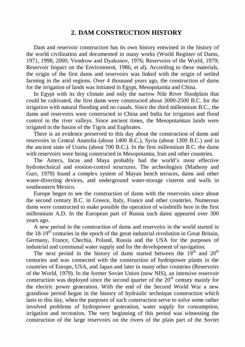
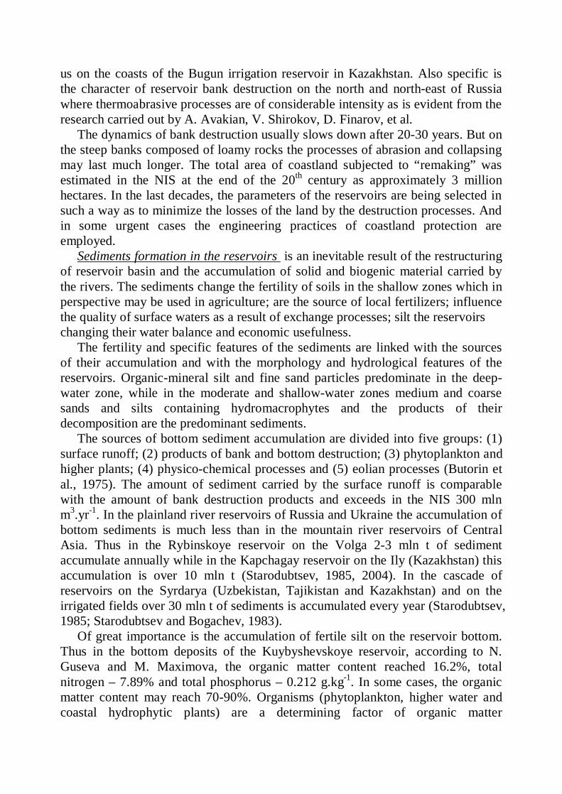
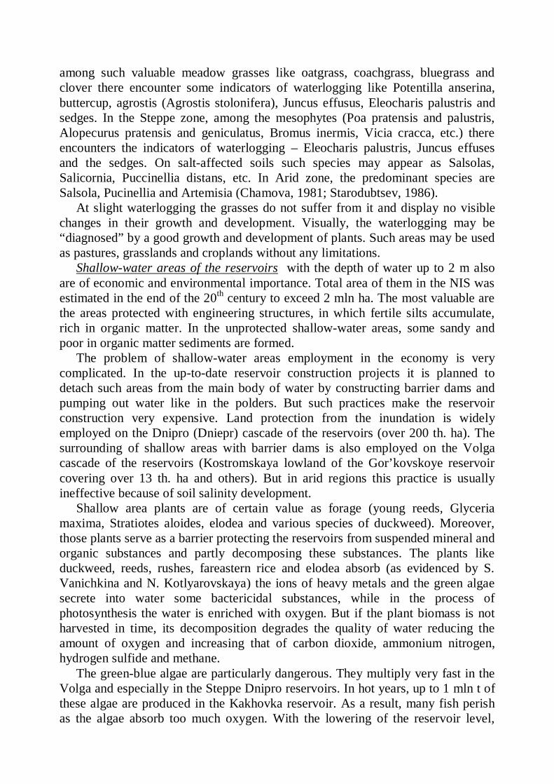
Fig.1. Large Reservoirs of the World (capacity in cubic kilometers:
1 – 1-10; 2 – 10-25; 3 – 25-50; 4 – 50-100; 5 – over 100). Among the continents, the richest in the number of dams are North America
with a multitude of large reservoirs in the USA and Canada, Asia with many smaller-sized reservoirs in Japan, India and China, and also Europe. In Africa even at the beginning of the 50s of the 20th century there were only a few large reservoirs, while now there are already four of the largest reservoirs of the world.
In the last 3-4 decades, mostly gigantic reservoirs are being constructed in the world. The largest modern-day reservoirs, if not take into account the lake-reservoir Victoria on the Nile River (204.8 km3), are Bratskoye on the Angara (169.3 km3), Caribba on the Zambezi (160.3 km3), Nasser on the Nile (157 km3); the largest by the area Volta (8480 km2) and Kuybyshevskoe on the Volga (6450 km2). Some gigantic reservoirs are constructed in China.
On the NIS territory, there are 150 thousand of reservoirs and ponds of varying size with a total useful capacity about 450 km3, but the number of large reservoirs is over 200. Approximately 70% of the reservoirs’ useful capacity is concentrated in an excessively wet taiga and only one-third – in the forest-steppe, steppe, semidesert and desert zones.
A borderline between the second and the third millennia is characterized by an evident reduction of dam construction in the developed countries of the world, but there is no sign of such a reduction in the developing countries despite the resistance of the environmentalists and (very often) that of a local population.
3. ECONOMIC AND SOCIAL IMPORTANCE OF DAMS AND RESERVOIRS FOR THE NIS REGION
In various geographic regions and at different historical time certain branches
of economy were the leading in the use of water resources and they determined the character of the river runoff regulation. In arid regions of the world, since ancient times irrigated farming was the main consumer of water. But economic and social development is continuously increasing there the role of hydropower generation, water supply management, flood control practices, recreation, etc.
Somewhat different was the situation in the regions with excessive wetness of the former Russian Empire where since the 18th century a very important role had been played by the transport navigation and subsequently by the industrial water supply. At the beginning and the middle of the 20th century here (in the former Soviet Union), hydropower generation was the leading branch of water use which determined the character of hydrotechnical construction. The cascades of reservoirs were created on the plainland rivers like the Volga, Kama and Dnipro (Dniepr), on the Siberian rivers and those of the north-eastern part of the country. Thus a cascade of reservoirs on the Volga and its tributary Kama now consists of Ivan’kovskoe, Uglichskoye, Rybinskoye, Gor’kovskoye, Kuybyshevskoe, Saratovskoye, Volgogradskoye, Cheboksarskoye, Kamskoye, Nizhnye-Kamskoye, Votkinskoye and other reservoirs. The Dnipro (Dniepr) cascade includes Kyiv, Kaniv, Kremenchuk, Dniprodzherzhinsk, Dniprovske (Zaporizhske) and Khahovka reservoirs.
In the last third of the 20th century, on the vast territory of the Soviet Union the interests of agriculture (irrigation) were acquiring ever greater importance. More attention was being paid to the construction of reservoirs and ponds for the recreation, tourism, fish production and other spheres linked with water management. In the northern and central regions of the European part of the former USSR (now the north of the Russian Federation), the hydropower station and reservoirs construction now solves mainly two problems – that of energy generation and that of transportation provision. In the southern regions of the European part of the USSR (now the southwest of Russian federation, Ukraine and Moldova), the river runoff regulation is now satisfying the needs of water supply, irrigation and power generation. In the Northern Caucasus and the states of Transcaucasia, the dams are being constructed mainly for power generation and irrigation. In Central Asia the main purpose of such a construction is irrigation and another one – power generation. In Siberia (Russian Federation) the primary reasons for dam construction are power generation, transportation and timber-rafting; on the Far East the purposes of dam construction are flood control, power generation and transportation by waterways.
No uniformity of the water resources spread over the NIS territory and not always optimal distribution of runoff in time make it necessary to redistribute the water between the basins by a system of dams, reservoirs and canals. The largest
projects which could not be realized because of the Soviet Union disintegration and the existence of some technological difficulties were the projects planning to rechannel (transfer) a part of runoff of the rivers from the northern part of European Russia to the Volga basin and to rechannel the Siberian rivers’ runoff to Kazakhstan and Central Asia. But the Irtysh water is now about to reach the Central Kazakhstan (Irtysh-Karaganda canal) to be used there for industrial and communal water supply. The Amudarya water will be transported to Turkmenistan (Karakum canal with a system of reservoirs) for irrigation and socio-economic development of this arid region and to the Karshinskaya Steppe of the Uzbekistan for irrigation. Some less grandiose projects have been realized or are on the way to realization, including the transboundary river projects in Central Asia.
Let us consider the role of dams and reservoirs in the development of irrigation in the NIS countries in more detail. In southern Kazakhstan, the water reservoirs of the Ily, Chu, Talas and many smaller rivers are used for irrigation. The utilization of water from the mountain tributaries in the Ily river basin allowed irrigating about 200 thousand hectares of land. It was the construction of a large Kapchagay reservoir (28.1 km3) in the Ily basin in 1970 and Bartogay reservoir on the left-bank tributary of the Chilik later on that made it possible to intensify the development of irrigation in the region. Irrigation areas were created in the region, such as Chingeldinsky (28 th. ha) on the Kapchagay reservoir coast, Akdalinsky (52 th. ha) in the ancient delta of the Ily and Chilik-Chemolgan (117 th. ha) on the basis of a Great Almatinsky canal.
In the basin of Chu (Kazakhstan and Kyrgyzstan) an intensive development of irrigation became possible after construction in 1956 of Ortotokoy and reconstruction in 1972-1974 of Tashutkul reservoirs and after creation of a number of smaller irrigation reservoirs on its tributaries. Total area of irrigated lands reached nearly 500 th. ha. Kirov reservoir was constructed for the development of irrigation in the Talas river basin.
An important part in the development of irrigation is played by the dams and reservoirs in the Aral Sea basin (Kazakhstan, Uzbekistan, Tadzhikistan and Kyrgyzstan), where the area of irrigation reached 8 million hectares. Water resources of the Syrdarya, Amudarya, Zaravshan and numerous smaller rivers are employed for the irrigation here. The Syrdarya runoff is regulated by Toktogul (19.5 km3), Kayrakkum (4.2 km3), Chardara (5.7 km3), Charvak (2.6 km3), Tyuyabuguz and Andizhan reservoirs as well as numerous smaller reservoirs and ponds. In the 70s of the late century the consumption of water for irrigation reached 35 km3 becoming nearly equal to the mean annual runoff of the Syrdarya (36.7 km3). In the subsequent years, the repeated use (reuse) of return waters for irrigation was increased.
The Amudarya runoff is regulated by Nurek, Tyuyamuyun, Rogun and other reservoirs. To give water to the Karshinskaya Steppe (the Syrdarya basin), the Talimardzhan reservoir was constructed. To utilize the runoff of the smaller rivers, Chimkurgan, Pachkamar and many other reservoirs were constructed.
The rivers of Turkmenistan (Murgab, Tedzhen and Atrek) are known for unfavorable seasonal runoff distribution and equally unfavorable perennial runoff variability. It is therefore very difficult to employ it for irrigation without regulation. Tashkeprin and Sariyazin reservoirs were constructed in the Murgab valley; Tedzhen I and II and Khorkhor reservoirs were constructed on the Tedzhen and Mamedkul and Delilin reservoirs - on the Atrek. This allowed irrigating 120 thousand hectares of lands. But really tremendous development of irrigation started here after rechannelling of the Amudarya water to this region along the Karakum canal (project area of irrigation equals 1 million ha and project capacity of water rechannelling that of 19 km3 her year). Khauzkhan, Ashgabat and Kopetdag reservoirs had been constructed along the canal, while a large Zeid reservoir is yet planned to be constructed here.
In the states of Transcaucasia (Azerbaijan, Georgia and Armenia), a number of smaller reservoirs constructed on the mountain rivers proved very effective for irrigation. The Kura, which is the largest river here, is regulated by a many-purpose Mingechaur reservoir. Northern Caucasus (Russian Federation) is a large rice-producing area. Krasnodarskoye reservoir (2 km3) plays here a significant role.
Ukraine saw an intensive development of irrigation in the 60-80s of the last century. It was and is being based on the Dnipro (Dniepr) basin reservoirs, primarily a Kakhovka one (18 km3) and on the water resources of the Ingul, South Bug, Dnistro (Dniestr), Dunay (Danube) and other rivers. In the southern part of the Russian federation, an intensively developing irrigation was created on the basis of Saratovskoye and Volgogradskoye reservoirs. In the Republic of Moldova, a great number of small reservoirs and ponds were constructed for irrigation.
It is important to note that dam and reservoir construction touches the interests of many million people. Considerable changes are imparted to the lives of people, environment and economy of vast regions. It all depends upon the goals of construction and a number of its negative consequences. Large areas of productive lands are being flooded in the river valleys. Urgency appears to resettle the residents and to move the economic objects to other territories. Many economic links and transport communications are destroyed. Climatic conditions on the coastal lands also change, to say nothing of sanitation, hygiene and other conditions of life. All this demands a thorough analysis of possible consequences of the construction of new reservoirs and planning of the practices meant to alleviate or prevent the negative factors.
The researches into socio-economic and environmental problems linked with dam and reservoir construction on the territory of the former USSR were carried out actively in the course of the 20th century but the 60-80s of it saw a real upheaval of these researches documented by S. Vendrow and K. Dyakonov (1976), Reservoirs of the World (1979), Reservoirs and their Impact on Environment (1986), V. Starodubtsev (1986), et al. But these documents had been published mostly in Russian and were practically inaccessible to international community.
4. RESERVOIRS AND THE ENVIRONMENT* The construction of reservoirs may serve an example of deep and multiaspect
intrusion of man into the natural processes on large territories. Large and often densely populated areas may be flooded or waterlogged. Among the negative processes brought about by reservoir construction may be coast bank erosion (bank destruction), development of slides, land sinks, swamping and salting of coastal soils, local climate and water and terrestrial biodiversity changes, as well as changes in hydrological regimes of the rivers in the tail water and the whole environment changes downstream, especially in the arid regions and so on.
Some complex investigations of the dam and reservoir impact on the environment were carried out in the former USSR most probably in the 20-30s of the last century while designing Volkhovskaya and other hydropower stations. In the 50-60s, many rivers in the European part of the USSR were turned into the cascade of hydropower stations so that their impact on the natural surroundings became much stronger. There appeared a necessity to study the character of this impact in detail and if necessary to alleviate or prevent the undesirable consequences. Large-scale research activities were initiated by the Institute of Geography of the USSR Academy of Sciences and by Moscow State University (MSU). Later on they were deployed by many research and projecting organizations, among them the Institute of Water Problems of the USSR Academy of Sciences, the Universities of Perm and Saratov, Giprovodkhoz and Hydroproject (Projecting and extension institute for water management), the All-Union Research Institute of Hydrotechnics and Amelioration, the Siberian Research Institute of Energetics, Research Institutes of the Ukrainian and Kazakh Academies of Sciences, the Hydrometeoservice of the USSR and other organizations.
Today the many-sided studies of dam and reservoir interaction with the environment and the ecological evaluation of the results of hydrotechnical construction are a must for the development of new projects. But not all the aspects of the reservoir impact on the environment became the objects of research. At first the research was limited to coast-bank and bed erosion (bank destruction), waterlogging of industrial and municipal buildings on the coast as well as the sanitation and hygienic quality of water. The impact on climate was first investigated in the 50s of the 20th century. Later on more attention was being paid to the changes in the soils and plant cover on the coasts (including the work of the authors of this booklet – see page 78), as well as to the reservoir biology. The last problem that came to investigation was a very important one from both economic and environmental points of view – the environmental transformations in the lower reaches of the rivers regulated with dams and reservoirs (desertification of landscapes, development of soil salinity, etc.). In the 70-90s of the last century the
*The problem is treated in greater detail in the monograph by V.M. Starodubtsev “Impact of Reservoirs on Soils” (1986) and in a book by a collective of authors – “Reservoirs and Their Impact on the Environment” (1986).
Research Institute of Soil Science of the Kazakh Academy of Sciences became the leading research organization taking count of the large-scale and profound changes in the river delta soils of Central Asia and on the coasts of the Aral Sea and the Lake Balkhash (Starodubtsev V.M. and co-authors, 1977-1992).
The reaction of reservoirs with the environment is of a distinct zonal character. Within a single zone, the intensity and direction of the processes occurring in the upper water areas of dams are influenced by the reservoir parameters, soil and rock composition on the coast and the bed, climate and character of runoff regulation. The environmental changes in the lower area of dams are influenced mainly by the character of flow regulation (perennial, seasonal, etc.), non-return withdrawal of a runoff and also climate. Of primary importance here is the dynamics of the water resources quality. Thus the increase in water salinity in the lower reaches (downstream) drastically degrades the irrigation water quality causing the development of soil salinity in deltas (Starodubtsev, 1985) and on the coasts of inland waters (lakes and seas) supplied by these rivers (Starodubtsev, 1990; Popov, Nekrasova, Semenov, Starodubtsev, 1992).
Of all the multitude of changes caused in the environment by the impact of dams and reservoirs, we shall examine in this booklet only those which directly or indirectly effect the formation, evolution and practical use of soils.
Losses of agricultural lands by inundating with the reservoirs were evaluated in the former USSR at the end of the 20th century by A. Avakian, S. Vendrow, K. Dyakonov, V. Sharapov and other researchers. According to these estimates, over 30 million hectares of lands used in agriculture had been flooded by the reservoirs in the world. On the NIS territory, over 0.5% of farmland was buried by the reservoirs, 15% of this area being plowland or lands potentially good for plowing. The largest land losses occurred in the valleys of plainland rivers. Thus the Volga reservoirs (Russian Federation) have the following specific land losses (expressed in hectares per 1 meter of a hydraulic head): Ivan’kovskoye – 3000, Gor’kovskoye – 10000, Rybinskoe – 24000, Kuybyshevskoye – 23500, Saratovskoye – 14000 and Volgogradskoye – 145000. Different agriculturally usable lands get flooded during the reservoir construction in various climatic zones: Thus in the Forest zone 70% of the inundated lands are forestlands, flood plain grasslands, pastures and plowland. In the Forest-Steppe and Steppe zones, some very fertile plowlands and valuable feed-producing areas in the river valleys become inundated. In the Desert and Semi-desert zones it is mostly the pastures that are flooded. There also are certain ‘off-site” losses of agricultural land caused by the moving of the installations from the inundated areas to new ones (about 1 mln ha according to G. Voropayev’s estimates).
On many reservoirs constructed on the NIS territory, including first of all those of the Volga and the Dnipro (Dniepr) cascades, some flood control practices are being employed to protect agricultural lands from flooding and waterlogging. Thus on the Dnipro cascade of the reservoirs hydrotechnical conservation structures protected about 225000 ha of land from flooding and waterlogging. In future such a protection, especially on the shallow-water areas, will acquire ever greater
significance. To protect the lands from flooding, the community of dedicated individuals becomes more and more oriented on the reservoirs construction not on the plainland rivers but in the mountains and foothills. Reservoir construction can also increase the area of lands used in agriculture by employing irrigation and reducing floods in the lower reaches. This is especially important for the river basins of the arid zone.
The dynamics of the reservoirs bank destruction (“remaking”) is one of the most important negative consequences of dam construction. In the process of such a “remaking”, the coastal soil cover suffers destruction and a great damage is caused to the economy and population. The character of the dynamics depends upon the initial relief of the reservoir basin, hydrogeology, engineering-geologic and meteorological conditions as well as upon chemical factors and the development of the reservoir biology (phytoplankton and hydromacrophyte development capable of neutralizing the waving), plant cover on the coastal slopes or their being denuded by tillage, etc.
The reservoir water level is of primary importance in this respect. Water cutline may shift its position vertically by 100 meters and more in irrigation and mountain power-generating reservoirs. Horizontal shifting of a cutline in large plainland reservoirs reaches 10-15 km and the area of drying – up to 24ooo ha for 1 m of water level lowering (Rybinskoye reservoir on the Volga). Large losses of soils and agricultural crops occur during the reservoir level elevation above the normal flood level in the interests of power generation.
The most intensive reservoir bank destruction (abrasion) takes place in the deep-water zone of a reservoir. Thus in the first twelve years of the Tsimlyanskoye reservoir (Russia) functioning, the losses of productive chernozemic soils (Mollisols) as a result of bank destruction reached 3000 ha of which 2000 ha were on the coasts of a deep-water zone and remaining 1000 ha – on those of a medium-water zone (Vendrow, 1970). On the Dnipro reservoirs, the average velocity of coastline receding toward the mainland is approximately 8-10 meters per year in the deep-water zone. But the velocity of coast destruction may be much greater, reaching150-200 meters per year as on the Bratskoye reservoir in Russia and other ones. The intensity of abrasion is much weaker in the shallow-water zones. Bank destruction here occurs mainly as a result of landslides, screes, wind erosion, freezing and wash-outs caused by snowmelt water.
Coast-bank destruction (“remaking”) may occur in the form of karst sinkholes and land subsidence. Thus on the Khahovka reservoir (Ukraine) the coastal subsidence areas were encountered at the distance over 100 km from the coastline. Somewhat specific is the character of coastline dynamics on the reservoirs surrounded by the loess and loess-like loams. Reservoir water becomes an effective agent of bank erosion, as the loess possessing a columnar structure and containing a large amount of silt easily soaks in water. Becoming sodden from below, such rocks collapse into a reservoir forming steep cliffs with vertical faces on the banks. The velocity of bank destruction (“remaking”) of the loess banks is 7-8 times greater than those composed of clay. Such processes were observed by
us on the coasts of the Bugun irrigation reservoir in Kazakhstan. Also specific is the character of reservoir bank destruction on the north and north-east of Russia where thermoabrasive processes are of considerable intensity as is evident from the research carried out by A. Avakian, V. Shirokov, D. Finarov, et al.
The dynamics of bank destruction usually slows down after 20-30 years. But on the steep banks composed of loamy rocks the processes of abrasion and collapsing may last much longer. The total area of coastland subjected to “remaking” was estimated in the NIS at the end of the 20th century as approximately 3 million hectares. In the last decades, the parameters of the reservoirs are being selected in such a way as to minimize the losses of the land by the destruction processes. And in some urgent cases the engineering practices of coastland protection are employed.
Sediments formation in the reservoirs is an inevitable result of the restructuring of reservoir basin and the accumulation of solid and biogenic material carried by the rivers. The sediments change the fertility of soils in the shallow zones which in perspective may be used in agriculture; are the source of local fertilizers; influence the quality of surface waters as a result of exchange processes; silt the reservoirs changing their water balance and economic usefulness.
The fertility and specific features of the sediments are linked with the sources of their accumulation and with the morphology and hydrological features of the reservoirs. Organic-mineral silt and fine sand particles predominate in the deep-water zone, while in the moderate and shallow-water zones medium and coarse sands and silts containing hydromacrophytes and the products of their decomposition are the predominant sediments.
The sources of bottom sediment accumulation are divided into five groups: (1) surface runoff; (2) products of bank and bottom destruction; (3) phytoplankton and higher plants; (4) physico-chemical processes and (5) eolian processes (Butorin et al., 1975). The amount of sediment carried by the surface runoff is comparable with the amount of bank destruction products and exceeds in the NIS 300 mln m3.yr-1. In the plainland river reservoirs of Russia and Ukraine the accumulation of bottom sediments is much less than in the mountain river reservoirs of Central Asia. Thus in the Rybinskoye reservoir on the Volga 2-3 mln t of sediment accumulate annually while in the Kapchagay reservoir on the Ily (Kazakhstan) this accumulation is over 10 mln t (Starodubtsev, 1985, 2004). In the cascade of reservoirs on the Syrdarya (Uzbekistan, Tajikistan and Kazakhstan) and on the irrigated fields over 30 mln t of sediments is accumulated every year (Starodubtsev, 1985; Starodubtsev and Bogachev, 1983).
Of great importance is the accumulation of fertile silt on the reservoir bottom. Thus in the bottom deposits of the Kuybyshevskoye reservoir, according to N. Guseva and M. Maximova, the organic matter content reached 16.2%, total nitrogen – 7.89% and total phosphorus – 0.212 g.kg-1. In some cases, the organic matter content may reach 70-90%. Organisms (phytoplankton, higher water and coastal hydrophytic plants) are a determining factor of organic matter
accumulation. Rich in nutrient elements sediments form mainly in the plainland reservoirs in humid climate rather than in arid regions.
Hydrogeologic impact of the reservoirs (waterlogging of coasts) takes place everywhere but with a differing intensity. The velocity of ground water table elevation and the distances of waterlogging spread depend upon the geography and climate of the region, hydraulic head of the river, reservoir filling-up regime, morphology of the coasts, infiltration properties of the soils and subsoil and initial hydrologic conditions. They also depend on the duration of groundwater regime stabilization which lasts 2-3 decades and sometimes longer.
On the reservoir coast, there is a flux of infiltration water from the reservoir to the watershed as well as a natural flux of groundwater from the watershed to the reservoir. A level depression arises at a certain distance from the cutline. This depression is gradually filled up and an initial kind of movement restores itself, that from the watershed towards the reservoir. In sandy and loam-sandy subsoils this occurs within 7-10 years whereas in loamy and clayey subsoils it takes 20-30 years for this process to complete. After groundwater regime stabilization there forms out a distinct zone surrounding the reservoirs in which the regime is determined entirely by the water level fluctuation.
In the plainland river basins, the hydrogeologic impact depends upon the climatic conditions. On the reservoir coasts of the Forest zone, the hydrogeologic impact of the reservoirs usually spreads itself to the distance of a few hundred meters, rarely – 1-2 kilometers (Rybinskoye and Ivan’kovskoye reservoirs in Russia, Kyiv reservoir in Ukraine and many others. In the Forest-Steppe zone the area of impact of the groundwater head is usually spread over a few kilometers. In some cases as, for example, around the Kuybyshevskoye reservoir, as evidenced by S. Vendrow, S. Beyrom, I. Garmonova and P. Kayukov, the hydrogeologic impact may stretch for 10-15 km. In the Steppe zone, according to V. Buylov, I. Skaballanovich, G. Legostin et al., the impact of groundwater head spreads in clays and loams over hundreds of meters, in loamy sands and sands – from 2-3 to 10-12 km and in cracked limestone up to 20-30 km and more (Kakhovka, Tsymlyanskoye, Saratovskoye and other reservoirs). On the north-east of Russia, the waterlogging of lands on reservoir coasts acquires specific features in connection with permafrost degradation.
The amplitude of groundwater level fluctuations on the coasts of reservoirs accumulating water for irrigation is usually very great and depends on seasonal water level changes in the reservoirs. Thus we observed the elevation of groundwater table on the coast of Bugun reservoir (Kazakhstan) by10 meters and E. Khalmatov, G. Mavlyanov and K. Ganiev observed it to elevate by 10-15 meters on the reservoir coasts in Central Asia. Hydrogeologic impact zone stretches here for over 1-2 to 5-6 km (Starodubtsev, 1977; 1980; 1986).
It is important to see the difference between the hydrogeologic impact of the reservoir, or the groundwater head, and a more complicated physico-geographic process – waterlogging. The latter occurs when groundwater table or a capillary fringe elevate to join the root-inhabited layer of the soil creating an additional
surplus wetness there. In humid regions, the waterlogging increases the natural high moisture of the soil causing a negative effect on the development of plants and soil properties. In the regions with inadequate humidity this may cause some positive effects on soil moisture. But in arid regions waterlogged soils may entirely lose their productivity because of a strong salinity. The role of waterlogging may depend on the distance from the reservoir water cutline. This role may be negative with medium and severe waterlogging, but it may be positive with a slight one.
The groundwater of the reservoir coasts may also undergo some complicated changes of their chemical composition. In the Forest zone, the amount of oxygen in groundwater decreases which intensifies the processes of swamping and causes the respective transformation of a plant cover (A. Uspenskaya, N. Butorin, et al). In the Steppe regions, the changes in groundwater mineralization are more important. Usually the waters become less saline, but there are cases of water salinity growth (I. Skaballanovich, S. Vendrow, L. Boltova and S. Beyrom). The most important changes in groundwater salinity occur in arid regions, where they determine the salinity of soils and subsoils. Thus we observed the reduction of groundwater salinity near the Bugun reservoir coast and significant growth of salinity with the growing distance from the coastline. But groundwater salinity may remain high even near coastline as, for example, on the Kapchagay reservoir constructed on the river of Ily in the mountain depression (Starodubtsev, 1981, 1986).
Climate changes on the reservoir coasts influence the character of agricultural production and the conditions of soil and plant cover formation. Two aspects should be differentiated when talking about the reservoir impact on the climate: (1) the limits of the physical influence of the aquatory on the meteorological regime and (2) the limits of practically significant influence on physico-geographic and biological processes. The theoretical limits of the impact zone may be registered at the distance of 10 km and on large reservoir – up to 30-40 km. Practically significant limits usually spread to 1-3 km.
Because of the difference between the radiation balances over the water and terrestrial surface, the reservoirs have a cooling effect on local climate in spring and a warming one – in the autumn. The difference between the temperature of water and that of the air over its surface may reach, according to S. Vendrow, 3.7-6.40C. In the northern regions of Russia with their low heat resources, the reservoir impact on the air temperature is the most significant. The lowering of temperature on the coasts causes a delay in the start of a vegetation period by 8-10 days, but it makes longer the frostless period in autumn. As a result, the sum of positive air temperatures on the coasts increases by 100-1600C (Vendrow and Dyakonov, 1976).
The absolute air humidity in the coastal zone is more changeable in the south. It is higher than on the surrounding territory on Volgogradskoye and Tsymlyanskoye reservoirs by 7-8 mbar, on Kuybyshevskoye reservoir – by 5 mbar and on Rybinskye reservoir – by only 1.4 mbar (S. Vendrow, K. Dyakonov, A. Reteyum, L. Dubrovina, N. Kolobova, et al). Relative air humidity is higher during the
period of cooling reservoir effect and lower during the period of warming effect. The reservoir effect on the amount of precipitation was found to be contradictory in character. In humid regions the annual rainfall over the aquatory and flatland coasts is lower (K. Dyakonov), while in arid ones it is higher (B. Kirsta). World data analysis (B. Kornilov, V. Sharapov) also proves the increase in the annual rainfall. Wind velocity over the reservoir coasts is higher in the warm seasons of the year.
The changes in plant cover in the zone of reservoir impact considerably affect the landscapes including the character of soil formation. With perennial inundation, the terrestrial plant communities usually die out, while with periodic shallow flooding, the vegetation transforms itself in evolutionary successions of plant communities. Of trees and shrubs only the most resistant remain poplars and willows. The vegetation of grasses becomes represented by the sedges, rushes and reeds along the reservoir coasts, while in a deeper flooded zone, communities of floating-leaved and submerged plants develop.
Severe waterlogging on the reservoir coasts of the Forest zone impedes the growth and development of firs, pines and spruces reducing 2-3 times the annual increases of timber. In the undergrowth stand of the forest, there is a noticeable transformation in shrub, grass and moth vegetation. In the Forest-Steppe zone, the waterlogging impact is weaker. Here not only willows and poplars are resistant to waterlogging, but also elms, ashes, elders and other trees. With a slight waterlogging of the coasts the trees usually grow better.
The grassy vegetation in the wet zone changes depending on the degree of waterlogging and climatic conditions. With severe waterlogging in the Forest zone, according to N. Kotova and G. Petrov, large sedges predominate in the upper and forget-me-nots, Gallium trifidum and Deschampsia caespitosa (spikerush) in the lower grass stand. In the Forest-Steppe zone, the predominant species of grasses are the sedges (Carex dioica, pauciflora, obtusata etc.) and agrostis in communities with buttercup, Potentila anserina and Rhynchospora alba. In the Steppe zone, the predominant hydrophytic grasses are the sedges and Rhynchospora as well as foxtail, gallium and alisma (Alisma plantago-aquatica). On salt-affected soils, some halophytic species predominate like Puccinellia distans, Salicornia europea and different species of Salsola. In Arid zone, the reservoir coasts overgrow with rushes and reeds, but if the soils are salt-affected, the halophytes predominate, like salicornia, salsola and suaeda (Suaeda prostrata). On the areas with low groundwater salinity, some annual salsola-containing communities develop (Plisak, 1985).
With moderate waterlogging, the plant communities consist mostly of mesophytic species, though their mixture with hydrophytic ones may also occur. In the Forest zone, the most widespread are the communities of spikerush, while the indicators of waterlogging here are the sedges, buttercup, Juncus, Eleocharis palustris, water horsetail and gallium. Of valuable meadow grasses there encounter foxtail, oatgrass, bluegrass, couchgrass, timothygrass, clover and other species (N. Kotova, G. Petrova, A. Lyutin, Yu. Matarzin, et al). In the Forest-Steppe zone
among such valuable meadow grasses like oatgrass, coachgrass, bluegrass and clover there encounter some indicators of waterlogging like Potentilla anserina, buttercup, agrostis (Agrostis stolonifera), Juncus effusus, Eleocharis palustris and sedges. In the Steppe zone, among the mesophytes (Poa pratensis and palustris, Alopecurus pratensis and geniculatus, Bromus inermis, Vicia cracca, etc.) there encounters the indicators of waterlogging – Eleocharis palustris, Juncus effuses and the sedges. On salt-affected soils such species may appear as Salsolas, Salicornia, Puccinellia distans, etc. In Arid zone, the predominant species are Salsola, Pucinellia and Artemisia (Chamova, 1981; Starodubtsev, 1986).
At slight waterlogging the grasses do not suffer from it and display no visible changes in their growth and development. Visually, the waterlogging may be “diagnosed” by a good growth and development of plants. Such areas may be used as pastures, grasslands and croplands without any limitations.
Shallow-water areas of the reservoirs with the depth of water up to 2 m also are of economic and environmental importance. Total area of them in the NIS was estimated in the end of the 20th century to exceed 2 mln ha. The most valuable are the areas protected with engineering structures, in which fertile silts accumulate, rich in organic matter. In the unprotected shallow-water areas, some sandy and poor in organic matter sediments are formed.
The problem of shallow-water areas employment in the economy is very complicated. In the up-to-date reservoir construction projects it is planned to detach such areas from the main body of water by constructing barrier dams and pumping out water like in the polders. But such practices make the reservoir construction very expensive. Land protection from the inundation is widely employed on the Dnipro (Dniepr) cascade of the reservoirs (over 200 th. ha). The surrounding of shallow areas with barrier dams is also employed on the Volga cascade of the reservoirs (Kostromskaya lowland of the Gor’kovskoye reservoir covering over 13 th. ha and others). But in arid regions this practice is usually ineffective because of soil salinity development.
Shallow area plants are of certain value as forage (young reeds, Glyceria maxima, Stratiotes aloides, elodea and various species of duckweed). Moreover, those plants serve as a barrier protecting the reservoirs from suspended mineral and organic substances and partly decomposing these substances. The plants like duckweed, reeds, rushes, fareastern rice and elodea absorb (as evidenced by S. Vanichkina and N. Kotlyarovskaya) the ions of heavy metals and the green algae secrete into water some bactericidal substances, while in the process of photosynthesis the water is enriched with oxygen. But if the plant biomass is not harvested in time, its decomposition degrades the quality of water reducing the amount of oxygen and increasing that of carbon dioxide, ammonium nitrogen, hydrogen sulfide and methane.
The green-blue algae are particularly dangerous. They multiply very fast in the Volga and especially in the Steppe Dnipro reservoirs. In hot years, up to 1 mln t of these algae are produced in the Kakhovka reservoir. As a result, many fish perish as the algae absorb too much oxygen. With the lowering of the reservoir level,
great masses of decaying algae are deposited on the coasts creating an unsanitary situation. In the arid regions the green-blue algae are less numerous. The reduction of shallow-water areas by a correct choice of the reservoir parameters and using engineering protection is advisable for agricultural land use and landscape conservation. But complete elimination of such areas is not advisable for the biological life of the reservoirs.
Hydrochemical features of the reservoirs are dependent on the river regime and on their interaction with the environment. Thus the Volga reservoirs have an increased amount of organic (humic) acids in their water, those on the Kama – high content of mineral and those on the Angara – low content of minerals in their water. In the reservoirs, unlike in the rivers, the average annual and perennial amplitude of salt content in water is lower. This is particularly true for the reservoir cascades (on the Dnipro, Volga and other rivers).
River flow regulation by the dams affects not only the mineralization of water but also the organic matter and biogenic substance contents as well as the gaseous regime. In the Forest and the Forest-Steppe zones, the concentration of salts in water is usually 0.2-0.3 g/l, gaseous regime is poor because of the oxygen deficit and the ability of water for self-purification is weakened. In the Steppe zone, the concentration of salts in water is within 0.4-0.6 g/l, lower organic matter contents while oxygen deficit appears only periodically. In arid regions, water mineralization is significantly higher (up to 1-3 g/l), biogenic matter content – low and that of dissolved oxygen – high.
The feeding of the reservoirs with groundwater to a considerable extent influences the concentration of salts in the reservoir water especially in the arid zone (Alekin, 1960; Vidineeva, 1974; Starodubtsev, 1981, 1982). It is also influenced by the reservoir water interaction with the basin (bottom) and coastal soils, which was underestimated for a long time (Starodubtsev, 1986).
The reservoir water quality is also affected by the organic matter of the flooded plants decomposition, accompanied by the enrichment of water with organic and mineral nitrogen, phosphorus and organic substances, and by the green-blue algae metabolism. Nearly a half of all the biogenic substances come to the reservoirs from the fertilized fields surrounding them.
Environmental changes in the lower reservoir water are of great ecological and economic significance. In the lower reaches of rivers regulated with dams, the landscapes of the river valleys, deltas, as well as those of the lakes (internal seas) and the bays of the seas feeded by these rivers undergo some fundamental changes. The character of these changes is generally determined by physico-geographic conditions, regime of flow regulation and the peculiarities of the runoff use. This is especially important for the regions with developed irrigation and for the inter-basin runoff distribution. But in any particular river basin the environmental transformation is of some specific character.
In the excessively humid regions of northern Russia, the regulation of the river flow by the dams and reservoirs protects the flood plains below the hydraulic engineering structure from prolonged spring floods, and in the Far East of Russia –
from severe rainfall floods in summer. Ameliorative conditions in the river valleys become better too. In the steppe regions of Russia, Kazakhstan, Ukraine and Moldova the regulation of the flow stopped the spring floods in the floodplain areas of the river valleys occupied with agricultural lands. Fertile soils and meadow grasses become more “steppe-like”, degrade and lose their productive value. Such processes intensively develop in the lower reaches of the Volga, Don, Irtysh, Dnipro, Dnistro and other rivers.
But the most profound negative changes in the natural environment take place in the lower reaches of rivers in the arid regions of Central Asia and Kazakhstan. Earlier, owing to powerful floods in spring and summer, some unique wetland landscapes with rich flora, fauna and soils formed in the lower reaches of the rivers. Floodplain meadows in the deltas served a source of forage for cattle-breeding and an asylum for the wildlife. The irrigation was developing in deltas since ancient times. But the river flow regulation in the second half of the 20th century carried out in the interests of irrigation and power generation brought about a notable and since 70-80s a rapid aridization of the landscapes in the lower reaches. The numerous aspects of aridization, such as drying-up, desertification and the growth of salinity in delta soils had been revealed and discussed in our publications (Starodubtsev et al., 1978, 1983, 1998, and 2004; Starodubtsev, 1985, etc.).
The most important factor of delta landscapes desertification was the reduction of runoff used for filling the reservoirs and for irrigation. Thus in the 70-80s the annual runoff in the Syrdarya delta reduced by 70-80 %, and in some years there was no runoff at all. In the Chu river delta it reduced by 30-40% and in that of the Ily – by 25-30%. The same runoff reduction occurred on the other large rivers of Central Asia. The result of it was the formation of desertificated landscapes with saline soils on many hundred thousand hectares of formerly rich wetland landscapes. Salt concentration in the Syrdarya water increased threefold and in the Chu – twofold favoring the accumulation of toxic salts in soils and groundwater. These negative processes were to a certain extent alleviated by the reduction of water consumption from these basins in the 90s when the Soviet Union started to disintegrate.
Water runoff reduction is accompanied by the reduction of solid particle runoff. Thus inflow of suspended particles in the lower reaches of Syrdarya decreased by 90-95%, Chu – by 60-70% and Ily – by 70-80%. As a result, the continental delta landscapes do not receive a large amount of organic matter, nitrogen, phosphorus and other nutrients. Desertification and eolian destruction become the leading processes in such deltas. Solid runoff reduction into the deltas joining the Caspian and Black Seas (those of the Don, Volga, Kura and others) transformed the deltas’ advance into the seas into their stabilization and even retreat from the seas. This means that the deltas suffer destruction by the erosion (abrasion) of banks.
To alleviate the processes of landscapes degradation in the lower reaches of rivers one of the practices is to allow additional portions of the reservoir water to go into runoff. But while planning such “allowances”, it is not always possible to satisfy the opposing interests of many competing water users, especially those of
agricultural and fishing industry. As a result, the flora in the lower reaches undergoes only a partial restoration.
The reservoirs also affect the thermal regime of the river water and the soils in the lower reaches and the local climate. Thus the temperature of water in the lower bief of hydraulic power scheme becomes higher in winter and lower in summer. The average reduction of temperature in the river water remains lower within several degrees. Over the desertifying delta plains in Central Asia, the annual air temperature amplitude increases by 40 and more, relative air humidity becomes lower and the annual amount of rainfall also decreases by up to 25 mm in a ten-year period. Heat flow regime of formerly wetland soils becomes more contrasting (Starodubtsev, 1977).
In general, the environmental transformations occurring in the lower reaches of the rivers under the impact of dams and reservoirs deeply affect the processes of soil formation in the deltas and the conditions of soil management and conservation.
5. CHANGES OF SOILS ON THE RESERVOIR COAST*
Construction of a large number of reservoirs calls attention to the problem of soil management and conservation on the coastal lands. The soils in the waterlogging zone differ from their zonal counterparts by their morphological, physico-chemical and agrochemical properties. Depending on the natural features of a location, the waterlogging may cause swamping, gleization, slitization, alkalinization and salinization of soils.
The first investigations of the possible changes in soil development caused by the reservoir construction in the Forest zone had been carried out in 1921-1927 under the direction of L.I. Prasolov before the construction of the Volkhov hydropower station. Nizhnye-Volzhskaya expedition of the USSR Academy of Sciences headed and directed by B.A. Keller and V.A. Kovda performed some soil surveys to provide research grounds for the irrigation projects in Zavolzhye (Russia). In 1933-1935, the Volzhsko-Kamskaya expedition of the USSR Academy of Sciences developed a schematic prediction model to foresee the changes in soil development on the coasts of a reservoir of the Yaroslavskaya hydropower station which was then under construction (A. Rode and A. Lyutin).
A considerable contribution to the research of soil waterlogging processes had been made in the 50s by the Floodplain Expedition activities (G. V. Dobrovol’sky) and by the research workers of the Darwin’s nature reserve (Rybinskoye reservoir). Some active research activities had been carried out in the Forest zone by the soil scientists of the Moscow State University (MSU) directed by S.A.Vladychensky (1958, 1961 and 1968). These activities were continued by V. Korenyevskaya, M. Khrustalyeva, L. Yakovleva, Z. Gromova and others. In 60-70s the reservoir impact on soils in the Forest, Forest-Steppe and Steppe zones were studied by the Institute of Geography of the USSR Academy of Sciences under the guidance of S.L. Vendrow, the Institute of Aquatic Problems of the USSR Academy of Sciences under the direction of A.B. Avakyan, Kalinin State University (A. Yemelyanov), Northern Research Institute of Hydrotechnics and Melioration (G. Petrov and N. Kotova), Ukrainian Research Institute of Hydrotechnics and Melioration, Ukrainian Project Institute of Water Management and others. In the arid zone of the former USSR we started research this problem since 1966 on irrigation and power generation reservoirs (Yegorichev and Starodubtsev, 1970, Starodubtsev, 1977, 1986).
5.1. Changes in soil development caused by reservoir-induced waterlogging in the Forest zone. The early research activities here were oriented on the measurement of water table depth and its fluctuations determining the extent of waterlogging on the coasts. The observations performed on the long-existing reservoirs of the Forest zone (Ivan’kovskoye, Kamskoye and Rybinskoye) showed the waterlogging to appear at groundwater depth (GWD) of 150-200 cm,
* - Some detailed analysis of cited research activities is presented in our monograph (Starodubtsev, 1986).
depending on soil texture. Severe waterlogging occurs with groundwater table (GWT) depth over 100 cm (Dobrovol’sky, 1958; Vladychensky, 1960, 1961). Subsequently a great attention was being paid to the role of water-elevating soil capacity, forms of water rising in the capillaries and, which proved the most important, to the reservoir water level fluctuations perceptibly alleviating the extent of waterlogging (Uspenskaya, 1957).
The waterlogging zone width of the reservoirs was determined to be within 100-500 m on high and within 1.5-2 km on low banks (G. Dobrovol’sky, S. Vladychensky, V. Starodubtsev, A. Uspenskaya et al). S. Vladychensky (1958, 1968) identified the zone of a direct (direct seepage into the coasts) and indirect (water table elevation caused by interaction with reservoir water seepage and slow-down of groundwater flow) reservoir impact. He then divided the waterlogged territory into three sub-zones, those of soil swamping, soil gleization (meadow soil formation) and subsoil gleization, which later received the names of the sub-zones of severe, moderate and slight waterlogging.
The changes in morphological features of waterlogged soils are being investigated ever since the 40-60s (A. Uspenskaya, G. Dobrovol’sky, A. Lyutin, L. Yakovleva, etc.). Among the most widespread were the strengthened morphological features of reduction processes (gleization) in the profiles, possessing a certain dynamics determined by the water table fluctuations caused in their turn by the fluctuations of the reservoir water level. A moderate as well as slight waterlogging cause the appearance of the “meadow soil” features in podzolic soils developing under the continuous impact of capillary fringe. Severe waterlogging formed peaty-podzolic-gleyey soils which gradually transform into peaty-gleyey ones with a deep layer of peat. With the development in time of the processes of meadow-soil formation, gleization and swamping the layer of sod becomes thicker from 2 cm in slightly gleyed to 5-8 cm in moderately gleyed soils (approximately in a 10-year period). Subsequently the layer of sod transforms into that of peat in swampy soils. Surface A1 horizon, containing humified organic matter also transforms from light-grey 12-17 cm thick in slightly gleyed to grey and dark-grey 14-23 cm thick in moderately gleyed and to dull bluish-grey with dark-brown and rusty iron hydroxide spots in severely gleyed soils. Physical properties of the soils especially those determining water potential and flow also change under the influence of waterlogging (Vladychensky, 1958. 1968). It slightly (if at all) changes the porosity and aggregation of podzolic and soddy-podzolic sandy and loamy-sandy soils (which are naturally with low porosity and aggregation), but lowers their bulk density favoring the accumulation of organic matter and its partial conservation in peat. Infiltration rate of such light-textured soils also changes little with gleying but their penetrability remains low being impeded by water table head. The growth of the intensity of gleying reduces soil aeration so that it becomes unsatisfactory in humic-gleyed soils.
Physico-chemical and agrochemical properties are more changeable with severe and moderate waterlogging. The swamping of soils reduces their productivity very much. Under the surface peaty horizon, some gleyed horizons are
formed with unfavorable physico-chemical properties. In moderately waterlogged “meadow-like” soils the contents of organic matter, nitrogen and phosphorus increase. Reduction conditions favor the increases of available iron and aluminum concentration caused by their biogenic and hydrogenic accumulation. In the lower horizons, waterlogging with neutral reaction water reduces soil acidity and increases base saturation percent. The rates of organic matter accumulation fluctuate from 1% in 30 years to 2% in 10 years (G. Dobrovolsky, A. Lyutin, Z. Gromova, V. Korenevskaya, V. Starodubtsev, et al). Redox potential (Eh) in slightly glayed soils fluctuates within 635-435 mV, while in severely gleyed ones it may be of 200-400 mV and lower (Gromova, 1968). With slight waterlogging, the properties of the surface and near-surface horizons basically remain unchanged. Only in the lower horizons Eh becomes lower and the solubility of iron and aluminum increases.
The prediction of the intensity of waterlogging was based on works of A. Rode, S. Vladychensky and A. Lyutin, on the estimates of the soil capillary rise and on the relationships between groundwater depth and intensity of swamping. It was accepted that severe waterlogging takes place if capillary fringe reaches soil surface and the upper soil horizons are moistened to capillary capacity. If their moisture equals field capacity – a moderate waterlogging develops. Slight waterlogging appears when the capillary fringe reaches the lower horizons of the soil profile. The character of soil evolution under the impact of waterlogging was prognosticated by geographic analogy methods based on the spatial dynamics of soil cover under varying conditions of soil wetness. Actually it was a beginning of practical employment of the method of ecologo-genetic series of soil dynamics which is widely employed for predicting evolutionary changes today. N. Kotova (1972) and other geobotanics recommended a method of bioindicators to predict waterlogging effects as the plants are the integral reflectors of changing soil conditions. But actually this method is a component part of the method of ecologo-genetic series.
5.2. Soil changes under the impact of reservoir-caused waterlogging in the Forest-Steppe and Steppe zones. The role of atmospheric precipitation in these zones becomes less important then that of capillary rise and evapotranspiration in the formation of water regime which, in its turn, determines the character and extent of soil waterlogging. Slight and moderate waterlogging usually improves soil fertility and productivity of natural biocommunities. In the sub-zone of severe waterlogging, the swamp development is much less widespread and not so intensive as in the Forest zone. But in the direction from the Forest-Steppe to Steppe zone, the hazards of salinity and alkalinity development in waterlogged soils increase.
The researchers point to a connection between the extent of soil waterlogging and the fluctuations of the reservoir level which in its turn influences the groundwater depth (Madanov, et al, 1972; Petrov and Kotova, 1974, etc.). Under such conditions, the waterlogging occurs periodically and the morphological features of reduction processes are therefore less distinct than in the Forest zone.
Thus in the sub-zone of severe waterlogging of the Kuybyshevskoe reservoir, the upper horizons of soils are usually marked by the ochric and rustic spots of gleying, evidencing the alternation in time of the processes of reduction and oxidation. In the sub-zones of moderate and slight waterlogging, the signs of gleying in floodplain meadow, grey forest and chernozemic soils are visible only in the lower part and singular dull grey spots – in the middle part of soil profile. Subsequently these soils become transformed into meadow gley soils with varying extent of gleying.
In the Forest-Steppe zone the waterlogging of soils is weakened as relatively high reservoir banks dominate here. Thus, on the Novosibirskoye reservoir coast with abrasion cliff up to 2 m, the severe waterlogging is absent, while the moderate waterlogging sub-zone with water table depth within 1.5-2 m, is 50-250 m wide (Dyakonov, 1974). Soil changes may be observed as gleying of the lower part of soil profiles and as water regime improvement for the forest plant communities. The situation is more complicated when the low reservoir banks are protected from flooding (Starodubtsev, 2001; Starodubtsev et al., 2000, 2004). On some reservoirs soil salinity and alkalinity (sodicity) are prone to develop with waterlogging. An example of this is discussed in more detail in chapter 6.
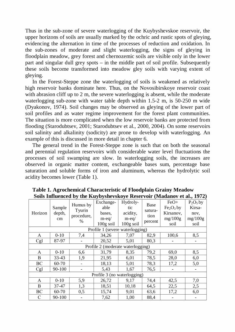
The general trend in the Forest-Steppe zone is such that on both the seasonal and perennial regulation reservoirs with considerable water level fluctuations the processes of soil swamping are slow. In waterlogging soils, the increases are observed in organic matter content, exchangeable bases sum, percentage base saturation and soluble forms of iron and aluminum, whereas the hydrolytic soil acidity becomes lower (Table 1).
Table 1. Agrochemical Characteristic of Floodplain Grainy Meadow Soils Influenced by the Kuybyshevskoye Reservoir (Madanov et al., 1972)
Horizon Sample depth,
cm
Humus by Tyurin
procedure, %
Exchange-able
bases, m-eq/
100g soil
Hydroly-tic
acidity, m-eq/
100g soil
Base satura-
tion percent
FeO+ Fe2O3 by Kirsanov, mg/100g
soil
P2O5 by Kirsa-nov,
mg/100g soil
Profile 1 (severe waterlogging) А 0-10 7,4 34,26 7,07 82,9 100,6 8,5 Сgl 87-97 - 20,52 5,01 80,3 - -
Profile 2 (moderate waterlogging) А 0-10 6,6 31,79 8,35 79,2 69,0 8,5 В 33-43 1,9 21,95 6,01 78,5 28,0 6,0 ВС 60-70 - 18,13 5,01 78,3 17,2 5,0 Сgl 90-100 - 5,43 1,67 76,5 - -
Profile 3 (no waterlogging) А 0-10 5,9 26,72 9,17 74,4 42,5 7,0 В 37-47 1,3 18,51 10,18 64,5 22,5 2,5 ВС 60-70 0,5 15,74 9,01 63,6 17,2 6,0 С 90-100 - 7,62 1,00 88,4 - -
In the Steppe zone, even with high water table, the atmospheric precipitations are unable to cause the surface swamping and waterlogging of soils. Therefore, the most important factor of soil water regimes here is sufficiently high capillary rise of ground water in loamy subsoil and soils. Among the changes of soil properties and features in the waterlogged zone gleying still remains important the extent of which depends on the water table depth. But no less important here become the processes of soil salinization and alkalinization profoundly altering the level of soil productivity and the character of agricultural land use. The investigators therefore concentrated their attention on these issues. Salt accumulation in coastal soils were observed in Russia on the Veselovskoye reservoir by S. Vladychensky, on the Volgogradskoye – by P. Madanov, G. Petrov and others, on the Bratskoye – by V. Filippov and S. Filippova and on the Moldovian reservoirs – by V. Shrag and L. Pekatoris. The development of soil salinity is usually linked with capillary rise of saline ground water and with relic deposits of salts in parent materials and rocks underlying them and dissolution of salt-containing rocks.
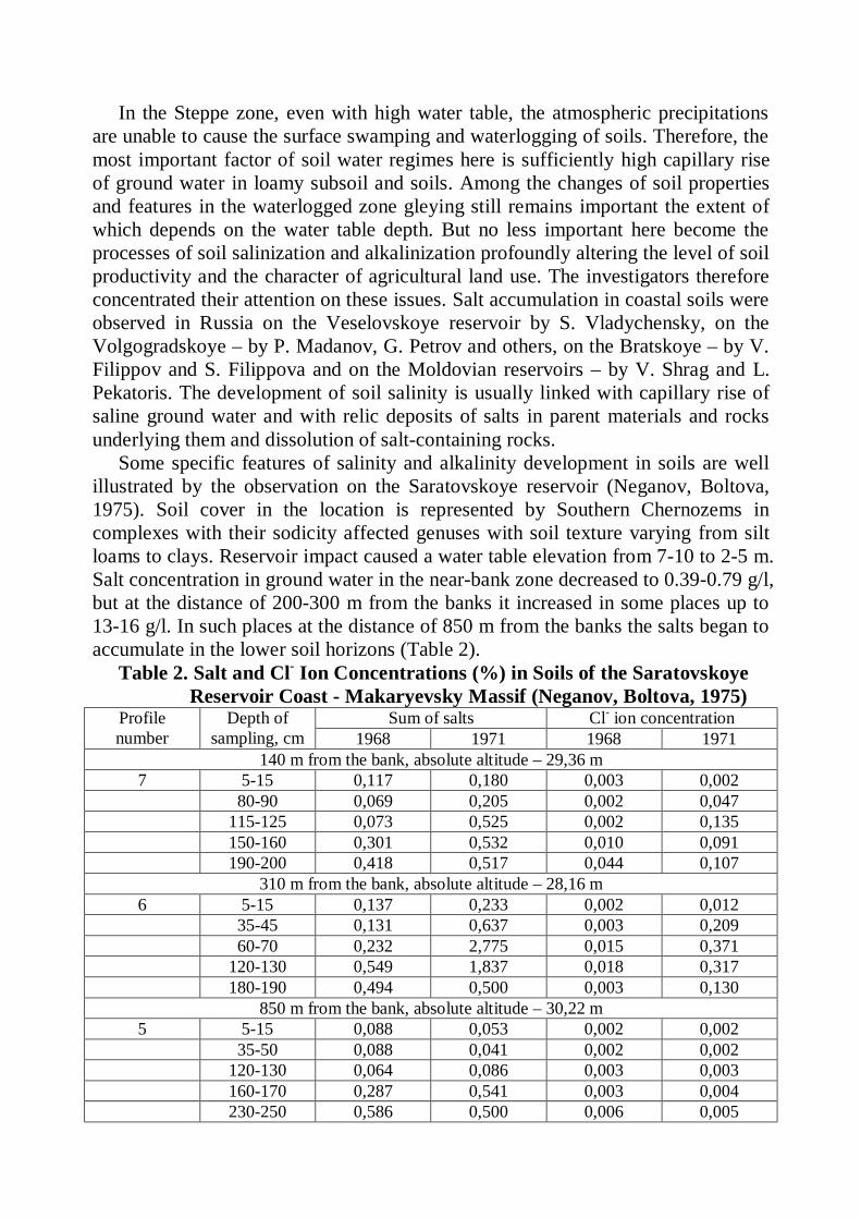
Some specific features of salinity and alkalinity development in soils are well illustrated by the observation on the Saratovskoye reservoir (Neganov, Boltova, 1975). Soil cover in the location is represented by Southern Chernozems in complexes with their sodicity affected genuses with soil texture varying from silt loams to clays. Reservoir impact caused a water table elevation from 7-10 to 2-5 m. Salt concentration in ground water in the near-bank zone decreased to 0.39-0.79 g/l, but at the distance of 200-300 m from the banks it increased in some places up to 13-16 g/l. In such places at the distance of 850 m from the banks the salts began to accumulate in the lower soil horizons (Table 2).
Table 2. Salt and Cl- Ion Concentrations (%) in Soils of the Saratovskoye Reservoir Coast - Makaryevsky Massif (Neganov, Boltova, 1975)
Sum of salts Cl- ion concentration Profile number
Depth of sampling, cm 1968 1971 1968 1971
140 m from the bank, absolute altitude – 29,36 m 7 5-15 0,117 0,180 0,003 0,002 80-90 0,069 0,205 0,002 0,047 115-125 0,073 0,525 0,002 0,135 150-160 0,301 0,532 0,010 0,091 190-200 0,418 0,517 0,044 0,107
310 m from the bank, absolute altitude – 28,16 m 6 5-15 0,137 0,233 0,002 0,012 35-45 0,131 0,637 0,003 0,209 60-70 0,232 2,775 0,015 0,371 120-130 0,549 1,837 0,018 0,317 180-190 0,494 0,500 0,003 0,130
850 m from the bank, absolute altitude – 30,22 m 5 5-15 0,088 0,053 0,002 0,002 35-50 0,088 0,041 0,002 0,002 120-130 0,064 0,086 0,003 0,003 160-170 0,287 0,541 0,003 0,004 230-250 0,586 0,500 0,006 0,005
At the same time, the development of sodicity started in these soils under the influence of capillary fringe of ground waters containing carbonate and sulphate salts. Four years after water table elevation to the depth of3-4 m, pH in the Southern Chernozems began to rise and sodium carbonate began to be detected in soil extracts. Exchangeable sodium in some cases increased up to 25-30% of total exchangeable bases content. In meadow-chernozemic soils of the same coastal locality, the development of soil sodicity was even more intensive. At the same time, with the waterlogging of non-saline chernozems by hydrocarbonate-calcium groundwater containing only 0.4-0.6 % of soluble salts and with pH of 7.5, neither salinity nor sodicity developed on the Kuybyshevskoye reservoir coasts (Korenevskaya, et al., 1982).
The reservoir waterlogging zone width in the Steppe zone, according to the above mentioned studies, is within 0.3-1.5 km (although the groundwater head spreads to larger distances). Land swamping is fragmentary and only within a narrow coastal band. But such hydromorphic changes of soils as gleying and “meadowing” of chernozems are much more widespread, so that chernozems transform into chernozemic-meadow and meadow-chernozemic soils and into gleic chernozems. Waterlogging of chernozems sometimes is accompanied by their leaching from carbonates (V. Korenevskaya, V. Buylov, et al).
There is a tendency in waterlogged soils for the growth of organic matter, available phosphorus and exchangeable potassium contents. The increases in the amount of soluble iron and manganese here are less considerable than in the Forest and Forest-Steppe soils (V. Korenevskaya, P. Madanov, A. Voronin, et al). Thus in waterlogged chernozems on the Kuybyshevskoye reservoir coast, the available iron content increased to 20-45 and that of manganese – to 30-40 mg per 100 g of soil. Redox potential (Eh) in the surface humic horizon reduced to 200-300 mV (Voronin, et al., 1984). The changes in waterlogged soil biochemical properties were pointed to by I. Sviridova and G. Odnoralov, explaining it by the lowering of aeration and soluble oxygen content in soil and subsoil water. Severe waterlogging degrades soil physical properties. Thus soil compaction occurs in the upper horizons of soil profile (up to 1.70 g/cm3) on pasture, as well as reduction of soil porosity and degradation of its structure (V. Korenevskaya, et al).
5.3. Changes of soils caused by waterlogging in the Semidesert and Desert zones. The researches of soils waterlogged by the reservoirs in arid and semiarid regions were oriented mostly on the issues of salinization and leaching (desalinization), the processes drastically changing the ameliorative condition and productivity of soils. The pioneer researches in this field in the former USSR were those carried out, as we have already stated, by the Nizhnye-Volzhskaya expedition of the Academy of Sciences in 1932-1933. To scientifically prove the feasibility of large water management projects in Zavolzhye, the local experience of irrigation had been subjected to investigations, including the impact of already functioning not so large reservoirs constructed for irrigation. It was found out (Kovda, 1937) that the reservoirs of the Piterskaya, Novouzenskaya and Valuyskaya irrigation systems caused water table elevation on the coasts up to
1-2 m from the surface and brought about a severe salinization of chestnut, meadow-chestnut and meadow soils at the distance of 150-200 m from the bank. Similar results were obtained by G. Grigoryev, A. Kudinova, N. Usov, et al.
In the semidesert zone of Kazakhstan, in the 50s the impact of a reservoir constructed on the Kengir river for industrial water supply of city of Dzhezkazgan had been investigated. S. Sagimbayev and I. Barkalov detected water table elevation from the depth of 5-7 to 20 m to the depth of 2-4 m from the soil surface and in the lowlands of topography even to 0.5-2 m. That is why saline soils and solonchaks are widespread on the city’s territory.
Though the irrigation reservoirs have a long history (since ancient times) in the arid regions of Central Asia, their impact on the soils of adjacent territories was the least studied. Only in the 60s we began our research activities in Southern Kazakhstan (Starodubtsev, et al., 1970, 1977, 1981, 1982, 1984, 1986, etc.), and the studies also started in Uzbekistan (A. Einisman, et al). The water and salt regimes in coastal soils surrounding the irrigation reservoirs of Central Asia usually develop under conditions of surface and ground water level fluctuations. This happens owing to the annual filling-up and consumption of water from the reservoirs for irrigation and the resulting lowering of the volume of water in the reservoir to a “deadline” capacity. In such a situation, near the very banks of the reservoirs, the soils become leached from soluble salts and ground waters become less saline. But under certain hydrogeological conditions, when saline ground waters approach the surface, an intensive development of soil salinity takes place which drastically reduces soil productivity. Such processes were observed by us on Bugun irrigation reservoir in South Kazakhstan; the research result we discuss in chapter 8 of this book
A much more complicated situation is observed on the coasts of large power generation reservoirs constructed in the lowlands between the mountain ranges in arid zone. Soil salinity development here may reach high intensity and spread over large areas. Some detailed research results (Starodubtsev, 1981, 19822, 1986) pertaining to the processes occurring on the Kapchagay reservoir coasts in the Ily valley (South Kazakhstan) are presented in chapter 7.
6. IMPACT OF DNIPRO RIVER’ RESERVOIRS ON COASTAL SOILS (FOREST AND FOREST -STEPPE ZONES
OF UKRAINE)
The Dnipro (Dniepr) flow regulation performed in Ukraine in the 50-70s of the last century and connected with construction of a cascade of 6 reservoirs brought about the inundation of about 0.7 mln ha of fertile lands in the river valley. It also brought about the changes of conditions for agriculture, forestry and recreation on the adjacent lands, particularly in the wet zone of the waterlogged soils.
The series or cascade of the reservoirs (Fig. 2) crosses all natural zones of Ukraine, from the Forest zone (Polissya) in the north to the Arid Steppe zone in the south. But we managed to carry out our research only on the three upper reservoirs: Kyivs’ke (Forest zone), Kanivs’ke (northern part of the Forest-Steppe zone) and Kremenchuks’ke (the south of the Forest-Steppe zone). In 1993-1995 our research activities had been financed partly by the Ukrainian Ministry for Agriculture and Food Production. But later on they were conducted a little bit unsystematically by the undergraduate and graduate students of the National Agricultural University under Professor V.M. Starodubtsev direction. A sizable aid in our research result generalization in 1999-2000 had been kindly granted to us by George Soros Foundation (Research Support Scheme, Grant 629/1998).
6.1. Kyivs’ke reservoir. Kyivs’ke reservoir had been constructed in 1965 in the Forest zone to the north
of Ukrainian capital the city of Kyiv. Since then it regulates the runoff of the Dnipro and Prypyat’. While constructing it, some large-scale engineering practices had been realized to protect the Dnipro – Desna inter-basin territory from inundation and waterlogging. Thus along the entire left bank a protective dam and a large drainage canal diverting the infiltration water into the Dnipro below the hydropower plant had been constructed. But the soils on the part of the lower coasts (left bank and northern part of the right bank) are subject to waterlogging on a strip from some hundreds meters to 0.5-1.0 km wide. Right-bank soils especially along a segment stretching from the village of Lyutizh to the Kyivs’ka hydroaccumulative power plant continue to erode as a result of abrasion (streambank disruption) and landslide processes.
As Kyivs’ke reservoir is situated in the Forest soil-climatic zone, the soils around it are mainly soddy-podzolic including slightly and cryptopodzolic sandy and loamy-sandy ones employed predominantly in forestry not being productive enough for agricultural crops. But moderately podzolic loamy-sandy soils are important for crop production.
Our soil surveys allowed us to carry out a zoning of the territory adjacent to the Kyivs’ke reservoir by the character and extent of changes of ecologo-ameliorative soil conditions (Fig. 3).
Regions I to III were identified on the left-bank coast where the soils are subject to waterlogging by infiltration water flowing from the reservoir to the drainage
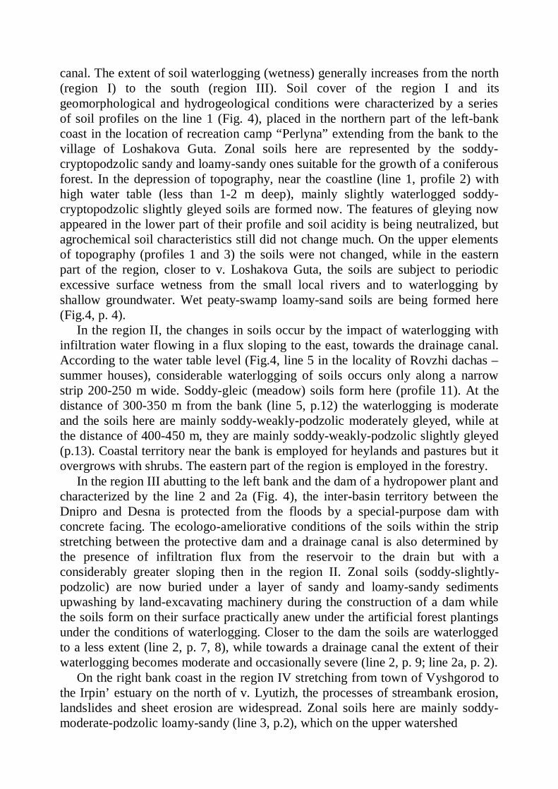
canal. The extent of soil waterlogging (wetness) generally increases from the north (region I) to the south (region III). Soil cover of the region I and its geomorphological and hydrogeological conditions were characterized by a series of soil profiles on the line 1 (Fig. 4), placed in the northern part of the left-bank coast in the location of recreation camp “Perlyna” extending from the bank to the village of Loshakova Guta. Zonal soils here are represented by the soddy-cryptopodzolic sandy and loamy-sandy ones suitable for the growth of a coniferous forest. In the depression of topography, near the coastline (line 1, profile 2) with high water table (less than 1-2 m deep), mainly slightly waterlogged soddy-cryptopodzolic slightly gleyed soils are formed now. The features of gleying now appeared in the lower part of their profile and soil acidity is being neutralized, but agrochemical soil characteristics still did not change much. On the upper elements of topography (profiles 1 and 3) the soils were not changed, while in the eastern part of the region, closer to v. Loshakova Guta, the soils are subject to periodic excessive surface wetness from the small local rivers and to waterlogging by shallow groundwater. Wet peaty-swamp loamy-sand soils are being formed here (Fig.4, p. 4).
In the region II, the changes in soils occur by the impact of waterlogging with infiltration water flowing in a flux sloping to the east, towards the drainage canal. According to the water table level (Fig.4, line 5 in the locality of Rovzhi dachas – summer houses), considerable waterlogging of soils occurs only along a narrow strip 200-250 m wide. Soddy-gleic (meadow) soils form here (profile 11). At the distance of 300-350 m from the bank (line 5, p.12) the waterlogging is moderate and the soils here are mainly soddy-weakly-podzolic moderately gleyed, while at the distance of 400-450 m, they are mainly soddy-weakly-podzolic slightly gleyed (p.13). Coastal territory near the bank is employed for heylands and pastures but it overgrows with shrubs. The eastern part of the region is employed in the forestry.
In the region III abutting to the left bank and the dam of a hydropower plant and characterized by the line 2 and 2a (Fig. 4), the inter-basin territory between the Dnipro and Desna is protected from the floods by a special-purpose dam with concrete facing. The ecologo-ameliorative conditions of the soils within the strip stretching between the protective dam and a drainage canal is also determined by the presence of infiltration flux from the reservoir to the drain but with a considerably greater sloping then in the region II. Zonal soils (soddy-slightly-podzolic) are now buried under a layer of sandy and loamy-sandy sediments upwashing by land-excavating machinery during the construction of a dam while the soils form on their surface practically anew under the artificial forest plantings under the conditions of waterlogging. Closer to the dam the soils are waterlogged to a less extent (line 2, p. 7, 8), while towards a drainage canal the extent of their waterlogging becomes moderate and occasionally severe (line 2, p. 9; line 2a, p. 2).
On the right bank coast in the region IV stretching from town of Vyshgorod to the Irpin’ estuary on the north of v. Lyutizh, the processes of streambank erosion, landslides and sheet erosion are widespread. Zonal soils here are mainly soddy-moderate-podzolic loamy-sandy (line 3, p.2), which on the upper watershed
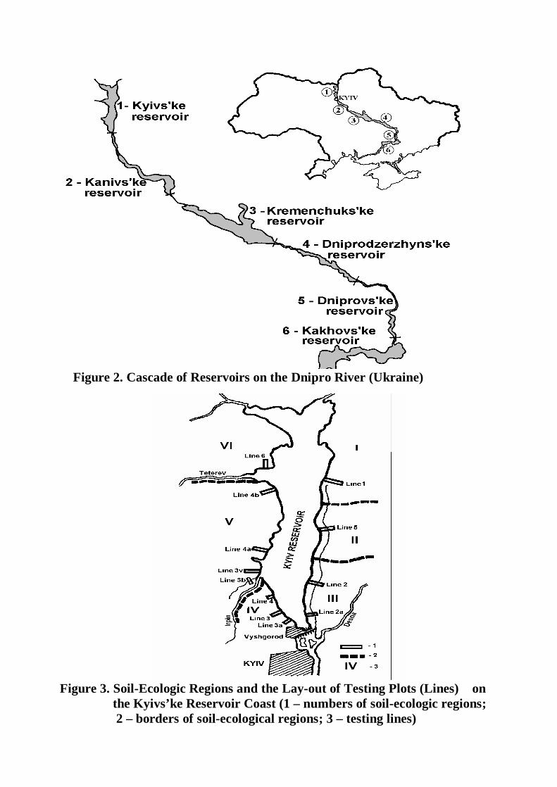
Figure 2. Cascade of Reservoirs on the Dnipro River (Ukraine)
Figure 3. Soil-Ecologic Regions and the Lay-out of Testing Plots (Lines) on the Kyivs’ke Reservoir Coast (1 – numbers of soil-ecologic regions; 2 – borders of soil-ecological regions; 3 – testing lines)
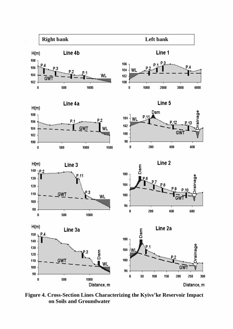
Figure 4. Cross-Section Lines Characterizing the Kyivs’ke Reservoir Impact on Soils and Groundwater
Right bank Left bank
elements of topography are used in agriculture and near-house plots in numerous villages and small towns. But right on the high-bank coasts elevating to 30-40 m over the reservoir level, the soils continue to erode. Only in the southern part of the region (between the Kyivs’ka hydroaccumulative power plant and the town of Vyshgorod), the streambank erosion (abrasion) of high coasts was nearly stopped and other forms of soil erosion was considerably weakened (line 3a, p.1) as a result of conservation practices implementation (terracing and agroforestry practices on the slopes) and the construction of a concrete fence on the bank over the reservoir cutline. Soil destruction in the estuaries of ravines and gullies became weaker as a result of erosion basis elevation and the soil-protecting effects of the forest vegetation. The formation and development of gullies as well as surface erosion by water are now much less damageful here.
In the region V (from the Irpin’ to the Teteriv estuary), there are observed the simultaneous processes of bank erosion with the formation of cliff 1-3 m high and weak fragmentary waterlogging in the local depressions of topography (Fig. 3 and 4, line 4a near the village of Yasnogorodka). On the right-bank coast, the waterlogging occurs as a result of interaction between the reservoir and groundwater flux directed to the Dnipro valley, but not with the infiltration water as it occurs on the left-bank coast. It is worth noting that within the region, in the direction towards the Teteriv estuary, the processes of bank destruction (abrasion) gradually vanish altogether and there is no cliff formation on the bank, but the extent of soil waterlogging increases. As is evident from Fig.4 (line 4b near the village of Sukholuchchya), a narrow strip of severely waterlogged meadow and meadow-swampy soils 30-50 m wide abuts to the reservoir coastline. Farther from the coastline, at the distance up to 200 m, there stretches a band of moderately waterlogged soddy-podzolic gleyed soils with water table 80-120 cm deep. The vegetation changes in accordance with the soil conditions: meadow grasses dominate with severe waterlogging, broad-leaf forests with meadow grass communities occupy the moderately waterlogged soils, while mixed forest plant communities dominate on the spot with slight waterlogging. Only beyond the boundaries of a waterlogged zone (Fig.4, line 4b, p.4), there is a typical coniferous forest growing on soddy-slightly-podzolic soils. In the region VI (to the north of the Teteriv estuary), the abrasion processes are practically absent and soil waterlogging near the reservoir become stronger. Near the villages Gornostypol, Zeleny Mys and Strakholissya the agricultural lands (predominantly fields of forage crops) become waterlogged as well as the territories remediated by drainage. Farther on, to the north of the Prypyat’ near already evacuated villages Gorodyshche, Kupovate and Opachicgy, some agricultural lands, no longer used because of radioactive pollution, as well a territory bordering with the forest are also subject to waterlogging. In all waterlogged soils the processes of glaying and occasionally the processes of swamp formation become more intensive. Soil-water relations as well as morphological features and physico-chemical properties of waterlogged soils become significantly altered. Worthy of attention are the changes in soil reaction as a result of interaction of waterlogged soils with infiltration water
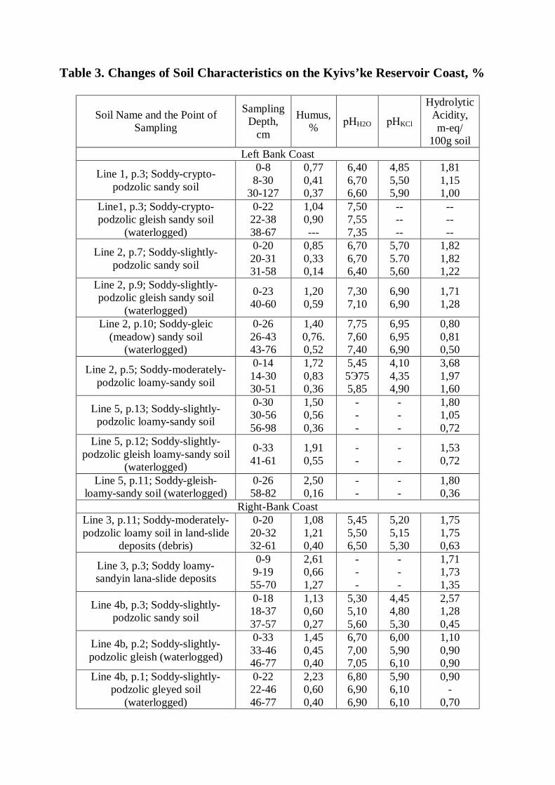
Table 3. Changes of Soil Characteristics on the Kyivs’ke Reservoir Coast, %
Soil Name and the Point of Sampling
Sampling Depth,
cm
Humus, % рНH2O рНKCl
Hydrolytic Acidity, m-eq/
100g soil Left Bank Coast
Line 1, p.3; Soddy-crypto-podzolic sandy soil
0-8 8-30
30-127
0,77 0,41 0,37
6,40 6,70 6,60
4,85 5,50 5,90
1,81 1,15 1,00
Line1, p.3; Soddy-crypto-podzolic gleish sandy soil
(waterlogged)
0-22 22-38 38-67
1,04 0,90 ---
7,50 7,55 7,35
-- -- --
-- -- --
Line 2, p.7; Soddy-slightly-podzolic sandy soil
0-20 20-31 31-58
0,85 0,33 0,14
6,70 6,70 6,40
5,70 5.70 5,60
1,82 1,82 1,22
Line 2, p.9; Soddy-slightly-podzolic gleish sandy soil
(waterlogged)
0-23 40-60
1,20 0,59
7,30 7,10
6,90 6,90
1,71 1,28
Line 2, p.10; Soddy-gleic (meadow) sandy soil
(waterlogged)
0-26 26-43 43-76
1,40 0,76. 0,52
7,75 7,60 7,40
6,95 6,95 6,90
0,80 0,81 0,50
Line 2, p.5; Soddy-moderately-podzolic loamy-sandy soil
0-14 14-30 30-51
1,72 0,83 0,36
5,45 5Э75 5,85
4,10 4,35 4,90
3,68 1,97 1,60
Line 5, p.13; Soddy-slightly-podzolic loamy-sandy soil
0-30 30-56 56-98
1,50 0,56 0,36
- - -
- - -
1,80 1,05 0,72
Line 5, p.12; Soddy-slightly-podzolic gleish loamy-sandy soil
(waterlogged)
0-33 41-61
1,91 0,55
- -
- -
1,53 0,72
Line 5, p.11; Soddy-gleish-loamy-sandy soil (waterlogged)
0-26 58-82
2,50 0,16
- -
- -
1,80 0,36
Right-Bank Coast Line 3, p.11; Soddy-moderately-podzolic loamy soil in land-slide
deposits (debris)
0-20 20-32 32-61
1,08 1,21 0,40
5,45 5,50 6,50
5,20 5,15 5,30
1,75 1,75 0,63
Line 3, p.3; Soddy loamy-sandyin lana-slide deposits
0-9 9-19 55-70
2,61 0,66 1,27
- - -
- - -
1,71 1,73 1,35
Line 4b, p.3; Soddy-slightly-podzolic sandy soil
0-18 18-37 37-57
1,13 0,60 0,27
5,30 5,10 5,60
4,45 4,80 5,30
2,57 1,28 0,45
Line 4b, p.2; Soddy-slightly-podzolic gleish (waterlogged)
0-33 33-46 46-77
1,45 0,45 0,40
6,70 7,00 7,05
6,00 5,90 6,10
1,10 0,90 0,90
Line 4b, p.1; Soddy-slightly-podzolic gleyed soil
(waterlogged)
0-22 22-46 46-77
2,23 0,60 0,40
6,80 6,90 6,90
5,90 6,10 6,10
0,90 -
0,70
containing calcium hydrocarbonate and having a pH within 7.25-7.50. Soddy-podzolic soils usually have an acidic reaction, as is evident from Table 3 (line 1, p.3; line 2, p.5; line 3, p.11; line 4b, p.3).
In the waterlogged soils of the left-bank coast (line 1, p.2; line 2, p.9,10) pHH2O
increases to 7.35-7.75. At the same time, the hydrolytic acidity decreases and base saturation percent increases. But in waterlogged soddy-podzolic soils of the right-bank coast (not by infiltration water but by perched groundwater) the changes in the physico-chemical properties of soils were not so considerable (Table 3, line 4b, p. 1, 2)
The general trend for the content of humus in the surface horizons of waterlogged soils is to increase. Thus in waterlogged soddy-crypto-podzolic sandy soils (line 1, p.2) humus content in the surface horizon increased to 1.04 % from 0.4-0.8% in their counterpart not subjected to waterlogging (line 1, p.1, 3). In soddy-slightly-podzolic soils of the line 2 the amount of humus increased with waterlogging to 1.20-1.40% (p. 9, 10) versus 0.85% in no waterlogged soils (p.7). In loamy-sandy soddy-podzolic soils of the line 5 the content of humus was within 1.50 (p.13) to 1.91% (p.12).
In the moderately waterlogged soils, subsequently transformed into soddy (meadow) ones as a result of waterlogging the percent of humus reaches 2.10-2.50% (line 4, p.1; line 5, p.11). In severely waterlogged swampy soils which are periodically subject to inundation in addition to continuous waterlogging, the amount of organic matter in the surface horizon reaches 18.3%.
Our research activities in 2000-2003 made possible to detect some unique for Ukrainian Polissya processes of soil salinization on the right-bank coast of the Kyivs’ke reservoir to the north of the Irpin’ floodplain (near the village of Kozarovychi). On a reservoir cliff 1-1.5 m high at the depth of 0.5 m from the surface a layer of salt crystal efflorescence had been detected. Further studies on this plot showed it to be covered by soddy-gleish-podzolised and soddy-gleic (with the signs of solodization) soils formed in carbonatic slightly saline loams. Waterlogging of these soils led to salt migration in the profile and to the appearance of salt efflorescence on the cliffy banks. A significant amount of salts is detected already at the depth of 30-50 cm, ionic composition of salts in this horizon being sulfatic-bicarbonate and calcium-sodium (Table 4, line 3v, p.1). Additionally excavating lines of soil profile on this plot are shown in Fig.5.
Worthy of attention are the changes of radioactive pollution in the soils of the Kyivs’ke reservoir coast. After Chernobyl disaster, a large amount of radionuclide had fallen on the reservoir aquatory and on the soils surface of its coasts. Our investigations of the subsequent radionuclide migration in the coastal soils were spread on both low waterlogged coasts and high coasts with landslides, abrasion, and surface erosion (Fig. 4 and 5). It was found that in the first 7-12 years after the accident on the atomic plant, the radionuclide (137Cs) were leached downwards in the soil profile to the depth of 15-25 cm and occasionally deeper, depending on soil type, organic matter content, soil texture and the character of land use (Table 5).
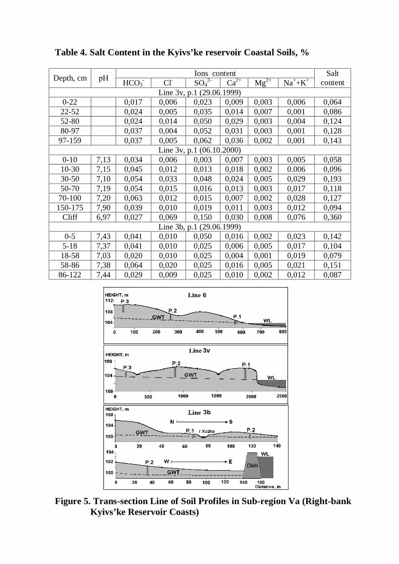
Table 4. Salt Content in the Kyivs’ke reservoir Coastal Soils, %
Ions content Depth, cm рН HCO3- Cl- SO4
2- Ca2+ Mg2+ Na++K+ Salt
content Line 3v, p.1 (29.06.1999)
0-22 0,017 0,006 0,023 0,009 0,003 0,006 0,064 22-52 0,024 0,005 0,035 0,014 0,007 0,001 0,086 52-80 0,024 0,014 0,050 0,029 0,003 0,004 0,124 80-97 0,037 0,004 0,052 0,031 0,003 0,001 0,128
97-159 0,037 0,005 0,062 0,036 0,002 0,001 0,143 Line 3v, p.1 (06.10.2000)
0-10 7,13 0,034 0,006 0,003 0,007 0,003 0,005 0,058 10-30 7,15 0,045 0,012 0,013 0,018 0,002 0.006 0,096 30-50 7,10 0,054 0,033 0,048 0,024 0,005 0,029 0,193 50-70 7,19 0,054 0,015 0,016 0,013 0,003 0,017 0,118
70-100 7,20 0,063 0,012 0,015 0,007 0,002 0,028 0,127 150-175 7,90 0,039 0,010 0,019 0,011 0,003 0,012 0,094
Cliff 6,97 0,027 0,069 0,150 0,030 0,008 0,076 0,360 Line 3b, p.1 (29.06.1999)
0-5 7,43 0,041 0,010 0,050 0,016 0,002 0,023 0,142 5-18 7,37 0,041 0,010 0,025 0,006 0,005 0,017 0,104 18-58 7,03 0,020 0,010 0,025 0,004 0,001 0,019 0,079 58-86 7,38 0,064 0,020 0,025 0,016 0,005 0,021 0,151
86-122 7,44 0,029 0,009 0,025 0,010 0,002 0,012 0,087
Figure 5. Trans-section Line of Soil Profiles in Sub-region Va (Right-bank Kyivs’ke Reservoir Coasts)
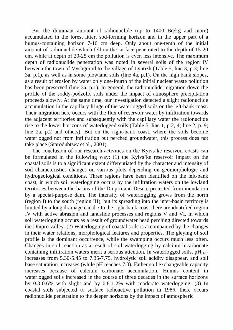
But the dominant amount of radionuclide (up to 1400 Bq/kg and more) accumulated in the forest litter, sod-forming horizon and in the upper part of a humus-containing horizon 7-10 cm deep. Only about one-tenth of the initial amount of radionuclide which fell on the surface penetrated to the depth of 15-20 cm, while at depth of 20-25 cm the pollution is even less intensive. The maximum depth of radionuclide penetration was noted in several soils of the region IV between the town of Vyshgorod to the village of Lyutizh (Table 5, line 3, p.3; line 3a, p.1), as well as in some plowland soils (line 4a, p.1). On the high bank slopes, as a result of erosion by water only one-fourth of the initial nuclear waste pollution has been preserved (line 3a, p.1). In general, the radionuclide migration down the profile of the soddy-podzolic soils under the impact of atmosphere precipitation proceeds slowly. At the same time, our investigation detected a slight radionuclide accumulation in the capillary fringe of the waterlogged soils on the left-bank coast. Their migration here occurs with the flux of reservoir water by infiltration towards the adjacent territories and subsequently with the capillary water the radionuclide rise to the lower horizons of waterlogged soils (Table 5, line 1, p.2, 4; line 2, p. 9; line 2a, p.2 and others). But on the right-bank coast, where the soils become waterlogged not from infiltration but perched groundwater, this process does not take place (Starodubtsev et al., 2001).
The conclusion of our research activities on the Kyivs’ke reservoir coasts can be formulated in the following way: (1) the Kyivs’ke reservoir impact on the coastal soils is to a significant extent differentiated by the character and intensity of soil characteristics changes on various plots depending on geomorphologic and hydrogeological conditions. Three regions have been identified on the left-bank coast, in which soil waterlogging occurs by the infiltration waters on the lowland territories between the basins of the Dnipro and Desna, protected from inundation by a special-purpose dam. The intensity of waterlogging grows from the north (region I) to the south (region III), but its spreading into the inter-basin territory is limited by a long drainage canal. On the right-bank coast there are identified region IV with active abrasion and landslide processes and regions V and VI, in which soil waterlogging occurs as a result of groundwater head perching directed towards the Dnipro valley. (2) Waterlogging of coastal soils is accompanied by the changes in their water relations, morphological features and properties. The gleying of soil profile is the dominant occurrence, while the swamping occurs much less often. Changes in soil reaction as a result of soil waterlogging by calcium bicarbonate containing infiltration waters merit a serious attention. In waterlogged soils, pHH2O increases from 5.30-5.45 to 7.35-7.75, hydrolytic soil acidity disappear, and soil base saturation increases (while pH reaches 7.0). Father soil exchangeable capacity increases because of calcium carbonate accumulation. Humus content in waterlogged soils increased in the course of three decades in the surface horizons by 0.3-0.6% with slight and by 0.8-1.2% with moderate waterlogging. (3) In coastal soils subjected to surface radioactive pollution in 1986, there occurs radionuclide penetration to the deeper horizons by the impact of atmospheric
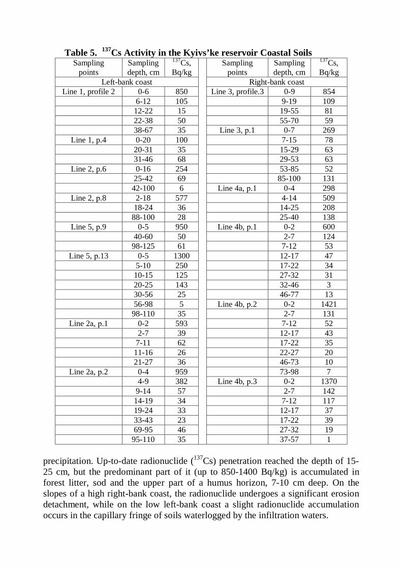
Table 5. 137Cs Activity in the Kyivs’ke reservoir Coastal Soils Sampling
points Sampling depth, cm
137Cs, Bq/kg
Sampling points
Sampling depth, cm
137Cs, Bq/kg
Left-bank coast Right-bank coast Line 1, profile 2 0-6 850 Line 3, profile.3 0-9 854
6-12 105 9-19 109 12-22 15 19-55 81 22-38 50 55-70 59 38-67 35 Line 3, р.1 0-7 269
Line 1, p.4 0-20 100 7-15 78 20-31 35 15-29 63 31-46 68 29-53 63
Line 2, p.6 0-16 254 53-85 52 25-42 69 85-100 131 42-100 6 Line 4а, р.1 0-4 298
Line 2, р.8 2-18 577 4-14 509 18-24 36 14-25 208 88-100 28 25-40 138
Line 5, р.9 0-5 950 Line 4b, р.1 0-2 600 40-60 50 2-7 124 98-125 61 7-12 53
Line 5, р.13 0-5 1300 12-17 47 5-10 250 17-22 34 10-15 125 27-32 31 20-25 143 32-46 3 30-56 25 46-77 13 56-98 5 Line 4b, р.2 0-2 1421 98-110 35 2-7 131
Line 2а, р.1 0-2 593 7-12 52 2-7 39 12-17 43 7-11 62 17-22 35 11-16 26 22-27 20 21-27 36 46-73 10
Line 2а, р.2 0-4 959 73-98 7 4-9 382 Line 4b, р.3 0-2 1370 9-14 57 2-7 142 14-19 34 7-12 117 19-24 33 12-17 37 33-43 23 17-22 39 69-95 46 27-32 19 95-110 35
37-57 1 precipitation. Up-to-date radionuclide (137Cs) penetration reached the depth of 15-25 cm, but the predominant part of it (up to 850-1400 Bq/kg) is accumulated in forest litter, sod and the upper part of a humus horizon, 7-10 cm deep. On the slopes of a high right-bank coast, the radionuclide undergoes a significant erosion detachment, while on the low left-bank coast a slight radionuclide accumulation occurs in the capillary fringe of soils waterlogged by the infiltration waters.
6.2. Kanivs’ke reservoir (second in the Dnipro cascade) had been constructed in 1974. Its “water mirror” area is 675 km2, total capacity – 2.62 km3, average width – 5.5 km and average depth – 3.9 m. Climate of the region is typical for the Forest-Steppe zone: mean annual air temperature is within 6.6-7.20C; mean July temperature: within +18.8-20.00C; mean January temperature: within -5.9-6.60C; mean annual precipitation is 560 mm, 75% of which is a rainfall of the period of crop growth; frostless period lasts 180 days and the sum of biologically effective temperatures (over 100C) is 26270.
In the respect of orography, the reservoir is located on the contact between the Near-Dnipro Highland (right-bank coast) and Near-Dnipro Lowland (left-bank coast). Geologic structure of the Dnipro Valley in the region consists of the strata of different ages, from Paleozoic to Cenozoic. Parent materials of soils on the high right-bank coast of the reservoir are predominantly the loesses of silt-loam texture, rich in the coarse silt fraction, of recent and date-quaternary age (Q4 and Q3). They are underlain by the layered neogenic and paleogenic deposits of different texture, including red-brown and motley clays. On the height of a normal perching level (NPL) of the reservoir, there are the marly clays of the Kyiv suite which considerably alleviate the processes of bank destruction (abrasion). On the low left-bank coast, the most widespread are the early-quaternary alluvial sands of the “pineforest” terrace which further to the east are covered by the loess-like loams of the second “over-flood-plain” terrace.
There is a great diversity of soils on the Kanivs’ke reservoir coasts. On a right-bank coast from the village of Khalepya to the town of Kaniv the most widespread are the typical and podzolized chernozems as well as dark-grey podzolized soils eroded to different extent. On the “borova” (from Russian “bor” – a pine forest) terrace along the left bank, there formed soddy-podzolic soils occupied by the forest vegetation. On the low coasts (Kozyn, Bortnychi, Kyiliv and Leplyavo polders) the most widespread are the soddy, soddy-gleic, meadow, meadow-swampy and swampy (boggy) soils used as forage lands. Only by a narrow strip near the village of Tsybli the coast meets typical chernozems used as plowland.
Kanivs’ke reservoir construction was accompanied by the unique set of practices aimed to protect the coastal soils from inundation and waterlogging. 79.5 km of diversion dams, 7 pumping stations with a capacity of 159.2 m3/s and 75 km of drainage canals were put to practice. 45.6 thousand hectares including 25.2 thousand hectares of farmlands were protected from inundation and waterlogging. The town of Pereyaslav-Khmel’nytsky is one of the protected settlements.
To evaluate the Kanivs’ke reservoir impact on the coastal landscapes we need to analyze the ecologo-ameliorative conditions of the coastal soils and the character of their use in agriculture. For this purpose we undertook a zoning of the entire coast by the characteristic bearing on the above mentioned issue and identified 8 regions (Fig. 6). On the right-bank coast the following 4 regions have been identified:
Region I. Kozyn polder system with soddy and podzolic-soddy gleyed and meadow-swampy soils stretching from the reservoir coast to the Stugna estuary.
This territory is protected from the floods by a special-purpose dam and a drainage canal, while the extent of waterlogging is controlled by the hydropower system near the town of Ukrainka. The soils of the polder system are good as forage lands (heylands) and are of certain environmental significance. The territory is also of certain value for the object of recreation.
Region II is a technogenic territory between the Stugna river estuary (town of Ukrainka) and the Bobrovytsya river estuary (village of Khalepye), occupied by the installations, warehouses and moors of the Trypil’ska electric power plant. The soils of the region are partly protected from inundation by the engineering structures but they are subjected to waterlogging on a part of the territory to the south of town of Ukrainka. This territory is of very limited agricultural importance.
Region III occupies a high-bank coast between the village of Khalepye and town of Rzhyshchev with typical and podzolized chernozems and dark-grey podzolized soils eroded to different extent. The coast is subject to intensive abrasion and the height of cliff reaches 20-30 m and more, the area of vertical denudations occupies 30-40% of the total area of coastal slopes. Soil erosion on the banks is accompanied by the sheet, rill and gully erosion and landslides, as the bank rises 70-90 m high over the reservoir normal water level (NWL). But the intensity of bank disruption is curbed by the lithologic structure of the territory: water levels are maintained on high lines which coincide with the depth of marl deposits, quite resistant to washing.
Region IV is a high-bank coast between Rzhyshchev and town of Kaniv, where dark-grey and chernozemic podzolized soils predominate. The coast is subject to only a fragmentary active abrasion by the reservoir water and high cliff does not form on a considerable part of the coast as it is protected from erosion. But the soils conditions and productivity are much governed by the surface and gully erosion and landslides if the banks elevate over NWL by 100-150 m. Forest planting here play an important role in soil conservation. But in perspective it would be necessary to resort to engineering practices to control gully erosion and landslides. The region, in general, has an environmental, partly as forest grounds and recreative importance.
On the left-bank coast of the Kanivs’ke reservoir the following regions have been identified:
Region V is a system of polders from the village of Gnidyn to the village of Kyiliv with soddy, meadow and meadow-swampy soils waterlogged by the reservoir, but with water relations regulated by the dam, drainage and pumping stations. The soils on the polder systems are used as forage lands (heylands and pastures), but not very efficiently. An efficient system of water regime regulation is needed here to increase the productivity of grasslands.
Region VI is a severely waterlogged territory stretching from the village of Kyiliv to the Borispil’ dachas (summer houses for recreation), situated to the south-west of the village of Stare with multitude of lakes and reservoir’s bays. Dominating soil mapping units here is being meadow, meadow-swampy and
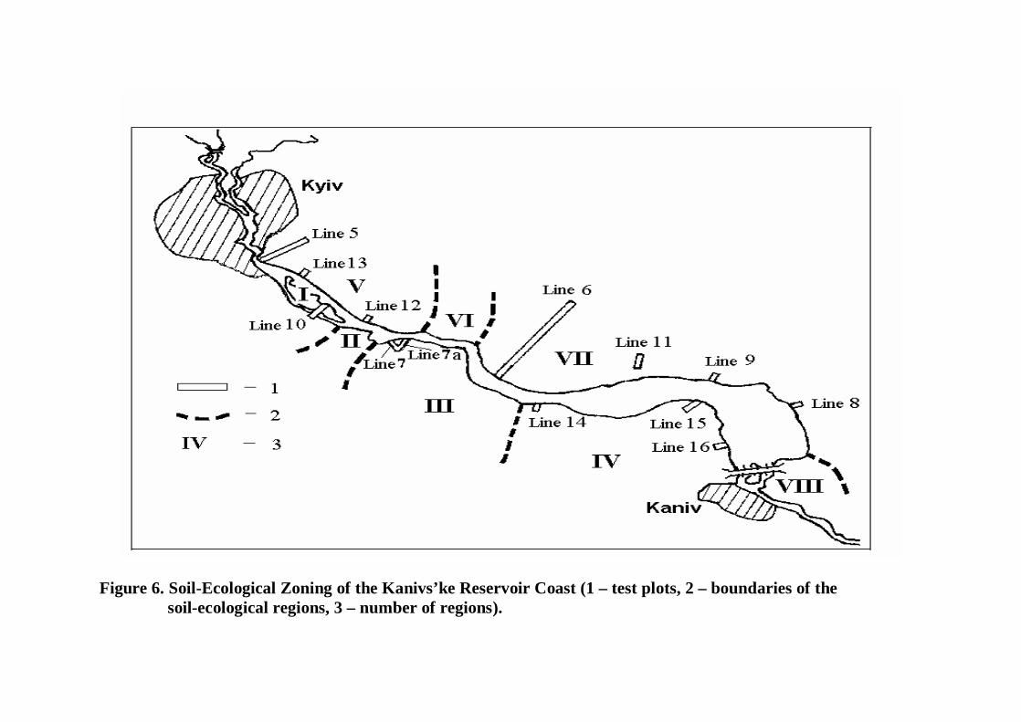
Figure 6. Soil-Ecological Zoning of the Kanivs’ke Reservoir Coast (1 – test plots, 2 – boundaries of the soil-ecological regions, 3 – number of regions).
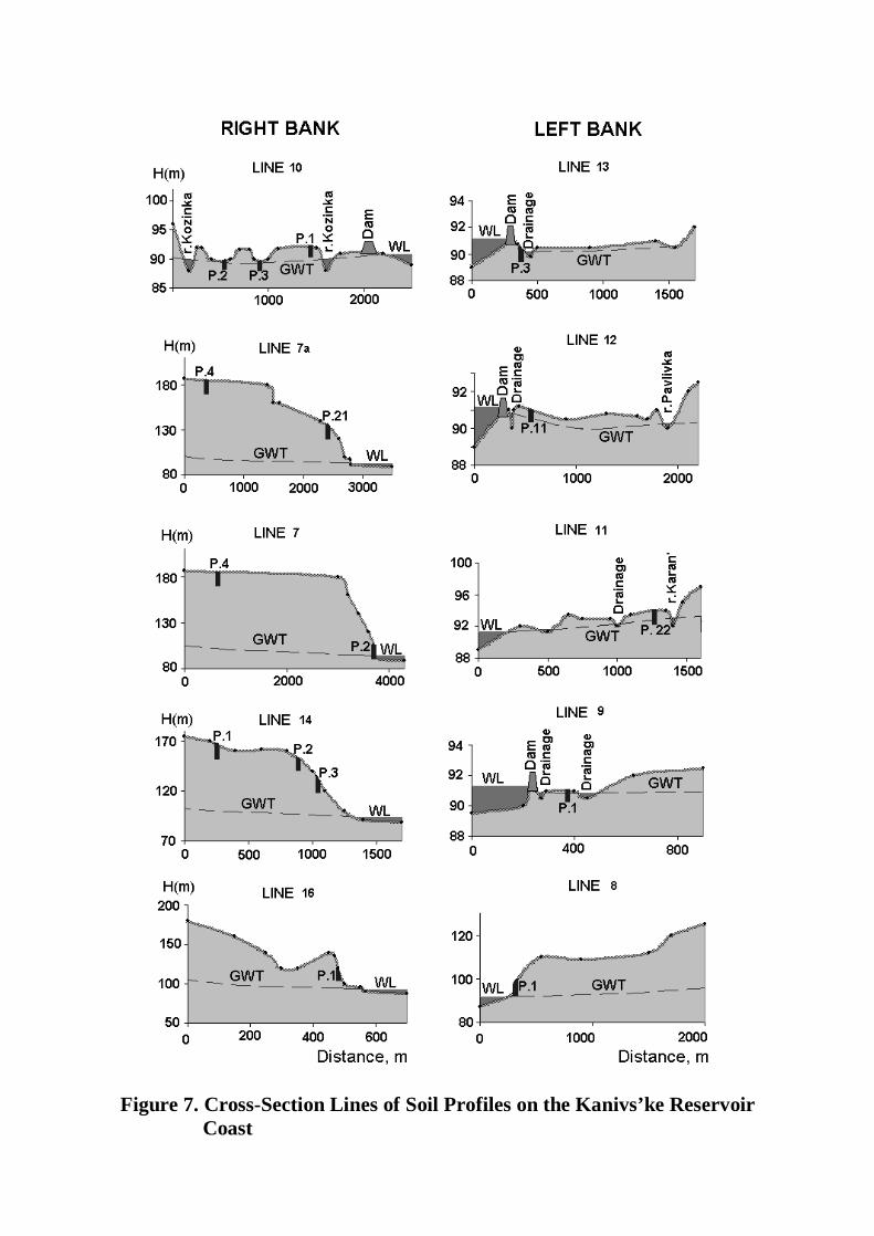
Figure 7. Cross-Section Lines of Soil Profiles on the Kanivs’ke Reservoir Coast
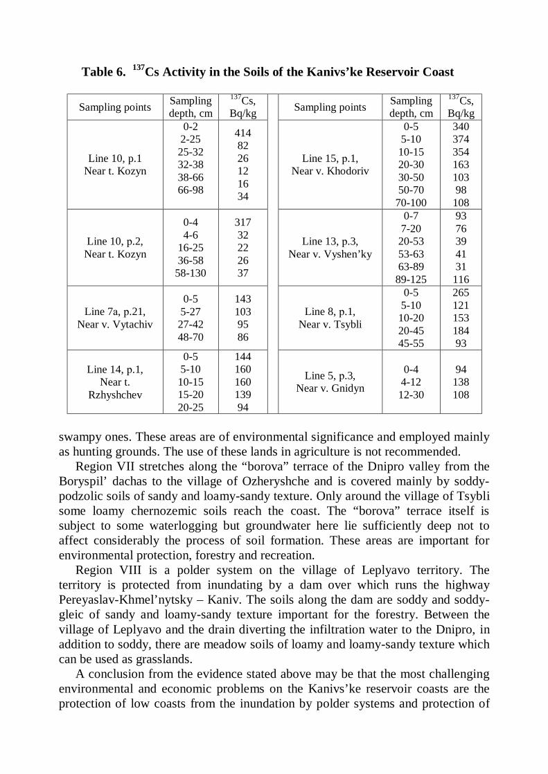
Table 6. 137Cs Activity in the Soils of the Kanivs’ke Reservoir Coast
Sampling points Sampling depth, cm
137Cs, Bq/kg Sampling points Sampling
depth, cm 137Cs, Bq/kg
Line 10, p.1 Near t. Kozyn
0-2 2-25 25-32 32-38 38-66 66-98
414 82 26 12 16 34
Line 15, р.1, Near v. Khodoriv
0-5 5-10 10-15 20-30 30-50 50-70
70-100
340 374 354 163 103 98
108
Line 10, р.2, Near t. Kozyn
0-4 4-6
16-25 36-58
58-130
317 32 22 26 37
Line 13, р.3, Near v. Vyshen’ky
0-7 7-20 20-53 53-63 63-89
89-125
93 76 39 41 31
116
Line 7а, р.21, Near v. Vytachiv
0-5 5-27 27-42 48-70
143 103 95 86
Line 8, р.1, Near v. Tsybli
0-5 5-10 10-20 20-45 45-55
265 121 153 184 93
Line 14, р.1, Near t.
Rzhyshchev
0-5 5-10 10-15 15-20 20-25
144 160 160 139 94
Line 5, р.3, Near v. Gnidyn
0-4 4-12 12-30
94 138 108
swampy ones. These areas are of environmental significance and employed mainly as hunting grounds. The use of these lands in agriculture is not recommended.
Region VII stretches along the “borova” terrace of the Dnipro valley from the Boryspil’ dachas to the village of Ozheryshche and is covered mainly by soddy-podzolic soils of sandy and loamy-sandy texture. Only around the village of Tsybli some loamy chernozemic soils reach the coast. The “borova” terrace itself is subject to some waterlogging but groundwater here lie sufficiently deep not to affect considerably the process of soil formation. These areas are important for environmental protection, forestry and recreation.
Region VIII is a polder system on the village of Leplyavo territory. The territory is protected from inundating by a dam over which runs the highway Pereyaslav-Khmel’nytsky – Kaniv. The soils along the dam are soddy and soddy-gleic of sandy and loamy-sandy texture important for the forestry. Between the village of Leplyavo and the drain diverting the infiltration water to the Dnipro, in addition to soddy, there are meadow soils of loamy and loamy-sandy texture which can be used as grasslands.
A conclusion from the evidence stated above may be that the most challenging environmental and economic problems on the Kanivs’ke reservoir coasts are the protection of low coasts from the inundation by polder systems and protection of
high banks from disruption, landslides and other forms of erosion by water. Polder systems are an efficient way to control air and water relation of the soils protected from floods. This practice ensures optimal soil wetness and diversion of excess water by a system of dams, canals and pumping stations. Under the conditions of market economy taking shape in Ukraine the electric power became so expensive that the polder system exploitation is no longer economically feasible. Today they do not implement ameliorative practices to an extent sufficient for the soil water-air regime optimization. As a result, the grasslands on the polder systems are of low productivity and need a fundamental improvement.
Radionuclide pollution and migration in the waterlogged soils on the reservoir coasts is an important environmental characteristic. Only on the Kozyn polder the surface horizons of soils are slightly polluted by nuclear wastes (137Cs activity is within 300-400 Bq/kg), but deeper in the profiles the radioactivity sharply decreases, increasing slightly within the capillary fringe (Table 6, line 10, p. 1, 2). Wet soils of the left-bank coast are very slightly polluted and only in the village of Tsybli the waterlogged coastal soils have a noticeable radioactive contamination all over the profile (Table 6, line 8, p.1). Zonal soils of the right-bank coast subject to abrasion and landslides are practically no contaminated, except the plot near the village of Khodoriv, where the radionuclide activity in the surface reaches 340-374 B1/kg and they penetrate 20-30 cm deep (Lin 15, p.1).
6.3. Kremenchuks’ke reservoir filled in 1961 is the largest in the middle
reaches of the Dnipro. It’s “water mirror” area (reservoir’ square) is 2252 km2 and total capacity – 13.52 km3. We did not investigate the reservoir in sufficient detail so far, and the zoning of its coasts by the character of its impact on the soils will, therefore, remain schematic. The following 5 regions were identified on its right-bank coast (Figure 8).
Region I occupies a high-bank eroded coast from the town of Svitlovods’k to the village of Stetsivka with typical chernozems, containing 3-5.5% of soil organic matter (humus), and leached chernozems. Reservoir impact expresses itself here by the coastline abrasion and landslides. The territory is good mainly for the forestry.
Region II occupies a high-bank coast from the village of Stetsivka to the city of Cherkasy with typical and leached chernozems and meadow-chernozemic deep-leached solodized soils lying in complexes with solots in the locked depressions of topography, locally named “blyudtsya”, which means “saucers”. Bank disruption and other forms of soil erosion are rampant only within a narrow strip stretching along the coast. Cliff banks are well formed, and the plainland is employed in crop production without any limitations.
Region III is a system of polders, lakes and swamps stretching from the village of Sagunivka to that of Chervona Sloboda. The soils here are soddy-gleic, meadow-swampy and swampy (peat). The area is severely waterlogged and good mainly for fishery.
Region IV is an elevated rolling area between the city of Cherkasy and the village of Svydovok with podzolized chernozems, dark-gray podzolized and grey
forest soils. The small areas of soddy-podzolic soils are encountered within the “borova” (pine-forest) terrace of the Irdynka river. The reservoir impact on the soils here is very slight. The territory is good for forestry and recreation.
Region V is a lowland coast between the village of Svydovok and that of Khreshchatyk with a complex of severely waterlogged hydromorphic and semi-hydromorphic soils and lakes. The territory is protected from inundation by the dams and is good for forage production (grasslands), fishery and as a hunting ground.
Six regions were identified on left-bank coast of the Kremenchuks’ke reservoir (Figure 8).
Region VI is generally a lowland territory between the villages Matviivka and Irkliiv, cut by numerous riverbeds. There is a complex combination of meadow and swampy soils with soddy-podzolic ones formed on the “borova” (pine-forest) terrace of the Zolotonoshka river. Soil waterlogging is more severe in the north-western part of the region between the village of Matviivka and the settlement named Chapayivka. Severely waterlogged hydromorphic soils are used as grasslands and pastures. The waterlogged areas of the forest are good for timber production and recreation. The waterlogged meadow soil developed a slight secondary salinity.
Region VII is a high-bank coast stretching from Irkliiv to the village of Zhovnino covered by typical, leached and carbonaceous chernozems in combination with solodized chernozems and solots in the saucer-like depression of topography. Chernozems with a residual sodicity are encountered in the south-eastern part of the region. The coastline is 30-50 m higher than the reservoir water cutline, so the soils are not waterlogged in any way and soil erosion and bank disruption take place only within a narrow strip along the coast. There are no limitations to the land use in agriculture, and some fields are irrigated.
Region VIII is a lowland territory between the villages Lyashkivka and Pogrebnyaky and adjoining the Sula river estuary where it falls into the reservoir. Here dominate swampy (peat), meadow-swampy, meadow and meadow-chernozemic soils in combination with solonetzes (sodic soils). The processes of soil salinity and alkalinity (sodicity) development become more intensive with waterlogging and soil productivity sharply reduces. The area is utilized as grasslands and pastures.
Region IX is a territory between the villages Demyanivka and Tymoshivka adjoining from the north to the Bugaivka polder system. The soils here are typical slightly sodicity-affected chernozems in combinations with meadow-chernozemic deeply sodicity-affected, meadow-swampy and swampy sodicity-affected soils as well as with meadow and meadow-steppe solonetzes. Soil waterlogging caused by the reservoir interacts here with the natural wetness of complex soil cover. Severe waterlogging on the coast is observed only in the depressions of topography and may reach the distance of 2-3 km from the coastline. On the greater part of the coast there is only moderate and slight waterlogging which spreads to the distance
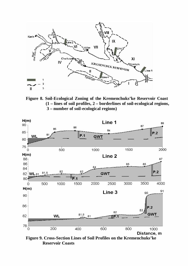
Figure 8. Soil-Ecological Zoning of the Kremenchuks’ke Reservoir Coast
(1 – lines of soil profiles, 2 – borderlines of soil-ecological regions, 3 – number of soil-ecological regions)
Figure 9. Cross-Section Lines of Soil Profiles on the Kremenchuks’ke Reservoir Coasts
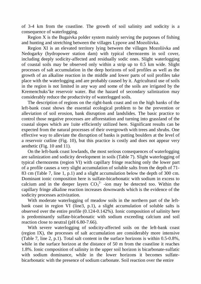
of 3-4 km from the coastline. The growth of soil salinity and sodicity is a consequence of waterlogging.
Region X is the Bugaivka polder system mainly serving the purposes of fishing and hunting and stretching between the villages Lypove and Mozoliivka.
Region XI is an elevated territory lying between the villages Mozoliivka and Nedogarky (hydropower station dam) with typical chernozems in soil cover, including deeply sodicity-affected and residually sodic ones. Slight waterlogging of coastal soils may be observed only within a strip up to 0.5 km wide. Slight processes of salt accumulation in the deep horizons of soil profiles as well as the growth of an alkaline reaction in the middle and lower parts of soil profiles take place with the waterlogging and are probably caused by it. Agricultural use of soils in the region is not limited in any way and some of the soils are irrigated by the Kremenchuks’ke reservoir water. But the hazard of secondary salinization may considerably reduce the productivity of waterlogged soils.
The description of regions on the right-bank coast and on the high banks of the left-bank coast shows the essential ecological problem to be the prevention or alleviation of soil erosion, bank disruption and landslides. The basic practice to control those negative processes are afforestation and turning into grassland of the coastal slopes which are 1uite efficiently utilized here. Significant results can be expected from the natural processes of their overgrowth with trees and shrubs. One effective way to alleviate the disruption of banks is putting boulders at the level of a reservoir cutline (Fig. 10), but this practice is costly and does not appear very aesthetic (Fig. 10 and 11).
On the left-bank coast lowlands, the most serious consequences of waterlogging are salinization and sodicity development in soils (Table 7). Slight waterlogging of typical chernozems (region VI) with capillary fringe reaching only the lower part of a profile causes a very slight accumulation of soluble salts from the depth of 71-83 cm (Table 7, line 1, p.1) and a slight accumulation below the depth of 300 cm. Dominant ionic composition here is sulfate-bicarbonatic with sodium in excess to calcium and in the deeper layers CO3
2- -ion may be detected too. Within the capillary fringe alkaline reaction increases downwards which is the evidence of the sodicity processes activization.
With moderate waterlogging of meadow soils in the northern part of the left-bank coast in region VI (line3, p.1), a slight accumulation of soluble salts is observed over the entire profile (0.124-0.142%). Ionic composition of salinity here is predominantly sulfate-bicarbonatic with sodium exceeding calcium and soil reaction close to neutral (pH 6.80-7.66).
With severe waterlogging of sodicity-affected soils on the left-bank coast (region IX), the processes of salt accumulation are considerably more intensive (Table 7, line 2, p.1). Total salt content in the surface horizons is within 0.5-0.8%, while in the surface horizon at the distance of 50 m from the coastline it reaches 1.8%. Ionic composition of salinity in the upper soil horizon is bicarbonate-sulfatic with sodium dominance, while in the lower horizons it becomes sulfate-bicarbonatic with the presence of sodium carbonate. Soil reaction over the entire
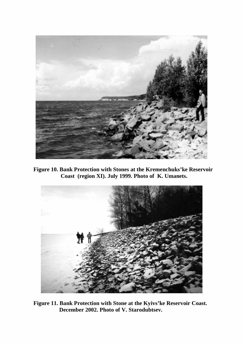
Figure 10. Bank Protection with Stones at the Kremenchuks’ke Reservoir Coast (region XI). July 1999. Photo of K. Umanets.
Figure 11. Bank Protection with Stone at the Kyivs’ke Reservoir Coast. December 2002. Photo of V. Starodubtsev.
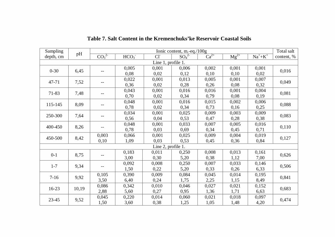
Table 7. Salt Content in the Kremenchuks’ke Reservoir Coastal Soils
Ionic content, m.-eq./100g Sampling depth, cm рН CO3
2- HCO3- Cl- SO4
2- Ca2+ Mg2+ Na++K+ Total salt
content, % Line 1, profile 1.
0-30 6,45 -- 0,005 0,08
0,001 0,02
0,006 0,12
0,002 0,10
0,001 0,10
0,001 0,02 0,016
47-71 7,52 -- 0,022 0,36
0,001 0,02
0,013 0,28
0,005 0,26
0,001 0,08
0,007 0,32 0,049
71-83 7,48 -- 0,043 0,70
0,001 0,02
0,016 0,34
0,016 0,79
0,001 0,08
0,004 0,19 0,081
115-145 8,09 -- 0,048 0,78
0,001 0,02
0,016 0,34
0,015 0,73
0,002 0,16
0,006 0,25 0,088
250-300 7,64 -- 0,034 0,56
0,001 0,04
0,025 0,53
0,009 0,47
0,003 0,28
0,009 0,38 0,083
400-450 8,26 -- 0,048 0,78
0,001 0,03
0,033 0,69
0,007 0,34
0,005 0,45
0,016 0,71 0,110
450-500 8,42 0,003 0,10
0,066 1,09
0,001 0,03
0,025 0,53
0,009 0,45
0,004 0,36
0,019 0,84 0,127
Line 2, profile 1.
0-1 8,75 -- 0,183 3,00
0,011 0,30
0,250 5,20
0,008 0,38
0,013 1,12
0,161 7,00 0,626
1-7 9,34 -- 0,092 1,50
0,008 0,22
0,250 5,20
0,007 0,33
0,033 0,26
0,146 6,33 0,506
7-16 9,92 0,105 3,50
0,390 6,40
0,009 0,24
0,084 1,75
0,045 2,25
0,014 1,15
0,195 8,49 0,841
16-23 10,19 0,086 2,88
0,342 5,60
0,010 0,27
0,046 0,95
0,027 1,36
0,021 1,71
0,152 6,63 0,683
23-45 9,52 0,045 1,50
0,220 3,60
0,014 0,38
0,060 1,25
0,021 1,05
0,018 1,48
0,097 4,20 0,474
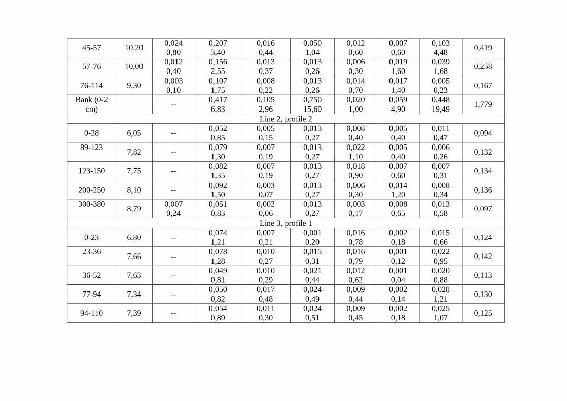
45-57 10,20 0,024 0,80
0,207 3,40
0,016 0,44
0,050 1,04
0,012 0,60
0,007 0,60
0,103 4,48 0,419
57-76 10,00 0,012 0,40
0,156 2,55
0,013 0,37
0,013 0,26
0,006 0,30
0,019 1,60
0,039 1,68 0,258
76-114 9,30 0,003 0,10
0,107 1,75
0,008 0,22
0,013 0,26
0,014 0,70
0,017 1,40
0,005 0,23 0,167
Bank (0-2 cm) -- 0,417
6,83 0,105 2,96
0,750 15,60
0,020 1,00
0,059 4,90
0,448 19,49 1,779
Line 2, profile 2
0-28 6,05 -- 0,052 0,85
0,005 0,15
0,013 0,27
0,008 0,40
0,005 0,40
0,011 0,47 0,094
89-123 7,82 -- 0,079
1,30 0,007 0,19
0,013 0,27
0,022 1,10
0,005 0,40
0,006 0,26 0,132
123-150 7,75 -- 0,082 1,35
0,007 0,19
0,013 0,27
0,018 0,90
0,007 0,60
0,007 0,31 0,134
200-250 8,10 -- 0,092 1,50
0,003 0,07
0,013 0,27
0,006 0,30
0,014 1,20
0,008 0,34 0,136
300-380 8,79 0,007
0,24 0,051 0,83
0,002 0,06
0,013 0,27
0,003 0,17
0,008 0,65
0,013 0,58 0,097
Line 3, profile 1
0-23 6,80 -- 0,074 1,21
0,007 0,21
0,001 0,20
0,016 0,78
0,002 0,18
0,015 0,66 0,124
23-36 7,66 -- 0,078
1,28 0,010 0,27
0,015 0,31
0,016 0,79
0,001 0,12
0,022 0,95 0,142
36-52 7,63 -- 0,049 0,81
0,010 0,29
0,021 0,44
0,012 0,62
0,001 0,04
0,020 0,88 0,113
77-94 7,34 -- 0,050 0,82
0,017 0,48
0,024 0,49
0,009 0,44
0,002 0,14
0,028 1,21 0,130
94-110 7,39 -- 0,054 0,89
0,011 0,30
0,024 0,51
0,009 0,45
0,002 0,18
0,025 1,07 0,125
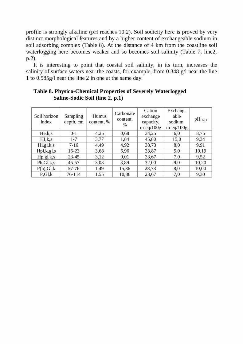
profile is strongly alkaline (pH reaches 10.2). Soil sodicity here is proved by very distinct morphological features and by a higher content of exchangeable sodium in soil adsorbing complex (Table 8). At the distance of 4 km from the coastline soil waterlogging here becomes weaker and so becomes soil salinity (Table 7, line2, p.2).
It is interesting to point that coastal soil salinity, in its turn, increases the salinity of surface waters near the coasts, for example, from 0.348 g/l near the line 1 to 0.585g/l near the line 2 in one at the same day.
Table 8. Physico-Chemical Properties of Severely Waterlogged Saline-Sodic Soil (line 2, p.1)
Soil horizon index
Sampling depth, cm
Humus content, %
Carbonate content,
%
Cation exchange capacity,
m-eq/100g
Exchang-able
sodium, m-eq/100g
pHH2O
He,k,s 0-1 4,25 0,68 34,25 6,0 8,75 HI,k,s 1-7 3,77 1,84 45,80 15,0 9,34
Hi,gl,k,s 7-16 4,49 4,92 38,73 8,0 9,91 Hpi,k,gl,s 16-23 3,68 6,96 33,87 5,0 10,19 Hp,gl,k,s 23-45 3,12 9,01 33,67 7,0 9,52 Ph,Gl,k,s 45-57 3,03 3,89 32,00 9,0 10,20 P(h),Gl,k 57-76 1,49 15,36 28,73 8,0 10,00
P,Gl,k 76-114 1,55 10,86 23,67 7,0 9,30
7. LARGE RESERVOIRS OF ARID ZONE IMPACT ON THE COASTAL SOILS (on example of Kapchagay reservoir)
In arid zone, of all the aspects of reservoir impact on soils and ameliorative
conditions the first place is taken by the processes of soil and ground and surface water salinization and desalinization. These processes acquire a special significance on the large reservoirs constructed in between-the-mountain depressions, where active salt accumulation takes place under natural conditions. A typical example of such conditions may be the Kapchagay reservoir, on which we carried out our research activities in 1976-1986.
The reservoir had been constructed on the Ily river in Southern Kazakhstan with a project capacity of 28.1 km3. The dam on the Ily was constructed in 1970, but the filling of the basin outstretched for many years as the period between 1974 and 1977 was that of a low water. There also were a number of ecological and water management problems. The problems include land waterlogging on the low left-bank reservoir’ coast, landscape desertification on the large area in the Ily delta, lowering of the lake Balkhash level and the growth of water salinity in it and some other unfavorable processes. The reservoir is of multiple purposes, including power generation, irrigation, recreation, fishing industry and transportation.
The area of inundated agricultural lands during the reservoir filling should have reached with NWL of 475 m – 98 thousand hectares, with NWL of 480 m – 120 th. ha and with NWL of 485 m – 147 th. ha. The project envisaged the waterlogged land area on the reservoir coasts (with groundwater table depth within 0-2 m) calculated on the basis of a hydrogeological prediction to reach with NWL of 475 m – 106 thousand hectares, with NWL of 480 m – 100 th. ha, and with NWL of 485 m – 91 th. ha. In general, the reservoir impact on the coastal soils was envisaged to be very significant. Therefore, the Kazakhstan Ministry of Melioration and Water Management entrusted us with a task of long-term investigations of the processes of coastal soil waterlogging in the course of reservoir filling to make the prognostication more precise.
Natural conditions of the Kapchagay reservoir region. The reservoir had been constructed in the Ily between-the-mountain depression within the Almainskaya oblast of Kazakhstan. The region is well developed economically. The essential crops here are industrial ones (tobacco and sugar beet), small grains, vegetables, melons, fruits, vines and in the lower reaches of Ily – rice. Animal husbandry is well developed.
Climate of the region is a pronounced continental with hot dry summer and a low-snow winter, typical of deserts and semi-deserts of the subboreal belt. The average annual temperature depending on hypsometrical geographic position is within 7.7-9.20C, absolute maximum being 43…440C and absolute minimum – 43…440C. The average July temperature is about 21.3…23.90C, July being the warmest month of the year. Annual rainfall is within 200-300 mm, the bulk of it
falling in the warmer season of the year. The period with relative air humidity below 30% lasts from 110 to 150 days.
Hydrology and hydrography. The region has an intensive surface and a well developed stream pattern, belonging to the Ily basin. The Ily’s length is 1380 km (1439 km with tributary Tekes) and the area of basin – 140 th. km2. The river rises in China at an altitude of 4000 m but flows mostly in Kazakhstan and falls into the Lake Balkhash. The average annual water discharge near the town of Kapchagay was before the construction of a dam 471 m3/s and the total runoff volume – 14,8 km3, including the losses in the delta (3 km3) and the runoff into the Lake Balkhash (11.8 km3). It has numerous tributaries rising in the mountains within the Kazakh territory like the Chilik, Charyn, Turgen, Issyk, Kaskelen, Small and Large Almatinkas. The tributaries have a specific hydrological regime: they are plentifully supplied with water within the mountains, but in the discharge cones they lose a bulk of their runoff primarily on infiltration (50-60%), irrigation and water supply. But in the lower part of a sloping plainland before the mountain foothills their runoff sharply increases at the expense of ground water discharge (seepage). Changes in the Ily runoff connected with the Kapchagay reservoir construction we discussed earlier (Starodubtsev, 1985; Starodubtsev et al., 2004).
Relief and geologic structure. The Ily mountain-bordered lowland reaches Kazakhstan from the territory of China by its western part in which Kapchagay reservoir is being filled. The lowland is framed in the south by the range of Zailiysky Ala-Tau and in the north it is bordered by the mountain spurs of Dzhungarsky Ala-Tau. The northern foothills of Zailiysky Ala-Tau border with the band of the cones of discharge (“debris cones”) which merge to form a train of prolluvial deposits 10-12 km wide. This is a wavy sloping plainland at the altitude of 600-1200 m and it is of great value in agriculture. Almaty (Alma-Ata), the former capital of Kazakhstan is situated here. To the north of the prolluvial train stretches a slightly sloping plain used for irrigation farming, pastures and as hunting grounds.
Lower quaternary deposits (Q4) lie at the mountains foots and are represented by deluvial and proluvial deposits. Boulders, pebbles and gravel dominate in the basis of these deposits, while upwards the rock fragments become smaller turning into silty sands and even sandy clays. Foothill plainland was formed on middle quaternary deposits (Q2), 100-200 m thick. These are mainly loams and loamy sands with the layers and lenses of sands, gravel and clays. A complex of middle- and upper quaternary rocks (Q2+3) is also encountered here. These are mainly alluvial and prolluvial loess-like sediments with strata and lenses of sands and pebble-gravels. Recent deposits (Q4) are usually shallow. They compose the floodplain terrace of the Ily and its tributaries.
Ground waters here are represented by various types including those from the crevices (fissure spring) and from the pores, free-surface waters and those of artesian aquifers. Waters of tectonic crevices are usually thermal, including sodic ones. Fissure waters of the solid rocks with good physical and chemical properties and large debits are the feeders of the mountain rivers. Pore space waters are
widespread in unconsolidated sedimentary rocks of the quaternary period. In the cones of debris these are quite powerful streams with salt concentration up to 0.5 g/l and calcium hydrocarbonate composition of salts. The cone of debris waters unload (seep out) over their (cones’) periphery into the ravines and valleys of small local rivers (“karasu” – black water), but if such drainage is absent, the cone waters unload themselves by dispersed multiple outlets along the entire bedding plane of springs, forming seep spots and “saza” sinks. The waters of sandy-clay deposits of the accumulative plainland on the left-bank coast of the Ily have a less favorable quality. According to regime, placement conditions and chemical composition, the waters are divided into headless (not being under hydraulic pressure) groundwater (perched waters) and waters with hydraulic pressure. Perched waters lie at the depth not exceeding 5 m, have a stagnant regime and salt concentration up to 50-60 g/l, and even up to 100 g/l near the reservoir banks. But fresh perch waters also occur in sandy-gravel deposits (lenses). The lower-lying horizons of water are under pressure which grows with depth and the distance from the mountains. Their mineralization is below 1 g/l and salt composition – calcium hydrocarbonate.
Soils of the Kapchagay reservoir coasts. Zonal soils of the Ily lowland are light greyzems and grey-brown desert soils. But the foothill plain along the southern reservoir coast is occupied mainly by the meadow-greyzemic and meadow soils affected by salinity and sodicity to varying extent and by large areas of meadow and ordinary solonchaks. Smaller areas are occupied by meadow-swampy and swampy soils.
To study the Kapchagay reservoir impact on the coastal soils we carried out some reconnaissance soil surveys in 1976 along the six transects (lines) over the reservoir perimeter (Fig. 2). On two of these lines, in 1977, we performed soil and salinity development survey and mapping and organized perennial (regime) observations over the dynamics of soil moisture, salt content and ground water fluctuations. Line 1, 9 km long and 1 km wide, had been projected in the western part of the southern coast from the village of Frunze to the reservoir cutline; line 2, 20 km long and 1 km wide, had been projected in the central part of the southern coast from the village of Teskensu (Chilik district) to the reservoir cutline. These two lines could be employed to characterize such part of the coast within which according to hydrogeological prediction (Akhmedsafin et al., 1975), the maximum intensity of reservoir impact should occur.
Within line 1, meadow-greyzem soils with varied salinity dominate occupying the southern and central parts of it. By hydrogeologic conditions these soils were formed in the zone of secondary groundwater immersion, the waters lying at depth of 3-5 m and being fresh or slightly mineralized with satisfactory ground outflow. Parent rocks here are mostly loess-like loams underlain in the lower part of profile by sands and soddy-pebbles. The vegetation is represented mostly by camel burr (Alhagi pseudoalhagi), small reeds, licorice, wormwood, bluegrasses and some shrubs (Halymodendron halodendron and others). Salt tolerant vegetation (of Salsola genus) grows saline, while wormwood and camphorosma occupy sodic-saline soils.
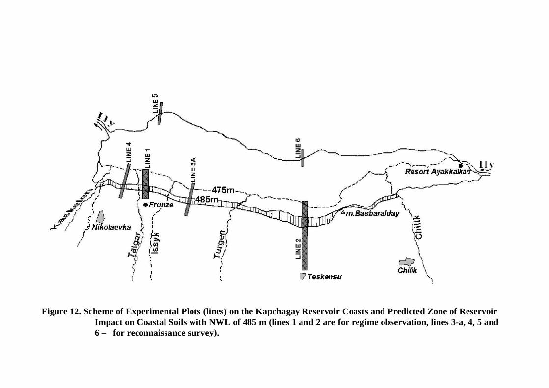
Figure 12. Scheme of Experimental Plots (lines) on the Kapchagay Reservoir Coasts and Predicted Zone of Reservoir
Impact on Coastal Soils with NWL of 485 m (lines 1 and 2 are for regime observation, lines 3-a, 4, 5 and 6 – for reconnaissance survey).
The morphological profile of such soils has moisture increasing with depth below 50 to 100 cm and indistinct rusty spots of periodic gleying are visible in the second meter of soil profile depth. Organic matter (humus) content in the surface horizon reaches 2.13%, the amounts of available forms of phosphorus and potassium are moderate, while that of hydrolysable nitrogen – high. Carbonate CO2 is within 3-9% and pH within 8.6-10.0, the alkaline reaction growing downwards. The amount of soluble salts in the upper 1 m layer of non-saline soils is of 11.5 t/ha, while in saline ones it may reach 20-27 t/ha.
Meadow saline soils and solonchaks are widespread in the northern part of line 1 in the zone of groundwater elevated head (interaction between groundwater and reservoir seepage water). Water table elevation here is from 3-5 to 1-2 m from the surface. The band of these saline soils 1-1.5 km wide is stretching along the coast to the area between the rivers Kaskelen and Issyk (Fig. 12). Ground waters in these soils had risen the depth of 1-2 m only 5-6 years ago, so they are only slightly different from the initial meadow-greyzem soils by the extent of gleying, character of water regime and some morphological properties. The changes in the essential physico-chemical and agrochemical properties lag in time behind the changes in soil wetting from ground waters.
The organic matter (humus) content in the surface horizon is 2.47%, the amount of carbonate CO2 in soil profile is within 3-5%, soil reaction is alkaline (pH 9.9-10.3). The soils are well supplied with available forms of nitrogen, phosphorus and potassium. Salt distribution in soil profiles corresponds to the “sweating” (evaporate) type of water regimes with maximum salt concentration (0.9-1.0%) in the surface layer and reduction downwards in profiles. Chemically, the salinity here is sodic-sulfate with sodium predomination. In periodically flooded soils, the amount of sodium carbonate increases, while the concentration of chlorides increases in them too, but much less often. As the filling of the reservoir continued in the years of our research, we observed a gradual shifting of the waterlogging (wet) zone to the south with additional accumulation of salts in the 0-30 cm up to 51 t/ha and in the 0-100 cm layer – to 60 t/ha. From flooded soils, a large amount of salts was leached by the flooding water. This process will be considered in more detail in the next section.
Within the line 2 in wet (waterlogged) zone 2-3 km wide, the meadow solonchaks are widespread, including crusted and pudgy ones. The entire southern part of the line 2 is occupied by meadow-greyzemic and meadow saline soils and the central part – by ordinary solonchaks.
Meadow-greyzems of the line 2 occupy the periphery of the discharge (debris) cones on the transition to the “saza” band. At the depth of 3-6 m they are underlain by sands and boulder-gravels. By their properties these soils are close to their counterparts of the line 1. The main difference is in the extent and character of salinity. Depending on the amount of salts in the surface layer, the soils are divided into saline and deep-saline ones. While saline soils contain sulfates and chlorides (sulfate dominating), deep-saline soils contain mostly sulfates and have mixed cationic composition. The amount of salts in deep-saline soils is within 53-82 t/ha
in 0-100 cm layer and 120-167 t/ha in 100-200 cm. In saline soils these amounts respectively are 100-146 and 137-180 t/ha.
Meadow saline soils are in the “saza” band, on the border area between a foothill plain formed by the discharge cones and near-mountain slightly sloping plain. The “saza” band is very distinctly expressed along the Chilik-Issyk inter-valley terrain. Ground waters here lie at depth of 1-3 m coming to the surface in numerous places. Vegetation is diversified and depends on soil moisture and salinity. Some “pure azhrek (Aeluropus littoralis) meadow” encounter here, while with the growth of salinity and reduction of soil wetness because of water table lowering, new plant species appear such as “chiy” (Lasiagrostis splendens), licorice (Glycyrrhiza uralensis), saltwort (Halocnemum strobilaceum, Petrosimonia brachiata, Suaeda , Salicornia), and wormwood. Salt content in the upper horizons is high (1-2%) decreasing with depth of a profile. Salt composition is sulfatic and chloride-sulfatic in the upper horizons often with an increased alkalinity, but it is sulfate-chloridic in the lower part of soil profile. By mechanical composition these soils are mostly fine-silt-loams. Organic matter content in the surface horizon is 3%, the amount of carbonate CO2: 3.5-6.8%, pH: 8.6-9.5.
Ordinary solonchaks occupy a strip 10 km wide along the under-mountain and plainland which is hypsometrically below the “saza” band. Ground waters here are at depth of 3-5 m with increased salt concentration. Soil surface is covered with cracks and salt efflorescences. Vegetation is very scanty, represented exclusively by salt tolerant salsoles (saltworts) and the shrubs of Tamarix hispida, T. pentrada and T. elongata. By mechanical composition the solonchaks are fine-silt-loams close by their properties to meadow-greyzemic soils. Organic matter content in the surface horizon is within 1.05-2.03% and that of carbonate CO2 – 6.0-6.6%. Soil reaction is alkaline (pH 8.7-9.5). Soil salinity in the upper 2-meters layer is severe (1-3% of soluble salts), salinity type is mostly sulfatic and occasionally – chloride-sulfatic with sodium carbonate “participation”. The amount of salts in the layers 0-100 cm and 100-200 cm are about 200 and 300 t/ha respectively.
Meadow solonchaks (pudgy and crusty) are spread in the northern part of line 2 on the territory 2-3 km wide adjoining the reservoir. As a result of groundwater interaction with the reservoir seepage the water table here is within 1-2 (2.5) m and is the vicinity of a coast – 0.5-1 m. On the surface of pudgy meadow solonchaks, there is always a thick layer of salts periodically blown up and carried aways by the wind. The vegetation here is exclusively very salt tolerant. Salt concentration in the surface horizons is 2-5% and higher but it reduced with depth to 1-3%. Salinity type is chloride-sulfatic with sodium-cation and sodium carbonate “participation”. Waterlogging causes the accumulation of predominantly sodium chlorides and sulfates. The amount of salts reach 600-700 t/ha in the 0-2 m layer; an additional salt accumulation in the 0-1 m layer as a result of waterlogging is about 51 t/ha. But this does not take into account the additional amount of salts which accumulates on the surface as a pudgy loose mass and is periodically transferred by the wind to the adjacent territories. Organic matter content in the surface horizon is
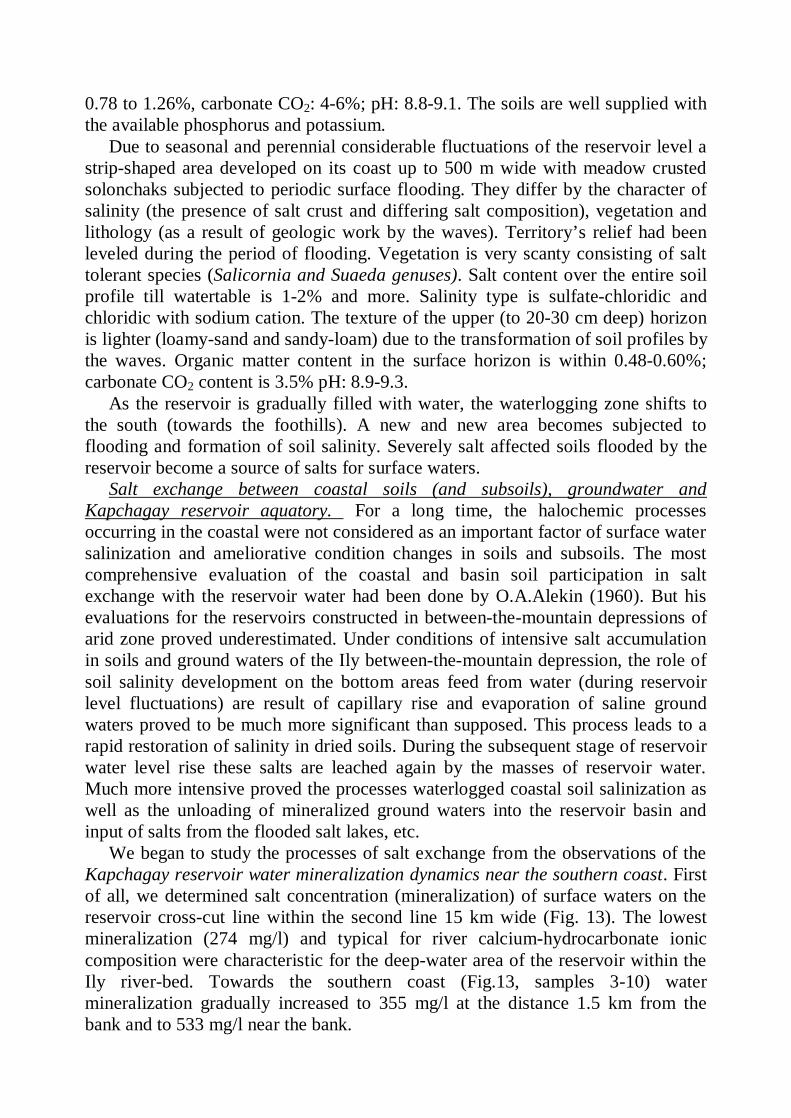
0.78 to 1.26%, carbonate CO2: 4-6%; pH: 8.8-9.1. The soils are well supplied with the available phosphorus and potassium.
Due to seasonal and perennial considerable fluctuations of the reservoir level a strip-shaped area developed on its coast up to 500 m wide with meadow crusted solonchaks subjected to periodic surface flooding. They differ by the character of salinity (the presence of salt crust and differing salt composition), vegetation and lithology (as a result of geologic work by the waves). Territory’s relief had been leveled during the period of flooding. Vegetation is very scanty consisting of salt tolerant species (Salicornia and Suaeda genuses). Salt content over the entire soil profile till watertable is 1-2% and more. Salinity type is sulfate-chloridic and chloridic with sodium cation. The texture of the upper (to 20-30 cm deep) horizon is lighter (loamy-sand and sandy-loam) due to the transformation of soil profiles by the waves. Organic matter content in the surface horizon is within 0.48-0.60%; carbonate CO2 content is 3.5% pH: 8.9-9.3.
As the reservoir is gradually filled with water, the waterlogging zone shifts to the south (towards the foothills). A new and new area becomes subjected to flooding and formation of soil salinity. Severely salt affected soils flooded by the reservoir become a source of salts for surface waters.
Salt exchange between coastal soils (and subsoils), groundwater and Kapchagay reservoir aquatory. For a long time, the halochemic processes occurring in the coastal were not considered as an important factor of surface water salinization and ameliorative condition changes in soils and subsoils. The most comprehensive evaluation of the coastal and basin soil participation in salt exchange with the reservoir water had been done by O.A.Alekin (1960). But his evaluations for the reservoirs constructed in between-the-mountain depressions of arid zone proved underestimated. Under conditions of intensive salt accumulation in soils and ground waters of the Ily between-the-mountain depression, the role of soil salinity development on the bottom areas feed from water (during reservoir level fluctuations) are result of capillary rise and evaporation of saline ground waters proved to be much more significant than supposed. This process leads to a rapid restoration of salinity in dried soils. During the subsequent stage of reservoir water level rise these salts are leached again by the masses of reservoir water. Much more intensive proved the processes waterlogged coastal soil salinization as well as the unloading of mineralized ground waters into the reservoir basin and input of salts from the flooded salt lakes, etc.
We began to study the processes of salt exchange from the observations of the Kapchagay reservoir water mineralization dynamics near the southern coast. First of all, we determined salt concentration (mineralization) of surface waters on the reservoir cross-cut line within the second line 15 km wide (Fig. 13). The lowest mineralization (274 mg/l) and typical for river calcium-hydrocarbonate ionic composition were characteristic for the deep-water area of the reservoir within the Ily river-bed. Towards the southern coast (Fig.13, samples 3-10) water mineralization gradually increased to 355 mg/l at the distance 1.5 km from the bank and to 533 mg/l near the bank.
Figure 13. Cross-Section Hydrochemical Reservoir Profile and the Cyclogramms of Water Ionic Composition
Wat
er m
iner
aliz
atio
n, g
/l
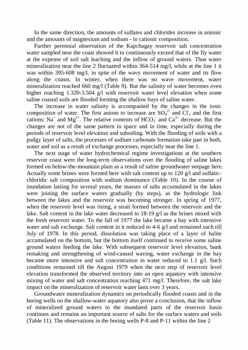
In the same direction, the amounts of sulfates and chlorides increase in anionic and the amounts of magnesium and sodium - in cationic composition.
Further perennial observation of the Kapchagay reservoir salt concentration water sampled near the coast showed it to continuously exceed that of the Ily water at the expense of soil salt leaching and the inflow of ground waters. Thus water mineralization near the line 2 fluctuated within 364-514 mg/l, while at the line 1 it was within 395-608 mg/l, in spite of the wavy movement of water and its flow along the coasts. In winter, when there was no wave movement, water mineralization reached 660 mg/l (Table 9). But the salinity of water becomes even higher reaching 1.320-3.504 g/l with reservoir water level elevation when some saline coastal soils are flooded forming the shallow bays of saline water.
The increase in water salinity is accompanied by the changes in the ionic composition of water. The first anions to increase are SO4
2- and Cl-, and the first cations: Na+ and Mg2+. The relative contents of HCO3
- and Ca2+ decrease. But the changes are not of the same pattern in space and in time, especially during the periods of reservoir level elevation and subsiding. With the flooding of soils with a pudgy layer of salts, the processes of sodium carbonate formation take part in both, water and soil as a result of exchange processes, especially near the line 1.
The next stage of water hydrochemical regime investigations at the southern reservoir coast were the long-term observations over the flooding of saline lakes formed on below-the-mountain plain as a result of saline groundwater seepage here. Actually some brines were formed here with salt content up to 120 g/l and sulfatic-chloridic salt composition with sodium dominance (Table 10). In the course of inundation lasting for several years, the masses of salts accumulated in the lakes were joining the surface waters gradually (by steps), as the hydrologic link between the lakes and the reservoir was becoming stronger. In spring of 1977, when the reservoir level was rising, a strait formed between the reservoir and the lake. Salt content in the lake water decreased to 18-19 g/l as the brines mixed with the fresh reservoir water. To the fall of 1977 the lake became a bay with intensive water and salt exchange. Salt content in it reduced to 4-6 g/l and remained such till July of 1978. In this period, dissolution was taking place of a layer of halite accumulated on the bottom, but the bottom itself continued to receive some saline ground waters feeding the lake. With subsequent reservoir level elevation, bank remaking and strengthening of wind-caused waving, water exchange in the bay became more intensive and salt concentration in water reduced to 1.1 g/l. Such conditions remained till the August 1979 when the next step of reservoir level elevation transformed the observed territory into an open aquatory with intensive mixing of water and salt concentration reaching 471 mg/l. Therefore, the salt lake impact on the mineralization of reservoir water lasts over 3 years.
Groundwater mineralization dynamics on periodically flooded coasts and in the boring wells on the shallow-water aquatory also prove a conclusion, that the inflow of mineralized ground waters to the inundated parts of the reservoir basin continues and remains an important source of salts for the surface waters and soils (Table 11). The observations in the boring wells P-8 and P-11 within the line 2
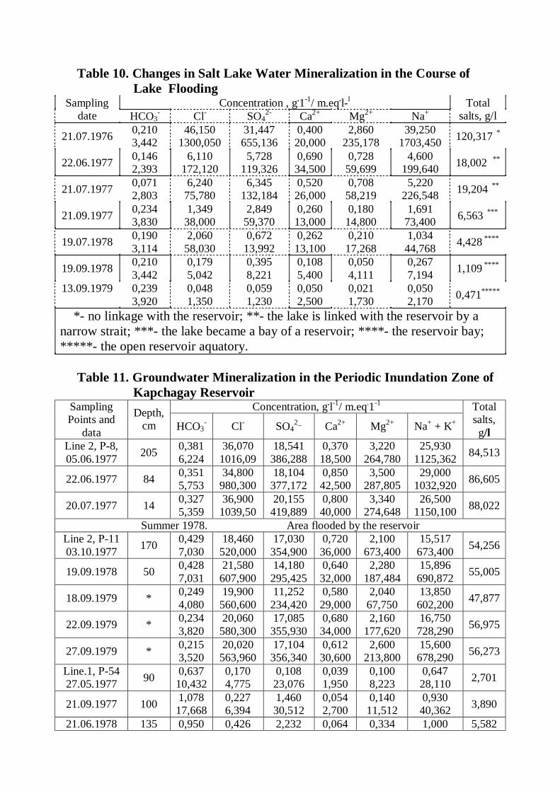
Table 10. Changes in Salt Lake Water Mineralization in the Course of Lake Flooding
Concentration , g.1-1/ m.eq.l-l Sampling date HCO3
- Cl- SO42- Ca2+ Mg2+ Na+
Total salts, g/l
21.07.1976 0,210 3,442
46,150 1300,050
31,447 655,136
0,400 20,000
2,860 235,178
39,250 1703,450 120,317 *
22.06.1977 0,146 2,393
6,110 172,120
5,728 119,326
0,690 34,500
0,728 59,699
4,600 199,640 18,002 **
21.07.1977 0,071 2,803
6,240 75,780
6,345 132,184
0,520 26,000
0,708 58,219
5,220 226,548 19,204 **
21.09.1977 0,234 3,830
1,349 38,000
2,849 59,370
0,260 13,000
0,180 14,800
1,691 73,400 6,563 ***
19.07.1978 0,190 3,114
2,060 58,030
0,672 13,992
0,262 13,100
0,210 17,268
1,034 44,768 4,428 ****
19.09.1978 0,210 3,442
0,179 5,042
0,395 8,221
0,108 5,400
0,050 4,111
0,267 7,194 1,109 ****
13.09.1979
0,239 3,920
0,048 1,350
0,059 1,230
0,050 2,500
0,021 1,730
0,050 2,170 0,471*****
*- no linkage with the reservoir; **- the lake is linked with the reservoir by a narrow strait; ***- the lake became a bay of a reservoir; ****- the reservoir bay; *****- the open reservoir aquatory.
Table 11. Groundwater Mineralization in the Periodic Inundation Zone of
Kapchagay Reservoir Concentration, g.l-1/ m.eq.1-1 Sampling
Points and data
Depth, cm HCO3
- Cl- SO42_ Ca2+ Mg2+ Na+ + K+
Total salts, g/l
Line 2, Р-8, 05.06.1977 205 0,381
6,224 36,070
1016,09 18,541
386,288 0,370 18,500
3,220 264,780
25,930 1125,362 84,513
22.06.1977 84 0,351 5,753
34,800 980,300
18,104 377,172
0,850 42,500
3,500 287,805
29,000 1032,920 86,605
20.07.1977 14 0,327 5,359
36,900 1039,50
20,155 419,889
0,800 40,000
3,340 274,648
26,500 1150,100 88,022
Summer 1978. Area flooded by the reservoir Line 2, Р-11 03.10.1977 170 0,429
7,030 18,460
520,000 17,030
354,900 0,720 36,000
2,100 673,400
15,517 673,400 54,256
19.09.1978 50 0,428 7,031
21,580 607,900
14,180 295,425
0,640 32,000
2,280 187,484
15,896 690,872 55,005
18.09.1979 * 0,249 4,080
19,900 560,600
11,252 234,420
0,580 29,000
2,040 67,750
13,850 602,200 47,877
22.09.1979 * 0,234 3,820
20,060 580,300
17,085 355,930
0,680 34,000
2,160 177,620
16,750 728,290 56,975
27.09.1979 * 0,215 3,520
20,020 563,960
17,104 356,340
0,612 30,600
2,600 213,800
15,600 678,290 56,273
Line.1, Р-54 27.05.1977 90 0,637
10,432 0,170 4,775
0,108 23,076
0,039 1,950
0,100 8,223
0,647 28,110 2,701
21.09.1977 100 1,078 17,668
0,227 6,394
1,460 30,512
0,054 2,700
0,140 11,512
0,930 40,362 3,890
21.06.1978 135 0,950 0,426 2,232 0,064 0,334 1,000 5,582
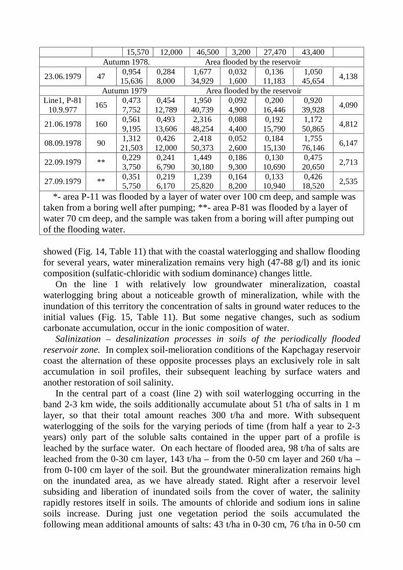
15,570 12,000 46,500 3,200 27,470 43,400 Autumn 1978. Area flooded by the reservoir
23.06.1979 47 0,954 15,636
0,284 8,000
1,677 34,929
0,032 1,600
0,136 11,183
1,050 45,654 4,138
Autumn 1979 Area flooded by the reservoir Line1, Р-81
10.9.977 165 0,473 7,752
0,454 12,789
1,950 40,739
0,092 4,900
0,200 16,446
0,920 39,928 4,090
21.06.1978 160 0,561 9,195
0,493 13,606
2,316 48,254
0,088 4,400
0,192 15,790
1,172 50,865 4,812
08.09.1978 90 1,312 21,503
0,426 12,000
2,418 50,373
0,052 2,600
0,184 15,130
1,755 76,146 6,147
22.09.1979 ** 0,229 3,750
0,241 6,790
1,449 30,180
0,186 9,300
0,130 10,690
0,475 20,650 2,713
27.09.1979 ** 0,351 5,750
0,219 6,170
1,239 25,820
0,164 8,200
0,133 10,940
0,426 18,520 2,535
*- area P-11 was flooded by a layer of water over 100 cm deep, and sample was taken from a boring well after pumping; **- area P-81 was flooded by a layer of water 70 cm deep, and the sample was taken from a boring will after pumping out of the flooding water.
showed (Fig. 14, Table 11) that with the coastal waterlogging and shallow flooding for several years, water mineralization remains very high (47-88 g/l) and its ionic composition (sulfatic-chloridic with sodium dominance) changes little.
On the line 1 with relatively low groundwater mineralization, coastal waterlogging bring about a noticeable growth of mineralization, while with the inundation of this territory the concentration of salts in ground water reduces to the initial values (Fig. 15, Table 11). But some negative changes, such as sodium carbonate accumulation, occur in the ionic composition of water.
Salinization – desalinization processes in soils of the periodically flooded reservoir zone. In complex soil-melioration conditions of the Kapchagay reservoir coast the alternation of these opposite processes plays an exclusively role in salt accumulation in soil profiles, their subsequent leaching by surface waters and another restoration of soil salinity.
In the central part of a coast (line 2) with soil waterlogging occurring in the band 2-3 km wide, the soils additionally accumulate about 51 t/ha of salts in 1 m layer, so that their total amount reaches 300 t/ha and more. With subsequent waterlogging of the soils for the varying periods of time (from half a year to 2-3 years) only part of the soluble salts contained in the upper part of a profile is leached by the surface water. On each hectare of flooded area, 98 t/ha of salts are leached from the 0-30 cm layer, 143 t/ha – from the 0-50 cm layer and 260 t/ha – from 0-100 cm layer of the soil. But the groundwater mineralization remains high on the inundated area, as we have already stated. Right after a reservoir level subsiding and liberation of inundated soils from the cover of water, the salinity rapidly restores itself in soils. The amounts of chloride and sodium ions in saline soils increase. During just one vegetation period the soils accumulated the following mean additional amounts of salts: 43 t/ha in 0-30 cm, 76 t/ha in 0-50 cm
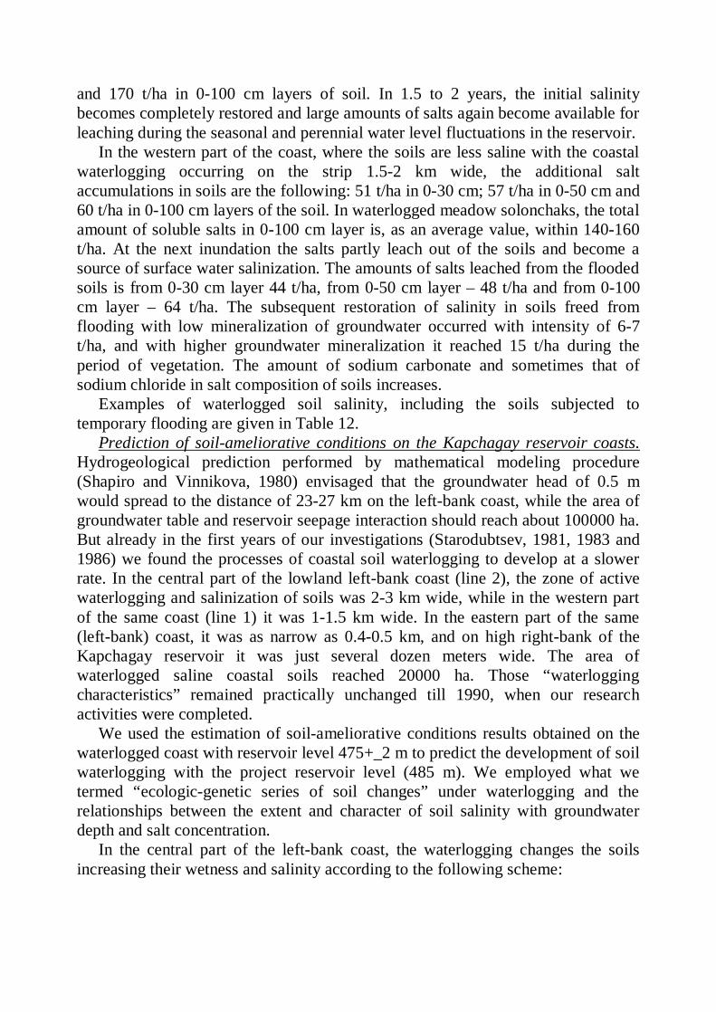
and 170 t/ha in 0-100 cm layers of soil. In 1.5 to 2 years, the initial salinity becomes completely restored and large amounts of salts again become available for leaching during the seasonal and perennial water level fluctuations in the reservoir.
In the western part of the coast, where the soils are less saline with the coastal waterlogging occurring on the strip 1.5-2 km wide, the additional salt accumulations in soils are the following: 51 t/ha in 0-30 cm; 57 t/ha in 0-50 cm and 60 t/ha in 0-100 cm layers of the soil. In waterlogged meadow solonchaks, the total amount of soluble salts in 0-100 cm layer is, as an average value, within 140-160 t/ha. At the next inundation the salts partly leach out of the soils and become a source of surface water salinization. The amounts of salts leached from the flooded soils is from 0-30 cm layer 44 t/ha, from 0-50 cm layer – 48 t/ha and from 0-100 cm layer – 64 t/ha. The subsequent restoration of salinity in soils freed from flooding with low mineralization of groundwater occurred with intensity of 6-7 t/ha, and with higher groundwater mineralization it reached 15 t/ha during the period of vegetation. The amount of sodium carbonate and sometimes that of sodium chloride in salt composition of soils increases.
Examples of waterlogged soil salinity, including the soils subjected to temporary flooding are given in Table 12.
Prediction of soil-ameliorative conditions on the Kapchagay reservoir coasts. Hydrogeological prediction performed by mathematical modeling procedure (Shapiro and Vinnikova, 1980) envisaged that the groundwater head of 0.5 m would spread to the distance of 23-27 km on the left-bank coast, while the area of groundwater table and reservoir seepage interaction should reach about 100000 ha. But already in the first years of our investigations (Starodubtsev, 1981, 1983 and 1986) we found the processes of coastal soil waterlogging to develop at a slower rate. In the central part of the lowland left-bank coast (line 2), the zone of active waterlogging and salinization of soils was 2-3 km wide, while in the western part of the same coast (line 1) it was 1-1.5 km wide. In the eastern part of the same (left-bank) coast, it was as narrow as 0.4-0.5 km, and on high right-bank of the Kapchagay reservoir it was just several dozen meters wide. The area of waterlogged saline coastal soils reached 20000 ha. Those “waterlogging characteristics” remained practically unchanged till 1990, when our research activities were completed.
We used the estimation of soil-ameliorative conditions results obtained on the waterlogged coast with reservoir level 475+_2 m to predict the development of soil waterlogging with the project reservoir level (485 m). We employed what we termed “ecologic-genetic series of soil changes” under waterlogging and the relationships between the extent and character of soil salinity with groundwater depth and salt concentration.
In the central part of the left-bank coast, the waterlogging changes the soils increasing their wetness and salinity according to the following scheme:
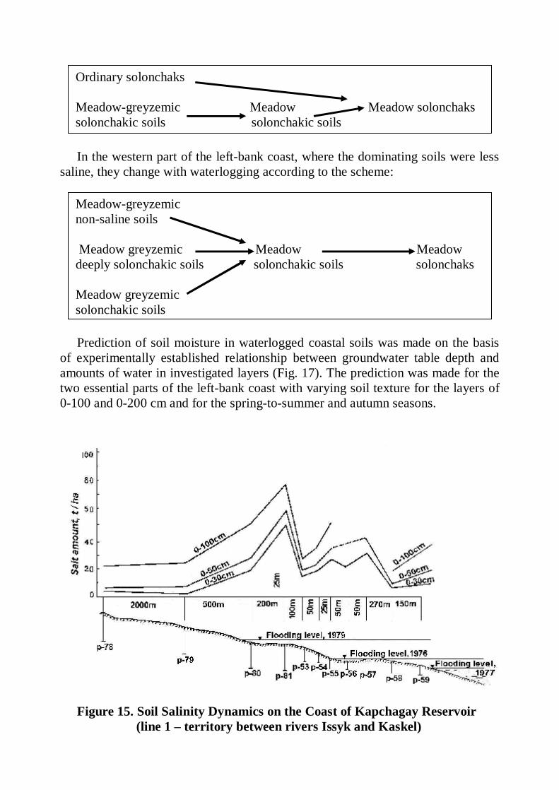
In the western part of the left-bank coast, where the dominating soils were less
saline, they change with waterlogging according to the scheme:
Prediction of soil moisture in waterlogged coastal soils was made on the basis
of experimentally established relationship between groundwater table depth and amounts of water in investigated layers (Fig. 17). The prediction was made for the two essential parts of the left-bank coast with varying soil texture for the layers of 0-100 and 0-200 cm and for the spring-to-summer and autumn seasons.
Figure 15. Soil Salinity Dynamics on the Coast of Kapchagay Reservoir (line 1 – territory between rivers Issyk and Kaskel)
Ordinary solonchaks Meadow-greyzemic Meadow Meadow solonchaks solonchakic soils solonchakic soils
Meadow-greyzemic non-saline soils Meadow greyzemic Meadow Meadow deeply solonchakic soils solonchakic soils solonchaks Meadow greyzemic solonchakic soils
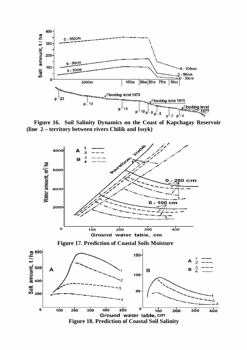
Figure 16. Soil Salinity Dynamics on the Coast of Kapchagay Reservoir (line 2 – territory between rivers Chilik and Issyk)
Figure 17. Prediction of Coastal Soils Moisture
Figure 18. Prediction of Coastal Soil Salinity
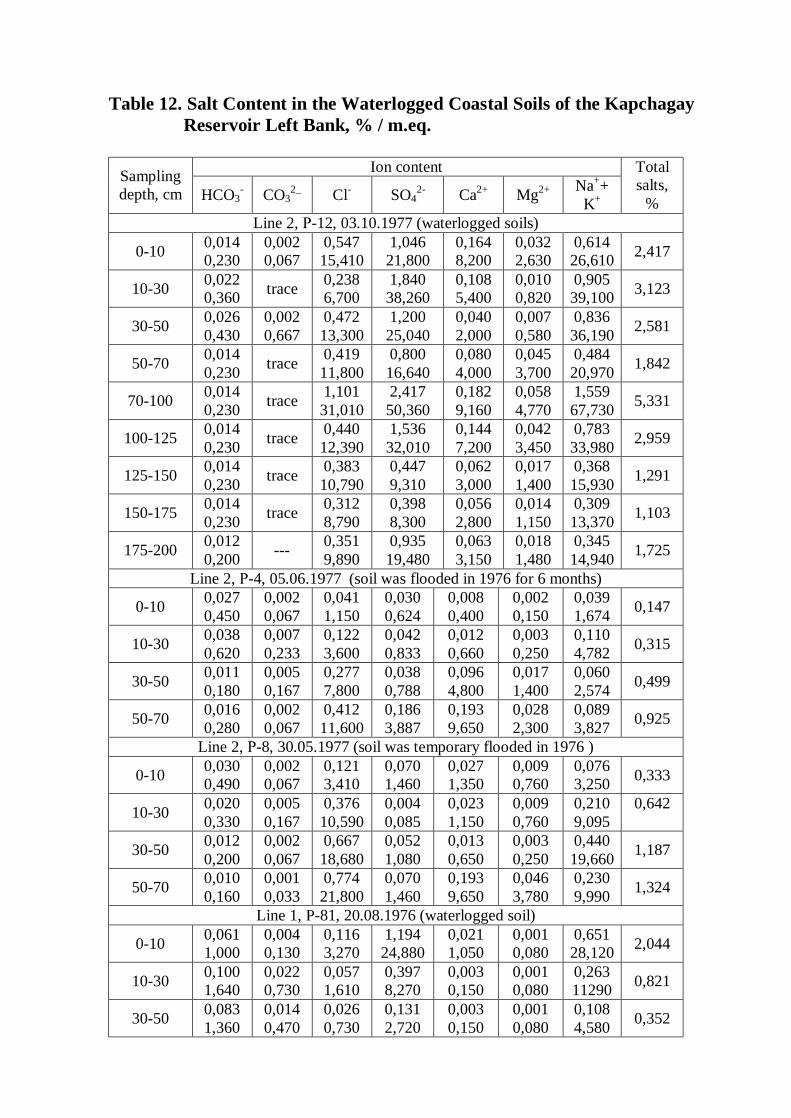
Table 12. Salt Content in the Waterlogged Coastal Soils of the Kapchagay Reservoir Left Bank, % / m.eq.
Ion content Sampling depth, cm HCO3
- CO32_ Cl- SO4
2- Ca2+ Mg2+ Na++ K+
Total salts,
% Line 2, Р-12, 03.10.1977 (waterlogged soils)
0-10 0,014 0,230
0,002 0,067
0,547 15,410
1,046 21,800
0,164 8,200
0,032 2,630
0,614 26,610 2,417
10-30 0,022 0,360 trace 0,238
6,700 1,840 38,260
0,108 5,400
0,010 0,820
0,905 39,100 3,123
30-50 0,026 0,430
0,002 0,667
0,472 13,300
1,200 25,040
0,040 2,000
0,007 0,580
0,836 36,190 2,581
50-70 0,014 0,230 trace 0,419
11,800 0,800 16,640
0,080 4,000
0,045 3,700
0,484 20,970 1,842
70-100 0,014 0,230 trace 1,101
31,010 2,417 50,360
0,182 9,160
0,058 4,770
1,559 67,730 5,331
100-125 0,014 0,230 trace 0,440
12,390 1,536 32,010
0,144 7,200
0,042 3,450
0,783 33,980 2,959
125-150 0,014 0,230 trace 0,383
10,790 0,447 9,310
0,062 3,000
0,017 1,400
0,368 15,930 1,291
150-175 0,014 0,230 trace 0,312
8,790 0,398 8,300
0,056 2,800
0,014 1,150
0,309 13,370 1,103
175-200 0,012 0,200 --- 0,351
9,890 0,935 19,480
0,063 3,150
0,018 1,480
0,345 14,940 1,725
Line 2, Р-4, 05.06.1977 (soil was flooded in 1976 for 6 months)
0-10 0,027 0,450
0,002 0,067
0,041 1,150
0,030 0,624
0,008 0,400
0,002 0,150
0,039 1,674 0,147
10-30 0,038 0,620
0,007 0,233
0,122 3,600
0,042 0,833
0,012 0,660
0,003 0,250
0,110 4,782 0,315
30-50 0,011 0,180
0,005 0,167
0,277 7,800
0,038 0,788
0,096 4,800
0,017 1,400
0,060 2,574 0,499
50-70 0,016 0,280
0,002 0,067
0,412 11,600
0,186 3,887
0,193 9,650
0,028 2,300
0,089 3,827 0,925
Line 2, Р-8, 30.05.1977 (soil was temporary flooded in 1976 )
0-10 0,030 0,490
0,002 0,067
0,121 3,410
0,070 1,460
0,027 1,350
0,009 0,760
0,076 3,250 0,333
10-30 0,020 0,330
0,005 0,167
0,376 10,590
0,004 0,085
0,023 1,150
0,009 0,760
0,210 9,095
0,642
30-50 0,012 0,200
0,002 0,067
0,667 18,680
0,052 1,080
0,013 0,650
0,003 0,250
0,440 19,660 1,187
50-70 0,010 0,160
0,001 0,033
0,774 21,800
0,070 1,460
0,193 9,650
0,046 3,780
0,230 9,990 1,324
Line 1, P-81, 20.08.1976 (waterlogged soil)
0-10 0,061 1,000
0,004 0,130
0,116 3,270
1,194 24,880
0,021 1,050
0,001 0,080
0,651 28,120 2,044
10-30 0,100 1,640
0,022 0,730
0,057 1,610
0,397 8,270
0,003 0,150
0,001 0,080
0,263 11290 0,821
30-50 0,083 1,360
0,014 0,470
0,026 0,730
0,131 2,720
0,003 0,150
0,001 0,080
0,108 4,580 0,352
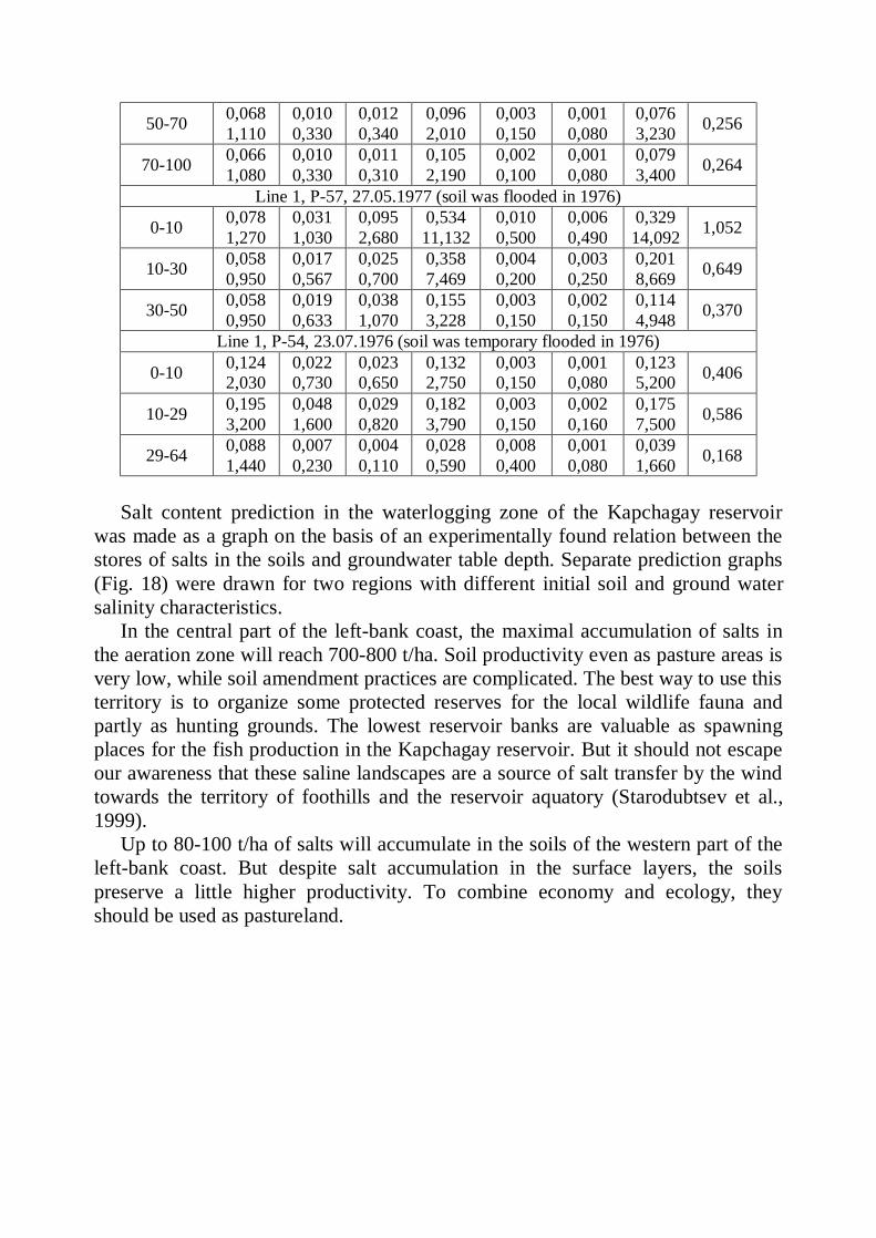
50-70 0,068 1,110
0,010 0,330
0,012 0,340
0,096 2,010
0,003 0,150
0,001 0,080
0,076 3,230 0,256
70-100 0,066 1,080
0,010 0,330
0,011 0,310
0,105 2,190
0,002 0,100
0,001 0,080
0,079 3,400 0,264
Line 1, Р-57, 27.05.1977 (soil was flooded in 1976)
0-10 0,078 1,270
0,031 1,030
0,095 2,680
0,534 11,132
0,010 0,500
0,006 0,490
0,329 14,092 1,052
10-30 0,058 0,950
0,017 0,567
0,025 0,700
0,358 7,469
0,004 0,200
0,003 0,250
0,201 8,669 0,649
30-50 0,058 0,950
0,019 0,633
0,038 1,070
0,155 3,228
0,003 0,150
0,002 0,150
0,114 4,948 0,370
Line 1, Р-54, 23.07.1976 (soil was temporary flooded in 1976)
0-10 0,124 2,030
0,022 0,730
0,023 0,650
0,132 2,750
0,003 0,150
0,001 0,080
0,123 5,200 0,406
10-29 0,195 3,200
0,048 1,600
0,029 0,820
0,182 3,790
0,003 0,150
0,002 0,160
0,175 7,500 0,586
29-64 0,088 1,440
0,007 0,230
0,004 0,110
0,028 0,590
0,008 0,400
0,001 0,080
0,039 1,660 0,168
Salt content prediction in the waterlogging zone of the Kapchagay reservoir
was made as a graph on the basis of an experimentally found relation between the stores of salts in the soils and groundwater table depth. Separate prediction graphs (Fig. 18) were drawn for two regions with different initial soil and ground water salinity characteristics.
In the central part of the left-bank coast, the maximal accumulation of salts in the aeration zone will reach 700-800 t/ha. Soil productivity even as pasture areas is very low, while soil amendment practices are complicated. The best way to use this territory is to organize some protected reserves for the local wildlife fauna and partly as hunting grounds. The lowest reservoir banks are valuable as spawning places for the fish production in the Kapchagay reservoir. But it should not escape our awareness that these saline landscapes are a source of salt transfer by the wind towards the territory of foothills and the reservoir aquatory (Starodubtsev et al., 1999).
Up to 80-100 t/ha of salts will accumulate in the soils of the western part of the left-bank coast. But despite salt accumulation in the surface layers, the soils preserve a little higher productivity. To combine economy and ecology, they should be used as pastureland.
8. THE IMPACT OF THE IRRIGATION RESERVOIRS OF ARID ZONE ON THE COASTAL SOILS (on an example of the
Bugun reservoir) The reservoir had been constructed in Southern Kazakhstan in the Bugun river
valley by the erection of two dams (Fig. 19). The right bank is a premountain plainland, and the left – watershed upland between the Bugun river and Karazhantak lowland. Reservoir capacity is 370 mln m3, aquatory area – 6300 ha and depth: 15-17 m. The reservoir accumulates the Bugun and partly the Arys runoff for the Prikaratau plainland irrigation. It is filled every year from October to April, while from June to September the water is discharged for irrigation till its stores reach a “dead capacity”.
Climate here is a pronounced continental one, dry, with abundant solar radiation and heat resources. Mean annual rainfall is 178 mm, the precipitation being more abundant in winter and spring. Mean air temperature is +12oC, absolute maximal temperature: +490C and absolute minimal one: -390C. Frostless period lasts 6 to 7 months. Relative air humidity in the summer is very low – below 15-20% in July.
Geomorphologically, this is a wavy plain with prefoothill elevation joining the south-eastern foothills of the Karatau ridge. Absolute altitudes on the territory are 200 to 220 m. The surface of the plain is cut by the stream patterns. From the north to the south, it is transected by the Bugun valley entering it from the Karatau ridge. Geologically undisturbed early and middle quaternary deposits compose the ancient terrace of the river valley and are lithologically represented by the loamy, loamy-sandy and pebble-containing sediments having a total thickness of 60-130 m. The upper quaternary and recent deposits form the upper terrace and the floodplain of a river valley. The basis of a geologic profile is composed of gravel-pebbly deposits with the strata clays up to 50 m deep. They are covered by consolidated clay loams from 2-5 to 35-50 m deep. The recent roof of the quaternary system is represented loess-like loams 20-30 m deep covering the entire territory like an undisturbed mantle.
Underground waters form here three aquifers including layer-porosity water of the middle Oligocene deposits, ground waters of the discharge cones and ground waters of the proluvial-alluvial deposits. Water in the middle Oligocene horizon is under pressure and a good quality, the horizon lying in the pebble deposits covered by the clays at the depth of 120 m. The discharge-cone waters are not salty, with hydrocarbonate-calcium mineralization. They fill the gravel and pebble deposits covered by the sands, loamy sands and loams. As the flow moves from the foothills to the valley, the water becomes more and more under pressure in the aquifer. The ground waters belonging to the aquifer of proluvial-alluvial deposits lye in the loess-like loams and loamy sands, forming a “free mirror” of the water plane at the depth of 3 to 15 m. Vegetation here is represented by wormwood-ephemeral and wormwood-saltwort associations. Cereal ephemeris (Poa bulbosa
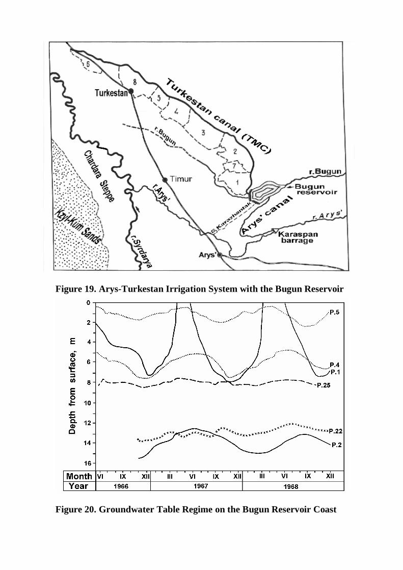
Figure 19. Arys-Turkestan Irrigation System with the Bugun Reservoir
Figure 20. Groundwater Table Regime on the Bugun Reservoir Coast
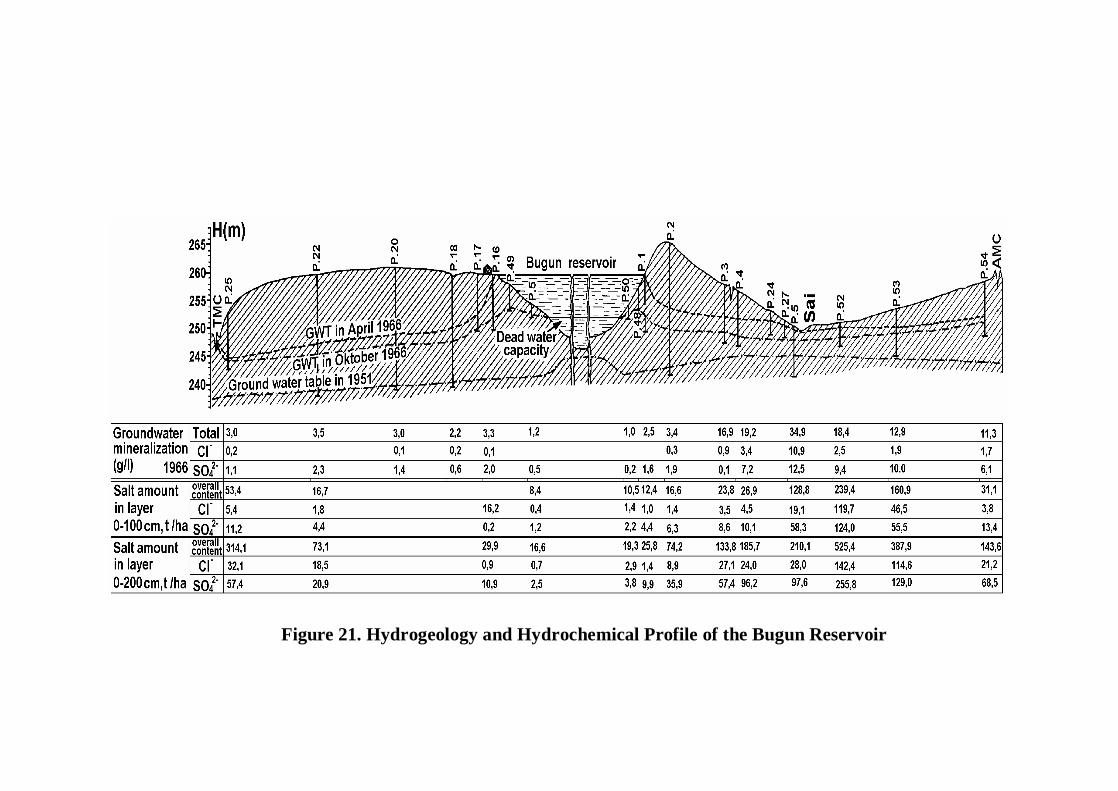
Figure 21. Hydrogeology and Hydrochemical Profile of the Bugun Reservoir
and Carex physoides) vegetate in spring but dry out in June. Various species of wormwood (Artemisia terrae-albae, turanica, cina and other) actively vegetate in summer as well as ebelek (Ceratocarpus alenarius, C. utriculosus) and some other species. Azhrek (Aeluropus littoralis), kermek (Limonium Gmelini), and petrosimonia (Petrosimonia brachiata, P. sibirica) are widespread on saline soils.
Soil cover is represented by light colored southern greyzems, which have an indistinctly differentiated profile and cloddy-grainy structure in the horizons of humus accumulation (A+B = 50-60 cm). At the depth of 30 to 50 cm, there is an indistinct horizon containing carbonate mycelium, at the depth of 60 to 120 cm – an illuvial carbonate horizon of spherical bean-sited carbonate concretions (called “white-eyed” horizon in Russia) and below it – a gypsiferous horizon. Humus content in the surface horizon is within 1-1.5%and the content of nitrogen: 0.06-0.1%. Cation exchange capacity is within 6-12 m.-eq. per 100 g of soil and the amount of carbonate CO2: 5-9%. Bulk density of the soil fluctuates within 1.25-1.40 g/cm3 and infiltration rate – within 0.6-1.2 m per day (24 hours). The soils are adequately supplied with exchangeable potassium (no lee than 400 ppm K2O), moderately well by available nitrogen (50-70 ppm N), but deficient in available phosphorus (35-50 ppm P2O5).
Light greyzems are noted for relic profile salinity from 1-1.5 to 20-30 m of depth (Table 13, profile p.2). By anionic composition, the salinity is sulfatic or chloride-sulfatic and by cationic – sodium-calcium or calcium-sodium (sodium dominating below 3 m of depth). The amount of salts in the 10-meter layer of a profile reach 1200 t/ha. Wet soils of the Bugun reservoir basin (which is now a zone of inundation) had surface soil salinity (Table 13, profile S-9). In the entire aeration zone of the reservoir basin before inundation (by soil-ameliorative conditions of 1951), there was about 10 mln t of salts.
Our researches were carried out for over 10 years on two transactions (lines 1 and 3) laid out on the northern and southern coasts (Fig. 21).A soil-ameliorative survey had been conducted here on the scale 1:5000, enveloping a territory 0.7 km wide and over 8 km long. In 1966, the lines of soil profiles were organized on these transactions for the investigations of water and salt regimes of soils as well as groundwater regimes. The territory under studies was that of periodic inundation by the reservoir as well (Fig. 21). Line 1 crosses the territory from the southern reservoir coast through the watershed to the Karazhantak say (valley) and farther on to the Aryss canal (AMA). Line 3 characterizes a territory stretching from the northern reservoir coast to Turkestan canal (TMC). Zonal watershed soils were subjected to the investigations (deeply saline light greyzems) as well as waterlogged (meadow-greyzemic) soils contiguous with the reservoir cutline and semi-hydromorphic and hydromorphic (wet) saline soils of the zone of infiltration waters seepage from the reservoir. Soil and subsoil lithology and salinity were investigated by us to the depth of 25 m, the deposits of pebbles being detected at depth of 20to 25 m. Before the reservoir construction, the ground waters were lying on these plots (on the watersheds) at depth of 20 m, in which the Bugun
floodplain the water table depth was 2-5 m and in the Karazhantak “say” it was within 5-10 m.
The filling of the Bugun reservoir which started in 1960 caused an intensive redistribution of salt masses in the soils as well as drastic changes in the hydrogeological and soil-ameliorative conditions on the territory adjacent to the reservoir. As a consequences of infiltration out of the reservoir, which reached in the beginning years a value of 20 mln m3 per year, and the infiltration from the main canals interacting with the hydrostatic head, the water table rose in 1966-1968 7-10 m on the coast and by 15 m on the periodic inundation area. In the lower water of the dams, the water table reached the surface. In 1973 a further, though a slow one, water table elevation was observed on the entire territory under our researches. But already in 1976 the groundwater level became relatively stabilized.
The construction of a reservoir changed the groundwater regime. The dynamics of groundwater level in the upper water of the dam is determined by the reservoir level changes, but the maximal and minimal levels are observed 1-3 months later than in the reservoir. Farther from the reservoir, the amplitude of level fluctuation reduces from 10-12 to 1-2 m (Fig. 20 and 21). Water infiltration from the reservoir brought about the formation of a specific hydrochemical regime of groundwater on the adjacent territory. Thus, on the southern coast, the mineralization of water changes from 1-3 near the reservoir to 20-35 g/l at the distance of 5 km from it, the amount of chloride ion drastically increasing in the ionic composition of water.
Changing hydrogeological conditions caused a soil cover transformation The soils of the reservoir basin in the first 5-6 years lost 4/5 of the initial amount of salts (about 8 mln t) by infiltration and transfer to the adjacent territory, which increased soil salinity in both upper and lower water (bief) of the dam. Zonal soils (light-colored deeply salinated greyzems) were transformed into deep-solonchakic and occasionally into solonchaky soils on large areas affected by the reservoir and main irrigation canals and acquired the morphologic features of wet soils. In the zone of infiltration water seepage on the southern coast, meadow-greyzemic, greyzemic-meadow very saline soils and meadow solonchaks were formed. In the lower water area of the dam, some meadow-swampy and very saline soils were formed.
In the periodic inundation zone, the remaking of coastal banks and the reservoir bottom caused the erosion of soils by water on the upper elements of topography and sediment accumulation on the lower ones. The vast areas coming to the surface as the reservoir water is being utilized for irrigation (in June to October) have the appearance of a desert with very scanty vegetation. Water regime of the inundated soils depends on the reservoir level regime. Our test soil profiles (Fig. 20, 21 and 22, p.48-51) are freed from water usually in June to August and by winter become inundated again. By summer groundwater level becomes 1-3 m and by autumn – by 3-5 m lower. Groundwater mineralization changes from 1 g/l in summer to 3 g/l in autumn remaining sulfatic and calcium-sodium by the ionic composition. Soils and sub-soils are considerably leached from soluble salts by infiltration waters,
total amount of salts in the surface horizons never exceeding 0.1%. The restoration of salinity just does not occur during the short period from summer to autumn.
On the coast directory abutting to the reservoir cutline, the light-colored greyzems transform into meadow-greyzemic soils (Fig. 21, 22, p.1, 16). In accordance with the reservoir level fluctuation in spring with groundwater depth within 1-2 m, the capillary fringe reaches the surface, while in summer water table 3-4 m deep, it reaches the middle part of soil profile. In autumn, with water table depth within5-8 m the capillary fringe subsides low the soil profile. Groundwater mineralization is the lowest with high water table in summer (0.4-0.5 g/l). In September-October it reaches 1-2 g/l and in January-March – up to 2-4 g/l. In the period of 1960-1966, the amount of soluble salts in the 10 m layer reduced from 1200 to 263 t/ha under the impact of reservoir water infiltration into the coasts. In the upper 1m layer it was only within 9-16 t/ha and the desalinization of soils still goes on.
The deeply saline light-colored greyzems on the elevated watershed (Fig. 20-22) develop as automorphic (not affected by groundwater) soils, despite water table elevation from the depth of 20 to that of 12-13 m. Groundwater mineralization reaches 3.4 g/l, their ionic composition being mostly chloride-sulfatic and hydrocarbonate-sulfatic with minimal groundwater mineralization. Total amount of salts in soil layers remain stable with only some insignificant seasonal changes. In the main canal (TMC and AMC) region and on the area of a dry canal A-9 (Fig. 20-21, p. 3, 25 and 54) location, the light-colored greyzems transformed under the join impact of the reservoir and canals (waterlogging) from deeply saline to deeply solonchakic soils. Capillary soil moisture rose to 0.5-1.0 m from the surface and some not very distinct signs of gleization appeared in soil profiles. Water table depth was within 4-6 m in summer and 6-8 m in autumn. Groundwater mineralization is here within 3-19 g/l, ionic composition being predominantly chloride-sulfatic and calcium-sodic. Saline horizon in the soil profile was lying from the depth of 100 cm to water table but it gradually rose to the depth of 50-70 cm from the surface in 1976.
Saline meadow-greyzemic (p. 24), greyzemic-meadow soils (p. 5, 52) and meadow solonchaks (p.5, Fig. 20-22) of the infiltration water unloading zone accumulate additional amounts of salts as a result of waterlogging. Salt content in the 0-200 cm layer is from 185 t/ha in meadow-greyzemic solonchakic soils to 525 t/ha in meadow solonchaks. Types of salt composition are chloride-sulfatic or sulfate-chloridic in the aeration zone and sulfatic in the saturation zone. Ground waters lie 0.4-2.4m deep in meadow solonchaks and 4-7 m deep in meadow-greyzemic soils with mineralization within 9-35 g/l.
Generally speaking, the water and salt regime of soils experiencing the Bugun reservoir impact drastically changed towards more salinity and wetness in the first 5-6 years after the reservoir filling. The subsequent quantitative changes proceed more slowly while the the qualitative ones come forth, such as physico-chemical properties of soils and the processes of salt exchange, etc.
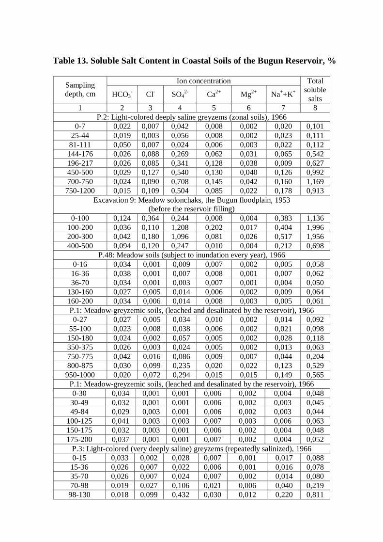
Table 13. Soluble Salt Content in Coastal Soils of the Bugun Reservoir, %
Ion concentration Sampling depth, cm HCO3
- Cl- SO42- Ca2+ Mg2+ Na++K+
Total soluble
salts 1 2 3 4 5 6 7 8
Р.2: Light-colored deeply saline greyzems (zonal soils), 1966 0-7 0,022 0,007 0,042 0,008 0,002 0,020 0,101
25-44 0,019 0,003 0,056 0,008 0,002 0,023 0,111 81-111 0,050 0,007 0,024 0,006 0,003 0,022 0,112 144-176 0,026 0,088 0,269 0,062 0,031 0,065 0,542 196-217 0,026 0,085 0,341 0,128 0,038 0,009 0,627 450-500 0,029 0,127 0,540 0,130 0,040 0,126 0,992 700-750 0,024 0,090 0,708 0,145 0,042 0,160 1,169
750-1200 0,015 0,109 0,504 0,085 0,022 0,178 0,913 Excavation 9: Meadow solonchaks, the Bugun floodplain, 1953
(before the reservoir filling) 0-100 0,124 0,364 0,244 0,008 0,004 0,383 1,136
100-200 0,036 0,110 1,208 0,202 0,017 0,404 1,996 200-300 0,042 0,180 1,096 0,081 0,026 0,517 1,956 400-500 0,094 0,120 0,247 0,010 0,004 0,212 0,698
Р.48: Meadow soils (subject to inundation every year), 1966 0-16 0,034 0,001 0,009 0,007 0,002 0,005 0,058 16-36 0,038 0,001 0,007 0,008 0,001 0,007 0,062 36-70 0,034 0,001 0,003 0,007 0,001 0,004 0,050
130-160 0,027 0,005 0,014 0,006 0,002 0,009 0,064 160-200 0,034 0,006 0,014 0,008 0,003 0,005 0,061 Р.1: Meadow-greyzemic soils, (leached and desalinated by the reservoir), 1966 0-27 0,027 0,005 0,034 0,010 0,002 0,014 0,092
55-100 0,023 0,008 0,038 0,006 0,002 0,021 0,098 150-180 0,024 0,002 0,057 0,005 0,002 0,028 0,118 350-375 0,026 0,003 0,024 0,005 0,002 0,013 0,063 750-775 0,042 0,016 0,086 0,009 0,007 0,044 0,204 800-875 0,030 0,099 0,235 0,020 0,022 0,123 0,529
950-1000 0,020 0,072 0,294 0,015 0,015 0,149 0,565 Р.1: Meadow-greyzemic soils, (leached and desalinated by the reservoir), 1966 0-30 0,034 0,001 0,001 0,006 0,002 0,004 0,048
30-49 0,032 0,001 0,001 0,006 0,002 0,003 0,045 49-84 0,029 0,003 0,001 0,006 0,002 0,003 0,044
100-125 0,041 0,003 0,003 0,007 0,003 0,006 0,063 150-175 0,032 0,003 0,001 0,006 0,002 0,004 0,048 175-200 0,037 0,001 0,001 0,007 0,002 0,004 0,052 Р.3: Light-colored (very deeply saline) greyzems (repeatedly salinized), 1966 0-15 0,033 0,002 0,028 0,007 0,001 0,017 0,088
15-36 0,026 0,007 0,022 0,006 0,001 0,016 0,078 35-70 0,026 0,007 0,024 0,007 0,002 0,014 0,080 70-98 0,019 0,027 0,106 0,021 0,006 0,040 0,219 98-130 0,018 0,099 0,432 0,030 0,012 0,220 0,811
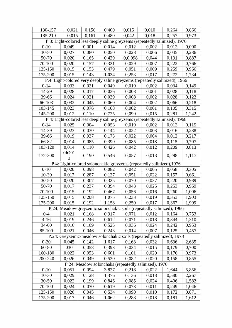
130-157 0,021 0,156 0,400 0,015 0,010 0,264 0,866 185-210 0,015 0,161 0,480 0,042 0,018 0,257 0,973 Р.3: Light-colored less deeply saline greyzems (repeatedly salinized), 1976
0-10 0,049 0,001 0,014 0,012 0,002 0,012 0,090 30-50 0,027 0,080 0,050 0,028 0,006 0,045 0,236 50-70 0,020 0,165 0,429 0,0,098 0,044 0,131 0,887
70-100 0,020 0,157 0,331 0,029 0,007 0,222 0,766 125-150 0,015 0,153 0,479 0,051 0,009 0,259 0,966 175-200 0,015 0,143 1,034 0,253 0,017 0,272 1,734
Р.4: Light-colored very deeply saline greyzems (repeatedly salinized), 1966 0-14 0.033 0,021 0,049 0,010 0,002 0,034 0,149 14-29 0,028 0,017 0,036 0,008 0,001 0,028 0,118 39-66 0,024 0,021 0,039 0,008 0,002 0,028 0,122
66-103 0,032 0,045 0,069 0,004 0,002 0,066 0,218 103-145 0,023 0,076 0,108 0,002 0,001 0,105 0,315 145-200 0,012 0,110 0,725 0,099 0,015 0,281 1,242
Р.4: Light-colored less deeply saline greyzems (repeatedly salinized), 1968 0-14 0,025 0,004 0,053 0,019 0,002 0,012 0,115 14-39 0,023 0,030 0,144 0,022 0,003 0,016 0,238 39-66 0,019 0,037 0,173 0,022 0,004 0,012 0,217 66-82 0,014 0,085 0,390 0,085 0,018 0,115 0,707
103-120 0,014 0,110 0,426 0,042 0,012 0,209 0,813
172-200 0Ю013 0,190 0,546 0,057 0,013 0,298 1,117
Р.4: Light-colored solonchakic greyzems (repeatedly salinized),1976 0-10 0,020 0,098 0,082 0,042 0,005 0,058 0,305 10-30 0,017 0,287 0,127 0,051 0,022 0,157 0,661 30-50 0,020 0,307 0,335 0,070 0,037 0,220 0,989 50-70 0,017 0,237 0,394 0,043 0,025 0,253 0,969
70-100 0,015 0,192 0,467 0,056 0,016 0,260 1,006 125-150 0,015 0,208 1,075 0,233 0,019 0,353 1,903 175-200 0,015 0,192 1,158 0,250 0,017 0,367 1,999
Р.24: Meadow-greyzemic solonchakic soils (repeatedly salinized), 1966 0-4 0,021 0,168 0,317 0,071 0,012 0,164 0,753
4-16 0,019 0,246 0,612 0,071 0,018 0,344 1,310 34-60 0,016 0,109 0,525 0,036 0,024 0,242 0,953
85-100 0,021 0,046 0,243 0,014 0,007 0,125 0,457 Р.24: Greyzemic-meadow solonchakic soils (repeatedly salinized), 1973
0-20 0,045 0,142 1,617 0,163 0,032 0,636 2,635 60-80 030 0,058 0,393 0,034 0,015 0,179 0,700
160-180 0,022 0,053 0,601 0,101 0,020 0,176 0,973 200-240 0,026 0,049 0,520 0,082 0,020 0,158 0,855
Р.24: Meadow solonchaks (repeatedly salinized), 1976 0-10 0,051 0,094 3,827 0,218 0,022 1,644 5,856 10-30 0,029 0,128 1,376 0,136 0,018 0,580 2,267 30-50 0,022 0,199 0,846 0,085 0,024 0,406 1,582
70-100 0,024 0,070 0,619 0,073 0,011 0,249 1,046 125-150 0,020 0,045 0,534 0,090 0,010 0,172 0,871 175-200 0,017 0,046 1,062 0,288 0,018 0,181 1,612
Р.5: Meadow solonchaks (repeatedly salinized), 1966 0-10 0,019 0,186 1,152 0,175 0,066 0,545 2,447 10-32 0,018 0,266 0,480 0,035 0,025 0,321 1,145 32-55 0,027 0,101 0,336 0,015 0,006 0,209 0,696
74-100 0,034 0,066 0,211 0,007 0,002 0,146 0,468 340-370 0,013 0,033 0,720 0,205 0,036 0,066 1,083 440-470 0,012 0,021 0,816 0,200 0,069 0,049 1,166
Р.5: Meadow solonchaks (repeatedly salinized), 1976 0-10 0,063 0,417 4,054 0,244 0,050 1,885 6,713 10-30 0,027 0,261 1,163 0,154 0,028 0,518 2,151 30-50 0,015 0,237 0,807 0,143 0,021 0,348 1,571 50-70 0,017 0,180 0,608 .096 0,016 0,278 1,195
70-100 0,017 0,139 0,44 0,055 0,012 0,226 0,893 125-150 0,012 0,111 0,951 0,270 0,018 0,190 1,552
Father observations in the period of 1971-1976 that the mineralized ground
waters on the coasts become gradually substituted by less mineralized ones as a result of water infiltration from the reservoir (Table 14), while highly mineralized (saline) waters concentrate in the depressions of topography (pp. 4, 5, 24 and 52). In the same direction the salt migrate in soils, accumulating in the waterlogged soils of such depressions in amounts of 300 t/ha in 0-200 cm layer (Table 13). The soils of the lower water (bief) impact zone remain very saline.
Hydrochemical specificities of a reservoir depend on the rate of water masses replacement occurring in it. As we have already mentioned, the reservoir accumulates the Bugun and Arys runoff with mineralization of water within 0.4-0.5 g/l. Every year, 90% of water is employed for the irrigation, while in June –July the water for irrigation is transferred through the reservoir from the Arys river. All this favors the maintenance of low mineralization of reservoir water. But in the first years of reservoir filling we observed an active salt exchange between the banks and the water. In 1966, the mineralization of water near the coast reached 1.8-2.0 g/l, in 1967 it reached to 0.7-0.9 g/l and during the period of 1968-1976 it gradually lowered to 0.4-0.6 g/l.
We estimated the zone of the Bugun reservoir direct impact on the ameliorative processes by the character of soil and groundwater regime changes to be within 5-6 km wide in the upper water. While evaluating soil evolution it is necessary not to forget that soil regimes, processes, morphological features and physico-chemical properties change with different rates. This creates difficulties in soil diagnostics. The changes of hydrogeological conditions on the waterlogged coast the first to change are soil water and salinity regimes which determine the further development of new features and properties.
Groundwater regime directly on the coast and in the locations of infiltration water seepage stabilized already 3 to 5 years after the filling of a reservoir. But on the significant part of the coast (Fig. 20-23, p.3, 4 and 53) the groundwater table continued to rise slowly in the course of 15 years, changing soil water regime. The essential morphological features of waterlogged soils changed even more slowly
Figure 22. Water Regime of Soils in the Bugun Reservoir Coast (test plot 1).
Figure 23. Changes of Soil Salinity on the Bugun Reservoir Coast -test plot 1 (1-non saline soils, 2-deeply saline, 3-very deeply solonchakic, 4-deeply solonchakic, 5-solonchakic soils, 6-Solonchaks).
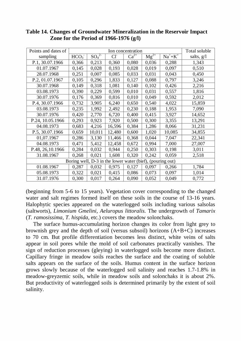
Table 14. Changes of Groundwater Mineralization in the Reservoir Impact Zone for the Period of 1966-1976 (g/l)
Ion concentration Points and dates of sampling HCO3
- SO42- Cl- Ca2+ Mg2+ Na++K+
Total soluble salts, g/l
Р.1, 30.07.1966 0,366 0,213 0,360 0,080 0,036 0,288 1,343 01.07.1967 0,145 0,028 0,193 0,028 0,019 0,097 0,510 28.07.1968 0,251 0,007 0,085 0,033 0,031 0,043 0,450
Р.2, 01.07.1967 0,105 0,296 1,833 0,127 0,088 0,797 3,246 30.07.1968 0,149 0,318 1,081 0,140 0,102 0,426 2,216 03.08.1973 0,390 0,229 0,599 0,010 0,031 0,557 1,816 30.07.1976 0,176 0,369 0,816 0,010 0,049 0,592 2,012
Р.4, 30.07.1966 0,732 3,905 6,240 0,650 0,540 4,022 15,859 03.08.1973 0,235 1,992 2,492 0,230 0,188 1,953 7,090 30.07.1976 0,420 2,770 6,720 0,400 0,415 3,927 14,652
Р.24, 10.05.1966 0,293 0,923 7,920 0,500 0,300 3,355 13,291 04.08.1973 0,683 4,216 16,596 0,384 1,286 8,066 31,231
Р.5, 30.07.1966 0,659 10,011 12,480 0,600 1,020 10,085 34,855 01,07.1967 0,286 3,130 11,466 0,368 0,044 7,047 22,341 04.08.1973 0,471 5,412 12,458 0,672 0,994 7,000 27,007
Р.48, 26,10.1966 0,284 0,032 0,944 0,250 0,303 0,198 3,011 31.08.1967 0,268 0,021 1,608 0,320 0,242 0,059 2,518
Boring well, D-3 in the lower water (bief), (pouring out) 01.08.1967 0,287 0,032 0,975 0,127 0,097 0,266 1,784 05.08.1973 0,322 0,021 0,415 0,086 0,073 0,097 1,014 31.07.1976 0,300 0,017 0,264 0,090 0,052 0,049 0,772
(beginning from 5-6 to 15 years). Vegetation cover corresponding to the changed water and salt regimes formed itself on these soils in the course of 13-16 years. Halophytic species appeared on the waterlogged soils including various salsolas (saltworts), Limonium Gmelini, Aeluropus littoralis. The undergrowth of Tamarix (T. ramosissima, T. hispida, etc.) covers the meadow solonchaks.
The surface humus-accumulating horizon changes its color from light grey to brownish grey and the depth of soil (versus subsoil) horizons (A+B+C) increases to 70 cm. But profile differentiation becomes less distinct, white veins of salts appear in soil pores while the mold of soil carbonates practically vanishes. The sign of reduction processes (gleying) in waterlogged soils become more distinct. Capillary fringe in meadow soils reaches the surface and the coating of soluble salts appears on the surface of the soils. Humus content in the surface horizon grows slowly because of the waterlogged soil salinity and reaches 1.7-1.8% in meadow-greyzemic soils, while in meadow soils and solonchaks it is about 2%. But productivity of waterlogged soils is determined primarily by the extent of soil salinity.
9. CONCLUSION
Effect of dams on a soil cover is strong enough both at coast of reservoirs, and in the lower reaches of the rivers. At coast soil waterlogging, formation of swamps, soil salinization and alkalinization, and also destruction of the banks resulting from erosion and abrasion, occur. And in the lower reaches of the rivers aridization of landscapes, soil drying-up or desertification in the river valleys and especially in deltas, occur. As a result of long-term investigations of these processes in the countries of former Soviet Union the wide experience is stored which allows to estimate and to predict negative consequences for a soil cover because of dams and reservoirs creation, and also to develop measures on struggle with them. The greatest losses of agricultural lands occur at inundation by reservoirs on the plainland rivers. They reach here 10000-24000 hectares per 1 meter of a hydraulic head of reservoir. To protect the lands from flooding the scientific community becomes now more oriented on the reservoirs construction not on the plailand rivers, but in the mountains and foothills. The changes in soil properties on the reservoir coasts resulting from waterlogging have a zonal character. In humid regions (the Forest zone) on the low coast waterlogging take place in a strip up to 1.5-2 km. Here soil gleization and swamping occurs, sod and peat is formed on a surface, water mode and agrochemical properties are worsened. At strong waterlogging an available iron and aluminum concentration increases. And at moderate and weak waterlogging the contents of organic matter (humus), nitrogen and phosphorus is increased in these soils. In the lower soil horizons soil acidity decreases resulting from waterlogging by waters with neutral reaction. In Forest-Steppe and Steppe zones high coasts, on which soil waterlogging is very weak, often prevail. And on low coast soil waterlogging can be shown on the distance from 2-3 till 10-12 km. Waterlogged soils swamping and gleization is much weaker here, and the important role belongs to processes of soil alkalinization and salinization. In semi-desert and desert zones soil salinization occurs first of all because of waterlogging, that sharply worsens their fertility. On the distance up to 5-6 km and sometimes it is more, soils can accumulate up to 500-600 t/ha soluble salts in a layer of 0-2 m. On the bank of reservoirs these salted soils interact with superficial waters, raising their mineralization. Our long-term researches at the coast of reservoirs in different natural zones of Ukraine and Central Asia have allowed determining qualitative features and quantitative parameters of soil fertility changes. The features of soil evolution and soil cover transformation are revealed also at waterlogged coasts, which allow predicting these processes correctly.
10 . AUTHORS’ PUBLICATIONS ON THE PROBLEM Yegorichev G.A. and Starodubtsev V.M. Soil Ameliorative Conditions in the Bugun
Reservoir Impact Zone / Problems of Soil Melioration in Central Asia and Kazakhstan. Alma-Ata: Kazakh Academy of Sciences Publication. Kaz.SSR. – 1970. (Егоричев Г.А., Стародубцев В.М. Почвенно-мелиоративные условия в зоне влияния Бугуньского водохранилища / Проблемы мелиорации почв Средней Азии и Казахстана. Алма-Ата: Изд. АН КазССР. – 1970.).
Starodubtsev V.M. Soil-Ameliorative Processes in the Reservoir Impact Zone // Problems of Desert Development. N 6. 1977. P.18-26. (Стародубцев В.М. Почвенно-мелиоративные процессы в зоне влияния водохранилищ // Проблемы освоения пустынь.-№6. – 1977. – С.18-26).
Starodubtsev V.M. Heat Flow Regime in Wet Soils and Its Utilization for Soil Moisture Dynamics Prediction // News of the Kazakh Academy of Sciences. Biologic Series.N 1. 1977. P.66-72. (Стародубцев В.М. Тепловой режим гидроморфных почв и его использование для прогноза динамики почвенной влаги // Известия АН КазССР. Серия биологическая. - №1. – 1977. – С.66-72).
Starodubtsev V.M., Nekrasova T.F. and Popov Yu.M. Soil Aridization in the Delta Plainlands of Southern Kazakhstan Linked With the River Flow Regulation // Problems of Desert Development. N 5. 1978. P.14-23. (Стародубцев В.М., Некрасова Т.Ф., Попов Ю.М. Аридизация почв дельтовых равнин Южного Казахстана в связи с зарегулированием речного стока // Проблемы освоения пустынь. - №5. – 1978. – С.14-23).
Starodubtsev V.M., Kalmynkina E.M., Magasheva R.Yu., etc. Kapchagay Reservoir and the Changes of Environment / Geography in Kazakhstan. Alma-Ata: Science Publishers. 1980. P.128-136. (Стародубцев В.М., Калмынкина Е.М., Магашева Р.Ю. и др. Капчагайское водохранилище и изменения природной среды / География в Казахстане. Алма-Ата: Наука. – 1980. – С.128-136).
Starodubtsev V.M. Kapchagay Reservoir Impact on Coastal Soils // News of the Kazakh Academy of Sciences. Biiologic Series. N 3. 1981. P.57-61. (Стародубцев В.М. Влияние Капчагайского водохранилища на почвы побережья // Известия АН КазССР. Серия биологическая. - №1. – 1981. – С.57-61).
Starodubtsev V.M. Soil Cover Role in Increasing Salinity of the Kapchagay Reservoir // News of Kazakh Academy of Sciences. Biological Series. N 3. 1981. P.57-61. (Стародубцев В.М. Роль почвенного покрова в повышении минерализации воды Капчагайского водохранилища // Известия АН КазССР. Серия биологическая. - №3. – 1981. – С.57-61).
Starodubtsev V.M. Prediction of Soil-Ameliorative Conditions in the Impact Zone of the Kapchagay Reservoir // Herald of the Kazakh Academy of Sciences. N 2. 1982. P.47-52. (Стародубцев В.М. Прогноз почвенно-мелиоративных условий в зоне влияния Капчагайского водохранилища // Вестник АН КазССР. - №2. – 1982. – С.47-52).
Starodubtsev V.M., Nekrasova T.F. and Popov Yu.M. Changes of Ameliorative Conditions in the Head Part of the Ily Delta Caused by the Flow Regulation // Water Resources. N 5. 1983. P.75-84. (Стародубцев В.М., Некрасова Т.Ф., Попов Ю.М. Изменения мелиоративных условий головной части дельты р.Или при зарегулировании речного стока // Водные ресурсы. - №5. – 1983. – С.75-84).
Starodubtsev V.M., Bogachev V.P. Ameliorative Evaluation of the Syrdarya Runoff // Soil Science (Moscow). N 12. 1983. P.90-101. (Стародубцев В.М., Богачев В.П. Мелиоративная оценка стока р. Сырдарьи // Почвоведение (Москва). - №12. – 1983. – С.90-101).
Starodubtsev V.M., Nekrasova T.F. Environmental Changes in the Ily Basin Connected with Water Management Construction // Problems of Desert development. N 1. 1983. P.25-33.
(Стародубцев В.М., Некрасова Т.Ф. Изменения природной среды в бассейне р. Или в
связи с водохозяйственным строительством // Проблемы освоения пустынь. - №1. – 1983. – С.25-33).
Starodubtsev V.M. Salt Exchange Processes on the Kapchagay Reservoir Coast // Problems of Desert Development. N 2. 1984. P.39-48. (Стародубцев В.М. Процессы солеобмена на побережье Капчагайского водохранилища // Проблемы освоения пустынь. - №2. – 1984. – С.39-48).
Starodubtsev V.M. Irrigation Effects on the Ameliorative Quality of River Runoff. Alma-Ata: Science Publishers. 1985. 168 p. (Стародубцев В.М. Влияние орошения на мелиоративные качества речного стока. Алма-Ата: Наука. – 1985. – 168 с.).
Starodubtsev V.M. Reservoir’s Impact on the Soils. Alma-Ata: Science Publishers. 1986. 296 p. (Влияние водохранилищ на почвы. Алма-Ата: Наука. – 1986. – 296 с.).
Starodubtsev V.M. Changes of Soils in the Zone of Reservoir-Caused Waterlogging / Influence of Economic activities on Biological Resources of Inland Waters. Alma-Ata: Science Publishers. 1988. P.129-150. (Стародубцев В.М. Изменения почв в зоне подтопления водохранилищ / Влияние хозяйственной деятельности на биологические ресурсы водоемов. Алма-Ата: Наука. – 1988. – С.129-150).
Starodubtsev V.M. The soil and ecological consequences of regulating the discharge of the rivers in Mesopotamia // Problems of Desert Development. – N 2. – 1998. – P.11-17.
Starodubtsev V.M., Petrenko L.R., Mikala-Dianga R.-A. et al. The Changes in Soils of River Basins Caused by Large-Scale Construction for the Purposes of Water Management / Proceedings of 16-th World Congers of Soil Sciences. CD-Rom. Montpellier, France. – 1999.
Starodubtsev V.M., Petrenko L.R., Kazanina O.V. The Effect of Kyiv Reservoir on Environmental Status of Soils // Journal of Hydrology and Hydromechanics. Bratislava. – N47. – 5. – 1999. – P.366-377.
Starodubtsev V.M., Petrenko L.R., Titenko M.M. Salt Transportation by the Wind as a Factor of Salt Regimes of Soils and Landscapes. Kyiv: Nora-Print. – 1999. – 40 p.
Starodubtsev V.M., Kazanina O.V., Nesterov G.I., et al. Changes in the Soils of the Kyivs’ke Reservoir Coast // Agricultural Sciences News. Kyiv. N 3. 2000. P.294-298. (Стародубцев В.М., Казаніна О.В., Нестеров Г.І., та інші // Вісник аграрної науки. - №3. – 2000. – С.50-56).
Starodubtsev V.M., Fedorenko O.L., Umanets K.M., et al. Zoning of Kanivs’ke Reservoir Coasts by the Character of Soil Changes //NAU Research News. Kyiv. No31. 2000. P.294-298. (Стародубцев В.М., Федоренко О.Л., Уманець К.М. Районування узбережжя Канівського водосховища за характером змін грунтів // Науковий вісник НАУ. Київ. - №31. – 2000. – С.294-298).
Starodubtsev V.M., Kolodyazhnyy O.A., Petrenko L.R., et al. Soil Cover and Land Use. Kyiv: Nora-Print. – 2000. – 98 p.
Starodubtsev V.M., Petrenko L.R., Fedorenko et al. Radionuclides Pollution in Soils of the Kyiv Reservoir Coasts after the Chernobyl Accident / 5-th International Symposium and Exhibition on Environmental Contamination in Central and Eastern Europe. Proceeding on CD-Rom. Prague. – 2001. – 9 p.
Starodubtsev V.M. The Influence of the Dnipro Reservoirs on the Coastal Soils //KhSAU Research News. Kharkiv. N03. 2001. P.105-108. (Стародубцев В.М. Вплив Дніпровських водосховищ на грунти узбережжя // Вісник ХДАУ. Харків. - №3. – 2001. – С.105-108).
Starodubtsev V.M., Fedorenko O.L., Burlibaev M.Zh. Assessment of Influence of River Runoff Regulation on Ecological Situation / Risk Assessment as a Tool for Water Resources Decision-Making in Central Asia. Kluwer Academic Publishers. Dordrecht. – 2004.
Starodubtsev V.M., Fedorenko O.L. Evaluation of the Effect of Dnipro River’ Reservoirs on Coastal Landscapes / Ecological Standardization and Equidosimetry for Radioecology and Environment Ecology. Kluwer Academic Publishers. Dordrecht. – 2004.
Starodubtsev V.M., Burlibaev M.Zh., Popov Yu.M. Soil Degradation in the Ily Delta Connected with Flow Regulation // Problems of Desert Development. N01. 2004.
11. LITERATURE CITED (abridged list)*
Alekin O.A. Arid Zone Reservoirs and the Factors of their Salinity // Problems of Soil and Water Sources Salinity. Moscow. 1960. P.14-28. (Алекин О.А. Водохранилища аридной зоны и факторы их засоления / Проблема засоления почв и водных источников. Москва. – 1960. – С.14-23).
Akhmedsafin U.M., Shapiro S.M., Dzhabasov M.Kh., et al. Hydrogeological Predictions of Balkhash Depression. Alma-Ata: Science Publishers. 1975. 132 p. (Ахмедсафин У.М., Шапиро С.М., Джабасов М.Х., и др. Гидрогеологические прогнозы Балхашской впадины. Алма-Ата: Наука. – 1975. – 132 с.).
Butorin N.V., Ziminova N.A., Kurdin V.P. Bottom Sediments of the Upper Volga Reservoirs. Leningrad. 1975. 158 p. (Буторин Н.В., Зиминова Н.А., Курдин В.П. Донные отложения верхневолжских водохранилищ. Ленинград: Гидрометеоиздат. – 1975. – 158 с.).
Chamova N.M. Prediction of the Waterlogging Impact on the Soil Cover in the Zone of Reservoir Projecting. Moscow. 1981. 60 p. (Чамова Н.М. Прогнозирование влияния подтопления на почвенно-растительный покров в зоне проектируемых водохранилищ. Москва. – 1981. – 60 с.).
Dobrovolsky G.V. On Soil Waterlogging on the Reservoir Coasts // Higher School Research Reports. Biological Sciences Series. Moscow. N03. 1958. P.173-178. (Добровольский Г.В. Щ подтоплении почв на побережьях водохранилищ // Научные доклады высшей школы. Серия «Биологические науки». Москва. - №3. – 1958. – С.173-178).
Dyakonov K.N. The Influence of Large Plainland Reservoirs on the Coastal Zone Forests. Leningrad: Hydrometeoizdat. 1975. 127 p. (Дьяконов К.Н. Влияние равнинных водохранилищ на леса прибрежной зоны. Ленинград: Гидрометеоиздат. – 1975. – 127 с.).
Engineering-Geographic Problems of Designing and Exploitation of Large Plainland Reservoirs. Moscow. 1972. 240 c. (Инженерно-географические проблемы проектирования и эксплуатации крупных равнинных водохранилищ. Москва. – 1972. – 240 с.).
Gromova Z.N. Air Flow and Aeration Regime of Soddy-Podzolic Sandy Soils Gleyed to Varying Extent // Transaction of the Darvinsky Reserve. Issue 9. 1968. P.216-258. (Громова З.Н. Воздушный режим дерново-подзолистых песчаных почв разной степени оглеения // Труды Дарвинского заповедника. – Вып. IX. – 1968. – С.216-258).
Korenevskaya V.Ye., Khrustaleva M.A., Kabalina L.N. Influence of Kuybyshevskoye Reservoir-Caused Waterlogging on the Properties of Terrace Chernozems // MSU Research News. Series N017 - Soil Science. N04. 1982. P.56-62. (Кореневская В.Е., Хрусталева М.А., Кабалина Л.Н. Влияние подтопления Куйбышевского водохранилища на свойства террасовых черноземов // Вестник МГУ. Серия 17 – Почвоведение. - №4. – 1982. – С.56-62).
Korenevskaya V.Ye. Kuybyshevskoye Reservoir Influence on the Coastal Territory Soils of the Saralovskoye Forest District of the Volzhsko-Kamskiy Reserve // MSU Research News. Serie no17 – Soil Science. No1. 1984. P.9-15. (Кореневская В.Е. Влияние Куйбышевского водохранилища на почвенный покров прибрежной территории Сараловского лесничества Волжско-Камского заповедника // Вестник МГУ. Серия 17 «Почвоведение». - №1. – 1984. – С.9-15).
Kotova N.G. Up-to-date Condition and the Ways of Rational Use of Lands Waterlogged by the Power Generating Reservoirs. A Precis of a Candidate of Agricultural Sci. Thesis. Moscow. 1972. 24 p. (Котова Н.Г. Современное состояние и пути рационального использования земель, подтопленных водохранилищами ГЭС. Автореф. дисс…канд. с/х наук. Москва. – 1972. – 24 с.).
Kovda V.A. General Research Results on the Effects of Reservoirs and Irrigation on the
* - Complete list of literature may be submitted on an inquiry
Soils in the Lower Zavolzhye River Valley // Commission on Irrigations Transactions. Moscow-Leningrad. Issue 10. 1937. P.223-233. (Ковда В.А. Общие результаты изучения влияния водохранилищ и орошения на почвы долин рек Нижнего Заволжья // Труды Комиссии по ирригации. Москва-Ленинград. - Вып. 10. – 1937. – С.223-233).
Madanov P.V., Voykin L.M., Boychuk V.A., and N.G. Kotova. Comparative Characteristics of Soils Influenced by the Gorkovskoye, Kuybyshevskoye and Volgоgradskoye Reservoirs // Transactions of the Gorkovsky Agricultural Institute. Volume 49. 1972. P.122-130. (Маданов П.В., Войкин Л.М., Бойчук В.А., Котова Н.Г. Сравнительная характеристика почв, испытывающих влияние Горьковского, Куйбышевского и Волгоградского водохранилищ // Труды Горьковского СХИ. – Т.49. – 1972. – С.122-130).
Man-Made Lakes as Modified Ecosystems. SCOP Report 2. Paris, 1972. Man-Made Lakes: Their Problems and Environmental Effects. Washington D.C.: Amer.
Geophysical Union, 1973. Matheny R.T., Gurr D.L. Ancient Hydraulic Techniques in the Chiapas Highlands./ Am. Sci.
no 64 (4), 1979. P.441-449. Neganov A.F., Boltova L.M. Changes of Some Soil Properties on the Saratovskoye
Reservoir Waterlogged Coasts // Transactions of the Complex Saratov University Expedition Researching Volgogradskoye and Saratovskoye Reservoirs. Issue 4. 1975. P.31-40. (Неганов А.Ф., Болтова Л.М. Изменение некоторых свойств почв на подтопляемых побережьях Саратовского водохранилища // Труды комплексной экспедиции Саратовского университета по изучению Волгоградского и Саратовского водохранилищ. – Вып.4. – 1975. – С.31-40).
Petrov G.N., Kotova N.G. Ways of Land Use on the Waterlogged Areas of Large Reservoirs // Land Amelioration in Reservoir Impact Zone. Moscow. 1974. P.212-222. (Петров Г,Н., Котова Н.Г. Пути использования подтопленных земель крупных водохранилищ // Мелиорация земель в зоне влияния равнинных водохранилищ. Москва. – 1974. – С. 212-222).
Plisak R.P. Vegetation Communities Dynamics on the Southern Coast of the Kapchagay Reservoir // Flood Plain Vegetation Dynamics in the Valleys of Chu and Ily. Alma-Ata: Science Publishers. 1985. P.152-181. (Динамика растительности южного побережья Капчагайского водохранилища // Динамика пойменной растительности рек Чу и Или. Алма-Ата.: Наука. – 1985. – С.152-181).
Popov Yu.M., Nekrasova T.F., Semenov O.Ye., Starodubtsev V.M. Anthropogenic Changes in Near-the-Aral-Sea Soils and Their Ecological and Economical Significance. Alma-Ata: KazNIINKI. 1982. 60 p. (Попов Ю.М., Некрасова Т.Ф., Семенов О.Е., Стародубцев В.М. Антропогенные изменения почв Приаралья и их эколого-хозяйственное значение. Алма-Ата: КазНИИНКИ. – 1992. – 60 с.).
Reservoirs of the World. Moscow: Science Publishers. 1979. 287 p. (Водохранилища мира. Москва: Наука. – 1979. – 287 с.).
Reservoirs and Their Environmental Impact/ Edited by G.V. Voropayev and A.B. Avakyan. Moscow: Science Publishers. 1986. 368 p. (Водохранилища и их воздействие на окружающую среду / Под ред Г.В. Воропаева и А.Б. Авакяна. Москва: Наука. 1986. 368 с.).
Reteyum A.Yu. Dynamics of the Natural Components in the Sphere of the Reservoirs Impact. A Precis of a Candidate of Engineering Sci. Thesis. Moscow. 1968. 29 p. (Ретеюм А.Ю. Динамика природных компонентов в сфере влияния водохранилищ. Автореф. дисс… канд. техн. наук. Москва. – 1968. – 29 с.).
Starodubtsev V.M. Irrigation Impact on the River Runoff Ameliorative Qualities. Alma-Ata: Science Publishers. 1985. 296 p. (Стародубцев В.М. Влияние орошения на мелиоративные качества речного стока. Алма-Ата: Наука. – 1985. – 168 с.).
Starodubtsev V.M. Reservoirs Impact on the Soils. Alma-Ata: Science Publishers. 1986. 296 p. (Стародубцев В.М. Влияние водохранилищ на почвы. Алма-Ата: Наука. – 1986. – 296 с.).

Starodubtsev V.M. Soil Salinization at the Eastern Coast of the Drying Aral Sea Bottom //Problems of Desert Development. no5. 1990. P.45-50. (Стародубцев В.М. Засоление почвогрунтов обсыхающего дна Аральского моря у восточного побережья // Проблемы освоения пустынь // Проблемы освоения пустынь. - №5. – 1990. – С.45-50).
Starodubtsev V.M., Kolodyazhnyy O.A., Petrenko L.R., et al. Soil Cover and Land Use. Kyiv: Nora-Print. – 2000. – 98 p.
Starodubtsev V.M., Fedorenko O.L., Burlibaev M.Zh. Assessment of Influence of River Runoff Regulation on Ecological Situation / Risk Assessment as a Tool for Water Resources Decision-Making in Central Asia. Kluwer Academic Publishers. Dordrecht. – 2004.
Uspenskaya A.A. On the Rybinskoye Reservoir Influence on the Signs of Bogging Appearance in the Waterlogged Territory Soils // Transactions of the Darwin Reserve. Issue 4. 1957. P.499-518. (Успенская А.А. О влиянии Рыбинского водохранилища на появление в почвах территории подтопления признаков заболачивания // Труды Дарвинского заповедника. – Вып.4. – 1957. – С.499-518).
Vendrow S.L. Problems of River Systems Transformation. Leningrad: Hydrometeoizdat. 1970. 236 p. (Вендров С.Л. Проблемы преобразования речных систем. Ленинград: Гидрометеоиздат. – 1970. – 236 с.).
Vendrow S.L., Dyakonov K.N. Reservoirs and the Environment. Moscow: Science Publishers. 1976. 136 p. (Вендров С.Л., Дьяконов К.Н. Водохранилища и окружающая природная среда. Москва: Наука. – 1976. – 136 с.).
Vidinyeyeva Ye.M. Hydrochemical Regime and Salt Balance of Some Reservoirs in Central Asia. Cand. of Sci. (Geography) Thesis. Tashkent. 1974. 25 p. (Видинеева Е.М. Гидрохимический режим исолевой баланс некоторіх водохранилищ Средней Азии. Автореф.дисс... канд. геогр. Наук. Ташкент. – 1974. – 25 с.).
Vladychensky S.A. Reservoir Impact on Soils // Soil Science (Moscow). N09. 1958. P.70-79. (Владыченский С.А. Влияние водохранилищ на почвы // Почвоведение - №9. – 1958. – С.70-79).
Vladychensky S.A. On the Methodology of Reservoir-Caused Waterlogging Prediction in the Forest Zone // Higher School Research Reports. Biological Sciences Series. N04. 1961. P.196-202. (Владыченский С.А. Щ методике прогноза подтопления от искусственных водохранилищ лесной зоны // Научные доклады высшей школы. Серия «биологические науки». - №4. – 1961. – С.196-202).
Vladychensky S.A. Soil-Ameliorative Characteristic of the Rybinskoye Reservoir Coastal Territory // Transaction of the Darvinsky Reserve. Issue 9. 1968. P.182-215. (Владыченский С.А. Почвенно-мелиоративная характеристика прибрежной территории Рыбинского водохранилища // Труды Дарвинского заповедника. – Вып.9. – 1968. – С.182-215).
World Register of Dams. Paris: ICOLD, 1964, 1971, 1998, 2000.

Наукове видання
Володимир Михайлович Стародубцев
Леонід Романович Петренко Олександр Леонідович Федоренко
ДАМБИ Й НАВКОЛИШНЄ СЕРЕДОВИЩЕ: ВПЛИВ НА ГРУНТИ
З усіх питань щодо цього видання звертатись до авторів:
E-mail [email protected], Поштова адреса: Стародубцев В.М., П/в-127, а/с-64, Київ-03127, Україна
With all requests about this book to address to the authors: e-mail [email protected],
Postal address: Starodubtsev V.M., P.O.-127, Box-64, Kiev-03127, Ukraine


