Embed Size (px)
Citation preview
CITY OR PARISH: DILEMMAS IN BRASILIA, BRAZILFrederico de Holanda
Faculdade de Arquitetura e Urbanismo, Universidade deBrasília
[email protected], phone numbers: + 55 61 34859824, +55 61 99861724
ABSTRACT
Surprisingly enough, neighbourhood unit related concepts have lasting appeal. This is the case concerning current controversies about the preservation plan of Brasilia, Brazil’s Federal Capital, as a World Cultural Heritage site. A proposal has been prepared by the Local Government,submitted to the Legislative Power, and widely publicised so that contributions from Civil Society might arise. On the one hand, the governmental proposal sticks to modernistic principles or urban design, considering individual buildings or city blocks in themselves, not in their relation with the surroundings. A piecemeal approach predominates, not one which is about the attributes and qualities of space between buildings, or of sets of blocks defining morphological urban types. On the other hand, outstanding speakers on behalf of Civil Society do not consider the city as a system, but rather as 1) a patchwork of isolated parts and 2) the sum total of, again, isolated dimensions, not a phenomenon which involves simultaneously practical and expressive aspects – functional, bioclimatic, economic and sociological, in the first case, imagistic, affective, symbolic and aesthetic, in the second. This paper explores the benefits of a systemic approach of the city – one that does not consider it a sum total of parishes nor of isolated disciplinary approaches.1
INTRODUCTIONAt the time of writing the draft of the Law Project
concerning the preservation of Brasilia as a World Cultural
Heritage Site (PPCUB) is pending in the Legislative Branch 1 Paper presented at the International Seminar on Urban Form - ISUF, Porto, Portugal, 2014.
1
of the Federal District Government, Brazil (SEDHAB, 2012).
The document deals with nearly two hundred articles. The
proposal includes consideration of the "surrounding areas",
which are also supposed to be controlled by interfering in
the landscape of the classified area.
The area is divided into eleven "conservation areas" (APs),
subdivided into 71 "conservation units" (PU) (the Section
2, about 45 acronyms used, indicates what lies ahead).
Along time, the monitoring of Brasilia by the State became
an endless maze of "NGB's" (the normative concerning the
templates for the various areas), almost one for each city
zone. The PPCUB would be the opportunity to reorder the
legal chaos of urban laws and make something clearer, to
devise legal documents as tools for achieving a better
urban landscape - for solving the structural problems of
the city, at least those related to configuration the
metropolis that are related to its classified core. Another
missed opportunity, like so many others in the history of
the Federal Capital of Brazil.
The most unfortunate aspect is that the intense debate on
the Plan that has occurred throughout 2013 between the
2
Executive and the Civil Society could not have been more
ideological, in the bad sense of the term: based on
appearances, ignoring systematic knowledge produced over
the city for decades; riddled with unacknowledged values
and doctrines that should have been long buried; a
parochial viewpoint that does not consider the measures in
the context of the city as a system, but rather as
interventions to supposedly solve specific problems.
Surely, the metropolitan problems cannot be solved by
interventions in the classified area. But at least some
interventions might be done here in order to contribute to the
balance of the system as a whole. There is no space in this
paper to review the guidelines for all areas of
preservation, least of all the units or preservation of the
surrounding areas. Some points illustrate how the
guidelines of the PPCUB ignore the city problems as
identified on several occasions and by many authors
(Paviani, 1985; Holanda, 2002, 2010, 2011).
3
THE SURROUNDING AREAS
Brasilia is a “tri-cephalous city” (Holanda, 2010). In order to
characterize the concept we propose three concepts for centre.
The cities have:
1) a functional centre, or the Central Business District (CBD), the
point around which concentrates the majority of jobs and
services;
2) a morphological centre, the most accessible point topologically,
i.e., the one at which ones gets with least number of turns on
average from all other points in the city, considered the road
system (this concept of accessibility arises from Space Syntax
Theory [Hillier and Hanson, 1984]);
3) a demographic Centre, the point that minimizes the average
distance per capita for the inhabitants of the metropolis,
considered the place of residence (say, the "centre of mass").
Brasilia is “tri-cephalous” because it organizes, in a
peculiar way, the relations between the three centralities.
The functional centre, around which 44.25% of the jobs of
the DF are located, locates in the immediate vicinity of
the intersection of two structural axes of the Pilot Plan -
the Monumental Axis and Road Axis. It is 10km away from the
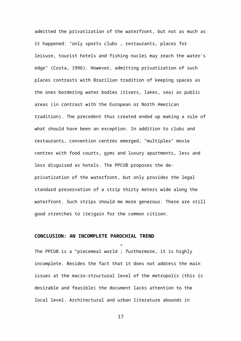
morphological centre, towards southwest. The demographic 4
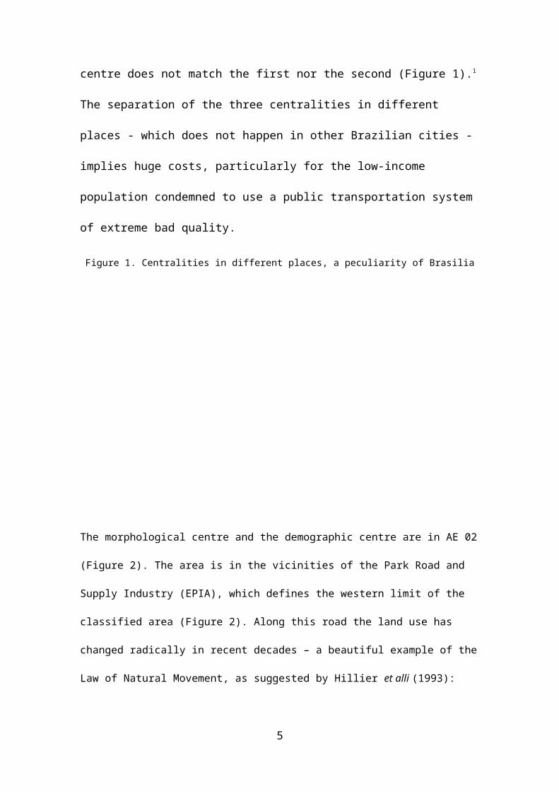
centre does not match the first nor the second (Figure 1).1
The separation of the three centralities in different
places - which does not happen in other Brazilian cities -
implies huge costs, particularly for the low-income
population condemned to use a public transportation system
of extreme bad quality.
Figure 1. Centralities in different places, a peculiarity of Brasilia
#
#
#
C E N TR O M O R FO LÓ G IC O
C B D - C R U ZA M E N TO D O S E IXO S
C E N TR O D E M A S S A 11,6 Km
10,3 Km
5,8 K
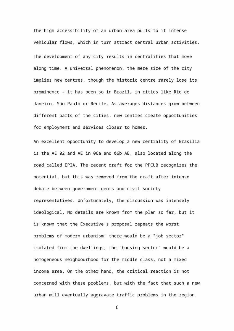
The morphological centre and the demographic centre are in AE 02
(Figure 2). The area is in the vicinities of the Park Road and
Supply Industry (EPIA), which defines the western limit of the
classified area (Figure 2). Along this road the land use has
changed radically in recent decades – a beautiful example of the
Law of Natural Movement, as suggested by Hillier et alli (1993):
5
the high accessibility of an urban area pulls to it intense
vehicular flows, which in turn attract central urban activities.
The development of any city results in centralities that move
along time. A universal phenomenon, the mere size of the city
implies new centres, though the historic centre rarely lose its
prominence – it has been so in Brazil, in cities like Rio de
Janeiro, São Paulo or Recife. As averages distances grow between
different parts of the cities, new centres create opportunities
for employment and services closer to homes.
An excellent opportunity to develop a new centrality of Brasilia
is the AE 02 and AE in 06a and 06b AE, also located along the
road called EPIA. The recent draft for the PPCUB recognizes the
potential, but this was removed from the draft after intense
debate between government gents and civil society
representatives. Unfortunately, the discussion was intensely
ideological. No details are known from the plan so far, but it
is known that the Executive's proposal repeats the worst
problems of modern urbanism: there would be a "job sector"
isolated from the dwellings; the "housing sector" would be a
homogeneous neighbourhood for the middle class, not a mixed
income area. On the other hand, the critical reaction is not
concerned with these problems, but with the fact that such a new
urban will eventually aggravate traffic problems in the region.
6
Land use and mobility are not thought of as both variables in
the equation; no thoughts are dedicated to the fact that a new
centrality requires new patterns of mobility, especially in
Brasilia, where eventually the current standards – based in the
private car – will have to be revised.
But the reaction of Civil Society against the expansion area
hides something more, not just mobility issues: it masks the
ideology of apartheid, whereby a cordon sanitaire must continue to
isolate as much as possible the metropolitan core - the master
plan designed by Lucio Costa – from the rest of the metropolis.
By political opportunism, the State withdrew the proposal.
Eventually it will return: another example, among others, to
illustrate the trend, also in Brasilia, towards a more compact
city, despite the isolationist desires of the upper classes who
inhabit the central areas of the metropolis.
Among the considerations about urban expansions, there are no
comments on built heights based on clear criteria for the
visibility of the classified area and its main buildings may be
defined (white area in the centre of Figure 2). In AE06B, in the
same figure, nothing built with less than 100 meters in height
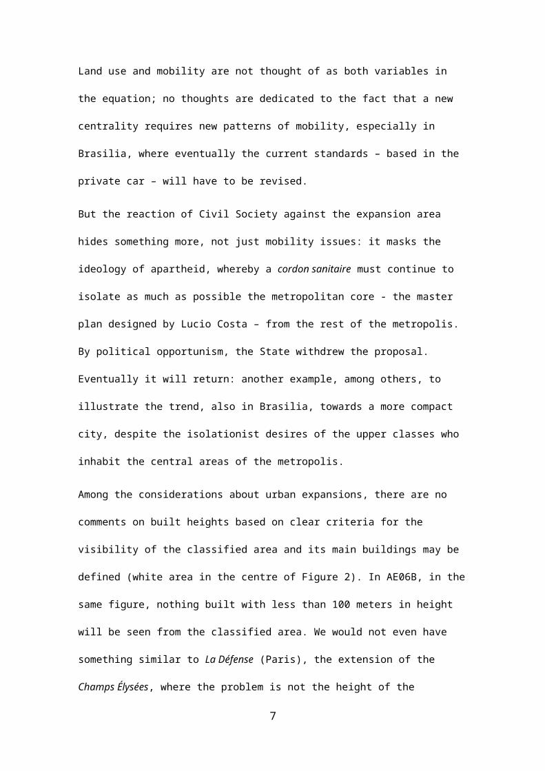
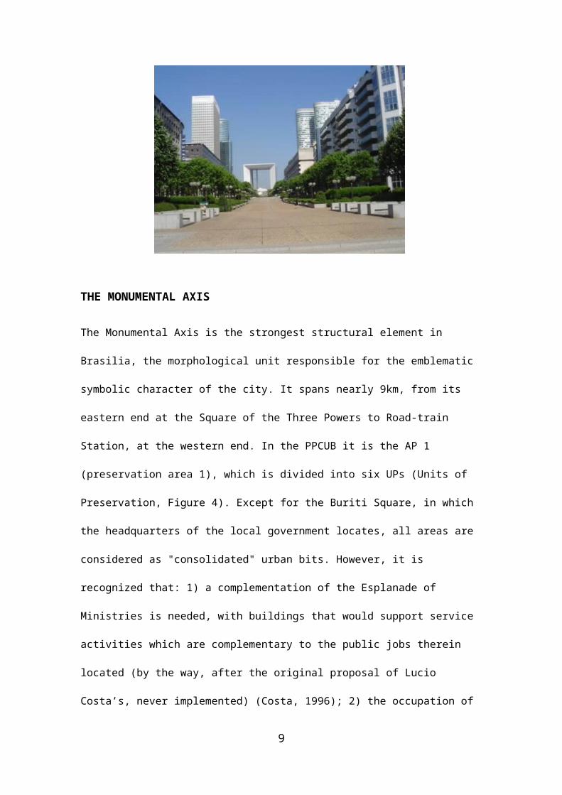
will be seen from the classified area. We would not even have
something similar to La Défense (Paris), the extension of the
Champs Élysées, where the problem is not the height of the
7
skyscrapers, but the poor public they define (Figure 3). These
sites of the surrounding spots of the classified area are
valuable resources for the metropolitan development, a
potentiality so far ignored by both State and Civil Society.
Figure 2. Surrounding areas of the site declared World Cultural
Heritage. (Source: <www.sedhab.df.gov.br/>.)
Figure 3. La Défense (Paris)
8
THE MONUMENTAL AXIS
The Monumental Axis is the strongest structural element in
Brasilia, the morphological unit responsible for the emblematic
symbolic character of the city. It spans nearly 9km, from its
eastern end at the Square of the Three Powers to Road-train
Station, at the western end. In the PPCUB it is the AP 1
(preservation area 1), which is divided into six UPs (Units of
Preservation, Figure 4). Except for the Buriti Square, in which
the headquarters of the local government locates, all areas are
considered as "consolidated" urban bits. However, it is
recognized that: 1) a complementation of the Esplanade of
Ministries is needed, with buildings that would support service
activities which are complementary to the public jobs therein
located (by the way, after the original proposal of Lucio
Costa’s, never implemented) (Costa, 1996); 2) the occupation of
9
the final tract to the west should be intensified, one which
extends from the Buritis Square to the Road-train Station (AP1,
UP6), with institutional, "cultural, recreational and sports"
activities, and the provision of services. The proposal was also
withdrawn from the draft.
10
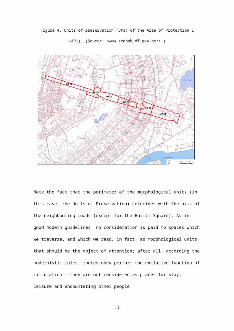
Figure 4. Units of preservation (UPs) of the Area of Protection 1
(AP1). (Source: <www.sedhab.df.gov.br/>.)
Note the fact that the perimeter of the morphological units (in
this case, the Units of Preservation) coincides with the axis of
the neighbouring roads (except for the Buriti Square). As in
good modern guidelines, no consideration is paid to spaces which
we traverse, and which we read, in fact, as morphological units
that should be the object of attention; after all, according the
modernistic rules, routes obey perform the exclusive function of
circulation – they are not considered as places for stay,
leisure and encountering other people.
11
To consider the streets as simple tools for vehicular
circulation results - again – in the disregard for the bordering
buildings. The configuration of the Monumental Axis should
necessarily be differentiated according to its tracts,
especially in a city that excels in many ways, e.g. by clear
space/built volumes relations. No, today the occupation of urban
block edges is random, and no discussion about it is present in
the draft. Along the borders of the Monumental Axis there is
everything: buildings 65m in height in hotel sectors; empty
parking lots of big facilities, such as the Mane Garrincha
Football Stadium or Nielson Nelson Gym; the palaces of the
Buriti Square; single family residences in the Urban Military
Sector and Cruzeiro Velho neighbourhood etc. Each new demand
that arises comes with ad hoc definitions for the built types
concerned and does not relate to the configuration of the place
in which they locate (something that is done so well in the
Esplanade of Ministries).
12
In the areas which are considered as "consolidated", but which
nevertheless present many empty spaces, some occupation is
proposed, e.g. plots of land "between 10.000m2 and 20.000m2".
However, no criteria for their number, location and
configuration are offered. This is particularly the case of the
rectangular grassy central area 2,500m long by 170m (the western
tract, UP6, Figure 4), in which there is only a religious
building. As long as they keep the predominantly bucolic
character of the park, the space should be marked by occasional
edifices. This new visual stimuli would strengthen the image of
the city is this area (and contribute for the image of the city
as a whole), which is now mostly deserted with no justifiable
reasons for that – practical or expressive. However, such
occupation was considered by sections of Civil Society as simply
reflected the greed of the builders for more and more built
areas. Ideology revisited.
THE CENTRAL SECTORS
In the central and densest areas of the Pilot Plan
discontinuities proliferate, as well as paths to be traversed by
pedestrians in long stretches which are devoid of activity -
paths in the middle of nowhere. Even more so than in projects
dated from the classical period of modern urbanism (1960s),
13
spaces defined by blank walls abound, or buildings are designed
in introverted schemes, as in the North Commercial Sector, which
dates from the late 1980s onwards, Figure 5): activities open to
the interior of the edifices and there are few openings relating
internal spaces and the public, open space realm of the city.
Huge voids that did not exist in the plan have never been
occupied with buildings (Figure 6). Morphological concerns about
space for public life are absent from PPCUB. Patterns and
indices proposed in the plan do not refer to urban space but to
buildings seen in isolation: Article 63 lists five of them, all
referring to space inside the borders of the plots. Concerns for
the quality or public urban space are simply absent, except as
general recommendations in respect to urban furniture, trees
etc. One might fear the proposal for an increase in buildings
height in the hotel sectors, where buildings are only two
stories high today - eventually it will happen, and this is not
bad, for nothing justifies such a low dense occupation in such a
central area. But, as before, the point is not simply increasing
building heights and occupation ratios, but configuring the
public sphere in a better way.
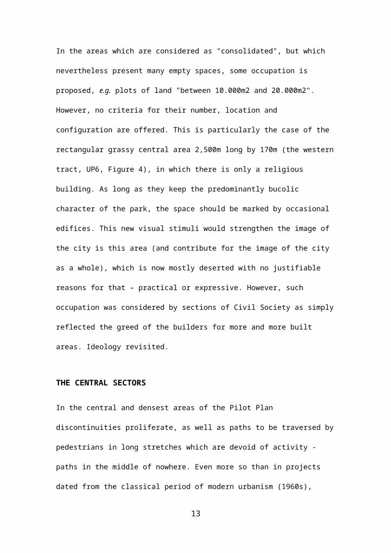
Figure 5. North Commercial Sector, Brasília
14
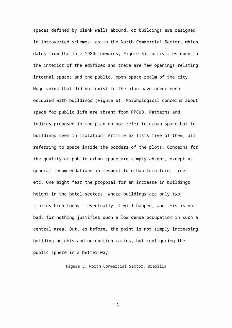
Figure 6. Unpredicted void between Amusement Sectors North and South
THE “LABYRINTH OF THE DESERT”
The AP 07 and AP 08 comprise the low-occupancy areas east of the
residential wings of the Pilot Plan. These are areas in which
there is a proliferation of the remnants of one of the two
typical "labyrinths" of modern urbanism, the "labyrinth of the
desert", dominated by the "far": major morphological
discontinuities, with few or no visual stimuli on a smaller
scale, impairing readability and urban orientability. (The
15
second “labyrinth” is the “labyrinth of the walls”, in which, on
the contrary, we see only “near”, the place lacks global
references [Borges, 2009].) It is almost unbelievable that the
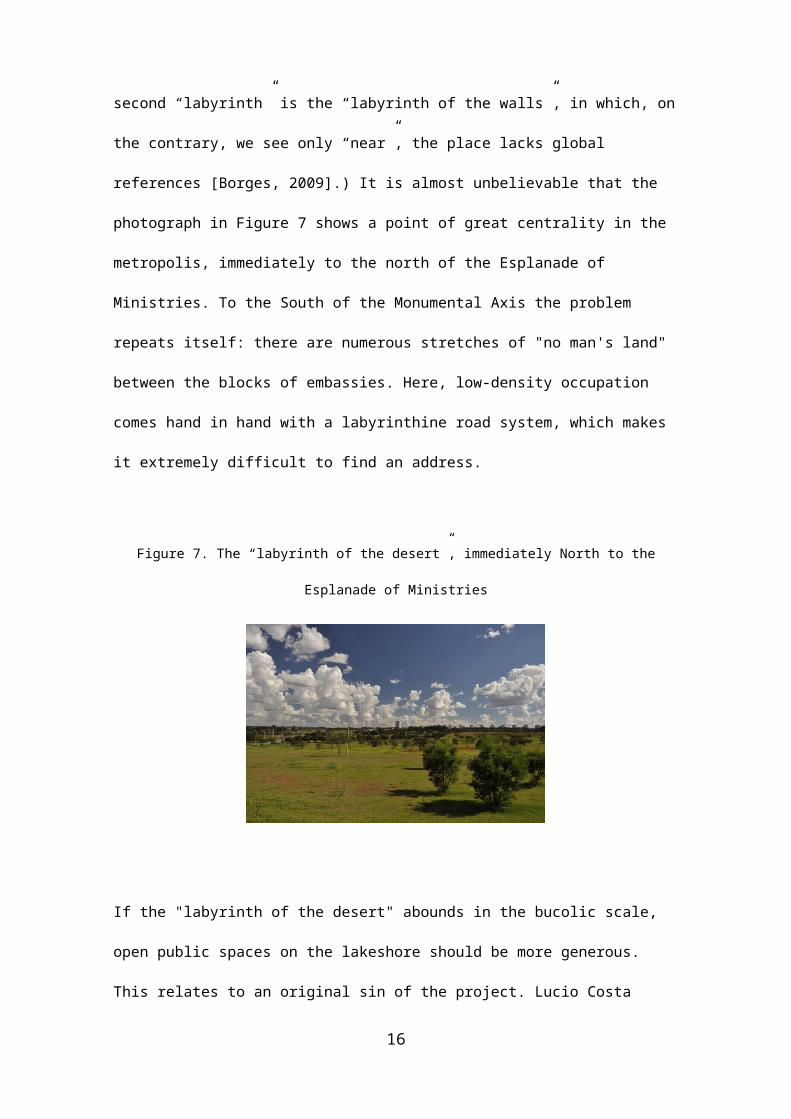
photograph in Figure 7 shows a point of great centrality in the
metropolis, immediately to the north of the Esplanade of
Ministries. To the South of the Monumental Axis the problem
repeats itself: there are numerous stretches of "no man's land"
between the blocks of embassies. Here, low-density occupation
comes hand in hand with a labyrinthine road system, which makes
it extremely difficult to find an address.
Figure 7. The “labyrinth of the desert”, immediately North to the
Esplanade of Ministries
If the "labyrinth of the desert" abounds in the bucolic scale,
open public spaces on the lakeshore should be more generous.
This relates to an original sin of the project. Lucio Costa
16
admitted the privatization of the waterfront, but not as much as
it happened: "only sports clubs , restaurants, places for
leisure, tourist hotels and fishing nuclei may reach the water's
edge" (Costa, 1996). However, admitting privatization of such
places contrasts with Brazilian tradition of keeping spaces as
the ones bordering water bodies (rivers, lakes, sea) as public
areas (in contrast with the European or North American
tradition). The precedent thus created ended up making a rule of
what should have been an exception. In addition to clubs and
restaurants, convention centres emerged, "multiplex" movie
centres with food courts, gyms and luxury apartments, less and
less disguised as hotels. The PPCUB proposes the de-
privatization of the waterfront, but only provides the legal
standard preservation of a strip thirty meters wide along the
waterfront. Such strips should me more generous. There are still
good stretches to (re)gain for the common citizen.
CONCLUSION: AN INCOMPLETE PAROCHIAL TREND
The PPCUB is a “piecemeal world”; furthermore, it is highly
incomplete. Besides the fact that it does not address the main
issues at the macro-structural level of the metropolis (this is
desirable and feasible) the document lacks attention to the
local level. Architectural and urban literature abounds in
17
suggestions concerning decent spaces for a healthy public life,
particularly in cities’ central areas. Since the pioneering work
of Kevin Lynch (1960) and Jane Jacobs (1961) – let alone Camillo
Sitte (1889) – many authors have contributed to such issues:
Christopher Alexander et alli (1977), Bill Hillier and Julienne
Hanson (1984), Alan Jacobs and Donald Appleyard (1987), the
people belonging to the movement Project for Public Spaces (2005),
Andrés Duany and the Congress for the New Urbanism (1993), Jan Gehl
(2006), and many others. Some summarizing examples illustrate
what is missing the PPCUB: the amount and shape of space
compared to the total urban area (too much free space is
occupied only in exceptional circumstances, not in the daily
life of the city); the average size of morphological units of
open space, particularly the width of the streets, damaging an
appropriate scale of the places in between built façades, so
that we might have good visibility and recognition of other
people; variety, complementarity and distribution of activities
in time, related to a vital urban space; the occurrence of
housing in central areas, a proper distribution of various built
types and densities, that would provide for a greater
concentration of people; design at a micro scale, concerning the
street space, and taking into account accessibility issues,
priority to pedestrians, cyclists, and public transport etc.;
18
the small size of the blocks, facilitating movement across city
parts, particularly in central areas; the "constitution" of
places, i.e. frequent direct transitions between inside and
outside, but also numerous windows (the "eyes on the street"),
avoiding one of the most perverse attributes of modern urbanism
etc.
The PPCUB reproduces the classic modern view of the city: the
objects of attention are the sectors of the city or the isolated
buildings. Rules never relate to the spaces in between built
volumes, the attention is concentrated in the indices within
plots. Rules are related to "conservation units" whose
boundaries are important arterial roads which, however, are not
the object of attention as defined by bordering built volumes -
or else, we find the great error of defining a pathway itself,
independently from what surrounds it, as a “unit of
preservation”. Surely, the normative maintains built heights in
accordance with the "scales" of the city – namely the
morphological types that constitute Brasilia’s configuration:
taller in the urban centre, lower the residential wings, with
larger open spaces in the Civic Centre etc. It is not enough. In
all areas, morphological problems continue to haunt the city as
unburied ghosts.
19
The PPCUB is the exemplary translation, in a legal document, of
the hegemony of modern urbanism, rightly criticized in many
places on the world for the damage it has caused to spaces for
public life. In Brasilia, it continues to reign sovereign. Some
people think that maintaining the essential qualities of the
city depends on the reproduction of modern orthodox principles.
On the contrary, the essential qualities of Brasilia do not
relate to its modern character. They stem from the attributes
that makes the qualities of cities of all times, particularly in
its expressive dimensions: a strong identity, a clear
readability of its parts and their interconnection as a system
(à la Lynch), a unique beauty, a configuration that fulfils its
role as a symbol of nationality etc. Problems, on the other
hand, do relate to modern principles: the city-for-all-people,
in which a same built type would be suitable to every class, has
proved a myth; the superblock buildings are constituted by flats
which imply a lot of money to buy and to maintain them; strong
physical barriers impose heavy burden for pedestrians; mobility
patterns are compatible with the private car, not with public
transport; bio-climatically, the city is comfortable within
sectors (or superblocks), very uncomfortable outside them (or in
between them).
20
Brasilia was not been declared World Cultural Heritage for
“historical” reasons, nor because it is “original”, nor because
it represents a certain architectural movement and a certain
epoch. Certainly, circumstantial reasons appear in the texts of
its classification as a heritage site. However, does this
actually underlies the classification, or is it an ideological
discourse, blind to the essential qualities of the city? If
circumstances come to the fore, are we not “degrading an
aesthetic appreciation to a historical assessment” (Cicero,
2012)? Brasilia is worth not because Lucio Costa is among the
first to do something, but because he is among the best; not
because he makes things anew, but because he makes things that
do not get old.
Solving impending problems depends on thinking systemically about
the city, not about its isolated bits – not parochially. Solving
its problems is to free the city from the perverse circumstances
in which it was created.
The PPCUB is, again, a lost opportunity.
REFERENCES
ALEXANDER, C.; ISHIKAWA, S.; SILVERSTEIN, M. (1977) A pattern Language
(Oxford University Press, New York).
21
BORGES, Jorge Luis (2009) ‘Os dois reis e os dois labirintos’, in
BORGES, Jorge Luis O Aleph (Editora Schwarcz LTDA, São Paulo) 122-123.
CICERO, Antonio (2012) Poesia e filosofia (Civilização Brasileira, Rio de
Janeiro).
CONGRESS FOR THE NEW URBANISM (1993) Charter for the New Urbanism
(http://www.cnu.org/charter) accessed 25 May 2014.
COSTA, Lucio (1995) Lucio Costa: registro de uma vivência (Empresa das Artes,
São Paulo).
GEHL, J. (2006) Life between buildings: using public space (The Danish
Architectural Press, Copenhagen).
HILLIER, Bill et alli. (1993) ‘Natural movement: or, configuration and
attraction in urban pedestrian movement’, Environment and Planning B: Planning
and Design 20, 29-66.
HILLIER, Bill; HANSON, Julienne (1984) The Social Logic of Space (Cambridge
University Press, Cambridge).
HOLANDA, Frederico de (ed.) (2011) Arquitetura e Urbanidade (FRBH, Brasília).
HOLANDA, Frederico de (2010) Brasília - cidade moderna, cidade eterna (FAU UnB,
Brasília).
HOLANDA, Frederico de (2002) O espaço de exceção (Editora Universidade de
Brasília, Brasília).
HOLANDA, Frederico de (2011) Oscar Niemeyer: De vidro e concreto / Of glass and
concrete (FRBH, Brasília).
22
HOLANDA, Frederico de, TENORIO, Gabriela (2010) ‘Brasilia:
informalidad en los intersticios del orden dominante, in X CONGRESO
INTERNACIONAL DE REHABILITACIÓN DEL PATRIMONIO ARQUITECTÓNICO Y
EDIFICACIÓN (CICOP, Santiago).
JACOBS, A.; APPLEYARD, D. (1987) ‘Toward an Urban Desing Manifesto’,
Journal of the American Planning Association (112-120).
JACOBS, Jane (1961) The Death and Life of Great American Cities (Random House, New
York).
LYNCH, Kevin (1960) The image of the city (The MIT Press, Harvard).
PAVIANI, Aldo (ed.) (1985) Brasília, Ideologia e Realidade. Espaço Urbano em Questão
(Projeto Ed., São Paulo).
PROJECT FOR PUBLIC SPACES (2005) How to turn a place around - A handbook for
creating successful public spaces (Project for Public Spaces, Nova York).
SEDHAB. Plano de Preservação do Conjunto Urbanístico de Brasília. Available in: <www.sedhab.df.gov.br/>. Access: 31st May 2012.
SITTE, Camillo (1992) A construção das cidades segundo seus princípios artísticos
(Editora Ática S. A., São Paulo.
Keywords: Brasilia, preservation policies, architectural ideology,
conflicting interests
Conference theme: ii. Urban morphological methods and techniques
23

1 Figure 1 shows part of the road axes of Brasilia municipality, where the three centres of this “tri-cephalous” city locate. The axial map comes from Space Syntax Theory. The warmer the colours (tending to red), the more accessible are the roads to the system as a whole.


