Embed Size (px)
Citation preview
Chapter 1
4 Landscape, Recreation and Am
enities
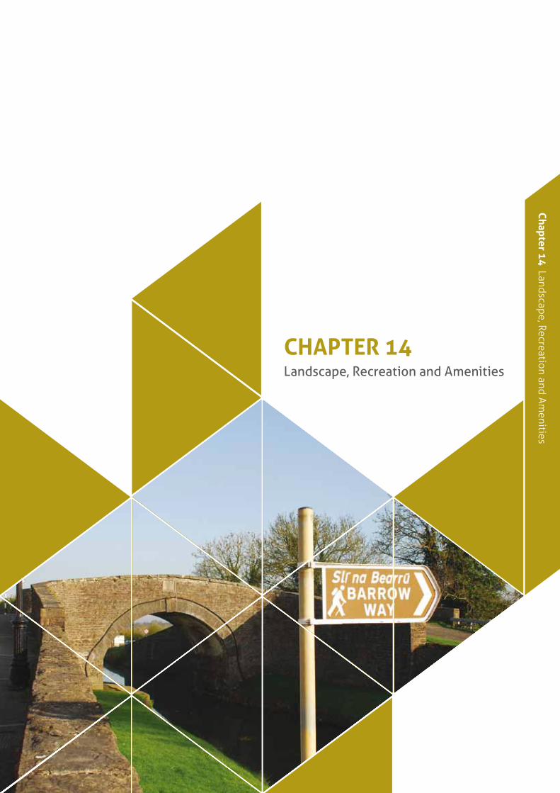
Chapter 14 Landscape, Recreation and Amenities
// Kildare County Development Plan 2011–2017266
14.1 Background
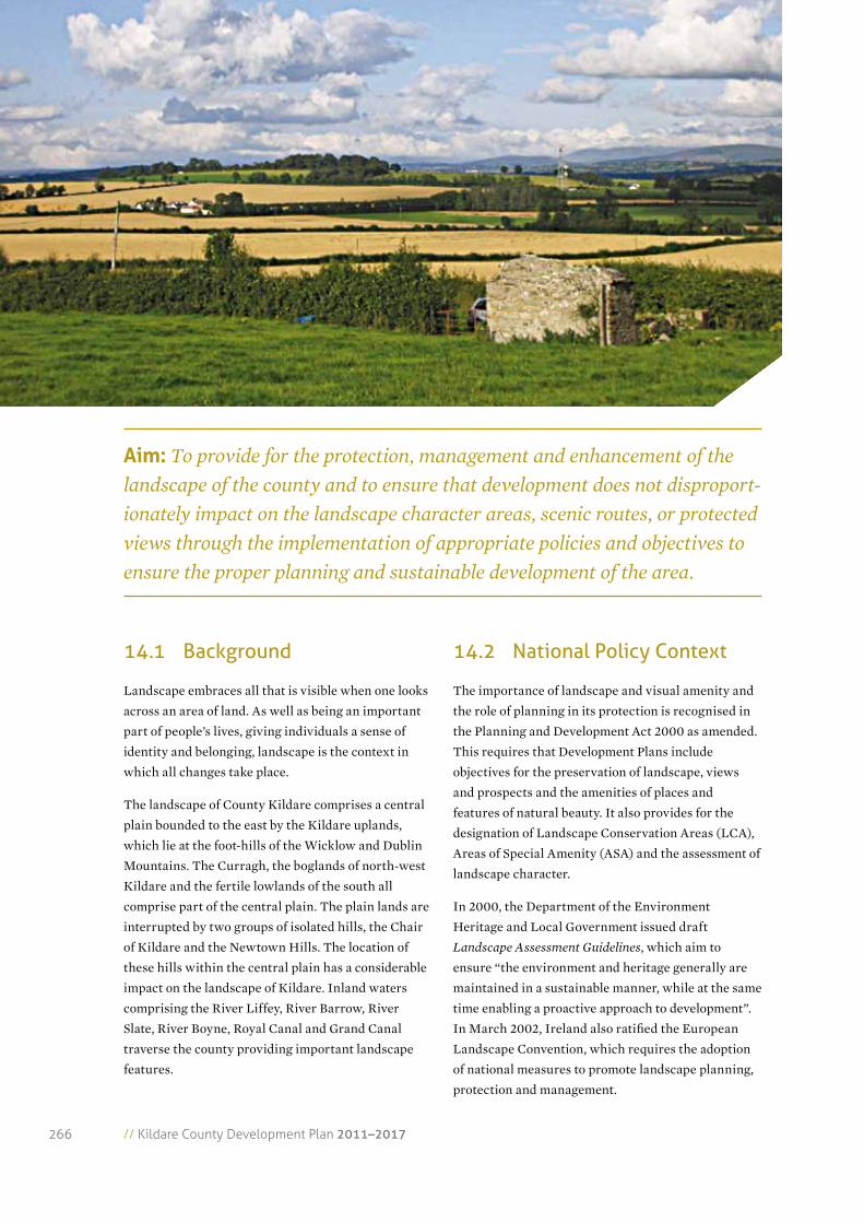
Landscape embraces all that is visible when one looks
across an area of land. As well as being an important
part of people’s lives, giving individuals a sense of
identity and belonging, landscape is the context in
which all changes take place.
The landscape of County Kildare comprises a central
plain bounded to the east by the Kildare uplands,
which lie at the foot-hills of the Wicklow and Dublin
Mountains. The Curragh, the boglands of north-west
Kildare and the fertile lowlands of the south all
comprise part of the central plain. The plain lands are
interrupted by two groups of isolated hills, the Chair
of Kildare and the Newtown Hills. The location of
these hills within the central plain has a considerable
impact on the landscape of Kildare. Inland waters
comprising the River Liffey, River Barrow, River
Slate, River Boyne, Royal Canal and Grand Canal
traverse the county providing important landscape
features.
14.2 National Policy Context
The importance of landscape and visual amenity and
the role of planning in its protection is recognised in
the Planning and Development Act 2000 as amended.
This requires that Development Plans include
objectives for the preservation of landscape, views
and prospects and the amenities of places and
features of natural beauty. It also provides for the
designation of Landscape Conservation Areas (LCA),
Areas of Special Amenity (ASA) and the assessment of
landscape character.
In 2000, the Department of the Environment
Heritage and Local Government issued draft
Landscape Assessment Guidelines, which aim to
ensure “the environment and heritage generally are
maintained in a sustainable manner, while at the same
time enabling a proactive approach to development”.
In March 2002, Ireland also ratified the European
Landscape Convention, which requires the adoption
of national measures to promote landscape planning,
protection and management.
aim: To provide for the protection, management and enhancement of the landscape of the county and to ensure that development does not disproport-ionately impact on the landscape character areas, scenic routes, or protected views through the implementation of appropriate policies and objectives to ensure the proper planning and sustainable development of the area.
Chapter 1
4 Landscape, Recreation and Am
enities
267
14.3 Strategy
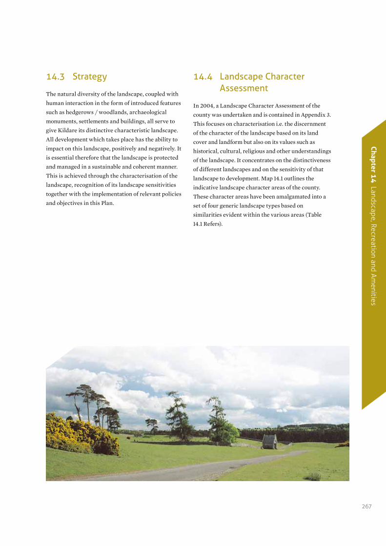
The natural diversity of the landscape, coupled with
human interaction in the form of introduced features
such as hedgerows / woodlands, archaeological
monuments, settlements and buildings, all serve to
give Kildare its distinctive characteristic landscape.
All development which takes place has the ability to
impact on this landscape, positively and negatively. It
is essential therefore that the landscape is protected
and managed in a sustainable and coherent manner.
This is achieved through the characterisation of the
landscape, recognition of its landscape sensitivities
together with the implementation of relevant policies
and objectives in this Plan.
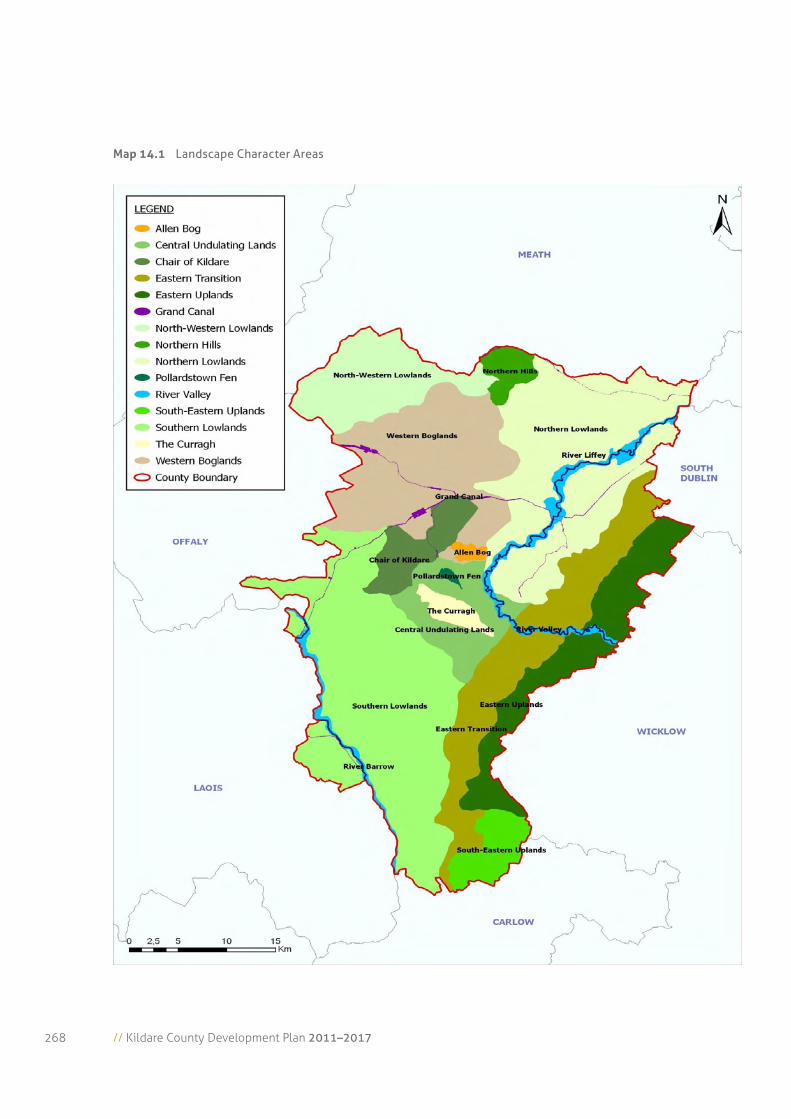
14.4 Landscape Character Assessment
In 2004, a Landscape Character Assessment of the
county was undertaken and is contained in Appendix 3.
This focuses on characterisation i.e. the discernment
of the character of the landscape based on its land
cover and landform but also on its values such as
historical, cultural, religious and other understandings
of the landscape. It concentrates on the distinctiveness
of different landscapes and on the sensitivity of that
landscape to development. Map 14.1 outlines the
indicative landscape character areas of the county.
These character areas have been amalgamated into a
set of four generic landscape types based on
similarities evident within the various areas (Table
14.1 Refers).
// Kildare County Development Plan 2011–2017268
Map 14.1 Landscape Character Areas
Chapter 1
4 Landscape, Recreation and Am
enities
269
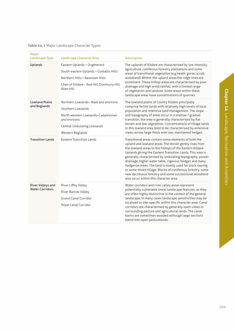
table 14.1 Major Landscape Character Types
Major Landscape Type Landscape Character Area Description
Uplands Eastern Uplands – Oughterard
South-eastern Uplands – Corballis Hills
Northern Hills – Newtown Hills
Chair of Kildare – Red Hill, Dunmurry Hill, Allen Hill
The uplands of Kildare are characterised by low intensity agriculture, coniferous forestry plantations and some areas of transitional vegetation (e.g heath, gorse, scrub, woodland). Within the upland areas the ridge lines are prominent. These hilltop areas are characterised by poor drainage and high wind/rainfall, with a limited range of vegetation and landuse. Some areas within these landscape areas have concentrations of quarries.
Lowland Plains and Boglands
Northern Lowlands– Naas and environs
Southern Lowlands
North-western Lowlands–Cadamstown and environs
Central Undulating Lowlands
Western Boglands
The lowland plains of County Kildare principally comprise fertile lands with relatively high levels of local population and intensive land management. The slope and topography of areas occur in a shallow / gradual transition; the area is generally characterised by flat terrain and low vegetation. Concentrations of tillage lands in this lowland area tend to be characterised by extensive views across large fields with low, maintained hedges.
Transition Lands Eastern Transition Lands Transitional areas contain some elements of both the upland and lowland areas. The terrain gently rises from the lowland areas to the hilltops of the Eastern Kildare Uplands giving the Eastern Transition Lands. This area is generally characterised by undulating topography, poorer drainage, higher water table, vigorous hedges and many hedgerow trees. The land is mostly used for stock rearing or some mixed tillage. Blocks of coniferous forestry, some new deciduous forestry and some successional woodland also occur within this character area.
River Valleys and Water Corridors
River Liffey Valley
River Barrow Valley
Grand Canal Corridor
Royal Canal Corridor
Water corridors and river valley areas represent potentially vulnerable linear landscape features, as they are often highly distinctive in the context of the general landscape. In many cases landscape sensitivities may be localised or site-specific within this character area. Canal corridors are characterised by generally open views to surrounding pasture and agricultural lands. The canal banks are sometimes wooded although large sections blend into open pasturelands.
// Kildare County Development Plan 2011–2017270
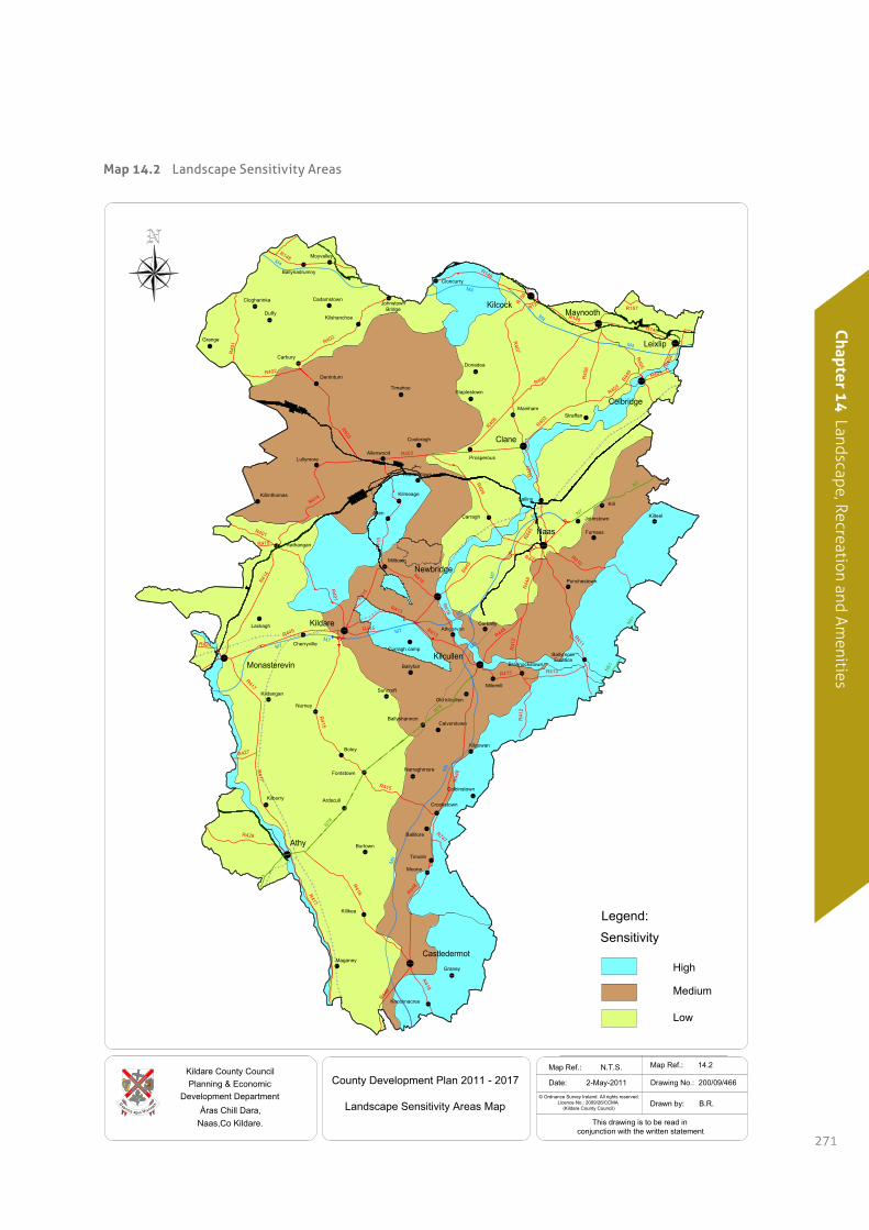
14.4.1 Landscape Sensitivity
Based on the findings of the Landscape Character
Assessment a landscape sensitivity rating was
developed for each of the Landscape Character Areas.
Landscape sensitivity is a measure of the ability of the
landscape to accommodate change or intervention
without suffering unacceptable effects to its character
and values. It is determined using the following
factors: slope, ridgeline, water bodies, land use and
prior development. The landscape Character Areas
have been mapped according to their landscape
sensitivity (Map 14.2 refers).
Low Sensitivity Landscapes
Low sensitivity landscapes are robust landscapes
which are tolerant to change, and which have the
ability to accommodate development pressure. These
landscapes comprise:
•Northern Lowlands – Naas and environs.
•Southern Lowlands.
•North-western Lowlands – Cadamstown and
environs.
Medium Sensitivity Landscapes
Medium sensitivity landscapes can accommodate
development pressure but with limitations in the scale
and magnitude. In this rank of sensitivity, landscape
elements can accept some changes while others are
more vulnerable to change. These landscapes
comprise:
•Central Undulating Lowlands.
•Western Boglands.
•Transition lands.
High Sensitivity Landscapes
High sensitivity landscapes are vulnerable landscapes
with the ability to accommodate limited development
pressure. In this rank of sensitivity, landscape quality
is at a high level and landscape elements are highly
sensitive to certain types of change. If pressure for
development exceeds the landscape’s limitations the
character of the landscape may change. These
landscapes comprise:
•Eastern Uplands – Oughterard.
•South-eastern Uplands – Corballis Hills.
•Northern Hills – Newtown Hills.
•Chair of Kildare – Red Hill, Dunmurry Hill, Allen
Hill.
•River Valleys and Canal Corridors
(River Liffey Valley, River Barrow Valley, Grand
Canal Corridor, Royal Canal Corridor).
14.4.2 Impact of Development on Landscape
In order to determine the likely perceived impact of a
particular development on the landscape, the
potential impact of the development must be viewed
in light of the sensitivity of the area. However, all
developments are unique and at micro / local level
landscapes vary in terms of their ability to absorb
development and each site should be assessed on its
individual merits.
Chapter 1
4 Landscape, Recreation and Am
enities
271
Map 14.2 Landscape Sensitivity Areas
AthgarvanCorbally
M7
M9
M4
R448
N7
Carbury
JohnstownBridge
Allenwood
Rathangan
Fontstown
Crookstown
Prosperous
M7
R148
M4
M7
M7
N78
N78
M9
Killkea
Ballynadrumny
Moyvalley
Cadamstown
Duffy
Clogharinka
Grange
Kilshanchoe
Cloncurry
Timahoe
Donadea
Staplestown
Mainham
Cooleragh
Lullymore
Killinthomas
Milltown
Allen
Kilmeage
Carragh
Sallins
Straffan
Kill
Johnstown
Furness
Kilteel
Punchestown
R418R417
R415
R415
R417
R427
R428
R418
R747
R410
R411
R41
2
R448
R413
R41
2
R413
R416
R445
R416
R413
R413
R415
R41
5
R401
R44
8
R409
R40
7
R403
R414
R401
R419
R414
R403
R402
R402
R40
1
R407
R40
6
R405
R403
R403
R148
R157
R148
N7
R445
M7
M7
R417
Knocknacree
Graney
Maganey
Timolin
Moone
Burtown
Ardscull
Colbinstown
Kilgowan
Narraghmore
Calverstown
Boley
Kilberry
Nurney
KildanganOld kilcullen
Milemill
Curragh campCherryville
Lackagh
Ballyfair
Derrinturn
R445
R408
M4
M4
R148
R158
R125
R449 R403
R404
R44
8
Ballitore
M9
R448
R445
R447
R408
N81
N81
Robertstown
Maynooth
Celbridge
Leixlip
Clane
Kilcock
Naas
Monasterevin
Kildare
Kilcullen
Athy
Castledermot
EustaceBallymore
Brannockstown
Ballyshannon
Suncroft
Newbridge
R424
County Development Plan 2011 - 2017
Landscape Sensitivity Areas MaphcaensiMsugaamnaeM
Kildare County CouncilPlanning & Economic
Development DepartmentÁras Chill Dara,
Naas,Co Kildare.
© Ordnance Survey Ireland. All rights reserved. Licence No.: 2009/26/CCMA (Kildare County Council)
This drawing is to be read inconjunction with the written statement
Date: 2-May-2011
Map Ref.: 14.2
Drawing No.: 200/09/466
Drawn by: B.R.
Map Ref.: N.T.S.
High
Medium
Low
SensitivityLegend:
// Kildare County Development Plan 2011–2017272
14.5 Areas of High Amenity
In addition to landscape character areas and the
sensitivity of these areas to development there are
certain special landscape areas within the county,
some of which overlap with sensitive landscapes. For
the purposes of this Plan these areas have been
defined as Areas of High Amenity. They are classified
because of their outstanding natural beauty and/or
unique interest value and are generally sensitive to
the impacts of development. These areas are outlined
in the following sub-sections.
14.5.1 the Curragh and environs
The Curragh, located between Newbridge and
Kildare Town, is the largest area of unenclosed
natural grassland in the country and provides a
valuable amenity area for the surrounding towns of
Kildare, Newbridge and Kilcullen. The Curragh Camp
and the Curragh Racecourse are located within the
plain.
The Curragh constitutes a unique national asset from
the point of view of landscape and geomorphology
which extends over 2000 hectares and is an historic
open plain of high conservation value. Extensive
views can be obtained from the south-east of the site,
at St. Legers Bottoms, around much of the perimeter
of the site. The sense of openess has been diminished
over the years with the development of the military
camp, the racecourse complex, the railway, the new
motorway and power lines.
The Curragh is of conservation value for a number of
reasons. It is most unusual in an Irish and European
context, in that it is an extensive open plain area of
lowland acidic grassland, succeeding to dry heath in
places. It has been grazed but unfertilised for
hundreds, perhaps even thousands of years. Due to
the management regime on the open grassland,
nationally important populations of rare fungi are
found which only occur in ancient grasslands.
Landuse at the Curragh is dominated by sheep
grazing on the open plains which are commonage.
Horse exercising and training is carried out on the
many gallops. There is a military range at the south
east of the Curragh where target practice is regularly
carried out.
14.5.2 pollardstown Fen
Pollardstown Fen is situated on the northern margin
of the Curragh, approximately 3km west-north-west
of Newbridge. It lies in a shallow depression, running
in a north-west/south-east direction. Pollardstown
Fen is the largest remaining calcareous spring-fed fen
in Ireland. Covering an area of 220 ha, it is recognised
as an internationally important fen ecosystem with
unique and endangered plant communities. From a
landscape point of view, the unique vegetation and the
low-lying nature of the area allows for extensive
vistas of the site along the local roads, as well as to the
hilltops in the vicinity (e.g. The Hill of Allen).
Consequently, development can have a
disproportionate visual impact in the local context,
due to an inherent inability to be visually absorbed by
the existing topography.
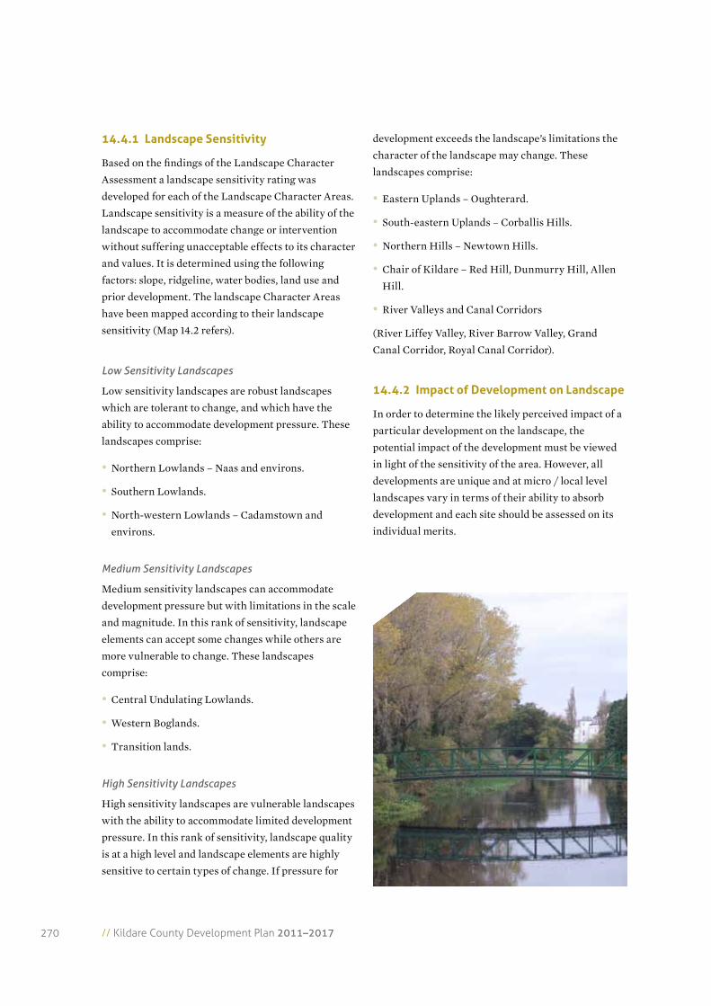
14.5.3 the river Liffey and the river Barrow Valleys
The River Liffey and River Barrow valleys are of
significance in terms of landscape and amenity value
and as such are sensitive to development. They are
characterised by smooth terrain and low vegetation
with extensive upland views (i.e. the Chair of Kildare
to the west and the Eastern Uplands to the east;
distant views including the neighbouring Wicklow
Mountains). The topography is such that it allows
vistas over long distances without disruption along
the river corridor. As a result development on the
banks of the rivers can have a disproportionate visual
impact, due to an inherent inability to be visually
absorbed. However, the undulating topography
occurring within the river valleys provides physical
Chapter 1
4 Landscape, Recreation and Am
enities
273
shielding and has the potential to visually enclose the
built form within the river valley, where it does not
break the skyline. Shelter vegetation exists along some
stretches of the valleys with the presence of natural
and native woodland that grows on the floodplains of
the rivers, as well as by conifer plantation in adjacent
lands. This vegetation has a shielding and absorbing
quality in landscape terms. It can provide a natural
visual barrier as well as add to the complexity of a
vista, breaking it up to provide scale and containment
for built forms.
Many views of the river valleys are available from
local roads and from viewing points located along the
valleys. While river valleys represent potentially
vulnerable linear landscape features, as they are often
highly distinctive in the context of the general
landscape, in certain circumstances landscape
sensitivities may be localised or site-specific.
14.5.4 the Grand and royal Canal Corridors
The Grand Canal and the Royal Canal are extensive
water corridors that flow through the county. The
Grand Canal flows in an east to south-west direction
and divides at Sallins into the Naas and Corbally
Branch, and is further divided in three branches at
Robertstown: the Milltown Feeder, the Barrow Line
and the continuation of the Grand Canal into
neighbouring County Offaly.
The Royal Canal flows in an east to west direction
along the northern boundary of the county through
Leixlip, Maynooth and Kilcock and continues into
County Meath.
The canal corridors and their adjacent lands have
been landscaped and enhanced along the sections
where the canals flow through urban areas. Canal
locks are distinctive features of these water corridors.
The smooth terrain, generally gentle landform and
low canal bank grassland that characterise the canal
corridors, allow vistas over long distances without
disruption, where the canal flows in a straight-line
direction. Consequently, development can have a
disproportionate visual impact along the water
corridor and can prove difficult for the existing
topography, to visually absorb development. The
occurrence of natural vegetation, coniferous and
mixed plantations adjacent to the water corridors can
have shielding and absorbing qualities in landscape
terms, by providing natural visual barriers.
Canal corridors are potentially vulnerable linear
landscape features, as they are often highly
distinctive in the context of the general landscape. In
some cases landscape sensitivities may be localised or
site-specific.
14.5.5 east Kildare Uplands
The Eastern Uplands are located in the northeast of
the county and are part of the Wicklow Mountain
complex. The topography rises from the lowland
plains, through undulating terrain to the highest
points of 379m above sea level (O. D.) at
Cupidstownhill, east of Kilteel. The elevated nature of
this area provides a defined skyline with scenic views
over the central plains of Kildare and the
neighbouring Wicklow Mountains which further
define the skyline and the extent of visibility. The East
Kildare Uplands are rural in character with a number
of scenic views from elevated vantage points. The
general landuse on the uplands is pasture, with some
tillage, quarrying and forestry.
Along a number of roads, which cross the upper and
lower slopes of the uplands, there are long distance
views towards the Kildare lowlands and the Chair of
Kildare. The sloping land provides this area with its
distinctive character and intensifies the visual
prominence and potential adverse impact of any
feature over greater distances. Slope also provides an
increased potential for development to penetrate
primary and secondary ridgelines when viewed from
lower areas. In the Eastern Kildare Uplands, nearly
all ridgelines are secondary when viewed from the
lowland areas, as the Wicklow Mountains to the east
define the skyline (i.e. form primary ridgelines).
Gently undulating topography and shelter vegetation
// Kildare County Development Plan 2011–2017274
provided by conifer and woodland plantation can
provide a shielding of built form. Views of the River
Liffey Valley as well as of the Poulaphouca Reservoir
are available from the hilltops and high points on
some of the local roads.
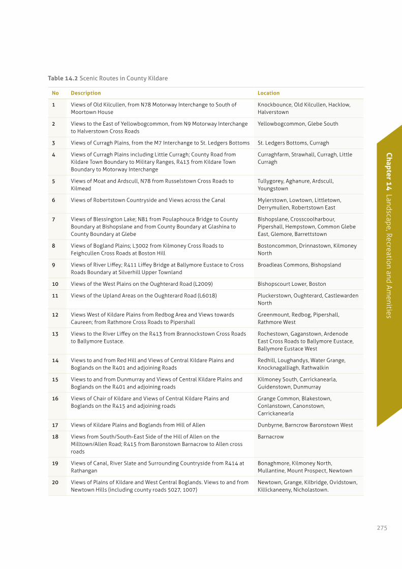
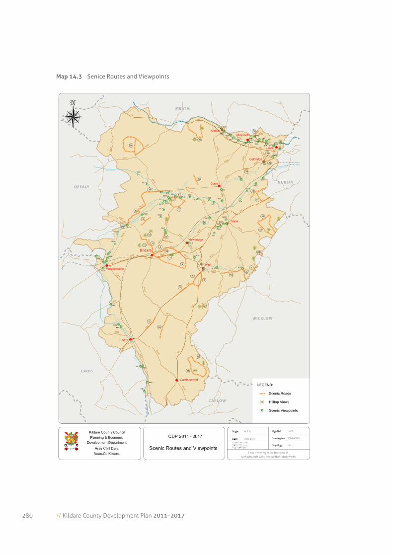
14.6 Scenic Routes and Protected Views
Scenic routes and protected views consist of
important and valued views and prospects within the
county. Table 14.2 lists the specific scenic routes
which provide views of the landscape of the county
and many built and archaeological features. Map 14.3
also outlines the scenic routes within the county.
Each of the views is described individually in
Appendix 4 providing a brief description of the route,
the general views from the route being protected and
the identification of some of the features which make
these particular routes attractive as scenic routes. In
addition to scenic routes there are a number of
protected views throughout the county. These are
located particularly along water corridors and to and
from the hills in the countryside.
The Council recognises the need to protect the
character of the county by protecting views and
scenic routes. However, it is acknowledged that in
certain circumstances, some development may be
necessary. In this regard, appropriate location, siting
and design criteria should strictly apply. All proposals
should be assessed taking into account the overall
character of the scenic route and the character of the
landscapes through which the route passes.
14.6.1 Views to and from the county’s waterways: Grand Canal, royal Canal, river Liffey, river Barrow and the rye Water river.
River floodplains and canal banks are generally
sensitive to development to varying degrees. Both the
rivers and the canal corridors provide a contrast of
form and colour on the landscape. The widths of
rivers and canals vary throughout their corridors and
with that the visual amenity also varies. In some areas
the vegetation along the banks of water corridors has
been cleared and pasturelands characterise the
surrounding landscape while at other points debris
and vegetation cover the banks. Debris material
affects both the quality of the waters and the scenic
views at some locations.
Urban and rural development has taken place along
some sections of the canals and rivers, interrupting
the integrity of these linear landscape features and in
some cases significantly affecting their scenic
amenity value. It is important that development does
not further interrupt the integrity of river and canal
corridors.
Tables 14.3–14.7 identify the protected views to and
from the Royal and Grand Canal and to and from the
River Liffey, River Barrow and Rye River.
14.6.2 Views to and from hills
As the landform of the county is generally flat, with
very little variation in topography, and predominantly
low vegetation, extensive views can be obtained from
hilltops, allowing vistas over long distances, and
similarly from the lowland areas, the eyes are drawn
to the primary and secondary ridgelines that define
the skyline throughout the county. Ridgelines are
conspicuous features of the natural landscape as they
perform an important role as dominant landscape
focal points. It is important that development does not
interrupt the integrity of ridgelines. Development on
steeply sloping land can be viewed over greater
distances.
14.7 Advertising in the Countryside
The proliferation of signs and hoardings in the
countryside detracts from the visual amenity of the
Kildare rural landscape. This signage is a distraction
to road users and may constitute a traffic hazard.
Chapter 1
4 Landscape, Recreation and Am
enities
275
table 14.2 Scenic Routes in County Kildare
No Description Location
1 Views of Old Kilcullen, from N78 Motorway Interchange to South of Moortown House
Knockbounce, Old Kilcullen, Hacklow, Halverstown
2 Views to the East of Yellowbogcommon, from N9 Motorway Interchange to Halverstown Cross Roads
Yellowbogcommon, Glebe South
3 Views of Curragh Plains, from the M7 Interchange to St. Ledgers Bottoms St. Ledgers Bottoms, Curragh
4 Views of Curragh Plains including Little Curragh; County Road from Kildare Town Boundary to Military Ranges, R413 from Kildare Town Boundary to Motorway Interchange
Curraghfarm, Strawhall, Curragh, Little Curragh
5 Views of Moat and Ardscull, N78 from Russelstown Cross Roads to Kilmead
Tullygorey, Aghanure, Ardscull, Youngstown
6 Views of Robertstown Countryside and Views across the Canal Mylerstown, Lowtown, Littletown, Derrymullen, Robertstown East
7 Views of Blessington Lake; N81 from Poulaphouca Bridge to County Boundary at Bishopslane and from County Boundary at Glashina to County Boundary at Glebe
Bishopslane, Crosscoolharbour, Pipershall, Hempstown, Common Glebe East, Glemore, Barrettstown
8 Views of Bogland Plains; L3002 from Kilmoney Cross Roads to Feighcullen Cross Roads at Boston Hill
Bostoncommon, Drinnastown, Kilmoney North
9 Views of River Liffey; R411 Liffey Bridge at Ballymore Eustace to Cross Roads Boundary at Silverhill Upper Townland
Broadleas Commons, Bishopsland
10 Views of the West Plains on the Oughterard Road (L2009) Bishopscourt Lower, Boston
11 Views of the Upland Areas on the Oughterard Road (L6018) Pluckerstown, Oughterard, Castlewarden North
12 Views West of Kildare Plains from Redbog Area and Views towards Caureen; from Rathmore Cross Roads to Pipershall
Greenmount, Redbog, Pipershall, Rathmore West
13 Views to the River Liffey on the R413 from Brannockstown Cross Roads to Ballymore Eustace.
Rochestown, Gaganstown, Ardenode East Cross Roads to Ballymore Eustace, Ballymore Eustace West
14 Views to and from Red Hill and Views of Central Kildare Plains and Boglands on the R401 and adjoining Roads
Redhill, Loughandys, Water Grange, Knocknagalliagh, Rathwalkin
15 Views to and from Dunmurray and Views of Central Kildare Plains and Boglands on the R401 and adjoining roads
Kilmoney South, Carrickanearla, Guidenstown, Dunmurray
16 Views of Chair of Kildare and Views of Central Kildare Plains and Boglands on the R415 and adjoining roads
Grange Common, Blakestown, Conlanstown, Canonstown, Carrickanearla
17 Views of Kildare Plains and Boglands from Hill of Allen Dunbyrne, Barncrow Baronstown West
18 Views from South/South-East Side of the Hill of Allen on the Milltown/Allen Road; R415 from Baronstown Barnacrow to Allen cross roads
Barnacrow
19 Views of Canal, River Slate and Surrounding Countryside from R414 at Rathangan
Bonaghmore, Kilmoney North, Mullantine, Mount Prospect, Newtown
20 Views of Plains of Kildare and West Central Boglands. Views to and from Newtown Hills (including county roads 5027, 1007)
Newtown, Grange, Kilbridge, Ovidstown, Killickaneeny, Nicholastown.
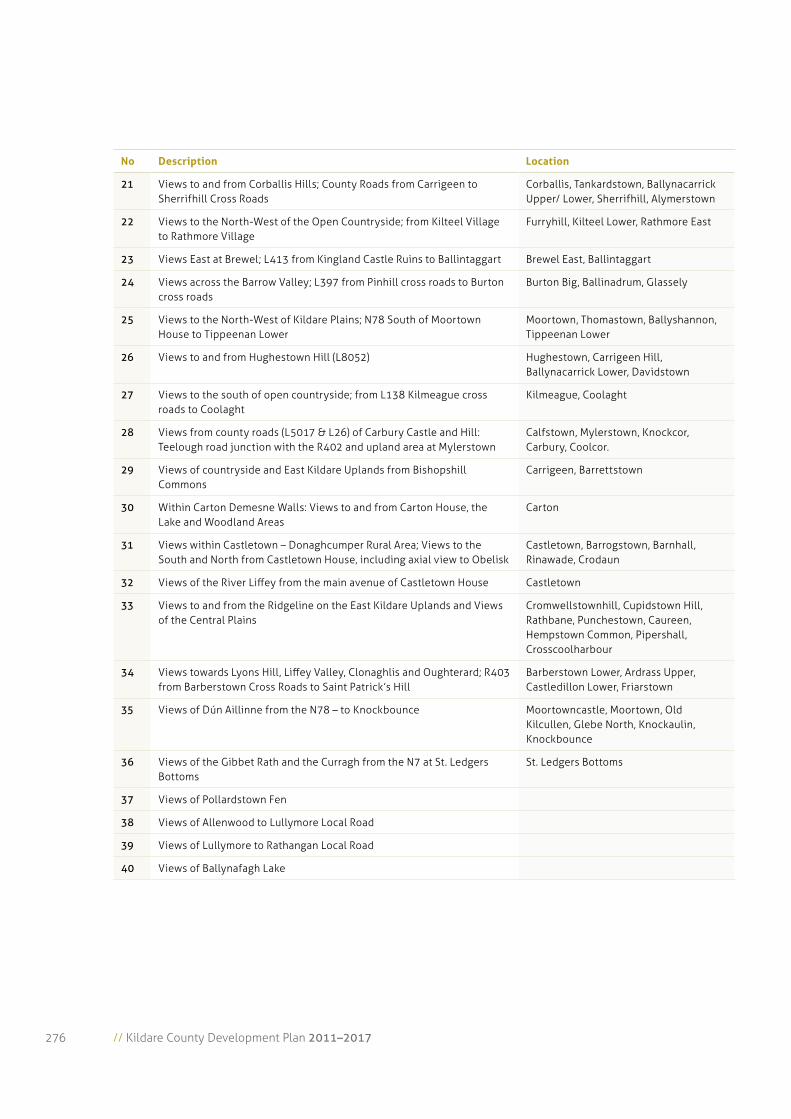
// Kildare County Development Plan 2011–2017276
No Description Location
21 Views to and from Corballis Hills; County Roads from Carrigeen to Sherrifhill Cross Roads
Corballis, Tankardstown, Ballynacarrick Upper/ Lower, Sherrifhill, Alymerstown
22 Views to the North-West of the Open Countryside; from Kilteel Village to Rathmore Village
Furryhill, Kilteel Lower, Rathmore East
23 Views East at Brewel; L413 from Kingland Castle Ruins to Ballintaggart Brewel East, Ballintaggart
24 Views across the Barrow Valley; L397 from Pinhill cross roads to Burton cross roads
Burton Big, Ballinadrum, Glassely
25 Views to the North-West of Kildare Plains; N78 South of Moortown House to Tippeenan Lower
Moortown, Thomastown, Ballyshannon, Tippeenan Lower
26 Views to and from Hughestown Hill (L8052) Hughestown, Carrigeen Hill, Ballynacarrick Lower, Davidstown
27 Views to the south of open countryside; from L138 Kilmeague cross roads to Coolaght
Kilmeague, Coolaght
28 Views from county roads (L5017 & L26) of Carbury Castle and Hill: Teelough road junction with the R402 and upland area at Mylerstown
Calfstown, Mylerstown, Knockcor, Carbury, Coolcor.
29 Views of countryside and East Kildare Uplands from Bishopshill Commons
Carrigeen, Barrettstown
30 Within Carton Demesne Walls: Views to and from Carton House, the Lake and Woodland Areas
Carton
31 Views within Castletown – Donaghcumper Rural Area; Views to the South and North from Castletown House, including axial view to Obelisk
Castletown, Barrogstown, Barnhall, Rinawade, Crodaun
32 Views of the River Liffey from the main avenue of Castletown House Castletown
33 Views to and from the Ridgeline on the East Kildare Uplands and Views of the Central Plains
Cromwellstownhill, Cupidstown Hill, Rathbane, Punchestown, Caureen, Hempstown Common, Pipershall, Crosscoolharbour
34 Views towards Lyons Hill, Liffey Valley, Clonaghlis and Oughterard; R403 from Barberstown Cross Roads to Saint Patrick’s Hill
Barberstown Lower, Ardrass Upper, Castledillon Lower, Friarstown
35 Views of Dún Aillinne from the N78 – to Knockbounce Moortowncastle, Moortown, Old Kilcullen, Glebe North, Knockaulin, Knockbounce
36 Views of the Gibbet Rath and the Curragh from the N7 at St. Ledgers Bottoms
St. Ledgers Bottoms
37 Views of Pollardstown Fen
38 Views of Allenwood to Lullymore Local Road
39 Views of Lullymore to Rathangan Local Road
40 Views of Ballynafagh Lake
Chapter 1
4 Landscape, Recreation and Am
enities
277
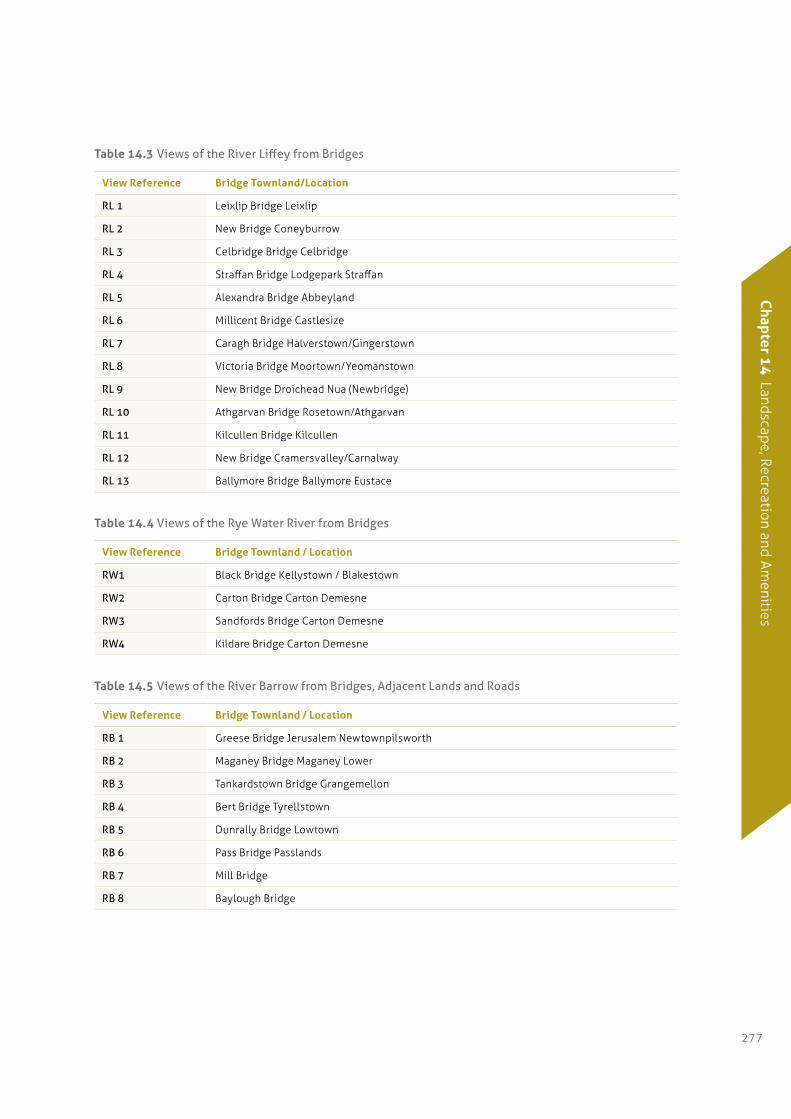
table 14.3 Views of the River Liffey from Bridges
View reference Bridge townland/Location
RL 1 Leixlip Bridge Leixlip
RL 2 New Bridge Coneyburrow
RL 3 Celbridge Bridge Celbridge
RL 4 Straffan Bridge Lodgepark Straffan
RL 5 Alexandra Bridge Abbeyland
RL 6 Millicent Bridge Castlesize
RL 7 Caragh Bridge Halverstown/Gingerstown
RL 8 Victoria Bridge Moortown/Yeomanstown
RL 9 New Bridge Droichead Nua (Newbridge)
RL 10 Athgarvan Bridge Rosetown/Athgarvan
RL 11 Kilcullen Bridge Kilcullen
RL 12 New Bridge Cramersvalley/Carnalway
RL 13 Ballymore Bridge Ballymore Eustace
table 14.4 Views of the Rye Water River from Bridges
View reference Bridge townland / Location
RW1 Black Bridge Kellystown / Blakestown
RW2 Carton Bridge Carton Demesne
RW3 Sandfords Bridge Carton Demesne
RW4 Kildare Bridge Carton Demesne
table 14.5 Views of the River Barrow from Bridges, Adjacent Lands and Roads
View reference Bridge townland / Location
RB 1 Greese Bridge Jerusalem Newtownpilsworth
RB 2 Maganey Bridge Maganey Lower
RB 3 Tankardstown Bridge Grangemellon
RB 4 Bert Bridge Tyrellstown
RB 5 Dunrally Bridge Lowtown
RB 6 Pass Bridge Passlands
RB 7 Mill Bridge
RB 8 Baylough Bridge
// Kildare County Development Plan 2011–2017278
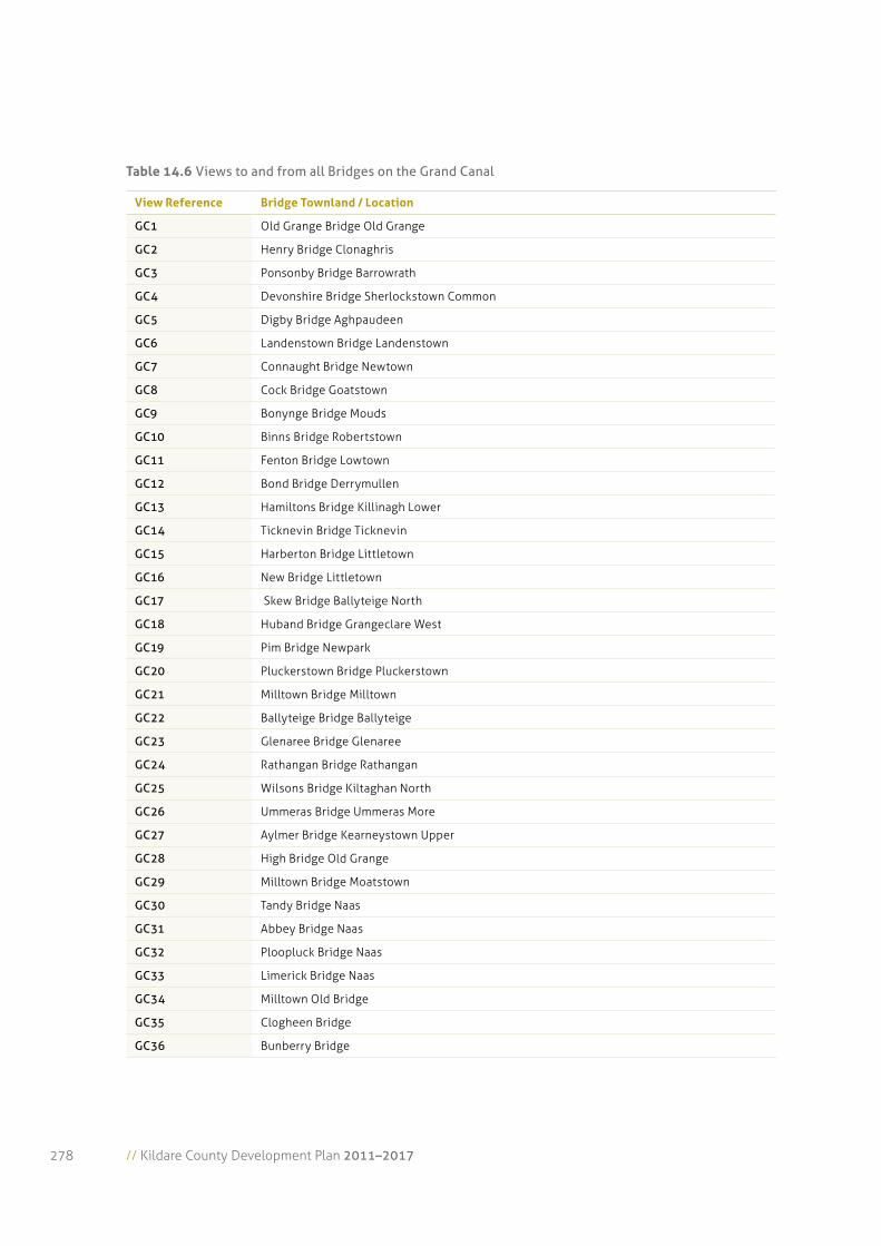
table 14.6 Views to and from all Bridges on the Grand Canal
View reference Bridge townland / Location
GC1 Old Grange Bridge Old Grange
GC2 Henry Bridge Clonaghris
GC3 Ponsonby Bridge Barrowrath
GC4 Devonshire Bridge Sherlockstown Common
GC5 Digby Bridge Aghpaudeen
GC6 Landenstown Bridge Landenstown
GC7 Connaught Bridge Newtown
GC8 Cock Bridge Goatstown
GC9 Bonynge Bridge Mouds
GC10 Binns Bridge Robertstown
GC11 Fenton Bridge Lowtown
GC12 Bond Bridge Derrymullen
GC13 Hamiltons Bridge Killinagh Lower
GC14 Ticknevin Bridge Ticknevin
GC15 Harberton Bridge Littletown
GC16 New Bridge Littletown
GC17 Skew Bridge Ballyteige North
GC18 Huband Bridge Grangeclare West
GC19 Pim Bridge Newpark
GC20 Pluckerstown Bridge Pluckerstown
GC21 Milltown Bridge Milltown
GC22 Ballyteige Bridge Ballyteige
GC23 Glenaree Bridge Glenaree
GC24 Rathangan Bridge Rathangan
GC25 Wilsons Bridge Kiltaghan North
GC26 Ummeras Bridge Ummeras More
GC27 Aylmer Bridge Kearneystown Upper
GC28 High Bridge Old Grange
GC29 Milltown Bridge Moatstown
GC30 Tandy Bridge Naas
GC31 Abbey Bridge Naas
GC32 Ploopluck Bridge Naas
GC33 Limerick Bridge Naas
GC34 Milltown Old Bridge
GC35 Clogheen Bridge
GC36 Bunberry Bridge
Chapter 1
4 Landscape, Recreation and Am
enities
279
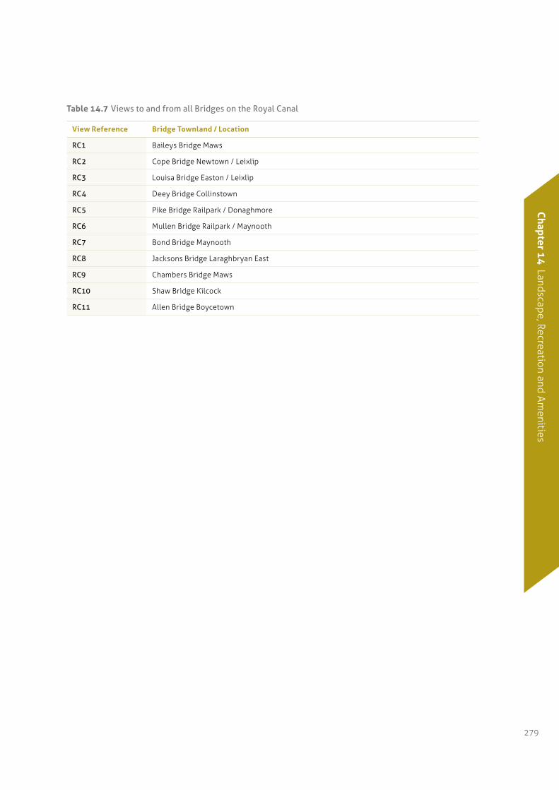
table 14.7 Views to and from all Bridges on the Royal Canal
View reference Bridge townland / Location
RC1 Baileys Bridge Maws
RC2 Cope Bridge Newtown / Leixlip
RC3 Louisa Bridge Easton / Leixlip
RC4 Deey Bridge Collinstown
RC5 Pike Bridge Railpark / Donaghmore
RC6 Mullen Bridge Railpark / Maynooth
RC7 Bond Bridge Maynooth
RC8 Jacksons Bridge Laraghbryan East
RC9 Chambers Bridge Maws
RC10 Shaw Bridge Kilcock
RC11 Allen Bridge Boycetown
// Kildare County Development Plan 2011–2017280
Map 14.3 Senice Routes and Viewpoints
WICKLOW
CARLOW
LAOIS
OFFALY
MEATH
DUBLIN
Grand Canal
River Barrow
River Barrow
Grand Canal
Grand Canal
Grand Canal
Royal CanalR
LEGEND:
ScenicRoads
HilltopViews
ScenicViewpoints
Chapter 1
4 Landscape, Recreation and Am
enities
281
14.8 Landscape Policies
14.8.1 General Landscape policies
It is the policy of the Council:
LA 1: To ensure that consideration of landscape
sensitivity is an important factor in
determining development uses. In areas of
high landscape sensitivity, the design, type
and the choice of location of proposed
development in the landscape will also be
critical considerations.
LA 2: To protect and enhance the county’s
landscape, by ensuring that development
retains, protects and, where necessary,
enhances the appearance and character of the
existing local landscape.
LA 3: To require a Landscape/Visual Impact
Assessment to accompany significant
proposals, located within or adjacent to
sensitive landscape. This assessment will
provide details of proposed mitigation
measures to address negative impacts.
LA 4: To seek to ensure that local landscape
features, including historic features and
buildings, hedgerows, shelter belts and stone
walls are retained, protected and enhanced
where appropriate, so as to preserve the local
landscape and character of an area, whilst
providing for future development.
LA 5: To prohibit advertising structures and
hoardings in the open countryside. The
Council will use its enforcement powers under
the Planning Acts to secure the removal of
unauthorised advertising signs and hoardings
including those that are affixed to trailers,
wheeled vehicles etc.
LA 6: To preserve, where permissible, the open
character of commonage.
14.8.2 Lowland plains and Boglands Character area policies
It is the policy of the Council:
LL 1: To recognise that the lowlands are made up of
a variety of working landscapes, which are
critical resources for sustaining the economic
and social well-being of the county.
LL 2: To continue to permit development that can
utilise existing structures, settlement areas
and infrastructure, whilst taking account of
the visual absorption opportunities provided
by existing topography and vegetation.
LL 3: To recognise that this lowland landscape
character area includes areas of significant
landscape and ecological value, which are
worthy of protection.
LL 4: To recognise that intact boglands are critical
natural resources for ecological and
environmental reasons.
LL 5: To recognise that cutaway and cut-over
boglands represent degraded landscapes and/
or brownfield sites and thus are potentially
robust to absorb a variety of appropriate
developments.
14.8.3 Upland Character areas included. east Kildare Uplands (area of high amenity)
It is the policy of the Council:
LU 1: To ensure that development will not have a
disproportionate visual impact (due to excessive
bulk, scale or inappropriate siting) and will not
significantly interfere or detract from scenic
upland vistas, when viewed from areas nearby,
scenic routes, viewpoints and settlements.
LU 2: To ensure that developments on steep slopes
(i.e. >10%) will not be conspicuous or have a
disproportionate visual impact on the
surrounding environment as seen from relevant
scenic routes, viewpoints and settlements.
// Kildare County Development Plan 2011–2017282
LU 3: To facilitate, where appropriate, developments
that have a functional and locational
requirement to be situated on steep or
elevated sites (e.g. reservoir,
telecommunication masts or wind energy
structures) where residual adverse visual
impacts are minimised or mitigated.
LU 4: To maintain the visual integrity of areas,
which have retained a largely undisturbed
upland character.
LU 5: To have regard to the potential for screening
vegetation when evaluating proposals for
development within the uplands.
14.8.4 transitional Character areas
It is the policy of the Council:
TA 1: To maintain the visual integrity of areas,
which have retained an upland character.
TA 2: To recognise that the lowlands in the
transitional area are made up of a variety of
working landscapes that are critical resources
for sustaining the economic and social
well-being of the county.
TA 3: To continue to permit development that can
utilise existing infrastructure, whilst taking
account of local absorption opportunities
provided by the landscape, landform and
prevailing vegetation.
TA 4: To continue to facilitate appropriate
development, in an incremental and clustered
manner, where feasible, that respects the
scale, character and sensitivities of the local
landscape, recognising the need for
sustainable settlement patterns and economic
activity within the county.
14.8.5 Water Corridors (rivers and Canals) (areas of high amenity)
It is the policy of the Council:
WC 1: To seek to locate new development in the
water corridor landscape character areas
towards existing structures and mature
vegetation.
WC 2: To facilitate appropriate development that can
utilise existing structures, settlement areas
and infrastructure, whilst taking account of
the visual absorption opportunities provided
by existing topography and vegetation.
WC 3: To control development that will adversely
affect the visual integrity of distinctive linear
sections of water corridors and river valleys
and open floodplains.
WC 4: To co-operate with the DoEHLG in the
protection and conservation of both Canals
and the River Barrow, designated as a pNHA
and cSAC respectively and in the sections of
the River Liffey designated as a pNHA.
WC 5: To promote the amenity, ecological and
educational value of the canals and rivers
within the county while at the same time
ensuring the conservation of their fauna and
flora, and protection of the quantity and
quality of the water supply.
WC 6: To support and promote an extension of the
proposed Special Amenity Area Order for the
Liffey Valley from Lucan to Leixlip (which is
envisaged by the Dublin Local Authorities) to
other parts of the Valley within County
Kildare.
WC 7: To explore the establishment of the Barrow
Valley and the Canals as Areas of Special
Amenity, as per section 202 of the Planning
and Development Act, 2000 as amended.
Chapter 1
4 Landscape, Recreation and Am
enities
283
14.8.6 the Curragh and environs (area of high amenity)
It is the policy of the Council:
CU 1: To restrict development, particularly on the
Curragh edge, or where it obtrudes on the
skyline as viewed from the Curragh Plains and
to avoid the over development of the edge of
the Curragh.
CU 2: To ensure that fencing, earth works or
planting do not conflict with the intrinsic
quality of the landscape.
CU 3: To co-operate with the Department of
Defence, the DoEHLG, the racehorse industry,
the owners of sheep grazing rights and the
various interests currently with rights to the
Curragh in the protection and conservation of
the Curragh, designated as a pNHA.
CU 4: To restrict the development of vertical
structures within the Curragh Plains
including advertising signs, hoardings, fencing
etc which create visual clutter and disrupt the
open nature of the Plains.
14.8.7 pollardstown Fen (area of high amenity)
It is the policy of the Council:
PF 1: To restrict development within the immediate
environs of the Fen which may have a negative
impact on the water quality and water
quantity of the Fen.
PF 2: To co-operate with the DoEHLG and other
statutory bodies in the protection and
conservation of the Fen, a designated pSAC
and the immediate environs of the Fen.
PF 3: To promote the amenity, ecological and
educational value of the Pollardstown Fen
Area .
14.9 Scenic Routes and Protected Views
14.9.1 Scenic routes policies
It is the policy of the Council:
SR 1: To protect views from designated scenic routes
by avoiding any development that could disrupt
the vistas or disproportionately impact on the
landscape character of the area thereby affecting
the scenic and amenity value of the views.
SR2: To review and update all Scenic Routes and
Views in the county during the lifetime of the
Plan (Tables 14.2–14.7 refer).
14.9.2 Water Course and Canal Corridor Views
It is the policy of the Council:
WV 1: To curtail any further development along the
canal and river banks that could cumulatively
affect the quality of a designated view.
WV 2: To preserve and enhance the scenic amenity
of the river valleys and canal corridors and the
quality of the vistas available from designated
views.
WV 3: To restrict development on floodplains of the
rivers in the county.
WV 4: To prevent inappropriate development along
canal and river banks and to preserve these
areas in the interests of biodiversity, built and
natural heritage and amenity by creating or
maintaining buffer zones, where development
should be avoided.
14.9.3 hill Views
It is the policy of the Council:
HV 1: To protect the upland Landscape Character
Areas as identified in the Landscape Character
Assessment and to ensure that development on
or in the vicinity of the upland areas does not
disproportionately affect views to and from
the hills, or impact on the landscape character
of the area as a whole.
// Kildare County Development Plan 2011–2017284
14.10 Landscape Objectives
It is an objective of the Council:
LO 1: To have regard to the Landscape Sensitivity
Classification of sites in the consideration of
any significant development proposals.
LO 2: To ensure landscape assessment will be an
important factor in all land-use proposals.
LO 3: To investigate the feasibility of preparing a
Landscape Conservation Area Assessment
within the county to identify any area(s) or
place(s) within the county as a Landscape
Conservation Area in accordance with the
Planning and Development Acts.
LO 4: To protect the visual and scenic amenities of
County Kildare’s built and natural
environment.
LO 5: To preserve the character of all important
views and prospects, particularly upland,
river, canal views, views across the Curragh,
views of historical or cultural significance
(including buildings and townscapes) and
views of natural beauty.
LO 6: To preserve and protect the character of those
views and prospects obtainable from scenic
routes identified in this Plan, listed in Table
14.2 and identified on Map 14.3.
LO 7: To encourage appropriate landscaping and
screen planting of developments along scenic
routes. Where scenic routes run through
settlements, street trees and ornamental
landscaping may also be required.
LO 8: To prepare further detailed guidance in
relation to views and prospects available along
scenic routes occurring within the boundaries
of Local Area Plans.
LO 9: To plant gateway roundabouts within the
County with innovative design themes, having
regard to traffic safety.
LO 10: To review and update the County Landscape
Character Assessment in accordance with all
relevant legislation and guidance documents.
Chapter 1
4 Landscape, Recreation and Am
enities
285
14.11.1 Background
Recreational and amenity areas within the county
include natural, recreational and sporting amenities
as well as social and community infrastructure.
These facilities provide many cultural, social,
economic and environmental benefits and provide a
positive contribution towards quality of life. The
provision of a range of amenities which can cater for
the demands of an increasing population and which
will be accessible for all sectors and age groups of the
population is a central element in the delivery of
sustainable communities.
14.11.2 Strategy
The strategies for the provision of recreational and
amenity resources in the county seeks:
•To provide an opportunity for all sectors of
Kildare’s population, and visitors to the county to
avail of good quality recreational, sports and open
space facilities, suitable to their needs;
•To ensure that the natural resources which form
the basis for countryside recreation are protected
and effectively managed; and
•To provide and maintain facilities in an
economically and environmentally sustainable
manner.
14.11.3 Countryside recreation
Countryside recreation includes a wide range of
activities including horse riding, cycling, walking,
picnicking, country drives, off-road biking, nature
trails, bird watching, painting, photography, field
studies, orienteering, para – and hang – gliding, rock
climbing, adventure sports, camping, archaeological
guided walks and water related activities which
include swimming, boating, canoeing and kayaking. It
is recognised that the countryside of Kildare provides
an important resource in outdoor recreational
facilities not only for the population of Kildare but
also for those visiting the county. The Council
recognises the significance of natural amenities as a
major resource for visitors and local people.
The National Countryside Recreation Strategy was
finalised in 2006. It defines the scope, vision and a
suggested framework for the implementation of
countryside recreation as agreed by Comhairle na
Tuaith. This strategy will inform Kildare Sports
Partnership in the preparation of a strategic plan for
physical recreation in County Kildare.
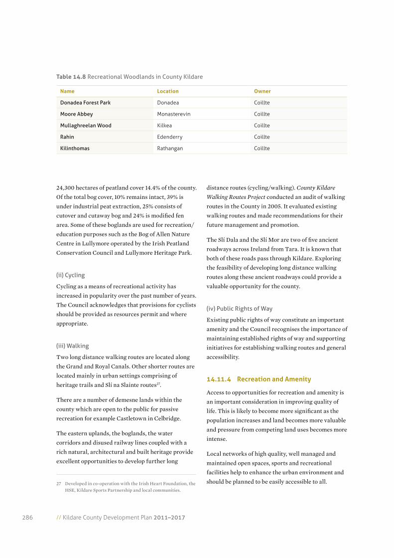
(i) Forest Parks/Woodlands & Boglands
Approximately 9,200 hectares of land in Kildare is
under forest cover. Forests and woodlands provide
benefits over and above the revenue yielded from
timber and other wood based products. These include
recreational and tourism amenities for local
communities. Table 14.8 outlines recreational
woodlands in the county.
14.11 Recreation and Amenities
aim: To develop recreation areas and the amenities of County Kildare in an equitable, environmental and sustainable way.
// Kildare County Development Plan 2011–2017286
24,300 hectares of peatland cover 14.4% of the county.
Of the total bog cover, 10% remains intact, 39% is
under industrial peat extraction, 25% consists of
cutover and cutaway bog and 24% is modified fen
area. Some of these boglands are used for recreation/
education purposes such as the Bog of Allen Nature
Centre in Lullymore operated by the Irish Peatland
Conservation Council and Lullymore Heritage Park.
(ii) Cycling
Cycling as a means of recreational activity has
increased in popularity over the past number of years.
The Council acknowledges that provisions for cyclists
should be provided as resources permit and where
appropriate.
(iii) Walking
Two long distance walking routes are located along
the Grand and Royal Canals. Other shorter routes are
located mainly in urban settings comprising of
heritage trails and Slí na Slainte routes27.
There are a number of demesne lands within the
county which are open to the public for passive
recreation for example Castletown in Celbridge.
The eastern uplands, the boglands, the water
corridors and disused railway lines coupled with a
rich natural, architectural and built heritage provide
excellent opportunities to develop further long
27 Developed in co-operation with the Irish Heart Foundation, the HSE, Kildare Sports Partnership and local communities.
distance routes (cycling/walking). County Kildare
Walking Routes Project conducted an audit of walking
routes in the County in 2005. It evaluated existing
walking routes and made recommendations for their
future management and promotion.
The Slí Dala and the Slí Mor are two of five ancient
roadways across Ireland from Tara. It is known that
both of these roads pass through Kildare. Exploring
the feasibility of developing long distance walking
routes along these ancient roadways could provide a
valuable opportunity for the county.
(iv) Public Rights of Way
Existing public rights of way constitute an important
amenity and the Council recognises the importance of
maintaining established rights of way and supporting
initiatives for establishing walking routes and general
accessibility.
14.11.4 recreation and amenity
Access to opportunities for recreation and amenity is
an important consideration in improving quality of
life. This is likely to become more significant as the
population increases and land becomes more valuable
and pressure from competing land uses becomes more
intense.
Local networks of high quality, well managed and
maintained open spaces, sports and recreational
facilities help to enhance the urban environment and
should be planned to be easily accessible to all.
table 14.8 Recreational Woodlands in County Kildare
Name Location Owner
Donadea Forest Park Donadea Coillte
Moore Abbey Monasterevin Coillte
Mullaghreelan Wood Kilkea Coillte
Rahin Edenderry Coillte
Kilinthomas Rathangan Coillte
Chapter 1
4 Landscape, Recreation and Am
enities
287
(i) Open Space
New development of housing and / or commercial
development influences the need for new sports and
outdoor community facilities. The zoning of land for
“open space” is an important element of landuse
planning and should be provided within Development
and Local Area Plans as appropriate.
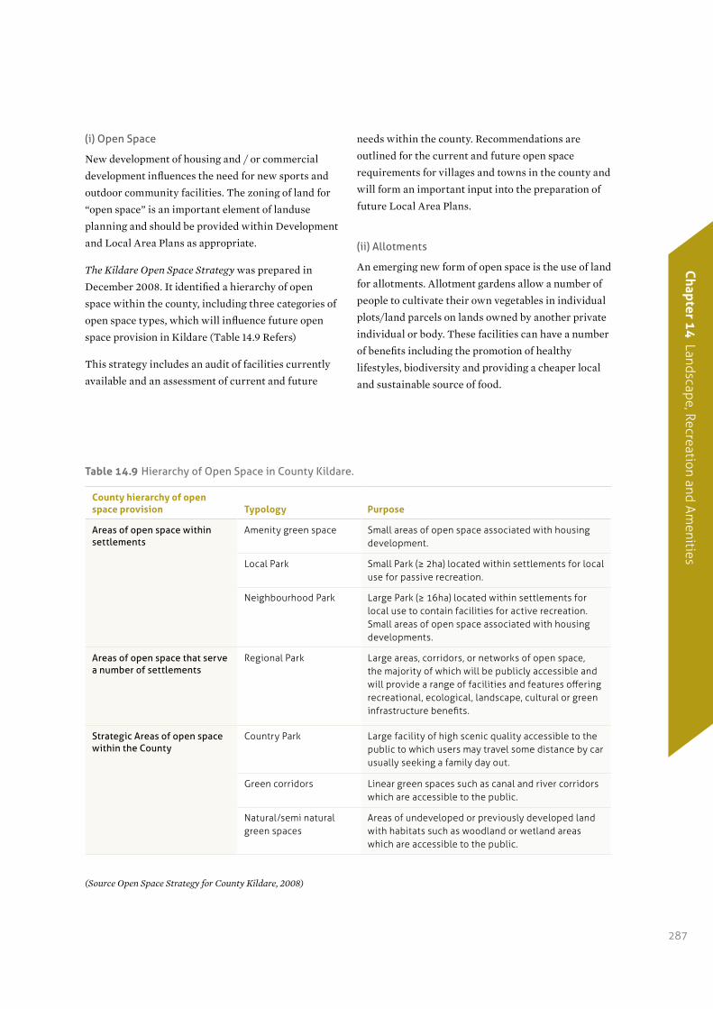
The Kildare Open Space Strategy was prepared in
December 2008. It identified a hierarchy of open
space within the county, including three categories of
open space types, which will influence future open
space provision in Kildare (Table 14.9 Refers)
This strategy includes an audit of facilities currently
available and an assessment of current and future
needs within the county. Recommendations are
outlined for the current and future open space
requirements for villages and towns in the county and
will form an important input into the preparation of
future Local Area Plans.
(ii) Allotments
An emerging new form of open space is the use of land
for allotments. Allotment gardens allow a number of
people to cultivate their own vegetables in individual
plots/land parcels on lands owned by another private
individual or body. These facilities can have a number
of benefits including the promotion of healthy
lifestyles, biodiversity and providing a cheaper local
and sustainable source of food.
table 14.9 Hierarchy of Open Space in County Kildare.
County hierarchy of open space provision typology purpose
Areas of open space within settlements
Amenity green space Small areas of open space associated with housing development.
Local Park Small Park (≥ 2ha) located within settlements for local use for passive recreation.
Neighbourhood Park Large Park (≥ 16ha) located within settlements for local use to contain facilities for active recreation. Small areas of open space associated with housing developments.
Areas of open space that serve a number of settlements
Regional Park Large areas, corridors, or networks of open space, the majority of which will be publicly accessible and will provide a range of facilities and features offering recreational, ecological, landscape, cultural or green infrastructure benefits.
Strategic Areas of open space within the County
Country Park Large facility of high scenic quality accessible to the public to which users may travel some distance by car usually seeking a family day out.
Green corridors Linear green spaces such as canal and river corridors which are accessible to the public.
Natural/semi natural green spaces
Areas of undeveloped or previously developed land with habitats such as woodland or wetland areas which are accessible to the public.
(Source Open Space Strategy for County Kildare, 2008)
// Kildare County Development Plan 2011–2017288
(iii) Green Infrastructure
Green infrastructure refers to the network of linked
high quality green spaces and other environmental
features within an urban setting. This strategically
planned and delivered network should be designed
and managed as a multifunctional resource capable of
delivering a wide range of environmental and quality
of life benefits for local communities. This includes
climate change adaptation, waste and water
management, food production, recreation and health
benefits, biodiversity enhancement linkages and
economic benefits.
In developing green infrastructure, opportunities
should be taken to develop and enhance networks for
cycling, walking and other non – motorised transport.
Green infrastructure includes parks, open spaces,
playing fields, woodlands, allotments and private
gardens.
(iv) Liffey Valley Park
As most of the River Liffey flows through County
Kildare, it has played a critical role in the social,
economic and cultural life of the county and in
particular the development of the towns and villages
along its length. In 2006 the strategy document
Towards a Liffey Valley Park, was published. It
represents the first comprehensive strategy for that
section of the river between Chapelizod in Dublin and
Celbridge in Co. Kildare .
(v) Sports and Recreational Facilities
The Council is currently preparing an audit of sports,
arts and community facilities within the county. This
audit will influence the future provision of sports and
recreational facilities in the county.
The Council will endeavour through this Plan and the
implementation of development management to
provide appropriate land for recreational and amenity
open space. This land shall be available to the public,
and generally in or adjacent to areas of existing or
zoned residential use, or close to centres of rural
communities.
The Council will generally favour developments which
seek to cluster sporting activities and integrate them
with community facilities, including schools, to ensure a
more sustainable and efficient use of shared arrangements
such as parking, playgrounds, changing rooms etc.
Public swimming pools have been provided in Athy
and Naas to service the south and mid county areas.
14.11.5 Children’s play Facilities
The Council acknowledges the overarching role of the
National Play Policy Ready, Steady, Play, as published
by the Department of Health and Children, 2004. The
objectives of Ready, Steady, Play are:
•To improve the quality and safety of playgrounds
and play areas.
•To ensure that children’s play needs are met through
the development of a child-friendly environment.
•To give children a voice in the design and
implementation of play policies and facilities; and
•To maximise the range of public play opportunities
available to all children, particularly children who
are marginalised, disadvantaged or who have a
disability.
The Council will seek to develop a Play Policy for the
County which will guide the provision and
development of play opportunities within the county
over the lifetime of this Plan.
14.12 Recreation and Amenity Policies
14.12.1 Countryside recreation
It is the policy of the Council:
CR 1: To support the diversification of the rural
economy through the development of the
recreational potential of the countryside in
accordance with the National Countryside
Recreation Strategy.
Chapter 1
4 Landscape, Recreation and Am
enities
289
CR 2: To support the development of woodland
areas in conjunction with proposed
development and on Council owned lands.
CR 3: To develop and implement a County Walking
Strategy, within the lifetime of the Plan, in
consultation with statutory bodies and
landowners, and in accordance with the
recommendations of the County Kildare
Walking Routes Project, 2005. This strategy
will seek to identify established walking
routes in the county, evaluate these routes and
make recommendations for their promotion.
CR 4: To develop, in conjunction with the Irish
Sports Council and adjoining Local Authorities,
long distance walking and cycling routes.
CR 5: To investigate the possibility of developing
long distance walking routes, within the
lifetime of the Plan, along disused sections of
railway lines (eg Tullow line) and canals in the
County (Corbally Line, Blackwood Feeder, and
Mountmellick Line).
CR 6: To develop in conjunction with local
communities short walking routes, such as
heritage trails and Slí Na Sláinte routes.
CR 7: To facilitate, where appropriate, the provision
of cycle-ways or walkways along the extent of
the canals and watercourses in the county in
co-operation with landowners, Waterways
Ireland, Government Departments and other
Local Authorities.
CR 8: To explore the feasibility of developing the
route of the Slí Mór and Slí Dála as long
distance walking routes in co-operation with
the Irish Sports Council, Fáilte Ireland and
other Local Authorities.
CR 9: To promote the expansion of cycle facilities
throughout the county and to liaise with Fáilte
Ireland, the Sports Council, the National
Transportation Authority and other bodies in
the development of cycling touring routes
throughout the county and adjoining counties,
in particular in areas of high amenity.
CR 10: To investigate the possibility of providing
appropriately designed quality signage for
walking and cycling routes throughout the
county.
CR 11: To support and promote public access to
upland areas, rivers, lakes and other natural
amenities which do not endanger the
conservation of such natural amenities.
CR 12: To facilitate the development of a walking
route between Ballymore Eustace, Golden
Falls, Poulaphouca, Russborough and
Barrettstown in cooperation with landowners
and government agencies.
CR13: To encourage and support the development of
water safety awareness initiatives in
association with Kildare Water Safety and
related statutory bodies.
CR14: To seek to provide car parks for walkers at
appropriate access points to amenities, where
feasible, and subject to compliance with the
requirements arising from the Habitats
Directive.
// Kildare County Development Plan 2011–2017290
14.12.2 public rights of way
It is the policy of the Council:
RW 1: To preserve, protect, promote and improve for
the common good, existing rights of way
which contribute to general amenity,
particularly those which provide access to
archaeological sites and National Monuments
and amenities, including upland areas and
water corridors, and to create new ones or
extend existing ones where appropriate either
by agreement with landowners or through the
use of compulsory powers, without adversely
affecting landscape conservation interests.
RW 2: To seek to ensure that new development will
not have a negative impact on established
walking routes/ public rights of way, in
particular in areas of high amenity and along
the inland waterways of the county.
RW 3: To identify existing rights of way and walking
routes prior to any new planting, new
infrastructural development and any new
energy / telecommunications or golf course
developments.
RW 4: To seek to improve the condition and appearance
of existing rights of way as part of a proposed
development where the applicant has confirmed
legal status of existing rights of way.
14.12.3 Open Space
It is the policy of the Council:
OS 1: To implement the recommendations of the
Kildare Open Space Strategy, when adopted,
and make provision for a hierarchy of parks,
open spaces and outdoor recreation areas
within towns and villages so that the
population can participate in a wide range of
active and passive recreational pursuits within
easy reach of their homes and places of work.
OS 2: To require the provision of good quality, well
located and functional open space in new
residential developments to cater for all age
groups.
OS 3: To preserve, manage and maintain to a high
standard the existing public parks and open
spaces in the county.
OS 4: To develop and improve physical linkages and
connections between the network of open
spaces.
OS 5: To retain, where appropriate, areas adjacent to
waterways as a linear park which may link
into the wider open space network.
14.12.4 recreation and amenity
It is the policy of the Council:
RA 1: To zone lands for sports and recreational
amenities within Local Area Plans in
accordance with established local demands
and needs.
RA 2: To prohibit the development of areas zoned
open space/amenity or areas which have been
indicated in a previous planning application as
being open space.
RA 3: To avoid the loss of an existing amenity or
recreational facility through any development
proposal, unless:
(i) The facility or amenity was established as an
interim use pending the completion of an
improved or satisfactory replacement facility,
or
(ii) The applicant can demonstrate that there is an
insufficient local demand for the existing
facility,
or
(iii) Satisfactory alternative provision can be made
by the applicant prior to the commencement
of development.
Chapter 1
4 Landscape, Recreation and Am
enities
291
RA 4: To require the provision of recreational
facilities concurrent with new residential
developments as deemed necessary by the
Council. Types of facilities to be provided will
be dependent upon factors such as the size of a
given development proposal and the
availability of facilities (if any) in the area.
RA 5: To seek improvement in the range, quality and
capacity of sporting and recreational facilities
through initiatives in partnership with
community groups and sporting organisations
and to cater for all age-groups and abilities.
RA 6: To encourage the clustering of sport and
community facilities and to encourage them to
be multi-functional and not used exclusively
by any one group.
RA 7: To consider the future needs of sporting
facilities i.e. capacity, access, community
facilities, in the provision of new or in the
expansion of existing sporting facilities.
RA 8: To promote town and village centre sites for
sports and recreational facilities and to
facilitate out of town/village sites, where
appropriate, (following a sequential test) in
servicing large hinterland communities,
where the site includes comprehensive off
road parking, conforms to all safety guidelines
and is in accordance with the proper planning
and sustainable development of the area.
RA 9: To complete the swimming pool programme
which will meet the needs of the whole county
through the provision of a north Kildare
swimming pool within the Leixlip Amenities
Campus.
RA 10: To seek to promote additional non
mainstream facilities for children and
teenagers through the provision of suitable
recreation and amenity facilities in all major
towns and villages.
14.12.5 allotments
It is the policy of the Council:
AL 1: To facilitate the development of allotments of
an appropriate scale and in accordance with
current guidelines, which meet the following
criteria:
(i) The lands are situated within or immediately
adjacent to the edge of towns/villages;
(ii) The lands are easily accessible to the residents
of a particular town or village; and
(iii) Adequate water supply and adequate parking
facilities can be provided.
14.12.6 Green Infrastructure
It is the policy of the Council:
GI 1: To facilitate and promote the development of
green infrastructure which allows for the
development of active and passive recreation
and the protection and enhancement of
heritage and landscape features.
GI 2: To make provision for habitat creation/
maintenance and facilitate biodiversity by
encouraging the development of linear parks,
nature trails, wildlife corridors and urban
woodlands.
14.12.7 Liffey Valley park
It is the policy of the Council:
LV 1: To progress the implementation of the
flagship projects identified in the Towards a
Liffey Valley Park Strategy.
LV 2: To pursue the creation of a Liffey Valley
Regional Park together with Fingal and South
Dublin County Councils within the lifetime of
the Plan.
// Kildare County Development Plan 2011–2017292
14.12.8 Children’s play areas
It is the policy of the Council:
CP 1: To develop and implement a Play Policy for
County Kildare which will set out a strategy
for the provision, resourcing and
implementation of improved opportunities for
children to play.
CP 2: To provide play facilities adjacent to other
community and childcare facilities, in so far as
is possible, and to ensure their proper
management and maintenance.
CP 3: To seek the provision and suitable
management of children’s play areas in new
housing developments and to implement
measures to find suitable sites for their
provision to serve existing residential areas.
14.13 Recreation and Amenity Objectives
It is an objective of the Council:
RAO 1: To facilitate the provision of a variety of
amenities within the county, including
natural amenities, walking routes, cycling
routes, and sports facilities.
RAO 2: To develop and implement a county walking
strategy in consultation with statutory
bodies and landowners and in accordance
with the recommendations of the County
Kildare Walking Routes Project, 2005.
RAO 3: To prepare a Sports and Recreation Strategy
for the county in co-operation with Kildare
Sports Partnership, during the lifetime of
this Plan.
RAO 4: To develop a Play Policy for County Kildare.
RAO 5: To complete the sports, arts and community
facility audit for the county to inform future
requirements over the period of this Plan.
RAO 6: To designate or zone, through the Local
Area Plan process, suitable active and
passive open space in all settlements,
commensurate with their existing and
future needs.
RAO 7: To require passive and active open space to
be provided in tandem with new residential
development.
RAO 8: To protect and develop substantial
connected networks of green spaces in urban
areas and urban fringe areas adjacent to the
countryside to serve the growing
communities in urban centres.
RAO 9: To identify flagship projects for the River
Liffey Valley from Celbridge to Ballymore
Eustace as recommended in the report
Towards a Liffey Valley Park Strategy.
RAO 10: To investigate the feasibility of creating a
pedestrian link between the Liffey Valley
the Wicklow Mountains and the Wicklow
Way in consultation with Wicklow County
Council as recommended in the report
Towards a Liffey Valley Park Strategy.
RAO 11: To preserve the pedestrian link between the
River Liffey and the Grand Canal at the
Leinster Aqueduct and to explore making
the existing underpass fully accessible as
recommended in the report Towards a Liffey
Valley Park Strategy.
RAO 12: To provide for the preservation of public
rights of way which give access to
mountains, lakeshores, riverbanks or other
places of natural beauty or recreational
utility, where public rights of way shall be
identified both by marking them on at least
one of the maps forming part of this Plan and
by indicating their location on a list
appended to this Plan.