Embed Size (px)
Citation preview
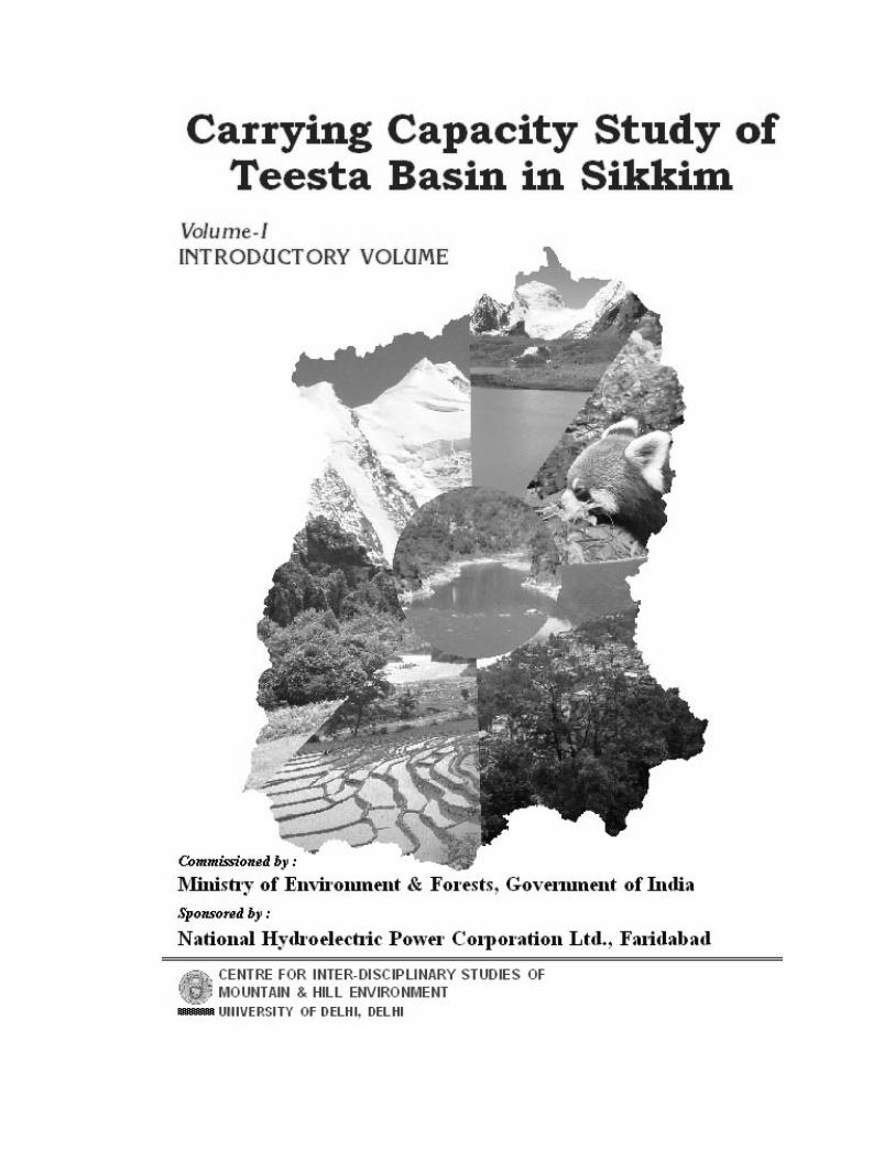
PARTICIPATING INSTITUTIONS
• Centre for Inter-disciplinary Studies of Mountain & Hill Environment, University of Delhi, Delhi
• Centre for Atmospheric Sciences, Indian Institute of
Technology, Delhi
• Centre for Himalayan Studies, University of North Bengal, Distt. Darjeeling
• Department of Geography and Applied Geography,
University of North Bengal, Distt. Darjeeling
• Salim Ali Centre for Ornithology and Natural History, Anaikatti, Coimbatore
• Water and Power Consultancy Services (India) Ltd.,
Gurgaon, Haryana
• Food Microbiology Laboratory, Department of Botany, Sikkim Government College, Gangtok
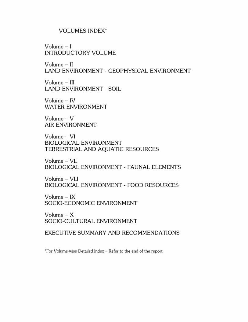
VOLUMES INDEX*
Volume – I INTRODUCTORY VOLUME
Volume – II LAND ENVIRONMENT - GEOPHYSICAL ENVIRONMENT
Volume – III LAND ENVIRONMENT - SOIL
Volume – IV WATER ENVIRONMENT
Volume – V AIR ENVIRONMENT
Volume – VI BIOLOGICAL ENVIRONMENT TERRESTRIAL AND AQUATIC RESOURCES
Volume – VII BIOLOGICAL ENVIRONMENT - FAUNAL ELEMENTS
Volume – VIII BIOLOGICAL ENVIRONMENT - FOOD RESOURCES
Volume – IX SOCIO-ECONOMIC ENVIRONMENT
Volume – X SOCIO-CULTURAL ENVIRONMENT
EXECUTIVE SUMMARY AND RECOMMENDATIONS *For Volume-wise Detailed Index – Refer to the end of the report
PREFACE
The ‘Carrying Capacity Study of Teesta Basin in Sikkim’ was
initiated at the instance of Ministry of Environment & Forests, Government of India while issuing Environmental Clearance to Teesta Stage-V H.E. project proposed by National Hydroelectric Power Corporation Ltd., Faridabad. The above mentioned environmental clearance was given in May, 1999 with a stipulation that ‘no other project in Sikkim will be considered for environmental clearance till the Carrying Capacity Study is completed’ the funds for which would be provided by NHPC Ltd. Therefore, the present study was entrusted to the Centre for Inter-disciplinary Studies of Mountain & Hill Environment (CISMHE) in September, 2001 by Ministry of Environment & Forests, Government of India vide letter No. J.12011/1199-IA.1 for which funds were provided by NHPC Ltd. The study was being coordinated by CISMHE, University of Delhi, Delhi being the Principal Investigator with institutional collaboration with other national level institutes viz.,
i) Centre for Atmospheric Sciences, Indian Institute of Technology, Delhi
ii) Centre for Himalayan Studies, University of North Bengal, Distt. Darjeeling
iii) Department of Geography and Applied Geography, University of North Bengal, Distt. Darjeeling
iv) Salim Ali Centre for Ornithology and Natural History, Anaikatti, Coimbatore
v) Water and Power Consultancy Services (India) Ltd., Gurgaon, Haryana
vi) Food Microbiology Laboratory, Department of Botany, Sikkim Government College, Gangtok
The main objective of the study was to assess the ‘Carrying Capacity
Study of Teesta Basin in Sikkim’ in terms of various natural resources like water, land and air encompassing biological, water, air, socio-economic and socio-cultural environments. The study has been completed in three phases over a period of four years. The last phase of the project, Phase-IV would entails conducting workshops, seminars, etc. in the state of Sikkim at different places to appraise the various sections of the people and government officials
regarding the technical findings of the report and then to receive inputs from all concerned with the sustainable development of the state of Sikkim. These inputs in the form of suggestions and specific recommendations would then form the appendix to the main report of the study.
This final technical report contains the details of the work done
during the study entitled “Carrying Capacity Study of Teesta Basin in Sikkim” covered in three different phases. The findings of the studies undertaken by various participating institutions has been presented in ten volumes covering different aspects of land, water, air, biological and socio-economic and socio-cultural environment in order to understand the importance of these resources.
The Volume-I is an Introductory Volume, which highlights the
‘Carrying Capacity’ concept and methodology adopted for the studies. It provides an account of physiography, terrain, drainage and other characteristics of the study area i.e. Teesta basin in Sikkim. It also provides information on the proposed power development model being adopted by the state. Further, it contains information on various nodal points of water resources. This volume also gives detailed description of the characteristics of Teesta river system and salient features of 17 watersheds delineated in the Teesta basin as most of the information on soil, landuse, etc. has been analysed and presented watershed-wise for future planning. There is a separate chapter on landuse/landcover mapping. In the end a copy of the report of state level workshop on Promotion of Community Health & Development through Medicinal Plants organized by Voluntary Health Association of Sikkim (VHAS) supported by the Centre in January, 2005 as one of the outreach activities of this study has also been annexed.
The Volume-II of the report covers geophysical environment of
Teesta basin and deals with various geological and seismotectonic aspects. The phenomenon of frequent landslides in the basin has been highlighted and various mitigation measures also have been suggested in the chapter on landslides. In addition, the problem of floods and mitigation measured to be adopted also has been highlighted in this volume with inputs from WAPCOS. Due to global warming phenomena, glaciers (the vast reserves of water in the form of ice) are melting fast.
Therefore, a separate chapter has been devoted only to assess and evaluate the various issues related to glaciers, glacial lakes and glacial lakes outburst floods (GLOF), and their implications in hazard generation along with appropriate recommendations. The soil resource has been dealt in detail in the Volume-III under the Geophysical Environment. This part of the study was jointly undertaken by the Centre (CISMHE) and Regional Centre, National Bureau of Soil Survey & Landuse Planning (NBSS & LUP), Kolkata. It contains details of the soils of all the 17 watersheds of Teesta basin including the land capability classification and suitability of soils of different regions for various activities like agriculture, horticulture and forestry plantations.
The Volume-IV covers different aspects of water environment in
Teesta basin. This volume discusses the hydro-meteorology, hydrology, irrigation, land resource management, agriculture, horticulture and drought prone areas in the state. This volume has been prepared by Water and Power Consultancy Services (WAPCOS) Ltd., Gurgaon.
The Volume-V of the report covers issues related to air
environment. It contains report on the air quality status of different areas of Sikkim. It also gives suggestions for improvement in air quality. This volume has been prepared by Centre for Atmospheric Sciences, Indian Institute of Technology, Delhi.
As biodiversity is one of the most important resource of the region,
various aspects of this have been covered in three volumes i.e. Volumes VI-VIII. The Volume-VI deals with the plant resources and provides information on forest types, vegetation profile and diversity of different plant resources. Aquatic environment and water quality also has been covered in this volume in a separate chapter. It also deals with the aquatic environment of some of the important lakes of Teesta basin. Similarly fish fauna has been discussed in this volume. The information on protected areas has also been given in this volume. Faunal resources have been dealt in detail in Volume-VII. It provides details of diversity of various animal groups viz. mammals, birds, herpetofauna and butterflies in different altitudinal zones of Teesta basin. This volume has been prepared by Salim Ali Centre for Ornithology and Natural History (SACON), Coimbatore. Volume-VIII deals with the food resources where
emphasis has been laid on ethnic food resources and ethnic food tourism. This volume has been compiled and prepared by Food Microbiology Laboratory, Department of Botany, Sikkim Government College, Gangtok.
Volume-IX and Volume-X deal with the socio-economic and socio-
cultural environment of the state. The volume on socio-economic environment deals in details with the problem of livestock in the state. This volume has been compiled by Department of Geography and Applied Geography, University of North Bengal, Siliguri. Volume-X mainly deals with cultural profile and quality of life in the state in addition to the socio-economic conditions in the different districts of the state. This volume has been prepared by Centre for Himalayan Studies, University of North Bengal, Siliguri. A summary of all the volumes along with recommendations that emerged from the study have been given in Executive Summary & Recommendations. It provides an insight into the overall assessment and evaluation of various resources in Teesta basin and discusses about the intrinsic environmental sensitivity of different regions/watersheds of Teesta basin and also with respect to various developmental activities that are being proposed in the basin. The observations made by some of the experts have also been appended with this volume.
Arun Bhaskar CISMHE, New Delhi March, 2006
Introductory Volume
CISMHE
CONTENTS
Page No. CHAPTER 1 INTRODUCTION 1.1 STUDY AREA 1 1.2 PHYSICAL FEATURES 3 1.3 GEOLOGICAL SETTING 4 1.4 RIVER TEESTA 5 1.5 HYDRO-METEOROLOGY 7 1.5.1 Climate and Rainfall 7 1.6 DEVELOPMENT SCENARIO 8 CHAPTER 2 CONCEPT AND METHODOLOGY 2.1 CARRYING CAPACITY 10 2.2 DEVELOPMENTAL PLANNING AND CARRYING CAPACITY 13 2.3 EXISTING ENVIRONMENTAL RESOURCES BASE 16 2.3.1 Air Environment 16 2.3.2 Water Environment 17 2.3.3 Land Environment 18 2.3.4 Biological Environment 20 2.3.5 Socio-economic Environment 21 CHAPTER 3 PROPOSED POWER DEVELOPMENT PROFILE OF TEESTA BASIN 3.1 POWER DEVELOPMENT SCENARIO 23 3.2 POWER REQUIREMENT 25 3.3 HYDRO POWER POTENTIAL IN TEESTA BASIN 26 3.3.1 Schemes Identified by CWC 27 3.3.2 Schemes Proposed by SPDC 31 3.3.3 Under 50,000 MW Initiative 33 CHAPTER 4 TEESTA RIVER SYSTEM – THE STUDY AREA 4.1 INTRODUCTION 38 4.2 CHHOMBO CHHU/TEESTA RIVER UPSTREAM OF ZEMU CHHU-
TEESTA CONFLUENCE 39 4.3 LACHUNG CHHU 41
Introductory Volume
CISMHE
4.4 ZEMU CHHU 43 4.5 TEESTA RIVER BETWEEN LACHEN AND CHUNGTHANG 44 4.6 CHUNGTHANG-MANGAN-CHAKUNG CHHU SUB SYSTEM 45 4.7 TALUNG CHHU (RANGYONG CHHU) 46 4.8 RANGIT RIVER SUB-SYSTEM 48 4.9 DIK CHHU SUB-SYSTEM 51 4.10 RANGPO CHHU 52 4.11 TEESTA RIVER BETWEEN MANGAN AND SINGTAM 55 4.12 RANI KHOLA (RONGNI CHHU) 55 4.13 TEESTA RIVER BETWEEN TEESTA-RANI KHOLA CONFLUENCE TEESTA-RANGPO CHHU CONFLUENCE 56 4.14 TEESTA RIVER PROFILE 57 4.15 IMPLICATIONS 59 CHAPTER 5 NODAL POINTS OF WATER RESOURCE IN TEESTA BASIN 5.1 GEOMORPHIC PROFILE 60 5.2 NODAL POINTS OF WATER RESOURCE 62 5.2.1 Chhombo Glacier Complex 64 5.2.2 Yumthang Glacier Complex 66 5.2.3 Langpo Glacier Complex 67 5.2.4 Zemu Glacier Complex 67 5.2.5 Talung Glacier Complex 68 5.2.6 Rel Glacier Complex 69 5.2.7 Rathang Glacier Complex 70 CHAPTER 6 TEESTA RIVER BASIN CHARACTERISTICS 6.1 INTRODUCTION 71 6.2 GEOMORPHOLOGICAL PROFILE OF TEESTA BASIN 85 6.3 RELIEF AND ASPECT 86 6.4 SLOPE 86 6.5 SOIL 87 CHAPTER 7 REMOTE SENSING AND GIS STUDIES – LANDUSE/LANDCOVER MAPPING OF TEESTA BASIN 7.1 LANDUSE MAPPING 88 7.2 STUDY AREA 90 7.3 DATABASE 90
Introductory Volume
CISMHE
7.4 METHODOLOGY 91 7.5 CLASSIFICATION SCHEME 98 7.6 LANDUSE/ LANDCOVER 101 7.6.1 Chhombo Chhu 103 7.6.2 Yumthang Chhu 103 7.6.3 Zemu Chhu 104 7.6.4 Lachung Chhu 104 7.6.5 Lachen Chhu 104 7.6.6 Rangyong Chhu 105 7.6.7 Prek Chhu 105 7.6.8 Rel Chhu 106 7.6.9 Rathong Chhu 106 7.6.10 Dik Chhu 106 7.6.11 Rangpo Chhu 107 7.6.12 Rangit River 107 7.6.13 Kalej Khola 107 7.6.14 Ramam Khola 108 7.6.15 Manpur Khola 108 7.6.16 Teesta (Lower Part) - Right Bank 108 7.6.17 Rani Khola 109 7.6.18 Jaldhaka 109 7.7 FOREST TYPE MAPPING 109
BIBLIOGRAPHY 111 ANNEXURE
Introductory Volume
CISMHE
LIST OF TABLES
Table 1.1 Administrative set up of Sikkim
Table 3.1 Installed capacity in power projects (in MW)
Table 3.2 Power requirements of Sikkim state
Table 3.3 Estimated Hydro-power Potential in Sikkim State
Table 4.1 Major tributaries of Teesta river
Table 6.1 Physiographic and morphometric attributes of the watersheds in Teesta basin in Sikkim
Table 6.2 Legend to the soil map
Table 7.1 Database used for landuse/ landcover mapping of Teesta basin
Table 7.2 District-wise forest cover (sq km) in Teesta basin
Introductory Volume
CISMHE
LIST OF FIGURES Fig.1.1 Location map of Teesta river basin in Sikkim
Fig.1.2 Drainage map of Teesta river basin in Sikkim
Fig.2.1 Schematic presentation of the model used for estimating Carrying Capacity
Fig.3.1 Proposed hydro-power development model in Teesta river basin in Sikkim
Fig.4.1 Drainage map of Chhombo Chhu watershed of Teesta river basin in Sikkim
Fig.4.2 Drainage map of Yumthang Chhu watershed of Teesta river basin in Sikkim
Fig.4.3 Drainage map of Zemu Chhu watershed of Teesta river basin in Sikkim
Fig.4.4 Drainage map of Lachung Chhu watershed of Teesta river basin in Sikkim
Fig.4.5 Drainage map of Lachen Chhu watershed of Teesta river basin in Sikkim
Fig.4.6 Drainage map of Rangyong Chhu watershed of Teesta river basin in Sikkim
Fig.4.7 Drainage map of Prek Chhu watershed of Teesta river basin in Sikkim
Fig.4.8 Drainage map of Rel Chhu watershed of Teesta river basin in Sikkim
Fig.4.9 Drainage map of Rathong Chhu watershed of Teesta river basin in Sikkim
Fig.4.10 Drainage map of Dik Chhu watershed of Teesta river basin in Sikkim
Fig.4.11 Drainage map of Rangpo Chhu watershed of Teesta river basin in Sikkim
Fig.4.12 Drainage map of Rangit River watershed of Teesta river basin in Sikkim
Fig.4.13 Drainage map of Kalej Khola watershed of Teesta river basin in Sikkim
Fig.4.14 Drainage map of Ramam Khola watershed of Teesta river basin in Sikkim
Fig.4.15 Drainage map of Manpur Khola watershed of Teesta river basin in Sikkim
Fig.4.16 Drainage map of Teesta (Lower Part) watershed of Teesta river basin in Sikkim
Fig.4.17 Drainage map of Rani Khola watershed of Teesta river basin in Sikkim
Fig.4.18 Longitudinal profile of Teesta river with important localities and points of confluence of major streams
Introductory Volume
CISMHE
Fig.4.19 Longitudinal profiles of the Teesta river and its major tributaries
Fig.4.20 Longitudinal profiles of the Teesta river showing SL/K indices and marked knick points (horizontal bars)
Fig.5.1 False Color Composite (FCC) of Teesta river basin in Sikkim
Fig.5.2 Index map of Glacier Complexes in Sikkim
Fig.6.1 Watershed boundaries of Teesta basin in Sikkim
Fig.6.2 The area, relief and shape (Elongation ratio) of the watersheds in Teesta basin in Sikkim
Fig.6.3 Geomorphology map of Teesta basin in Sikkim
Fig.6.4 Area (per cent) under various geomorphology categories of Teesta basin in Sikkim
Fig.6.5 Three-dimensional view of relief map of Teesta river basin in Sikkim
Fig.6.6 Relief map of Teesta basin in Sikkim
Fig.6.7 Area (Per cent) under various elevation categories of Teesta basin in Sikkim
Fig.6.8 Aspect map of Teesta river basin in Sikkim
Fig.6.9 Slope map of Teesta river basin in Sikkim
Fig.6.10 Area (per cent) under various slope categories of Teesta basin in Sikkim
Fig.6.11 Soil map of Teesta basin in Sikkim
Fig.7.1 Flow diagram for landuse/ landcover classification
Fig.7.2 Landuse/ landcover map of Teesta basin in Sikkim
Fig.7.2a Three-dimensional view of landuse/landcover map of Teesta river basin in Sikkim
Fig.7.3 Per cent area under different forest cover density categories in Teesta river basin in the year 1988 and 2002
Fig.7.4 False Color Composite (FCC) of Chhombo Chhu watershed of Teesta river basin in Sikkim
Fig.7.5 Landuse/ landcover map of Chhombo Chhu watershed of Teesta river basin in Sikkim
Fig.7.6 Area (per cent) under various Landuse\Landcover categories of watersheds Chhombo Chhu, Yumthang Chhu, Zemu Chhu and Lachung Chhu of Teesta river basin in Sikkim
Fig.7.7 False Color Composite (FCC) of Yumthang Chhu watershed of Teesta river basin in Sikkim
Fig.7.8 Landuse/ landcover map of Yumthang Chhu watershed of Teesta river basin in Sikkim
Introductory Volume
CISMHE
Fig.7.9 False Color Composite (FCC) of Zemu Chhu watershed of Teesta river basin in Sikkim
Fig.7.10 Landuse/ landcover map of Zemu Chhu watershed of Teesta river basin in Sikkim
Fig.7.11 False Color Composite (FCC) of Lachung Chhu watershed of Teesta river basin in Sikkim
Fig.7.12 Landuse/ landcover map of Lachung Chhu watershed of Teesta river basin in Sikkim
Fig.7.13 False Color Composite (FCC) of Lachen Chhu watershed of Teesta river basin in Sikkim
Fig.7.14 Area (per cent) under various Landuse\Landcover categories of watersheds Lachen Chhu, Rangyong Chhu, Prek Chhu and Rel Chhu of Teesta river basin in Sikkim
Fig.7.15 Landuse/ landcover map of Lachen Chhu watershed of Teesta river basin in Sikkim
Fig.7.16 False Color Composite (FCC) of Rangyong Chhu watershed of Teesta river basin in Sikkim
Fig.7.17 Landuse/ landcover map of Rangyong Chhu watershed of Teesta river basin in Sikkim
Fig.7.18 False Color Composite (FCC) of Prek Chhu watershed of Teesta river basin in Sikkim
Fig.7.19 Landuse/ landcover map of Prek Chhu watershed of Teesta river basin in Sikkim
Fig.7.20 False Color Composite (FCC) of Rel Chhu watershed of Teesta river basin in Sikkim
Fig.7.21 Landuse/ landcover map of Rel Chhu watershed of Teesta river basin in Sikkim
Fig.7.22 False Color Composite (FCC) of Rathong Chhu watershed of Teesta river basin in Sikkim
Fig.7.23 Landuse/ landcover map of Rathong Chhu watershed of Teesta river basin in Sikkim
Fig.7.24 Area (per cent) under various Landuse\Landcover categories of watersheds Rathang Chhu, Dik Chhu, Rangpo Chhu and Rangit River of Teesta river basin in Sikkim
Fig.7.25 False Color Composite (FCC) of Dik Chhu watershed of Teesta river basin in Sikkim
Fig.7.26 Landuse/ landcover map of Dik Chhu watershed of Teesta river basin in Sikkim
Fig.7.27 False Color Composite (FCC) of Rangpo Chhu watershed of Teesta river basin in Sikkim
Introductory Volume
CISMHE
Fig.7.28 Landuse/ landcover map of Rangpo Chhu watershed of Teesta river basin in Sikkim
Fig.7.29 False Color Composite (FCC) of Rangit River watershed of Teesta river basin in Sikkim
Fig.7.30 Landuse/ landcover map of Rangit River watershed of Teesta river basin in Sikkim
Fig.7.31 False Color Composite (FCC) of Kalej Khola watershed of Teesta river basin in Sikkim
Fig.7.32 Landuse/ landcover map of Kalej Khola watershed of Teesta river basin in Sikkim
Fig.7.33 Area (per cent) under various Landuse\Landcover categories of watersheds Kalej Khola, Ramam Khola, Manpur Khola and Teesta (Lower Part) of Teesta river basin in Sikkim
Fig.7.34 False Color Composite (FCC) of Ramam Khola watershed of Teesta river basin in Sikkim
Fig.7.35 Landuse/ landcover map of Ramam Khola watershed of Teesta river basin in Sikkim
Fig.7.36 False Color Composite (FCC) of Manpur Khola watershed of Teesta river basin in Sikkim
Fig.7.37 Landuse/ landcover map of Manpur Khola watershed of Teesta river basin in Sikkim
Fig.7.38 False Color Composite (FCC) of Teesta (Lower Part) watershed of Teesta river basin in Sikkim
Fig.7.39 Landuse/ landcover map of Teesta (Lower Part) watershed of Teesta river basin in Sikkim
Fig.7.40 False Color Composite (FCC) of Rani Khola watershed of Teesta river basin in Sikkim
Fig.7.41 Landuse/ landcover map of Rani Khola watershed of Teesta river basin in Sikkim
Fig.7.42 Area (per cent) under various Landuse\landcover categories of watersheds Rani Khola and Jaldhaka river of Teesta river basin in Sikkim
Fig.7.43 False Color Composite (FCC) of Jaldhaka watershed of Teesta river basin in Sikkim
Fig.7.44 Landuse/ landcover map of Jaldhaka watershed of Teesta river basin in Sikkim
Fig.7.45 Forest type map of Teesta basin in Sikkim
Fig.7.46 Per cent area under different forest types in Teesta basin in Sikkim
Fig.7.47 Area (sq km) under different forest types in Teesta basin in Sikkim

Introductory Volume – Introduction
CISMHE
1.1 STUDY AREA
Sikkim is a small Himalayan state in north-east India situated
between 27000’46” to 28007’48” N latitude and 88000’58” to
88055’25”E longitude with geographical area of 7096 sq km
constituting only 0.22% of total geographical area of India. It has a
human population of 5,40,493 as per Census, 2001, which constitutes
only 0.05% of India’s total population. The state is somewhat
rectangular in shape with a maximum length from north to south of
about 112 km and the maximum width from east to west of 90 km.
The state is bounded in the north by the Tibetan plateau, by China
(Tibet) on the north-east, by Pangola range of Bhutan on the south-
east, by Darjeeling district of West Bengal on the south and Singalila
range and Khangchendzonga on the west and north-west (Fig. 1.1).
Entire state of Sikkim constitutes upper basin of Teesta river except
for a small area of 75.62 sq km in extreme south-east of Jaldhaka
river, which originates in East Sikkim and flows through West Bengal
parallel to Teesta river to meet Brahmaputra river. In southernmost
part of Sikkim, Teesta river flows in southwest direction and defines
the inter-state boundary between Sikkim and West Bengal up to Melli
Bazar where it is joined by Rangit river which drains West Sikkim
district. Rangit river, the largest tributary of Teesta river in Sikkim,
from Naya Bazar point flows in southeast direction and marks the
inter-state boundary between Sikkim and West Bengal in the
southwest.

Introductory Volume – Introduction
2
CISMHE
The state of Sikkim has been administratively divided into four
districts viz. North Sikkim, South Sikkim, East Sikkim and West Sikkim
using water divides of major and minor tributaries of Teesta river as
criteria. North Sikkim is the largest district with an area of 4,226 sq km
constituting about 60% of the entire state. The West, East and South
districts constitute about 16%, 13% and 11% of the geographical area
of the state, respectively. The state capital is located at Gangtok in
East Sikkim. Each district has been further divided into two sub-
divisions each except in East Sikkim, which has been divided into three
sub-divisions. All the districts together have 407 revenue blocks and 42
forest blocks. The administrative set up of the state is outlined in Table
1.1. East Sikkim is the most populated district having 45.29% of state’s
total population and North Sikkim is the least populated with 7.59%
share of the total human population.
Table 1.1 Administrative set up of Sikkim
Particulars District
North Sikkim South Sikkim East Sikkim West Sikkim
Area (sq km) 4,226 750 954 1166
Sub-division Mangan* Ravang Gangtok* Gyalzing*
Chungthang Namchi* Pakyong Soreng
Rongli
*District headquarters
Human population of Sikkim is comprised mainly of Nepali, Bhutia
and Lepchas. Main languages of the state are Nepali, Bhutia and
Introductory Volume – Introduction
3
CISMHE
Lepcha. Majority of the population speaks Nepali, which is the main
medium of instruction in educational institutions along with English. The
inhabitants of the state are predominantly Buddhists. Majority of
residents depend on agriculture and related activities for their livelihood.
Maize, large cardamom, rice and wheat are principal crops grown in the
state.
1.2 PHYSICAL FEATURES
Sikkim state being a part of inner mountain ranges of Himalaya, is
entirely hilly, having no plain area with altitude varying from 213 m in the
south to above 8,000 m in the north-west and north. The human
habitable area is limited only up to the altitude of 2,100 m constituting
only 20% of the total area of the state. North Sikkim, which is deeply cut
into escarpments is the least populated with a population density of 9.7
persons/ sq km only. The habitation at higher altitudes exists mainly in
Lachen and Lachung valleys comprising the upper catchment of Teesta
river. The population, however, is concentrated in lower altitude
habitations, viz. Mangan, Singhik, Chungthang, etc. North Sikkim is
endowed with a number of glaciers that descend from the eastern
slopes of Khangchendzonga and western slopes of Pauhunri. Zemu
glacier located in North Sikkim is one of the largest glaciers in India with
a total length of about 25 km. This high altitude district forms the upper
Teesta basin and is endowed with number of glacial lakes of various
sizes and shapes. The prominent among them are Chho Lhamo,
Gurugongmar Chho, Lhonak Chho, Green lake and Khangchung Chho.
Introductory Volume – Introduction
4
CISMHE
Other important lakes in the state are Chhangu and Kupup lakes in
East Sikkim and Khecheopalri in West Sikkim. More than 43% of
Teesta basin in Sikkim is characterised by very steep slopes and
escarpments i.e. more than 43% of its geographical area lies in more
than 50% slope category. This district can safely be called as the
hydrological estate of Sikkim state as it holds a pivotal position in
controlling the water regime in the entire Teesta basin.
The landforms and drainage of Teesta river are characterised
mainly by the four tiered terraces, canyons or gorge-valleys at different
altitudes, asymmetric valleys, polyprofilic U-shaped valleys and steps or
troughs, lakes, alluvial cones, truncated ridge-spurs, terracettes (soil
landscape systems), rectangular-barbed-parallel-trellis-radial to sub-
dendritic drainage patterns, straight to meandering and braided
channels. All these physiographic features are indicative of active
processes of weathering, denudation and deposition making the area
physically very sensitive.
1.3 GEOLOGICAL SETTING
The regional geological set-up of the Sikkim Himalaya is best
displayed in the form of Teesta gorge, flowing in general from north to
south. The Central Crystallines represented by a sequence of high-
grade meta-sedimentaries (calc-granulities, schist, quartzite),
gneisses/ migmatites and a number of granitic intrusions are exposed
in the Axial Zone of North Sikkim. The Central Crystalline rocks are
separated from the gneisses and schists (Darjeeling gneiss and
Introductory Volume – Introduction
5
CISMHE
Daling Group) in the south by a prominent dislocation zone, namely
the Main Central Thrust, which is an important tectonic feature or
activity all along the Himalaya. The foothills in southern part of Teesta
basin in Sikkim is characterised by low grade pelite-psammite
assemblage (Dalings) followed by alternate sequence of the
sandstone-shale-coal assemblage (Gondwana) occurring with
prominent structural dislocations in between. Further south, the
Gondwana rocks are separated tectonically from the Shiwaliks by the
Main Boundary Fault. Though there are no recorded events of macro-
and/or micro-seismicity in North Sikkim, which makes the area is
highly vulnerable to earthquakes and natural hazards. As per the
revised Seismic Zoning Map of India, the state of Sikkim lies in the
seismic zone classified as Zone-IV.
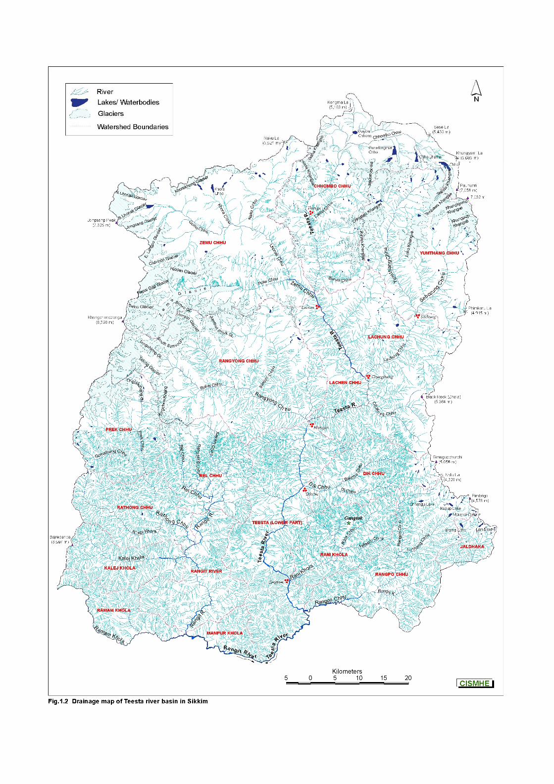
1.4 RIVER TEESTA
The river Teesta is one of the main Himalayan rivers and
originates from the glaciers of Sikkim in North at an elevation of
about 5,280 m. The river rises in mountainous terrain in extreme
north as Chhombo Chhu which flows eastward and then southward
to be joined by Zemu Chhu, upstream of Lachen village. The river
takes a gentle turn in southeast direction and meets Lachung Chhu
at Chungthang where it takes the form of a mighty Himalayan river
(Fig. 1.2). Teesta, therefore, is the main river of the state with its
several tributaries viz. Zemu, Lachung, Rangyong, Dikchu, Rongli,
Rangpo and Rangit and constitutes an extremely important
resource of the state.
Introductory Volume – Introduction
6
CISMHE
After the confluence of Lachen Chhu and Lachung Chhu at
Chungthang, the river gradually widens and takes a strong westward
turn upstream of Tong and after flowing down to Singhik, the river drops
from 1,550 m to 750 m. At Singhik, the river receives one of its major
tributaries, Rangyong Chhu on its right bank, which originates from the
Talung glacier, a part of the Khangchendzonga mountain range. From
Singhik, the river flows southwards to Dikchu with a 200 m drop through
a very deep valley for about 30 km. From Dikchu onwards, the river
takes many sharp and wide curves and flows down to Singtam with a
further drop of about 200m. Rangpo Chhu, which drains the Chhangu
lake area in East Sikkim joins Teesta river on its left bank at Rangpo.
Downstream of Rangpo, Teesta river widens and is joined by Rangit
river at Melli Bazar on Sikkim-West Bengal border. From Melli Bazar
downstream, the river leaves the hilly terrain and enters the plains of
West Bengal at Sevoke near Siliguri. Teesta river ultimately drains into
Brahmaputra at Teestamukh Ghat (Kamarjani-Bahadurabad in Rangpu
district of Bangladesh) and traverses a distance of about 400 km from its
origin.
Teesta and most of its tributaries are flashy mountain rivers and
carry boulders and considerable quantity of sediment. The flow is
turbulent and characterised by high velocities. Throughout its course in
Sikkim, Teesta and its tributaries flow in very narrow and deep valleys
having precipitous hill slopes, except where the tributaries join the main
stream. The hill slopes are mostly friable and landslips are very
common throughout the basin.
Introductory Volume – Introduction
7
CISMHE
1.5 HYDRO-METEOROLOGY
Teesta basin is characterised by frequent occurrence of extreme
(catastrophic) meteorological events during monsoon season. These
events lead to slope transformation accompanied with gravitation, slope
wash and linear erosion under fluvo-glacial environment in North Sikkim
and are mainly responsible for large quantities of silt and aggradation
material which is deposited in river channels. The high rainfall (about
2,300 mm) over the steeper slopes has created a suitable environment
for initiation of run-off and subsequent soil erosion, slope failures, slides
or sinking of land masses in Teesta basin. Large slope areas are
(glacial) morainic in nature. 1.5.1 Climate and Rainfall Variation in altitudinal profile of the state from 213m to 8,598m in
less than 100 km is responsible for abrupt changes in climatic conditions
in the basin and the state. Relief features, such as high mountains act
as a barrier for the movement of monsoon winds resulting in a significant
variation in rainfall and temperature profiles across the Teesta basin in
Sikkim. March, April and May are the transition months between the
winter, summer and monsoon. The surface temperatures start rising in
late April which are accompanied by thunderstorms and hails. The
rainfall in Sikkim, decreases with elevation after a certain limit. Rainfall
at Chungthang (1,600 m) is 2,650 mm and at Lachen (2,730 m) being
Introductory Volume – Introduction
8
CISMHE
situated at a distance of only about 20 km north of Chungthang is 1,680
mm, whereas Thangu (3,800 m), located about 20 km further north
receives only 840 mm of rain annually. As a result, across the altitudinal
gradient of Teesta basin the southern and middle valleys are hot humid
and wet, while northern parts are comparatively drier and cold.
The climate of Teesta basin in Sikkim can be categorised into
four distinct seasons viz. i) Winter season from mid-November to mid
April, ii) Spring (summer equivalent) season from mid-April to mid-June,
iii) Monsoon season from mid-June to mid-September, and iv) Autumn
season from mid-September to mid-November.
1.6 DEVELOPMENT SCENARIO
Sikkim is a thinly populated state with its unique environment and
ecology. The population is concentrated around the capital Gangtok only
and the rest of the area is occupied by forests with small villages and
townships. The economy is largely agriculture and forest based with
very little technologically advanced industrial base. The general
economic conditions of the inhabitants of the state are average and
below average. Due to the hilly terrain, the agricultural production is not
sufficient even for sustaining local consumption needs of the human
population. Energy needs of the region are chiefly met by petroleum
products and wood based products.
In view of physical constraints to development of industries and
allied economic activities the state for its economic welfare concentrates
Introductory Volume – Introduction
9
CISMHE
on the harnessing and exploitation of natural resources. One such
important resource of the state is a massive network of rivers in the
basin which provides tremendous opportunities and potential for the
economic development of the state. For many years various Central
and State Government agencies have proposed a model of
hydropower development for Teesta basin which aims at harnessing
the hydropower potential of Teesta river. Accordingly, a cascade of
six power projects across the basin were proposed from North to
South. Out of six proposed projects, Teesta Stage-V H.E. project,
under construction by NHPC is an on-going project. However, after
the Hon’ble Prime Minister’s 50,000 MW initiative in 2003, number of
schemes have been proposed on Teesta and its tributaries. The
present study ascertains an environmentally sound development in
the state.
Introductory Volume – Concept and Methodology
CISMHE
2.1 CARRYING CAPACITY
Carrying capacity of any ecological system can be defined as its
ability to provide optimum support for various natural processes and
allow sustainable activities undertaken by its inhabitants. It also provides
for assimilation and absorption of bye-products of these activities without
harming the production capability of the system. Carrying capacity of
different ecosystem can be modified but is not elastic beyond a point,
though the limits at a particular period of time or place can be enhanced
or decreased depending on the quantum of activities undertaken. Owing
to its integrated approach carrying capacity has emerged as a new and
dependable tool in planning and development process which is
sustainable.
In the following pages we have attempted to provide various
dimensions of the carrying capacity as a concept and various
methodologies for estimating the same. Though modeling is an
authentic tool in making past assessments of developmental process
and future projections, ecosystems tend not to fit in deterministic
framework and predictive models simply because too many
factors/variables in an ecosystem works singly and/or in concert. This is
particularly true of natural ecosystems where processes and patterns
are most often controlled by a plethora of interactions and feedback
mechanisms. In the current exercise we have, therefore, tried to assess
and estimate carrying capacity based on natural processes of
production, consumption and assimilation. These functions have been
Introductory Volume – Concept and Methodology
11
CISMHE
expressed in terms of environmental sensitivity and fragility of physical,
biological, socio-economic and cultural attributes of a region. Thus, more
consumption than production and more waste than assimilation in a
system would make the system more fragile and, in turn, it would have
less carrying capacity. In contrast a system which is more productive,
consumes less resources and generates less waste makes a system
ecologically less fragile and has more carrying capacity.
For natural ecosystems carrying capacity can be described in
terms of the following :
a) Allowance of interactions among biotic and abiotic
components and absorption of bye-products of these
interactions, and
b) Any changes occurring in the ecosystem must be within
its resilience and without causing any impairment to the
structure and functions of the ecosystem.
Based on above definition all the natural ecosystem processes,
patterns and structure must be maintained by the ecosystem. Under
such circumstances a natural ecosystem absorbs and assimilates any
raw materials and bye-products which are formed by ecosystem
processes such as weathering, decomposition, bio-geochemical cycling,
regeneration, food webs and food chains, etc. It also allows perpetuation
of all the life processes in the ecosystem without favoring or bias to an
individual or a group of individuals.
Introductory Volume – Concept and Methodology
12
CISMHE
For a managed ecosystems, particularly those inhabited by
humans, carrying capacity can be defined in terms of maximum rate
of resource utilisation, consumption and generation of bye-product
of this activity (waste) which is discharged into the system, without
causing any imbalance and negative impact on any one of the life
supporting environmental resources. The survival of human
societies, their economic and physical well-being depend on
availability of different environmental resources. Most of the human
activities are, therefore, linked to the unhindered supply of natural
goods and services. However, it needs to be understood that these
goods and services from natural environment cannot flow in
unlimited quantities for unlimited period of time and for unlimited
number of human individuals. One or many of these vital life
supporting natural products could be in short supply in time and
space resulting from over-exploitation of natural depletion. It is,
therefore, important to emphasize that the carrying capacity of a
system may be ultimately governed by a resource which is in the
least supply. In other words, the rate of development would be
determined by the resource which is least available. Depending on
the time or place, it could be air, water, land, biomass, etc. which
would determine the carrying capacity of a region/system. For a
sustainable society, it is, therefore, important that human activities
must be carried out within the carrying capacity of its environmental
resources. Though we may be able to increase the carrying
capacity of a system through technology innovations, management
practices, conservation measures but in the final analysis it can not
be elastic beyond a limit.
Introductory Volume – Concept and Methodology
13
CISMHE
Carrying capacity as a concept, therefore, envisages betterment in
the living standards of individuals through development processes which
is based on sound and sustainable use of environmental resources. This
paradigm of development takes into account the concerns, aspirations
and expectations of human populations living within ecological resilience
of a system. Like a natural ecosystem it must balance production and
waste, demand and supply, availability of amenities and their use and
must aim at becoming a homeostatic system. Such a system would be
sustainable and just, keeping in view the intergenerational equity by
ensuring resource availability for future generations.
2.2 DEVELOPMENTAL PLANNING AND CARRYING CAPACITY
The aim of this exercise is to achieve the goal of development
which is simple to understand, easy to execute, locally relevant and
economically viable. To determine the limits of development we must
estimate the carrying capacity of a region/system and only then plan a
developmental process which is sustainable. The concept of carrying
capacity does not undermine a system’s ability to allow production of
goods and services from the existing quantity and/or quality of
environmental resource base without compromising on the improved
quality of life. On the other hand, it ensures that there is no impairment
of the environmental quality of the system. In addition to this, it must
also provide for the possibility of regeneration, rejuvenation,
reinforcement and alleviation through additions (imports) and removals
of resources, services, management and technology interventions, etc.
Though carrying capacity envisages a framework for planning and
Introductory Volume – Concept and Methodology
14
CISMHE
development within the sustainable resource consumption pattern, it can
not completely wash away the loss of existing resource base or its
quality. It is, therefore, necessary to understand that a likely scenario
would develop in which necessary trade-offs between consumption
patterns and conservation levels are provided for.
In some of the past studies the operational framework for the
internalization of the concept of carrying capacity in decision-making
related to developmental planning involved :
• Estimation of supportive capacity
• Estimation of assimilative capacity
• Allocation of resources to various socio-economic
activities for maximization of the quality of life.
In the present context, however, we have attempted to
determine carrying capacity in terms of the following :
• Inventorisation and analysis of the existing resource
base and its production, consumption and conservation
levels
• Determination of regional ecological fragility/sensitivity
based on geo-physical, biological, socio-economic and
cultural attributes
• Analysis of the existing and projected developmental
profile of Teesta basin in view of its geo-biological
setting, ecological sensitivity and socio-economic
aspirations
Introductory Volume – Concept and Methodology
15
CISMHE
• Estimation of existing quality of life (QOL) of human
population in the basin as also their perceived and
preferred QOL scenarios
• Preparation of comprehensive evaluation reports for
major proposed developmental projects within the
carrying capacity framework.
The ecological fragility/sensitivity of the basin will be evaluated
through analysis of data on the following parameters :
• Geological and physical features including seismicity and
seismic history
• Natural hazards phenomena and land instability including
landslides/landslips
• Drainage, hydrology, hydrometeorology, sedimentation in
river systems
• Landuse and landcover through remote sensing and GIS
• Demographic evaluation of extant, endemic, endangered,
keystone species
• Evaluation of past, continuing, proposed development
activities and human interventions in the basin
• Evaluate people’s aspirations for better quality of life and
integrate these in sustainable development plan.
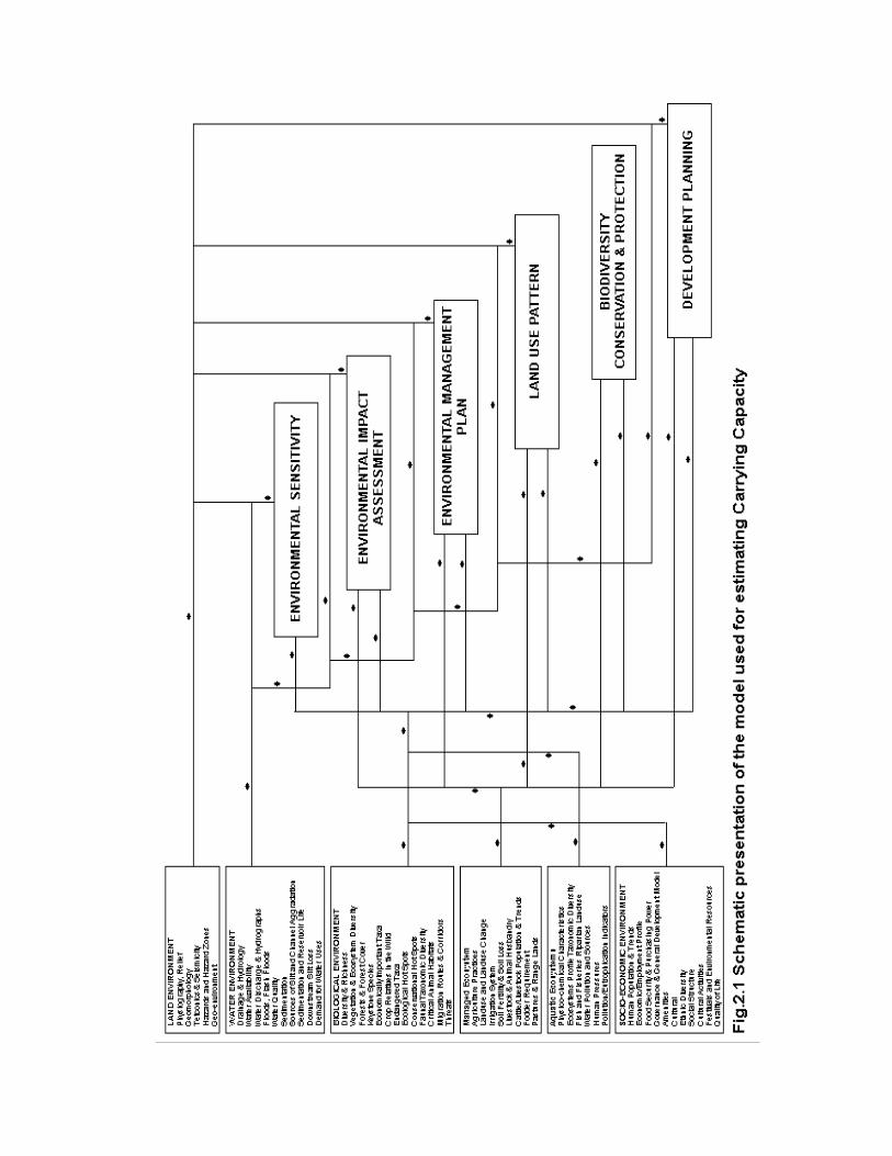
The attributes of various environmental resources and human
activities have been presented in the form of a model used in the
Introductory Volume – Concept and Methodology
16
CISMHE
present study for estimation of carrying capacity. A schematic
presentation of the model is depicted in Figure 2.1.
2.3 EXISTING ENVIRONMENTAL RESOURCES BASE
A detailed account of environmental resource base in terms of air,
water, land including biotic resources, socio-economic and quality of life is
provided for determining the quality and quantity of available resources
for use in the process of planning and development. This body of data
does not only aim at inventorisation of resources but also gives detailed
analysis of the prevailing environmental resource base and
environmental quality of the basin. This data would ultimately help us
identify limiting resources as also the environmentally critical areas
which can be delimited as hot spots for conservation or remediation.
The evaluation of resources would also lead to understanding the
impacts of various developmental activities on these resources on one
hand and the planning process on the other. In the final analysis
evaluation of the entire environment resource base vis-a-vis various
developmental activities would provide a scientific basis for developing
management plans and alternate development plans for critical
environmental resources and areas.
2.3.1 Air Environment
Though air pollution is not so far an area of critical concern of
critical importance in the Teesta basin in Sikkim, yet it was considered
Introductory Volume – Concept and Methodology
17
CISMHE
important to evaluate the resource for future development scenarios.
The air environment has been assessed for the following :
• Ambient air quality
• Pollution sources
• Air environment sensitivity analysis In order to collect data for air environment the following
standard methodologies were followed :
• Delineation of air sheds based on topography,
identification of micro-climatic zones and wind fields data
• Inventorisation of point, area and line sources of pollution
and estimation of pollution loads
• Temporal and spatial variations in air pollutant
concentration for existing sources using multiple source-
receptor model to establish sources-receptor relationships
• Estimation of air environment sensitivity in critical micro-
climatic zones for various pollutants vis-a-vis air quality
standards for sensitive receptors
• Quantification of upper limits of pollution load in critical
pockets
2.3.2 Water Environment
Water is the key resource of Sikkim and majority of present and
future developmental activities revolve around this resource. This may
not be a critical resource from environmental point of view at present,
but it is surely a critical economic resource for the state. Any resource
Introductory Volume – Concept and Methodology
18
CISMHE
utilisation, consumption and conservation must take into account both
the ecological as well as economic criticality of this resource. The
present study has focused on evaluation of water environment in
the basin in terms of the following :
• The drainage characteristics of the basin which include
surface water bodies like rivers and lakes, underground
drainage of various types and origins
• Nodal points of water resources
• Precipitation of rainfall and drainage during dry and/or
non-dry periods
• Seasonal flows of water bodies (lakes including glacial
lakes, rivers, ponds, etc.) and estimation of flood levels
• Water availability at various points and estimation of 75%
and 90% dependable discharge
• Estimation of sediment load at various points in the basin
and its qualitative analysis and seasonal flow of silt
• Water availability and demand for various sectors
• Inventorisation of point and non-point sources of pollution
• Quantification of upper limits of pollution load in various
stretches
2.3.3 Land Environment
Keeping in view the mountainous terrain of the basin it is pertinent
to consider land environment as a critical resource for developmental
activity. The criticality of land for developmental purposes has to be
understood in terms of its fragility, capability and availability. In order
Introductory Volume – Concept and Methodology
19
CISMHE
to classify the land as ecologically fragile, production-wise capable
and resource-wise available, it is important to understand the physical
nature in terms of basic landforms, physiography, rock types, tectonic
processes, hazardous phenomena as also the soil types. To ascertain
the existing levels of land resource exploitation a landuse/land cover
map is a pre-requisite for estimating the existing scenario and
projecting the future scenario of development. A detailed account on
various physical features, processes and activities of the basin’s land
environment have been evaluated for following attributes for
estimating ecological sensitivity/fragility of land resource. It included
the following considerations :
• Preparation of a base map delineating major watersheds
of the Teesta basin
• Watershedwise slope, aspect, elevation profile and
preparation of digital elevation models at 1:50,000 and/or
1:25,000 scale
• Mapping of erosion prone areas, old and active landslides
using merged LISS-III and PAN data at 1:50,000 scale
• Preparation of watershedwise detailed soil maps
• Mapping of important zones of crustal weakness in terms
of structural discontinuities, thrust, shear, ductile zones
• Mapping of river terraces, moraine deposits including
glacial moraines
• Regional stratigraphic - tectono-stratigraphic succession
along south-north Sikkim Himalaya for estimation of
possibility of tectonic diverticulation
Introductory Volume – Concept and Methodology
20
CISMHE
• Seismo-tectonic map of the basin including micro-
seismic activities and seismic history
• Physical environmental/ecological sensitivity analysis.
2.3.4 Biological Environment
Sikkim is one of the most important areas of biological importance
and has been classified as a global hot spot for biodiversity
conservation. The importance of assessing the status and nature of
biological diversity including ecosystem diversity of Teesta basin,
therefore, can not be over- emphasized. A great variation in the agro-
climatic conditions of the basin have given rise to a myriad ecosystems
from hot humid tropics and sub-tropics to frigid alpine areas in the state
of Sikkim. It is, therefore, important to understand that biological
resource holds an important place in the planning and developmental
process of Sikkim. In order to achieve a balancing act of conserving the
biological diversity and ensuring economic gains from conservation and
also utilisation of biological resource, it is essential to assess the existing
biological environment base of the basin. To achieve this objective
following aspects of biological environment have been evaluated in the
study :
• Inventorisation of floral and faunal species diversity in
terrestrial, aquatic and aerial ecosystems
• Identification and mapping of endangered rare taxa of
conservational and economic significance
Introductory Volume – Concept and Methodology
21
CISMHE
• Identification of hot spots for conservation and sustainable
exploitation
• Landuse and vegetation mapping including forest cover
• Biological sensitivity analysis of ecosystems/areas where
developmental projects are proposed
• Identification of potential areas for eco-tourism
• Identification of potential biological resources for economic
welfare of local population and industrial use
2.3.5 Socio-economic Environment
The human population density, demographic profile, cultural
practices and the associated activities play the most crucial role in
shaping the nature of environmental resources of land, air and
water of a region. In highlands particularly, there are even more
profound results on these resources arising out of human activity.
The Teesta basin in Sikkim exhibits varied demographic profiles
and patterns in various districts and along the altitudinal gradients.
The state is also rich in cultural and ethnic diversity besides being
rich in water and biological resources. For any planning and
development process to be successful and meaningful it is
essential to understand the existing socio-economic resource base
and levels of its exploitation by the human population. Linked to it is
the quality and quantum of services and amenities provided by the
state for providing better quality of life to the human population.
Since human ecosystems are heavily loaded towards producing
higher quantities of waste as a result of various activities it is
Introductory Volume – Concept and Methodology
22
CISMHE
important to assess the consumption and waste production levels and
suggest measures to reduce pollution loads in land, air and water
resources. To evaluate the socio-economic environment in this study
following parameters have been considered relevant to the carrying
capacity study.
• Assessment of human population density and population
growth
• Economic profile of human population living in various
districts and sector-wise employment and employment
potential
• Man land ratio across the population profile
• Evaluation of agricultural practices, food production vis-a-
vis land capability and agricultural productivity
• Distribution pattern of input resources in agriculture vis-a-
vis socio-economic profile of the population
• Agricultural productivity and carrying capacity
• Evaluation of amenities and services provided by the state
in terms of educational, health, communication and other
facilities
• Assessment of quality of life in terms of existing scenario,
perceived scenario and preferred scenario
Introductory Volume – Proposed Power Development Profile of Teesta Basin
CISMHE
3.1 POWER DEVELOPMENT SCENARIO
The power situation of Sikkim before its merger with India in 1975
was in its infancy because of low demand. The power requirement of
Gangtok and a few townships located on the national highway was met
from the small 2.1 MW Jali Power House commissioned in 1964. Also, a
small Diesel Powerhouse was used as a standby to meet the
requirement during emergencies. Similarly, Roathak (South) and Rimbi
(West) micro hydels with an installed capacity of 200 KW each were
under operation to feed District Headquarters and major townships in
the South and West districts, while the North district had to manage with
a 50 KW micro hydel unit known as Manul micro hydel, which has since
become inoperative. Till the end of 1975, there were only 8 declared
towns that used electricity in Sikkim, while rest of the areas had no
power supply.
Till the end of 1979, the state had a total power generation
capacity of only 3 MW to meet the increasing demand of the state and
hence drastic load shedding had to be resorted to. Thereafter, the state
undertook the extension of electrification to small townships and villages
at a faster pace. Today, the state has an installed capacity of 39 MW as
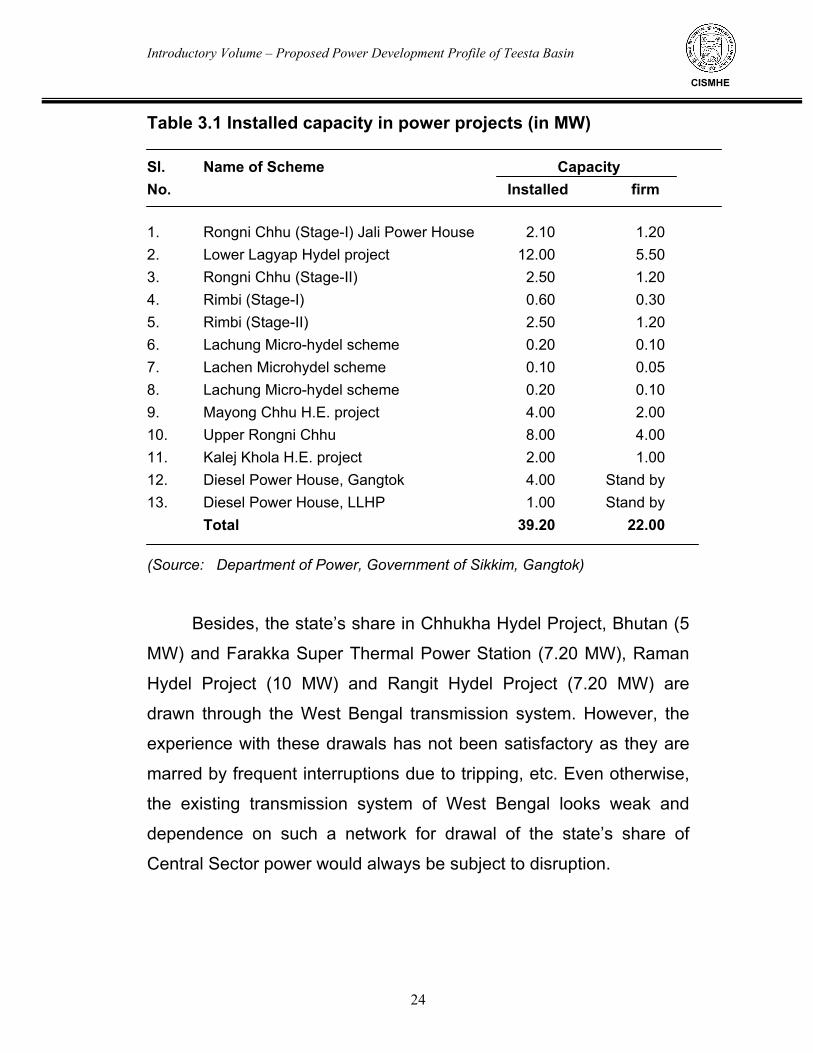
given in Table 3.1.
Introductory Volume – Proposed Power Development Profile of Teesta Basin
24
CISMHE
Table 3.1 Installed capacity in power projects (in MW) Sl. Name of Scheme Capacity No. Installed firm 1. Rongni Chhu (Stage-I) Jali Power House 2.10 1.20 2. Lower Lagyap Hydel project 12.00 5.50 3. Rongni Chhu (Stage-II) 2.50 1.20 4. Rimbi (Stage-I) 0.60 0.30 5. Rimbi (Stage-II) 2.50 1.20 6. Lachung Micro-hydel scheme 0.20 0.10 7. Lachen Microhydel scheme 0.10 0.05 8. Lachung Micro-hydel scheme 0.20 0.10 9. Mayong Chhu H.E. project 4.00 2.00 10. Upper Rongni Chhu 8.00 4.00 11. Kalej Khola H.E. project 2.00 1.00 12. Diesel Power House, Gangtok 4.00 Stand by 13. Diesel Power House, LLHP 1.00 Stand by Total 39.20 22.00 (Source: Department of Power, Government of Sikkim, Gangtok)
Besides, the state’s share in Chhukha Hydel Project, Bhutan (5
MW) and Farakka Super Thermal Power Station (7.20 MW), Raman
Hydel Project (10 MW) and Rangit Hydel Project (7.20 MW) are
drawn through the West Bengal transmission system. However, the
experience with these drawals has not been satisfactory as they are
marred by frequent interruptions due to tripping, etc. Even otherwise,
the existing transmission system of West Bengal looks weak and
dependence on such a network for drawal of the state’s share of
Central Sector power would always be subject to disruption.
Introductory Volume – Proposed Power Development Profile of Teesta Basin
25
CISMHE
3.2 POWER REQUIREMENT
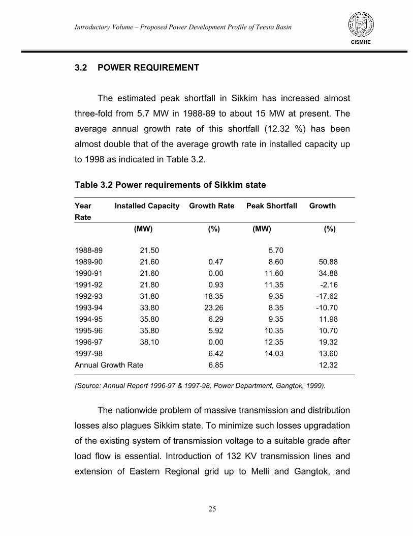
The estimated peak shortfall in Sikkim has increased almost
three-fold from 5.7 MW in 1988-89 to about 15 MW at present. The
average annual growth rate of this shortfall (12.32 %) has been
almost double that of the average growth rate in installed capacity up
to 1998 as indicated in Table 3.2.
Table 3.2 Power requirements of Sikkim state Year Installed Capacity Growth Rate Peak Shortfall Growth Rate (MW) (%) (MW) (%) 1988-89 21.50 5.70 1989-90 21.60 0.47 8.60 50.88 1990-91 21.60 0.00 11.60 34.88 1991-92 21.80 0.93 11.35 -2.16 1992-93 31.80 18.35 9.35 -17.62 1993-94 33.80 23.26 8.35 -10.70 1994-95 35.80 6.29 9.35 11.98 1995-96 35.80 5.92 10.35 10.70 1996-97 38.10 0.00 12.35 19.32 1997-98 6.42 14.03 13.60 Annual Growth Rate 6.85 12.32 (Source: Annual Report 1996-97 & 1997-98, Power Department, Gangtok, 1999).
The nationwide problem of massive transmission and distribution
losses also plagues Sikkim state. To minimize such losses upgradation
of the existing system of transmission voltage to a suitable grade after
load flow is essential. Introduction of 132 KV transmission lines and
extension of Eastern Regional grid up to Melli and Gangtok, and
Introductory Volume – Proposed Power Development Profile of Teesta Basin
26
CISMHE
upgradation of sub-stations and distribution lines including energy
audition, etc. at all levels of generation, transmission and distribution
up to the consumers’ premises are other primary requirements.
In view of the anticipated development in the industrial sector
and also growing urban, domestic and rural needs, the present not so
reliable and inadequate power supply has been a major reason for the
state’s power economic development. It has also affected private
investments in the state. In fact, even without further industrial
expansion, the peakload demand of the state by 2002 is expected to
reach 60 MW. The state has to be geared to generate this power for its
economic welfare.
3.3 HYDRO POWER POTENTIAL IN TEESTA BASIN
The topography and resource availability in the Teesta basin
makes development of thermal or petroleum based power
development very expensive and environmentally unsustainable. The
increase in the power demands can, therefore, be met quite profitably
by the development of hydro-power. The surplus power will enable the
state to earn a substantial amount of revenue which can be utilised for
the much needed economic upliftment of its inhabitants.
The river Teesta has great potential for development of power,
as the river descends from an elevation of about 5200 m to about 300
m over a distance of about 175 km. According to the preliminary
Introductory Volume – Proposed Power Development Profile of Teesta Basin
27
CISMHE
reconnaissance survey by the team of experts of erstwhile Central
Water & Power Commission in 1974, the river could be harnessed
under a cascade development for hydro-power generation. The hydro-
electric potential of the Teesta and its tributaries in Sikkim was
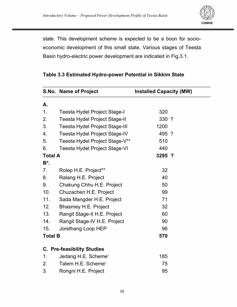
estimated at about 3735 MW (Table 3.3) (Fig. 3.1). The cascade
development consists of power generation in six stages along Teesta
river. In addition Sikkim Power Development Corporation had identified
more schemes to be developed with the help of private agencies.
Recently under the Hon’ble Prime Minister’s 50,000 MW, ten schemes
were proposed for pre-feasibility studies. All these schemes have been
described in brief below.
3.3.1 Schemes indentified by CWC 3.3.1.1 Teesta Project Stage-I
Under this stage of development, it is proposed to divert the
waters of Lachen Chhu (Teesta), Lhonak Chhu and Poke Chhu by
constructing diversion structures and inter-connecting tunnels. The
combined water to be dropped at Lachen Chhu to generate power. The
diversion weirs across Poke Chhu, Lhonak Chhu and Lachen Chhu
would be located at an elevation of nearly 3300 m. At powerhouse site,
the drop of about 730 m would be available. Estimated dependable
discharge would be of the order of 17 cumec which may generate 96
MW of firm power with an installed capacity of 390 MW.
3.3.1.2 Teesta Project Stage-II Under stage-II, it is proposed that the tail race waters of Lachen
Chhu would be picked up near Chhatten village and diverted through a
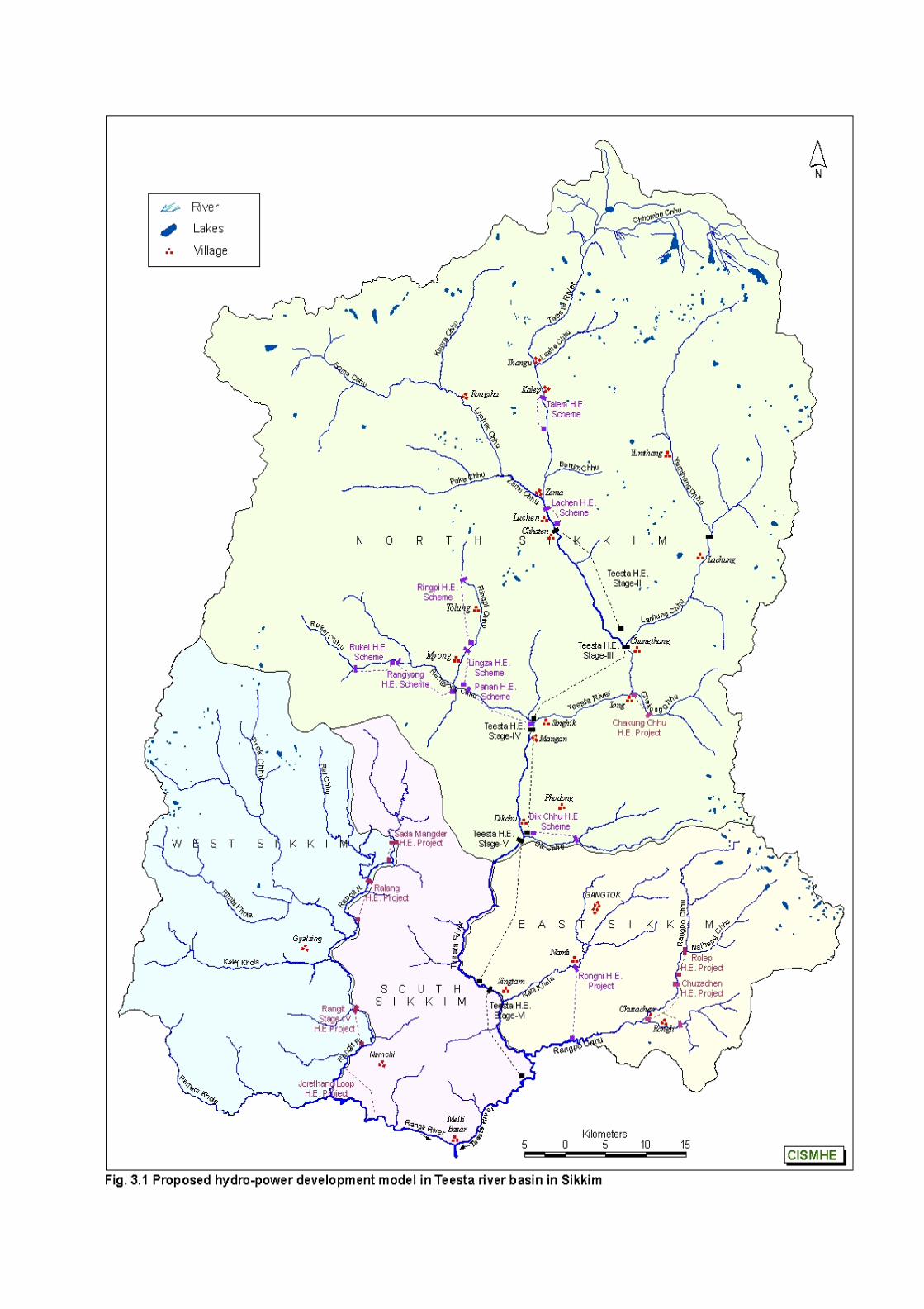
Introductory Volume – Proposed Power Development Profile of Teesta Basin
28
CISMHE
tunnel. A second weir across the Lachung Chhu at Lachung would
divert the waters through another tunnel. The combined waters would
be utilised to generate power in a powerhouse located upstream of
Chungthang. The gross head available at the powerhouse would be
about 1100 m with a power draft of about 26 cumec. This is expected
to generate 224 MW of firm power with an installed capacity of 330
MW. In absence of a possible site for constructing a balancing
reservoir, Stage I & II schemes may have to be operated as run-of-
the-river schemes for base load generation.
3.3.1.3 Teesta Project Stage-III Under this stage of development, which is the most ambitious
and economic one, the waters of Teesta would be diverted through a
12.93 km long tunnel by constructing a dam downstream of
Chungthang. The waters will be dropped through a height of about 800
m at the proposed power house located at an elevation of about 780 m
in the left bank hill of Rangyong Chhu (Talung Chhu), about 700 m
upstream of its confluence with Teesta. The proposed surge shaft,
powerhouse and penstock will be underground. As this powerhouse
will be utilised as the peaking station for the North Eastern grid, the
installed capacity of the project has been proposed at 1200 MW.
3.3.1.4 Teesta Project Stage-IV
In this scheme, the tail race waters from powerhouse of Teesta
project Stage-III will be picked up by a diversion structure downstream
Introductory Volume – Proposed Power Development Profile of Teesta Basin
29
CISMHE
of confluence of Rangyong Chhu and Teesta and diverted through a
tunnel leading near Dik Chhu where a firm power of 85 MW is proposed
to be generated with an installed capacity of 495 MW. This will involve
construction of a 11.3 km long tunnel. The dependable discharge would
be of the order of 56 cumec with available gross head of 194.5 m.
3.3.1.5 Teesta Project Stage-V
This project is already under execution by NHPC. Under this stage of Teesta basin development, the waters of Teesta are being diverted through a tunnel of about 15 km length by constructing a dam at Dikchu immediately below the confluence of Dik Chhu with Teesta. The dependable discharge available throughout the year has been assessed at 42 cumec and the gross head available is 198 m. The power house is located near Singtam about 4 km upstream of the confluence of Rongni Chhu (Rani Khola) and Teesta and is expected to generate 72.4 MW of firm power with an installed capacity of 510 MW.
3.3.1.6 Teesta Project Stage-VI
In the river stretch downstream of Singtam, it is proposed to utilise the drop of about 70 m of water between Singtam and Rangpo by diverting the Teesta river through a suitable 4.3 km long water conductor system. The powerhouse would generate about 55.5 MW of firm power and an installed capacity of 440 MW.
Thus, this proposed model envisages to generate a large quantity
of hydro-power to the tune of about 3735 MW (see Table 3.3) in the
Introductory Volume – Proposed Power Development Profile of Teesta Basin
30
CISMHE
state. This development scheme is expected to be a boon for socio-
economic development of this small state. Various stages of Teesta
Basin hydro-electric power development are indicated in Fig.3.1.
Table 3.3 Estimated Hydro-power Potential in Sikkim State S.No. Name of Project Installed Capacity (MW) A. 1. Teesta Hydel Project Stage-I 320 2. Teesta Hydel Project Stage-II 330 ? 3. Teesta Hydel Project Stage-III 1200 4. Teesta Hydel Project Stage-IV 495 ? 5. Teesta Hydel Project Stage-V** 510 6. Teesta Hydel Project Stage-VI 440 Total A 3295 ? B*. 7. Rolep H.E. Project** 32 8. Ralang H.E. Project 40 9. Chakung Chhu H.E. Project 50 10. Chuzachen H.E. Project 99 11. Sada Mangder H.E. Project 71 12. Bhasmey H.E. Project 32 13. Rangit Stage-II H.E. Project 60 14. Rangit Stage-IV H.E. Project 90 15. Jorethang Loop HEP 96 Total B 570 C. Pre-feasibility Studies 1. Jedang H.E. Scheme† 185 2. Talem H.E. Scheme† 75 3. Rongni H.E. Project 95
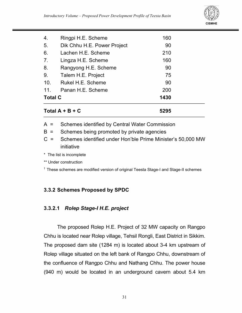
Introductory Volume – Proposed Power Development Profile of Teesta Basin
31
CISMHE
4. Ringpi H.E. Scheme 160 5. Dik Chhu H.E. Power Project 90 6. Lachen H.E. Scheme 210 7. Lingza H.E. Scheme 160 8. Rangyong H.E. Scheme 90 9. Talem H.E. Project 75 10. Rukel H.E. Scheme 90 11. Panan H.E. Scheme 200 Total C 1430 Total A + B + C 5295 A = Schemes identified by Central Water Commission B = Schemes being promoted by private agencies C = Schemes identified under Hon’ble Prime Minister’s 50,000 MW
initiative * The list is incomplete
** Under construction † These schemes are modified version of original Teesta Stage-I and Stage-II schemes
3.3.2 Schemes Proposed by SPDC 3.3.2.1 Rolep Stage-I H.E. project
The proposed Rolep H.E. Project of 32 MW capacity on Rangpo
Chhu is located near Rolep village, Tehsil Rongli, East District in Sikkim.
The proposed dam site (1284 m) is located about 3-4 km upstream of
Rolep village situated on the left bank of Rangpo Chhu, downstream of
the confluence of Rangpo Chhu and Nathang Chhu. The power house
(940 m) would be located in an underground cavern about 5.4 km
Introductory Volume – Proposed Power Development Profile of Teesta Basin
32
CISMHE
downstream of the proposed dam site on the left bank of Rangpo chhu.
A head race tunnel of 5 km length is proposed.
3.3.2.2 Ralang Stage-I H.E. project The proposed Ralang H.E. project of 40 MW capacity is located
near Polaut village, tehsil Ralong, Sub-division Rabong, South Sikkim
district. The proposed dam site is located at the foot of Polaut about
500m downstream of the confluence of Rel Chhu with Rangit river.
The water of Rangit river would be diverted through 5.0 km long head
race tunnel and conveyed to an underground powerhouse. The
powerhouse is proposed to be in an underground cavern about 5 km
downstream of the proposed dam site on the left bank of Rangit river.
The project envisages generation of 40 MW of electricity.
3.3.2.3 Chakung Chhu Stage-I H.E. project The proposed Chakung Chhu H.E. Project of 50 MW capacity
on Chakung Chhu river is located near Tong village, tehsil
Chungthang, North Sikkim district. The proposed dam site (1,950 m)
is located about 3-4 km upstream of Tong village and the powerhouse
(1,320 m) would be located about 3 km downstream of the proposed
dam site near Tong village. A head race tunnel of 3 km length is
proposed.
3.3.2.4 Chuzachen H.E. project
Chuzachen H.E. project is located downstream of the under
construction Rolep H.E. project. It envisages construction of two dams,
dam-I on Rangpo Chhu intakes through Rangpo and dam-II on Rongli
Introductory Volume – Proposed Power Development Profile of Teesta Basin
33
CISMHE
with head race tunnels of 2.6 km and 2.3 km long, respectively. The
powerhouse is proposed on the left bank of Rangpo Chhu with an
installed capacity of 99 MW.
3.3.3 Under 50,000 MW initiative 3.3.3.1 Jedang H.E. Scheme Jedang H.E. scheme is one of the various projects proposed in the higher reaches of Teesta river basin in Sikkim. It is a modified version of earlier Teesta Stage-I. The proposed project envisages construction of a dam upstream of confluence of Lhonak Chhu with Zemu Chhu in North Sikkim. The project involves construction of diversion structure and diversion of water through a head race tunnel of about 9 km length. The powerhouse is proposed near the confluence of Lhonak Chhu with Zemu Chhu on its left bank. The proposed project envisages power generation of 185 MW.
3.3.3.2 Teesta Stage-I H.E. Scheme
Teesta Stage-I H.E. scheme envisages construction of two dams,
i.e. dam-I to be located downstream of confluence of Lhonak Chhu with
Zemu Chhu and dam-II downstream of the confluence of Chento Chhu
with Teesta river in North Sikkim. The project involves construction of 40
m high dam-I and diversion of water to the dam-II reservoir through a
3.5 km long link tunnel. The water from the 45 m high dam-II is
proposed to be diverted through a 3.5 km long head race tunnel. An
underground powerhouse is proposed immediately upstream of Zema
Introductory Volume – Proposed Power Development Profile of Teesta Basin
34
CISMHE
on the right bank of Teesta river. The proposed project envisages
power generation of 300 MW.
3.3.3.3 Rongni H.E. Project
Rongni H.E. Project is located 700 m downstream of the
confluence of Rongni Chhu (Rani Khola) and Andheri Khola near
Namli township in East Sikkim. The project involves the construction
of a diversion structure on Rongni Chhu and 10 km long head race
tunnel with power house to be located on the right bank of Rangpo
Chhu near Bhasme village. The proposed project envisages power
generation of 95 MW. This scheme has now been revised as Rongni
H.E. Project with dam site located near village Namli with very little
submergence with envisaged power generation of 96 MW.
3.3.3.4 Ringpi H.E. Scheme
Ringpi H.E. scheme is located downstream of the confluence of
Jumthul Chhu and Kishong Chhu in North Sikkim. This is one of the
high altitude hydro-electric schemes proposed on Rangyong Chhu or
its tributaries. The project involves construction of a diversion dam
immediately downstream of the confluence of the two streams,
Jumthul and Kishong and a 7.0 km long head race tunne. The dam
site is to be located near the Talung village in Sakyong Pentong
Revenue Block at the confluence of Jumthul Chhu and Kishong
Chhu. The power house is located on the right bank of Ringpi Chhu
about 2 km upstream of Shabrung village. The proposed project
envisages power generation of 160 MW.
Introductory Volume – Proposed Power Development Profile of Teesta Basin
35
CISMHE
3.3.3.5 Dik Chhu H.E. Scheme
Dik Chhu H.E. scheme is located 100 m downstream of the
confluence of Dik Chhu/ Rate Chhu and Bakcha Chhu near Phodong
township in North Sikkim. The project involves the construction of a
diversion structure on Dik Chhu and 7.5 km long head race tunel with
power house proposed on the left bank of Teesta river at the
confluence of Dik Chhu with Teesta river near Dikchu town. The
proposed project envisages power generation of 90 MW.
3.3.3.6 Lachen H.E. Scheme
Lachen H.E. scheme envisages construction of a dam
downstream of confluence of Zemu Chhu with Teesta river in North
Sikkim. The project involves construction of diversion structure and
diversion of water through a head race tunnel of about 4.5 km length.
The power house is proposed near village Bonsoi upstream of Teesta
Stage-II project site. The proposed project envisages power
generation of 210 MW. 3.3.3.7 Lingza H.E. Scheme
Lingza H.E. scheme is located on Ringpi Chhu in North Sikkim.
The proposed project is located on Ringpi Chhu. The project involves
construction of a diversion structure immediately downstream of the
power house of proposed Ringpi H.E. scheme with a 4.0 km long
head race tunnel for carrying waters to a power house to be located
on the left bank of main channel Rangyong or Talung Chhu about 2
Introductory Volume – Proposed Power Development Profile of Teesta Basin
36
CISMHE
km upstream of Lingza village. The proposed project envisages
power generation of 160 MW.
3.3.3.8 Rangyong H.E. Scheme
Rangyong H.E. scheme envisages construction of two dams,
i.e. upper dam to be located immediately downstream of confluence
of Umram Chhu and Passaram Chhu in North Sikkim and lower dam
on Rangyong Chhu upstream of the confluence of Umram Chhu with
Rangyong Chhu. The project involves construction of 55 m high
upper dam and diversion of water to the lower dam reservoir through
a 2 km long link tunnel. The water from the 55 m high lower dam is
proposed to be diverted through a 7.5 km long head race tunnel. An
underground power house is proposed immediately upstream of the
reservoir of Panan H.E. scheme. The proposed project envisages
power generation of 90 MW.
3.3.3.9 Talem H.E. Project
Talem H.E. project envisages construction of a rockfill dam
downstream of confluence of Kalep Chhu with Teesta river in North
Sikkim. The project involves construction of a 50 m high dam on
Teesta river and diversion of water through a head race tunnel of
about 4.5 km length. An underground power house is proposed near
village Talem upstream of the proposed Teesta Stage-I project site on
the right bank of Teesta river. The proposed project envisages power
generation of 75 MW.
Introductory Volume – Proposed Power Development Profile of Teesta Basin
37
CISMHE
3.3.3.10 Rukel H.E. Scheme
Rukel H.E. scheme is located downstream of confluence of
Rukel Chhu and Rangyong Chhu in North Sikkim. This is the
uppermost hydro-electric scheme proposed on Rangyong Chhu. The
project involves construction of a diversion dam immediately
downstream of the confluence of the two streams and a 4.0 km long
head race tunnel. The proposed project envisages power generation
of 90 MW.
3.3.3.11 Panan H.E. Scheme
Panan H.E. scheme is located about 1.75 km downstream of
the confluence of Rangyong Chhu (Talung Chhu) and Ringpi Chhu
near Lingah village in North Sikkim. The project involves the
construction of a diversion structure on Rangyong Chhu and a 9.0 km
long head race tunnel with underground power house proposed on
the right bank of Teesta river at the confluence of Talung Chhu with
Teesta river near Panan town. The proposed project envisages power
generation of 200 MW.
Introductory Volume – Teesta River System – The Study Area
CISMHE
4.1 INTRODUCTION
Teesta river originates as Chhombo Chhu from a glacial lake
Khangchung Chho at an elevation of 5,280 m in the northeastern corner
of the state. The glacial lake lies at the snout of the Teesta Khangse
glacier descending from Pauhunri peak (7,056 m) in north western
direction. Teesta Khangse glacier and Chho Lhamo are also considered
as the source of Teesta river by many authors. Along its traverse from
its origin to the plains, the river receives drainage from a number of
tributaries on either side of its course. The tributaries on the eastern
flank are shorter in course but larger in number whereas the tributaries
on the western flank are much longer with larger drainage areas,
consequently contributing much more amount of discharge to the main
Teesta river. Furthermore, right-bank tributaries drain heavily glaciated
areas with large snow-fields. The left bank tributaries, on the other hand,
originate from semi-permanent and much smaller snow-fields as
compared to right bank tributaries. The major tributaries of Teesta river
are listed in Table 4.1. For better understanding of Teesta river system,
it has been divided into a number of river sub-systems which are
described in the succeeding paragraphs. These sub-systems are: i)
Chhombo Chhu/ Teesta river upstream of Zemu Chhu-Teesta
confluence, ii) Zemu Chhu, iii) Teesta river between Lachen and
Chungthang, iv) Lachung Chhu, v) Chungthang-Mangan and Chakung
Chhu sub-system, vi) Rangyong (Talung) Chhu, vii) Dik Chhu, viii)
Teesta river between Mangan and Singtam, ix) Rani Khola, x) Teesta
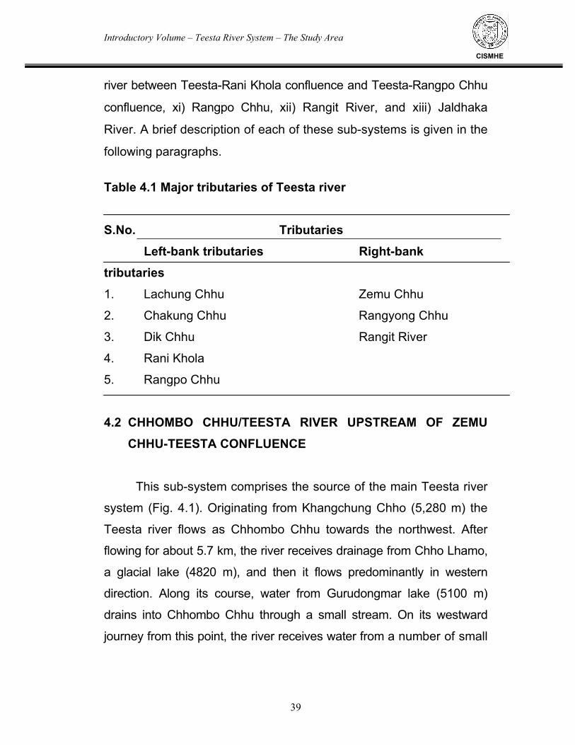
Introductory Volume – Teesta River System – The Study Area
39
CISMHE
river between Teesta-Rani Khola confluence and Teesta-Rangpo Chhu
confluence, xi) Rangpo Chhu, xii) Rangit River, and xiii) Jaldhaka
River. A brief description of each of these sub-systems is given in the
following paragraphs.
Table 4.1 Major tributaries of Teesta river S.No. Tributaries Left-bank tributaries Right-bank tributaries
1. Lachung Chhu Zemu Chhu
2. Chakung Chhu Rangyong Chhu
3. Dik Chhu Rangit River
4. Rani Khola
5. Rangpo Chhu 4.2 CHHOMBO CHHU/TEESTA RIVER UPSTREAM OF ZEMU
CHHU-TEESTA CONFLUENCE
This sub-system comprises the source of the main Teesta river
system (Fig. 4.1). Originating from Khangchung Chho (5,280 m) the
Teesta river flows as Chhombo Chhu towards the northwest. After
flowing for about 5.7 km, the river receives drainage from Chho Lhamo,
a glacial lake (4820 m), and then it flows predominantly in western
direction. Along its course, water from Gurudongmar lake (5100 m)
drains into Chhombo Chhu through a small stream. On its westward
journey from this point, the river receives water from a number of small
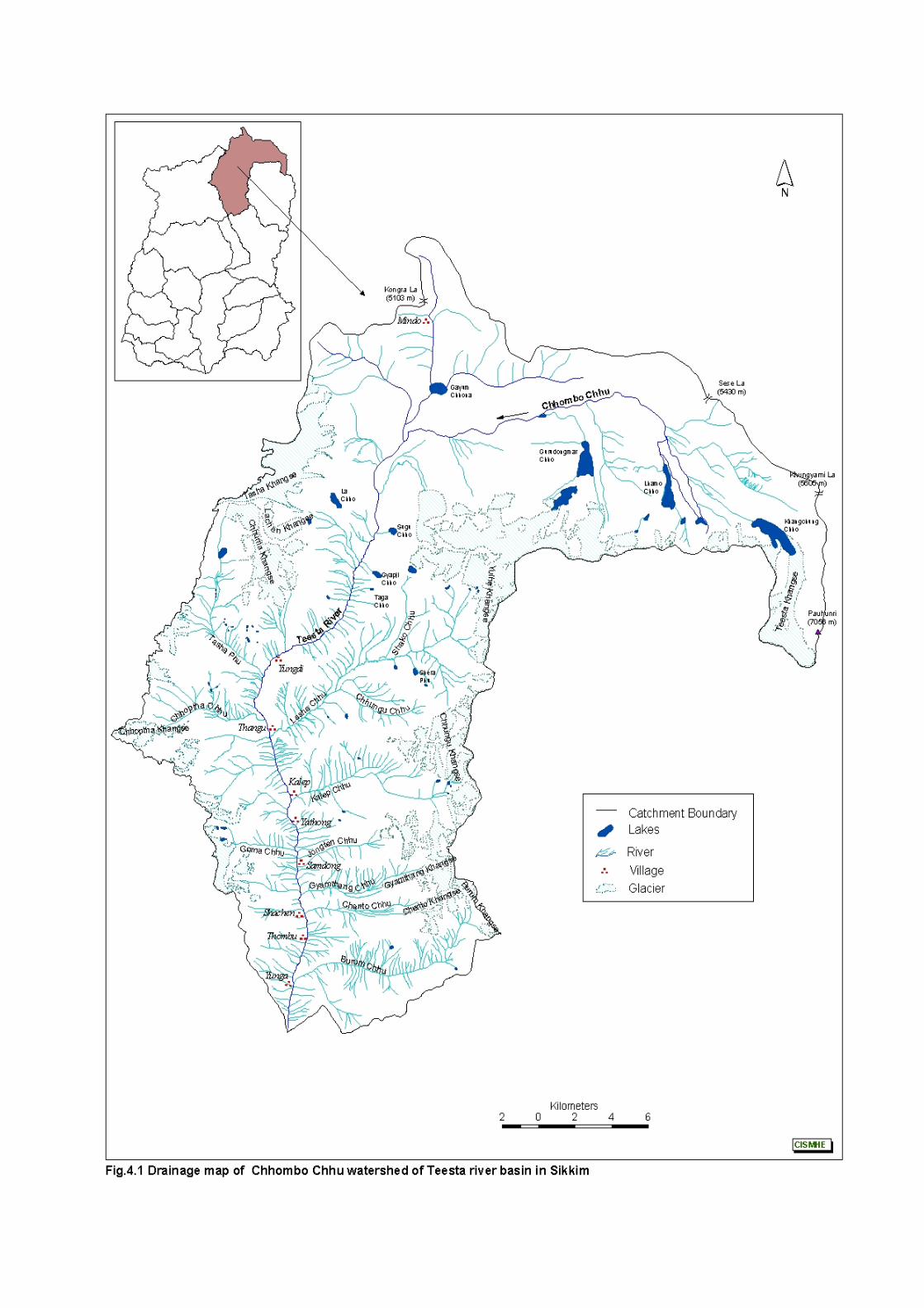
Introductory Volume – Teesta River System – The Study Area
40
CISMHE
streams joining it on either side. The river changes its course towards
southwest near Oakra, where it receives drainage from a stream
flowing from Gayum Chhona lake on its right bank. Thereafter, south
of Oakra, Chhombo Chhu flows as Teesta river. About 6.4 km
downstream of Oakra, a stream draining Sugu Chho joins Teesta
river at its left bank at 4,620 m. A little further downstream of this
confluence, a stream draining Gyapji Chho lake joins the river on its
left bank at 4,540 m and another stream coming out from Lachen
Khangse glacier (5,100 m) joins the river at 4,550 m on its right bank.
From this point the river flows towards southeast through an arcuate
valley for about 7.3 km where a stream with its head waters at
Chhuma Khangse glacier (4,800 m) confluences on its right bank at
4,220 m. Along this arcuate valley several small streams join the river
on either bank. After about another 2 km from this confluence Tasha
Phu with its head water at Tasha Khangse (4,840 m) joins the river on
its right bank at 4,090 m near Yongdi. At about 3 km downstream of
Yongdi, Chhoptha Chhu which has its headwaters at Chhobu
Khangse (>5000 m) flowing towards east joins Teesta river at 4,100
m downstream (~0.9 km) of Chhoptha. A little distance downstream,
Lasha Chhu joins Teesta river at 3,835 m near Thangu. Originating
from Yulhe Khangse at >5000 m, Lasha Chhu flows towards
southeast for 17.8 km. In its initial course it is known as Shako Chhu
which after joining the tributary Chhungu Chhu (5 km long) flows as
Lasha Chhu for a distance of 4.5 km. About 3.6 km downstream of its
confluence, Kalep Chhu joins the Teesta river on the left bank at
3,648 m. Kalep Chhu is a short course glacier-fed stream (10.6 km).
After flowing about 3.0 km from Kalep Chhu confluence, Teesta is joined
Introductory Volume – Teesta River System – The Study Area
41
CISMHE
by Goma Chhu at 3,500 m. Further downstream at 3.0 km and 3.8 km two
snowfed rivers, Goma Chhu and Jongten Chhu join Teesta river at 3,500
m and 3,455 m, respectively. Gyamthang Chhu, originating from
Gyamthang Khangse glacier above 4,600 m traverses a distance of
about 16 km to join Teesta river on its left bank at 3,310 m near
Chhochen. Two streams, Chento Chhu and Burum Chhu drain Chento
Khangse and Burum Khangse glaciers, respectively and merge with
Teesta river on its left bank at Shacham and Yunga villages. Thereafter,
Teesta river flows for a distance of about 2.5 km and is joined by Zemu
Chhu on the right bank at 2,675 m near Zema.
4.3 LACHUNG CHHU
Lachung Chhu sub-system, is one of the main drainage
system contributing to the discharge of Teesta in upper reaches.
Lachung Chhu in its initial stretch is known as Yumthang Chhu
formed by the confluence of Sebu Chhu and Dongkya Chhu (Figs
4.2 & 4.4). Dongkya Chhu originates in the glaciated terrain near
Dongkya La at an elevation above 5,000 m in the northeastern
part of Sikkim. From its headwater, Dongkya Chhu flows for about
7 km towards southeast up to Zadong where a southward flowing
stream (3.8 km long) draining Sanglaphui lake, joins it on the right
bank at 4,880 m. From this confluence downstream, Dongkya
Chhu is met by its tributary Jakhthang Chhu on its left bank at
4,780 m. Further downstream Tenbawa Chhu flowing westward
from Korpo La and draining Tenbawa glacier (> 5,000 m) joins the
river at 4,685 m near Yumesamdong. About 1.3 km downstream of
Introductory Volume – Teesta River System – The Study Area
42
CISMHE
this confluence, Sebu Chhu joins Dongkya Chhu at 4,485 m. Sebu
Chhu is a major right bank tributary of Dongkya Chhu which flows for
7.3 km from its headwater near Sebu La in Changme Khang and
Changme Khangpu glaciers draining a number of glacial lakes before
joining the main river channel. Yumthang Chhu flows for a distance of
about 18-19 km in southward direction before it is joined by Sebozung
Chhu at Chhuba (2,800 m). After this confluence, the river flows as
Lachung Chhu in south-west direction in general. Along its course
Yumthang Chhu receives drainage from Khangpup Chhu on its
eastern flank and Rulak Chhu, and Lako Chhu draining the right bank
slopes of Yumthang valley.
Sebozung Chhu is a major left bank tributary of Yumthang Chhu
with a total course of about 23 km from its headwater above 5,000 m.
It received water from Khangpup Khangse, Khangkyong Khangse
and Ghorathang glaciers and a number of glacial lakes like Kasang
Chho, Chhopup Chho, etc. Sebozung Chhu originates at about 4,055
m and flows southward receiving drainage from Sebophyak Khangse
through small streams on its left bank and then is joined by Toklang
Chhu at Dombang on its right bank. Toklung Chhu originates from
Toklung Khangse at about 4,600 m. Sima Chhu is another left bank
tributary, which joins Sebozung Chhu before Dombang at 3,100 m.
Sima Chhu has its origin in a glacial lake named Sima Chhoka.
Shargophui Chhu with its headwater above 5,000 m flows
eastward and joins Lachung Chhu on its left bank at 2,560 m. Tibik
Introductory Volume – Teesta River System – The Study Area
43
CISMHE
Chhu and Nimuphui Chhu are the other main streams that join the
river on its right bank at Lema (2,320 m) and Khedum (1,980 m)
villages, respectively. The tributaries on the right bank have a very
short course between Lachung and Chungthang and the only
significant contribution comes from an unnamed stream rising from a
glacial lake (Chhumzomni Chhokha) which joins Lachung Chhu near
Gompa village.
4.4 ZEMU CHHU
Zemu glacier, N. Lhonak and S. Lhonak twin glaciers, Hidden
glacier and Green lake are the characteristic features of this sub-
system, contributing large amount of discharge to Teesta river (Fig. 4.3).
Lhonak Chhu is main drainage of this complex with North and
South Lhonak glaciers being the source of this drainage system.
These two glaciers on the eastern faces of Lhonak and Jongsang
peaks form the origin of Lhonak Chhu as Goma Chhu and is marked
by a number of glacial lakes that drain into Goma Chhu. Goma Chhu
flows in W-E direction and is joined on its right bank by Phutung Chhu
which drains Langpo and Chanson glaciers. Goma Chhu is then joined
by Khora Chhu on its left bank which drains Khora Chhobuk (glacial
lakes) and Khora Khang glacier. Further downstream, it receives
drainange from Naku Chhu to form Langpo Chhu. Naku Chhu rises at
Naku La and drains a number of glacial lakes, with Thang Chho being
the major glacial lake. It flows in southward direction to merge with
Goma Chho near Puckchhang. Langpo Chhu, thereafter, takes a
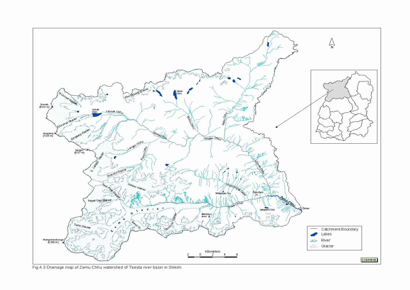
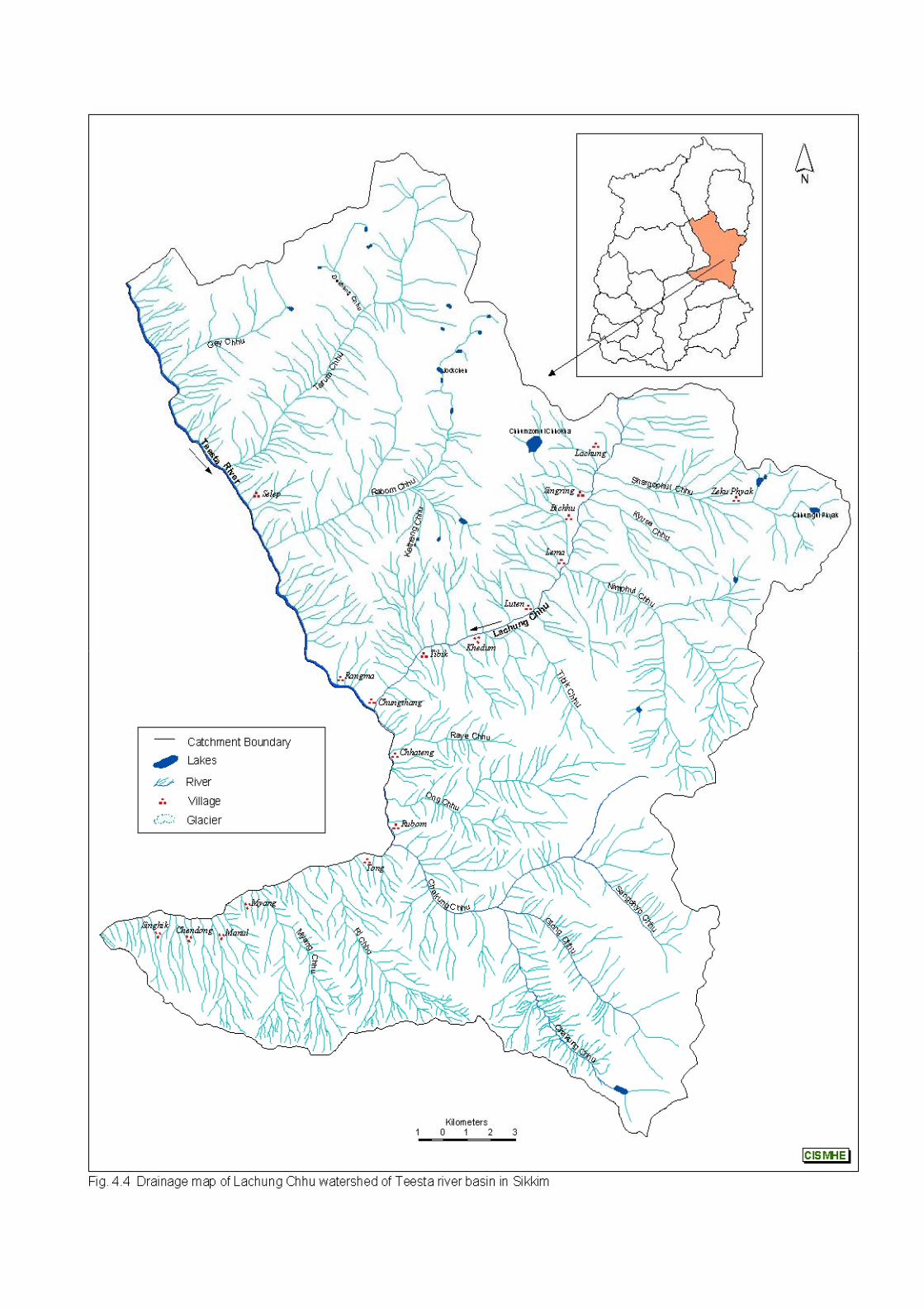
Introductory Volume – Teesta River System – The Study Area
44
CISMHE
southward turn and flows as Lhonak Chhu to join Zemu Chhu near
Jakthang on its left bank.
Zemu Chhu originates as Poke Chhu from Zemu glacier,
which is the largest glacier in Teesta basin about 25 km in length
(see Fig. 4.3). Zemu glacier lies on the eastern face of
Khanchendzonga peak (8,598m) and is joined by Simvo glacier on
its right and Nepal Gap and Tent Peak glaciers on its left. It is
joined by Hidden glacier on its left. Poke Chhu flows in W-E
direction and receives drainage on its left bank from Thomphyak
Chhu. Thereafter, it flows as Zemu Chhu to drain into Teesta river
near Zema village.
4.5 TEESTA RIVER BETWEEN LACHEN AND CHUNGTHANG
In this stretch the river flows 22 km towards southeast from
Teesta-Zemu Chhu confluence (2,675 m) to Teesta-Lachung Chhu
confluence (1,560 m) at Chungthang (Fig.4.5). Several streams
mostly flowing through arcuate valleys join Teesta river on either
side. The left bank tributaries have a longer course than those
joining on the right bank. Among the left bank tributaries, Gey Chhu
joins near Chhaten, Tarum Chhu joins downstream of Jorphul at
2,200 m and Rabom Chhu joins near Rapung at 2,135 m. Chyaga
Chhu, Nathang Chhu, Yukti Chhu, Yel Chhu, Phim Chhu and
Rolazong Chhu are the major right bank tributaries of this sub-
system.
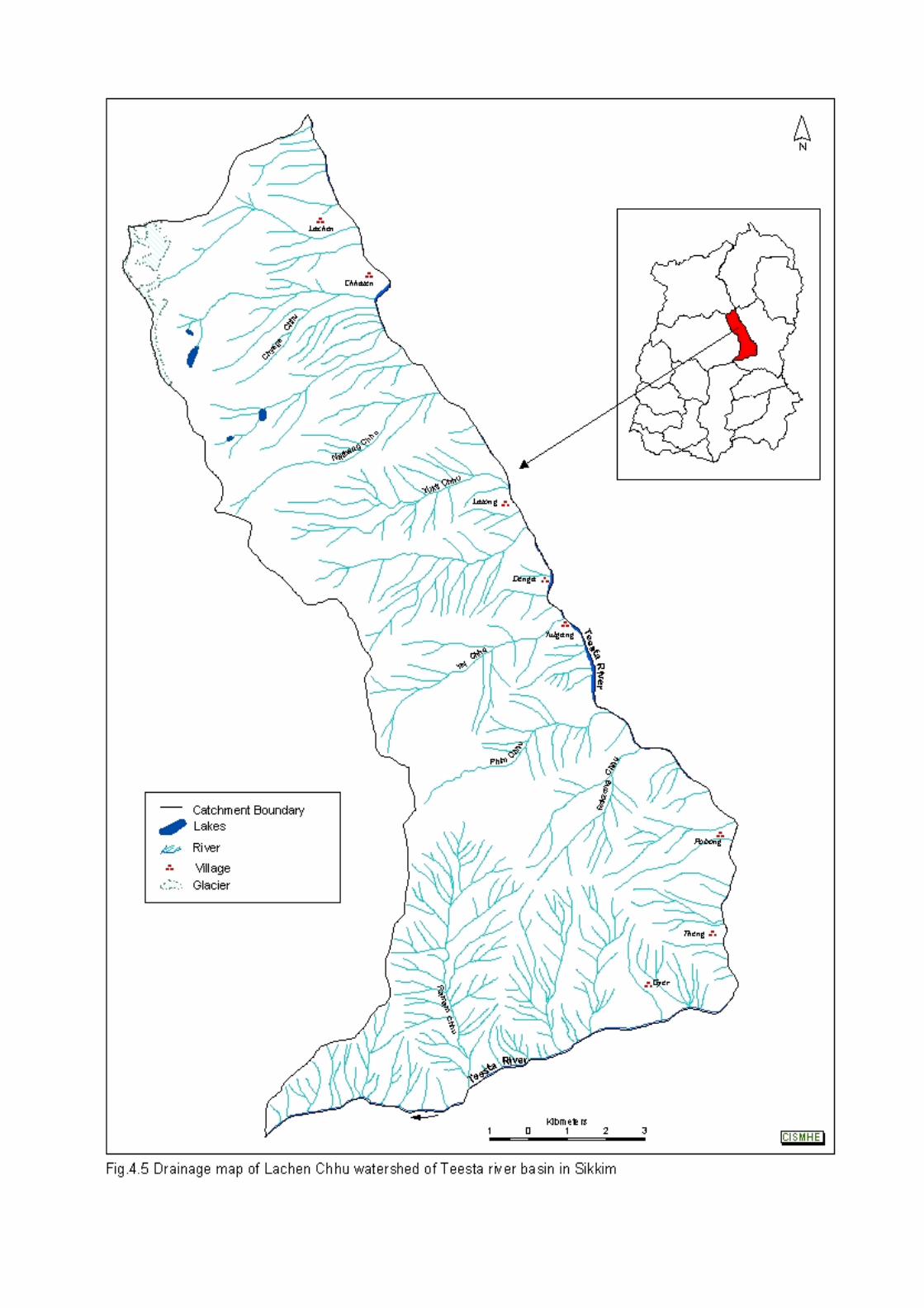
Introductory Volume – Teesta River System – The Study Area
45
CISMHE
4.6 CHUNGTHANG-MANGAN-CHAKUNG CHHU SUB-SYSTEM
In this stretch Teesta river flows from north to south and then
east to west forming an oblong basin with steep slopes facing east
and west (see Fig. 4.4). The predominant tributaries in this stretch are
on the left bank. Raye Chhu and Ong Chhu are two main tributaries
before Rubom village, flowing east to west joining Teesta river at
Chhaten and Theng, respectively. Chakung Chhu is the main left
bank tributary draining the wedge-shaped basin.
Chakung Chhu has its headwaters in Tosa Chho (4,120 m)
where from it flows down up to 2,480 m in an arcuate valley towards
northwest and receives water from Glong Chhu on its right bank.
From this point onward, Chakung Chhu flows east ward and is joined
by Sangchyo Chhu on its right bank at 2,400 m. Chakung Chhu,
thereafter flows for 4.6 km through an arcuate valley up to 1,570 m
where a stream coming from Makangchu ridge (3,720 m) drains into it
on the right bank. Then Chakung Chhu, after flowing northwest,
drains into Teesta on its left bank at 1,350 m near Tong.
In the stretch between Tong and Mangan, Teesta river flows for
a distance of about 14 km traversing a deep valley with triangular faces
steeply sloping southwest and northeast. Several small streams with
steep gradients passing through waterfalls and landslide scars join the
river in this stretch mainly on the left bank. Teesta river flows in EW
direction and receives water from Ri Chhu and Myang Chhu (from
Anden peak : 3,698 m), which join it on the left bank. Ramam Chhu
Introductory Volume – Teesta River System – The Study Area
46
CISMHE
coming from Rockzongchu peak (4,097 m) is the main right bank
tributary of Teesta.
4.7 TALUNG CHHU (RANGYONG CHHU)
Talung Chhu also known as Rangyong Chhu in different
stretches is 36.9 km long and originates from Tongshiong glacier at
about 4,800 m in the western part of Sikkim (Fig. 4.6). In its initial
stretch the stream is known as Rukel Chhu. After flowing for about
10 km from its headwaters Rukel Chhu receives water from a stream
(6.3 km long) which drains a glacier present above 4,600 m coming
from the Narsingh peak (5,825 m). From this confluence Rukel Chhu
flows downstream for 7.5 km where Umram Chhu confluences with it
at 1,420 m near Lom. Umram Chhu has its headwaters at South
Simvo glacier (> 5,000 m) and Umram Khang glacier (> 4,800 m).
After flowing 13.2 km from its headwaters, Umram Chhu receives
water on its left bank from Passaram Chhu at 1,795 m near Passam
Phyku. Passaram Chhu originates from Jumthul Phuk glacier (>
5,200 m) and flows for 7.7 km. From this confluence Umram Chhu
flows 2.2 km and joins Rukel Chhu near Lom. From Lom Rukel Chhu
flows for 3.4 km and receives water from Ravingrum Chhu. This
stream originates from Ringpi Lama Ridge (> 4,200 m) and flows
southward for 8.9 km through a 171 m fall and confluences with
Rukel Chhu at 1350 m on its left bank. After flowing 1.6 km from this
point, Rukel Chhu receives water at 1320 m from its right bank
tributary Pokhram Chhu (6.2 km long), which has its headwater at
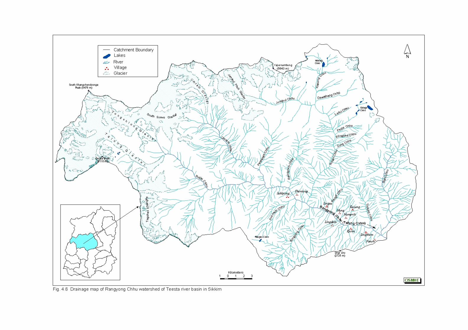
Introductory Volume – Teesta River System – The Study Area
47
CISMHE
Paki Lhu peak (4,934 m). From this confluence it flows 2.7 km
downstream where Ringpi Chhu confluences it at 1,150 m on its left
bank. Ringpi Chhu originates as Jumthul Chhu from Jumthul Phuk
glacier (> 4,200 m) and travels for 7.3 km up to Talung where
Kishong Chhu flowing 7.4 km from a lake joins it at 2950 m. While
flowing further downstream for 7.6 km through the Talong Gompha
region up to 2,000 m, Jumthul Chhu receives water on its left bank
from Ludui Chhu, Pegor Chhu, Kangcha Chhu and Zong Chhu. From
here this stream flows 8 km as Ringpi Chhu. About 0.5 km
downstream of Ringpi Chhu confluence Ringyong Chhu (10.5 km
long) with its headwaters at Urednra ridge (> 3,400 m) joins Rukel
Chhu, which flows downstream as Rangyong Chhu. After flowing 2.9
km, Rangyong Chhu receives water from Rangli Chhu on its left bank
at 1005 m near Laven. Rangli Chhu originates above 3,800 m and
flows 7.5 km towards southwest and passing through a fall of 80 m
confluences with Rangyong Chhu. From this point the river flows 5.9
km up to 850 m where Tadung Chhu (6.6 km) joins it. From here the
river flows as Talung Chhu. After flowing for 1.8 km, it receives water
from Rahi Chhu on its left bank at 780 m. Rahi Chhu has its
headwater in Thepala ridge (5,064 m) and flows southward for 16 km.
From this confluence Talung Chhu flows 0.9 km and joins the Teesta
river on its right bank at 750 m near Sangklang Forest Guest House.
Teesta river flows southward for 15 km from Mangan (750 m) to
Dikchu (538 m). Several eastward and westward flowing streams
joins the river, respectively on its right and left banks, in this stretch.
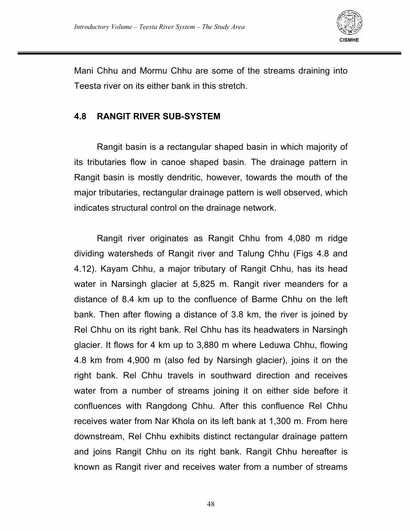
Introductory Volume – Teesta River System – The Study Area
48
CISMHE
Mani Chhu and Mormu Chhu are some of the streams draining into
Teesta river on its either bank in this stretch.
4.8 RANGIT RIVER SUB-SYSTEM
Rangit basin is a rectangular shaped basin in which majority of
its tributaries flow in canoe shaped basin. The drainage pattern in
Rangit basin is mostly dendritic, however, towards the mouth of the
major tributaries, rectangular drainage pattern is well observed, which
indicates structural control on the drainage network.
Rangit river originates as Rangit Chhu from 4,080 m ridge
dividing watersheds of Rangit river and Talung Chhu (Figs 4.8 and
4.12). Kayam Chhu, a major tributary of Rangit Chhu, has its head
water in Narsingh glacier at 5,825 m. Rangit river meanders for a
distance of 8.4 km up to the confluence of Barme Chhu on the left
bank. Then after flowing a distance of 3.8 km, the river is joined by
Rel Chhu on its right bank. Rel Chhu has its headwaters in Narsingh
glacier. It flows for 4 km up to 3,880 m where Leduwa Chhu, flowing
4.8 km from 4,900 m (also fed by Narsingh glacier), joins it on the
right bank. Rel Chhu travels in southward direction and receives
water from a number of streams joining it on either side before it
confluences with Rangdong Chhu. After this confluence Rel Chhu
receives water from Nar Khola on its left bank at 1,300 m. From here
downstream, Rel Chhu exhibits distinct rectangular drainage pattern
and joins Rangit Chhu on its right bank. Rangit Chhu hereafter is
known as Rangit river and receives water from a number of streams
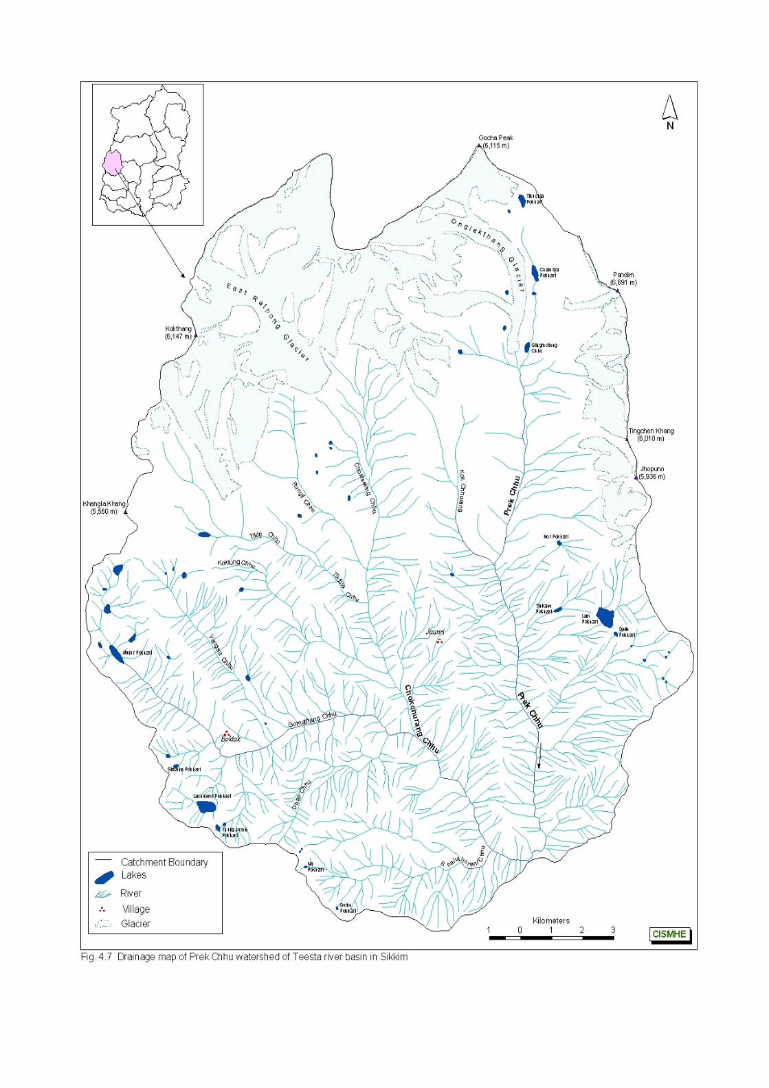
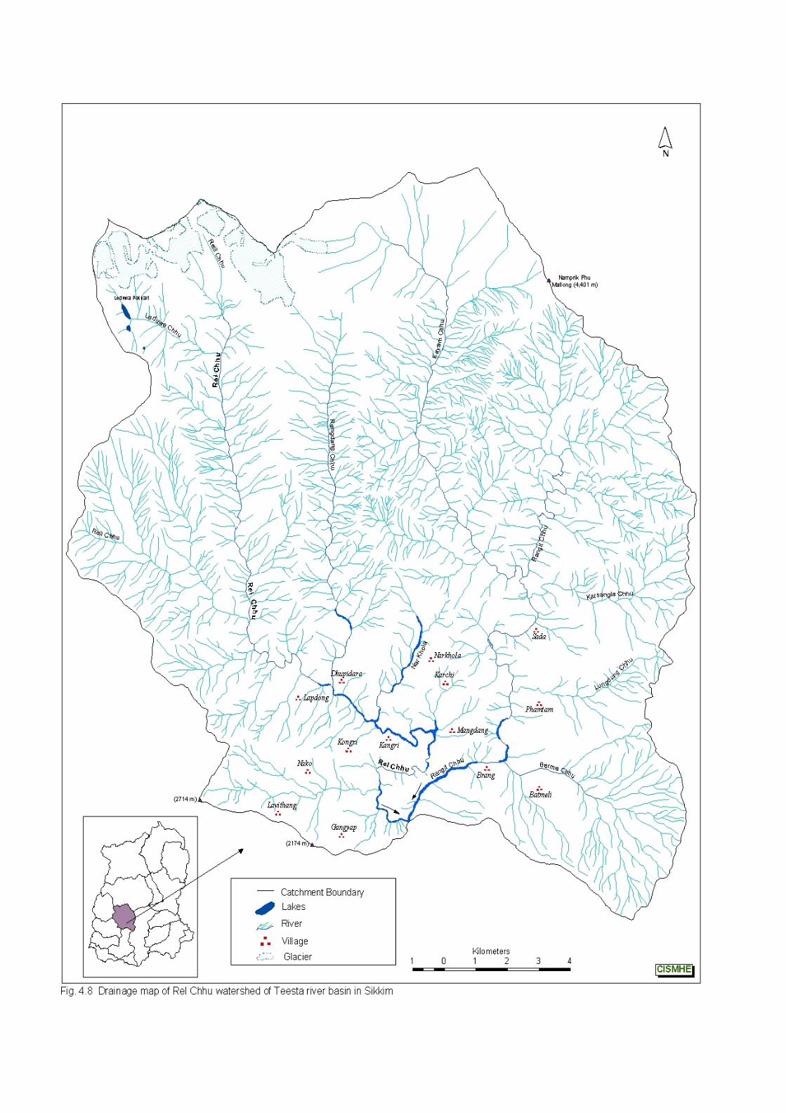
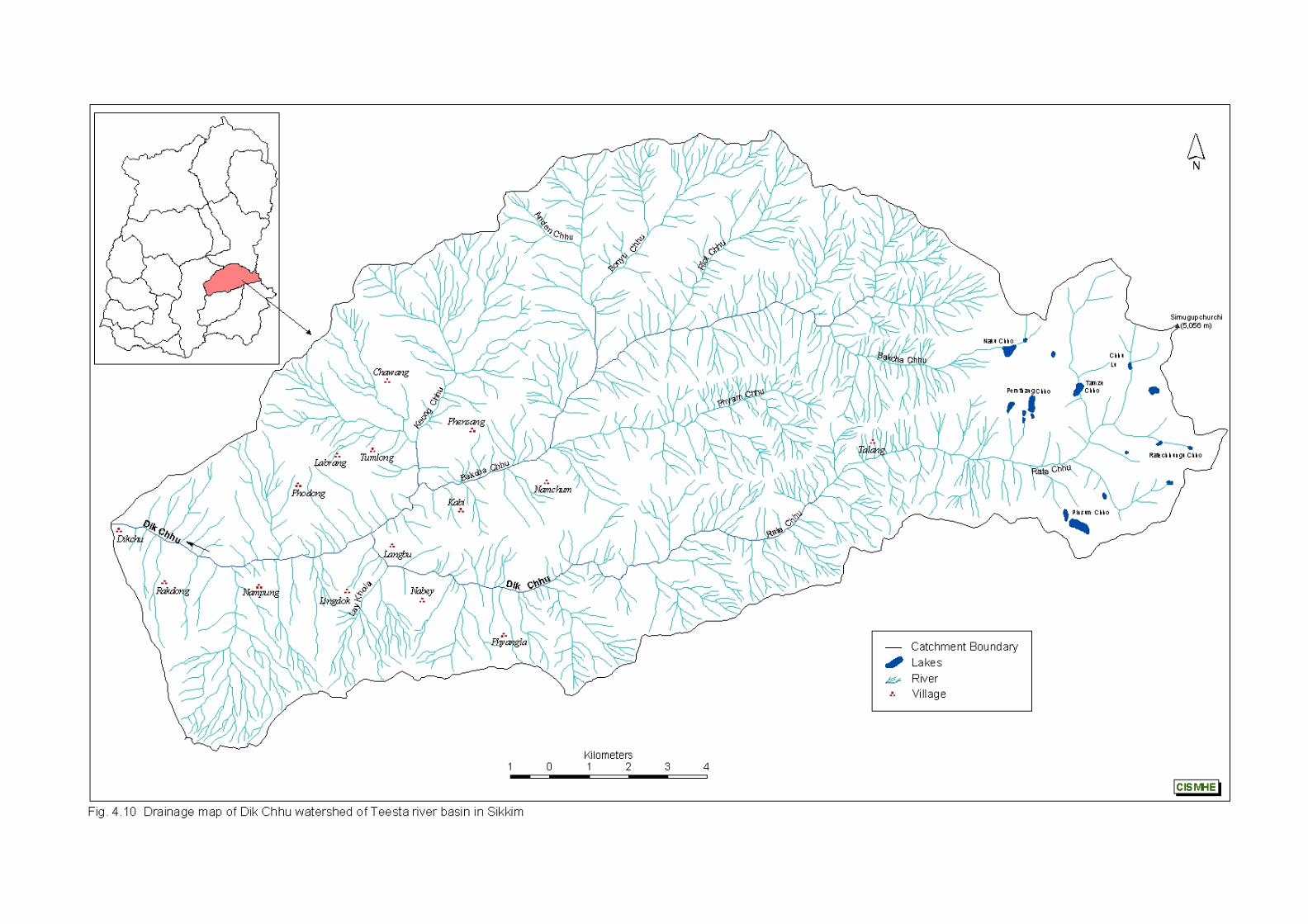
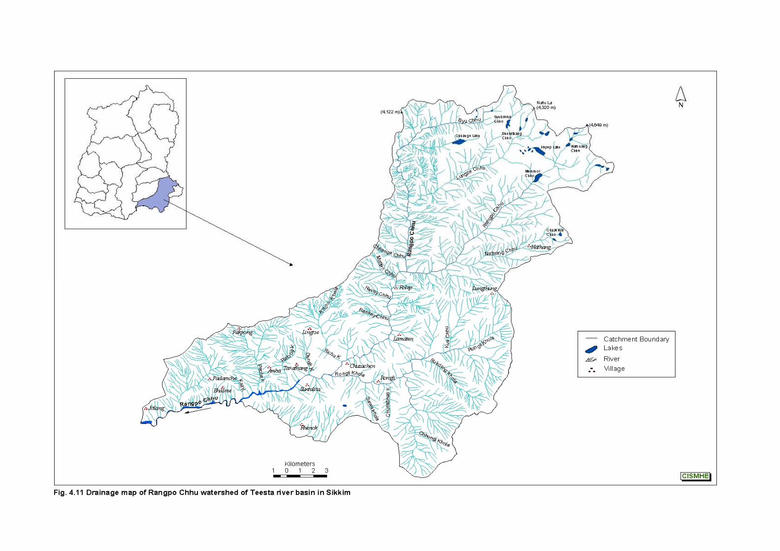
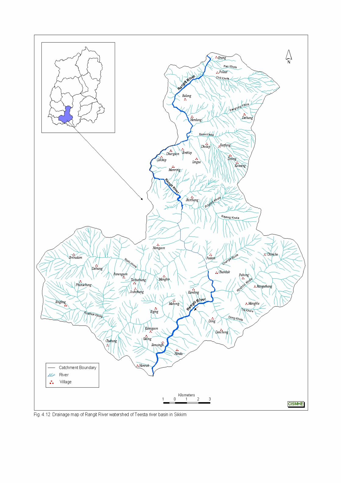
Introductory Volume – Teesta River System – The Study Area
49
CISMHE
like Chil Khola, Sangrung Khola and Bania Khola. After their
confluence, Rathong Chhu, the largest tributary of Rangit river
confluences with the river at 602 m on the right bank.
Rathong Chhu is comprised of two forks i.e. Prek Chhu and
Chokchurang Chhu (Figs. 4.7 and 4.9). Prek Chhu originates from
Jemathang (4,740 m) and its headwater lies in Onglakthang glacier. It
receives water from glacial lakes viz. Tikuchia Pokhari (4,800 m),
Chamliya Pokhari (4,600 m) and Sungmoteng Chho (4,280 m)
located on the lateral moraines lying on the left flank of Onglakthang
glacier. Prek Chhu flows 11.7 km up to 3840 m where it receives
water from a stream named Kokchhurong, which is fed by glacier at
the base of Forked Peak (6,220 m). From this confluence Prek Chhu
flows 9.9 km up to 2,175 m where Chokchurang Chhu confluences
with it on the right bank. Chokchurang Chhu originates from East
Rathong glacier at 4,600 m from where it flows for 6.9 km up to 3,780
m where Rungli Chhu (> 4,000 m) joins it on the right bank. From
here the stream flows 1km up to 3,770 m and receives water from
Tikip Chhu on its right bank. Then it flows for another 2.3 km and
receives water from Koklung Chhu which flows 7.2 km from its origin
at 5,000 m on its right bank. From this confluence the river flows 1.7
km where Gomathang Chhu confluences it on the right bank at 3140
m. Gomathang Chhu has its headwaters in a glacial lake complex.
Mujur Pokhari (4,260 m), Simana Pokhari (4,540 m), Lachhmi Pokhari
(4,320 m) and Thumlo Jumle Pokhari (4,400 m) are some of the
glacial lakes in this region that contribute significantly to the discharge
of Gomathang Chhu. Gomathang Chhu after receiving water from
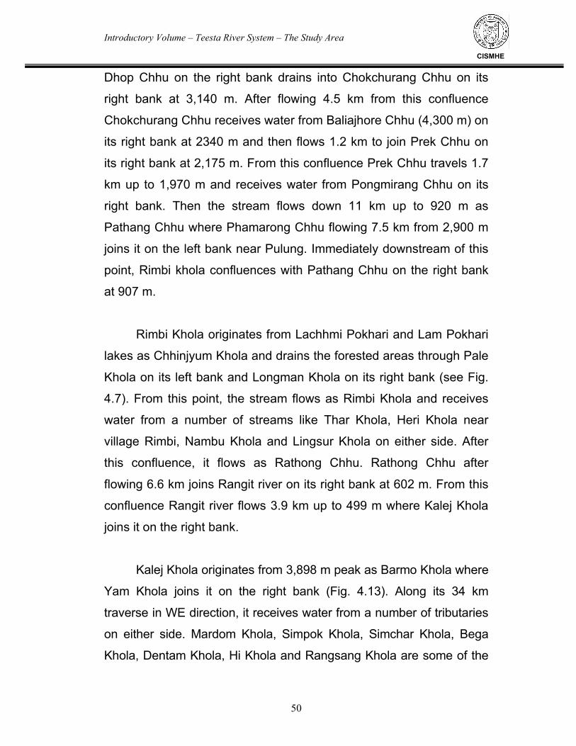
Introductory Volume – Teesta River System – The Study Area
50
CISMHE
Dhop Chhu on the right bank drains into Chokchurang Chhu on its
right bank at 3,140 m. After flowing 4.5 km from this confluence
Chokchurang Chhu receives water from Baliajhore Chhu (4,300 m) on
its right bank at 2340 m and then flows 1.2 km to join Prek Chhu on
its right bank at 2,175 m. From this confluence Prek Chhu travels 1.7
km up to 1,970 m and receives water from Pongmirang Chhu on its
right bank. Then the stream flows down 11 km up to 920 m as
Pathang Chhu where Phamarong Chhu flowing 7.5 km from 2,900 m
joins it on the left bank near Pulung. Immediately downstream of this
point, Rimbi khola confluences with Pathang Chhu on the right bank
at 907 m.
Rimbi Khola originates from Lachhmi Pokhari and Lam Pokhari
lakes as Chhinjyum Khola and drains the forested areas through Pale
Khola on its left bank and Longman Khola on its right bank (see Fig.
4.7). From this point, the stream flows as Rimbi Khola and receives
water from a number of streams like Thar Khola, Heri Khola near
village Rimbi, Nambu Khola and Lingsur Khola on either side. After
this confluence, it flows as Rathong Chhu. Rathong Chhu after
flowing 6.6 km joins Rangit river on its right bank at 602 m. From this
confluence Rangit river flows 3.9 km up to 499 m where Kalej Khola
joins it on the right bank.
Kalej Khola originates from 3,898 m peak as Barmo Khola where
Yam Khola joins it on the right bank (Fig. 4.13). Along its 34 km
traverse in WE direction, it receives water from a number of tributaries
on either side. Mardom Khola, Simpok Khola, Simchar Khola, Bega
Khola, Dentam Khola, Hi Khola and Rangsang Khola are some of the
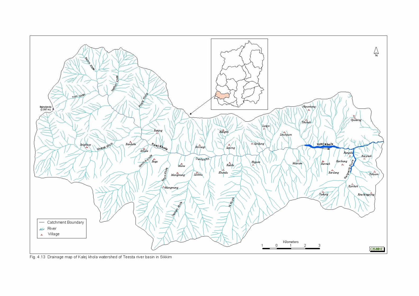
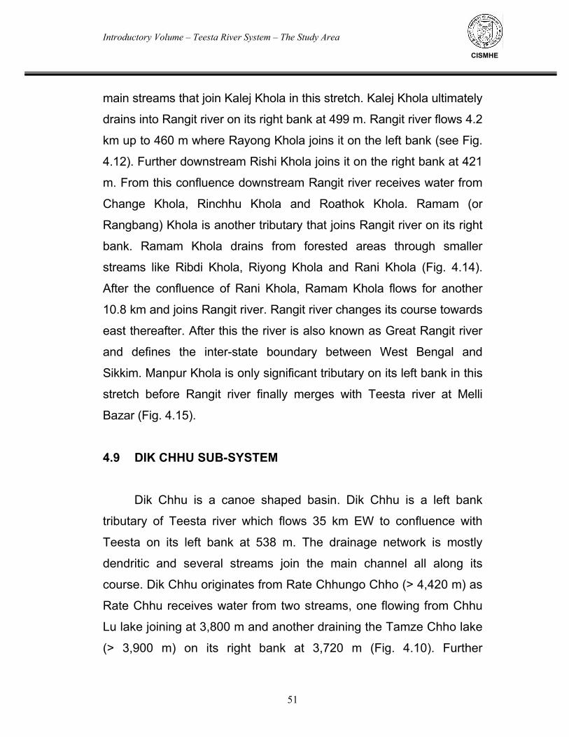
Introductory Volume – Teesta River System – The Study Area
51
CISMHE
main streams that join Kalej Khola in this stretch. Kalej Khola ultimately
drains into Rangit river on its right bank at 499 m. Rangit river flows 4.2
km up to 460 m where Rayong Khola joins it on the left bank (see Fig.
4.12). Further downstream Rishi Khola joins it on the right bank at 421
m. From this confluence downstream Rangit river receives water from
Change Khola, Rinchhu Khola and Roathok Khola. Ramam (or
Rangbang) Khola is another tributary that joins Rangit river on its right
bank. Ramam Khola drains from forested areas through smaller
streams like Ribdi Khola, Riyong Khola and Rani Khola (Fig. 4.14).
After the confluence of Rani Khola, Ramam Khola flows for another
10.8 km and joins Rangit river. Rangit river changes its course towards
east thereafter. After this the river is also known as Great Rangit river
and defines the inter-state boundary between West Bengal and
Sikkim. Manpur Khola is only significant tributary on its left bank in this
stretch before Rangit river finally merges with Teesta river at Melli
Bazar (Fig. 4.15).
4.9 DIK CHHU SUB-SYSTEM
Dik Chhu is a canoe shaped basin. Dik Chhu is a left bank
tributary of Teesta river which flows 35 km EW to confluence with
Teesta on its left bank at 538 m. The drainage network is mostly
dendritic and several streams join the main channel all along its
course. Dik Chhu originates from Rate Chhungo Chho (> 4,420 m) as
Rate Chhu receives water from two streams, one flowing from Chhu
Lu lake joining at 3,800 m and another draining the Tamze Chho lake
(> 3,900 m) on its right bank at 3,720 m (Fig. 4.10). Further
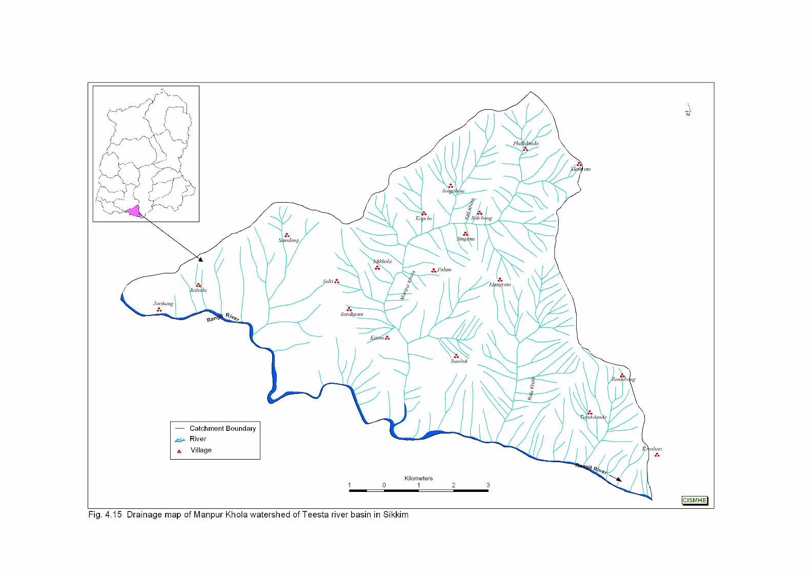
Introductory Volume – Teesta River System – The Study Area
52
CISMHE
downstream, a stream flowing from Chho Pinsung lake joins it at
3,590 m on its left bank. From this point Rate Chhu flows for a
distance of about 1.3 km up to near Pithang Chen (1,539 m),
receiving small streams on either side. From this point downstream,
the river flows as Dik Chhu. After Pithang Chen, Dik Chhu traverses a
distance of about 4.5 km before it is joined by its main tributary
Bakcha Chhu on its right bank.
Bakcha Chhu originates from a ridge (4,507-4,603 m) and flows
in EW direction for a distance of about 8.5 km before it receives
drainage on its right bank from Riot Chhu at 1,560 m. Bonyu Chhu
originating from 4,360 m is the main right bank tributary of Bakcha
Chhu in this stretch and joins Bakcha Chhu near Sirdong. Bakcha
Chhu, then receives water from Phyam Chhu on its left bank at 1,330
m. Phyam Chhu has its headwaters in Zethang ridge (3,585-3,621 m).
From 1,330 m Bakcha Chhu flows 3.8 km and receives water from
Keong Chhu on its right bank at 1,030 m. Bakcha Chhu flows down 2
km from this point and confluences with Di Chhu on its right bank at
930 m.
From Dik Chhu - Bakcha Chhu confluence, Dik Chhu flows for
another 4 km to join Teesta river on its left bank at 538 m.
4.10 RANGPO CHHU
The drainage pattern in Rangpo basin is mostly rectangtular.
The tributaries of Rangpo Chhu exhibit dendritic pattern. All the types
Introductory Volume – Teesta River System – The Study Area
53
CISMHE
of dendritic drainage pattern viz. broad-dendritic, narrow-dendritic,
paniculate-dendritic, pinnate-dendritic and asymmetrical-dendritic are
seen in the basin. The rectangular pattern indicates structural control
on the drainage network. Rangpo Chhu originates from glacial lakes
near Indo-China border as Byu Chhu and Lungze Chhu (see Fig.
4.10). Byu Chhu flows in EW direction as a stream coming out of
Chhangu lake (3,750 m). After this confluence, Byu Chhu flows as
Rangpo Chhu. It takes southward turn near Kyongnosla and is joined
by Lungze Chhu on the left bank. Lungze Chhu also has its
headwaters at the southwest slope of 4,400 m peak on the Indo-
China border. In its initial course, it drains two glacial lakes viz.
Syebiruka lake (4,040 m), Chho Thuiba and Sharathang Chho (3,880
m). Rangpo Chhu along its southward flow receives drainage from
Chhange Chhu on its right bank. Rangpo Chhu is then joined by
Nathang Chhu on the left bank at 1,300 m.
Nathang Chhu with its headwaters at Chhokhya Chho (3,920 m)
receives water from its largest tributary on its right bank at 1960 m i.e.
Rangpo Chhu.
The stream Rangpo Chhu (E), which is a tributary of Nathang
Chhu, originates from the northern end of Namnag Chho complex
(3,960m). It receives water from another stream flowing from Jelep
Chho lake complex comprised of three lakes. From Menmoi Chho
lake at 3,669 m, a stream flows as Rangpo Chhu (a tributary of
Nathang Chhu). Later Rangpo Chhu after flowing for 5.3 km receives
water from a stream flowing from Neo La peak (4,122 m). Rangpo
Introductory Volume – Teesta River System – The Study Area
54
CISMHE
Chhu then flows for another 3.7 km to join Nathang Chhu on right
bank at 1,960m. Nathang Chhu then flows in SW direction to join
main Rangpo Chhu on its left bank at 1,300 m.
Nathang Chhu drains into Rangpo Chhu almost at right angle and
after this Rangpo Chhu flows in EW direction for a short distance and
then resumes its southward course and receives water from Malten
Chhu on its right bank at 1,160 m. Along its journey further S-SW, it
receives water from Navey Chhu near Rolep and Soge Chhu, Rankey
Chhu and Ri Chhu joining on either bank. Rangpo Chhu then receives
drainage from Rongli Khola another major tributary, on its left bank at
644 m. After its confluence Rangpo Chhu flows mainly in westward
direction.
Rongli Khola drains snowfields on the southern slope of
Lungthung (3,835 m) and Pangolakha (3,062 m) peak. Before draining
into Rangpo Chhu, it receives water from a number of small streams viz.
Kae Chhu, Lingtam Khola, Sukdang Khola, Chunabhati Khola and
Sawa Khola on either side.
Rangpo Chhu, after the confluence of Rongli Khola at Rongli
receives water from Danak Khola on its right bank at 550 m. Thereafter,
Rangpo Chhu flows through a wide valley and receives water from
Ralong Khola, Pache Khola, Kali Khola and Rishi Khola on either side.
Rishi Khola has its origin in the forested areas of West Bengal
and drains into Rangpo Chhu on its left bank near Rhenok.
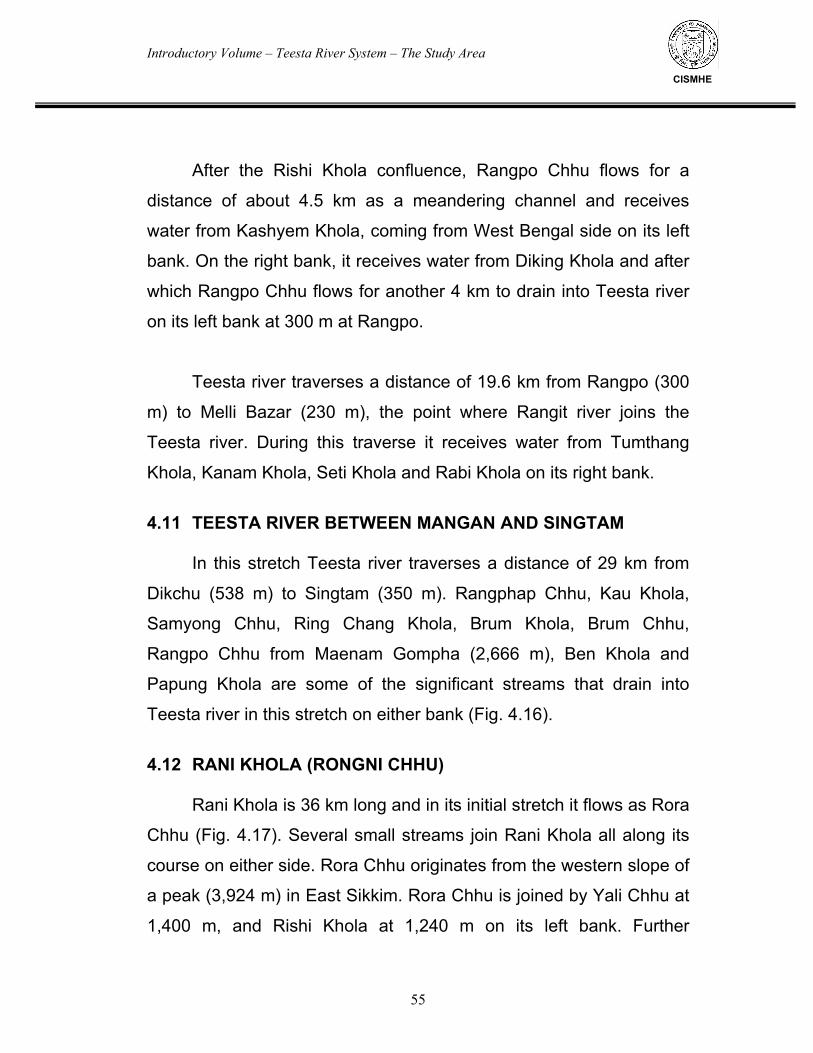
Introductory Volume – Teesta River System – The Study Area
55
CISMHE
After the Rishi Khola confluence, Rangpo Chhu flows for a
distance of about 4.5 km as a meandering channel and receives
water from Kashyem Khola, coming from West Bengal side on its left
bank. On the right bank, it receives water from Diking Khola and after
which Rangpo Chhu flows for another 4 km to drain into Teesta river
on its left bank at 300 m at Rangpo.
Teesta river traverses a distance of 19.6 km from Rangpo (300
m) to Melli Bazar (230 m), the point where Rangit river joins the
Teesta river. During this traverse it receives water from Tumthang
Khola, Kanam Khola, Seti Khola and Rabi Khola on its right bank.
4.11 TEESTA RIVER BETWEEN MANGAN AND SINGTAM
In this stretch Teesta river traverses a distance of 29 km from
Dikchu (538 m) to Singtam (350 m). Rangphap Chhu, Kau Khola,
Samyong Chhu, Ring Chang Khola, Brum Khola, Brum Chhu,
Rangpo Chhu from Maenam Gompha (2,666 m), Ben Khola and
Papung Khola are some of the significant streams that drain into
Teesta river in this stretch on either bank (Fig. 4.16).
4.12 RANI KHOLA (RONGNI CHHU)
Rani Khola is 36 km long and in its initial stretch it flows as Rora
Chhu (Fig. 4.17). Several small streams join Rani Khola all along its
course on either side. Rora Chhu originates from the western slope of
a peak (3,924 m) in East Sikkim. Rora Chhu is joined by Yali Chhu at
1,400 m, and Rishi Khola at 1,240 m on its left bank. Further
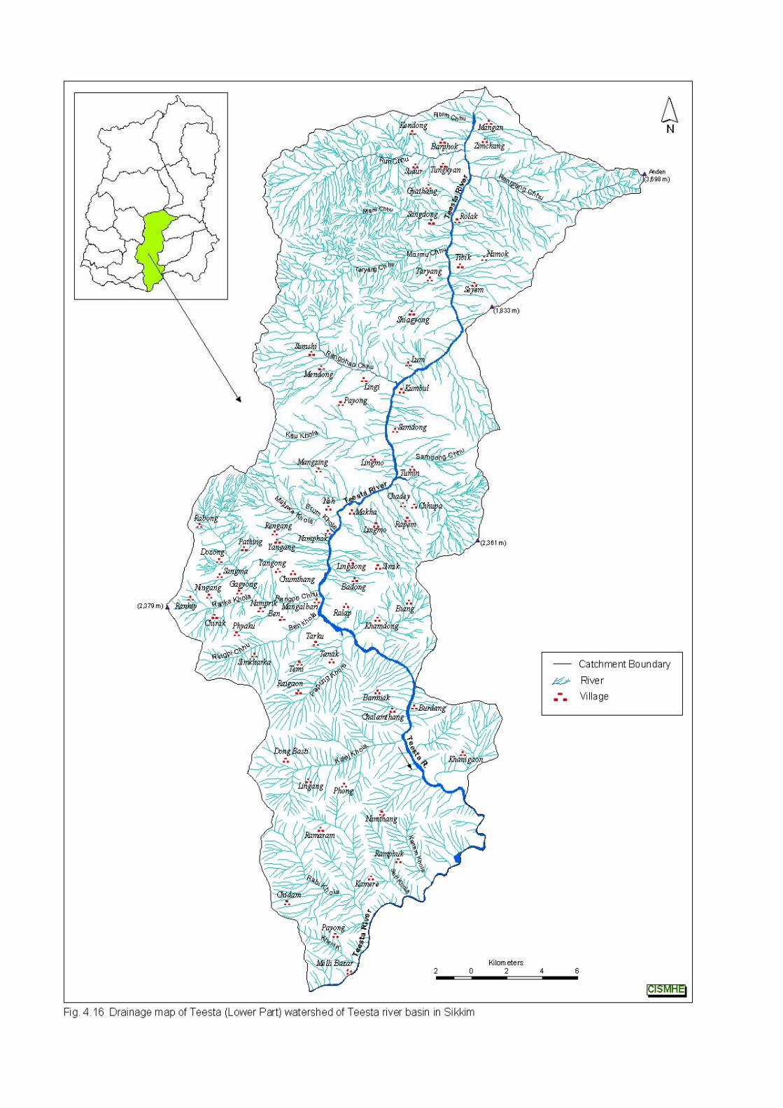
Introductory Volume – Teesta River System – The Study Area
56
CISMHE
downstream, Lah Chhu near Pam on the left bank and Tarang Rang
Chhu (Kali Khola) join it on the right bank. Downstream of the
confluence of Tarang Rang Chhu, Rora Chhu flows as Rani Khola.
After flowing for about 1 km Rani Khola receives water from
Aho Khola and Andheri Khola on its left bank. Chhuba Khola, Pagh
Khola, Martam Khola and Sang Khola join it on the right bank. After
the confluence of Rani Khola on the left bank at 390 m, Rongni Chhu
confluences with Teesta river on its left bank at 350 m near Singtam.
4.13 TEESTA RIVER BETWEEN TEESTA-RANI KHOLA
CONFLUENCE AND TEESTA-RANGPO CHHU CONFLUENCE In this stretch Teesta river flows for about 9.1 km from Teesta-
Rani Khola confluence (350 m) to Teesta-Rangpo Chhu confluence
(300 m) (see Fig. 4.16). After flowing 3.3 km from Rani Khola
confluence Teesta receives water from Kalej Khola on its right bank at
320 m; Kalej Khola originates from 2,640 m peak and flows 8.9 km.
From this confluence the river flows 1.1 km where another stream
flowing 4.2 km joins it at 300 m. Further downstream at 1.5 km a right
bank stream flowing 3.76 km from 1,720 m peak drains into the river
at 300 m. From this point Teesta flows 1 km and receives water from
a 6.4 km long stream, flowing from 2,560 m peak, on its left bank at
300 m. From here the river flows down for 2.1 km where the left bank
tributary Rangpo Chhu confluences it at 300 m near Rangpo town.
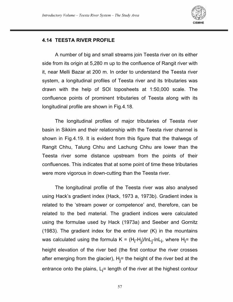
Introductory Volume – Teesta River System – The Study Area
57
CISMHE
4.14 TEESTA RIVER PROFILE A number of big and small streams join Teesta river on its either
side from its origin at 5,280 m up to the confluence of Rangit river with
it, near Melli Bazar at 200 m. In order to understand the Teesta river
system, a longitudinal profiles of Teesta river and its tributaries was
drawn with the help of SOI toposheets at 1:50,000 scale. The
confluence points of prominent tributaries of Teesta along with its
longitudinal profile are shown in Fig.4.18.
The longitudinal profiles of major tributaries of Teesta river
basin in Sikkim and their relationship with the Teesta river channel is
shown in Fig.4.19. It is evident from this figure that the thalwegs of
Rangit Chhu, Talung Chhu and Lachung Chhu are lower than the
Teesta river some distance upstream from the points of their
confluences. This indicates that at some point of time these tributaries
were more vigorous in down-cutting than the Teesta river.
The longitudinal profile of the Teesta river was also analysed
using Hack’s gradient index (Hack, 1973 a, 1973b). Gradient index is
related to the ‘stream power or competence’ and, therefore, can be
related to the bed material. The gradient indices were calculated
using the formulae used by Hack (1973a) and Seeber and Gornitz
(1983). The gradient index for the entire river (K) in the mountains
was calculated using the formula K = (Hi-Hj)/lnLj-lnLi, where Hi= the
height elevation of the river bed (the first contour the river crosses
after emerging from the glacier), Hj= the height of the river bed at the
entrance onto the plains, Li= length of the river at the highest contour
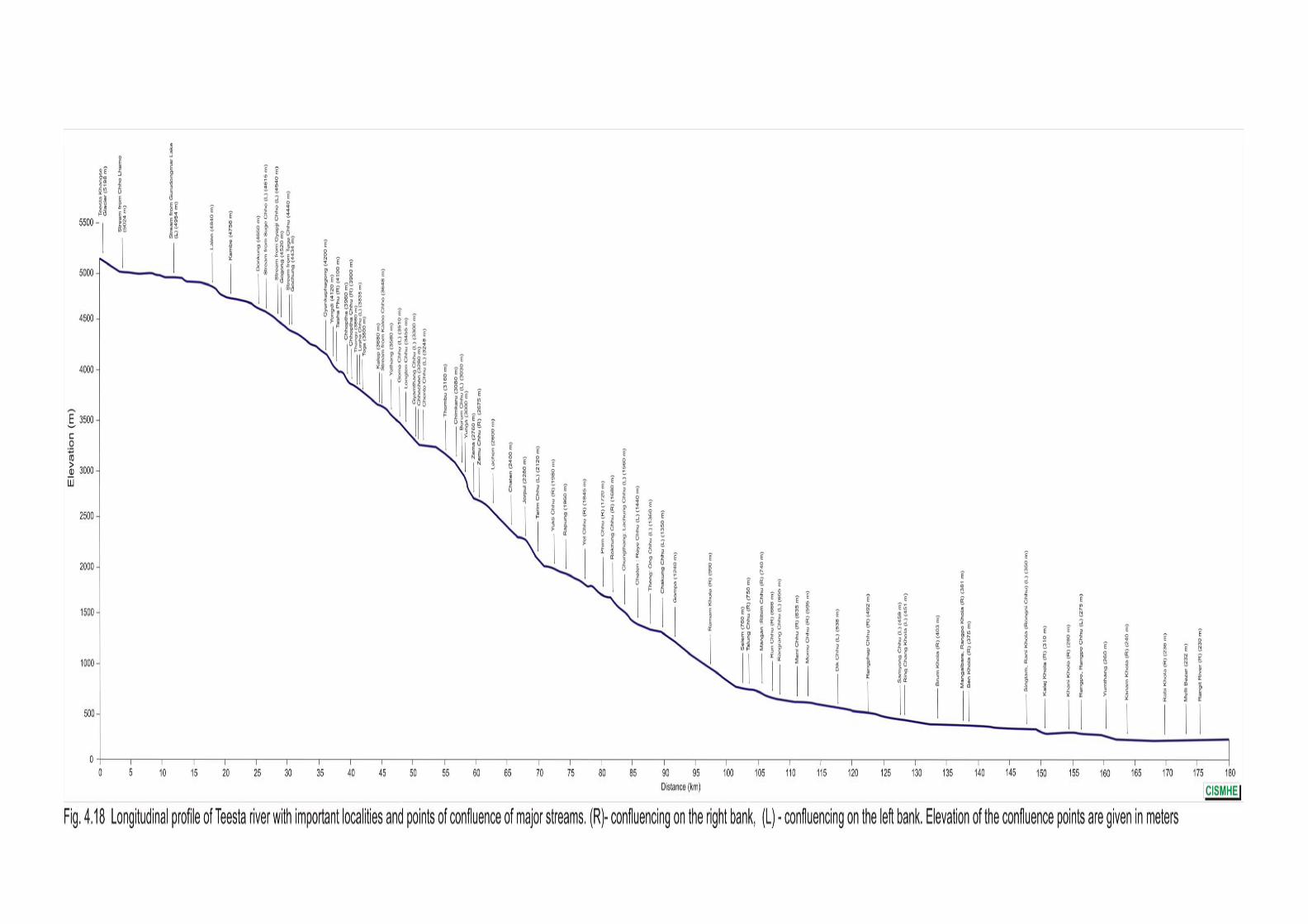
Introductory Volume – Teesta River System – The Study Area
58
CISMHE
(0.1 km for convenience of calculation), Lj= length of the river at the
entrance on the plains. The gradient indices (SL) for the segments of
the river between consecutive contours were calculated using the
formula SL=(dH x L)/dL, where, dH = elevation difference between
the two end points of a reach, dL= planimetric length of a given reach
and L = length of the stream from the headwaters to the middle point
of a given reach. These SL values of the individual reaches were
reduced to relative ratios by dividing SL by K. The following points are
indicated from the SL/K values:
i) SL/K = 1.0 shows that the gradient of the given reach is the
same as the gradient of the logarithmic profile of that reach of the
river,
ii) SL/K < 1.0 depicts a gentler reach and a value greater than
1.0 is for steeper reach,
iii) an increasing trend in the values of SL/K for consecutive
reaches is associated with a steepening of river bed,
iv) a decreasing trend is related to a river bed that is becoming
gentler, and
v) a sharp increase in the SL/K values is related to knick-points
in the longitudinal profile of the river.
The longitudinal profile of the Teesta river with the bars showing
SL/K values for different reaches is given in Fig. 4.20. It is evident
from the figure that there are several knick points along the thalweg
profile of Sikkim viz. near Yongdi (4,000-4,200 m), Chhochen (3,250-
3,500 m), Zema (2,700-3,000 m), Jorpul (2,000-2,200 m),
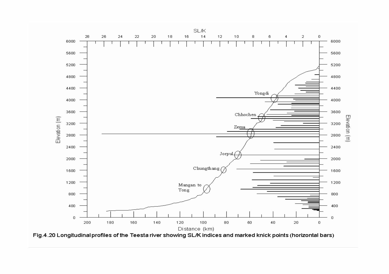
Introductory Volume – Teesta River System – The Study Area
59
CISMHE
Chungthang (1,500-1,700 m), Mangan-Tong (800-1,200 m), etc. Of
these the prominent knick-point is the one near Zema between 2,700
and 3,000 m. The regions with marked knick-points indicate the
presence of major structural features in those regions.
The drainage network, particularly the rectangular pattern in
Rangpo Chhu and Rangit river basins in the south of MCT,
underscores the structural peculiarities of the region. It indicates that
the intersecting sets of joints or faults trending NW-SE and NE-SW
are controlling the drainage network.
4.15 IMPLICATIONS
The drainage network in Sikkim shows that the water will be
available in Teesta and its major tributaries Rangit and Rangpo all
along their courses.
The thalwegs of Rangit Chhu, Talung Chhu and Lachung Chhu
are lower than the Teesta river some distance upstream from the
points of their confluences indicating that these tributaries were more
vigorous in down-cutting than the Teesta river.
The knick points indicate certain regions of structural
discontinuities along the Teesta river. Therefore, due attention must
be given to these regions when any developmental project is
proposed there.
Introductory Volume – Nodal Points of Water Resource in Teesta Basin
CISMHE
5.1 GEOMORPHIC PROFILE
The terraces and floodplains, valley-side slopes and landslide
slopes, alluvial cones of different types and generations, tors, kettle
shaped depressions, terrace-isles, sickle shaped ranges, bevelled
plains, undulating plains and deeply-dissected valleys, glacial or
periglacial deposits, related sedimentary structures, crevasses, etc.
are the distinctive geomorphological feature of Teesta river basin in
Sikkim. The landforms and landform assemblages in the terrain of
Teesta river basin and its innumerable tributaries are the result of
continuous denudation and deposition processes that are constantly
modifying the newly formed land forms in the upper reaches and
burying the existing land forms in the lower reaches. Based upon the
geomorphological features as well as ecological and climatic regimes,
Teesta basin in Sikkim can be demarcated into five distinct geo-eco-
climatic zones viz.
i) Frigid zone above 4,000 m (glacial, periglacial and fluvio-
glacial processes)
ii) Cold zone between 2,500 and 4,000 m (periglacial, fluvio-
glacial and fluvial processes at higher altitudes,
iii) Cold temperate zone between 2,000 and 2,500 m (fluvio-
glacial, and fluvial processes at higher altitudes),
iv) Warm temperate zone between 1,000 and 2,000 m (fluvial
processes), and
v) Sub-tropical zone up to 1,000 m (fluvial processes at
lower altitudes).
Introductory Volume – Nodal Points of Water Resource in Teesta Basin
61
CISMHE
First three eco-climatic zones jointly constitute the major part of
the North Sikkim district comprised of Upper Teesta basin and
stretches for about 100 km from east to west. This portion is marked
by innumerable glaciers and glacial lakes, alpine meadows, deodar-
oak, birch-rhododendron and juniper forests (sub-alpine to alpine
forest), terraces along the Teesta river and numerous tributary valleys
of varied origin and valley-aspects harbouring rich floral and faunal
wealth. This northern part of Teesta basin with varied and diverse
environments is responsible for unique and conspicuous landforms
within the Teesta river basin. The glaciated areas in this part are
engaged in the erosional activities through abrasion scouring, frost
action, freeze-thaw cycle, etc. Upper Teesta basin is also
characterized by huge accumulation of debris in the form of debris
cones, rock-glaciers and alluvial fans, debris avalanches and other
hazards. These debris are transported mainly in monsoon season
and during snow-melt period. Transportation rates of these debris
become 20 times than normal during any catastrophic event. The
watersheds located in the Upper Teesta basin contribute huge
amounts of silt. The movement of glaciers over their beds, reduce the
rock surface to rock flour by their frictional activity. The rock flour after
mixing with melt water forms the glacial milk which ultimately
transformed into thin mud during peak melt discharge. The changes
in glacial-phase of the Upper Teesta basin section require special
attention in planning for watershed management, especially landslide
and flood control in lower reaches. The fluctuations in ice-cover in this
region are generally accompanied by
i) production and transport of debris,
Introductory Volume – Nodal Points of Water Resource in Teesta Basin
62
CISMHE
ii) floods and siltation of reservoirs,
iii) vegetation cover, and
iv) associated cooling effects of the glaciers in Sikkim
Himalaya.
Therefore, the fluctuations in such activities in the Upper Teesta
basin are required to be monitored and evaluated for the formulation
of any precautionary and mitigative measures.
The factors like orientation of slopes, precipitation along with
other local aspects have given rise to intra-valley variation in the
elevation of snow-line in the Upper Teesta basin. The south facing
slopes have a lesser ice-cover.
Middle and lower parts of the basin are marked by subdued
relief, slope-wash slides and slips, scourge and filling, abandoned
channels, etc.
5.2 NODAL POINTS OF WATER RESOURCE
High mountain ranges in Sikkim Himalaya particularly the North
Sikkim are characterized by snow and numerous glaciers. These
glaciers are the perennial source of water for Teesta river and
regulate the run off. Since most of the glaciers are inaccessible and
are located in rugged terrain of North Sikkim, remote-sensing data
was procured for the mapping and analysis of glaciers. For this
Introductory Volume – Nodal Points of Water Resource in Teesta Basin
63
CISMHE
purpose digital IRS-ID LISS-III, PAN data as well as LANDSAT-7
ETM have been obtained from NRSA, Hyderabad and University of
Maryland, Glocal Land Cover Facility, U.S.A. The remote sensing
studies helped in generation of glacier inventory map of Sikkim and
glacier index map. The glaciers are depicted as white in the FCC of
IRS-ID LISS-III data as well as PAN data (Fig. 5.1). The present study
aims at merging the PAN data with LISS-III data, which would enable
the interpretation of glaciers much easier and more accurately. In the
Phase-II of the present study an inventory of prominent glaciers and
glacial lakes of entire Teesta basin has been prepared.
The inventory of prominent glaciers and glacial lakes was
prepared by digital image processing of merged IRS-1D LISS-III and
PAN data with the help of enhancement techniques of satellite data
using ERDAS Imagine 8.7. The processed image would then be
transferred to Geographical Information System (ArcGIS 9.0,
GeoMedia Professional 5.2, etc.) for the generation of different
coverages or layers. Similar studies have earlier been carried out at
RRSSC, Nagpur in 1991 using IRS-1B LISS-II data of November
1990.
The glaciers of Sikkim occur as compound glaciers termed as
glacier complexes, where a number of glaciers originate from a
common permanent ice-cover. The glaciers of Teesta basin have
been delineated into seven glacier complexes (Fig. 5.2). These are
Chhombo, Yumthang, Lamgpo, Zemu, Talung, Rathang and Rel
glacier complexes. These complexes constitute the nodal points of
water resource in Sikkim and cover about 17% of Sikkim.
Yumthang glacier complex is the largest glacier complex with
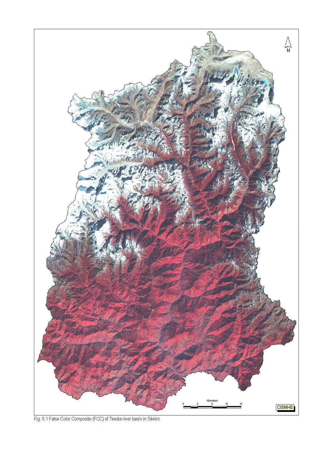
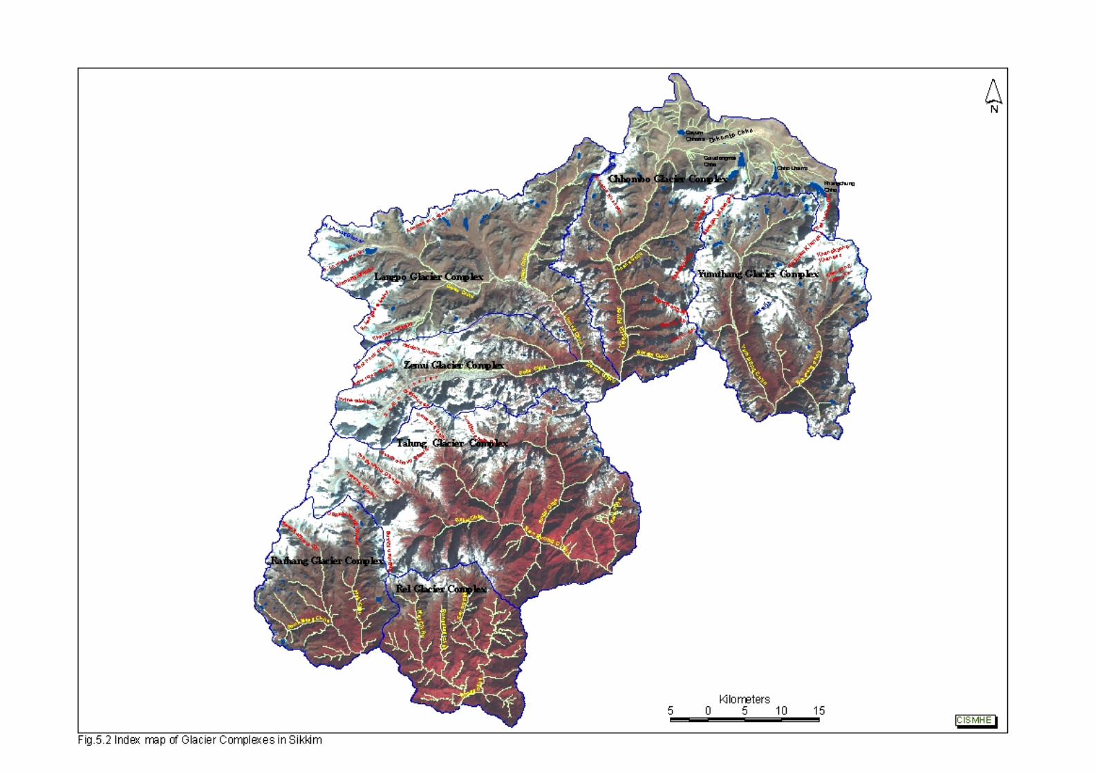
Introductory Volume – Nodal Points of Water Resource in Teesta Basin
64
CISMHE
maximum number of major glaciers (12) and has about 11% total
area under glaciers.
5.2.1 Chhombo Glacier Complex
This glacier complex constitutes the source of Teesta river and
is comprised of at least 11 major glaciers. Teesta river originates as
Chhombo Chhu from a glacial lake, Khangchung Chho (5,380 m)
located at the snout of Teesta Khangse glacier which descends from
Pauhunri peak (7,056 m) (see Figs 4.1 and 5.2), which is one of the
highest peaks in north-eastern part of North Sikkim. Along its course
in this glacial region, Chhombo Chhu drains another glacial lake viz.
Chho Lhamo (5,320 m). Chhombo Chhu flows in north-western
direction up to Chho Lhamo and further downstream, it flows in E-W
direction after draining the water of Gurudongmar Chho (5,270 m). It
continues its westward journey up to Oakra village where it receives
drainage from Gayum Chho, draining Gayum Chhona lake, on its
right bank. Thereafter, Chhombo Chhu is known as Teesta river and
flows generally in southward direction for a considerable distance up
to Tong village. After passing by Donkung and Gogang villages, it
drains water of glacial lakes viz. La Chho, Sugu Chho and Gyapji
Chho on both the banks. Tasha Phu is first significant tributary which
drains into Teesta river on its right bank near Yongdi village (4,200
m) draining the Tasha Khangse glacier. Further downstream it is
joined on its right bank by Chhopta Chhu little ahead of Thangu
village (3,920 m). Lasha Chhu is first major tributary on the left bank
joining Teesta near Thangu. It drains the slopes of Yulhe Khangse
glacier and glacial lake Sebu Chho. Teesta river is later joined on its
Introductory Volume – Nodal Points of Water Resource in Teesta Basin
65
CISMHE
left bank by Kalep Chhu at Kalep village (3,650 m). Kalep Chhu
drains glaciated region in the vicinity of Shawaphu (4,966 m). Goma
Chhu and Jongten Chhu are small streams that drain into Teesta river
near Chotengang and Samdong (3,455 m) on right and left banks,
respectively. At Chhochen it is joined by Gyamthang Chhu on its left
bank, which originates from Gyamthang Khangse glacier. Further
downstream Chento Chhu from Chento Khangse and Burum Chhu
from Burum La are some of the tributaries that join Teesta on its left
bank near Schacham and Yunga villages. At Zema it is joined by its
major tributary Zemu Chhu on its right bank. Therefore, Teesta river
from its origin at Pauhunri up to its confluence with Zemu Chhu at
Zema, constitutes a distinct watershed as well as glacier complex
comprised of 11 glaciers and a number of glacial lakes. Teesta
Khangse (source of Teesta), Yulhe Khangse, Chhunga Khangse,
Tasha Khangse, Lachen Khangse, Chhopta Khangse, Gyamthang
Khangse, Chenta Khangse, Burum Khangse and an unnamed glacier
constitute the main source of water resource in this glacier complex.
Gurudongmar Chho (151.42 ha), Khangchung Chho (102.95 ha) and
Chho Lhamo (127 ha), Gayum Chhona (50 ha) and La Chho (30 ha)
are some of the big glacial lakes that contribute to the discharge of
Teesta. Gurudongmar Chho and Khangchung Chho are considered
as one of the highest glacial lakes in the Himalaya. The glaciers cover
more than 96 sq km of area while glacial lakes cover more than 46 sq
km of area. Teesta Khangse is the longest glacier (6.10 km) while
Gurudongmar Chho, Chho Lhamo and Khangchung Chho are the
largest lakes having an area more than one sq km.
Introductory Volume – Nodal Points of Water Resource in Teesta Basin
66
CISMHE
5.2.2 Yumthang Glacier Complex
Yumthang glacier complex is comprised of glaciers of
Yumthang Chhu and Sebzung Chhu. Yumthang Chhu is formed by
the confluence of Dongkya Chhu and Sebu Chhu at Yume Samdong
(4,500 m) (see Figs 4.2 and 5.2). Sebu Chhu originates from
Changme Khangphu glacier while Dongkya Chhu drains
Ramthangphui Khangse and Tenbawa Khangse glaciers. Dongkya
Chhu before its confluence with Sebu Chhu also receives drainage
from Tenbawa Chhu on its left bank which originates from Khangpup
Khangse.
Sebozung Chhu originates above Chhubakha (4,100 m) and
receives drainage from Khangkyong Khangse, Khangpup Khangse
and a number of glacial lakes. Along its downward course, it is joined
by Toklung Chhu, which originates from Toklung Khangse on its right
bank. Sebozung Chhu upstream of Lachung village is known as
Lachung Chhu. Lachung Chhu then travels westwards to meet
Teesta river at Chungthang.
Yumthang glacier complex is comprised of 12 prominent
glaciers covering an area of 148 sq km. These are Ramthangphui,
Changme, Rulak, Burum, Debo, Tenbawa, Khangkyong, Khangpup
(E), Khangpup (W), Toblung, Lako and Sebophyak glaciers.
Sanglaphui Chho, Sebu Chho, Kasang Chho and Sima Chhokha are
some of the prominent lakes of this complex.
Introductory Volume – Nodal Points of Water Resource in Teesta Basin
67
CISMHE
5.2.3 Langpo Glacier Complex
Lhonak Chhu is main drainage of this complex with North and
South Lhonak glaciers being the source of this drainage system (see
Figs 4.3 and 5.2). These two glaciers on the eastern faces of Lhonak
and Jonsang peaks form the origin of Lhonak Chhu as Goma Chhu
and is marked by a number of glacial lakes that drain into Goma
Chhu. Goma Chhu flows in W-E direction and is joined on its right
bank by Phutung Chhu which drains Langpo and Changsang
glaciers. Goma Chhu is then joined by Khora Chhu on its left bank
which drains Khora Chhobuk (glacial lake) and Khora Khang glacier.
Further downstream, it receives drainage from Naku Chhu to form
Langpo Chhu. Naku Chhu rises at Naku La and drains a number of
glacial lakes, with Thang Chho being the major glacial lake. It flows in
southward direction to merge with Goma Chho near Puckchhang.
Langpo Chhu, thereafter, takes a southward turn and flows as Lhonak
Chhu to join Zemu Chhu near Jakthang on its left bank.
Langpo glacier complex is comprised of 10 glaciers covering an
area of 153 sq km of which North and South Lhonak glaciers,
Jonsang, E. Langpo, Chanson and Khorakhang are the prominent
glaciers. Lhonak Chho and Khora Chho are two most significant
glacial lakes of this complex.
5.2.4 Zemu Glacier Complex
Zemu Chhu originates as Poke Chhu from Zemu glacier, which
is the largest glacier in Teesta basin and is about 25 km in length
(see Figs 4.3 and 5.2). Zemu glacier lies on the eastern face of
Introductory Volume – Nodal Points of Water Resource in Teesta Basin
68
CISMHE
Kanchendzonga peak (8,598 m) and is joined by Simvo and Siniolchu
glaciers on its right flank and Nepal Gap and Tent Peak glaciers on its
left. It is joined by Hidden glacier on its left. Poke Chhu flows in W-E
direction and receives drainange on its left bank from Thomphyak
Chhu. Thereafter, it flows as Zemu Chhu to drain into Teesta river
near Zema village. This glacier complex is comprised of 6 glaciers
covering an area of 113 sq km. Green lake is most prominent glacial
lake of this region.
5.2.5 Talung Glacier Complex
Talung glacier complex is comprised of glaciers of Rukel Chhu
viz. Tongshiong glacier and Talung glacier (see Figs 4.6 and 5.2).
These glaciers are located on the eastern faces of Kanchendjunga
and Gocha peaks (6,115m). Rukel Chhu flows in S-W direction for
some distance where it receives drainage from Tingchen Khang
glacier on its right bank. Rukel Chhu then flows as Rangyong Chhu in
W-E direction. Rangyong Chhu is joined by Umram Chhu on its left
bank. Umram Chhu receives drainage from an unnamed glacier.
Further downstream, Rangyong Chhu receives drainage from Ringpi
Chhu on its left bank and Ringyong Chhu on its right bank. Ringpi
Chhu drains the southern slopes of Siniolchu (6,888 m),
Yajuknamteng (5,643 m) and Lamo Angdang (5,862 m) and also
receives drainage from Shingo Chho and other unnamed glacial
lakes. Rangyong Chhu keeps flowing in S-W direction to join Teesta
river on its right bank near Mangan.
Introductory Volume – Nodal Points of Water Resource in Teesta Basin
69
CISMHE
Talung glacier complex is comprised of 9 glaciers of which
Tongchiong, Talung, Umram, South Simvo, Jumthul Phuk and
Tingchen glaciers are prominent glaciers. Together these glaciers
cover more than 150 sq km of area. Kishong Chho and Rangen Chho
are the two prominent glacial lakes of this complex.
5.2.6 Rel Glacier Complex
Rel glacier complex is comprised of 3 unnamed glaciers
covering 6.5 sq km of area and a glacial lake, Leduwa Pokhari. This
complex constitutes the source of Rel Chhu, which is an important
tributary of Rangit river in West Sikkim.
In addition to the above described seven glacier complexes,
there are a number of glacial lakes and snow-fields also in East
Sikkim that contribute significantly to the water of resource of Sikkim.
Chhangu, Kupup, Namnang, Menmoi Chho, Sherathang and
Syebiruk are the prominent glacial lakes in this region. These glacial
lakes and snow-fields are drained through Rangpo Chhu and Dik
Chhu.
All the glacier complexes cover more than 710 sq km of area, of
which constitute about 10% of the total geographic area of Sikkim.
Glacial lakes also cover more than 21 sq km of area with
Gurudongmar lake being the largest lake and Chho Lhamo lake, the
highest lake in Teesta basin.
Introductory Volume – Nodal Points of Water Resource in Teesta Basin
70
CISMHE
5.2.7 Rathang Glacier Complex
Rathang glacier complex is comprised mainly of glacier of Prek
Chhu, Choktsering Chhu and Rungli Chhu. East Rathang and
Onglathang glaciers and two unnamed glaciers source of Rungli
Chhu and Tikip Chhu are the 4 glaciers that constitute this glacier
complex. These glaciers cover more than 50 sq km of area. There are
a number of glacial lakes viz. Mujur Pokhari, Lachchami Pokhari,
Thulla Jumle Pokhari, Lam Pokhari, Chamliya and Tikuchia Pokhari.
The four glaciers and a number of glacial lakes constitute the major
point of water resource in West Sikkim.
Introductory Volume – Teesta River Basin Characteristics
CISMHE
6.1 INTRODUCTION
The main Teesta while flowing from north to south divides the
state into two parts. Teesta drainage basin in Sikkim cover an area of
7,015 sq km of Sikkim and 81 sq km of the state is under Jaldhaka
river watershed, which is not the part of Teesta basin. In order to
understand the profile and behaviour of the prominent tributaries of
Teesta river basin in Sikkim, Teesta basin was divided into its major
tributary watersheds. The entire Teesta basin falling in Sikkim has
been delineated into 17 watersheds following the conventional
methodology of delineation based upon drainage order classification.
For this, Survey of India toposheets at 1:50,000 scale were used, with
ridge line demarcating the boundaries between adjacent watersheds.
These watersheds vary in size and shape depending upon the
drainage pattern in a particular watershed.
The analysis of entire data was done watershed-wise e.g.
slope, relief, draining pattern, landuse, soil, etc. The results,
therefore, are also presented watershed-wise. The seventeen
watersheds are : i) Rangpo Chhu, ii) Rani Khola, iii) Teesta (Lower
Part), iv) Dik Chhu, v) Lachung Chhu, vi) Yumthang Chhu, vii)
Chhombo Chhu, viii) Zemu Chhu, ix) Rangyong Chhu, x) Lachen
Chhu, xi) Prek Chhu, xii) Rel Chhu, xiii) Rathong Chhu, xiv) Kalej
Khola, xv) Ramam Khola, xvi) Rangit river and xvii) Manpur Khola
(Fig. 6.1). Jaldhaka river watershed drains into West Bengal and not
the part of Teesta basin.
The form parameters of these watersheds are given in Table
6.1 and discussed below.
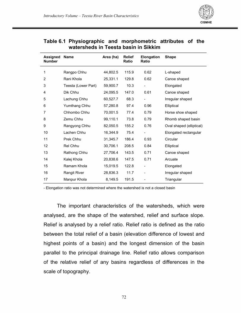
Introductory Volume – Teesta River Basin Characteristics
72
CISMHE
Table 6.1 Physiographic and morphometric attributes of the
watersheds in Teesta basin in Sikkim Assigned Name Area (ha) Relief Elongation Shape Number Ratio Ratio
1 Rangpo Chhu 44,802.5 115.9 0.62 L-shaped
2 Rani Khola 25,331.1 129.8 0.62 Canoe shaped
3 Teesta (Lower Part) 59,900.7 10.3 - Elongated
4 Dik Chhu 24,095.5 147.0 0.61 Canoe shaped
5 Lachung Chhu 60,527.7 68.3 - Irregular shaped
6 Yumthang Chhu 57,280.8 97.4 0.96 Elliptical
7 Chhombo Chhu 70,001.5 77.4 0.79 Horse shoe shaped
8 Zemu Chhu 99,110.1 73.8 0.79 Rhomb shaped basin
9 Rangyong Chhu 82,050.5 155.2 0.76 Oval shaped (elliptical)
10 Lachen Chhu 16,344.9 75.4 - Elongated rectangular
11 Prek Chhu 31,345.7 186.4 0.93 Circular
12 Rel Chhu 30,706.1 208.5 0.84 Elliptical
13 Rathong Chhu 27,706.4 143.5 0.71 Canoe shaped
14 Kalej Khola 20,838.6 147.5 0.71 Arcuate
15 Ramam Khola 15,019.5 122.8 - Elongated
16 Rangit River 28,836.3 11.7 - Irregular shaped
17 Manpur Khola 8,149.5 191.5 - Triangular - Elongation ratio was not determined where the watershed is not a closed basin
The important characteristics of the watersheds, which were
analysed, are the shape of the watershed, relief and surface slope.
Relief is analysed by a relief ratio. Relief ratio is defined as the ratio
between the total relief of a basin (elevation difference of lowest and
highest points of a basin) and the longest dimension of the basin
parallel to the principal drainage line. Relief ratio allows comparison
of the relative relief of any basins regardless of differences in the
scale of topography.
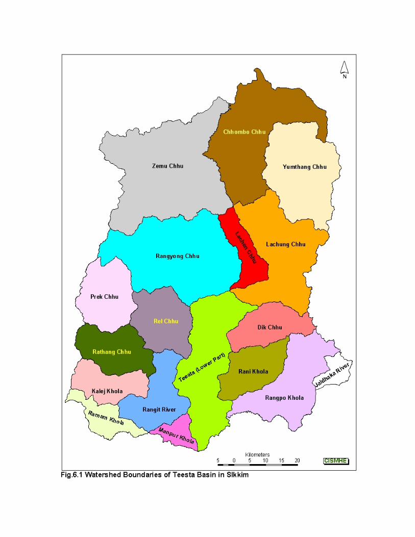
Introductory Volume – Teesta River Basin Characteristics
73
CISMHE
The shape of the watershed is expressed by an elongation
ratio. Elongation ratio is the ratio between the diameter of a circle with
the same area as the basin and the maximum length of the basin as
measured for the relief ratio. Wherever this ratio approaches 1 the
shape approaches a circle.
The area, relief ratio and elongation ratio are given in Table 6.1
and arranged in decreasing order in Fig.6.2. Zemu Chhu, Rangyong
Chhu and Chhombo Chhu are the largest watersheds in the Teesta
basin. However, Zemu Chhu and Chhombo Chhu have low relief ratio
compared to Rangyong Chhu. Manpur Khola watershed is the
smallest watershed in the basin. Rangit river and Teesta (lower part)
watersheds have low relief ratio. However, when calculation of the
ratio along the main channels is done, the slopes alongside the
channels have large elevational ranges. Yumthang Chhu, Prek Chhu,
Rel Chhu have high elongation ratios supporting their near circular
shapes. On the other hand, lower elongation ratio is observed for Dik
Chhu, Rani Khola and Rangpo Chhu watersheds indicating that the
basins are elongated.
i) Chhombo Chhu Watershed
Chhombo Chhu watershed is source watershed of Teesta river
with a horse-shoe shaped basin having catchment area of 70,001.5
ha and elongation ratio of 0.79. The elevational range covered by the
main channel is 2925 m (from 5,280 m to 2,675 m) with relief ratio of
77.4. Zemu Chhu watershed lies at the west of this watershed and
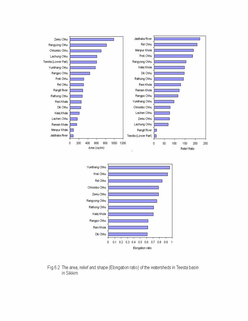
Introductory Volume – Teesta River Basin Characteristics
74
CISMHE
Yumthang Chhu and Lachung Chhu watersheds are situated at its
south. The main river flows as Chhombo Chhu from its source
Teesta-Khangse glacier up to Oakra and then as Teesta river
downstream. The streams are fed mostly from glaciers or glacial
lakes. In its northern stretch the watershed is mostly covered with
moraines and landslide debris. The slopes of the hills in the southern
part of the basin are susceptible to failure. Water availability is very
high in this watershed.
ii) Yumthang Chhu Watershed
Yumthang Chhu watershed is an elliptical basin with geographic
area of 57,280.8 ha and elongation ratio of 0.96. The elevational
range covered by the main channel is 2,735 m (from 5,600 m to 2,865
m) with relief ratio of 97.4. Two major glacier-fed rivers Yumthang
Chhu and Sebozung Chhu flow in this watershed. The watershed is
mostly covered with moraines and landslide debris. The water
availability is also good in this watershed.
iii) Zemu Chhu Watershed
Zemu Chhu watershed is a rhombus shaped basin with
catchment area of 99,110.1 ha and elongation ratio of 0.79. The
elevational range covered by the main channel (Goma Chhu-Langpo
Chhu-Lhonak Chhu-Zemu Chhu), running from NW to SE, is 3,322 m
(from 5,997 m to 2,675 m) with relief ratio of 73.8. Chhombo Chhu
Introductory Volume – Teesta River Basin Characteristics
75
CISMHE
watershed lies at the east of this watershed and Rangyong and
Lachen watersheds are situated at its south. The streams are fed
mostly from glaciers or glacial lakes. The largest glacier of Sikkim
Himalaya, named Zemu glacier, lies in this watershed. Zemu Chhu
flows from west to east and receives water from the Zemu glacier.
The watershed is mostly covered with moraines and landslide debris.
Water availability in this watershed is very high.
iv) Lachung Chhu Watershed
Lachung Chhu watershed has geographic area of 60,527.7 ha.
This is a watershed with irregular geometry and contains the wedge
shaped Chakung Chhu sub-watershed, the oval shaped watershed
representing parts of Lachung Chhu basin and left slope of parts of
Teesta river channel. The elevational range covered by the main
channel is 2,115 m (from 2,865 m to 750 m) with relief ratio of 68.3.
Because three major rivers and several streams flow in this
watershed, the water availability is very high in this region. Several
terraces alongside the Teesta river and the gentle slopes along left
bank of Teesta provided suitable platforms where settlements have
been developed and can undergo further growth.
Introductory Volume – Teesta River Basin Characteristics
76
CISMHE
v) Lachen Watershed
Lachen Chhu watershed is an elongated rectangular watershed
representing the right bank slope of the Teesta river between Zemu
Chhu-Teesta confluence (2,675 m) and Talung Chhu-Teesta
confluence (750 m) with catchment area of 16,344.9 ha. This eastern
facing slope is very steep and densely vegetated, however, at the
south of Chungthang there are some pockets where settlements have
been developed on the old fan lobes, terraces or stabilized landslides.
The Teesta river channel covers an elevational range of 1925 m
whereas the watershed covers maximum elevational range of 3064
m. The main channel, Teesta river, flows from NW to SE, then from N
to S and NE to SW and covers a distance of 42 km. Rangyong
watershed lies to the west of this watershed. Lachung Chhu
watershed lies in the east and south and Chhombo Chhu and Zemu
Chhu watersheds lie in the north. Major streams which flow in this
watershed are Yel Chhu, Phim Chhu, Chyaga Chhu, Rokzung Chhu
and Ramam Khola. The streams are spring fed. Water availability in
this watershed is high.
vi) Rangyong Chhu (Talung Chhu) Watershed
Rangyong Chhu watershed, also known as Talung Chhu in
some stretches, is an oval shaped basin with watershed area of
82,050.5 ha and elongation ratio of 0.76. The elevational range
covered by the main channel (Rukel-Rangyong Chhu), running from
Introductory Volume – Teesta River Basin Characteristics
77
CISMHE
NW to SE, is 6,588 m (from 7,338 m to 750 m) with relief ratio 155.2.
Lachen watershed lies at the east of this watershed and Prek Chhu,
Rel Chhu and Teesta Lower watersheds lie at the south of this
watershed. The streams are fed mostly from glaciers. Major streams
flowing in this watershed are Rangyong Chhu, Rukel Chhu, Umram
Chhu, Ringyong Chhu, Ringpi Chhu and Rahi Chhu. At places the
watershed is covered with old landslide cones where settlements
have been developed. Some new landslide scars are also present.
Water availability in this watershed is high.
vii) Prek Chhu Watershed
Prek Chhu watershed is circular shaped with total catchment
area of 31,345.7 ha. The main channel, Prek Chhu, flows from NNW
to SSE and covers an elevational range of 4,010 m (from 6,670 m to
2,660 m) with relief ratio of 186.4. The elongation ratio is very high
(0.93). This is bounded by Rangyong watershed in the north, Rel
Chhu watershed in the east, and Rathong Chhu watershed in the
south. Major streams which flow in this watershed are Prek Chhu,
Kok Churong Chhu, Chokesering Chhu, Rungi Chhu, Tikip Chhu,
Yangsa Chhu, Gomathang Chhu, Dhap Chhu and Bhaliajhoreni
Chhu. The streams are either glacier fed or lake fed or fed from both
the sources. Important glaciers present in this watershed are
Onglakthang glacier, Umram glacier, South Shimvo glacier,
Tongshiong glacier, Talung glacier and East Rathong glacier.
Important lakes present in this watershed are Lachchmi Pokhri, Mujur
Introductory Volume – Teesta River Basin Characteristics
78
CISMHE
Pokhri and Lam Pokhri. Water availability in this watershed is very
high. Water of this watershed is drained into Rathong Chu watershed.
viii) Rel Chhu Watershed
Rel Chhu watershed is an elliptical shaped basin having a
geographic area of 30,706.1 ha. The elevational range covered by the
watershed is 4,883 m (from 5,485 m to 602 m) with relief ratio of
208.5. The elongation ratio of this watershed is 0.84. This watershed
is bounded by Rangyong watershed in north, Teesta lower watershed
in the east, Pake Chhu watershed in northwest, Rathong Chhu
watershed in the southeast and Rangit river watershed in the south.
The main channels in this watershed are the Rangit Chhu, a channel
flowing from north to south and the Rel Chhu channel flowing from
NW to SE. Other major streams are Barme Chhu, Lungdung Chhu,
Karsangla Chhu, Kayaru Chhu, Ramam Khola and Rel Chhu. The
streams are glacier and spring fed. Some major landslide scars are
present along Rel Chhu and Rangit Chhu. Water availability in this
watershed is very high. Water of this watershed is drained into Rangit
river watershed.
ix) Rathong Chhu Watershed
Rathong Chhu watershed is a canoe shaped basin with
catchment area of 27,706.4 ha. The elevational range covered by the
watershed is 3,798 m (from 4,400 m to 602 m) with relief ratio of
Introductory Volume – Teesta River Basin Characteristics
79
CISMHE
143.5. The elongation ratio of this watershed is 0.71. This watershed
is bounded by Prek Chhu watershed in the north, Rel Chhu
watershed in the northeast, Rangit river watershed at the east and
Kalej Khola watershed in the south. The main channel, Rimbi Khola-
Rathong Chhu, flows from NW to SE. Other major streams are
Lungman Khola, Heri Khola, Nambu Khola, Lingsur Khola, Phamrung
Chhu, Pathang Chhu. There are several waterfalls at the southern
slope of the sickle shaped Langphare Danda ridge. The streams are
mostly spring fed. An important lake in this watershed is Chhejo
Pokhari which is situated at 1,810 m. Some major landslide scars are
present along Rel Chhu and Rangit Chhu. Water availability in this
watershed is very high. This watershed receives water from Prek
Chhu watershed and drains into Rangit river watershed.
x) Dik Chhu Watershed
Dik Chhu watershed is a canoe shaped basin covering an area
of 24,095.5 ha. The main channel, Dik Chhu, is 35 km long and flows
from east to west. The elevational range covered by the main channel
is 4,214 m (from 4752 m to 538 m) with relief ratio of 147. The
elongation ratio is 0.61. Bakcha Chhu is the major tributary of Dik
Chhu. The major source of water to these channels is from snowmelt,
glacial lakes and seasonal rain. Important landslide that creates
problems for the transportation network is B2. Besides there are
some sinking zones alongside the road.
Introductory Volume – Teesta River Basin Characteristics
80
CISMHE
xi) Rangpo Chhu Watershed
This is a L-shaped basin covering planimetric area of 44,802.5
ha, with elongation ratio of 0.62. Rangpo river and its tributaries
constitute main drainage of this watershed and lies between Rani
Khola watershed in north and Jaldhaka river watershed in south-east.
The main river, named Rangpo, flows from north to south and then
from east to west defining a L-shaped pattern at the left bank of
Teesta river. The river covers an elevational range of 4,452 m (from
4,735 m to 300 m). Along the N-S course of Rangpo several streams
flowing from NE-SW joins it on the left bank. These streams
separated by NE-SW trending ridges define sub-watersheds with high
water availability. The right bank slopes are very steep with small
streams and therefore with low water availability.
xii) Rangit River Watershed
Rangit River watershed is with irregular geometry and includes
the right bank and left bank slopes of the Rangit river between Rel
Chhu- Rangit River confluence (602 m) to Ramam Khola-Rangit river
confluence (300 m) excluding the Rathong Chhu and Kalej Khola
watersheds. The total geographic area of this watershed is 28,836.6
ha. In this watershed the Rangit river changes its course from NW-SE
to NE-SW at several points and covers a distance of 38 km with relief
ratio of 11.7. The maximum elevational range is 2,429 m along the
right bank in the southern part of this watershed. This watershed is
bounded by Rathong Chhu, Kalej Khola, Ramam Khola watersheds in
Introductory Volume – Teesta River Basin Characteristics
81
CISMHE
the west, Teesta (lower part) watershed in the east, Manpur Khola
watershed in the southeast and Rel Chhu watershed in the north.
This watershed receives water from Rel Chhu, Rathong Chhu and
Kalej Khola watersheds. Major streams flowing in this watershed are
Chil Khola, Sangrung Khola, Bania Khola, Rayang Khola, Change
Khola, Rishi Khola, Tre Khola, Dong Khola and Roathok Khola.
These streams are spring fed. Water availability in this watershed is
very high. The water from this watershed drains into Manpur Khola
watershed. There are several landslide scars in this watershed. Both
the right and left banks of the Rangit river has provided suitable
locales for settlements.
xiii) Kalej Khola Watershed
Kalej Khola watershed is an arcuate shaped basin with
catchment area of 20,838.6 ha. The elevational range covered by the
watershed is 3,399 m (from 3,898 m to 499 m) and relief ratio of
147.5. The elongation ratio of this watershed is 0.71. This watershed
is bounded by Rathong Chhu watershed in the north, Ramam Khola
watershed in the south and Rangit river watershed in the east. The
main channel, Kalej Khola, initially flows from NW to SE and then
towards east. Other major streams are Mardom Khola, Pharik Khola,
Simpok Khola, Simchar Khola, Bega Khola, Dentam Khola, Hi Khola.
This watershed has large number of waterfalls in the left and right of
Kalej Khola. The streams are mostly spring fed. Water availability in
this watershed is high. The water of this watershed drains into Rangit
Introductory Volume – Teesta River Basin Characteristics
82
CISMHE
river watershed. Settlements have developed alongside the main
channel from its mouth (499 m) up to 2,000 m.
xiv) Ramam Khola Watershed
Ramam Khola watershed is an elongated watershed with
catchment area of 15,019.5 ha. This watershed represents the left
bank slope of the Ramam Khola basin; its right bank slope is in West
Bengal. The elevational range covered by the main channel Ramam
Khola is 3,385 m (from 3,685 m to 300 m) with relief ratio of 122.8.
This watershed is bounded by Kalej Khola watershed at the north.
The main channel, Ramam Khola, initially flows from NW to SE and
then towards east. Other major streams flowing in this watershed and
joining Ramam Khola on its left bank are Kali Khola, Ribdi Khola,
Riyang Khola and Rani Khola. The streams are spring fed. Water
availability in this watershed is high. The water from this watershed
drains into Rangit river at the point where it meets with Rangit river
and Manpur Khola watersheds.
xv) Manpur Khola Watershed
Manpur Khola watershed is triangular shaped with catchment
area of 8,149.5 ha. It represents the left bank slope of Rangit river
between Ramam khola-Rangit and Rangit-Teesta confluence.
Manpur Khola, a spring fed stream, is the major channel in this
watershed with a total fall of 1,290 m (from 2,255 to 260 m) and relief
Introductory Volume – Teesta River Basin Characteristics
83
CISMHE
ratio of 191.5. Rangit river flows from west to east at the base of this
watershed covering a distance of 20 km. This watershed is bounded
by Rangit river watershed in the west and Teesta (lower part)
watershed in the east. Another stream which flows in this watershed
is Ralu Khola. Water availability in this watershed is high near the
basal region. The water from this watershed drains into Teesta river.
Settlements have been well developed in this watershed.
xvi) Teesta (Lower Part) Watershed
Teesta (Lower Part) watershed is an elongated basin covering
geographic area of 59,900.7 ha. In this stretch Teesta river flows from
north to south for 70 km. The elevational range covered by the main
channel is 516 m (from 750 m to 234 m) with relief ratio of 10.34. The
elongation ratio is 0.55. The slope at the right bank of the main
channel is gentler compared to the steep slope alongside the left
bank. Besides the Teesta river, major tributaries of this watershed are
Ribim Chhu, Run Chhu, Ambithang Chhu, Rangrang Chhu, Mani
Chhu, Mormu Chhu, Rangphap Chhu, Samdong Chhu, Rangchang
Khola, Brum Khola, Rangpo Khola, Ben Khola, Papung Khola,
Kanam Khola, Rabi Khola, and Khani Khola. Water from Dik Chhu,
Rani Khola and Rangpo Chhu also flows into this watershed. The
stretch of Teesta river in this watershed has good water availability
because this is at the southernmost part of Sikkim. However, the
streams on the slopes, particularly at the southern part of the
watershed, are recharged only through rain water and remain dry
Introductory Volume – Teesta River Basin Characteristics
84
CISMHE
during the summer. This watershed has good number of terraces and
fans alongside the river where settlements are established or can be
established.
xvii) Rani Khola Watershed
This is a canoe-shaped basin covering an area of 25,331.1 ha
and is aligned in NE-SW direction with elongation ratio of 0.62. It is
bounded by the Dik Chhu watershed in the north, Rangpo Chhu
watershed in its south and southeast and Teesta (lower part)
watershed in the west. The main river draining this watershed is Rani
Khola also known as Rongni Chhu which flows from NE to SW
covering elevational range of 3,772 m (from 4,122 m to 350 m). A
stream joining on the left bank either flows from east to west or from
south to north or from southeast to northwest. A stream joining on the
right bank either flows from north to south or from northwest to
southeast. Two major tributaries of Rani Khola are Taksom Chhu and
Re Chhu, which respectively joins it on the left and right banks.
Gangtok, the capital town of Sikkim, is developed on the wedge
between the Rani Khola and Taksom Chhu channels. The drainage
network indicates that the stretch of Rani Khola downstream of
Ranipul (where Taksom Chhu and Re Chhu confluence) will have
high water availability.
xviii) Jaldhaka Watershed
Jaldhaka watershed is an arcuate shaped basin with watershed
area of 7,561.5 ha. This watershed covers an elevational range of
Introductory Volume – Teesta River Basin Characteristics
85
CISMHE
2,752 m (from 4,752 m to 2,000 m) and relief ratio of 221.9. It
represents upper part of the Jaldhaka river; rest of the basin lies in
West Bengal. The streams are fed from lakes. Jaldhaka river (also
called Di Chhu) is the major channel which flows down through an
arcuate valley. Major lakes in this watershed are Bitang Chho, Lam
Pokhri, Laba Chho, Nangpo Chho, Chham Chho, and Chumpo Chho.
Water availability in this watershed is high. Jaldhaka river is a
tributary of Brahmaputra river. Therefore, water from this watershed
flows down through West Bengal to Brahmaputra river. As Jaldhaka
river does not constitute the part of Teesta river basin, it has not been
dealt in detail for different parameters.
6.2 GEOMORPHOLOGICAL PROFILE OF TEESTA BASIN
To understand the geomorphological characteristics of Teesta
basin, base map was prepared from the merged scenes of IRS-1D
LISS-III, PAN and SOI toposheets at 1:50,000 scale covering entire
Teesta basin in Sikkim. Ten broad landforms could be identified in the
basin (Figs 6.3 and 6.4). These are ridge, rocky cliff, escarpment,
landslide zone, morainic zone, low mountain (< 1,000 m), narrow
valley, middle mountain (1,000 - 2,000 m), high mountain (2,000 -
3,000 m), very high mountain (3,000 - 4,000 m) and extremely high
mountain (> 4,000 m) along with glaciers. The ruggedness terrain in
Teesta basin is evident from the 3-dimensional view of the basin (see
Fig.6.5). More than 22% of the total basin area is comprised of very
high mountains and as much as 16% area is under perpetual snow.
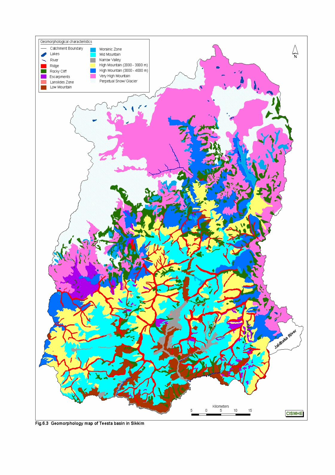
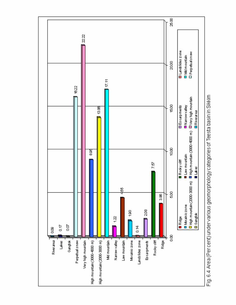
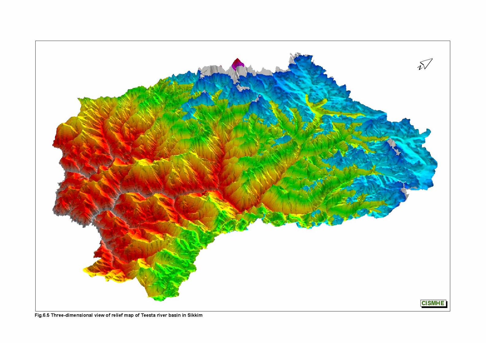
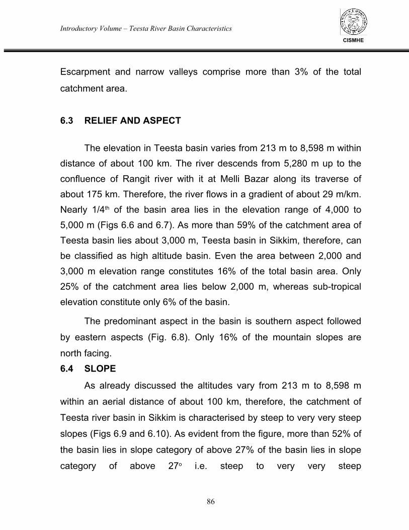
Introductory Volume – Teesta River Basin Characteristics
86
CISMHE
Escarpment and narrow valleys comprise more than 3% of the total
catchment area.
6.3 RELIEF AND ASPECT The elevation in Teesta basin varies from 213 m to 8,598 m within distance of about 100 km. The river descends from 5,280 m up to the confluence of Rangit river with it at Melli Bazar along its traverse of about 175 km. Therefore, the river flows in a gradient of about 29 m/km. Nearly 1/4th of the basin area lies in the elevation range of 4,000 to 5,000 m (Figs 6.6 and 6.7). As more than 59% of the catchment area of Teesta basin lies about 3,000 m, Teesta basin in Sikkim, therefore, can be classified as high altitude basin. Even the area between 2,000 and 3,000 m elevation range constitutes 16% of the total basin area. Only 25% of the catchment area lies below 2,000 m, whereas sub-tropical elevation constitute only 6% of the basin.
The predominant aspect in the basin is southern aspect followed
by eastern aspects (Fig. 6.8). Only 16% of the mountain slopes are
north facing.
6.4 SLOPE
As already discussed the altitudes vary from 213 m to 8,598 m
within an aerial distance of about 100 km, therefore, the catchment of
Teesta river basin in Sikkim is characterised by steep to very very steep
slopes (Figs 6.9 and 6.10). As evident from the figure, more than 52% of
the basin lies in slope category of above 27% of the basin lies in slope
category of above 27o i.e. steep to very very steep
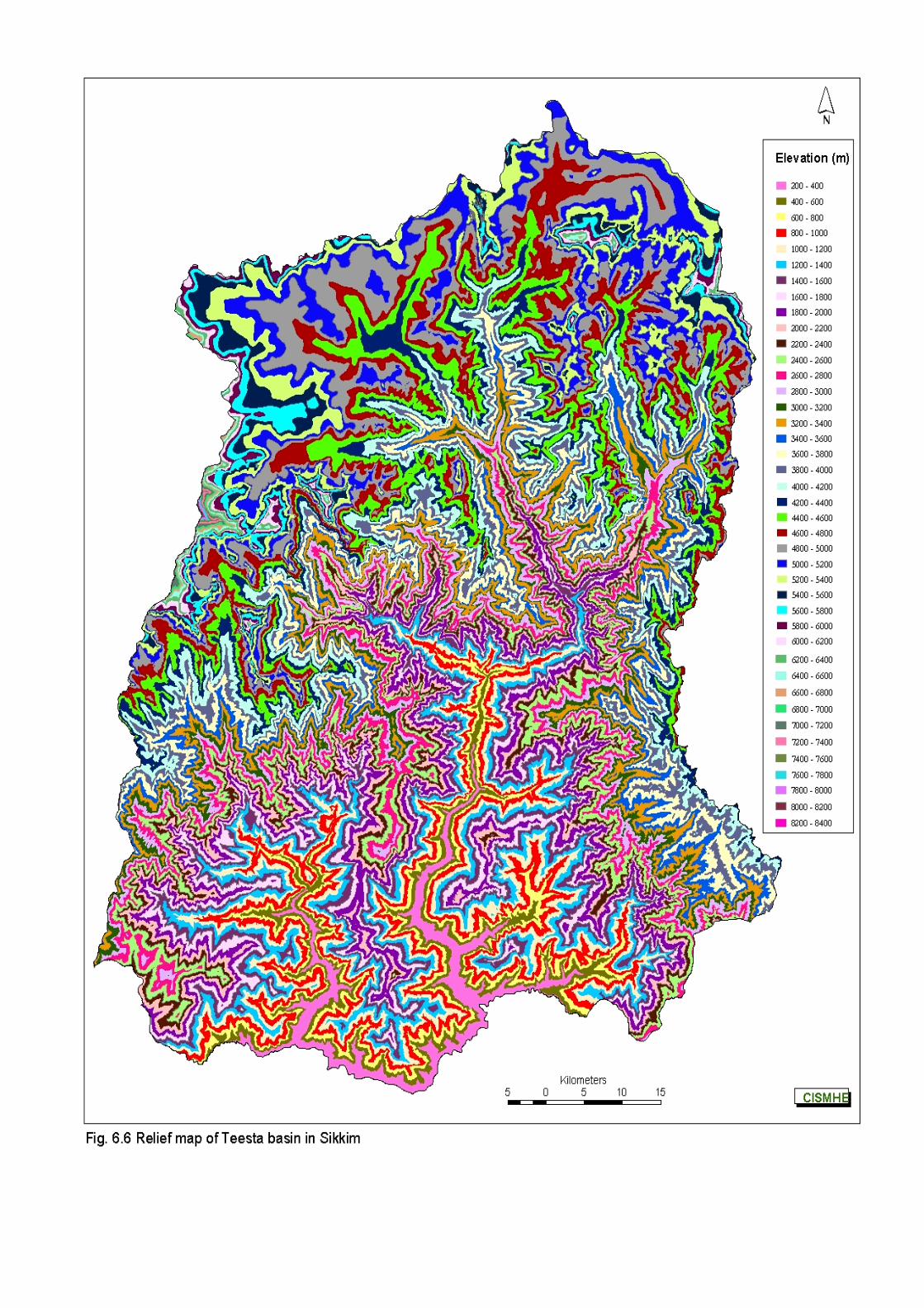
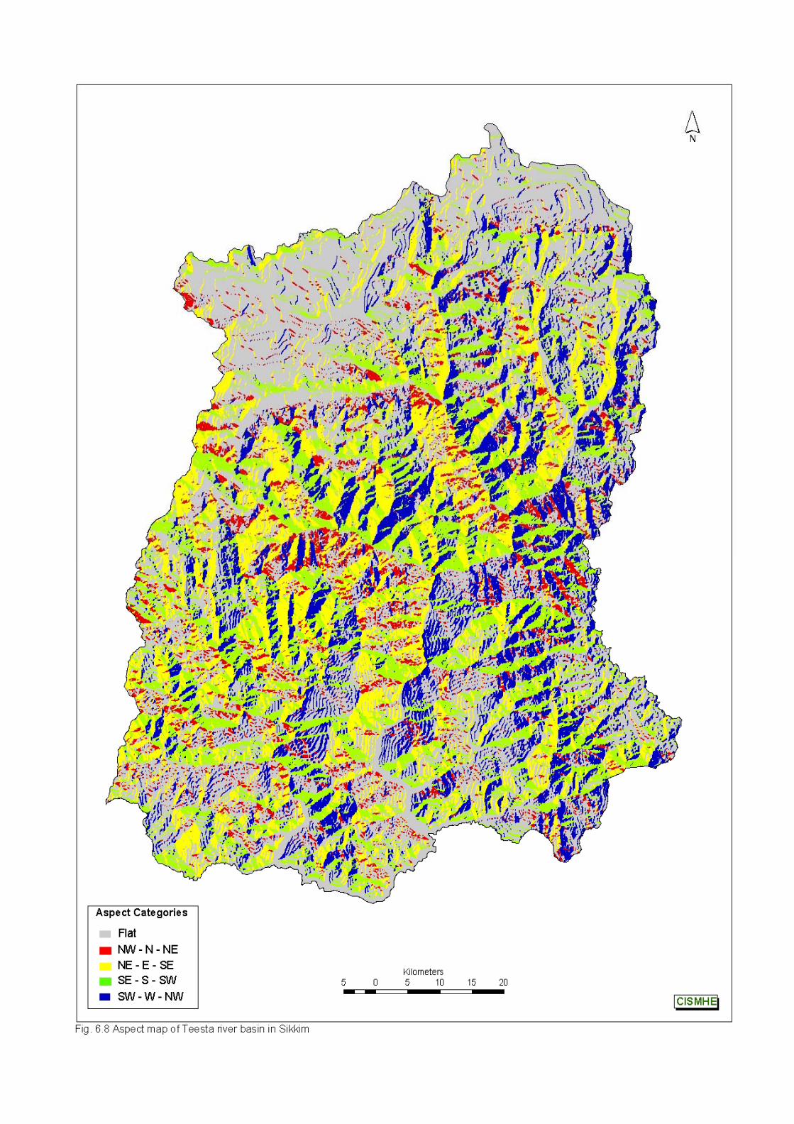
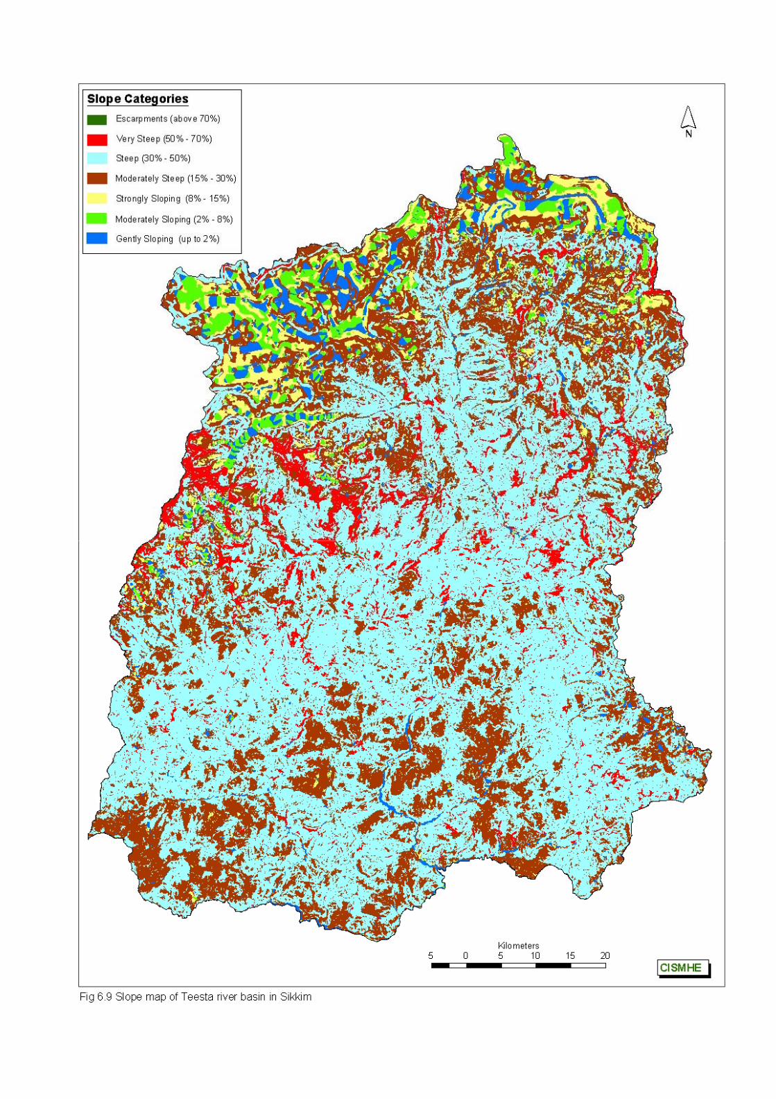
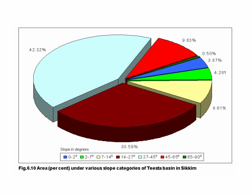
Introductory Volume – Teesta River Basin Characteristics
87
CISMHE
slope class. As much as 10.32% of the catchment area is either rocky
cliffs or are escarpments i.e. 65o and above slope class. The
catchment area under moderately steep slopes category is only
8.61% of the total. About 4.37% of the basin has area of gentle slope
category. Maximum area under gentle slope category is recorded in
Zemu valley followed by Chhombo Chhu, both incidentally are the
main sources of water in Teesta river. Zemu valley is characterized by
25 km long Zemu glacier with a descending from Khangchendzonga
peak with steep moderately steep in the initial stages and gentle
gradient in most of its stretch. Chhombo Chhu also is characterized
by wide U-shaped glacial valley with moderately steep to gentle
gradient slope near the source of Teesta river up to its confluence
with Gayum Chho near Oakra.
6.5 SOIL
Soil map prepared by NBSS & LUP, Regional Centre, Kolkata
and the legends are given in Fig.6.11 and Table 6.2. The details
regarding the soils of Teesta basin are given in Chapter 3 of Volume-
II of this report.

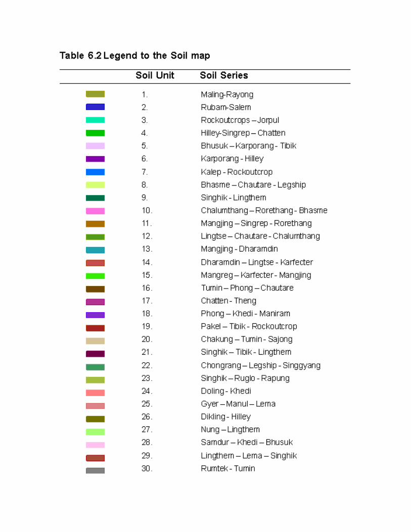

Introductory Volume – Remote Sensing and GIS Studies- Landuse/Landcover Mapping of Teesta Basin
CISMHE
7.1 LANDUSE MAPPING
The satellite remote sensing technology has found its
acceptance worldwide for rapid resource assessment and monitoring,
particularly in the developing world. National Aeronautical and Space
Administration (NASA) of USA has made most significant
contributions with satellite based remote sensing. Since 1972, when
Landsat -1 was launched, remote sensing technology and application
has undergone a tremendous change in terms of sensor
development, aerial flights with improved sensors, satellite design
development and operations including data reception, processing,
interpretation and utilisation of satellite images. All these
developments have widened the applicability of remotely sensed data
in various areas viz. forest cover, vegetation type mapping and their
changes on a regional scale. These developments have indicated
that if satellite data is judiciously used along with the sufficient ground
data, it is possible to carry out detailed forest inventories and
monitoring of landuse and vegetation cover at various scales.
Forests constitute the major proportion of Teesta basin in
Sikkim and play an important role in maintaining the ecological
balance and regulation of hydrological regime of Teesta river system.
In addition, these forests form the first resource of Sikkim and provide
wide range of forest related services for the welfare of human
populace in Sikkim. As per the Status of Forest Report prepared by
Forest Survey of India (2001), the forests of the country as a whole
Introductory Volume – Remote Sensing abd Gis Studies- Landuse/Landcover Mapping of Teesta Basin
89
CISMHE
have been decreasing due to increasing demand for fuel wood,
fodder, timber coupled with conversion of forest land to non-forest
landuse for undertaking various developmental activities. As indicated
in this report, however, no authentic information is available on the
real time database on the status of these forests.
The satellite remote sensing technology with its synoptic
coverage, with medium to high resolution data availability coupled
with repetitive availability of coverage of a particular region, has
provided an excellent opportunity to map the real time extent of forest
cover a period of time. However, due to the constraint of low
resolution data availability, no authentic data on forest cover of Sikkim
is available. This was also due to the fact that the remote sensing
technology and image processing technology was still in infancy in
1970s and 1980s. The only authentic information available on forest
cover of Sikkim is of 1988, which was done by Regional Remote
Sensing Service Centre, Kharagpur along with Forest Department,
Government of Sikkim. However, the data used at that time was of
IRS-IA LISS II, which was of very low resolution. Therefore, in this
study an exercise has been taken up for the analysis of extent of
forest cover depletion was undertaken. For the preparation of latest
forest type maps of Teesta basin in Sikkim, LANDSAT 7 ETM+ data
was used.
Landuse and landcover mapping of Teesta basin was carried
out by standard methods of analysis of remotely sensed data,
followed by ground truth collection, and digital image processing of
satellite data. For this purpose digital data on CDROMs was procured
Introductory Volume – Remote Sensing abd Gis Studies- Landuse/Landcover Mapping of Teesta Basin
90
CISMHE
from National Remote Sensing Agency, Hyderabad. Digital image
processing of the satellite data and the analysis of interpreted maps
were carried out at the Computer Centre at CISMHE using ERDAS
Imagine 8.7 of Erdas Inc.
7.2 STUDY AREA
The study deals with the natural and managed ecosystems of
Teesta basin in Sikkim in Eastern Himalaya. The region is
characterized by extensive Tropical moist deciduous-semi-evergreen
forest, Sub-tropical broad-leaf hill forest, Temperate forest, Mixed
coniferous and Fir forests. The study area is also prone to landslides
and changes in landscape features.
The objective of the study was to produce a detailed vegetation/
landuse map using hybrid digital classification technique. The study
also aims to produce land cover data set appropriate for wide variety
of applications.
7.3 DATABASE
The details of primary data in the form of digital data on
CDROMs procured from NRSA for interpretation and analysis are
given in Table 7.1.
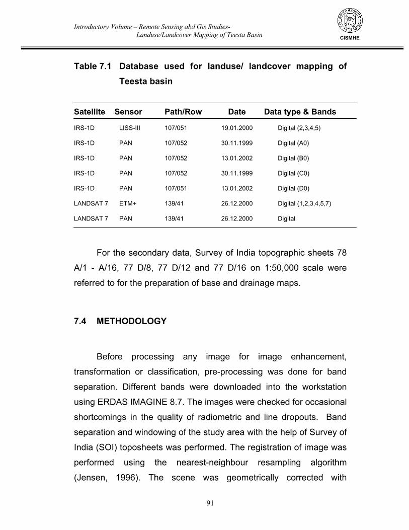
Introductory Volume – Remote Sensing abd Gis Studies- Landuse/Landcover Mapping of Teesta Basin
91
CISMHE
Table 7.1 Database used for landuse/ landcover mapping of Teesta basin
Satellite Sensor Path/Row Date Data type & Bands
IRS-1D LISS-III 107/051 19.01.2000 Digital (2,3,4,5)
IRS-1D PAN 107/052 30.11.1999 Digital (A0)
IRS-1D PAN 107/052 13.01.2002 Digital (B0)
IRS-1D PAN 107/052 30.11.1999 Digital (C0)
IRS-1D PAN 107/051 13.01.2002 Digital (D0)
LANDSAT 7 ETM+ 139/41 26.12.2000 Digital (1,2,3,4,5,7)
LANDSAT 7 PAN 139/41 26.12.2000 Digital
For the secondary data, Survey of India topographic sheets 78
A/1 - A/16, 77 D/8, 77 D/12 and 77 D/16 on 1:50,000 scale were
referred to for the preparation of base and drainage maps.
7.4 METHODOLOGY
Before processing any image for image enhancement,
transformation or classification, pre-processing was done for band
separation. Different bands were downloaded into the workstation
using ERDAS IMAGINE 8.7. The images were checked for occasional
shortcomings in the quality of radiometric and line dropouts. Band
separation and windowing of the study area with the help of Survey of
India (SOI) toposheets was performed. The registration of image was
performed using the nearest-neighbour resampling algorithm
(Jensen, 1996). The scene was geometrically corrected with
Introductory Volume – Remote Sensing abd Gis Studies- Landuse/Landcover Mapping of Teesta Basin
92
CISMHE
toposheets using proper identification of GCPs with a root-mean-
square (RMS) error of 0.0002 to 0.003 pixels. IRS LISS III and
LANDSAT 7 ETM+ were radiometrically corrected using dark pixel
subtraction technique. They were then co-registered with SOI
toposheets using Polyconic projection. Geo-referencing of the
composite image was done using digital vector layer of drainage,
road network, water bodies and other permanent ground features
extracted from SOI toposheets. Distinguishable Ground Control
Points (GCPs) both on image and vector database were identified
and using these GCPs the image was resampled and geo-coded.
Sub-pixel image to map registration accuracy was achieved through
repeated attempts. The image enhancement was performed by using
different combinations for best image contrast for the full dynamic
range for each band employing enhancement techniques like edge
detection, filters, manipulation of contrast and brightness, histogram
equalisation, etc. False Colour Composite (FCC) was prepared using
enhanced data of Bands 2, 3 and 4 of LISS III, IRS-ID as well as of
LANDSAT 7 ETM+ (see Fig. 5.1). The image was interpreted digitally
using various digital image processing techniques. All operations
were carried out using ERDAS IMAGINE 8.7 software. The general
procedure for classification involved the following important steps viz.
enhancement of scene, rectification and classification technique, etc.
is given in Fig. 7.1.
In order to utilise the higher resolution of panchromatic image of
IRS-ID, image fusion was done to enhance the lower multispectral
LISS and ETM+ images. For this purpose a portion of high resolution
Introductory Volume – Remote Sensing abd Gis Studies- Landuse/Landcover Mapping of Teesta Basin
93
CISMHE
PAN image that corresponds with an area of interest in the
multispectral LISS and ETM+ images were extracted. Thereafter,
both the images were coregistered and LISS and ETM+ images were
resampled for merging with PAN image. Merging or image fusion was
done by spatial enhancement module of ERDAS Imagine 8.7.
The digital vector layers of state of Sikkim as well as the
administrative boundaries of various districts and their sub-divisions
and village boundaries obtained from Census of India 2001 maps
procured from the Office of the Registrar General of India and
boundaries of different watersheds of Teesta basin were prepared
from the Survey of India (SOI) toposheets at 1:50,000 scale and the
available district maps obtained from NATMO and Survey of India.
These vector layers were used as masks to extract the sub-
watersheds from the images for further processing. A mosaic image
from was prepared from four different PAN scenes. As the scenes
were of different dates for a particular year, mosaicing was done by
histogram matching using band by band matching tool of ERDAS
IMAGINE 8.7. It was from these mosaic images, mask of Sikkim was
extracted. From the Sikkim mosaic image, masks of different districts
and watersheds were extracted, which were then used for further
digital image processing and enhancement.
In the preliminary analysis, image classification was done by
unsupervised classification method by performing ISODATA training.
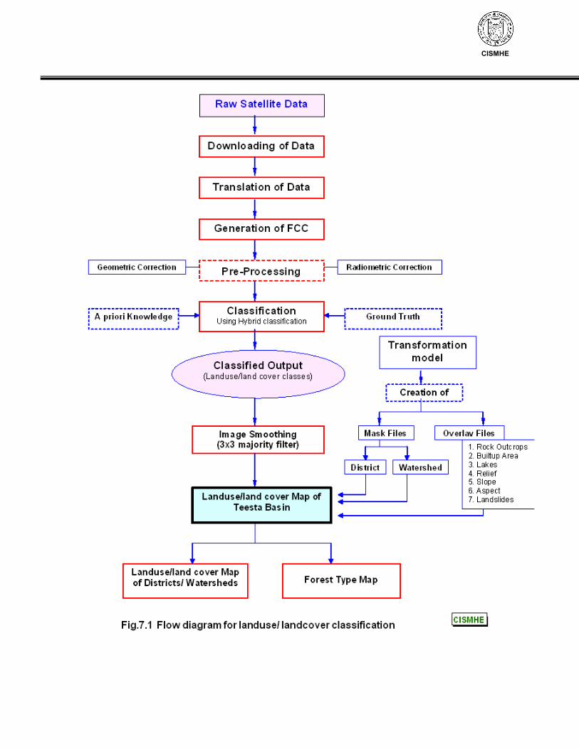
CISMHE
Introductory Volume – Remote Sensing abd Gis Studies- Landuse/Landcover Mapping of Teesta Basin
94
CISMHE
It helped in assigning the classification of the image into landuse
categories. Later on, the boundaries of water bodies were separately
mapped using SOI toposheets and merged with classified image. The
doubtful areas or wrongfully interpreted areas owing to various
physical features controlling the study area were marked for ground
truthing. The ground truth collected during the field surveys was used
for the supervised classification for the preparation and identification
of landuses resulting in accurate classification of the areas. The
classified map was regrouped and merged. The classified raster map,
thus prepared, was then converted to vector format for GIS analysis
and the preparation of required thematic maps using ArcGIS 9.0 and
GeoMedia Professional 5.2. Reconnaissance surveys of different
parts of Teesta basin were conducted in the months of May-June,
2002 and May-June, 2003. These trips were mainly undertaken to
understand the terrain and vegetation structure of the study area.
However, only a limited ground truthing could be done as the
permission for entering the protected as well as forested areas in
different parts of Sikkim was not granted by the Forest Department.
Remotely sensed vegetation indices have been recommended
to remove variability caused by canopy geometry, soil background,
sun view angles and atmospheric conditions when measuring
biophysical properties (biomass, LAI and percent green vegetation
cover) of vegetation at canopy scale (Blackburn & Steele, 1999;
Boegh et al., 2002; Elvidge & Chen, 1995; Gao et al., 2000;
Schowengerdt, 1983; Tucker, 1979).
Introductory Volume – Remote Sensing abd Gis Studies- Landuse/Landcover Mapping of Teesta Basin
95
CISMHE
As Teesta basin is entirely hilly, the classification of the
undulating terrain is difficult. Different areas with brightness and
intensity values of same class occasionally fall within shadow,
partially shadow and non-shadow area. Therefore, it is difficult to
extract useful information from these areas. In order to overcome this,
technique of ratioing was used to enhance the image to a certain
extent. Linear stretching technique was also used to overcome these
difficulties. All these techniques were used in combination for
judicious training of datasets during supervised training during
classification. The classes in the shadow areas were assigned
classes similar to the neighbourhood classified non-shadow area and
linear stretching.
As the data sets were of different time periods, a number of
difficulties were encountered in classification process. The most
widely used vegetation indices are computed using data from the red
and near infrared (NIR) portions of the electromagnetic spectrum
(Treitz & Howarth, 1999). These vegetation indices operate by
contrasting intense chlorophyll pigment absorptions in the red against
the high reflectance due to multiple scattering in the near infrared
(Elvidge & Chen, 1995; Hoffer, 1978; Todd et al., 1998). Widely used
vegetation indices such as normalized difference vegetation index
(NDVI) (Tucker, 1979; Wiegand et al., 1991), transformed vegetation
index (TVI) (Richardson & Wiegand, 1977; Rouse et al., 1973), simple
ratio (SR) (Jordan, 1969; Maxwell, 1976) and difference vegetation
Introductory Volume – Remote Sensing abd Gis Studies- Landuse/Landcover Mapping of Teesta Basin
96
CISMHE
index (DVI) respond to these differences in the near infrared and the
visible regions (Lillesand and Kiefer, 1994; Schowengerdt, 1983). In
addition, indices that control for variations in soil background effects
as well as atmospheric induced variations have also been developed.
These include the perpendicular vegetation index (PVI) (Richardson
& Wiegand, 1977), weighted difference vegetation index (WDVI)
(Clevers, 1988), soil adjusted vegetation index (SAVI) (Huete, 1988),
transformed soil adjusted vegetation index (TSAVI) (Baret & Guyot,
1991) and modified normalized difference vegetation index (MNDVI)
(Liu and Huete, 1995).
Based on broadband satellite images, vegetation indices such
as Normalized Difference Vegetation Index (NDVI), Simple Ratio
(SR), Transformed Vegetation Index (TVI) and Transformed Soil
Adjusted Vegetation Index (TSAVI) have been widely used to
measure vegetation quantity, leaf area index (LAI) and percent green
vegetation cover of vegetation at canopy scale (Blackburn & Steele,
1999; Boegh et al., 2002; Elvidge & Chen, 1995; Gao et al., 2000;
Schowengerdt, 1983; Tucker, 1979). Although these indices have
been successfully used in areas with open canopy cover or sparsely
vegetated regions, they have not been successful in estimating
quantity at high canopy density. Specifically, the widely used
vegetation indices particularly NDVI derived from broad band satellite
images such as NOAA or Landsat TM tend to saturate after a certain
Introductory Volume – Remote Sensing abd Gis Studies- Landuse/Landcover Mapping of Teesta Basin
97
CISMHE
biomass density or LAI (Gao et al., 2000; Sellers, 1985; Thenkabail et
al., 2000; Todd et al., 1998; Tucker, 1977).
Accurate quantitative information on the distribution and
phenology of vegetation formations is limited, yet is fundamental for
the effective management of forest resources. The spatial distribution
of NDVI values has been dominated by the high values in October
and December. The senescence stages in April and May for
deciduous forest can be clearly demarcated by the spatial distribution
of NDVI values. The comparative analysis revealed the influence of
seasonal variation on the vegetation. During January–March, the
vegetation showed a growing trend. From April to June, the decrease
in NDVI values is seen. The maximum NDVI image has been
computed to represent the maximum foliage cover in the time period.
In the present studies, biophysical processing was carried out
using Band 1 and Band 2 and NDVI was calculated for different
months for which data sets were available. Maximum NDVI was
calculated for the entire study period. For the mapping, maximum
NDVI, and Band 1 (Red) and Band 2 (NIR) data sets were taken. The
mapping involves using clustering algorithm based on the ISODATA
algorithm. Each cluster was assigned a preliminary cover type
considering the spatial and spectral pattern, multi-temporal statistics
of each class and comparison with ancillary data and ground truth.
Ancillary data included descriptive land cover information, NDVI
Introductory Volume – Remote Sensing abd Gis Studies- Landuse/Landcover Mapping of Teesta Basin
98
CISMHE
profiles and class relationships to the other land cover classes.
Related ‘single category’ classes were then grouped using a
convergence of evidence approach. The cloud classes were masked
out using supervised classification. The unsupervised classification
was followed by post classification refinement. The hybrid approach
was used to refine the classes. The classes were labeled using the
spectral values from ground truth, available data sets and spectral
analysis of the data sets. For evaluation of classification, comparisons
were made at a regional level with the available forest database. The
classes and statistics were in correlation to the ground reality.
7.5 CLASSIFICATION SCHEME
The classification scheme adopted for the preparation of
landuse/landcover maps and related thematic maps on 1:50,000
scale is as follows. Two forest density classes were interpreted for the
forest cover mapping. The forests with >40% canopy cover were
delineated as dense forests and between 10% and 40% crown
density as open forest. In non-forest agriculture with settlements,
degraded land/barren and rockyland, snow/ice cover, glaciers, etc.
were delineated. Landuse/landcover Remarks Dense forest Tropical Moist Deciduous Forest (Crown density > 40%) Sub-tropical Forest Temperate Forest Sub-alpine Forest Open forest Tropical Moist Deciduous Forest
Introductory Volume – Remote Sensing abd Gis Studies- Landuse/Landcover Mapping of Teesta Basin
99
CISMHE
(Crown density < 40%) Sub-tropical Forest Temperate Forest Sub-alpine Forest Mixed Conifer Forest Fir Forest Pine Forest Sub-tropical scrub Scrub Alpine Scrub Temperate scrub Alpine scrub Alpine meadows Agriculture/Settlements Barren Rockyland/ Alpine Barren Moraines Snow Glaciers/Ice fields Lakes
An interpretation key was prepared based on the relationships
between ground features and image elements like texture, tone,
shape, location, pattern. Image interpretation was done for the entire
Teesta basin. Interpreted details (polygons) were then transferred to
base map. Since satellite data is geo-coded there was not much error
in the geometry of the data and wherever necessary, local matching
was done while transferring the details.
The base map, drainage map and landuse/landcover map
prepared using the satellite data were digitized on computer for
further processing and analysis using the GeoMedia Professional 5.2.
Introductory Volume – Remote Sensing abd Gis Studies- Landuse/Landcover Mapping of Teesta Basin
100
CISMHE
The Survey of India toposheets at 1:50,000 scale were used for the
delineation of watersheds in Teesta basin in Sikkim. These
watersheds were then overlaid on the drainage map, PAN-LISS
merged enhanced images and landuse map of the catchment in order
to extract the drainage and landuse of the respective watersheds. All
the different theme layers, i.e. base map, drainage and landuse/land
cover maps were then transferred to Geographic Information System
(GIS) using GeoMedia Professional 5 for further overlay analysis.
The mask image of Teesta basin was divided into forest and
non-forest areas in the beginning and was then classified separately.
The digital data was rectified to match with Survey of India
toposheets. False Colour Composites (FCCs) of each district were
extracted from the FCC of Teesta basin. For the purpose of ground
truthing, sufficient ground truth points were identified which covered
entire range of image characteristics like tone, texture, association
with other features, location, etc. As already stated hybrid
classification approach was used. The density map was prepared
using NDVI technique. For forest type map, queries were run using
modeler and knowledge classifier modules of ERDAS Imaging 8.7.
The layers used for classification were relief, slope, aspect, landslides
and geological formations. Therefore, landuse/landcover maps were
generated for all the watersheds and districts separately. Ground
truth collection, however, could be done only for limited areas as the
permission to undertake surveys in protected areas was not granted
by the State Forest Department.
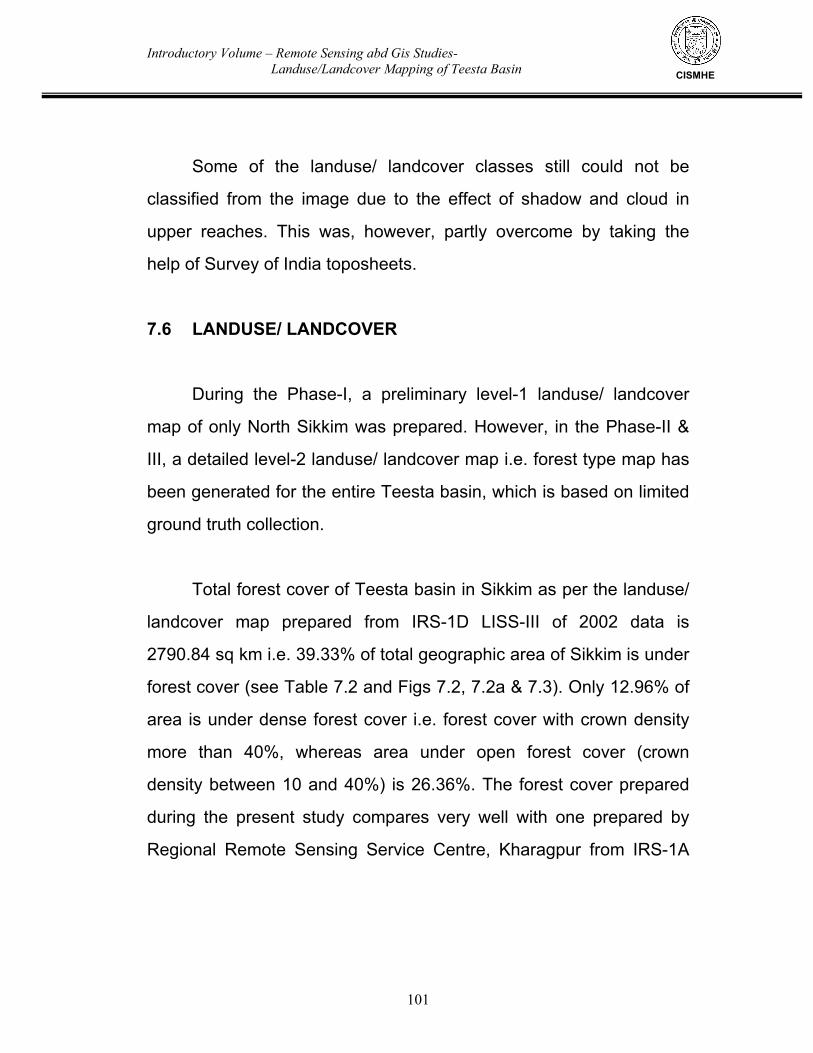
Introductory Volume – Remote Sensing abd Gis Studies- Landuse/Landcover Mapping of Teesta Basin
101
CISMHE
Some of the landuse/ landcover classes still could not be
classified from the image due to the effect of shadow and cloud in
upper reaches. This was, however, partly overcome by taking the
help of Survey of India toposheets.
7.6 LANDUSE/ LANDCOVER
During the Phase-I, a preliminary level-1 landuse/ landcover
map of only North Sikkim was prepared. However, in the Phase-II &
III, a detailed level-2 landuse/ landcover map i.e. forest type map has
been generated for the entire Teesta basin, which is based on limited
ground truth collection.
Total forest cover of Teesta basin in Sikkim as per the landuse/
landcover map prepared from IRS-1D LISS-III of 2002 data is
2790.84 sq km i.e. 39.33% of total geographic area of Sikkim is under
forest cover (see Table 7.2 and Figs 7.2, 7.2a & 7.3). Only 12.96% of
area is under dense forest cover i.e. forest cover with crown density
more than 40%, whereas area under open forest cover (crown
density between 10 and 40%) is 26.36%. The forest cover prepared
during the present study compares very well with one prepared by
Regional Remote Sensing Service Centre, Kharagpur from IRS-1A
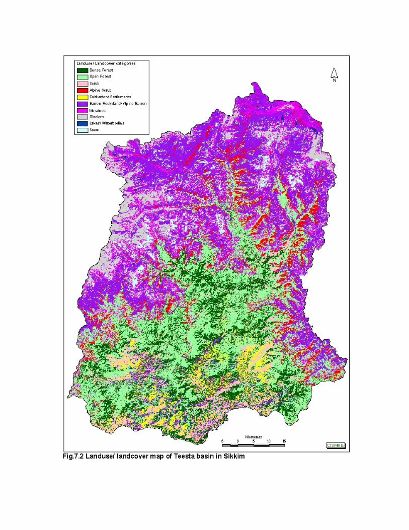
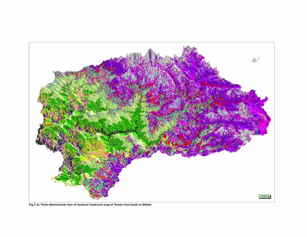
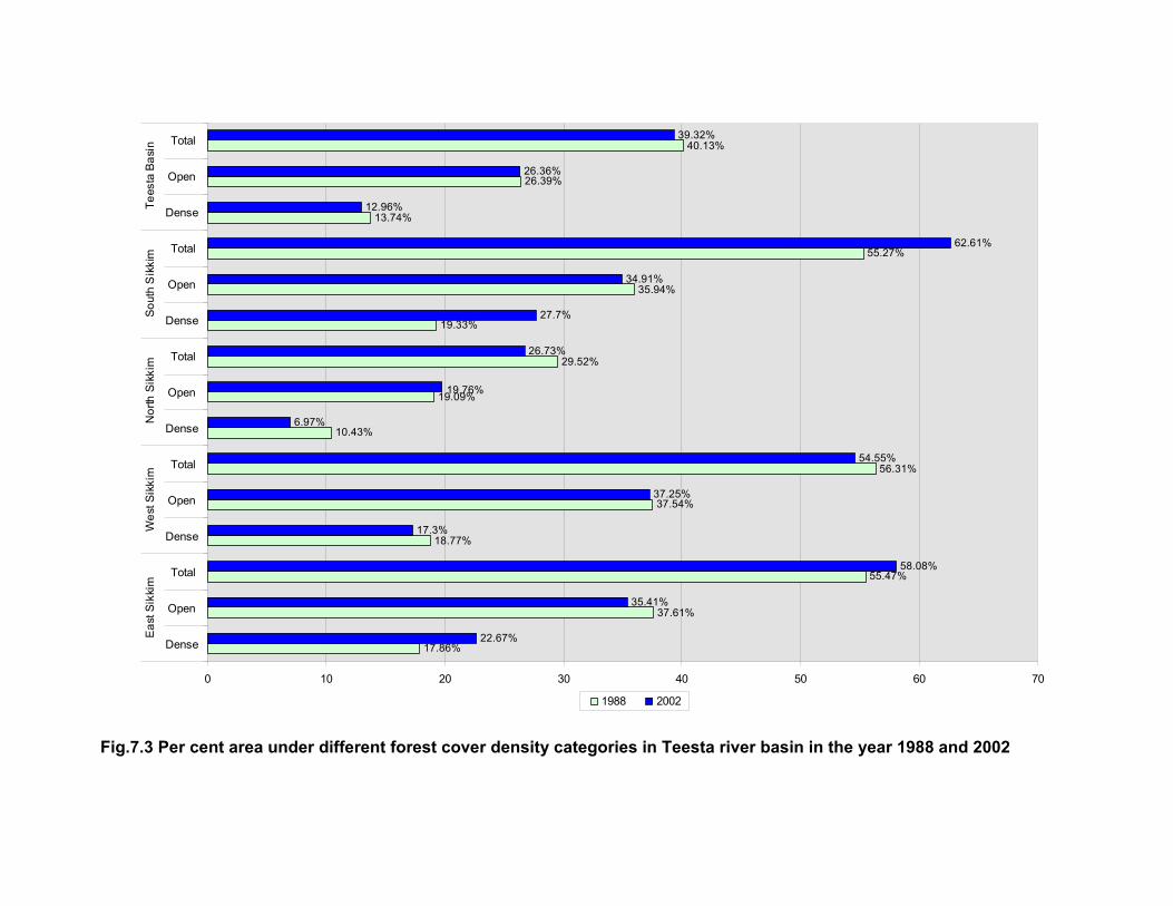
Fig.7.3 Per cent area under different forest cover density categories in Teesta river basin in the year 1988 and 2002
17.86%
37.61%
55.47%
18.77%
37.54%
56.31%
10.43%
19.09%
29.52%
19.33%
35.94%
55.27%
13.74%
26.39%
40.13%
22.67%
35.41%
58.08%
17.3%
37.25%
54.55%
6.97%
19.76%
26.73%
27.7%
34.91%
62.61%
12.96%
26.36%
39.32%
0 10 20 30 40 50 60 70
Dense
Open
Total
Dense
Open
Total
Dense
Open
Total
Dense
Open
Total
Dense
Open
Total E
ast S
ikki
mW
est S
ikki
mN
orth
Sik
kim
Sou
th S
ikki
mTe
esta
Bas
in
1988 2002
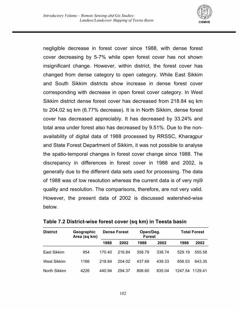
Introductory Volume – Remote Sensing abd Gis Studies- Landuse/Landcover Mapping of Teesta Basin
102
CISMHE
negligible decrease in forest cover since 1988, with dense forest
cover decreasing by 5-7% while open forest cover has not shown
insignificant change. However, within district, the forest cover has
changed from dense category to open category. While East Sikkim
and South Sikkim districts show increase in dense forest cover
corresponding with decrease in open forest cover category. In West
Sikkim district dense forest cover has decreased from 218.84 sq km
to 204.02 sq km (6.77% decrease). It is in North Sikkim, dense forest
cover has decreased appreciably. It has decreased by 33.24% and
total area under forest also has decreased by 9.51%. Due to the non-
availability of digital data of 1988 processed by RRSSC, Kharagpur
and State Forest Department of Sikkim, it was not possible to analyse
the spatio-temporal changes in forest cover change since 1988. The
discrepancy in differences in forest cover in 1988 and 2002, is
generally due to the different data sets used for processing. The data
of 1988 was of low resolution whereas the current data is of very mji9
quality and resolution. The comparisons, therefore, are not very valid.
However, the present data of 2002 is discussed watershed-wise
below.
Table 7.2 District-wise forest cover (sq km) in Teesta basin District Geographic Dense Forest Open/Deg. Total Forest Area (sq km) Forest
1988 2002 1988 2002 1988 2002 East Sikkim 954 170.40 216.84 358.79 338.74 529.19 555.58 West Sikkim 1166 218.84 204.02 437.69 439.33 656.53 643.35 North Sikkim 4226 440.94 294.37 806.60 835.04 1247.54 1129.41
Introductory Volume – Remote Sensing abd Gis Studies- Landuse/Landcover Mapping of Teesta Basin
103
CISMHE
South Sikkim 750 144.96 204.62 269.57 257.88 414.63 462.50 Total 7096 975.14 919.85 1872.65 1879.99 2847.79 2790.84 7.6.1 Chhombo Chhu
Chhombo Chhu watershed, being a high altitude watershed,
has little forest cover, i.e. only 8% of its area is under forest that too is
of open category (Figs 7.4 - 7.6). Alpine scrub cover about 9% of its
area. The watershed has more than 52% of its area under barren
rockyland landcover comprised of scree slopes and rocky outcrops
with no vegetation at all. In addition moraines constitute about 15% of
the area whereas glaciers and permanent snowfields cover 9.9%
area and snow accounts for more than 5% of watershed area. Due to
the presence of number of glacial lakes like Chho Lhamo,
Gurudongmar Chho, Khangchung Chho, etc., these account for about
1% of watershed area.
7.6.2 Yumthang Chhu
Like Chhombo Chhu, Yumthang Chhu watershed also does not
have much forest cover and only 11% of its area under forest cover of
open category (see Figs 7.6 - 7.8). Alpine scrub accounts for 8% of
watershed area. About 45% of watershed area is under barren
rockyland and moraines cover about 13% of total area. Snow and
glaciers cover 9.6-10% and 13% of watershed area, respectively. The
area under settlements/ cultivation is negligible.
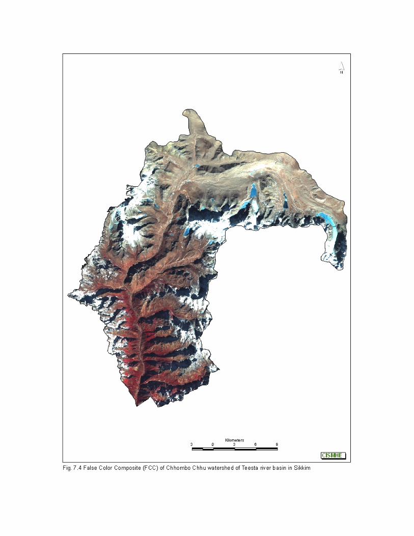
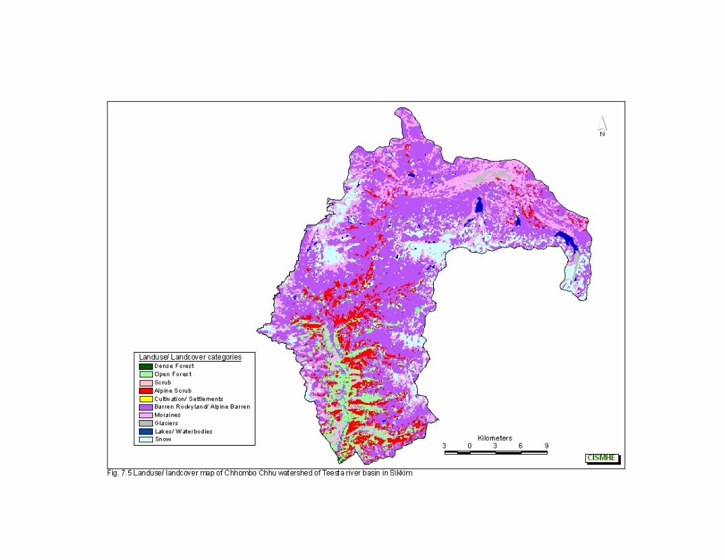
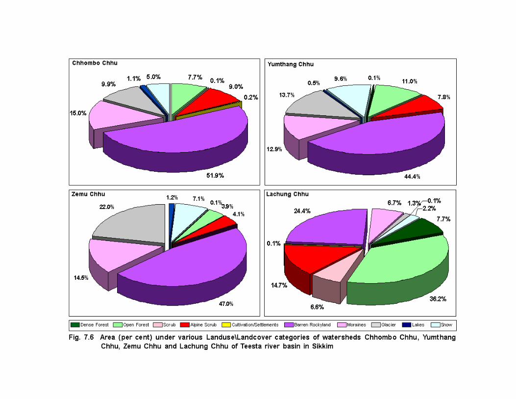
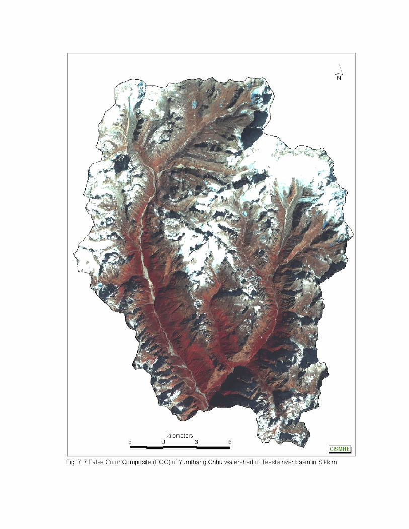

Introductory Volume – Remote Sensing abd Gis Studies- Landuse/Landcover Mapping of Teesta Basin
104 104
CISMHE
7.6.3 Zemu Chhu Zemu Chhu is the largest watershed with an area of 991.40 sq
km. It harbours very little forest cover i.e. only 4% of its area is
covered by forests (see Fig.7.6 and Figs 7.9 - 7.10). Alpine scrub also
covers only 4% of area. Barren rocky areas constitute more than 47%
of watershed area. Glaciers and snow cover about 22% and 7.1% of
watershed areas, respectively. A significant amount of area is
covered with moraines (14.5%) while glacial lakes also cover about
1.23% of watershed area.
7.6.4 Lachung Chhu
Lachung Chhu is another high altitude watershed in North
Sikkim. This watershed has good forest cover i.e. more than 44% of
watershed area is under forest (see Fig 7.6 and Figs 7.11 - 7.12). Out
of this 8% area is under dense forest cover comprised mainly of
mixed conifer forest, whereas 36% area is under forests of open
category. In addition, 15% area is under alpine scrub forest. As much
as 26% of watershed area is under barren/rockyland category, and
moraines constitute 7% of total area. 7.6.5 Lachen Chhu
This is a small watershed located at middle altitudes. More than
64% of Lachen Chhu watershed is covered with forests (Figs 7.13 -
7.15). Dense forests cover 20% of watershed area whereas open
forest account for 44% of area. Further, about 11% area is under
Introductory Volume – Remote Sensing abd Gis Studies- Landuse/Landcover Mapping of Teesta Basin
105
CISMHE
scrub category (alpine as well as temperate scrub). A little more than
10% of area is barren (comprised of rocky outcrop, scree slopes,
etc.). Similarly glacial moraines also cover about 8.3% of watershed
area. More than 6.3% of area is either under snow or glaciers and
permanent snowfields.
7.6.6 Rangyong Chhu
It is the second largest watershed of Teesta basin located in the
south-west of North Sikkim district. Nearly 37% of Rangyong Chhu
watershed is covered with forests comprised of Mixed conifer, sub-
alpine and fir forests. This constitutes major part of
Khangchendzonga National Park. About 11.9% of forests area is of
closed type whereas 25% of forests are of open category (Figs 7.15 -
7.17). The scrub landuse (both alpine and temperate scrub) cover
about 8.9% of watershed area. Barren rockyland and moraines
constitute 21% and 12.3% of watershed area. Snow and glaciers
together cover 20.5% of total area.
7.6.7 Prek Chhu Prek Chhu watershed is source tributary watershed of Rangit
river in West Sikkim. It has a forest cover of 80.75% sq km (25.7%)
(see Fig.7.15 and Figs 7.18 - 7.19). About 40% of Prek Chhu
watershed is under barren/ rockyland landcover category. Glaciers,
snow and moraines constitute 10.1%, 3.8% and 11.2% of total
watershed area, respectively.
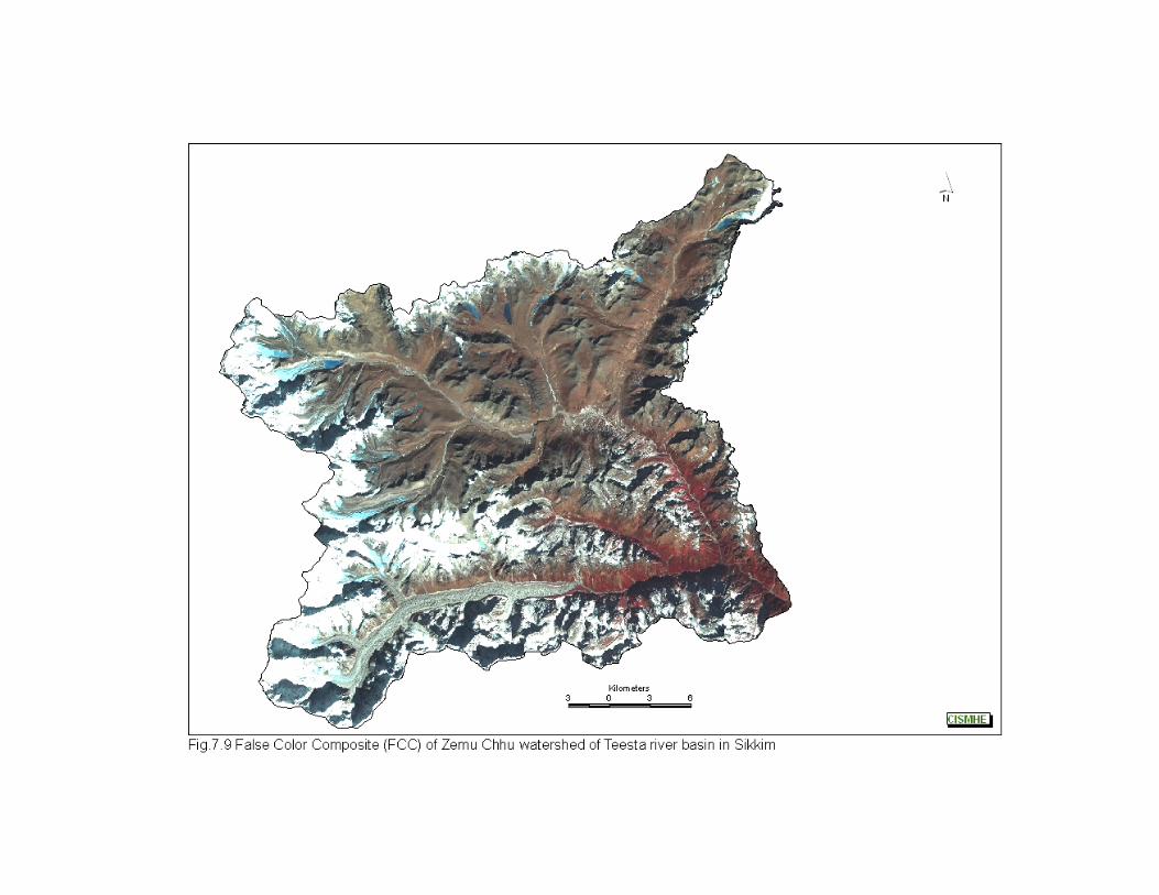
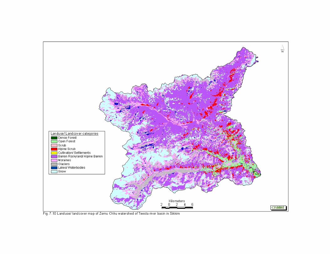
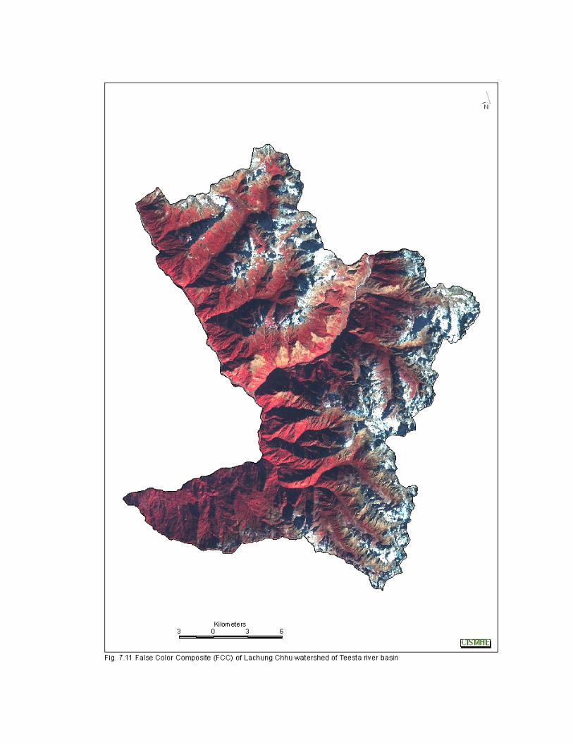
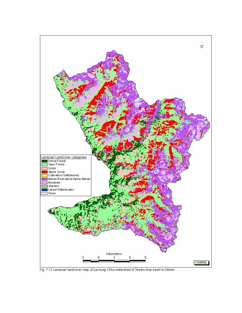
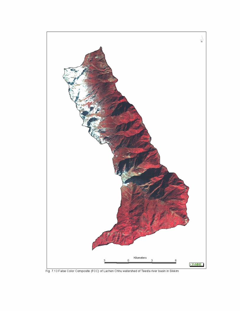
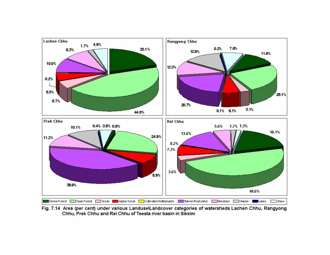
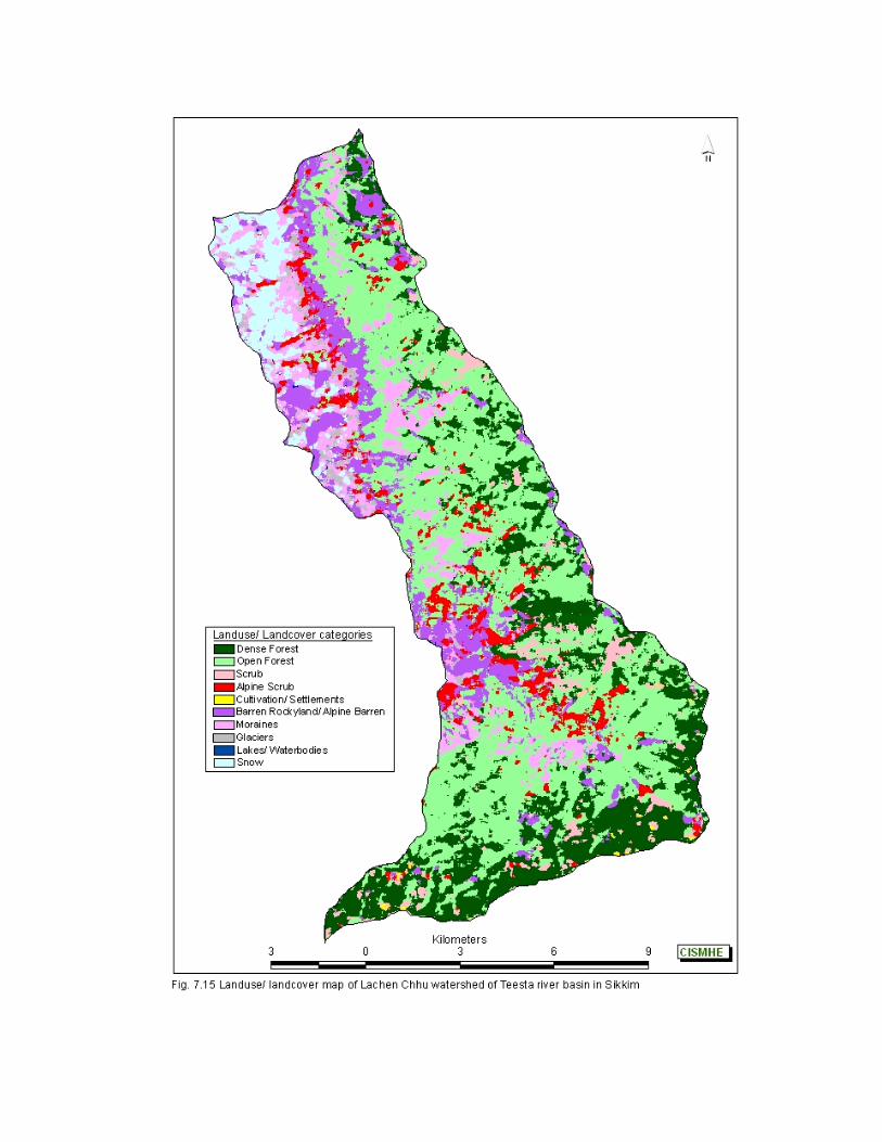
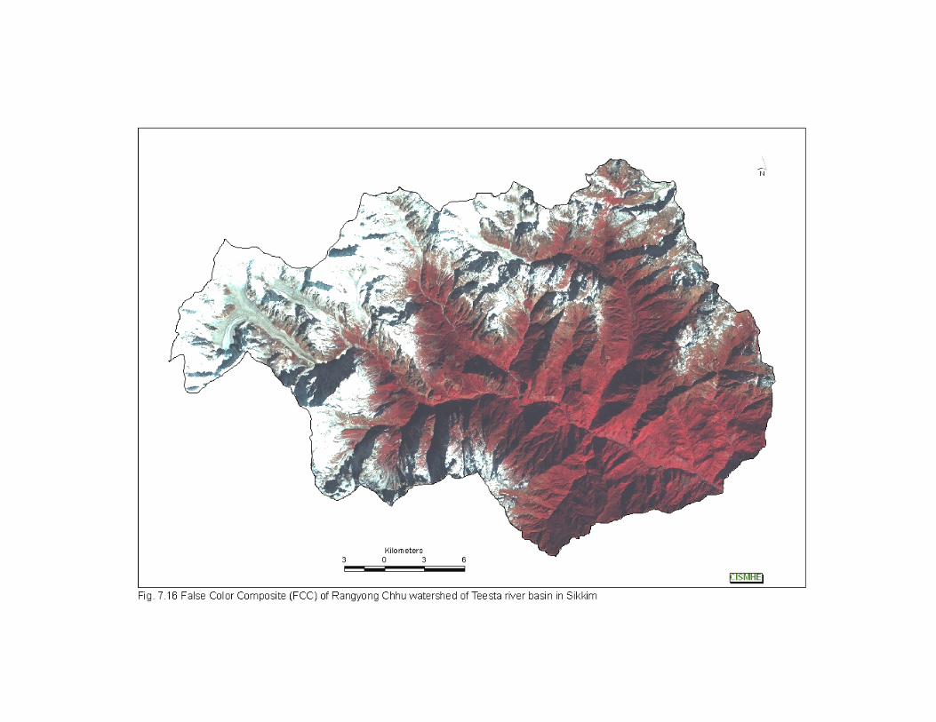
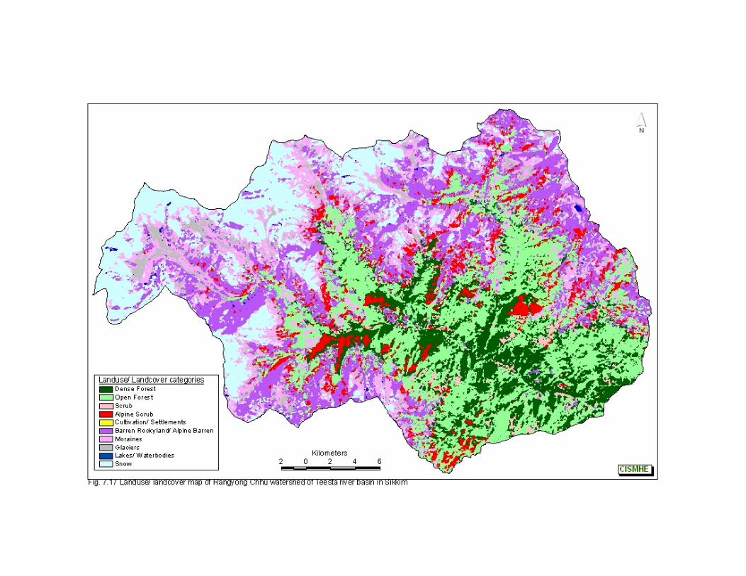
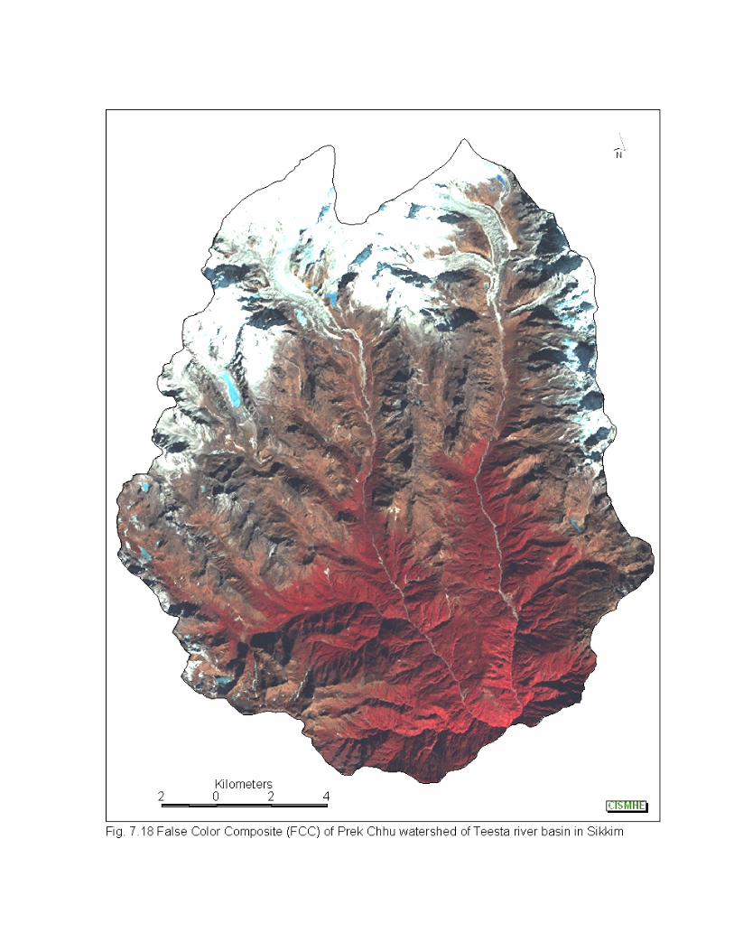
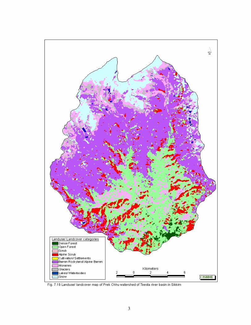
3
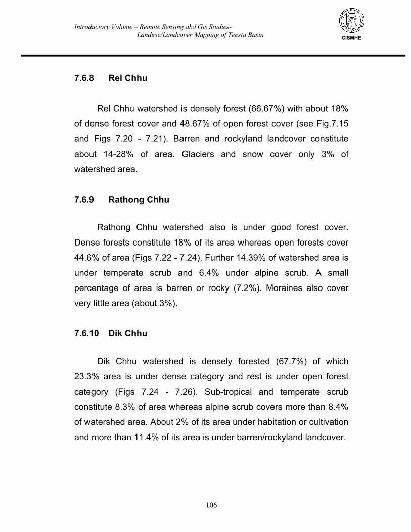
Introductory Volume – Remote Sensing abd Gis Studies- Landuse/Landcover Mapping of Teesta Basin
106
CISMHE
7.6.8 Rel Chhu Rel Chhu watershed is densely forest (66.67%) with about 18%
of dense forest cover and 48.67% of open forest cover (see Fig.7.15
and Figs 7.20 - 7.21). Barren and rockyland landcover constitute
about 14-28% of area. Glaciers and snow cover only 3% of
watershed area.
7.6.9 Rathong Chhu
Rathong Chhu watershed also is under good forest cover.
Dense forests constitute 18% of its area whereas open forests cover
44.6% of area (Figs 7.22 - 7.24). Further 14.39% of watershed area is
under temperate scrub and 6.4% under alpine scrub. A small
percentage of area is barren or rocky (7.2%). Moraines also cover
very little area (about 3%).
7.6.10 Dik Chhu
Dik Chhu watershed is densely forested (67.7%) of which
23.3% area is under dense category and rest is under open forest
category (Figs 7.24 - 7.26). Sub-tropical and temperate scrub
constitute 8.3% of area whereas alpine scrub covers more than 8.4%
of watershed area. About 2% of its area under habitation or cultivation
and more than 11.4% of its area is under barren/rockyland landcover.
Introductory Volume – Remote Sensing abd Gis Studies- Landuse/Landcover Mapping of Teesta Basin
107
CISMHE
7.6.11 Rangpo Chhu
Rangpo Chhu watershed has more than 60% of its area under
forest cover (see Fig.7.24 and Figs 7.27 - 7.28). Dense and open
forests cover 24.3% and 35.9% of land area, respectively. Alpine
meadows and alpine scrub constitute about 6.5% of watershed area.
Sub-tropical scrub also cover 11.6% of the area at the lower altitudes.
About 3.5% of watershed is under habitation or cultivation. Nearly 18%
of area is either barren or covered with moraines. Upper catchment of
Rangpo Chhu is covered with fir and rhododendron forests.
7.6.12 Rangit River
Rangit river watershed has dense forest cover of 30.7%
whereas open forests cover 35.6% of area (see Fig.7.24 and Figs
7.29 - 7.30). About 15.5% of area is covered with sub-tropical and
temperate scrub while 4.5% area is covered with alpine scrub. Only
9.1% of watershed is barren and rocky in nature. The habitation and
cultivation areas constitute about 9.0% of watershed area.
7.6.13 Kalej Khola
Percent area under forest is maximum in this watershed i.e.
73.21% of this forest cover, 24.5% under dense forest category and
48.71% is under open forest category (Figs 7.31 - 7.33). Sub-tropical
scrub also constitute 12.52% of area. About 3.6% watershed is under
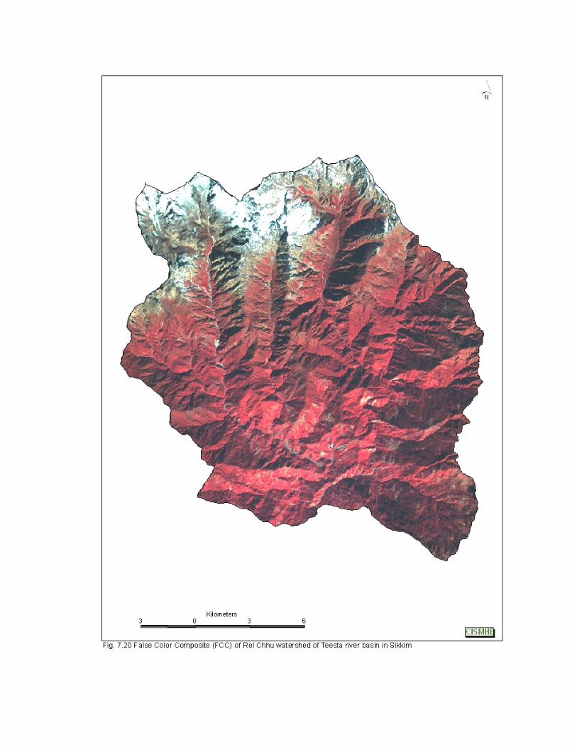
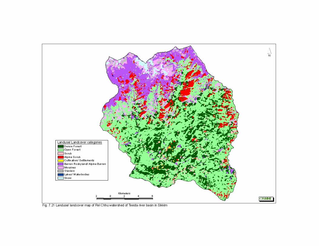
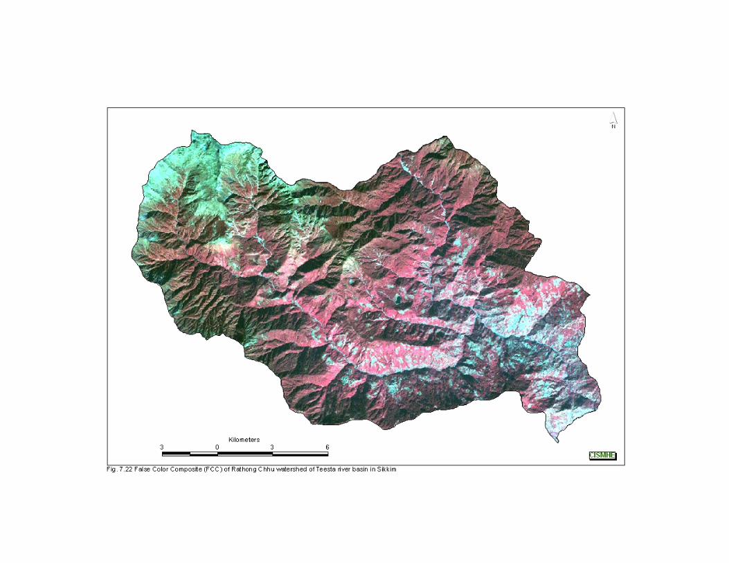
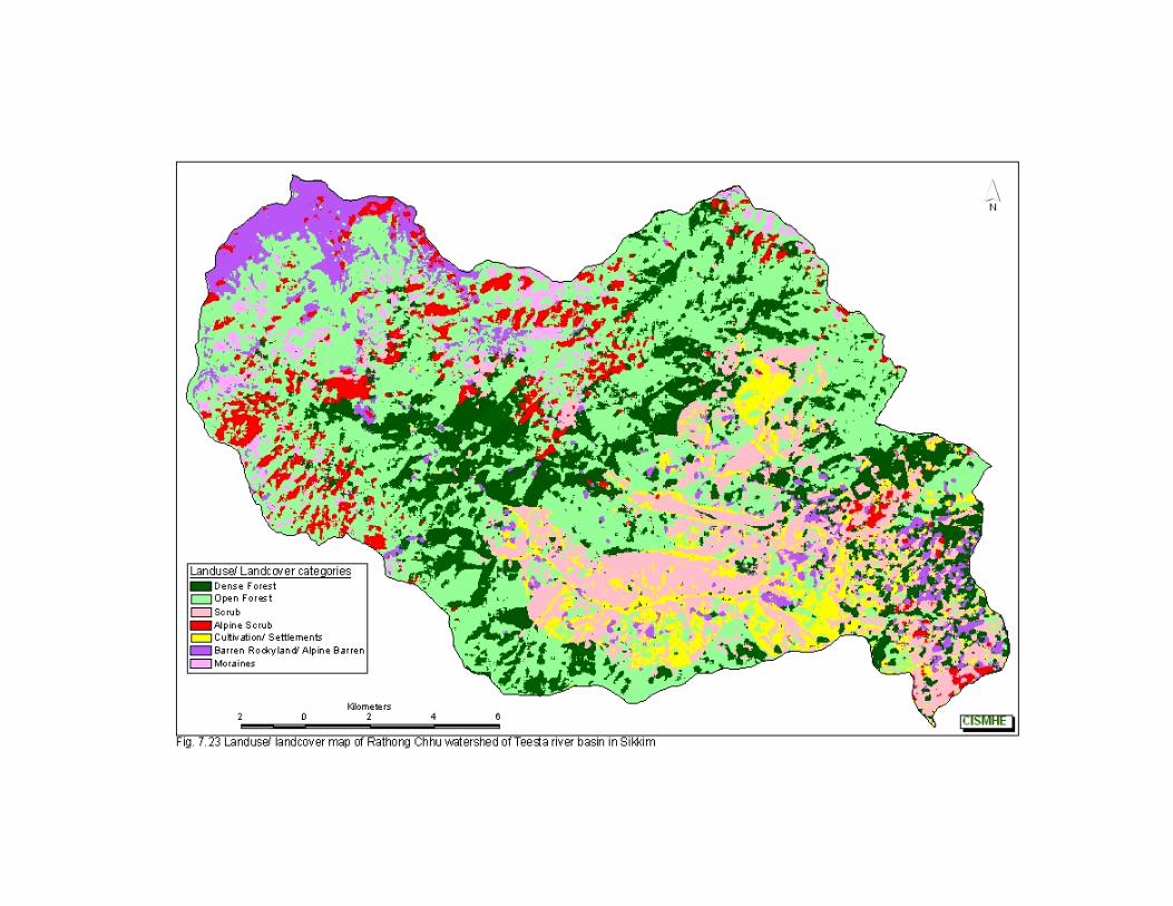
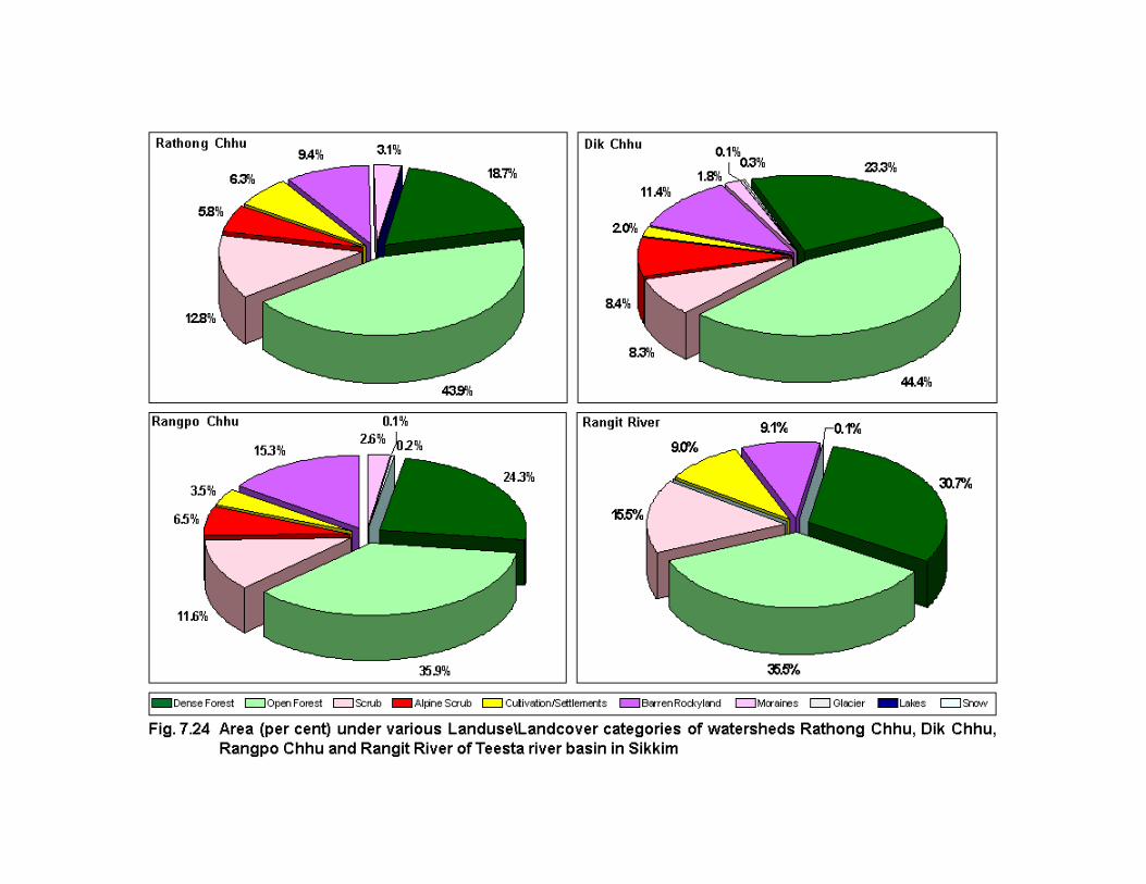
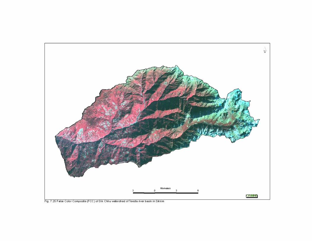
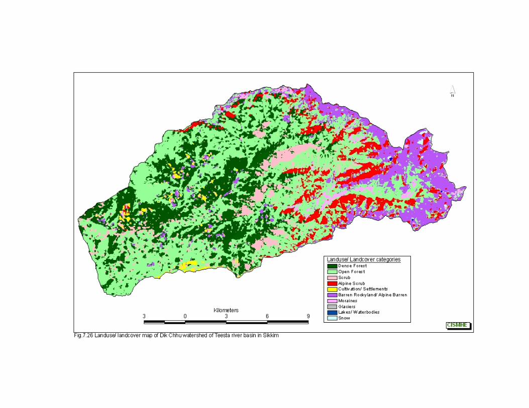
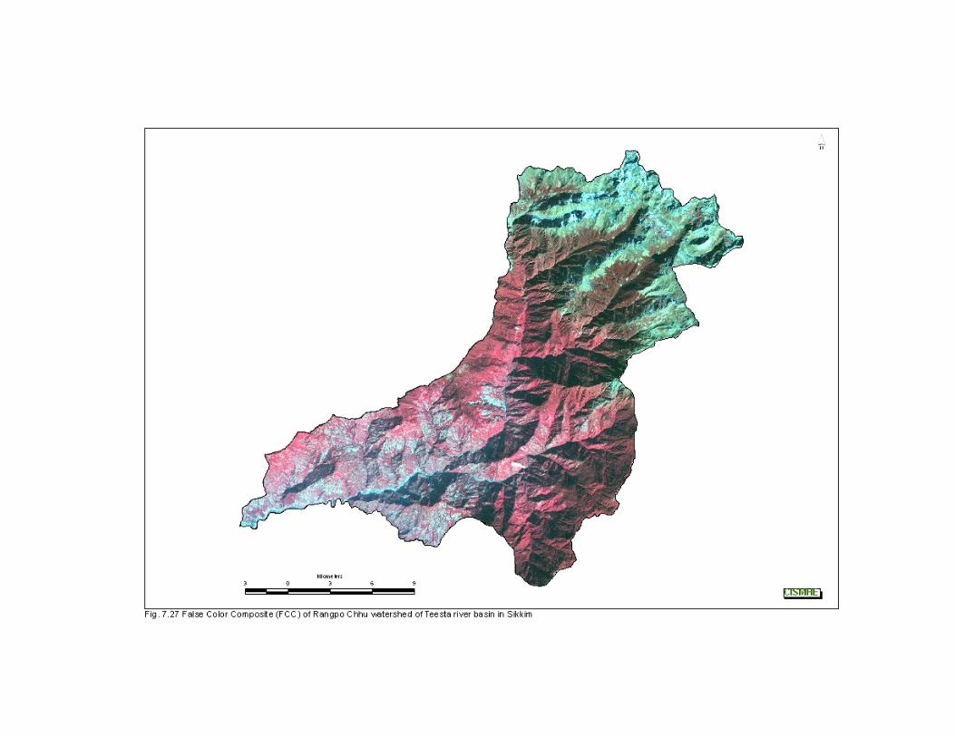
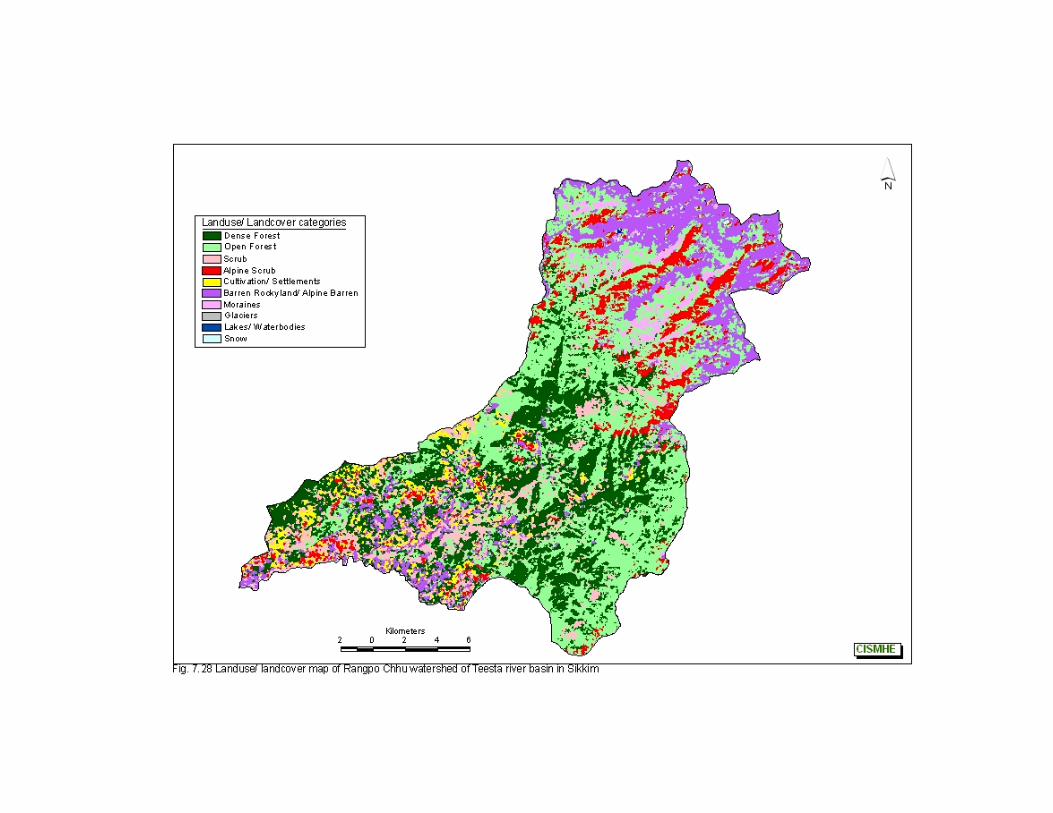
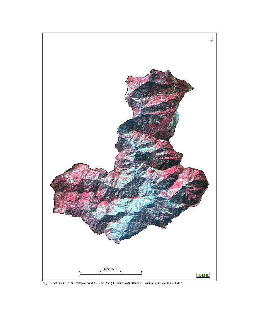
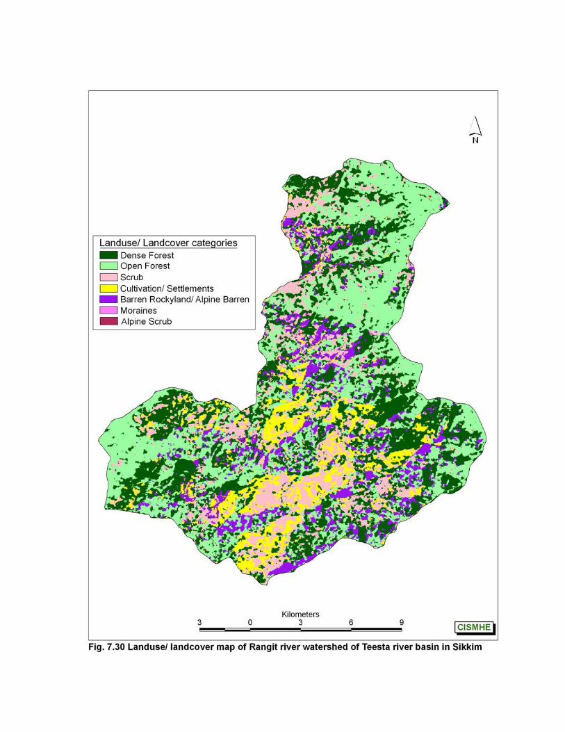
Introductory Volume – Remote Sensing abd Gis Studies- Landuse/Landcover Mapping of Teesta Basin
108
CISMHE
habitation or cultivation landuse. Only 7.2% of the watershed is under
barren/ rockyland landcover.
7.6.14 Ramam Khola
Forests cover 62% of this watershed comprised of 26.6% of
dense forests and 35.4% of open forests (Figs 7.33 - 7.35). About
1/5th of watershed has scrub landuse. Habitation and cultivation areas
constitute 7.9% of watershed.
7.6.15 Manpur Khola
This is the smallest watershed and has 45% of its area under
forests comprised mainly of dense sal forests comprising 32.9% of
total area (see Fig.7.33 and Figs 7.36 - 7.37). Scrub also cover 23.8%
of watershed area.
7.6.16 Teesta (Lower Part) – Right Bank
This watershed is covered with more than 71% of forests, with
dense forests comprising 33% and open forests covering 38% of area
(see Fig.7.33 and Figs 7.38 - 7.39). More than 13% of watershed is
under scrub landuse category. Area under habitation and cultivation
landuse/ landcover category is about 9.4%. Barren and rocky
landcover also cover 6.3% of watershed.
Introductory Volume – Remote Sensing abd Gis Studies- Landuse/Landcover Mapping of Teesta Basin
109
CISMHE
7.6.17 Rani Khola
This is one of the most disturbed watershed in Teesta basin,
with Gangtok, the capital of Sikkim situated in this. Therefore, more
than 19.3% area of the watershed is under habitation or cultivation
landuse (Figs 7.40 - 7.42). The forests are either found in the upper
catchment or in the vicinity of Rumtek monastery in Fabong Lho
sanctuary and constitute about 49% of total watershed area. Further,
scrub landuse also constitute 23.9% of watershed.
7.6.18 Jaldhaka
This is the only watershed in Sikkim which does not form the
part of Teesta basin and drains directly into Brahmaputra in West
Bengal. It has a forest cover of 52% and open forest constitute 49%
(Figs 7.42 - 7.44). Alpine scrub cover about 14% of watershed area.
More than 34% of Jaldhaka river watershed is under barren rockyland
and moraines landcover category.
7.7 FOREST TYPE MAPPING
Forest type map of Teesta basin shows that Sub-tropical forest
and Temperate forest are the two predominant forest types in the
basin (Figs 7.45 and 7.46). Sub-tropical forest covers 12.88% of the
entire basin of which 6.92% of dense canopy and 5.96% are of open
canopy and are distributed mainly in Manpur Khola, Rangpo Chhu,
Rani Khola, Ramam Khola and Teesta (Lower Part) watersheds (see
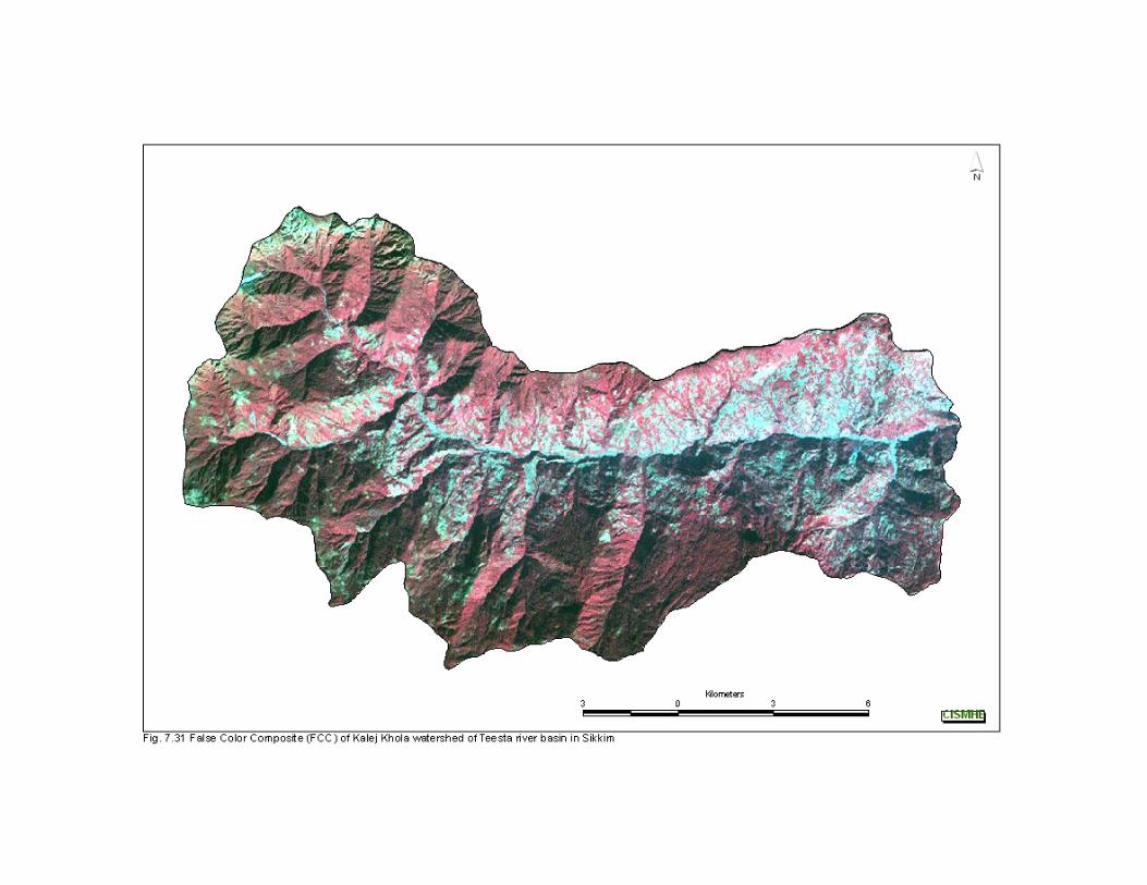
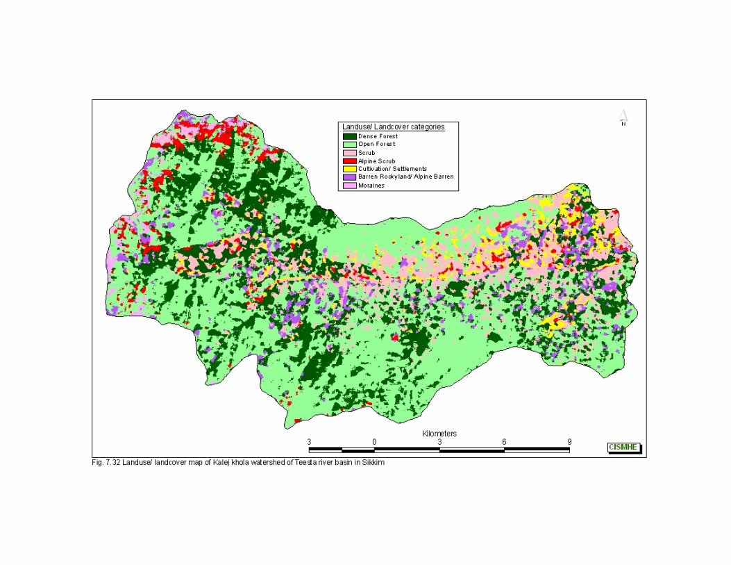
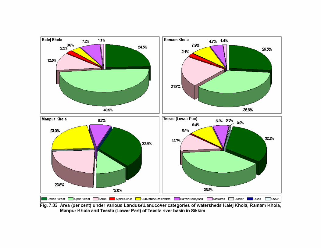
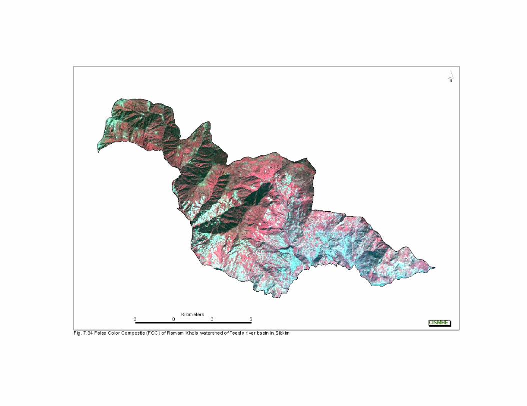
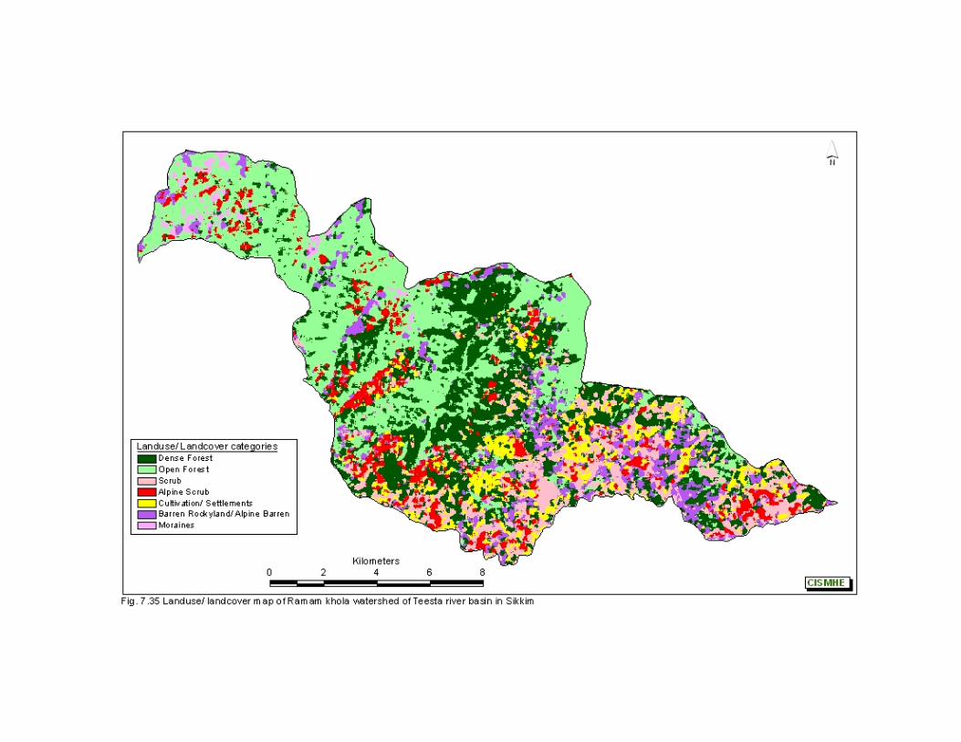
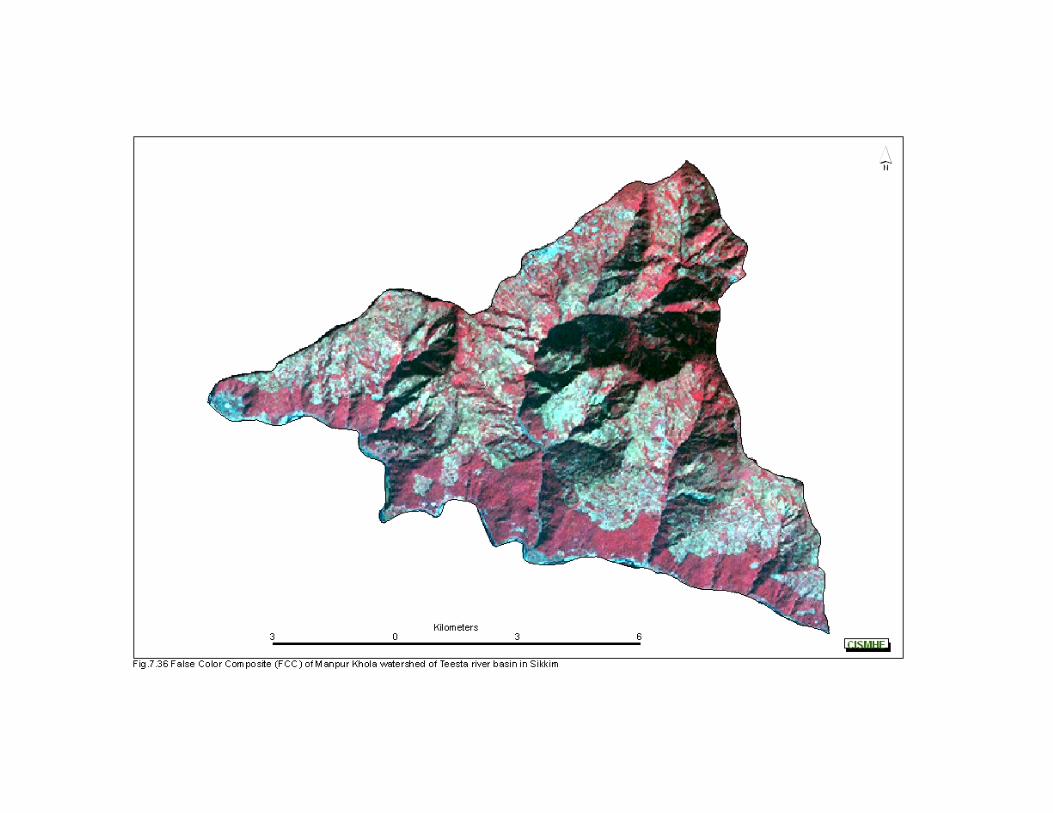
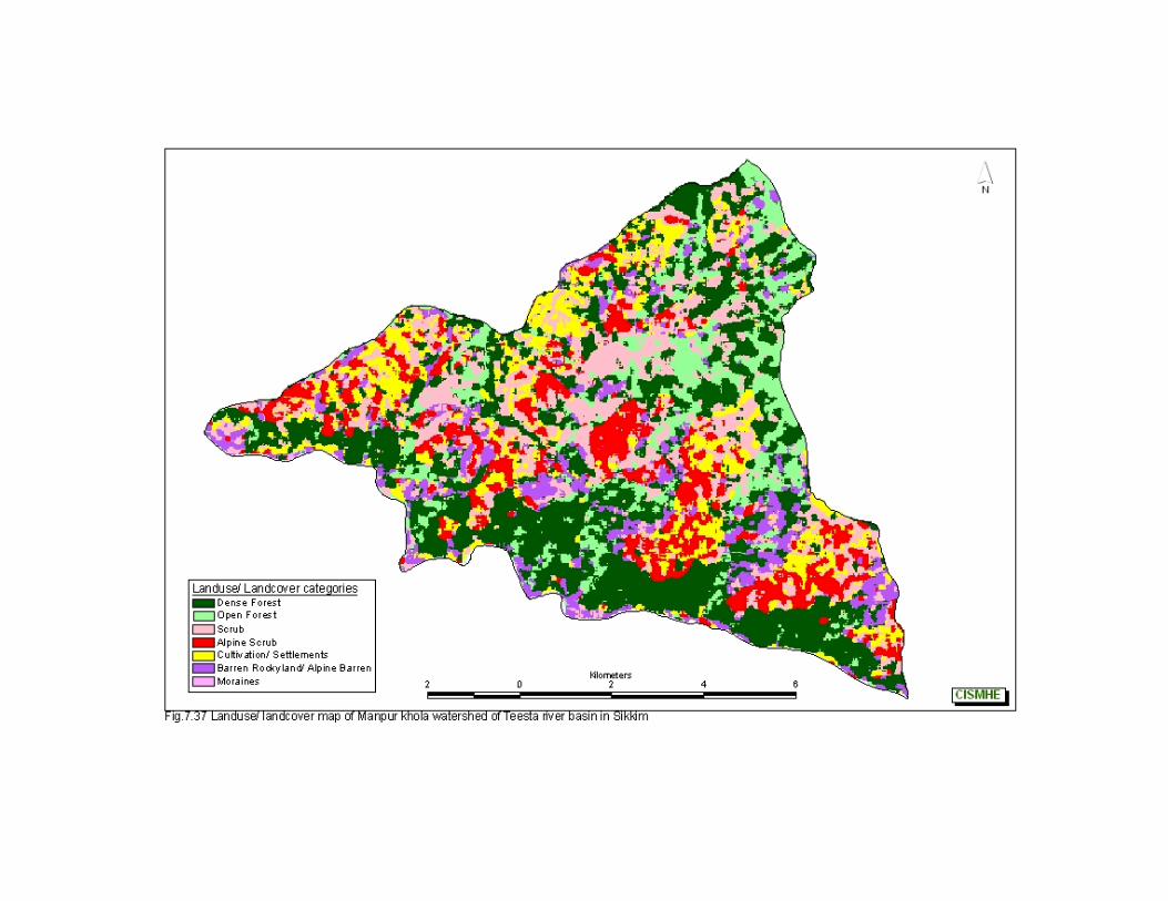
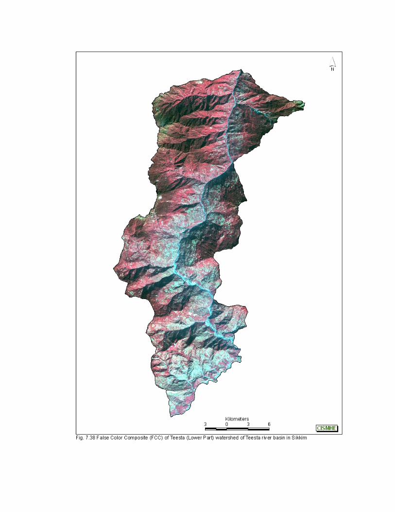
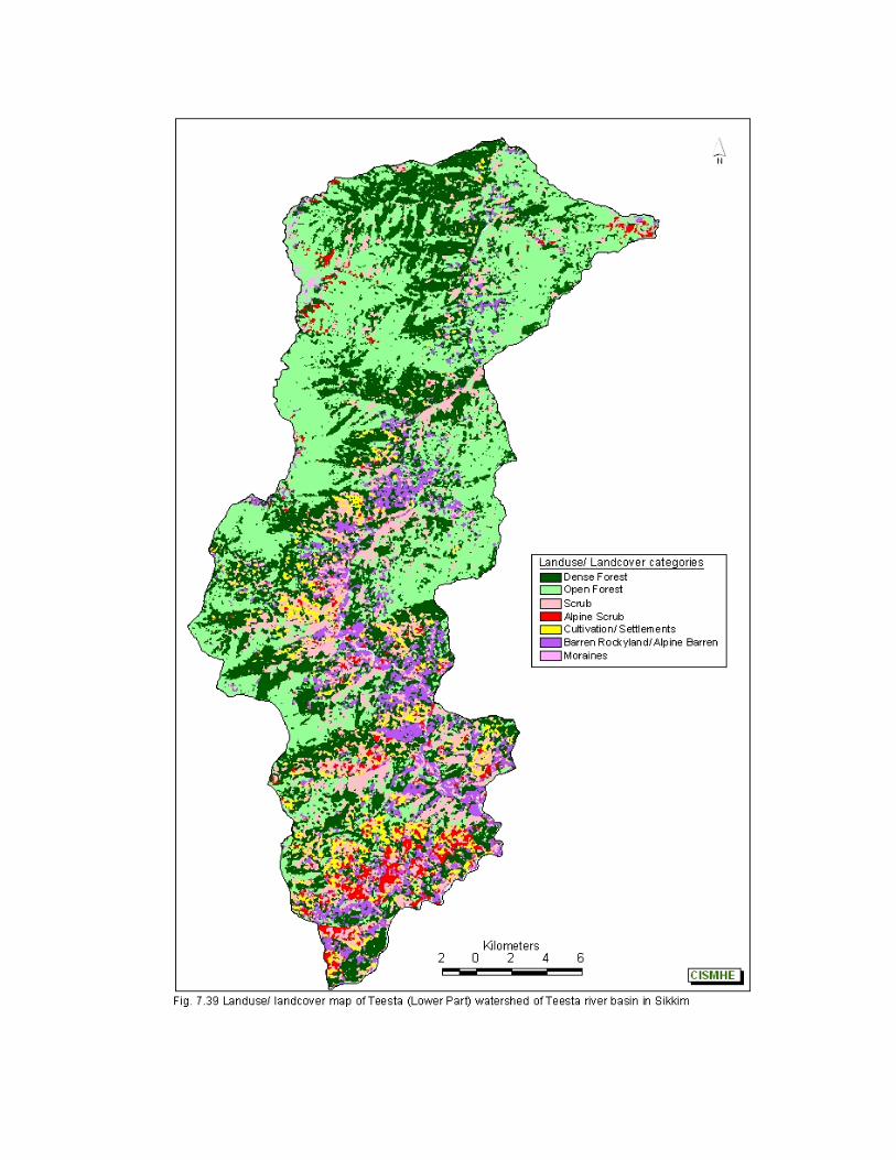
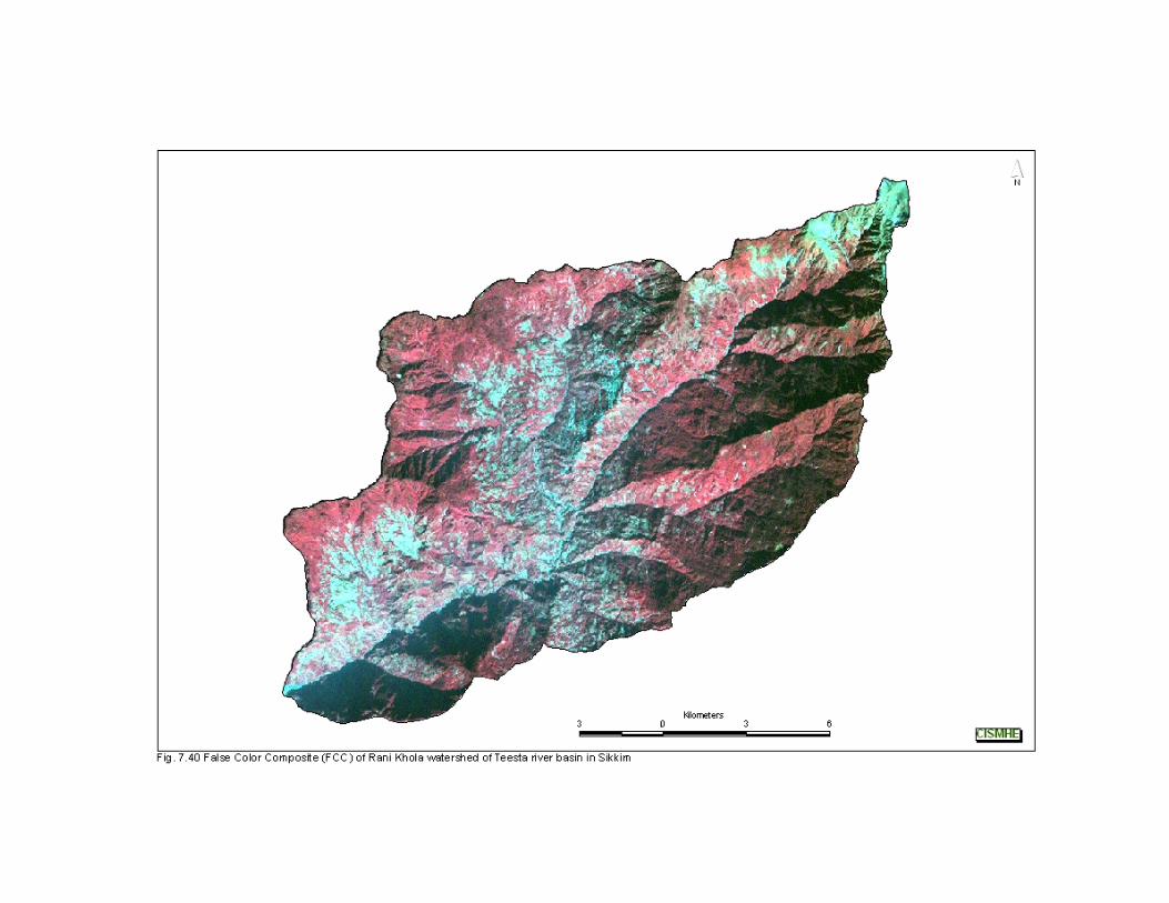
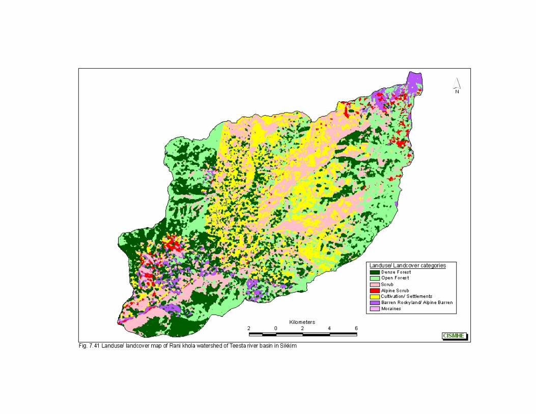
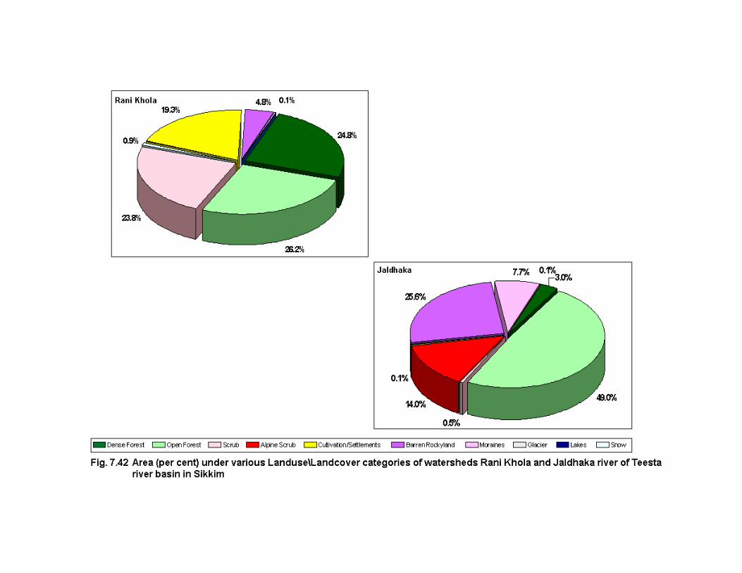
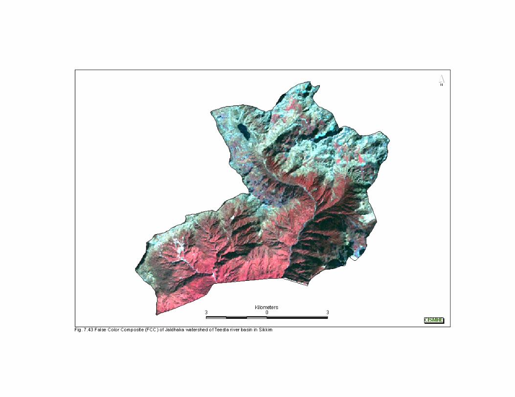
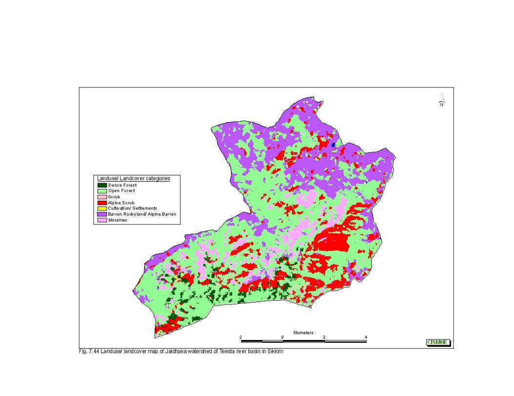
Fig.7.46 Per cent area under different forest types in Teesta basin in Sikkim
2.58%
12.88%
0.29%
5.95%
11.69%
2.79%
0.19%
8.14%
5.53%
0.79%
13.03%
3.01%
13.01%
7.99%
0.38%
7.31%
3.7%
Tropical Moist Deciduous Forest
Sub-tropical Forest
Pine Forest
Scrub
Temperate Forest
Mixed Conifer Forest
Fir Forest
Sub-alpine Forest
Alpine Scrub
Alpine Meadow
Alpine Barren
Cultivation/ Settlements
Barren Rockyland
Moraines
Lakes
Glacier
Snow
Fig.7.47 Area (sq km) under different forest types in Teesta basin in Sikkim
1832
2.98
9081
3.94
2074
.98
4222
6.2
8295
8.99
1982
9.78
1379
.2
6276
0.28
3927
4.56
5596
.32
9247
3.12
2133
7.89
9228
8.82
5666
3.61
2950
.34
5189
6.68
2625
1.76
0
10000
20000
30000
40000
50000
60000
70000
80000
90000
100000
Are
a (s
q km
)
Trop
ical
Moi
st D
ecid
uous
Fore
st
Sub
-trop
ical
For
est
Pin
e Fo
rest
Scr
ub
Tem
pera
te F
ores
t
Mix
ed C
onife
r For
est
Fir F
ores
t
Sub
-alp
ine
Fore
st
Alp
ine
Scr
ub
Alp
ine
Mea
dow
Alp
ine
Bar
ren
Cul
tivat
ion/
Set
tlem
ents
Bar
ren
Roc
kyla
nd
Mor
aine
s
Lake
s
Gla
cier
Sno
w
Introductory Volume – Remote Sensing abd Gis Studies- Landuse/Landcover Mapping of Teesta Basin
110
CISMHE
Fig. 7.46). Temperate forest types are spread over an area of 829.56
sq km (11.69% of Teesta basin), out of which 579 sq km is open
canopy forest (Fig. 7.47). Tropical moist deciduous forests are found
mainly in lower altitudes mainly in Manpur Khola, Rangpo Chhu
watersheds. Mixed conifer forest, comprised of about 2.81% of
Teesta basin, is found mainly in Rangyong Chhu, Lachung Chhu,
Lachen Chhu and Yumthang Chhu watersheds. Sub-alpine forest
constitute 8.83% of Teesta basin lying above 2,700 m in watersheds
of Rangyong Chhu, Lachen Chhu, Lachung Chhu, Chhombo Chhu,
Yumthang Chhu, Rel Chhu and Prek Chhu. Sub-alpine forests are
comprised predominantly of different species of Rhododendron mixed
with species of Viburnum, Rubus, Gaultheria, Euonymus, etc. Alpine
scrub and meadow cover about 7.2% of Teesta basin in higher
reaches with milder slopes. Alpine scrub is comprised of bushes and
clumps of Juniparus, Salix, Berberis, Rosa, etc.

Bibliography
111
CISMHE
Baret, F. and Guyot, G. (1991). Potentials and limits of vegetation
indices of LAI and APAR assessment, Proceedings,
International Geoscience and Remote Sensing Symposium
(IGARSS’89)/ 12th Canadian Symposium on Remote Sensing,
July 10 - 14. IGARSS’ 89, Vancouver, BC : 1355 – 1358.
Blackburn, G.A. and Steele, C.M. (1999). Towards the Remote
sensing of matorral vegetation physiology: relationships
between spectral reflectance, pigment, and biophysical
characteristics of semiarid bushland canopies. Remote Sensing
of Environment. 70: 278 -292.
Boegh, E., Broge, H.S.N., Hasager, C.B., Jensen, N.O., Schelde, K.
and Thomsen, A. (2002). Airborne multispectral data for
quantifying leaf area index, nitrogen concentration, and
photosynthetic efficiency in agriculture. Remote Sensing of
Environment. 81: 179 -193.
Clevers, J.G. (1988). The derivation of a simplified reflectance model
for the estimation of leaf area index. Remote Sensing of
Environment. 35: 53-70.
Elvidge, C.D. and Chen, Z. (1995). Comparison of broad-band and
narrow band red and near infrared vegetation indices. Remote
Sensing of Environment. 54: 38-48.
Gao, X., Huete, A.R., Ni, W. and Miura, T. (2000). Optical -
Biophysical relationships of vegetation spectra without
background contamination. Remote Sensing of Environment.
74: 609-620.
Bibliography
112
CISMHE
Hack, J.T. (1973a). Stream-profile analysis and stream gradient
index, U.S. Geol. Surv. Jour. Res. I.4: 421-429.
Hack, J.T. (1973b). Drainage adjustment in the Appalachians, In: M.
Morisawa (ed.) Fluvial Geomorphology, Binghamton, N.Y., 51-
69.
Hoffer, R.M. (1978). Biological and physical considerations in
applying computer-aided analysis techniques to remote
sensor data. In: P.H. Swain & S.M. Davis (eds), Remote
Sensing: The quantitative approach. McGraw-Hill International
Book Company, New York. 227-289.
Huete, A.R. (1988). A soil adjusted vegetation index (SAVI).
International Journal of Remote Sensing. 9: 295-309.
Jensen, J.R. (1996). Introductory Digital Image Processing: A Remote
Sensing Perspective. (2nd ed.) Englewood Cliffs, NJ: Prentice-
Hall, 316.
Jordan, C.F. (1969). Derivation of leaf area index from quality of light
on the forest floor. Ecology. 50: 663-666.
Lillesand, T.M., and Kiefer, R.W. (1994). Remote sensing and image
interpretation. John Wiley and Sons, New York.
Maxwell, E.L. (1976). Multivariate Systems Analysis of Multi spectral
Imagery. Photogrammetric Engineering and Remote Sensing.
42(9), 1173-1186.
Richardson, A.J. and Wiegand, C.L. (1977). Distinguishing Vegetation
from Soil Background Information. Photogrammetric
Engineering and Remote Sensing. 43(12): 1541-1552.
Bibliography
113
CISMHE
Rouse, J.W., Haas, R.H., Schell, J.A. and Deering, D.W. (1973).
Monitoring vegetation systems in the great plains with ERTS,
Third ERTS Symposium. NASA, Washington, DC. 309-317.
Schowengerdt, R.A. (1983). Techniques for Image Processing and
Classification in Remote Sensing. Academic Press, Inc, New
York.
Seeber, L. and Gorintz, V. (1983). River profiles along the Himalayan
arc as indicators of active tectonics. Tectonophysics. 92: 335-
367.
Sellers, P.J. (1985). Canopy reflectance, photosynthesis and
transpiration. International Journal of Remote Sensing. 6(8):
1335-1372.
Thenkabail, P.S., Smith, R.B. and De Pauw, E. (2000). Hyperspectral
vegetation indices and their relationships with agricultural crop
characteristics. Remote Sensing of Environment. 71: 158-182.
Todd, S.W., Hoffer, R.M. and Milchunas, D.G. (1998). Biomass
estimation on grazed and ungrazed rangelands using spectral
indices. International Journal of Remote Sensing. 19(3): 427-
438.
Treitz, P.M., and Howarth, P.J. (1999). Hyperspectral remote sensing
for estimating biophysical parameters of forest ecosystems.
Progress in Physical Geography. 23(3): 359-390.
Tucker, C.J. (1979). Red and photographic infrared linear
combinations for monitoring vegetation. Remote Sensing of
Environment. 8: 127-150.
Wiegand, C.L., Richardson, A.J., Escobar, A.J. and Gerbermann,
A.H. (1991). Vegetation indices in crop assessments. Remote
Sensing of Environment. 35: 105-119.

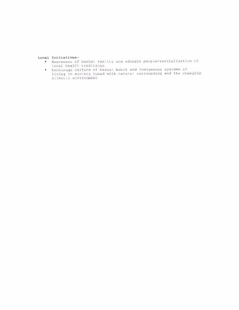
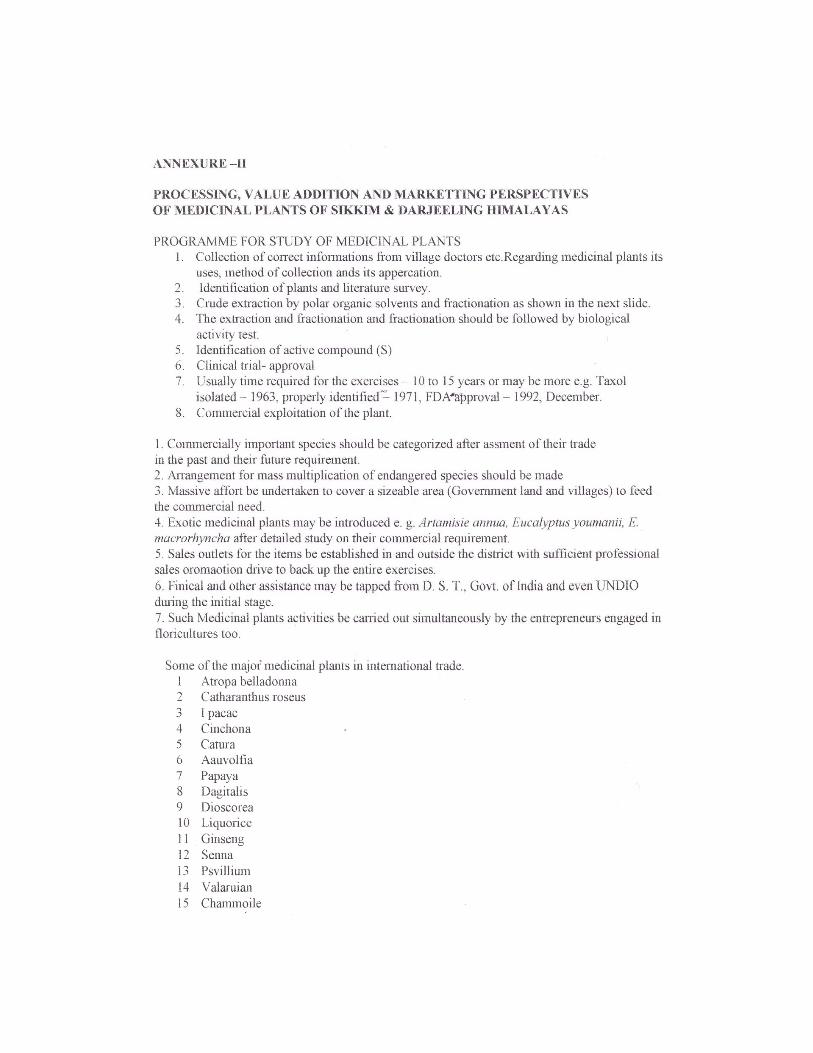
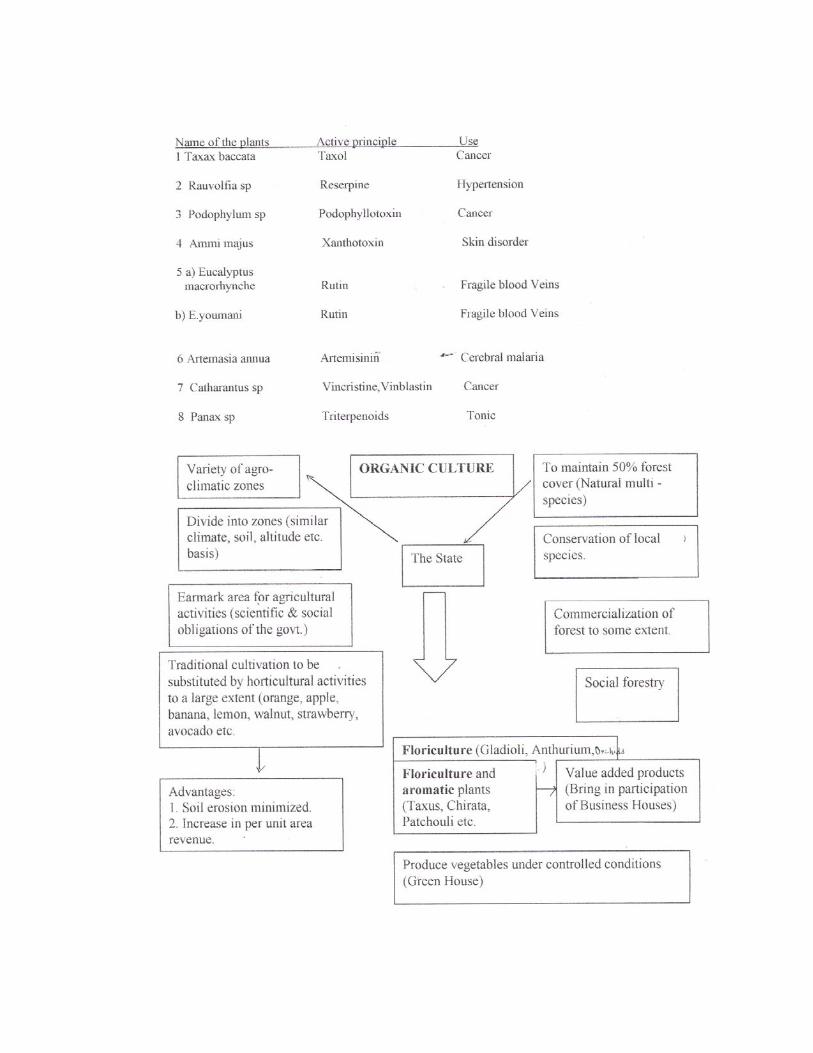

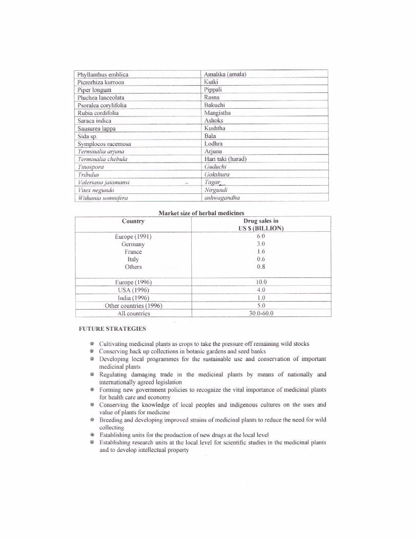
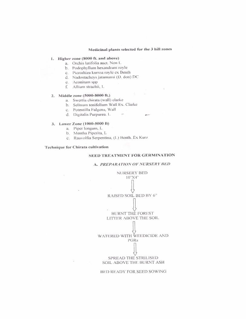
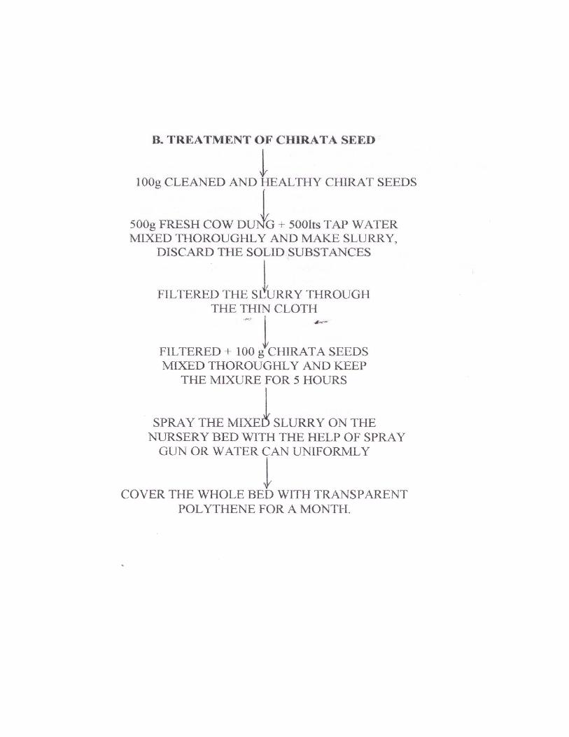
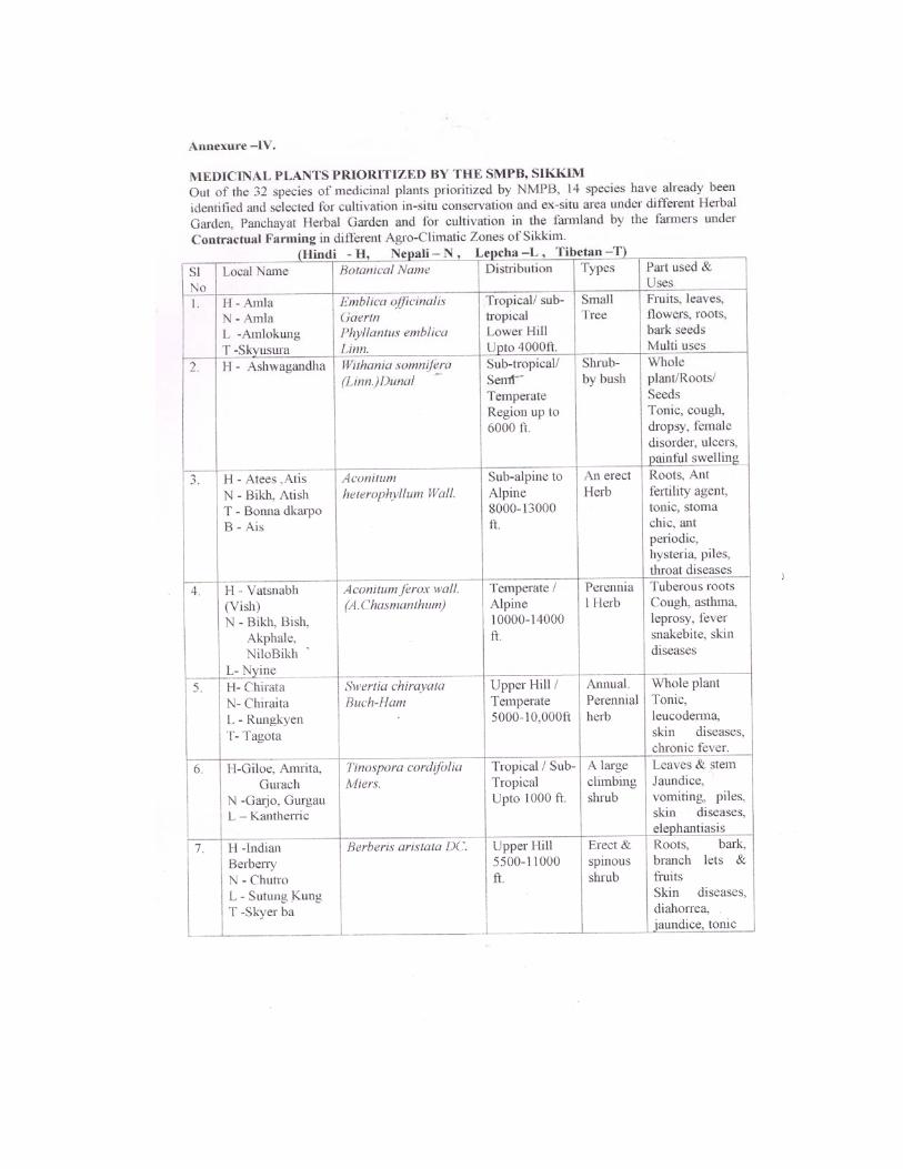
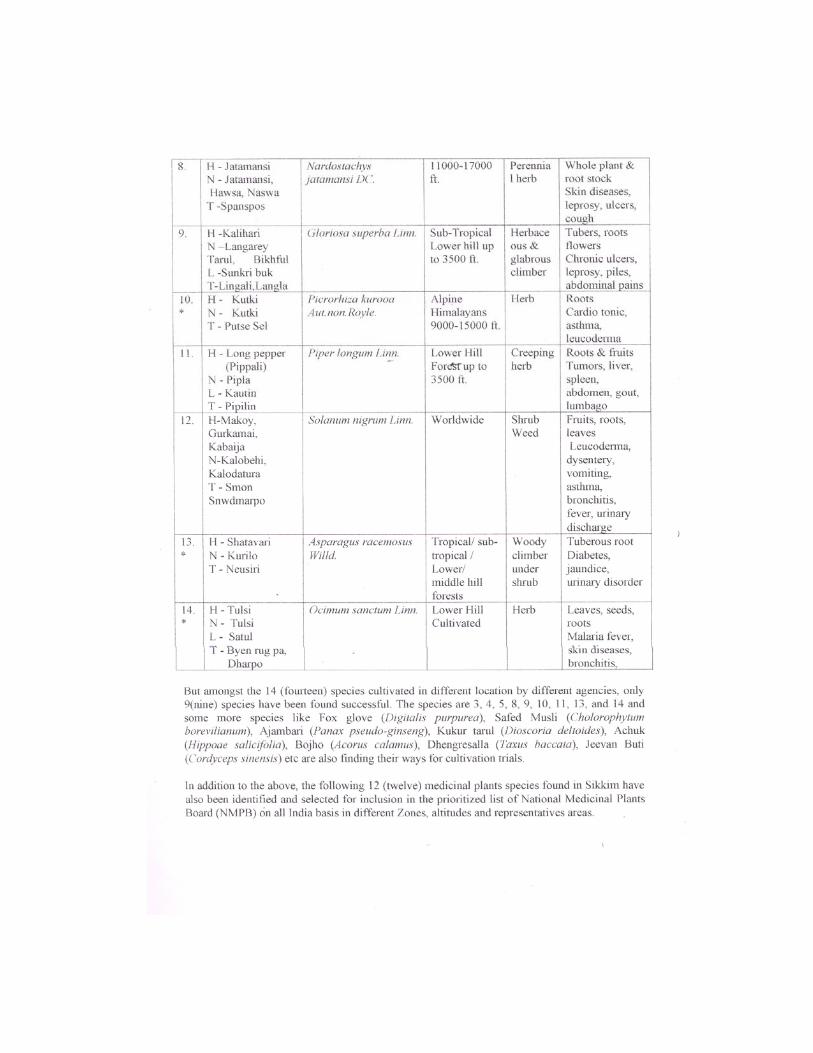
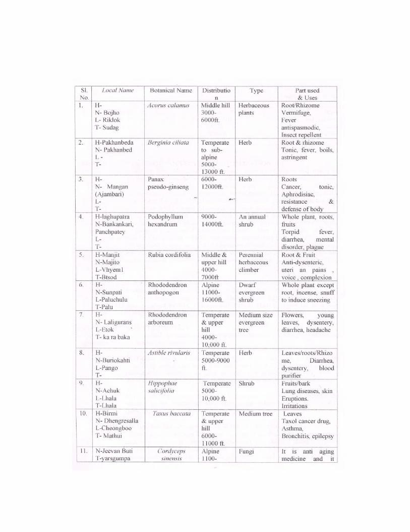
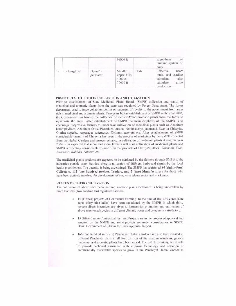
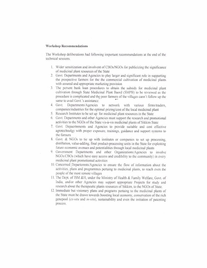
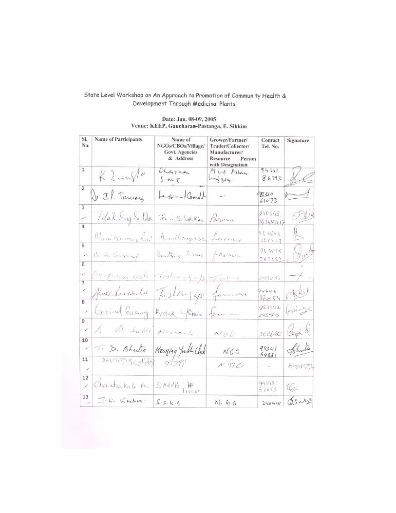
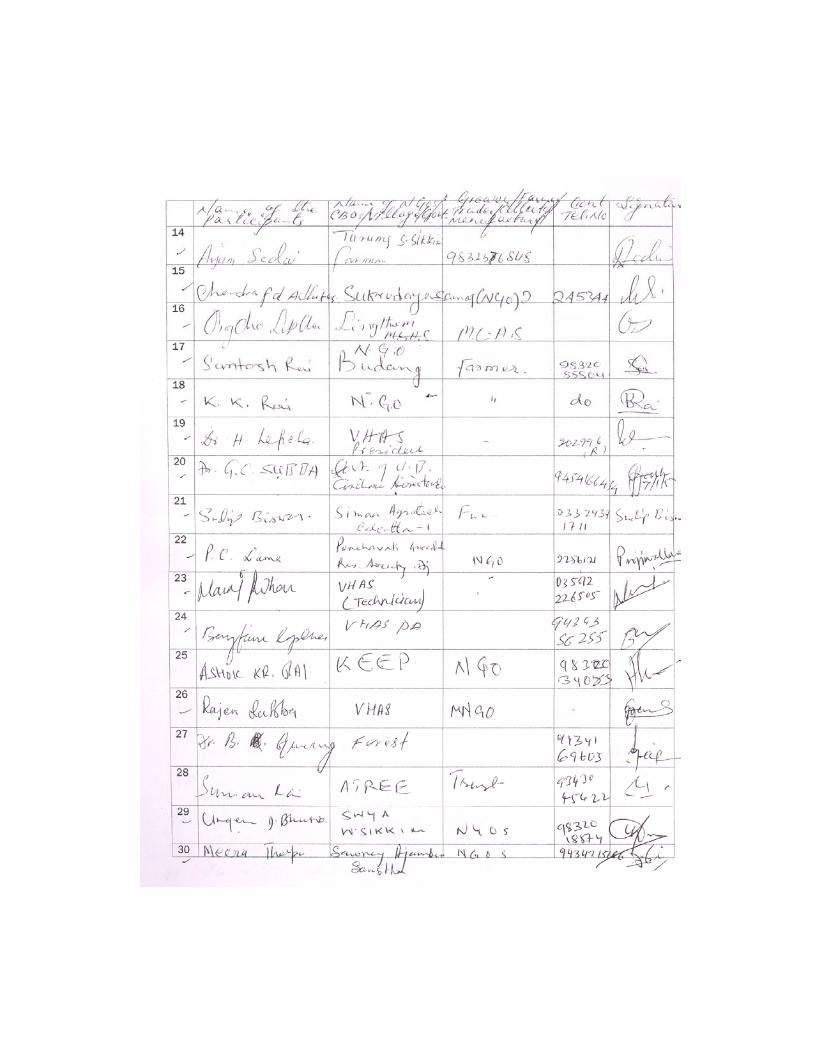


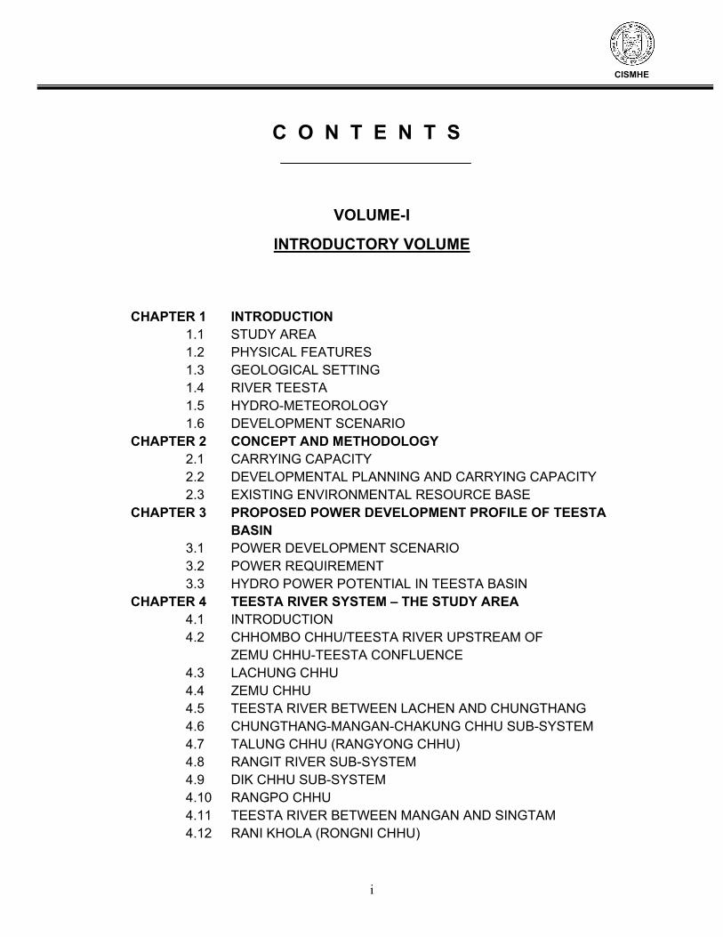
i
CISMHE
C O N T E N T S
VOLUME-I INTRODUCTORY VOLUME
CHAPTER 1 INTRODUCTION 1.1 STUDY AREA 1.2 PHYSICAL FEATURES 1.3 GEOLOGICAL SETTING 1.4 RIVER TEESTA 1.5 HYDRO-METEOROLOGY 1.6 DEVELOPMENT SCENARIO CHAPTER 2 CONCEPT AND METHODOLOGY 2.1 CARRYING CAPACITY 2.2 DEVELOPMENTAL PLANNING AND CARRYING CAPACITY 2.3 EXISTING ENVIRONMENTAL RESOURCE BASE CHAPTER 3 PROPOSED POWER DEVELOPMENT PROFILE OF TEESTA BASIN 3.1 POWER DEVELOPMENT SCENARIO 3.2 POWER REQUIREMENT 3.3 HYDRO POWER POTENTIAL IN TEESTA BASIN CHAPTER 4 TEESTA RIVER SYSTEM – THE STUDY AREA 4.1 INTRODUCTION 4.2 CHHOMBO CHHU/TEESTA RIVER UPSTREAM OF ZEMU CHHU-TEESTA CONFLUENCE 4.3 LACHUNG CHHU 4.4 ZEMU CHHU 4.5 TEESTA RIVER BETWEEN LACHEN AND CHUNGTHANG 4.6 CHUNGTHANG-MANGAN-CHAKUNG CHHU SUB-SYSTEM 4.7 TALUNG CHHU (RANGYONG CHHU) 4.8 RANGIT RIVER SUB-SYSTEM 4.9 DIK CHHU SUB-SYSTEM 4.10 RANGPO CHHU 4.11 TEESTA RIVER BETWEEN MANGAN AND SINGTAM 4.12 RANI KHOLA (RONGNI CHHU)
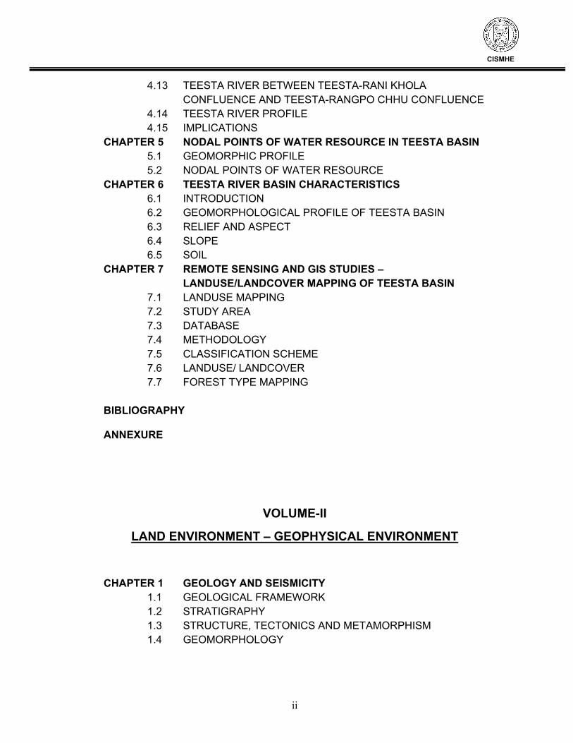
ii
CISMHE
4.13 TEESTA RIVER BETWEEN TEESTA-RANI KHOLA CONFLUENCE AND TEESTA-RANGPO CHHU CONFLUENCE
4.14 TEESTA RIVER PROFILE 4.15 IMPLICATIONS CHAPTER 5 NODAL POINTS OF WATER RESOURCE IN TEESTA BASIN 5.1 GEOMORPHIC PROFILE 5.2 NODAL POINTS OF WATER RESOURCE CHAPTER 6 TEESTA RIVER BASIN CHARACTERISTICS 6.1 INTRODUCTION 6.2 GEOMORPHOLOGICAL PROFILE OF TEESTA BASIN 6.3 RELIEF AND ASPECT 6.4 SLOPE 6.5 SOIL CHAPTER 7 REMOTE SENSING AND GIS STUDIES – LANDUSE/LANDCOVER MAPPING OF TEESTA BASIN 7.1 LANDUSE MAPPING 7.2 STUDY AREA 7.3 DATABASE 7.4 METHODOLOGY 7.5 CLASSIFICATION SCHEME 7.6 LANDUSE/ LANDCOVER 7.7 FOREST TYPE MAPPING BIBLIOGRAPHY ANNEXURE
VOLUME-II LAND ENVIRONMENT – GEOPHYSICAL ENVIRONMENT
CHAPTER 1 GEOLOGY AND SEISMICITY 1.1 GEOLOGICAL FRAMEWORK 1.2 STRATIGRAPHY 1.3 STRUCTURE, TECTONICS AND METAMORPHISM 1.4 GEOMORPHOLOGY
iii
CISMHE
1.5 MINERAL RESOURCES 1.6 SEISMICITY 1.7 GEOLOGICAL INVESTIGATIONS IN TEESTA BASIN IN SIKKIM 1.8 SPATIAL DISPOSITION OF STUDIED REGIONS ON THE SEISMOTECTONIC MAP OF SIKKIM 1.9 GEOLOGICAL SENSITIVITY AND VULNERABILITY CHAPTER 2 LANDSLIDES 2.1 INTRODUCTION 2.2 STATUS OF LANDSLIDES IN TEESTA BASIN 2.3 SOME EXISTING LANDSLIDES IN SIKKIM 2.4 CASE HISTORIES OF SOME IMPORTANT LANDSLIDES 2.5 ENVIRONMENTAL IMPACT OF THESE SLIDES 2.6 REMEDIAL MEASURES TO PREVENT LANDSLIDES 2.7 TYPICAL LANDSLIDE PROBLEM 2.8 FLOOD PROBLEM
2.9 SOCIO-ECONOMIC IMPLICATION OF FLOODS AND LAND EROSION/SLIDES
CHAPTER 3 GLACIERS 3.1 HIMALAYA AND GLACIERS 3.2 RECESSION OF GLACIERS 3.3 GLACIAL STUDIES IN SIKKIM 3.4 OBJECTIVE OF THE STUDY 3.5 GLACIERS 3.6 GLACIAL LAKES 3.7 DATA USED AND METHODOLOGY 3.8 INVENTORY OF GLACIERS 3.9 INVENTORY OF GLACIAL LAKES 3.10 GLACIERS OF SIKKIM HIMALAYA 3.11 MAJOR LAKES BIBLIOGRAPHY ANNEXURE
iv
CISMHE
VOLUME – III LAND ENVIRONMENT - SOIL
CHAPTER 1 INTRODUCTION CHAPTER 2 GEOGRAPHICAL SETTINGS 2.1 LOCATION AND EXTENT 2.2 GEOLOGY 2.3 GEOMORPHOLOGY 2.4 CLIMATE 2.5 DELINEATION OF WATERSHEDS CHAPTER 3 MORPHOMETRIC CHARACTERISTICS IN RANI KHOLA WATERSHED 3.1 ABSOLUTE RELIEF 3.2 RELATIVE RELIEF 3.3 DISSECTION INDEX 3.4 SLOPE CHAPTER 4 WATERSHEDS IN TEESTA BASIN 4.1 RANGPO CHHU WATERSHED 4.2 RANI KHOLA WATERSHED 4.3 TEESTA (LOWER PART) WATERSHED
4.4 DIK CHHU WATERSHED 4.5 TEESTA UPPER (LEFT BANK) WATERSHED 4.6 YUMTHANG CHHU WATERSHED 4.7 CHHOMBO CHHU WATERSHED 4.8 ZEMU CHHU WATERSHED 4.9 RANGYONG CHHU WATERSHED 4.10 TEESTA UPPER (RIGHT BANK) WATERSHED 4.11 PREK CHHU WATERSHED 4.12 REL CHHU WATERSHED 4.13 RATHONG CHHU WATERSHED 4.14 KALEJ KHOLA WATERSHED 4.15 RAMAM KHOLA WATERSHED 4.16 RANGIT RIVER WATERSHED 4.17 MANPUR KHOLA WATERSHED ANNEXURES
v
CISMHE
VOLUME – IV WATER ENVIRONMENT
CHAPTER 1 INTRODUCTION 1.1 OBJECTIVE OF THE STUDY
1.3 METHODOLOGY CHAPTER 2 SALIENT CHARACTERISTICS OF SIKKIM 2.1 LOCATION 2.2 PHYSIOGRAPHY 2.3 TOPOGRAPHY 2.4 THE TEESTA & ITS TRIBUTARIES 2.5 SOILS 2.6 DRAINAGE CHARACTERISTICS 2.7 DEVELOPMENT PROSPECTS CHAPTER 3 HYDRO-METEOROLOGY 3.1 GENERAL 3.2 CLIMATE 3.3 WATER REGIME 3.4 RAINGAUGE NETWORK 3.5 RAINFALL FEATURES 3.6 CLIMATOLOGICAL CHARACTERISTICS CHAPTER 4 HYDROLOGY 4.1 GENERAL 4.2 CATCHMENT AREA 4.3 ASSESSMENT OF SURFACE WATER RESOURCES 4.4 FLOOD HYDROLOGY 4.5 SEDIMENT LOAD CHAPTER 5 IRRIGATION 5.1 GENERAL 5.2 ULTIMATE AND CREATED IRRIGATION POTENTIAL 5.3 FINANCIAL PERFORMANCE OF I&CAD SECTOR 5.4 CENSUS OF MINOR IRRIGATION (1995-96) 5.5 MASTER PLAN FOR IRRIGATION DEVELOPMENT IN SIKKIM (1995) 5.6 PRESENT STATUS OF MINOR IRRIGATION SCHEMES 5.7 ORGANIZATIONAL STRUCTURE
vi
CISMHE
CHAPTER 6 LAND RESOURCE MANAGEMENT 6.1 GENERAL 6.2 LAND USE PATTERN 6.3 TEMPORAL TREND OF LAND USE IN THE STATE 6.4 DISTRICT WISE STATUS OF FALLOW LAND 6.5 LAND RESOURCE MANAGEMENT STRATEGY 6.6 PAST AND PRESENT EFFORTS ON LAND USE MANAGEMENT 6.7 SOIL CONSERVATION CHAPTER 7 AGRICULTURE 7.1 GENERAL 7.2 AREA UNDER CROPS, DRY AND WASTE LAND 7.3 LAND HOLDINGS 7.4 CROP CALENDER 7.5 CROPPING PATTERN 7.6 CROP WATER REQUIREMENT 7.7 NET IRRIGATION REQUIREMENT 7.8 GROSS IRRIGATION REQUIREMENT 7.9 AGRICULTURE PRODUCTION AND YIELD 7.10 STRATEGIES PROPOSED BY THE STATE FOR ADOPTION DURING TENTH FIVE YEAR PLAN 7.11 IMPROVED CULTIVATION PRACTICES 7.12 SUMMING UP CHAPTER 8 HORTICULTURE 8.1 GENERAL 8.2 HORTICULTURE 8.3 FLORICULTURE 8.4 MEDICINAL AND AROMATIC PLANTS 8.5 BEEKEEPING 8.6 ORGANIC FARMING 8.7 ANIMAL HUSBANDRY 8.8 FISHERIES CHAPTER 9 DROUGHT- PRONE AREAS IN THE STATE 9.1 GENERAL 9.2 RAINFALL 9.3 REPORT OF THE SURVEY 9.4 PACKAGE OF SCHEMES FORMULATED BY
vii
CISMHE
DEPARTMENTAL COMMITTEE CHAPTER 10 IRRIGATION AND WATER MANAGEMENT - PERSPECTIVE PLANNING
10.1 GENERAL 10.2 PRESENT STATUS OF IRRIGATION DEVELOPMENT 10.3 IDENTIFICATION OF MINOR IRRIGATION SCHEMES 10.4 DESIGN OF CANAL AND RELATED STRUCTURES 10.5 TYPICAL DESIGN OF MINOR IRRIGATION SCHEMES 10.6 OPERATION AND MAINTENANCE OF MINOR IRRIGATION SCHEMES 10.7 WATER RATES 10.9 PARTICIPATORY IRRIGATION MANAGEMENT IN THE STATE OF SIKKIM CHAPTER 11 CARRYING CAPACITY – PERSPECTIVE PLANNING 11.1 GENERAL 11.2 PERSPECTIVE PLANNING 11.3 PROJECTION OF NET SOWN AREA, GROSS CROPPED AREA AND IRRIGATED AREA 11.4 DOMESTIC WATER REQUIREMENT 11.5 IRRIGATION WATER REQUIREMENT 11.6 TOTAL WATER REQUIREMENT 11.7 AGRICULTURE PRODUCTION CHAPTER 12 FINDINGS AND STRATEGIC RECOMMENDATIONS
12.1 SALIENT CHARACTERISTICS 12.2 HYDROMETEOROLOGY 12.3 HYDROLOGY 12.4 IRRIGATION 12.5 LAND RESOURCE MANAGEMENT 12.6 AGRICULTURE 12.7 HORTICULTURE AND OTHER ALLIED AGRICULTURE
ACTIVITIES 12.8 DROUGHT PRONE AREAS 12.9 LAND SLIDES AND FLOOD MANAGEMENT 12.10 IRRIGATION AND WATER MANAGEMENT – PERSPECTIVE PLANNING 12.11 CARRYING CAPACITY – PERSPECTIVE PLANNING ANNEXURES
viii
CISMHE
VOLUME – V AIR ENVIRONMENT
CHAPTER 1 CARRYING CAPACITY BASED DEVELOPMENT PLANNING PROCESS 1.1 INTRODUCTION 1.2 THE STUDY AREA – SIKKIM 1.3 OBJECTIVES 1.4 ASSIMILATIVE CAPACITY ASSESSMENT METHODOLOGY CHAPTER 2 APPROACH I- ESTIMATION OF ASSIMILATIVE CAPACITY
THROUGH VENTILATION COEFFICIENT 2.1 INTRODUCTION 2.2 METHODOLOGY AND DATA REQUIREMENT 2.3 RESULTS CHAPTER 3 APPROACH II- ASSESSMENT OF POLLUTION POTENTIAL
USING AIR QUALITY MODELING 3.1 AIR QUALITY STUDIES USING MODELS 3.2 BASELINE ENVIRONMENTAL QUALITY OF AIR 3.3 MODEL DESCRIPTION 3.4 NORTH SIKKIM 3.5 SOUTH AND EAST REGIONS OF SIKKIM 3.6 GANGTOK 3.7 WEST SIKKIM CHAPTER 4 AIR QUALITY ASSESSMENT OF TEESTA RIVER BASIN IN SIKKIM
4.1 INTRODUCTION 4.2 METHODOLOGY 4.3 RESULTS 4.4 CONCLUSIONS
BIBLIOGRAPHY ANNEXURE
ix
CISMHE
VOLUME – VI
BIOLOGICAL ENVIRONMENT TERRESTRIAL AND AQUATIC RESOURCES
CHAPTER 1 FOREST TYPES & VEGETATION 1.1 TROPICAL MOIST DECIDUOUS FORESTS 1.2 SUB-TROPICAL FORESTS 1.3 MONTANE WET TEMPERATE FORESTS 1.4 SUB-ALPINE FOREST 1.5 ALPINE SCRUBS AND PASTURES 1.6 VEGETATION PROFILE CHAPTER 2 FLORISTICS 2.1 INTRODUCTION 2.2 PLANT EXPLORATIONS IN TEESTA BASIN 2.3 TAXONOMIC DIVERSTIY 2.4 PHYSIOGNOMIC DIVERSIT 2.5 PHYTOGEOGRAPHICAL AFFINITIES 2.6 ENDEMICS 2.7 THREATENED FLORA 2.8 RHODODENDRONS 2.9 PRIMULA SPP. 2.10 ORCHID DIVERSITY 2.11 ECONOMICALLY IMPORTANT PLANT SPECIES 2.12 FLORAL HOT SPOTS OF SIKKIM 2.13 PERSPECTIVE PLANNING CHAPTER 3 AQUATIC ENVIRONMENT AND WATER QUALITY 3.1 INTRODUCTION 3.2 METHODS 3.3 TEESTA RIVER 3.4 RANGPO CHHU 3.5 RANI KHOLA 3.6 RANGIT RIVER 3.7 RANGYONG CHHU 3.8 OTHER STREAMS OF TEESTA BASIN 3.9 CONCLUSION
x
CISMHE
3.10 LAKES 3.11 CONCLUSIONS CHAPTER 4 FISH FAUNA 4.1 INTRODUCTION 4.2 FISH COMPOSITION AND DISTRIBUTION 4.3 FISH MIGRATION IN SIKKIM 4.4 ENDEMIC AND THREATENED SPECIES 4.5 FISH INTRODUCTION IN SIKKIM 4.6 FISHERIES DEVELOPMENT IN SIKKIM 4.7 STRESSES ON FISH POPULATIONS IN SIKKIM 4.8 MITIGATION MEASURES CHAPTER 5 PROTECTED AREAS 5.1 INTRODUCTION 5.2 KHANGCHENDZONGA BIOSPHERE RESERVE 5.3 KHANGCHENDZONGA NATIONAL PARK 5.4 MAENAM WILDLIFE SANCTUARY 5.5 SHINGBA RHODODENDRON SANCTUARY 5.6 KYONGNOSLA ALPINE SANCTUARY 5.7 BARSEY RHODODENDRON SANCTUARY 5.8 FAMBONG LHO WILDLIFE SANCTUARY 5.9 PANGOLAKHA WILDLIFE SANCTUARY 5.10 PROPOSED PROTECTED AREAS BIBLIOGRAPHY ANNEXURE
VOLUME – VII
BIOLOGICAL ENVIRONMENT FAUNAL ELEMENTS
CHAPTER
1.1 INTRODUCTION
1.2 STUDY AREA 1.3 METHODS 1.4 DATA ANALYSIS 1.5 RESULTS

xi
CISMHE
1.6 HERPETOFAUNA 1.7 BUTTERFLIES 1.8 DETAILED STUDIES IN ZONE-I 1.9 DISCUSSION 1.10 LIMITATIONS OF THE STUDY 1.11 SUMMARY AND RECOMMENDATIONS BIBLIOGRAPHY ANNEXURES
VOLUME – VIII
BIOLOGICAL ENVIRONMENT FOOD RESOURCES
CHAPTER 1.1 INTRODUCTION 1.2 METHODOLOGY
1.3 RESULTS AND DISCUSSION
1.4 CONCLUSION 1.5 SUMMARY AND RECOMMENDATIONS BIBLIOGRAPHY ANNEXURES
VOLUME – IX SOCIO-ECONOMIC ENVIRONMENT
INTRODUCTION CHAPTER 1 OCCUPATIONAL STRUCTURE OF THE INHABTANTS 1.0 INTRODUCTION 1.1 OCCUPATION PATTERN 1.2 TRENDS OF OCCUPATIONAL STRUCTURE OF
xii
CISMHE
THE PEOPLE 1.3 LAND AND ITS USES 1.4 LIVESTOCK ACTIVITIES 1.5 CONCLUSION CHAPTER 2 SOCIO-ECONOMIC CONDITIONS OF THE LIVESTOCK
FARMERS 2.0 INTRODUCTION 2.1 HOUSEHOLDS AND FAMILY SIZE 2.2 FAMILY SIZE AND LIVESTOCK POPULATION 2.3 SEX RATIO OF LIVESTOCK FARMERS 2.4 ECONOMICS OF LIVESTOCK FARMING 2.5 LIVESTOCK DEVELOPMENT 2.6 INCOME STRUCTURE OF INHABITANTS 2.7 INCOME FROM LIVESTOCK REARING 2.8 CONCLUSION CHAPTER 3 LIVESTOCK REARING AND FODDER AVAILABLITY 3.0 INTRODUCTION 3.1 LIVESTOCK REARING ZONES 3.2 GROWTH OF LIVESTOCK POPULATION 3.3 LIVESTOCK MIGRATORY TRACTS 3.4 LIVESTOCK FARMS AND THEIR LOCATION 3.5 AVAILABILITY OF GRAZING LAND 3.6 GREEN AND DRY FODDER 3.7 CROPS RESIDUES 3.8 REQUIREMENTS OF FEED AND FODDER AND PRESENT SITUATION 3.9 FEED AND FODDER: REQUIREMENT AND THEIR MANAGEMENT 3.10 CONCLUSION CHAPTER 4 LIVESTOCK PRODUCTS AND THEIR MARKETING 4.0 INTRODUCTION
4.1 DAIRY PRODUCTS 4.2 POULTRY AND EGGS PRODUCTION 4.3 WOOL PRODUCTION 4.4 MEAT PRODUCTION 4.5 ACHIEVEMENTS IN LIVESTOCK PRODUCTIONS 4.6 MARKETING OF LIVESTOCK PRODUCTS
xiii
CISMHE
4.7 LOCATION OF MILK COLLECTION CENTERS 4.8 PROBLEMS OF TRANSPORTING AND MARKETING
OF LIVESTOCK PRODUCTS 4.9 MILK PRODUCERS’ CO-OPERATIVE SOCIETIES 4.10 CONCLUSION
CHAPTER 5 ANIMAL HUSBANDRY DEVELOPMENT 5.0 INTRODUCTION
5.1 ANIMAL HUSBANDRY DEVELOPMENTAL SCHEMES 5.2 DAIRY DEVELOPMENT SCHEMES 5.3 POULTRY DEVELOPMENT SCHEMES 5.4 CATTLE DEVELOPMENT SCHEMES 5.5 PIGGERY DEVELOPMENT SCHEMES 5.6 SHEEP AND GOATS DEVELOPMENT SCHEMES 5.7 YAK DEVELOPMENT SCHEMES 5.8 FEED AND FODDER DEVELOPMENT 5.9 VETERINARY SERVICES AND THEIR DISTRIBUTION 5.10 INVESTMENT IN PSU FOR LIVESTOCK DEVELOPMENT 5.11 LIVESTOCK INSURANCE 5.12 CONCLUSION
CHAPTER 6 LIVESTOCK REARING AND ITS PROBLEMS 6.0 INTRODUCTION 6.1 PHYSICAL PROBLEMS 6.2 DECLINE TRENDS OF LIVESTOCK POPULATION 6.3 POOR SUPPLY OF LIVESTOCK PRODUCTION 6.4 MAN MADE HAZARDS 6.5 CONCLUSION CHAPTER 7 MEASURES FOR LIVESTOCK FARMING 7.0 INTRODUCTION 7.1 INTRODUCTION TO MODERN TECHNOLOGY
7.2 INTRODUCTION OF CROSSBREED LIVESTOCK 7.3 IMPROVEMENT IN ANIMAL HEALTH CARE FACILITIES
7.4 CONCLUSION CHAPTER 8 CONCLUSION AND SUGGESTIONS BIBLIOGRAPHY ANNEXURES
xiv
CISMHE
VOLUME – X
SOCIO-CULTURAL ENVIRONMENT
ACKNOWLEDGMENTS CHAPTER 1 INTRODUCTION 1.1 INTRODUCTION 1.2 OBJECTIVE 1.3 METHODOLOGY CHAPTER 2 THE SOCIO-CULTURAL PROFILE OF NORTH DISTRICT,
SIKKIM 2.1 ETHNIC DIVERSITY 2.2 RELIGION AND CULTURE 2.3 TRIBES AND COMMUNITIES 2.4 SOCIAL NORMS AND COMMUNITY BEHAVIOUR 2.5 CONFLICTING INTERESTS CHAPTER 3 THE SOCIO-CULTURAL PROFILE OF SOUTH DISTRICT, SIKKIM 3.1 ETHNIC DIVERSITY 3.2 RELIGION AND CULTURE 3.3 TRIBES AND COMMUNITIES 3.4 SOCIAL NORMS AND COMMUNITY BEHAVIOUR 3.5 CONFLICTING INTERESTS CHAPTER 4 SOCIO-ECONOMIC PROFILE OF SIKKIM 4.1 DEMOGRAPHIC PROFILE OF SIKKIM 4.2 THE AMENITIES AVAILABLE IN SIKKIM 4.3 THE CULTURAL PROFILE OF SIKKIM 4.4 QUALITY OF LIFE IN SIKKIM CHAPTER 5 OBSERVATIONS AND RECOMMENDATIONS 5.1 OBSERVATIONS
5.2 RECOMMENDATION FOR TEESTA STAGE-III 5.3 RECOMMENDATION FOR TEESTA STAGE-IV
5.4 RECOMMENDATION FOR TEESTA STAGE-VI

xv
CISMHE
BIBLIOGRAPHY ANNEXURES EXECUTIVE SUMMARY AND RECOMMENDATIONS