Embed Size (px)
Citation preview
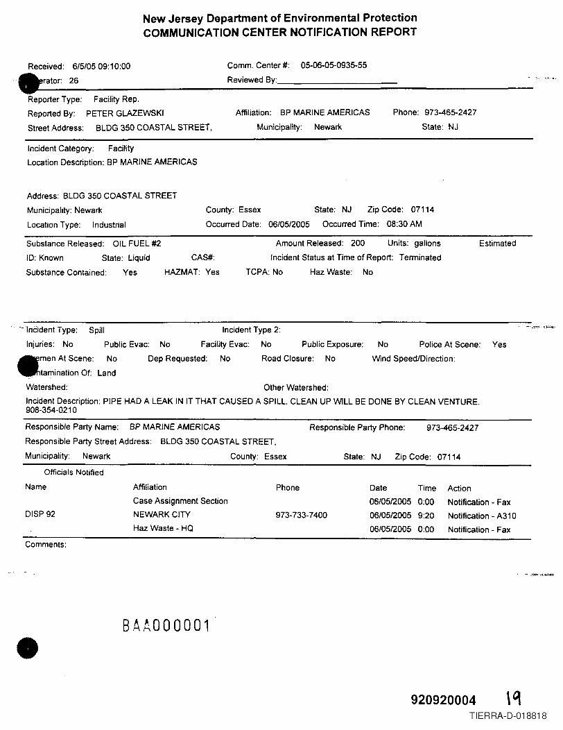
New Jersey Department of Environmental ProtectionCOMMUNICATION CENTER NOTIFICATION REPORT
Received: 6/5/05 09:10:00 Comm. Center #: 05-06-05-0935-55
.' erator: 26 Reviewed By:
ReporterType: Facility Rep.Reported By: PETER GLAZEWSKI Affiliation: BP MARINEAMERICAS
StreetAddress: BLDG 350 COASTAL STREET, Municipality: Newar1<
Phone: 973-465-2427
State: NJ
Incident Category: FacilityLocation Description: BP MARINEAMERICAS
Address: BLOG350 COASTAL STREET
Municipality: Newark
LocationType: Industrial
County: Essex
Occurred Date: 06/05/2005
State: NJ Zip Code: 07114
Occurred Time: 08:30 AM
Substance Released: OIL FUEL #2
10: Known State: Liquid CAS#:
Substance Contained: Yes HAZMAT: Yes
Amount Released: 200 Units: gallons
Incident Status at Time of Report: Terminated
TCPA: No HazWaste: No
Estimated
,. ~ lnCidentType: Spill Incident Type 2:
Injuries: No Public Evac: No Facility Evac: No Public Exposure: No
•
men At Scene: No Dep Requested: No Road Closure: No
. tamination Of: Land
Watershed: Other Watershed:
Incident Description: PIPE HAD A LEAK IN IT THAT CAUSEDA SPILL. CLEAN UPWILL BE DONE BY CLEAN VENTURE.908-354-0210
Police At Scene: Yes
Wind Speed/Direction:
Responsible Party Name: BP MARINE AMERICAS
Responsible Party Street Address: BLOG350 COASTAL STREET,
Municipality: Newark County: Essex
Responsible Party Phone: 973-465-2427
State: NJ Zip Code: 07114
Officials Notified
Name
DISP92
Affiliation
Case Assignment SectionNEWARK CITYHaz Waste - HQ
Phone Date Time Action06/0512005 0:00 Notification - Fax
973-733-7400 06/05/2005 9:20 Notification - A31006/05/2005 0:00 Notification - Fax
Comments:
BAA000001•920920004 \q
TIERRA-D-018818
•
•
•
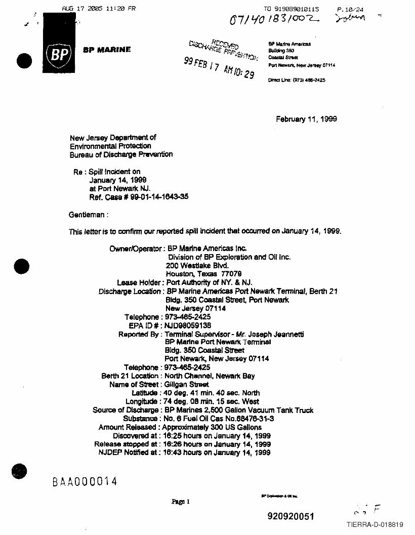
AI.JG 17 2005 11: 20 FR TO 919089010115
a71LfO 1133/007-or '
BP MARINE8P Martne AmericaSBuIlding 350CoaslaJ StreetPor1NlIwark. New JeIMy 07".
0Iraet Une: (973)4.2.25
February 11 r 1999
New Jersey Department ofEnvironmental ProtectionBureau of Discharge Prevention
Re : Spill Incident onJanuary 14, 1999at Port Newark NJ.Ref. case, 9~1-14-1643-35
Gentleman:
This letter is to confirm our reported spill incident that occurred on January 14, 1999.
OwnerJOperator: BP Marine Americas loe.Division of 8P Exploration and QUine .200 Wes1Iake Blvd.Houston. Texas 11079
Lease Holder: Port Authority of NY. & NJ.Discharge Location: BP Marine Americas Port Newark Terminal, Berth 21
Bldg. 350 Coastal Street, Port NewarkNew Jersey 07114
Telephone: 973-485-2425EPA 10# : NJD9805913B
Reported By : Tenninsl Supervisor - Mr. Joseph JeannettiSP Marine Port Newark TerminalBldg. S50 Coastal StreetPort Newarx, New Jersey 07114
Telephone: 973-465-2425Berth 21 Location: North Channel, Newark BayName of S1reet : Gillgan Str&et
Latitude; 40 de;. 41 min. 40 sec. NorthLongitude: 74 deg. 08 min. 15 sec. West
Source of Discharge : BP Marines 2,500 Gallon Vacuum Tank TruckSubstance: NO.6 Fuel Oil Cas No.68476-31-3
Amount Released: Approximately 300 US GallonsDiscovered at: 16:25 hours on January 14,1999
Release stopped lit: 16:26 hours on January 14, 1999NJDEP Notified at: 16:43 hours on January 14, 1999
BAA000014.............. &01 ....
Page 1
920920051TIERRA-D-018819
•
•
•
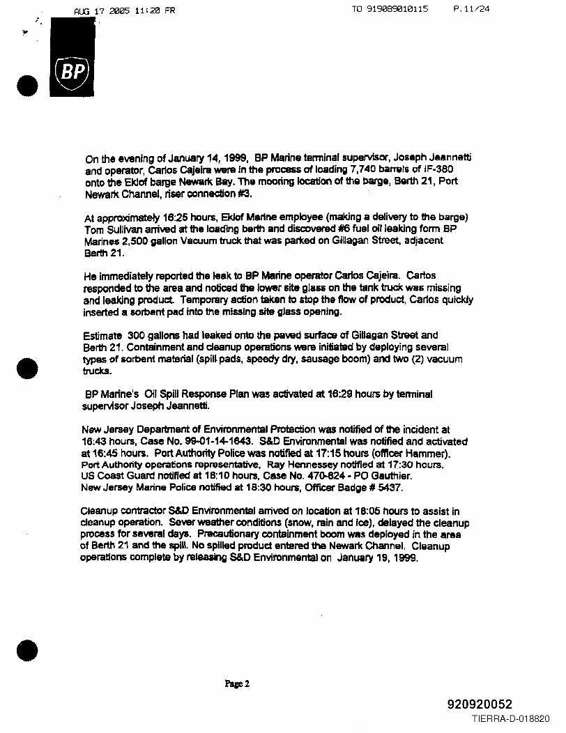
AUG 17 2005 11:20 FR TO 919089010115 P.11/24
On the evening of January 14, 1999, BP Marine tenninal supervisor, Joseph Jeannettiand operator, carlos C8jelra were in the process of leading 7,740 barrels of IF-380onto the EkJof bar;e Newark Bay. The mooring location of the barge, Berth 21, PortNewark Channel, riser connection #3.
At approximately 16:25 hours, Eklcf Marine employee (making a delivery to the barge)Tom Sullivan arrived at the loading berth and discovered 16 fuel oil leaking fonn BPMarines 2,500 gallon Vacuum truck that was parked on Gillagan Street, adjacentBerth 21.
He immediately reported the leak to BP Marine operator cartos Cajeira. Carlosresponded to the area and noticed the lower site g18&& on the tank truck was missingand leaking product. Temporary action taken to stop the flow of product, Carlos quicklyinserted a sorbent pad into the missing site glass opening.
Estimate 300 gallons had leaked onte the paved surface of Gillagan Street andBerth 21. Containment and cleanup operations Vll'BrB initiated by deploying severaltypes of sorbent material (spill pads, speedy dry, sausage boom) and two (2) vacuumtruckS.
8P Marine's Oil Spill Response Plan was activated at 16:29 hours by terminalsupervisor Joseph Jeannetti.
New Jersey Department of Environmental Protection was notified of the incident at16:43 hours, Case No. 99-01-14-1643. SID Environmental was notified and activatedat 16:45 hours. Port Authority Police was notified at 17: 15 hours (officer Hammer).Port Authority operations representative, Ray Hennessey notified at 17:30 hours.US Coast Guard notified at 18:10 hours, Case No. 470-624 - PO Gauthier.New Jersey Marine Police notified at 18:30 hours, OffIC8t' Badge # 5437.
Cleanup contrador S&D environmental arrived on location at 18:05 hours to assist incleanup operation. sever weather conditions (snow, rain and Ice), delayed the cleanupprocess for several days. Precautionary containment boom was deployed in the areaof Berth 21 and the spill. No spilled produd entered the Newalt Channel. Cleanupoperations complete by releasing S&D Environmental on January 19, 1999.
920920052TIERRA-D-018820
•
•
•
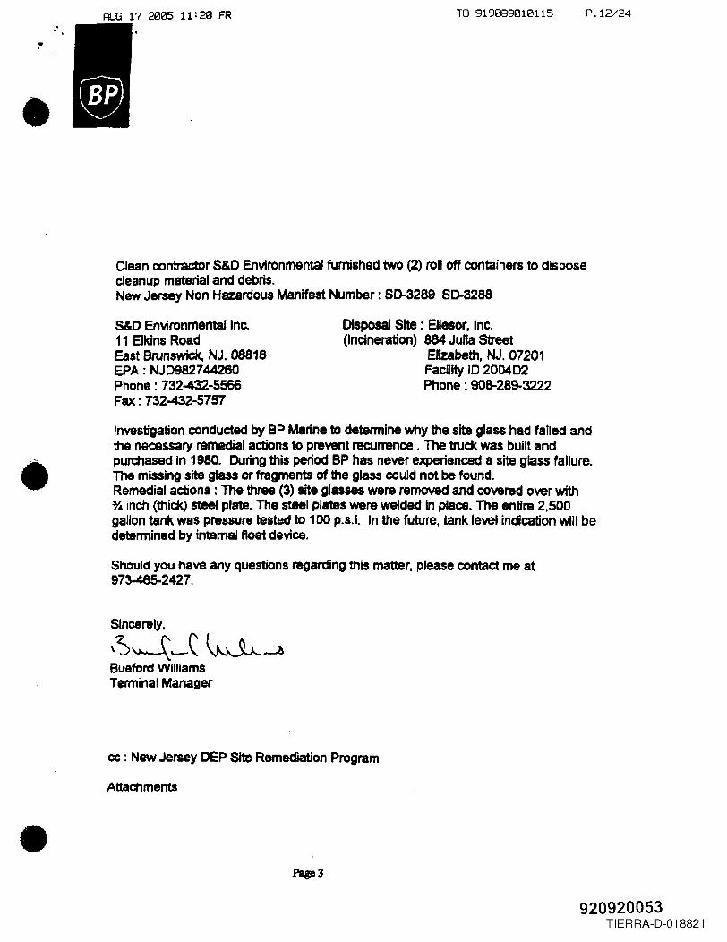
AUG 17 2005 11: 20 FR TO 919089010115 P.12/24.-..
Clean contractor S&C Environmental furnished two (2) roDoff containers to disposecleanup material and debris.New Jersey Non Hazardous Manifest Number: 50-3289 50-3288
S&O EnVironmental Ine.11 Elkins RoadEastBrun~,NJ.0881eEPA: NJD982744260Phone: 732-432-5566Fax: 732-432-5757
Disposal Site: EHesor, Inc.(Incineration) 884 Julia Street
EJlzabeth, NJ. 07201Facility 10 200402Phone: 908-289-3222
Investigation conducted by BP Marine to detennine why the site glass had failed andthe necessary remedial actions to prevent recurrence . The truck was built andpurchased in 1980. Curing this period BP has never experienced a site glass failure .The missing site glass or fragments of the glass could not be found.Remedial actions: The three (3) site glasses were removed and covered over with% inch (thick) steel plate. The steel plates went welded in place. The entlnt 2,500gallon tank was pressure tested to 100 p.sJ. In the future, tank level indication will bedetermined by internal float device.
Should you have any questions regarding this matter, please contact me at973--465-02427.
Sincerely,
\~~'-C~Bueford WiUiamsTerminal Manager
cc : New Jersey DEP Site Remediation Program
Attachments
920920053TIERRA-D-018821
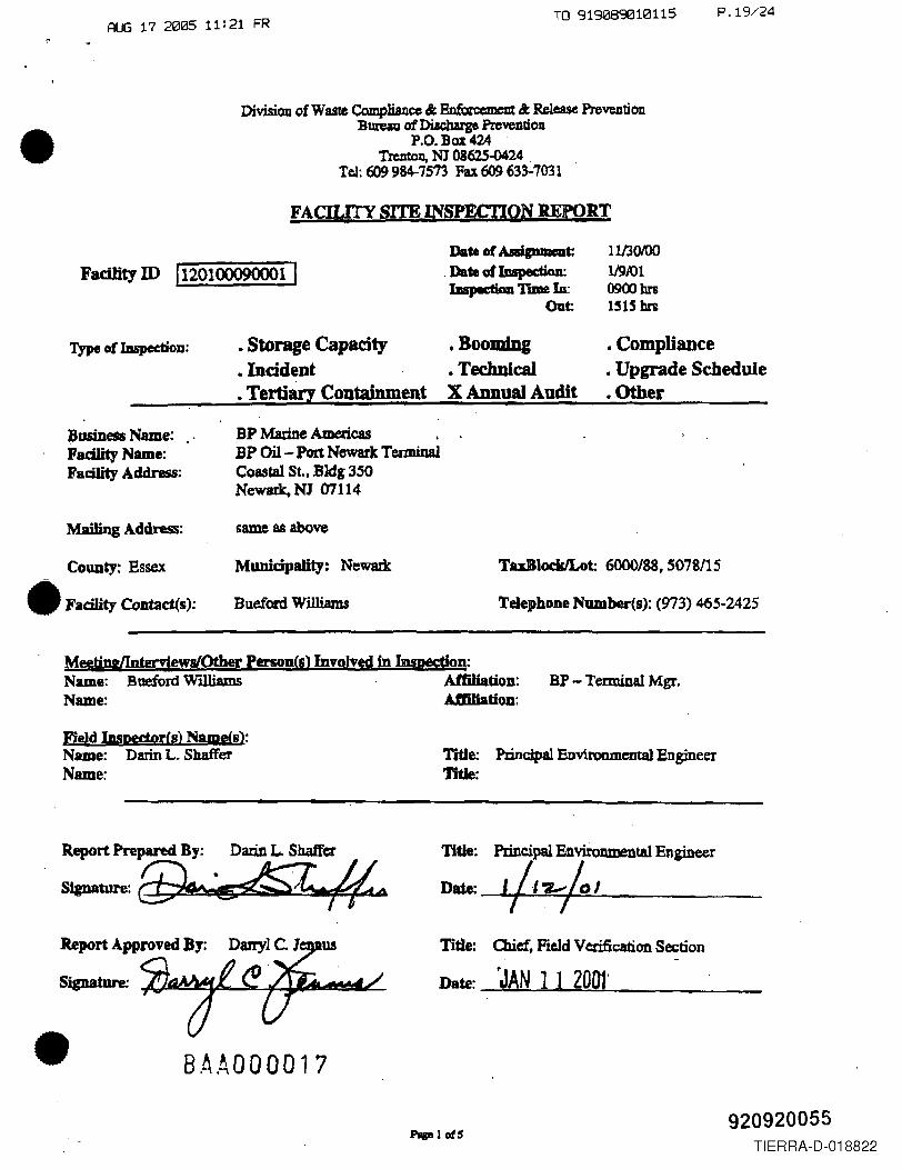
RUG 17 2005 11:21 FR TO 919089010115 P.19/24
•Divisiou of Waste Compliance & Bn.forc:emmJt & Release PreWDtion
BtlleaU ofDiacbarge fuvelllioDP.O. Box 424
Trenton, NJ' 08625-0424 .Tel: 609 984-7573 Fax 609 63~7031
FACILITY SITE INSP.l&I'IQN :REfQRT
FacUity ID (120100090001 IDate of A .. p....t:
.Date oI1Dspedion:1DspediaD nme Iu:
Oat:
Type of IDspection: • Storage Capacity •BoolIIing•Incident .TecluUad. Tertiary Containment X Annual Audit
•Compliance•Upgrade Schedule•Other
Business Name:Fadlity Name:ll'adlity Address:
Mailing Address:
COUDty: Essex
• Facility Comad(s):
BP Marine Americas .BP 00- Pent Newark TemlinalCoastal St, Bldg 350Newark. NJ 07114
Munidpality: Newark TuBlockJLot: 6000/88,5078115
Bueford Williams Telephone Number(s): (973) 465-2425
MeetiD&lInterviewslOther Person!s) Involved in Inspection:Name: Bueford Williams AfDUation: BP - Terminal Mgr.Name: Amliatiou:
Field Inspertprfs) Name(s):Name: Darin L. ShafferName:
Title: Principal Environmental EngineerTitle:
Report Prepared By: Darin L. Shaffer
~:f.#...~.f?
•
Title: Principal Bnvironmental Engineer
Date: -1i,oz,lo JTI
Title: CUd, Field Vcri£ication Section
Date: rJAN 11 200t'
B.A.ADDaD17
920920055TIERRA-D-018822
•
•
•
AUG 17 2005 11:21 FRTO 919089010115 P.20/24
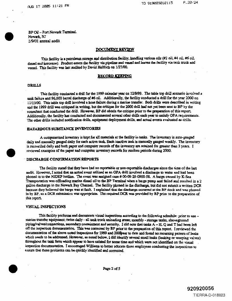
BP 00- Port Newark TerminalNewark,NJ119/01 annual audit
This facility iJa petrolewn storage aod distribution facility, haodIiDg various oils (#2 oil, #4 oil, #6 oil.diesel and keroSCIUI). Product euta'S the t'8ciJity viapipe1iDc SlId vessel and leaves the fa(:ility via tank lll1ck andvessel This facility wulast audited by David Hclfricb on 1121/00.
mORn DEPRfG
DRILLS
This facility coadueted a drill for the 1999 caJeudar yat OD 12J9199. The table top drill scenario involved atank failure and 96.000 barrel discharge of ##6 oD. Additionally, the facility conducted a drill for the year 2000 on11/13/00. Tbil table top drill involved a hose failure duriD& a marine transfer. Sorb drills were described in writingand the 1999 drill was critiqued illwriting, but the critique for the 2000 drill bad DOt yet been Sl'lDt to BP by theconsullant that conducted the drill. However. SP did obtain the critique prior to the pRp8r8tion of this report.Additionally. the facility has c.ondw:t.ed and documented several ocher drills each year to satisfy OPA requirements.The othor drills included notificadcm. drills. equi~t deployment drills, and acbull events evaluated as drills.
BAZARDOUS SUBSTANCE INVBNTORIES
A computerited inventory is kept for all materials at the facility intanks. The invcntCllY is auto-gaugeddaily and manually gau.ged daily for each active taQk. Each iQacUve t8IIk is lD8JWaIly gauged weekly. The inventoryis reconciled daily and both paper and computer records of the inventory ~ reQincd for greater than 3 years. Ireviewed examples aftbe paper and compater inventory records for IUdom periods during 2000 .
. DISCHARGE CONFIRMA110N REPOR'IS
The facility stated that they have had no reponable or non-feponable discharges since the time of the lastaudit. However, I DOted that aD actUal event lltilUed as an OPA drill involved a di!cbarge 10 water and had beenphoned in to the NJDEP hotline. 'I'bc nent W8S 8Iliiped case#00-09-29~S8. A barge owned by K·SeaTransportation was offloading marine diesel oil to the BP Terminal when a barge pump seal faiIcd and resulted in a 2gallon discharge to the Newark Bay 0amJc1. The facility phoDed in the dischaqe. but dic;l not submit a written OCRbecause they believed the barge was at fault. I explai1wldthat the dis.cbarge 0CC\m'Cd at the BP dock and was phonedin by BP. SO a OCR submission was appropriate. The required OCR. was provided by BP prior to the preparation ofthis report.
VISUAL INSPECTIONS
This facility pedorms aDd documents visual inspectiona according to the following schedule: prior to use -marine transfer equipment; twice daily - all tank truck unloading areas, monthly. storage tanks. aboveJrOundpipiDglvalvesicoDneCtioIl&, secondary. containment and security. I did DOte that tanka A-H. Q and T had been leftoff the inspection dacumentatiall. This was corrcctBd by BP prior to the prcp8[ation of this report. I reviewed thedOC\lJDC1ltatiOJ1 of the above noted iDspcctinns for 1999 and ~ to date and found DO lCClU'1'inI pattern of 1eak5which needs to be addre£ted. Howe~. 15noted below, I did identify seveml smallieab Oeaking or weeping valves)throughout the tank farm wbil:.b appear to have e.zisted for some time and which were Dot identified OD the visual .inspection documentation. I encouraged Wi1liuIJs to better educate those employees conducting the inspections toensure that these problems can be quickly identified and corrected .
Pa,c2 ofS
920920056TIERRA-D-018823
•
•
•
RUG 17 2005 11:21 FR TO 919089010115 P.21/24
BP 00- Port Newark Terminal.Newark, NJ11'9/01 annual audit
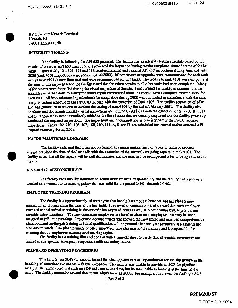
INTEGRITY TESTING
The facility is following the API 653 protocol. The facility has aD integrity testing schedule based On theresul18 of pt'evious API 653 iuspcctioas. I reviewed b inspcctioDltestiDg results completed since the time of the lastaudit. Tanks #101. 104. lOSt 112 aml1l3 received intemaJ and exttmal API 6S3inspections during June and July2000 (tank #101 i.DspeCtioDSwere completed 1012D00). Minor repain or upgrades M:re recommended for each tankexcep& tank #101 (a new tloor IIDd roof "Nele recommended for rhis tank). lbc repairs w tank #101 were on-going atthe time of tbiI inspection and tile facility stated that the minor repairs to all other tanks had been completed. MlIlIYof the repairs were identified during the visual inspection of the site. Iencouraged the facility to document in thetank files what was dOIle to satiJfy the minor repllir recoaunemlatioDS in order w have I complete repair history foreach tank. All inspectioDltesting scbeduled for completion during 2000 was completed in accordance with the tankintegrity teSting scl,1edule in thIl OPCCIDCR p1aJl with the ~011 of Tank #103. The facUity requested of BDPand \ViIS gnmted an extension to conduct the testiug of tank #103 by the end of February 2001. The facility also
, conducts and documents moathly visual inspections as required by API 6S3 with UJe exception of tanks A, B. C. Dand E. Those tanks were iJJJmediately added to the list of tanks tbIlac visually inspected and the facility promptlycoDdueted the required inspections. The inspeCtiODS ADddOCUlDCDtationalso satisfy part of the DPeC requiredinspections, Tanks 102. 103. 106. 107, 108. 109, ] 14, A. B and D In' scheduled for int=ma1 and/or exteruaI APIinspectionltesting during 2001. .
MAJOR MAINTENANCFlREPAIR
The facility indicated that it bas not performed auy major maintenance or repair to tanks or processequipment since the time of the last audit with 1be exception afthe curreritly on-going repairs to tank #101. Thefacility noted that all the repairs will be well documented and the tank will be re-inspccttd prior to being returned toservice.
FINANCIAL RESPONSIBIUI'Y
1M fatUity uses liability insunmce to demonstrate tinan¢ial responsibility and the facility had a properlyworded endorsement to aD exilting policy that was valid for the period 111101 through 111102.
EMPLOYEE TRAINING PR.OGRAM
The facility bas approWlately 'J 4 employees tbat bandlo hazardous substances and bas hired 3 DeWCOlltraetot employees since the time of the last audit. I reviewed documentation that showed that each employeereceived annual refresher training in tite-specific bazwoper (8 hour) as well as other health/safety topics duringmonthly safety meetings. The DeW contractor employees are hired as $bort tt:ml employees tIw may be laterassigned to full-time positions. l~viewed documentation that showed the new employees recdved comprehensiveclassroom and o~the-job training and final qualification will be granted after one year (quarterly assessments arealso documented). The plant JDID8BCl' or plant supervisor proVides most of the training and is responsible forensuring that DO einployces miss required tnUniDg topi(;S.
The facility bas a !raiDing .film and booklet with a sip-off sheet to verify that all outside contractors aretraiDed in site-specific emergency responae., health and safety wues,
STANDARD OPERATING PROCEDU1U!:S
This !acllity has SOPs (in vmous forms) for what appears w be all operations at the facility involving thehandling of bazardol.1S sub&taDccs with <me exception. The facility was unable to provide an SOP for pipelinereceipts. Williams noted that such aD SOP did exist at one time. but be was UDab1eto locate it at the time of theaudit. The facility maintains seven! dOCtlJDeDts which ll8rYe u SOPs. For example. I reviewed the facility's SOP
Pap 3 of 5
920920057TIERRA-D-018824
•
•
•
AUG 17 2005 11: 22 FRTO 919089010115 P.22/24
BP Oil - Port Newark TcmW1aLNewark, NJ119/01 annual audit
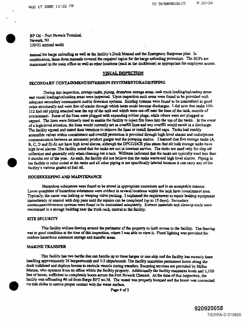
ttWlual for barge UDl~ IS wen as the facility's Dock Maoual and the Emergency Response plan. Incombination, these three manuals covered tbereqWred topics for the barF unloading procedure. The SOPs arcmaintajped in the maiD office 8$ well as other locations (such as the dockhouse) as appropriate for employee access.
YJSUAL INSPECTI~SECONDAR.Y CONTAlNMENTJDIVERSION SYSTEMSISTORAGEIPlPING
Duriug this inspection. storage taDb, pipiQg. drumItote storage areas. taDk truck loadinglunloading areasaud vessc11oadinghmloading areas ~ inspected. Upon inspection such areas W8le found to be provided withadequate secondaIy containmem and/or diversiOJl systems. Existing systems were found to be maintained in goodorder strUetura1.ly and were free of c:racb through which l~ could become discharges. I did note that tanks 109-112 had old piping attached DC8f the top of the tank and Which wa'e c:ut-off near the base of the tank, outside ofcontainment. Some of the lines were plugged with expandin, rubber plugs, while otber$ were not plugged orcapped. The lines were formerly used to enable the facility to inject tire foam into the top of the tanks. In the eventof a bigh-levelsituation. the linea would eunently act as ovediJllines BDdany overfill would result in a discharge.The facility agxeed and staled 1I1eirintention to remove the liDes or install threaded caps. Tanks had readilyaccessible VIllveswithin containment aDd ove:dilI proteetion is provided through high-level alarms and radiolphonecommunication bctweea aD autolIl8tic product gaui« aud the pumping station. Ilearned that five storage tanks (A.B. C, D and E) do not have high level alarms. although the DPCCIDCR plan states that all bulk storage tanks havehigh level alarms. The facility DOted thar the tanks are not inconstaDt service. The tanks are used only for slop oilcol1ecUon and geDerally o.oly "'beD clcaniug out a tank. Wslliams iAdiC8led that tho tzmb arc typically used less than6 IXlQnths out ot the year. IU such, the facility did nCX belitve that the tanks warranted high level alarms. Piping inthe facility is color coded lit the racks and all other piping is DOt specifically labeled because it CAD cany any of thefacility's various grades of fuel oil.
HOUSEKEEPING AND MAINTENANCE
Hazardous 5I1bstaDCCI -.re found to be stored in appropriate containers and in an acceptable manner.Loose quantities of hazardous suhstmees were evident in seven11ocatious within the tank farm conuUnment area.Typically, the cause was leaking or wccpiDg valve pacJdD,. I uplaiDed the requirement to repair leaking equipmentimmediately or control with drip pans until the repairs can be completed (up to IS days). Secondarycontainment/diversion systems were found to be: uWntained adcquaIely. SOrbent materials and cleanup-tools weremaintained in a storase buildiDg near tbe ~ nck, cennl to 1hc facility.
SITE SECURITY
This facility utiliz.es fcDciog lU'OWldthe pcri=ter of ~ PlOpcrty to limit access to the facility. The fenciugwas in good condition at"tbe tUne of this iJJspectioo, where Iwas able to view it ·FiJted lightin, was provided foroutdoor hazardous substance stDraBe and transfer areas. .
MARINE TRANSFER
This facility bas two bcrtbs that caD handle up to three barges ar ODC ship aDd the facility has recently beenhaDdling approximately 24 bargeslmontb and 2-3 ship&lmontb. The facility maintains permaDtmt boom along thedock bulkhtad and deploys booms to CDCitclevessels during transfers. Booming 8eIVices are provided by MillerMarine, who operates n-om an affK:e within the facility property. AdditiODally the faeility nWntaiDs boats and I, J 00feet. of boom, sufficient to completely boom am>ss the Port Ncwarlc Channel. At the time of this inspection, thefacility was offloadiJlg fI6 oil from Barge BFI' Do.38. The vessel was properly boomed and the boom was connectedvia tide slides to ensure proper contact with the water surface.
Page40fS
920920058TIERRA-D-018825
•
•
•
AUG 17 2005 11: 22 FRP.23/24
. BP Oil- Port Newark rennina)Newark.NJ119/01 annual audit
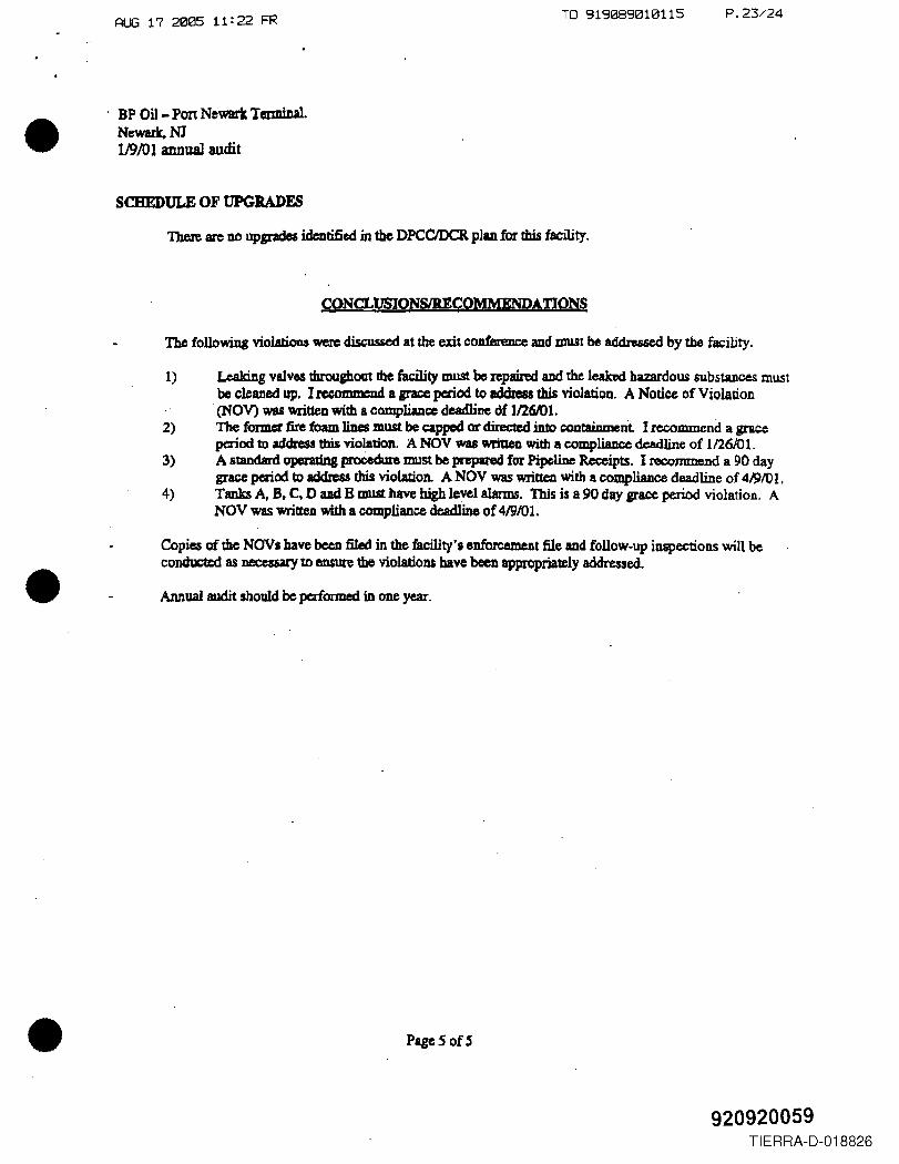
SCHEDULE OF UPGRADES
There arc no upgrades identified in the DPCCIDCR plan for this facility.
CONCLVSIONSlRECQMMENpATION§
The following violatioos were discussed at the exit conference and must be addre56ed by the facility.
1) Leaking valves throughout the facility must be repaired aDd the leabd hazardous substances mustbe cleaned up, I recommcod a grace period to address this violatioQ. A Notice of Violation
.(NOV) was wriueD with a compliance deadline Of II26Rl1.2) The former fire foam liDes must be capped or diIec1cd into containment I recommend a grace
period to address tbis violation. A NOV was written with a compl.iance deadline of 1/26/01.3) A standard operadDg proCedure must be pRpVed for Pipeliue ~ipU. I recommend a 90 day
grace period to address this violation. A NOV was Mitten with a compliance deadline of 41910 1.4) Tanks A. B. C, D and B must have high level alanns. This is a 90 day srS':C period violation. A
NOV was written with a COOIpliancedeadline of 419/01.
Copie.sof the NOVa have been filed in the facility's eDforcement file and follow-up inspections win beconduct.c:d as necessary to ensure the violations have been approp~ly addre$sed .
Annual audit should be performed in one year .
PageS ofS
920920059TIERRA-D-018826
•
•
RUG 17 2005 11:19 FR TO 919089010115
O"bpmarine RECEIVED
8P MarIne Americals8l.tdIng 3S) Coe&taI StreetPart Newarit, New J-.y 07114
onct LIne: (873) 465-2CZS
April 29, 2005
New Jersey Department ofEnvironmental ProtectionBureau of Discharge Prevention
Re: Discharge Confirmation ReportRef. Case" 050425115128
Gentleman:
This letter is to continn our reported non-compJiance (excursion) that occurredon Marm 30, 2005.
Ovvner/Operator: BP Marine Americas Inc.Division of BP Products North America Inc.
200 WesUake Blvd .Houston, Texas n079
Lease Holder: Port Authority of NY. & NJ.Discharge Location : 8P Marine Americas Port Newart< Tenninal
Bldg. 350 coastal Street, Port NewarxNew Jersey 07114
Telephone: 973-465-2425EPA 10#: NJD98059138
Reported By : Terminal Manager - Mr. Bueford WilliamsBP Marine Port NewIIrt( TenninalBldg. 350 Coastal StreetPort Newark, New Jersey 07114
Telephone : 973-46~2425Location: Skig. 350
Name of Street : coastal StreetLatitude: 40 deg. 41 min. 54 see. Nor1h
Longitude: 74 deg. 09 min. 23 see. WestSource of Discharge: StDrmwater OutfaU 001A
SUbstance: Ol/&GreaseAmount Released: 15.7 mgIL
Discovered at: 11:45 hour on April 25, 2005Release stopped at : 07:15 hour on Marm 30, 2005NJDEP Notified at : 11:45 hour on Aprif 25. 2005
f/j/F~ ~ (nIl{ o/1"s 100).
,1\/<- ~"'r C:-I/-I bS'T.ek ~. B AAO a0 01 9p¥1
P.04/24
920920061TIERRA-D-018827
•
•
•
RUG 17 2005 11:19 FR TO 919089010115 P.05/24
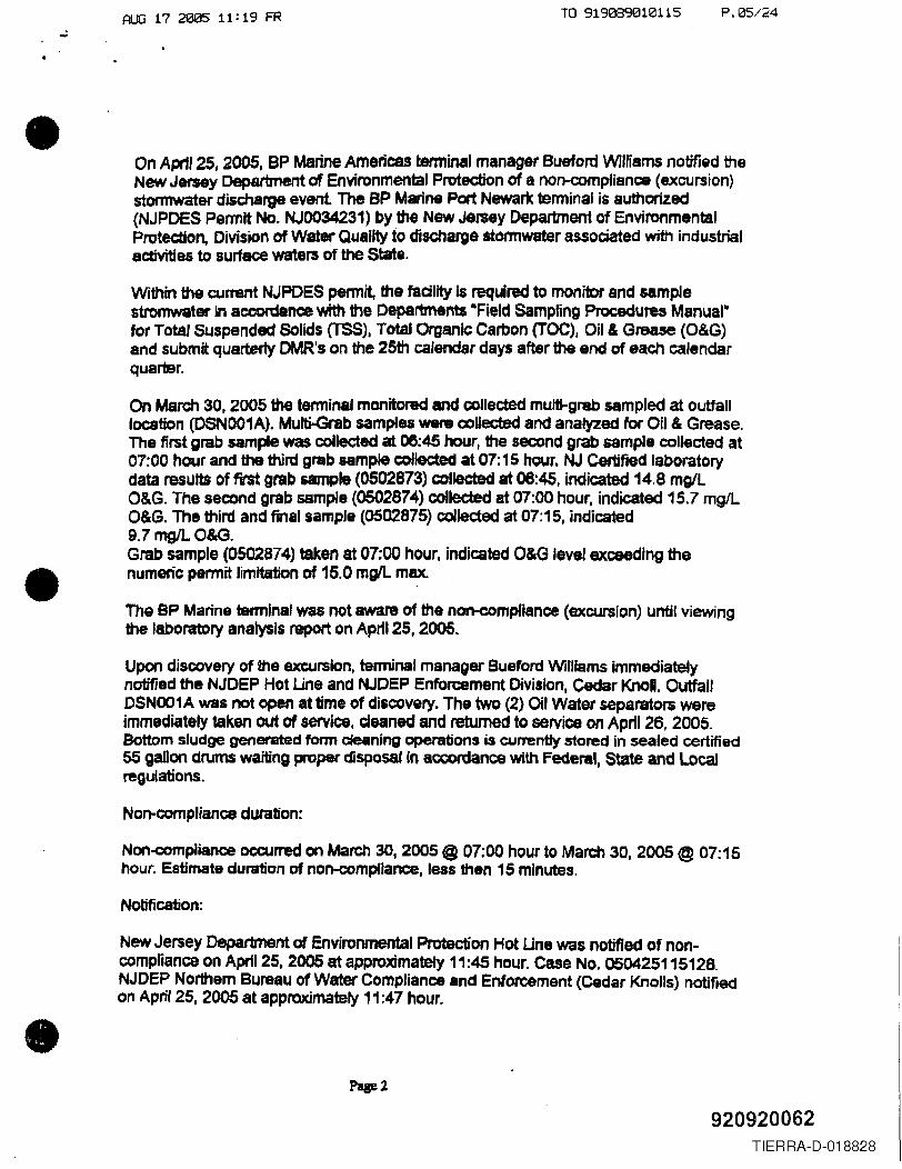
On Aprtl 25, 2005, BP Marine Americas terminal manager Bueford WiIHams notified theNew Jersey Department of Environmental Protection of a nofl-(X)mplisnce (excursion)stormwater discharge event The BP Marine Port Newark tenninal is authorized(NJPDES Pennit No. NJOO34231) by the New Jersey Department of EnvironmentalProtection, DivisiOn of Water Qualjty to discharge stormwater associated with industrialaetivitiea to surface waters of the State.
Within the current NJPDES permit, the facility is required to monitor and samplestromwater in accordance with the Departments -Field Sampling Procedures Manual·fOr Total Suspended Solids (TSS). Total Organic Carbon (TOC), Oil & Grease (O&G)and submit. quarterly OMR's on the 25th calendar days after the end of each calendarquarter.
On March 30. 2005 the tenninsl monitored and oolleded multi-grab sampled at outfalllocation (DSN001A). Multi-Grab samples were coUected and analyzed for Oil & Grease.The first grab sample was collected at 06:45 hour, the second grab sample collected at07:00 hour and the third grab sample collected at 07: 15 hour. NJ certified laboratorydata results of first grab &le (0502873) colleeted at 06:45. Indicated 14.8 mglLO&G. The second grab sample (0502874) collected at 07:00 hour. indicated 15.7 mgILO&G. The third and final sample (0502875) collected at 07:15. indicated9.7 mgIL 0&<3.Grab sample (0502874) taken at 07;00 hour, indicated O&G level exceeding thenumeric permit limitation of 15.0 mgIL max.
The BP Marine tenninal was not aware of the non-compliance (excursion) until viewingthe laboratory analysJs report on Aptil 25, 2005.
Upon discovery of the excursion, terminal manager Bueford Williams immediatelynotified the NJDEP Hot Line and NJDEP Enforcement Division. Cedar KnoU. OutfallDSNOO1A was not open at time of discovery. The two (2) Oil Water separators wereimmediately taken out of service, deaned and returned to service on April 26, 2005.Bottom sludge genetsted fOrm cleaning operations is currentJy stored in sealed certified55 gallon drums waiting proper disposaf in accordance with Federal. State and Localregulations.
Non-compliance duration:
Non-compliance occurred on March 30, 2005 @ 07:00 hour to March 30. 2005 @ 07: 15hour. Estimate dumon of non-compfiance, less then 15 minutes.
Notification:
New Jersey Department of Environmental Protection Hot Une was notified of non-compliance on April 25. 2005 at approximately 11:45 hour. case No. 050425115128.NJDEP Northem Bureau of Water Compliance and Enforcement (cedar Knolls) notifiedon April 25, 2005 at appraximately 11:47 hour.
920920062TIERRA-D-018828
UiV1S1011 aT yjU~~l: l'IU"U':l""'~"-
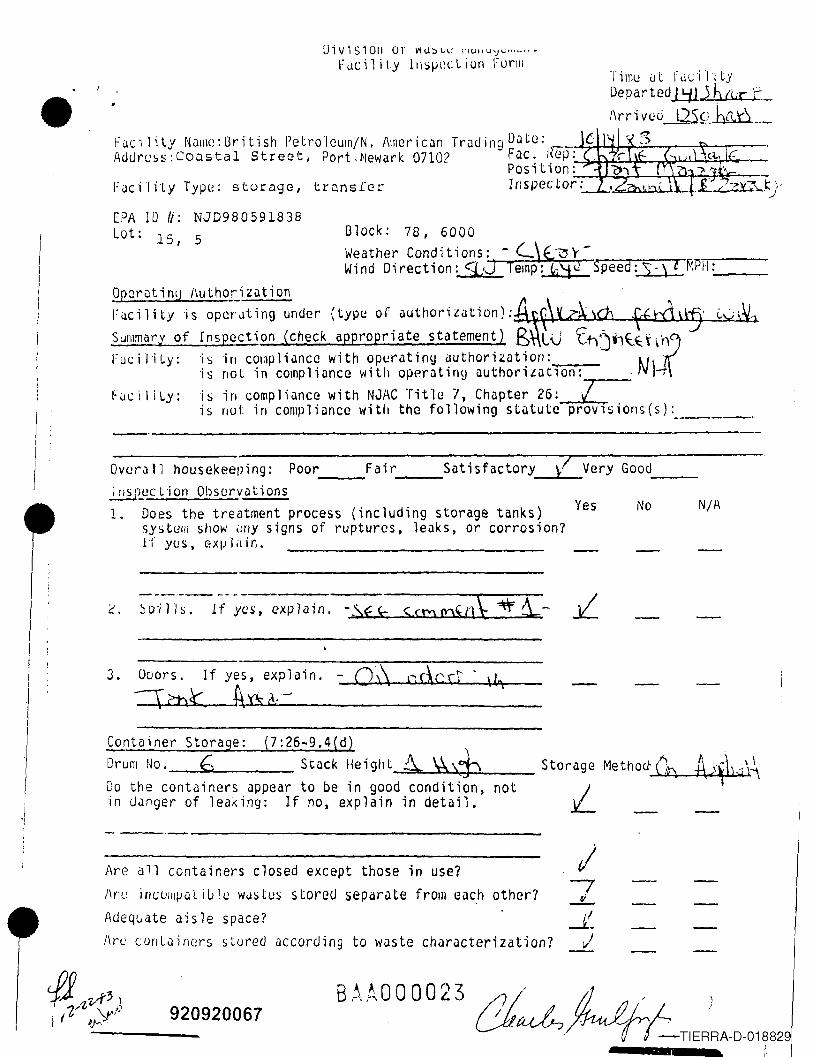
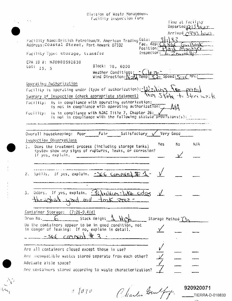
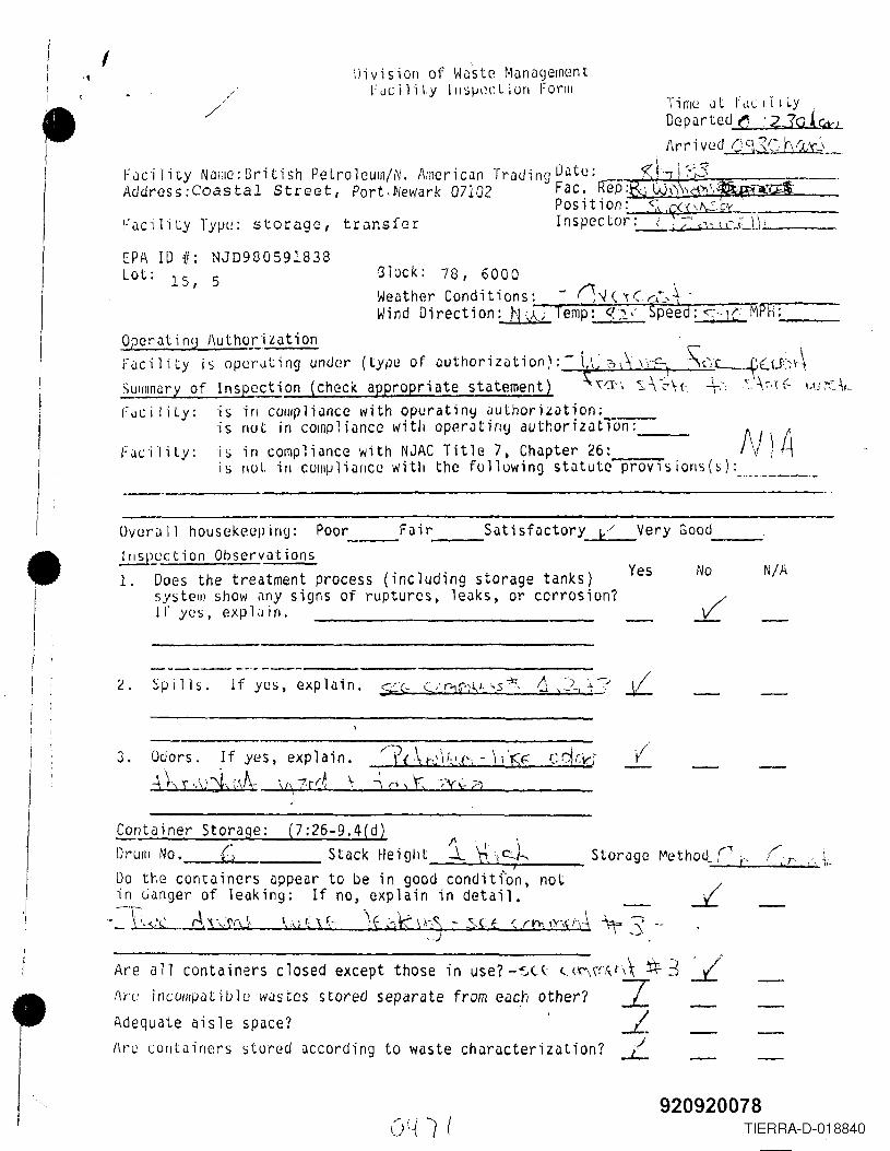
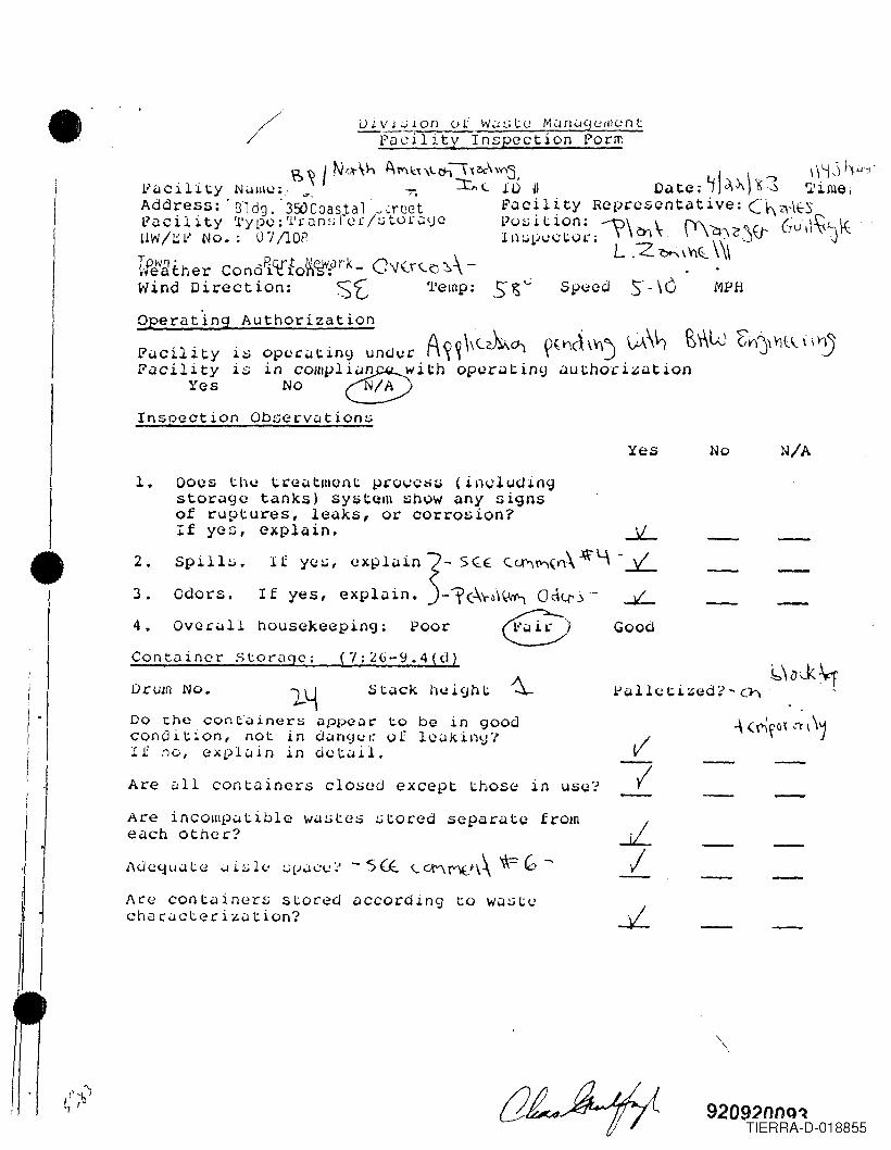
FJciliLy ll\')~H~cLiun I:Llrilil i111l! i.lt f ueill tyDeparted ILjJJ b LCC 'r-Arr; ved-'2S~_• rucility NJlIlu:[3ritish Petroleum/N. I\lner;can TrJding Dilte: _''-''';~~~~-r-~-T-----r--
Adurc:ss:Coustal Street, Port,~'ewark 07102 FilC. IWP:...:~~!".,.L,J~~~~~"""_Po sit ion:-:---l~~L--~,..lw4~~=--
Facility Typ(~; stori:lgc, trunsLer Iflspector,'-.' -i-}k,.:;hUl.! ...U
EPA ID II: NJD980591838lot: 15, 5 Glock: 78, 6000
Weathe~ Con?it io~s: - C\(Cl 'r - ..,..,..... _Wind 01 rectl0n: q:J Temp: ~;:tJ Speed: S" \ t MPH:~ __
Operutinv /\uLhorJZiltion ". 'Fi.lcility 'is opcY'Jting under (type of iluthorilatiOn):At~\~~\<b ¥rd\~' L0\~
SUfll~a? of ~ns~cct;on ~Check ~ppropriat~ statemen~) E?\\. Lv {,t)j.1~.~h~FiJell'ILy: 'IS HI cOlOplHlncc wlth op(.!ratlny authOr1lDtlOn: N)
is not in compliance with operuting iluthoriLiltTon:- ' .
Fi.lciljLy: is in compliilnce with NJAC Tit'le 7, Chapter 26: /is /Iut in compliunce with the following stl1tute prov;sions(s): _
}/ Very Good _Overall housekeeping: Poor Fair Satisfactory--- ---.!.!.!iPyct-i on Observu t ions1. Does the treatment process (including storage tanks)
sY!itelil show ,trly signs of ruptures, leaks, or corrosion?H yes, GXplilin.
Yes No N/A
-------------
I! I
I 3. Odors. If yes, explain.
-=rCht t\Ys &~
Container Storage: (7:26~9.4{d)DrulTl r~o. (; Stack Height .6..\\¢r...-. __ Storage MethoctCt) A.<\~k.:j\\Do the containers appear to be in good conditiont not Lin u~nger of leaking: If no, explain in detail.
B r\ .A0 a 0 a 2 3'~
, , tl / ).I.~a .. -'-TIERRA-D-018829
I,.
/--,...L..J!..
,j
Are all containers closed except those in use?)\rt; illCUIIi/Ju Li lJl e Wi.lSles stared separute from each other?Adequate aisle space?I\rt: contQin0.rs stured according to wJste charucterization?
920920067
Nu N/A
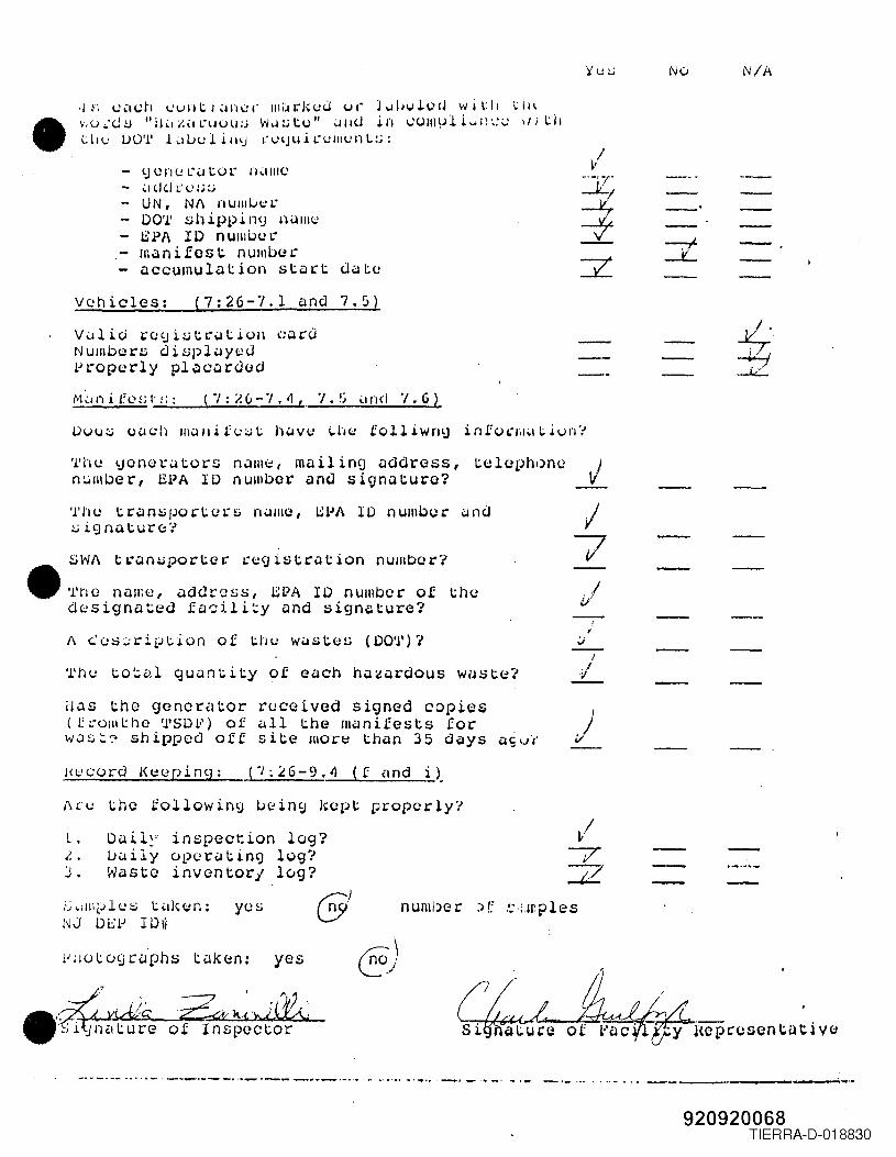
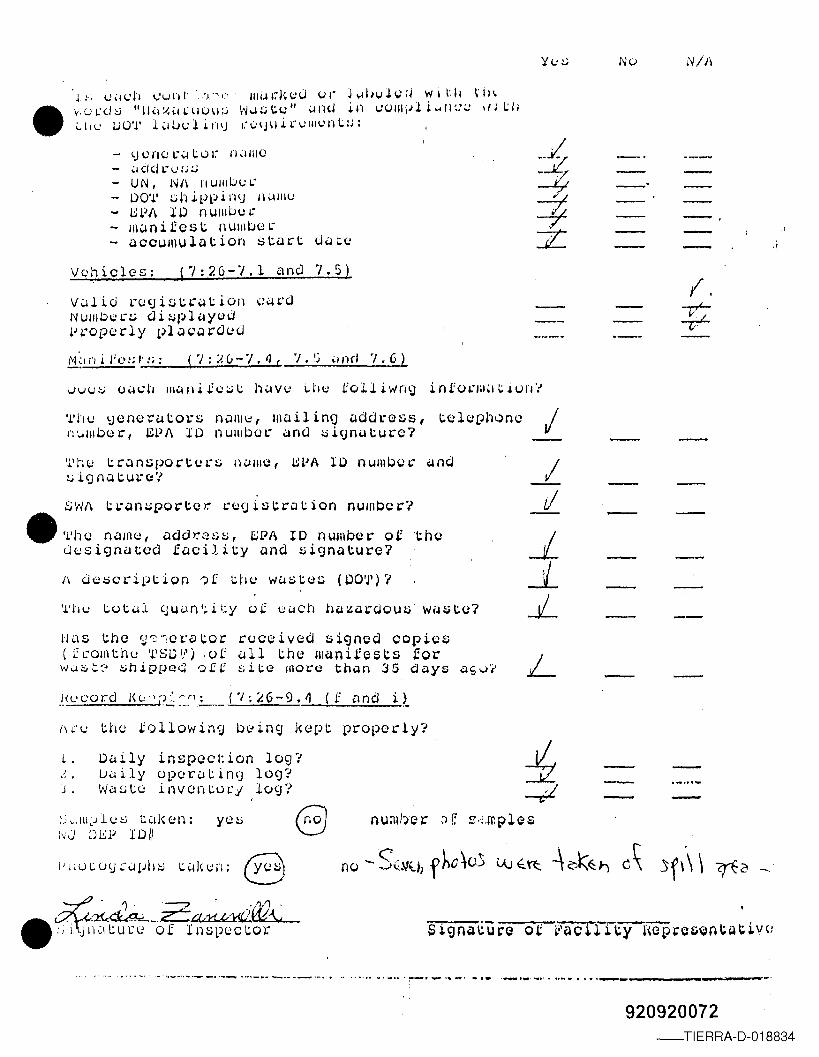
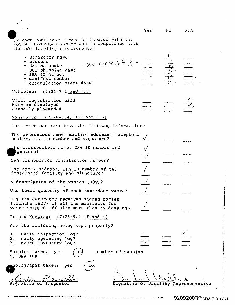
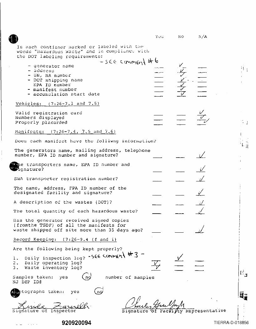
• .J~; ~'H;h 1..:unti'uH:r IIliH"kuJ vI" J ••dJl.d.Q,J wi\:11 ~II\y,U","<.J::J "11':Ii:ilL-lIUll:i w~~tu" <.I1l<.! in l:(")1l1\Jli ... ll',:~ \/! t:ll
Ulf",) UO'l' l.:l1..Jf",)li'llj t:l.HJuln':lIlf",)nL:.i:
- <.J UI"l<JL"u tUl" lIdlllC- ~l(J (I L'l.':.i:;- UN, NI\ nUIIILJul."- DO'l' :;1) ippi Il<j 1li.lIIlU- SPA II) nUlllblH-- manifest numbor- accumulation start date
--"
vehicles: (7:26-7.1 and 7.5)Vulio re<ji,l;trution cardNumbors di,l;pl'-lycJproperly placardod
'l'hu Ijeno l.:i.l ton; n.JIl1~,rnailinCj address, tolo!)h,.)nen~lI\ber, EPA 1D number anu signature? .i.
/7
Tho transport,n:s nullle, l:;l.lA 10 number uno:.;.ignat.ure::'/SW/\ t I.-an:.;port.et:' 1:<;:£1is t.ri:lt ion numbo ro'
• 'l'ho name, addross, L.::PA II) numbor oJ: \:.hedesignated facili~y and signature?1\ <':us:::ript.ion of tllu Wi.lS\:'<;:S (DO'J')?
'l'hu to~al qUi:lntity of each hi:l~ardous w~sto?I
.fII
Has the generator roceived signed copies(tl."oliltho '1'8D1o') of iJl1 the manifests for )was~? shipped off site more than 35 days asuJHc'cord Keeping: (/;~6-9.4 (f und i~
I\cu the followin9 ~~in9 kopt properly?L. D~il~r inspection log?1. • LJi.l i ly ()pur~ t ing log?J. Waste inventorj lvg?,'j,llllplus t,l!c<;:n: yesNJ DEP 1Djf
61numIJcr:->(; ~·';.I~ples
§)
nepccsentutivC:lZI\~'J<~of Inspector
_ .. ----- _.. _ .._ _- _._-_ _.- _ .. _. _ -.- -'-"~." _------,-,---~.._ ..
920920068TIERRA-D-018830
--- -----------Gl:__rznK G I,) _ X/"'~''j~L~ (~ii0_.221 O'J-C-_flkw '\\ (; -• d¥y4ig.. 2aM>--f1;£t· (Jj;~ ft=dff -----_ ----
Sl.gnature of Inspector Sl.gnature or r"C1cl.hty RelJresenLiltl.Ve
TIERRA-D-018831
920920069
~IIII
--:-:-----(VAt" ...... ,
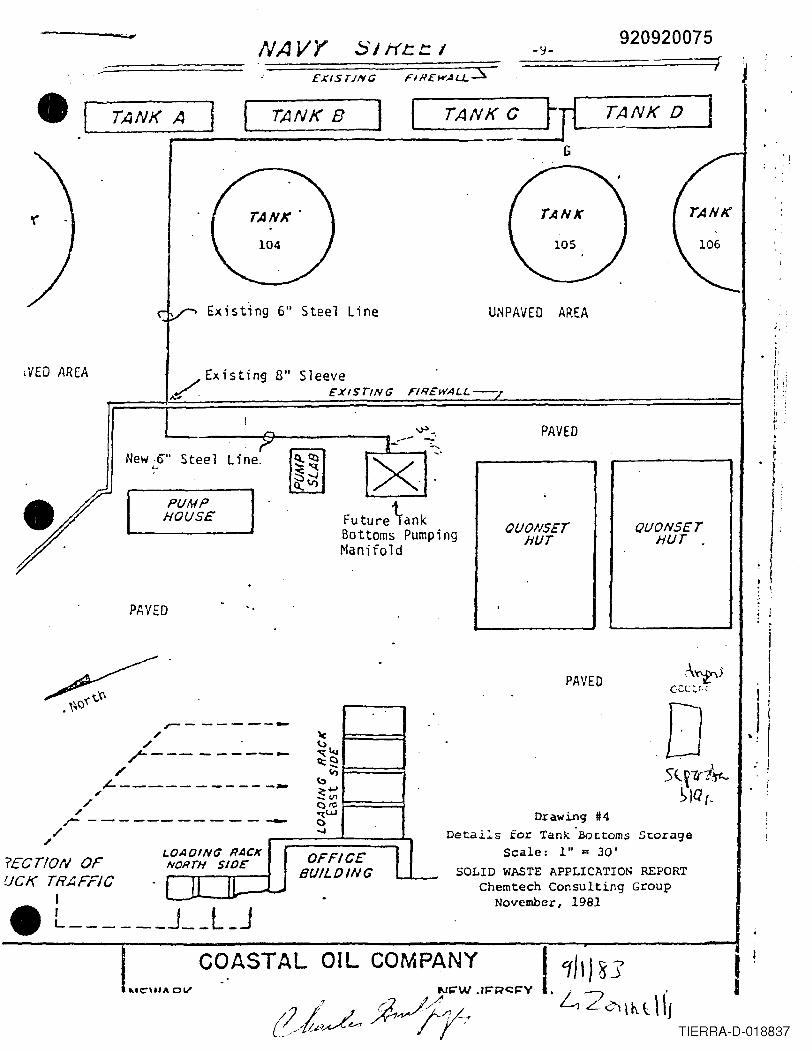
eXIST/lYe;
., " [ TANK A ] I TANK B f TANK C rpANK 0 IG
PAVED
"Stee Line UNPAVED AREA
-:WED AREA /. Existin!) B" Sleeve./ . EXISTING,.' f'IR£WAI..L-
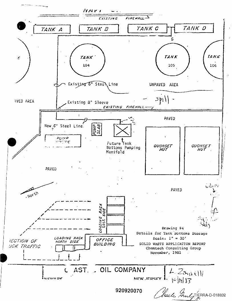
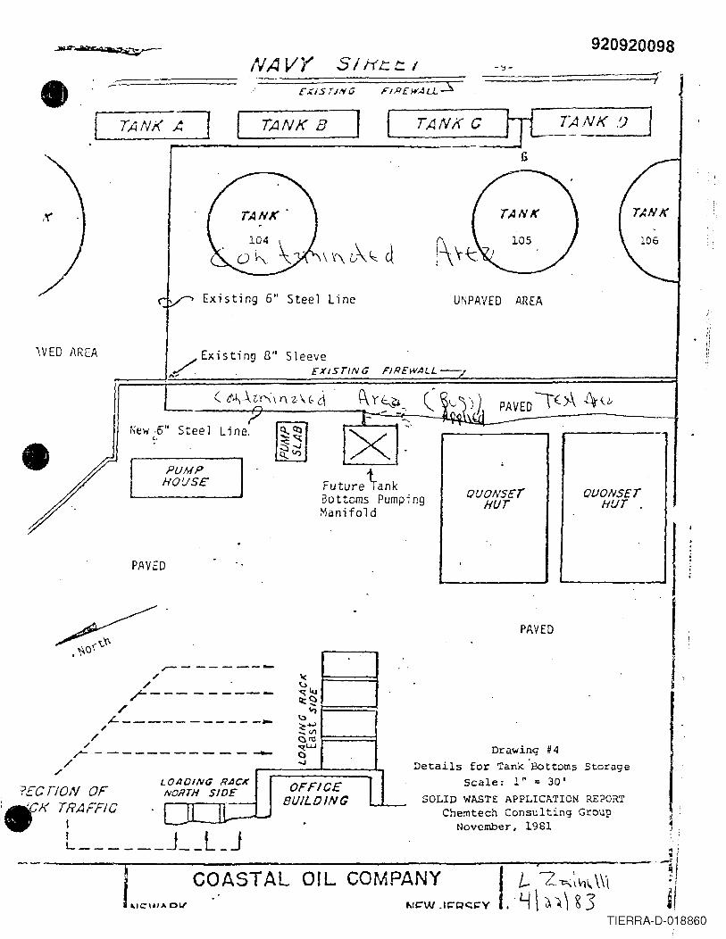
Drawing 114Details for 'rank 'BottOffip Storage
Scale: I" = 30'SOLID WASTE APPLICATION REPORT
. Chemtech Consulting GroupNovember, 1981
\1'> _.L-------A--------v .........- _~r--Jl.---1 ...New·off Steel
'-,
fEeT/ON OFUCK TRAFFiC
I, L- J__l_J
I L....ov lAST.I
Future \ank60 ttoms PumpingManifold
QUONSE:THUT
PAVED
PAVED
------- ..\(
-- ----- ..... ~...,-q:C)ct ....
It)
-------- ... \:)~+-'-..VI~ro"li.l..l------...... <;)...,
OAOING RACK OFFICE ,NORTH SIO£'
BUILOINGLU If- .
r-/
./r-/
tL----,/
/r ------
/./
L
"
QUONSETHI./T .
OlL COMPANY I L'Zo-.\\, \ \Iit.I~W .1r=~C;;~Y .' \G )N) ~?
920920070
•
•
•:.l" .
. "'\
lJivision of !>Justo Milnuqemelll-I:ucili\y 111~~I~cLioll Forlll
Ti III~ J L I J l:il ~ LYDeparted-ls~IS g ;-1:f\rr iYed-D:l::i~_
Foci lity Nalllc:Gritish Petroleum/N. American Trading D"LC:'=--2(~9,3 ~ . ...Addrcss:Coostal Street, Port.llewark 07102 ~~~;Lj~~~ ~ \t k;~~i@f--I:<.lei) iLy Typl?: s tor <:lgc, tl: i:lnsf cr Inspector: I 'Zrb \o(llj..:::.- __ ..
EPA 10 (I: NJD980591838Lot: 15, 5 Glock: 78, 6000
WeJther Conditi~9S~_-~<:~:~\~E~~~-_~ ~=--~,Wind Oirection~Temp: U""' Speed:s:..,C MPH: _
S~?.erJtill\J /\uLhor_'izJtion .'I~JciliLyis opcrJting under (typl! of outhorizutiOn):-WZ\'0j,\JitSummary of Inspection (check appropriate statement) ~~ .S-\~~ -\r..:FJcility: h 'in cOlripliJnce with opcratiny authoriziltion: __ --
'is nolin compliunce with operiltin0 duthorization:r--A;\AFJciliLy: i~ in compliilnce with NJAC Title 7, Chapter 26: ~
is nol.in COIl1\Jliance with the following stutut(J-prov·lsions{:.); ... ~. _
Overall housekeeping: Poor Fair Satisfactory 7..Lr.!.~.E.ection O/)serva t ions1. Does the treatment process (including storage tanks)
systelll show any signs of ruptures, leilkst or corrosion?If ye:., exp·ldin.
Very Good---Yes No N/A
---_. __ ._- .... _._--------...X:~ c'G1"1P1'n~ 1F -1.-,~. Spills. If yes, explain.
3. Ouors. If yes, explain. d~~ Qdq;s~bt vv:~(,\,,\ ~:et c\ Q) d ' -
Container Storage: (7:26-9.4(d)DrUi/l No. C Stack Heigllt 1. \\~ StoragG Method_- .....(' .....,h4-- _Do lhe containers appear to be in good condition. not /in udnger of leaking: If no. explain in detail. V
__ .~~f C(DNJ"-'~?'
I-L!
7-
Are all containers closed except those in use?I\rv i f1C()lIllJilL i LJ le WJS Les stored separate from eilch other?Adequate aisle space?/\re contilinQrs storecl ileeording to wilste characterization?
t fO[t) 920920071__ TIERRA-D-018833
NIJI
•J:; w,ldl ,-,'un I' :'A--'I' IIlj:4I~J-;uu vr j\-llll,Jlc,HJ wi \:11 \II~'v,UL'<:J8 "11'\Y.~ll:llU\I;j \~.J~c.(,)11 \.lnU in VVIII\,il i..•ll~:~ IIJ l.:11~IIL' 110'1' L.ilJwl!li\j I."I..'\J\I.i.I.-vlllvnL:;;
- 'JCflC: L-\.jLor n,IIIIO- .;,d<jl."\):;:';- UN, N/\ nUIIIUWI.·- l>O'J.' :;;11i.Pl;! n<j n\.lllll.:- 8W~ to nUlllUI,n:- IIIClnifcst nUIIlUI::ll:'- ~ccumul~tion start dato
--"
Vc:hiclcs: (7:26-7,1 and 7.5)v .:.11i ci 1,
40 'J i ~ t &:Clt ion ,;~"':JNUllIown; di~pl~yodv&:oporly ~lacarQod
'L'h\.: l;jenot''-4tol."£; nalllt2, mailinC] address, t.eloph~ncn\.AllIber, LW/\ Xl> nUllibol: ~nd :,d<jnaturc?
j--1
rI
-'-.JL ---L
'J.'hu transportoL-£; n~1l10, 8LJA IO nUllloo," ~nd!,j i9 n..:4t U L"C:: '/
SWf\ l;;L"an:.;portcr. l:0<Jist;rucion number?• '.1.'110namo, ado>:'oss, L:;PA IO number oJ:l;ho
uwsignated f~cility and signature?
Il~IS the ']s-,ct·~\;.or rocoived signed copies( [coll\tho 'l.'SOI,o') ,of '-ill tho lIl~nifests for LW~~=~shi~pq~ Qf( ~ite more th~n 35 d~ys ~£~~
}wcor.c.l l<u";):>": ('I;~6-9."'( f and i).. 1-- __ .•
"CO l:.b~ tQllowin';} oljing )\ept properly?
L, l>aily inspccl:ion log:~~, LJui1y 0pc r u l: in IJ log:j. W~st;0 inventorj 10<J';>
,'jdlllLJlws ull\cm: yu~ Qi'JJ [)[O;1I 10// 0i)ilUt:.°Vl:'u!JII:.i t~llc~n: B
" "'._ .. ':--._ .. -' - .. ._._ ,. _-----,-----......
920920072-TIERRA-D-018834
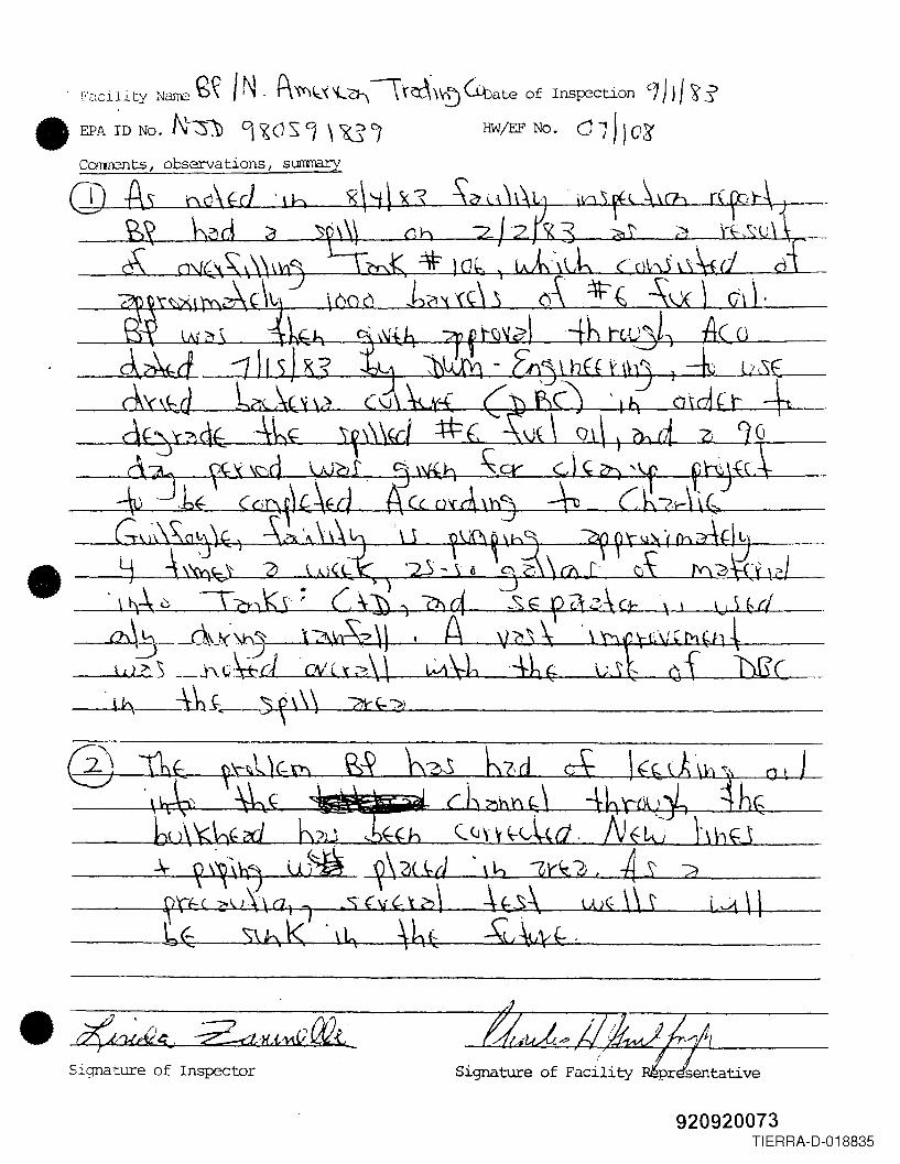
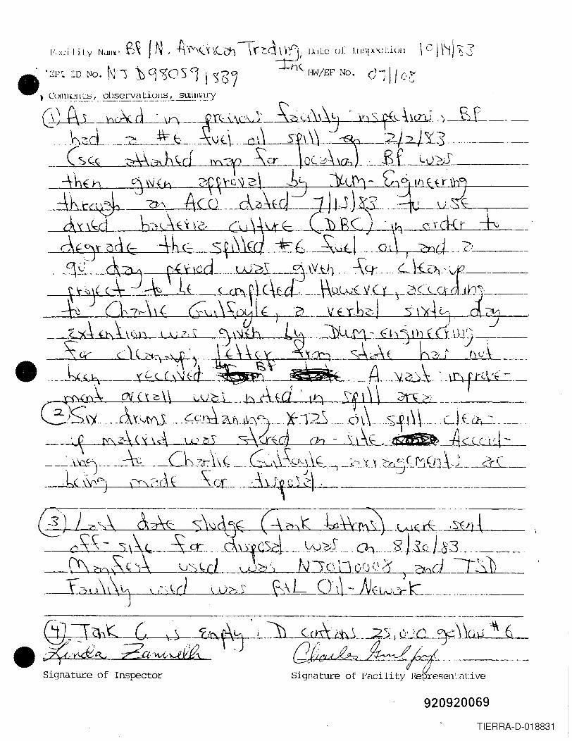
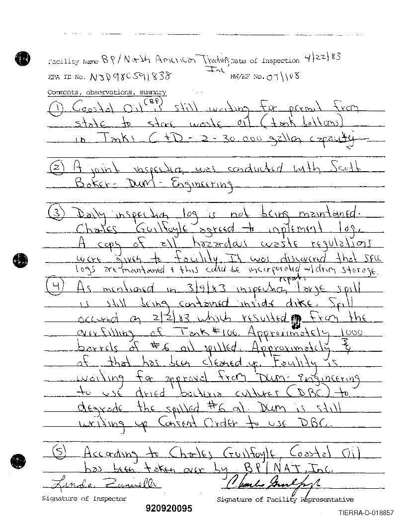
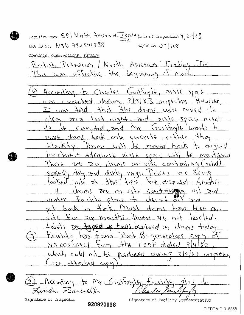
. ["c:cility NillT'/2 £~ IN. P\'\'l\l'<'L~ \t~'\\!) Unate of Insp2ction OJ j) f 'g s• EPA ~D No. N~1) 9 ~os '1 \ Xi I HW/EF No. Q -;J 103'
Caments, observations, surrmary
-\- y~\~ Lt~ ~b'.:d \6 sf"-?;, A~.sl...--...:?:.t..-- _~rf;( ~u\\ ~ 1 .S fV( 10\ 1£:S\ U)( \\ l L../i \lbE: S\ n K, \lq \h~(;-·---,,~llot-'·k~v~f.-,--, _
• ~g. --z.a.}{J11f} a?{,-Signature of Inspector
.'Signature of Facility
920920073TIERRA-D-018835
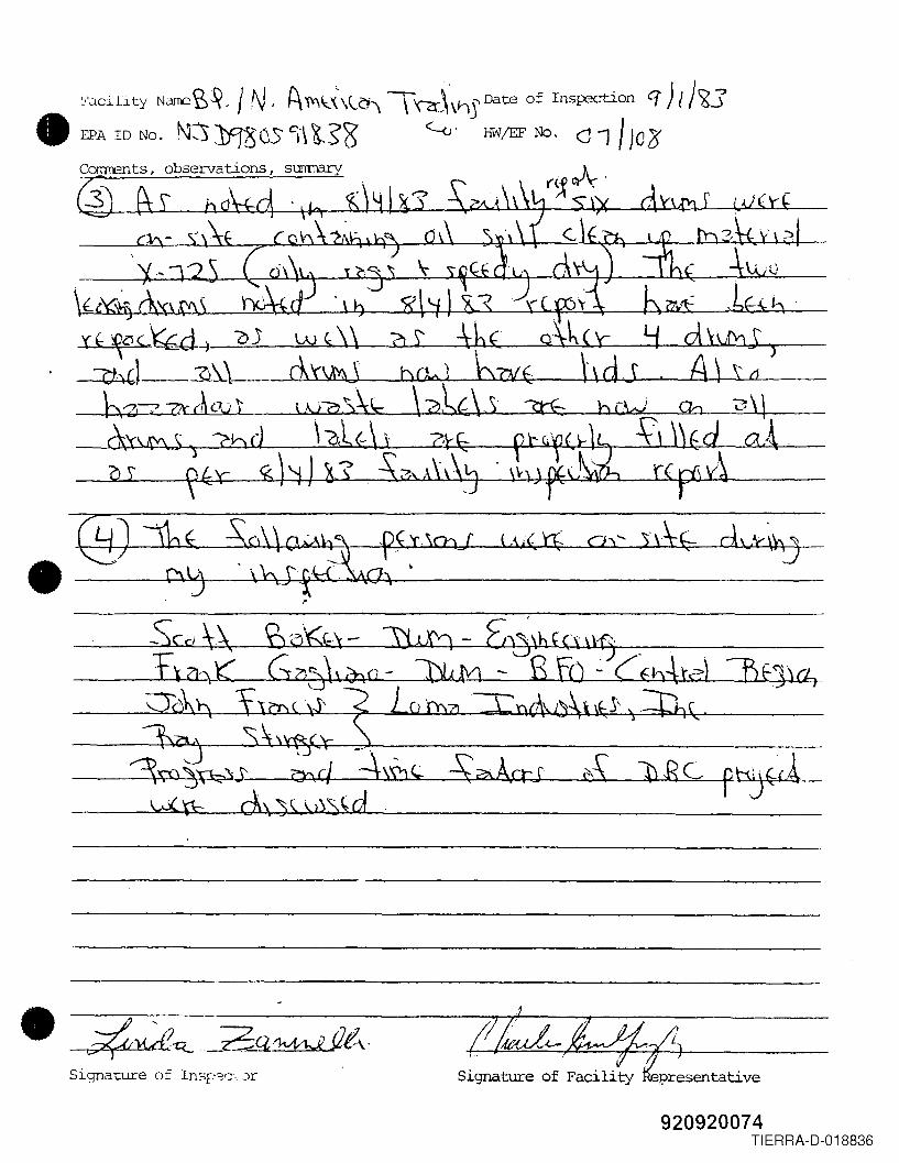
l·'o.cility NdIl'C~~. IN, {\ 1',\;.X\\.~, \ '\2r\ViS Date of Insp2ction q) I j?J• EPA 1D No. t\W JfJ80s 'H~s8' ~'HW/EF No. d 1/ )c3'
(~~.
f
'( f- ~oct't-di oj w (;\\ ~ S' =\-6( Y d x®S )=~hd--~~\-_.- ar\X'JJ bOo J b7JIE La J .A \..........l.S'-LLtl __
_ \:y~77Jr (h 001 l.\.iS) \\1,... \ A~(\,)' ?tE: b rW On Q \ \1--_<k'~S2~Q(L \o~f\~ ~fz- . ~ly ft \lid ca.4.
~Q~I_~~~~X:--=-5:;)~~S ~?A,lli\J ~ t(flil-l--l;Y~I----
• @ =:~-s:.~~:\ChJ (.11(\% a)~ nh-- d\k~
..
1
Signature of Fac~hty presentative
920920074TIERRA-D-018836
NA VY ::il tit:. t:. /920920075-~-
£XISTJNG
• [TANK A
•VED AREA
TANK B ] ( TANK C rJliANK 0 IG
Existing 6" Steel Line UNPAVED AREA
./. Ex is t ;n9 B" Sleeve/" . EXiSTING F"/R£WALL-,..,
f
,i, "
I ~
" .
L.-.----8---'-------e~-- ~-2.
I~~IX~·Future \ankBottoms PumpingManifold
New 6" Steel Line.
I~------
PAVED
?ECTION OFUCK TRAFFIC
I
• L---- __J__l_J
PUMPHOUSE
LOAOIN(; RAC/(NORTH SIDe
PAVED
Q/JONSETHUT.
iI
. \I IJ !..:
OFFICEBUILOING I
QUONSETHUT
LIl
PAVED
o5~i1{1\c-.
>IQ(.Drawing #4
Details for Tank Bottom~ ~torageScale: 1" s:: 30'
SOLID WASTE APPLICATION REPORTCherntech Consulting Group
November, 1981
•
•\4
Form DWM-0052/83
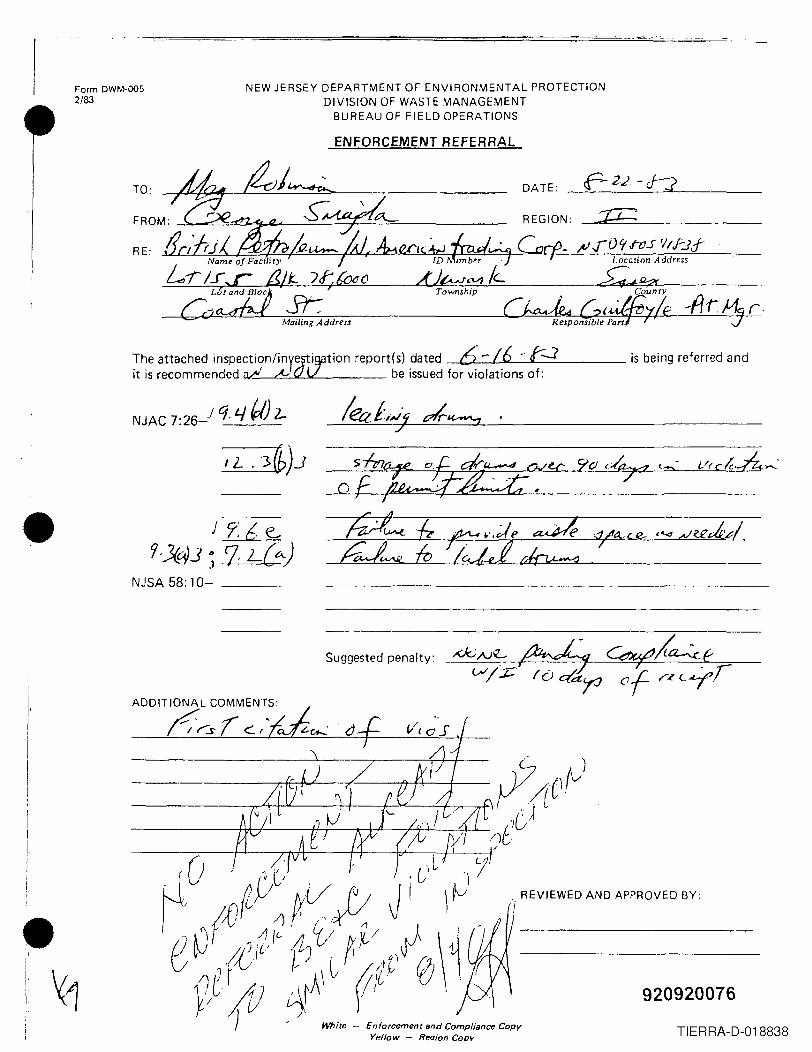
NEW JERSEY DEPARTMENT OF ENVIRONMENTAL PROTECTIONDIVISION OF WASTE MANAGEMENT
BUREAU OF FIELD OPERATIONS
ENFORCEMENT REFERRAL
r·
The attached inspection/inYcr~tion report(s) dated 6' -/6 . !:....:Jit is recommended ~ .& be issued for violations of:
is being referred and
NJAC 7:26-) q 4~) 2-
J9<6e..r;J(t1.J I> -I-7--=L-\c.-C,,-)
.1NJSA 58: 10- _
ADDITIONAL COMMENTS:r:~s
920920076TIERRA-D-018838
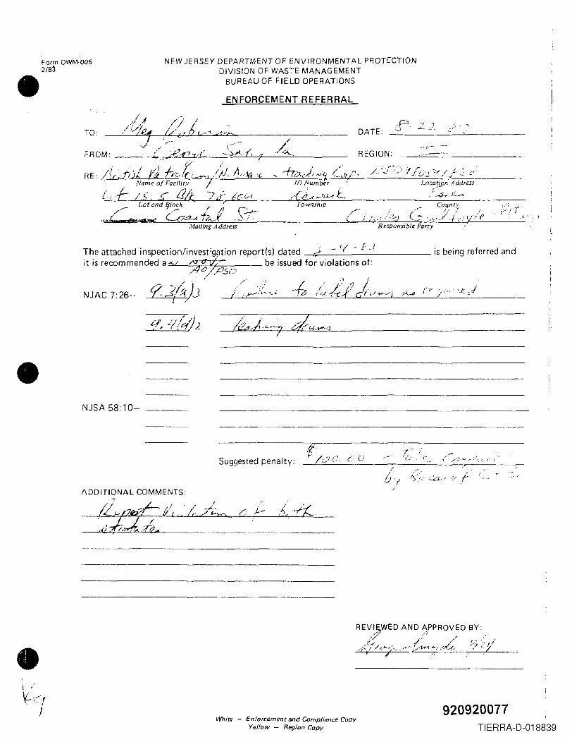
Form DWM·0052/8~•
NEW JERSEY DEPARTMENT OF ENVIRONMENTAL PROTECTIONDIVISION OF WASTE MANAGEMENT
BUREAU OF FIELD OPERATIONS
TO:
I'1 ,f/>'ig.,., I, DATE:
-P". -, ..,'-' ...:.- ~'-
ENFORCEMENT REFERRAL
r
/~. REGION:
RE:
___ Lot and Ijlock r: ,_.~/,- -+;. \ ~
"'-OJ e;; ......... LOCL--I 14.,r -.~ i .
1D Number
.d.:e~_/iA.-11:...Location Address
Township , ....-... :~~':': "V
~ !Mailing Address Responsible Parry ....
The attached inspection/investig~tion report(s) dated ,,}-- if - [ .Jit is recommended a -v be issued for violations of:
is being referred and
NJAC 7:26-.."""
",./If'. ,,-~J.,...-:,....,_ f
I ".;/ .., 1.//, ~ -/ (C"'1/2
•NJSA 58:10-
.{!Suggested pena Ity: _._t-.-!./....:~~.-,....:•. :~.7_. --=.(_::_L_' __ ---:- __ ~_..:.....:~~..::-.-..---_
-r ~.,'(.-' ·-."'r ....
( t""':.~"~~.~.":. '. ,"
C /..-
•Whire - Enforcemenr and Compliance Copy
Yellow - Region Copy
920920077TIERRA-D-018839
II II "I
~I
II
1,I
II
•I
I,.iI
/
Ilivision of Waste ManagernentFJcilHy 111~~H~cLi()n FOrJII
Tim~ ill IJlili ly ,Oepilrteu!O '210 1<¢JI\rrivue! 0 qS::' b 0.:(..)
F ucil i ty NaIIIG:Grit ish Pe tro 1cumiN. Amcri Ciln TrucJi ng Oil te: .---u--.:~~l-'"...,,;~i,~..:;~~~---,r~--=----Address:Coastal Street, Port.Newark 07102 Fac~ ~ep;~_'0.h\\'151?'\\1ii~fiiii
Pos 1t 1~n: . ,<,\ ,~< \/\..;,or ~ ,Ins pec tor :...-...i.. '.L ' ;;)'. \ \-..LU.l-i _
cPA 1D it: NJD980591838Lot; 15, 5 (31ock : 78, 60 0 0
Weather Conditions: :..-__--.i-:-~-:.:..:~~...---T;'''"..----Wind Di reet i on: N i),,;
OpcrJtinSi /\uth0.c.izutionFc:JC 'j 1ityi S opcr'Jt ing une!Qr (type of iluthori Z(lt ion) ; - ~J ""> \\ \ ,\.~ \{'::.Y(ly~r\SUlllmary of Inspection (check appropriate statement) ,1J;1'\ 'S.\;:\{- +', '\"({. "\J~_\r_r:lIcilily: 'is in cOlllplillncc with opuratiny <Juthori;li>tion: __
'is nut in cOlnpliunce with operiltinu authorizatTon: _Fi1cillty: h in comp1iance with NJAC Tit 1e 7. Chapter 26 :__ ... 1'/ ) A
IS nol. in COlilpliuflce with the folluwin9 statute provisions(~): .. ,_
Ov<.!r'l.l 'I1 housekeeping: Poor Fair Satisfactory l-/~~uction Observations1. Does the treatment process (including storage tanks)
systelll show any signs of ruptures. leaks, or corrosion?Jf yes, explain.
Very Good---Yes No N/A
~ . Spills. If yes, explain.
3. Odors. If yes, explain.:\~\~"\fJ, 'ir',h· \/\ 7r(~ \-
i
Container Storage: (7:26-9.4(d)Drum No. {, Stack Height 1. n,,\C',;,,)....,Do the containers appeur to be in good conditfo~, notin uanger of leaking: If no, explain in detail.
-=-Y"~.'l' ..--d:s \,!,rL\, 0 \~I '. \ ~- \t ;-J<} ;\-S - Sr f <: rp', reAiJ~-oj'
Storage Methou_ (' i'
Are all containers closed except those in use? -<.,(;:( <,c(',\\;"I\~*- 3 '..L.'I\rl' incuillpiJl ilJ 1(.' Wilstcs stored separate from each other? 7Adequate aisle space? ~rlrt: conLainers stored according to waste charilcteriziltion? .L..
920920078TIERRA-D-018840
..'
.. No N/Ae' .I~~ o."\chcunt.J;IOCr IIlj:lr~eu ul" Jubvlvd WII'l, llil.\',ord~ "li~:GurcJou:.; WiJ~\;.o".;.anuin COlIllJli.Jl1cV \'Ii IIIthe 00'.1' 1\.1bcll n<J CC:'IU i l:CIIIVn L;:.;:
- \Jon(n:ul;orn~IIIC
- ,"O<.Jcvti:':; ,_ '<....1.( CCf\("fY\\'~ ~ -- UN, NA nUllluur /'1:: ~
- DO'L' shipping JH~lIle- U;~A Io"nulIlbor
manifest. number- accumulation start Uutc
Vohicles: (7:26-7.1 und I.~)
valid registration cardNumn~~s displayedpropo~ly plDcard~dM~niL'osts: ('/:i!<i-7.4, 7.li ,lncl 7.6),
'/ .v
-:J2.)i-
'J.'hebgenet"Dtors nambe, maidlin~ addre~,s?, teleiJhone 1/0l •• 11 er, EPA 10 nUI1Ior an Sl<Jn.:1l;urc; v
_he t ra nsport ars niJlJIG,~PA ID numb,-!'gnature?
SWl\ tl.".:1n:;port:.errOlJistr.:1tionnumber"
///-;-
;;
The name, address, EfA ID number of thedesignated facility and signature?A description of the wastes (DOT)?
I
The total quantity of each ha~ardous waste?Has the generator received signed copies(fromthe TSDF)of all the manifests forwaste shipped off site more th~n 35 days .:190:Reco~d Keeping: (7:26-9.4 (f and i~Arc the following being kept pr~pcrly?1. Daily inspection log?2. uaily operating log?3. Waste inventory log?
.I
Samples taken:NJ DEP ID#
yes number of samplesI'
R . .~W~\J~ ,Signature of ~acility Representative
...... _-----.~.._. -----_._--_._ - - _.~ _. -.-
II
I,I
9209200iTIERRA-D-018841
. . c 10'\' N f\ r··f.-'\' 'i- --r ...\ ,.., !J,lL'\ ()! .IJl~;!.x.x.;L:.i.on o.~'j'i'/ ~-".'.?,.1·',,<:11 !!y NLJllil.' I",. .. H,·· ..n '{. \ \(C"-1\r,") c.. .:2\ Y~_
Le, ..../t<:Pi. l[) No. N'') -:v (~,~ (; S r:) j R?) CJ !l\'i!EF No. 01 ~Ic~•
•
! r; rJrj J-. ?; J i (-LS i'A .it' f.. dr, '\ .) f' 4 \ } fd . A ~f r f) X t h? \.\;\'-7 C . . \ . , nn .J.:-~\ ,\.:-\: -\ h2';\ b,,:>; l' c j (//,,< d 'f---.!..._~,-.:.)-,-i-.,l.-)-----
_.__ ._ dzl-L'YL--)..-<_---l~~....4_J~-~H-U-~L----L~~..L.>....!c........J,-'----4--=--4f_~---~. J (. j:? ~__ '1:.L.! Ch ,')-Jt....L--~, L:y~....:.\'-----+-_"__'~...ll..:..::....:d _ _>l...;...:,L:,~..L..:I.._..l_~_._.:::::~_'!......Jl~..l._ _
(C~'"b() VJ,~ S' ('?~, \ \( d =-\:': _ '; ~ ill,' :,___ :\-".......\-"'(~\'\ }/\(:r.cL.:- (~-C, v; t ! "j \ 1\, ~ 'y_(,.\ 1~ ~~~\,:\Ii· J'
,;')( 1\ \ eli"'~\\ '~;i <' \ Q(1 c; Iuff
L_o
~1\tt:.r)t"". /' ., I • • J; l II ~, ( :5
\ \ 'j.Co \ \ it4
--\(( \-(1=\ ( ~\\/z\\
II ~ ". \ \.
----~------------------,.------------~-------( -, )''C.-~ +-1", (,
-£ Ci::
920920080TIERRA-D-018842
.---~-LJJ0~3 ~~~~\~~~~~~~~~~~~~~~~~_:;t~/v~tr;:, 2(hI-h <ITA,., .
-:--. ,
• SiCJnuture of Inspector Signature of Facility Representative
•
•
11-1 -1,,\ Is, \' I .,d AA ~ 1M <",Ii - \',) t\\~):i [h,lS 0-C (,r\ \ \ 0\ \ de S :bf?hS ,A/oJ I ~>J(. r~ I ~I.jj ,-\\\)';.-.\
:::lc .... \-~- ,)>> If .
Signature of Inspector Signature of Facility Representative
920920081TIERRA-D-018843
•
•
•
In))., c. --\. ~,4. .. '1, "3 G~--.~-1hl.---_~.L\' ~ \ v(£\(d-d,,--,,-,y~1"\'-4-0.'-'-\ -
L".s'_D. ',;,l(; ',- . h~A..~.m. ~~} . ~."':Or,,,~",,-,-_\.\"j\ a. ch~,C~} 0\;\ ,~\ j\~l( d'i c:\'<\Xh' hG,\f4-.---\1\ L 11,,),)J \''')/f!IV~jC~!
._... _._ G: ~;, '\ \ .."'t 2 J .0.I~\ \-:N (~~ ) (~ ~ d \\ .rL1-1.-(-_ ........C6-+-1-'-'--
--1+-,03 j 8_'? P ~ ,AI b d l.b,. Q\ 0 , ?; 1'\ {r 'tv \{~ (y, d..-. -.=t ':)\) ~\_~\'-,\}\ \T-~-L~-=-'.j:'tJG. I' . fkiL'<~, h'<.oIf )'\.1,) •
\J\ (:~,\ \) \ -\t --- ..8'>-. -:?=.2 __~ .. __ .._. . _._. ._ ...J
... -_._-----_._---_._---
._------_._--- ------_._--------------------
..._-------
._--_.-_ ...._-----, -- ._._----_._-
- .. -.- .. '--" ......._---_._._ .._._ ...-._ .._---_ ..- --_._------------_._--
. -' _. --------_ __ --' - - .._- _ .. _ .. _ _ _.._--._ .._-_ ..- _._-_._--
--... _------._------ .._- ....__ ._--_._-_ .._----_._- .._--_._-----
,....'£.~:.,..2;~;~~&.,·._-.u'-:s3-~-~G~~--·-·-" ~ - ----
;;iqJ111.l:.ureof Inspector Signature of FClcility R8presentative
920920082TIERRA-D-018844

NAVY 5THi:.f:.''- '::::=:============ EXISTING
-~-:=
• I r--.:...~ T_A_NXc :tyLi)lNX D.---~
/' ----/ '
./ ,,)II
TANK A (TANK B
/----< ,,\\ //.~x i s t; n.Q_~,,';-'~Jg..e{l ine
-'-~
,\\
WED AREA ~istin9 8" Sleeve-d' ' EXISTING FIREWALL- -Sd i\
II,
106\\
\
f
]
, iI
, ,
I'FI!
r-_--L-l ----.- .."I <"(;'-,", ~ ,,~(c=----e-------_ .__~:. --------PA'VEO :)~;il"--LNew -6" Steel Line.
'"
Future \ank80 ttoms Pump; n9Manifold
QUONSErHUT
PAVED
,-- ------.../
"r---------"~------------,
/./
r ---------- ---/
" LOADING RACKNORTH SIO£ OFFlCE
BUILDING?£CTlON OFUCK TRAFFIC
IL--- J__l_J•
QUONSETHUT.
PAVED
Drawing #4Details for Tank 'Bottom~ Storuge
Scale: 1" ""30'SOLID WASTE APPLICATION REPORT
Chemtech Consulting GroupNovember, 1901
COASTAL OIL COMPANY
920920083
•
•
NEW JERSEY DEPARTMENT OF ENVI RONMENTAL PROTECTION
DIVISION OF WASTE MANAGEMENT
NOTICE OF VIOLATION
10 NO. DATEn 7 J \ \'.'-S
NAME OF FACILITY \3 -2 / N (i'(\)-l--&'0'/t!\\ (>. \" :CA,eb!', <'-.. Co. Jh.~(;,.~,:>\<;,.\ ~j I t'1/j-} __-:-s'i<' -'j~,\!\ tJ\(-'-:~rt(\.\'~..~\\(- G\;\\\cL,X- .I 8: 1~./J\\L0f~)
• '.) J
LOCATION OF FACI LITY
NAME OF OPERATOR
You are hereby NOTI F lED that during my inspection of your facility on the above date, the following
violation(s) of the Solid Waste Management Act, (N.J.S.A. 13: 1E·1 et seq.) and Regulations (N.J.A.C.
7:26·1 et seq.) promulgated thereunder and/or the Spill Compensation and Control Act, (N.J.S.A.
58: 10-23.11 et seq.l and Regulations (N.J.A.C. 7: 1E·1 et seq.l promulgated thereunder were observed.
These violation(s) have been recorded as part of the permanent enforcement history of your facility.
IJ-,((~ ~\ (._ p,r,\ ) \\~, ' ,~-:-,.-~jl-"
~ _-"--...e.-._-'-CJ,...' ~!~_
r,\ <1: 1; \"t1 0", _""'="'O'--'-'--'-"'-...J-- __ r=....' -'-(~.!rJ..\~,,!..l..\_\'_'_,(_rL.o.. _.. - ),.,...._\J' ,
f'" A. "0_\. CO;\\\ .J,(. \."-
_ "_t...-_ _ .)
\\\\'( d\~·t,I. ,.
I; " 1;--' \ f
~\' ">
Remedial action to correct these violations must be initiated immediately. The issuance of this docu·
ment serves as notice to you that a violation has occurred and does not preclude the State of New
Jersey, or any of its agencies from initiating further ddministrative or legal action, or from assessing
penalties, with respect to this or other violations. Violations of these regulations are punishable by
penalties of $25,000 per violation.
. Investigator, Division of Waste Management
~artment~oEnvironmental ~rotec~ion
\ ~,~~--\,.-\\~" \~ ~
920920084TIERRA-D-018846
NEW JERSEY DEPARTMENT OF ENVIRONMENTAL PROTECTIONDIVISION OF WASTE MANAGEMENT
NOTICE OF VIOLATION
NAME OF OPERATOR
You are hereby NaT IFIE D that du ring my inspection 0 f your faci Iity on the above date, the following
violation(sl of the Solid Waste Management Act, (N.J.S.A. 13: 1E-1 et seq.) and Regulations (N.J.A.C.
7:26-1 et seq.) promulgated thereunder and/or the Spill Compensation and Control Act, (N.J.S.A.
58: 10-23.11 et seq.) and Regulations (N.J.A.C 7: 1E-1 et seq.) promulgated thereunder were observed.
These vioiation(s) have been recorded as part of the permanent enforcement history of your facility.
• <.' (' /' " .... \' (.- , , ,~, -j
cY' f 1'"'\ V\ ..,~\\ Y"'~'l' ~
~.\
.J
Remedial action to correct these violations must be initiated immediately. The issuance of this docu-
ment serves as notice to you that a violation has occurred and does not preclude the State of New
Jersey, or any of its agencies from initiating further administrative or legal action, or from assessing
penalties, with respect to this or other violations. Violations of these regulations are punishable by
penalties of $25,000 per violation.
•-/' . - ,,-; (;j
.- ..;LrCV./') q z:= 11/\1k'\I\ i .V{,/!- .investigator, OiviSlon of Waste Managementffeparrment of Environmental Protection
, ~~\ ~~, \\~ SJJ, ",-h
920920085TIERRA-D-018847
•Division of Waste Managemenl
hlCi li Iy !JI~lJl~cL ion ForJl~//' TiJnL; Jt fJci lily
Departed I K;' (0 h (1 tS!\rr"i vea..ct.G 0 hCytS
I-uCL lily Nullle: ~r it i sh Pc lro I cumiN. Amcri e,n Truu illV Dote: .. "!j;J.lt± .Address;Co'stal Street, Port -Newark 07102 ;~;;tli~~: ==~S£~1\~hlCi I i~y TYIJl:: f~l::()r~gc, l::L"<1l1s1er Inspector: ..L.~hf..... \t----EPA 10 It: NJD980591838lot: 15, 5
Yes No N/I\
----·----"--------------\-"""-~A ~-:>-CCM M\!\ ~ '-L\-x:.- <- _~. Spins. If yes, explain. - $~s-
3. Odors. If yes, explain·-1>C,,\tG\\\K"1 -\Z\)J. = i-t) <tors ~
Container Storage: (7:26-9.4(d)Orufll No. a\..l- Ss ~\ Stack Hei9Iltli,2h Storilge Method On Cch(K \{00 the containers appear to be in good condition, notin Janger of leaking: If no, explain in detail. ~_- SfG- ~l"'&h\,w '2 -
Are all containers closed except those in use?
Art}. irlcolIl~JLilJle wi.lsles storetl separilte from eilch other?Adequate aisle space?/\rl: corILJirJ(~rs sLurecl according to waste churilcterization?
92092nnsu~TIERRA-D-018848
t:?~10,;{ .,Signature of racil~~resentative I
I
92092~1~~~A_D_018L9
_:~ -:"ch I.:vnlJ.'uh:r 111411:"'UU VI- Ldil,.'lL"cl willI lll~\-,(,)/,:<.J::J "H'.o~.:Jnjou:.; W....Sl:0" .:JncJ in u<JIIlIJli<.JIIUU vd L11the DO'l' 1ubcl inV rC(Ju i t-Clllcn t:;:
- Sl~ CCX'\M~~\ =*2. -- y 0nc l:') tOt- n\.lIlIC- ~Id cJ r u :; :;- UN, NA nUllIu<.n,,"- 00'1'shipping llulllC- EPA ID~ number- manifest number- accumulation start date
Vehicles: (1:26-1.1 uncl 'l.~)
V"llid registration GardNum~~~s cli~?layodpropc~ly placardud
'l'hegenerators name, rnailin9 addre£.s, telei:Jhlmom...l\ber, BPA ID n umber and s iCjniltur<.;?
•'h<.! t ra nsportec~ n.:.une,EPA 1 D numb,-C I;;l\d
'gnatuce?SWA tL·i:mupoctet."ruvistr.:ltion nUlIlbo,'?The name, address, EPA ID numbor of thudesignated facility und ~ignature?A descciption of the wastes (DO~)?The total quantity of each hazardous wa~te?Has the generator received signed cJpies(fromthe TSOF) of all the manifests forwaste shipped off site more than 35 days ago:HecOl:d Keeping: (7:26-9.4 (f and i)
Arc the following beir.g kept pCQperly?1. Daily inspect.ion log?2. UQily operating log?3. WQste inventory Ivg?S~mples taken: yesNJ DEP IO~
number of samples
4IIoto9r-aPhs
~;Sig ture of
@2ctiwn~,Inspector
taken: yes
Nu
..... _---_ -._----_ .._----_.- - ~..---.._ .._._ - -"- ._ _ -
NIJ\
•
•
•
--~~r ~~ ~Q\~~~~~ ~r~::~:J~I=t:\~-------c \;~f k l \~C! Z!" cJ ~\I\~~d '\ h-±u =r£!1 ~ L _
<3 I \ ,\-5 - VfOc\\Ju\ =\oJ\........5--L-, _
<:0 f\~~'PJ~\ ill/"\9 k> \f,,Js;.~1a?l chw r w£Ko d-,srx\Jfd~ 0'\ 'hE: 2lf d)U'Y\,\ S.\cK-ci en c;\\-£ \ 6
Signuture of Inspector Signature of Pacility Rep esentative
9209?nnRRTIERRA-D-018850
L'clciJiLy NUJl~ ~ V { N, A'f'\l-(\\..~ \rt~Y)j!Jute of InsfCction C) 17l 83• EPAIDNO.N3~9~oS9IgjJ . HW/EFNo. ol/Jor
Comrcnl:.sI observutions, sumnary
o \~~\, \-
__ -1h'rOJ~ \'h~ h\J\\; ~M \vh'\h JbaJ' L~£lq lAl(J=-:k~d__ ch hA\b~,(tn" GG~" ~h() I ))UJ'Y) . \\t)VfS~~3~iCJ-I-' .. M_b£E- h c ()'('(fC~cI I f\ (( c.t d'h) -\L f'<\!'. ._- -~~~Ii~~ =~~l\'~=k?k~ ~" .~~_£9I:Ld .
__ ..fu...=:......L.~SWJ'ii~ md :\h~ S~~ lL~\h~ _~\rE _~._ ~\.0p2> \rLbd Ch S\\~\B3, ~o<; ~\~0 . _U)(~ ?\Cih,d u--.o\C,= \~~ .r\'r~E\ ?h eJ hYVf-b<"f;-b sf,~\(d. ILv0 hEW ~~(-S \.-V\\\ Lc- ,
7> ~ t\G:q . \b. -\- he b{ Z1: ;\\J\.k{. A\ J i) I z,(J.,c-t cl IhJAu \Y\x, Gu~S;<.l'}\\ ) -+\AJU \fS\ GJ( \ Ls \A\I _..__...k 51" nJ;, -h S«. hew "\ Dr (j\ \ \'f~t~,-=(J~J' _
@ \\'<{~t~'iiIlY\"\t\y '1\*\ \C>:4 J' 0-\ ci~. ""d: w,,\~----·· .._-..~~~~ £:~~ c ~ bnt\ ,-l~ 3-<~.\ __i& ~~;~h;d\)~~J\hiG5ChJi2~\(()IL_._LI)\7~ f.\b \Af?;;, \bf h~u\(t \J.3\-d "h d\\ (>,S~5'? _
Zhcl ""3: S ~ Y~/A\\\y uSfd \ AJ ?1 1 ~ \- L ()\\ - N f Lv ?J'k~._
•
•920~,nnR~
TIERRA-D-018851
•
CONT'!<'OLBL D\<;.
I/'l:J~ "wr::tQa ,.
FOAM 1-40U5E
• EX/ST. WALL
PIf"ELINE~XfST. F?O.W.
~.o. vv.PI f"ELI N ~
.. "
920920090
).. - "
32/
3DC
305
•
•
•
I'(HIII LJWM-OO~'j1t3'J
NEW J El{SEY I.n;n~H'l'MEN'l' OF ENVIHONMEN'l'AL l)lW'!'lW'!'lONDIV)SION 01" WAS'l'E MII.N i\G EMEN '1'
NO'J'lCH U!." VIOJ..fI'l'lON
1.0 NO. ~Q"8' DN1'E QuJ-""~L.....:3~ _NM E OF l?AC11 ITY ~ £ ,I ~t\o-L'i'"\.J.:(lo..,.;'(~- \.u.\.~<:h~=r--"-~t-",?3""",,di.....' \,,-,-h.L..~-+- _
LOCATION OF FACUlTY C~fl~A?j\ 5\. I 3Gr\ N-",,~_l...J.:::...·Lt~t'"-- _NANE Olc OPE1{!\'l'OR ~~ G\I\\£Cl~4\J.;~ _
't'UU iJn: llcl:Uhy NO'nFLliD 1:1i~' uudl1g Illy ill¥P~ccivn vi your iac:L.liCy \,Ill t:lw ill.>OVC
dace. chc [ollowi.ng violaClon(R) of th~ Solid Wuste Management Ace, (N.J.S.A.I:.!: 11·:-1 et' Hell.) IIlld H~!gl/l"C~OllH (N.J.A.G.' 7::l0-1 or t;(,:~l') IH'O"lul~(Icuu cllc1'o-UIlJ01" <lIlU/Ol' chc 8pi.J.l COlllpal1l;1lJt:loni.md Control Ace. eN.J.S.A. 58:10-23.11 at:!ie,!.) 'lilYl{cgul.:lCiolla (N.J.A.C. 7:W-l ct: tiC"') prolliulgut~d t:hurounduc wel."C;o!Jtiorvou. These violation(s) have !Joen recorded as part of t:h~ pOrlllUIHJHConJ.'urculllcnt: hi,,\:ory of yoU( 1'ucllity.
))ESCKIPTION OF VIOLATION 1J :s .A .C, J 'd L -L\A~\\Y hz, S b.\ ['\n\~~\1{d
-O~->~.l-~1: "'1\ =ALp.;! <£ \6£.M.....~J~t \I~ 3ti\Xj 0" 5f"\\\.-m.d~E.'r\ c'\ [
(~LGJC~,..---_"3 J (Q\J~\J:
\hI(~ tQA I)-
~\t;tt} - 'f--
"
RC\IIC;ldial <lction t:o correct thc!;;~violations mut>t be initiated immediately.Tllo issuance of t:hi6 documen~ scrVDH <l8 notice to you that a violation haGoccurred and does not preclude th~ State of New Jersey, or any of its agencie6fl.'Olll init:iot:ing further adlHinilJl:t'nt:ivc 01.' lcgal action, or from Ll~fjel:lliingp~llaltil't;, wHlI rC::iIHH:l: to till!> or. ol:llcl." violl1Cions. Violl1tiolHi of tl,cuclCUU1<ICioll~ <.lrc puni<;!l,lll1e by j>D1wltics of $25,000 per Violation.
, 'rl 2tvMA,t2&'-in estigator, Division of Waste ManagementDepartment of Environmental Protection
920920091TIERRA-D-018853
•• f )C\lJC --l- of ..1---_Date: ~)/171 ~3
c: 0 N J .• I J) J'; N 'JI I 1\ L
Hcconm::~nd(\tions\
Subject: 6 £ / N oc\h Amf;'< \C.,<:h =C'C?ld\~) Co I
--._---_._ ...._--_._---------------
9209200~?TIERRA-D-018854
•
•
ULVl;jlOn of W.:Jste M~nug<':/Il<:nt--Facility Inspection Form
. . ?> ~ ,NrX\h AM~~\\.c;,\l~W'1 I \\~j f1iri-Il~C1IH:Y N<.!IIIU;. <T -~ -:J::"nL J.l) -It D~te; ~ J..).,1~1 'l.'ime;Add:e~s: ·Bldg. '35tJCoas:tal ~~n~~t P~c~lity Rcpr-cscntative; C~~-\ES ..Pi:lclllty rllYP:;'lfrun:~IC'r/:..;t()J.:.:l'.Jc l)O::.i.Ltlon;----b\ \- ("y'-,~ ">'(c ... G-u\\~J.,KUW/L::l" No.: U/IlOP In:..ipuCl',H;; Y 0\ \'\ :'\v<.J'VJT • L :2 ~ \Y\~ \ \\tfewgther Cond1'[[0~1f':c1rk- C\f(r< ..i;J ;~\ -
Wind Direct ion: Sf, 'l'emp: S ~...; s-- \0 MPHOperating AuthorizationL"ucility i~ opucuting undue A~~\\<.c.&O) ~()'\d\n) l:A\~ B\\W GY'l)'f1t\.\\'2JP<Jcility i;;:; in cOlllpli~ith opQruting .:luthoei~i:ltion
Yes No ~
Inspection Ob5erv~tion~Yes N/ANo
2.
3 •
DOus t,;.hu t,catlllonl pCOl,;:Ca~ (inl,;ll,Jdingstorage tanks) system show any signsof ruptures, leaks, or corrosion?If yef:J, expl~in. ..:::L-Spill:..;. If y<:lJ, ('!xPl~in ~- S'-E: c.U"\tI"\\l1:\ -\tl.\-..:L...Odors. I f yes, eXpli:lln.)- r(-\'r~\~ OdQ')- .L-Ovecull housekeeping: Poor ~ Good4 •
Cont~incr StOr.u9C: ('l:26-Y.4(d)Drum NO. '1l{Do the con~ainer5 appcac to be in goodcondition, not in d~n9u( of lo~kin~1If no, expluin in dutuil.Are ~ll cont~incrs closed except those 1n use?Are incol\lp~tible W41stcs :.;tocedseparate fromeach othcc?1\<.1 cq u \.1 tc ~ i.::..; 1<..- <;LJu(.'u~' - 5« '-CMt"l(t\\ '\\:= ~ ~Ace cont4liners stored according to WulJtucha'clcteci~ution?
\
92097nnQ~TIERRA-D-018855
Repres~ntative
• No
Is .:>i:lchcontiuncr marked 01" l.JbcJed wilh tJl('wo::d~ "j-jil:t:(lrd()u~ W.:ll.Ote" .::lnd111 COlllpli.:Jl1cl' willIthe DOT labeling requirements:
- S (. ~ c. QV\Pl~V\\ #- ~- g8nerator liilme.:lc1dres:.;
- UN, NA numbwc- DOT shipping name
EPA ID number- manifest number- accumulation start date
Vehicles: (7:26-7.1 and 7.5)
Valid registration cardNumbers displayedproperly placardedM.:Jnifcsts: (7:26-7.4, 7.5 dnd 7.6)
Does oilch manifc~t h4.lv,~the [011iwn9 intorllli.lL.i.vnlThe generators name, mailing address, telephonenumber, EPA ID number and signature?
•. e trans~orters name, EPA ID number and
gnaturelSWA transporter registriltion number?The name, address, FPA ID number of thedesignated facility and signature?A description of the wastes (DOT)?The total quantity of each hazardous waste?Has the generator received signed copies(fromthe TSDP) of all the manifests forwaste shipped off site more than 35 days ago?Record Keeping: (7:26-9.4 (f and i)Are the following being kept properly?1. Daily inspection log? -5fE::: '-<.A"\~""\ *32. Daily operating log? ~,3. waste inventory log?Samples taken: yesNJ DEP ID#
number of samples
eto9rC1Phs
~?6,
Signature of
taken: yes
2a~e\.·In~pector
920920094
N/A
i i:TIERRA-D-018856
•
•
•
----_ ... _._-.------- .. - --- .
Signature of Insfector920920095 TIERRA-D-018857
• ~"o.cility NCllTl2B\ \ N O''{\\t f\~\. \"'-~ -=s5Z<\ \r1ktc of Inspection lf 12~1~s~"'(.
EPA ID No. N~\) ~~u S~\ ~S8 HW/EF No. 01110'0
CCli11T'Cl1ts, observ <1tions, slllll11ilrY
•
",,-,k\~ c C!./\d on' b~ ,to c\\1CC-d QV{ \\1)5 3 \ ~hs S \ h) f\ ~>k(],( .)\-\ b\\ Cil.,h~cli----==c.~cr'--1+-,10~.----------_
•Signature of Inspector 920920096 Signature of Facility Rep escntativc
TIERRA-D-018858
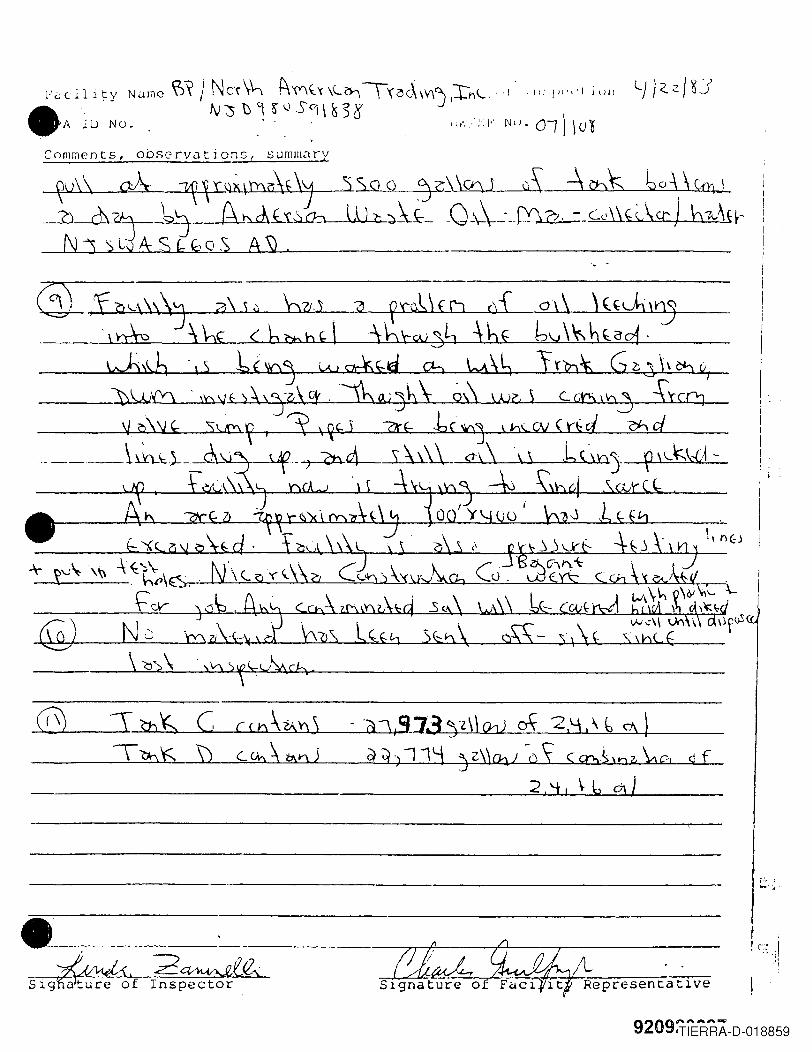
Comments, oDsc:rvcJtions, sumlllZlry
~\ aA- ~V"~\l:h~''J :SSG Q'jZll<h I uS --\ ~ boj ~\mJh ch'1 '6j fA ~f-'\'.~:>~LO \---\-.:.j"Y;w, - -Cc\\ k\ CI' J bw\H--N1 sWASc;(;oS A5J.
:r b)~ C cu,,\?Ab)\Ynl; \) C-GhA ~1'\5
• - -----:rr-ff--+J---.,-----
JJI1J./{) 2~f./Z,Sig~of Inspector Representatlve
r'-, " ,h.. ~ .
, c:: ,I~ . .. ."
·-1
9209:TiERRA-D-018859
NAVY S/Ht:.t:.1
• EXIS T/IVG
-':f-
1
TANK .i]
/
WED AREA
TANK 8 ,
Existing 6" Steel Line UNPAVED AREA
,/ Existin~ B" Sleeve/ . EXiSTING f'IR£WALL-
New ·6" Steel Line.L x·/1_1PUMP
HOUSE
PAVED
Future \ankBottoms PumpingManifold
r-- ------
"/,1'---- - -----
/~------------,/
"r ---------- ---/
/
920920098
-1QUONSET
HUT.
Dra....ing #4Details for Tank ·Eottom~ Stor~ge
Scale: 1" '"30'OFFICEBUILDING 1
QUONSETHUT
7ECTION OF.K T~AFF/C
L- J__L_J
L"'ADV COASTAL OIL COMP~~:.",,,,,,,.y1.~\~.\~"3\\'1TIERRA-D-018860
LOADING RACKNORTH SID£
l_ It 11--
PAVED
SOLID WASTE APPLICATION REPORTChemtech Consulting Group
November, 1981
920920102
.•REMEDIAL ACI1VITY
INSTALLATION OF FOUR (4) ADDmONAL RECOVERY WELLSFAPS PARKING LOT
BRmSH PETROLEUM MARINE TERMINALPORT NEWARK, NEW JERSEY
Report Date: March 9. 1995Recovery Wells Installed: November 14-15, 1994
• Prepared for:
BP Marine AmericasBuilding 350
Coastal StreetPort Newark, New Jersey
Prepared by:
Handex of New Jersey, Inc.500 Campus Drive
Morganville. New Jersey
_e BAA00002591iandaxe-- ~
.' ", rl'" L.>.
TIERRA-D-018861
.•
•
•
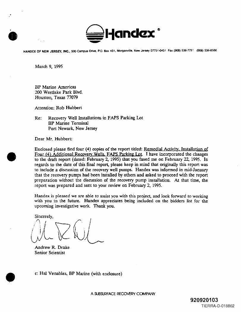
HANDEX OF NEW JERSEY. INC.. 500 campus Drive, P.O. Box 451, Morganville. New Jersey 07751{)451 Fax (908) 536-7751 (908) 536-8500
March 9, 1995
BP Marine Americas200 Westlake Park Blvd.Houston, Texas 77079
Attention: Rob Hubbert
Re: Recovery Well Installations in FAPS Parking LotBP Marine TerminalPort Newark, New Jersey
Dear Mr. Hubbert:
Enclosed please find four (4) copies of the report titled: Remedial Activity. Installation ofFour (4) Additional RecoveJY Wells. FAPS Parkin2 Lot. I have incorporated the changesto the draft report (dated: February 2, 1995) that you faxed me on February 22, 1995. Inregards to the date of this final report, please keep in mind that originally this report wasto include a discussion of the recovery well pumps. Handex was informed in mid-Januarythat the recovery pumps had been installed by others and asked to proceed with the reportpreparation without the discussion of the recovery pump installation. At that time, thereport was prepared and sent to your review on February 2, 1995.
Handex is pleased we are able to assist you with this project, and look forward to workingwith you in the future. Handex appreciates being included on the bidders list for theupcoming investigative work. Thank you.
Andrew R. DrakeSenior Scientist
c: Hal Venables, BP Marine (with enclosure)
A SU3SURFACERECOVERY COMPANY
920920103TIERRA-D-018862
, .
•
•
•
1.0INTRO DUcrI ON
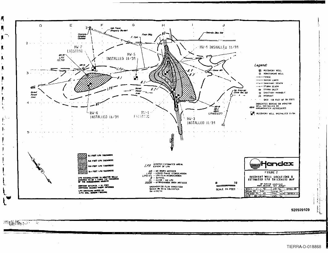
Handex of New Jersey, Ine. (Handex) was contracted by BP Marine Americas (BP Marine)to install four (4) recovery wells at a property referred to as the FAPS parking lot, locatedadjacent and to the south of BP Marine's Pon Newark facility. The purpose of drilling therecovery wells was to enhance the recovery efforts of liquid-phase hydrocarbon (LPH) in thearea of a former line: leak.
Two (2) recovery wells had been installed in previous efforts. After completion of the four(4) wells associated with this effort, the total recovery well in place as of November 15, 1994is six (6). The placement of the four (4) new recovery wells was assisted by fieldinvestigative efforts performed on April 27 and 28, 1994.
Section 2.0 provides. background information. Section 3.0 describes the recovery wellinstallations. The report is summarized in Section 4.0.
2.0 BACKGROUND
2.1 SITE DESCRIYnON
The property investigated is located immediately south/southwest of the BP Marine facilityin Pon Newark, New Jersey (see Figure 1). The property is owned by The Port Authorityof New York and New Jersey (Port Authority) and is leased to Foreign Auto PreparationService (FAPS). The property is used by FAPS as a parking lot for cars unloaded frommarine vessels. Transecting the FAPS property is an abandoned below-grade pipeline that,prior to 1992. was used by BP Marine to convey products from their terminal to a dock atPort Newark (City) Channel, located approximately 1000 feet from the BP facility. In 1992,BP Marine abandoned these below grade pipelines in place and now uses above gradepiping to convey products from the terminal to Port Newark (City) Channel.
.2.2 INCIDENT BACKGROUND
The following background information was obtained by Handex from BP Marine personneland records.
BP Marine first reported a possible spill event to the Coast Guard and the NJDEP onOctober 4, 1992, after an oil sheen was discovered immediately adjacent to BP Marine's
1
9209TIERRA-D-018863
•
•
•
dock at Port Newark (City) Channel. The sheen was traced to a storm sewer outfall leadingfrom the BP Marine Terminal and the adjacent FAPS parking lot. On October 6, 1992, oilwas discovered in a storm sewer basin (located next to RW-2 on Figure 2) and access pitassociated with underground pipelines from BP Marine's Terminal (located at RW-1, seeFigure 2). The release of oil had apparently resulted from a leak from one of four of BPMarine's underground pipelines. It was suspected that oil within the storm sewer basin hadoriginated from this underground pipeline leak.
Immediately upon discovery of the oil, BP Marine shut off and drained the oil from all fourunderground pipelines until the source was determined. In addition, BP Marine evacuatedthe spilled oil from the access pit and the storm sewer basin and installed absorbent buoysat the storm sewer outfall in the vicinity of the BP Marine dock. Upon conducting ahydrostatic testing of all four underground pipelines on October 6, 1992, it was determinedthat the oil was the result of only one of the four lines leading from the storage facilities onBP Marine Terminal to the dock adjacent to the access pit. The leak had not been detectedin hydrostatic pressure testing performed only a few months prior and was not indicated indaily product monitoring performed by BP Marine. This information suggests that the leakonly occurred during times when the line was under elevated pressures while in operationfor product transfers and the duration over which the leak occurred was probably short
To prevent the potential for further incidents, BP Marine has replaced all undergroundpipelines between the Terminal and dock with above ground piping. The undergroundpipelines have been cleaned and are inactive.
23 REGULATORY INVOLVEMENT
On November 16, 1992, BP Marine submitted a remedial work plan to the NJDEP toinvestigate the nature and extent of possible contamination caused by the undergroundpipeline leak.. No immediate response to the work plan was provided by the NJDEP. BPMarine chose to continue with its remedial investigation voluntarily, without NJDEPoversight.
On February 5, 1993, the NJDEP offered BP Marine the opportunity to proceed with theremedial activities at the site under a Memorandum of Agreement (MOA). During thisperiod of dialogue with the NJDEP. BP Marine initiated an effort with Ground WaterAssociates, Inc. on March 8 - 10, 1993, to investigate the area of concern as well as initiateextraction of the subsurface oil. After further dialogue, BP Marine entered into aMemorandum of Agreement (MOA) with the NJDEP on June 7, 1993.
2
92CTiERRft:=O-018864
•
•
•
2.4 PRIOR ENVIRONMENTAL INVESTIGATIONS (FAPS PARKING LOT)
The initial investigation of the area was conducted by Ground Water Associates andincluded drilling nine (9) soil borings, two (2) of which were completed as groundwatermonitor wells, and installing one (1) recovery well. A complete description of this initialeffort can be found in the April 9, 1993 report prepared by Ground Water Associates titled:Remedial Investigation Report. BP Marine Terminal. Port Newark. New JerseY. A secondeffort was completed by Handex and included drilling three (3) soil borings, installing one(1) monitor well and one (1) recovery well. This work is detailed in the April 21, 1994Handex report titled: Remedial Investi~ation Update Report. BP Marine Terminal. PortNewark. New Jers~. liquid-phase hydrocarbon (LPH) was detected in the two monitorwells installed by Ground Water Associates (shown as MW-19 and MW-20 on Figure 2),both recovery wells (RW-l and RW-2) and one soil boring (SB-l) installed by GroundWater Associates. LPH is currently recovered from the two recovery wells via automatedpump systems.
To roughly define the area of LPH impact, Handex drilled 22 soil borings on April 27 and28, 1994. Field observations and measurements were used to estimate an areal extent ofLPH. The estimated LPH thickness map constructed from the collected field data has beenincluded as Figure 2. A complete description of this field investigation is detailed in theSeptember 7, 1994 Handex report titled: Remedial Investigation Update Report. E?ij?)orat0O'Boring Program. FAPS Parking Lot BP Marine Terminal. Port Newark. New Jersey.
3.0 RECOVERY WELL INSTALLATIONS
Handex installed four recovery wells in the FAPS parking lot on November 14 and 15, 1994.The recovery well locations were based on the findings of the exploratory boring programconducted in April 1994. The recovery well locations are shown on Figure 2. It should benoted that RW-3 was intended as a replacement recovery well to RW-1. Prior to and at thetime of RW-3 installation, RW-l was non-operational.
On November 14 and 15, 1994, four, eight-inch diameter recovery wells were installed. Therecovery well installation was supervised by Handex of New Jersey, Ine. and conducted byBurlington Environmental Inc. The wells were installed via the auger drilling method using14-inch outer-diameter augers. The recovery wells were installed to a depth of 18 or 185feet. The eight-inch recovery wells were constructed of continuous-slot PVc. #1 Moriewell gravel was used for the sand pack. The wells were developed by over-pumping.
The upper seven feet of sediments were predominately sand, gravel and silt. Below sevenfeet was predominately silt and clay. LPH was noted on the cuttings and augers during
3
•
•
•
drilling of RW-4. Strong hydrocarbon odors were noted during drilling of the other threerecovery wells. A complete description of the sediments found and the well constructionof each recovery well is detailed in well logs attached as Appendix A
BP Marine installed pneumatic submersible, top-loading, total-fluids pumps in the recoverywells along with the associated piping in December 1994 and January 1995. Handexrecommends the intakes be set 4 to 5 feet below static water levels. The four recovery wellsinstalled in November 1994 augment the recovery efforts of two previously installed recoverywells.
4.0 SUMMARY
Handex installed four recovery wells in the FAPS parking lot on November 14 and 15, 1994in a continuing effort to remediate an LPH plume in this area Placement of the recoverywells were based on the findings of an exploratory boring program conducted on April 27and 28, 1994. BP Marine has installed pneumatic submersible, top-loading, total-fluidspumps in the recovery wells. The four recovery wells augment the recovery efforts of twopreviously installed recovery wells .
4
920920107Qliandax·-
TIERRA-D-018866
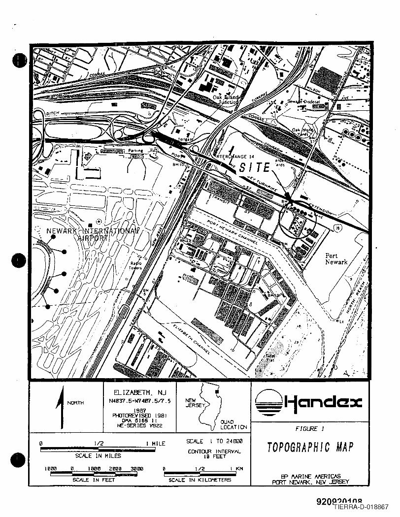
•FIGIRE 1
ELIZABETH. NJN4B37.5-W74B1.517.5
1961PHOTrnEV J SED 1981
OM 5165 1(t£:-~IES V822
SCALE I TO 24000]/2 TOPOGRAPHIC MAP- CDNlOUR INTERVtLIII FEETSOLE IN MILES
B 100 I!! 2008--1800i
1/2 I t<I'1
SCJ\LE I N FEET
920Q')n-tno'TIERRA-D-018867
~,
r·,,-
!.
o E
Legend:III RECOVERY VELL$ HONITORINO \lEL~
-w.-r£KCE-,,- VATER LINES-.- SANITARY SEWER-.- STORH SEllER
"" STORM INLET& $ANIl ARY HANHOt..EA HYDRANT
'RID [51 fEET aT 51 FEET!
INDICATES BORING OR HONITOR
tar.... ~~~~N~~~~~~L~~S~~IATES
'i.Il RECOVERY VELL INSTA~LED 11/94
~1-fC1ndC!XFI~2
UCOVEn WELL lOCATIONS &ESTIMATED lPH THICKNESS MAP
2
4
11.,'91
IF IVR I t-E A,JVJt I CASPCRT t£\l'AH<. t-I:."'V ~
SCALE • 1· .. <49' ~ t'b. - 11I1B604·eeOMIIN • SJ-i 121SK ..,. -
RI...I·-t· 'F \ j,j TI ;',:r, (,:,
INSTALLED
920920109
·~V~tti'~.~r~';'~:~':i3.:;!~'"~-:_;t"--~----~--------------------------------------------------------------------..1I
5
~D.If1111\'UOl~
• Uf1III\' LPtlT1llQClCSS
~J!!]j) u f1III\' LPtl T1lIQCICSSa 0.4 f1IIIT LPtl T1lIQCICSS
LPII ACl:UlILA~ Dl __ W1.U
AaUIIIlI TO lilt 4 T1IlU na: -IF tHE a........... MIIIIf'Q
CDlT1IUIt DITDIY __ - ILJ """~MDtDl--LPII CIIlIT1IlaS .,..0 ...4n4 alii. __ ..-
Ll'1I ~~~~~~S:SZ~ATED AREAL
ND - NO ODORS NOTICEDLPH - LIQUID PHASE HYDROCARBON
LPH-Fl - LPN fILM NYDROtllRBDlIN - REruSAL
CL - CLEAR - NO LPNODON - HYDROCARBON DOOR NOTICED
GRlIUNDV.·iER fLOV DIRECTIONlIMED ON IlllTA COLLECTEDON 4/IJ/~4
5C/Il.E IN FEET
TIERRA-D-018868
.•
• APPENDIX A
BORING LOGS
•920920110
TIERRA-D-018869
•
•
•
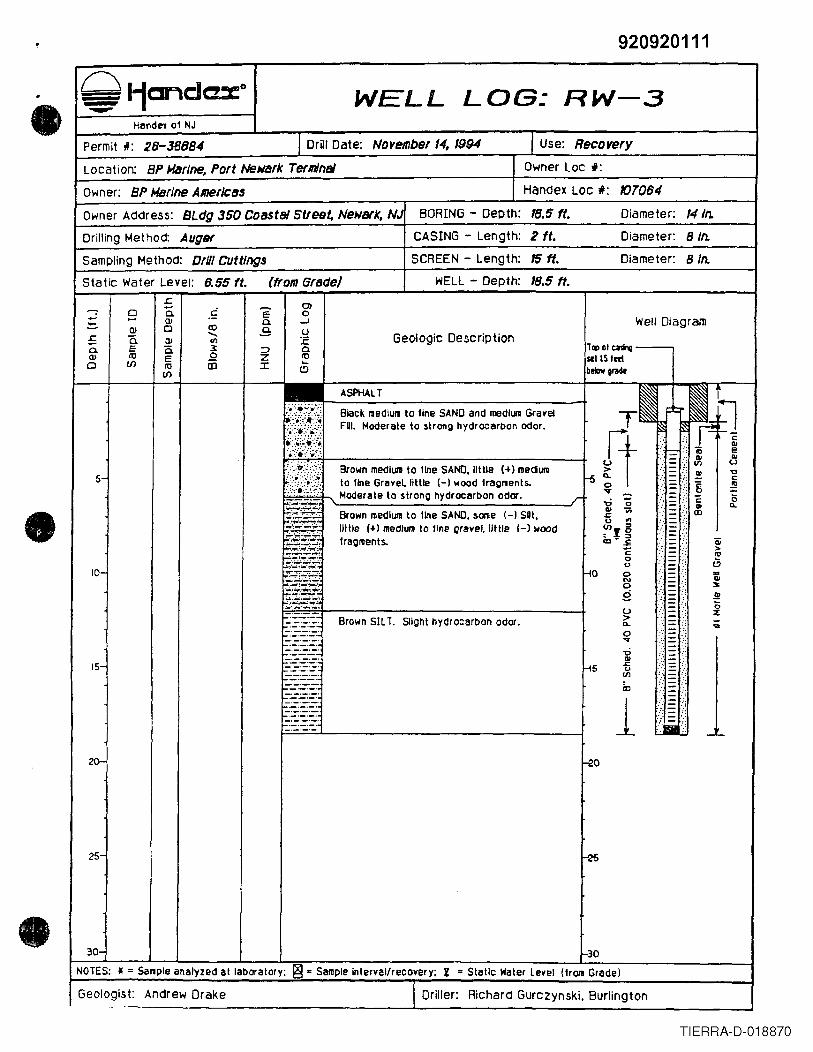
920920111Q I-jClJ"'"\d axe WELL LOG: RW-3--- Handel 01 NJ
Permit *: 28-38884 I Drill Date: November 14, 1994 I Use: Recovery
Location: BP Harlne, Port Nell/ark TerlldnlJ Owner Loc f:Owner: BP UBrJneAmericas Handex Loc #: 107084
Owner Address: SLag 350 COBStBlStleet, NewBlk, N,; BORING - Depth: 18.5 ft. Diameter: 14/n.
Drilling Method: Auger CASING - Length: 2 ft. Diameter: 8 In.
Sampling Method: Drill CUttings SCREEN - Length: 15ft. Diameter: 8 In.
Static Water Level: 8.55 ft. (from Grade) WELL - Depth: 18.5 ft.r:.
0)- 0 a. c E 0- .... Q.I 0. -J Well DiagramQ) 0 <0 .9: u
£ Ci "- Geologic DescriptionQ) ell :.E0. E 0- J:: :J 0. lq, at talInlJ -Q.I m E 0 Z m seIlS ted0 If} m iD :r ~
If} c:> bekN 8!'1de
ASPHALT T"II~":~:}~.:':'~~~:~'Black l1ediull to line SAND and medhJlll Gral'e11i:)::'.:~:') FQI. Moderate to $trong hydrocarbon odor.:~~:~'~~'.:<~::'::.
ft.<;;:.::.• ::.;~.·;.·:::'i/;;·?~~. - iij e= III OJ
',··.:.• :';·Yi Brown medium to 1lne SAND. little (+) meClUl1 = Vl U
'\'~~::~~/~'i ~ = ~ ~5- to fine Grlll'e~ little (-I wood 1ragments. =: 8 ~'.':':.':.'.".' Moderate to strong hydrocarbon odor."Or _
.r '0 '0 :: c 0i§::- - III ...
Brown medium to 1lne SAND. sOllIe (-) SUt• ~ -;; = CD;;::t:;;:t:::~~ o oil
little (+) medlUtll to 11negral'el. little 1-) wood ~Ig =.;.;..~~-:,;.. -.~"...- fragl1lents. CZ) .. .,E = Qi:;:;:;;;':~' C - >
~Sf2' - Rl0 -- i3
-l0u -10- 2-£2: 0 -= ;N -.........--~ 0 - :s:¢#...~.~. g -- .!!!::'::ti:';-~ = <5U -
..:~-=~.:. - %Brown SIL T. Slight hydrocarbon odor. :> -
C>. = ..._._._. -:::::::.-:::::.:. 0 -.... =.__ ._. -_._._._. -0 -.__ .- =_._-_._.III
15-_._-
HS ~ --,_._._.u -.__ .- --_._._. (/] -_._- --_._-iD --_._. --_._._. ---'- --'-'--' 1 -_._.- ---_._._. -._._._. --_._._.
Iii._._.-_._._,-, _ .....
20- -20
25- ~
30- ~ONOTES: }I = Sample analyzed at laboratory; ~ .. Sample interl'al/recovery; ~ .. Slatic Waler Lel'el (1rol1 Grade)
Geologist: Andrew Drake I Driller: Richard GurczynSki. Burlington. __ .
TIERRA-D-018870

920920112
.• I Use: Reeo very
WELL LOG: RW-4Handel of NJ
Permit -II: 28-38885 I Drill Date: November 15,1994
Handex Loc *: 107084Location: BP "'arlne. Port Netiark TerminBI Owner Loc *:Owner: BP "'arlne Amerlea~
Owner Address: BLclg 350 COastBi Street, Newark, N~ BORING - Depth: 18 ft. Diameter: 14 In.
Drilling Method: Auger CASING - Length: L5 ft. Diameter: 8 In.
Sampling Method: D,OI Cuttings SCREEN - Length: 15 ft. Diameter: 8 In.
Static water Level: NA (from Graclel WELL - Depth: 18 ft..r::. Ola. c ~- 0 E 0..... (l) 0 ...J Well Diagram- (l) 0 co .9 u
:5 a. "- Geologic Description(l) '" :.c0 E a. 3: => 0 T~ol tnrq(l) 10 E 52 z 10 st! l5 'ed0 (/) 10 CD ::r: ...
(/)t.::l bebv grade
.................•....• .....
.·•.a·.~·•.....~....~.:...../.Brown coarse to fine SAND. some line Gravel •little Silt.
5- .......... .:.:..;"';~..-.~._.
.~.~.~...~•
_L-
10- f-lo ==._._._.-
Black SIL TV CLAY (moderate odors below 12teet) .
u>0-0
'"UQI£:
H5()(/)
<c
1~
.-._._.-_._._ ..
._._._.-... -
15- ._._-_.-._ .. _.-._._._.-
20-
25-
_e30- 1-30
NOTES: * = Sample analyzed at laboratory; ~ = Sample Interval/recovery; l . Static Water level (lrOlll Gradel
Geologist: Andrew Drake I Driller: Richard Gurczynski. Burlington
<5%
;;
I
TIERRA-D-018871
•
•
•
920920113
I Use: Recovery
WELL LOG: RW-5Handex 01 NJ
Permit #: 28-38888 I Drill Dale: Noyember 14,1994
Handex Loc II: 101084location: BP Marine. Port NeNlJrk Terminal Owner Loc I:
Owner: BP Marine Americas
Owner Address: BLdg 350 Coastal Street, Newark. NJ BORING - Depth: 18.5 ft. Diameter: 14 In.
Drilling Method: Auger CASING - Length: 2 ft. Diameter: 8 In.
Sampling Method: D,81 Cuttings SCREEN - Length: 15 ft. Diameter: 8 In.
Static Water Level: 1.82 ft. (from GrlJ(Je) WELL - Depth: 18.5 ft.
ASPHALT
Well Diagram
.t= 0)- 0 - E E- a. 0- ..... OJ 0. -J- OJ 0 CD ..9- 0£ '0
--.. Geologie DescriptionOJ en :E0. E 0. x =' 0.OJ to E .2 z co0 (I) to co :I: ...
(I)C)
T~ IIICli~ --...,letlS teetbebw gtlde
25-
=
5-
Brown medlUlll 10 tine SAI'D, ~ome mediul1l toHne Grevel, Irace 1+) Wood and Bricklragmenl~. Moderale 10 slrong hydrocarbonodor~.
_._- ._.8rown SILT and CLAY•._._._.-
--'-'-'-'-~o =10- ._._._.-
=Brown ClAY and SILl. Slight to moderalehydrocarbon odors.
=
20-
-U:>...0'<f
'0QI
-15 s=0VI
ill
1-eo
==---
15-
NOTES; I ..Sellple enalyzed at labor21lory; ~ .. S2lIIpie Interval/recovery; I • Static Water Level I1rom Grade)
I-Geologist: Andrew Drake I Driller: Richard Gurczynski, Burlington
-'-
TIERRA-D-018872
,
WELL LOG: RW-6Handex of NJ
Permit I: 28-38887 I Drill Date: November IS. '994
Owner Lac #:
I Use: Recovery
Location: BP Marine, Port Ne~~rk TerminBl
Handex Loc 'II: 107084Owner: BP Marine Americas
Owner Address: BLog 350 CoastBi Street. Newark, NJ BORING - Depth: 18 ft. Diameter: 14In.
Drilling Method: Auger CASING - Length: '.5 ft. Diameter: 8 In.
Sampling MethOd: arYl Cuttings SCREEN - Length: 15 ft. Diameter: 8 in.
Static water Level: NA (from Grade) WELL - Depth: 18 ft..c
Ol~ .... c -0 a E 0- ..... OJ a ....J WellDiagram~ OJ 0 CD Eo u.....:; a. OJ U'l E Geologic Descriptiona E a. 3: ::> a T~ofcasir>g-Cl.l 10 E .2 z 10 s~l15 l~et0 U) 10 CD I ~
U) ~ bekJ" grallt
•
•
t::J ... '\ ASPHAl Tt> •1'\
'~~.. ;;:;;::::;:\ GRAVEL, Sub-base.
;;'~E~;:f;'Brown fine SAND, some medium to fine Graveli~§~}i:~:;.i Iill.~·~~~F~·;9':
rr
- . 0 --0 ~ C 0~ a ~ ~ Q.
VJ ::l
Co 1;c::o(,)
oNoci
HO
H5
-i!5
1
u>"-ov
---=
1
:-._._.-Brown/Red SIl T and CLAY. trace fine tomedium Gravel
I:' :=I:' :=i· :=i=:.-
5- ._._._.-
Red/Brown SIl T and CLAY. trace tine GravelStronlj hydrocarbon odors .
GeOlogist: Andrew Drake I Driller: Richard Gurczynski. Burfington
10- ,-' ._.-_._ .. -._._.
Red/Brown Silty CLAY.
15-
._._._.-_._._._.
20-
25-
NOTES: II = Sample analyzed at laboratory: ~ = Sample interval/recovery; f • Static Water level (fron Gradel
9209"n ......ATIERRA-D-018873
•
REMEDIAL INVESTIGATION UPDATE REPORT
BP MARINE TERMINALPORT NEWARK, NEW JERSEY
April 21, 1994
Prepared for:
• BP Marine Americas200 Westlake Park Blvd.
Houston, TX 77079
Jl:eRtJ{~Andrew R. Drake
Senior Scientist
Reviewed hy:/()<L~,StMOM-
Thomas J. MarrPrincipal Hydrogeologist
Handex of New Jersey, Inc.500 Campus Drive
Morganvjlle, New Jersey
• BAA00002892TiERRA~D-018874
,
• EXECUTIVE SUMMARY
Handex of New Jersey, Inc. (Handex) was retained by BP Marine Americas (BP Marine)in August 1993 to perform additional remedial investigations and corrective actions in aformer leak area of a below-grade pipeline. approximately 100 feet from the BP MarineTerminal facility. Based on a previously conducted remedial investigation (conducted byGround Water Associates), there was a small leak in a joint of a below-grade pipeline(immediately repaired upon detection). The below-grade pipeline was used by BP Marineto convey products between BP Marine's dock at City Channel and the BP Marine Terminalfacility.
The work performed by Handex included completing soil borings and collecting soil samples,installing a recovery well and pump. installing one monitor well, and sealing the walls andpipe connections in a storm water catch basin.
Two soil borings (5B-1 and 5B-2) were performed to investigate subsurface conditions nearthe terminal, next to the below-grade pipeline. One soil boring (5B-A) was performed toassess the impact along a storm sewer line located in the parking lot, southwest of the BPMarine Terminal. Figure 2 is a site plan showing the locations of the borings and theassociated total petroleum hydrocarbon (TPHC) results.
•TPHC concentrations in the soil samples were: 140 ppm in 5B-1. 2,400 ppm in 5B-2, and< 25 ppm in 5B-A. The NJDEPE Soil Cleanup Criteria for TPHC is 10,000 ppm if volatileorganics are less than 1,000 ppm (this is the case at this area of concern). 5B-2 was alsoanalyzed for volatile organics (VTCL+ 15) by Method SWR46 8240, and base neutrals(B625 + 15) by Method 5WX46 8270 (Tahle 3). All detected volatile organic and baseneutral compounds were below the NJDEPE Soil Cleanup Criteria.
•
The recovery well and monitor well installation and catch hasin sealing were performed toaddress hydrocarbons that have been observed by BP Marine personnel in a catch basinlocated approximately 75 feet south of the BP Marine Terminal (see Figure 2), and at theoutfall of the storm drain line to City Channel. To eliminate hydrocarbons entering thecatch basin through cracks (concentrated around two inlet pipes), the walls of the catchbasin were sealed and a recovery well (RW-2) was installed to depress the water table inthe area of the catch hasin and to recover hydrocarhons (note: RW-l was installed byGround Water Associates in April/May 1993). After completion of RW-2, a total fluidspump was installed in the well and approximately five feet of drawdown is currentlymaintained. The water and product is pumped to the BP Marine Terminal oil/waterseparator. Additionally, a monitor well was installed to gauge the influence of the recoverywell. A cross sectional depiction of the water-tahle drawdown in the vicinity of the recoverywell and catch basin is shown in Figure 3. Figure 3 shows the recovery well has effectivelylowered the water table near the catch basin. thus preventing migration of the product alongthe subsurface storm water lines. Based on observations at the discharge point, the BPMarine separator, product is being recovered. Because the pump transfers total fluid (hothproduct and water) to the BP Marine separator, the extracted volume of product recoveredis measured after the two phases of liquid are segregated at the separator .
eliC1ndC!x~.....~-...: -
•
• TABLE OF CONTENTS
1.0 INTRODUCfION Page 1
2.0 BACKGROUND Page 1
3.0 SITE DESCRIPTION Page 2
4.0 SCOPE OF WORK Page 3
4.1 SOIL BORINGS Page 3
4.2 CATCH BASIN SEALING Page 4
4.3 RECOVERY WELL AND MONITOR WELL INSTALLATION Page 5
FIGURES
• Figure 1 Site Location Map
Figure 2 Site Plan Showing Soil Boring Locations and TPHC Concentrations
Figure 3 Cross Section of Recovery Well RW-2 Area
APPENDICES
Appendix A Boring Logs (Soil Borings)
Appendix B Laboratory Analytical Report
Appendix C Borings Logs (RW-2 & MW·21)
•91-1andC!x~
• 1.0 INTRODUCTION
Handex of New Jersey, Inc. (Handex) was retained by BP Marine Americas (BP Marine)in August 1993 to perform additional remedial investigations and corrective actionsassociated with the BP Marine Port Newark facility operations. This effort was conductedin response to a former leak of a below-grade pipeline. The purpose of this investigationwas to further evaluate an area of known contamination defined by Ground WaterAssociates, Inc. on March 8 - 10, 1993. An area wide map illustrating the site setting isattached as Figure 1.
Based on the previous remedial investigation (see Ground Water Associates, Inc. RemedialInvestigation Report dated April 9, 1993), it was concluded that a small leak occurred in ajoint of a below-grade pipeline. The pipeline was immediately hydrostatically tested andrepaired. The below-grade pipeline was used by BP Marine to convey products between BPMarine's dock at City Channel and the BP Marine Terminal facility. The area of concernis located southwest of the BP Marine Terminal facility. The below-grade pipeline islocated in an easement owned by BP Marine. This easement traverses a piece of propertyowned by the New York/New Jersey Port Authority. The property the easement traversesis leased to FAPS Inc. and is currently used as a parking lot.
• The work performed by Handex included completing soil borings and collecting soil samples,installing a recovery well and recovery pump, installing one monitor well, and sealing thewalls and pipe connections in a storm water catch basin.
2.0 BACKGROUND
The following background information was obtained by Handex from BP Marine personneland records.
Contamination of groundwater is known to exist in the area immediately southwest of theBP Marine's Port Newark Terminal. BP Marine first reported a possible spill event to theCoast Guard and the NJDEPE on October 4, 1992, arrer an oil sheen was discoveredimmediately adjacent to BP Marine's dock along Newark Bay. The sheen was traced to astorm sewer outfall leading from the BP Marine Terminal and an adjacent parking lot. OnOctober 6, 1992, oil was discovered in a storm sewer basin and access pit associated withunderground pipelines from BP Marine's Terminal. The release of oil had apparentlyresulted from a leak from one of four of BP Marine's underground pipelines. It wassuspected that oil within the storm sewer basin had originated from the undergroundpipeline leak.
• 1
91-1andC!x~.".;;,:-:
• Immediately upon discovery of the oil, BP Marine shut off and drained the oil from all fourunderground pipelines until the source was determined. In addition, BP Marine evacuatedthe spilled oil from the access pit and the storm sewer basin and installed ahsorbent huoysat the storm sewer outfall in the vicinity of the BP Marine dock. Upon conducting ahydrostatic test of all four underground pipelines on October 6, 1992, it was determined thatthe oil was the result of only one of the four lines leading from the storage facilities on BPMarine Terminal to the dock adjacent to the access pit. The leak had not been detectedin hydrostatic pressure test performed only a few months prior and was not indicated indaily product monitoring performed by BP Marine. This information suggests that the leakonly occurred during times when the line was under elevated pressures while in operationfor product transfers and the duration over which the leak occurred was probably short.
To prevent the potential for further incidents, BP Marine has replaced all undergroundpipelines between the Terminal and dock with ahove ground piping. The undergroundpipelines have been cleaned and are inactive.
•On November 16, 1992, BP Marine suhmitted a remedial work plan to the NJDEPE to
investigate the nature and extent of possible contamination caused by the undergroundpipeline leak. No immediate response to the work plan was provided by the NJDEPE. BPMarine chose to continue with its remedial investigation voluntarily, without NJDEPEoversight.
On February 5, 1993, the NJDEPE offered BP Marine the opportunity to proceed with theremedial activities at the site under a Memorandum of Agreement (MOA). During thisperiod of dialogue with the NJOEPE, BP Marine initiated an effort with Ground WaterAssociates, Inc. on March 8 • 10, 1993, to delineate the area of concern as well as initiateextraction of the subsurface oil. After further dialogue, BP Marine entered into aMemorandum of Agreement (MOA) with the NJDEPE on June 7, 1993.
To further delineate the area of concern, Handex was contracted in Octoher 1993 toperform additional investigative and removal efforts.
3.0 SITE DESCRIPTION
The BP Marine's Terminal stores petroleum products and supplies these products to shipsin Newark Bay. A BP Marine fueling dock located approximately 900 feet to the southalong Newark Bay provides a means to transfer fuel oil to and from ships and barges.Pipelines transfer the material between the Terminal and dock. Although fuel oil iscurrently pumped through above ground pipes, it was historically transferred through a series
• 2
eliandax.:.
•
••
•
•
of four underground pipelines beneath an adjacent parking lot within an easement ownedhy BP Marine. These below grade pipelines have been cleaned and are inactive. There aretwo access pits associated with the inactive pipelines, the first is on BP Marine's property.The second pit, which is the one in which the leaked oil was detected, is about 200 feetsouth of BP Marine's property line. This offsite pit is approximately 4 feet by 8 feet by 4feet deep and is constructed of 12-inch reinforced concrete. A 36-inch manhole providesentry into the pit.
Subsurface utility lines in the vicinity of the spill include a sanitary sewer line and apressurized water line. Both are located under the parking lot immediately south of BPMarine property. Also, a water discharge line leads from BP Marine's permitted oil/waterseparator to the impacted storm sewer basin.
4.0 SCOPE OF WORK
The work performed by Handex included performing three soil borings and collecting soilsamples from each of the three borings, sealing the walls and pipe connections in a stormwater catch basin, installing one recovery well and recovery pump, and installing onemonitor well.
4.1 SOIL BORINGS
Three soil borings were performed to further investigate subsurface conditions in the areaof the former leak. Two soil borings (SB.l and SB·2) were performed near the terminalproperty next to the below-grade pipeline that runs from the BP Marine Terminal to theBerth 19 dock area. One soil boring (58-A) WdS performed to assess the impact along astorm sewer line located in the parking lot, approximately 100 feet southwest of the BPMarine Terminal, and west of the pipeline. The locations of these soil borings areillustrated on the site plan attached as Figure 2.
The borings were performed lIsing the auger drilling method. Soil samples were collectedfrom all borings using split spoon samplers and were field screened with an HNUphotoionization detector (PID) for volatile organics (see Tahle 1). Referring to Table 1,PID readings of the soil samples ranged from 2 ppm to 110 ppm. It should he noted thatthe PID provides a field assessment of ionizable volatiles that may be present in the sample,and the results are neither compound specific or quantitative .
3
9liandax..:9209201 TIERRA-D-018879
•
•
•
The samples for laboratory analysis were collected above the water table from the zone withthe highest PID readings. The water table' at time of sampling was found to vary fromapproximately 4.5 feet below grade to 5.5 feet below grade. The sample depths are shownon the boring logs, attached as Appendix A. Also illustrated on the boring logs is thematerial encountered during drilling. The surficial material is predominately sand withvarying percentages of gravel, silt and clay. Based on the drilling conducted to install themonitor well and recovery well, clay predominates below 5 feet.
Soil samples were laboratory analyzed for total petroleum hydrocarbons (TPHC) by EPAMethod 418.1, and the results are summarized in Table 2. Referring to Table 2, TPHCconcentrations in the soil samples were: 140 ppm in SB-l, 2,400 ppm in SB-2, and <25 ppmin SB-A. SB-2 was also analyzed for volatile organics (VTCL+ 15) by Method SW846 8240,and base neutrals (B625 + 15) by Method SW846 8270; these results are summarized inTable 3. Referring to Table 3, all compounds were below the NJDEPE Soil CleanupCriteria. As noted in Table 3, NJDEPE Impact to Groundwater Soil Cleanup Criteria wasused based on the close proximity of groundwater to the sample locations. The NJDEPESoil Cleanup Criteria for TPHC is 10,000 ppm if volatile organics are less than 1,000 ppm,which they are in this case.
Although this area is an established areu of concern, based on this phase of the investigationin which no compounds exceeded the NJDEPE Soil Cleanup Criteria, no remedial actionin connection with the soil should be required by the NJDEPE.
4.2 CATCH BASIN SEALING
BP Marine personnel have ohserved a hydrocarbon sheen at the outfall of the storm sewerline as well as in the catch basin located next to RW-2 (see Figure 2). BP Marine personnelhave also observed liquid entering the catch basin through cracks/holes in the catch basinbelow the water table. The catch basin is nearly 9 feet deep, and the water table isapproximately 4 to 5 feet below grade. BP Marine suspects that hydrocarbons were seepinginto the storm drain basin located next to RW-2 and travelling to the outfall via the stormdrain. To eliminate this, Handex has sealed the catch basin and depressed the water tablenear the catch basin below the cracked areas via the new recovery well R W-2.
The cracks in the catch basin were located around two pipes that enter the catch basin 4 to6 feet below grade. Handex sealed the inside of the catch basin by patching the visibleholes and cracks in the storm drain basin with mortar, and epoxy coating the entire basin .
4
eliandC!x~920" ..,,""........
TIERRA-D-018880
•
•
•
4.3 RECOVERY WELL AND MONITOR WELL INSTALLATION
To depress the water table below the pipe inverts, recovery well RW-2 was installedapproximately 4 feet from the catch basin. RW-2 is eight-inch in diameter, is 18 feet deep,and is constructed of 0.020-inch continuous slot PVe. The bore hole diameter, gravel packand well construction details are illustrated in the boring log, attached as Appendix e.
Monitor well MW-21 was installed 18 feet from RW-2 along the storm sewer line toevaluate the drawdown created by RW-2. MW-21 is a typical4.inch diameter monitor wellconstructed of 0.020 slot Schedule 40 PVC, and is 16 feet deep. The boring log for MW-21is attached as Appendix e.
A downhole pneumatic total fluids pump was installed in RW-2 to depress the water tahleand recover separate phase product. The pump conveys both ground water and separate-phase product to the BP Marine facility oil/water separator. The pump intake is setapproximately 10 feet below grade, which provides approximately 5 feet of drawdown in therecovery well. Figure 3 is a cross sectional depiction of the recovery well, catch basin, stormsewer line, and water levels under pumping and non-pumping conditions. Based on Figure3, the pump is maintaining drawdown below the pipe inverts in the catch basin (the area ofthe former cracks). Approximately one foot of drawdown is being achieved in MW-21,located 18 feet from RW-2. Although not depicted in Figure 3, approximately 3 feet ofdrawdown is being achieved in MW-20, located approximately 15 feet from RW-2. Thestatic level readings were collected on October 26, 1993, prior to turning on the pump. Thepumping level readings were collected October 29, 1993, after three d<Jys of pumping.
The difference in liquid levels in the two monitor wells suggests a gr<Juient reversal andcapture of the LPH plume in the vicinity of RW-2 .
5
91-1andC!x~920Q'ln-t'l'l
'TIERRA-D-018881
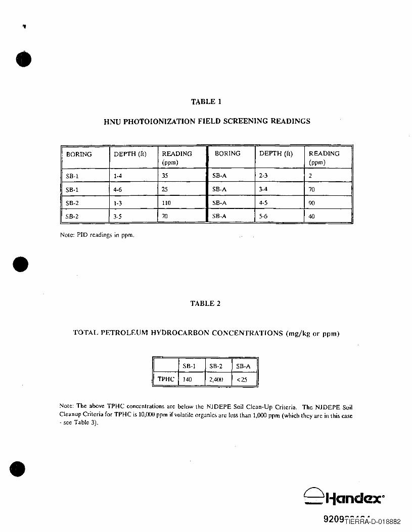
•
•
•
TABLE 1
HNU PHOTOIONIZATION FIELD SCREENING READINGS
BORING DEPTH (fl) READING BORING DEPTH (fl) READING(ppm) (ppm)
5B-l 1·4 35 5B·A 2-3 2
SB·1 4-6 25 SB-A 3-4 705B-2 1-3 no SB·A 4-5 90
5B·2 3-5 70 SB-A 5-6 40
Nole: PID readings in ppm .
TABLE 2
TOTAL PETROLEUM HYDROCARBON CONCENTRATIONS (mg/kg or ppm)
SB-1 SB-2 SB-A
TPHC 140 2,4()() <25
Note: The above TPHC concentrations are below the NJDEPE Soil Clean-Up Criteria. The NJDEPE SoilCleanup Criteria for TPHC is IO,n()O ppm if volatile organics arc less than 1,000 ppm (which they arc in this case- see Table 3) .
9209TIERRA-D-018882
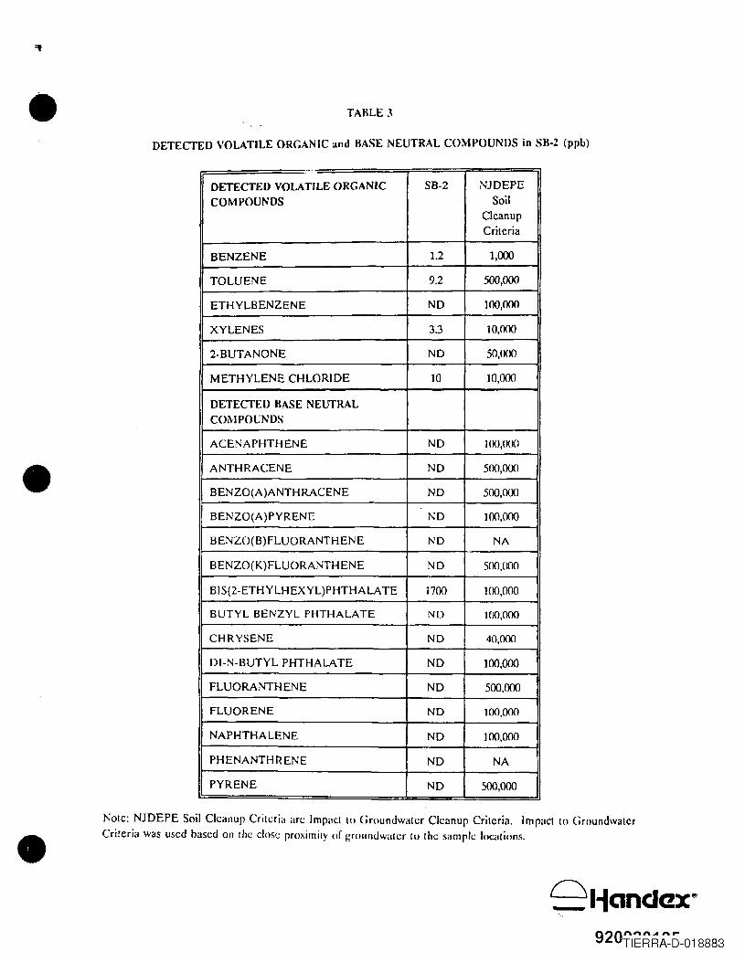
•
•
•
TABLE 3
DETECTED VOLATILE ORGANIC and BASE NEUTRAL COMPOUNDS in SB·2 (ppb)
---
DETECTEU VOLATILE ORGANIC 5B-2 NJDEPE
COMPOUNDS SoilClcanupCritcria
BENZENE 1.2 1,000
TOLUENE 9.2 500,000
ETHYLBENZENE ND 100,000
XYLENES 33 10,000
2·BUTANONE ND 50,000
METHYLENE CHLORIDE 10 10,000
DETECTED BASE NEUTRALCOI\-IPOUNDS
ACENAPHTHENE ND 100,000
ANTHRACENE ND 500,000
BENZO(A)ANTHRACENE ND 500,000
BENZO(A)PYRENE ND 100,000
BENZO(B)FLUORANTHENE ND NA
BENZO(K)FLUORANTHENE NO SOO,OOO
BIS(2-ETHYLHEXYL)PHTHALA TE 1700 100,000
BUTYL BENZYL PHTHALATE ND 100,000
CHRYSENE NO 40,000
DI-N-BUTYL PHTHALATE NO 100,000
FLUORANTHENE ND 500,000
FLUORENE ND 100,000
NAPHTHALENE ND 100,000
PHENANTHRENE ND NA
PYRENE ND 500,000
Notc: NJDEPE Soil Cleanup Criteria arc Impilct to Groundwaler Cleanup Criteria. Imp<Jct 10 GroundwalcrCriteria was used based on lhe close rroximilY of grounuwaler 10 lhe silmpk: 1<lC<1lions.
9liandax~
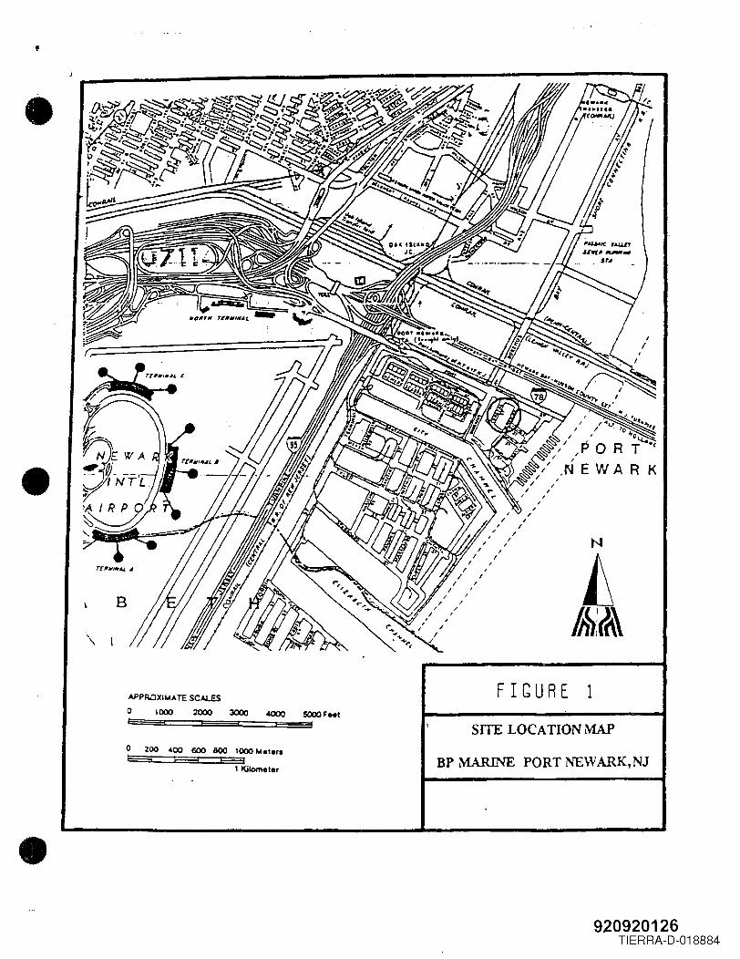
-1
•
•
•
FIGURE 13000
SITE LOCATION MAP
BP MARINE PORT NEWARK,NJo 200 ~OO 600 """~ ....,.. 1000 104.ler.~ b===4- t===-:'
1 Kilometer
920920126TIERRA-D-018884
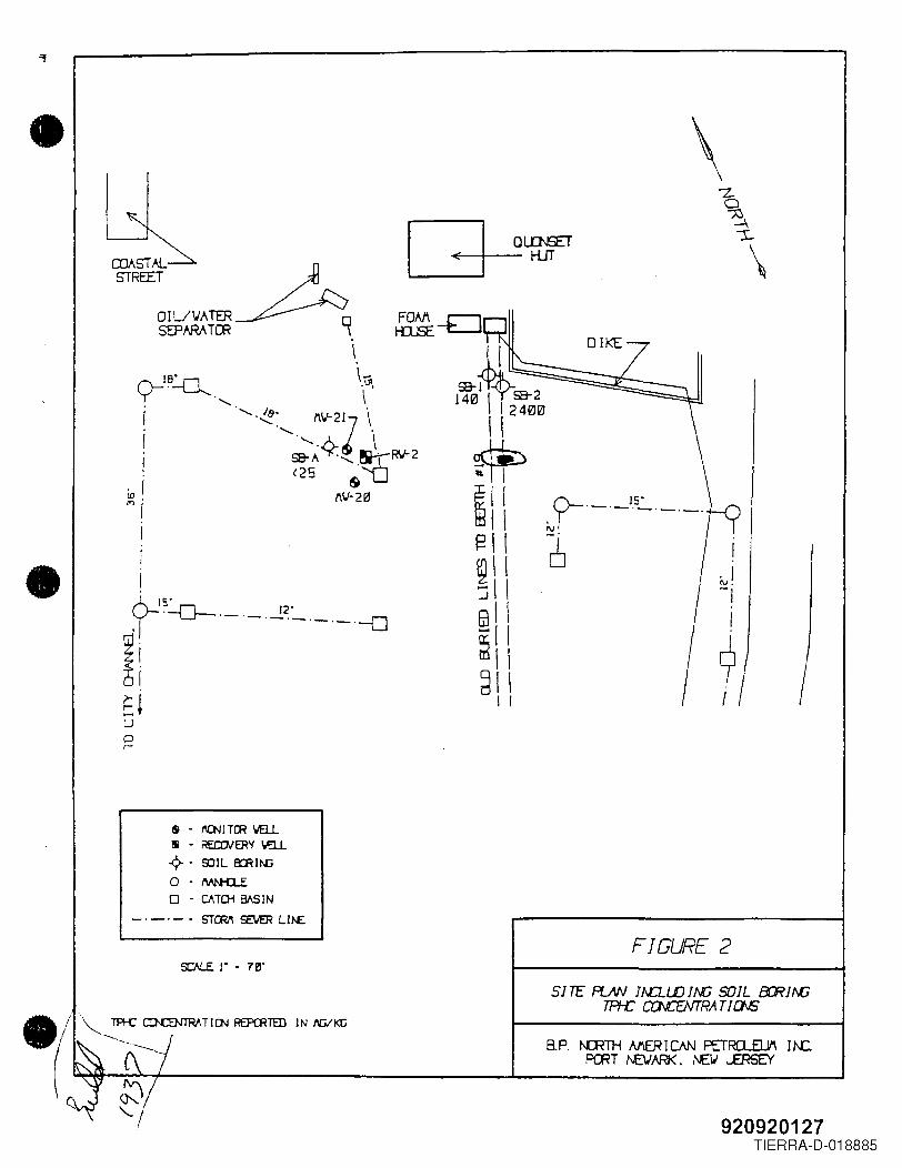
•
•
~-EJ
J~~\ IU5&;72 ==~~~JI,IT"t400II
~
~ [ [tti I I~\ I~\ !:J I I@I I-- I I~IIdl \
I I
s - f'OIJ ITCR wa.L5 - REroJERY wa.L.q.. 9J1 L 8CR ) /I(j
o - M!'H1Eo - CATDi BASIN
_._._. STCRI\ ~ Ll~
y- IS"'-'-'-'-'-'
~
\
I. IN.-,
I
9I
FIGURE 2
SITE: PJN JAD...LD 1M; SOIL 8CR 1M;TPf-C CCNCENTRA TIas
8.P. NFfH MER I CAN PETRCl...ElYI I I\C.PrnT t"2JAR<. f\E.V ...ERSEY
920920127TIERRA-D-018885
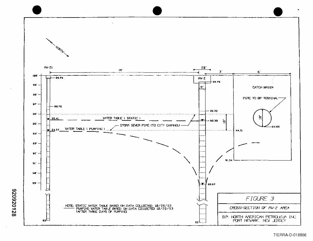
• • •
---\ ::~:=: /
\ .._ ..... /~ 89.87
~
IJ········. .
82
6'
/
Plft 10 ,., """7CU,,,
9~.31
91.3~'-- --J
"
FIGURE 3CROSS- SECTI CN CF RII- 2 ~
·········-98.32
::: ~ ' ..~~:~: _,,_.._._ _,,_,,_._ ~;~ .~~.; '~~~'l'~';""" _,,_,,_._ = = /..~:~'"~~:~~~I"".. ~~.27~1ER~ ~~ I L.~ ..~ ..~~~.~~.~.l.~ ..~ -.-- .
94'- - __ --..51)'-
92'-..
...
91' -....
..9"'- ..
-89'- ..-
CD....
I\,) <0CD ....I\,)0 ....~ ..,.I\,)00
....
._.83
I'OlE: STATIC VAll:R T,&8.£ ~ Cl'l DATA CIl.lECTED: HV 26/93-- FU"f'1~ VAlER Tm....E f¥SED Cl'l DATA lXl...l.ECTED 1121/29/93
t.-FTER TH<fE DAYS CF FlV'P 1l'G
TIERRA-D-018886
-,
•
APPENDIX A
• BORING LOGS(SOIL BORINGS)
•9209?01?Q
TIERRA-D-018887
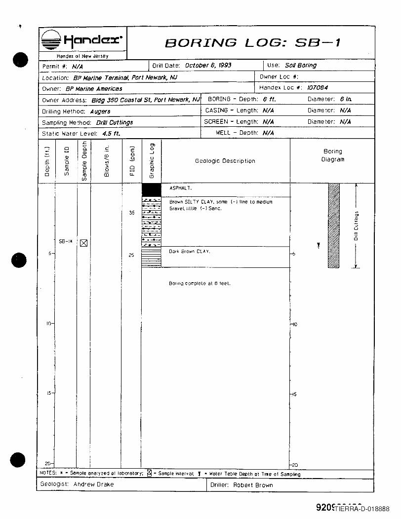
."
•
•
•
9l1cncJC!xeBORING LOG: 5B-l
Handel 01 New Jersey
Permit #: N/A I Drill Oat e: October 6, 1993 I Use: Soil Boring
Location: BP Marine Terminal, Port Newark, NJ Owner Lac #:
Owner: BP Marine Americas Handex Loc 1/: 107064
Owner Address: Blag 350 Coastal St, Port Ne;/ark, NJ BOR[NG - Depth: 6 't. Diameter: 6 In.
Drilling Method: Augers CAS[NG - Length: N/A Diameter: N/A
Sampling Method: Drill Cuttings SCREEN - Length: N/A Diameter: N/A
Static Water Level: 4.5 ft. WELL - Depth: N/A..r:: 0>- ~0 0. c E 0- ..... OJ -.J Boring0.~ OJ 0 co 0. U--.... Diagram..r:: a. OJ '" E Geologic Description-0. E Q 3 0 0.
OJ <1J
IE .2 ..... <1J
0 U1 <1J CD u.. ~U1
l!)
ASPHALT.
--.-.-.- Brown SIL TY CLAY. some (-) line to medium._._".---_.- - Grave~ little (-) Sand.35 ~.~";".iL.. '"-_ .•.. 0
--::::;:-~-_. .S:._~_._-- :>
-- U
........ :J
SB-Hi ~..._ ..... 6-_._- - t 15 25 Dark Brown CLAY. f--5
Boring complete at e feet.
10- -10
15- li5
20- 2D
NOTES: II a Sample analyzed at laboratory; ~ c Sample interval; f c Water Table Depth at Tille at Sampling
Geologist: AMrew Drake I Driller: Robert Brown
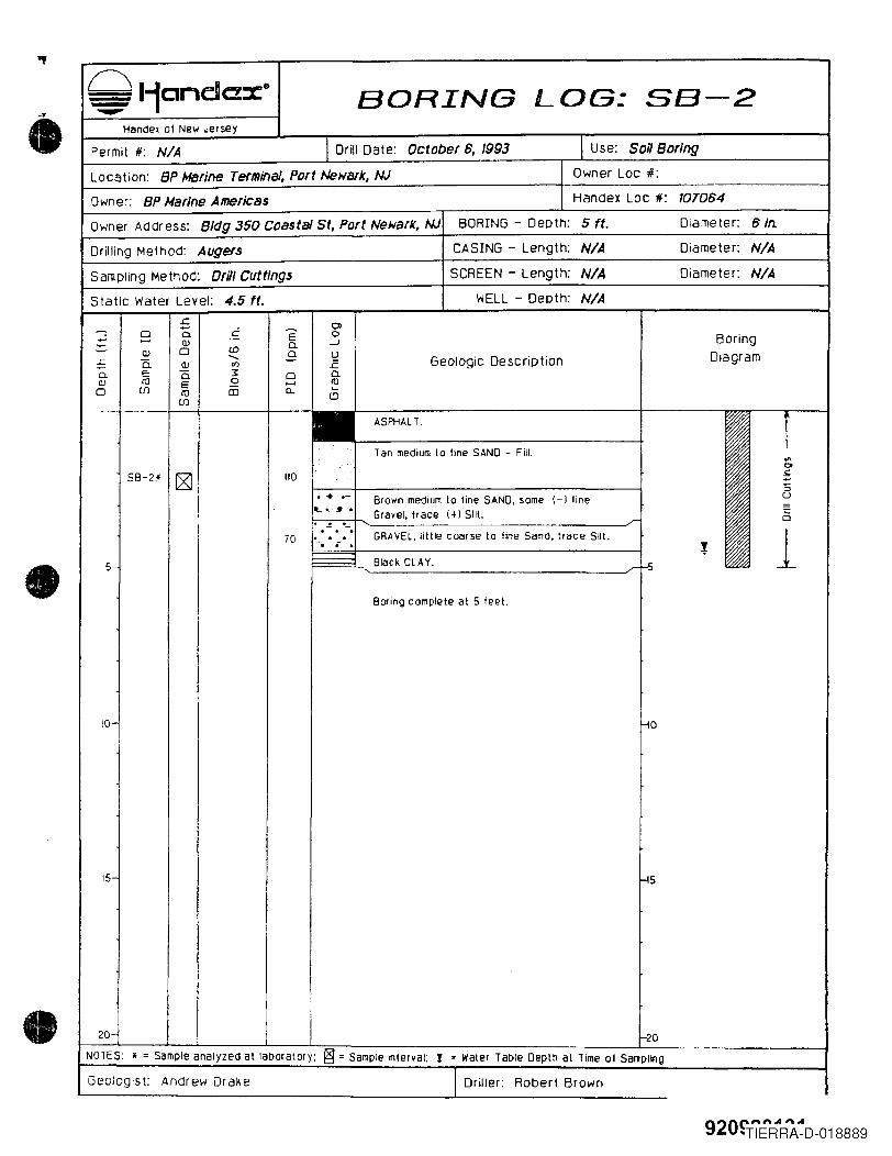
•
•
•
c::: 11cndax· BORING LOG: 5B-2Handex 01 New Jersey
Permit #: N/A I Drill Date: October 8, 1993 I Use: SoiJ Boring
Locotion: BP Marine Terminal, Port Newark, NJ Owner Loc 11:
Owner: BP Marine Americas Handex Lac #: 1070B4
Owner Address: 8/(Jg 350 Coastal St, Port Newark, NJ BORING - Depth: 5 ft. Diameter: BIn.
Drilling Method: Augers CASING - Length: N/A Diameter: N/A
Sampling MethOd: Drill Cuttings SCREEN - Length: N/A Diameter: N/A
Static Water Level: 4.5 ft. WELL - Depth: N/A.c OJ
--: -0 a c E 0~ OJ 0- -l Boring~ OJ 0 co 0- U...... Diagram£ a. OJ <I) E Geologic Description0- E "0 ~ 0 0-(lJ 10 E 0 ...... III0 (J) 10 CD c... ....
(J) ~
ASPHALT. i.. Tan medium to line SAND - Fill.'"0
5B-2* rg] 110 .1;;
:;... - Brown medium to line SAND, some (-) line u... e, ~ • Gravel, tr ace (+) Silt. ~. . .r. . . GRAVEL. little coarse to line Sand. trace Silt. 170 . .-. • . l
5- BiackCLAY. .r t-5
Boring complete at 5 ieet.
10- f-10I
j
15- -15
20- 20NOTES: * = Sample analyzed at laboratory: ~ = Sample interval: l = Water Table Depth at Time 01 Sal1pllng
Geologist: Andrew Dralle I Driller: Robert Brown
920c ...........",..."TIERRA-D-018889
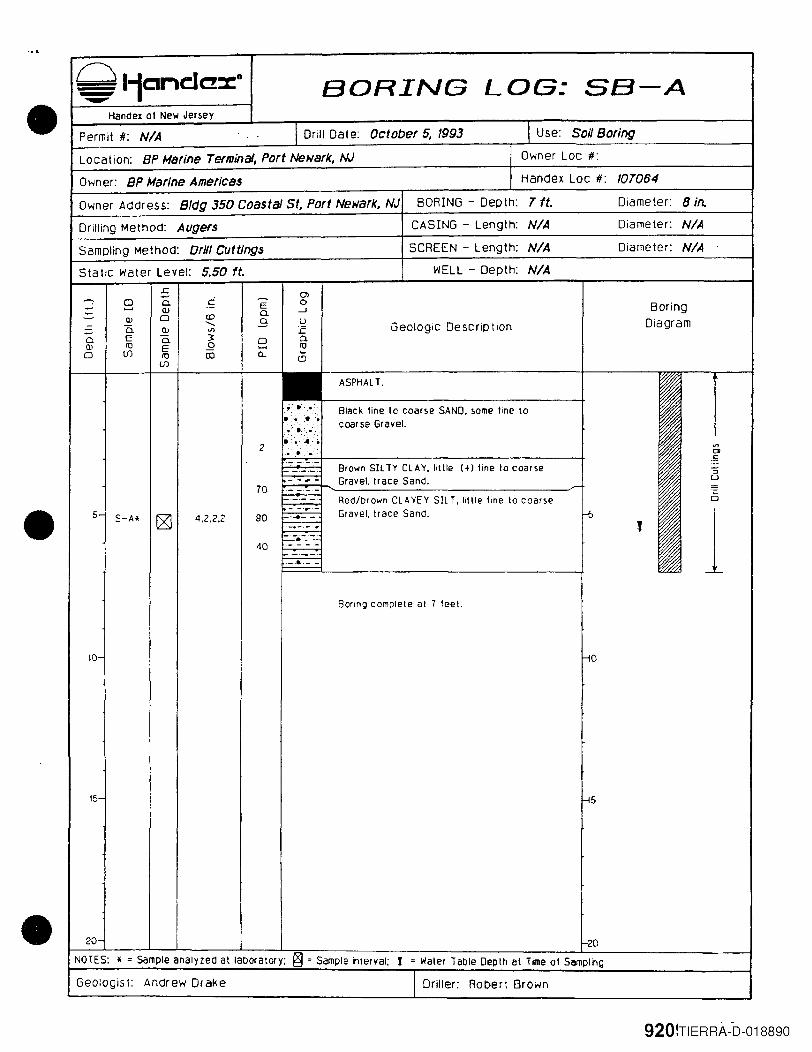
•
•
•
~ l-fanclC!x' BORING LOG: SB-AHandex 01 New Jersey
Permit #: NIA I Drill Date: October 5, 1993 I Use: Soil Boring
Location: BP Marine Terminal, Port Newark, NJ Owner Loc #:
Owner: BP Marine Americas Handex Lac #: IOT064
Owner Address: B/dg 350 Coastal St, Port Newark, NJ BORING - Depth: T ft. Diameter: 8 in.
Drilling Method: Augers CASING - Length: NIA Diameter: NIA
Sampling MethOd: DrH/Cuttings SCREEN - Length: NIA Diameter: NIA
Static water Level: 5.50 ft. WELL - Depth: NIA.r. 0>- C ~
0 0. E 0- ...... Q) .- -.J Boring- 0.- OJ 0 CD 0. U...... GeOlogic Description Diagram- 0. Q) <J') E0. E 0. ~ 0 0.Q) I1J E 52 ...... 100 (J) I1J OJ a... ~
(J) 1.9
ASPHALT.
..:.~.,. -. Black line 10 coarse SAND. some line to• >~.-:-:-. :~ coarse Gravel..•..•........:... : .... "."
2.: ....... to. < ....... '"........... : co
.S_ .. - Brown SIL TV CLAY. lillie (+) line 10 coarse '5'-'r-- Gravel. trace Sand. u
70 _. .- -_._.- -- Redfbrown CLAYEY SIL T. little fine to coarse Q
5- ·r·Gravel. tr ace Sand. -5 1S-Alf [gJ 4.2.2.2 90 _ ..... _.
.__ ._ .... l_._._._.40 ._. - --'-'--_ ...- -
Boring complete at 7 leet.
10- -in
15- -15
20- 1-20
NOTES: • - Sample analyzed at laDoratory; @ - Sample interval; ! = Waler Table Depth at Time of Sampling
GeOlogist: Andrew Drake I Driller: Robert Brown
920lTIERRA--D-018890
•
APPENDIX B
• LABORATORY ANALYTICAL REPORT
•920Q?n1~~
'TIERRA-D-018891
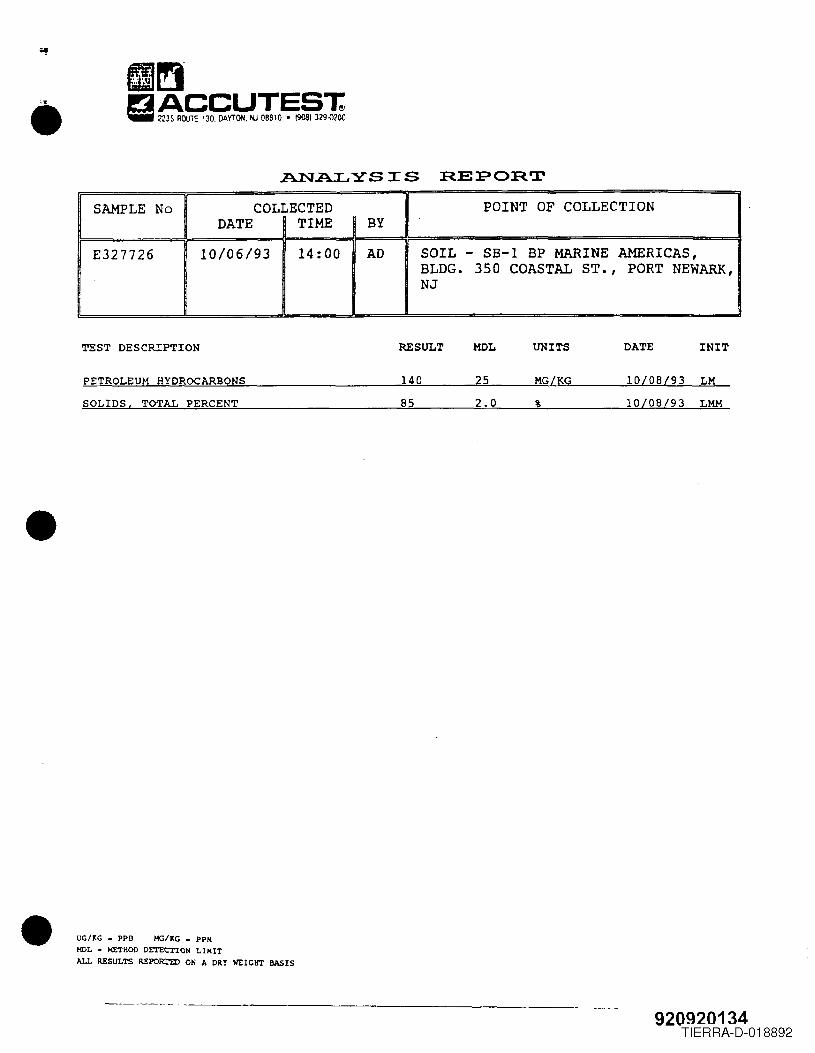
•
•
•
ANALYSIS REPORTSAMPLE No COLLECTED POINT OF COLLECTION
DATE TIME BY
E327726 10/06/93 14:00 AD SOIL - SB-l BP MARINE AMERICAS,BLDG. 350 COASTAL ST., PORT NEWARK,NJ
TEST DESCRIPTION RESULT DATE INITMOL UNITS
PETROLEUM HYDROCARBONS 140 MG/KG 10/08/93 LM25SOLIDS, TOTAL PERCENT 85 10/08/93 LMM2.0 %
UG/~G • PPB Me/KG = PPMMOL = METHOD DETECTION LIMITALL RESULTS REPORJ'ED ON A DRY WEIGHT BASIS
920920134TIERRA-D-018892
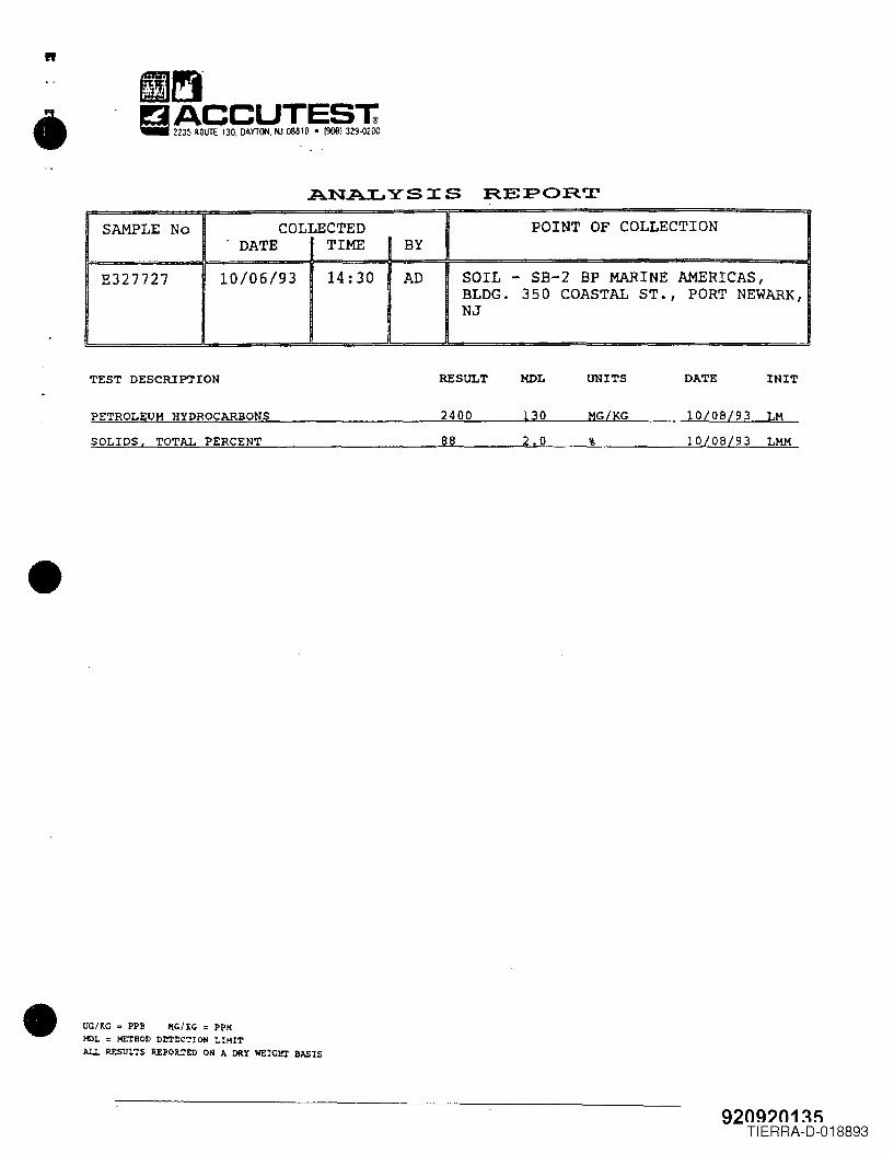
•
•
•
"
ANALYSIS REPOR.TSAMPLE No COLLECTED POINT OF COLLECTION
DATE TIME BY
E327727 10106/93 14: 30 AD SOIL - SB-2 BP MARINE AMERICAS,BLDG. 350 COASTAL ST., PORT NEWARK,NJ
TEST DESCRlPTrON RESULT MOL UNITS DATE INIT
PETROLEUM HYDROCARBONS 2400 10/08/93 LM130 MG/KG
SOLIDS, TOTAL PERCENT 88 10/08/93 LMM2.0 %
UG/KG = PPB HC/XC = PPHHOL = METHOD DeTtC~ION LIHITALL RESULTS REPOR.TtD ON A DRY WEIGIlI IlJ\SIS
920g?n1~~TIERRA-D-018893
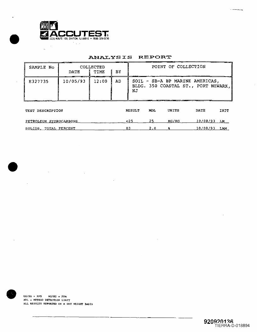
•
•
•
A.NALYSIS REPORTSAMPLE No COLLECTED POINT OF COLLECTION
DATE TIME BYE327735 10/05/93 12:00 AD SOIL - SB-A BP MARINE AMERICAS,
BLDG. 350 COASTAL ST., PORT NEWARK,NJ
TEST DESCRIPTION REStJLT MOL UNITS DATE INIT
PETROLEUM HYDROCARBONS <25 MG/KG 10108/93 LM25
SOLIDS, TOTAL PERCENT 83 2.0 % 10/08/93 LMM
UG/XG = PPB HG/XG = PPKHDL = METHOD DETECTION LIHITALL RESI1LTS REPOR!'ED ON " DRY WEIGHT BJ>.SIS
920~?n1~~TIERRA-D-018894
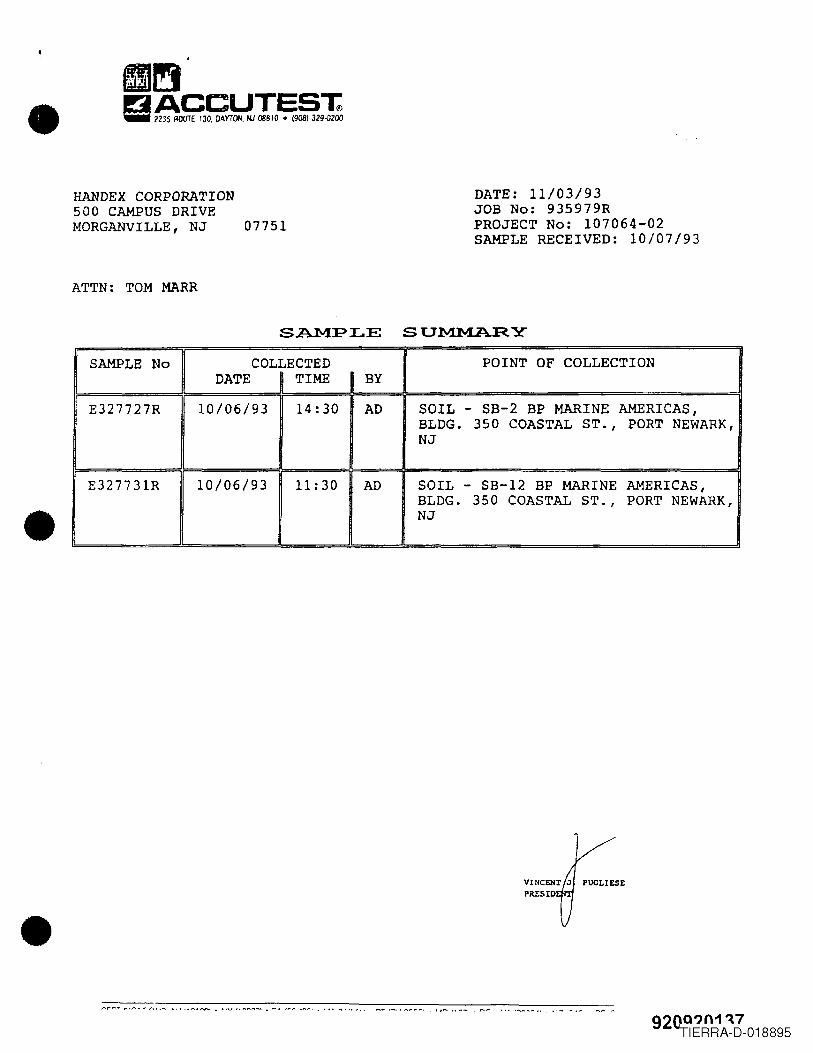
HANDEX CORPORATION500 CAMPUS DRIVEMORGANVILLE, NJ 07751
DATE: 11/03/93JOB No: 935979RPROJECT No: 107064-02SAMPLE RECEIVED: 10/07/93
ATTN: TOM MARR
SAMPLE SUMMARY
•
SAMPLE No COLLECTED POINT OF COLLECTIONDATE TIME BY
E327727R 10/06/93 14:30 AD SOIL - SB-2 BP MARINE AMERICAS,BLDG. 350 COASTAL ST., PORT NEWARK,NJ
E327731R 10106/93 11:30 AD SOIL - SB-12 BP MARINE AMERICAS,BLDG. 350 COASTAL ST., PORT NEWARK,NJ
•""'~""''f".~ .......•. r>, .......• " ", , , • r-oo .,.. , •• , '" _ _ ,. __ • • . 92QQ?n1~7
TIERRA-D-018895
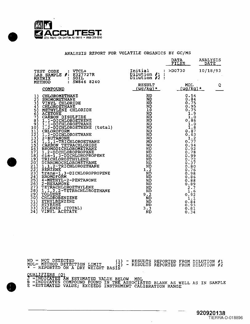
IJ~• ga~3~YTId!o~§291:ANALYSIS REPORT FOR VOLATILE ORGANICS BY GCjMS
DATA ANALYSISFILES DATETEST CODE · VTCL+ Initial >D0730 10/18/93· Dilution #1LAB SAMPLE I: E327727RMATRIX · SOIL D:llut:lon#2·METHOD SW846 8240 RESULT MOL QCOMPOUND (ug/kg)* (ug/kg)*1 CHLOROMETHANE ND 0.542 BROMOMETHANE ND 0.843 VINYL CHLORIDE ND 0.754 CHLOROETHANE ND 0.955 METHYLENE CHLORIDE 10 0.756 ACETONE ND 1.97 CARBON DISULFIDE ND 1.08 1,1-DICHLOROETHENE ND 0.869 1 I-DICHLOROETHANE ND 1.010 Ih2-DICHLOROETHENE (total) ND 1.811 C LOROFORM ND 0.8712 1,2-DICHLOROETHANE ND 0.6313 2-BUTANONE ND 1.214 l~I-TRICHLOROETHANE ND 0.7715 C ON TETRACHLORIDE ND 0.9416 BROMODICHLOROMETHANE ND 0.9217 1/2-DICHLOROPROPANE ND 0.7818 C:lS-1t3-DICHLOROPROPENE ND 0.99• 19 TRICH OROETHYLENE ND 0.7220 DIBROMOCHLOROMETHANE ND 0.3721 l~i2-TRICHLOROETHANE ND 0.8022 B ENE 1.2 0.7623 tranS-l~-DICHLOROPROPENE ND 0.9824 BROMOFO ND 0.8625 4-METHYL-2-PENTANONE ND 0.8826 2-HEXANONE ND 0.8927 TETRACHLOROETHYLENE ND 2.728 16162,2-TETRACHLOROETHANE ND 1.629 T L ENE 9.2 0.9230 CHLOROBENZENE ND 1.131 ETHYLBENZENE ND 0.84
32 STYRENE NO 0.9333 XYLENES fTOTAL) 3.3 0.8134 VINYL AC TATE ND 0.34
•ND = NOT DETECTED Jl) - RESULTS REPORTED FROM DILUTION #1MDL= METHOD DETECTION LIMIT 2) - RESULTS REPORTED FROM DILUTION #2* - REPORTED ON A DRY WEIGHT BAS S~UALIFIERS £QkN-INOlcATE ESTIMATED VALUE BELOW MDLB =INDICATES COMPOUND FOUND IN THE ASSOCIATED BLANK AS WELL AS IN SAMPLEE =ESTlMATED VALUE; EXCEEDS INSTRUMENT CALIBRATION RANGE
920920138TIERRA-D-018896
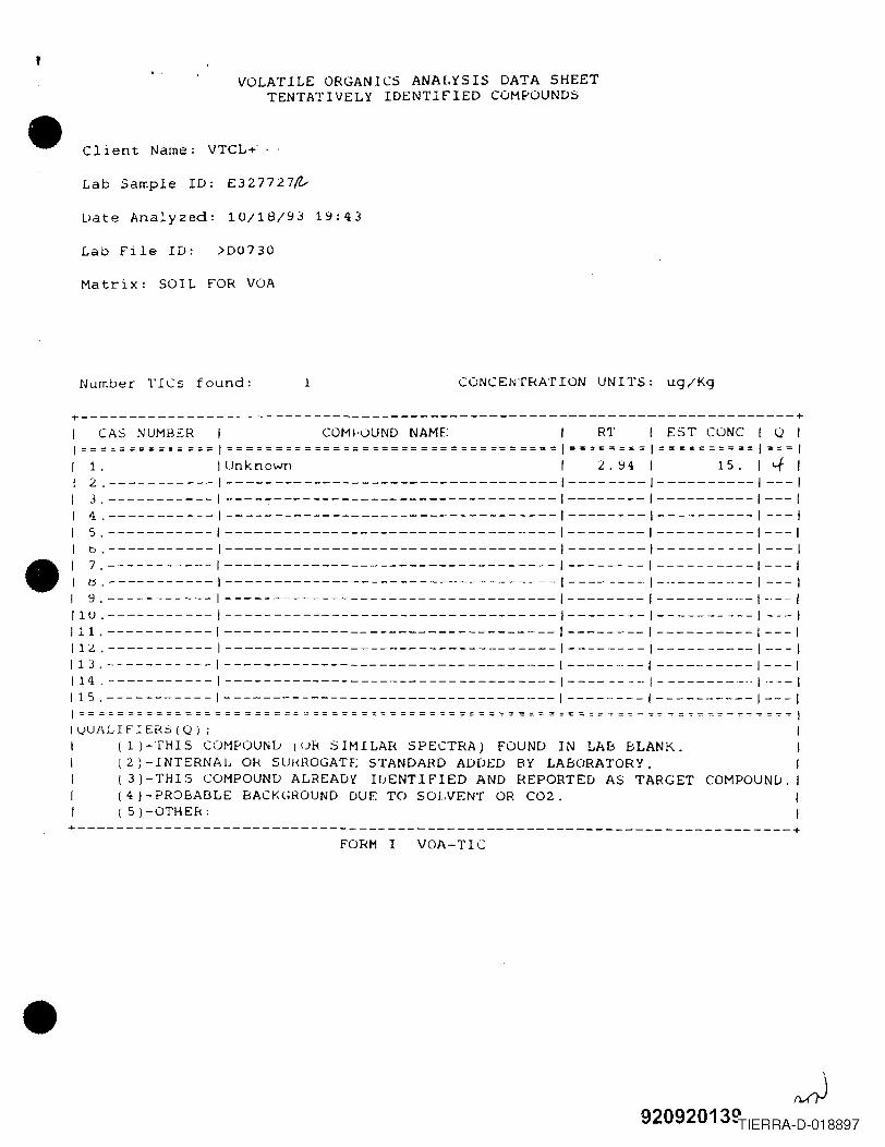
•
•
•
,VOLATILE ORGANICS ANALYSIS DATA SHEET
TENTATIVELY IDENTIFIED COMPOUNDS
Client Name: VTCL~ --
Lab Sample ID: E327727~
Uate Analyzed: 10/18/93 19:43
Lab file 1D: >D0730
Matrix: SOIL fOR VOA
Number TICs found: CONCENTRATION UNITS: ug/Kg1
+-------------------------------------------------------------------------+I CAS NUMBSR I COMhjUND NAME: I RT 1 EST CONe 1 Q II~=====~=====~=I======~==~========================I==~==~==I======~===I===II 1. Unknown I 2.94 I 15. l'-f II 2.----------- ----------------------------------1--------1----------1---11 3.----------- ----------------------------------1--------1----------1---1I 4.----------- ----------------------------------1--------1----------1---1I 5.----------- -----------------------------------1--------1----------1---1I b.----------- ----------------------------------1--------1----------1---1
1 7.----------- ----------------------------------1--------1----------1---1I ~.----------- ----------------------------------1--------1-----------1---11 9.----------- ----------------------------------1--------1----------1----111U.----------- ----------------------------------1--------1----------1 ---I111.----------- ----------------------------------1--------1----------1---111~.----------- ----------------------------------1--------1----------1---1113.----------- ----------------------------------1---------1----------1---1114.-----------1----------------------------------1--------1-----------1----1115.-----------1----------------------------------1--------1----------1---1I============~=========~=~==~==~=========~=====~========~=~==~~==~=~=-~=-=IIVUALIF1Ef<S(Q); IIII J -THIS COMPOUND l uk SIMILAR SPECTRA) FOUND IN LAB BLANK. II (2)-INTERNAL Of< SUl<HOGATF;STANDARD ADDED BY LABORATORY. I1 (3)-THIS COMPOUND ALREADY IDENTIFIED AND REPORTED AS TARGET COMPOUND. I1 l4 ) - PROBABLE BACK(;ROUND DUE TO SOLVENT OR C02. II l 5)-OTHEk: I+-------------------------------------------------------------------------+
FORM I VOA-TIC
~92092013~TIERRA-D-018897
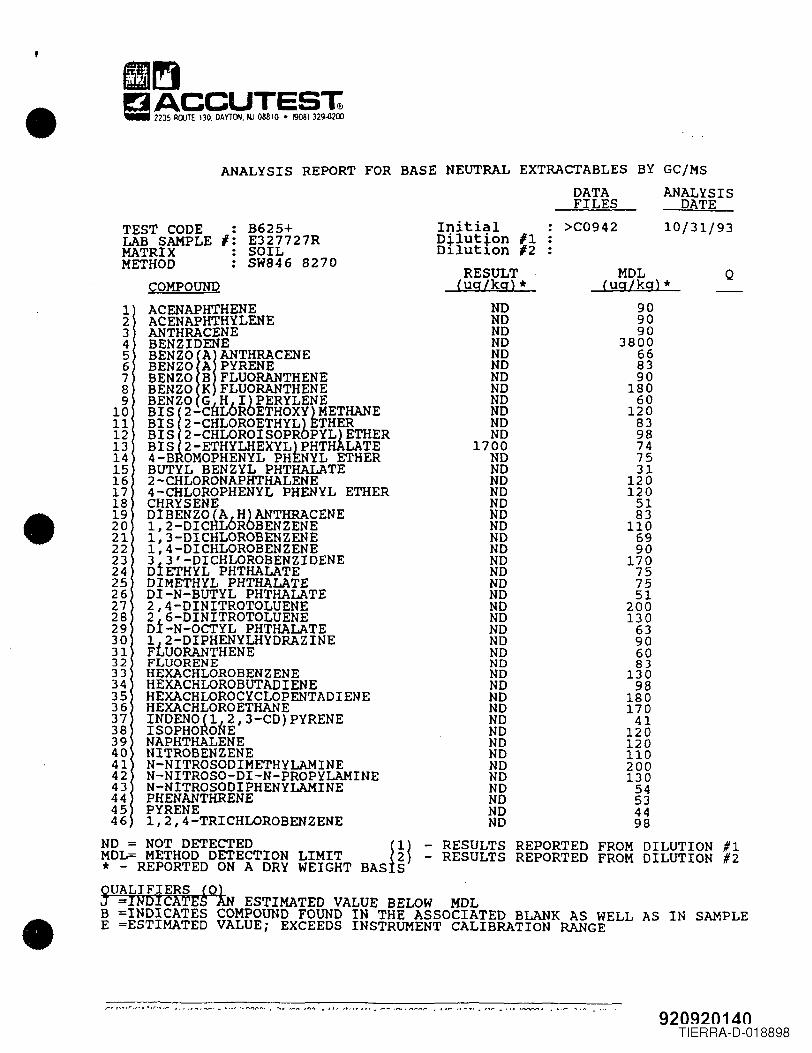
•
•
•
ANALYSIS REPORT FOR BASE NEUTRAL EXTRACTABLES BYDATAFILES
• B625+I: E327727RSOILSW846 8270
InitialDilution #1Dilutl.on #2RESULTlug/kg) *
NONDNDNDNDNDNDNDNDNDNDND1700NDNDNDNDNDNDNDNDNDNDNDNDNDNDNDNDNDNDNONONDNDNDNDNDNONDNDNDNDNDNDND
GC/liSANALYSISDATE
>C0942 10/31/93TEST CODELAB SAMPLEMATRIXMETHODCOMPOUND
1 ACENAPHTHENE2 ACENAPHTHYLENE3 ANTHRACENE4 BENZIDENE5 BENZOIAIANTHRACENE6 BENZO A PYRENE7 BENZO B FLUORANTHENE8 BENZO K FLUORANTHENE9 BENZO G H I)PERYLENE
10 BIS12-CHLbROETHOXY) METHANE11 BIS 2-CHLOROETHYL)ETHER12 BIS 2-CHLOROISOPROPYL)ETHER13 BIS 2-ETHYLHEXYL)PHTHALATE14 4-B OMOPHENYL PHENYL ETHER15 BUTYL BENZYL PHTHALATE16 2-CHLORONAPHTHALENE17 4-CHLOROPHENYL PHENYL ETHER18 CHRYSENE19 DIBENZO lA6H)ANTHRACENE20 1,2-DICaL ROBENZENE21 1,3-DICHLOROBENZENE22 1,4-DICHLOROBENZENE23 3f3'-DICHLOROBENZIDENE24 D ETHYL PHTHALATE25 DIMETHYL PHTHALATE26 DI-N-BUTYL PHTHALATE27 2,4-DINITROTOLUENE28 2f6-DINITROTOLUENE29 D -N-OCTYL PHTHALATE30 1J2-DIPHENYLHYDRAZINE31 FLUORANTHENE32 FLUORENE33 HEXACHLOROBENZENE34 HEXACHLOROBUTADIENE35 HEXACHLOROCYCLOPENTADIENE36 HEXACHLOROETHANE37 INDENOl1~2,3-CD)PYRENE38 ISOPHO~ONE39 NAPHTHALENE40 NITROBENZENE41 N-NITROSODIMETHYLAMINE42 N-NITROSO-DI-N-PROPYLAMINE43 N-NITROSODIPHENYLAMINE44 PHENANTHRENE45 PYRENE46 1,2,4-TRICHLOROBENZENE
ND = NOT DETECTED 11) - RESULTS REPORTED FROM DILUTION #1MDL= METHOD DETECTION LIMIT 2) - RESULTS REPORTED FROM DILUTION #2* - REPORTED ON A DRY WEIGHT BAS SQUALIFIERS 10lJ -INDICATES AN ESTIMATED VALUE BELOW MDLB =INDICATES COMPOUND FOUND IN THE ASSOCIATED BLANK AS WELL AS IN SAMPLEE =ESTIMATED VALUE; EXCEEDS INSTRUMENT CALIBRATION RANGE
MDLlug/kg) *909090380066839018060
120839874753112012051831106990170757551
2001306390608313098
1801704112012011020013054534498
Q
920920140TIERRA-D-018898
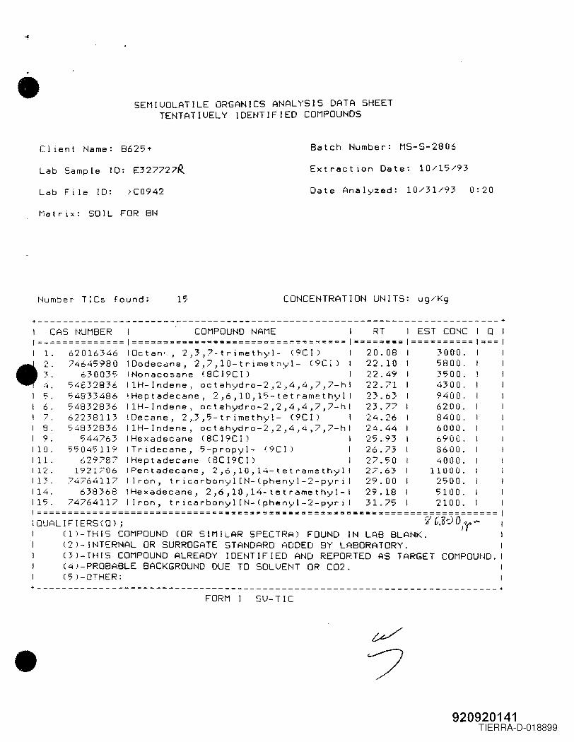
• SEMIUOLATILE ORGANICS ANALYSIS DATA SHEETTENTATIUELY IDENTIFIED COMPOUNDS
Client Name: B625+ Batch Number: MS-S-2806
Lab Sample ID: E327727~ Extr~ction Date: 10/17/93
Lab File ID: >C0942 Date Anal)-'zed: 10/31/93 0:20
Matrix: SOIL FOR BN
Number TICs found: 17 CONCENTRATION UNITS: ug/Kg
+-------------------------------------------------------------------------+COMPOUND NAME RT I EST CONC I Q I
1. 62016346 10ctan', 2,3,7-trimethyl- (9C1) I 20.08 3000.
•
2. 74645 98 0 IDo de C cl ne, 2, 7 ,10- trime thy'I- (9 C I) I 22 .10 58 00 .3 . 63003 S INo naC os ane (8C I9C I) 1 '22.49 3? 00 .4. 54832836 11H-Indene., octahydro-2,2,4,4,7,7-hl 22.71 4300.
1 7. 74833486 IHeptadecane, 2,6,10,lS-tetramethyl I 23.63 9400.I 6. 74832836 11H-Indene, octahydro-2,2,4,4,7,7-hl 23.77 6200.I /. 62238113 IDecane, 2,},5-trimeth)..1- (9CI) I 24.26 8400.I 8. 54832836 11H-Indene, octahydro-2,2,4,4,7,7-hl 24.44 6000.19. 744763 IHexadecane C8CI9CI) I 25.93 6900.110. 5504'5119 ITridecane, '5-propyl- (9CI) I 26.73 8600.I11 . 629787 IHe p tade can e ( 8C 19C I) I 27 .? 0 4000 .112. 1921706 IPentadecane, 2,o,10,14-tetramethyll 27.63 11000.113. 74764117 IIron, tricarbonyI[N-CphenyI-2-pyri I 29.00 2500.114. 638368 IHexadecane, 2,6,10,14-tetramethyI-1 29.18 '5100.11'5. 74764117 IIron, tricarbonyl[N-Cphen).-,1-2-pyril 31.77 I 2100. I I1=========================================================================1IQUALlFJERSCO); 'I t,~0D,'Y'- II Cl)-THIS COMPOUND (OR SIMILAR SPECTRA) FOUND IN LAB BLANK. II (2)-INTERNAL OR SURROGATE STANDARD ADDED BY LABORATORY. II (3)-THIS COMPOUND ALREADY IDENTIFIED AND REPORTED AS TARGET COMPOUND. II (4)-PROBABLE BACKGROUND DUE TO SOLUENT OR C02. II ('5)-OTHER: I+-------------------------------------------------------------------------+
FORM I SV-TIC
920920141TIERRA-D-018899
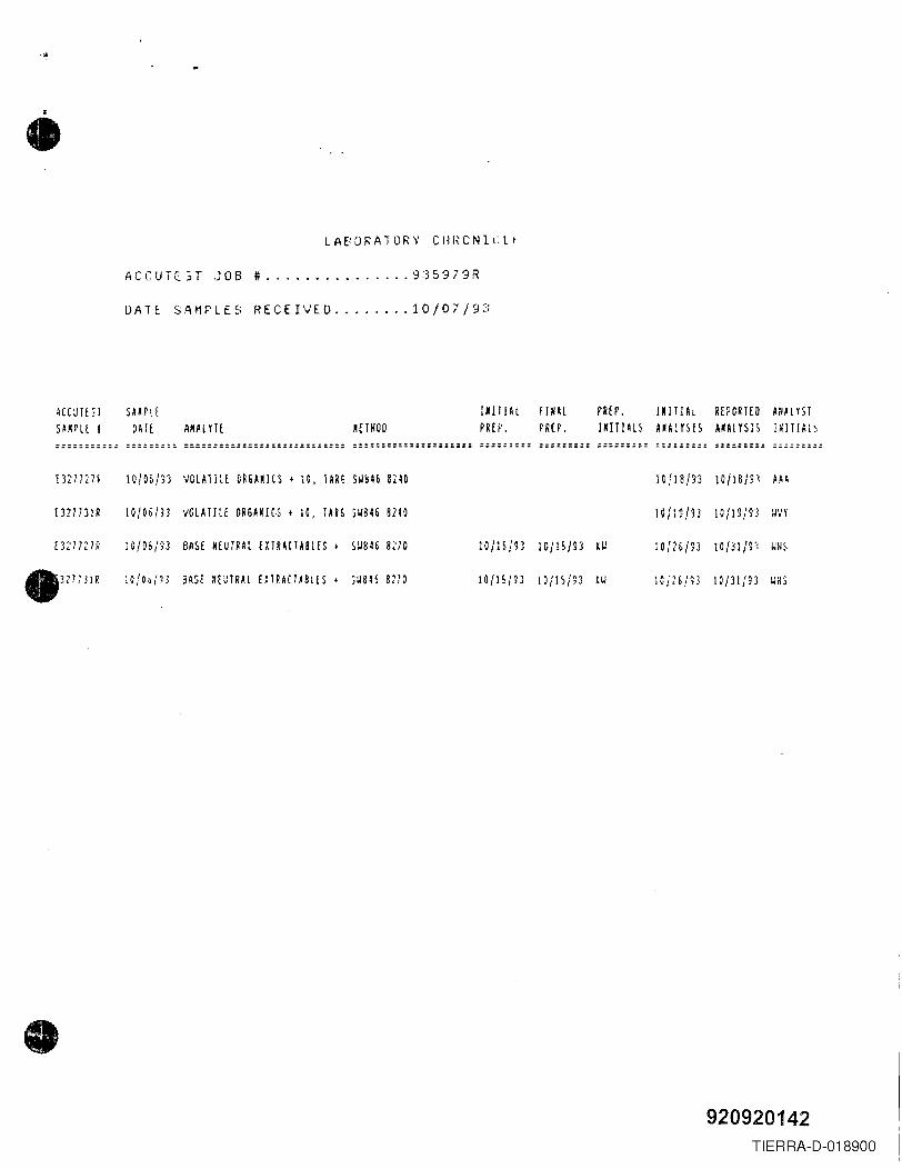
..••
LAE:ORA10RY CHI,ONILlr
ACCUTE3T JOB t 935979R
DATt SAMPLES RECEIVED ..••.••. 10/07/93
ACCUTEST SA~rlESAmE I OAfE ANAlYTf HTHOD
lUTJAl fINAlPREP. PREP.
PREP. lM1TIAl REPORTED AUAlYSTIKITIALS A~ALYSIS AKALYSIS l~ITl~L~
::::::::::: ::::;:::: :============:::::===::::::: ::::::::=:=====:::=== ::::::::: ==:====== :====::;: :::=:=::: =====:::: :====:=::
mnm lO/O&!n VOLATILE CR6AM1CS • 10, TARG S~b~b 8,~D 10/18/93 IO/18m AU
£327731R lO/O6/11 VOLATILE OR6ANIC~ t 1O, IAR6 SW846 8m IOfl~/B lOMI13 ~VY
E3~'71~}~ ,O!06(n BASE NEUTRAL fXTRACTABlES t S~B4& 8m IO/lS/~3 IC/15/~3 OJ ,D/nm IO/31/S'j ~HS
e327731R lO/H/'lJ SASE ~EUTRAL EXTRACTA8lES • ~~846 8m lO/15/~3 10/IS/S3 iU lCJ~6/~3 lO/31jS3 W~J
•920920142
TIERRA-D-018900
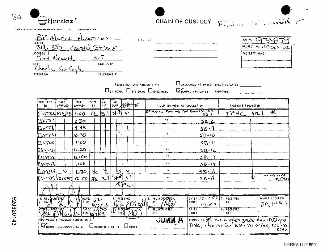
.' ..-CHAIN OF CUSTODY-0 ·=HandC!x- c ,..-:--,r ~...........:'7 li I.' .. ·•
'''Df.or_'_/I''''. "'(~WIDC.-'-''''''''.O''. U' ......_ .._ 00_ ............ ., •• o-.a..l .. '~
BILL TO: JOO NO.
PROJECT NO. JO"7-DI.. ~ ..D'L
FACI LI TY NAME:
ODISCHARGE (7 DAYS)
~ORMAl (14 DAYS)
REQUESTED TURN AROUND TIME:
024 MOURS O2-7 DAYS 08-13 DAYS
SPECIFIC DAlE: ___
APPROVED:
ACCUTEST10
TIHESAMPLED
SHPL MAT NO ABY lUX CONT A~~li
DATESAMPLED
./".
pH FIELD ID/POINT OF COLLECllON ANALYSIS REQUESTED
DrMAr: ...e, T~:"'4 rl',~rJ........... • N:I -rf>He- !/ 11. , "*5i!.-\,. S~·"Z..., . ·5~· CJ'1 SB-/OI. <R-II\, 'SB- '<'-'r S~·q\. .sa-' i" S~-If:,
s&~A \ I NO VO ~ ~",J.'.. ~lj'°ti·"'J
/ \ - \OA 1E / (0' '7 -Ci 7TIME: I L('c/ 0
DATE/TIME:
<.0No<.0No~,I:::l.w
3. RECEIVEDBY:
SAMPLE LOCATION
3AJ 14f\44. RECEIVED
BY:
O~ IVERABLE PACKAGE (CHECK ONE) I ~\.)J~lrwl .~~ORMAL QC/COMMERCIAL A 0 REDUCED TIER II 0 OTHER .• ---~
~MENTS: ~ Fu r ';aw.~:s S"~~.h,.t~ JD[X) rrl(/\I PHC-) a,l!>o ;-"v ......~,.. SN 'T YO c,c./,,-..: TeL "-/b
) ~?'io
TIERRA-D-018901
• BAA000030
n
•rrL
rl. REMEDIAL INVESTIGATION REPORT
BP MARINE AMERICAS, PORT NEWARK, NEW JERSEYrr
L BP MARINE AMERICASHOUSTON, TEXAS.,•r'
l.
,. JULy 1996
,.
r . PREPARED BY:
,. MALCOLM PIRNIE, INC.One International Boulevard
Mahwah, New Jersey
,.
, .
Prinltcl 1HIReqded Paper
920920183TIERRA-D-018902
~•'" BP MARINE AMERICASCONTENTS
,. Page
,"
1.0 lNTRODUCTION " " 1-11.1 Background :. 1-11.2 Description of Petroleum Release ' 1-21.3 Objectives and Scope ofWorlc , , 1-21.4 Prior Environmental Investigations , . .. 1-31.5 Remedial Investigation , 1-4
,.
,2.0 FIELD INVESTIGATION PROCEDURES 2-1
2.1 Soil Sampling . . . . . . . . . . . . . . . . . . . . . . . . . . . . . . . . . . . . . . . . . .. 2-12.1.1 Soil Sample Locations. . . . . . . . . . . . . . . . . . . . . . . . . . . . . .. 2-12.1.2 Soil Sampling Procedure . . . . . . . . . . . . . . . . . . . . . . . . . . . .. 2-22.1.3 Soil Sampling Depths 2-22.1.4 Soil Sample Handling 2-32.1.5 Soil Analyses 2-3
2.2 Hydrogeoligic Investigation 2-42.2.1 Monitoring Well Locations . . . . . . . . . . . . . . . . . . . . .. 2-42.2.2 Monitoring Well Construction. . . . . . . . . . . . . . . . . . . . . . . .. 2-52.2.3 Well Development 2-52.2.4 Petroleum Hydrocarbon Product
and Ground Water Measurements 2-62.2.5 Groundwater Sampling . . . . . . . . . . . . . . . . . . . . . . . . . . . . .. 2-62.2.6 Disposal of Drill Cuttings and Purge Water 2-8
•3.0 REMEDIAL INVESTIGATION RESULTS 3-1
3.1 Soil Sample Analytical Results and Discussion 3-13.2 Ground Water Analyses 3-23.3 Site Geology 3-33.4 Site Hydrogeology . . . . . . . . . . . . . . . . . . . . . . . . . . . . . . . . . . . . . .. 3-4
4.0 SUMMARY AND CONCLUSIONS 4-1
...
•i-l
920920184TIERRA-D-018903
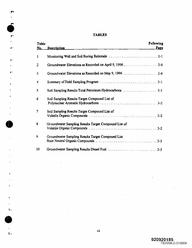
r TABLES
TableNo. Descriptiop
FollowingPale
1 Monitoring Well and Soil Boring Rationale 2-1
"2 Groundwater Elevations as Recorded on April 9. 1996 . . . . . . . . . . . . . . . . .. 2-6
,.3 Groundwater Elevations as Recorded on May 9. 1996 ... . . . . . . . . . . . . . .. 2-6
4 Summary ofField Sampling Program . . . . . . . . . . . . . . . . . . . . . . . . . . . . . .. 3-1,
5 Soil Sampling Results Total Petroleum Hydrocarbons 3-1
6 Soil Sampling Results Target Compound List ofPolynuclear Aromatic Hydrocarbons . . . . . . . . . . . . . . . . . . . . . . . . . . . . . .. 3-2
7 Soil Sampling Results Target Compound List ofVolatile Organic Compounds 3-2
• 8 Groundwater Sampling Results Target Compound List ofVolatile Organic Compounds 3-2
9 Groundwater Sampling Results Target Compound ListBase Neutral Organic Compounds 3-3
10 Groundwater Sampling Results Diesel Fuel 3-3
•L
i-2
920920185TIERRA-D-018904
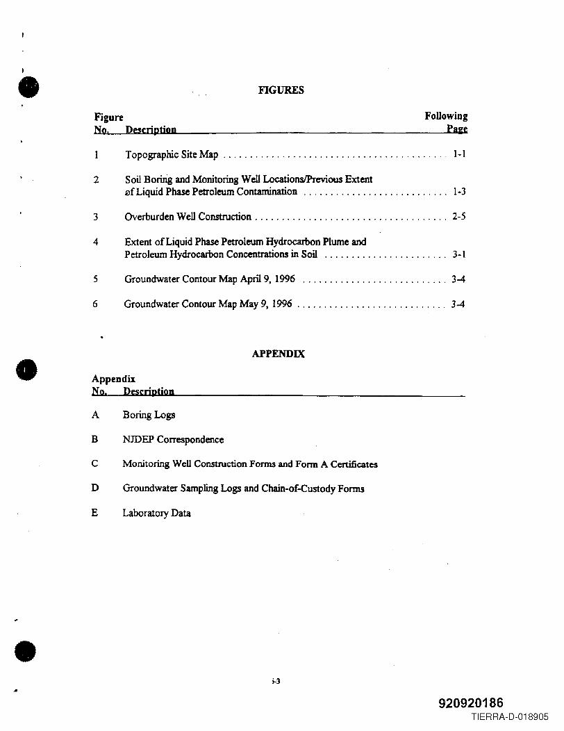
•• FIGURES
FigureNo, Descriptiop
FoUowing. PIEe
1 Topographic Site Map .. . . . . . . . . . . . . . . . . . . . . . . . . . . . . . . . . . . . . . . .. 1-1
2 Soil Boririg and Monitoring Well LocationslPrevious ExtentefLiquid Phase Petroleum Contamination 1-3
3 Overburden Well Construction 2-5
4 Extent of Liquid Phase Petroleum Hydrocarbon Plume andPetroleum Hydrocarbon Concentrations in Soil 3-1
5 Groundwater Contour Map April 9, 1996 3-4
6 Groundwater Contour Map May 9, 1996 " 3-4
APPENDIX• AppendixNo. Description
A Boring Logs
B NJDEP Correspondence
C Monitoring Well Construction Forms and Fonn A Certificates
D Groundwater Sampling Logs and Chain-or-Custody Forms
E Laboratory Data
• ...3
920920186TIERRA-D-018905
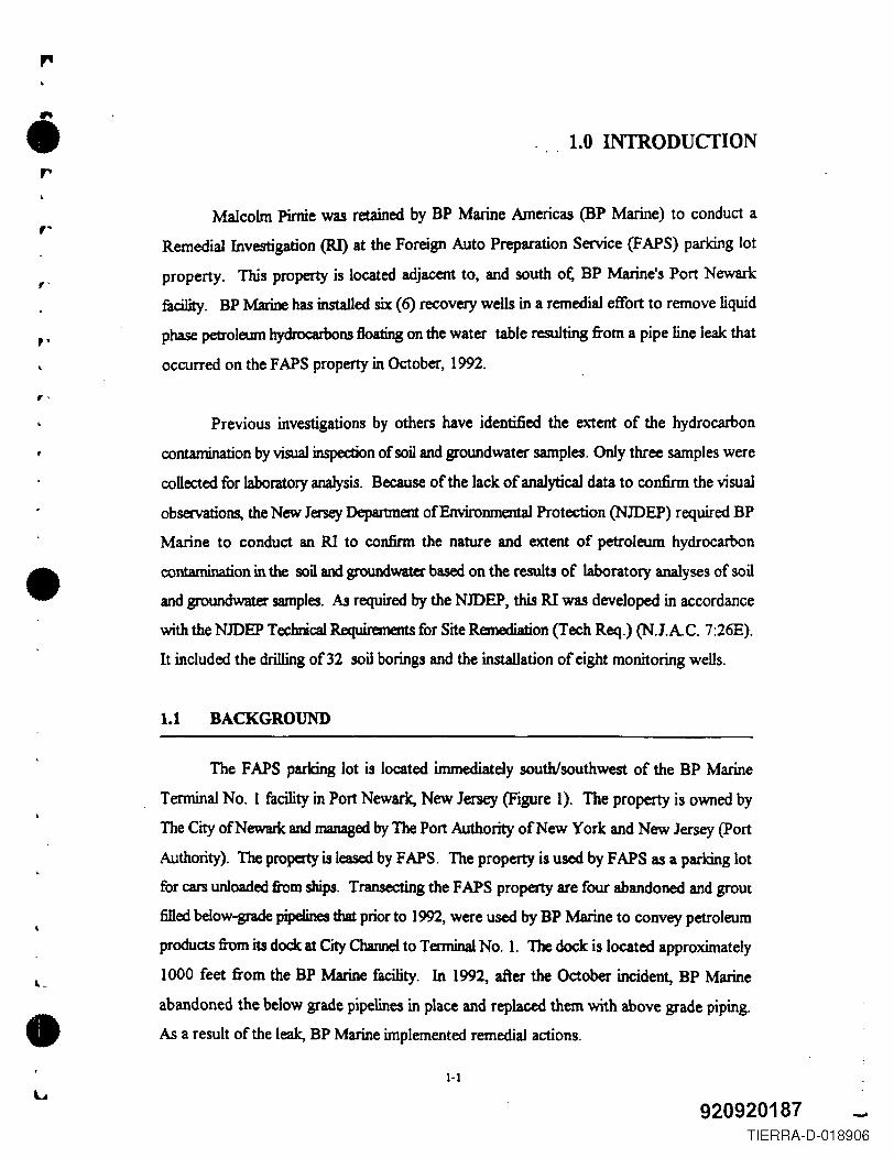
,.
• 1.0 INTRODUCTION,..
," Malcolm Pimie was retained by BP Marine Americas (BP Marine) to conduct a
Remedial Investigation (RI) at the Foreign Auto Preparation Service (FAPS) parking lot
property. This property is located adjacent to, and south ot: BP Marine's Port Newark
fucility. BP Marine has installed six (6) recovery wells in a remedial effort to remove liquid
phase petroleum hydrocarbons floating on the water table resulting from a pipe line leak that
occurred on the FAPS property in October, 1992.
'"
""
•
Previous investigations by others have identified the extent of the hydrocarbon
contamination by visual inspection of soil and groundwater samples. Only three samples were
collected for laboratory analysis. Because of the lack of analytical data to confirm the visual
observations, the New Jersey Department of Environmental Protection (NJDEP) required BP
Marine to conduct an RI to confirm the nature and extent of petroleum hydrocarbon
contamination in the soil and groundwater based on the results of laboratory analyses of soil
and groundwater samples. As required by the NJDEP, this RI was developed in accordance
with the NJDEP Technical Requirements for Site Remediation (Tech Req.) (N.lAC. 7:26E).
It included the drilling of 32 soil borings and the installation of eight monitoring wells.
1.1 BACKGROUND
•
The FAPS parking lot is located immediately south/southwest of the BP Marine
Tenninal No. I facility in Port Newark, New Jersey (Figure 1). The property is owned by
The City of Newark and managed by The Port Authority of New York and New Jersey (port
Authority). The property is leased by FAPS. The property is used by FAPS as a parking lot
for cars unloaded from ships. Transecting the FAPS property are four abandoned and grout
filled below-grade pipelines that prior to 1992, were used by BP Marine to convey petroleum
products from its dock at City Channel to Terminal No.1. The dock is located approximately
1000 feet from the BP Marine facility. In 1992, after the October incident, BP Marine
abandoned the below grade pipelines in place and replaced them with above grade piping.
As a result of the leak, BP Marine implemented remedial actions.
1-1
920920187 -'TIERRA-D-018906
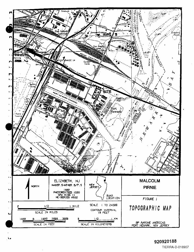
"KO" S
;:::.~~·,~r'
• I
r-',·, Z·.
.J.,II
·,N:RTH
EL IZAEETH. N..J~B37 . 5-w7 ~B7.517.5
1957PHJTCREY J SED 198 J
00'V\ Ci 1155 I INE::-!:ERIES vezz
MALCOLMPIRNIE
FIGI.RE 1
1/2 MILE SOLE TO 24000Eli CONTOUR )NTERV I'i.SCALE IN MILES Ie FEET~
nmt3 'a 113t3E! ZOO!! ~OO B 1/2 KI1i ! i
SCI\LE I N FEET SCALE IN "ILO"IETERS
TOPOGRAPHIC MAP
920920188TIERRA-D-018907
"
••• 1.2 DESCRIPTION OF PETROLEUM RELEASE
,-The following background infonnation is summarized from reports prepared for BP
Marine by Ground Water Associates, Inc.
,.BP Marine first reported a possible spill to the Coast Guard and the NJDEP on
October 4, 1992, after an oil sheen was discovered immediately adjacent to BP Marine's dock
at City Channel. The sheen was traced to a stonn sewer .outfallleading from the BP Marine
terminal and the adjacent FAPS parking lot. On October 6, 1992, oil was discovered in a
storm sewer basin and an access pit for the underground pipelines.,
•Immediately upon discovering of the oil, BP Marine shut off and drained the oil from
all four pipelines. In addition, BP Marine cleaned up the spilled oil from the access pit and
the storm sewer basin, and installed absorbent buoys at the storm sewer outfall in the vicinity
of the BP Marine dock. After conducting hydrostatic tests of all four underground pipelines
on October 6, 1992, it was determined that the oil had leaked from only one of the four lines.
The type of oil was identified as No.2 to No.4 fuel oil. The leak had not been detected in
hydrostatic pressure tests perfonned only a few months prior and was not indicated in daily
product monitoring by BP Marine. This information suggests that the pipeline leaked only
when the line was under elevated pressure for product transfer. The time over which the
leakage occurred was believed to be short.
To prevent further leaks, BP Marine has replaced all underground pipelines between
the terminal and the dock with above ground piping. The underground pipelines have been
abandoned in place by filling them with cement grout..
1.3 OBJECTIVES ANDSCOPEOF WORK
•On November 16, 1992, BP Marine submitted a remedial work plan to the NJDEP
to investigate the nature and extent of possible contamination caused by the underground
pipeline leak. No immediate response to the work plan was provided by the NJDEP. BP
l...1-2
920920189TIERRA-D-018908
•r Marine chose to continue with its remedial investigation voluntarily, without NJDEP
oversight.
r' On February 5, 1993, the NJDFP offered BP Marine the opportunity to proceed with
remedial activities under a Memorandum of Agreement (MOA). BP Marine retained
Groundwater Associates, Inc. on March 8, 1993, to investigate the area of concern as well
as to begin cleaning up the subsurfilce oil. BP Marine entered into an MOA with the NJDEP
on June 7, 1993 .".-
,1.4 PRIOR ENVIRONMENTAL INVFSTIGATIONS AND REMEDIAL ACTIONS
•The initial investigation was conducted by Ground Water Associates from March 8
to 11, 1993, and included the drilling of nine soil borings, two of which were completed as
groundwater monitoring wells, and one as a recovery well A description of the investigation
is given in the Apri19, 1993, report prepared by Ground Water Associates entitled; Remedial
Investigation Report, BP Marine Tenninal, Port Newark, New Jersey. A second investigation
was conducted on October 5 and 6, 1993, by Randex. Three soil borings were drilled, and
one monitoring well and one recovery well were installed. This work is described in the April
21, 1994, Handex report entitled; Remedial Investigation Update Report, BP Marine
Terminal, Port Newark, New Jersey. Liquid-phase petroleum hydrocarbon was detected in
the two monitoring wells, two recovery wells, and one soil boring.
A third phase of investigation was conducted by Handex from April 27 to 28, 1994,
which included drilling 22 soil borings. This work is described in the September 7, 1994,
Handex Report entitled; Remedial Investigation Update Report. Exploratory Boring Program,
FAPS Parking Lot. Odors, but no direct physical evidence of liquid phase petroleum
hydrocarbons were detected in five of the 22 borings. Evidence of liquid petroleum
hydrocarbons were observed in seven of the 22 borings.
• A fourth phase of work was completed by Handex from November 14 to 15, 1994,
which included the installation of four recovery wens. A complete description of this work
1-31.. ..
920920190TIERRA-D-018909
\III Il£QJYDll VIll.
@> MHnIRIIIII lD.L
·e SOIL BORING--FDla:--VATDUNa--IAHnMT UVDI--.- S'T'ODI UYDt
III nmuc JM.rTIII 1AHn"''' IWNU:A~.. VALYE
MalDI SUUUlIFACI:- -n\lUCTIM£NO NO COORS NOTICED
LPH
~
6CAL£ IN ~
llOUlD PHASEHYDROCARBONS
DENOTES ESTIMATEDAflEAl EX TENT Of' lPH
...I----,----:..-----.,;..----------::;;;;~::=:::-------------_r==-=::::_=1.;~
~.:\,,;' -
FIGURE 2
.i1:'I.-
• e a
920920191
TIERRA-D-018910
,. is given in the March 9, 1995, report prepar~. by Handex titled; Remedial Activity,
Installation of Four Recovery Wells, ~APS Parking Lot. These recovery wells were installed
to collect and remove the liquid phase petroleum hydrocarbons.,-
, These investigations have identified the extent of the liquid phase petroleum
hydrocarbon contamination associated with the pipeline leak (as shown on Figure 2) through
visual observation of petroleum hydrocarbon contamination in soil samples collected from soil
borings, and from the presence of liquid phase petroleum hydrocarbons in three observation
wells and six recovery wells.
,.
,.
.. 1.5 REMEDIAL INVESTIGAnON
•In February, 1995, the NJDEP requested that BP Marine prepare a Remedial
Investigation Work plan (RIW) in accordance with N.J.AC. 7:26E Technical Requirements
for Site Remediation desmoing the scope of work required to confirm the nature and extent
of the petroleum hydrocarbon contamination in the soil and groundwater. BP Marine retained
Malcolm Pimie in April, 1995, to prepare the RIW and conduct the worle per N.1.A.C. 7:26E.
The RIW was submitted to the NJDEP in June, 1995 and approved in December, 1995. The
objective of the RI was to satisfy the NJDEP's requirement to confirm the nature and extent
of hydrocarbon contamination with laboratory analyses of soil and groundwater. This was
done by using hollow stem augers and a split spoon sampler for the collection of soil samples,
the installation of monitoring wells for the collection of groundwater samples, and laboratory
analyses of soil and groundwater samples. The field investigations were conducted in
accordance with NJDEP's Field Sampling Procedures Manual (May 1992).
•L.
1-4,. 920920192TIERRA-D-018911
"
2.0 FIELD INVESTIGA nON PROCEDURESr
2.1 SOIL SAMPLING,.
2.1.1 Soil Sample Locations
,. Ahogether, 32 borings were drilled to determine the extent and nature of petroleum
hydrocarbon contamination in the soil. The locations of the soil borings (Figure 2) were
selected to confinn the results of visual observations reported by Groundwater Associates and
Handex, and were biased to identifY possible migration pathways following subsurface
utilities. Soil samples collected from the borings were used to assess the thickness of the free
phase petroleum hydrocarbon, determine the type of contamination through laboratory
analysis, and to determine the horizontal and vertical limits of contamination. The rationale
for locating each boring is summarized in Table 1.
,
"
• A number of the soil borings were located along transects to delineate the limits of
petroleum hydrocarbon contamination by establishing contaminant gradients across the
previously identified area of petroleum hydrocarbon contamination. The following five
transects were established:
TI - MPSS-I, MPSS-ll, and MPSS-2
T2 - MPSS-8, MPSS-9, MPSS-13. and MPSS-3
T3 - MPSS-16, MPSS-14, MPSS-17, and MPSS-4
T4 - MPSS-7, MPSS-15, MPSS-6. and MPSS-5
TS - MPSS-I, MPSS-12, MPSS-14, MPSS-lS, and MPSS-6
, .
Soil borings MPSS-I through MPSS-9 were drilled to determine the locations for
monitoring wells. At each location where free product was found, the boring was abandoned
and a new boring was drilled approximately ten feet away. This procedure was continued
until no free product was found. These additional borings were labeled with the original
boring number followed by the letter A, B, C, etc. Because many subsurface obstructions".
2-1
920920193TIERRA-D-018912
• •,•
TABLE IMONITORING WELL AND SOIL BORING RATIONALE
BP MARINE TEIlMINALPORT NEWARK, NEW JEIlSEY
Monitoring WeU Ilationaleaod SOU Boriog Ideodlkatlon No.
MW-l MPS8-1 Perimeter monitoring at the western end of the liquid phase plume, and to asscss the natwe and tx1cnl of petroleum hydrocarbons migrating alongMPSS-IA the subsurface utilities in the Bl'CB.
MPS8-1BMPS8-1CMPS8-lDMPS8-lE
MW·2 MPS8-2 Pcrim~r monitoring at the western end of the liquid phase plume, and to assess the nature and extent of petroleum hydrocarbons migrating alongMPS8-2A the IUbturface utilities in the arcB.
MPS8-3 Soil boring to _ the natwe and extent of petroleum hydroc:arbons on !his area. MW -3 was not inata1lcd because the locations of MW -4 andMW-2 wen: moved in Iu<:h a way that they could effectively monitor this area.
MW-4 MPSS-4 Perimeter monitoring at the southern end of the liquid phase plume, and to asseas the extent of petroleum hydrocarbons migTltins with theMPSS-4A hyclraulic: gradient to the eouth.
MW-S MPS8-S Perimeter monitorina at the aouthern end of the liquid phase plume, and to ICCC1IS the nature and exlent of petroleum hydrocarbons migrating withMPSS-SA the petrolewn pipeline to the IOUth.
MW-<i MPSS-<i Perimeter monitorina at the IOUthcm end of the liquid phuc plume, and to lIlIlICII the nature and tx1cnt of petroleum hydrocarbon. migrating withMPSS-<iA the hydtaulic gradient to the lOuth.MPSS-6BMPSS-6C
MW-7 MPS8-7 Perimeter monitoring at the eutern end of the liquid phase plume, and to lICCClIII the natwe and extent of petroleum hydrocarbon. migrating in theaewcr and water utilities to the IOUth.
MW-8 MPSs-B Perimeter monitoring at the northern end of the liquid phaac plwne, and to aaaeaa the up ~ condition.
MW-9 MPS8-9 Optionally insWlcd if the exiatina well is damlacd; Perimeter monitoring at the lIOI1hcm end of the plume and to useaa the up gradient, and natureMPS8-9A and exrcnt of petroleum hydrocalbona miaratina W'ClIt of the pipeline.
MPS8-l0 Assesa the extent of petroleum hydrocarbons in the 80iJ in the clean moe to the northwest of the pipeline.MPS8-11 ADeaa the extent of pctroIcum hydrocarbons in the 80iJ in the cIcan zone to the northwe&t of the pipeline.MPS8-11AMPSS-llBMPS8-12 Assess the extent of petroleum hydrocarbons in the soil in the clean zone to the southweat of the pipeline.MPSS-13 Aascsi the extent of petroleum hydrOCBIbons in the lOil to the west of the pipeline.MPS8-14 Aaacas the tx1cnt of petroleum hydrocarbons in the lOil in the clean zone to the southwest of the pipeline.MPS8-1S Assess the extent of petro/cum hydrocarbons in the soil to the east of the pipeline.MPS8-16 AI8esa the extent of pc:trolcwn hydrocarbonl in the aoil to the cast of the pipeline and adjacent to the sewer and water utilitica.MPS8-17 AS3C8Stho extent ofpetro/cum hydrocarbons in the IOUto the north and adjacent to the pipeline.MPS8-18 Assess the extent of petroleum hydrocarbon. in the llOilto the lOuth and adjacent to the pipeline.
TIERRA-D-018913
,.
•r' exist on the site (i.e., building foundations, paved surfaces, etc.), the augers met refusal at
several locations. The borings were moved several feet to avoid the obstruction.
2.1.2 Soil Sampling Procedure
The 32 soil borings were installed using a failing F-15 drill rig equipped with 8.25-
inch lD. hollow stem augers and standard 2-inch diameter split-spoon samplers. The split-
spoon samplers were advanced directly from ground surface using a 14o-pound hammer with
a 30-inch drop. Continuous samples were collected from the surface to the water table at
each location, and each sample was logged in the field book by a Malcolm Pirnie
hydro geologist. In most instances, because of the close proximity of the water table to the
surface, only two or three split-spoons were collected from each boring. At any soil boring
location where a monitoring weD was not installed, the bore holes were filled with a
cementlbentonite grout Prior to the collection of soil samples at each location, the downhole
drilling equipment was decontaminated by steam cleaning, and the sampling equipment was
decontaminated with the six-step decontamination procedure outlined below:
",.
,.
..
•..
1.
2.
3.
4.
Wash and scrub with nonphosphate detergent (Alconox);
Rinse with tap water (from potable water supply);
Rinse with methanol fonowed by hexane (pesticide grade or better);
Thorough rinse with deionized, demonstrated analyte-free water
(volume used during this rinse must be 3 to 5 times the volume of
solvent used in Step 3);
Air dry; and
Wrap in aluminum foil for transport.
5.
6.
2.1.3 Soil Sampling Depths
The soil sampling depths were determined in the field based on the depth to the liquid
petroleum hydrocarbon or the depth to ground water. All of the soil samples were collected
from the 6-inch interval above the saturated zone. This ranged from 1.0 to 5.0 feet befow&..
•2-2
920920",95TIERRA-D-018914
,.L
grade across the site. The above information is summarized on the boring logs in Appendix
A.
,.2.1.4 Soil Sample Handling
Upon retrieval. the split-spoon samplers were opened and screened immediately with
an OVA flame ionization detector (FID), ModeJ 128. The readings were recorded in the field
logbook in parts per million (ppm) OVA calibration gas equivalents. With the exception of
the samples to be analyzed for VOCs, which were collected directly from the split-spoons,
the samples were homogenized. This was accomplished by placing the sample in a stainless
steel bowl and thoroughly mixing it with a stainless steel trowel or spoon. Once mixed, the
soil samples were placed in the appropriate sample containers and stored in an iced cooler
until they were relinquished to the analytical laboratory at the end of each sampling day.
,...,.
po
•To check laboratory accuracy, two blind duplicate samples, MPSS-6D and MPSS-
16D, were collected from soil boring locations MPSS-6C and MPSS-16 and sent to the
laboratory for analysis. To determine if cross contamination of samples from sampling
equipment occurred, field rinsate blank FB-I was collected.
2.1.5 Soil Analyses
Since fuel oil was released from the pipeline, the Tech. Req. required the soil samples
to be analyzed for total petroleum hydrocarbons (TPHC) by Method 418.1. Twenty-five
percent of the samples that contained petroleum hydrocarbons at concentrations in excess of
100 mglKg were required to be analyzed Corthe Target Compound List (TCL) oCPolynuc1ear
Aromatic Hydrocarbons (PAH). Inaddition, 25 percent of the samples that had TPHC levels
exceeding 1000 ppm had to be analyzed for the EPA TCL of Volatile Organic Compounds
(VOCs). Soil sampling results are discussed in Section 3.0.
,.
2-3
920920196TIERRA-D-018915
"l,
• 2.2 HYDROGEOLOGIC INVESTIGATION
",. 2.2.1 Monitoring WeD Locations
The distn'bution of liquid phase petroleum hydrocarbons at the site is controlled by
factors such as the slope of the water table, the numerous underground utilities and the
intermittent pumping of the recovery wells. Even though the groundwater is flowing to the
south, a significant portion of the liquid phase petroleum hydrocarbons has migrated to the
west, which is lateral to the hydraulic gradient of the water table. This is believed to result
from the liquid phase petroleum hydrocarbons migrating along the sewer utilities which
transect the area.
,..,.
,...
,.
•The locations of the eight monitoring wells were chosen at locations where liquid
phase petroleum was previously detected. The weDs were installed outside the limit of the
floating petroleum hydrocarbon body to detect dissolved groundwater contamination
associated with the petroleum hydrocarbon spill and to establish a perimeter monitoring well
network to detect any movement of the floating oil petroleum hydrocarbon.
..
The eight monitoring wells,MW-l, MW-2 and MW-4 through MW-9, were installed
in the corresponding soil boring locations MPSS-I, MPSS-2 and MPSS-4 through MPSS-9.
Monitoring well MW-3, however, was not installed in soil boring MPSS-3. The monitoringwell locations, excludingMW-7 and MW-8, were moved from the original locations because
petroleum hydrocarbons were found in the first soil boring drilled at each location. The area
around proposed monitoring wellM\V-3 was effectively monitored by weDsMW-2 and MW-
4 eliminating the need for a weD at the soil boring MPSS-3 location. In some instances, up
to three or four additional soilborings had to be drilled before a clean boring with no evidence
of petrolewn hydrocarbons was found. Once a clean boring was encountered, a monitoring
well was installed. The revised well locations were agreed to by the NJDEP as summarized
in Malcolm Pimie's December 22, 1995 letter (Appendix B). The soil boring and monitoring
weD locations are shown on Figure 2.
•\ .2-4
920920197TIERRA-D-018916
"••
,. 2.2.2 Monitoring WeDComtruction
The eight monitoring wells, MW-l, MW-2, and MW-4 through MW-9, were installed
in December 1995. The weDs were installed by Advanced Drilling Inc., a New Jersey licensed
well driller, using a Strata Star-IS auger rig.
" Twelve-inch augers were used to ream out the soil borings to a depth sufficient to
install a monitoring well. The depths of the monitoring wells ranged from 12 to 14 feet
below grade. The wells are constructed of 6-inch diameter - schedule 40 PVC so that if free
product migrate into the wells, they can be used as recovery wells. They are constructed with
a five-foot sump, a five-foot length of 10 slot wen screen and enough riser to extend to
approximately six inches below grade. The sump was installed below the screen to provide
room to install a submersible pump should the well be used to recover oil.
P'
,.
•
Prior to installing each well, approximately one foot of clear silica sand fiher pack was
placed in the bottom of the borehole. The casing and screen assembly was inserted into the
borehole inside the hollow stem augers. The sand filter pack was then emplaced six to
twelve inches above the screen A bentonite slurry seal was then tremied on top of the sand
pack, and any remaining annular space was tremied grouted with a cementlbentonite slurry.
Due to the close proximity of the water table to the ground surface, the sand pack, bentonite
seal, and grout thicknesses had to be compressed. A minimum of at least six inches of sand
pack was placed above the saeeD, and at least six inches of bentonite was installed to seal the
well. The remaining annular space was sealed with bentonite/cement grout.
•
Each well was completed with a two foot square concrete pad installed around a flush
mount locking curl> box.. The riser pipe was completed with a compression seal well cap with
a one-quarter inch vent hole and a lock. Typical well construction details are shown on
Figure 3. Monitoring well construction forms and Form A's are in Appendix C.
•~.
2.2.3 WeDDevelopment
Each well was developed by surging and pumping with a centrifugal pump to insure
a proper hydraulic coMeetion with the shallow groundwater. None of the eight wells yielded
2-5
920920198TIERRA-D-018917
920920199
•••,."L,.
QAI VI NT TUII -·, VI- GAl VINT
'"WEEP HOLI...
...•• •",*
QZg:;c....WEll DAMETER • fI'
••
a ,
t..
L
I-.~-WIL~ c.uSTilL "'OTICTOR C» WITH L.OCKS
SURVIVOR'S PIN "LUSH MOUNTJ
SAND PACK 6 INCHESABOVE TOP OF SCREEN
III
INQIII~CC:»~~
SCREEDED INTERVAL 5 FT
::"~. "
BP MARINE TERMINALPORT NEWARK, NEW JERSEY
OVERBURDEN WELL CONSTRUCTION
....... .;.......,. :.. '" "...:....
:..."'~.~'........-.,.... ..:.:.-:- -; ..: ':~.. -fo'!.:~.,.....+-- SUMP/SEDIMENT TRAP 5 FT:..:::.: ~'~'~.. " . .. ..-. :~ .:..::-:~f~·. ~I·.~....~'.: '~.'.
• # ,' ..
::"'~... : .,!:.:; :.: .. :"'.: ... .... " :.... "'.• •• 0 .'0 :0::: .: ..::::--_ ...
MALCOLM ...... INC.
FIGURE 3
TIERRA-D-018918
"..enough water to be pumped continuously for three to five casing volumes. Each time a well
was pumped dry it was allowed to recover, and development was continued.
t'
The wells were developed until samples of the discharge water had a concentration
of 50 Nephelometric Turbidity Units (NT) or less. If a turbidity level of 50 NOUS was not
achieved after one hour, development continued for two additional hours. It: at that time, the
water quality parameters (specific conductivity, pH and temperature) did not vary more than
10 percent, the well was considered developed. Three to five well volumes of water were
removed from each well, and all wells were developed to below 50 NTUs, except MW-l
which had a final NTU reading of 186.
..'T'·.
·.
•2.2.4 Petroleum Hydrocarbon Product and Ground Water Measurements
After the weDs were installed and developed, two rounds of petroleum hydrocarbon
product and groundwater level measurements were made in the eight newly installed wells,
three existing monitoring wells and six recovery wells. Petroleum hydrocarbon product and
groundwater measurements were collected on April 9, 1996, and May 9, 1996. These
measurements were collected long after the wells were installed because the wells were
unaccessible. The wells were covered by large amounts of snow andlor snow banks from
plowing the parking lot, or by cars staged in the investigation area.) Product and
groundwater level measu.rcrnmts from both rounds of measurements are summarized in Table
2 and Table 3. Free phase petroleum hydrocarbons were only measured in two wells, MW-19
andMW-I0.
·,
l.
2.2.5 Groundwater Sampling
One round of groundwater samples was collected from the eight newly installed
monitoring wells on April 9, 1996. The samples were analyzed for diesel fuel (Modified
Method 8015), TCL V.C. (plus 10), and TCL List of base neutral organic compounds plus
15 (BN + 15).
Prior to the start of sampling, product level measurements, water level measurements
and organic vapor readings of the monitoring well head spaces were made. The head space
920920200TIERRA-D-018919
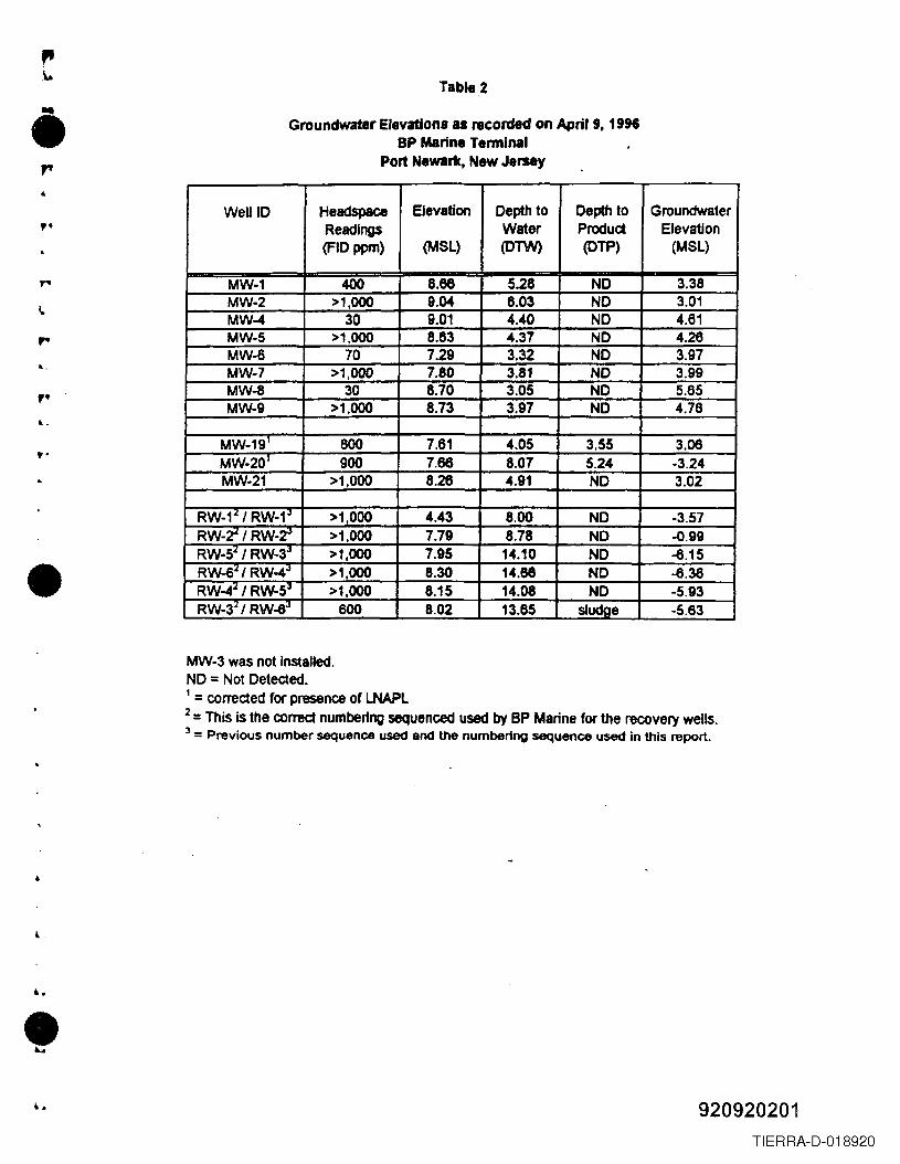
Table 2
• Groundwater Elevations as I8corded on April 9, 1996BP Marine Terminal
Port Newark, New Jersey
,. Wen 10 Headspace Elevation Depth to Depth to GroundwaterReadings Water Product Elevation(FIOppm) (MSL) (01W) (OTP) (MSL)
MW-1 400 8.68 5.28 NO 3.38MW-2 >1.000 9.04 6.03 NO 3.01MW-4 30 9.01 4.40 NO 4.61MW-5 >1.000 8.63 4.37 NO 4.26MW-6 70 7.29 3.32 NO 3.97MW-7 >1.000 7.80 3.81 NO 3.99MW-8 30 8.70 3.05 NO 5.65MW-9 >1.000 8.73 3.97 NO 4.76
MW-19' 600 7.61 4.05 3.55 3.06MW-201 900 7.66 8.07 S.24 -3.24MW-21 >1.000 8.26 4.91 NO 3.02
RW-1'" I RW-1,J >1,000 4.43 8.00 NO -3.57RW-2'" I RW-~ >1.000 7.79 8.78 NO -o.99RW-5'" I RW-3,J >1,000 7.95 14.10 NO -6.15RW-6'" I RW-4.J >1.000 8.30 14.68 NO -6.38RW-4'" I RW-5.J >1,000 8.15 14.08 NO -5.93RW-34 I RW-6.J 600 8.02 13.65 sludae -5.83
,....,.t..
t·
•MW-3 was not installed.NO = Not Detected.1 = corrected for presence of LNAPL2 = This is the correct numbering sequenced used by BP Marine for the recovery wells.3 = Previous number sequence used and the numbering sequence used in this report .
••
•920920201
TIERRA-D-018920
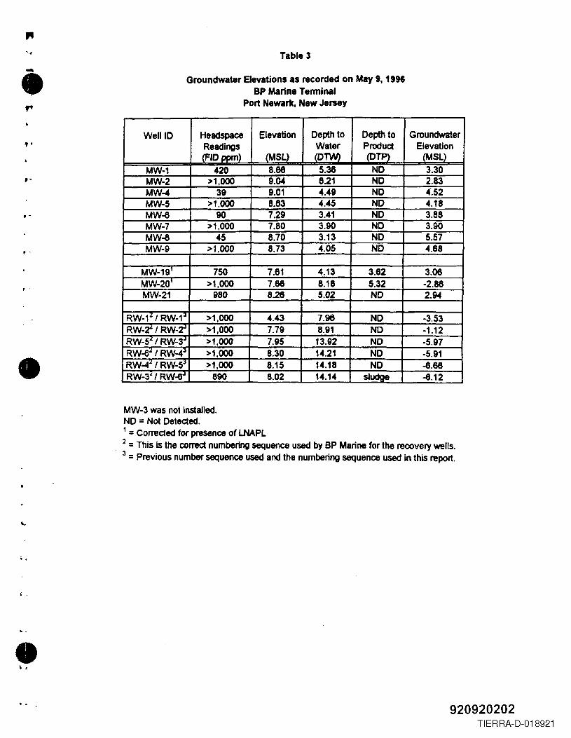
" Table 3-• Groundwater Elevations as recorded on May 9, 1996SP Marine Tenninal
Port Newark, New Jersey
,. Well 10 Headspace Elevation Depth to Depth to GroundwaterReadings Water Product Elevation(FIO oom) (MSl) (OTW) (OTP) (MSL)
MW-1 420 8.66 5.38 NO 3.30MW-2 >1,000 9.04 6.21 NO 2.83MW-4 39 9.01 4.49 NO 4'.52MW-5 >1,000 8.83 4.45 NO 4.18MW-6 90 7.29 3.41 NO 3.88MW-7 >1.000 7.80 3.90 NO 3.90MW-6 45 8.70 3.13 NO 5.57MW-9 >1.000 8.73 4.05 NO 4.68
MW-191 750 7.61 4.13 3.62 3.06MW-201 >1,000 7.66 8.18 5.32 -2.88MW-21 980 8.26 5.02 NO 2.94
RW-1;l1 RW-1;J >1,000 4.43 7.96 NO -3.53RW-r/RW-~ >1,000 7.79 8.91 NO -1.12RW-5z I RW-3J >1,000 7.95 13.92 NO -5.97RW-ez I RW-4J >1,000 8.30 14.21 NO -5.91RW-4z I RW-5.1 >1,000 8.15 14.18 NO -6.68RW-3" I RW-e.l 890 8.02 14.14 sludge -6.12
,-
.-
.'
, .
•MW-3 was not installed.NO = Not Deteded., :: Correded for presence of LNAPL.2 = This Is the correct numbering sequence used by BP Marine for the recovery wells.3 = Previous number sequence used and the numbering sequence used in this report.
·.I,
·,•·. 920920202
TIERRA-D-018921
I •..•,
readings were measured using an OVA FID. The OV~ readings ranged from 30 to >1,000
ppm above background. However, the OVA readings measured in the breathing zone were
equal to background and respiratory protection was not required. The depth to water was
measured with an electronic water product interface level indicator from a measuring point
on the top of each well. This information is summarized in Tables 2 and 3. Three well
volumes of water were purged from wells MW-l, MW-6 and MW-8 prior to sampling.
However, wells MW-l, MW-2, MW-4, MW-5 and MW-9 yielded only two volumes before
being pumped dry. The pH, specific conductivity and temperature of the purged water were
measured after each well volume was removed and again after sampling. This information
is included on the sample collection logs in Appendix D.
4
•Groundwater samples were collected using dedicated laboratory-decontaminated
stainless steel bailers with teflon leaders and dedicated nylon cord. The water samples were
transferred directly from the bailers to the sample containers. The vials provided for volatile .
organics were filled first, without leaving any headspace or air bubbles. Then the other
sample bottles were filled to the shoulder. The samples were collected in the following order:
• Volatile organics
• Base neutrals
• Diesel fuel
.,All pertinent information was entered on the sample labels and the sample containers
wel'e placed in coolers and maintained at 4 DC. The bailers and any sampling equipment that
entered the wells, or came in contact with the samples, were handled with surgical gloves to
prevent contamination. New surgical gloves were worn by the sampling personnel at each
sampling location.
l.
Quality Assurance/Quality Control (QAlQC) procedures in the field included field
blanks, trip blanks, duplicates and strict chain of custody protocols. To check
decontamination procedures, a field rinsate blank was collected using laboratory supplied
blank water which was poured over the sampling equipment and into the parameter-specific•2-7
920920203TIERRA-D-018922
, .
.,•r sample containers. A trip blank accompanied the bottles from the laboratory to the site and
back to the laboratory. To check the laboratory for accuracy, a blind duplicate sample called
MW -DUP was collected from MW -8 and sent in for analysis. The sample containers were
transported by Malcolm Pirnie personnel to the laboratory at the end of the sampling day.
Chain of custody forms accompanied the samples and file copies were kept. All analyses were
done by Laboratory Resources, Inc. in Teterboro, New Jersey. Groundwater sampling
results are discussed in Section 3.0. See Appendix D for sample collection logs and chain
of custody forms.
,.
~.
,.
,2.2.6 Disposal of Drill Cuttings and Purge Water
All decontamination fluids, driI1 cuttings, and well development/purge water generated
from the installation, development and sampling of monitoring wells were stored in DOT-
approved 55-gallon drums. Drill cuttings and well waters were staged in separate drums. All
dmrns containing cuttings or water were permanently numbered and labeled with the project
site name, date, and content The drums were staged on site for future disposal by BP Marine
once the analytical results of groundwater and soil samples were obtained .•
..
2-8
920920204TIERRA-D-018923
"..~e.. 3.0 REMEDIAL INVESTIGATION RESULTS
,e Soil and groundwater samples were sent to Laboratory Resources, Inc., located in
Teterboro, New Jersey, for analysis. Table 4 provides a summary of the samples collected
for soil and groundwater analyses. All soil and groundwater samples were analyzed within
the required holding times. Soil samples were analyzed within 12 hours of an acceptable
instrument tune and an acceptable instrument daily cahbration, and groundwater samples were
analyzed within 24 hours of an acceptable instrument tune and calibration. Method blanks
were extracted and analyzed at the proper frequency, and all method blanks met QAlQC
criteria for maximum allowable blank contamination concentrations. Laboratory data is
provided in Appendix E .
,e
..,e
..3.1 SOIL SAMPLE ANALYTICALRESULTS ANDDISCUSSION
l.
Thirty two soil borings were drilled to define the nature and extent of petroleum
hydrocarbon contamination. Five borings, MPSS-13, 15, 16, 17 and 18, were drilled
throughout the area where liquid phase petroleum hydrocarbons was determined to be present
from previous investigations (Figure 2). Those samples were sent to the laboratory for
1PHC analysis to define the nature of petroleum contamination. The remaining twenty seven
borings were drilled on the edge of what was defined as the limit of the liquid phase
petroleum hydrocarbons in previous investigations (Figure 2). Initially, thirteen borings
(MPSS-I though MPSS-14) were proposed to accomplish this task. However, due to the
presence of product in eight of these borings, an additional fourteen borings were drilled to
define the limit where no liquid phase petroleum hydrocarbons were usually noted in the soil
samples. Therefore, 27 borings were drilled to define the liquid phase limit on the clean
zone. Of these 27 samples, 20 were sent for TPHC analyses. In addition, two duplicate
samples were sent for QAlQC purposes.
e
~.
l.
The TPHC analyses are summarized in Table 5. TPHCs were not detected above the
proposed NJDEP remediation standard of 10,000 mglkg (per 24NJR386) in any of the 27
samples analyzed for TPHC. The TPHC distribution is shown on Figure 4. The limit of the
liquid phase petroleum hydrocarbons is also shown on Figure 4. This limit was based one3-1
l. 920920205TIERRA-D-018924
"" (")
:.,
B
,~----r-------------------:;;;;;;;~=::_---------;1,~ ,.
\
Ii"
J!!' 'i:i~I':
'~
m,'~
III IlCCIIYDlT n:u.@> ICIIIlITmlDllI n:u.• SOIL BORING
_-nJItI:__ Vl..n:. UNa--..-SANI1MY S£YDt__.- S"T"DRIC S£V'Ot
III STtIOIM 1ICUT& SNaTMY IlI\IeG..[
A~... VI\LYI:
~CI SUUUllf"Aa- - nlllJClUll:
NO =~o~~~~:=DETECTED
LPH~!%::~~::~HSr7"7"1 D£HOYES EsnllATEDI.L..L.LI AREAL EXTENT OF LPH
MPSS.18 BOlL BaAING LOCATION
'SOl ~~~'o~~.:~~:OI.O'NS, NOT SAUPL£D
FIGURE ~
BP IolAMtE T~pORT HEWilUlI(, NEW JERSEy
EXTENT OF UQUID PHASE PETROLEUM HYDROCARBON PLUIq; AND PETROLEUM HYDROCARBON CONCENTRATIONS IN SOIL
920920206
..,~.~I ~:
TIERRA-D-018925
r ••. . ...
TADLE4SUMMARY OF FIELD SAMPLING PROGRAM
DP MARINE TERMINALPORT NEW ARK, NEW JERSEY
MEDIA TYPE OF NUMBER OF NUMBER OF PARAMETERS METHODINVESTIGATION SAMPLES QAlQC
COLLECTED SAMPLES TOBE
COLLECTED
SOIL Subswfacc Soil sampling 25 2 Duplicate Total Petroleum Hydrocarbons (TPHC) 418.1Priority Pollutant- VOC (+ 10) on 25%
1 Field Blank of samples> 1000 ppm TPHC 624Polynuclear Aromatic Hydrocarbons on
25% of samples> 100 ppm TPHC 625
I
GROUNDWATER Groundwater 8 1 Duplicate Diesel Fuel Modified 8015SBIJJPling Priority Pollutant- VOC (+10) on 25%
I Field Blank samples> 1000 ppm TPHCPriorityPollutant·Semi VOC (+15) 624
1 Trip Blank . 25% of samples > 100 ppm TPHC624
P:U749002\REPORTS\sFSPTBL.4
TIERRA-D-018926
TableSSOUSampling Results
Total Petroleum BydrocarboDJBP Marine Terminal
Port Newark, New Jersey .(mWKg)
l .
, ~.Sample Total Petroleum Comments
ID Hydrocarbonsmglkg
MPS8-1 NS Petroleum Product ObservedMPSS-IA NS Petroleum Product ObservedMPss-lB 50MPss-IC 690MPSs-lD noMPSS·IE 27 UMPSS-2 NS Petroleum Product Observed
MPSS-2A 6SMPss-3 130MPSS4 310
MPSS4A 990MPSS-S NS Petroleum Product Observed
MPSS-SA 170MPSS-6 8000 Petroleum Product Sheen Observed
MPSS-6A 120MPSS-6B 870MPSS-6C 670MPSS-6D 1500MPSS-1 130MPSs-3 3100MPS8-9 NS Petroleum Product Observed
MPS8-9A 130 Petroleum Product Sheen ObservedMPS8-IO 460MPS8-11 NS Petroleum Odor Observed
MPSS-IIA NS Petroleum Odor ObservedMPSS-llB 410MPSS-12 390 Petroleum Odor ObservedMPSS-13 29 U Petroleum Odor ObservedMPSS-14 200MPSS-IS 27 Petroleum Product ObservedMPSS-16 78 Petroleum Odor and Sheen Observed
MPSS-16D 510 Petroleum Odor and Sheen ObservedMPSS-17 4&00MPSS-18 470 .
FB-l 0.42 mWL
,.L
,.
..
•
•~920920208
TIERRA-D-018927
visual observations and the TPHC analytical results. These results indicate that the liquid
phase limit extends further to the north, west and south then reported in the previous
investigations (Figure 2).
,.- The TPHC analytical results show that twenty one samples had TPHC concentrations
greater than 100 mglkg. As required by the RIW, 25 percent of the samples exceeding the
100 mglkg TPHC concentration were analyzed for PAIIs. Additional samples were also
analyzed for PARs to establish background concentrations. The PAH analytical results are
summarized on Table 6. Benzo[a]pyrene was the only PAR detected at a concentration
above NJDEP's Non-Residential Direct Soil Cleanup Criteria of 660 uglkg. This exceedance
occurred in only one sample, MPSS-17, which had a concentration of 870 JD uglkg. This
is an estimated concentration because it was below the reported detection limit for this
sample. This is an isolated exceedance and does not appear to be representative of the other
results. In addition, because the soil is below a paved surface there is little potential for direct
contact. Therefore, no further action is recommended .
..,.6..
r
'"
• The RIW also required that 25 percent of the samples with TPHC concentrations
exceeding 1,000 mglkg be analyzed for VOCs +10. Five samples were analyzed for VOCs
(Table 7). There were no YOCs detected above NJDEP's Non-Residential Direct Contact
Soil Cleanup criteria.
3.2 GROUNDWATERANALYSES
t.
A total of nine groundwater samples were collected, of which one sample was a
duplicate collected for laboratory QAlQC. These samples were analyzed for diesel fuel
(modified method 8015), TeL YOCs +10, and semi-volatile organic components (SYOCs).
Sample dilutions were required for sample MW-7 because of matrix effects and/or high
contaminant concentrations.
Methylene chloride was detected at concentrations above the groundwater standards
(NJ.A.C. 7:9 - Table 8) in the samples collected from wells MW-2, MW-4 and MW-7;
3-2
920920209TIERRA-D-018928
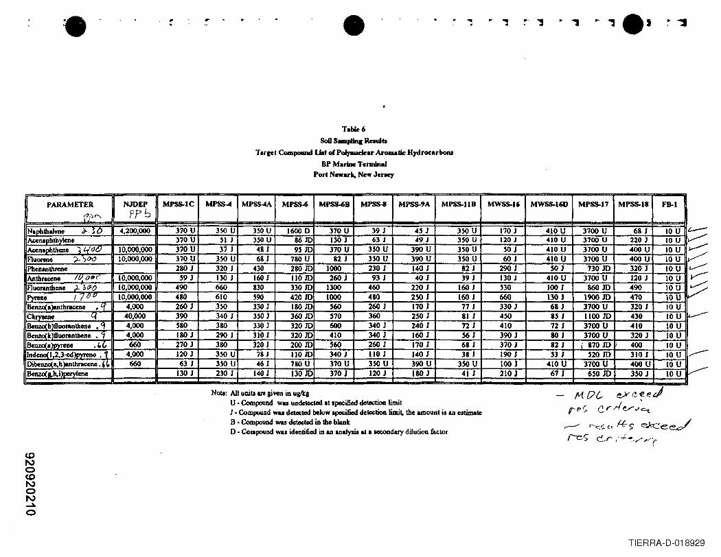
'. • '"II...,....
T.bIe 6SoD Samplinc Raulb
Tarcet Compound Uat 01Polynuclear Aromatic HydrocarboNBP M.rine Terminal
Port Newark, New Jency
PARAMETER NJDEP MPSS-IC MPSS4 MPSS-4A MJ>SS..6 MPSS-6B MPSS-8 MPSS-9A MPSS-llB MWSS-16 MWSS-I6D MPSS-17 MPSS-18 FB-I
'(J)>"\. ppbNaphthalene ~3D 4,200,000 370 U 350 U 350 U 1600 D 370 U 39 J 45 J 350 U 170 J 410 U 3700 U 68 J 10 U t.---henapbthylcne 370 U 51 J HOU 86JD 130 J 63 J 49 J 350 U 120 J 410 U 3700 U 220 J 10 U ~~naohthcne ~ 400 10,000,000 370 U 37 J 481 9HD 370 U 350 U 390 U 350 U 50 J 410 U 3700 U 400 U IOU ~Ruorene ?-'~OO 10,000,000 370 U 350 U 68 J 180 U 82 J 350 U 390 U 350 U 60J 410 U 3100 U 400 U 10 U ~Phenanthrene 280 J 320 J 430 280 JD 1000 230 J 140 J 82 J 290 J SOJ 130m 320 J 10 U ~Anthrac:eno IV. o~, 10.000,000 59 J 130 J 160 J 11010 260 J 93 J 40 J 39 J 130 J 410 U 3100 U 120 J 10 U V-Ruoranthene ).~dlO 10,000,000 490 660 830 330m 1300 460 220 J 160 J 530 100 J 860 m 490 10 U ~Pyrene /7lJQ 10,000,000 480 610 590 42010 1000 480 250 J 160 J 660 130 J 1900 JD 4'70 IOUBenzo(a)Bnthraceno ,q 4,000 260 J 350 330 J 180 m S60 260 J 170 J 77J 330 J 68 J 3700 U 320 J 10 UChrnc~ q 40,000 390 340 J 350 J 360 10 570 360 2SO J 81 J 450 UJ 1100 m 430 10 U ~
CDZOl b f1l1Orantheno • ( 4,000 580 380 330 J 32010 600 340J 240 J 72 J 410 72 J 3700 U 410 10 Uenzcl k f1uorantheno • 4,000 ISO J 290 J 310 J 32010 410 340 J 160 J 56 J 390 J SOJ 3700 U 320 J 10 Uenzcl IlPYrClJO .(, 660 270 J 3SO 320 J 200 10 S60 260 J 170 J 68 J 370 J 82 J I 87010 400 IOU
Indcno 1,2,3~)pyreno , 1 4,000 120 J 350 U 78 J 11010 340J 1I0J 140 J 38 J 190 J 53 J 52010 310 J 10 U .----Dibenzo(a,h)anll1rac:ene, ,~ 660 63 J 350 U 46 J 7&0 U 370 U 350 U 390 U 350 U 100 J 410 U 3700 U 400 U 10 U
~8enzo(1I.h,i)peryleno 130 J 230 J 140 J 13010 370 J 120 J ISO J 41 J 210 J 67 J 65010 350 J 10 U
Note: All unita are giYell in uglkaU • Compound wu undetected .t specified dol«tioo limitJ • Compound wu ~ below apocifiod d~tioD limit. tho amount is an estimateB • Compound wu d~tod in tho blanko . CompouDd wu identified in an anaJyaia at a ICCOndary dilution factor
M {/{, eYc-ee~
r-f?r; c.r.rl e/"'~
,....- r-<::.<; (.l ft. $' ~e~Ie S C-r,' .;.~.y ;'(
TIERRA-D-018929
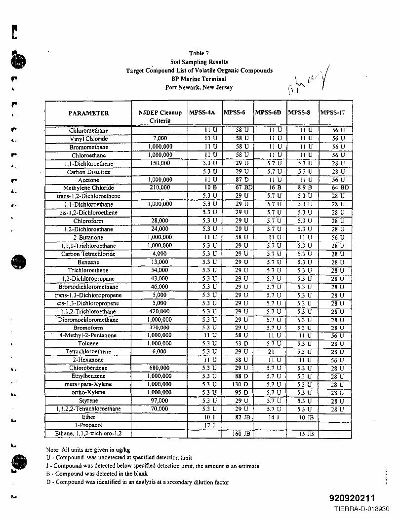
,.&
...,.
rL
"
•
••
Table 7
. Soil Sampling ResultsTarget Compound List of Volatile Organic Compounds
BP Marine TerminalPort Newark, New Jersey
PARAMETER NJDEP Cleanup MPSS-4A MPSS-6 MPSS-6D MPSS-S MPSS-17Criteria
Ch loromethane 11U 58 U 11 U 11 U 56 UVinyl Cbloride 7,000 IIU 58 U II U II U 56 U
Bromomethane 1,000,000 11U 58 U II U II U 56 UChloroethane 1,000,000 II U 58 U 11 U 11 U 56 U
I, I- Dichloroethene 150,000 5.3 U 29 U 5.7 U 5.3 U 28 UCarbon Disulfide 5.3 U 29 U 5.7 U 5.3 U 28 U
Acetone 1,000,000 II U 87 D lIU 11 U 56 UMethylene Chloride 210,000 lOB 67 BD 16 B 8.9 B 64 BD
trans-I ,2- Dichloroethene 5.3 U 29 U 5.7 U 5.3 U 28 UI, I- Dichloroethane 1,000,000 5.3 U 29 U 5.7 U 5.3 U 28 U
cis-I,2-Dichloroethene 5.3 U 29 U 5.7 U 5.3 U 28 UChlorofonn 28,000 5.3 U 29 U 5.7 U 5.3 U 28 U
I ,2 -D ichloroethane 24,000 5.3 U 29 U 5.7 U 5.3 U 28 U2-Butanone 1,000,000 II U 58 U II U II U 56 U
I, 1,1- Trichloroethane 1,000,000 5.3 U 29 U 5.7 U 5.3 U 28 UCarbon Tetrachloride 4,000 5.3 U 29 U 5.7 U S.3 U 28 U
Benzene 13,000 5.3 U 29 U 5.7 U 5.3 U 28 UTrichloroethene 54,000 5.3 U 29 U 5.7 U 5.3 U 28 U
1,2- Dichloropropane 43,000 5.3 U 29 U 5.7 U 5.3 U 28 UBromodichloromethane 46,000 5.3 U 29 U 5.7 U 5.3 U 28 U
trans-I.3-Dichloropropene 5,000 5.3 U 29 U 5.7 U 5.3 U 28 Ucis-l,3-Dichloropropene 5,000 5.3 U 29 U 5.7 U 5.3 U 28 U
1,1,2- Trichloroethane 420,000 5.3 U 29 U 5.7 U 5.3 U 28 UDibromocbloromethane 1,000,000 5.3 U 29 U 5.7 U 5.3 U 28 U
Bromoform 370,000 5.3 U 29 U 5.7 U 5.3 U 28 U4-Methyl-2-Pentanone 1,000,000 11 U 58 U 11 U 11 U 56 U
Toluene 1,000,000 5.3 U 53 D 5.7 U 5.3 U 28 U, Tetrachloroethene 6,000 5.3 U 29 U 21 5.3 U 28 U
2-Hexanone IIU 58 U 11 U 11 U 56 UChlorobenzene 680,000 5.3 U 29 U 5.7 U 5.3 U 28 UEthylbenzene 1,000,000 5.3 U 88 D 5.7 U 5.3 U 28 U
meta+para- Xylene 1,000,000 5.3 U 130D 5.7 U 5.3 U 28 Uortho-Xylene 1,000,000 5.3 U 95 D 5.7 U 5.3 U 28 U
Styrene 97,000 5.3 U 29 U 5.7 U 5.3 U 28 U1,1,2,2- Tetrachloroethane 70,000 5.3 U 29 U 5.7 U 5.3 U 28 U
Ether 10 J 82 JB 14 J 10 J8I-Propanol 17 J
Ethane, I, I ,2-trichloro-l,2 160 JB 1518
Note: All units are given in ug/kgU - Compound was undetected at specified detection limitJ - Compound was detected below specified detection limit, the amount is an estimate8 - Compound was detected in the blankD - Compound was identified in an analysis at a secondary dilution factor
920920211TIERRA-D-018930
"...
•.. -
however, methylene chloride was also detected in the blank and is a common lab contaminant.
The concentrations of ortho-xylene (65 ugll) and meta+para-xylene (54 ugll) in the sample
from well MW -7 were also detected above the groundwater standards of 40 ug/L for total
xylenes. These compounds were identified during a secondary sample analysis with a greater
dilution factor which caused the minimum detection limit to rise. The reported concentrations
of these two compounds are less than the higher minimum detection limit, therefore, the
concentrations were estimated. Xylenes were not detected in any other groundwater sample
and therefore, its presence is not believed to be related to the pipeline leak. The source of
those xylenes are unknown. However, it should be noted that a slight oil sheen was observed
in the water sample collected from Well MW -7.
"",.,.t..
,.
•No other volatile or semi-volatile (Table 8) compounds (Table 9) were detected above
the groundwater standards in any of the other samples. Diesel range organics (Table 10) were
detected in the samples from wells MW-l (0.016 J mgll- amount estimated), MW-5 (0.32
mW!), MW-7 (12 mgIl), MW-8 (0.04 mgll) and its duplicate sample (0.03 mgll), and MW-9
(0.4 mg/l).
..
These results indicate that the liquid phase petroleum has not broken down to the
individual hydrocarbons reported in a VOC or SVOC scan. Diesel range organics were
detected in upgradient wells MW-9 and MW-8, and in three down gradient wells. These
results indicate that the presence of diesel range organics is indicative of background
conditions. No further action is recommended for the groundwater.
l,3.3 SITEGEOWGY
A..The site is located in the Northern Piedmont Lowlands and is bounded by the Coastal
Plain to the south and east, the New England Uplands to the north, and the Piedmont Uplands
to the west. It is located within the Newark Group and is underlain by the Brunswick
Formation, which consists of thin-bedded shales, dust stones and sandstones. The bedrock
at the site is mantled by a Wisconsin-age glacial ground moraine and post-glacial tidal marsh
deposits. The moraine consists of various combinations of gravel, sand. silt and clay, while
3-3
920920212TIERRA-D-018931
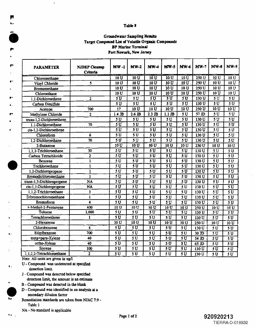
~.
..
p.
~.
•
•
L
..
•Iu
TableS
Grouadwlter Sampl1Dg RauItITarget CompoaDd List of Volatile Orpaic COIDpoIUIdJ
BP Mariae TermiDalPort Newark, New Jeney
Note: All UDJts are gIVenm ugllU - Compound was undetected at specified
detection limitJ - Compound was detected below specified
deteaion limit. the amount is an estimateB • Compound was detected in the blallkD - Compound was identified in an analysis at a
secondary dilution factorRemediation standards are taken from NIAC 7:9-
Table 1NA - No standard is applicable
Page 1on 920920213TIERRA-D-018932
PARAMETER NJDEP CIuDup MW-l MW-2 MW-4 MW-S MW-' MW-7 MW-8 MW-9Criteria
Chloromethane IOU IOU IOU IOU IOU 250U IOU IOUVmvl Chloride .5 IOU IOU IOU IOU IOU. 250U JOU IOUBromomethanc IOU IOU IOU IOU IOU 250U IOU IOUChloroethane IOU IOU IOU IOU IOU 250U IOU IOU
l,l-Dichloroethene 2 5U SU SU SU SU 130U SU SUCaJ'bon Disulfide 5U SU SU SU SU 130U SU SU
Acetone 700 17 IOU IOU IOU IOU 250U IOU IOUMethylene Chloride 2 1.4 JB 2.6JB 2.3 JB l.lJB SU 57 JD SU 5U
trans-I,2-Dichloroethene 5U 5U 5U SU SU 130U SU SUl,l-Dichloroethane 70 5U SU 5U SU SU 130U SU SU
cis-1,2-Dichloroethene 5U 5U SU SU SU 130U 5U 5UChloroform 6 SU SU SU SU SU 130U 5U SU
l,2-Dichloroethane 70 5U 5U SU SU 5U 130U 5U SU2·Butanone IOU IOU IOU IOU IOU 250U IOU IOU
1,1,1·Trichloroethane 30 SU 5U 5U SU 5U 130U 5U SUCarbon Tetrachloride 2 SU SU SU SU SU 130U SU SU
Benzene 1 SU SU SU SU SU 130U SU SUTrichloroethcne 1 SU SU SU SU SU 130U SU SU
1,2-Dichloro 1 SU SU SU SU SU 130U SU SUBromodichloromethane 1 SU SU SU SU SU 130U SU SU
trans· 1,3-Dichloropropene NA SU 5U SU .sU 5U 130U 5U 5Ucis-l,3 -Dichloropropene NA SU SU SU .sU SU 130U SU SU
1,1,2-Trichloroethane 3 SU SU SU .sU SU 130U SU SUDibromochloromethane 1 SU SU SU SU SU 130U SU SU
Bromoform 4 SU SU SU SU SU 130U SU SU4-Methyl-2-Pentanone 400 IOU IOU IOU IOU IOU 250U IOU IOU
Toluene 1,000 SU SU SU SU SU 130U 5U SUTetraehloroethene 1 SU SU SU SU SU 130U SU SU
2-Hexanone IOU IOU IOU IOU IOU 2S0U IOU IOUChlorobenzene 4 SU SU SU SU SU 130U SU SUEthvlbenzene 700 SU SU su .sU SU 30JD SU SU
meta+oara-Xylene 40 SU SU SU SU SU 54 JD SU SUonho-Xvlene 40 SU SU SU SU SU 6SJD SU SU
Styrene 100 5U 5U .sU .sU .sU 130U SU 5U1,1,2,2-Tetrachloroethane 2 .sU SU SU SU SU 130U SU SU
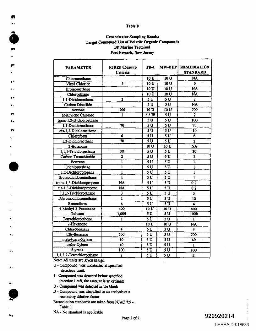
...TableS
Groundwater Sampling ResuJtJTarget Compoud List of Volatile Organic Compounds
BP Marine TerminalPort Newark. New Jeney"
PARAMETER NJDU Cleanup ¥B-1 MW-DUP OMEDIA nONCriteria STANDARD
Chloromethane IOU IOU NAVmyl Chloride 5 IOU IOU 5Bromometbane IOU IOU NAChloroethanc IOU IOU NA
I,I-Dichloroethene 2 5U 5U 2Carbon Disulfide 5U 5U NA
Acetone 700 IOU IOU 700Methylene Chloride 2 2.2m 5U 2
trans-1,2-DichloroetheDe 5U 5U 1001,l-Dichloroethane 70 5U 5U 70
cis-l,2-Dichloroethenc 5U 5U 10Chloroform 6 5U 5U 6
l,2-Dichloroethane 70 5U 5U 22-Butanonc IOU IOU NA
1,1,1-Trichloroethane 30 5U 5U 30CaIbon Tcttachloride 2 5U 5U 2
Benzene 1 5U 5U 1Trichloroethcne 1 5U 5U 1
1,2-Dichloroorooane 1 5U 5U 1Bromodichloromethanc I 5U 5U 1
trans-I ,3-Dichlorooroocne NA 5U 5U 0.2cis-I,3-Dichlo NA 5U 5U 0.2
1,1,2-Trichloroethane 3 5U 5U 3Dibromochlorometbane 1 5U 5U 10
Bromoform 4 5U 5U 44-Methyl-2-Pentanone 400 IOU IOU 400
Toluene 1,000 5U 5U 1000TetIachloroethcnc 1 5U 5U 1
2-Hcxaoonc IOU IOU NAChlorobcnzcuc 4 5U 5U 4Ethylbcnzcoc 700 5U 5U 700
m Xylene 40 5U 5U 40onho-Xylenc 40 5U 5U 1
SMene 100 5U 5U 1001,1,2,2- TetraebJoroethan 2 5U 5U 2
.,
...
....
•
,.
Note: All umts arc grven m ugllU - Compound was undetc:c:ted at specified
detection limitJ - Compound was detected below specified
detection limit, the amount is an estimate3 - Compound was detected in the blankD - Compound was identified in an analysis at a
secondary dilution factorRemediation standards arc taken from NJAC 7:9 -
Table 1NA - No standard is applicable 920920214Page2of2
TIERRA-D-018933
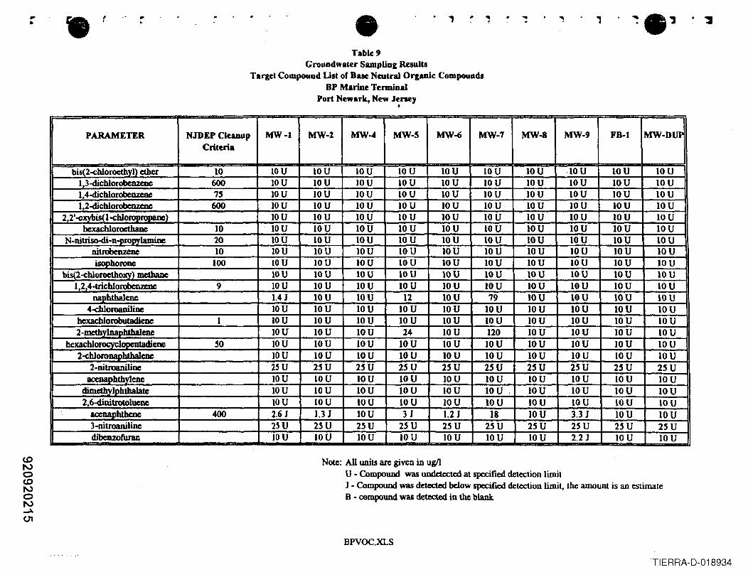
<0No<0NoN~(J1
• r , . ..... ,...Table 9
Groundwater Sampling ResultlTarget Compound List of Bue Neutral Organic Compound.
BP Marine TerminalPort Newark, New Jeney
•
PARAMETER NJDEP Cleanup MW-I MW-2 MW-4 MW-S MW~ MW-7 MW-8 MW-9 FB-I MW-DUPCriteria
bis(2-<:h1oroethyl) ether 10 IOU 10 U IOU 10 U IOU IOU IOU ·IOU IOU 10 U1.3-dichlorobenzenc 600 IOU IOU IOU IOU IOU IOU IOU IOU IOU 10 U1,4-dichlotobenzeoe 75 IOU IOU IOU 10 U IOU IOU IOU IOU IOU IOU1,2-dichioroben.zeDc 600 IOU IOU IOU IOU IOU IOU IOU IOU IOU IOU
2,2'o()X}'bis<l-<:hlo IOU IOU IOU 10 U IOU 10 U IOU 10 U IOU 10 Uhexachloroethane 10 IOU IOU IOU IOU IOU IOU IOU IOU IOU IOU
N-nitriso-di-n-DtoPYlamine 20 IOU IOU IOU IOU IOU IOU IOU IOU IOU IOUnitrobenzene 10 IOU IOU IOU IOU IOU IOU IOU IOU IOU IOUisophoronc 100 IOU IOU IOU 10 U IOU IOU IOU IOU IOU IOU
biS(2-chloroctho""\ methane IOU IOU IOU IOU IOU IOU IOU IOU IOU IOU1,2,4-trichlorobenzcDc 9 IOU IOU IOU 10 U IOU IOU IOU IOU IOU 10 U
naphthalene 1.4 J IOU IOU 12 IOU 79 IOU IOU IOU IOU4-ch1or08niJine IOU IOU IOU 10 U IOU IOU IOU IOU IOU IOU
hexacblorobutadieoe I IOU IOU IOU 10 U IOU 10 U IOU IOU IOU IOU2-mcthylnapb1halcnc IOU IOU IOU 24 IOU 120 IOU IOU 10 U IOU
hexachlorocycl cne 50 IOU IOU IOU IOU IOU IOU IOU IOU IOU IOU2-<:hloronaphthalcoe IOU IOU IOU 10 U IOU IOU IOU IOU IOU IOU
2-nitroanilioc 2~ U 2~U 25U 25U 25U 2SU 2SU 2SU 25U 25Uacenaohthvlene IOU 10 U IOU 10 U 10 U 10 U IOU IOU IOU 10 U
dimethylphthalate IOU IOU IOU 10 U IOU IOU. IOU IOU 10 U IOU2,6~trotolueoe IOU IOU IOU 10 U IOU IOU 10 U IOU 10 U IOU
aceJUlI)h1bcne 400 2.6 J 1.3J IOU 3 J 1.2 J 18 IOU 3.3 J 10 U IOU3-nitroaniline 2~U 2~U 25U 2SU 25 U 25U 25U 2~U 25 U 2~ Udibenzofuran IOU IOU IOU 10 U IOU 10 U 10 U 2.2 J 10 U 10 U
Note: All units arc given in ug/lU • Compound was undetected at specified detection limitJ • Compound was deteet.cd below specified detection limit. the amount is an estimateB - compound was detected in the blank
BPVOC.XLS
TIERRA-D-018934
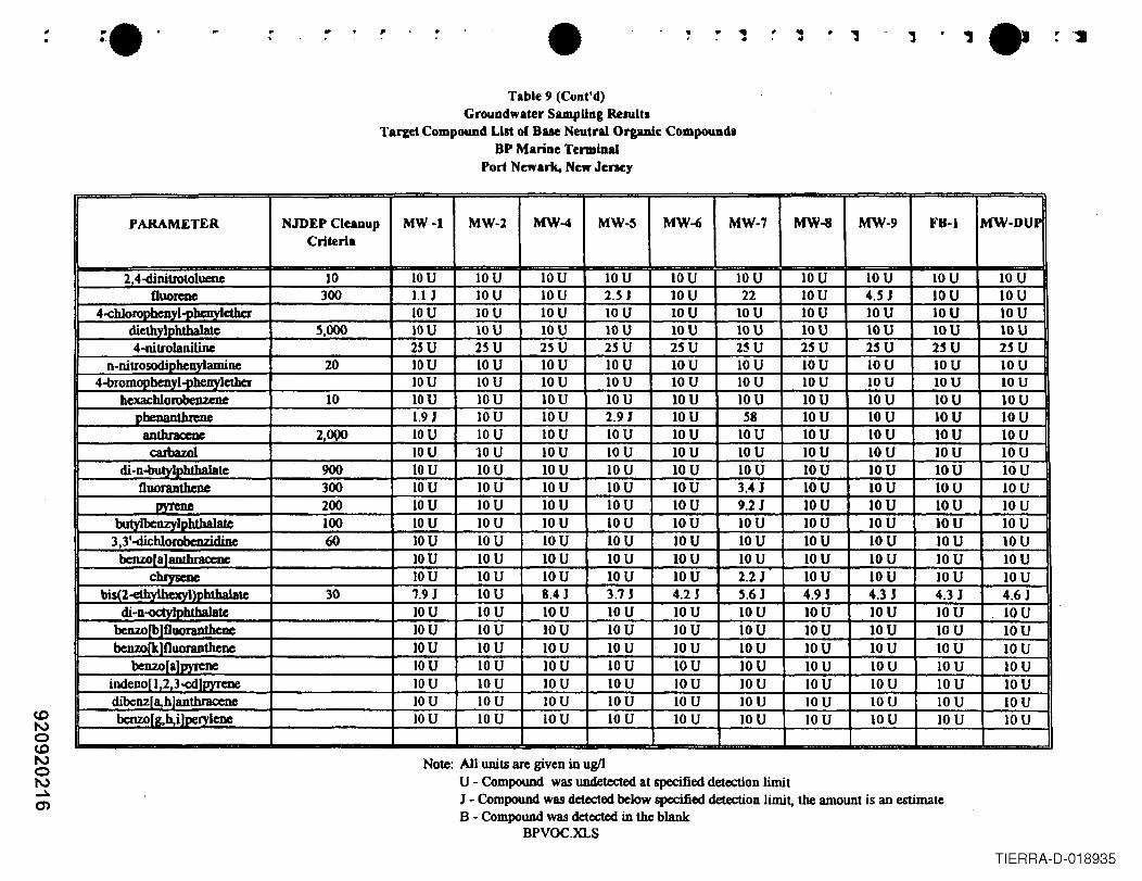
c.oNoc.oNoN~0)
". --..e· • .. ~• 1.Table 9 (Coot'd)
Groundwater SampUng ResuUsTarcet Compound Lilt of Bue Neutral Organic Compounds
8P Marine TerminalPort Newark. New Jenc:y
PARAMETER NJDEP Cleanup MW-l MW-l MW-4 MW-~ MW-6 MW-7 MW-8 MW-9 F8-1 MW-DUPCriteria
2.41iinitrotoluenc 10 IOU IOU IOU 10 U IOU IOU 10 U IOU IOU 10 UOuorene 300 1.IJ IOU IOU 2.SJ IOU 22 IOU 4.5 J IOU 10 U
4-<:hlorophenyl-pbcnyletber IOU IOU IOU IOU IOU IOU IOU IOU IOU IOUdiethylDhtha1atc 5,000 IOU IOU IOU IOU IOU IOU IOU IOU IOU IOU4-nitrolanilinc 2S U 2S U 2SU 2S U 25U 2~ U 2SU 2SU 2SU 2S U
n-nitrosodiDheuvlamine 20 IOU 10 U IOU 10 U IOU IOU IOU IOU IOU 10 U4-bromopbenyl-phenylether IOU IOU IOU IOU IOU IOU IOU 10 U IOU IOU
bexacblorobenzenc 10 IOU IOU IOU IOU IOU IOU IOU IOU IOU IOUphenanthrene 1.9 J IOU IOU 2.9 J IOU S8 IOU 10 U IOU 10 Uantbraccoc 2,OQO IOU IOU IOU IOU IOU IOU IOU IOU IOU 10 U
caJbazol IOU lOU IOU IOU IOU IOU IOU IOU IOU IOUdi-n-butylphthalate 900 IOU IOU IOU 10 U 10 U IOU IOU IOU IOU IOU
Ouoranthene 300 IOU IOU IOU IOU IOU 3.4 J IOU 10 U IOU IOUpytcue 200 IOU IOU IOU IOU IOU 9.2J IOU IOU IOU IOU
bu Iphtha1ate 100 IOU IOU IOU IOU IOU IOU IOU 10 U IOU 10 U3,3'-dichlorobcnzidinc 60 IOU 10 U IOU IOU IOU IOU IOU 10 U IOU IOU
benzor alanthraccoe IOU IOU IOU IOU IOU IOU IOU 10 U IOU IOUc".......... IOU 10 U IOU IOU IOU 2.2 J IOU 10 U IOU IOU
bis(l-etb: b1ha1atc 30 1.9 J IOU 8.4 J 3.7 J 4.2 J 5.6J 4.9 J 4.3 J 4.3 J 4.6 Jdi-n lvIobtha1ate IOU IOU IOU 10 U IOU IOU IOU 10 U IOU IOU
benzo Ouoranthcne IOU IOU IOU IOU IOU IOU IOU IOU IOU IOUbenzo Ouoranthene IOU IOU IOU 10 U IOU IOU IOU IOU 10 U IOU
benzorahmene IOU 10 U IOU 10 U IOU IOU IOU 10 U 10 U IOUindeno 1,2,3-<:dlpyrene IOU 10 U IOU IOU IOU IOU IOU 10 U 10 U IOUdibenz a,hlanthracene IOU IOU IOU IOU 10 U 10 U IOU IOU 10 U IOUbenzo [g,h.i loervlenc IOU 10 U IOU 10 U 10 U IOU IOU IOU IOU IOU
Note: All units are given in ugflU - Compound was undetected at specified detection limitJ - Compound was detected below specified detection iimit, the amount is an estimateB - Compound was detected in the blank
BPVOC.XLS
TIERRA-D-018935
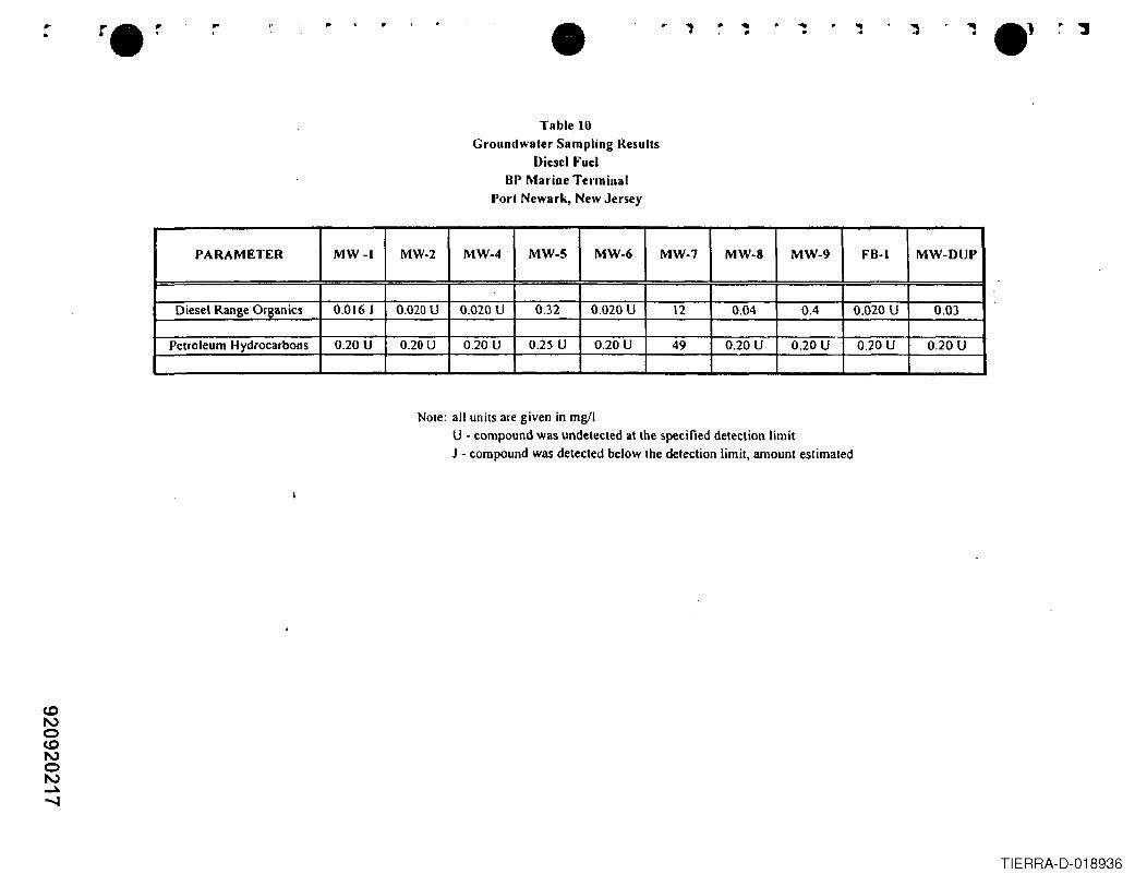
• ..of
...•.. ., .. ..... •...,.
Table 10Groundwater Sampling Results
Diesel FuclBP Marine Terminal
Port Newark, New Jersey
PARAMETER MW-I MW·2 MW-4 MW-5 MW-6. MW-7 MW-8 MW-9 FB-I MW-DUP
Diesel Range Organics 0.016 J 0.020 U 0.020 U 0.32 0.020 U 12 0.04 0.4 0.020 U 0.03
Petroleum Hydrocarbons 0.20 U 0.20U 0.20 U 0.2S U 0.20 U 49 0.20 U 0.20 U 0.20 U 0.20U
Note: all units are given in mgllU - compound was undetected at the specified detection limitJ - compound was detected below the detection limit, amount estimated
TIERRA-D-018936
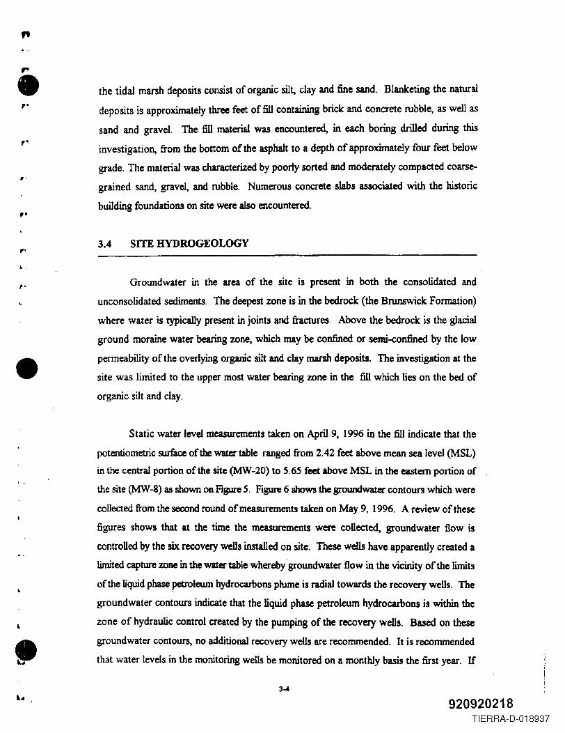
"r•,- the tidal marsh deposits consist of organic silt, clay and fine sand. Blanketing the natural
deposits is approximately three feet of fill containing brick and concrete rubble, as well as
sand and gravel. The fill material was encountered, in each boring drilled during this
investigation, from the bottom of the asphalt to a depth of approximately four feet below
grade. The material was characterized by poorly sorted and moderately compacted coarse-
grained sand, gravel, and rubble. Numerous concrete slabs associated with the historic
building foundations on site were also encountered.
,-
pi
3.4 SITE HYDROGEOWGY
..,. Groundwater in the area of the site is present in both the consolidated and
unconsolidated sediments. The deepest zone is in the bedrock (the Brunswick Formation)
where water is typically present in joints and fractures. Above the bedrock is the glacial
ground moraine water bearing zone, which may be confined or semi-confined by the low
permeability of the overlying organic silt and clay marsh deposits. The investigation at the
site was limited to the upper most water bearing zone in the fill which lies on the bed of
organic silt and clay.•
I.
Static water level measurements taken on April 9, 1996 in the fill indicate that the
potentiometric surface of the water table ranged from 2.42 feet above mean sea level (MSL)
in the central portion of the site (MW-20) to 5.65 feet above MSL in the eastern portion of
the site (MW-8) as shown on Figure 5. Figure 6 shows the groundwater contours which were
collected from the second round of measurements taken on May 9, 1996. A review of these
figures shows that at the time the measurements were collected, groundwater flow is
controlled by the six recovery wells installed on site. These wells have apparently created a
limited capture zone in the water table whereby groundwater flow in the vicinity of the limits
of the liquid phase petroleum hydrocarbons plume is radial towards the recovery wells. The
groundwater contours indicate that the liquid phase petroleum hydrocarbons is within the
zone of hydraulic control created by the pumping of the recovery weDs. Based on these
groundwater contours, no additional recovery wells are recommended. It is recommended
that water levels in the monitoring wells be monitored on a monthly basis the first year. If
3-4
920920218TIERRA-D-018937
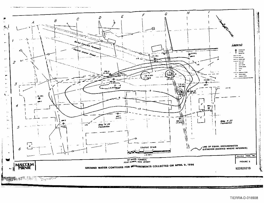
"
+.\
H I
\I II
,
I.'I
.. I_. ..... ....,--I i
! :
IIi1
8 c E F
",. I,'")
"glad:
0--g --. ---.--------1---. --_ ...---"--
---4
iI /
.-_ ..-" .., +4
i1..- \_ ..
Bldg. IN 24Foundation
..."..(4.61\
-I
6
\._~I
\
l~ --'--
~
\
J
Bldg. N 2JFoundation
5
GRAPHICscAlE ~\\ LINE OF EQUAL GROUNDWATER./'-/ ELEVATION (DASHED WHERE INFERRED)
. i:~; i
1_""1
~..
~"
j
BP lAAflINE TERMINALPORT NE'/iARlI, NEw JERSEY
GROUND WATER CONTOURS FOR IIfASUREMENTS COLLECTED ON APRIL 9. 1996
FIGURE 5
920920219
i
4A 44 + l JUB g #,,4 :"'~;;*t;'&*'i6"e'2 •
TIERRA-D-018938
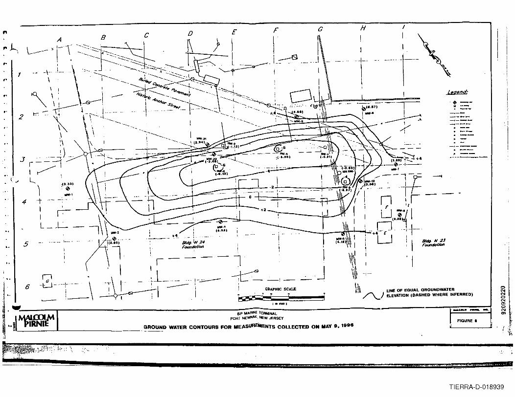
",.~r
I"f'
f'
2
E
-- --n !,IU -:'/1II.!,__ ~~ n-I.-\.-.- .."'+4- £ .
U ! I 8/df1. N 2J. Foundallt>n
, I
cI
I____.J
I
H
!I
···-1--
II
!
I~• I
/I
..
4+2
5 81dg. IN 2-#Faundafion
-- -- -- IJ
,.
I
II
L,g,nd:
.~ --g --, --
-.---, --, --.-.--------
CRAPHIC SCAU: ~\\ LINE OF EQUAL GROUNDWATER, /"\...1 ELEVATION (DASHED WHERE INFERRED)
-.ceuo -. _
BP ~ARINE TERMINALPORT NEWARK. IlEW JERSEY
GROUND WATER CONTOURS FOR MEASURE"ENTS COLLECTED ON MAY 9. 1996FIGURE 8
u 44 E
oNNoNmoNm
TIERRA-D-018939
..
"•,.
hydraulic control is maintained, and there is no evidence of petrolet,l11lin the sentinel wells,
then the water level and free product monitoring may be decreased to quarterly. IfBP M~e
wishes to enhance the recovery of petroleum, then an additional recovery well is
recommended. This optional recovery weD could be installed in the vicinity of soil boring
MPSS-18. BP Marine may also want to consider pumping weDMW -7 because of the slight
sheen noted in the water samples collected from this well.
•·-·.·.
·,
•3-5
I. • 920920221TIERRA-D-018940
"•• <
~• 4.0 SUMMARY AND CONCLUSIONS
"Malcolm Pimie was retained by BP Marine to conduct a RI at the property referred
to as the FAPS parking lot. The property is located adjacent to and to the south of BP
Marine's Port Newark facility. This RI consisted of the advancement of32 exploratory soil
borings and the installation of eight groundwater monitoring wells. Remedial action is
ongoing in an effort to cleanup liquidphase petroleum hydrocarbons from a pipeline leak that
occurred on the FAPS property in October, 1992.
pI
pi
•
Previous investigations have identified the extent of the liquid phase petroleum
contamination associated with the pipeline leak (Figure 2). This contamination was
determined through on-site visual observations of petroleum contamination in three
observation wells, six recovery wells and soil samples collected from borings. The NJDEP
feqwred BP Marine to confirmboth the nature and extent of the petroleum contamination in
the soil and groundwater associated with the pipeline leak in accordance with N.1.AC. 7:26E
(Technical Requirements for Site Remediation). Therefore, the objective of this RI was to
characterize and locate the area of contamination as required by the NJDEP.
Results from this RI confirmedthe presence of petrolann hydrocarbons in the soil and
groundwater apparently from the pipeline spill in 1992. Soil analytical results and visualobservations indicate that the extent of the liquid phase petroleum hydrocarbon extends
further to the north, west and south than reported in the previous investigations. The
analytical results indicate that there is no ex:ceedances of the proposed soil TPHC remediation
standard of 10,000 mg/kg, nor were there any VOC exceedances of the Non-Residential
Direct Soil Contact Cleanup Criteria. Benzo[a]pyrene exceeded this criteria in only one
sample. Due to the single detection and isolation location, there is little potential fOfdirectcontact; therefore, no further action is recommended.
•Groundwater analytical results from the eight weDs installed around the perimeter of
the liquid phase plume indicate that only the groundwater sample collected from monitoring
well MW-7 had concentrations of petroleum hydroc:a.Tbonrelated constituents (xyJenes) above
4-1 920920222TIERRA-D-018941
,...the standards. However, xylenes were not detected in any other sample and their source is
unknown. Based upon these analytical findings, no further action is recommended for the
groundwater.,.
..
The recovery well system has apparently established hydraulic control around the
liquid phase plume. The groundwater contours indicate that groundwater movement around
the liquid phase plume is radially towards the recovery wells. At this time, no additional
recovery wells or other remedial actions are reconunended. However, due to the intermittent
pwnping of the recovery wells and the numerous underground utilities, it is possible that the
liquid phase may migrate away from influence of the recovery wells. Therefore, it is
recommended that groundwater levels and free product thickness measurements be obtained
from the monitoring wells on a monthly basis to ensure that hydraulic control is maintained,
and that the liquid phase petroleum hydrocarbon plume is not migrating .
•..
•~.4-2.... 920920223
TIERRA-D-018942
- ~--~--_. --
..... _.~..-" .• --"111&- ........... -.., •.• ....
•MEMO .~ . 4t I
V NEW JERSEY STATE DEPARTMENT O\'..(NVIRONMENTAl PROTECTION
TOMAIOi 18, 1983
The subject facility experienced a #6 fuel oil s:nill whichresulted in 40,000 gallons of prcrluct escaJ:)inq into its dikearea. ~tely 20,000 gallons was returned to storage.
FEB..~ 4, 1983
1510 hrs. - CantactOO Paul Ferguson, Tenninal Manager of Coastal Oil.He reoorted that he nt::JN has a rrore accurate figure for thearrount of #6 fuel oil lost during the overfill. They havedetermined that 40, 000 gallons of product was soilled. Theywere able to collect and return to storage arout 15 to 20thousarrl gallons. 'Ihis also inchrle1 sate rainwater which waspresent fran the stann that night. He reported that thepressure generated within the tank dUring the overfill resultedin the roof seam 5T)li tt.:ing •• f>1A.RCH 9, 1983
1316 hrs. - Arrived at Coastal Oil in Port Newark.
1322 hrs. - ~t with Paul Ferguson, Vice President of ~ations andCharlie Guilfoyle, Plant Manager. Also T)resent ~e:
Tern ~ - O~, Region IISrott Baker - tloM, EngineeringBen Estencan - I:W1, Engineering
We discussed coastal Oil's proposal to use dried bacteria cuItures(DOC)to dearade the spilled #6 fuel oil. Scott Baker will bemaking a detailed review of the pro~sal and \-rill contact thiswriter for further discussion and/or rea:mrernations.
•
1400hrs. - he inspected the tank farm :i.mJ?aeted by the sr;>ill. Approximately80 to 90 percent of t.'1e dike field was conta!::li.nated by the oil.Drainage trenches within the field are filled with ra:i.nwater withoil floating on it. The terminal placed a steam line in t.'le trenchto facilitate oil raroval. The rest of the earthen field wascnverro with aCCUlUlationsof 1/2 inch to 2 inches of oil. Pene-tration into the soil was minimal as daronstrated through the useof a shovel in various raT'ldan locations (aOOut 1/8 inches). ~stof the oil (and water) was rerovered arrl put ~ into the ruoturedtank. The dike walls are madeof concrete arxi are al:out 10 feethigh. Heavy equi~t has limited accessibility into the tankfarm. The maze of piping inside the dikes makes conventional rn:x:3esof spill cleanup difficult. These are the premises on which Coastal
920920225 A 8A~~000033/'
TIERRA-D-018943
· '" '..
•
•
•
1:.
'l¥/iJ
mASTAL OIL, PORI' NEl'lARKMAID! 18, 1983PN;E ~D
MAOC1l 9, 1983 (cont.i.nuerl)
deci de'! to try the DOC~. Mr. Ferquson will su1:mi t afonral request far the proIX>sal's review and approval toScott Baker.
0400 hrs. - called Yardville to re;x:>rt in.
0410 hrs. - Departed for I..a.keY.a:rl.
FG:1mc
A 920920226~~~~~.~~~~~~~~~~~~~~~~~~~~~~~~~~·TIERRA-D-018944•
.. .r'COASTA~O'L COMPANY
• 1 J>
"
March 18. 1983GATEWAY ONE • SUITE 300
NEWARK, N. J. 07102(201) 643-7800
TELEX 642-972
Office of Hazardous Substances ControlDivision of Water Resources120 Route 56Yardville, New Jersey 08620Attention: Discharge Confirmation
03-- u 2 -C12 -0 I~co'J.{1
sf 0'1
Re: Confirmation of SpillPort Newark Terminal, Coastal Oil CompanyFebruary 2, 1983
Gentlemen:
We attached herewith written confirmation of a spill which occuredat our Port Newark Terminal on February 2, 1983,
• The cause of this spill incident was the failure of a terminaloperator to properly secure a tank valve before another operationcommenced.
Discussions and meetings with representatives of The Departmentof Environmental Protection are underway regarding the incident,clean up anu follow up action.
ver1 truly yours,
v;C~ 1~;?'L".~"""Paul F. Fer onVice Presi nt OperationsCoastal Oil Company
PFF:msBAA000042
• A 920920228TIERRA-D-018945
• I.- Il!IIJ _• £
"
•
•
•
",~.t. (,
Jb.
,.
"\
\~3/18/83
Re: Tank #106 OverfillPort Newark Terminal 2/2/83
At approximately 0015 hours 2/2/83 Tank #106 ran over during thetime a barge was being loaded from another tank.
When the barge loading commenced. product flowed to both the bargeand to a full tank through an incorrectly positioned valve.
The overfill distorted the tank roof and caused a rupture at theroof to shell seam. Approximately 88,000 gallons of No. 6 Fuel Oilwere released from the tank through the tank vents and ruptured seam.
All product spilled was contained within the diked area or drainagecatchment systems. The spilled product spread throughout the dikedstorage area. Clean-up is underway, however, it has been slowed byheavy rains, a severe snow storm, cold and resultant solidification ofthe spilled oil.
Tank 0106 will be unusable for normal service until it can becleaned, inspected and repaired. It is being used temporarily forstorage of the spilled product and the water being pumped from the dikeenclosure .
Clean-up of the adjacent piping, tanks, dike walls and the entirediked area will take a significant amount of time and effort due to thenature of the product and the adverse weather conditions.
There is no significant fire. safety or pollution hazard in the areafrom the presence of the spilled oil other than the housekeeping problemsand the oil coated slippery surfaces which exist.
All appropriate agencies which have jurisdiction were notified.The lead agency. The N. J. Department of Environmental Protection, willbe the most active in overseeing the clean-up operation and have ultimateapproval authority over clean-up. A preliminary approval has been receivedfrom this agency to use dried bacteria cultures to assist in removing alltraces of oil from the ground surfaces once all the standing liquids arepumped back to storage. Their final approval of this approach willallow treatment to commence as soon as weather and field conditions permit.
'-It;) ~~_<'~L- __
pa~. FusonCoastal Company
A 920920229TIERRA-D-018946
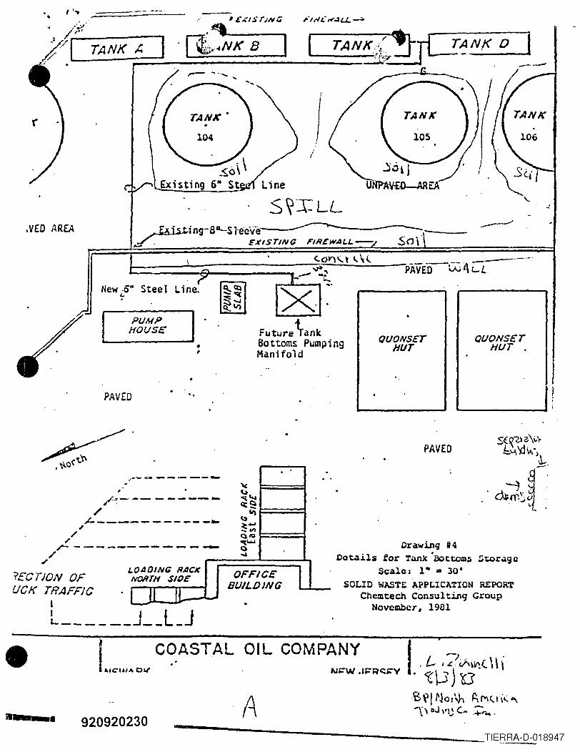
• ,'..
.VED AREA
S~~LL
I-- ~-&------~~- .- -._a.-_ ....
X·~·New -0" Steel'"',
PUMPHOf./SE Future \ank
Bottoms PumpingManifold
•,
PAVED ..
~.'.
,. ,.:.--~ ------- ,
'". (,)""-- - ------ ~Qct_tI)--------~ ~
~ ...~&IlQ/Q-----~ "t~()....
OADING RAC" OFFICE 1NORTH SIDE
I 11 IlBUILDING-- .
/~-/
"'----~/
/r ------
/
"?£CnON OFUCK TRAFFIC
lL- J__l_J
fj
I
..:
---_.- ..-
PAVE00:4Ci.
• 1..".... " ...COASTAL OIL COMP~~:'''RC:''V
920920230 A
"
QUONSETHUT
PAVED
QUONS£THUT,
Drawing '4Details for Tank 'Bott;om~ '::;~r.190
Scale: 1" ...30'SOLID WASTE A~PLICATION REPORT
Chemtech Consulting GroupNovembeT, 1901
--_aI..~~)~(\\i
ts\"l/ NOI\h ~£V\<'t\(eo,'\\ llJ"lj ( ...,~.
------------------ __ ~_TIERRA-D-018947
<6 3-d)-e~-d/~ ...e07-11- Gt.,
. Dr Nudh j\,jJl1.'lit.::l "I'r:.lllllitj tlle.
l:ii.lIVW~Y Onu-::iuilu JOUNuwwl<, NJ 0·/ IU~ref: 1.U I li/l~UGUU
December 16, 1983
Mr. David J. ShotwellChief. llurcall ur ClJlllpli'II1CC 'IIIUEnforcementDivision of Waste Management120 Rt. 156Yardville, New Jersey 08620
Re: AUlllinistr:.ttiveConsent OrderliP North America Trading Inc.
Dear Hr. Shotwell: Ii' :(~ ..We h4ve renched the termination of th~ subject Administrative Consent
Order transndtted to us on June~O, 1983.
We have thoroughly inspected the area subjected to the spill; Weh:.lvealso thoroughly reviewed the results of soil samples taken and analyzedas a part of the subject order. .
At this time we are not satisfied that.the visual appearance of theaffected area meets our expectations. We are reasonably well satisfied thatthe results of extrapolating data for the latest soil samples taken October26. 1983 indicate a quantitative recovery or reduction of spill relatedhydrocarbons in the soil during the test of 89.9%. We did not take a finalset of samples as we were awaiting further visual improvement of the remainingthin skin of "tarry" substance on portions of the affected surface area.We will, however. take a 5th set of samples shortly tq track the progress andverify the continued presence of beneficial bacteria in the soil.
From visual inspection it appears that virtually all of the remainingspilled product is in the above mentioned "tarry" material which is quitehard in some areas and almost like road oil. The very heavy rains recentlyhave frequently left the area inundated. however, very little, if any. 011is seen floating on the water. This would seem to indicate that any furtherrelease of oil through surface waters from this incident is unlikely. Therehas been no visual evidence of oil permeating the clay layers underlying thesurface.
B ~.,~,0 0 0 0 4 6
920920232- ·-TIERRA-D-018948
•
•
~).~..~
We feel it may be necessary to scrape and remove this thin surface ofvery heavy material to restore the appearance we seek. Since the coldweather and solidification of the remnants of the spill make this taskvirtually impossible at this time, we feel it c.::mbe most effectively donubeginning in mid April. We estimate it will require opproximDt~ly 30working days to complete. Providing for rain and wet ground, this willlikely apan 8 calendar weeks. Our consultants feel that siRnificantL!ddil:iollulucgrcdatioll through b~lcturlal Jige~lioll will cOlltinue oventhrough cold weather will slow tl~ action considerably, however, we havebased our estimates on the present visual appearance.
1n Sunilll41ry,we feul th~ test program uutlint!d in till! AtlmlnistrL!tlvuConsent Order was marginally successful. It is probable that. given aneorlier start in order to tuke advantage of a longer period of favorablewCL!L:her,we cuuld give a totally enthusiaHtic cnuorselllCntbut our appearancestamJan.ls are not there yet. "ddition~l soil saluplcs will be taken to IUOniturcontinuing degredation. Scraping and removing of any remaining spill materialwill be done when the weather breaks in 1984 and should be completed byJune 30. 1984.
We are most grateful to the Department and in particular, the Bureau of·Compliance and Enforcement for the substantial amount of time and effortexpended in our behalf in working with us in this program. We will lookforward to continued support as we finalize this incident •
Very truly yours,
-.;;A.. ( /' (/J1~:L--Paul F. l/guson
PFF:ms
A 920920233TIERRA-D-018949
.. ....r'C.1'::'.~
•ZCZ::NC~C i)E ~19ISN-~49/14~ Ib2209Z ~A~ 33F:.{ C:J(J A.P.[) CoT P :-.1::: ..1 YORK NY[0 CCGOTHR EE NE':I YORr. NYI'JFn ZEN2/FPA ;1E310N TI'IO EDISON ~JO)GA~W i'jAr [C)"IAl i?F::3?ONSC:: CErJTt.:P. WASHINGTON OCZPJ2/t~E:'J .J~RSE,{ STA"TE D.~r> YARf)V I LlE NJ8TlJl'lCLAS //;'Jlh4b5//S:IBJ: ?~JlPE? SEV;:N NP. b OIL'.IIN()~ IJISCHARGf CO,A.STAL oIL Co. ~n::'Jl\qv~IEtj .JE'tSEV ~)~d"'::tK C~AWJEL P PI 83-03-06/4/0126 (P IC 1-3-(033)I.SITPTIrPJ:
.'\. 1') LFY) .',,"'~ 8.1 FEnr:r?ALLY cfJ\lI)t::"l CLE"NIJ? CrlNT 1'111:::5.8. [:JTAlA.',ii\:J'H iiECO\f;::=fC:1') Tn I)AT~: APPROX b CUP IC VA>,?I)S ():=
o fJ_ CCl' T I~. 'n ..~,\T~'l 'io? 2 r:~ns.C. [!)TAL ·:;nC;T of :L;:;A'J:fP i') rJATE: APPRO;{. 500;.1 I)OI_LAi'{S.n. ,~:<: T:::IP j') I')[CP.EES F S:<V Cl~AP. SEA,S CALM.
2. "CT I ~)N T A '(~:.,:
.-\. ,·jI3,-Y)'!.I.-/ d3 II-JIJ':STIGATORS ALHEI'~ A\l1) JOl-ltJSON ARRI\I~()~! SC;::~Jr:.CL:::~'" \/':~.IT: if=!= r> =:lS'F!~.IEL r)r,1 SCENr:.
R. 131:3 fiE\:fJ\J,\l of oIL CO'JTAM'PJATED Sv~EEP COMM~NCC:D •
•
C. l.l.:.,n I'IVEST[':;,ATORS OBSERV9) S\~A.LL A,~()IJNTS ()F OIL 'lE::PPJG Trli1()rIG:i11.1'- '<!1EM) •
D. Itt')O c()lnC:'~c~n RCPLA.CF'iENT OF b IIS~f) SW~EPS.C:. 11130 Ol[) :)to!C:~PS RA.'¥)F.n ~i\lO ?LACFD IN BAP.Rt:LS.F. i500 I 'JI/C:C)T FJA TORS AND ClF: AN VENTURE PERSo NNEL f)EPAr:?T SCPJ':.
3. r-'rrU'ir: ?l,1"NS ANfJ RFCOMMEtlf")ATIrlNS:.'\. CG PC:;:J~(lN"I::L TO C~lNTnHJt: CLEANUP.
"1. CAS~ i)E'·TS. ·.\;:SSAGE Tn F')LLow AS DEV::LoPMENTS oCCfJii3TNNWJ
N9 n~ NC R Al T0q-~3:17:0b:~J:lb~I.'I'·H~
•l.l.lJUJ rU1\1'I OJ \' -au J
'2) ""3 _ ~ ~ _0 G:::J - 0 {C
"fO~c CO 2/ 1-
~ IlI1I 'I'lJRl\ COMItIlIIICATIONS
ecur ClJl1I IlIlT
CIllm(1 cor~oI~ mlN -0l'I PSO mKYPW WPO AIfT NY
suPP HMO s.wK
(lEe SMO RAlmp:1
ENG WPPO Imlh~~&\-
" ~ ACTION OffiCE LINEI .;. IlifO OfflC£ WIRE
HAWSER
llO~-· - .. ._ ..-
920920234TIERRA-D-018950
r:f'..1~ .~
• BP North America Trading Inc.
Gateway One-Suite 300Newark, NJ 07102Tel: 201 643-7600
February 17. 1984
N. J. Department of Environmental ProtectionDivision of Hazard Management120 Route tfl56Yardville. New Jersey 08620
Re: Spill IncidentJanuary 20. 1984Port Newark. New Jersey
Gentlemen:
Enclosed for your files is our written report pursuant to the subjectspill incident and verbal report.
At 00:50 January 20. 1984 approximately 1-2 barrels of No. 6 Fuelescaped from a frozen bleeder valve at our Port Newark Terminal at start upof loading of the barge E-24 •• On discovery of the spill. loading was immediately stopped, the spillreported. the cause investigated. and containment and clean up initiated.Clean Venture was called in to assist in clean up work.
A U.S. Coast Guard team directed clean up activity and declared the area,all structures and pilings free from residual c11ngage on February 6. 1984.
Procedures have been revised to prevent a similar recurrence by requiriugthat plugs and caps on all dock b-leeder valves remain in place except whenbeing operated for venting to drain hoses. lines. etc.
Very truly yours.
·..l1«.( l#h/~.Paul F. Fea-usonManager of Operations
PFF:ms
920920236TIERRA-D-018951
• BAA000051
•
•
•
mMIT ill. NJ0034231
Summary ReportDPCC/DCR Plans
BP North America Petroleum, Inc.Port Newark Terminal
The DPCC/DCR Plans for BP North America Petroleum, Inc. - PortNewark Terminal, located in Port Newark, new Jersey, whereinitially submitted to the Office of Hazardous Substance Control(OHSC) of the DEP on August 4, 1981. The most recent plans weresubmitted on September 28, 1984. This facility was purchasedfrom Coastal Oil Company in October of 1980. The facility wasvisited on November 8, 1985 and a Deficiency letter was mailed onApril 15, 1986. They responded on May 27, 1986.
The facility serves as an onshore storage and transfer terminalfor No. 2 Fuel Oil and Bunker Oil. Oil is received by barge andfrom the Colonial Pipeline transmission line. Oil leaves theterminal via trucks and the Coastal Oil Company pipeline. 16.1million gallons of No. 2 Fuel Oil, 15.7 million gallons ofbunker oil 1.26 million gallons of kerosene and 711,000 gallonsof diesel can be stored on site. Small underground tanks areused to store gasoline and waste oils.
A tank rupture in January of 1984 spilled 44,000 gallons ofbunker oil. The incident was reported as required and cleanupwas certified complete by the u.S. Coast Guard. In 1979, underdifferent ownership, there was a 4 million gallon fuel oil spill.
All dikes have earthen floors. Permeability of the soil and depthto groundwater have not been determined. The facility presentlyuses the waterflood technique to prevent ground watercontamination during large spills. The facility must submit acertified report on impermeability of diked areas within 60 days.
Housekeeping in the steel-diked area was good, but it could useimprovement elsewhere.
BP Oil Indicates that it has appropriate inspection andmaintenance programs to ensure prompt discovery of and responseto a spill incident. However, inspection records for undergroundtanks were not provided during site inspection. Undergroundtanks must be inspected regularly and records should be kept forminimum three years. In light of the tank rupture which occurredin January of 1984, the facility must develop and implement astrong maintenance program.
Aboveground piping in the southern tank farm was not adequatelysupported during site inspection. Suitable supports have beeninstalled, according to the facility's response letter of may 27,1986.
B~\0000011
920920248TIERRA-D-018952
Fm1IT ID. NJ0034231
~ A list of current cleanup contractors must be submitted within30 days.
The facility is located on Port Newark Channel, where it operatesa barge berth. It presently has a NJPDES permit (NJ0034231 DSW)for discharge into surface waters. It also has a TWA and aletter of Adequacy from the U.S. Coast Guard.
Spill containment materials are kept on site. BP will contractthe services of Clean Venture, Inc. to supplement any cleanupefforts.
The facility is manned 24 hours. It appears to be adequatelyilluminated.
~""'1'" ~ USurya ShahSenior Environmental EngineerBureau of Industrial Waste Management
~
~
920920249TIERRA-D-018953
---...'......._.--~ .,.
NI \10' Jl RSI ,. DfPARl 1141N1 01 £N\'JRONMI N1AI "~()11 nl(l~,OIVI!'>IUN 01 ..... ll R RI snllRCI ~
DATA CHlCK LIST FOR DPCC/llCR PLAN~
I A 11)'~NAMI OW~'II</OI'1 f<A "lOF'S I'AMI
B .P. NORTH AMERICA PETROLEUI-l INC. B.P. NORTH AMERICA PE TROLE U 1-: INC.TERt>lINAL TERMINAL
AlJllRI ~s A/)PKI S~
Building #350, Coastal Street Building #350, Coastal StreetPort Newark, N. J. 07114 Port Newark, N .J . 07114
NAMI OJ COMPANY Charles Guilfoyle, OATFoPCCPLA1" DATI DO. PLA"REPRESENTATlVl. Mr. SlIBMITIH> 9/28/84 Sl'BMITTlD 9/28/84
~ , M~~~~~
TELEPHO~r NO. DATE OF INSPH'jEDBY201-465-2426 INSPECTION11/8/85 L.K. Jain, Carol Berkower, & S'tDr~fh-
WATFR BODY Newark Bay NJPDES NO. PLANS REVIEWTD flYEFFEClED 0034231 (DSW) L K . Jain am Sme SlID
LX 1r1n January l.:10Up g b.Jt l::eim l:E!"&B3. !?f tEP_POLLUTION PREVENTION REGULATIONS (Nj.A.C. 7: lE=4)
PART 4.5 - DPeC PLANS
(A) Types of Substances Stored and Capacity of Ab~~ Ground and Buried Storage aboveground undergroundResidua] Oil 15.722,000 calf D1esel 709,000 gal. 2,000 gal.No 2 Fuel Oil 16,132,000 ca l.~ al..J. Gasoline none 1,000 gal.Kerosene 1,263,000 qa 1. . (iLlUVt;: Oil from o/w sep. none 1, 100 gal.a i] Settljnn 60,000 calf '':lI.v=ndOther waste oil none 2,000 ga 1.
(8) General Site Plan adequate Comments S; t e plan & drainage plans- revised.---
.amage Plans. ,adequate
"
PART 4.7 - FACILITY DRAINAGE AND SECONDARY CONTAINMENT
ITEM: COMPLIANCE I
Yes No Other IREMARKS
(A) Large~l probable spill prevented from entering waterJ X I 44,000 gal. spill history ( I?
(8) Appropriate secondary containment x Steel dikes(8) Appropriate secondarv diversionary x
.(C)l All probable routes blocked x Part of dike wall missing(C)2 Sufficient capacitY to contain or diven x Capacity (actual 7C)97 .5% to 166%(C)3 System made of or lined with impervious material x Material· Earthen dike floor(C)4 No drainage into watercoune or sewer system x(C)5 Lagoon's not subject to flooding x(C)6 Incompatible material not $tored in same x
containment areas
(C)7 Estimlted time to clean-up larttst spill x Time - 112 hours(D)I Permeability of liner material x Not known-must furnish
'(D)2 Depth to 1J0und wlter X Not known-must furnish(E)J Drainage system Ippunenances indicated on x
drainage plan
;_Drainag, Iyst,m ad'qua.. x
( All impoundmentJ indic.ted on plans x(F) Discharges to ground or surface wlter noted x
(G)I All dischlr~t's regula led by NJPDrS permitx
(G)2 1>IscharlZt'saccurattly dtimbed in NJPDES permit x -92(lQ?n?l:\nTIERRA-D-018954
ITEM COMPLIANCE I Rl.MARA.\ It't'l , No Orhrr I
(AI SIIII~I"(' cont;lInrl~ hrln~ usrd for sllltagr x -_._----
Aillra~mf lan~. \,ah'cs drum~ promptly rer:ured x 3 valves leaking(II oUI of serVlcr
I (e) All ~pilb promptly rlcaned up X Minor spillage to be cleanec: .'(D) U\(lSl' qualllJlles uf chemicals nol present X
i ([ ) S(lrbents availahlc xi (f) Safel) equIpment for spills available y
(Gl Se,'olldar)' containment systems in good repair X Part of dike wc:ll missing; SCl
(HI Damaged transfer hoses removed from work areas x stainEc
(I) Insprl'tion records maintained for 3 years x Except for underground tanks
PARl 4.8 - HOUSEKEEPING. MAIJI.'TENANCE. INSPlCTIONS AND RECORDS
PART 4.9 - DETECTION OF DISCHARGES TO GOUND WATER
(A) Are observation wells necessary x Awaiting locations from DE:F
(B) Sufficient number of wells for area X Number· :
(C) X,
Locations of wells mapped on site plan I
(D) Wells sampled once Quanerly X Last Report •
(E)I Repon of ground water problem to Department X
(E)] Analytical results reported to DEP X
(F) Baseline sample analysis established X
(G) Access to wells available X
(H) Wells meet State reqUirements X
PART4.IO-FLOODHAZARDAREAS n/a, but must be addresse:i
Hazardous materials stored in flood hazardareas pro\ec\ed
PART 4.1] - SECURJTY 24 hours manned
(AI Areas adequately fenced x P i3 r ~ (")f n; k ~ tol '" 1 1 m; co co ; ~ ~
(8) VaJves security locked X
(C) Staner controls locked x Controlled from control room(0) MllIlifolds capped or blllIlked off x
(E) Adequate illumination x(F) If not fenced, all other security items in force X
PART 4.12 - TRAINING
(A) Personnel training program implemented x
(B) Person for discharge prevention designated x Mr. Charles Guilfovle(C) Instruction given to employees x Date last inst. . 10/21/85 Minimum, -,
monthSPART 4.13 - CONTAINMENT EQUIPMENT
(A)l Containment equipment available x II
(A)2 Containment equipment maintained xr
'. Adequate secondary containment around above· :ground lanks x Steel dikes not adequate :
(A)3 Area below storage tank impervious x Uner MIl Concrete Perm. i(A)4 Valves to tanks dose to tanks x :
PART4 .• 4-BULXSTORAGETANKS Part of dike wall missing
P~r~92092025TIERRA-D-018955
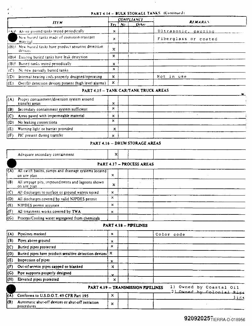
CYJMfLJANCl , I,IU.MARA.\ITU,! }'~s N(I O'ht'T
:• .,,,,, ",,""d """ "",d ",,;"d,,~I} x Ultrasonic cauzing ----!\;,..... bUllrd tJnks mJJl' of ':(lumlOn·rrSlsl:lllt x Fiberglass or coatedmallliJI
(H)3 Ne"," hUlled l:lIJb huv(' prodult serisilive detection I X Idevlle,
(Bioi EXb!IJI~ buried tanks have leilk detcCllon X
(8)5 Bumd lanh testrd periodically x,IC') No new parllally buried tanks x
I(D) internal heating coih properly desiF:Tled/operatin~ X Not in use(El Overfili deteclJon devices present (high level alarms) X
PART 4 .• 4 - BULK S10KAGL TA""'-S lCuntinucJI
PART 4.15 - TANK CARrrANK TRUCK AREAS
(A) Proper containment/diversion system around I
tr:msfer areas x(8) Secondary containment system sufficient x
(C) Areas paved with impermeable material x i
x ;
(D) No leaking connec tions ;
(E) Warning light or barrier provided X
(F) PIC present during transfer x
PART 4.16 - DRUM STORAGE AREAS
I Adequate secondary containment X'. PART 4.17 - PROCESS AREAS
(A) All catch basins, sumps and drainage systems locatedon sIte plan x
(8) All s('epage pits, impoundments and lagoons shownXon site plan ,
(e) All discharges to surface or ground waters noted x
(D) All discharges covered by valid NJPDES permit x
(E) NJPDES permit accurate X
(F) All treatment works covered by TW A x(G) Process/Coolin~ water se~re~ated from chemicals
PART 4.18 - PIPEUNES
(A) Pipelines marked x Color code(8) Pipes above·ground x(C) Buried pipes protected x
(D) Buried pipes have product sensitive detection devices X
(E) Inspection of pipes x(F) Out-of-service pipes capped or blanked X
(G) Pipe suppons properly designed v
(H) Elevated pipes protected X
1) Owned by Coastal Oil'---:------------------~-_r-...,.-----..,....---2) Ow n e d b;r Co J 0 P ; alP j r'
PART 4.19 - TRANSMISSION PlPEUNES
X 1i r.~(8) AUlomatic shul-of( devices or shut-off initiation
rocedures X
92092025TIERRA-D-018956
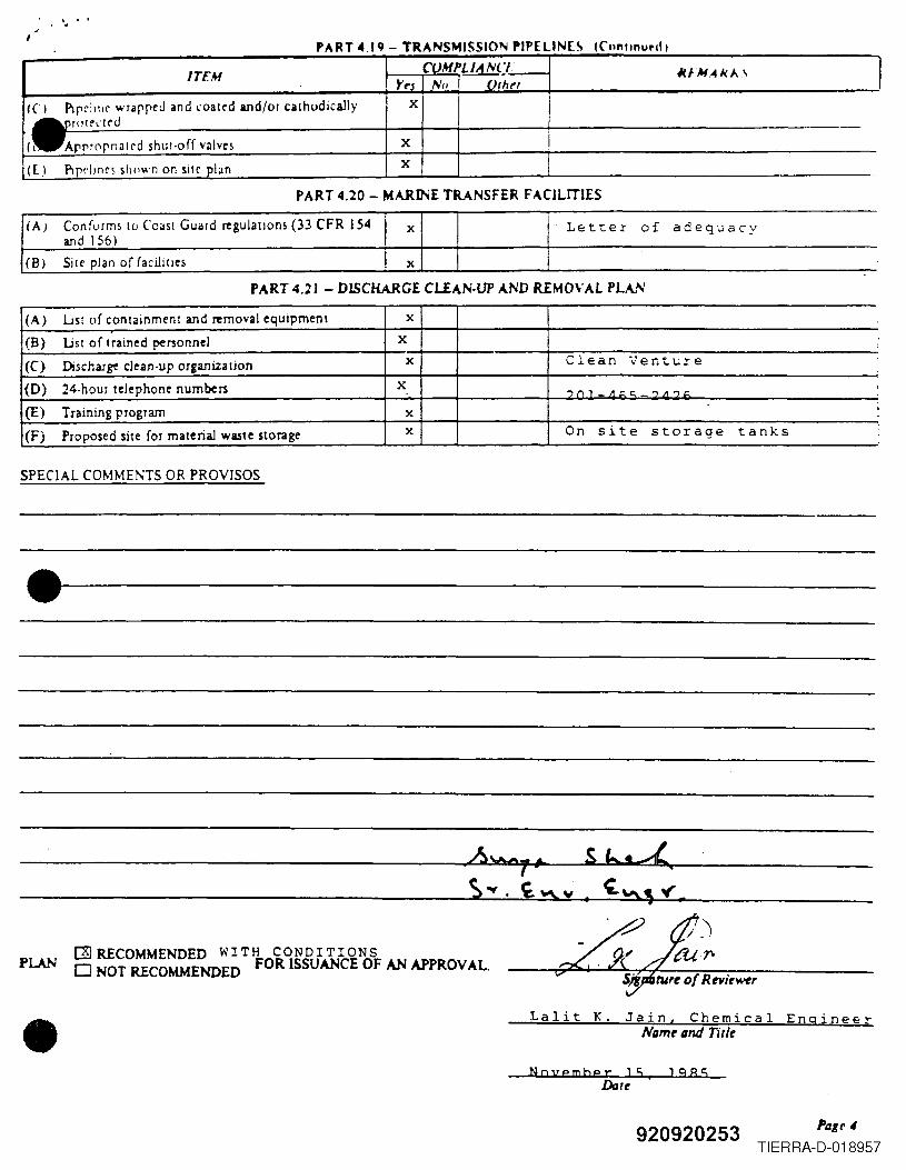
'.. ,
.ITEM CUMPLlAN(,- IUM ..4J<A\ IYt'j Nil OrhN
Ie I Plpeh1lf wrapreJ and .oated and/or cathodically X
I.ro(('<'!('dI I Arpr0rnated shut·off valves X
III PIpelInes sl1l1wn on sHe plan X
PART 4 I q - TRANSMISSION PIPELlN[~ Kllntlnur-d I
PART 4.20 - MARINE TRANSFER FACILITIES
/(A) ConfL1rms 10 Coast Guard regulations (33 CFR 154 I x Letter of adequacyandJ56)
(B) Site plan of facililles x
PART 4.21 - DISCHARGE CUAN-UP AND REMOVAL PLAN
(A) List of containment and removal equipment x
(B) List of t rained personnel x ,,
(C) Discharge clean-up organization x Clean Venture
(D) 24·hour telephone numbers x ..,,,,_"t:<:: ",,"t: ,
(E) Training program x !
(F) Proposed site for material waste storage x On site storage tanks
SPECIAL COMME~TS OR PROVISOS
.1-------------------
PLAN(]] RECOMMENDED WITH CONDITIONSo NOT RECOMMENDED FOR ISSUANCE OF AN APPROVAL.
• Lalit K. Jain, Chemical EngineerNilmr ilM nr/r
November 15 1985
920920253 Pilge 4
TIERRA-D-018957
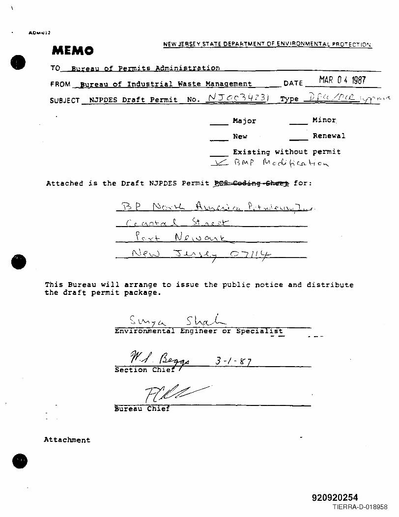
•
•
•
AOM~12
MEMONEW JERSEY SiATE OEPA~iMENi OF ENVIRONMENiAL PROTECTION
TO Bureau of Permits AdministrationFROM Bureau of Industrial Waste Management MAR 04 1987DATE _
SUBJECT NJPDES Draft Permit No. rJ:rcC'l4?3/ Type ])c((/ru~_ ~V'r-\'"t
__ Major Minor.New RenewalExisting without permit
~ IS M P (vl c ct ~ (..R \---t. c ~
Attached is the Draft NJPDES Permit ~S S&BiA~ 6he~ for:
OJll'j-:
This Bureau will arrange to issue the public notice and distributethe draft permit package.
3-1-8'7
Bureau Chief
Attachment
920920254TIERRA-D-018958
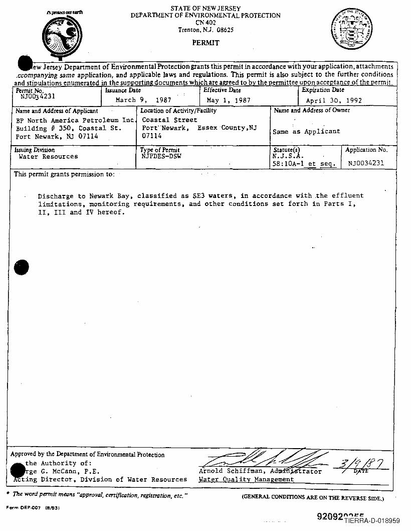
STAIE OF NEW JERSEYDEPARTMENT OF ENVIRONMENTAL PROTECTION
CN402Trenton. N.J. 08625
PERMIT
ew Jersey Department of Environmental Protection grants this permit in accordance with your application, attachments.ccompanying same application, and applicable laws and regulations. This permit is also subject to the further conditions
and sti ulations enumerated in the su ortin documents which are a eed to b the ermittee u on acce tance of the ermit.Permit No. Issuance Date Effective Date Expiration Date
NJ0Q34231 March 9, 1987 May 1, 1987 April 30, 1992
Issuing DivisionWater Resources
Statute(s) Application No.N.J.s.A.58:10A-l~ ~ NJ0034231
Type of PermitNJPDES-DSW
Same as Applicant
Name and Address of Applicant Location of Activity/Facility Name and Address of OwnerBP North America Petroleum Inc Coastal StreetBuilding /I 350. Coastal St. Port"Newark, Essex County,NJPort Newark, NJ 07114 07114
This permit grants permission to:
Discharge to Newark Bay, classified as SE3 waters, in accordance with .the effluentlimitations, monitoring requirements, and other conditions set forth in Parts I,II, III and IV hereof •
•
Approved by the Department of Environmental Protection,~. the Authority of:
ge G. McCann, P.E.cting Director, Division of Water Resources
Arnold Schiffman, Ad'~~'~Water Quality Management
• The word permit means "approval, certification, registration, etc ... (GENERAL CONDmONS ARE ON THE REVERSE SIDE.)
Form DEP-007 (8/83)
920929iERRA-D-018959
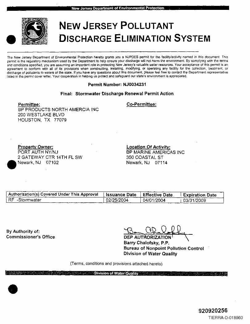
. New Jersey Department of Environmental Protection ,
•NEW JERSEY POLLUTANTDISCHARGE ELIMINATION SYSTEM
The New Jersey Department of Environmental Protection hereby grants you a NJPDES permit for the facility/activity named in this document. Thispermit is the regulatory mechanism used by the Department to help ensure your discharge will not harm the environment. By complying with the termsand conditions specified, you are assuming an important role in protecting New Jersey's valuable water resources. Your acceptance of this permit is anagreement to conform with all of its provisions when constructing, installing, modifying, or operating any facility for the collection, treatment, ordischarge of pollutants to waters of the state. If you have any questions about this document, please feel free to contact the Department representativelisted in the pennit cover letter. Your cooperation in helping us protect and safeguard our state's environment is appreciated.
Permit Number: NJ0034231
Final: Stormwater Discharge Renewal Permit Action
Permittee:BP PRODUCTS NORTH AMERCIA INC200 WESTLAKE BLVDHOUSTON, TX 77079
Co-Permittee:
Property Owner:PORT AUTH NY/NJ2 GATEWAY CTR 14TH FL SW
• Newark, NJ 07102
Location Of Activity:BP MARINE AMERICAS INC350 COASTAL STNewafk, NJ 07114
Authorization(s) Covered Under This Approval Issuance Date Effective DateRF -Stormwater 02/25/2004 04/01/2004
By Authority of:Commissioner's Office 1?>=--~
DEP AUTRiZATiON~\Barry Chalofsky, P.P.Bureau of Nonpoint Pollution ControlDivision of Water Quality
(Terms, conditions and provisions attached hereto)
•920920256
TIERRA-D-018960
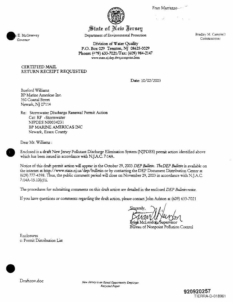
Fran Marrazzo _.,
~ta:te of ~£fu W£rs£~Department of Environmental Protection
•E McGreeveyGovernor
•
•
Bradley M. CampbellCommissioner
Division of Water QualityP.O. Box 029 Trenton, NJ' 08625-0029
Phone: (f.!J9) 633-7021/Fax: (609) 984-2147www.state.nj.dep.dwq.nonpoint.htm
CERTIFIED MAILRETURN RECEIPT REQUESTED
Date: 10/02/2003
Bueford WilliamsBP Marine Americas Inc.350 Coastal StreetNewark, NJ 07114
Re: Stormwater Discharge Renewal Permit ActionCat: RF -StormwaterNJPDES NJ0034231BP MARINE AMERICAS INCNewark, Essex County
Dear Mr. Williams :
Enclosed is a draft New Jersey Pollutant Discharge Elimination System (NJPDES) permit action identified abovewhich has been issued in accordance with N.JAC. 7:14A.
Notice of this draft permit action will appear in the October 29,2003 DEP Bulletin. TbeDEP Bulletin is available onthe internet at http://www.state.nj.us/dep/bulletin or by contacting the DEP Document Distribution Center at(609) 777-4398. Thus, the public comment period will close on November 29,2003 in accordance with N.]A.C.7:14A-15.10{c) 1i.
The procedures for submitting comments on this draft action are detailed in the enclosed DEP Bullet:i:nnot:Ue.
If you have questions or comments regarding the draft action, please contact John Ashton at (609) 633-7021
Enclosuresc: Permit Distribution List
Draftcov.doc New Jersey is an Equal Opponuniry EmployerRecycled Paper
920920257TIERRA-D-018961
Permit Number NjOO34231
• Table of Contents
This Permit Package Contains the Items Listed Below
1. Cover Letter
2. Table of Contents
3. Public Notice (Draft Only)
4. QuadMap
5. Fact Sheet or Statement of Basis
6. NJPDES Draft Permit Authorization Page
7. Part I NARRATIVE REQUIREMENTS
8. Part II GENERAL REQUIREMENTS: DISCHARGE CATEGORIES
• 9. Part III LTh1ITSAND MONITORING REQUIREMENTS
IO.Part IV SPECIFIC REQUIREJv1ENTS: NARRATIVE
II.Appendix A-List of Standards
12.Attachment 1- Contents of the Stormwater Pollution Prevention Plan
I3.Attachment 3-Annual Recertification
•920920258
TIERRA-D-018962
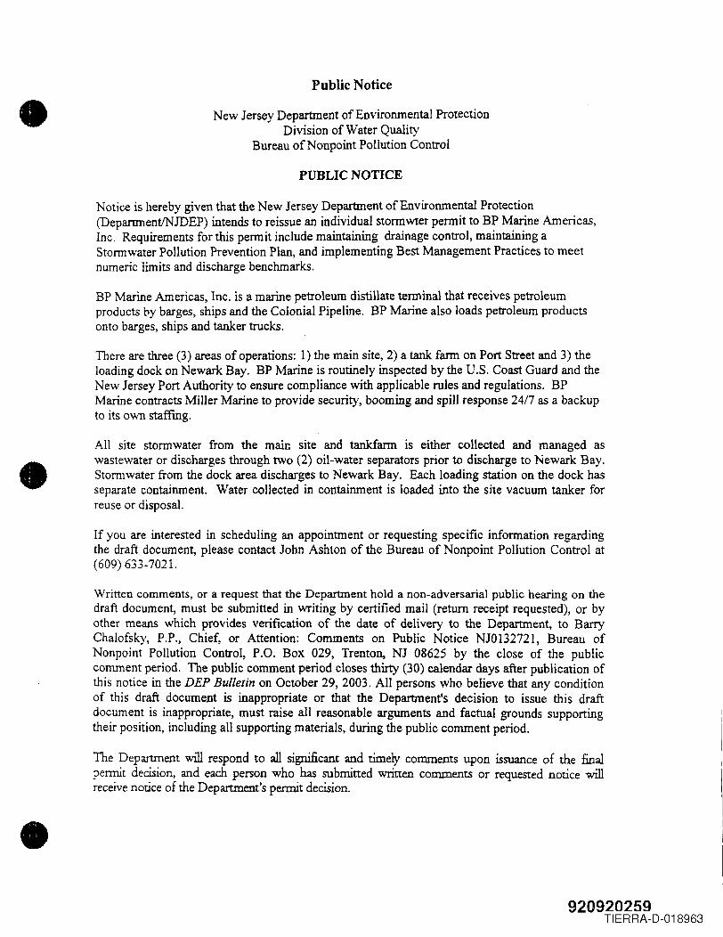
•
•
•
Public Notice
New Jersey Department of Environmental ProtectionDivision of Water Quality
Bureau of Non point Pollution Control
PUBLIC NOTICE
Notice is hereby given that the New Jersey Department of Environmental Protection(DepartrnentINJDEP) intends to reissue an individual stormwter permit to BP Marine Americas,Inc. Requirements for this permit include maintaining drainage control, maintaining aStonnwater Pollution Prevention Plan, and implementing Best Management Practices to meetnumeric limits and discharge benchmarks.
BP Marine Americas, Inc. is a marine petroleum distillate terminal that receives petroleumproducts by barges, ships and the Colonial Pipeline. BP Marine also loads petroleum productsonto barges, ships and tanker trucks.
There are three (3) areas of operations: 1) the main site, 2) a tank farm on Port Street and 3) theloading dock on Newark Bay. BP Marine is routinely inspected by the U.S. Coast Guard and theNew Jersey Port Authority to ensure compliance with applicable rules and regulations. BPMarine contracts Miller Marine to provide security, booming and spill response 24/7 as a backupto its own staffing.
All site stonnwater from the main site and tankfarm is either collected and managed aswastewater or discharges through two (2) oil-water separators prior to discharge to Newark Bay.Stonnwater from the dock area discharges to Newark Bay. Each loading station on the dock hasseparate containment. Water collected in containment is loaded into the site vacuum tanker forreuse or disposal.
If you are interested in scheduling an appointment or requesting specific information regardingthe draft document, please contact John Ashton of the Bureau of Nonpoint Pollution Control at(609) 633-7021.
Written comments, or a request that the Department hold a non-adversarial public hearing on thedraft document, must be submitted in writing by certified mail (return receipt requested), or byother means which provides verification of the date of delivery to the Department, to BarryChalofsky, P.P., Chief, or Attention: Comments on Public Notice NJ0132721, Bureau ofNonpoint Pollution Control, P.O. Box 029, Trenton, NJ 08625 by the close of the publiccomment period. The public comment period closes thirty (30) calendar days after publication ofthis notice in the DEP Bulletin on October 29,2003. All persons who believe that any conditionof this draft document is inappropriate or that the Department's decision to issue this draftdocument is inappropriate, must raise all reasonable arguments and factual grounds supportingtheir position, including all supporting materials, during the public comment period.
The Department will respond to all significant and timely comments upon issuance of the finalpennit decision, and each person who has submitted written comments or requested notice willreceive notice of the Department's permit decision.
920920259TIERRA-D-018963
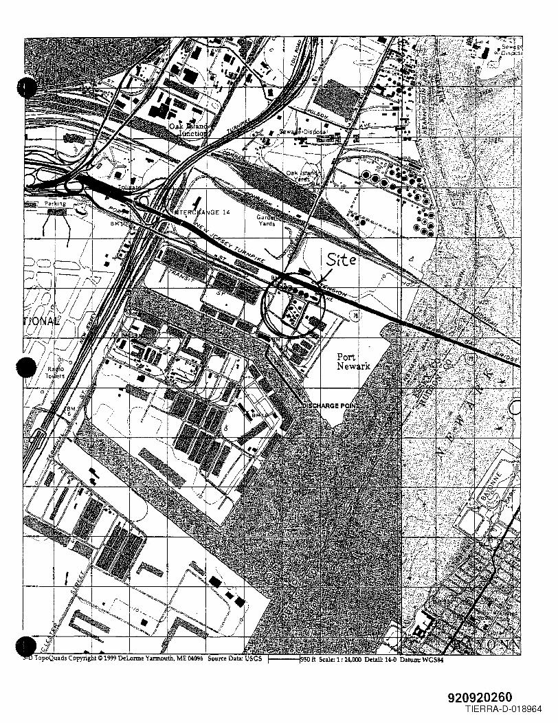
920920260TIERRA-D-018964
Fact SheetPage 1 of 6
NJPDES Permit No: NJ0034231Date: 08/14/2003
• New Jersey Department of Environmental ProtectionDivision of Water Quality
Bureau of Non point Pollution Control (Stonnwater)
- - FACT SHEET c-·- - -I,
This fact sheet sets forth the principal facts and the significant factual, legal, and policy considerationsexamined during preparation of the draft permit.
PERMIT ACTION: Stormwater Discharge Renewal Permit Action
DName and Address of the Applicant:
BP Products Na Inc200 Westlake BlvdHouston, TX , 77079
BName and Address of the Applicant:
BP Marine Americas lnc350 Coastal StNewark, NJ ,07114
'Name and Classification of the Receiving Water:
Newark BaySE3(C2)
I]Description of the Facility/Site:
BP Marine Americas, Inc. is a Marine Petroleum Distillate Terminal. Petroleum products are received frombarges, ships or Colonial Pipeline. Petroleum products are loaded onto barges, ships and tank trucks. BPMarine is also routinely inspected by the Coast Guard and the Port Authority for compliance with applicableenvironmental rules and regulations. BP Marine keeps a supply of spill cleanup equipment and materials atthe main facility and on the dock. In addition to the SPPP, the facility also has a DPCC and DCR Plan,Coast Guard Operations Manual and a COTP approved OPA 90 Spill Response Plan. There are three (3)areas of operation:
Area 1The main site has several loading bays with containment, fueling station, diesel tank, two (2) Quonset hutshousing a boiler and maintenance shop, testing lab, lockerrooms and spill equipment storage, an aircompressor room, an in-line heating furnace for the No.6 fuel oil tank and a tank fann with containment.The site has two (2) stonnwater drainage systems. All the site unloading bays except for the Low Sulfur 6
•1 Bay drain to an impervious concrete basin. The rest of the site including the Low Sulfur 6 Oil Bay
scharges through two (2) inline oil-water separators (rated for 15 ppm) prior to discharge into the Port
920920261TIERRA-D-018965

Fact SheetPage 2 of 6
NJPDES Pennit No: NJ0034231Date: 08/14/2003
a'-uthority stormdrain system that discharges to Newark Bay. The bays are routinely pressure washed with a.,ater-detergent mix. Vehicle and equipment wash activities are also frequently done at the bays.
Tank Farm containment is clay, covered by a liner, and finished with crushed stone. Permeability test resultsfor this area are also kept with the DPCC. Tanks are routinely hydrostatically tested using water from theNewark Bay in accordance with the terms of the existing permit NJOO34231. Tanks are cleaned and water isdisposed of as wastewater prior to hydrostatic testing. The hydrostatic test water is filtered prior to dischargethrough the inline oil-water separators.
Tank sludges are solidified with kiln ash and shipped offsite for incineration. Boiler ash is disposed of with otherwaste solids as needed.
Area 2The dock on Newark Bay has several pumping stations. Each pumping station is curbed and has acontainment basin. The basins are routinely pumped using the site vacuum tanker then transferred to theNo.6 fuel oil tanle Sludges are drummed and manifested for offsite incineration. BP Marine Americas, Inc.contracts Miller Marine for security, booming and spill emergencies. Miller Marine is stationed at the dock24/7 and has two (2) trailers on the dock containing spill prevention and spill emergency equipment. BPMarine also maintains an operator station on the dock and its own spill equipment.
Area 3The Tank Farm located on Port Street is loaded/unloaded through pipelines that are routed under Port Streetin concrete-encased piping. Each tank has its own containment with a capacity of 1-1/2 times the volume ofeetank. The tank farm base is clay, covered by a liner, and finished with crushed stone. Permeability test
sults for this area are also kept with the DPCC. The tank farm is bordered on two (2) sides by marshes
The above named applicant has applied for a New Jersey Pollutant Discharge Elimination System (NJPDES)permit Renewal Permit to the New Jersey Department of Environmental Protection (NJDEP), BureauNonpoint Pollution Control. A location map of the facility is included. The applicant is involved with thereceiving and transporting of petroleum products from barges, pipelines and tankers under the StandardIndustrial Classification (SIC) 5171. The existing permit regulates stormwater discharges to the NewarkBay, classified as SE3(C2)
After discussions with representatives ofBP MARINE AMERICAS INC a decision was reached to renew.The NJDEP intends to renew and modify the existing NJPDES permit NJ0034231 to include certain numericeffluent limitations, benchmarks and to include ongoing monitoring requirements. In addition, the permitrenewal requires the facility to maintain an upated Stormwater Pollution Prevention Plan (SPPP) to controlthe quality of its stormwater discharges, which is consistent with the Individual Permit requirements.
L1Description of the Receiving Water and 'Discharge Locations or Local Agency:
Saltwater TidalSE3(C2)
•920920262
TIERRA-D-018966
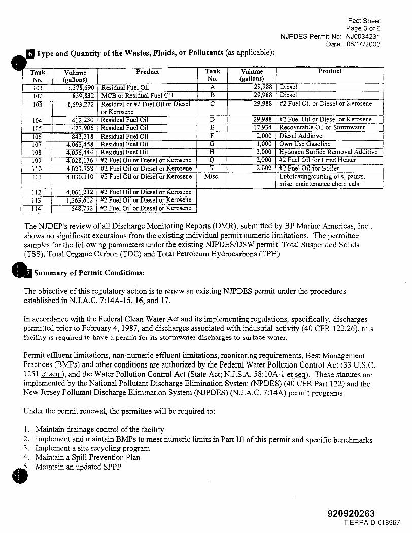
Fact SheetPage 3 of 6
NJPDES Permit No: NJ0034231Date: 08/14/2003
IIType and Quantity of the Wastes Fluids, or Pollutants (as applicable):,Tank Volume Product Tank Volume Product INo. (gallons) No. (gallons)101 3,378,690 Residual Fuel Oil A 29,988 Diesel102 839,832 MCB or Residual Fuel C'~l B 29,988 Diesel103 1,693,272 Residual or #2 Fuel Oil or Diesel C 29,988 #2 Fuel Oil or Diesel or Kerosene
or Kerosene104 412,230 Residual Fuel Oil D 29,988 #2 Fuel Oil or Diesel or Kerosene I105 423,906 Residual Fuel Oil E 17,934 Recoverable Oil or Storm water106 843,318 Residual Fuel Oil F 2,000 Diesel Additive I107 4,063,458 Residual Fuel Oil G 1,000 Own Use Gasoline108 4,056,444 Residual Fuel Oil H 3,000 Hydogen Sulfide Removal Additive I109 4,028,136 #2 Fuel Oil or Diesel or Kerosene Q 2,000 #2 Fuel Oil for Fired Heater\10 4,027,75& #2 Fuel Oil or Diesel or Kerosene T 2,000 #2 Fuel Oil for BoilerIII 4,030,110 #2 Fuel Oil or Diesel or Kerosene Misc. Lubricating/cutting oils, paints,
misc. maintenance chemicals112 4,061,232 #2 Fuel Oil or Diesel or Kerosene113 1,263,612 #2 Fuel Oil or Diesel or Kerosene114 648,732 #2 Fuel Oil or Diesel or Kerosene
The NJDEP's review of all Discharge Monitoring Reports (DMR), submitted by BP Marine Americas, Inc.,shows no significant excursions from the existing individual permit numeric limitations. The permitteesamples for the following parameters under the existing NJPDESIDSW permit: Total Suspended Solids(TSS), Total Organic Carbon (TOC) and Total Petroleum Hydrocarbons (TPH)
• Summary of Permit Conditions:
The objective of this regulatory action is to renew an existing NJPDES permit under the proceduresestablished in N.lA.C. 7:14A-15, 16, and 17.
In accordance with the Federal Clean Water Act and its implementing regulations, specifically, dischargespermitted prior to February 4, 1987, and discharges associated with industrial activity (40 CFR 122.26), thisfacility is required to have a permit for its stormwater discharges to surface water.
Permit effluent limitations, non-numeric effluent limitations, monitoring requirements, Best ManagementPractices (BMPs) and other conditions are authorized by the Federal Water Pollution Control Act (33 D.S.C.1251 et seg.), and the Water Pollution Control Act (State Act; N.J.S.A. 58:lOA-1 et seg). These statutes areimplemented by the National Pollutant Discharge Elimination System (NPDES) (40 CFR Part 122) and theNew Jersey Pollutant Discharge Elimination System (NJPDES) (N.J.A.c. 7:14A) permit programs.
Under the permit renewal, the permittee will be required to:
1.2.3.4.••
Maintain drainage control of the facilityImplement and maintain BMPs to meet nwneric limits in Part III of this permit and specific benchmarksImplement a site recycling programMaintain a Spill Prevention PlanMaintain an updated SPPP
920920263TIERRA-D-018967
Fact SheetPage 4 of 6
NJPDES Permit No: NJ0034231Date: 08/14/2003
_Drainage control is the use of grading, diversionary structures, containment, dedicated storage areas andther methods used to divert storm water from areas of industrial activity to a permitted outfall.
Benchmarks establish targets to help the permittee determine if the selected BMPs are effective. Continuedexceedance of the benchmarks indicates that the BMPs are not effective and may require modifications orreplacement. Additional BMPs may also be required based on monitoring results.
BP Marine is a heavily regulated facility and must comply with the standards listed inAppendix A of thepermit. One of the numerous requirements is for twenty-four (24) hour security and spill responsecapabilities. BP Marine accomplishes this through staffing and contracts with Miller Marine as noted inSection 4 of this Fact Sheet.
BP Marine will continue to monitor for TSS, and TOC. BP Marine will monitor for Oil & Grease (O&G) inplace ofTPH. O&G is a State effluent limit in NJ.A.C. 7:14A-12.8. There will be a numeric limit of 15mgIL maximum for O&G as shown in Part III of the permit.
The existing and proposed effluent limitations, non-numeric effluent limitations, and other pertinentinformation concerning the draft permit renewal are described in the Fact Sheet Summary Table.
Concerning the proposed permit (Renewal), the NJDEP is authorized under the federal regulations (40 CFR122.44) and under NJPDES rules (N.l.A.C. 7: 14A-6.2(b) to impose Best Management Practices (BMPs) tocontrol or abate the discharge of pollutants in lieu of numeric effluent limitations in NJPDES permits. BMPsmay be imposed when the NJDEP fmds numeric effluent limitations to be infeasible or when BMPs arereasonably necessary to achieve effluent limitations and standards or to carry out the purposes and intent of
•e State and Federal Acts. Additionally, the NJDEP believes that it is not feasible at this time to establish
ater quality based effluent limits (wQBEL) for this stormwater discharge. The proposed limitationsincorporated in the SPPP are consistent with the NJDEP's and EPA's stormwater permitting philosophy ofreducing the amount of pollution created and to prevent pollution from occurring in the first place (See 24NJ.R. 2352). The SPPP requirements and monitoring requirements operate as limitations and controls onstormwater effluent discharges to prevent stormwater contamination and are intended to achieve BestAvailable Technology Economically Achievable (BAD and Best Conventional Pollutant ControlTechnology (BCT). The SPPP proposed will consist of requirements for preparing the SPPP, certifying thepreparation and submitting the plan, implementation of the SPPP by a compliance date, certification ofimplementation of the SPPP, and annual recertification and reporting of the effectiveness of the SPPP. Theobjective of the SPPP is to prevent stormwater contamination through the elimination and/or minimization ofexposure, during and after storm events, of industrial materials, machinery, waste products, and other sourcematerials associated with industrial activity located at the facility, to stormwater that is discharged through.separate storm sewers to surface waters.
For permits that include a notification plan under NJ.A.C. 7: 14A-20.7(a)3, a brief description of theconditions of the permit that address approval of residual land application sites not identified at the time ofpermit issuance.)
m Description of Procedures for Reaching a Final Decision on the Draft Action:
These procedures are set forth in NJ.A.C. 7:14A-15, 16, and 17. Included in the public notice are
•uirements for the submission of comments by a specified date, procedures for requesting a hearing, and
er procedures for participation in the final agency decision.
920920264TIERRA-D-018968
Fact SheetPage 5 of 6
NJPDES Permit No: NJ0034231Date: 08/14/2003
For Minor Permits where no significant public comment is expected, please refer to the procedures described• the cover letter.
m Name, Bureau, and Phone Number of Contact Person:
Additional information concerning the Draft Permit renewal may be obtained between the hours of 8:30A.M. and 4:00 P.M., Monday through Friday from John Ashton, Bureau of Nonpoint Pollution Control, at(609) 633-7021.
1m Limitation Derivation Worksheets N/a:
mPermit Summary Table: (AddlDelete Parameters as appropriate)
Facility Name: BP Americas, Inc.Discharge #: DSN001ALAT: 40°41'54"LONG: 74°09'23"
PARAMETERall values are mgILunless otherwisestated
DMRFILEDATA
MTLYIDAILYAVGIMAX
Permit #: NJ0034231
Discharge Type: Stormwater
EXISTINGPERMIT
CONDmONSMTLYIDAILY
AVGIMAX
PROMULGATEDEFFLUENT
LIMITATIONGUIDELINES
DRAFTPERMIT
REQUIREMENTS
otal SuspendedSolids
Monitor Only::::;26 Monitor Only None
Total OrganicCarbon
Monitor Only::::;45 Monitor Only None
PetroleumHydrocarbons
None::::;1 Monitor Only None
Oil & Grease
IndustrialActivity
None None N.J.A.C.7:14A-12.8
S.U. is the abbreviation for standard units.
NOTES
15 maximum
Maintain an updatedSpppl
1 - Storrnwater Pollution Prevention Plan (SPPP) is derived from Federal (40 CFR 122.44) and State(NJ.A.c. 7:14A-11.2(a)3 rules and will be developed as a non-numeric effluent limit to replace the numeric
,Anits of the prior permit, and to control parameters not listed above. The following outside areas must be"'Itidressed in the SPPP, if applicable: (1) vehicle fueling and maintenance areas; (2) waste
920920265TIERRA-D-018969
Fact SheetPage 6 of 6
NJPDES Permit No: NJ0034231Date: 08/14/2003
~anagementJhandling areas; (3) ISRA clean-up areas; (4) loading docks; (5) storage areas; and (6) any other~eas with "stormwater discharges associated with industrial activity 11 as defined by NJ.A.C. 7:14A-1.2.
AppendixCONTENTS OF THE ADMINISTRATIVE RECORD
The following items are used to establish the basis of the draft permit renewal:
(1) The public notice of the NJDEP's intent to renew NJPDESpermit NJ (i.e .. I1DraftPermit")
(2) The fact sheet for that "Draft Permitl1
(3) NJPDESIDSW Permit NJO003778(4) NJPDES NJ0088315 (N.J.A.C. 7:14A-3 Appendix A) (NPI)*(5) N.lA.C. 7:14A (NPI)*(6) 40 CFR 122.28 (NPn*(7) NJ.S.A. 58:lOA-l et seq (NPI)*(8) Discharge Monitoring Reports submitted from 2000 to 2003 under NJPDES Permit
NJ 0034231.(9) Site visit conducted August 12,2003
.NP1: The document is part of the administrative record, but is not physically included with the record .
•920920266
TIERRA-D-018970
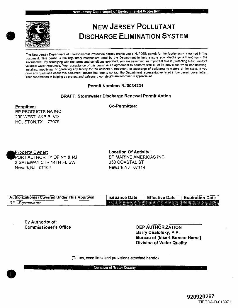
New'Jersey Department of Environmental Protection' :
• NEW JERSEY POLLUTANTDISCHARGE ELIMINATION SYSTEM
The New Jersey Department of Environmental Protection hereby grants you a NJPDES permit for the facility/activity named in thisdocument. This permit is the regulatory mechanism used by the Department to help ensure your discharge will not harm theenvironment. By complying with the terms and conditions specified, you are assuming an important role in protecting New Jersey'svaluable water resources. Your acceptance of this permit is an agreement to conform with all of its provisions when constructing,installing, modifying, or operating any facility for the collection, treatment, or discharge of pollutants to waters of the state. If youhave any questions about this document, please feel free to contact the Department representative listed in the permit cover letter.Your cooperation in helping us protect and safeguard our state's environment is appreciated.
Permit Number: NJ0034231
DRAFT: Stormwater Discharge Renewal Permit Action
Permittee:BP PRODUCTS NA INC200 WESTLAKE BLVDHOUSTON,TX 77079
Co-Permittee:
.roperty Owner:ORT AUTHORITY OF NY & NJ
2 GATEWAY CTR 14TH FL SWNewark, NJ 07102
Location Of Activity:BP MARINE AMERICAS INC350 COASTAL STNewark,NJ 07114
RF -StormwaterAuthorization(s) Covered Under This Approval
By Authority of:Commissioner's Office DEP AUTHORIZATION
Barry Chalofsky, P.P.Bureau of [Insert Bureau Name]Division of Water Quality
(Terms, conditions and provisions attached hereto)
• . Di'l/ision of Water Quality , ..
920920267TIERRA-D-018971
BP MARINEBP Marine Americas8uilding 350
Coaslal Slreet
Pon Newarl<. New Jersey 07114• Direct Line: (973) 465·2425
February 11, 1-999
New Jersey Department ofEnvironmental ProtectionBureau of Discharge Prevention
Re : Spill Incident onJanuary 14, 1999at Port Newark NJ.Ref. Case # 99-01-14-1643-35
Gentleman:
This letter is to confirm'our reported spill incident that occurred on January 14, 1999.
•Owner/Operator: BP Marine Americas Inc.
Division of BP Exploration and Oil Inc.200 Westlake Blvd.Houston, Texas 77079
Lease Holder: Port Authority of NY. & NJ.Discharge Location: BP Marine Americas Port Newark TermilJ?I, Ber1b.?1
Bldg.' 350 Coastal Stre'e( Port Newark .New Jersey 07114
Telephone: 973-465-2425EPA lO # : NJD98059138
Reported By: Terminal Supervisor - Mr. Joseph JeannettiBP Marine Port Newark Terminal
. '. Bldg. 350 Coastal StreetPort Newark, New Jersey 07114
Telephone: 973-465-2425Berth 21 Location: North Channel, Newark Bay
Name of Street: Gillgan StreetLatitude: 40 deg. 41 min. 40 sec. North
Longitude: 74 deg. 08 min. 15 sec. WestSource of Discharge: BP Marines 2,500 Gallon Vacuum Tank Truck
Substance: NO.6 Fuel Oil Cas NO.68476-31-3Amount Released: Approximately 300 US Gallons
Discovered at : 16:25 hours on January 14, 1999Release stopped at : 16:26 hours on January 14, 1999
NJDEP Notified at: 16:43 hours on January 14,1999
•PJge 1
., 920920268TIERRA-D-018972
On the evening of January 14, 1999, BP Marine terminal supervisor, Joseph Jeannettiand operator, Carlos Cajeira were in the process of loading 7,740 barrels of IF-380onto the Eklof barge Newark Bay. The mooring location of the barge, Berth 21,' PortNewark Channel, riser connection #3.
At approximately 16:25 hours, Eklof Marine employee (making a delivery to the barge)Tom Sullivan arrived at the loading berth and discovered #6 fuel oil leaking form BPMarines 2,500 gallon Vacuum truck that was parked on GiHagan Street, adjacentBerth 21.
He immediately reported the leak to BP Marine operator Carlos Cajeira. Carlosresponded to the area and noticed the lower site glass on the tank truck was missingand leaking product. Temporary action taken to stop the flow of product, Carlos quicklyinserted a sorbent pad into the missing site glass opening.
•Estimate 300 gallons had leaked onto the paved surface of Gillagan Street andBerth 21. Containment and cleanup operations were initiated by deploying severaltypes of sorbent material (spill pads, speedy dry, sausage boom) and two (2) vacuumtrucks.
BP Marine's Oil Spill Response Plan was activated at 16:29 hours by terminalsupervisor Joseph Jeannetti.
New Jersey Department of Environmental Protection was notified of the incident at16:43 hours, Case No. 99-01-14-1643. S&D Environmental was notified and activatedat 16:45 hours. Port Authority Police was notified at 17: 15 hours (officer Hammer).Port Authority operations representative, Ray Hennessey notified at 17:30 hours.US Coast Guard notified at 18:10 hours, Case No. 470-624 - PO Gauthier.New Jersey Marine Police notified at 18:30 hours, Officer Badge # 5437.
Cleanup contractor S&D Environmental anived on location at 18:05 hours to assist incleanup operation. Sever weather conditions (snow, rain and ice), delayed the cleanupprocess for several days. Precautionary containment boom was deployed in the areaof Berth 21 and the spill. No spilled product entered the Newark Channel. Cleanupoperations complete by releasing S&D Environmental on January 19, 1999 .
•Page 2
920920269TIERRA-D-018973
Clean contractor S&D Environmental furnished two (2) roll off containers to disposecleanup material and debris.New Jersey Non Hazardous Manifest Number: SD-3289 SO-3288
S&O Environmental Inc.11 Elkins RoadEast Brunswick, NJ. 08816EPA : NJ0982744260Phone: 732-432-5566 .,Fax: 732-432-5757
Disposal Site: Ellesor, Inc.(Incineration) 864 Julia Street
Elizabeth, NJ. 07201Facility 10 200402Phone: 908-289-3222
•Investigation conducted by BP Marine to determine why the site glass had failed andthe necessary remedial actions to prevent recurrence . The truck was built andpurchased in 1980. During this period BP has never experienced a site glass failure .The missing site glass or fragments of the glass could not be found.Remedial actions: The three (3) site glasses were removed and covered over with% inch (thick) steel plate. _The steel plates were welded in place. -The entire 2,500 -.gallon tank was pressure tested to 100 p.s.i. In the future, tank level indication will bedetermined by intemal float device.
Should you have any questions regarding this matter, please contact me at973-465-2427.
Sincerely,
\~'-'---\~-\' ~~,-l~~Bueford WilliamsTerminal Manager
cc : New Jersey DEP Site Remediation Program
Attachments
•Page 3
-' 920920270TIERRA-D-018974
•
•IiIiIII!
i
II
•I
.~~;--- \ '>,/ /pi
"",....~ I
,uno/< sm__E:E:_r_~
l:c- __ -Ll-
r STrl£E:r
z DISTRICT:..3-
'~ I~
~Ii ~. I--.~,' J --. U
I 12
II
i\),iI" -!2'_ (JJ'" /J---I •I ....",1_~7,It,,~,_~l ._2'__ a
I ._-==~_
,," ,
DOoP/fIN srncr.r
Irel
: 1_' _ .. lll.lllLl2. _...
"orl. rlt-JJJ~ ~5-20.00,000
...,W-JHOl.l11,;
!::'12" .~u .~ ........,
l' II;;,
! r0
'"12"CJ (3
IJ
Y\J~0
~..rI'l
I
TfJ ER11j ill 7
DL
y
CHANNELC I T Y GABLE WATERS). (NA V1
F L a 00
~E88 EAOFSPILL-AR
920920271RA D-018975TIER -
_._----
'!"'"'I-"""" '" --. fr· .....L ::~-- ...-ll .' •
..... , ........ _-_ ............ ..... ...
~'ELIZABETH QUADRANGLE \~~f.~t>" t-~
NEW JERSEY -NEW YORK b\.-<-7.5 MINUTE SERIES (TOPOGRAPHIC) ~~
74"P7'30"~-r---:::::Ir-'-::"""";-~ __-""""_<"'C""-::-"1en:.r=--'"II'!!'----'''''''''-'''''''''' 40· 45',
GEOLOCICAL SURVEY
i&t-NA?poRTtI£~AItI<IifAIMIIIAl.
. ~ ,
0Lt ./I
../I
/I
/I
4503
",
; ..'...~
~!:-.A~~=....ll>._.l!.>-Jj.f--.;_~L ·4'~~::"';" ~2.3 MI TO INT£RCHANGE: 12/:
TR£NTON 51 MI
ell' INTeJlI(Hll __ GEOLOQ:ICAL 'SVlltvt .... fl4eSTON, VIPlQINIA_ UHI!;l'
1960000 FEET (N.Y.I
THIS MI'\P COMPLIES WITH NATIONAL. MAP ACCURACY STANDARDS
FOR SALE BY U S. GEOLOGICAL ~:URVEY. RESTON. VIRGINIA 22092A fOLDER DESCRIBING TOPOt,RIIPHIC MAPS AND SYMBOLS IS AVAILABLE ON R£QUEST
,P"vlsions ~hown in NJlple and woodland compill'd lro": l""illphotograpl1s takl'n 1?76 and other sourcesThis il'1form~t,on not held checked. Map edited 1981
00131 en
21)" :,0'32·"19 <)I' C
CONTOUR INTERVAL 10 FEETNATIONAL GEODETIC VERTICAL DATUM OF 1929
DEPTH CURVES AND SOUNDINGS 11'1FEET-DATUM IS MEAN lOW WATERTHE RELATIONSHIP BETWEEN rHE TWO DATUMS IS VARIA6lE
SHORELINE SHOWN REPRESENTS THE A'PROXIMATE LINE OF MEAN HIGH WATERTHE MEAN RANGE OF TIO£ IS APPROXIMATELY 4.8 FEET
ROAD CLASSIFICATION
Heavy·duty light·duty .
Medium·duty _",....- ~~ Unimproved dirt "~~,,:===~
(J Interstate Route 0 U S. Route 0 Stale Route
1000 0 10C>0 7000E,LF"LJ3 ..:::r~·"",·
< I K1L()f'.'fTEP===.3
6000 7000 FEET3'I(lO 4000I~;,~ :::::?""':"+',
5000F?'F
~,r··'1 (,0·:) t.~,j~ ; ')A; V;\l"'t'f v C '~'1~"'101
:'('t l~tl't!,Yj Jt1 \:r~Tf p 0f ~'"'f£ tELIZABETH. N. J. - N Y
1%7PHOTOREVISED '981
OMA 8185 II NW-8ERIES Va22
TIERRA-D-018976
•
•
•
B.P. North American Trading CompanyBuilding #350 Coastal Street
Newark, Essex County New Jersey 07114
B.P. North American Trading Company is the current owner of Coastal Oil in Newark,New Jersey. They are a petroleum product distributor handling No. 2 Fuel Oil,Kerosene, No. 4 Fuel Oil, and No. 6 Fuel Oil. In the past they have emptied andcleaned their storage tanks resulting in the generation of hazardous waste oil andsludge. These materials were transported, stored, and recycled by the facility.B.p./coastal Oil no longer stores hazardous waste at their facility (as ofDecember 29, 1983).
On February 2, 1983 the roof seam of tank #106 split due to overfill pressuresgenerated by #6 Fuel Oil. Approximately 40,000 gallons of oil spilled into thedrainage trenches and earthen dike area. Half of the oil was recovered. The restof the contaminated oil and soil was treated by Dried Bacteria Cultures (DBC).These cultures were used in an attempt to reduce the oil to a more manageablestate, but due to poor weather conditions and improper maintenance the treatmentwas only moderately successful. Tar residues and remaining contaminated soil wereexpected to be removed by Spring, 1984 .
In addition to this spill, other minor discharges ofChannel near Coastal's bulkhead have been reported.leaking underground pipes belonging to B.P./Coastal.clean up of the sheens have been performed.
oil intoThe oils
Repairs
the Port Newarkwere traced toof the pipes and
The site is assigned a low priority based on observed minor discharges of oil toground and ~,,-~-:o \,':3'-ors and the fact that wr~_ttf'!nconfirmation of final cleanup of the contam:""at.:e..._,-,~l \\'3S never made availab.Le A site inspection isrecommended on a time available basis.
Submitted by:Michael SurowiecNJDEP/DWM/HSMAMSCA Project
HS152:jlc
BAB000013
920920274TIERRA-D-018977
•/
•
•
B.P. NORTH AMERICAN TRADING COMPANY BUILDING #350
COASTAL STREET, NEWARK, ESSEX COUNTY, NEW JERSEY 07114
Submitted by:Michael SurowiecNJDEP!DWM!HSMAMSCA Project
920920275TIERRA-D-018978
•
POTENTIAL HAZARDOUS WASTE SITE L IDENllFlCA lION
SEPA PRELIMINARY ASSESSMENT 10lSTAItiOZ
PART 1 • SITE INFORMA nON AND ASSESSMENT
IL SITE NAMI AND LOCA 110ItOlSIT1 __ -"---- Coastal . ~NCl .• 0I'l ~IC
B.P .North American Trading Inc./Oil Building #350 Coastal St.03CtTY ~ .TAll\ 06 ~ CClClI 10.CClUItTY \01: I QIST
Newark NJ 07114 Essexoe ~TU LATTTlJDE
IL.ONGITUDE
40041' 40". 740 08' 15" Lots 15, 510 DlI'£C11OHS10 Slrt,~ ____
Take N.J. Turnpike north to Exit 14 (just past Newark Intll. Airport) . Followramp around to Port St. , follow until Coastal St. , B.P. is on both sides.
Ul. RESPONS18L£ PARTIESOIOWNiR .. _
OZST~T, ___
B.P. North American Trading Inc. Gateway One, Suite 30003 CtTY ~STAnlos:.CClClI 100T~"""
Newark NJ 07102 1201'643-760001 oPERArOf\ .. -----
ClaSTAEfl ___
CleClT, 10STATf/" ~COOI 11:1 T£U""ClNI ~I ,
I J TYPl 01 O_1'lSl'lIf' rc-o_XXI A. PflIVATE o B.FeOE~ o C. STATE DO.COUNTY D E. MUHIClPA£.,--= F. OTHER . 's::c: ......, D G. UNKNOWN
I I ... .::....,'~c··\-'.J.-.:~..'7,J;.. :.;OT il-t{.. .. no", 0' ;:'-= ':"'.(- -~ .... -,XD C.NOH£~ A. ACAA 3001 OATE RECEIVE!): ( r o B UHCONTROl.L.fI) WASTE SIT! tCPaol '0) or OA.TERECEIVED: { I
~, ... o·n "tAJI MIQN'''' 06." .IMI'
IV. CHARACTEAI2A TlON OF POTENTIAL H.UARD0' ONSITi INSP£CT1OH
8'_..__Xag YES OAT'( ( r Cl A.. EPA Cl 8. EPA CC)NTlV.CT0" Cl C. STAT! Cl O.OTHERCONTMCTOR
ONe ...c:.'" DAy '1M' Cl E. LOCAL HEALTH ~f'lCl;.L Cl F. OTHER; ,.....,COHTRACTOA NAMEls):
02 SITE ST4TI.lS,e:-_ 03 'lAAS 0# 0l'£l'IA TIONI~A.ACTIY£ - 5/11/81 -o 8. INACTIVE o C.UNKNOWN o UNKNOWN~ ..... "". 1~"'I'"
O. O£SCl'IoPllONOF SUBS1.... CES ~ YPflE.SEHT. KNOWN.011AU.£Q&D
No. 2 Fuel Oil, Kerosene, No. 4 Fuel Oil, No. 6 Fuel Oil, Waste Oil fromtank bottoms.
O~ OESCl'IoPTION01 POTEHTl4l.hAlAArl TOlHY~T ANOIOI'l ~TIONSoil, groundwater, and surface water contamination due to leaking and spilledFuel Oil and waste oil.
Y. PRIORITY ASSESSMENT01 PI'\IORITY ~OR~CTlOHle-o_ .• _,,_. ___ I. ____ '. __ ..__ e- __
. D A. Ml(iH Cl 8. MEDIUM "X~ C. L.OW Cl O. NON£,.......,.....,....,." -- ... ,....., ........... ---.1 ,-............ ,..... .--................. ,.,..,VI. INFORMATION AVAILABLE FROM01 COHT4CT DZ0# _r'Oo__ Cl3Tti.&PtooON£ ~Il
Frank Gagliano NJDEP/DWM/BFO Central f:,09'426-022300 PfRSON RfSPONSlllU fOIl ASSt$$MEHT D~AGlHC:Y I:=~~IDr llUPI'OoE HUMell'l CIa DATI
~ Michael Surowiec NJDEP 1609'633-2215 11 ,OS,85~l ... DAy Vi"
El'IIo f0-20100121''''1
•
920920276TIERRA-D-018979
POTENTIAL HAZARDOUS WASTE SITEL IDENTIFICA TlON
SEPA PRELIMINARY ASSESSMENT01 sTAnl~SlTl~
-.,-:: PART2· WASn IHFORIIA nON'. -u. w UTE STATES. Qu.umTIES. AND CKARACUJUSTICI
O' pwy~5TATfI ----~ .. ...srI OUNITITY AT IITI
CU wAin e-ACTEIIIITJCI ,0-0 ___ •..........._-L:l A TOlllC L. E SOLL&I U I MIQooL YVOLATIU---1.1 A SQLC) t E.SWM\' lJ I. CON'IOSNI L. , ...,ecTIOUI ....JE~
~I.POWDUI.""" , UOUIl TONI wc~ X. G- 'Luw'a ...1 u K IllACTIYIC. Sl.UOQI u G COAl Lj 0 PfFISISTiHT :.,; .. GHlTAal L~.~ATa.I
~Y"'" ... .. NOT.u.....c:AIoLI::'O.OTI'lIIil ,--.' NO. Of' 0l'UMS
: W. WASTE TYPE
: CATEGOIlY ~TAHCl"""" 0' G'lOSS AWOVNT 02 UNITOf' .. EASuRE CU~HTS
I SUJ SL.uOG! APProximatelv 40000 oallons 0
OlW OILy wAST! #6 waste oil spilled from a,SlX SOLVENTS ruptured tank. Oil that was noPSO PESTICIO£S contained by dikes soaked into
I occ OT...eR ORGANIC CHEWCALS soil. Dried Bacteria CulturesI IOC lNORGAHIC CHEIoUCAL.S (DBC) were used to reduce the
...co ACIDS oil.8AS 80\5£5
t.4ES HEAVYt.4Ei~S
IV. HAZARDOUS SUBSTANCES ,s.. ___ ,,__ CAS_
01 CATf GOI'l'f' 02 5lJ8ST AHCl ......... 03 CAS "'UwaElI 04 STORAGe"OlSPOSAL wno<lC O~ COHCfNT"-'TOII 01 wtA5UAf OJFCOOoC!HTIIlATION
W #6 Fuel Oil 999 DBC's were used toreduce/down grade oil.Residue was packedinto drums.
OLW Unknown Fuel Oil 999 !Absorbent pads usedto soak up oil.~aste packed in drums_.-
v: FEEDSTOCKS ,__ .. c.aa_
CATEGOIlY D. 'UDSTOCX ........ 02 CAS NU"'BEIil CATEGOIlY O. FEEOSTOO< ....... E 02 CASNU"'EA
FDS FDS
FDS FOS
FOS FOS
FDS #FC,/S
VI. SOURCeS OF INFORMATION te- __ .0/1-. _ ..... __ .. _.
Attachment A- Various memos from DEP/DWM/BFO, letters from Coastal Oil., Attachment B- Memos from DEP/DWM/BFO, Coast Guard printout.
Attachment C- Letters from Coastal Oil/B.P., memos from SWA Engineering, memosLPA'OAM 2070-12 17·1\1 DWR.
920920277TIERRA-D-018980
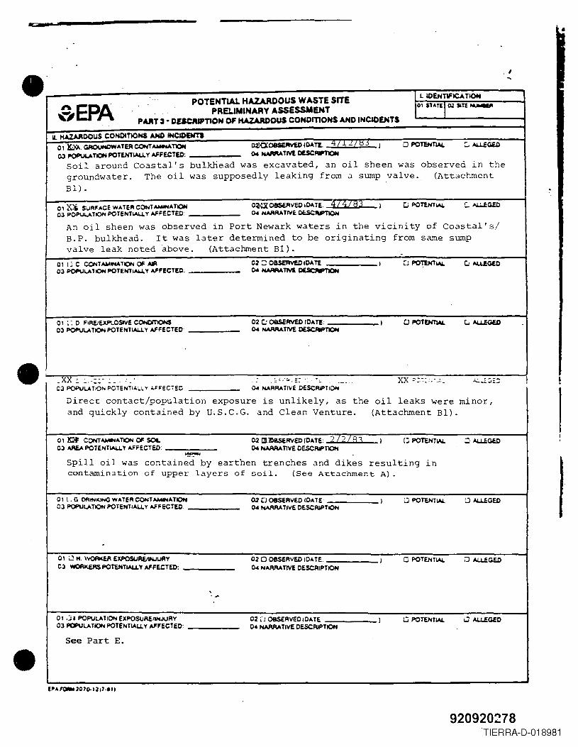
•
.' . I
•
POTENTiAL HAZARDOUS WASTE SITEL IDEHTlFICA TION
SEPA PRELIMINARY ASSESSMENT01 STATE1Q2 SlTl ~
P""13 • DESCIUPnOH OF KAZARDOUS CONOmOHS AND INcaDENTS,
II. HAZAADOUS CONDITlONS AND INCIDENn01 lQ{f.. GROUNDWATER CONT AWlMA TION O2XX08SEAV£D lOATL q / .L L / I,) I DPOTEN~ c.. AL.l..EGa)
03 POP\Jl.A T10H POTEHTIAU. Y AFFECTED: 04 NAMATIVl DESC~
Soil around Coastal's bulkhead was excavated, an oil sheen was observed in thegroundwater. The oil was supposedly leaking from a sump valve. (AttachmentBl) .
01 ZC5, SURFACE WATER CONT_ATIQN O~08$f.AVED 10ATE. 4/ .H~ I c; POTtHTlAL Co AU.fCOal03 PoP\JV< TION POTENTIAU. y AFFECTED 04 NARRATIVE OCSCAPTIOH
An oil sheen was observed in Port Newark waters in the vicinity of Coastal's/B.P. bulkhead. It was later determined to be originating from same sumpvalve leak noted above. (Attachment Bl). -
0' I~ C CONT~lNATION ~ AlA 02 C OBSEAVED IDA TE I ~J POTtHTlAL c.: AU.fGlD03 POPUu.' ION POTEHTIAU. Y AFFECTED: 04 NAMA TJVl DESCN'TION
0' ~: 0 FIREiExPlOSlVE CONOIT1ONS 02 ~ oascRVED 10" Tf: I o POTENTIAL G AU..EGlO03 POPUu.TION POTENTIAU. Y AFFECTED 04 NAAAATIVl 0£5CRIPTl0N
-. - . ' -- . _ .. - --xx' xx::' .
•
. - -' -- - - . .. . - . .. - --- ~... ' . - -~03 POPUu.TION peTENTI ....L.L. Y ....FFEC7~C 04 NA RRA TlvE DESCRiP T10"1
Direct contact/population exposure is unlikely, as the oil leaks were minor,and quickly contained by U,S.C.G. and Clean Venture. (Attachment Bl) .
01 ~ CONTAMHAT'lON ~ SOIL 02 lXlDBSCRVEO (0" TE: ? I?IR, I D POTENTIAL o AU£GED03 AREA POTENTIAU.Y AFFECTED: 04 NAAAATiVE DESCRIPTION
~Spill oil was contained by earthen trenches and dikes resulting incontamination of upper layers of soil. (See Attachment A) .
01l,G OAINKINGWATERCONTAMlNATION 02 D OBSERVEO lOATE I LJ POTeNTIAL LJ AU£CiED03 POPUU.TION POTENTIAU. Y AFFECTED. 04 NAAAA TIVE DESCRIPTION
.01 LJ" \\l0f'lI(EA EXPOSUAE/VIUURY 02DOBSa\VEDID",TE I o POTENTIAL LJ AU.EGEO03 WOAI<.£RSPOTENTIAU.Y AFFECTED: 04 NARRATIVE DESCRIPTION
\. ,
0, .:it POPULATION EXPOSURE/INJURY 02 ,'J OBSERvEDIOATE I G POTENTIAL o AU.EGED03 POPULATION POTENTIAL,L Y AFFECTED: 04 NARRATIVE DESCRIPTION
See Part E.
•
920920278TIERRA-D-018981
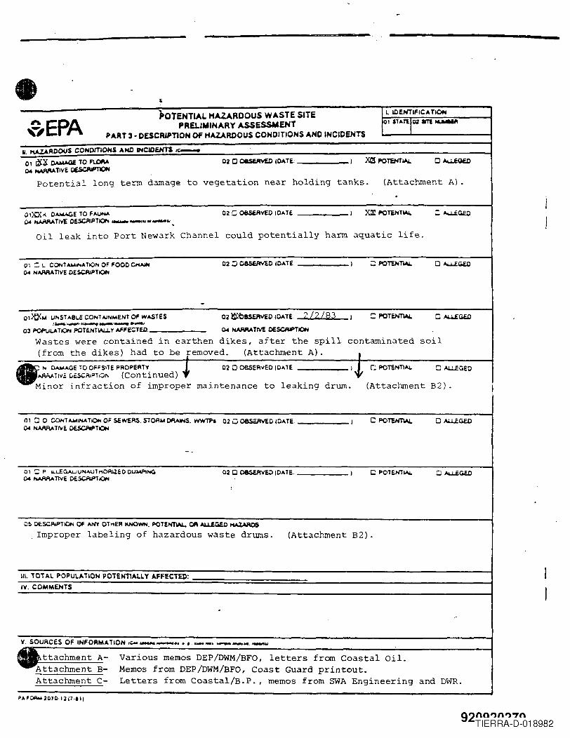
• POTENTiAL HAZARDOUS WASTE SITE L IOfHTIFICA TIOH
~EPA PRELIMINARY ASSESSMENT 01 stAnl~ SlI ..........
PART 3· DESCfUPTiON OF HAZARDOUS CONDITIONS AND INCIDENTS
II. KAZAROOU$ COHOmOHS AND INCIDeNTS te:-
o 1 ~~ 0AMAQi TO FlORA 020 08RRV£0 ,CATE: I X(! POTENTlol.L o AoU.£QfD
CWNAAAAnvE ~
Potential long term damage to vegetation near holding tanks. (Attachment A) ..
o'xx/( O-.o.CaE TO FAUNA 02 Ci 08SCAVEO cOATE I ~ POT£NTlol.L C AU.fGfDCot NJ,IIlAA n\iE OESO'lIPTlOf'l .- _ .. Of _ .. _
Oil leak into Port Newark Channel could potentially harm aquatic life.
01 :; L. CONT ......INATION OF FOOOCHAIH 02 :J OasiRVEO ,OATE I ::PO~ D AU.fGfDCot ",AMAnvE OE.$CAIPTION
-01~104 IJNSTA8l.E CONT AJNMENT OF wASTES 02 ~BS£AVEO IDATE. 212/83 I =POT~ D AU.fC&f.O
I~·'''''''''.'''''''''''-'·''''''''-''03 POPUi.ATION POTENTWoLY AFFeCTED: 04 NAMA TM O£SCRlPTION
Wastes were contained in earthen dikes, after the spill contaminated soil(from the dikes) had to be removed. (Attachment A) . I
N C......AGE TO OFFSlTE PROPERTY ~ 020 oesERvED tCATE 1.J, 0 POTENT1~ o "LUGEO~TI"a c.asciilPT,O" (Continued)
~lnor lnfractlon of lmproper malntenance to leaklng drum. (Attachment B2) .
0100 CONTAJ04INATIONOF SCWERS.STOAIo4Df\AlNS. WWTPa 020 OBSERVED (DATE. I CPO~ o AU..EGE.OCot PotANl.A T"iE OfSCM'T ION
--
01 ::: P u..-..EGAuuIolAUt"ORlZEO CUM?!"'" 02 Cl O8SVlVE.O ICATE I o POTENTlol.L o AU..EGf.OCWNAMA TlVE OESCRlPT ION ,
O~ OESCRlPTION OF ANY OT"ER KNOWN, POTENTIAL. OR ~GfD I'IAZAAOSImproper labeling of hazardous waste drums. (Attachment B2).
Ill. 101 A.l POPUlA liON P01ENll.1.1. Y .FFECTEI>:
IV. COMMENTS
.
V. SOURCES OF INFORMATION ,'- __ .,. ,. __ • __ .. '_a;
ttachment A- Various memos DEP/DWM/BFO, letters fram Coastal Oil.Attachment B- Memos from DEP/DWM/BFO, Coast Guard printout.Attachment C- Letters from Coastal/B.P. , memos from SWA Engineering and DWR.
PAF~ 2070·12 17"'1
92nnl)nl)"7nTIERRA-D-018982
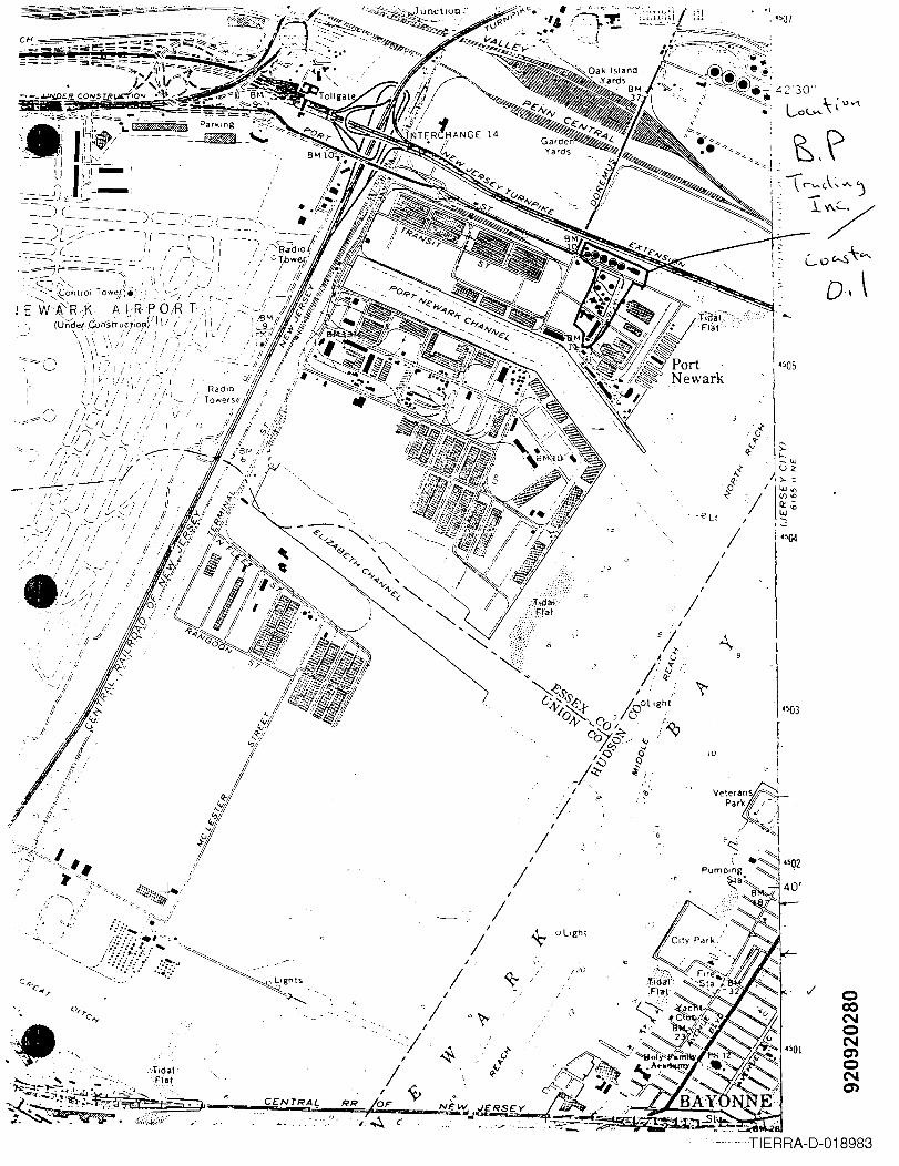
" ".i~~ r'
I
" ./,t ,// ; v
..: /
/ / .J
",\ . " .'i·\'-- / //i
"""-II}'
,f1/
f'=-1/
l:l
;I' Ii
f' J ff'·-~
~~...~~ '.
i
I
I .
/ ~
C£NTRAL
I
/
I
/ 6
I
/ ·6
I
/*- aLight
/..:'0
I
/
.. ,
~"'~i! ~ -"( r::A~...')
.._~"--~/
I
/
·SO)
iO
oCONoNenoNen
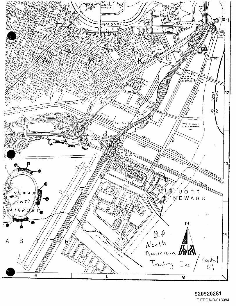
920920281TIERRA-D-018984
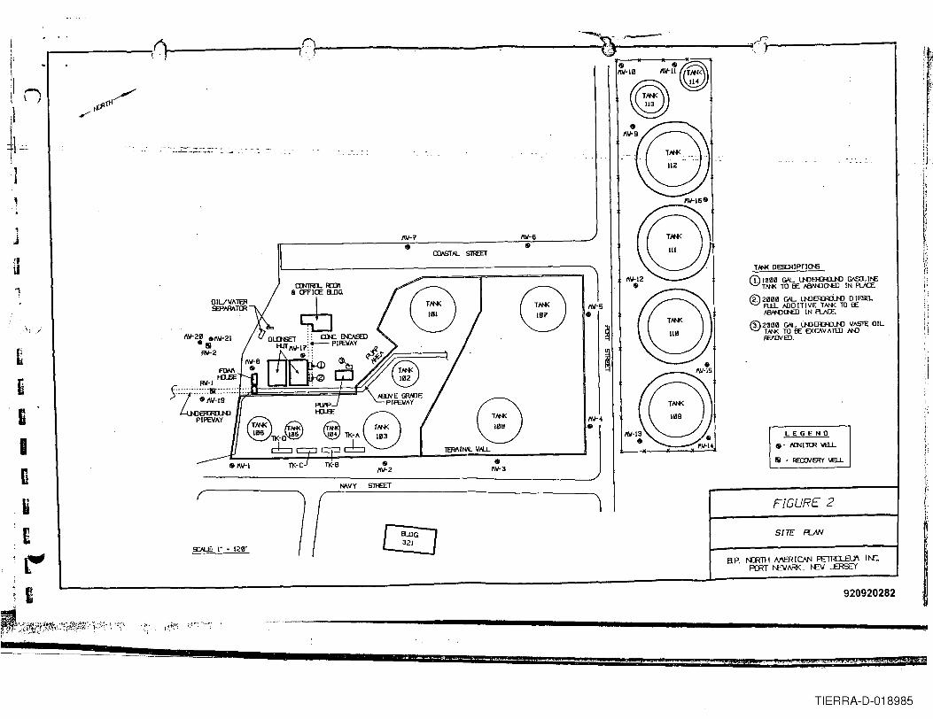
--~t: .-:~'.r:'r' -----------r-- I\~------.-,;D\ , r )
& &~~~(;;ill~~&
~~9
~~6~1J"7
Tm< DESCRIPTIO'S
Q) l~~~G'L lNJEJUnN) =11'£Tm< TO EE fWl'{JDI'£D IN fV{E
® 2~~~ G'L lNJERRiw D lESaFt£L mD ITIVE TI'N< TO EEi'BN'DDI'£D IN fU(E
@ 2~~~ G'L lNJEJUnN) 1JAS1E OILTm< TO EE EXCAVATED HDfF£lVED. '
r:::\~
~1J"5&
.\, )~~2~ _~~21
-IIIRl/-2C
tiBInu£c-"I
'I
:1
"j'
iI-'
I'"\:
I';J
rt ~
LEGEND&.. IDlI TrR 'wEJ..
III - F£aJV ERr 'wEJ..•1\~3•~~2
NAVY
FIGURE 2
SITE PI...JW
9:N...E: I" • 12~'
920920282
._-_ ...._-----------~..
_;:J!t'ti~(i~~.;~'~';i~1~~;;;.,~~;.',J,?, '. ;~;'"
51 Wi '< . ,1(,_, .t'~.L\$.,~~jJi&,C?JP.:j¥,M4FH!m'iK2i".'Si$ ]4 . . £ . ' "eqffiiMtF ,¥
TIERRA-D-018985
•
•
•
A DIIA.Q 12
MEMO NEW JERSEY STATE DEPARTMENT OF ENVIRONMENTAL PROTECTION
TO S~i11 EileFROM Thomas J. Allen July 20, 1978DATE
SUBJECT Coastal Oil Company, Doremous Avenue, Newark - OHMP Case # 78-1-31-6
On January 31, 1978, I investigated a spill report at the above noted facility.My investigation disclosed that an estimated 30,000 BSl's of 14 oil was spilledinto a diked area due to a rupture in a storage tank. Oil was seeping througha fire wall into a concrete vault but Coastal 011 personnel were pumping thisoil back into the diked area. There was minor seepage through an expansion jointbut this was readily contained by use of sand.I met with Mr. Charles Boggs, Vice President and discussed clean up strategy withhim. Since 38,000 BBl's were still in the tank and leaking, efforts were concen-trated on the removal of the remaining oil in the tank by use of barge. Once theoil was brought to a level below the leak transfer of the oil-'in the dike couldstart.On February 1, 1978, I spoke with Mr. Boggs by telephone. He informed me thatthe oil in the tank and dike area had reached equal levels. The oil in the tankis still being pumped into barges and removal of the oil in the dike would startby days end. Mr. Boggs estimated that the oil in the dike would be removed bylate evening on February 2, 1978. At 1530 Lt. Commander Dougherty U.S.C.G. informedme pumping of the dike area had started and the level of oil has noticably lowered.February 2, 1978On scene and met with Mr. Charles McGiuse, operations manager. They are currentlypumping from both the tank and dike at the rate of 500 BBl's per hour. An additionalpump should be working shortly that will increase the total pumping rate to approx-imately 1,000 BBl's per hour. There is approximately 2,000 BBl's remaining in thetank and an estimated 8,000 BBL's in the dike. At the time of the initial dischargethe oil was heated to 680 F.] met with P.O. Sattler and Ens. Del Bueno, U.S.C.G. and viewed clean up operationswith them. The oil level in the dike has lowered approximately 8 inches since mylast visit. All appears to be going well with an estimated 48 hours of pumpingtime left.February 15, 1978Spoke with Mr. McGuire. He informed me that everything was working out well untilthe recent snow storms. The oil in the dike area had been lowered to a point whereground surface was becomming visible in some areas. An inspection of the tankrevealed a hole in the floor plate.
B.~8000014
,'J.. 0I
920920284TIERRA-D-018986 I
I
•
•
•
- 2 -February 22, 1978Spoke with Mr. McGuire. The solidifing oil in the tank bottom will be removed byvacuum truck tomorrow. Contractor has been hired for the remaining clean up work.Andax Environmental Corporation, 416 Edgewood Place, Rutherford, NJ 07070, (201-939-1358) •March 1, 1978Spoke with Mr. McGuire. Oil is still floating to ground surface and being removedby vacuum truCK. A sump system has been installed in one corner of the dike andcontinually pumps an oil/water mixture. In all, an estimated 2,000 BBlis ofliquid (oil and water) have been removed from the dike area since February 23, 1978.Operations will continue in this manner until the thaw begins, at which time add-itional sumps will be installed.March 14, 1978Spoke with Mr. McGuire. Oil is still being pumped from the dike as the meltingsnow and ice lifts it. There is still some oil trapped under several inches ofice. A1mo Anti Pollution has been hired to remove this oil by vacuum truck. Inaddition to Almo, three diaphram pumps and one vacuum pump are also being utilized.March 21, 1978Received call from Ch. McGuire. Approximately 100 BBlis or less remain in severalsmall pools. Alma and Coastal transfer pumps are being used to pump the oil intotheir slop tank.March 29, 1978On scene and met Mr. McGuire. Most of the free oil has been removed. Oil pocketsremain scattered within the dike area and are being removed by vacuum truck. Sumpswill be installed when all of the free oil is removed.April 17, 1978
Received call from Ch. McGuire. The dike area was flooded with approximately sixinches of water to lift the oil. It worked quite well and vacuum trucks were usedto remove the oil. Clean up is now nearing completion.May 24. 1978Called Ch. McGuire. They are now in the tank and cleaning it out. The dike areahas been flooded again and a small amount of oil was lifted. Clean up should becomplete in the near future.July 12, 1978Received a call from Ch. McGuire. He informed me that they are now preparingto remove the contaminated soil from within the dike. To do so, a section of thedike will have to be removed so that a ramp can be built to allow the bulldozeraccess. A minimum of 3 to 4 feet will remain in tact to provide dike protection
920920285TIERRA-D-018987
e..
•
•
- 3 -
for the other tank in the dike system. This tank (# 107) has a capacity of96,000 BBL's. Since the dike was constructed to contain the capacity of bothtanks (192,000 BBL's) there should be more than adequate dike protection. As anadded precaution through tan~ 107 inventory will be reduced and dirt will bestockpiled near the dike opening.July 20. 1978Received a call from Ch. McGuire. A 10 foot section of the dike wall was removedon July 13, 1978, to provide access for equipment to enter. An earthen ramp 4 feethigh was put in its place. Both tanks are empty of all product. The dike isexpected to be out of service for approximately 4 to 6 weeks .
920920286TIERRA-D-018988
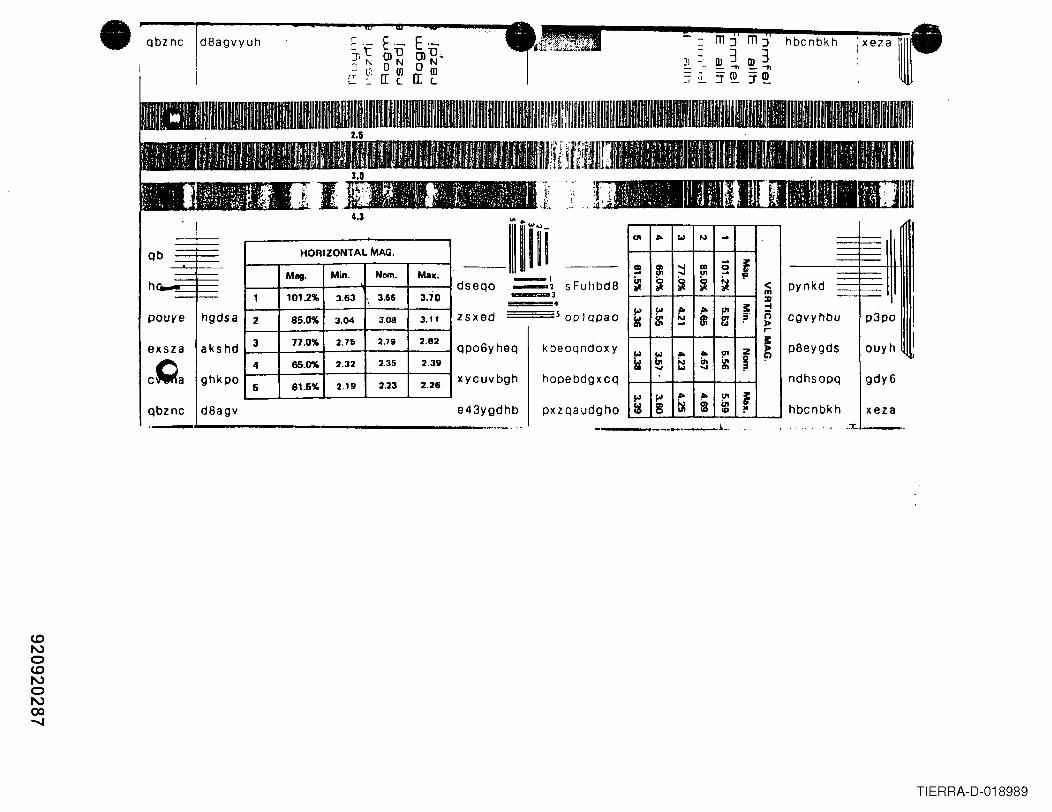
• a m ji mj' i,e,a ,.Qbz nc d8agvyuh r E·- E·- hbcnbkh;'t -OlD OlD .. -
OJ 3 OJ 3~, ~ o NON J) -~ l.i: - - _ -n _"'1ln- IT ~ a: ~ - . -ro -m- "~ - -' - :1'_ :1'_
Qb
h
pouye hgdsa
exsza akshd
cQa ghkpo
Qbznc d8agv
HORIZONTAL MAG.
Mag. Min. Nom. Mall.
1 1012% 3.63 , 3,66 3.70
2 85.0% 3.04 3,08 3.11
3 77.0% 2,75 2.79 2.82
4 65.0% 2.32 2,35 2.311
6 61.5% 2.19 2,23 2.26
dseQO _1_2 sFuhbd8_3
~~~~~ oplqpaozsxed
Qpo6yheQ kbeoqndoxy
xycuvbgh hopebdgxcQ
pxzQaudghoe43ygdhb
UI 410 101 1'0) .... fell 8l '-l CD g.. '-l UI ,.
~ ~ ~ ~ ~ <m:II
!'> !'> ,. ,.. fI' ;: -4
rsc 81 ~ 81 f: ?' r;»>,..
101 410 UI Z ~101 410 ~
~ lit i:l in g: ~'-l '-l
!'> ""410 .. c.n ~:g g: ~ $ C1l
II) 1"
cgvyhbu
xeza
p8eygds ouyh
ndhsoPQ gdy6
hbcnbkh---...__._._~., ,j .::t:. . .-- •.
TIERRA·D·018989
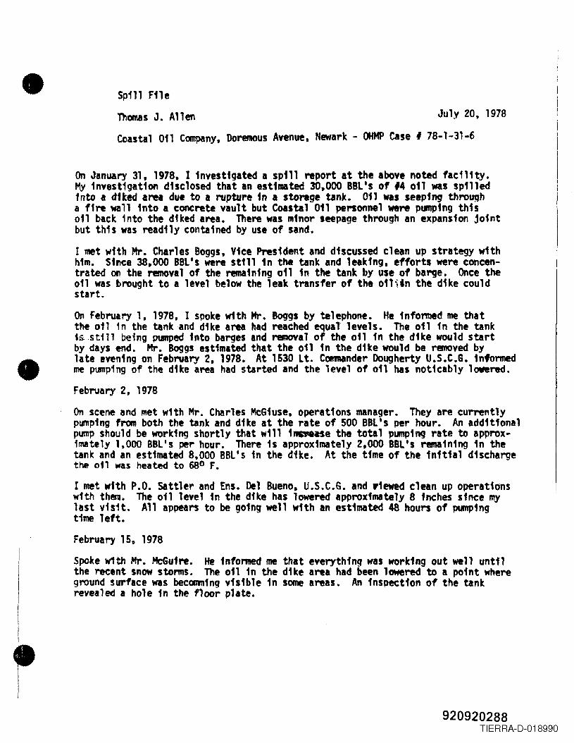
•
•
Spill FileThomas J. Allen July 20, 1978Coastal 011 Company, Doremous Avenue, Newark - OHMP case I 78-1-31-6
On January 31. 1978. ] investigated a spill report at the above noted faeili~.MY fnvestigation d1sclosed that an est1mated 30,000 BBL's of 14 011 was spilledinto a dtted area due to I rupture 1n a storage tank. 011 was seeping thro~ha ffre wa11 1nto a concrete vault but Coastal 011 pe1'"Sonnelwere ptlllP1ngthis011 back into the diked area. There was minor seepage through an expansion j01ntbut th1s was readily contained by use of sand.I met with Mr. Charles Boggs, Vice President and discussed clean up strategy withhim. Since 38.000 BBl's were st1ll in the tank and leaking. efforts were concen-trated 0I'l the removal of the rema1n1ng 011 1n the tank by use of barge. Once the011 was brought to a level below the leak transfer of the o11i'n the dike couldstart.On February 1, 1978, I spoke with Mr. Boggs by telephone. He infonned me thatthe 011 in the tank and dike area had reached equal levels. The 011 in the tankfsstill being PUmPed 1nto barges and removal of the oil 1n the dike would startby days end. Mr. Boggs estimated that the 011 1n the dike would be removed bylate evening on February 2. 1978. At 1530 Lt. C~nder Dougherty U.S.C.G. 1nformedme pumping of the dike area had started and the level of 011 has not1cably lowered.Februa~ 2, 1978
On scene and met w1th Mr. Charles McGiuse. operat10ns manager. They are currentlypumping from both the tank and dike at the rate of 500 BBL's per hour. An additionalpump should be working shortly that will inl'8iS8 the total pumping rate to approx-imately 1,000 BBl's pt!rhour. There 1s approximately 2.000 BBVs remaining in thetank and an estimated 8,000 BBl's 1n the dike. At the tfme of the 1nftial dischargethe 011 was heated to 680 F.
I met with P.O. Sattler and Ens. Del Bueno. U.S.C.G. and r1ewed clean up operationswith th~. The ofl level fn the dike has lowered approximately 8 1nches since mylast visit. All appears to be going well with an estimated 48 hours of pumpingtime left.February 15. 1978
Spoke with Mr. McGuire. He i"fonned me that everything was working out well untflthe recent snow stoms. The on in the d1ke area had been lowered to a point whereground surface was becommfng vfsfble in some areas. An inspection of the tantrevealed a hole 1n the floor plate.
920920288TIERRA-D-018990
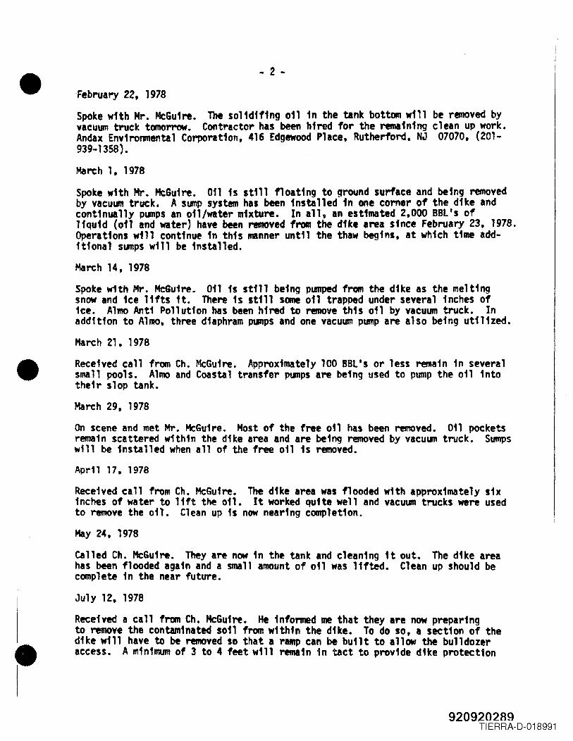
•
•
•
- 2 -'February 22, 1978Spoke with Mr. McGuire. The solidif1ng oil in the tank bottom will be removed byvacuum truck tomorrow. Contractor has been hired for the remaining clean up work.Andax Environmental Corporation, 416 Edgewood Place, Rutherford, NJ 07070, (201-939-1358).March 1, 1978Spoke with Mr. McGuire. Oil 15 still floating to ground surflce and being removedby vaCULIlI truck. A SlIIlP system has been installed in one corner of the dUce andcontinually pumps In oil/water mixture. In all, an estimated 2,000 BBl's ofliquid (011 and water) have been removed from the dike area sfnce Februa~ 23, 1978.Operations will continue in this manner until the thaw begins, at which time add-itional sumps will be installed.March 14, 1978Spoke w1th Mr. McGuire. Oil is still being pumped from the dike as the meltingsnow and ice lifts it. There is still some 011 trapped under several inches oftce. Almo Anti Pollution has been hired to remove this oil by vacuum truck. Inaddition to Alma, three dtaphram pumps and one vacuum pump are also being utilized.March 21, 1978Received call from Ch. McGuire. Approximately 100 BBl's or less remain in severalsmall pools. Almo and Coastal transfer pumps are being used to pump the oil intotheir slop tank.March 29, 1978On scene and met Mr. McGuire. Most of the free 011 has been removed. 011 pocketsremain scattered within the dike area and are being removed by vacuum truck. Sumpswill be installed when all of the free oil is removed.Aprl1 17, 1978
Received call from Ch. McGuire. The dike area was flooded with approximately sixinches of water to 11ft the oil. It worked quite well and vacuum trucks were usedto remove the oil. Clean up is now near'ng completion.May 24, 1978called Ch. McGuire. They are now in the tank and cleaning it out. The dike areahas been flooded again and a small amount of 0'1 was lifted. Clean up should becomplete in the near future.July 12, 1978Received a call from Ch. McGuire. He informed me that they are now preparingto remove the contaminated soil from within the dike. To do so, a section of thedike will have to be removed so that a raMp can be built to allow the bulldozeraccess. A minimum of 3 to 4 feet will remain in tact to provide dike protection
920920289TIERRA-D-018991
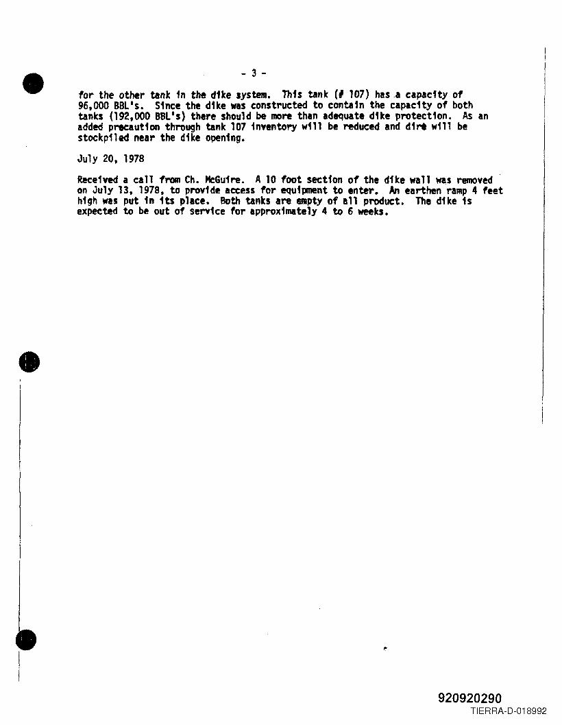
•
•
•
- 3 -
for the other tant in the dUe system. This tank (I 107) has.a capacity of96,000 BOLls. Since the dike WlS constructed to contafn the capacfty of bothtanks (192,000 BBL's) there should be mor-e than adequate dUe protectfon. As anadded precaution through tank 107 inventory will be reduced and dirt will bestockpiled near the dike opening.
July 20, 1978Received a call fY'Olll Ch. MeGuire. A 10 foot section of the dike wall was removedon July 13, 1978, to provide access for equ1pnent to enter. An earthen ramp 4 feethigh was put in its place. Both tanks are IIRpty of all product. The dllce 1$expected to be out of service for approximately 4 to 6 weeks•
920920290TIERRA-D-018992
•
•
i•
Spill File
Th~s J. Allen July 20, 1978
Coastal on Company, DorelllOUS Avenue, Newark - (JfMP Clse I 78-1-31-6
<m January 31, 1978. I fnvestfgated a sp111 report at the above noted facility.My tnvest1gatton disclosed that an e.tt.ted 30,000 BBl's of 14 011 WlS spf11edinto a dtked area due to a ruptu1"e fn a storage tank. 011 wu seeping througha ftre wall into a concrete Ylult but Coaltal on personnel were ptllPfng thisoil back tnto the diked area. There WlS .fnor seepage through an expansion jointbut this was readfly contafned by us. of sand.
I !let with Mr. Charles Boggs, Vice Prestdent and discussed clean up strategy withhi.. Since 38.000 BBl's were stn, 1n the tank and leaking, .fforts were concen-trated on the nmoval of the ..... 1nfng 011 fn the tank by use of barge. Once the011 WlS brought to a level below the leak transfer of the of1~1n the dike couldstart. .
On February 1. 1978. I spoke with Mr. Boggs by telephone. He fnformed me thatthe 011 1n the tank and dike area had reached equil levels. The 011 fn the tankis still being pumped fnto barges and removal of the oil in the dtke would startby days end. Mr. Boggs estt.ated that the oil in the dike would be reMOved bylate evenfng on February 2, 1978. At 1530 Lt. CCIIIInder Dougherty U.S.C.G. informedme pYlp1ng of the d1k. area had started and the leYel of on has noticably lowered •
February 2, 1978
On scene and met with Mr. Charles McGfuse, operatfons manager. They are currentlyplJllp1ng fl"Oll both the tank Ind dUe at the rate of 500 BBl's per hour. An additionalpump should be workfng shortly thlt will fncJleUe the total P\IIIPfng rate to IPProx-'IIIItely 1,000 Ill's per hour. There is approx1lMtely 2,000 BBlIS rea1ning in thetank Ind In estimated 8,000 BBl's in the d1te. At the tiMe of the fnftfal dfschargethe oil vas heated to 680 F.
I .t with P.O. sattler Ind Ens. Del Bueno. U.S.C.G. and r1ewed elan up operattonswith tt.l. The 011 level in the dike has lowered approximately 8 inches since mylist visit. All appears to be going well with In estimated 48 hours of PUmpingtime left.
February 15, 1978
Spoke wfth Mr. McGuire. He fnfonned IDe that everything was workfng out well untl1the recent snow stoms. The 011 fn the dflce arel hid been lowered to a point whereground surface was becOlMing visible fn SOle areas. An tnspect10n of the tankrevealed I hole fn the floor plate.
920920291TIERRA-D-018993
•
•
- 2 -Feb~ry 22, 1978Spoke with Mr. McGuire. The solfdff1ng oil 1n the tank bottom ~111 be removed byvacuum truck tomorrow. Contractor has been hired for the remaining clean up work.Andax Environmental Corporation, 416 Edgewood Pllce~ Rutherfo1"d~ NJ 07070. (201-939-1358) •
March 1. 1978Spoke with Mr. McGu1re. Oil is still float1ng to ground surface and be1ng removedby vaeulII truck. A sump system has been installed in one corner of the dike andcontinually pumps an oil/water mixture. In all. an estimated 2.000 BBl's ofliquid (011 and water) have been removed from the dike area since Februar,y 23. 1978.Operations will continue in this manner until the thaw begins. at which time add-itional sumps will be installed.March 14, 1978
Spoke with Mr. McGuire. Oil is still being pumped from the dike as the meltingsnow and ice lifts it. There is still some oil trapped under several 1nches offee. Alma Anti Pollution has been hired to remove this oil by vacuum truck. Inaddition to Alma. three d1aphram pumps and one vacuum pump are also be1ng ut11ized.March 21. 1978
Received call from Ch. t4cGuire. Approximately 100 BBl's or less rema1n in severalsmall pools. Alma and Coastal transfer PlJIJPS are befng used to pump the ofl fntotheir slop tank.March 29~ 1918
On scene and met Mr. McGuire. Most of the free on has been removed. 011 pocketsremain scattered within the dike area and are being removed by vacuum truck. Sumpswill be installed when all of the free oil fs removed.April 17. 1978Received call from Ch.•McGuire. The dike area was flooded with approximately sixInches of water to 11ft the oil. It worted quite well and vacuum trucks were usedto remove the 011. Clean up is now nearing completfon.May 24~ 1978called Ch. McGuire. They are now in the tank and cleaning it out. The dike areahas been flooded again and a small amount of oil was lifted. Clean up should becomplete in the near future.
July 12. 1978Received a call from Ch. McGufre. He 1nfonned me that they are now preparingto remove the contaminated s011 from within the dike. To do so. a section of thedike will have to be removed so that a raMP can be built to allow the bulldozeraccess. A m1n1mum of 3 to 4 feet will remafn in tact to provfde dike protection
920920292TIERRA-D-018994
- 3 -• for the other tank fn the dike system. This tank (I 107) has a capacfty of96,000 BBL's. Since the dike was constructed to contain the capacfty of bothtanks (192,000 BBL'5) there should be RIOre than adequate dUe protection. As Inadded precaution through tank 107 inventory wf11 be reduced and dirt will bestockpiled near the dike opening.
July 20. 1978
Received a call froBl Ch. McGuire. A 10 foot section of the dike wall was removedon July 13, 1978, to provide access for equipalent to enter. An elrthen raMP4 feethigh was put fn its place. Both tanks Ire 811Pty of all product. The dike isexpected to be out of service for approx1IUtely 4 to 6 weeks.
•
•920920293
TIERRA-D-018995
,;
9209?n?~.4TIERRA-D-018996
920920297

•
tj~~yf~~5f~~'0~~~ f"~6~_ '/.
r/-~~
•
•920920298
TIERRA-D-019000
• i§lillr Df ~ rw JJrr!lrgDEPARTMENT OF ENVIRONMENTAL PROTECTION
DIVISiON OF WATER RESOURCES
TRo;NTON NEW JlRSEY OIlSZS
THIS IS FOR STATE AGENCIES USE ONLY - NO FEE NECESSARY
Please 1imit your reques ts tQ no more than 10 ni\n,€s per day.
Corporale l:rficers ;--7(Request only when necessary. Yourrepresentative must obtain fro·m last.A.nnui'll Report).
Corporate Name)
• ~!X~
<J" d~{-~i1i) /L/~~;y~~_,t../
Reques ted by ~=o:;=~,,--~:.........s...ot..d~~50::::::... _
. (TO BE COMPLETED BY SECRETJ\RY OF STI\TE'S OrneE OrllY)
~ £:h.~~p-or-a"7t""'io-n-')----------
;(#,eeftni;-t---
•I Registered Agent
28~/i. ., - !i2(f~()8h08'J (Hegistercd Offi<k
~h0920920299
TIERRA-D-019001
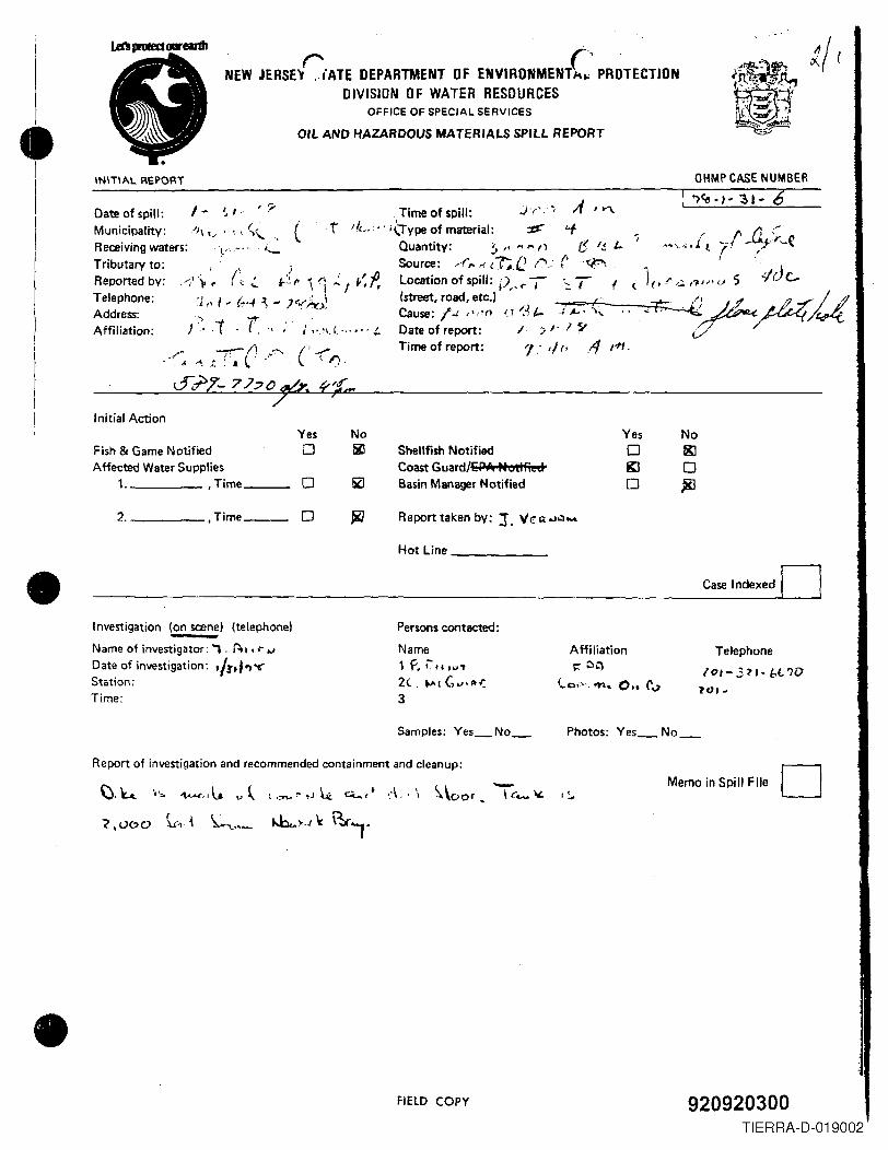
TI
•
•
NEW JERSE~'ATE DEPARTMENT OF ENVIRONMENT( ..' PROTECTIONDIVISION OF WATER RESDURCES
OFFICE OF SPECIAL SERVICES
INITIAL REPORT
OIL AND HAZARDOUS MATERIALS SPILL REPORT
I ' :;-Date of spill: -" I "
Municipality:/)\ '.' . '.• \\.., (Receiving waters: ,~"." " .....Tributary to:Reported by:Telephone:Address:Affiliation:
Time of spill: j'(', ~ A, "'"tIle.. .' ihype of material: :d' '+
Quantity: ~ " .., '"' " f! ,~ L.Source: /,. r. ~1';.C ,.-.: (' .:p.,location of spill: i)" ...I' ~T !(street, road, etc.)
Cause: I.J " ""'- ",'\.( ,,,•.. j. Date of report:
Time of report:)':>. ,( . r '. ·
Initial Action
Fish & Game NotifiedAffected Water Supplies
1. ,Time _
2. ,Time _
Investigation (on scene) (telephone)
Name of investigator: , . ~,. r ..,
Date of investigation: '/lthY;Station:Time:
IT '::.{ t- j'z. (I )/·1S'
l' th' /1 rf'l,
OHMP CASE NUMBER
~~., ~ '31- (6
, ,~·.,:·{t rt 4';'~('.I
<.' 1(1;" ,.; ,?U, <.J s¢rJc,
<~~M/ ,.
Affiliation>r C'l
(0;"" ~~ 0.. tv
Yes No Yes No0 lil Shellfish Notified 0 gj
Coast Guard/EPA PtoliFied KJ 00 5ZJ Basin Manager Notified 0 ~
0 ~ Report taken by: J. "r:.Q.~Q-
Hot Line
Report of investigation and recommended containment and cleanup:
Persons contacted:
Name1 P.~ .,2( 1 (,""1'''=3
Samples: Yes_ No_
\J.4 i'o. ~"t. v ~ (."....'" oJ4 Q;..",t .:\,' \ ~\oor.
c ,0('>0 \"",1 ~'\.,,_ ~,..J" ~"
FiElD COpy
Case Indexed DTelephone
10'-31'- b(.?DlfJ' ~
Photos: Yes_ No_
-\ c.... " I~
Memo in Spill File D
920920300TIERRA-D-019002
•
•
•
THE PORT AUTHORITY OF NY & NJEngineering DepartmentOne World Trade Center - 72 EastNew York, New York 10048
BAK000003
SITE INVESTIGATION REPORTFOR PORT STREET AND NAVY STREETINTERSECTIONNEW JERSEY MARINE TERMINALPORT NEWARK FACILITYNEW ARK, NEW JERSEY
VOLUME 1 OF 3
NJDEPE SPILL CASE NO.: 92-10-15-1235-22
APRIL 1994
Prepared by:
ROY F. WESTON, INC.Raritan Plaza I - 4th FloorEdison, New Jersey 08837
st(aIr:)IPORTAtrrHIPORniA VY.RPT
920920352TIERRA-D-019003
•
•
•
SITE INVESTIGATION REPORTPORT AND NAVY STREET INTERSECTION
NJMT, NEW ARK, NJ
NJDEPE Spill Case No.: 92-10-15-1235-22
APRil. 1994
Prepared for:
THE PORT AUTHORITY OF NEW YORK AND NEW JERSEYEngineering Department
One World Trade Center - 72 EastNew York, New York 10048
Prepared by:
ROY F. WESTON, INC.Raritan Plaza I, 4th Floor
Edison, New Jersey 08837
W.O. No. 02527-043-001-0012
slI:(ak)IPORTAUTH1PORTNA VY.RPT /
920920353TIERRA-D-019004
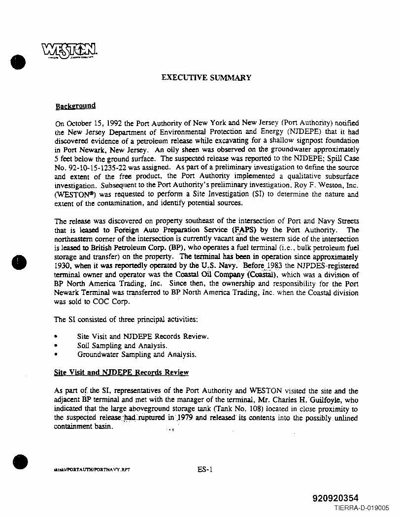
•
•
•
EXECUTIVE SUMMARY
Background
On October 15, 1992 the Port Authority of New York and New Jersey (Pon Authority) notifiedthe New Jersey Department of Environmental Protection and Energy (NJDEPE) that it haddiscovered evidence of a petroleum release while excavating for a shallow signpost foundationin Port Newark, New Jersey. An oily sheen was observed on the groundwater approximately5 feet below the ground surface. The suspected release was reported to the NJDEPE; Spill CaseNo. 92-10-15-1235-22 was assigned. As part of a preliminary investigation to define the sourceand extent of the free product, the Port Authority implemented a qualitative subsurfaceinvestigation. Subsequent to the Port Authority's preliminary investigation. Roy F. Weston, Inc.(WESTON*) was requested to perform a Site Investigation (SI) to determine the nature andextent of the contamination, and identify potential sources.
The release was discovered on property southeast of the intersection of Port and Navy Streetsthat is leased to Foreign Auto Preparation Service (FAPS) by the Port Authority. Thenortheastern corner of the intersection is currently vacant and the western side of the intersectionis leased to British Petroleum Corp. (BP), who operates a fuel terminal (i.e., bulk petroleum fuelstorage and transfer) on the property. The tezjninal has been in operation since approximately1930, when it was reportedly operated by the u.s. Navy. Before 1983 the NJPDES-registeredtenninal owner and operator was the Coastal oUCompany(eoastaI), which was a division ofBP North America Trading, Inc. Since then, the ownership and responsibility for the PortNewark Terminal was transferred to BP North America Trading, Inc. when the Coastal divisionwas sold to COC Corp.
The SI consisted of three principal activities:
• Site Visit and NJDEPE Records Review.• Soil Sampling and Analysis.• Groundwater Sampling and Analysis.
Site Visit and NJDEPE Records Review
As part of, the SI, representatives of the Port Authority and WESTON visited the site and theadjacent BP terminal and met with the manager of the terminal, Mr. Charles H. -Guilfoyle, whoindicated tttat the large aboveground storage tank (Tank No. 108) located in close proximity tothe sUspeCted release~.~d:.riiptured in)979 and released- its contents into the possibly unlinedcontainment basin. ....
at(IIt)lPORT A trrHIPOR11IIA VY .RPT ES-I
920920354TIERRA-D-019005
•
•
•
~ .On behalf of the Port Authority, WESTON requested a review of available files from theNJDEPE, and was able to arrange reviews at the Division of Water Resources and Departmentof Groundwater Well Permits. These __review~':-confirmed_~: the -facility had experienced arelease ..of 4'~&R<l ga.I!ons:o.,fi..~~fbilIn1979:,·presuriiib~f!?JlJrom· tank No. 108.
Soil Samplin2 and Analysis
The SI included the installation of 41 soil borings and soil sampling and analysis.
Soil boring locations were selected on the basis of:
• Results identified in the Port Authority's preliminary site investigation.• Potential sources identified in the review of Port Authority records.• Results from screening soil samples for total petroleum hydrocarbons (TPHC) during the
investigation.
Screening for total petroleum hydrocarbons (TPHC) was performed on soil samples obtainedfrom directly above the water table using the Port Authority Materials Division's portable totalpetroleum hydrocarbon (TPHC) analyzer, which is manufactured by the General AnalyticsCorporation. The TPHC analyzer allowed for short-term processing of soil samples todetermine petroleum hydrocarbon content on a quick turn-around basis. WESTON reviewed theresults from the TPHC screening with the Materials Division daily and identified individualsamples for laboratory analysis by the Port Authority's contracted laboratory, NYTEST. Finaldetermination of the selected samples was made by the Materials Department on the basis ofsample (split spoon) recovery .. }'til~~ples sUbmittecftO~YTESt\Vere analyzed for totalpetroleum hydrocarbons @.~C)~·b~.~~.ll~~~~,,~~ifcl~@J~$£9in,P.R~~i.@~A), lead, volatil~_organic compounds (V9C)~ iild~.meffiYI~tertiaif·btitYr-etl1er7i(MTBE)~1lnd·teiti'aiY':butyl alcohol --(fBA);'" ;'.::~N;.c"' .
Although not required by NJDEPE, four (4) samples were split with WESTON's LionvilleLaboratory for a "fingerprint" fuel analysis. This analysis was conducted in order to determineif the compounds detected in the soil samples were characteristic of diesel fuel, oil, or other fuel(e.g., gasoline).
The analytical results of the soil samples indicated:
• The presence of total petroleum hydrocarbons (TPHC) at concentrations exceeding theNJDEPE action lever'o.r.l{r:600~mgikg for-tota.!. org~,ic~c.ontaminants i~·f~u.r sampleslocated nearest to the containment basin wall in proximity to Tank No. 108. Two ofthese samples contained TPHC at concentrations approaching saturation .
st(Dtl/PORTAtrrHIPORTNA VY,RPT ES-2
920920355TIERRA-D-019006
•
•
•
• The presence of TPHC at concentrations below 10,000 mg/kg but greater than l,OOOmg/kg in seven samples located further away from the containment basin walls.
• The presence of TPHC in the site soils at concentrations below 1.000 mg/kg at locationsfurthest away from the containment basin wall.
Although many of the BNA results were reported at detection levels above the proposedNIDEPE cleanup criteria and thus could not be quantified for remediation purposes, the presenceof Tentatively Identified Compounds (TICs) in the samples suggests that regulated BNAcompounds may be present in the site soils at levels that may require remediation. Since theproposed NIDEPE soil cleanup criteria are compound specific (i.e .. for BNA) additionalconfinnatory sampling for these compounds as part of a Remedial Investigation (RI) will berequired to supplement the TPHC results and define clear cleanup boundaries for the subsurfacesoil.
The "fingerprint" analysisof~fo.~!-o~~~~J)_ ~~!~.,lmijCated.the p~n.s.(U~~,ftdiesel oil", withcomponents of No~'·Z;"No. -4,' and No.6 fueroil Confirme~rin)1t~~samples. The presence ofthese compounds is' consistent with the petroleum fuels that were listed in the CoastalDPCCIDCR Plan as having been stOred and blended at the BP f3cility: Although the petroleum"comparison standards" used by WESTON for the fingerprinting are of contemporary origin andcannot be indisputably tied to fuels that were released 15 years ago, no other organic compoundswere identified in the soil samples which would have indicated that the source of the analytes-:·was other than the BP/Coastai storage ~acilitY,,-
Groundwater Sampline and Analysis
Five shallow groundwater monitoring wells and one deep groundwater monitoring well were alsoinstalled to:
• Determine groundwater flow direction.• Detect possible presence of free product on the water table.• Test for the possible presence of dissolved petroleum product.
The deep well was installed to assess the conditions of the lower water-bearing zone at the site,since this zone is more likely to represent regional groundwater conditions.
Two water bearing zones were identified during the subsurface investigation. Comparing theinformation from the shallow and deep wells suggests that the deepeL~~tet7bearing zone is .connected to Newark Bay.and that the upper, unconfined wa.ter-beanng'Zonei~, most:lllcelY:'"perched freshwater resulting from percolating p~ipitation~ - .,'
Preliminary results indicated a 2 foot layer' of ft~,ting.tte£PrOductin;itie:·shaIlow~monitoririg·
lk(akllPORTAtrrHIPORTNA VY.RPT ES-3
920920356TIERRA-D-019007
•
•
•
~ .
w~..M»'~aI!4"tra~e .concentrations of organic contaminants in MW-4A and th~ deepmonitoring well-MW-4B:- These two wells were installed as a pair close to the contaInmentbasin wall at the intersections of Port Street and Nav~_~tJ:eet. Additional checks by the Port
=o~dtsfn:~:l~~=~C:n~~~U;~"~t.~~gl~:~ MW-5A. All'. -::-_',":,:,.~ ......-,-.:o~~:\,.\ 'l."'.-: -~,
The presence of elevated levels of benzene m the deep monitoring well MW-4B may indicate_ contamination of. the lower waterbearingzol!~j,!1the.area~- This may be due to a potential
pathway between the upper and lower "water bearing zones created by foundation piles. Boththe containment basin walls and the aboveground storage tanks are probably constructed on load-bearing pile foundations, as indicated by Mr. Guilfoyle of the BP Facility.
To confirm these findings, a second round of groundwater sampling should be performed.
Conclusions and Recommendations
The findings of theSI "suggest that the source of contamination in the vicinity of Port Street andNavy Street probably: originated within the Tank No. 108 contaminant basin. It is anticipatedthat an interim groundwater remedial measure (IRM) consisting of the removal of floating freeproduct should be considered after confrrmatory analyses. The soil analytical data for TPHC,coupled with field observations, indicate that a soil remedial action will be required in thevicinity of the containment basin wall.
Because of the discovery of regulated compounds on the site in concentrations exceedingNJDEPEcleanup criteria and indications that these compounds probably originated in the BPfacility, aRemediallnv~tigatiori (RI) Will need to be performed pursuant to N.J.A.C. 7:26E-4et. seq. Planning for the RI would be based on the need to detennine the sources and horizontaland vertical extent of contamination.
In additi()~,;_.~~O~.~r.ecommends that the Porte AU~h..O!ity request from BP"copies"of allhistoricaIand record co~n.<:Ierice with the NJDEPE regcirdirig the 1979 release and anysubsequent cleanup and site monitoring'actloni:"
K(lItlfPORTAUTHIPORTNA VY.RPT ES-4
920920357TIERRA-D-019008
•
•
•
~ .
SECTION 1.0
BACKGROUND
1.1 INTRODUCTION
On October 15, 1992 the Port Authority of New York and New Jersey (Port Authority) notifiedthe New Jersey Depanment of Environmental Protection and Energy (NJDEPE) that it haddiscovered evidence of a petroleum release while excavating for a shallow signpost foundationin Port Newark, New Jersey. An oily sheen was observed on the groundwater approximately5 feet below the ground surface. The suspected release was reported to the NJDEPE; Spill CaseNo. 92-10-15-1235-22 was assigned.
The release was discovered on property southeast of the intersection of Port and Navy Streetsthat is leased to Foreign Auto Preparation Service (PAPS) by the Port Authority. Thenortheastern comer of the intersection is currently vacant and the western side of the intersectionis leased to British Petroleum Corp. (BP), who operateS a fuel terminal (Le;, bulk petroleum fuelstorage and transfer) on the property. Thefermitmrhasoeen lI1 operation since approximately1930, when it was reportedly operated by the U.S. Navy. Before 13 April 1983 the NJPDES-registered terminal owner and operator was the Coastal Oil Company (Coastal), which was adivision of BP North America Trading, Inc. After that date, the ownership and responsibilityfor the Port Newark Terminal was transferred to BP North America Trading, Inc. when theCoastal division was sold to COC Corp.
As part of a preliminary investigation to define the source and extent of the free product, thePort Authority implemented a qualitative subsurface investigation using a small diameter auger.SLarting at the sign location where the sheen was first discovered, borings were performed alongthe southwestern side of Port Street and the southwestern side of Navy Street. Borings alongthe two perpendicular lines were spaced at intervals of either 25 feet or 50 feet. Subsequentinvestigations extended the survey to the southeastern side of the BP facility, into the FAPS lot,and to the northeastern side of the intersection. A visual observation was made of the soil coresremoved from each boring as the auger was lifted. This was continued until no visualobservations of petroleum were encountered. Neither chemical analyses nor vapor screening ofthe soil cores were performed. The findings of the preliminary investigation are p~y!.de4. inAppendix A.
Ik(DtlIPORT A t1THIPORTNA VY .RP1' 1-1
920920358TIERRA-D-019009
•
•
•
Subsequent to the Port Authority's preliminary investigation, Roy F. Weston, Inc. (WESTO~)was requested to perform a Site Investigation (51) to determine the nature and extent of thecontamination, and identify potential sources. The investigation was designed to meet thecriteria established in N.J.A.C. 7:26E, Technical Reguirements for Site Remediation. Theinvestigation involved a historical review and a field sampling and laboratory analysis program.
1.2 OR GANIZ ATION OF THIS REPORT
As a result of this network of environmental regulations, the Port Authority undertook the SiteInvestigation study, as described in this Report; in order to determine the nature and extent ofthe release observed in the sign post excavation:
• Ascertain if free product is present.• Sample the soil to determine if an impact due to a release had occurred.• Sample the groundwater to determine if an impact due to a release had occurred.
Once the scope of the contamination has been determined, a plan to remediate the site would bedeveloped. This remedial plan would incorporate the technical and environmental standardspromulgated in the environmental regulation described above.
The remainder of this Report discusses the results of the Site Investigation program as follows:
• SECTION 2 - Summarizes the history of Port Newark and the site and provides a sitedescription that includes the physical setting, an overview of the geology andhydrogeology, and a summary of the findings from a review of available NJDEPE filerecords.
• SECTION 3 - Discusses the Site Investigation program performed by WESTON,including soil sampling and analysis and reliability of the analysis through qualityassurance/quality control processes.
• SECTION 4 - Summarizes the findings of the Site Investigation field and laboratoryprogram and presents the analytical results.
• SECTION 5 - Discusses the conclusions made based on the results of the SiteInvestigation and gives recommendations for further action .
It(atlfPORT A trTHfPORTNA VY.RYT' 1-2
920920359TIERRA-D-019010
•
•
•
SECTION 2.0
HISTORICAL INFORMATION AND PHYSICAL SETTING
2.1 LOCATION AND mSTORY OF PORT NEWARK
The Port Authority's New Jersey Marine Terminal - Port Newark facility (port Newark) is awaterfront terminal development located on the western shore of Newark Bay in the City ofNewark, Essex County, New Jersey. The facility contains approximately 930 acres of propertythat includes wharves, deepwater ship berths, transit sheds, open storage areas, distributionbuildings, specialized facilities, and railroad trackage.
Port Newark is situated in an extensively developed area of New Jersey, one dominated bydomestic and international trade, transportation, and manufacturing. Port Newark is boundedby New Jersey Marine Terminal - Port Elizabeth (port Elizabeth) to the South, NewarkInternational Airport to the west, the New Jersey Turnpike an~.,QmraiF-s-{iarden Yards to thenorth, and Newark Bay to the east. Figure 2-1 shows the location of Port Newark. Figure 2-2shows the location of the Port and Navy Street site.
Port Newark was opened by the City of Newark in 1915. The City of Newark leased PortNewark property to the Port Authority on March 27, 1948. The adjacent United States NavalIndustrial Shipyard was acquired by the Port Authority in 1963 and is included in the leasehold.Construction of additional berths and related pavilrg in the Naval""Shipyarcfarea began in 1971and was completed in 1978. The Port Authority also developed the southern portion of the PortNewark facility along a channel that adjoins the Port Elizabeth facility. In 1986, the PortAuthority and the U.S. Army Corps of Engineers (ACE) signed an Agreement of LocalCooperation for developing Ne~ark Bay to a depth of 40 feet by the ACE. This depth ofchannel provided the necessary Idepth for the container ships that call at Port Newark-PortElizabeth's container ship facilities.
2.2 SITE DESCRIPTION
The Port and Navy Street site is located in the northeastern corner of Port Newark at theintersection of Port Street and Navy Street. Port Newark Ctulnnel-iies approXimatelY'6.4rnilessouth "Of the si~. Newark Bay is .located approxfmiteiy O.Smiles east of the site. Propertiesnorthwest and southwest of the intersection are occupied by British Petroleum (BP) fuel storageand distribution terminals. The area northeast of the roadway crossing is used as a parking lotfor "car carrier" trucks. The lot was formerly occupied by a police and fire station. Southeastof the intersection is the FAPS parking lot and Buildings No. 301 and 321. Building 301 is astorage warehouse owned by the Federation Company. Site details are provided on Figure 2-3 .
Ui.(ak}lPORT A \TTHfPOR1l'lA VY .RPT 2-1
9200.,n':1~n'TIERRA-D-019011
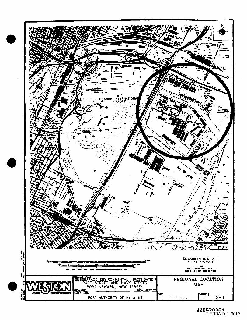
•
•
ELIZABETH. N. J. - N. Y"",037 ~-W"07.~17 ~
1967PHOTOREVISED , 8e1
OM. I." II ".-IUIII .122
PORT AUTHORITY OF' NY I: NJ 2-1
-•
SUBSURFACE ENVIRONMENTAL INVESTIGATIONPORT STREET AND NAVY STREET
PORT NEWARK, NEW JERSEYNEW JERSEY
REGIONAL LOCATIONMAP
"-I
••!~... ..... ............ ioiii.iI....................... _ ... ..................... ...10-29-93
920Q?n~~1TIERRA-D-019012
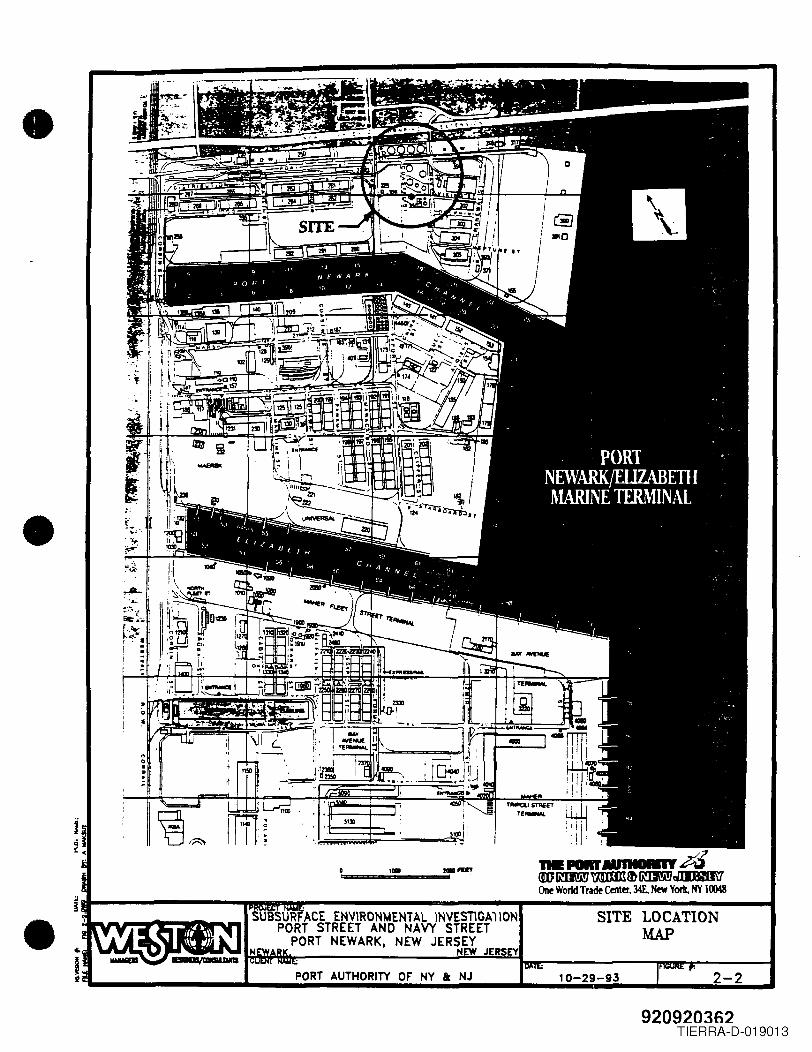
•
• >-'." I~~
;;'h,.-"j.,."~f ••
! :I
"~'.. :~~:===:r Hffil, I
'!' :....-r,..-.,dtmlm\!i!7mmItEftIm\!i!7d:WJM\1One World Trade Center, 34E. New York, NY 10048;J..,.--------mmmr----------- ....------------- ...!II• SITE LOCATION
MAP
2-210-29-93
920920362TIERRA-D-019013
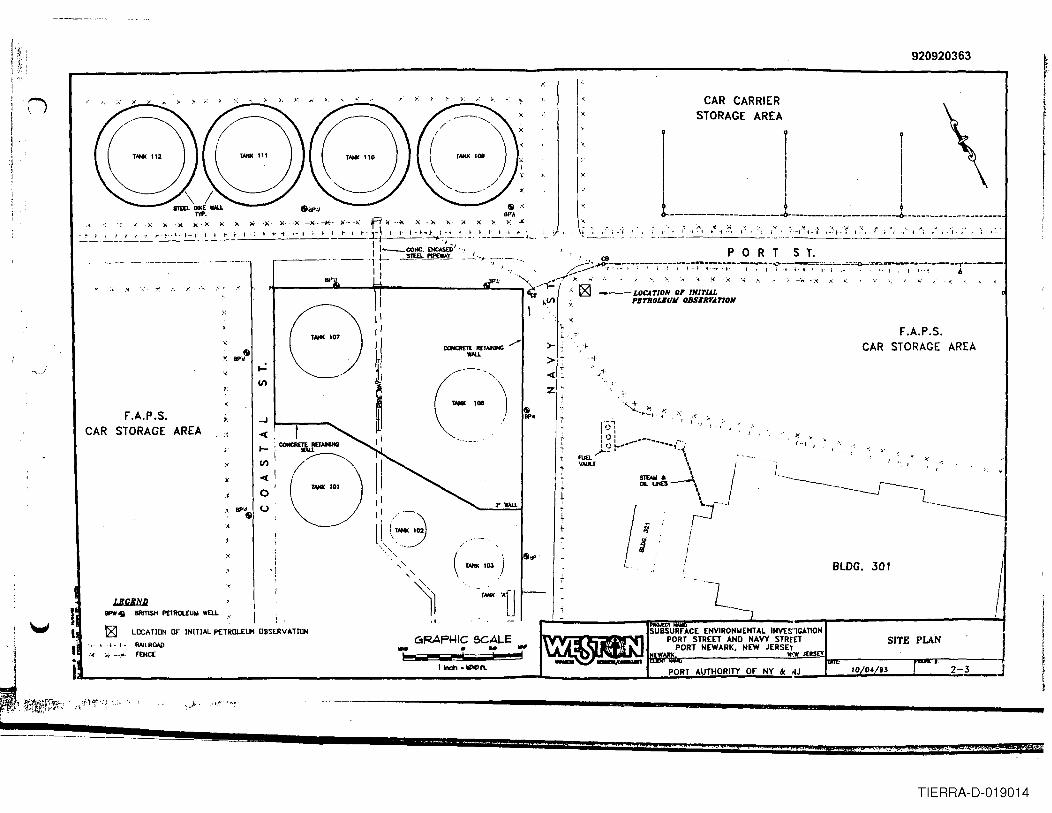
920920363
I",
'" " "
"
0I
:.:I'(,
"
~
&'Y.. BP'd
., ..... -.1 '(~II)
"
n
.<. ~.; , I ., ;. - ~ . I .•. _. t i j-
CAR CARRIERSTORAGE AREA:~
F.A.P.S. ., ...J
CAR STORAGE AREA" ~
I-
" II)
i ~o
,.,IIP'$ U
:<
:r lIAU
",
( ) &..r_ 'OJ
r_ ~D
rI
I I1 ~0---------------------- -- -<>- _
,>
.I I "I • :.;
" , ", "
...'-I~'- " :, : .., t t , 1-:1'· I i I . ; I I
II
'!
P 0 R T S T.
F.A.P.S.CAR STORAGE AREA
\. .-:, '"J ,
" I
T r0iI I:0: ......__..I I) .......... -- ..._,~
ruo. ~_., \VALA.T ,
~uo:s-l. I'\(1'I!
" >,.._, I
rtI
+ /:BLDG. 301
I
Ir
G1AAPI4IC &GALE• NO -e! ! "!l
SITE PLAN
PORT AUTHORITY or NY ac ~J
-I:- 1_._1\.
SUBSURrACE ENV1RONWEHTAl INVESIGAnONPORT STREET AND NAVY STREET
PORT NEWARK, NEW JERSn~I:W J[R$£Y
2-L-
::au. 400 ... PMi.... , #.40:0
TIERRA-D-019014
•
•
•
2.3 SITE HISTORICAL INFORMATION
Historical information on the site was gathered from three sources: a walkthrough with BPfacility and Port Authority personnel, a review of the Port Authority's Engineering DepartmentContract Files, and a review of available NJDEPE record files. Each of these is discussedbelow.
2.3.1 Site Walkthrough
As part of the Site Investigation, representatives of the Port Authority and WESTON visited thesite and the adjacent BP te~~_~~!J1et_,~~~-7".E:~ag~:~r~~· t_~~_~'7'~~~es B.,Guilfoyle. Mr.:Ouilfoyle, who reported diithehasWQrked at the termmal for over 30 years,provided some historical information and site details. Mr. Guilfoyle did not provide referencesfor this information. The infonnation provided by Mr. Guilfoyle consisted of the following:
• The large aboveground storage tank (Tank No. 108), located in close proximity to thesuspected release, had ruptured in 197~.-~ctre1e.ase(f1tSContentS'·into the containment .--basiri~'Thetahk had reportedly stored No. 2 oil<!~J.~~:ta.\~~e Secon~ World War.According to Mr. Guilfoyle, its contents at the time of the release was reportedly No.6 oil. The concrete containment basin's walls (approximately 10 ft. high) are constructedon piles whose top (butt) elevations are approximately 3 to 4 feet below the streetelevation. Coastal reported the release to the NJDEPE. In order to collect and disposeof the oil, the basin was flooded with water to float and skim the oil. The oil was thenrecovered and the water trucked off site. The basin floor was excavated to the watertable and refilled with a clayey soil to reduce penneability. The type and condition ofthe original basin floor's soil is not known. During the walkthrough a "post hole" in thenortheastern comer of the basin, which was dug into the basin's earth floor down to thewater table, was observed beneath a piece of plywood by WESTON and the PortAuthority. Mr. Guilfoyle pointed out that the groundwater could be seen to be free ofany sheen through this hole. He did not comment on the potential impact of the hole onthe basin's containment integrity.
• No. 2 oil is stored in tanks on the northeirf"Sid~ofthelernunar~~;:>thlioHis transferred .across PortStreet ttWugh buried underground pipes to the southern side of the tenninal.'
2.3.2 Review of Available Port Authority En~ineering De,partment Files
WESTON also performed a limited records search of the Port Authority's Engineering Files togain information about other physical structures in the area. Since the Port Authority did notbuild the facility but acquired it approximately 18 years after initial construction, the availableinformation was limited. The information that was obtained consisted of the following:
K(ak)lPOItTAtrrHIPORTNA VY.RPT 2-5
920920364TIERRA-D-019015
•
•
•
• A fuel Dbun~'1.'consistingof several tanks (5SG-gallon and 2.000,.gallon) or a. vault islocated to the south of the railroad track on the eastern side of Navy Street. ThisstrUcture is reportedly registered for fuel,storage:-by~~fNrmy and provides fuelserviceto ..Building,JOl. Neither its present nor historical contents are known .
..••~ •... . -:0..
2.3.3 Review of Available NJDEPE Record Files
On behalf of the Port Authority, WESTON requested a review of available files from thefollowing Departments within the NJDEPE:
• Division of Water Resources.• Division of Responsible Party Site Remediation.• Division of HazardOUSWaste Management.• Office of Legal Affairs.• Metropolitan Bureau of Water and Hazardous Waste Enforcement.• Department of Groundwater Well Permits.
WESTON reviewed files at the Division of Water Resources and Department of GroundwaterWell Permits. Requests for reviews are still pending at the Division of Responsible Party SiteRemediation, Office of Legal Affairs, and the Metropolitan Bureau of Water and HazardousWaste Enforcement.
At the Division of Water Resources, WESTON reviewed the BP/Coastal file (NJPDESNJOO34231) and the General File for Newark/Essex County. At the Department of GroundwaterWell Permits, WESTON reviewed the well installation records. There was no me on recordfor BP/Coastal at the Division of Hazardous Waste. Information copied from the files isprovided in this Report as Attachment 1, located in front of Appendix A in this Volume. Thefollowing is a summary of the information obtained from the reviews.
• Division of Water Resources
• Coastal had submitted three revised DPCC/DCR Plans to the NJDEPE between1979 and 1981. The newest revision in the file, dated August 4, 1981, includedthe following statement, "Facility has experienced one reportable discharge in lastyear. Incident reported as required ... "
• A Summary Report on the facility DPCC/DCR Plans, prepared by Surya Shahof the Bureau of Industrial Waste Management, s~~l1g._"~:DtiS-faci.litY~waspurchased from Coastal Oil Company in October19~9 ....in1979, under differentownership;'there waf a. 4 million gallon ~fuel'oil "spiil." The file did not containinformation to determine the source of information used by Mr. Shah for hisSummary Report .
K(IIt)IPORTA trrHIPORTNA VY .RPT 2-6
920920365TIERRA-D-019016
•
•
•
~ .• Information in the DPCC/DCR Plans indicated that Tank No. 108 has a volume
of approximately 4,000,000 gallons, and that it stored No.4 fuel oil around thetime of the release.
• Letter from W.C. Myers (BP North America Trading) to the NJDEP, dated 13April 1983, advising NJDEP that the Coastal Oil Company, which was a divisionof BP North America Trading, Inc. has been sold to cac Corp ... ownership andresponsibility for the Port Newark Terminal, which has been known as theCoastal Oil Company, Port Newark Terminal will remain with BP North AmericaTrading, Inc."
• Letter from Paul C. Kurisko (NJDEP) to Mr. C. Guilfoyle (BP) dated 8 June1987 regl:lrding the facility's Final NJPDES-BMP Modification DPCC/DCR PlanNJOO34321. This letter granted permission to BP to implement DPCC/DCRPlans submitted September 1984 (not in file) along with a Best ManagementPractices (BMP) submitted in letter format 27 May 1986. With this Modification,12 additional Special Conditions were stipulated, two of which require:
I) A study of the permeability of the soils within the diked areas Within3 months ... to also determine the depth of the groundwater ... and shallstate whether or not the liner is impermeable as defined underN.J.A.C. 7:1E-4.2. Waterflooding may not be used in place of animpermeable lining.
2) A plan and schedule to bring all diked areas into compliance with theN.J.A.C. 7: IE regulations.
• The file did not appear to contain information answering these requirements.
• DWartment of Groundwater Wells
• Well construction logs for 17 shallow (each 11 feet deep) groundwater monitoringwells installed for British Petroleum Co. by Handex Corp. in November 1986.Exact coordinate locations were not given with the logs.
2.4 PORT NEWARK GEOWGY AND HYDROGEOWGY
The Port Newark Geology described in the following section is based on information providedby the Port Authority Engineering Department and work previously performed at the site. PortNewark was built over a tidal marsh deposit consisting of very weak and compressible organicsilts and peats extending from about mean high water to a depth of 10 to 30 feet. The organicdeposits are generally underlain by a medium dense, fine grained sand or silty sand with a
III:(DkllPORTA UTHIPORTNA VY.RPT 2-7
920920366TIERRA-D-019017
•
•
•
thickness of five feet or more. Below the sand are glacial lake deposits and bedrock. Theglacial lake deposits consist of reddish-brown silts and clays, frequently varved. Bedrock is soft,red shale, and occurs at depths ranging from 40 to 100 feet.
The site location and surrounding area are essentially flat, with elevations between 307.8 feetto 303.7 feet. Mean high water elevation in Newark Channel is 300 feet (elevation is referencedto Port Authority datum system). The Port Authority datum is 2.653 feet above mean sea level(0.0 ft.) at the Sandy Hook, New Jersey reference station. The Sandy Hook reference datumis established by the National Oceanic and Atmospheric Administration. National Ocean Service.
Beginning iri1913; the area was systematically filled With dry hydraulic fill. The fill first placedon the tidal marsh was generally dredge soil excavated during the construction of Port Newarkchannel. In certain areas, miscellaneous fill was placed by dumping and spreading on the virgirimarsh.
Subsequent to the initial filling, fine to medium sand was used to fill areas to present grade.Current average elevations at Port Newark range between 303 and 308 feet.
sk(IIt)lPORTA UTHIPORl1'lA VY .RPT 2-8
920920367TIERRA-D-019018
~ .• SECTION 4.0
FINDINGS OF THE FlEW PROGRAM
4.1 OVERVIEW
Forty one borings and six monitoring wells were installed across the Port and Navy Street site.During the subsurface investigation soils were screened visually for stains or saturation bypetroleum products and screened with instruments using an HNu photoionization detector (PID).Petroleum or petroleum residues and odors were observed in twenty-one of the forty-oneborings. For borings where visual observations of suspected petroleum was observed, the HnuPID field screening data, Materials Laboratory TPHC screening reSUlts. and NYTEST analyticallaboratory TPHC results are summarized in Table 4-1. The complete list of HNu PID readings,which are provided in Appendix B, showed readings that ranged from 0 units to 150 units abovebackground with the majority of the readings between 0 units and 10 units above background.
Summary Tables for the soil and groundwater analytical data are provided at the end of Section4.0.
• 4.2 SOIL ANALYTICAL RESULTS
A total of 27 samples were selected and delivered to NYTEST for confirmatory laboratoryanalysis based on visual observations of samples in the field, HNu pro readings, and screeningresults of soils using the Port Authority Materials Department TPHC analyzer, as discussed inSection 3.3. The samples were analyzed for TPHC, volatile organic compounds (VO+ 10),base/neutral/acid extractable compounds (BNA) , and total lead. The following sectionssummarize the finding of the laboratory analyses and compare these findings to NJDEPE soilcleanup criteria. Analytical data packages are provided in Appendix D.
4.2.1 Total Petroleum Hydrocarbon CTPHC)
•
Analytical results indicate that elevated levels of TPHC in soils were observed closest to thecontainment basin wall and decrease with distance away from the containment basin wall.Confirmatory laboratory analysis for TPHC indicated four samples contained TPHC atconcentrations greater than 10,000 mg/kg, with the highest detected concentration being 29,600mglkg (soils containing TPHC at a concentration of 30,000 mg/kg or more are considered to be"saturated" and would be classified as a New Jersey "X series" hazardous waste if disposed of).All four samples were from soil borings located closest to the containment basin wall, asdepicted in Figure 4-1. Since TPHC is one component of "total organic compounds", TPHCresults can be used to make a preliminary delineation of the potential area impacted, as depictedin Figure 4-1 .
K(ak)IPORT AtrrHIPOR1WA VY. RPT 4-1
920920368TIERRA-D-019019
• • •TABLE 4-1
FIELD DATA AND LAB TPHC ANALYSISFOR BORING LOCATIONS IN WlDcn PETROLEUM
OR PETROLEUM RESIDUE WAS SUSPECTED
. 'O.m,dNUM;~.t·••··••.·•······HNJilib.Nbs ~g~At~~~oi.ts~g >Lis~¢~tiLti~B'fkg .B-3 1 unit 91 SNR
B-4 10 unilJ 22 261
B-S 35 unilJ 510 SNR
B-6 50/40 units > 1000 6410
B-1 lSO/SO unill > 1000 29600
B-8 4 units 29 SNR
B-12 0 unill 40S 186
B-l1 50 unill 59 SNR
B-18 35 units 12 261
B-19 ISO unill 48 8530
B-20 35 unill 21 284
8021 2S unitt 414 SNR
B-22 0 unill 6B 324
B-23 10/5 units > 1000 28300
B-21 25 units > 1000 2630
B-31 35 units > 1000 4140
MB-4 50 unill 54 19400
MB-5 lS units > 1000 18000
MB-6 2S units > 1000 2020
M801 IS unita 48 SNR
MB·I0 6 unilJ > 1000 4nSNJ. - Sapk Hal ..80S - Bduw 0r1lUIId SUrf_50140 iDdiclIlaI Radiaa. iD lbc IIfPCI"lIoova pcJIIQa ollbc MlDfIIe.
TIERRA-D-019020
9209203708-28 B-21
8-11~
MHHM~(
UJillJll_ $ BRmSH PETROl£UII WEll.
IIN.I) ~t...~~~lN~R= Wl1Il8-7 ... BORING LOCAllON WHERE
TPHC >10,000 lAG/KG
8-8 $ ro":GIIl;m~ON~~~O.ooo IIG/KG&-'2 ~ BORING LOCATION WHERE
TPHC <1,000 1I0/KG-+-+-+-+- RAIlROAD....-- FENCE
-$~
\,., .....' V)
8-JO
F.A.P.S. ...J
CAR STORAGE AREA 8-~1 <C(
l-
V)
<C(
0- (.)
-, -18
W8-10
~
CONCRrn: REI_ ./'WAll.
2' WAlL
B-2
i
II I I
~ 9 9i>-------------------------i>-. -----------------------i>----------- ---- -------
I
U!!-. ~8
CAR CARRIERSTORAGE AREA
liB ~
~
118-2
CBP 0 R T 5 T.
t- t I I I I I I I I I I I I I
F.A.P.S.CAR STORAGE AREA
GRAFI4IC 5CALE_ tI ....
~ ---' ! I'1nOh ._1'1.
><C(
z
B-22
[lJBLDG. 301
PETROLEUM HYDROCARBONSANALYTICAL RESULTS
iI
!ii!
f11
I'IIOBf .-,SUBSURfACE ENVIRONMENTAL INVESlIGATION
PORT STREET AND NAVY STRE';TPORT NEWARK. NEW JERSEY- 4-1
• I:"-.H
TIERRA-D-019021
•
•
•
An additional seven (7) soil samples exhibited TPHC concentrations between 1,000 mg/kg and10,000 mg/kg. Six (6) of these samples were collected from soil borings located either in closeproximity to the containment basin wall or the BP transfer pipelines which extend beneath PortStreet. The seventh was located next to Tank No. 110, one of the tanks located to the north ofPort Street. Locations of these samples are depicted on Figure 4-1.
The remaining 16 soil samples did not indicate TPHC concentrations above 1,000 mg/kg.
4.2.2 Volatile Organic CVO+ 10) Compounds
VO+ 10 were found to be below the NJDEPE's impact to groundwater soil cleanup criteria.
4.2.3 Base/Neutral/Acid Extractable CBNA) Compounds
During preparation for analysis at NYTEST, 11 of the 27 samples analyzed for BNA compoundswere diluted before analysis such that it was not possible to determine if chemical specific(BNA) soil cleanup criteria were exceeded. While seven of these samples also indicated TPHCconcentrations greater than 1,000 mg/kg, four did not, preventing their use in determiningwhether the soils associated with those four samples exceed NJDEPE soil cleanup criteria.
The presence of elevated concentrations of Tentatively Identified Compounds (TICs) in most ofthe soil samples correlates with the elevated TPHC results.
4.2.4 Total Lead
Analysis for total lead indicated concentrations in soil samples ranged from 13.1 to 796 mg/kg.NJDEPE's proposed impact to groundwater soil cleanup criteria does not currently have a valuefor lead.
These soil analytical results are summarized in Tables 4-2 to 4-4 at the end of Section 4.0.
4.3 SOIL ANALYTICAL RESULTS FOR DIESEL FUEL FINGERPRINT PARAMETERS
Fingerprint analysis indicated that the petroleum hydrocarbons found in the soil samples weregenerally indicative of weathered diesel fuel, or a combination of diesel fuel and fuel oils No.4, No .5, and No.6. These findings are consistent with the types of fuel and oil that were listedin Coastal DPCC/DCR Plans as having been stored at the facility and suggest that thecontaminants in the area probably originated at the terminal. Analytical results for thefmgerprint samples are presented in Appendix E .
K(IIk)/PORTA UTHIPORTNA VY .RIT 4-4
920920371TIERRA-D-019022
•
•
•
4.4 GRQUNPW ATER ANALYTICAL RESULTS
A total of six (6) groundwater samples were delivered to NYTEST for analysis. The sampleswere analyzed for total petroleum hydrocarbons (fPHC), volatile organic compounds (VO+ 10),base/neutral/acid extractable compounds (BNA), and total lead. A summary of analytical resultsis presented in Table 4-5 at the end of Section 4.0. Laboratory analytical data results for thegroundwater samples are provided in Appendix F.
4.4.1 Free Product Determination
A layer (estimated 2 feet thick) of floating free product was observed in the shallow monitoringwell MW-4A, which is located just outside the containment basin wall in proximity to Tank No.108. Evidence of a few inches of free product was independently observed in the shallowmonitoring well MW-5A by the Port Authority, which is also just outside the containment basinwall near Tank No. 108. The presence of free product in these two shallow monitoring wellscorrelates with the apparent subsurface soil depression and contour discussed in Subsection3.2.1, and the apparent direction of flow of the shallow groundwater illustrated on Figure 3-5.
4.4.2 Volatile Organic and Base/Neutrall Acid Extractable Compounds
The analytical results indicated the presence of benzene in the deep monitoring well MW-4B andbis(2-ethylhexyl)phthalate in the shallow monitoring well MW-4A at concentrations exceedingpromulgated NJDEPE Class ll-A groundwater cleanup standards for the respective compounds.
The analyses also indicated the presence of methylene chloride in all shallow well groundwatersamples at estimated concentrations greater than the groundwater cleanup standards for thatcompound. Also detected in the laboratory (method blank) QA/QC sample, methylene chloridein the method blank indicates that this compound appears to be present as a laboratory artifactin the samples. In addition, the presence of 2-propanone (acetone) in the method blank indicatesthis compound appears to be present as a laboratory artifact in the samples collected from theshallow groundwater monitoring wells MW-I, MW-2, MW-3, MW-4A. and MW-5. Table 4-6,at the end of Section 4.0, summarizes the abbreviations and data qualifiers used in Tables 4-2through 4-5.
No other regulated volatile organic compounds or BNA compounds or floating free product weredetected.
4.4.3 Tentatively Identified Compounds
In both VOA and BNA analyses, TICs were reported at various concentrations .
It(aItlIPORTAtmIIPORTNAVY.RPT 4-5
920920372TIERRA-D-019023
•
•
•
4.5 ANALYTICAL DATA VALIDATION
The analytical data obtained from NYTEST was reviewed using data validation procedurespublished in eLP Organics Data Review and Preliminary Review - SOP No. HW-6, RevisionNo.8, USEPA Region IT, 1992. The findings of the review, which could potentially impactdirect use of the data are as follows:
4.5.1 Soil Samples
• The elevation of practical quantitation levels (PQLs) reported for samples B31 S2, B7 SIA,and MB5 S 1 were due to a 1:5 dilution of the samples before analysis.
• Although methylene chloride and acetone were detected in some soil samples, theirconcentrations were less than 10 times those corresponding concentrations detected in themethod blanks and/or the associated field blanks. As a result, the sample results werequalified as not detected (flag = u) at the reported concentrations. For the same reason,toluene was qualified as not detected at the appropriate PQLs, being corrected for the percentmoisture.
• Target compound 2-chloroethyl vinyl ether was not analyzed for in the soil samples .
• NYTEST had difficulty concentrating the extract from two soil samples, MB-6 S 1 and MB-lS1. These were analyzed at a final volume of 10.0 ml. The samples were subsequentlyanalyzed at a 1:4 dilution resulting in a final dilution of 1:40 and elevated quantitation levelsof 15,000 ug/kg and 20,000 ug/kg, with a correction for the percent moisture, respectively.
• With the exception of samples MB-6 SI and MB-l S2, all samples show BNA contaminantsat various concentrations.
• Samples for which estimated "J" values were reported may have contained analytes ofconcern in concentrations exceeding regulatory criteria but may not have been quantifiedbecause most of the soil samples were analyzed at 1:2 dilution. If the quantitation levels hadnot been corrected for the dilution factor, many of the BNA compound concentrations mayhave exceeded the uncorrected quantitation levels and would not have been reported asestimated "I" concentrations.
4.5.2 Groundwater Samples
• Although methylene chloride and acetone were detected in some samples, their concentrationswere less than ten times those in the method blank. As a result, all the methylene chlorideresults were qualified as not detected at 5 ug/L (5u). With the exception of sample MW-4B,the acetone results were qualified as not detected at 10 ug/L (lOu) for MW-5 and notdetected at the concentration reported for MW-I, MW-2, MW-3 and MW-4A .
*<DklIPORT A UTHIPORTNA VY .RPT 4-6
920920373TIERRA-D-019024
•
•
•
~.• NYTEST did not analyze for 2-chloroethyl vinyl ether, a target compound in Method 8240.
• NYTEST noted that crystals were formed during the extraction of sample MW-2 but did notprovide an explanation as to their cause. This finding might have caused the low surrogaterecoveries « 5 %) in the sample analysis. Due to the low recoveries, the reported non-detects should be considered unusable (R).
a(IIII:)IPOllT AUTH!POIlTNA VY .RPT 4-7
920920374TIERRA-D-019025
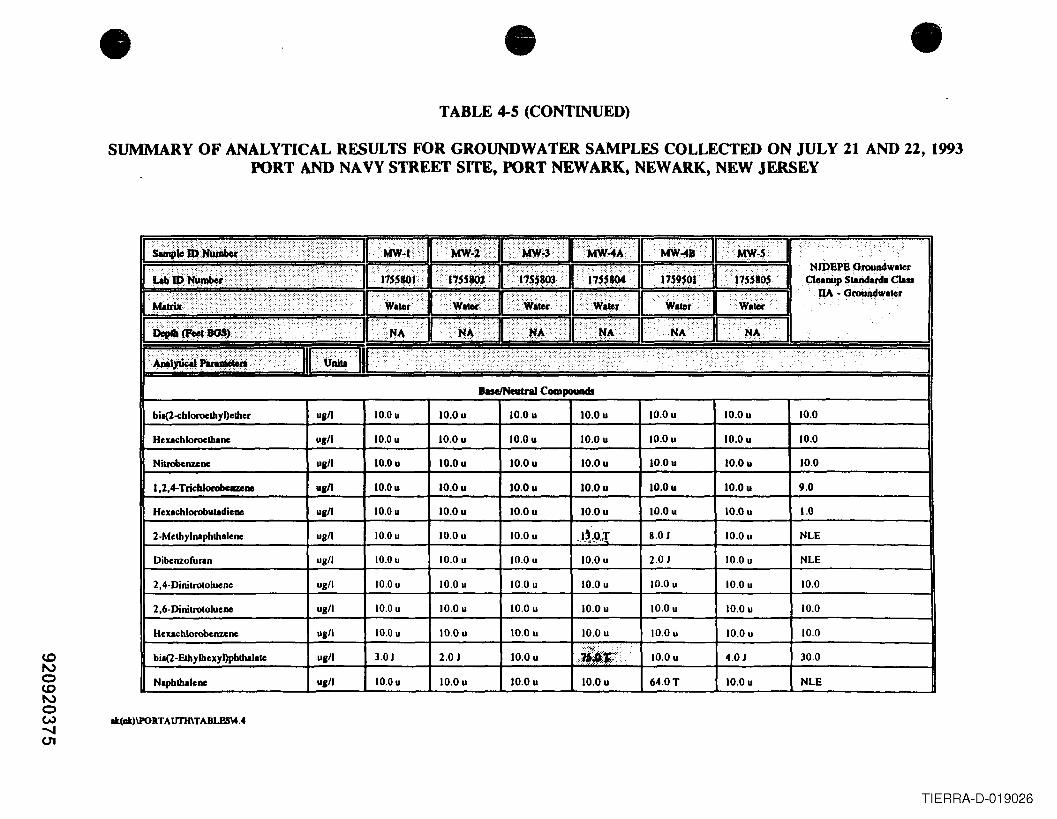
• •TABLE 4-5 (CONTINUED)
•SUMMARY OF ANALYTICAL RESULTS FOR GROUNDWATER SAMPLES COLLECTED ON JULY 21 AND 22,1993
PORT AND NAVY STREET SITE, PORT NEW ARK, NEWARK, NEW JERSEY
hseINeatraI Compouads
bil(2-e:bloroethyl)cthcr u,11 10.Ou 10.Ou 10.Ou 10.Ou 10.0 u 10.Ou 10.0
Hexachloroethane UIII 10.Ou 10.0 u 10.Ou 10.Ou 10.Ou 10.0 u 10.0
Nitrobenzene u,11 10.0 u 10.Ou 10.Ou IO.Ou 10.Ou 10.0 u 10.0
1,2,4- Tricblorobeazc .. u,1I 10.Ou 10.Ou IO.Ou 10.Ou 10.Ou 10.Ou 9.0
HexachlorobUladicne UIII 10.Ou 10.Ou 10.Ou IO.Ou 10.0 u 10.0 u 1.0.
2-MethylDllphthalenc UI" 10.0 u 10.0 u 1O.0u JtO.:r 8.01 10.0 u NLE
Dibenzofuran UI/I 10.0 u 10.0 u 10.0 u 10.0 u 2.0 J 10.0 u NLE
2,4-Dinilrololuene ugll 10.0 u 10.0 u 10.0 u 10.0 u 10.Ou 10.0 u 10.0
2,6-Dinilrololuene UI/I 10.0 u 10.0 u 10.0 u 1O.0u 10.Ou 10.Ou 10.0
Heuchlorobcnz.ene ugll IO.Ou 10.Ou 10.0 u 10.0 u 10.Ou 10.0 u 10.0-:;':.~:.:-..:... :.::
(0 bil(2-Etb Ylhexyl)pbthalate u,/l 3.0 J 2.0 J 10.0 u .:»A~"· 10.0 u 4.01 30.0f\)0 Napbthalene uI/1 IO.Ou 10.Ou 10.Ou 10.Ou 64.0T 10.Ou NLE(0f\)0W *(at)\PORTAtrrH\TABLI!S\4.4.......01
TIERRA-D-019026
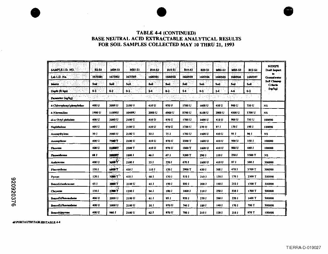
• • •TABLE 4-4 (CONTINUED)
BASE NEUTRAL ACID EXTRACTABLE ANALYTICAL RESULTSFOR SOIL SAMPLES COLLECTED MAY 10 THRU 21,1993
"., -: '"., ... ,., ...... : .<, ....... .:.;,'.; ..<::::::::::: ::.</Y: .. . ::> ..:..... ' ..
s~tD.~().······> .... ::::::/:,:>:::(y) ....
i~.sl'. .. NJDEPfi
MlM-SI MRS-SI ..• Bi~2 BIJ:SF BI9,S2 • mO-sl adll.S2 MOJ.S) BIl·SI Drtlft Jma-ct·1JIbJ.D.~o. 1613101
..
laO,OJ...... 10
16'ij802 161310i I68OJOf 1680302 1680304 '168030; 1680s06 1680307" GrouIadW1llaf......
"" .. >/:. :':,'::';-.-:' SoOt· . ···SoIl}· $oil V iIoa>······ >r: . SoUCIeiMup
MItria SOil· sOu SolI ..•. SoU Soil SoU C....
I.·~(t\ ...)· o-~, .••... :..•........•....... :.:...... c.-l·····.···· ':: ... c.-Z. ....( .. .. : . (~0-1 ..· ...• i~ H 0-7- 2;.4 4-6 ~7-
~(~a/q) .:.....:...•:...> ...•••••..•. ..' .......... " ........ :... :.: ......... ...>: ....•.•:... .. .:. •• .... ··r .: '.
. '.. ...... .
4-CbIoropbeayi JlI-yW- 400U 2000U 2100U 410U 970U 1700U I600U 410U 900U 730U NS
4- NitroouUliDe 1900U IJOOOU 10400U 2000U 4900U B700U BlooU 2000U 4500U J700U NS
di-a·OctyI pbdIaJaIe 400U 2000U 2100U 410U 970U 1700U I600U 410U 900U 730U 100000
Nophlbabe 400U 14001 2100U 410U 970U 1700U 270U 971 1701 190 I 100000
AcaI8J'lhy Ieac 30 I 2000U 2100U 301 751 1700U I600U 410U 931 961 NS
Ao-Mpehme 400U 1,.T 2100U 410U 970U 2500T I600U 410U 900U ]sOl 100000
AIorrae 400U 8."'- :nClOT 410U 970U lBOOT I600U 410U 900U 4401 100000
..........- 611 2OOC!ft IBOOI 461 67 I 3200T 2901 ltOI nOI 3500T NS
AaIbnca>e 400U J6liOf'-' 21001 2S1 2201 6701 1600U 410U B7J SBOI sooooo".""'.
AuorulbeDe nOI ~T" 4S01 ltOI 1201 2900T 4S01 3001 4701 J700T sooooo-.:'. ~ ~_.'. ;:.r
1')''''- 1201 JOOOT'·' 4201 601 IJOI BIOI 2101 IJOI nOI 2SOOT sooooo~', J .
Bmzo(.)aIIIlInc:aIe 6SJ :zoDOT 2100U 6S1 1901 BIOI 2001 1401 2101 nOOT sooooo
CluyaaIc nOI rIOIiif: 12001 941 IBOI 14001 JIOI 2S01 3301 1700T sooooo
Bmzo(b)Ruona'" 400U 2000U 2100U 61 I 951 9201 2701 2601 2201 1400T soooooBawJ(k)tJuot.dwao 400U 2000U 2100U SBJ 970U 74QI lBOI 14QI 1701 7BOT soooooa-o<aJpynDe 400U 9BOI 2100U 621 970U 7BOI 2101 1201 2101 970T 100000
*\PORTAU11I\TABUlS\TABLB.4-4
TIERRA-D-019027
•FINAL
TECHNICAL SUPPORT DOCUMENTFOR THE CLASS II-B
GROUNDWATER RECLASSIFICATION PETITIONELIZABETH PORT AUTHORITY MARINE TERMINAL
FEBRUARY 1998
Prepared for:
• ENGINEERING DEPARTMENTPORT AUTHORITY OF NEW YORK AND NEW JERSEY
One World Trade Center - 72nd FloorNew York, New York 10047
Prepared by: 8BA000004ROY F. WESTON, INC.Raritan Plaza III - Suite 2B
101 Fieldcrest AvenueEdison, New Jersey 08837
W.O. No. 02527-050-002-0001
•920920390
TIERRA-D-019028
•
•
•
TABLE OF CONTENTS
SECTION TITLE PAGE
ES EXECUTIVE SUMMARY ES-1
1.0 INTRODUCTION 1-1
1.1 Background 1-11.2 Site Setting and History 1-11.3 Hydrogeologic Setting 1-21.4 Horizontal and Vertical Limits of the Petition Area 1-41.5 Potential Receptors 1-4
2.0 INDUSTRY-SPECIFIC INFORMATION 2-1
2.12.2
Parties Included in the Petition 2-1Sources of Pollution 2-12.2.1 Environmental Database Search 2-22.2.2 Port Authority File Review 2-5
2.2.2.1 EWR 2-52.2.2.2 EPAMT 2-8
3.0 LAND AND WATER USE 3-1
3.1 Area History 3-13.2 Area Land Use 3-13.3 Groundwater Use 3-23.4 Surface Water Use 3-2
4.0 HYDROGEOLOGIC AND HYDROLOGIC SETTING 4-1
4.1 Geology and Hydrogeology 4-14.1.1 Regional Hydrogeology 4- I4.1.2 Local Hydrogeology 4-2
4.1.2.1 Historic Fill 4-24.1.2.2 Meadow Mat 4-34.1.2.3 Middle Sand 4-34.1.2.4 Silt and Clay 4-44.1.2.5 Bedrock 4-4
az\wp\Pn _auth\Nj_ marin\ Techsupt.doc 08106198
920920391TIERRA-D-019029
•
•
•
T ABLE OF CONTENTS (CONTINUED)
SECTION TITLE PAGE
4.1.3 Groundwater Movement in the Unconfined Historic Fill 4-44.1.4 Estimation of Groundwater Flow Parameters 4-64.1.5 Estimation of Dilution Rates 4-7
5.0 GROUNDWATER QUALITYfNATURAL ATTENUATION 5-1
5.1 Groundwater Quality 5-15.2 Geostatistical Analysis of the Probability of Groundwater
Contamination 5-25.2.1 Overview 5-25.2.2 Data 5-35.2.3 Structural Analysis 5-3
5.2.3.1 Variograrnming 5-35.2.3.2 Anisotropy 5-45.2.3.3 Composite Spatial Correlation 5-4
5.2.4 Probability of Groundwater Contamination 5-45.2.5 Area of Groundwater Contamination 5-4
5.3 Natural Attenuation Processes 5-55.3. I Biodegradation 5-55.3.2 Rates of Attenuation 5-6
5.3.2.1 Petroleum Hydrocarbons 5-65.3.2.2 Inorganics 5-7
6.0 IMPACT OF GROUNDWATER ON RECEPTORS 6-1
6.1 Potential Groundwater Receptors 6-26.1.1 Waterways 6-2
6. I .1. I Peripheral Ditch 6-26.1.1.2 Newark Bay 6-3
6.1.2 Wetland Areas 6-56.2 Potential for Bioaccumulation 6-66.3 Potential for Metals Uptake into Plants 6-66.4 Discussion of Existing Sediment and Water Quality
at Each Receptor 6- 7
az\wp\Prt _auth\Nj_ marin\ Techsupt.docII
OIV06I98
920920392TIERRA-D-019030
•
•
•
TABLE OF CONTENTS (CONTINUED)
SECTION TITLE PAGE
6.4.1 Peripheral Ditch 6-76.4.2 Newark Bay 6-8
6.4.2.1 Surface Water Quality 6-86.4.2.2 Sediment Quality 6-9
6.4.3 Wetlands 6-11
7.0 DEMONSTRATION OF THE FIVE NJDEP CHARACTERISTICSFOR CLASS lIB 7-1
7.1 Characteristic No.1 - Groundwater Quality Exhibits ExtensiveExceedances of Groundwater Quality Criteria as a Resultof Past Discharges 7-1
7.2 Characteristic No.2 - Aquifer Restoration Cannot Be AchievedUsing Technologically Practicable Means 7-2
7.3 Characteristic No.3 - There Are or Will Not Be Any Potable Usesof the Proposed Aquifer 7-3
7.4 Characteristic No.4 - No Significant Risk of Pollution .Migration Into Class I, II-A, or III-A Areas 7-4
7.5 Characteristic No.5 - Natural Attenuation Can be Relied on toRestore Groundwater Quality for Criteria Identified Pursuantto Characteristic No. I 7-47.5.1 Natural Attenuation Processes 7-47.5.2 Types of Contaminants Having the Potential
to Reach Receptors 7-57.5.3 Potential for Bioaccumulation 7-57.5.4 Potential for Metals Uptake into Plants 7-57.5.5 Wetlands 7-6
8.0 REFERENCES CITED 8-1
az\wp\Pn_auth\NLmarin\Techsupt doc111 08106/98-
920920393TIERRA-D-019031
•
•
•
~\A/~U~
FIGURE
1-11-22-13-13-23-34-14-24-34-44-55-15-25-35-45-55-65-75-85-96-1
PLATE
12
TABLE OF CONTENTS (CONTINUED)
LIST OF FIGURES
TITLE
Proposed Reclassification Area LimitsGeneralized Petition .-\rea Stratigraphic ColumnTerminals A & B Free Product PlumesLandfill Areas on Newark Airport PropertyLandfills, Known Contaminated Sites and Free-Phase Product PlumesLand Use ClassificationBedrock Elevation Contour MapPleistocene Sediment Thickness Contour MapGeologic Cross-SectionsMap of Glacial DepositsShallow Groundwater Elevation Contour MapSample Directional Variogram for the First Correlation StructureSample Directional Variogram for the Second Correlation StructureRose Diagram for the First Correlation StructureRose Diagram for the Second Correlation StructureComposite Spatial Correlation PatternGeostatistical Contour Map of the Probability of Groundwater ContaminationContour Map of Deviations in the Geostatistical Map from the Original DataProportion of Area Likely to Be ContaminatedProbability of Groundwater Contaminated Above Groundwater Quality StandardsWetland Map
LIST OF PLATES
TITLE
Newark Airport Site PlanNew Jersey Marine Terminal Site Plan
az\wplPn _.uthlNj_ mannlT celuupulocIV 08105198
920920394TIERRA-D-019032
•
•
•
TABLE
2-12-22-32-42-55-1
6-1
6-2
TABLE OF CONTENTS (CONTINUED)
LIST OF TABLES
TITLE
List of Tenants - EWRList of Tenants - EPAMTEnvironmental Database Search ResultsKnown Contaminated SitesEnvironmental Database Search Results for Nearby FacilitiesPetition for Groundwater Reclassification, Port Authority of NY INJ, Summary ofAnalytical DataComparison of Groundwater Quality Data with Surface Water Quality Data fromNewark BaySummary of Sediment Sampling Results for Newark Bay Adjacent to theProposed Reclassification Area
azlwplPn _authINj_ mann\ T«h,upuloc v 08105198
920920395TIERRA-D-019033
•
•
•
Appendix AAppendix BAppendix CAppendix D
Appendix E
Appendix F
az\wp\~n _auth~""ILJmJin\ Techsupc.doc
TAB~ E OF CONTENTS (continued)
LIST OF APPENDICES
EDRMapNJDEP Letter on Historic FillWell LogsEcological Communities Potentially Affected by the Class II-B GroundwaterReclassificationBioaccumulation Potential of Groundwater Contaminants of PotentialConcernSediment Concentration Plots of the NYINJ Harbor Estuary from the Battelle(1992) and NOAA (1995) Studies Petition for Groundwater ReclassificationPort Authority ofNYINJ
VI 08/05198
920920396TIERRA-D-019034
•
•
•
EXECUTIVE SUMMARY
The Port Authority of New York and New Jersey (Port Authority) is filing a petition to reclassifyshallow groundwater beneath the area occupied by Newark International Airport (EWR) and theElizabeth Port Authority Marine Terminal (EPAMT). This petition has been prepared inaccordance with the provisions of the New Jersey Administrative Code (NJ.A.c. 7:9-6). Thepetition seeks to amend NJ.A.C. 7:9-6.5 and designate the shallow groundwater beneath theproposed reclassification area as a Class II-B Classification Area. This will change the shallowgroundwater in the reclassification area from a Class II-A to a Class II-B designation.
The proposed reclassification area occupies the former Newark Meadows. The area is boundedon the east by Newark Bay, on the north by the New Jersey Turnpike Extension and Interstate78, and on the west by State Highway Routes 1 and 9. To the south the area extends just beyondthe southern extent of EPAMT. Intense industrial development has occurred in thereclassification area since the 1920s. Industrial development of the area has included, and for themost part required, the placement of fill materials over the natural marsh deposits of the NewarkMeadows. The nature of historical fill material placement in this area has varied widely fromcontrolled structural soil fill placed for foundation support, to municipal waste landfillingactivities, to miscellaneous construction and demolition debris disposal.
Placement of fill over the natural marsh deposits has caused the formation of the shallowgroundwater-bearing zone for which this petition is being filed. The shallow groundwater occursas a thin low-yielding saturated zone within the man-placed historic fill. The shallowgroundwater saturated zone is less than 10 feet thick. Because the unit was created by the fillingof the former Newark Meadows, the underlying marsh deposits, or meadow mat, provide a fine-grained low-permeability bottom for the shallow groundwater throughout the reclassificationarea. This low-permeability bottom serves to hydraulically isolate the historic fill fromsurrounding and underlying water-bearing units.
The shallow groundwater-bearing zone is a thin saturated zone that is not capable of producingsignificant or economically viable quantities of water by pumping from wells. The accumulationof the groundwater in the miscellaneous fill has also had an impact on the quality of the shallowgroundwater, particularly in comparison to the groundwater that occurs in the surroundingnatural geologic formations. The inherent impact of the historic fill materials, combined withimpacts from other industrial activities conducted if! llle area such as bulk fuels storage andhandling, has caused the shallow groundwater to not meet the New Jersey Department ofEnvironmental Protection (NJDEP) Class II-A Groundwater Quality Standards (GWQSs) on anareawide basis. These conditions create a hydrogeologically unique regime, which meets therequirements for reclassification to a Class II-B area.
az\wp\Pr1_ :Juth\N j _nwin\ T echsupl ,doc ES-I OI!lO~198
920920397TIERRA-D-019035
•
•
•
Class II-B groundwater is defined as groundwater thz.t has little or no current use or potential usein the foreseeable future, has widespread exceedance of the NJDEP Class II-A GWQSs such thatcurrent remedial technologies are insufficient, and has a minimal potential to impactdowngradient receptors. Existing hydrogeologic data demonstrate that the shallow groundwater-bearing zone beneath the area occupied by EWR and EP AMT and· contiguous lands, meets therequirements for reclassification. NJDEP-published guidance for Class II-B groundwaterreclassification identifies five areawide characteristics that must be demonstrated. Each of thefive characteristics required for reclassification are stated below along with a summary of theexisting conditions that demonstrate each characteristic.
1. Groundwater Quality Exhibits Extensive Exceedances of One or More of the GroundwaterQuality Criteria as a Result of Past Dischar~es
• Existing shallow groundwater quality data irom 218 wells in the reclassification areawere compiled from available reports. These data have indicated numerous exceedancesof the Class II-A GWQSs throughout the reclassification area. Geostatistical analysis ofthe existing data demonstrated that within 80% of the reclassification area there is agreater than 80% probability of encountering groundwater contaminated above NJDEPClass II-A GWQSs .
• Furthermore, in the course of filling the Newark Meadows, municipal wastes,construction and demolition debris, industrial wastes, and dredge spoils have beendisposed of in the area of reclassification, creating a source of areawide shallowgroundwater contamination. These fill deposits have been recognized as having impactedthe shallow groundwater in the reclassification area.
2. Groundwater Restoration Cannot Be Achieved Using Technolo~ically Practicable Means
• Due to the large area that has been affected (approximately 10 square miles), remediationis not technically or financially feasible. The low hydraulic conductivity and thinsaturated zone cause the shallow groundwater to have poor yield characteristics. Thepoor yield characteristics greatly inhibit and limit the effectiveness of conventionalgroundwater recovery and treatment systems, hydraulic control stations, bio-augmentation technologies, or other active remediation methods. Therefore, theapplication of currently available remedial approaches is technically impracticable andeconomically infeasible. For example, a remediation system based on groundwatercollection from well points may require 550,000 well points and may cost $275 million.
• The reclassification area is underlain by historic fill, which includes construction anddemolition debris, trash from former municipal landfills, industrial wastes, and dredgespoils. Both of these are sources of contamination, especially inorganic compounds .
az\wp\Pn _ aulh\NL marin\ T echsuptdoc ES-2 08/05198
920920398TIERRA-D-019036
•
•
•
Although an exact estimate of the volumes of the demolition debris and trash does notexist, the debris and trash underlie most of the 10 square miles of the reclassification area.Consequently, a remedial approach such as excavation and treatment or disposal, orcontainment and stabilization are technically and financially impracticable, because theywould require excavation or some form of in-situ or ex-situ treatment of almost the entire10 square miles of reclassification area.
3. There Are or Will Not Be Any Potable Uses of the Groundwater for Reclassification
• No public community supply wells or zones of contribution for such wells exist withinthe proposed reclassification area. All potable water used in the proposed reclassificationarea and surrounding region is imported from off-site. There are no registered productionwells within the limits of the proposed reclassification area.
• The potential use of the historic fill as a future potable water supply is not anticipated.Saltwater intrusion into the bedrock aquifer from historic overpumping has rendered thebedrock aquifer unusable beneath and around the proposed reclassification area.
• The Port Authority, which operates in most of the reclassification area, does not have anyplans to develop the shallow groundwater resources or to require the future use ofgroundwater in the area. Both the City of Newark and the City of Elizabeth are suppliedby surface water, originating outside the region. Neither city plans to developgroundwater resources. Both cities indicated that they have adequate capacity fromexisting surface water sources for the next 25 years.
4. No Significant Risk of Pollution Migration into Closs 1. II-A. or III-A Areas
• There is no risk of pollution migration to an aquifer of higher water quality. Theunderlying middle sand and bedrock groundwater are isolated from the historic fillgroundwater by the meadow mat and silt and clay layers. In addition, because thereclassification area is situated along Newark Bay in a regional discharge zone, thegroundwater flow gradients will be upward from the deeper aquifers to the shallowgroundwater. The upward flow gradients further preclude migration into the underlyingmiddle sand and bedrock. There are no Class I, II-A, or III-A areas between thereclassification area and where the shallow groundwater discharges into Newark Bay.
5. Natural Attenuation Can Be Relied on to Restore Groundwater Quality for Criteria IdentifiedPursuant to Characteristic No. 1
• The organic contamination consists of low levels of petroleum hydrocarbon compounds,which have been demonstrated to be readily biodegradable and amenable to natural
ES-3 08105198
920920399TIERRA-D-019037
•
•
•
attenuation. Whereas inorganic contaminants do not biodegrade, they will be adsorbedonto the soil matrix. Soil/water partitioning coefficients and solubility data for theinorganic contaminants of concern indicate that these analytes are generally moderatelymobile to immobile and have a moderate to high affinity for soils. Because groundwaterflow gradients are exceedingly low, most of the dissolved-phase contaminants areexpected to be adsorbed or biodegraded before reaching the discharge zone.
• The contaminants of concern are arsenic, cadmium, chromium, lead, and benzene,toluene, ethylbenzene, and xylenes (BTEX) compounds. The analysis of the migrat;onpotential of the contaminants of concern indicates that the dissolved organic compoundswill degrade and the inorganic compounds will be immobilized before the groundwaterdischarges to Newark Bay. It is estimated that the dissolved contaminant concentrationswill attenuate to undetectable levels within a 20-year time frame. Within 20 years thegroundwater will have traveled a total distance of only 20 feet. Furthermore, a 50,000-times dilution is estimated for groundwater discharging into Newark Bay surface water.At this rate of dilution, any contaminants that reach the surface water will have no effecton surface water quality .
az\wp\Pn _ llut.h\NL marin\T echsupI.doc ES-4 08l0~198
920920400TIERRA-D-019038
•
•
•
~. ','-VJ~U~
SECTION 1.0
INTRODUCTION
1.1 BACKGROUND
On behalf of the Port Authority of New York and New Jersey (Port Authority), Roy F. Weston,Inc. (WESTON®) has prepared t~is report to provide the technical background in support of thereclassification petition for the shallow groundwater beneath the Newark International Airport(EWR) and the Elizabeth Port Authority Marine Terminal (EPAMT) from Class II-A to Class II-B. This reclassification area occupies the former Newark Meadows and has undergone intenseindustrial development since the 1920s.
As a result of industrial activities, shallow groundwater beneath EWR and EP AMT does notmeet the New Jersey Department of Environmental Protection (NJDEP) Groundwater QualityStandards (GWQSs) for Class II-A Groundwaters (February 1993) on an areawide basis. Inaccordance with the provisions of the New Jersey Administrative Code (N.J.A.c. 7:9-6), the PortAuthority is petitioning NJDEP to reclassify the shallow groundwater in this area from Class II-A to Class II-B. Class II-B groundwater is defined as groundwater that has little or no currentuse or potential use in the foreseeable future, has widespread exceedances of the NJDEP Class II-A GWQSs such that current remedial technologies are insufficient, and has a minimal potentialto harm downgradient receptors. The Port Authority believes that the area occupied by EWR andEP AMT meets the requirements for reclassification. This report discusses, in detail, thejustification for meeting these requirements.
1.2 SITE SETTING AND HISTORY
The proposed reclassification area is located in a heavily industrialized area of Newark, EssexCounty and Elizabeth, Union County, New Jersey. The area is occupied mostly by EWR andEP AMT. Other features that overlie the area include portions of U.S. Routes I and 9 and theNew Jersey Turnpike. The area is bordered by Newark Bay to the east, the New Jersey TurnpikeExtension and Interstate 78 to the north, and State Highway Routes I and 9 to the west, andextends just beyond the southern extent of EPAMT to the south. Industrial, commercial, andresidential areas of the cities of Newark and Elizabeth lie beyond the western and southernboundary, respectively. The proposed reclassification area occupies approximately 10 squaremiles. Figure 1-1 presents an area location map.
EP AMT, which includes Port Newark and Port Elizabeth, is a waterfront terminal developmentlocated on the western shore of Newark Bay. The facility consists of approximately 930 acres ofproperty that includes wharves, deep-water ship berths, transit sheds, open storage areas,
az\wp\Pn _auth\N j _marin\ Tt'Chsupl.doc 1-1 08105198
920920401TIERRA-D-019039
•
•
•
distribution buildings, specializec r1cilities, and railroad tracks. Port Newark was opened by theCity of Newark in 1915. The City of Newark leased P011 Newark property to the Port Authoritybeginning on 27 March 1948. The adjacent United States Naval Industrial Shipyard wasacquired by the Port Authority in 1963 and is included in the leasehold. Construction ofadditional berths and related paving in the Naval Shipyard area began in 1971 and wascompleted in 1978. The Port Authority also developed the southern portion of the Port Newarkfacility along a channel that adjoins the Port Elizabeth facility. This developed area is alsoincluded in the reclassification area.
The EWR complex is comprised of paved surfaces (roads, runways, and parking lots), buildings,and support structures covering approximately 2,200 acres. The portion of EWR that falls withinthe County of Essex is under a lease with the City of Newark; the remaining portion (in UnionCounty) is owned by the Port Authority. Current functions of the structures at the airport includepassenger terminals, maintenance garages, storage areas, aircraft hangars, .::hicle and aircraftmaintenance facilities, aircraft fuel storage facilities, air cargo areas, and ancillary facilities.
The City of Newark built EWR in 1928. Construction began on the initial 68-acre unit in 1927,which included a 1,600-foot asphalt-topped runway and a hangar. In 1935 a new administrationbuilding was built, and after modifications for passenger use, the airlines transferred theiroperations to it. During the 1940s and World War II, the runway and other facilities were furtherexpanded by the military. In 1967, an ambitious expansion program was initiated, whichincluded the construction of new runways, passenger terminals, and parking and supportfacilities.
Prior to the construction of the EPAMT and EWR facilities (and features such as the New JerseyTurnpike and Route I), the area was occupied by a salt marsh. The "bleak marshland" wasprogressively "reclaimed" by filling with debris and refuse. The Mosquito Control Commissionwas instrumental in the filling of the salt marshes in Essex and Bergen Counties. Landmanagement practices of the time encouraged the draining of the marsh, application of oil tostagnant water pools to kill mosquito larvae, and the Illtimate filling of the marsh with demolitiondebris, industrial wastes, and trash to create land for industrial development. Large portions ofboth EPAMT and EWR tracts were utilized for municipal and industrial waste disposal.Dredging spoils from the adjacent harbor were also utilized as fill. These activities began in thelatter part of the 19th century and were continued up until the 1970s.
1.3 HYDROGEOLOGIC SETTING
Five hycirostratigraphic units have been identified beneath the reclassification area. These unitsinclude historic fill, meadow mat, middle sand, silt and clay, and bedrock. Figure 1-2 presents ageneralized stratigraphic column of the geology in the petition area.
az\wp\Pn. _;auth\NL marin\ Techsupt.doc 1-2 08105198
920920402TIERRA-D-019040
•
•
•
Historic fill varies from absent to 53 feet in thickness across the area, with an average thicknessof approximately 10 feet. The fill can be divided into an upper and lower unit. The upper unit issandy and the lower unit clayey. The upper fill is a mixture of hydraulic fill from dredgingoperations in Newark Bay, "sanitary" landfill materials, historic fill from construction of theVerrazano Bridge, and demolition debris from local construction projects. The lower fill is amixture of hydraulic fill from dredging operations in Newark Bay, historic fill from constructionof the Verrazano Bridge, and demolition debris from local construction projects. The upper fillcontains a saturated zone under phreatic (water table) conditions. The lower fill is usuallysaturated and is a semi confining bed, thereby impeding the vertical migration of groundwater andcontaminants.
The meadow mat is grayish brown, dark brown to dark gray, laminated organic silt with anadmixture of peat and lenses of peat and sandy organic silt. This unit is composed of tidal marshand tidal c.cek deposits. The meadow mat is usually saturated, and because of its clayeyconsistency, acts as a confining bed. It is sandy in the northeastern section of Port Newark, wheresand from the Passaic River has mixed with the tidal marsh deposits. On average, the meadowmat occurs approximately 10 feet below ground surface (bgs). This unit varies from absent to 33feet thick, with the average thickness between 5 and 10 feet. The thickest section of meadow matis in an elongated zone north-northwest of the EWR terminal complex, under the western end ofRunway 11-29. Generally, the meadow mat thickens towards the east and south. This unit islocally absent in an area southeast of the EWR passenger terminal complex, under the southernend of Runway 4R-22L.
The middle sand is composed of gray to brown silty sand to gravelly sand, and locally containsbeds or lenses of organic silt or grades into sandy silt. This unit is saturated and is a confined orsemiconfined water-bearing unit. It represents post-glacial fluvial sedimentation, and it generallyoccurs at approximately 20 feet bgs. The middle sand varies from absent to 57 feet thick. Itsaverage thickness ranges between 7 and 15 feet. The middle sand tends to thicken towards theeast. It is absent under the terminal complex at EWR, in a zone in the central portion of Runway4R-22L, and in small areas to the east of the New Jersey Turnpike.
The glaciolacustrine silt and clay is composed of thin laminae (varves) of silt and clay, with localsandy or gravelly zones. The silt and clay unit was deposited in glacial lake Hackensack, andaccording to the New Jersey Geological Survey, it is the main sedimentary mappable unit in thepetition area (Standford et aI., 1990). The silt and clay unit acts as a confining layer. This unitvaries from absent to 95 feet thick, with the ave,'age thickness of the varved silt and clay being20 to 30 feet. The unit thins to the west, and is draped against the glacial moraine that underliesElizabeth, Hillside, and Newark. The silt and clay unit is absent along the western edge of thetidal marsh, southwest of the EWR terminal co.nplex.. It is frequently underlain by 3 to 15 feetof gravelly, sandy, silty clay till. This glacial till is a relatively impermeable unit but isdiscontinuous.
az\wp\Prt _ auth\NL marin\ T cchsupt.doc 1-3 08l0Si98
920920403TIERRA-D-019041
•
•
•
The bedrock underlying EWR and EP AMT is red shale of the Brunswick Formation. The depthto bedrock varies from 34 to 113 feet under EWR and EP AMT. The bedrock is the major aquiferin the area of EWR and EP AMT (Nichols, 1968; Nemickas, 1976). The bedrock is separatedfrom the shallow aquifer by the thick sequence of the silt and clay (glaciolacustrine) sediments.The Brunswick Formation has been dewatered in the Newark area because of past overpumping.The pumping has resulted in high chlorides due to saltwater intrusion from the Passaic River andNewark Bay in the Newark area (approximately 1 mile upstream from EPAMT) (Herpers andBarksdale, 1951). Dredging of ship channels for navigation has probably removed impermeableRecent and Pleistocene deposits along the shipping channels, allowing saltwater intrusion intothe bedrock from the river and bay (Nichols, 1968). The nearest commercial public water supplywell is in the City of Roselle, 2.5 miles to the west-southwest of EWR (Nemickas, 1976). Thepublic water supply in Roselle is located outside the hydraulic region that is the subject of thisstudy.
Several industrial wells were identified within I mile of EWR and EPAMT (Nichols, 1968 andNemickas, 1976). These wells also pump from the bedrock, and are isolated from the EWR andEP AMT shallow groundwater. These wells are no longer in use because of the saltwaterintrusion.
1.4 HORIZONTAL AND VERTICAL LIMITS OF THE PETITION AREA
Figure I-I illustrates the horizontal extent of the proposed reclassification area. In general, theproposed area of reclassification encompasses all of the property designated as EWR andEP AMT. The area is essentially semispherical in shape and includes a total of approximately3,130 acres. The proposed area is bounded by latitudes 40° 39' 35" Nand 40° 42' 00" Nandlongitudes 74° 07' 30" Wand 74° 11' 35" W. The eastern border of the area is Newark Bay.The northern border of the area is delineated by Interchange 14 of the New Jersey Turnpike, theNew Jersey Turnpike Extension, and Interstate 78, while the western border is delineated byState Highway Routes 1 and 9. The southern border extends just beyond the southern propertyboundary of EPAMT.
The groundwater to be reclassified is limited to the shallow groundwater contained in the historicfill material underlying the proposed area. The vertical limit of this groundwater is defined bythe meadow mat layer, which is consistent throughout the proposed area. Based on availableboring logs, the top of the meadow mat ranges from approximately 280 feet to approximately310 feet local elevation datum. Local elevation datum 300 feet corresponds to 2.653 feet abovemean sea level (msl) at Sandy Hook.
1.5 POTENTIAL RECEPTORS
There are no potable, commercial, or industrial wells located within the reclassification area, orin an area that is hydraulically connected to the proposed reclassification area. The lack of
az\wp\Pn _ auth\NL rn.:uin\ T C'Chsupt, doc 1-4 OK!05198
920920404TIERRA-D-019042
•
•
•
current and planned use of shallow groundwater makes the su,face water and sediment inNewark Bay the two most important potential receptors of shallow groundwater from theproposed reclassification area. Surface waters considered to be potentially affected by thegroundwater reclassification include the Peripheral Ditch and Newark Bay. In addition, a fewwetland areas remain along the Peripheral Ditch, and limited tidal flat areas still remain in thenorthern portion of EP AMT .
U\WP\PT1_ :JUlh\Nj _ marin\ T echsupt doc 1-5 08lOS1118
920920405TIERRA-D-019043
•
•
•
SECTION ~.O
INDUSTRY-SPECIFIC INFORMATION
Most of the proposed reclassification area is operated by the Port Authority. Roads such as theNew Jersey Turnpike and Routes 1 and 9 are owned by the New Jersey Department ofTransportation (NJDOT). Other private owners of land within the proposed reclassification areainclude IKEA, Inc. A portion of the area is owned by the City of Newark and leased by the PortAuthority. In order to determine the current uses of the property above the proposedreclassification area, WESTON obtained tenant lists from the Port Authority for the areas thatencompass the petition area. The Port Authority also provided historical reports and data fromall environmental investigations that have taken place within the proposed reclassification area.In addition, WESTON obtained an environmental database search from Environmental DataResources, Inc. (EDR) for the entire petition area. The following section presents theenvironmental regulatory status of the proposed petition area, including detailed informationconcerning facilities that occupy the petition area.
2.1 PARTIES INCLUDED IN THE PETITION
The reclassification petition is being filed by the Port Authority. Other parties within theproposed reclassification area that are not responsible for filing the petition include NJDOT, theNew Jersey Turnpike Authority, and lKEA, Inc. Tables 2-] and 2-2 present a listing of currenttenants that occupy Port Authority-owned facilities at EWR and EPAMT, respectively. Thelisting of tenants is subject to change. Plates I ann 2 present detailed maps of EWR andEP AMT, respectively.
2.2 SOURCES OF POLLUTION
To determine the potential sources of groundwater contamination in the petition area, WESTONreviewed available Port Authority files for EWR and EPAMT. In addition, WESTON conductedan environmental database search for the petition area through EDR. WESTON also consultedthe most recent (January 1997) list of Known Contaminated Sites in New Jersey. The purpose ofthese activities was to identify active discharges to groundwater, source removal or aquiferrestoration projects completed or under way, areas of known groundwater contamination, orremedial activity occurring in response to regulatory programs. The results of each activity arepresented below .
2-1 08/051'18
920920406TIERRA-D-019044
•
•
•
2.2.1 Environmental Database Search
All of the facilities identified in the EDR database search as lying within the reclassification areaare located on EP AMT and EWR. Table 2-3 lists the facilities located on EP AMT and EWR thatwere found in at least one of the environmental databases searched by EDR. Numerous otherfacilities were identified immediately adjacent to and surrounding the reclassification area. Asummary of the results is presented below. Only those databases where sites were listed arepresented. Appendix A presents the EDR database map depicting the approximate location ofeach of the sites.
EPA National Priorities List Database
The National Priorities List (NPL) is the United States Environmental Protection Agency (EPA)listing of uncontrolled or abandoned hazardous waste sites identified for remedial action underthe Superfund program. A search of this database identified no NPL sites located on EWR orEPAMT.
EP A RCRIS Database
The EP A Resource Conservation and Recovery Act Information System (RCRIS) database is acompilation of reporting facilities that generate, transport, store, or dispose of hazardous waste.A total of 34 facilities on EP AMT and 26 on EWR were listed in the RCRIS database.
EPA CERCLIS Database
The EPA Comprehensive Environmental Response, Compensation, and Liability InformationSystem (CERCUS) list is a compilation of sites that EPA has investigated or is currentlyinvestigating regarding releases or threatened releases of hazardous substances pursuant to theComprehensive Environmental Response, Compensation, and Liability Act (CERCLA) of 1980.A search of this database identified three CERCUS sites within the limits of EPAMT and noneon EWR.
RCRA Corrective Action Activity (CORRACTS) Database
The RCRA Corrective Action Activity Database (CORRACTS) is a database listing handlersthat have had corrective action activities. A search of thi:. database identified one RCRACORRACTS site on EP AMT property and none on EWR .
az\wp\Pn _aulh\NJ _marin\ Techsupl.doc 2-2 08105198
920920407TIERRA-D-019045
•
•
•
Leaking Underground Storage """anks Site Database
NJDEP maintains a database for leaking underground storage tanks (LUSTs) in the state. TheLUST database identified 11 sites on EP AMT and 15 on EWR.
Solid Waste FacilitieslLandfill Sites Database
NJDEP maintains a list of landfill and solid waste disposal sites. One solid waste or transferstation site was identified within the property boundaries of EPAMT, and none were identifedonEWR.
Registered Underground Storage Tanks Site Database
NJDEP maintains a database of all registered underground storage tanks (USTs). A search ofthis database identified a total of25 USTs on EPAMT and 10 on EWR.
Facility Index System Database
The Facility Index System (FINDS) database contains both facility information and indicatorsleading to other sources of information. A total of 39 sites on EPAMT and 13 on EWR werelisted in the FINDS database.
Hazardous Materials Information Reporting System Database
The U.S. Department of Transportation maintains the Hazardous Materials InformationReporting System (HMIRS) Database, which contain all reported hazardous materials spillincidents. The HMIRS database listed three reported spills on EP AMT and none on EWR.
State Hazardous Waste Site Database
NJDEP maintains the State Hazardous Waste Site (SHWS) Database, which lists the knowncontaminated sites in New Jersey. A total of four sites were identified by EDR on EP AMTproperty. The date of the EDR version of the database is February 1996. WESTON reviewed acurrent version (January 1997) of the Known Contaminated Sites in New Jersey. Based on thisreview, a total of 25 known contaminated sites were identified on EPAMT and EWR. Table 2-4presents a summary of these results .
az\wp\Prt _lUlh\Nj _m:u-in\Ttthsupt.doc 2-3 08105198
920920408TIERRA-D-019046
•
•
•
CERCLA No Further Remedial Action Planned Database
In February 1995, CERCUS sites designated as No Further Remedial Action Planned (NFRAP)were removed from the CERCUS database. The CERC-NFRAP database identified three siteson EP AMT and none on EWR.
Major Facilities Database
NJDEP maintains a list of sites designated as major facilities in the State of New Jersey. Onemajor facility was identified on EP AMT property.
Toxic Chemical Release Inventory System Database
EPA maintains the Toxic Chemical Release Inventory System (TRIS) Database, which listsfacilities that release toxic chemicals to the air, water, and land in reportable quantities. TheTRIS database listed one facility on EPAMT and none on EWR.
Toxic Substances Control Act Database
The Toxic Substances Control Act (TSCA) Database identifies manufacturers and importers ofcertain chemical substances. The TSCA database listed two facilities located on EP AMT andnone on EWR.
Nearby Facilities
The EDR database report also identified a number of facilities within 0.25 mile of the proposedreclassification area boundary. Table 2-5 presents a list of these facilities, which summarizescurrent facility information. The EDR database search identified 15 facilities that operatedUSTs; 5 of these facilities were listed on the LUST database. All of the USTs for which contentswere reported contained petroleum products. A total of 15 RCRA generators were located within0.25 mile of the proposed reclassification area. One RCRA treatment, storage, and disposalfacility (TSDF) was identified. Also identified within the search area were three state hazardouswaste sites, two major facilities, and two sites that were assigned NFRAP recommendationsunder CERCLA. Based on the proximity of the above sites to the proposed reclassification area,there is a potential that these sites may have impacted the groundwater quality in the proposedreclassification area .
az\wp\Pn _ 3uth\Nj_ marin\T echsupt doc 2-4 08/05198
920920409TIERRA-D-019047
•
•
•
2.2.2 Port Authority File Review
WESTON obtained from Port Authority historical file information concerning groundwatercontamination, remedial activity, NJDEP oversight, and enforcement activities. A sununary ofthe information obtained is presented below.
2.2.2.1 EWR
Terminals A and B
In early 1980, jet fuel product was detected in the sumps that collect water from under-drainsystems at Terminals A and B. To determine the source of the free product, 4S groundwatermonitoring wells were installed in the area. The study concluded that leakage from the hydrantpits for the Lei supply lines was responsible for the release of the jet fuel. All hydrant pits wererepaired by the mid-1980s. Monitoring of groundwater levels and free product thickness hascontinued on a regular basis. A March 1993 Summary Report for the area indicates that productthickness and rate of product removal had decreased over the 10-year period. In addition,groundwater levels had risen slightly.
In April 1996, 20 additional monitoring wells were installed in the area and were sampled todetermine the extent of liquid- and dissolved-phase jet fuel and benzene, toluene, ethylbenzene,and xylenes (BTEX) in groundwater. The results of this effort delineated the extent of the liquid-phase jet fuel and indicated that the free product plumes in some locations may have shifted,possibly as the result of groundwater elevation changes. Figure 2-1 presents an illustration of theplumes identified. The horizontal extent of dissolved BTEX in groundwater was determined,and concentrations outside of the contaminant plumes were generally found to be belowdetection limits. Based on the data collected during this study, a remedial alternative evaluationis planned.
To coordinate management of subsurface remediation issues at EWR, the Port Authority hasentered into a memorandum of agreement (MOA) with NJDEP. This MOA outlines NJDEP'soversight role regarding the conduct of subsurface remediation activities at EWR by the PortAuthority.
Newark 2000
As part of the redevelopment program at EWR (Newark 2000), 11 soil borings and 3 monitoringwells were installed at various locations throughout the EWR property to evaluate necessarymethods for handling excavated soil and groundwater during the development process. In eachof the borings, one soil sample was collected from near the ground surface, one from just abovethe water table, one from just above the organic sili layer (meadow mat), and one from within the
a:z\\lfp\Pn_3ulh\Nj_nunn\Techsupt doc 2-5 0810\198
920920410TIERRA-D-019048
•
•
•
meadow mat, for a total of four samples per boring. Each soil sample was analyzed for totalpetroleum hydrocarbons (TPH), Extraction Procedure (EP) Toxicity, explosivity, reactivity, andpolychlorinated biphenyls (PCBs). Analytical results of the soil samples indicate elevated levelsofTPH and EP Toxicity lead in the area of Parking Lot E, in the parking lot in front of TenninalC, and near Parking Lot D.
Groundwater samples from each of the monitoring wells were collected and analyzed for TPH,reactivity, explosivity, PCBs, and Priority Pollutant List (PPL) organics and metals. TPH wasdetected in all three groundwater samples collected; however, the highest detection was 6.6 partsper million (ppm). No other contaminants were detected in any of the groundwater samplescollected.
Building 79 Vehicle Fueling Station
In September 1991, Port Authority representatives reported a leak of approximately 1 gallon ofleaded gasoline from Tank No. 22, one of three gasoline USTs located in the northeast comer ofEWR between Buildings 11 and 79. The NJDEP SpIll Case No. assigned to the tank is 91-9-16-1018-22. A discharge investigation was conducted, and a Discharge Investigation and CorrectiveAction Report (DICAR) was prepared in August 1992. During the investigation, four soilborings and four monitoring wells were installed in the vicinity of the USTs. TWQ soil sampleswere collected from each boring, and one groundwater sample was collected from each well. Allsoil and groundwater samples were analyzed for volatile organic compounds (VOCs), methyl-tertiary-butyl-ether (MTBE), tertiary butyl alcohol (TBA), semi volatile organic compounds(SVOCs), and Priority Pollutant metals. Analytical results of the soil samples indicated thepresence of VOCs (not detected to 8.185 milligrams per kilogram [mglkgJ), SVOCs (0.360mglkg to 97.75 mglkg), TPH (170 mglkg to 588 mg/kg), and lead (353 mglkg). Analyticalresults of the groundwater samples indicated the presence of total VOCs (102 micrograms perliter [/-lglLJ to 5,587 /-lglL), total SVOCs (I /-lg/L to 45 /-lg/L) , and TPH (1 milligrams per liter[mglL]).
Building 10 USTs
Four USTs were located adjacent to Building lOin the north-central portion of the EWRproperty. The USTs consisted of one 6,000-gallon gasoline tank (No. 19), one 6,000-gallondiesel tank (No. 20), one 1O,OOO-gallongasoline tarIk (No. 18), and one 10,000-gallon diesel tank(No. 17). In 1986, TarIk No. 19 failed a tightness test and a discharge was reported to NJDEP;Case No. 86-04-20-09M was assigned. In July 1993, all four tanks were removed. Duringremoval, gasoline odors were reportedly noticeable, and groundwater was observed entering thetank through a large hole in the tank wall. A total of 10 post-excavation soil samples werecollected from the base of the excavation and analyzed for VOCs and lead. Analytical results ofthe soil samples indicated the presence of total xylenes (not detected to 1,060 mglkg),
u\wp\Pn _auth\Nj_ marin' TechsUpl.doc 2-6 0&105/98
920920411TIERRA-D-019049

•
•
•
~VJ~U \;J.;.U\...J
ethylbenzene (not detected to 55 mg/kg), toluene (not detected to 44 mglkg), and lead (3.1 mg/kgto 33 mg/kg). No groundwater samples were collected during the investigation.
Building 51 USTs
In October 1992, two 4,000-gallon NO.4 fuel oil USTs were removed from an area adjacent toBuilding 51 in the northeast comer of the EWR property. Free product and stained soil wereobserved in the excavation. Due to the presence of the free product, no samples were collected.The excavation was backfilled with the contaminated soil generated during removal activities,and the area was secured.
South Fuel Farm
The South Fuel Farm is located in the southwestern po~ion of the EWR property. The fuel tankswere constructed in 1968. Prior to construction of the tanks, the meadow mat in this area wasremoved, and the area was regraded with sand fill. In 1993, a study was conducted to determinethe amount of free product fuel in the subsurface underneath the fuel farm. Up to that time, atotal of 90,000 gallons of fuel had been recovered over a 10-year period at the site. It wasdetermined that approximately 250,000 to 500,000 additional gallons of fuel could be recoveredthrough conventional pumping techniques. This value represented approximately half of theestimated free product in the subsurface. The time necessary to complete the fuel recoveryprocess is now being determined.
Runway 4L-22R Extension
In November and December 1994, a geotechnical and environmental investigation wasconducted south of Runway 4L-22R as part of an expansion project. The objective of the studywas to determine subsurface soil conditions in the unsaturated zone beneath the project area.During the investigation, no visible indications of USTs, stressed vegetation, or previous spillswere identified. The investigation involved the installation of 19 borings and 5 test pits. Anadditional four borings were also installed in stockpiled soil located near the project area todetermine appropriate disposal requirements. Soil sample analytical results indicated TPH levelsthat ranged from 23 ppm to 2,900 ppm. BTEX was not detected in any of the soil samplescollected. None of the waste characterization samples exceeded Toxic Characteristic LeachingProcedure (TCLP) criteria. Based on these results, the subsurface and stockpiled soils werecharacterized as Below Regulatory Concern Category .
u\wp\P11_ auth\NL marin\ Techsu~, doc 2-7 O!lO~198
920920412TIERRA-D-019050
•2.2.2.2 EP AMT
Port Street and Navy Street Intersection
In October 1992, the Port Authority notified NJDEP that it had discovered evidence of apetroleum release on a property southeast of the intersection of Port and Navy Streets. An oilysheen was observed on the groundwater in a shallow excavation at a depth of approximately 5feet below grade. The suspected release was assigned Spill Case No. 92-10-15-1235-22. A siteinvestigation was initiated to determine the nature and extent of contamination and to identifypotential sources. Based on the loc~tion and nature of the contamination, the adjacent BP NorthAmerica Trading, Inc. fuel terminal aboveground storage tanks (ASTs) were determined to be thesource of the contamination. A fingerprint analysis of four soil samples collected in the areaindicated the presence of diesel oil, with components of No.2, No.4, and No. 6 fuel oilconfirmed in the samples. Preliminary results indicated a 2-foot-thick layer of free product in theshallow monitoring well nearest the AST containment basin. Groundwate. samples collectedfrom shallow (surficial fill) and deep (middle sand) monitoring wells indicated the presence ofbenzene in the deep well at a concentration above the NJDEP Class II-A GWQS. Low levels ofTPH and trace levels of VOCs were detected in the shallow monitoring well samples. Aremedial investigation was recommended as a follow-up to the site investigation.
• 182 Calcutta Street
Operations conducted at 182 Calcutta Street prior to 1992 consisted of tire storage and shreddingand rock salt storage. In addition, three 2,000-gallon USTs were reported to be located on theproperty. A preliminary assessment of the property was conducted in 1992 to establishbackground soil and groundwater conditions. Twelve soil borings and four monitoring wellswere installed at the property during assessment activities. Soil samples were collected from 0 to12 inches bgs and 1 foot above the water table in each boring. Soil samples were analyzed forTPH, BTEX, TCLP metals, PCBs, and SVOCs. Analytical results of the soil samples indicatedthe presence of TPH (not detected to 4,120 mglkg), toluene (not detected to 2,040 microgramsper kilogram [flg/kg]), total xylenes (not detected to 2,270 flglkg), naphthalene (not detected to936 flglkg), 2-methylnaphthalene (not detected to 3,911 flglkg), and TCLP barium (not detectedto 1.14 mglL). One groundwater sample was collected from each of the four wells on-site.Analytical results of the groundwater samples indicated the presence of TPH (not detected to0.45 mg/L), benzene (not detected to 105 flglL), ethylbenzene (not detected to 1.9 flglL), toluene(not detected to 6.5 flglL), and xylene (not detected to 10.3 flglL).
UST Closures
A number of USTs were removed from various areas across EPAMT. Analytical results ofsubsurface soil and groundwater samples collected during a majority of the removals indicatedthe presence of VOCs, SVOCs, TPH, and metals in the soil and groundwater underlyingEPAMT .• az\wp\Pn_aulh\Nj_mann\Techsupt doc 2-8 OlllO6l98 -
920920413TIERRA-D-019051
•
•
•
SECTION 3.0
LAND AND WATER USE
3.1 AREA HISTORY
Historically, the proposed reclassification area had been occupied by an extensive salt marsh.Near the turn of the century, the industrial development in the greater Newark area generated aneed for land on which to erect factories and access to means of bulk shipping. At the sametime, public health concerns put a pressure on the authorities to manage the mosquito populationof the area. To address these issues, an effort was initiated to reclaim the marshlands alongNewark Bay. This program included the oiling of stagnant pools, the draining of the marsh, andthe filling'": the drained areas. Of particular significance to this petition is the filling of themarsh. These activities continued up until the 1970s.
To generate land suitable for industrial development, the marsh was filled with municipal andindustrial waste, demolition debris, and (later) dredging spoils. In the early part of the century,these activities were sporadic and unfocused. A 1930 map of the "Newark Meadows" preparedby the New Jersey Department of Conservation and Development shows a single large tidalwetland area covering all of the proposed reclassification area, extending south to Port Elizabethand east to Newark Bay. Starting in approximately 1935, three distinct areas of EWR were usedfor the dumping of mixed refuse, including liquid wastes, from the adjacent cities of Newark andElizabeth. During the same time period, dredge spoils were also deposited. Dumping continuedin some locations until the early 1950s. In addition, at least one section of EPAMT nearKapkowski Road was reportedly used as a landfill that also accepted liquid wastes.
The photos from 1961 and the 1970s show filling activities more representative of landfillingoccurring near the southern boundary of the proposed reclassification area, in the area near thepresent-day IKEA building. This correlates with reports that the City of Elizabeth operated alandfill in this area. In addition, the Port Authority has indicated that certain areas on the currentEWR property were used for landfilling purposes in the past. Many of these areas were reportedto have accepted liquid waste. The constituents of any of the waste deposited in the proposedreclassification area are unknown. Figure 3-1 presents the areas of the EWR property that areknown to have been used for landfilling activities. Figure 3-2 is a schematic representation oflandfill, known contaminated site locations, and free-phase product plumes.
3.2 AREA LAND USE
The proposed reclassification area and surrounding areas are heavily developed andindustrialized, with few of the original natural fe:ltures remaining. Land use classifications for
az\wp\Pn _lUth\NL marin\T ech.supc.doc 3-1 08105198
920920414TIERRA-D-019052
•
•
•
the area include industrial, commercial, and transportation. This land use extends beyond thelimits of the reclassification area. Figure 3-3 presents a summary of the land use classificationsfor the petition area and the areas immediately surrounding the petition area.
3.3 GROUNDWATER USE
Based on a well search conducted at the NJDEP Bureau of Water Allocation, NJDEP GeographicInformation System (GIS) data, and conversations with local water departments, no publiccommunity supply wells or zones of contribution for such wells were identified within theproposed reclassification area. All potable water used in the proposed reclassification area isimported from off-site, from sources outside the petition area. All potable and industrialgroundwater wells in the region draw from the bedrock aquifer, which is not hydraulicallyconnected to the reclassification area. Because of the very low groundwater yields from thishistoric fill, which is evidenced by a small saturated thickness, long recovery times in monitoringwells, and the presence of dry wells at Building 220 (EP AMT), the saturated zone of the historicfill has no potential as a future potable water supply.
According to the New Jersey State Water Quality Inventory Report (NJDEP 1988), thereclassification area is not identified as one or part of a"y of the State's Drainage Basins orWatersheds.
3.4 SURFACE WATER USE
The proposed reclassification area is bounded to the east by Newark Bay, which is usedextensively for commercial shipping activities. Newark Bay receives freshwater flow from theHackensack and Passaic Rivers, and is hydrologically contiguous with the Arthur Kill and KillVan Kull to the south. Estuarine intertidal flats are located along the shores of Newark Bay bothnorth and south of the Port Newark and Elizabeth terminals, while the Great Ditch (south andwest of the proposed reclassification area) is mapped by the U. S. Fish and Wildlife Service(USFWS) as estuarine intertidal open water, indicating that it is tidally influenced and supportsminimal wetland vegetation.
The Peripheral Ditch surrounds the property occupied by EWR. This manrnade drainage ditch isapproximately 8 feet deep and 80 feet wide, and was constructed to drain the EWR property andsome upland areas during the airport expansion in the 1970s. The Peripheral Ditch provides theprincipal means of surface water conveyance for an area of approximately 10 square miles,including EWR and industriaVcommercial facilities in and adjacent to the petition area (Killam1995). The ditch flows south and eastward through a tidal gate at the Elizabeth Channel, andinto Newark Bay. Killam Associates identified several industrial point source discharges to thePeripheral Ditch, as well as the potential for five combined sewer overflows (CSOs) from theCity of Newark and one from the City of Elizabeth to discharge to the Ditch.
az\owp\Pn _auth'NL marin\ Techsupl.doc 3-2 08/0S198
920920415TIERRA-D-019053
•
•
•
the area include industrial, commercial, and transportation. This land use extends beyond thelimits of the reclassification area. Figure 3-3 presents a summary of the land use classificationsfor the petition area and the areas immediately surrounding the petition area.
3.3 GROUNDW ATER USE
Based on a well search conducted at the NJDEP Bureau of Water Allocation, NJDEP GeographicInformation System (GIS) data, and conversations with local water departments, no publiccommunity supply wells or zones of contribution for such wells were identified within theproposed reclassification area. All potable water used in the proposed reclassification area isimported from off-site, from sources outside the petition area. All potable and industrialgroundwater wells in the region draw from the bedrock aquifer, which is not hydraulicallyconnected to the reclassification area. Because of the very low groundwater yields from thishistoric fill, which is evidenced by a small saturated thickness, long recovery times in monitoringwells, and the presence of dry wells at Building 220 (EP AMT), the saturated zone of the historicfill has no potential asa future potable water supply.
According to the New Jersey State Water Quality Inventory Report (NJDEP 1988), thereclassification area is not identified as one or part of a"'y of the State's Drainage Basins orWatersheds.
3.4 SURFACE WATER USE
The proposed reclassification area is bounded to the east by Newark Bay, which is usedextensively for commercial shipping activities. Newark Bay receives freshwater flow from theHackensack and Passaic Rivers, and is hydrologically contiguous with the Arthur Kill and KillVan Kull to the south. Estuarine intertidal flats are located along the shores of Newark Bay bothnorth and south of the Port Newark and Elizabeth terminals, while the Great Ditch (south andwest of the proposed reclassification area) is mapped by the U. S. Fish and Wildlife Service(USFWS) as estuarine intertidal open water, indicating that it is tidally influenced and supportsminimal wetland vegetation.
The Peripheral Ditch surrounds the property occupied by EWR. This manrnade drainage ditch isapproximately 8 feet deep and 80 feet wide, and was constructed to drain the EWR property andsome upland areas during the airport expansion in the 1970s. The Peripheral Ditch provides theprincipal means of surface water conveyance for an area of approximately 10 square miles,including EWR and industriaVcommercial facilities in and adjacent to the petition area (Killam1995). The ditch flows south and eastward through a tidal gate at the Elizabeth Channel, andinto Newark Bay. Killam Associates identified several industrial point source discharges to thePeripheral Ditch, as well as the potential for five combined sewer overflows (CSOs) from theCity of Newark and one from the City of Elizabeth to discharge to the Ditch .
az\wp\Pn _auth\NL marin\ Tcchsupc..doc 3-2 08105198
920920416TIERRA-D-019054
•
•
•
The Peripheral Ditch is not used for recreational purposes. Access to the Peripheral Ditch iscontrolled and limited. Neither Newark Bay nor the Peripheral Ditch is used as a potable watersource, nor is it likely that they will ever be used for such a purpose, due to their salinity anddegraded characteristics .
az\wp\Pn _ 3uth\Nj_mann\Tcchsupc,doc 3-3 0&105/98
920920417TIERRA-D-019055
•
•
•
SECTION 5.0
GROUNDWATER QUALITY/NATURAL ATTENUATION
5.1 GROUNDWATER QUALITY
WESTON reviewed available information on shallow groundwater quality within the vicinity ofthe proposed reclassification area. The following summary of groundwater quality is based upondata obtained from a variety of sources related to UST investigations, site remedial studies, andother environmental investigations where groundwater sampling was conducted within thesurficial fill water-bearing zone. All of the data evaluated were developed by New Jerseycertified laboratories. Most of the sampling events included the collection and analysis ofappropriate Quality Assurance/Quality Control (QAlQc) samples, including field blanks and tripblanks. Based on this, the analytical data used for groundwater quality evaluations are believedto be of known and defensible quality for comparison purposes.
Groundwater quality within the historic fill is impacted by the fill material used to develop whatwas formerly an extensive tidal marsh area. NJDEP has acknowledged the pervasive metalscontamination of the shallow groundwater as a result of historic filling throughout the area(Appendix B). Shallow groundwater quality data from within the proposed reclassification areawere compared with NJDEP GWQSs for Class II-A groundwater. This comparison shows thatseveral petroleum-derived compounds and metals in the shallow groundwater exceed thestandards. These compounds are listed in Table 5-1.
Benzene was the most common petroleum-related compound detected in groundwater within theshallow zone, with an average concentration of 1,141.36 Ilg/L. This average concentrationexceeds the benzene GWQS of 1 ).lglL by more than 10 orders of magnitude. Lead was the mostcommon metal detected in the surficial groundwater, at an average concentration of 799.79 IlgiL.This average concentration of lead is more than 70 times greater than its GWQS. However, theseare arithmetic means, which are conservative. Geometric means, which are more appropriate forlog-normally distributed data, were calculated for the compounds with more than 10 GWQSexceedances. As shown in Table 5-1, the geometric means are significantly lower than thearithmetic means, indicating that although there are extensive exceedances of GWQSs, themagnitude of these exceedances is moderate. As Table 5-1 indicates, methylene chloride was themost frequently detected compound. However, met);) lene chloride is a common laboratorycontaminant. As most of the detections were low-lev~l, it is reasonable to assume that they arelaboratory artifacts. Therefore, methylene chloride is not considered a significant contaminant inthe shallow zone.
az\wp\Pn_3Ulh\Nj_marln\Techsupc doc 5-1 OlllO5/98
920920418TIERRA-D-019056
•
•
•
Both benzene and lead can be directly related to rele:,ses of gasoline. However, lead can also berelated to the historic fill. The Port Authority has been advised by NJDEP that leadconcentrations detected in the shallow groundwater may be related to the historic fill rather thanto facility operations. The other more widely distributed compounds occurring at averageconcentrations exceeding the NJDEP GWQSs include arsenic, cadmium, chromium, and BTEXcompounds. It is likely that many of the metals detected at exceedance levels in groundwateroriginated in contaminated historic fill material.
5.2 GEOSTATISTICAL ANALYSIS OF THE PROBABILITY OF GROUNDWATERCONTAMINATION
5.2.1 Overview
Assessing the spatial distribution of contamination a:ld mapping areas where the concentrationsof contaminants in groundwater exceed standards require an unbiased quantification approach tobe defensible. Geostatistical contouring (a form of geostatical analysis) is generally consideredto be the best approach to contouring environmental data.
Geostatistical contouring is much more involved than is contouring by simpler interpolationmethods. First, a structural analysis is conducted to evaluate the spatial correlation structure ofthe data. This process involves the construction of a variety of semivariograms - plots of thespatial variance versus the distance between the samples. From these diagrams, modelsdescribing the spatial correlation structure are derived including:
• Nugget - the sum of natural variations in the magnitude of the spatial data (microvariance)and errors in the measurement of the variable (error variance).
• Sill - depending on the model used, the sill is approximately equal to the spatial varianceof the data.
• Range - depending on the model used, the range is the mInImum distance betweensamples at which the samples are statistically uncorrelated.
The range is also used to evaluate the spatial symmetry of the correlation structure (termed theanisotropy) of each model.
Grid values are estimated from the raw data using a statistical interpolation process calledkriging. Kriging is an unbiased linear estimator that uses the spatial correlation structure as abasis for an inverse-distance-weighted interpolation. Because geostatistical interpolation isbased on the raw data values as well as the correlation structure of the raw data, it generally
az\wp\Pn _auth\N j_ marin\ T«hsupc..doc 5-2 0810~198
920920419TIERRA-D-019057
•
•
•
produces surfaces that are clos:'" approximations of reality than does any other type ofinterpolation algorithm.
5.2.2 Data
Existing shallow groundwater quality data from 218 wells in the area were compiled fromavailable reports. All wells were screened in the same water-bearing zone. Logs of the wellsused for this analysis are included in Appendix C. Duplicate well locations were eliminated forthe analysis. Data from each well were assessed to determine whether GWQSs were exceeded.Wells that had any exceedance were assigned a code of 1; wells that had no exceedances wereassigned a code of O. These codes can be interpreted as the probability of exceeding GWQSs.Geostatistical techniques were then used to analyze the spatial correlation structure of theassigned codes. The geostatistical analysis was conducted "blind" (without a base map) toreduce the possibility of analyst bias.
5.2.3 Structural Analysis
The structural analysis, which is the evaluation of the spatial correlation structure of the data,consists of several steps. First, variograms (plots of the spatial variance [the semivariance]versus the distance between samples) are developed for all data to identify characteristic lags.These lags are distances between sampling points that display some distinctive pattern invariograms. Using the characteristic lags, variograms are developed for a variety of directions.These variograms are then modeled to identify the parameters of the spatial correlation (i.e.,range, sill, nugget, anisotropy). The results of these analyses are described in the followingsections.
5.2.3.1 Variogramming
Omnidirectional variograms were developed for a variety of lags from 10 feet to 8,000 feet.Characteristic lags were identified at 70 feet and 5,085 feet. Directional variograms were thendeveloped at 10-degree intervals for each lag. In these diagrams, the vertical axis is thesemivariance and the horizontal axis is the distance between sample pairs. The numbers besidethe points represent the number of data pairs used to calculate the semi variance at that distance.The smooth curve represents the theoretical model fit to the data.
Figure 5-1 is an example of a directional variogram for the 7G-foot lag at an orientation of 20°north of east. This figure shows the semivariance gradually increasing to a fairly stable level(characteristic of a gaussian model) at a distance of approximately 374 feet (the range). The sillof the diagram is 0.18, and there is no nugget.
az\wp\Pn _.luth\N Lmarin\ T echsupt.doc 5-3 08105198
920920420TIERRA-D-019058
•
•
•
Figure 5-2 is an example of a directional variogram for the 5,085-foot lag also at an orientationof 20° north of east. This figure shows the semivariance increasing steeply to a fairly stable level(characteristic of a spherical model) at a distance of approximately 4,940 feet (the range). Thesill of the diagram is 0.102, and the nugget is 0.122.
5.2.3.2 Anisotropy
Using the ranges derived from the directional variograms for each correlation structure, rosediagrams were developed to assess anisotropy. Figure 5-3 illustrates the rose diagram for thefirst correlation structure at a lag of 70 feet. This figure displays a major axis at 70 degrees withan anisotropy ratio (ratio of major axis length to minor axis length) of 1.4. Figure 5-4 illustratesthe rose diagram for the second correlation structure at a lag of 5,085 feet. This figure alsodisplays a major axis at 70 degrees with an anisotropy ratio of 2.
5.2.3.3 Composite Spatial Correlation
Using the variogram parameters described in the preceding sections, a composite spatialcorrelation was developed. This pattern is illustrated in Figure 5-5.
5.2.4 Probability of Groundwater Contamination
Based on the correlation structure interpreted from the semivariogram, a contour map wasgenerated using kriging estimators. Figure 5-6 illustrates the spatial probabilities of exceedinggroundwater standards.
Figure 5-7 illustrates the differences between the original data codings and the geostatisticalsurface shown in Figure 5-6. The lack of contours on the right side of the map indicates thatthere is good agreement between the data and the geostatistical surface. The left side of the map,however, indicates that the probability of contamination is less uniform and more subject toerror.
5.2.5 Area of Groundwater Contamination
The area covered by the geostatistical map was assessed to determine approximately how muchof the area had a high probability of being contaminated. Figure 5-8 is a plot of the percentage ofthe mapped area that exceeds groundwater standards at several probability levels. This graphindicates that in 80% of the reclassification area, there is an 80% probability that groundwater iscontaminated above the NJDEP Class IIA GWQSs. Figure 5-9 shows that virtually all of thearea east of the New Jersey Turnpike and most of the area west of it have a better than 80%probability of being underlain by groundwater contaminated above the NJDEP Class IIAGWQSs.
u\wp\Pn _lWth\Nj_ marin\ Techsupc.doc 5-4 OSlOY98
920920421TIERRA-D-019059
•
•
•
5.3 NATURAL ATTENUATION PROCESSES
Natural attenuation as a remedial approach relies upon natural processes (e.g., dilution,dispersion, sorption to aquifer materials, volatilization, chemical transformation, and intrinsicbiodegradation) to contain contaminant plumes, to reduce groundwater contaminant levels, andto remediate groundwater. The contribution of the various attenuation mechanisms depends onthe type of contaminants present and the geochemical conditions of the groundwater.
5.3.1 Biodegradation
Natural attenuation has been extensively demonstrated for petroleum hydrocarbons, which areknown to be biodegradable groundwater contaminants. NJDEP's guidance on the subject ofnatural attenuation focuses on petroleum hydrocarbons, and suggests that "Due to the widespreadoccurrence of aerobic aquifers in New Jersey and the large number of sites contaminated withpetroleum products, natural remediation is a viable alternative for many sites under investigationin the state." By having granted the Port Authority classification exception areas (CEAs) atseveral UST release sites, NJDEP has shown that natural attenuation is acceptable within thereclassification area .
The shallow groundwater quality data from the proposed reclassification area indicate thatbiodegradable organics are the main contaminants. Since the only groundwater receptor is theadjoining surface water body, where the impact of these compounds is negligible (see Section6.0), natural attenuation presents a technically sound and regulatorily acceptable remedialapproach. The majority of organic contaminants at the EWR and EP AMT sites are petroleum-derived hydrocarbons, which have been demonstrated to readily degrade in groundwater. Theshallow groundwater to be reclassified is at a relatively shallow depth and is recharged byoxygenated surface water. The formation surrounding the shallow groundwater consists of aloose, heterogeneous mixture of fill. For these reasons biodegradation provides a viable remedialsolution for the mitigation of impacts to the shallow groundwater. There is also evidence in theliterature that suggests that anaerobic biodegradation will also significantly reduce contaminantmass in contamination plumes where oxygen has been depleted (Wilson, et al.; Eganhouse, etal.). Additional data also indicate that over an 8-year period, biodegradation of petroleumreleased to groundwater has effectively limited the transport of contaminants to a distance of 200meters from the source (Eganhouse, et al.).
Information that further bolsters these statements can be inferred from several ongoing projects atEPAMT. For example, known old petroleum plumes (e.g., Buildings 183 and 220, and the BP-Coastal facility at the intersection of Port Street and Navy Street) have been shown to exhibitdiffuse, rather than drawn-out, expansion patterns. Furthermore, these diffuse patterns havemigrated limited distances, although they are many years old (e.g., BP-Coastal release occurred
az\wp\Pn _auth\Nj _marin\ Techsupt.doc 5-5 OSl05t<l8
920920422TIERRA-D-019060
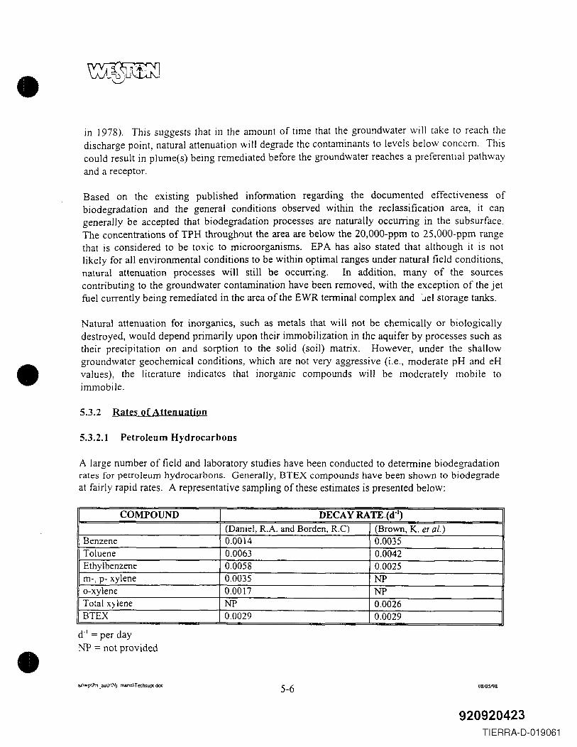
•
•
•
in 1978). This suggests that in the amount of time that the groundwater will take to reach thedischarge point, natural attenuation will degrade the contaminants to levels below concern. Thiscould result in plume(s) being remediated before the groundwater reaches a preferential pathwayand a receptor.
Based on the eXlstmg published information regarding the documented effectiveness ofbiodegradation and the general conditions observed within the reclassification area, it cangenerally be accepted that biodegradation processes are naturally occurring in the subsurface.The concentrations of TPH through()llt the area are below the 20,OOO-ppm to 25,OOO-ppm rangethat is considered to be toxic to microorganisms. EPA has also stated that although it is notlikely for all environmental conditions to be within optimal ranges under natural field conditions,natural attenuation processes will still be occurring. In addition, many of the sourcescontributing to the groundwater contamination have been removed, with the exception of the jetfuel currently being remediated in the area of the EWR terminal complex and -.lei storage tanks.
Natural attenuation for inorganics, such as metals that will not be chemically or biologicallydestroyed, would depend primarily upon their immobilization in the aquifer by processes such astheir precipitation on and sorption to the solid (soil) matrix. However, under the shallowgroundwater geochemical conditions, which are not very aggressive (i.e., moderate pH and eHvalues), the literature indicates that inorganic compounds will be moderately mobile toimmobile.
5.3.2 Rates of Attenuation
5.3.2.1 Petroleum Hydrocarbons
A large number of field and laboratory studies have heen conducted to determine biodegradationrates for petroleum hydrocarbons. Generally, BTEX compounds have been shown to biodegradeat fairly rapid rates. A representative sampling of these estimates is presented below:
COMPOUND DECAY RATE (d-J)
(Daniel, R.A. and Borden, R.C) (Brown, K. et al.)Benzene 0.0014 0.0035Toluene 0.0063 0.0042Ethylbenzene 0.0058 0.0025m-, p- xylene 0.0035 NPo-xylene 0.0017 NPTotal Xl lene NP 0.0026BTEX 0.0029 0.0029
dol= per dayNP = not provided
az\ ....p\Pn_ aulh\Nj_ mann\T tchsupt.doc 5-6 08105198
920920423TIERRA-D-019061
•
•
•
For first-order decay, the change in contaminant concentration through time is given by:
where:
C(t): Contaminant concentration as a function of timeC . Initial contaminant concentrationo'A: First-order decay constant
As presented in Section 4.0, the shallow groundwater Darcy velocities are very low (9 cm/y).The corresponding particle velocity would be 30 cm/y (assuming 30% porosity), or I foot peryear (ftly). Therefore, the time t over which the contaminants can degrade is large.
Substituting into the above equation:
t=lO yearsCo= 1,141 ppb (arithmetic mean of detected benzene concentration)1...=0.0014
The concentration in 10 years will be C(lO)=6.8 ppb. Over the same period of time the plume,will migrate only 10 feet. In 20 years the concentration will be C(20)=0.04 ppb, and the plumewill migrate 20 feet.
Although these are simplified degradation calculations, it is evident that because groundwaterflow velocities are low, the residence time of the contaminant solutions is high, providing ampleopportunity for the contaminants to degrade. The implication of this condition is that unless thecontaminant source is adjacent to a receptor, in this case the surface water body, thecontaminants will be degraded before the groundwater reaches the receptor.
5.3.2.2 Inorganics
Groundwater analytical results for inorganics from EWR and EP AMT are based on "totalmetals" analyses. These analyses are conducted on samples that have not been filtered to removesuspended solids. Because of the fine-grained nature of the fill materials, the groundwatersamples collected from the monitoring wells are usually very turbid. When these samples areacidified and analyzed, the results reflect the metal content of both the groundwater and thesuspended solids. Consequently, the results of the analyses are an artifact of the testing protocol,rather than a tme representation of the groundwater conditions. However, as a worst-case,conservative approach, the analytical results were treated as if they were representing dissolved-phase concentrations.
az\wp\Pn _ JUlh\N i_ m.:uin\ T echsupt.doc 5-7 08105198
920920424TIERRA-D-019062
•
•
•
Although there are no generally accepted rates of attenuation for inorganic compounds, anestimate of these rates was calculated based on generally accepted principles. Inorganiccompounds are removed from solution when the environment favors the formation of insolublecompounds or when they are adsorbed onto the soil matrix. For the purposes of this estimate, itis assumed that adsorption is the main mechanism acting to remove inorganics from solution.
The potential for a compound to be adsorbed onto the soil matrix is expressed by the sorption co-efficient defined as :
10gKd = 10g(Cs/Cw)
where: C, is the concentration of the chemical in the solid (soil) phase (mglkg) and C" is theconcentration of the chemical in the aqueous (groundwater) phase (mg/L).
The partitioning between the soil and aqueous phase is governed by the nature of the soil (e.g., aclayey soil will have a different Kd than will a gravelly soil). Kd values have been estimated forvarious inorganic compounds and different soil types. EPA has published selected values in the"Soil Transport and Fate Database 2.0", which were utilizf ~ in calculating these estimates. Forthe compounds of interest, Kd values range from 0.01 to 7.70. However, the majority of valuestend to concentrate in the 2.0- to 4.0-range.
The effect of the adsorption onto the migration of a particular compound is expressed as theRetardation Factor. A linear retardation isotherm was utilized for this calculation. This type ofisotherm is independent of solute concentration and assumes infinite adsorption capacity.Although nonlinear isotherms compensate for adsorption capacity, they cannot be estimated byforward calculation. Instead, they must be back-estimated from a transport model. For thisreason, the linear isotherm was utilized.
Where: R is the retardation factorPb is the bulk density of the porous medium (soil)e is the porosityKd is the distribution (adsorption) coefficient
az\wp\PT1_auth\N j _marin\ T echsupt.OOc 5-8 0810~198
920920425TIERRA-D-019063
•
•
•
Therefore, the retardation factor i:'stimated to be:
JPb 1.3gr em J/R = 1+ - Kd = 1+ 2.0em gr => R '=::: 10e 0.3
By utilizing a conservative (low) Kd value, this calculation compensates for the infiniteadsorption capacity of the linear model.
To estimate the rate at which the inorganics are removed from solution, and the distance overwhich the removal occurs, a simple analytical solution of the transport equation was utilized.The one-dimensional advection-dispersion transport of a nonconservative contaminant through asemi-infinite porous medium is given by the following equation:
The analytical solution of this equation is:
{ [ ~ [])I R - vt I vx R + vtC(x,t)= C; + (Co -C,) -erfe ~J+-exp(-)e'fe ~
2 2 (DRt) 2 D 2 (DRt)
where: C(r.t) is the concentration at distance x from the source at time tCo is the concentration at the sourceC; is the concentration at distance x from the source at time t=OR is the retardation factorD is the dispersion coefficientv is the average pore water velocity
Assuming a constant concentration source with a concentration of 22,500 Ilg/L (the maximumobserved concentration of lead), all solute will be removed over a distance of 60 meters (180feet).
Although the above estimate is based on many assumptions and simplifications (including theassumption that the dissolved concentration is equal to the total concentration), it demonstratesthat because the shallow groundwater flow velocities within the reclassification area are verylow, the residence time of the contaminant solutions is high. This provides ample opportunityfor the inorganic solutes to be adsorbed onto the soils. Therefore, unless the contaminant sourceis adjacent to the bay, the contaminants will be immobilized before the groundwater reaches thebay.
az\wp\Pn _ aUlh\Nj _ marin\ Techsupt. doc 5-9 081051'18
920920426TIERRA-D-019064
•
•
•
SECTION 6.0
IMPACT OF GROUNDWATER ON RECEPTORS
WESTON reviewed several prior studies conducted within the proposed reclassification area andimmediate vicinity to identify potential human and ecological receptors that could be influencedby groundwater quality within EWR and EPAMT. This review revealed that there is no directhuman health exposure route from contaminated groundwater within the reclassification area.Groundwater from beneath the reclassification area is not used nor are there plans for its use.The absence of a human exposure route is due to the following factors:
• Neither the groundwater within the proposed reclassification area nor potential receivingwater bodies (the Peripheral Ditch at EWR, Newark Bay) are used as a potable source.Moreover, the recreational potential of these receiving waters is very limited within thearea potentially affected by groundwater flows from the proposed reclassification area.
• Access to the Peripheral Ditch is limited by an existing chain-link fence, and by the factthat the ditch is on EWR property, making human contact highly unlikely. Futureresidential or other uses of the property allowing human contact with the ditch are alsounlikely.
• Access to Newark Bay is limited by the industrial nature of the area, which includesfenced and guarded properties.
• Contaminants of potential concern in the groundwater (i.e., those compounds exceedingNJDEP GWQSs within the reclassification area) are expected to either attenuate or tobecome adsorbed onto the soil matrix and immobilized before reaching Newark Bay.
• In the event that any contaminants reach Newark Bay, the groundwater from thereclassification area is diluted by a factor of approximately 50,000 by the surface watersof the bay, before it potentially reaches any human receptors.
Exposure to ecological receptors is also expected to be insignificant, because of the attenuationof groundwater contaminants or the lack of mobility of groundwater contaminants, and the highdilution rate once groundwater enters the bay. In addition:
• Most of the proposed reclassification area has been developed, and offers little wildlifehabitat that would potentially be affected by groundwater.
az\wp\Pn _ 3uth\Nj _ m3rin\ T echsupt .doc 6-1 08105198
920920427TIERRA-D-019065
•
•
•
• Most of the wetlands previously mapped by the National Wetland Inventory (NWl)program within the proposed reclassification area have been filled.
• Habitat provided by the Peripheral Ditch is very limited and consists primarily of aquatichabitat within the channel itself. Water quality within the ditch is known to be degraded,and the ditch offers poor-quality fish habitat (Section 6.1.1, and Appendix D).
• The shoreline of Newark Bay adjacent to the proposed reclassification area IS nearlyentirely bulkheaded, and shoreline habitat is limited.
Hence, the discussion below is presented primaril~r to meet the requirements of the NJDEPguidance for reclassification petitions, which specifies that the petition must identify receptorspotentially influenced by the groundwater reclassification.
6.1 POTENTIAL GROUNDWATER RECEPTORS
Only the surrounding surface water bodies, which receive discharge of groundwater, areconsidered potential receptors. The surface waters considered to be potential receptors of thegroundwater from the reclassification area are the Peripheral Ditch and Newark Bay. Whereasseveral wetland areas appear on the USFWS NWI program maps, a field reconnaissanceconducted by WESTON revealed that only two of these wetland areas remain undevelopedwithin the proposed reclassification area. None of the groundwater data collected to date, inconjunction with information on flow rates and travel times reviewed in Section 5.0, suggest thatgroundwater contamination has reached any of these receptors. Appendix D describes theecological receptors associated with each of the habitats identified below.
6.1.1 Waterways
6.1.1.1 Peripheral Ditch
The Peripheral Ditch surrounds the property occupied by EWR, and is the principal means ofsurface water drainage for the EWR property. The approximately 8-foot-deep, 80-foot-wideditch was constructed to drain the EWR property during the EWR expansion in the 1970s.However, the ditch actually drains an area of approximately 10 square miles, since it originateswithin the cities of Newark and Elizabeth (Killam, February 1995). From EWR the ditch flowssouth and eastward through a tidal gate at the Elizabeth Channd, and into Newark Bay. KillamAssociates identified several industrial point source discharges to the Peripheral Ditch, as well asthe potential for five CSOs from Newark and one from Elizabeth to discharge to the ditch.Surface water quality within the Peripheral Ditch is classified by the State of New Jersey as FW-2 Non-Trout, while the lower, tidal portion is classified as SE-3.
az\wp\Pn _aUlh\NL mann\ Techsupt.doc 6-2 08l0S198
920920428TIERRA-D-019066
•
•
•
Human access to the ditch is limited by a 6-foot-high chain-link fence, and any recreational orother use of the ditch is prohibited by the Port Authority. The ditch is not used as a potable watersource, nor is it connected to any water body that is used for potable purposes.
The Peripheral Ditch is fed primarily by surface water runoff from EWR, and the upstream flowsreferred to above. Portions of the ditch are piped as it runs through EWR. Because of thepresence of tide gates, water is allowed to flow out into the bay, but is not allowed to enter theditch from the bay. Water is regularly pumped from the ditch by the City of Newark as astormwater management tool in anticipation of heavy precipitation events.
The banks of the Peripheral Ditch are lined with riprap, such as concrete and asphalt blocks, forits entire length. Since the surrounding grassy areas are regularly mowed up to the top of thebank for most of the length of the ditch, available habitat is limited to the banks of the ditchitself, which support Phragmites vegetation, and in some areas young Tree-of-Heaven (Ailanthusaltissima) trees. Available habitat that is potentially affected by shallow groundwater flow islimited to open water areas within the channel. Thus, while the ditch may support limitedpopulations of benthic invertebrates and killifish, it supports little aquatic vegetation required bymany species of aquatic or wetland wildlife for cover or breeding habitat.
6.1.1.2 Newark Bay
The proposed reclassification area is bounded to the east by Newark Bay, as well as the shorelineof Newark Bay itself. Groundwater from the proposed reclassification area flows south andeastward, eventually reaching Newark Bay, but accounts for a relatively small proportion of thetotal water entering the bay. Most of the freshwater flows received by Newark Bay come fromthe Hackensack and Passaic Rivers, which enter the bay just north of the proposedreclassification area. Since Newark Bay is hydrologically contiguous with the Arthur Kill andKill Van Kull to the south, the primary source of the surface water present is ultimately theAtlantic Ocean. As a result, water quality in the bay is affected by many sources other thanshallow groundwater flows from the proposed reclassification area. Specifically, the surfacewater quality of Newark Bay is influenced by the following factors:
• Regional water and sediment quality within the Hudson-Raritan estuary.
• Pollution loadings from the Hackensack and Passaic Rivers, as well as smaller tidalstreams such as the Peripheral Ditch.
• New Jersey Pollutant Discharge Elimination System (NJPDES) and State PollutantDischarge Elimination System (SPDES) permitted, as well as unpermitted industrialdischarges.
• Oil and chemical spills.
az\wp\Pr1_3uth\Nj_marln\Techsupc doc 6-3 OHl05198
920920429TIERRA-D-019067
•
•
•
• Combined sewer outfalls and municipal wastewater discharges.
• Urban/industrial/residential stormwater runoff.
• Contaminated groundwater flow into the bay, especially from landfills and otherhistorically filled areas.
• Atmospheric deposition of contaminants from surrounding industries.
The degraded water quality of tne bay is reflected by its New Jersey surface water qualityclassification of SE-3. The "SE-3" classification means that the bay consists of estuarine surfacewaters that have the designated uses of secondary contact recreation, maintenance and migrationof fish populations, migration of diadromous fish, maintenance of wildlife populations, and anyother "reasonable" uses. Secondary contact recreation is defined by the State of New Jersey asconsisting of activities "where water ingestion is minimal and includes but is not limited toboating and fishing."
The bay itself does not represent a potable water source due to its salinity and degradedcharacteristics. Moreover, given its classification of SE-3, primary contact recreation (e.g.,swimming) in the bay is not encouraged, and is unlikely. Therefore, human exposure routes tothe diluted groundwater should be limited to secondary contact recreation.
Secondary contact recreation in the immediate vicinity of Ports Newark and Elizabeth is limitedby the shoreline access restrictions present at Ports Newark and Elizabeth; most of the land isprivately owned and fenced, while the shoreline is bulkheaded. The area is also used regularlyby large commercial vessels, which should preclude the use of the port area by small craft.While fishing from a boat in the vicinity of Ports Newark and Elizabeth is possible, publishedfish advisories exist for striped bass, bluefish, eels, and blue crabs within the area. If recreationalboating or fishing occurs in the area, it is highly unlikely that people would receive significantexposure to shallow groundwater from the proposed reclassification area, given the amount ofdilution groundwater would undergo upon entering the bay.
Thus, even if groundwater from the proposed reclassification area flowed directly into the baywithout any attenuation or adsorption to soil particles, the potential effects would be limited toecological receptors within the available habitat provided (Appendix D). Moreover, the greatestpotential for ecological effects would be at the point of entry of groundwater into the bay,namely within the bay sediments (see Section 6.2 and Appendices D and E). This assumes thatsignificant mixing does not occur in the tidally influenced groundwater present near the edge ofthe bay .
az\wp\Pn _ 3uth\NL marin\T echsupc.. doc 6-4 081O~198
920920430TIERRA-D-019068
•
•
•
6.1.2 Wetland Areas
While several wetland areas were mapped in the vicinity of the proposed reclassification area bythe USFWS NWI program in the 1970s, wetland habitats influenced by groundwater within thereclassification area are limited to two small areas that have not been filled. The wetlandsidentified by the NWI program were mapped on the basis of aerial photography from 1976.Since that time many of the areas mapped as freshwater wetlands have been filled or altered.The areas originally mapped by the NWI program are shown in Figure 6-1, and fall into severalcategories, including:
• Palustrine open water (small freshwater ponds).• Palustrine emergent wetlands (freshwater marsh).• Estuarine intertidal emergent.• Estuarine subtidal open water.• Estuarine intertidal flats.• Riverine lower perennial open water.
During a field reconnaissance conducted on 26 August 1997, only one of the I3 palustrineemergent (freshwater) wetland areas mapped by the NWI program within the proposedreclassification area could be located. The remainder have been apparently filled in since 1976as the area was developed. The only presently remaining palustrine emergent wetland is anarrow strip located along the Peripheral Ditch in the southeastern comer of EWR. ThePeripheral Ditch itself is mapped by NWI as riverine lower perennial open water habitat.
Estuarine intertidal flats are located along the shores of Newark Bay both north and south of thePort Newark and Elizabeth terminals. The Great Ditch (located south and west of the proposedreclassification area) is mapped by USFWS as estuarine intertidal open water, meaning that it istidally influenced and supports little wetland vegetation. However, within the proposedreclassification area, only one small « I acre) estuarine intertidal emergent wetland remains.This area is located in Port Newark in the northeastern corner of the proposed reclassificationarea. The area consists of approximately 0.5 acre of Spartina marsh, with approximately 0.25acre of Phragmites marsh along its upland margin. A small (approximately 0.25-acre) mudflatarea is located adjacent to this wetland, along the bay side. The remainder of the coastline withinthe proposed reclassification area consists either of bulkhead or riprap-lined areas. Riprap ispresent primarily in the northeastern corner of the area, near the aforementioned estuarineintertidal emergent wetland .
az\wp\Prt _auth\Nj _marin\ T«hsupt.doc 6-5 0810SJ<lB
920920431TIERRA-D-019069
•
•
•
6.2 POTENTIAL FOR BIO'~_CCUMULATION
The potential for bioaccumulation of a contaminant is based upon the presence of at least oneexposure pathway. Potential exposure pathways require four basic elements:
(1) A source and the release ofa contaminant of potential concern (COPC) from that source.
(2) Subsequent migration through an environmental medium.
(3) Potential contact between a receptor and the medium.
(4) An uptake mechanism associated with a potential receptor.
Thus, in orci~r fG:"a groundwater contaminant to bioaccumulate, it must first reach an aquatichabitat (e.g., surface water body) where ecological receptors are present. Since groundwatercontaminants are expected to attenuate or (in the case of metals) become adsorbed to soilparticles before they reach Newark Bay, the pottntial for bioaccumulation of these contaminantsis considered insignificant.
Appendix E provides a discussion of the bioaccumulation potential of groundwater contaminantsbased upon the overly conservative assumption that contaminated groundwater reaches NewarkBay in an undiluted, unattenuated form. A conclusion that may be drawn from this conservativeassessment is that even if groundwater were to reach Newark Bay at the concentrations measuredin the groundwater wells, significant bioaccumulation effects would largely be limited to metalsin the sediment. Since metals in bay sediments are already highly impacted by othercontaminant sources (see Section 6.4 below), it is unlikely that the volume of groundwaterentering the bay could cause a significant impact.
6.3 POTENTIAL FOR METALS UPTAKE INTO PLANTS
The potential for uptake of the metals of potential concern in groundwater (arsenic, cadmium,copper, lead, mercury, nickel, and zinc) is considered insignificant because of the followingfactors:
• The low probability that metals in groundwater from the proposed reclassification areaever reach Newark Bay.
• The limited wetland habitat provided within the proposed reclassification area, shouldmetals in groundwater reach it.
• The fact that vegetation within the Peripheral Ditch is largely limited to its banks, andhence would not be expected to come into contact with groundwater.
az\wp\Prt _aUlh\Nj _mann\ TcchsUpl.doc 6-6 08105198
920920432TIERRA-D-019070
•
•
•
A review of reports (Keystone Environmental Resources, Inc. 1990) and other informationavailable for the proposed reclassification area, in conjunction with the site reconnaissanceconducted in August 1997, indicates that existing wildlife habitat is very limited, as much of thearea is developed and unvegetated. Since most of the proposed reclassification area is filledupland that is developed with buildings, impervious cover, and lawns, the opportunity for uptakeof groundwater by plants is limited to wetland areas. Within the Peripheral Ditch, there is littleopportunity for contaminant uptake by plants, since little submerged aquatic vegetation existswithin the channel, and the banks of the ditch are rip-rapped throughout much of its extent.Thus, the plants should not come into contact with groundwater to any appreciable extent.
Natural attenuation and adsorption of contaminants to soil particles are expected to preventgroundwater contaminants from reaching the bay. Even if these contaminants did reach the bay,the only potential opportunity for metals uptake by groundwater exists within the estuarineemergent wetland noted at Port Newark in the northeastern comer of the proposedreclassification area. This area provides limited habitat, as it is less than 1 acre in extent. Theopportunity for metals uptake into plants and subsequent ingestion by primary consumers,therefore, is considered insignificant.
6.4 DISCUSSION OF EXISTING SEDIMENT AND WATER QUALITY AT EACHRECEPTOR
6.4.1 Peripheral Ditch
Surface water quality data in the Peripheral Ditch is limited to studies conducted by WESTON(October 1991) for the Port Authority from 1989 through 1991. Parameters measured were pH,TPH, chemical oxygen demand (COD), total suspended solids (TSS), and total organic carbon(TOC). Of these, only TPH results are directly applicable to the Class II-B reclassificationpetition. TPH concentrations at 10 locations sampled within the ditch ranged from 0.1 mg/L to2.6 mg/L. While no surface water quality standcrds exist for TPH, these results suggest that theditch has somewhat degraded water quality as a consequence of petroleum contamination andhigh COD values.
Sediment data collected by WESTON within the Peripheral Ditch suggest that the ditch isimpacted by petroleum-related compounds. The presence of these compounds is apparentlyassociated with runoff from EWR, the southern fuel farm, and upstream areas, as opposed toshallow groundwater flow, since there are no known plumes that occur within the immediatevicinity of the ditch.
Of the petroleum-related compounds detected. TPH ranged from 4,610 mg/kg to 31,300 mglkg atthe 10 locations sampled within the ditch. Total SVOCs ranged from 18.2 to 52.7 mg/kg, and
u\wp\Pn _auth\Nj _marin\ TechsUpI.dlX 6-7 08/0~1'l8
920920433TIERRA-D-019071
•
•
•
individual SVOCs, such as anthracene, phenanthrene, pyrene, fluorene, benzo(a)anthracene,naphthalene, benzo(a)pyrene, and benzo(b)fluoranthene, exceeded National Oceanic andAtmospheric Administration (NOAA) effects-range median (ER-M) or effects-range low (ER-L)sediment quality guidelines for the protection of aquatic life, each at a minimum of one location.
6.4.2 Newark Bay
6.4.2.1 Surface Water Quality
As noted above (see Sections 5.0 and 6.1.1) the proposed reclassification is likely to have littleimpact on Newark Bay water quality since:
• Contaminants in groundwater from the reclassification area are not expected to reachNewark Bay due to natural attenuation of organic compounds, and adsorption of metalsonto soil particles.
• Groundwater flows are an insignificant portion of the total hydrological inputs intoNewark Bay (1 :50,000 dilution) .
• Many other significant contamination sources affecting Newark Bay water quality havebeen identified. The existing water quality of Newark Bay has been reported to be theresult of contaminant discharges directly into the regional surface water system fromindustrial and municipal sources.
The ensuing discussion is primarily for the purpose of describing water quality characteristics ofthe bay as a potential receiving water body.
In some cases, measurements of surface water quality can provide an indication of whether thewater body is impacted by contaminated groundwater. However, in Newark Bay the situation iscomplicated by the facts that the bay is contaminated from multiple sources, that it is tidal andwell-mixed, and that the water volume of the bay is significantly larger than the groundwatervolume entering it. Moreover, surface water quality measurements are instantaneous and mayvary with tides, temperature, precipitation, and other factors that can vary daily or seasonally. Asa result, no inferences can be made by comparison of groundwater quality results with surfacewater quality results in the bay. However, should groundwater contaminants be absent or presentat levels not posing an ecological risk (i.e., below EPA ambient water quality criteria), it can beinferred that the effects of groundwater contamination on the water quality in the bay areinsignificant. Conversely, if water quality criteria were to be exceeded in the bay, it could notbe concluded on the basis of those results alone that the contamination resulted fromgroundwater, since there are many documented pollutant sources to the bay .
az\wp\Pn _ iilulh\NL marin\ Trchsupt ,doc 6-8 08l0~198
920920434TIERRA-D-019072
•
•
•
Table 6-1 summarizes surface water quality results m~asured at two locations in Newark Bay forgroundwater contaminants of concern within the proposed reclassification area. Data arepresented from the 1992 Battelle study (data collected in October 1991) for the New York CityDepartment of Environmental Protection's (NYCDEP's) New York Harbor water qualitymonitoring program, in which a sample at location itA7" just off Port Elizabeth was collected andanalyzed for selected metals (Battelle, 1992). Data are also presented from a 1995 groundwaterstudy conducted by the Port Authority in which a single water quality sample was collected andanalyzed for Priority Pollutant metals and VOCs, for comparison with groundwater results.Despite the wealth of studies on sediment quality within the Hudson-Raritan estuary, these werethe only three studies of surface water quality found with data relevant to the groundwaterreclassification petition.
During a fourth study conducted by Lawler, Matusky and Skelly (LMS) (Memorandum, 1995)for the Port Authority on sediment quality, a water quality sample was collected just off PortElizabeth, but was only analyzed for traditional water quality parameters such as biologicaloxygen demand (BOD), TSS, TDS, and dissolved oxygen (DO).
NYCDEP also conducts routine water quality monitoring within the New YorklNew JerseyHarbor region (NYCDEP 1993). However, the closest point monitored to Newark Bay isShooter's Island, near the juncture of the Arthur Kill and Kill Van Kull (station K2). NYCDEPonly measures BOD, DO, nitrogen, chlorophyll a, and fecal coliform; these parameters are notdirectly applicable to the proposed Class II-B groundwater reclassification.
No inferences can be made by comparison of groundwater quality with surface W2.ter qualityresults from the bay, for the reasons noted above. However, comparison of results of theselimited surface water quality studies within Newark Bay with EPA water quality criteria indicatethat the compounds of potential concern in groundwater do not exceed EPA surface water qualitycriteria in Newark Bay. This comparison indicates that groundwater from the reclassificationarea is not significantly impacting surface water quality in the bay.
6.4.2.2 Sediment Quality
Contaminated groundwater from the proposed reclassification area is not expected to reachNewark Bay; therefore, sediment quality in the bay should remain unaffected by groundwaterquality. The following discussion is intended to provide a profile of existing contamination inthe bay sediments in the vicinity of the proposed reclassification area, as a result of otherpollutant sources.
Sediment data measured in several studies (Table 6-2) conducted in Newark Bay show muchhigher values of most parameters as compared to surface water values.· This is to be expected,since contaminants often adhere to suspended particles that eventually settle from the water
u\wp\Pn _aulh\N j_marin\ Teduupc..doc 6-9 08105198
920920435TIERRA-D-019073
•
•
•
column into the sediment. As a result, sediments within the bay are among the most toxic in theNew YorklNew Jersey Harbor region (NOAA, 1995).
Appendix F shows results of metals concentrations in New YorkINt:w Jersey Harbor sedimentsmeasured as part of two regional studies. The first study was conducted by BatteIle OceanSciences in 1992 on behalf of NYCDEP as part of the New YorklNew Jersey Harbor Estuaryprogram (BatteIle, 1992). That study measured concentrations of trace metals in sediment andpore water at 20 sampling locations within the harbor region. Location "A 7" was located closestto Ports Newark and Elizabeth. The sample result plots for the metals of potential concerndescribed above (arsenic, cadmium, copper, lead, mercury, nickel, and zinc) show that LocationA 7 has lower concentrations in the sediment than do other locations measured within theimmediate vicinity. (No plots were available for selenium.) Nearly all of these metals weredetected at substantiaIly higher concentrations at location A5 (near the juncture of Newark Bayand the Kill Van KuIl), and locations A8 and A9 in the Passaic and Hackensack Rivers,respectively. These data suggest that regional sources of contamination other than EWR andEP AMT are major determinants of sediment quality within Newark Bay.
The second study was conducted by NOAA (NOAA 1995) to characterize the extent of sedimenttoxicity within the Hudson-Raritan estuary. During Phase I of the study in 1991, 117 sedimentsamples were coIlected throughout the entire estuary and tested for toxicity using three differentorganisms. Some of these locations were also analyzed for chemical parameters, including twolocations within Newark Bay. Location No. 16 was in upper Newark Bay, and is the closestsampled location to the proposed reclassification area. Location 17 was located in lower NewarkBay near the KiIl Van KuIl, and had higher concentrations of metals measured than those inLocation 16.
During Phase II of the study in 1993, an additional 57 samples were coIlected within NewarkBay and the immediate vicinity and also measured for toxicity. Some of these samples were alsoanalyzed for chemical parameters. Of the six locations analyzed by NOAA for sedimentchemistry in Newark Bay in 1993, the two closest to Port Newark and Port Elizabeth are Stations31 and 36, which are located closer to the eastern side of the bay. Table 6-2 summarizesanalytical results from the above sediment quality studies in the vicinity of the proposedreclassification area, as weIl as a third study conducted by Squibb et at. (1991).
While sediment chemistry was not analyzed within the Port Elizabeth or Port Newark channelsduring either Phase I or Phase II of the NOAA investigation, five out of six of the sedimentsamples within the channels or immediate vicinity were considered highly toxic «80% survival)to amphipods (benthic macroinvertebrates). Most of the sediments in Newark Bay and in thePassaic and Hackensack Rivers were also found to be highly toxic to the three organisms tested.
az\wp\Pn _auth\N j _nwin\T echsupLdoc 6-10 OSlO~198
920920436TIERRA-D-019074
•
•
•
~\'':'..Jt0LJ~
The above toxIcIty results confirmed results of the Squibb study, which found that severalparameters (metals, DDT, PCBs, and polycyclic aromatic hydrocarbons [PAHs]) in Newark Baysediments exceeded NOAA sediment quality guidelines for the protection of aquatic life. Thereport concluded that Newark Bay sediments have an extremely high potential for toxicity toaquatic biota, and are likely to be among the most impacted in the New YorklNew Jersey HarborregIOn.
Results of these three major sediment quality studies suggest that several contaminant sourcespresent in the bay contribute to the observed sediment toxicity. These chemicals include severalparameters that were not detected with high frequency at levels of concern in groundwater withinthe proposed reclassification area, such as dioxin congeners, PCBs, and PAHs. A review of thesediment quality plots (Appendix F) indicates that the presence of these contaminants in NewarkBay is clearly related to major sources in other locations, such as hazardous waste sites andindustries along the Passaic and Hackensack Rivers. The Hackensack and Passaic Rivers flowsouthward into Newark Bay, and carry with them sediment loads that ultimately influence thetoxicity of the bay sediments. This can be seen in the case of dioxins originating in the PassaicRiver, which have affected Newark Bay sediment quality (Bopp et al., 1991).
In summary, contaminated groundwater from the proposed reclassification area is not expected toreach the bay sediments. However, if it did, its contribution to the pollutant load of the bay andsubsequent sediment toxicity would likely be little, relative to the regional inputs from othersourc·es.
6.4.3 Wetlands
A review of reports available on the proposed reclassification area revealed no information onwater quality within the two wetland areas identified from the NWI map that were confirmed inthe field as still existing (see Section 6.1.2). Only one freshwater wetland area was identifiedwithin the proposed reclassification area; this is associated with the Peripheral Ditch in thesoutheastern corner of the ditch, before the ditch exits EWR. A report by Killam (April 1995)noted that the wetlands present within the reclassification area are classified by NJDEP as FW-2Non- Trout. Since the wetland is associated with the ditch, its water quality is probably degradedgiven that most of the area consists of disturbed fill material, much of which is thought to consistof dredge spoils (Killam, April 1995). However, the principal hydrological source for thePeripheral Ditch is stormwater runoff, as well as flows from upstream.
The remaining wetland area is an estuarine emergent wetland located at Port Newark. Thehydrology of that wetland is associated with Newark Bay, and hence the water quality within thewetland is also largely determined by Newark Bay. Because groundwater contaminants are notexpected to reach the bay, and the water quality of the wetland is determined by Newark Baywater quality, there should be no adverse effects to this wetland associated with reclassifying theshallow groundwater.
az\"-p\Pn _auth\Nj_ marin\ T«hsupc. doc 6-11 08/06198
920920437TIERRA-D-019075
•
•
•
SECTION 7.0
DEMONSTRATION OF THE FIVE NJDEP CHARACTERISTICS FOR CLASS liB
This section presents the five characteristics of a Class lIB groundwater unit and discusses howthe information presented in the preceding sections demonstrates that the groundwater unitproposed for reclassification is characteristic of a Class lIB area.
7.1 CHARACTERISTIC NO. 1 GROUNDWATER QUALITY EXHIBITSEXTENSIVE EXCEEDANCES OF ONE OR MORE OF THE GROUNDWATERQUALITY CRITERIA AS A RESULT OF PAST DISCHARGES
The groundwater quality in the region is shown to tave numerous exceedances of the NJDEPClass II-A GWQSs a result of past discharges of groundwater pollutants for severalcontaminants, principally petroleum-derived VOCs, SVOCs, and metals. These contaminantsare presumably associated with the fill material used to create the reclassification area. Asdiscussed in Section 5.2, in 80% of the site area there is a greater than 80% probability ofencountering groundwater contaminated above GWQSs. NJDEP, in correspondence with thePort Authority, acknowledged that contaminated fill had been utilized to create the area. Figure3-2 depicts the suspected and known sites in and around EWR and EPAMT that exhibitexceedances for Class II-A GWQSs. The following discussion explains the determination of"extensive exceedances":
Existing shallow groundwater quality data from 218 wells in the area were compiled fromavailable reports. All wells were screened in the same water-bearing zone. Data from each wellwere assessed to determine whether GWQSs were exceeded. Wells that had any exceedancewere assigned a code of 1; wells that had no exceedances were assigned a code of O. These codesrepresent the probability of exceeding GWQSs. Geostatistical techniques were then used toanalyze the spatial correlation structure of the assigned codes.
Based on the correlation structure interpreted from the semivariogram, a contour map wasgenerated using kriging estimators. Figure 5-9 illustrates the spatial probabilities of exceedinggroundwater standards. The area covered by the geostatistical map was assessed to determineapproximately how much of the area had a high probability of being contaminated. Figure 5-8 isa plot of the percentage of the mapped area that exceeds GWQSs at several probability levels.This graph indicates that the probability is high that groundwater beneath most of the mappedarea is contaminated .
az\wp\P"_auth\Nj_marin\Techsupc doc 7-1 08105/98
920920438TIERRA-D-019076
•
•
•
7.2 CHARACTERISTIC NO.2 - GROUNDWATER RESTORATION CANNOT BEACHIEVED USING TECHNOLOGICALLY PRACTICABLE MEANS
Under the EPA's Subpart S rule, the determination that aquifer restoration is not technologicallypracticable involves a consideration of the "engineering feasibility and reliability" of attainingmedia cleanup standards, as well as situations where remediation may be "technically possible,"but the "scale of the operations required might be of such a magnitude and complexity that thealternative would be impracticable."
As discussed in Section 7.1, contaminated groundwater occurs in most of the reclassificationarea. Furthermore, GWQSs are widely exceeded. The contaminants of concern are petroleum-derived VOCs, SVOCs, and metals. Typical remedies for organic compounds include thefollowing:
• Pump, treat, and dispose of.• Pump, treat, and re-inject.• Vent and sparge.• Bioremediate and bioaugment.
Typical remedies for inorganic compounds (metals) include the following:
• Pump, treat, and dispose of.• Pump, treat, and reinject.
As indicated above, the affected area is very large (approximately 10 square miles). Thesaturated thickness of the historic fill unit is small (approximately 10 feet), the permeability islow, and the unit is highly inhomogeneous. Because of these properties, the capture zone of anygroundwater capture system (extraction wells or trenches) will be limited to, at best, a few tens offeet. Under these conditions, an extensive network of recovery points would be necessary. Forexample, assuming a capture zone of 20 feet, approximately 550,000 well points will benecessary, assuming that approximately 80% of the reclassification area (i.e., 8 square miles) iscontaminated above the standards. At an average cost of $500 per well point, the cost of wellinstallation will be $275 million. This number does not include the cost of constructing,operating, and maintaining a treatment system. This calculation demonstrates that hydrogeologicand economic constraints preclude remediation of the contaminated groundwater on a regionalscale. Similarly, while natural biodegradation of organic compounds will lower theirconcentrations over time, any attempt to augment and accelerate the process on a regional scaleby constructing a nutrient and oxygen delivery system will incur costs comparable to those listedabove .
az\wp\Pn _ aUlh\Nj _ mouin\ T echsupl.doc 7-2 08/05198
920920439TIERRA-D-019077
•
•
•
Source removal in areas of fuel spills indicates that the geometric constraints of the historic fillunit make recovery a long-term undertaking. Reportedly, free-phase product recovery at theEWR fuel terminal has been under way for 6 years and is expected to continue for an indefiniteamount of time.
As discussed in other sections of this report, the reclassification area is underlain by historic fill,which includes construction demolition debris and trash from former municipal landfills. Bothof these are sources of contamination. especially inorganic compounds. An exact estimate of thevolumes of the demolition debris and trash does not exist. However, the debris and trashunderlie most of the 10 square miles of the reclassification area. Consequently, a source removalaction (such as excavation and treatment or disposal) or source control action (such ascontainment or stabilization) is technically and financially unimplementable, because it wouldrequire excavation or some form of in-situ or ex-situ treatment of almost the entirereclassificati ~n area.
7.3 CHARACTERISTIC NO.3 - THERE ARE OR WILL NOT BE ANY POTABLEUSES OF THE GROUNDWATER FOR RECLASSIFICATION
As described in Section 3.0, no public community supply wells or zones of contribution for suchwells were identified within the proposed reclassification area. All potable water used in theproposed reclassification area and surrounding region is imported from off-site. There are noregistered production wells within the limits of the proposed reclassification area.
Because of the anticipated very low groundwater yields from the historic fill, which is evidencedby a thin saturated thickness, long recovery times in monitoring wells, and the presence of drywells, the potential use of the historic fill as a future potable water supply is not anticipated. Allpotable and industrial groundwater wells in the greater region draw from the bedrock aquifer,which is not hydraulically connected to the historic fill. Furthermore, saltwater intrusion into thebedrock aquifer, from historic overpumping, has rendered the bedrock aquifer unusable beneathand around the proposed reclassification area.
Furthermore, the Port Authority, which operates most of the area, does not have any plans todevelop groundwater resources in the area. As a public agency, the Port Authority has the long-teI'm authority and permanence to guarantee that groundwater will never be utilized in this area.Inquiries to the City of Newark and City of Elizabeth indicated that there are no plans fordeveloping groundwater resources in this area. Inquiries to the City of Newark and City ofElizabeth indicated that there are no public or private wells in or near the reclassification area.Both the City of Newark and the City of Elizabeth are supplied by surface water, originatingoutside the region. Both cities indicated that they have adequate capacity for the next 25 years.
u\wp\Pn _aUlh\Nj_ m;ui n\Techsupt.doc 7-3 08105198
920920440TIERRA-D-019078
•
•
•
~~ ..;9...\~ eu ';U\L..f\J.J
7.4 CHARACTERISTIC NO. 4 - NO SIGNIFICANT RISK OF POLLUTIONMIGRATION INTO CLASS I. II-A. OR III-A AREAS
As discussed in detail in Section 4.0, there is no risk of pollution migration to an aquifer ofhigher water quality. The underlying middle sand and bedrock groundwater is isolated from thehistoric fill groundwater by the meadow mat and silt and clay layers. In addition, groundwatergradients are expected to be upward, further precluding migration into the underlying middlesand and bedrock. Consequently, because the petition area is situated along Newark Bay, itoccupies a regional discharge zone and the predicted groundwater flow gradients will be upward,since there are no active pumping centers to deflect them.
There are no Class I or Class III-A aquifers within the proposed reclassification area.
7.5 CHARACTERISTIC NO.5 - NATURAL ATTENUATION CAN BE RELIED ONTO RESTORE GROUNDWATER QUALITY FOR CRITERIA IDENTIFIEDPURSUANT TO CHARACTERISTIC NO.1
7.5.1 Natural Attenuation Processes
Based upon the principles of natural attenuation discussed in Section 5.3, it is reasonable to relyon the natural attenuation approach for remediation of the contamination at the reclassificationarea. Available data suggest that most of the organic contamination consists of low levels ofpetroleum hydrocarbon compounds, which have been demonstrated to be readily biodegradableand amenable to natural attenuation.
Whereas inorganic contaminants do not biodegrade, they will be adsorbed onto the soil matrix.Soil/water partitioning coefficients and solubility data for the contaminants of concern indicatethat these compounds are generally moderately mobile to immobile and have a moderate to highaffinity for soils. Because groundwater flow gradients are exceedingly low, most of thedissolved phase is expected to be adsorbed hefore it reaches the discharge zone. As aconservative measure, this report has assumed that the entire measured concentration ofinorganics is in the dissolved phase, while in fact, observations indicate that the largestpercentage of the measured concentrations is due to the presence of suspended fines in thegroundwater samples.
Information that further bolsters these statements can be inferred from several ongoing projects atEPAMT. For example, known old petroleum plumes (e.g., Buildings 183 and 220, and the BP-Coastal facility at the intersection of Port Street and Navy Street) have been shown to exhibitdiffuse, rather than drawn-out, expansion patterns. Furthermore, these diffuse patterns havemigrated limited distances, although they are many years old (e.g., the BP-Coastal releaseoccurred in 1978). These observations support the following:
az\wp\Pn _auth\N Lmarin\ Tecluupt.doc 7-4 08106198
920920441TIERRA-D-019079

•
•
•
• The hydraulic gradient is very flat and resulting flow velocities are very low. Thedissolved contaminant plume is moving away from the assumed source at a slow rate bydiffusion rather than by advection. The estimated rate of shallow groundwater flow(particle velocities) is I foot/year. At this rate, groundwater from the center of thereclassification area will take 2,000 to 4,000 years to reach the surrounding surface water.
• In the amount of time that groundwater will take to reach the discharge point, naturalattenuation will degrade the contaminants to levels below concern. The estimatespresented in Section 5.0 suggest that the contaminant concentrations will attenuate toundetectable within a 20-year time frame.
By granting CEAs at several EP AMT UST sites, NJDEP has recognized that natural attenuationis an acceptable solution for the dissolved phase contamination in the shallow groundwater in thearea proposed for reclassification.
7.5.2 Types of Contaminants Having the Potential to Reach Receptors
The contaminants of concern are arsenic, cadmium, chromium, lead, and BTEX compounds.The analysis of the migration potential of the contaminants of concern indicates that the organiccompounds will degrade and the inorganic compounds will be immobilized before groundwaterdischarges to Newark Bay. The estimates presented in Section 5.0 suggest that the contaminantconcentrations will attenuate to undetectable within a 20-year time frame. Furthermore, aspresented in Section 4.0, a 50,OOO-times dilution is estimated for water discharging into thesurface water. At this rate of dilution, any contaminants that reach the surface water will have noeffect on surface water quality.
7.5.3 Potential for Bioaccumulation
The contaminants of concern having the potential to bioaccumulate are metals. The extent ofuptake is determined by the physiological and behavioral characteristics of the organismexposed, and the duration of exposure. Thus, bioconcentration factors vary not only betweenthese metals, but also for the organisms exposed, and are difficult to predict. However, thepreceding analysis has demonstrated that the metals will likely be adsorbed onto the site soils andwill be immobilized before reaching the bay. Therefore, bioaccumulation does not represent asignificant concern.
7.5.4 Potential for Metals Uptake into Plants
The review of available reports and infonnation for the proposed reclassification area indicatesthat existing wildlife habitat is very limited; much of the area is developed and unvegetated.
u\wp\P'rt _auth\Nj_ marin\T echsupl.doc 7-5 08106198
920920442TIERRA-D-019080
•
•
•
Plant species present in the proposed reclassification area are mostly indicative of disturbedconditions and represent poor wildlife habitat quality; hence, the potential for metals uptake intoplants is not a significant ecological concern.
7.5.5 Wetlands
Only one freshwater wetland area is associated with the Peripheral Ditch. A report by Killam(April 1995) noted that the wetlands present withir. the reclassification area are classified byNJDEP as FW -2 Non-Trout. The water quality of this wetland is probably degraded given thatmost of the area consists of disturbed fill material, much of which is thought to consist of dredgespoils (Killam, April 1995). The principal hydrological source for the Peripheral Ditch isstormwater runoff, as well as flows from upstream.
The remaining wetland area is an estuarine intertidal emergent wetland located at Port Newark.The hydrology of that wetland is associated with Newark Bay, and hence, the water qualitywithin the wetland is also largely determined by Newark Bay. Reclassification of the aquiferwithin the proposed reclassification area is not anticipated to have a significant effect on thiswetland, relative to the influence of Newark Bay water quality .
az\wp\Pn _auth\Nj_ marin\ Ttthsupt. doc 7-6 0&106198
920920443TIERRA-D-019081
• !1lCc:...CDIII
Figures
•
•
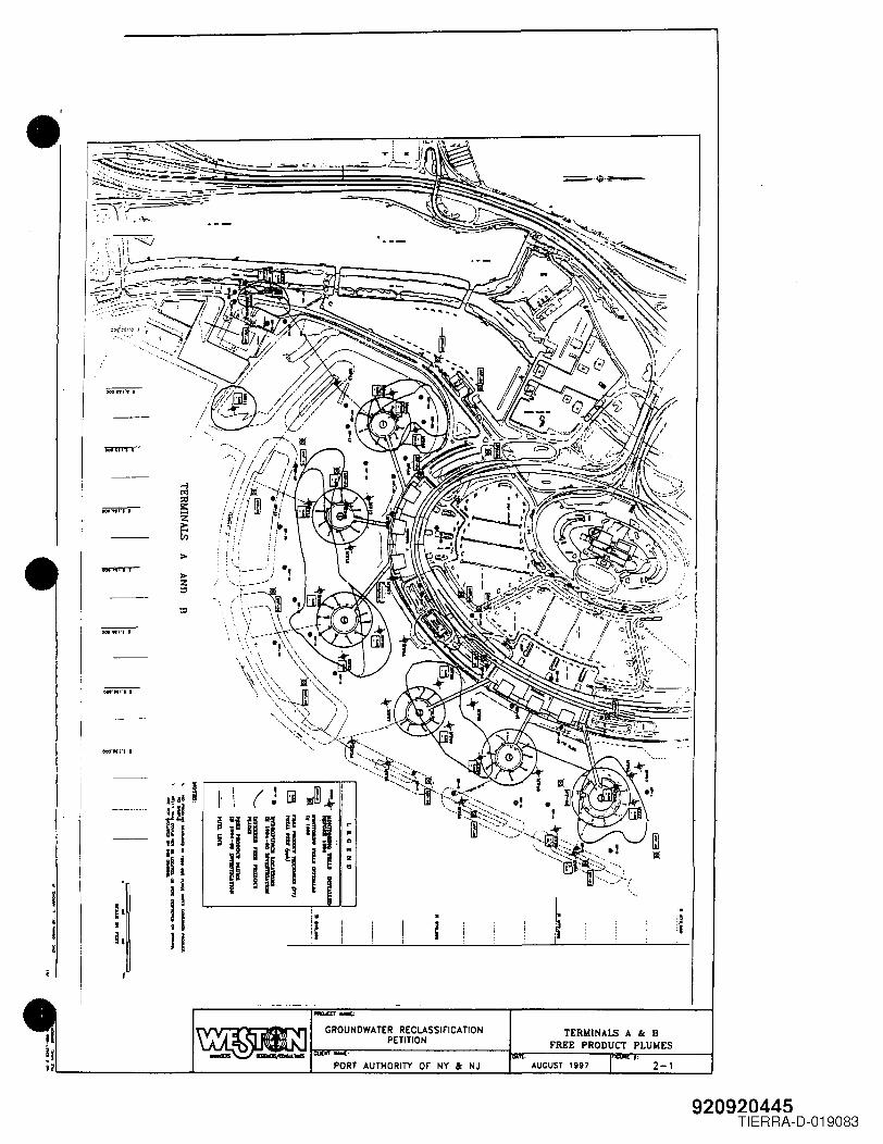
.'
>
>z"
OOO'KI'tl
~ GROUNDWATER REC~~ reili""""~.- PETITI~SSlriCATION
PORT AUTHORITY OF' NY ac NJ
TERMINALSFREE PRODU A & BCT PLUMES
AUGUST 1997 2-1
920920445TIERRA-D-019083
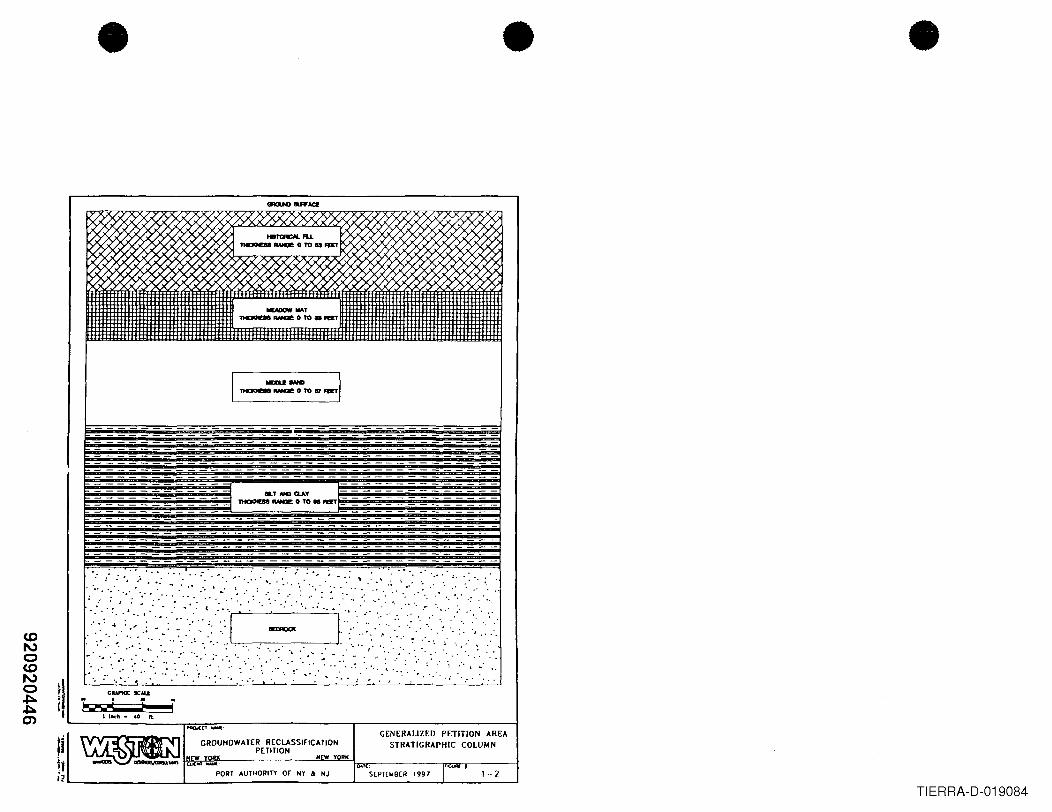
•
aT NGQ.AY__ ..UlO ...... :: ::=:::::::::
.' ...• ". :., ; 4-
",' " ..... : " ......· . . ' ".
· : .', : : ":. ".: t...
,,0 : ••. ,..... '." . " .. "'0, ' ••
,.0 '.'. " .. '" " ' .: .....• .. "0 -,' .. : .//'.~ ..:~.:<'::,',::]: . Ii'.<.:,< : .."...
• ".'- •••• to ••••• :', :.".', ":.' L...-,---~-,----,---------..J ", ....... ~ .- '.' .0. . • .".
.' '..
',' . .' '.' '. : .. '., - , ,CIlAPHJC SCAU
bo-.~ i iIlnch-40fl.
PQO.I(C'~:
H W YORK
S[PTEW8[R 1997
GROUNDWATER RECLASSIFICA nONPETITION
GENERALIZED PETITION AREA
STRATIGRAPHIC COLUMNIiiti~L- ..L ..L- -..L ----lPORT AUTHORITY or NY at NJ
• •
. ..
1-2TIERRA-D-019084
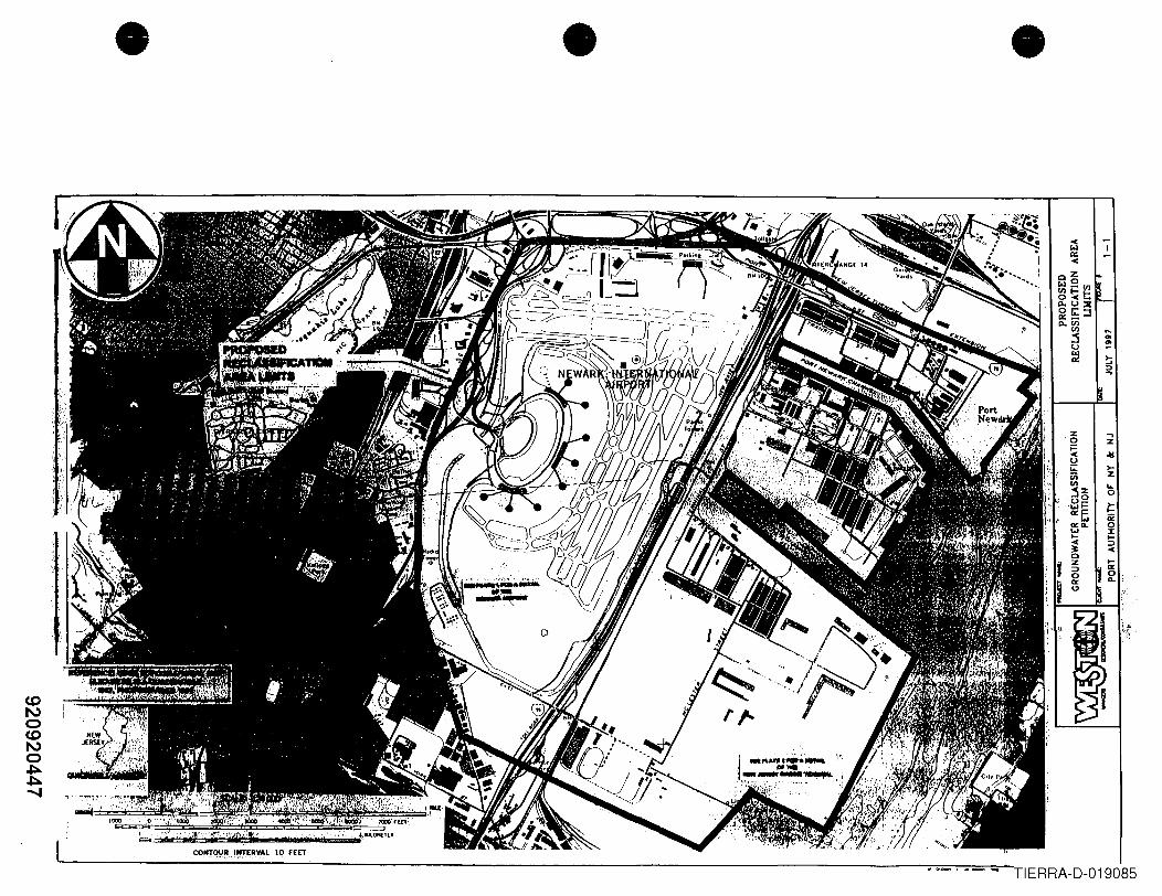
• • •
.........
.,z.-s>-z..a
,CONTOUR l..r[",,_...~ .. ,R,VAt 10 fEET
TIERRA-D-019085
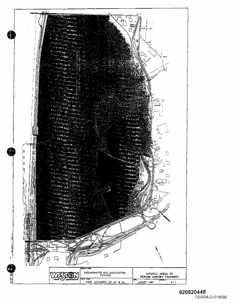
I•
\~ • PO~T AUTHORITY 0, NY &: NJ , AUGUST 1997
LANDfiLL ~E~SR~:ERTYNEWARK AIRPO .
. 3-1
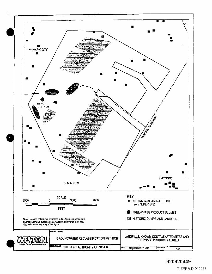
• ••,•
IINEWARK CITY
••
II
• •• • • •••
• •
• II
/,.,./
,/,/
• - -BAYONNE.-11....EUZABETH••••-
SCALE KEY• KNOWN CONTAMINATED SITE
(from NJDEP GIS)
• FREE-PHASE PRODUCT PLUMES
@ HISTORIC DUMPS AND LANDFILLS
3500 70003500 o
FEET
Nole: LocatlOl1 of features presented in this figure is approximateand for illustrative purposes only. Other contaminated sites mayalso exist within the area of the figure.
3-2
GROUNDWATER RECLASSIACATlON PETITION LANDFILlS, KNOWN CONTAMINATED SITES ANDFREE PHASE PRODUCT PLUMES
ClJEHTfWE: THE PORT AUTHORITY OF NY & NJ DATE: September 1997 FlClUREt:
920920449
\--....
-
TIERRA-D-019087
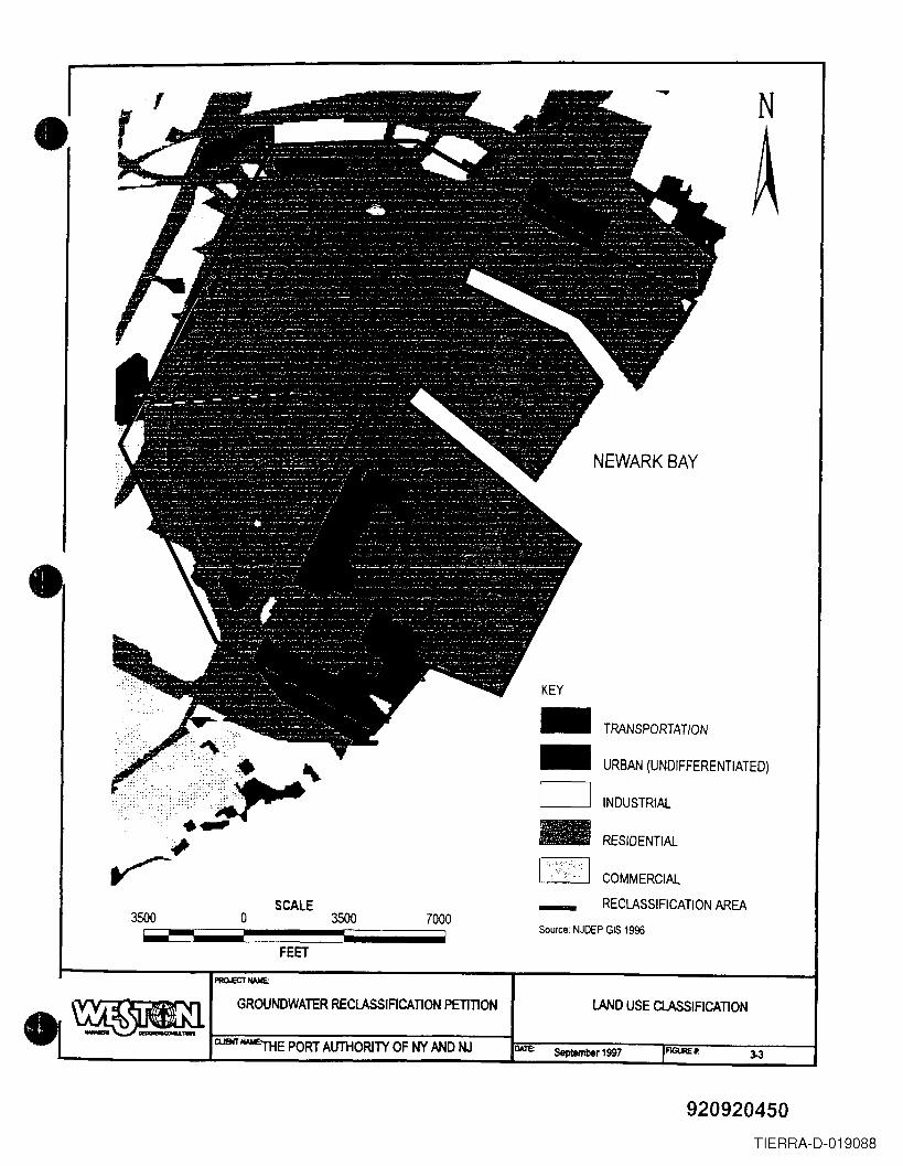
•, --
NEWARK BAY
TRANSPORTATION
URBAN (UNDIFFERENTIATED)
INDUSTRIAL
RESIDENTIAL
COMMERCIAL
RECLASSIFICATION AREASCALE -Source: NJDEP GIS 1996
N
KEY
3500 o 3500 7000
FEET
LAND USE ClASSIFICATION
FlGUREt:ClJSjT -l'HE PORT AUTHORITY OF NY AND NJ DAl'E: September 1997
GROUNDWATER RECLASSIACATION PETITION
920920450TIERRA-D-019088
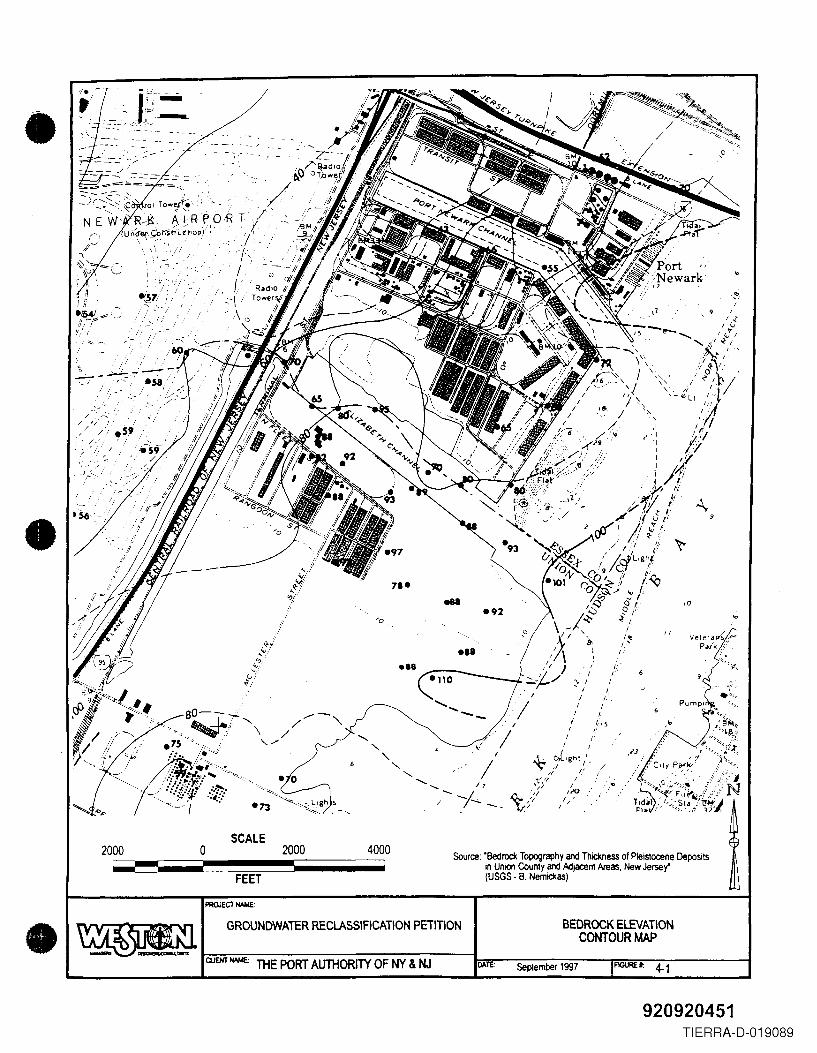
•",-'.\
'. \,
vele,at'/'-"Pa/k /~ ,
'';:-~.~.,~
I.',
-,11I I; ,; II
• ,S4! y:-:'II -;;:1- ~-ill!
'1/ ,:
, l.'.~7,/ ,:.,'!........ -,-~' .
;':.:....~~;''::
/ -'.' -:.,,- '// /// ,.S9/..~;.'/
/
•,0
CUENT NAME: THE PORT AUTHORITY OF NY & NJ
SCALE2000 o 2000 4000 Source: 'Bedrock Topography and Thickness of Pleistocene Deposits
in Union County and Adjacent Areas, New Jersey'(USGS· B, Nemickas)FEET
PROJECT NAME:
GROUNDWATER RECLASSIFICATION PETITION BEDROCK ElEVATIONCONTOUR MAP
September 1997 FIGURE" 4-1
920920451TIERRA-D-019089
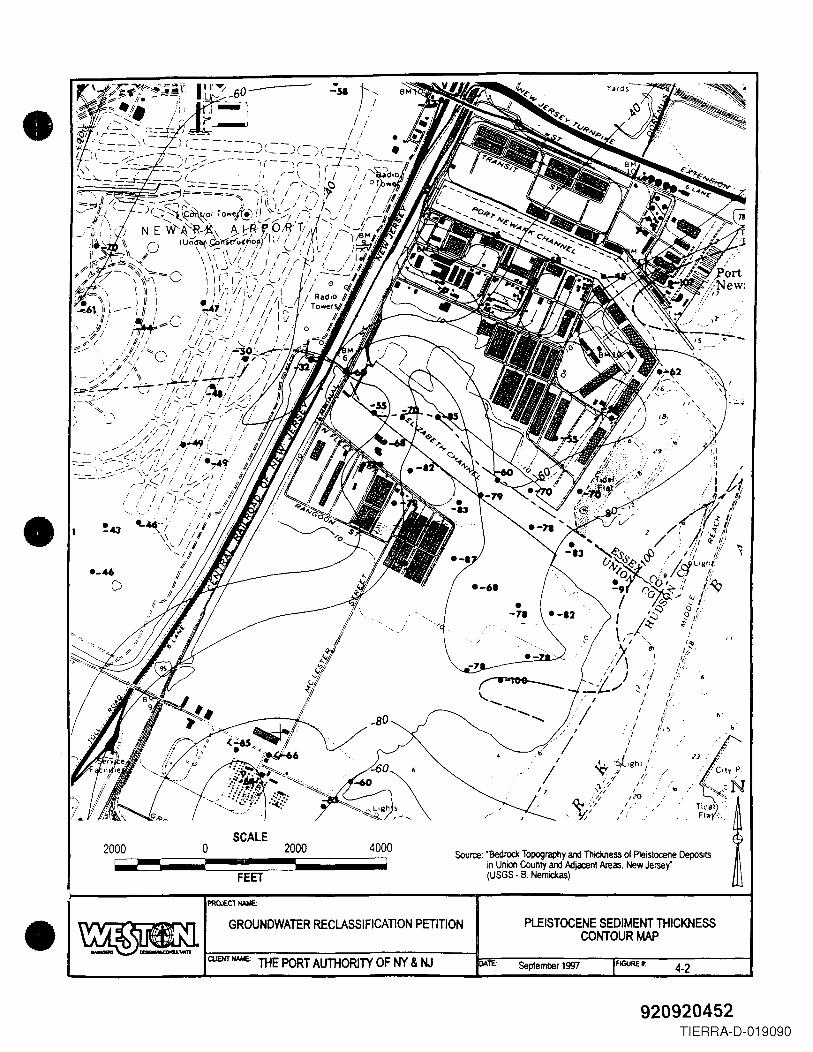
•
•.~.
TitiJl '~.Flit ,',.
SCALE2000 o 2000 4000 Source: "Bedrock Topography and Thickness of Pleistocene Deposits
in Union County and I>o:ljacenl Areas, New Jersey"(USGS - B. Nemickas)
..
FEET
PROJEC1IWo1E:
4-2
GROUNDWATER RECLASSIFICATION PETITION PLEISTOCENE SEDIMENT THICKNESSCONTOUR MAP
THE PORT AUTHORITY OF NY & NJ FlGUREt:September 1997
920920452TIERRA-D-019090
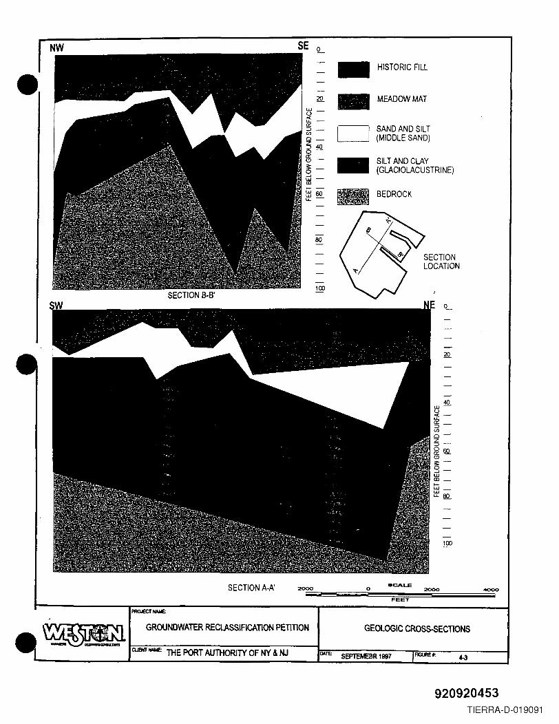
SE L - HISTORIC FILL• 20 - MEADOW MATUJ _
u«:u. -0::
CJ SAND AND SILT~ -en(MIDDLE SAND)0_
~400-0:: - SILT AND CLAY0-§- (GLACIOLACUSTRINE)....JUJ -lD0- -
BEDROCKUJ60tt'-
80
SECTIONLOCATION
100
40UJu«:-~-en0-Z~-~w..C);:-s-WlD _
0-UJ _UJu.80
100
SCALESECTION A-A' 2000 o 2000 '1000!
FEET
SEPTEMEBR 1997
GROUNDWATER RECLASSIFICATION PETlllON GEOlOGIC CR08S-SECTIONS
CUBiT IWIE: THE PORT AUTHORITY OF NY & NJ
920920453TIERRA-D-019091
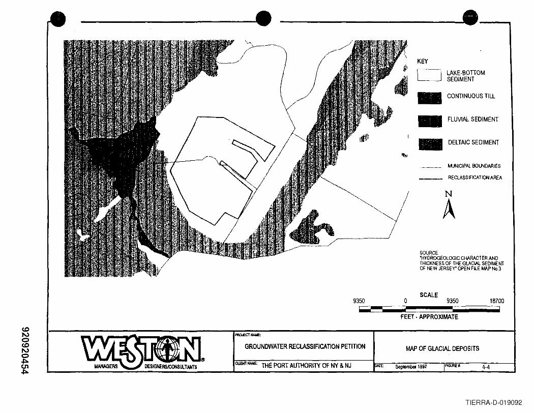
------. ------------...e---,
,I"- .I"'-. .. I~I
I__ ---J/
9350
KEY
LAKE-BOnOMSEDIMENT
CONTINUOUS TIll.
FLUVIAL SEDIMENT
DELTAIC SEDIMENT
MUNICIPAL BOUNDARIES
RECLASSIFICATION AREA
N
ASOURCE''HYDROGEOLOGIC CHARACTER ANDTHICKNESS OF THE GLACIAL SEDIMENTOF NEW JERSEY' OPEN FILE IMP No.3
SCALEo 9350
FEET· APPROXIMATE
GROUNDWATER RECLASSIFICATION PETITION MAP OF GLACIAL DEPOSITS
18700
September 1997CUOO NAME: THE PORT AUTHORITY OF NY & NJ FIGUREt. 4-4
TIERRA-D-019092

• N
•
Shallow GroundwaterElevation Contour line(Number in parenthesisis elevation feet local datum)
NoteThese contours are generalizedReading of the accompanying reportis necessalY for a proper understandingof the shallow groundwater IIow regime
SCALE3500 7000o 3500
FEET
4-5
GROUNDWATER REClASSIFICATION PETITION SHALLOW GROUNDWATERElEVATION CONTOUR MAP
C1JENT!WE: THE PORT AUTHORITY OF NY & NJ September 1997 F1GUREt:
920920455TIERRA-D-019093
• • •Direction 20
0.237
0.235
0.15 ~
..........
...c:::.-?- 0.1 //
//44/
0.0572 11
00 100 200 300 400 500Ihl
PROJECT NAME
GROUNDWATER RECLASSIFICATION PETITION SAMPLE DIRECTIONAL VARIOGRAM FOR THEfiRST CORRElATION STRUCTURE
CliENT NAME THE PORT AUTHORITY OF NY & NJ fIGURE.O~TE: September 1997 5-1
TIERRA-D-019094
•0.25
0.15
0.2
0.1
• •
0.05
Direction 205095
-;=='88.26 16.71 16.._..-/..==._..-..-.._.._.._.._.._..:._.._.._..-.._..249'2.r.'
5000 10000 15000 20000Ihl
PROJECT NAME
GROUNDWATER RECLASSIFICATION PETITION SAMPLE DIRECTIONAL VARIOGRAM FOR THESECOND CORRELATION STRUCTURE
CliENT NAME THE PORT AUTHORITY OF NY & NJ DATE: FIGURE .:September 1997 5-2
TIERRA-D-019095
coNoCONo~0100
---_----::. , ----:e_
180 o
PROJECT NAME:
GROUNDWATER RECLASSIFICATiON PETITION ROSE DIAGRAM FOR THEFIRST CORRELATION STRUCTURE
CUENT NAME: THE PORT AUn-lORITY OF NY & NJ D.A: ' September 1997 FIOUIU't: 5-3
TIERRA-D-019096
• • •90
180
120
150........
...... 1' ••••.., j,'/.......
........ .............
j.... ,...f"t"'T"M·t-t-t-t-t·t-rt-t.,..,...t-t,..,..' ....rt-t-t·t-t·t-tT,..,..t-
270
GROUNDWATER RECLASSIFICATION PETITION ROSE DIAGRAM FOR THESECOND CORRELATION STRUCTURE
FIGUREt'.CUENT NAME: THE PORT AUTHORITY OF NY & NJ DATE: September 1997
TIERRA-D-019097
CDNoCDNo,I:l.0')o
• • •8000
6000 I
4000
Q)(Jc:S 2000II)
oc:o:;:i aeoL-eoa.Q)
rn -2000 i
Q)
~
-4000
-6000
-8000
___I __ I
)
/ ..-
-.•//./ t,
,• / .- -".•
/ I / j ::/ )
/ ".
J / "/ / (/ /..- ( / \
/ I, ) \,./
/,
/ \ I /'. ;/ .' /iI! ::
i /j .: '~ />/'\
'"".<
I .~)
_..)
I I -, b \ \" --- I 1-8000 -6000 -4000 -2000 2000 4000 6000 8000
Well" Separation Oistance
PROJECT NAME-
GROUNDWATER RECLASSIFICATION PETITION COMPOSITE SPATIAL CORRELATION PATIERN
September 1997ClIENT NAAlE THE PORT AUTHORITY OF NY & NJ fiGURE .: 5-5
TIERRA-D-019098
•
•
• Probability of Contamination is 1• Probabil~y of Contamination is 0
Septsmber 1997
GROUNDWATER RECLASSIFICATION PETmONGEOSTATISTICAL. CONTOUR MAP
OF THE PROBABIUTY OFGROUNDWATER CONTAMINATION
QJfHT IWIE.THE PORT AUTHORITY OF NY AND NJ DATE:
920920461TIERRA-D-019099
.'
•2132000 2134000 2136000 21420002138000 2140000
•
_ Probability of Contamina . .Probability of Conta . ~on IS 1mlnation is 0
• ~ GROU~WATER REClASSIRCATlON PET1T10N
CUENT IWolE:
DEVIATIONSWOUR MAP OFFROM ~~~~INALTATISTlCAl MAPDATA
THE PORT AUTHORITY OF NY ANDNJ Septsmber 1997 FlGUREt:
920920462TIERRA-D-019100

• • •Probability that a Percentage of the Area is Contaminated1.0 +-----~-I----------+-------+--------+------~
"02cocEco......co()(f) ····
·r ..--· ..•·• ..•·•• .._-··· .
0.9 . .. .. - ~ ..·····,,,
··· ,· .· ......................................................................................................................... '\_ " ..· ,· ,· ,· ,· ., .· ., .· .· .· ., .· .
,
·,,·.. .. - --. _ .. - ..- - .. --,. .. --- -. _._" -_ .. -- _ ..0.8
......co.c...... 0.7 ........................................................................................................................i- ~- ..·····co~«Q).c......'+-o
···,,.--- _ - -_ .. _ ~ _ .. -- .. ---_ .. - _._ .. ~.-_ .. - --_ - _-- --_ - -~ .., , .· . .· . .· . .· , .· , ., . .· . .· , .· , .· , .· , ., . ..................................... - -.- - - - - .. _.. .. - ~.. - - - .. - - - .. ~ - - - -:" - ..· . .· . .· . .· , ., . .· . .· . .· . .· . .· . .· . .· . .
0.6
......c~Q)a..
0.5
0.4 +----~---4-------+------~~------+-------450% 70% 90%80%60%
Probability that the Area is Contaminated
GROUNDWATER RECLASSIFICATION PETITION PROPORTION OF AREALIKELY TO BE CONTAMINATED
5eptsmbef 1997 FIGURE ..CUeITllAAlE: THE PORT AUTHORITY OF NY & NJ DATE:
I
5-8
TIERRA-D-019101
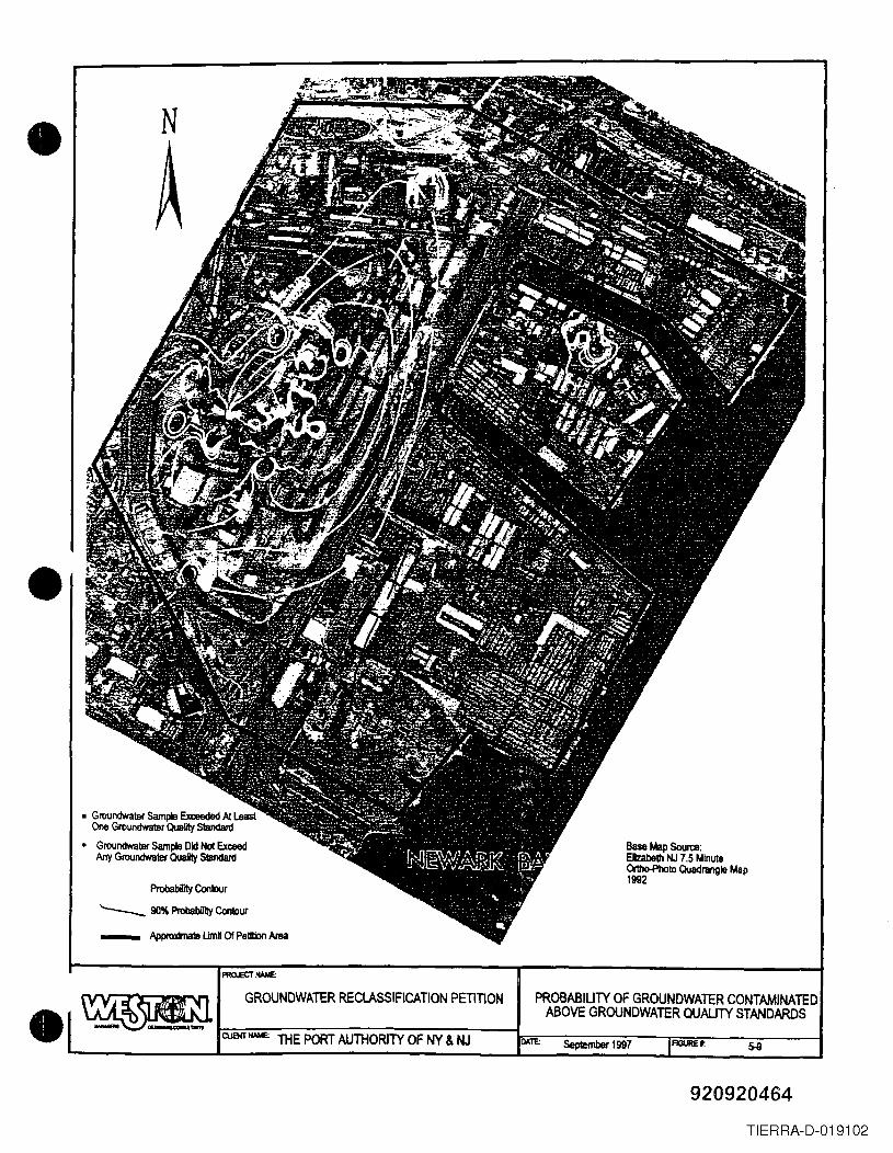
• N
A
•
• Groundwater SampIB Exceeded At LeastOne GroundWaleT Quality S1andanl
• Groundwater Sample Old ~ ExceedMy Groundwater Quaily Standald
Base Map SoUlt8:EJIzabelh NJ 7.5 MinuteOrtho-Photo Quadrangle Map1992
ProbabiIily Contour
'----- 90% ProbablIIty Contour_ Approxina!ll umn 0/ Pelilion Area
FlGlJRE "
GROUNDWATER RECLASSIFICATION PEnnON PROBABIUTY OF GROUNDWATER CONTAMINATEDABOVE GROUNDWATER QUALJTY STANDARDS
ClJB«twIE: THE PORT AUTHORITY OF NY & NJ DAre Seplember 1997
920920464TIERRA-D-019102
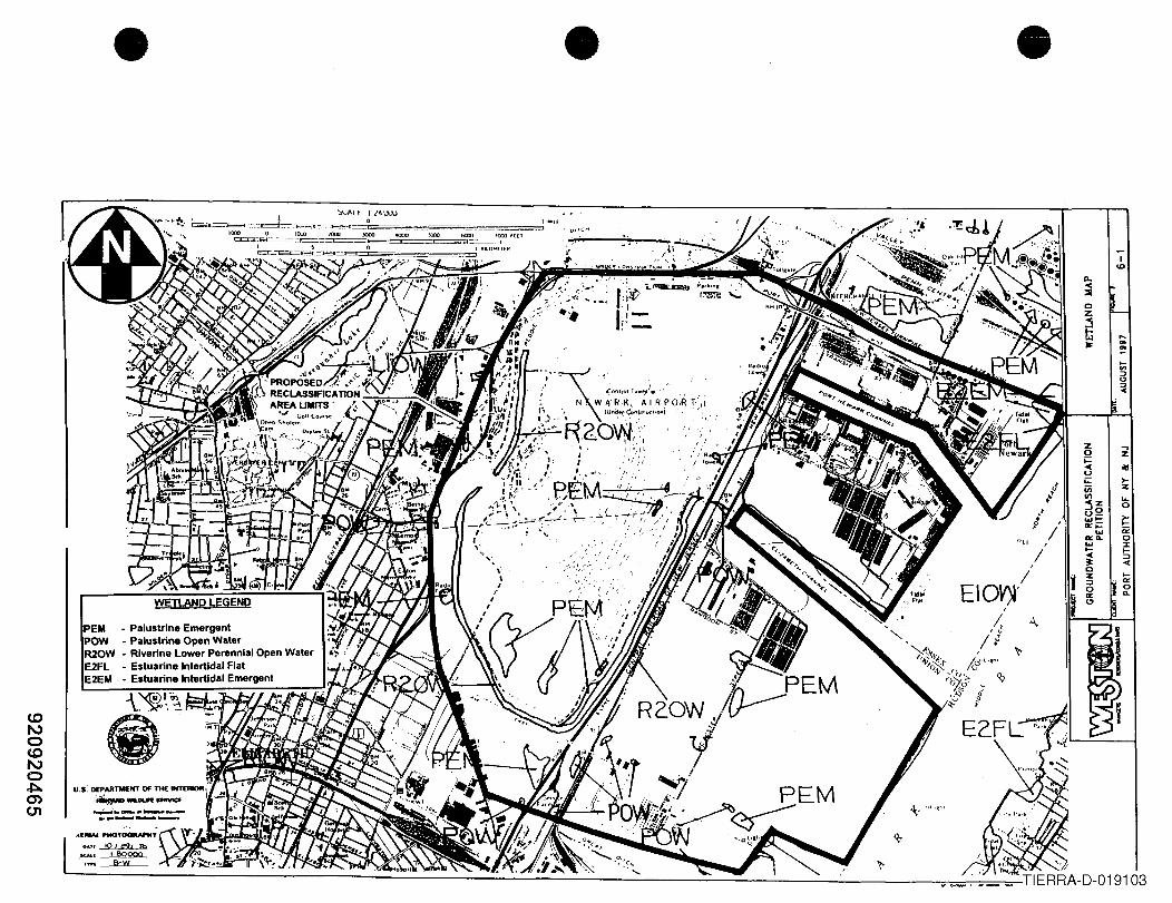
,/
z ...,0;::: z~ olIIu;;: >-iii ::ItIIIjZ ...uQ 0
....... ~..,;:::... it:.., ... 0....... I
~ ....~ :::J
0~
Z:::J0..,<.>
ICD
• • •'::>t.,ALt. 'l4lUJ
o
,/
....'"...
PEM PI- a ustrine EmergentPOW - PalustriR20W Ri . ne Opon Water
- venne Lower pe~2FL _ Estuarine Interllda~F~n:alOpen Water
2EM _ Estuarine Intertidal Eamergent
\~~.;~(I) ~·'"n~.r..,,~r..~
•Tables
•
•920920466
TIERRA-D-019104
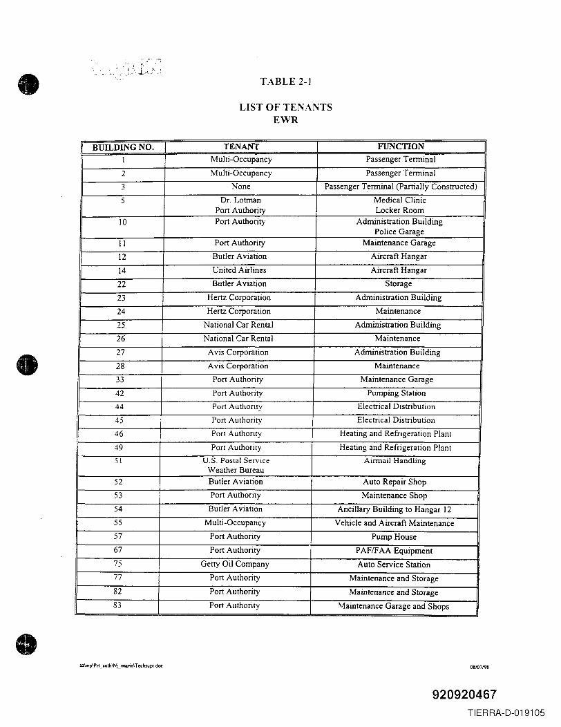
•
•
•
...;-" '-:
TABLE 2-]
LIST OF TENANTSEWR
BUILDING NO. TENANT FUNCTION1 Multi-Occupancy Passenger Terminal
2 Multi-Occupancy Passenger Terminal
3 None Passenger Terminal (Partially Constructed)
5 Dr. Lotman Medical ClinicPort Authority Locker Room
10 Port Authority Administration BuildingPolice Garage
11 Port Authority Maintenance Garage
12 Butler Aviation Aircraft Hangar
14 United Airlines Aircraft Hangar
22 Butler Aviation Storage
23 Hertz Corporation Administration Building
24 Hertz Corporation Maintenance
25 National Car Rental Administration Building
26 National Car Rental Maintenance
27 Avis Corporation Administration Building
28 Avis Corporation Maintenance
33 Port Authority Maintenance Garage
42 Port Authority Pumping Station
44 Port Authority Electrical Distribution
45 Port Authority Electrical Distribution
46 Port Authority Heating and Refrigeration Plant
49 Port Authority Heating and Refrigeration Plant51 U.S. Postal Service Airmail Handling
Weather Bureau52 Butler Aviation Auto Repair Shop
53 Port Authority Maintenance Shop
54 Butler Aviation Ancillary Building to Hangar 1255 Multi-Occupancy Vehicle and Aircraft Maintenance57 Port Authority Pump House67 Port Authority PAF/FAA Equipment75 Getty Oil Company Auto Service Station77 Port Authority Maintenance and Storage82 Port Authority Maintenance and Storage83 Port Authority Maintenance Garage and Shops
az\wp\Pn _ iilul.h\NL mouin\Techsupi doc 08/07198
920920467TIERRA-D-019105
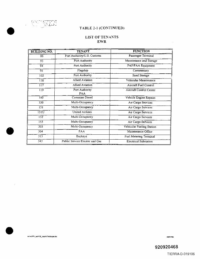
•
•
•
i: f ,,~. -. r:...·-...:~....,.-r~~_\~L'.J'u
TABLE 2-1 (CONTINUED)
LIST OF TENANTSEWR
BUILDING NO. TENANT FUNCTION
88 Port AuthoritylU.S. Customs Passenger Terminal
93 Port Authority Maintenance and Storage
94 Port Authority PAFtFAA Equipment
95 Flagship Commissary
102 Port Authority Sand Storage
116 Allied Aviation Vehicular Maintenance
117 Allied Aviation Aircraft Fuel Control
119 Port Authority Aircraft Control CenterFAA
140 Cummins Diesel Vehicle Engine Repairs
ISO Multi-Occupancy Air Cargo Services
151 MUlti-Occupancy Air Cargo Services
151U United Airlines Air Cargo Services
152 Multi-Occupancy Air Cargo Services
153 Multi-Occupancy Air Cargo Services
303 Multi-Occupancy Vehicular Fueling Station
304 FAA Maintenance Office
315 Buckeye Fuel Metering Terminal
343 Public Service Electric and Gas Electrical Substation
az\wp\Pn _aul.h\Nj_ mann\ Techsupl.doc 08107198
920920468TIERRA-D-019106
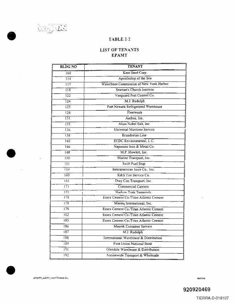
•
•
•
TABLE 2·2
LIST OF TENANTSEPAMT
I BLDGNO I TENANT I102 Kent Steel Corp.
114 Apostleship of the Sea
117 Waterfront Commission of New York Harbor
118 Seaman's Church Institute
122 Vanguard Pest Control Co.
124 MJ. Rudolph
125 Port Newark Refrigerated Warehouse
126 Fleetwash
131 Aarhus, Inc.
135 Akzo Nobel Salt, Inc.
136 Universal Maritime Service
138 Ecuadorian Line
140 ECDC Environmental, L.c.146 Naporano Iron & Metal Co.
148 M.P. Howlett, Inc.
ISO Marine Transport, Inc.
151 Swift Fuel Stop
154 Interamerican Juice Co., Inc.
160 K&S Tire Service Co.16! Dray Con Transport, Inc.
171 Commercial Carriers
\n Hudson Tank Terminals
178 Essex Cement Co.rritan Atlantic Cement
178 Minteq International, Inc.
179 Essex Cement Co.rritan Atlantic Cement
182 Essex Cement Co.rritan Atlantic Cement
185 Essex Cement Co.rritan Atlantic Cement
186 Maersk Container Service
187 MJ. Rudolph
188 International Warehouse & Distribution
189 First Union National Bank
191 Glendale Warehouse & Distribution
192 Nationwide Transport & Wholesale
3.l\wp\Pn _ 3Ulh\Nj_ nl.lrin\T ecllsupi doc 08/07/98
920920469TIERRA-D-019107
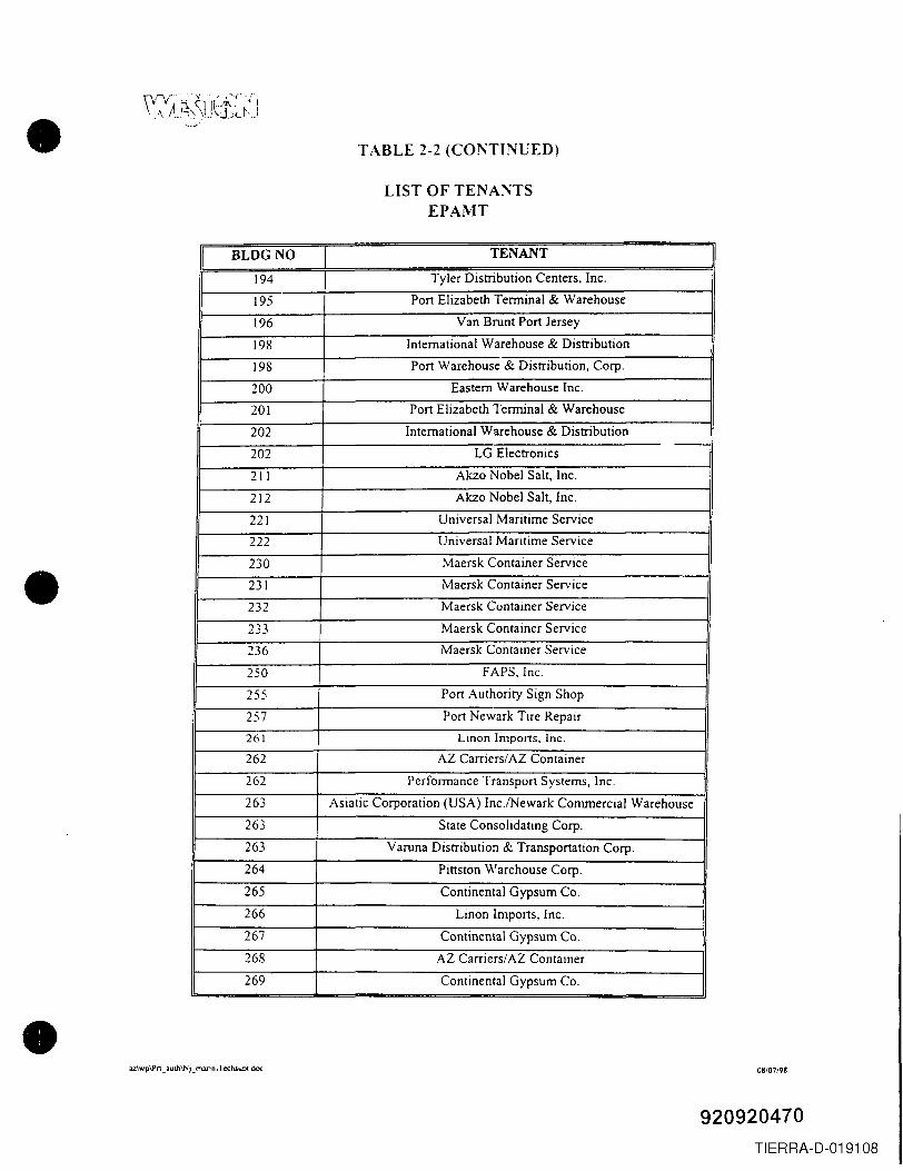
•
•
•
TABLE 2-2 (CONTINUED)
LIST OF TENANTSEPAMT
BLDGNO TENANT
194 Tyler Distribution Centers, Inc.
195 Port Elizabeth Terminal & Warehouse
196 Van Brunt Port Jersey
198 International Warehouse & Distribution
198 Port Warehouse & Distribution, Corp.
200 Eastern Warehouse Inc.
201 Port Elizabeth Terminal & Warehouse
202 International Warehouse & Distribution-202 LG Electronics
211 Akzo Nobel Salt, Inc.
212 Akzo Nobel Salt, Inc.
221 Universal Maritime Service
222 Universal Maritime Service
230 Maersk Container Service
231 Maersk Container Service
232 Maersk Cuntainer Service
233 Maersk Container Service
236 Maersk Container Service
250 FAPS, Inc.
255 Port Authority Sign Shop
257 Port Newark Tire Repair
261 Linon Imports, Inc.
262 AZ Carriers/AZ Container
262 Performance Transport Systems, Inc.
263 Asiatic Corporation (USA) Inc./Newark Commercial Warehouse
263 State Consolidating Corp.
263 Varuna Distribution & Transportation Corp.
264 Pittston Warehouse Corp.
265 Continental Gypsum Co.
266 Linon Imports, Inc.
267 Continental Gypsum Co.
268 AZ Carriers/AZ Container
269 Continental Gypsum Co.
az\wp\Pn_auth\Nj_m3I1n ,Tec:hsupl doc 08/07/98
920920470TIERRA-D-019108
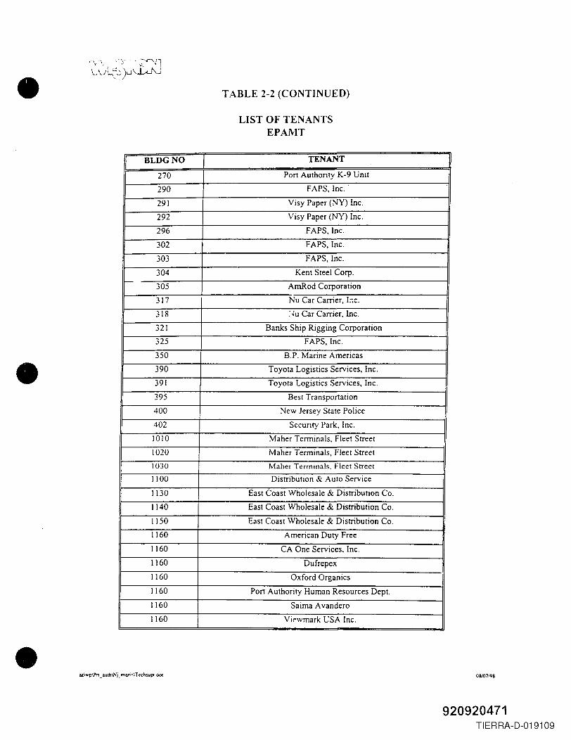
•
•
•
\"\,-\:. -.'::-:-',,,_,·~·~Jl\..\.JL,'~ )u\..J...,J\.J
... .. /
TABLE 2-2 (CONTINUED)
LIST OF TENANTSEPAMT
I BLDGNO I TENANT I270 Port Authority K-9 Unit
290 FAPS, Inc.
291 Visy Paper (NY) Inc.
292 Visy Paper (NY) Inc.
296 FAPS, Inc.
302 FAPS, Inc.
303 FAPS, Inc.
304 Kent Steel Corp.-
305 AmRod Corporation
317 Nu Car Carrier, I:-;c.
318 :~u Car Carrier, Inc.
321 Banks Ship Rigging Corporation
325 FAPS, Inc.
350 B.P. Marine Americas
390 Toyota Logistics Services, Inc.
391 Toyota Logistics Services, Inc.
395 Best Transportation
400 New Jersey State Police
402 Security Park, Inc.
1010 Maher Terminals. Fleet Street
1020 Maher Terminals, Fleet Street
1030 Maher Terminals. Fleet Street
1100 Distribution & Auto Service
1130 East Coast Wholesale & Distribution Co.1140 East Coast Wholesale & Distribution Co.
1150 East Coast Wholesale & Distribution Co.
1160 American Duty Free
1160 CA One Services, Inc.
1160 Dufrepex
1160 Oxford Organics
1160 Port Authority Human Resources Dept.
1160 Saima A vandero
1160 Vil'wmark USA Inc .
az\wp\Pn _ auth\Nj _marin\ T echsupt.d<X Os/07/98
920920471TIERRA-D-019109
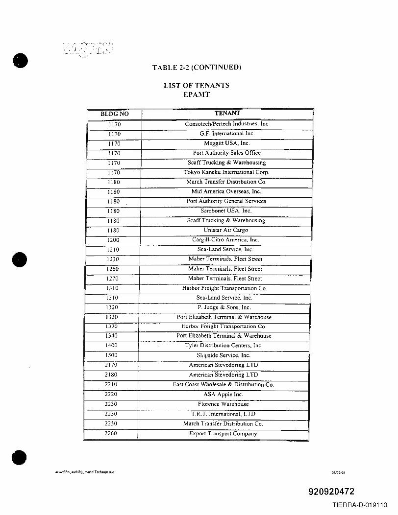
•
•
•
TABLE 2-2 (CONTINUED)
LIST OF TENANTSEPAMT
BLDGNO TENANT
1170 ConsotechlPertech Industries, Inc.
1170 G.F. International Inc.
1170 Meggitt USA, Inc.
1170 Port Authority Sales Office
1170 Scaff Trucking & Warehousing
1170 Tokyo Kaneku International Corp.
1180 March Transfer Distribution Co.
1180 Mid America Overseas, Inc.
1180 Port Authority General Services
1180 Sambonet USA, Inc.
1180 Scaff Trucking & Warehousing
1180 Unistar Air Cargo
1200 Cargill-Citro Amprica, Inc.
1210 Sea-Land Service, Inc.
1230 Maher Terminals, Fleet Street
1260 Maher Terminals, Fleet Street
1270 Maher Terminals, Fleet Street
1310 Harbor Freight Transportation Co.
1310 Sea-Land Service, Inc.
1320 P. Judge & Sons, Inc.
1320 Port Elizabeth Terminal & Warehouse
1330 Harbol" Freight Transportation Co.
1340 Port Elizabeth Terminal & Warehouse
1400 Tyler Distribution Centers, Inc.
1500 SLipside Service, Inc.
2170 American Stevedoring LTD
2180 American Stevedoring LTD
2210 East Coast Wholesale & Distribution Co.
2220 ASA Appie Inc.
2230 Florence Warehouse
2230 T.R.T. International, LTD
2250 March Transfer Distribution Co.
2260 Export Transport Company
az\wp\Pn _ auth\Nj_ matin\ T e'Chsupc_doc 08/07198
920920472TIERRA-D-019110
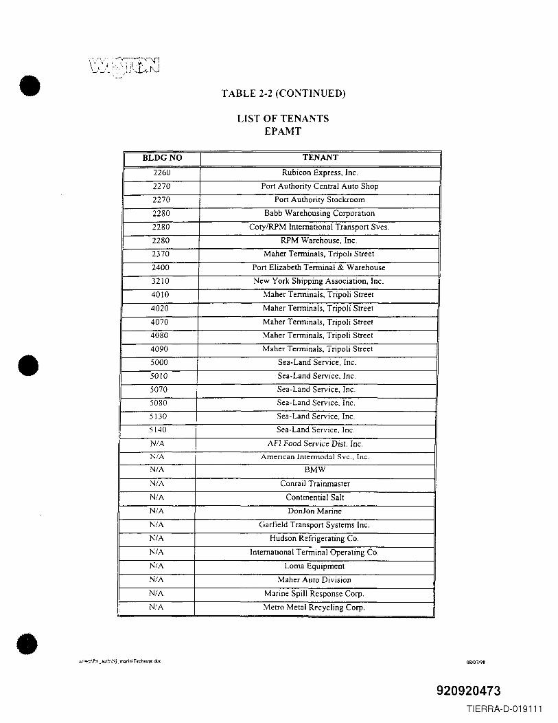
•
•
•
TABLE 2-2 (CONTINUED)
LIST OF TENANTSEPAMT
BLDGNO TENANT
2260 Rubicon Express, Inc.
2270 Port Authority Central Auto Shop
2270 Port Authority Stockroom
2280 Babb Warehousing Corporation
2280 CotylRPM International Transport Svcs.
2280 RPM Warehouse, Inc.
2370 Maher Terminals, Tripoli Street
2400 Port Elizabeth Terminal & Warehouse
3210 New York Shipping Association, Inc.
4010 Maher Terminals, Tripoli Street
4020 Maher Terminals, Tripoli Street
4070 Maher Termmals, Tripoli Street
4080 Maher Terminals, Tripoli Street
4090 Maher Terminals, 1ripoli Street
5000 Sea-Land Service, Inc.
5010 Sea-Land Service, Inc.
5070 Sea-Land Service, Inc.
5080 Sea-Land Service, Inc.
5130 Sea-Land Service, Inc.
5140 Sea-Land Service, Inc.
N/A AFI Food Service Dist. Inc.
N/A American Intermodal Svc., Inc.
N/A BMW
N/A Conrail Trainmaster
N/A Continentia I Salt
N/A Donlon Marine
N/A Garfield Transport Systems Inc.
N/A Hudson R::frigerating Co.
N/A International Terminal Operating Co.
N/A Lorna Equipment
N/A Maher Auto Division
N/A Marine Spill Response Corp.
N.'A Metro Metal Recycling Corp.
az\wp\Pn_auth\Nj~marin\TC'Chsupc. doc 0&107198
920920473TIERRA-D-019111
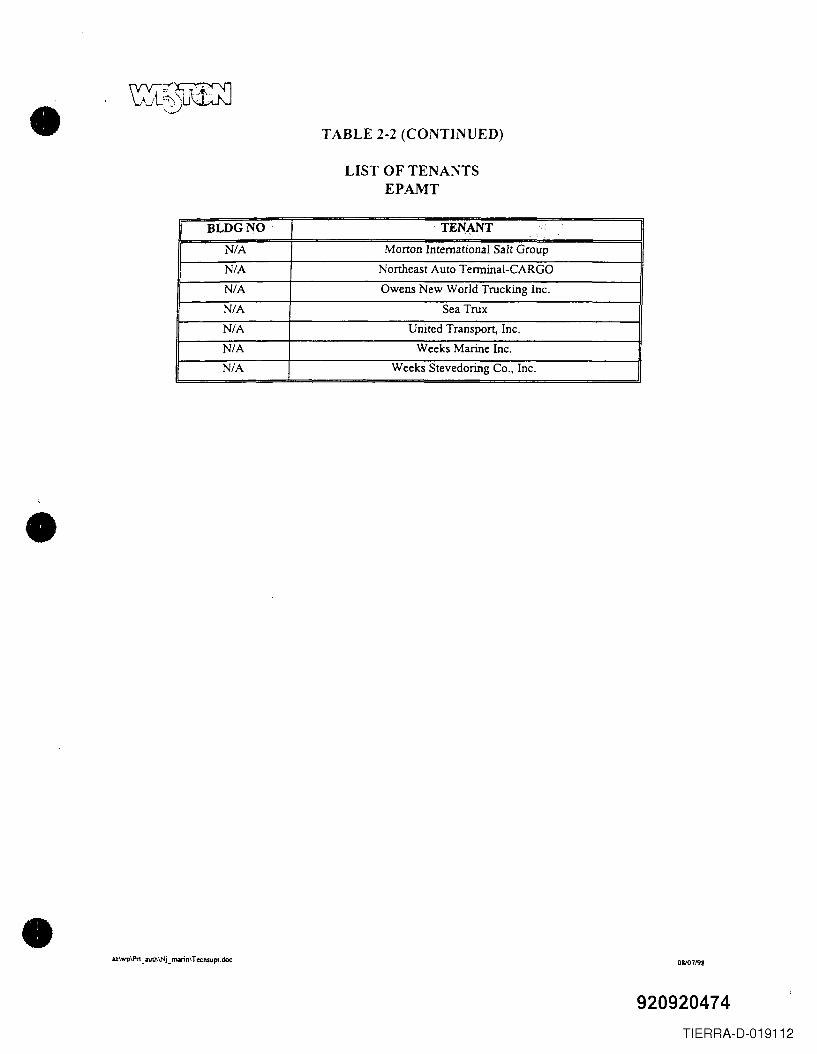
•
•
•
TABLE 2-2 (CONTINUED)
LIST OF TENA~TSEPAMT
BLDGNO TENANT "', "
N/A Morton International Salt Group
N/A Northeast Auto Terminal-CARGO
N/A Owens New World Trucking Inc.
N/A Sea TruxN/A United Transport, Inc.
N/A Weeks Marine Inc.N/A Weeks Stevedoring Co., Inc.
azlwplPn _authlNj_ nwinl Tcchsupt,doc 08lO719l!
920920474TIERRA-D-019112
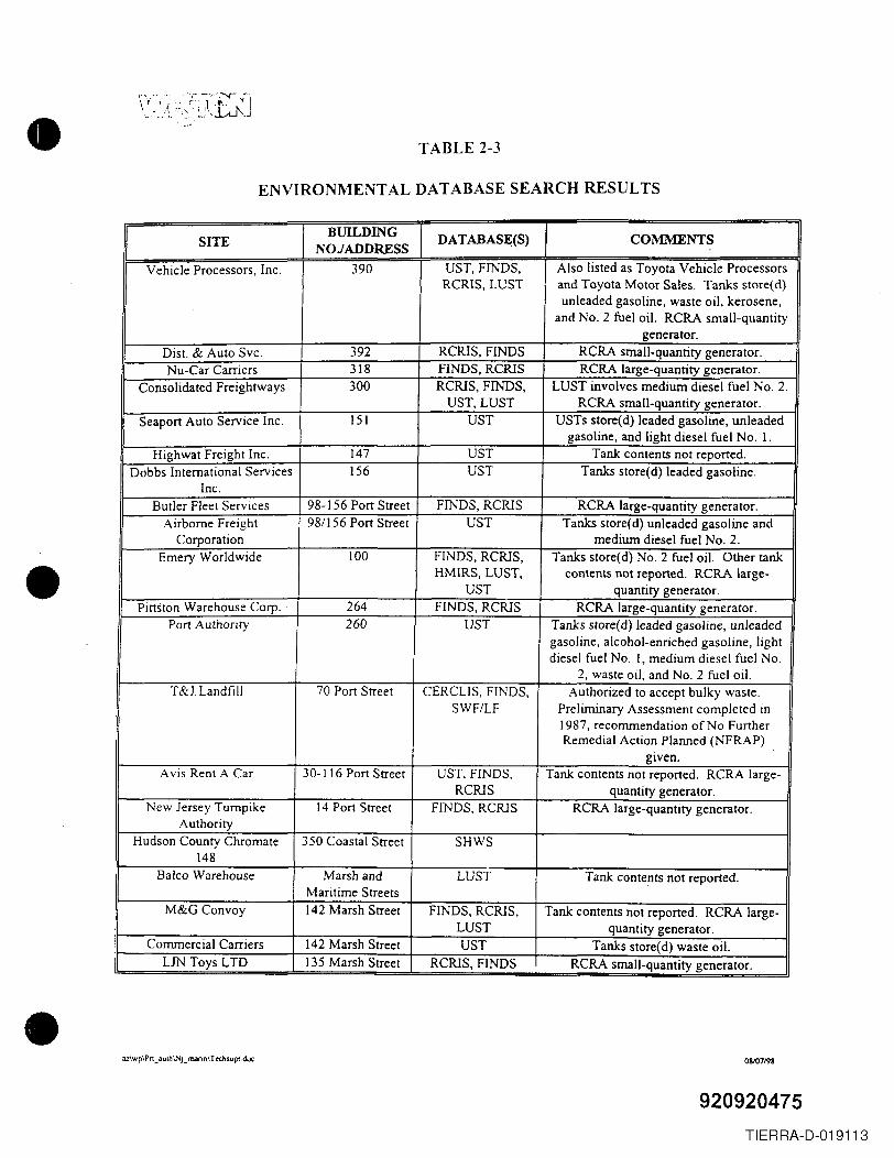
•
•
•
TABLE 2-3
ENVIRONMENTAL DATABASE SEARCH RESULTS
SITEBUILDING DATABASE(S) COMMENTS
NOJADDRESSVehicle Processors, Inc. 390 UST, FINDS, Also listed as Toyota Vehicle Processors
RCRIS, LUST and Toyota Motor Sales. Tanks store(d)unleaded gasoline, waste oil, kerosene,
and No.2 fuel oil. RCRA small-quantitygenerator.
Dist. & Auto Svc. 392 RCRIS, FINDS RCRA small-quantity generator.Nu-Car Carriers 318 FINDS, RCRIS RCRA large-quantity generator.
Consolidated Freightways 300 RCRIS, FINDS, LUST involves medium diesel fuel No.2.UST, LUST RCRA small-quantity generator.
Seaport Auto Service Inc. 151 UST USTs store( d) leaded gasoline, unleadedgasoline, and light diesel fuel No. I.
Highwat Freight Inc. 147 UST Tank contents not reported.Dobbs International Services 156 UST Tanks store(d) leaded gasoline.
Inc.Butler Fleet Services 98-156 Port Street FINDS, RCRIS RCRA large-quantity generator.
Airborne Freight 98/156 Port Street UST Tanks store(d) unleaded gasoline andCorporation medium diesel fuel No.2.
Emery Worldwide 100 FINDS, RCRIS, Tanks store(d) No.2 fuel oil. Other tankHMIRS, LUST, contents not reported. RCRA large-
UST quantity generator.Pittston Warehouse Corp. 264 FINDS, RCRIS RCRA large-quantity generator.
Port Authority 260 UST Tanks store(d) leaded gasoline, unleadedgasoline, alcohol-enriched gasoline, lightdiesel fuel No. I, medium diesel fuel No.
2, waste oil, and No.2 fuel oil.T&J Landfill 70 Port Street CERCUS, FINDS, Authorized to accept bulky waste.
SWF/LF Preliminary Assessment completed in1987, recommendation of No FurtherRemedial Action Planned (NFRAP)
given.Avis Rent A Car 30-116 Port Street UST, FINDS, Tank contents not reported. RCRA large-
RCRIS quantity generator.New Jersey Turnpike 14 Port Street FINDS, RCRIS RCRA large-quantity generator.
AuthorityHudson County Chromate 350 Coastal Street SHWS
148Balco Warehouse Marsh and LUST Tank contents not reported.
Maritime StreetsM&G Convoy 142 Marsh Street FINDS, RCRIS, Tank contents not reported. RCRA large-
LUST quantity generator.Commercial Carriers 142 Marsh Street UST Tanks store(d) waste oil.
UN Toys LID 135 Marsh Street RCRIS, FINDS RCRA small-quantity generator.
a.z\wp\Prt _ :u.llh\'''Jj _ marin\ T echsupt.doc 0&107198
920920475TIERRA-D-019113
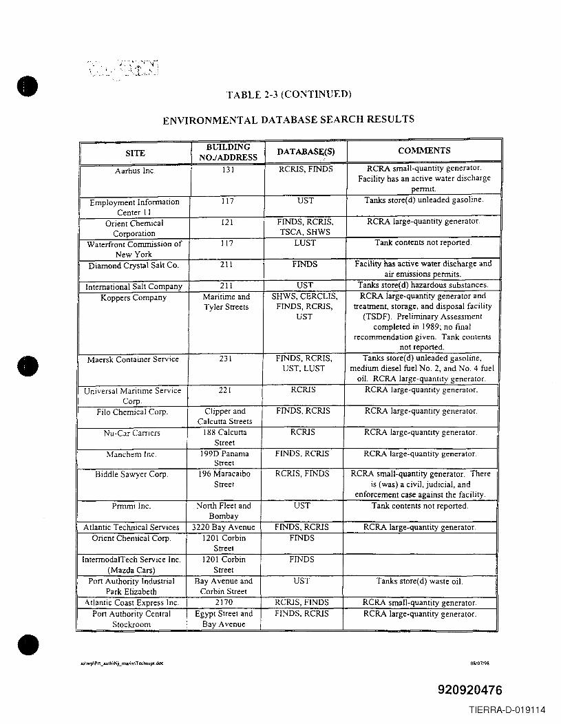
•
•
•
TABLE 2-3 (CONTINUED)
ENVIRONMENTAL DATABASE SEARCH RESULTS
SITEBillLDING DATABASE(S) COMMENTS
NOJADDRESSAarhus Inc. 131 RCRIS, FINDS RCRA small-quantity generator.
Facility has an active water dischargepermit.
Employment Information 117 UST Tanks store(d) unleaded gasoline.Center II
Orient Chemical 121 FINDS, RCRIS, RCRA large-quantity generator.Corporation TSCA, SHWS
Waterfront Commission of 117 LUST Tank contents not reported.New York
Diamond Crystal Salt Co. 211 FINDS Facility has active water discharge andair emissions permits.
International Salt Company 211 UST Tanks store(d) hazardous substances.Koppers Company Maritime and SHWS, CERCLIS, RCRA large-quantity generator and
Tyler Streets FINDS, RCRIS, treatment, storage, and disposal facilityUST (TSDF). Preliminary Assessment
completed in 1989; no finalrecommendation given. Tank contents
not reported.Maersk Container Service 231 FINDS, RCRIS, Tanks store(d) unleaded gasoline,
UST,LUST medium diesel fuel No.2, and No.4 fueloil. RCRA large-quantity generator.
Universal Maritime Service 221 RCRIS RCRA large-quantity generator.Corp.
Filo Chemical Corp. Clipper and FINDS, RCRIS RCRA large-quantity generator.Calcutta Streets
Nu-Car Carriers 188 Calcu tta RCRIS RCRA large-quantity generator.Street
Manchem Inc. 199D Panama FINDS, RCRIS RCRA large-quantity generator.Street
Biddle Sawyer Corp. 196 Maracaibo RCRIS, FINDS RCRA small-quantity generator. ThereStreet is (was) a civil, judicial, and
enforcement case against the facility.Prrnmi Inc. North Fleet and UST Tank contents not reported.
BombayAtlantic Technical Services 3220 Bay Avenue FINDS, RCRIS RCRA large-quantity generator.
Orient Chemical Corp. 1201 Corbin FINDSStreet
IntermodalTech Service Inc. 1201 Corbin FINDS(Mazda Cars) Street
Port Authority Industrial Bay Avenue and UST Tanks store(d) waste oil.Park Elizabeth Corbin Street
Atlantic Coast Express Inc. 2170 RCRIS, FINDS RCRA small-quantity generator.Port Authority Central Egypt Street and FINDS, RCRIS RCRA large-quantity generator.
Stockroom Bay Avenue
az\wp\Pn _aulh\NLmann\T echsupc:. doc 08107198
920920476TI ERRA-D-019114
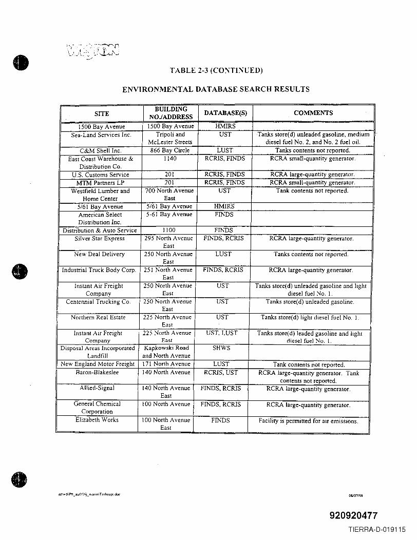
•
•
•
TABLE 2-3 (CO:"lTINUED)
ENVIRONMENTAL DATABASE SEARCH RESULTS
SITEBUILDING DATABASE(S) COMMENTS
NOJADDRESS
1500 Bay Avenue 1500 Bay Avenue HMIRSSea-Land Services Inc. Tripoli and UST Tanks store(d) unleaded gasoline, medium
McLester Streets diesel fuel No.2, and No.2 fuel oil.C&M Shell Inc. 866 Bay Circle LUST Tanks contents not reported.
East Coast Warehouse & 1140 RCRlS, FINDS RCRA small-quantity generator.Distribution Co.
U.S. Customs Service 201 RCRlS, FINDS RCRA large-quantity generator.MTM Partners LP 201 RCRlS, FINDS RCRA small-quantity generator.
Westfield Lumber and 700 North Avenue UST Tank contents not reported.Home Center East
5/61 Bay Avenue 5/61 Bay Avenue HMIRSAmerican Select 5-61 Bay Avenue FINDSDistribution Inc.
Distribution & Auto Service 1100 FINDSSilver Star Express 295 North Avenue FINDS, RCRlS RCRA large-quantity generator.
EastNew Deal Delivery 250 North Avenue LUST Tanks contents not reported.
EastIndustrial Truck Body Corp. 251 North Avenue FINDS, RCRIS RCRA large-quantity generator.
EastInstant Air Freight 250 North Avenue UST Tanks store(d) unleaded gasoline and light
Company East diesel fuel No. I.Centennial Trucking Co. 250 North Avenue UST Tanks store(d) unleaded gasoline.
EastNorthern Real Estate 225 North Avenue UST Tanks store(d) light diesel fuel No.1.
EastInstant AIr Freight 225 North Avenue UST,LUST Tanks store(d) leaded gasoline and light
Company East diesel fuel No.1.Disposal Areas Incorporated Kapkowski Road SHWS
Landfill and North AvenueNew England Motor Freight 171 North Avenue LUST Tank contents not reported.
Baron-Blakeslee 140 North Avenue RCRlS, UST RCRA large-quantity generator. Tankcontents not reported.
Allied-Signal 140 North Avenue FINDS, RCRIS RCRA large-quantity generator.East
General Chemical 100 North Avenue FINDS, RCRIS RCRA large-quantity generator.Corporation
Elizabeth Works 100 North Avenue FINDS Facility is permitted for air emissions.East
az\wp\Pn_ auth\Nj_ nlarin\Tcchsupt doc 0&107198
920920477TIERRA-D-019115
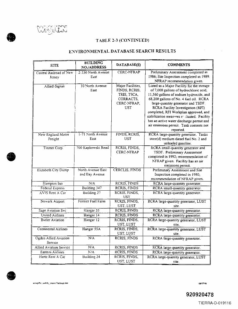
•
•
•
TABLE 2-3 (CONTINUED)
ENVIRONMENTAL DATABASE SEARCH RESULTS
BUILDING DATABASE(S) COMMENTS-SITE NOJADDRESS "
Central Railroad of New 2-330 North Avenue CERC-NFRAP Preliminary Assessment completed inJersey East 1986; Site Inspection completed in 1989.
NFRAP recommendation given.Allied-Signal 10 North Avenue Major Facilities, Listed as a Major Facility for the storage
East FINDS, RCRIS, of 7,000 gallons of hydrochloric acid,TRIS, TSCA, 11,560 gallons of sodium hydroxide, andCORRACTS, 68,200 gallons of No. 4 fuel oil. RCRA
CERC-NFRAP, large-quantity generator and TSDF.UST RCRA Facility Investigation (RFI)
completed, RFI Workplan approved, andstabilization meaSllres e' :luated. Facilityhas an active water discharge permit andair emissions permit. Tank contents not
reported.New England Motor 1-71 North Avenue FINDS, RCRIS, RCRA large-quantity generator. Tanks
Freight East UST store(d) medium diesel fuel No.2 andunleaded gasoline.
Tinmet Corp. 700 Kapkowski Road RCRIS, FINDS, RCRA small-quantity generator andCERC-NFRAP TSDF. Preliminary Assessment
completed in 1992; recommendation ofNFRAP given. Facility has an air
emissions permit.Elizabeth City Dump North Avenue East CERCUS, FINDS Preliminary Assessment and Site
and Bay Avenue Inspection completed in 1980;recommendation ofNFRAP given.
Hampton Inn N/A RCRIS, FINDS RCRA large-quantity generator.Federal Express Building 347 RCRIS, FINDS RCRA small-quantity generator.
AVIS Rent A Car Building 27 RCRIS, FINDS, RCRA large-quantity generator.UST
Newark Airport Former Fuel Farm RCRIS, FINDS, RCRA large-quantity generator, LUSTUST,LUST site.
Sage Aviation Svc Hangar 55 RCRIS, FINDS RCRA large-quantity generator.United Airlines Hangar 14 RCRIS, FINDS RCRA large-quantity generator.Butler Aviation Hangar 12 RCRIS, FINDS, RCRA large-quantity generator, LUST
UST, LUST site.Continental Airlines Hangar 55A RCRIS, FINDS, RCRA large-quantity generator, LUST
UST,LUST site.Ogden Allied Aviation N/A RCRIS, FINDS RCRA large-quantity generator.
ServiceAllied Aviation Service N/A RCRIS, FINDS RCRA large-quantity generator.
Eastern Airlines N/A RCRIS, FINDS RCRA large-quantity generator.Hertz Rent A Car Building 24 RCRIS, FINDS, RCRA large-quantity generator, LUST
UST,LUST site.
az\wp\Pn _ aUlh\Nj_ marin '.T echsupt.doc 08107198
920920478TIERRA-D-019116
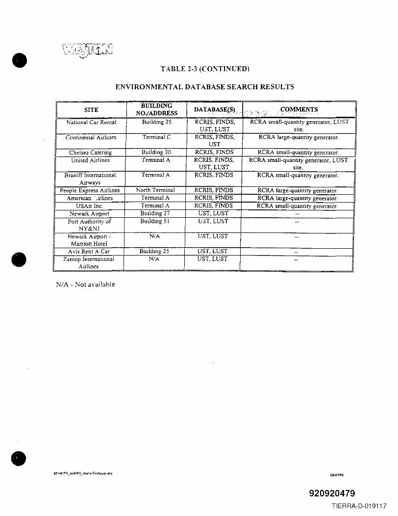
•
•
•
TABLE 2-3 (CONTINUED)
ENVIRONMENTAL DATABASE SEARCH RESULTS
SITEBUILDING DATABASE(S) __ .COMMENTSNOJADDRESS ..<~--~ --
~ ' • '. ." > ;-. . ~!-- -- -co' ---_:-.-.- __ '
National Car Rental Building 25 RCRlS, FINDS, RCRA small-quantity generator, LUSTU3T, LUST site.
Continental Airlines Terminal C RCRlS, FINDS, RCRA large-quantity generator.UST
Chelsea Catering Building 30 RCRlS, FINDS RCRA small-quantity generator.United Airlines Terminal A RCRlS, FINDS, RCRA small-quantity generator, LUST
UST, LUST site.Braniff International Terminal A RCRlS, FINDS RCRA small-quantity generator.
AirwaysPeople Express Airlines North Terminal RCRlS, FINDS RCRA large-quantity generator.
American ..irlines TermmalA RCRlS, FINDS RCRA large-quantity generator.USAir Inc. Terminal A RCRlS, FINDS RCRA small-quantity generator.
Newark Airport Building 27 UST, LUST --Port Authority of Building 51 U5T, LUST --
NY&NJNewark Airport - N/A UST,LUST --
Marriott HotelAvis Rent A Car Building 25 UST, LUST --
Zantop International N/A UST, LUST --Airlines
N/A - Not available
az\wp\Pn _3uth\Nj_ m:uin\ Tethsupc.doc 08/07198
920920479TIERRA-D-019117
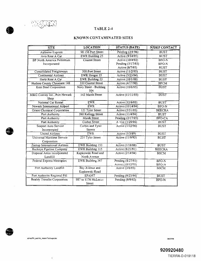
•
•
•
TABLE 2-4
KNOWN CONTAMINATED SITES
I SITE I LOCATION I STATUS (DATE) I NJDEP CONTACT IAirborne Express 98 156 Port Street Pending (2/8.'96) BUSTAvis Rent A Car EWR Building 25 Active (9/14/95) BUST
BP North America Petroleum Coastal Street Active (10/4/92) BFO-NIncorporated Pending (5/17/93) BFO-N
Active (6/7/95) BUSTConsolidated Freightways 300 Port Street Active (11/2/95) BUST
Continental Airlines EWR Hangar 55 Active (3/23/94) BUSTHertz Rent A Car EWR Building 23 Active (10/1/88) BUST
Hudson County Chromate 148 350 Coastal Street Active (4/17/90) BFCMKent Steel Corporation Navy Street - Building Active (10/6/95) BUST
304M&G Convoy Inc., Port Newark )42 Marsh Street Active (11/11/93) BUST
ShopNational Car Rental EWR Active ( 12/6/93) BUST
Newark International Airport EWR Active (10/14/94) BFO-NOrient Ch.;:mical Corporation 121 Tyler Street Active (5/31/95) BEECRA
Port Authority 260 Kellogg Street Active (11/4194) BUSTPort Authority Marsh Street Pending (2/17/95) BFO-CAPort Authority Corbin Street A ,tive (3/29/96) BUST
Seaport Auto Service Corbin and Tyler Active (1/22/96) BUSTIncorporated Streets
United Airlines EWR Active (1/3189) BUSTUniversal Maritime Service 231 Tyler Street Active (11/9193) BUST
CorporationZantop International Airlines EWR Building 153 Active (1/18/88) BUSTBuckeye Pipeline Company EWR Building liS Active (8/21/91) BEECRADisposal Areas Incorporated Kapkowski Road and Active (2/14/94) BSCM
Landfill North AvenueFederal Express Metroplex EWR Building 347 Pending (8/27/93) BFO-N
Active (10/1 2/95) BFO-NPort Authority Landfill Bay Avenue and Active (3/8/93) BSCM
Kapkowski RoadPort Authority Regional Fill EPAMT Pending (9/23/94) BUSTReality Transfer Corporation 987 to 1176 McLes;.::! Pending (9/9/92) BFO-N
Street
az\wp\Prt _ aulh\Nj_ marin\ T echsupl.doc 08107/98
920920480TIERRA-D-019118
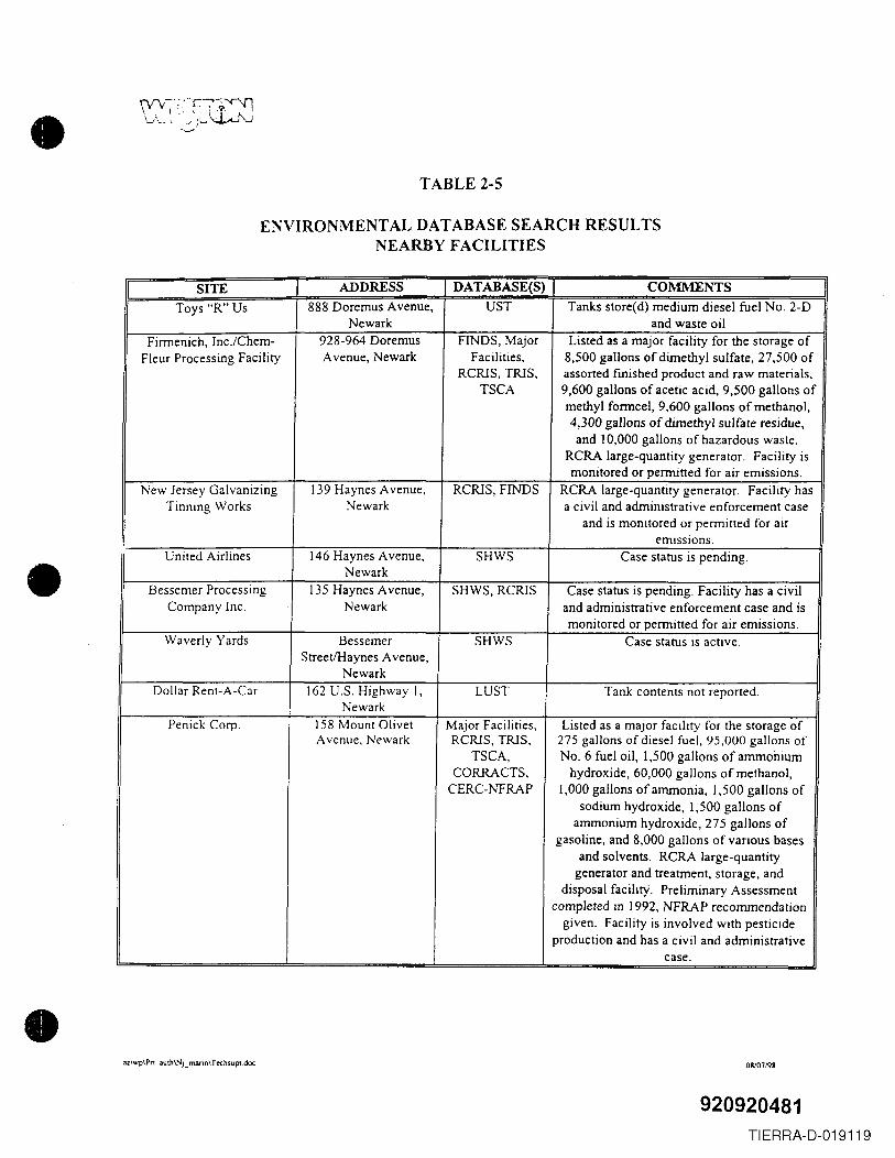
•
•
•
TABLE 2-5
ENVIRONMENTAL DATABASE SEARCH RESULTSNEARBY FACILITIES
SITE ADDRESS DATABASE(S) COMMENTSToys "R" Us 888 Doremus Avenue, UST Tanks store(d) medium diesel fuel No. 2-D
Newark and waste oilFirmenich,Inc.lChem- 928-964 Doremus FINDS, Major Listed as a major facility for the storage of
Fleur Processing Facility Avenue, Newark Facilities, 8,500 gallons of dimethyl sulfate, 27,500 ofRCRIS, TRIS, assorted fmished product and raw materials,
TSCA 9,600 gallons of acetic acid, 9,500 gallons ofmethyl formce!, 9,600 gallons of methanol,4,300 gallons of dimethyl sulfate residue,and 10,000 gallons of hazardous waste.
RCRA large-quantity generator. Facility ismonitored or permitted for air emissions.
New Jersey Galvanizing 139 Haynes Avenue, RCRIS, FINDS RCRA large-quantity generator. Facility hasTinning Works Newark a civil and administrative enforcement case
and is monitored or permitted for airemissions.
United Airlines 146 Haynes Avenue, SHWS Case status is pending.Newark
Bessemer Processing 135 Haynes Avenue, SHWS, RCRIS Case status is pending. Facility has a civil. Company Inc. Newark and administrative enforcement case and is
monitored or permitted for air emissions.Waverly Yards Bessemer SHWS Case status is active.
StreetlHaynes Avenue,Newark
Dollar Rent-A-Car 162 U.S. Highway I, LUST Tank contents not reported.Newark
Penick Corp. 158 Mount Olivet Major Facilities, Listed as a major facility for the storage ofAvenue, Newark RCRIS, TRIS, 275 gallons of diesel fuel, 95,000 gallons of
TSCA, NO.6 fuel oil, 1,500 gallons of ammoniumCORRACTS, hydroxide, 60,000 gallons of methanol,
CERC-NFRAP 1,000 gallons of ammonia, 1,500 gallons ofsodium hydroxide, 1,500 gallons of
ammonium hydroxide, 275 gallons ofgasoline, and 8,000 gallons of various bases
and solvents. RCRA large-quantitygenerator and treatment, storage, and
disposal facility. Preliminary Assessmentcompleted in 1992, NFRAP recommendation
given. Facility is involved with pesticideproduction and has a civil and administrative
case .
az\wp\Pn _ 3uth\Nj _ marin\ T echSUpl.doc 08107198
920920481TIERRA-D-019119
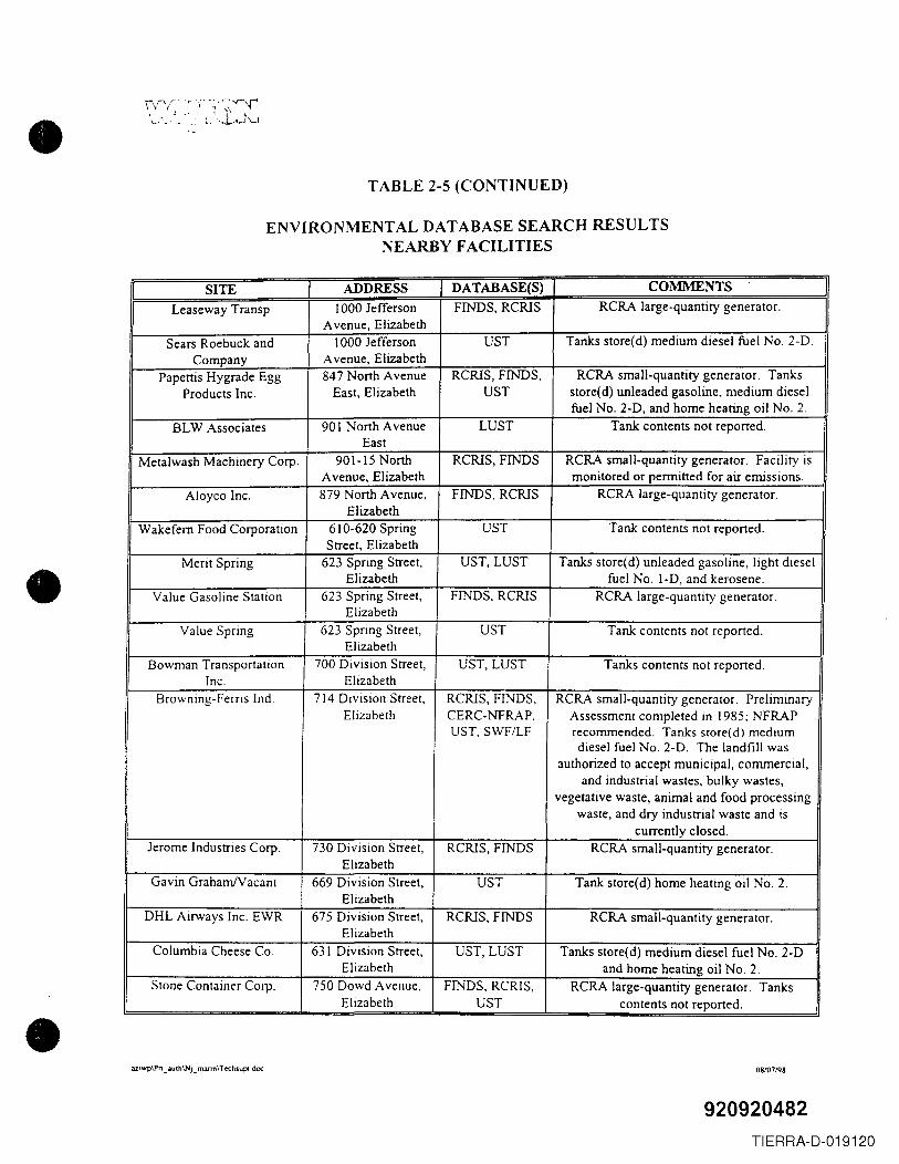
•
•
•
\\n/~'~;~.".r 4,1.·.'~~~\ .. ",~_.~'._ ~" -,...l.,.-J \...J
TABLE 2-5 (CONTINUED)
ENVIRONMENT AL DATABASE SEARCH RESULTSNEARBY FACILITIES
I SITE I ADDRESS I DATABASE(S) I COMMENTS !Leaseway Transp 1000 Jefferson FINDS, RCRlS RCRA large-quantity generator.
Avenue, ElizabethSears Roebuck and 1000 Jefferson UST Tanks store(d) medium diesel fuel No.2-D.
Company Avenue, ElizabethPapettis Hygrade Egg 847 North Avenue RCRlS, FINDS, RCRA small-quantity generator. Tanks
Products Inc. East, Elizabeth UST store(d) unleaded gasoline, medium dieselfuel No. 2-D, and home heating oil No.2.
SL W Associates 901 North Avenue LUST Tank contents not reported.East
Metalwash Machinery Corp. 901-15 North RCRlS, FINDS RCRA small-quantity generator. Facility isAvenue, Elizabeth monitored or permitted for air emissions.
Aloyco Inc. 879 North Avenue, FINDS, RCRlS RCRA large-quantity generator.Elizabeth
Wakefem Food Corporation 610-620 Spring UST Tank contents not reported.Street, Elizabeth
Merit Spring 623 Spring Street, UST,LUST Tanks store( d) unleaded gasoline, light dieselElizabeth fuel No. I-D, and kerosene.
Value Gasoline Station 623 Spring Street, FINDS, RCRlS RCRA large-quantity generator.Elizabeth
Value Spring 623 Spring Street, UST Tank contents not reported.Elizabeth
Bowman Transportation 700 Division Street, UST, LUST Tanks contents not reported.Inc. Elizabeth
Browning-Ferris Ind. 714 Division Street, RCRlS, FINDS, RCRA small-quantity generator. PreliminaryElizabeth CERC-NFRAP, Assessment completed in 1985; NFRAP
UST, SWF/LF recommended. Tanks store(d) mediumdiesel fuel No.2-D. The landfill was
authorized to accept municipal, conunerciaI,and industrial wastes, bulky wastes,
vegetative waste, animal and food processingwaste, and dry industrial waste and is
currently closed.Jerome Industries Corp. 730 Division Street, RCRlS, FINDS RCRA small-quantity generator.
ElizabethGavin GrahamlVacant 669 Division Street, UST Tank store(d) home heating oil No.2.
ElizabethDHL Airways Inc. EWR 675 Division Street, RCRlS, FINDS RCRA small-quantity generator.
ElizabethColumbia Cheese Co. 631 Division Street, UST,LUST Tanks store(d) medium diesel fuel No. 2-D
Elizabeth and home heating oil No.2.Stone Container Corp. 750 Dowd Avenue, FINDS, RCRlS, RCRA large-quantity generator. Tanks
Elizabeth UST contents not reported .
az\wp\Pn _iUlh\Nj_ marin\T echsupt doc 08lO71'l8
920920482TIERRA-D-019120
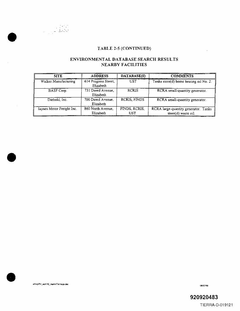
•
•
•
TABLE 2-5 (CONTINUED)
ENVIRONMENTAL DATABASE SEARCH RESULTSNEARBY FACILITIES
SITE ADDRESS DATABASE{S) COMMENTSWalker Manufacturing 614 Progress Street, UST Tanks store(d) home heating oil No.2.
ElizabethBASF Corp. 731 Dowd Avenue, RCRlS RCRA small-quantity generator.
ElizabethDiebold, Inc. 700 Dowd Avenue, RCRlS, FINDS RCRA small-quantity generator.
ElizabethJaynes Motor Freight Inc. 860 North Avenue, FINDS, RCRlS, RCRA large-quantity generator. Tanks
Elizabeth UST store(d) waste oil.
az\wp\Pn _.uth\NL marin\ Techsupl. doc08/07198
920920483TIERRA-D-019121
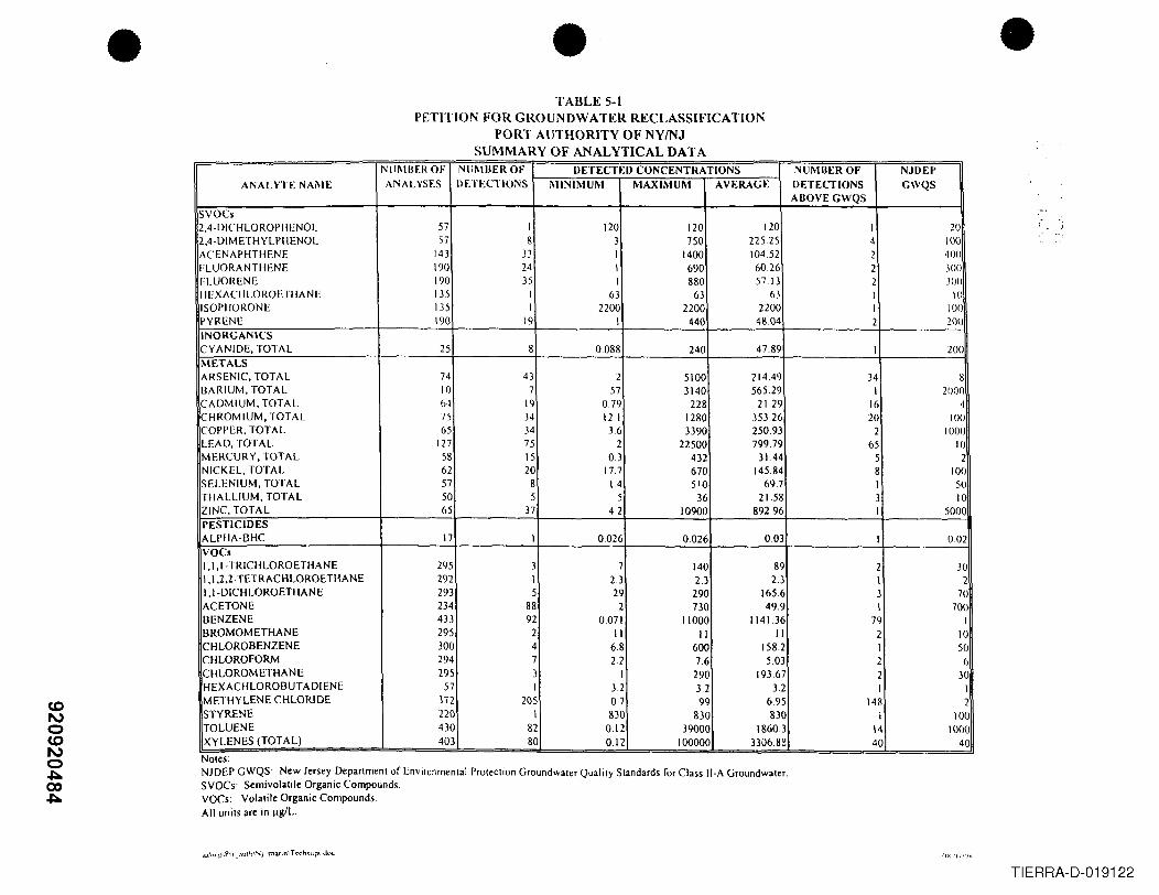
CDI\,)oCDI\,)o~00~
• •TABLE 5-1
PETITION FOR GROUNDWATER RECLASSIFICATIONPORT AUTHORITY OF NYINJ
SUMMARY OF ANALYTICAL DATA
•NUMBER OF NUMBER OF DETECTED CONCENTRATIONS NUMBER OF NJUEI'
ANAL YTE NAME ANALYSES DETECTIONS MINIMUM MAXIMUM AVERAGE DETECTIONS GWQSABOVE GWQS
SVOCs2,4-DICHLOROPIIENOL 57 I 120 120 120 I 202,4-DIMETHYLPIIENOL 57 8 3 750 22525 4 100ACENAPHTHENE 143 33 I 1400 10452 2 400FLUORANHIENE 190 24 I 690 60.26 2 300FLUORENE 190 35 I 880 57 13 2 .100IIEXACIILOROEHIANE 135 I 63 63 63 I 10ISOPIIORONE 135 I 2200 2200 2200 I 100PYRENE 190 19 1 440 48.04 2 200INORGANICSCYANIDE, TOTAL 25 8 0088 240 47.89 I 200METALSARSENIC, TOTAL 74 43 2 5100 21449 34 8BARIUM, TOTAL 10 7 57 3140 565.29 I 2000CADMIUM, TOTAL 64 19 079 228 2129 16 4CHROMIUM, TOTAL 75 J4 121 1280 35326 20 100COPPER, TOTAL 65 34 36 ))90 25093 2 1000LEAD, TOTAL 127 75 2 22500 799.79 65 10MERCURY, TOTAL 58 15 03 432 31.44 5 2NICKEL, TOTAL 62 20 177 670 145.84 8 100SELENIUM, TOTAL 57 8 \4 510 69.7 1 50THALLIUM, TOTAL 50 5 5 36 21.58 3 10ZINC, TOTAL 65 37 42 10900 89296 I 5000PESTICIDESALPHA-BHC 17 1 0026 0026 003 1 002VOCs1,1,1-TRICHLOROETHANE 295 3 7 140 89 2 301,I,2,2-TETRACHLOROETHANE 292 1 2J 23 23 I 2I,I-DICHLOROETHANE 293 5 29 290 165.6 3 70ACETONE 234 88 2 730 49.9 1 700BENZENE 433 92 0.071 11000 1141.36 79 IBROMOMETHANE 295 2 II II II 2 10CHLOROBENZENE 300 4 68 600 158.2 I 50CHLOROFORM 294 7 22 76 503 2 6CHLOROMETHANE 295 3 I 290 193.67 2 30HEXACHLOROBUTADIENE 57 1 32 32 32 I IMETHYLENE CHLORIDE 372 205 07 99 695 148 2STYRENE 220 I 830 830 830 1
10CIITOLUENE 430 82 012\ 39000 1860.3 \4 looeXYLENES (TOTAL) 403 80 0.12 100000 33()68~ 40 40Noles:NJDEP GWQS: New Jersey Department of Environmental Prolection Groundwater Quality Standards for Class II-A Groundwater.SVOCs: Semivolalile Organic Compounds.VOCs: Volatile Organic Compounds.All units are in l!g/L.
(PI. '!Ii'IX
TIERRA-D-019122
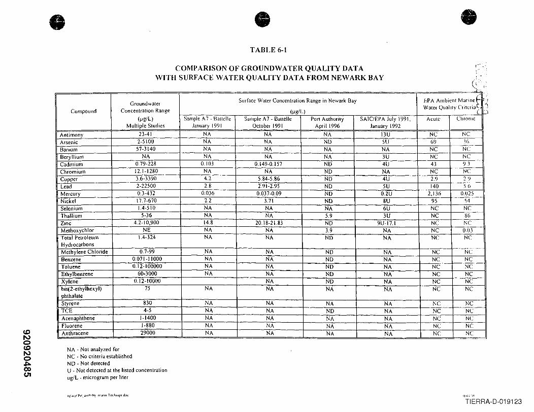
CDNoCDNo,J::l.00CJ1
• • •TABLE 6-1
COMPARISON OF GROUNDWATER QUALITY DATAWITH SURFACE WATER QUALITY DATA FROM NEWARK BAY
1-- '-..,
, .-I. :.~ "..-
,- . ,:
Groundwater Surface Water Concentration Range in Newark Bay EPA Ambient Marinet ./
Compound Concentration Range (J-1g/L)Water Quality Criteria C J
(J-1g/L) Sample A7 - Battclle Sample A7 - Battelle Port Authority SAIC/EPA July 1991, Acute ChronicMultiple Studies January 1991 October I991 April 1996 January 1992
Antimony 23-41 NA NA NA I3U NC NCArsenic 2-5100 NA NA NO 5U 69 3(,
Barium 57-3140 NA NA NA NA NC NCBeryllium NA NA NA NA 3U NC NCCadmium 0.79-228 0103 0.149-0.157 NO 4U 43 9.3Chromium 12.1-1280 NA NA NO NA NC NCCopper 3.6-3390 42 5.84-5.86 NO 4U 2.9 29Lead 2-22500 2.8 2.91-2.95 NO 5U 140 56Mercury 0.3-432 0036 0.037-0.09 NO 0.2U 2,136 0025Nickel 17.7-670 2.2 3.71 NO 8U 95 54Selenium 1.4-510 NA NA NA 6U NC NCThallium 5-36 NA NA 5.9 3U NC 86Zinc 4.2-10,900 14.8 20.18-21.83 NO 9U-17.1 NC NCMethoxychlor NE NA NA 3.9 NA NC 003Total Petroleum 1.4-324 NA NA NO NA NC NCHydrocarbonsMethylene Chloride 0.7-99 NA NA NO NA NC NCBenzene 0.071-11000 NA NA NO NA NC NCToluene 0.12-100000 NA NA ND NA NC NCEthylbenzene 60-3000 NA NA NO NA NC NCXylene 0.12-10000 NA NO NA NC NCbis(2-ethylhexyl) 75 NA NA NA NA NC NCphthalateStyrene 830 NA NA NA NA NC NCTCE 4-5 NA NA NO NA NC NCAcenaphthene 1-1400 NA NA NA NA NC NCFluorene 1-880 NA NA NA NA NC NCAnthracene 29000 NA NA NA NA NC NC
NA - Not analyzed forNC - No criteria establishedND - Not detectedU - Not detected at the listed concentrationug/L - microgram per liter
rlll-()7, (I~,
TIERRA-D-019123
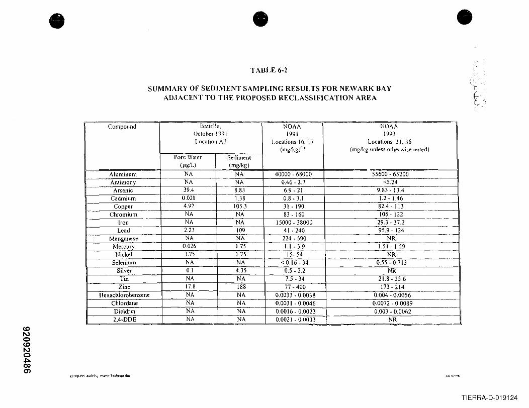
• •TABLE 6-2
SUMMARY OF SEDIMENT SAMPLING RESULTS FOR NEWARK BAYADJACENT TO THE PROPOSED RECLASSIFICATION AREA
Compound Battelle, NOAA NOAAOctober 1991 1991 1993Location A7 Locations 16, 17 Locations 31, 36
(mglkg)(') (mg/kg unless otherwise noted)Pore Water Sediment
(Ilg/L) (mglkg)
Aluminum NA NA 40000 - 68000 55600 - 65200Antimony NA NA 0.46 - 2.7 <5.24
Arsenic 39.4 8.83 6.9 - 21 9.83 - 13.4Cadmium 0.028 1.38 0.8 - 3.1 1.2 - 1.46
Copper 4.97 105.3 31 - 190 82.4 - 113Chromium NA NA 83 - 160 106 - 122
Iron NA NA 15000 - 38000 29.3-37.2Lead 2.23 109 41 - 240 95.9 - 124
Manganese NA NA 224 - 590 NRMercury 0.026 1.75 1.1 - 3.9 1.51 - 1.59Nickel 3.75 1.75 15- 54 NR
Selenium NA NA < 0.16 - 34 0.55 - 0.713Silver 0.1 4.35 0.5 - 2.2 NRTin NA NA 7.5 - 34 21.8 - 25.6Zinc 17.8 188 77 - 400 173-214
Hexachlorobenzene NA NA 0.0033 - 0.0038 0.004 - 0.0056Chlordane NA NA 0.0031 - 0.0046 0.0072 - 0.0089Dieldrin NA NA 0.0016 - 0.0023 0.003 - 0.00622,4-DDE NA NA 0.0021 - 0.0033 NR
az\wplPn __,IUIh\NJ_rnarin',T('chsUPI doc OR'I)7I'Hi
•
TIERRA-D-019124
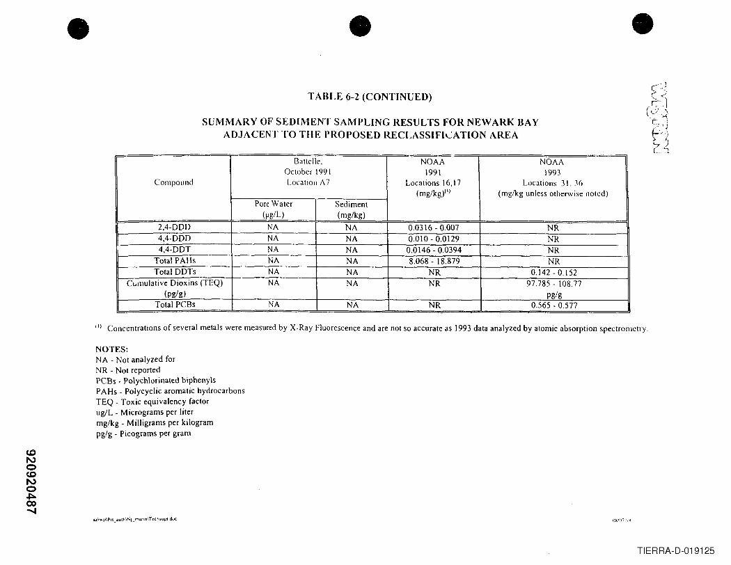
WNoCDNo,J::l.CO......
• •TABLE (i-2 (CONTINUED)
SUMMARY OF SEDIMENT SAMPLING RESULTS FOR NEWARK BAYADJACENT TO THE PROPOSED RECLASSIFILATION AREA
I3altelle, NOAA NOAAOctober 1991 1991 1993
Compound Location /\ 7 Locations 16,17 Locations 31, 36(mg/kg)(\) (mglkg unless otherwise noted)
Pore Water Sediment(Jlg/L) (mg/kg)
2,4-000 NA NA 0.0316 - 0.007 NR4,4-000 NA NA 0.010 - 0.0129 NR4,4-00T NA NA 0.0146 - 0.0394 NR
Total PAHs NA NA 8.068 - 18.879 NRTotal DOTs NA NA NR 0.142 - 0.152
CUlllulative Dioxins (TEQ) NA NA NR 97.785 - 108.77(pg/g) pg/g
Total PCBs NA NA NR 0.565 - 0.577
III Concentrations of several metals were measured by X-Ray Fluorescence and are not so accurate as 1993 data analyzed by atomic absorption spectrometry.
NOTES:NA - Not analyzed forNR - Not reportedPCBs - Polychlorinated biphenylsPAHs - Polycyclic aromatic hydrocarbonsTEQ - Toxic equivalency factorug/L - Micrograms per litermglkg - Milligrams per kilogrampg/g - Picograms per gram
u\ ....'p\Pn_iluth\Nj_mannITc:cl15up( doc
•
TIERRA-D-019125
•i1
! Appendix AI
•
•920920488
TIERRA-D-019126
•
•
APPENDIX A
EDRMAP
. \Tecl1supt docJ.2\wpIPn_Jult'l\Nj_ mann
•i
Js
j~[[4
~.
•
•
•
•
•920920R4A9~_019129TIER -
•
•
N
o!
1/4 1I
1/2
• Scale in Miles
920920492TIERRA-D-019130
},8/' ~.......... ,,\
.': , ....
:1izabethII Hater 0 1/4 1/2'''.'
- ~lLper fund SUes L ! !
-'-• Scale In Miles
920920493TIERRA-D-019131
•
I
920920TiERRA-D-019132
-- - --.- .. _----~~• , ~~/'~ .N / ". .-/Ilf .;,~! \
\
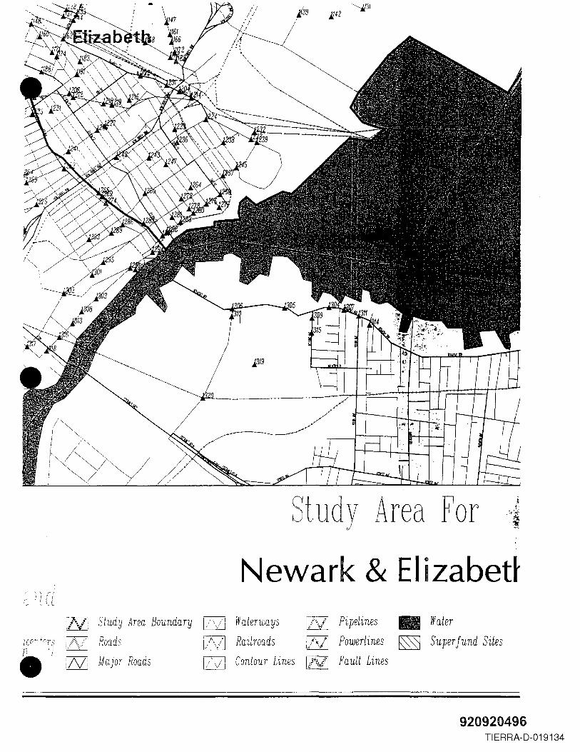
/~i "
I >"'",. / "-I , ~rv~/~ /I ~/ Y. .. /
Study Area For
Newark & EIizabet~.r- ~. '\ r i
, • , I
.~ . L {_ L
j\/: Study Area Boundaryj\ /' Roads
!~
1-.....-/1 Waterways IlVI Pipelines • Water~
i77l Railroads QSZJ Powerlines ~ Super fund Sites~pi Contour Lines [M Fault Lines~:N: Major Roads
920920496TIERRA-D-019134
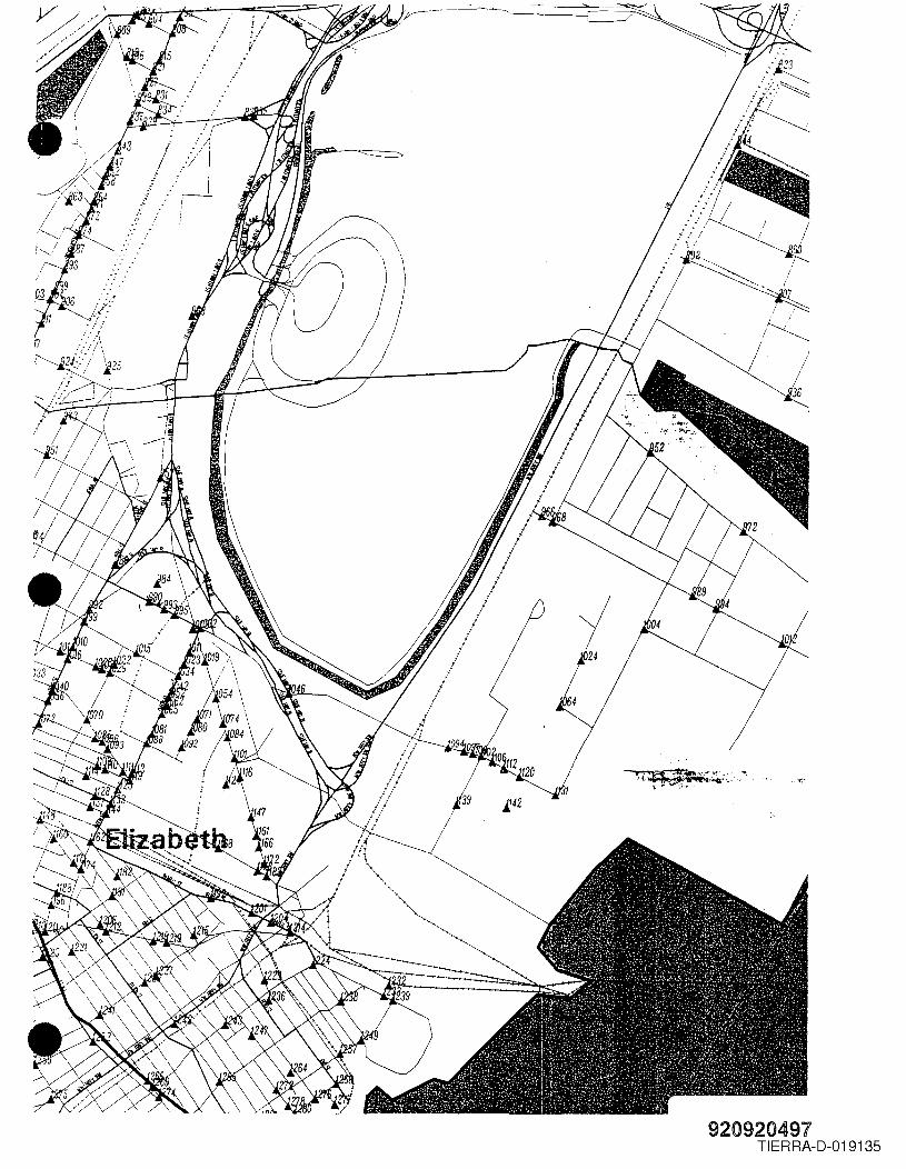
! I"?
,.'t;,.
920920491TI ERRA-D-019135
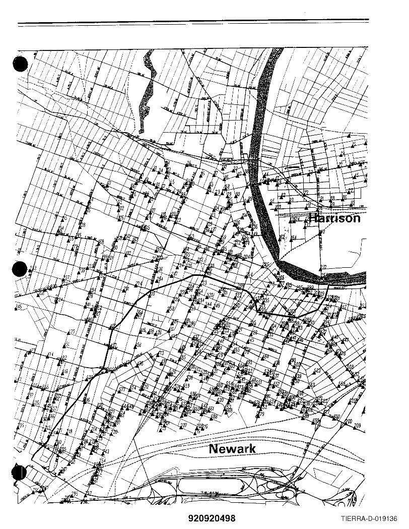
920920498 TIERRA-D-019136
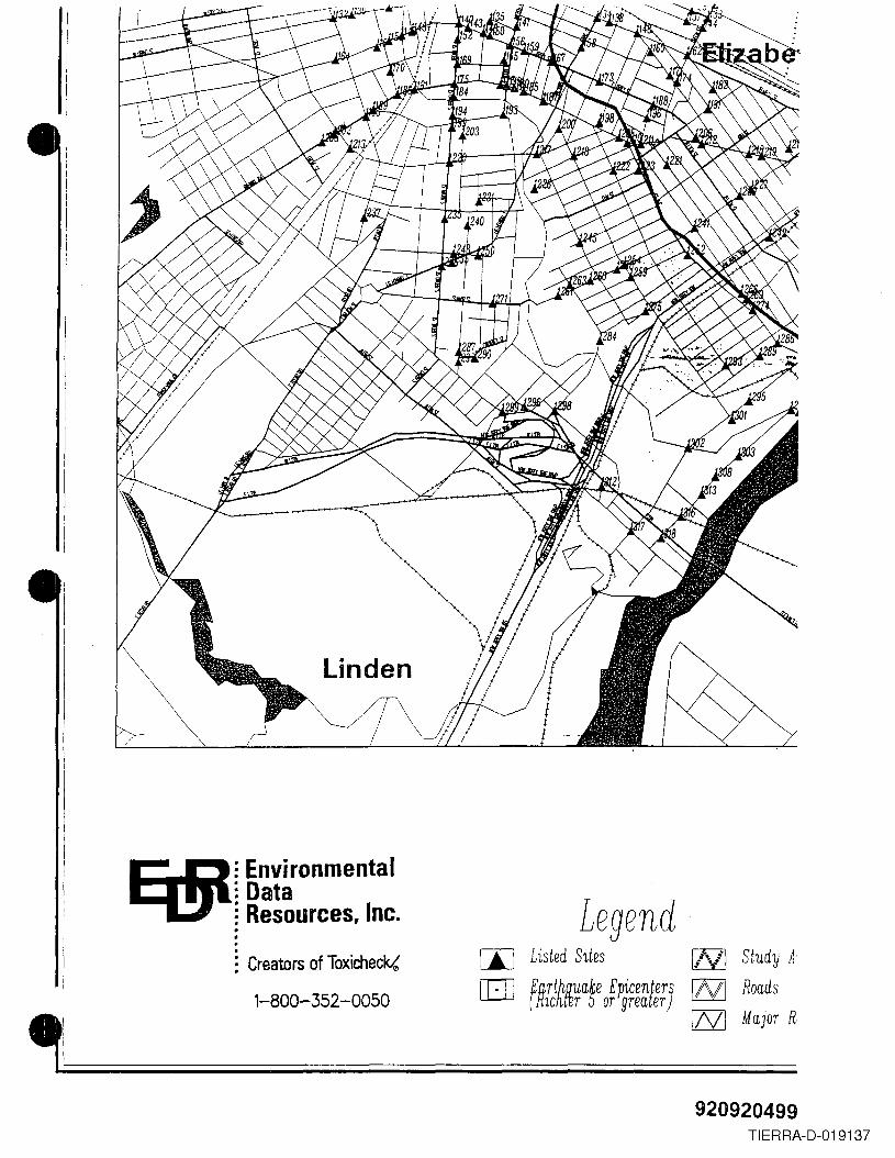
E(§I= Environmental= Data; Resources, Inc. Legend
[I] Listed Sites l...."'.,/l Study A[JJ fnTt~~ua~e EPicenter] [6ZJ Roads
lC r or grea er[ZSZ] Major R.
: Creators of Toxicheck,(
1-800-352-0050
920920499TI ERRA-D-019137
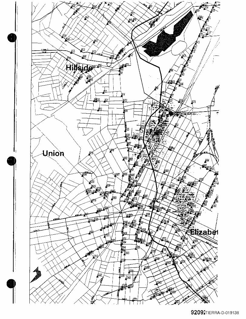
,
I-I
9209~TIERRA-D-019138
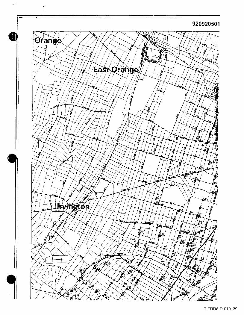
I 920920501
TI ERRA-D-019139
•
Appendix B
•
•920920502
TI ERRA-D-019140
•
•
• 3.ZIWpIPn_auth\Nj_mari,,\TechsupC doc
APPENDIXB
NJDEP LETTER ON HISTORIC FILL
02.'19/Q8
920920503TIERRA-D-019141
•
•
•
CHRISTINE TODD WHITMANGovernor
DEPARTMENT OF ENVIRONMEl'ITAL
PROTECTION
Bureau of Underground Storage TanksCN-Ol8
401 East State StreetTrenton, NJ 08625
ROBERT C. SHINN, JR.Commissiont'r
Mr. Marvin KirshnerThe Port Authority of NY & NJEnvironmental Engineering UnitOne World Trade CenterNY, NY 10048
NJ Marine Terminal, Port ElizabethElizabeth, Union CountyUST 110011026
Dear Mr. Kirshner:
During July 1994, the New Jersey O£partment of Environmental Protection(Department) received report(s) from The. Port Authority of NY & NJ. Thesereports document the site investigation, remedial investigation and/or remedialaction undertaken in response to the closure and/or discharges from yourunderground storage tank systems .
Based on our review of the information submitted, the Department finds that thepresence of lead withill the soil and ground water samples collected may be fromhistorical fill associated with the site. Based upon the presence of lead fromhistorical fill, a coPY of this case is being transferred from the Division ofResponsible Party Site Remediation (DRPSR), Bureau of Underground Storage Tanksto the DRPSR, Bureau of Field Operations. Please direct all correspondenceregarding the historic fill to:
New Jersey Department of Environmental ProtectionB.ureau of Field Operations
Case Asslgnmellt SectionAttention: Mark Pederson
401 E. State Street, 4th FloorCN 028
Trenton, NJ 08625
Please be advised that this letter only addr~sses the historic fill. All aspectsof the site investigation, remedial investigation, and remedial action associacedwitl.the underground storage tanks remains within the Bureau of Applicability andCompliance and th~ BurE<au of Undergrouno Storage Tanks. This letter makes norepresentation regarding, the envirollmencal conditions of any other .".reasfor chI.'referenCed property.
On April 5, 1993, the UST Fee RuL (Arr.endmp.ntsalldNew Rules at N.J.A.C 7:lt,B)was proposed. This rul~ appeared in the February 22. 19~4, New Jersey Register
New Jers~ Is An Equal Opport unity Employer. Printed on Recycled and Recyclable Paper
920920504TIERRA-D-019142
•
•
•
Effective February 22, 1994, the Department will be billing you for theDepartment's oversight of all work conducted at your site. Documents submittedto the Department in accordance with the "Technical Requirements for Si teRemediation" (N.J .A.C. 7:26E) will help reduce the time necessary for theDepartment oversight of your case. At this time, the Department intends toprocess bills on a semi-annual basis. Please consult the AprilS, 1993 andFebruary 22. 1994, State. Registers for details. Copies can be obtained bycontacting the Office of Administrative Law at (609) 588-6500. Your case managershould be contacted with any additional questions.
Thank you for your cooperation in this matter.
Sincerely,
wayne C. Howitz. Assistant DirectorIndustrial Site Evaluation Element
c: Mark Pedersen, BFa-SAJoseph P Eaker, BUST,Renee' Wright, BUSTRobert Posey, BACElizabeth Health Department
920920505TIERRA-D-019143
•
•
AppendiX C
920920506 TIERRA-D-019144
•
Appendix D
•}>"0"0(I):JQ.;C"o
•920920507
TIERRA-D-019145
•
•
• az\wp\Pn _uth\Nj_ marin\ Techsupl.OOc
APPENDIXD
ECOLOGICAL COMMUNITIESPOTENTIALL Y AFFECTED BY THE CLASSII-B GROUNDWATER RECLASSIFICATION
021191'18
920920508TIERRA-D-019146
•
•
•
vegetated areas within the ditch. These species have adapted well to urban environments, andwould remain unaffected by the proposed groundwater reclassification.
Reptiles and Amphibians
Some reptiles and amphibians may utilize the ditch, particularly towards its upper end wherefreshwater conditions are predominant. Since the direction of groundwater flow is toward thesouthern, brackish portion of the ditch, these species should remain largely unaffected by theproposed groundwater reclassification, regardless of existing groundwater quality.
Newark Bay
Potential ecological receptors associated with Newark Bay include wetland and mudflat habitatsalong the shores of the bay north and south of the Elizabeth and Newark C1:~.:mels, marinebenthic and open water habitats both within the channels and in the bay itself, and the speciesassemblages associated with these habitats that may be directly affected by degradation ofsurface water and sediment. The communities that are present within these habitats are welldocumented. A summary of these communities is presented below, based upon an extensiveliterature base of studies conducted within the area. Surveys of aquatic biota within Newark Bayhave been conducted for Port Authority by Lawler, Matusky and Skelly (LMS) (1995) and othersreviewed by LMS (e.g., Will and Houston 1988). These studies have characterized speciesassemblages within both shallow- and deep-water habitats, including fish, invertebrates, andother marine life. Additional studies include a literature review for the Port Authority preparedby Malcolm Pirnie (1995), a literature review of studies conducted in the nearby Arthur Killprepared by IT Corporation (1991), and studies of regional dioxin effects on marine life such asthe risk assessment conducted for the Port Authority by EA Engineering (1991). In addition, aletter sent by the National Oceanic and Atmospheric Administration (NOAA) National MarineFisheries Service to LMS dated July 26, 1995 lists endangered/threatened species that have beendocumented in the New York Harbor region, which would be used in evaluating effects tosurface water receptors (Attachment D-l).
The primary ecological communities of concern are associated with open water areas of NewarkBay located immediately adjacent to Ports Newark and Elizabeth. These open water areasprovide habitat for a variety of fish and wildlife species that utilize the vicinity of the site.Studies of existing biota were recently summarized in the Draft Environmental Impact Statement(EIS) for Newark Bay Confined Disposal Facility, prepared by the U.S. Army Corps ofEngineers (USACE) New York District in 1997, upon which the discussion below is largelybased .
D-2 02.'19198
920920509TIERRA-D-019147
•
•
•
It should be noted that the fish species noted within each study varied highly with the samplingmethod used. For example, prior studies (Will and Houston, 1989) of fish distribution in NewarkBay found that 91 % of the fish caught in seine nets were Atlantic menhaden, with striped bassand Atlantic tomcod comprising most of the remaining individuals. However, Atlantic tomcod,bay anchovy, and winter flounder collectively accounted for 88% of the trawl catch. Since thetrawling studies underestimated the numbers of fish inhabiting shallow areas, other studies wereconsidered in developing a species list for the vicinity of the proposed reclassification area.These included studies conducted at local power plants and other facilities where impingementand entrapment of smaller species occur that may be missed using conventional collectiontechniques.
Studies conducted in Newark Bay within the immediate vicinity of the proposed reclassificationarea (Hecht, 1995) found marked differences in species composition between shallow waterversus dredged channel areas. Striped bass and blue crabs were found to be abundant in the flat,shallow areas in spring and early summer surveys, although summer and winter flounder as wellas other species were recorded in smaller numbers. While fish were nearly absent from theseshoal areas in the winter, the deeper dredged channel areas were used year-round. The winterfish community in the channel areas was dominated by striped bass and white perch. Will andHouston (1989) noted that most species were more common in the deeper channel areas, but thatbay anchovy was more common in the shallows, and blueback herring was limited exclusively tothe shallows. Will and Houston (1989) also suggested that the bay is an important nurseryground for some species. This point is supported by studies in Newark Bay finding a largenumber of smaller-sized individuals of the dominant species (USACE 1996). Within the area ofNewark Bay immediately adjacent to the proposed reclassification area, the deeper water areasconsist of the two channels at Ports Newark and Elizabeth, which are approximately 31-33 feetdeep, while shallow water areas less than 2 feet deep exist immediately east of the shoreline areasoutside of the channels.
None of the species previously recorded from Newark Bay are listed as federally endangered orthreatened. While the short-nosed sturgeon is listed as endangered, it has not been found inNewark Bay.
Newark Bay Wildlife
A comprehensive review of wildlife species known to use or potentially use Newark Bay hasbeen compiled for the US ACE Draft EIS for the Newa.,l: Bay Confined Disposal Facility. Over227 species of mammals, birds, reptiles, and amphibians have been identified in the Newark Bayarea (Attachment D-4). However, proposed reclassification of the aquifer below Ports Newarkand Elizabeth would potentially impact primarily aquatic species associated with Newark Bay.This is because nearly all of the terrestrial habitat within the proposed reclassification area hasbeen developed, and the freshwater wetland areas have heen largely filled. The Peripheral Ditchprovides some limited habitat for wetland wildlife such as ducks, shorebirds, wading birds, and
az\wp\Pn_,uth\Nj_marin\TC"Chsupt doc D-4 O:Y19/9S
920920510TIERRA-D-019148
•
•
•
-;-",/"~.-i--' .·-j-.·:;''''~·I- ,,'
.....
affected are those using the area on an occasional or seasonal basis, such as wintering sea ducksor migratory waterfowl.
Marine Mammals
Both the harbor seal and harbor porpoise have been reported as uncommon visitors to NewarkBay (USACE 1997). Otherwise, the possibility of marine mammals entering the bay is remote.
Marine Turtles
Three species of marine turtles are known to inhabit the New YorklNew Jersey Harbor Estuary:the loggerhead sea turtle, Kemp's ridley sea turtle, and the green turtle. All of these species usethe area on a seasonal basis (May to November), and none nest as far north as Newark Bay(USACE 1997). Marine turtles primarily feed on estuarine invertebrates such as blue crabs andmolluscs, but are considered uncommon visitors to Newark Bay .
az\WpIPM_JUlh\Nj_m.vin\Techsupt doc D-6 O:!JI Q!98
920920511TIERRA-D-019149
•
• 16.
10. Killam Associates, Inc. April 1995. Environmental Document Report, North Avenue EastImprovements Project. C;ty of Elizabeth, NJ.
11. Lawler, Matusky and Skelly, June 15, 1995. Memorandum to Jack Hecht and SusanMetzger, "Newark Bay, Port Authority NY INJ Information and Results of ApriVMay1995 Surveys".
12. Malcolm Pirnie, Inc. November 1995. Literature Review and EnvironmentalPracticability Analysis for Construction of a Containment Island in the NY INJ HarborRegion.
13. Memorandum from John Bullard to E. Knoesel and R. Pruno. September 18, 1995 Re:Newark Bay Combined Disposal Facility (CDF) Additional Metals Testing.
14. Memorandum from John Bullard to E. Knoesel, R. Pruno and M. Masters. October 23,1995. Re: Port Newark Reach - Dioxin.
15. Memorandum from Joseph DiSorbo to Thomas Wakeman. June 15, 1995. Re: NewarkBay Confined Disposal Facility (sediment toxicity testing results).
National Oceanic and Atmospheric Administration. 1995. Magnitude and Extent ofSediment Toxicity in the Hudson-Raritan Estuary.
17. New York City Department of Environmental Protection. 1993. New York HarborWater Quality Survey (and Appendices).
18. Ney, R.E. 1995. Fate and Transport of Organic Chemicals In the Environment.Government Institutes, Inc. Rockville, MD. 299 pp.
19. Port Authority of New York and New Jersey, April 1995. Environmental BaselineInvestigation, Berths 30 and 32, Upland. Port Newark, NJ.
20. Science Applications International Corporation (SAle), 1993. Toxic Assessment of NewYorklNew Jersey Harbor Ambient Waters. Final Report. Submitted to Office of WaterEnforcement and Compliance, US Environmental Protection Agency.
21. Squibb, K.S., J.M. O'Connor, and T.J. Kneip. 1991. New YorklNew Jersey HarborEstuary Program. Module 3.1: Toxics Characterization Report. Prepared by Institute ofEnvironmental Medicine, New York University Medical Center, for US EP A Region II,New York City. 188 pp.
• Ib\wp\pn _aulh\nj _l'n.Irin\tt'Chsupt.doc 02-2 1/22/98
920920512TIERRA-D-019150
•
•
•
\VV:-5.~l'w\./.\..~--:: ....: ·...Lc'\-.l'\...j ATTACH..'lEi\T D-1
TABLE 3.08-2
Benthic Fauna Idenrifiej In \Jewark Bay
1993-1994
CNIDARIAAnthozoa
AHYNCHOCOELARhynchocoela
POLYCHAETALepidonotus squamatusLepidonotus sublevisHypereteone heteropodaHypereteone foliosaParanaitis speciosaEumida sanguineaPodar/ceopsis levifuscinaMicrophthalmus sczel/cowiiProceraea cornutaStreptosyl/is pettiboneaeNereididaeNeanrhes succineaNephtys incisaGlycera s,;p.Glycera americanaLeiroscoloplos sp.Leiroscoloplos robustus'Polydora spp.Polydora cornuta'Spio setosaPygospio elegansStreblospio benedicti'Marenzelleria viridisTharyx sp. A •Heteromastus {iIi/armisMediomastus Dmbiseta'Sabel/aria vulgaris'Pectinaria gouldiiAmpharetidaeAsabel/ides oculataSabellidaePolychaete fragments
OLiGOCHAET AOhgochaeta'
MOLLUSCAGastropodaEpitonium sp.
Odostomia sp.·Rictaxis punctostriafusCylichnel/a bidentataL)oradel/a obscuraMytilus edulisMulinia lateralis •Ensis directusMacoma balthicaTellina agilisMya arenaria'Barnea truncataBivalve siphons
CRUSTACEABalanus improvisusNeomysis americanaLeucon americanus·Oxyurostylis smithiCyathura politaSphaeroma quadridentataEdotea trilobaAmpelisca spp.Ampelisca abditaMicrodeutopus spp.Microdeutopus gryl/otalpaCorophium spp.Corophium acutumUnciola serrafaElasmopus laevisMehta nitidaMonoculodes sp. IParapleustes aesfUariusParacaprella fenuisCrangon septemspinosaCancer irroratusXanthidaeRhithropanopeus harrisii
INSECTAChironomidae
ECHINODERMA TAAsteroideaEchinoidea
ASCIDIACEAMolguia manhattensis
• Dominant taxon
'1'(11~·91 9:01pmIHS9141 (4~9-()14fTh)'(1II·1 3-105
920920513TIERRA-D-019151
• • •ATTACHMENT 0-3
Table 3.06-8 (Page 1 of 14)
Fish Species Collected in Newark Bay and Adjacent Waters8
FamilyGenus Species
o1984-85
G1987-88
H1988
E1987-88
F1987-88
B1972-73
A1972-73
C1972Common Name
Carchemlnldae Requ"", .... rluI
Muaralua CIIll/a S.-olh dogfleh XRajld .. 'IIA'"
,.."' ..... c_ Un..... t.
Aclpo_ .... 'lUf'8lH'M
Ac.tHtt- o.~rncua Adanllc aturg.on X
A""u'" ,.........'.'h ..Mfluilla ,oa'" r- American •• 1 X X X X X X X
Ophlc"'hldaa ...........-
Mrrop"'a pUllcr-rua Spackled wonn •• 1
Co"".... Conga, h..C#1llfl,JIoc_nlcua Cong., •• 1 X
l.lupaldaa He....
Ab ••• ali",,'a 8luab-ek hening X X X X X
AJo. pMUdoha''''l1ua Ala ... ". X X X X X X X
A.b •• pidiui"", Amoric on ahad X X X X X X X
A.b .. m«Iioct/a HIckory ahad X X Xa-a...,o,tJa tyrannua Allonllc mo"hod." X X XClup.. """l1ua Atlantic hening X XOG,o»"", copoditlnum Glu.rd ahad X X X
E""NUIdM Ancho .....
Mchoa mltchill B.y.nchovy X X X X X X X XAnc/Ioa hop_rua Striped .nchovy X X
Cyprlnldaa Carpa .. Minnow.
C.teulua auterua Goldfleh X X XHorropla amoOflua Comoly ahlnar
eyp,inu a c.rpio CIlfp X
TIERRA-D-019152
• •Table 3.06-8 (Page 3 of 14)
ATTACHMENT D-3 (CONTINUED) Fish Species Collected in Newark Bay and Adjacent Watersll
FamilyGenus Species Common Name
A1972-73
B1972-73
C1972
D1984-85
E1987-88
F1987-88
G1987-88
H1988
CDI\)oCDI\)o(J1~(J1
8elonld_ ..... Il.'w--.SrrtlngytJ,. ,.,.,In. AII.nlle need"'i.h X
Cyprlno6onlld.e It.,......
FundutJ. h.,.,oe'lII. Mummlc:hog X X X X X XFu"dutJ. "";'1. SIriped klllilith X X X XFundutJ. dieph.nu. B.nded klllilith
Alherinld.e ............M."iditl pen;nw •• r~.W'l.' .ilver'lide X X X X XMeniditl mflniditl At••ntte .ih,.eraid.
Membr., ",., rinic. Rough "Iv<oroid.
a..I.IO.I.Id_ 'Ilcklobeek.
o.,tero.tfHJ.'cu-'tu. Th.. ooplne .tiekleboek X X X XApeh .. qu.d,.cu. Fourepln. .Iie kI.bot: k
8ynvne1hld •• PIpo,.he.
Hippocllmpu •• 'tlClII. lined .... ho ... X X XSyngn.lhu. (uxu. Northern plp.'i.h X X X X X X X X
Triglld_ S•• robln.
!"rkJnorv.c.roinu. Northem ... ,.,bln X X X X X~ionohl' .vo'-n. SIriped ... robln X X X X X X
eollld_ Sculpin.
Myoooceph.tJ. lI.n •• u. Ol\lbby X X X X XMyoooceph.tJ. longhorn eculpin X X
oclodtICtHn/IfPlnoou.
Perclc:tlthyld.e T.mpe .. " ao_.Morone ameflcan. Whit. p.rch X X X XMoton •.... lih Striped b••• X X X X X X
S.... nld.e ••• ao_.c.'" fropri.ris 1ft;. fW Bleck .... b ... X X X
rpl/l-i·91 12:21pm1HS 10021/~5~7~fl1>)'()6-.TIERRA-D-019153
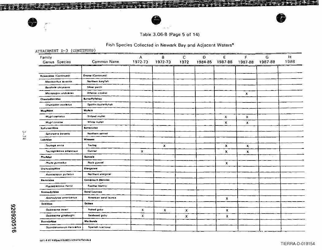
• •Table 3.06-8 (Page 5 of 14)
Fish Species Collected in Newark Bay and Adjacent Waters8
ATTACHMENT D-3 (CONTINUED)Family
Genus Species Common NameA
1972-73B
1972-73C
1972o
1984-85E
1987-88F
1987-88G
1987-88H
1988
Scw.nld .. (Continu.dl ON ..... lContinued)
Men tici"hu •.. ¥. ri'·~ Northern killQli.h
&i,dilli. chrYOSUf. Silve, p.rch
Micfopogon undu.r •• Atlan\k: croaker X
Ch•• lodonlld •• lluu.r1lylleh ..
Chu'odon ocr/leN' Spollin bUllorfl,li.h
Mugllld •• Mullel.
Mug" ctJPh.Iu, Strip.d mullo, X X
Mug" cu,~m. White mullet X X
Sphy, •• nld•• a.".cud ••
Sphyr •• ne bo,e •• ·~ Northern Nnn.t
l.brict .. W,._,T.vrag. on;r" ToutOO X X X
Tel/rogD.bru •• d'Pelau. Cunner X X. X.
Pholdoo Ounne"
Phoh gunnrllu. Rock gunnel X.
U,enolcopldoe 6Ia'V8'0"
AS(foscopuS t1urr.ruJ Northern It.'g"o,
Slannlld •• Combloolh Blonnl..
Hypsoblrnniul hen'l fnthe, blenn,
Ammodytld •• Sond L.unc ..
AnJmodytel .merie.nu. Americ.n •• nd ',unco X
Ooblld •• Goble,
Gobio.otr» bose; N,k.d gob, X X X X
Gobio..,,,,. gin~urghi S.. bo.rd gob, X X X
Scornbrid •• M.c .......
ScomberomoflJ' macu"rus Sp,ni,h m.ckorol
'l'1/1-8-97 9;02pm/HSIOO21/.~9'()74f1bH)6-8
TIERRA-D-019154
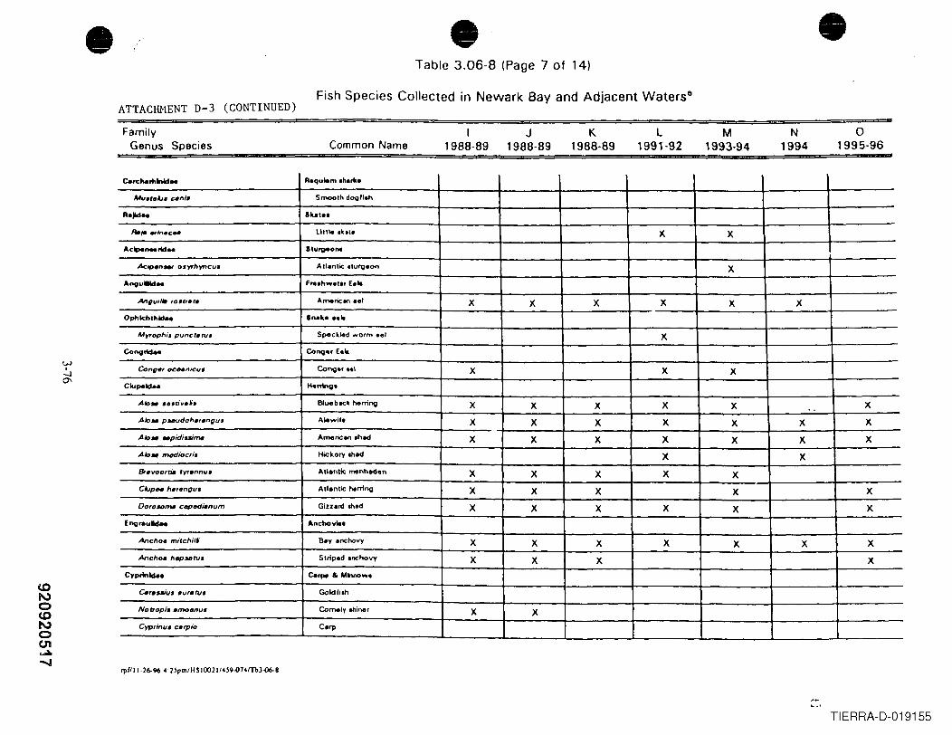
• • •Table 3.06-8 (Page 7 of 14)
ATTACHMENT D-3 (CONTINUED)Fish Species Collected in Newark Bay and Adjacent Waters8
FamilyGenus Species
L, 991·92
N1994
o1995·96
K1988-89
I1988-89
M1993·94
J1988·89Common Name
Carc ...... lnld.. R.qulem ."" ....
!lAU.fflAi. un/. Smooth dOQII.h
Rajld .. 11uI1 ••
R.;' .,in.c". lillie o~o.. X X...c .... n.. rid_ Blurv-0n •
Ac,pfln_ ooyrllyneu. Atl.ntic .turgeon X
"'nguilld .. F... hw.'tr Eolt
Anguil. 10'''.'' Americen eel X X X X X XOphlchlhld .. Bnok ••• It
ltAyroph,.. puncr.ru. SpeckJed worm eel X
ConQ_ ConlJ" E••
Cong., OCHnicv. ConQ.r •• 1 X X XClupoold.. Honing.
AIo ... eltf.., ••• Bluebeck herring X X X X X X..AAo.. pN(Jdoh.,t/ngu. Alewif. X X X X X X X
.A1o •• pidiuime Amflric.n .had X X X X X X XA.,. ~ioc"', Hickory oh.d X X8IltVOOfo. fyl.nnu. Atlenlle menhaden X X X X XCAJPH".,.ngu. AIlanlic ""rrino X X X X X
Oo,olOme eepedienum Gillard oh.d X X X X X X
Enorauld .. Anchovlt.
.Anello. mirellilf eay anchovy X X X X X X X
.AnellOt IIep5ltfU. Striped .nchovy X X X XC,prinidoa ea"", & Minnow.
c.,.-,;u. _VI.ru, Goldfioh
NOfrop/, .moenu. Comely ohiner X XCyp,inu. c.rpio Carp
'1'(l11-2C>-96 .;UpmIflS IOO211.~9-014fTbH)C>-8
TIERRA-D-019155
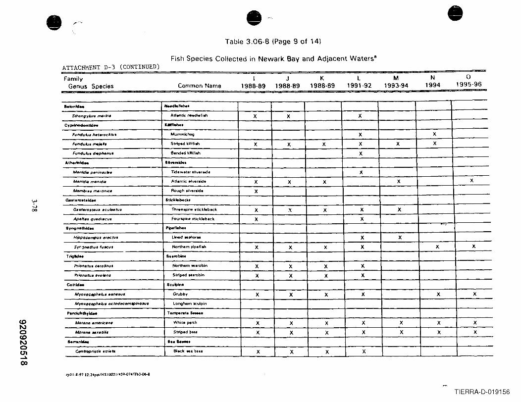
• • •Table 3.06-8 (Page 9 of 14)
Fish Species Collected in Newark Bay and Adjacent Waterstl
ATTACHMENT D-3 (CONTINUED)Family
Genus SpeciesI
1988-89J
1988·89K
1988-89L
1991-92M
1993-94N
1994o
1995·96Common Name
Belon~ HHd .. ' .. hel
StTongylJfDmIIrlna Atlantic oe-.lle'joh X X X
CypoW>odonlld-. It"""'.FvndulJ. "a'Mod-tv. Mummlc~ X X
FvndulJ. mIIl-" Slrl~d killili.... X X X X X X
FvndulJ. d;'p"'''u. e.nd.d kllll'i"" X
.. ' ... .-.14 .. lI.,.rMk.
A,f.nld~ p.n;nw •• TId.w.,., .nveraKIe X
Menld~ menid;' AII.nlk .dvenid. X X X X X
1.411mb, •• "...,tin;c. AoUOhlil,.,.id. X
a..I ..... I.1d-. 81lck"backl
04tar.fo,reu •• cuitNru. n,,... plno .tlckleback X X X X X
Apa"'" quadflcu. Fou'lplne lIickl.b.ck X X
8yng"ethld .. Pipe, ......
Hippocampu. ,,,,tetv. Lined ... ho'N X X
Syr:7natIJu. fuw:u. Northem plp.'I"" X X X X X X
Triglld .. a .. robln.
,.,io"oru. carotnu. Northem ... robln X X X X
Prlo"o,.,. ;rvolano Siriped ... robin X X X X
Conld .. 8culpln.
Myo.octIP"alJ. ,.".eu'_ Grubby X X X X X X
Myo.octIP"alJ. oc,od;rc;rmoplnollU. Longhom lCuipin
Perelchdl,w.. Tamperat. Ia_.MDfon".".,.,an. White perch X X X X X X X
Mprona .ntili. Strip.d be.. X X X X X X X
a.... "1da. a.. Be_.
e.tntropri.ti•• u;'t11 8lack ... b... X X X X
rplll-8-97 12:2'pmfHS 100211'~9-o14fTb3~
TIERRA-D-019156
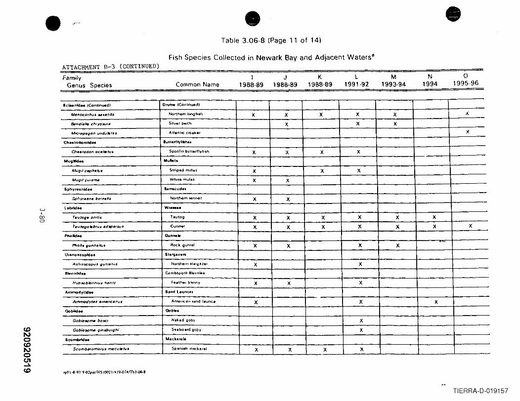
• • •Table 3.06-8 (Page 11 of 14)
Fish Species Collected in Newark Bay and Adjacent Waters8
ATTACHMENT D-3 (CONTINUED)Family
Genus SpeciesI
1988-89J
1988-89K
1988-89N
1994o
1995-96l
1991-92M
1993-94Common Name
WI
00o
8c ... nld_ lContinued' 0",_ lC<>nlinuedl
Menrici"hu ..... ,i.·, Nonhem kjrlQ,jlh X X X X X 1..
&i'die'. CIUYOWf. Silver perch X X X
M,cropogon vndv.r., Allentic era.k.er )(
Ch•• l0d0nlld •• Bull.rllyll.h ..
C/1•• todon OCf!'.tv. Spot,jn bunorlly'jlh X X X X
MIIgllld_ Mu"l.
Mupil cephdJI Slriped mull. 1 X X X
MVQilcu,e~ While mulle' X X
Sphyr .. nld •• &'rr8cud ••
Sph'1',.en. bore•• ·• Nonhem lenn.' X X
l.brld •• Wr .....
T.uroQ' oniCi. ToIIIOO X X X X X X
T.u togo .bru •• dIPtlfsu, Cunner X X X X X X X
PlKlld.. Ounno,"
Ftloh gunnel"" Roc .. gunnol X X X X
U,.no.copld •• 5'&"08'.R
AshOSCOpVJ QlJuefuJ Nonhem .1.rg a ler X X
BMnnUd •• Combloolh Bltnn"'1
Hypsoblt:nniu, hentz Feather blenny X X X
Ammodylld_ S.nd leune ••
Arnmodytlll .mttoC.nv$ Americ.n IInd launce X X X
Goblld .. Goblel
Gobio."".". bosei Nlkod goby X
Gobiooom. pint.bufghi 5elbolrd gobV X
8combrid .. Mee .......
ScombtfHOmOfV' m.cuJltWJ Spaniah mackerel X X X X
CDNoCDNoen..Jo.CD 'l'fIHI·97 9:02plll1HS1002114S9~74fTb3.()6-i
TIERRA-D-019157
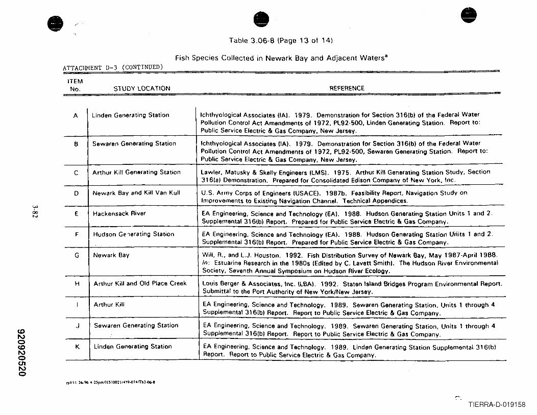
CDNoCDNo(J1No
• • •,~'
Table 3.06-8 (Page 13 of 14)
Fish Species Collected in Newark Bay and Adjacent Waters8
ATTACHMENT D-3 (CONTINUED)ITEMNo. STUDY LOCATION REFERENCE
A Linden Generating Station Ichthyological Associates (IAI. 1979. Demonstration for Section 3161b) of the Federal WaterPollution Control Act Amendments of 1972, PL92-500, Linden Generating Station. Report to:Public Service Electric & Gas Companv. New Jersev.
B Sewaren Generating Station Ichthyological Associates (tAl. 1979. Demonstration for Section 316(bl of the Federal WaterPollution Control Act Amendments of 1972, PL92-500, Sewaren Generating Station. Report to:Public Service Electric & Gas Company, New Jersey.
C Arthur Kill Generating Station Lawler, Matusky & Skelly Engineers (LMSI. 1975. Arthur Kill Generating Station Study, Section316(a) Demonstration. Prepared for Consolidated Edison Company of New York, Inc.
0 Newark Bay and Kill Van Kull U.S. Army Corps of Engineers (USACE). 1987b. Feasibility Report, Navigation Study onImprovements to Existing Navigation Channel. Technical Appendices.
E Hackensack River EA Engineering, Science and Technology (EA\. 1988. Hudson Generating Station Units 1 and 2.Supplemental 316(bl Report. Prepared for Public Service Electric &. Gas Company.
F Hudson Gelerating Station EA Engineering, Science and Technology (EA\. 1988. Hudson Generating Station Units 1 and 2.Supplemental 316(bl Report. Preparod for Public Service Electric &. Gas Company.
G Newark Bay Will, R., and L.J. Houston. 1992. Fish Distribution Survey of Newark Bay, May 1987-April 1988.In: Estuarine Research in the 1980s (Edited by C. Lavett Smith\. The Hudson River EnvironmentalSociety, Seventh Annual Symposium on Hudson River Ecology.
H Arthur Kill and Old Place Creek Louis Berger &. Associates, Inc. (LBA). 1992. Staten Island Bridges Program Environmental Report.Submittal to the Port Authority of New York/New Jersey.
I Arthur Kill EA Engineering, Science and Technology. 1989. Sewaren Generating Station, Units 1 through 4Supplemental 3161b) Report. Report to Public Service Electric & Gas Company.
J Sewaren Generating Station EA Engineering, Science and Technology. 1989. Sewaren Generating Station, Units 1 through 4Supplemental 316(b) Report. Report to Public Service Electric & Gas Company.
K Linden Generating Station EA Engineering, Science and Technology. 1989. Linden Generating Station Supplemental 316\b)Report. Report to Public Service Electric &. Gas Company.
",1111·2(,.96 4:~p",JHSIOO2114W'()74fTbJ-{)f>.8
TIERRA-D-019158
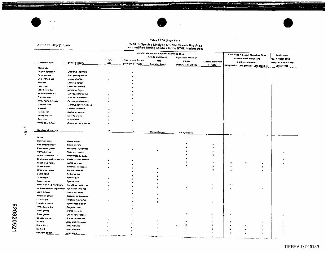
•ATTACHMENT D-4
•Tabl. 3.07-1 (Pog. 1 or 5}
Wildlife Species likely to Ur", the Newark Bay Areaas Identified During Studies In the NY/NJ Harbor Area
•...... m...
Vlfgln. opo.. um
En1.fn mol,
Unld.ntfttd b.t
R~ bal
Hoary bit
llm. tlr","," bel
E"','nC~tII'G,.y tqun.,
'Nh •• r~~ mOUN
UUdOW'o"OI.
Yuill,..'
NOIWaY'I'Hou •• moo ..
Raccoon
WI
CO'-J
B',de
Common k)on
R.o- ,t'lloaled loon
PIed·bll.cl gf.be
Horn.d gr. ue
Gru. COfmOf"lnt
Oovbl.-cr.sted Cormorant
G,", blu. h.ron
GrM" h.ron
llm. blu. h.ron
e,m •• gr.t
Gr••• egret
Snowy egret
BI.ell-crowned n6ght heron
V.IIOW-ClQilllimld night hlron
l.nt bta.,"
Amlnel" blntrn
Glotty I).loutlilna h.ron
Whtt.tJiCed Ibll
BrJnt g()()M
Snow goosl
C.n'd. goo••
.....II.'d
Black duck
USCG
Upland, IIbrln. and Adjacent ShoraU", Sit ..
Andria Ind Carroll Aquila .nd "ld.~nMartnt WidAdlact"t Ihorelln. Sh ••
HudllOn River W ... rf,on'
llolS Unpubllohe<l
llolS 11K4 0' llolS 11K4 b) llolS II'" <'H'f"bor HI,ons Report PII'I
I, .. dlng 8"d.I"W,
OnfWtn'ertng BlrdeLiberty 5'''e Part
TI (117')
()de'pl'Jl~ V'V"'JeM
SCU:)pvt aqu.'''u,IJnK1enrlf,., be,lesJ"""J bl::rN1"
"'rons ""'KUQiI'
Sr"""~UJ t\:rldI,,".se,,,,,,,. cwt)l,,..,,,.Pwr'omtlCu, ~.
"'0'0110" J*I"'r""-"lClll()rncHD'.,J".'hlC.
R.nll.~lCu.
Alu. '"UKulu,
It 11Not""DI~'bl.
Poa''YIhOvJ podlClpJ
PodICflPJ .,lfu,Pfl"earxor .. carbO
P#'l.,eaoc~. 'l.Ilfu.ArON herodJ.,
BIlIt:J"J<M" vrex.n,
E~n. ' • .-vIM
Bult>ucUJ lOrt"
AI'dlN .'Ou.EV'lIn. 'hu/.NrcrlCcn. ,,)'Cra:n.Nyc'ICCJrI. VIoiKH
l.otTycf'tll ••• 11,.
Bot.LnlJ At"'9JftO,JII'
PltlgedlJ '1IcIM/I",
H'(d"Wnu..s. ~1CoJor
PIe9MJI' ,h,,,,er-",. bernICI.
Chen n.,uleseell'&-"tIi ClnecMn""An., pI.tyr1fyncl'to&
Arl •• rver,,,.,,G.dwall A"u .hlperw
~~h.'~~ .__._..:.A.:.".U.. o.=KU.:.' ••_. _
TIERRA-D-019159
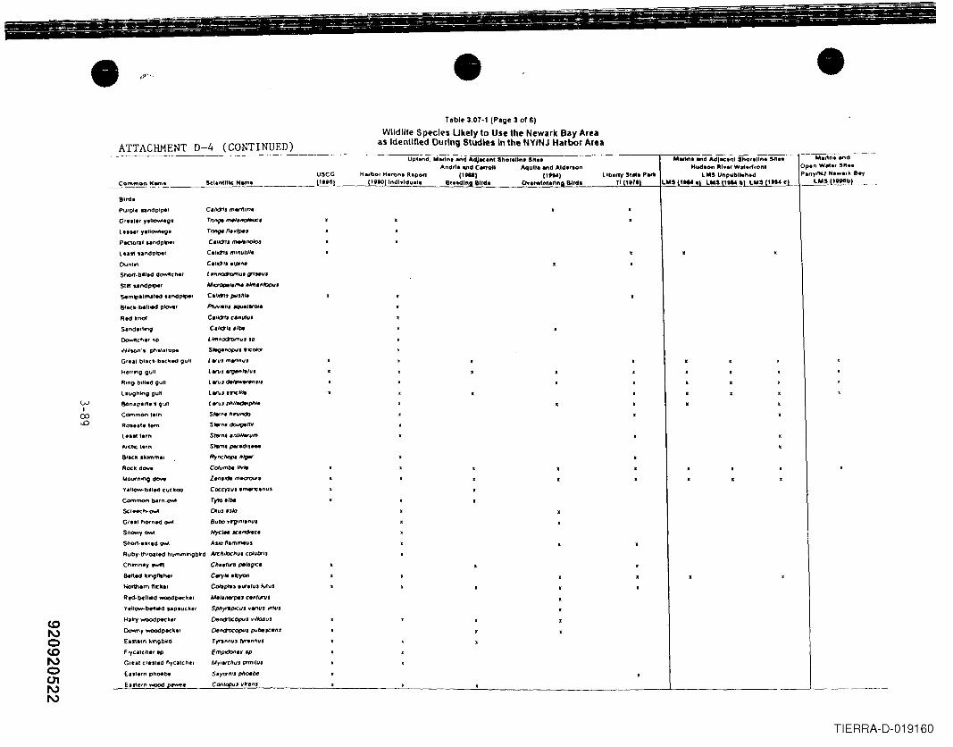
• •lobi. 3.07-1 (Pag. 3 or 61
Wlldille Species LIkely to Use the Newalk Bay Areaas Identlned During Studies In the NYINJ Harbor Area
•Mwint IInd AdjKlof Shoreline Sh ..
Mud.on Rln, W ... rfront
liberty S, ... P.R LMS UnpubllthtdTI (11711 LMS 11.... 1 LMS II .... bl LMS \" ... <I
ATTACHMENT D-4 (CONTINUED)------------.------.-----.,,=7"";";=--:-:::-=c=-:-;.,.--,,--=,----------.,-=-,--~~--~-=---.--~=c
Upland, "trin, Ilnd Adjacent Sho,..lInt Stt ..
Andrt, and CanoU Aquila and Ald.,..on
II-I 11""1Bl.. dl~a Bird. O"'rwI~l.rtria Bird.
coI\,)oCOI\,)o01I\,)I\,)
81t<h
pur pit .. "dplpol' e./.,.,. martf"n,Gr •• ltr y,UC7'lNttO' Tn""" "..,.ItIOINc.
It.Hr y.llowtegt rnl9l nelllpe.
PK1o~1 "ndplper C"01J ",.,.noIoJ
lon' ,andptpol C.fd1a ""nut""
[)ynltn e.,,,,.,. ,I",,..
ShOt1-blled d~che' L lmnQ:t'umu' ~WiJI
5111 undp."e' "'IC7OPIIa,"' 'U"""It2puJ
SAmlpa1mated UnctPlpel C"~J pu.Ute
Black. bell*' p'OY'ef Prl1Vte'" JQUel.",,1
Rod kno! C./d1. "nut",.
~nd.rIInO ClliO'" "be
Oorw«ch., ,p L Hnttoct"omu, Jp
w,,~'t phalalOP4 Sr.o-ftOPU. tIC 0Ia'
Gr.. , bIIlCIl·bf(kN gull LWL/.Ift"'''UJ
Herring gull (WlI" aro-"ht'IIJ
Jttn/1-tlllle., gull L"'u .. t1eI"""~J'J
llughWlG gun L."J 'lnCiII.
W 8on''''I1'', Qull L "-11" pltll«»lplueI
CO Common te'" S",,,,l'lnrnci:J
'-.0 Rose.te 'em S,...". dougellll
l •• " te'" Ster"•• nll"arum
-"et.:; te'n Srwn. peredft ...
BIKk tktmm.f Rrnc1lop> niger
Rock dO\te Columbl I,.,,.t.louf,ung dOYt l.".ldem~Y.l~bllle<t cuckoo COCey7UJ,,,..,-,canUJ
Common b'f"~ TylO tlbeI
SCfH<:~0-4 OfuJ IJJo
Gr •• t F\OIned grrr.4 8ubO v'ViIIl,nv,J
Snowy owt Nycl" x,ndI,ceShort-e.red o!Ht Am tt.rntnoeUJ
R",by·thfoat.ct hummlngbi'CI Mh,.locllul colutns
Chlmn.y twtIt CII.elll1t pol'olea
e.tted klngn.her Ca')'10 .Icyon
Northern ftc:"ef CoI,pleJ ,,,",'us ,'''usRl'd-bcU_d woodpeocke, ""e",..".,J '""'(I1IJV.ll()r.¥..belhllCi sapsuckef Sptt.,.,..picUJ VanUJ ~UJ
H~6ry WOOdp«k., Oen<tTXop4IS VI/WIIS
[)arrwnywoodpeck., Den<:Tocop4lJ puNK."J
E.stem kk'lgbtro f)""MUS f't"W,MUS
Flycalthe, .p Empl(Jonu II'
G,nt cr.It,d "ycatcher MyltJIChUJ almfUJ
Ealt'IM phoebe S.yCYtlfJ p"~be
EalteIM wood·~. ConlOOUJ vlr.nJ
TIERRA-D-019160
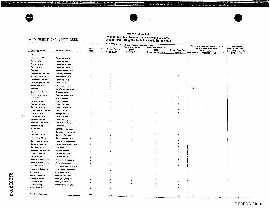
toNotoNo01NW
• •Tabl~ 3.07-1 IP.g~ 5 01 61
Wildlife Species likely to Use the Newark Bay Areaas Identified During Studies In the NY/NJ Harbor AreaATTACHMENT D-4 (CONTINUED)
36
TIERRA-D-019161
Upland, Mar1nl ,nd Adjacent Shorilln, '""Andn. and Canoll Aquila and AldtAon
U'CC Harbor H,ro", R.pOr1 (1'''1 (1ee.)- ~~~~~ .~'~'-- - ~~e~~t1!.I!.. ':'l!!!'.~ 11.8~.~L_u_ ~...1~~~) Indl .....I""'.I. Breeding BIrd' Ovtrwlnt.r1ng Bird'
Blrdt
Blackpoll warbl"
Pne .......rt>I.f
Pralt" warbl"
ComtT'lon "ll(JrWth'oe1
Amlnc.e" '.etna"CoonK1-=ut rol.'
81u.MnO~ 'bl.'Hous.,patrOlo'lr
BobOllnlll
E .... etn m•• d~.t"
Rt<I·....,"O.d blac.b"d
WI
..0
e.o.l.tll'.cI 0'10:11
Common O"'O:lt
B'~ hud.cl COlNf)_11
Scar1.' tanao.,
8oa'.~"e<J II'lellll
NOt1h.,n "fclln,1
R~b""leod oro.bUk
IndlQO bunllng
Purple flrleh
Hau .. 'InCh
Common f'd~l
A.m",,=an goldfinCh
Rufou .. tided town ..SIVIInn.h .parrow
O,rk-Iyed ,unco
Am'flCln " ..• p,nOW'
Chipping .p,rrow
Field .p.nOW'
WhI(~'OW"'led .p.nCM
WhIl.lhrOIt.-d .p.nO'W'
Seutde .pa"OW'
Sh"~UII.d .parrow
lincoln's .par,OW'
Swamp 'pauOloool
Song IparTO'W
Snow bunting
Houte ,paffOW'
•Liberty 5.... P.tt.
T11l17l1
M.rtn. and AdJac.nt Sho,el~.---- ~--M.f1n.'andHud.on Rlv., W"eJ1ront Open Wate, 51t..
lMS Unpubll.h,d P.ny/HJ H, •• ,.. B.-y~lIlhl lMSllIl4b)lMSj1ll4cL __ l~t~I.!bJ
Dend"ootc. Jtr,.,.DeIl(J"ot('. P'"UJ
~.dtJC'OlClr
~'PI'ma'llm
s..lIlJJ 'lI"OC'plllfJJ
G"""~P'J t"I('''u
s.ropJ'lllQe MI(I'Ie
~'JftQ"rJ
VrmM7aptll'tfJ.
Pls.s. c:bmeJloICfJ'
OoIlCf'tOttyl ayltvenJ,
SI~" m.on'AQIltIl/fJJ~I(""J
-=!.IIJ JP'I'uJ
-=1.-uJ0-/0..,"
ev'JC"UJ m.JO'
QulsetluS Q'.IIXUI•
UOIOIIVlJJ .,..
Pra"9" (\Irvac ..
Qu'SC"UJ m.JO'
CW'!1,,,.I,, ''''''"'''J~r"IIJ'~ICI'''"'PWuen". cy.".,
ClfJ)OdkfJJ ~,
CerpodiKlIJ me./t.nuJ
C"Ov.IIJ "',"1nNSpmUJ can;J..,.II, I"TJ'"
PlP'kJ lr)1'/W"orp"tl".,muJ
~s.sen:II'fJ' U"<1wolCl't'''JIJ
JllftCO "Y'm.IIJ
Spire',. iW'tIo'w
SpIre'" pe.s.HrIM
SP'lI'" puS,II1
Z.rt01nC1'I/fI "'\olCOP"V)'J
Z .notneftl' ,'OIeO/I'J
AmtnOrt7'limfJJ Cll/dlCutuJ
Am, lOSpl'l. martr/m'uJ
PaJJentli. "1K.
U~Io3p11' Ilnco'rlll
AAelOJP'lI~/.n.MfllO.Jpll. m.Iad"
Plectrophen •• "'/vI/fJ
11183 98 '8 70
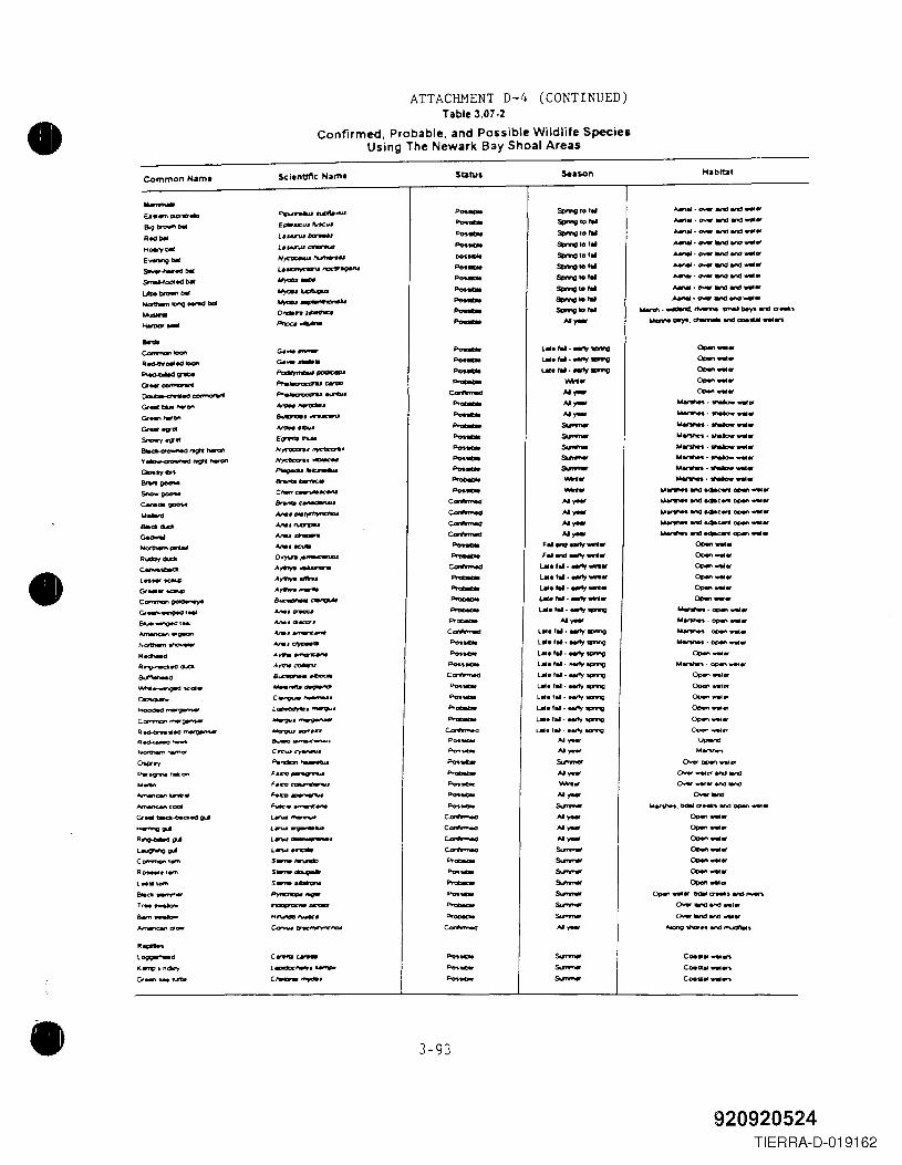
•ATTACHNENT D-4 (CONTINUED)
Table 3.07-2
Confirmed, Probable, and Possible Wildlife SpeciesUsing The Newark Bay Shoal Areas
Common Name S<:ientlllc Hame-E.a • ..,.,~"'. PpshIW~..us
819Dn:Jw"lMl Et*.cll$ 1\I«w
R..... L • .&.U'W~..-.... L._.&.U'W c....-..w:E__ '" N~"""""SiIfrww.,.,edDlll u~lIOC1II"~srrr.I-fOCll.-d bit --~_... _....-~1Df'lQ~bcf ~ .................-- Ol'll:llnl~-- p,ng--e- ..... ...--Red-CtY_" IOOI'l c.~ .....-~ ---GhoI_ -...,..... ......~........,.... ~ ........e-- .. ta.-""on
...-_.G< __
~ .......-=-ue..- ...... ...- ......s..".., 09"" E~"'"8Io_"ll"'_ /It~.~.'(~"'l1'Crw-on ,,-.-GloI9y en ---- -.......,,,-- c,.",~~c........_ _ .-....-.. A.Iw._~......- M.. .......-
~ Mu~-..... _ ......R.-,_ Ol')'\n"~
• e-_A....... ___
l ..... ~A....... _
Gr .... ~A....... _
c"'"""" __ _ ......G1~t'" M........
e,...,..~tMl ~,'*aca...."..,.... ....... _.~N_..- .....,..~c.R_
A,.....--.-.
Rlf'1O"'WC*t'CIl1IdIA_~
~ B~ • .a-e-'M'It.......-.ge<l Kat. ---e-o- c.~,."......-- L.~ • ......."
COtl"n"O"l""'~ --R~."~ ~"",D~~.-.o""'" -_...-.-'" C..... .,...-..
0......, ".,..,..-.Pw~l_on Foto_..- F.C'V~ •
~I:ai"-'-. ..............."..,...., ... F-1AC • .---.,.Gt ... ~-cea.c2~ .......--~ l .......-v----R_~ ..""'~.L_~ ............CClI"I"'I"F'lIIl""
S __
Ro...-.ter"'l
5__
l ... lem
5__
810"'-.- .............-Tr .. ....,.. ....,.,..,.,.. ......Bo.oo_ H~fWW'
..."..,....,,- ea-._....-L_d C..... c..-1<...,...,', "c2c"y LCIdDC'~'~
Gt ....... ~ C,..,... ""..
•
S13tus $enon Habitat
-- Spwlgfof" AMt .. ·O'<IW.,..,.,., ....-- SpMglo'" ...., ... (NeI .,.., It'd .....-- ~IO'" ..." ... tNeI Wla end ....-- Sl>mlIIO 'oO ....., • t:NW .,., end .....-- SI:wW'CIlof" ~·t:NW.,..,end ....-- Sl>mlIIO ... ...., • t:NW .,.., end .....-- se>nngto ... ~ - O'WI W'Id and ....-- SI:w'w'OIO'" ........ ".,..,..,..., ....- Sl>mlIIO ... ........".,..,..,..., .....- Sl>mlIIO 'oO ...,..,... .....-.t,....,.,., ...... DeyI end a .... '- "- ...... MyI. ~ and cae ...... ~-- lMil.f ... ..".,1IPI"nCI 0,-_.- lMil.,...·.."., .,.....g0,-_.-- 1.01..... -'1_ 0,-_ ..- _. 0,-_.
e- ..- 0,-_.- ..- ~·"""''''tI- AI_ ....,.."".. . .....,.....- so..... .......... .,..,.. .....-- so..... ... .,..,..... 1hakJw .... _-- so..... ............. v.Iow ... _-- so..... ......... .,..,.....-- so..... ~-INIow ....- _.....",.. .....,.....-- _.
.....",....Md.~opwt ....c_ "- "".",.... encJ -*c .. open ....
e- ..- .....",.......,.4K ... open .....
e- AI_ .....,...,.. WId ~c.nI open .....
e- ..- .....,..,..W'Id~~ ....-- F..... fIlIItt ..... 0,-_.- F.. Wd...., .....0,-_.
e- l.M.,.. . ...., ..... 0,-_ ..- LM.,..·..-ev .... 0,-_.- un.........,.... 0,-_.- ~.,....eMt1 .... 0,-_.- La. ,... ...,., tPN'IO ....,....~ ....."'- AI- ............. DPfJI'I....
e- L ... ' .. ·..,-,y....-.o iW.",....·DPfJI'I .....-- l ... ,... .-ty ..,ng ....~.~ .....-- l ... f... ~1Pf'W'IQ0,-_._.- l ... '... ~~ M~·OC*'\"""et
c_ l". 'iii· MItY s.prvtg ()pen ... leor-- Ute t ... ""y sPMg CJoen ... It!'-- l ... '.... .,-fy..,...g 0,-....."'- l.IlI. t .. • Mtty IIlfW'tQ 0Qen_ ..
"'- UlI. 'al . eetty 'ICJfW'IO 0Qen .....
~ LMe'''- • .".,.1Qr'W'IO D<-_ ..-- "'- u.-..-- "'- ....-._ .....&Irmoo' O¥oer OC*" wat et
"'- AI- ()ww -.t« iW'd1illnO-- ...... o-r.....,.ardlland-- AI- 0-_-- &Irmoo' "'.,.."....,bOIIla....".,.,(lIpen .....
c_ "'- 0,-.....c_ ..- 0,-_.c_ AI_ 0,-_.e- -- 0,-_."'- -- 0,-_.-- -- 0,-_."'- -- 0,-_ ..-- -- QcMrl.... bmII a.-, .,.,"..,..","'- -- o..r land ard ..c.
"'- -- CNlWIiIlnOWld ....
e- "'- AIcJnliJVICIf'"W'Id~'-- &Irmoo' Coe." ... ws-- &Irmoo' CoeQal ... .."-- -- Co.• ., ... .."
3-93
920920524TIERRA-D-019162
•
AppendixE
• 'I
•920920525
TIERRA-D-019163
•
•
• .u\wp\Pn _aUIh\Nj_ marin Techsupt.doc
APPENDIX E
BIOACCUMULATION POTENTIALOF GROUNDWATER CONTAMINANTS
OF POTENTIAL CONCERN
01/IQ/Q8
920920526TIERRA-D-019164
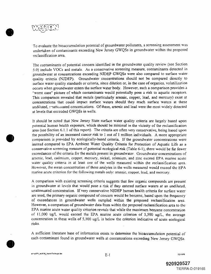
•
•
•
To evaluate the bioaccumulation potential of groundwater pollutants, a screening assessment wasundertaken of contaminants exceeding New Jersey GWQSs in groundwater within the proposedreclassification area.
The contaminants of potential concern identified in the groundwater quality review (see Section5.0) include VOCs and metals. As a conservative screening measure, contaminants detected ingroundwater at concentrations exceeding NJDEP GWQSs were also compared to surface waterquality criteria (NJDEP). Groundwater concentrations should not be compared directly tosurface water quality standards or criteria, since dilution or, in the case of organics, volatilizationoccurs when groundwater enters the surface water body, However, such a comparison provides a"worst case" picture of which contaminants would potentially pose a risk to aquatic receptors.This comparison revealed that metals (particularly arsenic, copper, lead, and mercury) exist atconcentrations that could impact surface waters should they reach surface waters at theseundiluted, t'iattelJUated concent.ations. Of these, arsenic and lead were the most widely detectedat levels that exceeded GWQSs in wells.
It should be noted that New Jersey State surface water quality criteria are largely based uponpotential human health exposure, which should be minimal in the vicinity of the reclassificationarea (see Section 6.1.1 of this report). The criteria are often very conservative, being based uponthe possibility of an increased cancer risk to lout of 1 million individuals. A more appropriatecomparison is provided by ecologically-based criteria. If the groundwater concentrations wereinstead compared to EPA Ambient Water Quality Criteria for Protection of Aquatic Life as aconservative screening measure of potential ecological risk (Table 6-1), there would be far fewerexceedances of the criteria for the metals present in groundwater. Groundwater concentrations ofarsenic, lead, cadmium, copper, mercury, nickel, selenium, and zinc exceed EPA marine acutewater quality criteria in at least one of the wells measured within the reclassification area.However, the mean concentration of these analytes in the wells measured would exceed the EP Amarine acute criterion for the following metals only: arsenic, copper, lead, and mercury.
A comparison with existing screening criteria suggests that few organic compounds are presentin groundwater at levels that would pose a risk if they entered surface waters at an undiluted,unattenuated concentration. If very conservative NJDEP human health criteria for surface waterare used, the primary organic compound of concern would be benzene, based upon the frequencyof exceedances in groundwater wells sampled within the proposed reclassification area.However, a comparison of groundwater data from within the proposed reclassification area to theEPA marine acute water quality criterion reveals that while the maximum benzene concentrationof 11,000 ugIL would exceed the EPA marine acute criterion of 5,500 uglL, the averageconcentration in these wells of 5,100 ugiL is below the criterion indicative of acute ecologicalrisks.
A sufficient literature base of information exists to determine the bioaccumulation potential ofeach contaminant found in groundwater wells at concentrations exceeding New Jersey GWQSs.
az\wp\P"_auth\Nj_marin\Techsupt doc E-I 02119/98
920920527TIERRA-D-019165
•
•
•
Generally, highly lipophilic compounds with a high octanol-water partitioning coefficient (~\J,such as pesticides and PCBs, have a higher potential to bioaccumulate in aquatic ecosystems.Since they are poorly soluble in water, their threat to aquatic food chains comes largely fromtheir presence in sediment, where they may be ingested by benthic invertebrates and passedupward through the food chain via ingestion of contaminated tissue. No PCBs were detected inthe groundwater wells measured within the proposed reclassification area, and only one pesticide(alpha-BHC) was detected (in one well).
Table E-l provides a list of ~'" values for contaminants detected in exceedance of New JerseyGWQSs. In general, compounds with ~'" values less than 500 are highly water-soluble andmobile, with little to no bioaccumulation potential, and are readily biodegraded (Ney, 1995).Most of the VOCs detected in groundwater at levels exceeding NJDEP GWQSs fall into thiscategory. Compounds with Ku", values greater than 1,000 have low solubility, are largelyimmobile in soil, are readily bioaccumulated, and are not readily biodegradable. Compoundsdetected in groundwater at exceedance levels having ~'" values greater than 1,000 include PAHssuch as acenaphthene, fluoranthene, fluorene, and pyrene. These compounds were each detectedin less than 25% of the groundwater wells analyzed for these compounds within the proposedreclassification area, and none exceeded NJDEP GWQSs in more than two wells sampled. Ofthese, only fluoranthene and fluorene would exceed EPA acute ambient marine water qualitycriteria for protection of aquatic life (Table 6-1), should lhe groundwater from the two wellsaffected reach the bay at a totally undiluted, un attenuated concentration.
Other compounds detected in groundwater at concentrations exceeding NJDEP GWQSs werehexachlorobutadiene, hexachloroethane, and xylenes. The first two compounds were eachdetected within only one well. Xylenes, however, were detected in 80 of the 403 samples forwhich they were analyzed, with 40 (a little over 10%) exceeding the NJDEP GWQS of 40 ugiL.There are no New Jersey state or EPA marine water quality criteria or standards for xylenes.Concentrations of xylenes ranged from 0.12 to 100,000 ug/L.
The remaining compounds detected at levels exceeding NJDEP GWQSs have ~w valuesbetween 500 and 1,000, implying that their solubility, mobility, and bioaccumulative andbiodegradation characteristics are variable (Ney, 1995). These compounds, chlorobenzene,alpha-BHC, and 2,4-dichlorophenol, were each detected in two wells or less. In summary,xylene is the organic compound with the most significant bioaccumulation potential, based uponits frequency and magnitude of contamination in groundwater, and its K"", value; however, it wasdetected at exceedance levels at less than 10% of the wells where it was analyzed for. Moreover,given its K"w value (1,585), it is not considered to be highly mobile, and hence is less likely toreach surface water bodies such as Newark Bay.
Metals often adhere to organic or minute suspended sediment particles, and settle out of thewater column where they may be available to consumers in the sediment. Transport of metalsfrom groundwater into surface water may occur in the dissolvei or suspended solids phases.
az\wp\Prt _ auth\Nj _ nwin\ T echsupc, doc E-2 02119198
920920528TIERRA-D-019166
•However, ultimately, if metals were to reach the marine ecosystem, the greatest threat wouldlikely to be posed by metals in the sediment, where concentrations are often an order ofmagnitude higher than those in the water column.
Metals of potential concern in groundwater are arsenic, cadmium, copper, lead, mercury, nickel,and zinc. All of these metals may bioaccumulate to some extent if they were to reach surfacewaters or sediment associated with the surface water body. The degree of bioaccumulation isdetermined by site-specific conditions determining the species of metal present and subsequentbioavailability. Factors affecting uptake include physical and chemical characteristics of thesediment and water (pH, salinity, total organic carbon, particle distribution of the sediment,degree of bioturbation of the sediment, form of the metal [dissolved or adhered to particles], andexposure route [ingestion, absorption, etc.]). For instance, the presence of selenium in the tissuesof an organism may act to bind mercury, making it unavailable, while the presence of calcium insediments may bind lead, making it unavailable.
•The extent of uptake is also determined by the physiological and behavioral characteristics of theorganism exposed, and the duration of exposure. Thus, bioconcentration factors (theconcentration in the animal's tissue divided by the concentration in the sediment and/or water)vary not only between these metals, but for the organisms exposed, and are difficult to predict.However, in the present case, the bioaccumulation potential of these metals is a moot point,given that it is highly unlikely that they would ever reach surface waters (see Section 5.0).
• az\wp\Pn. _auth\Nj_ mann\T echsupt doc E-3 02I1Q/QS
920920529TIERRA-D-019167
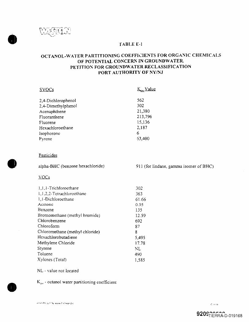
• TABLE E-1
OCTANOL-WATER PARTITIONING COEFFICIENTS FOR ORGANIC CHEMICALSOF POTENTIAL CONCERN IN GROUNDWATER.
PETITION FOR GROUNDWATER RECLASSIFICATIONPORT AUTHORITY OF NYfNJ
SYQCs
2,4-Dichlorophenol2,4- DimethylphenolAcenaphtheneFluorantheneFluoreneHexachloroethaneIsophoronePyrene
56230221,380213,79615,1362,187653,400
Pesticides• alpha-BHC (benzene hexachloride) 911 (for lindane, gamma isomer ofBHC)
1,1,1- TrichloroethaneI, I ,2,2- TetrachloroethaneI,I-DichloroethaneAcetoneBenzeneBromomethane (methyl bromide)ChlorobenzeneChloroformChloromethane (methyl chloride)HexachlorobutadieneMethylene ChlorideStyreneTolueneXylenes (Total)
30236361.660.9513512.596928785,49517.78NL4901,585
NL - value not located
• Kow - octanol water partitioning coefficient
920C"''''''''''''"'TIERRA-D-019168
•
Appendix F
/ ".u
•920920531
TIERRA-D-019169
•
•
•
APPENDIX F
SEDIMENT CONCENTRATION PLOTS OF THE NYINJ HARBOR ESTUARYFROM THE BATTELLE (1992) AND NOAA (1995) STUDIESPETITION FOR GROUNDWATER RECLASSIFICATION
PORT AUTHORITY OF NYINJ
9209291~~~A-D-019170
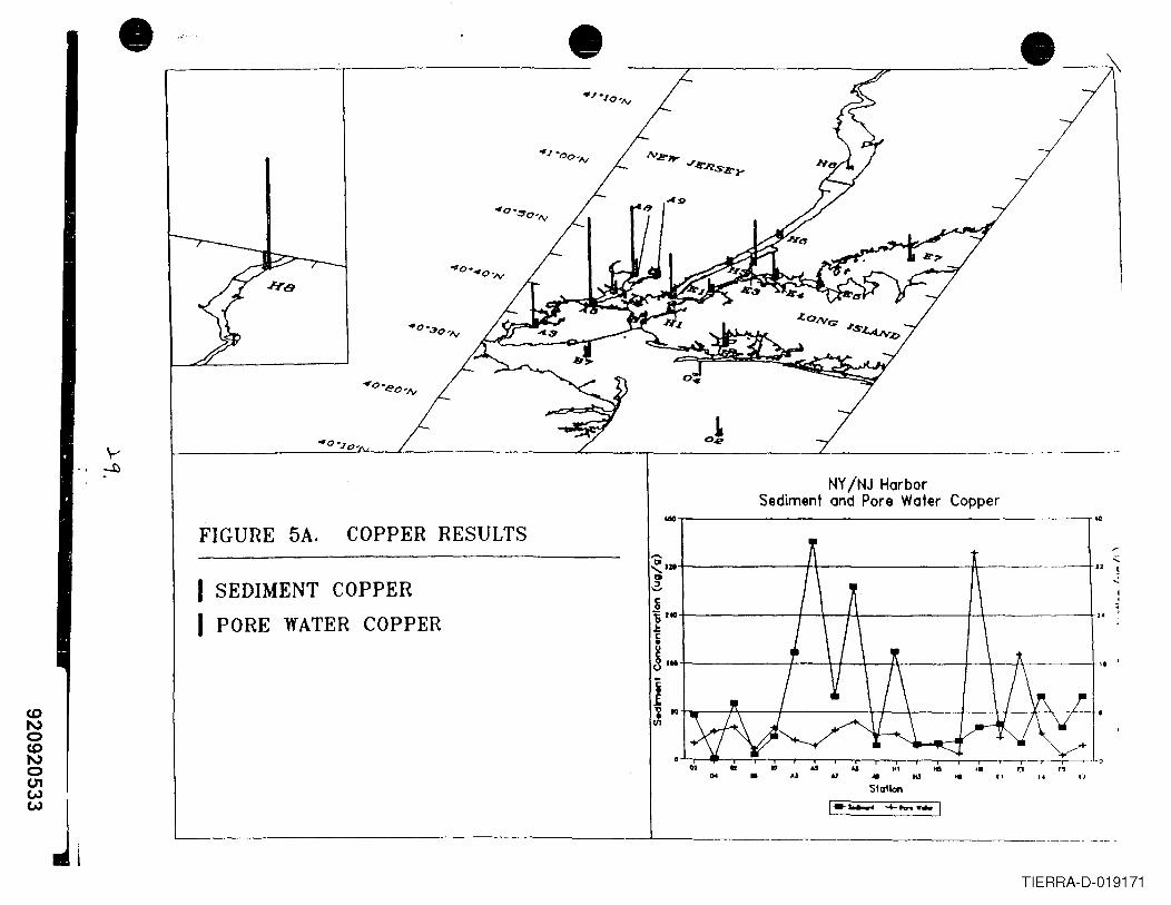
• --,-----_----:. -
FIGURE 5A. COPPER RESULTS
1-- 4-"""·-1
NY/NJ HarborSediment and Pore Water Copper
"~------------------------r'".....~I.+-------++----------a-----~---+III2,I SEDIMENT COPPER
I PORE WATER COPPER~~ua+---------+--\--f-\------+-\------+~c
!1Mt------+--+,I--+---Jl\------I-+---...,I\-----_+I.
1"i 1O+-r---r-\-----+-----4+-\--~--\---I--~(-\,~I__+VI
" U U Ht ~ ~• AJ j,} ... MJ toe (1
SIcrllan(4 n
L-- --L .__ ~ ~__~~.
TIERRA-D-019171
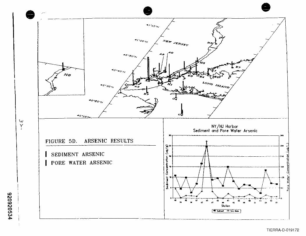
CDNoCDNo(J1e".)~
'vJY,
• ,."" • •-/
I
NY/NJ HarborSediment and Pore Water Arsenic
M
'Ol2S......!&-i1IS..~
r'"llJt I
U... • ..,
FIGURE 5D. ARSENIC RESULTS)10
)00
"0,.-c'"g0LlL
170 '"t~'"(,0
lIS .. UllJ .. [I .. "
II
SEDIMENT ARSENICPORE WATER ARSENIC
.. HI., ..Slot Ion
'----------------_L- ~__~_.__..
TIERRA-D-019172
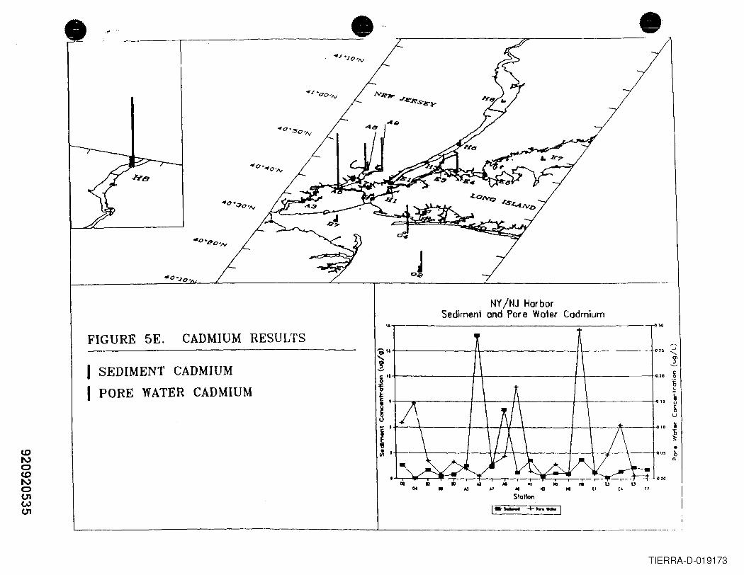
<.0I\)o<.0I\)oU1WU1
'------ -.1.-.... _
• .,..
FIGURE 5E. CADMIUM RESULTS
I SEDIMENT CADMIUMI PORE WATER CADMIUM
•
0_
NY/NJ HarborSediment and Pore Water Cadmium
".------------------,------
,..."t---------1ft---------jf-\----- r_~ -- ~u -:<! 1~11-r-------~r_-------~1-------~20 ~~ ~..~ i!I .. ~
I' 10~~ ~~ J +-----\----+--+l'-J+-\-----+--+---,/L-\----l~ 0' ~
""
• III "I .. ..., AI ~ .. (I
Stationu "[4 p
TIERRA-D-019173
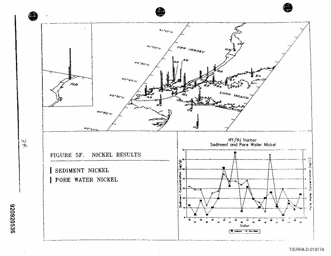
• • •
FIGURE SF. NICKEL RESULTS
.~----------
TIERRA-D-019174
NY/NJ HarborSediment and Pore Water Nickel
'0,--------------------
I SEDIMENT NICKELI PORE WATER NICKEL
.. 0' .. D• .7 oil HI I. " 0Station
•'0n
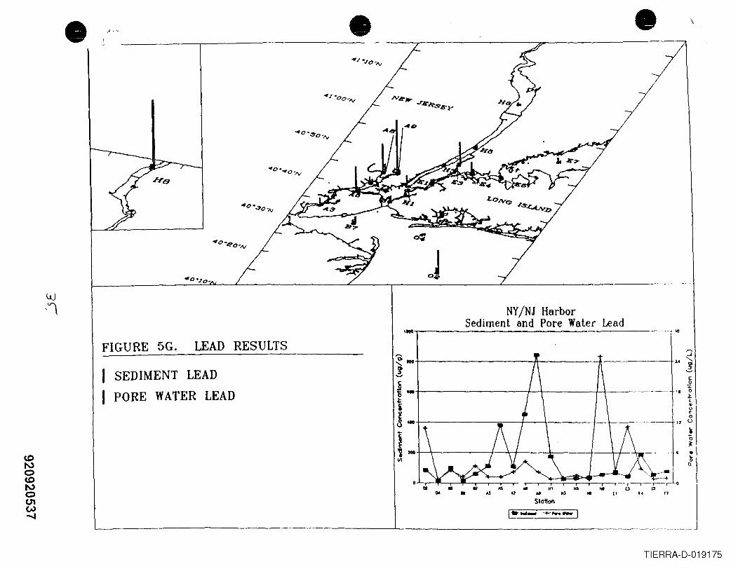
•
UJ-'l
.,.. • •
FIGURE 5G. LEAD RESULTS
NY/NJ HarborSediment and Pore Water Lead''"',-----------~~=-:..:...:.:..::..:.:..-.-:=:.:...=.._---~.'"
\
~ ~~'"t-----------A--------..;~-------!-..... 1-4 '-
! 1£o~c..ur:ou
SEDIMENT LEADPORE WATER LEAD
jli ...~i~- - 1J
1~ *III
A1 .. III
Slatton.. ,.
..~n
n
TIERRA-D-019175

CD
'"oCD
'"oU1e,..)CO
• • •,-,-""
FIGURE 5H. ZINC RESULTS ~-J
t----------.---:-------------I-,(Q ci;:J~
NY/NJ HarborSediment and Pore Water Zinc
10..1---------------------~,00
I SEDIMENT ZINCI PORE WATER ZINC
c~oL
C•u~..0t-------J:...-\rl~_1r+----t-:\------+.ou
...t--------=--+-\+\----------~
110 t--,..----:;;7=-- ....-f-\-A--\---+ -+--------,1~tt.O •(;n
IeAJ .... ICS .. 11
S101\0nII
1-- +....-l
l..-..-- L- ~._. ..._._
n
TIERRA-D-019176
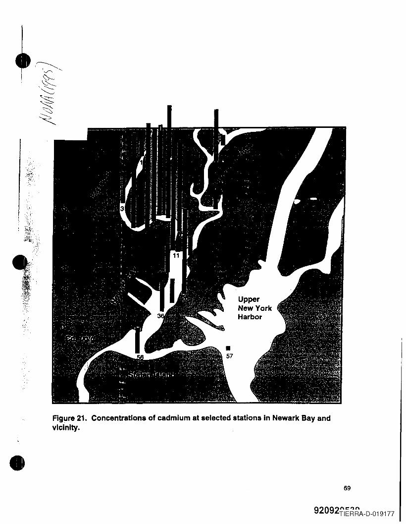
·.,(
\ ...
;1~,),?'":"
•Figure 21. Concentrations of cadmium at selected stations In Newark Bay andvicinity .
69
92092TIERRA-D-019177
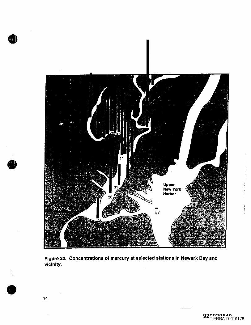
•
•
Figure 22. Concentrations of mercury at selected stations In Newark Bay andvicinity •
• 70
92nn"nCAnTIERRA-D-019178
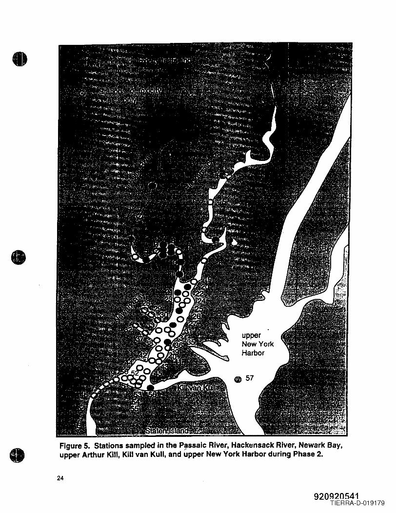
•
•
• Figure 5. Stations sampled in the P~ssalc River, Hackensack River, Newark Bay,upper Arthur Kill, Kill van Kull, and upper New York Harbor during Phase 2.
24
920920541TIERRA-D-019179
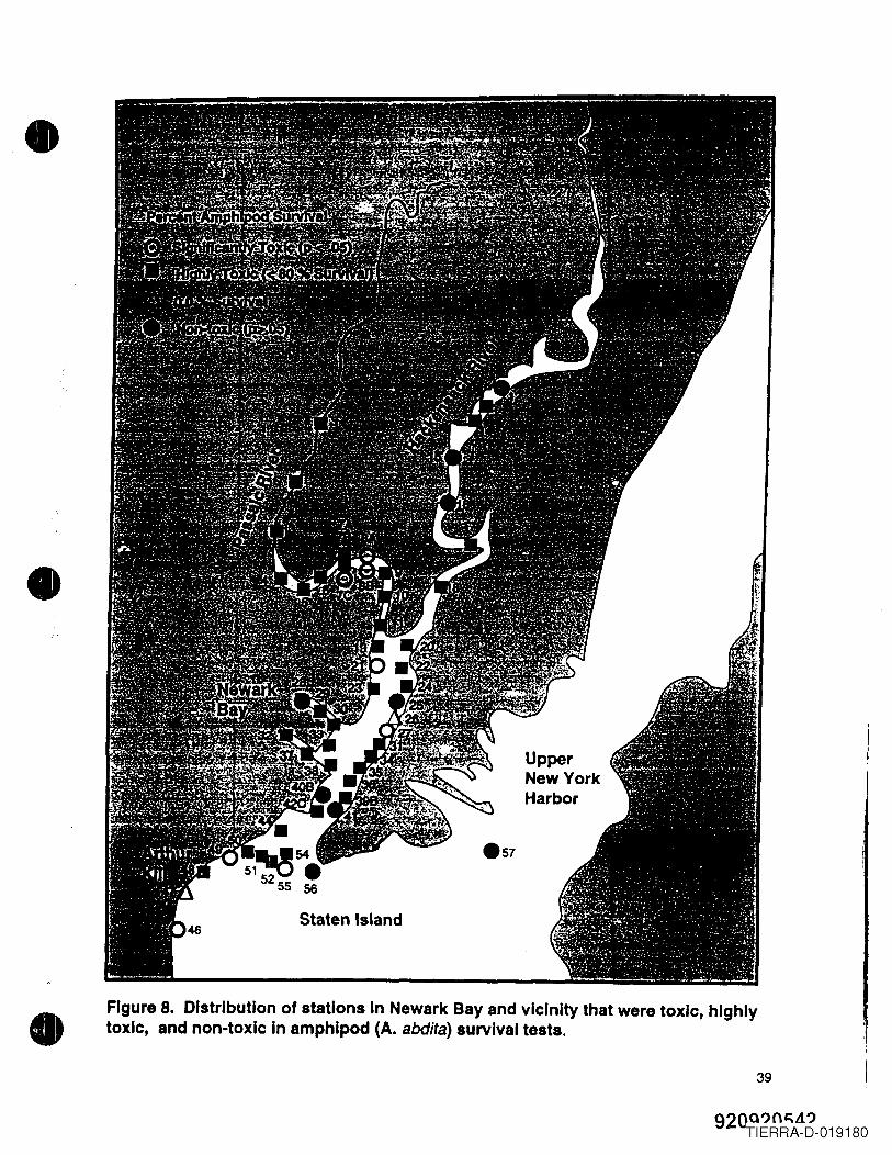
•
•
•
UpperNew YorkHarbor
Staten Island
Figure 8. Distribution of stations In Newark Bay and vicinity that were toxic, highlytoxic, and non-toxic In amphlpod (A. abdita) survival tests.
39
920QIJO"LiIJTIERRA-D-019180
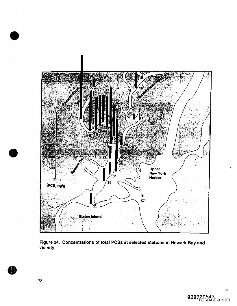
•
•
,.... '~'.'".'10"".
staten Island~-;-f'" .,.::."".,,~'..'¥' . '".
Figure 24. Concentrations of total PCBs at selected stations in Newark Bay andvicinity.
• 72
-920Q?(l,\LI.~
"TIERRA-D-019181
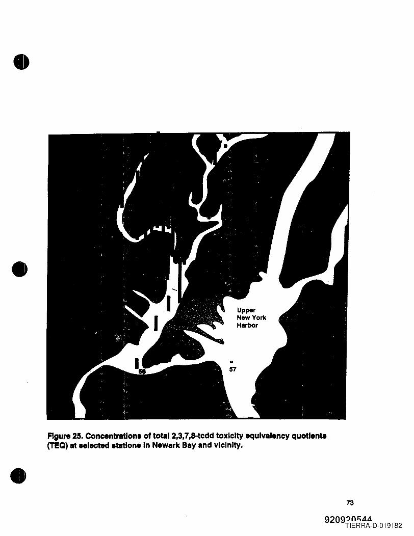
•
•
•Figure 25. Concentration. of totaI2,3,7,8-tcdd toxicity equivalency quotlenta(TEQ) at .. Iected .tatlon.ln Newark Bay and vicinity .
73
9209?n"..1LiTIERRA-D-019182


