Embed Size (px)
Citation preview
A Web-based Land Management System for Bangladesh
Ehtesham Choudhury, Mahmud Ridwan, M Abdul Awal, Shazzad Hosain Department of EECS, North South University, Bashundhara, Dhaka - 1229
{ehtesham273, mahmud343}@eecs.northsouth.edu, {abdulawal, shazzad}@northsouth.edu
Abstract The emergence of digitized land system has been carried out for years. This sector has been spotted as the leading factor in the corruption cases of Bangladesh. In this paper we have designed a framework that will add both transparency and efficiency to the current land management system. This paper presents a new modeling technique that represents data for the current land management system through a user-friendly and digitized map based system. We are proposing to scan the current paper based maps and convert the images into scalable vector graphics (svg) format into database. It allows nice visual presentation of maps and easy searching facility. User friendliness, data transparency and cost efficiency were the prime focus in designing the framework for the new Web-based Land Management System. Keywords: – Automated Web System, Land Information Management System, E-governance.
I. INTRODUCTION With the advancement of information technology, Digital Land Management System has become a crying need for Bangladesh. Of the various sectors in Bangladesh that are affected by corruption, the Land Management System is among the worst. Corruption has been highlighted as the main reason behind slow, poor quality and faulty land related services in the country. Given the absence of a transparent system, bribery and other irregularities are common. People in the administration who are responsible for creating and maintaining land records often prepare incorrect records intentionally, and land owners are forced to pay bribes to officials to get the records approved. Officials and surveyors are often in cahoots with touts and land sharks; cases abound where people have paid bribes to officials and/or surveyors and gotten land ownership transferred/recorded illegally in their names, leaving the real owner(s) running pillar to post to get justice. In 2006 alone, bribes worth about 83 billion Bangladeshi Taka were paid for land related services such as registration and altering of records [15].
Over 25 percent lands are disputed at present and 3.2 million land-related cases are pending before the judiciary in Bangladesh [15]. This huge figure does not take into account the large number of the aggrieved who do not feel empowered enough to approach the courts for litigation. Land disputes often lead to violence and criminal offenses. It is said that 80 percent of criminal offenses today stem from land disputes.
To deal with these problems of fraud and corruption, the government is working to digitize the land records and the land management system to infuse some level of transparency and accountability into the sector and curb the rampant corruption [4], [16]. Very recently researchers looked into designing automated land management system for Bangladesh and the work found in [1], [19] are nice examples of such efforts. Toaha et. al. in [1] elegantly depicted the present land management procedure of Bangladesh, and then proposed an envisioned system that could bring transparency and efficiency in land record management. They proposed possible ways to digitize land information, different modules of the system and the system architecture in general, but they did not provide any real implementation of the system and thus had no technical details of how land information would be stored/retrieved to/from the database. In this paper we bridge the gap by providing the design and representation of land information and a searchable query interface for the land management system. The most crucial part of land management system is to represent land information in such a way that splitting, merging and querying land information become easier. Also collecting and digitizing land data should be cost effective. As we surveyed the literature we found two most common techniques for digitizing land information. One is GPS based technology [1], [19] and the other is DOM (Digital Orthographic Map) technology [8], [17], [18]. Both of these techniques require aerial/satellite photography. While GPS technology is used to extract longitude and latitude information of land, DOM technology is used to extract spatial information of land. The DOM technique is good for 3-D viewing of land area but is not effective to demarcate lands that are covered with trees, forests or other obstacles that are abundant in Bangladesh. On the other hand, the GPS system [19] requires surveying the entire land area by surveyors using GPS devices that communicate with satellite to determine the exact location of a land. This is a popular method of surveying land information but is costly for many countries to afford. Considering the factors we propose an alternate method of getting digital land information that will be very cost effective. In our approach we scan the existing paper maps and draw the area by hand using InkScape [20] software that saves the maps as scalable vector graphics. The process is time consuming since it is manual. But, if we can automate the process of reading the scanned maps and find the coordinates of the map area then within very short time and with much less cost we would be able to represent the existing paper based maps into
scalable vector graphics. However, in this paper our goal is to show how we can represent maps in searchable format into database and to show how we can use different existing technologies to build a Web based land management system. The conversion of maps into scalable vector graphics can be done by our proposed approach or by GPS system or by any other method that is cost effective and has higher accuracy, and thus we leave this issue for further analysis. The paper is organized as the following. Section II provides related works, section III gives current systems and terminologies, section IV presents the proposed framework section V provides the implementation detail of the proposed framework, section VI presents the technical feasibility and advantage of the system, section VII provides the future works and finally section VIII makes the conclusion.
II. RELATED WORKS Various initiatives have been taken in different countries and as well as in Bangladesh to analyze their present Land Management System and to introduce some plans and techniques to upgrade the existing system. Most of the publications that dealt with the land management system are quite focused on providing a new infrastructure of the whole system. Like in [3], [7], authors introduced some new administrative features and rules that can make the land management system more secure and informative. On the other hand in [1] the authors have talked about a system and its different parts that could handle the existing land management system under an IT infrastructure. Several stages of the system have been explained there; in fact it highlighted the administration or land registration procedures in their database system. But the most challenging parts of the system i.e. representing the maps into database; and querying and updating the maps are not explained. Besides this, they mentioned aerial photography or GPS based data collection for the representation of land in the digitized system, but for a country like Bangladesh, it would be better to have a system that will cost less and use the available resources such as existing paper based maps. In [2] we get some idea about the ‘One-Map’ project for land information system and implementation of E-Governance. Their motivation was more towards introducing a system that will integrate the land management operation in different stages. So from administrative point of view this system will be effective to amalgamate the co-ordination among different parts that control the system. Reports found in [4], [6], [7] explained an overview about the actual practical system and factors that can be implemented for the betterment of the system. Moreover, several researches are being conducted for mapping technologies, most of which are based on GPS and remote sensing devices. On the other hand, our endeavor is more focused on finding a solution that will integrate the graphical representation of the whole country’s land under one shade. We introduced a new horizon that will handle digitized map on a web-based system based on recent advances in the field of web technologies such as HTML 5 CANVAS [13], [14] for map viewing, Scalable Vector Graphics (SVG) [9], [10] for
dynamic web mapping and PostGIS [11], [12] for geospatial analysis and mapping.
III. CURRENT SYSTEM AND THE TERMINOLOGIES
Before moving on to understand the digitized land management, it’s essential to get acquainted with the current terminologies that are there for years and are well documented in [1]. The whole Map is divided into different ‘Mouja’s. More precisely after Division, Zilla and Thana, ‘Mouja’ is the unit for identifying or locating an area of land. Each ‘Mouja’ has a name and a unique number, for example, “Dhaka Mohammadpur” is a Mouja which has a unique identification number. So together Division, Zilla, Thana, Mouja indicate an identical Mouja. After Mouja there are some more subdivisions like ‘Sheet’ and ‘Daag’. A Mouja is divided into several Sheets and a Sheet is divided into Daags. Daag number is used to identify a land, whether it is public or private. So, for locating a piece of land in Bangladesh the following sequence Division.Zilla.Thana.Mouja.Sheet.Daag is followed.
Besides locating a land there are some important terms for the ownership chores of a land. Lands or plots are of different sizes and shapes, for example, a plot with daag number 100 may be 50 acres or 300 acres or so. Each plot may be owned by multiple owners, but this ownership is not demarcated within the map. The ownership is written on land registration papers that are known as Porcha. These papers are reviewed during several land surveys occurred in different times. Some of them are known as CS Survey, the land survey that were done on British period; RS and SA Survey, during Pakistan period and BS Survey is done during Bangladesh Period. In these survey papers, the owner is given an ownership number usually known as Khaatian number. Though in this paper we propose a new digitized system for managing land information, but for the sake of simplicity to general users, we have used the existing terminologies that are being used for years.
IV. THE PROPOSED FRAMEWORK Currently, the land management system requires the maintenance of large number of records on paper. Government organizations and offices keep all the records on thick log books. Moreover, they use very primitive management skills to maintain these records. So the current system made it difficult to look up on records, modify them and synchronize them with other related organizations. Thus, requirement of an automated digitized system, an infrastructure that will replace the current, slow, messy, unreliable system for good is imminent. The first phase of this replacement procedure would be to digitize the current data. The most important and critical form of data in land records are maps. A computerized solution should definitely provide powerful means to handle maps.
These maps are currently available on large sheets of paper; outdated and confusing, these maps have been around for ages. They have been revised three times during the entire history of this country. But they somehow have been (miraculously!) effective throughout all the time. Digitizing the maps would be a one time job, a reason good enough to try it by any means necessary. With the help of computer aided design and skilled manpower, these drawings can be redrawn into geo-coded vector graphics on a computer in a relatively short period of time. And with the help of image processing techniques, this whole task can be simplified down to a matter of checking each drawing, as a computer program can be devised to read the scanned images of these drawings and generate these vector graphics automatically. During our experimentation we first scanned the maps and then used an open source application called InkScape [20] to trace the scanned images of the maps. We started out by first tracing the outlines of the map of the entire country at a detail of district level. Then we chose a district, a small region from that area, and we placed a scanned image of a sheet of a map. We then traced the outlines of the “daags” and exported it to SVG format. This particular format encodes the paths (a continuous irregular line that starts from one point, bounds an entire “daag” and ends at its starting point) in an XML format. We chose this format because this format retains various properties of these paths, including a label that can be specified from InkScape. We used this label to address each “daag” uniquely, in terms of its location in the country. The scheme we used for addressing each “daag” was similar to what is used today. A sequence of location names and numbers concatenated by a '/' sign. An example would be “Dhaka/Mohammadpur/Shamoly/25/24/2”. We later found that this scheme is not very effective and it makes hard to make changes. For example, when a particular “daag” is split and sold to two different persons, we need to make large number of changes; a problem that currently haunts the entire land management system. Therefore, we take a different approach, where we can easily label all the “daags” of this country and not worry about splitting them later. So instead of using a sequence of location names, we use a sequence of numbers, for example “1/5/3/5/19/7”, where each number indicates a particular division of its parent block of land. In this particular example, the first “1” could mean a division; the following “5” could be a district in that division and so on. Later on, if a particular piece of land were to be divided among two persons, we could simply create two ids “1/5/3/5/19/7/1” and “1/5/3/5/19/7/2”. This particular scheme would solve the problem quite easily. Also, one might think that we would soon get tangled into large strings. But, the idea is that people would only split their lands to a particular limit. And if at any time two lands were to be owned by the same person, we could refer to that land with their ids having their trailing numbers removed. Because, once digitized we won't have to worry about having human readable ids. These ids
would work for lands as National Security Numbers do for citizens. All information stated above is stored in a geo-spatial capable database. During our experiment we chose PostgreSQL for this. Against the ids we stored the land outline as a detailed irregular polygon. The database, being geo-spatial capable, allowed us to perform queries based on shape intersection, area, geo-position and so on. As a proof of concept we implemented the HTML5 based front end where we were able to query this database for a range of “daags" of their geometry. These data were retrieved in plain text and was then processed on the front end before drawing the shapes on a canvas. The system was optimized by making the query to return only those “daags” that would appear on the screen. The front end of the system shows a map with the manipulation tools floating on the surface. A smart-search system was implemented to complement the user experience. The search engine was real-time and took semi-natural inputs. The user can change the updated results as soon as s/he changes the query. The query doesn’t necessarily have to comply with any specific pattern. Instead a query such as “daag 14” would instantly return a list of “daags” that match the query.
V. IMPLEMENTATION OF THE PROPOSED SYSTEM
As per the details of the proposed framework, we have implemented a system focused on a particular area of Dhaka Division. We choose an area under Savar thana located in Dhaka Zila. We collected a map of Savar thana from the authorized office of Land Ministry. The map contains the details of the lands of Savar thana such as shape information and daag no (daag=identification number) of lands. Then a part of that map has been represented into database of our system. Since our system is based on a single map, we first prepared the map showing the outline of the country with different levels like Zilla and Thana. After that, the detail land-map is integrated in the map in the desired place. The workflow of the implementation is completed in different stages, as they are briefly described in subsequent sections. A. Re-draw map in Scalable Vector Graphics First, the paper based map is scanned into the computer. Then as mentioned earlier, by using InkScape, all the bounded regions in the map, which basically signifies a piece of land, are specified with unique identification number and the area as shown in the map. After completion of enclosing all the pieces of land in a map, the file is saved as scalable vector graphics. The .svg file, which is generated by InkScape, actually contains the id and the chain of co-ordinates of an enclosure, most of the cases which is an irregular polygon. Moreover, InkScape automatically generates other information about the geometric specification of the enclosure such as, curvature etc. and store it under a specified <path/> tag in XML format to
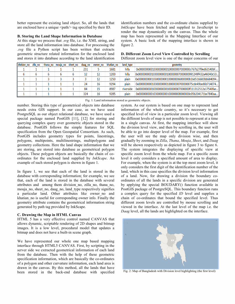
better represent the existing land object. So, are enclosed have a unique <path/> tag specifi B. Storing the Land Shape Information in DAt this stage we process that .svg file, i.e. the store all the land information into database. F.svg file a Python script has been writtegeometric structure related information for thand stores it into database according to the la
number. Storing this type of geometrical objeneeds extra GIS support. In our case, asPostgreSQL as our object relational databasespecial package named PostGIS [11], [12] querying complex query over geometric objedatabase. PostGIS follows the simple feaspecification from the Open Geospatial ConsPostGIS includes geometry types for popolygons, multipoints, multilinestrings, mugeometry collections. Here the land shape infare storing, are stored into database as geomobjects. These polygon objects are basically ordinates for the enclosed land supplied bexample of such stored polygon is shown in fi In figure 1, we see that each of the land database with corresponding information; for that, each of the land is stored in the databattributes and among them division_no, zilmouja_no, sheet_no, daag_no, land_type respa particular land. Other attributes like khatian_no is useful for corresponding ownergeometry attribute contains the geometrical ingenerated by path tag provided by InkScape. C. Drawing the Map in HTML Canvas HTML 5 has a very effective control namedallows dynamic, scriptable rendering of 2D shimages. It is a low level, procedural modebitmap and does not have a built-in scene grap We have represented our whole one map interface through HTML5 CANVAS. First, byserver side we extracted geometrical informatfrom the database. Then with the help of specification information, which are basicallyof a polygon and other curvature information, drawn in the canvas. By this method, all thebeen stored in the back-end database
Fi
all the lands that ied by their ID.
Database XML string, and or processing the en that extracts he enclosed land and identification
ects into database s we have used , we have used a for storing and
ects stored in the atures for SQL sortium. As such, ints, linestrings,
ultipolygons and formation that we metrical polygon the chain of co-
by InkScape. An igure 1.
is stored in the example, we see
base with several lla_no, thana_no, ectively signifies
owner_no and r info. Finally the nformation string
d CANVAS that hapes and bitmap el that updates a ph.
based mapping y scripting in the tion of each land these geometric
y the co-ordinates each land area is
e lands that have with specified
identification numbers and the co-oInkScape have been fetched and render the map dynamically on thmap has been represented in the system. A basic look of the mappfigure 2. D. Different Zoom Level View CoDifferent zoom level view is one of
system. As our system is based on information of the whole countryspecified level of view in a particulthe different levels of map is not poin a single canvas. At first, the mathe division level view, and then bybe able to go into deeper level of tthe user will see the map only gradually by zooming in Zilla, Thanwill be shown respectively as depicThe system integrates the displaspecific zoom level from the wholelevel it only considers a specified For example, when the system is at only considers the first digit of the iland, which in this case specifies theof a land. Now, for drawing a dordinates of all the lands in a specby applying the special BOUDARPostGIS package of PostgreSQL. Ta complex query for the specifiedchain of co-ordinates that bound different zoom levels are controlleviewed in the interface. At the lasDaag level, all the lands are highlig
Fig. 2: Map of Bangladesh with Division le
g. 1: Land information stored as geometric objects.
ordinate chains supplied by supplied to JavaScript to
he canvas. Thus the whole Mapping Interface of our
ping interface is shown in
ontrolled by Scrolling f the major concerns of our
one map to represent land y, so it’s necessary to get lar zoom level. Viewing all ssible to represent at a time apping interface will show y scrolling in, the user will the map. For example, first
division wise, and then na, Mouja, Sheet, and Daag cted in figure 3 to figure 6. aying of specific view at e map. For a specific zoom amount of area to display. the top most zoom level, it dentification number of the e division level information division the boundary co-cific division are generated RY() function available in
This boundary function runs d ID level and supplies a the specified level. Thus
ed by mouse scrolling and st level of the map i.e. the hted on the interface.
evel highlighting (the first level)
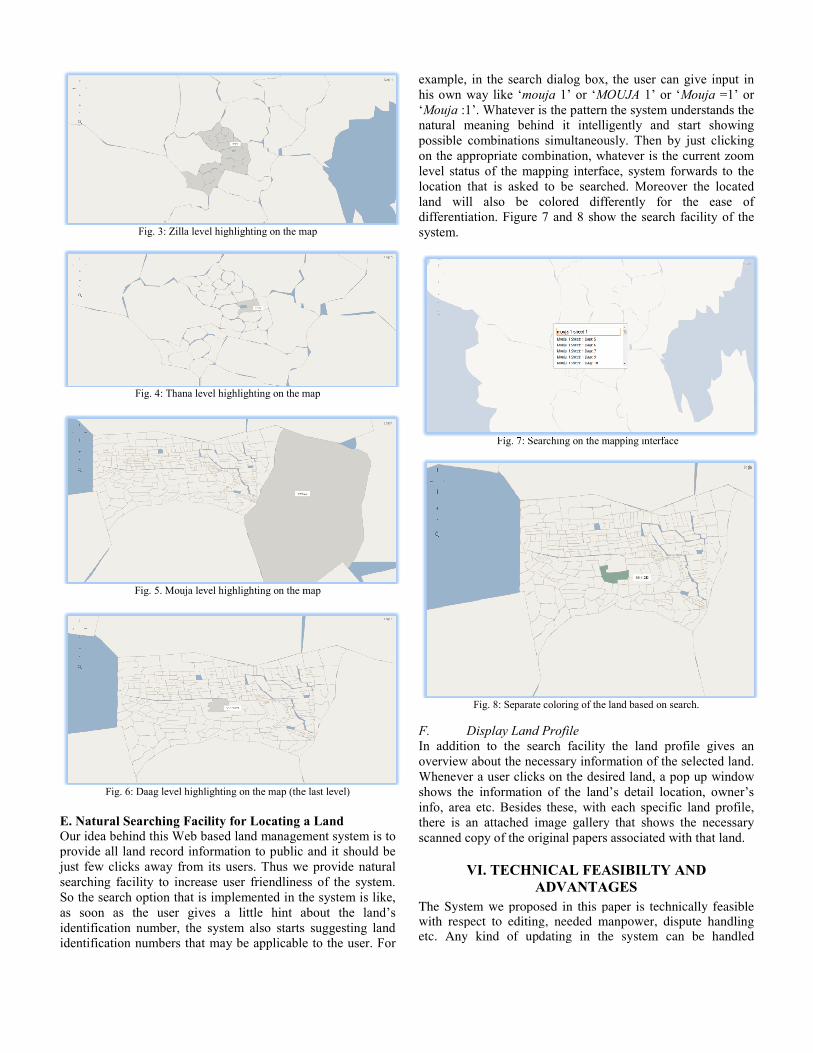
Fig. 3: Zilla level highlighting on the m
Fig. 4: Thana level highlighting on the m
Fig. 5. Mouja level highlighting on the m
Fig. 6: Daag level highlighting on the map (the E. Natural Searching Facility for Locating aOur idea behind this Web based land managemprovide all land record information to public just few clicks away from its users. Thus wesearching facility to increase user friendlinesSo the search option that is implemented in thas soon as the user gives a little hint aidentification number, the system also startsidentification numbers that may be applicable
map
map
map
e last level)
a Land ment system is to and it should be
e provide natural ss of the system. he system is like, about the land’s s suggesting land e to the user. For
example, in the search dialog box, his own way like ‘mouja 1’ or ‘MO‘Mouja :1’. Whatever is the pattern natural meaning behind it intellipossible combinations simultaneouon the appropriate combination, whlevel status of the mapping interfalocation that is asked to be searchland will also be colored diffdifferentiation. Figure 7 and 8 showsystem.
Fig. 7: Searching on the m
Fig. 8: Separate coloring of the
F. Display Land Profile In addition to the search facility overview about the necessary informWhenever a user clicks on the desirshows the information of the landinfo, area etc. Besides these, with there is an attached image galleryscanned copy of the original papers
VI. TECHNICAL FEAADVANTA
The System we proposed in this pwith respect to editing, needed metc. Any kind of updating in th
the user can give input in OUJA 1’ or ‘Mouja =1’ or the system understands the gently and start showing
usly. Then by just clicking hatever is the current zoom ce, system forwards to the hed. Moreover the located ferently for the ease of w the search facility of the
mapping interface
land based on search.
the land profile gives an mation of the selected land. red land, a pop up window
d’s detail location, owner’s each specific land profile,
y that shows the necessary associated with that land.
ASIBILTY AND GES aper is technically feasible anpower, dispute handling e system can be handled
technically in a very feasible and transparent way. The whole system will be handled through a distributed system, so all the information will be stored in an organised way. Like, for the current system people need to suffer a lot in the land office for gathering necessary information but here in our proposed system, one can get all the information under one shade. On the other hand the system is called feasible because editing in the map does not need a whole survey; instead any necessary update of this information is only three steps. For example, if a land is divided among two brothers of the same family, then the steps are: i) indicate a new enclosure in the current area in the .svg file ii) set an identification number and iii) upload that number into the system. Unlike other GIS based system, the proposed system is web based as we are using HTML5 CANVAS element for mapping. So, general users can get information from home that serves the citizens basic right of information. As a result, the land office does not need so many officials who wait in the office just to purpose these services. Besides this, a lot of manpower, time and budget are needed to conduct land survey for updating information that can be lessen by the current system to a great amount. Moreover, the system offers a transparent view of all the land information. In any case if a person comes with obligation about the stated information in the system, by proper verification it can be handled in a feasible way.
VII. FUTURE WORK There are few things that are not covered by our system. Proper research in these areas will make the system more efficient. For example, the image conversion from the paper based map to the digital map is a quite hectic process. Automation in this function can be done by image processing tools. Some work can be done in the database side also for keeping track of the owner information more wisely. For example, in spite of containing the information of the current owner only, the database can keep track of the history of ownership for a particular land. With the ownership history land area can also be tracked that has changed over time, e.g. if a land divides into two owners then the system should keep track of the division. In our system there is only textual information about the land type such as whether it’s a plain land or a hilly land. Contours of each land can be stored; in fact if the land view can be converted in to 3D view using DOM technologies then the system will be more realistic towards the general users.
VIII. CONCLUSION This paper presented a new way of digitizing maps for developing a web-based land management system for Bangladesh. First we showed the current problems that are haunting the country because of the presence of a poor and opaque land management system. We then proposed a web based land management system that can serve the land management purposes of the country as well as provide all kinds of necessary information for the general mass people. We proposed a technique to convert paper based land maps into digital maps i.e. .svg format, so that searching and retrieving land data become easier. It allows splitting and
merging land in a convenient way. Finally, we developed an Web interface for searching specific land and its information. The key concept was to use our current resources and existing technologies to present the country a technically advanced, transparent and user friendly system to manage its lands.
REFERENCES
[1] Mabruka Toaha, Shahriar Khan, “Automated Digital Archive for Land Registration and Records” Proceedings of 11th International Conference on Computer and Information Technology (ICCIT 2008) 25-27 December, 2008, Khulna, Bangladesh.
[2] Yaolong Zhao, “One Map”-based Land Information - Towards E-government for Land Management” , 2010 International Conference on E-Business and E-Government.
[3] S.S.Dael, P. Frederiksen & L.T. Jørgensen, “The Danish way to a national spatial data infrastructure”, http://citeseerx.ist. psu.edu/viewdoc/summary?doi=10.1.1.158.9348
[4] Government of the People’s Republic of Bangladesh and United Nations Development Programme, “Capacity Development and Resource Mobilization for Sustainable Land Management in Bangladesh”, June 2007, http://regionalcentrebangkok.undp.or.th/practices/energy_env/ documents/LDC-SIDS/Prodocs/Bangladesh%20SLM%20Prodoc% 2016%20May07%20DOA%20version.pdf
[5] “Ortho photography” Chapter-14, http://gis-lab.info/docs/books/aerial-mapping/cr1557_14.pdf
[6] Thomas T. Cochrane and Thomas A. Cochrane ,” The digital land systems surveys for monitoring land quality change in the Amazon”, http://www.agteca.com/publications/poster_soter.pdf
[7] “Land Information Integration and strategy “, http://www.mnre.gov.ws /projects/siam-2/documents/C5/Land%20Info%20Integration%20 Strategy.pdf
[8] Liu Chen , Ma Xiujun, Xie Kunqing, Liu Yu, Feng Xuebing, “Digital Orthographic Map Management in Spatial Databases”, 2nd Asian Symposium on Geographical Information Systems from Computer and Engineering View, ChongQing, China, 2004.
[9] “Dynamic web mapping using Scalable Vector Graphics” http://www.pelagis.net/gis_con/paper/svg.pdf
[10] Neumann, Andreas, Winter, Andréas M., “Vector-based Web Cartography: Enabler SVG”, http://www.carto.net/papers/svg/ index_e.shtml
[11] “Using PostGis: Data Management and Queries”, http://postgis.refractions. net /docs/ch04.html
“PostGIS for geospatial analysis and mapping” ,http://www.postgreonline.com/journal/archives/7-PostGIS-for-geospatial-analysis-and-mapping [12] “Mapping with HTML5,Javascript and Canvas”, http://indiemaps.com/
blog/2010/06/interactive-mapping-with-html5-javascript-and-canvas/ [13] “HTML5 map using canvas vector maps”,
http://www.designscripting.com /2011/06/html5-map-using-canvas-vector-maps-html5/
[14] “Stresses laid on digitizing land management to reduce corruption, August 2010”, accessed at http://www.digitalbangladesh.gov.bd /blog.php?ID=350
[15] “Land Record Management: 10 Firms Team Up, March 2010”, accessed at http://www.digitalbangladesh.gov.bd/blog.php?ID=31
[16] Kentaro Toyama, Ron Logan, Asta Roseway, “Geographic location tags on digital image”, Proceedings of the eleventh ACM international conference on Multimedia, Berkeley, California, USA, 2003, 156 – 166.
[17] Liu Chen, Ma Xiu-Jun, Xie Kun-Qing, Liu Yu, Feng Xuebing, “A solution of digital image management in spatial databases”, Journal of Chongqing University of Posts and Telecommunications, vol. 16, no. 5, October 2004, pp. 161-164.
[18] The Survey Advisory Board for Washington State Department of Natural Resources, “Standards and Guidelines For Land Surveying Using Global Positioning System Methods”, August 2004, accessed at http://www.ogug.net/PDF%20files/Standards%20and%20Guidelines%20for%20Land%20Surveying%20using%20GPS%20ver%202.1.3.pdf
[20] “InkScape- Draw Freely”, http://inkscape.org/doc/devdocs.php?lang=en


