Embed Size (px)
Citation preview

THE FLINDERS UNIVERSITY OF SOUTH AUSTRALIA
GPO Box 2100Adelaide 5001AUSTRALIA
Hills Face Zone Cultural Heritage Project
Cultural Heritage Survey Report
for
Sector 1 of the Yurrebilla Trail,
Norton Summit to Tea Tree Gully
for the
Yurrebilla Trail Committee, S.A. National Parks and Wildlife
The Morialta Barns (Photo HFZCHP)
Prepared by: Pam Smith, Project Co-ordinator
January 19th, 2003
Hills Face Zone Cultural Heritage Project Phone: 08 82015257 Department of Archaeology Mobile: 0428315266 Flinders University email: [email protected] http://ehlt.flinders.edu.au/archaeology/research/hfzchp/index.htm
ii
CONTENTS
1. Introduction 1
2. Report on part of Sector: Norton Summit township and environs 2 2.i. Report on significant cultural heritage features 4 2.ii. Recommendations for the Norton Summit region: 6 2.iii. References and Resources 7
3. Report on Sector: Norton Summit to First Falls, Morialta 8 3.ii Recommendations for the sector Norton Summit to First Falls, Morialta 11 3.iii. References and Resources 11
4. Report on Sector: First Falls, Morialta to the River Torrens 12 4.i Report on the significant cultural heritage features. 13 4.ii Recommendations for the sector First Falls, Morialta to the River Torrens 14 4.iii. References and Resources 15
Figures Figure 1. Map of the Yurrebilla Trail – Sector 1 showing the sites referred to in the report. Figure 2. Bronze statue of Sir Thomas Playford in the Norton Summit Memorial Gardens. Figure 3. The Scenic Hotel, Norton Summit. Figure 4. The stone walls of the courtyard, Morialta Barns Figure 5. Stone stairway, First Falls, Morialta Conservation Park Figure 6. Stone and cement footings for a slide associated with quarrying, Fox’s Hill Track,
Morialta Conservation Park
Appendices
Appendix 1. Maps and plans associated with the survey area Appendix 2. Yurrebilla Trail: Interpretation Framework, 8/4/02 Appendix 3. Hills Face Zone Cultural Heritage Project Profile Appendix 4. S.A. Department of Environment and Natural Resources. 1994 Heritage Survey
of the District Council of East Torrens, pages:43, 45, 46, 47; figures 5i and 7i. Appendix 5. East Torrens Heritage Tour Guide. 1989.
1
1. Introduction The Yurrebilla Trail is to be an international standard two-day walking trail across the central section of the Adelaide Hills Face Zone between the Belair Railway Station, Belair and the River Torrens, Tea Tree Gully; refer to Appendix 1 for a map of the route. In 2001 an Industry Partnership agreement was reached between the Hills Face Zone Cultural Heritage Project Steering Committee, Flinders University (HFZCHP) and Paul Tulloch, on behalf of the Yurrebilla Trail Committee, National Parks and Wildlife, SA (NP&W). It was agreed that the HFZCHP would research the cultural heritage of the Hills Face Zone in the vicinity of the Yurrebilla Trail and would make recommendations on cultural tourism opportunities along the route and on the content of interpretive signs relevant to cultural heritage. Since this agreement was finalised members of the HFZCHP Steering Committee have met regularly with Paul Tulloch (who left the project during 2002), Graham Hearn and Rebecca Brown (NP&W). Lyn Leader-Elliott (HFZCHP) and several cultural tourism students reported to the Yurrebilla Trail committee on the cultural tourism potential of sections of the trail at the end of 2001 and 2002, and Janine Hook, a Cultural Tourism Honours student did her Industry Placement with NP&W, working with the Yurrebilla Trail Committee. This report is to present the results of the cultural heritage surveys undertaken along the proposed route of Sector 1 of the trail between the Norton Summit and the River Torrens. Three sectors along the Yurrebilla Trail have been defined and themes allocated by the Yurrebilla Trail Committee. The framework of this report is based on these divisions, refer to the report prepared by Rebecca Brown, Yurrebilla Trail: Interpretation Framework, 8/4/02 (see Appendix 2). It should also be noted that detailed historical research is still in progress for several of the sites referred to. Reports of the cultural heritage surveys are available on the HFZCHP website. The Adelaide Hills Face Zone Cultural Heritage Project is supported both financially and in-kind by Flinders University, the Australian Research Council and by a number of Industry Partners, all of whom are listed on the project’s website (refer to front cover). Refer also to Appendix 3 for a copy of the Project Profile. The field surveys on which this report is based were done by volunteers, most of whom were members of the Flinders University Archaeology Society. This report is based on the reports of three preliminary surveys undertaken during 2002 in the vicinity of the Yurrebilla trail. All sites referred to in the report are identified on the relevant Yurrebilla Trail Sector maps. In addition to reports prepared for the Yurrebilla Trail committee, GPS data are entered into a Hills Face Zone Cultural Heritage GIS Database as they become available.

2
2. Report on part of Sector: Norton Summit township and environs Flavour: Primary visitor target: The history of the township of Norton Summit and environs has been thoroughly researched and documented and the heritage value of its buildings recognised. For detailed historical information refer to Hallack (edited by G.C. Bishop) 1987; Bishop and Bishop 1990; Bishop 1992; Hines 1996; Vivienne 1908 and files on the heritage listed buildings held by Heritage SA. (Refer also to Appendix 1 for historic maps of the district). The township of Norton Summit is an ideal place for an overnight stay for people walking along the trail and should be promoted as a place to linger and to explore its fascinating history. The Scenic Hotel has a popular restaurant with wonderful views across the valley to the plains. There are several places offering bed and breakfast in the township and there is a possibility that the Morialta Barns, now vacant and owned by the Adelaide Hills Council, may become either a backpackers hostel or a winery. Both of these would benefit from an increased number of tourists using the Yurrebilla Trail. Many of the buildings in this area are listed on the State Heritage Register and the Adelaide Hills Council Local Heritage Register. Refer to Appendix 4 for lists of buildings on these heritage registers and relevant extracts from the Heritage Survey of East Torrens, 1994. In addition the East Torrens Historical Society has published a tour guide map with references to significant heritage buildings in Norton Summit, Appendix 5 contains a copy of this guide, the East Torrens Heritage Tour Guide, 1989. For the purposes of the Yurrebilla Trail Committee, the East Torrens Tour Guide may provide sufficient information about individual heritage sites for visitors walking along the trail. It is therefore recommended that this guide should be used as the basis of the Yurrebilla Trail Guide in the region of Norton Summit, and that the East Torrens Historical Society be advised of this and acknowledged in publications. Most, but not all, of the following information is taken from the East Torrens Tour Guide; some private residences listed on the tour guide have been omitted. All sites referred to below are identified on the map, Yurrebilla Trail – Sector 1, see Figure 1.

3
Figure 1. Map of Sector 1 of the Yurrebilla Trail showing the sites referred to in this report.

4
2.i. Report on significant cultural heritage features • The Playford Family. Two Premiers of South Australia, the Hon. Thomas
Playford and Sir Thomas Playford, came from Norton Summit. The Hon. Thomas Playford was the son of the Reverend Thomas Playford of Mitcham and his house on Fourth Creek was known as Drysdale. He was elected to the House of Assembly as the Member for Onkaparinga in 1858 and subsequently served as the Premier of South Australia. Sir Thomas Playford is Australia’s longest-serving Premier (1938-1965) and there is a bronze statue commemorating his life in the gardens in the centre of Norton Summit (Crocker 1983). Several sites linked to the Playford family are close to the Yurrebilla Trail in this region.
o Drysdale ruins. (Site 56 in Appendix 5). This cottage was built in the 1870s for the Hon. Thomas Playford. It was burnt in 1983 in the Ash Wednesday fires.
o Former residence of Sir Thomas Playford. (Site 57 in Appendix 5). o Bronze statue of Sir Thomas Playford. This is located in the Memorial
Gardens opposite the Scenic Hotel.
Figure 2. Bronze statue of Sir Thomas Playford in the Memorial Gardens
• Norton Summit Cemetery. It is well worth a leisurely walk through this cemetery, where many local identities are buried. The cemetery is owned by the Adelaide Hills Council and dates from the 1880s. Refer also to the relevant HFZCHP Research Report.
5
• Norton Summit Primary School. (Site 59 in Appendix 5). The school was built in 1875 and was attended by Sir Thomas Playford.
• Former Norton Summit Baptist Church. (Site 61 in Appendix 5). This stone
church was built in 1876 and is located on a hill overlooking the town. • Norton Summit Post Office and General Store, this is now a private residence.
(Site 62 in Appendix 5). • Former Council Chambers. This stone building, located in the centre of town and
opposite the Scenic Hotel, was the home of the East Torrens Council from 1902-1980. It is currently the Norton Summit Post Office and Local Museum.
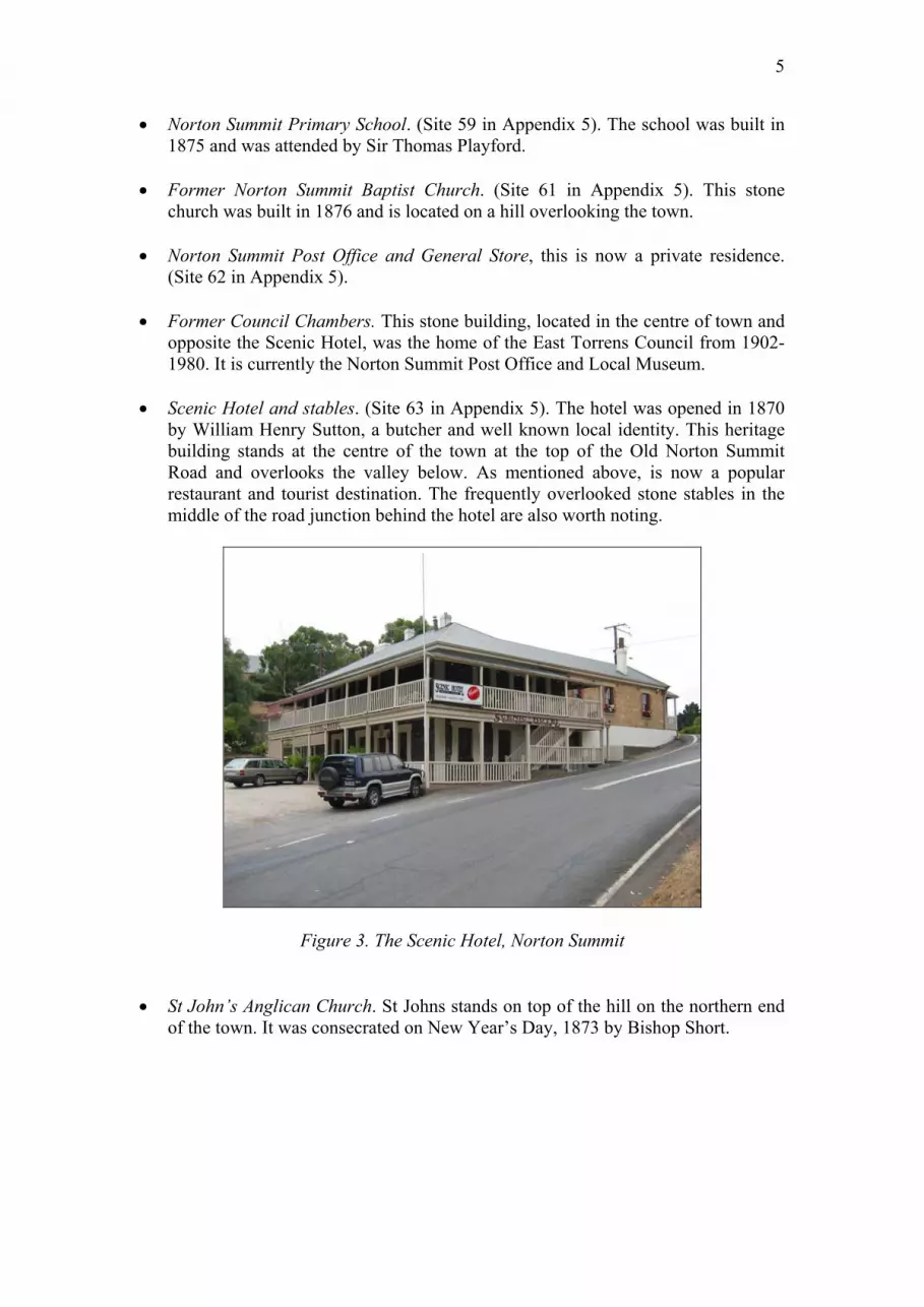
• Scenic Hotel and stables. (Site 63 in Appendix 5). The hotel was opened in 1870
by William Henry Sutton, a butcher and well known local identity. This heritage building stands at the centre of the town at the top of the Old Norton Summit Road and overlooks the valley below. As mentioned above, is now a popular restaurant and tourist destination. The frequently overlooked stone stables in the middle of the road junction behind the hotel are also worth noting.
Figure 3. The Scenic Hotel, Norton Summit
• St John’s Anglican Church. St Johns stands on top of the hill on the northern end of the town. It was consecrated on New Year’s Day, 1873 by Bishop Short.

6
2.ii. Recommendations for the Norton Summit region: Cultural heritage sites considered to be suitable to refer to in trail guides: All of the site identified in 2.i are either on the route of the Yurrebilla Trail, or are close to it. All could be considered for inclusion on a trail guide. Themes of local interest and links with other areas: Horticultural history. Norton Summit was one of the first significant horticultural areas to be developed following colonisation in 1836 and there are several historically significant properties in the valley below the town. It may be possible and appropriate to promote a trail linking the Yurrebilla Trail with several of these properties. Access, however, would be along the main road, which is winding and narrow.
• Grove Hill was one of the first large properties to be developed as an orchard and nursery following colonisation. The 325 acre block was purchased in 1846 by Charles Giles who had arrived in South Australia on the ‘Recovery’ 1839. Giles and his descendants developed the property into one of South Australia’s best known orchards and garden. Giles also developed his nursery at Kent Town and the Fullarton jam factory, using his hills property to propogate plants for the nursery. In recent years Grove Hill has been included in the South Australian Open Garden Scheme and has featured in books about the State’s better known gardens (Beams and Whitehill 1981). The property continues to be owned and managed by the descendants of Charles Giles and the small winery is open for wine tasting on Sunday afternoons.
• Rock Tavern. This now rather run-down building was built in 1850 and
purchased by Isaac Gepp in 1855, who converted the building to a tavern. Rock Tavern was used as a meeting place for the East Torrens District Council from 1859 to 1879. The two-storied section was built by the brewers Sison and Syme in 1883 and converted into a hotel. It was delicensed in 1890.
• Willow Leigh. This was originally Baier’s Tea Garden, established by J.F.
Baier in 1853. In 1856 Baier extended the building and renamed the premises the Sanitorium Hotel. Today there are several buildings adjacent to the house dating from the time when Baier’s Tea Garden was a popular destination, particularly on Sunday afternoons.
• Willow Glen. This attractive house was purchased by Captain Thomas
Cowling of Moonta Mines in 1882 and continues to be owned by his descendants.
• Ridgeway Cottage. This pug construction house was built in the 1860s by
John and Ruth Ridgeway.
The Playford family history. As mentioned above, there are several sites in the Norton Summit area linked to the Hon. Thomas Playford and Sir Thomas Playford and the Playford family. This could make an interesting theme for visitors passing through the town.

7
2.iii. References and Resources Beams, R.O and Whitehill, J.A.E. 1981 Some Historic Gardens of South Australia. Adelaide: Adelaide Botanic Gardens and the National Trust of South Australia. Bishop, G.C. 1992 Construction of the Great Eastern Road. East Torrens Historical Society Newsletter 11(4):11-14 Bishop, J.M. and Bishop, G.C. 1990 There Cherries Grow. The Bishops of Eldervale. Kent Town: Scrymgour and Sons and the authors. Crocker, W. 1983. Sir Thomas Playford – A portrait. Melbourne: Melbourne University Press. Hallack, E.H. (edited by G.C. Bishop)1987 Toilers of the Hills. Norton Summit: District Council of East Torrens. Hines, L.M. (edited by G.C. Bishop) 1996 Environs of Norton Summit. Norton Summit: East Torrens Historical Society Inc. Vivienne, M. 1908 Sunny South Australia. Adelaide: Hussey and Gillingham.

8
3. Report on Sector: Norton Summit to First Falls, Morialta Flavour: Natural heritage Primary Visitor Target: Local eco-recreation (The following references have been used to compile this section of the report: Morialta Conservation Park History draft report, nd., Hallack 1987; Hines 1996; Morialta and Black Hill Conservation Parks Management Plan 2001). The changes in land tenure in this region during the nineteenth and early twentieth century were complex and are documented in the Morialta Conservation Park History Report. Virtually all of this section of the Yurrebilla Trail passes through land formerly owned by several generations of the Baker family and by John Smith Reid (from 1901). Refer to Appendix 1, map 3, showing the land owned by the Baker family to the north of Norton Summit. John Baker, a pastoralist and member of Parliament, purchased land on Fourth Creek along the south-east boundary of the Morialta Park in 1850. The history of this well-known family, which included several politicians and a former Premier of South Australia, has been well documented elsewhere (Morialta Conservation Park History draft report, nd., Hallack 1987; Hines 1996; Morialta and Black Hill Conservation Parks Management Plan 2001). Reginald Wallman purchased Sections 820,824 and Part Sections 991 and 982 from John Baker in 1927. In 1966/67 these Sections were purchased from the Wallman family and proclaimed a National Park under the National Parks Act 1966. John Smith Reid purchased Sections 822, 823, 850, 853, 854 and 855 in 1901. This land included the current access road into the park and First Falls, and Reid was well aware of the significance of his land to the community. In 1911 he offered a part of his land for use as a public reserve under certain conditions, including a tramway extension to Morialta. An agreement with the Government was reached and in 1913 he donated 218 hectares. The Morialta National Pleasure Resort was proclaimed in 1915. In 1972 all sections of Morialta were re-proclaimed as the Morialta Conservation Park.
9
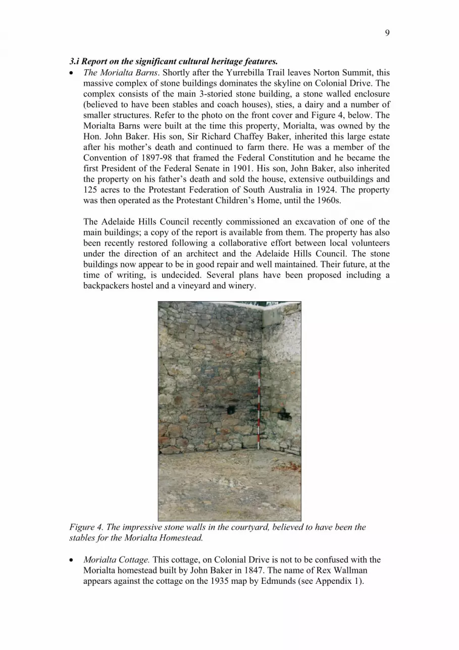
3.i Report on the significant cultural heritage features. • The Morialta Barns. Shortly after the Yurrebilla Trail leaves Norton Summit, this
massive complex of stone buildings dominates the skyline on Colonial Drive. The complex consists of the main 3-storied stone building, a stone walled enclosure (believed to have been stables and coach houses), sties, a dairy and a number of smaller structures. Refer to the photo on the front cover and Figure 4, below. The Morialta Barns were built at the time this property, Morialta, was owned by the Hon. John Baker. His son, Sir Richard Chaffey Baker, inherited this large estate after his mother’s death and continued to farm there. He was a member of the Convention of 1897-98 that framed the Federal Constitution and he became the first President of the Federal Senate in 1901. His son, John Baker, also inherited the property on his father’s death and sold the house, extensive outbuildings and 125 acres to the Protestant Federation of South Australia in 1924. The property was then operated as the Protestant Children’s Home, until the 1960s.
The Adelaide Hills Council recently commissioned an excavation of one of the main buildings; a copy of the report is available from them. The property has also been recently restored following a collaborative effort between local volunteers under the direction of an architect and the Adelaide Hills Council. The stone buildings now appear to be in good repair and well maintained. Their future, at the time of writing, is undecided. Several plans have been proposed including a backpackers hostel and a vineyard and winery.
Figure 4. The impressive stone walls in the courtyard, believed to have been the stables for the Morialta Homestead. • Morialta Cottage. This cottage, on Colonial Drive is not to be confused with the
Morialta homestead built by John Baker in 1847. The name of Rex Wallman appears against the cottage on the 1935 map by Edmunds (see Appendix 1).

10
• Fuzzy’s Farm. Fuzzy’s Farm has no heritage significance, but in the past it has
been open to the public. The day I called the farm was closed and Fuzzy wasn’t at home. I recommend that it not be included in the trail guide.
• Morialta, First Falls.
As mentioned above, John Smith Reid purchased the Sections on the southern side of the Morialta Conservation Park in1901, including the area around First Falls. In 1911 he offered the land around and below First Falls to the Government and, after some negotiation, the Morialta National Pleasure Resort was proclaimed in 1915. During the 1920s the public access area was landscaped with stone staircases, retaining walls and bridges. Despite floods and fires, much of this very attractive stonework remains and today there are many stone features around First Falls of heritage value. A stone stairway at First Falls is illustrated in Figure 5.
Figure 5. Stone stairway, First Falls, Morialta Conservation Park

11
3.ii Recommendations for the sector Norton Summit to First Falls, Morialta This sector of the trail is undoubtedly dominated by the natural environment. Each of the sites referred to above, with the exception of Fuzzy’s Farm, has some heritage significance and is worthy of inclusion in a trail guide.
3.iii. References and Resources Hallack, E.H. (edited by G.C. Bishop)1987 Toilers of the Hills. Norton Summit: District Council of East Torrens. Hines, L.M. (edited by G.C. Bishop) 1996 Environs of Norton Summit. Norton Summit: East Torrens Historical Society Inc. Morialta Conservation Park History draft report, nd.. Unpublished. Department of Environment and Heritage. 2001 Morialta and Black Hill Conservation Parks Management Plan 2001. Adelaide: Department of Environment and Heritage. Warburton, E. 1982. The Making of Morialta: From Farm to Suburb. Magill, South Australia: Morialta Residents’ Association.

12
4. Report on Sector: First Falls, Morialta to the River Torrens Flavour: People and the Landscape Primary Visitor Target: Local eco-recreation (The following references have been used to compile this section of the report: Mining in the Morialta Conservation Park and Surrounding Area, nd.; Montacute: The First Hundred Years 1946; Morialta Conservation Park History draft report, nd.; Morialta and Black Hill Conservation Parks Management Plan 2001). After leaving First Falls the trail climbs the steep sides of the gorge to the ridge above and enters a landscape filled with reminders of its long association with mineral exploration, mining and quarrying in both the Black Hill and Morialta Conservation Parks. In 1863 a reward was offered to anyone discovering copper in payable quantities in South Australia. Montacute became the centre of a minor mining boom between 1844 and 1888 and several payable copper and gold mines were found along Fifth Creek. By 1887 the rich silver and copper Fifth Creek Central mine had opened and was operated for 10 years. It became the biggest mine along the creek. Gold was discovered near Black Hill in 1846, and started a short-lived gold rush with an influx of Cornish miners, many of whom stayed and formed the nucleus of communities in this region. The first colonists to the northern Black Hill area, close to the rich flood plains of the River Torrens, were market gardeners and horticulturalists. Reminders of the horticultural history of the northern end of the park are found in Ambers Gully. The slopes of Black Hill provided a plentiful supply of timber and the area was heavily logged during the nineteenth and early twentieth centuries. The first land on Black Hill to be proclaimed a reserve was a 4 hectare block on the summit of Black Hill in 1860. Many sections have been added to the Black Hill Conservation Park and the park has expanded to 684 hectares. It is managed by the Lofty/Barossa District of National Parks and Wildlife, S.A.

13
4.i Report on the significant cultural heritage features. Mining heritage along the Fox’s Hill Track, Morialta. Evidence of nineteenth century and early twentieth century mining is a feature of this section of the trail. In 1864 the Adelaide Observer (13th February) reported that copper had been found on Colonel Fox’s property, but no payable discoveries were made. The area again became the centre of attention in 1931 when an application was made to prospect for gold on Sections 828 and 830. The prospecting continued until 1935, but again only small quantities of minerals were found. Refer to Figure 1. Gold was also found on the Baker’s property in 1885 and in March 1887 it is reported that forty to fifty men were working there, although the mine was spent by May 1887. Quarrying. There are a number of quarries in the northern sector of the park in the vicinity of Fox’s Hill Track. There is also a very extensive quarry, the Montacute Quarry, along the Montacute Road where the Yurrebilla Trail crosses to the Black Hill Conservation Park. Close to where the trail crosses the road the footings of a slide, or chute, for delivering stone is an interesting feature. It is rewarding to stand at the top of this structure and ponder how the quarried stone reached the bottom of this vertical cliff, see Figure 6.
Figure 6. Stone and cement footings for a slide associated with quarrying, Fox’s Hill Track, Morialta Conservation Park Shafts, Ambers Gully Waterfall. Test shafts close the waterfall in Ambers Gully are still visible. Quarry, Ambers Gully. A stone quarry which may be of some interest to people using the Trail. Cottage ruins. There are two ruins close to the trail along the Ambers Gully section of the Trail. Both are thought to have been shepherds’ cottages.
14
Black Hill Lodge. This State Heritage listed house is close to the end of the trail. Together with a garage, stone channels and dry stone walling; this was formerly the Weirmaster’s House. Reference 10 5600/0329 Section 526, Hundred of Onkaparinga.
4.ii Recommendations for the sector First Falls, Morialta to the River Torrens Themes and Linkage trails.
Mining and the history of the Morialta and Montacute region. The mining history of the Fifth Creek area and the Montacute region combine in this sector to make a highly recommended theme with a linkage trail. Apart from the mines mentioned above, there are many more mines in the immediate area of the Yurrebilla Trail between Fox’s Hill Track and Montacute. In 1844 600 tons of copper ore were taken from the Montacute Mine, of which 331 tons were sent to England, and in 1845, about 840 tons were mined. In 1846, the Victoria Mining Company was established and started to work the North Montacute Mine, this was also known as the Victoria Mine. On a Saturday morning in 1846, a Mr Tyrell found a vein containing gold about two inches thick in the principal shaft. This is believed to have been the first gold found in Australia. When this vein of auriferous gossan was worked it was found to contain native gold of almost perfect purity. Refer to the report Mining in the Morialta Conservation Park and Montacute S.A.: The First Hundred Years. A linkage trail to Montacute would provide visitors with an opportunity to visit one of South Australia’s best-kept secrets (perhaps it should stay a secret). Montacute was founded at the start of the mining boom as a town to service the miners. As the nineteenth century progressed the mining boom ran its course and today it appears that the twentieth century has by-passed this small, and very appealing, township. It is a relatively short walk to Montacute from the Yurrebilla Trail and there are several bed and breakfasts in the vicinity of the town. Black Hill Conservation Park. The several walking trails within the park provide links to other interesting areas of the park and particularly the Wildflower Garden in spring. An interesting link to the garden would be to take the lower track at the start of the Trail through the foothills and then rejoin the Trail by taking the Summit Track (refer to the Black Hill map in Appendix 1). People using the track would also be able to experience the magnificent views from the Black Hill summit. The Athelstone Wildflower Garden was established at the foot of Black Hill in 1940. At this time the garden contained 250 native plants from all over Australia. The garden is now a nationally recognised collection of Australian native plants. The responsibility for maintaining the garden has been in the hands of several government departments since 1963, but has always been closely associated with the Black Hill Conservation Park. It is open to the public and is staffed and maintained by volunteers from the Friends of Black Hill and Morialta Inc.
15
The Arid Garden in the old quarry south of the Wildflower Garden could also be referred to as a part of this link and there are ruins in Ghost Tree Gully.
4.iii. References and Resources Department of Environment and Heritage. 2001 Morialta and Black Hill Conservation Parks Management Plan 2001. Adelaide: Department of Environment and Heritage. Montacute S.A.: The first Hundred Years. 1946 Adelaide: Kent Town Press Morialta Conservation Park and Surrounding Area, nd., unpublished report. Morialta Conservation Park History draft report, nd., unpublished report.

16
Appendix 1.
Maps and plans associated with the survey area
• Map of the Yurrebilla Trail route.
• Historic map of the Norton Summit region, an extract from Road Map of the Adelaide Hills by W.H. Edmunds, 1935.
• Fourth Creek, Norton Summit 1908. Map from Baker v.
Bishop, Supreme Court of South Australia no. 19 of 1908. Reproduced in Fourth Creek Catchment Group. Fourth Creek Catchment Management Plan – Draft for Consultation. October, 2002, by courtesy of G.C. Bishop.
• Morialta and Black Hill Conservation Parks map. Morialta
and Black Hill Conservation Parks Management Plan (2001).
17
Appendix 2.
Yurrebilla Trail: Interpretation Framework, 8/4/02

18
Appendix 3.
Hills Face Zone Cultural Heritage Project Profile
19
Appendix 4. S.A. Department of Environment and Natural Resources. 1994 Heritage Survey of the District Council of East Torrens, pages:43, 45, 46, 47; figures 5i and 7i.
20
Appendix 5.
East Torrens Heritage Tour Guide. 1989.


