Embed Size (px)
Citation preview
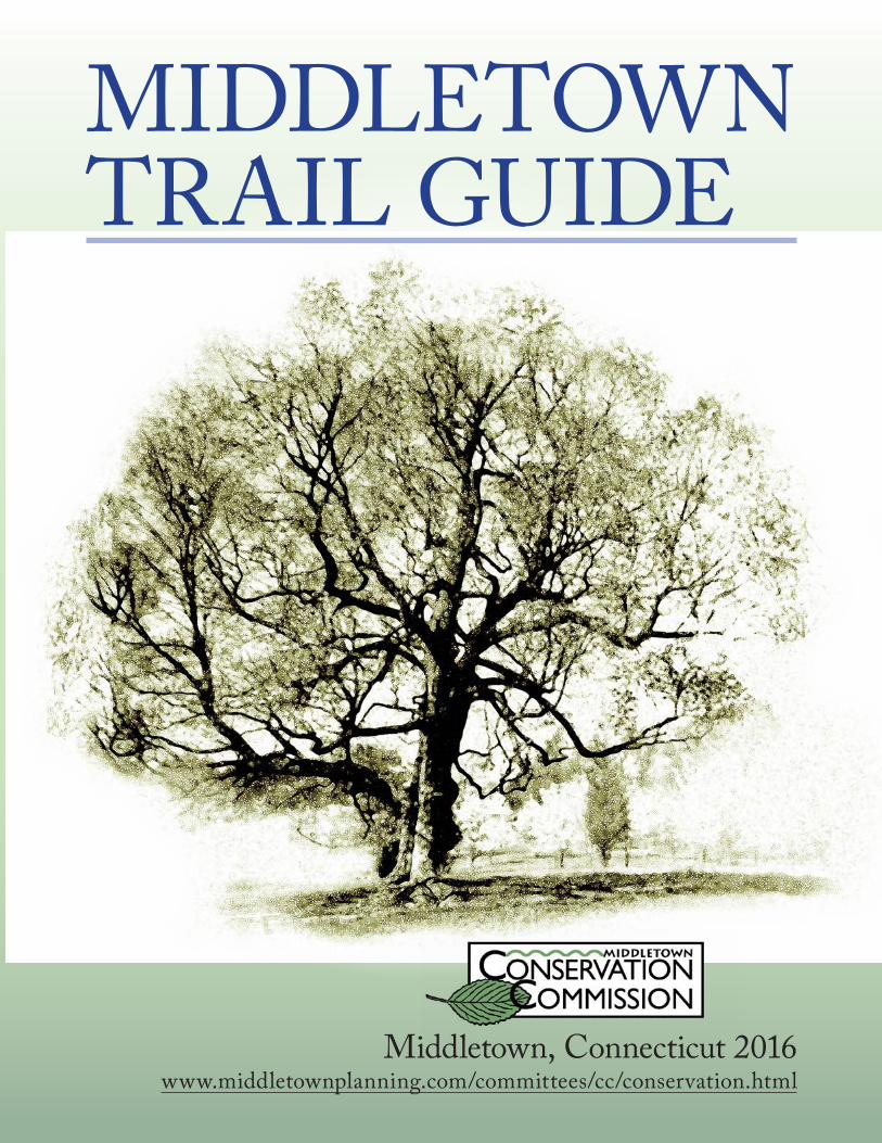
MIDDLETOWN TRAIL GUIDE
Middletown, Connecticut 2016 www.middletownplanning.com/committees/cc/conservation.html
Art: Patrick Derosier
ContentsDedication . . . . . . . . . . . . . . . . . . . . . . . . . . . . . . . . . 1
Acknowledgements . . . . . . . . . . . . . . . . . . . . . . . . . 2
Letter from the Mayor. . . . . . . . . . . . . . . . . . . . . . . 3
Letter from the Commission . . . . . . . . . . . . . . . . . 4
Overview . . . . . . . . . . . . . . . . . . . . . . . . . . . . . . . . . . . 5
Location Map . . . . . . . . . . . . . . . . . . . . . . . . . . . . . . 6
Rules of the Trail . . . . . . . . . . . . . . . . . . . . . . . . . . . 9
Property Use Table . . . . . . . . . . . . . . . . . . . . . . . . . 10
MAJOR TRAILS: Hiking Trails . . . . . . . . . . . . . . . . . . . . . . . . . . . . . . 12
BLUE-BLAZED HIKING TRAIL: Mattabesett Trail . . . . . . . . . . . . . . . . . . . . . . . . . . 13
BLUE-BLAZED HIKING TRAIL: Higby Mountain (with Tynan Park Connector) 14
BLUE-BLAZED HIKING TRAIL: Lamentation Mountain . . . . . . . . . . . . . . . . . . . . . 16
BLUE-BLAZED HIKING TRAIL: Seven Falls, Bear Hill/Katchen Coley Mountain Laurel Preserve, and Reservoir Loop Trail . . . 18
Daniels-Schwarzkopf Area . . . . . . . . . . . . . . . . . . 20
Guida Farm Conservation Area . . . . . . . . . . . . . 22
Highlawn Forest . . . . . . . . . . . . . . . . . . . . . . . . . . . 24
Hubbard Conservation Area . . . . . . . . . . . . . . . . 26
Long Hill Estate . . . . . . . . . . . . . . . . . . . . . . . . . . . 28
McCutcheon Park Area . . . . . . . . . . . . . . . . . . . . 31
Middletown Nature Gardens . . . . . . . . . . . . . . . . 34
Ravine Park . . . . . . . . . . . . . . . . . . . . . . . . . . . . . . . 36
Smith Park . . . . . . . . . . . . . . . . . . . . . . . . . . . . . . . . 38
Spiderweed Preserve . . . . . . . . . . . . . . . . . . . . . . . 40
Tynan Memorial Park (Tynan Park Connector Trail) and Jablonski Property . . . . . . . . . . . . . . . . 42
Veteran’s Memorial Park/Palmer Field . . . . . . . 46
Wadsworth Falls State Park . . . . . . . . . . . . . . . . . 49
Wilcox Conservation Area . . . . . . . . . . . . . . . . . 52
Multi-Use Trail System . . . . . . . . . . . . . . . . . . . . . 54
Downtown Walking Loop and River Walking Loop . . . . . . . . . . . . . . . . . . . . . . . . . . . . . . . . . . . . . . 56
Open Space Conservation Areas with Parking 58
Middletown’s Rivers: Canoe/Kayak and Pedestrian Access . . . . . . . . . 59
Mattabesset River Canoe/Kayak Trail . . . . . . . 60
Strolls & Vistas . . . . . . . . . . . . . . . . . . . . . . . . . . . . 63
Open Space Conservation Properties . . . . . . . . 66
Birding Checklist . . . . . . . . . . . . . . . . . . . . . . . . . 68
Other Resources . . . . . . . . . . . . . . . . . . . . . . . . . . . 70
Links to Outdoor Resources and Conservation Organizations . . . . . . . . . . . . 71
Middletown Parks Division Parks & Open Spaces . . . . . . . . . . . . . . . . . . . . . . 72
Notes: . . . . . . . . . . . . . . . . . . . . . . . . . . . . . . . . . . . . 74
Notes: . . . . . . . . . . . . . . . . . . . . . . . . . . . . . . . . . . . . 75
1
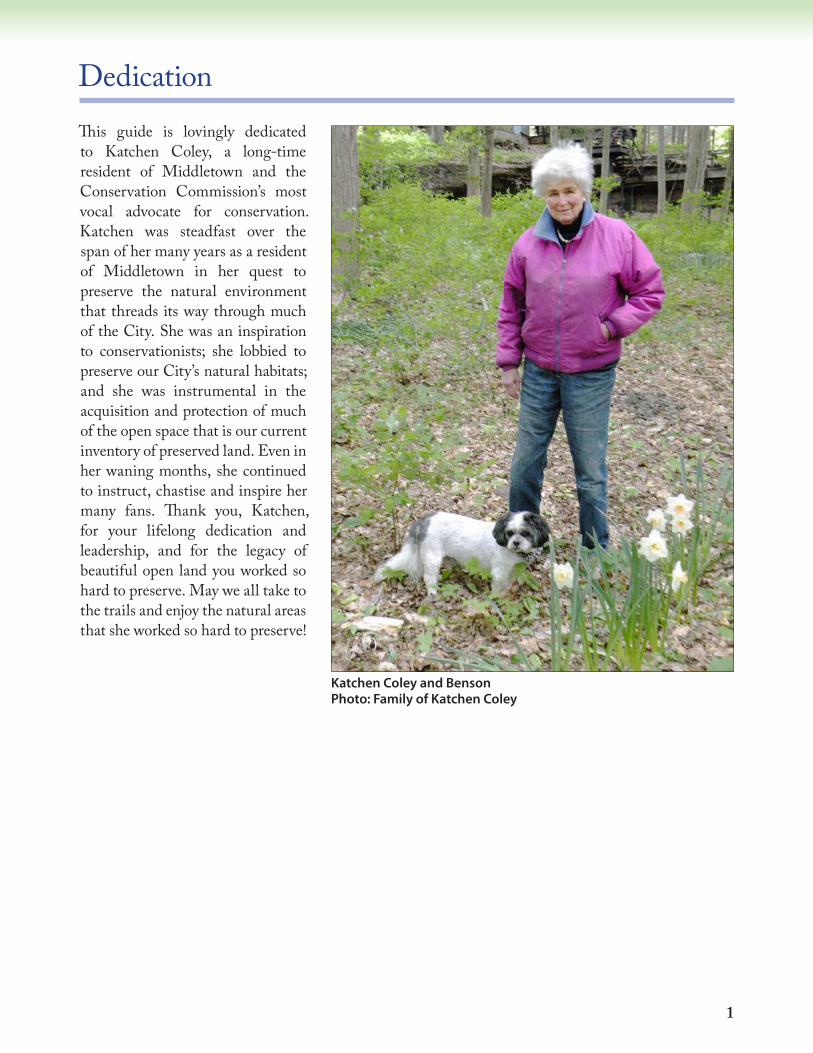
DedicationThis guide is lovingly dedicated to Katchen Coley, a long-time resident of Middletown and the Conservation Commission’s most vocal advocate for conservation. Katchen was steadfast over the span of her many years as a resident of Middletown in her quest to preserve the natural environment that threads its way through much of the City. She was an inspiration to conservationists; she lobbied to preserve our City’s natural habitats; and she was instrumental in the acquisition and protection of much of the open space that is our current inventory of preserved land. Even in her waning months, she continued to instruct, chastise and inspire her many fans. Thank you, Katchen, for your lifelong dedication and leadership, and for the legacy of beautiful open land you worked so hard to preserve. May we all take to the trails and enjoy the natural areas that she worked so hard to preserve!
Katchen Coley and Benson Photo: Family of Katchen Coley
2
AcknowledgementsThere are many people to thank for this edition of the trail guide. (We apologize to those who were inadvertently omitted in this list of contributors).
Jane BrawermanClare CainKatchen ColeyConnecticut Forest & Park AssociationPatrick DerosierMayor Daniel DrewMichelle FordSteven LaddJoan LiskaRonald LiskaEllen LukensDiane McGrathMiddlesex Land TrustKate MillerJonathan MorrisEric MosherSusan NescoDavid O’BrienKaren SwartzBrian StewartSheila StoaneLeonard StoaneMaggie VaillantMichiel Wackers
The Bird checklist was compiled by Pat Rasch and edited by David Titus of Mattabeseck Audubon Society.And thank you to all who contributed to the original Trail Guide edition published in 2004.Finally, great appreciation to Pat Rasch for her work in the final organization and graphic design of this document.
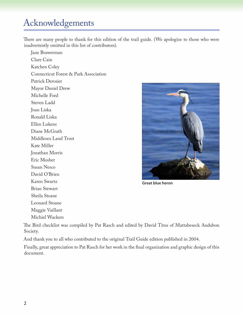
Great blue heron
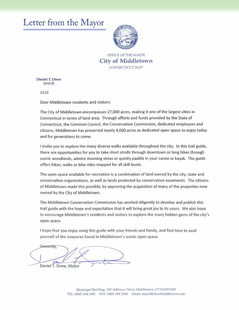
Letter from the Mayor
4
Letter from the Commission
2016Dear Reader,The Middletown Conservation Commission is pleased to provide you with this second edition of our guide to Middletown’s open spaces and trails. This guide is an invitation to the citizens of Middletown and its visitors to explore the City’s important and varied natural treasures. You will find information about our conservation lands in the City that provide a variety of passive recreational opportunities, including hiking, walking, jogging, cross country skiing, bicycling, canoeing and kayaking, and last but not least studying nature. Many of the City’s open spaces have notable geological, scenic and ecological features. This guide provides directions to the popular well-used open space areas, as well as less familiar spots throughout the City. Each of these properties offers diverse opportunities for exploration and enjoyment: traversing broad open fields, following winding trails through wooded terrain, climbing rocky crags or paddling along lush water ways, and observing a variety of wildlife from birds to foxes, and deer to turtles. In season, the flowering trees and shrubs offer a colorful array. Autumn is particularly spectacular. All of the awesome beauty of nature flourishes within the City’s conservation properties waiting for you to discover it. As you visit the City’s trails keep in mind that they may change over time, thus the descriptions included in the guide may not reflect the current status or condition of trails. Developed over a period of years, the guide has been a major undertaking of the Commission, made possible with assistance from many volunteers from the community. We thank them all for their efforts to bring this guide to fruition.This guide is for you, the citizens of Middletown and visitors. We hope you will use it often to enjoy our City’s special natural resources. Happy exploring!
5
Overview
This trail guide was written to help you locate and enjoy areas of open space in Middletown, Connecticut. These are places, both large and small, that have been permanently protected from development within Middletown’s borders by state or local governments and private conservation groups.
The Location Map shows many of the open spaces and trails in Middletown. This guide highlights areas with major trails and other places available for strolls or vistas.
Major Trails for hiking, biking, or canoeing/kayaking are described and mapped. Each page includes directions, information about parking, and an overview of the terrain, followed by a general description of trails at the site. Most trails are marked with small metal placards or blazing on trees along the trail. Please note that trail locations on these maps are approximate and should be used with caution. All information is as up-to-date as possible, but please be aware that information may have changed since publication of this guide.
Open Space Conservation Areas with parking include sites that may not have a network of trails, but have parking areas to access the properties and you are invited to walk the properties.
CityScape Walking Trails afford an opportunity to stroll along our city streets and appreciate the variety of architecture, shopping, restaurants, and entertainment venues.
The Strolls & Vistas section identifies properties that are small in size or with topography or features that offer a wonderful view or scenic landscape. Their listing within the guide includes the locations and prominent features.
Middletown is fortunate to have a large number of City Parks and Recreational Areas. These are summarized in the Parks/Recreation Appendix at the end of this guide. Parks with trails are described in the text of this guide, but the vast majority of these are primarily picnic areas, playgrounds, or ball fields that are otherwise not described in this guide. More information about parklands can be obtained from the City’s Parks Division.
Finally there is a list of other Resources for those of you who have discovered a love of these areas. These additional publications and the conservation organizations included can be contacted for provide more extensive information on trails, ecology, and history within city limits, as well as farther afield.
Art: Patrick Derosier
6 7
!!
!!
!!
!!
!! !!
!!
!!
!!
!!!!!!
!!
!!
!!!!
!!
!!
!!
!!
!!
!!!!
!!
!!
!!
!! !!
!!
!!
!!
!!
!!
!!
!!
H1
H14
H12
SV3
H2 B1
B2
SV6
H15
SV5
H16H8
H10
SV8
H6
H5
H9
SV4
H11
SV2
C1
H4
SV7
H4
H3
H13
SV1 H4
B3
H7
SV10
H18
SV12
H17
SV11
Cross Street
Pine
Stre
et
BowLane
SR-155
SpringSt.
GrandSt.
I-91
MinorRoad
High
Street
Atki
nsSt
reet
Farm Hill
Roa
d
LyceumRoad
East
Stre
et(S
R-2
17)
Indu
stria
lD
r.
SR-155
Route - 9
NorthMain St.
WilcoxRoad
Wadsworth
Street
Livingston
Road
West
Street
Cedar Lane
SaybrookRoad
Mid
dle
Stre
et
BrooksRoad
Long
HIllRoa
d
New
fieldStreet(SR
-3)East
Stre
et(S
R-2
17)
Country
Club Road
BearHillRoad
MargariteR
oad
SR-1
7
Sout
hM
ain
Stre
et
WestfieldStreet
Rid
gew
ood
Roa
d
RoundHillRoad
Mill
broo
k R
oad
Cham
berlainH
ill Road
AircraftRoad
(SR-410)Kelse
y Stre
et
Mile Lane
Washington
St. (SR-66)
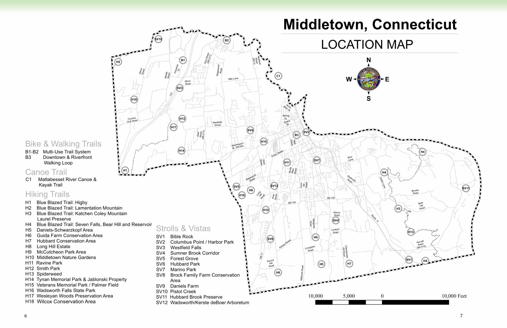
Middletown, ConnecticutLOCATION MAP
Hiking Trails
10,000 0 10,0005,000 Feet
H1 Blue Blazed Trail: HigbyH2 Blue Blazed Trail: Lamentation MountainH3 Blue Blazed Trail: Katchen Coley Mountain Laurel Preserve H4 Blue Blazed Trail: Seven Falls, Bear Hill and ReservoirH5 Daniels-Schwarzkopf AreaH6 Guida Farm Conservation AreaH7 Hubbard Conservation AreaH8 Long Hill EstateH9 McCutcheon Park AreaH10 Middletown Nature GardensH11 Ravine ParkH12 Smith ParkH13 SpiderweedH14 Tynan Memorial Park & Jablonski PropertyH15 Veterans Memorial Park / Palmer FieldH16 Wadsworth Falls State ParkH17 Wesleyan Woods Preservation AreaH18 Wilcox Conservation Area
SV1 Bible RockSV2 Columbus Point / Harbor ParkSV3 Westfield FallsSV4 Sumner Brook CorridorSV5 Forest GroveSV6 Hubbard ParkSV7 Marino ParkSV8 Brock Family Farm Conservation AreaSV9 Daniels FarmSV10 Pistol CreekSV11 Hubbard Brook PreserveSV12 Wadsworth/Kerste deBoer Arboretum
Strolls & Vistas
Canoe TrailC1 Mattabesset River Canoe & Kayak Trail
B1-B2 Multi-Use Trail SystemB3 Downtown & Riverfront Walking Loop
Bike & Walking Trails
:
Wilcox Conservation Area
Mul -Use Trail Systemti
8
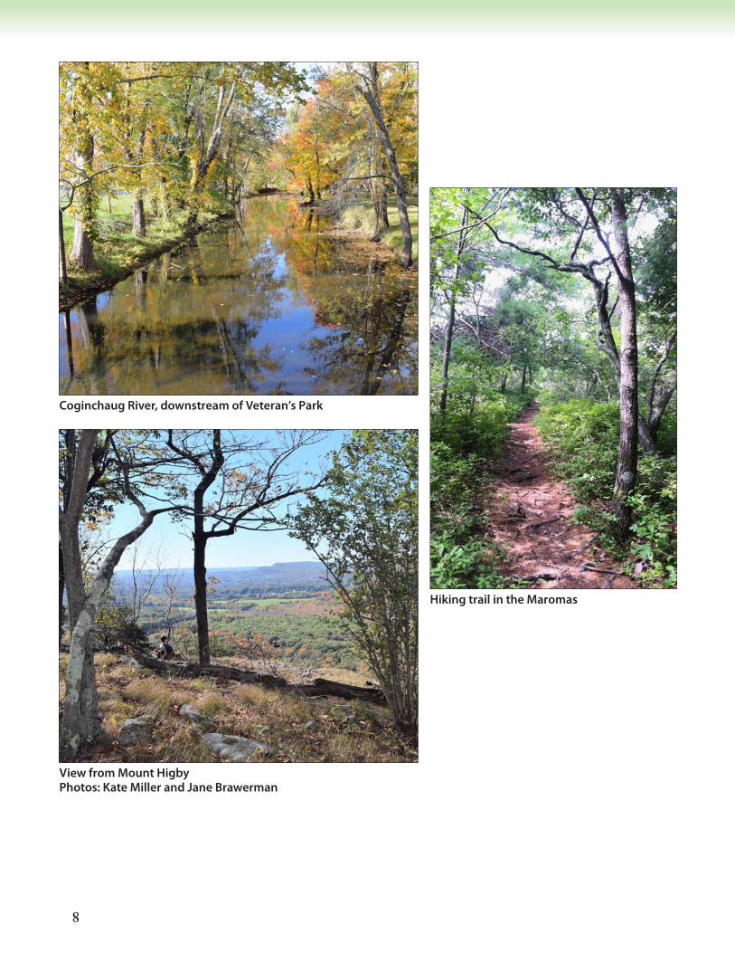
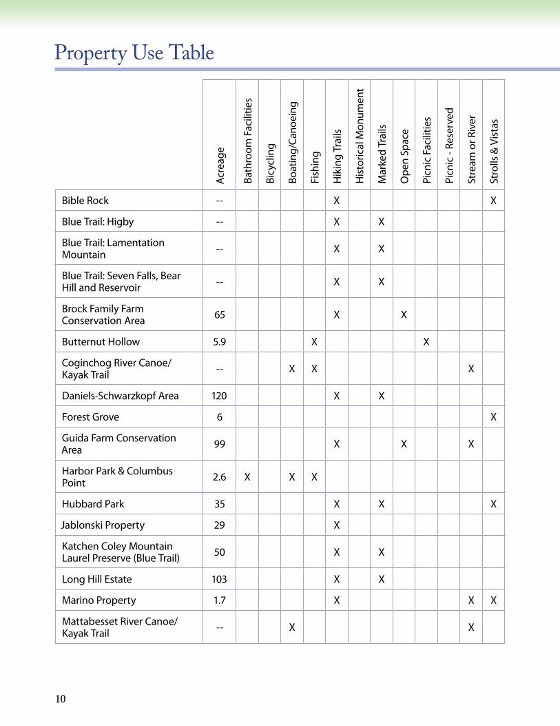
View from Mount Higby Photos: Kate Miller and Jane Brawerman
Coginchaug River, downstream of Veteran’s Park
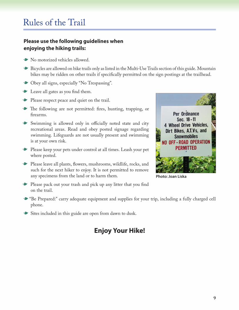
Hiking trail in the Maromas
9
Rules of the Trail
Please use the following guidelines when enjoying the hiking trails:
G No motorized vehicles allowed.
G Bicycles are allowed on bike trails only as listed in the Multi-Use Trails section of this guide. Mountain bikes may be ridden on other trails if specifically permitted on the sign postings at the trailhead.
G Obey all signs, especially “No Trespassing”.
G Leave all gates as you find them.
G Please respect peace and quiet on the trail.
G The following are not permitted: fires, hunting, trapping, or firearms.
G Swimming is allowed only in officially noted state and city recreational areas. Read and obey posted signage regarding swimming. Lifeguards are not usually present and swimming is at your own risk.
G Please keep your pets under control at all times. Leash your pet where posted.
G Please leave all plants, flowers, mushrooms, wildlife, rocks, and such for the next hiker to enjoy. It is not permitted to remove any specimens from the land or to harm them.
G Please pack out your trash and pick up any litter that you find on the trail.
G “Be Prepared:” carry adequate equipment and supplies for your trip, including a fully charged cell phone.
G Sites included in this guide are open from dawn to dusk.
Enjoy Your Hike!
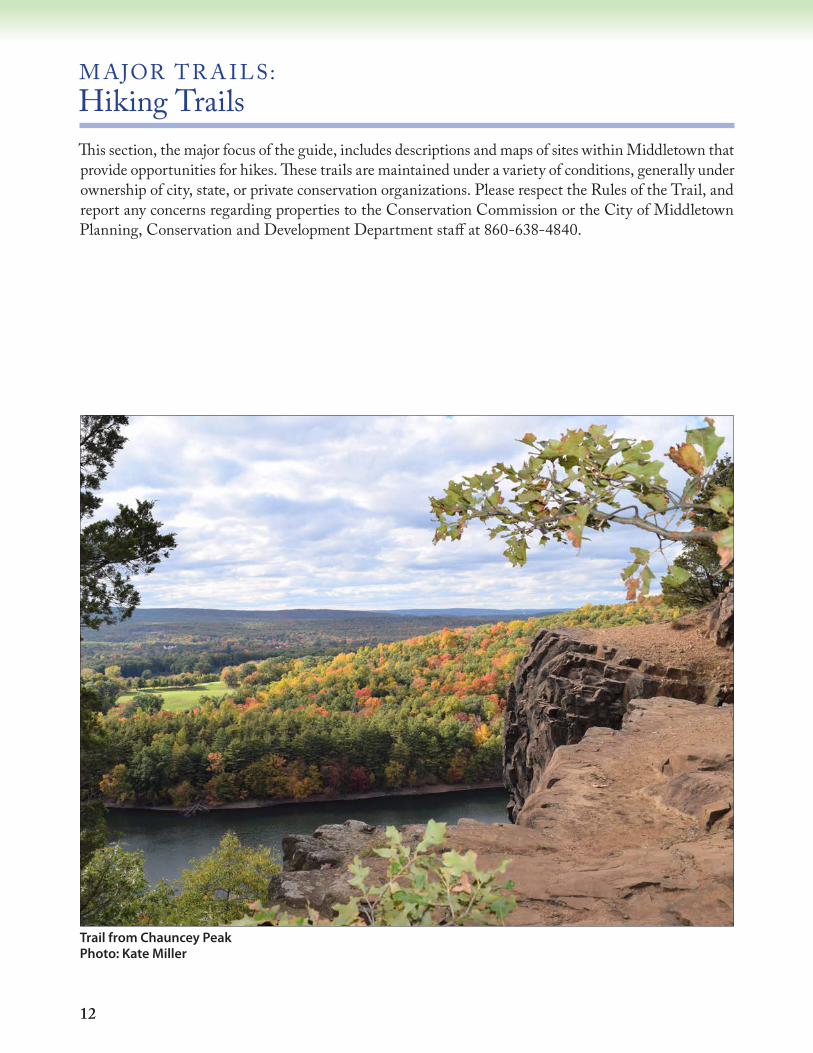
Photo: Joan Liska
10
Property Use Table
Acr
eage
Bath
room
Fac
ilitie
s
Bicy
clin
g
Boat
ing/
Can
oein
g
Fish
ing
Hik
ing
Trai
ls
His
toric
al M
onum
ent
Mar
ked
Trai
ls
Op
en S
pac
e
Picn
ic F
acili
ties
Picn
ic -
Rese
rved
Stre
am o
r Riv
er
Stro
lls &
Vis
tas
Bible Rock -- X X
Blue Trail: Higby -- X X
Blue Trail: Lamentation Mountain -- X X
Blue Trail: Seven Falls, Bear Hill and Reservoir -- X X
Brock Family Farm Conservation Area 65 X X
Butternut Hollow 5.9 X X
Coginchog River Canoe/Kayak Trail -- X X X
Daniels-Schwarzkopf Area 120 X X
Forest Grove 6 X
Guida Farm Conservation Area 99 X X X
Harbor Park & Columbus Point 2.6 X X X
Hubbard Park 35 X X X
Jablonski Property 29 X
Katchen Coley Mountain Laurel Preserve (Blue Trail) 50 X X
Long Hill Estate 103 X X
Marino Property 1.7 X X X
Mattabesset River Canoe/Kayak Trail -- X X

11
Acr
eage
Bath
room
Fac
ilitie
s
Bicy
clin
g
Boat
ing/
Can
oein
g
Fish
ing
Hik
ing
Trai
ls
His
toric
al M
onum
ent
Mar
ked
Trai
ls
Op
en S
pac
e
Picn
ic F
acili
ties
Picn
ic -
Rese
rved
Stre
am o
r Riv
er
Stro
lls &
Vis
tas
McCutcheon Park & Wildlife Sanctuary * 131 X X X X X X
Middletown Multi-Use Trail System (Westlake Bike Path) -- X X X X X
Middletown Nature Garden 18 X
Pistol Creek 40 X X X X
Ravine Park 19 X X
Smith Park 50 X X X
Spiderweed 157 X X X
Sumner Brook Corridor 86.5 X X X
Tynan Memorial Park 32 X X
Veterans’ Memorial Park - Palmer Field 41 X X X X X
Wadsworth Falls State Park 267 X X X X
Westfield Falls 4 X X X
Wilcox Island 16.5 X X
12
M AJOR TR A ILS: Hiking TrailsThis section, the major focus of the guide, includes descriptions and maps of sites within Middletown that provide opportunities for hikes. These trails are maintained under a variety of conditions, generally under ownership of city, state, or private conservation organizations. Please respect the Rules of the Trail, and report any concerns regarding properties to the Conservation Commission or the City of Middletown Planning, Conservation and Development Department staff at 860-638-4840.
Trail from Chauncey Peak Photo: Kate Miller

13
BLU E-BL A ZED H IK ING TR A IL: Mattabesett Trail The Mattabesett Trail winds in and out of Middletown and offers tremendous long-distance hiking opportunities for outdoor enthusiasts. The Mattabesett Trail was designated as part of the 215-mile New England National Scenic Trail (NET) in 2009, which runs from Long Island Sound in Guilford to the Massachusetts/New Hampshire border (newenglandtrail.org). The NET offers a terrific way to explore the open space and natural areas of Middletown. Middletown features three distinct and unique sections of the Mattabesett/NET for hikers to enjoy and explore. These include the following Blue-Blazed trails (please refer to the trail descriptions and maps on pages 14-19):
G Higby Mountain and Tynan Park
G Lamentation Mountain and Chauncey Peak
G Seven Falls, Bear Hill LoopsIn Connecticut, the NET is maintained by Connecticut Forest & Park Association (CFPA) as part of its 825-mile Blue-Blazed Hiking Trail System.The Mattabesett Trail not only intersects Middletown open space properties, but is hosted by the State, conservation partners, and private owners. Please stay on the trail, follow all posted signage, and travel lightly.
Art: Patrick Derosier
14
BLU E-BL A ZED H IK ING TR A IL: Higby Mountain (with Tynan Park Connector)Directions: From the junction of Routes 66 and 147, take Route 66 west for about 0.5 mile. The
trailhead is located just east of the intersection of Route 66 and Interstate 91.Parking: There is limited parking on the north side of Route 66 (heading west) just east of the
Middlefield-Meriden town line at the top of the hill where Route 66 becomes a divided highway. A second car may be parked at the Tynan Park trailhead, which is located on Higby Rd.
Terrain: There are many areas that are very steep, rocky, and unstable. Hikers should use particular caution in wet or icy conditions.
General: Higby Mountain is an area of several hundred acres owned by the City of Middletown, The Nature Conservancy, State of Connecticut and private landowners. The panoramic view at the pinnacle extends almost 360 degrees from Mount Tom in Massachusetts to Long Island Sound in New Haven. Higby Mountain is in the Metacomet Range and is part of an unusual geologic formation called a traprock ridge. This basalt rock supports several uncommon plants and provides a dry environment for struggling trees found along the ridge. Hawks use the thermal currents formed by the ridges for soaring and can be seen at eye level while walking along the cliff edge.
Trails: From the Route 66 parking area, one ascends directly uphill on a rough, stone-strewn path. Go left on a broad, level trail, following the blue blazes of the Mattabesett Trail. The trail makes several switchbacks, dips briefly westward, then climbs north along the ridge edge
to the viewpoint, the Pinnacle, approximately 830 feet above sea level. Continue north to Preston Notch, where a white-blazed trail travels down a steep slope to the power line right-of-way. Hike along the power line, or return to the ridge and continue to the northern part of Higby Mountain at approximately 890 feet above sea level and a natural bridge formation. Follow the blue-blazed trails north to Country Club Road. The trail is about 4.5 miles in length.
Photo: Michelle Ford
15
Æü
Æü
Æü
#
#
S.R. 66
Mas
saTo
mRd
. Country
Club
Rd.
Hig
by R
d.
John
son
Rd.
Country Club Rd.
Pres
ton
Ave.
S.R. 66
Mid
dle
St.
(Priv
ate)
800
750
700
650
600
500
450
550
450
800
750
650
550
500
300
35040
0
300
350
300
400
300
400
200
250
450
400
45040
0
550500
500
450
350
350
400
400
400 400
450
35070
0500
250
250
350
500
200
350
450
350
350
850
750
70070
0
650
600
550
Mat
tabe
sett
Trai
l (Bl
ue B
laze
d)
Mattabes ett Tr ai l( B
lueB
lazed)
Tynan Trail (Red/Blue Blazed)
892'
900'
Mount Higby & TynanMemorial Park
:
0 1,800 3,600900Feet
1 inch = 1,550 feet
# Scenic Overlook
Æü Parking
Municipal Boundary
Tynan Memorial Park
Trail
Road
Watercourse
Intermittent Stream
Waterbody
Wetland
LEGEND
Trail Data Contributed by ConnecticutForest and Park Association
Middletown
Middlefield
Mer
iden
Mt.Higby
Reservoir
Roar
ing B
rook
Res
ervo
ir
Connects to Lamentation Mountain Trail
WesleyanWoods
SR-147
16
BLU E-BL A ZED H IK ING TR A IL: Lamentation MountainDirections: From its intersection with Interstate 91, take Westfield Road (a continuation of Country
Club Road) west 2.2 miles to a trailhead on the north side of the road. This area can also be accessed from the trail at the north end of Higby Mountain by walking west along Country Club Road to this same location.
Parking: There is parking at Giuffrida Park, located off Westfield Road in Meriden, a short distance west of the trailhead.
Terrain: The terrain is varied and can be extremely steep in areas.General: Lamentation Mountain, known for its scenic vistas, extensive cliff faces, unique microclimate
ecosystems, and rare plant communities, is a several hundred-acre area that belongs to various municipal, land trust, and private owners. This hike provides some of the finest ridgetop hiking and cliff views in our area. This trail is part of the New England Scenic Trail and the Blue Trail System, maintained by Connecticut Forest and Park Association. The peak of Lamentation Mountain, in Meriden, is 720 feet. Chauncey Peak, which you climb on your way to Lamentation Mountain, is 686 feet. Several parcels here were purchased with DEEP Open Space Grant funds.
Trail: The blue-blazed trail, also part of the Mattabessett Trail, travels 4.85 miles from Westfield Road in Middletown to Spruce Brook Road in Berlin. The trail ascends steeply from Westfield Road to Chauncey Peak, which is approximately 686 feet above sea level. Running from south to north, the trail crosses a canal after one mile, and then begins the ascent to Lamentation Mountain, perhaps one of the most scenic traprock hikes in the state. The trail continues along an old woods road for 0.2 miles and ascends again, reaching a rocky summit. From here, the trail makes a long descent to Stantack Road, where it continues until it meets Spruce Brook Road in Berlin.
View from Chauncey Peak Photo: Kate Miller
17
#
#
Æü
Æü
ÆüÆü
Æü
100
150
150
150
300
500
350
250
150 150
350
150
100
450
150
150
200
300
700
450
250
700
150
100
300
150
200
250
650
150 15
0
750
450
300
650
600
300
550
400
150
500
150
600
150
200
250
150
150
300
350
200
550
300
150
500
100
650
450
450
100
250
600
200
400
400
350
550
150
300
250
250
250
200
200
20025
0
Spru
ceBr
ook
High
land Br
ook
Be
lcher Brook
Manthey Brook
Fall Brook
Sawmill
Broo
k
Brad
ley
Broo
k
Lam
enta
tion
Broo
k
Sno
wH
il lB
rook
East
Spru
ceBr
ook
East
Brad
leyBr
ook
Old
Rd. Dr.
New Park Dr.
Norton Ln.
Country Club Rd.
Pres
ton
Ave.
Orchard
Rd.
Spruce Brook Rd.
Toll
Gat
eR
d.
Bell
St.
Brad le y
St.
S.R.
5/1
5
Mid
dle
St.
Atk i
nsS
t.
Tynan Trail (Red/Blue Blazed)
Mat
tabe
sett
Trai
l (Bl
ueBl
azed
)
§̈¦I-91
LamentationMtn. 720'
ChaunceyPeak
Lamentation Mountain
:0 2,000 4,0001,000
Feet1 inch = 2,000 feet
Æü Parking
# Peak
Waterbody
Wetland
Municipal Boundary
Watercourse
Intermittent Stream
Dam
Aqueduct
Trail
Road
LEGEND
Trail Data Contributed by Connecticut Forestand Park Association
Middletow
n
Mer
iden
Berlin
Connects to Mount Higby Trail

18
BLU E-BL A ZED H IK ING TR A IL: Seven Falls, Bear Hill/Katchen Coley Mountain Laurel Preserve, and Reservoir Loop Trail Directions: Southern end: From Route 9, take Exit 10 (Aircraft Road). Go south on Route 154 for 0.8
miles to Seven Falls Park, on the left (east) side of the road. The entrance to the southern part of the trail is just north of the parking area along Route 154.
Northern end: From the north, take Route 9 to Exit 12, turn left onto Silver Street, and continue until the junction of River Road. Turn right on River Road; the trail starts on the right approximately 2 miles after this intersection, diagonally across from a large power plant.
Parking: Southern end: At Seven Falls Park, park in the lot at the southern end of this trail. Northern end: Park on the right side of River Road in the gravel pull-off. Look for
trailhead signs. Note: There are cross streets in-between to park vehicles for shorter hikes.Terrain: The terrain varies, with several steep areas and some wet sections.General: This portion of the Mattabesset Trail provides scenic vistas of the Connecticut River,
impressive rock outcroppings, numerous streams, shallow bogs, and magnificent stands of mountain laurel (Connecticut’s state flower, which blooms generally in mid-June). A portion of the Bear Hill Loop Trail passes through the Katchen Coley Mountain Laurel Preserve. For walks of various lengths, combine main and loop trails. Land ownership in this area is primarily private, although there is some state and city-owned land. This trail is part of the New England Scenic Trail and the Blue Trail System, maintained by
Connecticut Forest and Park Association.Trails: The main trail, blazed in blue, is 10.4 miles in length with 4.9 miles of loop trails (not shown on the map). The loop trails are easier hiking and are blazed with blue circles. The main trail runs in a north-south direction.
Seven Falls Photo: Michelle Ford
19
Æü
Æü
Æü
#
Æü
Æü
Æü
200
200
400
50
300
150
50
550
550
300
400
50200
150
100
400
200
400
450
300
300
400
200
100
200
550
550
100
400
600
350
50
550
350
150
150
300
350
250
350
350
550
400
500
50
450
300
550
550
50
500
100
600
50
200
150
600
150
50
350
100
15055
0
100
550
500
450
150
500
450
350
300
400
250
400
400
350
350
300
300
250
250
200
200
200
500
450
450400
350
300
250
BlueBlazed
Blue/YellowBlazed
Blue/YellowBlazed
Blue/YellowBlazed
Haddam
Middletown
Middletown
Portland
TrainingHill
Rd.
ReservoirRd.
BowLane
Freeman Rd.
RiverRd.
Brooks Rd.
Aircraft
Rd.
SR-9
SaybrookRd.
Toll GateR
d.C
edarLane
BearHill Rd.
Bartholom
ewRd.
BearHill
Seven Falls, Bear Hill & Reservoir Loop Trail
:
0 2,250 4,5001,125Feet
1 inch = 2,250 feet
LEGENDÆü Parking
Æü Limited Parking
# Mountain
Municipal BoundarySpiderweed PreserveWater
TrailRoadWatercourseIntermittent Stream
HubbardPond
Trail Data Contributed by Connecticut Forest and Parks
KatchenColey
MountainLaurel
Preserve
Spiderweed

20
Daniels-Schwarzkopf AreaDirections: From Randolph Road (Route 155), go south on Millbrook Road and turn right onto Old
Johnson Lane, a gravel road. The entrance to the area is less than 0.2 miles on the right.Parking: There is a small parking area on the right side just before the trailhead.Terrain: The trails follow old dirt roads and narrow paths with mostly gentle slopes.General: The parcels were purchased by the City of Middletown with open space bond funds and
a CT Department of Energy and Environmental Protection (DEEP) Open Space and Watershed Land Acquisition Grant. Together these parcels comprise almost 120 acres of attractive, mixed deciduous forest dominated by black birch, oaks, maples, hickory and beech. There are several small stands of hemlock, plus numerous witchhazel, ironwood and hophornbeam in the understory. A vernal pool, essential habitat for certain species of frogs and salamanders, is also located on the property. The area has an interwoven network of short trails, some of which are blazed. Trails on the west side of the property connect to trails (some with red blazes) on the adjoining Rockfall Foundation property (the Linus Baldwin Woodlot). Horseback riders use and maintain many of these trails; hikers should be aware that you may encounter horses. Please allow the horses to pass undisturbed. Do not attempt to approach them without gaining the rider’s permission. Because of the large number of intersecting trails, the lack of consistent blazes, and several unmarked trails that lead onto private property, take care not to lose your orientation.
Trails: The trails consist of a main trail that leads to one short loop and several unmarked trails. From Old Johnson Lane, the main trail (marked with circular Conservation Area markers) ascends gently southward on an old dirt road past a chain gate. Turning southwest, it begins a slight descent, passing through a small clearing with berry bushes (at 0.25 mile, an unmarked, unmaintained path branches to the left). The main trail ascends gently again, turns north and bisects a small stand of young birch. At 0.5 mile, a trail branches slightly to the right and continues northerly for a short distance. As it turns to circle back to the main trail, there is an unmarked trail that leads north to the power lines. This loop passes a vernal pool and a partially reconstructed stone wall to the east. It joins the main trail at the crest of a hill, which can be followed back to the parking lot. Several side trails branch off from this main trail. Bring a compass if you plan to explore beyond the marked main trail. Some of these trails connect to trails on the property of The Rockfall Foundation.
Wood Frog Photos: Pat Rasch
Witch hazel
21
500
300
200
200
500
350
150
250
400
300
250
350
450
450
300
150
350
200
300
250
350
200
Old Johnson Ln.
Ma rgarit e
Road
Ex t.
Daniels-Schwarzkopf Area
:0 500 1,000250
Feet
1 inch = 500 feet
Æü Parking
Municipal Boundary
Property Boundary
Road
Watercourse
Intermittent Stream
Trail
Waterbody
Wetland
Rockfall Found. Property
Vernal Pool
LEGEND142 Acres
Middletown
Durham
Property boundaries are approximate as shown. Owners of properties who make their land available for recreational use of the trails depicted herein are subject to limited liability under Connecticut State Statute 52-557f, g, h, and i.
Millbrook
Road
22
Guida Farm Conservation AreaDirections: From Route 17 south (toward Durham), take the first left after Dooley Pond onto Round
Hill Road. Continue straight for 0.5 miles to a stop sign at the intersection of Coleman and Round Hill Roads. Turn right (south) into the parking area.
Parking: There is parking for several cars at the property entrance.Terrain: The property varies from open fields to wet areas, and young wooded areas to mature
hardwood forest. The main trail is mostly level to gently sloped, but some of the wooded trails have steep sections.
General: This area consists of three contiguous parcels, the Guida Farm Conservation Area, the Cassa Property, and the Makuch Preserve.
The property is owned by the City of Middletown and is a 99-acre parcel containing eight open fields, two ponds, some old field habitat of black birch and eastern red cedar, and mixed deciduous woodland. The open fields are still actively farmed. Large portions of the wooded areas between the fields are invaded by Japanese barberry, oriental bittersweet and multiflora rose. A unique feature is the exposed Jurassic conglomerate rock formation (a very coarse-grained sedimentary rock) running north/south along the eastern border of the property. Fewer than a dozen places on earth display this type of formation so prominently.
Green frogs, bullfrogs, and painted turtles are often sighted at the first pond. Cardinal flowers and foraging ruby-throated hummingbirds can be seen in August in the wet meadow north of the second pond. Both ponds provide early spring breeding habitat for spotted salamanders and several frog species. Follow Coleman Road when you leave the conservation area to pass by the Guida family homesteads and the Sunshine Dairy that was the heart of the Guida milk business. Proceed slowly—the road is narrow, scenic and curvy.
Photo: Michelle Ford
Photo: Pat Rasch
23
Æü
450
300
400
350
450
400
400
400
400
550
300
450
300
300
500
450
550
350
350 50
0Ball
Broo
k
LongH
i ll Brook
Round Hill Road
Col
eman
Roa
d
Round Hill Road Ext.
Guida Farm Conservation Area
:0 600 1,200300
Feet
1 inch = 500 feet
Æü Parking
Municipal Boundary
Cassa Property
Makuch Property
Guida Property
Farm Road
Powerline
Road
Trail
Watercourse
Intermittent Stream
Waterbody
Wetland
LEGEND99 Acres
DurhamMiddletown
Field
Field
Field
Woods
Field
Woods
Woods
Woods
Property boundaries are approximate as shown. Owners of properties who make their land available for recreational use of the trails depicted herein are subject to limited liability under Connecticut State Statute 52-557f, g, h, and i
Cassa Property
Makuch Property
24
Highlawn ForestDirections: From Interstate 91 at Exit 18, go 4 miles east on Route 66. Look for the offices and meeting
room of Connecticut Forest and Park Association (CFPA) on the left. The trailhead of Highlawn Forest is located behind CFPA headquarters building.
Parking: Parking is provided adjacent to CFPA’s building.Terrain: The terrain on the western portion of the main trail presents a challenging rise of
approximately 100 feet in elevation change. The eastern portion of the main trail is a bit easier with only about a 20 foot elevation change.
General: The Highlawn Forest has an interesting land use history. It was likely once a fuel source for a nearby brick manufacturing factory, then an extensive patchwork of agricultural fields and woodlots, and then a Christmas tree farm. Stone walls, old foundations, apple presses, and coppiced hardwoods are still present on the property and serve as historical references to Connecticut’s past. Currently the property is under conservation easement by CFPA and is used for educational purposes such as instructing CFPA volunteers on trail building and maintenance.
The property is valuable both in its accessibility as a public green space in an increasingly developed semi-rural landscape and in its unique ecological composition, which combines conifer plantations, mixed hardwood forests, and areas of special ecological interest such as red maple swamps. The property showcases a diverse array of wildlife habitats, particularly given its unique hydrological traits, including vernal pools, streams, and wetlands. Highlawn is often used as a laboratory and classroom for the study of plant, insect, bird, and other wildlife species. Consult CFPA’s website for the schedule of events sponsored by CFPA at Highlawn Forest and elsewhere. (http://ctwoodlands.org/)
Trails: The main trail, known as Camille’s Way, is a 1.5 mile loop that is accessed from the parking lot. Camille’s Way trail is dissected by Camelia’s Trail (a 0.5 mile trail running north-south
off the western side of Camille’s Way loop trail). Camille’s Way is intersected by Sarah’s Path at the north end of Camille’s Way (0.4 mile “short-cut” from the western to the eastern portion of Camille’s Way that is bisected by Camelia’s Trail); Ruth’s Crossover (a 0.2 mile path running west to east midway on the western side of Camille’s Way loop); and Discovery Loop, located only a short jaunt from the beginning of Camille’s Way on its western side.
Photo: Michelle Ford
25
Æü
100
100
100
350
400
350
150
200
250
300
Wes
t SwampBr
ook
Wes
t Sw
amp
Bro
o k
MonarchLn.
Falcon Terr.
HickoryCir.
Hickory C
ir.
Geo
rge
St.
Lorra ineTe rr.
Cam
pSt.
SR-66 (Washington St.)
Westfield St.
Ballfall Rd.
LisaLn.
Hi gh vi ewTerr.
Highlawn Forest
:0 500 1,000250
Feet
1 inch = 650 feet
Æü Parking
Property
Road
Trail
Watercourse
Intermittent Stream
Waterbody
Wetland
LEGEND275 Acres
Trail Data Contributed by ConnecticutForest and Park Assoc.
26
Hubbard Conservation AreaDirections: From Randolph Road (Route 155), go south on Millbrook Road for 1.0 miles, then turn
left on Lyceum Road. Go to the stop sign and take a left on Chamberlain Hill Road. The trailhead is 0.5 miles on the left immediately past the utility right-of-way.
Parking: There is no designated parking area, but you can pull in right near the conservation trailhead sign, or at a narrow pull-out along the right side of Chamberlain Hill Road, approximately 0.1 miles past the trailhead sign. There is room for several cars.
Terrain: The beginning of the trail is steep as it runs along the northern edge of the property next to the utility right-of-way. The remainder of the trail passes through the forest and varies from level to moderate slopes. The first part of the trail is somewhat rocky. The forest path is eroded and rutted in places due to off-road vehicle usage (which is prohibited).
General: This 118 acre property is a prime example of mixed hardwood upland forest. Its maximum elevation of 624 feet is one of the highest points in southeast Middletown. The Hubbard Conservation Area is one of several Middletown open space properties that help preserve the integrity of the Sumner Brook watershed, a natural corridor running north/south through southern Middletown.
Trails: The trail begins steeply up the northern side of the property; be sure not to take any of the connecting trails that enter the utility right-of-way. The mixed hardwood forest here has a combination of tulip, maple, hickory, oak, beech and black birch, with abundant witch hazel in the understory. The trail turns right into the forest away from the right-of-way. Here, the mixed forest continues, with mature examples of black cherry, tulip and shagbark hickory. The understory has abundant spicebush, hayscented fern, and Japanese barberry – a non-native invasive shrub. The trail winds upward passing some outcrops and a large sugar maple. As the trail climbs, the forest becomes drier and contains more oak, beech, and
hickory. There are some excellent examples of mature hornbeam trees along the trail. The trail ends at the utility right-of-way on the eastern side of the property. A loop trail has been proposed, but as of publication of this guide it has not been marked, so one must turn around and retreat back along the same trail to the start.
Photo: Michelle Ford
27
Æü
400
350
450
200
550
550
350
250
600
300
550
500
350
400
500
Harris Brook
Hubbard Conservation Area
:0 500 1,000250
Feet1 inch = 450 feet
Æü Parking
Property Boundary
Road
Trail
Watercourse
Intermittent Stream
Waterbody
Wetland
Powerline R.O.W.
LEGEND
117 Acres
Cham
berlain Hill R
oad
Property boundaries are approximate as shown. Owners of properties who make their land available for recreational use of the trails depicted herein are subject to limited liability under Connecticut State Statute 52-557f, g, h, and i
Powerline Right-of-WayPow
erline Right-of-W
ay
28
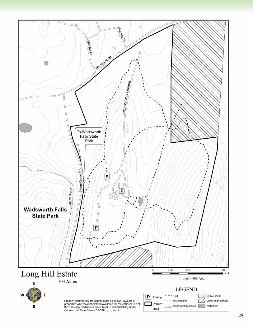
Long Hill EstateDirections: Take Route 66 to West Street and go south until it ends at Wadsworth Street. Turn right
(west) onto Wadsworth Street and go 0.3 miles. From this direction, the entrance will be on the left.
Parking: Parking lots are available to the left (west) and rear of Wadsworth Mansion, and are accessed by following the entrance drive.
Terrain: The Perimeter Trail’s terrain is varied, intermittently wet, and includes some moderately steep inclines on the east side of the property. The Olmsted Loop Trail is generally level.
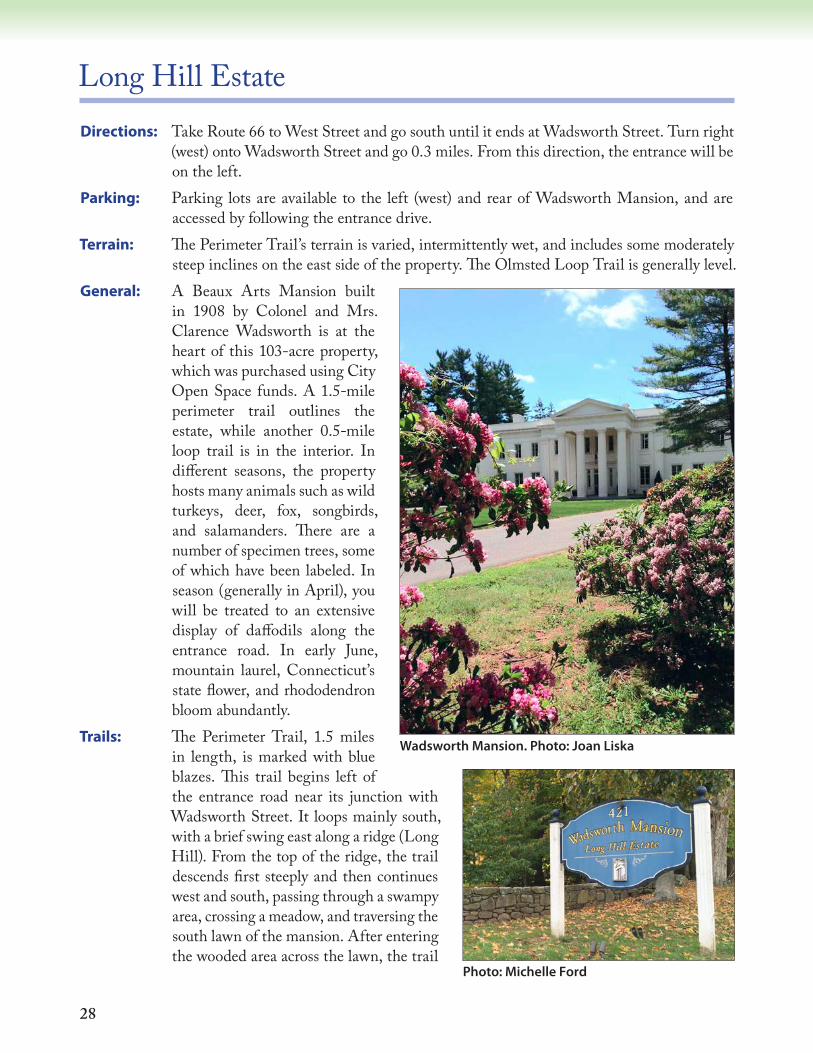
General: A Beaux Arts Mansion built in 1908 by Colonel and Mrs. Clarence Wadsworth is at the heart of this 103-acre property, which was purchased using City Open Space funds. A 1.5-mile perimeter trail outlines the estate, while another 0.5-mile loop trail is in the interior. In different seasons, the property hosts many animals such as wild turkeys, deer, fox, songbirds, and salamanders. There are a number of specimen trees, some of which have been labeled. In season (generally in April), you will be treated to an extensive display of daffodils along the entrance road. In early June, mountain laurel, Connecticut’s state flower, and rhododendron bloom abundantly.
Trails: The Perimeter Trail, 1.5 miles in length, is marked with blue blazes. This trail begins left of the entrance road near its junction with Wadsworth Street. It loops mainly south, with a brief swing east along a ridge (Long Hill). From the top of the ridge, the trail descends first steeply and then continues west and south, passing through a swampy area, crossing a meadow, and traversing the south lawn of the mansion. After entering the wooded area across the lawn, the trail
Wadsworth Mansion. Photo: Joan Liska
Photo: Michelle Ford
29
Æü
Æü
Æü
220
160
120
220
240
220
220
180
260
120
240
120
200
240
340
160
320
180
260
300
140
160
280
140
160
200
180
220
200
180
Laur
el B
rook
Spencer Dr.
Laur
elG
rove
Rd.
Wadsw
orthSt.
Hendley
St.Lo
ngH
il lE
sta t
eD
rivew
ay
Long Hill Estate
:0 500 1,000250
Feet
1 inch = 400 feet
Æü Parking
Property
Road
Trail
Watercourse
Wadsworth Mansion
SnowSchool
Mercy High School
Waterbody
LEGEND103 Acres
Wadsworth FallsState Park
To WadsworthFalls State
Park
Property boundaries are approximate as shown. Owners of properties who make their land available for recreational use of the trails depicted herein are subject to limited liability under Connecticut State Statute 52-557f, g, h, and i
30
swings north, paralleling Laurel Grove Road. There is a small connecting trail to the road and Wadsworth Falls State Park on the opposite side. Continuing farther on the main trail, there is a great white oak tree on the left. The trail then returns to the starting point on the entrance road.
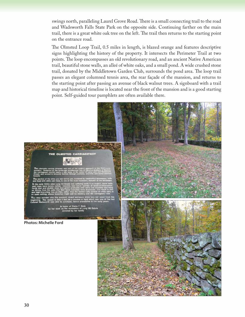
The Olmsted Loop Trail, 0.5 miles in length, is blazed orange and features descriptive signs highlighting the history of the property. It intersects the Perimeter Trail at two points. The loop encompasses an old revolutionary road, and an ancient Native American trail, beautiful stone walls, an alleé of white oaks, and a small pond. A wide crushed stone trail, donated by the Middletown Garden Club, surrounds the pond area. The loop trail passes an elegant columned tennis area, the rear façade of the mansion, and returns to the starting point after passing an avenue of black walnut trees. A signboard with a trail map and historical timeline is located near the front of the mansion and is a good starting point. Self-guided tour pamphlets are often available there.
Photos: Michelle Ford
31
McCutcheon Park AreaDirections: From Randolph Road (Route 155), turn south onto Millbrook Road. Follow Millbrook
Road for 1.5 miles and take a right onto Livingston Road. After 0.2 miles, take the first right off Livingston Road into McCutcheon Park.
Parking: There is ample parking that is accessible to people with limited mobility. Entrance requires a Middletown residence pass during the summer season. To use the Red Trail, proceed past the entrance booth, turn left and drive to the far side (west) of the parking lot. Look for red dots painted on wooden fence posts. To access the orange trail, use the parking area on the left, next to the first baseball field.
Terrain: The trails are varied, including flat areas, moderate to steep climbs, and some wet areas.General: McCutcheon Park is open from dawn to dusk and provides opportunities for hiking,
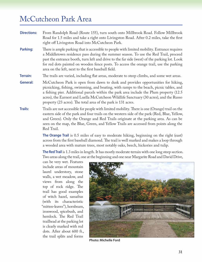
picnicking, fishing, swimming, and boating, with ramps to the beach, picnic tables, and a fishing pier. Additional parcels within the park area include the Plum property (12.5 acres), the Earnest and Luella McCutcheon Wildlife Sanctuary (30 acres), and the Russo property (23 acres). The total area of the park is 131 acres.
Trails: Trails are not accessible for people with limited mobility. There is one (Orange) trail on the eastern side of the park and four trails on the western side of the park (Red, Blue, Yellow, and Green). Only the Orange and Red Trails originate at the parking area. As can be seen on the map, the Blue, Green, and Yellow Trails are accessed from points along the Red Trail.
The Orange Trail is 0.5 miles of easy to moderate hiking, beginning on the right (east) across from the first baseball diamond. The trail is well marked and makes a loop through a wooded area with mature trees, most notably oaks, beech, hickories and tulip.
The Red Trail is 1.3 miles in length. It has mostly moderate terrain with one long steep section. Two areas along the trail, one at the beginning and one near Margarite Road and David Drive, can be very wet. Features include areas of mountain laurel understory, stone walls, a wet meadow, and views from along the top of rock ridge. The trail has good examples of witch hazel, sassafras (with its characteristic “mitten-leaves”), hornbeam, ironwood, spicebush, and hemlock. The Red Trail trailhead at the parking lot is clearly marked with red dots. After about 600 ft., the trail splits and forms
Photo: Michelle Ford
32
a loop that can be followed in either direction (see map). If you go left (first in a southerly direction), the wooded trail is a bit of a challenging climb. The trail turns west for a few hundred yards before it snakes toward the north to a fairly level path along an elevated escarpment. If you continue north, the trail will drop you onto Margarite Road. Turn right until you cross David Drive. The trail continues left just past the railed fence (the path parallels the fence). Just past the end of the railed fence, the trail turns south behind the neighboring house for about 300 ft. Turn east to traverse a marsh (dry in late summer and fall). After crossing the marsh, turn south and the trail curves around and then proceeds downhill in an easterly direction before turning back toward the beginning of the trail at the McCutcheon Park parking lot. If traveling counterclockwise on the Red Trail, care should be taken where the Red Trail meets the Green Trail because the Red Trail takes a very sharp left turn at this junction. The Red Trail rises on a short incline, turns south and then curves along a marshy area. Cross the marsh here and turn north until the split rail fence. Continue along the fence until you come to Margarite Road at the intersection of David Drive. Turn right, cross the road and the trail resumes in the woods to the left (west) just north of David Drive and continues south over mostly flat terrain, bordered by large stands of mountain laurel and several large rock outcrops. After the junction with the Yellow Trail, the Red Trail veers east. A short distance further, you’ll reach the junction with the Blue Trail on the right. The Red Trail continues straight to an unmarked dirt extension of Margarite Road (also the other end of the Blue Trail) and continues to the parking lot.
The Green Trail, accessed from the Red Trail, is 0.5 miles in length and covers mostly flat terrain, except for a short steep slope at its north end. There is mature forest, except for a section of field behind David Drive that is dominated by young black birch and oaks.
The Yellow Trail, also accessed from the Red Trail, is about 0.7 miles in length, with some difficult hiking at its southern end. It runs north through a small wooded valley below rock outcrops and past the underside of some overhanging cliffs, where ice caves form in winter. These cliffs include rock formations from the early Jurassic (Portland Formation), about 201 million years ago. The forest here includes oaks, maples, and black birch.
The Blue Trail is a 0.2-mile loop off the Red Trail. It offers moderate to difficult walking because it extends along the side of a hill that slopes downward, steeply at some points, toward Livingston Road. In the fall it is especially challenging due to fallen leaves.
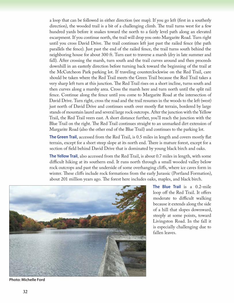
Photo: Michelle Ford

33
Æü
Æü
!!
!!
!!
!
!!
!!
!!
!
!
!!
!!
!!
!!
!
150
200
250
200
200 150
250
250
150
200
200
200
300
250
200
250
200
Margar ite
Rd.E
xt.
Kelsey St.
Andon
Rd.
Lake Rd.
Livingston Rd.
Cry
stal
Lake
Rd.
Margarite R
d.
McCutcheon Park Area
:0 500 1,000250
Feet
1 inch = 500 feet
Æü Parking
Property
Ammenities
Road
Waterbody
Wetland
Watercourse
Blue Trail
Orange Trail
! ! Green Trail
Yellow Trail
Red Trail
LEGEND131 Acres
Pavilion
BaseballDiamond
Multi-useField
Public Beach &Guard House
Cry
stal
Lak
e
Millbrook R
d.

34
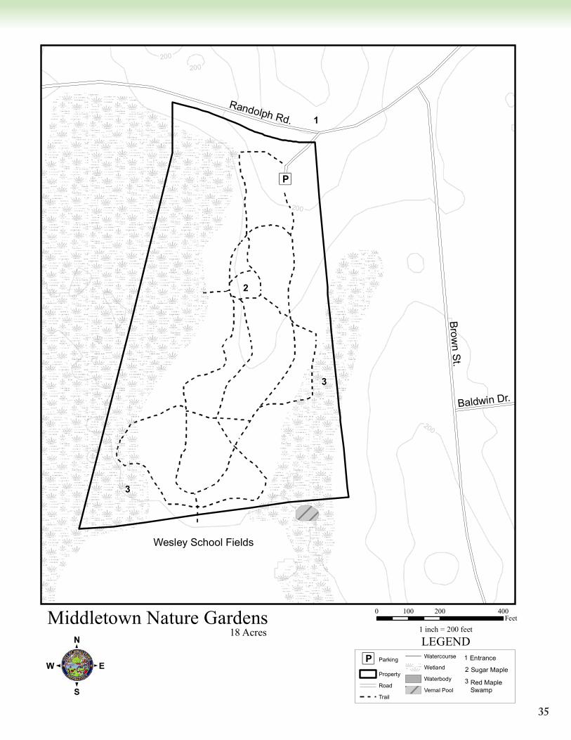
Middletown Nature GardensDirections: From Route 17, go west on Randolph Road for about 0.3 miles. The park entrance is on
the left (between Brown Street and Long Hill Road).Parking: Limited parking is available (6-8 spaces).Terrain: Slightly sloped from north to south, this parcel provides easy, flat walking. The main trail
is accessible to persons with limited mobility.General: Acquired in 1995, the Middletown Nature Gardens encompass 18 acres of land in the
southern part of town between Randolph Road and Wesleyan Hills Road, bordering Wesley Elementary School and the Wesleyan Hills development. This special piece of land features hummocky red maple swamp, vernal pools, mixed hardwoods, a classic
“old field” meadow, and variety of flora and fauna. Trees and shrubs include red cedar, flowering dogwood, swamp white oak, red maple, white pine, shagbark hickory, black cherry, arrowwood, ironwood, speckled alder, buckthorn, and autumn olive (a non-native invasive plant). Goldenrod, aster, and the tall, purplish joe-pye weed are common flowering perennials. The diverse mix of habitats makes for excellent bird watching. You will also see bluebird and bat boxes, erected by community volunteers.
Trails: The main trail is a 0.4-mile loop. Near the center of the old field is a majestic, nearly 200-year old sugar maple, named “The Bee Tree”. To the south, a small bridge connects the Nature Gardens with the Wesley Elementary School playing fields. On the west side of the park there are 10 acres of red maple swamp. In the spring, vernal pools, essential habitats for certain species of salamanders and frogs (e.g. wood frogs), can be seen in the southeast corner. Multiple benches are located near the trails, providing opportunities for a quiet moment’s rest. Mulched side trails, which branch off from the main trail, add another 0.5 miles to the walk. These side trails are sometimes wet.
The Bee Tree Photos: Pat Rasch
35
Æü
200
200
200
200
Baldwin Dr.
Randolph Rd.Brow
n St.
3
3
2
1
Middletown Nature Gardens
:0 200 400100
Feet1 inch = 200 feet
LEGEND18 Acres
Æü Parking
Property
Road
Trail
Watercourse
Wetland
Waterbody
Vernal Pool
1 Entrance
2 Sugar Maple
3 Red Maple Swamp
Wesley School Fields
36
Ravine ParkDirections: From Washington Street, go south on High Street for about one mile. Turn right on Beach
Street, opposite Warwick Street.Parking: There is a 2–3 car parking area on Beach Street in a pull-out near the park, about 1/10 of a mile
from High Street. The parking area is approximately 50 feet from the eastern trail entrance.Terrain: The area is generally level, though there are moderate slopes along both sides of the ravine.General: Ravine Park occupies 19 acres in central Middletown. The trail runs east/west through
the park from Beach Street to Pine Street. Ravine Park is a noteworthy oasis of biodiversity in a relatively densely developed residential area. The park constitutes the northeastern end of a nearly continuous greenway of undeveloped land that extends all the way to Wadsworth State Park in Middlefield. Unfortunately, the park has been impacted by human activity. Non-native, invasive species are abundant along the edge of the trail and near the small stream at the bottom of the ravine; these species include Japanese knotweed, multiflora rose, Asiatic bittersweet, Japanese barberry, burning bush, and garlic mustard. Most recently, tropical storm Irene and the October snowstorm of 2011 caused extensive damage near the eastern end of the trail, toppling a dozen or more mature trees. The stream running through the ravine, and the pond at its eastern end near High Street, serve as an important catchment area for storm water runoff, which has increased in volume in recent years due to increased development in the local watershed. Erosion due to stormwater runoff is visible at the western end of the stream, and sediment has accumulated in the pond at the eastern end of the park.
Nonetheless, Ravine Park contains some fine examples of wetland vegetation, plus impressive mature hardwoods. In the early spring there are extensive displays of trout lily and bloodroot. The dominant tree species are red maple, American elm, beech, and several types of oak. The understory contains abundant ironwood and spicebush, whose misty yellow flowers give a lovely cast to the stream banks in early spring. Alternate-leaved dogwood can be found at the west end of the trail. Horsetail and skunk cabbage grow abundantly in poorly drained areas along the trail and near the stream. Pileated woodpeckers are seen here, and the calls of screech owls are often heard at night. This is also a good spot to look for warblers during the spring and fall migrations, and to see frogs and salamanders.
Trail: The Marion Banks Nature Trail, approximately 0.125 miles in length, runs through Pike’s Ravine from Beach Street to Pine Street. It is easily accessed from either end. The trail is often soggy in its lowest stretches, so appropriate footwear is necessary if the weather has been wet. Watch out for the abundant poison ivy along the western section of the trail.
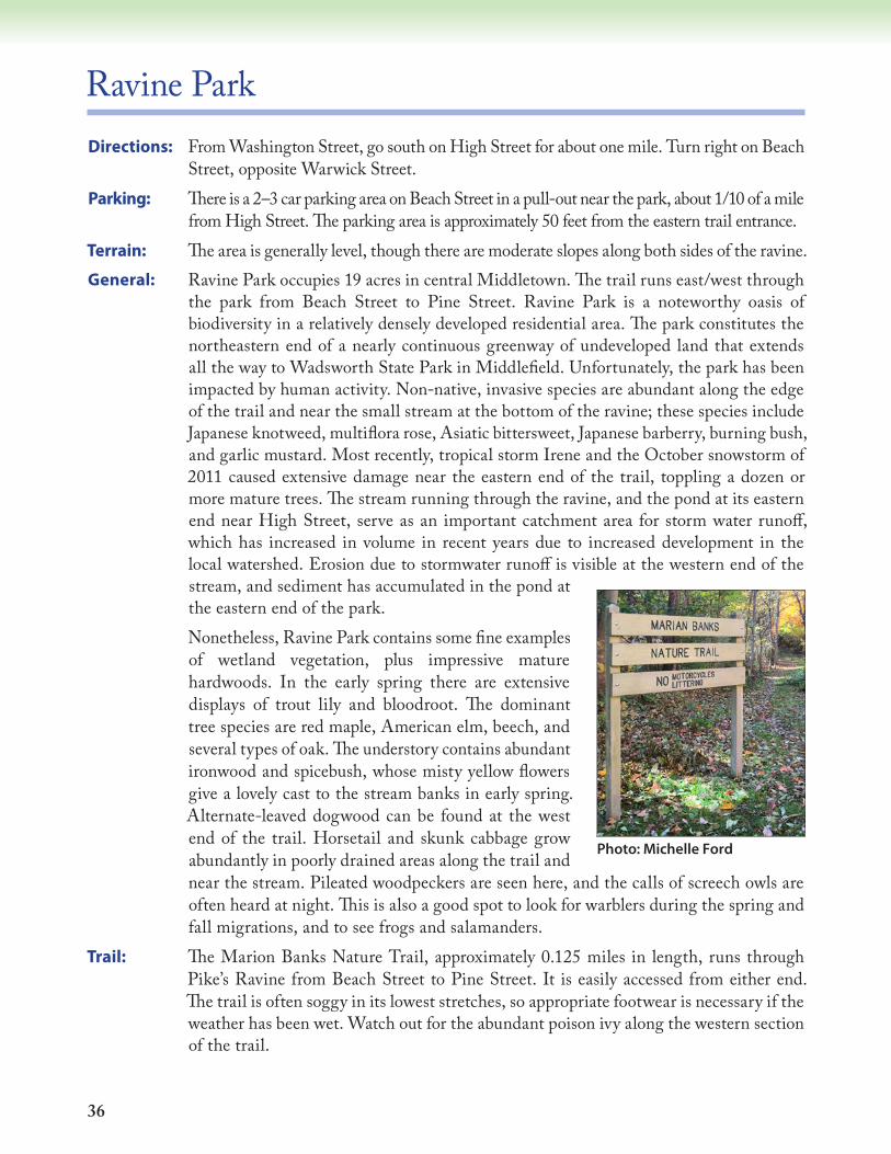
Photo: Michelle Ford

37
Æü
Æü
Æü
Æü
Æü
Æü
Æü
Æü
Æü
Æü
Æü
ÆüÆü
Æü
Æü
Æü
Æü
Æü
Æü
150
100
150Ravine Ave.
Summ
it Pl.
Bellevue Pl.
Gordon Pl.
Joac
obs
Terr.
Miles Ave.
Bretton P
l.
Mansfield Terr.
Ravine Ave.
Highland Terr.
Beach St.
Brainerd Rd.
Hom
e Ave.
Bretton Rd.
Pine
St.
Hig
hlan
d A
ve.
Ravine Park
:0 200 400100
Feet1 inch = 250 feet
Æü Parking
Property
Wesleyan Athletic Fields
Waterbody
Road
Trail
Watercourse
LEGEND19 Acres
Pameacha Pond
38
Smith ParkDirections: Take Country Club Road east from Interstate 91 or west from the Ballfall Road/East
Street junction. The park entrance is just west of Moody School on the north side of Country Club Road.
Parking: There is ample parking in the lot at the park.Terrain: The trail is relatively flat in slope. While the main trail should be appropriate for strollers
and wheelchairs, the park is not otherwise very accessible for those with limited mobility.General: Smith Park, acquired by the City of Middletown in June 1974, consists of 50 acres adjacent
to Moody School playing fields. The main access to the park is a gated entrance located just west of Moody School. The park is closed at sunset and the gates are locked. Amenities at Smith Park include ball fields, a playground, hiking trails, horseshoe pits, shuffleboard, and a pavilion. Seasonally, there are restrooms available near Moody School adjacent to the ball fields. Permission can be obtained from the Park and Recreation Commission to host a family outing or company picnic at the pavilion. Various types of plants and animals can be viewed in the undeveloped area of the park throughout the year. Adjacent to the wooded area is a wetland meadow with a variety of shrubs, including silky dogwood, winterberry, buttonbush, and highbush blueberry. A small pond and stream are located in the middle of the woodland.
Trails: Associated with the park is a short hiking trail, which loops into a woodland area.
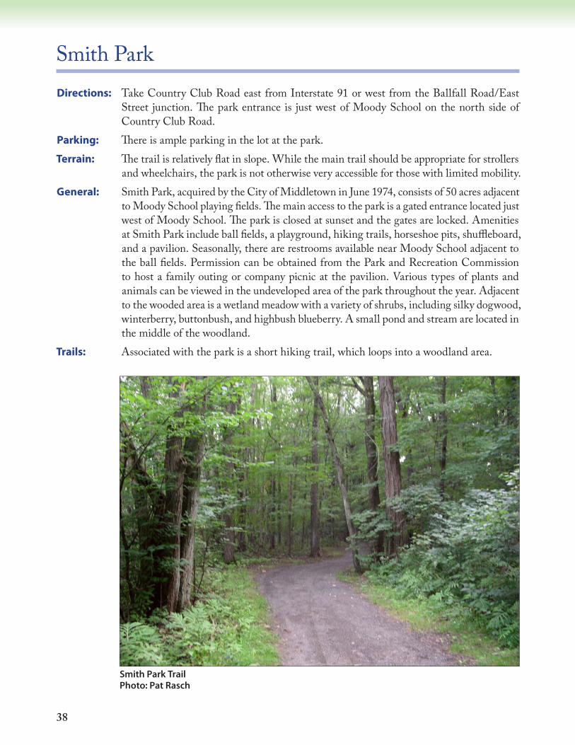
Smith Park Trail Photo: Pat Rasch

39
Æü
Æü
Æü
400
300
350
350
250
350
300
300
Fall Brook
Fall
Broo
k
Red
Cedar Ln.
Plumb Rd.
Country
Club Rd.
Oak
Rid
geD
r.
Partridge Ln.
Smith Park
:0 400 800200
Feet1 inch = 400 feet
Æü Parking
AmenitiesProperty
WaterbodyTrailRoadWatercourse
LEGEND50 Acres
MoodyElementary
School
Baseball Diamond
SoccerField
Playground
Pavillion

40
Spiderweed PreserveDirections: Take Route 9 to Exit 10 in the southern part of Middletown. At the end of the exit ramp,
take a left (north) onto Route 154 (Saybrook Road) and continue for 0.6 miles. Turn right onto Dripps Road. Follow the road uphill for 100 yards. The trail entrance is on the left, just as the road turns right.
Parking: There is no off-road parking, but there is room along the side of Dripps Road for a few cars.
Terrain: The Spiderweed trail varies in difficulty; it is rocky in some areas and can be very steep and challenging.
General: This 157-acre property is owned and managed by The Nature Conservancy. The preserve offers a varied hike through deciduous forest, along massive rock outcrops, over a rock bluff, down to a stream, and along an old farm lane. Several vernal pools, essential habitat for certain species of amphibians, are present in the spring, as are bloodroot, trillium, Jack-in-the-pulpit, and wild geranium. Stone walls along the route date from early colonial times.
Trail: The preserve has a main trail plus two small spur trails. The main trail is marked with white blazes and generally travels in an easterly direction. Starting from the gated entrance, the trail climbs through a black birch, oak and hickory forest with ironwood, witch hazel and hornbeam in the understory. There are also several small chestnut trees along the first part of the trail. An abandoned cabin can be seen to the left as the trail reaches the top of the hill. About 100 yards past this point, there is a white blazed spur trail on the right leading to a scenic overlook on a pegmatite outcrop. This spur trail is about 200 ft. long, and the view is well worth the side trip. The main trail passes several large tulip trees and continues along the base of several rock outcrops, then at a double-blaze turns right and continues steeply downhill to an intermittent stream where it runs along a farm road lined by stone walls. The trail continues down a gentle slope with more impressive rock outcrops to the left. Further along, another set of double blazes indicates the start of the loop trail. This trial climbs and then loops to the left to eventually rejoin itself. The second spur trail, blazed in blue, branches off the easternmost part of the loop and continues for 0.5 miles to a rocky outcrop with a scenic view.
Photo: Michelle Ford

41
#
#Æü
SR-9
Airc
raft
Rd.
Sayb
rook
Rd
260
24066
064
0
540
480
420
440
600
560
520
500
460
400
36062
0
380
280
300
320
340
580
Dripps
Rd.
Spid
erw
eed
Pres
erve
:0
500
1,00
025
0Fe
et1
inch
= 6
00 fe
et
ÆüP
arki
ng
#S
ceni
c O
verlo
ok
Pro
perty
Roa
d
Trai
l
Wat
erco
urse
Inte
rmitt
ent S
tream
Wat
erbo
dy
Wet
land
LEG
END
150
Acr
es
Spid
erw
eed
Pres
erve
is o
wne
d an
d m
aint
aine
d by
The
Nat
ure
Cons
erva
ncy.
Prop
erty
bo
unda
ries
are
appr
oxim
ate
as
show
n.
Ow
ners
of
pr
oper
ties
who
m
ake
thei
r la
nd
avai
labl
e fo
r re
crea
tiona
l us
e of
th
e tra
ils
depi
cted
he
rein
ar
e su
bjec
t to
lim
ited
liabi
lity
unde
r Co
nnec
ticut
St
ate
Stat
ute
52-5
57f,
g,
h,
and
i.

42
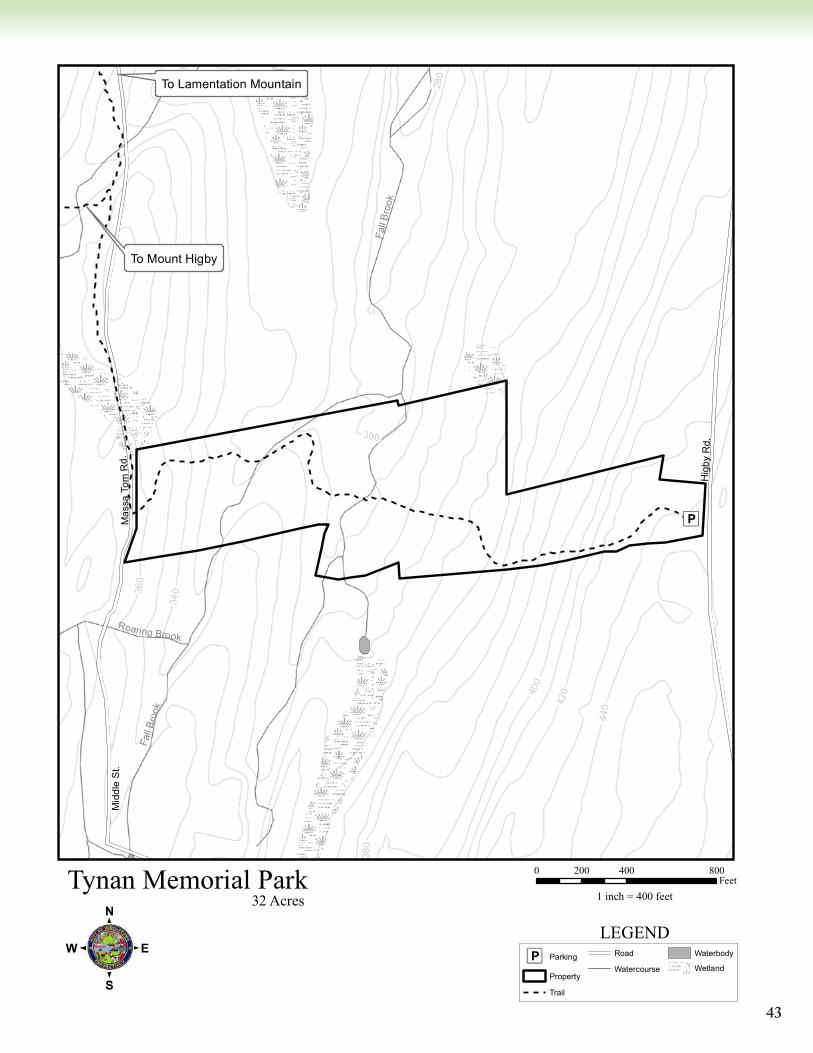
Tynan Memorial Park (Tynan Park Connector Trail) and Jablonski PropertyDirections: Take Washington Street (Route 66) to Higby Road in the western part of town. Go north
(right) on Higby Road for a half mile; the park is on the left shortly after the stop sign at Sisk Street. The park entrance is marked with a sign and has two entrances connected by a semicircular gravel drive. The Jablonski Property is to the left of Tynan Memorial Park (west).
Parking: There is limited parking on the grass just off of the gravel drive.Terrain: The terrain varies from gentle to moderate slopes; the trail traverses through formerly
cultivated open fields, an extensive wetland corridor, mixed woodlot, and crosses two streams.
General: The 32-acre Tynan Memorial Park, purchased by the City of Middletown using Open Space funds, offers a variety of habitat, wildlife, and scenic views. The property lies on the eastern side of Higby Mountain, and consists of old fields, forest, and wetlands. During the 1930s, the fields on the eastern side of this small valley were used for row crops. Deer, coyotes, rabbits, hawks, owls, turkeys, woodpeckers, chickadees, hermit thrushes, and white-breasted nuthatches are but a few of the many species common at the property. The abandoned fields support herbaceous vegetation such as goldenrod, curly dock, yarrow,
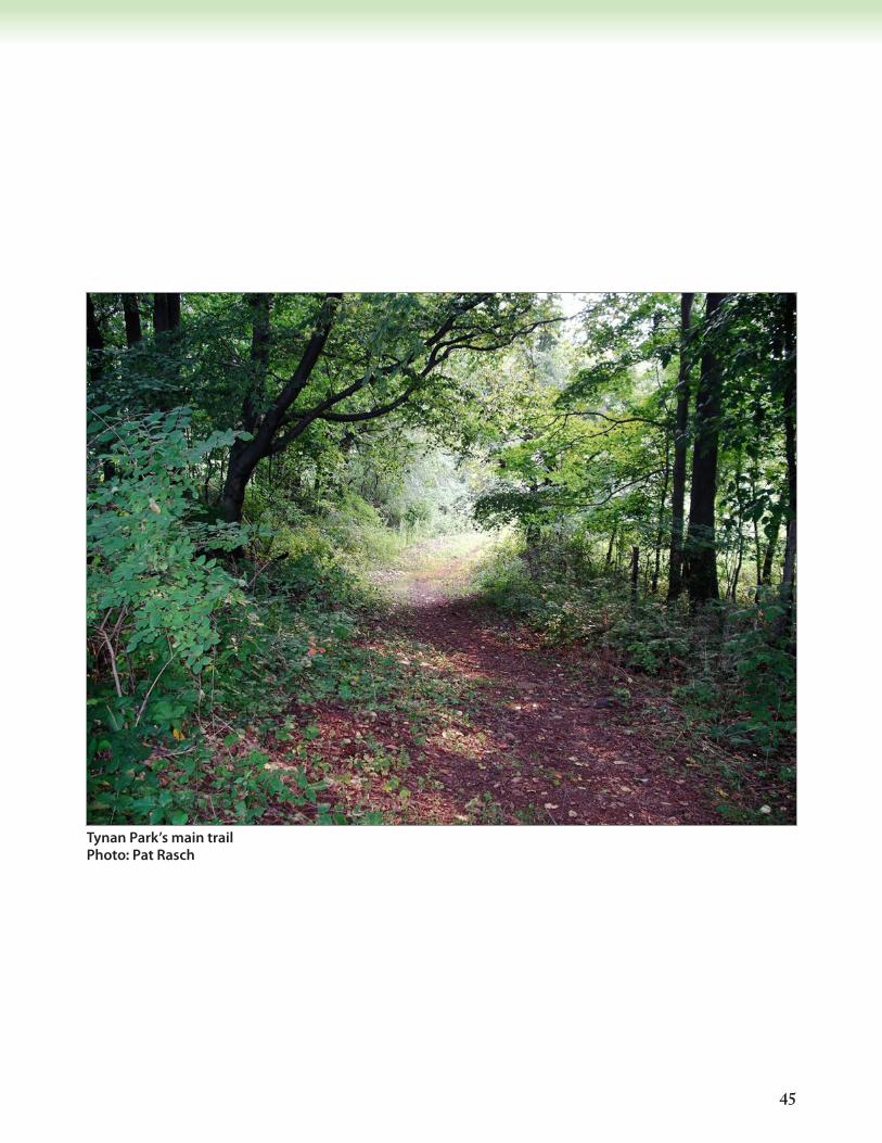
Looking up Tynan Park’s main trail Photo: Pat Rasch
43
Æü
44042
0400
360
340
300
380
28032
0
Hig
by R
d.
Mid
dle
St.
Mas
saTo
mR
d.
Fall
Broo
k
Fall
Bro
ok
Roaring Brook
Tynan Memorial Park
:0 400 800200
Feet1 inch = 400 feet
Æü Parking
Property
Trail
Road
Watercourse
Waterbody
Wetland
LEGEND
32 Acres
To Lamentation Mountain
To Mount Higby

44
wild garlic, and purple vetch, and dense shrub thickets of blackberry, red raspberry, spicebush, staghorn sumac, and several non-native invasive plants (multiflora rose, Japanese barberry). There is a dense stand of eastern hemlock trees just past the wetland area, which is unfortunately in decline due to the hemlock woolly adelgid parasite. Other trees found on the property include black birch, white ash, black cherry, beech, shagbark hickory, white oak, chestnut oak, sycamore, flowering dogwood, apple, sugar maple, red maple, red cedar and tulip.
The adjacent 29-acre Jablonski Property offers a relatively short, moderately difficult hike along a portion of the Mattabesett Trail. The trail loop includes an open field with two picnic areas within sight of the trail. The end of the trail loop is uphill. The southern end of the property is muddy in early spring. The property has four parcels divided by small tree stands that are predominantly deciduous species (maples and oaks). Most of the property is open field dominated by grasses and mowed woody stumps. There are a lot of thorny species reestablishing in the fields and around the property. Appropriate shoes and clothing are advised if venturing off the trail. The most common animals you will encounter on this property will be rabbits. Horses are within eyeshot of the property on adjacent private land.
Trails: The main trail (blue-over-red blazes), known as the Tynan Park Connector Trail, connects to the Mattabesset Blue Trail, which is part of the longer New England Scenic Trail. There is a signpost at the parking area with an explanation of the trail’s connection to the New England Scenic Trail. The trailhead is at a well-marked post approximately 75 yards southwest across the mowed field at the top of the park. The trail descends west through an overgrown field and traverses a large, ungrazed wet meadow that runs through the center of the property. The trail enters a dense shrub thicket, crosses an intermittent stream, and then enters forested land dominated by eastern hemlock. There is a second water crossing at Fall Brook. After this crossing, the trail becomes rocky, slopes gently upward, and veers slightly south. The trail ends at Massa Tom Road, which connects Country Club Road with the Mount Higby Reservoir service area. Please note that the crossing at Fall Brook can be difficult, if not impossible, when water levels rise during late winter and early spring. This trail dead-ends at the blue blazed Mattabesett/New England Trail.
The trail on the Jablonski property can only be accessed from the Tynan Park Connector Trail. Park in the Tynan parking lot, and take the trail south of the parking lot. It begins with a moderately steep slope. Follow this trail about 0.08 miles until the break on the left and continue left along the Jablonski trail (a half mile loop that returns to this starting point). The trail goes downhill, loops west, and then follows along the south side of the property on a steep incline up along the perimeter. The trail continues across relatively flat ground back to the Tynan trail intersection. Also refer to Blue-Blazed Trails: Tynan Park Connector map for additional details.
45
Tynan Park’s main trail Photo: Pat Rasch
46
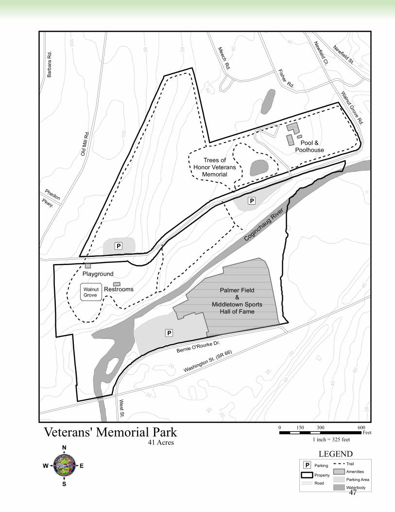
Veteran’s Memorial Park/Palmer FieldDirections: Veteran’s Memorial Park can be accessed several ways. From Newfield Street (Route 3)
take Fisher Road; from Washington Street (Route 66) take Old Mill Road north; or from Westfield Street go south on Old Mill Road. Palmer Field is accessible from Washington Street via Bernie O’Rourke Drive.
Parking: There is a large parking area along Bernie O’Rourke Drive to access both Palmer Field and the pedestrian bridge that links Palmer Field to Veteran’s Memorial Park. In Veteran’s Memorial Park, there is parking near the pool area. There is also a large parking area along Walnut Grove Road, which bisects the park.
General: Veteran’s Memorial Park offers a variety of recreational facilities including a public pool, softball and soccer fields, children’s playscape, picnic areas, and two small pavilions. In addition, there are many wooded portions of the park, and it is the easiest place in the City to access the Coginchaug River. A trail runs roughly around the perimeter of the park with a long stretch along the Coginchaug. From the river, the trail goes through a large old grove of black walnut trees as it approaches the playground and pavilion on the western side of the park. Other mature trees found at Veteran’s include
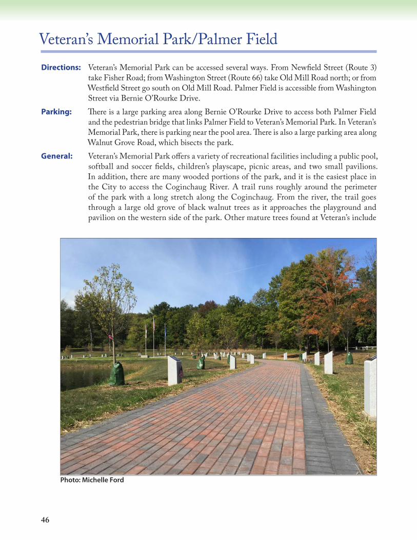
Photo: Michelle Ford
47
Æü
Æü
Æü
20
20
20
80
40
20
20
20
40
40
60
40
100
100
40
80 60 40
20
PhedonPkwy.
West St.
Newfield Ct.
Bar
bara
Rd.
Newfield St.
Meech R
d. Fisher
Rd.
Bernie O'Rourke Dr.
Old
Mill
Rd.
Washington St. (SR 66)
Walnut G
rove Rd.
Veterans' Memorial Park
:0 300 600150
Feet1 inch = 325 feet
Æü Parking
Property
Road
Trail
Amenities
Parking Area
Waterbody
LEGEND41 Acres
Palmer Field&
Middletown SportsHall of Fame
Playground
Restrooms
Trees ofHonor Veterans
Memorial
Pool &Poolhouse
Coginchaug Rive
r
WalnutGrove
48
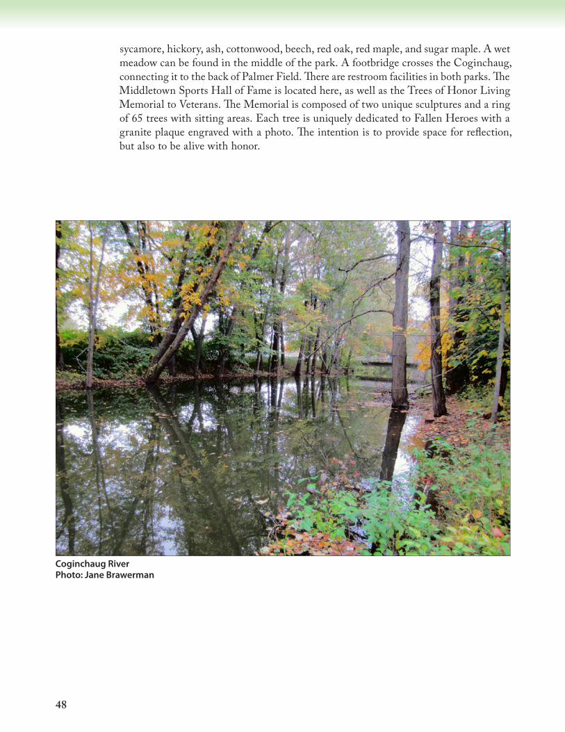
sycamore, hickory, ash, cottonwood, beech, red oak, red maple, and sugar maple. A wet meadow can be found in the middle of the park. A footbridge crosses the Coginchaug, connecting it to the back of Palmer Field. There are restroom facilities in both parks. The Middletown Sports Hall of Fame is located here, as well as the Trees of Honor Living Memorial to Veterans. The Memorial is composed of two unique sculptures and a ring of 65 trees with sitting areas. Each tree is uniquely dedicated to Fallen Heroes with a granite plaque engraved with a photo. The intention is to provide space for reflection, but also to be alive with honor.
Coginchaug River Photo: Jane Brawerman

49
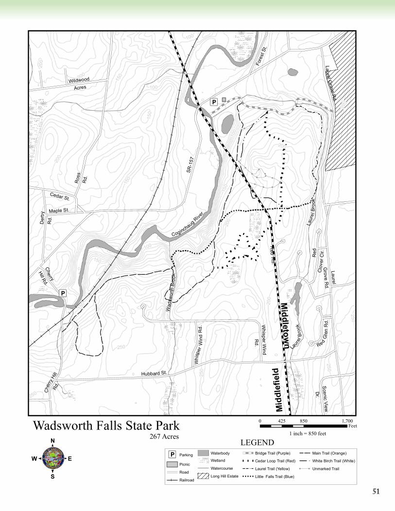
Wadsworth Falls State ParkDirections: Take Route 66 to West Street (Route 157). Go south on West Street until the first stop
sign. Turn right (west) and follow Route 157 to the main park entrance on the left.Parking: A large parking lot is located at the main entrance, where a state park fee is charged during
season. There is also limited parking in a pull-out along Cherry Hill Road in Middlefield (see map).
Terrain: The main trail is flattest and most accessible to hikers. Other trails vary from fairly flat to extremely steep.
General: Clarence Wadsworth willed the 267-acre parcel, located in both Middletown and Middlefield, to the state in 1942. Special features include two brooks, two major streams, the Coginchaug River, and two waterfalls. The larger of the two, Wadsworth Falls, is across a field from the parking lot on Cherry Hill Road. Many trails wind through the park.
Trails: The Main Trail (orange-blazed) is approximately 1.5 miles long and is best accessed from the main parking area. From the Cherry Hill Road parking area, the trail is on the left, up the hill and across a small bridge. The trail winds through deciduous forest and areas of large mountain laurel. Most other trails intersect with the main trail.
The Deer Trail (green-blazed) is somewhat steep on its southwest end and runs between the White Birch Trail (near its junction with the Bridge Trail) and the Main Trail.
The Little Falls Trail (dark blue blazed) is steep and narrow. It branches from the Main Trail and crosses Wadsworth Brook at its lowest point. Little Falls is visible on the upstream side where the brook flows over a large brownstone outcrop. It is especially magnificent in spring or after a heavy rain. On the west side of the brook, a steep incline leads back to the Main Trail.
The Bridge Trail (light blue-blazed) follows Laurel Brook and is named for the brownstone bridge that was constructed by the Civilian Conservation Corps during the Depression. Though relatively flat, the trail has many rocks and tree roots. It runs easterly from the main trail to Laurel Grove Road.
Photo: Michelle Ford

50
The White Birch Trail (white-blazed) passes through multiple stands of mature white birch trees. It is a trail of varied terrain and hiking difficulty.
The Cedar Loop Trail (red-blazed) is named for the predominant cedar tree along this route. The Laurel Brook Trail (yellow-blazed) is accessed from the Bridge Trail or White Birch
Trail. It follows Laurel Brook with many steep and narrow sections (can be icy and treacherous in winter).
The White Birch Ridge Trail is a short stretch of trail that can be wet and difficult to walk.
Photos: Michelle Ford
Photos: Jane Brawerman
51
Æü
Æü
!
!
!
!
!
!
!
!
!
!!
!
!!
!
100
250
250
200
100250
150
200
150
200
250
250
200
100
150
150
200
100
150
150
150
200
200
200
Wad
swor
thB
rook
La
urel
Bro
ok
CoginchaugRive
r
Laur
elB
r ook
Fore
st S
t.
Maple St.
Whi
sper
Win
dR
d.Cedar St.
Wildwood
Acres
Ros
sR
d.
Laurel Grove
Rd.
Hubbard St.
SR-1
57
Red
Clo
v er C
ir.
Scenic
View
Dr.
Der
byR
d.
Red
Rd.
Cherry
Hill Rd.
Che
rryHi
llRd
.Laurel
Grove
Rd.
RedG
len
Rd .W
hi sp er Win d
Rd.
Wadsworth Falls State Park
:0 850 1,700425
Feet1 inch = 850 feet
Æü Parking
Picnic
Road
Railroad
Waterbody
Wetland
Watercourse
Long Hill Estate
Bridge Trail (Purple)
Cedar Loop Trail (Red)
Laurel Trail (Yellow)
Little Falls Trail (Blue)
Main Trail (Orange)
White Birch Trail (White)
! ! Unmarked Trail
LEGEND267 Acres
Mid
dlef
ield
Middletow
n
52
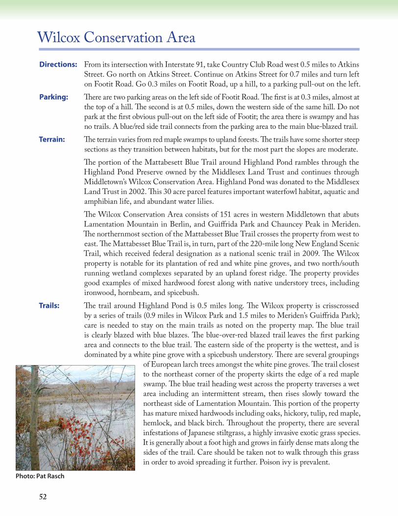
Wilcox Conservation Area Directions: From its intersection with Interstate 91, take Country Club Road west 0.5 miles to Atkins
Street. Go north on Atkins Street. Continue on Atkins Street for 0.7 miles and turn left on Footit Road. Go 0.3 miles on Footit Road, up a hill, to a parking pull-out on the left.
Parking: There are two parking areas on the left side of Footit Road. The first is at 0.3 miles, almost at the top of a hill. The second is at 0.5 miles, down the western side of the same hill. Do not park at the first obvious pull-out on the left side of Footit; the area there is swampy and has no trails. A blue/red side trail connects from the parking area to the main blue-blazed trail.
Terrain: The terrain varies from red maple swamps to upland forests. The trails have some shorter steep sections as they transition between habitats, but for the most part the slopes are moderate.
The portion of the Mattabesett Blue Trail around Highland Pond rambles through the Highland Pond Preserve owned by the Middlesex Land Trust and continues through Middletown’s Wilcox Conservation Area. Highland Pond was donated to the Middlesex Land Trust in 2002. This 30 acre parcel features important waterfowl habitat, aquatic and amphibian life, and abundant water lilies.
The Wilcox Conservation Area consists of 151 acres in western Middletown that abuts Lamentation Mountain in Berlin, and Guiffrida Park and Chauncey Peak in Meriden. The northernmost section of the Mattabesset Blue Trail crosses the property from west to east. The Mattabesset Blue Trail is, in turn, part of the 220-mile long New England Scenic Trail, which received federal designation as a national scenic trail in 2009. The Wilcox property is notable for its plantation of red and white pine groves, and two north/south running wetland complexes separated by an upland forest ridge. The property provides good examples of mixed hardwood forest along with native understory trees, including ironwood, hornbeam, and spicebush.
Trails: The trail around Highland Pond is 0.5 miles long. The Wilcox property is crisscrossed by a series of trails (0.9 miles in Wilcox Park and 1.5 miles to Meriden’s Guiffrida Park); care is needed to stay on the main trails as noted on the property map. The blue trail is clearly blazed with blue blazes. The blue-over-red blazed trail leaves the first parking area and connects to the blue trail. The eastern side of the property is the wettest, and is dominated by a white pine grove with a spicebush understory. There are several groupings
of European larch trees amongst the white pine groves. The trail closest to the northeast corner of the property skirts the edge of a red maple swamp. The blue trail heading west across the property traverses a wet area including an intermittent stream, then rises slowly toward the northeast side of Lamentation Mountain. This portion of the property has mature mixed hardwoods including oaks, hickory, tulip, red maple, hemlock, and black birch. Throughout the property, there are several infestations of Japanese stiltgrass, a highly invasive exotic grass species. It is generally about a foot high and grows in fairly dense mats along the sides of the trail. Care should be taken not to walk through this grass in order to avoid spreading it further. Poison ivy is prevalent.
Photo: Pat Rasch
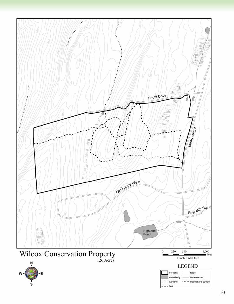
53
400
350
300
200
250
350
300
250
300
250
250
200
300
450
300
250
Wilcox Conservation Property
:0 500 1,000250
Feet1 inch = 600 feet
Property
Waterbody
Wetland
Trail
Road
Watercourse
Intermittent Stream
LEGEND126 Acres
Footit Drive
Atkins Street
Old Farms West
Saw Mill Rd.
HighlandPond
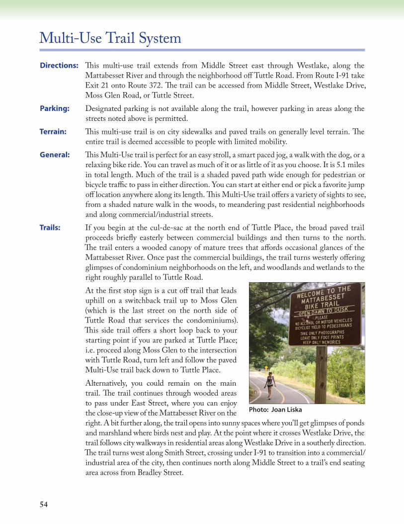
54
Multi-Use Trail SystemDirections: This multi-use trail extends from Middle Street east through Westlake, along the
Mattabesset River and through the neighborhood off Tuttle Road. From Route I-91 take Exit 21 onto Route 372. The trail can be accessed from Middle Street, Westlake Drive, Moss Glen Road, or Tuttle Street.
Parking: Designated parking is not available along the trail, however parking in areas along the streets noted above is permitted.
Terrain: This multi-use trail is on city sidewalks and paved trails on generally level terrain. The entire trail is deemed accessible to people with limited mobility.
General: This Multi-Use trail is perfect for an easy stroll, a smart paced jog, a walk with the dog, or a relaxing bike ride. You can travel as much of it or as little of it as you choose. It is 5.1 miles in total length. Much of the trail is a shaded paved path wide enough for pedestrian or bicycle traffic to pass in either direction. You can start at either end or pick a favorite jump off location anywhere along its length. This Multi-Use trail offers a variety of sights to see, from a shaded nature walk in the woods, to meandering past residential neighborhoods and along commercial/industrial streets.
Trails: If you begin at the cul-de-sac at the north end of Tuttle Place, the broad paved trail proceeds briefly easterly between commercial buildings and then turns to the north. The trail enters a wooded canopy of mature trees that affords occasional glances of the Mattabesset River. Once past the commercial buildings, the trail turns westerly offering glimpses of condominium neighborhoods on the left, and woodlands and wetlands to the right roughly parallel to Tuttle Road.
At the first stop sign is a cut off trail that leads uphill on a switchback trail up to Moss Glen (which is the last street on the north side of Tuttle Road that services the condominiums). This side trail offers a short loop back to your starting point if you are parked at Tuttle Place; i.e. proceed along Moss Glen to the intersection with Tuttle Road, turn left and follow the paved Multi-Use trail back down to Tuttle Place.
Alternatively, you could remain on the main trail. The trail continues through wooded areas to pass under East Street, where you can enjoy the close-up view of the Mattabesset River on the right. A bit further along, the trail opens into sunny spaces where you’ll get glimpses of ponds and marshland where birds nest and play. At the point where it crosses Westlake Drive, the trail follows city walkways in residential areas along Westlake Drive in a southerly direction. The trail turns west along Smith Street, crossing under I-91 to transition into a commercial/industrial area of the city, then continues north along Middle Street to a trail’s end seating area across from Bradley Street.
Photo: Joan Liska
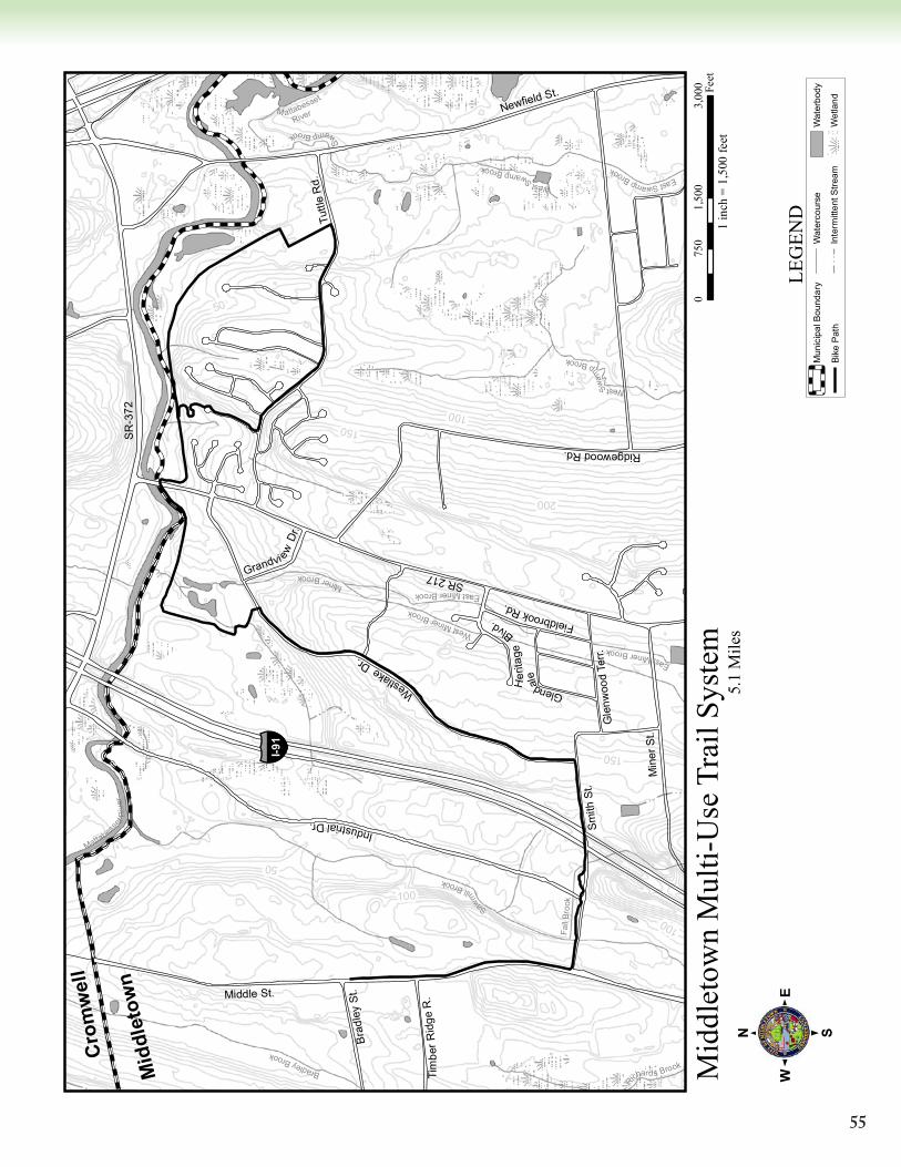
55
150
100
200
150
100
100
5050
EastSwampBrook
S
wampBrook
WestS
wampBrook
M attabesset
River
Mattabesse
t
Riv
er
Richards Brook
WestSwa
m
pBrook
Sawm
illBrook
EastMinerBrook
MinerBrook
Fall
Broo
kEastMinerBrook
BradleyBrook
WestMinerBrook
Grandvi ew
Dr.
Bra
dley
St.
FieldbrookRd.
Tim
berR
idge
R.
Glendale
Gle
nwoo
d Te
rr.
WestlakeDr.
Min
er S
t.
Newfield St.
Smith
St.
Tuttl
e R
d.
RidgewoodRd.
IndustrialDr.
SR
-372
Middle St.
Her
itage
Blvd.
SR 217
§̈ ¦I-91
Mid
dlet
own
Cro
mw
ell
Mid
dlet
own
Mul
ti-U
se T
rail
Syst
em
:0
1,50
03,
000
750
Feet
1 in
ch =
1,5
00 fe
et
Mun
icip
al B
ound
ary
Bik
e P
ath
Wat
erco
urse
Inte
rmitt
ent S
tream
Wat
erbo
dy
Wet
land
LEG
END
5.1
Mile
s
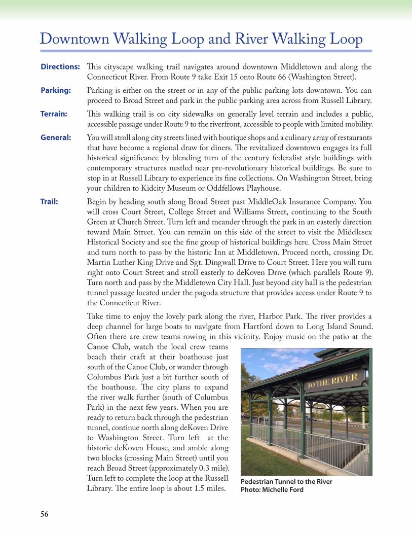
56
Downtown Walking Loop and River Walking LoopDirections: This cityscape walking trail navigates around downtown Middletown and along the
Connecticut River. From Route 9 take Exit 15 onto Route 66 (Washington Street). Parking: Parking is either on the street or in any of the public parking lots downtown. You can
proceed to Broad Street and park in the public parking area across from Russell Library.Terrain: This walking trail is on city sidewalks on generally level terrain and includes a public,
accessible passage under Route 9 to the riverfront, accessible to people with limited mobility.General: You will stroll along city streets lined with boutique shops and a culinary array of restaurants
that have become a regional draw for diners. The revitalized downtown engages its full historical significance by blending turn of the century federalist style buildings with contemporary structures nestled near pre-revolutionary historical buildings. Be sure to stop in at Russell Library to experience its fine collections. On Washington Street, bring your children to Kidcity Museum or Oddfellows Playhouse.
Trail: Begin by heading south along Broad Street past MiddleOak Insurance Company. You will cross Court Street, College Street and Williams Street, continuing to the South Green at Church Street. Turn left and meander through the park in an easterly direction toward Main Street. You can remain on this side of the street to visit the Middlesex Historical Society and see the fine group of historical buildings here. Cross Main Street and turn north to pass by the historic Inn at Middletown. Proceed north, crossing Dr. Martin Luther King Drive and Sgt. Dingwall Drive to Court Street. Here you will turn right onto Court Street and stroll easterly to deKoven Drive (which parallels Route 9). Turn north and pass by the Middletown City Hall. Just beyond city hall is the pedestrian tunnel passage located under the pagoda structure that provides access under Route 9 to the Connecticut River.
Take time to enjoy the lovely park along the river, Harbor Park. The river provides a deep channel for large boats to navigate from Hartford down to Long Island Sound. Often there are crew teams rowing in this vicinity. Enjoy music on the patio at the Canoe Club, watch the local crew teams beach their craft at their boathouse just south of the Canoe Club, or wander through Columbus Park just a bit further south of the boathouse. The city plans to expand the river walk further (south of Columbus Park) in the next few years. When you are ready to return back through the pedestrian tunnel, continue north along deKoven Drive to Washington Street. Turn left at the historic deKoven House, and amble along two blocks (crossing Main Street) until you reach Broad Street (approximately 0.3 mile). Turn left to complete the loop at the Russell Library. The entire loop is about 1.5 miles.
Pedestrian Tunnel to the River Photo: Michelle Ford
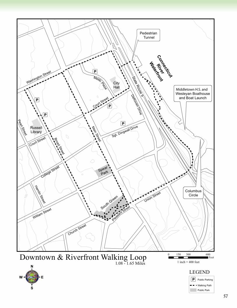
57
Æü
Æü
Æü
Æü
Æü
100
50Court Street
Pearl Street
Hamlin Street
Melilli Plaza
Pleasa
nt Street
Court Street
Broad Street
William Street
College Street
Union Street
Church Street
Washington Street
DeKovenD
rive
Sgt. Dingwall DriveMain Street
Connecticut
River
Waterfront
Downtown & Riverfront Walking Loop
:0 300 600150
Feet1 inch = 400 feet
Æü Public Parking
Walking Path
Public Park
LEGEND
1.08 - 1.65 Miles
Pedestrian Tunnel
ColumbusCircle
Wesleyan Boathouseand Boat Launch
South Green
Spear
Park
RussellLibrary
CityHall
State Route 9
Pedestrian Tunnel
Connecticut
River
Waterfront
Wesleyan Boathouseand Boat Launch
Middletown H.S. and
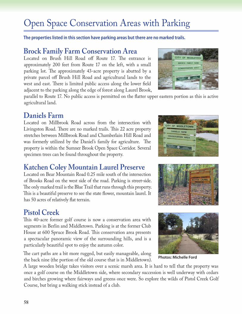
58
Open Space Conservation Areas with ParkingThe properties listed in this section have parking areas but there are no marked trails.
Brock Family Farm Conservation AreaLocated on Brush Hill Road off Route 17. The entrance is approximately 200 feet from Route 17 on the left, with a small parking lot. The approximately 43-acre property is abutted by a private parcel off Brush Hill Road and agricultural lands to the west and east. There is limited public access along the lower field adjacent to the parking along the edge of forest along Laurel Brook, parallel to Route 17. No public access is permitted on the flatter upper eastern portion as this is active agricultural land.
Daniels FarmLocated on Millbrook Road across from the intersection with Livingston Road. There are no marked trails. This 22 acre property stretches between Millbrook Road and Chamberlain Hill Road and was formerly utilized by the Daniel’s family for agriculture. The property is within the Sumner Brook Open Space Corridor. Several specimen trees can be found throughout the property.
Katchen Coley Mountain Laurel PreserveLocated on Bear Mountain Road 0.25 mile south of the intersection of Brooks Road on the west side of the road. Parking is street-side. The only marked trail is the Blue Trail that runs through this property. This is a beautiful preserve to see the state flower, mountain laurel. It has 50 acres of relatively flat terrain.
Pistol CreekThis 40-acre former golf course is now a conservation area with segments in Berlin and Middletown. Parking is at the former Club House at 600 Spruce Brook Road. This conservation area presents a spectacular panoramic view of the surrounding hills, and is a particularly beautiful spot to enjoy the autumn color.The cart paths are a bit more rugged, but easily manageable, along the back nine (the portion of the old course that is in Middletown). A large wooden bridge takes visitors over a scenic marsh area. It is hard to tell that the property was once a golf course on the Middletown side, where secondary succession is well underway with cedars and birches growing where fairways and greens once were. So explore the wilds of Pistol Creek Golf Course, but bring a walking stick instead of a club.
Photos: Michelle Ford
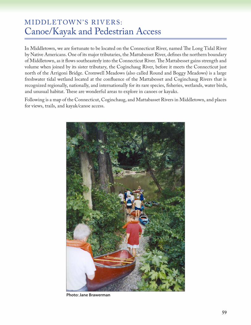
59
M IDDLE TOW N’S R IV ER S: Canoe/Kayak and Pedestrian AccessIn Middletown, we are fortunate to be located on the Connecticut River, named The Long Tidal River by Native Americans. One of its major tributaries, the Mattabesset River, defines the northern boundary of Middletown, as it flows southeasterly into the Connecticut River. The Mattabesset gains strength and volume when joined by its sister tributary, the Coginchaug River, before it meets the Connecticut just north of the Arrigoni Bridge. Cromwell Meadows (also called Round and Boggy Meadows) is a large freshwater tidal wetland located at the confluence of the Mattabesset and Coginchaug Rivers that is recognized regionally, nationally, and internationally for its rare species, fisheries, wetlands, water birds, and unusual habitat. These are wonderful areas to explore in canoes or kayaks.Following is a map of the Connecticut, Coginchaug, and Mattabasset Rivers in Middletown, and places for views, trails, and kayak/canoe access.
Photo: Jane Brawerman

60
Mattabesset River Canoe/Kayak TrailDirections: Cromwell Access: Take Route 9 to Exit 19 (Route 372/West Street). Turn west onto
West Street, and left onto Route 3 at the stoplight before Stop & Shop. Dunkin Donuts is located at 24 Shunpike Road (Rt. 3), about 0.25 miles on the left side of road. Access to the trail is from the open lot adjacent to the right side of Dunkin Donuts parking lot.
Philip Salafia Cartop Boat Launch: Take Route 9 to Exit 16. Take the first right onto North Main Street and proceed north until the road ends at Johnson Street. Turn right and the boat launch is immediately on the left.
Harbor Park Access: Take Route 9 to Exit 15 (Route 66/ Washington Street). Take an immediate left onto deKoven Drive, which parallels Route 9. Travel about 0.5 miles, and turn left at the stoplight at Union Street. Go under Route 9, turn left onto Harbor Drive, and then right into the parking area by the boathouse, next to the restaurant.
Parking: North end parking: Adjacent to Dunkin Donuts in Cromwell. Please park in the gravel lot.
Phil Salafia Cartop Boat Launch: Parking is available adjacent to the boat launch. South end parking: Harbor Park. Please park in the delineated parking spaces nearest
the boathouse.
Paddling under the railroad bridge near the confluence with the Connecticut River Photo: Pat Rasch

61
Æü
Æü
ÆüÆü
John
son
St. North Main St.
State Route 3
State Route 9
:0 1,500 3,000750
Feet1 inch = 2,000 feet
Æü Parking
Municipal Boundary
Canoe_Trail
Water
Intermittent Stream
Waterbody
Marsh
LEGEND
1.08 - 1.65 Miles
Cromwell MeadowsState Wildlife Area
Middletown
Mattabesset Canoe & Kayak Trail
Harbor Park AccessHarbor Drive
Middletown, CT
Conn
ectic
ut R
iver
Cromwell Access24 ShunpikeCromwell, CT
Philip Salafia CartopBoat Launch
Johnson Street
Wilc
ox Is
land
Mattabesset River
Cogi
ncha
ug R
iver
Cromwell
Portland
Cromwell
Cromwell Meadows State Wildlife AreaRound and Boggy Meadows

62
General: The canoe/kayak trail and accompanying guide were developed by the Connecticut River Coastal Conservation District, based in Middletown, CT, with funding from the Silvio O. Conte National Fish and Wildlife Refuge, the Long Island Sound License Plate Program, Connecticut Department of Environmental Protection, and Middlesex Community Foundation. The launch area is on the property to the south of, and adjacent to, the Dunkin Donuts parking lot on Route 3 in Cromwell. Current and prior owners have graciously allowed use of their property for public access to the river. Copies of the laminated guide are available at the Conservation District office (860-346-3282).
Trail: The Mattabesset River section of the trail is a fairly easy paddle downstream, generally suitable for novice boaters. However, when traveling on the Connecticut River, watch out for large boat traffic, strong currents, and tides. The North end access to the Mattabesset River trail begins behind the property adjacent to the Dunkin Donuts and ends at Harbor Park in Middletown. The trip time from Dunkin Donuts to Harbor Park is approximately two hours. An interpretive sign and trail guide box are located near the entrance to
the trail in Cromwell. Follow the trail to the river’s edge to launch your boat. Turn left (downstream) at the put-in spot. The canoe/kayak trail winds its way downstream from Dunkin Donuts through Cromwell Meadows, a large freshwater tidal wetland at the confluence of the Coginchaug and Mattabesset Rivers, and out to the Connecticut River to Harbor Park. The Phil Salafia Cartop Boat Launch is located approximately two miles north of Harbor Park and makes another excellent put-in or take-out location. The Dunkin Donuts launch area can be very muddy at low tide, so it is best to begin your trip during high
tide. If you plan to take out at Harbor Park, you can leave a second car there. When using the public dock at Harbor Park, please yield to any crew teams departing and arriving at the dock. If you plan to return to the upstream access areas again be aware of the tides.
Paddling from the south, the trail is a more difficult paddle against the strong currents and tides of the Connecticut River. Watch for large boat traffic until you turn into the Mattabesset River section of the trail approximately 0.5 miles north of the launch area, past the Arrigoni Bridge.
Special Note: • Children 11 years and under are required by State law to wear a personal flotation device (PFD) at all times while on a vessel. PFD usage is encouraged strongly for both children and adults. There must always be one PFD in the vessel for each person. Canoeists/kayakers must wear PFDs during cold weather months from October through May.
• Be aware that waterfowl hunters use the river and this area from mid-October through December.
• Please be mindful that this area is home to several species of endangered or threatened birds. To minimize disturbance to nesting and foraging birds, small creeks and marsh edges should be avoided.
Photo: Pat Rasch
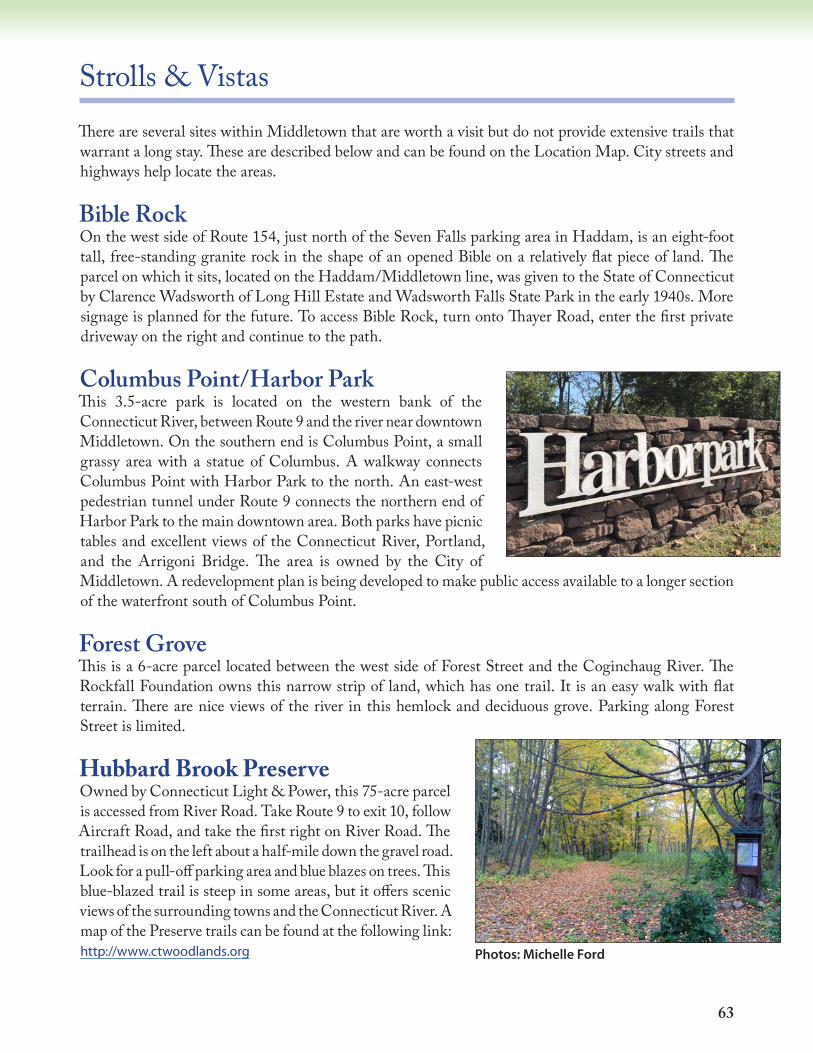
63
Strolls & VistasThere are several sites within Middletown that are worth a visit but do not provide extensive trails that warrant a long stay. These are described below and can be found on the Location Map. City streets and highways help locate the areas.
Bible RockOn the west side of Route 154, just north of the Seven Falls parking area in Haddam, is an eight-foot tall, free-standing granite rock in the shape of an opened Bible on a relatively flat piece of land. The parcel on which it sits, located on the Haddam/Middletown line, was given to the State of Connecticut by Clarence Wadsworth of Long Hill Estate and Wadsworth Falls State Park in the early 1940s. More signage is planned for the future. To access Bible Rock, turn onto Thayer Road, enter the first private driveway on the right and continue to the path.
Columbus Point/Harbor ParkThis 3.5-acre park is located on the western bank of the Connecticut River, between Route 9 and the river near downtown Middletown. On the southern end is Columbus Point, a small grassy area with a statue of Columbus. A walkway connects Columbus Point with Harbor Park to the north. An east-west pedestrian tunnel under Route 9 connects the northern end of Harbor Park to the main downtown area. Both parks have picnic tables and excellent views of the Connecticut River, Portland, and the Arrigoni Bridge. The area is owned by the City of Middletown. A redevelopment plan is being developed to make public access available to a longer section of the waterfront south of Columbus Point.
Forest GroveThis is a 6-acre parcel located between the west side of Forest Street and the Coginchaug River. The Rockfall Foundation owns this narrow strip of land, which has one trail. It is an easy walk with flat terrain. There are nice views of the river in this hemlock and deciduous grove. Parking along Forest Street is limited.
Hubbard Brook PreserveOwned by Connecticut Light & Power, this 75-acre parcel is accessed from River Road. Take Route 9 to exit 10, follow Aircraft Road, and take the first right on River Road. The trailhead is on the left about a half-mile down the gravel road. Look for a pull-off parking area and blue blazes on trees. This blue-blazed trail is steep in some areas, but it offers scenic views of the surrounding towns and the Connecticut River. A map of the Preserve trails can be found at the following link: http://www.ctwoodlands.org Photos: Michelle Ford
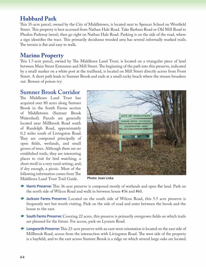
64
Hubbard ParkThis 35-acre parcel, owned by the City of Middletown, is located next to Spencer School on Westfield Street. This property is best accessed from Nathan Hale Road. Take Barbara Road or Old Mill Road to Phedon Parkway (west), then go right on Nathan Hale Road. Parking is on the side of the road, where a sign identifies the tract. This primarily deciduous wooded area has several informally marked trails. The terrain is flat and easy to walk.
Marino PropertyThis 1.7-acre parcel, owned by The Middlesex Land Trust, is located on a triangular piece of land between Main Street Extension and Mill Street. The beginning of the path into this preserve, indicated by a small marker on a white post at the trailhead, is located on Mill Street directly across from Front Street. A short path leads to Sumner Brook and ends at a small rocky beach where the stream broadens out. Beware of poison ivy.
Sumner Brook CorridorThe Middlesex Land Trust has acquired over 80 acres along Sumner Brook in the South Farms section of Middletown (Sumner Brook Watershed). Parcels are generally located near Millbrook Road south of Randolph Road, approximately 0.2 miles south of Livingston Road. They are composed principally of open fields, wetlands, and small groves of trees. Although there are no established trails, they are interesting places to visit for bird watching, a short stroll in a very rural setting, and, if dry enough, a picnic. Most of the following information comes from The Middlesex Land Trust Trail Guide.
G Harris Preserve: This 36-acre preserve is composed mostly of wetlands and open flat land. Park on the north side of Wilcox Road and walk in between house #36 and #60.
G Jackson Farms Preserve: Located on the south side of Wilcox Road, this 5.5 acre preserve is frequently wet but worth visiting. Park on the side of road and enter between the brook and the house to the east.
G South Farms Preserve: Covering 22 acres, this preserve is primarily overgrown fields on which trails are planned for the future. For access, park on Lyceum Road.
G Longworth Preserve: This 23-acre preserve with an east-west orientation is located on the east side of Millbrook Road, across from the intersection with Livingston Road. The west side of the property is a hayfield, and to the east across Sumner Brook is a ridge on which several large oaks are located.
Photo: Joan Liska
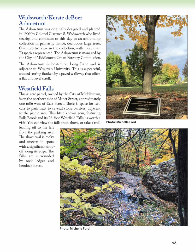
65
Wadsworth/Kerste deBoer ArboretumThe Arboretum was originally designed and planted in 1909 by Colonel Clarence S. Wadsworth who lived nearby, and continues to this day as an astounding collection of primarily native, deciduous large trees. Over 170 trees are in the collection, with more than 70 species represented. The Arboretum is managed by the City of Middletown Urban Forestry Commission.The Arboretum is located on Long Lane and is adjacent to Wesleyan University. This is a peaceful, shaded setting flanked by a paved walkway that offers a flat and level stroll.
Westfield FallsThis 4-acre parcel, owned by the City of Middletown, is on the northern side of Miner Street, approximately one mile west of East Street. There is space for two cars to park next to several stone barriers, adjacent to the picnic area. This little known gem, featuring Falls Brook and its 26-foot Westfield Falls, is worth a visit! You can view the falls from above, or take a trail leading off to the left from the parking area. The short trail is rocky and uneven in spots, with a significant drop-off along its edge. The falls are surrounded by rock ledges and hemlock forest.
Photo: Michelle Ford
Photo: Michelle Ford
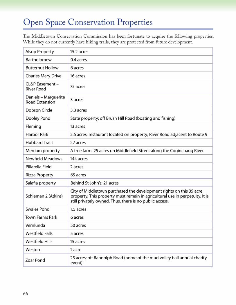
66
Open Space Conservation PropertiesThe Middletown Conservation Commission has been fortunate to acquire the following properties. While they do not currently have hiking trails, they are protected from future development.
Alsop Property 15.2 acres
Bartholomew 0.4 acres
Butternut Hollow 6 acres
Charles Mary Drive 16 acres
CL&P Easement – River Road 75 acres
Daniels – Marguerite Road Extension 3 acres
Dobson Circle 3.3 acres
Dooley Pond State property; off Brush Hill Road (boating and fishing)
Fleming 13 acres
Harbor Park 2.6 acres; restaurant located on property; River Road adjacent to Route 9
Hubbard Tract 22 acres
Merriam property A tree farm. 25 acres on Middlefield Street along the Coginchaug River.
Newfield Meadows 144 acres
Pillarella Field 2 acres
Rizza Property 65 acres
Salafia property Behind St John’s; 21 acres
Schieman 2 (Atkins)City of Middletown purchased the development rights on this 35 acre property. This property must remain in agricultural use in perpetuity. It is still privately owned. Thus, there is no public access.
Swales Pond 1.5 acres
Town Farms Park 6 acres
Vernlunda 50 acres
Westfield Falls 5 acres
Westfield Hills 15 acres
Weston 1 acre
Zoar Pond 25 acres; off Randolph Road (home of the mud volley ball annual charity event)
67
Other Conservation organizations have also contributed to the acquisition of open space properties within the City of Middletown.
Connecticut Valley Hospital State of CT; off Silver Street and Eastern Drive
Harris Preserve Owned by The Middlesex Land Trust
Higby Mt Preserve 99 acres; Public Access; owned by The Middlesex Land Trust
Jackson Farms Preserve Owned by The Middlesex Land Trust
Longworth Preserve Owned by The Middlesex Land Trust
Shailer Ledges Preserve
Owned by The Middlesex Land Trust Located in Maromas (bounded on the west by Maromas Road, on the south by Aircraft Road, on the east by Pratt & Whitney property and on the north by CL&P power lines); 22 +/- acres of steep outcroppings, ledges, enclosing deep ravines; best access is from old River Road climbing in easterly direction to the south-western terminus of the property. A loop trail is planned. CAUTION: steep climb
South Farms Preserve Owned by The Middlesex Land Trust – Lyceum Road
Wesleyan Woods property Owned by The Nature Conservancy
Art: Patrick Derosier

68
Birding Checklist Following is a list of 168 birds that may be found along Middletown trails in varied habitats.W winter resident; S summer resident; M migrant; U uncommon; (no symbol is year-round resident)
Alder Flycatcher S
American Bittern S
American Black Duck American Crow American Goldfinch American Kestrel American Redstart S
American Robin American Tree Sparrow W
American Woodcock S
Bald Eagle Bank Swallow S
Barn Swallow S
Barred Owl Belted Kingfisher Black Vulture Black-and-white Warbler S
Black-billed Cuckoo S U
Black-capped Chickadee Blackpoll Warbler M
Black-throated Blue Warbler S
Black-throated Green Warbler S
Blue-gray Gnatcatcher S
Blue Jay Blue-winged Teal M
Blue-winged Warbler S
Bobolink S
Broad-winged Hawk M S
Brown Creeper Brown-headed Cowbird Brown Thrasher Bufflehead W
Canada Goose Canada Warbler S U
Carolina Wren Cedar Waxwing Chestnut-sided Warbler S
Chimney Swift S
Chipping Sparrow S
Common Grackle
Common Loon W
Common Merganser M
Common Nighthawk M S
Common Raven Common Redpoll U
Common Snipe M
Common Tern S
Common Yellowthroat Cooper’s Hawk Dark-eyed Junco W
Double-crested Cormorant Downy Woodpecker Eastern Bluebird Eastern Kingbird S
Eastern Meadowlark S
Eastern Phoebe S
Eastern Screech-Owl Eastern Wood-Pewee S
Evening Grosbeak W
European Starling Field Sparrow S
Fish Crow Fox Sparrow Golden-crowned Kinglet Golden Eagle W U
Gray Catbird Great Cormorant W
Great Black-backed Gull Great Blue Heron Great Crested Flycatcher S
Great Egret Great Horned Owl Green-backed Heron Green-winged Teal S
Hairy Woodpecker Hermit Thrush S
Herring Gull Hooded Merganser M
Hooded Warbler S U
Horned Lark
69
____ House Finch____ House Sparrow____ House Wren S____ Indigo Bunting S____ Killdeer____ Laughing Gull S____ Least Flycatcher S____ Least Tern S____ Louisiana Waterthrush S____ Mallard____ Marsh Wren____ Merlin____ Mourning Dove____ Mute Swan____ Northern Cardinal____ Northern Flicker____ Northern Harrier____ Northern Mockingbird____ Northern Oriole (“Baltimore”)____ Northern Parula S____ Northern Pintail M____ N. Rough-wing Swallow S____ Northern Waterthrush M ____ Olive-sided Flycatcher M ____ Orchard Oriole S____ Osprey S____ Ovenbird S____ Palm Warbler M____ Peregrine Falcon____ Pied-billed Grebe____ Pileated Woodpecker____ Pine Warbler S____ Prairie Warbler S____ Purple Finch____ Purple Martin S____ Red-bellied Woodpecker____ Red-breasted Merganser M____ Red-breasted Nuthatch____ Red Crossbill U____ Red-eyed Vireo S____ Red-shouldered Hawk____ Red-tailed Hawk____ Red-throated Loon W____ Red-winged Blackbird____ Ring-billed Gull
____ Ring-necked Duck M____ Ring-necked Pheasant____ Rock Dove____ Rose-breasted Grosbeak S____ Ruby-crowned Kinglet____ Ruby-throated Hummingbird S____ Ruffed Grouse____ Rufous-sided Towhee____ Tufted Titmouse____ Saw-whet Owl U____ Scarlet Tanager S____ Sharp-shinned Hawk____ Snow Bunting W____ Snow Goose U____ Snowy Egret S____ Solitary Vireo S____ Song Sparrow____ Sora S____ Spotted Sandpiper S____ Swamp Sparrow____ Tree Swallow____ Turkey Vulture____ Veery S____ Virginia Rail____ Warbling Vireo S____ Whip-poor-will S____ White-breasted Nuthatch____ White-crowned Sparrow S M____ White-eyed Vireo S____ White-throated Sparrow____ Wild Turkey____ Willow Flycatcher S____ Wilson’s Warbler S U____ Winter Wren____ Wood Duck S____ Wood Thrush S____ Worm-eating Warbler S____ Yellow-bellied Sapsucker____ Yellow-billed Cuckoo S U____ Yellow-breasted Chat S U____ Yellow-rumped Warbler____ Yellow-throated Vireo S____ Yellow Warbler S
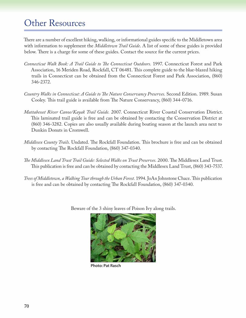
70
Other ResourcesThere are a number of excellent hiking, walking, or informational guides specific to the Middletown area with information to supplement the Middletown Trail Guide. A list of some of these guides is provided below. There is a charge for some of these guides. Contact the source for the current prices.
Connecticut Walk Book: A Trail Guide to The Connecticut Outdoors. 1997. Connecticut Forest and Park Association, 16 Meriden Road, Rockfall, CT 06481. This complete guide to the blue-blazed hiking trails in Connecticut can be obtained from the Connecticut Forest and Park Association, (860) 346-2372.
Country Walks in Connecticut: A Guide to The Nature Conservancy Preserves. Second Edition. 1989. Susan Cooley. This trail guide is available from The Nature Conservancy, (860) 344-0716.
Mattabesset River Canoe/Kayak Trail Guide. 2007. Connecticut River Coastal Conservation District. This laminated trail guide is free and can be obtained by contacting the Conservation District at (860) 346-3282. Copies are also usually available during boating season at the launch area next to Dunkin Donuts in Cromwell.
Middlesex County Trails. Undated. The Rockfall Foundation. This brochure is free and can be obtained by contacting The Rockfall Foundation, (860) 347-0340.
The Middlesex Land Trust Trail Guide: Selected Walks on Trust Preserves. 2000. The Middlesex Land Trust. This publication is free and can be obtained by contacting the Middlesex Land Trust, (860) 343-7537.
Trees of Middletown, a Walking Tour through the Urban Forest. 1994. JoAn Johnstone Chace. This publication is free and can be obtained by contacting The Rockfall Foundation, (860) 347-0340.
Beware of the 3 shiny leaves of Poison Ivy along trails.
Photo: Pat Rasch

71
Links to Outdoor Resources and Conservation Organizations
Biodiversity Database http://biodiversity.wesleyan.edu/index.php
Connecticut Forest & Park Association
(860) 346-2372www.ctwoodlands.org
Connecticut River Coastal Conservation District
(860) 346-3282www.conservect.org/ctrivercoastal
Connecticut River Watershed Council
(860) 704-0557www.ctriver.org
CT Department of Energy and Environmental Protection (DEEP)
www.ct.gov/deep
Jonah Center For Earth and Art
(860) 398-3771www.thejonahcenter.org
The Nature Conservancy (203) 568-6270www.nature.org
The Middlesex Land Trust (860) 343-7537www.middlesexlandtrust.org
Middletown Parks Division
(860) 638-4520cityofmiddletown.com (go to “Departments” tab)
Middletown Recreation Division
(860) [email protected] (go to “Departments” tab)
Natural Resources Conservation Service (NRCS), an agency of the United States Department of Agriculture
The field office for the Middletown area is located in Norwich, CT. (860) 887-3604http://www.nrcs.usda.gov/wps/portal/nrcs/site/ct/home/
Other websites and resources:
http://nemo.uconn.edu/
http://nemo.udel.edu/assessments.aspx
http://nemo.udel.edu/manual/AppendixAWeb.pdf
http://www.centerharbornh.org/nri2009.pdf
http://files.dnr.state.mn.us/assistance/nrplanning/community/nrig/
fullguide/howinv.html
http://www.greenvalleyinstitute.org/conservation_resource.htm
http://extension.unh.edu/resources/representation/Resource000215_
Rep233.pd

72
MID
DL
ET
OW
N P
AR
KS
DIV
ISIO
N
Park
s & O
pen
Spac
es
Accessible
Electricity
Reservable Area
Picnic Facilities
Tennis
Playground
Basketball
Little League Field
Soccer Field
Football Field
Baseball Field
Softball Field
Fishing
Swimming
Boating
Ice Skating
Hiking Trails
Hist. Monuments
Bathrooms
Open Space
Als
op P
rop
erty
N
ewfie
ld S
tree
t 15
.2 a
c
X
Bart
holo
mew
Pro
per
ty
Bart
holo
mew
Roa
d 0.
4 ac
X
Butt
ernu
t Hol
low
Bu
tter
nut S
tree
t 5.
9 ac
X
X
X
X
Colu
mbu
s Po
int
Har
bor
Driv
e 0.
75 a
cX
X
X
X
X
Dob
son
Circ
le
Den
ison
Roa
d 3.
3 ac
X
Don
ovan
Par
k St
ack
Stre
et
2.25
ac
X
X
XX
X
Gui
da C
onse
rvat
ion
Are
a Co
lem
an R
oad
100
ac
X
X
Har
bor
Par
k H
arb
or D
rive
2.6
acX
X
X
X
X
Hub
bar
d Pa
rk L
ittle
Lea
gue
East
Mai
n St
reet
3.
5 ac
XX
X
Hub
bar
d Tr
act
Wes
tfiel
d St
reet
22
ac
X
Mar
zale
k Pa
rk
Mid
dlefi
eld
Stre
et
0.5
ac
McC
arth
y Pa
rkH
otch
kiss
Str
eet
2.4
ac
X
X
McC
utch
eon
Park
Livi
ngst
on R
oad
104.
6 ac
XX
XX
X
X
X
XX
X
X
XX
McC
utch
eon
Wild
life
Sanc
.Li
ving
ston
Roa
d 29
.7 a
c
X
X
Mid
dlet
own
Nat
ure
Gar
den
Rand
olph
Roa
d 17
.9 a
cX
X
X
New
field
Mea
dow
s M
ile L
ane
144
ac
X
Palm
er F
ield
Be
rnie
O’R
ourk
e D
r. 6.
7 ac
XX
X
X
X
Pat K
idne
y Fi
eld
Farm
Hill
Roa
d 9
acX
X
X
X
X
X
X
X
Pilla
rella
Fie
ld
Kap
lan
Driv
e 2.
1 ac
X
X

73
MID
DL
ET
OW
N P
AR
KS
DIV
ISIO
N
Park
s & O
pen
Spac
es
Accessible
Electricity
Reservable Area
Picnic Facilities
Tennis
Playground
Basketball
Little League Field
Soccer Field
Football Field
Baseball Field
Softball Field
Fishing
Swimming
Boating
Ice Skating
Hiking Trails
Hist. Monuments
Bathrooms
Open Space
Ravi
ne P
ark
Hig
hlan
d A
venu
e 8.
8 ac
X
X
X
X
Roos
evel
t Par
k M
iller
Str
eet
2 ac
X
Smith
Par
k *
Coun
try
Club
Roa
d 80
ac
X
XX
X
XX
X
X
X
XX
Spea
r Par
k M
ain
Stre
et
2.2
acX
X
X
X
Swal
es P
ond
Wad
swor
th S
tree
t 1.
5 ac
X
X
Tow
n Fa
rms
Park
Ri
ver R
oad
6 ac
X
X
Tyna
n M
emor
ial P
ark
Hig
by R
oad
30.2
ac
X
X
Uni
on P
ark
at S
outh
Gre
en
Mai
n St
reet
1.
3 ac
XX
X
Vete
ran’
s M
emor
ial P
ark
New
field
Str
eet
41 a
cX
XX
X
X
X
X
X
X
Vete
ran’
s M
emor
ial G
reen
Was
hing
ton
Stre
et
3.3
ac
X
Wes
tfiel
d Fa
lls
Min
er S
tree
t 2
ac
X
Wilc
ox Is
land
Conn
ectic
ut R
iver
16
.5 a
c
X
Will
e Pe
p S
kate
boa
rd P
ark
deKo
ven
Driv
e 0.
25 a
c
X
Zoar
s Po
nd
Rand
olph
Roa
d 24
.7 a
c
X
X

74
Notes:
���������������������������������������������������������������������������������������������������������������������������
���������������������������������������������������������������������������������������������������������������������������
���������������������������������������������������������������������������������������������������������������������������
���������������������������������������������������������������������������������������������������������������������������
���������������������������������������������������������������������������������������������������������������������������
���������������������������������������������������������������������������������������������������������������������������
���������������������������������������������������������������������������������������������������������������������������
���������������������������������������������������������������������������������������������������������������������������
���������������������������������������������������������������������������������������������������������������������������
���������������������������������������������������������������������������������������������������������������������������
���������������������������������������������������������������������������������������������������������������������������
���������������������������������������������������������������������������������������������������������������������������
���������������������������������������������������������������������������������������������������������������������������
���������������������������������������������������������������������������������������������������������������������������
���������������������������������������������������������������������������������������������������������������������������
���������������������������������������������������������������������������������������������������������������������������
���������������������������������������������������������������������������������������������������������������������������
���������������������������������������������������������������������������������������������������������������������������
���������������������������������������������������������������������������������������������������������������������������
���������������������������������������������������������������������������������������������������������������������������
���������������������������������������������������������������������������������������������������������������������������