Embed Size (px)
Citation preview
Page 29
3. General lanD use anD reDevelopment conceptsThe purpose of this section of the Redevelopment Plan is to explain
the rationale behind the key land use, circulation and redevelopment
recommendations, and to illustrate the potential of the plan. The
illustrations, including plans, perspective views and other designs are
illustrative only and are subject to change and refinement as the plan
is implemented.
3.1 Plan Concept and Strategy
In order to achieve the vision, goals and objectives for downtown, the
Redevelopment Plan is based on the concept of converting, where
feasible, existing surface parking lots to mixed-use development
supported by structured parking. This “infill” development is designed
to improve retail continuity, add larger retail spaces that can improve
retail diversity, add downtown housing, and add to downtown’s
parking supply. The plan also recommends relocating the Department
of Public Works facility, an incompatible land use, from downtown to
a new facility elsewhere in the Township. In addition, the plan provides
a new outdoor civic space and relocates Town Hall in order to provide
a needed new facility and to create a key redevelopment opportunity
in the heart of downtown, and the site of existing Town Hall. Once
successfully completed, the new development is expected to revitalize
downtown as a shopping and living destination, and spur additional
private revitalization efforts.
Page 30
140
150
160
160150
140
140
140
140
150
150
150
160
160
160
130
Essex Street
Millburn Avenue
Taylor Street
Church Street
Old
Short Hills Road
Do
ug
las Street
Sprin
g Street
Blain
e Street
Hawthorne Road
Whitingham
TerraceLackaw
anna PlaceGlen Avenue
Taylor Park
Main
Street
Millburn Station
in St
0
61606160160150150
140140
Glen Avenue
Glen Avenue
Glen Avenue
GlenGlen Av
Millburn Avenue
Taylor Streetor Stre
Taylor Streaylor Saylor Strr S eetre
Church Street
Church Street
Church Streeth S
Do
ug
las Streetg
Blain
e StreetB
li
Stt
Bl
iSt
teee
Hawthorne Road
Hawthorne Road
Hawthorne Roadd
th
d
wtRo
h
Whitingham
Terrace
WWhitingham
Terrac
Whitingham
Terrace
mT
Whitingham
Terrace
hitingham Terrace
Whitingham
TerraceTerra
W
am T
Whitingham
Terrace
W
Lackawanna Place
ackawanna Placee
aackawanna Place
nna Pnna P
kna
ac
Taylor ParkTay arkark
onnnMillburn llburn Statiillburn Sn SM ationatioatioatio
0 50 100 200 300 400 500
N
Downtown District Redevelopment Plan
Millburn, NJ
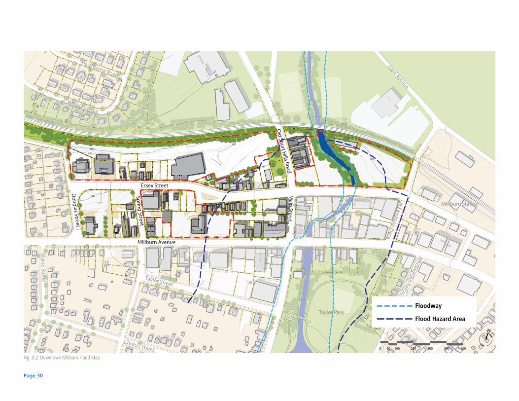
Fig. 3.2: Downtown Millburn Flood Map
Floodway
Flood Hazard Area
Page 31
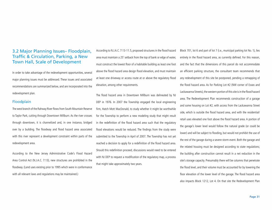
3.2 Major Planning Issues– Floodplain, Traffic & Circulation, Parking, a New Town Hall, Scale of Development
In order to take advantage of the redevelopment opportunities, several
major planning issues must be addressed. These issues and associated
recommendations are summarized below, and are incorporated into the
redevelopment plan.
Floodplain
The west branch of the Rahway River flows from South Mountain Reserve
to Taylor Park, cutting through Downtown Millburn. As the river crosses
through downtown, it is channelized and, in one instance, bridged
over by a building. The floodway and flood hazard area associated
with this river represent a development constraint within parts of the
redevelopment area.
According to the New Jersey Administrative Code’s Flood Hazard
Area Control Act (N.J.A.C. 7:13), new structures are prohibited in the
floodway. (Land uses existing prior to 1995 which were in conformance
with all relevant laws and regulations may be maintained.)
According to N.J.A.C. 7:13-11.5, proposed structures in the flood hazard
area must maintain a 25’ setback from the top of bank or edge of water,
must construct the lowest floor of a habitable building as least one foot
above the flood hazard area design flood elevation, and must maintain
at least one driveway or access route at or above the regulatory flood
elevation, among other requirements.
The flood hazard area in Downtown Millburn was delineated by NJ
DEP in 1976. In 2007 the Township engaged the local engineering
firm, Hatch Mott MacDonald, to study whether it might be worthwhile
for the Township to perform a new modeling study that might result
in the redefinition of the flood hazard area such that the regulatory
flood elevations would be reduced. The findings from the study were
submitted to the Township in April of 2007. The Township has not yet
reached a decision to apply for a redefinition of the flood hazard area.
Should this redefinition proceed, discussions would need to be entered
with NJ DEP to request a modification of the regulatory map, a process
that might take approximately two years.
Block 701, lot 6 and part of lot 7 (i.e., municipal parking lot No. 1), lies
entirely in the flood hazard area, as currently defined. For this reason,
and the fact that the dimensions of this parcel do not accommodate
an efficient parking structure, the consultant team recommends that
any redevelopment of this site be postponed, pending a remapping of
the flood hazard area. As for Parking Lot #2 (NW corner of Essex and
Lackawanna Streets), the western portion of this site is in the flood hazard
area. The Redevelopment Plan recommends construction of a garage
and some housing on Lot #2, with access from the Lackawanna Street
side, which is outside the flood hazard area, and with the residential/
retail uses elevated one foot above the flood hazard area. A portion of
the garage’s lower level would follow the natural grade (or could be
lower) and will be subject to flooding, but would not prohibit the use of
the rest of the garage during a severe storm event. Both the garage and
the related housing must be designed according to state regulations;
the building after construction cannot result in a net reduction in the
site’s storage capacity. Presumably there will be columns that penetrate
the flood level, and their volume must be accounted for by lowering the
floor elevation of the lower level of the garage. The flood hazard area
also impacts Block 1212, Lot 4. On that site the Redevelopment Plan
Page 32
Fig. 3.4: Existing circulation in Downtown Millburn
140
150
160
160150
140
140
140
140
150
150
150
160
160
160
130
0
61606160160150150
140140
Essex Street
Millburn Avenue
Taylor Street
Church Street
Old
Short Hills Road
Do
ug
las Street
Sprin
g Street
Blain
e Street
Hawthorne Road
Whitney Road
Glen Avenue
Taylor Park
Main
Street
Millburn Station
Whi
tingh
am T
erra
ce
Lack
awan
na P
lace
0 50 100 200 300 400 500
NDowntown District Redevelopment Plan
Millburn, NJ
A
A
B
B
Page 33
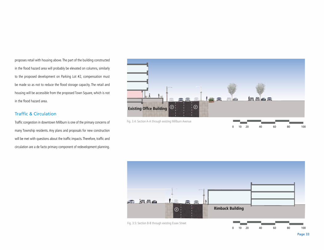
proposes retail with housing above. The part of the building constructed
in the flood hazard area will probably be elevated on columns, similarly
to the proposed development on Parking Lot #2, compensation must
be made so as not to reduce the flood storage capacity. The retail and
housing will be accessible from the proposed Town Square, which is not
in the flood hazard area.
Traffic & Circulation
Traffic congestion in downtown Millburn is one of the primary concerns of
many Township residents. Any plans and proposals for new construction
will be met with questions about the traffic impacts. Therefore, traffic and
circulation are a de facto primary component of redevelopment planning.
P P
P
0 10 20 40 60 80 100
0 10 20 40 60 80 100
Fig. 3.4: Section A-A through existing Millburn Avenue
Fig. 3.5: Section B-B through existing Essex Street
Existing Offce Building
Rimback Building
Page 34
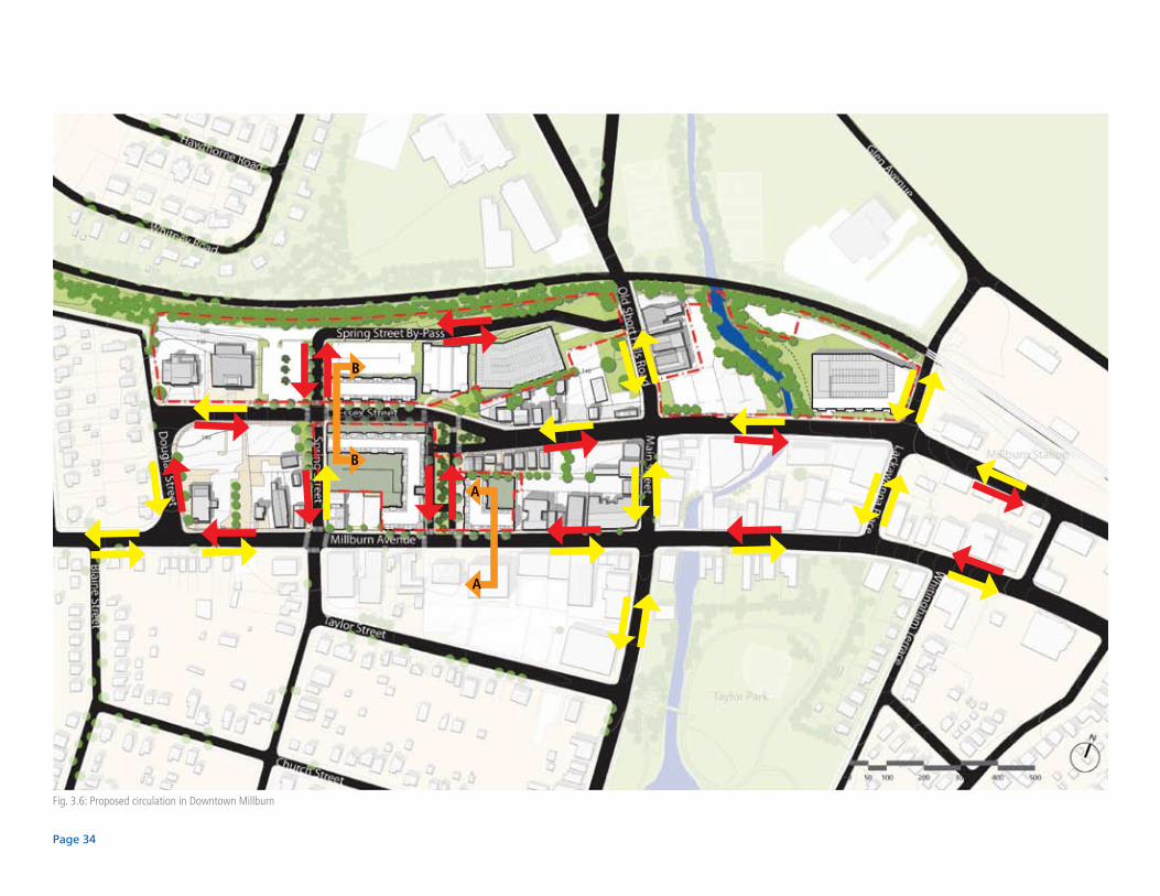
Fig. 3.6: Proposed circulation in Downtown Millburn
A
A
B
B
Page 35
In preparing the redevelopment plan, the consultants were made aware
of a number of concerns related to downtown traffic and circulation.
These concerns include:
Traffic congestion.•
The speed of traffic, particularly on Millburn Avenue •
and Essex Street, Old Short Hills Road and the
difficulty pedestrians face crossing these streets.
Questions about whether the one-way traffic •
circulation on Millburn Avenue and Essex Street
should be returned to two-way circulation.
The need for access by the Fire Department to Old •
Short Hills Road via the rear of the municipal DPW
site when Main Street between Millburn Avenue
and Essex Street is closed for special events.
The large size of the block where Town Hall •
is currently located, which limits circulation
options between Millburn Avenue and Essex
Street and encourages drivers to use the
parking lot for this purpose.
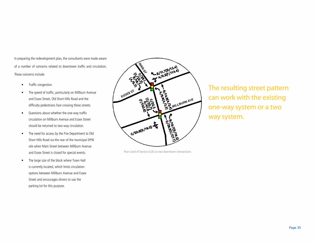
Poor Level of Service (LOS) at two downtown intersections
The resulting street pattern can work with the existing one-way system or a two way system.

Page 36
Fig. 3.7: Section A-A through redeveloped Millburn Avenue
Fig. 3.8: Section B-B through redeveloped Essex Street
P P
P P
26’ 12’8’ 8’13’
102’
13’22’
12’ 8’ 8’12’
64’
12’ 12’
0 10 20 40 60 80 100
0 10 20 40 60 80 100
Existing Offce Building New Mixed-Use Building
New Mixed-Use BuildingNew Residential Building

Page 37
In response to these concerns the consultants examined a number of
alternative street patterns in relation to the redevelopment parcels. The
recommended circulation system adds new streets to the existing street
grid to provide circulation options, and to redistribute and calm traffic.
The resulting street pattern can work with the existing one-way system
or a two-way system. The plan recommends the extension of Spring
Street to the north of Essex Street through the redevelopment area, to
connect with a new east-west street on the north side of the existing
DPW site. This street will intersect with Main Street, providing a new
circulation option for downtown traffic and direct access for the Fire
Department to Short Hills Road and the northern part of the Township.
The plan also adds a wide street with a central median between Essex
Street and Millburn Avenue. This street, with a right-of-way of 100 feet,
will provide 18 feet wide sidewalks, on-street parking and a broad
median that will be designed to accommodate public events, such as
fairs, outdoor markets and festivals, when the street is closed. This new
wide street is referred to in the plan as Millburn’s new “Town Square”
and is intended to provide the Township with a new civic focal point.
Existing Proposed Two-Way CirculationFig. 3.9
Page 38
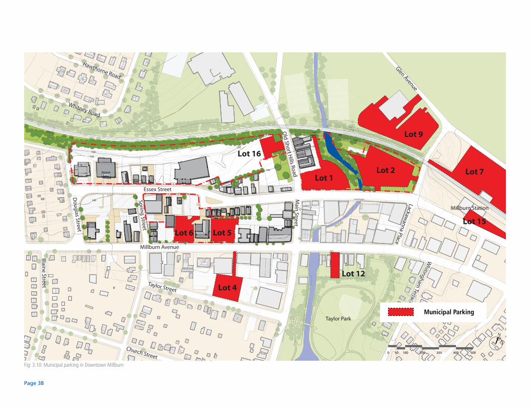
Fig: 3.10: Municipal parking in Downtown Millburn
140
150
160
160150
140
140
140
140
150
150
150
160
160
160
130
0
61606160160150150
140140
Essex Street
Millburn Avenue
Taylor Street
Church Street
Old
Short Hills Road
Do
ug
las Street
Sprin
g Street
Blain
e Street
Hawthorne Road
Whitney Road
Whitingham
TerraceLackaw
anna PlaceGlen Avenue
Taylor Park
Main
Street
Millburn Station
Lot 1
Lot 4
Lot 5Lot 6
Lot 7
Lot 9
Lot 12
Lot 15
Lot 16
Lot 2
0 50 100 200 300 400 500
N
Downtown District Redevelopment Plan
Millburn, NJ
Municipal Parking

Page 39
Parking
Shortages of all types of parking affect Downtown Millburn. Commuter
parking in Municipal Lots 1, 2, 7, 9, and 15 are filled to capacity during the
weekdays, leaving few spaces available for transit users looking to travel
to New York City after the morning rush hour. Currently, Municipal Lot 7
provides valet parking to accommodate the high demand for commuter
parking spaces. Of these commuter parking lots, Lots 1 and 2 are in the
redevelopment area. Other Municipal Lots in the redevelopment area
are Lots 5, 6 and 16. These surface lots serve retail customers as well as
employees and patrons of Town Hall.
A perceived lack of parking for retail customers is one of the main factors
that limit retail growth in Downtown Millburn. Parking, therefore, is a
major consideration in creating a successful business environment in
the downtown. A study by Maser Consulting (completed October of
2007) shows that parking lots at or near capacity increase Downtown
traffic congestion – vehicles circling lots or waiting in lots for a open
parking space impede the progress of other vehicles in the lot and this
on occasion spill out onto the street. Hence, parking, or the lack thereof,
is closely related to traffic congestion.
Met
ered
Par
king
Sta
lls
Bus
ines
s P
erm
it S
talls
Bus
ines
s S
talls
Res
iden
tial O
nly
Sta
lls
Per
mit
Sta
lls
Mun
icip
al S
talls
Com
mut
er S
talls
Vale
t Sta
lls
Libr
ary
Sta
lls
All
Day
Par
king
Sta
lls
Offi
ce O
nly
Sta
lls
Tota
l
Municipal Parking Lot 1 65 50 115
Municipal Parking Lot 2 76 52 39 7 174
Municipal Parking Lot 4 31 28 59
Municipal Parking Lot 5 58 14 13 85
Municipal Parking Lot 6 56 56
Municipal Parking Lot 7 355 70 425
Municipal Parking Lot 9 47 35 20 9 111
Municipal Parking Lot 12 15 15
Municipal Parking Lot 15 13 16 29
Municipal Parking Lot 16 27 27
Table 3.1: Municipal parking inventory in Downtown Millburn
A perceived lack of parking for retail customers is one of the main factors that prohibit retail growth in Downtown Millburn.
Page 40
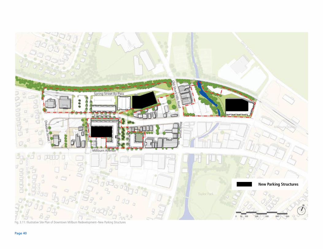
Fig. 3.11: Illustrative Site Plan of Downtown Millburn Redevelopment–New Parking Structures
New Parking Structures
Page 41
In recognition of the shortage of commuter parking near the Millburn
Train Station, in 2008 the Township established a committee to address
this specific issue. Most of the commuter parking is located on lots on the
north side of the NJ Transit rail line, outside of the redevelopment area.
Since the majority of the land within the designated redevelopment
area is currently used for surface parking, any additional development
on these sites will require replacement of the surface parking through
construction of parking garages. These garages must also accommodate
additional parking needed to support the additional development. Also,
the garages can be designed to add to the existing downtown parking
inventory to relieve the perceived shortage of parking.
The redevelopment plan recommends construction of three parking
structures: on the site of the existing DPW yard, on the site of existing
Town Hall, and on existing municipal lot No. 2. Each garage is planned
to be an “open” garage in order to eliminate the cost of for mechanical
ventilation. The first garage will provide replacement parking for the
surface lots adjacent to existing Town Hall. It is a two-level structure
that can take advantage of the site’s topography and thereby eliminate
the need for garage ramps. Because development of the other sites
in the redevelopment area will temporarily remove existing surface
parking, construction of this garage is viewed as a first step that will
allow clearance of the existing Town Hall site for redevelopment.
The garage on the site of existing Town Hall will be designed to
accommodate the needs of the development program on this site, and
will be “wrapped” by development that faces the new Town Square and
Essex Street. Access to this garage will be from Spring Street. The garage
on the site of existing municipal lot No. 2 will also have multiple levels and
be “wrapped” by development that faces Lackawanna Place and Essex
Street. This garage is programmed to replace the existing surface parking,
to accommodate parking related to new on-site development, and to
accommodate approximately 100 additional spaces to serve downtown.

Page 42
A New Town Hall
The Township of Millburn’s existing Town Hall is inadequate for current
needs and the Township plans to replace it. The current Town Hall does
not meet the requirements of the Americans for Disabilities Act and
does not meet other contemporary standards. Identifying a suitable
site for a new Town Hall within the Redevelopment Area was one of
the considerations of the Redevelopment Plan. After evaluating several
alternatives, the site of the existing DPW building was selected as the
preferred location for a new Town Hall. Construction of a new Town
Hall and adjacent replacement parking on the DPW site as a first phase
project will allow clearance and redevelopment of the existing Town Hall
and related parking so that redevelopment of that site (and adjacent
properties, including the site of the former Rimback Storage Building)
can take place.
Existing Millburn Town Hall building

Page 43
Scale of Development
One of the goals of redevelopment is to retain downtown Millburn’s
small-town character, and to create an environment that is pedestrian-
friendly. One of the issues in relation to this goal is the height of
downtown’s buildings, which currently range from one to four and a
half stories, varying in height from 15’ to 52’. Achieving an economically
feasible plan must be balanced with density of development, which is
also related to building height. The plan includes a variety of building
heights, ranging from two to four stories, in keeping with the scale of
existing downtown. The maximum building height of four stories is based
on a ground level of retail space with three levels of housing above. The
apparent height of such a building can be reduced by setbacks and use
of a mansard roof on the top floor, so that the top floor appears as a
steeply pitched roof.
Existing office building on Millburn Avenue is 52.4 feet tall
Page 44
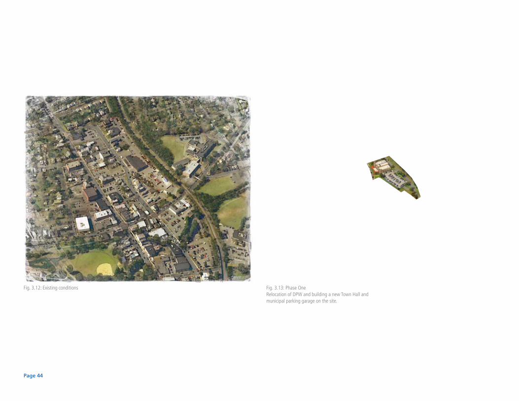
Fig. 3.12: Existing conditions Fig. 3.13: Phase OneRelocation of DPW and building a new Town Hall and municipal parking garage on the site.
Page 45
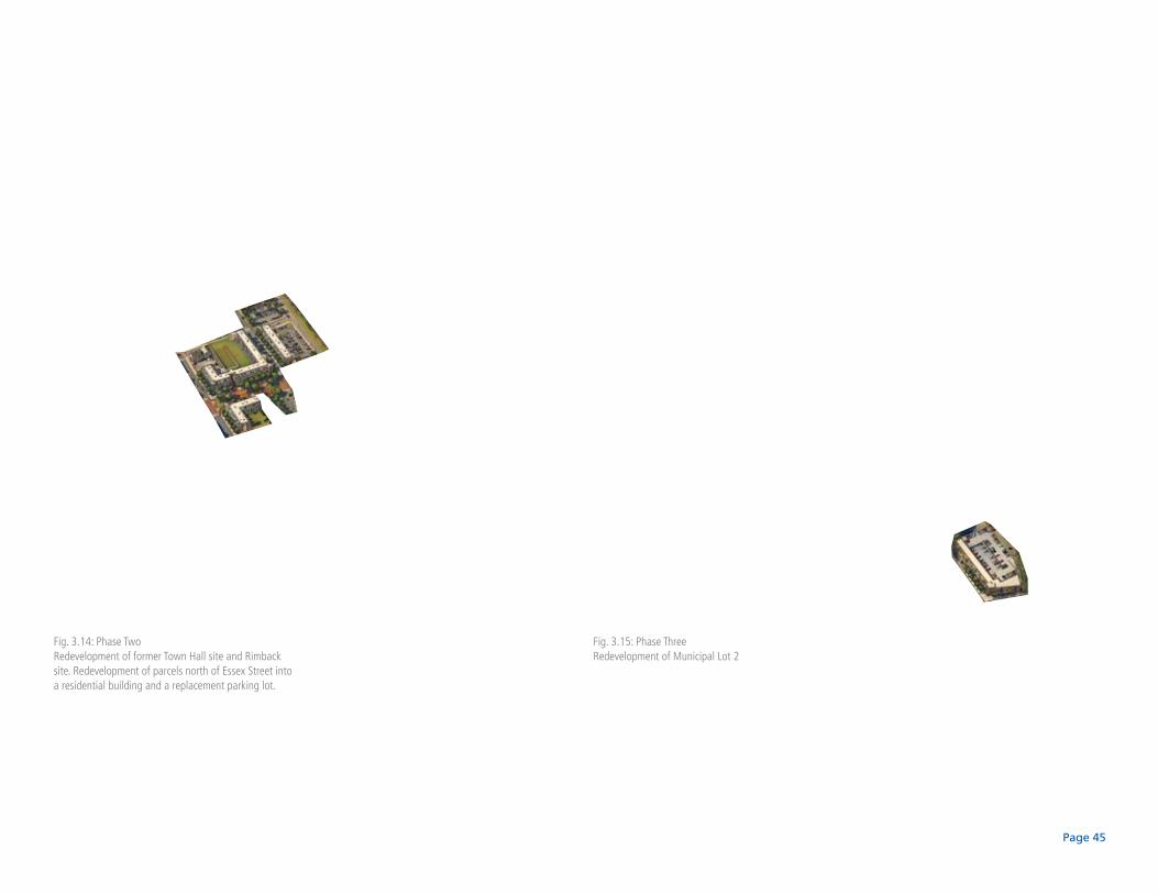
Fig. 3.14: Phase TwoRedevelopment of former Town Hall site and Rimback site. Redevelopment of parcels north of Essex Street into a residential building and a replacement parking lot.
Fig. 3.15: Phase ThreeRedevelopment of Municipal Lot 2
Page 46
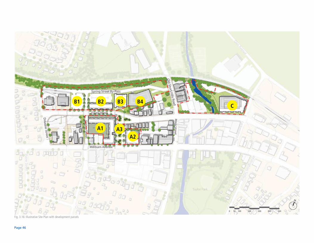
Fig. 3.16: Illustrative Site Plan with development parcels
A1
A2A3
B1 B2 B3 B4C
Page 47
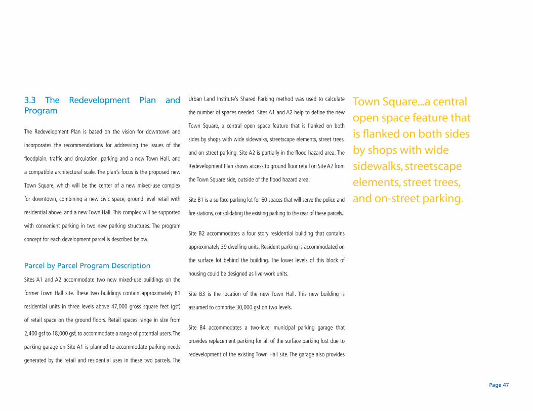
3.3 The Redevelopment Plan and Program
The Redevelopment Plan is based on the vision for downtown and
incorporates the recommendations for addressing the issues of the
floodplain, traffic and circulation, parking and a new Town Hall, and
a compatible architectural scale. The plan’s focus is the proposed new
Town Square, which will be the center of a new mixed-use complex
for downtown, combining a new civic space, ground level retail with
residential above, and a new Town Hall. This complex will be supported
with convenient parking in two new parking structures. The program
concept for each development parcel is described below.
Parcel by Parcel Program Description
Sites A1 and A2 accommodate two new mixed-use buildings on the
former Town Hall site. These two buildings contain approximately 81
residential units in three levels above 47,000 gross square feet (gsf)
of retail space on the ground floors. Retail spaces range in size from
2,400 gsf to 18,000 gsf, to accommodate a range of potential users. The
parking garage on Site A1 is planned to accommodate parking needs
generated by the retail and residential uses in these two parcels. The
Urban Land Institute’s Shared Parking method was used to calculate
the number of spaces needed. Sites A1 and A2 help to define the new
Town Square, a central open space feature that is flanked on both
sides by shops with wide sidewalks, streetscape elements, street trees,
and on-street parking. Site A2 is partially in the flood hazard area. The
Redevelopment Plan shows access to ground floor retail on Site A2 from
the Town Square side, outside of the flood hazard area.
Site B1 is a surface parking lot for 60 spaces that will serve the police and
fire stations, consolidating the existing parking to the rear of these parcels.
Site B2 accommodates a four story residential building that contains
approximately 39 dwelling units. Resident parking is accommodated on
the surface lot behind the building. The lower levels of this block of
housing could be designed as live-work units.
Site B3 is the location of the new Town Hall. This new building is
assumed to comprise 30,000 gsf on two levels.
Site B4 accommodates a two-level municipal parking garage that
provides replacement parking for all of the surface parking lost due to
redevelopment of the existing Town Hall site. The garage also provides
Town Square...a central open space feature that is flanked on both sides by shops with wide sidewalks, streetscape elements, street trees, and on-street parking.
Page 48
36 additional spaces. Due to a change in topography at this site, the
Plan assumes that a two-level parking garage can be built relatively
inexpensively – without the construction of interior ramps. Access to the
two levels will be at two separate locations.
Site C accommodates a new mixed-use building that contains
approximately 36 residential units and 2,400 gsf (gross square feet)
of retail space. An attached parking garage will provide parking for the
proposed program as well as replacement parking for spaces displaced
by the redevelopment. Site C is constrained by the river to the west, the
existing flood hazard area, and a NJ Transit sub-station easement to
the north. The proposed retail space, garage entrance/exit and lobby for
the housing units above are located outside the flood hazard area, on
the east side of the parcel. The floor levels of all proposed housing are
located above the flood hazard elevation.
Fig. 3.17: Close-up of Town Square (shown with two-way circulation)
10,000 gsfretail
18,000 gsfretail
4,000 gsfretail
2,400 gsfretail
3,600 gsfretail
3,600 gsfretail
C C
New Town Hall
Millburn Ave.
Essex Street
Site A1
Site A2
New Municipal Parking Garage
Page 49
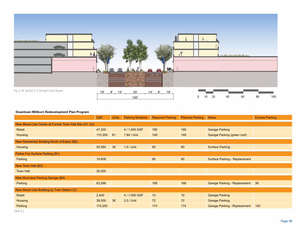
Downtown Millburn Redevelopment Plan Program
GSF Units Parking Multiplier Required Parking Planned Parking Notes Excess Parking
New Mixed-Use Center at Former Town Hall Site (A1, A2)
Retail 47,330 4 / 1,000 GSF 190 190 Garage Parking
Housing 115,359 81 1.84 / Unit 149 149 Garage Parking (green roof)
New Residential Building North of Essex (B2)
Housing 55,584 39 1.5 / Unit 60 60 Surface Parking
Police Fire Surface Parking (B1)
Parking 19,608 60 60 Surface Parking - Replacement
New Town Hall (B3)
Town Hall 30,000
New Municipal Parking Garage (B4)
Parking 63,268 168 168 Garage Parking - Replacement 36
New Mixed-Use Building by Train Station (C)
Retail 2,400 4 / 1,000 GSF 10 10 Garage Parking
Housing 38,500 36 2.0 / Unit 72 72 Garage Parking
Parking 115,200 174 174 Garage Parking - Replacement 100
14’ 18’8’ 8’20’
100’
14’18’
0 10 20 40 60 80 100
Fig. 3.18: Section C-C through Town Square
Table 3.2

Page 50
3.4 Financial / Economic Model
Although the preparation of an economic or feasibility analysis of the
Redevelopment Plan is not required by the Local Redevelopment and
Housing Law, N.J.S.A. 40A:12A-1 et seq., or published case law, the
Township of Millburn desired to exceed the minimum requirements
of the law and have an economic analysis prepared. As part of the
redevelopment plan, Robert B. Pauls, LLC, Real Estate and Planning
Consultants, conducted a preliminary economic analysis of the project to
help shape the development program to ensure, to the extent possible,
that the project would be feasible and financially attractive to both the
development community and to the Township. Although the economic
model will need to be refined during the negotiation process between
the Township and one or more developers, the preliminary results of the
analysis suggest that the proposed redevelopment plan is feasible and
will be attractive to both potential developers and to the Township.
...the proposed redevelopment plan is feasible and will be attractive to both potential developers and to the Township.
Total New Retail: 49,730 gsfTotal New Housing: 156 unitsTotal New Parking: 481 spacesTotal Replacement Parking: 402 spacesTotal Excess Parking: 136 spaces

Page 51
Fig. 3.19: Rendering of Town Square (looking north from Millburn Avenue)

Page 52
Existing Essex Street (looking west)

Page 53
Fig. 3.20: Rendering of Essex Street looking west (shown with two-way traffic circulation)
Page 54
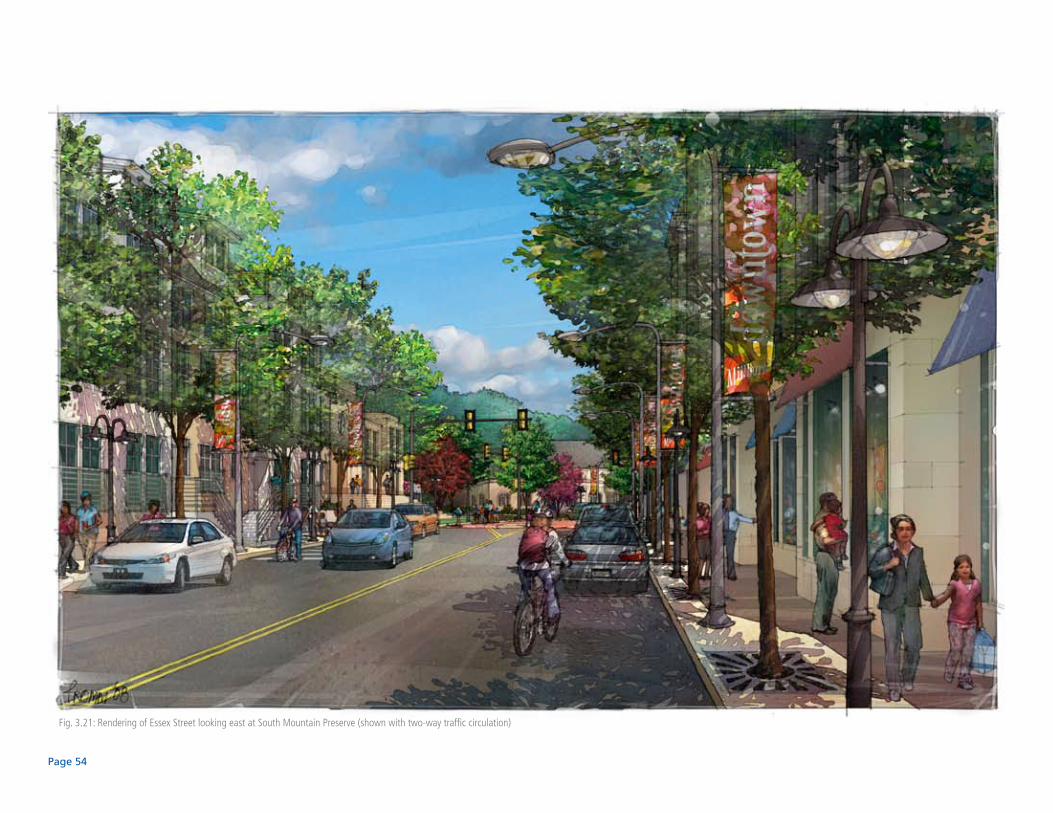
Fig. 3.21: Rendering of Essex Street looking east at South Mountain Preserve (shown with two-way traffic circulation)
Page 55
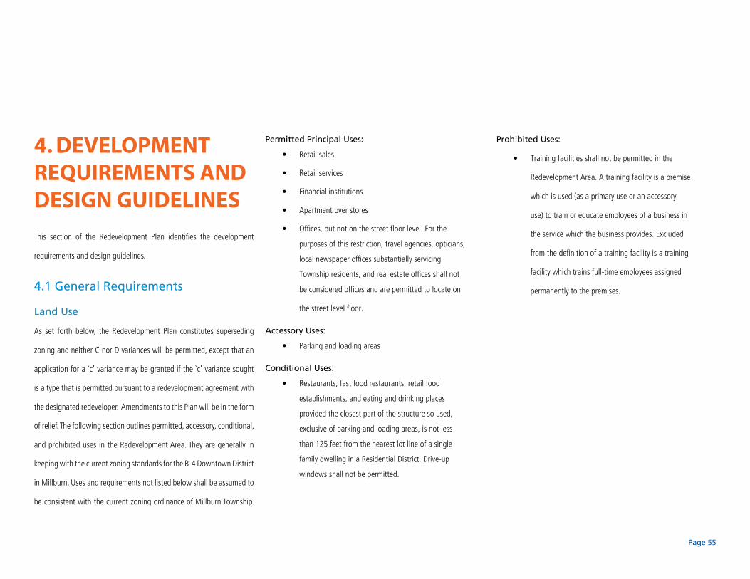
4. Development reQuirements anD DesiGn GuiDelines
This section of the Redevelopment Plan identifies the development
requirements and design guidelines.
4.1 General Requirements
Land Use
As set forth below, the Redevelopment Plan constitutes superseding
zoning and neither C nor D variances will be permitted, except that an
application for a `c’ variance may be granted if the `c’ variance sought
is a type that is permitted pursuant to a redevelopment agreement with
the designated redeveloper. Amendments to this Plan will be in the form
of relief. The following section outlines permitted, accessory, conditional,
and prohibited uses in the Redevelopment Area. They are generally in
keeping with the current zoning standards for the B-4 Downtown District
in Millburn. Uses and requirements not listed below shall be assumed to
be consistent with the current zoning ordinance of Millburn Township.
Permitted Principal Uses:
Retail sales•
Retail services•
Financial institutions•
Apartment over stores•
Offices, but not on the street floor level. For the •
purposes of this restriction, travel agencies, opticians,
local newspaper offices substantially servicing
Township residents, and real estate offices shall not
be considered offices and are permitted to locate on
the street level floor.
Accessory Uses:
Parking and loading areas•
Conditional Uses:
Restaurants, fast food restaurants, retail food •
establishments, and eating and drinking places
provided the closest part of the structure so used,
exclusive of parking and loading areas, is not less
than 125 feet from the nearest lot line of a single
family dwelling in a Residential District. Drive-up
windows shall not be permitted.
Prohibited Uses:
Training facilities shall not be permitted in the •
Redevelopment Area. A training facility is a premise
which is used (as a primary use or an accessory
use) to train or educate employees of a business in
the service which the business provides. Excluded
from the definition of a training facility is a training
facility which trains full-time employees assigned
permanently to the premises.

Page 56
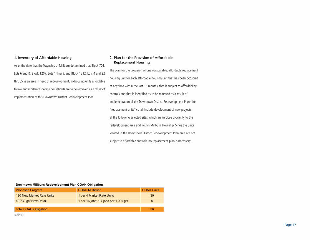
Affordable Housing Element
To the extent that any redevelopment project impacts the Township’s
obligation to provide low and moderate-income housing, that obligation
shall be the responsibility of the Redeveloper. Preliminary calculations
for total COAH required units generated from this redevelopment plan
have been made. They are shown in the table on the following page.
Assembly Bill A500 passed both Houses of the New Jersey Legislature
on June 23, 2008 and was signed into law by Governor Corzine on July
17, 2008. A500 requires that a redevelopment plan include (i) as of the
date of the adoption of the resolution finding the area to be in need of
redevelopment, an inventory of all affordable housing units that are to be
removed as a result of implementation of the redevelopment plan; and (ii) a
plan for the provision, through new construction or substantial rehabilitation
of one comparable, affordable replacement housing unit for each affordable
housing unit that has been occupied at any time within the last 18 months,
that is subject to affordability controls and that id identified as to be removed
as a result of implementation of the redevelopment plan.
The following subsections (1) and (2) satisfy the affordable housing
“inventory” and “replacement unit plan” requirements of this law.
Bulk Requirements
All buildings within the Redevelopment Area, with the •
exception of Town Hall, shall have zero (0) setback
from the sidewalk for a minimum of 90% of its
facade, except that the building setback at the street
corner may be up to10 feet from the sidewalk.
The rear setback shall be abundantly landscaped with •
vegetation and otherwise buffered, particularly near
residential areas.
Minimum number of stories: two (2).•
Maximum number of stories (excluding mechanical •
penthouses shall be three (3), although a building
may have an additional story that is set back as
described below:
Above the third floor, buildings shall be set back from •
the street such that:
1). For a four story building, the top floor shall be set •
back ten (10) feet from the front façade or designed
as a full height mansard roof in order to reduce the
apparent height of the building.
2). In order to create distinctive civic landmarks, •
buildings may include a tower feature at building
entrances or the corners of the building. This feature
is not required to have a setback at the top floor. The
combined width of all tower features for any building
shall not be greater than 35% of the length of the
lot-line they face or 30 feet, whichever is less.
Parking, Signs, and Maintenance
Parking, signage, and maintenance are regulated per •
the current Township ordinances, except as follows:
Off-street parking spaces shall be 9 feet by 18 feet, •
and in the case of 90 degree parking, one-way and
two-way aisles can be a minimum of 20 feet to a
maximum of 24 feet.
Minimum parking requirements for residential units •
over 1,000 gross square feet shall be 1.5 spaces per
dwelling unit.
Parking requirements for other uses in the •
Redevelopment Area may use the Urban Land
Institute’s Shared Parking Method (ref. Shared
Parking, Second Edition, 2005) to calculate the
amount of parking required. Assumptions and results
must be approved by the Planning Board.
The primary access points to parking lots and facilities •
shall be from streets other than Millburn Avenue.
Page 57
1. Inventory of Affordable Housing
As of the date that the Township of Millburn determined that Block 701,
Lots 6 and &; Block 1207, Lots 1 thru 9; and Block 1212, Lots 4 and 22
thru 27 is an area in need of redevelopment, no housing units affordable
to low and moderate income households are to be removed as a result of
implementation of this Downtown District Redevelopment Plan.
Downtown Millburn Redevelopment Plan COAH ObligationProposed Program COAH Multiplier COAH Units
120 New Market Rate Units 1 per 4 Market Rate Units 30
49,730 gsf New Retail 1 per 16 jobs; 1.7 jobs per 1,000 gsf 6
Total COAH Obligation: 36
2. Plan for the Provision of Affordable Replacement Housing
The plan for the provision of one comparable, affordable replacement
housing unit for each affordable housing unit that has been occupied
at any time within the last 18 months, that is subject to affordability
controls and that is identified as to be removed as a result of
implementation of the Downtown District Redevelopment Plan (the
“replacement units”) shall include development of new projects
at the following selected sites, which are in close proximity to the
redevelopment area and within Millburn Township. Since the units
located in the Downtown District Redevelopment Plan area are not
subject to affordable controls, no replacement plan is necessary.
Table 4.1

Page 58
Fig. 4.1: Illustrative Site Plan with development parcels
A1
A2A3
B1 B2 B3 B4C
Page 59
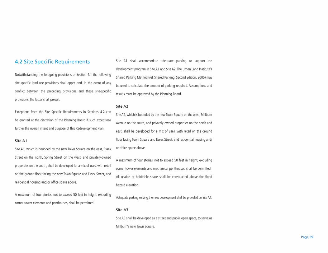
4.2 Site Specific Requirements
Notwithstanding the foregoing provisions of Section 4.1 the following
site-specific land use provisions shall apply, and, in the event of any
conflict between the preceding provisions and these site-specific
provisions, the latter shall prevail.
Exceptions from the Site Specific Requirements in Sections 4.2 can
be granted at the discretion of the Planning Board if such exceptions
further the overall intent and purpose of this Redevelopment Plan.
Site A1
Site A1, which is bounded by the new Town Square on the east, Essex
Street on the north, Spring Street on the west, and privately-owned
properties on the south, shall be developed for a mix of uses, with retail
on the ground floor facing the new Town Square and Essex Street, and
residential housing and/or office space above.
A maximum of four stories, not to exceed 50 feet in height, excluding
corner tower elements and penthouses, shall be permitted.
Site A1 shall accommodate adequate parking to support the
development program in Site A1 and Site A2. The Urban Land Institute’s
Shared Parking Method (ref. Shared Parking, Second Edition, 2005) may
be used to calculate the amount of parking required. Assumptions and
results must be approved by the Planning Board.
Site A2
Site A2, which is bounded by the new Town Square on the west, Millburn
Avenue on the south, and privately-owned properties on the north and
east, shall be developed for a mix of uses, with retail on the ground
floor facing Town Square and Essex Street, and residential housing and/
or office space above.
A maximum of four stories, not to exceed 50 feet in height, excluding
corner tower elements and mechanical penthouses, shall be permitted.
All usable or habitable space shall be constructed above the flood
hazard elevation.
Adequate parking serving the new development shall be provided on Site A1.
Site A3
Site A3 shall be developed as a street and public open space, to serve as
Millburn’s new Town Square.

Page 60
Fig. 4.2: Rendering of Downtown Millburn
A1
A2
A3
B1
B2
B3
B4
C

Page 61
Site B1
Site B1 shall be developed as 60 surface parking spaces for the Township
of Millburn Police and Fire Departments.
Vehicular access shall be from the proposed Spring Street By-Pass.
No curb cut shall be permitted from Essex Street.
The surface parking lot shall be adequately landscaped.
Site B2
Site B2 shall be developed for residential housing and related parking.
A maximum of four stories of housing shall be permitted.
The lower two levels of the structure may be designed as live/work units.
Site B3
Site B3 shall be developed as the new Town Hall for the Township
of Millburn.
Site B4
Site B4 shall be developed for parking to replace the approximately 168
surface parking spaces on the existing Municipal Lots 5, 6, and 16 plus
an additional 36 new spaces to serve downtown.
Access to the parking shall be from the Spring Street Bypass.
Pedestrian access shall be provided from the parking to the New Town
Hall, to the new Town Square, and to Main Street/Old Short Hills Road.
Site C
Site C shall be developed as a mixed-use project that includes ground
level retail and four levels of housing. Office space is also permitted as
an alternate to the residential component.
Site C shall accommodate adequate parking to support the development
program in Site C, plus parking to replace the approximately 174 surface
parking spaces on the existing Site C, plus 100 additional parking spaces
to serve downtown.
All retail, residential and office space shall be constructed at least one
foot above the flood hazard elevation as required by law. Access to this
space shall also be provided above the flood hazard area.
All structures shall be set back a minimum of twenty-five feet from the
top of the channel bank of the West Branch of the Rahway River.
Page 62
4.3 General Design Guidelines
This section sets forth general design guidelines to ensure that
redevelopment results in the best possible downtown environment for
Millburn. The Township is looking to achieve sustainable or “green”
urban design. The guidelines that follow are intended to result in
environmentally friendly, economically vibrant, and pedestrian-scaled
development consistent with sustainable design principles.
Exceptions from the General Design Guidelines in Sections 4.3 can
be granted at the discretion of the Planning Board if such exceptions
further the overall intent and purpose of this Redevelopment Plan or if
said exceptions are consistent with the Township’s Master Plan.
1. Green Building Certification
Currently, the most widely adopted “green” rating system in the country
is the Leadership in Energy and Environmental Design (LEED®) Green
Building Rating System®, as developed by the U.S. Green Building
Council (USGBC). The USGBC describes itself as a coalition of leaders
from across the building industry working to promote buildings that
are environmentally responsible, profitable, and healthy places to
live and work. LEED® has been adopted by many federal agencies
(including General Services Administration), states (including Arizona
and California), and many municipalities in various states throughout
the country.
According to the U.S. Green Building Council, LEED evaluates
environmental performance from a whole building perspective over a
building’s life cycle, providing a definitive standard for what constitutes
a “green building.” It is based on accepted energy and environmental
principles and strikes a balance between known established practices
and emerging concepts. LEED is a performance-oriented system in which
points are earned for satisfying performance criteria in the categories of
sustainable site development, water savings, energy efficiency, materials
Page 63
selection, and indoor environmental quality. Different levels of green
building certification are awarded by the USGBC based on the total
points earned. Therefore:
As a means of evaluating and measuring •
achievements in sustainable design, this
Redevelopment Plan encourages design, construction,
and operation of development that meet the criteria
for a LEED Silver certified rating. For more detailed
information about the requirements, resources, and
standards for LEED certified projects, visit the US
Green Building Council website at www.usgbc.org.
Detailed provisions concerning the implementation of
this goal will be set forth in any Request for Proposals
(RFP) and/or the Redevelopment Agreement to be
negotiated with the selected redeveloper(s).
2. Building Orientation
Streets are the primary open space network within any community as
well as serving as important places of commercial and civic exchange. In
order for a street to be successful it must be recognizable as a human-
scaled, comfortable place to be, so as to be inviting to pedestrians. Even
when most visitors arrive by car, every journey features some portion
that takes place on foot.
A walkable street is created through the design of the public realm,
including the sidewalks and travelway. It also requires good spatial
proportion defined by the buildings facing it. Buildings along a street
serve as the walls to the ‘outdoor room,’ providing enclosure, definition,
and visual interest to both pedestrians and motorists. When buildings
are set back from the street, behind parking lots for example, the
street ceases to be a defined space, which is one reason why many
commercial streets with this character are not comfortable for or used
by pedestrians. The following guidelines are intended to create a street
that excels at providing comfortable and convenient pedestrian access
to local businesses and a common civic realm for Millburn’s citizens
and visitors.

Page 64
In general, buildings shall be constructed to meet the •
sidewalk. The exact placement of the front wall of
the building shall create a sidewalk with a minimum
width of fifteen (15) and shall allow for the planting
of street trees. A greater setback is generally not
desired as it might dissipate pedestrian flow—
potentially weakening the street’s retail potential.
A wider sidewalk of 18’ from the curb is permitted in •
front of buildings that face the new Town Square to
allow space for outdoor cafes and dining.
Restaurants that provide temporary outdoor seating •
in the public walk shall only place tables immediately
in front of the restaurant space and shall provide
for unobstructed pedestrian traffic of ten (10) feet
between the closest edge of the tables and the curbline.
No side yard setbacks are required except those •
required to meet the current local fire code.
Sustainable commerce. Projects are encouraged to •
incorporate elements that promote goods and services
purchased from/produced in the local community so
as to enhance the social-commercial fabric of the
community.
3. Scale and Massing
The intent of these guidelines is to protect the pedestrian, human scale
of Millburn by creating buildings which establish the street as an outdoor
“room” of enclosed space, but do not overwhelm the pedestrian or
motorist in scale. Therefore:
Building volumes shall be articulated into three •
distinct vertical components — a “base”, a “middle”,
and a “top.” In order to respond to the scale of the
existing retail “bases” in Millburn, the first floor
height of new construction shall be a minimum of
twelve (12) feet.
Different uses on different floors, such as residential •
over retail, shall be expressed in the architecture of
the building. Setbacks and balconies are encouraged
because they can decrease the apparent size and
scale of a building and provide vitality to the street.
For new buildings constructed three stories or •
higher, a uniform cornice line shall be established at
approximately 35 feet above the street. New buildings
shall use architectural features to establish this
cornice line.
Page 65
Façades shall be expressed as building modules that •
do not exceed 30 feet in width, both to reduce the
apparent size of larger buildings and to set up a
rhythm in the façade that expresses the traditional
scale of commercial buildings. Architectural variety
in building material, massing, cornice height, and
window style/height/arrangement is encouraged.
This is useful to maintain pedestrian scale — larger
building modules make blocks feel much longer and
thus inhibit walkability.
4. Entrances and Fenestration
These guidelines are intended to result in safe and attractive streets that
are comfortable for walking and shopping.
Minimums of 75% of ground floors and 30% of •
upper floors shall be transparent and provide visual
access to the street. Providing windows and doors
facing the street creates the impression of “eyes on
the street.” This is desirable in order to provide good
security through passive surveillance as well as to
provide a lively atmosphere for walking. Blanked-
out storefront windows or windows which look into
unused dead space do not meet this requirement;
however attractive merchandising displays do meet
the requirement.
Consider placing building entrances at street corners. •
Having the entrance at the corner takes advantage
of merging streams of traffic for maximum visibility.
It also creates a more prominent presence at the
intersection, helping the building to be a more
memorable and distinctive landmark.
Articulate the building entrance in the façade to make •
it easily identifiable by pedestrians and motorists and
to provide architectural interest. Examples of special
Page 66
features of entrances include awnings, architectural
treatments, and a setback from the sidewalk.
Consider providing shelter at the building entrance in
order to provide a place to transition from indoors to
outdoors during inclement weather.
When separate rentable spaces are housed in the •
ground floor of any building, separate entrances onto
the sidewalk for each space are required, except when
two stores share a vestibule.
Upper floor windows directly facing onto streets •
shall be divided into individual units, rather than a
continuous “ribbon,” to enhance visual interest and
scale.
Above the first level, windows shall generally be •
oriented vertically in order to be compatible with
traditional window designs.
Windows shall be slightly recessed or project as bays •
from the main wall of the façade so as to create
texture and shadows on the façade for visual interest
as well as the perception that individual people or
activities are behind individual windows.
Consider designing brieses soleil, trellises, shallow •
balconies, or other shading devices for windows with
a southern exposure.
5. Services, Loading Areas, and Mechanical Equipment
Services are an essential component of any building, but they can be a
nuisance to surrounding neighbors and visually unattractive. These guidelines
require that building services be properly screened and located.
Trash, service, and loading areas shall not be located •
along street frontage and shall be screened from view
from public streets, open areas, residential areas and
pedestrian corridors. Trash storage areas shall be
constructed so as to accommodate trash receptacles
of the type and size permitted in the Business
Improvement District.
Rooftop mechanical units, vents, and flues shall •
be screened using parapets, pitched roof forms,
or penthouses, and located, to the extent practicable,
centrally on the building roof with screening materials
constructed of the same or similar material as the
building.
All trash, service, loading, and mechanical unit areas •
shall incorporate controls to minimize noise and odor.
Page 67
6. Parking Lots
The following guidelines describe the location and design of parking
facilities, and encourage use of shared parking facilities.
Shared parking is parking which is available to more •
than one building or land use. In general, different
types of land uses may create different demands for
parking throughout the day. For example, restaurants
may require more parking in evenings while office
buildings need parking during the day. To prevent the
wasteful duplication of parking facilities that could
serve more than one group of users, shared parking
is encouraged. When compatible land uses are within
700’ of each other, parking may be shared, reducing
the amount of parking required for each land use and
cost for development.
In general, the preferred location of parking is behind •
buildings.
Parking lots are required to have clear pedestrian •
access routes within them and to streets. Pass-
through walkways, those connecting parking located
behind buildings to the sidewalk, shall be provided
to rear parking lots and to pedestrian walks leading
to surrounding residential districts. These walks shall
have clear signs and markings for orientation and
a high degree of passive surveillance, overlooking
windows, and adequate lighting for security.
For office development of 25,000 square feet or more, •
preferred parking shall be provided for carpools/
vanpools serving building occupants. (For more
information see LEED® Sustainable Sites credit 4.)
For residential development, secure, sheltered bike •
parking shall be provided for residents.
In order to facilitate bicycle commuting, secure bicycle •
storage shall be provided at all buildings for at least
15% of building occupants. (For more information see
LEED® Sustainable Sites credit 4.)
Parking lots shall be landscaped with trees to provide •
shade with one tree for every six parking spaces.

Page 68
Subdivide surface parking lots into smaller areas •
through the use of landscaping and other visual
elements. Landscaping shall be hardy and able
to withstand soot and gas fumes.
Landscaping shall be designed to remove contaminants •
from and encourage infiltration of stormwater runoff
according to stormwater BMPs (Best Management
Practices), for example, curbs surrounding landscaped
areas should be perforated and graded to drain water
into the planted areas for filtration.
Pervious paving materials are encouraged for •
parking lots, as described in the Stormwater
Management guidelines.
In order to decrease the impervious area and increase •
the landscaped area of parking lots, 90° parking
stalls are preferred that face a landscaped area to be
designed such that the eighteen inches of parking
place depth fronting the landscaping be added to
the landscape area and protected by a wheelstop or
perforated curb. Thus instead of the standard parking
space depth of 18 feet, the parking space will be 16
feet and six inches deep, with 18 inches of turf or a thin
layer of vegetation used as a vehicle overhang area.
7. Parking Garages
Providing structured parking is an essential part of the plan. However,
parking garages can have negative impacts on the streets and property they
face. These guidelines mitigate some of the impacts of parking structures.
“Wrapping” parking structures with retail or •
residential and office uses is encouraged to screen
parking decks from the street and nearby residential
areas.
Parking structures shall display similar architectural •
quality, scale, and massing to surrounding structures
on all façades.
Parking structures shall not express sloping decks in •
the façades of the structure. Architectural elements in
the façade shall be expressed as horizontal, level lines
similar to other building uses.
Page 69
8. Public Art
Public art enriches the lives of citizens and beautifies the town.
Consider providing public art as part of redevelopment •
projects for exterior and interior applications in
publicly visible areas.
Provide public art as part of or within public spaces •
created by development.
9. Erosion Control
Construction activity can lead to soil erosion when proper precautions
are not taken. Erosion can cause property damage and lead to increased
sediment in local water bodies, reducing water quality. The following
guideline for new construction is intended to reduce erosion impacts
from redevelopment.
To minimize erosion, a sediment and erosion control •
plan is required before construction begins. This
plan shall include measures to prevent soil from
being carried off the site by wind or water and
prevent sedimentation of local water bodies. At a
minimum, the plan must conform to the United States
Environmental Protection Agency (EPA) Document No.
EPA 832/R-92-005 (September 1992), Storm Water
Management for Construction Activities, Chapter 3,
which is available online at www.epa.gov/npdes/
pubs/chap03_conguide.pdf. (For more information
see LEED® Sustainable Sites prerequisite 1.)

Page 70
10. Stormwater Management
As sites are further developed surface permeability is generally reduced,
leading to higher volumes of stormwater runoff that have to be
transported away from the site (via underground pipes) to receiving
waters. Not only does this keep local aquifers from being recharged, but
the stormwater runoff contains sediments and other contaminants that
have a negative impact on the receiving body’s water quality. (For more
information see LEED® Sustainable Sites credit 6.) However, since most
nearly all of the land in the Redevelopment Area is already developed
with buildings and paving, it may be possible to actually reduce the
amount of stormwater runoff.
A stormwater management plan that decreases the •
rate and quantity of stormwater runoff from pre-
redevelopment levels shall be implemented. Consider
installing pervious paving and green roofs. Also
consider harvesting stormwater for use in irrigation
and for flushing toilets.
Millburn encourages projects to treat stormwater •
runoff before it enters the natural drainage system.
Apply stormwater BMPs (Best Management Practices)
as outlined in Chapter 4, Part 2 (Urban Runoff), of the
EPA’s Guidance Specifying Management Measures
for Sources of Nonpoint Pollution in Coastal Waters,
January 1993 (Document No. EPA-840-B-92-002),
available online at www.epa.gov/owow/nps/MMGI.)
The use of vegetated swales, biofilters, bioretention
systems, and rain gardens are encouraged to assist
in treating runoff and to provide visually attractive
landscapes.
Page 71
11. Reducing the Urban Heat Island
The ambient air in urban environments is usually significantly warmer
(sometimes more than 10°F warmer) than the air in less developed
areas — an effect known as the urban heat island. Dark, non-reflective
surfaces absorb heat from the sun and then radiate it back to the
surrounding area. Such hotter temperatures lead to an increased need for
air conditioning, which costs money and consumes significant amounts
of energy. Current statistics show that air conditioning consumes one
sixth of all electricity used in the United States. The following guidelines
help to mitigate the formation of an urban heat island, thus reducing
operating cost for owners and tenants. At a minimum one of the
guidelines must be implemented. (For more information see LEED®
Sustainable Sites credit 7.)
Provide shade (within five years) for 30% of the site’s •
non-roof impervious surfaces.
Use light-colored/high albedo materials (reflectance •
of at least 0.3) for at least 30% of the site’s non-roof
impervious surfaces.
Place a minimum of 50% of the site’s parking spaces •
underground or covered by structured parking.
Use a paving system that is more than 50% pervious •
(open grid pervious pavers) for at least 50% of the
surface parking lot area.
Use ENERGY STAR compliant (highly reflective) and •
high emmissivity roofing material (at least 0.9 when
tested in accordance with ASTM 408) for at least 75%
of the roof surface. In addition to the operational
benefits to the building, this application helps to
extend the life span of the roof.
Use a “green” vegetative roof for at least 50% of •
the roof area. In addition to its ability to reduce
stormwater flows and provide insulation, this
application helps to extend the life span of the roof.
Page 72
12. Light Pollution
While outdoor lighting is necessary for safety and security, these results
can be achieved without letting the lighting be a nuisance. When lighting
spills over beyond the boundary where the illumination is intended it
can cause glare, light trespass and light pollution. Light pollution is
light that is directed into or reflected into the sky where it reflects off
dust, debris, and water vapor, causing an effect known as “sky glow.”
Light pollution limits the visibility of the night sky and compromises
nocturnal environments and astronomical research. To improve the
quality of lighting and reduce light pollution and light trespass, projects
shall meet the following requirements. (For more information see LEED®
Sustainable Sites credit 8.)
Do not exceed the light levels and meet the uniformity •
ratios that are recommended by the Illuminating
Engineering Society of North America (IESNA)
Recommended Practice Manual: Lighting for Exterior
Environments (RP-33-99).
Provide shielding for external luminaires with more •
than 1000 initial lamp lumens to limit the amount
of light that is emitted or reflected at or above the
horizontal plane (90°), and emit no direct uplight.
Use IESNA designation “full cutoff” external •
luminaires for lamps with more than 3500 initial lamp
lumens so zero light is emitted or reflected at or above
the horizontal plane (90°).
Interior lighting shall not be directed to fall outdoors.•
Exterior lighting shall be directed and shielded so no •
measurable light crosses the property boundary.
When signs are lit, they should be lit from •
above, rather than below, to direct spillover light
to the ground.
Page 73
13. Energy Efficiency
According to the U.S. Department of Energy reports, buildings consume
approximately 40% of the energy and 70% of the electricity produced
in the United States. Seventy percent of the nation’s energy is produced
by burning fossil fuels, which are non-renewable resources and a major
source of pollution. The following guidelines are intended to reduce the
demand for energy brought on by redevelopment.
Buildings shall be designed to exceed by 15% the •
state energy code or the most recent edition of
ASHRAE/IESNA Standard 90.1 (without amendments),
whichever is more stringent. (For more information
see LEED® Energy & Atmosphere prerequisite 2
and credit 1.)
Building owners are encouraged to provide a portion •
of the total energy used by a building with on-site
renewable sources, such as photovoltaic systems.
(For more information see LEED® Energy &
Atmosphere credit 2.)
14. Water Efficiency
Water is a limited resource that requires money and raw materials for
treatment, both before and after use. The following guidelines help
decrease the amount of municipal water needed for buildings.
Consider installing native plants and xeriscaping •
so the amount of irrigation necessary is minimized.
Decrease the quantity of potable water used for
landscape irrigation by 50%. (For more information
see LEED® Water Efficiency credit 1.)
Install ultra low flow fixtures in bathrooms, and •
consider reusing roof runoff volumes for flushing
toilets in order to reduce the amount of potable water
required. (For more information see LEED® Water
Efficiency credit 3.)

Page 74
15. Materials
Building materials must be created and transported. Those processes
consume natural resources and energy, and pollute the air and water.
The environmental impact of the building materials used shall be limited
as much as possible. The following materials guidelines ensure quality
environments that help decrease the environmental impact of the
materials needed for buildings.
Façades of buildings and site structures shall be •
constructed of or faced with high quality, natural
brick, stone, cast stone or wood. Variety in building
material is encouraged. Strict compliance with
these requirements will not be required where, in
the discretion of the Planning Board, other façade
materials are appropriate. Notwithstanding the
foregoing, the façade materials prohibited under
current Township code shall not be permitted.
Divert as much construction waste away from disposal •
in landfills as possible. There are many markets for
recycling construction materials including metal,
wood, concrete, brick, drywall, and cardboard.
(For more information see LEED® Materials &
Resources credit 2.)
Incorporate building materials that contain a high •
percentage of recycled content. (For more information
see LEED® Materials & Resources credit 4.)
Incorporate building materials that have been •
manufactured and, where possible extracted,
regionally. Using regional products not only reduces
the amount of energy required for transportation,
but it also supports the local economy.
(For more information see LEED® Materials &
Resources credit 5.)
Incorporate bio-based building materials where •
possible. This includes materials incorporating certified
wood, bamboo, wool, cotton, cork, natural linoleum,
agricultural fiber boards, etc. (For more information
see LEED® Materials & Resources credit 6 & 7.)
Limit the amount of indoor air contaminants that •
are introduced through building materials where
possible. Materials, including adhesives, sealants,
paints, and carpets, with lower VOC values shall be
preferred over standard versions. Materials made of
wood and agricultural fiber shall contain no added
urea-formaldehyde.
(For more information see LEED® Indoor nvironmental
Quality credit 4.)

Page 75
16. Accessibility
All redevelopment projects shall comply with federal, state and local
requirements regarding handicap accessibility.
Page 76
5. implementation
5.1 Relationship to Zoning
The proposed land use in the Millburn Downtown District Redevelopment
Plan includes all the use categories currently permitted in the B-4 Central
Business Zone, plus additional land uses identified in this plan. The
zoning is superseded by this Redevelopment Plan, and all development
and redevelopment in the Millburn Downtown Redevelopment Area
shall be governed by the land use provisions and design guidelines
contained herein.
5.2 Redeveloper Selection
The Township intends to undertake a redeveloper selection process
that will provide a qualified designated redeveloper to implement
the Redevelopment Plan in a manner that is in the best interest of
the Township.
In order to assure that the vision of the Redevelopment Plan will be
successfully implemented in an effective and timely way in order to
achieve the public purpose goals of the Plan, the Township Committee,
as the redevelopment entity, will select the redeveloper(s) for any
redevelopment project. Establishment of the Township Committee as
the redevelopment entity has not yet been determined.
The selected redeveloper(s) will be required to execute a redevelopment
agreement with the Township of Millburn.
It is anticipated that the implementation of this Redevelopment Plan will
require a competitive selection of one or more redeveloper(s). In order
to achieve successful implementation of this Redevelopment Plan, the
Township Committee will have the ability to select the most appropriate
redeveloper(s) for projects based upon a competitive selection process.
Under a competitive selection process, an applicant for selection as a
redeveloper must submit materials to the Township Committee that
specify their qualifications, financial resources, experience and design
approach to the property in question. The competitive selection process
is recommended to include the submission of some or all of the following
Page 77
materials (additional submission materials may be requested by the
Township Committee as deemed appropriate to the lands in question):
Conceptual plans and elevations sufficient in scope to •
demonstrate that the design approach, architectural
concepts, number and type of dwelling units, parking,
traffic circulation, landscaping, recreation space and
other elements are consistent with the objectives and
standards of this Redevelopment Plan
Anticipated construction schedule, including •
estimated pre-construction time period to secure
permits and approvals
Documentation evidencing the financial responsibility •
and capability with respect to carrying out the
proposed redevelopment and/or including, but not
limited to: type of company or partnership, disclosure
of ownership interest, list of comparable projects
successfully completed, list of references, list of any
general or limited partners, and financial profile of the
redeveloper
The Township Committee may, at any time, entertain an unsolicited
proposal from a prospective redeveloper for redevelopment of one
or more redevelopment parcels. The Township Committee may also
proactively solicit potential redevelopers by utilizing appropriate
methods of advertisement and written communication.
The following restrictions and controls on redevelopment are hereby
imposed in connection with the selection and designation of a redeveloper
for any property or properties included in the Redevelopment Plan and
shall apply notwithstanding the provisions of any zoning or building
ordinance or other regulations now or hereafter in force.
The designated redeveloper will be obligated to carry 1.
out the specified improvements in accordance with
the Redevelopment Plan and any redevelopment
agreement that is executed by the Township and
the designated redeveloper. The Township shall
not designate a redeveloper in the absence of a
memorandum of understanding or a redevelopment
agreement with the redeveloper that is satisfactory to
the Township.

Page 78
The designated redeveloper shall redevelop in 2.
accordance with the uses and buildings requirements
specified in the Redevelopment Plan.
Until the required improvements are completed and 3.
a Certificate of Completion is issued, the designated
redeveloper covenants set forth at N.J.S.A. 40A:12A-9
and imposed in any redeveloper agreement, lease,
deed or other instruments shall remain in full force
and effect.
5.3 Site Plan and Subdivision Review
Any subdivision of lots and parcels of land within the Redevelopment
Area shall be in accordance with the requirements of this plan and the
site plan and subdivision ordinance of the Township of Millburn.
The Millburn Township Committee acting as the Redevelopment
Entity shall review all proposed redevelopment projects within the
redevelopment area to ensure that such project(s) is consistent with
the Redevelopment Plan and relevant redeveloper agreement(s). Such
review shall occur prior to the submission of the redevelopment project(s)
to the Planning Board. As part of its review, the Redevelopment Entity
may require the redeveloper to also submit its proposed project to a
technical review committee or subcommittee of the Redevelopment
Entity. The technical review committee may include members of the
Redevelopment Entity and any other members and/or professionals
as determined necessary and appropriate by the Township Committee.
The technical review committee shall make its recommendations to the
Redevelopment Entity.

Page 79
In undertaking its review, the Redevelopment Entity shall determine
whether the proposal is consistent with this Redevelopment Plan and
relevant redeveloper agreement(s). All applications submitted to a land
use board for the development or redevelopment of property, or any
portion thereof, situated in the Downtown District Redevelopment Plan
shall be deemed incomplete unless the applicant is the designated
redeveloper and there is a prior determination by the Township
Committee that the plan set forth in the application by the designated
redeveloper is consistent with this Redevelopment Plan, together with
any amendments to the Redevelopment Plan.
No deviations from the terms and requirements of this Redevelopment
Plan, including the granting of ‘d’ or ‘c’ variances shall be granted by
any land use board, except that an application for a `c’ variance may be
granted if the `c’ variance sought is a type that is permitted pursuant
to a redevelopment agreement with the designated redeveloper. Any
proposed changes to the Redevelopment Plan shall be in the form of
an amendment to the Redevelopment Plan adopted by the Millburn
Township Committee in accordance with the procedures set forth in the
Local Redevelopment and Housing Law.
5.4 Provisions Related to Off-Site
Improvements
The designated redeveloper(s) shall be responsible for its fair share of any
installation or upgrade of infrastructure related to their project whether
on-site or off-site. Infrastructure items include but are not limited to
gas, electric, water, sanitary and storm sewers, telecommunications,
recreation or open space, streets, curbs, sidewalks, street lighting
and street trees or other improvements. The extent of the designated
redeveloper’s responsibility will be outlined in the redeveloper’s
agreement with the Township.
All infrastructure improvements shall comply with applicable local, state
and federal codes including the Americans With Disabilities Act. All
utilities shall be placed underground.
Page 80
5.5 Provisions Relating to State and
Federal Regulations
Certain redevelopment activities proposed in this plan may be subject
to state and federal standards, regulations and permit requirements. The
redeveloper is responsible for ensuring compliance with all applicable
standards and obtaining necessary state and federal permits.
Any revisions to plans previously approved by the Planning Board must
also be submitted to the Planning Board for approval. This pertains
to revisions or additions prior to, during, and after completion of the
improvements.
5.6 Acquisition and Relocation
The identification of property within the redevelopment area which is
proposed to be acquired in accordance with the Redevelopment Plan
is as follows:
Block 1207: Lots 1, 2, 3, 4, 5, 6, 7, 8, 9
Block 1212: Lots 4, 22, 23, 24, 25, 26, 27
Block 701: Lots 6, 7
The Township may sell, lease, or otherwise convey to a designated
redeveloper for redevelopment, subject to restrictions, controls and
requirements of the Redevelopment Plan, all or any of the properties
designated in need of redevelopment that it owns or may acquire.
Page 81
No property in the Redevelopment Area may be acquired through the
filing of a Declaration of Taking and deposit of estimated compensation
with the clerk of the Court under the Eminent Domain Act of 1971,
N.J.S.A. 20:3-1 et seq,, unless the Township has first engaged in bona
fide negotiations with the property owner as required by N.J.S.A. 20:3-6.
To the extent that residents or businesses in the Redevelopment Area are
displaced as a result of the acquisition of property adequate provision
for the temporary and permanent relocation of such residents or
businesses, as necessary, shall be made in accordance with all applicable
regulations along with other relocation assistance as required by law.
A Workable Relocation Assistance Plan (“WRAP”) shall be submitted
to the Department of Community Affairs for review and approval in
accordance with the requirements of N.J.A.C. 5:11-1.1 et seq. Written
offers to property owners for the purpose of engaging in bona fide
negotiations shall not occur without the submission of the WRAP to
the Department of Community Affairs. No relocation shall occur without
prior approval of the WRAP by the Department of Community Affairs.
5.7 Designation of Redevelopment Entity and Redeveloper
The Township Committee for the Township of Millburn shall be the
designated Redevelopment Entity under the Local Redevelopment and
Housing Law (N.J.S.A. 40A: 12A-1 et seq.) and shall be responsible for the
selection of the redeveloper and reaching a redevelopment agreement.
5.8 Severability
The provisions of this Redevelopment Plan are subject to approval by
Ordinance. If a Court of competent jurisdiction finds any word, phrase,
clause, section, or provision of this Redevelopment Plan to be invalid,
illegal, or unconstitutional, the word, phrase, clause, section, or provision
shall be deemed severable, and the remainder of the Redevelopment
Plan and implementing Ordinance shall remain in full force and effect.
Page 82
References
Redevelopment Area Study for Portions of Block 701, 1207 and 1212
in Downtown Millburn, Essex County, New Jersey.
Phillips Preiss Shapiro Associates, Inc. December 2006.
Downtown Millburn Master Plan.
Downtown Millburn Development Alliance. Buckhurst Fish & Jacquemart, Inc.
Robert C. Pauls, LLC. November 2000.
Township of Millburn Master Plan.
Queale & Lynch, Inc. Updated December 1997.
Downtown Millburn Traffic Study & Analysis.
Maser Consulting. July 8th, 2007.
Municipal Parking Lot Study & Analysis for Township of Millburn.
Maser Consulting. October 10th, 2007.
Shared Parking.
Urban Land Institute. 2005.
Who Lives in New Jersey Housing? New Jersey Demographic Multipliers.
Rutgers University Center for Urban Policy Research. November 2006.
Acknowledgements
The consultant team would like to thank the following individuals whose
guidance and feeback helped shaped this document.
Michael Gorman Millburn Township Planning Board Chair
Ken Leiby Millburn Township Planning Board Vice Chair
Saul Spivack Millburn Township Planning Board
Richard Metsky Redevelopment Plan Steering Committee
Sandra H. Haimoff Mayor, Millburn Township
Dan Baer Committeeman, Millburn Township
Tim Gordon Millburn Township Business Administrator
Joseph Maraziti Legal Counsel, Maraziti Falcon & Healey
Christopher Falcon Legal Counsel, Maraziti Falcon & Healey
Brent Carney Legal Counsel, Maraziti Falcon & Healey
Finally the consultant team would like to thank the citizens of Millburn
Township for their time and guidance.

Page 83
appenDix

Page 84
This page intentionally left blank.

Properties in the Downtown Millburn Redevelopment AreaLocation Owner Size Assessed Value Current Use
Land Improvements Total
Block 701, Lots 6 and 7 Essex Street Township of Millburn ±4.0 acres $1,183,400 $- $1,183,400 Surface Parking
Block 1207, Lot 9 345 Essex Street Township of Millburn ±5 acres $715,000 $1,319,600 $2,034,600 Municipal Garage and Public Works Facility
Block 1207, Lots 7 and 8 371-391 Essex Street Township of Millburn ±0.27 acres $370,000 $- $370,000 Parking
Block 1207, Lot 6 397 Essex Street Essex Fidelco, LLCN ±0.12 acres $387,400 $119,000 $506,400 Two-Family Residence (Unoccupied)
Block 1207, Lot 5 407 Essex Street Meyers Holding, LLC ±0.11 acres $108,000 $184,400 $292,400 Medical Office
Block 1207, Lot 4 421 Essex Street Margaret Rosen ±0.13 acres $127,100 $201,900 $329,000 Professional Office
Block 1207, Lot 3 425 Essex Street Coppola Family ±0.25 acres $176,000 $336,100 $512,100 Medical Office
Block 1207, Lot 2 435 Essex Street Township of Millburn ±0.52 acres $625,600 $1,258,400 $1,884,000 Municipal Police Headquarters
Block 1207, Lot 1 450 Essex Street Township of Millburn ±0.45 acres $523,100 $631,500 $1,154,600 Municipal Fire Department Headquarters
Block 1212, Lots 26 and 27 161 Spring Street 161 Properties, LLC ±0.50 acres $243,000 $1,111,100 $1,354,400 Warehousing / Storage
Block 1212, Lot 25 380 Essex Street Thomas & Eileen Ruane ±0.13 acres $162,700 $186,300 $349,000 Two-Family Residence
Block 1212, Lot 24 368 Essex Street Colmaur Enterprises ±0.2 acres $150,000 $169,300 $319,800 Commercial
Block 1212, Lots 4, 22, and 23 375 Millburn Avenue Township of Millburn ±1.75 acres $1,755,000 $554,000 $2,309,000 Municipal Offices and Parking
Block 1207, Lot 10 Property not in Redevelopment Area; purchase recommended in connection with construction of new town hall
Source: Redevelopment Area Study for Portions of Block 701, 1207 and 1212 in Downtown Millburn, Essex County, New Jersey.

This page intentionally left blank.


Wallace Roberts & Todd, LLC (WRT)
is an internationally recognized firm practicing
with a holistic approach to designing with nature,
context, and culture.
www.wrtdesign.com