Embed Size (px)
Citation preview
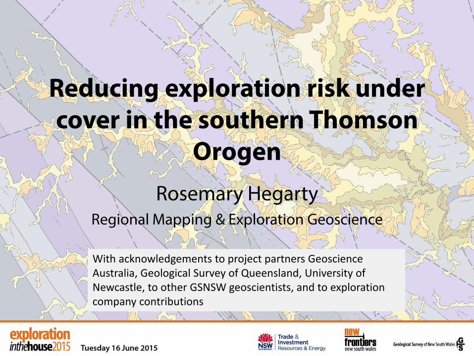
Reducing exploration risk under cover in the southern Thomson
Orogen Rosemary Hegarty
Regional Mapping & Exploration Geoscience
With acknowledgements to project partners Geoscience Australia, Geological Survey of Queensland, University of Newcastle, to other GSNSW geoscientists, and to exploration company contributions
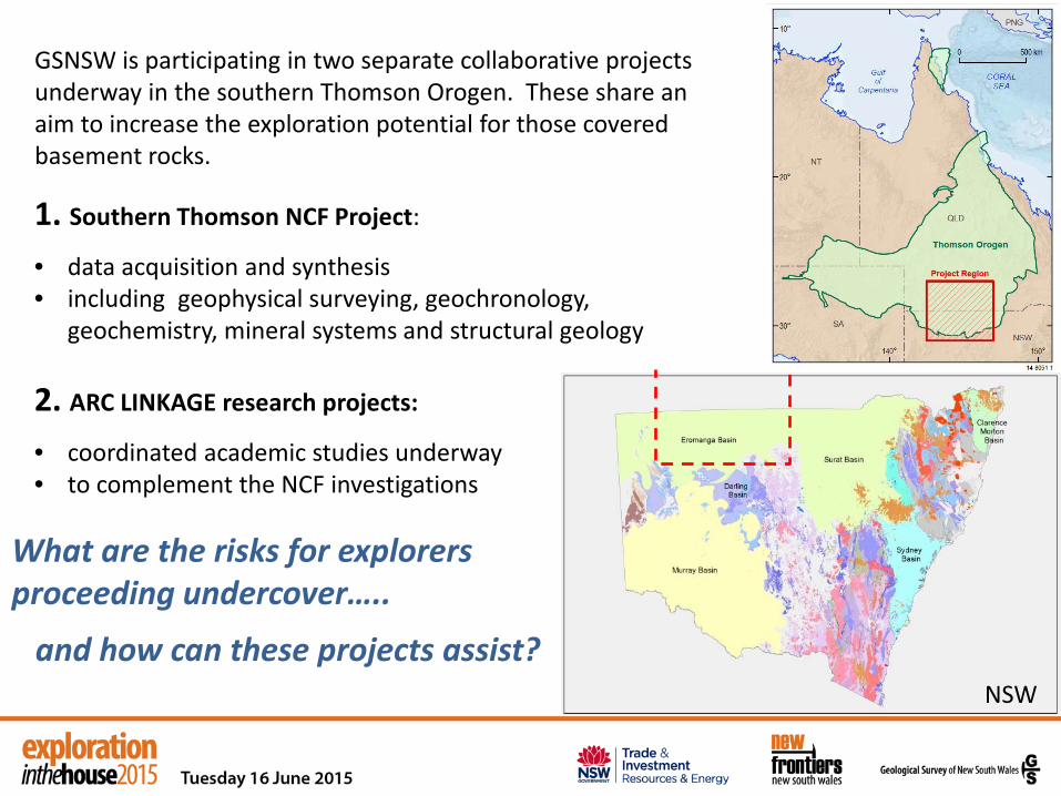
GSNSW is participating in two separate collaborative projects underway in the southern Thomson Orogen. These share an aim to increase the exploration potential for those covered basement rocks.
1. Southern Thomson NCF Project:
• data acquisition and synthesis • including geophysical surveying, geochronology,
geochemistry, mineral systems and structural geology
2. ARC LINKAGE research projects:
• coordinated academic studies underway • to complement the NCF investigations
What are the risks for explorers proceeding undercover…..
and how can these projects assist?
NSW

The lure to explore and the risks…..
NELYAMBO TROUGH

The lure to explore and the risks…..
• Recognition of mineral prospectivity is hampered in the first instance by poorly defined (or unknown) rock units and structures
• DTB - masking by cover sequences of the Eromanga Basin and by regolith units (irregular DTB surfaces constrained mainly by water bore intercepts)
• ‘Surface’ geochemistry on rocks and soil not available, hence a need to detect distal signatures
• Tangible mineral systems targets that are relevant to the local area are difficult to define within basement
NELYAMBO TROUGH

What are the solutions in southern Thomson region?
Since 2005 exploration work has taken place, but the tides of finance are fickle. The legacy is valuable samples now available for analysis from tested targets (largely magnetic). Governments are acting on their role to build the framework and understanding of the area, and connecting with the 4 themes of the UNCOVER vision being developed.
Impact: To provide the mineral exploration industry with pre-competitive data, and knowledge that reduces risk and encourages investment in the region.
Collaborative NCF between Geoscience Australia, GSNSW and GSQ commenced Dec 2013
Solid geology map compilation Geochronology Mineral systems study Structural synthesis New geophysical acquisition

STO
NSW 2010
Solid Geology for NSW + QLD
• Merged geophysical–geological interpretation across border
• Development of unit descriptions
and naming, in spite of the lack of lithologic information and few age dates
• Expanded our concepts of “complex”, but also improves broader perspective on major trends
• Provides structural framework for kinematic studies, defining ductile zones and brittle fault sets
• Inclusion of prospective rocks in
NSW (Late Silurian & Early Devonian), even with poor geophysical contrast

• New Ar-Ar muscovite (11), K-Ar on fine clays (26) for age of metamorphism and deformational fabrics including the Culgoa lineament
• Ages will be released as a new GA Record on southern Thomson-northern Lachlan 2015
Isotopic dating for frameworks
New data on magmatic, provenance, metamorphic and mineralisation ages are building on recent NGA Geochron in NSW and QLD
NSW
Cuttaburra area Culgoa area
QLD
STO
I. Roach, Digging Deeper 2014
• New U-Pb SHRIMP mounts from industry drill core: 16 magmatic and detrital provenance ages for project
• Efforts come together and age patterns and relationships are emerging e.g. strongly magnetic diorites at 400 Ma synchronous with local volcanic-proximal red bed sequence north of Bourke

STO
Mineral Systems
Reassessing prospectivity of southern Thomson Orogen based on new isotopic data and structural interpretations
• New U/Pb, Ar-Ar and Pb isotope analyses from Cuttaburra area drill cores to better define timing of mineralisation events
• Petrography & SEM, major & trace elements for 12 samples from Pirelli ultramafic intrusion on Culgoa lineament for PGEs and compare with Fifield Complex
• Explore links between W-Mo and Au-basemetal mineral systems in Cobar and Lachlan Orogen and southern Thomson Orogen: Re-Os
Structural Synthesis
• Mapping structures using aeromagnetic, gravity and seismic data
• Dating fabrics using K-Ar & Ar-Ar to develop the timing of main events
• Potential field modelling of Paka Tank Trough
• Geodynamic interpretations are evolving
M Doulier & GS of India Huston, Skirrow & Champion

I. Roach, Digging Deeper 2014
Magnetotelluric (MT) & Gravity surveys
Acquisition now complete
• Broadband MT (lithospheric depth)
• Some Audio MT (high-resolution, near-surface)
• Gravity along traverses @ 333 m spacing ~3600 new gravity stations
Combined AEM, MT & gravity data will provide the deep conductivity picture down to >100 km depth along these lines.
They will be used to model Thomson-Lachlan boundary and lithospheric architecture.

Airborne electromagnetic survey completed
New AEM data:
• Regional survey at 5 km line spacing over the Eulo Ridge
• Single lines along the MT-gravity traverses
Phase 1 (Contractor-supplied) data released 18 August 2014
Phase 2 (GA inversions) data released December 2014
All data are available from the Geoscience Australia website: www.ga.gov.au
GeoTech Airborne Ltd: VTEM plus® I. Roach, Digging Deeper 2014
I. Roach, Digging Deeper 2014
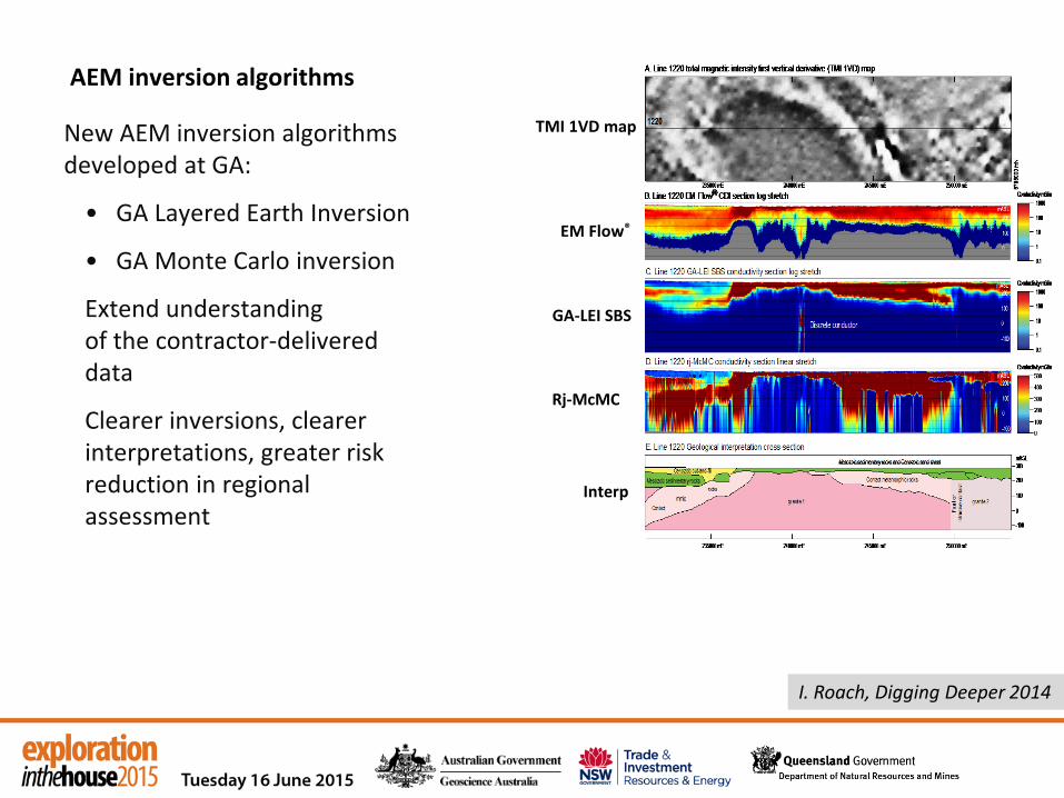
AEM inversion algorithms
New AEM inversion algorithms developed at GA:
• GA Layered Earth Inversion
• GA Monte Carlo inversion
Extend understanding of the contractor-delivered data
Clearer inversions, clearer interpretations, greater risk reduction in regional assessment
TMI 1VD map
EM Flow®
GA-LEI SBS
Rj-McMC
Interp
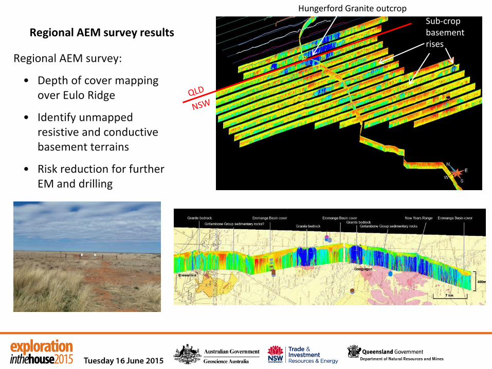
Regional AEM survey results
Regional AEM survey:
• Depth of cover mapping over Eulo Ridge
• Identify unmapped resistive and conductive basement terrains
• Risk reduction for further EM and drilling
Sub-crop basement rises
Hungerford Granite outcrop

The Cap and Pipe the Bores program • controlled 398 free flowing bores and supplied approximately 4.2
million ha with permanent, reliable, efficient watering points • has seen increases in artesian bore pressure are being observed in
many areas and reduces salt
Great Artesian Basin Sustainability Initiative NSW Office of Water
Extent of GAB, non perennial streams, surface water and springs
Peery Springs
A recent survey revealed that around 55% of spring groups are rendered inactive due to groundwater extraction, while many of the remaining springs have diminished in flow. Of 45 original springs in NSW, just 13 spring groups were found to be operating. (Oases to Oblivion: The Rapid Demise of Springs, Powell et al)

AEM identifies basement highs in NSW
• DTB variability means 5 km line spacing is too wide for gridding in this zone
• Yantabulla example coincident with water bore bedrock granite at <10m
1VD image
YANTABULLA
YANTABULLA

NCF Project Plans looking forward…
ARC Linkage
2014 2015 2016 2017 NCF
WRAPPING UP NCF 1 & PREPARING NCF 2
Planned stratigraphic drilling program can potentially incorporate developments from DET CRC e.g. downhole tools, solids recovery (SRU) & lab at rig (LAR) Brukunga DET CRC site

Chief Investigators - University of Newcastle (Prof Bill Collins) Also – University of Queensland, Queensland University of Technology
Partner Investigators – GSQ, GSNSW
Designed to increase understanding of key aspects and sites
1. Systematic age determination of key lithostratigraphic units across the STO, both sedimentary, igneous and metamorphic;
2. Detrital zircon age spectra of major sedimentary units for provenance analysis;
3. Kinematic analysis and Ar-Ar age determination of major fault structures and syn-kinematic intrusions, where possible;
ARC Linkage Collaborative Research Agreement - funded, signed & commencing 2015
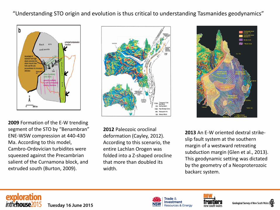
2009 Formation of the E-W trending segment of the STO by “Benambran” ENE-WSW compression at 440-430 Ma. According to this model, Cambro-Ordovician turbidites were squeezed against the Precambrian salient of the Curnamona block, and extruded south (Burton, 2009).
2012 Paleozoic oroclinal deformation (Cayley, 2012). According to this scenario, the entire Lachlan Orogen was folded into a Z-shaped orocline that more than doubled its width.
2013 An E-W oriented dextral strike-slip fault system at the southern margin of a westward retreating subduction margin (Glen et al., 2013). This geodynamic setting was dictated by the geometry of a Neoproterozoic backarc system.
“Understanding STO origin and evolution is thus critical to understanding Tasmanides geodynamics”

Focus: to expand on the exact character of detrital provenance for Cobar Super Supergroup so that Southern Thomson investigations can compare with confidence.
“Age and provenance of the Cobar Supergroup” (results in prep for publication) Honours thesis completed by Matthew Parrish, 2014, at University of Newcastle
• Investigated max dep ages and provenance using LA_ICP_MS
• Seven samples selected to represent a section through stratigraphy in the local Cobar area, including Florida Volcanics
• Useful conclusions on methodology of LA-ICP-MS, including inheritance, and grainsize limitations
• Considered the provenance through time, comparing rift stage with basin sag infill and tying in with previous results

Focus on Warraweena Volcanics and surrounding sedimentary basement rocks
“Uncovering the Southern Thomson Orogen, NSW: Geodynamic Significance of Warraweena Volcanics and Related Rocks” (results in prep for publication) Hons thesis completed by Sarah Whalan, 2014, at University of Newcastle
• Comparison of ICP_MS with shrimp dating of zircons from S-type Brewarrina Granite
• Sm Nd isotope chemistry of the igneous rocks (granite, volcs and tuff)
• Investigated max dep ages and provenance using LA_ICP_MS
• Included trace element composition for source: Yb/Sm
• Concluded by comparing these samples with detrital spectra from others obtained in the STO region in NSW
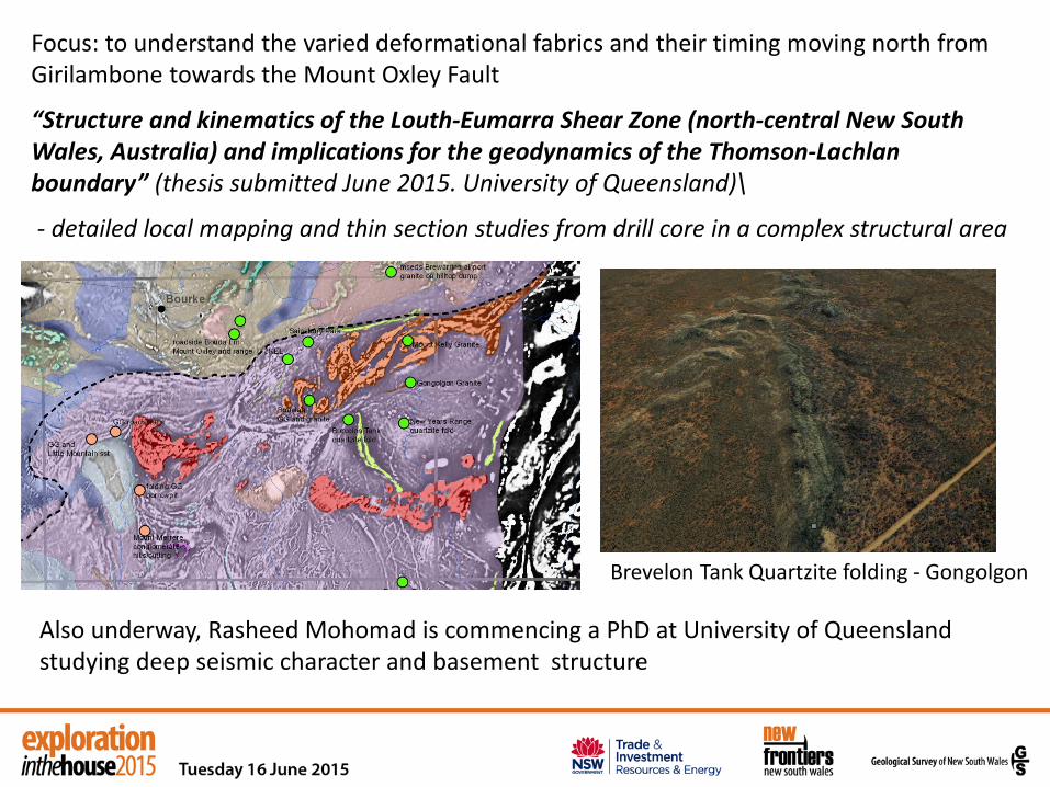
Focus: to understand the varied deformational fabrics and their timing moving north from Girilambone towards the Mount Oxley Fault
“Structure and kinematics of the Louth-Eumarra Shear Zone (north-central New South Wales, Australia) and implications for the geodynamics of the Thomson-Lachlan boundary” (thesis submitted June 2015. University of Queensland)\
- detailed local mapping and thin section studies from drill core in a complex structural area
Also underway, Rasheed Mohomad is commencing a PhD at University of Queensland studying deep seismic character and basement structure
Brevelon Tank Quartzite folding - Gongolgon

Other ARC Linkage research projects lie ahead….
Xenoliths and clasts in diatremes and basaltic plugs could contribute crustal information. There are > 6 separate fields of Permian to ?Tertiary diatremes.
Tinchelooka Diorite at 400 Ma - need to define the igneous petrology and geochemistry of the variations within and between the 4 cored drill holes. Do they compare/relate to units of similar age in NSW or elsewhere (QLD?)
Easter Monday Fm & Jeffreys Flat Fm
Yancannia Fm
Investigate the metasedimentary rocks of the west Warratta Group? belts
Two projects • First stage of NCF Southern Thomson Project is almost completed and all results due
mid-2015 and Second stage of NCF Project is being planned to undertake stratigraphic drilling in coming years
• ARC Linkage Project is funded and will focus on key aspects with detailed academic studies in the next 3 years
These will contribute to reduce exploration risk: • Generate new precompetitive survey data AEM to define DTB & cover conditions, and MT/gravity to seek crustal-scale basement features • Develop the framework of information for geology structure and mineral systems Build confidence and enhancing perception of exploration opportunities
IN SUMMARY
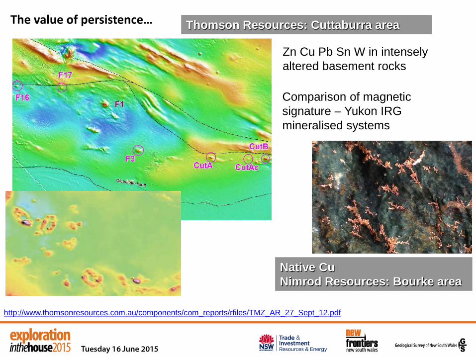
Thomson Resources: Cuttaburra area
Zn Cu Pb Sn W in intensely altered basement rocks
Native Cu Nimrod Resources: Bourke area
Comparison of magnetic signature – Yukon IRG mineralised systems
http://www.thomsonresources.com.au/components/com_reports/rfiles/TMZ_AR_27_Sept_12.pdf
The value of persistence…
Thank You!