Embed Size (px)
Citation preview
Enabling RTK-like positioning offshore using the global VERIPOS GNSS network
Pieter ToorGNSS Technology Manager

Introduction
PPP/RTK Positioning Techniques
PPP-AR Technology
PPP-AR Service Performance
PPP-AR Re-Convergence
Example Applications
Presentation Overview

Introduction
• Surface positioning technology has evolved providing…
– Positioning on a global basis
– Improved accuracy and reliability
• Precise Point Positioning (PPP) has been used since 2000– GPS, then added GLONASS
– Signals from BEIDOU, GALILEO, QZSS offer further benefits
• PPP with Ambiguity Resolution
– Better position accuracy
– Rapid Re-convergence
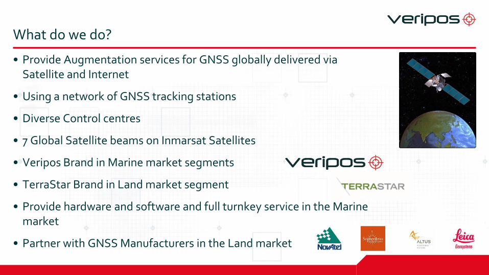
What do we do?
• Provide Augmentation services for GNSS globally delivered via Satellite and Internet
• Using a network of GNSS tracking stations
• Diverse Control centres
• 7 Global Satellite beams on Inmarsat Satellites
• Veripos Brand in Marine market segments
• TerraStar Brand in Land market segment
• Provide hardware and software and full turnkey service in the Marine market
• Partner with GNSS Manufacturers in the Land market
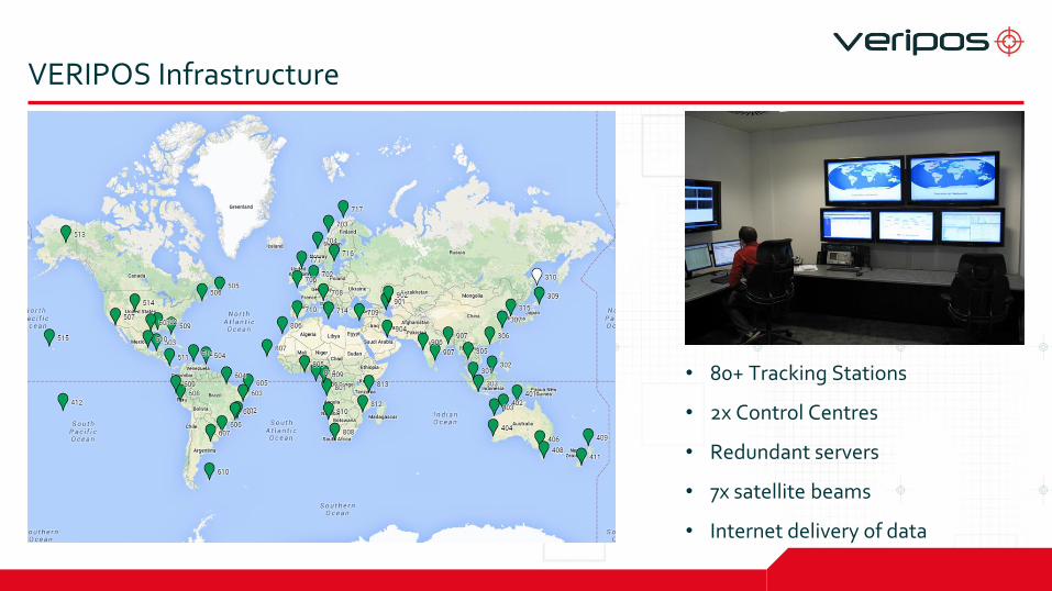
VERIPOS Infrastructure
• 80+ Tracking Stations
• 2x Control Centres
• Redundant servers
• 7x satellite beams
• Internet delivery of data

Illustration of VERIPOS’ positioning solution
•Receive positioning data from
multiple satellites allowing for
positioning correctional
measures
•Equipped with dual redundant
systems and back up power.
Located for maximum coverage
•Provide global redundant
coverage
•Combine input data with
proprietary algorithms to
remove satellite-based
positioning errors
•Fully
redundant
facilities.
Provide 24/7
customer
support
•Receive positioning
signals and correction data,
enabling secure and
accurate operations
•Transmit
data to
NCCs.
Minimum
two
separate
links
•Transmit correction data
from the NCCS to the
vessels on 7 L-band
Inmarsat satellites
•GPS or GLONASS satellites
•Communication satellites
•NCCs
•Comm.
links•GNSS reference stations •GNSS reference stations •NCCs
•Onboard hardware and
software
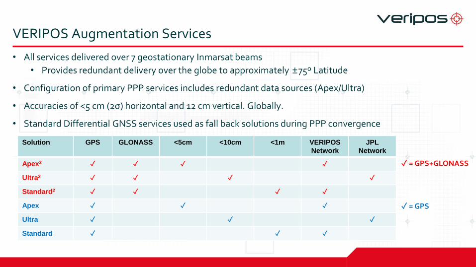
VERIPOS Augmentation Services
• All services delivered over 7 geostationary Inmarsat beams
• Provides redundant delivery over the globe to approximately ±75º Latitude
• Configuration of primary PPP services includes redundant data sources (Apex/Ultra)
• Accuracies of <5 cm (2σ) horizontal and 12 cm vertical. Globally.
• Standard Differential GNSS services used as fall back solutions during PPP convergence
Solution GPS GLONASS <5cm <10cm <1m VERIPOS
Network
JPL
Network
Apex2 ✓ ✓ ✓ ✓
Ultra2 ✓ ✓ ✓ ✓
Standard2 ✓ ✓ ✓ ✓
Apex ✓ ✓ ✓
Ultra ✓ ✓ ✓
Standard ✓ ✓ ✓
✓ = GPS+GLONASS
✓ = GPS

Introduction
PPP/RTK Positioning Techniques
PPP-AR Technology
PPP-AR Service Performance
PPP-AR Re-Convergence
Example Applications
Precise Point Positioning Techniques

Precise Point Positioning: PPP and RTK (1)
• RTK offers– - Local / Regional solution: available within an RTK network or
near a base station
– + 1-2 cm positioning
– + Initialisation <1 minute
• PPP offers:– + Global solution: no knowledge of network required by user
– + 5-8 cm positioning - anywhere
– - Initialisation ~20-30 minutes
– - Requires full re-initialisation after loss of data

Precise Point Positioning: PPP and RTK (2)
• PPP-AR offers– + Global solution: no knowledge of network required by user
– + RTK-like accuracies: 2-3 cm positioning
– - Initialisation ~20-30 minutes
– + Fast (~seconds) re-initialisation after short loss of data
• PPP-RTK offers– ~ Regional / Wide Area solution: some knowledge of network
required by user
– + 1-2 cm positioning
– + Initialisation <1 minute
– + Fast (~seconds) re-initialisation after short loss of data

Precise Point Positioning: PPP and RTK (3)
• Summary:
• PPP-RTK delivers RTK capability but in a different way
Technique Area Accuracy(Horizontal)
Initialisation Re-
initialisation
RTK Local/Regional 1-2 cm <1 minute <1 minute
PPP Global 5-8 cm ~20-30 minutes ~20-30 minutes
PPP-AR Global 2-3 cm ~20-30 minutes <1 minute
PPP-RTK Regional/
Wide Area
1-2 cm <1 minute <1 minute

From PPP to PPP-RTK: layers of data required by applications
• Layer 1: PPP:– User receives global orbit & clock information
• Layer 2: PPP-AR:– User also receives observation specific biases
• Layer 3: PPP-RTK:– User also receives ionospheric and tropospheric corrections
Sum of PPP-RTK parameters enables RTK-like positioning
• Layered concept is defined by RTCM standard
Orbit
+
Clock
+
Biases
+
Ionosphere
+
Troposphere
=
Same information as RTK

From PPP to PPP-RTK: layers of data required by applications
• PPP-RTK uses ‘State Space Representation’ of GNSS error sources
• Message concepts designed by RTCM
• GNSS service providers generally adopt proprietary messages to efficiently use costly satellite bandwidth
(image source: IGS workshop, June 2014, Pasadena, US)

PPP-AR Technology
PPP-AR…what is it?
• Extension to Precise Point Positioning (PPP-AR = ‘PPP with Ambiguity Resolution’)
• Ambiguity Resolution requires additional bias parameters to be computed and broadcast
• Use with Orbit & Clock corrections already used in regular PPP
• Enables horizontal accuracy of a few cm
• Supports rapid re-convergence, in many cases instantaneously– Satellite specific ionosphere delays used as constraints in AR process
• VERIPOS PPP-AR service broadcast begun on 2nd December 2014 for final validation– Actively being used in land market since March 2015
– Integration and testing in marine environment ongoing

VERIPOS Infrastructure Improvements
• VERIPOS offers PPP and PPP-AR services, globally
• High accuracy requires advanced infrastructure
• Entire reference station network upgraded over 18 month period
– New receivers = better GNSS measurement quality
– New geodetic antennas = better GNSS measurement quality
– Ability to track all GNSS constellations
• Developed Improved Servers
– To improve Orbits & Clocks
– To enable PPP-AR capability

PPP-AR Service Data
• Enabling ambiguity resolution requires the following
– Satellite orbit corrections
– Satellite clock corrections
– Satellite hardware biases of code observations
– Satellite hardware biases of carrier phase observations
• Data estimated in real-time by the VERIPOS orbit and clock determination algorithms
• Code biases very stable
• Phase biases stable but occasionally need reset – Due to SV observability in tracking network

Server Processing & Data Dissemination

PPP-AR Service Performance

Apex2 (PPP) Service Performance (29th Dec 2014)
Aberdeen Monitor Site

PPP-AR Service Performance (29th Dec 2014)
Aberdeen Monitor Site

PPP-AR Accuracy & Stability Example
Norwich Monitor Site
Norwich Monitor Site
2D: 2 cm (95%)
Height: 7 cm (95%)

Service Performance Over Time
Aberdeen Monitor Site
<5 cm
<12 cm
3 cm
8 cm

PPP-AR Position Solution – Global Service Monitoring

PPP-AR Re-Convergence

PPP-AR…Position Re-Convergence
• Cold-start or initial convergence is similar for PPP and PPP-AR
• Any break in GNSS observations results in loss of position
• On re-acquisition of GNSS observations
– PPP solution is typically re-set and repeat cold-start process
– PPP-AR solution can instantaneously re-converge to previous position accuracy
• Fast re-convergence is achieved if satellite specific line-of-sight ionospheric delays are estimated at all times
• These delays are then applied after re-acquiring satellites as a constraint to fix the carrier phase ambiguities instantly

PPP and PPP-AR Dynamic Performance
• Dynamic trials in urban setting
• Testing on vehicle
• Positions compared against a truth system
– Post-processed INS-GNSS
– Tightly-coupled
• PPP-AR (red) re-converges much quicker than PPP (green)

Re-Convergence After 5-sec Outage
• 5-second break in data (full GNSS & correction signal outage)
• 72 hourly gaps
• PPP re-converges
• PPP-AR bridges gaps
• Static data
• Different firmware versions with improvements to Apex2
15-min 30-minApex2 PPP (f/w 6.510)
PPP-AR (f/w 6.600)
Apex2 PPP (f/w 6.600)
95% error computed over
72 re-convergences

Re-Convergence After 30-sec Outage
• 30-second break in data (full GNSS & correction signal outage)
• PPP-AR bridges 30-sec gaps
• <10cm within a few seconds
15-min 30-minApex2 PPP (f/w 6.510)
PPP-AR (f/w 6.600)
Apex2 PPP (f/w 6.600)
95% error computed over
72 re-convergences

2 minute gaps
• Green is Float (PPP), Red is fixed (PPP-AR) solution
PPP-AR – no gap bridging PPP-AR – with gap bridging
Conclusions
PPP-AR has the following main benefits for users…
• Improved final accuracy– Final accuracy is achieved faster than with PPP
• Immediate recovery from short (minutes) of GNSS data outage– Suitable for applications with GNSS signal masking
• Global solution– Easy to use
Example Applications

Marine Applications that benefit from PPP-AR
• Improved accuracy:– Dredging
– Survey & Construction
• Improved stability:– DP
• Gap recovery:– Masked environments
– Overhead cranes


![[Sky-Tel] RTK Extend. Navcom Starfire Satcom GNSS Augmentation Extends RTK When Lacks Coverage](https://img.dokumen.tips/doc/110x75/55720524497959fc0b8b66e4/sky-tel-rtk-extend-navcom-starfire-satcom-gnss-augmentation-extends-rtk-when-lacks-coverage.jpg)