Embed Size (px)
Citation preview
Traditional GNSS RTK compared to Network RTK Solutions
Presenter: David Twaddle
Role: National Technical Support
Bsc Mine & Engineering Surveying
Authorised Grade One Mine Surveyor
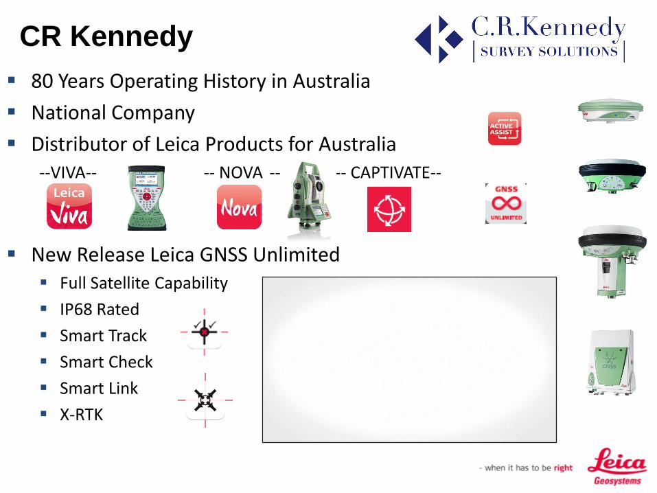
80 Years Operating History in Australia
National Company
Distributor of Leica Products for Australia--VIVA-- -- NOVA -- -- CAPTIVATE--
New Release Leica GNSS Unlimited Full Satellite Capability
IP68 Rated
Smart Track
Smart Check
Smart Link
X-RTK
CR Kennedy

Machine Control and Automation
Full Range of CI Products
Digital Levels and Leica / Riegl Scanners
UAV Fix Wings and Multi-Copter Options
New Local Product Launch in June
CR Kennedy

Traditional RTK Survey vs RTK Network Survey
X,Y,Z
Internet
What are we Talking about today?
Look at two methods of RTK Survey
Look at Field Procedure of Typical Situation
Look at Errors within RTK Surveying
What Options do we have with Network Methods?

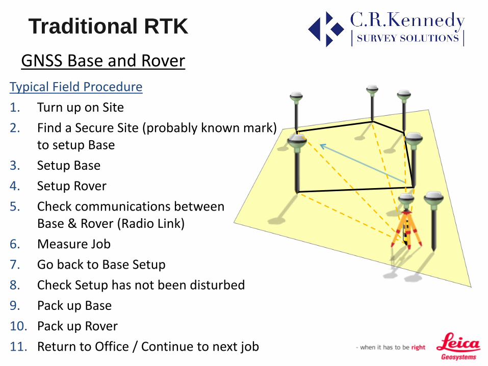
Traditional RTK
GNSS Base and Rover
Uses a GNSS Base placed locally
RTK Corrections are transmitted
Typically via UHF or Spread Spectrum Radios
X,Y,Z
GNSS Base
GNSS Rover
Correction
Traditional RTK
GNSS Base and Rover
Typical Field Procedure
1. Turn up on Site
2. Find a Secure Site (probably known mark) to setup Base
3. Setup Base
4. Setup Rover
5. Check communications between Base & Rover (Radio Link)
6. Measure Job
7. Go back to Base Setup
8. Check Setup has not been disturbed
9. Pack up Base
10. Pack up Rover
11. Return to Office / Continue to next job

Traditional RTK
GNSS Base and Rover
Disadvantages of this Method Location
Finding a Secure site to Setup a Base
Missing Pieces
Realising something is missing (Battery, Cables, Antenna)
Battery at Base goes Flat
Radio Range too Short
Radio Signal not Present at All!
Base Position is Compromised AFTER job is measured
Pieces missing from the base setup
EVERYTHING goes missing from the base setup!
Am I limiting myself / What are my Checks?
Am I using all of the Satellites Available?-$$$$
X,Y,Z
?

Issues with RTK
Error Influences:
Satellite clock error sat_clock
Satellite orbit error orbit
Ionosphere iono
Troposphere tropo
Multipath mpath
Antenna PCV PCV
Receiver clock error rec_clock
Receiver Bias biases
XY
Z
WGS84

RTK Errors – Distance Dependant Errors The further we get away from the point we are using to determine the
errors, the less those errors hold true
Typical RTK accuracies are 10mm + 1ppm
Typical results
• 5km Baseline: 15mm
• 10km Baseline: 20mm
• 30km Bas3line: 40mm
• Vertical 1½-2 Times Greater
Satellite Availability Under Utilised Existing Base Station may be GPS Only
Issues with RTK

Issues with UHF RTK -
Usage Density & Licensing

RTK Delivery – UHF Licensing
With the ACMA revised 400MHz Schema, UHF licences in High Density Zones have reduced output power and bandwidth.
By 2015, all Area Wide licences will be on one of 10 x 12.5KHz or 4 x 25.0KHz Channel spaced frequencies, Nationally.
UHF Licence fees will only rise. ACMA have stated they want people out of the 400MHz spectrum
Alternatives are 900MHz Spread Spectrum or 3G connections.
Issues with RTK

Network RTK
GNSS CORS Network
Lets look at the “New” RTK Alternative
Network RTK is utilising one or more Continuous Operating Reference Stations (CORS) to provide RTK data to the GNSS Rover.
For my Company it is called Smartnet
Internet
CORS Station

Network RTK
GNSS CORS Field Procedure
Typical situation
1. Turn up on Site
2. Setup Rover
3. Connect to RTK service via Internet
(eg.SIM card)
4. Measure job
5. Pack up rover
6. Return to office / next job
Internet

What is Currently Available?
Network RTK

Network RTK
Creating a CORS Network To build a successful CORS Network, firstly you need the CORS themselves.
SmartNet Aus is a mixture of Federal, State and Privately owned infrastructure.
New Users build the Network and Reap the Benefits
Is not Manufacturer Specific
RTCM Format

Network RTK
Background of a CORS Network Solution
Survey Practices tell us we need reliability & redundancy
Network is Built on consistent Datum / Datum's
REG13 Values provided by GeoScience Australia
RTCM selected as Format of Choice
X,Y,Z
X,Y,Z
X,Y,Z
X,Y,Z
X,Y,Z

Network RTK
Background of the CORS Network Solution?
– It needs a Two Way Communications System

Network RTK
Background of the the CORS Network Solution?

Network RTK – My Options
• Network RTK Products– Individual Base
– Nearest Base
– Virtual Reference Station
– MAX & MAC
– iMAX
• Single Base RTK Products– Individual Base
– Nearest Base
• Network RTK Products

Network RTK – My Options
• Individual Base User Selects a data stream from a nominated Base.
No matter where the Rover is, it receives the RTK data from the same Base
Site A
Site E
Site D
Site C
Site B

Network RTK – My Options
• Nearest Base User connects to the server & uploads the Rover location
The nTrip Server will provide data from the closest Base Station

Network RTK – My Options
• Virtual Reference Station User connects to the server & uploads the Rover location
The nTrip Server will create a Virtual Reference Station and provide the data to the Rover
The Virtual Reference Station solution utilises proprietary algorithms to calculate the Single Base RTK corrections
Network RTK – My Options
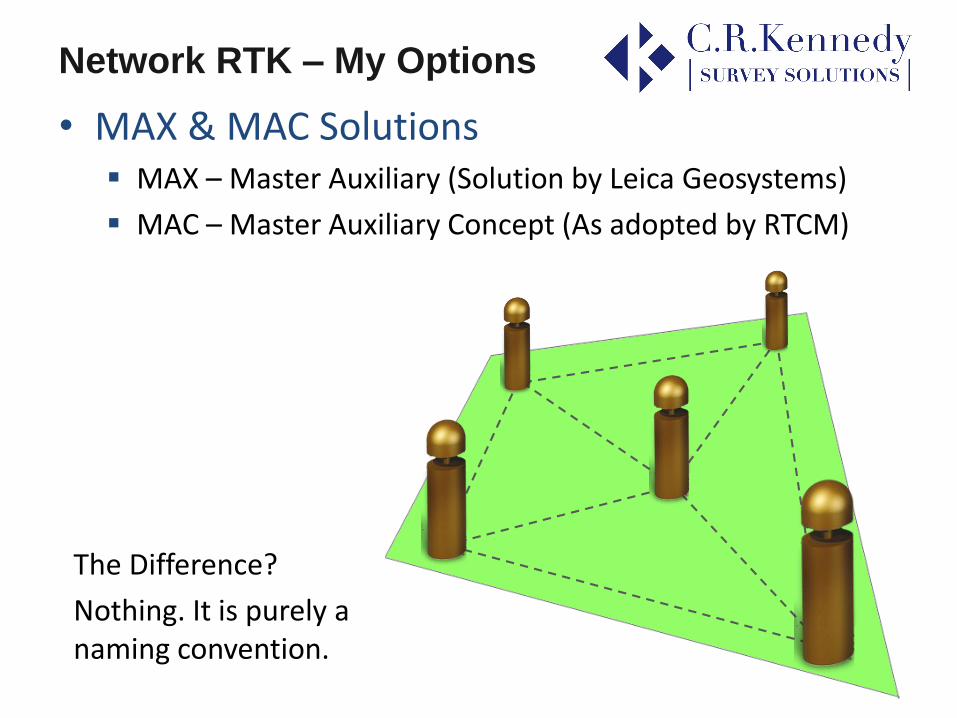
• MAX & MAC Solutions MAX – Master Auxiliary (Solution by Leica Geosystems)
MAC – Master Auxiliary Concept (As adopted by RTCM)
The Difference?
Nothing. It is purely a naming convention.

• MAX & MAC Solutions User connects to the server & uploads the Rover location
The nTrip Server determines the Master Site and the Auxillary sites
Network RTK – My Options
• MAX & MAC Solutions Solution is now calculated at the GNSS Rover
The rover uses the standard RTK data from the Master plus the additional differences from the Auxillaries
Master
AuxAux
Aux
Aux
AuxAux
Aux
Aux
Distance Dependant Errors are reduced
No re-initialisations due to new VRS
Aux
AuxAux
Aux
Master
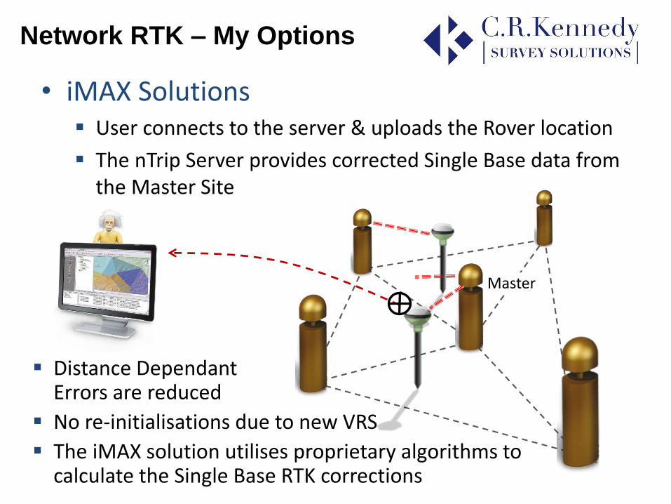
• iMAX Solutions User connects to the server & uploads the Rover location
The nTrip Server provides corrected Single Base data from the Master Site
Network RTK – My Options
Master
Distance Dependant Errors are reduced
No re-initialisations due to new VRS
The iMAX solution utilises proprietary algorithms to calculate the Single Base RTK corrections
Network RTK - Reliability
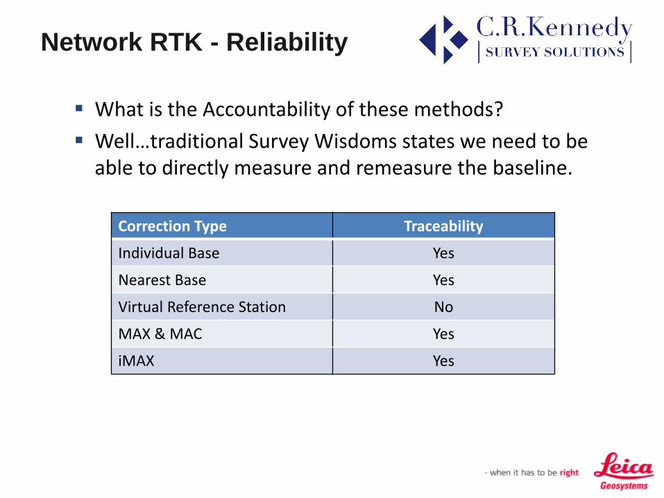
What is the Accountability of these methods?
Well…traditional Survey Wisdoms states we need to be able to directly measure and remeasure the baseline.
Correction Type Traceability
Individual Base Yes
Nearest Base Yes
Virtual Reference Station No
MAX & MAC Yes
iMAX Yes

Network RTK
Is it all Roses?
• We still have some Distance Dependant Errors
Correction Type Distance Error Minimised
Individual Base No
Nearest Base No
Virtual Reference Station Yes
MAX & MAC Yes
iMAX Yes
Note: VRS, the further you move from the VRS the less the errors are minimised.

Network RTK
Benefits of Network RTK
Save on cost of Base Station for RTK – only Rover needed
Increase RTK coverage using entire network
Avoid radio licensing issues UHF – using Internet instead
Consistent co-ordinate and Satellite Systems
Flexible data formats – Manufacturer Independent
Accountability – 24 Hours a Day with Rinex Logging
Annual Subscription – easy to budget, no obligation to renew (National, State & Site Specific)
National Service – don’t need license per state
CORS owners – incentives to invest / host
Network RTK
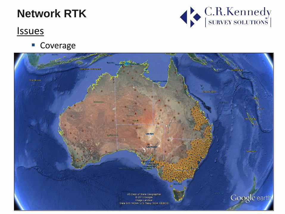
Issues
Coverage

Network RTKIssues
Internet and 3G Coverage

RTK Summary
ComparisonsCorrection Type Traditional
Base RTKCORS Single
Base RTKCORS Network
RTK
Quickly Setup and Start Surveying
Reduces Start Up costs to purchase an RTK system
Minimises Distance Dependant Errors
Consistency in Datum (eg: Setup error)
Traceability (excl VRS)
Can be used outside of CORS coverage areas

RTK Summary
• ComparisonsCorrection Type Traditional
Base RTKCORS Single
Base RTKCORS Network
RTK
Doesn’t Rely on 3G Coverage /
Not affected by UHF Licencing and Narrowbanding /
Licence Fees for UHF Radios
Subscription Fees to CORS Service Provider

Video Summary

Thank You.
David Twaddle
National Technical Support
CR Kennedy & Co.


![[Sky-Tel] RTK Extend. Navcom Starfire Satcom GNSS Augmentation Extends RTK When Lacks Coverage](https://img.dokumen.tips/doc/110x75/55720524497959fc0b8b66e4/sky-tel-rtk-extend-navcom-starfire-satcom-gnss-augmentation-extends-rtk-when-lacks-coverage.jpg)