Embed Size (px)
Citation preview

1
Unclassified
3 June 2008
Introduction Satellite Orbits Overview of a satellite system Link Budget Digital Communication Technologies Coverage Satellite Systems & Applications (Examples)
Satellite CommunicationsSatellite Communications

2
Unclassified
3 June 2008
IntroductionIntroduction Satellite communications systems exist because Satellite communications systems exist because
earth is a sphere.earth is a sphere.– Radio waves travel in straight lines at the Radio waves travel in straight lines at the
microwave frequencies used for wideband microwave frequencies used for wideband communicationscommunications
– Repeater is needed to Repeater is needed to convey signals very long convey signals very long distancesdistances

3
Unclassified
3 June 2008
Communications satellites is an artificial station in Communications satellites is an artificial station in space which operates as a radio relayspace which operates as a radio relay
Introduction (cont.)Introduction (cont.)

4
Unclassified
3 June 2008
Introduction (cont.)Introduction (cont.)
Satellites are important in: voice communications, video & radio transmission, navigation (GPS), remote sensing (maps, weather satellites) etc.
A majority of communication satellites are in geostationary earth orbit an altitude of 35 786 km– Satellite in “fixed place”– Typical path length from earth station to a GEO satellite
is 38 500 km
Satellite systems operate in the microwave and millimeter wave frequency bands, using frequencies between 1 and 50 GHz – Above 10 GHz rain causes significant attenuation of the
signal

5
Unclassified
3 June 2008
History of Satellite Communications – History of Satellite Communications – Some MilestonesSome Milestones
Satellite communications began in October 1957 with the launch by the USSR a small satellite called Sputnik 1 (4.10.1957)– Beacon transmitter, no communications capability
3.11.1957 Sputnik 2 with Laika
12.4.1961 Vostok 1 with Juri Gagarin
First true communication satellites (Telstar I & II) were launched in July 1962 & May 1963
10/1964 Syncom 2: First GEO satellite, 7.4/1.8 GHz (one TV-channel or several 2-way telephone connections
1987 TVSAT: First DBS-satellite (Direct Broadcast Satellite, Television-broadcasts directly to home)

6
Unclassified
3 June 2008
Satellite OrbitsSatellite Orbits

7
Unclassified
3 June 2008

8
Unclassified
3 June 2008
Geostationary orbitsGeostationary orbits
A satellite in a geostationary orbit appears to be in a fixed position to an earth-based observer. A geostationary satellite revolves around the earth at a constant speed once per day over the equator.
As a result, an antenna can point in a fixed direction and maintain a link with the satellite. The satellite orbits in the direction of the Earth's rotation, at an altitude of approximately 35,786 km (22,240 statute miles) above ground. This altitude is significant because it produces an orbital period equal to the Earth's period of rotation

9
Unclassified
3 June 2008
The geostationary orbit is useful for communications applications because ground based antennas, which must be directed toward the satellite, can operate effectively without the need for expensive equipment to track the satellite’s motion. Especially for applications that require a large number of ground antennas (such as direct TV distribution), the savings in ground equipment can more than justify the extra cost and onboard complexity of lifting a satellite into the relatively high geostationary orbit
Geostationary OrbitsGeostationary Orbits

10
Unclassified
3 June 2008
Satellite Orbits [5]Satellite Orbits [5] Geostationary Orbit (GEO) satellites, i.e. satellites that are stationary
with respect to a fixed point on the earth– good coverage: Theoretically, only three GEO satellites are
sufficient to serve all the earth.– the simplest space configuration and simple space control system– no need for tracking system at the earth stations– no variation of propagation delay and elevation angle– negligible Doppler effects– problematic links feasibility due to the long satellite-user distance
(prohibitive power levels and/or too large on-board antennas could be required if low power hand-held user terminals are considered)
– high propagation delays for interactive services and mobile-to-mobile communications (higher than 400 ms recommended by CCITT in case of double hop communications)
– low minimum elevation angles at high latitudes (i.e. regions cannot be covered)

11
Unclassified
3 June 2008
Low-Earth-orbiting SatellitesLow-Earth-orbiting Satellites
A Low Earth Orbit (LEO) typically is a circular orbit about 400 kilometers above the earth’s surface and, correspondingly, a period (time to revolve around the earth) of about 90 minutes. Because of their low altitude, these satellites are only visible from within a radius of roughly 1000 kilometers from the sub-satellite point. In addition, satellites in low earth orbit change their position relative to the ground position quickly. So even for local applications, a large number of satellites are needed if the mission requires uninterrupted connectivity.
Low earth orbiting satellites are less expensive to position in space than geostationary satellites and, because of their closer proximity to the ground, require lower signal strength (Recall that signal strength falls off as the square of the distance from the source, so the effect is dramatic). So there is a trade off between the number of satellites and their cost. In addition, there are important differences in the onboard and ground equipment needed to support the two types of missions.

12
Unclassified
3 June 2008
MarkerMarkerDistance above Distance above earth (km)earth (km)
Low Earth Low Earth Orbit (LEO)Orbit (LEO)Cyan areaCyan area160160 to 2,000to 2,000
Medium Medium Earth Orbit Earth Orbit
(MEO)(MEO)Yellow areaYellow area2,0002,000 to 34,780to 34,780
International International Space Space
Station (ISS)Station (ISS)Red dotted Red dotted
lineline500500
Global Global Positioning Positioning
System System (GPS) (GPS)
satellitessatellitesGreen dash-Green dash-
dot linedot line20,23020,230

13
Unclassified
3 June 2008
Overview of a Satellite Overview of a Satellite SystemSystem

14
Unclassified
3 June 2008
The satellite system is composed of a space segment and a ground segment
The Space Segment contains one or several active satellites organized in a constellation
The Control Segment consists of all ground facilities for the control and monitor the satellites (TTC-tracking, telemetry and command) and for management the traffic and the resources onboard the satellite
The Ground Segment consists of all traffic earth stations

15
Unclassified
3 June 2008

16
Unclassified
3 June 2008
Satellites – Satellite SubsystemsSatellites – Satellite Subsystems Attitude and Orbit Control System
– Rocket motors to move satellite back to the correct orbit– Keep antennas point toward to earth
Telemetry, tracking, command and monitoring – Telemetry system monitor satellite health, tracking system is located
at the earth station and provides information about elevation & azimuth angles of the satellite
Power system – Electrical power from solar cells
Communication subsystem– Major component of communications satellites, one or more
antennas & a set of receivers and transmitters (transponders)• The linear or bent pipe transponders; amplifiers the received signal &
retransmits it a different, usually lower frequency• Base-band processing transporters; used with digital signals, converts the
received signal to base-band, process it, & then retransmits a digital signal

17
Unclassified
3 June 2008 Satellite communication system & interfacing with terrestrial entities

18
Unclassified
3 June 2008
The Space SegmentThe Space Segment

19
Unclassified
3 June 2008
What Are Satellite PayloadsWhat Are Satellite Payloads ? ?• The payloads on communications The payloads on communications
satellites are effectively just satellites are effectively just repeaters. They receive the signals repeaters. They receive the signals that are transmitted to them and then that are transmitted to them and then retransmit them at a different retransmit them at a different frequency back to earth frequency back to earth
• Modern satellites do more than this. Modern satellites do more than this. They receive the signals and then They receive the signals and then demodulate them to access the data, demodulate them to access the data, the data can then be processed the data can then be processed before being modulated and before being modulated and retransmitted. The data can be retransmitted. The data can be stored for later retransmission or stored for later retransmission or modulated using a different method, modulated using a different method,
even at a different data rateeven at a different data rate
A wireless repeater

20
Unclassified
3 June 2008
A typical satellite consists of a number of repeaters (transponders), each of A typical satellite consists of a number of repeaters (transponders), each of which provides a large-capacity communication channel. Each transponder which provides a large-capacity communication channel. Each transponder has a receiver tuned to a frequency range that has been allocated for uplink has a receiver tuned to a frequency range that has been allocated for uplink communication signals from Earth to the satellite. Following the receiver, communication signals from Earth to the satellite. Following the receiver, each transponder consists of a frequency shifter to lower the received signals each transponder consists of a frequency shifter to lower the received signals to a downlink frequency, a filter tuned to the frequency of the transponder and to a downlink frequency, a filter tuned to the frequency of the transponder and a power amplifier to transmit signals back to Earth a power amplifier to transmit signals back to Earth
The communication capacity of a satellite is determined by the number of The communication capacity of a satellite is determined by the number of transponder channels and the volume of communication that can be transponder channels and the volume of communication that can be transmitted on each channel. Although this varies from one type of satellite to transmitted on each channel. Although this varies from one type of satellite to another, the most commonly used satellite in 1995 had 24 transponders. another, the most commonly used satellite in 1995 had 24 transponders. Each can carry a colour TV signal (or 6 digitally compressed TV signals) or at Each can carry a colour TV signal (or 6 digitally compressed TV signals) or at least 1200 telephone voice signals in one direction. Each new generation of least 1200 telephone voice signals in one direction. Each new generation of satellites tends to have increased communication capability satellites tends to have increased communication capability

21
Unclassified
3 June 2008

22
Unclassified
3 June 2008Elements of basic satellite link

23
Unclassified
3 June 2008
Ground SegmentGround Segment

24
Unclassified
3 June 2008
Control SegmentControl Segment
Communications satellite operations are monitored from control rooms such as this Communications satellite operations are monitored from control rooms such as this one, where minor orbit adjustments can be made and communications functions can one, where minor orbit adjustments can be made and communications functions can be regularly checked. If problems occur, technicians can attempt repairs or transfer be regularly checked. If problems occur, technicians can attempt repairs or transfer communications to a different satellite communications to a different satellite

25
Unclassified
3 June 2008
Common Frequency BandsCommon Frequency Bands

26
Unclassified
3 June 2008
Main ParametersMain Parameters Coverage
Cost: Infrastructure and bandwidth
DATA structure size
Mobility vs Transportability
Latency: Time critical applications
Complexity: Size of network
Regulatory
Interface: GPS, Device telemetry
Interoperability: Switchover to available network

27
Unclassified
3 June 2008
Satellite Communication Satellite Communication
Link BudgetLink Budget

28
Unclassified
3 June 2008
Link budget is actually the sum of all the losses between: Transmitter - Satellite & Link budget is actually the sum of all the losses between: Transmitter - Satellite & back down to a Receiver. back down to a Receiver. These losses are reduced by any gain you have at the transmitter, satellite or These losses are reduced by any gain you have at the transmitter, satellite or receiver. So in order to see if your signal is still going to be big enough to use after it receiver. So in order to see if your signal is still going to be big enough to use after it has been sent to a receiver via satellite, the gains and losses are effectively added has been sent to a receiver via satellite, the gains and losses are effectively added together and the result will be the net gain or loss. A loss means your signal has got together and the result will be the net gain or loss. A loss means your signal has got smaller, and a gain means it has got bigger. smaller, and a gain means it has got bigger.

29
Unclassified
3 June 2008
Satellite Link DesignSatellite Link Design
The four factors related to satellite system design:– The weight of satellite – The choice frequency band – Atmospheric propagation effects– Multiple access technique
The major frequency bands are 6/4 GHz, 14/11 GHz and 30/20 GHz (Uplink/Downlink)
At geostationary orbit there is already satellites using both 6/4 and 14/11 GHz every 2 (minimum space to avoid interference from uplink earth stations) -> Additional satellites higher BW
Low earth orbit (LEO) & medium earth orbit (MEO) satellite systems are closer and produces stronger signals but earth terminals need omni directional antennas

30
Unclassified
3 June 2008
Satellite Link DesignSatellite Link Design
Low earth orbit (LEO) & medium earth orbit (MEO) satellite systems are closer and produces stronger signals but earth terminals need omni directional antennas
The design of any satellite communication is based on – Meeting of minimum C/N ratio for a specific percentage of time – Carrying the maximum revenue earning traffic at minimum cost

31
Unclassified
3 June 2008
32
Unclassified
3 June 2008
Link BudgetsLink Budgets
C/N ratio calculation is simplified by the use of link budgets
Evaluation the received power and noise power in radio link
The link budget must be calculated for individual transponder and for each link
When a bent pipe transponder is used the uplink and down link C/N rations must be combined to give an overall C/N

33
Unclassified
3 June 2008
Satellite Link Design – Satellite Link Design – Downlink received PowerDownlink received Power
The calculation of carrier to noise ratio in a satellite link is The calculation of carrier to noise ratio in a satellite link is based on equations for received signal power Pbased on equations for received signal power Pr r and and
receiver noise power:receiver noise power:
PPrr = EIRP + G = EIRP + Grr – L – Lpp – L – Laa – L – Ltata – L – Lrara dBW, dBW,
Where:Where:
EIRPEIRP = 10log= 10log1o1o (P (PttGGtt))
GGrr = 10log= 10log1010 (4 (4AAe e / / 22)dB)dB
PathLoss LPathLoss LPP = 10log= 10log10 10 [(4 [(4 AAe e / / ) 2] = 20log) 2] = 20log1o1o (4 (4R/ R/ )dB)dB
LLaa = Attenuation in the atmosphere= Attenuation in the atmosphere
LLtata = Losses assosiated with transmitting antenna= Losses assosiated with transmitting antenna
LLrara = Losses associated with receiving antenna= Losses associated with receiving antenna

34
Unclassified
3 June 2008
Satellite Link Design – Satellite Link Design – Downlink Noise PowerDownlink Noise Power
A receiving terminal with a system noise temperature TsK and a noise bandwidth Bn Hz has a noise power Pn referred to the output terminals of the antenna where
Pn = kTsBn watts
The receiving system noise power is usually written in decibel units as:
N = k + Ts + Bn dBW,
where:
k is Boltzmann’s constant (-228.6 Dbw/K/Hz)
Ts is the sytem noise temperature in DBK
Bn is the noise Bandwidth of the receiver in dBHz

35
Unclassified
3 June 2008
Satellite Link Design – UplinkSatellite Link Design – Uplink Uplink design is easier than the down link in many cases
– Earth station could use higher power tranmitters
Earth station transmitter power is set by the power level required at the input to the transporter, either– A specific flux density is required at the satellite – A specific power level is required at the input to the transporter
Analysis of the uplink requires calculation of the power level at the input to the transponder so that uplink C/N ratio can be found
With small-diameter earth stations, a higher power earth station transmitter is required to achieve a similar satellite EIRP. – Interference to other satellites rises due to wider beam of small
antenna
Uplink power control can be used to against uplink rain attenuation

36
Unclassified
3 June 2008
Propagation Effects & their ImpactPropagation Effects & their Impact Many phenomena causes lead signal loss on through the earths
atmosphere:– Atmospheric Absorption (gaseous effects)– Cloud Attenuation (aerosolic and ice particles– Tropospheric Scintillation (refractive effects)– Faraday Rotation (an ionospheric effect)– Ionospheric Scintillation (a second ionospheric effect)– Rain attenuation– Rain and Ice Crystal Depolarization
The rain attenuation is the most important for frequencies above 10 GHz– Rain models are used to estimate the amount of degradation (or
fading) of the signal when passing through rain. – Rain attenuation models: Crane 1982 & 1985; CCIR 1983; ITU-R
p,618-5(7&8)

37
Unclassified
3 June 2008
Propagation Effects and their Propagation Effects and their Impact IIImpact II

38
Unclassified
3 June 2008
Digital Communication Digital Communication TechnologiesTechnologies

39
Unclassified
3 June 2008
Recent Technical AdvancesRecent Technical Advances Communications satellite systems have entered a period of transition from point-to-
point high-capacity trunk communications between large, costly ground terminals to multipoint-to-multipoint communications between small, low-cost stations.
With TDMA, each ground station is assigned a time slot on the same channel for use in transmitting its communications; all other stations monitor these slots and select the communications directed to them. By amplifying a single carrier frequency in each satellite repeater, TDMA ensures the most efficient use of the satellite's onboard power supply.
A technique called frequency reuse allows satellites to communicate with a number of ground stations using the same frequency by transmitting in narrow beams pointed toward each of the stations. Beam widths can be adjusted to cover areas as large as the entire United States or as small as a state like Maryland.
Satellite antennas have been designed to transmit several beams in different directions, using the same reflector.

40
Unclassified
3 June 2008
Case DVB-S – Broadcast SatellitesCase DVB-S – Broadcast Satellites DVB-S (Digital Video Broadcasting
– Geosynchronous orbit– DVB-S uses QPSK modulation
Satellite locations are specified as degree of longitude:– ASTRA 1 = 6 satellites: 19.2E– Hot bird = 5 satellites: 13E– Thor: 0.8W
DVB-S2 is a newer specification of the standard, ratified by ETSI in March 2005– Adaptive coding to optimize the use of satellite transponders– 4 modulation modes: QPSK, 8PSK, (used in non-linear
transponders near to saturation); 16APSK and 32APSK– V ideo codec has also been changed from MPEG-2 to H.264
(a.k.a) MPEG-4 Part 10)

41
Unclassified
3 June 2008
Case DVB-S – Error CorrectionCase DVB-S – Error Correction

42
Unclassified
3 June 2008
Case DVB-S – Error CorrectionCase DVB-S – Error Correction
• Figure 5 Error correction in DVB systems. At the receiving side in the typical bit error ratio Figure 5 Error correction in DVB systems. At the receiving side in the typical bit error ratio after QPSK demodulation is 10after QPSK demodulation is 10-1-1 ….. 10 ….. 10-2-2, after inner decoding 10, after inner decoding 10-4-4 and after outer decoder and after outer decoder 1010-11-11. [3] & [4]. [3] & [4]

43
Unclassified
3 June 2008
On Board Processor SubsystemOn Board Processor Subsystem
The next generation satellites extensively need to use On Board Processors (OBP) to design cost effective system solution for the customer needs. The OBP in satellites eliminates the inherent disadvantages of the “Bent Pipe” transponders. The payloads either employ partial or full on board processing depending upon the system design requirements and cost. Full on board processing enables an ATM like switching process in payloads. The partial processing on board is used in “Digital Transponders”.

44
Unclassified
3 June 2008
On Board Processor SubsystemOn Board Processor Subsystem
Generally the processor in satellite provides the following on board features and capabilities for system enhancements [5]:– Full network connectivity (Mesh, Star)– On board switching of signals, beams & coverage areas– Simplified payloads with efficient use of TWTA/SSPA– Efficient bandwidth and power level control (Automatic, Selectable)– On orbit management of network traffic, capacity and QOS– Flexible system integration, operation and tests

45
Unclassified
3 June 2008
Communication Payload System Communication Payload System ConfigurationConfiguration

46
Unclassified
3 June 2008
CoverageCoverage

47
Unclassified
3 June 2008
Satellite System CoverageSatellite System Coverage
The types of network services, customer population and required system performance, governs the design of satellite system coverage. The satellite payloads are developed to provide the services in Local, Regional and Global areas for transmission of specific contents
Local Coverage The local coverage contains transmissions in the selected areas
(City or country) to provide the local content delivery services to meet the demand of customers located in the city. The antenna spot beams in the satellite provide high gain directivity in specific coverage areas. The beams are optimized for the maximum system capacity and performance for local service contents.

48
Unclassified
3 June 2008
Satellite Coverage AreaSatellite Coverage Area

49
Unclassified
3 June 2008
AMOS 3AMOS 3Manufacturer : Israel Aircraft Industries (IAI)Manufacturer : Israel Aircraft Industries (IAI)
Orbital Location : 4 WestOrbital Location : 4 West
Launch Date : December 2007 (scheduled)Launch Date : December 2007 (scheduled)
Mission period : 12 yearsMission period : 12 years
# #of transponders: 15of transponders: 15
Transponder BW : 72 MHZTransponder BW : 72 MHZ
Beams : ME, EU, US, SteerableBeams : ME, EU, US, Steerable
Frequency BandsFrequency Bands: :
Ku band uplink : 14.00 to 14.50 GHZKu band uplink : 14.00 to 14.50 GHZ
Ku band downlink : 10.95 to 11.45 GHZKu band downlink : 10.95 to 11.45 GHZ
Ka band uplink : 29.40 to 30.60 GHZKa band uplink : 29.40 to 30.60 GHZ
Ka band downlink : 19.60 to 20.80 GHZKa band downlink : 19.60 to 20.80 GHZ
G/T at beam centerG/T at beam center: :
ME - 15 dB/kME - 15 dB/k
EU - 14.5 dB/kEU - 14.5 dB/k
US - 9 dB/kUS - 9 dB/k

50
Unclassified
3 June 2008
AMOS-3 CoverageAMOS-3 Coverage

51
Unclassified
3 June 2008
Satellite Systems & Satellite Systems & Applications (Examples)Applications (Examples)
52
Unclassified
3 June 2008
Applications & ServicesApplications & Services• Commercial satellites provide a wide range of communications Commercial satellites provide a wide range of communications
services. Television programs are relayed internationally, giving rise to services. Television programs are relayed internationally, giving rise to the phenomenon known as the “global village.” Satellites also relay the phenomenon known as the “global village.” Satellites also relay programs to cable television systems as well as to homes equipped programs to cable television systems as well as to homes equipped with dish antennas. In addition, very small aperture terminals (VSATs) with dish antennas. In addition, very small aperture terminals (VSATs) relay digital data for a multitude of business services. relay digital data for a multitude of business services. IntelsatIntelsat satellites satellites now carry over 100,000 telephone circuits, with growing use of digital now carry over 100,000 telephone circuits, with growing use of digital transmission. Digital source coding methods (transmission. Digital source coding methods (see see TelecommunicationsTelecommunications) have resulted in a ten-fold reduction in the ) have resulted in a ten-fold reduction in the transmission rate needed to carry a voice channel, thus enhancing the transmission rate needed to carry a voice channel, thus enhancing the capacity of existing facilities and reducing the size of ground stations capacity of existing facilities and reducing the size of ground stations that provide telephone service. that provide telephone service.
• The International Mobile Satellite Organization (INMARSAT), founded The International Mobile Satellite Organization (INMARSAT), founded in 1979 as the International Maritime Satellite Organization, is a mobile in 1979 as the International Maritime Satellite Organization, is a mobile telecommunications network, providing digital data links, telephone, telecommunications network, providing digital data links, telephone, and and facsimile transmissionfacsimile transmission, or fax, service between ships, offshore , or fax, service between ships, offshore facilities, and shore-based stations throughout the world. It is also now facilities, and shore-based stations throughout the world. It is also now extending satellite links for voice and fax transmission to aircraft on extending satellite links for voice and fax transmission to aircraft on international routes.international routes.

53
Unclassified
3 June 2008
• A group of satellites working in concert thus is known as a A group of satellites working in concert thus is known as a satellite constellation. Two such constellations which were satellite constellation. Two such constellations which were intended for provision for satellite phone services, primarily intended for provision for satellite phone services, primarily to remote areas, were the Iridium and Globalstar. The to remote areas, were the Iridium and Globalstar. The Iridium system has 66 satellites. Another LEO satellite Iridium system has 66 satellites. Another LEO satellite constellation known as Teledesic, with backing from constellation known as Teledesic, with backing from Microsoft entrepreneur Paul Allen, was to have over 840 Microsoft entrepreneur Paul Allen, was to have over 840 satellites. This was later scaled back to 288 and ultimately satellites. This was later scaled back to 288 and ultimately ended up only launching one test satellite ended up only launching one test satellite
• The GPS system….The GPS system….
Satellite ConstellationSatellite Constellation
54
Unclassified
3 June 2008
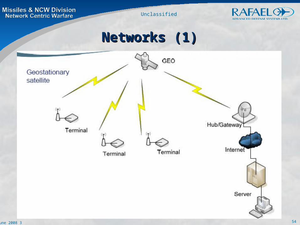
Networks (1)Networks (1)

55
Unclassified
3 June 2008
Networks (2)Networks (2)

56
Unclassified
3 June 2008

57
Unclassified
3 June 2008
The GPS SystemThe GPS System

58
Unclassified
3 June 2008
• Global Positioning System (GPS) satellites orbit high above Global Positioning System (GPS) satellites orbit high above the surface of Earth at precise locations. They allow a user the surface of Earth at precise locations. They allow a user with a GPS receiver to determine latitude, longitude, and with a GPS receiver to determine latitude, longitude, and altitude. The receiver measures the time it takes for signals altitude. The receiver measures the time it takes for signals sent from the different satellites (A, B, and C) to reach the sent from the different satellites (A, B, and C) to reach the receiver. From this data, the receiver triangulates an exact receiver. From this data, the receiver triangulates an exact position. At any given time there are multiple satellites within position. At any given time there are multiple satellites within the range of any location on Earth. Three satellites are the range of any location on Earth. Three satellites are needed to determine latitude and longitude, while a fourth needed to determine latitude and longitude, while a fourth satellite (D) is necessary to determine altitude satellite (D) is necessary to determine altitude
The GPS System (cont)The GPS System (cont)

59
Unclassified
3 June 2008
The satellites orbit the earth with a speed of 3.9 km per second and have a circulation time of 12 h sidereal time, corresponding to 11 h 58 min earth time. This means that the same satellite reaches a certain position about 4 minutes earlier each day. The mean distance from the middle of the earth is 26560 km. With a mean earth radius of 6360 km, the height of the orbits is then about 20200 km. Orbits in this height are referred to as MEO – medium earth orbit .
The satellites are arranged on 6 planes, each of them containing at least 4 slots where satellites can be arranged equidistantly. Today, typically more than 24 satellites orbit the earth, improving the availability of the system.The number and constellation of satellites guarantees that the signals of at least four satellites can be received at any time all over the world
The GPS System (cont)The GPS System (cont)

60
Unclassified
3 June 2008
IRIDIUM (1)IRIDIUM (1)

61
Unclassified
3 June 2008
IRIDIUM (2)IRIDIUM (2)

62
Unclassified
3 June 2008
AmerHis – A New Era in Satellite AmerHis – A New Era in Satellite CommunicationsCommunications
AmerHis is an advanced communications system, based around the Alcatel
9343 DVB On-Board Processor, carried by Hispasat’s Amazonas satellite.
This processor has the capacity to provide the demodulation, decoding,
switching, encoding and modulation for the four transponders on
Amazonas. Each Ku-band transponder covers one of the four geographical
regions served by the satellite, namely: Europe, Brazil and North and South
America, as shown in Figure 2 .

63
Unclassified
3 June 2008
System ConfigurationSystem Configuration
The initial terrestrial system configuration will include:
A Management System (MS), consisting of a Network Control Centre (NCC) and associated management control, responsible for managing the onboard resources and user terminals.
User Terminals (RCTs) oriented towards the commercial demonstration of new services.
Gateways (RSGWs) that will provide the system with access to terrestrial networks.

64
Unclassified
3 June 2008
AmerHis SatelliteAmerHis Satellite

65
Unclassified
3 June 2008

66
Unclassified
3 June 2008
Figure 4 – AmerHis provides connectivity between spot-beam coverage areas without the need for double hops between ground and spacecraft

67
Unclassified
3 June 2008
The combination of onboard processing (OBP) and a full compatibility with the open standards of DVB-S (downlink) and DVB-RCS (uplink) gives the telecommunications satellite unprecedented potential compared with the conventional bent-pipe architectures. The AmerHis system

68
Unclassified
3 June 2008
OBP AdvantagesOBP Advantages
Provision of direct “end-to-end” connectivity between any two users in different regions through a single satellite hop. This allows real-time voice and video services, as well reducing bandwidth usage.
Full flexibility both for the interconnection of coverage areas and payload-capacity management, allowing optimum exploitation of available onboard resources (so-called dynamic bandwidth on demand). The system supports predictable symmetric (up-and downlink) traffic, as well as bursty traffic generated by a large number of uses, owing to the dynamic resource a location process.
The regenerative nature of this AmerHis payload and the utilization of DVB-S saturated carriers on each downlink provide substantial performance improvements when using the AmerHis enabled transponders. These improvements are reflected both in their enhanced throughput capacity and the reduced receive-antenna size requirements for users.

69
Unclassified
3 June 2008
Applications/ ServicesApplications/ ServicesAmerHis is a win-win solution for Interactive Network Access Providers (INAPs) service providers and customers. The much greater flexibility for managing and selling capacity is such that all of the main players will benefit from this advanced technology. Real and non-real time multimedia services and applications can be provided on readily available DVB-S/DVB-RCS compatible terminals. The system permits the assignment of resources to different sub-networks in a very flexible manner and allows user transmission rates ranging from 512 kbit/s to 8 Mbit/sec. The system supports IP-based as well as native MPEG-based services, with efficient mechanisms for the provision of uni-and multi-cast services, and the possibility to define various quality-of-service (QoS) levels to meet differing user needs.

70
Unclassified
3 June 2008
Applications/ ServicesApplications/ Services
Video ServicesVideo Services
The AmerHis payload offers multiplexing and de-multiplexing of MPEG-2 transport streams and is therefore not only capable of offering IP services over MPEG-2, but also allows the routing of video. Contribution links can be made from different uplink stations and, depending on the onboard switch configuration, duplicated and sent to multiple destinations if necessary, using the DVB-S standard for Direct-to-Home (DTH) services. Business television services, occasional-use services and video contributions with smaller terminals can all be supported more easily by exploiting these capabilities.

71
Unclassified
3 June 2008
System ElementsSystem Elements
Space Segment – The regenerative payloadSpace Segment – The regenerative payload
The AmerHis payload is a novel set of On-Board Processing (OBP) technologies which is being flown on the Amazonas satellite for the first time. The key feature of AmerHis is that the payload is regenerative and provides unique connectivity possibilities via its switchboard in the sky’ functionality .
A redundancy ring allows switching between transparent and regenerative modes with the four DVB transponders.

72
Unclassified
3 June 2008
The uplink format to the OBP is MF-TDMA according to the DVB-RCS standard (MPEG-2 option) with a granularity of up to 64 carriers per transponder (0.5 Mbps each). Data rates of 0.5, 1, 2, 4 & 8 Mbps are combinable in the same transponder. The coding scheme is Turbo Code with a ¾ or 4/5 coding rate .
The down-link format is according to the DVB-S standard with a maximum data rate of 54 Mbps (per transponder). The Forward Error Correction (FEC) uses Reed-Solomon and convolutional coding with ratios of ½, 2/3, ¾, 5/6, or 7/8.


![UNIVERSITY OF PUNE [4361]-102 F. E. (Semester - II) Examination](https://img.dokumen.tips/doc/110x75/584cc52e1a28ab85738f7031/university-of-pune-4361-102-f-e-semester-ii-examination-.jpg)

![Biol 2153-1-investigaciones [compatibility mode]](https://img.dokumen.tips/doc/110x75/55b32195bb61ebb2798b4663/biol-2153-1-investigaciones-compatibility-mode.jpg)