Embed Size (px)
Citation preview

THE EMPTY INTERIOR(Chapter 13)

Introduction• The largest area of sparse
population in sub-Arctic North America: Rocky Mountains to Cascade Range and Canadian Coast Range
• Variations in topography• Population mostly of
Northern European stock with Hispanics and Native Americans in southern parts
• Economic activities unevenly distributed and widely scattered

EmptyInterior
(page 253)


Mountains
• Dramatic elevation changes: 1000 meters (3000 feet) from base to summit
• Abrupt, almost vertical slopes with jagged summits
• Shaped by erosion• Glaciation– Pleistocene ice sheets– Alpine: smaller areas today

Plateaus
• Colorado Plateau– Along middle
Colorado River in Utah and Arizona
– Gently dipping sedentary rocks
– Major landscape features from erosion by exotic rivers, especially Colorado—major scenery resources

Plateaus• Columbia
Plateau– Formed from
gradual buildup of lava flows to depth of 650 meters (2000 feet)
– Stream-eroded canyons


Bryce Canyon
Garden of the Gods
Canyon Lands

Basin and Range
• Across southern New Mexico, Arizona, west to Death Valley and Mojave Desert
• 80 broad, flat basins containing > 200 linear ridges
• No drainage outlet to the sea
• Lake Bonneville largest Pleistocene lake (northern Utah), remnant in Great Salt Lake
Pleistocene Lakes(page 256)


Climate• Arid or semiarid, especially toward south
• Much of North America’s desert area
• Major determinant of population distribution
• Dependence on exotic surface streams for water

Climate
• Direct association with topography– Low lying areas dry– Heaviest
precipitation on midslopes of mountains
– Altitudinal vegetation zonation• Lowest elevations:
desert scrub• Treeline: sufficient
precipitation for tree growth
• Upper treeline: tree growth hindered by high winds, short growing season
The Patriarch TreeBristlecone Pines-California


Physical GeographyRocky Mountains
• Vegetation– Role of elevation and
slope– Western Forests
• CONIFEROUS– Sagebrush and Prairie
• Climate– Importance of location
• Major Microclimatic Variations

Physical Geography Intermontane Region• Vegetation:
– Role of elevation and slope– Mountains: Forested
• Ponderosa Pine/Douglas Fir • Piñon/Juniper
– Uplands: Short grass prairie– Desert Lowlands: Sagebrush
• Climate:– Importance of location
• Ranges of ARIDITYFigure 15-10

Wildlife• Much land publicly owned• Wildlife population explosion since
1935– Buffalo (bison) from 10,000 to
60,000– Elk from 225,000 to 500,000– Pronghorn antelope from 40,000
to 750,000– White-tail deer from 5 million to
15 million• Major attraction to tourists,
hunters• Controversies over policies,
especially regarding certain species (e.g., wolves)– Tourists – Ranchers


Public Land Ownership
Most land in the region still under government control (90% of Nevada)
• Last to be settled
• Largely unsuitable for agriculture
(page 258)

Public Control of Land
• Conservation programs– National parks– National forests– Canadian provincial lands
• Criticism– Hindrance to planning– “Sagebrush Rebellion”– Forest and Rangeland
Renewable Resource and Planning Act (1974)
– Federal Land Policy and Management Act (1976)
– Plight of Indian reservations in regions
(page 259)Lawrence Red Feathers sits on his porch at Pine Ridge Reservation, Rapid City, South Dakota, USA. Photograph: Jennifer Brown/Corbis

BLM (Bureau of Land Management), controlled by politically powerful public lands ranching-livestock industry, aka in the west as the sagebrush rebellion, thru the media managed to discredit Michael Blake, author/screen play of "Dances with Wolves", in his effort to preserve and protect America's wild horses & burros on public lands thru a legitimate and much needed campaign to bring public awareness to the plight of America's wild horses & burros. Mr. Blake was simply attempting to get BLM to do a credible wild horse & burro count and for BLM to follow the federal laws in their decisions to remove "excess" free-
roaming wild horses.
http://www.blm.gov/wo/st/en/prog/wild_horse_and_burro/What_We_Do/rangeland_management0.html
BLM information about rangeland

The Forest and Rangeland Renewable Resources Planning Act of 1974 (or RPA) (P.L. 93-378) is a United States federal law which authorizes long-range planning by the US Forest Service to ensure the future supply of forest resources while maintaining a quality environment. RPA requires that a renewable resource assessment and a Forest Service plan be prepared every ten and five years, respectively, to plan and prepare for the future of natural resources. It is found in the United States Code at Title 16, Chapter 36.
Prescott cattle grazing
Wild horse roundup

National Parks in this region…
• Big Bend • Carlsbad Caverns• Grand Canyon• Petrified Forest• Canyonlands, Zion,
Bryce• Mesa Verde

Reasons for population nodes in the Intermontane West
• Enough precip. (or irrigation) for dry farming;
• Mining activities• Transportation hubs• Recreational
opportunities• Retirement
developments

Historical Cultural Geography• Indigenous Population– Fur trade
• 1780s to1860s– Fur trade shifts to
mining• 1860s to 1920s–Displacement of First
Nations–Role of the railroads–Rise of irrigated
agriculture
• 1920s to 1970s– Fluctuations in the
primary sector, particularly mining
• 1970s to Present– Environmental
conflicts– Increasing
importance of tourism

• First Nations to 1860s– Influx of Spanish
– Fur trade shifts to mining– Rise of Mormon Deseret
• 1860s to 1920s– Removal of First
Nations– Economic role of the
railroads– Mining booms and
busts– Rise of irrigated
agriculture
Historical Cultural
Geography

Modern Cultural Geography• 1920s to 1970s
– Fluctuations in primary sector• Global mining booms and busts
• 1970s to Present– Rapid urbanization – Environmental conflicts over water in
particular– Hispanic Borderland issues– Increasing importance of tourism

Mormon Influence
• Church of Jesus Christ of Latter-Day Saints founded in New York State (1830), suffered repeated attacks and persecution
• Migrated to West, settled in the Wasatch Valley between Wasatch Mountains and Great Salt Lake
• Population growth– Migration and missionary outreach– Natural growth
• Innovative agriculturalists– Irrigation techniques– Strong central organization (theocracy)
• Failed to establish independent state of Deseret

Mormon cultural landscapes
Donald Meinig’s classic study The core: Salt Lake City and Ogden – Wasatch oasis area, intensive settlement, urbanization.The domain: Utah and SE Idaho – where Mormonism is dominantThe sphere: Mormon enclaves within Gentile majorities


Salt Lake City from the north
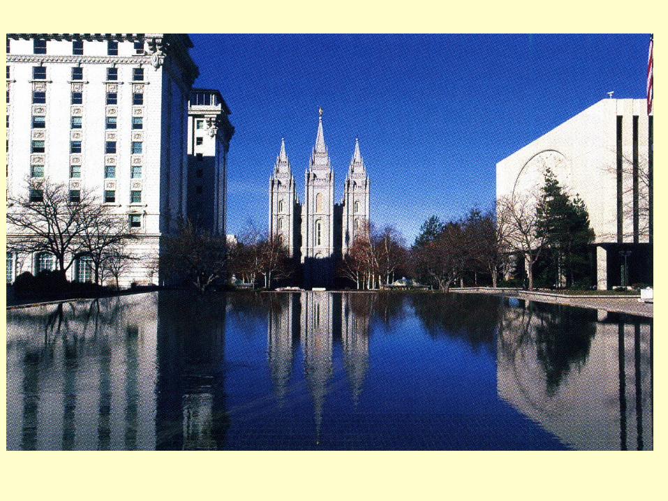
Mormon Temple, Salt Lake City

More on Mormon cultural landscapes…
• Wide streets• Unpainted barns• Greek revival houses
(red brick, porches)• Town plans:Grid laid out with large
blocks/wide streets
• Irrigation canals at edges of streets
• Poplar trees• Dreamed of creating
state of ‘Deseret’

Mormon landscapes in the Intermontane region

Irrigation and Agriculture
Reliance on irrigation for stable agriculture• Diversion of rivers
mainly for agriculture
• Doctrine of Prior Appropriation: “first come, first served”
• Reclamation Act of 1902: support for water works
Irrigated areas (page 263)

Focus on Water Issues• Pre-railway Era– Beaver Ponds Valuable
• Railway Era– Role of Mining
• Sluicing Operations
– Livestock vs. Crops
• Post-railway Era– Multi-purpose Projects– Pros/Cons of Mega-Projects– Importance of Water Today
To dam or not to dam...
Figure 14-11

Colorado River
• Region’s longest river• Nearly entire flow allocated by 1915, mainly to
Arizona and California• 1929 reallocation, ½ to downstream, ½ to
upstream states• Highly variable precipitation• Intense competition for water– Little use until recently by upper-river states– Population and economic booms in Arizona (lower-
river state)

Colorado River Water Use
(page 264)

• Snake River Plain– Idaho plains– Potatoes, sugar beets
• Columbia River– Grand Coulee Dam– Alfalfa, sugar beets, potatoes
• Wasatch valley– Mormon area– Sugar beets, alfalfa
Irrigated Areas and Crops (North)

Snake River Plain•Idaho plains•Potatoes, sugar beets

• Columbia River– Grand Coulee
Dam– Alfalfa, sugar
beets, potatoes

• Wasatch valley– Mormon area– Sugar beets, alfalfa

Irrigated Areas and Crops (continued)
• Grand Valley, West-central Colorado– Alfalfa, potatoes– Tree fruits
• Washington– Columbia River tributaries, especially Yakima,
Wenatchee, Okanagan (Okanogan)– Irrigated since 1860s– Major producer of apples

• Grand Valley, West-central Colorado– Alfalfa, potatoes– Tree fruits

• Washington– Columbia River tributaries,
especially Yakima, Wenatchee, Okanagan (Okanogan)
– Irrigated since 1860s– Major producer of apples

Irrigated Areas (South)
• Imperial Valley – 300 frost-free days, south of Salton Sea– Vegetables, lettuce, grapes, cotton, alfalfa– Double cropping possible with some crops
• Coachella Valley– North of Salton Sea– Dates, grapes, grapefruit

• Imperial Valley – 300 frost-free days, south of
Salton Sea– Vegetables, lettuce, grapes,
cotton, alfalfa– Double cropping possible
with some crops

• Coachella Valley– North of Salton Sea
– Dates, grapes, grapefruit

Irrigated Areas (continued)
• Yuma valley– Lower Colorado River– Cotton, sugar beets, oranges
• Salt River valley– Near Phoenix– Winter lettuce, oranges, cotton

• Yuma valley– Lower Colorado River– Cotton, sugar beets,
oranges

• Salt River valley– Near Phoenix
– Winter lettuce, oranges, cotton

• Location between more populated, earlier settled Midwest and West Coast
• Construction of railroads (later highways) east-west
• Towns to service railroads, later auto and truck travelers
• Growth centers with additional attributes– Central location– Retirement centers– Manufacturing, especially electronics and
computer software
Transportation

Tourism
• Federal control of most major scenic attractions• Related private enterprises– Needed tourist services– Distance between attractions
• Las Vegas– 1931: Legislation allowing gambling, easy divorce– Cheap electricity from Boulder Dam– Proximity to southern California
• Problem of overburdening attractions


Lumbering and Ranching
• Depend on federal lands– U.S. Forest Service and Bureau of Land Management
lands open to grazing– Most lumbering in national forests
• Productivity of federal lands less than private lands– Federal lands by definition multiple use– Low quality of federal lands
• Transhumance– Seasonal movement of animals– Especially important in sheep ranching
• British Columbia: Wood products economic cornerstone

• Miners second largest group (after Mormons) to settle region– Attraction of mineral deposits– Minerals as reason for settlements – Today serve as tourist attractions
• Mining today– Gold and silver still mined, but less important – Copper: most important mineral
• Arizona and Utah• Mostly low-grade (< 5%)
– Lead and zinc: More important than copper in Canada
Mining

Butte’s only economic base in the past – copper mining

Oil Shale
• Utah, Colorado, Wyoming
• Green River geologic formation
• Issues– Extraction technology
expensive– Requires huge amounts
of water– Huge amounts of waste
material(page 270)


Growing Cities
• Phoenix– Approaching Tucson
to the south and Flagstaff to the north; Mesa already within it
• Wasatch Front– Salt Lake City north to
Ogden and south to Provo and growing!
• El Paso-Ciudad Juarez– The Maquiladoras
• Las Vegas

Urban settlement
Urban centers: • El Paso• Salt Lake City• Phoenix• Las Vegas• Reno

The future of the Rocky Mountain region?

And historic preservation like Butte, Montana’s downtown…

The future of the Intermontane? (urban sprawl in Phoenix)