PREHISTORIC HERDERS OF NORTHERN ISTRIATHE ARCHAEOLOGY OF PUPI�INA CAVE
Volume 1
PRETPOVIJESNI STO ARI SJEVERNE ISTREARHEOLOGIJA PUPI INE PE I
1. svezak
MONOGRAFIJE I KATALOZI 14 − ARHEOLOŠKI MUZEJ ISTRE
ISSN
035
2-94
28
ISBN 953-6153-37-8
14
Editors / Urednici
Preston T. MiracleStašo Forenbaher
MON
OGRA
FIJE
I K
ATA
LOZI
14
− A
RH
EOLO
ŠKI
MU
ZEJ
ISTR
E

MONOGRAFIJE I KATALOZIARHEOLOŠKI MUZEJ ISTRE
MONOGRAPHS AND CATALOGUESARCHAEOLOGICAL MUSEUM OF ISTRIA
14
Izdava / PublisherARHEOLOŠKI MUZEJ ISTRE ∑ PULA
Za izdava a / For the publisherKRISTINA MIHOVILI�
Urednici / EditorsPreston T. MiracleStašo Forenbaher
Recenzenti / ReviewersJohn Chapman (Department of Archaeology, Durham University)John Robb (Department of Archaeology, University of Cambridge)
Autori poglavlja / ContributorsMaša Amatt, Maja Andri�, Giovanni Boschian, William Fletcher, Stašo Forenbaher, Timothy Kaiser, Eva Laurie, Marco Madella, Preston Miracle, Simon Parfitt, Marija Poje, Laura Pugsley, John Stewart
Prijevod na hrvatski / Croatian translationMaša Amatt, Milena Gradiška, Miloš Ilgo, Darko Komšo, Ljerka Marjanac, Lara Orli�, Siniša Radovi�, Ljerka Vajagi�, Nada Vu�ini�, Nikola Vukosavljevi�
Lektura / ProofLina Pliško (hrvatski jezik)
Priprema za tisak / LayoutABS 95 d.o.o., Zagreb
Tisak / PrintPlan-B, Zagreb
Tiskanje dovršeno u ožujku 2006. / Printed in March 2006
Naklada / No. of copies1.000
© Zašti eno autorskim pravom Arheološkog muzeja Istre. Sva prava pridržana. Nijedan dio ove knjige ne smije se reproducirati bez pisanog odobrenja izdava a.© Copyright by the Archeological Museum of Istria All rights reserved. No part of the contents of this book may be reproduced without the written permission of the publisher.
CIP − Katalogizacija u publikacijiSveu�ilišna knjižnica u Puli
UDK 903.3(497.5-3 Istra-17)=63=(082) 903.3(497.5 Pupi�ina pe�)=63=(082)
PREHISTORIC herders of northern Istria : thearchaelogy of Pupi�ina cave = Pretpovijesni sto�arisjeverne Istre : arheologija Pupi�ine pe�i / urednici, editors Preston T. Miracle … <et al> ; <autori poglavljaMaša Amatt … et al. ; prijevod na hrvatski, croatian translation Maša Amatt … et al.>. − Pula : Arheološki muzej Istre, 2006 - .
Usporedo engl. i hrv. tekst. − Bibliografija uz svaki rad.ISBN 953-6153-37-8 (cjelina)
Vol. 1. − 2006. − (Monografije i katalozi / Arheološki muzej Istre, ISSN 0352-9428 ; 14) ISBN 953-6153-39-4
ISBN 953-6153-37-8
Na korici / On the coverSijanje pri ulazu u Pupi�inu pe� / Sieving in Pupi�ina Cave mout
PREHISTORIC HERDERS OF NORTHERN ISTRIATHE ARCHAEOLOGY OF PUPI�INA CAVEVolume 1
PRETPOVIJESNI STO ARI SJEVERNE ISTREARHEOLOGIJA PUPI INE PE I1. svezak
Editors / UredniciPreston T. MiracleStašo Forenbaher
MONOGR. I KAT. 14 − ARHEOL. MUZ. ISTRE 2006., STR. 1 − 560

Preface ................................................................................................................................................................................................................................XI Predgovor
1. Introduction to the Pupi�ina Cave Project .................................................................................................................................................. 1 Uvod u projekt Pupi ina pe Preston Miracle
2. Prapo�e Pollen Core and Holocene Vegetation Change in Northern Istria ........................................................................ 31 Peludna jezgra iz Prapo a i promjene vegetacije za holocena u sjevernoj Istri Maja Andri
3. Excavations at Pupi�ina Cave ............................................................................................................................................................................ 63 Iskopavanja u Pupi inoj pe i Preston Miracle & Stašo Forenbaher
4. Geoarchaeology of Pupi�ina Cave .................................................................................................................................................................123 Geoarheologija Pupi ine pe i Giovanni Boschian
5. The Pottery of Pupi�ina Cave ...........................................................................................................................................................................163 Lon arija Pupi ine pe i Stašo Forenbaher & Timothy Kaiser
6. Flaked Stone Artefacts .........................................................................................................................................................................................225 Izra evine od cijepanog kamena Stašo Forenbaher
7. Vertebrate Faunal Remains from Pupi�ina Cave .................................................................................................................................259 Ostaci faune kralježnjaka iz Pupi ine pe i Preston Miracle & Laura Pugsley
8. Bone and Antler Artefacts from Pupi�ina Cave ..................................................................................................................................401 Koštani artefakti iz Pupi ine pe i Maša Amatt & Preston Miracle
9. Terrestrial and Marine Molluscs from Pupi�ina Cave .......................................................................................................................417 Kopneni i morski mekušci iz Pupi ine pe i Eva Laurie, Preston Miracle & Marija Poje
10. Characterising the Post-Mesolithic Landscape around Pupi�ina Cave: Results of Charcoal and Phytolith Analyses..........................................................................................................................................429
Osobine postmezoliti kog krajolika okolice Pupi ine pe i:rezultati analiza drvenog ugljena i fitolita
William Fletcher & Marco Madella
11. Small Vertebrate Remains from Pupi�ina Cave ....................................................................................................................................447 Ostaci malih kralježnjaka iz Pupi ine pe i John Stewart & Simon Parfitt
12. Changing Activities and Environments at Pupi�ina Cave ............................................................................................................455 Promjene aktivnosti i krajolika oko Pupi ine pe i Preston Miracle & Stašo Forenbaher
13. Pupi�ina Cave and the Spread of Farming in the Eastern Adriatic .......................................................................................483 Pupi ina pe i širenje zemljoradnje na isto nom Jadranu Stašo Forenbaher & Preston Miracle
Appendices ....................................................................................................................................................................................................................531 Dodaci
Table of ContentsKazalo

Prapo�e Pollen Core and Holocene Vegetation Change in Northern IstriaPeludna jezgra iz Prapo a i promjene vegetacije za holocena u sjevernoj Istri
Maja AndriË
2.1. Uvod
Cilj je ovog poglavlja predstaviti rezultate paleoe-koloških istraživanja na i ariji u sjeveroisto noj Istri te, napose, analizirati razvoj holocenske vegetacije na paleoekološkom lokalitetu Prapo e. Razvoj holo-censkog krajolika ove regije slabo je istražen jer su prijašnja istraživanja peluda u Istri posve ivala pažnju uglavnom lokalitetima na zapadnoj obali istarskoga poluotoka (slika 2.1). Gra a prikupljena s lokaliteta (Palud, braki na mo vara) na jugozapadnoj obali te Škocjanski zatok i Zajezeri-Vodenjak na sjeverozapadu) ukazuje da se sastav vegetacije u sjevernoj i južnoj Istri vjerojatno znatno razlikovao. Pelud iz jezgrovane taložine iz Škocjanskog zatoka, prikupljen na izvo-ru rijeke Rižane, proteže se u prošlost barem do oko 4000. pr. Kr. (kalibrirano), dok je onaj iz Zajezeri-Vodenjaka sa uvan tek u dijelu jezgre koji je mla i od oko 1000 po Kr. (Culiberg 1995). Na oba lokali-teta najvažniji drvenasti taksoni su bukva (Fagus), hrast (Quercus), lijeska (Corylus), bijeli ili obi ni grab (Carpinus) i jela (Abies) pa je na temelju toga zaklju-eno da se prirodna vegetacija sjeverne Istre pretežno
sastojala od šumskih zajednica bukve i jele te hrasta i graba (Culiberg 1995). Današnji otvoreni krajolik sa šumskom zajednicom hrasta (Quercus petraea i Quercus pubescens), crnoga graba (Ostrya carpinifolia) i bora (Pinus sylvestris) razvio se u posljednijih nekoliko stol-je a zbog intenzivnog kr enja šuma i ispaše (Culiberg 1995, 1997). S druge strane, na lokalitetu Palud, na jugu, hrast je bio naj eš i tip stabla tijekom najve eg dijela holocena, dok je postotak bukve bio manji nego u Škocijanskom zatoku (Beug 1977). Pretpostavlja se da je današnja vegetacija s priobalnim pojasom makije
2.1 Introduction
The aim of this chapter is to present the results of palaeoecological research in the �i�arija region of north-eastern Istria and, in particular, to analyse the Holocene vegetation development at Prapo�e palaeoecological site. The development of Holocene landscape in this region is poorly investigated since previous palynological re-search in Istria concentrated mainly on sites located on the western coast of the Istrian peninsula (Figure 2.1). The pollen record of three study sites − Palud, a brackish swamp on the south-western coast, and Škocjanski zatok and Zajezeri-Vodenjak in the north-west − indicates that the vegetation composition of the northern and southern Istria probably differed significantly. The pollen record of Škocjanski zatok sedimentary core, which has been collected at the mouth of the Rižana river, extends back to at least ca. 4000 Cal. BC, whereas at Zajezeri-Voden-jak pollen is preserved only in the section of the core dated after ca. 1000 AD (Culiberg 1995). On both sites the most important tree taxa include beech (Fagus), oak (Quercus), hazel (Corylus), hornbeam (Carpinus) and fir (Abies) and on the basis of these results it has been argued that the natural vegetation of the northern Istria was predominantly beech-fir and oak-hornbeam forest (Culiberg 1995). The present-day open landscape with oak (Quercus petraea and Quercus pubescens), hop hornbeam (Ostrya carpinifolia) and pine (Pinus sylvest-ris) woodland developed due to intensive forest clear-ance and pasture in the last centuries (Culiberg 1995, 1997). On the Palud site in the south, on the other hand, oak was the most common tree type throughout most of the Holocene sequence and the percentage of beech was lower than at Škocjanski zatok (Beug 1977). It has
Chapter Poglavlje 2

C H A P T E R 2 : P R A P O � E P O L L E N C O R E A N D H O L O C E N E V E G E T A T I O N C H A N G E 32 A N D R I Ë
been suggested that the present-day vegetation with ca. 200 m wide belt of Phillyrea-Quercus ilex maquis near the coast probably formed due to forest clearance in the Roman period (Beug 1977). A similar vegetation devel-opment was also suggested for Vransko jezero on the northern Adriatic island of Cres (Schmidt et. al. 2000).
The Holocene vegetation development in Istria de-scribed above is very general and it is complicated by the fact that most study sites are located on the Adriatic coast. It is possible that the pollen deposited in the sedi-ment was brought to the site by sea water and the pollen record deriving from different source areas (Jacobson & Bradshaw 1981) therefore reflects the vegetation chang-es of a very wide area.
Relatively little palynological research has been car-ried out in the interior of the Istrian peninsula, even where the above mentioned problem of pollen source area could be avoided, because of the bedrock composi-tion. Most of Istria is covered by Mesozoic limestones and has no surface water. Rivers are limited to a belt of Tertiary flysch, which diagonally crosses central Istrian peninsula (Rogli� 1981; Crnkovi� 1981; Rodi� 1987). Due to dry summers, permanent marshy areas, suitable for palynological research, are extremely rare.
The aim of this research was therefore to find a small palaeoecological site located in the interior of the Istrian peninsula in order to study changes of local and extra-lo-cal vegetation (sensu Jacobson & Bradshaw 1981) in the vicinity of Pupi�ina cave and other archaeological sites located in north-eastern Istria. This study therefore con-centrates on the �i�arija region of north-eastern Istria
(Phillyrea-Quercus ilex) širokim oko 200 m vjerojatno nastala kao posljedica kr enja šume za anti kog raz-doblja (Beug 1977). Sli an razvoj vegetacije predložen je za Vransko jezero na otoku Cresu u sjevernom Jad-ranu (Schmidt et. al. 2000).
Opisani razvoj holocenske vegetacije u Istri vrlo je op enit, a komplicira ga i injenica da se ve ina prou avanih lokaliteta nalazi na jadranskoj obali. Mogu e je da je pelud koji je odložen u taložinu nanesen na lokalitet morem pa stoga navedena gra a potje e iz razli itih predjela (Jacobson & Bradshaw 1981) i odražava promjene vegetacije vrlo široka podru ja.
ak i ondje gdje se spomenuti problem porijek-la peluda mogao izbje i, u unutrašnjosti istarskog poluotoka, provedeno je relativno malo palinoloških istraživanja i to zbog sastava kamene podloge. Naj-ve i dio Istre sazdan je od mezozoi kih vapnenaca i nema površinskih voda. Rijeke su ograni ene na pojas tercijarnog fliša koji dijagonalno presijeca sre-dišnji dio istarskog poluotoka (Rogli 1981; Crnkovi 1981; Rodi 1987). Zbog suhih ljeta, stalna mo varna podru ja pogodna za palinološka istraživanja vrlo su rijetka.
Cilj ovog istraživanja bio je prona i mali paleoe-kološki lokalitet smješten u unutrašnjosti istarskog poluotoka koji bi omogu io prou avanje promjena vegetacije u bližoj i daljoj okolici (sensu Jacobson & Bradshaw 1981) Pupi ine pe i i drugih arheoloških lokaliteta sjeveroisto ne Istre. Ova je studija stoga usmjerena na podru je i arije u sjeveroisto noj Ist-
Figure 2.1. Palaeoecologi-cal and archaeological study sites discussed in Chapter 2.
Slika 2.1 Paleoekološka i arheološka nalazišta spome-nuta u 2. poglavlju.
A N D R I 33 P O G L A V L J E 2 : P E L U D N A J E Z G R A I Z P R A P O A I P R O M J E N E V E G E T A C I J E
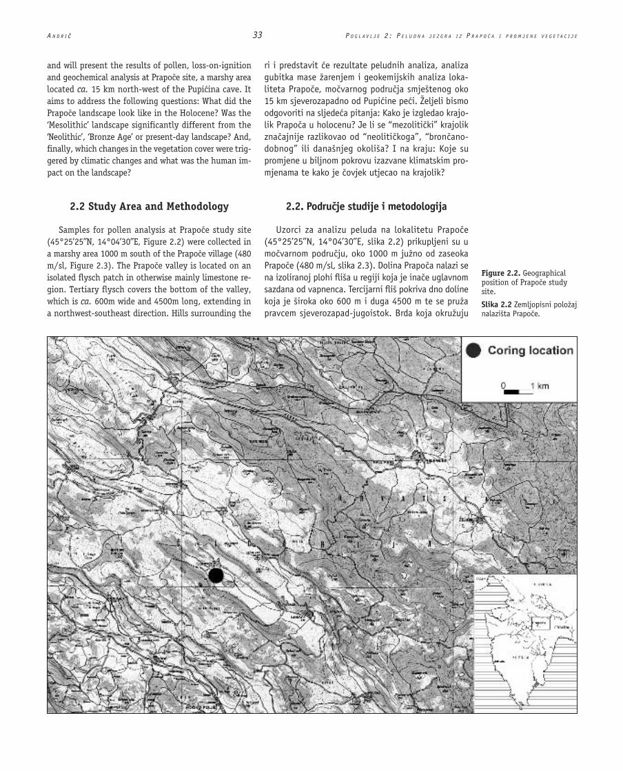
and will present the results of pollen, loss-on-ignition and geochemical analysis at Prapo�e site, a marshy area located ca. 15 km north-west of the Pupi�ina cave. It aims to address the following questions: What did the Prapo�e landscape look like in the Holocene? Was the ‘Mesolithic’ landscape significantly different from the ‘Neolithic’, ‘Bronze Age’ or present-day landscape? And, finally, which changes in the vegetation cover were trig-gered by climatic changes and what was the human im-pact on the landscape?
2.2 Study Area and Methodology
Samples for pollen analysis at Prapo�e study site (45°25’25’’N, 14°04’30’’E, Figure 2.2) were collected in a marshy area 1000 m south of the Prapo�e village (480 m/sl, Figure 2.3). The Prapo�e valley is located on an isolated flysch patch in otherwise mainly limestone re-gion. Tertiary flysch covers the bottom of the valley, which is ca. 600m wide and 4500m long, extending in a northwest-southeast direction. Hills surrounding the
ri i predstavit e rezultate peludnih analiza, analiza gubitka mase žarenjem i geokemijskih analiza loka-liteta Prapo e, mo varnog podru ja smještenog oko 15 km sjeverozapadno od Pupi ine pe i. Željeli bismo odgovoriti na sljede a pitanja: Kako je izgledao krajo-lik Prapo a u holocenu? Je li se “mezoliti ki” krajolik zna ajnije razlikovao od “neoliti koga”, “bron ano-dobnog” ili današnjeg okoliša? I na kraju: Koje su promjene u biljnom pokrovu izazvane klimatskim pro-mjenama te kako je ovjek utjecao na krajolik?
2.2. Podru je studije i metodologija
Uzorci za analizu peluda na lokalitetu Prapo e (45°25’25’’N, 14°04’30’’E, slika 2.2) prikupljeni su u mo varnom podru ju, oko 1000 m južno od zaseoka Prapo e (480 m/sl, slika 2.3). Dolina Prapo a nalazi se na izoliranoj plohi fliša u regiji koja je ina e uglavnom sazdana od vapnenca. Tercijarni fliš pokriva dno doline koja je široka oko 600 m i duga 4500 m te se pruža pravcem sjeverozapad-jugoistok. Brda koja okružuju
Figure 2.2. Geographical position of Prapo�e study site.
Slika 2.2 Zemljopisni položaj nalazišta Prapo e.

C H A P T E R 2 : P R A P O � E P O L L E N C O R E A N D H O L O C E N E V E G E T A T I O N C H A N G E 34 A N D R I Ë
valley consist of Tertiary marl and limestones and exceed 700 m/sl (Šiki� & Pleni�ar 1975).
The climate of �i�arija has some mediterranean and some continental characteristics. The main mediterra-nean characteristic is that the precipitation maximum is in the autumn (October). The secondary precipitation maximum occurs in the spring (Rogli� 1981). The annual amount of precipitation in nearby Laniš�e is 1664 mm (Makjani� & Volari� 1981). Another mediterranean char-acteristic of the climate is that the autumns are warmer than springs. The average annual temperature in Buzet, located 7.5 km south-west from Prapo�e is 12.8°C (7-year average) and the maximum and minimum temperature measured there (before 1981) were 38.6°C and -14.1°C respectively (Tomi� 1981).
The �i�arija area has been classified in terms of its vegetation as a submediterranean region, where ther-mophilous forest of oak (Quercus pubescens Willd.) and hop hornbeam (Ostrya carpinifolia Scop.) prevails (Ilijani� 1981). The vegetation at the coring location is wet meadow with meadowsweet (Filipendula ulmaria L.) and individual poplar (Populus sp.) and willow (Salix sp.) trees (Figure 2.4). Meadows and fields cover the bottom of the valley, whereas open, predominantly broadleaved forest (a mixture of several species of oak, hornbeam, ash, maple, lime, hazel and pine) grows on the slopes
dolinu sastoje se od tercijarnog lapora i vapnenaca te nadmašuju nadmorsku visinu od 700 m (Šiki & Pleni ar 1975).
Klima i arije ima dijelom sredozemne, a dijelom kontinentalne karakteristike. Glavna sredozemna karak-teristika je to što je oborina najviše u jesen (u lis-topadu). Sekundarni maksimum oborina je u prolje e (Rogli 1981). Godišnja koli ina oborina u obližnjem Laniš u je 1664 mm (Makjani & Volari 1981). Drugo sredozemno obilježje klime su jeseni koje su toplije od prolje a. Prosje na godišnja temperatura u Buzetu (7.5 km jugozapadno od Prapo a) je 12.8°C (sedmogodišnji prosjek), najviša ondje izmjerena temperatura iznosi 38.6°C, a najniža -14.1°C (Tomi 1981).
Na temelju vegetacije, podru je i arije klasificirano je kao subsredozemna regija gdje prevladava termofilna šuma hrasta (Quercus pubescens Willd.) i crnoga graba (Ostrya carpinifolia Scop.) (Ilijani 1981). Vegetacija na uzorkovanom lokalitetu je barska livada s kon arom (Filipendula ulmaria L.) te pojedinim stablima topole (Populus sp.) i vrbe (Salix sp.) (slika 2.4). Livade i polja prekrivaju dno doline, dok na okolnim padinama raste rijetka, uglavnom listopadna šuma (mješavina nekoliko razli itih vrsta hrasta, graba, jasena, javora, lipe, lijeske i bora). Vegetacija koja prekriva brežuljke u neposrednoj blizini uzorkovanog lokaliteta sastoji
Figure 2.3. Prapo�e valley.
Slika 2.3 Dolina Prapo a.

A N D R I 35 P O G L A V L J E 2 : P E L U D N A J E Z G R A I Z P R A P O A I P R O M J E N E V E G E T A C I J E
surrounding the valley. The vegetation covering smaller hills in close vicinity of the coring location consists of lime (Tilia platyphyllos Scop.), oak (Quercus petraea [Matt.] Liebl.) and hazel (Corylus avellana L.). Only a few people live in Prapo�e today, but the village was much bigger several decades ago. The local people still remember that several hundred head of cattle were kept in the village, and due to this grazing pressure the slopes surrounding the valley were devoid of forest.
In June 1997 a sedimentary core was collected in the marsh area south of Prapo�e village using a modified 7-cm diameter Livingstone piston corer (Wright 1967), mounted upon a portable drilling rig. Samples were extracted from the corer in the field, wrapped in cling film, tin foil and thick plastic and transported to the laboratory where they were stored in dark at 4ºC. The sediment characteristics of this 212 cm long core were described following Troels-Smith (1955) and the colour of the sediment was determined using Munsell soil chart. The following analyses of the sediment were carried out: radiocarbon dating, loss-on-ignition, geochemical and pollen analysis.
First, 1 cm3 of the sediment was subsampled from se-lected levels of the core using a metal volumetric subsam-pler. A preliminary pollen analysis with sampling resolu-tion ca. 16 cm was carried out in order to roughly estimate which part of the core might be of the Holocene age and the quality of pollen preservation. After the preliminary pollen analysis, 9 cm section (200 g) of the core was sent to Beta Analytic Inc., Florida for radiocarbon dating. Since the sample did not yield enough carbon for standard ra-
se od lipe (Tilia platyphyllos Scop.), hrasta (Quercus petraea [Matt.] Liebl.) i lijeske (Corylus avellana L.). Danas u Prapo u živi tek nekoliko ljudi, no selo je prije nekoliko desetlje a bilo znatno ve e. Doma i ljudi se još sje aju da je u selu bilo nekoliko stotina grla stoke, i upravo su zbog pritiska ispaše ogoljene padine koje okružuju dolinu.
U lipnju 1997. gorine, taložine mo varnog podru ja južno od zaseoka Prapo e jezgrovane su modificiranom 7-centimetarskom Livingstoneovom klipnom bušilicom (Wright 1967) postavljenom na prijenosno buša e postolje. Uzorci su na terenu izva eni iz ure aja, umo-tani u tanku plasti nu foliju, aluminijsku foliju i debelu plastiku te preneseni u laboratorij gdje su pohranjeni u mraku na 4ºC. Svojstva taložine te 212 cm duge jez-gre opisana su prema Troels-Smithu (1955), a njena je boja odre ena prema Munsellovoj skali. Provedene su sljede e analize taložine: datiranje radioaktivnim ug-ljikom, analiza gubitka mase žarenjem te geokemijske i peludne analize.
Najprije je pomo u metalnog volumetri kog pribora za uzimanje uzorka uzet preliminarni uzorak po 1 cm3
taložine iz odabranih razina jezgre. Preliminarna analiza peluda s rezolucijom uzorkovanja od oko 16 cm provede-na je kako bi se grubo odredio dio jezgre koji bi mogao pripadati holocenu te procijenila kvaliteta o uvanosti peludnih zrnaca. Nakon te preliminarne analize, odsje ak jezgre dug 9 cm (200 g) poslan je u laboratorij Beta Analytic na Floridi radi datiranja radioaktivnim ugljikom. Budu i da uzorak nije sadržavao dovoljno ugljena za standardni postupak 14C datiranja, organski ugljik izdvo-
Figure 2.4. The coring location.
Slika 2.4 Mjesto na kojem je provedeno jezgrovanje.

C H A P T E R 2 : P R A P O � E P O L L E N C O R E A N D H O L O C E N E V E G E T A T I O N C H A N G E 36 A N D R I Ë
diometric dating, AMS dating of organic carbon extracted from the sediment was carried out. Four additional sam-ples, 1 cm of the core each time (ca. 20 g of the sediment), were sent for radiocarbon dating, in order to obtain more detailed chronology. For all four samples material pretreat-ment included acid washes and direct atomic counting was performed using an accelerator mass spectrometer. All radiocarbon dates were calibrated by Beta Analytic using INTCAL 98 database (Stuvier et al. 1998).
The amount of organic material and carbonates in the sediment was determined using loss-on-ignition analy-sis (Bengtsson & Enell 1986). For geochemical analysis an acid digestion method (a variation of method 2 of Bengtsson & Enell 1986, M. Braun, personal communica-tion) was used to process the samples. The concentration of 21 elements in each sample was measured by induc-tively coupled plasma atomic-emission spectroscopy us-ing Perkin Elmer Optima 3300 RL spectrometer facility at the Department of Geology, Royal Holloway, University of London, Egham.
Samples for pollen analysis were prepared using the standard laboratory procedures (method B of Berglund & Ralska-Jasiewiczowa 1986; Bennett & Willis 2002), which include the following steps: hot 7% HCl treat-ment, hot 10% NaOH treatment, sieving (180µm mesh), cold 7% HCl, hot 60% HF, hot 7% HCl, acetolysis, stain-ing (0.2% aquaeous safranine), dehydration in TBA and mounting in silicone oil. Two tablets of Lycopodium spores with a known number of spores were added to each sample at the beginning of pollen preparation and Lycopodium spores were counted along with the pollen in order to determine the pollen concentration (Stock-marr 1971). For pollen identification Leitz and Nikon Eclipse E400 light microscopes at 400x magnification were used. Pollen grains were identified by comparison with the reference collection of the Department of Ge-ography, University of Oxford and consulting the fol-lowing pollen keys: Moore, Webb and Collinson (1991), Reille (1992, 1995), and Punt et al. (1976−1995). A minimum count of 600 grains (terrestrial pollen and spores) per sample was made in the levels with the pollen concentration above 1000 pollen grains per 1 cm3 of the sediment. The concentration of microscopic charcoal in the pollen samples was established using Clark’s (1982) point count method.
The diagrams were plotted using PSIMPOLL 3.00 and PSCOMB 3.01 C programs for plotting pollen diagrams and analysing pollen data (Bennett 1998, http://www.kv.geo.uu.se/software.html/). The percentage pol-len diagram was divided into zones using optimal split-ting by information content and the number of significant zones was determined by the broken-stick model (Bennett 1996, 1998). For age modelling all five models available in the PSIMPOLL 3.00 (linear interpolation, cubic spline in-terpolation, general line-fitting by weighted least-squares,
jen iz taložine datiran je metodom akceleratorske masene spektrometrije. etiri dodatna uzorka, od po 1 cm jezgre za svaki (oko 20 g taložine), poslana su na datiranje metodom radioaktivnog ugljika radi odre ivanja to ni-je kronologije. Priprema materijala svih etiriju uzoraka sastojala se od ispiranja kiselinom, a izravno je mjerenje provedeno metodom AMS. Svi 14C datumi kalibrirani su u laboratoriju Beta Analytic koriste i bazu podataka INT-CAL 98 (Stuvier et al. 1998).
Koli ina organskog materijala i karbonata u taložini odre ena je analizom gubitka mase žarenjem (Bengts-son & Enell 1986). Za potrebe geokemijske analize korištena je metoda kiselinske obrade uzoraka (prila-go ena metoda 2 prema Bengtsson & Enell 1986, M. Braun, osobno priop enje). Svakom je uzorku izmje-rena koncentracija 21 elementa induktivnom plazma emisijskom spektroskopijom pomo u Perkin Elmer Opti-ma 3300 RL spektrometra Odsjeka za geologiju, Royal Holloway, Londonskog sveu ilišta u Eghamu.
Uzorci za peludnu analizu pripremljeni su prema standardnim laboratorijskim procedurama (metoda B prema Berglund & Ralska-Jasiewiczowa 1986; Bennett & Willis 2002), koje uklju uju sljede e korake: obrada vru om 7% HCl, obrada vru im 10% NaOH, prosija-vanje (otvori sita veli ine 180µm), obrada hladnom 7% HCl, vru om 60% HF, vru om 7% HCl, acetoliza, bojenje (0,2% vodenom otopinom sufranina), dehidra-cija u TBA i priprema preparata sa silikatnim uljem. Na po etku pripreme, svakom su uzorku dodane po dvije tablete spora Lycopodiuma s poznatim brojem spora. Te su spore izbrojane usporedo sa zrncima peluda kako bi se odredila koncentracija peluda (Stockmarr 1971). Za identifikaciju peluda korišteni su mikroskopi Leitz i Nikon Eclipse E400 pove anja 400x. Zrnca peluda iden-tificirana su usporedbom s referentnom zbirkom Odsjeka za zemljopis Sveu ilišta u Oxfordu te prema sljede im klju evima za pelud: Moore, Webb i Collinson (1991), Reille (1992, 1995) i Punt et al. (1976 1995). U razina-ma s koncentracijom peluda iznad 1000 zrnaca po 1 cm3 taložine, izbrojeno je najmanje 600 zrnaca po uzorku kopneni pelud i spore). Koncentracija mikroskopskih estica drvenog ugljena u uzorcima peluda odre ena je
koriste i metodu brojanja po Clarku (1982).Dijagrami su iscrtani koriste i programe za crtanje
peludnih dijagrama i analizu peludnih podataka PSIM-POLL 3.00 i PSCOMB 3.01 C (Bennett 1998, http://www.kv.geo.uu.se/software.html/). Dijagram pro-centualne zastupljenosti peluda podijeljen je na zone optimalnim cijepanjem prema sadržaju informacija, dok je broj zna ajnih zona odre en prema “broken-stick” modelu (Bennett 1996, 1998). Za modeliranje starosti iskušano je svih pet modela dostupnih u PSIMPOLL 3.00 (linearna interpolacija, interpolacija splineovima tre eg reda, op a aproksimacija pravcem ponderiranom meto-dom najmanjih kvadrata, op a aproksimacija pravcem

A N D R I 37 P O G L A V L J E 2 : P E L U D N A J E Z G R A I Z P R A P O A I P R O M J E N E V E G E T A C I J E
general line-fitting by singular value decomposition, curve-fitting by Bernshtein polynomial, Bennett 1994) were run and, due to the irregular sedimentation rate throughout the sequence, the linear interpolation was selected as the most appropriate age model. The intercept of radiocarbon age with the calibration curve (in calibrated years BP) was used for the age modelling and the positions of these dates are plotted on each diagram. The principle components analysis (PCA) was also run with the PSIMPOLL program (Bennett 1998) and during the analysis of the pollen data the square root transformation of the dataset was car-ried out to diminish the influence of more numerous taxa (Birks & Gordon 1985; Grimm 1987; Bennett 1998).
2.3 Results
The results of loss-on-ignition, geochemical and pol-len analysis of the sediment are presented on several diagrams (Figures 2.6−2.7, and 2.9−2.11). The sediment description of the core and radiocarbon dates, presented on Tables 2.1 and 2.2, are included also in the loss-on-ignition, geochemistry and pollen diagrams (Figures 2.6, 2.7 and 2.9). On each of these diagrams the sample depth is presented on the far left side, followed by the age estimation (in years BC/AD), sedimentary column and the position of each radiocarbon date (in years Cal. BP). The results of analyses (loss-on-ignition, geochemistry, pollen and charcoal) follow, and each diagram concludes with the column marking pollen zones. Only the results of pollen analysis were used for this zonation, although the pollen zones are plotted also on loss-on-ignition and geochemistry diagrams in order to facilitate comparison between diagrams.
2.3.1 Radiocarbon dates and age modelling
The radiocarbon date for the bottom of the Prapo�e core at 206 cm indicates that the sequence extends back to ca. 7500 Cal. BC. Five radiocarbon dates have been ob-tained by AMS dating of organic carbon extracted from the sediment and the results are presented in Table 2.1.
Radiocarbon dates plotted against depth (Figure 2.5) suggest that the sedimentation rate increased towards the end of the Holocene, from ca. 1.1 cm of
singularnom dekompozicijom, aproksimacija krivulje Bernsteinovim polinomom, Bennett 1994). Budu i da je brzina taloženja slojeva kroz itav slijed bila neu-jedna ena, kao najpodesniji model odabrana je metoda linearne interpolacije. Za modeliranje starosti koristi-li smo sjecišta 14C datuma i kalibracijske krivulje (u kalibriranim godinama pr. Kr.) pa smo navedene datume unijeli u sve dijagrame. Analiza glavnih komponenata (PCA) tako er je provedena pomo u programa PSIMPOLL (Bennett 1998). Za potrebe analize peludnih podataka provedena je transformacija kvadratnim korjenovanjem kako bi se umanjio utjecaj bolje zastupljenih taksona (Birks & Gordon 1985; Grimm 1987; Bennett 1998).
2.3. Rezultati
Rezultati analize gubitka mase žarenjem, geokemij-ske analize i analize peluda predstavljeni su na nekoliko dijagrama (slika 2.6 2.7, i 2.9 2.11). Opis taložina jezgre i 14C datumi, predstavljeni u tablicama 2.1 i 2.2, uklju eni su i u dijagrame gubitka mase žarenjem, geo-kemijske i peludne dijagrame (slika 2.6, 2.7 i 2.9). Na svakom dijagramu, sasvim lijevo, nazna ena je dubina uzorka, zatim slijedi procjena starosti (u godinama pr. Kr./po Kr.), taložinski stupac i položaj svakog 14C datu-ma (u godinama pr. Kr. kalibrirano). Slijede re zultati analiza (gubitka mase žarenjem, geokemije, peluda, drvenog ugljena), a svaki dijagram završava stupcem koji nazna uje peludne zone. Za odredbu zona koriš-tene su samo peludne analize, premda su zbog lakše usporedbe dijagrama peludne zone tako er prikazane i na dijagramima gubitka mase žarenjem i geokemijskim dijagramima.
2.3.1. 14C datumi i modeliranje starosti
Starost dna jezgre iz Prapo a na dubini 206 cm, odre ena metodom radioaktivnog ugljika, ukazuje da slijed seže u prošlost do oko 7500. godine pr. Kr. (ka-librirano). Pet 14C datuma dobiveno je AMS metodom datiranja organskog ugljena izdvojenog iz taložine. Rezultati su prikazani na tablici 2.1.
14C datumi, prikazani pored dubine (slika 2.5), uka-zuju da se brzina taloženja pove ala pri kraju holocena,
Sample Number Depth (cm) Conventional 14C age
13C/12C ratio Intercept with Calibration Curve BC (BP) 2 S.D. Calibrated Range
Beta-183918 131 1660±40 bp -26.3 o/oo 400 AD (1550 BP) 260−290, 320−450 AD
Beta-145368 140 3050±40 bp -24.5 o/oo 1310 BC (3260 BP) 1410−1200 BC
Beta-183919 150 3680±40 bp -22.9 o/oo 2040 BC (3990 BP) 2190-2170, 2150-1940 BC
Beta-123732 163-172 5250±60 bp -27.7 o/oo 4035 BC (5985 BP) 4235−3960 BC
Beta-141212 206 8360±40 bp -25.4 o/oo 7475 BC (9425 BP) 7530−7330 BC
Table 2.1. Prapo�e radio-carbon dates.
Tablica 2.1 14C datumi iz Prapo a.

C H A P T E R 2 : P R A P O � E P O L L E N C O R E A N D H O L O C E N E V E G E T A T I O N C H A N G E 38 A N D R I Ë
2.3.2 Sediment description and loss-on-ignition analysis
The Prapo�e core is clay-rich throughout (Table 2.2). Results of loss-on-ignition are presented on Figure 2.6. Pollen zones (P-1 to P-4) have been included in this dia-gram in order to facilitate the comparison between loss-on-ignition and pollen data.
The amount of organic material, carbonates and inor-ganic residue is presented as a percentage calculated from the dry weight of 1 cm3 of the sediment. The percentage of organic material in the bottom half of the core is be-low 10% and slightly increases towards the top. The inor-ganic content of the core is 80−90%. At the bottom of the core in the zone P-1 the amount of carbonates is higher (5−15%) than in the rest of the core (ca. 2.5%).
2.3.2. Opis taložine i analiza gubitka mase žarenjem
Jezgra iz Prapo a po itavoj je dužini bogata glinom (tablica 2.2). Rezultati analize gubitka mase žarenjem predstavljeni su na slici 2.6. Peludne zone (P-1 do P-4) uklju ene su u navedeni dijagram kako bi se ti rezultati mogli lakše usporediti s podacima o peludu.
Koli ine organskog materijala, karbonata i anorgan-skih ostataka prikazane su kao postoci od težine 1 cm3 suhe taložine. Koli ina organskog materijala u donjoj polovici jezgre je ispod 10% te lagano raste prema njenom vrhu. Koli ina anorganskih tvari je 80 90%. Pri dnu jezgre u zoni P-1 koli ina karbonata je ve a (5 15%), nego u ostatku jezgre (oko 2,5%).
Table 2.2. Prapo�e sediment column. Description of the sediment follows Troels-Smith (1955).Tablica 2.2 Prapo e: opis taložine prema Troels-Smith (1955).
Depth (m) Troels-Smith symbol Colour (Munsell soil chart)
0.25-0.43 As4 (clay) 10 YR 4/2 dark greyish brown
0.43-1.00 As4 (clay) 2.5 YR 4/2 dark greyish brown
1.00-1.06 As4 (clay) 2.5 Y 3/2 very dark greyish brown
1.06-1.14 As4 (clay) 5Y 2.5/1 black
1.14-1.45 As4 (clay) marbled, 2.5 Y 4/2 dark greyish brown
1.45-1.60 As4 (clay) marbled, 2.5 Y 4/3 olive brown
1.60-1.90 As4 (clay) marbled, 2.5 Y 4/4 olive brown
1.90-2.20 As4 (clay) marbled, 2.5 Y 5/2 olive grey
Figure 2.5. Prapo�e: Sedi-ment age (calibrated 2 S.D. ranges) plotted against depth (data from Table 2.1).
Slika 2.5 Prapo e: starost taložine (kalibrirani rasponi od 2 S.D.) po dubini (podaci iz tablice 2.1).
sediment /100 years at the bottom of the core to ca. 8 cm/100 years in the section of the core dated after ca. 1500 Cal. BP.
od oko 1.1 cm taložine na 100 godina pri dnu jezgre na oko 8 cm na 100 godina u dijelu jezgre datiranom nakon oko 1500. prije sadašnjosti (kalibrirano).

A N D R I 39 P O G L A V L J E 2 : P E L U D N A J E Z G R A I Z P R A P O A I P R O M J E N E V E G E T A C I J E
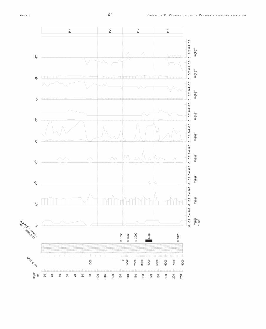
2.3.3 Geochemistry
The results of geochemical analysis (Figure 2.7) are plotted as weight (in mg) of each element per 1 kg of dry sediment. Pollen zones (P-1 to P-4) have been included in this diagram in order to facilitate the comparison between geochemistry and pollen data. The concentrations of iron (Fe) and aluminium (Al) fluctuate between approximately 20−40 mg/kg. The amount of magnesium (Mg) and potas-sium (K) stay constant throughout the whole sequence, ca. 10 mg/kg. The calcium (Ca) curve, however, is high at the bottom of the core (up to 120 mg/kg) and decreases at the top of the zone P-1. This calcium peak coincides with higher carbonates, determined by the loss-on-igni-tion (Figure 2.6).
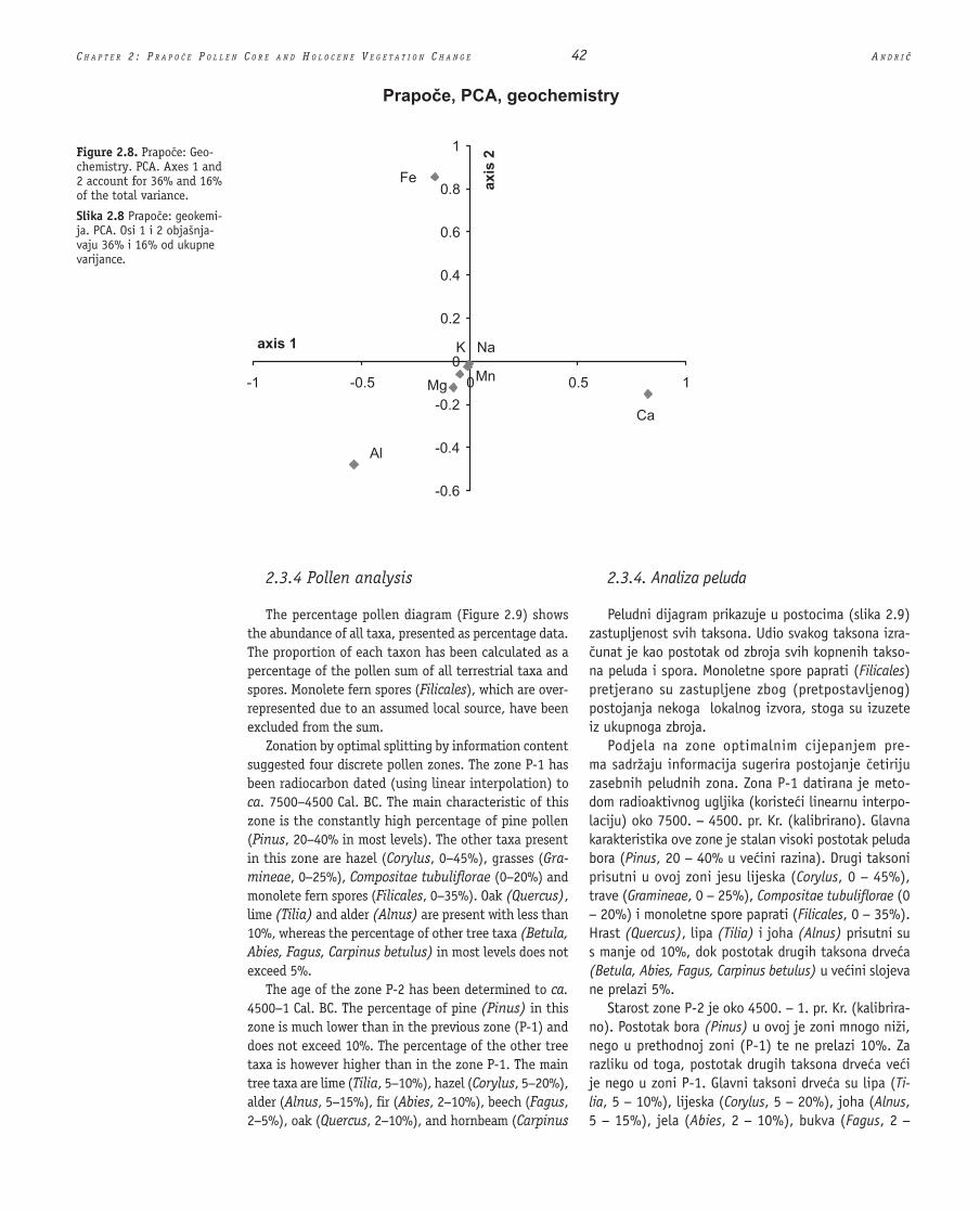
The PCA of geochemical analysis (Figure 2.8) shows that the main direction of variance on the first axis is between calcium (Ca) and aluminium (Al). The main di-rection of variance on the second axis is between iron (Fe) and aluminium (Al). The variance along the first axis (accounting for 36% of total variance) can be associated with changes of temperature and wetness, controlling the precipitation of calcium carbonate into the sediment. The reasons for variance along other axes are still poorly un-derstood. It might be connected with changes in the redox conditions of the sediment.
2.3.3. Geokemijska analiza
Rezultati geokemijske analize (slika 2.7) prikazani su kao težina svakog elementa (u mg) po 1 kg suhe taložine. Peludne zone (P-1 do P-4) prikazane su s namjerom da olakšaju usporedbu izme u geokemijskih podataka i podataka o peludu. Koncentracije željeza (Fe) i aluminija (Al) kolebaju se izme u otprilike 20 40 mg/kg. Koli ine magnezija (Mg) i kalija (K), oko 10 mg/kg, konstantne su kroz itav slijed. Krivulja kalcija (Ca) pokazuje visoke vrijednosti pri dnu jezgre (do 120 mg/kg), dok se one prema vrhu zone P-1 smanjuju. Ovaj maksimum kalcija podudara se s povišenim vrije-dnostima karbonata, odre enih analizom gubitka mase žarenjem (slika 2.6).
Analiza glavnih komponenata (slika 2.8) pokazuje da je prva glavna komponenta saturirana kalcijem (Ca) i aluminijem (Al). Druga glavna komponenta saturirana je željezom (Fe) i aluminijem (Al). Varijanca duž prve osi (koja objašnjava 36% od ukupne varijabilnosti) može se dovesti u svezu s promjenama temperature i vlažnosti, koje odre uju obaranje kalcijevog karbona-ta u taložini. Uzroci varijance duž druge osi zasad su nejasni. Mogu e je da je ona povezana s promjenama oksidacijsko-redukcijskih uvjeta unutar taložine.
Figure 2.6. Prapo�e: Loss-on-ignition. “ ” marks position of 0.5-cm section of core for AMS 14C date; “ ” marks position of 9-cm section of core for AMS 14C date.
Slika 2.6 Prapo e: gubitak mase žarenjem. “ ” ozna a-va položaj odsje aka jezgre dužine 0,5 cm uzetih za AMS 14C datiranje; “ ”ozna ava položaj 9 cm odsje ka jezgre uzetog za AMS 14C datiranje.

C H A P T E R 2 : P R A P O � E P O L L E N C O R E A N D H O L O C E N E V E G E T A T I O N C H A N G E 40 A N D R I Ë
Figure 2.7. Prapo�e: Geochemistry. “ ” marks position of 0.5-cm section of core for AMS 14C date; “ ” marks position of 9-cm section of core for AMS 14C date.
Slika 2.7 Prapo e: geokemi-ja. “ ”ozna ava položaj odsje aka jezgre dužine 0,5 cm uzetih za AMS 14C dati-ranje; “ ”ozna ava položaj 9 cm odsje ka jezgre uzetog za AMS 14C datiranje.
A N D R I 41 P O G L A V L J E 2 : P E L U D N A J E Z G R A I Z P R A P O A I P R O M J E N E V E G E T A C I J E
C H A P T E R 2 : P R A P O � E P O L L E N C O R E A N D H O L O C E N E V E G E T A T I O N C H A N G E 42 A N D R I Ë
2.3.4 Pollen analysis
The percentage pollen diagram (Figure 2.9) shows the abundance of all taxa, presented as percentage data. The proportion of each taxon has been calculated as a percentage of the pollen sum of all terrestrial taxa and spores. Monolete fern spores (Filicales), which are over-represented due to an assumed local source, have been excluded from the sum.
Zonation by optimal splitting by information content suggested four discrete pollen zones. The zone P-1 has been radiocarbon dated (using linear interpolation) to ca. 7500−4500 Cal. BC. The main characteristic of this zone is the constantly high percentage of pine pollen (Pinus, 20−40% in most levels). The other taxa present in this zone are hazel (Corylus, 0−45%), grasses (Gra-mineae, 0−25%), Compositae tubuliflorae (0−20%) and monolete fern spores (Filicales, 0−35%). Oak (Quercus), lime (Tilia) and alder (Alnus) are present with less than 10%, whereas the percentage of other tree taxa (Betula, Abies, Fagus, Carpinus betulus) in most levels does not exceed 5%.
The age of the zone P-2 has been determined to ca. 4500−1 Cal. BC. The percentage of pine (Pinus) in this zone is much lower than in the previous zone (P-1) and does not exceed 10%. The percentage of the other tree taxa is however higher than in the zone P-1. The main tree taxa are lime (Tilia, 5−10%), hazel (Corylus, 5−20%), alder (Alnus, 5−15%), fir (Abies, 2−10%), beech (Fagus, 2−5%), oak (Quercus, 2−10%), and hornbeam (Carpinus
2.3.4. Analiza peluda
Peludni dijagram prikazuje u postocima (slika 2.9) zastupljenost svih taksona. Udio svakog taksona izra-unat je kao postotak od zbroja svih kopnenih takso-
na peluda i spora. Monoletne spore paprati (Filicales) pretjerano su zastupljene zbog (pretpostavljenog) postojanja nekoga lokalnog izvora, stoga su izuzete iz ukupnoga zbroja.
Podjela na zone optimalnim cijepanjem pre-ma sadržaju informacija sugerira postojanje etiriju zasebnih peludnih zona. Zona P-1 datirana je meto-dom radioaktivnog ugljika (koriste i linearnu interpo-laciju) oko 7500. 4500. pr. Kr. (kalibrirano). Glavna karakteristika ove zone je stalan visoki postotak peluda bora (Pinus, 20 40% u ve ini razina). Drugi taksoni prisutni u ovoj zoni jesu lijeska (Corylus, 0 45%), trave (Gramineae, 0 25%), Compositae tubuliflorae (0 20%) i monoletne spore paprati (Filicales, 0 35%).
Hrast (Quercus), lipa (Tilia) i joha (Alnus) prisutni su s manje od 10%, dok postotak drugih taksona drve a (Betula, Abies, Fagus, Carpinus betulus) u ve ini slojeva ne prelazi 5%.
Starost zone P-2 je oko 4500. 1. pr. Kr. (kalibrira-no). Postotak bora (Pinus) u ovoj je zoni mnogo niži, nego u prethodnoj zoni (P-1) te ne prelazi 10%. Za razliku od toga, postotak drugih taksona drve a ve i je nego u zoni P-1. Glavni taksoni drve a su lipa (Ti-lia, 5 10%), lijeska (Corylus, 5 20%), joha (Alnus, 5 15%), jela (Abies, 2 10%), bukva (Fagus, 2
Figure 2.8. Prapo�e: Geo-chemistry. PCA. Axes 1 and 2 account for 36% and 16% of the total variance.
Slika 2.8 Prapo e: geokemi-ja. PCA. Osi 1 i 2 objašnja-vaju 36% i 16% od ukupne varijance.
A N D R I 43 P O G L A V L J E 2 : P E L U D N A J E Z G R A I Z P R A P O A I P R O M J E N E V E G E T A C I J E
Figure 2.9. Prapo�e: Percentage pollen diagram. “ ” marks position of 0.5-cm section of core for AMS 14C date; “ ” marks position of 9-cm section of core for AMS 14C date.
Slika 2.9 Prapo e: dijag-ram procentualnog udjela peluda. “ ”ozna ava položaj odsje aka jezgre dužine 0,5 cm uzetih za AMS 14C dati-ranje; “ ”ozna ava položaj 9 cm odsje ka jezgre uzetog za AMS 14C datiranje.

C H A P T E R 2 : P R A P O � E P O L L E N C O R E A N D H O L O C E N E V E G E T A T I O N C H A N G E 44 A N D R I Ë

A N D R I 45 P O G L A V L J E 2 : P E L U D N A J E Z G R A I Z P R A P O A I P R O M J E N E V E G E T A C I J E

C H A P T E R 2 : P R A P O � E P O L L E N C O R E A N D H O L O C E N E V E G E T A T I O N C H A N G E 46 A N D R I Ë
betulus, 2−5%). Towards the top of the zone herb pollen (mainly Gramineae, Compositae liguliflorae and Gerani-um) starts to increase and exceeds 50%. The first cereal type pollen grains appear at the middle of the zone P-2 which is dated to ca. 2100 Cal. BC.
In the zone P-3 (1 Cal. BC−850 AD) the percentage of tree pollen is below 10% and herbs reach ca. 80%. Among tree taxa the alder (Alnus) and hazel (Corylus) pollen reach values of ca. 5%, whereas the pollen of oth-er trees, although constantly present, usually does not exceed 1%. Herbs characteristic for this pollen zone are Compositae liguliflorae (40−70%), Gramineae (5−15%), Geranium (5−30%), and Compositae tubuliflorae (ca. 10%).
The percentage of tree pollen remains low in zone P-4 (850−1950 AD). The percentage of alder (Alnus) and hazel (Corylus) decreases below 2%. The main charac-teristic of this pollen zone is an increase of Cyperaceae (ca. 40%) and Filipendula pollen (exceeds 10% in one level), whereas the percentage of Compositae liguliflo-rae (10−40%), Compositae tubuliflorae (ca. 2%) and Geranium (ca. 2%) decreases.
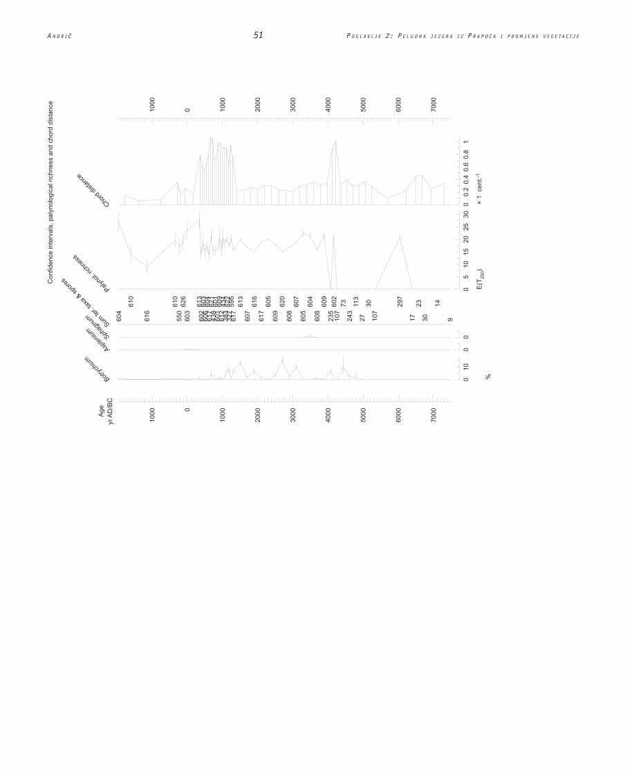
Due to low pollen concentration (in some levels below 500 pollen grains per 1 cm3) the pollen sum in some sec-tions of Prapo�e core does not exceed 250. Therefore the percentage pollen diagram with 95% confidence inter-vals (Figure 2.10) has been plotted against age in order to evaluate the precision of percentages displayed on the pollen diagram. Horizontal bars at each level indi-cate where the percentage values for each taxa would be located (with 95% probability) if pollen counting would be repeated (Maher 1972; Bennett 1998). Palynological richness (measuring the number of taxa in the pollen spectrum) and chord distance (rate-of-change analysis measuring dissimilarity between adjacent pairs of sam-ples) have also been included in this diagram. The rate of change is highest at ca. 500 AD, whereas the paly-nological richness is highest at ca. 800 AD and in the present-day landscape. Owing to additional radiocarbon dating of the Prapo�e core, the estimated age of ‘rate of change’ and ‘palynological richness’ peaks is several centuries younger than suggested previously (Andri� 2001a, 2001b).
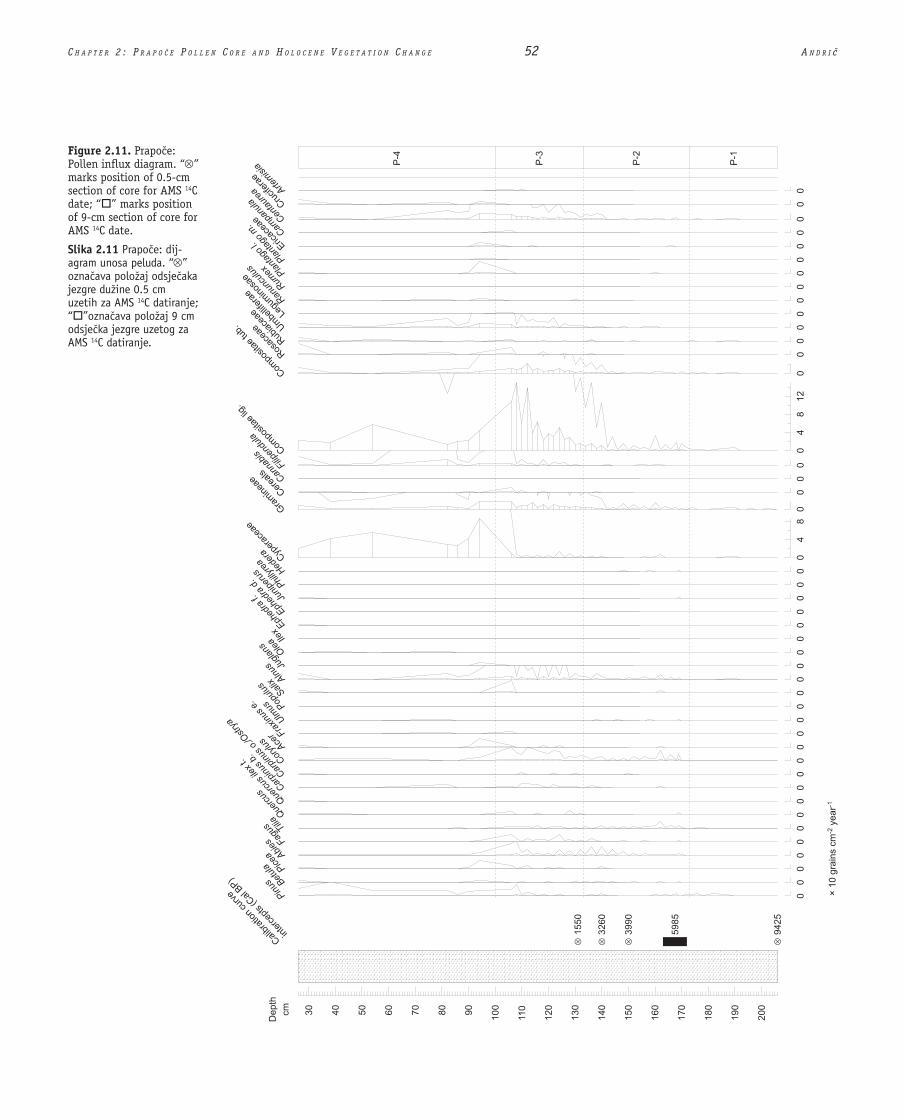
The influx pollen diagram (Figure 2.11) presents the dataset in grains per cm2 per year. In the zone P-1 pollen influx is below 10 grains per cm2 per year, then it gradu-ally increases, being highest at the transition between zones P-3 and P-4 (100−200 grains per cm2 per year).
The results of principal components analysis (PCA) are presented on Figures 2.12 and 2.13. During the PCA the square root transformation was carried out in order to diminish the influence of more numerous taxa and therefore more clearly see the variance in the dataset. Only taxa with a significant percentage (at least 5% of the pollen sum) were included and results are presented
5%), hrast (Quercus, 2 10%) i obi ni grab (Carpinus betulus, 2 5%). Pri vrhu zone po inje rasti udio peluda zeljastog bilja (uglavnom Gramineae, Compositae ligu-liflorae i Geranium) te prelazi 50%. Prva peludna zrnca tipa žitarica pojavljuju se pri sredini zone P-2 koja se datira oko 2100. pr. Kr. (kalibrirano).
U zoni P-3 (1. pr. Kr. [kalibrirano] 850. po Kr.), postotak peluda drve a je ispod 10%, dok zastuplje-nost zeljastih biljaka dostiže oko 80%. Me u taksonima drve a, pelud johe (Alnus) i lijeske (Corylus) dostiže vrijednost od oko 5%, dok pelud drugog drve a, iako je stalno prisutan, ne prelazi 1%. Ovu peludnu zonu obilježuju zeljaste biljke, Compositae liguliflorae (40 70%), Gramineae (5 15%), Geranium (5 30%), i
Compositae tubuliflorae (oko 10%).Postotak peluda drve a u zoni P-4 (850. 1950.
po Kr.) i dalje je nizak. Postotak johe (Alnus) i lijes-ke (Corylus) pada ispod 2%. Glavna karakteristika ove peludne zone jest porast zastupljenosti peluda šaševa (Cyperaceae) (oko 40%) i Filipendule (preko 10% u jednoj od razina, dok se postotak Compositae liguliflo-rae (10 40%), Compositae tubuliflorae (oko 2%) i Geraniuma (oko 2%) smanjuje.
Zbog niske koncentracije peluda (manje od 500 peludnih zrnaca po 1 cm3 u nekim razinama), njegov ukupan zbroj u nekim sekcijama jezgre iz Prapo a ne prelazi 250. Zbog toga su, pored starosti, na dijagramu procentualne zastupljenosti prikazani i intervali 95% pouzdanosti (slika 2.10), kako bi se preciznost tih podataka mogla uzeti u obzir. Vodoravne linije nazna-uju, za svaku razinu, gdje bi se (s vjerojatnoš u 95%)
nalazile procentualne vrijednosti za svaki od taksona kad bi se brojanje peludnih zrnaca ponavljalo (Maher 1972; Bennett 1998). Bogatstvo peluda (mjereno bro-jem vrsta u peludnom spektru) i udaljenost akorda (analiza brzine promjene, mjerene razli itoš u izme u susjednih parova uzoraka) tako er su uklju eni u dija-gram. Brzina promjene najve a je oko 500. godine po Kr., dok je bogatstvo peluda najve e oko 800. godine po Kr. te u današnjem krajoliku. Zahvaljuju i dodatnim 14C datumima za jezgru iz Prapo a, starost maksimuma ‘brzine promjene’ i ‘bogatstva peluda’ procijenjena je na nekoliko stolje a kasnije, no što je to prije bilo predloženo (Andri 2001a, 2001b).
Dijagram priliva peluda (slika 2.11) pruža podatke o broju zrnaca po cm2 na godinu. U zoni P-1, priliv je ispod 10 zrnaca po cm2 godišnje, zatim se postepeno pove ava, a najve i je pri prijelazu izme u zona P-3 i P-4 (100 200 zrnaca po cm2 godišnje).
Rezultati analize glavnih komponenata (PCA) pred-stavljeni su na slikama 2.12 i 2.13. Za potrebe PCA provedena je transformacija kvadratnim korjenovanjem kako bi se umanjio utjecaj brojnije zastupljenih tak-sona i tako jasnije uo ila varijanca podataka. Uzeti su u obzir samo taksoni sa zna ajnom procentualnom

A N D R I 47 P O G L A V L J E 2 : P E L U D N A J E Z G R A I Z P R A P O A I P R O M J E N E V E G E T A C I J E
Figure 2.10. Prapo�e: Percentage pollen dia-gram. Confi dence intervals, palynological richness and chord distance.
Slika 2.10 Prapo e: dijagram procentualnog udjela peluda. Intervali pouzdanosti, bogat-stvo polena i udaljenost akorda.

C H A P T E R 2 : P R A P O � E P O L L E N C O R E A N D H O L O C E N E V E G E T A T I O N C H A N G E 48 A N D R I Ë

A N D R I 49 P O G L A V L J E 2 : P E L U D N A J E Z G R A I Z P R A P O A I P R O M J E N E V E G E T A C I J E

C H A P T E R 2 : P R A P O � E P O L L E N C O R E A N D H O L O C E N E V E G E T A T I O N C H A N G E 50 A N D R I Ë
A N D R I 51 P O G L A V L J E 2 : P E L U D N A J E Z G R A I Z P R A P O A I P R O M J E N E V E G E T A C I J E
C H A P T E R 2 : P R A P O � E P O L L E N C O R E A N D H O L O C E N E V E G E T A T I O N C H A N G E 52 A N D R I Ë
Figure 2.11. Prapo�e: Pollen infl ux diagram. “ ” marks position of 0.5-cm section of core for AMS 14C date; “ ” marks position of 9-cm section of core for AMS 14C date.
Slika 2.11 Prapo e: dij-agram unosa peluda. “ ” ozna ava položaj odsje aka jezgre dužine 0.5 cm uzetih za AMS 14C datiranje; “ ”ozna ava položaj 9 cm odsje ka jezgre uzetog za AMS 14C datiranje.
A N D R I 53 P O G L A V L J E 2 : P E L U D N A J E Z G R A I Z P R A P O A I P R O M J E N E V E G E T A C I J E

C H A P T E R 2 : P R A P O � E P O L L E N C O R E A N D H O L O C E N E V E G E T A T I O N C H A N G E 54 A N D R I Ë
on Figure 2.12. Axis 1 and 2 account for 39% and 18%, respectively, of the total variance in the dataset. The main direction of variance on the first axis is between herbaceous types (e.g. Compositae liguliflorae, Gra-mineae, Compositae tubuliflorae, Centaurea), sedges (Cyperaceae), pine (Pinus), oak (Quercus), charcoal and monolete fern spores (Filicales), lime (Tilia), fir (Abies), and hazel (Corylus). The main direction of vari-ance on the second axis is between pine (Pinus) and some herbaceous types (Compositae liguliflorae, Gera-nium, Filicales).
The sample scores have also been plotted and the points (each point on the diagram represents one sam-ple) were connected in chronological order (Figure 2.13). Axis 1 and 2 account for 58% and 12%, respectively, of the total variance in the dataset. The main direction of variance on the first axis is between samples from the top of the core (dated after 1000 AD) and mid-Holocene samples. The main direction of variance on the second axis is between early Holocene samples and samples dated between ca. 100 Cal. BC − 850 AD.
zastupljenoš u (barem 5% od ukupnog zbroja peluda), a rezultati su predstavljeni na slici 2.12. Osi 1 i 2 objašnjavaju 39%, odnosno 18% od ukupne varijance podataka. Prva glavna komponenta zasi ena je zel-jastim biljnim tipovima (e.g. Compositae liguliflorae, Gramineae, Compositae tubuliflorae, Centaurea), šaše-vima (Cyperaceae), borom (Pinus), hrastom (Quercus), drvenim ugljenom i monoletnim sporama paprati (Fili-cales), lipom (Tilia), jelom (Abies) i lijeskom (Corylus). Druga glavna komponenta zasi ena je borom (Pinus) i nekim zeljastim biljnim tipovima (Compositae liguliflo-rae, Geranium, Filicales).
Vrijednosti za pojedine uzorke prikazane su dijagra-mom (slika 2.13) na kojem svaka to ka predstavlja po jedan uzorak, a spojene su kronološkim redom. Osi 1 i 2 objašnjavaju 58%, odnosno 12% ukupne varijance podataka. Prva glavna komponenta zasi ena je uzorci-ma s vrha jezgre (datiranih nakon 1000. godine po Kr.) i uzorcima iz sredine holocena. Druga glavna kompo-nenta zasi ena je uzorcima iz ranog holocena i uzorcima datiranim oko 100. pr. Kr. (kalibrirano) 850. po Kr.
Figure 2.12. Prapo�e: PCA. Axes 1 and 2 account for 39.6% and 18.2% of the total variance in the dataset. (The unlabelled points in the middle of the diagram are scores for Betula, Quercus ilex type, Alnus, Juglans, Filipendula, Leguminosae, Ranunculus, Plantago l., Cruciferae and Selaginella.)
Slika 2.12 Prapo e: PCA. Osi 1 i 2 objašnjavaju 39,6% i 18,2% od ukupne varijan-ce. (Neozna ene to ke pri sredini dijagrama rezultati su vrijednosti ua Betula, tip Quercus ilex, Alnus, Juglans, Filipendula, Leguminosae, Ranunculus, Plantago l., Cruciferae i Selaginella.)

A N D R I 55 P O G L A V L J E 2 : P E L U D N A J E Z G R A I Z P R A P O A I P R O M J E N E V E G E T A C I J E
2.4 The Holocene Vegetation in the Prapo�e area
In the early Holocene (7500−4500 Cal. BC) Prapo�e area was probably surrounded by woodland of pine, oak, lime and hazel. Due to the low pollen concentration and high percentage of degraded pollen grains it is difficult to estimate whether the pollen record reflects the real vegetation composition or postdepositional preserva-tion due to a selective degradation. The pollen sum in most levels does not exceed 250, confidence intervals for pollen counts are wide (Figure 2.10) and vegetation composition cannot be discussed in detail. Degraded pollen and low pollen concentration might indicate a warm and dry climate in the early Holocene. Pollen sur-vival tends to be poor in dry, aerobic conditions with high microbial activity in the sediment (Moore et al. 1991). Loss-on-ignition and geochemical results support this suggestion. The concentration of calcium (Ca) in the sediment depends on the temperature (Cole 1979; Williams et al. 1998). Increased temperature and pro-
2.4. Holocenska vegetacija na podru ju Prapo a
U ranom holocenu (7500. 4500. pr. Kr. [kalibri-rano]), podru je Prapo a bilo je vjerojatno okruženo šumama bora, hrasta, lipe i lijeske. Zbog niske koncen-tracije peluda i velikog postotka degradiranih peludnih zrnaca, teško je procijeniti odražava li gra a stvarni sastav vegetacije ili je posljedica selektivne degradacije peluda nakon odlaganja. Ukupni zbroj peluda u ve i-ni razina ne prelazi 250, intervali pouzdanosti za broj peludnih zrnaca su široki (slika 2.10) pa ne možemo podrobno raspravljati o sastavu vegetacije. Degradacija i niska koncentracija peluda mogli bi upu ivati na toplu i suhu klimu za ranog holocena. Pelud se obi no loše uva u suhim, aerobnim uvjetima, u taložini s veli-
kom aktivnoš u mikroorganizama (Moore et al. 1991). Analize gubitka mase žarenjem i geokemijski rezultati podupiru ovu pretpostavku. Koncentracija kalcija (Ca) u taložini ovisi o temperaturi (Cole 1979; Williams et al. 1998). Pove ana temperatura i postupno isparavanje
Figure 2.13. Prapo�e: PCA sample scores.
Slika 2.13 Prapo e: PCA vrijednosti uzoraka.

C H A P T E R 2 : P R A P O � E P O L L E N C O R E A N D H O L O C E N E V E G E T A T I O N C H A N G E 56 A N D R I Ë
gressive evaporation of the lake water could cause the precipitation of calcium carbonate into the sediment. In the section of the core dated between ca. 8000−5500 Cal. BC the concentration of carbonates (10−20% of the sediment dry weight, Figure 2.6) and calcium (60−120 mg per kg, Figure 2.7) is higher than in the upper part of the core and might indicate relatively more arid con-ditions before 5500 Cal. BC than after this date. Our results match with palaeoecological research on the island of Mljet (southern Dalmatia), where the pollen record and the concentration of pigments in the sedi-ment suggest that between ca. 6000−4400 Cal. BC the climate on the eastern Adriatic coast was dry (Jahns & van den Bogaard 1998).
An increase of iron (Fe), which followed at ca. 5000−4500 Cal. BC was probably caused by changes of redox conditions due to waterlogging of the basin. Under oxidising conditions iron has, similar to manganese (Mn) very low solubility. It only becomes mobile under reduc-ing conditions. The difference between the two elements is that manganese can become mobile already under mod-erately anaerobic conditions. When anaerobic conditions in the soil surrounding the basin increase, manganese is washed out of the soil before iron (Mackereth 1966; Engstrom & Wright 1984). The low values of the Fe:Mn ratio before the iron peak on the diagram (Figure 2.7) therefore suggest that the valley gradually became wa-terlogged at ca. 5000 Cal. BC. The fluctuation of the iron and Fe:Mn ratio curves after 5000 Cal. BC indicate that the redox conditions in the basin were fluctuating.
In the section of the core dated after 4500 Cal. BC the percentage of degraded pollen grains declines and pollen concentration increases to 2000−6000 grains per 1 cm3 of the sediment (Figure 2.9). This indicates that the pollen record in this section of the core is reliable and pollen composition was probably not changed due to selective preservation. Here a rather low pollen concentration is most likely a consequence of sedimentation rate and vegetation composition.
The vegetation growing in the Prapo�e area between 4500 and 2000 Cal. BC was probably an open forest of lime, oak, beech, fir, hornbeam, hop hornbeam, and ha-zel. Alder and willow were growing in the marshy areas in the bottom of the valley. High percentages of hazel (5−25%) and herb pollen (20−60%) suggest that open areas, presumably meadows and fields, were located in the vicinity of the coring location. Several lines of evi-dence suggest that human activity in the area might be the reason for this forest thinning. The charcoal record detects regular, small-scale burning of the landscape, and several ‘anthropogenic indicators’ (Plantago l., Centau-rea, Artemisia, Chenopodiaceae) appear on the pollen diagram. The poor pollen preservation at the bottom of the core does not allow one to see how open was the land-scape before 4500 Cal. BC and whether these, ‘anthropo-
jezerske vode može uzrokovati obaranje kalcijeva kar-bonata u taložinu. U dijelu jezgre datiranom otprilike izme u 8000. 5500. pr. Kr. (kalibrirano), koncentracija karbonata (10 20% težine suhe taložine, slika 2.6) i kalcija (60 120 mg po kilogramu, slika 2.7) ve a je nego u gornjem dijelu jezgre, te možda upu uje na relativno suše uvjete prije 5500. pr. Kr. u usporedbi s kasnijim razdobljima. Naši rezultati podudaraju se s paleoekološkim istraživanjem na otoku Mljetu (u južnoj Dalmaciji), gdje peludne analize i koncentracija pig-menata u taložini ukazuju da je otprilike izme u 6000. 4400. pr. Kr. (kalibrirano) klima duž isto ne obale
Jadrana bila suha (Jahns & van den Bogaard 1998).Pove anje udjela željeza (Fe), koje je uslijedilo otpri-
like nakon 5000. 4500. pr. Kr. (kalibrirano), vjerojatno je posljedica promjena redukcijsko-oksidacijskh uvjeta do kojih je došlo zbog zasi enja bazena vodom. Željezo, sli no kao i mangan (Mn), u oksidacijskim je uvjetima vrlo slabo topivo. Postaje pokretljivo tek u redukcijskim uvjetima. Razlika izme u ta dva elementa jest da man-gan može postati pokretljiv ve u umjereno anaerobnim uvjetima. Kada u tlu koje okružuje bazen oja aju ana-erobni uvjeti, mangan e biti ispran iz tla prije željeza (Mackereth 1966; Engstrom & Wright 1984). Prema tome, niske vrijednosti omjera Fe/Mn prije maksimuma željeza na dijagramu (slika 2.7) upu uju da je oko 5000. pr. Kr. (kalibrirano) dolina bila postupno zasi ena vodom. Kolebanje krivulja za željezo i omjer Fe/Mn nakon 5000. pr. Kr. (kalibrirano) upu uje na kolebljivost redukcijsko-oksidacijskih uvjeta u udolini.
U odsje ku jezgre datiranom nakon 4500. pr. Kr. (kalibrirano), postotak degradiranih peludnih zrnaca opada, a koncentracija peluda raste na 2000 do 6000 zrna po 1 cm3 taložine (slika 2.9). To ukazuje da je gra a u tom odsje ku jezgre pouzdana te da sastav peluda vjerojatno nije izmijenjen selektivnom o uva-noš u. Ovdje je niska koncentracija peluda vjerojatno posljedica brzine taloženja i sastava vegetacije.
Vegetacija koja je rasla na podru ju Prapo a izme u 4500. i 2000. pr. Kr. (kalibrirano) vjerojatno je bila rijetka šuma lipe, hrasta, bukve, jele, crnog i bijelog graba te lijeske. Joha i vrba rasle su u mo varnim dije-lovima u dnu doline. Visoka procentualna zastupljenost peluda lijeske (5 25%) i zeljastog bilja (20 60%) ukazuje da su se u blizini mjesta na kojem je provedeno jezgrovanje nalazila otvorena podru ja, vjerojatno liva-de i polja. Nekoliko razli itih izvora podataka ukazuje da je uzrok prorje ivanju šume u tom podru ju mogla biti ljudska aktivnost. Prikupljena gra a drvenog uglje-na svjedo i o u estalim spaljivanjima krajolika manjih razmjera, a u peludnom dijagramu pojavljuje se neko-liko ‘antropogenih indikatora’ (Plantago l., Centaurea, Artemisia, Chenopodiaceae). Slaba o uvanost peluda pri dnu jezgre ne dopušta procjenu otvorenosti krajo-lika prije 4500. pr. Kr. (kalibrirano), kao niti odgovor

A N D R I 57 P O G L A V L J E 2 : P E L U D N A J E Z G R A I Z P R A P O A I P R O M J E N E V E G E T A C I J E
genic indicators’ were also growing in the ‘natural’ early and mid Holocene landscape. The present-day habitat of many species from Chenopodiaceae, Centaurea and Arte-misia family are dry, rocky places in the Submediterra-nean region (Martin�i� et al. 1999), and it is possible that they were growing in similar habitats also in the middle Holocene. The first cereal type pollen grains appear at ca. 2100 Cal. BC. Cereal pollen production is low and pollen does not spread far from the plant (Behre 1988; Rösch 2000); therefore, they indicate that Eneolithic/Bronze Age fields and/or sites must have been located in the vicinity of the coring location. Since the beginning of the second millennium BC human pressure on the envi-ronment started to increase. The amount of tree pollen declined and a change in forest composition occurred at 2000−1500 Cal. BC, when fir became more numerous. The reason for this increase of fir might be climate (increased precipitation, similar increase of fir appears on the Mlaka site in south-eastern Slovenia between 2000 and 100 cal BC, Andri� 2001a, 2001b) and/or development of metal-lurgy (more beech was cut for fuel, similarly as suggested for Hungary, Willis et al. 1998). Despite this change in the forest composition the areas covered by forest dimin-ished and the present-day landscape formed already at the beginning of the 1st Millennium BC.
Earlier it has been argued that due to poor pollen preservation in the early Holocene section of the core, the vegetation composition in the Prapo�e area can-not be reconstructed in detail. Nevertheless, the pollen record, in combination with archaeological data, does give us some information about Mesolithic and Neolithic landscape. The seven Mesolithic sites investigated to date (Miracle 1997; Miracle et al. 2000; Miracle & Foren-baher 2000) in north-eastern Istria are all located within 15 km radius from the Prapo�e site. Radiocarbon dates from Mesolithic levels in cave sites range from ca. 9500 to 7000 Cal. BC (ca. 11500−9000 Cal. BP). Rich faunal re-mains suggest that the main hunting animals during the Early Holocene were red deer (Cervus elaphus), roe deer (Capreolus capreolus), and wild boar (Sus scrofa), with rare chamoix/ibex (Rupicapra/Capra) and aurochs (Bos primigenius) (Miracle 1997, 2001; Miracle & Forenbaher 2000, Miracle et al. 2000).
These faunal and charcoal remains are important since they give indirect information about the early Holocene vegetation in the Prapo�e area. Grass is an im-portant part of the diet of red deer and wild boar and the aurochs are specialised grass eaters (Vera 2000). Several authors have even argued that the impact of large graz-ers on the vegetation was significant (Kuiters & Kirby 1999; Bradshaw & Mitchell 1999), and the lowlands of central and western Europe were a park-like landscape throughout the Holocene (Vera 2000). Therefore it is possible that the early Holocene vegetation had signifi-cant openings.
na pitanje jesu li navedeni ‘antropogeni indikatori’ rasli ve i u ‘prirodnom’ krajoliku ranog i srednjeg holocena. Današnja staništa brojnih vrsta iz porodica Chenopodia-ceae, Centaurea i Artemisia su suhi, stjenoviti položaji u submediteranskoj regiji (Martin i et al. 1999) pa je mogu e da su te vrste rasle na sli nim staništima i sredinom holocena. Prva zrna peluda žitarica pojavljuju se oko 2100. pr. Kr. (kalibrirano). U žitarica je pro-izvodnja peluda niska, a pelud se ne širi daleko od biljke (Behre 1988; Rösch 2000), stoga spomenuta zrnca peluda upu uju na postojanje bakrenodobnih ili bron anodobnih polja ili nalazišta u blizini mje-sta na kojem je provedeno jezgrovanje. Od po etka drugog tisu lje a pr. Kr. po inje rasti pritisak ovjeka na okoliš. Koli ina peluda drve a se smanjuje, a oko 2000. do 1500. pr. Kr. (kalibrirano) dolazi do promje-ne sastava šuma (jele postaju brojnije). Porast udjela jele mogao je biti uvjetovan klimom (više oborina; do sli nog pove anja udjela jele dolazi na nalazištu Mlaka u jugoisto noj Sloveniji izme u 2000. i 100. pr. Kr. [kalibrirano] (Andri 2001a, 2001b) ili razvojem meta-lurgije (više je bukve sje eno za gorivo, sli no kao što je zabilježeno u Ma arskoj, Willis et al. 1998). Unato ovoj promjeni u sastavu šume, pošumljena podru ja su se smanjila, a današnji krajolik nastao je ve po etkom prvog tisu lje a pr. Kr.
Ranije je navedeno da se, zbog slabe o uvanos-ti peluda u ranoholocenskom dijelu jezgre, sastav vegetacije na podru ju Prapo a ne može podrobno rekonstruirati. Unato tome, navedena gra a, zajedno s arheološkim podacima, ipak pruža ponešto informa-cija o mezoliti kom i neoliti kom Svih sedam do danas istraživanih mezoliti kih nalazišta sjeveroisto ne Istre (Miracle 1997; Miracle et al. 2000; Miracle & Foren-baher 2000) nalaze se unutar udaljenosti od 15 km od Prapo a. 14C datumi mezoliti kih slojeva špiljskih nalazišta kre u se u rasponu od oko 9500. 7000. pr. Kr. (kalibrirano) (oko 11500. 9000. prije sadašnjosti, kalibrirano). Bogati ostaci životinja ukazuju da su za ranog holocena glavne lovne životinje bile jelen (Cer-vus elaphus), srna (Capreolus capreolus) i divlja svinja (Sus scrofa), a tek rijetko divokoza (Rupicapra/Capra) i pragovedo (Bos primigenius) (Miracle 1997, 2001; Miracle & Forenbaher 2000, Miracle et al. 2000).
Ti ostaci životinja i drvenog ugljena važni su jer pružaju posredne informacije o vegetaciji ranog holo-cena na podru ju Prapo a. Trava je važan dio ishrane jelena i divljih svinja, a pragoveda su specijalizirani travojedi (Vera 2000). Nekoliko je autora, dapa e, tvr-dilo da je utjecaj velikih travojeda na vegetaciju bio zna ajan (Kuiters & Kirby 1999; Bradshaw & Mitchell 1999) te da su nizinski dijelovi srednje i zapadne Evro-pe za itavog holocena nalikovali na parkove (Vera 2000). Mogu e je stoga da je u ranoholocenskoj vege-taciji bilo zna ajnih otvorenih podru ja.
C H A P T E R 2 : P R A P O � E P O L L E N C O R E A N D H O L O C E N E V E G E T A T I O N C H A N G E 58 A N D R I Ë
Was the early Holocene vegetation in Istria and the Trieste Karst an open, pine-dominated woodland? Among macrobotanical remains, pine charcoal domi-nates in Early Holocene assemblages of Pupi�ina cave until at least ca. 9700 Cal. BP (ca. 7700 Cal. BC, Mira-cle 1997; William Fletcher, personal communication; Fletcher & Madella, Chapter 10). Similarly, in the Edera cave on the Trieste karst the percentage of pine (Pinus sylvestris/montana) in the charcoal assemblages dated to ca. 7000 Cal. BC (ca. 9000 Cal. BP) is ca. 67% (Nisbet 2000). Pine (Pinus) is also the most common pollen found in the early Holocene (degraded) section of the Prapo�e core (Figure 2.9). Recent palaeobotanical re-search thus suggests that pine was growing in �i�arija and the Trieste Karst during the early Holocene. These results, however, do not allow an estimation of the frequency of pine trees in early Holocene forests. The charcoal composition on an archaeological site could reflect the human selection of the wood and might not agree with the vegetation composition (Fletcher & Madella, Chapter 10). Likewise, with pollen, indi-vidual pine (Pinus sylvestris, L.) trees could grow on shallow, sandy soils near the study site. It is also pos-sible that high percentage of pine pollen in the early Holocene section of Prapo�e core is a consequence of selective pollen degradation. Therefore a new palyno-logical site with better preserved early Holocene sedi-ments is needed to allow a more detailed vegetation reconstruction.
The comparison of Holocene vegetation development with the archaeological settlement pattern is difficult because to date no systematic archaeological excavations of open-air Neolithic, Bronze or Iron Age sites have been carried out in the vicinity of the Prapo�e village. Ar-chaeological reports from the beginning of the 20th cen-tury mention several prehistoric fortified settlements in the area (Benussi 1927−28; Marchesetti 1903). The pol-len record suggests that the area was densely inhabited since the Late Bronze Age, when human pressure on the environment increased and the present-day landscape formed.
2.5 Conclusions
The results from this research suggest that in the ear-ly and middle Holocene (7500−4500 Cal. BC) the Prapo�e valley and surrounding hillslopes were probably covered by open woodland. Poor pollen preservation in this sec-tion of the core does not allow more detailed reconstruc-tion of the vegetation composition and development. Tree taxa present in the region were pine, lime, oak, and hazel. For the period after 4500 Cal. BC the pollen record is reliable and suggests that the vegetation growing in the Prapo�e area was probably open, predominantly lime
Je li ranoholocenska vegetacija Istre i trš anskog Krasa bila rijetka šuma u kojoj prevladava bor? Drveni ugljen bora prevladava me u makrobotani kim ostaci-ma ranoholocenskih skupova nalaza iz Pupi ine pe i barem do oko 9700. prije sadašnjosti, kalibrirano (oko 7700. pr. Kr. [kalibrirano], Miracle 1997; Willi-am Fletcher, osobno priop enje; Fletcher & Madella, 10. poglavlje). Sli no tome, u špilji Edera u trš ans-kom Krasu postotak bora (Pinus sylvestris/montana) u skupovima nalaza ugljena datiranim oko 7000. pr. Kr. (kalibrirano; oko 9000. prije sadašnjosti, kalibri-rano) je oko 67% (Nisbet 2000). U ranoholocenskom (degradiranom) dijelu jezgre iz Prapo a tako er je naj-eš i pelud bora (Pinus) (slika 2.9). Nedavna paleo-
botani ka istraživanja ukazuju, dakle, da je bor rastao na i ariji i u trš anskom Krasu za ranog holocena. Ovi rezultati ne dopuštaju, me utim, procjenu u estalosti borova u šumama ranog holocena. Sastav ugljena na arheološkim nalazištima može odražavati ljudski odabir drva i ne mora se podudarati sa sastavom vegetacije (Fletcher & Madella, 10. poglavlje). Sli no tome, kad se radi o peludu, pojedina na stabla borova (Pinus sylvestris, L.) mogla su rasti na plitkim, pjeskovitim tlima u blizini prou avanog lokaliteta. Mogu e je i to da je velik postotak peluda bora u ranoholocenskom dijelu jezgre iz Prapo a posljedica selektivne degra-dacije. Zbog toga bi trebalo prona i novo nalazište s bolje o uvanim ranoholocenskim taložinama što bi omogu ilo detaljniju rekonstrukciju vegetacije.
Usporedba razvoja holocenske vegetacije s pro-stornim razmještajem arheoloških naselja teško je provediva, jer do danas u blizini zaseoka Prapo e nisu provo ena sustavna arheološka iskopavanja neoliti -kih, bron anodobnih ili željeznodobnih nalazišta na otvorenom. Arheološki izvještaji s po etka 20. stol-je a spominju u tom podru ju nekoliko pretpovijes-nih utvr enih naselja (Benussi 1927 28; Marchesetti 1903). Peludne analize ukazuju da je ovo podru je bilo gusto naseljeno od kasnog bron anog doba, kada se pove ao pritisak ovjeka na okoliš te je stvoren krajolik kakav je i danas.
2.5. Zaklju ci
Rezultati ovog istraživanja ukazuju da su u ranom i srednjem holocenu (7500. 4500. pr. Kr. [kalibrirano]) dolina Prapo a i okolna brda vjerojatno bila prekrive-na rijetkom šumom. Slaba o uvanost peluda u tom odsje ku jezgre ne dopušta detaljniju rekonstrukciju sastava i razvoja vegetacije. Od drve a, u regiji su bili prisutni bor, lipa, hrast i lijeska. Za razdoblje nakon 4500. pr. Kr. (kalibrirano) gra a je pouzdana te uka-zuje da se vegetacija na podru ju Prapo a vjerojatno sastojala od rijetke šume kojom je dominirala lipa.

A N D R I 59 P O G L A V L J E 2 : P E L U D N A J E Z G R A I Z P R A P O A I P R O M J E N E V E G E T A C I J E
woodland. Meadows and fields were presumably located in the vicinity of the coring location. Human pressure on the environment increased in the Late Bronze Age when, due to forest clearance and burning, the present-day landscape formed at the beginning of the 1st Millennium BC. The principal components analysis (Figure 2.13) of temporal variation in vegetation composition indicates that the ‘Neolithic’ landscape was different from ‘Late Bronze Age’ and present-day landscapes. It is difficult to estimate what was the human impact on the landscape and which changes of the vegetation were triggered by climate, especially because little pollen from the early Holocene, ‘natural’ vegetation in the area is preserved. Nevertheless, pollen record for the last six millennia sug-gests that due to forest clearance and burning, the biodi-versity of the landscape (measured by palynological rich-ness) increased after the formation of the present-day landscape (Figure 2.10). These results are in accordance with the analysis of charcoal from Pupi�ina cave sug-gesting an increase in taxonomic diversity from the Late Neolithic and Bronze Age onwards (Fletcher & Madella, Chapter 10). The reason for this increased biodiversity in the Late Bronze and Iron Age was presumably human impact − the creation of a mosaic environment composed of small patches with different vegetation composition (sensu Birks et al. 1990; Birks 1990).
Acknowledgements
This research was part of my study towards DPhil degree at School of Geography, Oxford University. I would like to thank Kathy Willis for her supervision, constant support and guidance throughout this research project. This research was completed under the tenure of a research project J6-8598-0581 at the Department of Archaeology, University if Ljubljana (the head of the project was M. Budja) and I am obliged to Mihael Budja for his support and numerous discussions over the years. I would like to express my deepest gratitude to Preston Miracle for correcting an early version of this chapter. This fieldwork could not have been carried out without his invaluable help and information about the Prapo�e study area. I am also grateful to Will Fletcher for com-ment on an early version of this chapter. Geochemical analysis was performed using the ICP AES facilities at Geology Department, Royal Holloway (University of Lon-don). I would like to thank Nikki Paige, Sarah James and Nick Walsh, who helped me with measurements.
This research was funded by Slovenian Ministry for Science and Technology, Dulverton Trust, scholarship from ORS awards scheme, St. Hugh’s College (Oxford) and Selwyn College (Cambridge). The funding for the radio-carbon dates was provided by K. J. Willis (Oxford Univer-sity), Dulverton Trust and Marjorie Clerk scholarship (St.
U blizini mjesta na kojem je provedeno jezgrovanje vjerojatno su se nalazile livade i polja. Pritisak ovjeka na okoliš pove ao se za kasnog bron anog doba kada je, po etkom prvog tisu lje a pr. Kr., kr enjem i pal-jenjem šume nastao krajolik kakav je i danas. Analiza glavnih komponenata (slika 2.13) dijakronijske varij-abilnosti sastava vegetacije upu uje da se ‘neoliti -ki’ krajolik razlikovao od ‘kasnobron anodobnog’ i od današnjeg krajolika. Teško je procijeniti kakav je bio utjecaj ovjeka na krajolik, odnosno koje su promjene vegetacije bile izazvane klimom, naro ito stoga što je sa uvano tek malo peluda ranoholocenske ‘prirod-ne’ vegetacije ovog podru ja. Unato tome, peludna gra a koja obuhva a zadnjih šest tisu lje a ukazuje da se, zbog kr enja i paljenja šume, biološka raznolikost (mjerena bogatstvom peluda) pove ala nakon stvaran-ja današnjeg krajolika (slika 2.10). Navedeni rezultati u skladu su s rezultatima analize drvenog ugljena iz Pupi ine pe i, koja ukazuju na porast taksonomske raz-nolikosti od kasnog neolitika i bron anog doba nadalje (Fletcher & Madella, 10. poglavlje). Razlog pove an-ja biološke raznolikosti za kasnog bron anog doba i željeznog doba vjerojatno je utjecaj ovjeka, odnos-no stvaranje mozai kog okoliša sastavljenog od malih ploha vegetacije razli itih sastava (sensu Birks et al. 1990; Birks 1990).
Zahvale
Ovo istraživanje dio je mojeg doktorskog studija pri School of Geography Oxfordskog sveu ilišta. Žel-jela bih zahvaliti Kathy Willis za njen nadzor, stalnu podršku i vodstvo tijekom ovog istraživa kog pro-jekta. Istraživanje je provedeno unutar znanstveno-istraživa kog projekta J6-8598-0581 Arheološkog odsjeka Sveu ilišta u Ljubljani (voditelj projekta M. Budja). Zahvalna sam Mihaelu Budji za potporu i brojne rasprave tijekom godina. Željela bih posebno zahva-liti Prestonu Miracleu za ispravke ranije verzije ovog poglavlja. Opisana terenska istraživanja ne bi se mogla provesti bez njegove dragocjene pomo i i informacija o podru ju Prapo a. Zahvalna sam i Willu Fletcheru na njegovim sugestijama vezanim uz raniju verziju ovog poglavlja. Geokemijska analiza provedena je koriste i ICP AES opremu Odsjeka za geologiju Royal Holloway Londonskog sveu ilišta. Željela bih zahvaliti Nikki Pai-ge, Sarah James i Nicku Walshu, koji su mi pomogli pri mjerenjima.
Sredstva za istraživanja osigurali su slovensko Ministarstvo znanosti i tehnologije, Dulverton Trust, stipendija zaklade ORS, St. Hugh’s College (Oxford) te Selwyn College (Cambridge). Sredstva za analize 14C datuma priskrbila je K. J. Willis (Oxfordsko sveu ilište), Dulverton Trust, stipendija Marjorie Clerk (St. Hugh’s

C H A P T E R 2 : P R A P O � E P O L L E N C O R E A N D H O L O C E N E V E G E T A T I O N C H A N G E 60 A N D R I Ë
Hugh’s College, Oxford), and the Institute of Archaeol-ogy, ZRC SAZU (Ljubljana). The fieldwork was funded by Worts Travelling Fund, Selwyn College Cott Fund, Soulby Fund Grant and P. T. Miracle (Cambridge University). It could not have been carried out without invaluable help of Kathy Willis (Oxford University), Keith Bennett (Uppsala University), Alva Hobom (Cambridge University), Tomo Andri� (Horjul), Dražen Brajkovi� (INA - Industrija nafte d.d. Zagreb), Preston Miracle (Cambridge University) and Stašo Forenbaher (Institute for Anthropological Research Zagreb). Last, but not least, I would like to thank many people working at School of Geography and the Environ-ment (Oxford University), Godwin Lab (Cambridge Univer-sity), Department of Plant Sciences (Cambridge Universi-ty), Department of Archaeology (University of Ljubljana), Institute of Archaeology (Ljubljana), as well as everyone from the “Pupi�ina cave” team.
College, Oxford) te Arheološki istitut ZRC SAZU (Ljublja-na). Sredstva za terenski rad osigurao je Worts Travel-ling Fund, Selwyn College Cott Fund, Soulby Fund Grant i P. T. Miracle (Sveu ilište u Cambridgeu). Istraživanje bi bilo neizvedivo bez dragocjene pomo i Kathy Willis (Oxfordsko sveu ilište), Keitha Bennetta (Sveu ilište u Uppsali), Alve Hobom (Sveu ilište u Cambridgeu), Tome Andri a (Horjul), Dražena Brajkovi a (INA Industrija nafte d.d., Zagreb), Prestona Miraclea (Sveu-ilište u Cambridgeu) i Staše Forenbahera (Institut za
antropologiju). Na kraju, ali ne i manje važno, željela bih zahvaliti mnogima koji rade u School of Geography and the Environment Oxfordskog sveu ilišta, Godwin Labu (Sveu ilište u Cambridgeu), Department of Plant Sciences (Sveu ilište u Cambridgeu), Odsjeku za arhe-ologiju Sveu ilišta u Ljubljani, Arheološkom institutu u Ljubljani, kao i svima iz ekipe “Pupi ina pe ”.
References Cited
Literatura
Andri�, M. 2001a. Transition to Farming and Human Im-pact on the Slovenian Landscape. Unpublished DPhil Thesis. Oxford University.
Andri�, M. 2001b, The Holocene vegetation dynamics and the formation of Neolithic and present-day Slovenian landscape. Documenta Praehistorica 28: 133−175.
Behre, K.-E., 1988. The role of man in European vegeta-tion history. in Vegetation History, eds. B. Huntley & T. Webb III, Kluwer Academic Publishers, Dodre-cht, 633−672.
Bengtsson, L. & M. Enell. 1986. Chemical analysis. in Handbook of Holocene Palaeoecology and Palaeohy-drology. ed. B. E. Berglund, John Wiley & Sons, New York, 423−451.
Bennett, K. D. 1994. Confi dence intervals for age esti-mates and deposition times in Late-Quaternary sedi-ment sequences. The Holocene 4(4): 337−348.
Bennett, K. D. 1996. Determination of the number of zones in a biostratigraphical sequence. New Phytolo-gist 132: 155−170.
Bennett, K. D. 1998. Documentation for PSIMPOLL 3.00 and PSCOMB 1.03: C Programs for Plotting Pollen Diagrams and Analysing Pollen Data. Cambridge. http://www.kv.geo.uu.se/software.html.
Bennett, K. D. & K. J. Willis. 2002. Pollen. in Tracking Environmental Changes Using Lake Sediments, Vol. 3: Terrestrial, Algal, and Siliceous Indicators. eds. J. P. Smol, H. J. B. Birks & W. M. Last, Kluwer Aca-demic Publishers, Dodrecht, 5−32.
Benussi, B. 1927−28. Dalle annotazioni di Alberte Pus-chifer la carta archaeologica dell’Istria. Archeografo Triestino Ser. III 14: 267.
Berglund, B. E. & M. Ralska-Jasiewiczowa. 1986. Pollen analysis and pollen diagrams. in Handbook of Holo-
A N D R I 61 P O G L A V L J E 2 : P E L U D N A J E Z G R A I Z P R A P O A I P R O M J E N E V E G E T A C I J E
cene Palaeoecology and Palaeohydrology. ed. B. E. Berglund, John Wiley & Sons, New York, 455−485.
Beug, H.-J. 1977. Vegetationsgeschichtliche Unter-suchungen im Küstenbereich von Istrien (Jugos-lawien). Flora 166: 357−381.
Birks, H. J. B. 1990. Introduction. in The Cultural Land-scape − Past, Present and Future. eds. H. H. Birks, H. J. B. Birks, P. E. Kaland & D. Moe, Cambridge University Press, Cambridge, 179−187.
Birks, H. J. B. & A. D. Gordon. 1985. Numerical Meth-ods in Quaternary Pollen Analysis. Academic Press, London.
Birks, H. J. B., J. M. Line & T. Persson. 1990. Quan-titative estimation of human impact on cultural landscape development. in The Cultural Landscape − Past, Present and Future. eds. H. H. Birks, H. J. B. Birks, P. E. Kaland & D. Moe, Cambridge University Press, Cambridge, 229−240.
Bradshaw, R. & F. J. G. Mitchell. 1999. The palaeoeco-logical approach to reconstructing former grazing-vegetation interactions. Forest Ecology and Manage-ment 120: 3−12.
Clark, R. L. 1982. Point count estimation of charcoal in pollen preparations and thin sections of sediments. Pollen et Spores 24: 523−532.
Cole, G. A. 1979. Textbook of Limnology. The C. V. Mos-by Company, St. Louis.
Crnkovi�, B. 1981. Geološka gra�a Istre. Liburnijske Teme 4: 37−62.
Culiberg, M. 1995. Dezertifi kacija in reforestacija Slov-enskega krasa. (Desertifi cation and Reforestation of the Karst in Slovenia). Poro�ilo o raziskovanju paleolitika, neolitika in eneolitika v Sloveniji XXII: 201−217.
Culiberg, M. 1997. Paleovegetacijske razmere v Kopr-skem primorju. in Sermin: Prazgodovinska in zgod-njerimska naselbina v severozahodni Istri. ed. J. Horvat, (Opera Instituti Archaeologici Sloveniae 3.) ZRC SAZU, Ljubljana, 135−139.
Engstrom, D. R. & H. E. Wright Jr. 1984. Chemical stratigraphy of lake sediments as a record of envi-ronmental change. in Lake Sediments and Environ-mental History. eds. E. Y. Haworth & J. W. G. Lund, University of Minnesota Press, Minneapolis, 11−67.
Grimm, E. C. 1987. CONISS: a FORTRAN 77 program for stratigraphically constrained cluster analysis by the methods of incremental sum of squares. Computers & Geoscience 13: 13−35.
Ilijani�, L. 1981. Floristi�ke zna�ajke Istre. Liburnijske Teme 4: 158−167.
Jacobson, G. L. & R. H. W. Bradshaw. 1981. The selec-tion of sites for palaeovegetational studies. Quater-nary Research 16: 80−96.
Jahns, S. & C. van der Bogaard. 1998. New palynologi-cal and tephrostratigraphical investigations of two salt lagoons on the Island of Mljet, South Dalmatia, Croatia. Vegetation History and Archaeobotany 7: 219−234.
Kuiters, A. T. & K. J. Kirby. 1999. Methodologies in forest grazing research. Forest Ecology and Manage-ment 120: 1−2.
Mackereth, F. J. H. 1966. Some chemical observations on post-glacial lake sediments. Philosophical Trans-actions of the Royal Society of London, Series B 250: 165−213.
Maher, Jr., L. J. 1972. Nomograms for computing 0.95 confi dence limits of pollen data. Review of Palaeo-botany and Palynology 13: 85−93.
Makjani�, B. & B. Volari�. 1981. Kratki pregled klime Istre. Liburnijske Teme 4: 91−102.
Marchesetti, C. 1903. I castellieri prehistorici di Trieste e della regione Giulia. Museo civico di storia naturale, Trieste.
Martin�i�, A., T. Wraber, N. Jogan, V. Ravnik, A. Podob-nik, B. Turk & A. Vreš. 1999. Mala fl ora Slovenije (Klju� za dolo�anje praprotnic in semenk). Tehniška založba Slovenije, Ljubljana.
Miracle, P. T. 1997. Early Holocene foragers in the karst of northern Istria. Poro�ilo o raziskovanju paleolitika, neolitika in eneolitika v Sloveniji XXIV: 43−61.
Miracle, P. T. 2001. Feast or famine? Epipaleolithic sub-sistence in the northern Adriatic basin. Documenta Praehistorica 28: 177−197.
Miracle, P. T. & S. Forenbaher. 2000. Pupi�ina Cave Project: brief summary of the 1998 season. Histria Archaeologica 29 (1998): 27−48.
Miracle, P. T., N. Galaniodou & S. Forenbaher. 2000. Pioneers in the hills: early Mesolithic foragers at Šebrn Abri (Istria, Croatia). European Journal of Ar-chaeology 3(3): 293−329.
Moore P. D., J. A. Webb & M. E. Collinson. 1991. Pol-len Analysis (Second Edition). Blackwell Science, Oxford.
Nisbet, R. 2000. Nota preliminare sull’ antracologia dei depositi olocenici della grotta dell-Edera, Carso Tri-estino (Scavi 1990−1999). Società per la Preistoria e Protostoria della Regione Friuli-Venezia Giulia, Quad-erno 8: 161−170.
Punt, W. et al. (eds). 1976−1995. The Northwest Europe-an Pollen Flora I−VII. Amsterdam: Elsevier Scientifi c Publishing Company.
Reille, M. 1992. Pollen et Spores d’Europe et d’Afrique du Nord. Laboratoire de botanique historique et paly-nologie URA CNRS, Marseille.
Reille, M. 1995. Pollen et Spores d’Europe et d’Afrique du Nord. Supplement. Laboratoire de botanique histo-rique et palynologie URA CNRS, Marseille.
Rodi�, D. P. 1987. Geografi ja Jugoslavije I. Nau�na knjiga, Beograd.
Rogli�, J. 1981. Geografski aspekt na tribut o podlogu Istre. Liburnijske Teme 4: 29−34.
Rösch, M. 2000. Long-term human impact as registered in an upland pollen profi le from the southern Black Forest, south-western Germany. Vegetation History and Archaeobotany 9: 205−218.
Schmidt, R., J. Müller, R. Drescher-Schneider, R. Kirsai, K. Szeroczynska & A. Bari�. 2000. Changes in lake level
C H A P T E R 2 : P R A P O � E P O L L E N C O R E A N D H O L O C E N E V E G E T A T I O N C H A N G E 62 A N D R I Ë
and trophy at Lake Vrana, a large karstic lake on the Is-land of Cres (Croatia), with respect to palaeoclimate and anthropogenic impacts during the last approximately 16,000 years. Journal of Limnology 59(2): 113−130.
Stockmarr, J. 1971. Tablets with spores used in abso-lute pollen analysis. Pollen et Spores 13: 615−621.
Stuvier, M., P. J. Reimer, E. Bard, J. W. Beck, G. S. Burr, K. A. Hughen, B. Kromer, F. G. McCormac, J.v. d. Pli-cht & M. Spurk. 1998. INTCAL98 radiocarbon age cali-bration 24,000−0 Cal. BP. Radiocarbon 40: 1041−1083.
Šiki�, D. & M. Pleni�ar, 1975. Tuma� za list Ilirska Bis-trica L33-89. Savezni geološki zavod, Beograd.
Tomi�, A. 1981. Problem opskrbe vodom prostora Istre. Liburnijske Teme 4: 76−90.
Troels-Smith, J. 1955. Karakterising af løse jordater. Geological Survey of Denmark IV. Series 3/10, Række: 1-73.
Vera, F. W. M. 2000. Grazing Ecology and Forest History. CABI Publishing, Oxon.
Williams, M., D. Dunkerly, P. D. E. Deckker, P. Kershaw & J. Chapell, eds. 1998. Quaternary Environments, 2nd edition. Arnold, London.
Willis, K. J., P. Sümegi, M. Braun, K. D. Bennett, A. Toth. 1998. Prehistoric land degradation in Hun-gary: who, how and why? Antiquity 72: 101−113
Wright, H. E. 1967. A square-rod piston sampler for lake sediments. Journal of Sedimentary Petrology 37: 975−976.
Recommended