Qwalímak/Upper Birkenhead Conservancy
Management Plan
March 2012

Cover photo: Upper Birkenhead River Photo credit: Liz Scroggins

Qwalímak/Upper Birkenhead Conservancy
Management Plan


Qwalímak/Upper Birkenhead Conservancy Management Plan i
Acknowledgements
The Lil’wat Nation and BC Parks have jointly prepared this management plan. The management planning process was coordinated by Harriet VanWart, Referral Coordinator, and Lucinda Phillips, Director, Land and Resources Department of the Lil’wat Nation and by Vicki Haberl, Planning Section Head, South Coast Region, BC Parks. Tracy Howlett, GIS Manager for the Lil’wat Nation Land and Resources Department, prepared all of the maps. Liz Scroggins of Scroggins Consulting prepared management plan drafts for review by Lil’wat Nation and BC Parks, under contract to Lil’wat Nation. The management planning team extends special thanks to Johnny Jones and Lex Joseph of the Lil’wat Nation for their input on culturally significant features and for their review of the management plan documents. Additional thanks are also extended to Jennie Aikman, Regional Planner for BC Parks, for providing support to the management planning process. The Lil’wat Nation and Ministry of Environment would like to thank those who took the time to provide comments on this conservancy management plan.

Qwalímak/Upper Birkenhead Conservancy Management Plan ii
Table of Contents
Acknowledgements ..................................................................................................... i
1.0 Introduction .................................................................................................... 1
1.1 Management Plan Purpose................................................................................. 1
1.2 Planning Area ...................................................................................................... 1
1.3 Legislative Framework ........................................................................................ 4
1.4 Management Commitments ............................................................................... 4
1.5 Adjacent Land Use .............................................................................................. 5
1.6 Planning Process ................................................................................................. 8
2.0 Values and Roles of the Conservancy ............................................................... 9
2.1 Significance in the Protected Areas System ....................................................... 9
2.2 Cultural Heritage ................................................................................................. 9
2.3 Natural Heritage................................................................................................ 11
2.4 Recreation ......................................................................................................... 16
2.5 Development and Use of Natural Resources .................................................... 16
3.0 Management Direction .................................................................................. 18
3.1 Vision ................................................................................................................. 18
3.2 Management Objectives, Issues and Strategies ............................................... 18
3.3 Zoning................................................................................................................ 20
4.0 Plan Implementation ..................................................................................... 22
4.1 Policy Context ................................................................................................... 22
4.2 Implementation ................................................................................................ 22
4.3 Implementation Priorities ................................................................................. 22
Appendix 1: Appropriate Uses Table ......................................................................... 23
Appendix 2: Biogeoclimatic Zones ............................................................................. 25
Figure 1: Regional Context Map ......................................................................................... 2
Figure 2: Qwalímak/Upper Birkenhead Conservancy Map ................................................ 3
Figure 3: Adjacent Land Use Map ....................................................................................... 7
Figure 4: Natural Features ................................................................................................ 15
Figure 5: Biogeoclimatic Zone Map .................................................................................. 25

Qwalímak/Upper Birkenhead Conservancy Management Plan 1
1.0 Introduction
The Qwalímak/Upper Birkenhead Conservancy (the conservancy) is located in the headwaters of the culturally and ecologically rich Birkenhead River watershed. The Lil’wat Nation has named the area “Qwalímak”, a word meaning “mosquito” in the Ucwalmicwts language.
1.1 Management Plan Purpose
The purpose of this management plan is to guide the management of the conservancy. The management plan:
describes the background and legal context of the conservancy;
sets out a vision and role for the conservancy;
identifies significant conservancy features;
identifies management issues, objectives and strategies; and,
identifies zones in the conservancy where area specific management direction applies.
1.2 Planning Area
The conservancy is located in the Lil’wat Nation Traditional Territory (Lil’wat Territory), approximately 60 kilometres north of Pemberton and Mount Currie (Figure 1). The conservancy is approximately 4,888 hectares in size and encompasses the uppermost reaches of the Birkenhead River watershed. From its origins in the conservancy, the Birkenhead River flows for approximately 60 kilometres through the Coast Mountains into the north end of Lillooet Lake. The main access to the conservancy is via the Birkenhead River Forest Service Road which is located off of the Pemberton-D’Arcy Portage Road, approximately 35 kilometres northeast from Pemberton. The northern portion of the conservancy can be accessed by travelling from the Hurley River Road, along the Hope Creek Forest Service Road, and then traversing in by foot from the road (Figure 2). The conservancy is adjacent to the western boundary of Birkenhead Lake Park.

Qwalímak/Upper Birkenhead Conservancy Management Plan 2
Figure 1: Regional Context Map

Qwalímak/Upper Birkenhead Conservancy Management Plan 3
Figure 2: Qwalímak/Upper Birkenhead Conservancy Map
Qwalímak/Upper Birkenhead Conservancy Management Plan 4
1.3 Legislative Framework
The Qwalímak/Upper Birkenhead Conservancy was established on June 27, 2008 and is named and described in Schedule E of the Protected Areas of British Columbia Act. A conservancy is set aside for four reasons:
(a) the protection and maintenance of their biological diversity and natural environments; (b) the preservation and maintenance of social, ceremonial and cultural uses of first nations; (c) the protection and maintenance of their recreation values; and (d) to ensure that development or use of their natural resources occurs in a sustainable manner
consistent with the purposes of paragraphs (a), (b) and(c). Under the Park Act commercial logging, mining, and hydro electric power generation (other than local run-of-the-river projects) are not permitted in conservancies. "Local run-of-the-river projects" in relation to a conservancy, means hydro power projects supplying power for use (a) in the conservancy, or (b) by communities, including first nation communities, that do not otherwise have access to hydro electric power.
1.4 Management Commitments
In 2006 the Lil’wat Nation developed the Lil’wat Land Use Plan: Phase 1 which presented the vision and plan for the land and resources of the Lil’wat Territory. In April 2008, the Sea to Sky Land and Resource Management Plan was completed. This plan provides direction for future land use planning and management of natural resources in the Sea to Sky area. That same month, a Land Use Planning Agreement between the Lil’wat Nation and the Province of British Columbia (LUPA) was signed by Lil’wat Nation and the Province. Under the Land Use Planning Agreement, the Province agreed to establish new protected areas, including the Qwalímak/Upper Birkenhead Conservancy. The Province also committed to prepare a management plan for the conservancy once it was established. The Lil’wat Land Use Plan, Sea-to-Sky Land and Resource Management Plan and the Land Use Planning Agreement provide high-level direction for land use in the conservancy and on adjacent lands.
The Land Use Planning Agreement 1 sets out high-level management direction and objectives for the conservancy:
to maintain opportunities for Lil’wat Nation social, ceremonial and cultural uses;
to protect and enhance the integrity of the Lil’wat Nation’s cultural and heritage resources, including sacred sites;
1 Land Use Planning Agreement between the Lil’wat Nation and the Province of British Columbia (2008). Section C-4 Management Direction.
Qwalímak/Upper Birkenhead Conservancy Management Plan 5
to protect the biological diversity and natural environments, including wildlife habitat values and low elevation riparian ecosystems;
to maintain, where appropriate, current levels of low intensity backcountry recreational and tourism uses; and,
to increase opportunities for Lil’wat Nation participation in commercial recreation and tourism enterprises.
Section 5.5 of the Land Use Planning Agreement states that all tenures in the conservancy will be reviewed to determine if existing tenures should be authorized by park use permits and whether or not any tenure amendments are required to meet the management intent of the conservancy. This management plan and the Lil’wat Nation’s involvement in the development of this management plan are without prejudice to the aboriginal rights, including aboriginal title, of the Lil’wat Nation. Nothing in this management plan is intended to create, define, diminish, alter, abrogate or extinguish Lil’wat Nation aboriginal rights, including aboriginal title.
1.5 Adjacent Land Use
Forestry
The lower portion of the conservancy is bordered by the Soo Timber Supply Area (TSA).
Mining Tenures
Mineral exploration has been ongoing in this area for many years. There are many old mine workings and evidence of exploration in the surrounding area. There are six active mineral tenures adjacent to the western boundary of the conservancy; none of these tenures overlap the conservancy.
Recreation
There is a licence for commercial recreation (land file 3408461) held by Chilcotin Holidays Inc. which overlaps the uppermost portions of the conservancy. There is also a licence for commercial heli-skiing (land file 2403273) held by Whistler Heli-Skiing Ltd. which overlaps most of the conservancy; this term extends until 2024. Hiking and mountain biking occur in the nearby Tenquille Lake area which can be accessed by the Birkenhead Forest Service Road, at the southern end of the conservancy (Figure 3). Active forest service roads including Hope Creek Forest Service Road (ID 9150 01) and East Hope Creek Forest Service Road (ID 9150 03) are located in the Hope Creek drainage, the watershed to the north of the conservancy. These forest service roads may enable limited access to the upper conservancy. Cat-skiing and snowmobiling take place in the Hope Creek area, but is not believed to

Qwalímak/Upper Birkenhead Conservancy Management Plan 6
be occurring in the conservancy, although motorised access to the conservancy via these Forest Service Roads is a management concern (Figure 3). Adjacent to the conservancy, to the east, Birkenhead Lake Park offers recreational opportunities, some of which are supported with developed facilities including campgrounds and picnic sites. Although the two protected areas connect at the height of land, access to Birkenhead Lake Park is via the Blackwater Creek Forest Service Road, while access to Qwalímak/Upper Birkenhead Conservancy is accessed via the Birkenhead River Forest Service Road (Figure 1).
Sea-to Sky Land and Resource Management Plan Zoning
Lands adjacent to the conservancy have been designated as Wildland Zones and a Cultural Management Area under the Sea-to-Sky Land and Resource Management Plan (S2S LRMP) (Figure 3). Wildland Zones are identified under the Sea-to-Sky Land and Resource Management Plan to recognize areas with First Nations’ cultural values, high wildlife values, backcountry recreation values, and remote wilderness characteristics (S2S LRMP, p. ii). The Qwalímak/Birkenhead Headwaters Wildland Zone (#6) encompasses the headwaters of the Birkenhead River watershed to the west and southeast of the conservancy. Area-specific management direction for this cultural Wildland Zone encourages commercial and public recreation facilities to be located outside of the Wildland Zone. Facilities may be considered where they do not interfere with First Nation uses. The Sockeye Creek Headwaters Wildland Zone (# 38) encompasses the Sockeye Creek watershed to the northeast of the conservancy. The management direction for this wildlife Wildland Zone is to minimize impacts to Mountain Goat, Bull Trout, Wolverine and Grizzly Bear. This area provides high value summer forage habitat for Grizzly Bears. Commercial or public lodges are not permitted in this zone (p.185, S2S LRMP). The Qwalímak/Birkenhead River Cultural Management Area is adjacent to the lower sections of the conservancy, and is divided into two units: the Birkenhead River Upland and the Birkenhead River Corridor. Construction of new cabins and lodges is not permitted in the Cultural Management Area unless it can be demonstrated that any construction is consistent with cultural use of the area through consultation with First Nations (p. 93, S2S LRMP).

Qwalímak/Upper Birkenhead Conservancy Management Plan 7
Figure 3: Adjacent Land Use Map

Qwalímak/Upper Birkenhead Conservancy Management Plan 8
Protected Areas
Most of the eastern portion of the conservancy is bordered by Birkenhead Lake Park. The management plan for Birkenhead Lake Park identifies the portion of the park adjacent to the conservancy as a Wilderness Conservation Zone to protect the remote wilderness landscape.
Other Tenures
There are two trapline licence areas overlapping the conservancy (ID#TR0211T008 and ID# TR0211T005).
1.6 Planning Process
BC Parks and Lil’wat Nation worked collaboratively to develop management plans for three conservancies in the Lil’wat Nation’s traditional territory: K’zuzált/Twin Two Conservancy, Mkwal’ts Conservancy and Qwalímak/Upper Birkenhead Conservancy. The planning team developed a Terms of Reference which has guided the conservancy management planning process. Liz Scroggins of Scroggins Consulting prepared the draft management plans with input from Lil’wat Nation and BC Parks representatives, and together, all three parties made up the planning team. Data gathering and draft management plan preparations were followed by a collaborative review process from the management planning team. Both Lil’wat Nation and BC Parks conducted an initial internal review of the plans. A public review period was initiated with two open house events, one in Mt. Currie and one in Pemberton. The draft management plans were posted on the BC Parks website and comments were submitted to Vicki Haberl. All the comments were reviewed and appropriate changes were made in the final drafting stage. A final draft management plan was then presented to both the Lil’wat Nation and BC Parks for approval and signing.

Qwalímak/Upper Birkenhead Conservancy Management Plan 9
2.0 Values and Roles of the Conservancy
2.1 Significance in the Protected Areas System
The Qwalímak/Upper Birkenhead Conservancy is significant to the provincial protected areas system because it:
protects a portion of the Qwalímak Nt’akmen Area2 including the cultural and ecological features of the land that support the needs of the Lil’wat people;
protects the ecological integrity of the headwaters of the Birkenhead River;
supports species resilience to climate change due to the conservancy’s proximity to other protected areas; and,
protects numerous Grizzly Bear and Mountain Goat habitat units.
provides for low-impact, unassisted backcountry recreation in a wilderness setting.
2.2 Cultural Heritage
Values
The Qwalímak/Upper Birkenhead Nt’akmen is in the heart of the Lil’wat Territory. Due to the salmon that return home to the Birkenhead River each year, it has always been an important area for the Lil’wat people. Nt’akmen Areas are intended to provide long-term security for Lil’wat Nation to harvest traditional resources and practice their culture including but not limited to those traditional Lil’wat cultural activities as described in the Land Use Planning Agreement3:
gathering traditional foods;
gathering plants used for medicinal and ceremonial purposes;
hunting, trapping and fishing;
cutting selected trees for cultural or artistic purposes;
conducting, teaching or demonstrating ceremonies;
seeking cultural or spiritual inspiration;
constructing or using shelters, such as camps, longhouse or pithouses, essential to the pursuit of the above activities; and,
cultural burning4.
2 The Lil’wat Nt’akmen (Our Way) Areas were identified in the Lil’wat Land Use Plan (2006).
3 Land Use Planning Agreement between the Lil’wat Nation and the Province of British Columbia (2008). Section C-4 Management Direction..
4 Intentional landscape burning carried out to maintain certain habitat conditions and enhance production of important plants and animals.

Qwalímak/Upper Birkenhead Conservancy Management Plan 10
The upper portion of the Nt’akmen has been designated as the Qwalímak/Upper Birkenhead Conservancy and the remainder of the Nt’akmen has been identified as a Cultural Management Area to protect important cultural features and the high fisheries values downstream.
Historically, hunting, trapping and plant harvesting occurred throughout the area. Moose and Deer are reported as the most common species that continue to be harvested by Lil’wat Nation members in the conservancy area. Berry picking, mushroom gathering and the collection of “hawka7” (Ucwalmicwts4 for cow parsnip5) also occur. Habitats within the watershed which support plants and wildlife also support the needs of the Lil’wat people. In the Lil’wat Land Use Plan, Qwalímak/Upper Birkenhead is described as a place where Lil’wat people can learn about the land and celebrate their culture.
The Birkenhead River valley was noted as a travel route by the Lil’wat people who travelled through the valley for harvesting as well as for visiting neighbouring First Nation communities.
There are no registered archaeological sites within the conservancy, however it should be noted that a significant number of registered archaeological sites and traditional use areas occur in the lower portion of the watershed, outside of the conservancy in the Cultural Management Area. The Lil’wat Nation has a recorded place name for Chipmunk Mountain which is located to the west of the conservancy. In the Ucwalmicwts language this place is called “Ao7xeq” which refers to the beauty of the area.
Role
The role of the conservancy is the protection and representation of Lil’wat Nation cultural heritage. It contributes to the protection of the larger Qwalímak/Upper Birkenhead Nt’akmen Area. The conservancy also protects the headwaters of the Birkenhead River, an important salmon spawning river.
4 The language of the Lil’wat people
5 Cow parsnip is used as a green vegetable. Young stalks and leaf stems are peeled and eaten raw or occasionally boiled. Pojar and MacKinnon (1994).

Qwalímak/Upper Birkenhead Conservancy Management Plan 11
2.3 Natural Heritage
Values
Protected Watershed
The conservancy, along with adjacent Birkenhead Lake Park, protects 15,327 hectares within the Birkenhead River watershed; a quarter of the watershed.
The conservancy contains the headwaters of the Birkenhead River and two of its larger tributaries; Headquarters Creek and Tenquille Creek. These tributaries flow into the Birkenhead River from the west along with numerous smaller creeks which drain into the Birkenhead River. The Birkenhead River watershed is the largest in the Lillooet River watershed, encompassing 592 square kilometres of steep, mountainous terrain.
Typical steep terrain in the Birkenhead Valley.
Ecosystem Representation
The conservancy is situated within the Leeward Pacific Ranges Ecosection; 26% of this ecosection is within protected areas, of which 5% is found in the Upper Birkenhead Conservancy. The conservancy contributes significantly to the protection of the Interior Mountain-heather Alpine,

Qwalímak/Upper Birkenhead Conservancy Management Plan 12
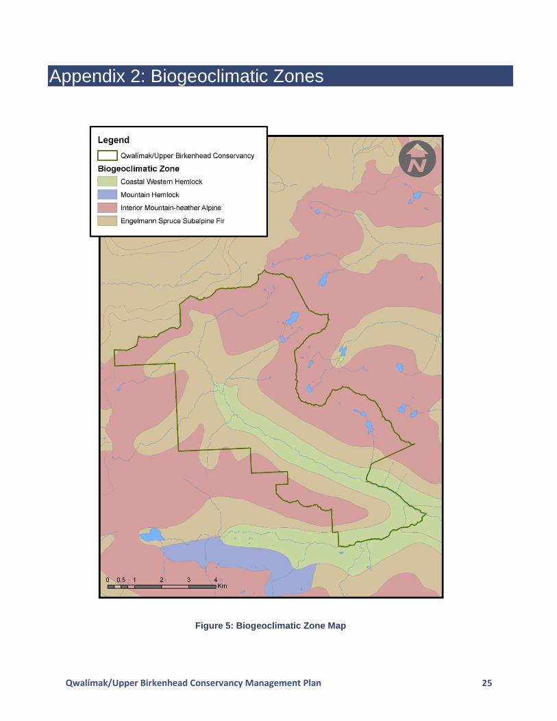
undifferentiated (IMAun) variant, protecting almost 2% of IMAun found in the province, and contributing 9% to the IMAun found within the protected area system in British Columbia. The conservancy also protects significant amounts of two bioegeoclimatic units within the Leeward Pacific Ranges Ecosection, including 4% of the Coastal Western Hemlock southern moist submaritime (CWHms1) and 3% of the Engelmann Spruce subalpine fir moist warm parkland (ESSFmwp). The conservancy contributes 23% respectively to the representation of these biogeoclimatic units within the Leeward Pacific Ranges Ecosection (Appendix 2).
Old-Growth Forests
Past logging activities have removed much of the old-growth forests in the lower reaches of the watershed. Several Old Growth Management Areas were established under the Forest and Range Practices Act to preserve old-growth forests.
High Value Fish Habitat
The rivers and streams of the conservancy support habitat for salmon downstream. The Birkenhead River has limited glacial influence and its waters are relatively clear for most of the year. The river supports large numbers of Sockeye and smaller populations of Chinook, Pink, Chum and Coho. None of these anadromous salmon are found within the waters of the conservancy. Other fish species that occur in the watershed are Kokanee, Rainbow Trout, Coastal Cutthroat, Dolly Varden Char, Bull Trout, Mountain Whitefish, Large-scale Sucker and Sculpin.
Important Wildlife Values
The conservancy provides suitable habitat for a variety of wildlife species such as Grizzly Bear, Black Bear, Mountain Goat, Wolverine and the endangered Northern Spotted Owl. The Upper Birkenhead area is part of the threatened South Chilcotin Range population unit for Grizzly Bear; 16 bears have been detected by DNA with home ranges overlapping in this area. Mountain Goats are also present in the conservancy. A wolverine den has been located in the Sockeye Creek drainage to the west of the conservancy, and may indicate presence in the conservancy. Prior to the establishment of the conservancy, certain portions of the working forest were identified for habitat protection under the Forest and Range Practices Act. Wildlife Habitat Areas were set aside for Grizzly Bear. The General Wildlife Measures for Wildlife Habitat Areas are that no roads, trails, or landings will be constructed. Ungulate Winter Range (UWR) was set aside for Mountain Goat and Mule Deer. UWRs are intended to protect suitable habitat such as foraging opportunities, escape terrain and steep south facing slopes. Old Growth Management Areas are areas with old-growth forest values which provide habitat for species dependent on old-growth forests, including the endangered Northern Spotted Owl. Because these areas of habitat protection are now within a conservancy, the Forest and Range Practices Act has been superseded by the Park Act. However, the spatial extent of these habitat protection areas provides important information

Qwalímak/Upper Birkenhead Conservancy Management Plan 13
and informs the management direction developed for the conservancy (Figure 4). These wildlife habitat areas include:
three Grizzly Bear Wildlife Habitat Areas in the upper portion of the conservancy; and,
four Ungulate Winter Range Areas for Mountain Goat overlap the conservancy boundary; and,
several Old Growth Management Areas are located within, and adjacent to, the conservancy.
Role
The conservancy plays an important role in the protection of important ecological values including habitat for species of high conservation priority such as Grizzly Bear, Mountain Goat, Wolverine and Northern Spotted Owl. The conservancy contains several areas of old-growth forest and protects the headwaters of the Birkenhead River watershed which provides habitat for Sockeye, Chinook and Coho Salmon, along with many resident fish species. The conservancy also contributes to the protection of the neighbouring Birkenhead Lake Park, creating a large contiguous wilderness area totalling 15,327 hectares.
A field of hakwa7 (Cow Parsnip)

Qwalímak/Upper Birkenhead Conservancy Management Plan 14
Large avalanche chute provides important bear habitat.

Qwalímak/Upper Birkenhead Conservancy Management Plan 15
Figure 4: Natural Features

Qwalímak/Upper Birkenhead Conservancy Management Plan 16
2.4 Recreation
Values
The conservancy offers limited recreational opportunities such as hiking and backcountry skiing. There are no recreational amenities within the conservancy. Currently there are motorised activities in the conservancy; management strategies have been developed to address this. It is not known at this time how many visitors the area receives on an annual basis.
Existing tourism and recreation tenures overlapping the conservancy include:
a commercial recreation licence for heli-skiing, held by Whistler Heli-Skiing Limited (land file # 2403273). The current licence term ends in May 2024.
a commercial recreation licence for guided horseback riding (land file #3408461), held by Chilcotin Holidays Ltd.; term expires 2024.
A Forest Service Road which provided access to the conservancy has been decommissioned.
Role
This remote conservancy provides an opportunity for low-impact, non-motorised backcountry recreation in a wilderness setting.
2.5 Development or Use of Natural Resources
The use of natural resources is limited to those activities described in the cultural values and recreation values section and the use of the two existing traplines. Other uses or development of natural resources, including local run-of-river projects, within the conservancy are not appropriate due to incompatibility with the role of the conservancy and the conservancy management objectives.

Qwalímak/Upper Birkenhead Conservancy Management Plan 17
Remote wilderness terrain of the Qwalímak/Upper Birkenhead Conservancy.

Qwalímak/Upper Birkenhead Conservancy Management Plan 18
3.0 Management Direction
3.1 Vision
The Qwalímak/Upper Birkenhead Conservancy is a place that sustains the Lil’wat People, physically, culturally and spiritually. The conservancy protects the Upper Birkenhead River headwaters and supports cultural values. The protection of the headwaters will help to protect the important fisheries and wildlife habitats known to occur downstream. Visitors to the conservancy enjoy a wilderness experience and an opportunity to gain an appreciation of Lil’wat cultural heritage.
3.2 Management Objectives, Issues and Strategies
The following table summarizes the management objectives, issues, and strategies for the conservancy.
Objectives Issues Strategies
Sustain and promote Lil’wat Nation traditional uses including social, ceremonial and cultural activities.
Lack of information available to the public about Lil’wat Nation’s rich cultural heritage may be impacting the area’s cultural values.
Use Ucwalmicwts language and place names on signs and in informational material developed for the conservancy.
Interpretive signage may be installed at key access points to the conservancy or at existing sign kiosks in the area.
Ensure that conservancy information products are culturally sensitive.
Ensure that any tourism operations are culturally sensitive (information on cultural sensitivity will be incorporated through the park use permit referral process).
Include conservancy information and mapping on signage in the Lower Birkenhead River watershed (e.g., on the active Forest Service Roads), at Birkenhead Lake Park, and at the entrance to the Hope Creek Forest Service Road.

Qwalímak/Upper Birkenhead Conservancy Management Plan 19
Objectives Issues Strategies
Maintain biodiversity and natural ecological processes.
Recreational activities need to be managed to mitigate impacts to wildlife species sensitive to human presence (e.g., Grizzly Bear, Wolverine and Mountain Goat).
Work with other agencies to ensure that motorised access on adjacent Crown lands and forest service roads (e.g. Hope Creek FSR) does not enable motorized access to the conservancy.
Where there may be a risk to conservancy values, conduct inventories of invasive plants and, where needed, develop plans to address invasive species.
Recommend a regulatory change to close the conservancy to hunting to protect Grizzly Bear and Mountain Goat populations and preserve the remote wilderness qualities of the conservancy.
Ensure heli-skiing operations observe the Provincial Mountain Goat Management Plan Guidelines which state that no helicopter use should occur within 2,000 metres of Mountain Goat habitat.
Potential impacts from neighbouring mining activities.
Work with the appropriate provincial government agency to ensure that the access to any adjacent mining activities does not facilitate motorized access to the conservancy.
Monitor status of the excluded mineral titles. When the tenures expire, pursue adding those portions of the tenures that are in the Upper Birkenhead watershed to the conservancy.
Limited information on biodiversity values, particularly species at risk, makes it more difficult to protect these values.
Complete an inventory for the presence of species at risk and support implementation of recovery plans.

Qwalímak/Upper Birkenhead Conservancy Management Plan 20
Objectives Issues Strategies
Avoid human-wildlife conflicts.
Potential for bear-human conflicts resulting from recreational activities in bear country.
Provide education and information about wildlife in the area, including known Grizzly Bear habitat areas.
Promote “Bear Smart” practices to reduce human-wildlife conflicts.
All tenures and park use permits to be consistent with zoning and management objectives.
Existing licenses occurring in the conservancy require park use permits.
Pre-existing and valid tenure holders will be contacted to determine if they wish to continue to operate within the conservancy and may be transitioned to park use permits.
Through the strategy above, the tenure terms will be reviewed and additional permit conditions may be required to minimize impacts to conservancy values.
BC Parks and the Lil’wat Nation will work with the heli-ski tenure holder to determine how to phase out this activity.
Regulatory changes to prohibit aircraft landings may be recommended.
The use of natural resources is limited to those activities described in the cultural values and recreation values section and the use of the two existing traplines. Other uses or development of natural resources, including local run-of-river projects, within the conservancy are not appropriate.
3.3 Zoning
Zoning assists in the planning and management of conservancies and other protected areas by communicating and focusing management direction in particular areas using a landscape level approach. Management objectives for a spatial area describe the desired natural environment conditions and visitor experience opportunities on a given landscape.

Qwalímak/Upper Birkenhead Conservancy Management Plan 21
Wilderness Conservation Zone
The entire conservancy is zoned Wilderness Conservation to protect important wildlife habitat and ecological values. The intent of the Wilderness Conservation Zone is to place a high priority on conserving the natural environment, specifically habitats supporting Grizzly Bear and Mountain Goat populations. The use of pack animals and mountain bikes will not be permitted in the Wilderness Conservation Zone to minimize erosion in the watershed and potential damage to ecological and cultural features. This remote conservancy provides an opportunity for for low-impact, unassisted backcountry recreation in a wilderness setting. This zoning is consistent with the adjacent Wilderness Conservation Zone in Birkenhead Lake Park, which protects the headwaters associated with Sockeye Creek.

Qwalímak/Upper Birkenhead Conservancy Management Plan 22
4.0 Plan Implementation
4.1 Policy Context
In addition to any area-specific policies highlighted in this conservancy management plan, there are numerous other provincial/regional policies and guidelines which will be considered during management plan implementation. This includes BC Parks’ policies on conservation, permitting and impact assessment processes, and broader government commitments to reduce greenhouse gas emissions.
4.2 Implementation
BC Parks and Lil’wat Nation will seek project-specific funding and partners to implement high priority strategies and to monitor key performance measures. Specific projects will be evaluated for priority in relation to the overall protected areas system. Many of the initiatives contemplated are not funded as part of core BC Parks activities so jointly seeking funds or partners will be a key aspect of management plan implementation.
4.3 Implementation Priorities
The following strategies have been identified as high priorities for implementation:
use Ucwalmicwts language and place names on signs and in informational material developed for the conservancy;
pre-existing and valid tenure holders will be contacted to determine if they wish to continue to operate within the conservancy and may be transitioned to park use permits;
develop a road deactivation strategy that includes bridge removals and road decommissioning; and,
promote “Bear Smart” practices to reduce human-wildlife conflicts.

Qwalímak/Upper Birkenhead Conservancy Management Plan 23
Appendix 1: Appropriate Uses Table
The following table lists existing and potential future uses in the Qwalímak/Upper Birkenhead Conservancy. This is not an exhaustive list of uses that may be considered in this conservancy and does not restrict the exercise of Lil’wat Nation aboriginal rights.
Activities Wilderness Conservation Zone
Hunting N
Fishing Y
Trapping Y
Horse Use/Pack Animals N
Guide Outfitting N
Mechanized Use (e.g. mountain biking) N
Motorized Use (e.g. including quads, 4x4s, dirt bikes, snowmobiles and snowcats)
N
Heli-skiing N
Heli-hiking N
Aircraft Access N
Backcountry Skiing Y
Hiking/Walking Y
Backpacking Y
Facilities/Infrastructure Wilderness Conservation Zone
Huts/Cabins/Shelters N
Picnic Areas (vehicle accessed and serviced) N
Interpretive Signage Y
Roads N
Parking Lots N
Trails N
Hydro Electric (Run-of-River) Projects and Infrastructure N

Qwalímak/Upper Birkenhead Conservancy Management Plan 24
Legend
N Not an appropriate use in this zone
It has been confirmed during the management planning process that this use is not appropriate in this zone.
This may be an existing use which the management planning process has determined is no longer an appropriate use in this zone. The management plan details strategies for addressing this inappropriate use (e.g., phasing out, closing).
Y May be an appropriate use in this zone
This indicates that some degree or scale of this use may be appropriate.
For existing uses, the management plan will provide guidance on the appropriate level or scale of this use (e.g., direction to reduce, restrict or increase the current level of this activity) and may address specific restrictions or enhancements (e.g., capacity, appropriate sites, designated trails, purposes, party size, time of year, etc.).
For new or expanded uses, this does not constitute approval. This indicates that the use may be considered for further evaluation and possible approval (e.g., park use permit adjudication, completion of a review as part of the BC Parks’ Impact Assessment Process). In some cases the appropriateness may not be confirmed until further assessments are completed.
N/A Not an applicable use in this zone
This is applied where it is not feasible for the use to take place in this zone (e.g., mooring buoys in a terrestrial zone).
Qwalímak/Upper Birkenhead Conservancy Management Plan 25
Appendix 2: Biogeoclimatic Zones
Figure 5: Biogeoclimatic Zone Map
Recommended