is ruled out as the source of shoreline defor-mation. Any subsequent mass redistributions would have been considerably less than that associated with the formation of Tharsis, and would almost certainly have left Tharsis close to Mars’s equatorial plane. But might Mars have reordered itself less comprehensively in more recent times, in the Hesperian epoch — mid-dle martian history — roughly 2.8–3.7 billion years ago?
Perron et al.8 believe so. The first question they address successfully is whether there is a path of true polar wander that can explain the deviation of the putative shorelines from equi-potential surfaces. The supplementary ques-tion is whether plausible candidates exist that could have driven such a reorientation during middle martian history. The Elysium volcanic province, which is in the opposite hemisphere to Tharsis, is a possibility, as is the massive Utopia basin that is buried beneath the north-ern plains, or a redistribution of mass associ-ated with large-scale convection in the interior of Mars. Other, arguably less likely, possibili-ties include the addition of even more volcanic material during the late-stage accretion of the Tharsis volcanic pile, or the mass associated with the putative ocean itself.
Evidence for recently discovered sedi-mentary depositional features on Mars15 and models that support the possibility of sus-tained groundwater upwelling at Meridiani Planum, the landing site of the Opportunity rover16, have, for the time being, focused atten-tion away from the idea of an ancient ocean or oceans to explain Mars’s watery past. Perron and colleagues now resuscitate that possibility. Their result8 hints that, despite dramatic recent advances made possible by various rovers and orbiters, the understanding of the ‘blue’ history of the red planet is far from complete. ■
Maria T. Zuber is in the Department of Earth, Atmospheric and Planetary Sciences, Massachusetts Institute of Technology, Cambridge, Massachusetts 02139, USA.e-mail: [email protected]
1. Squyres, S. W. et al. Science 305, 794–799 (2004).2. Squyres, S. W. et al. Science 306, 1709–1714 (2004).3. Baker, V. R. et al. Nature 352, 589–594 (1991).4. Parker, T. J. et al. J. Geophys. Res. 98, 11016–11078
(1993). 5. Malin, M. C. & Edgett, K. S. Geophys. Res. Lett. 26,
3049–3052 (1999).6. Head, J. W. et al. Science 286, 2134–2137 (1999).7. Carr, M. H. & Head, J. W. J. Geophys. Res. 108, doi:10.1029/
2002JE001963 (2003).8. Perron, J. T. et al. Nature 447, 840–843 (2007).9. Lemoine, F. G. et al. J. Geophys. Res. 106, 23359–23376
(2001).10. Yuan, D.-N. et al. J. Geophys. Res. 106, 23377–23401
(2001).11. Smith, D. E. et al. J. Geophys. Res. 106, 23689–23722
(2001).12. Goldreich, P. & Toomre, A. J. Geophys. Res. 74, 2555–2567
(1969).13. Phillips, R. J. et al. Science 291, 2587–2591 (2001).14. Tanaka, K. L., Scott, D. H. & Greeley, R. in Mars (eds Kieffer,
H. H. et al.) 345 (Univ. Ariz. Press, Tucson, 1992).15. Malin, M. C. & Edgett, K. S. Science 302, 1931–1934
(2003).16. Andrews-Hanna, J. C., Phillips, R. J. & Zuber, M. T. Nature
446, 163–166 (2007).
PALAEOBOTANY
Forests frozen in timeKirk R. Johnson
Just over 300 million years ago, a forest was dropped below sea level by an earthquake and swiftly buried. Such rapid events provide snapshots of lost ecosystems, sometimes on a huge spatial scale.
Fossil plants preserve a vast amount of infor-mation about ancient ecosystems and climates. But much of this information is difficult to retrieve because plants fall apart both during life and after death, and many extinct groups are still poorly described because not all of their organs are known. However, the rooted nature of plants means that vegetation can be buried in place, preserving spatial and ecologi-cal information that could never be retrieved for mobile organisms.
Writing in Geology, DiMichele et al.1 report an extraordinary occurrence of a catastrophi-cally buried forest, now exposed on the roofs of tunnels and chambers of a coal mine in Vermillion County, Illinois. By surveying the mine, they have documented the vegetation of an Upper Carboniferous forest covering an area greater than 1,000 hectares. Such extensive data allow them to map both the small-scale
and large-scale spatial patterns of the 307-mil-lion-year-old forest, and statistically to resolve ecological gradients.
Dispersed plant parts are rapidly recycled by soil organisms and reduced to their organic constituents within months. Well-preserved palaeobotanical remains are therefore direct evidence of rapid burial below the level of destructive processes occurring in soils. For this reason, fossil plants represent the least time-averaged of any terrestrial fossils, and present opportunities to capture precise data about ancient ecosystems and climates. Rapid burial can result from various mechanisms. In the case of the Illinois forest, which grew in a coastal mire, local tectonic subsidence dropped the forest floor to sea level quickly enough for the plants to be preserved in place. The rate of this type of subsidence is difficult to measure, but DiMichele et al.1 argue that it must have
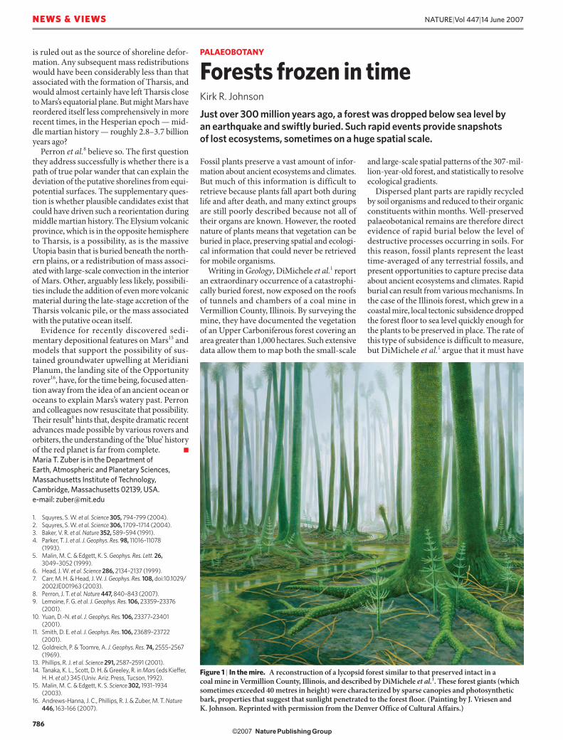
Figure 1 | In the mire. A reconstruction of a lycopsid forest similar to that preserved intact in a coal mine in Vermillion County, Illinois, and described by DiMichele et al.1. These forest giants (which sometimes exceeded 40 metres in height) were characterized by sparse canopies and photosynthetic bark, properties that suggest that sunlight penetrated to the forest floor. (Painting by J. Vriesen and K. Johnson. Reprinted with permission from the Denver Office of Cultural Affairs.)
786
NATURE|Vol 447|14 June 2007NEWS & VIEWS
��������������� ���� ����� �������
occurred within two months to provide the quality of preservation seen in the mine.
Volcanic ash falls and mud flows are another, and demonstrably instant, method by which vegetation can be buried and preserved. Indeed, many fossil plant sites characterized by superb preservation seem to have a component of vol-canic ash deposition in their genesis. For exam-ple, Wing et al.2 described a 4-kilometre-long transect through a Late Cretaceous meadow, dating to about 71.7 million years ago, that had been preserved in a 2–4-metre-thick slurry of volcanic ash. In this case, not only arboreal but also herbaceous vegetation was found rooted where it grew. Wing et al. were able to map the vegetation according to soil type, and to show that angiosperm herbs were more prevalent in better drained sites, whereas ferns and cycads trended towards the mires.
These ‘plant Pompeiis’ have an additional advantage in that they are preserved in a medium that is itself amenable to radiometric dating. Volcanic ash beds often contain sani-dine or zircon crystals that formed in magma chambers shortly before eruption, trapping radioactive potassium and uranium, respec-tively. Ash-bed floras are literally buried in a matrix of fossil ‘clocks’. As the precision of dating techniques increases, the ability to resolve the age of in situ deposits also increases. Because of better mass spectrometers and labo-ratory practices, error bars have been getting smaller during the past few years, and errors at the two-sigma statistical level have crept down from 0.5% to 0.1%, and in some labs are head-ing for 0.05% or even less3,4.
EARTHTIME5,6 is an international project intended to consolidate these gains by reducing
interlaboratory variability, and to understand the differences in precision and accuracy of different dating methods (especially between uranium–lead and argon–argon geochronol-ogy). This precision is being combined with the ability of the astronomical timescale to define individual 22,000-year Milankovitch cycles7, which are due to variation in Earth’s orbit. All in all, we can look forward to a time when events that occurred as long ago as the beginning of the Cretaceous, some 145 mil-lion years ago, can be directly and precisely measured in thousands of years rather than hundreds of thousands or millions of years. Sedimentological evidence for instantane-ous deposition could then pin-point an event to a period of a few months or less within the window of a few thousand years.
DiMichele et al.1 have taken advantage of the near-instantaneous deposition, superb preser-vation and great extent of their fossil forest to statistically analyse the distribution of differ-ent tree species across an ancient landscape. Carboniferous rainforests were composed of completely different major tree groups from those that exist today. For example, lycopsids (Fig. 1), the largest trees in these forests, stood above understories of tree ferns, pteridosperms (extinct seed ferns), cordaitaleans (extinct seed plants related to conifers) and sphenop-sids (trees related to living horsetail rushes). The authors’ analysis shows that the ecology of these long-extinct forests can be retrieved, and that forest heterogeneity on the local scale can be resolved from ecological gradients on a landscape scale.
There is good evidence that vegetation is in dynamic equilibrium with climate8, and it is
becoming clear that some climate change can occur on a subdecadal timescale9. In circum-stances in which a fossil site has been buried over a period of between hours and months, with climate change occurring in decades and geochronological resolution improving by the day, we are entering a world in which the term ‘geological time’ is becoming less rel-evant and we are forging the tools to resolve rapid events in real time. A new partnership between palaeon tologists and geochronolo-gists will revolutionize the way we think about rates of change — even for events that occurred hundreds of millions of years ago. Just because something happened a long time ago does not mean it took a long time to happen. ■
Kirk R. Johnson is at the Denver Museum of Nature and Science, 2001 Colorado Boulevard, Denver, Colorado 80205, USA.e-mail: [email protected]
1. DiMichele, W. A., Falcon-Lang, H. J., Nelson, W. J., Elrick, S. D. & Ames, P. R. Geology 35, 415–418 (2007).
2. Wing, S. L., Hickey, L. J. & Swisher, C. C. Nature 363, 342–344 (1993).
3. Storey, M., Duncan, R. A. & Swisher, C. C. Science 316, 587–589 (2007).
4. Furin, S. et al. Geology 34, 1009–1012 (2006).5. Kerr, R. A. Science 302, 375 (2003).6. www.earthtime.org7. Kuiper, K. F., Wijbrans, J. R. & Hilgen, F. J. Terra Nova 17,
385–398 (2005).8. Webb, T. Vegetatio 67, 75–91 (1986).9. Alley, R. B. Quat. Sci. Rev. 19, 213–226 (2000).
While casually sipping his Martini, a secret agent scans the glamorous guests filling the room. His eyes rest on an innocent-looking woman in a simple dress adorned with a single pale stone. Has he recognized that the stone is the key to all the information that is holding his adversary’s evil organization together?
Yuko Ishii et al. would have recognized this hidden device. They have developed a holographic information storage system in which a piece of the mineral ulexite is a key component (Y. Ishii et al. Opt. Express 15, 7218–7223; 2007). As each stone is unique and irreproducible, only the stone that is used to store the information can retrieve it again.
In holographic memory, information is stored optically in a light-sensitive crystal. An ‘object’
laser beam (containing information) produces an interference pattern with a reference beam, and the pattern is inscribed on the crystal. Information is retrieved again by using a third beam, in combination with the reference laser.
The beauty of the technique is that multiple images can be stored in the same volume, by slightly changing the settings of the reference beam at each recording step.
Although it cannot yet beat magnetic disks in terms of price and performance, holographic data storage has its own advantages, and could become more competitive if its storage capacity could be improved. One way to achieve this is to use random reference beams, which can be generated by randomly rotating a diffuser in front of the reference laser. But this requires
a computer-controlled rotator and an algorithm to impose the randomness.
Ishii and colleagues’ approach is much simpler and more compact. They use a piece of ulexite as the diffuser and rotate it in regular steps. Because each piece of mineral has a unique composition, the random pattern of reference beams produced cannot be replicated by any other stone. Furthermore, only that stone can be used to retrieve the data. Ishii
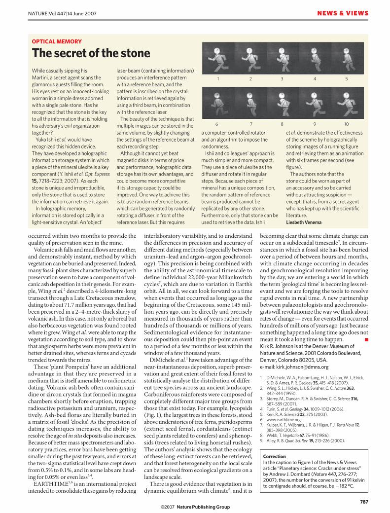
et al. demonstrate the effectiveness of the scheme by holographically storing images of a running figure and retrieving them as an animation with six frames per second (see figure).
The authors note that the stone could be worn as part of an accessory and so be carried without attracting suspicion — except, that is, from a secret agent who has kept up with the scientific literature.Liesbeth Venema
OPTICAL MEMORY
The secret of the stone
CorrectionIn the caption to Figure 1 of the News & Views article “Planetary science: Cracks under stress” by Andrew J. Dombard (Nature 447, 276–277; 2007), the number for the conversion of 91 kelvin to centigrade should, of course, be �182 °C.
1 3 4 52
6 8 9 107
787
NATURE|Vol 447|14 June 2007 NEWS & VIEWS
�������������� ���� ����� �������
Recommended