Lachlan RiverHillston Floodplain Management Plan
Lake Brewster to WhealbahOctober 2005

Lachlan River – Hillston Floodplain Management Plan
Cover Photograph:
Hillston - Roto Railway Crossing the Yangellawah Creek Floodplain - 30th August, 1990
Lachlan River – Hillston Floodplain Management Plan
TABLE OF CONTENTSPage
1 INTRODUCTION .............................................................................................................. 1
1.1 Background .............................................................................................................................................. 1
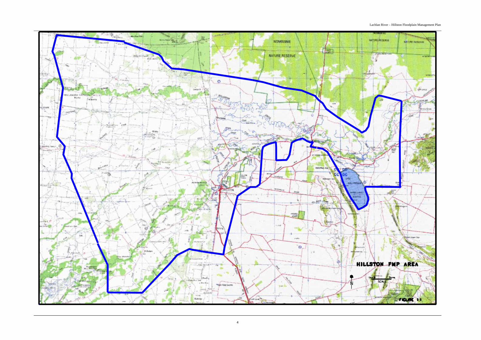
1.2 Hillston FMP Area................................................................................................................................... 3
1.3 Objectives ................................................................................................................................................. 5
1.4 Vision......................................................................................................................................................... 5
1.5 Legislation, Policy and Planning Overview ........................................................................................... 51.5.1 The Flood Prone Land Policy................................................................................................................ 51.5.2 Water Act 1912 and Water Management Act 2000............................................................................... 51.5.3 Additional Floodplain Management Controls ....................................................................................... 61.5.4 Relevant Management Plans.................................................................................................................. 6
1.6 Flooding Overview................................................................................................................................... 7
1.7 Environmental Overview ........................................................................................................................ 8
1.8 Floodplain Management Principles........................................................................................................ 9
2 PLAN IMPLEMENTATION ........................................................................................... 10
2.1 Staging of Plan Outcomes...................................................................................................................... 10
2.2 Part 8 Approval Process for Flood Control Works............................................................................. 112.2.1 General ................................................................................................................................................ 112.2.2 Works that Require Approval.............................................................................................................. 112.2.3 Applying for Approval ........................................................................................................................ 122.2.4 Determination Process......................................................................................................................... 122.2.5 Possible Determinations ...................................................................................................................... 142.2.6 Complying Works................................................................................................................................ 142.2.7 Non-complying Works ........................................................................................................................ 142.2.8 Unauthorised Works ............................................................................................................................ 152.2.9 Roads and Railways............................................................................................................................. 16
3 FMP FLOODWAY NETWORK AND FLOOD FRINGE AREA .................................. 17
3.1 Design Basis ............................................................................................................................................ 17
3.2 Floodway Network................................................................................................................................. 17
3.3 Flood Fringe Area .................................................................................................................................. 18
4 WORKS MODIFICATIONS............................................................................................ 19
5 ASSESSING NON – COMPLYING WORKS ................................................................ 42
5.1 Hydraulic Criteria ................................................................................................................................. 42
5.2 Environmental Criteria ......................................................................................................................... 45
Lachlan River – Hillston Floodplain Management Plan
6 LONG TERM STRATEGY ............................................................................................. 47
7 ENVIRONMENTAL WATERING RECOMMENDATION .......................................... 48
8 STRATEGIC ENVIRONMENTAL ASSESSMENT ...................................................... 49
8.1 Overview of Environmental Impact ..................................................................................................... 49
8.2 State Water Management Outcomes Plan Target............................................................................... 51
8.3 Catchment Impacts ................................................................................................................................ 51
9 MONITORING AND REVIEW....................................................................................... 52
9.1 Performance Indicators......................................................................................................................... 52
9.2 Flood Monitoring ................................................................................................................................... 52
9.3 Environmental Monitoring ................................................................................................................... 53
9.4 Plan Review ............................................................................................................................................ 53
10 REFERENCES.............................................................................................................. 54
11 APPENDICES............................................................................................................... 55
11.1 APPENDIX A – Estimated 1990 Flow Distribution............................................................................ 56
11.2 APPENDIX B – Monitoring Activities................................................................................................. 57
11.3 APPENDIX C – Glossary and Abbreviations...................................................................................... 64

Lachlan River – Hillston Floodplain Management Plan
FIGURES
PageFigure 1.1 Hillston FMP Area 4Figure 5.1 Areas of Differing Hydraulic Criteria 44
TABLES
Page
Table 4.1 Required Modifications to Existing Flood Control Works and Road and Rail Structures 20Table 5.1 Adopted Hydraulic Criteria 43Table 5.2 Environmental Value Assessment Criteria 45Table 5.3 Scores for Rating Assessment Criteria 46Table 7.1 Ecosystems Recommended for Watering through Irrigation Infrastructure 48Table 8.1 Summary of Environmental Impacts 49
MAPS(A copy of the maps or a CD of the maps is held at the rear of this report)
Sheets 1-5 Hillston Floodplain Management Plan - Floodway Network and Flood Fringe AreasSheet 6 Flood Dependent Ecosystems and Floodway NetworkSheet 7 Flood Extent 1998 and Floodway Network (SWMOP Assessment)

Lachlan River – Hillston Floodplain Management Plan
PREFACE
The following poem is reproduced from the book “Where the River Divides – History of Hillston andDistrict”
HILLSTON’S RECORD FLOOD – 1956
By “Noega”There’s a little town called HillstonOn the flooded Lachlan stands.Its folks build banks by day and nightWith help of many hands.The floods round here are serious,Yet the outside world don’t know;The radio and the papersHaven’t heard that this is so
Harry Biggar, who is eighty-odd,Some big floods can recall,Says this is far the worst he’s seen,‘Tis the daddy of them all.Joe Cashmere and his brotherCan remember, Oh! So well,When the Lachlan it was floodedAnd for twelve months never fell.
We seldom see the township,The distance is too far,If you dare to cross that waterTen to one you’ll bog your car.Some roads are back to normalAnd some are not quite so;A few belated CrusoesGet out where they can row.
We made the trip into the town,Our mileage it was doubled;It wasn’t like old Hillston now,The folks are all so troubled.The old hands say, they’ve never seenA flood like this before,You go to bed to sleep the night,Next morn it’s at your door.
No matter tho’ where e’er you lookThere is water far and wide;It’s sad to see sheep being drownedAlong the Railway side.They are working hard to build high banksIt is the very devil,We’re hoping now ’tis not in vainWhen the water finds it’s level.
There is water from the tennis courts,A good two mile they say;It is the main road into town,We must find another wayThere’s one road left by “Poison-tank”That still defies the water;All this will make our rates go up,Our hearts just turn to mortar.
The Police have taken things in hand,Each person they compelTo give a hand where needed mostOtherwise you try the cell.Yes, we’re clenching all effortsSide by side in blinding rain,We don’t give a “Tinkler’s Tadlum,”There is much we can attain.
There’s the butcher and the bakerAnd two “Parsons” I can tell,There’s men from every walk of lifeAlso the R.S.L.The Farmer with his tractorIs never know to lag,And gangs of men in shovels bentDig sand to fill each bag.
There’s the Peters of “Burilda”And those of “Bonnie Doone”,With Cliff and Angus Rathmell,Say, “It’s really none too soon.”The Morans and the ShellysWith Kev-like and Harry DaggeThey leave their jobs behind them,Not time to light a fag.
Bert Jackson and young Eric,With their hands to tractor wheels,Working many hours between themWith ne’er a thought for meals.Our women-folk don’t lag behindSo they rob the pantry shelf,When all our neighbours round us,Go out each day to help.

Lachlan River – Hillston Floodplain Management Plan
The Fensoms at the “Four-mile”Are worried one and all,They’ve built high banks yet pleased they’d beTo see the Lachlan fall.Frank Strong of “Currah”, and “Winton” too.Indeed they have not tarried.It’s hard to take, there’s no mistakeFor folks who’ve just been married.
The western-end of HillstonIs as bad as bad can be.In the playground of the Convent schoolThere is water to the knee.In Danny Pentland’s lovely homeThe water flows insideThere are many others such as this,‘Tis a fact you cannot hide.
Our Railway line is none too safe,It’s got officials thinkingThey’ve cut the line in a place or twoTo save the rails from sinking.So tragic it would be for allShould our train just cease to run;Its piercing whistle seems to say“I’m here again, “but ‘tis no fun.
It won’t be long, ‘tis plain to seeBefore our roads are taken,With the surging waters rising fastThe old Town looks forsaken.There is one thing we’ll remember,Should we live four score and ten,How the floods out-back just triumphedDespite the efforts of our men.
There are lots of city dwellersSay, “We do nought but moan,”Whilst they spend their hours of leisureBy deep sea’s frothy foam.Country folks have joys and sorrows,(Quite right it seems to me),But so often most one-sided‘Tis their share of destiny.
If you mention out-back Hillston,Why! They say with such surprise“That place where crows fly backwardsLest dust gets in their eyes?”Still, its folk find joy in livingIn this place of floods and drought.It has many compensationsThat the City cannot flout.
- Author: L. M. Busch
Lachlan River – Hillston Floodplain Management Plan
1
1 INTRODUCTION
1.1 BackgroundThe Hillston Floodplain Management Plan Lake Brewster to Whealbah (FMP) has been prepared bythe Department of Natural Resources (DNR) in conjunction with the local community. DNR hasprepared the plan under Part 8 of the Water Act 1912 on behalf of the Water AdministrationMinisterial Corporation. The Hillston Rural Floodplain Management Committee, comprisingrepresentatives of the community and stakeholder groups, has guided the preparation of the plan.Funding for the FMP was provided jointly by the State and Federal Governments, with Federalfunding provided under the Natural Heritage Trust.
The FMP applies to the floodplains of the Lachlan River and Willandra Creek surrounding the town ofHillston as identified on Figure 1.1. The floodplains are regarded as prime agricultural land andsupport a very successful irrigation and dryland farming industry. They also have significantecological values including extensive areas of wetlands and a diversity of native flora and fauna thatbenefit from periodic flooding. The expansion of irrigated cropping in recent times has led to concernsabout the impacts of associated works on flood behaviour. Flood control works, such as levees,channels and roads, can alter floodwater distribution and can increase flood risk to floodplainoccupiers and cause environmental problems by isolating flood-dependent ecosystems, such aswetlands, from flooding.
The FMP aims to coordinate the existing and future development of flood control works so that floodrisk is minimised and the natural functions of the floodplain environment are sustained. It outlinesspecific modifications to existing flood control works based on hydraulic and environmental criteriaand identifies a floodway network and flood fringe area for the planning of proposed works.Implementation of the FMP will provide the community with greater security against flood risk andallow for the sustainable management of flood-dependent ecosystems.
The required modifications to works identified in the FMP will restore the existing floodplain to onethat is acceptable to the community in regard to the passage of flood flows and the ecology of thefloodplain. The FMP also provides a process to allow the efficient assessment of new development interms of the relevant legislation. Finally it provides a long - term strategy that encourages thereduction of less desirable development located in the defined floodway areas.
The FMP has been prepared in accordance with processes outlined in the NSW Government’sFloodplain Development Manual (NSW Government 2005), which supports the NSW Flood ProneLand Policy. Development of the FMP has progressed through three (3) key stages:
• Flood Study – completed by the Department of Land and Water Conservation in 2001, thestudy defines the nature and extent of flooding, including development of a hydraulic modelof flood behaviour;
• Floodplain Management Study – evaluates management options based on hydraulicmodelling, analysis of the floodplain environment and social and economic considerations, toaddress existing and future floodplain management issues; and,
• Floodplain Management Plan – adopts community-owned strategies to manage flood risk andto support the requirements of the floodplain environment.

Lachlan River – Hillston Floodplain Management Plan
2
Extensive community consultation has been undertaken to improve understanding of flood behaviour,identify flooding issues and ensure that the plan is compatible with the community’s expectations. TheFMP forms a layer in the catchment planning process for the Lachlan Valley and has been preparedwith consideration of natural resource legislation, policy and management plans relevant to floodplainmanagement.
Once adopted under the provisions of Part 8 of the Water Act 1912, the FMP must be considered byDNR when reviewing and determining approval applications for flood control works under the Act orits forthcoming replacement the Water Management Act 2000.
A floodplain management plan for Hillston township has recently been completed by Carrathool ShireCouncil (Carrathool Shire Council 2005). It applies to the urban area of Hillston whereas the ruralFMP covers the rural areas surrounding the town as described above. However, the two plans areclosely related as they have both been developed from the same hydraulic model.
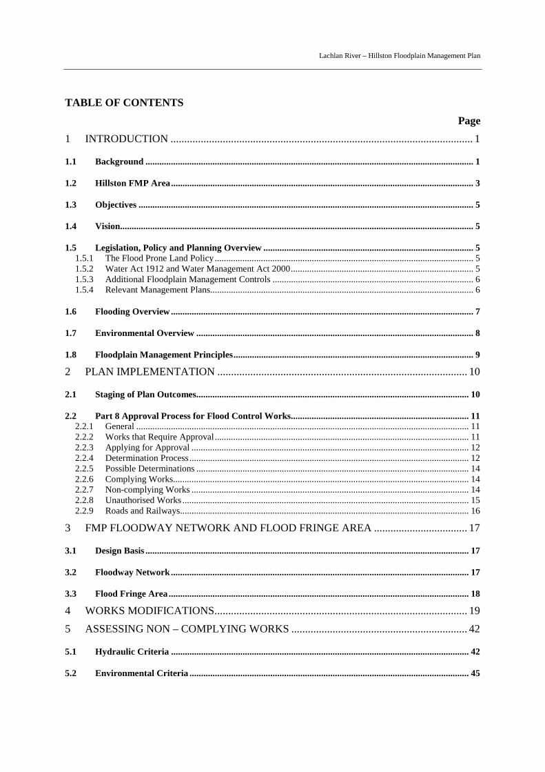
Brewster Weir, Ballyrogan (Inlet) Channel and Lake Brewster – 30th August 1990
Lachlan River – Hillston Floodplain Management Plan
3
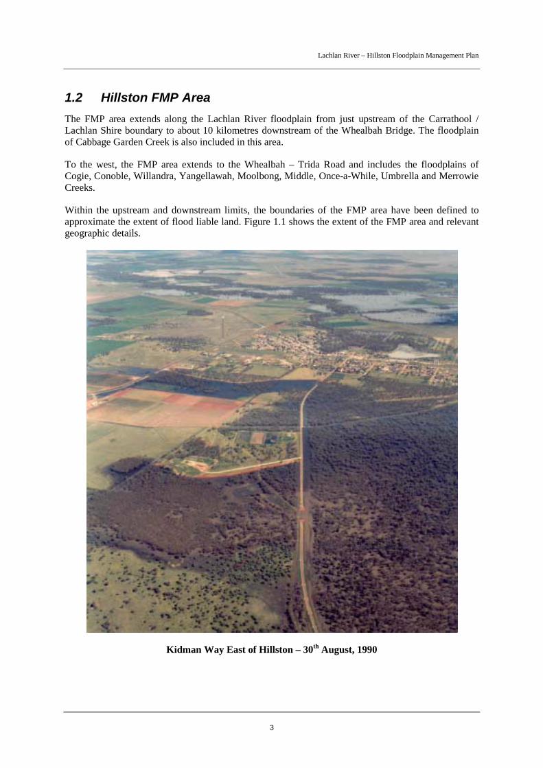
1.2 Hillston FMP AreaThe FMP area extends along the Lachlan River floodplain from just upstream of the Carrathool /Lachlan Shire boundary to about 10 kilometres downstream of the Whealbah Bridge. The floodplainof Cabbage Garden Creek is also included in this area.
To the west, the FMP area extends to the Whealbah – Trida Road and includes the floodplains ofCogie, Conoble, Willandra, Yangellawah, Moolbong, Middle, Once-a-While, Umbrella and MerrowieCreeks.
Within the upstream and downstream limits, the boundaries of the FMP area have been defined toapproximate the extent of flood liable land. Figure 1.1 shows the extent of the FMP area and relevantgeographic details.
Kidman Way East of Hillston – 30th August, 1990
Lachlan River – Hillston Floodplain Management Plan
4

Lachlan River – Hillston Floodplain Management Plan
5
1.3 ObjectivesThe strategic objectives of the FMP are to:
• reduce the impact of flooding and flood liability on individual owners and occupiers of floodprone property, and to reduce private and public losses resulting from floods, utilisingecologically positive methods wherever possible (NSW Flood Prone Land Policy objective);
• coordinate floodplain development in order to minimise adverse changes to flood flowpatterns;
• increase the sustainable social, economic and ecological benefits of using the floodplain;
• improve and maintain the diversity and well being of native riverine and floodplainecosystems that depend on flood inundation; and,
• take into account the cumulative impact on flooding behaviour of individual developments.
1.4 VisionThe vision for the FMP is:
A floodplain managed for the social and economic interest of the community thatcontributes to a healthy and sustainable environment.
1.5 Legislation, Policy and Planning OverviewThe management of the floodplain in the Hillston area must be undertaken within the currentlegislative and policy framework. A brief summary of the primary pieces of relevant legislation andpolicy is presented below. Refer to the Hillston Floodplain Management Study Lake Brewster toWhealbah (DNR 2005) for a detailed overview of the legislation and policy framework for floodplainmanagement.
1.5.1 The Flood Prone Land Policy
The primary objective of the Government’s Flood Prone Land Policy is to reduce the impacts offlooding on individual owners and occupiers of flood prone land, and to reduce private and publiclosses caused by flooding. A central tenet of the policy is that land use proposals for flood prone landbe treated within the framework of a strategically generated floodplain risk management plan preparedusing a merit approach. Floodplain Development Manual (NSW Government 2005) supports thepolicy and outlines a merit - based approach to floodplain management.
1.5.2 Water Act 1912 and Water Management Act 2000
DNR takes the lead role for floodplain management in the western rural areas of NSW through itsadministration of Part 8 of the Water Act 1912. Part 8 was gazetted in 1984 and makes provisionsconcerning “controlled works” that affect, or are likely to affect, flooding and/or floodplain functions.Part 8 was amended in 1999 to allow for more strategic control of such works through the preparationof FMPs and a more streamlined and resource efficient approval process. The amended Water Act

Lachlan River – Hillston Floodplain Management Plan
6
provides for a broader consideration of issues in the approval of existing and proposed “controlledworks” and strengthens DNR’s ability to deal with unauthorised works.
At the time of preparing this FMP the State Government had initiated wide-ranging reform of waterlegislation, with the outcome being the new Water Management Act 2000. The Act consolidates mostof the Acts previously covering water management in NSW and is being phased in gradually asvarious regulations are developed. It will eventually replace Part 8 of the Water Act and is likely tocontain floodplain management provisions that relate closely to existing provisions under the amendedWater Act.
1.5.3 Additional Floodplain Management Controls
There are several additional legislative acts and policies that are relevant to floodplain managementand the approval process for flood control works. The majority of these relate to floodplainenvironmental matters such as flora and fauna, wetlands, threatened species and fish habitat.
The Environmental Planning and Assessment Act 1979 is of particular importance. In determiningapplications for flood control works, DNR is required to assess the environmental impact of the worksunder Part 5 of this Act. Consideration of proposed works under Part 4 of the Act is not required asthere is no relevant environmental planning instrument that applies to flood control works in the FMParea. Other relevant legislation includes:
• Native Vegetation Conservation Act 1997 and Native Vegetation Act 2003
• Fisheries Management Act 1994
• Threatened Species Conservation Act 1995
• National Parks and Wildlife Act 1974
• Rivers and Foreshores Improvement Act 1948
• The Forestry Act 1916
In certain circumstances, where a flood control work is likely to impact on a matter of nationalenvironmental significance, such as a nationally listed threatened species or a listed migratory species,an approval may also be required under the Commonwealth Environment Protection and BiodiversityConservation Act 1999. These approvals are assessed by the Commonwealth Department of theEnvironment and Heritage.
Natural resource management policy that supported decision-making in the FMP included the StateRivers and Estuaries Policy 1993, which provides a framework for the sustainable use, conservationand management of rivers, the Wetlands Management Policy 1996 and the State GroundwaterDependent Ecosystems Policy 2002.
1.5.4 Relevant Management Plans
Following recent natural resource reforms in NSW, catchment action plans that consolidate existingnatural resource management plans and provide long-term direction for investment in naturalresources, will be prepared. The Lachlan Catchment Management Authority will work with local

Lachlan River – Hillston Floodplain Management Plan
7
communities to prepare the Lachlan Catchment Action Plan. The FMP should be viewed as onecomponent of the integrated planning process, with other linked components including -
! Lachlan Catchment Blueprint;
! Water Sharing Plan for the Lachlan Regulated River Water Source;
! State Water Management Outcomes Plan;
! Lower Lachlan Groundwater Sharing Plan; and
! Draft Western Riverina Regional Vegetation Management Plan.
1.6 Flooding OverviewMajor flooding in the Hillston area generally arises from prolonged rainfall in the upper catchment andmajor flood releases from Wyangala Dam. The largest floods on record occurred in 1956 and 1990when the Lachlan River at Hillston was above minor flood level for many months. Floods take anumber of weeks to travel from Wyangala Dam to the Hillston area. For example, the peak of theAugust 1990 flood took some four weeks to reach Hillston from Wyangala Dam.
During larger floods a significant portion of total flows entering the FMP area are conveyed to thewest via the major effluents of Willandra Creek, Yangellawah Creek, Middle Creek and MerrowieCreek and their floodplains. There is also a series of breakouts from the Lachlan River onto thefloodplain. The most substantial of these are the outflows into Gum Swamp that activate flow paths tothe east of Hillston and a breakout on the right bank opposite Hillston town that inundates a large areato the west. Downstream of Hillston, Cabbage Garden Creek is an important effluent of the LachlanRiver in large flood events.
The larger floods can result in crop losses, damage to pastures and grasses from long inundation,damage to irrigation works, loss of fences and damage to private access roads. As well, inundation anddamage to public roads and railways can result in the loss of vital transport links. The larger floodsalso threaten the security of Hillston town.
Floodplain development can impact on flooding by altering the flow distribution, blocking importantflow paths, increasing flood levels, increasing flood flow velocities, and denying inundation offloodplain ecosystems. As well, extensive development of the floodplain has the potential to reducethe amount of floodplain storage area for a flood and result in more floodwater passing to thedownstream areas.
Flood behaviour in the FMP area is dependent upon the volume of water in the flood wave, the lengthof time the flood is above the critical height, the rate of rise and fall of the flood, the vegetative coverand the development on the floodplain. Floods may reach similar heights at a river gauge, such asHillston, but may behave differently on the floodplain remote from the gauge.
More detailed information on flooding is available in the Flood Study (Department of Land and WaterConservation 2001). The estimated 1990 flow distribution for the total study area is reproduced inAppendix A.

Lachlan River – Hillston Floodplain Management Plan
8
1.7 Environmental OverviewFlooding is a vital natural process that drives a pulse of ecological productivity. It replenishes thefloodplain with water and releases organic carbon and nutrients on a large scale. This boostsinvertebrate production, triggers breeding activity in waterbirds and fish, and initiates the growth andregeneration of floodplain vegetation. Floodplain inundation provides a key source of organic carbonand nutrients for river life in the lower Lachlan catchment.
The floodplain environment in the FMP area has been modified by agricultural development.Regulation of the river for agricultural water supply, through the operation of Wyangala and CarcoarDams, has altered the frequency, magnitude and duration of floods. The environmental impacts ofthese changes are addressed within the Water Sharing Plan for the Lachlan Regulated River WaterSource (2003). Development has also altered the distribution and behaviour of floodwaters, removedlarge areas of floodplain vegetation (for broadacre cropping) and impacted on the hydrology andecology of some wetlands. Despite these impacts, the floodplain area retains significant ecologicalvalues. The area also has important cultural values because of Aboriginal and European settlement.
There are approximately 85,000 hectares of wetlands in the FMP area. Flood flow paths to about 7,000hectares of these wetlands are affected by existing flood control works. Native floodplain vegetationconsists mainly of communities dominated by River Red Gum, Black Box, Lignum and NitreGoosefoot. These species are dependent on flooding for their health and regeneration. The floodplainsupports a diversity of native fauna including species that rely directly on flooding for maintenance oftheir life cycles (eg some species of waterbirds, invertebrates and fish) and species that rely onfloodplain vegetation for food or habitat (eg honeyeaters). More detailed information on the floodplainenvironment is provided in the Floodplain Management Study.
Cabbage Garden Creek Offtake from the Lachlan River at “Cowl Cowl” – 30th August, 1990
Lachlan River – Hillston Floodplain Management Plan
9
1.8 Floodplain Management PrinciplesManagement principles were developed and adopted to help guide the decision making process so thatoutcomes were consistent with the objectives of the FMP. The principles were applied to identifyexisting and potential flooding issues and to develop strategies to address them. These strategiesrelated to the modification of existing works and the design of the FMP floodway network. A numberof the principles related to the design of the FMP floodway network.
The committee adopted the following principles:
1. Defined floodways must possess adequate hydraulic capacity and continuity to enable theorderly passage of floodwaters through the floodplain;
2. Any system of defined floodways should conform as closely as is reasonable to the naturaldrainage pattern after taking into account the existing floodplain development;
3. Floodway areas should be equitably allocated, consistent with natural/historical flow paths;
4. Environmental issues related to the rural floodplain management plan need to be identifiedand investigated including developing strategies for flood dependent ecosystems;
5. The exit of floodwaters from defined floodways should be at rates and depths similar to thosewhich would have been experienced under natural/historical conditions and should dischargeas close as practicable to the location of natural/historical floodways;
6. Sufficient pondage must be retained on the developed floodplain so that the flood peak traveltime is not unduly accelerated to downstream areas or its height increased;
7. Velocities of flood flow in defined floodways and through structures should be minimised andbe of an order which would not cause erosion or increased siltation under various land uses;
8. There should be no detrimental impact from floodplain development on any individuallandholder or community infrastructure including increases in peak flood levels and increaseddrainage times;
9. Floodplain development should not cause significant redistribution of floodwater.
The committee allowed for some scope to depart from the natural/historical drainage pattern, providedthe community was in agreement and it was hydraulically and environmentally feasible.
Lachlan River – Hillston Floodplain Management Plan
10
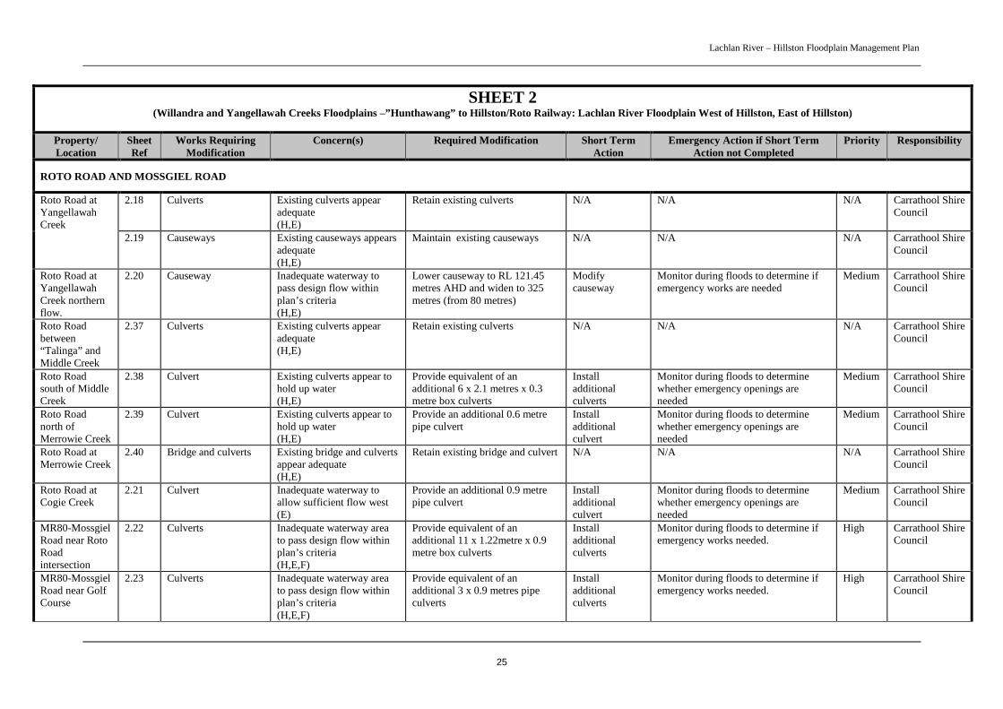
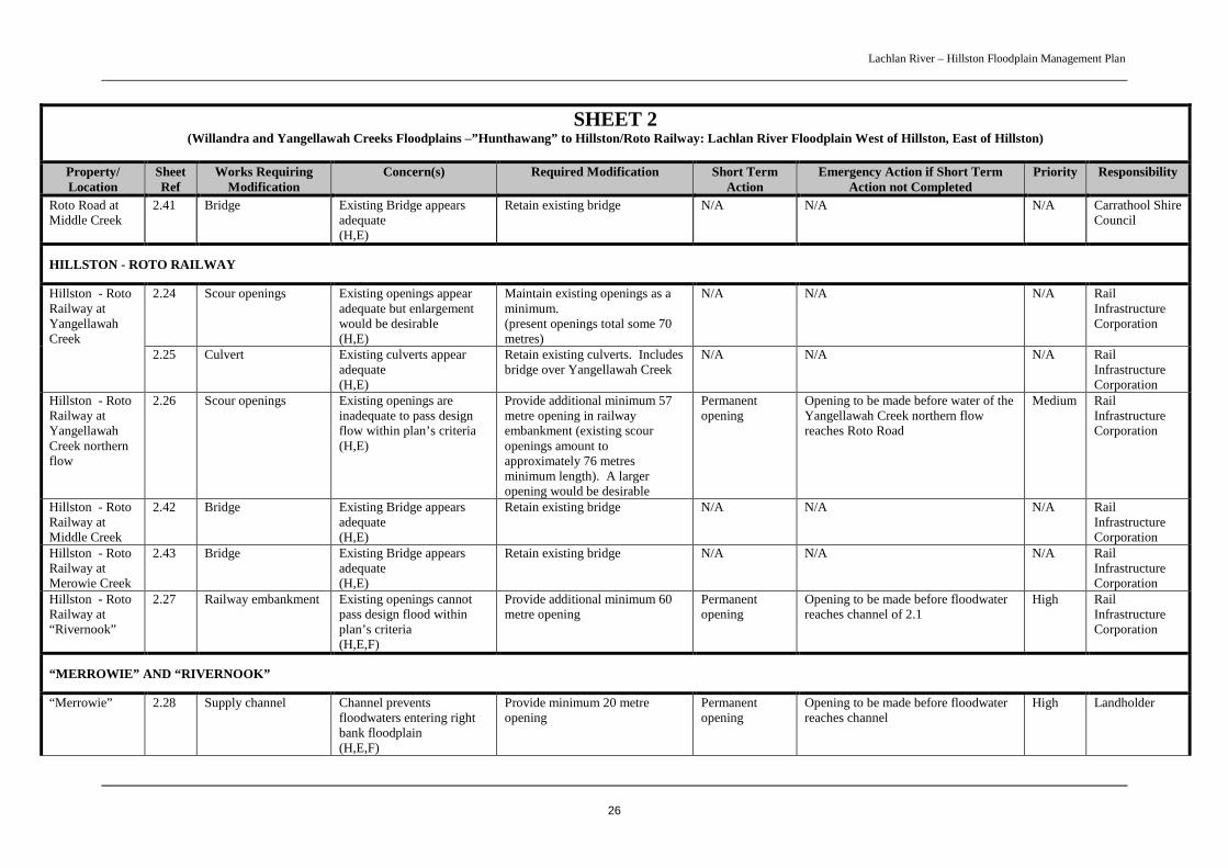
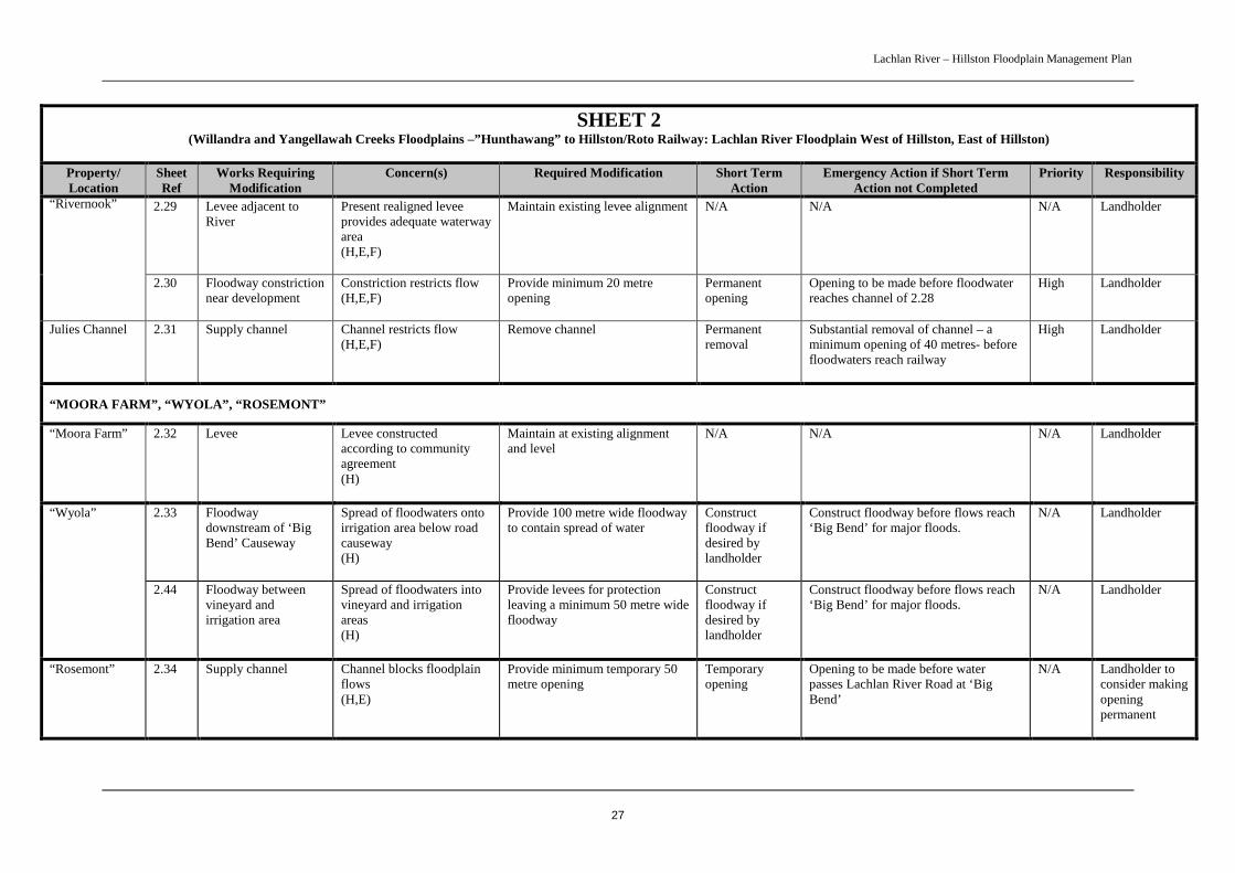
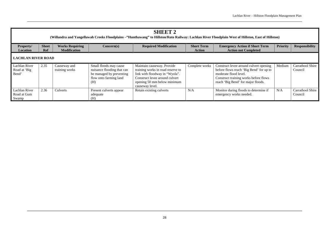
2 PLAN IMPLEMENTATIONThe FMP outlines modifications to existing flood control works and identifies a floodway network andflood fringe area to allow for the planning of future flood control works. Implementation of the FMPconcerns identified modifications to existing flood control works, licensing of works and futureproperty planning. Sheets 1 to 5 show the details of the FMP in map form.
Hydraulic and environmental issues associated with existing works have been identified and outcomesdetermined. The FMP has staged these modifications based on the nature of the issues and oneconomic and social considerations. It identifies priorities for the required works modifications andoutlines emergency management measures to be implemented when a major flood is approaching. TheFMP also identifies a timeframe for the licensing of existing flood control works not requiringmodifications. The Water Act 1912 requires that all flood control works (existing and proposed) withina designated floodplain need to be assessed for approval. There is scope for FMP requirements forflood control works to be incorporated into future property management plans that will be linked to theLachlan Catchment Action Plan.
2.1 Staging of Plan OutcomesThe plan identifies broad implementation stages and, within this framework, priorities for specificoutcomes for permanent works modifications:
Short term implementation
• High priority – within 2 years of FMP adoption - permanent works modifications that areimportant for the performance of the floodway network and have the potential to impact onflooding in Hillston Town; and,
• Medium priority – within 5 years of FMP adoption - other permanent works modifications thatare important for the performance of the floodway network, licensing of existing flood controlworks.
All works modifications identified for short-term implementation are listed in Table 4.1
Emergency implementation
The FMP outlines emergency management measures for all works identified in the short-termimplementation plan. These measures are to be implemented in the event that a flood is approachingand the permanent modifications required under the short-term plan are not completed. The emergencymanagement measures also specify when temporary openings are to be made in existing works at theonset of a flood. The measures include specified openings in works, removal of works and, in somecases, monitoring to determine if emergency works are needed. DNR, the State Emergency Serviceand Carrathool Shire Council will coordinate the implementation of the emergency managementmeasures. Emergency management measures are listed in Table 4.1.
Lachlan River – Hillston Floodplain Management Plan
11
2.2 Part 8 Approval Process for Flood Control Works
2.2.1 General
All activities associated with flood control works are administered under the relevant sections of Part 8of the Water Act 1912. The Water Administration Ministerial Corporation (hereafter WAMC) is thebody that prepares, adopts and administers FMPs, as well as receives and determines Part 8applications. DNR acts on behalf of WAMC for all matters relating to Part 8 of the Water Act.
Once the Hillston FMP has been adopted, it is proposed to designate the land area of the FMP as afloodplain under the Water Act 1912. Once designated the following will apply:
• All flood control works will require an approval under Part 8 of the Act;
• All Part 8 applications for new and existing (unapproved) works within Hillstonfloodplain will be determined in accordance with the Hillston FMP and Part 8 of the Act;and,
In respect of any existing unauthorised works, a reasonable time will be allowed for the lodgment ofan application under Part 8 of the Water Act. If, after a reasonable time period has elapsed, anapplication under Part 8 is not lodged for existing unauthorised works, the WAMC may serve a noticeunder Section180D of the Water Act directing the occupier of the relevant land to do a number ofthings, such as: remove, modify, repair or restore the works. Unauthorised works are dealt with inmore detail in Section 2.2.8 of the FMP.
2.2.2 Works that Require Approval
A work referred to as a flood control work is defined under Part 8 of the Water Act 1912 as ‘controlledwork’. A controlled work requires approval under the Act and is defined at Section 165A of the Actas:
(a) an earthwork, embankment or levee that is situated, or proposed to be constructed, on landthat:
(i) is, or forms part of, the bank of a river or lake, or
(ii) is within a floodplain, or
(b) any work that is situated, or proposed to be constructed, on land that:
(i) is, or forms part of, the bank of a river or lake, or
(ii) is within a floodplain,
and that is declared by order of the Ministerial Corporation published in the Gazette to be acontrolled work, or
(c) an earthwork, embankment or levee, wherever situated or proposed to be constructed, that:
(i) affects or is reasonably likely to affect the flow of water to or from a river or lake,and
(ii) is used or is to be used for, or has the effect or likely effect of, preventing landfrom being flooded by water, or
Lachlan River – Hillston Floodplain Management Plan
12
(d) any work, wherever situated or proposed to be constructed, that:
(i) affects or is reasonably likely to affect the flow of water to or from a river or lake,and
(ii) is used or is to be used for, or has the effect or likely effect of, preventing landfrom being flooded by water, and
(iii) is declared by order of the Ministerial Corporation published in the Gazette to bea controlled work.
2.2.3 Applying for Approval
The following is an outline of the steps required by an applicant in applying for approval for a floodcontrol work:
Step 1 - Obtain an application form and discuss your proposal with neighbouring landholders.
Step 2 - Contact a DNR Floodplain Licensing Officer to arrange a site inspection, discuss theapplication and get advice on the information required for the approval process.
Step 3 - Gather supporting information as your application will require you to supplytechnical information.
Step 4 - Fill in the application form. Complete additional information requirements on theform including the condition of the existing surrounding environment.
Step 5 - Lodge the application with the supporting information and application fee at yourlocal DNR office.
2.2.4 Determination Process
All applications under Part 8 of the Water Act 1912 must proceed through a set process prior to DNRdetermining the application under Section 171 of the Act. This process includes (but is not limited to):
• Section 166C of the Water Act 1912 - DNR must have regard to the matters for generalconsideration outlined in Section 166C including (but not limited to):
− the contents of any relevant FMP or any other relevant Government policy;
− the need to maintain the natural flood regimes in wetlands and related ecosystems and thepreservation of any habitat animals (including fish) or plants that benefit from periodicflooding;
− the effect or likely effect on water flows in downstream river sections;
− any geographical features, or other matters of Aboriginal interest that may be affected by acontrolled work;
− the effect or likely effect of a controlled work on the passage, flow and distribution offlood waters;
Lachlan River – Hillston Floodplain Management Plan
13
− the effect or likely effect of a controlled work on existing dominant floodways or exitsfrom floodways, rates of flow, flood water levels and the duration of inundation;
− the protection of the environment; and,
− any other matter relating to the desirability or otherwise of a controlled work.
• Part 5 of the Environmental Planning and Assessment Act 1979 – as there are no relevantenvironmental planning instruments relating to the FMP all proposals must undergo assessmentunder Part 5. DNR must take into account the following factors concerning the impact of the floodcontrol works on the environment:
− any environmental impact on a community;
− any transformation of a locality;
− any environmental impact on the ecosystems of the locality;
− any reduction of the aesthetic, recreational, scientific or other environmental quality orvalue of a locality;
− any effect on a locality, place or building having aesthetic, anthropological,archaeological, architectural, cultural, historical, scientific or social significance or otherspecial value for present or future generations;
− any impact on the habitat of protected fauna (within the meaning of the National Parks andWildlife Act 1974;
− any endangering of any species of animal, plant or other form of life, whether living onland, in water or in the air;
− any long-term effects on the environment;
− any degradation of the quality of the environment;
− any risk to the safety of the environment;
− any reduction in the range of beneficial uses of the environment;
− any pollution of the environment;
− any environmental problems associated with the disposal of waste;
− any increased demands on resources (natural or otherwise) that are, or are likely tobecome, in short supply;
− any cumulative environmental effect with other existing or likely future activities.
• Floodplain Management Plan - DNR must consider the Hillston FMP and informationcontained within the Hillston FMP including principles, assessment criteria, and anyrecommendations.
Lachlan River – Hillston Floodplain Management Plan
14
• Additional Information - DNR must consider any investigation information that has beenprovided by the applicant.
2.2.5 Possible Determinations
DNR will inform the applicant at the earliest opportunity of the determination of an application for aflood control work. The general terms of approval should be comprehensive enough to cover all of theconstraints (terms and conditions) that may be applied to the relevant Part 8 licence. Under the WaterAct 1912, there are three (3) possible determinations - approval of the application, approval of theapplication subject to conditions, or refusal of the application.
In certain circumstances there may be a right of appeal to the Land and Environment Court in respectof a determination under the Water Act. Before making a determination in respect of an application forflood control works, DNR is required to decide whether the works do or do not comply with theHillston FMP.
2.2.6 Complying Works
Under Section 168B(2) of the Water Act 1912, a flood control work is assessed as a complying work ifDNR is satisfied that the work complies with the FMP for the area in which the work is situated orproposed to be constructed. As such, complying flood control works are defined as:
• existing or proposed works located outside the limits of the floodway network as shown onSheets 1 to 5;
• existing works that are satisfactory in their current state/condition as specified in Table 4.1;
• existing works to be modified in accordance with the required modifications as specified in Table4.1; and,
• other existing works within the floodway network that are consistent with the hydraulic criteria asspecified in Table 5.1 and the environmental value criteria in Table 5.2.
In some cases, a landholder may be required to provide the necessary technical details to demonstratethat the application is a complying work. Where an existing or proposed flood control work iscomplying, the application for approval will be determined by DNR without the need for advertisingto canvass third party objections. Approvals for complying works are likely to be straightforward andexpedient, depending on the required assessment of environmental impact.
2.2.7 Non-complying Works
Under Section 168B(3) of the Water Act 1912, a flood control work is assessed as a non-complyingwork if DNR is not satisfied that the work complies with the FMP for the area in which the work issituated or proposed to be constructed. As such, non-complying works are:
• works proposed to be located within the floodway network as shown on Sheets 1 to 5;
• existing works that the landholder refuses to modify in accordance with the required modificationsas specified in Table 4.1; and,
• other existing works within the floodway network that are not consistent with the hydrauliccriteria as specified in Table 5.1 and the environmental value criteria in Table 5.2.

Lachlan River – Hillston Floodplain Management Plan
15
Non-complying works may be considered for approval after a detailed investigation of hydraulic andenvironmental, impacts and consideration of social and economic issues (refer to Section 5). Thecumulative impact of proposed works on flooding characteristics needs to be comprehensivelyaddressed. It is important to understand that it is the applicant’s responsibility to engage a suitablyqualified consultant to undertake the investigation. DNR will provide the required assessment criteriafor the consultant. Where the requested supporting information is not furnished, DNR can refuse todeal with the application.
Applications for non-complying works must be advertised and third party objections sought prior tothe determination of the application. If an objection is received that cannot be resolved, compulsorymediation will be required. DNR may request additional supporting information from the party wholodged the objection, with failure to do so possibly resulting in the objection being rejected. If DNRgrants an approval for an application and an objection has been made, DNR must notify the objector ofits determination. The objector may appeal against the determination in the Land and EnvironmentCourt.
Any person applying for the approval of works may appeal to the Land and Environment Court againsta determination by DNR to refuse to grant the approval or to grant the approval subject to conditions.
2.2.8 Unauthorised Works
Unauthorised controlled works include the following:
• Works without approval;
• Works that have been constructed in contravention of an approval; or,
• Works that have not been constructed in accordance with approval conditions.
Where unauthorised works are identified, DNR may direct that one or more of the following types ofwork are carried out by issuing a notice under Section 180D of the Water Act, 1912:
• (a) Work to remove, modify, repair or restore the controlled work or to render the workineffectual.
• (b) Work to repair any damage caused by the controlled work (including any damage causedto any specified land, river, lake, structure or vegetation, or to the environment).
• (c) Works to ensure that any specified land, structure, river, lake or vegetation, or theenvironment, will not be damaged or adversely affected, or further damaged or furtheradversely affected, by the controlled work.
• Without limiting (a) to (c) above, work to correct or restore any alteration caused by thecontrolled work to the flow of water into or from, or the quantity of water contained in, anyspecified river or lake.
In the event of the occupier not complying with the served notice, DNR can carry out the work andrecover the costs incurred in doing such work. DNR is not required to give any prior notice of itsdecision to exercise these powers. The occupier can appeal such action to the Land and EnvironmentCourt.
Lachlan River – Hillston Floodplain Management Plan
16
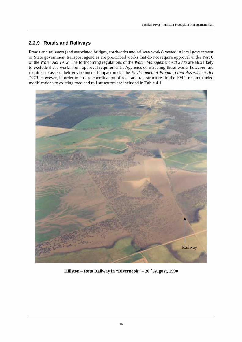
2.2.9 Roads and Railways
Roads and railways (and associated bridges, roadworks and railway works) vested in local governmentor State government transport agencies are prescribed works that do not require approval under Part 8of the Water Act 1912. The forthcoming regulations of the Water Management Act 2000 are also likelyto exclude these works from approval requirements. Agencies constructing these works however, arerequired to assess their environmental impact under the Environmental Planning and Assessment Act1979. However, in order to ensure coordination of road and rail structures in the FMP, recommendedmodifications to existing road and rail structures are included in Table 4.1
Hillston – Roto Railway in “Rivernook” – 30th August, 1990
Railway
Lachlan River – Hillston Floodplain Management Plan
17
3 FMP FLOODWAY NETWORK AND FLOOD FRINGEAREA
3.1 Design BasisThe 1990 flood was used as the design flood for determining the floodway network and flood fringearea on the floodplain. Flow estimates of the 1990 flood were used in assessing the modificationsrequired to existing works.
Further to the hydraulic design of the floodways, the network was adjusted to include flood-dependentecosystems, such as wetlands. This provides for continued flood access to these ecosystems so that theenvironmental benefits of flooding to these areas can be maintained.
It should be recognised that, due to the varied nature of floods, no two floods will behave exactly thesame and, consequently, some local variation in the performance of the floodway network may occur.Whilst peak level readings at specific river gauges may be similar, the impacts of different densities ofvegetation, differences in how long a flood stays up and differences in the rise and fall of a flood, canresult in changes to flood behaviour on the floodplain.
Modelling of flood behaviour was undertaken using the best available processes but, as is the case inhydraulic modelling, it was limited by available data (ie flood levels, stream flow measurements,survey etc). As a result, some inaccuracies in absolute values will be inherent. As well, the modellingdid not take into account increases in water level as a result of wave action.
The plan makes a number of recommendations for additional waterway area with an aim to providingan improved passage for a flood of the 1990 size. In some cases they aim to provide flood free accessfor a similar size flood. However, in the event of a flood similar in height to the 1990 flood occurring,it cannot be certain that the structure will behave exactly as planned. Hence it is important to monitorthe works during floods. Larger floods may exceed the capacity of the recommended waterway areas.
Due to the low frequency of flooding the plan is not advocating a floodway/levee scheme that hasbeen used in the past in other areas of the State to maximise areas of flood protected land. Rather, theplan is aiming to manage development, existing and new, on the floodplain in a manner that matchesthe social, environmental and economic needs of the community.
3.2 Floodway NetworkThe FMP floodway network that is shown on Sheets 1 to 5 will be used as the basis for determiningfuture applications for flood control works. The floodway network represents a coordinated andintegrated network of flood flow paths of adequate hydraulic capacity and continuity to effectivelyconvey floodwaters and support the floodplain environment. The floodway, even if partially blocked,could cause a significant redistribution of flood flow or a significant increase in flood levels andthereby increase the flood risk to flood prone communities. As such, future applications to undertakeflood control works in the floodway are assessed as non-complying works and are likely to be refused.However, if the applicant can demonstrate that the proposed works will meet relevant hydraulic andenvironmental criteria and will not result in any significant adverse environmental effects, then theworks may be considered for approval. For example, proposed supply channels crossing floodwayareas may need to be constructed below ground in order to meet approval requirements. Similarly,proposed access roads in floodway areas would need to be constructed at low levels.
Lachlan River – Hillston Floodplain Management Plan
18
Applications for flood control works outside the floodway limits will be assessed as complying worksand, in general, will be readily approved with appropriate conditions if required. The assessment ofthese applications will need to take into account environmental impacts and cumulative impacts on theredistribution of floodwaters.
3.3 Flood Fringe AreaThe FMP identifies the flood fringe area as the area between the delineated floodway and the extent ofthe 1990 flood and is shown by the blue wash area outside of the floodway limits. Development in theflood fringe would not in general cause a significant redistribution of design flood flows or asignificant increase in flood levels. However, while applications for flood control works in this areawill be assessed as complying works, the assessment will need to take into account any potentialincrease in flood hazard or flood damage to other properties bordering the floodway network. Adverseimpacts could result, for example, if extensive works are proposed on one side of the floodwaynetwork and not the other.
Assessment of flood hazard will be largely qualitative taking into consideration existing works, theextent of proposed works and the potential for localised impacts on neighbouring properties. Suchassessment would not need to go to the details of that for proposed works within the floodway wherethe impact on overall flood behaviour could be significant and therefore far reaching. It should berealised that floods larger than the 1990 flood would inundate areas outside of the flood fringe.

Lachlan River – Hillston Floodplain Management Plan
19
4 WORKS MODIFICATIONSTable 4.1 lists the required modifications to existing flood control works determined by the FMP andthe modifications to road and rail structures. The modifications are required for hydraulic and / orenvironmental (including fish passage) purposes as indicated. The table also lists emergencymanagement measures in the event that a flood is approaching and the modifications have not beencompleted.
Implementation of the works modifications will restore the functions of the floodplain to levelsacceptable to the community. The required modifications and their locations are shown on Sheets 1 to5. Modifications listed in Table 4.1 indicate the minimum waterway needs for specified works. At anumber of road sites the table states that existing structures be retained. However, if these structuresare upgraded in future, it will be important to assess their impacts against the relevant design criteriaas shown in Section 5.
It is important to remember that all proposed and existing flood control works within the Hillstonfloodplain will require approval under Part 8 of the Water Act 1912. Specific structural modificationsto existing works outlined in Table 4.1 will be administered under the relevant sections of Part 8 of theAct. Where works are unauthorised, DNR may take the relevant action(s) under the Act. Please referto Section 2 for further details regarding the approval of flood control works and administration of theHillston FMP under Part 8 of the Water Act 1912.
“Rivernook” with Roto Railway crossing Roto Road in foreground

Lachlan River – Hillston Floodplain Management Plan
20
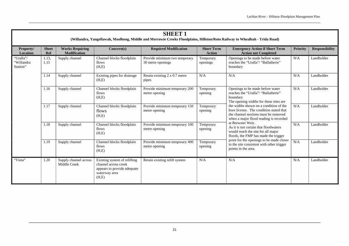
Table 4.1 Required Modifications to Existing Flood Control Works and Road and Rail Structures
The items are listed under the relevant sheet with reference to the property or location of the works:
SHEET 1(Willandra, Yangellawah, Moolbong, Middle and Merrowie Creeks Floodplains, Hillston/Roto Railway to Whealbah - Trida Road)
Property/Location
SheetRef
Works RequiringModification
Concern(s) Required Modification Short TermAction
Emergency Action if Short TermAction not Completed
Priority Responsibility
“MOUNT VIEW” and LOWLANDS ROAD
“Mount View” 1.1 Supply channel Channel prevents spread offlow to wetlands(E)
Provide minimum four temporary20 metre openings in channelsystem
Temporaryopenings
Openings to be made before waterpasses Lowlands Road near “MountView” homestead
N/A Landholder
Lowlands Road 1.2,1.3,1.4,1.5
Culverts Inadequate waterway toallow sufficient water to thenorth(E)
Provide additional three 0.6 mpipe culverts, one additional 2 x0.6 m pipe culvert and a 20 metrecauseway
Installadditionalculverts andcauseway
Monitor during floods to determinewhether emergency openings areneeded
Medium Carrathool ShireCouncil
“WILLANDRA STATION”, “URALLA”, “VIETA”
1.6,1.7,1.8
Supply channel Channel blocks floodplainflows(H,E)
Provide three 30 metre openingsin stock supply channel. Openingacross Yangellawah Creek to bepermanent, other two aretemporary
Installpermanentopening acrossYangellawahCreek
Openings to be made before waterreaches the “Willandra Station”/“Ballatherie” boundary
Medium Landholder
1.9,1.10
Supply channel Channel blocks floodplainflows(H,E)
Provide minimum two temporary30 metre openings
Temporaryopenings
Openings to be made before waterreaches the “Willandra Station”/“Ballatherie” boundary
N/A Landholder
1.11 Supply channelsyphon
Existing syphon appearsadequate(H,E)
Retain existing syphon N/A N/A N/A Landholder
“WillandraStation”
1.12 Supply channel Channel blocks floodplainflows(H,E)
Provide a minimum temporary 30metre opening
Temporaryopenings
Openings to be made before waterreaches the “Uralla”/ “Ballatherie”boundary
N/A Landholder
Lachlan River – Hillston Floodplain Management Plan
21
SHEET 1(Willandra, Yangellawah, Moolbong, Middle and Merrowie Creeks Floodplains, Hillston/Roto Railway to Whealbah - Trida Road)
Property/Location
SheetRef
Works RequiringModification
Concern(s) Required Modification Short TermAction
Emergency Action if Short TermAction not Completed
Priority Responsibility
1.13,1.15
Supply channel Channel blocks floodplainflows(H,E)
Provide minimum two temporary30 metre openings
Temporaryopenings
Openings to be made before waterreaches the “Uralla”/ “Ballatherie”boundary
N/A Landholder
1.14 Supply channel Existing pipes for drainage(H,E)
Retain existing 2 x 0.7 metrepipes
N/A N/A N/A Landholder
1.16 Supply channel Channel blocks floodplainflows(H,E)
Provide minimum temporary 200metre opening
Temporaryopening
N/A Landholder
1.17 Supply channel Channel blocks floodplainflows(H,E)
Provide minimum temporary 150metre opening
Temporaryopening
N/A Landholder
1.18 Supply channel Channel blocks floodplainflows(H,E)
Provide minimum temporary 100metre opening
Temporaryopening
N/A Landholder
“Uralla”/“WillandraStation”
1.19 Supply channel Channel blocks floodplainflows(H,E)
Provide minimum temporary 400metre opening
Temporaryopening
Openings to be made before waterreaches the “Uralla”/ “Ballatherie”boundaryThe opening widths for these sites arethe widths shown on a condition of thebore license. The condition stated thatthe channel sections must be removedwhen a major flood reading is recordedat Brewster Weir.As it is not certain that floodwaterswould reach the site for all majorfloods, the FMP has made the triggerpoint for the openings to be made closerto the site consistent with other triggerpoints in the area.
N/A Landholder
“Vieta” 1.20 Supply channel acrossMiddle Creek
Existing system of reliftingchannel across creekappears to provide adequatewaterway area(H,E)
Retain existing relift system N/A N/A N/A Landholder

Lachlan River – Hillston Floodplain Management Plan
22
SHEET 1(Willandra, Yangellawah, Moolbong, Middle and Merrowie Creeks Floodplains, Hillston/Roto Railway to Whealbah - Trida Road)
Property/Location
SheetRef
Works RequiringModification
Concern(s) Required Modification Short TermAction
Emergency Action if Short TermAction not Completed
Priority Responsibility
MOSSGIEL ROAD
Mossgiel Roadat Middle Creek
1.21 Two bridges Existing bridges appearadequate(H)
Retain two existing bridges N/A N/A N/A Carrathool ShireCouncil
Mossgiel Roadat Middle Creekoverflow
1.22 Culverts Existing culverts appearadequate(H)
Retain existing 2 x 0.45 metrepipe culverts
N/A N/A N/A Carrathool ShireCouncil
Mossgiel Roadat Once-a WhileCreek
1.23 Culvert Some concern from locallandholders that the culvertsare inadequate(H)
Consider installing additionalwaterway area in the road,possibly in the form of acauseway
Council toconsiderinstallingcauseway
Monitor during floods to determinewhether emergency openings areneeded
N/A Carrathool ShireCouncil
Mossgiel Roadat UmbrellaCreek overflow
1.24 Bridge and culverts Existing bridge and culvertsappear adequate. Road hasbeen raised since 1990.(H)
Retain existing bridge andculverts
N/A Monitor road during floods todetermine if existing waterway isadequate
N/A Carrathool ShireCouncil
Mossgiel Roadat MerrowieCreek overflow
1.25 Bridge Existing bridge appearsadequate(H)
Retain existing bridge N/A N/A N/A Carrathool ShireCouncil

Lachlan River – Hillston Floodplain Management Plan
23
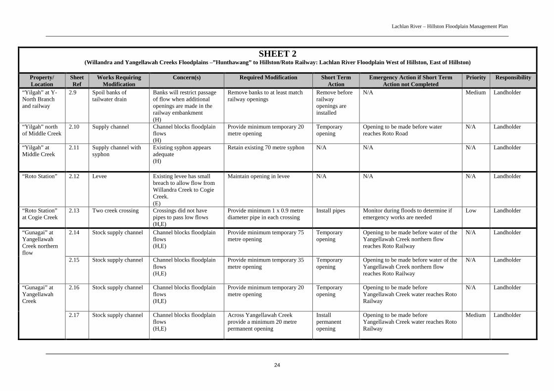
SHEET 2(Willandra and Yangellawah Creeks Floodplains –”Hunthawang” to Hillston/Roto Railway: Lachlan River Floodplain West of Hillston, East of Hillston)
Property/Location
SheetRef
Works RequiringModification
Concern(s) Required Modification Short TermAction
Emergency Action if Short TermAction not Completed
Priority Responsibility
“HUNTHAWANG”, “JOHNNELL”, “YILGAH”, “ROTO STATION”, “GUNAGAI”
2.1 Supply channel withsyphon
Existing syphon appearsadequate(H)
Retain existing 70 metre syphon N/A N/A N/A Landholder“Hunthawang”at Middle Creek
2.2 Access road/crossing Creek crossing restrictshigh flow and road blockshigh flow runner
Provide pipes and /or causeway inroad across high flow runner
Install works Provide opening in road before waterreaches high flow runner
Medium Landholder
2.3 Supply channel towestern irrigation area
Raised channel bankprevents water reachingwetland(E)
Remove 50 metre section of bank.Channel flow level is belowground level and removal of bankwill not affect supply
Permanentopening
Remove before water reaches channel Medium Landholder“Hunthawang”
2.4 Block banks alongMiddle Creek
Four block banks isolatemeanders of Middle Creek(E,F)
Provide 10 metre openings ineach of the four block banks
PermanentOpenings
Provide openings before water reachesblock banks.
Medium Landholder
“Johnnell” 2.5 Levees Existing levees may blocksome flow but it is expectedto be only a small amountwith little adverse impact(H)
Retain existing levees N/A N/A N/A Landholder
2.6 Channel Existing 10 metre syphon inchannel is inadequate(H,E)
Provide a permanent opening ( egsyphon) of minimum 160 metresin channel
Permanentopening
Opening to be made before water of theYangellawah Creek northern flowreaches the “McGills”/ “Yilgah”boundary
Medium Landholder“Yilgah” atYangellawahcreek northernflow
2.7 Irrigationdevelopment infloodway
Above ground earthworksof the irrigation (eg headditches, drains etc) that arewithin the floodway mayrestrict flows(H,E)
Above ground earthworks withinfloodway are to be realigned orremoved to provide free passageof flow
Realign worksor agree upontemporaryremoval ofworks
Remove above ground works beforewater of the Yangellawah Creeknorthern flow reaches the “McGills”/Yilgah” boundary
N/A Landholder
“Yilgah” atYangellawahCreek
2.8 Channel spoil banks Existing openings in spoilbanks appear adequate(H,E)
Two openings of approximately100 metres each have beenprovided in the spoil banks. Moreand/or larger openings would bedesirable
N/A N/A N/A Landholder
Lachlan River – Hillston Floodplain Management Plan
24
SHEET 2(Willandra and Yangellawah Creeks Floodplains –”Hunthawang” to Hillston/Roto Railway: Lachlan River Floodplain West of Hillston, East of Hillston)
Property/Location
SheetRef
Works RequiringModification
Concern(s) Required Modification Short TermAction
Emergency Action if Short TermAction not Completed
Priority Responsibility
“Yilgah” at Y-North Branchand railway
2.9 Spoil banks oftailwater drain
Banks will restrict passageof flow when additionalopenings are made in therailway embankment(H)
Remove banks to at least matchrailway openings
Remove beforerailwayopenings areinstalled
N/A Medium Landholder
“Yilgah” northof Middle Creek
2.10 Supply channel Channel blocks floodplainflows(H)
Provide minimum temporary 20metre opening
Temporaryopening
Opening to be made before waterreaches Roto Road
N/A Landholder
“Yilgah” atMiddle Creek
2.11 Supply channel withsyphon
Existing syphon appearsadequate(H)
Retain existing 70 metre syphon N/A N/A N/A Landholder
“Roto Station” 2.12 Levee Existing levee has smallbreach to allow flow fromWillandra Creek to CogieCreek.(E)
Maintain opening in levee N/A N/A N/A Landholder
“Roto Station”at Cogie Creek
2.13 Two creek crossing Crossings did not havepipes to pass low flows(H,E)
Provide minimum 1 x 0.9 metrediameter pipe in each crossing
Install pipes Monitor during floods to determine ifemergency works are needed
Low Landholder
2.14 Stock supply channel Channel blocks floodplainflows(H,E)
Provide minimum temporary 75metre opening
Temporaryopening
Opening to be made before water of theYangellawah Creek northern flowreaches Roto Railway
N/A Landholder“Gunagai” atYangellawahCreek northernflow
2.15 Stock supply channel Channel blocks floodplainflows(H,E)
Provide minimum temporary 35metre opening
Temporaryopening
Opening to be made before water of theYangellawah Creek northern flowreaches Roto Railway
N/A Landholder
2.16 Stock supply channel Channel blocks floodplainflows(H,E)
Provide minimum temporary 20metre opening
Temporaryopening
Opening to be made beforeYangellawah Creek water reaches RotoRailway
N/A Landholder“Gunagai” atYangellawahCreek
2.17 Stock supply channel Channel blocks floodplainflows(H,E)
Across Yangellawah Creekprovide a minimum 20 metrepermanent opening
Installpermanentopening
Opening to be made beforeYangellawah Creek water reaches RotoRailway
Medium Landholder
Lachlan River – Hillston Floodplain Management Plan
25
SHEET 2(Willandra and Yangellawah Creeks Floodplains –”Hunthawang” to Hillston/Roto Railway: Lachlan River Floodplain West of Hillston, East of Hillston)
Property/Location
SheetRef
Works RequiringModification
Concern(s) Required Modification Short TermAction
Emergency Action if Short TermAction not Completed
Priority Responsibility
ROTO ROAD AND MOSSGIEL ROAD
2.18 Culverts Existing culverts appearadequate(H,E)
Retain existing culverts N/A N/A N/A Carrathool ShireCouncil
Roto Road atYangellawahCreek
2.19 Causeways Existing causeways appearsadequate(H,E)
Maintain existing causeways N/A N/A N/A Carrathool ShireCouncil
Roto Road atYangellawahCreek northernflow.
2.20 Causeway Inadequate waterway topass design flow withinplan’s criteria(H,E)
Lower causeway to RL 121.45metres AHD and widen to 325metres (from 80 metres)
Modifycauseway
Monitor during floods to determine ifemergency works are needed
Medium Carrathool ShireCouncil
Roto Roadbetween“Talinga” andMiddle Creek
2.37 Culverts Existing culverts appearadequate(H,E)
Retain existing culverts N/A N/A N/A Carrathool ShireCouncil
Roto Roadsouth of MiddleCreek
2.38 Culvert Existing culverts appear tohold up water(H,E)
Provide equivalent of anadditional 6 x 2.1 metres x 0.3metre box culverts
Installadditionalculverts
Monitor during floods to determinewhether emergency openings areneeded
Medium Carrathool ShireCouncil
Roto Roadnorth ofMerrowie Creek
2.39 Culvert Existing culverts appear tohold up water(H,E)
Provide an additional 0.6 metrepipe culvert
Installadditionalculvert
Monitor during floods to determinewhether emergency openings areneeded
Medium Carrathool ShireCouncil
Roto Road atMerrowie Creek
2.40 Bridge and culverts Existing bridge and culvertsappear adequate(H,E)
Retain existing bridge and culvert N/A N/A N/A Carrathool ShireCouncil
Roto Road atCogie Creek
2.21 Culvert Inadequate waterway toallow sufficient flow west(E)
Provide an additional 0.9 metrepipe culvert
Installadditionalculvert
Monitor during floods to determinewhether emergency openings areneeded
Medium Carrathool ShireCouncil
MR80-MossgielRoad near RotoRoadintersection
2.22 Culverts Inadequate waterway areato pass design flow withinplan’s criteria(H,E,F)
Provide equivalent of anadditional 11 x 1.22metre x 0.9metre box culverts
Installadditionalculverts
Monitor during floods to determine ifemergency works needed.
High Carrathool ShireCouncil
MR80-MossgielRoad near GolfCourse
2.23 Culverts Inadequate waterway areato pass design flow withinplan’s criteria(H,E,F)
Provide equivalent of anadditional 3 x 0.9 metres pipeculverts
Installadditionalculverts
Monitor during floods to determine ifemergency works needed.
High Carrathool ShireCouncil
Lachlan River – Hillston Floodplain Management Plan
26
SHEET 2(Willandra and Yangellawah Creeks Floodplains –”Hunthawang” to Hillston/Roto Railway: Lachlan River Floodplain West of Hillston, East of Hillston)
Property/Location
SheetRef
Works RequiringModification
Concern(s) Required Modification Short TermAction
Emergency Action if Short TermAction not Completed
Priority Responsibility
Roto Road atMiddle Creek
2.41 Bridge Existing Bridge appearsadequate(H,E)
Retain existing bridge N/A N/A N/A Carrathool ShireCouncil
HILLSTON - ROTO RAILWAY
2.24 Scour openings Existing openings appearadequate but enlargementwould be desirable(H,E)
Maintain existing openings as aminimum.(present openings total some 70metres)
N/A N/A N/A RailInfrastructureCorporation
Hillston - RotoRailway atYangellawahCreek
2.25 Culvert Existing culverts appearadequate(H,E)
Retain existing culverts. Includesbridge over Yangellawah Creek
N/A N/A N/A RailInfrastructureCorporation
Hillston - RotoRailway atYangellawahCreek northernflow
2.26 Scour openings Existing openings areinadequate to pass designflow within plan’s criteria(H,E)
Provide additional minimum 57metre opening in railwayembankment (existing scouropenings amount toapproximately 76 metresminimum length). A largeropening would be desirable
Permanentopening
Opening to be made before water of theYangellawah Creek northern flowreaches Roto Road
Medium RailInfrastructureCorporation
Hillston - RotoRailway atMiddle Creek
2.42 Bridge Existing Bridge appearsadequate(H,E)
Retain existing bridge N/A N/A N/A RailInfrastructureCorporation
Hillston - RotoRailway atMerowie Creek
2.43 Bridge Existing Bridge appearsadequate(H,E)
Retain existing bridge N/A N/A N/A RailInfrastructureCorporation
Hillston - RotoRailway at“Rivernook”
2.27 Railway embankment Existing openings cannotpass design flood withinplan’s criteria(H,E,F)
Provide additional minimum 60metre opening
Permanentopening
Opening to be made before floodwaterreaches channel of 2.1
High RailInfrastructureCorporation
“MERROWIE” AND “RIVERNOOK”
“Merrowie” 2.28 Supply channel Channel preventsfloodwaters entering rightbank floodplain(H,E,F)
Provide minimum 20 metreopening
Permanentopening
Opening to be made before floodwaterreaches channel
High Landholder
Lachlan River – Hillston Floodplain Management Plan
27
SHEET 2(Willandra and Yangellawah Creeks Floodplains –”Hunthawang” to Hillston/Roto Railway: Lachlan River Floodplain West of Hillston, East of Hillston)
Property/Location
SheetRef
Works RequiringModification
Concern(s) Required Modification Short TermAction
Emergency Action if Short TermAction not Completed
Priority Responsibility
2.29 Levee adjacent toRiver
Present realigned leveeprovides adequate waterwayarea(H,E,F)
Maintain existing levee alignment N/A N/A N/A Landholder“Rivernook”
2.30 Floodway constrictionnear development
Constriction restricts flow(H,E,F)
Provide minimum 20 metreopening
Permanentopening
Opening to be made before floodwaterreaches channel of 2.28
High Landholder
Julies Channel 2.31 Supply channel Channel restricts flow(H,E,F)
Remove channel Permanentremoval
Substantial removal of channel – aminimum opening of 40 metres- beforefloodwaters reach railway
High Landholder
“MOORA FARM”, “WYOLA”, “ROSEMONT”
“Moora Farm” 2.32 Levee Levee constructedaccording to communityagreement(H)
Maintain at existing alignmentand level
N/A N/A N/A Landholder
2.33 Floodwaydownstream of ‘BigBend’ Causeway
Spread of floodwaters ontoirrigation area below roadcauseway(H)
Provide 100 metre wide floodwayto contain spread of water
Constructfloodway ifdesired bylandholder
Construct floodway before flows reach‘Big Bend’ for major floods.
N/A Landholder“Wyola”
2.44 Floodway betweenvineyard andirrigation area
Spread of floodwaters intovineyard and irrigationareas(H)
Provide levees for protectionleaving a minimum 50 metre widefloodway
Constructfloodway ifdesired bylandholder
Construct floodway before flows reach‘Big Bend’ for major floods.
N/A Landholder
“Rosemont” 2.34 Supply channel Channel blocks floodplainflows(H,E)
Provide minimum temporary 50metre opening
Temporaryopening
Opening to be made before waterpasses Lachlan River Road at ‘BigBend’
N/A Landholder toconsider makingopeningpermanent
Lachlan River – Hillston Floodplain Management Plan
28
SHEET 2(Willandra and Yangellawah Creeks Floodplains –”Hunthawang” to Hillston/Roto Railway: Lachlan River Floodplain West of Hillston, East of Hillston)
Property/Location
SheetRef
Works RequiringModification
Concern(s) Required Modification Short TermAction
Emergency Action if Short TermAction not Completed
Priority Responsibility
LACHLAN RIVER ROAD
Lachlan RiverRoad at ‘BigBend’
2.35 Causeway andtraining works
Small floods may causenuisance flooding that canbe managed by preventingflow onto farming land(H)
Maintain causeway. Providetraining works in road reserve tolink with floodway in “Wyola”.Construct levee around culvertopening 50 mm below minimumcauseway level.
Complete works Construct levee around culvert openingbefore flows reach ‘Big Bend’ for up tomoderate flood level.Construct training works before flowsreach ‘Big Bend’ for major floods.
Medium Carrathool ShireCouncil
Lachlan RiverRoad at GumSwamp
2.36 Culverts Present culverts appearadequate(H)
Retain existing culverts N/A Monitor during floods to determine ifemergency works needed.
N/A Carrathool ShireCouncil
Lachlan River – Hillston Floodplain Management Plan
29
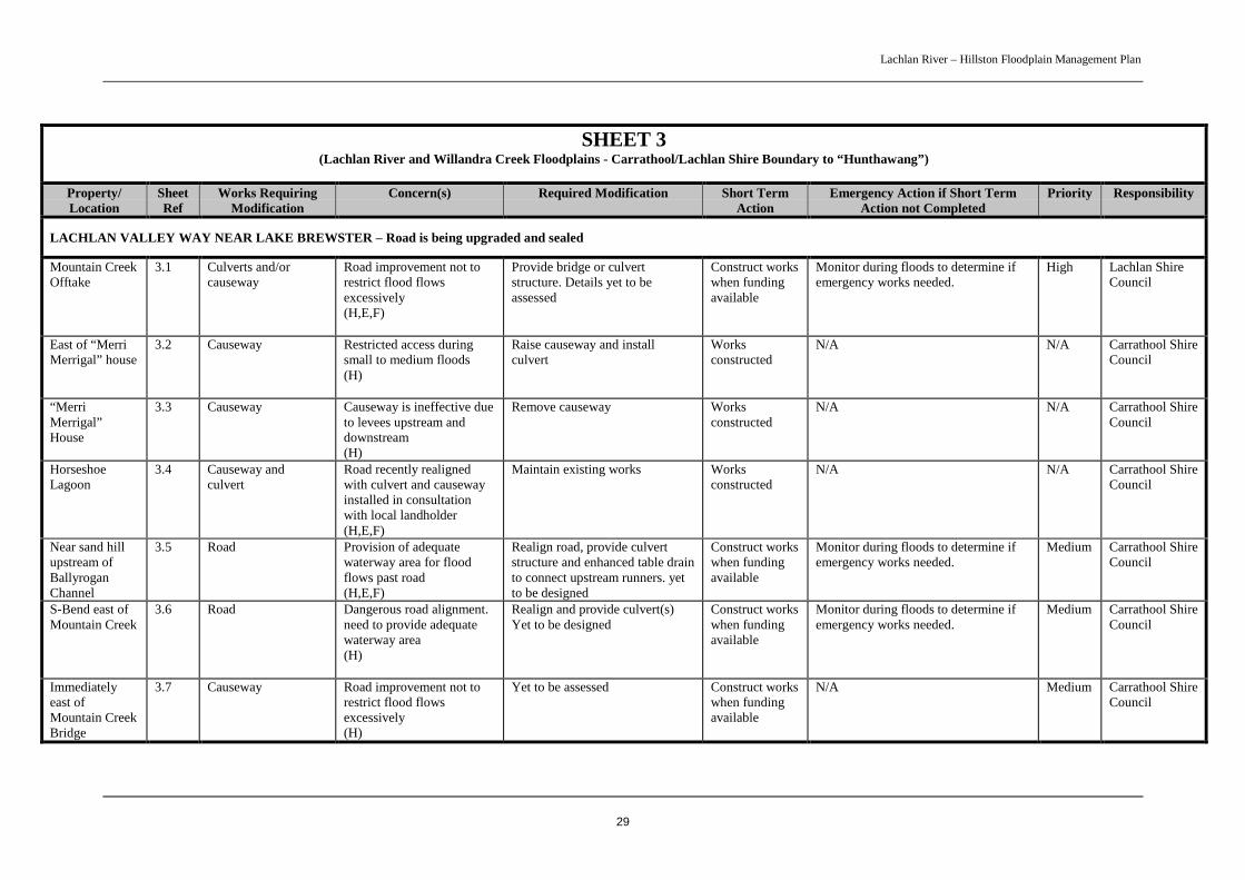
SHEET 3(Lachlan River and Willandra Creek Floodplains - Carrathool/Lachlan Shire Boundary to “Hunthawang”)
Property/Location
SheetRef
Works RequiringModification
Concern(s) Required Modification Short TermAction
Emergency Action if Short TermAction not Completed
Priority Responsibility
LACHLAN VALLEY WAY NEAR LAKE BREWSTER – Road is being upgraded and sealed
Mountain CreekOfftake
3.1 Culverts and/orcauseway
Road improvement not torestrict flood flowsexcessively(H,E,F)
Provide bridge or culvertstructure. Details yet to beassessed
Construct workswhen fundingavailable
Monitor during floods to determine ifemergency works needed.
High Lachlan ShireCouncil
East of “MerriMerrigal” house
3.2 Causeway Restricted access duringsmall to medium floods(H)
Raise causeway and installculvert
Worksconstructed
N/A N/A Carrathool ShireCouncil
“MerriMerrigal”House
3.3 Causeway Causeway is ineffective dueto levees upstream anddownstream(H)
Remove causeway Worksconstructed
N/A N/A Carrathool ShireCouncil
HorseshoeLagoon
3.4 Causeway andculvert
Road recently realignedwith culvert and causewayinstalled in consultationwith local landholder(H,E,F)
Maintain existing works Worksconstructed
N/A N/A Carrathool ShireCouncil
Near sand hillupstream ofBallyroganChannel
3.5 Road Provision of adequatewaterway area for floodflows past road(H,E,F)
Realign road, provide culvertstructure and enhanced table drainto connect upstream runners. yetto be designed
Construct workswhen fundingavailable
Monitor during floods to determine ifemergency works needed.
Medium Carrathool ShireCouncil
S-Bend east ofMountain Creek
3.6 Road Dangerous road alignment.need to provide adequatewaterway area(H)
Realign and provide culvert(s)Yet to be designed
Construct workswhen fundingavailable
Monitor during floods to determine ifemergency works needed.
Medium Carrathool ShireCouncil
Immediatelyeast ofMountain CreekBridge
3.7 Causeway Road improvement not torestrict flood flowsexcessively(H)
Yet to be assessed Construct workswhen fundingavailable
N/A Medium Carrathool ShireCouncil
Lachlan River – Hillston Floodplain Management Plan
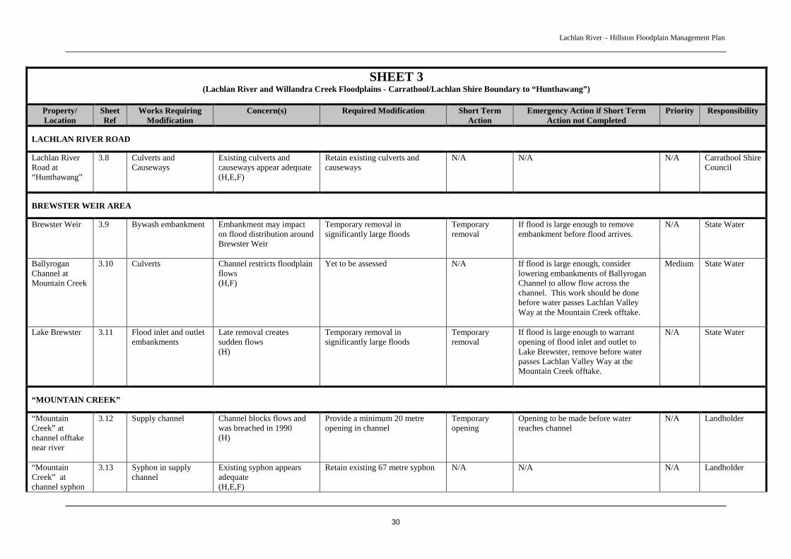
30
SHEET 3(Lachlan River and Willandra Creek Floodplains - Carrathool/Lachlan Shire Boundary to “Hunthawang”)
Property/Location
SheetRef
Works RequiringModification
Concern(s) Required Modification Short TermAction
Emergency Action if Short TermAction not Completed
Priority Responsibility
LACHLAN RIVER ROAD
Lachlan RiverRoad at“Hunthawang”
3.8 Culverts andCauseways
Existing culverts andcauseways appear adequate(H,E,F)
Retain existing culverts andcauseways
N/A N/A N/A Carrathool ShireCouncil
BREWSTER WEIR AREA
Brewster Weir 3.9 Bywash embankment Embankment may impacton flood distribution aroundBrewster Weir
Temporary removal insignificantly large floods
Temporaryremoval
If flood is large enough to removeembankment before flood arrives.
N/A State Water
BallyroganChannel atMountain Creek
3.10 Culverts Channel restricts floodplainflows(H,F)
Yet to be assessed N/A If flood is large enough, considerlowering embankments of BallyroganChannel to allow flow across thechannel. This work should be donebefore water passes Lachlan ValleyWay at the Mountain Creek offtake.
Medium State Water
Lake Brewster 3.11 Flood inlet and outletembankments
Late removal createssudden flows(H)
Temporary removal insignificantly large floods
Temporaryremoval
If flood is large enough to warrantopening of flood inlet and outlet toLake Brewster, remove before waterpasses Lachlan Valley Way at theMountain Creek offtake.
N/A State Water
“MOUNTAIN CREEK”
“MountainCreek” atchannel offtakenear river
3.12 Supply channel Channel blocks flows andwas breached in 1990(H)
Provide a minimum 20 metreopening in channel
Temporaryopening
Opening to be made before waterreaches channel
N/A Landholder
“MountainCreek” atchannel syphon
3.13 Syphon in supplychannel
Existing syphon appearsadequate(H,E,F)
Retain existing 67 metre syphon N/A N/A N/A Landholder

Lachlan River – Hillston Floodplain Management Plan
31
SHEET 3(Lachlan River and Willandra Creek Floodplains - Carrathool/Lachlan Shire Boundary to “Hunthawang”)
Property/Location
SheetRef
Works RequiringModification
Concern(s) Required Modification Short TermAction
Emergency Action if Short TermAction not Completed
Priority Responsibility
“MountainCreek” at creekcrossing
3.14 Mountain Creekaccess crossing
Existing pipe in crossing isnot favourable for fishpassage and may behydraulically inadequate(H,F)
Provide more fish friendlystructure if Ballyrogan Channelculverts are suitably modified
Install newstructure whenrequired
Monitor during floods to assess impactof crossing hydraulically andenvironmentally
Low Landholder
“MountainCreek” wherecreek joinsoutlet channel
3.15 Block bank onMountain Creek
Block bank restricts flowand fish passage(H,F)
To be assessed if modificationsmade to Ballyrogan Channel
N/A Monitor during floods to assess impactof block bank hydraulically andenvironmentally
Low Landholder
EUABALONG ROAD
Euabalong Roadat “Tarcoola”
3.16 Culvert andcauseways
Existing culverts andcauseways appear adequate(H,E)
Retain existing culverts andcauseways
N/A N/A N/A Carrathool ShireCouncil
Euabalong Roadat “KindraPark”
3.17 Culvert Inadequate waterway toallow sufficient water tospread to wetland(E)
Provide additional 0.45 metrepipe culvert
Install works Monitor during floods to determine ifemergency opening is required
Medium Carrathool ShireCouncil
Euabalong Roadat “Stobhall”
3.18 Culvert Existing culvert appearsadequate(E)
Retain existing 0.45 metre pipeculvert
N/A N/A N/A Carrathool ShireCouncil
Euabalong Roadat WillandraCreek andoverflow
3.19 Bridge, culverts andcauseways
Existing waterway area inroad appears adequate(H)
Retain existing bridges, culvertsand causeways.
N/A N/A N/A Carrathool ShireCouncil
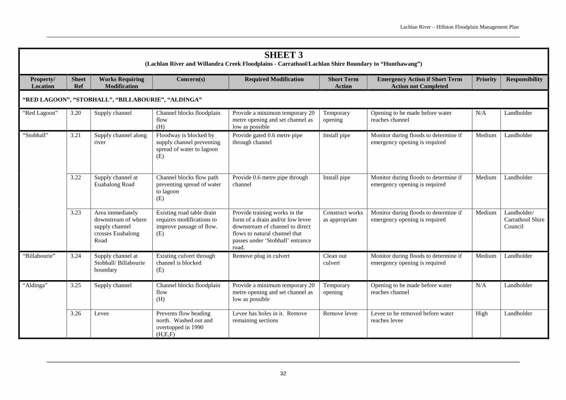
Lachlan River – Hillston Floodplain Management Plan
32
SHEET 3(Lachlan River and Willandra Creek Floodplains - Carrathool/Lachlan Shire Boundary to “Hunthawang”)
Property/Location
SheetRef
Works RequiringModification
Concern(s) Required Modification Short TermAction
Emergency Action if Short TermAction not Completed
Priority Responsibility
“RED LAGOON”, “STOBHALL”, “BILLABOURIE”, “ALDINGA”
“Red Lagoon” 3.20 Supply channel Channel blocks floodplainflow(H)
Provide a minimum temporary 20metre opening and set channel aslow as possible
Temporaryopening
Opening to be made before waterreaches channel
N/A Landholder
3.21 Supply channel alongriver
Floodway is blocked bysupply channel preventingspread of water to lagoon(E)
Provide gated 0.6 metre pipethrough channel
Install pipe Monitor during floods to determine ifemergency opening is required
Medium Landholder
3.22 Supply channel atEuabalong Road
Channel blocks flow pathpreventing spread of waterto lagoon(E)
Provide 0.6 metre pipe throughchannel
Install pipe Monitor during floods to determine ifemergency opening is required
Medium Landholder
“Stobhall”
3.23 Area immediatelydownstream of wheresupply channelcrosses EuabalongRoad
Existing road table drainrequires modifications toimprove passage of flow.(E)
Provide training works in theform of a drain and/or low leveedownstream of channel to directflows to natural channel thatpasses under ‘Stobhall’ entranceroad.
Construct worksas appropriate
Monitor during floods to determine ifemergency opening is required
Medium Landholder/Carrathool ShireCouncil
“Billabourie” 3.24 Supply channel atStobhall/ Billabourieboundary
Existing culvert throughchannel is blocked(E)
Remove plug in culvert Clean outculvert
Monitor during floods to determine ifemergency opening is required
Medium Landholder
3.25 Supply channel Channel blocks floodplainflow(H)
Provide a minimum temporary 20metre opening and set channel aslow as possible
Temporaryopening
Opening to be made before waterreaches channel
N/A Landholder“Aldinga”
3.26 Levee Prevents flow headingnorth. Washed out andovertopped in 1990(H,E,F)
Levee has holes in it. Removeremaining sections
Remove levee Levee to be removed before waterreaches levee
High Landholder
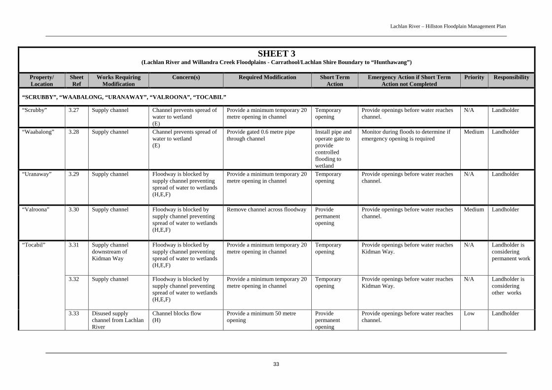
Lachlan River – Hillston Floodplain Management Plan
33
SHEET 3(Lachlan River and Willandra Creek Floodplains - Carrathool/Lachlan Shire Boundary to “Hunthawang”)
Property/Location
SheetRef
Works RequiringModification
Concern(s) Required Modification Short TermAction
Emergency Action if Short TermAction not Completed
Priority Responsibility
“SCRUBBY”, “WAABALONG, “URANAWAY”, “VALROONA”, “TOCABIL”
“Scrubby” 3.27 Supply channel Channel prevents spread ofwater to wetland(E)
Provide a minimum temporary 20metre opening in channel
Temporaryopening
Provide openings before water reacheschannel.
N/A Landholder
“Waabalong” 3.28 Supply channel Channel prevents spread ofwater to wetland(E)
Provide gated 0.6 metre pipethrough channel
Install pipe andoperate gate toprovidecontrolledflooding towetland
Monitor during floods to determine ifemergency opening is required
Medium Landholder
“Uranaway” 3.29 Supply channel Floodway is blocked bysupply channel preventingspread of water to wetlands(H,E,F)
Provide a minimum temporary 20metre opening in channel
Temporaryopening
Provide openings before water reacheschannel.
N/A Landholder
“Valroona” 3.30 Supply channel Floodway is blocked bysupply channel preventingspread of water to wetlands(H,E,F)
Remove channel across floodway Providepermanentopening
Provide openings before water reacheschannel.
Medium Landholder
3.31 Supply channeldownstream ofKidman Way
Floodway is blocked bysupply channel preventingspread of water to wetlands(H,E,F)
Provide a minimum temporary 20metre opening in channel
Temporaryopening
Provide openings before water reachesKidman Way.
N/A Landholder isconsideringpermanent work
3.32 Supply channel Floodway is blocked bysupply channel preventingspread of water to wetlands(H,E,F)
Provide a minimum temporary 20metre opening in channel
Temporaryopening
Provide openings before water reachesKidman Way.
N/A Landholder isconsideringother works
“Tocabil”
3.33 Disused supplychannel from LachlanRiver
Channel blocks flow(H)
Provide a minimum 50 metreopening
Providepermanentopening
Provide openings before water reacheschannel.
Low Landholder

Lachlan River – Hillston Floodplain Management Plan
34
SHEET 3(Lachlan River and Willandra Creek Floodplains - Carrathool/Lachlan Shire Boundary to “Hunthawang”)
Property/Location
SheetRef
Works RequiringModification
Concern(s) Required Modification Short TermAction
Emergency Action if Short TermAction not Completed
Priority Responsibility
KIDMAN WAY
Kidman Waynorth of LachlanRiver to“Valroona”
3.34 Bridges, culverts, andcauseways
Existing waterway area inroad appears adequate(H,E,F)
Retain existing bridges, culvertsand causeways.
N/A N/A N/A Roads andTrafficAuthority
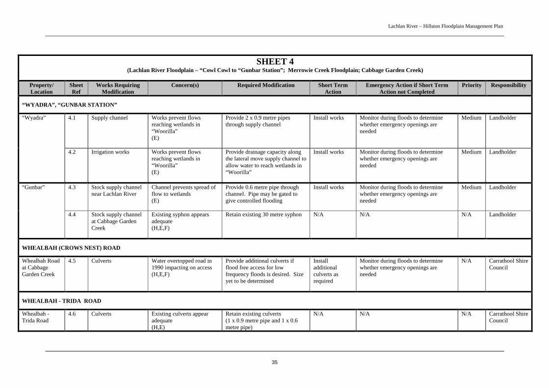
Lachlan River – Hillston Floodplain Management Plan
35
SHEET 4(Lachlan River Floodplain – “Cowl Cowl to “Gunbar Station”; Merrowie Creek Floodplain; Cabbage Garden Creek)
Property/Location
SheetRef
Works RequiringModification
Concern(s) Required Modification Short TermAction
Emergency Action if Short TermAction not Completed
Priority Responsibility
“WYADRA”, “GUNBAR STATION”
4.1 Supply channel Works prevent flowsreaching wetlands in“Woorilla”(E)
Provide 2 x 0.9 metre pipesthrough supply channel
Install works Monitor during floods to determinewhether emergency openings areneeded
Medium Landholder“Wyadra”
4.2 Irrigation works Works prevent flowsreaching wetlands in“Woorilla”(E)
Provide drainage capacity alongthe lateral move supply channel toallow water to reach wetlands in“Woorilla”
Install works Monitor during floods to determinewhether emergency openings areneeded
Medium Landholder
4.3 Stock supply channelnear Lachlan River
Channel prevents spread offlow to wetlands(E)
Provide 0.6 metre pipe throughchannel. Pipe may be gated togive controlled flooding
Install works Monitor during floods to determinewhether emergency openings areneeded
Medium Landholder“Gunbar”
4.4 Stock supply channelat Cabbage GardenCreek
Existing syphon appearsadequate(H,E,F)
Retain existing 30 metre syphon N/A N/A N/A Landholder
WHEALBAH (CROWS NEST) ROAD
Whealbah Roadat CabbageGarden Creek
4.5 Culverts Water overtopped road in1990 impacting on access(H,E,F)
Provide additional culverts ifflood free access for lowfrequency floods is desired. Sizeyet to be determined
Installadditionalculverts asrequired
Monitor during floods to determinewhether emergency openings areneeded
N/A Carrathool ShireCouncil
WHEALBAH - TRIDA ROAD
Whealbah -Trida Road
4.6 Culverts Existing culverts appearadequate(H,E)
Retain existing culverts(1 x 0.9 metre pipe and 1 x 0.6metre pipe)
N/A N/A N/A Carrathool ShireCouncil
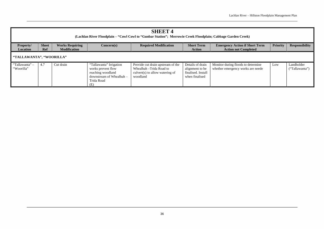
Lachlan River – Hillston Floodplain Management Plan
36
SHEET 4(Lachlan River Floodplain – “Cowl Cowl to “Gunbar Station”; Merrowie Creek Floodplain; Cabbage Garden Creek)
Property/Location
SheetRef
Works RequiringModification
Concern(s) Required Modification Short TermAction
Emergency Action if Short TermAction not Completed
Priority Responsibility
“TALLAWANTA”, “WOORILLA”
“Tallawanta” –“Woorilla”
4.7 Cut drain “Tallawanta” Irrigationworks prevent flowreaching woodlanddownstream of Whealbah –Trida Road(E)
Provide cut drain upstream of theWhealbah –Trida Road toculvert(s) to allow watering ofwoodland
Details of drainalignment to befinalised. Installwhen finalised
Monitor during floods to determinewhether emergency works are neede
Low Landholder(“Tallawanta”)
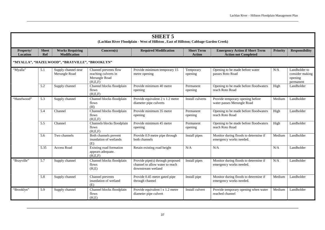
Lachlan River – Hillston Floodplain Management Plan
37
SHEET 5(Lachlan River Floodplain - West of Hillston , East of Hillston; Cabbage Garden Creek)
Property/Location
SheetRef
Works RequiringModification
Concern(s) Required Modification Short TermAction
Emergency Action if Short TermAction not Completed
Priority Responsibility
“MYALLA”, “HAZELWOOD”, “BRAYVILLE”, “BROOKLYN”
5.1 Supply channel nearMerungle Road
Channel prevents flowreaching culverts inMerungle Road(H,E,F)
Provide minimum temporary 15metre opening
Temporaryopening
Opening to be made before waterpasses Roto Road
N/A Landholder toconsider makingopeningpermanent
“Myalla”
5.2 Supply channel Channel blocks floodplainflows(H,E,F)
Provide minimum 40 metreopening
Permanentopening
Opening to be made before floodwatersreach Roto Road
High Landholder
5.3 Supply channel Channel blocks floodplainflows(H)
Provide equivalent 2 x 1.2 metrediameter pipe culverts
Install culverts Provide temporary opening beforewater passes Merungle Road
Medium Landholder
5.4 Channel Channel blocks floodplainflows(H,E,F)
Provide minimum 35 metreopening
Permanentopening
Opening to be made before floodwatersreach Roto Road
High Landholder
5.5 Channel Channels blocks floodplainflows(H,E,F)
Provide minimum 45 metreopening
Permanentopening
Opening to be made before floodwatersreach Roto Road
High Landholder
5.6 Two channels Both channels preventinundation of wetlands(E)
Provide 0.9 metre pipe throughboth channels
Install pipes Monitor during floods to determine ifemergency works needed.
Medium Landholder
“Hazelwood”
5.35 Access Road Existing road formationappears adequate.(H,E,F)
Retain existing road height N/A N/A N/A Landholder
5.7 Supply channel Channel blocks floodplainflows(H,E)
Provide pipe(s) through proposedchannel to allow water to reachdownstream wetland
Install pipes Monitor during floods to determine ifemergency works needed.
N/A Landholder“Brayville”
5.8 Supply channel Channel preventsinundation of wetland(E)
Provide 0.45 metre gated pipethrough channel
Install pipe Monitor during floods to determine ifemergency works needed.
Medium Landholder
“Brooklyn” 5.9 Supply channel Channel blocks floodplainflows(H,E)
Provide equivalent l x 1.2 metrediameter pipe culvert
Install culvert Provide temporary opening when waterreached channel
Medium Landholder
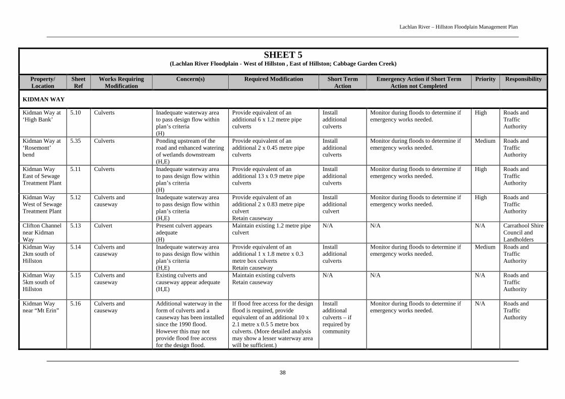
Lachlan River – Hillston Floodplain Management Plan
38
SHEET 5(Lachlan River Floodplain - West of Hillston , East of Hillston; Cabbage Garden Creek)
Property/Location
SheetRef
Works RequiringModification
Concern(s) Required Modification Short TermAction
Emergency Action if Short TermAction not Completed
Priority Responsibility
KIDMAN WAY
Kidman Way at‘High Bank’
5.10 Culverts Inadequate waterway areato pass design flow withinplan’s criteria(H)
Provide equivalent of anadditional 6 x 1.2 metre pipeculverts
Installadditionalculverts
Monitor during floods to determine ifemergency works needed.
High Roads andTrafficAuthority
Kidman Way at‘Rosemont’bend
5.35 Culverts Ponding upstream of theroad and enhanced wateringof wetlands downstream(H,E)
Provide equivalent of anadditional 2 x 0.45 metre pipeculverts
Installadditionalculverts
Monitor during floods to determine ifemergency works needed.
Medium Roads andTrafficAuthority
Kidman WayEast of SewageTreatment Plant
5.11 Culverts Inadequate waterway areato pass design flow withinplan’s criteria(H)
Provide equivalent of anadditional 13 x 0.9 metre pipeculverts
Installadditionalculverts
Monitor during floods to determine ifemergency works needed.
High Roads andTrafficAuthority
Kidman WayWest of SewageTreatment Plant
5.12 Culverts andcauseway
Inadequate waterway areato pass design flow withinplan’s criteria(H,E)
Provide equivalent of anadditional 2 x 0.83 metre pipeculvertRetain causeway
Installadditionalculvert
Monitor during floods to determine ifemergency works needed.
High Roads andTrafficAuthority
Clifton Channelnear KidmanWay
5.13 Culvert Present culvert appearsadequate(H)
Maintain existing 1.2 metre pipeculvert
N/A N/A N/A Carrathool ShireCouncil andLandholders
Kidman Way2km south ofHillston
5.14 Culverts andcauseway
Inadequate waterway areato pass design flow withinplan’s criteria(H,E)
Provide equivalent of anadditional 1 x 1.8 metre x 0.3metre box culvertsRetain causeway
Installadditionalculverts
Monitor during floods to determine ifemergency works needed.
Medium Roads andTrafficAuthority
Kidman Way5km south ofHillston
5.15 Culverts andcauseway
Existing culverts andcauseway appear adequate(H,E)
Maintain existing culvertsRetain causeway
N/A N/A N/A Roads andTrafficAuthority
Kidman Waynear “Mt Erin”
5.16 Culverts andcauseway
Additional waterway in theform of culverts and acauseway has been installedsince the 1990 flood.However this may notprovide flood free accessfor the design flood.
If flood free access for the designflood is required, provideequivalent of an additional 10 x2.1 metre x 0.5 5 metre boxculverts. (More detailed analysismay show a lesser waterway areawill be sufficient.)
Installadditionalculverts – ifrequired bycommunity
Monitor during floods to determine ifemergency works needed.
N/A Roads andTrafficAuthority
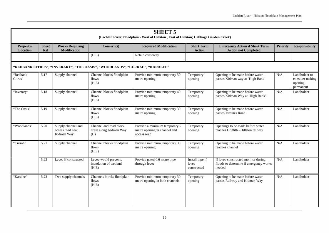
Lachlan River – Hillston Floodplain Management Plan
39
SHEET 5(Lachlan River Floodplain - West of Hillston , East of Hillston; Cabbage Garden Creek)
Property/Location
SheetRef
Works RequiringModification
Concern(s) Required Modification Short TermAction
Emergency Action if Short TermAction not Completed
Priority Responsibility
(H,E) Retain causeway
“REDBANK CITRUS”, “INVERARY”, ”THE OASIS”, ”WOODLANDS”, “CURRAH”, “KARALEE”
“RedbankCitrus”
5.17 Supply channel Channel blocks floodplainflows(H,E)
Provide minimum temporary 50metre opening
Temporaryopening
Opening to be made before waterpasses Kidman way at ‘High Bank’
N/A Landholder toconsider makingopeningpermanent
“Inverary” 5.18 Supply channel Channel blocks floodplainflows(H,E)
Provide minimum temporary 40metre opening
Temporaryopening
Opening to be made before waterpasses Kidman Way at ‘High Bank’
N/A Landholder
“The Oasis” 5.19 Supply channel Channel blocks floodplainflows(H,E)
Provide minimum temporary 30metre opening
Temporaryopening
Opening to be made before waterpasses Jardines Road
N/A Landholder
“Woodlands” 5.20 Supply channel andaccess road nearKidman Way
Channel and road blockdrain along Kidman Way(H)
Provide a minimum temporary 5metre opening in channel andaccess road
Temporaryopening
Openings to be made before waterreaches Griffith –Hillston railway
N/A Landholder
5.21 Supply channel Channel blocks floodplainflows(H,E)
Provide minimum temporary 30metre opening
Temporaryopening
Opening to be made before waterreaches channel
N/A Landholder“Currah”
5.22 Levee if constructed Levee would preventsinundation of wetland(H,E)
Provide gated 0.6 metre pipethrough levee
Install pipe ifleveeconstructed
If levee constructed monitor duringfloods to determine if emergency worksneeded
N/A Landholder
“Karalee” 5.23 Two supply channels Channels blocks floodplainflows(H,E)
Provide minimum temporary 30metre opening in both channels
Temporaryopening
Opening to be made before waterpasses Railway and Kidman Way
N/A Landholder

Lachlan River – Hillston Floodplain Management Plan
40
SHEET 5(Lachlan River Floodplain - West of Hillston , East of Hillston; Cabbage Garden Creek)
Property/Location
SheetRef
Works RequiringModification
Concern(s) Required Modification Short TermAction
Emergency Action if Short TermAction not Completed
Priority Responsibility
5.24 Levee Levee prevents inundationof wetland(E)
Provide temporary 0.45 metregated pipe through levee
Temporaryopening
Install pipe or equivalent openingbefore water reaches “Karalee” supplychannel
N/A Landholder
JARDINES ROAD, NORWOOD LANE, PETERS ROAD
Jardines Road 5.25 Causeway Existing causeway appearsadequate(H)
Maintain existing causeway N/A N/A N/A Carrathool ShireCouncil
Norwood Lane 5.26 Drains Drainage linked to urbanflood plan(H)
Provide drains as recommendedin urban flood plan
N/A N/A High Carrathool ShireCouncil
Peters Road 5.27 Culverts Existing culverts appearadequate(H)
Maintain existing culverts N/A N/A N/A Carrathool ShireCouncil
RANKIN SPRINGS ROAD
Rankin SpringsRoad
5.28 Culverts Existing culverts appearadequate(H)
Maintain existing culvertsLinked to urban plan
N/A N/A N/A Carrathool ShireCouncil
Rankin SpringsRoad nearNorwood Lane
5.29 Culverts andcauseway
Existing culverts andcauseway appear adequate(H)
Maintain existing culvertsRetain causewayLinked to urban plan
N/A N/A N/A Carrathool ShireCouncil
GRIFFITH – HILLSTON RAILWAY
Railway 2kmsouth ofHillston
5.30 Culverts Inadequate waterway areato pass design flow withinplan’s criteria(H,E)
Provide equivalent of anadditional 2 x 0.6 metre diameterpipe culverts
Installadditionalculverts
Monitor during floods to determine ifemergency works needed.
Medium RailInfrastructureCorporation
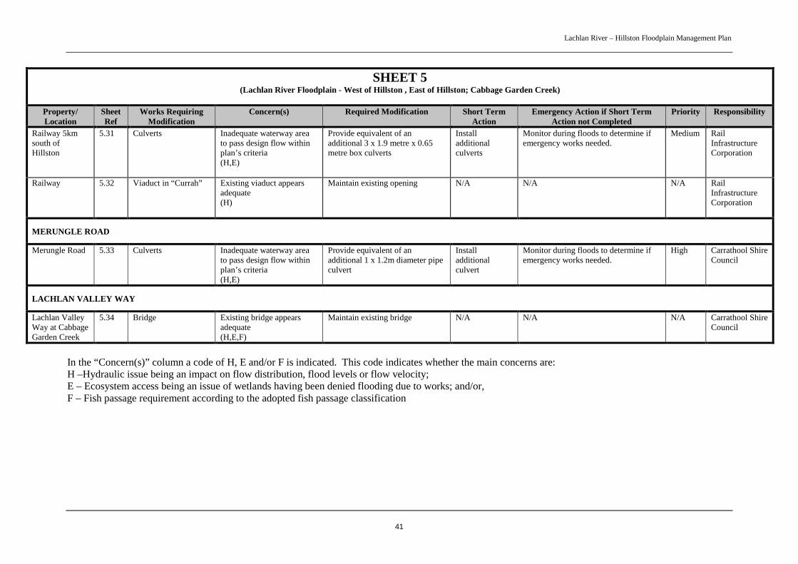
Lachlan River – Hillston Floodplain Management Plan
41
SHEET 5(Lachlan River Floodplain - West of Hillston , East of Hillston; Cabbage Garden Creek)
Property/Location
SheetRef
Works RequiringModification
Concern(s) Required Modification Short TermAction
Emergency Action if Short TermAction not Completed
Priority Responsibility
Railway 5kmsouth ofHillston
5.31 Culverts Inadequate waterway areato pass design flow withinplan’s criteria(H,E)
Provide equivalent of anadditional 3 x 1.9 metre x 0.65metre box culverts
Installadditionalculverts
Monitor during floods to determine ifemergency works needed.
Medium RailInfrastructureCorporation
Railway 5.32 Viaduct in “Currah” Existing viaduct appearsadequate(H)
Maintain existing opening N/A N/A N/A RailInfrastructureCorporation
MERUNGLE ROAD
Merungle Road 5.33 Culverts Inadequate waterway areato pass design flow withinplan’s criteria(H,E)
Provide equivalent of anadditional 1 x 1.2m diameter pipeculvert
Installadditionalculvert
Monitor during floods to determine ifemergency works needed.
High Carrathool ShireCouncil
LACHLAN VALLEY WAY
Lachlan ValleyWay at CabbageGarden Creek
5.34 Bridge Existing bridge appearsadequate(H,E,F)
Maintain existing bridge N/A N/A N/A Carrathool ShireCouncil
In the “Concern(s)” column a code of H, E and/or F is indicated. This code indicates whether the main concerns are:H –Hydraulic issue being an impact on flow distribution, flood levels or flow velocity;E – Ecosystem access being an issue of wetlands having been denied flooding due to works; and/or,F – Fish passage requirement according to the adopted fish passage classification
Lachlan River – Hillston Floodplain Management Plan
42
5 ASSESSING NON – COMPLYING WORKSLandholders applying for approval of non-complying works will need to engage a suitably qualifiedconsultant to investigate the hydraulic and environmental impact of the works. DNR will provide therequired assessment criteria for the consultant. Applications will be assessed against, among otherthings, hydraulic and environmental criteria adopted by the committee in determining outcomes in theHillston Floodplain Management Study Lake Brewster to Whealbah (DNR 2005). As well, theenvironmental impacts of the works applications will need to be assessed under Part 5 of theEnvironmental Planning and Assessment Act 1979. Assessment under Part 4 of this Act is not requiredas there is currently no relevant environmental planning instrument applying to flood control works inthe FMP area.
5.1 Hydraulic CriteriaThe hydraulic criteria adopted to assess existing works during preparation of the Hillston FloodplainManagement Study Lake Brewster to Whealbah (DNR 2005) will be applied to assess applications fornon-complying works. These criteria were also used in the design of the floodway network wherehydraulic modelling was undertaken. The criteria consider the maximum allowable afflux (afflux canbe defined as the increase in the upstream flood level created by the obstruction to flow of thestructure), the maximum allowable velocities, and what is acceptable in terms of the impact on floodflow distribution.
Design Flood
The 1990 flood, which was adopted by the committee as the design flood, is used as the basis fordetermining hydraulic impact. This flood was selected as it was:
• a large flood of 60 to 70 year Average Recurrence Interval (ARI) close to the 100 year ARIflood or otherwise termed the 1% Annual Exceedance Probability (AEP) flood. The 1% AEPflood is an accepted common design flood; and,
• relatively recent so that people could remember the flooding behaviour.
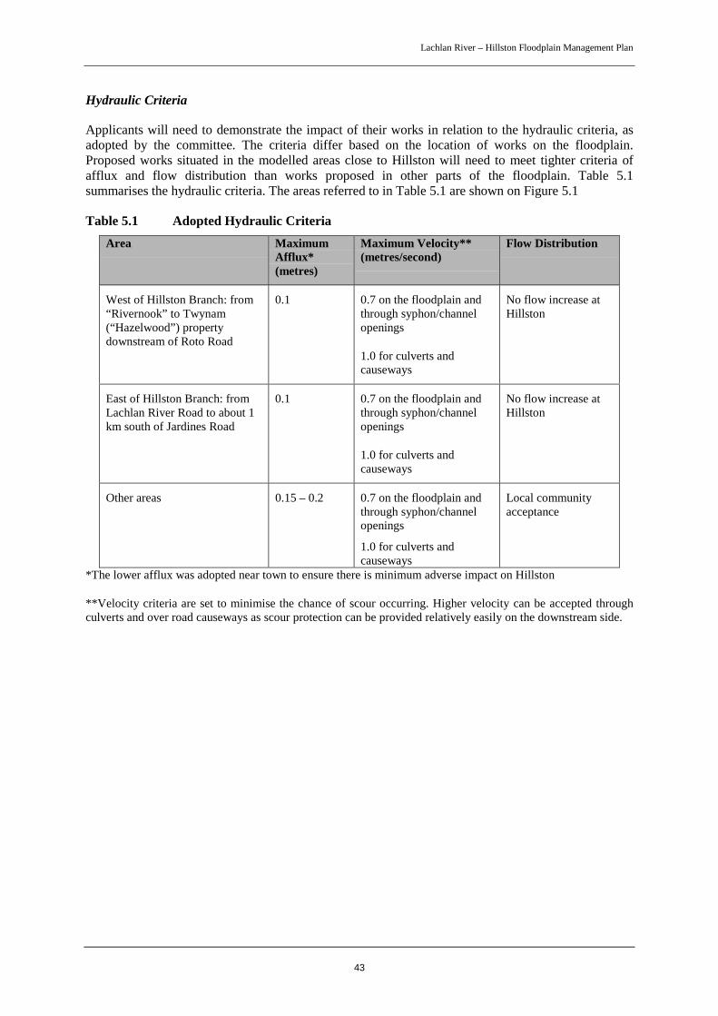
Lachlan River – Hillston Floodplain Management Plan
43
Hydraulic Criteria
Applicants will need to demonstrate the impact of their works in relation to the hydraulic criteria, asadopted by the committee. The criteria differ based on the location of works on the floodplain.Proposed works situated in the modelled areas close to Hillston will need to meet tighter criteria ofafflux and flow distribution than works proposed in other parts of the floodplain. Table 5.1summarises the hydraulic criteria. The areas referred to in Table 5.1 are shown on Figure 5.1
Table 5.1 Adopted Hydraulic CriteriaArea Maximum
Afflux*(metres)
Maximum Velocity**(metres/second)
Flow Distribution
West of Hillston Branch: from“Rivernook” to Twynam(“Hazelwood”) propertydownstream of Roto Road
0.1 0.7 on the floodplain andthrough syphon/channelopenings
1.0 for culverts andcauseways
No flow increase atHillston
East of Hillston Branch: fromLachlan River Road to about 1km south of Jardines Road
0.1 0.7 on the floodplain andthrough syphon/channelopenings
1.0 for culverts andcauseways
No flow increase atHillston
Other areas 0.15 – 0.2 0.7 on the floodplain andthrough syphon/channelopenings
1.0 for culverts andcauseways
Local communityacceptance
*The lower afflux was adopted near town to ensure there is minimum adverse impact on Hillston
**Velocity criteria are set to minimise the chance of scour occurring. Higher velocity can be accepted throughculverts and over road causeways as scour protection can be provided relatively easily on the downstream side.

Lachlan River – Hillston Floodplain Management Plan
44

Lachlan River – Hillston Floodplain Management Plan
45
5.2 Environmental CriteriaEnvironmental assessment criteria were developed in consultation with the committee to helpdetermine outcomes for flood dependent ecosystems affected by existing private works. Two sets ofcriteria were developed, one to assess the environmental value of an area and another to assess thepracticality of modifying works to restore flood flow access. Applicants with non-complying worksaffecting a flood dependent ecosystem will need to address the environmental value criteria (inaddition to the need to address environmental impact under Part 5 of the EPA Act).
The environmental value criteria are shown in Table 5.2.
Table 5.2 Environmental Value Assessment Criteria
Factor Criteria Score
Size (wetland, floodplainvegetation) [Watercourses aremeasured in width x lengthfor area]
• Greater than 50 ha• 10-50 ha• Less than 10 ha
• High• Moderate• Low
Ecological condition / Habitatvalue
• Sound ecological condition / habitat value based oncurrent impacts
• Poor ecological condition / habitat value
• High /Moderate
• Low
Representativeness ofecosystem type
• Good example of an ecosystem type that is notcommon on the floodplain
• Good example of an ecosystem type that is relativelycommon on the floodplain
• Poor example of ecosystem type
• High
• Moderate
• Low
Cultural / historicalsignificance
• Known significance based on Aboriginal sites,mythological values
• Likely significance based on regional evidence• No known / likely significance
• High
• Moderate• Low
Rehabilitation potential • Sound rehabilitation potential based on ease ofrestoring aquatic flora and fauna / floodplainvegetation
• Poor rehabilitation potential
• High /Moderate
• Low
Hydrology • Ecosystem would wet up under a range of floodevents
• Ecosystem would wet up in large floods (>20yr ARI)only
• High
• Low
Hydrological connectivity • Watercourse connects with wetlands or otherwatercourses
• Watercourse does not connect with wetlands or otherwatercourses
• High
• Low
Special Features • Sites which are part of complexes or have listedspecies or have high habitat diversity
• If these features don’t exist, then no score is given
• High
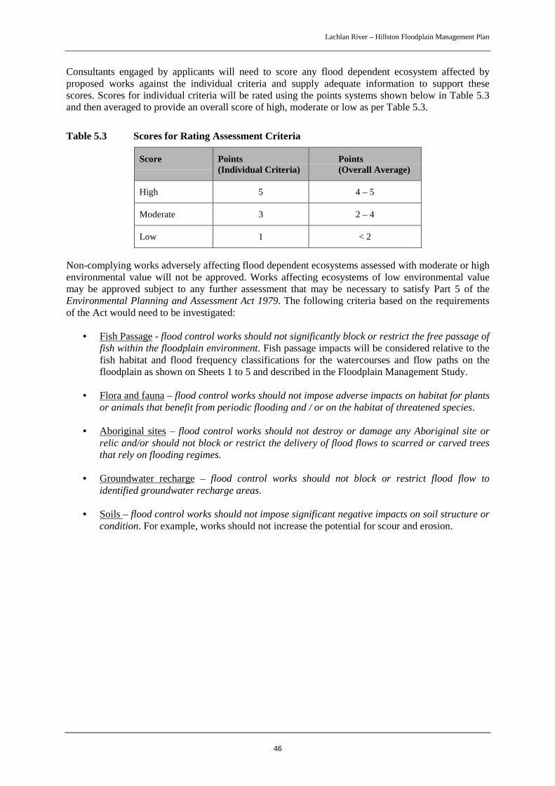
Lachlan River – Hillston Floodplain Management Plan
46
Consultants engaged by applicants will need to score any flood dependent ecosystem affected byproposed works against the individual criteria and supply adequate information to support thesescores. Scores for individual criteria will be rated using the points systems shown below in Table 5.3and then averaged to provide an overall score of high, moderate or low as per Table 5.3.
Table 5.3 Scores for Rating Assessment Criteria
Score Points(Individual Criteria)
Points(Overall Average)
High 5 4 – 5
Moderate 3 2 – 4
Low 1 < 2
Non-complying works adversely affecting flood dependent ecosystems assessed with moderate or highenvironmental value will not be approved. Works affecting ecosystems of low environmental valuemay be approved subject to any further assessment that may be necessary to satisfy Part 5 of theEnvironmental Planning and Assessment Act 1979. The following criteria based on the requirementsof the Act would need to be investigated:
• Fish Passage - flood control works should not significantly block or restrict the free passage offish within the floodplain environment. Fish passage impacts will be considered relative to thefish habitat and flood frequency classifications for the watercourses and flow paths on thefloodplain as shown on Sheets 1 to 5 and described in the Floodplain Management Study.
• Flora and fauna – flood control works should not impose adverse impacts on habitat for plantsor animals that benefit from periodic flooding and / or on the habitat of threatened species.
• Aboriginal sites – flood control works should not destroy or damage any Aboriginal site orrelic and/or should not block or restrict the delivery of flood flows to scarred or carved treesthat rely on flooding regimes.
• Groundwater recharge – flood control works should not block or restrict flood flow toidentified groundwater recharge areas.
• Soils – flood control works should not impose significant negative impacts on soil structure orcondition. For example, works should not increase the potential for scour and erosion.
Lachlan River – Hillston Floodplain Management Plan
47
6 LONG TERM STRATEGYThe proposed works modifications identified in the FMP will address key hydraulic andenvironmental issues on the floodplain. While they will improve floodplain functions significantly,flood behaviour could be further improved by the relocation or removal of other existing above groundworks and irrigation areas from the floodway. It is not seen as necessary that such development shouldbe removed in the short term. However, in the long term, as farming practices change and ifopportunities arise, it is recommended that such development be relocated away from the floodwayareas thereby improving flood passage and floodplain ecology.
Examples of alternative land use practices that would enable works to be relocated from the floodwayinclude:
• transfer of irrigation water from floodway areas to less flood - prone and more water efficientareas. The works in the floodway could then be removed and the floodway area used foractivities such as grazing which do not require above ground works; and,
• replacement of above ground channels leading from river pumps with underground piping.This would lessen irrigation water transmission losses and remove flow restrictions near theriver. While the initial costs may be high, valuable future water savings would be expected.
Some areas within the floodway network have pasture developments using “check bank” irrigation.While not completely desirable, such works, (as those in the Willanthery area), are generallyovertopped by floodwaters and do not impact greatly on flood flows. These works have existed forsome time and have undergone a number of floods without major concern. However the larger mainsupply channels may have the potential to impact adversely on flood flows and under the long - termstrategy these would preferably be replaced by underground piping.
In summary the long - term strategy should:
• discourage future above ground works in the defined floodway; and,
• promote relocation of existing development (eg irrigation areas) within the floodway to lessflood liable areas.
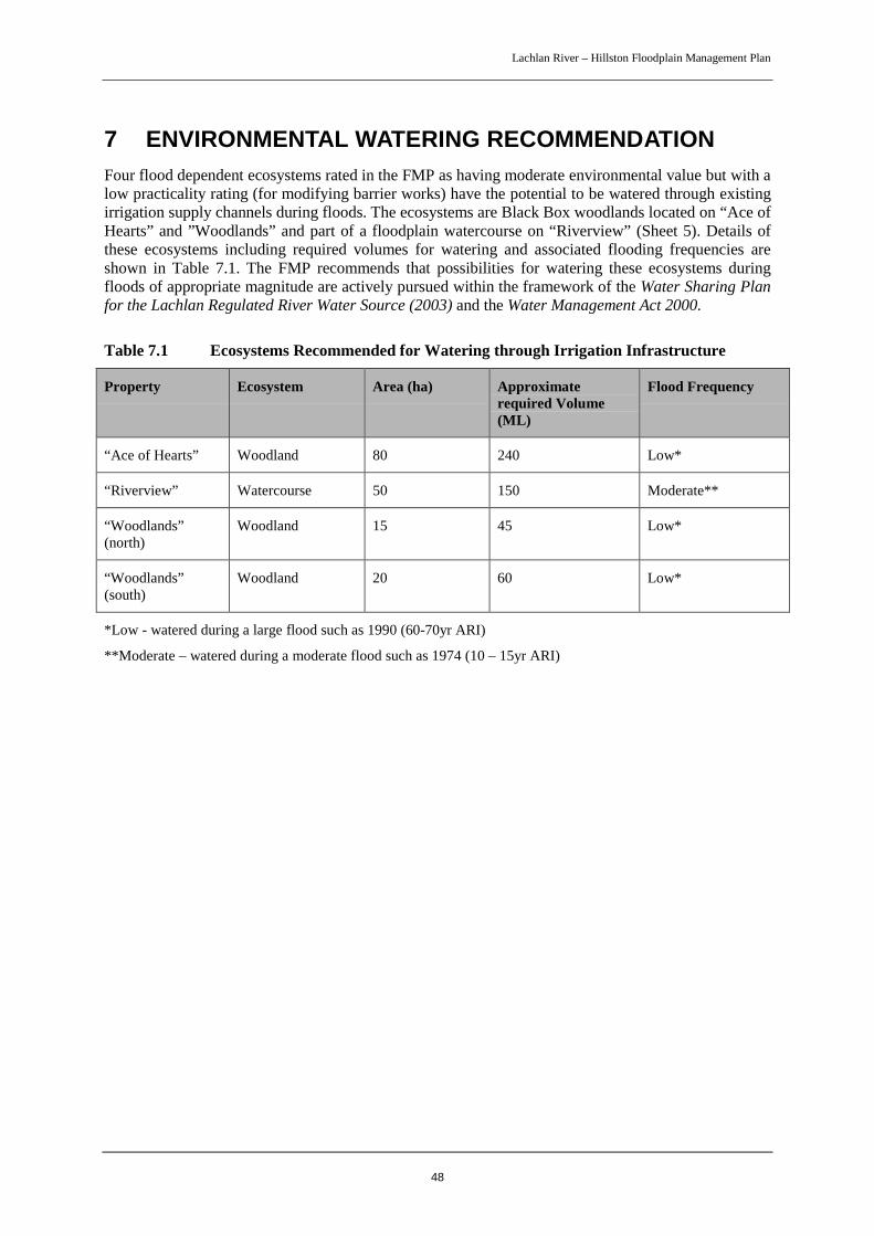
Lachlan River – Hillston Floodplain Management Plan
48
7 ENVIRONMENTAL WATERING RECOMMENDATIONFour flood dependent ecosystems rated in the FMP as having moderate environmental value but with alow practicality rating (for modifying barrier works) have the potential to be watered through existingirrigation supply channels during floods. The ecosystems are Black Box woodlands located on “Ace ofHearts” and ”Woodlands” and part of a floodplain watercourse on “Riverview” (Sheet 5). Details ofthese ecosystems including required volumes for watering and associated flooding frequencies areshown in Table 7.1. The FMP recommends that possibilities for watering these ecosystems duringfloods of appropriate magnitude are actively pursued within the framework of the Water Sharing Planfor the Lachlan Regulated River Water Source (2003) and the Water Management Act 2000.
Table 7.1 Ecosystems Recommended for Watering through Irrigation Infrastructure
Property Ecosystem Area (ha) Approximaterequired Volume(ML)
Flood Frequency
“Ace of Hearts” Woodland 80 240 Low*
“Riverview” Watercourse 50 150 Moderate**
“Woodlands”(north)
Woodland 15 45 Low*
“Woodlands”(south)
Woodland 20 60 Low*
*Low - watered during a large flood such as 1990 (60-70yr ARI)
**Moderate – watered during a moderate flood such as 1974 (10 – 15yr ARI)
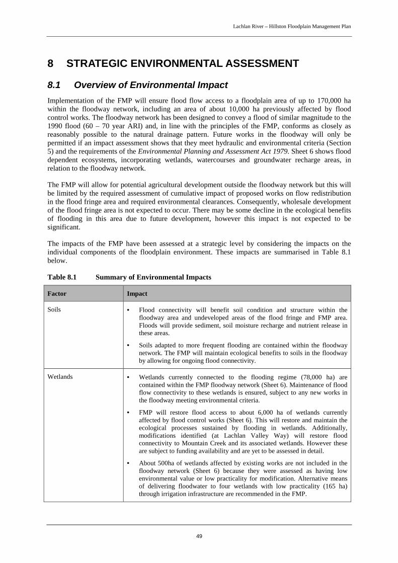
Lachlan River – Hillston Floodplain Management Plan
49
8 STRATEGIC ENVIRONMENTAL ASSESSMENT
8.1 Overview of Environmental ImpactImplementation of the FMP will ensure flood flow access to a floodplain area of up to 170,000 hawithin the floodway network, including an area of about 10,000 ha previously affected by floodcontrol works. The floodway network has been designed to convey a flood of similar magnitude to the1990 flood (60 – 70 year ARI) and, in line with the principles of the FMP, conforms as closely asreasonably possible to the natural drainage pattern. Future works in the floodway will only bepermitted if an impact assessment shows that they meet hydraulic and environmental criteria (Section5) and the requirements of the Environmental Planning and Assessment Act 1979. Sheet 6 shows flooddependent ecosystems, incorporating wetlands, watercourses and groundwater recharge areas, inrelation to the floodway network.
The FMP will allow for potential agricultural development outside the floodway network but this willbe limited by the required assessment of cumulative impact of proposed works on flow redistributionin the flood fringe area and required environmental clearances. Consequently, wholesale developmentof the flood fringe area is not expected to occur. There may be some decline in the ecological benefitsof flooding in this area due to future development, however this impact is not expected to besignificant.
The impacts of the FMP have been assessed at a strategic level by considering the impacts on theindividual components of the floodplain environment. These impacts are summarised in Table 8.1below.
Table 8.1 Summary of Environmental Impacts
Factor Impact
Soils • Flood connectivity will benefit soil condition and structure within thefloodway area and undeveloped areas of the flood fringe and FMP area.Floods will provide sediment, soil moisture recharge and nutrient release inthese areas.
• Soils adapted to more frequent flooding are contained within the floodwaynetwork. The FMP will maintain ecological benefits to soils in the floodwayby allowing for ongoing flood connectivity.
Wetlands • Wetlands currently connected to the flooding regime (78,000 ha) arecontained within the FMP floodway network (Sheet 6). Maintenance of floodflow connectivity to these wetlands is ensured, subject to any new works inthe floodway meeting environmental criteria.
• FMP will restore flood access to about 6,000 ha of wetlands currentlyaffected by flood control works (Sheet 6). This will restore and maintain theecological processes sustained by flooding in wetlands. Additionally,modifications identified (at Lachlan Valley Way) will restore floodconnectivity to Mountain Creek and its associated wetlands. However theseare subject to funding availability and are yet to be assessed in detail.
• About 500ha of wetlands affected by existing works are not included in thefloodway network (Sheet 6) because they were assessed as having lowenvironmental value or low practicality for modification. Alternative meansof delivering floodwater to four wetlands with low practicality (165 ha)through irrigation infrastructure are recommended in the FMP.

Lachlan River – Hillston Floodplain Management Plan
50
Factor Impact
Floodplain Vegetation • Existing stands of flood dependent vegetation (predominantly River RedGum and Black Box woodlands) identified within wetlands and, with theexception of 500 ha of wetlands listed above, are incorporated into thefloodway network. The FMP will allow for ongoing flood connectivity andthe sustenance and regeneration of floodplain vegetation in the long term. Itwill restore flood connectivity to about 10,000 ha of floodplain (including6,000 ha of wetlands) currently affected by flood control works and enhancerestoration of floodplain vegetation in this area.
• One threatened plant species, Slender Darling Pea (Swainsonia murrayana)has been recorded and four others may potentially occur. None of the speciesis restricted to floodplain habitats but four, including Slender Darling Pea, arefound in Black Box woodlands and expected to benefit as the FMP will helpto maintain or restore the condition of these woodlands.
Fauna • FMP will benefit terrestrial fauna species relying directly on flooding (egwaterbirds) and those utilising floodplain habitats by restoring or maintainingflood connectivity to floodplain ecosystems.
• 14 threatened fauna species have been recorded and a further 15 species maypotentially occur. These species are expected to benefit from the restorationand maintenance of ecological processes sustained by ongoing floodconnectivity through the FMP.
Aquatic Fauna • Maintenance of flood flow access to wetlands currently connected to theflooding regime and restoration of access to about 10,000 ha of floodplain(including 6,000 ha of wetlands) currently affected by works will enhanceinvertebrate production and fish habitat. Fish passage has been a keyconsideration in determining modifications to existing works and in thedesign of the floodway network. A fish habitat classification scheme basedon the hydrology, stream morphology and stream connectivity of flood flowpaths across the floodplain was taken into account and is shown on Sheets 1to 5 in relation to the floodway network.
• One threatened species, Silver Perch is expected to occur. This speciesdepends on access to the floodplain for spawning and is expected to benefitfrom enhanced flood connectivity between the river and the floodplainprovided through the FMP floodway network.
Water Quality Risk of surplus nutrient and pesticide transport through inundation of croppedareas or through excessive scour or erosion will be restricted as the floodwaynetwork has been designed to limit flood velocities and to minimise the flood riskto complying agricultural development
Groundwater Areas of groundwater recharge with the greatest response to flooding areincorporated in the mapping of flood dependent ecosystems (Sheet 6) and areincluded in the FMP floodway network. Implementation will allow for floodconnectivity to these areas to be maintained in the long term.
Aboriginal Heritage Recorded Aboriginal sites that benefit from flooding include scarred and carvedBlack Box trees, other unrecorded sites likely to occur in floodplain woodlands.These are incorporated in flood dependent ecosystems mapping and included inthe floodway network. Assessment of wetlands affected by existing works hasincluded consideration of Aboriginal heritage value.
European Heritage Known historical sites are located on high ground and not likely to be flooded.Implementation of the FMP not likely to significantly impact on other historicalsites as potential erosion damage from flooding will be minimised.

Lachlan River – Hillston Floodplain Management Plan
51
8.2 State Water Management Outcomes Plan TargetThe State Water Management Outcomes Plan (SWMOP) outlines an action target for 11 key ruralNSW floodplains, including the Hillston area, for which floodplain management plans are beingprepared. This specifies that action is taken to (re)connect at least 60% of the natural 1 in 5 yearflooded area to the river by:
• mapping the major flood paths and flood dependent ecosystems; and
• identifying the significant barriers to flooding and commencing action to deal with the prioritybarriers.
The 1998 flood at Hillston had an AEP of about 20% (5 year ARI). The extent of this flood at its peakat Hillston on 23rd October 1998 is shown on Sheet 7 with the FMP floodway superimposed. While theextent of the 1998 flood does not exactly replicate the natural 1 in 5 year flooded area because of thepresence of on-ground works, it is highly indicative and the best available approximation. As shownon Sheet 7, the 1998 flood extent is contained within the FMP floodway network, which also includesthe major flood paths and flood dependent ecosystems on the floodplain. The FMP has identifiedsignificant barriers within the floodway network, specified actions to deal with these and set out aprocess to allow the floodway network to be unimpeded by future works. In summary, the FMP willexceed the SWMOP target for the Hillston floodplain of (re)connecting at least 60% of the natural 1 in5 year flooded area to the river.
8.3 Catchment ImpactsThe Lachlan floodplain directly upstream of the FMP area is relatively confined with little wetlanddevelopment. Implementation of the FMP is not expected to impact on this area. Downstream of theFMP area, the floodplain is expansive and there are a number of wetlands of national importance onMerrimajeel and Muggabah Creeks (Booligal Swamp, Lake Merrimajeel, Murrumbidgil Swamp),Merrowie Creek (Tarwong Lakes) and the Lachlan River (Great Cumbung Swamp). The FMPfloodway network is based on the natural drainage pattern and the exit of floodwaters from thefloodways is expected to be at rates and depths similar to those that would have been experiencedunder natural / historical conditions. The FMP floodway network will preserve flood flow paths andallow for future delivery of the flood regime to downstream ecosystems.
Lachlan River – Hillston Floodplain Management Plan
52
9 MONITORING AND REVIEW
9.1 Performance IndicatorsTwo sets of performance indicators are proposed. The first is that existing works are modifiedaccording to the FMP, the second that the floodplain performs adequately in a flood. These indicatorswill be closely linked with the FMP objectives.
The process of approval of flood control works will provide a measure of works that abide by the FMPand works that are not approved will need to be removed. An audit of works should be carried outafter the majority of approvals are completed.
The performance of the floodplain during floods would be assessed from information gathered duringflood monitoring activities. This information should be measured against the FMP’s objectives. Inparticular the following should be considered with comparison made to historical flood events:
Hydraulic:
• improved passage of flood waters through the FMP area;
• structures performing to the agreed hydraulic criteria;
Environmental:
• improved fish passage;
• improved habitat for plants and animals that utilise floodplains;
• increased flood connectivity to wetlands
Economic:
• lesser flood damage
Social:
• improved access during floods;
• clarity for the community in actions carried out during a flood
In order to assess the performance of the FMP against these indicators, a monitoring program asoutlined below is proposed.
9.2 Flood MonitoringMonitoring of hydraulic flood behaviour would identify any problem areas and whether anymodifications or upgrades are required. Depending on the size of flood, monitoring would range fromsimple observation to measuring of flows and levels followed by additional hydraulic analyses.
For the smaller, more frequent floods, monitoring should be limited to observations of critical areas(or ‘hot spots’). A list of these areas and what to look for is included in Appendix B. The larger floods,nearing the 1990 design flood levels, should be monitored in more detail. In particular, as thehydraulic modelling has a significant degree of reliance upon flow estimates, especially peak flows, itwill be important to collect data to verify these estimates. Appendix B also lists critical areas tomonitor in the larger floods.
Floods in the Hillston area usually have a relatively long lead - in time. Hence there is time to plan amonitoring program. An effective monitoring program will require input from DNR, Carrathool ShireCouncil and landholders. The following is recommended:

Lachlan River – Hillston Floodplain Management Plan
53
• DNR should undertake aerial photography, collection of satellite imagery, survey, streamgaugings and flow measurements; and,
• where safe to do so, Carrathool Shire Council and landholders should observe the performanceof their part of the floodway network, including marking high flood levels, estimating flowvelocities and taking photographs.
Following floods, landholders should estimate flood damage including crop and fencing losses anddamage to private roads. Council should provide an estimate of flood damage to public roads andinfrastructure.
Refer to Appendix B for detailed advisory notes on flood monitoring.
9.3 Environmental MonitoringEnvironmental monitoring during and after floods would determine whether required environmentalworks modifications are working properly and help to assess the ecological impacts of local flooding.Environmental data would mainly consist of observations with supporting photography whereverpossible. The scale of flooding would influence the extent of data collected. For example, in a flood of1990 proportions, observations of wetland inundation, waterbirds and fish would be extensive incomparison to a relatively small flood.
DNR should undertake the collation of environmental data from Carrathool Shire Council, landholdersand other agencies. Council and landholders would observe their areas of the floodplain noting:
• performance of environmental works modifications during floods,
• wetland inundation,
• waterbirds and fish presence; and
• regeneration of floodplain vegetation.
Appendix B includes detailed advisory notes on environmental monitoring and specifies sites wherethe performance of environmental modifications should be monitored during floods.
9.4 Plan ReviewFloodplain management plans adopted as Minister’s plans under the Water Management Act 2000 arerequired to be reviewed at 5 yearly intervals to determine whether their provisions adequatelyimplement the water management principles of the Act.
Lachlan River – Hillston Floodplain Management Plan
54
10 REFERENCESCarrathool Shire Council (2005) Hillston Floodplain Risk Management Study – Final Study Reportand Floodplain Risk Management Plan.
Department of Natural Resources (2005) Hillston Floodplain Management Study, Lake Brewster toWhealbah
Department of Land and Water Conservation (2001) Lachlan River Floodplain Management Study –Lake Brewster to Whealbah Final Report on Flood Study.
Lachlan Regulated River Management Committee (2003) Water Sharing Plan for the LachlanRegulated River Water Source.
NSW Government (2005) Floodplain Development Manual: the management of flood liable land.

Lachlan River – Hillston Floodplain Management Plan
55
11 APPENDICESAppendix A – Estimated 1990 Flow Distribution
Appendix B – Monitoring Activities
Appendix C – Glossary and Abbreviations
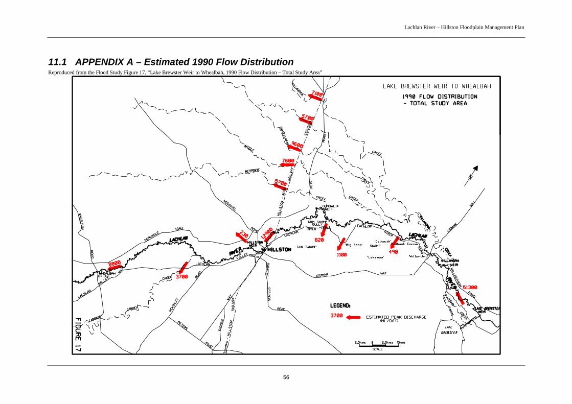
Lachlan River – Hillston Floodplain Management Plan
56
11.1 APPENDIX A – Estimated 1990 Flow DistributionReproduced from the Flood Study Figure 17, “Lake Brewster Weir to Whealbah, 1990 Flow Distribution – Total Study Area”

Lachlan River – Hillston Floodplain Management Plan
57
11.2 APPENDIX B – Monitoring ActivitiesIn addition to the activities listed below, a number of existing works requiring modification will needto be monitored if the modifications have not been carried out at the onset of a flood. These works arespecified in Table 4.1 of the FMP. Monitoring would determine if emergency works are required.
1) Critical Hydraulic Areas (“Hot Spots”) to Monitor
(Listed from the upstream end of the study area)
Area When toMonitor
Where to Monitor What to Monitor
Lachlan Valley Wayat Mountain CreeknearCarrathool/LachlanShire boundary
Major floods Culverts for Mountain Creek Head difference; FlowRates; Velocities
Brewster Weir All floods Block bank on bywash
Weir
Flow behaviour; Headdifference; Velocities
Ballyrogan Channel Major floods Culverts for Mountain Creek Head difference; FlowRates; Velocities
Lake Brewster Major floods Flood inlet and outletembankments
Flow behaviour
“Tocabil” Moderatefloods
Irrigation channel downstreamof Kidman Way
Flow behaviour, Drainageof water on recession
Lachlan River Roadat ‘Big Bend’
All floods Rennie’s Bank, road culvert andcauseway, “Wyola” floodway
Flow behaviour, Headdifference, Velocities
“Hunthawang” All floods Middle Creek crossing andculverts
Flow behaviour, Headdifference, Velocities
Lachlan River Roadat Gum Swamp
All floods Culverts Head difference; FlowRates; Velocities
“Rosemont” Channel Moderateflood
Irrigation channel Flow behaviour, Headdifference, Velocities
Kidman Way east ofHillston
Moderatefloods
Culverts and causeways fromHillston to “Rosemont”
Flow behaviour, Headdifference, Velocities
Clifton’s Channel atKidman Way
Moderatefloods
Pipe in channel Flow behaviour, Headdifference, Velocities
East of Hillston Moderatefloods
Irrigation development andchannels, roads
Flow behaviourparticularly with regard tothe impact on the townlevee; Head difference,
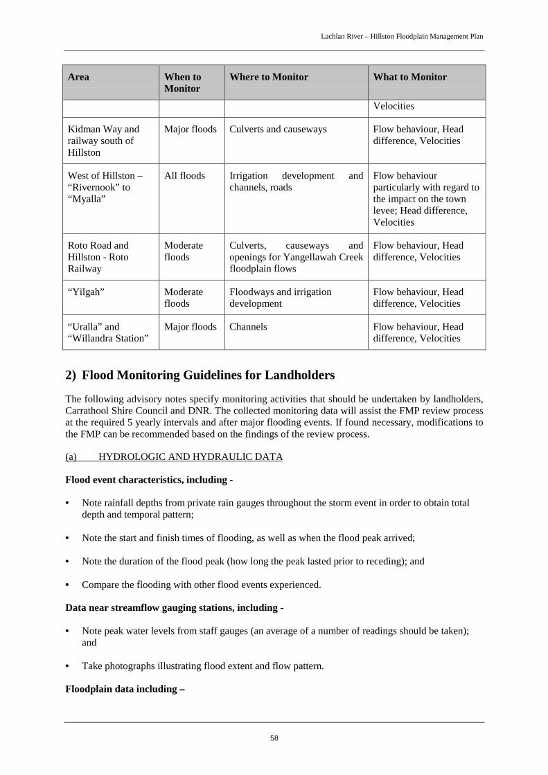
Lachlan River – Hillston Floodplain Management Plan
58
Area When toMonitor
Where to Monitor What to Monitor
Velocities
Kidman Way andrailway south ofHillston
Major floods Culverts and causeways Flow behaviour, Headdifference, Velocities
West of Hillston –“Rivernook” to“Myalla”
All floods Irrigation development andchannels, roads
Flow behaviourparticularly with regard tothe impact on the townlevee; Head difference,Velocities
Roto Road andHillston - RotoRailway
Moderatefloods
Culverts, causeways andopenings for Yangellawah Creekfloodplain flows
Flow behaviour, Headdifference, Velocities
“Yilgah” Moderatefloods
Floodways and irrigationdevelopment
Flow behaviour, Headdifference, Velocities
“Uralla” and“Willandra Station”
Major floods Channels Flow behaviour, Headdifference, Velocities
2) Flood Monitoring Guidelines for Landholders
The following advisory notes specify monitoring activities that should be undertaken by landholders,Carrathool Shire Council and DNR. The collected monitoring data will assist the FMP review processat the required 5 yearly intervals and after major flooding events. If found necessary, modifications tothe FMP can be recommended based on the findings of the review process.
(a) HYDROLOGIC AND HYDRAULIC DATA
Flood event characteristics, including -
• Note rainfall depths from private rain gauges throughout the storm event in order to obtain totaldepth and temporal pattern;
• Note the start and finish times of flooding, as well as when the flood peak arrived;
• Note the duration of the flood peak (how long the peak lasted prior to receding); and
• Compare the flooding with other flood events experienced.
Data near streamflow gauging stations, including -
• Note peak water levels from staff gauges (an average of a number of readings should be taken);and
• Take photographs illustrating flood extent and flow pattern.
Floodplain data including –

Lachlan River – Hillston Floodplain Management Plan
59
• Where possible peg flood peaks across the floodplain (eg. flood marks or debris on strainer posts,trees, farm sheds or dwellings);
• Note the extent and width of the flooding;
• Estimate surface flow velocities (usually expressed in metres per second) and where possible noteflow pattern. Velocities can be estimated by timing the movement of floating debris over anapproximated length of travel;
• Where possible measure flood water slope by pegging water levels over a length of 1 kilometre;
• Note any obstructions to the passage of flood flow (eg. roads, levees, banks), and where possibleobtain estimated difference in water levels upstream and downstream of the obstruction; and
• Take photographs illustrating flow paths, flooded areas and dry areas, and flow near obstructions.
Note: Select floodplain monitoring sites that are near hydraulic controls such as roads, levees,major overbank flow breakouts, and at defined floodways.
Data along roads and at causeways/floodways, including –
• Where flooded – estimate flow velocities and flow width over the road, as well as the difference inwater levels upstream and downstream of the road; and
• Where dry – estimate the height out of water.
(b) FLOOD DAMAGE
After a flood event, information is normally sought to assist in determining the nature and cause of anyflood damage. Notes and sketches provided by landholders can aid this process.
Farm loss incurred –
• Note the location of any damage and estimate the loss of crops and fencing.
Road damages –
• Note the location and extent of pavement damage and silt over roads; and
• Where possible estimate the length of road cuts.
Erosion and siltation –
• Symptoms of stream bed lowering include vertical headcuts in stream bed, extensive bank erosionon both side of stream, headcuts in tributary streams and gullies, exposed gravel and/or rock beds,exposed pipe capping on bridge piers, and undermining of causeways;
• Causes of stream bank erosion include flood flows and abrupt changes in channel alignment,gullying where overland flow enters streams, bed lowering, and obstructions to stream flow suchas weirs or low level crossings;
• Causes of floodplain erosion include unsustainable land use practices (eg. clearing), overflowsfrom perched streams, and/or flow concentration due to floodplain development; and

Lachlan River – Hillston Floodplain Management Plan
60
• Causes of floodplain siltation include hill-slope erosion and/or reduced capacity of the mainchannel (bridge crossings, excessive vegetation/regrowth, influx of sediment), which result ininstream sediment being deposited onto the floodplain.
(c) ENVIRONMENTAL DATA
Wetland data, including –
• Monitor the performance of works modifications specified in Table 4.1 to reconnect wetlands toflood flows. Note whether flood flows are reaching the wetland and whether openings in existingworks are of adequate size;
• Note and photograph any changes to the flooding and drying patterns of the wetland;
• Note how long the wetland holds water after a flood event;
• Measure and note how deep the water is at different times in the wetland; and
• Note and photograph the condition and variety of wetland plant species over time.
Floodplain vegetation (Black Box, River Red Gum, Lignum) data, including –
• Note and photograph the extent of floodplain vegetation regeneration over time; and
• Note and photograph the extent of flood inundation in the vicinity of floodplain vegetation.
Waterbird and fish observations –
• At key sites, such as wetlands, note the abundance and diversity of waterbird species. The easiestmethod is to group the waterbirds into ducks, grebes, cormorants, etc. and count by 10’s, 50’s or100’s; and
• At key sites, such as wetlands and waterways, note the abundance and diversity of fish species.Dip-netting is the simplest way to monitor small fish in wetlands.
For more information on monitoring wetlands, waterbirds and fish refer to the NSW Murray WetlandsWorking Group (2002) document titled Wetlands Watch – A Field Guide for Monitoring Wetlands inthe Southern Section of the Murray-Darling Basin.
The following questionnaire could be filled out by landholders as a means of collating informationregarding the characteristics of a flood event, as well as flood damage. Additional sheets could beused.

Lachlan River – Hillston Floodplain Management Plan
61
LANDHOLDER MONITORING QUESTIONNAIRE
Hydrologic and Hydraulic Data
Rainfall depths & duration (private rain gauges)…………………millimetres at 9:00am each day
Inundation limits – sketch on a map areas inundated, flow paths, & areas of backwater
Duration of inundation…………………hours / days
Depth of inundation…………………metres at location…………………
Flow velocity estimates…………………metres per second at location…………………
Flood marks – provide location and description, mark levels upstream and downstream of
structures (channels, roads, culverts etc)
Identify any flow obstructions – banks, channels, roads, etc
Compare with previous floods – larger/smaller, etc
Flood Damage
Crop loss – Yes/No – If yes describe location & extent
Fence loss – Yes/No – If yes describe location & extent
Road damage – Yes/No – If yes describe type, location & extent
Erosion – Yes/No – If yes describe type, location & extent
Siltation – Yes/No – If yes describe location & extent
Environmental Data
Duration of flooding in wetland………………….days
Depth of flooding in wetland…………………….metres at location…………….
Note numbers and types of waterbirds if present
Note presence of native fish in floodwaters
Note extent of regeneration of floodplain vegetation (following floods)
Where works modifications are required to reconnect wetlands:
Is the opening of adequate size?
Did floodwater reach the wetland?
Was floodwater backed up upstream of the opening?
Note level of floodwater through works modifications.
(d) AERIAL AND GROUND PHOTOGRAPHY
Photographs (to be taken between identifiable points on a map)
• Areas flooded and areas not flooded;
• Areas of active flow and backwater;
• The main flow paths;
Lachlan River – Hillston Floodplain Management Plan
62
• Known earthworks such as levees, banks, channels;
• Known problem areas;
• Roads and railways;
• Environmental information, as outlined in (c) above, and;
• Time and date each photograph was taken.
3) Carrathool Council Monitoring Activities
These activities are similar to those listed for landholders above but in relation to council works. Inparticular the performance of road structures should be carefully assessed as well as the impact of allfloodplain development on Hillston town. With regard to the road structures, those that are ofsignificant importance (eg the ‘High Bank’ on the Kidman Way) should be monitored over theduration of the flood. Less crucial structures could be observed at peak levels and at overtoppinglevels for causeways.
For road structures the following data should be collected:
• the head difference across the structure at peak and critical levels;
• depth of flow over causeways
• estimate the flow velocity through or across the structure;
• whether the structure gets affected by debris;
• photographs of the structure in flood;
• time when flow commences and finishes.
Following floods, Council should assess flood damage to roads and infrastructure by:
• Noting the location and extent of pavement damage and silt over roads;
• Estimating the length of road cuts where possible; and
• Noting damage to other infrastructure such as culverts or bridges.
4) DNR Monitoring Activities
DNR’s role in monitoring includes the following activities:
Flood photography, including –
• Undertake and obtain on-ground photography of flood event;
• If thought necessary, undertake oblique aerial photography of flood event;
• If found necessary, organise vertical aerial photography of flood event; and
• Obtain available satellite imagery the study area under flood.
Lachlan River – Hillston Floodplain Management Plan
63
Obtain survey data, including –
• Collate existing survey data undertaken or organised by DNR, landholders, or local councils; and,
• If found necessary obtain additional survey data, particularly in the vicinity of new flood controlworks (storages, levees, channels, etc) and structures (bridges, culverts, weirs).
Consultation activities, including –
• Undertake consultation activities with stakeholder groups (landholders, government agencies,local councils, and other interest groups) to source their opinion on the flood event and theperformance efficiency of the FMP floodway network;
• If thought necessary, reconvene the FMC in order to source their opinion on the flood event, theperformance of the FMP floodway network, and any identified issues; and,
• Undertake field investigations after flood events to view identified problem areas.
Obtain flow data, including –
• Obtain flood heights and discharge records from gauging stations within the vicinity of the studyarea; and,
• If necessary, obtain rainfall data from the Bureau of Meteorology and DNR records.
Collate environmental data, including –
Fish and aquatic invertebrates -
• Obtain information regarding fish abundance and diversity within the vicinity of the FMP area.This data can be sourced from NSW Fisheries who undertake sampling on a regular basis; and,
• Obtain information regarding the abundance and diversity of macroinvertebrates within thevicinity of the FMP area. This data can be sourced from the existing program titled AusRivAS(Australian River Assessment System), which generates health assessments for river sites based onthe presence of macroinvertebrates.
Vegetation –
• Based on obtained flood photography and field investigations, assess change(s) in floodplainvegetation following flood events.
Additional data -
• Approach government agencies in order to source any relevant environmental data gathered bythem in response to a flood event. This may include data in relation to fish, water quality,floodplain vegetation, waterbird observations and wetlands.
Review Floodplain Management Plan
• Review hydraulic models with new data; and,
• Identify modifications to plan.
Lachlan River – Hillston Floodplain Management Plan
64
11.3 APPENDIX C – Glossary and Abbreviations
GLOSSARY
anabranch a channel of a river or creek that leaves the main channeland re-enters downstream.
Annual Exceedance Probability (AEP) the chance of a flood of a given or larger size occurring inany one year, usually expressed as a percentage.
Average Recurrence Interval (ARI) the long term average number of years between theoccurrence of a flood as big as, or larger than, the selectedevent.
ecosystem a biological system involving interaction between livingorganisms and their immediate physical, chemical andbiological environment.
effluent stream a stream that leaves a watercourse and does not return to it.
flood control works works such as levees, roads and channels that can affectthe distribution of floodwaters on the floodplain. These areknown as “controlled works” in the Water Act 1912.
flood dependent ecosystem an ecosystem that depends on periodic flooding to supportessential ecological processes.
flood fringe area the floodplain area between the limit of the floodway andthe extent of the 1990 flood.
floodplain an area of land which is subject to inundation by floods upto and including the probable maximum flood.
floodway network the area of floodplain required for the unobstructed andorderly passage of a flood of given magnitude.
habitat the type of environment in which a plant or animal lives,including physical and chemical conditions.
hydraulics the study of water flow in relation to watercourses and theland surface; in particular the assessment of water leveland velocity.
hydrology the study of the rainfall and runoff process; in particular,the assessment of peak flows and flow volumes.
invertebrates animals without backbones, including zooplankton, worms,insects, shellfish, crabs, shrimps and snails.
microinvertebrates invertebrates that cannot be seen with the naked eye.
Probable Maximum Flood (PMF) the largest flood that could conceivably occur at aparticular location.

Lachlan River – Hillston Floodplain Management Plan
65
threatened species species of plant or animals listed as vulnerable orendangered on the schedules of the NSW ThreatenedSpecies Conservation Act.
wetland an area that is wet for a long enough period such that theplants and animals living in it are adapted to, and oftendependent on, living in wet conditions for at least part oftheir life cycle.
ABBREVIATIONS
AEP Annual Exceedance Probability
ARI Average Recurrence Interval
DNR Department of Natural Resources
DLWC Department of Land and Water Conservation
FMP Floodplain Management Plan
PMF Probable Maximum Flood
SWMOP State Water Management Outcomes Plan
WAMC Water Administration Ministerial Corporation
Hillston FMP -Final DNR-V1.doc
Recommended