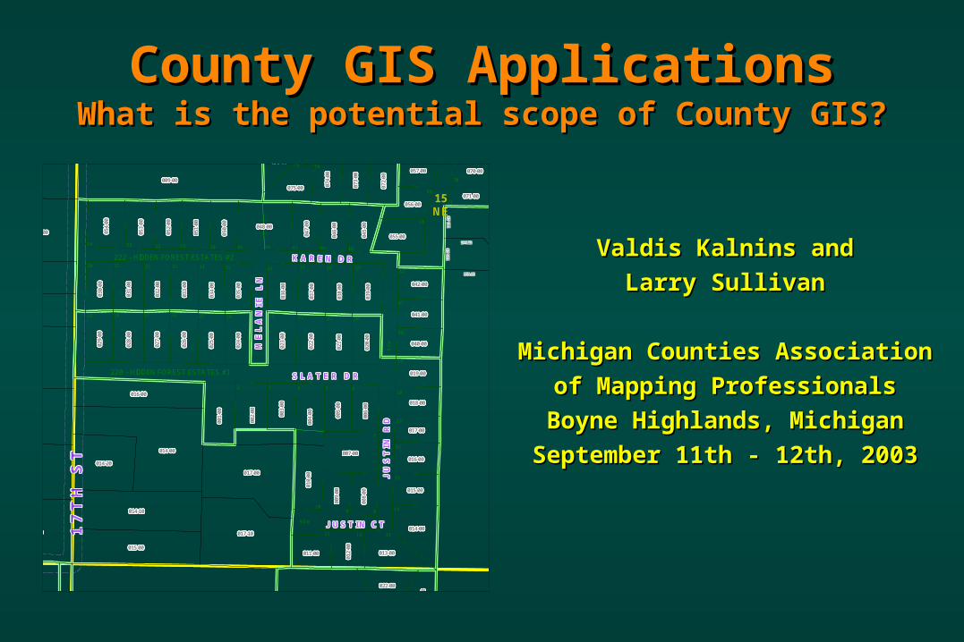
County GIS ApplicationsCounty GIS ApplicationsWhat is the potential scope of County GIS?What is the potential scope of County GIS?
Valdis Kalnins andValdis Kalnins and
Larry SullivanLarry Sullivan
Michigan Counties AssociationMichigan Counties Association
of Mapping Professionalsof Mapping Professionals
Boyne Highlands, MichiganBoyne Highlands, Michigan
September 11th - 12th, 2003September 11th - 12th, 2003
1 4 3 R D A V E1 4 3 R D A V E1 4 3 R D A V E1 4 3 R D A V E1 4 3 R D A V E1 4 3 R D A V E1 4 3 R D A V E1 4 3 R D A V E1 4 3 R D A V E
1 7
T H
S
T1
7 T
H
S T
1 7
T H
S
T1
7 T
H
S T
1 7
T H
S
T1
7 T
H
S T
1 7
T H
S
T1
7 T
H
S T
1 7
T H
S
T
K A R E N D RK A R E N D RK A R E N D RK A R E N D RK A R E N D RK A R E N D RK A R E N D RK A R E N D RK A R E N D R
J U
S T
I N
R
DJ
U S
T I
N
R D
J U
S T
I N
R
DJ
U S
T I
N
R D
J U
S T
I N
R
DJ
U S
T I
N
R D
J U
S T
I N
R
DJ
U S
T I
N
R D
J U
S T
I N
R
DS L A T E R D RS L A T E R D RS L A T E R D RS L A T E R D RS L A T E R D RS L A T E R D RS L A T E R D RS L A T E R D RS L A T E R D R
M E
L A
N I
E
L N
M E
L A
N I
E
L N
M E
L A
N I
E
L N
M E
L A
N I
E
L N
M E
L A
N I
E
L N
M E
L A
N I
E
L N
M E
L A
N I
E
L N
M E
L A
N I
E
L N
M E
L A
N I
E
L N
J U S T I N C TJ U S T I N C TJ U S T I N C TJ U S T I N C TJ U S T I N C TJ U S T I N C TJ U S T I N C TJ U S T I N C TJ U S T I N C T
070-00070-00070-00070-00070-00070-00070-00070-00070-00070-00070-00070-00070-00070-00070-00070-00070-00070-00070-00070-00070-00070-00070-00070-00070-00070-00070-00070-00070-00070-00070-00070-00070-00070-00070-00070-00070-00070-00070-00070-00070-00070-00070-00070-00070-00070-00070-00070-00070-00057-00057-00057-00057-00057-00057-00057-00057-00057-00057-00057-00057-00057-00057-00057-00057-00057-00057-00057-00057-00057-00057-00057-00057-00057-00057-00057-00057-00057-00057-00057-00057-00057-00057-00057-00057-00057-00057-00057-00057-00057-00057-00057-00057-00057-00057-00057-00057-00057-00
071-00071-00071-00071-00071-00071-00071-00071-00071-00071-00071-00071-00071-00071-00071-00071-00071-00071-00071-00071-00071-00071-00071-00071-00071-00071-00071-00071-00071-00071-00071-00071-00071-00071-00071-00071-00071-00071-00071-00071-00071-00071-00071-00071-00071-00071-00071-00071-00071-00056-00056-00056-00056-00056-00056-00056-00056-00056-00056-00056-00056-00056-00056-00056-00056-00056-00056-00056-00056-00056-00056-00056-00056-00056-00056-00056-00056-00056-00056-00056-00056-00056-00056-00056-00056-00056-00056-00056-00056-00056-00056-00056-00056-00056-00056-00056-00056-00056-00
055-00055-00055-00055-00055-00055-00055-00055-00055-00055-00055-00055-00055-00055-00055-00055-00055-00055-00055-00055-00055-00055-00055-00055-00055-00055-00055-00055-00055-00055-00055-00055-00055-00055-00055-00055-00055-00055-00055-00055-00055-00055-00055-00055-00055-00055-00055-00055-00055-00
016-00016-00016-00016-00016-00016-00016-00016-00016-00016-00016-00016-00016-00016-00016-00016-00016-00016-00016-00016-00016-00016-00016-00016-00016-00016-00016-00016-00016-00016-00016-00016-00016-00016-00016-00016-00016-00016-00016-00016-00016-00016-00016-00016-00016-00016-00016-00016-00016-00
040-00040-00040-00040-00040-00040-00040-00040-00040-00040-00040-00040-00040-00040-00040-00040-00040-00040-00040-00040-00040-00040-00040-00040-00040-00040-00040-00040-00040-00040-00040-00040-00040-00040-00040-00040-00040-00040-00040-00040-00040-00040-00040-00040-00040-00040-00040-00040-00040-00
018-00018-00018-00018-00018-00018-00018-00018-00018-00018-00018-00018-00018-00018-00018-00018-00018-00018-00018-00018-00018-00018-00018-00018-00018-00018-00018-00018-00018-00018-00018-00018-00018-00018-00018-00018-00018-00018-00018-00018-00018-00018-00018-00018-00018-00018-00018-00018-00018-00
013-00013-00013-00013-00013-00013-00013-00013-00013-00013-00013-00013-00013-00013-00013-00013-00013-00013-00013-00013-00013-00013-00013-00013-00013-00013-00013-00013-00013-00013-00013-00013-00013-00013-00013-00013-00013-00013-00013-00013-00013-00013-00013-00013-00013-00013-00013-00013-00013-00
072-
0007
2-00
072-
0007
2-00
072-
0007
2-00
072-
0007
2-00
072-
0007
2-00
072-
0007
2-00
072-
0007
2-00
072-
0007
2-00
072-
0007
2-00
072-
0007
2-00
072-
0007
2-00
072-
0007
2-00
072-
0007
2-00
072-
0007
2-00
072-
0007
2-00
072-
0007
2-00
072-
0007
2-00
072-
0007
2-00
072-
0007
2-00
072-
0007
2-00
072-
0007
2-00
072-
0007
2-00
072-
0007
2-00
072-
0007
2-00
072-
00
039-
0003
9-00
039-
0003
9-00
039-
0003
9-00
039-
0003
9-00
039-
0003
9-00
039-
0003
9-00
039-
0003
9-00
039-
0003
9-00
039-
0003
9-00
039-
0003
9-00
039-
0003
9-00
039-
0003
9-00
039-
0003
9-00
039-
0003
9-00
039-
0003
9-00
039-
0003
9-00
039-
0003
9-00
039-
0003
9-00
039-
0003
9-00
039-
0003
9-00
039-
0003
9-00
039-
0003
9-00
039-
0003
9-00
039-
0003
9-00
039-
00
042-00042-00042-00042-00042-00042-00042-00042-00042-00042-00042-00042-00042-00042-00042-00042-00042-00042-00042-00042-00042-00042-00042-00042-00042-00042-00042-00042-00042-00042-00042-00042-00042-00042-00042-00042-00042-00042-00042-00042-00042-00042-00042-00042-00042-00042-00042-00042-00042-00
073-
0007
3-00
073-
0007
3-00
073-
0007
3-00
073-
0007
3-00
073-
0007
3-00
073-
0007
3-00
073-
0007
3-00
073-
0007
3-00
073-
0007
3-00
073-
0007
3-00
073-
0007
3-00
073-
0007
3-00
073-
0007
3-00
073-
0007
3-00
073-
0007
3-00
073-
0007
3-00
073-
0007
3-00
073-
0007
3-00
073-
0007
3-00
073-
0007
3-00
073-
0007
3-00
073-
0007
3-00
073-
0007
3-00
073-
0007
3-00
073-
00
041-00041-00041-00041-00041-00041-00041-00041-00041-00041-00041-00041-00041-00041-00041-00041-00041-00041-00041-00041-00041-00041-00041-00041-00041-00041-00041-00041-00041-00041-00041-00041-00041-00041-00041-00041-00041-00041-00041-00041-00041-00041-00041-00041-00041-00041-00041-00041-00041-00
019-00019-00019-00019-00019-00019-00019-00019-00019-00019-00019-00019-00019-00019-00019-00019-00019-00019-00019-00019-00019-00019-00019-00019-00019-00019-00019-00019-00019-00019-00019-00019-00019-00019-00019-00019-00019-00019-00019-00019-00019-00019-00019-00019-00019-00019-00019-00019-00019-00
021-
0002
1-00
021-
0002
1-00
021-
0002
1-00
021-
0002
1-00
021-
0002
1-00
021-
0002
1-00
021-
0002
1-00
021-
0002
1-00
021-
0002
1-00
021-
0002
1-00
021-
0002
1-00
021-
0002
1-00
021-
0002
1-00
021-
0002
1-00
021-
0002
1-00
021-
0002
1-00
021-
0002
1-00
021-
0002
1-00
021-
0002
1-00
021-
0002
1-00
021-
0002
1-00
021-
0002
1-00
021-
0002
1-00
021-
0002
1-00
021-
0000
5-00
005-
0000
5-00
005-
0000
5-00
005-
0000
5-00
005-
0000
5-00
005-
0000
5-00
005-
0000
5-00
005-
0000
5-00
005-
0000
5-00
005-
0000
5-00
005-
0000
5-00
005-
0000
5-00
005-
0000
5-00
005-
0000
5-00
005-
0000
5-00
005-
0000
5-00
005-
0000
5-00
005-
0000
5-00
005-
0000
5-00
005-
0000
5-00
005-
0000
5-00
005-
0000
5-00
005-
0000
5-00
005-
0000
5-00
005-
0000
5-00
009-
0000
9-00
009-
0000
9-00
009-
0000
9-00
009-
0000
9-00
009-
0000
9-00
009-
0000
9-00
009-
0000
9-00
009-
0000
9-00
009-
0000
9-00
009-
0000
9-00
009-
0000
9-00
009-
0000
9-00
009-
0000
9-00
009-
0000
9-00
009-
0000
9-00
009-
0000
9-00
009-
0000
9-00
009-
0000
9-00
009-
0000
9-00
009-
0000
9-00
009-
0000
9-00
009-
0000
9-00
009-
0000
9-00
009-
0000
9-00
009-
00
017-00017-00017-00017-00017-00017-00017-00017-00017-00017-00017-00017-00017-00017-00017-00017-00017-00017-00017-00017-00017-00017-00017-00017-00017-00017-00017-00017-00017-00017-00017-00017-00017-00017-00017-00017-00017-00017-00017-00017-00017-00017-00017-00017-00017-00017-00017-00017-00017-00
015-00015-00015-00015-00015-00015-00015-00015-00015-00015-00015-00015-00015-00015-00015-00015-00015-00015-00015-00015-00015-00015-00015-00015-00015-00015-00015-00015-00015-00015-00015-00015-00015-00015-00015-00015-00015-00015-00015-00015-00015-00015-00015-00015-00015-00015-00015-00015-00015-00
007-00007-00007-00007-00007-00007-00007-00007-00007-00007-00007-00007-00007-00007-00007-00007-00007-00007-00007-00007-00007-00007-00007-00007-00007-00007-00007-00007-00007-00007-00007-00007-00007-00007-00007-00007-00007-00007-00007-00007-00007-00007-00007-00007-00007-00007-00007-00007-00007-00
021-
0002
1-00
021-
0002
1-00
021-
0002
1-00
021-
0002
1-00
021-
0002
1-00
021-
0002
1-00
021-
0002
1-00
021-
0002
1-00
021-
0002
1-00
021-
0002
1-00
021-
0002
1-00
021-
0002
1-00
021-
0002
1-00
021-
0002
1-00
021-
0002
1-00
021-
0002
1-00
021-
0002
1-00
021-
0002
1-00
021-
0002
1-00
021-
0002
1-00
021-
0002
1-00
021-
0002
1-00
021-
0002
1-00
021-
0002
1-00
021-
00
014-00014-00014-00014-00014-00014-00014-00014-00014-00014-00014-00014-00014-00014-00014-00014-00014-00014-00014-00014-00014-00014-00014-00014-00014-00014-00014-00014-00014-00014-00014-00014-00014-00014-00014-00014-00014-00014-00014-00014-00014-00014-00014-00014-00014-00014-00014-00014-00014-00
022-00022-00022-00022-00022-00022-00022-00022-00022-00022-00022-00022-00022-00022-00022-00022-00022-00022-00022-00022-00022-00022-00022-00022-00022-00022-00022-00022-00022-00022-00022-00022-00022-00022-00022-00022-00022-00022-00022-00022-00022-00022-00022-00022-00022-00022-00022-00022-00022-00
023-00023-00023-00023-00023-00023-00023-00023-00023-00023-00023-00023-00023-00023-00023-00023-00023-00023-00023-00023-00023-00023-00023-00023-00023-00023-00023-00023-00023-00023-00023-00023-00023-00023-00023-00023-00023-00023-00023-00023-00023-00023-00023-00023-00023-00023-00023-00023-00023-00
012-
0001
2-00
012-
0001
2-00
012-
0001
2-00
012-
0001
2-00
012-
0001
2-00
012-
0001
2-00
012-
0001
2-00
012-
0001
2-00
012-
0001
2-00
012-
0001
2-00
012-
0001
2-00
012-
0001
2-00
012-
0001
2-00
012-
0001
2-00
012-
0001
2-00
012-
0001
2-00
012-
0001
2-00
012-
0001
2-00
012-
0001
2-00
012-
0001
2-00
012-
0001
2-00
012-
0001
2-00
012-
0001
2-00
012-
0001
2-00
012-
00
075-00075-00075-00075-00075-00075-00075-00075-00075-00075-00075-00075-00075-00075-00075-00075-00075-00075-00075-00075-00075-00075-00075-00075-00075-00075-00075-00075-00075-00075-00075-00075-00075-00075-00075-00075-00075-00075-00075-00075-00075-00075-00075-00075-00075-00075-00075-00075-00075-00 074-
0007
4-00
074-
0007
4-00
074-
0007
4-00
074-
0007
4-00
074-
0007
4-00
074-
0007
4-00
074-
0007
4-00
074-
0007
4-00
074-
0007
4-00
074-
0007
4-00
074-
0007
4-00
074-
0007
4-00
074-
0007
4-00
074-
0007
4-00
074-
0007
4-00
074-
0007
4-00
074-
0007
4-00
074-
0007
4-00
074-
0007
4-00
074-
0007
4-00
074-
0007
4-00
074-
0007
4-00
074-
0007
4-00
074-
0007
4-00
074-
0004
6-00
046-
0004
6-00
046-
0004
6-00
046-
0004
6-00
046-
0004
6-00
046-
0004
6-00
046-
0004
6-00
046-
0004
6-00
046-
0004
6-00
046-
0004
6-00
046-
0004
6-00
046-
0004
6-00
046-
0004
6-00
046-
0004
6-00
046-
0004
6-00
046-
0004
6-00
046-
0004
6-00
046-
0004
6-00
046-
0004
6-00
046-
0004
6-00
046-
0004
6-00
046-
0004
6-00
046-
0004
6-00
046-
0004
6-00
046-
0004
6-00
076-00076-00076-00076-00076-00076-00076-00076-00076-00076-00076-00076-00076-00076-00076-00076-00076-00076-00076-00076-00076-00076-00076-00076-00076-00076-00076-00076-00076-00076-00076-00076-00076-00076-00076-00076-00076-00076-00076-00076-00076-00076-00076-00076-00076-00076-00076-00076-00076-00
038-
0003
8-00
038-
0003
8-00
038-
0003
8-00
038-
0003
8-00
038-
0003
8-00
038-
0003
8-00
038-
0003
8-00
038-
0003
8-00
038-
0003
8-00
038-
0003
8-00
038-
0003
8-00
038-
0003
8-00
038-
0003
8-00
038-
0003
8-00
038-
0003
8-00
038-
0003
8-00
038-
0003
8-00
038-
0003
8-00
038-
0003
8-00
038-
0003
8-00
038-
0003
8-00
038-
0003
8-00
038-
0003
8-00
038-
0003
8-00
038-
00
037-
0003
7-00
037-
0003
7-00
037-
0003
7-00
037-
0003
7-00
037-
0003
7-00
037-
0003
7-00
037-
0003
7-00
037-
0003
7-00
037-
0003
7-00
037-
0003
7-00
037-
0003
7-00
037-
0003
7-00
037-
0003
7-00
037-
0003
7-00
037-
0003
7-00
037-
0003
7-00
037-
0003
7-00
037-
0003
7-00
037-
0003
7-00
037-
0003
7-00
037-
0003
7-00
037-
0003
7-00
037-
0003
7-00
037-
0003
7-00
037-
00
048-00048-00048-00048-00048-00048-00048-00048-00048-00048-00048-00048-00048-00048-00048-00048-00048-00048-00048-00048-00048-00048-00048-00048-00048-00048-00048-00048-00048-00048-00048-00048-00048-00048-00048-00048-00048-00048-00048-00048-00048-00048-00048-00048-00048-00048-00048-00048-00048-00
003-
0000
3-00
003-
0000
3-00
003-
0000
3-00
003-
0000
3-00
003-
0000
3-00
003-
0000
3-00
003-
0000
3-00
003-
0000
3-00
003-
0000
3-00
003-
0000
3-00
003-
0000
3-00
003-
0000
3-00
003-
0000
3-00
003-
0000
3-00
003-
0000
3-00
003-
0000
3-00
003-
0000
3-00
003-
0000
3-00
003-
0000
3-00
003-
0000
3-00
003-
0000
3-00
003-
0000
3-00
003-
0000
3-00
003-
0000
3-00
003-
00
025-
0002
5-00
025-
0002
5-00
025-
0002
5-00
025-
0002
5-00
025-
0002
5-00
025-
0002
5-00
025-
0002
5-00
025-
0002
5-00
025-
0002
5-00
025-
0002
5-00
025-
0002
5-00
025-
0002
5-00
025-
0002
5-00
025-
0002
5-00
025-
0002
5-00
025-
0002
5-00
025-
0002
5-00
025-
0002
5-00
025-
0002
5-00
025-
0002
5-00
025-
0002
5-00
025-
0002
5-00
025-
0002
5-00
025-
0002
5-00
025-
00
023-
0002
3-00
023-
0002
3-00
023-
0002
3-00
023-
0002
3-00
023-
0002
3-00
023-
0002
3-00
023-
0002
3-00
023-
0002
3-00
023-
0002
3-00
023-
0002
3-00
023-
0002
3-00
023-
0002
3-00
023-
0002
3-00
023-
0002
3-00
023-
0002
3-00
023-
0002
3-00
023-
0002
3-00
023-
0002
3-00
023-
0002
3-00
023-
0002
3-00
023-
0002
3-00
023-
0002
3-00
023-
0002
3-00
023-
0002
3-00
023-
00
004-
0000
4-00
004-
0000
4-00
004-
0000
4-00
004-
0000
4-00
004-
0000
4-00
004-
0000
4-00
004-
0000
4-00
004-
0000
4-00
004-
0000
4-00
004-
0000
4-00
004-
0000
4-00
004-
0000
4-00
004-
0000
4-00
004-
0000
4-00
004-
0000
4-00
004-
0000
4-00
004-
0000
4-00
004-
0000
4-00
004-
0000
4-00
004-
0000
4-00
004-
0000
4-00
004-
0000
4-00
004-
0000
4-00
004-
0000
4-00
004-
00
001-
0000
1-00
001-
0000
1-00
001-
0000
1-00
001-
0000
1-00
001-
0000
1-00
001-
0000
1-00
001-
0000
1-00
001-
0000
1-00
001-
0000
1-00
001-
0000
1-00
001-
0000
1-00
001-
0000
1-00
001-
0000
1-00
001-
0000
1-00
001-
0000
1-00
001-
0000
1-00
001-
0000
1-00
001-
0000
1-00
001-
0000
1-00
001-
0000
1-00
001-
0000
1-00
001-
0000
1-00
001-
0000
1-00
001-
0000
1-00
001-
00
002-
0000
2-00
002-
0000
2-00
002-
0000
2-00
002-
0000
2-00
002-
0000
2-00
002-
0000
2-00
002-
0000
2-00
002-
0000
2-00
002-
0000
2-00
002-
0000
2-00
002-
0000
2-00
002-
0000
2-00
002-
0000
2-00
002-
0000
2-00
002-
0000
2-00
002-
0000
2-00
002-
0000
2-00
002-
0000
2-00
002-
0000
2-00
002-
0000
2-00
002-
0000
2-00
002-
0000
2-00
002-
0000
2-00
002-
0000
2-00
002-
00
014-00014-00014-00014-00014-00014-00014-00014-00014-00014-00014-00014-00014-00014-00014-00014-00014-00014-00014-00014-00014-00014-00014-00014-00014-00014-00014-00014-00014-00014-00014-00014-00014-00014-00014-00014-00014-00014-00014-00014-00014-00014-00014-00014-00014-00014-00014-00014-00014-00
017-10017-10017-10017-10017-10017-10017-10017-10017-10017-10017-10017-10017-10017-10017-10017-10017-10017-10017-10017-10017-10017-10017-10017-10017-10017-10017-10017-10017-10017-10017-10017-10017-10017-10017-10017-10017-10017-10017-10017-10017-10017-10017-10017-10017-10017-10017-10017-10017-10
010-
0001
0-00
010-
0001
0-00
010-
0001
0-00
010-
0001
0-00
010-
0001
0-00
010-
0001
0-00
010-
0001
0-00
010-
0001
0-00
010-
0001
0-00
010-
0001
0-00
010-
0001
0-00
010-
0001
0-00
010-
0001
0-00
010-
0001
0-00
010-
0001
0-00
010-
0001
0-00
010-
0001
0-00
010-
0001
0-00
010-
0001
0-00
010-
0001
0-00
010-
0001
0-00
010-
0001
0-00
010-
0001
0-00
010-
0001
0-00
010-
00
035-
0003
5-00
035-
0003
5-00
035-
0003
5-00
035-
0003
5-00
035-
0003
5-00
035-
0003
5-00
035-
0003
5-00
035-
0003
5-00
035-
0003
5-00
035-
0003
5-00
035-
0003
5-00
035-
0003
5-00
035-
0003
5-00
035-
0003
5-00
035-
0003
5-00
035-
0003
5-00
035-
0003
5-00
035-
0003
5-00
035-
0003
5-00
035-
0003
5-00
035-
0003
5-00
035-
0003
5-00
035-
0003
5-00
035-
0003
5-00
035-
00
009-00009-00009-00009-00009-00009-00009-00009-00009-00009-00009-00009-00009-00009-00009-00009-00009-00009-00009-00009-00009-00009-00009-00009-00009-00009-00009-00009-00009-00009-00009-00009-00009-00009-00009-00009-00009-00009-00009-00009-00009-00009-00009-00009-00009-00009-00009-00009-00009-00
051-
0005
1-00
051-
0005
1-00
051-
0005
1-00
051-
0005
1-00
051-
0005
1-00
051-
0005
1-00
051-
0005
1-00
051-
0005
1-00
051-
0005
1-00
051-
0005
1-00
051-
0005
1-00
051-
0005
1-00
051-
0005
1-00
051-
0005
1-00
051-
0005
1-00
051-
0005
1-00
051-
0005
1-00
051-
0005
1-00
051-
0005
1-00
051-
0005
1-00
051-
0005
1-00
051-
0005
1-00
051-
0005
1-00
051-
0005
1-00
051-
00
034-
0003
4-00
034-
0003
4-00
034-
0003
4-00
034-
0003
4-00
034-
0003
4-00
034-
0003
4-00
034-
0003
4-00
034-
0003
4-00
034-
0003
4-00
034-
0003
4-00
034-
0003
4-00
034-
0003
4-00
034-
0003
4-00
034-
0003
4-00
034-
0003
4-00
034-
0003
4-00
034-
0003
4-00
034-
0003
4-00
034-
0003
4-00
034-
0003
4-00
034-
0003
4-00
034-
0003
4-00
034-
0003
4-00
034-
0003
4-00
034-
00
033-
0003
3-00
033-
0003
3-00
033-
0003
3-00
033-
0003
3-00
033-
0003
3-00
033-
0003
3-00
033-
0003
3-00
033-
0003
3-00
033-
0003
3-00
033-
0003
3-00
033-
0003
3-00
033-
0003
3-00
033-
0003
3-00
033-
0003
3-00
033-
0003
3-00
033-
0003
3-00
033-
0003
3-00
033-
0003
3-00
033-
0003
3-00
033-
0003
3-00
033-
0003
3-00
033-
0003
3-00
033-
0003
3-00
033-
0003
3-00
033-
00
032-
0003
2-00
032-
0003
2-00
032-
0003
2-00
032-
0003
2-00
032-
0003
2-00
032-
0003
2-00
032-
0003
2-00
032-
0003
2-00
032-
0003
2-00
032-
0003
2-00
032-
0003
2-00
032-
0003
2-00
032-
0003
2-00
032-
0003
2-00
032-
0003
2-00
032-
0003
2-00
032-
0003
2-00
032-
0003
2-00
032-
0003
2-00
032-
0003
2-00
032-
0003
2-00
032-
0003
2-00
032-
0003
2-00
032-
0003
2-00
032-
0002
7-00
027-
0002
7-00
027-
0002
7-00
027-
0002
7-00
027-
0002
7-00
027-
0002
7-00
027-
0002
7-00
027-
0002
7-00
027-
0002
7-00
027-
0002
7-00
027-
0002
7-00
027-
0002
7-00
027-
0002
7-00
027-
0002
7-00
027-
0002
7-00
027-
0002
7-00
027-
0002
7-00
027-
0002
7-00
027-
0002
7-00
027-
0002
7-00
027-
0002
7-00
027-
0002
7-00
027-
0002
7-00
027-
0002
7-00
027-
0002
7-00
008-
0000
8-00
008-
0000
8-00
008-
0000
8-00
008-
0000
8-00
008-
0000
8-00
008-
0000
8-00
008-
0000
8-00
008-
0000
8-00
008-
0000
8-00
008-
0000
8-00
008-
0000
8-00
008-
0000
8-00
008-
0000
8-00
008-
0000
8-00
008-
0000
8-00
008-
0000
8-00
008-
0000
8-00
008-
0000
8-00
008-
0000
8-00
008-
0000
8-00
008-
0000
8-00
008-
0000
8-00
008-
0000
8-00
008-
0000
8-00
008-
00
017-00017-00017-00017-00017-00017-00017-00017-00017-00017-00017-00017-00017-00017-00017-00017-00017-00017-00017-00017-00017-00017-00017-00017-00017-00017-00017-00017-00017-00017-00017-00017-00017-00017-00017-00017-00017-00017-00017-00017-00017-00017-00017-00017-00017-00017-00017-00017-00017-00
011-00011-00011-00011-00011-00011-00011-00011-00011-00011-00011-00011-00011-00011-00011-00011-00011-00011-00011-00011-00011-00011-00011-00011-00011-00011-00011-00011-00011-00011-00011-00011-00011-00011-00011-00011-00011-00011-00011-00011-00011-00011-00011-00011-00011-00011-00011-00011-00011-00
050-
0005
0-00
050-
0005
0-00
050-
0005
0-00
050-
0005
0-00
050-
0005
0-00
050-
0005
0-00
050-
0005
0-00
050-
0005
0-00
050-
0005
0-00
050-
0005
0-00
050-
0005
0-00
050-
0005
0-00
050-
0005
0-00
050-
0005
0-00
050-
0005
0-00
050-
0005
0-00
050-
0005
0-00
050-
0005
0-00
050-
0005
0-00
050-
0005
0-00
050-
0005
0-00
050-
0005
0-00
050-
0005
0-00
050-
0005
0-00
050-
00
036-
0003
6-00
036-
0003
6-00
036-
0003
6-00
036-
0003
6-00
036-
0003
6-00
036-
0003
6-00
036-
0003
6-00
036-
0003
6-00
036-
0003
6-00
036-
0003
6-00
036-
0003
6-00
036-
0003
6-00
036-
0003
6-00
036-
0003
6-00
036-
0003
6-00
036-
0003
6-00
036-
0003
6-00
036-
0003
6-00
036-
0003
6-00
036-
0003
6-00
036-
0003
6-00
036-
0003
6-00
036-
0003
6-00
036-
0003
6-00
036-
00
045-
0004
5-00
045-
0004
5-00
045-
0004
5-00
045-
0004
5-00
045-
0004
5-00
045-
0004
5-00
045-
0004
5-00
045-
0004
5-00
045-
0004
5-00
045-
0004
5-00
045-
0004
5-00
045-
0004
5-00
045-
0004
5-00
045-
0004
5-00
045-
0004
5-00
045-
0004
5-00
045-
0004
5-00
045-
0004
5-00
045-
0004
5-00
045-
0004
5-00
045-
0004
5-00
045-
0004
5-00
045-
0004
5-00
045-
0004
5-00
045-
00
047-
0004
7-00
047-
0004
7-00
047-
0004
7-00
047-
0004
7-00
047-
0004
7-00
047-
0004
7-00
047-
0004
7-00
047-
0004
7-00
047-
0004
7-00
047-
0004
7-00
047-
0004
7-00
047-
0004
7-00
047-
0004
7-00
047-
0004
7-00
047-
0004
7-00
047-
0004
7-00
047-
0004
7-00
047-
0004
7-00
047-
0004
7-00
047-
0004
7-00
047-
0004
7-00
047-
0004
7-00
047-
0004
7-00
047-
0004
7-00
047-
0002
2-00
022-
0002
2-00
022-
0002
2-00
022-
0002
2-00
022-
0002
2-00
022-
0002
2-00
022-
0002
2-00
022-
0002
2-00
022-
0002
2-00
022-
0002
2-00
022-
0002
2-00
022-
0002
2-00
022-
0002
2-00
022-
0002
2-00
022-
0002
2-00
022-
0002
2-00
022-
0002
2-00
022-
0002
2-00
022-
0002
2-00
022-
0002
2-00
022-
0002
2-00
022-
0002
2-00
022-
0002
2-00
022-
0002
2-00
022-
0002
2-00
020-
0002
0-00
020-
0002
0-00
020-
0002
0-00
020-
0002
0-00
020-
0002
0-00
020-
0002
0-00
020-
0002
0-00
020-
0002
0-00
020-
0002
0-00
020-
0002
0-00
020-
0002
0-00
020-
0002
0-00
020-
0002
0-00
020-
0002
0-00
020-
0002
0-00
020-
0002
0-00
020-
0002
0-00
020-
0002
0-00
020-
0002
0-00
020-
0002
0-00
020-
0002
0-00
020-
0002
0-00
020-
0002
0-00
020-
0002
0-00
020-
0000
6-00
006-
0000
6-00
006-
0000
6-00
006-
0000
6-00
006-
0000
6-00
006-
0000
6-00
006-
0000
6-00
006-
0000
6-00
006-
0000
6-00
006-
0000
6-00
006-
0000
6-00
006-
0000
6-00
006-
0000
6-00
006-
0000
6-00
006-
0000
6-00
006-
0000
6-00
006-
0000
6-00
006-
0000
6-00
006-
0000
6-00
006-
0000
6-00
006-
0000
6-00
006-
0000
6-00
006-
0000
6-00
006-
0000
6-00
006-
0000
6-00
024-
0002
4-00
024-
0002
4-00
024-
0002
4-00
024-
0002
4-00
024-
0002
4-00
024-
0002
4-00
024-
0002
4-00
024-
0002
4-00
024-
0002
4-00
024-
0002
4-00
024-
0002
4-00
024-
0002
4-00
024-
0002
4-00
024-
0002
4-00
024-
0002
4-00
024-
0002
4-00
024-
0002
4-00
024-
0002
4-00
024-
0002
4-00
024-
0002
4-00
024-
0002
4-00
024-
0002
4-00
024-
0002
4-00
024-
0002
4-00
024-
00
028-
0002
8-00
028-
0002
8-00
028-
0002
8-00
028-
0002
8-00
028-
0002
8-00
028-
0002
8-00
028-
0002
8-00
028-
0002
8-00
028-
0002
8-00
028-
0002
8-00
028-
0002
8-00
028-
0002
8-00
028-
0002
8-00
028-
0002
8-00
028-
0002
8-00
028-
0002
8-00
028-
0002
8-00
028-
0002
8-00
028-
0002
8-00
028-
0002
8-00
028-
0002
8-00
028-
0002
8-00
028-
0002
8-00
028-
0002
8-00
028-
00
026-
0002
6-00
026-
0002
6-00
026-
0002
6-00
026-
0002
6-00
026-
0002
6-00
026-
0002
6-00
026-
0002
6-00
026-
0002
6-00
026-
0002
6-00
026-
0002
6-00
026-
0002
6-00
026-
0002
6-00
026-
0002
6-00
026-
0002
6-00
026-
0002
6-00
026-
0002
6-00
026-
0002
6-00
026-
0002
6-00
026-
0002
6-00
026-
0002
6-00
026-
0002
6-00
026-
0002
6-00
026-
0002
6-00
026-
0002
6-00
026-
00
052-
0005
2-00
052-
0005
2-00
052-
0005
2-00
052-
0005
2-00
052-
0005
2-00
052-
0005
2-00
052-
0005
2-00
052-
0005
2-00
052-
0005
2-00
052-
0005
2-00
052-
0005
2-00
052-
0005
2-00
052-
0005
2-00
052-
0005
2-00
052-
0005
2-00
052-
0005
2-00
052-
0005
2-00
052-
0005
2-00
052-
0005
2-00
052-
0005
2-00
052-
0005
2-00
052-
0005
2-00
052-
0005
2-00
052-
0005
2-00
052-
00
054-
0005
4-00
054-
0005
4-00
054-
0005
4-00
054-
0005
4-00
054-
0005
4-00
054-
0005
4-00
054-
0005
4-00
054-
0005
4-00
054-
0005
4-00
054-
0005
4-00
054-
0005
4-00
054-
0005
4-00
054-
0005
4-00
054-
0005
4-00
054-
0005
4-00
054-
0005
4-00
054-
0005
4-00
054-
0005
4-00
054-
0005
4-00
054-
0005
4-00
054-
0005
4-00
054-
0005
4-00
054-
0005
4-00
054-
0005
4-00
054-
00
015-00015-00015-00015-00015-00015-00015-00015-00015-00015-00015-00015-00015-00015-00015-00015-00015-00015-00015-00015-00015-00015-00015-00015-00015-00015-00015-00015-00015-00015-00015-00015-00015-00015-00015-00015-00015-00015-00015-00015-00015-00015-00015-00015-00015-00015-00015-00015-00015-00
048-10048-10048-10048-10048-10048-10048-10048-10048-10048-10048-10048-10048-10048-10048-10048-10048-10048-10048-10048-10048-10048-10048-10048-10048-10048-10048-10048-10048-10048-10048-10048-10048-10048-10048-10048-10048-10048-10048-10048-10048-10048-10048-10048-10048-10048-10048-10048-10048-10
016-00016-00016-00016-00016-00016-00016-00016-00016-00016-00016-00016-00016-00016-00016-00016-00016-00016-00016-00016-00016-00016-00016-00016-00016-00016-00016-00016-00016-00016-00016-00016-00016-00016-00016-00016-00016-00016-00016-00016-00016-00016-00016-00016-00016-00016-00016-00016-00016-00
030-
0003
0-00
030-
0003
0-00
030-
0003
0-00
030-
0003
0-00
030-
0003
0-00
030-
0003
0-00
030-
0003
0-00
030-
0003
0-00
030-
0003
0-00
030-
0003
0-00
030-
0003
0-00
030-
0003
0-00
030-
0003
0-00
030-
0003
0-00
030-
0003
0-00
030-
0003
0-00
030-
0003
0-00
030-
0003
0-00
030-
0003
0-00
030-
0003
0-00
030-
0003
0-00
030-
0003
0-00
030-
0003
0-00
030-
0003
0-00
030-
0002
9-00
029-
0002
9-00
029-
0002
9-00
029-
0002
9-00
029-
0002
9-00
029-
0002
9-00
029-
0002
9-00
029-
0002
9-00
029-
0002
9-00
029-
0002
9-00
029-
0002
9-00
029-
0002
9-00
029-
0002
9-00
029-
0002
9-00
029-
0002
9-00
029-
0002
9-00
029-
0002
9-00
029-
0002
9-00
029-
0002
9-00
029-
0002
9-00
029-
0002
9-00
029-
0002
9-00
029-
0002
9-00
029-
0002
9-00
029-
0002
9-00
031-
0003
1-00
031-
0003
1-00
031-
0003
1-00
031-
0003
1-00
031-
0003
1-00
031-
0003
1-00
031-
0003
1-00
031-
0003
1-00
031-
0003
1-00
031-
0003
1-00
031-
0003
1-00
031-
0003
1-00
031-
0003
1-00
031-
0003
1-00
031-
0003
1-00
031-
0003
1-00
031-
0003
1-00
031-
0003
1-00
031-
0003
1-00
031-
0003
1-00
031-
0003
1-00
031-
0003
1-00
031-
0003
1-00
031-
0003
1-00
031-
00
049-00049-00049-00049-00049-00049-00049-00049-00049-00049-00049-00049-00049-00049-00049-00049-00049-00049-00049-00049-00049-00049-00049-00049-00049-00049-00049-00049-00049-00049-00049-00049-00049-00049-00049-00049-00049-00049-00049-00049-00049-00049-00049-00049-00049-00049-00049-00049-00049-00
052-00052-00052-00052-00052-00052-00052-00052-00052-00052-00052-00052-00052-00052-00052-00052-00052-00052-00052-00052-00052-00052-00052-00052-00052-00052-00052-00052-00052-00052-00052-00052-00052-00052-00052-00052-00052-00052-00052-00052-00052-00052-00052-00052-00052-00052-00052-00052-00052-00
002-00002-00002-00002-00002-00002-00002-00002-00002-00002-00002-00002-00002-00002-00002-00002-00002-00002-00002-00002-00002-00002-00002-00002-00002-00002-00002-00002-00002-00002-00002-00002-00002-00002-00002-00002-00002-00002-00002-00002-00002-00002-00002-00002-00002-00002-00002-00002-00002-00
014-20014-20014-20014-20014-20014-20014-20014-20014-20014-20014-20014-20014-20014-20014-20014-20014-20014-20014-20014-20014-20014-20014-20014-20014-20014-20014-20014-20014-20014-20014-20014-20014-20014-20014-20014-20014-20014-20014-20014-20014-20014-20014-20014-20014-20014-20014-20014-20014-20
014-10014-10014-10014-10014-10014-10014-10014-10014-10014-10014-10014-10014-10014-10014-10014-10014-10014-10014-10014-10014-10014-10014-10014-10014-10014-10014-10014-10014-10014-10014-10014-10014-10014-10014-10014-10014-10014-10014-10014-10014-10014-10014-10014-10014-10014-10014-10014-10014-10
053-
0005
3-00
053-
0005
3-00
053-
0005
3-00
053-
0005
3-00
053-
0005
3-00
053-
0005
3-00
053-
0005
3-00
053-
0005
3-00
053-
0005
3-00
053-
0005
3-00
053-
0005
3-00
053-
0005
3-00
053-
0005
3-00
053-
0005
3-00
053-
0005
3-00
053-
0005
3-00
053-
0005
3-00
053-
0005
3-00
053-
0005
3-00
053-
0005
3-00
053-
0005
3-00
053-
0005
3-00
053-
0005
3-00
053-
0005
3-00
053-
00
72 57
70
69
71
56
41
RO
W
20
618
19
2223
8
12
21
38
4647
37
22
4 5
45
3942
40
55
76
75 74
73ROW
24 23
1 2 3
51 50 49
35 3634
48
910
7
1311
16
14
17
15
ROW
32
54 5253
30 31
29 2728 26
33
25
222 - HIDDEN FOREST ESTATES #2
220 - HIDDEN FOREST ESTATES #1
22
3 -
HID
DE
N F
OR
ES
T E
ST
AT
ES
#3
144.75144.75144.75144.75144.75144.75144.75144.75144.75
195.43195.43195.43195.43195.43195.43195.43195.43195.43
116.
5011
6.50
116.
5011
6.50
116.
5011
6.50
116.
5011
6.50
116.
5011
6.50
116.
5011
6.50
116.
5011
6.50
116.
5011
6.50
116.
5011
6.50
15NE
15NW
15SE
15SW
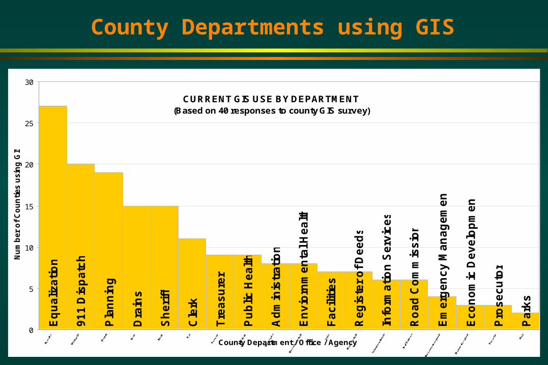
County Departments using GIS
CURRENT GIS USE BY DEPARTMENT(Based on 40 responses to county GIS survey)
Eq
ua
liza
tio
n
Pla
nn
ing
Dra
ins
Sh
eri
ff
Cle
rk
En
vio
rnm
en
tal H
ea
lth
Fa
cili
tie
s
Re
gis
ter
of
De
ed
s
Info
rma
tio
n S
erv
ice
s
Ro
ad
Co
mm
iss
ion
Em
erg
en
cy
Ma
na
ge
me
nt
Ec
on
om
ic D
ev
elo
pm
en
t
Pro
se
cu
tor
Pa
rks
Tre
as
ure
r
Ad
min
istr
ati
on
Pu
blic
He
alt
h
91
1 D
isp
atc
h
0
5
10
15
20
25
30
County Department / Office / Agency
Nu
mb
er
of
Co
un
ties u
sin
g G
IS

GIS Application Categories - Core
Create, view and print maps Point and click information retrieval from a map.
– What is the tax assessment on this parcel?– How far is it from the street to this house?
Select features based on a set of criteria– Which owners live within 500 feet of this zoning change?– Which wells have been tested in the last year?
Distribution mapping– What is the distribution of parcels in this years sales study?– What areas of the county are hot-spots for crime?
Site investigation– Which sites are suitable for a waste water treatment plant?– Which part of this parcel is suitable for development?
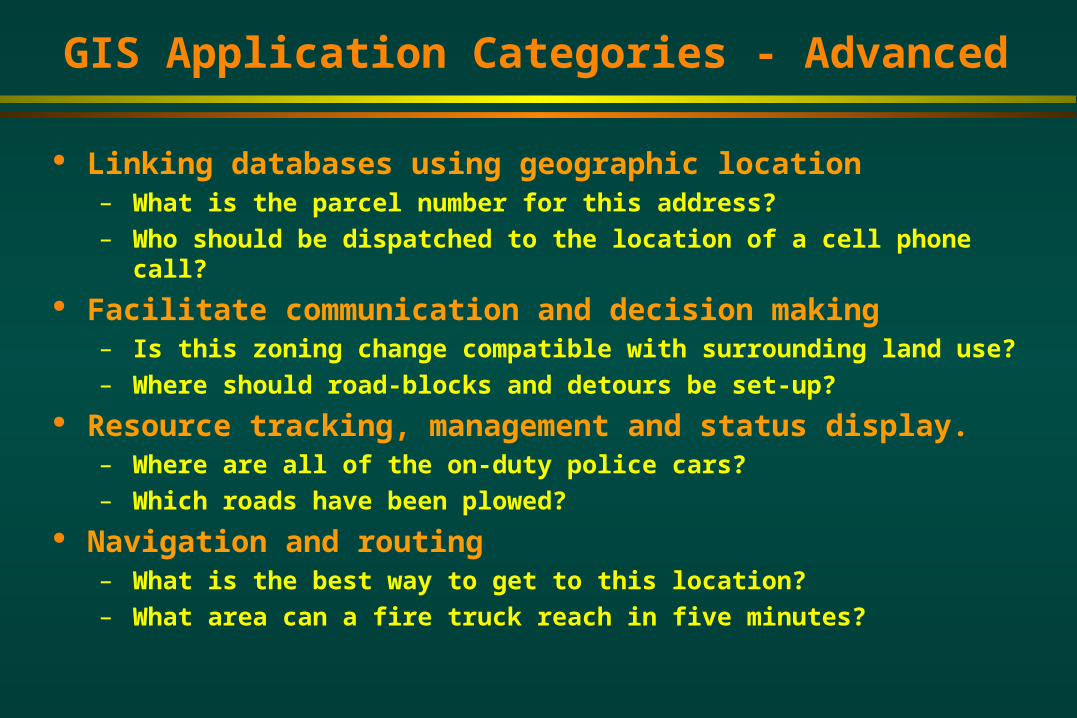
GIS Application Categories - Advanced
Linking databases using geographic location– What is the parcel number for this address?– Who should be dispatched to the location of a cell phone call?
Facilitate communication and decision making– Is this zoning change compatible with surrounding land use?– Where should road-blocks and detours be set-up?
Resource tracking, management and status display.– Where are all of the on-duty police cars?– Which roads have been plowed?
Navigation and routing– What is the best way to get to this location?– What area can a fire truck reach in five minutes?

Worksheet Format - Complete the Sentence:
General Activity #1– Specific Case #1
Notes
– Specific Case #2 General Activity #2
– Etc.
A county can use GIS in the(Insert Department)
To...
Note: In many cases a listed activity may occur in one of several departments. In the interest of brevity, each activity has only been
listed once in the department most likely to engage in it.

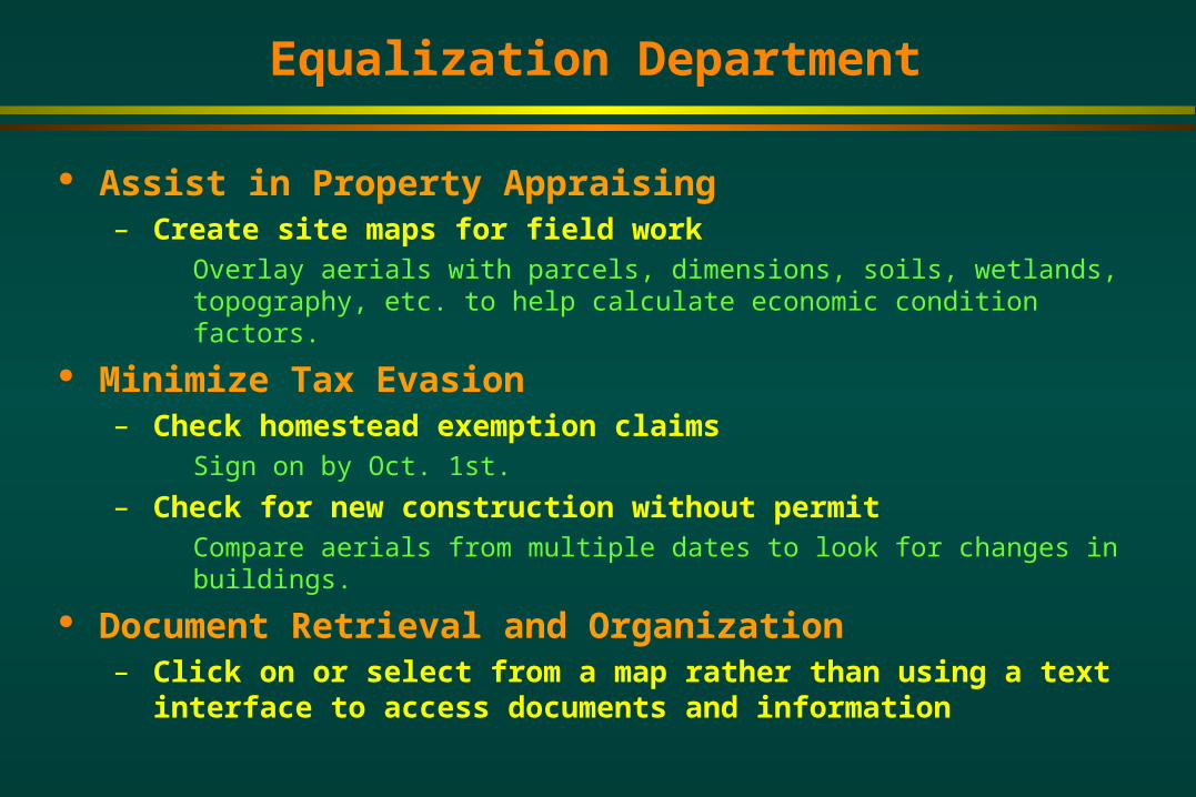
Equalization Department
Maintain Tax Maps– Map splits and maintain annotation (dimensions, lot #s, etc.)
Ensure Quality Control of Tax Database– Verify school district coding
Compare coded school district in tax database to digitized school boundaries.
– Parcel acreage verification Compare parcel acreage in tax database with GIS calculated acreage.
– Verify property class coding Ex. Subdivision lots classified as AG parcels.
Conduct Sales Studies– Thematically map or stratify sales by class, amount, type, etc.– Facilitate picking sales for equalization studies– Estimate average land values– Neighborhood analysis
Equalization Department
Assist in Property Appraising– Create site maps for field work
Overlay aerials with parcels, dimensions, soils, wetlands, topography, etc. to help calculate economic condition factors.
Minimize Tax Evasion– Check homestead exemption claims
Sign on by Oct. 1st.
– Check for new construction without permit Compare aerials from multiple dates to look for changes in buildings.
Document Retrieval and Organization– Click on or select from a map rather than using a text
interface to access documents and information

Equalization Department
Facilitate Tax Reporting– Calculate land values of tax exempt parcels
Maintain Other GIS Layers– Use source documents to maintain layers other than
parcels (ex. addresses, roads, school districts, plats, drainage easements, building footprints, etc.)
Generate Products for Sale– Print tax maps with aerial and other overlays– Create a plat book for the county– Mailing Lists
Some Key Layers:– Parcels, dimensions, lots, sections, section corners, right
of ways, annotation
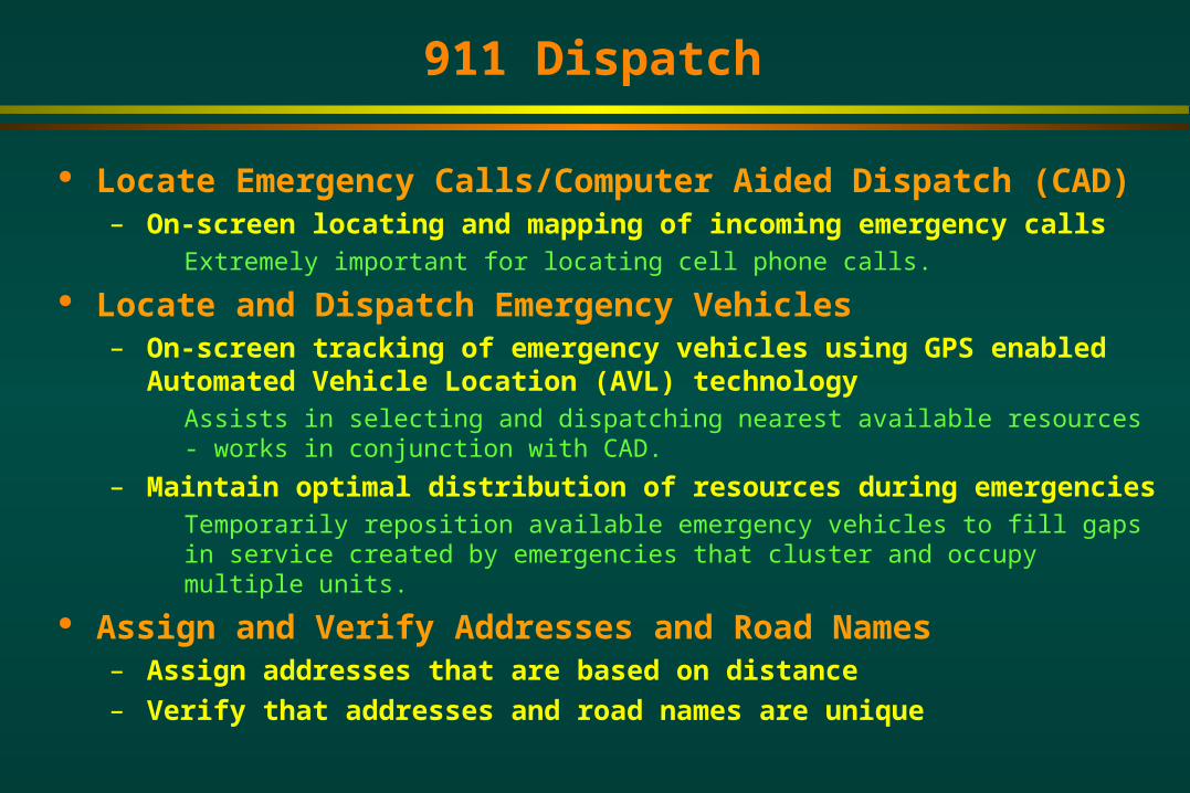
911 Dispatch
Locate Emergency Calls/Computer Aided Dispatch (CAD)– On-screen locating and mapping of incoming emergency calls
Extremely important for locating cell phone calls.
Locate and Dispatch Emergency Vehicles– On-screen tracking of emergency vehicles using GPS enabled
Automated Vehicle Location (AVL) technology Assists in selecting and dispatching nearest available resources - works in
conjunction with CAD.
– Maintain optimal distribution of resources during emergencies Temporarily reposition available emergency vehicles to fill gaps in service created by
emergencies that cluster and occupy multiple units.
Assign and Verify Addresses and Road Names– Assign addresses that are based on distance– Verify that addresses and road names are unique
911 Dispatch
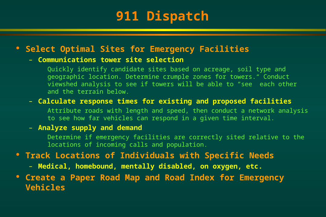
Select Optimal Sites for Emergency Facilities– Communications tower site selection
Quickly identify candidate sites based on acreage, soil type and geographic location. Determine crumple zones for towers. Conduct viewshed analysis to see if towers will be able to “see” each other and the terrain below.
– Calculate response times for existing and proposed facilities Attribute roads with length and speed, then conduct a network analysis to see how
far vehicles can respond in a given time interval.
– Analyze supply and demand Determine if emergency facilities are correctly sited relative to the locations of
incoming calls and population.
Track Locations of Individuals with Specific Needs – Medical, homebound, mentally disabled, on oxygen, etc.
Create a Paper Road Map and Road Index for Emergency Vehicles

911 Dispatch
Emergency Vehicle Routing– Optimize routing of emergency vehicles in consideration
of current road conditions Take into consideration construction zones, detours, collapsed bridges, plowed
roads, flooded areas etc.
Obtain Data and Generate Maps for Reports– Area of service district, miles of road, locations of calls,
etc. Some Key Layers:
– Roads, addresses, aerials, recognized names, emergency service areas and facilities (ambulance, fire, police), emergency resources (hydrants, fire breaks), building plans, utilities, hazards Addresses can be stored either as address ranges tied to a road segment or as
individual point locations.
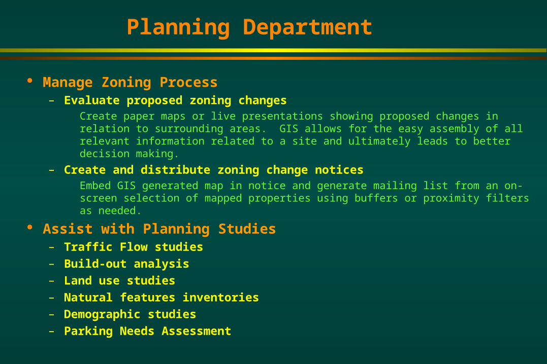
Planning Department
Manage Zoning Process– Evaluate proposed zoning changes
Create paper maps or live presentations showing proposed changes in relation to surrounding areas. GIS allows for the easy assembly of all relevant information related to a site and ultimately leads to better decision making.
– Create and distribute zoning change notices Embed GIS generated map in notice and generate mailing list from an on-screen
selection of mapped properties using buffers or proximity filters as needed.
Assist with Planning Studies– Traffic Flow studies– Build-out analysis– Land use studies– Natural features inventories– Demographic studies– Parking Needs Assessment

Planning Department
Comprehensive Growth Management Planning– Conduct analysis and generate maps for county master
plan Document Retrieval and Organization
– Link zoning ordinances, documents and related information to map features to provide easier access to information
Some Key Layers:– Parcels, zoning, master plan, soils, floodplains,
topography, land use, census, infrastructure (utilities, all season roads), aerials

Drain Commission
Assess Parcels in Drainage Districts– Calculate parcel acreage
Cut out parcels using watershed boundaries and calculate acreage for parcels in the drain district to be assessed. Calculate acreage of MDOT right of ways.
– Calculate runoff coefficients for parcels Use land-use, soils, photos, slope and proximity to drain variables to factor
assessments
Locate New Drains and Drainage Districts– Create preliminary site plans for proposed drains
Conduct flow modeling from a digital elevation model to determine the direction of flow for surface runoff. Use this information to site new drains.
– Locate natural drainage boundaries for new drains Conduct a watershed analysis using a digital elevation model to determine
locations of naturally occurring watershed boundaries.
Drain Commission
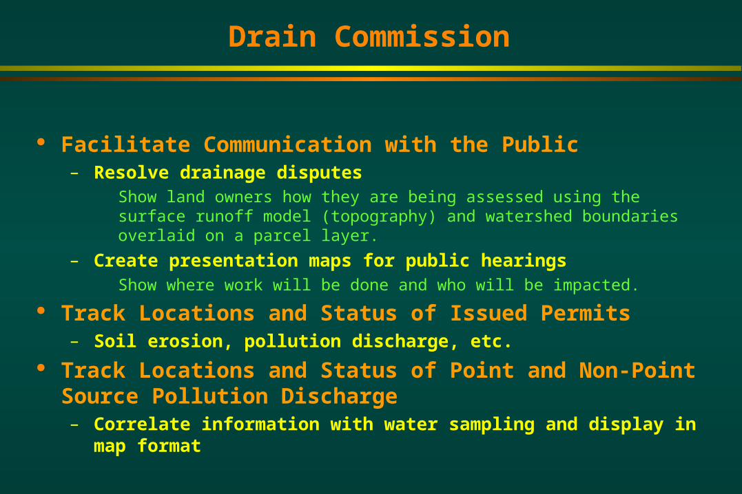
Facilitate Communication with the Public– Resolve drainage disputes
Show land owners how they are being assessed using the surface runoff model (topography) and watershed boundaries overlaid on a parcel layer.
– Create presentation maps for public hearings Show where work will be done and who will be impacted.
Track Locations and Status of Issued Permits– Soil erosion, pollution discharge, etc.
Track Locations and Status of Point and Non-Point Source Pollution Discharge– Correlate information with water sampling and display in
map format
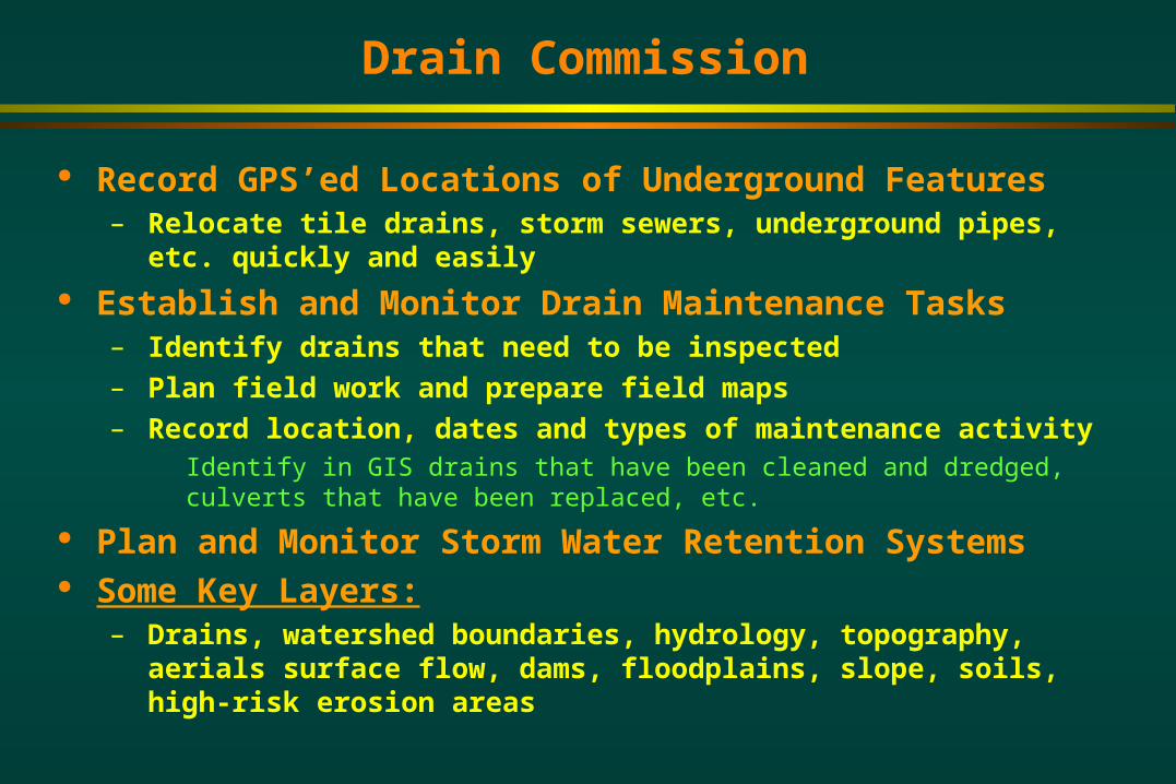
Drain Commission
Record GPS’ed Locations of Underground Features– Relocate tile drains, storm sewers, underground pipes,
etc. quickly and easily Establish and Monitor Drain Maintenance Tasks
– Identify drains that need to be inspected– Plan field work and prepare field maps– Record location, dates and types of maintenance activity
Identify in GIS drains that have been cleaned and dredged, culverts that have been replaced, etc.
Plan and Monitor Storm Water Retention Systems Some Key Layers:
– Drains, watershed boundaries, hydrology, topography, aerials surface flow, dams, floodplains, slope, soils, high-risk erosion areas

Sheriff / Drug Enforcement
Reduce Traffic Accidents– Track accidents by location and type– Identify accident prone areas
Dangerous intersections and curves, wildlife crossings, areas prone to speeding. These locations can be correlated to traffic counts to see if they are statistically significant or not.
– Assess the effectiveness of remedial action Reduce Crime
– Track crime by location and type– Identify crime hot-spots and crime patterns
Clustered burglaries, marijuana growing, meth labs etc.
– Assess the effectiveness of remedial actions DARE, neighborhood watch, increased speed enforcement, etc.

Sheriff / Drug Enforcement
Coordinate Search, Rescue and Recovery Efforts– Generate maps for planning and conducting searches and
exercises Include military or other grid to make maps compatible with GPS coordinate
readings. This will facilitate communication between all units involved (ground, air and marine).
– Overlay GPS’ed paths of search crews to track areas searched.
Provide Information for Investigations– Support research and surveillance activities
Provide aerials photos of site; topography to show infiltration routes and high spots for surveillance; property ownership; distance measurements; known area felons; historical crime activity (burglaries, marijuana growing, methamphetamine labs) etc.
– Look-up parcel ownership records for search warrants.
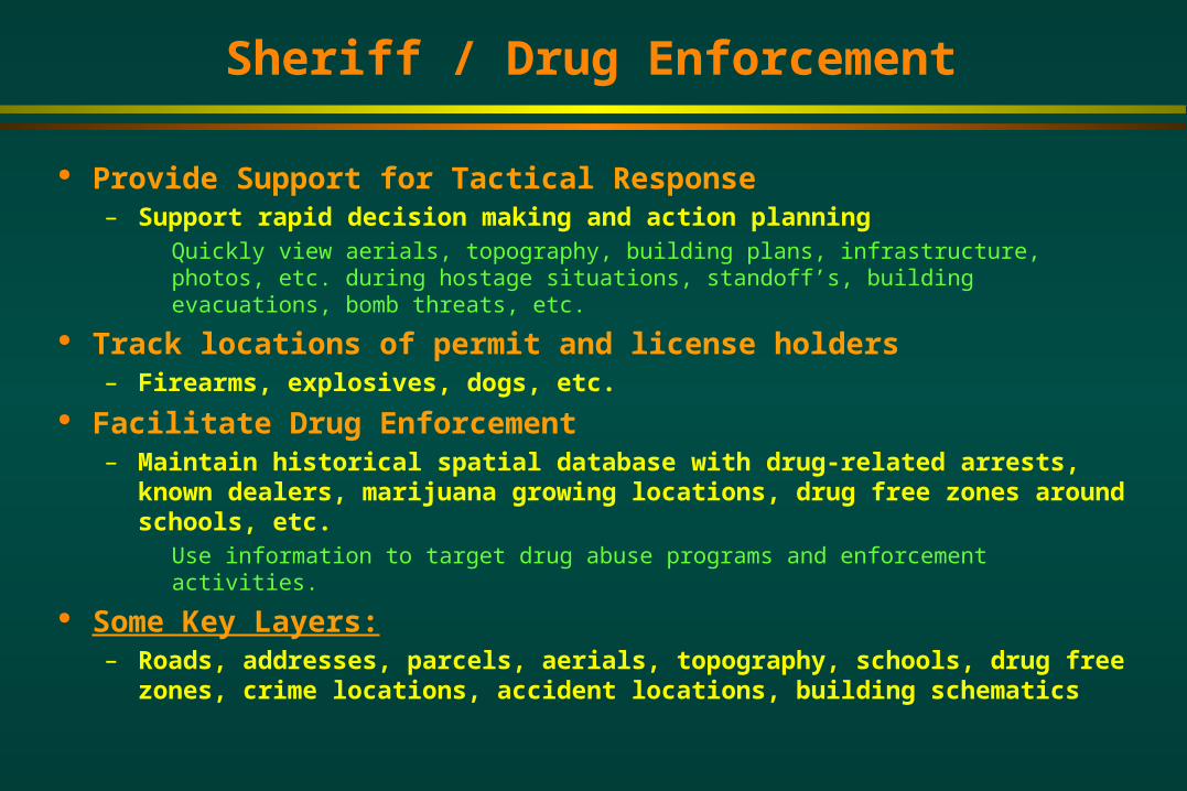
Sheriff / Drug Enforcement
Provide Support for Tactical Response– Support rapid decision making and action planning
Quickly view aerials, topography, building plans, infrastructure, photos, etc. during hostage situations, standoff’s, building evacuations, bomb threats, etc.
Track locations of permit and license holders– Firearms, explosives, dogs, etc.
Facilitate Drug Enforcement– Maintain historical spatial database with drug-related
arrests, known dealers, marijuana growing locations, drug free zones around schools, etc. Use information to target drug abuse programs and enforcement activities.
Some Key Layers:– Roads, addresses, parcels, aerials, topography, schools,
drug free zones, crime locations, accident locations, building schematics

Clerk
Facilitate Voter Registration– Submit new roads and road changes to the Michigan
Center for Geographic Information Support Election Process
– Generate election maps Voting locations, district and precinct boundaries, election results, etc.
– Estimate ballots needed Use district and precinct boundaries to query census data.
– Evaluate distribution of polling locations relative to voters Establish Voter Precincts
– Tabulate population from census data to evaluate different precinct scenarios

Clerk
Evaluate Redistricting Proposals– Tabulate population and voter records to evaluate
different redistricting scenarios Maintain Cemetery Records
– Link database to map to locate plots– Generate cemetery maps showing plot availability
Some Key Layers:– Roads, addresses, census tracts, political and municipal
boundaries, precinct boundaries, school districts, polling locations
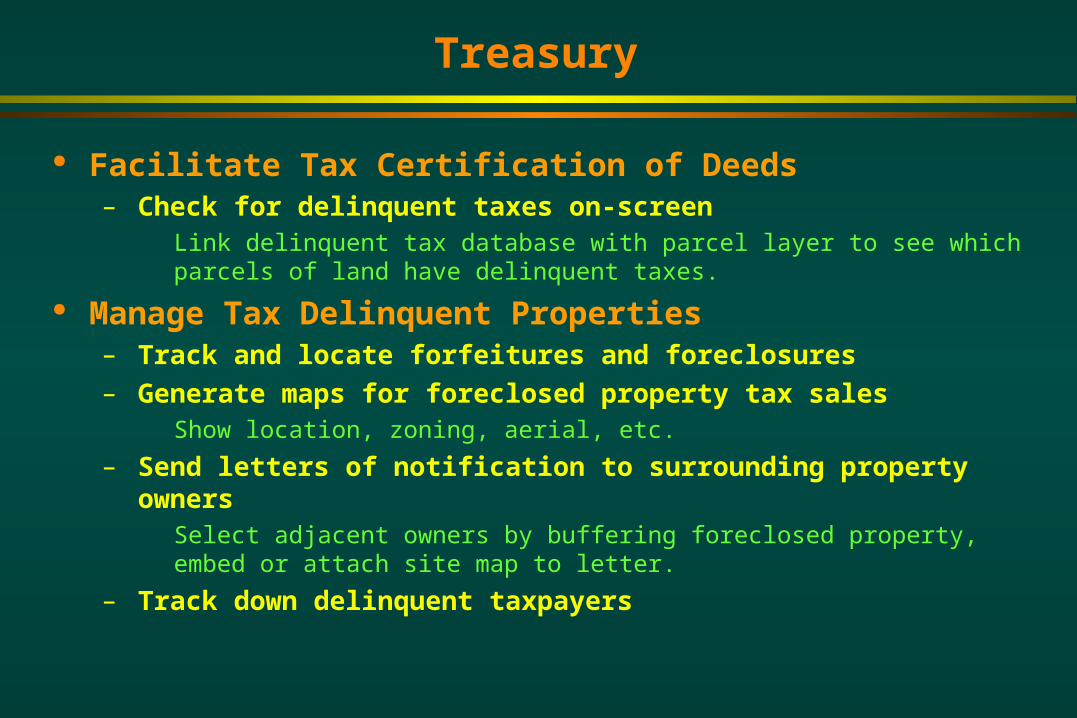
Treasury
Facilitate Tax Certification of Deeds– Check for delinquent taxes on-screen
Link delinquent tax database with parcel layer to see which parcels of land have delinquent taxes.
Manage Tax Delinquent Properties– Track and locate forfeitures and foreclosures– Generate maps for foreclosed property tax sales
Show location, zoning, aerial, etc.
– Send letters of notification to surrounding property owners Select adjacent owners by buffering foreclosed property, embed or attach site
map to letter.
– Track down delinquent taxpayers

Treasury
Tax Abatement– Maintain locations and boundaries of special tax zones
Brownfields, downtown development authorities, commercial forests, industrial parks, enterprise zones, renaissance zones, PA 116’s, annexations, etc.
Some Key Layers:– Parcels, splits, roads, addresses, municipal boundaries,
tax zone boundaries

Administration
Generate a County Report Card– Compile data and maps from a wide variety of sources to
track the health of the county. Include community surveys, crime, health, roads, census, etc.
Support Decision Making on County-wide Projects– Track locations and status of county facilities and assets– Evaluate new infrastructure development
Preliminary site and impact studies for jails, buildings, roads, public water and sewer, landfills, etc.
Print Decorative Wall Maps for Offices and Corridors
Generate Promotional Material Generate Maps for the Public Media

Public / Environmental Health
Track and Monitor Wells– Record location of new wells with GPS and link to well log
data– Create maps showing sampling results, well depths, well
types– Generate groundwater flow models– Administer wellhead protection program
Track and Monitor Sites of Concern– Track location, extent and status of hazardous waste
storage facilities, contaminated soils, underground storage tanks, polluted water, manure lagoons, etc.
– Plan and evaluate remediation action– Identify populations, wells and surface water in close
proximity to these sites that could be at risk.
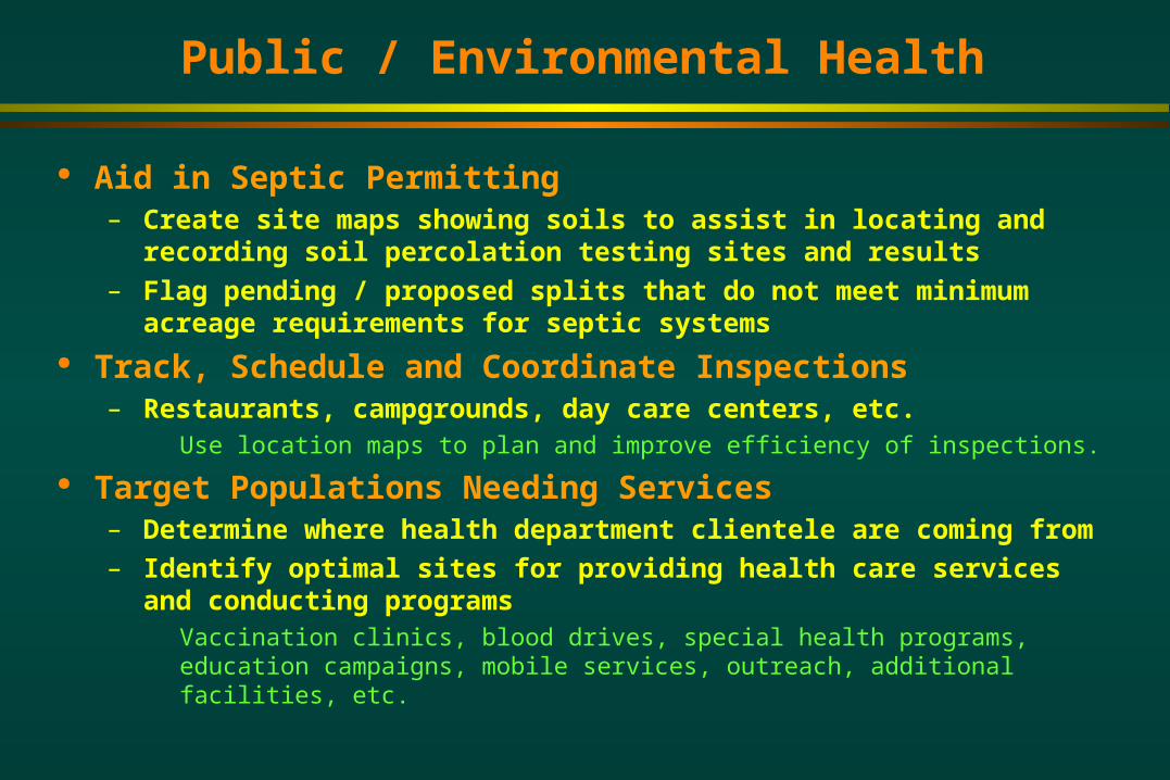
Public / Environmental Health
Aid in Septic Permitting– Create site maps showing soils to assist in locating and
recording soil percolation testing sites and results– Flag pending / proposed splits that do not meet minimum
acreage requirements for septic systems Track, Schedule and Coordinate Inspections
– Restaurants, campgrounds, day care centers, etc. Use location maps to plan and improve efficiency of inspections.
Target Populations Needing Services– Determine where health department clientele are coming
from– Identify optimal sites for providing health care services and
conducting programs Vaccination clinics, blood drives, special health programs, education campaigns,
mobile services, outreach, additional facilities, etc.

Public / Environmental Health
Track the Outbreak and Spread of Diseases– West Nile, swimmers itch, encephalitis, STD’s, cancer,
SARS, hepatitis, etc. Plan and Respond to Bioterrorism
– Optimize locations of smallpox vaccination centers relative to population
– Track outbreaks and monitor response Assign School Districts
– Match addresses to school districts for program administration Ex. Baby Links
Some Key Layers:– Parcels, addresses, wells, septic systems, school districts,
hydrology, soils, aerials, wetlands

Facilities / Public Works
Track and Manage Facilities and Infrastructure– Map locations of sewer, water, cable, fiber, gas, power,
communications and parking infrastructure.– Schedule and record routine and emergency maintenance– Calculate GPS coordinates for infrastructure to assist in
relocation Manage Waste Disposal
– Map extent of landfills and monitor volume with GPS– Optimize routes of waste collection vehicles– Find suitable sites for new landfills
Store and Retrieve Plans and Drawings– Scan and register engineering and architectural drawings
to aerials and building footprints Generate Building Evacuation Wall Maps
Facilities / Public Works
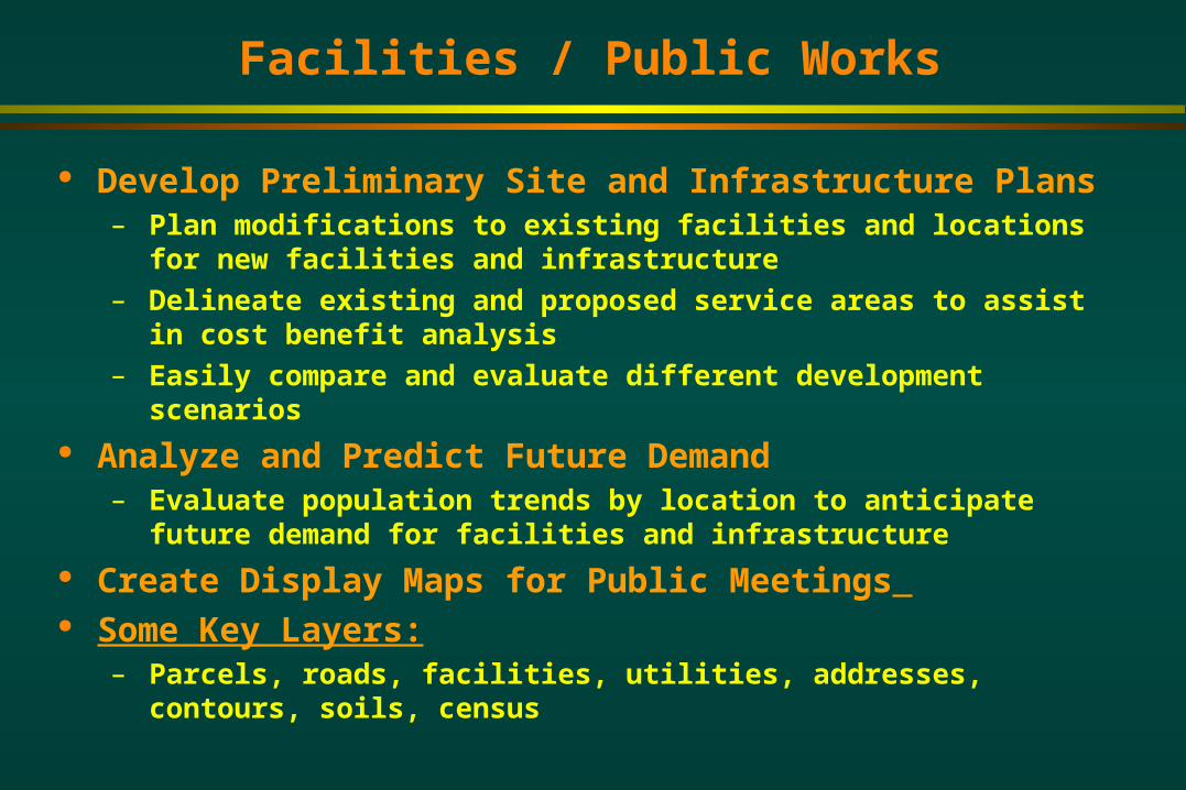
Develop Preliminary Site and Infrastructure Plans– Plan modifications to existing facilities and locations for
new facilities and infrastructure– Delineate existing and proposed service areas to assist in
cost benefit analysis– Easily compare and evaluate different development
scenarios Analyze and Predict Future Demand
– Evaluate population trends by location to anticipate future demand for facilities and infrastructure
Create Display Maps for Public Meetings Some Key Layers:
– Parcels, roads, facilities, utilities, addresses, contours, soils, census
Road Commission
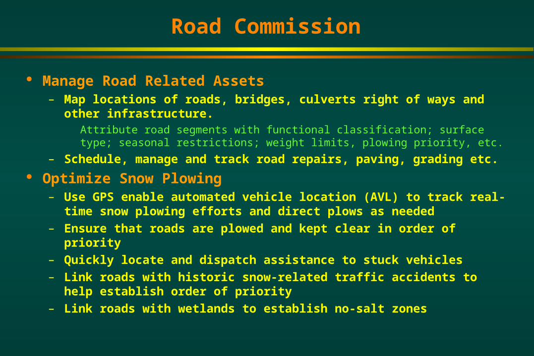
Manage Road Related Assets– Map locations of roads, bridges, culverts right of ways and
other infrastructure. Attribute road segments with functional classification; surface type; seasonal
restrictions; weight limits, plowing priority, etc.
– Schedule, manage and track road repairs, paving, grading etc. Optimize Snow Plowing
– Use GPS enable automated vehicle location (AVL) to track real-time snow plowing efforts and direct plows as needed
– Ensure that roads are plowed and kept clear in order of priority
– Quickly locate and dispatch assistance to stuck vehicles– Link roads with historic snow-related traffic accidents to help
establish order of priority – Link roads with wetlands to establish no-salt zones

Road Commission
Provide Information to the Public via Internet– Create website with map showing locations of current and
proposed road projects with detours– Create website with map that allows public to locate and
notify road commission of problems (potholes, fallen trees, road kill, etc.)
Store and Retrieve Plans and Drawings– Scan and register engineering drawings to aerials and
road segments Create County Road Maps and Street Index Create Display Maps for Public Meetings Some Key Layers:
– Roads, road infrastructure, hydrology, topography, right of ways
Register of Deeds
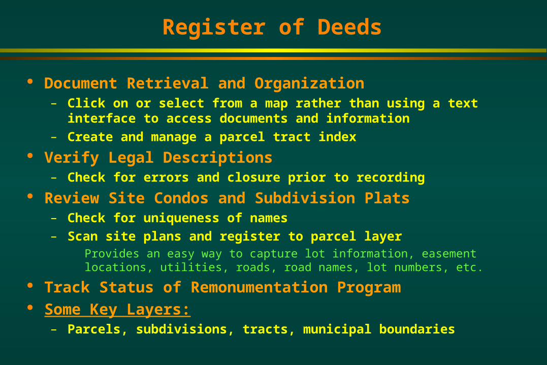
Document Retrieval and Organization– Click on or select from a map rather than using a text
interface to access documents and information– Create and manage a parcel tract index
Verify Legal Descriptions– Check for errors and closure prior to recording
Review Site Condos and Subdivision Plats– Check for uniqueness of names– Scan site plans and register to parcel layer
Provides an easy way to capture lot information, easement locations, utilities, roads, road names, lot numbers, etc.
Track Status of Remonumentation Program Some Key Layers:
– Parcels, subdivisions, tracts, municipal boundaries
IT / IS
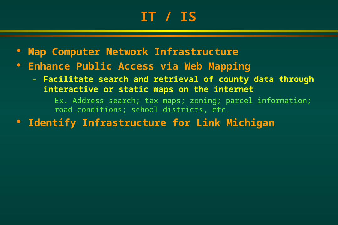
Map Computer Network Infrastructure Enhance Public Access via Web Mapping
– Facilitate search and retrieval of county data through interactive or static maps on the internet Ex. Address search; tax maps; zoning; parcel information; road conditions;
school districts, etc.
Identify Infrastructure for Link Michigan

Emergency Management
Track Hazardous Sites– Track and monitor locations of chemical storage facilities
(farm, commercial and industrial), fuel tanks, animal waste, tire piles, etc.
Identify Locations of Critical Infrastructure– Bridges, dams, utilities, rail lines, highways, key facilities
(government, schools, emergency service, power generation) Hazard Mitigation Planning
– Evaluate multiple scenarios and develop mitigation plans based on probable sequences of events Assess the likely impact areas for population and structures. Determine optimal
siting for road blocks, evacuation routes, decontamination centers, etc.
– Assemble portfolio for potential disaster areas Link aerials, site plans, building schematics, photos and other materials in GIS to
allow for rapid retrieval during event.

Emergency Management
Manage Disasters– Identify area affected by a tornado, flood, fire, spill or
leak– Generate maps showing current and predicted spread and
dispersion– Rapidly prioritize response given adjacent population,
structures and hazards identified in GIS Ex. During forest fire, identify near-by population clusters, buildings, storage
tanks for flammable materials and utility infrastructure to plan evacuations, set-up road blocks and determine critical places to set up fire lines.
– Generate field maps to aid field crews in hazard response– Monitor status of various response measures
Ex. Indicate when proposed road blocks, fire lines, decontamination centers become operational; show which homes have been evacuated; etc.

Emergency Management
Assess and Report Damage– Record damaged structures reported by field crews and
tally assessed values.– Generate maps for final reports
Evaluate Response to Hazard Event– Look at maps and timelines to see how effective a
response was Some Key Layers:
– Parcels, roads, addresses, aerials, hydrology, topography, soils, hazardous sites, critical infrastructure, utilities

Economic Development
Create and Maintain a Portfolio of Available Sites– Compile aerial, parcel, tax, zoning, infrastructure and
environmental information for site and surrounding area. – Include vacant, industrial, commercial and brownfields.– Make available with a search engine on the web.
Provide Easy Access to Demographic Data– Provide census, demographic, labor and housing data and
information for communities in map format. Assist with Infrastructure Development and Site
Selection– Conduct preliminary studies for water and sewer projects.– Quickly find locations that meet certain criteria.
Ex: Find parcel with the following characteristics: Zoned commercial, at least 40 acres in size, within 1 mile of water and sewer, less than 10 miles from nearest highway interchange, adjacent to all season road.

Economic Development
Create and Maintain Business Directory– Track business type, employees, ownership, etc.
Some Key Layers:– Census, parcels, roads, aerials, hydrology, topography,
soils, infrastructure, utilities

Prosecutor / Courts
Print Large Format Maps for Court Exhibits Maintain sex-offenders registry
– Make maps available on the internet. Enforce Probation and House Arrest
– Match offender’s residence with with probation officers.– Monitor locations of offenders on GPS enabled tethers.
Schedule Community Service– Match offender’s residence with available community service
locations and needs. Facilitate Jury Selection Process
– Generate mailing addresses for Jury selection.– Evaluate distribution of jurors.
Some Key Layers:– Addresses, school districts

Pest / Animal / Environmental Control
Monitor Distributions of Pests and Invasive Species– Map affected areas and locations.
Ex: Gypsy moths, mosquitoes (West Nile Virus), Emerald Ash Borer, purple loosestrife, zebra mussels, water fowl, etc.
– Monitor changes in distribution and calculate rates of spread. Plan, Manage and Evaluate Abatement Programs
– Identify aerial spray blocks, sites and targets for abatement.– Generate mailing lists to notify property owners in targeted
areas.– Identify sites and properties for special consideration.
Ex: environmentally sensitive areas, no-spray zones, objectors, schools, etc.
– Identify parcels in application area for special tax assessment.– Provide maps and coordinates to applicators and field workers.

Pest / Animal / Environmental Control
Track Owners of Exotic Species– Keep registry of exotic species ownership
Ex: Game farms, mountain lions, alligators, snakes, wild boars, etc.
Facilitate Dog Census Some Key Layers:
– Addresses, parcels, tall structures, environmentally sensitive areas, schools

Parks and Recreation
Create and Maintain Parks and Recreation Maps– Create maps and brochures for individual parks showing
campsites, trails, public access, etc.– Create county-wide map showing campgrounds, golf
courses, trails, public access sites and other recreational facilities.
Manage Campground Reservations– Link maps with reservations database and post on the
internet.– Keep track of nuisance campers.
Track Parks and Recreation Facility Use– Summarize information on facility use in map format.– Find out who is using parks.
Link use permit information / surveys with zip code map.
– Find out which campsites are most popular.
Parks and Recreation
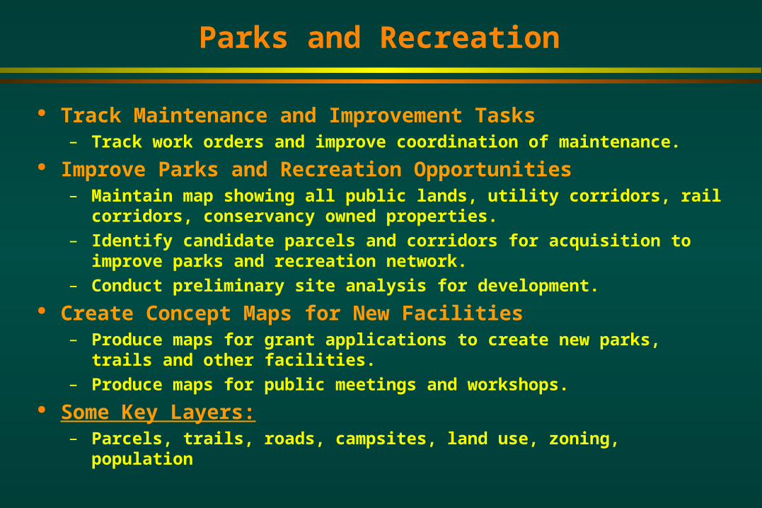
Track Maintenance and Improvement Tasks– Track work orders and improve coordination of maintenance.
Improve Parks and Recreation Opportunities– Maintain map showing all public lands, utility corridors, rail
corridors, conservancy owned properties.– Identify candidate parcels and corridors for acquisition to
improve parks and recreation network.– Conduct preliminary site analysis for development.
Create Concept Maps for New Facilities– Produce maps for grant applications to create new parks,
trails and other facilities.– Produce maps for public meetings and workshops.
Some Key Layers:– Parcels, trails, roads, campsites, land use, zoning, population
Recommended


![Insitu: Sketching Architectural Designs in Contextvclab.kaist.ac.kr/siggraphasia2011/Insitu_SA2011pres.pdf · Kalnins et al. [2002] developed a sketching system incorporating non-photorealistic](https://img.dokumen.tips/doc/110x75/5eb9cee43dc27936963c64db/insitu-sketching-architectural-designs-in-kalnins-et-al-2002-developed-a-sketching.jpg)


![Untitled-1 [] · Title: Untitled-1 Author: valdis Created Date: 5/11/2015 10:19:09 AM](https://img.dokumen.tips/doc/110x75/5f493a06ba3c696ef774091a/untitled-1-title-untitled-1-author-valdis-created-date-5112015-101909.jpg)


