Shamrock Station Irrigation Project supplementary report
Phoenix Environmental Sciences Pty Ltd
Appendix 2 Flora and fauna assessment

Flora and vegetation survey and terrestrial fauna survey for Shamrock Station Irrigation Project
Prepared for Argyle Cattle Company Pty Ltd
August 2017
Final Report
Flora and vegetation survey and terrestrial fauna survey fauna survey for Shamrock Station Irrigation Project
Prepared for Argyle Cattle Company Pty Ltd
Flora and vegetation survey and terrestrial fauna survey fauna survey for the Shamrock Station Irrigation Project
Prepared for Argyle Cattle Company Pty Ltd
Final Report
Authors: Ryan Ellis, Grant Wells
Reviewer: Karen Crews, Grace Wells
Date: 1 August 2017
Submitted to: Cameron McDonald (Australian Standard Agriculture)
Version history
Name Task Version Date
K. Crews Draft for client comments 1.0 27 July 2017
K. Crews Final submitted to client 1.1 1 August 2017
©Phoenix Environmental Sciences Pty Ltd 2017
The use of this report is solely for the Client for the purpose in which it was prepared. Phoenix Environmental Sciences accepts no responsibility for use beyond this purpose.
All rights are reserved and no part of this report may be reproduced or copied in any form without the written permission of Phoenix Environmental Sciences or the Client.
This document is protected by legal professional privilege. To ensure privilege is not waived, please keep this document confidential and in a safe and secure place. This document should not be distributed to, nor any reference to it made to, any person or organisation not directly involved in making decisions upon the subject matter of this document. If this document is required by a third party, legal advice should be immediately obtained prior to that person viewing or taking the document.
Phoenix Environmental Sciences Pty Ltd
1/511 Wanneroo Rd BALCATTA WA 6021
P: 08 9345 1608
F: 08 6313 0680
Project code: 1147-SIP-AC-ECO
Flora and vegetation survey and terrestrial fauna survey fauna survey for Shamrock Station Irrigation Project
Prepared for Argyle Cattle Company Pty Ltd
Phoenix Environmental Sciences Pty Ltd i
Contents
CONTENTS ................................................................................................................................................ I
LIST OF FIGURES ...................................................................................................................................... II
LIST OF TABLES ........................................................................................................................................ II
LIST OF APPENDICES .............................................................................................................................. III
EXECUTIVE SUMMARY ........................................................................................................................... IV
1 INTRODUCTION ............................................................................................................................... 1
1.1 Survey objective and scope .................................................................................................... 1
1.2 Study area ............................................................................................................................... 1
2 LEGISLATIVE CONTEXT .................................................................................................................... 3
2.1 Commonwealth ....................................................................................................................... 3
2.2 State ........................................................................................................................................ 4
2.2.1 Threatened and Priority species ..................................................................................... 4
2.2.2 Threatened and Priority Ecological Communities ........................................................... 4
2.2.3 Significant flora and vegetation ...................................................................................... 5
2.2.4 Clearing of native vegetation .......................................................................................... 5
2.2.5 Environmentally Sensitive Areas ..................................................................................... 6
2.3 Introduced flora ...................................................................................................................... 6
3 EXISTING ENVIRONMENT ................................................................................................................ 7
3.1 Interim Biogeographic Regionalisation of Australia ............................................................... 7
3.2 Land systems ........................................................................................................................... 9
3.3 Climate and weather ............................................................................................................. 11
3.4 Land use ................................................................................................................................ 12
3.5 Conservation reserves and Environmentally Sensitive Areas ............................................... 12
3.6 Threatening processes .......................................................................................................... 12
4 METHODS ...................................................................................................................................... 13
4.1 Desktop review ..................................................................................................................... 13
4.1.1 Database searches and literature review ..................................................................... 13
4.1.2 Habitat assessment ....................................................................................................... 13
4.2 Field survey ........................................................................................................................... 14
4.2.1 Flora and vegetation ..................................................................................................... 14
4.2.2 Fauna and fauna habitat ............................................................................................... 18
4.2.1 Taxonomy and nomenclature ....................................................................................... 21
4.3 Survey personnel .................................................................................................................. 21
5 RESULTS ........................................................................................................................................ 22
5.1 Desktop review ..................................................................................................................... 22
5.1.1 Flora and vegetation ..................................................................................................... 22
5.1.2 Fauna and fauna habitat ............................................................................................... 26
5.2 Field survey ........................................................................................................................... 30
5.2.1 Flora and vegetation ..................................................................................................... 30
Flora and vegetation survey and terrestrial fauna survey fauna survey for Shamrock Station Irrigation Project
Prepared for Argyle Cattle Company Pty Ltd
Phoenix Environmental Sciences Pty Ltd ii
5.2.2 Fauna and fauna habitats.............................................................................................. 45
5.3 Survey limitations ................................................................................................................. 53
6 DISCUSSION ................................................................................................................................... 55
6.1 Flora and vegetation ............................................................................................................. 55
6.1.1 Conservation significant flora ....................................................................................... 56
6.1.2 Vegetation ..................................................................................................................... 57
6.2 Vertebrate fauna ................................................................................................................... 57
7 REFERENCES .................................................................................................................................. 64
List of Figures
Figure 1-1 Project location and study area ...................................................................................... 2 Figure 3-1 IBRA region of the study area ......................................................................................... 8 Figure 3-2 Land system of the study area ...................................................................................... 10 Figure 3-3 Annual climate and weather data for Bidyadanga Community (no. 003030) (BoM
2017) and mean monthly data for the 12 months preceding the field survey ............. 11 Figure 4-1 Flora and vegetation survey sites ................................................................................. 15 Figure 4-2 Terrestrial fauna survey sites ........................................................................................ 19 Figure 5-1 Desktop records of conservation significant flora and ecological communities .......... 23 Figure 5-2 Shepherd et al. (2002) vegetation associations of the study area ............................... 25 Figure 5-3 Desktop records of conservation significant fauna ...................................................... 29 Figure 5-4 Conservation significant flora records from survey ...................................................... 35 Figure 5-5 Vegetation types in the study area ............................................................................... 41 Figure 5-6 Hierarchical clustering (UPGMA) of the flora quadrats of the study area .................... 42 Figure 5-7 Vegetation condition in the study area ........................................................................ 44 Figure 5-8 Fauna habitats and conservation significant fauna records from survey ..................... 46
List of Tables
Table 4-1 Flora and vegetation survey reports incorporated in the desktop review ................... 13 Table 4-2 Vegetation condition rating scale (Trudgen 1988, in EPA 2016d) ................................ 17 Table 4-3 Nomenclatural references, morphospecies designations and reference collections .. 21 Table 4-4 Project team .................................................................................................................. 21 Table 5-1 Conservation significant flora species identified from the desktop review ................. 22 Table 5-2 Priority ecological communities identified in the desktop review ............................... 24 Table 5-3 Conservation significant terrestrial fauna identified through the desktop review ...... 26 Table 5-4 Vegetation types recorded in the study area ............................................................... 37 Table 5-5 Extent of vegetation types in the study area ................................................................ 42 Table 5-6 Vegetation condition – extent of each condition rating in study area ......................... 43 Table 5-7 Fauna habitats of the study area .................................................................................. 45 Table 5-8 Vertebrate taxa recorded during the survey and the total number of species
potentially occurring in the study area ......................................................................... 47 Table 5-9 Conservation significant vertebrate fauna recorded during the field survey ............... 47 Table 5-10 Survey limitations from EPA Technical Guidance: Terrestrial fauna surveys (EPA 2016f)
....................................................................................................................................... 53 Table 5-11 Survey limitations for flora and vegetation survey (EPA 2016d) .................................. 54 Table 6-1 Comparison of floristic data from the current survey with previous flora surveys ...... 55

Flora and vegetation survey and terrestrial fauna survey fauna survey for Shamrock Station Irrigation Project
Prepared for Argyle Cattle Company Pty Ltd
Phoenix Environmental Sciences Pty Ltd iii
Table 6-2 Species numbers of the most dominant plant families recorded in the study area in comparison with other regional studies ....................................................................... 56
Table 6-3 Summary of conservation significant vertebrate fauna species with likelihood of occurrence for the study area ....................................................................................... 59
List of Appendices
Appendix 1 Flora, fauna and ecological community conservation codes and definitions (DEC 2013; DPaW 2017a)
Appendix 2 NVIC Information Hierarchy (ESCAVI 2003) and comparable WA current practice (from EPA 2016d)
Appendix 3 Flora survey site descriptions Appendix 4 Terrestrial fauna survey site descriptions Appendix 5 DPaW correspondence regarding Bilby survey methods Appendix 6 Flora species inventory Appendix 7 Vertebrate species records from desktop review and this survey
Flora and vegetation survey and terrestrial fauna survey fauna survey for Shamrock Station Irrigation Project
Prepared for Argyle Cattle Company Pty Ltd
Phoenix Environmental Sciences Pty Ltd iv
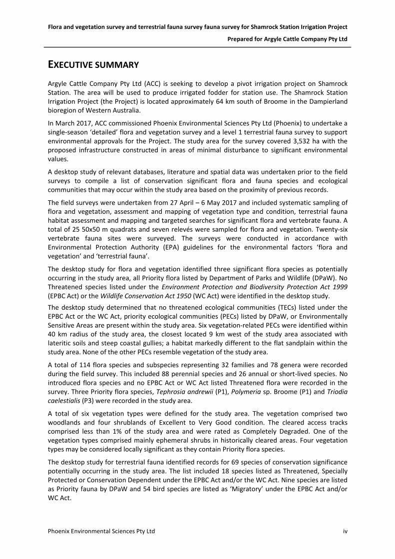
EXECUTIVE SUMMARY
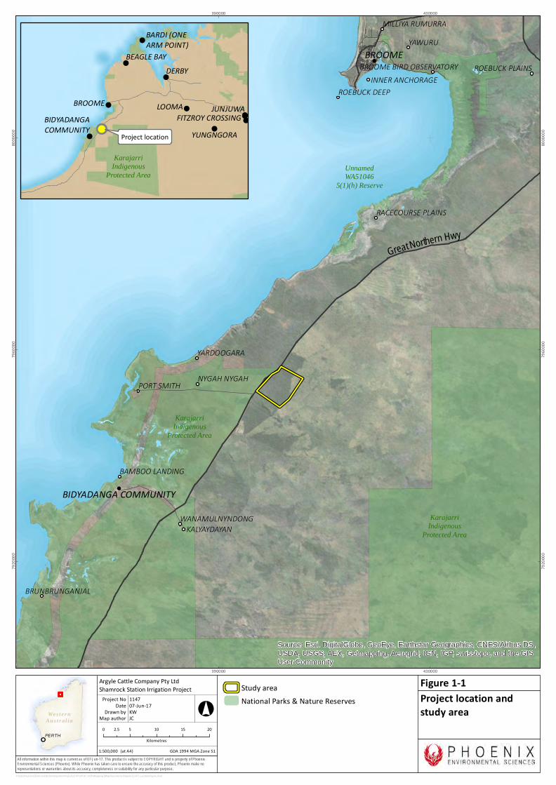
Argyle Cattle Company Pty Ltd (ACC) is seeking to develop a pivot irrigation project on Shamrock Station. The area will be used to produce irrigated fodder for station use. The Shamrock Station Irrigation Project (the Project) is located approximately 64 km south of Broome in the Dampierland bioregion of Western Australia.
In March 2017, ACC commissioned Phoenix Environmental Sciences Pty Ltd (Phoenix) to undertake a single-season ‘detailed’ flora and vegetation survey and a level 1 terrestrial fauna survey to support environmental approvals for the Project. The study area for the survey covered 3,532 ha with the proposed infrastructure constructed in areas of minimal disturbance to significant environmental values.
A desktop study of relevant databases, literature and spatial data was undertaken prior to the field surveys to compile a list of conservation significant flora and fauna species and ecological communities that may occur within the study area based on the proximity of previous records.
The field surveys were undertaken from 27 April – 6 May 2017 and included systematic sampling of flora and vegetation, assessment and mapping of vegetation type and condition, terrestrial fauna habitat assessment and mapping and targeted searches for significant flora and vertebrate fauna. A total of 25 50x50 m quadrats and seven relevés were sampled for flora and vegetation. Twenty-six vertebrate fauna sites were surveyed. The surveys were conducted in accordance with Environmental Protection Authority (EPA) guidelines for the environmental factors ‘flora and vegetation’ and ‘terrestrial fauna’.
The desktop study for flora and vegetation identified three significant flora species as potentially occurring in the study area, all Priority flora listed by Department of Parks and Wildlife (DPaW). No Threatened species listed under the Environment Protection and Biodiversity Protection Act 1999 (EPBC Act) or the Wildlife Conservation Act 1950 (WC Act) were identified in the desktop study.
The desktop study determined that no threatened ecological communities (TECs) listed under the EPBC Act or the WC Act, priority ecological communities (PECs) listed by DPaW, or Environmentally Sensitive Areas are present within the study area. Six vegetation-related PECs were identified within 40 km radius of the study area, the closest located 9 km west of the study area associated with lateritic soils and steep coastal gullies; a habitat markedly different to the flat sandplain within the study area. None of the other PECs resemble vegetation of the study area.
A total of 114 flora species and subspecies representing 32 families and 78 genera were recorded during the field survey. This included 88 perennial species and 26 annual or short-lived species. No introduced flora species and no EPBC Act or WC Act listed Threatened flora were recorded in the survey. Three Priority flora species, Tephrosia andrewii (P1), Polymeria sp. Broome (P1) and Triodia caelestialis (P3) were recorded in the study area.
A total of six vegetation types were defined for the study area. The vegetation comprised two woodlands and four shrublands of Excellent to Very Good condition. The cleared access tracks comprised less than 1% of the study area and were rated as Completely Degraded. One of the vegetation types comprised mainly ephemeral shrubs in historically cleared areas. Four vegetation types may be considered locally significant as they contain Priority flora species.
The desktop study for terrestrial fauna identified records for 69 species of conservation significance potentially occurring in the study area. The list included 18 species listed as Threatened, Specially Protected or Conservation Dependent under the EPBC Act and/or the WC Act. Nine species are listed as Priority fauna by DPaW and 54 bird species are listed as ‘Migratory’ under the EPBC Act and/or WC Act.
Flora and vegetation survey and terrestrial fauna survey fauna survey for Shamrock Station Irrigation Project
Prepared for Argyle Cattle Company Pty Ltd
Phoenix Environmental Sciences Pty Ltd v
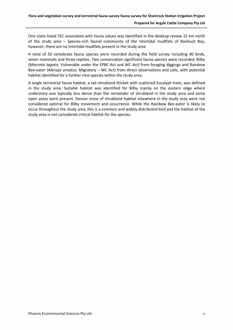
One state-listed TEC associated with fauna values was identified in the desktop review 15 km north of the study area – Species-rich faunal community of the intertidal mudflats of Roebuck Bay; however, there are no intertidal mudflats present in the study area
A total of 50 vertebrate fauna species were recorded during the field survey including 40 birds, seven mammals and three reptiles. Two conservation significant fauna species were recorded, Bilby (Macrotis lagotis; Vulnerable under the EPBC Act and WC Act) from foraging diggings and Rainbow Bee-eater (Merops ornatus; Migratory – WC Act) from direct observations and calls, with potential habitat identified for a further nine species within the study area.
A single terrestrial fauna habitat, a tall shrubland thicket with scattered Eucalypt trees, was defined in the study area. Suitable habitat was identified for Bilby mainly on the eastern edge where understory was typically less dense than the remainder of shrubland in the study area and some open areas were present. Denser areas of shrubland habitat elsewhere in the study area were not considered optimal for Bilby movement and occurrence. While the Rainbow Bee-eater is likely to occur throughout the study area, this is a common and widely distributed bird and the habitat of the study area is not considered critical habitat for the species.

Flora and vegetation survey and terrestrial fauna survey for Shamrock Station Irrigation Project
Prepared for Argyle Cattle Company Pty Ltd
Phoenix Environmental Sciences Pty Ltd 1
1 INTRODUCTION
Argyle Cattle Company Pty Ltd (ACC) is seeking approval to develop an irrigation project on Shamrock Station, located approximately 64 km south of Broome, Western Australia (Figure 1-1). In March 2017, Phoenix Environmental Sciences Pty Ltd (Phoenix) was commissioned by ACC to undertake a flora and vegetation survey and terrestrial fauna survey for the Shamrock Station Irrigation Project (the Project).
The proposal includes the development of twelve 40 ha irrigation pivots, access tracks, water infrastructure for groundwater abstraction. The area will be used to produce irrigated fodder for station use and will be grazed and possibly baled as required. Site design is not finalised but will be guided by:
• access to groundwater – targeting areas of shallow water table
• environmental values identified in the baseline surveys with the aim of avoiding significant environmental values as far as practicable.
1.1 SURVEY OBJECTIVE AND SCOPE
The objective of the survey was to define the flora and vegetation, and terrestrial fauna values of the study area to inform project design and environmental approvals. The scope of works undertaken to achieve this objective was as follows:
• desktop and literature review of all existing flora and vegetation and terrestrial fauna information to define the key biological values likely to occur in the study area
• field survey in the study area comprising:
o single season detailed flora and vegetation survey
o level 1 terrestrial vertebrate fauna survey, including targeted plot surveys for Bilby (Macrotis lagotis)
• data analyses, sample processing and species identifications for samples collected during the field surveys
• preparation of maps showing significant species records, vegetation units and fauna habitats in the study area
• preparation of a technical report documenting survey methods and results.
Preliminary desktop review of habitat suitability for short range endemic invertebrates (SREs) identified low potential for SREs to be present in the study area. The fauna survey was therefore focussed on vertebrate fauna.
1.2 STUDY AREA
The study area for the survey was 3,532 ha, larger than the proposed project area and thereby allowing sufficient flexibility to avoid or minimise disturbance to significant environmental values (Figure 1-1).
Wes ter nAus t r al ia
PERTH
All information within this map is current as of 07-Jun-17. This product is subject to COPYRIGHT and is property of PhoenixEnvironmental Sciences (Phoenix). While Phoenix has taken care to ensure the accuracy of this product, Phoenix make norepresentations or warranties about its accuracy, completeness or suitability for any particular purpose.
!
!
KarajarriIndigenous
Protected Area
KarajarriIndigenous
Protected Area
UnnamedWA51046
5(1)(h) Reserve
ROEBUCK DEEP
ROEBUCK PLAINS
PORT SMITH
YARDOOGARA
WANAMULNYNDONG
BRUNBRUNGANJAL
KALYAYDAYAN
YAWURUMILLIYA RUMURRA
INNER ANCHORAGE
RACECOURSE PLAINS
BAMBOO LANDING
BROOME BIRD OBSERVATORY
NYGAH NYGAH
BROOME
BIDYADANGA COMMUNITY
Great Northern Hwy
Source: Esri, DigitalGlobe, GeoEye, Earthstar Geographics, CNES/Airbus DS,
USDA, USGS, AEX, Getmapping, Aerogrid, IGN, IGP, swisstopo, and the GISUser Community
390000
390000
430000
430000
7920
000
7920
000
7960
000
7960
000
8000
000
8000
000
P:\GIS\Projects\ShamrockStationIrrigationProject\1147-SIP-AC-ECO\Mapping\MapDocuments\Figures\1147_LocationFigure.mxd
Study areaNational Parks & Nature Reserves
0 5 10 15 202.5Kilometres
1:500,000
Argyle Cattle Company Pty LtdShamrock Station Irrigation Project
Map authorDrawn by
GDA 1994 MGA Zone 51
°
(at A4)
07-Jun-17DateProject No 1147
KWJC
Project location andstudy area
Figure 1-1
!
!
!
!
!
!
!!!
!!! Project location
BROOME
DERBY
BIDYADANGACOMMUNITY
LOOMA
BEAGLE BAY
BARDI (ONEARM POINT)
JUNJUWAFITZROY CROSSING
YUNGNGORA
KarajarriIndigenous
Protected Area

Flora and vegetation survey and terrestrial fauna survey for Shamrock Station Irrigation Project
Prepared for Argyle Cattle Company Pty Ltd
Phoenix Environmental Sciences Pty Ltd 3
2 LEGISLATIVE CONTEXT
The protection of flora and fauna in Western Australia (WA) is principally governed by three acts:
• Commonwealth Environmental Protection and Biodiversity Conservation Act 1999 (EPBC Act)
• Western Australian Wildlife Conservation Act 1950 (WC Act)
• Western Australian Environmental Protection Act 1986 (EP Act).
2.1 COMMONWEALTH
The EPBC Act is administered by the Federal Department of the Environment (DoE). Under the EPBC Act, actions that have, or are likely to have, a significant impact on a matter of national environmental significance (NES), require approval from the Australian Government Minister for the Environment through a formal referral process. The EPBC Act provides for the listing of threatened native flora, fauna and threatened ecological communities (TECs) as matters of NES.
Conservation categories applicable to Threatened Flora and Threatened Fauna species under the EPBC Act are as follows:
• Extinct (EX)1 – there is no reasonable doubt that the last individual has died
• Extinct in the Wild (EW) – taxa known to survive only in captivity
• Critically Endangered (CR) – taxa facing an extremely high risk of extinction in the wild in the immediate future
• Endangered (EN) – taxa facing a very high risk of extinction in the wild in the near future
• Vulnerable (VU) – taxa facing a high risk of extinction in the wild in the medium-term
• Conservation Dependent (CD)1 – taxa whose survival depends upon ongoing conservation measures; without these measures, a conservation dependent taxon would be classified as Vulnerable or more severely threatened.
Ecological communities are defined as ‘naturally occurring biological assemblages that occur in a particular type of habitat’ (English & Blyth 1997). There are three categories under which ecological communities can be listed as TECs under the EPBC Act: Critically Endangered, Endangered and Vulnerable.
The EPBC Act is also the enabling legislation for protection of migratory species as matters of NES under a number of international agreements:
• Japan-Australia Migratory Bird Agreement (JAMBA)
• China-Australia Migratory Bird Agreement (CAMBA)
• Convention on the Conservation of Migratory Species of Wild Animals (Bonn)
• Republic of Korea-Australia Migratory Bird Agreement (ROKAMBA).
1 Species listed as Extinct and Conservation Dependent are not matters of NES and therefore do not trigger the
EPBC Act.

Flora and vegetation survey and terrestrial fauna survey for Shamrock Station Irrigation Project
Prepared for Argyle Cattle Company Pty Ltd
Phoenix Environmental Sciences Pty Ltd 4
2.2 STATE
2.2.1 Threatened and Priority species
In WA, the WC Act provides for the listing of flora and fauna species which are under identifiable threat of extinction as specially protected (threatened species). Threatened flora listed under the WC Act receive statutory protection and, under current classifications (Western Australian Government 2017a), are assigned to one of four categories (under four schedules in the act; Appendix 1):
• Schedule 1 (S1) – flora that are considered likely to become extinct or rare as critically endangered (CR) flora
• Schedule 2 (S2) – flora that are considered likely to become extinct or rare as endangered (EN) flora
• Schedule 3 (S3) – flora that are considered likely to become extinct or rare as vulnerable (VU) flora
• Schedule 4 (S4) – flora presumed to be extinct (EX).
Under current classifications, protected fauna are assigned to one of seven categories under the WC Act (Western Australian Government 2017b):
• Schedule 1 (S1) – fauna that is rare or is likely to become extinct as critically endangered (CR) fauna
• Schedule 2 (S2) – fauna that is rare or is likely to become extinct as endangered (EN) fauna
• Schedule 3 (S3) – fauna that is rare or is likely to become extinct as vulnerable (VU) fauna
• Schedule 4 (S4) – fauna presumed to be extinct (EX)
• Schedule 5 (S5) – Migratory birds protected under an international agreement (Mig.)
• Schedule 6 (S6) – fauna that is of special conservation need (SC) as conservation dependent fauna
• Schedule 7 (S7) – other specially protected (SP) fauna.
Threatened fauna species are listed under schedules 1-4. Assessments for listing of both flora and fauna are based on the International Union for Conservation of Nature threat categories.
The Department of Parks and Wildlife (DPaW) administers the WC Act and also maintains a non-statutory list of Priority Flora and Priority Fauna species (updated each year). Priority species are still considered to be of conservation significance – that is they may be rare or threatened – but cannot be considered for listing under the WC Act until there is adequate understanding of threat levels imposed on them. Species on the Priority Flora and Fauna lists are assigned to one of five priority (P) categories, P1 (highest) – P4 (lowest), based on level of knowledge/concern.
2.2.2 Threatened and Priority Ecological Communities
The Minister for Environment may list ecological communities, which are at risk of becoming destroyed as ‘Threatened’. DPaW maintains a list of ministerial-endorsed TECs which fall into three categories:
• Critically endangered (CR)

Flora and vegetation survey and terrestrial fauna survey for Shamrock Station Irrigation Project
Prepared for Argyle Cattle Company Pty Ltd
Phoenix Environmental Sciences Pty Ltd 5
• Endangered (EN)
• Vulnerable (VU).
There is an additional category, Presumed Totally Destroyed, where all records of the ecological community within the last 50 years have been destroyed or presumed to be destroyed.
DPaW also maintains a non-statutory list of Priority Ecological Communities (PECs), which may become Threatened Ecological Communities in the future, however currently that do not meet survey criteria or that are not adequately defined. PECs are assigned to one of five categories depending on their priority for survey or definition, with Priority 1 of highest concern and Priority 5 of lowest concern.
2.2.3 Significant flora and vegetation
Flora and vegetation may be considered significant for a range of reasons, including, but not limited to the following (EPA 2016d):
• flora
o being identified as threatened or priority species
o locally endemic or association with a restricted habitat type (e.g. surface water or groundwater dependent ecosystems)
o new species or anomalous features that indicate a potential new species representative of the range of a species (particularly, at the extremes of range recently discovered range extensions, or isolated outliers of the main range)
o unusual species, including restricted subspecies, varieties or naturally occurring hybrids
o relictual status, being representative of taxonomic groups that no longer occur widely in the broader landscape
• vegetation
o being identified as threatened or priority ecological communities
o restricted distribution
o degree of historical impact from threatening processes
o a role as a refuge
o providing an important function required to maintain ecological integrity of a significant ecosystem.
2.2.4 Clearing of native vegetation
The clearing of native vegetation in WA is not generally permitted where the biodiversity values, land conservation and water protection roles of native vegetation would be significantly affected. Any clearing of native vegetation in WA requires a permit under Part V Division 2 of the EP Act, except where an exemption applies under the Act, or is prescribed by the Environmental Protection (Clearing of Native Vegetation) Regulations 2004 (the Regulations), and the vegetation is not in an Environmentally Sensitive Area (ESA). Permit applications to clear native vegetation require assessment against the ‘10 Clearing Principles’, as outlined in the regulations.
Flora and vegetation survey and terrestrial fauna survey for Shamrock Station Irrigation Project
Prepared for Argyle Cattle Company Pty Ltd
Phoenix Environmental Sciences Pty Ltd 6
2.2.5 Environmentally Sensitive Areas
Under section 51B of the EP Act the Minister for Environment may declare by notice either a specified area of the State or a class of areas of the State to be Environmentally Sensitive Areas (ESAs). ESAs are declared in the Environmental Protection (Environmentally Sensitive Areas) Notice 2005, which was gazetted on 8 April 2005 (DMP 2008).
ESAs are areas where the vegetation has high conservation value. Several types of areas are declared ESAs including:
• the area covered by vegetation within 50 m of Threatened Flora, to the extent to which the vegetation is continuous with the vegetation in which the Threatened Flora is located
• the area covered by a TEC
• a defined wetland (Ramsar wetlands, conservation category wetlands and nationally important wetlands) and the area within 50 m of the wetland
• Bush Forever sites.
2.3 INTRODUCED FLORA
Introduced flora pose threats to biodiversity and natural values by successfully out-competing native species for available nutrients, water, space and sunlight; reducing the natural structural and biological diversity by smothering native plants or preventing them from growing back after clearing, fire or other disturbance; replacing the native plants that animals use for shelter, food and nesting; and altering fire regimes, often making fires hotter and more destructive (AWC 2007).
Management of some weed species is required under Commonwealth or State frameworks. Key classifications for significant introduced flora that are relevant to this report are:
• declared pest – the Biosecurity and Agriculture Management Act 2007 (BAM Act), Section 22 makes provision for a plant taxon to be listed as a declared pest organism in parts of, or the entire State. Under the Biosecurity and Agriculture Management Regulations 2013 declared pests are assigned to one of three control categories that dictate level of management required (DAFWA 2016).
• Weed of National Significance (WoNS) – high impact, established introduced flora causing major economic, environmental, social and/or cultural impacts in a number of states/territories, and which have strong potential for further spread (Australian Weeds Committee 2012) Management is required in accordance with Department of Agriculture and Food guidelines for particular WoNS.
Throughout this report, introduced flora species are indicated with an asterisk (*).
Flora and vegetation survey and terrestrial fauna survey for Shamrock Station Irrigation Project
Prepared for Argyle Cattle Company Pty Ltd
Phoenix Environmental Sciences Pty Ltd 7
3 EXISTING ENVIRONMENT
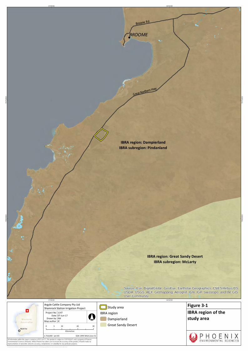
3.1 INTERIM BIOGEOGRAPHIC REGIONALISATION OF AUSTRALIA
The Interim Biogeographic Regionalisation of Australia (IBRA) defines ‘bioregions’ as large land areas characterised by broad, landscape-scale natural features and environmental processes that influence the functions of entire ecosystems (Department of the Environment and Energy 2016; Thackway & Cresswell 1995). They categorise the large-scale geophysical patterns that occur across the Australian continent that are linked to fauna and flora assemblages and processes at the ecosystem scale (Thackway & Cresswell 1995).
Western Australia contains 26 IBRA bioregions and 53 subregions. The study area falls within the Dampierland bioregion, which covers an area of 83,460 km2 (DEWHA 2008; Thackway & Cresswell 1995) and is divided into two subregions (May & McKenzie 2003): Fitzroy Trough (DAL01) and Pindanland (DAL02). The study area is situated within the Pindanland subregion (Figure 3-1) which is characterised by (Graham 2001):
• Quaternary sandplain overlying Jurassic ad Mesozoic sandstones with Pindan. There are hummock grasslands on hills.
• Quaternary marine deposits on coastal plains, with mangal, samphire – Sporobolus spp. Grasslands, Melaleuca alsophila low forests, and Spinifex spp. – Crotalaria spp. Strand communities.
• Quaternary alluvial plains associated with the Permian and Mesozoic sediments of Fitzroy Trough support tree savannahs of ribbon grass (Chrysopogon spp.) – bluegrass (Dichanthium spp.) grasses with scattered coolabah (Eucalyptus microtheca) – Bauhinia cunninghamii. There are riparian forests of river red gum (Eucalyptus camaldulensis) and Cadjeput (Melaleuca spp.) fringe drainages.
• Dry hot tropical to semi-arid climate with summer rainfall.
Rare features within the subregion include numerous patches of rainforest found mainly behind coastal primary dune structure unique to Dampier Peninsula, extensive mudflats of Roebuck Bay and Eighty Mile Beach, vast grasslands of the Roebuck Plains and coastal swamps adjacent to Eighty Mile Beach (Graham 2001).
Wes ter nAus t r al ia
PERTH
All information within this map is current as of 07-Jun-17. This product is subject to COPYRIGHT and is property of PhoenixEnvironmental Sciences (Phoenix). While Phoenix has taken care to ensure the accuracy of this product, Phoenix make norepresentations or warranties about its accuracy, completeness or suitability for any particular purpose.
!
IBRA region: DampierlandIBRA subregion: Pindanland
IBRA region: Great Sandy DesertIBRA subregion: McLarty
BROOMEBroome Rd
Great Northern Hwy
Source: Esri, DigitalGlobe, GeoEye, Earthstar Geographics, CNES/Airbus DS,
USDA, USGS, AEX, Getmapping, Aerogrid, IGN, IGP, swisstopo, and the GISUser Community
370000
370000
445000
445000
7900
000
7900
000
7975
000
7975
000
P:\GIS\Projects\ShamrockStationIrrigationProject\1147-SIP-AC-ECO\Mapping\MapDocuments\Figures\1147_IBRA.mxd
Study areaIBRA region
DampierlandGreat Sandy Desert0 10 20 305
Kilometres1:750,000
Argyle Cattle Company Pty LtdShamrock Station Irrigation Project
Map authorDrawn by
GDA 1994 MGA Zone 51
°
(at A4)
07-Jun-17DateProject No 1147
KWJC
IBRA region of thestudy area
Figure 3-1

Flora and vegetation survey and terrestrial fauna survey for Shamrock Station Irrigation Project
Prepared for Argyle Cattle Company Pty Ltd
Phoenix Environmental Sciences Pty Ltd 9
3.2 LAND SYSTEMS
The Department of Agriculture and Food (DAFWA) has mapped the land systems in the Kimberley Region (Schoknecht & Payne 2011). The study area falls entirely within the Yeeda land system (Figure 3-2) which is described as sandplains and occasional dunes with shrubby spinifex grasslands or pindan woodlands; sandplains with deep red and yellow sands (Schoknecht & Payne 2011).
Important vertebrate fauna habitats contained within the Yeeda land system of the study area includes:
• sandplain habitat supporting shrubby spinifex grasslands or pindan woodlands for conservation significant burrowing mammal species, including the Greater Bilby and Short-tailed Mouse.
• sandplain habitat providing suitable foraging habitat and possibly nesting habitat where suitable trees or structures are present for conservation significant birds of prey, including the Grey Falcon and Peregrine Falcon.

Wes ter nAus t r al ia
PERTH
All information within this map is current as of 21-Jun-17. This product is subject to COPYRIGHT and is property of PhoenixEnvironmental Sciences (Phoenix). While Phoenix has taken care to ensure the accuracy of this product, Phoenix make norepresentations or warranties about its accuracy, completeness or suitability for any particular purpose.
PhireSystem
GourdonSystem
EightyMile
System
Yeeda System
RoebuckSystem
Great North
ernHwy
390000
390000
410000
410000
7940
000
7940
000
7960
000
7960
000
P:\GIS\Projects\ShamrockStationIrrigationProject\1147-SIP-AC-ECO\Mapping\MapDocuments\Figures\1147_LandSystems.mxd
Study areaLand systems
Yeeda SystemEighty Mile SystemGourdon SystemPhire SystemRoebuck System
0 2 4 61Kilometres
1:150,000
Argyle Cattle Company Pty LtdShamrock Station Irrigation Project
Map authorDrawn by
GDA 1994 MGA Zone 51
°
(at A4)
21-Jun-17DateProject No 1147
KWJC
Land system of the studyarea
Figure 3-2
Flora and vegetation survey and terrestrial fauna survey for Shamrock Station Irrigation Project
Prepared for Argyle Cattle Company Pty Ltd
Phoenix Environmental Sciences Pty Ltd 11
3.3 CLIMATE AND WEATHER
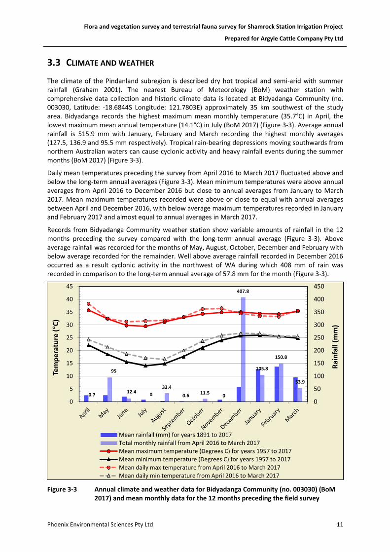
The climate of the Pindanland subregion is described dry hot tropical and semi-arid with summer rainfall (Graham 2001). The nearest Bureau of Meteorology (BoM) weather station with comprehensive data collection and historic climate data is located at Bidyadanga Community (no. 003030, Latitude: -18.6844S Longitude: 121.7803E) approximately 35 km southwest of the study area. Bidyadanga records the highest maximum mean monthly temperature (35.7°C) in April, the lowest maximum mean annual temperature (14.1°C) in July (BoM 2017) (Figure 3-3). Average annual rainfall is 515.9 mm with January, February and March recording the highest monthly averages (127.5, 136.9 and 95.5 mm respectively). Tropical rain-bearing depressions moving southwards from northern Australian waters can cause cyclonic activity and heavy rainfall events during the summer months (BoM 2017) (Figure 3-3).
Daily mean temperatures preceding the survey from April 2016 to March 2017 fluctuated above and below the long-term annual averages (Figure 3-3). Mean minimum temperatures were above annual averages from April 2016 to December 2016 but close to annual averages from January to March 2017. Mean maximum temperatures recorded were above or close to equal with annual averages between April and December 2016, with below average maximum temperatures recorded in January and February 2017 and almost equal to annual averages in March 2017.
Records from Bidyadanga Community weather station show variable amounts of rainfall in the 12 months preceding the survey compared with the long-term annual average (Figure 3-3). Above average rainfall was recorded for the months of May, August, October, December and February with below average recorded for the remainder. Well above average rainfall recorded in December 2016 occurred as a result cyclonic activity in the northwest of WA during which 408 mm of rain was recorded in comparison to the long-term annual average of 57.8 mm for the month (Figure 3-3).
Figure 3-3 Annual climate and weather data for Bidyadanga Community (no. 003030) (BoM 2017) and mean monthly data for the 12 months preceding the field survey
0.7
95
12.40
33.4
0.611.5
0
407.8
105.8
150.8
53.9
0
50
100
150
200
250
300
350
400
450
0
5
10
15
20
25
30
35
40
45
Rai
nfa
ll (m
m)
Tem
per
atu
re (°C
)
Mean rainfall (mm) for years 1891 to 2017
Total monthly rainfall from April 2016 to March 2017
Mean maximum temperature (Degrees C) for years 1957 to 2017
Mean minimum temperature (Degrees C) for years 1957 to 2017
Mean daily max temperature from April 2016 to March 2017
Mean daily min temperature from April 2016 to March 2017
Flora and vegetation survey and terrestrial fauna survey for Shamrock Station Irrigation Project
Prepared for Argyle Cattle Company Pty Ltd
Phoenix Environmental Sciences Pty Ltd 12
3.4 LAND USE
The dominant land use within the Pindanland subregion is Unallocated Crown Land (UCL) or Crown reserve and grazing-native pasture-leasehold and to a lesser extent conservation reserves (Graham 2001).
3.5 CONSERVATION RESERVES AND ENVIRONMENTALLY SENSITIVE AREAS
The study area does not intersect any ESAs or conservation reserves; however, the Karajarri Indigenous Protected Area is located directly to the west (Figure 1-1).
3.6 THREATENING PROCESSES
Several threatening processes affect biodiversity values of the Pindanland subregion (Graham 2001):
• habitat alteration from grazing pressure
• habitat fragmentation or loss of remnant vegetation from clearing
• introduction and spread of feral fauna
• introduction and spread of non-native flora
• wildfire and modified fire regimes
• modification of hydrology
• disturbance to groundwater for irrigated agriculture
• pollution
• climate change.

Flora and vegetation survey and terrestrial fauna survey for Shamrock Station Irrigation Project
Prepared for Argyle Cattle Company Pty Ltd
Phoenix Environmental Sciences Pty Ltd 13
4 METHODS
Survey design, methodology and report-writing adhered to relevant principles and guidelines, including:
• EPA Statement of Environmental Principles, Factors and Objectives (EPA 2016c)
• EPA Environmental Factor Guideline: Flora and vegetation (EPA 2016a)
• EPA Technical Guidance: Flora and vegetation surveys for Environmental Impact Assessment (EPA 2016d)
• EPA Environmental Factor Guideline: Terrestrial fauna (EPA 2016b)
• EPA Technical Guidance: Terrestrial fauna surveys (EPA 2016f)
• EPA Technical Guidance: Sampling methods for terrestrial vertebrate fauna (EPA 2016e).
4.1 DESKTOP REVIEW
4.1.1 Database searches and literature review
Database searches and a literature review (Table 4-1) were undertaken to identify the significant flora, vegetation and fauna that may occur within the study area. The following database searches were undertaken within a 40 km buffer around the study area:
• EPBC Act Protected Matters Search Tool (Department of the Environment and Energy 2017b)
• DPaW Threatened Flora, Fauna and Ecological Communities database searches (DPaW 2017e)
• DPaW/WA Museum NatureMap database (DPaW 2017d)
• Birdlife Australia Birdata database (Birdlife Australia 2017).
Table 4-1 Flora and vegetation survey reports incorporated in the desktop review
Report author Survey type Project
GHD (2009) Detailed Flora and Fauna survey Broome North: Southern Portion (Area A)
GHD (2013) Vegetation and Flora survey Cape Leveque Road
Biota (2009) Vegetation and Flora survey James Price Point: Wet Season
4.1.2 Habitat assessment
Initial characterisation of terrestrial fauna habitats in the study area was undertaken using various remote geographical tools, including aerial photography (incl. Google Earth™), land system maps and topographic maps. Desktop habitat characterisation was verified and broad fauna habitats were defined and mapped within the study area during the field survey. The potential for the habitats of the study area to support conservation significant flora, ecological communities and terrestrial fauna was then assessed based on species-specific habitat preferences and nearest records.
Flora and vegetation survey and terrestrial fauna survey for Shamrock Station Irrigation Project
Prepared for Argyle Cattle Company Pty Ltd
Phoenix Environmental Sciences Pty Ltd 14
4.2 FIELD SURVEY
The concurrent flora and vegetation and terrestrial fauna survey was undertaken over ten consecutive days from 27 April to 6 May 2017.
4.2.1 Flora and vegetation
Field methods for the flora and vegetation survey of the study area included:
• surveying of quadrats and relevés (see 4.2.1.1)
• targeted flora searches (see 4.2.1.2)
• vegetation association mapping (see 4.2.1.3)
• vegetation condition mapping (see 4.2.1.4).
Prior to the commencement of the field surveys, data including satellite imagery, estimated survey boundary, and pre-selected vegetation quadrats were loaded onto tablets using the application GIS Pro version 3.18 (Garafa 2016). The field survey involved assessing and mapping vegetation boundaries, conducting, where possible, at least three quadrat/relevés sites per vegetation unit and collecting opportunistic flora specimens. GPS locations of vegetation and condition boundaries, and quadrat, relevés and flora specimen data were recorded on an AppleTM digital tablet using Mobile Data Studio (MDS) version 8.0 (CreativityCorp 2016). Photographs were taken at each quadrat (in a south-easterly direction from the north-west corner) and relevé.
Quadrats and relevés
Quadrat locations were selected to ensure that an accurate representation of the major vegetation types within the study area were sampled adequately. Two methods were used for the selection of quadrat placement within the study area. Preliminary quadrat locations were pre-selected using high quality aerial photography; with selection based on apparent changes in the vegetation visible in the aerial imagery. The preliminary quadrat locations were re-assessed during the site visit, while ground-truthing the study area on foot. Some preliminary quadrats were moved to locations which better represented vegetation types and some quadrats were changed to relevés, where only dominant vegetation was recorded for the purposes of accurate vegetation mapping. In total, 25 quadrats and seven relevés were surveyed across the study area (Figure 4-1; Appendix 3).
Co-ordinates of all corners of each quadrat were recorded on a hand-held Garmin GPS. A solitary GPS co-ordinate was recorded for each relevé.

Wes ter nAus t r al ia
PERTH
All information within this map is current as of 07-Jun-17. This product is subject to COPYRIGHT and is property of PhoenixEnvironmental Sciences (Phoenix). While Phoenix has taken care to ensure the accuracy of this product, Phoenix make norepresentations or warranties about its accuracy, completeness or suitability for any particular purpose.
")
")
")
")
")
")")
")
")
")
")
")
")
")
")
")
")
")
")
")
")
")
")
")
")
!(
!(
!( !(
!(!(
!(
Great Northern Hwy
S001
S002
S003
S004
S005
S006S007
S008
S009
S010
S011
S012
S013
S014S015
S016
S017
S018
S019
S020
S021
S022
S023
S024
S025
SR01SR02
SR03 SR04
SR05SR06
SR07
398000
398000
402000
402000
406000
406000
7948
000
7948
000
7952
000
7952
000
7956
000
7956
000
P:\GIS\Projects\ShamrockStationIrrigationProject\1147-SIP-AC-ECO\Mapping\MapDocuments\Figures\1147_Sites.mxd
Study area") Quadrat sites!( Relevé sites
0 0.5 1 1.5 20.25Kilometres
1:50,000
Argyle Cattle Company Pty LtdShamrock Station Irrigation Project
Map authorDrawn by
GDA 1994 MGA Zone 51
°
(at A4)
07-Jun-17DateProject No 1147
KWKC
Flora and vegetationsurvey sites
Figure 4-1
Flora and vegetation survey and terrestrial fauna survey for Shamrock Station Irrigation Project
Prepared for Argyle Cattle Company Pty Ltd
Phoenix Environmental Sciences Pty Ltd 16
The following information was recorded for each quadrat:
• location – the geographic coordinates of all four corners of the quadrat in WGS84 projection
• description of vegetation – a broad description utilising the structural formation and height classes based on National Vegetation Information System (ESCAVI 2003) and in accordance with EPA (2016d) (Appendix 2)
• habitat – a brief description of landform and habitat
• geology – a broad description of surface soil type and rock type
• disturbance history – a description of any observed disturbance including an estimate of time since last fire, weed invasions, soil disturbance, human activity and fauna activity
• vegetation condition – the condition of the vegetation was recorded utilising the condition scale of Trudgen (1988 in EPA 2016d) (Table 4-2)
• height and percentage foliage cover (PFC) – a visual estimate of the canopy cover of each species present within the 50 m x 50 m quadrat was recorded as a percentage, as was the total vegetation cover, cover of shrubs and trees >2 m tall, cover of shrubs <2 m, total grass cover and total herb cover.
• photograph – a colour photograph of the vegetation within each quadrat in a south-easterly direction from the north-west corner of the quadrat
• flora species list – a list including the name of every flora species present within the quadrat; to ensure accurate taxonomic identification of flora species present within the B2018 study area, collections were made of each specimen at least once and each collection was pressed and documented for identification using the WA Herbarium resources.
Targeted flora searches
Targeted flora searches were undertaken simultaneously with the flora and vegetation survey to determine whether any of the conservation significant species identified from the desktop and literature review occurred in the study area. The searches focused on habitats considered likely to support conservation significant flora, in addition to previously recorded locations of conservation significant plants or populations in close proximity to the study area.
If a flora species was considered to potentially be a conservation significant species (i.e. similar floristic characteristics and occurring within suitable habitat) the following information was collected:
• GPS coordinates, including population boundary where applicable
• description of the habitat and floristic community in which the potential conservation significant species was located
• population size estimate (i.e. estimated number of individual plants) where applicable
• specimen collection for taxonomic identification and lodgement at the WA Herbarium
• photograph of live plant in situ and description of important details, such as flower colour, height of individual or average height of population.
Flora and vegetation survey and terrestrial fauna survey for Shamrock Station Irrigation Project
Prepared for Argyle Cattle Company Pty Ltd
Phoenix Environmental Sciences Pty Ltd 17
Vegetation mapping
The vegetation descriptions from quadrats and relevés from the survey were grouped according to similarity of community structure (i.e. canopy levels), species composition and combination of species and the prevalent community structure (i.e. woodland, shrubland, etc.). The vegetation boundaries were mapped utilising high-quality colour aerial photography and from vegetation boundaries recorded on GPS during the field survey.
To support delineation of vegetation types, a cluster analysis was conducted based on species cover in each quadrat. The fusion strategy for the site classification was flexible UPGMA with a beta value of -0.1 and Bray Curtis association measure in the software package PATN (Belbin 2003). A dendrogram was produced to illustrate the similarities between the vegetation units identified. Statistically distinct vegetation units (the floristic group) classified the vegetation at a local scale. Local scale vegetation units were described at NVIS Level V – Association (ESCAVI 2003). The term ‘vegetation type’ was used for local scale vegetation units in accordance with the technical guidance (EPA 2016d).
Condition mapping
The condition of vegetation was mapped across the study area based on the Trudgen (1988 in EPA 2016d) scale, an appropriate condition rating scale for the Northern Botanical Province where the Pindanland subregion is located (EPA 2016d).
The vegetation condition ratings relate to vegetation structure, the level of disturbance and weed cover at each structural layer and the ability of the vegetation unit to regenerate. Vegetation condition ranges from Excellent being the highest rating to Completely Degraded as the lowest (Table 4-2).
Table 4-2 Vegetation condition rating scale (Trudgen 1988, in EPA 2016d)
Vegetation condition
Description
Excellent Pristine or nearly so, no obvious signs of damage caused by human activities since European settlement.
Very Good Some relatively slight signs of damage caused by human activities since European settlement. For example, some signs of damage to tree trunks caused by repeated fire, the presence of some relatively non-aggressive weeds, or occasional vehicle tracks.
Good More obvious signs of damage caused by human activity since European settlement, including some obvious impact on the vegetation structure such as that caused by low levels of grazing or slightly aggressive weeds.
Poor Still retains basic vegetation structure or ability to regenerate it after very obvious impacts of human activities since European settlement, such as grazing, partial clearing, frequent fires or aggressive weeds.
Degraded Severely impacted by grazing, very frequent fires, clearing or a combination of these activities. Scope for some regeneration but not to a state approaching good condition without intensive management. Usually with a number of weed species present including very aggressive species.
Completely Degraded
Areas that are completely or almost completely without native species in the structure of their vegetation; i.e. areas that are cleared or ‘parkland cleared’ with their flora comprising weed or crop species with isolated native trees or shrubs.
Flora and vegetation survey and terrestrial fauna survey for Shamrock Station Irrigation Project
Prepared for Argyle Cattle Company Pty Ltd
Phoenix Environmental Sciences Pty Ltd 18
4.2.2 Fauna and fauna habitat
Site selection
Initial habitat characterisation was undertaken using various remote geographical tools, including aerial photography (Google Earth®), land system maps and topographic maps. Habitats with the potential to support conservation significant terrestrial fauna species were identified based on known habitats of such species within the Dampierland bioregion. Tentative sites corresponding with flora and vegetation survey quadrats were selected for the terrestrial fauna survey to represent all habitat types. Final survey site selection was conducted after ground-truthing of site characteristics.
At the broadest scale, site selection considered aspect, topography and land systems. At the finer scale, consideration was given to proximity to water bodies (drainage lines and creek), vegetation complexes and condition and soil type. Sites were primarily chosen to represent the best example of distinct habitats within the broader habitat associations of the study area. Consideration was also given to the potential project footprint, as available at the time which predominantly occurred in the northern section for the study area.
Vertebrate fauna
Twenty-six level 1 terrestrial fauna sites were surveyed comprising all botany quadrats and one additional site. These covered all fauna habitats in the study area. In addition, 30 targeted Bilby plot surveys were undertaken in the study area and within a 1 km buffer of the study area (Figure 4-2). Habitat descriptions and characteristics were recorded at all sites (Appendix 7). Survey work was undertaken over 10 consecutive days and comprised:
• active searches (for details see section 4.2.2.2.1)
• avifauna surveys (see 4.2.2.2.1)
• bat echolocation and Night Parrot call recordings (see 4.2.2.2.2)
• opportunistic records (see 4.2.2.2.3)
• targeted Bilby survey plots (see 4.2.2.2.4).
Active searches
Active searches were undertaken at each of the 26 level 1 fauna survey sites and primarily targeted diurnal herpetofauna and mammals from direct sightings and secondary evidence. Searches were undertaken in any observable microhabitats considered likely to support mammals, reptiles and amphibians. Techniques included: raking leaf and bark litter, overturning logs, searching beneath the bark of trees, investigating dead trees and logs, investigating burrows, investigating infrastructure ruins or disused building materials such as tin piles and identifying any secondary evidence including tracks, diggings, scats, fur or sloughs (shed skins), predation or feeding sites, and fauna constructed structures such as nests. A minimum of one person hour was spent active searching at each site for a total of 26 hours over the duration of the field survey.

Wes ter nAus t r al ia
PERTH
All information within this map is current as of 14-Jun-17. This product is subject to COPYRIGHT and is property of PhoenixEnvironmental Sciences (Phoenix). While Phoenix has taken care to ensure the accuracy of this product, Phoenix make norepresentations or warranties about its accuracy, completeness or suitability for any particular purpose.
!(
!A
!A
!A
#*
#*
#*
#*
#*
#*
#*#*
#*
#*
#*
#*
#*
#*
#*
#*
#*
#*
#*
#*#*
#*
#*
#*
#*
#*
#*
#*
#*
#*
!(
!(
!(
!(
!(
!(!(
!(
!(
!(
!(
!(
!(
!(
!(
!(
!(
!(
!(
!(
!(
!(
!(
!(
!(
Great North
ern Hwy
A001
A002
A003
A004
A005
A007
A008
A006A009
A010
A011A012
A013
A014
A015
A016
A017
A018 B001
B002
B003
B004
B005
B006
B009B010
B011
B012
B007
B008SM02
SM03
SM01FAU001
S001
S002
S003
S004
S005
S006S007
S008
S009
S010
S011
S012
S013
S014 S015
S016
S017
S018
S019
S020
S021
S022
S023
S024
S025
398000
398000
402000
402000
406000
406000
7948
000
7948
000
7952
000
7952
000
7956
000
7956
000
P:\GIS\Projects\ShamrockStationIrrigationProject\1147-SIP-AC-ECO\Mapping\MapDocuments\Figures\1147_FaunaSites.mxd
Study area!( Level 1 fauna site!A SongMeter site#* Targeted bilby plot site within study area#* Targeted bilby plot site within buffer
0 0.5 1 1.5 20.25Kilometres
1:50,000
Argyle Cattle Company Pty LtdShamrock Station Irrigation Project
Map authorDrawn by
GDA 1994 MGA Zone 51
°
(at A4)
14-Jun-17DateProject No 1147
KWRE
Terrestrial fauna surveysites
Figure 4-2

Flora and vegetation survey and terrestrial fauna survey for Shamrock Station Irrigation Project
Prepared for Argyle Cattle Company Pty Ltd
Phoenix Environmental Sciences Pty Ltd 20
Avifauna surveys
Twenty-minute avifauna surveys were undertaken at each of the 26 level 1 fauna survey sites (Figure 4-2). Avifauna surveys were confined to the habitat type (up to 2 ha) represented by each level 1 survey site to collect assemblage data for each habitat. Avifauna surveys were undertaken throughout the day with a focus on periods of higher activity around sunrise and sunset. Surveys consisted of bird recordings from visual sightings and call recognition.
Additional avifauna observations were also recorded at opportunistically while other field work was being completed, including observations made during travel and active searches or during targeted Bilby plot surveys.
A total of approximately 8.6 person hours of avifauna census was undertaken during the field survey.
Bat echolocation and Night Parrot call recordings
SongMeter SM2 recording devices were used to record bat echolocation and night parrot calls at three opportunistic sites (Figure 4-2). Recording devices were deployed at each site for one night of recording for between eight and 12 continuous hours per night. Recording devices were aimed at a 45° angle to the ground. Areas of habitat likely to have increased insect activity and to attract bats (i.e. open water sources and likely movement corridors) and potential roosting and nesting sites for Night Parrots (Pezoporus occidentalis) (DPaW 2017c) were targeted. The recorded data were analysed by Mr. Bob Bullen, Bat Call WA.
Opportunistic records
Any opportunistic observations of vertebrate species were recorded during the survey, particularly conservation significant species. Opportunistic sampling involved recording all sightings of vertebrate fauna species while working and travelling within the study area, including species recorded during targeted Bilby plot searches.
Targeted Bilby survey plots
Consultation was undertaken with DPaW prior to the survey regarding proposed survey methodology for Bilby (Appendix 5).
Targeted Bilby plot surveys were undertaken to search for evidence of occurrence of the species in the study area using standardised 2 ha plots adopted from Southgate et al. (2005) and Southgate and Moseby (2008). Due to the size of the study area the distance between placement of plots was reduced for a greater survey effort within the study area. Eighteen random 2 ha plots (~142 m x 142 m), spaced approximately 1–2 km apart (no less than 1 km, no greater than 2 km) within the study area and a further 12 within a 1 km buffer of the study area to identify activity in close proximity (Figure 4-2). Each plot was surveyed for 0.5 person hour (1 observer = 30 min, 2 = 15 min each) during which searches will be undertaken for any evidence of the species including tracks, scats, foraging diggings and/or burrows. Suitability of habitat for Bilby was assessed at all plots based on substrate and vegetation structure or density.
Three fixed transect searches were undertaken along sandy tracks bordering the west, north and east edges of the study area for evidence of Bilby occurrence indicating movement into and out of the study area into areas adjacent to the study area. In addition to 2 ha survey plots and fixed transects, additional transects searches were undertaken while traversing between Bilby survey plots and when moving between level 1 survey sites for evidence of Bilby occurrence.
Flora and vegetation survey and terrestrial fauna survey for Shamrock Station Irrigation Project
Prepared for Argyle Cattle Company Pty Ltd
Phoenix Environmental Sciences Pty Ltd 21
4.2.1 Taxonomy and nomenclature
Plant species were identified using local and regional flora keys, and comparisons with named species held at the WA Herbarium. Nomenclature for flora and vegetation used in this report follows that used by FloraBase (DPaW 2017b) and the WA Herbarium. The conservation status of all recorded flora was compared against the current lists available on FloraBase (DPaW 2017b) and the EPBC Act Threatened species database provided by the Department of the Environment (Department of the Environment and Energy 2017a).
The taxonomy and nomenclature of terrestrial vertebrate fauna follows several taxon-specific references (Table 4-3).
Table 4-3 Nomenclatural references, morphospecies designations and reference collections
Taxonomic group
Taxonomic reference for described species and higher taxa
Mammals Menkhorst and Knight (2011)
Birds Simpson and Day (2010)
Christidis and Boles (2008)
Reptiles Wilson and Swan (2013)
Amphibians Tyler and Doughty (2009)
4.3 SURVEY PERSONNEL
The personnel involved in the survey are presented (Table 4-4).
Table 4-4 Project team
Name Qualifications Role/s
Mr Ryan Ellis Dip. (Cons. Land Mgmt.) Project manager, field survey, fauna taxonomy (vertebrates) and reporting
Dr Grant Wells PhD (Botany) Field surveys, flora taxonomy, data analyses and report review
Dr Grace Wells PhD (Plant Conservation) GIS and vegetation mapping, reporting
Ms Alice Watt BSc. Hons (Cons Bio. and Botany.) Reporting
Mrs Karen Crews BSc. (Env. Biol.) (Hons) Reporting
Mrs Kathryn Wyatt BIS. (GIS)
Grad. Cert. (GIS) GIS
Mr Bob Bullen
(Bat Call WA)
B. Eng. (Aero. Eng.) Bat echolocation analysis
Frank Obbens
(WA Herbarium)
BSc. Hons. (Env. Biol.) Flora taxonomy
Flora and vegetation survey and terrestrial fauna survey for Shamrock Station Irrigation Project
Prepared for Argyle Cattle Company Pty Ltd
Phoenix Environmental Sciences Pty Ltd 22
5 RESULTS
5.1 DESKTOP REVIEW
5.1.1 Flora and vegetation
Conservation significant flora
Three conservation significant flora species were identified from the database searches and literature review as previously recorded within 40 km of the study area (Table 5-1).
Table 5-1 Conservation significant flora species identified from the desktop review
Species DPaW Priority list
Nearest record to study area
Source
Polymeria distigma P3 Records ~16 km east of study area
NatureMap
Tephrosia andrewii P1 Records ~8 km north of study area
NatureMap
DPaW T&P flora database
Triodia caelestialis P3 Records ~8 km west of study area
NatureMap
DPaW T&P flora database
Introduced flora
The desktop assessment identified records for 11 weed species near the study area (Table 5-2). One of the species, Parkinsonia aculeata is a declared pest.
Table 5-2 Weed species recorded by the desktop assessment near the study area
Family Name WoNS
Amaranthaceae Amaranthus viridis
Poaceae Cenchrus americanus
Poaceae Cenchrus biflorus
Poaceae Cenchrus ciliaris
Poaceae Cenchrus setiger
Poaceae Eragrostis cilianensis
Poaceae Megathyrsus maximus
Fabaceae Parkinsonia aculeata yes
Verbenaceae Phyla nodiflora var. nodiflora
Fabaceae Prosopis ssp.
Fabaceae Stylosanthes hamata

Wes ter nAus t r al ia
PERTH
All information within this map is current as of 21-Jun-17. This product is subject to COPYRIGHT and is property of PhoenixEnvironmental Sciences (Phoenix). While Phoenix has taken care to ensure the accuracy of this product, Phoenix make norepresentations or warranties about its accuracy, completeness or suitability for any particular purpose.
#*#*
#*
#*
#*
#*
BROOME
Broome Rd
Great Northern Hwy
Source: Esri, DigitalGlobe, GeoEye, Earthstar Geographics, CNES/Airbus DS,
USDA, USGS, AEX, Getmapping, Aerogrid, IGN, IGP, swisstopo, and the GISUser Community
370000
370000
420000
420000
470000
470000
7950
000
7950
000
8000
000
8000
000
P:\GIS\Projects\ShamrockStationIrrigationProject\1147-SIP-AC-ECO\Mapping\MapDocuments\Figures\1147_DPaWSearchesFLORA.mxd
Study area#* Tephrosia andrewii (P1)#* Triodia caelestialis (P3)
Species-rich faunalcommunity of theintertidal mudflats ofRoebuck Bay (Vulnerable)Eighty Mile Land System(P3)
Gourdon Land System (P3)Kimberley VegetationAssociation 37 (P3)Kimberley VegetationAssociation 73 (P3)Parda Land System (P3)Roebuck Land System (P3)
0 5 10 15 202.5Kilometres
1:575,000
Argyle Cattle Company Pty LtdShamrock Station Irrigation Project
Map authorDrawn by
GDA 1994 MGA Zone 51
°
(at A4)
21-Jun-17DateProject No 1147
KWJC
Desktop records ofconservation significantflora and ecologicalcommunities
Figure 5-1
Flora and vegetation survey and terrestrial fauna survey for Shamrock Station Irrigation Project
Prepared for Argyle Cattle Company Pty Ltd
Phoenix Environmental Sciences Pty Ltd 24
Vegetation associations
Regional scale vegetation mapping by Shepherd et al. (2002, after Beard) defined two vegetation associations in the study area (Figure 5-2):
• Association 699 Acacia thicket with scattered low trees over spinifex Acacia eriopoda, Corymbia dichromophloia, Triodia pungens, T. bitextura – covering the majority of the study area
• Association 104 Hummock grassland with scattered shrubs or mallee Triodia spp. Acacia spp., Grevillea spp. Eucalyptus spp.
Both vegetation associations are extensively represented in the Pindanland subregion and have over 99% remaining according to Government of Western Australia (2016).
Threatened and Priority Ecological Communities
No Commonwealth or State listed TECs or DPaW listed PECs intersect the study area. Six vegetation-related PECs were identified within the area of the desktop review (Figure 5-1; Table 5-2). Based on TEC/PEC descriptions, land system of the study area and regional vegetation associations of study area (section 5.1.1.3), it was considered unlikely that the vegetation of the study area would align with any of the communities.
Table 5-2 Priority ecological communities identified in the desktop review
Community name Conservation status
Proximity and relevance to study area
Eighty Mile Land System P3 12 km west. Beach foredunes, longitudinal coastal dunes and sandy plains with tussock grasslands and spinifex grasslands. Not relevant to study area, Eighty Mile land system. Not represented in study area.
Gourdon Land System P3 9 km west. Sandplain and undulating lateritic country with steep coastal gullies supporting spinifex grasslands with scattered trees. Not relevant to study area, Gourdon land system not represented in study area.
Parda Land System P3 25 km east. Conical hills, stony ring plains, alluvial plains and shallow valleys supporting spinifex grasslands with sparse shrubs and trees. Not relevant to study area, Parda land system not represented in study area.
Roebuck Land System P3 20 km west. Paleo-tidal coastal plains and tidal flats with saline soil supporting salt-water couch grasslands, samphire low shrublands, melaleuca. Not relevant to study area, Roebuck land system not represented in study area.
Kimberley Vegetation Association 37
P3 12 km SW. As defined by John Beard’s vegetation mapping for the Kimberley. Shrublands; teatree thicket. Unlikely to be relevant to study area
Kimberley Vegetation Association 73
P3 17 km north. As defined by John Beard’s vegetation mapping for the Kimberley (Beard 1979). Grasslands, tall bunch grass savanna, Mitchell & blue grass. Unlikely to be relevant to study area

Wes ter nAus t r al ia
PERTH
All information within this map is current as of 21-Jun-17. This product is subject to COPYRIGHT and is property of PhoenixEnvironmental Sciences (Phoenix). While Phoenix has taken care to ensure the accuracy of this product, Phoenix make norepresentations or warranties about its accuracy, completeness or suitability for any particular purpose.
Great North
ern Hwy
400000
400000
410000
410000
7950
000
7950
000
7960
000
7960
000
P:\GIS\Projects\ShamrockStationIrrigationProject\1147-SIP-AC-ECO\Mapping\MapDocuments\Figures\1147_ShepherdVeg.mxd
Study area104: Hummock grasslands, shrub steppe; Grevillearefracta and hakea over soft spinifex699: Shrublands, pindan; Acacia eripoda shrublandwith scattered low bloodwood (Eucalyptusdicromophloia) and E. setosa over soft and curlyspinifex on sandplain
0 1 2 3 40.5Kilometres
1:100,000
Argyle Cattle Company Pty LtdShamrock Station Irrigation Project
Map authorDrawn by
GDA 1994 MGA Zone 51
°
(at A4)
21-Jun-17DateProject No 1147
KWKC
Shepherd et al. (2002)vegetation associationsof the study area
Figure 5-2
104
104
699

Flora and vegetation survey and terrestrial fauna survey for Shamrock Station Irrigation Project
Prepared for Argyle Cattle Company Pty Ltd
Phoenix Environmental Sciences Pty Ltd 26
5.1.2 Fauna and fauna habitat
A total of 287 terrestrial vertebrate fauna species were identified in the desktop review as potentially occurring in the study area (Appendix 7). This comprised of one freshwater fish, three frogs, 42 reptiles, 216 birds (215 native or migratory and one introduced) and 25 mammals (17 native and eight introduced). All marine species returned in the desktop review, due to the proximity of the study area to the coast and the desktop review search area, were subsequently excluded due to the absence of any marine habitats within the study area.
A total of 69 species or subspecies of conservation significance were identified in the desktop review including 18 listed under the EPBC Act and/or WC Act as Threatened, Conservation Dependent or Specially Protected (Table 5-3; Figure 5-3). Fifty-four species are listed as ‘Migratory’ under the EPBC Act and WC Act and nine species are listed as Priority species (Table 5-3). Nine species returned for the desktop review are listed as Threatened and Migratory under the EPBC Act and/or WC Act (CR, EN, VU) and two are listed as Threatened under the EPBC Act and as a Priority species by DPaW (Table 5-3).
One state-listed TEC associated with fauna values was identified in the desktop review – Species-rich faunal community of the intertidal mudflats of Roebuck Bay (VU) (Figure 5-1). The buffer boundary for this TEC is 15 km north of study area. The TEC is not relevant to study area as it is confined to the Roebuck Bay mudflats.
Table 5-3 Conservation significant terrestrial fauna identified through the desktop review
Scientific name Common name Conservation status
EPBC Act WC Act DPaW
Fish
Pristis pristis Freshwater Sawfish
P3
Reptiles
Crocodylus porosus Salt-water Crocodile
SP
Ctenotus angusticeps Airlie Island Ctenotus VU VU
Lerista separanda Dampierland Plain Slider
P2
Birds
Pandion haliaetus Osprey Mig. Mig.
Apus pacificus Fork-tailed Swift Mig. Mig.
Ardea ibis Cattle Egret Mar Mig.
Ardea modesta Eastern Great Egret
Mig.
Charadrius bicinctus Double-banded Plover Mig. Mig.
Charadrius leschenaultii Greater Sand Plover VU/Mig. Mig.
Charadrius mongolus Lesser Sand Plover EN/Mig. EN/Mig.
Charadrius veredus Oriental Plover
Mig.
Pluvialis fulva Pacific Golden Plover
Mig.
Pluvialis squatarola Grey Plover
Mig.
Cuculus optatus Oriental Cuckoo Mig. Mig.
Falco hypoleucos Grey Falcon
VU
Falco peregrinus Peregrine Falcon
SP
Fregata ariel Lesser Frigatebird
Mig.
Fregata minor Greater Frigatebird
Mig.
Glareola maldivarum Oriental Pratincole
Mig.
Hirundo rustica Barn Swallow
Mig.
Oceanites oceanicus Wilson's Storm Petrel Mig. Mig.
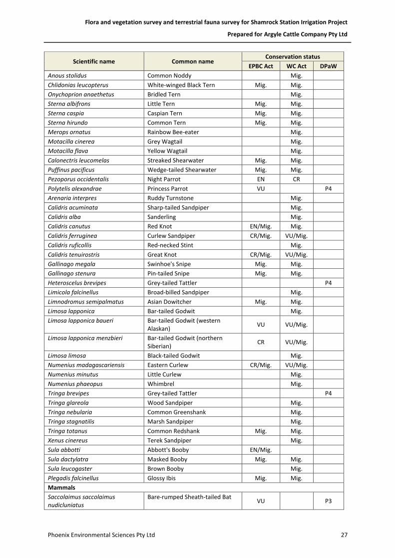
Flora and vegetation survey and terrestrial fauna survey for Shamrock Station Irrigation Project
Prepared for Argyle Cattle Company Pty Ltd
Phoenix Environmental Sciences Pty Ltd 27
Scientific name Common name Conservation status
EPBC Act WC Act DPaW
Anous stolidus Common Noddy
Mig.
Chlidonias leucopterus White-winged Black Tern Mig. Mig.
Onychoprion anaethetus Bridled Tern
Mig.
Sterna albifrons Little Tern Mig. Mig.
Sterna caspia Caspian Tern Mig. Mig.
Sterna hirundo Common Tern Mig. Mig.
Merops ornatus Rainbow Bee-eater
Mig.
Motacilla cinerea Grey Wagtail
Mig.
Motacilla flava Yellow Wagtail
Mig.
Calonectris leucomelas Streaked Shearwater Mig. Mig.
Puffinus pacificus Wedge-tailed Shearwater Mig. Mig.
Pezoporus occidentalis Night Parrot EN CR
Polytelis alexandrae Princess Parrot VU
P4
Arenaria interpres Ruddy Turnstone
Mig.
Calidris acuminata Sharp-tailed Sandpiper
Mig.
Calidris alba Sanderling
Mig.
Calidris canutus Red Knot EN/Mig. Mig.
Calidris ferruginea Curlew Sandpiper CR/Mig. VU/Mig.
Calidris ruficollis Red-necked Stint
Mig.
Calidris tenuirostris Great Knot CR/Mig. VU/Mig.
Gallinago megala Swinhoe's Snipe Mig. Mig.
Gallinago stenura Pin-tailed Snipe Mig. Mig.
Heteroscelus brevipes Grey-tailed Tattler
P4
Limicola falcinellus Broad-billed Sandpiper
Mig.
Limnodromus semipalmatus Asian Dowitcher Mig. Mig.
Limosa lapponica Bar-tailed Godwit
Mig.
Limosa lapponica baueri Bar-tailed Godwit (western Alaskan)
VU VU/Mig.
Limosa lapponica menzbieri Bar-tailed Godwit (northern Siberian)
CR VU/Mig.
Limosa limosa Black-tailed Godwit
Mig.
Numenius madagascariensis Eastern Curlew CR/Mig. VU/Mig.
Numenius minutus Little Curlew
Mig.
Numenius phaeopus Whimbrel
Mig.
Tringa brevipes Grey-tailed Tattler
P4
Tringa glareola Wood Sandpiper
Mig.
Tringa nebularia Common Greenshank
Mig.
Tringa stagnatilis Marsh Sandpiper
Mig.
Tringa totanus Common Redshank Mig. Mig.
Xenus cinereus Terek Sandpiper
Mig.
Sula abbotti Abbott's Booby EN/Mig.
Sula dactylatra Masked Booby Mig. Mig.
Sula leucogaster Brown Booby
Mig.
Plegadis falcinellus Glossy Ibis Mig. Mig.
Mammals
Saccolaimus saccolaimus nudicluniatus
Bare-rumped Sheath-tailed Bat VU
P3

Flora and vegetation survey and terrestrial fauna survey for Shamrock Station Irrigation Project
Prepared for Argyle Cattle Company Pty Ltd
Phoenix Environmental Sciences Pty Ltd 28
Scientific name Common name Conservation status
EPBC Act WC Act DPaW
Lagorchestes conspicillatus leichardti
Spectacled Hare-wallaby
P3
Mormopterus loriae cobourgiana Little North-western Mastiff Bat
P1
Leggadina lakedownensis Short-tailed Mouse
P4
Isoodon auratus auratus Golden Bandicoot VU VU
Macrotis lagotis Bilby VU VU
1 — CR – Critically Endangered; EN – Endangered; VU – Vulnerable; SP – Specially Protected; CD – Conservation Dependant; Mig — Migratory; P1–P4 —Priority 1–4.

Wes ter nAus t r al ia
PERTH
All information within this map is current as of 21-Jun-17. This product is subject to COPYRIGHT and is property of PhoenixEnvironmental Sciences (Phoenix). While Phoenix has taken care to ensure the accuracy of this product, Phoenix make norepresentations or warranties about its accuracy, completeness or suitability for any particular purpose.
!BROOME
Broome Rd
Great Northe
rn Hwy2
41
3
3
8
9
4
41
41
4240
3
3
3
3
33
39
7
2
3
3
17
17
19
19
19
19
19
30
30
3032
31
38
6
6
6
29
29
8
37
37
37
1
21
21
26
10
36
28
28
28
28
28
28
28
28
28
28
28
28
7
22
22
22
13
13
30
30
32
6
8
21
11
7
Source: Esri, DigitalGlobe, GeoEye, Earthstar Geographics, CNES/Airbus DS,
USDA, USGS, AEX, Getmapping, Aerogrid, IGN, IGP, swisstopo, and the GISUser Community
370000
370000
420000
420000
7950
000
7950
000
8000
000
8000
000
P:\GIS\Projects\ShamrockStationIrrigationProject\1147-SIP-AC-ECO\Mapping\MapDocuments\Figures\1147_DPaWSearchesFAUNA.mxd
Study area
0 4 8 12 162Kilometres
1:450,000
Argyle Cattle Company Pty LtdShamrock Station Irrigation Project
Map authorDrawn by
GDA 1994 MGA Zone 51
°
(at A4)
21-Jun-17DateProject No 1147
KWJC
Desktop records ofconservation significantfauna
Figure 5-3
Map label: Cons code: Common name1: EN & IA: lesser sand plover2: VU: Airlie Island ctenotus3: VU: bilby, dalgyte, ninu4: VU: golden bandicoot(mainland), wintarru5: VU: grey falcon6: VU & IA: curlew sandpiper7: VU & IA: eastern curlew8: VU & IA: great knot9: OS: peregrine falcon10: IA: barn swallow11: IA: black-tailed godwit12: IA: broad-billed sandpiper13: IA: brown booby14: IA: common greenshank,greenshank15: IA: common redshank,redshank
16: IA: common tern17: IA: fork-tailed swift18: IA: glossy ibis19: IA: great egret, white egret20: IA: grey plover21: IA: lesser frigatebird22: IA: little curlew, littlewhimbrel23: IA: marsh sandpiper, littlegreenshank24: IA: masked booby25: IA: oriental plover26: IA: oriental pratincole27: IA: Pacific golden plover28: IA: rainbow bee-eater29: IA: red-necked stint30: IA: ruddy turnstone31: IA: sanderling32: IA: sharp-tailed sandpiper
33: IA: whimbrel34: IA: white-winged black tern,white-winged tern35: IA: Wilson's storm-petrel36: IA (& VU at subsp. level):bar-tailed godwit37: IA (& VU at subsp. level):greater sand plover, large sandplover38: IA (& VU at subsp. level): redknot, knot39: P1: little north-westernmastiff bat40: P2: Dampierland Plain slider41: P3: spectacled hare-wallaby(mainland)42: P4: Lakeland Downs mouse,kerakenga
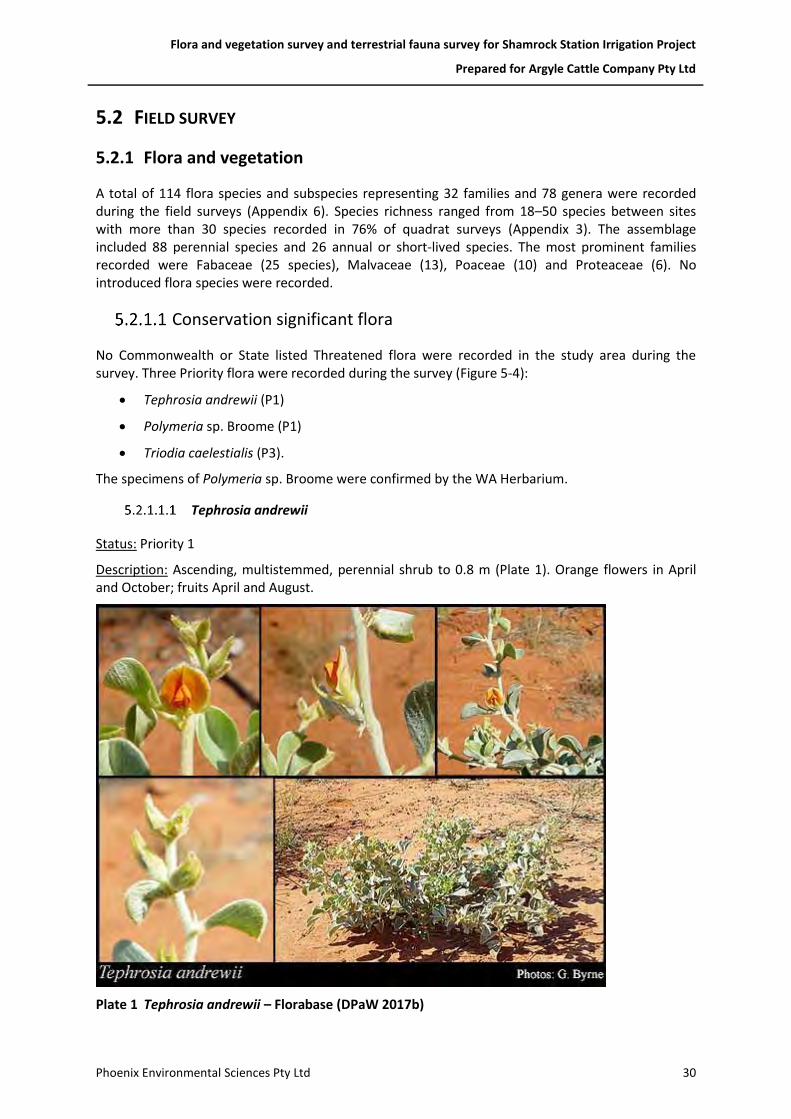
Flora and vegetation survey and terrestrial fauna survey for Shamrock Station Irrigation Project
Prepared for Argyle Cattle Company Pty Ltd
Phoenix Environmental Sciences Pty Ltd 30
5.2 FIELD SURVEY
5.2.1 Flora and vegetation
A total of 114 flora species and subspecies representing 32 families and 78 genera were recorded during the field surveys (Appendix 6). Species richness ranged from 18–50 species between sites with more than 30 species recorded in 76% of quadrat surveys (Appendix 3). The assemblage included 88 perennial species and 26 annual or short-lived species. The most prominent families recorded were Fabaceae (25 species), Malvaceae (13), Poaceae (10) and Proteaceae (6). No introduced flora species were recorded.
Conservation significant flora
No Commonwealth or State listed Threatened flora were recorded in the study area during the survey. Three Priority flora were recorded during the survey (Figure 5-4):
• Tephrosia andrewii (P1)
• Polymeria sp. Broome (P1)
• Triodia caelestialis (P3).
The specimens of Polymeria sp. Broome were confirmed by the WA Herbarium.
Tephrosia andrewii
Status: Priority 1
Description: Ascending, multistemmed, perennial shrub to 0.8 m (Plate 1). Orange flowers in April and October; fruits April and August.
Plate 1 Tephrosia andrewii – Florabase (DPaW 2017b)
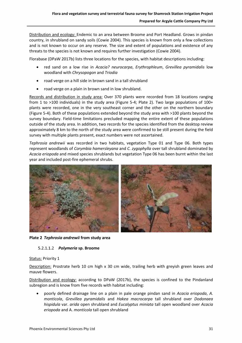
Flora and vegetation survey and terrestrial fauna survey for Shamrock Station Irrigation Project
Prepared for Argyle Cattle Company Pty Ltd
Phoenix Environmental Sciences Pty Ltd 31
Distribution and ecology: Endemic to an area between Broome and Port Headland. Grows in pindan country, in shrubland on sandy soils (Cowie 2004). This species is known from only a few collections and is not known to occur on any reserve. The size and extent of populations and existence of any threats to the species is not known and requires further investigation (Cowie 2004).
Florabase (DPaW 2017b) lists three locations for the species, with habitat descriptions including:
• red sand on a low rise in Acacia? neurocarpa, Erythrophleum, Grevillea pyramidalis low woodland with Chrysopogon and Triodia
• road verge on a hill side in brown sand in a tall shrubland
• road verge on a plain in brown sand in low shrubland.
Records and distribution in study area: Over 370 plants were recorded from 18 locations ranging from 1 to >100 individuals) in the study area (Figure 5-4; Plate 2). Two large populations of 100+ plants were recorded, one in the very southeast corner and the other on the northern boundary (Figure 5-4). Both of these populations extended beyond the study area with >100 plants beyond the survey boundary. Field-time limitations precluded mapping the entire extent of these populations outside of the study area. In addition, two records for the species identified from the desktop review approximately 8 km to the north of the study area were confirmed to be still present during the field survey with multiple plants present, exact numbers were not ascertained.
Tephrosia andrewii was recorded in two habitats, vegetation Type 01 and Type 06. Both types represent woodlands of Corymbia hamersleyana and C. zygophylla over tall shrubland dominated by Acacia eriopoda and mixed species shrublands but vegetation Type 06 has been burnt within the last year and included post-fire ephemeral shrubs.
Plate 2 Tephrosia andrewii from study area
Polymeria sp. Broome
Status: Priority 1
Description: Prostrate herb 10 cm high x 30 cm wide, trailing herb with greyish green leaves and mauve flowers.
Distribution and ecology: according to DPaW (2017b), the species is confined to the Pindanland subregion and is know from five records with habitat including:
• poorly defined drainage line on a plain in pale orange pindan sand in Acacia eriopoda, A. monticola, Grevillea pyramidalis and Hakea macrocarpa tall shrubland over Dodonaea hispidula var. arida open shrubland and Eucalyptus miniata tall open woodland over Acacia eriopoda and A. monticola tall open shrubland

Flora and vegetation survey and terrestrial fauna survey for Shamrock Station Irrigation Project
Prepared for Argyle Cattle Company Pty Ltd
Phoenix Environmental Sciences Pty Ltd 32
• Acacia eriopoda shrubland over low Gyrostemon tepperi low open shrubland over Eragrostis aff. eriopoda, Aristida holathera var. holathera and A. hygrometrica open tussock grassland
• on coastal plain in Terminalia ferdinandiana scattered shrubs over *Cenchrus ciliaris, Heteropogon contortus tussock grassland.
• red pindan soil on road verge and in drain.
Records and distribution in study area:
Polymeria sp. Broome was collected from seven quadrats (S004, S009, S011, S015, S018, S019, S022) (Figure 5-4; Plate 5) in two habitats, vegetation Type 01, a woodland of Corymbia hamersleyana and C. zygophylla over tall shrubland dominated by Acacia eriopoda and mixed species shrublands, and Type 03, Isolated low Corymbia zygophylla trees over tall Acacia eriopoda shrubland over low closed Aristida holathera, Chrysopogon pallidus and Triodia schinzii tussock grassland and sparse low Fimbristylis oxystachya sedgeland. Population counts were not undertaken as the species was identified post-field.
Plate 3 Polymeria sp. Broome from study area
Triodia caelestialis
Status: Priority 3
Description: Caespitose, non-resinous, non-stoloniferous perennial forming compact, non-branching tussocks 40 cm tall x 60 cm wide (Armstrong 2008) (Plate 4). Not hummock forming.
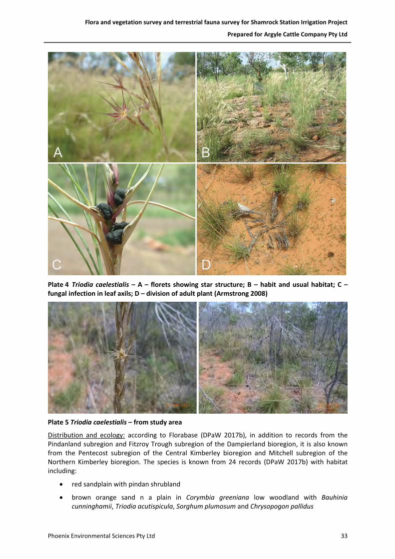
Flora and vegetation survey and terrestrial fauna survey for Shamrock Station Irrigation Project
Prepared for Argyle Cattle Company Pty Ltd
Phoenix Environmental Sciences Pty Ltd 33
Plate 4 Triodia caelestialis – A – florets showing star structure; B – habit and usual habitat; C – fungal infection in leaf axils; D – division of adult plant (Armstrong 2008)
Plate 5 Triodia caelestialis – from study area
Distribution and ecology: according to Florabase (DPaW 2017b), in addition to records from the Pindanland subregion and Fitzroy Trough subregion of the Dampierland bioregion, it is also known from the Pentecost subregion of the Central Kimberley bioregion and Mitchell subregion of the Northern Kimberley bioregion. The species is known from 24 records (DPaW 2017b) with habitat including:
• red sandplain with pindan shrubland
• brown orange sand n a plain in Corymbia greeniana low woodland with Bauhinia cunninghamii, Triodia acutispicula, Sorghum plumosum and Chrysopogon pallidus

Flora and vegetation survey and terrestrial fauna survey for Shamrock Station Irrigation Project
Prepared for Argyle Cattle Company Pty Ltd
Phoenix Environmental Sciences Pty Ltd 34
• brown sand-silt on low plain in woodland with Chrysopogon fallax, Sorghum stipoideum, Eriachne obtusa and Grevillea striata
• gentle mid-slope in red sand with Michrostachys chamaelea, Acacia tumida var. tumida, Chrysopogon pallidus and Corymbia greeniana
• brown sandy loam on flat lower slope with Acacia tumida var. pilbarensis, Santalum lanceolatum, Acacia colei var. colei, Corymbia bella and Enneapogon polyphyllus
• open woodland savannah in skeletal soil on mountainous low ridge
• flat pindan plain with ironstone gravel with Acacia holosericea and Sorghum savannah
• sandstone habitat (Armstrong 2008).
A population of the species identified in the desktop review located approximately 8 km to the west of the study area was confirmed during the field survey. Population size was not ascertained but several plants were observed at the location of the record.
Records and distribution in study area: Triodia caelestialis was recorded from 16 locations in the study area in numbers ranging from 1 to 25 plants (Figure 5-4; Plate 5). It was recorded in one habitat, a woodland of Corymbia hamersleyana and C. zygophylla over tall shrubland dominated by Acacia eriopoda and mixed species shrublands (vegetation Type 01).

Wes ter nAus t r al ia
PERTH
All information within this map is current as of 21-Jun-17. This product is subject to COPYRIGHT and is property of PhoenixEnvironmental Sciences (Phoenix). While Phoenix has taken care to ensure the accuracy of this product, Phoenix make norepresentations or warranties about its accuracy, completeness or suitability for any particular purpose.
")
")
")
!(
!(!(
!(
!(
!(
!(!(
!(
!(
!(
!(
!(
!(!(
!(
!(
!(!(
!(
!(
!(
!(
!(
!(
!(
!(
!(
!(
!(
!(
!(!(
!(
!(
!(
!(
!(
!(
!(
!(
Great Northern Hwy
398000
398000
402000
402000
406000
406000
7948
000
7948
000
7952
000
7952
000
7956
000
7956
000
P:\GIS\Projects\ShamrockStationIrrigationProject\1147-SIP-AC-ECO\Mapping\MapDocuments\Figures\1147_ConsigFlora.mxd
Study areaPriority flora!( ? Polymeria sp. Broome (P1) !( Tephrosia andrewii (P1)!( Triodia caelestialis (P3)
Significant range extension only") Crotalaria aridicola subsp. densifolia
0 0.5 1 1.5 20.25Kilometres
1:50,000
Argyle Cattle Company Pty LtdShamrock Station Irrigation Project
Map authorDrawn by
GDA 1994 MGA Zone 51
°
(at A4)
21-Jun-17DateProject No 1147
KWKC
Conservation significantflora records from survey
Figure 5-4
( <10 plants
( 10-99 plants
( >=100 plants
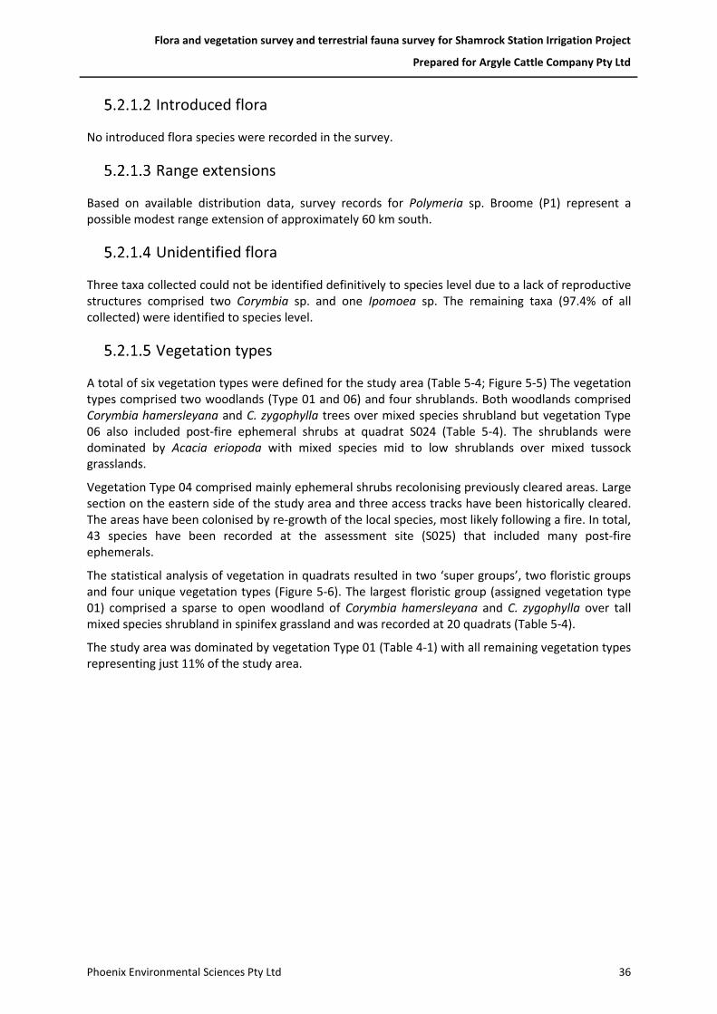
Flora and vegetation survey and terrestrial fauna survey for Shamrock Station Irrigation Project
Prepared for Argyle Cattle Company Pty Ltd
Phoenix Environmental Sciences Pty Ltd 36
Introduced flora
No introduced flora species were recorded in the survey.
Range extensions
Based on available distribution data, survey records for Polymeria sp. Broome (P1) represent a possible modest range extension of approximately 60 km south.
Unidentified flora
Three taxa collected could not be identified definitively to species level due to a lack of reproductive structures comprised two Corymbia sp. and one Ipomoea sp. The remaining taxa (97.4% of all collected) were identified to species level.
Vegetation types
A total of six vegetation types were defined for the study area (Table 5-4; Figure 5-5) The vegetation types comprised two woodlands (Type 01 and 06) and four shrublands. Both woodlands comprised Corymbia hamersleyana and C. zygophylla trees over mixed species shrubland but vegetation Type 06 also included post-fire ephemeral shrubs at quadrat S024 (Table 5-4). The shrublands were dominated by Acacia eriopoda with mixed species mid to low shrublands over mixed tussock grasslands.
Vegetation Type 04 comprised mainly ephemeral shrubs recolonising previously cleared areas. Large section on the eastern side of the study area and three access tracks have been historically cleared. The areas have been colonised by re-growth of the local species, most likely following a fire. In total, 43 species have been recorded at the assessment site (S025) that included many post-fire ephemerals.
The statistical analysis of vegetation in quadrats resulted in two ‘super groups’, two floristic groups and four unique vegetation types (Figure 5-6). The largest floristic group (assigned vegetation type 01) comprised a sparse to open woodland of Corymbia hamersleyana and C. zygophylla over tall mixed species shrubland in spinifex grassland and was recorded at 20 quadrats (Table 5-4).
The study area was dominated by vegetation Type 01 (Table 4-1) with all remaining vegetation types representing just 11% of the study area.

Flora and vegetation survey and terrestrial fauna survey for Shamrock Station Irrigation Project
Prepared for Argyle Cattle Company Pty Ltd
Phoenix Environmental Sciences Pty Ltd 37
Table 5-4 Vegetation types recorded in the study area
Vegetation type Site/s Vegetation description Photograph
Type 01 CzAeTs
S001, S003 S004, S005 S006, S007 S009, S010 S011, S012 S013, S015 S016, S017 S019, S020 S021, S022 S023, S024
Woodland: Isolated low trees to low woodland of Corymbia hamersleyana and C. zygophylla over tall shrubland dominated by Acacia eriopoda with Bauhinia cunninghamii, Grevillea pyramidalis, G. refracta and G. wickhamii over low tussock grassland dominated by Triodia schinzii with Aristida holathera, Chrysopogon pallidus and Sorghum plumosum.
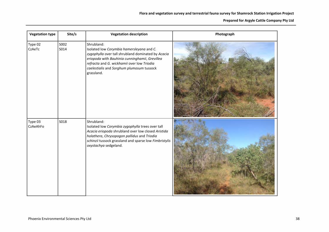
Flora and vegetation survey and terrestrial fauna survey for Shamrock Station Irrigation Project
Prepared for Argyle Cattle Company Pty Ltd
Phoenix Environmental Sciences Pty Ltd 38
Vegetation type Site/s Vegetation description Photograph
Type 02 CzAeTc
S002 S014
Shrubland: Isolated low Corymbia hamersleyana and C. zygophylla over tall shrubland dominated by Acacia eriopoda with Bauhinia cunninghamii, Grevillea refracta and G. wickhamii over low Triodia caelestialis and Sorghum plumosum tussock grassland.
Type 03 CzAeAhFo
S018
Shrubland: Isolated low Corymbia zygophylla trees over tall Acacia eriopoda shrubland over low closed Aristida holathera, Chrysopogon pallidus and Triodia schinzii tussock grassland and sparse low Fimbristylis oxystachya sedgeland.
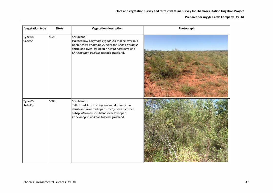
Flora and vegetation survey and terrestrial fauna survey for Shamrock Station Irrigation Project
Prepared for Argyle Cattle Company Pty Ltd
Phoenix Environmental Sciences Pty Ltd 39
Vegetation type Site/s Vegetation description Photograph
Type 04 CzAeAh
S025 Shrubland: Isolated low Corymbia zygophylla mallee over mid open Acacia eriopoda, A. colei and Senna notabilis shrubland over low open Aristida holathera and Chrysopogon pallidus tussock grassland.
Type 05 AeToCp
S008 Shrubland: Tall closed Acacia eriopoda and A. monticola shrubland over mid open Trachymene oleracea subsp. oleracea shrubland over low open Chrysopogon pallidus tussock grassland.

Flora and vegetation survey and terrestrial fauna survey for Shamrock Station Irrigation Project
Prepared for Argyle Cattle Company Pty Ltd
Phoenix Environmental Sciences Pty Ltd 40
Vegetation type Site/s Vegetation description Photograph
Type 06 CzTaTs
S024 Woodland: Low Corymbia hamersleyana and C. zygophylla woodland over low sparse Indigofera monophylla, Tephrosia andrewii and T. sp. D Kimberley Flora shrubland over low open Aristida holathera, Chrysopogon pallidus and Triodia schinzii tussock grassland.
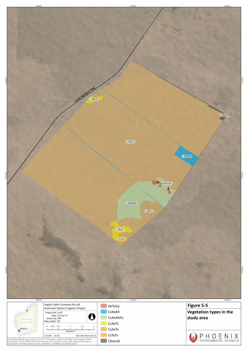
We s te r nAus t r a l ia
PERTH
All information within this map is current as of 21-Jun-17. This product is subject to COPYRIGHT and is property of PhoenixEnvironmental Sciences (Phoenix). While Phoenix has taken care to ensure the accuracy of this product, Phoenix make norepresentations or warranties about its accuracy, completeness or suitability for any particular purpose.
Cleared
CzAeAh
CzAeTs
CzAeTc
CzAeTs
CzAeTc
CzAeAhFo
AeToCp
CzTaTs
Great Northern Hwy
398000
398000
402000
402000
406000
406000
7948
000
7948
000
7952
000
7952
000
7956
000
7956
000
P:\GIS\Projects\ShamrockStationIrrigationProject\1147-SIP-AC-ECO\Mapping\MapDocuments\Figures\1147_VegMapping.mxd
AeToCpCzAeAhCzAeAhFoCzAeTcCzAeTsCzTaTsCleared
0 0.5 1 1.5 20.25Kilometres
1:50,000
Argyle Cattle Company Pty LtdShamrock Station Irrigation Project
Map authorDrawn by
GDA 1994 MGA Zone 51
°
(at A4)
21-Jun-17DateProject No 1147
KWKC
Vegetation types in thestudy area
Figure 5-5
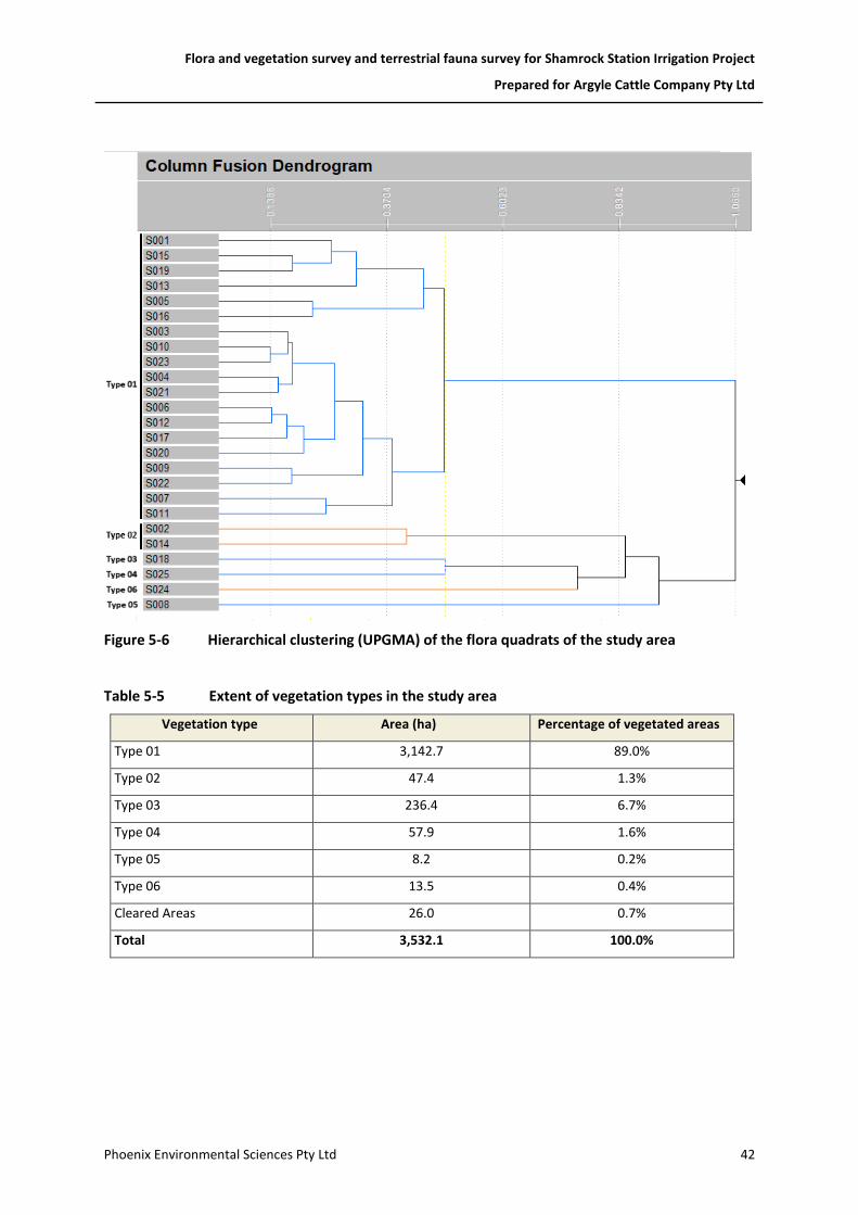
Flora and vegetation survey and terrestrial fauna survey for Shamrock Station Irrigation Project
Prepared for Argyle Cattle Company Pty Ltd
Phoenix Environmental Sciences Pty Ltd 42
Figure 5-6 Hierarchical clustering (UPGMA) of the flora quadrats of the study area
Table 5-5 Extent of vegetation types in the study area
Vegetation type Area (ha) Percentage of vegetated areas
Type 01 3,142.7 89.0%
Type 02 47.4 1.3%
Type 03 236.4 6.7%
Type 04 57.9 1.6%
Type 05 8.2 0.2%
Type 06 13.5 0.4%
Cleared Areas 26.0 0.7%
Total 3,532.1 100.0%
Flora and vegetation survey and terrestrial fauna survey for Shamrock Station Irrigation Project
Prepared for Argyle Cattle Company Pty Ltd
Phoenix Environmental Sciences Pty Ltd 43
Vegetation condition
The condition of vegetation across the study area ranged from Excellent to Completely Degraded according to the applied condition scale (Figure 5-7). The majority of vegetation was mapped as Excellent with regrowth of vegetation in previously cleared areas (including historic tracks) rated as Very Good. Cleared access tracks were rated as Completely Degraded (Table 5-6).
Table 5-6 Vegetation condition – extent of each condition rating in study area
Condition (Trudgen 1988, in EPA 2016d) Area (ha) Percentage (%) of
study area
Excellent 3,444.8 97.5%
Very Good 61.3 1.7%
Completely Degraded 26.0 0.7%
Total: 3532.1 100%
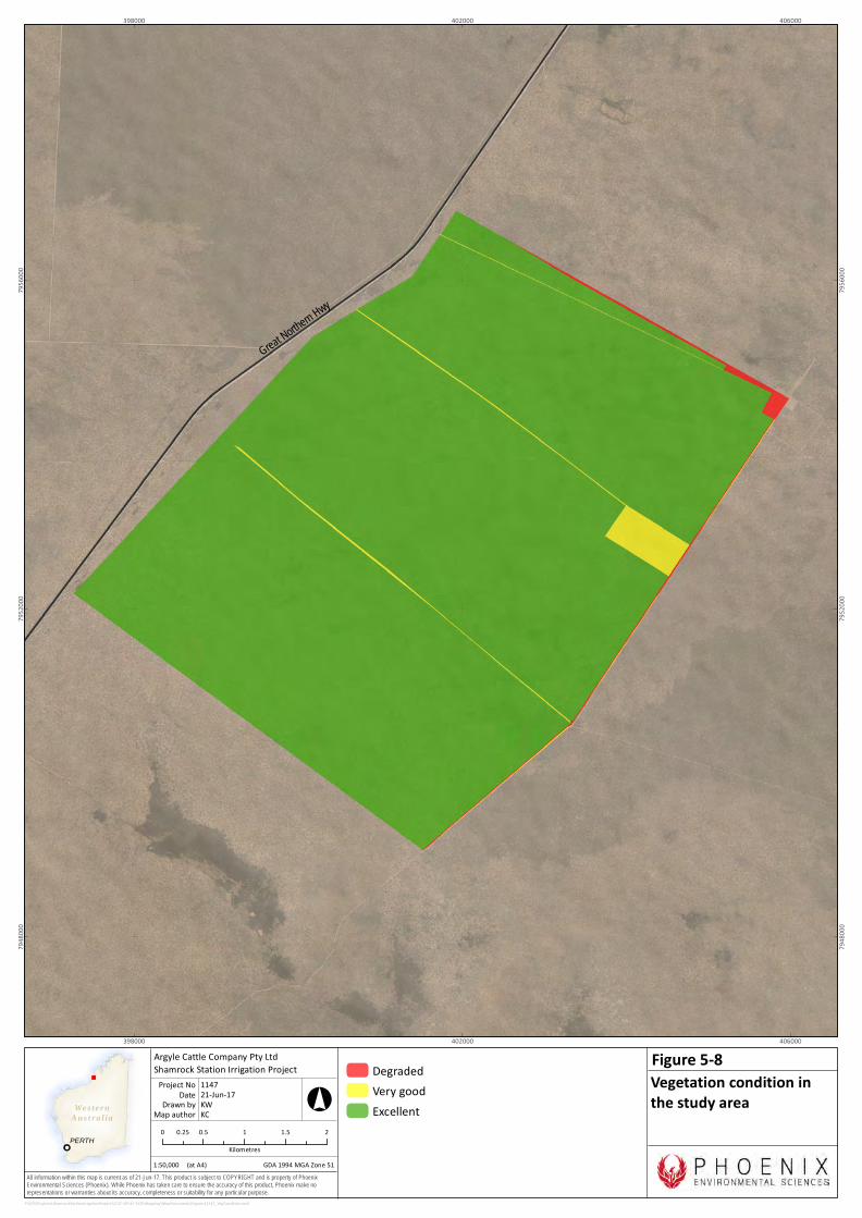
We s te r nAus t r a l ia
PERTH
All information within this map is current as of 21-Jun-17. This product is subject to COPYRIGHT and is property of PhoenixEnvironmental Sciences (Phoenix). While Phoenix has taken care to ensure the accuracy of this product, Phoenix make norepresentations or warranties about its accuracy, completeness or suitability for any particular purpose.
Great Northern Hwy
398000
398000
402000
402000
406000
406000
7948
000
7948
000
7952
000
7952
000
7956
000
7956
000
P:\GIS\Projects\ShamrockStationIrrigationProject\1147-SIP-AC-ECO\Mapping\MapDocuments\Figures\1147_VegCondition.mxd
DegradedVery goodExcellent
0 0.5 1 1.5 20.25Kilometres
1:50,000
Argyle Cattle Company Pty LtdShamrock Station Irrigation Project
Map authorDrawn by
GDA 1994 MGA Zone 51
°
(at A4)
21-Jun-17DateProject No 1147
KWKC
Vegetation condition inthe study area
Figure 5-8
Flora and vegetation survey and terrestrial fauna survey for Shamrock Station Irrigation Project
Prepared for Argyle Cattle Company Pty Ltd
Phoenix Environmental Sciences Pty Ltd 45
Threatened and Priority Ecological Communities
No vegetation types were classified as either a TEC or PEC.
Local and regional significance of vegetation
Four vegetation types (Type 01, 02, 03 and 06) may be considered locally significant as they contain Priority flora species. Vegetation with a restricted distribution included Types 05 and 06 (Table 5-5). Vegetation Type 06 was a recently burnt area and following growth of the recovering vegetation and subsequent decrease in the abundance of fire ephemeral shrubs is likely to resemble the dominant vegetation Type 01.
5.2.2 Fauna and fauna habitats
Fauna habitats
The study area contains a single terrestrial fauna habitat, tall shrubland thicket (Table 5-7; Figure 5-8). The tall shrubland thickets often consisted of sparsely scattered Corymbia hamersleyana and C. zygophylla up to 12 m over scattered patches of open to dense tall shrubs dominated by Grevillea pyramidalis, G. refracta and G. wickhamii to 4 m over scattered patches of dense understory, often dominated by Bauhinia cunninghamii and Triodia schinzii with Aristida holathera, Chrysopogon pallidus and Sorghum plumosum hummock and tussock grasses and a few open areas on sandy to clay-loam substrates.
The vegetation structure varied in parts of the study area, particularly along the eastern edge where previous clearing and fire have resulted in varying stages of regrowth. In areas where understory was not too dense and some open areas were present to allow for fauna movement through the habitat, shrubland thicket habitat within the study area provides suitable habitat for the Bilby (Figure 5-8). This habitat may also provide suitable foraging habitat for the Grey Falcon and Peregrine Falcon in areas where tall shrubs are not as dense, particularly in area of regrowth, and nesting habitat where suitable tall trees are present within the study area.
Table 5-7 Fauna habitats of the study area
Habitat Area (ha) Percentage
Tall shrubland thicket 3,506.1 99.3%
Existing cleared areas 26.0 0.7%
Total: 3,532.1 100%
We s te r nAus t r a l ia
PERTH
All information within this map is current as of 27-Jun-17. This product is subject to COPYRIGHT and is property of PhoenixEnvironmental Sciences (Phoenix). While Phoenix has taken care to ensure the accuracy of this product, Phoenix make norepresentations or warranties about its accuracy, completeness or suitability for any particular purpose.
!(#*
#*
!(
#*
!(
#*#*
!(
!(
!(
Great Northern Hwy
398000
398000
402000
402000
406000
406000
7948
000
7948
000
7952
000
7952
000
7956
000
7956
000
P:\GIS\Projects\ShamrockStationIrrigationProject\1147-SIP-AC-ECO\Mapping\MapDocuments\Figures\1147_ConsigFauna_Habitat.mxd
#* Bilby (Macrotis lagotis): Foraging evidence- digging (VU)
!( Rainbow Bee-eater (Merops ornatus):Direct observation - call (Mig.)
!( Rainbow Bee-eater (Merops ornatus):Direct observation (Mig.)
Fauna habitatsTall shubland thicketCleared
0 0.5 1 1.5 20.25Kilometres
1:50,000
Argyle Cattle Company Pty LtdShamrock Station Irrigation Project
Map authorDrawn by
GDA 1994 MGA Zone 51
°
(at A4)
27-Jun-17DateProject No 1147
KWKC
Fauna habitats andconservation significantfauna records from survey
Figure 5-9
two Bilby records
Flora and vegetation survey and terrestrial fauna survey for Shamrock Station Irrigation Project
Prepared for Argyle Cattle Company Pty Ltd
Phoenix Environmental Sciences Pty Ltd 47
Vertebrate fauna
A total of 50 vertebrate species were recorded during the field survey representing approximately 17% of the species identified from the desktop review (Table 5-8; Appendix 7). Two conservation significant species were recorded during the field survey, Bilby (Macrotis lagotis) (VU – EPBC Act, WC Act) from secondary evidence and Rainbow Bee-eater (Merops ornatus) (Mig – WC Act) from direct observation (Table 5-9; Figure 5-8).
Table 5-8 Vertebrate taxa recorded during the survey and the total number of species potentially occurring in the study area
Taxa No. of species recorded during this
survey in the study area
Total no. of species potentially occurring in study area (based on
desktop review)
Fish - 1
Amphibians - 3
Reptiles 3 42
Birds 40 216
Mammals 7 25
Total 50 287
Table 5-9 Conservation significant vertebrate fauna recorded during the field survey
Species Common name Record type Qty.
Within study area
or 1 km buffer
Latitude Longitude
Macrotis lagotis Bilby Foraging digging 1 Buffer -18.5028 122.1063
Macrotis lagotis Bilby Foraging digging 1 Study area -18.5421 122.0694
Macrotis lagotis Bilby Foraging digging 1 Study area -18.4917 122.0837
Macrotis lagotis Bilby Foraging digging 1 Buffer -18.4894 122.1050
Macrotis lagotis Bilby Foraging digging 1 Buffer -18.4895 122.1050
Merops ornatus Rainbow Bee-eater Call 1 Buffer -18.5287 122.0912
Merops ornatus Rainbow Bee-eater Direct observation 2 Study area -18.5063 122.0815
Merops ornatus Rainbow Bee-eater Direct observation 2 Study area -18.5328 122.0840
Merops ornatus Rainbow Bee-eater Direct observation 1 Buffer -18.4849 122.0540
Merops ornatus Rainbow Bee-eater Call 1 Buffer -18.4938 122.0411
Merops ornatus Rainbow Bee-eater Direct observation 1 Buffer -18.5031 122.1087

Flora and vegetation survey and terrestrial fauna survey for Shamrock Station Irrigation Project
Prepared for Argyle Cattle Company Pty Ltd
Phoenix Environmental Sciences Pty Ltd 48
Conservation significant species recorded and potentially occurring in the study area
In addition to the two conservation significant vertebrate fauna species recorded during the field survey (Bilby and Rainbow Bee-eater), potential habitat was identified for a further nine species within the study area. Potential habitat was identified for a further nine of the 69 conservation significant species identified in the desktop review (Table 5-3). Potential occurrence of conservation significant species in the study area was assessed based on presence of suitable habitat, proximity of previous records and current known distributions of the species. Due to the proximity of the study area to the coast, the desktop review returned a large number of threatened and migratory shorebirds which are considered unlikely to be present within the study area due to a lack of suitable habitat or specific habitat qualities (Table 5-3).
Fork-tailed Swift
Status: Migratory (EPBC Act and WC Act)
Distribution and ecology: The Fork-tailed Swift is a widespread migratory species that overwinters in Australia. It can be found across most of WA and is uncommon to moderately common in the north-west. They are mostly found over inland plains and along foothills, coastal areas and over settlements. They occur in a wide range of dry or open habitats, including riparian woodlands, tea-tree swamps, low scrub, heathland, saltmarsh, grassland and spinifex sandplains, open farmland and inland and coastal sand-dunes. Fork-tailed Swifts are often found in areas that experience updraughts around cliffs and normally forage several hundred metres above ground level (Department of the Environment and Energy 2017c).
Records and likely distribution in the study area: Fork-tailed Swift was not recorded during the field survey but is likely to occur occasionally within the study area. The nearest records of the species is located approximately 20 km north northeast and 20 km southwest of the study area (DPaW 2017d). The species can occur within a wide range of habitats, including those found in the study area. The species is likely to forage, though it is unlikely it will land or nest within the study area.
Cattle Egret
Status: Migratory (EPBC Act and WC Act)
Distribution and ecology: The Cattle Egret is a worldwide widespread, polytypic, medium-size Ardeidae. In Australia, they are more common in eastern states than on the west coast. The species is uncommon in south-western WA and breed in small numbers near Kununurra. The origin of the species in Australia is not certain. It may have been introduced but a natural colonisation from individuals reaching the northern coast through Indonesian islands is more probable (McKilligan 2005).
In Australia, Cattle Egrets have benefited from human settlements (irrigation, grazing). They can feed on a wide range of prey (vertebrate and invertebrates) that they find in swamps and open grasslands, inland as well as on the coast (McKilligan 2005). The species is partially migratory with overseas movements between New-Zealand and Australia.
Records and likely distribution in the study area: The Cattle Egret was not recorded during the field survey; however, it may occasionally occur within the study area, particularly in close proximity to the small dam located along the eastern border of the study area when water is present. The nearest record of the species is located approximately 60 km north of the study area (DPaW 2017d).

Flora and vegetation survey and terrestrial fauna survey for Shamrock Station Irrigation Project
Prepared for Argyle Cattle Company Pty Ltd
Phoenix Environmental Sciences Pty Ltd 49
Eastern Great Egret
Status: Migratory (WC Act)
Distribution and ecology: The Eastern Great Egret can be found near waterbodies or along inland rivers, lakes and shallow freshwater or saltwater wetlands and inundated samphire flats (McKilligan 2005). This species is highly mobile and can be found throughout most of the western fringes of the State in coastal areas and towards the semi-arid interior (Johnstone & Storr 1998).
Records and likely distribution in the study area: No Eastern Great Egret were recorded during the field survey; however, the species may occasionally occur within the study area, particularly in close proximity to the small dam located along the eastern border of the study area when water is present. The nearest record of the species is located approximately 13 km north of the study area (DPaW 2017d).
Grey Falcon
Status: Vulnerable (WC Act)
Distribution and ecology: The Grey Falcon is a widespread but rare species inhabiting much of the semi-arid interior of Australia. Its distribution is centred along inland drainage systems. It has a large foraging range extending from timbered plains, such as Acacia shrublands, into open grasslands. Prey includes mainly birds (Sutton 2010), but also invertebrates and mammals. The species often utilizes old nests of other species, particularly other raptors, in the tallest trees along watercourses and sometimes in telecommunication towers (Sutton 2010).
There are no confirmed threats to the Grey Falcon but it is thought that clearing of the semi-arid zone for marginal farming has reduced habitat availability and overgrazing of arid zone rangelands may affect prey abundance (Garnett et al. 2011).
Records and likely distribution in the study area: The Grey Falcon was not recorded during the field survey; however, the species is considered likely to occasionally occur within, and in the vicinity of, the study area due to its large foraging range, particularly within areas where very dense vegetation isn’t present allowing the species to forage for ground dwelling species. The species may nest where suitable tall trees are present. The nearest record of the species is located approximately 13 km north of the study area (DPaW 2017d).
Peregrine Falcon
Status: Specially Protected (WC Act)
Distribution and ecology: The Peregrine Falcon is a widespread bird of prey with a large foraging range found across Australia. In WA, it can be rare or scarce to moderately common. The Peregrine Falcon’s preferred habitat includes cliffs and wooded watercourses. Nesting occurs mainly on cliff ledges, granite outcrops, quarries and in trees with old raven or Wedge-tailed Eagle nests (Johnstone & Storr 1998).
Birds constitute a very large proportion of their diet, if not the exclusive part (Johnstone & Storr 1998; Ratcliffe 1980). Historically, the widespread use of DDT caused worldwide global decline of the Peregrine Falcon. The main current threat to the species in Australia is habitat loss, particularly woodland trees for nesting (Department of the Environment and Energy 2017c).
Records and likely distribution in the study area: Peregrine Falcon was not recorded during the field survey; however, the species is considered to possibly occur occasionally within the study area to
Flora and vegetation survey and terrestrial fauna survey for Shamrock Station Irrigation Project
Prepared for Argyle Cattle Company Pty Ltd
Phoenix Environmental Sciences Pty Ltd 50
forage. It is unlikely to nest due to the lack of suitable nesting habitat within the study area. The species has previously been recorded approximately 13 km west of the study area (DPaW 2017d).
Rainbow Bee-eater
Status: Migratory (WC Act)
Distribution and ecology: The Rainbow Bee-eater is a migratory bird that moves between Australia and Asia and is commonly seen singly or in pairs. It can be found across Australia, with complex seasonal movements depending on location and rainfall, preferring the more watered areas of the country. In Western Australia, the Rainbow Bee-eater can be found in lightly wooded, preferably sandy country, near water (Department of the Environment and Energy 2017c).
Occurring as a resident, breeding visitor, postnuptial nomad, passage migrant or winter visitor, and being highly mobile, they can be scarce to locally common. They are often associated with creek lines supporting sandy banks in which burrows can be created (Johnstone & Storr 1998). Its diet consists primarily of bees (especially hive bees) and flies, but it is known to predate on other invertebrates.
The species nests in sandy banks and breeding occurs from August to November; however, breeding can occur at other times of year if environmental conditions are suitable. Four to six eggs are laid in an open chamber at the end of a burrow (Johnstone & Storr 1998).
Records and likely distribution in the study area: The Rainbow Bee-eater was recorded six times during the field survey is considered likely to frequently occur within the study area (Figure 5-8). The species was recorded four times from direct observations of one or two individuals and twice from calls. The species is likely to occur throughout the study area to forage and is likely to nest in areas where suitable substrates allowing construction of burrows are present. The species has previously been recorded approximately 5 km west of the study area (DPaW 2017d).
Night Parrot
Status: Endangered (EPBC Act); Critically Endangered (WC Act)
Distribution and ecology: The Night Parrot is the rarest bird in Australia. The species was thought to be extinct until a single road killed specimen was collected in Queensland in October 1990 (Boles et al. 1994). Since then, additional specimens have been recorded in Queensland (McDougall et al. 2009) and further sightings in the Pilbara and Kimberley regions of WA.
Little is known about the biology of the species. Most sightings occur at night, near water and it is assumed that birds come to drink prior feeding at night. The nest is located in tunnelled dense vegetation and can contain three to six eggs (Garnett et al. 2011). Chenopod grasslands, Spinifex plains and hummock grasslands in the proximity of salt lakes are likely to be its typical habitat. The map of historical records in WA indicates the species can potentially occur across a wide range of common habitat (Davis & Metcalf 2008).
Alteration of fire regime, predation by introduced species and over grazing by cattle are the main threat to the species, resulting in poor habitat quality and direct mortality of individuals.
Records and likely distribution in the study area: No night parrots were recorded during the field survey; however, the species is considered to possibly occur within the study area. Little is known of the species habitat preferences; however, previous records have been in in habitats consisting of spinifex or samphire vegetation. The species may possibly occur within the study area, particularly in areas of dense understory dominated by spinifex species. The nearest record of the species is
Flora and vegetation survey and terrestrial fauna survey for Shamrock Station Irrigation Project
Prepared for Argyle Cattle Company Pty Ltd
Phoenix Environmental Sciences Pty Ltd 51
located approximately 380 km south of the study area (DPaW 2017d); however, the species has recently been recorded elsewhere in the Kimberley region, though precise locality has not been disclosed and its proximity to the study area is not known.
Princess Parrot
Status: Vulnerable (EPBC Act); Priority 4 (DPaW)
Distribution and ecology: The Princess Parrot is one of the most elusive Australian parrots. They are only found in the arid inland desert of central Australia with most of their range extending between the Great Victorian Desert and the Great Sandy Desert in WA.
Princess Parrots inhabit sandy deserts where they feed on seeds and flowers (Garnett & Crowley 2000). The species is highly irruptive and after important rainfall, can occur in numbers in areas previously unoccupied. They nest in large tree hollows and can produce three to six chicks per clutch. Threats to the species are not clearly identified and even the population trend is not clear given the irruptive fluctuating pattern of the populations. Changes in fire regimes and introduction of grazing mammals are listed as the main threats to the Princess Parrot (Garnett & Crowley 2000).
Records and likely distribution in the study area: The Princess Parrot wasn’t recorded during the field survey; however, it is considered to possibly occur within the study area occasionally. Records of the species are sparse; however, it’s occurrence and abundance is often dependent on rainfall events. Records of the species in the vicinity of the study area are sparse and the nearest record is located approximately 50 km southwest of the study area (DPaW 2017d).
Spectacled Hare-wallaby
Status: Priority 3 (DPaW)
Distribution and ecology: Once widespread in the northern section of the Australian continent, the Spectacled Hare-wallaby is now found across northern Queensland, Northern Territory and north WA (Kimberley and a small section of the Pilbara). A large population lives on Barrow Island where the species is relatively common.
In WA, Spectacled Hare-wallabies live in habitat dominated by spinifex, where large hummocks are available. They spend the day hidden in these hummocks in which they tunnel a shelter. At night, the species feeds on various plant materials. Matures at around one year and is capable of breeding throughout the year depending on conditions (Van Dyck & Strahan 2008).
Predation by Feral Cat and Red Fox is responsible for the decline and range constriction of the species. Altered fire regimes are also likely to reduce the number of large spinifex hummocks available (Van Dyck & Strahan 2008).
Records and likely distribution in the study area: No Spectacled Hare-wallabies were recorded during the field survey; however, the species is considered to possibly occur in habitat represented within the study area. Records of the species in the vicinity of the study area are sparse; however, the species has previously been recorded approximately 19 km southwest and 21 km northeast of the study area (DPaW 2017d).
Flora and vegetation survey and terrestrial fauna survey for Shamrock Station Irrigation Project
Prepared for Argyle Cattle Company Pty Ltd
Phoenix Environmental Sciences Pty Ltd 52
Short-tailed Mouse
Status: Priority 4 (DPaW)
Distribution and ecology: This secretive species occurs in the Pilbara and the Kimberley regions of WA as well as the Northern Territory and Queensland. It occupies a variety of habitats including hummock and tussock grasslands, tropical woodlands, samphire, sedgelands and stony ranges (Moro & Kutt 2008). Its populations rise and fall dramatically, probably in response to climatic fluctuations and availability of seeds (Van Dyck & Strahan 2008).
Records and likely distribution in the study area: The Short-tailed Mouse was not recorded during the field survey; however, the species has previously been recorded approximately 23 km west of the study area and is considered to possibly occur (DPaW 2017d). Due to the influence of rainfall on the species occurrence and abundance the species may occasionally occur, particularly following rainfall events when resources are plentiful for the species.
Bilby
Status: Vulnerable (EPBC Act and WC Act)
Distribution and ecology: The Greater Bilby or Dalgyte is a rabbit-sized marsupial that originally occupied over 70% of the Australian mainland. It now occurs in less than 20% of its original range, with remaining WA populations predominantly in the Great Sandy and Gibson Deserts.
Habitat preferences of the Greater Bilby include hummock grassland in plains and alluvial areas, open tussock grassland on uplands and hills, and mulga woodland/shrubland on ridges and rises (Department of the Environment and Energy 2017c). The species is highly mobile and can have large foraging ranges. Home ranges in sandy deserts are usually temporary and may shift in response to changes in food availability (Van Dyck & Strahan 2008). The species can be identified through secondary evidence, such as scats, tracks and its typical burrow systems.
The massive decline in Greater Bilby distribution is thought to be due to effects on food availability from changing fire regimes, drought, grazing by rabbits and livestock, and predation by the Red Fox and feral Cat (Van Dyck & Strahan 2008).
Records and likely distribution in the study area: The Bilby was recorded five times during the field survey from foraging diggings. Two records were from within the study area and three within 1 km of the study area (Figure 5-8). No tracks or burrows of the species were recorded during the field survey and all foraging diggings recorded during the field survey appeared to be aged and weathered.
Habitat assessments at Bilby survey plots within and beyond the study area identified a mix high and low habitat suitability for the species. The majority of survey plots within the study area were rated low value for Bilby. Habitat considered of high suitability was recorded primarily along the eastern edge of the study area, including plots outside the eastern boundary, and along the western edge but mostly in plots outside the study area (Figure 5-8).
High habitat suitability consisted of areas supporting a range of vegetation structures lacking dense understory, where movement for the species would be restricted, and presence of substrates permitting burrowing by the species. Low suitability plots were typically characterised by very dense understory.
The species has previously been recorded approximately 1 km south west of the study area with multiple recorded within 10 km south of the study area (DPaW 2017d).
Flora and vegetation survey and terrestrial fauna survey for Shamrock Station Irrigation Project
Prepared for Argyle Cattle Company Pty Ltd
Phoenix Environmental Sciences Pty Ltd 53
5.3 SURVEY LIMITATIONS
The limitations of the terrestrial fauna survey have been considered (Table 5-10) in accordance with Technical Guidance: Terrestrial fauna surveys (EPA 2016f). No major limitations were identified for the survey.
Table 5-10 Survey limitations from EPA Technical Guidance: Terrestrial fauna surveys (EPA 2016f)
Limitations Limitation for this survey?
Comments
Competency/experience of survey personnel, including taxonomy
No The field team and report authors have extensive experience in terrestrial fauna and flora and vegetation surveys within the region and across WA.
Scope and completeness - were all target groups sampled, were all planned survey methods implemented successfully, was the study area fully surveyed
No All target groups, conservation significant species and habitats within the study area were surveyed adequately.
Intensity - in retrospect, was the intensity adequate
No The survey intensity was appropriate for the areas that were surveyed and conservation significant species targeted.
Proportion of fauna identified, recorded and/or collected.
No
All fauna was identified to species level in the field with the exception of analysis of bat echolocation call recordings. Bat echolocation call recordings were analysed by an external expert on return to Perth.
Availability of adequate contextual information
Partial
With the exception of extensive shorebird surveys to the west of the study area there have been limited survey within the vicinity and broader region of the study area.
Timing, weather, season, cycle No Weather preceding and during the survey was comparable to annual averages for previous years.
Disturbances which affected the results of the survey
No No disturbances occurred during the field survey which are considered to have impacted the results.
Remoteness and/or access problems No The whole of the study area was accessible by vehicle or foot.
The limitations of the flora and vegetation survey have been considered (Table 5-11) in accordance with Technical Guidance: Flora and vegetation surveys for Environmental Impact Assessment (EPA 2016d).

Flora and vegetation survey and terrestrial fauna survey for Shamrock Station Irrigation Project
Prepared for Argyle Cattle Company Pty Ltd
Phoenix Environmental Sciences Pty Ltd 54
Table 5-11 Survey limitations for flora and vegetation survey (EPA 2016d)
Limitations Limitation for this survey?
Comments
Availability of contextual information at a regional and local scale
Yes In total only 4 flora and vegetation assessments from the Dampierland bioregion were available for comparison to the current assessment and the majority of project areas were located over 100 km from the current study area.
Competency/experience of the team carrying out the survey, including experience in the bioregion surveyed
No The principal botanist Dr Grant Wells has undertaken numerous flora and vegetation surveys within the Kimberley including six years of research.
Proportion of flora recorded and/or collected, any identification issues
No Only a small proportion (2.6%) of taxa could not be identified definitively to species level due to insufficient reproductive characters.
Effort and extent; was the appropriate area fully surveyed
Yes Suitable survey methods were used based on EPA technical guidance (EPA 2016d). However, the minimal replicate of three sites per vegetation type defined was not maintained for all vegetation types due to the limited extent and distribution of some of the vegetation types encountered.
Access within the study area No There were no access problems.
Timing, rainfall, season No The survey was conducted at an appropriate time, following wet season and above average annual rainfall.
Disturbance that may have affected the results of the survey
No There were no notable recent disturbances that may have impacted the survey.
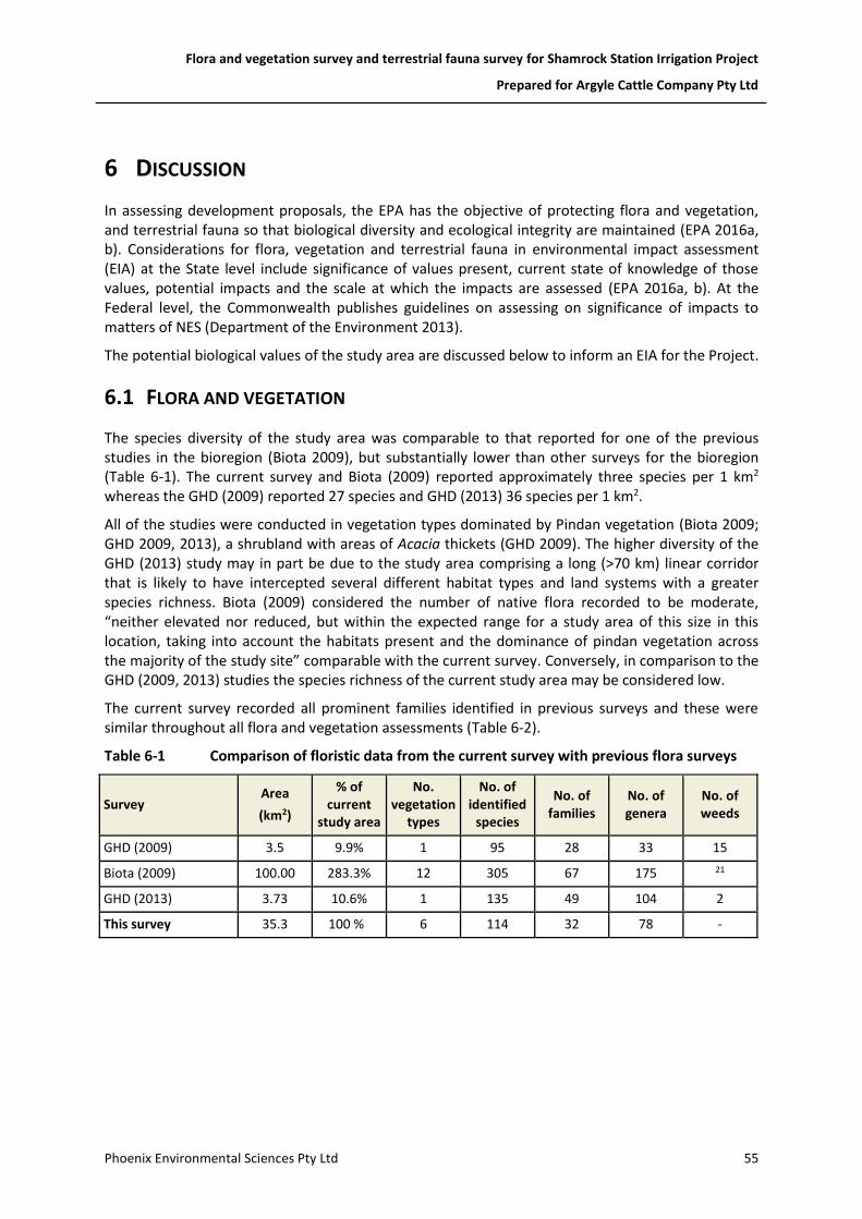
Flora and vegetation survey and terrestrial fauna survey for Shamrock Station Irrigation Project
Prepared for Argyle Cattle Company Pty Ltd
Phoenix Environmental Sciences Pty Ltd 55
6 DISCUSSION
In assessing development proposals, the EPA has the objective of protecting flora and vegetation, and terrestrial fauna so that biological diversity and ecological integrity are maintained (EPA 2016a, b). Considerations for flora, vegetation and terrestrial fauna in environmental impact assessment (EIA) at the State level include significance of values present, current state of knowledge of those values, potential impacts and the scale at which the impacts are assessed (EPA 2016a, b). At the Federal level, the Commonwealth publishes guidelines on assessing on significance of impacts to matters of NES (Department of the Environment 2013).
The potential biological values of the study area are discussed below to inform an EIA for the Project.
6.1 FLORA AND VEGETATION
The species diversity of the study area was comparable to that reported for one of the previous studies in the bioregion (Biota 2009), but substantially lower than other surveys for the bioregion (Table 6-1). The current survey and Biota (2009) reported approximately three species per 1 km2
whereas the GHD (2009) reported 27 species and GHD (2013) 36 species per 1 km2.
All of the studies were conducted in vegetation types dominated by Pindan vegetation (Biota 2009; GHD 2009, 2013), a shrubland with areas of Acacia thickets (GHD 2009). The higher diversity of the GHD (2013) study may in part be due to the study area comprising a long (>70 km) linear corridor that is likely to have intercepted several different habitat types and land systems with a greater species richness. Biota (2009) considered the number of native flora recorded to be moderate, “neither elevated nor reduced, but within the expected range for a study area of this size in this location, taking into account the habitats present and the dominance of pindan vegetation across the majority of the study site” comparable with the current survey. Conversely, in comparison to the GHD (2009, 2013) studies the species richness of the current study area may be considered low.
The current survey recorded all prominent families identified in previous surveys and these were similar throughout all flora and vegetation assessments (Table 6-2).
Table 6-1 Comparison of floristic data from the current survey with previous flora surveys
Survey Area
(km2)
% of current
study area
No. vegetation
types
No. of identified
species
No. of families
No. of genera
No. of weeds
GHD (2009) 3.5 9.9% 1 95 28 33 15
Biota (2009) 100.00 283.3% 12 305 67 175 21
GHD (2013) 3.73 10.6% 1 135 49 104 2
This survey 35.3 100 % 6 114 32 78 -

Flora and vegetation survey and terrestrial fauna survey for Shamrock Station Irrigation Project
Prepared for Argyle Cattle Company Pty Ltd
Phoenix Environmental Sciences Pty Ltd 56
Table 6-2 Species numbers of the most dominant plant families recorded in the study area in comparison with other regional studies
Family This study GHD 2009 Biota 2009 GHD 2013
Malvaceae 13 12 10 11
Poaceae 10 13 43 15
Fabaceae 24 18 44 30
Amaranthaceae 4 6 11 6
Myrtaceae 4 6 12 7
Proteaceae 6 3 5 5
Total number of species 61 58 125 74
% dominant families comprise of all species recorded for the survey
53.5 61.1 41.0 54.8
6.1.1 Conservation significant flora
Two of the three of the Priority flora identified as potentially present in the study area in the desktop review, Tephrosia andrewii and Triodia caelestialis, were recorded during the field survey. No records of the third species, Polymeria distigma were found in the study area; however, two Polymeria species, P. ambigua and P. sp. Broome (Priority 1), were located.
Of the Priority flora recorded in the study area, the populations of Tephrosia andrewii represent new records for the species that is known from only a few locations in the vicinity of the Project. The populations of Triodia caelestialis also represent new records for the species but this is locally abundant. The records of Polymeria sp. Broome represent a southern range extension and therefore a significant new record for the species.
The three taxa that could be not be definitively identified to species level were considered unlikely to represent conservation significant flora. Ipomoea tolmerana subsp. occidentalis (P1) is the only conservation significant Ipomoea species recorded for the Dampierland bioregion (DPaW 2017b). This species is an annual vine whereas the unidentified Ipomoea sp. from the current survey was a robust perennial vine and did not resemble the Priority species. Two Priority 1 Corymbia species have been recorded for the Dampierland bioregion (DPaW 2017b); however, suitable habitat was not present in the study area for either of these species and the Corymbia specimens did not resemble those of the Priority 1 Corymbia spp. held at the WA Herbarium.
Notably, all significant species recorded during the field survey occur within the dominant vegetation type (Type 01) in the study area. This vegetation type extends over a vast area locally and therefore substantial suitable habitat for the Priority species occurs in the broader landscape.
Flora and vegetation survey and terrestrial fauna survey for Shamrock Station Irrigation Project
Prepared for Argyle Cattle Company Pty Ltd
Phoenix Environmental Sciences Pty Ltd 57
6.1.2 Vegetation
The vegetation types defined for the study area are representative of the broad vegetation type mapped by Shepherd et al. (2002) Association 699, Acacia thicket with scattered low trees over spinifex, that covers the majority of the study area. Consequently, the vegetation in the study area represents a widespread community well represented at a regional level with 99% of pre-European extent remaining. Subsequently, the vegetation of the study area is considered to have low regional conservation significance, especially as species diversity was low in comparison to that recorded in other flora and vegetation studies conducted in the bioregion.
The majority of the vegetation in the study area was considered locally significant due to the presence of conservation significant flora and/or has a restricted distribution.
6.2 VERTEBRATE FAUNA
When considering the fauna field assessment results, together with the desktop study findings (i.e. historic or recent records of species or suitable habitat in the proximity of the study area) and known habitat preferences, 11 of the 70 significant fauna species identified in the desktop review were considered to have the potential to occur in the study area (Table 6-3). Two of these were recorded during the survey, the Bilby (VU) from secondary evidence and the Rainbow Bee-eater (Mig. – WC Act) from direct observations and calls. Five of the 11 species are listed under the EPBC Act and/or WC Act as Threatened, Conservation Dependent or Specially Protected and a further four as ‘Migratory’ under the EPBC Act and WC Act (Table 6-3). A further three species are listed as Priority species (Table 6-3).
A single terrestrial fauna habitat, tall shrubland thicket, was mapped within the study area; however, the variability in vegetation structure and density is likely to influence usage by fauna species. Areas of dense understory comprising thick low vegetation, often dominated by grasses, was scattered throughout the study area forming a mosaic amongst more open understory. In particular, along the eastern edge previous clearing and fire events have resulted in varying stages of regrowth.
The tall shrubland thicket habitat, or parts of it, is likely to provide suitable foraging and possible nesting or burrowing habitat for several conservation significant species, particularly Bilby, Spectacled Hare-wallaby, Short-tailed Mouse, Grey Falcon, Peregrine Falcon, Princess Parrot and some migratory bird species to varying extents (Table 6-3). Tall shrubland thickets are widely represented in the broader vicinity of the study area and habitat present within the study area is not likely to be critical to the survival of any significant species.
The survey results for Bilby indicate the majority of the study area is low value habitat for the species. Highest value habitat was located in an approximate 1 km corridor along the eastern boundary, partly within and partly outside the study area, with four of the five diggings recorded there and survey plots consistently rated high value (Figure 5-8). All recorded Bilby diggings corresponded with areas assessed as high value habitat for the species; these were areas where understory was open and areas of sparse vegetation were present. No Bilby records were obtained from areas where dense understory, that would limit ease of movement, was present. No Bilby burrows were recorded in the survey; however, the potential for burrowing by the species in the high value habitat of the study area cannot be ruled out as suitable digging substrate was present. Otherwise, Bilby may occasionally utilise the high value habitat of the study area to forage and for dispersal.

Flora and vegetation survey and terrestrial fauna survey for Shamrock Station Irrigation Project
Prepared for Argyle Cattle Company Pty Ltd
Phoenix Environmental Sciences Pty Ltd 58
The Rainbow Bee-eater records (Figure 5-8) suggest the species is likely to occur frequently throughout the study area. It is likely to forage and nest where suitable sandy substrates permitting burrow construction are present. The species is frequently encountered in the broader vicinity of the study area and further afield across most of its distribution.
The list of conservation significant fauna from the desktop review included many migratory shorebirds and waterbirds which were returned in the database searches due to the proximity of the study area to important migratory bird areas including Roebuck Bay and Eighty Mile Beach. While suitable habitat is not present for migratory shorebirds and waterbirds in the study area, the installation of irrigated pasture may create suitable habitat for some wetland species and lead to foraging and possibly roosting depending on the abundance of water present.

Flora and vegetation survey and terrestrial fauna survey for Shamrock Station Irrigation Project
Prepared for Argyle Cattle Company Pty Ltd
Phoenix Environmental Sciences Pty Ltd 59
Table 6-3 Summary of conservation significant vertebrate fauna species with likelihood of occurrence for the study area
Scientific name Common name
Conservation status Likelihood
of occurrence
Summary of records and occurrence
Nearest record to the study area
(Birdlife Australia 2017; DPaW
2017d)
EPBC Act WC Act DPaW
Fish
Pristis pristis Freshwater Sawfish P3 Unlikely Suitable habitat not present. ~80 km north
Reptiles
Crocodylus porosus Salt-water Crocodile SP Unlikely Suitable habitat not present. ~60 km north
Ctenotus angusticeps Airlie Island Ctenotus VU VU Unlikely Suitable habitat not present. ~25 km west
Lerista separanda Dampierland Plain Slider P2 Unlikely Suitable habitat not present. ~23 km west
Birds
Pandion haliaetus Osprey Mig. Mig. Unlikely Suitable habitat not present. ~107 km north
Apus pacificus Fork-tailed Swift Mig. Mig. Likely
Likely to occasionally occur above the study are to forage; however, unlikely to land or nest within the study area.
~20 km north northeast and ~20 km southwest
Ardea ibis Cattle Egret Mig. Mig. Possible May occasionally occur at the small dam located on the eastern edge of the study area when water is present.
~60 km north
Ardea modesta Eastern Great Egret Mig. Possible May occasionally occur at the small dam located on the eastern edge of the study area when water is present.
~13 km north
Charadrius bicinctus Double-banded Plover Mig. Mig. Unlikely Study area north of species currently known Western Australian range. Suitable habitat not present.
over 1,500 km south
Charadrius leschenaultii Greater Sand Plover VU/Mig. Mig. Unlikely Suitable habitat not present. ~13 km north
Charadrius mongolus Lesser Sand Plover EN/Mig. EN/Mig. Unlikely Suitable habitat not present. ~13 km northwest
Charadrius veredus Oriental Plover Mig. Unlikely Suitable habitat not present. ~23 k m southwest
Pluvialis fulva Pacific Golden Plover Mig. Unlikely Suitable habitat not present. ~32 km north

Flora and vegetation survey and terrestrial fauna survey for Shamrock Station Irrigation Project
Prepared for Argyle Cattle Company Pty Ltd
Phoenix Environmental Sciences Pty Ltd 60
Scientific name Common name
Conservation status Likelihood
of occurrence
Summary of records and occurrence
Nearest record to the study area
(Birdlife Australia 2017; DPaW
2017d)
EPBC Act WC Act DPaW
Pluvialis squatarola Grey Plover Mig. Unlikely Suitable habitat not present. ~31 km west
Cuculus optatus Oriental Cuckoo Mig. Mig. Unlikely Suitable habitat not present. ~60 km north
Falco hypoleucos Grey Falcon VU Likely
Likely to occasionally occur within study area to forage and may nest in areas where suitable tall trees are present.
~13 km north
Falco peregrinus Peregrine Falcon SP Likely Likely to occasionally occur within study area to forage, though unlikely to nest. ~13 km west
Fregata ariel Lesser Frigatebird Mig. Unlikely Suitable habitat not present. ~13 km north
Fregata minor Greater Frigatebird Mig. Unlikely Suitable habitat not present. ~62 km north
Glareola maldivarum Oriental Pratincole Mig. Unlikely Suitable habitat not present. ~19 km north
Hirundo rustica Barn Swallow Mig. Unlikely Suitable habitat not present. ~34 km north
northeast
Oceanites oceanicus Wilson's Storm Petrel Mig. Mig. Unlikely Suitable habitat not present. ~23 km west
Anous stolidus Common Noddy Mig. Unlikely Suitable habitat not present. ~60 km north
Chlidonias leucopterus White-winged Black Tern Mig. Mig. Unlikely Suitable habitat not present. ~33 km north
Onychoprion anaethetus Bridled Tern Mig. Unlikely Suitable habitat not present. ~60 km north
Sterna albifrons Little Tern Mig. Mig. Unlikely Suitable habitat not present. ~60 km north
Sterna caspia Caspian Tern Mig. Mig. Unlikely Suitable habitat not present. ~60 km north
Sterna hirundo Common Tern Mig. Mig. Unlikely Suitable habitat not present. ~13 km north
Merops ornatus Rainbow Bee-eater
Mig. Recorded
Recorded six times during the field survey from direct observation and call. Likely to frequently occur within the study area to forage and nest.
~5 km west
Motacilla cinerea Grey Wagtail Mig. Unlikely Suitable habitat not present. ~160 km north
northeast

Flora and vegetation survey and terrestrial fauna survey for Shamrock Station Irrigation Project
Prepared for Argyle Cattle Company Pty Ltd
Phoenix Environmental Sciences Pty Ltd 61
Scientific name Common name
Conservation status Likelihood
of occurrence
Summary of records and occurrence
Nearest record to the study area
(Birdlife Australia 2017; DPaW
2017d)
EPBC Act WC Act DPaW
Motacilla flava Yellow Wagtail Mig. Unlikely Suitable habitat not present. ~60 km north
Calonectris leucomelas Streaked Shearwater Mig. Mig. Unlikely Suitable habitat not present. ~47 km north
northeast
Puffinus pacificus Wedge-tailed Shearwater Mig. Mig. Unlikely Suitable habitat not present. ~62 km north
Pezoporus occidentalis Night Parrot EN CR Possible
Little is known of the species habitat preferences; however, records of the species have often been in habitats consisting of spinifex or samphire vegetation. May possibly occur within the study area, particularly in areas of dense understory dominated by spinifex species. Recently recorded elsewhere in the Kimberley region, though precise locality not disclosed.
~380 km south
Polytelis alexandrae Princess Parrot VU P4 Possible
May possibly occur within the study area; however, species sparsely recorded and occurrence and abundance often dependant on rainfall events.
~50 km southwest
Arenaria interpres Ruddy Turnstone Mig. Unlikely Suitable habitat not present. ~13 km north
northwest
Calidris acuminata Sharp-tailed Sandpiper Mig. Unlikely Suitable habitat not present. ~21 km southwest
Calidris alba Sanderling Mig. Unlikely Suitable habitat not present. ~32 km north
northeast
Calidris canutus Red Knot EN/Mig. Mig. Unlikely Suitable habitat not present. ~32 km north
northeast
Calidris ferruginea Curlew Sandpiper CR/Mig. VU/Mig. Unlikely Suitable habitat not present. ~13 km north
Calidris ruficollis Red-necked Stint Mig. Unlikely Suitable habitat not present. ~21 km southwest
Calidris tenuirostris Great Knot CR/Mig. VU/Mig. Unlikely Suitable habitat not present. ~13 km north
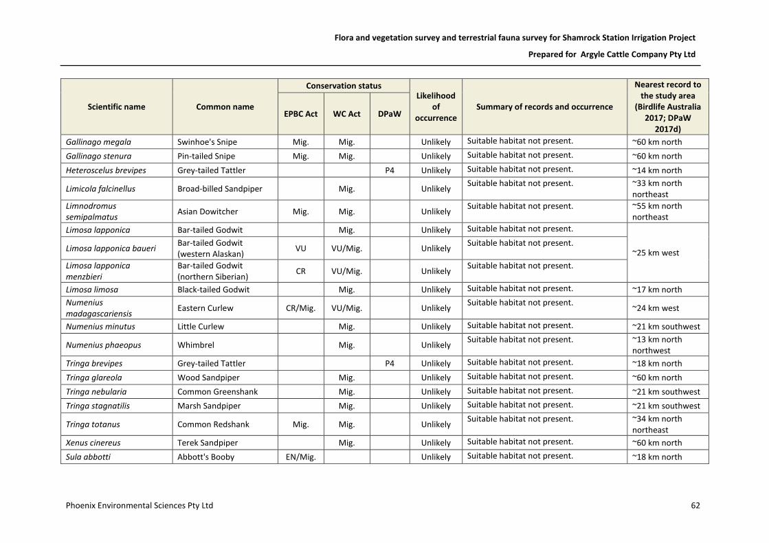
Flora and vegetation survey and terrestrial fauna survey for Shamrock Station Irrigation Project
Prepared for Argyle Cattle Company Pty Ltd
Phoenix Environmental Sciences Pty Ltd 62
Scientific name Common name
Conservation status Likelihood
of occurrence
Summary of records and occurrence
Nearest record to the study area
(Birdlife Australia 2017; DPaW
2017d)
EPBC Act WC Act DPaW
Gallinago megala Swinhoe's Snipe Mig. Mig. Unlikely Suitable habitat not present. ~60 km north
Gallinago stenura Pin-tailed Snipe Mig. Mig. Unlikely Suitable habitat not present. ~60 km north
Heteroscelus brevipes Grey-tailed Tattler P4 Unlikely Suitable habitat not present. ~14 km north
Limicola falcinellus Broad-billed Sandpiper Mig. Unlikely Suitable habitat not present. ~33 km north
northeast
Limnodromus semipalmatus
Asian Dowitcher Mig. Mig. Unlikely Suitable habitat not present. ~55 km north
northeast
Limosa lapponica Bar-tailed Godwit Mig. Unlikely Suitable habitat not present.
~25 km west Limosa lapponica baueri Bar-tailed Godwit (western Alaskan)
VU VU/Mig. Unlikely Suitable habitat not present.
Limosa lapponica menzbieri
Bar-tailed Godwit (northern Siberian)
CR VU/Mig. Unlikely Suitable habitat not present.
Limosa limosa Black-tailed Godwit Mig. Unlikely Suitable habitat not present. ~17 km north
Numenius madagascariensis
Eastern Curlew CR/Mig. VU/Mig. Unlikely Suitable habitat not present.
~24 km west
Numenius minutus Little Curlew Mig. Unlikely Suitable habitat not present. ~21 km southwest
Numenius phaeopus Whimbrel Mig. Unlikely Suitable habitat not present. ~13 km north
northwest
Tringa brevipes Grey-tailed Tattler P4 Unlikely Suitable habitat not present. ~18 km north
Tringa glareola Wood Sandpiper Mig. Unlikely Suitable habitat not present. ~60 km north
Tringa nebularia Common Greenshank Mig. Unlikely Suitable habitat not present. ~21 km southwest
Tringa stagnatilis Marsh Sandpiper Mig. Unlikely Suitable habitat not present. ~21 km southwest
Tringa totanus Common Redshank Mig. Mig. Unlikely Suitable habitat not present. ~34 km north
northeast
Xenus cinereus Terek Sandpiper Mig. Unlikely Suitable habitat not present. ~60 km north
Sula abbotti Abbott's Booby EN/Mig. Unlikely Suitable habitat not present. ~18 km north

Flora and vegetation survey and terrestrial fauna survey for Shamrock Station Irrigation Project
Prepared for Argyle Cattle Company Pty Ltd
Phoenix Environmental Sciences Pty Ltd 63
Scientific name Common name
Conservation status Likelihood
of occurrence
Summary of records and occurrence
Nearest record to the study area
(Birdlife Australia 2017; DPaW
2017d)
EPBC Act WC Act DPaW
Sula dactylatra Masked Booby Mig. Mig. Unlikely Suitable habitat not present. ~13 km northwest
Sula leucogaster Brown Booby Mig. Unlikely Suitable habitat not present. ~13 km north
Plegadis falcinellus Glossy Ibis Mig. Mig. Unlikely Suitable habitat not present. ~21 km southwest
Mammals
Saccolaimus saccolaimus nudicluniatus
Bare-rumped Sheath-tailed Bat
VU P3 Unlikely Suitable habitat not present. ~400 km east,
possibly in error
Lagorchestes conspicillatus leichardti
Spectacled Hare-wallaby P3 Possible
May possibly occur within the study area; however, mainland records sparse in Western Australia and species rarely recorded.
~19 km southwest and ~21 km northeast
Mormopterus loriae cobourgiana
Little North-western Mastiff Bat
P1 Unlikely Suitable habitat not present.
~20 km west
Leggadina lakedownensis Short-tailed Mouse P4 Likely
Likely to occur in shrubland habitat recorded within the study area. Occurrence and abundance likely to be influenced by rainfall events.
~23 km west
Isoodon auratus auratus Golden Bandicoot VU VU Unlikely Study area outside of species current known range.
~40 km southwest
Macrotis lagotis Bilby VU VU Recorded
Recorded from secondary evidence (foraging diggings) five times during the field survey. Likely to occur within study area where suitable vegetation cover with open areas present.
~1 km southwest and ~6km south

Flora and vegetation survey and terrestrial fauna survey for Shamrock Station Irrigation Project
Prepared for Argyle Cattle Company Pty Ltd
Phoenix Environmental Sciences Pty Ltd 64
7 REFERENCES
Armstrong, G. 2008. Triodia caelestialis (Triodieae: Chloridoideae: Poaceae), a new species from the central Kimberley, Western Australia. Journal of the Royal Society of Western Australia 91: 313–317.
Australian Weeds Committee. 2012. Weeds of National Significance 2012. Department of Agriculture, Fisheries and Forestry, Canberra, ACT.
AWC. 2007. The Australian Weeds Strategy. A national strategy for weed management in Australia. Natural Resource Management Ministerial Council, Australian Weeds Committee, Canberra, ACT. Available at: http://www.environment.gov.au/biodiversity/invasive/weeds/publications/strategies/pubs/weed-strategy.pdf (accessed 20 November 2015).
Beard, J. S. 1979. Kimberley, 1:1 000,000 vegetation series: explanatory notes to sheet 1, the vegetation of the Kimberley area. University of Western Australia, Nedlands, WA.
Belbin, L. 2003. PATN. A revised user's guide. Blatant Fabrications Pty Ltd, Bonnet Hill, Tas. Biota. 2009. A vegetation and flora survey of James Price Point: wet season 2009. Biota
Environmental Sciences Pty Ltd, Leederville, WA. Unpublished report prepared for the Department of State Development.
Birdlife Australia. 2017. Birdata Birdlife Australia, Calton, VIC. Available at: https://birdata.birdlife.org.au/
Boles, W. E., Longmore, N. W. & Thompson, M. C. 1994. A recent specimen of the Night Parrot Geopsittacus occidentalis. Emu 94: 37–40.
BoM. 2017. Climate statistics for Australian locations. Commonwealth of Australia, Bureau of Meterology. Available at: http://www.bom.gov.au/climate/data/
Christidis, L. & Boles, W. E. 2008. Systematics and taxonomy of Australian birds. CSIRO Publishing, Collingwood, Vic.
Cowie, I. D. 2004. New species and lectotypifications of some reticulate-nerved Tephrosia (Fabaceae) from north-west Australia and the genus Paratephrosia re-evaluated. Nuytsia 15: 163–186.
CreativityCorp. 2016. Mobile Data Studio 8.0. CreativityCorp Pty Ltd, Manjimup, WA. Available at: https://www.creativitycorp.com/mds/ (accessed 8 April 2016).
DAFWA. 2016. List of Declared Pests. Department of Agriculture and Food, Perth, WA. Available at: https://www.agric.wa.gov.au/bam/western-australian-organism-list-waol
Davis, R. A. & Metcalf, B. M. 2008. The Night Parrot (Pezoporus occidentalis) in northern Western Australia: a recent sighting form the Pilbara region. Emu 108: 233–236.
DEC. 2013. Definitions, categories and criteria for Threatened and Priority Ecological Communities. Department of Environment and Conservation, Kensington, WA. Available at: https://www.dpaw.wa.gov.au/images/plants-animals/threatened-species/definitions_categories_and_criteria_for_threatened_and_priority_ecological_communities.pdf
Department of the Environment. 2013. Matters of National Environmental Significance. Significant impact guidelines 1.1. Environment Protection and Biodiversity Conservation Act 1999. Australian Government, Department of the Environment, Canberra, ACT.
Department of the Environment and Energy. 2016. Maps: Australia's bioregions (IBRA). Department of the Environment and Energy, Canberra, ACT. Available at: http://www.environment.gov.au/topics/land/national-reserve-system/science-maps-and-data/australias-bioregions-ibra
Department of the Environment and Energy. 2017a. EPBC Act list of threatened flora. Department of the Environment and Energy, Canberra, ACT. Available at: http://www.environment.gov.au/cgi-bin/sprat/public/publicthreatenedlist.pl?wanted=flora
Flora and vegetation survey and terrestrial fauna survey for Shamrock Station Irrigation Project
Prepared for Argyle Cattle Company Pty Ltd
Phoenix Environmental Sciences Pty Ltd 65
Department of the Environment and Energy. 2017b. Protected matters search tool. Canberra, ACT. Available at: http://www.environment.gov.au/epbc/protected-matters-search-tool
Department of the Environment and Energy. 2017c. Species Profile and Threats Database. Department of the Environment and Energy, Australian Government, Canberra, ACT. Available at: http://www.environment.gov.au/cgi-bin/sprat/public/sprat.pl
DEWHA. 2008. Rangelands 2008 - taking the pulse. Dampierland bioregion. Department of Environment, Water, Heritage and the Arts, Parkes, ACT. Available at: https://www.environment.gov.au/system/files/resources/a8015c25-4aa2-4833-ad9c-e98d09e2ab52/files/bioregion-dampierland.pdf (accessed 16 April 2015).
DMP. 2008. Environmentally Sensitive Areas and Schedule 1 areas. December 2008. Native Vegetation Assessment Branch, Department of Mines and Petroleum, Perth, WA.
DPaW. 2017a. Conservation codes for Western Australian flora and fauna. Department of Parks and Wildlife, Kensington, WA. Available at: https://www.dpaw.wa.gov.au/images/documents/plants-animals/threatened-species/Listings/conservation_code_definitions.pdf (accessed 8 June 2017).
DPaW. 2017b. Florabase. Department of Parks and Wildlife, Perth, WA. Available at: https://florabase.dpaw.wa.gov.au/
DPaW. 2017c. Interim guideline for preliminary surveys of Night Parrot (Pezoporus occidentalis) in Western Australia. Department of Parks and Wildlife, Kensington, WA. Available at: https://www.dpaw.wa.gov.au/images/documents/plants-animals/animals/interim_guideline_for_night_parrot_survey.pdf
DPaW. 2017d. NatureMap. Department of Parks and Wildlife, Perth, WA. Available at: https://naturemap.dpaw.wa.gov.au/default.aspx
DPaW. 2017e. Threatened Flora, Fauna and Ecological Communities database searches. Department of Parks and Wildlife, Kensington, WA.
English, V. & Blyth, J. 1997. Identifying and conserving Threatened Ecological Communities (TECs) in the South West Botanical Province. Department of Conservation and Land Management, Wanneroo, WA. ANCA National Reserves System Cooperative Program: Project Number N702.
EPA. 2016a. Environmental Factor Guideline. Flora and vegetation. Environmental Protection Authority, Perth, WA. Available at: http://www.epa.wa.gov.au/sites/default/files/Policies_and_Guidance/Guideline-Flora-Vegetation-131216_4.pdf (accessed 20 December 2016).
EPA. 2016b. Environmental Factor Guideline. Terrestrial fauna. Environmental Protection Authority, Perth, WA. Available at: http://www.epa.wa.gov.au/sites/default/files/Policies_and_Guidance/Guideline-Terrestrial-Fauna-131216_3.pdf (accessed 20 December 2016).
EPA. 2016c. Statement of environmental principles, factors and objectives. Environmental Protection Authority, Perth, WA. Available at: http://www.epa.wa.gov.au/sites/default/files/Policies_and_Guidance/Statement of Environmental Principles%2C factors and objectives_Dec16_1.pdf (accessed 20 December 2016).
EPA. 2016d. Technical Guidance. Flora and vegetation surveys for Environmental Impact Assessment. Environmental Protection Authority, Perth, WA. Available at: http://www.epa.wa.gov.au/sites/default/files/Policies_and_Guidance/EPA Technical Guidance - Flora and Vegetation survey_Dec13.pdf (accessed 20 December 2016).
EPA. 2016e. Technical Guidance. Sampling methods for terrestrial vertebrate fauna. Environmental Protection Authority, Perth, WA. Available at: http://epa.wa.gov.au/sites/default/files/Policies_and_Guidance/Tech guidance- Sampling-TV-fauna-Dec2016.pdf
Flora and vegetation survey and terrestrial fauna survey for Shamrock Station Irrigation Project
Prepared for Argyle Cattle Company Pty Ltd
Phoenix Environmental Sciences Pty Ltd 66
EPA. 2016f. Technical Guidance. Terrestrial fauna surveys. Environmental Protection Authority, Perth, WA. Available at: http://www.epa.wa.gov.au/sites/default/files/Policies_and_Guidance/Tech guidance- Terrestrial Fauna Surveys-Dec-2016.pdf (accessed 10 December 2016).
ESCAVI. 2003. National Vegetation Information System — Australian vegetation attribute manual (version 6.0). Executive Steering Committee for Australian Vegetation Information; Department of Environment and Heritage, Canberra, ACT. Available at: http://www.environment.gov.au/node/18927
Garafa. 2016. GIS Pro & GIS Kit. Available at: http://garafa.com/wordpress/all-apps/gis-pro (accessed 7 April 2007).
Garnett, S. T. & Crowley, G. M. 2000. The action plan for Australian birds 2000. Birds Australia, Environment Australia, Canberra, ACT. Available at: http://www.environment.gov.au/biodiversity/threatened/publications/action/birds2000/
Garnett, S. T., Szabo, J. K. & Dutson, G. 2011. The action plan for Australian birds 2010. CSIRO Publishing, Collingwood, Vic.
GHD. 2009. Broome North: southern portion (Area A) preliminary environmental impact assessment and biological survey. GHD Pty Ltd, East Perth, WA. Unpublished report prepared for Landcorp.
GHD. 2013. Cape Leveque Road vegetation and flora assessment. GHD Pty Ltd, East Perth, WA. Unpublished report prepared for Main Roads WA.
Government of Western Australia. 2016. 2016 Statewide Vegetation Statistics incorporating the CAR Reserve Analysis (Full Report). Current as of October 2016. Department of Parks and Wildlife, Perth. Available at: https://www2.landgate.wa.gov.au/web/guest/downloader
Graham, G. 2001. Dampierland 2 (DL2—Pindanland subregion). In: May, J. E. & McKenzie, N. L. (eds) A biodiversity audit of Western Australia's 53 biogeographical subregions. Department of Conservation and Land Management, Perth, WA, pp. 179–187.
Johnstone, R. E. & Storr, G. M. 1998. Handbook of Western Australian birds. Volume 1: Non-passerines (Emu to Dollarbird). Western Australian Museum, Perth, WA.
May, J. E. & McKenzie, N. L. (eds). 2003. A biodiversity audit of Western Australia’s 53 biogeographical subregions in 2002. Department of Conservation and Land Management, Perth, WA.
McDougall, A., Porter, G., Mostert, M., Cupitt, R., Cupitt, S., Joseph, L., Murphy, S., Janetzki, H., Gallagher, A. & Burbidge, A. 2009. Another piece in an Australian ornithological puzzle – a second Night Parrot is found dead in Queensland. Emu 109: 198–203.
McKilligan, N. (ed.) 2005. Herons, egrets and bitterns. CSIRO Publishing, Collingwood, Vic. Menkhorst, P. W. & Knight, F. 2011. A field guide to the mammals of Australia. 3rd edition. Oxford
University Press, Oxford (UK). Moro, D. & Kutt, A. S. 2008. Northern Short-tailed Mouse, Leggadina lakedonensis. In: Van Dyck, S. &
Strahan, R. (eds) The mammals of Australia. Reed New Holland, Sydney, NSW, pp. 583–584. Ratcliffe, D. 1980. The Peregrine Falcon. Buteo Books, Shipman, VA (USA). Schoknecht, N. R. & Payne, A. L. 2011. Land systems of the Kimberley region, Western Australia.
Department of Agriculture and Food, Western Australia, Perth. Shepherd, D. P., Beeston, G. R. & Hopkins, A. J. M. 2002. Native vegetation in Western Australia.
Extent, type and status. Department of Agriculture, South Perth, WA. Resource Management Technical Report 249.
Simpson, K. & Day, N. 2010. Field guide to the birds of Australia. Penguin Group, Camberwell, Vic. Southgate, R. & Moseby, K. 2008. Track-based monitoring for the deserts and rangelands of
Australia. WWF Australia, Sydney. Unpublished report prepared for the Threatened Species Network at WWF Australia.
Flora and vegetation survey and terrestrial fauna survey for Shamrock Station Irrigation Project
Prepared for Argyle Cattle Company Pty Ltd
Phoenix Environmental Sciences Pty Ltd 67
Southgate, R., Paltridge, R., Masters, P. & Nano, T. 2005. An evaluation of transect, plot and aerial survey techniques to monitor the spatial pattern and status of the bilby (Macrotis lagotis) in the Tanami Desert. Wildlife Research 32: 43–52.
Sutton, A. J. G. 2010. Aspects of the biology of the Grey Falcon Falco hypoleucos in the Pilbara region of Western Australia. Corella 35: 11–15.
Thackway, R. & Cresswell, I. D. 1995. An Interim Biogeographic Regionalisation for Australia: a framework for establishing the national system of reserves, Version 4.0. Australian Nature Conservation Agency, Canberra, ACT.
Tyler, M. J. & Doughty, P. 2009. Field guide to frogs of Western Australia. 4th edition. Western Australian Museum, Perth, WA.
Van Dyck, S. & Strahan, R. 2008. The mammals of Australia. New Holland Publishers, Sydney, NSW. Western Australian Government. 2017a. Wildlife Conservation Act 1950 - Wildlife Conservation
(Rare Flora) Notice 2016. Western Australian Governement Gazette 4: 69–76. Western Australian Government. 2017b. Wildlife Conservation Act 1950 - Wildlife Conservation
(Specially Protected Fauna) Notice 2016. Western Australian Governement Gazette 4: 76–89. Wilson, S. & Swan, G. 2013. A complete guide to reptiles of Australia. New Holland, Sydney, NSW.

Flora and vegetation survey and terrestrial fauna survey for Shamrock Station Irrigation Project
Prepared for Argyle Cattle Company Pty Ltd
Phoenix Environmental Sciences Pty Ltd
Appendix 1 Flora, fauna and ecological community conservation codes and definitions (DEC 2013; DPaW 2017a)

CONSERVATION CODES For Western Australian Flora and Fauna
Specially protected fauna or flora1 are species2 which have been adequately searched for and are deemed to be, in the wild, either rare, at risk of extinction, or otherwise in need of special protection, and have been gazetted as such.
Categories of specially protected fauna and flora are:
T Threatened species
Published as Specially Protected under the Wildlife Conservation Act 1950, and listed under Schedules 1 to 4 of the Wildlife Conservation (Specially Protected Fauna) Notice for Threatened Fauna and Wildlife Conservation (Rare Flora) Notice for Threatened Flora (which may also be referred to as Declared Rare Flora).
Threatened fauna is that subset of ‘Specially Protected Fauna’ declared to be ‘likely to become extinct’ pursuant to section 14(4) of the Wildlife Conservation Act.
Threatened flora is flora that has been declared to be ‘likely to become extinct or is rare, or otherwise in need of special protection’, pursuant to section 23F(2) of the Wildlife Conservation Act.
The assessment of the conservation status of these species is based on their national extent and ranked according to their level of threat using IUCN Red List categories and criteria as detailed below.
CR Critically endangered species
Threatened species considered to be facing an extremely high risk of extinction in the wild. Published as Specially Protected under the Wildlife Conservation Act 1950, in Schedule 1 of the Wildlife Conservation (Specially Protected Fauna) Notice for Threatened Fauna and Wildlife Conservation (Rare Flora) Notice for Threatened Flora.
EN Endangered species
Threatened species considered to be facing a very high risk of extinction in the wild. Published as Specially Protected under the Wildlife Conservation Act 1950, in Schedule 2 of the Wildlife Conservation (Specially Protected Fauna) Notice for Threatened Fauna and Wildlife Conservation (Rare Flora) Notice for Threatened Flora.
VU Vulnerable species
Threatened species considered to be facing a high risk of extinction in the wild. Published as Specially Protected under the Wildlife Conservation Act 1950, in Schedule 3 of the Wildlife Conservation (Specially Protected Fauna) Notice for Threatened Fauna and Wildlife Conservation (Rare Flora) Notice for Threatened Flora.
EX Presumed extinct species
Species which have been adequately searched for and there is no reasonable doubt that the last individual has died. Published as Specially Protected under the Wildlife Conservation Act 1950, in Schedule 4 of the Wildlife Conservation (Specially Protected Fauna) Notice for Presumed Extinct Fauna and Wildlife Conservation (Rare Flora) Notice for Presumed Extinct Flora.
IA Migratory birds protected under an international agreement
Birds that are subject to an agreement between the government of Australia and the governments of Japan (JAMBA), China (CAMBA) and The Republic of Korea (ROKAMBA), and the Bonn Convention, relating to the protection of migratory birds. Published as Specially Protected under the Wildlife Conservation Act 1950, in Schedule 5 of the Wildlife Conservation (Specially Protected Fauna) Notice.

Last updated 23 May 2017
CD Conservation dependent fauna
Fauna of special conservation need being species dependent on ongoing conservation intervention to prevent it becoming eligible for listing as threatened. Published as Specially Protected under the Wildlife Conservation Act 1950, in Schedule 6 of the Wildlife Conservation (Specially Protected Fauna) Notice.
OS Other specially protected fauna
Fauna otherwise in need of special protection to ensure their conservation. Published as Specially Protected under the Wildlife Conservation Act 1950, in Schedule 7 of the Wildlife Conservation (Specially Protected Fauna) Notice.
P Priority species
Possibly threatened species that do not meet survey criteria, or are otherwise data deficient, are added to the Priority Fauna or Priority Flora Lists under Priorities 1, 2 or 3. These three categories are ranked in order of priority for survey and evaluation of conservation status so that consideration can be given to their declaration as threatened flora or fauna.
Species that are adequately known, are rare but not threatened, or meet criteria for near threatened, or that have been recently removed from the threatened species or other specially protected fauna lists for other than taxonomic reasons, are placed in Priority 4. These species require regular monitoring.
Assessment of Priority codes is based on the Western Australian distribution of the species, unless the distribution in WA is part of a contiguous population extending into adjacent States, as defined by the known spread of locations.
1 Priority 1: Poorly-known species
Species that are known from one or a few locations (generally five or less) which are potentially at risk. All occurrences are either: very small; or on lands not managed for conservation, e.g. agricultural or pastoral lands, urban areas, road and rail reserves, gravel reserves and active mineral leases; or otherwise under threat of habitat destruction or degradation. Species may be included if they are comparatively well known from one or more locations but do not meet adequacy of survey requirements and appear to be under immediate threat from known threatening processes. Such species are in urgent need of further survey.
2 Priority 2: Poorly-known species
Species that are known from one or a few locations (generally five or less), some of which are on lands managed primarily for nature conservation, e.g. national parks, conservation parks, nature reserves and other lands with secure tenure being managed for conservation. Species may be included if they are comparatively well known from one or more locations but do not meet adequacy of survey requirements and appear to be under threat from known threatening processes. Such species are in urgent need of further survey.
3 Priority 3: Poorly-known species
Species that are known from several locations, and the species does not appear to be under imminent threat, or from few but widespread locations with either large population size or significant remaining areas of apparently suitable habitat, much of it not under imminent threat. Species may be included if they are comparatively well known from several locations but do not meet adequacy of survey requirements and known threatening processes exist that could affect them. Such species are in need of further survey.
4 Priority 4: Rare, Near Threatened and other species in need of monitoring
(a) Rare. Species that are considered to have been adequately surveyed, or for which sufficient knowledge is available, and that are considered not currently threatened or in need of special protection, but could be if present circumstances change. These species are usually represented on conservation lands. (b) Near Threatened. Species that are considered to have been adequately surveyed and that are close to qualifying for Vulnerable, but are not listed as Conservation Dependent. (c) Species that have been removed from the list of threatened species during the past five years for reasons other than taxonomy.
1 The definition of flora includes algae, fungi and lichens 2Species includes all taxa (plural of taxon - a classificatory group of any taxonomic rank, e.g. a family, genus, species or any infraspecific category i.e. subspecies or variety, or a distinct population).

Flora and vegetation survey and terrestrial fauna survey for Shamrock Station Irrigation Project
Prepared for Argyle Cattle Company Pty Ltd
Phoenix Environmental Sciences Pty Ltd
Appendix 2 NVIC Information Hierarchy (ESCAVI 2003) and comparable WA current practice (from EPA 2016d)
Western Australia Current Practice National Standard
Hierarchy of terms Brief description in WA Indicative
scale
NVIS
Level
Description NVIS structural/floristic components required
Vegetation formation Structure and growth form – Forest, Woodland. 1:5 000 000 I Class Dominant growth form for the ecologically or structurally dominant stratum.
Vegetation sub-formation Structural and dominant vegetation layer - Eucalypt Forest, Banksia Woodland.
1:2 500 000 II Structural
Formation
Dominant growth form, cover and height for the ecologically or structurally dominant stratum.
Vegetation association Structural form and dominant species - Medium woodland; York gum (Eucalyptus loxophleba) & Wandoo
1:1 000 000
to 1:250 000
III Broad
Floristic
Formation
Dominant growth form, cover, height and dominant land cover genus for the uppermost or dominant stratum.
Vegetation complex Structural and floristic description linked to geomorphology – Quindalup Complex.
1:250 000 to
1:100 000
IV Sub-
Formation
Dominant growth form, cover, height and dominant genus and Family for the three traditional strata. (i.e. Upper, Mid and Ground).
Vegetation type Floristic definition by strata with structural detail. Often represented with a code and floristic description.
1:100 000 to
1:10 000
V Association Dominant growth form, height, cover and up to 3 species for the three traditional strata. (i.e. Upper, Mid and Ground).
Plant community Basic unit of vegetation classification, site specific and highly localised with detailed floristics for each stratum.
1:10 000 VI Sub-
Association
Dominant growth form, height, cover and up to 5 species for all layers/strata.
Floristic Community Type Floristic composition definition; e.g. Northern banksia woodlands over herb rich shrublands on the Swan Coastal Plain.
No absolute scale

Flora and vegetation survey and terrestrial fauna survey for Shamrock Station Irrigation Project
Prepared for Argyle Cattle Company Pty Ltd
Phoenix Environmental Sciences Pty Ltd
Appendix 3 Flora survey site descriptions

Site: S001 Type: Quadrat (50 m x 50 m)
Date(s): 28 April 2017
Topography: plain
Soil: sand; sandy loam
Soil colour: red-brown
Rock type: none
Total vegetation cover (%): 70
Tree/shrub cover >2 m (%): 30
Shrub cover <2 m (%): 1
Grass cover (%): 50
Herb cover (%): 1
Disturbance details: none
Fire age: not evident
Vegetation description: Isolated low Corymbia hamersleyana and C. zygophylla trees over tall Acacia eriopoda and Bauhinia cunninghamii shrubland over low Aristida holathera, Sorghum plumosum and Triodia schinzii tussock grassland.
Vegetation condition: Excellent, EPA (2016)
Position: -18.485719, 122.063644
Species Cover (%) Height (m)
Weeds Conservation status
40.0Triodia schinzii 00.20
30.0Acacia eriopoda 04.00
05.0Aristida holathera 00.30
05.0Sorghum plumosum 00.30
02.0Corymbia hamersleyana 04.00
02.0Corymbia zygophylla 04.00
02.0Bauhinia cunninghamii 01.80
01.0Goodenia armitiana 00.40
01.0Zornia chaetophora 00.25
00.1Euphorbia hassallii 00.25
00.1Trianthema pilosum 00.05
00.1Calandrinia strophiolata 00.10
00.1Newcastelia cladotricha 00.40
00.1Phyllanthus maderaspatensis 00.50
00.1Tephrosia sp. D Kimberley Flora (R.D. Royce 1848) 00.15
00.1Bulbostylis barbata 00.20
00.1Spermacoce occidentalis 00.25
00.1Senna notabilis 00.40
00.1Clerodendrum floribundum 00.50
00.1Cleome viscosa 00.30
Phoenix Environmental Sciences Pty Ltd

00.1Abutilon otocarpum 00.25
00.1Cucumis melo 01.20
00.1Grewia retusifolia 01.50
00.1Goodenia sepalosa var. sepalosa 00.15
00.1Brachychiton diversifolius 01.20
00.1Trichodesma zeylanicum var. latisepaleum 00.40
00.1Indigofera monophylla 00.50
00.1Crotalaria aridicola subsp. densifolia 00.40
00.1Seringia nephrosperma 00.50
00.1Corymbia sp. (white bark) 02.50
00.1Grevillea pyramidalis 02.00
00.1Waltheria indica 00.30
Phoenix Environmental Sciences Pty Ltd
Site: S002 Type: Quadrat (50 m x 50 m)
Date(s): 28 April 2017
Topography: plain
Soil: sand, sandy loam,
Soil colour: red-brown,
Rock type: none
Total vegetation cover (%): 50
Tree/shrub cover >2 m (%): 30
Shrub cover <2 m (%): 0
Grass cover (%): 30
Herb cover (%): 2
Disturbance details: none,
Fire age: 1 – 5 years
Vegetation description: Isolated low Corymbia hamersleyana and C. zygophylla trees over tall Acacia eriopoda and Bauhinia cunninghamii shrubland over low Sorghum plumosum and Triodia caelestialis tussock grassland.
Vegetation condition: Excellent, EPA (2016)
Position: -18.49147, 122.055652
Species Cover (%) Height (m)
Weeds Conservation status
30.0Acacia eriopoda 04.00
20.0Triodia caelestialis 00.25 P3 (WC Act)
10.0Sorghum plumosum 00.30
01.0Bauhinia cunninghamii 03.00
01.0Newcastelia cladotricha 00.50
01.0Corymbia hamersleyana 04.00
01.0Corymbia zygophylla 04.00
01.0Goodenia sepalosa var. sepalosa 00.15
00.1Calandrinia strophiolata 00.10
00.1Halgania solanacea 00.30
00.1Senna notabilis 00.40
00.1Cleome uncifera 00.30
00.1Waltheria indica 00.25
00.1Grevillea pyramidalis 00.40
00.1Polycarpaea corymbosa 15.00
00.1Cucumis melo 00.10
00.1Heliotropium foliatum 00.30
Gardenia pyriformis
Phoenix Environmental Sciences Pty Ltd

Site: S003 Type: Quadrat (50 m x 50 m)
Date(s): 29 April 2017
Topography: plain
Soil: sandy loam,
Soil colour: red-brown,
Rock type: none
Total vegetation cover (%): 75
Tree/shrub cover >2 m (%): 35
Shrub cover <2 m (%): 5
Grass cover (%): 70
Herb cover (%): 2
Disturbance details: none,
Fire age: >5 years
Vegetation description: Low open Corymbia flavescens and C. zygophylla woodland over tall open Acacia eriopoda and Grevillea wickhamii shrubland over mid sparse Dodonaea hispidula var. arida shrubland over low closed Triodia schinzii tussock grassland.
Vegetation condition: Excellent, EPA (2016) Eremaean
Position: -18.536404, 122.062008
Species Cover (%) Height (m)
Weeds Conservation status
70.0Triodia schinzii 00.30
15.0Acacia eriopoda 04.00
10.0Grevillea wickhamii 04.00
05.0Dodonaea hispidula var. arida 01.50
05.0Corymbia zygophylla 04.00
02.0Sorghum plumosum 00.40
02.0Corymbia flavescens 03.00
02.0Halgania solanacea 00.30
02.0Acacia colei 03.00
01.0Indigofera monophylla 00.50
01.0Zornia prostrata 00.40
01.0Fimbristylis oxystachya 00.30
01.0Corchorus sidoides subsp. vermicularis 00.40
01.0Waltheria indica 00.40
01.0Gardenia pyriformis 01.40
01.0Dolichandrone heterophylla 01.20
01.0Acacia adoxa var. subglabra 00.50
01.0Jacksonia aculeata 00.40
00.1Evolvulus alsinoides var. decumbens 00.40
Phoenix Environmental Sciences Pty Ltd
00.1Cynanchum carnosum 03.00
00.1Solanum cunninghamii 00.50
00.1Spermacoce occidentalis 00.30
00.1Goodenia sepalosa var. sepalosa 00.15
00.1Calandrinia strophiolata 00.10
00.1Grevillea pyramidalis 00.50
00.1Euphorbia hassallii 00.20
00.1Rhynchosia minima 00.20
00.1Sida sp. Pindan (B.G. Thomson 3398) 00.50
00.1Stackhousia intermedia 00.50
00.1Chamaecrista symonii 00.45
00.1Cassytha filiformis 03.00
00.1Trichodesma zeylanicum var. latisepaleum 00.80
00.1Cucumis melo 01.20
00.1Phyllanthus maderaspatensis 00.40
00.1Tephrosia leptoclada 00.30
00.1Senna oligoclada 00.50
00.1Hibiscus leptocladus 00.40
00.1Yakirra australiensis 00.15
00.1Tephrosia sp. D Kimberley Flora (R.D. Royce 1848) 00.15
Phoenix Environmental Sciences Pty Ltd

Site: S004 Type: Quadrat (50 m x 50 m)
Date(s): 02 May 2017
Topography: plain
Soil: sandy loam,
Soil colour: brown,
Rock type: none
Total vegetation cover (%): 75
Tree/shrub cover >2 m (%): 25
Shrub cover <2 m (%): 10
Grass cover (%): 75
Herb cover (%): 2
Disturbance details: none,
Fire age: not evident
Vegetation description: Isolated low Corymbia zygophylla trees over tall open Acacia eriopoda shrubland over low sparse Jacksonia aculeata shrubland over low closed Triodia schinzii tussock grassland.
Vegetation condition: Excellent, EPA (2016) Eremaean
Position: -18.488625, 122.069781
Species Cover (%) Height (m)
Weeds Conservation status
75.0Triodia schinzii 00.30
20.0Acacia eriopoda 03.50
05.0Jacksonia aculeata 00.60
02.0Corymbia zygophylla 04.00
01.0Grevillea pyramidalis 01.50
01.0Bauhinia cunninghamii 02.20
01.0Acacia colei 02.00
01.0Dolichandrone heterophylla 01.50
01.0Crotalaria aridicola subsp. densifolia 00.50
01.0Spermacoce occidentalis 00.40
00.1Polygala tepperi 00.50
00.1Phyllanthus maderaspatensis 00.40
00.1Newcastelia cladotricha 01.00
00.1Acacia adoxa var. subglabra 00.50
00.1Rhynchosia minima 00.30
00.1Calandrinia strophiolata 00.10
00.1Corchorus sidoides subsp. vermicularis 00.40
00.1Euphorbia hassallii 00.20
00.1Leptosema anomalum 00.20
00.1Halgania solanacea 00.40
Phoenix Environmental Sciences Pty Ltd
00.1Cynanchum carnosum 00.50
00.1Ehretia saligna 01.40
00.1Crotalaria ramosissima 00.20
00.1? Polymeria sp. Broome 00.20 P1 (WC Act)
00.1Cassytha filiformis 01.00
00.1Chamaecrista symonii 00.40
00.1Senna oligoclada 01.00
00.1Chrysopogon pallidus 00.40
00.1Cucumis melo 00.50
00.1Codonocarpus cotinifolius 00.70
00.1Indigofera monophylla 01.00
00.1Grevillea refracta 04.00
00.1Goodenia sepalosa 00.15
Phoenix Environmental Sciences Pty Ltd

Site: S005 Type: Quadrat (50 m x 50 m)
Date(s): 02 May 2017
Topography: plain
Soil: sandy loam,
Soil colour: red-orange,
Rock type: none
Total vegetation cover (%): 70
Tree/shrub cover >2 m (%): 45
Shrub cover <2 m (%): 5
Grass cover (%): 60
Herb cover (%): 2
Disturbance details: none
Fire age: 1 – 5 years
Vegetation description: Isolated low Corymbia hamersleyana and C. zygophylla trees over tall Acacia eriopoda and Grevillea wickhamii shrubland over low Triodia schinzii and Chrysopogon pallidus tussock grassland.
Vegetation condition: Excellent, EPA (2016) Eremaean
Position: -18.501109, 122.059946
Species Cover (%) Height (m)
Weeds Conservation status
40.0Triodia schinzii 00.30
40.0Acacia eriopoda 04.00
20.0Chrysopogon pallidus 00.40
10.0Grevillea wickhamii 04.00
01.0Calandrinia strophiolata 00.10
01.0Spermacoce occidentalis 00.40
01.0Grevillea pyramidalis 01.20
01.0Bauhinia cunninghamii 01.50
01.0Halgania solanacea 00.40
01.0Corymbia hamersleyana 03.00
01.0Corymbia zygophylla 04.00
00.1Yakirra australiensis 00.10
00.1Eriachne avenacea 00.40
00.1Fimbristylis oxystachya 00.20
00.1Corchorus sidoides subsp. vermicularis 00.30
00.1Crotalaria ramosissima 00.25
00.1Tephrosia sp. D Kimberley Flora (R.D. Royce 1848) 00.15
00.1Senna notabilis 00.30
00.1Eragrostis eriopoda 00.10
00.1Newcastelia cladotricha 00.50
Phoenix Environmental Sciences Pty Ltd

00.1Cucumis melo 00.30
00.1Acacia stipuligera 01.40
00.1Phyllanthus maderaspatensis 00.50
00.1Goodenia sepalosa var. sepalosa 00.15
00.1Acacia adoxa var. subglabra 00.50
00.1Cleome uncifera 00.20
00.1Heliotropium paniculatum 00.30
00.1Polygala tepperi 00.50
00.1Indigofera monophylla 01.20
00.1Rhynchosia minima 00.30
Phoenix Environmental Sciences Pty Ltd

Site: S006 Type: Quadrat (50 m x 50 m)
Date(s): 01 May 2017
Topography: plain
Soil: sandy loam,
Soil colour: red-brown,
Rock type: none
Total vegetation cover (%): 75
Tree/shrub cover >2 m (%): 35
Shrub cover <2 m (%): 5
Grass cover (%): 70
Herb cover (%): 1
Disturbance details: none,
Fire age: 1 – 5 years
Vegetation description: Isolated low Corymbia zygophylla trees over tall Acacia eriopoda shrubland over mid sparse Bauhinia cunninghamii and Dolichandrone heterophylla shrubland over low closed Triodia schinzii tussock grassland.
Vegetation condition: Excellent, EPA (2016) Eremaean
Position: -18.519761, 122.057905
Species Cover (%) Height (m)
Weeds Conservation status
70.0Triodia schinzii 00.30
30.0Acacia eriopoda 04.00
05.0Chrysopogon pallidus 00.40
05.0Corymbia zygophylla 07.00
04.0Bauhinia cunninghamii 01.80
01.0Dolichandrone heterophylla 01.50
01.0Heliotropium foliatum 00.25
01.0Dodonaea hispidula var. arida 01.50
00.5Spermacoce occidentalis 00.40
00.1Gardenia pyriformis 01.00
00.1Calandrinia strophiolata 00.10
00.1Trianthema pilosum 00.02
00.1Grevillea wickhamii 00.60
00.1Fimbristylis oxystachya 00.20
00.1Oldenlandia mitrasacmoides subsp. mitrasacmoides 00.20
00.1Tephrosia sp. D Kimberley Flora (R.D. Royce 1848) 00.15
00.1Stackhousia intermedia 00.50
00.1Goodenia sepalosa 00.15
00.1Heliotropium paniculatum 00.30
00.1Triumfetta johnstonii 00.20
Phoenix Environmental Sciences Pty Ltd

00.1Polygala tepperi 00.50
Phoenix Environmental Sciences Pty Ltd

Site: S007 Type: Quadrat (50 m x 50 m)
Date(s): 01 May 2017
Topography: plain
Soil: sand, sandy loam,
Soil colour: red-orange,
Rock type: none
Total vegetation cover (%): 70
Tree/shrub cover >2 m (%): 25
Shrub cover <2 m (%): 10
Grass cover (%): 65
Herb cover (%): 2
Disturbance details: none,
Fire age: >5 years
Vegetation description: Isolated low Corymbia hamersleyana and C. zygophylla trees over tall open Acacia eriopoda, A. colei and Grevillea wickhamii shrubland over mid open Erythrophleum chlorostachys shrubland over low Triodia schinzii tussock grassland.
Vegetation condition: Excellent, EPA (2016)
Position: -18.517838, 122.035911
Species Cover (%) Height (m)
Weeds Conservation status
60.0Triodia schinzii 03.00
15.0Acacia eriopoda 03.00
10.0Erythrophleum chlorostachys 01.80
05.0Grevillea wickhamii 04.00
05.0Acacia colei 03.00
05.0Chrysopogon pallidus 00.40
03.0Corymbia zygophylla 05.00
02.0Corymbia hamersleyana 05.00
02.0Jacksonia aculeata 00.50
01.0Aristida holathera 00.40
00.1Scaevola parvifolia subsp. parvifolia 00.20
00.1Acacia adoxa var. subglabra 00.50
00.1Tephrosia leptoclada 00.25
00.1Phyllanthus maderaspatensis 00.50
00.1Ptilotus astrolasius 00.50
00.1Euphorbia hassallii 00.20
00.1Polygala tepperi 00.60
00.1Polycarpaea corymbosa 00.20
00.1Eragrostis eriopoda 00.15
Phoenix Environmental Sciences Pty Ltd

00.1Calandrinia strophiolata 00.10
00.1Leptosema anomalum 00.25
00.1Bulbostylis barbata 00.15
00.1Goodenia sepalosa var. sepalosa 00.15
00.1Eriachne avenacea 00.40
00.1Indigofera monophylla 01.10
00.1Spermacoce occidentalis 00.40
Phoenix Environmental Sciences Pty Ltd

Site: S008 Type: Quadrat (50 m x 50 m)
Date(s): 02 May 2017
Topography: plain
Soil: sand, sandy loam,
Soil colour: red-brown,
Rock type: none
Total vegetation cover (%): 90
Tree/shrub cover >2 m (%): 90
Shrub cover <2 m (%): 20
Grass cover (%): 10
Herb cover (%): 1
Disturbance details: grazing – medium, livestock tracks,
Fire age: not evident
Vegetation description: Tall closed Acacia eriopoda and A. monticola shrubland over mid open Trachymene oleracea subsp. oleracea shrubland over low open Chrysopogon pallidus tussock grassland.
Vegetation condition: Excellent, EPA (2016) Eremaean
Position: -18.524495, 122.082216
Species Cover (%) Height (m)
Weeds Conservation status
80.0Acacia monticola 02.50
10.0Acacia eriopoda 04.00
10.0Chrysopogon pallidus 00.40
10.0Trachymene oleracea subsp. oleracea 01.10
05.0Triumfetta johnstonii 00.30
01.0Zornia prostrata 00.15
00.1Oldenlandia mitrasacmoides subsp. mitrasacmoides 00.20
00.1Triodia schinzii 00.30
00.1Goodenia sepalosa var. sepalosa 00.15
00.1Dodonaea hispidula var. arida 01.50
00.1Euphorbia hassallii 00.15
00.1Evolvulus alsinoides var. decumbens 00.20
00.1Grevillea wickhamii 03.00
00.1Tephrosia leptoclada 00.25
00.1Paspalidium rarum 00.10
00.1Acacia colei 03.00
00.1Senna oligoclada 00.60
00.1Grevillea refracta 00.50
00.1Spermacoce occidentalis 00.40
Phoenix Environmental Sciences Pty Ltd
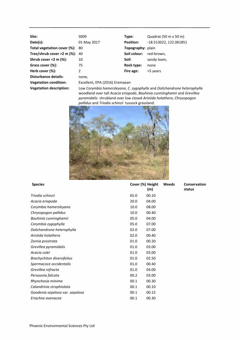
Site: S009 Type: Quadrat (50 m x 50 m)
Date(s): 01 May 2017
Topography: plain
Soil: sandy loam,
Soil colour: red-brown,
Rock type: none
Total vegetation cover (%): 80
Tree/shrub cover >2 m (%): 40
Shrub cover <2 m (%): 10
Grass cover (%): 75
Herb cover (%): 2
Disturbance details: none,
Fire age: >5 years
Vegetation description: Low Corymbia hamersleyana, C. zygophylla and Dolichandrone heterophylla woodland over tall Acacia eriopoda, Bauhinia cunniinghamii and Grevillea pyramidalis shrubland over low closed Aristida holathera, Chrysopogon pallidus and Triodia schinzii tussock grassland.
Vegetation condition: Excellent, EPA (2016) Eremaean
Position: -18.513022, 122.061851
Species Cover (%) Height (m)
Weeds Conservation status
65.0Triodia schinzii 00.10
20.0Acacia eriopoda 04.00
10.0Corymbia hamersleyana 08.00
10.0Chrysopogon pallidus 00.40
05.0Bauhinia cunninghamii 04.00
05.0Corymbia zygophylla 07.00
02.0Dolichandrone heterophylla 07.00
02.0Aristida holathera 00.40
01.0Zornia prostrata 00.20
01.0Grevillea pyramidalis 03.00
01.0Acacia colei 03.00
01.0Brachychiton diversifolius 02.50
01.0Spermacoce occidentalis 00.40
01.0Grevillea refracta 04.00
00.2Persoonia falcata 03.00
00.1Rhynchosia minima 00.30
00.1Calandrinia strophiolata 00.10
00.1Goodenia sepalosa var. sepalosa 00.15
00.1Eriachne avenacea 00.30
Phoenix Environmental Sciences Pty Ltd

00.1Panicum effusum 00.15
00.1Scaevola parvifolia subsp. parvifolia 00.20
00.1Sida sp. Pindan (B.G. Thomson 3398) 00.50
00.1Crotalaria aridicola subsp. densifolia 00.40
00.1Acacia adoxa var. subglabra 00.50
00.1Fimbristylis oxystachya 00.25
00.1Phyllanthus maderaspatensis 00.50
00.1Euphorbia hassallii 00.20
00.1? Polymeria sp. Broome 00.25 P1 (WC Act)
00.1Cleome viscosa 01.00
00.1Cucumis melo 00.20
00.1Hybanthus aurantiacus 00.50
00.1Ptilotus astrolasius 00.40
00.1Corchorus sidoides subsp. vermicularis 00.20
Phoenix Environmental Sciences Pty Ltd

Site: S010 Type: Quadrat (50 m x 50 m)
Date(s): 28 April 2017
Topography: plain
Soil: sand, sandy loam,
Soil colour: red-orange,
Rock type: none
Total vegetation cover (%): 85
Tree/shrub cover >2 m (%): 35
Shrub cover <2 m (%): 2
Grass cover (%): 75
Herb cover (%): 1
Disturbance details: none,
Fire age: 1 – 5 years
Vegetation description: Isolated low Corymbia hamersleyana trees over tall Acacia eriopoda, A. monticola and Grevillea wickhamii shrubland over low closed Triodia schinzii tussock grassland.
Vegetation condition: Excellent, EPA (2016) Eremaean
Position: -18.500572, 122.104345
Species Cover (%) Height (m)
Weeds Conservation status
75.0Triodia schinzii 00.30
20.0Acacia eriopoda 03.00
10.0Grevillea wickhamii 03.00
05.0Acacia monticola 02.80
05.0Sorghum plumosum 00.30
01.0Dodonaea hispidula var. arida 01.00
01.0Seringia nephrosperma 00.60
01.0Dolichandrone heterophylla 01.20
01.0Corymbia hamersleyana 04.00
01.0Jacksonia aculeata 00.80
01.0Acacia colei 03.00
00.1Cucumis melo 00.20
00.1Goodenia sepalosa var. sepalosa 00.15
00.1Spermacoce occidentalis 00.30
00.1Triumfetta johnstonii 00.50
00.1Senna notabilis 00.40
00.1Halgania solanacea 00.40
00.1Waltheria indica 00.40
00.1Nauclea orientalis 00.60
00.1Corymbia zygophylla 02.00
Phoenix Environmental Sciences Pty Ltd

00.1Goodenia stobbsiana 00.40
00.1Triodia caelestialis 00.40 P3 (WC Act)
00.1Fimbristylis oxystachya 00.20
00.1Acacia adoxa var. subglabra 00.50
00.1Oldenlandia mitrasacmoides subsp. mitrasacmoides 00.30
00.1Acacia stipuligera 01.50
00.1Phyllanthus maderaspatensis 00.30
00.1Chamaecrista symonii 00.20
00.1Solanum cunninghamii 00.40
00.1Codonocarpus cotinifolius 01.00
00.1Grevillea refracta 02.50
00.1Calandrinia strophiolata 00.10
00.1Zornia prostrata 00.10
00.1Stackhousia intermedia 00.25
00.1Corymbia sp. (white bark) 04.00
00.1Hybanthus aurantiacus 00.40
Phoenix Environmental Sciences Pty Ltd

Site: S011 Type: Quadrat (50 m x 50 m)
Date(s): 30 April 2017
Topography: plain
Soil: sandy clay, sandy loam,
Soil colour: red-orange,
Rock type: none
Total vegetation cover (%): 65
Tree/shrub cover >2 m (%): 40
Shrub cover <2 m (%): 10
Grass cover (%): 60
Herb cover (%): 2
Disturbance details: none,
Fire age: >5 years
Vegetation description: Isolated low Corymbia zygophylla trees over tall Acacia eriopoda, Erythrophleum chlorostachys and Grevillea wickhamii shrubland over low Aristida holathera, Sorghum plumosum and Triodia schinzii tussock grassland.
Vegetation condition: Excellent, EPA (2016) Eremaean
Position: -18.498322, 122.093833
Species Cover (%) Height (m)
Weeds Conservation status
50.0Triodia schinzii 00.30
15.0Acacia eriopoda 05.00
15.0Grevillea wickhamii 04.00
10.0Sorghum plumosum 00.40
10.0Erythrophleum chlorostachys 04.00
05.0Corymbia zygophylla 05.00
05.0Aristida holathera 00.40
01.0Halgania solanacea 00.30
01.0Brachychiton diversifolius 03.00
01.0Zornia prostrata 00.20
01.0Persoonia falcata 01.80
01.0Bulbostylis barbata 00.20
01.0Grevillea pyramidalis 01.50
01.0Acacia colei 03.00
00.5Grewia retusifolia 01.70
00.1Acacia adoxa var. subglabra 00.50
00.1Euphorbia hassallii 00.20
00.1Hibiscus leptocladus 00.25
00.1Mitrasacme connata 00.10
00.1Spermacoce occidentalis 00.40
Phoenix Environmental Sciences Pty Ltd

00.1Calandrinia strophiolata 00.10
00.1Rhynchosia minima 00.20
00.1Bauhinia cunninghamii 02.50
00.1Senna oligoclada 00.50
00.1Denhamia cunninghamii 02.20
00.1Scaevola parvifolia subsp. parvifolia 00.20
00.1Jacksonia aculeata 00.60
00.1Senna notabilis 00.40
00.1Zornia chaetophora 00.30
00.1Polycarpaea corymbosa 00.15
00.1Goodenia armitiana 00.20
00.1Dolichandrone heterophylla 01.50
00.1Cucumis melo 00.50
00.1Goodenia sepalosa var. sepalosa 00.10
00.1Corymbia sp. (sterile) 01.00
00.1Oldenlandia mitrasacmoides subsp. mitrasacmoides 00.20
00.1Eriachne avenacea 00.40
00.1Yakirra australiensis 00.10
00.1Polygala tepperi 00.50
Phoenix Environmental Sciences Pty Ltd

Site: S012 Type: Quadrat (50 m x 50 m)
Date(s): 29 April 2017
Topography: plain
Soil: sandy loam,
Soil colour: red-orange,
Rock type: none
Total vegetation cover (%): 80
Tree/shrub cover >2 m (%): 30
Shrub cover <2 m (%): 5
Grass cover (%): 75
Herb cover (%): 2
Disturbance details: none,
Fire age: >5 years
Vegetation description: Tall Acacia eriopoda, A. colei and Grevillea refracta shrubland over isolated low Corymbia zygophylla mallee over low closed Triodia schinzii tussock grassland.
Vegetation condition: Very Good, EPA (2016)
Position: -18.517106, 122.09047
Species Cover (%) Height (m)
Weeds Conservation status
75.0Triodia schinzii 00.30
30.0Acacia eriopoda 04.00
10.0Sorghum plumosum 00.30
05.0Bauhinia cunninghamii 01.80
05.0Corymbia zygophylla 02.00
02.0Acacia colei 03.00
02.0Halgania solanacea 00.40
02.0Indigofera monophylla 01.20
02.0Rhynchosia minima 03.00
01.0Grevillea refracta 03.00
01.0Seringia nephrosperma 00.40
00.1Bulbostylis barbata 00.20
00.1Tephrosia leptoclada 00.20
00.1Cleome viscosa 00.50
00.1Cucumis melo 01.50
00.1Phyllanthus maderaspatensis 00.50
00.1Spermacoce occidentalis 00.40
00.1Chamaecrista symonii 00.40
00.1Grewia retusifolia 01.50
00.1Heliotropium paniculatum 00.15
00.1Stackhousia intermedia 00.40
Phoenix Environmental Sciences Pty Ltd

00.1Calandrinia strophiolata 00.10
00.1Dolichandrone heterophylla 01.70
00.1Yakirra australiensis 00.10
00.1Grevillea pyramidalis 02.20
00.1Goodenia sepalosa var. sepalosa 00.15
00.1Trianthema pilosum 00.02
00.1Dodonaea hispidula var. arida 01.20
Phoenix Environmental Sciences Pty Ltd

Site: S013 Type: Quadrat (50 m x 50 m)
Date(s): 29 April 2017
Topography: plain
Soil: sandy loam,
Soil colour: red-brown,
Rock type: none
Total vegetation cover (%): 60
Tree/shrub cover >2 m (%): 10
Shrub cover <2 m (%): 20
Grass cover (%): 60
Herb cover (%): 2
Disturbance details: none,
Fire age: >5 years
Vegetation description: Low Corymbia hamersleyana and C. zygophylla woodland over tall open Acacia eriopoda shrubland over low Aristida holathera, Sorghum plumosum and Triodia schinzii tussock grassland.
Vegetation condition: Excellent, EPA (2016) Eremaean
Position: -18.53283, 122.079714
Species Cover (%) Height (m)
Weeds Conservation status
35.0Triodia schinzii 00.30
25.0Acacia eriopoda 03.00
15.0Sorghum plumosum 00.40
15.0Corymbia hamersleyana 08.00
10.0Aristida holathera 00.40
05.0Corymbia zygophylla 06.00
02.0Gardenia pyriformis 01.50
02.0Bauhinia cunninghamii 01.50
02.0Dodonaea hispidula var. arida 01.30
02.0Grevillea pyramidalis 01.80
01.0Cassytha filiformis 01.00
01.0Acacia adoxa var. subglabra 00.40
01.0Scaevola parvifolia subsp. parvifolia 00.25
01.0Rhynchosia minima 00.30
01.0Crotalaria ramosissima 00.25
01.0Ptilotus astrolasius 00.50
00.5Corchorus sidoides subsp. vermicularis 00.30
00.1Heliotropium paniculatum 00.30
00.1Trianthema cusackianum 00.02
00.1Polygala tepperi 00.40
Phoenix Environmental Sciences Pty Ltd

00.1Stackhousia intermedia 00.30
00.1Eriachne avenacea 00.15
00.1Halgania solanacea 00.30
00.1Panicum effusum 00.15
00.1Polycarpaea corymbosa 00.15
00.1Senna oligoclada 00.40
00.1Cleome uncifera 00.20
00.1Calandrinia strophiolata 00.10
00.1Dolichandrone heterophylla 01.20
00.1Bulbostylis barbata 00.20
00.1Tephrosia sp. D Kimberley Flora (R.D. Royce 1848) 00.15
00.1Sida sp. Pindan (B.G. Thomson 3398) 00.50
00.1Spermacoce occidentalis 00.30
00.1Goodenia sepalosa var. sepalosa 00.15
00.1Euphorbia hassallii 00.15
Phoenix Environmental Sciences Pty Ltd

Site: S014 Type: Quadrat (50 m x 50 m)
Date(s): 29 April 2017
Topography: plain
Soil: sandy loam,
Soil colour: red-brown,
Rock type: none
Total vegetation cover (%): 60
Tree/shrub cover >2 m (%): 10
Shrub cover <2 m (%): 20
Grass cover (%): 60
Herb cover (%): 3
Disturbance details: none,
Fire age: 1 – 5 years
Vegetation description: Isolated low Corymbia hamersleyana and C. zygophylla trees over tall Acacia eriopoda, Grevillea refracta and G. wickhamii shrubland over low Triodia caelestialis and Sorghum plumosum tussock grassland.
Vegetation condition: Excellent, EPA (2016) Eremaean
Position: -18.541975, 122.065012
Species Cover (%) Height (m)
Weeds Conservation status
50.0Triodia caelestialis 00.40 P3 (WC Act)
20.0Acacia eriopoda 03.00
10.0Grevillea wickhamii 03.00
10.0Sorghum plumosum 00.40
05.0Bauhinia cunninghamii 01.50
02.0Corymbia hamersleyana 04.00
02.0Halgania solanacea 00.30
02.0Aristida holathera 00.40
02.0Rhynchosia minima 00.50
02.0Corymbia zygophylla 04.00
02.0Grevillea refracta 03.00
01.0Eriachne avenacea 00.40
01.0Acacia adoxa var. subglabra 00.50
01.0Calandrinia strophiolata 00.10
01.0Grevillea pyramidalis 04.00
01.0Scaevola parvifolia subsp. parvifolia 00.15
01.0Dodonaea hispidula var. arida 01.20
01.0Ptilotus astrolasius 00.50
00.1Bulbostylis barbata 00.15
00.1Tephrosia sp. D Kimberley Flora (R.D. Royce 1848) 00.15
Phoenix Environmental Sciences Pty Ltd

00.1Euphorbia hassallii 00.25
00.1Hybanthus aurantiacus 00.40
00.1Heliotropium paniculatum 00.15
00.1Clerodendrum floribundum 01.70
00.1Oldenlandia mitrasacmoides subsp. mitrasacmoides 00.20
00.1Trianthema pilosum 00.02
00.1Tephrosia leptoclada 00.15
00.1Yakirra australiensis 00.15
00.1Leptosema anomalum 00.30
00.1Hibiscus sturtii var. campylochlamys 00.70
00.1Dolichandrone heterophylla 01.50
00.1Cucumis melo 00.50
00.1Phyllanthus maderaspatensis 00.40
00.1Corchorus sidoides subsp. vermicularis 00.30
00.1Goodenia sepalosa var. sepalosa 00.15
Phoenix Environmental Sciences Pty Ltd
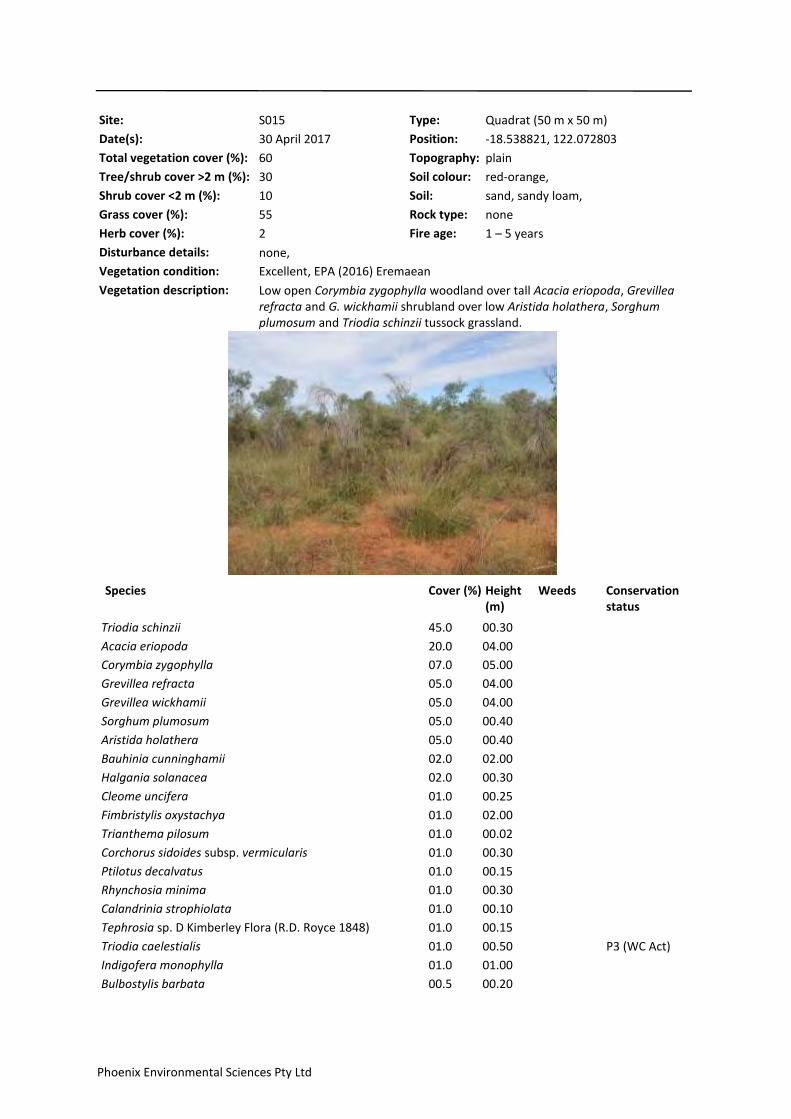
Site: S015 Type: Quadrat (50 m x 50 m)
Date(s): 30 April 2017
Topography: plain
Soil: sand, sandy loam,
Soil colour: red-orange,
Rock type: none
Total vegetation cover (%): 60
Tree/shrub cover >2 m (%): 30
Shrub cover <2 m (%): 10
Grass cover (%): 55
Herb cover (%): 2
Disturbance details: none,
Fire age: 1 – 5 years
Vegetation description: Low open Corymbia zygophylla woodland over tall Acacia eriopoda, Grevillea refracta and G. wickhamii shrubland over low Aristida holathera, Sorghum plumosum and Triodia schinzii tussock grassland.
Vegetation condition: Excellent, EPA (2016) Eremaean
Position: -18.538821, 122.072803
Species Cover (%) Height (m)
Weeds Conservation status
45.0Triodia schinzii 00.30
20.0Acacia eriopoda 04.00
07.0Corymbia zygophylla 05.00
05.0Grevillea refracta 04.00
05.0Grevillea wickhamii 04.00
05.0Sorghum plumosum 00.40
05.0Aristida holathera 00.40
02.0Bauhinia cunninghamii 02.00
02.0Halgania solanacea 00.30
01.0Cleome uncifera 00.25
01.0Fimbristylis oxystachya 02.00
01.0Trianthema pilosum 00.02
01.0Corchorus sidoides subsp. vermicularis 00.30
01.0Ptilotus decalvatus 00.15
01.0Rhynchosia minima 00.30
01.0Calandrinia strophiolata 00.10
01.0Tephrosia sp. D Kimberley Flora (R.D. Royce 1848) 00.15
01.0Triodia caelestialis 00.50 P3 (WC Act)
01.0Indigofera monophylla 01.00
00.5Bulbostylis barbata 00.20
Phoenix Environmental Sciences Pty Ltd
00.5Goodenia sepalosa var. sepalosa 00.15
00.1Ipomoea sp. sterile 00.40
00.1Polygala tepperi 00.40
00.1Acacia adoxa var. subglabra 00.50
00.1Sida sp. Pindan (B.G. Thomson 3398) 00.60
00.1Gyrostemon tepperi 00.80
00.1Gardenia pyriformis 01.20
00.1Dodonaea hispidula var. arida 01.00
00.1Solanum diversiflorum 00.30
00.1Solanum cunninghamii 00.40
00.1Hibiscus sturtii var. campylochlamys 00.80
00.1Waltheria indica 00.50
00.1Clerodendrum floribundum 01.80
00.1Polycarpaea corymbosa 00.20
00.1Cucumis melo 00.20
00.1Heliotropium paniculatum 00.25
00.1Grevillea pyramidalis 02.00
00.1Abutilon otocarpum 25.00
00.1Tephrosia leptoclada 00.15
00.1Yakirra australiensis 00.15
00.1Euphorbia hassallii 00.15
00.1? Polymeria sp. Broome 00.15 P1 (WC Act)
00.1Panicum effusum 00.15
00.1Scaevola parvifolia subsp. parvifolia 00.15
00.1Senna oligoclada 00.40
00.1Zornia prostrata 00.15
00.1Senna notabilis 00.40
Phoenix Environmental Sciences Pty Ltd

Site: S016 Type: Quadrat (50 m x 50 m)
Date(s): 02 May 2017
Topography: plain
Soil: sandy loam,
Soil colour: red-orange,
Rock type: none
Total vegetation cover (%): 80
Tree/shrub cover >2 m (%): 35
Shrub cover <2 m (%): 10
Grass cover (%): 75
Herb cover (%): 2
Disturbance details: livestock tracks,
Fire age: >5 years
Vegetation description: Tall Acacia eriopoda shrubland over sparse mid Seringia nephrosperma shrubland over low closed Chrysopogon pallidus and Triodia schinzii tussock grassland.
Vegetation condition: Excellent, EPA (2016) Eremaean
Position: -18.494817, 122.077724
Species Cover (%) Height (m)
Weeds Conservation status
45.0Triodia schinzii 00.30
35.0Chrysopogon pallidus 00.40
30.0Acacia eriopoda 04.00
07.0Seringia nephrosperma 00.60
02.0Bauhinia cunninghamii 02.50
01.0Corymbia zygophylla 04.00
01.0Grevillea pyramidalis 01.50
01.0Dodonaea hispidula var. arida 01.20
01.0Dolichandrone heterophylla 01.80
01.0Brachychiton diversifolius 02.00
01.0Halgania solanacea 00.40
01.0Corymbia hamersleyana 03.00
00.1Indigofera monophylla 01.20
00.1Trianthema pilosum 00.02
00.1Euphorbia hassallii 00.20
00.1Mitrasacme connata 00.20
00.1Scaevola parvifolia subsp. parvifolia 00.15
00.1Spermacoce occidentalis 00.40
00.1Acacia colei 02.00
00.1Grevillea pyramidalis subsp. leucadendron 01.50
Phoenix Environmental Sciences Pty Ltd
00.1Calandrinia strophiolata 00.10
00.1Leptosema anomalum 00.25
00.1Senna notabilis 00.50
00.1Newcastelia cladotricha 00.50
00.1Heliotropium paniculatum 00.25
00.1Hibiscus sturtii var. campylochlamys 00.30
00.1Yakirra australiensis 00.10
00.1Fimbristylis oxystachya 02.00
00.1Goodenia sepalosa var. sepalosa 00.15
00.1Cucumis melo 00.40
00.1Ipomoea sp. sterile 00.40
00.1Senna oligoclada 00.30
00.1Zornia prostrata 00.20
00.1Aristida holathera 00.40
00.1Panicum effusum 00.15
00.1Phyllanthus maderaspatensis 00.50
00.1Tephrosia leptoclada 00.20
00.1Cassytha filiformis 04.00
Phoenix Environmental Sciences Pty Ltd

Site: S017 Type: Quadrat (50 m x 50 m)
Date(s): 30 April 2017
Topography: plain
Soil: sand, sandy loam,
Soil colour: red-orange,
Rock type: none
Total vegetation cover (%): 75
Tree/shrub cover >2 m (%): 40
Shrub cover <2 m (%): 5
Grass cover (%): 70
Herb cover (%): 2
Disturbance details: none,
Fire age: >5 years
Vegetation description: Low Corymbia hamersleyana and C. zygophylla woodland over tall Acacia eriopoda, Bauhinia cunninghamii and Grevillea pyramidalis shrubland over low closed Triodia schinzii tussock grassland.
Vegetation condition: Excellent, EPA (2016) Eremaean
Position: -18.513998, 122.085541
Species Cover (%) Height (m)
Weeds Conservation status
70.0Triodia schinzii 00.30
30.0Acacia eriopoda 04.00
10.0Bauhinia cunninghamii 02.00
10.0Corymbia zygophylla 05.00
05.0Corymbia hamersleyana 05.00
05.0Grevillea pyramidalis 02.00
05.0Aristida holathera 00.40
05.0Sorghum plumosum 00.40
03.0Dolichandrone heterophylla 01.50
02.0Halgania solanacea 00.40
02.0Acacia colei 03.00
01.0Spermacoce occidentalis 00.40
01.0Rhynchosia minima 00.30
01.0Indigofera monophylla 01.50
01.0Cassytha filiformis 02.50
00.1Bulbostylis barbata 00.15
00.1Yakirra australiensis 00.15
00.1Euphorbia hassallii 00.15
00.1Phyllanthus maderaspatensis 00.50
00.1Gomphrena canescens 00.25
Phoenix Environmental Sciences Pty Ltd

00.1Eriachne avenacea 00.40
00.1Goodenia sepalosa var. sepalosa 00.15
00.1Tephrosia sp. D Kimberley Flora (R.D. Royce 1848) 00.15
00.1Cleome uncifera 00.30
00.1Heliotropium paniculatum 00.25
00.1Polycarpaea corymbosa 00.10
00.1Zornia prostrata 00.15
00.1Tephrosia leptoclada 00.25
00.1Oldenlandia mitrasacmoides subsp. mitrasacmoides 00.30
00.1Trianthema pilosum 00.02
00.1Corchorus sidoides subsp. vermicularis 00.15
00.1Clerodendrum floribundum 01.80
00.1Calandrinia strophiolata 00.10
00.1Chamaecrista symonii 00.40
Phoenix Environmental Sciences Pty Ltd

Site: S018 Type: Quadrat (50 m x 50 m)
Date(s): 02 May 2017
Topography: plain
Soil: sand, sandy loam,
Soil colour: red-brown,
Rock type: none
Total vegetation cover (%): 80
Tree/shrub cover >2 m (%): 35
Shrub cover <2 m (%): 5
Grass cover (%): 75
Herb cover (%): 2
Disturbance details: grazing – low, livestock tracks,
Fire age: >5 years
Vegetation description: Isolated low Corymbia zygophylla trees over tall Acacia eriopoda shrubland over low closed Aristida holathera, Chrysopogon pallidus and Triodia schinzii tussock grassland and sparse low Fimbristylis oxystachya sedgeland.
Vegetation condition: Excellent, EPA (2016) Eremaean
Position: -18.528515, 122.072198
Species Cover (%) Height (m)
Weeds Conservation status
55.0Aristida holathera 00.40
30.0Acacia eriopoda 04.00
10.0Triodia schinzii 00.30
10.0Chrysopogon pallidus 00.40
05.0Corymbia zygophylla 05.00
05.0Fimbristylis oxystachya 00.25
02.0Zornia prostrata 00.20
01.0Acacia colei 05.00
01.0Dolichandrone heterophylla 01.80
01.0Jacksonia aculeata 01.00
00.5Bauhinia cunninghamii 02.00
00.5Rhynchosia minima 00.30
00.1? Polymeria sp. Broome 00.30 P1 (WC Act)
00.1Heliotropium paniculatum 00.40
00.1Oldenlandia mitrasacmoides subsp. mitrasacmoides 00.20
00.1Senna oligoclada 00.50
00.1Goodenia sepalosa var. sepalosa 00.15
00.1Tephrosia sp. D Kimberley Flora (R.D. Royce 1848) 00.25
00.1Euphorbia hassallii 00.20
00.1Waltheria indica 00.40
Phoenix Environmental Sciences Pty Ltd
00.1Ehretia saligna 01.80
00.1Corymbia hamersleyana 02.00
00.1Scaevola parvifolia subsp. parvifolia 00.20
00.1Indigofera monophylla 00.30
00.1Solanum diversiflorum 00.30
00.1Halgania solanacea 00.30
00.1Acacia adoxa var. subglabra 00.40
00.1Calandrinia strophiolata 00.10
00.1Corchorus sidoides subsp. vermicularis 00.25
00.1Grevillea pyramidalis 01.00
00.1Spermacoce occidentalis 00.25
00.1Clerodendrum floribundum 01.50
00.1Mitrasacme connata 00.10
00.1Ptilotus decalvatus 00.15
00.1Dodonaea hispidula var. arida 01.00
00.1Panicum effusum 00.20
00.1Senna notabilis 00.40
Phoenix Environmental Sciences Pty Ltd

Site: S019 Type: Quadrat (50 m x 50 m)
Date(s): 30 April 2017
Topography: plain
Soil: sandy clay, sandy loam,
Soil colour: red-orange,
Rock type: none
Total vegetation cover (%): 70
Tree/shrub cover >2 m (%): 40
Shrub cover <2 m (%): 5
Grass cover (%): 60
Herb cover (%): 2
Disturbance details: grazing – low, livestock tracks,
Fire age: >5 years
Vegetation description: Low Corymbia hamersleyana and C. zygophylla woodland over tall Acacia colei, A. eriopoda and Grevillea refracta shrubland over low Aristida holathera, Sorghum plumosum and Triodia schinzii tussock grassland.
Vegetation condition: Excellent, EPA (2016) Eremaean
Position: -18.507179, 122.095085
Species Cover (%) Height (m)
Weeds Conservation status
45.0Triodia schinzii 00.30
20.0Acacia eriopoda 04.00
10.0Sorghum plumosum 00.40
05.0Corymbia hamersleyana 05.00
05.0Acacia colei 04.00
05.0Grevillea refracta 04.00
05.0Aristida holathera 00.40
05.0Corymbia zygophylla 04.00
04.0Bauhinia cunninghamii 02.00
02.0Grevillea pyramidalis 01.80
02.0Dolichandrone heterophylla 01.80
02.0Halgania solanacea 00.40
01.0Grevillea wickhamii 04.00
01.0Gardenia pyriformis 01.50
01.0Persoonia falcata 01.80
01.0Rhynchosia minima 00.30
00.5Zornia prostrata 00.15
00.5Trianthema pilosum 00.02
00.5Spermacoce occidentalis 00.40
00.5Grewia retusifolia 01.70
Phoenix Environmental Sciences Pty Ltd
00.2Chamaecrista symonii 00.40
00.1Scaevola parvifolia subsp. parvifolia 00.15
00.1Euphorbia hassallii 00.10
00.1Fimbristylis oxystachya 00.20
00.1Oldenlandia mitrasacmoides subsp. mitrasacmoides 00.20
00.1Seringia nephrosperma 00.40
00.1Corchorus sidoides subsp. vermicularis 00.30
00.1Ipomoea sp. sterile 03.00
00.1Mitrasacme connata 00.10
00.1Zornia chaetophora 00.20
00.1Brachychiton diversifolius 03.00
00.1Calandrinia strophiolata 00.10
00.1Portulaca bicolor 00.01
00.1Panicum effusum 00.15
00.1Tephrosia sp. D Kimberley Flora (R.D. Royce 1848) 00.10
00.1Cassytha filiformis 04.00
00.1Heliotropium paniculatum 00.30
00.1Cucumis melo 00.40
00.1Polycarpaea corymbosa 00.10
00.1Bulbostylis barbata 00.10
00.1? Polymeria sp. Broome 00.20 P1 (WC Act)
00.1Eriachne avenacea 00.40
00.1Leptosema anomalum 00.25
00.1Goodenia sepalosa var. sepalosa 00.15
00.1Yakirra australiensis 00.10
Phoenix Environmental Sciences Pty Ltd

Site: S020 Type: Quadrat (50 m x 50 m)
Date(s): 30 April 2017
Topography: plain
Soil: sand, sandy loam,
Soil colour: red-orange,
Rock type: none
Total vegetation cover (%): 80
Tree/shrub cover >2 m (%): 30
Shrub cover <2 m (%): 5
Grass cover (%): 75
Herb cover (%): 2
Disturbance details: none,
Fire age: >5 years
Vegetation description: Low open Corymbia hamersleyana and C. zygophylla woodland over tall Acacia eriopoda and Grevillea refracta shrubland over low closed Triodia schinzii tussock grassland.
Vegetation condition: Excellent, EPA (2016) Eremaean
Position: -18.513349, 122.075449
Species Cover (%) Height (m)
Weeds Conservation status
75.0Triodia schinzii 00.40
20.0Acacia eriopoda 04.00
10.0Grevillea refracta 04.00
05.0Corymbia hamersleyana 05.00
05.0Bauhinia cunninghamii 01.80
05.0Sorghum plumosum 00.40
02.0Dolichandrone heterophylla 01.50
02.0Acacia colei 04.00
01.0Rhynchosia minima 00.30
01.0Calandrinia strophiolata 00.10
01.0Spermacoce occidentalis 00.40
01.0Indigofera monophylla 01.00
01.0Zornia prostrata 02.00
01.0Corymbia zygophylla 04.00
01.0Halgania solanacea 00.30
01.0Triodia caelestialis 00.50 P3 (WC Act)
01.0Grevillea pyramidalis 01.50
00.5Bulbostylis barbata 00.20
00.2Goodenia sepalosa var. sepalosa 00.10
00.1Heliotropium paniculatum 00.25
Phoenix Environmental Sciences Pty Ltd

00.1Phyllanthus maderaspatensis 00.50
00.1Cleome viscosa 00.40
00.1Trianthema pilosum 00.02
00.1Acacia adoxa var. subglabra 00.60
00.1Clerodendrum floribundum 01.50
00.1Ipomoea sp. sterile 02.00
00.1Grewia retusifolia 01.50
00.1Tephrosia sp. D Kimberley Flora (R.D. Royce 1848) 00.15
Phoenix Environmental Sciences Pty Ltd
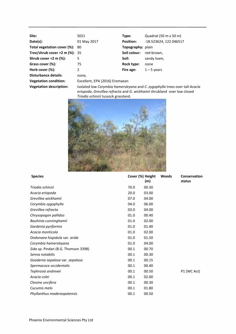
Site: S021 Type: Quadrat (50 m x 50 m)
Date(s): 01 May 2017
Topography: plain
Soil: sandy loam,
Soil colour: red-brown,
Rock type: none
Total vegetation cover (%): 80
Tree/shrub cover >2 m (%): 35
Shrub cover <2 m (%): 5
Grass cover (%): 75
Herb cover (%): 2
Disturbance details: none,
Fire age: 1 – 5 years
Vegetation description: Isolated low Corymbia hamersleyana and C. zygophylla trees over tall Acacia eriopoda, Grevillea refracta and G. wickhamii shrubland over low closed Triodia schinzii tussock grassland.
Vegetation condition: Excellent, EPA (2016) Eremaean
Position: -18.523624, 122.046517
Species Cover (%) Height (m)
Weeds Conservation status
70.0Triodia schinzii 00.30
20.0Acacia eriopoda 03.00
07.0Grevillea wickhamii 04.00
04.0Corymbia zygophylla 06.00
03.0Grevillea refracta 04.00
01.0Chrysopogon pallidus 00.40
01.0Bauhinia cunninghamii 02.00
01.0Gardenia pyriformis 01.40
01.0Acacia monticola 02.00
01.0Dodonaea hispidula var. arida 01.50
01.0Corymbia hamersleyana 04.00
00.1Sida sp. Pindan (B.G. Thomson 3398) 00.70
00.1Senna notabilis 00.30
00.1Goodenia sepalosa var. sepalosa 00.15
00.1Spermacoce occidentalis 00.40
00.1Tephrosia andrewii 00.50 P1 (WC Act)
00.1Acacia colei 02.00
00.1Cleome uncifera 00.30
00.1Cucumis melo 01.80
00.1Phyllanthus maderaspatensis 00.50
Phoenix Environmental Sciences Pty Ltd

00.1Waltheria indica 00.20
00.1Ptilotus astrolasius 00.60
00.1Ipomoea sp. sterile 03.00
00.1Seringia nephrosperma 00.40
00.1Corchorus sidoides subsp. vermicularis 00.30
00.1Euphorbia hassallii 00.15
00.1Calandrinia strophiolata 00.10
00.1Yakirra australiensis 00.10
00.1Hybanthus aurantiacus 00.40
00.1Dolichandrone heterophylla 01.00
Phoenix Environmental Sciences Pty Ltd
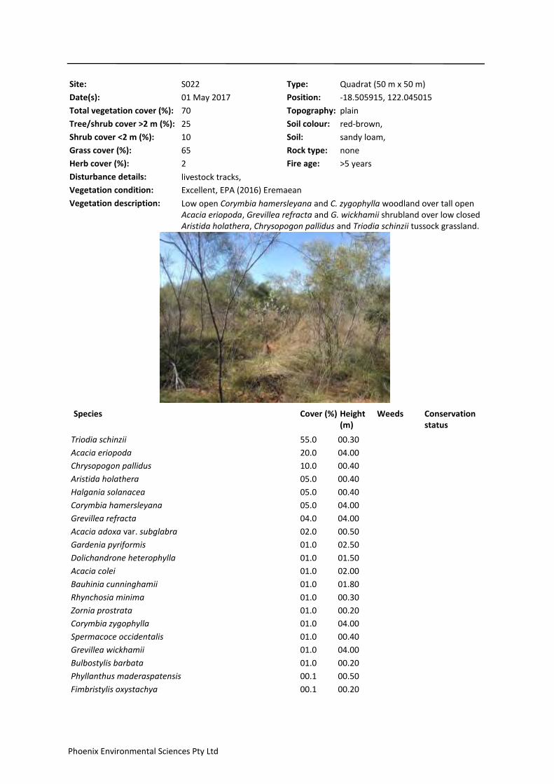
Site: S022 Type: Quadrat (50 m x 50 m)
Date(s): 01 May 2017
Topography: plain
Soil: sandy loam,
Soil colour: red-brown,
Rock type: none
Total vegetation cover (%): 70
Tree/shrub cover >2 m (%): 25
Shrub cover <2 m (%): 10
Grass cover (%): 65
Herb cover (%): 2
Disturbance details: livestock tracks,
Fire age: >5 years
Vegetation description: Low open Corymbia hamersleyana and C. zygophylla woodland over tall open Acacia eriopoda, Grevillea refracta and G. wickhamii shrubland over low closed Aristida holathera, Chrysopogon pallidus and Triodia schinzii tussock grassland.
Vegetation condition: Excellent, EPA (2016) Eremaean
Position: -18.505915, 122.045015
Species Cover (%) Height (m)
Weeds Conservation status
55.0Triodia schinzii 00.30
20.0Acacia eriopoda 04.00
10.0Chrysopogon pallidus 00.40
05.0Aristida holathera 00.40
05.0Halgania solanacea 00.40
05.0Corymbia hamersleyana 04.00
04.0Grevillea refracta 04.00
02.0Acacia adoxa var. subglabra 00.50
01.0Gardenia pyriformis 02.50
01.0Dolichandrone heterophylla 01.50
01.0Acacia colei 02.00
01.0Bauhinia cunninghamii 01.80
01.0Rhynchosia minima 00.30
01.0Zornia prostrata 00.20
01.0Corymbia zygophylla 04.00
01.0Spermacoce occidentalis 00.40
01.0Grevillea wickhamii 04.00
01.0Bulbostylis barbata 00.20
00.1Phyllanthus maderaspatensis 00.50
00.1Fimbristylis oxystachya 00.20
Phoenix Environmental Sciences Pty Ltd
00.1Calandrinia strophiolata 00.10
00.1Polycarpaea corymbosa 00.20
00.1Goodenia sepalosa var. sepalosa 00.15
00.1Acacia monticola 01.80
00.1Cleome viscosa 00.50
00.1Polygala tepperi 00.40
00.1Indigofera monophylla 00.70
00.1Yakirra australiensis 00.25
00.1Solanum cunninghamii 00.40
00.1Cucumis melo 00.10
00.1Abutilon macrum 00.30
00.1Heliotropium paniculatum 00.30
00.1Cynanchum carnosum 01.20
00.1Triumfetta johnstonii 00.25
00.1Cassytha filiformis 04.00
00.1Dodonaea hispidula var. arida 01.00
00.1Grevillea pyramidalis 01.50
00.1Panicum effusum 00.15
00.1Ptilotus astrolasius 00.40
00.1Euphorbia hassallii 00.20
00.1Scaevola parvifolia subsp. parvifolia 00.15
00.1? Polymeria sp. Broome 00.20 P1 (WC Act)
Phoenix Environmental Sciences Pty Ltd
Site: S023 Type: Quadrat (50 m x 50 m)
Date(s): 29 April 2017
Topography: plain
Soil: sand, sandy loam,
Soil colour: red-orange,
Rock type: none
Total vegetation cover (%): 80
Tree/shrub cover >2 m (%): 25
Shrub cover <2 m (%): 5
Grass cover (%): 75
Herb cover (%): 2
Disturbance details: none,
Fire age: >5 years
Vegetation description: Isolated low Corymbia hamersleyana and C. zygophylla trees over tall open Acacia eriopoda, Grevillea pyramidalis and G. wickhamii shrubland over low closed Sorghum plumosum and Triodia schinzii tussock grassland.
Vegetation condition: Excellent, EPA (2016) Eremaean
Position: -18.53461, 122.056411
Species Cover (%) Height (m)
Weeds Conservation status
75.0Triodia schinzii 00.30
10.0Grevillea wickhamii 03.00
10.0Acacia eriopoda 03.00
05.0Sorghum plumosum 00.40
02.0Jacksonia aculeata 00.50
02.0Acacia adoxa var. subglabra 00.50
02.0Bauhinia cunninghamii 01.80
01.0Zornia prostrata 00.15
01.0Halgania solanacea 00.30
01.0Grevillea pyramidalis subsp. pyramidalis 02.00
01.0Gardenia pyriformis 01.50
01.0Indigofera monophylla 00.70
01.0Corymbia zygophylla 05.00
01.0Corymbia hamersleyana 05.00
01.0Grevillea pyramidalis 02.00
00.5Goodenia sepalosa var. sepalosa 00.15
00.1Wrightia saligna 01.20
00.1Waltheria indica 00.80
00.1Spermacoce occidentalis 00.20
00.1Ptilotus astrolasius 00.50
Phoenix Environmental Sciences Pty Ltd

00.1Acacia platycarpa 01.00
00.1Brachychiton diversifolius 01.40
00.1Phyllanthus maderaspatensis 00.30
00.1Euphorbia hassallii 00.20
00.1Dolichandrone heterophylla 01.20
00.1Tephrosia andrewii 00.40 P1 (WC Act)
00.1Hibiscus sturtii var. campylochlamys 00.20
00.1Cynanchum carnosum 01.20
00.1Codonocarpus cotinifolius 01.50
00.1Stackhousia intermedia 00.50
00.1Calandrinia strophiolata 00.10
00.1Hybanthus aurantiacus 00.40
00.1Fimbristylis oxystachya 00.40
00.1Tephrosia sp. D Kimberley Flora (R.D. Royce 1848) 03.00
00.1Solanum diversiflorum 00.60
00.1Grevillea refracta 03.00
00.1Eriachne avenacea 00.50
00.1Trianthema pilosum 00.05
00.1Senna oligoclada 00.30
00.1Dodonaea hispidula var. arida 01.20
00.1Cucumis melo 00.50
00.1Aristida holathera 00.40
00.1Heliotropium paniculatum 00.30
00.1Cassytha filiformis 00.50
00.1Corchorus sidoides subsp. vermicularis 00.20
00.1Senna notabilis 00.30
Phoenix Environmental Sciences Pty Ltd

Site: S024 Type: Quadrat (50 m x 50 m)
Date(s): 03 May 2017
Topography: plain
Soil: sand, sandy loam,
Soil colour: red-orange,
Rock type: none
Total vegetation cover (%): 30
Tree/shrub cover >2 m (%): 7
Shrub cover <2 m (%): 10
Grass cover (%): 15
Herb cover (%): 2
Disturbance details: grazing – low, livestock tracks,
Fire age: 1 – 5 years
Vegetation description: Low Corymbia hamersleyana and C. zygophylla woodland over low sparse Indigofera monophylla, Tephrosia andrewii and T. sp. D Kimberley Flora shrubland over low open Aristida holathera, Chrysopogon pallidus and Triodia schinzii tussock grassland.
Vegetation condition: Excellent, EPA (2016) Eremaean
Position: -18.545435, 122.065837
Species Cover (%) Height (m)
Weeds Conservation status
10.0Triodia schinzii 00.20
10.0Corymbia zygophylla 05.00
05.0Corymbia hamersleyana 05.00
05.0Tephrosia andrewii 00.30 P1 (WC Act)
05.0Chrysopogon pallidus 00.30
03.0Indigofera monophylla 00.70
02.0Corymbia flavescens 05.00
01.0Acacia eriopoda 00.40
01.0Aristida holathera 00.40
01.0Rhynchosia minima 00.15
01.0Tephrosia sp. D Kimberley Flora (R.D. Royce 1848) 00.20
01.0Corchorus sidoides subsp. vermicularis 00.20
00.5Bauhinia cunninghamii 01.00
00.5Trianthema pilosum 00.02
00.1Bulbostylis barbata 00.15
00.1Acacia colei 00.30
00.1Heliotropium paniculatum 00.30
00.1Solanum diversiflorum 00.25
00.1Calandrinia strophiolata 00.10
Phoenix Environmental Sciences Pty Ltd

00.1Cleome uncifera 00.15
00.1Leptosema anomalum 00.20
00.1Polycarpaea corymbosa 00.10
00.1Grevillea refracta 00.30
00.1Tephrosia leptoclada 00.20
00.1Goodenia sepalosa var. sepalosa 00.15
00.1Acacia adoxa var. subglabra 00.15
00.1Gardenia pyriformis 00.20
00.1Evolvulus alsinoides var. decumbens 00.20
00.1Fimbristylis nuda 00.10
00.1Panicum effusum 00.20
00.1Ptilotus decalvatus 00.10
00.1Grevillea pyramidalis 00.70
00.1Sida sp. Pindan (B.G. Thomson 3398) 00.30
00.1Tephrosia remotiflora 00.30
00.1Indigofera colutea 00.05
00.1Zornia prostrata 00.15
00.1Senna notabilis 00.50
00.1Polymeria ambigua 00.10
00.1Cucumis melo 00.30
00.1Solanum cunninghamii 00.40
00.1Dolichandrone heterophylla 01.00
00.1Ptilotus astrolasius 00.15
00.1Euphorbia hassallii 00.10
00.1Tribulopis angustifolia 00.02
00.1Mitrasacme connata 00.10
00.1Spermacoce occidentalis 00.20
00.1Hybanthus aurantiacus 00.15
00.1Scaevola parvifolia subsp. parvifolia 00.15
00.1Chamaecrista symonii 00.20
00.1Triumfetta johnstonii 00.10
Phoenix Environmental Sciences Pty Ltd
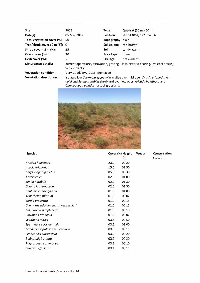
Site: S025 Type: Quadrat (50 m x 50 m)
Date(s): 05 May 2017
Topography: plain
Soil: sandy loam,
Soil colour: red-brown,
Rock type: none
Total vegetation cover (%): 50
Tree/shrub cover >2 m (%): 0
Shrub cover <2 m (%): 25
Grass cover (%): 30
Herb cover (%): 5
Disturbance details: current operations, excavation, grazing – low, historic clearing, livestock tracks, vehicle tracks,
Fire age: not evident
Vegetation description: Isolated low Corymbia zygophylla mallee over mid open Acacia eriopoda, A. colei and Senna notabilis shrubland over low open Aristida holathera and Chrysopogon pallidus tussock grassland.
Vegetation condition: Very Good, EPA (2016) Eremaean
Position: -18.513064, 122.094386
Species Cover (%) Height (m)
Weeds Conservation status
20.0Aristida holathera 00.20
15.0Acacia eriopoda 01.50
05.0Chrysopogon pallidus 00.30
02.0Acacia colei 01.00
02.0Senna notabilis 01.30
02.0Corymbia zygophylla 01.50
01.0Bauhinia cunninghamii 01.00
01.0Trianthema pilosum 00.02
01.0Zornia prostrata 00.15
01.0Corchorus sidoides subsp. vermicularis 00.15
01.0Calandrinia strophiolata 00.10
01.0Polymeria ambigua 00.02
00.5Waltheria indica 00.50
00.5Spermacoce occidentalis 03.00
00.5Goodenia sepalosa var. sepalosa 00.15
00.2Fimbristylis oxystachya 00.20
00.2Bulbostylis barbata 00.20
00.1Polycarpaea corymbosa 00.10
00.1Panicum effusum 00.15
Phoenix Environmental Sciences Pty Ltd
00.1Chamaecrista symonii 00.20
00.1Eriachne avenacea 00.20
00.1Tribulopis angustifolia 00.02
00.1Polygala tepperi 00.30
00.1Hibiscus sturtii var. campylochlamys 00.40
00.1Trichodesma zeylanicum var. latisepaleum 01.00
00.1Tephrosia sp. D Kimberley Flora (R.D. Royce 1848) 00.15
00.1Hybanthus aurantiacus 00.30
00.1Grewia retusifolia 01.00
00.1Gardenia pyriformis 01.00
00.1Tephrosia leptoclada 00.10
00.1Scaevola parvifolia subsp. parvifolia 00.15
00.1Yakirra australiensis 00.10
00.1Indigofera monophylla 00.80
00.1Rhynchosia minima 00.10
00.1Mitrasacme connata 00.10
00.1Solanum cunninghamii 00.40
00.1Euphorbia hassallii 00.20
00.1Eragrostis eriopoda 00.10
00.1Heliotropium paniculatum 00.15
00.1Grevillea refracta 00.30
00.1Dolichandrone heterophylla 00.60
00.1Sida rohlenae subsp. rohlenae 00.30
00.1Sida sp. Pindan (B.G. Thomson 3398) 00.40
Phoenix Environmental Sciences Pty Ltd

Flora and vegetation survey and terrestrial fauna survey for Shamrock Station Irrigation Project
Prepared for Argyle Cattle Company Pty Ltd
Phoenix Environmental Sciences Pty Ltd
Appendix 4 Terrestrial fauna survey site descriptions

0A001 (Quadrat) (-18.534139, 122.065455)
Topography: plain
Slope: negligible
Soil: sandy loam
Soil colour: red–brown
Rock type: none
Disturbance: grazing – medium, livestock tracks
Fire age: Not recorded
Habitat description:
Tall shrubland. Scattered patches of tall dhrubs and isolated Corymbia sp. to 5 m, over sparsely scattered small to medium shrubs to 1.5 m, over dense hummock and tussock grasses to 0.75 m, on sandy, loam substrate.
Habitat type: shrubland
Site:
0A002 (Quadrat) (-18.513174, 122.039736)
Topography: plain
Slope: negligible
Soil: sandy loam
Soil colour: red–brown
Rock type: none
Disturbance: grazing – medium, livestock tracks
Fire age: Not recorded
Habitat description:
Tall shrubland. Scattered tall shrubs to 4 m, over sparsely scattered small to medium shrubs to 2 m, over scattered patches of tussock grasses to 0.5 m. Scattered patches of sparse vegetation with exposed sandy, loam substrate. Scatered patches of dense shrub or grassy understorey.
Habitat type: shrubland
Site:
0A003 (Quadrat) (-18.518625, 122.050946)
Topography: plain
Slope: negligible
Soil: sandy loam
Soil colour: red–brown
Rock type: none
Disturbance: grazing – medium, livestock tracks
Fire age: Not recorded
Habitat description:
Tall shrubland. Sparsely scattered Corymbia sp. to 5 m, over scattered patches of tall shrubs to 4 m, over sparsely scattered small shrubs to 1.5 m and dense tussock grass patches to 0.5 m, on sandy, loam substrate.
Habitat type: shrubland
Site:
Phoenix Environmental Sciences Pty Ltd
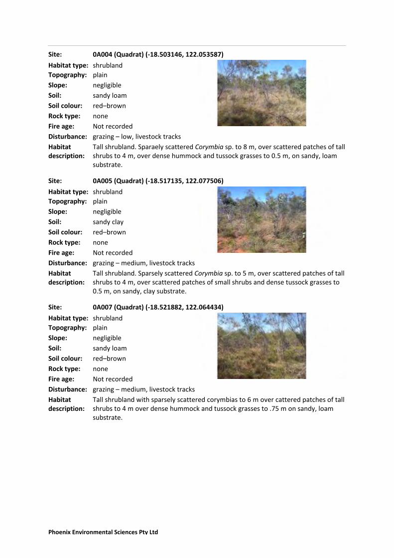
0A004 (Quadrat) (-18.503146, 122.053587)
Topography: plain
Slope: negligible
Soil: sandy loam
Soil colour: red–brown
Rock type: none
Disturbance: grazing – low, livestock tracks
Fire age: Not recorded
Habitat description:
Tall shrubland. Sparaely scattered Corymbia sp. to 8 m, over scattered patches of tall shrubs to 4 m, over dense hummock and tussock grasses to 0.5 m, on sandy, loam substrate.
Habitat type: shrubland
Site:
0A005 (Quadrat) (-18.517135, 122.077506)
Topography: plain
Slope: negligible
Soil: sandy clay
Soil colour: red–brown
Rock type: none
Disturbance: grazing – medium, livestock tracks
Fire age: Not recorded
Habitat description:
Tall shrubland. Sparsely scattered Corymbia sp. to 5 m, over scattered patches of tall shrubs to 4 m, over scattered patches of small shrubs and dense tussock grasses to 0.5 m, on sandy, clay substrate.
Habitat type: shrubland
Site:
0A007 (Quadrat) (-18.521882, 122.064434)
Topography: plain
Slope: negligible
Soil: sandy loam
Soil colour: red–brown
Rock type: none
Disturbance: grazing – medium, livestock tracks
Fire age: Not recorded
Habitat description:
Tall shrubland with sparsely scattered corymbias to 6 m over cattered patches of tall shrubs to 4 m over dense hummock and tussock grasses to .75 m on sandy, loam substrate.
Habitat type: shrubland
Site:
Phoenix Environmental Sciences Pty Ltd
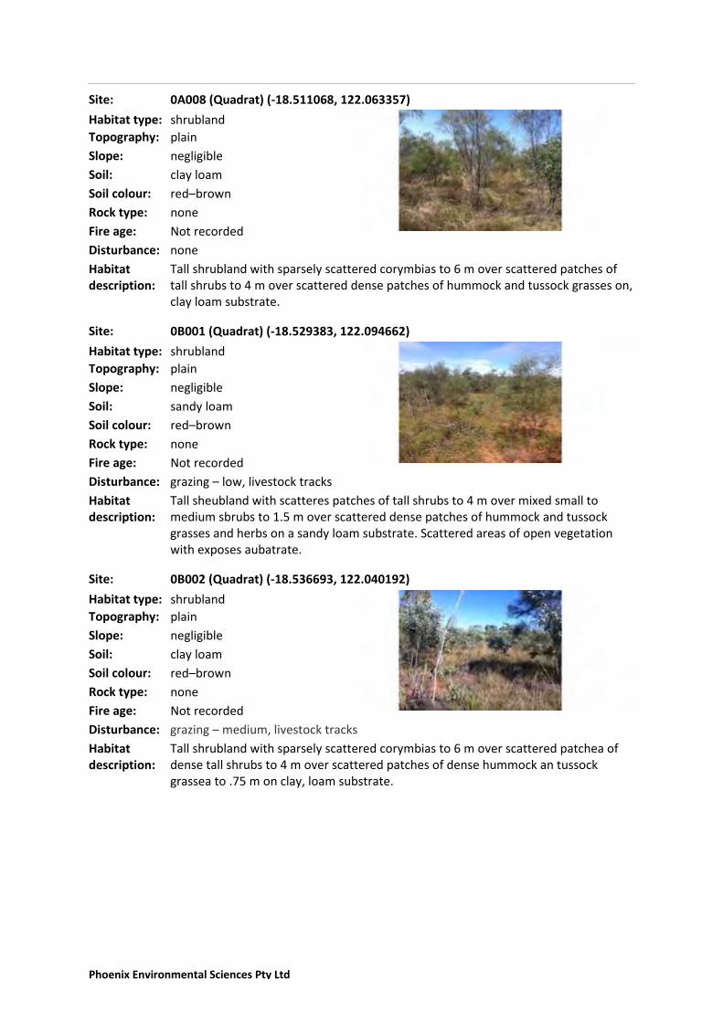
0A008 (Quadrat) (-18.511068, 122.063357)
Topography: plain
Slope: negligible
Soil: clay loam
Soil colour: red–brown
Rock type: none
Disturbance: none
Fire age: Not recorded
Habitat description:
Tall shrubland with sparsely scattered corymbias to 6 m over scattered patches of tall shrubs to 4 m over scattered dense patches of hummock and tussock grasses on, clay loam substrate.
Habitat type: shrubland
Site:
0B001 (Quadrat) (-18.529383, 122.094662)
Topography: plain
Slope: negligible
Soil: sandy loam
Soil colour: red–brown
Rock type: none
Disturbance: grazing – low, livestock tracks
Fire age: Not recorded
Habitat description:
Tall sheubland with scatteres patches of tall shrubs to 4 m over mixed small to medium sbrubs to 1.5 m over scattered dense patches of hummock and tussock grasses and herbs on a sandy loam substrate. Scattered areas of open vegetation with exposes aubatrate.
Habitat type: shrubland
Site:
0B002 (Quadrat) (-18.536693, 122.040192)
Topography: plain
Slope: negligible
Soil: clay loam
Soil colour: red–brown
Rock type: none
Disturbance: grazing – medium, livestock tracks
Fire age: Not recorded
Habitat description:
Tall shrubland with sparsely scattered corymbias to 6 m over scattered patchea of dense tall shrubs to 4 m over scattered patches of dense hummock an tussock grassea to .75 m on clay, loam substrate.
Habitat type: shrubland
Site:
Phoenix Environmental Sciences Pty Ltd

0B003 (Quadrat) (-18.54762, 122.066755)
Topography: plain
Slope: negligible
Soil: clay loam
Soil colour: red–brown
Rock type: none
Disturbance: grazing – medium, livestock tracks
Fire age: Not recorded
Habitat description:
Tall shrubland. Sparaely scattered Corymbia sp. to 6 m and tall shrubs to 4 m, over scattered small to medium shrubs to 1.5 m, over scattered patches of hummock and tussock grasses to 0.75 m. Scattered areas of open vegetation with exposed clay, loam substrate.
Habitat type: shrubland
Site:
0B004 (Quadrat) (-18.504485, 122.029281)
Topography: plain
Slope: negligible
Soil: sandy loam
Soil colour: red–brown
Rock type: none
Disturbance: grazing – medium, livestock tracks
Fire age: 1–5 years
Habitat description:
Tall shrubland. Sparsely scattered Corymbia sp. to 6 m over scattered patches of tall shrubs tp 3 m, over scattered understory of post fire regrowth shrubs and grasses to 0.5 m, with scattered areas of exposed substrate.
Habitat type: shrubland
Site:
0B005 (Quadrat) (-18.471799, 122.069061)
Topography: plain
Slope: negligible
Soil: clay loam
Soil colour: red–brown
Rock type: none
Disturbance: grazing – medium, livestock tracks
Fire age: Not recorded
Habitat description:
Tall shrubland. Scattered patches of tall shrubs to 4 m, over scattered small to medium shrubs to 1.5 m, over tussock grasses to 0.5 m, on clay loam substrate. Scattered areas of sparse vegetation with exposed substrate.
Habitat type: shrubland
Site:
Phoenix Environmental Sciences Pty Ltd

0B006 (Quadrat) (-18.488072, 122.101646)
Topography: plain
Slope: negligible
Soil: clay loam
Soil colour: red–brown
Rock type: none
Disturbance: grazing – medium, livestock tracks
Fire age: Not recorded
Habitat description:
Tall shrubland. Scattered tall shrubs to 4 m, over sparsely scattered patches of small to medium shrubs to 1.5 m, over scattered tussock grasses to 0.5 m, on clay, loam substrate.
Habitat type: shrubland
Site:
0B009 (Quadrat) (-18.481112, 122.051583)
Topography: plain
Slope: negligible
Soil: loam
Soil colour: red–brown
Rock type: none
Disturbance: grazing – medium, livestock tracks
Fire age: Not recorded
Habitat description:
Tall shrubland. Sparsely scattered Corymbia sp. over scattered patches of tall shrubs to 4 m, over scattered small shrubs to 1.5 m, over hummock and tussock grasses to 0.5 m, with scattered patches of sparse vegetation and exposed loam substrate.
Habitat type: shrubland
Site:
A006 (Quadrat) (-18.493011, 122.071813)
Topography: plain
Slope: negligible
Soil: clay loam
Soil colour: red–brown
Rock type: none
Disturbance: grazing – low, livestock tracks
Fire age: Not recorded
Habitat description:
Tall shrubland. Scattered patches of tall shrubs to 5 m, over sparsely scattered patches of medium shrubs to 2 m, over dense hummock an tussock grasses to 0.75 m. Sparse patches of exposed clay, loam substrate.
Habitat type: shrubland
Site:
Phoenix Environmental Sciences Pty Ltd
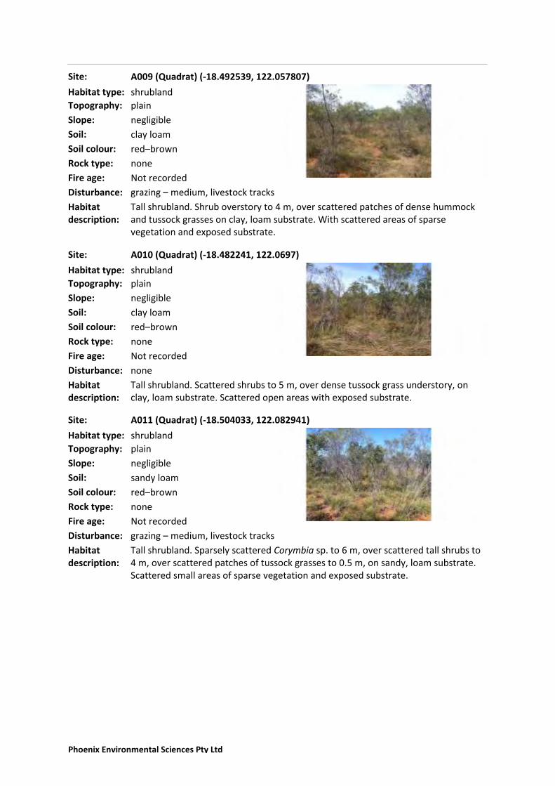
A009 (Quadrat) (-18.492539, 122.057807)
Topography: plain
Slope: negligible
Soil: clay loam
Soil colour: red–brown
Rock type: none
Disturbance: grazing – medium, livestock tracks
Fire age: Not recorded
Habitat description:
Tall shrubland. Shrub overstory to 4 m, over scattered patches of dense hummock and tussock grasses on clay, loam substrate. With scattered areas of sparse vegetation and exposed substrate.
Habitat type: shrubland
Site:
A010 (Quadrat) (-18.482241, 122.0697)
Topography: plain
Slope: negligible
Soil: clay loam
Soil colour: red–brown
Rock type: none
Disturbance: none
Fire age: Not recorded
Habitat description:
Tall shrubland. Scattered shrubs to 5 m, over dense tussock grass understory, on clay, loam substrate. Scattered open areas with exposed substrate.
Habitat type: shrubland
Site:
A011 (Quadrat) (-18.504033, 122.082941)
Topography: plain
Slope: negligible
Soil: sandy loam
Soil colour: red–brown
Rock type: none
Disturbance: grazing – medium, livestock tracks
Fire age: Not recorded
Habitat description:
Tall shrubland. Sparsely scattered Corymbia sp. to 6 m, over scattered tall shrubs to 4 m, over scattered patches of tussock grasses to 0.5 m, on sandy, loam substrate. Scattered small areas of sparse vegetation and exposed substrate.
Habitat type: shrubland
Site:
Phoenix Environmental Sciences Pty Ltd
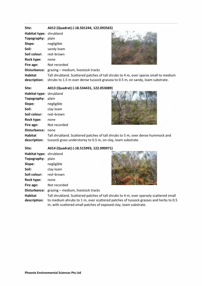
A012 (Quadrat) (-18.501244, 122.093565)
Topography: plain
Slope: negligible
Soil: sandy loam
Soil colour: red–brown
Rock type: none
Disturbance: grazing – medium, livestock tracks
Fire age: Not recorded
Habitat description:
Tall shrubland. Scattered patches of tall shrubs to 4 m, over sparse small to medium shrubs to 1.5 m over dense tussock grassea to 0.5 m, on sandy, loam substrate.
Habitat type: shrubland
Site:
A013 (Quadrat) (-18.534431, 122.053089)
Topography: plain
Slope: negligible
Soil: clay loam
Soil colour: red–brown
Rock type: none
Disturbance: none
Fire age: Not recorded
Habitat description:
Tall shrubland. Scattered patches of tall shrubs to 5 m, over dense hummock and tussock grass understorey to 0.5 m, on clay, loam substrate.
Habitat type: shrubland
Site:
A014 (Quadrat) (-18.515993, 122.090971)
Topography: plain
Slope: negligible
Soil: clay loam
Soil colour: red–brown
Rock type: none
Disturbance: grazing – medium, livestock tracks
Fire age: Not recorded
Habitat description:
Tall shrubland. Scattered patches of tall shrubs to 4 m, over sparsely scattered small to medium ahrubs to 1 m, over scattered patches of tussock grasses and herbs to 0.5 m, with scattered small patches of exposed clay, loam substrate.
Habitat type: shrubland
Site:
Phoenix Environmental Sciences Pty Ltd

A015 (Quadrat) (-18.491106, 122.083519)
Topography: plain
Slope: negligible
Soil: sandy loam
Soil colour: red–brown
Rock type: none
Disturbance: grazing – medium, livestock tracks
Fire age: Not recorded
Habitat description:
Tall shrubland. Scattered patches of tall shrubs to 5 m, over scattered patches of dense tussock grasses, on sandy, loam substrate. Scattered patches of sparse vegatation with exposed substrate.
Habitat type: shrubland
Site:
A016 (Quadrat) (-18.533751, 122.07942)
Topography: plain
Slope: negligible
Soil: clay loam
Soil colour: red–brown
Rock type: none
Disturbance: grazing – medium, livestock tracks
Fire age: Not recorded
Habitat description:
Tall shrubland. Sparsely scattered Corymbia sp. to 8 m, over scattered mixed medium-large shrubs to 4 m, over scattered patches of low shrubs to 1.5 m and hummock and tussock grasses to 0.5 m. Also scattered patches of exposed clay, loam substrate.
Habitat type: shrubland
Site:
A017 (Quadrat) (-18.516913, 122.028468)
Topography: plain
Slope: negligible
Soil: clay loam
Soil colour: red–brown
Rock type: none
Disturbance: grazing – medium, livestock tracks
Fire age: Not recorded
Habitat description:
Tall shrubland. Sparsely scattered Corymbia sp. to 10 m, over scattered patches of tall shrubs to 4 m, over scattered patches of hummock and tussock grasses to 0.5 m, on clay, loam substrate.
Habitat type: shrubland
Site:
Phoenix Environmental Sciences Pty Ltd

A018 (Quadrat) (-18.525373, 122.038174)
Topography: plain
Slope: negligible
Soil: sandy loam
Soil colour: red–brown
Rock type: none
Disturbance: grazing – medium, livestock tracks
Fire age: Not recorded
Habitat description:
Tall shrubland. Scattered patches of tall shrubs to 4 m, over scattered patches of dense hummock and tussock grasses to 0.5 m, with scattered areas of sparse vegetation with exposed sandy, loam substrate.
Habitat type: shrubland
Site:
B010 (Quadrat) (-18.479658, 122.088641)
Topography: plain
Slope: negligible
Soil: clay loam
Soil colour: red–brown
Rock type: none
Disturbance: grazing – medium, livestock tracks
Fire age: Not recorded
Habitat description:
Tall shrubland. Scattered patches of tall ahrubs to 3 m, over dense patches of hummock and tussock grasses, on clay, loam substrate.
Habitat type: shrubland
Site:
B011 (Quadrat) (-18.528155, 122.025964)
Topography: plain
Slope: negligible
Soil: sandy loam
Soil colour: red–brown
Rock type: none
Disturbance: grazing – medium, livestock tracks
Fire age: Not recorded
Habitat description:
Tall shrubland. Sparsely scattered corymbias to 6 m over scattered patches of tall shrubs to 4 m over dense small shrubs and hummock and tussock grasses to .5 m on sandy loam substrate.
Habitat type: shrubland
Site:
Phoenix Environmental Sciences Pty Ltd
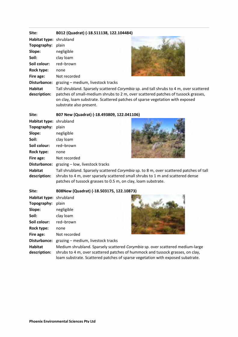
B012 (Quadrat) (-18.511138, 122.104484)
Topography: plain
Slope: negligible
Soil: clay loam
Soil colour: red–brown
Rock type: none
Disturbance: grazing – medium, livestock tracks
Fire age: Not recorded
Habitat description:
Tall shrubland. Sparsely scattered Corymbia sp. and tall shrubs to 4 m, over scattered patches of small-medium shrubs to 2 m, over scattered patches of tussock grasses, on clay, loam substrate. Scattered patches of sparse vegetation with exposed substrate also present.
Habitat type: shrubland
Site:
B07 New (Quadrat) (-18.493809, 122.041106)
Topography: plain
Slope: negligible
Soil: clay loam
Soil colour: red–brown
Rock type: none
Disturbance: grazing – low, livestock tracks
Fire age: Not recorded
Habitat description:
Tall shrubland. Sparsely scattered Corymbia sp. to 8 m, over scattered patches of tall shrubs to 4 m, over sparsely scattered small shrubs to 1 m and scattered dense patches of tussock grasses to 0.5 m, on clay, loam substrate.
Habitat type: shrubland
Site:
B08New (Quadrat) (-18.503175, 122.10873)
Topography: plain
Slope: negligible
Soil: clay loam
Soil colour: red–brown
Rock type: none
Disturbance: grazing – medium, livestock tracks
Fire age: Not recorded
Habitat description:
Medium shrubland. Sparsely scattered Corymbia sp. over scattered medium-large shrubs to 4 m, over scattered patches of hummock and tussock grasses, on clay, loam substrate. Scattered patches of sparse vegetation with exposed subatrate.
Habitat type: shrubland
Site:
Phoenix Environmental Sciences Pty Ltd

FAU001 (Opportunistic Fauna Site) (-18.532816, 122.083995)
Topography: plain
Slope: negligible
Soil: sandy loam
Soil colour: red–brown
Rock type: none
Disturbance: current operations, erosion channels, excavation, grazing – high, large-scale clearing, livestock tracks, vehicle tracks
Fire age: Not recorded
Habitat description:
Large cleared area for well and small dam at track intersection with sparsely scattered Corymbia sp. to 10 m, over sparsely scattered medium-large ahrubs to 4 m, over sparse, small patches of heavily grazed grasses. Also with large areas of sparse vegetation on exposed sandy, loam substrate. Surrounding vegetation tall shrubland with sparse to dense understorey.
Habitat type: shrubland
Site:
Phoenix Environmental Sciences Pty Ltd

Flora and vegetation survey and terrestrial fauna survey for Shamrock Station Irrigation Project
Prepared for Argyle Cattle Company Pty Ltd
Phoenix Environmental Sciences Pty Ltd
Appendix 5 DPaW correspondence regarding Bilby survey methods

Flora and vegetation survey and terrestrial fauna survey for Shamrock Station Irrigation Project
Prepared for Argyle Cattle Company Pty Ltd
Phoenix Environmental Sciences Pty Ltd
Appendix 6 Flora species inventory
Family Species
Aizoaceae Trianthema cusackianum
Aizoaceae Trianthema pilosum
Amaranthaceae Gomphrena canescens
Amaranthaceae Ptilotus astrolasius
Amaranthaceae Ptilotus decalvatus
Apocynaceae Carissa lanceolata
Apocynaceae Cynanchum carnosum
Apocynaceae Marsdenia angustata
Apocynaceae Wrightia saligna
Araliaceae Trachymene oleracea subsp. oleracea
Bignoniaceae Dolichandrone heterophylla
Boraginaceae Ehretia saligna
Boraginaceae Halgania solanacea
Boraginaceae Heliotropium foliatum
Boraginaceae Heliotropium paniculatum
Boraginaceae Trichodesma zeylanicum var. latisepaleum
Caryophyllaceae Polycarpaea corymbosa
Celastraceae Denhamia cunninghamii
Celastraceae Stackhousia intermedia
Cleomaceae Cleome uncifera
Cleomaceae Cleome viscosa
Commelinaceae Murdannia graminea
Convolvulaceae Polymeria sp. Broome (P1 WC Act)
Convolvulaceae Evolvulus alsinoides var. decumbens
Convolvulaceae Ipomoea sp. sterile
Convolvulaceae Polymeria ambigua
Cucurbitaceae Cucumis melo
Cyperaceae Bulbostylis barbata
Cyperaceae Fimbristylis nuda
Cyperaceae Fimbristylis oxystachya
Euphorbiaceae Euphorbia hassallii
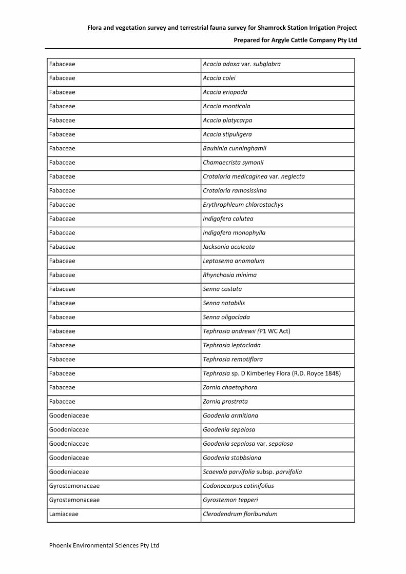
Flora and vegetation survey and terrestrial fauna survey for Shamrock Station Irrigation Project
Prepared for Argyle Cattle Company Pty Ltd
Phoenix Environmental Sciences Pty Ltd
Fabaceae Acacia adoxa var. subglabra
Fabaceae Acacia colei
Fabaceae Acacia eriopoda
Fabaceae Acacia monticola
Fabaceae Acacia platycarpa
Fabaceae Acacia stipuligera
Fabaceae Bauhinia cunninghamii
Fabaceae Chamaecrista symonii
Fabaceae Crotalaria medicaginea var. neglecta
Fabaceae Crotalaria ramosissima
Fabaceae Erythrophleum chlorostachys
Fabaceae Indigofera colutea
Fabaceae Indigofera monophylla
Fabaceae Jacksonia aculeata
Fabaceae Leptosema anomalum
Fabaceae Rhynchosia minima
Fabaceae Senna costata
Fabaceae Senna notabilis
Fabaceae Senna oligoclada
Fabaceae Tephrosia andrewii (P1 WC Act)
Fabaceae Tephrosia leptoclada
Fabaceae Tephrosia remotiflora
Fabaceae Tephrosia sp. D Kimberley Flora (R.D. Royce 1848)
Fabaceae Zornia chaetophora
Fabaceae Zornia prostrata
Goodeniaceae Goodenia armitiana
Goodeniaceae Goodenia sepalosa
Goodeniaceae Goodenia sepalosa var. sepalosa
Goodeniaceae Goodenia stobbsiana
Goodeniaceae Scaevola parvifolia subsp. parvifolia
Gyrostemonaceae Codonocarpus cotinifolius
Gyrostemonaceae Gyrostemon tepperi
Lamiaceae Clerodendrum floribundum

Flora and vegetation survey and terrestrial fauna survey for Shamrock Station Irrigation Project
Prepared for Argyle Cattle Company Pty Ltd
Phoenix Environmental Sciences Pty Ltd
Lamiaceae Clerodendrum tomentosum var. mollissima
Lamiaceae Newcastelia cladotricha
Lauraceae Cassytha filiformis
Loganiaceae Mitrasacme connata
Malvaceae Abutilon macrum
Malvaceae Abutilon otocarpum
Malvaceae Brachychiton diversifolius
Malvaceae Corchorus sidoides subsp. vermicularis
Malvaceae Grewia retusifolia
Malvaceae Hibiscus leptocladus
Malvaceae Hibiscus sturtii var. campylochlamys
Malvaceae Seringia nephrosperma
Malvaceae Sida rohlenae subsp. rohlenae
Malvaceae Sida sp. Pindan (B.G. Thomson 3398)
Malvaceae Triumfetta johnstonii
Malvaceae Waltheria indica
Myrtaceae Corymbia flavescens
Myrtaceae Corymbia hamersleyana
Myrtaceae Corymbia sp. (sterile)
Myrtaceae Corymbia sp. (white bark)
Myrtaceae Corymbia zygophylla
Phyllanthaceae Phyllanthus maderaspatensis
Poaceae Aristida holathera
Poaceae Chrysopogon pallidus
Poaceae Eragrostis eriopoda
Poaceae Eriachne avenacea
Poaceae Panicum effusum
Poaceae Paspalidium rarum
Poaceae Sorghum plumosum
Poaceae Triodia caelestialis (P3 WC Act)
Poaceae Triodia schinzii
Poaceae Yakirra australiensis
Polygalaceae Polygala tepperi

Flora and vegetation survey and terrestrial fauna survey for Shamrock Station Irrigation Project
Prepared for Argyle Cattle Company Pty Ltd
Phoenix Environmental Sciences Pty Ltd
Portulacaceae Calandrinia strophiolata
Portulacaceae Portulaca bicolor
Proteaceae Grevillea pyramidalis
Proteaceae Grevillea pyramidalis subsp. leucadendron
Proteaceae Grevillea pyramidalis subsp. pyramidalis
Proteaceae Grevillea refracta
Proteaceae Grevillea wickhamii
Proteaceae Persoonia falcata
Rubiaceae Gardenia pyriformis
Rubiaceae Nauclea orientalis
Rubiaceae Oldenlandia mitrasacmoides subsp. mitrasacmoides
Rubiaceae Spermacoce occidentalis
Sapindaceae Dodonaea hispidula var. arida
Solanaceae Solanum cunninghamii
Solanaceae Solanum diversiflorum
Violaceae Hybanthus aurantiacus
Zygophyllaceae Tribulopis angustifolia

Flora and vegetation survey and terrestrial fauna survey for Shamrock Station Irrigation Project
Prepared for Argyle Cattle Company Pty Ltd
Phoenix Environmental Sciences Pty Ltd
Appendix 7 Vertebrate species records from desktop review and this survey
Class Family Species Common Name
Bir
dD
ata
EPB
C A
ct P
rote
cte
d
Mat
ters
Nat
ure
Map
DP
aW
Th
reat
en
ed
&
Pri
ori
ty F
aun
a
This
su
rve
y
Elasmobranchii Pristidae Pristis pristis Freshwater Sawfish ●
Amphibia Hylidae Litoria caerulea Green Tree Frog ●
Amphibia Hylidae Litoria rubella Little Red Tree Frog ●
Amphibia Hylidae Cyclorana longipes Long-footed Frog ●
Reptilia Agamidae Ctenophorus nuchalis Central Netted Dragon ●
Reptilia Agamidae Ctenophorus isolepis isolepis Crested Dragon ●
Reptilia Agamidae Diporiphora pindan Pindan Dragon ● ●
Reptilia Agamidae Amphibolurus gilberti Ta-ta Dragon ●
Reptilia Agamidae Pogona minor mitchelli Western Bearded Dragon ●
Reptilia Boidae Antaresia stimsoni stimsoni Stimson's Python ●
Reptilia Crocodylidae Crocodylus porosus Salt-water Crocodile ●
Reptilia Diplodactylidae Diplodactylus conspicillatus Fat-tailed Gecko ●
Reptilia Diplodactylidae Strophurus ciliaris aberrans Northern Spiny-tailed Gecko ●
Reptilia Diplodactylidae Strophurus jeanae Southern Phasmid Gecko ●
Reptilia Diplodactylidae Rhynchoedura ornata Western Beaked Gecko ●
Reptilia Diplodactylidae Amalosia rhombifer Zigzag velvet gecko ●
Reptilia Elapidae Simoselaps anomalus Desert Banded Snake ●
Reptilia Elapidae Acanthophis pyrrhus Desert Death Adder ●
Reptilia Elapidae Furina ornata Moon Snake ●
Reptilia Elapidae Pseudechis australis Mulga Snake ●
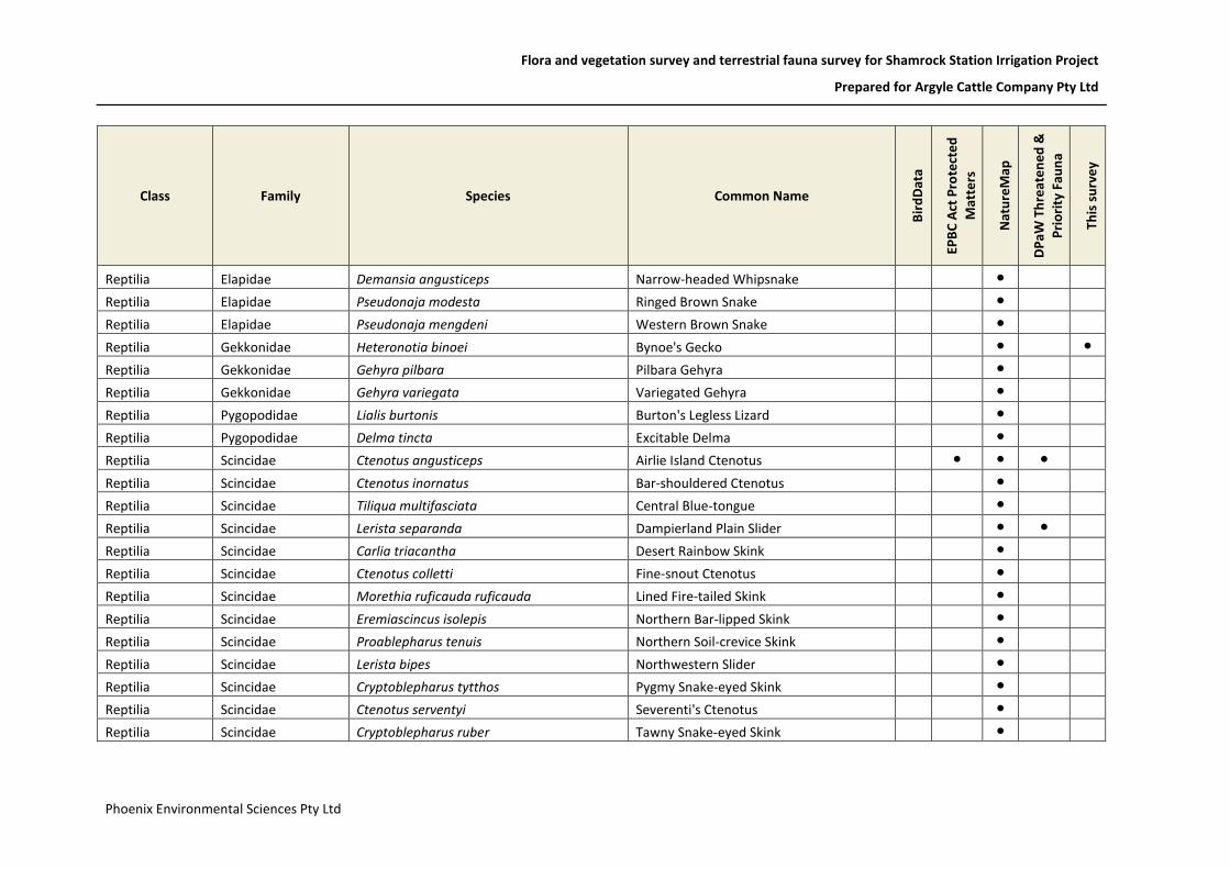
Flora and vegetation survey and terrestrial fauna survey for Shamrock Station Irrigation Project
Prepared for Argyle Cattle Company Pty Ltd
Phoenix Environmental Sciences Pty Ltd
Class Family Species Common Name
Bir
dD
ata
EPB
C A
ct P
rote
cte
d
Mat
ters
Nat
ure
Map
DP
aW
Th
reat
en
ed
&
Pri
ori
ty F
aun
a
This
su
rve
y
Reptilia Elapidae Demansia angusticeps Narrow-headed Whipsnake ●
Reptilia Elapidae Pseudonaja modesta Ringed Brown Snake ●
Reptilia Elapidae Pseudonaja mengdeni Western Brown Snake ●
Reptilia Gekkonidae Heteronotia binoei Bynoe's Gecko ● ●
Reptilia Gekkonidae Gehyra pilbara Pilbara Gehyra ●
Reptilia Gekkonidae Gehyra variegata Variegated Gehyra ●
Reptilia Pygopodidae Lialis burtonis Burton's Legless Lizard ●
Reptilia Pygopodidae Delma tincta Excitable Delma ●
Reptilia Scincidae Ctenotus angusticeps Airlie Island Ctenotus ● ● ●
Reptilia Scincidae Ctenotus inornatus Bar-shouldered Ctenotus ●
Reptilia Scincidae Tiliqua multifasciata Central Blue-tongue ●
Reptilia Scincidae Lerista separanda Dampierland Plain Slider ● ●
Reptilia Scincidae Carlia triacantha Desert Rainbow Skink ●
Reptilia Scincidae Ctenotus colletti Fine-snout Ctenotus ●
Reptilia Scincidae Morethia ruficauda ruficauda Lined Fire-tailed Skink ●
Reptilia Scincidae Eremiascincus isolepis Northern Bar-lipped Skink ●
Reptilia Scincidae Proablepharus tenuis Northern Soil-crevice Skink ●
Reptilia Scincidae Lerista bipes Northwestern Slider ●
Reptilia Scincidae Cryptoblepharus tytthos Pygmy Snake-eyed Skink ●
Reptilia Scincidae Ctenotus serventyi Severenti's Ctenotus ●
Reptilia Scincidae Cryptoblepharus ruber Tawny Snake-eyed Skink ●

Flora and vegetation survey and terrestrial fauna survey for Shamrock Station Irrigation Project
Prepared for Argyle Cattle Company Pty Ltd
Phoenix Environmental Sciences Pty Ltd
Class Family Species Common Name
Bir
dD
ata
EPB
C A
ct P
rote
cte
d
Mat
ters
Nat
ure
Map
DP
aW
Th
reat
en
ed
&
Pri
ori
ty F
aun
a
This
su
rve
y
Reptilia Varanidae Varanus tristis Black-headed Monitor ●
Reptilia Varanidae Varanus gouldii Gould's Monitor ● ●
Reptilia Varanidae Varanus gilleni Pygmy Mulga Monitor ●
Reptilia Varanidae Varanus brevicauda Short-tailed Pygmy Monitor ●
Reptilia Varanidae Varanus acanthurus Spiny-tailed Monitor ●
Aves Acanthizidae Gerygone tenebrosa Dusky Gerygone ● ●
Aves Acanthizidae Gerygone levigaster Mangrove Gerygone ● ●
Aves Acanthizidae Smicrornis brevirostris Weebill ●
Aves Acanthizidae Gerygone olivacea White-throated Gerygone ●
Aves Accipitridae Milvus migrans Black Kite ● ●
Aves Accipitridae Hamirostra melanosternon Black-breasted Buzzard ● ●
Aves Accipitridae Elanus caeruleus Black-shouldered Kite ● ●
Aves Accipitridae Haliastur indus Brahminy Kite ● ●
Aves Accipitridae Accipiter fasciatus Brown Goshawk ● ● ●
Aves Accipitridae Accipiter cirrocephalus Collared Sparrowhawk ● ●
Aves Accipitridae Hieraaetus morphnoides Little Eagle ●
Aves Accipitridae Pandion haliaetus Osprey ● ● ●
Aves Accipitridae Circus assimilis Spotted Harrier ●
Aves Accipitridae Circus approximans Swamp Harrier ● ●
Aves Accipitridae Aquila audax Wedge-tailed Eagle ● ●
Aves Accipitridae Haliastur sphenurus Whistling Kite ● ● ●

Flora and vegetation survey and terrestrial fauna survey for Shamrock Station Irrigation Project
Prepared for Argyle Cattle Company Pty Ltd
Phoenix Environmental Sciences Pty Ltd
Class Family Species Common Name
Bir
dD
ata
EPB
C A
ct P
rote
cte
d
Mat
ters
Nat
ure
Map
DP
aW
Th
reat
en
ed
&
Pri
ori
ty F
aun
a
This
su
rve
y
Aves Accipitridae Haliaeetus leucogaster White-bellied Sea-Eagle ● ● ●
Aves Aegothelidae Aegotheles cristatus Australian Owlet-nightjar ● ●
Aves Alaudidae Mirafra javanica Horsfield's Bushlark ● ●
Aves Anatidae Anas gracilis Grey Teal ● ●
Aves Anatidae Aythya australis Hardhead ● ●
Aves Anatidae Anas superciliosa Pacific Black Duck ● ●
Aves Anatidae Malacorhynchus membranaceus Pink-eared Duck ● ●
Aves Anatidae Dendrocygna eytoni Plumed Whistling Duck ● ●
Aves Anatidae Dendrocygna arcuata Wandering Whistling Duck ● ●
Aves Anhingidae Anhinga novaehollandiae Australasian Darter ●
Aves Anseranatidae Anseranas semipalmata Magpie Goose ●
Aves Apodidae Apus pacificus Fork-tailed Swift ● ● ● ●
Aves Ardeidae Ardea ibis Cattle Egret ●
Aves Ardeidae Ardea modesta Eastern Great Egret ● ● ● ●
Aves Ardeidae Egretta sacra Eastern Reef Egret ●
Aves Ardeidae Ardea intermedia Intermediate Egret ● ●
Aves Ardeidae Ardea garzetta Little Egret ● ●
Aves Ardeidae Nycticorax caledonicus Rufous Night Heron ● ●
Aves Ardeidae Butorides striata Striated Heron ●
Aves Ardeidae Ardea novaehollandiae White-faced Heron ● ●
Aves Ardeidae Ardea pacifica White-necked Heron ●
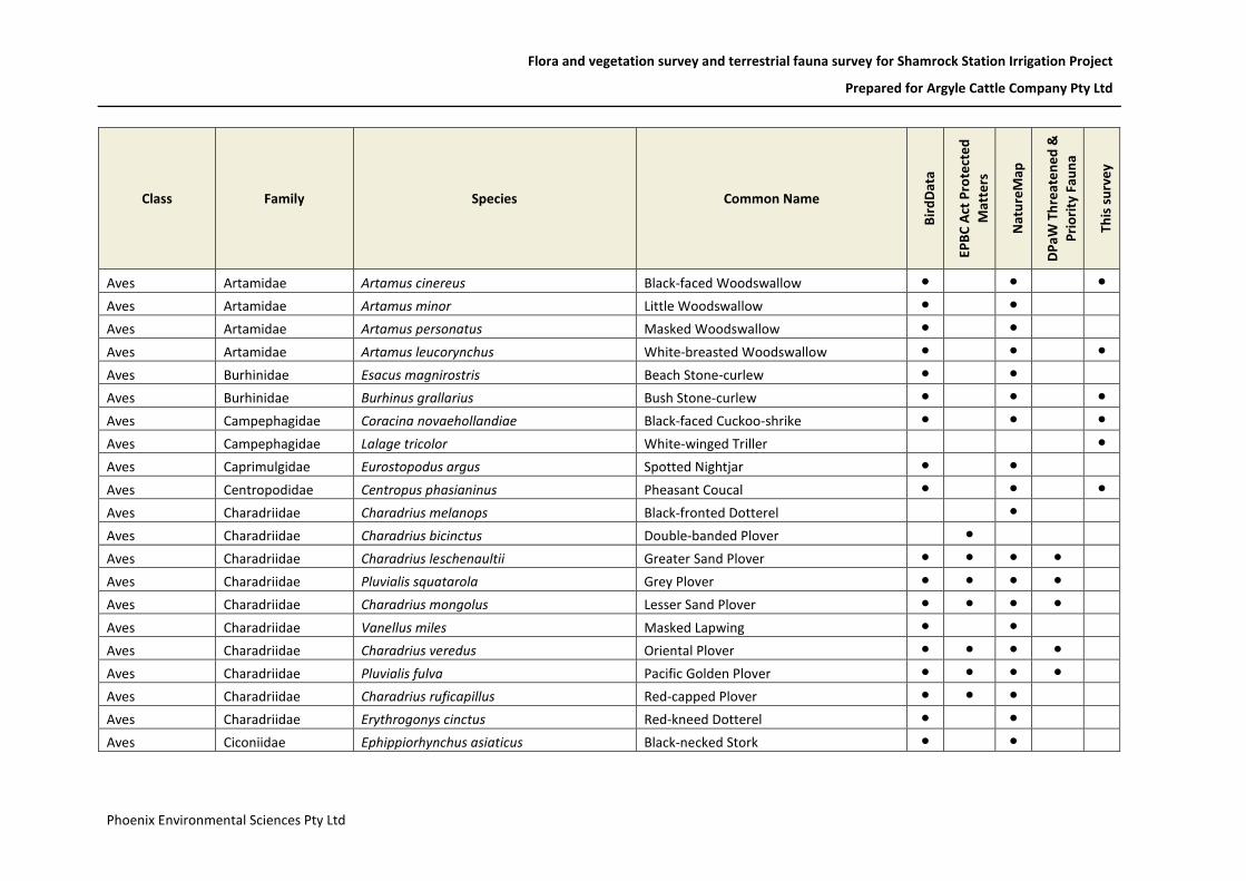
Flora and vegetation survey and terrestrial fauna survey for Shamrock Station Irrigation Project
Prepared for Argyle Cattle Company Pty Ltd
Phoenix Environmental Sciences Pty Ltd
Class Family Species Common Name
Bir
dD
ata
EPB
C A
ct P
rote
cte
d
Mat
ters
Nat
ure
Map
DP
aW
Th
reat
en
ed
&
Pri
ori
ty F
aun
a
This
su
rve
y
Aves Artamidae Artamus cinereus Black-faced Woodswallow ● ● ●
Aves Artamidae Artamus minor Little Woodswallow ● ●
Aves Artamidae Artamus personatus Masked Woodswallow ● ●
Aves Artamidae Artamus leucorynchus White-breasted Woodswallow ● ● ●
Aves Burhinidae Esacus magnirostris Beach Stone-curlew ● ●
Aves Burhinidae Burhinus grallarius Bush Stone-curlew ● ● ●
Aves Campephagidae Coracina novaehollandiae Black-faced Cuckoo-shrike ● ● ●
Aves Campephagidae Lalage tricolor White-winged Triller ●
Aves Caprimulgidae Eurostopodus argus Spotted Nightjar ● ●
Aves Centropodidae Centropus phasianinus Pheasant Coucal ● ● ●
Aves Charadriidae Charadrius melanops Black-fronted Dotterel ●
Aves Charadriidae Charadrius bicinctus Double-banded Plover ●
Aves Charadriidae Charadrius leschenaultii Greater Sand Plover ● ● ● ●
Aves Charadriidae Pluvialis squatarola Grey Plover ● ● ● ●
Aves Charadriidae Charadrius mongolus Lesser Sand Plover ● ● ● ●
Aves Charadriidae Vanellus miles Masked Lapwing ● ●
Aves Charadriidae Charadrius veredus Oriental Plover ● ● ● ●
Aves Charadriidae Pluvialis fulva Pacific Golden Plover ● ● ● ●
Aves Charadriidae Charadrius ruficapillus Red-capped Plover ● ● ●
Aves Charadriidae Erythrogonys cinctus Red-kneed Dotterel ● ●
Aves Ciconiidae Ephippiorhynchus asiaticus Black-necked Stork ● ●

Flora and vegetation survey and terrestrial fauna survey for Shamrock Station Irrigation Project
Prepared for Argyle Cattle Company Pty Ltd
Phoenix Environmental Sciences Pty Ltd
Class Family Species Common Name
Bir
dD
ata
EPB
C A
ct P
rote
cte
d
Mat
ters
Nat
ure
Map
DP
aW
Th
reat
en
ed
&
Pri
ori
ty F
aun
a
This
su
rve
y
Aves Columbidae Geopelia humeralis Bar-shouldered Dove ● ● ●
Aves Columbidae Phaps chalcoptera Common Bronzewing ●
Aves Columbidae Ocyphaps lophotes Crested Pigeon ● ● ●
Aves Columbidae Geopelia cuneata Diamond Dove ● ● ●
Aves Columbidae Geopelia striata Peaceful Dove ● ● ●
Aves Coraciidae Eurystomus orientalis Dollarbird ● ●
Aves Corvidae Corvus bennetti Little Crow ● ● ●
Aves Corvidae Corvus orru Torresian Crow ● ●
Aves Cracticidae Cracticus torquatus Grey Butcherbird ● ●
Aves Cracticidae Cracticus nigrogularis Pied Butcherbird ● ● ●
Aves Cuculidae Chrysococcyx osculans Black-eared Cuckoo ●
Aves Cuculidae Cacomantis variolosus Brush Cuckoo ● ●
Aves Cuculidae Scythrops novaehollandiae Channel-billed Cuckoo ● ●
Aves Cuculidae Chrysococcyx basalis Horsfield's Bronze Cuckoo ● ●
Aves Cuculidae Cuculus optatus Oriental Cuckoo ●
Aves Cuculidae Cacomantis pallidus Pallid Cuckoo ● ● ●
Aves Dicaeidae Dicaeum hirundinaceum Mistletoebird ● ●
Aves Dicruridae Myiagra ruficollis Broad-billed Flycatcher ● ●
Aves Dicruridae Rhipidura albiscapa Grey Fantail ●
Aves Dicruridae Grallina cyanoleuca Magpie-lark ● ● ●
Aves Dicruridae Rhipidura phasiana Mangrove Grey Fantail ● ●

Flora and vegetation survey and terrestrial fauna survey for Shamrock Station Irrigation Project
Prepared for Argyle Cattle Company Pty Ltd
Phoenix Environmental Sciences Pty Ltd
Class Family Species Common Name
Bir
dD
ata
EPB
C A
ct P
rote
cte
d
Mat
ters
Nat
ure
Map
DP
aW
Th
reat
en
ed
&
Pri
ori
ty F
aun
a
This
su
rve
y
Aves Dicruridae Myiagra inquieta Restless Flycatcher ● ●
Aves Dicruridae Rhipidura leucophrys Willie Wagtail ● ● ●
Aves Dromaiidae Dromaius novaehollandiae Emu ●
Aves Estrilidae Taeniopygia bichenovii Double-barred Finch ● ●
Aves Estrilidae Emblema pictum Painted Finch ● ●
Aves Estrilidae Heteromunia pectoralis Pictorella Mannikin ●
Aves Estrilidae Taeniopygia guttata Zebra Finch ● ● ●
Aves Falconidae Falco longipennis Australian Hobby ● ●
Aves Falconidae Falco cenchroides Australian Kestrel ● ●
Aves Falconidae Falco berigora Brown Falcon ● ●
Aves Falconidae Falco hypoleucos Grey Falcon ● ● ●
Aves Falconidae Falco peregrinus Peregrine Falcon ● ●
Aves Fregatidae Fregata minor Greater Frigatebird ●
Aves Fregatidae Fregata ariel Lesser Frigatebird ● ● ● ●
Aves Glareolidae Stiltia isabella Australian Pratincole ● ●
Aves Glareolidae Glareola maldivarum Oriental Pratincole ● ● ● ●
Aves Gruidae Grus rubicunda Brolga ● ●
Aves Haematopodidae Haematopus longirostris Pied Oystercatcher ● ●
Aves Haematopodidae Haematopus fuliginosus Sooty Oystercatcher ● ●
Aves Halcyonidae Dacelo leachii Blue-winged Kookaburra ● ●
Aves Halcyonidae Todiramphus chloris Collared Kingfisher ● ●
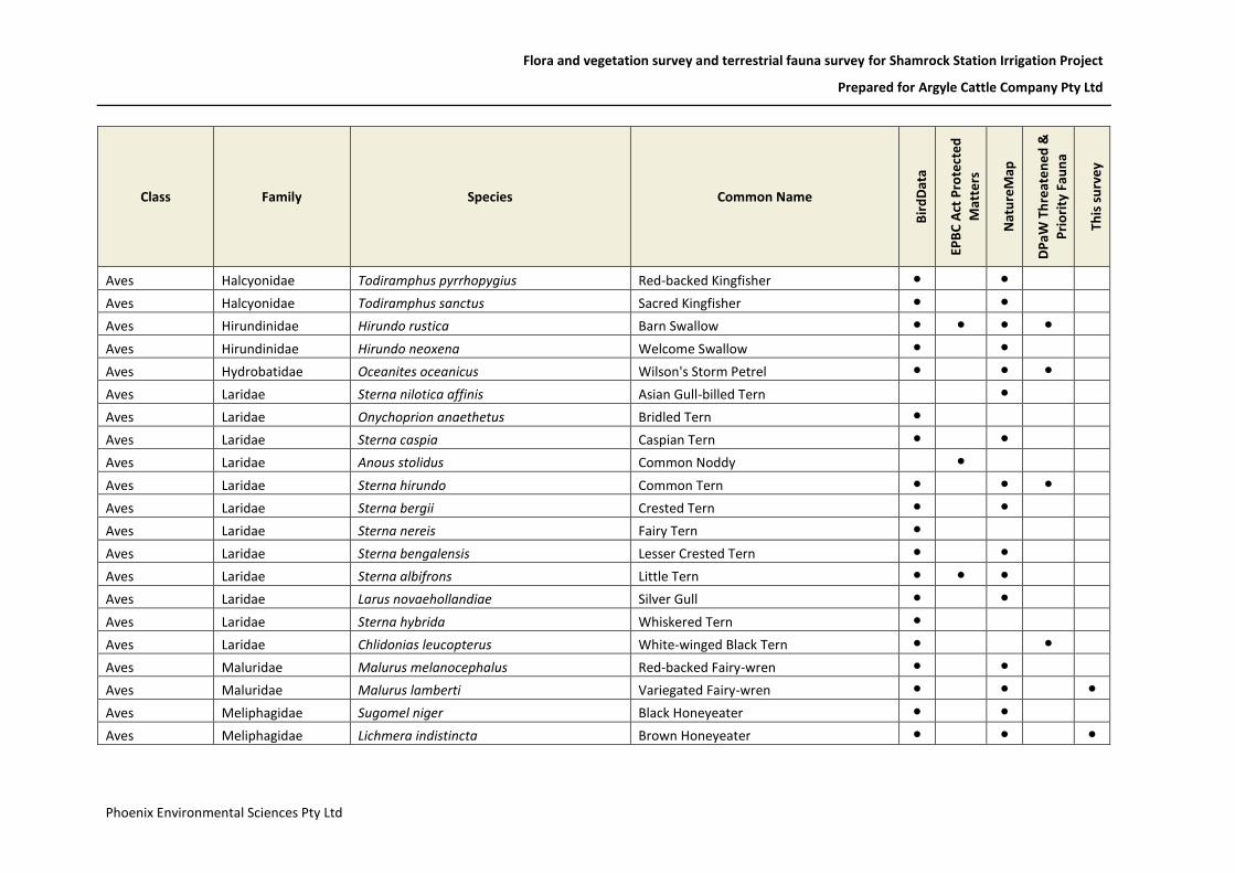
Flora and vegetation survey and terrestrial fauna survey for Shamrock Station Irrigation Project
Prepared for Argyle Cattle Company Pty Ltd
Phoenix Environmental Sciences Pty Ltd
Class Family Species Common Name
Bir
dD
ata
EPB
C A
ct P
rote
cte
d
Mat
ters
Nat
ure
Map
DP
aW
Th
reat
en
ed
&
Pri
ori
ty F
aun
a
This
su
rve
y
Aves Halcyonidae Todiramphus pyrrhopygius Red-backed Kingfisher ● ●
Aves Halcyonidae Todiramphus sanctus Sacred Kingfisher ● ●
Aves Hirundinidae Hirundo rustica Barn Swallow ● ● ● ●
Aves Hirundinidae Hirundo neoxena Welcome Swallow ● ●
Aves Hydrobatidae Oceanites oceanicus Wilson's Storm Petrel ● ● ●
Aves Laridae Sterna nilotica affinis Asian Gull-billed Tern ●
Aves Laridae Onychoprion anaethetus Bridled Tern ●
Aves Laridae Sterna caspia Caspian Tern ● ●
Aves Laridae Anous stolidus Common Noddy ●
Aves Laridae Sterna hirundo Common Tern ● ● ●
Aves Laridae Sterna bergii Crested Tern ● ●
Aves Laridae Sterna nereis Fairy Tern ●
Aves Laridae Sterna bengalensis Lesser Crested Tern ● ●
Aves Laridae Sterna albifrons Little Tern ● ● ●
Aves Laridae Larus novaehollandiae Silver Gull ● ●
Aves Laridae Sterna hybrida Whiskered Tern ●
Aves Laridae Chlidonias leucopterus White-winged Black Tern ● ●
Aves Maluridae Malurus melanocephalus Red-backed Fairy-wren ● ●
Aves Maluridae Malurus lamberti Variegated Fairy-wren ● ● ●
Aves Meliphagidae Sugomel niger Black Honeyeater ● ●
Aves Meliphagidae Lichmera indistincta Brown Honeyeater ● ● ●

Flora and vegetation survey and terrestrial fauna survey for Shamrock Station Irrigation Project
Prepared for Argyle Cattle Company Pty Ltd
Phoenix Environmental Sciences Pty Ltd
Class Family Species Common Name
Bir
dD
ata
EPB
C A
ct P
rote
cte
d
Mat
ters
Nat
ure
Map
DP
aW
Th
reat
en
ed
&
Pri
ori
ty F
aun
a
This
su
rve
y
Aves Meliphagidae Epthianura tricolor Crimson Chat ● ●
Aves Meliphagidae Philemon citreogularis Little Friarbird ● ●
Aves Meliphagidae Certhionyx variegatus Pied Honeyeater ● ●
Aves Meliphagidae Myzomela erythrocephala Red-headed Honeyeater ● ●
Aves Meliphagidae Conopophila rufogularis Rufous-throated Honeyeater ● ●
Aves Meliphagidae Lichenostomus virescens Singing Honeyeater ● ●
Aves Meliphagidae Lichenostomus unicolor White-gaped Honeyeater ●
Aves Meliphagidae Lichenostomus penicillatus White-plumed Honeyeater ●
Aves Meliphagidae Manorina flavigula Yellow-throated Miner ● ●
Aves Meliphagidae Lichenostomus flavescens Yellow-tinted Honeyeater ●
Aves Meropidae Merops ornatus Rainbow Bee-eater ● ● ● ●
Aves Motacillidae Anthus australis Australian Pipit ●
Aves Motacillidae Motacilla cinerea Grey Wagtail ●
Aves Motacillidae Motacilla flava Yellow Wagtail ●
Aves Neosittidae Daphoenositta chrysoptera Varied Sittella ● ●
Aves Oriolidae Oriolus sagittatus Olive-backed Oriole ● ●
Aves Otididae Ardeotis australis Australian Bustard ● ● ●
Aves Pachycephalidae Oreoica gutturalis Crested Bellbird ● ●
Aves Pachycephalidae Colluricincla harmonica Grey Shrike-thrush ● ● ●
Aves Pachycephalidae Pachycephala melanura Mangrove Golden Whistler ● ●
Aves Pachycephalidae Pachycephala rufiventris Rufous Whistler ● ● ●
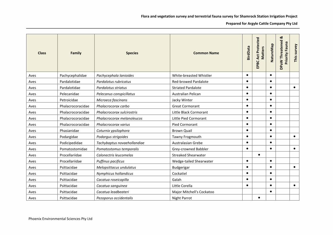
Flora and vegetation survey and terrestrial fauna survey for Shamrock Station Irrigation Project
Prepared for Argyle Cattle Company Pty Ltd
Phoenix Environmental Sciences Pty Ltd
Class Family Species Common Name
Bir
dD
ata
EPB
C A
ct P
rote
cte
d
Mat
ters
Nat
ure
Map
DP
aW
Th
reat
en
ed
&
Pri
ori
ty F
aun
a
This
su
rve
y
Aves Pachycephalidae Pachycephala lanioides White-breasted Whistler ● ●
Aves Pardalotidae Pardalotus rubricatus Red-browed Pardalote ● ●
Aves Pardalotidae Pardalotus striatus Striated Pardalote ● ● ●
Aves Pelecanidae Pelecanus conspicillatus Australian Pelican ● ●
Aves Petroicidae Microeca fascinans Jacky Winter ● ●
Aves Phalacrocoracidae Phalacrocorax carbo Great Cormorant ● ●
Aves Phalacrocoracidae Phalacrocorax sulcirostris Little Black Cormorant ● ●
Aves Phalacrocoracidae Phalacrocorax melanoleucos Little Pied Cormorant ● ●
Aves Phalacrocoracidae Phalacrocorax varius Pied Cormorant ● ●
Aves Phasianidae Coturnix ypsilophora Brown Quail ● ●
Aves Podargidae Podargus strigoides Tawny Frogmouth ● ● ●
Aves Podicipedidae Tachybaptus novaehollandiae Australasian Grebe ● ●
Aves Pomatostomidae Pomatostomus temporalis Grey-crowned Babbler ● ● ●
Aves Procellariidae Calonectris leucomelas Streaked Shearwater ●
Aves Procellariidae Puffinus pacificus Wedge-tailed Shearwater ● ●
Aves Psittacidae Melopsittacus undulatus Budgerigar ● ● ●
Aves Psittacidae Nymphicus hollandicus Cockatiel ● ●
Aves Psittacidae Cacatua roseicapilla Galah ● ●
Aves Psittacidae Cacatua sanguinea Little Corella ● ● ●
Aves Psittacidae Cacatua leadbeateri Major Mitchell's Cockatoo ●
Aves Psittacidae Pezoporus occidentalis Night Parrot ●

Flora and vegetation survey and terrestrial fauna survey for Shamrock Station Irrigation Project
Prepared for Argyle Cattle Company Pty Ltd
Phoenix Environmental Sciences Pty Ltd
Class Family Species Common Name
Bir
dD
ata
EPB
C A
ct P
rote
cte
d
Mat
ters
Nat
ure
Map
DP
aW
Th
reat
en
ed
&
Pri
ori
ty F
aun
a
This
su
rve
y
Aves Psittacidae Polytelis alexandrae Princess Parrot ●
Aves Psittacidae Trichoglossus haematodus Rainbow Lorikeet ● ●
Aves Psittacidae Calyptorhynchus banksii Red-tailed Black-Cockatoo ● ● ●
Aves Psittacidae Aprosmictus erythropterus Red-winged Parrot ● ● ●
Aves Psittacidae Cacatua galerita Sulphur-crested Cockatoo ● ●
Aves Ptilonorhynchidae Ptilonorhynchus nuchalis Great Bowerbird ● ●
Aves Ptilonorhynchidae Ptilonorhynchus maculatus guttatus Western Bowerbird ● ●
Aves Rallidae Gallinula ventralis Black-tailed Native-hen ●
Aves Rallidae Porphyrio porphyrio Purple Swamphen ● ●
Aves Recurvirostridae Himantopus himantopus Black-winged Stilt ● ● ●
Aves Recurvirostridae Recurvirostra novaehollandiae Red-necked Avocet ●
Aves Rostratulidae Rostratula australis Australian Painted Snipe ●
Aves Rostratulidae Rostratula benghalensis Painted Snipe ●
Aves Scolopacidae Limnodromus semipalmatus Asian Dowitcher ● ●
Aves Scolopacidae Limosa lapponica Bar-tailed Godwit ● ● ● ●
Aves Scolopacidae Limosa lapponica menzbieri Bar-tailed Godwit (northern Siberian) ●
Aves Scolopacidae Limosa lapponica baueri Bar-tailed Godwit (western Alaskan) ●
Aves Scolopacidae Limosa limosa Black-tailed Godwit ● ● ● ●
Aves Scolopacidae Limicola falcinellus Broad-billed Sandpiper ● ● ● ●
Aves Scolopacidae Tringa nebularia Common Greenshank ● ● ● ●
Aves Scolopacidae Tringa totanus Common Redshank ● ● ● ●

Flora and vegetation survey and terrestrial fauna survey for Shamrock Station Irrigation Project
Prepared for Argyle Cattle Company Pty Ltd
Phoenix Environmental Sciences Pty Ltd
Class Family Species Common Name
Bir
dD
ata
EPB
C A
ct P
rote
cte
d
Mat
ters
Nat
ure
Map
DP
aW
Th
reat
en
ed
&
Pri
ori
ty F
aun
a
This
su
rve
y
Aves Scolopacidae Actitis hypoleucos Common Sandpiper ● ● ●
Aves Scolopacidae Calidris ferruginea Curlew Sandpiper ● ● ● ●
Aves Scolopacidae Numenius madagascariensis Eastern Curlew ● ● ● ●
Aves Scolopacidae Calidris tenuirostris Great Knot ● ● ● ●
Aves Scolopacidae Tringa brevipes Grey-tailed Tattler ● ●
Aves Scolopacidae Numenius minutus Little Curlew ● ● ● ●
Aves Scolopacidae Tringa stagnatilis Marsh Sandpiper ● ● ●
Aves Scolopacidae Gallinago stenura Pin-tailed Snipe ●
Aves Scolopacidae Calidris canutus Red Knot ● ● ● ●
Aves Scolopacidae Calidris ruficollis Red-necked Stint ● ● ● ●
Aves Scolopacidae Arenaria interpres Ruddy Turnstone ● ● ● ●
Aves Scolopacidae Calidris alba Sanderling ● ● ● ●
Aves Scolopacidae Calidris acuminata Sharp-tailed Sandpiper ● ● ● ●
Aves Scolopacidae Gallinago megala Swinhoe's Snipe ●
Aves Scolopacidae Xenus cinereus Terek Sandpiper ● ●
Aves Scolopacidae Numenius phaeopus Whimbrel ● ● ● ●
Aves Scolopacidae Tringa glareola Wood Sandpiper ●
Aves Strigidae Ninox connivens Barking Owl ● ●
Aves Strigidae Ninox novaeseelandiae Boobook Owl ● ●
Aves Sulidae Papasula abbotti Abbott's Booby ● ●
Aves Sulidae Sula leucogaster Brown Booby ● ● ●
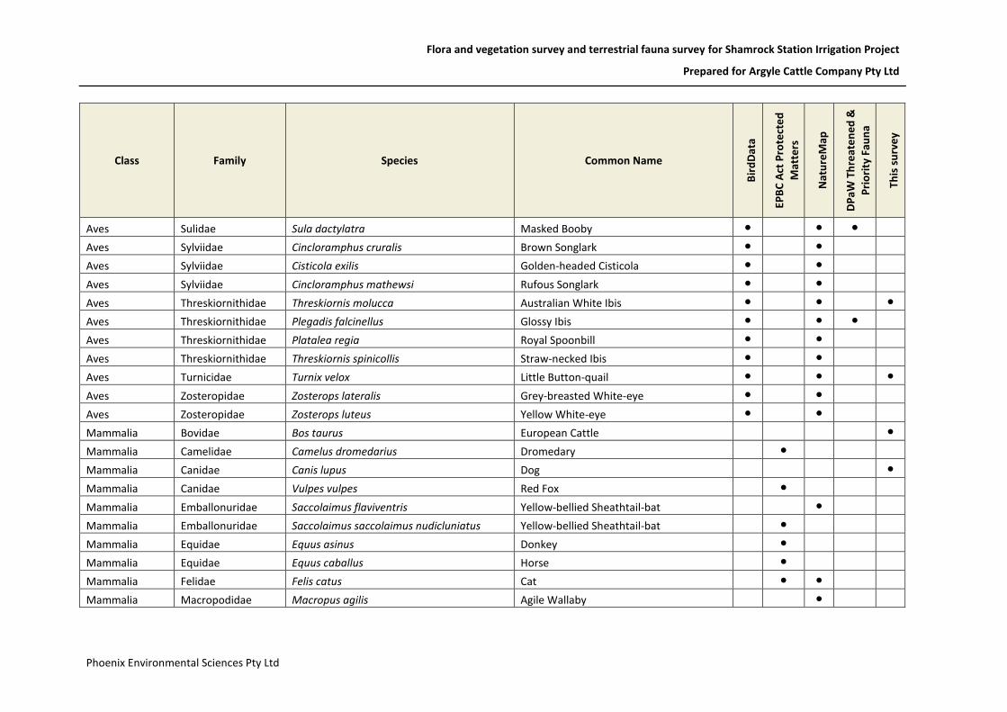
Flora and vegetation survey and terrestrial fauna survey for Shamrock Station Irrigation Project
Prepared for Argyle Cattle Company Pty Ltd
Phoenix Environmental Sciences Pty Ltd
Class Family Species Common Name
Bir
dD
ata
EPB
C A
ct P
rote
cte
d
Mat
ters
Nat
ure
Map
DP
aW
Th
reat
en
ed
&
Pri
ori
ty F
aun
a
This
su
rve
y
Aves Sulidae Sula dactylatra Masked Booby ● ● ●
Aves Sylviidae Cincloramphus cruralis Brown Songlark ● ●
Aves Sylviidae Cisticola exilis Golden-headed Cisticola ● ●
Aves Sylviidae Cincloramphus mathewsi Rufous Songlark ● ●
Aves Threskiornithidae Threskiornis molucca Australian White Ibis ● ● ●
Aves Threskiornithidae Plegadis falcinellus Glossy Ibis ● ● ●
Aves Threskiornithidae Platalea regia Royal Spoonbill ● ●
Aves Threskiornithidae Threskiornis spinicollis Straw-necked Ibis ● ●
Aves Turnicidae Turnix velox Little Button-quail ● ● ●
Aves Zosteropidae Zosterops lateralis Grey-breasted White-eye ● ●
Aves Zosteropidae Zosterops luteus Yellow White-eye ● ●
Mammalia Bovidae Bos taurus European Cattle ●
Mammalia Camelidae Camelus dromedarius Dromedary ●
Mammalia Canidae Canis lupus Dog ●
Mammalia Canidae Vulpes vulpes Red Fox ●
Mammalia Emballonuridae Saccolaimus flaviventris Yellow-bellied Sheathtail-bat ●
Mammalia Emballonuridae Saccolaimus saccolaimus nudicluniatus Yellow-bellied Sheathtail-bat ●
Mammalia Equidae Equus asinus Donkey ●
Mammalia Equidae Equus caballus Horse ●
Mammalia Felidae Felis catus Cat ● ●
Mammalia Macropodidae Macropus agilis Agile Wallaby ●
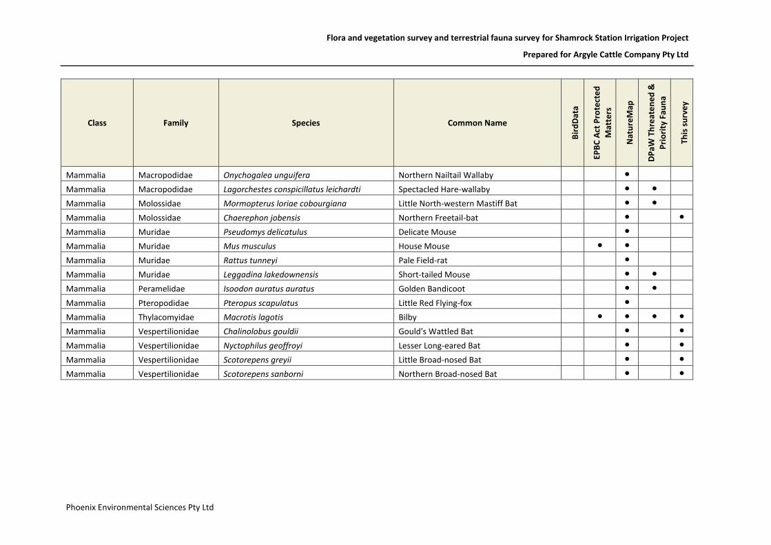
Flora and vegetation survey and terrestrial fauna survey for Shamrock Station Irrigation Project
Prepared for Argyle Cattle Company Pty Ltd
Phoenix Environmental Sciences Pty Ltd
Class Family Species Common Name
Bir
dD
ata
EPB
C A
ct P
rote
cte
d
Mat
ters
Nat
ure
Map
DP
aW
Th
reat
en
ed
&
Pri
ori
ty F
aun
a
This
su
rve
y
Mammalia Macropodidae Onychogalea unguifera Northern Nailtail Wallaby ●
Mammalia Macropodidae Lagorchestes conspicillatus leichardti Spectacled Hare-wallaby ● ●
Mammalia Molossidae Mormopterus loriae cobourgiana Little North-western Mastiff Bat ● ●
Mammalia Molossidae Chaerephon jobensis Northern Freetail-bat ● ●
Mammalia Muridae Pseudomys delicatulus Delicate Mouse ●
Mammalia Muridae Mus musculus House Mouse ● ●
Mammalia Muridae Rattus tunneyi Pale Field-rat ●
Mammalia Muridae Leggadina lakedownensis Short-tailed Mouse ● ●
Mammalia Peramelidae Isoodon auratus auratus Golden Bandicoot ● ●
Mammalia Pteropodidae Pteropus scapulatus Little Red Flying-fox ●
Mammalia Thylacomyidae Macrotis lagotis Bilby ● ● ● ●
Mammalia Vespertilionidae Chalinolobus gouldii Gould's Wattled Bat ● ●
Mammalia Vespertilionidae Nyctophilus geoffroyi Lesser Long-eared Bat ● ●
Mammalia Vespertilionidae Scotorepens greyii Little Broad-nosed Bat ● ●
Mammalia Vespertilionidae Scotorepens sanborni Northern Broad-nosed Bat ● ●

Recommended