DETAILED PROJECT REPORT
National Adaptation Fund
Addressing Climate Change vulnerability of water Sector at Gram Panchayat Level in
drought prone areas of Sikkim
Submitted to
Ministry of Environment, Forest and Climate Change Government of India
Through National Implementation Entity
NABARD
Submitted by
Rural Management and Development Department
Government of Sikkim

Brief Profile of the DPR
Title of the Project
Addressing Climate Change Vulnerability of Water Sector at Gram
Panchayat Level in drought prone areas of Sikkim
Project/Programme
objectives
1. To upgrade Village Water Security Plans for vulnerable
GPs through baseline data collection and situation analysis
2. To identify remedial measures to the problem based on the
actual ground reality as indicated in Village Water Security
Plan
Project / Programme
Sector
Water
Name of Executing
entity/Department
Rural Management and Development Department, Government of
Sikkim
Beneficiaries:
1, 45,358 (Census 2011) people from South and West Districts will
be directly benefitted by the intervention
Project duration
Three Years
Start Date: To be decided
• End Date: 36 month since the date of implementation
•
Amount of Financing
Requested (Rs.):
Rs. 2470.04 Lakhs
Project Location
State: Sikkim
District: South district and 4 blocks from West District
Contact Details of
Nodal Officer of the
Executing
Entity/ies/:
Mrs. Sarika Pradhan
Additional Director cum Project Director(MGNREGA)
Gram Vikas Bhawan, Tashiling Secretariat, Gangtok
737101
Contact:
+91 9434756998
Email: [email protected]

Table of Contents
Sl. No Contents Page no
1.0 Project background 1
2.0 Sikkim State profile 2
2.1 Location and Physiography 2
2.2 Hydro-meteorology 3
2.3 Soil 5
2.4 Bio diversity 6
2.5 Demography 6
2.6 Land-use 7
2.7 Forest resources 8
2.8 Agriculture 8
3.0 Climate Change 9
3.1 Climate change projections for Sikkim 9
3.2 Climate change projections for Sikkim 10
3.3 Impact of climate change on water resources 13
3.4 Overview of vulnerability analysis 14
3.5 Role of Rural Management and Development Department 15
4.0 Rationale of the project 15
5.0 Project objectives 17
6.0 Project Area 17
7.0 Baseline information of project area 19
7.1 Demography 19
7.2 Analysis of water sector 20
7.3 Geomorphology and Hydro-Geology 23
8.0 Project Calendar 24
9.0 Project component and financing 25
10.0 Project justification 26
10.1 Component-wise details and justification of the project components 26
10.2 Details on Economic, Social and Environmental benefits of the
project
28
10.3 Sustainability of intervention 29
10.4 Analysis of the cost-effectiveness of the proposed project 29
10.5 Alignment with the National and State Action Plans and other
Policies/Programmes
31
10.6 Component-wise technical standards 32
10.7 Duplication Check 32
10.8 Details on Stakeholder Consultation 32
10.9 Learning and knowledge management 33
10.10 Sustainability of project outcomes 33
10.11 Overview of the environmental and social impacts and risks 34
11.0 Implementation Arrangements 35
11.1 Arrangements for Project implementation 35
11.2 Monitoring and evaluation plan 37
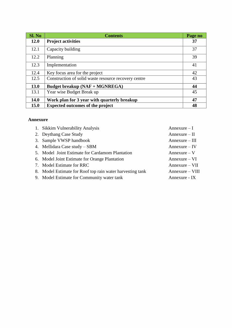
Sl. No Contents Page no
12.0 Project activities 37
12.1 Capacity building 37
12.2 Planning 39
12.3 Implementation 41
12.4 Key focus area for the project 42
12.5 Construction of solid waste resource recovery centre 43
13.0 Budget breakup (NAF + MGNREGA) 44
13.1 Year wise Budget Break up 45
14.0 Work plan for 3 year with quarterly breakup 47
15.0 Expected outcomes of the project 48
Annexure
1. Sikkim Vulnerability Analysis Annexure – I
2. Deythang Case Study Annexure – II
3. Sample VWSP handbook Annexure – III
4. Mellidara Case study – SBM Annexure – IV
5. Model Joint Estimate for Cardamom Plantation Annexure – V
6. Model Joint Estimate for Orange Plantation Annexure – VI
7. Model Estimate for RRC Annexure – VII
8. Model Estimate for Roof top rain water harvesting tank Annexure – VIII
9. Model Estimate for Community water tank Annexure - IX

1
1.0 Project background
Water is undoubtedly one of the major local, strategic, and geopolitical issues today
across the world in the face of changing and unpredictable climatic conditions with
greater and conflicting needs of rising population and resource use. The Himalayas of
Sikkim is abundant in water resources, yet many parts suffer from acute water scarcity,
often intensified by climate change and its triggering factors resulting in over, or under
supply of water. Hence lack of supply of optimum quantities of water results in either
wastage or scarcity of valuable resource like water.
The primary sources of water in the rural areas of Sikkim Himalaya are springs, streams
and small rivers through the surface and sub-surface water flows originating mostly from
the unconfined aquifers. Springs occur where sloping ground and impenetrable rocks
intersect with the ground water table. Several forms of springs such as Dhara/Pandhera
(pool/fountain), Kuwa(shallow well) and Simsaar(marshy area) are the main sources of
water. As per the State Socio-Economic Household Census 2005, nearly 65,000 (80%) of
the 80,000 rural households of the State depend on these springs as a source of drinking
water1. As of today, the dependency of rural households on spring water is nearly 100%
2.
The introduction of piped water supply and services to communities from a distance has
shifted the focus from conservation of local springs and water resources. This has made
them dependent on the often improper/inefficient, sometimes unreliable and inequitable
distribution of piped water, owing to unsystematic pipe networking and storage tanks. The
downstream consumers suffer the most in the loop. Over the years many of these springs
are drying up in the dry belts of Sikkim especially in the southern part owing to several
factors. As a consequence there is a shortage of drinking water in the villages. Local level
institutions on water management and conservation of natural resources are lacking.
These areas are dry belts and face severe domestic water shortage, and thus conservation
of seasonal water sources/natural springs by using traditional/ecological/scientific
technologies are the immediate interventions required in the area.
In view of these significantly important challenges, this project aims to address the

2
drinking water issues in vulnerable blocks of Sikkim through as-is situation assessment,
identification of problems, formulation of recommendations and subsequent
implementation. The State Rural Management and Development Department in
consultation with the German Technical Cooperation, or GIZ has already prepared
comprehensive Village Water Security Plan for 14 villages across South and West
districts of Sikkim in 2013-14. In continuation with the same activity, this project will
envisage the following:
1. Development of Village Water Security Plan for remaining GPs of vulnerable
blocks in south and west districts of Sikkim whose objectives will be to:
i. Identify current issues related to drinking water in each GP
ii. Assess dependency for drinking water to local springs
iii. Analyze gravity based water supply systems
iv. Estimate the current water requirement, state of water governance and
sanitation statusin the GPs
2. Formulation of recommendations for each GP as a fallout of Village Water
Security Plan
3. Implementation of recommendations (including infrastructural development) in
each GP
Technical and financial details of one model spring shed development project and
experiences associated with the implementation of similar projects (Dharavikas work in
Maneydara ward n0. 1 Deythang GPU) has been provided in Annexure II.
2.0 Sikkim State profile
2.1 Location and Physiography
Sikkim is situated in the eastern Himalaya between 88o 03‟ – 88
o 57‟ E longitude and
27 o 03‟ – 28
o 07‟ N latitude. It is a small mountain state bounded by Tibet on north, Nepal
on west, Bhutan on east and West Bengal on south. The state extends to about 115 km from
north to south and 65 km from west to east. It fall in the 1.4 Meso Regions, namely North
Eastern Himalayas of the Macro Region 1 the Northern Mountains of the Natural Division of
India. Nearly two third of its hilly regions are very high mountains perpetually covered with
snow are the sources of glaciers like Talung, Zemu, Lhonak etc. The state being the part of
inner mountain ranges of Himalayas, is hilly having varied elevations ranging from 300
meters to 7000 meters. The largest portion of Sikkim is in its North-West, a large number of

3
mountains having the altitude of about nine thousand meters stand here which includes the
famous Kanchenjunga (8598 meters), the third highest peak in the world.
Fig 1: Map of Sikkim
2.2 Hydro-meteorology
For evaluation, planning and development of water resources in a basin, it is most important
to have a detailed knowledge of hydro-meteorological characteristics of the basin. Hydro-
meteorological parameters include rainfall, temperature, humidity, wind flow, evaporation
and duration of sunshine which determine the climate of a region or basin. The hydro-
meteorological parameters in turn are greatly influenced by the physical features and the
climate of the area. These parameters vary a lot within the state due to the variation in
elevation, location, aspect, and slope.

4
The river Teesta along with its main tributary the Rangit is a perennial river which originates
from the snow and glaciers in the upper reaches of the State. It flows through the territories of
Sikkim, West Bengal in India and Bangladesh. Most of its tributaries are flashy mountain
rivers and carry boulders and considerable quantity of sediment. The flow is turbulent,
characterised by high velocities. Throughout its course in Sikkim, the Teesta and its
tributaries flow in very narrow and deep valleys having precipitous hill slopes, except where
the tributaries join the main stream. The hill slopes are mostly friable and land slips are very
common. Access to the river in these reaches is very difficult.
The southwest monsoon season which is the principle rainy period for almost the entire
Teesta basin is responsible for more than 80% of the total annual rainfall in these
mountainous ecological sites, and significant in controlling the water balance. It is generally
observed that the valleys along Teesta river and its tributaries receives good amount of
rainfall whereas the valleys of Rangit river and its tributaries receives lesser or scarce rainfall
one possible reason for less rainfall or sometimes no rain in the region may be attributed to
the shadowing effect exerted by the adjoining Darjeeling hills in this part of the south and
west districts. The isohyetal map for non-monsoon period reveals distinctly lesser rainfall
towards south Sikkim, varying from 1343 mm in Gangtok to less than 500 mm towards
Namchi. Looking at the monthly variation of normal rainfall, it is seen that the month of July
receives maximum rainfall of the order of 480 mm and minimum normal rainfall of 19 mm is
recorded in the month of December for the Sikkim as a whole. The project area receives
much less rainfall compared to other villages of the state.
Table 1: monthly average rainfall for Sikkim
Month Month wise Normal Rainfall for Sikkim as a whole in mm /
month
January 37.0
February 53.0
March 104.1
April 151.7
May 287.6
June 442.7
July 480.1
August 440.1
September 331.8
October 156.0
November 30.7
December 19.1
Total 2,533.9

5
The climatologically characteristics like monthly mean values of the maximum and minimum
temperatures, mean monthly relative humidity, monthly sunshine hours and monthly mean
wind speed are available at Gangtok station. These climatological figures are being taken as
representative of the Teesta Basin in Sikkim. The temperature distribution like the mean daily
maximum temperature in the sub-basin varies from about 26.8o C in September to 20.7
o C in
the month of January. Mean daily minimum temperatures are around 7.5o C in January, 10.7
o
C in April, 14.5o C in July and 13.3
o C in October. The districtwise monthly mean
temperatures are given at Table 3.5. The Mean daily Relative Humidity varies from 63.8
percent to 88.7 percent over the basin. The mean daily RH is 68.3 percent in January, 66.2
percent in April, 88.7 in July and 68.0 in October. The mean monthly wind speed varies from
as low as 43.2 km/day from July to September to high of 98.4 km/day in the month of April.
2.3 Soil
Based on the soil survey conducted by „National Bureau of Soil Survey of India & Land Use
Planning (ICAR)‟, the state has been classified into three main groups viz.
i) Udalf : High base status soil of humid region
ii) Orthants : Recent formed soil
iii) Odhepts : Shallow blocks, brown and alluvial soil
The characteristics of soil vary from place to place due to topographical variations. The soil
in general is loamy sand to silty clay loam with a depth of 30 cm to 100 cm and in some cases
even more than 120 cm. It has less water holding capacity and is dry in nature. Chemically
acidic soil abound resulting from the washing down of the salts in rain water and also on
account of leaching effect. The pH value varies from 4.5 to 7.5. The soils are characterized by
low to high organic matter (2-5 percent, in some places even more than 5 percent) with low
action exchange capacity and high lime requirement. Notwithstanding the relatively high
organic matter content, the nitrogen content in the soil is low. Some of the plant nutrient like
phosphate gets fixed in soils due to the high acidity and thus does not become available to the
growing plants even on application. As such there is remarkable deficiency of micro-nutrients
viz. zinc, boron, copper, calcium, magnesium, manganese etc in the soils. There is a great
deal of variation in the physical properties of the soils. The soils may be classified into
following 5 categories:
6
i) Soils on summit and ridge tops
ii) Soils on side slopes of hills
iii) Soils on valleys
iv) Soils on cliff and precipitous slopes
v) Soils on glacial drift moraines and boulders
2.4 Biodiversity
Sikkim has been identified as one of the HOT-SPOT in the Eastern Himalayas (Out of the 18
bio diversity hotspots in the world and of 2 in India). There are 10 bio-geographic zones & 25
biotic provinces-- which have 16 major forests types & > 200 sub types as per (Champion &
Seth 1968). Sikkim falls under Himalayan (2) Bio-geographic zone & Central Himalaya (2c)
biotic province-having about 9 types of forests types (Champion & Seth).
The State is endowed with rich floral and faunal diversity and the mega-fauna and flora
comprises nearly 4500 species of flowering plants, 550 species of Orchids, 36 species of
Rhododendrons, 16 species of Conifers, 28 species of Bamboos, 362 species of Ferns and its
allies, 9 species of Tree Ferns, 30 species of Primulas, 11 species of Oaks, over 424 species of
Medicinal plants, 144+ mammals species, 550 Birds species, 48 Fishes species and over 600
Butterflies species. The tremendous diversity of insects like beetles and moths as well as a
host of other life forms is yet to be enumerated. Most of the high altitude medicinal plants are
rare and endangered species. Sikkim also has 28 Mountains/Peaks, more than 38 Glaciers,
227 high altitude lakes/wetlands and over 104 rivers and streams.
The forests contain a number of plants whose medicinal values have been well recognized by
local people as well as by different pharmaceutical, insecticidal and perfumery sectors.
2.5 Demography of Sikkim
As per details from Census 2011, Sikkim has population of 6.11 Lakhs, an increase from
figure of 5.41 Lakh in 2001 census. Total population of Sikkim as per 2011 census is 610,577
of which male and female are 323,070 and 287,507 respectively. In 2001, total population
was 540,851 in which males were 288,484 while females were 252,367. Density of
population in Sikkim is 86 per sq km which is lower than national average 382 per sq km. In

7
2001, density of Sikkim was 76 per sq km, while nation average in 2001 was 324 per sq km
The total population growth in this decade was 12.89 percent while in previous decade it was
32.98 percent. The population of Sikkim forms 0.05 percent of India in 2011. In 2001, the
figure was 0.05 percent. Sex Ratio is 890 i.e. for each 1000 male, which is below national
average of 940 as per census 2011. In 2001, the sex ratio of female was 875 per 1000 males
in Sikkim.
Literacy rate in Sikkim has seen upward trend and is 81.42 percent as per 2011 population
census. Of that, male literacy stands at 86.55 percent while female literacy is at 75.61 percent.
In 2001, literacy rate in Sikkim stood at 68.81 percent of which male and female were 76.04
percent and 60.40 percent literate respectively. Nepali, Bhutia and lepcha are the major
languages spoken in the State.
2.6 Land-use
The state has a distinct alpine flavour with about 56% (3995 km2) of the total geographical
area above the tree line which is at 3,800 meters. 84% of the land is classified as forest land,
and the remaining 16% is privately owned. The average size of land holding is 1.3 ha. Out of
the total cultivated land of 1,09,963 hectares, only 11% is irrigated: dry land constitutes
58%, followed by cardamom (19%), paddy (13%) and wasteland (10%). This reflects the
cropping pattern in Sikkim where different districts were prominent for each of the above
four categories. The maximum dry land area was in the West district (35%), followed by the
South district (33%), the East district (21% and the North district (11%). The largest portion
of cardamom land was in North (32%), followed by East (29%), South (21%) and West
(18%). In case of paddy, the South district ranked first (44%), followed by West (25%), East
(23%) and North (8%). It may be noted that Large Cardamom, the most vital cash crop, is
predominantly grown in the tribal belt in the North district.
Table 2: Land-use Sikkim
District
Total
Paddy
Fields
Total
Dry
Land Wasteland Cardamom
Total
Cultivated
Land
North Sikkim 8.03% 10.96% 8.07% 32.42% 14.76
East Sikkim 23.15% 20.73% 52.39% 28.74% 28.96
8
South Sikkim 44.05% 32.90% 15.15% 20.78% 26.95
West Sikkim 24.78% 35.41% 24.39% 18.06% 29.34
Grand Total 14,680.6 64,739.8 11,734.4 21,761.7 1,09,963.0
Source: Land Revenue Department, Govt. of Sikkim
2.6 Forest resources
Forest is one of the richest natural resources of Sikkim. With luxuriant forest abounding in all
part of state, Forestry has been the major land use in the State and 82.31% of the total
geographical area of the State is under the administrative control of the State Forest
Department. The total forest and tree cover of the State is 3392 sq. km (47.80% of the total
geographical area of the state). The composition ranges from tropical Dry Deciduous Forests
with Sal and its associates in the valleys of Teesta and Rangit to the Alpine Scrub and
grassland in high altitude.
2.7 Agriculture in Sikkim
Agriculture Sikkim is a hilly State in the Eastern Himalayas where agricultural practices and
adaptations are highly variable in time and space due to varying altitudes and agro-climatic
situations. Agriculture is the primary activity of the people of Sikkim. About 15.36% of the
total geographical area of the land is devoted to agriculture but the actual area available for
agricultural purpose is declining due to diversion of cultivable land for non-agricultural
purposes like establishment of industries, township expansion, construction of roads, hydel
projects, buildings etc. Farming has been considerably handicapped by small and fragmented
holdings, limited irrigation, and lack of farm mechanization and frequent occurrence of
natural calamities like landslides, floods and earthquakes. In view of these facts, emphasis is
being given to intensive and judicious use of limited land so that the per capita land
productivity and overall production is maintained at a desired level. Agriculture in an entirely
mountainous state like Sikkim operates under many constraints resulting into low average
yield per unit area for most of the crops. The low productivity is seriously characterised by
two important features, viz. land holding size and socio-economic condition of the farmers.
The majority of the farming communities of the state fall in the small and marginal farmers.

9
Table 3: Cropping pattern in Sikkim
3.0 Climate Change
3.1 Climate Change Scenario in Sikkim
Altitude variation across Sikkim is the main factor controlling climate and weather
conditions. Relief features such as high mountains act as barriers for the movement of the
Monsoon winds. Low temperature, high rainfall on windward slopes, comparatively dry on
the leeward side and heavy precipitation in the form of snow at the mountain tops are the
main features of the climate. Analysis of annual average maximum, minimum temperature
and rainfall of the two stations indicates that though there is no change in the maximum
temperature, but the minimum temperature has increased by almost by 2.5oC between the
1957 and 2009. The total rain fall has decreased by around 250 mm between the period 1983
to 2009. After the drought of 2001, the annual precipitation rose to a maximum of 3700 mm
but since then it has been continuously decreasing .However, there exists a spatial variability.
Monthly, seasonal and annual analysis of data only for Gangtok station for the period 1957 to
2005 indicates a trend towards warmer nights and cooler days, with increased rainfall except
in winter (Seetharam, 2008). The temperature in Gangtok has been rising at the rate of 0.2-
0.3oC per decade and the annual rainfall is increasing at the rate of nearly 50 mm per decade.
Therefore, the temperature in Gangtok has risen by 1 to 1.5oC since 1957. Comparison of
long term meteorological data available for Gangtok station (1957 to 2005) with the trend
over the last few years (2006-09), shows an acceleration of these patterns, with winters
becoming increasingly warmer and drier. Now winter rains is increasingly becoming scarce.
During the year 2008 and 2009, the state witnessed one of the driest winters in living
10
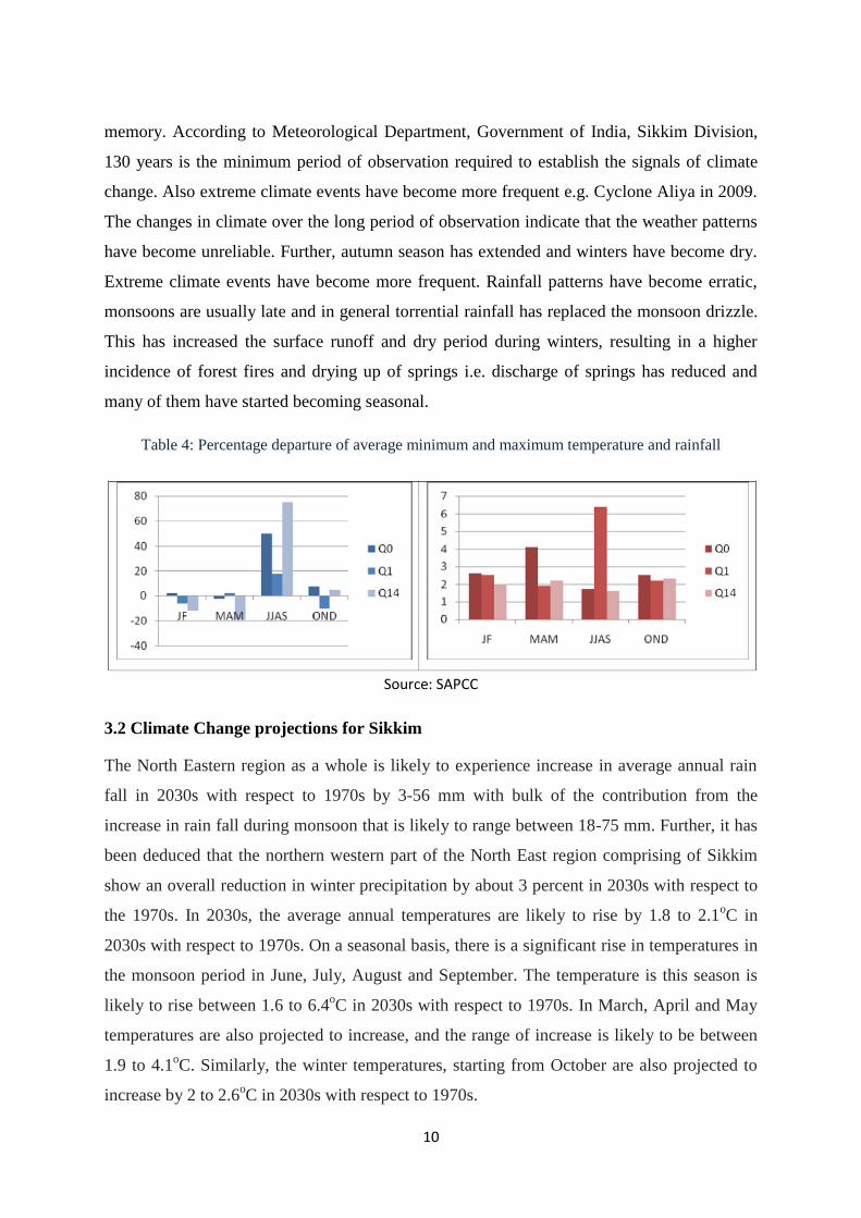
memory. According to Meteorological Department, Government of India, Sikkim Division,
130 years is the minimum period of observation required to establish the signals of climate
change. Also extreme climate events have become more frequent e.g. Cyclone Aliya in 2009.
The changes in climate over the long period of observation indicate that the weather patterns
have become unreliable. Further, autumn season has extended and winters have become dry.
Extreme climate events have become more frequent. Rainfall patterns have become erratic,
monsoons are usually late and in general torrential rainfall has replaced the monsoon drizzle.
This has increased the surface runoff and dry period during winters, resulting in a higher
incidence of forest fires and drying up of springs i.e. discharge of springs has reduced and
many of them have started becoming seasonal.
Table 4: Percentage departure of average minimum and maximum temperature and rainfall
Source: SAPCC
3.2 Climate Change projections for Sikkim
The North Eastern region as a whole is likely to experience increase in average annual rain
fall in 2030s with respect to 1970s by 3-56 mm with bulk of the contribution from the
increase in rain fall during monsoon that is likely to range between 18-75 mm. Further, it has
been deduced that the northern western part of the North East region comprising of Sikkim
show an overall reduction in winter precipitation by about 3 percent in 2030s with respect to
the 1970s. In 2030s, the average annual temperatures are likely to rise by 1.8 to 2.1oC in
2030s with respect to 1970s. On a seasonal basis, there is a significant rise in temperatures in
the monsoon period in June, July, August and September. The temperature is this season is
likely to rise between 1.6 to 6.4oC in 2030s with respect to 1970s. In March, April and May
temperatures are also projected to increase, and the range of increase is likely to be between
1.9 to 4.1oC. Similarly, the winter temperatures, starting from October are also projected to
increase by 2 to 2.6oC in 2030s with respect to 1970s.
11
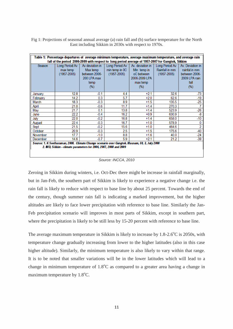
Fig 1: Projections of seasonal annual average (a) rain fall and (b) surface temperature for the North
East including Sikkim in 2030s with respect to 1970s.
Source: INCCA, 2010
Zeroing in Sikkim during winters, i.e. Oct-Dec there might be increase in rainfall marginally,
but in Jan-Feb, the southern part of Sikkim is likely to experience a negative change i.e. the
rain fall is likely to reduce with respect to base line by about 25 percent. Towards the end of
the century, though summer rain fall is indicating a marked improvement, but the higher
altitudes are likely to face lower precipitation with reference to base line. Similarly the Jan-
Feb precipitation scenario will improves in most parts of Sikkim, except in southern part,
where the precipitation is likely to be still less by 15-20 percent with reference to base line.
The average maximum temperature in Sikkim is likely to increase by 1.8-2.6oC is 2050s, with
temperature change gradually increasing from lower to the higher latitudes (also in this case
higher altitude). Similarly, the minimum temperature is also likely to vary within that range.
It is to be noted that smaller variations will be in the lower latitudes which will lead to a
change in minimum temperature of 1.8oC as compared to a greater area having a change in
maximum temperature by 1.8oC.

12
Fig 2: Change in Average Rainfall during winter, Pre-monsoon, Monsoon & Post-monsoon Seasons
across Sikkim State in 2050s (top panel) and 2080s (bottom panel)
Source: SAPCC
Fig 3: Change in maximum and minimum temperatures in Sikkim in mid century (2050s) and at the
end of the century (2080s)

13
3.3 Impact of Climate change on Water Resources
Water is one of the most important sectors on which climate change (increase in
temperatures, evapo-transpiration, and spatial variation in rain fall, increase intensity of
extreme rain fall and drought events) can have a profound impact, which in turn can have
cascading impacts on other sectors. While a consensus exists on the likely impacts of climate
change on the water resources of the Himalayas, quantitative analyses of such changes are
sparse due to the dearth of baseline data essential for such analysis.
The National Water Mission, which is a part of the National Action Plan on Climate Change
(MoWR, 2010), identifies the threat to water resources due to climate change, and the ones
that are relevant to Sikkim are as follows:
i. Drinking water dependent on rain fall likely to become more scarce as rain fall may
increasingly get restricted to only monsoon period (as is the present situation) and
there might be a reduced amount of rain fall as the number of rainy days decrease.
ii. Increase in intensity of rain fall will lead to high run off and less infiltration, and
consequently adversely affecting spring recharge;
iii. Increased drought-like situations due to the overall decrease in the number of rainy
days;
iv. Warming may lead to a decline in the glaciers and snowfields;
v. Further, increased water temperature also may lead to lower availability of dissolved
oxygen, altered ice-free period, increased biological activity exhausting oxygen in
water, and changed pattern of thermal mixing in water bodies to create anaerobic
conditions leading to eutrophication.
Particularly for Sikkim, the water yield which is a function of rain fall run off and evapo-
transpiration is projected to decrease upto 12 percent in 2030s with respect to 1907s (MoEF,
2010). The consequences of these changes for food web interactions, community structure,
nutrient dynamics, and water quality are likely to be critical for the ecological health of the
wetlands and living communities deriving benefits from them.

14
3.4 Overview of the Vulnerability Analysis
The state is administratively divided into four districts, namely North, East, South and
West.Climate change related vulnerability studiestaken up in the state at the district level -
macro scale, have found South and West districts tobe the most vulnerable (WWF-India
2010, IISc2010). Inspite of being a small state, there is a highvariation in exposure
(temperature and rainfall), sensitivity (water, livelihoods and health) andadaptive capacity
(poverty, literacy, environment and connectivity) indicators over short distances.
As per the vulnerability assessment studies conducted in 2011, the vulnerability of the rural
communities extending over the entire Gram Panchayats in Sikkim, estimated as a
combination of exposure, sensitivity and adaptive capacity indices, is found to vary between
climate 0 to 1 with the mean being 0.43+0.223. Exposure and adaptive capacity was found to
determine the vulnerability to a large extent as sensitivity did not vary much. South district
was found to be the most vulnerable followed by West. East and North districts were found to
be relatively resilient to climate related change.
Fig 4: Sikkim vulnerability analysis

15
3.5 Role of Rural Management and Development Department
The mandate of RMDD is to provide clean, safe and adequate drinking water to the rural
habitation, improve the sanitation facilities, and ensure rural water security. The function of
the RMDD includes assessment of actual ground position of water supply to rural
communities in terms of numbers of habitations Not Covered, Partially Covered and Fully
Covered. It undertakes, on a regular basis the survey of water availability, i.e. survey of all
the available water sources and upgrades water maps for the State; undertakes monitoring and
surveillance of water quality and intensification of water testing facilities e.g. establishment
of water testing facilities in the Districts and Sub-Divisional Level; completes
the incomplete schemes; addresses the coverage of the newly emerged habitations/ reverse
coverage habitations. Promotes appropriate alternate technology, viz., roof top collection,
rain water harvesting etc. for dry pockets; Works towards integrating Integration of rural
water supply programme with other rural development activities and redefining appropriate
unit for coverage area. Pilot projects have been taken up for spring shed development
(namely Dhara vikas) which aims at artificial spring recharge using rain water harvesting
techniques and is funded under MGNREGA. Resource mapping of springs is also underway
by preparation of village spring atlas (www.sikkimsprings.org).
4.0 Rationale of the Project
Based on the vulnerability analysis on water sector done by Rural Management and
Development Department (Annexure I), the entire south District and 4 blocks of West Sikkim
have been identified as water stressed area. The annual rainfall received is less than 150 cm
as compared to 300 cm for East and North districts. This is because of the geographical
location of these blocks in the rain shadow area of Darjeeling hills.
The area covers the north east-south west running mountain ranges in south western part of
Sikkim towards west bank of River Teesta and north bank of River Rangit respectively. The
peculiar feature of these mountain ranges is that they do not rise above 3000 m ASL.
Therefore, these ranges are devoid of snow covered peaks which supports perennial streams.
The discharge of streams varies from huge flash floods in summer to less than 1 LPM water
or even dry during the months from Dec to May.
16
The rural habitations are dispersed between 900 to 3000 m ASL and the perennial river Like
Teesta and Rangit flow at almost 1000 m below in the valley. Thus, the people are dependent
on small springs which provide very low but continuous discharge throughout the year. The
discharge from these springs are collected in storage tanks and distributed to individual
households through gravity based piped water system.
Spring water is the rain water which infiltrates the ground during the rainy season and flows
out from the cracks, fractures and joints as ground water. The upper catchments and the
forested areas in general are the recharge areas for these springs. However, due to reduction
in the number of rainy days due to the impact of the climate change, the precipitation which
was well distributed in months now comes as heavy downpour in short spell which eventually
converts into flash-floods and storm flow. Moreover, this is also aided by the land use
changes due to various developmental activities over the decades wherein the ground surface
is not conducive for infiltration of water. Thus, most of the rainwater due to steep slope
converts into runoff and this has eventually led to reduction in recharge and drying up of the
springs particularly during the lean season from December to May.
Thus, there is wide spread water scarcity during the lean season wherein farmers have to
spend most of the time carrying water uphill from the downstream sources for meeting their
daily domestic and livestock requirements.
Each gram panchayat across the state has constituted village water and sanitation committee
(VWSC). The main responsibility of this committee is to ensure the water security at the
village level. However, there is lack of expertise to formulate a perspective plan for the water
security. The need was felt to strengthen the VWSC and facilitate them to prepare a proper
village water security plan (VWSP). A pilot project was launched to upgrade the VWSP
across 14 selected GPs in these Gram panchayats. The detail assessment of water situation at
the habitation level has been done with site-specific adaptation measures to be followed up
(http://www.sikkimsprings.org/dv/villagewatersecurityplans.php).
The present project envisages upgrading the VWSP of 60 Gram Panchayats (of the identified
vulnerable blocks) and implementing the follow-up adaptation activities to the extent possible
in convergence with MGNREGA and other RD schemes.
17
5.0 Project objective:
1. To upgrade Village Water Security Plans for vulnerable GPs through baseline data
collection and situation analysis
2. To identify remedial measures to the problem based on the actual ground reality as
indicated in Village Water Security Plan
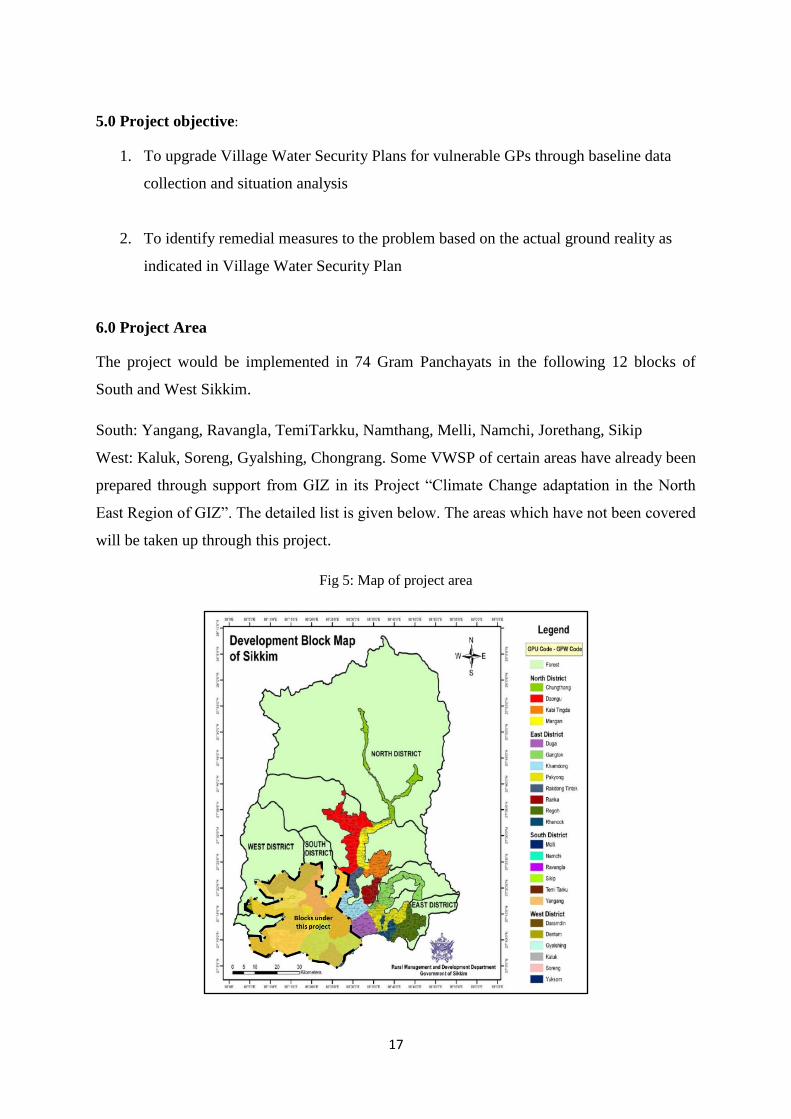
6.0 Project Area
The project would be implemented in 74 Gram Panchayats in the following 12 blocks of
South and West Sikkim.
South: Yangang, Ravangla, TemiTarkku, Namthang, Melli, Namchi, Jorethang, Sikip
West: Kaluk, Soreng, Gyalshing, Chongrang. Some VWSP of certain areas have already been
prepared through support from GIZ in its Project “Climate Change adaptation in the North
East Region of GIZ”. The detailed list is given below. The areas which have not been covered
will be taken up through this project.
Fig 5: Map of project area

18
. Table 5: Number of Blocks, GPs and Wards and existing VWSPs
Sl. No. District Block GPs No. of wards VWSP Prepared with GIZ
1 SOUTH
YANGANG
1/LINGI 05 No
2 2/PAIYONG 07 No
3 3/KOLTHANG TOKDEY 05 No
4 4/NIYA MANZING 05 No
5 5/SRIPATAM GAGYONG 06 No
6 6/YANGANG RANGANG 06 No
7
RAVANGLA
7/RABONG SANGMOO 07 No
8 41/TINKITAM RAYONG 05 No
9 43/LEGSHIP 05 No
10 44/KEWZING BAKHIM 05 No
11 45/BARFUNG ZARONG 07 No
12 46/RALONG NAMLUNG 06 No
13 47/BORONG PHAMTAM 06 No
14
TEMI TARKKU
8/BEN NAMPRIK 07 No
15 9/TEMI 06 No
16 10/TARKU 06 No
17 11/NAMPHING 06 Yes
18 12/BARNYAK TOKAL 05 No
19 13/RAMENG NIZRAMENG 05 Yes
20
NAMTHANG
14/PERBING DOVAN 05 No
21 15/CHUBA PHONG 06 No
22 16/NAMTHANG MANEYDARA 08 No
23 17 NAGI KAREK 06 No
24 18/KATENG PHAMPOK 06 No
25 19/TURUNG MAMRING 06 No
26 20/TANZI BIKMAT 05 No
27 21/RATEYPANI 06 Yes
28
MELLI
22/SADAM SUNTALEY 08 Yes
29 23/MELLIDARA PAIYONG 06 Yes
30 24/TURUK RAMABUNG 07 Yes
31 25/LUNGCHOK KAMAREY 06 Yes
32 26/SUMUK KARTIKEY 05 No
33
NAMCHI
27/RONG BUL 06 No
34 28/MANIRAM PHALIDARA 06 No
35 29/KITAM MANPUR 05 Yes
36 30/MIKHAOLA BOOMTAR 07 No
37 31/SOROK SHYAMPANI 06 No
38 33/ASSANGTHANG 05 Yes
39 36/MAMLEY KAMRANG 05 Yes
40 37/TINGRITHANG 05 Yes
41 38/DAMTHANG 05 No
42
JORETHANG
34/POKLOK DENCHUNG 05 Yes
43 35/TINIK CHISOPANI 05 No
44 32/SHALGHARI 05 Yes
45
SIKIP
39/WAK OMCHU 06 No
46 40/SANGANATH 05 No
47 42/LAMTING TINGMO 05 No
48 WEST
KALUK
27/SANGADORJI 05 No
49 28/TADONG RINCHENPONG 05 No
50 29/SAMDONG 06 No
51 30/DEYTHANG 06 Yes
19
Sl. No. District Block GPs No. of wards VWSP Prepared with GIZ
52 31/TAKUTHANG 05 No
53
SORENG
35/CHOTA SAMDONG ARUBOTEY 05 No
54 41/MALBASEY 06 No
55 42/SORENG 07 No
56 43/SINGLING 05 No
57 44/TIMBERBONG 05 No
58 45/THARPU 05 No
59 46/KARTHOK BOJEK 05 No
60 47/DODAK 05 No
61 48/BURIAKHOP 05 No
62
GYALSHING
10/DARAP 07 No
63 11/SINGYANG CHUMPONG 06 No
64 12/YANGTEN 06 No
65 13/GYALSHING OMCHU 06 No
66 14/YANGTHANG 06 No
67 15/LINGCHOM TIKJYA 05 No
68 16/SARDONG LUNGZIK 06 No
69
CHONGRANG
1/KARZI MANGNAM 05 No
70 2/DHUPIDARA NARKLHOLA 06 No
71 3/KONGRI LABDANG 05 No
72 4/TASHIDING 06 No
73 5/ARITHANG CHONGRONG 05 No
74 6/GERETHANG 06 No
TOT 02 12 74 421
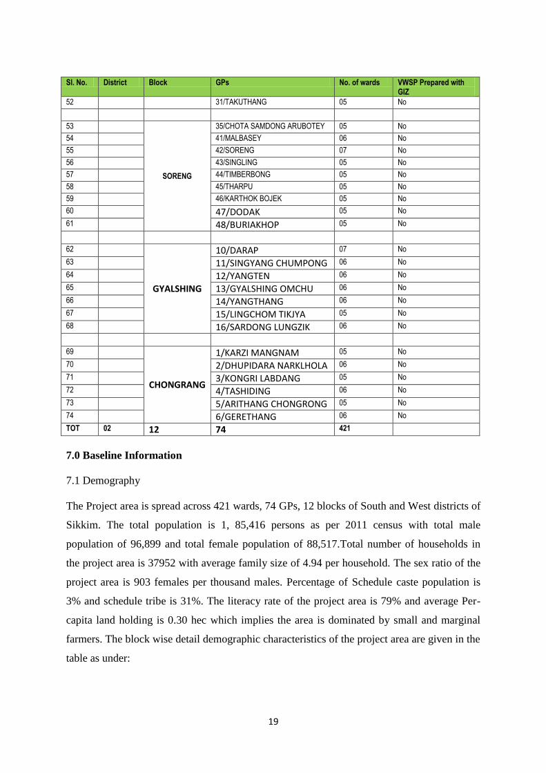
7.0 Baseline Information
7.1 Demography
The Project area is spread across 421 wards, 74 GPs, 12 blocks of South and West districts of
Sikkim. The total population is 1, 85,416 persons as per 2011 census with total male
population of 96,899 and total female population of 88,517.Total number of households in
the project area is 37952 with average family size of 4.94 per household. The sex ratio of the
project area is 903 females per thousand males. Percentage of Schedule caste population is
3% and schedule tribe is 31%. The literacy rate of the project area is 79% and average Per-
capita land holding is 0.30 hec which implies the area is dominated by small and marginal
farmers. The block wise detail demographic characteristics of the project area are given in the
table as under:

20
Table 6: Demography of Project area
Distric
t Block
No of
HH
Avera
ge
family
size
Total
Populatio
n
Total
Male
Total
Femal
e
% of
Femal
e
% of
SC
%
of
ST
Literacy
rate
Sex
rati
o
Percapit
a land
holding
West
Chongrang 1485 5.31 7876 4390 3486 45% 3% 17% 82% 794 0.25
Kaluk 2978 4.81 14349 7345 7004 49% 2% 45% 76% 954 0.34
Soreng 3742 4.76 17470 8930 8540 49% 5% 41% 78% 956 0.31
Gyalshing 4264 4.99 21124 10934 10190 48% 5% 44% 76% 932 0.30
South
Jorethang 1485 5.31 7876 4390 3486 45% 3% 17% 82% 794 0.25
Melli 3411 4.71 15959 8135 7824 49% 5% 15% 81% 962 0.26
Namchi 3610 4.75 17117 8766 8351 49% 3% 27% 81% 953 0.40
Namthang 3515 5.04 17640 9404 8236 47% 5% 33% 82% 876 0.35
Ravangla 4580 4.87 21946 11795 10151 46% 3% 36% 78% 861 0.37
Sikip 1070 4.70 5136 2731 2405 47% 1% 37% 77% 881 0.62
Temi Tarku 4221 4.81 20031 10317 9714 48% 5% 35% 81% 942 0.31
Ravangla 3591 5.28 18892 9762 9130 48% 3% 29% 79% 935 0.34
Project Area 37952 4.94 185416 96899 88517 48% 3% 31% 79% 903 0.34
Source: Census of 2011
7.2 Analysis of water sector
The project area is much more drier compared to the state which can be discerned from
the fact that more than 60 % of unirrigated arable land or dry land (Suka bari) is in the
project area and only 6 % land irrigated which is Paniket existing in the areas with
availability of water.
Table 7: Land-use project area
Districts Blocks
Total
Irrigated/
Pani Khet
(ha)
Unirrigated/
Suka bari
(ha)
Culturable
wasteland
(ha)
Area not
available
for
cultivation
(ha)
Total
Area
(ha)
West
Chongrang 147.69 3505.35 2784.28 301.03 6738.35
2% 52% 41% 4%
Galshing 701.19 4364.91 847.78 385.88 6299.76
11% 69% 13% 6%
Kaluk 139.86 3223.93 1017.11 453.8 4834.7
3% 67% 21% 9%

21
Soreng 485.16 2425.855 911.51 706.51 4529.04
11% 54% 20% 16%
South
Jorethang 91.29 1237.95 437.66 92.07 1858.97
5% 67% 24% 5%
Melli 297.09 2193.71 1262.49 249.22 4002.51
7% 55% 32% 6%
Namchi 59.79 4127.95 2050.46 480.65 6718.85
1% 61% 31% 7%
Namthang 182.72 3595.24 1859.07 180.51 5817.54
3% 62% 32% 3%
Ravangla 242.21 5260.75 1423.18 334.5 7260.64
3% 72% 20% 5%
Sikip 40.51 1762.19 999.62 101.31 2903.63
1% 61% 34% 3%
Temi
Tarku 367.56 3301.12 1433.56 162.81 5265.05
7% 63% 27% 3%
Yangang 743.77 3888.62 1219.31 164.27 6015.97
12% 65% 20% 3%
Project
Area 3498.84 38887.575 16246.03 3612.56 62245.01
6% 62% 26% 6%
Source: Census 2011
Further, the rainfall distribution map of Sikkim shows that project area receives the annual
rainfall of 150 cm compared to 300 cm in the East and some part of the north district. The
pattern of rainfall distribution clearly indicates the drought prone areas in the south central
part; this forms the rain-shadow area of Darjeeling Himalaya (ICAR, 2000). Moreover, the
analysis of 5 years rainfall from 2010 to 2014 and average rainy days of Damthang hills
which receives highest rainfall in the project area suggest that most of the rainfall is received
from May to first week of September over the average slope of more than 40%. Since the
area doesn‟t have high density forest cover in upper catchment 80% of the rainfall is
converted into runoff.

22
Fig 6: Rainfall map of Sikkim
Source: ICAR 2000
The current estimates by the Agriculture Department, Government of Sikkim, suggest that the
present water demand for water for domestic uses is 0.18 BCM, Crop- 0.21 BCM, livestock-
0.008 BCM and Industrial uses- 0.0003 BCM. The current total water demand in the project
area is 0.244 BCM. However, it has been projected that by 2020 the additional 0.015 BCM
water would be required for domestic uses and 0.002 BCM water for crops. Therefore, there
would be requirement of additional 0.017 BCM water to meet up the demand for various
sectors.
Table 8: Present water demand of the project area
District Block Domestic Crop Livestock Industrial
Power
generation Total
West
Chongrang 0.0004 0.063801 0.0002 0 0 0.064
Gyalshing 0.0007 0.048528 0.0002 0 0 0.049
Kaluk 0.0005 0.045273 0.0003 0 0 0.046
Soreng 0.0006 0.057924 0.0002 0 0 0.059
South
Namchi 0.0035 0.000033 0.0012 0 0 0.005
Namthang 0.0022 0.000002 0.0006 0.0002 0 0.003
Jorethang 0.0009 0.000001 0.0001 0.0001 0 0.001
Sikkip 0.0006 0.000013 0.0002 0 0 0.001

23
Sumbuk 0.0020 0.000002 0.0005 0.00003 0 0.003
Temi 0.0021 0.000019 0.0024 0 0 0.004
Rabong 0.0023 0.001100 0.0013 0 0 0.005
Yangang 0.0025 0.000007 0.0012 0 0 0.004
Total 0.0183 0.216704 0.0085 0.0003 0 0.244
Table 9: Projected water demand of the project area for 2020 in BCM
Block Domestic Crop Livestock Industrial Power
generation Total
Chongrang 0.0004 0.063690 0.00002 0 0 0.064
Geyzing 0.0008 0.048350 0.00004 0 0 0.049
Kaluk 0.0005 0.045250 0.00005 0 0 0.046
Soreng 0.0006 0.057880 0.00005 0 0 0.059
Namchi 0.0188 0.000032 0.00131 0 0 0.020
Namthang 0.0023 0.000002 0.00064 0.0002 0 0.003
Jorethang 0.0010 0.000001 0.00015 0.00007 0 0.001
Sikkip 0.0006 0.000013 0.00023 0 0 0.001
Sumbuk 0.0021 0.000002 0.00057 0.00003 0 0.003
Temi 0.0022 0.002217 0.00248 0 0 0.005
Rabong 0.0025 0.001100 0.00133 0 0 0.005
Yangang 0.0027 0.000007 0.00123 0 0 0.004
Total 0.034 0.219 0.008 0.0003 0 0.259
Source: Department of Agriculture, Government of Sikkim
7.3 Geomorphology and Geo-hydrology
Geohydrology map of Sikkim suggest that the project area falls under the Gorubathan,
Reyong and Buxa formation and also deposits from the Damuda group. The
geomorphological map of the state indicates that the project area falls under moderate to less
dissected hill segments. Dissection index helps to understand the probability of ground water
occurrences in the Himalaya. Areas with high dissection and greater slopes have lesser
chances of ground water occurrences. These are mostly the higher elevation areas. Most of
the rain water converts into runoff due to steeper slopes creating higher density of drainage.
However, in the areas having low to moderate dissection the probability of occurrence of
ground water is more. However, the valley floors and river banks also have higher probability
of ground water occurrences.

24
Fig 7: Hydro-geology and Geomorphological map of Sikkim
Source: DST, Sikkim
8.0 Projected Calendar
(Indicate the dates of the following milestones for the proposed project/programme (projects
which have four or more than four years of implementation period would require having mid-
term review after two years of implementation).
Table 10: Milestones and expected dates
Milestones
Expected Dates
Start of Project/Programme
Implementation
To be Decided once the concept is approved
Mid-term Review (if planned) 18th Month since the date of project
inception
Project/Programme Closing 36th Month since implementation
Terminal Evaluation 3 months before the closing of the project

25
9.0 Project Components and Financing
Table 11: Project Components and Financing
No. Project
Components
Expected Concrete
Outputs Expected Outcomes
Amount
(lakhs)
1
Training and
Capacity
Building
Community
mobilization on
water conservation
and climate resilient
activities
Training on
preparation of
Village Water
Security Plan
Training on
implementation of
Village Water
Security Plan
To develop knowledge of
local people on water
conservation and its need
To train people on
development of VWSP and
understand the
recommendations of the
Plan
To train people on how to
implement the different
recommendations under the
VWSP
27.92
2 Planning
Preparation of
Village Water
Security Plan
(VWSP) of Gram
Panchayat Units and
collection of
baseline data
Hydrogeological
study of the springs
Feasibility
assessment and
budget estimation of
the suggested
measures in VWSP
Updation of village
springs atlas
Assess current issues and
water requirement in GPs
Geohydrology assessment
to identify the recharge
area using scientific study
Technical, financial
assessment of suggested
measures in Plan and
evaluate nature of climate
resilient activities
Village spring atlas to do
resource mapping of
springs
66.1
3
Implementation
of suggested
activities under
Village water
Security Plan -
Construction of
infrastructure
Roof top water
harvesting
structures for
harvesting roof
water during rainy
season
Community water
storage reservoirs to
store night
discharge of the
springs and excess
monsoon discharge
of the springs
Construction of
solid waste recovery
Increase water storage
capacity in villages located
on top of hills with
perennial water shortage
Household level tanks can
be constructed to store the
perennial spring water
overnight, and this stored
water can be used during
the day for household as
well as minor irrigation
works
1544.63

26
No. Project
Components
Expected Concrete
Outputs Expected Outcomes
Amount
(lakhs)
centre
4. Support
Services
► Fodder
development
► Horticulture
development
► Plantation of saplings 646.66
5. Project Execution Cost (INR 50,00,000 set aside against project
management by DST and remaining for RMDD)
116.17
6. Total Project Cost 2401.48
. Project Cycle Management Fee charged by the Implementing Entity
(3%)
68.56
Amount of Financing Required 2470.04
10.0 Project Justification
10.1 Component-wise details and justification of the project components
(i) Planning
Baseline Scenario-Presently, there is dearth of technical studies and needs assessment on the
water availability and requirement in the villages of Sikkim. Without an in-depth technical
review of the same, no feasible technical intervention can be carried out to yield measurable
results. Hence, it is imperative for the state to carry out a detailed technical study on water
security to address drinking water issues in the villages.
Adaptation Activities-In order to improve the baseline scenario, a thorough review of the
project sites will be carried out during the planning phase to determine infrastructure needs.
This will be done through preparation of Village Water Security Plans for GPs,
Hydrogeological study of the springs to identify the recharge area using scientific study, and
updation of Village Spring Atlas.
Contribution to climate resilience-The conduction of such studies will aid in assessment of
the present scenario and development of recommendations, or action points for achieving
resource security and climate resilience. At a later stage, infrastructure will be created as per
these plans to ensure water security in villages.
(ii) Construction of infrastructure

27
Baseline Scenario-Currently there is a lack of physical infrastructure for providing clean
drinking water to the villages in the project locations. The introduction of piped water supply
from distance has led to reduced conservation of local springs and inequitable distribution of
piped water, owing to unsystematic pipe networking and storage tanks. Hence, there is a need
to create suitable infrastructure for appropriate water storage and harvesting. An example of
the baseline scenario can be ascertained from the following Table 12.
Table 12: baseline information on water storage infrastructure in Upper and Lower Sadam
Details of water storage infrastructure in Upper Sadam and Lower Sadam wards of SadamSuntalay GP
GP
Ward
No
of
HH
Funding
Agency/
Dept.
Total
No. of
Tanks
Funct
ional
Defunc
t
Reason
s
Capacit
y/ tank
(ltrs)
Functio
nal
Total
capacity
(ltrs)
No of
HHs
without
water
storage
medium
Upper
Sadam
96 NREGA 20 15 5 Under
constru
ction
10,000 150000 200000 25
RMDD 5 5 0 NA 10,000 50000 50000
Lower
Sadam 114
NREGA 20 20 0 NA 30,000 600000 600000
60
Horticultur
e Dept.
2 2 0 NA 34,000 68000 68000
RMDD 3 3 0 NA 10,000 30000 30000
RWSS 3 3 0 NA 10,000 30000 30000
Source: http://www.sikkimsprings.org/dv/vwsp/VWSP%20Sadam%20Suntaley-Final.pdf
Adaptation Activities-In order to improve the baseline scenario, the activities suggested in
the study documents prepared as a result of the planning stage would be implemented.
Specific strategies like roof top rainwater harvesting and community water storage reservoirs
to store night discharge of the springs and excess monsoon discharge of the springs. Apart
from this, adequate fodder and horticulture development activities will also be carried out.
Contribution to climate resilience-Creation of such infrastructure will aid in addressing
drinking water issues in the villages, hence contributing to ensuring water security in the
vulnerable villages of the state. Plantation of saplings will have a major role to play in
combating climate change impacts.
(iii) Training and Capacity Building
Baseline Scenario-Currently there is very less training and awareness on water conservation
and other associated climate resilient activities, hence local people will have to be trained for

28
the project. There is also currently no local capacity to prepare and execute village water
security plans.
Adaptation Activities-Wide-spread training programs for local villagersto ensure
community mobilization on water conservation and climate resilient activities. They will also
have to be trained on how to properly collect baseline data and prepare water security plans.
People who will be engaged in such activities will also be trained on how to technically
implement the recommendations of such plans.
Contribution to climate resilience-Issues like wastage of water and benefits of storage can
be addressed which in turn will bring water conservation. Capacity building of people helps
in behavioral changes which in turn helps in reduction of water usage and its benefits in the
long run.
10.2 Details on Economic, Social and Environmental benefits of the project
Table 13: Details on Economic, Social and Environmental benefits of the project
No. Components/
Activities
Key Benefits (Direct)
Social Economic Environmental
Planning and
Construction
of
infrastructure
► Improved basic
infrastructure in
villages by
installing rooftop
rainwater
harvesting in 1,263
units, 74
community water
storage reservoirs,
10,20,000 saplings
► Improved standard
of living by
ensuring provision
of basic amenities
► Involve local
villagers in the
region‟s
development
► Lead to more
livelihood
opportunities
and job
creation
► Reduced
economic loss
in unplanned
pipe repair
works
► Reduce wastage of
resource (water)
and improved
resource efficiency
► Plantation of trees
to contribute in
betterment of
environment
► Involve local
villagers in water
conservation
efforts thereby
reducing their
conflict with
conservation

29
No. Components/
Activities
Key Benefits (Direct)
Social Economic Environmental
Water is directly linked with the economic condition of the households
in rural areas as majority of them are dependent on agriculture and
animal husbandry. The artificial interventions on the recharge areas
will have enormous contribution to local fauna as it enhances the soil
moisture.
Training and
Capacity
Building
► Improved capacity
of local youths and
villagers
► Improved project
management
capacity
► Improved
knowledge of
people and
creation of job
opportunities.
► This will allow for
collection of
baseline data
which help
monitor long-term
climate change
impacts
10.3 Sustainability of intervention
RMDD personnel will be the agency primarily responsible for setting up the
infrastructural systems under this project. They would also oversee operation and
maintenance of the rainwater harvesting systems, with key involvement from local
people.
The operation and maintenance cost of these types of projects are very low. Hence the
project is expected to continue without much difficulty even after the life term of the
project. Capacity building of the beneficiaries is essential in this case to ensure sustained
use of these installations.
Sustainability would also be ensured through use of low emission materials and
processes (including low emissions across life cycle). To ensure sustainability after
completion of project, the local villagers would be involved in meeting the operation and
maintenance costs and activities.
10.4 Analysis of the cost-effectiveness of the proposed project
i) A comparison of the chosen options vis-à-vis alternative options has been provided in
the table 14:

30
Table 14: Analysis of the cost-effectiveness of the proposed project
No. Activity Proposed
Alternatives Benefits
1
Conservation of
water by
construction of
rainwater
harvesting facility
and reservoirs in
Sikkim for 74
GPs
An alternative to the
project proposed
under NAF can be
the concerned
Municipality water
supply project which
will pump and
provide continuous
supply of water to
these GPs.
The rainwater harvesting and reservoirs
project is more cost effective compared to the
alternative project as the project size is smaller
and the project duration is shorter in
comparison.
It will start supplying water to the vulnerable
communities immediately after its
implementation. Also, the O&M costs of such
systems are very low compared to the pumped
water supply systems.
The benefits of the rainwater harvesting
project compared to the alternative project are
as follows:
1. The rainwater harvesting and reservoirs
project will conserve the natural
rainwater and reduce surface run-off.
2. It is a climate adaptation project that
converts the future climate risk of
increased precipitation to future gain by
providing water storage to the local
vulnerable communities.
3. The rainwater harvesting and reservoirs
project will provide a sustainable supply
of water to the households even if the
pumped water is not available.
ii) The funding allocation for investment activities, capacity building activities and
project management activities has been provided in the table 15.
Table 15: funding allocation for activities
Type of Activity List of Activities Funding Requirement

31
Type of Activity List of Activities Funding Requirement
Investment
Activities
► Preparation of Village Water
Security Plan (VWSP) of Gram
Panchayat Units and collection
of baseline data
► Hydrogeological study of the
springs
► Feasibility assessment and
budget estimation of the
suggested measures in VWSP
► Updation of village springs atlas
► Roof top water harvesting
structures for harvesting roof
water during rainy season
► Community water storage
reservoirs to store night
discharge of the springs and
excess monsoon discharge of the
springs
► Construction of solid waste
recovery centre
► Fodder development
► Horticulture development
2257.10
Capacity Building
activities
► Community mobilization on
water conservation and climate
resilient activities
► Training on preparation of
Village Water Security Plan
► Training on implementation of
Village Water Security Plan
27.92
Project Management
Activities
► Monitoring of the project
► Coordination between various
stakeholders
► Oversight of operational
activities
► Nodal point for Mid-year
Review and Final Review
184.97
10.5 Alignment with the National and State Action Plans and other
Policies/Programmes
This project is aligned with both the National Action Plan on Climate Change (NAPCC) as
well as Sikkim‟s State Action Plan on Climate Change (SAPCC). Under the NAPCC this

32
activity would fall under The National Water Mission. Under the SAPCC, this activity is
aligned with the focus given to the water security water resources in Sikkim and concerns of
water security. The project is also clearly a climate change adaptation project and is aligned
with climate change requirements under both the NAPCC and SAPCC.
10.6 Component-wise technical standards
Table 16: Component-wise technical standards
No. Activity Applicable Standard Application to Project
1 Water Supply CPHEEO Applicable
2 Ensuring Water Quality BIS, CPHEEO Applicable
3 Structural Stability IS Code Applicable
10.7 Duplication check
Table 17: Duplication check
SNo. Project Objectives Complementarities Geographical
Coverage/ Agency
1
Spring-Shed
Management/Dh
ara-vikas
Recharge Aquifers For Sustainable
spring flow
514 hectares/
RMDD
10.8 Details on stakeholder consultation
Village Water Security Plans have already been prepared for 12 villages of West and South
Sikkim. Therefore, there will be definitely no concerns regarding the acceptability of the
project from the potential beneficiaries. However, since exact project site selection and
components will take place only once the project begins, a thorough stakeholder consultation
will be conducted during the planning phase of the project. This consultation will not only re-
confirm the buy-in from the local population but will also identify the exact project
boundaries, livelihood options for the selected sites and will familiarize the beneficiaries with
the organizational and implementation mechanism to be used.

33
10.9 Learning and knowledge management
► Capacity building and knowledge sharing workshops and sessions will be held for the
ULBs to capture and disseminate the lessons learnt during the project implementation
phase. During these workshops, the ULBs will also be prepared for the operation and
maintenance of the installed systems. The sessions will also empower the ULBs to
replicate similar project in other areas.
► Capacity building sessions will also be held for the beneficiaries - local communities
so that the installed systems can be used in an efficient manner.
10.10 Sustainability of project outcomes
Table 18: Sustainability of the project
No. Expected outcomes Expected concrete
outputs
Sustainability
Mechanism
Responsible
party/ies
► Assess current
issues and water
requirement in GPs
► Geohydrology
assessment to
identify the recharge
area using scientific
study
► Technical, financial
assessment of
suggested measures
in Plan and evaluate
nature of climate
resilient activities
► Village spring atlas
to do resource
mapping of springs
► Preparation of
Village Water
Security Plan
(VWSP) of Gram
Panchayat Units and
collection of
baseline data
► Hydrogeological
study of the springs
► Feasibility
assessment and
budget estimation of
the suggested
measures in VWSP
► Updation of village
springs atlas
Local villagers
would be
involved in
implementation,
operation and
maintenance of
the created
assets under this
project
RMDD,
Govt. of
Sikkim
2. ► Increased water
storage capacity in
villages located on
top of hills
► Household level
tanks can be
constructed to store
the perennial spring
► Roof top water
harvesting
structures for
harvesting roof
water during rainy
season
► Community water
storage reservoirs to

34
No. Expected outcomes Expected concrete
outputs
Sustainability
Mechanism
Responsible
party/ies
water overnight, and
this stored water can
be used during the
day for household as
well as minor
irrigation works
store night
discharge of the
springs and excess
monsoon discharge
of the springs
► Construction of
solid waste recovery
centre
3. ► To develop
knowledge of local
people on water
conservation and its
need
► To train people on
development of
VWSP and
understand the
recommendations of
the Plan
► To train people on
how to implement
the different
recommendations
under the VWSP
► Community
mobilization on
water conservation
and climate resilient
activities
► Training on
preparation of
Village Water
Security Plan
► Training on
implementation of
Village Water
Security Plan
4. ► Plantation of
saplings
► Fodder
development
► Horticulture
development
10.11 Overview of the environmental and social impacts and risks identified as being
relevant to the project
Table 19: Environmental and social impacts and risk
No.
Checklist of
environmental and social
principles
No further assessment
required for compliance
Potential impacts and
risks- further assessment
and management
required for compliance
1. Compliance with the Law √
2. Access and Equity √
3. Marginalized and √

35
Vulnerable Groups
4. Human rights √
5. Gender Equity and
Women‟s empowerment √
6. Core Labour Rights √
7. Indigenous People √
8. Involuntary Resettlement NA
9. Protection of Natural
Habitats NA
10. Conservation of
Biological Diversity √
11. Climate Change √
12. Pollution Prevention and
Resource Efficiency √
13. Public Health √
14. Physical and Cultural
Heritage √
15. Lands and Soil
Conservation NA
11.0 Implementation Arrangements
11.1 Arrangements for Project implementation
Table 20: Arrangements for project implementation
Hierarchy Charge Responsibility
State
State Nodal
Officer/Joint
Secretary/
Additional
Director - DST
Co-ordinate with funding agency
Receive funds and disburse it to the district as per the
district plan
Ensure accountability and transparency in the Scheme at
all levels
Regular review, monitoring and evaluation of processes
and outcomes
Establish a network of professional agencies for training,
technical support and for quality-control measures
District
DPC (District
Planning
Committee)/ADC
(Dev)
Autonomous
district Council
Receive funds and disburse it to the district as per the
block plan
Ensure timely release and utilization of funds
Review, monitor and supervise the performance of the
POs
Conduct and cause to be conducted periodic inspection of
the works in progress
Block Programme
Officer/Block
Monitoring and supervising implementation of works
taken up by GPs and other implementing agencies within
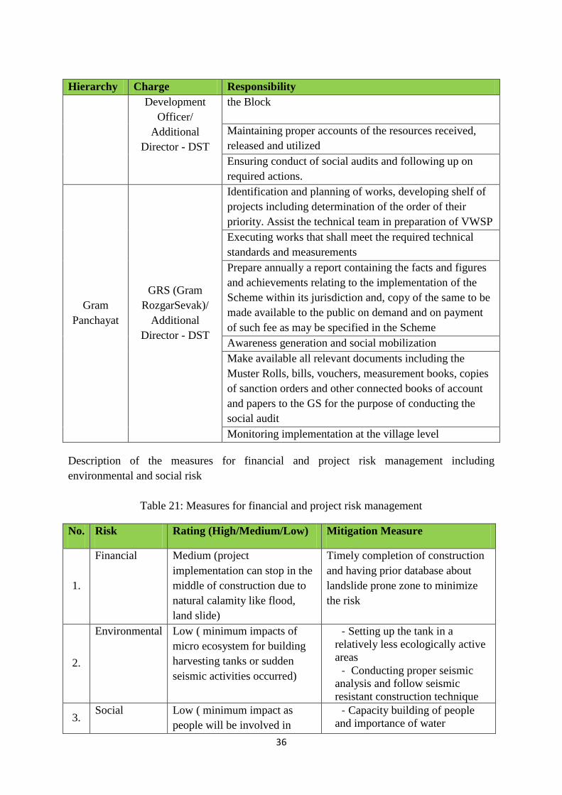
36
Hierarchy Charge Responsibility
Development
Officer/
Additional
Director - DST
the Block
Maintaining proper accounts of the resources received,
released and utilized
Ensuring conduct of social audits and following up on
required actions.
Gram
Panchayat
GRS (Gram
RozgarSevak)/
Additional
Director - DST
Identification and planning of works, developing shelf of
projects including determination of the order of their
priority. Assist the technical team in preparation of VWSP
Executing works that shall meet the required technical
standards and measurements
Prepare annually a report containing the facts and figures
and achievements relating to the implementation of the
Scheme within its jurisdiction and, copy of the same to be
made available to the public on demand and on payment
of such fee as may be specified in the Scheme
Awareness generation and social mobilization
Make available all relevant documents including the
Muster Rolls, bills, vouchers, measurement books, copies
of sanction orders and other connected books of account
and papers to the GS for the purpose of conducting the
social audit
Monitoring implementation at the village level
Description of the measures for financial and project risk management including
environmental and social risk
Table 21: Measures for financial and project risk management
No. Risk Rating (High/Medium/Low) Mitigation Measure
1.
Financial Medium (project
implementation can stop in the
middle of construction due to
natural calamity like flood,
land slide)
Timely completion of construction
and having prior database about
landslide prone zone to minimize
the risk
2.
Environmental Low ( minimum impacts of
micro ecosystem for building
harvesting tanks or sudden
seismic activities occurred)
- Setting up the tank in a
relatively less ecologically active
areas
- Conducting proper seismic
analysis and follow seismic
resistant construction technique
3. Social Low ( minimum impact as
people will be involved in
- Capacity building of people
and importance of water
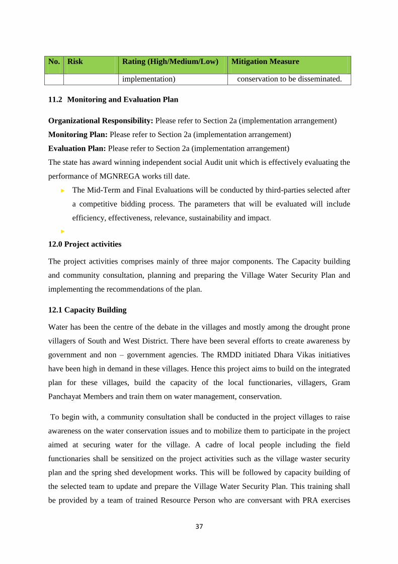
37
No. Risk Rating (High/Medium/Low) Mitigation Measure
implementation) conservation to be disseminated.
11.2 Monitoring and Evaluation Plan
Organizational Responsibility: Please refer to Section 2a (implementation arrangement)
Monitoring Plan: Please refer to Section 2a (implementation arrangement)
Evaluation Plan: Please refer to Section 2a (implementation arrangement)
The state has award winning independent social Audit unit which is effectively evaluating the
performance of MGNREGA works till date.
► The Mid-Term and Final Evaluations will be conducted by third-parties selected after
a competitive bidding process. The parameters that will be evaluated will include
efficiency, effectiveness, relevance, sustainability and impact.
►
12.0 Project activities
The project activities comprises mainly of three major components. The Capacity building
and community consultation, planning and preparing the Village Water Security Plan and
implementing the recommendations of the plan.
12.1 Capacity Building
Water has been the centre of the debate in the villages and mostly among the drought prone
villagers of South and West District. There have been several efforts to create awareness by
government and non – government agencies. The RMDD initiated Dhara Vikas initiatives
have been high in demand in these villages. Hence this project aims to build on the integrated
plan for these villages, build the capacity of the local functionaries, villagers, Gram
Panchayat Members and train them on water management, conservation.
To begin with, a community consultation shall be conducted in the project villages to raise
awareness on the water conservation issues and to mobilize them to participate in the project
aimed at securing water for the village. A cadre of local people including the field
functionaries shall be sensitized on the project activities such as the village waster security
plan and the spring shed development works. This will be followed by capacity building of
the selected team to update and prepare the Village Water Security Plan. This training shall
be provided by a team of trained Resource Person who are conversant with PRA exercises

38
and have been working on our Spring Shed development project for the last several years.
Further, the training will also be imparted for implementation of VWSP adaptation measures.
Photo 1: Community consultation for preparing the village water security plan
12.2 Planning
Once the sensitization program and training of the block / GP level VWSP team is completed,
the team will prepare a village Water Security Plan for the Gram Panchayat which will
involve series of activities like
- Collection of baseline data
- Community consultation
- PRA Exercises
- FGDs with women and other members
- Preparing village water resource map
- Water distribution maps
- Assessing demand and availability of water in
the village
- Assessing the existing infrastructure and its
status
- Field survey, inspection with Technical team of
experts including Engineers
- Door to door visit and interaction with villagers

39
After completing the entire assessment and field surveys, inspection and collection of
baseline data, a comprehensive Water Security Plan will be prepared with the help of the
Gram Panchayat members, villagers and various stakeholders including the officials of
the various government departments. This set of plan shall be then forwarded to the block
development office for preparing detail technical report such as estimates and plan. The
plan will take into consideration the activities needed to be taken up on short, medium
and long term basis.
Simultaneously, a team of experts on Hydro-geological shall carry out the study of the
potential recharge area of the village. The Hydro-geological assessment shall further
strengthen the plan with technical knowledge and provide a scientific basis for
implementation of the spring shed development works in adaptation measures wherever it
is feasible.
All springs, steams and lake shall be surveyed, their historic trends shall be recorded, and
their current status, discharge rate and dependency shall also be recorded. These springs
shall also be mapped in the spring‟s atlas using a google platform.
Photo2: Mapping of recharge area on google map
12.3 Implementation
The recommendation and the action plan on Village Water Security Plan after due approval
shall be implemented in a phase manner through various schemes and projects. The NAF
project funded by NABARD shall be utilized to fill in the critical gap are in the project
activities while subsequent amount of investment shall be channelized through various

40
ongoing central and state schemes. MGNREGA convergence on unskilled labour shall be
utilized toward taken up various water related and NRM projects in the village as per the
plan. The Village Water Security Plan shall be integrated with the MGNREGA Labour
Budget plan from the subsequent year to ensure enough convergence in the project.
Photo3: Identification of recharge area on google map
Photo 4: trenches on recharge area

41
12.4 Key focus area for the project
Reviving of springs, streams and hill top lakes through various artificial recharge activities
shall be the top most priority. Major part of this work shall be taken up under MGNREGA
since its does not involve much material while the technical assessment, study for identifying
the recharge area shall be taken up under the NAF project. Priority of the project shall be to
revive the dried up springs, increasing the discharge of the spring during lean season (Nov-
April) and ensuring that the surface runoff during monsoon are fully harnessed to recharge
the underground aquifer / water table.
Subsequently, in order to ensure that every drop of water is conserved and wisely utilized, a
series of storage facilities like roof rain water harvesting structures, community water tanks
and Individual Household water storage tanks shall be constructed. This will ensure that
every drop of water is conserved, stored and not wasted. This will ensure that the night time
discharge of waters is taped into these large water reservoirs to meet the water need
throughout the year. The hamlets or cluster which are the most vulnerable and have acute
water shortage shall be target first with this interventions. The Project will also seek
convergence with other national flagship program like Pradhan Mantri Krishi Sechai Yojana
(PMKSY) and Integrated Watershed Management Programme.
Photo 3: Off season organic vegetable farming in South Sikkim
Similarly, in order to promote greening of the village, fodder and horticulture plantation shall
be taken up simultaneously in this village. This will help in green covering the village and
also shall provide additional livelihood benefits. The fodder plantation will strengthen the
dairy development in the village. MGNREGA is already constructing animal shelters like
cowshed, goat shelter in huge numbers in the village. Some village is on the way to saturation

42
and has covered more than 50% of the poor and marginal farmers in the village. This will
boost the dairy development while provide additional income of about Rs. 12,000 – 20,000/
household per annum.
12.5 Construction of solid waste - Resource Recovery Centre
Solid waste management has become a growing problem with increase number of population
and urbanization. This problem have reached far nock and corner of the village, the
increasing waste and lack of proper management is further leading to contamination of water
source and agriculture field. In most cases the garbage find their way into stream, river and
Jhoras, often pollution the head water of the spring for many downstream villages. Thus a
small part of the investment shall also be utilized to address this Solid waste management
problem in the project area in partnership with Swatch Bharat Mission (Gramin). The funding
available under this project shall be used to supplement their infrastructure and IEC need for
the ongoing SBM (Gramin) programmes, thus directly addressing the issues of water
contamination and pollution.
Photo 4: Plastic / Pet bottles graded and shredded into pebbles at a processing plant at Singtam
SBM (Gramin) – Sikkim has implemented some successful project on Solid, Liquid Waste
Management and they already have a model developed for rural area. The model of Melli
Dara Gram Panchayat shall be replicated to this NAF project sites. Source segregation shall
be promoted in the centrally located place in the GP, where all kind of waste shall be
segregated into different component. The waste shall be graded into colors, types and its
resalable market values. This shall be further compressed and shredded into pebbles and shall
be sold as raw materials to plastic factories outside the state. So a unique waste management
model shall be developed and upscaled to all 12 project blocks.

43
13.0 Budget breakup (NAF + MGNREGA)
Table 22: Budget breakup (NAF+ MGNREGA)
Sl. No
Activities Unit Unit cost (in
INR) Total Units
NAF Cost (In lakh)
Co-funding from MGNREGA
Total Cost
(In lakh)
1 Capacity Building
1.1 Community mobilization on water conservation and climate resilient activities Numbers 14,000.00 74 10.36 0 10.36
1.2 Training on preparation of Village Water Security Plan Numbers 12,000.00 60 7.2 0 7.2
1.3 Training on implementation of Village Water Security Plan Numbers 14,000.00 74 10.36 0 10.36
Sub total 27.92 0 27.92
2 Planning
2.1
Preparation of Village Water Security Plan of Gram Panchayat Units and collection of baseline data No. of GP 50,000.00 60 30 0 30
2.2 Hydrogeological study of the springs to identify the recharge area using scientific study
Numbers of landscape level studies Lump Sum 1 20 0 20
2.3
Feasibility and budget estimation of the suggested measures for climate resilient activities Numbers 15,000.00 74 11.1 0 11.1
2.4 Updation of village springs atlas Lump Sum 5 0 5
Sub total 66.1 0 66.1

44
3 Implementation
Implementation of suggested activities under Village Water Security Plan 0
3.1
Implementation of suggested activities under Village Water Security Plan like roof top water harvesting structure for harvesting roof water during rainy season Nos 1,13,000.00 1263.00 999.03 428.157 1427.19
3.2
Implementation of suggested activities under Village Water Security Plan like community water storage reservoir to store night discharge of the springs and excess monsoon discharge of the springs 50,000 litre Nos 350000.00 148.00 362.60 155.4 518.00
3.3 Dhara Vikas Hec 30000.00 300.00 27.00 63 90.00
3.4 Fodder Development- cost of saplings Hec 36000.00 1684.00 242.50 363.744 606.24
3.5 Horticulture Development- cost of saplings Hec 64000.00 1684.00 404.16 673.6 1077.76
3.6 Construction of solid waste recovery centre Nos 15,00,000.00 12.00 156.00 24 180.00
Sub total 2191.29 1707.901 3899.19
A Total of project cost (NABARD project only) (SL-1+ SL-2 + SL-3) 2285.31
B Project execution cost ( 5%) which includes 50 lakh for DST project execution charge 116.17
C Project Cycle Management Fee charged by the Implementing Entity (3% of total project cost) in lakh 68.56
D Total funding sought from NAF 2470.04
MGNREGA cost in %
E Total MGNREGA Investment in Lakh 1707.901 40.87%
F Total project cost (NAF + MGNREGA) in Lakh 4177.94
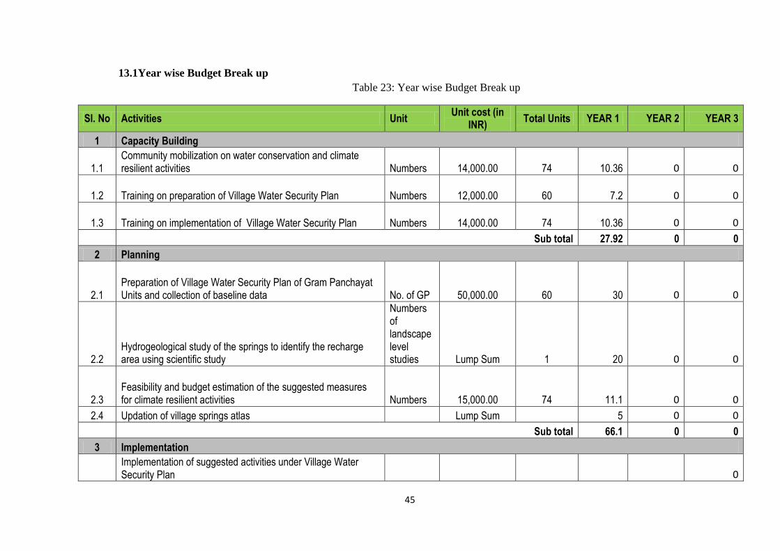
45
13.1Year wise Budget Break up
Table 23: Year wise Budget Break up
Sl. No Activities Unit Unit cost (in
INR) Total Units YEAR 1 YEAR 2 YEAR 3
1 Capacity Building
1.1 Community mobilization on water conservation and climate resilient activities Numbers 14,000.00 74 10.36 0 0
1.2 Training on preparation of Village Water Security Plan Numbers 12,000.00 60 7.2 0 0
1.3 Training on implementation of Village Water Security Plan Numbers 14,000.00 74 10.36 0 0
Sub total 27.92 0 0
2 Planning
2.1 Preparation of Village Water Security Plan of Gram Panchayat Units and collection of baseline data No. of GP 50,000.00 60 30 0 0
2.2 Hydrogeological study of the springs to identify the recharge area using scientific study
Numbers of landscape level studies Lump Sum 1 20 0 0
2.3 Feasibility and budget estimation of the suggested measures for climate resilient activities Numbers 15,000.00 74 11.1 0 0
2.4 Updation of village springs atlas Lump Sum 5 0 0
Sub total 66.1 0 0
3 Implementation
Implementation of suggested activities under Village Water Security Plan 0

46
3.1
Implementation of suggested activities under Village Water Security Plan like roof top water harvesting structure for harvesting roof water during rainy season Nos 1,13,000.00 1263.00 0.00 999.03 0.00
3.2
Implementation of suggested activities under Village Water Security Plan like community water storage reservoir to store night discharge of the springs and excess monsoon discharge of the springs 50,000 litre Nos 350000.00 148.00 0.00 362.6 0.00
3.3 Dhara Vikas Hec 30000.00 300.00 0.00 13.5 13.50
3.4 Fodder Development- cost of saplings Hec 36000.00 1684.00 0.00 121.25 121.25
3.5 Horticulture Development- cost of saplings Hec 64000.00 1684.00 0.00 202.08 202.08
Construction of solid waste recovery centre Nos 15,00,000.00 12.00 156.00 0 0.00
Sub total 250.02 1698.46 336.83
A Project execution cost ( 5%) which includes 50 lakh for DST project execution charge 46.46 46.46 23.25
B Project Cycle Management Fee charged by the Implementing Entity (3% of total project cost) in lakh 27.52 27.52 13.76
C Total Year wise break including admin cost 324.00 1772.44 373.84
Total NAF fund sought for 3 year 2470.28 %
Year 1 324.00 13.12
Year 2 1772.44 71.75
Year 3 373.84 15.13

47
14.0 Work plan for 3 year with quarterly breakup Table 24: Work plan
Sl.
No Activities
YEAR 1 YEAR 2 YEAR 3
1 Capacity Building Q1 Q2 Q3 Q4 Q1 Q2 Q3 Q4 Q1 Q2 Q3 Q4
1.1
Community mobilization on water conservation and climate
resilient activities
1.2 Training on preparation of Village Water Security Plan
1.3 Training on implementation of Village Water Security Plan
2 Planning
2.1
Preparation of Village Water Security Plan of Gram
Panchayat Units and collection of baseline data
2.2
Hydrogeological study of the springs to identify the recharge
area using scientific study
2.3
Feasibility and budget estimation of the suggested measures
for climate resilient activities
2.4 Updation of village springs atlas
3 Implementation
Implementation of suggested activities under Village Water
Security Plan
3.1
Implementation of suggested activities under Village Water
Security Plan like roof top water harvesting structure for
harvesting roof water during rainy season
3.2
Implementation of suggested activities under Village Water
Security Plan like community water storage reservoir to store
night discharge of the springs and excess monsoon discharge
of the springs 50,000 litre
3.3 Dhara Vikas
3.4 Fodder Development- cost of saplings
3.5 Horticulture Development- cost of saplings
3.6 Construction of solid waste recovery centre

48
15.0 Expected outcome of the project
• Vulnerability in water sector due to climate variability will be reduced by enhancing
the availability of water
• 1, 85, 416 (Census 2011) will be directly benefitted by the intervention
• Co benefits of carbon sequestration shall be ensured in the state
Recommended